DRAFT RESULTS OF FOCUSED SURVEYS FOR THE LEAST BELL’S ... · invasion of southern California by...
60
DRAFT RESULTS OF FOCUSED SURVEYS FOR THE LEAST BELL’S VIREO AND SOUTHWESTERN WILLOW FLYCATCHER FOR THE VALLEY-IVYGLEN SUBTRANSMISSION LINE PROJECT, PHASE 1 RIVERSIDE COUNTY, CALIFORNIA Prepared for: Southern California Edison 2244 Walnut Grove Avenue Rosemead, California 91770 Prepared by: AMEC Environment & Infrastructure, Inc. 9210 Sky Park Court, Suite 200 San Diego, California 92123 August 2013 AMEC Project No. 1255400498
Transcript of DRAFT RESULTS OF FOCUSED SURVEYS FOR THE LEAST BELL’S ... · invasion of southern California by...

DRAFT RESULTS OF FOCUSED SURVEYS FOR THE LEAST BELL’S VIREO
AND SOUTHWESTERN WILLOW FLYCATCHER FOR THE VALLEY-IVYGLEN SUBTRANSMISSION LINE PROJECT, PHASE 1
RIVERSIDE COUNTY, CALIFORNIA
Prepared for: Southern California Edison 2244 Walnut Grove Avenue
Rosemead, California 91770
Prepared by: AMEC Environment & Infrastructure, Inc.
9210 Sky Park Court, Suite 200 San Diego, California 92123
August 2013 AMEC Project No. 1255400498


Draft Focused Surveys for Riparian Birds Valley-Ivyglen Subtransmission Line Project, Phase 1 AMEC Project No. 1255400498 August 2013 EXECUTIVE SUMMARY
At the request of Southern California Edison (SCE), AMEC Environment & Infrastructure, Inc. (AMEC) conducted focused surveys for the state and federally listed as endangered Least Bell’s Vireo (Vireo belli pusillus) and Southwestern Willow Flycatcher (Empidonax traillii extimus). Surveys were conducted at suitable habitat patches along the Valley-Ivyglen Transmission Line Project, Phase 1 (see Appendix A, Figures 1-3). These patches are locations where these subspecies have not been detected in previous survey years (AMEC 2007, 2009, 2010, 2011, 2012). The surveys were performed to satisfy requirements of the Western Riverside County Multiple Species Habitat Conservation Plan (MSHCP) (Riverside County 2003). One Least Bell’s Vireo territory was detected. No Southwestern Willow Flycatchers were detected.
Page ES-1

Draft Focused Surveys for Riparian Birds Valley-Ivyglen Subtransmission Line Project, Phase 1 AMEC Project No. 1255400498 August 2013
Page ES-2
This page intentionally left blank

Draft Focused Surveys for Riparian Birds Valley-Ivyglen Subtransmission Line Project, Phase 1 AMEC Project No. 1255400498 August 2013 TABLE OF CONTENTS
Page EXECUTIVE SUMMARY ........................................................................................................ ES-1 ACRONYMS AND ABBREVIATIONS .......................................................................................... iii 1.0 INTRODUCTION ............................................................................................................ 1-1
1.1 Project Description ............................................................................................. 1-1 1.2 Survey Areas ...................................................................................................... 1-1 1.3 Species Information: Least Bell’s Vireo .............................................................. 1-2 1.4 Species Information: Southwestern Willow Flycatcher ....................................... 1-3
2.0 METHODS ..................................................................................................................... 2-1 2.1 Least Bell’s Vireo and Southwestern Willow Flycatcher ..................................... 2-1
3.0 RESULTS ....................................................................................................................... 3-1 3.1 Habitat Description ............................................................................................. 3-1 3.2 Survey Results ................................................................................................... 3-2
3.2.1 Southwestern Willow Flycatcher ............................................................. 3-2 3.2.2 Least Bell’s Vireo .................................................................................... 3-2
4.0 LITERATURE CITED ..................................................................................................... 4-1 LIST OF TABLES Table 1. Least Bell’s Vireo and Southwestern Willow Flycatcher Survey Data ................ 2-1 LIST OF APPENDICES APPENDIX A FIGURES APPENDIX B BIRD SPECIES LIST APPENDIX C SWF SURVEY FORMS APPENDIX D CERTIFICATION APPENDIX E PHOTOGRAPHS
Page i

Draft Focused Surveys for Riparian Birds Valley-Ivyglen Subtransmission Line Project, Phase 1 AMEC Project No. 1255400498 August 2013
This page intentionally left blank
Page ii

Draft Focused Surveys for Riparian Birds Valley-Ivyglen Subtransmission Line Project, Phase 1 AMEC Project No. 1255400498 August 2013 ACRONYMS AND ABBREVIATIONS
AMEC AMEC Environment & Infrastructure, Inc.
CDFW California Department of Fish and Wildlife
°F degrees Fahrenheit
kV kilovolt
LBV Least Bell’s Vireo
mph miles per hour
MSHCP Multiple Species Habitat Conservation Plan
PST Pacific Standard Time
project Valley-Ivyglen Transmission Line Project, Phase 1
ROW right-of-way
SCE Southern California Edison
study area project ROW and 500-foot buffer from centerline of ROW
SWF Southwestern Willow Flycatcher
USFWS United States Fish and Wildlife Service
USGS United States Geological Survey
Page iii

Draft Focused Surveys for Riparian Birds Valley-Ivyglen Subtransmission Line Project, Phase 1 AMEC Project No. 1255400498 August 2013
Page iv
This page intentionally left blank

Draft Focused Surveys for Riparian Birds Valley-Ivyglen Subtransmission Line Project, Phase 1 AMEC Project No. 1255400498 August 2013 1.0 INTRODUCTION
At the request of Southern California Edison (SCE), AMEC Environment & Infrastructure, Inc. (AMEC) conducted focused surveys for the state and federally listed as endangered Least Bell’s Vireo (Vireo belli pusillus) and Southwestern Willow Flycatcher (Empidonax traillii extimus). Surveys were conducted at suitable habitat patches along the Valley-Ivyglen Transmission Line Project, Phase 1 (see Appendix A, Figures 1-3). These patches are locations where these subspecies have not been detected in previous survey years (AMEC 2007, 2009, 2011, 2012). The surveys were performed to satisfy requirements of the Western Riverside County Multiple Species Habitat Conservation Plan (MSHCP) (Riverside County 2003). This report presents the findings of those focused surveys
1.1 Project Description
The proposed project has been divided into two portions: eastern (Phase 1) and western (Phase 1I). Phase 1 extends from the Valley Substation in the City of Menifee southwest to the corner of Collier Avenue and Third Street in the City of Lake Elsinore. The Valley Substation is located in the City of Menifee on the west side of Menifee Road between McLaughlin and Ethanac Roads. Phase 2 extends from that corner northwest to the Ivyglen Substation in the City of Corona. The proposed project is designed to improve reliability and meet projected electrical load requirements in western Riverside County, and involves the eventual construction of a new 115 kilovolt (kV) transmission line between the Valley and Ivyglen Substations. The proposed Phase 1 transmission line route (project) is located entirely in western Riverside County, California. It traverses portions of unincorporated county and the cities of Menifee, Perris, and Lake Elsinore (see Appendix A, Figure 1). The route traverses portions of the Lake Elsinore and Romoland United States Geological Survey (USGS) 7.5-minute series topographic quadrangles (see Appendix A, Figures 2-1 and 2-2). This report concerns focused surveys conducted within the Phase 1 portion of the project area; Phase 2 will not be discussed further. Appropriate habitat was surveyed along the proposed transmission line right-of-way (ROW) and a 500-foot buffer from the centerline of the proposed ROW (study area), with the exception of areas that already have established occurrences of Least Bell’s Vireos. The study area is located within the Western Riverside County Multiple Species Habitat Conservation Plan (MSHCP). The MSHCP is a comprehensive, multi-jurisdictional Habitat Conservation Plan, which focuses on conservation of species and their associated habitats in western Riverside County (Riverside County 2003).
1.2 Survey Areas
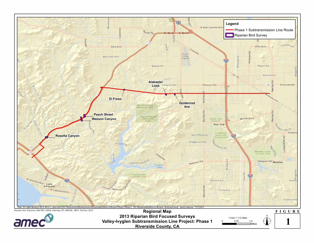
Areas considered to contain suitable habitat along the project route are:
1. Goldenrod Avenue: approximate UTM of survey area: Zone 11, 478950E, 3732690N (NAD27). This point occurs on lands mapped on the USGS 7.5 minute Romoland, Calif quadrangle.
Page 1-1

Draft Focused Surveys for Riparian Birds Valley-Ivyglen Subtransmission Line Project, Phase 1 AMEC Project No. 1255400498 August 2013
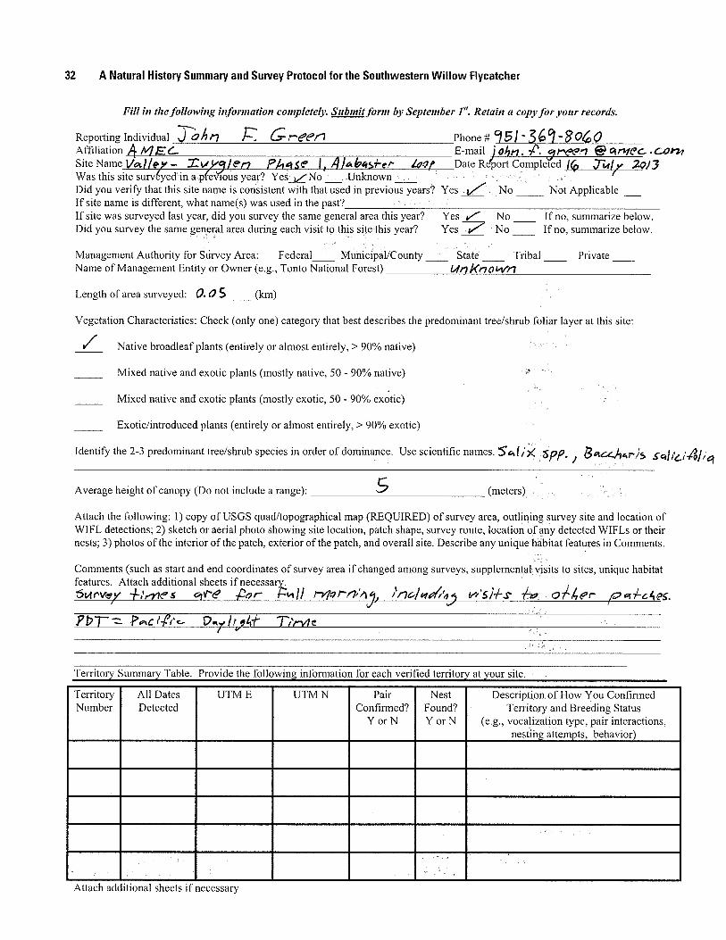
2. Alabaster Loop: approximate UTM of survey area: Zone 11, 475389E, 3733085N (NAD27). This point occurs on lands mapped on the USGS 7.5 minute Romoland, Calif quadrangle.
3. El Freso: approximate UTM of survey area: Zone 11, 478330E, 3732650N (NAD27). This point occurs on lands mapped on the USGS 7.5 minute Lake Elsinore, Calif quadrangle.
4. Peach Street: approximate UTM at north end of survey area: Zone 11, 472580E, 3730997N (NAD27); approximate UTM at south end of survey area: Zone 11, 472612E, 3730803N (NAD27). These points occur on lands mapped on the USGS 7.5 minute Lake Elsinore, Calif. quadrangle.
5. Wasson Canyon: approximate UTM at north end of survey area: Zone 11, 472339E, 3730799N (NAD27); approximate UTM at south end of survey area: Zone 11, 472425E, 3730494N (NAD27). These points occur on lands mapped on the USGS 7.5 minute Lake Elsinore, Calif. quadrangle. Report cover photo is of this survey area, taken from the south end looking north.
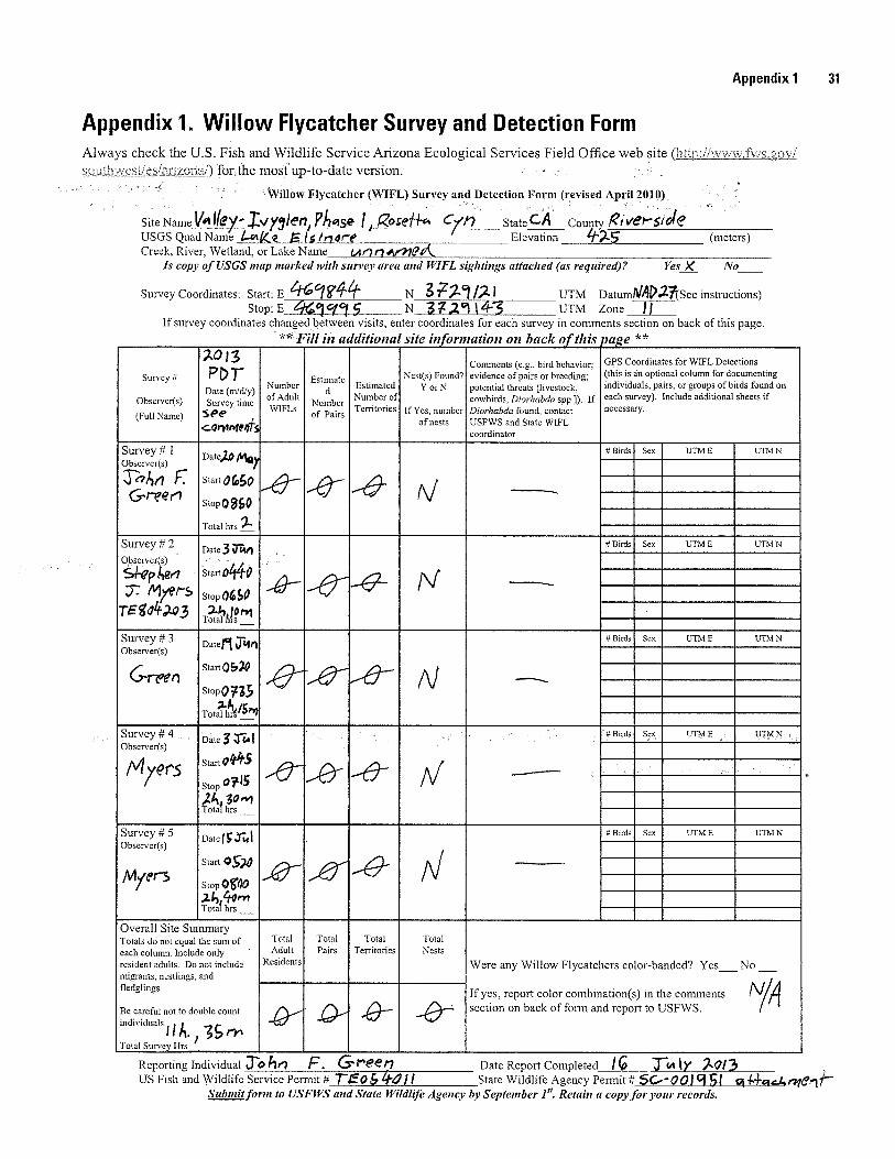
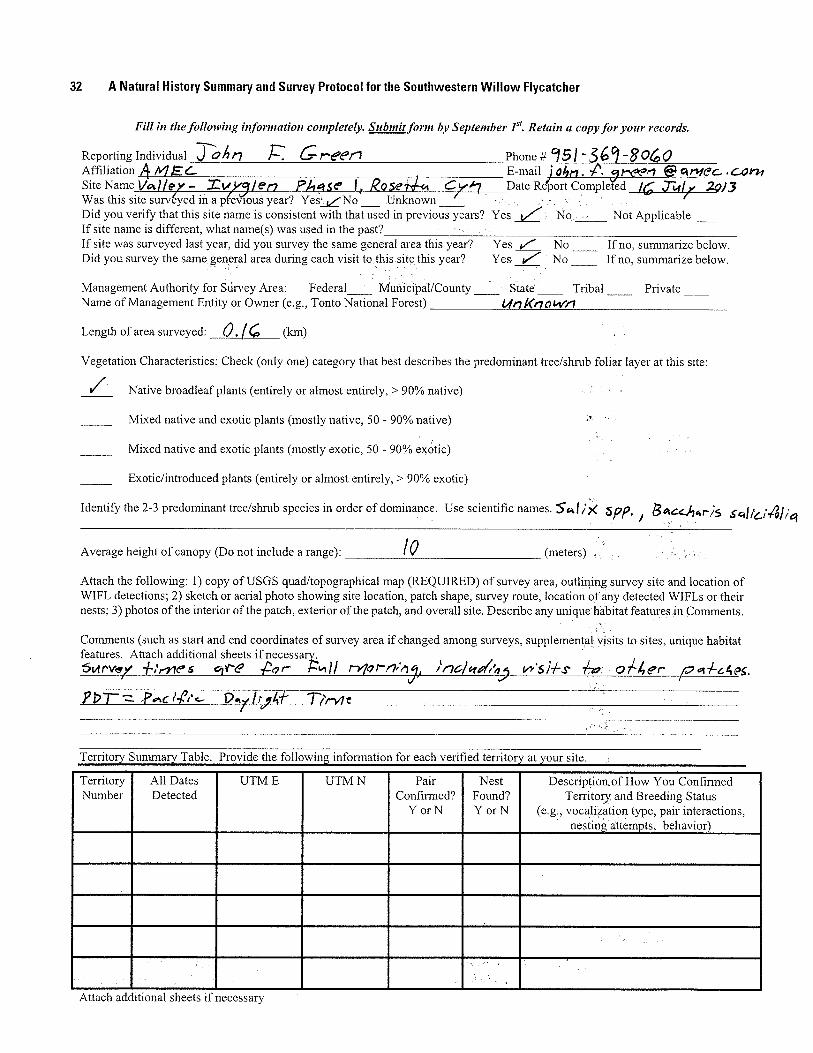
6. Rosetta Canyon: approximate UTM at west end of survey area: Zone 11, 469844E, 3729121N (NAD27); approximate UTM at east end of survey area: Zone 11, 469995E, 3729143N (NAD27). These points occur on lands mapped on the USGS 7.5 minute Lake Elsinore, Calif. quadrangle.
Maps of the survey areas can be found in Appendix A, and photos of the survey areas can be found in Appendix E.
1.3 Species Information: Least Bell’s Vireo
Least Bell's Vireo (LBV) is a small, migratory, insectivorous bird which occurs in willow-dominated riparian habitats. Although this bird is drab in plumage and can be secretive within its densely vegetated habitat, males are easy to detect on the breeding grounds due to their conspicuous and diagnostic song. Nesting habitat of this species is restricted to willow and/or mulefat dominated riparian scrub along permanent or nearly permanent streams (Grinnell and Miller 1944, Goldwasser 1978, Franzreb 1987, Garrett and Dunn 1981). Least Bell's Vireos were formerly widespread and common throughout low-lying riparian habitats of central and southern California, but are now restricted to a limited number of locations in southern California. Habitat reduction has contributed to this species' significant population declines. Nest parasitism by Brown-headed Cowbirds (Molothrus ater) has also seriously impacted reproductive success by Least Bell's Vireo, as well as many other species which build cup nests (Goldwasser 1978). The population is slowly recovering as a result of habitat restoration and cowbird control efforts. Least Bell's Vireo is listed as Endangered by the California Department of Fish and Wildlife (CDFW) and by the United States Fish and Wildlife Service (USFWS) (USFWS 1986). A final determination of critical habitat was made in 1994 (USFWS 1994). The project area is not within designated critical habitat for the Least Bell’s Vireo.
Page 1-2

Draft Focused Surveys for Riparian Birds Valley-Ivyglen Subtransmission Line Project, Phase 1 AMEC Project No. 1255400498 August 2013 1.4 Species Information: Southwestern Willow Flycatcher
The Southwestern Willow Flycatcher (SWF) is a small, brownish-olive flycatcher that was formerly considered a common summer resident in southern California’s lowland willow thickets and in low elevation mountain canyons (Garrett and Dunn 1981). Following the large-scale invasion of southern California by Brown-headed Cowbirds in the 1920s, along with loss of willow riparian habitat, this subspecies was nearly extirpated from southern California. The Willow Flycatcher was listed by the State of California as endangered in 1990. The subspecies E. t. extimus (Southwestern Willow Flycatcher) is listed as federally endangered (USFWS 1995). Critical habitat was designated for this species in 1997 (USFWS 1997), then revised and finalized again in 2005 (USFWS 2005), then revised and finalized again in 2013 (USFWS 2013). The project area is not within currently designated critical habitat for the SWF. Surveys have revealed populations along the Santa Margarita and San Luis Rey Rivers in San Diego County, in the San Bernardino Mountains and along the Mojave River in San Bernardino County, the Santa Ynez River in Santa Barbara County, the Santa Clara River in Los Angeles and Ventura counties, the South Fork of the Kern River in Kern County (Unitt 1987, Marshall 2000), and the Prado Basin and San Timoteo Creek in western Riverside County (J. Pike, Orange County Water District; R. McKernan, San Bernardino County Museum: pers. comm.). This subspecies also persists in the Lower Colorado River Valley (Marshall 2000, R. McKernan, pers. comm.). Unlike LBVs, SWF populations do not appear to have gained any significant benefit from habitat restoration and cowbird control efforts. The Southwestern Willow Flycatcher breeds in dense riparian habitats near surface water or saturated soil. Plant composition and habitat structure can vary greatly depending on the site, but willows often make up much of the understory. Populations along the Colorado River are known to use thickets dominated by both native and nonnative plants (especially Salt-Cedar [Tamarix spp.]). Dense patches of understory vegetation are a critical component of occupied habitat (Sogge et al. 1997).
Page 1-3

Draft Focused Surveys for Riparian Birds Valley-Ivyglen Subtransmission Line Project, Phase 1 AMEC Project No. 1255400498 August 2013
Page 1-4
This page intentionally left blank

Draft Focused Surveys for Riparian Birds Valley-Ivyglen Subtransmission Line Project, Phase 1 AMEC Project No. 1255400498 August 2013 2.0 METHODS
2.1 Least Bell’s Vireo and Southwestern Willow Flycatcher
In accordance with the currently accepted survey protocol for the Least Bell’s Vireo (USFWS 2001), each site was surveyed eight times by AMEC biologists. The LBV protocol requires surveys to be conducted at least 10 days apart from 10 April to 31 July. The SWF protocol requires five surveys, and that the first survey be performed from 15 May to 31 May, the next two surveys from 1 June to 24 June, and the final two surveys from 25 June and 17 July (Sogge et al. 2010), with at least five days between surveys. The SWF surveys were performed concurrently with LBV surveys. Surveys consisted of slowly moving through the habitat while listening for the songs and calls of the two target species. During the SWF surveys, recordings of their vocalizations were broadcast as required by protocol. All bird species detected during the surveys were recorded in field notes and a list of them was compiled for Appendix B. Field forms for the SWF are presented in Appendix C. Due to the small size of the riparian patches, all areas were surveyed in a single morning on each visit. Surveys were performed by Stephen J. Myers (TE804203) and John F. Green (TE054011). Table 1 summarizes the surveys. The survey areas are illustrated in Appendix A on Figures 2-1 and 2-2 (USFWS required topographic maps) which correspond to Figures 3-1 through 3-6 (aerial photos).
Table 1. Least Bell’s Vireo and Southwestern Willow Flycatcher Survey Data
Date Observer Time (PST) Temp. (°F) Wind (mph) Sky (% cover) 10 April 2013 John F. Green 0800-1000 69-71 2-5 0
26 April 2013 John F. Green 0735-0940 63-76 0 0
8 May 2013 Stephen J. Myers 0830-1025 65-73 0-2 50-70
20 May 2013† John F. Green 0650-0850 65-80 1-3 0
3 June 2013† Stephen J. Myers 0440-0650 58-65 0-2 100-80
19 June 2013† John F. Green 0520-0735 60-70 0-2 0
3 July 2013† Stephen J. Myers 0445-0715 69-80 0 60-50
15 July 2013† Stephen J. Myers 0520-0800 67-85 0 0 Notes: † SWF and LBV surveys conducted concurrently. Other surveys were for LBV only.
Page 2-1

Draft Focused Surveys for Riparian Birds Valley-Ivyglen Subtransmission Line Project, Phase 1 AMEC Project No. 1255400498 August 2013
Page 2-2
This page intentionally left blank
Draft Focused Surveys for Riparian Birds Valley-Ivyglen Subtransmission Line Project, Phase 1 AMEC Project No. 1255400498 August 2013 3.0 RESULTS
3.1 Habitat Description
The six survey areas are all vegetated with plants typical of lowland riparian areas in Southern California, including willows (Salix spp.), Mulefat (Baccharis salicifolia), and Fremont Cottonwoods (Populus fremontii). The Goldenrod Avenue survey area was part of a poorly defined drainage in the past (judging from topographic maps and old aerial photos), but probably did not support riparian vegetation. Runoff from new housing developments has created and sustained this patch, and surface water was present throughout the survey season. The Alabaster Loop survey area is on a former USGS mapped blueline intermittent stream, but again likely did not support riparian vegetation in the past. The drainage was highly modified by development, and the riparian patch is sustained by runoff. Surface water was present throughout the survey season. The El Freso survey area is in a small, narrow canyon above a USGS mapped, intermittent, unnamed stream. It appears to be supported by groundwater and/or runoff from an adjacent rural residence, but no surface water was visible during the season. The Peach Street survey area was also part of a poorly defined drainage in the past, which probably did not support riparian vegetation. It is split by Highway 74, which it crosses under through a culvert. Runoff from Highway 74 and rural residential in the area has sustained the riparian vegetation here, but drought conditions this year resulted in no surface water present during the survey season. Some riparian vegetation near Highway 74 was damaged/removed from the north patch prior to the survey season, possibly for flood control maintenance. The Wasson Canyon survey area is in a relatively large and well defined drainage mapped by the USGS as an intermittent stream. It is split by Highway 74, which it crosses under through large culverts. It gains some water through runoff from Highway 74 and rural residences, but rarely contains surface water, and contained none during this season. It may have historically sustained riparian vegetation. Finally, the Rosetta Canyon survey area was part of yet another poorly defined drainage in the past which probably did not support riparian vegetation. It is split by Highway 74, which it crosses under through a culvert. Runoff from Highway 74 and rural residences and businesses now sustain riparian vegetation on the north side of the highway, and a new patch has developed on the south side which was once scraped bare (several years ago). Surface water was present throughout the survey season. Appendix A has maps of the survey areas and Appendix E has photographs of them.
Page 3-1

Draft Focused Surveys for Riparian Birds Valley-Ivyglen Subtransmission Line Project, Phase 1 AMEC Project No. 1255400498 August 2013
Page 3-2
3.2 Survey Results
Sixty-two bird species were detected during the 2013 Phase 1 riparian birds focused surveys. Among them were the following birds that are typical of lowland riparian habitats in southern California: Mourning Dove (Zenaida macroura), Black-chinned Hummingbird (Archilochus alexandri), Nuttall’s Woodpecker (Picoides nuttallii), Black Phoebe (Sayornis nigricans), Bushtit (Psaltriparus minimus), House Wren (Troglodytes aedon), Yellow Warbler (Setophaga petechia), Common Yellowthroat (Geothlypis trichas), Song Sparrow (Melospiza melodia), and Lesser Goldfinch (Spinus psaltria). A complete list is attached as Appendix B.
3.2.1 Southwestern Willow Flycatcher
No Southwestern Willow Flycatchers or any other subspecies of Willow Flycatcher were detected at any of the survey areas.
3.2.2 Least Bell’s Vireo
A single, singing Least Bell’s Vireo was detected on multiple survey days at the northern patch of the Rosetta Canyon survey area (see Appendix A, Figure 3-6). Only the singing male was ever seen/heard; breeding success is unknown.

Draft Focused Surveys for Riparian Birds Valley-Ivyglen Subtransmission Line Project, Phase 1 AMEC Project No. 1255400498 August 2013 4.0 LITERATURE CITED
AMEC. 2012. Results of Focused Surveys for the Least Bell’s Vireo and Southwestern Willow Flycatcher for the Valley-Ivyglen Subtransmission Line Project, Phase 1. Unpublished report prepared for SCE.
AMEC. 2011. Valley-Ivyglen Transmission Line Project, 2011 Focused Surveys for Least Bell’s Vireo, Southwestern Willow Flycatcher, and Western Yellow-billed Cuckoo. Unpublished report prepared for SCE.
AMEC. 2009. 2009 Focused Surveys for the Least Bell’s Vireo and Southwestern Willow Flycatcher, Valley-Ivyglen Subtransmission Line Project. Unpublished report prepared for SCE.
AMEC. 2007. Focused Surveys for the Least Bell’s Vireo, Southwestern Willow Flycatcher, and Western Yellow-billed Cuckoo for the Valley-Ivyglen Transmission Line Project. Unpublished report prepared for SCE.
Franzreb, K.E. 1987. Endangered status and strategies for conservation of the Least Bell's Vireo (Vireo bellii pusillus) in California. W. Birds 18:43-49.
Garrett, K. and J. Dunn. 1981. Birds of southern California: Status and distribution. Los Angeles Audubon Soc., Los Angeles, CA.
Goldwasser, S. 1978. Distribution, reproductive success, and impact of nest parasitism by Brown-headed Cowbirds on Least Bell's Vireos. Unpublished report prepared for the Resources Agency, California Department of Fish and Game, Sacramento, CA.
Grinnell, J. and A.H. Miller. 1944. The Distribution of the Birds of California. Pac. Coast Avif. 27.
Marshall, R.M. 2000. Population status on breeding grounds. Pp. 3-11 in Status, ecology, and conservation of the Southwestern Willow Flycatcher (Finch, D.M. and S.H. Stoleson, eds.). Gen. Tech. Rpt. RMRS-GTR-60, U.S. Dept. of Agriculture, Forest Service, Rocky Mountain Research Station, Ogden, UT.
Riverside County Integrated Project. 2003. MSHCP Final Documents. Online at: http://www.rcip.org/conservation.htm
Sogge, M.K., D. Ahlers, and S.J. Sferra. 2010. A natural history summary and survey protocol for the Southwestern Willow Flycatcher. U.S. Geological Survey Techniques and Methods 2A-10, 38 pgs.
Sogge, M.K., R.M. Marshall, S.J. Sferra, and T.J. Tibbitts. 1997. A Southwestern Willow Flycatcher natural history summary and survey protocol. Technical report NPS/NAUCPRS/NRTR-97/12, National Park Service, Denver.
USFWS. 2013. Endangered and Threatened Wildlife and Plants; Designation of Critical Habitat for Southwestern Willow Flycatcher. Final Rule. Federal Register. Vol. 78, Pgs. 50542-50629.
USFWS. 2011. Endangered and Threatened Wildlife and Plants; Designation of Revised Critical Habitat for Southwestern Willow Flycatcher. Proposed Rule. Federal Register. Vol. 76, Pgs. 50542-50629.
Page 4-1

Draft Focused Surveys for Riparian Birds Valley-Ivyglen Subtransmission Line Project, Phase 1 AMEC Project No. 1255400498 August 2013
Page 4-2
USFWS. 2005. Endangered and Threatened Wildlife and Plants; Designation of Critical Habitat for the Southwestern Willow Flycatcher (Empidonax traillii extimus). Final Rule. Federal Register. Vol. 70, Pgs. 60885-61009.
United States Fish and Wildlife Service. 2001. Least Bell’s Vireo survey guidelines. Ecological Services, Carlsbad Fish and Wildlife Office, Carlsbad, CA.
USFWS. 1997. Final Determination of Critical Habitat for the Southwestern Willow Flycatcher. Federal Register. Vol. 62, Pgs. 39129-39147.
USFWS. 1995. Endangered and Threatened Wildlife and Plants; Final Rule Determining Endangered Status for the Southwestern Willow Flycatcher. Federal Register. Vol. 60, No. 38.
USFWS. 1994. Endangered and Threatened Wildlife and Plants; Designation of Critical Habitat for the Least Bell’s Vireo. Federal Register. Vol. 59, No. 22.
USFWS. 1986. Endangered and Threatened Wildlife and Plants; Determination of Endangered Status for the Least Bell’s Vireo, Final Rule. Federal Register. Vol. 51.
United States Fish and Wildlife Service. 1994. Endangered and Threatened Wildlife and Plants; Designation of Critical Habitat for the Least Bell’s Vireo; Final Rule. Federal Register 59:4845-4867.
Unitt, P. 1987. Empidonax traillii extimus: An endangered subspecies. W. Birds 18:137-162.

Draft Focused Surveys for Riparian Birds Valley-Ivyglen Subtransmission Line Project, Phase 1 AMEC Project No. 1255400498 August 2013
APPENDIX A
FIGURES

Draft Focused Surveys for Riparian Birds Valley-Ivyglen Subtransmission Line Project, Phase 1 AMEC Project No. 1255400498 August 2013
This page intentionally left blank
F I G U R ERegional Map2013 Riparian Bird Focused Surveys
Valley-Ivyglen Subtransmission Line Project: Phase 1Riverside County, CA
1
Path: W:\sd06\Biology\SCE 06\ivy_glen\mxd\2013\ReportsAndSubmissions\RiparianBirdSurveyReport\Phase1\Phase1_2013RiparianBirdSurveyReport_Regional.mxd, aaron.johnson 7/23/2013
AlabasterLoop
GoldenrodAve
Peach StreetWasson Canyon
Rosetta Canyon
El Freso
Legend
Phase 1 Subtransmission Line RouteRiparian Bird Survey
o0 1.50.75Miles
Sources: Esri, DeLorme, NAVTEQ, USGS, Intermap, iPC, NRCAN, METI, TomTom, 2012
1 inch = 1.5 miles

F I G U R EProject Location2013 Riparian Bird Focused Surveys
Valley-Ivyglen Subtransmission Line Project: Phase 1Riverside County, CA
Path: W:\sd06\Biology\SCE 06\ivy_glen\mxd\2013\ReportsAndSubmissions\RiparianBirdSurveyReport\Phase1\Phase1_2013RiparianBirdSurveyReport_Vicinity_Series.mxd, aaron.johnson 7/23/2013
Alabaster Loop
El Freso
Goldenrod Ave
12
3
Legend
Phase 1 Subtransmission Line RouteRiparian Bird Survey Areas (2013)Map Grid Extents
o0 2,0001,000Feet
Topo Source: 2011 National Geographic Society, i-cubed
1 inch = 2,017.4 feet 2-1

F I G U R EProject Location2013 Riparian Bird Focused Surveys
Valley-Ivyglen Subtransmission Line Project: Phase 1Riverside County, CA
Path: W:\sd06\Biology\SCE 06\ivy_glen\mxd\2013\ReportsAndSubmissions\RiparianBirdSurveyReport\Phase1\Phase1_2013RiparianBirdSurveyReport_Vicinity_Series.mxd, aaron.johnson 7/23/2013
Wasson Canyon
Peach Street
Rosetta Canyon
5
4
6
Legend
Phase 1 Subtransmission Line RouteRiparian Bird Survey Areas (2013)Map Grid Extents
o0 2,0001,000Feet
Topo Source: 2011 National Geographic Society, i-cubed
1 inch = 2,000 feet 2-2


"S "S "S "S "S "S "SSandstone C
t
Goldenrod Av
Vant
age
Dr
Bluff St
Monument Pky
GoldenrodAve
o1 inch = 125 feet
2013 Riparian Bird Focused SurveysValley - Ivyglen Subtransmission Line Project
Phase 1
Figure 3-1
0 60 120Feet
Project Features"S Pole Locations (7/16/2013)
Subtransmission Line (7/16/2013)Riparian Bird Survey Areas (2013)Map Grid Extents
Sensitive Species Data (AMEC)_̂ Sensitive Species (2013)
L e g e n d
Path: W:\sd06\Biology\SCE 06\ivy_glen\mxd\2013\ReportsAndSubmissions\RiparianBirdSurveyReport\Phase1\Phase1_2013RiparianBirdSurveys_Detail.mxd aaron.johnson 7/16/2013

"S "S "S "S "S "S "S
Goldenrod Av
Bluff St
Pinnacle St
AlabasterLoop
o1 inch = 125 feet
2013 Riparian Bird Focused SurveysValley - Ivyglen Subtransmission Line Project
Phase 1
Figure 3-2
0 60 120Feet
Project Features"S Pole Locations (7/16/2013)
Subtransmission Line (7/16/2013)Riparian Bird Survey Areas (2013)Map Grid Extents
Sensitive Species Data (AMEC)_̂ Sensitive Species (2013)
L e g e n d
Path: W:\sd06\Biology\SCE 06\ivy_glen\mxd\2013\ReportsAndSubmissions\RiparianBirdSurveyReport\Phase1\Phase1_2013RiparianBirdSurveys_Detail.mxd aaron.johnson 7/16/2013

"S
"S
"S
"S
"S
"S
"S
El F
reso
Rd
Mcp
hers
on R
d
El Freso
o1 inch = 125 feet
2013 Riparian Bird Focused SurveysValley - Ivyglen Subtransmission Line Project
Phase 1
Figure 3-3
0 60 120Feet
Project Features"S Pole Locations (7/16/2013)
Subtransmission Line (7/16/2013)Riparian Bird Survey Areas (2013)Map Grid Extents
Sensitive Species Data (AMEC)_̂ Sensitive Species (2013)
L e g e n d
Path: W:\sd06\Biology\SCE 06\ivy_glen\mxd\2013\ReportsAndSubmissions\RiparianBirdSurveyReport\Phase1\Phase1_2013RiparianBirdSurveys_Detail.mxd aaron.johnson 7/16/2013

"S
"S
"S
"S
"S
"S
"S
"S
"S
·|}þ
Peac
h St
Vine
ll A
v
Suzan St
74
PeachStreet
PeachStreet
WassonCanyon o1 inch = 125 feet
2013 Riparian Bird Focused SurveysValley - Ivyglen Subtransmission Line Project
Phase 1
Figure 3-4
0 60 120Feet
Project Features"S Pole Locations (7/16/2013)
Subtransmission Line (7/16/2013)Riparian Bird Survey Areas (2013)Map Grid Extents
Sensitive Species Data (AMEC)_̂ Sensitive Species (2013)
L e g e n d
Path: W:\sd06\Biology\SCE 06\ivy_glen\mxd\2013\ReportsAndSubmissions\RiparianBirdSurveyReport\Phase1\Phase1_2013RiparianBirdSurveys_Detail.mxd aaron.johnson 7/16/2013

"S
"S
"S
"S
"S
"S
"S"S
"S
"S
"S
"S
·|}þ
Lari Mark St
Wasson Canyo
74
PeachStreet
WassonCanyon
WassonCanyon
o1 inch = 125 feet
2013 Riparian Bird Focused SurveysValley - Ivyglen Subtransmission Line Project
Phase 1
Figure 3-5
0 60 120Feet
Project Features"S Pole Locations (7/16/2013)
Subtransmission Line (7/16/2013)Riparian Bird Survey Areas (2013)Map Grid Extents
Sensitive Species Data (AMEC)_̂ Sensitive Species (2013)
L e g e n d
Path: W:\sd06\Biology\SCE 06\ivy_glen\mxd\2013\ReportsAndSubmissions\RiparianBirdSurveyReport\Phase1\Phase1_2013RiparianBirdSurveys_Detail.mxd aaron.johnson 7/16/2013

"S
"S
"S
"S
"S
"S
"S
"S
"S
"S
"S
"S
·|}þ
Rosetta Cyn Dr Sunblaze Rd
Ardenwood Wy
Centra
l Av
_̂
_̂
_̂
_̂ _̂LeastBell'sVireo
LeastBell'sVireo
LeastBell'sVireo
LeastBell'sVireo
LeastBell'sVireo
74
RosettaCanyon
RosettaCanyon
o1 inch = 125 feet
2013 Riparian Bird Focused SurveysValley - Ivyglen Subtransmission Line Project
Phase 1
Figure 3-6
0 60 120Feet
Project Features"S Pole Locations (7/16/2013)
Subtransmission Line (7/16/2013)Riparian Bird Survey Areas (2013)Map Grid Extents
Sensitive Species Data (AMEC)_̂ Sensitive Species (2013)
L e g e n d
Path: W:\sd06\Biology\SCE 06\ivy_glen\mxd\2013\ReportsAndSubmissions\RiparianBirdSurveyReport\Phase1\Phase1_2013RiparianBirdSurveys_Detail.mxd aaron.johnson 7/16/2013

Draft Focused Surveys for Riparian Birds Valley-Ivyglen Subtransmission Line Project, Phase 1 AMEC Project No. 1255400498 August 2013
APPENDIX B
BIRD SPECIES LIST

Draft Focused Surveys for Riparian Birds Valley-Ivyglen Subtransmission Line Project, Phase 1 AMEC Project No. 1255400498 August 2013
This page intentionally left blank

Draft Focused Surveys for Riparian Birds Valley-Ivyglen Subtransmission Line Project, Phase 1 AMEC Project No. 1255400498 August 2013
Appendix B Bird Species List
─────────────────────────────────────────────────────────── This list reports only bird species which were observed along the Phase I project alignment during 2013 focused riparian bird surveys. Nomenclature and taxonomy for birds observed on site follows the American Ornithologists' Union Checklist (1998) and its supplements. ─────────────────────────────────────────────────────────── SYMBOLS AND ABBREVIATIONS: ─────────────────────────────────────────────────────────── sp. Identified only to genus; species unknown (plural = spp.) * Non-native species ** Sensitive species (State or Federally Listed as Threatened or Endangered, or a
CDFG Species of Special Concern / Watch List Species, or a USFWS Bird of Conservation Concern)
─────────────────────────────────────────────────────────── BIRDS AVES New World Quail Odontophoridae
California Quail Callipepla californica Bitterns and Herons Ardeidae
Great Blue Heron Ardea herodias Great Egret Ardea alba Snowy Egret Egretta thula
American Vultures Cathartidae
Turkey Vulture Cathartes aura Hawks, Kites, Eagles Accipitridae
**Cooper's Hawk Accipiter cooperii Red-shouldered Hawk Buteo lineatus Red-tailed Hawk Buteo jamaicensis
Plovers and Lapwings Charadriidae
Killdeer Charadrius vociferus Pigeons and Doves Columbidae
*Rock Pigeon Columba livia *Eurasian Collared-Dove Streptopelia decaocto Mourning Dove Zenaida macroura
Cuckoos, Roadrunners, Allies Cuculidae
Greater Roadrunner Geococcyx californianus
Page B-1

Draft Focused Surveys for Riparian Birds Valley-Ivyglen Subtransmission Line Project, Phase 1 AMEC Project No. 1255400498 August 2013 Hummingbirds Trochilidae
Black-chinned Hummingbird Archilochus alexandri Anna’s Hummingbird Calypte anna Rufous / Allen's Hummingbird Selasphorus sp.
Woodpeckers and Allies Picidae
Nuttall’s Woodpecker Picoides nuttallii Northern Flicker Colaptes auratus
Falcons Falconidae
American Kestrel Falco sparverius Flycatchers Tyrannidae
Black Phoebe Sayornis nigricans Say’s Phoebe Sayornis saya Cassin’s Kingbird Tyrannus vociferus Western Kingbird Tyrannus verticalis
Vireos Vireonidae
**Least Bell's Vireo Vireo bellii pusillus Jays, Magpies and Crows Corvidae
American Crow Corvus brachyrhynchos Common Raven Corvus corax
Larks Alaudidae
**Horned Lark Eremophila alpestris Swallows Hirundinidae
Northern Rough-winged Swallow Stelgidopteryx serripennis Cliff Swallow Petrochelidon pyrrhonota
Long-tailed Tits and Bushtits Aegithalidae
Bushtit Psaltriparus minimus Wrens Troglodytidae
House Wren Troglodytes aedon Bewick’s Wren Thryomanes bewickii
Thrushes Turdidae
Western Bluebird Sialia mexicana Mockingbirds, Thrashers, and Allies Mimidae
Northern Mockingbird Mimus polyglottos California Thrasher Toxostoma redivivum
Page B-2

Draft Focused Surveys for Riparian Birds Valley-Ivyglen Subtransmission Line Project, Phase 1 AMEC Project No. 1255400498 August 2013 Starlings and Allies Sturnidae
*European Starling Sturnus vulgaris Silky-flycatchers Ptilogonatidae
Phainopepla Phainopepla nitens Wood-Warblers Parulidae
Orange-crowned Warbler Oreothlypis celata Nashville Warbler Oreothlypis ruficapilla MacGillivray's Warbler Geothlypis tolmiei Common Yellowthroat Geothlypis trichas **Yellow Warbler Setophaga petechia Black-throated Gray Warbler Setophaga nigrescens Yellow-rumped Warbler Setophaga coronata Wilson’s Warbler Cardellina pusilla
Emberizines Emberizidae
Spotted Towhee Pipilo maculatus **Southern California Rufous-crowned Sparrow Aimophila ruficeps canescens California Towhee Melozone crissalis Lark Sparrow Chondestes grammacus Song Sparrow Melospiza melodia White-crowned Sparrow Zonotrichia leucophrys
Cardinals and Allies Cardinalidae
Western Tanager Piranga ludoviciana Blue Grosbeak Passerina caerulea
Blackbirds and Allies Icteridae
Western Meadowlark Sturnella neglecta Brewer’s Blackbird Euphagus cyanocephalus Brown-headed Cowbird Molothrus ater Hooded Oriole Icterus cucullatus Bullock's Oriole Icterus bullockii
Finches and Allies Fringillidae
House Finch Haemorhous mexicanus Lesser Goldfinch Spinus psaltria American Goldfinch Spinus tristis
Old World Sparrows Passeridae
*House Sparrow Passer domesticus
Page B-3

Draft Focused Surveys for Riparian Birds Valley-Ivyglen Subtransmission Line Project, Phase 1 AMEC Project No. 1255400498 August 2013
Page B-4
This page intentionally left blank

Draft Focused Surveys for Riparian Birds Valley-Ivyglen Subtransmission Line Project, Phase 1 AMEC Project No. 1255400498 August 2013
APPENDIX C
SWF SURVEY FORMS

Draft Focused Surveys for Riparian Birds Valley-Ivyglen Subtransmission Line Project, Phase 1 AMEC Project No. 1255400498 August 2013
This page intentionally left blank


Draft Focused Surveys for Riparian Birds Valley-Ivyglen Subtransmission Line Project, Phase 1 AMEC Project No. 1255400498 August 2013
APPENDIX D
CERTIFICATION

Draft Focused Surveys for Riparian Birds Valley-Ivyglen Subtransmission Line Project, Phase 1 AMEC Project No. 1255400498 August 2013
This page intentionally left blank

Draft Focused Surveys for Riparian Birds Valley-Ivyglen Subtransmission Line Project, Phase 1 AMEC Project No. 1255400498 August 2013
Appendix D Certification Statement for the
United States Fish and Wildlife Service
We certify that the information in the survey report and attached exhibits fully and accurately represents our work. Signed:_________________________________________________________________ Date:___________________________________________________________________ Signed:_________________________________________________________________ Date:___________________________________________________________________ Signed:_________________________________________________________________ Date:___________________________________________________________________
Page D-1

Draft Focused Surveys for Riparian Birds Valley-Ivyglen Subtransmission Line Project, Phase 1 AMEC Project No. 1255400498 August 2013
Page D-2
This page intentionally left blank

Draft Focused Surveys for Riparian Birds Valley-Ivyglen Subtransmission Line Project, Phase 1 AMEC Project No. 1255400498 August 2013
APPENDIX E
PHOTOGRAPHS

Draft Focused Surveys for Riparian Birds Valley-Ivyglen Subtransmission Line Project, Phase 1 AMEC Project No. 1255400498 August 2013
This page intentionally left blank

Draft Focused Surveys for Riparian BirdsValley-Ivyglen Subtransmission Line Project, Phase 1
Project Photographs
Photograph 1: Goldenrod Avenue survey area.
Photograph 2: Alabaster Loop survey area.
Graphics/Biology/Valley_Ivyglen/Ivyglen_photos1.ai

Draft Focused Surveys for Riparian BirdsValley-Ivyglen Subtransmission Line Project, Phase 1
Project Photographs
Photograph 3: El Freso survey area.
Photograph 4: Peach Street survey area.
Graphics/Biology/Valley_Ivyglen/Ivyglen_photos2.ai

Draft Focused Surveys for Riparian BirdsValley-Ivyglen Subtransmission Line Project, Phase 1
Project Photographs
Photograph 5: Wasson Canyon survey area.
Photograph 6: Rosetta Canyon survey area. A Least Bell’s Vireo was detected here.
Graphics/Biology/Valley_Ivyglen/Ivyglen_photos3.ai