(DRAFT) Medium-High to High Density Residential Zoning ...
34
(DRAFT) Medium-High to High Density Residential Zoning Ordinance Amendment to Code Due Diligence and Windshield Survey Report Prepared for: City of Walnut 21201 La Puente Road Walnut, CA 91789 Prepared by: CASC Engineering and Consulting, Inc. 633 West Route 66, Suite A Glendora, CA 91740 Prepared On: May 25, 2021 Revised June 22, 2021
Transcript of (DRAFT) Medium-High to High Density Residential Zoning ...
(DRAFT)
Medium-High to High Density Residential Zoning Ordinance
Amendment to Code
Due Diligence and Windshield Survey Report
Prepared for:
City of Walnut
21201 La Puente Road
Walnut, CA 91789
Prepared by:
CASC Engineering and Consulting, Inc.
633 West Route 66, Suite A
Glendora, CA 91740
Prepared On:
May 25, 2021
Revised June 22, 2021


CITY OF WALNUT DUE DILIGENCE REPORT
TABLE OF CONTENTS
TABLE OF CONTENTS SECTION 1: INTRODUCTION ..................................................................................................... 4
PURPOSE ................................................................................................................................................... 4
CITY HISTORY............................................................................................................................................. 4
GENERAL PLAN .......................................................................................................................................... 4
HOUSING ELEMENT UPDATE .................................................................................................................... 5
STUDY AREA PROJECT DESCRIPTIONS ....................................................................................................... 5
Figure 1-1 Regional Location .......................................................................................................... 8
Figure 1-2 Study Area Locations ..................................................................................................... 9
SECTION 2: DUE DILIGENCE RESEARCH ................................................................................. 10
Study Area No. 1 ..................................................................................................................................... 10
Study Area No. 2 ..................................................................................................................................... 11
Study Area No. 3 ..................................................................................................................................... 12
Study Area No. 4 ..................................................................................................................................... 13
Study Area No. 5 ..................................................................................................................................... 14
Study Area No. 6 (optional) .................................................................................................................... 15
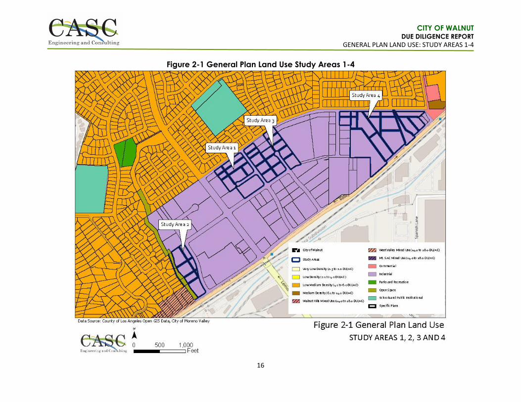
Figure 2-1 General Plan Land Use Study Areas 1-4 ...................................................................... 16
Figure 2-2 Zoning Study Areas 1-4 ............................................................................................... 17
Figure 2-3 General Plan Land Use Study Area 5 ........................................................................... 18
Figure 2-4 Zoning Study Area 5 .................................................................................................... 19
Figure 2-5 General Plan Land Use Study Area 6 ........................................................................... 20
Figure 2-6 Zoning Study Area 6 .................................................................................................... 21
Figure 2-7 Aerial Study Area 1 ...................................................................................................... 22
Figure 2-8 Aerial Study Area 2 ...................................................................................................... 23
Figure 2-9 Aerial Study Area 3 ...................................................................................................... 24
Figure 2-10 Aerial Study Area 4 .................................................................................................... 25
Figure 2-11 Aerial Study Area 5 .................................................................................................... 26
Figure 2-12 Aerial Study Area 6 .................................................................................................... 27
SECTION 3: OPPORTUNITIES AND CONSTRAINTS ANALYSIS .................................................. 28
Study Areas No. 1 – 4 .............................................................................................................................. 28
Study Area No. 5 ..................................................................................................................................... 30
Study Area No. 6 (optional) .................................................................................................................... 32
Housing Element Update Consistency ................................................................................................... 33

CITY OF WALNUT DUE DILIGENCE REPORT
INTRODUCTION
4
SECTION 1: INTRODUCTION
PURPOSE The City of Walnut (City) is currently in the process of updating the City’s General Plan Housing Element in preparation for the 6th Cycle of the City’s Regional Housing Needs Assessment (RHNA). Based on the SCAG 6th Cycle Final RHNA Allocation Plan approved on March 22, 2021, the City has a total allocation of RHNA 1,293 dwelling units and a No Net Loss from of 170 dwelling units that must be accounted for from the previous cycle. Thus, the City is proposing to update and replace the City’s R-2 and R-3 Zone districts with a modern, user-friendly form-based Zoning Ordinance Amendment (Amendment) and Zoning Map with higher residential density categories to implement the Housing Element Update. This purpose of this Due Diligence Report (Report) is to provide a summary and review of the proposed five (5) Study Areas and one (1) optional Study Area selected by the City of Walnut (City) as potential locations to be rezoned under the Housing Element Update (2021 – 2029) and General Plan Amendment. The report identifies the opportunities and constraints of the Study Areas for future development within infill areas located in the City. The goal of the City is to provide a form-based code that achieves a specific urban design theme. The new Code will assist in transitioning existing land uses into a Housing District that is vibrant with unique streetscapes and innovated design concepts. This report provides a description of each Study Area; opportunities and constraints analysis for each Study Area; conclusions; and the Windshield Survey Report.
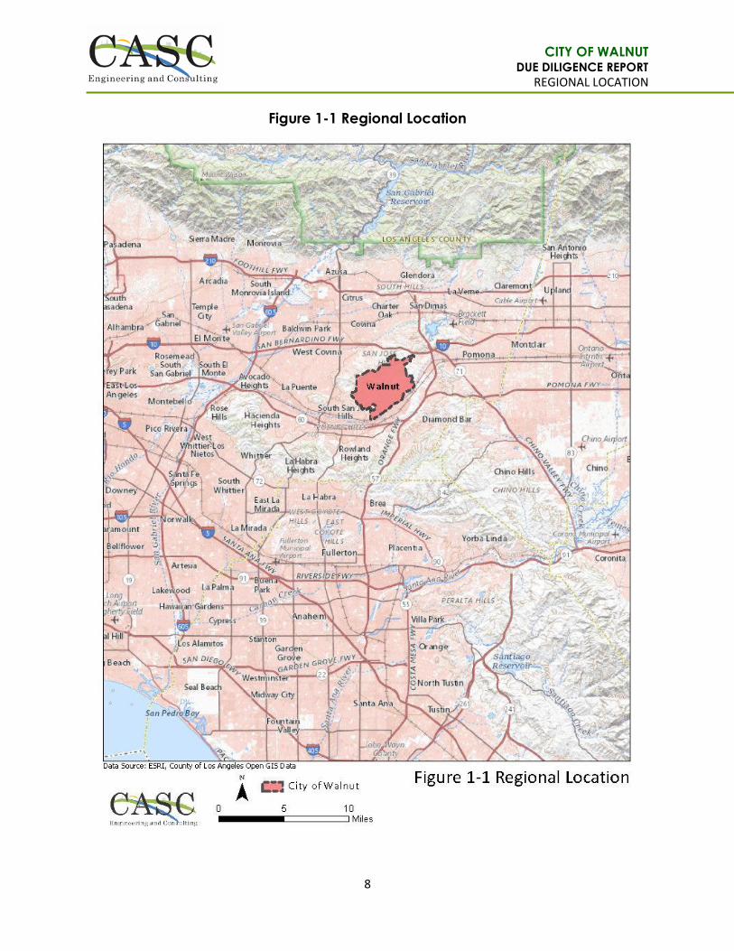
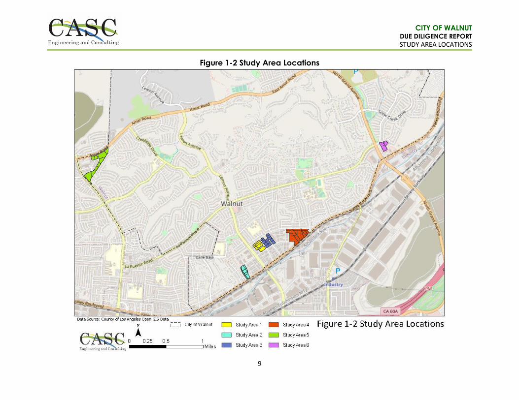
CITY HISTORY The City is located in the eastern part of the San Gabriel Valley and Los Angeles County, adjacent to the cities of Diamond Bar, Industry, Pomona, West Covina, and San Dimas. The City’s corporate limits encompass approximately 8.9 square miles. Figure 1-1, (Regional Location), identifies the regional context of Walnut, and Figure 1-2, (Study Area Locations), illustrates the six (6) Study Areas. The City is known as a quaint equestrian community encompassing a small-town atmosphere with natural open spaces, creeks, trails, and parks. The City consists primarily of low-density residential development, with a scattering of commercial centers, light industrial, and public and institutional uses. As of 2018, the City has nearly 31,000 residents and just over 9,000 housing units. Local businesses and institutions provide approximately 9,300 jobs in the City.
GENERAL PLAN The City’s General Plan was formally adopted on May 9, 2018. Serving as a blueprint for future development, the General Plan established policies that protect and plan for the small-town character of the City. The key guiding principles within the Plan are as follows:
Maintain Small-Town Community.
Ensure Public Safety.
Quality Community Services.
Support Economic Diversity and Vitality.
Support Lifelong Learning.
Preserve Community Resources.
Embrace Accessibility.
Ensure Responsive Government.
The General Plan covers Land Use and Community Design; Housing; Circulation; Conservation, Open Space, and Recreation; Community Facilities and Infrastructure; Public Safety; and the Noise Elements. The Land Uses within the Land Use and Community Design Element(s) consist of residential, commercial, and industrial uses. A majority of the City was developed in the 1980s by various companies, providing many forms of architecture within distinct low-density neighborhoods. Multi-family residential development within the City is currently limited. However, with rising housing costs and consumer demand for more diversified product, opportunities to build higher residential neighborhoods is a possibility. The City’s residential designations include Very Low Density Residential (0.5 to 2.0 DU/AC); Low Density Residential (2.1 to 4.0 DU/AC); Low Medium Density Residential (4.1 to 6.0 DU/AC); and Medium Density Residential (6.1 to 14.0 DU/AC). At this time, the City does not

CITY OF WALNUT DUE DILIGENCE REPORT
INTRODUCTION
5
currently have Medium High, nor High land use designations identified within the General Plan. The General Plan covers a timeframe from 2018 extending to 2040.
HOUSING ELEMENT UPDATE The City is currently in the process of updating the Housing Element in preparation for the 6th Cycle of the City’s Regional Housing Needs Assessment (RHNA). The current Housing Element was adopted in 2014 and was found to be in compliance with the State Housing Element Law by the Department of Housing and Community Development (HCD). The RHNA allows communities to anticipate growth so that collectively, the region and sub-regions in Southern California may grow in ways that enhance quality of life, improve access to jobs, promote transportation mobility, and address fair share housing needs. Based on the SCAG 6th Cycle Final RHNA Allocation Plan approved on March 22, 2021, the City has a total of RHNA 1,293 units and a No Net Loss of 170 units that must be accounted for. Of the 1,293, the City needs 427 very-low-income units, 225 low income units, 231 moderate income units, and 410 above moderate income units. Since the current General Plan includes residential densities only up to 14 DU/AC and mixed-use density designations from 14.0 to 28.0 DU/AC, a Medium-High Density and High-Density residential designation should be considered to meet the projected densities required for the City’s RHNA allocation numbers.
STUDY AREA PROJECT DESCRIPTIONS This report analyzed six (6) Study Areas in the City, comprised of 56.32 acres and 53 non-residential parcels currently under consideration for the new Medium-High to High Density Housing District. The Study Areas are as follows:
Study Area No. 1 encompasses eight (8) parcels on 5.94 acres and is bounded by Carrey Road to the north, South Lemon Avenue to the west, Paseo Del Prado to the south, and Paseo Sonrisa to the east.
Study Area No. 2 encompasses six (6) parcels on 5.31 acres and is bounded by a parking lot and commercial building to the north, Lemon Creek Dr. to the east, Valley Blvd. to the south, and single-family homes and an auto center to the west.
Study Area No. 3 encompasses thirteen (13) parcels on 7.46 acres and is bounded by Carrey Road to the north, Paseo Sonrisa to the west, and Paseo Del Prado to the south.
Study Area No. 4 encompasses sixteen (16) parcels on 18.49 acres and is bounded by single family residential to the north, railroad, and warehouse to the south, warehouse/commercial to the west, and multi-family residential development/industrial to the east.
Study Area No. 5 encompasses eight (8) parcels on 14.94 acres and is bounded by Amar Road to the north and Francesca Drive to the east.
Study Area No. 6 (optional) encompasses two (2) parcels on approximately 4.18 acres and is bounded by La Puente Road and Rodeo Way to the north, Grand Avenue to the west, and Valley Boulevard to the south.

CITY OF WALNUT DUE DILIGENCE REPORT
INTRODUCTION
6
Table 1 – General Plan Land Use and Zoning Information
The following section is a more detailed breakdown of the existing land uses of the proposed Study Areas: General Plan – Industrial: (Study Areas 1, 2, 3, and 4) The General Plan describes that the Industrial land use designation allows for light manufacturing, commercial storage, craftsman and artisan assembly and production, and limited vehicle service repair. Limited commercial retail and office uses are allowed as well. Prohibited uses include commercial warehousing, trucking and transportation-related businesses, large-scale utilities and energy production activities, and heavy manufacturing. Zoning Ordinance - Light Manufacturing (M-1): (Study Areas 1, 2, 3, and 4) Section 6.48.050 of the Walnut Municipal Code (WMC) limits structures in the M-1 Zone to two (2)-stories or thirty-five (35’) feet in height, whichever is less. Each parcel has a minimum lot area of no less than 7,200 square feet, with a minimum lot width of not less than sixty (60’) feet. Additionally, each parcel has a maximum lot coverage by building or structure of sixty (60%) percent of the lot area. Any front yard or setback line adjacent to all major and secondary highways must be fifty (50’) feet minimum, of which the rear thirty (30’) feet may be used for off-street parking; or thirty (30’) feet provided the off-street parking is located a minimum of fifty (50’) feet from the front property line. Any front yard or setback line adjacent to local streets shall be ten (10’) feet and no off-street parking is permitted in the setback area. Additionally, all portions of the required setback area not used for access way or off-street parking must be landscaped and permanently maintained perpendicular to the street. Wherever the M-1 Zone is adjacent to a residential zone, the yard requirements detailed in Section 6.48.060 of the WMC are required on all major and secondary highways. Walnut Hills Mixed-Use District: (Study Area 5) The Walnut Hills Mixed-Use district encompasses properties at the City’s Amar Road/Nogales Street gateway, including all properties fronting along Francesca Drive. The General Plan describes that the Walnut Hills Mixed-Use-designation allows for additional residential development, as well as office spaces. Clear and well-designed pedestrian connections must be made to link uses together. Public plazas and green spaces should reinforce the community-serving nature of the district and provide places that can be used for public gatherings and events. Francesca Mixed-Use Specific Plan: (Study Area 5) The Francesca Mixed-Use Specific Plan was adopted in March 2008, and is comprised of non-contiguous lots totaling 3.23 acres. This area was approved for age-restricted senior housing condominiums and general, neighborhood, and retail commercial uses.
Snow Creek Village Specific Plan: (Study Area 6) The Snow Creek Village Specific Plan was adopted in January 2001 and provides for the orderly development of 37.7
acres with a mix of residential housing, senior assisted living, and commercial uses. The residential component consists
Study Area No. General Plan Land Use Designation Zone
1 Industrial Light Manufacturing (M-1)
2 Industrial Light Manufacturing (M-1)
3 Industrial Light Manufacturing (M-1)
4 Industrial Light Manufacturing (M-1)
5 Walnut Hills Mixed Use, Francesca
Mixed Use Specific Plan Heavy Commercial (C-3), Heavy Commercial and Specific Plan
Overlay (C3-SP)
6 Commercial, Snow Creek Village
Specific Plan Heavy Commercial (C-3), Heavy Commercial and Specific Plan
Overlay (C3-SP)

CITY OF WALNUT DUE DILIGENCE REPORT
INTRODUCTION
7
of 15.9 acres of low-density single-family homes. The senior assisted living land use designation includes 6.5 acres,
and the commercial area is 15.3 acres of general commercial retail/restaurant uses.
Zoning Ordinance - Heavy Commercial (C-3): (Study Areas 5 and 6) Section 6.44.050 of the WMC details that premises in the C-3 Zone shall have a minimum lot area of not less than 7,200 square feet and a minimum lot width of sixty (60’) feet. No parcel of land in Zone C-3 shall have a building or structure in excess of two (2)-stories or thirty-five (35’) feet in height, whichever is less. Additionally, the maximum lot coverage by buildings or structures is fifty (50%) percent of the lot area. Front yard setbacks shall be fifteen (15’) feet along all street frontages. Where properties are adjacent to a residential zone, side yards shall be not less than ten (10’) feet in width and rear yards shall be not less than ten (10’) feet in depth where lot lines adjoin residential zone. The General Plan describes that the commercial land use designation accommodates commercial services, retail, professional and creative offices, restaurants, entertainment, hospitality, and similar uses that support local and regional needs. Businesses should have limited impact on adjacent residential areas, particularly in terms of lighting, signage, traffic, odor, noise, and hours of operation. Commercial development should be designed and intended to accommodate and encourage pedestrian access and connectivity and must be compatible with surrounding development in terms of scale, building design, materials, color, and overall enhanced architecture.
CITY OF WALNUT DUE DILIGENCE REPORT
REGIONAL LOCATION
8
Figure 1-1 Regional Location
CITY OF WALNUT DUE DILIGENCE REPORT
STUDY AREA LOCATIONS
9
Figure 1-2 Study Area Locations
CITY OF WALNUT DUE DILIGENCE REPORT
DUE DILIGENCE RESEARCH: STUDY AREA 1
10
SECTION 2: DUE DILIGENCE RESEARCH
Study Area No. 1
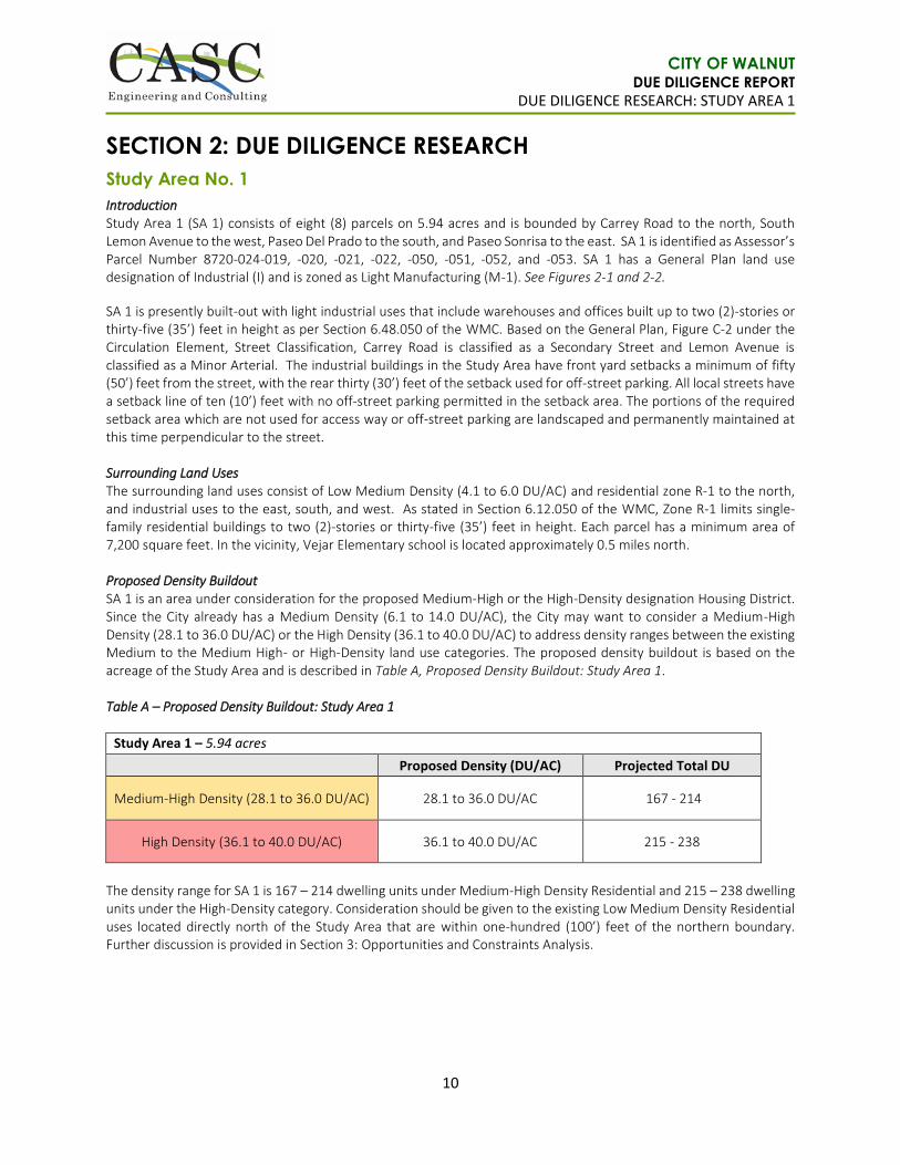
Introduction Study Area 1 (SA 1) consists of eight (8) parcels on 5.94 acres and is bounded by Carrey Road to the north, South Lemon Avenue to the west, Paseo Del Prado to the south, and Paseo Sonrisa to the east. SA 1 is identified as Assessor’s Parcel Number 8720-024-019, -020, -021, -022, -050, -051, -052, and -053. SA 1 has a General Plan land use designation of Industrial (I) and is zoned as Light Manufacturing (M-1). See Figures 2-1 and 2-2.
SA 1 is presently built-out with light industrial uses that include warehouses and offices built up to two (2)-stories or thirty-five (35’) feet in height as per Section 6.48.050 of the WMC. Based on the General Plan, Figure C-2 under the Circulation Element, Street Classification, Carrey Road is classified as a Secondary Street and Lemon Avenue is classified as a Minor Arterial. The industrial buildings in the Study Area have front yard setbacks a minimum of fifty (50’) feet from the street, with the rear thirty (30’) feet of the setback used for off-street parking. All local streets have a setback line of ten (10’) feet with no off-street parking permitted in the setback area. The portions of the required setback area which are not used for access way or off-street parking are landscaped and permanently maintained at this time perpendicular to the street. Surrounding Land Uses The surrounding land uses consist of Low Medium Density (4.1 to 6.0 DU/AC) and residential zone R-1 to the north, and industrial uses to the east, south, and west. As stated in Section 6.12.050 of the WMC, Zone R-1 limits single-family residential buildings to two (2)-stories or thirty-five (35’) feet in height. Each parcel has a minimum area of 7,200 square feet. In the vicinity, Vejar Elementary school is located approximately 0.5 miles north. Proposed Density Buildout SA 1 is an area under consideration for the proposed Medium-High or the High-Density designation Housing District. Since the City already has a Medium Density (6.1 to 14.0 DU/AC), the City may want to consider a Medium-High Density (28.1 to 36.0 DU/AC) or the High Density (36.1 to 40.0 DU/AC) to address density ranges between the existing Medium to the Medium High- or High-Density land use categories. The proposed density buildout is based on the acreage of the Study Area and is described in Table A, Proposed Density Buildout: Study Area 1. Table A – Proposed Density Buildout: Study Area 1
Study Area 1 – 5.94 acres
Proposed Density (DU/AC) Projected Total DU
Medium-High Density (28.1 to 36.0 DU/AC) 28.1 to 36.0 DU/AC 167 - 214
High Density (36.1 to 40.0 DU/AC) 36.1 to 40.0 DU/AC 215 - 238
The density range for SA 1 is 167 – 214 dwelling units under Medium-High Density Residential and 215 – 238 dwelling units under the High-Density category. Consideration should be given to the existing Low Medium Density Residential uses located directly north of the Study Area that are within one-hundred (100’) feet of the northern boundary. Further discussion is provided in Section 3: Opportunities and Constraints Analysis.
CITY OF WALNUT DUE DILIGENCE REPORT
DUE DILIGENCE RESEARCH: STUDY AREA 2
11
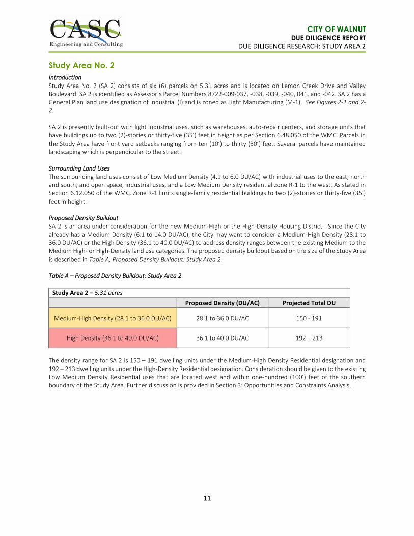
Study Area No. 2
Introduction Study Area No. 2 (SA 2) consists of six (6) parcels on 5.31 acres and is located on Lemon Creek Drive and Valley Boulevard. SA 2 is identified as Assessor’s Parcel Numbers 8722-009-037, -038, -039, -040, 041, and -042. SA 2 has a General Plan land use designation of Industrial (I) and is zoned as Light Manufacturing (M-1). See Figures 2-1 and 2-2. SA 2 is presently built-out with light industrial uses, such as warehouses, auto-repair centers, and storage units that have buildings up to two (2)-stories or thirty-five (35’) feet in height as per Section 6.48.050 of the WMC. Parcels in the Study Area have front yard setbacks ranging from ten (10’) to thirty (30’) feet. Several parcels have maintained landscaping which is perpendicular to the street. Surrounding Land Uses The surrounding land uses consist of Low Medium Density (4.1 to 6.0 DU/AC) with industrial uses to the east, north and south, and open space, industrial uses, and a Low Medium Density residential zone R-1 to the west. As stated in Section 6.12.050 of the WMC, Zone R-1 limits single-family residential buildings to two (2)-stories or thirty-five (35’) feet in height. Proposed Density Buildout SA 2 is an area under consideration for the new Medium-High or the High-Density Housing District. Since the City already has a Medium Density (6.1 to 14.0 DU/AC), the City may want to consider a Medium-High Density (28.1 to 36.0 DU/AC) or the High Density (36.1 to 40.0 DU/AC) to address density ranges between the existing Medium to the Medium High- or High-Density land use categories. The proposed density buildout based on the size of the Study Area is described in Table A, Proposed Density Buildout: Study Area 2. Table A – Proposed Density Buildout: Study Area 2
Study Area 2 – 5.31 acres
Proposed Density (DU/AC) Projected Total DU
Medium-High Density (28.1 to 36.0 DU/AC) 28.1 to 36.0 DU/AC 150 - 191
High Density (36.1 to 40.0 DU/AC) 36.1 to 40.0 DU/AC 192 – 213
The density range for SA 2 is 150 – 191 dwelling units under the Medium-High Density Residential designation and 192 – 213 dwelling units under the High-Density Residential designation. Consideration should be given to the existing Low Medium Density Residential uses that are located west and within one-hundred (100’) feet of the southern boundary of the Study Area. Further discussion is provided in Section 3: Opportunities and Constraints Analysis.

CITY OF WALNUT DUE DILIGENCE REPORT
DUE DILIGENCE RESEARCH: STUDY AREA 3
12
Study Area No. 3
Introduction Study Area No. 3 (SA 3) consists of thirteen (13) parcels on 7.46 acres and is bounded by Carrey Road to the north, Paseo Sonrisa to the west, and Paseo Del Prado to the south. SA 3 is identified as Assessor’s Parcel Numbers 8720-024-006, -007, -033, -034, -035, -036, -037, -038, -039, -040, -041, -042, and -043. SA 3 has a General Plan land use designation of Industrial (I) and is zoned as Light Manufacturing (M-1). See Figures 2-1 and 2-2. SA 3 is presently built-out with light industrial uses consisting of warehouses, and other businesses, that are up to two (2)-stories or thirty-five (35’) feet in height as per Section 6.48.050 of the WMC. Based on the General Plan, Figure C-2 under the Circulation Element, Street Classification, Carrey Road is classified as a Secondary Street. Parcels in the Study Area have front yard setbacks ranging from ten (10’) to thirty (30’) feet. Several parcels have maintained landscaping which is perpendicular to the street. Surrounding Land Uses The surrounding land uses consist of Low Medium Density (4.1 to 6.0 DU/AC) with residential zone R-1 to the north, and industrial uses to the east, south, and west. As stated in Section 6.12.050 of the WMC, Zone R-1 limits single-family residential buildings to two (2)-stories or thirty-five (35’) feet in height. Each parcel has a minimum area of 7,200 square feet. In the vicinity, Vejar Elementary school is located approximately 0.5 miles north. Proposed Density Buildout SA 3 is an area under consideration for the proposed Medium-High or the High-Density Housing District. Since the City already has a Medium Density (6.1 to 14.0 DU/AC), the City may want to consider a Medium-High Density (28.1 to 36.0 DU/AC) or the High Density (36.1 to 40.0 DU/AC) to address density ranges between the existing Medium to the Medium High- or High-Density land use categories. The proposed density buildout based on the size of the Study Area is described in Table A, Proposed Density Buildout: Study Area 3. Table A – Proposed Density Buildout: Study Area 3
Study Area 3 – 7.46 acres
Proposed Density (DU/AC) Projected Total DU
Medium-High Density (28.1 to 36.0 DU/AC) 28.1 to 36.0 DU/AC 210 - 269
High Density (36.1 to 40.0 DU/AC) 36.1 to 40.0 DU/AC 270 - 299
The density range for SA 3 is 210 – 269 dwelling units under the Medium-High Density Residential designation and 270 – 299 dwelling units under the High-Density Residential designation. Consideration should be given to the Low Medium Density Residential uses that are located directly north and within one-hundred (100’) feet of the northern boundary of the Study Area. Further discussion is provided in Section 3: Opportunities and Constraints Analysis.
CITY OF WALNUT DUE DILIGENCE REPORT
DUE DILIGENCE RESEARCH: STUDY AREA 4
13
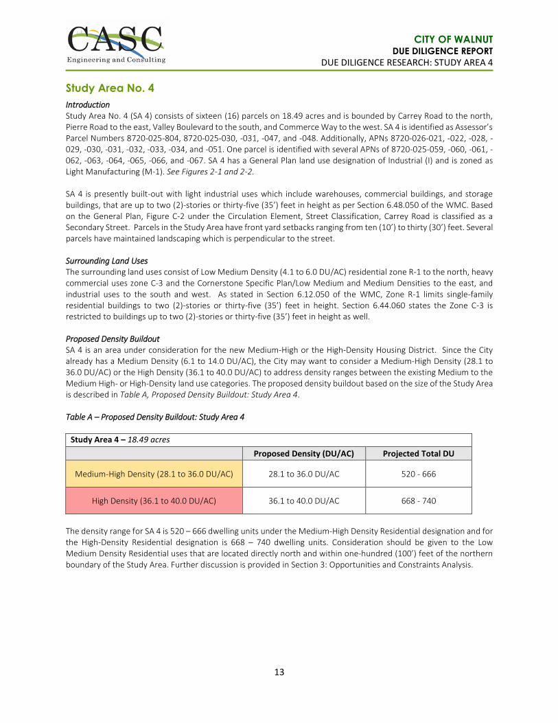
Study Area No. 4
Introduction Study Area No. 4 (SA 4) consists of sixteen (16) parcels on 18.49 acres and is bounded by Carrey Road to the north, Pierre Road to the east, Valley Boulevard to the south, and Commerce Way to the west. SA 4 is identified as Assessor’s Parcel Numbers 8720-025-804, 8720-025-030, -031, -047, and -048. Additionally, APNs 8720-026-021, -022, -028, -029, -030, -031, -032, -033, -034, and -051. One parcel is identified with several APNs of 8720-025-059, -060, -061, -062, -063, -064, -065, -066, and -067. SA 4 has a General Plan land use designation of Industrial (I) and is zoned as Light Manufacturing (M-1). See Figures 2-1 and 2-2. SA 4 is presently built-out with light industrial uses which include warehouses, commercial buildings, and storage buildings, that are up to two (2)-stories or thirty-five (35’) feet in height as per Section 6.48.050 of the WMC. Based on the General Plan, Figure C-2 under the Circulation Element, Street Classification, Carrey Road is classified as a Secondary Street. Parcels in the Study Area have front yard setbacks ranging from ten (10’) to thirty (30’) feet. Several parcels have maintained landscaping which is perpendicular to the street. Surrounding Land Uses The surrounding land uses consist of Low Medium Density (4.1 to 6.0 DU/AC) residential zone R-1 to the north, heavy commercial uses zone C-3 and the Cornerstone Specific Plan/Low Medium and Medium Densities to the east, and industrial uses to the south and west. As stated in Section 6.12.050 of the WMC, Zone R-1 limits single-family residential buildings to two (2)-stories or thirty-five (35’) feet in height. Section 6.44.060 states the Zone C-3 is restricted to buildings up to two (2)-stories or thirty-five (35’) feet in height as well. Proposed Density Buildout SA 4 is an area under consideration for the new Medium-High or the High-Density Housing District. Since the City already has a Medium Density (6.1 to 14.0 DU/AC), the City may want to consider a Medium-High Density (28.1 to 36.0 DU/AC) or the High Density (36.1 to 40.0 DU/AC) to address density ranges between the existing Medium to the Medium High- or High-Density land use categories. The proposed density buildout based on the size of the Study Area is described in Table A, Proposed Density Buildout: Study Area 4. Table A – Proposed Density Buildout: Study Area 4
Study Area 4 – 18.49 acres
Proposed Density (DU/AC) Projected Total DU
Medium-High Density (28.1 to 36.0 DU/AC) 28.1 to 36.0 DU/AC 520 - 666
High Density (36.1 to 40.0 DU/AC) 36.1 to 40.0 DU/AC 668 - 740
The density range for SA 4 is 520 – 666 dwelling units under the Medium-High Density Residential designation and for the High-Density Residential designation is 668 – 740 dwelling units. Consideration should be given to the Low Medium Density Residential uses that are located directly north and within one-hundred (100’) feet of the northern boundary of the Study Area. Further discussion is provided in Section 3: Opportunities and Constraints Analysis.

CITY OF WALNUT DUE DILIGENCE REPORT
DUE DILIGENCE RESEARCH: STUDY AREA 5
14
Study Area No. 5
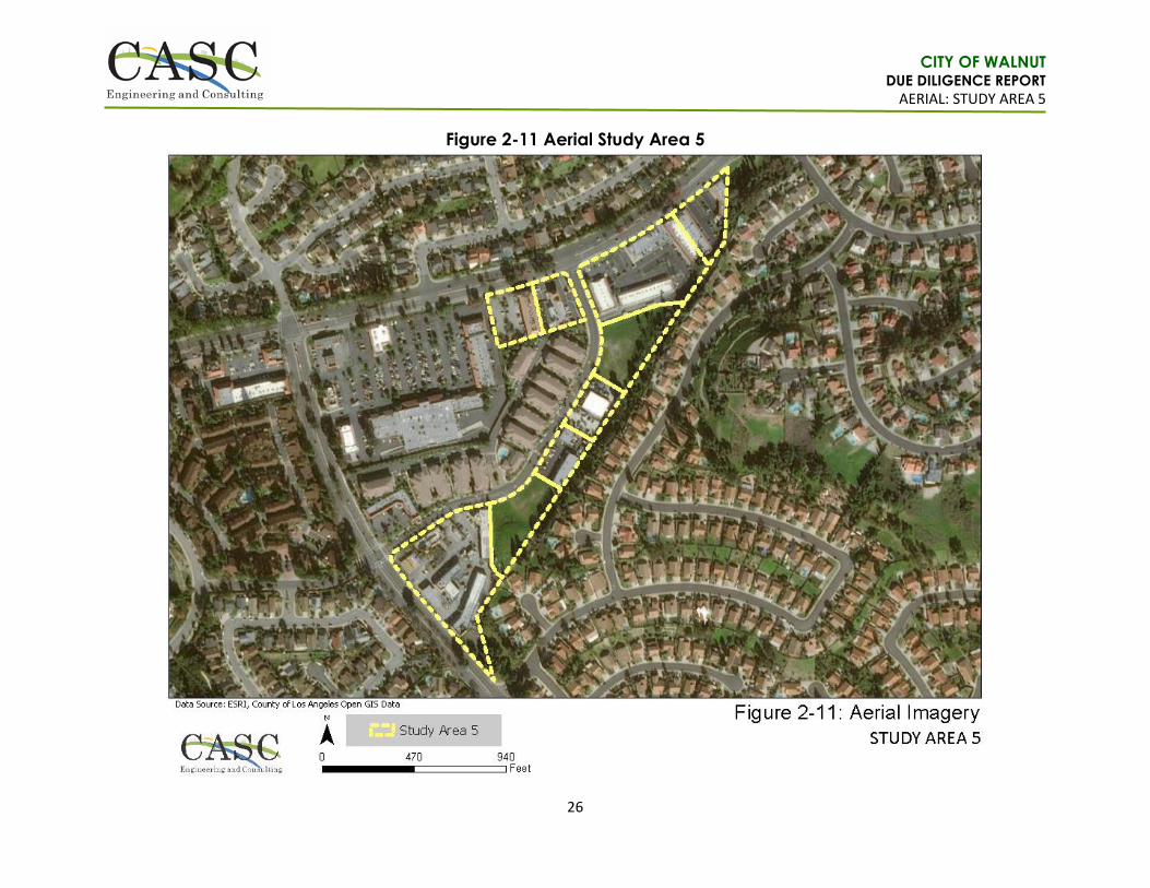
Introduction Study Area No. 5 (SA 5) consists of nine (9) parcels on 14.94 acres and is bounded by Amar Road to the north and Francesca Drive to the east. SA 5 is identified as 800 Nogales Street, 715-735 Nogales Street, 750 Nogales Street, 755-855 Francesca Drive, 825-855 Francesca Drive, 18780 Amar Road and 18790 Amar Road. Additionally, one (1) parcel without an address is identified as Assessor’s Parcel Number 8735-026-059. SA 5 has a General Plan land use designation of Walnut Hills Mixed Use (14 to 28 D.U.) and Francesca Mixed Use Specific Plan and is zoned as Heavy Commercial (C-3) and Heavy Commercial and Specific Plan Overlay (C3-SP). See Figures 2-3 and 2-4. SA 5 consists of parcels which are presently built-out with commercial uses, such as office buildings, retail, eateries, auto repair, and a private school, with buildings that are up to two (2)-stories or thirty-five (35’) feet in height as per Section 6.48.050 of the WMC. Additionally, two (2) parcels are vacant but disturbed (i.e. disced). Based on the General Plan, Figure C-2 under the Circulation Element, Street Classification, Amar Road is classified as a Minor Arterial. Parcels in the Study Area have front yard setbacks fifteen (15’) feet along street frontages. Several parcels have maintained landscaping which is perpendicular to Amar Road. Surrounding Land Uses The surrounding land uses consist of single family residential (8 D.U./AC) in the City of West Covina to the north, Low Density (2.1 to 4.0 DU/AC) residential zone Residential Planned Development (R.P.D.) to the east and south, and heavy commercial uses zone C-3 to the west. The RPD Zone has a minimum lot size of 14,800 square feet and 2.5 dwelling units per acre. As stated in Section 6.12.050 of the WMC, Zone R-1 limits single-family residential buildings to two (2)-stories or thirty-five (35’) feet in height. Section 6.44.060 states the Zone C-3 is restricted to buildings up to two (2)-stories or thirty-five (35’) feet in height as well. Additionally, the Walnut Grove Specific Plan is located directly west of SA 5 and is developed with Senior Housing Condominiums. Proposed Density Buildout SA 5 is an area under consideration for the new Medium-High or the High-Density Housing District. Since the City already has a Medium Density (6.1 to 14.0 DU/AC), the City may want to consider a Medium-High Density (28.1 to 36.0 DU/AC) or the High Density (36.1 to 40.0 DU/AC) to address density ranges between the existing Medium to the Medium High- or High-Density land use categories. The proposed density buildout based on the size of the Study Area is described in Table A, Proposed Density Buildout: Study Area 5. Table A – Proposed Density Buildout: Study Area 5
Study Area 5 – 14.94 acres
Proposed Density (DU/AC) Projected Total DU
Medium-High Density (28.1 to 36.0 DU/AC) 28.1 to 36.0 DU/AC 420 - 538
High Density (36.1 to 40.0 DU/AC) 36.1 to 40.0 DU/AC 540 - 598
The density range for SA 5 is 420 – 538 dwelling units under the Medium-High Density Residential and is 540 – 598 dwelling units for the High-Density Residential designation. Consideration should be given to the Low Medium Density Residential uses that are located directly north and within one-hundred (100’) feet of the eastern boundary of the Study Area. Further discussion is provided in Section 3: Opportunities and Constraints Analysis.

CITY OF WALNUT DUE DILIGENCE REPORT
DUE DILIGENCE RESEARCH: STUDY AREA 6
15
Study Area No. 6 (optional)
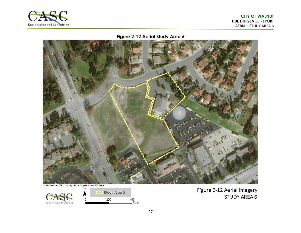
Introduction Study Area No. 6 (SA 6) consists of two (2) parcels on 4.18 acres and is bounded by Rodeo Way to the north and Grand Avenue to the west. SA 6 is identified as Assessor’s Parcel Number 8709-057-028 and -029. APN 8709-057-028 has a General Plan land use designation of Commercial but falls within the Snow Creek Village Specific Plan, and is zoned Heavy Commercial and Specific Plan Overlay (C3-SP). APN 8709-057-029 has a General Plan land use designation of Commercial and is zoned as Heavy Commercial (C-3). The Walnut Sheriff Station borders the parcels to the south. See Figures 2-5 and 2-6. APN 8709-057-028 is vacant undeveloped land that appears to be routinely disturbed (i.e. disced) and APN 8709-057-029 is developed with a private school. Pursuant to Section 6.44.060 of the Municipal Code, Zone C-3 restricts buildings up to two (2)-stories or thirty-five (35’) feet in height. Based on the General Plan, Figure C-2 under the Circulation Element, Street Classification, Grand Avenue is classified as a Major Arterial, however, no development is proposed on the westerly half of APN 8709-057-028, which fronts the street. The C-3 Zone requires front yard setbacks at least fifteen (15’) feet from all street frontages. Surrounding Land Uses The surrounding land uses consist of Residential Planned Development (R.P.D.) to the north and east, and heavy commercial uses to the south and west. The RPD Zone has a minimum lot size of 16,800 square feet and 2.2 dwelling units per acre. The underlying General Plan land use designation is Low Density Residential (2.1 to 4.0 D.U./AC). As stated in Section 6.12.050 of the WMC, Zone R-1 limits single-family residential buildings to two (2)-stories or thirty-five (35’) feet in height. Section 6.44.060 states the Zone C-3 is restricted to buildings up to two (2)-stories or thirty-five (35’) feet in height as well. Proposed Density Buildout SA 6 is an area under consideration for the new Medium-High or the High-Density Housing District. Since the City already has a Medium Density (6.1 to 14.0 DU/AC), the City may want to consider a Medium-High Density (28.1 to 36.0 DU/AC) or the High Density (36.1 to 40.0 DU/AC) to address density ranges between the existing Medium to the Medium High- or High-Density land use categories. The proposed density buildout based on the size of the Study Area is described in Table A, Proposed Density Buildout: Study Area 6. Table A – Proposed Density Buildout: Study Area 6
Study Area 6 – 4.18 acres
Proposed Density (DU/AC) Projected Total DU
Medium-High Density (28.1 to 36.0 DU/AC) 28.1 to 36.0 DU/AC 118 - 151
High Density (36.1 to 40.0 DU/AC) 36.1 to 40.0 DU/AC 152 - 168
The density range for SA 6 is 118 – 151 dwelling units under Medium-High Density Residential designation and is 152 – 168 dwelling units under the High-Density Residential designation. Consideration should be given to the Low Medium Density Residential uses are located directly north and within one-hundred (100’) feet of the eastern boundary of the Study Area. Further discussion is provided in Section 3: Opportunities and Constraints Analysis.
CITY OF WALNUT DUE DILIGENCE REPORT
GENERAL PLAN LAND USE: STUDY AREAS 1-4
16
Figure 2-1 General Plan Land Use Study Areas 1-4

CITY OF WALNUT DUE DILIGENCE REPORT
ZONING: STUDY AREAS 1-4
17
Figure 2-2 Zoning Study Areas 1-4
CITY OF WALNUT DUE DILIGENCE REPORT
GENERAL PLAN LAND USE: STUDY AREA 5
18
Figure 2-3 General Plan Land Use Study Area 5

CITY OF WALNUT DUE DILIGENCE REPORT
ZONING: STUDY AREA 5
19
Figure 2-4 Zoning Study Area 5

CITY OF WALNUT DUE DILIGENCE REPORT
GENERAL PLAN LAND USE: STUDY AREA 6
20
Figure 2-5 General Plan Land Use Study Area 6

CITY OF WALNUT DUE DILIGENCE REPORT
ZONING: STUDY AREA 6
21
Figure 2-6 Zoning Study Area 6
CITY OF WALNUT DUE DILIGENCE REPORT
AERIAL: STUDY AREA 1
22
Figure 2-7 Aerial Study Area 1

CITY OF WALNUT DUE DILIGENCE REPORT
AERIAL: STUDY AREA 2
23
Figure 2-8 Aerial Study Area 2
CITY OF WALNUT DUE DILIGENCE REPORT
AERIAL: STUDY AREA 3
24
Figure 2-9 Aerial Study Area 3
CITY OF WALNUT DUE DILIGENCE REPORT
AERIAL: STUDY AREA 4
25
Figure 2-10 Aerial Study Area 4
CITY OF WALNUT DUE DILIGENCE REPORT
AERIAL: STUDY AREA 5
26
Figure 2-11 Aerial Study Area 5
CITY OF WALNUT DUE DILIGENCE REPORT
AERIAL: STUDY AREA 6
27
Figure 2-12 Aerial Study Area 6

CITY OF WALNUT DUE DILIGENCE REPORT
OPPORTUNITIES AND CONSTRAINTS ANALYSIS: STUDY AREAS 1-4
28
SECTION 3: OPPORTUNITIES AND CONSTRAINTS ANALYSIS
Study Areas No. 1 – 4
BACKGROUND
Commerce Centers The nearest grocery store for Study Areas 1 – 4 is located less than one (1) mile north, approximately a fifteen (15) to twenty (20)-minute walk of the areas under consideration for the new housing districts. The nearest United States Postal Service is located at 280 S. Lemon Avenue and is within a five (5) to ten (10)-minue walk of the Study Areas. Additional commercial centers and shopping areas are located within a few miles of the four Study Areas. Transit/Transportation The nearest bus stop to Study Areas 1, 2, and 3 is provided by Foothill Transit/Metropolitan Transportation Authority (MTA) and is located on the corner of Valley Boulevard and Lemon Avenue, approximately a five (5) to ten (10)-minute walking distance from these areas. Additionally, another bus stop is located at Valley Boulevard and Pierre Road, which is within a five (5)-minute walking distance of Study Area 4. The nearest Metrolink to the Study Areas is the Industry Metrolink Station, located at 600 South Brea Canyon Road in the City of Industry, less than two (2) miles away. The nearest Park & Ride is the Walnut Park & Ride lot located on La Puente Road, less than two (2) miles away. The nearest Amtrak is the Amtrak Pomona Station located at 100 W. Commercial Street in the City of Pomona, approximately eight (8) miles away. Recreation The closest parks to Study Area 1 – 4 include Lemon Creek Bicentennial Park (within 0.5 mile), Butterfield Park (within 1.5 miles), Walnut Hills Park (within 2 miles), Suzanne Park (within 2 miles), City of West Covina’s Friendship Park (within 2 miles), and Norman Ashley Park (within 1.5 miles). Lemon Creek Bicentennial Park is within a ten (10)-minute walking distance of Study Areas 1 – 3. Nearby recreational facilities include Walnut Gymnasium and Teen Center (within 2 miles) and the City’s Maintenance Department and Recreation Services (MDRS) building (within 2.5 miles). Schools The closest schools to the study are Vejar Elementary (0.5 to 1 mile away), Ron Hockwalt Academies (within 1 mile), Cyrus J. Morris Elementary (within 1.5 miles), Walnut High School (within 1.5 miles), Walnut Elementary (within 1.5 miles), and Suzanne Middle School (within 2 miles). At a greater distance are Westhoff Elementary (within 3 miles), South Pointe Middle School (within 3 miles), and Collegewood Elementary (within 3.5 miles). Walnut Unified School District provides transportation services for children to and from school. Public Services The Walnut Library is within two (2) miles of Study Areas 1 – 4. The nearest police station is the Walnut-Diamond Bar Sheriff’s Department located within 2.5 miles of the Study Areas. The nearest fire station is the Los Angeles County Fire Department, Station 61, located within one (1) mile of the Study Areas. All hospitals are located within a nine (9)-mile radius. Opportunities and Constraints Analysis Changing the land uses of Study Areas 1 – 4 would involve a General Plan Amendment and Zone Change to either the Medium-High Residential designation or the High-Density Residential designation. The primary constraint regarding the rezoning of Study Areas 1 – 4 to Medium-High or the High-Density residential designation is the proximity to existing Low Density Residential and Low Medium Density Residential uses located directly adjacent to each Study Area. This includes the following locations:

CITY OF WALNUT DUE DILIGENCE REPORT
OPPORTUNITIES AND CONSTRAINTS ANALYSIS: STUDY AREAS 1-4
29
North side of Study Area 1
West side of Study Area 2
North side of Study Area 3
North side of Study Area 4 Currently, the height of buildings in the Light Manufacturing (M-1) and Residential (R-1) are limited to two (2)-stories or thirty-five (35’) feet in height, whichever is less. Enforcing similar height restrictions for the Housing District would mitigate potential visual and aesthetic impacts to neighboring communities. However, the Housing District could potentially include structures up to three (3) to four (4) stories in height. Thus, the anticipated buildings within Study Areas 1 – 4 could potentially be an impact to the existing residences. Building placement, massing, and articulation will be a critical component of the proposed residential development adjacent to the existing residential developments to avoid potential impacts. Study Area 2 is in a unique location where there is a riparian buffer Zoned as Open Space located adjacent to the western boundary of the Study Area. The riparian corridor would serve as a visual buffer between the single-family residential community to the south and the proposed Housing District on Study Area 2. The riparian buffer provides habitat and protection for Lemon Creek, which flows into the San Jose Creek Channel. Impacts to existing residences around Study Area 2 would be lower than Study Areas 1, 3, and 4. Additionally, the Study Area has direct access to the “Schabarum-Skyline Trail” which traverses through the riparian buffer and connects to the City-wide trail system. Public Safety Public safety is an important consideration for the development of the six (6) Study Areas. While the buildout of the Study Areas would increase the population of the City of Walnut, the General Plan states many policies and procedures which are adequate to serve the increase in residency. Study Areas 1 – 4 are within two (2) to three (3) miles of the Sheriff’s Station and one (1) to two (2) miles of the Fire Station 61. The Study Areas are not located in any designated fire severity zones or areas of historic fires. Furthermore, according to FEMA Flood Insurance Rate Maps for the City of Walnut, Study Areas 1 – 4 are located in Zone X, which indicated areas outside of the 0.2% annual chance floodplain. Walnut Valley Water District (WVWD) provides water services to the City of Walnut and would serve the proposed Study Areas. The General Plan states that the City of Walnut experiences few incidents of violent crime and many goals and policies are included in the Public Safety element to guide crime prevention and protection services. Furthermore, public outreach and education will be necessary to ensure that the community has a say in the proposed buildout of the Housing District. Another consideration is the effects additional housing would have on congestion and circulation throughout the Project area. Buildout of Study Areas 1 – 4 as Medium-High and/or High Density residential would generate additional vehicle trips throughout the area and would increase traffic congestion in the vicinity. There are alternative transit opportunities such as, the Foothill Transit/MTA, the Metrolink, and the Walnut Park & Ride. Conclusion Overall, the locations of Study Areas 1 – 4 are potentially suitable for implementation of the proposed Housing District. Primary considerations should take into account the location of the proposed dwelling units adjacent to existing residential development, building height, massing, parking design, location to nearby recreational opportunities as well as commercial and employment centers. Based on the Medium-High Residential designation of 28.1 DU/AC – 36.0 DU/AC, the City could potentially provide between 1,047 – 1,340 dwelling units and 1,345 – 1,490 dwelling units under the High-Density Residential designation of 36.5 – 40.0 DU/AC. Please note the High-Density Residential designation may be more of a challenge to develop due to public perception and locations adjacent to existing residential developments.

CITY OF WALNUT DUE DILIGENCE REPORT
OPPORTUNITIES AND CONSTRAINTS ANALYSIS: STUDY AREA 5
30
Study Area No. 5
BACKGROUND
Commerce Centers The nearest grocery store to Study Area 5 is located within 1.5 miles to the south, approximately a thirty (30)-minute walk of the Study Area. The nearest United States Postal Service is located at 280 S. Lemon Avenue and is within three (3) miles. Additional commercial centers and shopping areas are located within a few miles of the Study Area. Transit/Transportation The nearest bus stop to Study Area 5 is provided by Foothill Transit/MTA and is located on the corner of Amar Road and Nogales Avenue East, approximately a five (5)-minute walking distance from the proposed Housing District. The nearest Metrolink to the Study Area is the Industry Metrolink Station, located at 600 South Brea Canyon Road in the City of Industry, approximately four (4) miles south. The nearest Amtrak Station located at 100 W. Commercial Street in the City of Pomona, approximately nine (9) miles away. Overall, the Foothill Transit/MTA is the most optimal transit option within walking and driving distance for the Study Area under consideration. Recreation The closest parks to Study Area 5 include Creekside Park (within 1 mile), Shadow Oak Park (within 1 mile), and Gingrich Park in the City of West Covina (within 2 miles). Nearby recreational facilities include Walnut Gymnasium and Teen Center (within 4 miles) and the City’s Maintenance Department and Recreation Services (MDRS) building (within 5 miles). Schools The closest schools to the Study Area are Collegewood Elementary (within 3 miles), Cyrus J. Morris Elementary (within 3 miles), Vejar Elementary (within 3 miles), Walnut Elementary (approximately 4 miles away), Westhoff Elementary (within 2 miles), Suzanne Middle School (within 3.5 miles), Walnut High School (within 3.5 miles), and Ron Hockwalt Academies (within 3.5 miles). Walnut Unified School District provides transportation services for children to and from school. Public Services The Walnut Library is within three (3) miles of Study Area 5. The nearest police station is the Walnut-Diamond Bar Sheriff’s Department located within a five (5)-mile driving radius of the Study Area. The nearest fire station is the Los Angeles County Fire Department, Station 61, located within a three (3) mile driving radius of the Study Area. All hospitals are located within a nine (9) mile radius. Opportunities and Constraints Analysis Changing the land uses of Study Area 5 would involve a General Plan Amendment and Zone Change from Heavy Commercial (C-3) to Residential to either the Medium-High Density designation or the High Density designation. The primary constraint regarding the rezoning of Study Area 5 is the proximity to existing residential uses located directly north and east of the Study Area. Currently, the height of buildings in the Commercial (C-3) and Residential (R-1) Zones are limited to two (2)-stories or thirty-five (35’) feet in height, whichever is less. Enforcing similar height restrictions for the Housing District would mitigate potential visual and aesthetic impacts to neighboring communities. However, the Housing District could potentially include structures up to three (3) to four (4) stories in height. Thus, the anticipated buildings within Study Area 5 could potentially be a visual and aesthetic impact to the existing residences on the eastern boundary. Public Safety Public safety is an important consideration for the development of housing districts. While the buildout of the Study Area would increase the population of the City of Walnut, the General Plan states many policies and procedures which are adequate to serve the increase in residency. Study Area 5 is within five (5) miles of the Sheriff’s Station and three (3) miles of the Fire Station 61. The Study Area is not located in any designated fire severity zone or an area of historic

CITY OF WALNUT DUE DILIGENCE REPORT
OPPORTUNITIES AND CONSTRAINTS ANALYSIS: STUDY AREA 5
31
fires. Additionally, the Study Area is not within a flood hazard area. Walnut Valley Water District (WVWD) provides water services to the City of Walnut and would serve the proposed Study Area. The General Plan states that the City of Walnut experiences few incidents of violent crime and many goals and policies are included in the Public Safety element to guide crime prevention and protection services. Furthermore, public outreach and education will be necessary to ensure community input in the proposed buildout of the Housing District. Another consideration is the effects additional housing would have on congestion and circulation throughout the Project area. Buildout of Study Area 5 as Medium-High Density or High Density residential would generate additional vehicle trips throughout the area and would increase traffic congestion in the vicinity. While there are alternative transit opportunities such as the Foothill Transit/MTA there are no major transportation centers within a reasonable walking distance (15 minutes) or a quarter mile of the Study Area. Thus, development of the Study Area would have direct impacts to traffic congestion. Conclusion Overall, the location of Study Areas 5 is suitable for development of the new Housing District. The primary considerations to take into account regard the height and massing of the proposed buildings, parking opportunities to serve the residents, and the density of buildout. Based on the Medium-High Density designation, the City could potentially provide 420 – 538 dwelling units and 540 – 598 dwelling units under the High Density designation. Please note the High-Density designation may be more of a challenge to develop due to public perception and locations adjacent to existing residential development to the north and east of the Study Area.
CITY OF WALNUT DUE DILIGENCE REPORT
OPPORTUNITIES AND CONSTRAINTS ANALYSIS: STUDY AREA 6
32
Study Area No. 6 (optional)
BACKGROUND
Commerce Centers The nearest grocery store to Study Area 6 is located within 0.5 miles to the southwest, approximately a seven (7)-minute walk of the Study Area. The nearest United States Postal Service is located at 280 S. Lemon Avenue and is within three (3) miles. Additional commercial centers and shopping areas are located within a few miles of the Study Area. Transit/Transportation The nearest bus stop to Study Area 6 is provided by Foothill Transit/MTA and is located at Grand Avenue and La Puente Road, a two (2)-minute walking distance from the proposed Housing District. The nearest Metrolink to the Study Sreas is the Industry Metrolink Station, located at 600 South Brea Canyon Road in the City of Industry, approximately two (2) miles south. The nearest Amtrak Station is located at 100 W. Commercial Street in the City of Pomona, over eight (8) miles away. Recreation A City trail which connects to Snow Creek Park is located just across the street from the Study Area. There is approximately 0.4 miles of trail between the Study Area and Snow Creek Park, allowing it to be within a ten (10)-minute walking distance from Study Area 6. Suzanne Park is located approximately one (1)-mile west of Study Area 6 within a twenty (20)-minute walk. Schools The closest schools to the study are Suzanne Middle School (within 1-mile), Walnut High School (within 1-mile), Vejar Elementary School (within 2.5 miles), and Leonard G. Westhoff Elementary School (within 2.5 miles). Walnut Unified School District provides transportation services for children to and from school. Public Services The Walnut Library is within 0.5 miles of Study Area 6. The nearest police station is the Walnut-Diamond Bar Sheriff’s Department is located directly east of the Study Area. The nearest fire station is the Los Angeles County Fire Department, Station 146, located within a two (2)-mile driving radius of the Study Area. All hospitals are located over 8-miles away. Opportunities and Constraints Analysis Changing the land uses of Study Area 6 would involve a General Plan Amendment Zone Change from Heavy Commercial (C-3) to Residential to either the Medium-High Density designation or the High Density designation. The primary constraint regarding the rezoning of Study Area 6 is the proximity to the existing residential uses located directly north and east of the Study Area. Currently, the height of buildings in the Commercial (C-3) and Residential (R-1) Zones are limited to two (2)-stories or thirty-five (35’) feet in height, whichever is less. Enforcing similar height restrictions for the Housing District would mitigate potential visual and aesthetic impacts to neighboring communities. However, the Housing District could potentially include structures up to three (3) to four (4) stories in height. Thus, the anticipated buildings within Study Area 6 could potentially be a visual and aesthetic impact to the existing residences on the eastern boundary. Public Safety Public safety is an important consideration for the development of housing districts. While the buildout of the Study Area would increase the population of the City of Walnut, the General Plan states many policies and procedures which are adequate to serve the increase in residency. Study Area 6 is directly adjacent to the Sheriff’s station and within two (2) miles of the Fire Station 61. The Study Area is not located in any designated fire severity zone or an area of historic fires. Additionally, the Study Area is not within a flood hazard area. Walnut Valley Water District (WVWD) provides water services to the City of Walnut and would serve the proposed Study Area.

CITY OF WALNUT DUE DILIGENCE REPORT
OPPORTUNITIES AND CONSTRAINTS ANALYSIS: STUDY AREA 6
33
The General Plan states that the City of Walnut experiences few incidents of violent crime and many goals and policies are included in the Public Safety element to guide crime prevention and protection services. Furthermore, public outreach and education will be necessary to ensure that the community has a voice in the proposed buildout of the Housing District. Another consideration is the effects additional housing would have on congestion and circulation throughout the Project area. Buildout of Study Area 6 as Medium-High Density residential would generate additional vehicle trips throughout the area and would increase traffic congestion in the vicinity. However, there are alternative transit opportunities such as the Foothill Transit/MTA and the Metrolink in the vicinity of the Study Area. Thus, nearby transit opportunities may help to mitigate potential effects on congestion and traffic. Conclusion Study Area 6 is an “optional” study area under consideration for development. It is included in this document for informational purposes only and is not a priority area under consideration for the new Housing District. Overall, the location of Study Areas 6 is suitable for medium to high density residential. The primary considerations to take into account regard the height and massing of the proposed buildings, parking opportunities to serve the residents, and the density of buildout. Study Area 6 has direct access to nearby parks, trails, commerce centers, and schools within a reasonable walking distance.
Housing Element Update Consistency
As previously noted, the City is currently in the process of updating the Housing Element in preparation for the 6th Cycle of the City’s Regional Housing Needs Assessment (RHNA). The RHNA allows communities to anticipate growth so that collectively, the region and subregions in Southern California may grow in ways that enhance quality of life, improve access to jobs, promote transportation mobility, and address fair share housing needs. Based on the SCAG 6th Cycle Final RHNA Allocation Plan approved on March 22, 2021, the City has a total allocation of RHNA 1,293 dwelling units and a No Net Loss of 170 dwelling units that must be accounted for. Based on Study Areas 1 - 6, the City could potentially provide 1,585 – 2,256 dwelling units under the proposed Medium-High Density and the High-Density ranges which is consistent with the SCAG 6th Cycle Final RHNA Allocation Plan of 1,293 dwelling units.

CITY OF WALNUT DUE DILIGENCE REPORT
APPENDIX A: WINDSHEILD SURVEY
34
APPENDIX A: Windshield Survey