DRAFT MALAYSIAN 12G004R1 STANDARD - SIRIM … · 2014-06-30 · whose authority this Malaysian...
340
DRAFT MALAYSIAN 12G004R1 STANDARD STAGE : PUBLIC COMMENT (40.20) DATE : 01/07/2014 - 31/08/2014 Geographic information/geomatics - Feature and attribute codes (First Revision) OFFICER/SUPPORT STAFF: (WR / ) ICS: 35.080 Descriptors: data processing, information interchange, network interconnection, communication procedure, management, concepts, models, rules (instructions), feature, attribute code © Copyright 2014 DEPARTMENT OF STANDARDS MALAYSIA For Public Comment
-
Upload
nguyencong -
Category
Documents
-
view
217 -
download
0
Transcript of DRAFT MALAYSIAN 12G004R1 STANDARD - SIRIM … · 2014-06-30 · whose authority this Malaysian...

DRAFT
MALAYSIAN 12G004R1
STANDARD STAGE : PUBLIC COMMENT (40.20)
DATE : 01/07/2014 - 31/08/2014
Geographic information/geomatics - Feature and attribute codes (First Revision) OFFICER/SUPPORT STAFF: (WR / )
ICS: 35.080 Descriptors: data processing, information interchange, network interconnection, communication
procedure, management, concepts, models, rules (instructions), feature, attribute code
© Copyright 2014
DEPARTMENT OF STANDARDS MALAYSIA
For Pub
lic Com
ment

For Pub
lic Com
ment

12G004R1
© STANDARDS MALAYSIA 2014 - All rights reserved i
Contents Page Committee representation ..........................................................................................................ii Foreword .................................................................................................................................... iii Introduction ................................................................................................................................iv 1 Scope ............................................................................................................................ 1 2 Normative references ................................................................................................... 1 3 Terms and definitions ................................................................................................... 1 4 Features and attributes ................................................................................................. 1 Annex A Feature codes ........................................................................................................ 7
Annex B Attribute codes ................................................................................................... 231 Bibliography ........................................................................................................................... 333
For Pub
lic Com
ment

12G004R1
ii © STANDARDS MALAYSIA 2014 - All rights reserved
Committee representation
The Industry Standards Committee on Information Technology, Communications and Multimedia (ISC G) under whose authority this Malaysian Standard was developed, comprises representatives from the following organisations: Association of Consulting Engineers Malaysia CyberSecurity Malaysia Department of Standards Malaysia Federation of Malaysian Manufacturers Institut Tadbiran Awam Negara, Malaysia (INTAN) Malaysian Administrative, Modernisation and Management Planning Unit (MAMPU) Malaysian International Chamber of Commerce and Industry Malaysian National Computer Confederation Malaysian Technical Standards Forum Berhad MIMOS Berhad Ministry of Communication and Multimedia Ministry of Energy, Green Technology and Water Ministry of International Trade and Industry Ministry of International Trade and Industry Ministry of Science, Technology and Innovation Multimedia Development Corporation Sdn Bhd Multimedia University Persatuan Industri Komputer dan Multimedia Malaysia Prime Minister's Department Science and Technology Research Institute for Defence SIRIM Berhad (Secretariat) Suruhanjaya Komunikasi dan Multimedia Malaysia The Institution of Engineers, Malaysia TM Applied Business Sdn Bhd Universiti Teknologi Malaysia The Technical Committee on Geaographic Information/Geomatics which developed this Malaysian Standard consists of representatives from the following organisations: Agensi Remote Sensing Malaysia Astronautic Technology (M) Sdn Bhd Department of Agriculture Malaysia Department of Survey and Mapping Malaysia Department of Town and Country Planning ESRI Malaysia Sdn Bhd Jabatan Kerja Raya Malaysia Malaysian Agricultural Research and Development Institute Malaysian Centre for Geospatial Data Infrastructure Minerals and Geoscience Department Malaysia Ministry of Natural Resources and Environment National Space Agency SIRIM Berhad (Secretariat) Universiti Putra Malaysia Universiti Sains Malaysia Universiti Teknologi Malaysia Universiti Teknologi MARA
For Pub
lic Com
ment

12G004R1
© STANDARDS MALAYSIA 2014 - All rights reserved iii
Foreword This Malaysian Standard was developed by the Technical Committee on Geographic Information/Geomatics under the authority of the Industry Standards Committee on Information Technology, Communications and Multimedia. This Malaysian Standard cancels and replaces MS 1759:2004, Geographic information/geomatics - Feature and attribute codes. Compliance with a Malaysian Standard does not of itself confer immunity from legal obligations.
For Pub
lic Com
ment

12G004R1
iv © STANDARDS MALAYSIA 2014 - All rights reserved
Introduction
This Malaysian Standard is intended for use by all businesses that produce, distribute or utilise
geospatial data, either alone or in conjunction with non-geospatial data. These range from
geographic information systems, decision support systems, data mining, data warehousing, to
modelling and simulations. Application areas include but not limited to resource planning and
management, automated mapping, geo-engineering, construction, communication, transportation
and utilities.
It provides a system for feature and attribute coding by which producers and users of geographic
information may use in structuring their digital spatial data. This standard facilitates sharing and
exchanging between both data producers and users.
For Pub
lic Com
ment

12G004R1
© STANDARDS MALAYSIA 2014 - All rights reserved 1
Geographic information/geomatics - Feature and attribute codes (First revision)
1 Scope This Malaysian Standard specifies the method for encoding of geospatial data and provides the description of features and their associated attributes for the exchange of digital geographic information.
2 Normative references The following normative references are indispensable for the application of this standard. For dated references, only the edition cited applies. For undated references, the latest edition of the normative reference (including any amendments) applies. ISO/TS 19104, Geographic information - Terminology
3 Terms and definitions For the purposes of this Malaysian Standard, the terms and definitions given in ISO/TS 19104:2008 apply.
4 Features and attributes This Standard describes the encoding of the world in terms of features and attributes. Features are real world objects while attributes are properties or characteristics associated with the objects. 4.1 Coding of features and attributes
This standard has not been developed to the requirements of any single application or level of
resolution. This standard is also not meant to support any specific digital product.
As with any dictionary, there may be more than one way to encode spatial entities, either by offering a choice of features or a combination of features and attributes. For example, an airport is listed as feature AB0010 - Aerodrome "A defined area on land or water intended to be used either wholly or in part for the arrival, departure and surface movement of aircrafts", could also be coded as feature BD0010 - Institutional Building with attribute INU "Institutional Usage" with a coded value of 001 "Airport Terminal". The choice is entirely up to user’s own application and interpretation; to code only the terminal building or the entire aerodrome area. Feature codes are shown in Annex A and Attribute codes and values are given in Annex B. Annex B also provides information as to the units, formats, ranges, increments and maximum text characters typically associated with each actual value attribute. If a feature does not reside within this standard, it is allowed for a user-designated features and associated attributes. Otherwise, features and attributes shall be encoded using this standard. The process for amending and updating this standard is described in 4.3.
For Pub
lic Com
ment

12G004R1
2 © STANDARDS MALAYSIA 2014 - All rights reserved
4.2 Coding structure 4.2.1 Features Each feature is identified by a unique six-character code. The first character corresponds to the feature category and can have an alphabetic value from A through Z. Currently there are twelve feature categories, including one category, X, which has been reserved for special use (dataset-specific) features. The categories are as follows:
CODE CATEGORY A Aeronautical B Built Environment D Demarcation G Geology H Hydrography R Hypsography S Soil T Transportation U Utility V Vegetation X Special Use (Dataset-specific) Z General
Each major category is further divided into subcategories which are identified by the second character of the six-digit code, containing an alphabetic value from A through Z. The subcategories that have currently been defined for each major category are as follows:
A-Aeronautical AA Air Space AB Aerodrome
B-Built Environment BA Residential BB Commercial BC Industrial BD Institutional BE Educational BF Religious BG Recreational BH Cemetery BJ Built-up D-Demarcation DA Topographic DB Maritime DC Cadastral DD Planning Land Use G-Geology GA Geolithology GB Mineral GC Fossils GD Mining GE Exploration GF Geological Features GG Geoscience
For Pub
lic Com
ment

12G004R1
© STANDARDS MALAYSIA 2014 - All rights reserved 3
H-Hydrography HA Coastal Hydrography HB Shoreline Structures HC Fishing Facillities HD Ports and Harbours HE Navigation Aids HF Danger and Hazard HG Depth Information HH Inland Water HJ River Structure HK Offshore HL Island HM Miscellaneous
R-Hypsography RA Relief Portrayal
S-Soil SA Histosols SB Spodosols SC Andisols SD Oxisols SE Vertisols SF Ultisols SG Mollisols SH Alfisols SJ Inceptisols SK Entisols SM Miscelaneous Soil Unit
T-Transportation TA Land Transportation TB Water Transportation
U-Utility UA Electricity UB Telecommunication UC Water Supply UD Oil and Gas UE Broadcasting UF Sewerage UG Waste Management UH Meteorological
V-Vegetation VA Agriculture VB Forest VC Miscellaneous
X-Special Use (Dataset specific) XA Terrain Analysis Dataset XB Meteorological Dataset XC Imagery and Gridded Dataset
Z-General ZA Control Points ZB Label of Geographical Names ZC Environmental Controls
For Pub
lic Com
ment

12G004R1
4 © STANDARDS MALAYSIA 2014 - All rights reserved
For the purpose of small scale mapping, a special feature code is allocated to identify general built-up area (BZ0000) and vegetation area (VZ0000). The third, fourth, fifth and sixth characters of the six-character feature code are a numeric value from 0000 through 9999. This value provides unique feature identification within categories yet allows flexibility. All features shall be identified by all six alphanumeric characters (for example, the feature “Road” is represented by TA0060). The block of feature code values from 8000 through 8999 has been reserved for special usage, e.g. usage within a particular agency or a group of users. Due to hierarchical nature of geology features, the first, second, third and fourth numeric represent the level of hierarchy of the feature within a particular subcategory. The first numeric represents the first level, the second numeric represents the second level, and the third numeric represents the third level, and so on, if they are not ‘0’. The value of the numeric is the feature number within that particular level. ‘0’ means that the level is undefined. Due to hierarchical nature of soil features, the first numeric represents the region i.e. ‘1’ represents Peninsular Malaysia; ‘2’ represents Sarawak and ‘3’ represents Sabah. The second and third numeric represent the soil families. The fourth numeric represents the soil series except those with ‘0’ represents the families. For other categories of features (other than geology and soil), the numeric simply represents feature number within a particular subcategory.
4.2.2 Attributes Attributes are used to describe characteristics of a feature. Each attribute is described by using attribute codes to represent the category of information. Attribute value format statements provide a computer interpretation for the attribute value data type (e.g. real, alphanumeric) and attribute values give quantitative/qualitative meaning to the attribute code. An attribute can be used by any feature, but care shall be taken so that only meaningful attributes are chosen for a particular feature. For example, syntactically, an attribute “Lift Facilities” can be used with feature “Rail Line”, but semantically, the combination is useless. A list of possible attributes for each feature have been provided for the convenient of users. 4.2.2.1 Attribute codes Each attribute is identified by a unique three character alphanumeric code. For example, the attribute “Road Service Area” has the code RDS and the attribute “Bridge Construction Material Type” has the code BMT. 4.2.2.2 Attribute values There are two types of attribute values: coded and actual. A given attribute has only one type of value, which is specified in Annex B. Coded values may be given as alpha, numeric or combination of alpha and numeric and each of the value has its own meaning. Meanwhile actual values are typically real measurements like height, width, date, etc. The units of measurement associated with an attribute are abbreviated according to the units of measurement codes as detailed in Annex B. A coded value attribute can be logically depicted as shown below:
Attribute Coded Attribute Value Format Attribute Value (coded in this case) RDS I 2
For Pub
lic Com
ment

12G004R1
© STANDARDS MALAYSIA 2014 - All rights reserved 5
where RDS represents Road Service Area; I is the format of the coded value (in this case the format is that of a 4-byte integer);
and
2 represents the coded value of the RUC attribute (in this case Rural). For consistency and unless otherwise stated, the following coded values will be used where relevant:
0 is “Unknown” (except for SDG) 996 is “None” 997 is “Mixed” 998 is “Not Applicable” 999 is “Others”
The block of coded attribute values from 600 through 899 has been reserved for special
usage, e.g. usage within a particular agency or a group of users. Actual value can have a format of either:
A Alphanumeric; I Integer; L Lexical; R Real Number; or S Structure Text.
For example, a Road (feature code TA0060) which has the route number “J23”, has four lanes, and is dual carriageway, would be attributed as follows: Attribute code Attribute value format Attribute value (actual) RTN (Route Number) LAN (Number of Lane) CWT (Carriageway Type)
A I I
J23 4 2
4.2.2.3 Range value attributes
Normally attributes are single valued text strings, numbers or enumerated values. However, at times it is necessary to assign values that fall within predetermined ranges. This can be done through an enumerated list that pre-defined the permitted ranges. For example, an attribute for height may be defined as:
0 < 10 1 10 to <20 2 20 to <30 3 30 to <40 4 > 40
4.3 Rules for documenting new features and attributes This standard should be used during the development of specifications of digital application systems to support and satisfy the exchange of spatial information. However, this standard can be modified and updated in response to dynamic technology and evolving requirements. If this standard does not contain the required features, the standard allows for amendment to incorporate extensions and additions.
For Pub
lic Com
ment
12G004R1
6 © STANDARDS MALAYSIA 2014 - All rights reserved
This sub clause lists the rules that are used to document the features and attributes contained in Annexes A and B. All extensions and additions shall also follow these rules: a) feature and attribute names should be precise and unambiguous; b) attribute values should be self-describing; c) a feature and attribute should not have the same name; d) a feature or attribute can have multiple names but only one definition; e) a feature or attribute name should not be used in the description of the feature or
attributes; f) a feature name or definition should not specify if the feature is an area, point or line
feature; g) a feature should be relatively permanent; h) a feature should not be duplicated between categories; i) all attribute values are positive unless otherwise stated; j) a boundary is just a spatial object or information that be considered a line feature and not
a perimeter or solid surface of an area or spatial feature; and k) the systematic structure of the coding schema should be permanent. The features and attributes in this standard represent both spatial information and information which is considered important in geographic information system. Care should be taken to restrict additions to this standard to items of a stable nature only. Users should, for the development of their feature and attribute requirements, seek inter-organisation co-operation and co-ordination.
For Pub
lic Com
ment

12G004R1
© STANDARDS MALAYSIA 2014 - All rights reserved 7
Annex A (normative)
Feature Codes
A - AERONAUTICAL
AA - Air Space Feature Code: AA0010 Feature Name: Air Space Description: Designated airspace within which some or all aircraft may be
subjected to air traffic control. Feature Class: Polygon Possible Attribute: Name (NAM), Area Measured (km²) (ARK), Airspace Identification
Attribute (AIA), Air Space Category (ASC)
Feature Code: AA0020 Feature Name: Limited Activity Air Space Description: Air space where activities shall be confined because of their nature
and/or where limitations may be imposed upon aircraft operations. Feature Class: Polygon Possible Attribute: Name (NAM), Area Measured (km²) (ARK), Airspace Use Limitations
(AUL) Feature Code: AA0030 Feature Name: Navigation Aid Description: Any visual electronic device which provides point-to-point guidance
information or position data. Feature Class: Point Possible Attribute: Name (NAM), Navigation Aid Type (NAT) Feature Code: AA0040 Feature Name: Air Route Description: A specific route designated for channelling the flow of traffic as
necessary for the provision of air traffic service. Feature Class: Line Possible Attribute: Name (NAM), Air Route Segments Length (ALN), Air Route Usage
(ARU)
AB - Aerodrome
Feature Code: AB0010 Feature Name: Aerodrome Description: A defined area on land or water (including any buildings, installations
and equipments) intended to be used either wholly or in part for the arrival, departure and surface movement of aircraft.
Feature Class: Polygon Possible Attribute: Name (NAM), Area Measured (h) (ARH), Certainty of Delineation
(COD)
For Pub
lic Com
ment

12G004R1
8 © STANDARDS MALAYSIA 2014 - All rights reserved
Feature Code: AB0020 Feature Name: Airfield Description: A land aerodrome with limited facilities. Feature Class: Line, Polygon Possible Attribute: Name (NAM), Area Measured (m²) (ARM), Airfield Type (APT),
Certainty of Delineation (COD) Feature Code: AB0030 Feature Name: Aerodrome Control Tower Description: A high rise structure from where air traffic control service to aerodrome
is provided. Feature Class: Point Possible Attribute: Name (NAM) Feature Code: AB0040 Feature Name: Aerodrome Beacon Description: A light, visible intermittently at all azimuths, used to indicate the
location of an aerodrome from the air. Feature Class: Point Possible Attribute: Name (NAM) Feature Code: AB0050 Feature Name: Runway Description: A defined rectangular area on a land aerodrome prepared for the
landing and take-off of aircraft. Feature Class: Line, Polygon Possible Attribute: Name (NAM), Area Measured (m²) (ARM), Length (LEN), Width (WID),
Road Surface Composition (RSC), Airfield/Aerodrome Elevation (ZV3) Feature Code: AB0060 Feature Name: Runway Strip Description: A defined area including the runway and stopway, if provided,
intended:
a) To reduce the risk or damage to aircraft running off a runway; and,
b) To protect aircraft flying over it during take-off or landing
operations. Feature Class: Line, Polygon Possible Attribute: Name (NAM), Area Measured (m²) (ARM), Length (LEN), Width (WID),
Road Surface Composition (RSC), Airfield/Aerodrome Elevation (ZV3) Feature Code: AB0070 Feature Name: Stopway Description: A defined rectangular area at the end of a runway in the direction of
take-off, which has been selected or prepared as a suitable area in which an aircraft can be stopped after an interrupted take-off.
Feature Class: Polygon Possible Attribute: Name (NAM), Area Measured (m²) (ARM), Width (WID),
Road Surface Composition (RSC), Airfield/Aerodrome Elevation (ZV3)
For Pub
lic Com
ment

12G004R1
© STANDARDS MALAYSIA 2014 - All rights reserved 9
Feature Code: AB0080 Feature Name: Clearway Description: A rectangular area at the end of the take-off run, available, selected,
or prepared as a suitable area over which an aircraft may make a portion of its initial climb to a specified height.
Feature Class: Polygon Possible Attribute: Name (NAM), Area Measured (m²) (ARM)
Feature Code: AB0090 Feature Name: Approach Surface Description: A surface sloping up outwards located preceding threshold that defines
the volume of upwards airspace that should be kept free from obstacles to protect aircraft in the final phase of approach.
Feature Class: Polygon Possible Attribute: Name (NAM), Area Measured (m²) (ARM), Slope Gradient (SGR)
Feature Code: AB0100 Feature Name: Take-off Climb Surface Description: A surface sloping up outwards located beyond the end of the TORA or
clearway that defines the volume of upwards airspace that should be kept free from obstacles to protect aircraft on take-off.
Feature Class: Polygon Possible Attribute: Name (NAM), Area Measured (m²) (ARM), Slope Gradient (SGR)
Feature Code: AB0110 Feature Name: Transitional Surface Description: A surface around a runway strip sloping up outwards to the inner
horizontal surface that defines the volume of upwards air space that should be kept free from obstacles to protect aircraft in their final phase of approach.
Feature Class: Polygon Possible Attribute: Name (NAM), Area Measured (m²) (ARM), Slope Gradient (SGR),
Width (WID)
Feature Code: AB0120 Feature Name: Inner Horizontal Surface Description: A horizontal surface around a runway strip above an aerodrome and its
vicinity that defines the volume of upwards air space that should be kept free from obstacles to protect aircraft for visual circling prior to landing.
Feature Class: Polygon Possible Attribute: Name (NAM), Area Measured (m²) (ARM), Z Orthometric (ZOR), Width (WID)
Feature Code: AB0130 Feature Name: Conical Surface Description: A surface sloping up outwards from the periphery of the inner
horizontal surface that defines the volume of upwards air space that should be kept free from obstacles to protect aircraft for visual circling prior to landing.
Feature Class: Polygon Possible Attribute: Name (NAM), Area Measured (m²) (ARM), Slope Gradient (SGR),
Width (WID)
For Pub
lic Com
ment

12G004R1
10 © STANDARDS MALAYSIA 2014 - All rights reserved
Feature Code: AB0140 Feature Name: Outer Horizontal Surface Description: A specified portion of a horizontal plane beyond the limit of the conical
surface that defines the volume of upwards air space that should be kept free from obstacles to facilitate instrument approach procedures.
Feature Class: Polygon Possible Attribute: Name (NAM), Area Measured (m²) (ARM), Z Orthometric (ZOR),
Width (WID)
Feature Code: AB0150 Feature Name: Obstacle Free Zone (OFZ) Description: A volume of air space in the immediate vicinity of a precision
approach runways defined by the inner approach, inner transitional and balked landing surfaces, which shall be kept free from fixed objects.
Feature Class: Polygon Possible Attribute: Name (NAM), Area Measured (m²) (ARM) Feature Code: AB0160 Feature Name: Threshold Description: The beginning of that portion of the runway usable for landing. Feature Class: Line, Polygon Possible Attribute: Name (NAM), Area Measured (m²) (ARM) Feature Code: AB0170 Feature Name: Holding Point Description: A location on the manoeuvring area of an aerodrome at which an
aircraft carries out an engine run-up or is held before entering a runway for take-off.
Feature Class: Point Possible Attribute: Name (NAM) Feature Code: AB0180 Feature Name: Taxiway Description: A defined path on a land aerodrome established for the taxiing of
aircraft and intended to provide a link between one part of the aerodrome and another.
Feature Class: Line, Polygon Possible Attribute: Name (NAM), Area Measured (m²) (ARM), Width (WID), Road Surface Composition (RSC), Airfield/Aerodrome Elevation (ZV3) Feature Code: AB0190 Feature Name: Aircraft Parking Area Description: A specially prepared or selected part of an aerodrome within which
aircraft may be parked. Feature Class: Polygon Possible Attribute: Name (NAM), Area Measured (m²) (ARM) Feature Code: AB0200 Feature Name: Apron Description: A define area on a land aerodrome, intended to accommodate aircraft
for purposes of loading or unloading passengers, mail or cargo, and for fuelling, parking or maintenance.
Feature Class: Polygon Possible Attribute: Name (NAM), Area Measured (m²) (ARM), Width (WID), Road
Surface Composition (RSC), Airfield/Aerodrome Elevation (ZV3)
For Pub
lic Com
ment

12G004R1
© STANDARDS MALAYSIA 2014 - All rights reserved 11
Feature Code: AB0210 Feature Name: Localiser Description: A device on the ground that provides azimuth guidance to a runway
(runway centre line) to an approaching aircraft. Feature Class: Point Possible Attribute: Name (NAM) Feature Code: AB0220 Feature Name: Glideslope Description: A device on the ground that provides landing slope to an approaching
aircraft. Feature Class: Point Possible Attribute: Name (NAM) Feature Code: AB0230 Feature Name: Radar Description: A radio detection device on the ground which provides information on
range, azimuth and/or elevation of aircraft. Feature Class: Point Possible Attribute: Name (NAM) Feature Code: AB0240 Feature Name: Landing Directional Indicator Description: A device to indicate visually the direction currently designated for
landing and take-off. Feature Class: Point Possible Attribute: Name (NAM) Feature Code: AB0250 Feature Name: Wind Direction Indicator Description: A visual device used to provide wind information. Feature Class: Point Possible Attribute: Name (NAM) Feature Code: AB0260 Feature Name: Obstacle Description: All fixed (whether temporary or permanent) and mobile objects, or part
thereof, that are located on an area intended for the surface movement of aircraft or that extend above a defined surface intended to protect aircraft in flight.
Feature Class: Point Possible Attribute: Name (NAM) Feature Code: AB0270 Feature Name: Obstruction Light Description: Lights mounted on or adjacent to obstructions or potential hazards to
aircraft moving on the ground or in the navigable airspace, for the purpose of indicating the aircraft by night.
Feature Class: Point Possible Attribute: Name (NAM)
For Pub
lic Com
ment
12G004R1
12 © STANDARDS MALAYSIA 2014 - All rights reserved
Feature Code: AB0280 Feature Name: Obstruction Marker Description: Markers on or adjacent to obstructions or potential hazards to aircraft
moving on the ground or in the navigable airspace, for the purpose of indicating the aircraft by day.
Feature Class: Point Possible Attribute: Name (NAM) Feature Code: AB0290 Feature Name: Aeronautical Ground Light Description: Any light specially provided as an aid to air navigation, other than a
light displayed on an aircraft. Feature Class: Point Possible Attribute: Name (NAM), Light Characteristic Category (LCC) Feature Code: AB0300 Feature Name: Helicopter Landing Site Description: A place that is authorised to be used as an aerodrome for the purpose
of the landing and taking-off of helicopter. Feature Class: Point, Polygon Possible Attribute: Name (NAM), Area Measured (m²) (ARM), Landing Base Type (LBT),
Certainty of Delineation (COD) Feature Code: AB0310 Feature Name: Final Approach and Take-off Area Description: An area of land or water associated with a helicopter-landing site, over
which the final phase of the approach maneuver to hover or landing is completed and from which the take-off maneuver is commenced.
Feature Class: Polygon Possible Attribute: Name (NAM), Area Measured (m²) (ARM) Feature Code: AB0320 Feature Name: Touchdown and Lift Off Area Description: A load bearing area on which a helicopter may touch down or lift off. Feature Class: Point, Polygon Possible Attribute: Name (NAM), Area Measured (m²) (ARM)
For Pub
lic Com
ment

12G004R1
© STANDARDS MALAYSIA 2014 - All rights reserved 13
B - BUILT ENVIRONMENT Feature Code: BZ0000 Feature Name: Built Environment Description: An area contains building, property or place designated for use as
premises, residential, commercial, industrial, institutional, educational, religious, recreational, cemetery and built up structures.
Feature Class: Point, Polygon Possible Attribute: Name (NAM), Area Measured (ha) (ARH)
BA - Residential Feature Code: BA0010 Feature Name: Residential Building Description: Building or property designated for use as premises for dwelling units
or home. Feature Class: Point, Polygon Possible Attribute: Name (NAM), Area Measured (m²) (ARM), Building Name (BA1),
Building Number (BA2), Street Name (BA3), Post Code (BA4), State Name (BA5), Residential Building Type (RET), Number of Storey (NOS), Lift Facilities (LIF), Residential Usage (REU), Height (HEI), Length/Diameter (LEN), Width (WID), Product Category (PRO)
BB - Commercial
Feature Code: BB0010 Feature Name: Commercial Building Description: Building or property designated for use as premises for business
related activities such as trading and services. Feature Class: Point, Polygon Possible Attribute: Name (NAM), Area Measured (m²) (ARM), Building Name (BA1),
Building Number (BA2), Street Name (BA3), Post Code (BA4), State Name (BA5), Commercial Building Type (CBT), Number of Storey (NOS), Lift Facilities (LIF), Height (HEI), Length/Diameter (LEN), Width (WID), Product Category (PRO)
Feature Code: BB0020 Feature Name: Billboard Description: A huge structure used for advertising panels. Feature Class: Point Possible Attribute: Name (NAM), Registered Number (RNO), Billboard Structure (BBS),
Billboard Size (BBZ), Project or Company Name (PRJ) Feature Code: BB0030 Feature Name: Office Description: A building or place which business, administrative, clerical or
professional activities are conducted. Feature Class: Point, Polygon Possible Attribute: Name (NAM), Area Measured (m²) (ARM), Building Name (BA1),
Building Number (BA2), Street Name (BA3), Post Code (BA4), State Name (BA5), Commercial Building Type (CBT), Number of Storey (NOS), Lift Facilities (LIF), Height (HEI), Length/Diameter (LEN), Width (WID), Product Category (PRO)
For Pub
lic Com
ment

12G004R1
14 © STANDARDS MALAYSIA 2014 - All rights reserved
Feature Code: BB0031 Feature Name: Shop Office/ Shop House Description: A multi-level units on commercial area and usually with two and more
storey for business activities and residential. Feature Class: Point, Polygon Possible Attribute: Name (NAM), Area Measured (m²) (ARM), Building Name (BA1),
Building Number (BA2), Street Name (BA3), Post Code (BA4), State Name (BA5), Commercial Building Type (CBT), Number of Storey (NOS), Lift Facilities (LIF), Height (HEI), Length/Diameter (LEN), Width (WID), Product Category (PRO)
Feature Code: BB0040 Feature Name: Post Office Description: A building or an office where mail is received, sorted, and delivered,
stamps and other postal materials are sold and other postal business is conducted.
Feature Class: Point, Polygon Possible Attribute: Name (NAM), Area Measured (m²) (ARM), Building Name (BA1),
Building Number (BA2), Street Name (BA3), Post Code (BA4), State Name (BA5), Commercial Building Type (CBT), Number of Storey (NOS), Lift Facilities (LIF), Height (HEI), Length/Diameter (LEN), Width (WID), Product Category (PRO)
Feature Code: BB0050 Feature Name: Bank Description: A financial institution and a financial intermediary that accepts
deposits and channels those deposits into lending activities, either directly by loaning or indirectly through capital markets.
Feature Class: Point, Polygon Possible Attribute: Name (NAM), Area Measured (m²) (ARM), Building Name (BA1),
Building Number (BA2), Street Name (BA3), Post Code (BA4), State Name (BA5), Commercial Building Type (CBT), Number of Storey (NOS), Lift Facilities (LIF), Height (HEI), Length/Diameter (LEN), Width (WID), Product Category (PRO)
Feature Code: BB0060 Feature Name: Hotel Description: A commercial establishment that provides lodging and other services
for travellers and other paying guests. Feature Class: Point, Polygon Possible Attribute: Name (NAM), Area Measured (m²) (ARM), Building Name (BA1),
Building Number (BA2), Street Name (BA3), Post Code (BA4), State Name (BA5), Commercial Building Type (CBT), Number of Storey (NOS), Lift Facilities (LIF), Height (HEI), Length/Diameter (LEN), Width (WID), Product Category (PRO)
Feature Code: BB0061 Feature Name: Apartel Description: The collaboration or the combination of an apartment and a hotel. Feature Class: Point, Polygon Possible Attribute: Name (NAM), Area Measured (m²) (ARM), Building Name (BA1),
Building Number (BA2), Street Name (BA3), Post Code (BA4), State Name (BA5), Commercial Building Type (CBT), Number of Storey (NOS), Lift Facilities (LIF), Height (HEI), Length/Diameter (LEN), Width (WID), Product Category (PRO)
For Pub
lic Com
ment

12G004R1
© STANDARDS MALAYSIA 2014 - All rights reserved 15
Feature Code: BB0070 Feature Name: Market Description: A regular gathering of people for the purchase and sale of provisions,
livestock, and other commodities. Feature Class: Point, Polygon Possible Attribute: Name (NAM), Area Measured (m²) (ARM), Building Name (BA1),
Building Number (BA2), Street Name (BA3), Post Code (BA4), State Name (BA5), Commercial Building Type (CBT), Number of Storey (NOS), Lift Facilities (LIF), Height (HEI), Length/Diameter (LEN), Width (WID), Product Category (PRO)
Feature Code: BB0080 Feature Name: Shopping Arcade/Complex Description: One or more buildings forming a complex of shops with
interconnecting walkways enabling visitors to easily walk from unit to unit, along with a parking area.
Feature Class: Point, Polygon Possible Attribute: Name (NAM), Area Measured (m²) (ARM), Building Name (BA1),
Building Number (BA2), Street Name (BA3), Post Code (BA4), State Name (BA5), Commercial Building Type (CBT), Number of Storey (NOS), Lift Facilities (LIF), Height (HEI), Length/Diameter (LEN), Width (WID), Product Category (PRO)
Feature Code: BB0081 Feature Name: Hypermarket/Supermarket Description: A retail store that combines a department store and a grocery. Often a
very large establishment or building offer a large variety of products such as appliances, clothing and groceries.
Feature Class: Point, Polygon Possible Attribute: Name (NAM), Area Measured (m²) (ARM), Building Name (BA1),
Building Number (BA2), Street Name (BA3), Post Code (BA4), State Name (BA5), Commercial Building Type (CBT), Number of Storey (NOS), Lift Facilities (LIF), Height (HEI), Length/Diameter (LEN), Width (WID), Product Category (PRO)
Feature Code: BB0082 Feature Name: Retail Description: A building or place that sells smaller quantities of products or services
to the general public or end consumers. Feature Class: Point, Polygon Possible Attribute: Name (NAM), Area Measured (m²) (ARM), Building Name (BA1),
Building Number (BA2), Street Name (BA3), Post Code (BA4), State Name (BA5), Commercial Building Type (CBT), Number of Storey (NOS), Height (HEI), Length/Diameter (LEN), Width (WID), Product Category (PRO)
Feature Code: BB0090 Feature Name: Entertainment Centre Description: A building or place which commercially operated enterprise that offers
rides, games and other forms of fun. Feature Class: Point, Polygon Possible Attribute: Name (NAM), Area Measured (m²) (ARM), Building Name (BA1),
Building Number (BA2), Street Name (BA3), Post Code (BA4), State Name (BA5), Commercial Building Type (CBT), Number of Storey (NOS), Lift Facilities (LIF), Height (HEI), Length/Diameter (LEN), Width (WID), Product Category (PRO)
For Pub
lic Com
ment

12G004R1
16 © STANDARDS MALAYSIA 2014 - All rights reserved
Feature Code: BB0100 Feature Name: Restaurant Description: The premises or a business establishment which prepares and serves
food and drink to customers in return for money. Feature Class: Point, Polygon Possible Attribute: Name (NAM), Area Measured (m²) (ARM), Building Name (BA1),
Building Number (BA2), Street Name (BA3), Post Code (BA4), State Name (BA5), Commercial Building Type (CBT), Number of Storey (NOS), Lift Facilities (LIF), Height (HEI), Length/Diameter (LEN), Width (WID), Product Category (PRO)
Feature Code: BB0999 Feature Name: Other Commercial Building Description: The premises or a business establishment which prepares and serves
food and drink to customers in return for money. Feature Class: Point, Polygon Possible Attribute: Name (NAM), Area Measured (m²) (ARM), Building Name (BA1),
Building Number (BA2), Street Name (BA3), Post Code (BA4), State Name (BA5), Commercial Building Type (CBT), Number of Storey (NOS), Lift Facilities (LIF), Height (HEI), Length/Diameter (LEN), Width (WID), Product Category (PRO)
BC - Industrial
Feature Code: BC0010 Feature Name: Industrial Building Description: Building or property designated for use as premises for manufacturing
and processing related industry, repairing, servicing activities, foundries and warehousing/storage.
Feature Class: Point, Polygon Possible Attribute: Name (NAM), Area Measured (m²) (ARM), Building Name (BA1),
Building Number (BA2), Street Name (BA3), Post Code (BA4), State Name (BA5), Industrial Building Type (IDT), Number of Storey (NOS), Lift Facilities (LIF), Category of Industry (IDC), Industry Permit Status (IDL), Industrial Planned Category (IDP), Industry Tax Status (IDS), Industrial Usage (IDU), Height (HEI), Width (WID), Length/Diameter (LEN), Product Category (PRO)
BD - Institutional
Feature Code: BD0010 Feature Name: Institutional Building Description: Building or premises designated specifically for use by government
and its agencies, foreign embassies and other public purposes. Feature Class: Point, Polygon Possible Attribute: Name (NAM), Area Measured (m²) (ARM), Building Name (BA1),
Building Number (BA2), Street Name (BA3), Post Code (BA4), State Name (BA5), Institutional Building Type (INT), Number of Storey (NOS), Lift Facilities (LIF), Institutional Category (INC), Height (HEI), Width (WID), Length/Diameter (LEN), Product Category (PRO)
For Pub
lic Com
ment

12G004R1
© STANDARDS MALAYSIA 2014 - All rights reserved 17
Feature Code: BD0020 Feature Name: Hospital Description: An institution that provides medical, surgical, or psychiatric care and
treatment for the sick or the injured. Feature Class: Point, Polygon Possible Attribute: Name (NAM), Area Measured (m²) (ARM), Building Name (BA1),
Building Number (BA2), Street Name (BA3), Post Code (BA4), State Name (BA5), Number of Storey (NOS), Lift Facilities (LIF), Institutional Category (INC), Height (HEI), Width (WID), Length/Diameter (LEN), Product Category (PRO)
Feature Code: BD0021 Feature Name: Clinic Description: A place or a private hospital where patients and outpatients are given
medical treatment or advice and have to pay directly for their treatment.
Feature Class: Point, Polygon Possible Attribute: Name (NAM), Area Measured (m²) (ARM), Building Name (BA1),
Building Number (BA2), Street Name (BA3), Post Code (BA4), State Name (BA5), Number of Storey (NOS), Lift Facilities (LIF), Institutional Category (INC), Clinic Service Type (SCT), Height (HEI), Width (WID), Length/Diameter (LEN), Product Category (PRO)
Feature Code: BD0030 Feature Name: Fire and Rescue Station Description: A building or department in which the members of a fire department
and the equipment used to put out fires are located. Feature Class: Point, Polygon Possible Attribute: Name (NAM), Area Measured (m²) (ARM), Building Name (BA1),
Building Number (BA2), Street Name (BA3), Post Code (BA4), State Name (BA5), Number of Storey (NOS), Lift Facilities (LIF), Height (HEI), Width (WID), Length/Diameter (LEN), Product Category (PRO)
Feature Code: BD0040 Feature Name: Police Station Description: Building that serves as headquarter or station in a designated police
jurisdiction. Feature Class: Point, Polygon Possible Attribute: Name (NAM), Area Measured (m²) (ARM), Building Name (BA1),
Building Number (BA2), Street Name (BA3), Post Code (BA4), State Name (BA5), Number of Storey (NOS), Lift Facilities (LIF), Height (HEI), Width (WID), Length/Diameter (LEN), Product Category (PRO)
Feature Code: BD0041 Feature Name: Police Training Centre Description: A place or building where the process of finding and hiring the best-
qualified candidate, screening and selecting applicants for police department are conducted.
Feature Class: Point, Polygon Possible Attribute: Name (NAM), Area Measured (m²) (ARM), Building Name
(BA1),Building Number (BA2), Street Name (BA3), Post Code (BA4), State Name (BA5), Number of Storey (NOS), Lift Facilities (LIF), Institutional Category (INC), Height (HEI), Width (WID), Length/Diameter (LEN), Product Category (PRO)
For Pub
lic Com
ment

12G004R1
18 © STANDARDS MALAYSIA 2014 - All rights reserved
Feature Code: BD0042 Feature Name: Police Beat (Pondok Polis) Description: A small place that serves as a station in a designated police
jurisdiction. Feature Class: Point, Polygon Possible Attribute: Name (NAM), Area Measured (m²) (ARM), Building Name (BA1),
Building Number (BA2), Street Name (BA3), Post Code (BA4), State Name (BA5), Number of Storey (NOS), Height (HEI), Width (WID), Length/Diameter (LEN), Product Category (PRO)
Feature Code: BD0043 Feature Name: Detention Centre Description: A place or building where people are held in detention for short
periods, in particular illegal immigrants, refugees, etc. Feature Class: Point, Polygon Possible Attribute: Name (NAM), Area Measured (m²) (ARM), Building Name (BA1),
Building Number (BA2), Street Name (BA3), Post Code (BA4), State Name (BA5), Number of Storey (NOS), Lift Facilities (LIF), Height (HEI), Width (WID), Length/Diameter (LEN), Product Category (PRO)
Feature Code: BD0044 Feature Name: Rehabilitation Centre Description: A place or building that provides rehabilitation services or program to persons. Feature Class: Point, Polygon Possible Attribute: Name (NAM), Area Measured (m²) (ARM), Building Name (BA1),
Building Number (BA2), Street Name (BA3), Post Code (BA4), State Name (BA5), Number of Storey (NOS), Lift Facilities (LIF), Institutional Category (INC), Height (HEI), Width (WID), Length/Diameter (LEN), Product Category (PRO)
Feature Code: BD0045 Feature Name: Prison Description: A place or building to which people are legally committed as a
punishment for crimes they have committed or while awaiting trial. Feature Class: Point, Polygon Possible Attribute: Name (NAM), Area Measured (m²) (ARM), Building Name (BA1),
Building Number (BA2), Street Name (BA3), Post Code (BA4), State Name (BA5), Number of Storey (NOS), Lift Facilities (LIF), Height (HEI), Width (WID), Length/Diameter (LEN), Product Category (PRO)
Feature Code: BD0050 Feature Name: Army Camp Description: A shelter (bivouac) or a semi-permanent facility for the lodging of an
army. Feature Class: Point, Polygon Possible Attribute: Name (NAM), Area Measured (m²) (ARM), Building Name (BA1),
Building Number (BA2), Street Name (BA3), Post Code (BA4), State Name (BA5), Number of Storey (NOS), Height (HEI), Width (WID), Length/Diameter (LEN), Product Category (PRO)
For Pub
lic Com
ment

12G004R1
© STANDARDS MALAYSIA 2014 - All rights reserved 19
Feature Code: BD0051 Feature Name: Army Training Centre Description: A place or building where such activity responsible for basic training of Army enlisted personnel and some advanced individual training. Feature Class: Point, Polygon Possible Attribute: Name (NAM), Area Measured (m²) (ARM), Building Name (BA1),
Building Number (BA2), Street Name (BA3), Post Code (BA4), State Name (BA5), Number of Storey (NOS), Lift Facilities (LIF), Institutional Category (INC), Height (HEI), Width (WID), Length/Diameter (LEN), Product Category (PRO)
Feature Code: BD0060 Feature Name: Government Office Description: A building or place where government employees conduct their
administrative, clerical or professional activities. Feature Class: Point, Polygon Possible Attribute: Name (NAM), Area Measured (m²) (ARM), Building Name (BA1),
Building Number (BA2), Street Name (BA3), Post Code (BA4), State Name (BA5), Number of Storey (NOS), Lift Facilities (LIF), Height (HEI), Width (WID), Length/Diameter (LEN), Product Category (PRO)
Feature Code: BD0061 Feature Name: Foreign Diplomatic Mission Description: The building or compound housing for an ambassador's office and
staff. Feature Class: Point, Polygon Possible Attribute: Name (NAM), Area Measured (m²) (ARM), Building Name (BA1),
Building Number (BA2), Street Name (BA3), Post Code (BA4), State Name (BA5), Number of Storey (NOS), Lift Facilities (LIF), Institutional Category (INC), Height (HEI), Width (WID), Length/Diameter (LEN), Product Category (PRO)
Feature Code: BD0070 Feature Name: Parliament House Description: The building in which a parliamentary session held. Feature Class: Point, Polygon Possible Attribute: Name (NAM), Area Measured (m²) (ARM), Building Name (BA1),
Building Number (BA2), Street Name (BA3), Post Code (BA4), State Name (BA5), Number of Storey (NOS), Lift Facilities (LIF), Height (HEI), Width (WID), Length/Diameter (LEN), Product Category (PRO)
Feature Code: BD0071 Feature Name: State Assembly House Description: A place or building where State Assembly session held. Feature Class: Point, Polygon Possible Attribute: Name (NAM), Area Measured (m²) (ARM), Building Name (BA1),
Building Number (BA2), Street Name (BA3), Post Code (BA4), State Name (BA5), Number of Storey (NOS), Lift Facilities (LIF), Height (HEI), Width (WID), Length/Diameter (LEN), Product Category (PRO)
For Pub
lic Com
ment

12G004R1
20 © STANDARDS MALAYSIA 2014 - All rights reserved
Feature Code: BD0072 Feature Name: Town Hall Description: A building that contains the offices to conduct the administrative of
local government. Feature Class: Point, Polygon Possible Attribute: Name (NAM), Area Measured (m²) (ARM), Building Name (BA1),
Building Number (BA2), Street Name (BA3), Post Code (BA4), State Name (BA5), Number of Storey (NOS), Lift Facilities (LIF), Institutional Category (INC), Height (HEI), Width (WID), Length/Diameter (LEN), Product Category (PRO)
Feature Code: BD0080 Feature Name: Court Description: A building where judicial tribunal duly constituted is conducted. Feature Class: Point, Polygon Possible Attribute: Name (NAM), Area Measured (m²) (ARM), Building Name (BA1),
Building Number (BA2), Street Name (BA3), Post Code (BA4), State Name (BA5), Number of Storey (NOS), Lift Facilities (LIF), Institutional Category (INC), Height (HEI), Width (WID), Length/Diameter (LEN), Product Category (PRO)
Feature Code: BD0090 Feature Name: Museum Description: A building in which objects of historical, artifact, scientific, artistic or
cultural interest are located and exhibited. Feature Class: Point, Polygon Possible Attribute: Name (NAM), Area Measured (m²) (ARM), Building Name (BA1),
Building Number (BA2), Street Name (BA3), Post Code (BA4), State Name (BA5), Number of Storey (NOS), Lift Facilities (LIF), Institutional Category (INC), Height (HEI), Width (WID), Length/Diameter (LEN), Product Category (PRO)
Feature Code: BD0100 Feature Name: Science Centre Description: A Centre that emphasize a hands-on approach, featuring interactive
exhibits that encourage visitors to experiment and explore. Feature Class: Point, Polygon Possible Attribute: Name (NAM), Area Measured (m²) (ARM), Building Name (BA1),
Building Number (BA2), Street Name (BA3), Post Code (BA4), State Name (BA5), Number of Storey (NOS), Lift Facilities (LIF), Institutional Category (INC), Height (HEI), Width (WID), Length/Diameter (LEN), Product Category (PRO)
Feature Code: BD0110 Feature Name: Art Theatre (National Theatre) Description: A building specifically used for the performance of arts, musicals,
operas, theatres, etc. Feature Class: Point, Polygon Possible Attribute: Name (NAM), Area Measured (m²) (ARM), Building Name (BA1),
Building Number (BA2), Street Name (BA3), Post Code (BA4), State Name (BA5), Number of Storey (NOS), Lift Facilities (LIF), Institutional Category (INC), Height (HEI), Width (WID), Length/Diameter (LEN), Product Category (PRO)
For Pub
lic Com
ment

12G004R1
© STANDARDS MALAYSIA 2014 - All rights reserved 21
Feature Code: BD0120 Feature Name: Library Description: A place or building which contain books, periodicals, and other material
for reading, viewing, listening, study or reference, as a room, set of rooms, or building where books may be read or borrowed.
Feature Class: Point, Polygon Possible Attribute: Name (NAM), Area Measured (m²) (ARM), Building Name (BA1),
Building Number (BA2), Street Name (BA3), Post Code (BA4), State Name (BA5), Number of Storey(NOS), Lift Facilities (LIF), Institutional Category (INC), Height (HEI), Width (WID), Length/Diameter (LEN), Product Category (PRO)
Feature Code: BD0130 Feature Name: Memorial Description: A place or a structure that reminds or memorized people or event. Feature Class: Point, Polygon Possible Attribute: Name (NAM), Area Measured (m²) (ARM), Building Name (BA1),
Building Number (BA2), Street Name (BA3), Post Code (BA4), State Name (BA5), Number of Storey (NOS), Lift Facilities (LIF), Institutional Category (INC), Height (HEI), Width (WID),Length/Diameter (LEN), Product Category (PRO)
Feature Code: BD0140 Feature Name: Palace Description: The official residence of a royal personage. Feature Class: Point, Polygon Possible Attribute: Name (NAM), Area Measured (m²) (ARM), Building Name (BA1),
Building Number (BA2), Street Name (BA3), Post Code (BA4), State Name (BA5), Institutional Building Type (INT), Number of Storey (NOS), Lift Facilities (LIF), Institutional Category (INC), Height (HEI), Width (WID), Length/Diameter (LEN), Product Category (PRO)
Feature Code: BD0150 Feature Name: Multi-Purpose House Description: A place or a building which is able to be used for several purposes. Feature Class: Point, Polygon Possible Attribute: Name (NAM), Area Measured (m²) (ARM), Building Name (BA1),
Building Number (BA2), Street Name (BA3), Post Code (BA4), State Name (BA5), Institutional Building Type (INT), Number of Storey (NOS), Lift Facilities (LIF), Institutional Category (INC), Height (HEI), Width (WID), Length/Diameter (LEN), Product Category (PRO)
Feature Code: BD0151 Feature Name: Community Hall Description: A place or a building where members of a community tend to gather for
group activities, social support, public information, and other purposes. Feature Class: Point, Polygon Possible Attribute: Name (NAM), Area Measured (m²) (ARM), Building Name (BA1),
Building Number (BA2), Street Name (BA3), Post Code (BA4), State Name (BA5), Institutional Building Type (INT), Number of Storey (NOS), Lift Facilities (LIF), Institutional Category (INC), Height (HEI), Width (WID), Length/Diameter (LEN), Product Category (PRO)
For Pub
lic Com
ment

12G004R1
22 © STANDARDS MALAYSIA 2014 - All rights reserved
Feature Code: BD0152 Feature Name: Hostel Description: A building that provides lodging for a specific group of people, such as
students, workers or travellers. Feature Class: Point, Polygon Possible Attribute: Name (NAM), Area Measured (m²) (ARM), Building Name (BA1),
Building Number (BA2), Street Name (BA3), Post Code (BA4), State Name (BA5), Institutional Building Type (INT), Number of Storey (NOS), Lift Facilities (LIF), Institutional Category (INC), Height (HEI), Width (WID), Length/Diameter (LEN), Product Category (PRO)
Feature Code: BD0153 Feature Name: Youth Hostel Description: A building that provides lodging especially young people for short
periods when they are travelling. Feature Class: Point, Polygon Possible Attribute: Name (NAM), Area Measured (m²) (ARM), Building Name (BA1),
Building Number (BA2), Street Name (BA3), Post Code (BA4), State Name (BA5), Institutional Building Type (INT), Number of Storey (NOS), Lift Facilities (LIF), Institutional Category (INC), Height (HEI), Width (WID), Length/Diameter (LEN), Product Category (PRO)
Feature Code: BD0154 Feature Name: Youth Club Description: A place where young people can meet and enjoy activities such as
sport and recreational, often associated with a community. Feature Class: Point, Polygon Possible Attribute: Name (NAM), Area Measured (m²) (ARM), Building Name (BA1),
Building Number (BA2), Street Name (BA3), Post Code (BA4), State Name (BA5), Institutional Building Type (INT), Number of Storey (NOS), Lift Facilities (LIF), Institutional Category (INC), Height (HEI), Width (WID), Length/Diameter (LEN), Product Category (PRO)
Feature Code: BD0155 Feature Name: Club House Description: A building or place which is used for social or recreational activities by
occupants. Feature Class: Point, Polygon Possible Attribute: Name (NAM), Area Measured (m²) (ARM), Building Name (BA1),
Building Number (BA2), Street Name (BA3), Post Code (BA4), State Name (BA5), Institutional Building Type (INT), Number of Storey (NOS), Lift Facilities (LIF), Institutional Category (INC), Height (HEI), Width (WID), Length/Diameter (LEN), Product Category (PRO)
Feature Code: BD0160 Feature Name: Welfare Home Description: A place or institution where social services provided by a government
for its citizens. Feature Class: Point, Polygon Possible Attribute: Name (NAM), Area Measured (m²) (ARM), Building Name (BA1),
Building Number (BA2), Street Name (BA3), Post Code (BA4), State Name (BA5), Institutional Building Type (INT), Number of Storey (NOS), Lift Facilities (LIF), Institutional Category (INC), Height (HEI), Width (WID), Length/Diameter (LEN), Product Category (PRO)
For Pub
lic Com
ment
12G004R1
© STANDARDS MALAYSIA 2014 - All rights reserved 23
Feature Code: BD0161 Feature Name: Old Folk Home Description: A place or a building to help old people live and are looked after. Feature Class: Point, Polygon Possible Attribute: Name (NAM), Area Measured (m²) (ARM), Building Name (BA1),
Building Number (BA2), Street Name (BA3), Post Code (BA4), State Name (BA5), Institutional Building Type (INT), Number of Storey (NOS), Lift Facilities (LIF), Institutional Category (INC), Height (HEI), Width (WID), Length/Diameter (LEN), Product Category (PRO)
Feature Code: BD0162 Feature Name: Handicapped Home Description: A place or a building for the care, protection and education of disabled
peoples. Feature Class: Point, Polygon Possible Attribute: Name (NAM), Area Measured (m²) (ARM), Building Name (BA1),
Building Number (BA2), Street Name (BA3), Post Code (BA4), State Name (BA5), Institutional Building Type (INT), Number of Storey (NOS), Lift Facilities (LIF), Institutional Category (INC), Height (HEI), Width (WID), Length/Diameter (LEN), Product Category (PRO)
Feature Code: BD0163 Feature Name: Orphanage Description: A place or a building for the care, protection and education of orphans
and abandoned children. Feature Class: Point, Polygon Possible Attribute: Name (NAM), Area Measured (m²) (ARM), Building Name (BA1),
Building Number (BA2), Street Name (BA3), Post Code (BA4), State Name (BA5), Institutional Building Type (INT), Number of Storey (NOS), Lift Facilities (LIF), Institutional Category (INC), Height (HEI), Width (WID), Length/Diameter (LEN), Product Category (PRO)
Feature Code: BD0170 Feature Name: Agricultural Station Description: A research station that conducts scientific investigations to solve
problems and suggest improvements in the food and agriculture industry.
Feature Class: Point, Polygon Possible Attribute: Name (NAM), Area Measured (m²) (ARM), Building Name (BA1),
Building Number (BA2), Street Name (BA3), Post Code (BA4), State Name (BA5), Institutional Building Type (INT), Number of Storey (NOS), Lift Facilities (LIF), Institutional Category (INC), Height (HEI), Width (WID), Length/Diameter (LEN), Product Category (PRO)
Feature Code: BD0180 Feature Name: Research Station/Laboratory Description: A research station is a station built for the purpose of conducting
scientific research on a given site, or aspects of the site where experiments are carried out.
Feature Class: Point, Polygon Possible Attribute: Name (NAM), Area Measured (m²) (ARM), Building Name (BA1),
Building Number (BA2), Street Name (BA3), Post Code (BA4), State Name (BA5), Institutional Building Type (INT), Number of Storey (NOS), Lift Facilities (LIF), Institutional Category (INC), Height (HEI), Width (WID), Length/Diameter (LEN), Product Category (PRO)
For Pub
lic Com
ment
12G004R1
24 © STANDARDS MALAYSIA 2014 - All rights reserved
Feature Code: BD0999 Feature Name: Other Institutional Building Description: Building or premises designated for other institutional purposes. Feature Class: Point, Polygon Possible Attribute: Name (NAM), Area Measured (m²) (ARM), Building Name (BA1),
Building Number (BA2), Street Name (BA3), Post Code (BA4), State Name (BA5), Institutional Building Type (INT), Number of Storey (NOS), Lift Facilities (LIF), Institutional Category (INC), Height (HEI), Width (WID), Length/Diameter (LEN), Product Category (PRO)
BE - Educational
Feature Code: BE0010 Feature Name: Educational Building Description: Building or premises designated for education-related activities. Feature Class: Point, Polygon Possible Attribute: Name (NAM), Area Measured (m²) (ARM), Building Name (BA1),
Building Number (BA2), Street Name (BA3), Post Code (BA4), State Name (BA5), Educational Building Type (EDT), Number of Storey (NOS), Educational Category (EDC), Educational Level (EDL), Educational Stream (EDS), Educational Boarding Facilities (EDB), Height (HEI), Length/Diameter (LEN), Width (WID), Product Category (PRO)
BF - Religious
Feature Code: BF0010 Feature Name: Building of Worship Description: A building or premises used as a place of worship, religious talks and
other related activities. Feature Class: Point, Polygon Possible Attribute: Name (NAM), Area Measured (m²) (ARM), Religious Building Usage
(RBU), Height (HEI), Length/Diameter (LEN), Width (WID), Product Category (PRO)
BG - Recreational
Feature Code: BG0010 Feature Name: Stadium Description: An enclosed large open or closed roofed concrete building or premises
with seats in tiers specifically built as a sports arena. Feature Class: Point, Polygon Possible Attribute: Name (NAM), Area Measured (m²) (ARM), Width (WID), Height (HEI),
Length/Diameter (LEN), Product Category (PRO) Feature Code: BG0020 Feature Name: Sport Complex Description: An area comprising more than one building or premises specifically
built to be used for various sports purposes. Feature Class: Point, Polygon Possible Attribute: Name (NAM), Area Measured (m²) (ARM), Width (WID), Height (HEI),
Length/Diameter (LEN), Product Category (PRO)
For Pub
lic Com
ment

12G004R1
© STANDARDS MALAYSIA 2014 - All rights reserved 25
Feature Code: BG0030 Feature Name: Swimming Complex Description: An enclosed area comprising a few swimming pools including training
and wading pools. Feature Class: Point, Polygon Possible Attribute: Name (NAM), Area Measured (m²) (ARM), Highest Z-value (ZV2),
Height (HEI) Feature Code: BG0040 Feature Name: Swimming Pool Description: An opened area comprising a few swimming pools including training
and wading pools. Feature Class: Point, Polygon Possible Attribute: Name (NAM), Area Measured (m²) (ARM) Feature Code: BG0050 Feature Name: Velodrome Description: An enclosed large open-roofed concrete building specifically built with
walls slanting at a 45° and laid with certain graded wood for cycling competitions.
Feature Class: Point, Polygon Possible Attribute: Name (NAM), Area Measured (m²) (ARM) Feature Code: BG0060 Feature Name: Play Ground Description: An open turf premises used for recreational purposes and provided
with game facilities. Feature Class: Point, Polygon Possible Attribute: Name (NAM), Area Measured (m²) (ARM), Playground Services (PGS) Feature Code: BG0070 Feature Name: Golf Course Description: A man-made landscaped open premises specifically built for playing
golf. Feature Class: Point, Polygon Possible Attribute: Name (NAM), Area Measured (m²) (ARM) Feature Code: BG0080 Feature Name: Polo Field Description: An area or premises for recreational activities of the polo sports
fraternity. Feature Class: Point, Polygon Possible Attribute: Name (NAM), Area Measured (m²) (ARM) Feature Code: BG0090 Feature Name: Park Description: A natural or man-made open area or ground equipped with leisure and
recreational facilities. Feature Class: Point, Polygon Possible Attribute: Name (NAM), Area Measured (m²) (ARM)
For Pub
lic Com
ment

12G004R1
26 © STANDARDS MALAYSIA 2014 - All rights reserved
Feature Code: BG0100 Feature Name: Theme Park Description: A man-made recreational area or premises designed for sports and
leisure activities based on a theme concept. Feature Class: Point, Polygon Possible Attribute: Name (NAM), Area Measured (m²) (ARM), Structure Shape Category
(SHC) Feature Code: BG0110 Feature Name: Racing Circuit Description: A premise specifically designed and built for motor racing pursuits and
competitions. Feature Class: Point, Polygon Possible Attribute: Name (NAM), Area Measured (m²) (ARM), Length (LEN) Feature Code: BG0120 Feature Name: Race Course Description: A premise specifically designed and built for horse racing pursuits and
competitions. Feature Class: Point, Polygon Possible Attribute: Name (NAM), Area Measured (m²) (ARM), Length (LEN) Feature Code: BG0130 Feature Name: Golf Driving Range Description: A premise specifically designed and built with driving range for golf
training. Feature Class: Point, Polygon Possible Attribute: Name (NAM), Area Measured (m²) (ARM) Feature Code: BG0140 Feature Name: Zoo Description: An area with a collection of live animals usually for public display. Feature Class: Point, Polygon Possible Attribute: Name (NAM), Area Measured (h) (ARH) Feature Code: BG0150 Feature Name: Firing Line Description: Line for fire shooting practice or competition. Feature Class: Line Possible Attribute: Name (NAM) Feature Code: BG0151 Feature Name: Firing Target Description: Target for shooting practice or competition. Feature Class: Point Possible Attribute: Name (NAM) Feature Code: BG0160 Feature Name: Equestrian Centre Description: A place or Centre which are created and maintained for the purpose of
accommodating, training or competing especially horses. Feature Class: Point Possible Attribute: Name (NAM), Area Measured (h) (ARH)
For Pub
lic Com
ment

12G004R1
© STANDARDS MALAYSIA 2014 - All rights reserved 27
Feature Code: BG0170 Feature Name: Futsal Centre Description: An indoor or outdoor training and competition ground for futsal game. Feature Class: Point Possible Attribute: Name (NAM), Area Measured (h) (ARH)
BH - Cemetery Feature Code: BH0010 Feature Name: Cemetery Description: A place for the burial of the dead. Feature Class: Point, Polygon Possible Attribute: Name (NAM), Area Measured (m²) (ARM), Religious Burial Ground
Type (RCT), Highest Z-Value (ZV2) Feature Code: BH0020 Feature Name: Crematorium Description: A building or premises used for cremating bodies of the deceased and
where the ashes are collected. Feature Class: Point, Polygon Possible Attribute: Name (NAM), Area Measured (m²) (ARM) Feature Code: BH0030 Feature Name: Memorial Park Cemetery Description: A burial site designed and landscaped as a cemetery cum recreational
park and operated on a commercial basis. Feature Class: Point, Polygon Possible Attribute: Name (NAM), Area Measured (h) (ARH), Highest Z-Value (ZV2) Feature Code: BH0040 Feature Name: Columbarium Description: A building or premises to house the ashes of the deceased which are
kept in urns. Feature Class: Point, Polygon Possible Attribute: Name (NAM), Area Measured (h) (ARH)
BJ - Built-Up Feature Code: BJ0010 Feature Name: Taxi Terminal/Taxi Stand Description: The end point of taxi routes including taxi parking area, administrative
building and passenger facilities. Feature Class: Polygon Possible Attribute: Name (NAM), Area Measured (m²) (ARM) Feature Code: BJ0020 Feature Name: Bus Terminal/Bus Stand Description: The end point of bus routes including bus parking area, administrative
building and passenger facilities. Feature Class: Point, Polygon Possible Attribute: Name (NAM), Area Measured (m²) (ARM)
For Pub
lic Com
ment

12G004R1
28 © STANDARDS MALAYSIA 2014 - All rights reserved
Feature Code: BJ0021 Feature Name: Bus Stop Description: A place where the buses load and unload passengers Feature Class: Point, Polygon Possible Attribute: Name (NAM), Area Measured (m2) (ARM), Custodian (CUS), Date
(DAT), Status (STA), Route Number (RTN), Section Number (SEC), Project Name (PRJ), Bus Stop Material Type (BMA), Small Variable Message System Type (SVM)
Feature Code: BJ0030 Feature Name: Rail Terminal/Railway Station Description: The end point of rail routes including administrative building and other
facilities. Feature Class: Polygon Possible Attribute: Name (NAM), Area Measured (m²) (ARM), Rail Usage (RTU) Feature Code: BJ0040 Feature Name: Integrated Transportation Terminal Description: The end point of transportation routes including parking area,
administrative building and passenger facilities. Feature Class: Polygon Possible Attribute: Name (NAM), Area Measured (m²) (ARM), Rail Usage (RTU) Feature Code: BJ0050 Feature Name: Bus Depot Description: An area designated for repairs and maintenance of buses. Feature Class: Polygon Possible Attribute: Name (NAM), Area Measured (m²) (ARM) Feature Code: BJ0060 Feature Name: Rail Depot Description: An area designated for repairs and maintenance of trains. Feature Class: Point, Polygon Possible Attribute: Name (NAM), Area Measured (m²) (ARM), Rail Usage (RTU) Feature Code: BJ0070 Feature Name: Freight Depot Description: An area designated for receiving, storing and re-distributing of freight. Feature Class: Point, Polygon Possible Attribute: Name (NAM), Area Measured (m²) (ARM) Feature Code: BJ0080 Feature Name: Jetty Terminal Description: A jetty including its supporting structures and facilities for loading and
unloading of cargo or passengers. Feature Class: Point, Polygon Possible Attribute: Name (NAM), Area Measured (m²) (ARM), Jetty Category (JYC), Length (LEN), Width (WID) Feature Code: BJ0090 Feature Name: Power Station Complex Description: A power station including its supporting structures and facilities. Feature Class: Point, Polygon Possible Attribute: Name (NAM), Area Measured (m²) (ARM), Power Station Type (PST), Height (HEI), Voltage (VLT)
For Pub
lic Com
ment

12G004R1
© STANDARDS MALAYSIA 2014 - All rights reserved 29
Feature Code: BJ0100 Feature Name: Substation Complex Description: A substation including its supporting structures and facilities. Feature Class: Point, Polygon Possible Attribute: Name (NAM), Area Measured (m²) (ARM), Substation Category (SSC),
Voltage (VLT), Accuracy Category (ACC) Feature Code: BJ0110 Feature Name: Reservoir Complex Description: A reservoir including its supporting structures and facilities. Feature Class: Point, Polygon
Possible Attribute: Name (NAM), Area Measured (m²) (ARM), Reservoir Type (RVT) Custodian (CUS), Water Level (CWL), Spring/Well Characteristic Category (SWC), Highest Z-Value (ZV2)
Feature Code: BJ0120 Feature Name: Water Treatment Plant Complex Description: A water treatment plant including its supporting structures and facilities. Feature Class: Point, Polygon Possible Attribute: Name (NAM), Area Measured (m²) (ARM), Product Category (PRO) Feature Code: BJ0130 Feature Name: Water Intake Complex Description: A water intake including its supporting structures and facilities. Feature Class: Point, Polygon Possible Attribute: Name (NAM), Area Measured (m²) (ARM), Length (LEN), Width (WID) Feature Code: BJ0140 Feature Name: Pump House Complex Description: A pump house including its supporting structures and facilities. Feature Class: Point, Polygon Possible Attribute: Name (NAM), Area Measured (m²) (ARM), Water Pump Category
(WPC), Water Pump Type (WPT), Custodian (CUS), Pump House Usage (PHU)
Feature Code: BJ0150 Feature Name: Tank Complex Description: A tank including its supporting structures and facilities. Feature Class: Point, Polygon Possible Attribute: Name (NAM), Area Measured (m²) (ARM), Tank Type (TAT), Tank
Usage (TAU), Height (HEI), Length/Diameter (meters) (LEN), Width (WID), Location Category (LOC), Product Category (PRO), Structure Shape Category (SHC)
Feature Code: BJ0160 Feature Name: Earth Satellite Complex Description: An earth satellite receiving station including its supporting structures
and facilities. Feature Class: Point, Polygon Possible Attribute: Name (NAM), Area Measured (m²) (ARM), Height (HEI), Structure
Shape Category (SHC), Highest Z-Value (ZV2)
For Pub
lic Com
ment
12G004R1
30 © STANDARDS MALAYSIA 2014 - All rights reserved
Feature Code: BJ0170 Feature Name: VSAT Station Complex Description: A VSAT station including its supporting structures and facilities. Feature Class: Point, Polygon Possible Attribute: Name (NAM), Area Measured (m²) (ARM), Height (HEI), Structure
Shape Category (SHC), Highest Z-Value (ZV2) Feature Code: BJ0180 Feature Name: Cellular Radio Base Station Complex Description: A cellular radio base station including its supporting structures and
facilities. Feature Class: Point, Polygon Possible Attribute: Name (NAM), Area Measured (m²) (ARM), Height (HEI), Structure
Shape Category (SHC), Highest Z-Value (ZV2) Feature Code: BJ0190 Feature Name: Exchange Building Complex Description: An exchange building including its supporting structures and facilities. Feature Class: Point, Polygon Possible Attribute: Name (NAM), Area Measured (m²) (ARM) Feature Code: BJ0200 Feature Name: Hill Station Complex Description: A hill station including its supporting structures and facilities. Feature Class: Point, Polygon Possible Attribute: Name (NAM), Area Measured (m²) (ARM) Feature Code: BJ0210 Feature Name: Radio Station Complex Description: A radio station including its supporting structures and facilities. Feature Class: Point, Polygon Possible Attribute: Name (NAM), Area Measured (m²) (ARM), Height (HEI), Structure
Shape Category (SHC), Highest Z-Value (ZV2) Feature Code: BJ0220 Feature Name: Antenna Tower Complex Description: An antenna tower including its supporting structures and facilities. Feature Class: Point, Polygon Possible Attribute: Name (NAM), Area Measured (m²) (ARM), Height (HEI), Structure
Shape Category (SHC), Highest Z-Value (ZV2) Feature Code: BJ0230 Feature Name: Telecom Tower Complex Description: A telecom tower including its supporting structures and facilities. Feature Class: Point, Polygon Possible Attribute: Name (NAM), Area Measured (m²) (ARM), Height (HEI), Structure
Shape Category (SHC), Highest Z-Value (ZV2) Feature Code: BJ0240 Feature Name: Bin Point Complex Description: A bin point including its supporting structures and facilities. Feature Class: Point, Polygon Possible Attribute: Name (NAM), Area Measured (m²) (ARM)
For Pub
lic Com
ment
12G004R1
© STANDARDS MALAYSIA 2014 - All rights reserved 31
Feature Code: BJ0250 Feature Name: Transfer Station Complex Description: A transfer station including its supporting structures and facilities. Feature Class: Point, Polygon Possible Attribute: Name (NAM), Area Measured (m²) (ARM), Waste Type (WAT) Feature Code: BJ0260 Feature Name: Secured Landfill Complex Description: A secured landfill including its supporting structures and facilities. Feature Class: Point, Polygon Possible Attribute: Name (NAM), Area Measured (m²) (ARM), Waste Type (WAT) Feature Code: BJ0270 Feature Name: Waste Treatment Plant Complex Description: A waste treatment plant including its supporting structures and
facilities. Feature Class: Point, Polygon Possible Attribute: Name (NAM), Area Measured (m²) (ARM), Waste Type (WAT) Feature Code: BJ0280 Feature Name: Incineration Plant Complex Description: An incineration plant including its supporting structures and facilities. Feature Class: Point, Polygon Possible Attribute: Name (NAM), Area Measured (m²) (ARM), Waste Type (WAT) Feature Code: BJ0290 Feature Name: Sewerage Treatment Plant Complex Description: A sewerage treatment plant including its supporting structures and
facilities. Feature Class: Point, Polygon Possible Attribute: Name (NAM), Area Measured (m²) (ARM), Sewerage Treatment Plant
Type (STT) Feature Code: BJ0300 Feature Name: Sewerage Pump Station Complex Description: A sewerage pump station including its supporting structures and
facilities. Feature Class: Point, Polygon Possible Attribute: Name (NAM), Area Measured (m²) (ARM) Feature Code: BJ0310 Feature Name: Pond Complex Description: A pond including its supporting structures and facilities. Feature Class: Point, Polygon Possible Attribute: Name (NAM), Area Measured (m²) (ARM), Pond Type (POT),
Custodian (CUS), Pond Complex Usage (PCU) Feature Code: BJ0320 Feature Name: City Gate Station Complex Description: A city gate station including its supporting structures and facilities. Feature Class: Point, Polygon Possible Attribute: Name (NAM), Area Measured (m²) (ARM)
For Pub
lic Com
ment

12G004R1
32 © STANDARDS MALAYSIA 2014 - All rights reserved
Feature Code: BJ0330 Feature Name: Petrol Station Description: An area designated for filling of petrol. Feature Class: Point, Polygon Possible Attribute: Name (NAM), Area Measured (m²) (ARM), Product Category (PRO) Feature Code: BJ0340 Feature Name: Residential Complex Description: An area consisting of one or more residential buildings and other
supporting features. Feature Class: Point, Polygon Possible Attribute: Name (NAM), Area Measured (m²) (ARM) Feature Code: BJ0350 Feature Name: Industrial Complex Description: An area consisting of one or more industrial buildings and other
supporting features. Feature Class: Point, Polygon Possible Attribute: Name (NAM), Area Measured (m²) (ARM) Feature Code: BJ0360 Feature Name: Commercial Complex Description: An area consisting of one or more commercial buildings and other
supporting features. Feature Class: Point, Polygon Possible Attribute: Name (NAM), Area Measured (m²) (ARM) Feature Code: BJ0370 Feature Name: Parking Area Description: A designated area for parking of vehicles. Feature Class: Point, Polygon Possible Attribute: Name (NAM), Area Measured (m²) (ARM), Parking Area Type (PAT) Feature Code: BJ0371 Feature Name: Parking Complex Description: A building designated for parking of vehicles. Feature Class: Point, Polygon Possible Attribute: Name (NAM), Area Measured (m²) (ARM) Feature Code: BJ0380 Feature Name: Historical Site Description: Site or area declared to be of historical or heritage significance. Feature Class: Point, Polygon Possible Attribute: Name (NAM), Area Measured (m²) (ARM), Historical Site Category
(HSC) Feature Code: BJ0390 Feature Name: Wall Description: An upright structure made of stone or brick that divides one area from
another or surrounds an area. Feature Class: Line Possible Attribute: Name (NAM), Height (HEI)
For Pub
lic Com
ment

12G004R1
© STANDARDS MALAYSIA 2014 - All rights reserved 33
Feature Code: BJ0400 Feature Name: Fence Description: A structure that surrounds an area. Feature Class: Line Possible Attribute: Name (NAM), Fence Type (FET), Fence Material (FEM), Height (HEI) Feature Code: BJ0410 Feature Name: Trench Description: Channel used for certain purposes. Feature Class: Line Possible Attribute: Name (NAM), Trench Type (TRT), Trench Usage (TRU) Feature Code BJ0420 Feature Name Conduit Description Casing buried under the ground or otherwise which is used to place an
easily damaged and/or obstructive utilities. Feature Class Line Possible Attribute Name (NAM) Feature Code BJ0430 Feature Name Centralised Air Conditioning Building Description A building or place to locate all the centralizing air conditioning units
like a compressor, condenser, throttling valve and the evaporator Feature Class Polygon, point Possible Attribute Name (NAM), Area Measured (m²) (ARM) Feature Code BJ0440 Feature Name Airport Terminal Description An airport building where passengers connect with airplanes and used
for ticketing, luggage handling, waiting and gate access. Feature Class Point, Polygon Possible Attribute Name (NAM), Area Measured (m²) (ARM) Feature Code BJ0450 Feature Name Guard House Description A guard house is a building used to house personnel and security
equipment Feature Class Point, Polygon Possible Attribute Name (NAM), Area Measured (m²) (ARM) Feature Code BJ0460 Feature Name Public Toilet Description A building designated as a rest room for civilian. Feature Class Point, Polygon Possible Attribute Name (NAM), Area Measured (m²) (ARM) Feature Code: BJ0470 Feature Name: Aquaculture Description: Land which is subjected for aquaculture. Feature Class: Polygon Possible Attribute: Name (NAM), Area Measured (h) (ARH), Aquaculture Type (AQP)
For Pub
lic Com
ment

12G004R1
34 © STANDARDS MALAYSIA 2014 - All rights reserved
Feature Code: BJ0480 Feature Name: Livestock Description: Land which is subjected for livestock. Feature Class: Polygon Possible Attribute: Name (NAM), Area Measured (h) (ARH), Animal Type (ANP)
For Pub
lic Com
ment
12G004R1
© STANDARDS MALAYSIA 2014 - All rights reserved 35
D - DEMARCATION
DA - Topographic (Boundaries/Limits/Zones) Feature Code: DA0010 Feature Name: International or Country Boundary Description: A line defining the limit of a country. Feature Class: Line Possible Attribute: Name (NAM), Boundary Type (BDT), Accuracy Category (ACC),
Boundary Status Type (BDS) Feature Code: DA0020 Feature Name: Country Coverage Description: An area of land that falls within an international or country boundary. Feature Class: Polygon Possible Attribute: Name (NAM), Area Measured (km²) (ARK), Accuracy Category (ACC),
Boundary Status Type (BDS) Feature Code: DA0030 Feature Name: State Boundary Description: A line defining the limit of a state or federal territory. Feature Class: Line Possible Attribute: Name (NAM), Boundary Type (BDT), Accuracy Category (ACC),
Boundary Status Type (BDS)
Feature Code: DA0040 Feature Name: State Coverage Description: An area of land that falls within a state boundary. Feature Class: Polygon Possible Attribute: Name (NAM), Area Measured (km²) (ARK), Accuracy Category (ACC),
Boundary Status Type (BDS), Feature Code: DA0050 Feature Name: Division Boundary Description: A line defining the limit of a division. Feature Class: Line Possible Attribute: Name (NAM), Boundary Type (BDT), Accuracy Category (ACC),
Boundary Status Type (BDS) Feature Code: DA0060 Feature Name: Division Coverage Description: An area of land that falls within a division boundary. Feature Class: Polygon Possible Attribute: Name (NAM), Area Measured (km²) (ARK), Accuracy Category (ACC), Boundary Status Type (BDS) Feature Code: DA0070 Feature Name: District or Jajahan Boundary Administrative Description: A line defining the limit of a district or jajahan for administrative
purpose. Feature Class: Line Possible Attribute: Name (NAM), Boundary Type (BDT), Accuracy Category (ACC),
Boundary Status Type (BDS)
For Pub
lic Com
ment
12G004R1
36 © STANDARDS MALAYSIA 2014 - All rights reserved
Feature Code: DA0075 Feature Name: District or Jajahan Boundary Land Description: A line defining the limit of a district or jajahan for land management
purpose. Feature Class: Line Possible Attribute: Name (NAM), Boundary Type (BDT), Accuracy Category (ACC),
Boundary Status Type (BDS) Feature Code: DA0080 Feature Name: District or Jajahan Coverage Administrative Description: An area of land that falls within a district or jajahan boundary for
administrative purpose. Feature Class: Polygon Possible Attribute: Name (NAM), Area Measured (km²) (ARK), Accuracy Category (ACC),
Boundary Status Type (BDS) Feature Code: DA0085 Feature Name: District or Jajahan Coverage Land Description: An area of land that falls within a district or jajahan boundary for land
management purpose. Feature Class: Polygon Possible Attribute: Name (NAM), Area Measured (km²) (ARK), Accuracy Category (ACC),
Boundary Status Type (BDS) Feature Code: DA0086 Feature Name: Sub-district Boundary Administrative Description: A line defining the limit of a sub-district for administrative purpose. Feature Class: Line Possible Attribute: Name (NAM), Boundary Type (BDT), Accuracy Category (ACC),
Boundary Status Type (BDS) Feature Code: DA0087 Feature Name: Sub-district Boundary Land Description: A line defining the limit of a sub-district for land management purpose. Feature Class: Line Possible Attribute: Name (NAM), Boundary Type (BDT), Accuracy Category (ACC),
Boundary Status Type (BDS) Feature Code: DA0088 Feature Name: Sub-district Coverage Administrative Description: An area of land that falls within a sub-district boundary for
administrative purpose. Feature Class: Polygon Possible Attribute: Name (NAM), Area Measured (km²) (ARK), Accuracy Category (ACC),
Boundary Status Type (BDS) Feature Code: DA0089 Feature Name: Sub-district Coverage Land Description: An area of land that falls within a sub-district boundary for land
management purpose. Feature Class: Polygon Possible Attribute: Name (NAM), Area Measured (km²) (ARK), Accuracy Category (ACC), Boundary Status Type (BDS)
For Pub
lic Com
ment

12G004R1
© STANDARDS MALAYSIA 2014 - All rights reserved 37
Feature Code: DA0090 Feature Name: Mukim Boundary Administrative Description: A line defining the limit of a mukim for administrative purpose. Feature Class: Line Possible Attribute: Name (NAM), Boundary Type (BDT), Accuracy Category (ACC),
Boundary Status Type (BDS) Feature Code: DA0095 Feature Name: Mukim Boundary Land Description: A line defining the limit of a mukim for land management purpose. Feature Class: Line Possible Attribute: Name (NAM), Boundary Type (BDT), Accuracy Category (ACC),
Boundary Status Type (BDS) Feature Code: DA0100 Feature Name: Mukim Coverage Administrative Description: An area of land that falls within a mukim boundary for administrative
purpose. Feature Class: Polygon Possible Attribute: Name (NAM), Area Measured (km²) (ARK), Accuracy Category (ACC),
Boundary Status Type (BDS) Feature Code: DA0105 Feature Name: Mukim Coverage Land Description: An area of land that falls within a mukim boundary for land
management purpose. Feature Class: Polygon Possible Attribute: Name (NAM), Area Measured (km²) (ARK), Accuracy Category (ACC),
Boundary Status Type (BDS) Feature Code: DA0110 Feature Name: Town Boundary Administrative Description: A line defining the limit of a town for administrative purpose. Feature Class: Line Possible Attribute: Name (NAM), Boundary Type (BDT), Accuracy Category (ACC), Boundary Status Type (BDS) Feature Code: DA0115 Feature Name: Town Boundary Land Description: A line defining the limit of a town for land management purpose. Feature Class: Line Possible Attribute: Name (NAM), Boundary Type (BDT), Accuracy Category (ACC),
Boundary Status Type (BDS) Feature Code: DA0120 Feature Name: Town Coverage Administrative Description: An area of land that falls within a town boundary for administrative
purpose. Feature Class: Polygon Possible Attribute: Name (NAM), Area Measured (km²) (ARK), Accuracy Category (ACC),
Boundary Status Type (BDS)
For Pub
lic Com
ment

12G004R1
38 © STANDARDS MALAYSIA 2014 - All rights reserved
Feature Code: DA0125 Feature Name: Town Coverage Land Description: An area of land that falls within a town boundary for land management
purpose. Feature Class: Polygon Possible Attribute: Name (NAM), Area Measured (km²) (ARK), Accuracy Category (ACC),
Boundary Status Type (BDS) Feature Code: DA0130 Feature Name: Pekan Boundary Administrative Description: A line defining the limit of a pekan for administrative purpose. Feature Class: Line Possible Attribute: Name (NAM), Boundary Type (BDT), Accuracy Category (ACC),
Boundary Status Type (BDS) Feature Code: DA0135 Feature Name: Pekan Boundary Land Description: A line defining the limit of a pekan for land management purpose. Feature Class: Line Possible Attribute: Name (NAM), Boundary Type (BDT), Accuracy Category (ACC), Boundary Status Type (BDS) Feature Code: DA0140 Feature Name: Pekan Coverage Administrative Description: An area of land that falls within a pekan boundary for administrative
purpose. Feature Class: Polygon Possible Attribute: Name (NAM), Area Measured (km²) (ARK), Accuracy Category (ACC),
Boundary Status Type (BDS) Feature Code: DA0145 Feature Name: Pekan Coverage Land Description: An area of land that falls within a pekan boundary for land
management purpose. Feature Class: Polygon Possible Attribute: Name (NAM), Area Measured (km²) (ARK), Accuracy Category (ACC),
Boundary Status Type (BDS) Feature Code: DA0150 Feature Name: Kampung Boundary Administrative Description: A line defining the limit of a kampung for administrative purpose. Feature Class: Line Possible Attribute: Name (NAM), Boundary Type (BDT), Accuracy Category (ACC),
Boundary Status Type (BDS) Feature Code: DA0155 Feature Name: Kampung Boundary Land Description: A line defining the limit of a kampung for land management purpose. Feature Class: Line Possible Attribute: Name (NAM), Boundary Type (BDT), Accuracy Category (ACC),
Boundary Status Type (BDS)
For Pub
lic Com
ment

12G004R1
© STANDARDS MALAYSIA 2014 - All rights reserved 39
Feature Code: DA0160 Feature Name: Kampung Coverage Administrative Description: An area of land that falls within a kampung boundary for administrative
purpose. Feature Class: Polygon Possible Attribute: Name (NAM), Area Measured (km²) (ARK), Kampung Coverage Type
(KCT), Accuracy Category (ACC), Boundary Status Type (BDS) Feature Code: DA0165 Feature Name: Kampung Coverage Land Description: An area of land that falls within a kampung boundary for land
management purpose. Feature Class: Polygon Possible Attribute: Name (NAM), Area Measured (km²) (ARK), Accuracy Category (ACC),
Boundary Status Type (BDS) Feature Code: DA0170 Feature Name: Section Boundary Administrative Description: A line defining the limit of a section for administrative purpose. Feature Class: Line Possible Attribute: Name (NAM), Boundary Type (BDT), Accuracy Category (ACC),
Boundary Status Type (BDS) Feature Code: DA0175 Feature Name: Section Boundary Land Description: A line defining the limit of a section for land management purpose. Feature Class: Line Possible Attribute: Name (NAM), Boundary Type (BDT), Accuracy Category (ACC),
Boundary Status Type (BDS) Feature Code: DA0180 Feature Name: Section Coverage Administrative Description: An area of land that falls within a section boundary for administrative
purpose. Feature Class: Polygon Possible Attribute: Name (NAM), Area Measured (km²) (ARK), Accuracy Category (ACC),
Boundary Status Type (BDS) Feature Code: DA0185 Feature Name: Section Coverage Land Description: An area of land that falls within a section boundary for land
management purpose. Feature Class: Polygon Possible Attribute: Name (NAM), Area Measured (km²) (ARK), Accuracy Category (ACC),
Boundary Status Type (BDS) Feature Code: DA0190 Feature Name: Precinct Boundary Description: A line defining the limit of a precinct. Feature Class: Line Possible Attribute: Name (NAM), Boundary Type (BDT), Accuracy Category (ACC),
Boundary Status Type (BDS)
For Pub
lic Com
ment

12G004R1
40 © STANDARDS MALAYSIA 2014 - All rights reserved
Feature Code: DA0200 Feature Name: Precinct Coverage Description: An area of land that falls within a precinct boundary. Feature Class: Polygon Possible Attribute: Name (NAM), Area Measured (h) (ARH), Accuracy Category (ACC),
Boundary Status Type (BDS) Feature Code: DA0210 Feature Name: Local Authority Boundary Description: A line defining the limit of a local authority area. Feature Class: Line Possible Attribute: Name (NAM), Boundary Type (BDT), Accuracy Category (ACC),
Boundary Status Type (BDS) Feature Code: DA0220 Feature Name: Local Authority Area Description: An area of land that falls within a local authority boundary. Feature Class: Polygon Possible Attribute: Name (NAM), Area Measured (h) (ARH), Accuracy Category (ACC),
Boundary Status Type (BDS) Feature Code: DA0230 Feature Name: Housing Estate Boundary Description: A line defining the limit of a housing estate. Feature Class: Line Possible Attribute: Name (NAM), Accuracy Category (ACC), Boundary Status Type (BDS) Feature Code: DA0240 Feature Name: Housing Estate Description: An area of land that falls within a housing estate boundary. Feature Class: Polygon Possible Attribute: Name (NAM), Area Measured (h) (ARH), Accuracy Category (ACC),
Boundary Status Type (BDS) Feature Code: DA0250 Feature Name: Census Enumeration Block Boundary Description: A line gazetted as the limit of a census enumeration block. Feature Class: Line Possible Attribute: Name (NAM), Accuracy Category (ACC), Boundary Status
Type (BDS) Feature Code: DA0260 Feature Name: Census Enumeration Block Description: An area of land that falls within a census enumeration block boundary. Feature Class: Polygon, Point Possible Attribute: Name (NAM), Area Measured (h) (ARH), Accuracy Category (ACC),
Boundary Status Type (BDS) Feature Code: DA0270 Feature Name: Parliamentary Electoral Boundary Description: A line gazetted as the limit of a parliamentary electoral area. Feature Class: Line Possible Attribute: Name (NAM), Accuracy Category (ACC), Boundary Status Type (BDS)
For Pub
lic Com
ment

12G004R1
© STANDARDS MALAYSIA 2014 - All rights reserved 41
Feature Code: DA0280 Feature Name: Parliamentary Electoral Area Description: An area of land that falls within a parliamentary electoral boundary. Feature Class: Polygon, Possible Attribute: Name (NAM), Area Measured (km²) (ARK), Election Candidate (ELC),
Election Party Representative (ELP) Feature Code: DA0290 Feature Name: State Electoral Boundary Description: A line gazetted as the limit of a state electoral area. Feature Class: Line Possible Attribute: Name (NAM) Feature Code: DA0300 Feature Name: State Electoral Area Description: An area of land that falls within a state electoral boundary. Feature Class: Polygon Possible Attribute: Name (NAM), Area Measured (km²) (ARK) Feature Code: DA0310 Feature Name: Postcode Boundary Description: A line defining the limit of a postcode area. Feature Class: Line Possible Attribute: Name (NAM), Accuracy Category (ACC), Boundary Status Type (BDS) Feature Code: DA0320 Feature Name: Postcode Area Description: An area of land that falls within a postcode boundary. Feature Class: Polygon Possible Attribute: Name (NAM), Area Measured (km²) (ARK), Accuracy Category (ACC), Boundary Status Type (BDS) Feature Code: DA0330 Feature Name: Police District Boundary Description: A line defining the limit of a police district. Feature Class: Line Possible Attribute: Name (NAM) Feature Code: DA0340 Feature Name: Police District Area Description: An area of land that falls within a police district boundary. Feature Class: Polygon Possible Attribute: Name (NAM), Area Measured (km²) (ARK) Feature Code: DA0350 Feature Name: Fire and Rescue Station Boundary Description: A line defining the limit of a fire and rescue service station. Feature Class: Line Possible Attribute: Name (NAM) Feature Code: DA0360 Feature Name: Fire and Rescue Station Area Description: An area of land that falls within a fire and rescue station boundary. Feature Class: Polygon Possible Attribute: Name (NAM), Area Measured (km²) (ARK)
For Pub
lic Com
ment
12G004R1
42 © STANDARDS MALAYSIA 2014 - All rights reserved
Feature Code: DA0370 Feature Name: Medical Emergency Station Boundary Description: A line defining the limit of a medical emergency station. Feature Class: Line Possible Attribute: Name (NAM) Feature Code: DA0380 Feature Name: Medical Emergency Station Area Description: An area of land that falls within a medical emergency station boundary. Feature Class: Polygon Possible Attribute: Name (NAM), Area Measured (km²) (ARK) Feature Code: DA0390 Feature Name: Agriculture Land Scheme Boundary Description: A line defining the limit of an agricultural land scheme. Feature Class: Line Possible Attribute: Name (NAM) Feature Code: DA0400 Feature Name: Agriculture Land Scheme Area Description: An area of land that falls within an agricultural land scheme boundary. Feature Class: Polygon Possible Attribute: Name (NAM), Area Measured (h) (ARH) Feature Code: DA0410 Feature Name: Trigonometrical Station Boundary Description: A line defining the limit of a trigonometrical station area. Feature Class: Line Possible Attribute: Name (NAM) Feature Code: DA0420 Feature Name: Trigonometrical Station Area Description: An area of land that falls within a trigonometrical station boundary. Feature Class: Polygon Possible Attribute: Name (NAM), Area Measured (m²) (ARM) Feature Code: DA0430 Feature Name: Irrigation Scheme Boundary Description: A line either gazetted or not, defining the limit of an irrigation scheme. Feature Class: Line Possible Attribute: Name (NAM) Feature Code: DA0440 Feature Name: Irrigation Scheme Area Description: An area of land either gazetted or not, that falls within an irrigation
scheme boundary. Feature Class: Polygon Possible Attribute: Name (NAM), Area Measured (h) (ARH), Irrigation Scheme Category
(IGC), Irrigation Scheme Type (IGT) Feature Code: DA0450 Feature Name: Animal Husbandry Boundary Description: A line defining the limit of an animal husbandry area. Feature Class: Line Possible Attribute: Name (NAM)
For Pub
lic Com
ment

12G004R1
© STANDARDS MALAYSIA 2014 - All rights reserved 43
Feature Code: DA0460 Feature Name: Animal Husbandry Area Description: An area of land that falls within an animal husbandry boundary. Feature Class: Point, Polygon Possible Attribute: Name (NAM), Area Measured (h) (ARH) Feature Code: DA0470 Feature Name: Transmission Line ROW Boundary Description: A line defining the limit of a transmission line ROW. Feature Class: Line Possible Attribute: Name (NAM) Feature Code: DA0480 Feature Name: Transmission Line ROW Area Description: An area of land that falls within a transmission line ROW boundary. Feature Class: Polygon Possible Attribute: Name (NAM), Area Measured (m²) (ARM), Power Line Category
(PLA), Power Line Characteristics (PLC), Voltage (VLT) Feature Code: DA0510 Feature Name: Drainage Reserve Boundary Description: A line gazetted as the limit of a drainage reserve. Feature Class: Line Possible Attribute: Name (NAM) Feature Code: DA0515 Feature Name: Agricultural Drainage Reserve Boundary Description: A line gazetted as the limit of a drainage reserve where agricultural
drainage infrastructures has been provided. Feature Class: Line Possible Attribute: Name (NAM) Feature Code: DA0520 Feature Name: Drainage Reserve Area Description: An area of land that falls within a drainage reserve boundary. Feature Class: Polygon Possible Attribute: Name (NAM), Area Measured (h) (ARH), Authority (AUT) Feature Code: DA0525 Feature Name: Agricultural Drainage Reserve Area Description: An area of land that falls within a drainage reserve boundary where
agricultural drainage infrastructures has been provided. Feature Class: Polygon Possible Attribute: Name (NAM), Area Measured (h) (ARH), Authority (AUT) Feature Code: DA0530 Feature Name: Park Reserve Boundary Description: A line gazetted as the limit of a park reserve. Feature Class: Line Possible Attribute: Name (NAM)
For Pub
lic Com
ment

12G004R1
44 © STANDARDS MALAYSIA 2014 - All rights reserved
Feature Code: DA0540 Feature Name: Park Reserve Area Description: An area of land, marine, estuarine, or freshwater that falls within a park
reserve boundary. Feature Class: Polygon Possible Attribute: Name (NAM), Area Measured (h) (ARH) Feature Code: DA0550 Feature Name: Grazing Reserve Boundary Description: A line gazetted as the limit of a grazing reserve. Feature Class: Line Possible Attribute: Name (NAM) Feature Code: DA0560 Feature Name: Grazing Reserve Area Description: An area of land that falls within a grazing reserve boundary. Feature Class: Polygon Possible Attribute: Name (NAM), Area Measured (h) (ARH) Feature Code: DA0570 Feature Name: Forest Reserve Boundary Description: A line gazetted as the limit of a forest reserve. Feature Class: Line Possible Attribute: Name (NAM) Feature Code: DA0580 Feature Name: Forest Reserve Area Description: An area of land that falls within a forest reserve boundary. Feature Class: Polygon Possible Attribute: Name (NAM), Area Measured (h) (ARH) Feature Code: DA0590 Feature Name: Water Catchment Reserve Boundary Description: A line gazetted as the limit a water catchment reserve. Feature Class: Line Possible Attribute: Name (NAM) Feature Code: DA0600 Feature Name: Water Catchment Reserve Area Description: An area of land that falls within a water catchment reserve boundary. Feature Class: Polygon Possible Attribute: Name (NAM), Area Measured (h) (ARH) Feature Code: DA0610 Feature Name: Wildlife Reserve Boundary Description: A line gazetted as the limit a wildlife reserve. Feature Class: Line Possible Attribute: Name (NAM) Feature Code: DA0620 Feature Name: Wildlife Reserve Area Description: An area of land that falls within a wildlife reserve boundary. Feature Class: Polygon Possible Attribute: Name (NAM), Area Measured (h) (ARH)
For Pub
lic Com
ment

12G004R1
© STANDARDS MALAYSIA 2014 - All rights reserved 45
Feature Code: DA0630 Feature Name: Game Reserve Boundary Description: A line gazetted as the limit of a game reserve. Feature Class: Line Possible Attribute: Name (NAM) Feature Code: DA0640 Feature Name: Game Reserve Area Description: An area of land that falls within a game reserve boundary. Feature Class: Polygon Possible Attribute: Name (NAM), Area Measured (m²) (ARM) Feature Code: DA0650 Feature Name: Sanctuary Reserve Boundary Description: A line defining the limit of a sanctuary reserve. Feature Class: Line Possible Attribute: Name (NAM), Area Measured (h) (ARH) Feature Code: DA0660 Feature Name: Sanctuary Reserve Description: An area of land that falls within a sanctuary reserve boundary. Feature Class: Polygon Possible Attribute: Name (NAM), Area Measured (h) (ARH) Feature Code: DA0670 Feature Name: Agriculture Reserve Boundary Description: A line gazetted as the limit of an agricultural reserve. Feature Class: Line Possible Attribute: Name (NAM) Feature Code: DA0680 Feature Name: Agriculture Reserve Area Description: An area of land that falls within an agricultural reserve boundary. Feature Class: Polygon Possible Attribute: Name (NAM), Area Measured (h) (ARH) Feature Code: DA0690 Feature Name: Aquaculture Reserve Boundary Description: A line gazetted as the limit of an aquaculture reserve. Feature Class: Line Possible Attribute: Name (NAM) Feature Code: DA0700 Feature Name: Aquaculture Reserve Area Description: An area of land that falls within an aquaculture reserve boundary. Feature Class: Polygon Possible Attribute: Name (NAM), Area Measured (h) (ARH) Feature Code: DA0710 Feature Name: Malay Reserve Boundary Description: A line gazetted as the limit of a Malay reserve. Feature Class: Line Possible Attribute: Name (NAM)
For Pub
lic Com
ment

12G004R1
46 © STANDARDS MALAYSIA 2014 - All rights reserved
Feature Code: DA0720 Feature Name: Malay Reserve Area Description: An area of land that falls within a Malay reserve boundary. Feature Class: Polygon Possible Attribute: Name (NAM), Area Measured (h) (ARH) Feature Code: DA0730 Feature Name: Government Reserve Boundary Description: A line gazetted as the limit of a government reserve. Feature Class: Line Possible Attribute: Name (NAM) Feature Code: DA0740 Feature Name: Government Reserve Area Description: An area of land that falls within a government reserve boundary. Feature Class: Polygon Possible Attribute: Name (NAM), Area Measured (h) (ARH) Feature Code: DA0750 Feature Name: Firing Range Reserve Boundary Description: A line gazetted as the limit of a firing range reserve. Feature Class: Line Possible Attribute: Name (NAM) Feature Code: DA0760 Feature Name: Firing Range Reserve Area Description: An area of land that falls within a firing range reserve boundary. Feature Class: Polygon Possible Attribute: Name (NAM), Area Measured (h) (ARH) Feature Code: DA0770 Feature Name: Road Reserve Boundary Description: A line gazetted as the limit of a road reserve. Feature Class: Line Possible Attribute: Name (NAM) Feature Code: DA0780 Feature Name: Road Reserve Area Description: An area of land that falls within a road reserve boundary. Feature Class: Polygon Possible Attribute: Name (NAM), Area Measured (m²) (ARM) Feature Code: DA0790 Feature Name: Rail Reserve Boundary Description: A line gazetted as the limit of a rail reserve. Feature Class: Line Possible Attribute: Name (NAM) Feature Code: DA0800 Feature Name: Rail Reserve Area Description: An area of land that falls within a rail reserve boundary. Feature Class: Polygon Possible Attribute: Name (NAM), Area Measured (m²) (ARM), Rail Usage (RTU)
For Pub
lic Com
ment

12G004R1
© STANDARDS MALAYSIA 2014 - All rights reserved 47
Feature Code: DA0810 Feature Name: Oil and Gas Pipeline Reserve Boundary Description: A line gazetted as the limit of an oil and gas pipeline reserve. Feature Class: Line Possible Attribute: Name (NAM) Feature Code: DA0820 Feature Name: Oil and Gas Pipeline Reserve Area Description: An area of land that falls within an oil and gas pipeline reserve
boundary. Feature Class: Polygon Possible Attribute: Name (NAM), Area Measured (m²) (ARM) Feature Code: DA0830 Feature Name: Irrigation Reserve Boundary Description: A line gazetted as the limit of an irrigation reserve where irrigation
infrastructures have been provided. Feature Class: Line Possible Attribute: Name (NAM Feature Code: DA0840 Feature Name: Irrigation Reserve Area Description: An area of land that falls within an irrigation reserve where irrigation
infrastructures have been provided. Feature Class: Polygon Possible Attribute: Name (NAM), Area Measured (m²) (ARM), Irrigation Scheme Category
(IGC), Irrigation Scheme Type (IGT) Feature Code: DA0850 Feature Name: River Reserve Boundary Description: A line gazetted as the limit of a river reserve. Feature Class: Line Possible Attribute: Name (NAM) Feature Code: DA0860 Feature Name: River Reserve Area Description: An area of land that falls within a river reserve boundary. Feature Class: Polygon Possible Attribute: Name (NAM), Area Measured (m²) (ARM) Feature Code: DA0870 Feature Name: Aborigine Reserve Boundary Description: A line gazetted as the limit of an aborigine reserve. Feature Class: Line Possible Attribute: Name (NAM) Feature Code: DA0880 Feature Name: Aborigine Reserve Area Description: An area of land that falls within an aborigine reserve boundary. Feature Class: Polygon Possible Attribute: Name (NAM), Area Measured (m²) (ARM)
For Pub
lic Com
ment

12G004R1
48 © STANDARDS MALAYSIA 2014 - All rights reserved
Feature Code: DA0890 Feature Name: Royal Reserve Boundary Description: A line gazetted as the limit of a royal reserve. Feature Class: Line Possible Attribute: Name (NAM) Feature Code: DA0900 Feature Name: Royal Reserve Area Description: An area of land that falls within a royal reserve boundary. Feature Class: Polygon Possible Attribute: Name (NAM), Area Measured (m²) (ARM) Feature Code: DA0910 Feature Name: Cemetery Reserve Boundary Description: A line gazetted as the limit of a cemetery reserve. Feature Class: Line Possible Attribute: Name (NAM), Religious Burial Ground Type (RCT) Feature Code: DA0920 Feature Name: Cemetery Reserve Area Description: An area of land that falls within a cemetery reserve boundary. Feature Class: Polygon Possible Attribute: Name (NAM), Area Measured (m²) (ARM), Religious Burial Ground
Type (RCT) Feature Code: DA0930 Feature Name: Clinic Reserve Boundary Description: A line gazetted as the limit of a clinic reserve. Feature Class: Line Possible Attribute: Name (NAM) Feature Code: DA0940 Feature Name: Clinic Reserve Area Description: An area of land that falls within a clinic reserve boundary. Feature Class: Polygon Possible Attribute: Name (NAM), Area Measured (m²) (ARM), Clinic Service Type (SCT) Feature Code: DA0950 Feature Name: Hospital Reserve Boundary Description: A line gazetted as the limit of a hospital reserve. Feature Class: Line Possible Attribute: Name (NAM) Feature Code: DA0960 Feature Name: Hospital Reserve Area Description: An area of land that falls within a hospital reserve boundary. Feature Class: Polygon Possible Attribute: Name (NAM), Area Measured (m²) (ARM) Feature Code: DA0970 Feature Name: School Reserve Boundary Description: A line gazetted as the limit of a school reserve. Feature Class: Line Possible Attribute: Name (NAM)
For Pub
lic Com
ment

12G004R1
© STANDARDS MALAYSIA 2014 - All rights reserved 49
Feature Code: DA0980 Feature Name: School Reserve Area Description: An area of land that falls within a school reserve boundary. Feature Class: Polygon Possible Attribute: Name (NAM), Area Measured (m²) (ARM) Feature Code: DA0990 Feature Name: Army Reserve Boundary Description: A line gazetted as the limit of an army reserve. Feature Class: Line Possible Attribute: Name (NAM) Feature Code: DA1000 Feature Name: Army Reserve Area Description: An area of land that falls within an army reserve boundary. Feature Class: Polygon Possible Attribute: Name (NAM) Feature Code: DA1010 Feature Name: Reserve Land Boundary Description: A line gazetted as the limit of a Sarawak Reserve Land area. Feature Class: Line Possible Attribute: Name (NAM) Feature Code: DA1020 Feature Name: Sarawak Reserve Land Area Description: An area of land that falls within a reserve land boundary in Sarawak. Feature Class: Polygon Possible Attribute: Name (NAM), Area Measured (km²) (ARK) Feature Code: DA1030 Feature Name: Mixed Zone Land Boundary Description: A line gazetted as the limit of a Sarawak Mixed Zone Land area. Feature Class: Line Possible Attribute: Name (NAM) Feature Code: DA1040 Feature Name: Mixed Zone Land Area Description: An area of land that falls within a mixed zone land boundary in
Sarawak. Feature Class: Polygon Possible Attribute: Name (NAM), Area Measured (h) (ARH) Feature Code: DA1050 Feature Name: Native Land Boundary Description: A line gazetted as the limit of a native land in Sarawak, Sabah and
Labuan. Feature Class: Line Possible Attribute: Name (NAM)
For Pub
lic Com
ment

12G004R1
50 © STANDARDS MALAYSIA 2014 - All rights reserved
Feature Code: DA1060 Feature Name: Native Land Area Description: An area of land that falls within a native land boundary in Sarawak,
Sabah and Labuan. Feature Class: Polygon Possible Attribute: Name (NAM), Area Measured (h) (ARH) Feature Code: DA1070 Feature Name: Native Customary Land Boundary Description: A line gazetted as the limit of a Sarawak Native Customary Land area. Feature Class: Line Possible Attribute: Name (NAM) Feature Code: DA1080 Feature Name: Native Customary Land Area Description: An area of land that falls within a native customary land boundary in
Sarawak. Feature Class: Polygon Possible Attribute: Name (NAM), Area Measured (h) (ARH) Feature Code: DA1090 Feature Name: Interior Land Boundary Description: A line gazetted as the limit of an Interior Land area. Feature Class: Line Possible Attribute: Name (NAM) Feature Code: DA1100 Feature Name: Interior Land Area Description: An area of land that falls within an interior land boundary. Feature Class: Polygon Possible Attribute: Name (NAM), Area Measured (h) (ARH) Feature Code: DA1110 Feature Name: Sarawak Town Land Boundary Description: A line defining the limit of a Sarawak Town Land area. Feature Class: Line Possible Attribute: Name (NAM) Feature Code: DA1120 Feature Name: Sarawak Town Land Area Description: An area of land that falls within a Sarawak Town Land boundary. Feature Class: Polygon Possible Attribute: Name (NAM), Area Measured (km²) (ARK) Feature Code: DA1130 Feature Name: Sarawak Suburban Land Boundary Description: A line defining the limit of a Sarawak Suburban Land area. Feature Class: Line Possible Attribute: Name (NAM) Feature Code: DA1140 Feature Name: Sarawak Suburban Land Area Description: An area of land that falls within a Sarawak Suburban Land boundary. Feature Class: Polygon Possible Attribute: Name (NAM), Area Measured (km²) (ARK)
For Pub
lic Com
ment

12G004R1
© STANDARDS MALAYSIA 2014 - All rights reserved 51
Feature Code: DA1150 Feature Name: Sarawak Country Land Boundary Description: A line defining the limit of a Sarawak Country Land area. Feature Class: Line Possible Attribute: Name (NAM) Feature Code: DA1160 Feature Name: Sarawak Country Land Area Description: An area of land that falls within a Sarawak Country Land boundary. Feature Class: Polygon Possible Attribute: Name (NAM), Area Measured (km²) (ARK) Feature Code: DA1170 Feature Name: Native Timber Reserve Boundary Description: A line gazetted as the limit of a native timber reserve under the Sabah
state legislation. Feature Class: Line Possible Attribute: Name (NAM) Feature Code: DA1180 Feature Name: Native Timber Reserve Area Description: An area of land that falls within a native timber reserve boundary under
the Sabah state legislation. Feature Class: Polygon Possible Attribute: Name (NAM), Area Measured (km²) (ARK)
DB - Maritime Feature Code: DB0010 Feature Name: Baseline Description: A line from which the outer limits of a territorial sea and certain other
outer limits are measured. Feature Class: Line Possible Attribute: Name (NAM) Feature Code: DB0020 Feature Name: Continental Shelf Boundary Description: A line defining the limit of a continental shelf. Feature Class: Line Possible Attribute: Name (NAM) Feature Code: DB0030 Feature Name: Continental Shelf Description: The continental shelf of a coastal state (country) comprises the sea-
bed and subsoil of the submarine areas that extend beyond its territorial sea throughout the natural prolongation of its land territory to the outer edge of the continental shelf margin, or to a distance of 200 nautical miles from the baselines where the outer edge of the continental margin does not extend up to that distance.
Feature Class: Polygon Possible Attribute: Name (NAM)
For Pub
lic Com
ment

12G004R1
52 © STANDARDS MALAYSIA 2014 - All rights reserved
Feature Code: DB0040 Feature Name: Exclusive Economic Zone Boundary Description: A line defining the limit of an Exclusive Economic Zone. Feature Class: Line Possible Attribute: Name (NAM) Feature Code: DB0050 Feature Name: Exclusive Economic Zone Description: An area beyond and adjacent to the territorial sea not exceeding 200
nautical miles from the baseline under which a coastal state (country) has certain right and jurisdiction.
Feature Class: Polygon Possible Attribute: Name (NAM) Feature Code: DB0060 Feature Name: Contiguous Zone Boundary Description: A line defining the limit of a contiguous zone. Feature Class: Line Possible Attribute: Name (NAM) Feature Code: DB0070 Feature Name: Contiguous Zone Description: A zone not exceeding 24 nautical miles from the baseline where the
coastal state (country) may exercise certain controls. Feature Class: Polygon Possible Attribute: Name (NAM) Feature Code: DB0080 Feature Name: Territorial Water Boundary Description: A line defining a territorial water. Feature Class: Line Possible Attribute: Name (NAM) Feature Code: DB0090 Feature Name: Territorial Water Description: A belt of water of a defined breadth but not exceeding 12 nautical miles
measured seaward from a territorial sea baseline. Feature Class: Polygon Possible Attribute: Name (NAM) Feature Code: DB0100 Feature Name: State Territorial Water Boundary Description: A line defining the limit of state territorial water. Feature Class: Line Possible Attribute: Name (NAM) Feature Code: DB0110 Feature Name: State Territorial Water Description: A belt of water of a defined breadth but not exceeding 3 nautical miles
measured seaward from a territorial sea baseline where the adjacent state has exclusive rights.
Feature Class: Polygon Possible Attribute: Name (NAM)
For Pub
lic Com
ment

12G004R1
© STANDARDS MALAYSIA 2014 - All rights reserved 53
Feature Code: DB0120 Feature Name: Internal Water Boundary Description: A line defining the limit of internal water. Feature Class: Line Possible Attribute: Name (NAM) Feature Code: DB0130 Feature Name: Internal Water Description: Waters on the landward side of the baseline of a territorial sea and
landlocked waters within a state. Feature Class: Polygon Possible Attribute: Name (NAM) Feature Code: DB0140 Feature Name: Fishing Zone Boundary Description: A line defining the limit of a fishing zone. Feature Class: Line Possible Attribute: Name (NAM) Feature Code: DB0150 Feature Name: Fishing Zone Description: The offshore zone in which fishing rights and management are held by
coastal nation or an area designated for fishing within the EEZ limits, in accordance to the vessel size, power of engine, type of gears, and category of vessel’s owner.
Feature Class: Polygon Possible Attribute: Name (NAM), Area Measured (h) (ARH) Feature Code: DB0160 Feature Name: Maritime Firing Boundary Description: A line defining the limit of a firing area. Feature Class: Line Possible Attribute: Name (NAM) Feature Code: DB0170 Feature Name: Maritime Firing Area Description: A water area in which firing exercise is frequently carried out by the
armed forces. Feature Class: Polygon Possible Attribute: Name (NAM), Area Measured (h) (ARH) Feature Code: DB0180 Feature Name: Harbour Authority Boundary Description: A line defining the limit of a harbour authority area. Feature Class: Line Possible Attribute: Name (NAM) Feature Code: DB0190 Feature Name: Harbour Authority Area Description: An area around a harbour under the authority the harbour. Feature Class: Polygon Possible Attribute: Name (NAM), Area Measured (m²) (ARM)
For Pub
lic Com
ment

12G004R1
54 © STANDARDS MALAYSIA 2014 - All rights reserved
Feature Code: DB0200 Feature Name: Port Authority Boundary Description: A line defining the limit of a port authority area. Feature Class: Line Possible Attribute: Name (NAM) Feature Code: DB0180 Feature Name: Harbour Authority Boundary Description: A line defining the limit of a harbour authority area. Feature Class: Line Possible Attribute: Name (NAM) Feature Code: DB0190 Feature Name: Harbour Authority Area Description: An area around a harbour under the authority the harbour. Feature Class: Polygon Possible Attribute: Name (NAM), Area Measured (m²) (ARM) Feature Code: DB0200 Feature Name: Port Authority Boundary Description: A line defining the limit of a port authority area. Feature Class: Line Possible Attribute: Name (NAM) Feature Code: DB0210 Feature Name: Port Authority Area Description: An area surrounding a port under the authority of the port. Feature Class: Polygon Possible Attribute: Name (NAM), Area Measured (m²) (ARM)
DC - Cadastral
Feature Code: DC0010 Feature Name: State Land Boundary Description: A line defining the limit of a state land. Feature Class: Line Possible Attribute: Name (NAM) Feature Code: DC0020 Feature Name: State Land Description: All land in a state, including river bed, foreshore and sea bed as is
within the territories of the state or the limits of territorial waters, other than alienated land, reserved land and mining land.
Feature Class: Polygon Possible Attribute: Name (NAM), Area Measured (m²) (ARM) Feature Code: DC0030 Feature Name: Land Parcel or Lot Boundary Description: A line defining the limit of a parcel or lot. Feature Class: Line Possible Attribute: Name (NAM), Survey Status (SUS)
For Pub
lic Com
ment

12G004R1
© STANDARDS MALAYSIA 2014 - All rights reserved 55
Feature Code: DC0040 Feature Name: Land Parcel or Lot Description: A piece of land allotted by a state. Feature Class: Polygon Possible Attribute: Name (NAM), Area Measured (m²) (ARM), Survey Status (SUS) Feature Code: DC0050 Feature Name: Strata Parcel Boundary Description: A line defining the limit of a strata parcel. Feature Class: Line Possible Attribute: Name (NAM) Feature Code: DC0060 Feature Name: Strata Parcel Description: Sub-division of any building having two or more storeys on alienated
land held as one lot under Final Title into parcels each to be held under a separate Strata Title.
Feature Class: Polygon Possible Attribute: Name (NAM), Area Measured (m²) (ARM) Feature Code: DC0070 Feature Name: Subterranean Parcel Boundary Description: A line defining the limit of underground parcel. Feature Class: Line Possible Attribute: Name (NAM) Feature Code: DC0080 Feature Name: Subterranean Parcel Description: Underground land parcel formerly known as stratum Feature Class: Polygon Possible Attribute: Name (NAM), Area Measured (m²) (ARM) Feature Code: DC0090 Feature Name: Strata Accessory Parcel Boundary Description: A line defining the limit of a strata accessory parcel. Feature Class: Line Possible Attribute: Name (NAM) Feature Code: DC0100 Feature Name: Strata Accessory Parcel Description: Any parcel shown on a strata plan which is used in conjunction with a
strata parcel. Feature Class: Polygon Possible Attribute: Name (NAM), Area Measured (m²) (ARM) Feature Code: DC0110 Feature Name: Common Property Boundary Description: A line defining the limit of a common property. Feature Class: Line Possible Attribute: Name (NAM)
For Pub
lic Com
ment

12G004R1
56 © STANDARDS MALAYSIA 2014 - All rights reserved
Feature Code: DC0120 Feature Name: Common Property Description: Any area not comprised in any strata parcel, including its accessory, or
any provisional block as shown in an approved strata plan. Feature Class: Polygon Possible Attribute: Name (NAM), Area Measured (m²) (ARM)
DD - Planning Land Use Feature Code: DD1000 Feature Name: Existing Land Use Description: An area of current land use of the site or existing land use which
involved activities, or, new development that has obtained the Certificate of Completion and Compliance (CCC) from professional bodies.
Feature Class: Polygon Possible Attribute: Land Use Type (LUT), Area Measured (h) (ARH), Name (NAM) Feature Code: DD2000 Feature Name: Committed Land Use Description: An area of approved land use planning application (within the planning
permission expiry date) and have yet to commence / carry-out *land work, and have not obtained the Certificate of Completion and Compliance (CCC) from professional bodies.
Feature Class: Polygon Possible Attribute: Land Use Type (LUT), Area Measured (h) (ARH), Approval Date
(ADT), Developer (DEV), Year of Approval (YOA) Feature Code: DD3000 Feature Name: Zoning Land Use Description: Development zones for the permitted land use for a development
based on planning studies and zoning designation proposed, upon publicity of the plan in which will be gazette.
Feature Class: Polygon Possible Attribute: Land Use Type (LUT), Area Measured (h) (ARH), Gazette Date (GDT),
Gazette Reference Number (GNU) Feature Code: DD4000 Feature Name: Planning Permission Description: An area under planning applications in accordance to legal provisions/
current practices and has not been approved. Feature Class: Polygon Possible Attribute: Land Use Type (LUT), Name (NAM), Area Measured (m) (ARM),
Submission Date (SDA), Principal Submitted Person (PSP), Principal Submitted Person Contact Number (PSN), Principal Submitted Person Contact Address (PSA), Developer (DEV), Year of Approval (YOA)
For Pub
lic Com
ment

12G004R1
© STANDARDS MALAYSIA 2014 - All rights reserved 57
G - GEOLOGY
GA - Geolithology Feature Code: GA1000 Feature Name: Surficial Deposit Description: Unconsolidated deposit occurring on the earth’s surface. Feature Class: Polygon Possible Attribute: Surficial Deposit Type (SDT), Minimum Geological Age in Period
(GAM), Maximum Geological Age in Period (GAX), Geological Feature Description (GFD), Surface Roughness Description (SRD)
Feature Code: GA1100 Feature Name: Alluvium Description: Detrital materials deposited by running water. Feature Class: Polygon Possible Attribute: Surficial Deposit Composition Type (SDC), Texture (TEX),
Environment of Deposition (END), Minimum Geological Age in Period (GAM), Maximum Geological Age in Period (GAX), Fossils (FOS), Name (NAM), Geologist(s) (GEO), Date (DAT), Geological Feature Description (GFD), Surface Roughness Description (SRD)
Feature Code: GA1110 Feature Name: Older Alluvium (high terrace) Description: Unconsolidated or moderately consolidated sedimentary deposited on
the higher level. Feature Class: Polygon Possible Attribute: Surficial Deposit Composition Type (SDC), Texture (TEX),
Environment of Deposition (END), Minimum Geological Age in Period (GAM), Maximum Geological Age in Period (GAX), Fossils (FOS), Name (NAM), Geologist(s) (GEO), Date (DAT), Geological Feature Description (GFD), Surface Roughness Description (SRD)
Feature Code: GA1120 Feature Name: Raised Beach Description: Ancient beach occurring above the present shore line characterised by
unconsolidated or moderately consolidated sedimentary deposited. Feature Class: Polygon Possible Attribute: Surficial Deposit Composition Type (SDC), Texture (TEX),
Environment of Deposition (END), Minimum Geological Age in Period (GAM), Maximum Geological Age in Period (GAX), Fossils (FOS), Name (NAM), Geologist(s) (GEO), Date (DAT), Geological Feature Description (GFD), Surface Roughness Description (SRD)
Feature Code: GA1200 Feature Name: Peat Description: Unconsolidated deposit of semi carbonised plant remains. Feature Class: Polygon Possible Attribute: Surficial Deposit Composition Type (SDC), Texture (TEX),
Environment of Deposition (END), Minimum Geological Age in Period (GAM), Maximum Geological Age in Period (GAX), Fossils (FOS), Name (NAM), Geologist(s) (GEO), Date (DAT), Geological Feature Description (GFD), Surface Roughness Description (SRD)
For Pub
lic Com
ment
12G004R1
58 © STANDARDS MALAYSIA 2014 - All rights reserved
Feature Code: GA1300 Feature Name: Surficial Deposit Others Description: Other unconsolidated deposit occurring on the earth’s surface. Feature Class: Polygon Possible Attribute: Surficial Deposit Composition Type (SDC), Texture (TEX),
Environment of Deposition (END), Minimum Geological Age in Period (GAM), Maximum Geological Age in Period (GAX), Fossils (FOS), Name (NAM), Geologist(s) (GEO), Date (DAT), Geological Feature Description (GFD), Surface Roughness Description (SRD)
Feature Code: GA2000 Feature Name: Sedimentary Rock Description: Rocks resulting from the consolidation of loose sediments. Feature Class: Polygon Possible Attribute: Sedimentary Rock Group (SRG), Maximum Geological Age in Period
(GAX), Minimum Geological Age in Period (GAM), Geological Feature Description (GFD), Surface Roughness Description (SRD)
Feature Code: GA2100 Feature Name: Argillaceous Rock Description: Sedimentary rocks composed of higher proportion of clay minerals. Feature Class: Polygon Possible Attribute: Sedimentary Rock Type (SRT), Minimum Geological Age in Period
(GAM), Maximum Geological Age in Period (GAX), Fossils (FOS), Name (NAM), Geologist(s) (GEO), Date (DAT), Geological Feature Description (GFD), Surface Roughness Description (SRD)
Feature Code: GA2200 Feature Name: Arenaceous Rock Description: Sedimentary rocks composed of higher proportion of sand minerals. Feature Class: Polygon Possible Attribute: Sedimentary Rock Type (SRT), Minimum Geological Age in Period
(GAM), Maximum Geological Age in Period (GAX), Fossils (FOS), Name (NAM), Geologist(s) (GEO), Date (DAT), Geological Feature Description (GFD), Surface Roughness Description (SRD)
Feature Code: GA2300 Feature Name: Rudaceous Rock Description: Sedimentary rocks composed of fragments coarser than sand. Feature Class: Polygon Possible Attribute: Sedimentary Rock Type (SRT), Minimum Geological Age in Period
(GAM), Maximum Geological Age in Period (GAX), Fossils (FOS), Name (NAM), Geologist(s) (GEO), Date (DAT), Geological Feature Description (GFD), Surface Roughness Description (SRD)
Feature Code: GA2400 Feature Name: Calcareous Rock Description: Sedimentary rocks composed of higher proportion of calcium or
magnesium carbonates. Feature Class: Polygon Possible Attribute: Sedimentary Rock Type (SRT), Minimum Geological Age in Period
(GAM), Maximum Geological Age in Period (GAX), Fossils (FOS), Name (NAM), Geologist(s) (GEO), Date (DAT), Geological Feature Description (GFD), Surface Roughness Description (SRD)
For Pub
lic Com
ment

12G004R1
© STANDARDS MALAYSIA 2014 - All rights reserved 59
Feature Code: GA2500 Feature Name: Siliceous Rock Description: Sedimentary rocks composed of higher proportion of silicon dioxide. Feature Class: Polygon Possible Attribute: Sedimentary Rock Type (SRT), Minimum Geological Age in Period
(GAM), Maximum Geological Age in Period (GAX), Fossils (FOS), Name (NAM), Geologist(s) (GEO), Date (DAT), Geological Feature Description (GFD), Surface Roughness Description (SRD)
Feature Code: GA2600 Feature Name: Carbonaceous Rock Description: Sedimentary rocks composed of higher composition of sedimentary
organic matter in various forms. Feature Class: Polygon Possible Attribute: Sedimentary Rock Type (SRT), Minimum Geological Age in Period
(GAM), Maximum Geological Age in Period (GAX), Fossils (FOS), Name (NAM), Geologist(s) (GEO), Date (DAT), Geological Feature Description (GFD), Surface Roughness Description (SRD)
Feature Code: GA2700 Feature Name: Evaporite Rock Description: Sedimentary rocks mostly composed of minerals produced from a
saline solution as a result of extensive or total evaporation of the solvent.
Feature Class: Polygon Possible Attribute: Sedimentary Rock Type (SRT), Minimum Geological Age in Period
(GAM), Maximum Geological Age in Period (GAX), Fossils (FOS), Name (NAM), Geologist(s) (GEO), Date (DAT), Geological Feature Description (GFD), Surface Roughness Description (SRD)
Feature Code: GA3000 Feature Name: Igneous Rocks Description: Rocks that solidified from molten or partly molten magma. Feature Class: Polygon Possible Attribute: Igneous Rock Group (IRG), Igneous Rock Composition Type (IRP),
Minimum Geological Age in Period (GAM), Maximum Geological Age in Period (GAX), Geological Feature Description (GFD), Surface Roughness Description (SRD)
Feature Code: GA3100 Feature Name: Volcanic Acid Rocks Description: Rocks ejected by volcanic activity of acidic composition. Feature Class: Polygon Possible Attribute: Name (NAM), Igneous Rock Type (IRT), Geologist(s) (GEO), Date
(DAT), Geological Feature Description (GFD), Minimum Geological Age in Period (GAM), Maximum Geological Age in Period (GAX), Surface Roughness Description (SRD)
Feature Code: GA3200 Feature Name: Volcanic Intermediate Rocks Description: Rocks ejected by volcanic activity of intermediate composition. Feature Class: Polygon Possible Attribute: Name (NAM), Igneous Rock Type (IRT), Geologist(s) (GEO), Date
(DAT), Geological Feature Description (GFD), Minimum Geological Age in Period (GAM), Maximum Geological Age in Period (GAX), Surface Roughness Description (SRD)
For Pub
lic Com
ment
12G004R1
60 © STANDARDS MALAYSIA 2014 - All rights reserved
Feature Code: GA3300 Feature Name: Volcanic Basic Rocks Description: Rocks ejected by volcanic activity of basic composition. Feature Class: Polygon Possible Attribute: Name (NAM), Igneous Rock Type (IRT), Geologist(s) (GEO), Date
(DAT), Geological Feature Description (GFD), Minimum Geological Age in Period (GAM), Maximum Geological Age in Period (GAX), Surface Roughness Description (SRD)
Feature Code: GA3400 Feature Name: Plutonic Acid Rocks Description: Igneous rocks that contain high percentage of silica. Feature Class: Polygon Possible Attribute: Name (NAM), Igneous Rock Type (IRT), Geologist(s) (GEO), Date
(DAT), Geological Feature Description (GFD), Minimum Geological Age in (GAM), Maximum Geological Age in Period (GAX), Surface Roughness Description (SRD)
Feature Code: GA3500 Feature Name: Plutonic Intermediate Rocks Description: Igneous rocks that contain medium percentage of silica. Feature Class: Polygon Possible Attribute: Name (NAM), Igneous Rock Type (IRT), Geologist(s) (GEO), Date
(DAT), Geological Feature Description (GFD), Minimum Geological Age in Period (GAM), Maximum Geological Age in Period (GAX), Surface Roughness Description (SRD)
Feature Code: GA3600 Feature Name: Plutonic Basic Rocks Description: Igneous rocks that contain low percentage of silica. Feature Class: Polygon Possible Attribute. Name (NAM), Igneous Rock Type (IRT), Geologist(s) (GEO), Date
(DAT), Geological Feature Description (GFD), Minimum Geological Age in (GAM), Maximum Geological Age in Period (GAX), Surface Roughness Description (SRD)
Feature Code: GA3700 Feature Name: Plutonic Ultrabasic Rocks Description: Igneous rocks that contain little or no silica. Feature Class: Polygon Possible Attribute: Name (NAM), Igneous Rock Type (IRT), Geologist(s) (GEO), Date
(DAT), Geological Feature Description (GFD), Minimum Geological Age in Period (GAM), Maximum Geological Age in Period (GAX), Surface Roughness Description (SRD)
Feature Code: GA3800 Feature Name: Volcanic Pyroclastic Rocks Description: Rock formed of material from volcanic explosion Feature Class: Polygon Possible Attribute: Name (NAM), Igneous Rock Type (IRT), Geologist(s) (GEO), Date
(DAT), Geological Feature Description (GFD), Minimum Geological Age in Period (GAM), Maximum Geological Age in Period (GAX), Surface Roughness Description (SRD)
For Pub
lic Com
ment

12G004R1
© STANDARDS MALAYSIA 2014 - All rights reserved 61
Feature Code: GA4000 Feature Name: Metamorphic Rocks Description: Rocks formed by changes of temperature, pressure and chemical
environment. Feature Class: Polygon Possible Attribute: Metamorphic Rock Group (MRG), Geological Feature Description
(GFD), Minimum Geological Age in Period (GAM), Maximum Geological Age in Period (GAX), Surface Roughness Description (SRD)
Feature Code: GA4100 Feature Name: Regional Description: Sedimentary rock that shows evidence of having been subjected to
metamorphism regionally. Feature Class: Polygon Possible Attribute: Metamorphic Rock Type (MRT), Minimum Geological Age in Period
(GAM),Maximum Geological Age in Period (GAX), Name (NAM), Geologist(s) (GEO), Date (DAT), Geological Feature Description (GFD), Surface Roughness Description (SRD)
Feature Code: GA4200 Feature Name: Contact Description: Sedimentary rock that shows evidence of having been subjected to
metamorphism by contact. Feature Class: Polygon Possible Attribute: Metamorphic Rock Type (MRT), Minimum Geological Age in Period
(GAM), Maximum Geological Age in Period (GAX), Name (NAM), Geologist(s) (GEO), Date (DAT), Geological Feature Description (GFD), Surface Roughness Description (SRD)
Feature Code: GA4300 Feature Name: Dynamic Description: Sedimentary rock that shows evidence of having been subjected to
metamorphism by dynamic. Feature Class: Polygon Possible Attribute: Metamorphic Rock Type (MRT), Minimum Geological Age in Period
(GAM), Maximum Geological Age in Period (GAX), Name (NAM), Geologist(s) (GEO), Date (DAT), Geological Feature Description (GFD), Surface Roughness Description (SRD)
Feature Code: GA4400 Feature Name: Impact Metamorphic Rocks Description: Sedimentary rock that shows evidence of having been subjected to
metamorphism by meteorite impact. Feature Class: Polygon Possible Attribute: Metamorphic Rock Type (MRT), Minimum Geological Age in Period
(GAM), Maximum Geological Age in Period (GAX), Name (NAM), Geologist(s) (GEO), Date (DAT), Geological Feature Description (GFD), Surface Roughness Description (SRD)
For Pub
lic Com
ment

12G004R1
62 © STANDARDS MALAYSIA 2014 - All rights reserved
Feature Code: GA5000 Feature Name: Meteorites Description: Solid mass in the form of rock, metal or mixture of both that come from space and reached the earth. Feature Class: Point Possible Attribute: Outer space material type (OSM), Geologist(s) (GEO), Date (DAT),
Geological Feature Description (GFD), Surface Roughness Description (SRD)
GB - Mineral
Feature Code: GB1000 Feature Name: Minerals Description: Location of a concentration of mineral that is considered to be
valuable. Feature Class: Point, polygon Possible Attribute: Mineral Group (MIG), Mineral Category (MIC) Feature Code: GB1100 Feature Name: Metallic Minerals Description: Location of metallic mineral mineralisation. Metallic minerals are
minerals normally with a high specific gravity and metallic lustre. Feature Class: Point, Polygon Possible Attribute: Metallic Minerals Type (MTY), Mineral Category (MIC), Feature Code: GB1110 Feature Name: Precious Metals Description: Location of precious metals mineralisation. Feature Class: Point, Polygon Possible Attribute: Mineral Name (MIN), Mineral Category (MIC) Feature Code: GB1120 Feature Name: Base Metals Description: Location of base metals mineralisation, commonly refer to a group of
metals that include copper, lead and zinc. Feature Class: Point, Polygon Possible Attribute: Mineral Name (MIN), Mineral Category (MIC) Feature Code: GB1130 Feature Name: Light Metals Description: Location of light metals mineralisation. Feature Class: Point, Polygon Possible Attribute: Mineral Name (MIN), Mineral Category (MIC) Feature Code: GB1140 Feature Name: Iron & Ferrous Alloy Description: Location of iron and ferrous alloy mineralisation. Feature Class: Point, Polygon Possible Attribute: Mineral Name (MIN), Mineral Category (MIC) Feature Code: GB1150 Feature Name: Tin & Associated Minerals Description: Location of tin & associated minerals mineralisation. Feature Class: Point, Polygon Possible Attribute: Mineral Name (MIN), Mineral Category (MIC)
For Pub
lic Com
ment

12G004R1
© STANDARDS MALAYSIA 2014 - All rights reserved 63
Feature Code: GB1160 Feature Name: Rare Metals Description: Location of rare metals mineralisation. Feature Class: Point, Polygon Possible Attribute: Mineral Name (MIN), Mineral Category (MIC) Feature Code: GB1170 Feature Name: Other Metallic Minerals Description: Location of other metallic minerals. Feature Class: Point, Polygon Possible Attribute: Mineral Type (MTP), Mineral Category (MIC) Feature Code: GB1200 Feature Name: Non-Metallic Minerals Description: Location of non-metallic mineralisation. Feature Class: Point, Polygon Possible Attribute: Mineral Category (MIC), Non-Metallic Mineral Type (NMT) Feature Code: GB1210 Feature Name: Clay-Based Minerals Description: Location of potential clay-based minerals. Feature Class: Point, Polygon Possible Attribute: Mineral Name (MIN), Mineral Category (MIC) Feature Code: GB1220 Feature Name: Sand-Based Minerals Description: Location of potential sand-based minerals. Feature Class: Point, Polygon Possible Attribute: Mineral Name (MIN), Mineral Category (MIC) Feature Code: GB1230 Feature Name: Rock-Based Minerals Description: Location of potential rock-based minerals. Feature Class: Point, Polygon Possible Attribute: Mineral Name (MIN), Mineral Category (MIC) Feature Code: GB1240 Feature Name: Other Non-Metallic Minerals Description: Location of other non-metallic mineralisation. Feature Class: Point, Polygon Possible Attribute: Mineral Category (MIC), Mineral Type (MTP) Feature Code: GB1300 Feature Name: Energy Minerals Description: Location of potential site for energy minerals. Feature Class: Point, polygon Possible Attribute: Mineral Name (MIN), Mineral Category (MIC) Feature Code: GB1400 Feature Name: Fertilizer Minerals Description: Location of potential site for fertilizer minerals. Feature Class: Point, Polygon Possible Attribute: Mineral Name (MIN), Mineral Category (MIC)
For Pub
lic Com
ment

12G004R1
64 © STANDARDS MALAYSIA 2014 - All rights reserved
GC - Fossils Feature Code: GC1000 Feature Name: Fossil Description: Any remains, traces, or imprint of plants or animals that has been
preserved. Feature Class: Point Possible Attribute: Field Number (FNO), Registered Number (RNO), Fossil Type (FOT),
Age in Period (APE), Fossil Habitat (FOH) Feature Code: GC1100 Feature Name: Fauna Description: Preserved animal fossils. Feature Class: Point Possible Attribute: Name (NAM), Field Number (FNO), Registered Number (RNO), Age in
Period (APE), Fossil Habitat (FOH) Feature Code: GC1200 Feature Name: Flora Description: Preserved plant fossils. Feature Class: Point Possible Attribute: Field Number (FNO), Registered Number (RNO), Name (NAM), Age in
Period (APE), Fossil Habitat (FOH) Feature Code: GC1300 Feature Name: Trace Description: Preserved fossil imprints. Feature Class: Point Possible Attribute: Field Number (FNO), Registered Number (RNO), Name (NAM), Age in
Period (APE), Fossil Habitat (FOH)
GD - Mining
Feature Code: GD1000 Feature Name: Mining and Quarrying Area Description: An area authorised for mining or mining tenement. Feature Class: Point, Polygon Possible Attribute: Field Number (FNO), Mines Type (MNT), Quarry Type (QUT), Date
Start (DAS), Date End (DAE) Feature Code: GD2000 Feature Name: Mines Description: An authorised area where minerals are worked. Feature Class: Point, Polygon Possible Attribute: Field Number (FNO), Registered Number (RNO), Name (NAM),
Authority (AUT), Custodian (CUS), Mines Type (MNT), Mineral Group (MIG), Operational Status (OPS)
Feature Code: GD2100 Feature Name: Mine Pit Description: Actual excavation for mineral extraction site on the surface. Feature Class: Point, Polygon Possible Attribute: Mine Pit Type (MPT)
For Pub
lic Com
ment

12G004R1
© STANDARDS MALAYSIA 2014 - All rights reserved 65
Feature Code: GD2200 Feature Name: Mine Tailings Area Description: The storage area for gangue and other refused material resulting from
the washing, concentration or treatment of ground ore. Feature Class: Point, Polygon Possible Attribute: Mining Tail Area Type (MTT) Feature Code: GD3000 Feature Name: Quarry Site Description: Area designated for quarry operations. Feature Class: Point, Polygon Possible Attribute: Field Number (FNO), Registered Number (RNO), Name (NAM),
Custodian (CUS), Authority (AUT), Date Start (DAS), Date End (DAE), Quarry Use (QUU), Quarry Type (QUT), Rock Type (RKT), Operational Status (OPS), Quarry Authorised Type (QAT)
Feature Code: GD3100 Feature Name: Quarry Pit Description: Area within the quarry site where the rocks are actually extracted. Feature Class: Point, Polygon Possible Attribute: Quarry Type (QUT) Feature Code: GD4000 Feature Name: Extraction Permit Area Description: Area authorised for clay and sand extraction. Feature Class: Point, Polygon Possible Attribute: Registered Number (RNO), Earth Material Type (EMT), Custodian
(CUS), Authority (AUT), Date Start (DAS), Date End (DAE) Feature Code: GD5000 Feature Name: Stockpile Description: A designated area for storing broken ore or material accumulated in a
heap on the surface, pending treatment or shipment. Feature Class: Polygon Possible Attribute: Stockpile Type (STY) Feature Code: GD6000 Feature Name: Rehabilitational Area Description: An area where the land is subjected for rehabilitation after mining
activities ceased. Feature Class: Point, Polygon Possible Attribute: Mines Type (MNT), Name (NAM), Custodian (CUS), Authority (AUT),
Quarry Type (QUT), Reclaimed Land Purpose (RLP)
GE - Exploration Feature Code: GE1000 Feature Name: Mineral and Geoscience Exploration Block Description: An area designated for mineral exploration. Feature Class: Point, Polygon Possible Attribute: Name (NAM), Custodian (CUS), Mineral Exploration Block Type
(MET), Date Start (DAS), Date End (DAE), Authority (AUT)
For Pub
lic Com
ment

12G004R1
66 © STANDARDS MALAYSIA 2014 - All rights reserved
Feature Code: GE1100 Feature Name: Geological Mapping Area Description: An area where various rock types and geological features are mapped. Feature Class: Point, Polygon Possible Attribute: Field Number (FNO), Registered Number (RNO), Name (NAM),
Authority (AUT), Custodian (CUS), Geologist(s) (GEO), Date Start (DAS), Date End (DAE), Work Status (WOS), Report Status (RES), Coverage Percentage (PCC), Survey Phase (SVP)
Feature Code: GE1200 Feature Name: Geochemical Survey Area Description: An area where geochemical investigation is carried out to search for
minerals or environmental studies. Feature Class: Point, Polygon Possible Attribute: Field Number (FNO), Registered Number (RNO), Name (NAM),
Authority (AUT), Custodian (CUS), Geologist(s) (GEO), Date Start (DAS), Date End (DAE), Work Status (WOS), Report Status (RES), Coverage Percentage (PCC), Survey Phase (SVP)
Feature Code: GE1210 Feature Name: Geochemical Sample Point Description: Sites where samples are taken for chemical analysis. Feature Class: Point Possible Attribute: Field Number (FNO), Registered Number (RNO), Geochemical
Sample Point Type (GPT), Geochemical Survey Area Purpose (GEP) Feature Code: GE1211 Feature Name: Sample Point Rock Description: Rock sampling location. Feature Class: Point Possible Attribute: Field Number (FNO), Registered Number (RNO), Collector (COL),
Date Start (DAS), Date End (DAE) Feature Code: GE1212 Feature Name: Sample Point Soil Description: Soil sampling location. Feature Class: Point Possible Attribute: Field Number (FNO), Registered Number (RNO), Collector (COL),
Date Start (DAS), Date End (DAE) Feature Code: GE1213 Feature Name: Sample Point Silt Description: Silt sampling location. Feature Class: Point Possible Attribute: Field Number (FNO), Registered Number (RNO), Collector (COL),
Date Start (DAS), Date End (DAE) Feature Code: GE1214 Feature Name: Sample Point Stream Concentrate Description: Stream concentrate sampling location. Feature Class: Point Possible Attribute: Field Number (FNO), Registered Number (RNO), Collector (COL),
Date Start (DAS), Date End (DAE)
For Pub
lic Com
ment

12G004R1
© STANDARDS MALAYSIA 2014 - All rights reserved 67
Feature Code: GE1215 Feature Name: Sample Point Stream Water Description: Stream water sampling location. Feature Class: Point Possible Attribute: Field Number (FNO), Registered Number (RNO), Collector (COL),
Date Start (DAS), Date End (DAE) Feature Code: GE1300 Feature Name: Geophysical Survey Area Description: An area where the search for minerals, groundwater and geological
features is done using geophysical method. Feature Class: Polygon Possible Attribute: Field Number (FNO), Registered Number (RNO), Name (NAM),
Authority (AUT), Custodian (CUS), Geologist(s) (GEO), Date Start (DAS), Date End (DAE), Work Status (WOS), Report Status (RES), Coverage Percentage (PCC), Survey Phase (SVP)
Feature Code: GE1310 Feature Name: Geophysical Survey Line Description: A line where the geophysical measurements are made. Feature Class: Line Possible Attribute: Field Number (FNO), Registered Number (RNO), Person (PER), Date
Start (DAS), Date End (DAE), Geophysical Method (GPM) Feature Code: GE1320 Feature Name: Geophysical Survey Station Description: A point where the geophysical measurement is made. Feature Class: Point Possible Attribute: Field Number (FNO), Registered Number (RNO), Name (NAM),
Authority (AUT), Custodian (CUS), Geologist(s) (GEO), Date Start (DAS), Date End (DAE), Work Status (WOS), Report Status (RES), Coverage Percentage (PCC), Survey Phase (SVP)
Feature Code: GE1400 Feature Name: Exploration Hole Description: Location of holes made for downhole logging and sample collection. Feature Class: Point Possible Attribute: Field Number (FNO), Registered Number (RNO), Collector (COL),
Survey Phase (SVP), Mineral Type (MTP), Drill Method (DRM), Depth (DPT), Record Number (REC), Exploration Holes Purpose (EHP)
Feature Code: GE1500 Feature Name: Anomaly Area Description: Areas where anomalies are identified. Feature Class: Polygon Possible Attribute: Field Number (FNO), Registered Number (RNO), Name (NAM),
Authority (AUT), Custodian (CUS), Geologist(s) (GEO), Date Start (DAS), Date End (DAE), Status (WOS), Report Status (RES), Coverage Percentage (PCC), Survey Phase (SVP)
For Pub
lic Com
ment
12G004R1
68 © STANDARDS MALAYSIA 2014 - All rights reserved
Feature Code: GE1510 Feature Name: Mineral Anomaly Description: Areas interpreted to have a potential for mineralisation. Feature Class: Polygon Possible Attribute: Field Number (FNO), Registered Number (RNO), Name (NAM),
Authority (AUT), Custodian (CUS), Geologist(s) (GEO), Date Start (DAS), Date End (DAE), Work Status (WOS), Report Status (RES), Coverage Percentage (PCC), Survey Phase (SVP)
Feature Code: GE2000 Feature Name: Geological Remote Sensing Area Description: An area where remote sensing is carried out for geological mapping
and mineral exploration Feature Class: Polygon Possible Attribute: Field Number (FNO), Registered Number (RNO), Name (NAM),
Authority (AUT), Custodian (CUS), Geologist(s) (GEO), Date Start (DAS), Date End (DAE), Work Status (WOS), Report Status (RES), Coverage Percentage (PCC), Phase (SVP)
Feature Code: GE3000 Feature Name: Environmental Geology Survey Area Description: An area where environmental geology studies are conducted. Feature Class: Polygon Possible Attribute: Field Number (FNO), Registered Number (RNO), Name (NAM),
Authority (AUT), Custodian (CUS), Geologist(s) (GEO), Date Start (DAS), Date End (DAE), Work Status (WOS), Report Status (RES), Coverage Percentage (PCC), Survey Phase (SVP)
GF - Geological Features
Feature Code: GF1100 Feature Name: Faulting Description: Large fracture in rock where movement has taken place. Feature Class: Line Possible Attribute: Faulting (FTY), Geological Accuracy (GAC), Strike (STR), Dip (DIP) Feature Code: GF1200 Feature Name: Folding Description: The formation of fold in rocks. Feature Class: Line Possible Attribute: Folding Type (FLT), Geological Accuracy (GAC), Fold Axis Direction
(FOX), Fold Plunging Angle (FOP) Feature Code: GF1300 Feature Name: Bedding Description: The arrangement of a sedimentary rock in beds or layers of varying
thickness and character. Feature Class: Point, Line Possible Attribute: Bedding and Jointing Type (BJT), Strike (STR), Dip (DIP) Feature Code: GF1400 Feature Name: Jointing Description: Fracture in rock where no movement has taken place. Feature Class: Point, Line Possible Attribute: Bedding and Jointing Type (BJT), Strike (STR), Dip (DIP)
For Pub
lic Com
ment
12G004R1
© STANDARDS MALAYSIA 2014 - All rights reserved 69
Feature Code: GF1500 Feature Name: Lineament Description: A linear topographic feature reflecting the crustal structure line. Feature Class: Line Possible Attribute: Lineament Type (LTY), Strike (STR), Lineament Dip Inclination (LIP) Feature Code: GF2000 Feature Name: Intrusive Structure Description: A ridgelike or moundlike structure, layered or massive. Feature Class: Point, Line, Polygon Possible Attribute: Intrusive Structure Type (IST), Intrusive Structure Composition (ISC) Feature Code: GF3000 Feature Name: Other Geological Structure Description: Distinctive structures contributing to the geological properties. Feature Class: Point, Line, Polygon Possible Attribute: Geological Structure Category (GSC) Feature Code: GF4000 Feature Name: Geological Boundary Description: A line demarcating rock units of different properties. Feature Class: Line Possible Attribute: Geological Accuracy (GAC) Feature Code: GF4100 Feature Name: Rock Outcrop Description: Area of rock outcrop occurrence. Feature Class: Polygon Possible Attribute: Rock Outcrop Type (ROT) Feature Code: GF4200 Feature Name: Rock Boulders Description: Area of rock boulder occurrence. Feature Class: Polygon Possible Attribute: Rock Boulders Type (RBT) Feature Code: GF5000 Feature Name: Geological Lithostratigraphic Unit Description: Area of geological rock units classified according to principal
stratigraphic categories; which generally conforms to the Law of Superposition and commonly is stratified and tabular in form.
Feature Class: Polygon Possible Attribute: Geological Lithostratigraphic / Lithodemic Name (GLN), Minimum
Geological Age in Period (GAM), Maximum Geological Age in Period (GAX), Geological Lithostratigraphic / Lithodemic Rank (GLR), Geological Lithostratigraphic/ Lithodemic Type (GLS), Geologist(s) (GEO), Date (DAT), Geological Feature Description (GFD)
For Pub
lic Com
ment

12G004R1
70 © STANDARDS MALAYSIA 2014 - All rights reserved
Feature Code: GF6000 Feature Name: Geological Lithodemic Unit Description: A lithodemic unit is a body of intrusive, pervasively deformed, or highly
metamorphosed rock, generally non-tabular and lacking primary depositional structures, and characterized by lithologic heterogeneity. The unit is defined entirely on the basis of lithogic character. In contrast to lithostratigraphic units, a lithodemic unit generally does not conform to the Law of Superposition.
Feature Class: Polygon Possible Attribute: Geological Lithostratigraphic / Lithodemic Name (GLN), Minimum
Geological Age in Period (GAM), Maximum Geological Age in Period (GAX), Geological Lithostratigraphic / Lithodemic Rank (GLR), Geological Lithostratigraphic/ Lithodemic Type (GLS), Geologist(s) (GEO), Date (DAT), Geological Feature Description (GFD)
Feature Code: GF7000 Feature Name: Profile Line Description: Indicative line where 2D information is available. Feature Class: Line Possible Attribute: Profile Type (PTY)
GG - Geoscience
Feature Code: GG1000 Feature Name: Hydrogeological Survey Area Description: An area where hydrogeological studies are conducted. Feature Class: Polygon Possible Attribute: Field Number (FNO), Registered Number (RNO), Name (NAM),
Authority (AUT), Custodian (CUS), Geologist(s) (GEO), Date Start (DAS), Date End (DAE), Work Status (WOS), Report Status (RES), Coverage Percentage (PCC), Survey Phase (SVP)
Feature Code: GG1100 Feature Name: Groundwater Potential Area Description: An area identified capable of producing significant quantity of
groundwater. Feature Class: Polygon Possible Attribute: Host Rock (HOR), Groundwater Potential Class (GWP) Feature Code: GG1110 Feature Name: Aquifer Alluvial Description: A water bearing formation composed of loose, unsorted earthen
materials, or particles such as clay, silt, sand, gravel, or stones. Feature Class: Polygon Possible Attribute: Aquifer Material (AQM), Aquifer Type (AQT), Aquifer Depth (AQD),
Discharge (DIS) Feature Code: GG1120 Feature Name: Aquifer Peat Description: A water bearing formation composed of peat Feature Class: Polygon Possible Attribute: Aquifer Material (AQM), Aquifer Type (AQT), Aquifer Depth (AQD),
Discharge (DIS)
For Pub
lic Com
ment

12G004R1
© STANDARDS MALAYSIA 2014 - All rights reserved 71
Feature Code: GG1130 Feature Name: Aquifer Hardrock Description: A water bearing formation in hardrock. Feature Class: Polygon Possible Attribute: Host Rock (HOR), Aquifer Depth (AQD), Aquifer Type (AQT),
Discharge (DIS) \ Feature Code: GG1200 Feature Name: Groundwater Monitoring Station Description: A monitoring station to measure the level and effects of groundwater
discharge and groundwater quality. Feature Class: Point Possible Attribute: Field Number (FNO), Registered Number (RNO), Groundwater Station
Type (GST) Feature Code: GG1300 Feature Name: Groundwater Well Description: A hole drilled into the earth for the extraction of groundwater. Feature Class: Point Possible Attribute: Field Number (FNO), Registered Number (RNO), Authority (AUT),
Custodian (CUS), Well Type (WTY), Tube Well Use (WTU), Discharge (DIS), Aquifer Depth (AQD), Groundwater Quality (GWQ), Total Dissolved Solid (TDS), Operational Status (OPS)
Feature Code: GG1400 Feature Name: Groundwater Limit Description: An isoline defining the limit of an area with similar groundwater
characteristics. Feature Class: Line Possible Attribute: Groundwater Limit Type (GLT) Feature Code: GG1410 Feature Name: Groundwater Flow Description: A line indicating the direction of groundwater movement. Feature Class: Line Possible Attribute: - Feature Code: GG1500 Feature Name: Hydrogeological Zone Description: An area delineated for groundwater extraction, source or protection. Feature Class: Polygon Possible Attribute: Hydrogeological Zone Type (HZT) Feature Code: GG1600 Feature Name: Hydrogeological Natural Features Description: Groundwater natural discharges point. Feature Class: Point Possible Attribute: Field Number (FNO), Registered Number (RNO), Hydrogeological
Natural Features Type (HNT), Discharge (DIS)
For Pub
lic Com
ment
12G004R1
72 © STANDARDS MALAYSIA 2014 - All rights reserved
Feature Code: GG2000 Feature Name: Engineering Geology Survey Area Description: An area where engineering geology studies are conducted. Feature Class: Point, Polygon Possible Attribute: Field Number (FNO), Registered Number (RNO), Name (NAM),
Authority (AUT), Custodian (CUS), Geologist(s) (GEO), Date Start (DAS), Date End (DAE), Work Status (WOS), Report Status (RES), Coverage Percentage (PCC), Survey Phase (SVP)
Feature Code: GG2100 Feature Name: Geohazard Site Description: A site of naturally occurring or man-made geologic condition that
presents a risk or is a potential danger to life and property. Feature Class: Point, Polygon Possible Attribute: Field Number (FNO), Registered Number (RNO), Name (NAM),
Geohazard Type (GHT), Geohazard Status (GHS) Feature Code: GG2110 Feature Name: Landslide Site Description: A site of mass movement of landforms, and processes involving the
downslope transport under gravitational influence. Feature Class: Point, Polygon Possible Attribute: Field Number (FNO), Registered Number (RNO), Landslide Type
(LST), Rock Type (RKT), Date (DAT) Feature Code: GG2120 Feature Name: Rockfall Site Description: A site of the relatively free falling of rock of any size from a cliff or other
very steep slope. Feature Class: Point, Polygon Possible Attribute: Field Number (FNO), Registered Number (RNO), Rockfall Type (RFT),
Rock Type (RKT), Date (DAT) Feature Code: GG2130 Feature Name: Erosion Site Description: A site whereby the soil are loosened, dissolved or worn away,
simultaneously moved from one place to another; usually by water. Feature Class: Point, Polygon Possible Attribute: Field Number (FNO), Registered Number (RNO), Erosion Type (EST) Feature Code: GG2140 Feature Name: Sinkhole Site Description: A site of sinkhole or, a relatively small spot of land subsidence. Feature Class: Point, Polygon Possible Attribute: Field Number (FNO), Registered Number (RNO), Sinkhole Type
(SKH), Rock Type (RKT), Date (DAT) Feature Code: GG2150 Feature Name: Land Subsidence Site Description: A site where a downward settling of material with little horizontal
motion occurred. Feature Class: Point, Polygon Possible Attribute: Field Number (FNO), Registered Number (RNO), Land Subsidence
Site Type (GSS), Rock Type (RKT), Date (DAT)
For Pub
lic Com
ment

12G004R1
© STANDARDS MALAYSIA 2014 - All rights reserved 73
Feature Code: GG2200 Feature Name: Construction Suitability Description: An area indicating the suitability of land to be developed in terms of
free from one or more of any geological hazard. Feature Class: Polygon Possible Attribute: Construction Suitability Class Type (CST)
For Pub
lic Com
ment

12G004R1
74 © STANDARDS MALAYSIA 2014 - All rights reserved
H - HYDROGRAPHY
HA - Coastal Hydrography
Feature Code: HA0010 Feature Name: Shore Line Description: The high water mark of ordinary spring tides. Feature Class: Line Possible Attribute: Name (NAM), Shore Type (SHT), Associated Hydrographic Category
(AHC) Feature Code: HA0020 Feature Name: Coast Description: The edge margin of land next to the sea. Feature Class: Line Possible Attribute: Name (NAM), Coast Type (COT), Coastal Erosion Status (CES) Feature Code: HA0030 Feature Name: Shore Description: The narrow strip of land in immediate contact with the sea, including
the zone between the high and low water lines. Feature Class: Polygon Possible Attribute: Name (NAM), Area Measured (m²) (ARM), Shore Type (SHT) Feature Code: HA0040 Feature Name: Bay Description: A recess in the shore or an inlet of a sea between two capes or
headlands. Feature Class: Polygon Possible Attribute: Name (NAM), Area Measured (m²) (ARM) Feature Code: HA0050 Feature Name: Lagoon Description: A shallow body of water, like a pond or lake, usually connected to the
sea. Feature Class: Polygon Possible Attribute: Name (NAM), Area Measured (m²) (ARM) Feature Code: HA0060 Feature Name: Headland Description: A high, steep-faced promontory extending into the sea. Feature Class: Polygon Possible Attribute: Name (NAM), Area Measured (m²) (ARM) Feature Code: HA0070 Feature Name: Delta Description: An alluvial deposit formed at a river mouth. Feature Class: Polygon Possible Attribute: Name (NAM), Area Measured (m²) (ARM) Feature Code: HA0080 Feature Name: Bar Description: A submerged or emerged embankment of sand, gravel, or other
unconsolidated material built on the sea floor in shallow water by waves or currents.
Feature Class: Polygon Possible Attribute: Name (NAM), Area Measured (m²) (ARM)
For Pub
lic Com
ment

12G004R1
© STANDARDS MALAYSIA 2014 - All rights reserved 75
Feature Code: HA0090 Feature Name: Spit Description: A small point of land or a narrow shoal projecting into a body of water
from the shore. Feature Class: Polygon Possible Attribute: Name (NAM), Area Measured (m²) (ARM) Feature Code: HA0100 Feature Name: Reef Description: An offshore consolidated rock hazard to navigation with a depth of
about 20 m or less. Feature Class: Polygon Possible Attribute: Name (NAM), Area Measured (m²) (ARM), Reef Category (RFC),
Vertical Reference Category (VRR) Feature Code: HA0110 Feature Name: Atoll Description: A ring-shaped coral reef, often carrying low sand islands, enclosing a
lagoon. Feature Class: Polygon Possible Attribute: Name (NAM), Area Measured (m²) (ARM) Feature Code: HA0120 Feature Name: Beach Description: The zone of unconsolidated material that extends landward from the
low water line to the place where there is marked change in material or physiographic form, or to the line of permanent vegetation.
Feature Class: Polygon Possible Attribute: Name (NAM), Area Measured (m²) (ARM), Beach Type (BET) Feature Code: HA0130 Feature Name: Intertidal Flat/ Littoral Zone Description: Lowest tide level which can be predicted to occur under average
metrological and the region lies between the lines of high tide and low tide.
Feature Class: Polygon Possible Attribute: Name (NAM), Area Measured (m²) (ARM) Feature Code: HA0131 Feature Name: Highest Astronomical Tide (HAT) Description: The highest tide level which can be predicted to occur under average
meteorological conditions and under any combination of astronomical conditions.
Feature Class: Line Possible Attribute: Name (NAM), Water Level Mark (WAM) Feature Code: HA0132 Feature Name: Lowest Astronomical Tide (LAT) Description: The lowest tide level which can be predicted to occur under average
meteorological conditions and under any combination of astronomical conditions.
Feature Class: Line Possible Attribute: Name (NAM), Water Level Mark (WAM)
For Pub
lic Com
ment

12G004R1
76 © STANDARDS MALAYSIA 2014 - All rights reserved
Feature Code: HA0140 Feature Name: Saline Flat Description: Marshy or muddy land areas which are influenced by seawater. Feature Class: Polygon Possible Attribute: Name (NAM), Area Measured (m²) (ARM) Feature Code: HA0150 Feature Name: Water Mark Description: The limit where the sea water encroach into a river. Feature Class: Line, Point Possible Attribute: Name (NAM), Water Level Mark (WAM) Feature Code: HA0160 Feature Name: Mean Sea Level Description: The average level of the sea over a long period of time. Feature Class: Line Possible Attribute: Name (NAM) Feature Code: HA0161 Feature Name: Mean Lower Water Spring (MLWS) Description: The arithmetic mean of the low water heights occurring at the time of
the spring tides observed. Feature Class: Line Possible Attribute: Name (NAM), Water Level Mark (WAM) Feature Code: HA0162 Feature Name: Mean Low Water Neap (MLWN) Description: The average height of low waters occurring at the time of the neap
tides. Feature Class: Line Possible Attribute: Name (NAM), Water Level Mark (WAM) Feature Code: HA0163 Feature Name: Mean Lower Low Water (MLLW) Description: The arithmetic mean of the lower low water heights of a mixed tide
observed over a specific 18.6 years lunar cycle . Feature Class: Line Possible Attribute: Name (NAM), Water Level Mark (WAM) Feature Code: HA0164 Feature Name: Mean Higher Low Water (MHLW) Description: The arithmetic mean of the higher low water heights of a mixed tide
observed over a specific 18.6 years lunar cycle. Feature Class: Line Possible Attribute: Name (NAM), Water Level Mark (WAM) Feature Code: HA0165 Feature Name: Mean High Water Springs (MHWS) Description: The average of high water heights occurring at the time of spring tides. Feature Class: Line Possible Attribute: Name (NAM), Water Level Mark (WAM) Feature Code: HA0166 Feature Name: Mean High Water Neaps (MHWN) Description: The average of high water heights occurring at the time of neap tides. Feature Class: Line Possible Attribute: Name (NAM), Water Level Mark (WAM)
For Pub
lic Com
ment

12G004R1
© STANDARDS MALAYSIA 2014 - All rights reserved 77
Feature Code: HA0167 Feature Name: Mean Lower High Water (MLHW) Description: The arithmetic mean of the lower high water heights of a mixed tide
observed over a specific 18.6 years lunar cycle. Feature Class: Line Possible Attribute: Name (NAM), Water Level Mark (WAM) Feature Code: HA0168 Feature Name: Mean Higher High Water (MHHW) Description: The arithmetic mean of the higher high water heights of a mixed tide
observed over a specific 18.6 years lunar cycle. Feature Class: Line Possible Attribute: Name (NAM), Water Level Mark (WAM) Feature Code: HA0170 Feature Name: Coastal Flood Plain Description: An area along the coast which is submerged when sea water level
reaches a specified level. Feature Class: Polygon Possible Attribute: Name (NAM), Area Measured (m²) (ARM) Feature Code: HA0180 Feature Name: Cape Description: A piece of land projecting into a body of water. Feature Class: Point, Polygon Possible Attribute: Name (NAM) Feature Code: HA0190 Feature Name: Cay Description: A small insular feature usually with scant vegetation; usually of sand or
coral. Often applied to smaller coral shoals. Feature Class: Point, Polygon Possible Attribute: Name (NAM)
HB - Shoreline Structure Feature Code: HB0010 Feature Name: Breakwater Description: A structure protecting a shore area, harbour, anchorage, or basin from
waves. Feature Class: Polygon Possible Attribute: Name (NAM), Area Measured (m²) (ARM), Breakwater Type (BWT),
Armour Type (AMT), Vertical Reference Category (VRR), Width (WID) Feature Code: HB0020 Feature Name: Groyne Description: A shore-protection structure built to trap littoral drift or retard erosion of
the shore. Feature Class: Polygon Possible Attribute: Name (NAM), Area Measured (m²) (ARM), Vertical Reference
Category (VRR), Width (WID)
For Pub
lic Com
ment

12G004R1
78 © STANDARDS MALAYSIA 2014 - All rights reserved
Feature Code: HB0030 Feature Name: Reclaimed Land Description: An area formerly submerged under water which has been filled up and
whose ground level is above high water line. Feature Class: Polygon Possible Attribute: Name (NAM), Area Measured (m²) (ARM), Reclaimed Land Purpose
(RLP) Feature Code: HB0040 Feature Name: Revetment Description: A facing of stone, concrete or other material, built to protect a scarp,
embankment, or shore structure against erosion by wave action or currents.
Feature Class: Line, Polygon Possible Attribute: Name (NAM), Area Measured (m²) (ARM) Feature Code: HB0050 Feature Name: Sea Wall Description: A structure separating land and water areas, primarily designed to
prevent erosion and other damage due to wave action. Feature Class: Line, Polygon Possible Attribute: Name (NAM), Area Measured (m²) (ARM), Vertical Reference
Category (VRR), Width (WID) Feature Code: HB0060 Feature Name: Bund Description: A wall or mould built around a low-lying area to prevent flooding. Feature Class: Line, Polygon Possible Attribute: Name (NAM), Area Measured (m²) (ARM) Feature Code: HB0070 Feature Name: Outfall Description: A structure extending into a body of water for the purpose of
discharging sewage, storm runoff, or cooling water. Feature Class: Point, Line, Polygon Possible Attribute: Name (NAM), Area Measured (m²) (ARM) Feature Code: HB0080 Feature Name: Steps Description: Steps at the shoreline as the connection between land and water on
different levels. Feature Class: Point, Polygon, Line Possible Attribute: Nature of Construction (NOC), Status (STA) Feature Code: HB0090 Feature Name: Pile Description: A long heavy timber or section of steel, wood, concrete forced into the
earth which may serve as a support, as for a pier, or a free standing pole within a marine environment.
Feature Class: Point Possible Attribute: Category of Pile (COP), Name (NAM) Feature Code: HB0100 Feature Name: Hulkes Description: A permanently moored ship. Feature Class: Point, Polygon Possible Attribute: Category of Hulkes (COH), Name (NAM)
For Pub
lic Com
ment

12G004R1
© STANDARDS MALAYSIA 2014 - All rights reserved 79
Feature Code: HB0110 Feature Name: Canal Description: An artificial waterway with no flow, or a controlled flow, used for
navigation or for draining or irrigating land (ditch). Feature Class: Line, Polygon Possible Attribute: Canal Type (CAT), Name (NAM)
HC - Fishing Facilities Feature Code: HC0010 Feature Name: Sea Recreational Area Description: An area of sea water used for recreation or sports. Feature Class: Polygon Possible Attribute: Name (NAM), Area Measured (m²) (ARM) Feature Code: HC0020 Feature Name: Fishing Haven Description: Areas established to stimulate and attract fish. Feature Class: Point, Polygon Possible Attribute: Name (NAM), Area Measured (m²) (ARM) Feature Code: HC0030 Feature Name: Marine Farm Description: An assemblage of cages, nets, rafts and floats where fish including
shellfish are artificially cultivated. Feature Class: Point, Polygon Possible Attribute: Name (NAM), Area Measured (m²) (ARM) Feature Code: HC0040 Feature Name: Fishing Gate Description: A structure that may be swung, drawn or lowered to block an entrance
or passageway. Feature Class: Point, Line Possible Attribute: Name (NAM) Feature Code: HC0050 Feature Name: Fishing Trap Description: A structure (usually portable) for catching fish. Feature Class: Point Possible Attribute: Name (NAM), Fishing Trap Type (FTT) Feature Code: HC0060 Feature Name: Fishing Platform Description: A permanent offshore structure used for fishing. Feature Class: Point Possible Attribute: Name (NAM) Feature Code: HC0070 Feature Name: Artificial Reef Description: An artificial structure made for fish breeding. Feature Class: Point, Polygon Possible Attribute: Name (NAM)
For Pub
lic Com
ment

12G004R1
80 © STANDARDS MALAYSIA 2014 - All rights reserved
HD - Ports and Harbours Feature Code: HD0010 Feature Name: Harbour Description: A protected inlet of a body of water where ships can anchor. Feature Class: Polygon Possible Attribute: Name (NAM), Length (LEN), Width (WID), Location Category (LOC),
Vertical Reference Category (VRR) Feature Code: HD0020 Feature Name: Port Description: A place provided with terminal and transfer facilities for loading and
discharging cargo or passengers usually located in a harbour. Feature Class: Polygon Possible Attribute: Name (NAM), Number of Berth (NOB), Length (LEN), Width (WID),
Location Category (LOC), Vertical Reference Category (VRR) Feature Code: HD0030 Feature Name: Lock Basin Description: A wet dock in a waterway permitting ship to move from one level to
another. Feature Class: Polygon Possible Attribute: Name (NAM), Area Measured (m²) (ARM), Length (LEN), Width (WID),
Location Category (LOC), Vertical Reference Category (VRR) Feature Code: HD0040 Feature Name: Jetty/Pier Description: A long, narrow structure extending into the water to afford a berthing
place for vessels, to serve as a promenade, etc. Feature Class: Point, Line, Polygon Possible Attribute: Name (NAM), Area Measured (m²) (ARM), Length (LEN), Width (WID),
Vertical Reference Category (VRR) Feature Code: HD0045 Feature Name: Wharf/Quay Description: A structure serving as a berthing place for vessels consisting of a solid
or open wall of concrete, mansory, wood etc. Feature Class: Point, Line, Polygon Possible Attribute: Name (NAM), Area Measured (m²) (ARM), Length (LEN), Width (WID) Feature Code: HD0050 Feature Name: Slipway Description: Reinforced inclined surface on which keel and bilge-blocks are laid for
supporting vessel under construction. Feature Class: Line Possible Attribute: Name (NAM), Length (LEN), Width (WID) Feature Code: HD0060 Feature Name: Dockyard Description: An artificially enclosed area within which ships undergo repair or
construction. Feature Class: Point, Polygon Possible Attribute: Name (NAM), Area Measured (m²) (ARM), Length (LEN), Width (WID),
Location Category (LOC), Vertical Reference Category (VRR)
For Pub
lic Com
ment

12G004R1
© STANDARDS MALAYSIA 2014 - All rights reserved 81
Feature Code: HD0070 Feature Name: Pontoon Description: A floating structure usually rectangular in shape which serves as
landing, pier head or bridge support. Feature Class: Point, Polygon Possible Attribute: Name (NAM) Feature Code: HD0080 Feature Name: Dry Dock Description: An artificial basin fitted with a gate or caisson, into which vessel can be
floated. Feature Class: Point, Line, Polygon Possible Attribute: Name (NAM), Area Measured (m²) (ARM), Length (LEN), Width (WID),
Location Category (LOC), Vertical Reference Category (VRR) Feature Code: HD0090 Feature Name: Marina Description: A harbour facility for small boats and yachts where supplies repairs
and various services are available. Feature Class: Point, Line, Polygon Possible Attribute: Name (NAM), Area Measured (m²) (ARM), Length (LEN), Width (WID),
Location Category (LOC), Vertical Reference Category (VRR) Feature Code: HD0100 Feature Name: Floating Dock Description: A dock consisting of a floating structure of one or more sections that
can control flooding to receive a vessel and pumping out the water to expose vessel’s bottom.
Feature Class: Point, Line, Polygon Possible Attribute: Name (NAM), Area Measured (m²) (ARM), Length (LEN), Width (WID),
Location Category (LOC), Vertical Reference Category (VRR) Feature Code: HD0110 Feature Name: Dolphin Description: A post or group of posts used for mooring or warping a vessel, or as an
aid to navigation. Feature Class: Point Possible Attribute: Name (NAM) Feature Code: HD0120 Feature Name: Mooring Facilities Description: The equipment or structure use to secure a vessel. Feature Class: Point Possible Attribute: Name (NAM) Feature Code: HD0130 Feature Name: Anchorage Area Description: An area in which vessels are allowed to anchor. Feature Class: Point, Polygon Possible Attribute: Name (NAM), Area Measured (m²) (ARM) Feature Code: HD0140 Feature Name: Anchorage Prohibited Description: An area in which vessels are prohibited to anchor. Feature Class: Point, Polygon Possible Attribute: Name (NAM), Area Measured (m²) (ARM)
For Pub
lic Com
ment

12G004R1
82 © STANDARDS MALAYSIA 2014 - All rights reserved
Feature Code: HD0150 Feature Name: Pilot Boarding Place Description: The meeting place to which the pilot comes out. Feature Class: Point, Polygon Possible Attribute: Name (NAM)
HE - Navigation Aids Feature Code: HE0010 Feature Name: Beacon Description: A prominent specially constructed object forming a conspicuous mark
as fixed aid to navigation. Feature Class: Point Possible Attribute: Name (NAM), Top Mark (TOP) Feature Code: HE0020 Feature Name: Light House Description: A tower or structure containing a beacon light to warn or guide ships. Feature Class: Point Possible Attribute: Name (NAM), Light Characteristic Category (LCC) Feature Code: HE0030 Feature Name: Transit Mark Description: Two distant fixed objects which provide position line. Feature Class: Point Possible Attribute: Name (NAM) Feature Code: HE0040 Feature Name: Navigation Pole Description: An elongated wood or metal embedded in the bottom of the sea to
provide navigation. Feature Class: Point Possible Attribute: Name (NAM) Feature Code: HE0050 Feature Name: Buoy Description: A floating object moored to the seabed in a charted place as a
navigation aid or for other specific purpose. Feature Class: Point Possible Attribute: Name (NAM), Buoy Type (BUT) Feature Code: HE0060 Feature Name: Dredge Area Description: An area at the bottom of a body of water which has been deepened. Feature Class: Polygon Possible Attribute: Name (NAM), Area Measured (m²) (ARM) Feature Code: HE0070 Feature Name: Turning Basin Description: An area of water or enlargement of a channel in a port which is kept
clear of buoy to enable vessels to turn. Feature Class: Polygon Possible Attribute: Name (NAM), Area Measured (m²) (ARM)
For Pub
lic Com
ment

12G004R1
© STANDARDS MALAYSIA 2014 - All rights reserved 83
Feature Code: HE0080 Feature Name: Traffic Separation Scheme Description: Imaginary lines forming an area on water bodies to separate opposing
traffics. Feature Class: Polygon Possible Attribute: Name (NAM) Feature Code: HE0090 Feature Name: Inshore Traffic Zone Description: A routing measure comprising a designated area between the
landward boundary of a traffic separation scheme and the adjacent coast, to be used in accordance with the provisions of the International Regulations for Preventing Collision at Sea.
Feature Class: Polygon Possible Attribute: Name (NAM), Area Measured (m²) (ARM) Feature Code: HE0100 Feature Name: Recommended Route Description: A track, shown on a chart by either a dashed or a continuous line,
recommended to all or only certain vessels. Feature Class: Line Possible Attribute: Name (NAM), Area Measured (m²) (ARM) Feature Code: HE0110 Feature Name: Precautionary Area Description: A routing measure comprising an area within defined limits where ships
shall navigate with particular caution and within which direction of traffic flow may be recommended.
Feature Class: Polygon Possible Attribute: Name (NAM), Area Measured (m²) (ARM) Feature Code: HE0120 Feature Name: Marine Round About Description: A specific point or zone where traffic moves around in a counter
clockwise direction. Feature Class: Point, Polygon Possible Attribute: Name (NAM), Area Measured (m²) (ARM) Feature Code: HE0130 Feature Name: Restricted Area Description: A specified area designated by an appropriate authority within which
navigation is restricted in accordance with certain specified conditions. Feature Class: Polygon Possible Attribute: Name (NAM), Category of Restricted Area (CRA) Feature Code: HE0140 Feature Name: Military Practice Area Description: An area within which naval, military or aerial exercises are carried out
also called an exercise area. Feature Class: Point, Polygon Possible Attribute: Name (NAM)
For Pub
lic Com
ment
12G004R1
84 © STANDARDS MALAYSIA 2014 - All rights reserved
Feature Code: HE0150 Feature Name: Log Pond Description: A maritime area enclosed with connected floating timbers used as a
staging area for sawn logs. Feature Class: Point, Polygon Possible Attribute: Name (NAM)
HF - Danger and Hazards Feature Code: HF0010 Feature Name: Obstruction Description: Objects that endangers or prevent safe passage of a vessel, e.g.
sunken rock, pinnacle etc. Feature Class: Point, Polygon Possible Attribute: Name (NAM), Area Measured (m²) (ARM), Certainty of Delineation
(COD), Vertical Reference Category (VRR) Feature Code: HF0020 Feature Name: Current Description: Lines on charts showing the strength and directions of horizontal
movement of water. Feature Class: Line Possible Attribute: Name (NAM) Feature Code: HF0030 Feature Name: Sandwave Description: A large wavelike sediment feature in very shallow water and composed
of sand. Feature Class: Polygon Possible Attribute: Name (NAM), Area Measured (m²) (ARM) Feature Code: HF0040 Feature Name: Wreck Description: The ruined remains of a stranded or sunken vessel. Feature Class: Point Possible Attribute: Name (NAM), Wreck Category (WKC), Wreck Depth (WKD) Feature Code: HF0050 Feature Name: Spoil Ground Description: An area at sea where dredged material is deposited. Also called
dumping ground. Feature Class: Polygon Possible Attribute: Name (NAM), Area Measured (m²) (ARM) Feature Code: HF0060 Feature Name: Explosive Dumping Ground Description: An area at sea where explosives are dumped. Feature Class: Polygon Possible Attribute: Name (NAM), Area Measured (m²) (ARM) Feature Code: HF0070 Feature Name: Rocks Description: A concreted mass of stony material or coral which dries is awash or is
below the water surface. Feature Class: Point, Polygon Possible Attribute: Name (NAM), Category of Rock (COR), Category of Water Level
(CWL), Certainty of Delineation (COD), Vertical Reference Category (VRR)
For Pub
lic Com
ment

12G004R1
© STANDARDS MALAYSIA 2014 - All rights reserved 85
HG - Depth Information Feature Code: HG0010 Feature Name: Unsurveyed Area Description: An area where the determination of ocean depth is determined by
estimation because survey data does not exist or very poor. Feature Class: Polygon Possible Attribute: Name (NAM), Area Measured (m²) (ARM) Feature Code: HG0020 Feature Name: Upright Sounding Description: Soundings compiled from smaller scale or unreliable source. Feature Class: Point Possible Attribute: Name (NAM) Feature Code: HG0030 Feature Name: Unsurveyed Depth Contour Description: A depth contour that is determined from points with no survey or very
poor data. Feature Class: Line Possible Attribute: Name (NAM), Contour Line Value (CLV) Feature Code: HG0040 Feature Name: Swept Area Description: An area swept by a towline or object below the surface to clear to a
certain depth for the navigation safety. Feature Class: Polygon Possible Attribute: Name (NAM), Area Measured (m²) (ARM) Feature Code: HG0050 Feature Name: Sounding Depth Description: Depth obtained through sounding by means of any sounding
equipments. Feature Class: Point Possible Attribute: Name (NAM), Contour Line Value (CLV) Feature Code: HG0060 Feature Name: Surveyed Depth Contour Description: Line containing point of the same depth with survey data. Feature Class: Line Possible Attribute: Name (NAM), Contour Line Index (CLI), Contour Line Type (CLT),
Contour Line Value (CLV) Feature Code: HG0070 Feature Name: Mud Line Description: Delineates an area of mud that covers and uncovers depending on the
elevation of the surface above chart datum. Feature Class: Line Possible Attribute: Name (NAM) Feature Code: HG0080 Feature Name: Sand Line Description: Delineates an area of sand that covers and uncovers depending on the
elevation of the surface above chart datum. Feature Class: Line Possible Attribute: Name (NAM)
For Pub
lic Com
ment

12G004R1
86 © STANDARDS MALAYSIA 2014 - All rights reserved
Feature Code: HG0090 Feature Name: Depth Area Description: Water area containing soundings within a defined range of values
permanently at or below sounding datum. Feature Class: Polygon Possible Attribute: Name (NAM), Area Measured (m²) (ARM), Contour Line Value (CLV)
HH - Inland Water Feature Code: HH0000 Feature Name: Water Body Description: An open body of water entirely surrounded by land either naturally
formed or man-made. Feature Class: Polygon Possible Attribute: Name (NAM), Area Measured (h) (ARH) Feature Code: HH0010 Feature Name: Dam Description: A barrier, together with appurtenant structures, constructed for the
purposes of storage, control and diversion of water. A dam may be constructed across a natural watercourse or on the periphery of a reservoir.
Feature Class: Point Possible Attribute: Name (NAM), Dam Usage (DMU), Dam Type (DMT), Dam Structures
(DMS), Area Measure (m²) (ARM), Height (HEI), Length (LEN), Width (WID) Dam Face Type (DFT)
Feature Code: HH0020 Feature Name: Lake Description: A large inland body of water entirely surrounded by land either
naturally formed or manmade. Feature Class: Polygon Possible Attribute: Name (NAM), Area Measured (h) (ARH), Authority (AUT), Category of
Water Level (CWL), Spring/Well Characteristic Category (SWC), Highest Z-Value (ZV2)
Feature Code: HH0030 Feature Name: Reservoir Description: Body of water, either natural or artificial, used for storage regulation
and control of water resources. Feature Class: Polygon Possible Attribute: Name (NAM), Area Measured (m²) (ARM), Custodian (CUS), Authority
(AUT), Category of Water Level (CWL), Spring/Well Characteristic Category (SWC), Highest Z-Value (ZV2)
Feature Code: HH0040 Feature Name: River Description: A relatively large natural stream of water. Feature Class: Line, Polygon Possible Attribute: Name (NAM), Width (WID), Depth (DPT), Height (HEI), Center Line
(CTL), Category of Water Level (CWL), Military Gap Width (WD3), Water Velocity Average (WVA)
For Pub
lic Com
ment

12G004R1
© STANDARDS MALAYSIA 2014 - All rights reserved 87
Feature Code: HH0041 Feature Name: River Bank Description: The edge of a relatively large natural stream of water. Feature Class: Line Possible Attribute: Name (NAM), Width (WID), Depth (DPT), Height (HEI), Category of
Water Level (CWL), Military Gap Width (WD3), Water Velocity Average (WVA)
Feature Code: HH0042 Feature Name: River Coverage Description: An open body of water surrounded by river bank. Feature Class: Polygon Possible Attribute: Name (NAM), Area Measured (m²) (ARM), Width (WID), Depth (DPT),
Height (HEI), Category of Water Level (CWL), Military Gap Width (WD3), Water Velocity Average (WVA)
Feature Code: HH0050 Feature Name: Under Ground River Description: Stream that flow under the ground. Feature Class: Line, Polygon Possible Attribute: Name (NAM), Width (WID), Depth (DPT), Height (HEI), Category of
Water Level (CWL), Military Gap Width (WD3), Water Velocity Average (WVA)
Feature Code: HH0060 Feature Name: Old River Bed Description: An old course of river. Feature Class: Line, Polygon Possible Attribute: Name (NAM), Area Measured (m²) (ARM) Feature Code: HH0080 Feature Name: Sand Bar Description: A mass of sand, gravel and/or other consolidated materials, which
rises near, to, or above water level, often near the mouth of a river or at the approach to a harbour.
Feature Class: Line, Polygon Possible Attribute: Name (NAM), Area Measured (m²) (ARM) Feature Code: HH0090 Feature Name: Salt Lick Description: An area where wildlife lick for salt. Feature Class: Point, Polygon Possible Attribute: Name (NAM), Area Measured (m²) (ARM) Feature Code: HH0100 Feature Name: Water Hole Description: A dip or hole in the surface of the ground in which water collects. Feature Class: Point Possible Attribute: Name (NAM) Feature Code: HH0110 Feature Name: Waterfall Description: A sudden, vertical or near vertical descent of water over a step or
ledge in the bed of a river. Feature Class: Point Possible Attribute: Name (NAM), Hydrographic Form Category (HFC)
For Pub
lic Com
ment
12G004R1
88 © STANDARDS MALAYSIA 2014 - All rights reserved
Feature Code: HH0120 Feature Name: Rapids Description: A fast flowing section of a watercourse generally with exposed rocks or
boulders. Feature Class: Point, Polygon Possible Attribute: Name (NAM), Hydrographic Form Category (HFC) Feature Code: HH0130 Feature Name: Natural Spring Description: A natural exit of water from the ground. Feature Class: Point, Polygon Possible Attribute: Name (NAM), Area Measured (m²) (ARM) Feature Code: HH0140 Feature Name: Pool Description: Small areas of still water especially formed naturally or shallow patch
of water or other liquid lying on a surface. Feature Class: Point, Polygon Possible Attribute: Name (NAM), Area Measured (m²) (ARM) Feature Code: HH0150 Feature Name: Artificial Recharge Basin Description: A man made circular container used to reload and fill water. Feature Class: Polygon Possible Attribute: Name (NAM), Area Measured (m²) (ARM) Feature Code: HH0160 Feature Name: Tank Description: A fixed structure for storing liquids. Feature Class: Point Possible Attribute: Name (NAM), Tank Type (TAT), Tank Usage (TAU) Feature Code: HH0170 Feature Name: Drain Description: Channel that carry away storm water to control flooding. Feature Class: Line Possible Attribute: Name (NAM), Drain Conveyance (DRV), Drain Usage (DRU), Drain
Category (DRC), Drain Structure (DRS) Feature Code: HH0171 Feature Name: Drain Edge Description: Edge of drains that carry away storm water to control flooding. Feature Class: Line Possible Attribute: Name (NAM) Feature Code: HH0172 Feature Name: Drain Coverage Description: Area of the drain that falls within it edges. Feature Class: Polygon Possible Attribute: Name (NAM), Area Measured (m²) (ARM) Feature Code: HH0180 Feature Name: Irrigation Drain Description: Open earth/concrete channel that transport surplus water from the
paddy plots to the river. Feature Class: Line Possible Attribute: Name (NAM), Irrigation Drain Category (IRC)
For Pub
lic Com
ment

12G004R1
© STANDARDS MALAYSIA 2014 - All rights reserved 89
Feature Code: HH0181 Feature Name: Irrigation Drain Edge Description: The edge of open earth/concrete drain that transport surplus water
from the paddy plots to the river. Feature Class: Line Possible Attribute: Name (NAM) Feature Code: HH0182 Feature Name: Irrigation Drain Coverage Description: Area of the drains that transport surplus water from the paddy plots to
the river. Feature Class: Polygon Possible Attribute: Name (NAM), Area Measured (m²) (ARM) Feature Code: HH0190 Feature Name: Irrigation Canal Description: Open earth/concrete channel that transport irrigation water from the
source to other locations transversing topographic features along the way.
Feature Class: Line Possible Attribute: Name (NAM), Irrigation Canal Category (ICC), Width (WID), Depth
(DPT), Height (HEI), Center Line (CTL), Category of Water Level (CWL), Military Gap Width (WD3), Water Velocity Average (WVA)
Feature Code: HH0191 Feature Name: Irrigation Canal Edge Description: The edge of open earth/concrete canal that transports irrigation water
from the source to other locations transversing topographic features along the way.
Feature Class: Line Possible Attribute: Name (NAM), Width (WID), Depth (DPT), Height (HEI),Category of
Water Level (CWL), Military Gap Width (WD3), Water Velocity Average (WVA)
Feature Code: HH0192 Feature Name: Irrigation Canal Coverage Description: An open body of water surrounded by irrigation Canal Edge. Feature Class: Polygon Possible Attribute: Name (NAM), Area Measured (m²) (ARM), Width (WID), Depth (DPT),
Height (HEI),Category of Water Level (CWL), Military Gap Width (WD3), Water Velocity Average (WVA)
Feature Code: HH0200 Feature Name: Agricultural Drainage Drain Description: An open earth ditch/channel used to control the ground water table and
transport surplus runoff water from an agricultural area to the river/sea. Feature Class: Line Possible Attribute: Name (NAM), Agricultural Drain Category (ADC), Agricultural Drainage
Structures Purpose (ADS), Width (WID), Hydrographic Form Category (HFC)
For Pub
lic Com
ment

12G004R1
90 © STANDARDS MALAYSIA 2014 - All rights reserved
Feature Code: HH0210 Feature Name: Pond Description: An open body of water smaller than a lake which is either naturally
formed or man-made. Feature Class: Polygon Possible Attribute: Name (NAM), Area Measured (m²) (ARM), Pond Type (POT), Authority
(AUT), Hydrographic Form Category (HFC), Highest Z-Value (ZV2), Spring/Well Characteristic Category (SWC)
Feature Code: HH0220 Feature Name: Drain Structures Description: Structures constructed along drain alignment to facilitate the removal of
excess storm water in a drain. Feature Class: Point Possible Attribute: Name (NAM), Drainage Structures (DRS), Width (WID), Hydrographic
Form Category (HFC) Feature Code: HH0225 Feature Name: Irrigation Drain Structures Description: Structures constructed along drain alignment in an irrigation scheme to
regulate and remove excess water for paddy cultivation. Feature Class: Point Possible Attribute: Name (NAM), Irrigation Drain Structures (IRS), Width (WID),
Hydrographic Form Category (HFC) Feature Code: HH0230 Feature Name: Irrigation Canal Structures Description: Structures constructed along canal alignment in an irrigation scheme to
facilitate application of water for paddy cultivation. Feature Class: Point Possible Attribute: Name (NAM), Irrigation Canal Structure Purpose (ICS), Width (WID),
Hydrographic Form Category (HFC) Feature Code: HH0240 Feature Name: Agricultural Drainage Structures Description: Wooden or reinforced concrete structures used to control the water in
an agricultural area. Feature Class: Polygon Possible Attribute: Name (NAM), Agricultural Drainage Structures Purpose (ADS) Feature Code: HH0250 Feature Name: Inland Flood Prone Area Description: An inland areas that are prone to flood in relation to the rainfall intensity
and year of accurance. Feature Class: Polygon Possible Attribute: Name (NAM), Area Measured (m²) (ARM) Feature Code: HH0260 Feature Name: Wetland Description: An area of land inundated temporarily or permanently with shallow
water, usually slow moving or stationary that create growing conditions suitable for both emergent and other aquatic vegetation.
Feature Class: Polygon Possible Attribute: Name (NAM), Area Measured (m²) (ARM)
For Pub
lic Com
ment

12G004R1
© STANDARDS MALAYSIA 2014 - All rights reserved 91
HJ - River Structure Feature Code: HJ0010 Feature Name: Water Control Structure Description: A building or structure used to control the flow of water. Feature Class: Point Possible Attribute: Name (NAM) Feature Code: HJ0020 Feature Name: Riverbank Protection Description: Structures built alongside riverbanks to protect bank failure, erosion,
etc. Feature Class: Line Possible Attribute: Name (NAM), Riverbank Protection Type (RPT) Feature Code: HJ0030 Feature Name: Weir Description: A barrier constructed to control the flow or raise the level of water. Feature Class: Point Possible Attribute: Name (NAM) Feature Code: HJ0040 Feature Name: Fish Ladder Description: Structure built alongside river to allow fish to migrate upstream or
downstream. Feature Class: Point Possible Attribute: Name (NAM) Feature Code: HJ0050 Feature Name: Riverlock Description: A dock in a river waterway permitting boats from one level to another. Feature Class: Point Possible Attribute: Name (NAM) Feature Code: HJ0060 Feature Name: Barrage Description: A barrier, provided with a series of gates, across the river to regulate
water level upstream and also to control tidal influence. Feature Class: Point, Line Possible Attribute: Name (NAM) Feature Code: HJ0070 Feature Name: Tidal Gate Description: A barrier similar to barrage but smaller in size specifically to control
tidal influence. Feature Class: Point, Line Possible Attribute: Name (NAM) Feature Code: HJ0080 Feature Name: Gross Polutant Traps Description: A devises used to intercept/trap gross litter, hydrocarbons and coarse
solids. Feature Class: Point Possible Attribute: Name (NAM), Gross Polutant Type (GRS)
For Pub
lic Com
ment

12G004R1
92 © STANDARDS MALAYSIA 2014 - All rights reserved
Feature Code: HJ0090 Feature Name: Culvert Description: A transverse drain or waterway structure that crosses beneath a road,
railway, canal or through an embankment by means of a pipe or enclosed.
Feature Class: Point Possible Attribute: Name (NAM) Feature Code: HJ0100 Feature Name: River Groyne Description: A low artificial waal-like structure extending from the bank of the river in
transverse direction to the current. Feature Class: Point Possible Attribute: River Groyne Type (RYT) Feature Code: HJ0110 Feature Name: Drainage Gate Description: Control device at drainage outlet to avoid backflow during high tides/
flood levels at the receiving water bodies. Feature Class: Point Possible Attribute: Name (NAM), Drainage Gate (DRG)
HK - Offshore Feature Code: HK0010 Feature Name: Offshore Lighting Description: A group of light located on the sea. Feature Class: Point Possible Attribute: Name (NAM), Light Characteristic Category (LCC) Feature Code: HK0020 Feature Name: Offshore Platform Description: A flat surface raised above the sea used as a drilling, production or
living quarters in offshore oil and gas operations. Feature Class: Polygon Possible Attribute: Name (NAM) Feature Code: HK0030 Feature Name: Flare Stack Description: A tall structure used for burning off waste oil or gas. Feature Class: Point Possible Attribute: Name (NAM) Feature Code: HK0040 Feature Name: Sea Coverage Description: An open body of water surrounded by shore line. Feature Class: Polygon Possible Attribute: Name (NAM), Area Measured (m²) (ARM) Feature Code: HK0050 Feature Name: Offshore Production Area Description: An area at sea within which there are production facilities. Feature Class: Polygon Possible Attribute: Name (NAM), Offshore Production (OFP)
For Pub
lic Com
ment

12G004R1
© STANDARDS MALAYSIA 2014 - All rights reserved 93
HL - Island Feature Code: HL0010 Feature Name: Inland Island Description: A naturally formed area of land, surrounded by inland water, which is
above water at high tide. Feature Class: Polygon Possible Attribute: Name (NAM), Area Measured (h) (ARH) Feature Code: HL0020 Feature Name: Coastal Island Description: A naturally formed area of land, surrounded by seawater within 3
nautical miles from the coastline, which is above water at high tide. Feature Class: Polygon Possible Attribute: Name (NAM), Area Measured (h) (ARH) Feature Code: HL0030 Feature Name: Offshore Island Description: A naturally formed area of land, surrounded by seawater beyond the
State Territorial Water Boundary, which is above water at high tide. Feature Class: Polygon Possible Attribute: Name (NAM), Area Measured (h) (ARH)
HM - Miscellaneous Feature Code: HM0010 Feature Name: Hydrological Station Description: A hydrological station is a geographical location at which observations
and measurements of hydrological parameters such as rainfall, evaporation, water level, stream flow, suspended sediment and water quality are made either manually by an observer, automatically recorded by a recorder or logged by a data logger. In addition, the station can be equipped with a telemetric system using telecommunication where data are collected, transmitted, recorded and displayed at the base station for flood forecasting and warning as well as drought monitoring purposes.
Feature Class: Point Possible Attribute: Name (NAM), Hydrological Station Type (HST) Feature Code: HM0020 Feature Name: Swamp Description: Land that is always wet or covered with water. Feature Class: Polygon Possible Attribute: Name (NAM), Area Measured (m²) (ARM), Swamp Type (SWT) Feature Code: HM0030 Feature Name: Water Flow Description: Direction which the water flows. Feature Class: Point Possible Attribute: Name (NAM)
For Pub
lic Com
ment
12G004R1
94 © STANDARDS MALAYSIA 2014 - All rights reserved
R - HYPSOGRAPHY
RA - Relief Portrayal Feature Code: RA0010 Feature Name: Contour Line Description: An imaginary line formed by connecting points on earth surface having
the same elevations. Feature Class: Line Possible Attribute: Name (NAM), Contour Line Index (CLI), Contour Line Value (CLV), Contour Line Type (CLT) Feature Code: RA0020 Feature Name: Valley Bottom Line Description: A line representation of the lowest part of a valley. Feature Class: Line Possible Attribute: Name (NAM), Contour Line Type (CLT), Highest Z-Value (ZV2) Feature Code: RA0030 Feature Name: Breakline Description: A line representing the demarcation of a sudden and significant
change in the gradient of the terrain relief. Feature Class: Line Possible Attribute: Name (NAM), Contour Line Type (CLT), Highest Z-Value (ZV2) Feature Code: RA0040 Feature Name: Inland Water Elevation Description: A location with a generalised elevation value relative to a vertical
datum associated with an inland, usually confined, water body. Feature Class: Point Possible Attribute: Name (NAM) Feature Code: RA0050 Feature Name: Pinnacle Description: A small turret or spire usually ending in a pyramid or cone, crowning a
buttress. Feature Class: Point, Polygon Possible Attribute: Name (NAM), Area Measured (m²) (ARM) Feature Code: RA0060 Feature Name: Cliff Precipitous Description: A high, steep face of rock. Feature Class: Line, Polygon Possible Attribute: Name (NAM), Height (HEI), Portion Class (RPS), Depth to pedological
features (SDP) Feature Code: RA0061 Feature Name: Cliff Area Description: An area of high, steep face of rock Feature Class: Polygon Possible Attribute: Name (NAM), Area Measured (m²) (ARM), Height (HEI), Depth to
pedological features (SDP)
For Pub
lic Com
ment
12G004R1
© STANDARDS MALAYSIA 2014 - All rights reserved 95
Feature Code: RA0070 Feature Name: Cutting Description: An excavated channel through high ground. Feature Class: Line, Polygon Possible Attribute: Name (NAM), Height (HEI), Width (WID), Portion Class (RPS), Vertical
Reference Category (VRR) Feature Code: RA0071 Feature Name: Cutting Area Description: An area of excavated channel through high ground Feature Class: Polygon Possible Attribute: Name (NAM), Area Measured (m²) (ARM), Height (HEI), Width (WID),
Vertical Reference Category (VRR) Feature Code: RA0080 Feature Name: Embankment Description: An earth or concrete bank for keeping back water, or for carrying a
road or railway or for protecting adjacent land from inundation by flood water.
Feature Class: Line, Polygon Possible Attribute: Name (NAM), Embankment Purpose (EMP), Width (WID), Height
(HEI), Portion Class (RPS), Vertical Reference Category (VRR) Feature Code: RA0081 Feature Name: Embankment Area Description: An area of embankment for keeping back water, or for carrying a road
or railway or for protecting adjacent land from inundation by flood water.
Feature Class: Polygon Possible Attribute: Name (NAM), Area Measured (m²) (ARM), Height (HEI), Width (WID),
Vertical Reference Category (VRR) Feature Code: RA0090 Feature Name: Ridge Description: A long narrow hilltop, mountain range or watershed. Feature Class: Line Possible Attribute: Name (NAM), Ridge Type (RIT), Height (HEI), Width (WID), Reference
Category (VRR) Feature Code: RA0100 Feature Name: Spot Height Description: Locations where height has been determined with respect to a vertical
datum. Feature Class: Point Possible Attribute: Name (NAM), Spot Height Value (SHV), Accuracy Category (ACC),
Highest Z-Value (ZV2)
For Pub
lic Com
ment

12G004R1
96 © STANDARDS MALAYSIA 2014 - All rights reserved
S - SOIL
SA - Histosols Feature Code: SA0000 Feature Name: Histosols Description: Soils derived from organic deposit that have an organic soil material
thickness of more than 50 cm within 100 cm of the soil profile; occur in swampy area (unless artificially drained) or unsaturated highland. Also known as organic or peat soil
Feature Code: SA1010 Feature Name: Bakri Family Description: Shallow organic soil (thickness of organic layer is >50-100 cm)
overlying sulfidic marine clay, very poorly drained soils. Feature Class: Polygon Possible Attribute: Label (LBL), Area Measured (h) (ARH), Soil Drainage Class (SDG),
Soil Thickness of Organic Layer (STO), Soil Material Type Underlying organic layer (SMP)
Feature Code: SA1011 Feature Name: Bakri Series Description: Shallow, very poorly drained organic soil, dominantly hemic material,
overlying sulfidic marine clay. Feature Class: Polygon Possible Attribute: Label (LBL), Area Measured (h) (ARH), Soil Textural Class (STC), Soil
Drainage Class (SDG), Soil Thickness of Organic Layer (STO), Soil Material Type Underlying organic layer (SMP)
Feature Code: SA1012 Feature Name: Penor Series Description: Shallow, very poorly drained organic soil, dominantly sapric material,
overlying sulfidic marine clay substratum. Feature Class: Polygon Possible Attribute: As in SA1011 Feature Code: SA1020 Feature Name: Gali Family Description: Shallow, very poorly drained organic soil (thickness of organic layer is
>50-100 cm) overlying riverine clay substratum. Feature Class: Polygon Possible Attribute: As in SA1010 Feature Code: SA1021 Feature Name: Changkat Lobak Series Description: Shallow, very poorly drained organic soil, dominantly fibric material,
overlying riverine clay. Feature Class: Polygon Possible Attribute: As in SA1011 Feature Code: SA1022 Feature Name: Gali Series Description: Shallow, very poorly drained organic soil, dominantly hemic material,
overlying riverine clay. Feature Class: Polygon Possible Attribute: As in SA1011
For Pub
lic Com
ment

12G004R1
© STANDARDS MALAYSIA 2014 - All rights reserved 97
Feature Code: SA1023 Feature Name: Pak Bong Series Description: Shallow, very poorly drained organic soil, dominantly hemic material,
overlying riverine sand substratum. Feature Class: Polygon Possible Attribute: As in SA1011 Feature Code: SA1030 Feature Name: Linggi Family Description: Shallow organic soil (thickness of organic layer is >50-100 cm)
overlying non-sulfidic marine clay substratum. Feature Class: Polygon Possible Attribute: As in SA1010 Feature Code: SA1031 Feature Name: Linggi Series Description: Shallow, very poorly drained organic soil, dominantly sapric material,
overlying brown non-sulfidic marine clay substratum. Feature Class: Polygon Possible Attribute: As in SA1011 Feature Code: SA1032 Feature Name: Nipis Series Description: Shallow, very poorly drained organic soil, dominantly sapric material,
overlying grey non-sulfidic marine clay substratum. Feature Class: Polygon Possible Attribute: As in SA1011 Feature Code: SA1040 Feature Name: Tasik Family Description: Moderately deep, very poorly drained organic soil (thickness of organic
layer is >100-300 cm) overlying riverine clay substratum. Feature Class: Polygon Possible Attribute: As in SA1010 Feature Code: SA1041 Feature Name: Tasik Series Description: Moderately deep, very poorly drained organic soil, dominantly hemic
material, overlying riverine clay substratum. Feature Class: Polygon Possible Attribute: As in SA1011 Feature Code: SA1050 Feature Name: Telok Buloh Family Description: Moderately deep, very poorly drained organic soil (thickness of organic
layer is >100-300 cm) overlying non-sulfidic clay substratum. Feature Class: Polygon Possible Attribute: As in SA1010 Feature Code: SA1051 Feature Name: Telok Buloh Series Description: Moderately deep, very poorly drained organic soil, dominantly sapric,
overlying non-sulfidic clay substratum. Feature Class: Polygon Possible Attribute: As in SA1011
For Pub
lic Com
ment

12G004R1
98 © STANDARDS MALAYSIA 2014 - All rights reserved
Feature Code: SA1060 Feature Name: Gondang Family Description: Deep, very poorly drained organic soil (thickness of organic layer is
> 300 cm) overlying riverine materials substratum. Feature Class: Polygon Possible Attribute: As in SA1010 Feature Code: SA1061 Feature Name: Gondang Series Description: Deep, very poorly drained organic soil, dominantly hemic, overlying
riverine materials substratum. Feature Class: Polygon Possible Attribute: As in SA1011 Feature Code: SA1062 Feature Name: Salleh Series Description: Deep, very poorly drained organic soil, dominantly fibric, overlying
riverine materials substratum. Feature Class: Polygon Possible Attribute: As in SA1011 Feature Code: SA1070 Feature Name: Bayas Family Description: Deep, very poorly drained organic soil (thickness of organic layer is
> 300 cm) overlying marine/estuarine materials substratum. Feature Class: Polygon Possible Attribute: As in SA1010 Feature Code: SA1071 Feature Name: Bayas Series Description: Deep, very poorly drained organic soil, dominantly hemic, overlying
marine/estuarine materials substratum. Feature Class: Polygon Possible Attribute: As in SA1011 Feature Code: SA1080 Feature Name: Brinchang Family Description: Moderately deep, unsaturated, highland mossy-montane peat
(thickness of organic layer is > 100-300 cm) overlying in-situ material. Feature Class: Polygon Possible Attribute: As in SA1010 Feature Code: SA1081 Feature Name: Brinchang Series Description: Moderately deep, unsaturated highland peat, dominantly sapric/folist
material overlying saprolite of granitic material. Feature Class: Polygon Possible Attribute: As in SA1011 Feature Code: SA2010 Feature Name: Kapor Family Description: Shallow (thickness of organic soil material > 50-100 cm), overlying
limestone, very poorly drained soils. Feature Class: Polygon Possible Attribute: As in SA1010
For Pub
lic Com
ment

12G004R1
© STANDARDS MALAYSIA 2014 - All rights reserved 99
Feature Code: SA2011 Feature Name: Kapor Series Description: Shallow, dominantly sapric material (low ash content) overlying
limestone, very poorly drained soils. Feature Class: Polygon Possible Attribute: As in SA1011 Feature Code: SA2020 Feature Name: Mulu Family Description: Shallow, unsaturated highland/folist peat (thickness of organic soil
material >50-100 cm), overlying limestone. Feature Class: Polygon Possible Attribute: As in SA1010 Feature Code: SA2021 Feature Name: Mulu Series Description: Shallow, dominantly hemic/sapric material (low ash), unsaturated
highland/folist peat, overlying limestone. Feature class: Polygon Possible Attribute: As in SA1011 Feature Code: SA2030 Feature Name: Bareo Family Description: Moderately deep, very poorly drained, highland organic soil (thickness
of organic soil material >100-300 cm), overlying clay. Feature Class: Polygon Possible Attribute: As in SA1010 Feature Code: SA2031 Feature Name: Bareo Series Description: Moderately deep, very poorly drained highland organic soil, dominantly
hemic/sapric material (low ash content) overlying clay. Feature class: Polygon Possible Attribute: As in SA1011 Feature Code: SA2040 Feature Name: Umor Family Description: Shallow, very poorly drained, highland organic soil (thickness of
organic soil material >50-150 cm), overlying in-situ clay material. Feature Class: Polygon Possible Attribute: As in SA1010 Feature Code: SA2041 Feature Name: Umor Series Description: Shallow, very poorly drained, highland organic soil, dominantly
hemic/sapric material (low ash content) overlying in-situ clay material. Feature class: Polygon Possible Attribute: As in SA1011 Feature Code: SA2050 Feature Name: Igan Family Description: Shallow, very poorly drained organic soil (thickness of organic soil
material >50-150 cm), overlying non-sulfidic marine sand. Feature Class: Polygon Possible Attribute: As in SA1010
For Pub
lic Com
ment

12G004R1
100 © STANDARDS MALAYSIA 2014 - All rights reserved
Feature Code: SA2051 Feature Name: Igan Series Description: Shallow, very poorly drained organic soil, dominantly hemic/sapric
material (low ash content) overlying non-sulfidic marine sand. Feature class: Polygon Possible Attribute: as in SA1011 Feature Code: SA2060 Feature Name: Mukah Family Description: Shallow, very poorly drained organic soil (thickness of organic soil
material >50-150 cm), overlying non-sulfidic marine clay. Feature Class: Polygon Possible Attribute: As in SA1010 Feature Code: SA2061 Feature Name: Epai Series Description: Shallow, very poorly drained organic soil, dominantly hemic/sapric
material (high ash content) overlying non sulfidic marine clay. Feature class: Polygon Possible Attribute: As in SA1011 Feature Code: SA2062 Feature Name: Mukah Series Description: Shallow, very poorly drained organic soil, dominantly hemic material
(low ash content) overlying non sulfidic marine clay. Feature class: Polygon Possible Attribute: As in SA1011 Feature Code: SA2070 Feature Name: Merapok Family Description: Shallow, very poorly drained organic soil (thickness of organic soil
material >50-150 cm), overlying sulfidic marine clay. Feature Class: Polygon Possible Attribute: As in SA1010 Feature Code: SA2071 Feature Name: Mahat Series Description: Shallow, very poorly drained, transported organic soil, dominantly fibric
material (low ash content) overlying sulfidic marine clay. Feature class: Polygon Possible Attribute: As in SA1011 Feature Code: SA2072 Feature Name: Merapok Series Description: Shallow, very poorly drained, in-situ organic soil, dominantly
hemic/sapric material (high ash content) overlying sulfidic marine clay. Feature class: Polygon Possible Attribute: As in SA1011 Feature Code: SA2073 Feature Name: Patok Series Description: Shallow, very poorly drained, in-situ organic soil, dominantly fibric
material (high ash content) overlying sulfidic marine clay. Feature class: Polygon Possible Attribute: As in SA1011
For Pub
lic Com
ment

12G004R1
© STANDARDS MALAYSIA 2014 - All rights reserved 101
Feature Code: SA2080 Feature Name: Anderson Family Description: Deep, very poorly drained in-situ organic soil (thickness of organic soil
material >300 cm), overlying non-sulfidic marine clay/sand. Feature Class: Polygon Possible Attribute: As in SA1010 Feature Code: SA2081 Feature Name: Anderson Series Description: Deep, very poorly drained in-situ organic soil, dominantly fibric/hemic
material, (low ash content), overlying non-sulfidic clay/sand, inland or coastal peat.
Feature class: Polygon Possible Attribute: As in SA1011 Feature Code: SA2082 Feature Name: Gadong Series Description: Deep, very poorly drained in-situ organic soil, dominantly fibric/hemic
material, (high ash content), overlying non-sulfidic clay/sand, inland or coastal peat.
Feature class: Polygon Possible Attribute: As in SA1011 Feature Code: SA2083 Feature Name: Luk Series Description: Deep, very poorly drained transported organic soil, dominantly
fibric/hemic material, (high ash content), overlying any substratum materials.
Feature class: Polygon Possible Attribute: As in SA1011 Feature Code: SA3010 Feature Name: Klias Family Description: Deep, very poorly drained organic soil (thickness of organic soil
material >300 cm), overlying non-sulfidic marine clay. Feature Class: Polygon Possible Attribute: As in SA1010 Feature Code: SA3011 Feature Name: Klias Series Description: Deep, very poorly drained organic soil, dominantly fibric/woody
material overlying non-sulfidic marine clay. Feature class: Polygon Possible Attribute: As in SA1011 Feature Code: SA3020 Feature Name: Mengalum Family Description: Moderately deep, very poorly drained organic soil (thickness of organic
soil material >100-300 cm), overlying marine sand. Feature Class: Polygon Possible Attribute: As in SA1010
For Pub
lic Com
ment

12G004R1
102 © STANDARDS MALAYSIA 2014 - All rights reserved
Feature Code: SA3021 Feature Name: Mengalum series Description: Moderately deep, very poorly drained organic soil, dominantly fibric
material overlying marine sand. Feature class: Polygon Possible Attribute: As in SA1011 Feature Code: SA3030 Feature Name: Arang Family Description: Moderately deep, very poorly drained organic soil (thickness of organic
soil material >100-300 cm), overlying sulfidic marine clay. Feature Class: Polygon Possible Attribute: As in SA1010 Feature Code: SA3031 Feature Name: Arang Series Description: Moderately deep, very poorly drained organic soil, dominantly hemic
material, overlying sulfidic marine clay. Feature class: Polygon Possible Attribute: As in SA1011 Feature Code: SA3040 Feature Name: Kaintano Family Description: Moderately deep, unsaturated organic soil (thickness of organic soil
material >100-300 cm), overlying sedimentary rock. Feature Class: Polygon Possible Attribute: As in SA1010 Feature Code: SA3041 Feature Name: Kaintano Series Description: Moderately deep, unsaturated organic soil, dominantly sapric/folist peat
overlying sedimentary rock. Feature class: Polygon Possible Attribute: As in SA1011
SB - SPODOSOLS Feature Code: SB0000 Feature Name: Spodosols Description: Mineral soils that have spodic horizon (high in Fe, Al oxides and humus
accumulation) within 2 meters of the soil surface; normally underlying an albic horizon
Feature Code: SB1010 Feature Name: Rhu Tapai Family Description: Sandy soils on beach ridges with an albic overlying a spodic horizon at
less than 50 cm from the surface. Feature Class: Polygon Possible Attribute: Label (LBL), Area Measured (h) (ARH), Soil Particle Size Class (SPC),
Soil Profile Development (SPE), Soil Drainage Class (SDC), Soil Depth to Pedological Features (SDP), Soil Pedological Features Type (SPF), Soil Parent Material (SPM)
For Pub
lic Com
ment

12G004R1
© STANDARDS MALAYSIA 2014 - All rights reserved 103
Feature Code: SB1011 Feature Name: Rhu Tapai Series Description: Soils on beach ridges, sand with an albic overlying a spodic horizon at
less than 50 cm from the surface. Feature Class: Polygon Possible Attribute: Label (LBL), Area Measured (h) (ARH), Soil Profile Development
(SPE), Soil Matrix Colour (SMC), Soil Textural Class (STC), Soil Drainage Class (SDG), Soil Depth to Pedological Features (SDP), Soil Pedological Features Type (SPF), Soil Parent Material (SPM)
Feature Code: SB1020 Feature Name: Rudua Family Description: Sandy soils on beach ridges with albic overlying spodic horizon at 50-
100 cm from the surface. Feature Class: Polygon Possible Attribute: As in SB1010 Feature Code: SB1021 Feature Name: Cherating Series Description: Sandy soils on beach ridges with albic horizon overlying wavy
fragmented spodic horizon at 50-100 cm from the surface. Feature Class: Polygon Possible Attribute: As in SB1011 Feature Code: SB1022 Feature Name: Rudua series Description: Sandy soils on beach ridges with albic horizon overlying moderate to
strongly fragmented spodic horizon at 50-100 cm from the surface. Feature Class: Polygon Possible Attribute: As in SB1011 Feature Code: SB1030 Feature Name: Jambu Family Description: Sandy soils on beach ridges with albic overlying spodic horizon at 100-
200 cm from the surface. Feature Class: Polygon Possible Attribute: As in SB1010 Feature Code: SB1031 Feature Name: Jambu Series Description: Soils on beach ridges, sand with albic overlying spodic horizon at 100-
200 cm from the surface. Feature Class: Polygon Possible Attribute: As in SB1011 Feature Code: SB2010 Feature Name: Grang Family Description: Sandy soil on waterlogged terraces with spodic horizon within 100 cm
of the soil surface. Feature Class: Polygon Possible Attribute: As in SB1010
For Pub
lic Com
ment

12G004R1
104 © STANDARDS MALAYSIA 2014 - All rights reserved
Feature Code: SB2011 Feature Name: Grang Series Description: Sandy soil on waterlogged terraces with histic epipedon and spodic
horizon within 100 cm of the soil surface. Feature Class: Polygon Possible Attribute: As in SB1011 Feature Code: SB2020 Feature Name: Jerijeh Family Description: Unsaturated, sandy soils on terraces with spodic horizon within 100 cm
of the soil surface. Feature Class: Polygon Possible Attribute: As in SB1010 Feature Code: SB2021 Feature Name: Jerijeh Series Description: Unsaturated, sandy soils on terraces with cemented spodic horizon
within 100 cm of the soil surface. Feature Class: Polygon Possible Attribute: As in SB1011 Feature Code: SB2022 Feature Name: Stoh Series Description: Unsaturated, sandy soil on terraces with non-cemented spodic horizon
within 100 cm of the soil surface. Feature Class: Polygon Possible Attribute: As in SB1011 Feature Code: SB2030 Feature Name: Buso Family Description: Unsaturated, sandy soils found on higher ground, with spodic horizon
within 100 cm of the soil surface. Feature Class: Polygon Possible Attribute: As in SB1010 Feature Code: SB2031 Feature Name: Buso Series Description: Unsaturated, sandy soil found on the higher ground, with weakly
cemented spodic horizon within 100 cm of the soil surface. Feature Class: Polygon Possible Attribute: As in SB1011 Feature Code: SB2032 Feature Name: Silantek Series Description: Unsaturated, residual sandy soil found on the higher ground, with
weakly cemented spodic horizon within 100 cm of the soil surface. Feature Class: Polygon Possible Attribute: As in SB1011 Feature Code: SB2040 Feature Name: Miri Family Description: Unsaturated, sandy soil on low to moderately highland area, with
strongly cemented spodic horizon within 100 cm of the soil surface. Feature Class: Polygon Possible Attribute: As in SB1010
For Pub
lic Com
ment

12G004R1
© STANDARDS MALAYSIA 2014 - All rights reserved 105
Feature Code: SB2041 Feature Name: Miri Series Description: Unsaturated, sandy soil on terraces at low to moderately highland
area, with strongly cemented spodic horizon within 100 cm of the soil surface.
Feature Class: Polygon Possible Attribute: As in SB1011 Feature Code: SB3010 Feature Name: Sibuga Family Description: Sandy soil developed on sandstone with spodic horizon at 50- 100 cm
of the soil surface. Feature Class: Polygon Possible Attribute: As in SB1010 Feature Code: SB3011 Feature Name: Sibuga Series Description: Unsaturated, sandy soil developed on sandstone with weakly
cemented (non-indurated) spodic horizon at 50-100 cm of the soil surface.
Feature Class: Polygon Possible Attribute: As in SB1011 Feature Code: SB3020 Feature Name: Silimpopon Family Description: Sandy soil on terrace alluvium with spodic horizon 0-50 cm of the soil
surface. Feature Class: Polygon Possible Attribute: As in SB1010 Feature Code: SB3021 Feature Name: Baiayo Series Description: Poorly drained sandy soils on alluvium terraces with strongly cemented
spodic horizon 0-50 cm of the soil surface. Feature Class: Polygon Possible Attribute: As in SB1011 Feature Code: SB3022 Feature Name: Silimpopon Series Description: Unsaturated, sandy soils on alluvium terraces with strongly cemented
spodic horizon 0-50 cm of the soil surface. Feature Class: Polygon Possible Attribute: As in SB1011 Feature Code: SB3030 Feature Name: Karamatoi Family Description: Soil on sandy beach ridges with albic overlying spodic horizon at 50-
100 cm from the surface. Feature Class: Polygon Possible Attribute: As in SB1010 Feature Code: SB3031 Feature Name: Karamatoi Series Description: Soil on sandy beach ridges with albic overlying weakly cemented
spodic horizon at 50-100 cm from the surface. Feature Class: Polygon Possible Attribute: As in SB1011
For Pub
lic Com
ment
12G004R1
106 © STANDARDS MALAYSIA 2014 - All rights reserved
Feature Code: SB3040 Feature Name: Pasia Family Description: Unsaturated, residual sandy soil, with spodic horizon at more than 100
cm of the soil surface. Feature Class: Polygon Possible Attribute: As in SB1010 Feature Code: SB3041 Feature Name: Pasia Series Description: Unsaturated, residual sandy soil developed on sandstone and
mudstone, with weakly cemented (non-indurated) spodic horizon at more than 100 cm of the soil surface.
Feature Class: Polygon Possible Attribute: As in SB1011 Feature Code: SB3050 Feature Name: Mesilau Family Description: Unsaturated, residual sandy soil with spodic horizon at 0-50 cm of the
soil surface. Feature Class: Polygon Possible Attribute: As in SB1010 Feature Code: SB3051 Feature Name: Mesilau Series Description: Unsaturated, residual sandy soil developed from granodiorite with thin
spodic horizon at more than 100 cm of the soil surface. Feature Class: Polygon Possible Attribute: As in SB1011
SC - Andisols Feature Code: SC0000 Feature Name: Andisols Description: Soils that have andic soil properties in 60 percent or more of the soil
thickness within 60 cm of the mineral soil surface; formed from mostly volcanic ejecta dominated by allophane or Al-humic complexes with low bulk density.
Feature Class: Polygon Possible Attribute: Label (LBL), Area Measured (h) (ARH) Feature Code: SC2010 Feature Name: Linau Family Description: Soils developed on volcanic ash, with andic soil properties, over lithic
or paralithic contact, low bulk density. Feature Class: Polygon Possible Attribute: Label (LBL), Area Measured (h) (ARH), Soil Parent Material (SPM),
Soil Textural Class (STC), Soil Depth to Pedological Features (SDP), Soil Pedological Features Type (SPF)
Feature Code: SC2011 Feature Name: Linau Series Description: Residual soil from volcanic ash, with andic soil properties, over lithic or
paralithic contact, bulk density less 0.90Mg/m3. Feature Class: Polygon Possible Attribute: Label (LBL), Area Measured (h) (ARH), Soil Matrix Colour (SMC), Soil
Textural Class (STC), Soil Drainage Class (SDG), Soil Depth to Pedological Features (SDP), Soil Pedological Features Type (SPF)
For Pub
lic Com
ment

12G004R1
© STANDARDS MALAYSIA 2014 - All rights reserved 107
SD - Oxisols Feature Code: SD0000 Feature Name: Oxisols Description: Soils that have an oxic horizon within 150cm; or 40 percent or more
clay within 18 cm and a kandic horizon with upper boundary within 100 cm of soil surface.
Feature Code: SD1010 Feature Name: Melaka Family Description: Soils that have an oxic horizon, very fine textured and developed over
in situ or transported parent materials, shallow profile. Feature Class: Polygon Possible Attribute: Label (LBL), Area Measured (h) (ARH), Soils Particle Size Class
(SPC), Depth to Pedological Features (SDP), Pedological Features Type (SPF), Soil Parent Material (SPM)
Feature Code: SD1011 Feature Name: Jabor Series Description: Shallow to rocks, heavy clay, brownish yellow soils derived from basalt. Feature Class: Polygon Possible Attribute: Label (LBL), Area Measured (h) (ARH), Soils Textural Class (STC),
Soil Matrix Colour (SMC), Soil Depth to Pedological Features (SDP), Pedological Features Type (SPF), Soil Drainage Class (SDG), Soil Parent Material (SPM)
Feature Code: SD1012 Feature Name: Melaka Series Description: Shallow to angular petroplinthite gravels or laterite stones or boulders,
red, heavy clay soils derived from reworked materials. Feature Class: Polygon Possible Attribute: As in SD1011 Feature Code: SD1020 Feature Name: Goh Family Description: Soil derived from Igneous and High Grade Metamorphic rocks, very
fine textured, moderately deep profie. Feature Class: Polygon Possible Attribute: As in SD1010 Feature Code: SD1021 Feature Name: Goh Series Description: Moderately deep soil, heavy clay, brownish yellow soils developed
over basalt. Feature Class: Polygon Possible Attribute: As in SD1011 Feature Code: SD1022 Feature Name: Kepayang Series Description: Moderately deep, heavy clay, red coloured soil developed over basalt. Feature Class: Polygon Possible Attribute: As in SD1011
For Pub
lic Com
ment

12G004R1
108 © STANDARDS MALAYSIA 2014 - All rights reserved
Feature Code: SD1030 Feature Name: Tandak Family Description: Soil derived from reworked materials, very fine textured, moderately
deep profile. Feature Class: Polygon Possible Attribute: As in SD1010 Feature Code: SD1031 Feature Name: Tandak Series Description: Soil developed over pediments or reworked materials, reddish in
colour, heavy clay over gravely heavy clay, somewhat excessively drained, moderately deep profile.
Feature Class: Polygon Possible Attribute: As in SD1011 Feature Code: SD1032 Feature Name: Tavy Series Description: Soil derived from reworked materials, brownish in colour, clayey,
abundant stones and gravels, well drained, moderately deep profile. Feature Class: Polygon Possible Attribute: As in SD1011 Feature Code: SD1040 Feature Name: Segamat Family Description: Soil derived from Igneous and high grade Metamorphic Rocks, very
fine textured, deep profile. Feature Class: Polygon Possible Attribute: As in SD1010 Feature Code: SD1041 Feature Name: Kampong Kolam Series Description: Soil derived from granodiorite rock, red, heavy clay, somewhat
excessively drained, deep profile. Feature Class: Polygon Possible Attribute: As in SD1011 Feature Code: SD1042 Feature Name: Katong Series Description: Soil derived from andesite rock, brown, heavy clay, somewhat
excessively drained, deep profile. Feature Class: Polygon Possible Attribute: As in SD1011 Feature Code: SD1043 Feature Name: Kuantan Series Description: Soil derived from basalt rock, brown, very fine clay, somewhat
excessively drained, deep profile. Feature Class: Polygon Possible Attribute: As in SD1011 Feature Code: SD1044 Feature Name: Patang Series Description: Soil derived from hornsfel parent rock, red, heavy clay, somewhat
excessively drained, deep profile. Feature Class: Polygon Possible Attribute: As in SD1011
For Pub
lic Com
ment

12G004R1
© STANDARDS MALAYSIA 2014 - All rights reserved 109
Feature Code: SD1045 Feature Name: Segamat Series Description: Soil derived from andesite rock, red, heavy clay, somewhat excessively
drained, deep profile. Feature Class: Polygon Possible Attribute: As in SD1011 Feature Code: SD1046 Feature Name: Senai Series Description: Soil derived from gabbro rock, brown, heavy clay, somewhat
excessively drained, deep profile. Feature Class: Polygon Possible Attribute: As in SD1011 Feature Code: SD1047 Feature Name: Sungai Mas Series Description: Soil derived from serpentinite rock, red, heavy clay, somewhat
excessively drained, deep profile. Feature Class: Polygon Possible Attribute: As in SD1011 Feature Code: SD1050 Feature Name: Munchung Family Description: Soil derived from sedimentary and low grade metamorphic rocks, very
fine textured, deep profile. Feature Class: Polygon Possible Attribute: As in SD1010 Feature Code: SD1051 Feature Name: Munchung Series Description: Soil derived from schist rocks, brown, heavy clay, somewhat
excessively drained, deep profile. Feature Class: Polygon Possible Attribute: As in SD1011 Feature Code: SD1052 Feature Name: Prang Series Description: Soil derived from schist/shale rocks, reddish in colour, heavy clay,
somewhat excessively drained, deep profile. Feature Class: Polygon Possible Attribute: As in SD1011 Feature Code: SD1053 Feature Name: Tangga Series Description: Soil derived from limestone and calcareous materials, strong brown in
colour, very fine clay, somewhat excessively drained, oxic horizon, deep profile.
Feature Class: Polygon Possible Attribute: As in SD1011 Feature Code: SD1060 Feature Name: Tersat Family Description: Soil derived from granite rock, very fine texture, and deep profile. Feature Class: Polygon Possible Attribute: As in SD1010
For Pub
lic Com
ment

12G004R1
110 © STANDARDS MALAYSIA 2014 - All rights reserved
Feature Code: SD1061 Feature Name: Tersat Series Description: Soil developed over granite rocks, brown, gravelly clay, somewhat
excessively drained, deep profile. Feature Class: Polygon Possible Attribute: As in SD1011 Feature Code: SD1070 Feature Name: Beserah Family Description: Soil derived from granite rocks, brownish, clayey skeletal, somewhat
excessively drained, deep profile. Feature Class: Polygon Possible Attribute: As in SD1010 Feature Code: SD1071 Feature Name: Beserah Series Description: Soil derived from granite rock, brown, gravelly clay, abundant angular
quatrz granels, and somewhat excessively drained, deep profile. Feature Class: Polygon Possible Attribute: As in SD1011 Feature Code: SD1072 Feature Name: Tunggal Series Description: Shallow to laterite stonelines or gravels, brownish yellow, heavy clay
soils derived from reworked materials. Feature Class: Polygon Possible Attribute: As in SD1011 Feature Code: SD1080 Feature Name: Kodiang Family Description: Soil derived from limestone and calcareous materials, reddish, very
fine clay, well drained, shallow profile. Feature Class: Polygon Possible Attribute: As in SD1010 Feature Code: SD1081 Feature Name: Kawah Series Description: Soil derived from reworked materials, red in colour, heavy clay,
abundant mixed gravels, somewhat excessively drained, moderately deep profile.
Feature Class: Polygon Possible Attribute: As in SD1011 Feature Code: SD1082 Feature Name: Kodiang Series Description: Soil derived from limestone and calcareous materials, reddish brown,
very fine clay, well drained, shallow profile. Feature Class: Polygon Possible Attribute: As in SD1011 Feature Code: SD2010 Feature Name: Sedong Family Description: Shallow residual soil (25-50 cm deep), clayey, sandy or loamy, derived
insitu over intermediate to basic igneous bedrock. Feature Class: Polygon Possible Attribute: As in SD1010
For Pub
lic Com
ment

12G004R1
© STANDARDS MALAYSIA 2014 - All rights reserved 111
Feature Code: SD2011 Feature Name: Buri Series Description: Shallow residual soil (25-50 cm deep), clayey, sandy or loamy, derived
insitu over acid igneous rock. Feature Class: Polygon Possible Attribute: As in SD1011 Feature Code: SD2012 Feature Name: Lundu Series Description: Shallow residual soil (25-50 cm deep), clayey, sandy or loamy, derived
from colluvium deposit of acid igneous rock. Feature Class: Polygon Possible Attribute: As in SD1011 Feature Code: SD2013 Feature Name: Sedong Series Description: Shallow residual soil (25-50 cm deep), clayey, sandy or loamy, derived
insitu over intermediate to basic igneous bedrock. Feature Class: Polygon Possible Attribute: As in SD1011 Feature Code: SD3010 Feature Name: Tungau Family Description: Soil formed on alluvium derived from sedimentary or low grade rocks,
brown, very fine textured, well drained, deep profile. Feature Class: Polygon Possible Attribute: As in SD1010 Feature Code: SD3011 Feature Name: Benuou Series Description: Soil formed on alluvium derived from shale and sandstone, red, fine
loamy, well drained, moderately deep profile. Feature Class: Polygon Possible Attribute: As in SD1011 Feature Code: SD3012 Feature Name: Tungau Series Description: Soil formed on alluvium derived from sedimentary rock, yellowish in
colour, heavy clay, well drained, moderately deep profile. Feature Class: Polygon Possible Attribute: As in SD1011 Feature Code: SD3020 Feature Name: Pinianakan Family Description: Soil derived from igneous or high grade methamorphic rocks, red, very
fine textured, well drained, very deep profile. Feature Class: Polygon Possible Attribute: As in SD1010 Feature Code: SD3021 Feature Name: Ambun Series Description: Soil derived from ultrabasic igneous rock, brown, very fine heavy clay,
well drained, very deep profile. Feature Class: Polygon Possible Attribute: As in SD1011
For Pub
lic Com
ment

12G004R1
112 © STANDARDS MALAYSIA 2014 - All rights reserved
Feature Code: SD3022 Feature Name: Apas Series Description: Soil derived from volcanic ash rock, red, fine heavy clay, well drained,
very deep profile. Feature Class: Polygon Possible Attribute: As in SD1011 Feature Code: SD3023 Feature Name: Jarangan Series Description: Soil derived from basalt, brown, heavy clay, well drained, very deep
profile. Feature Class: Polygon Possible Attribute: As in SD1011 Feature Code: SD3024 Feature Name: Nobusu Series Description: Soil formed on alluvium derived from ultrabasic igneous rock, red, very
fine heavy clay, well drained, very deep profile. Feature Class: Polygon Possible Attribute: As in SD1011 Feature Code: SD3025 Feature Name: Pinianakan Series Description: Soil derived from serpentinite rock, reddish brown in colour, very fine
heavy clay, well drained, very deep profile. Feature Class: Polygon Possible Attribute: As in SD1011 Feature Code: SD3026 Feature Name: Table Series Description: Soil derived from basalt, red, very fine heavy clay, well drained, very
deep profile. Feature Class: Polygon Possible Attribute: As in SD1011
SE - Vertisols Feature Code: SE0000 Feature Name: Vertisols Description: Soils that have high in shrinking and swelling clays; slickenslides or
wedge-shaped peds with more than 30 percent clay to the depth of 50 cm or densic, lithic or paralithic contact if shallower and deep cracks (called gilgai) that open and close periodically
Feature Code: SE1010 Feature Name: Rotan Family Description: Marine clay soils, fine textured, presence of slickenside, poorly
drained, shallow to parent material (C horizon). Feature Class: Polygon Possible Attribute: Label (LBL), Area Measured (h) (ARH), Soil Parent Material (SPM),
Soil Particle Size Class (SPC), Soil Drainage Class (SDG), Soil Depth to Pedological Features (SDP), Soil Pedological Features Type (SPF)
For Pub
lic Com
ment

12G004R1
© STANDARDS MALAYSIA 2014 - All rights reserved 113
Feature Code: SE1011 Feature Name: Rotan Series Description: Marine clay, olive gray, dominantly brown/yellow mottles, clay,
presence of slickenside, poorly drained, shallow to parent material (C horizon).
Feature Class: Polygon Possible Attribute: Label (LBL), Area Measured (h) (ARH), Soil Parent Material (SPM),
Soil Matrix Colour (SMC), Soil Mottle Colour Group (SMG), Soil Texture Class (STC), Soil Drainage Class (SDG), Soil Depth to Pedological Features (SDP), Soil Pedological Features Type (SPF)
Feature Code: SE1012 Feature Name: Tebengau Series Description: marine clay, greenish gray in colour, clayey, dominantly brown/yellow
mottles, presence of slickenside, poorly drained, shallow profile. Feature Class: Polygon Possible Attribute: As in SE1011 Feature Code: SE1020 Feature Name: Bernam Family Description: Marine clay soils, presence of slickenside, poorly drained, deep to
parent material (C horizon). Feature Class: Polygon Possible Attribute: As in SE1010 Feature Code: SE1021 Feature Name: Bernam Series Description: Marine clay, greenish gray in colour, clayey, dominantly brown/yellow
mottles, presence of slickenside, poorly drained, deep profile. Feature Class: Polygon Possible Attribute: As in SE1011
SF - Ultisols Feature Code: SF0000 Feature Name: Ultisols Description: Soils that have an argillic or kandic horizon with base saturation of less
than 35 percent at 1.8 metres depth or at 75 cm below the fragipan. Feature Code: SF1010 Feature Name: Jeram Family Description: Shallow to rock fragments or parent rock, very fine textured, well
drained soils. Feature Class: Polygon Possible Attribute: Label (LBL), Area Measured (h) (ARH), Soils Particle Size Class
(SPC), Depth to Pedological Features (SDP), Pedological Features Type (SPF), Soil Parent Material (SPM)
Feature Code: SF1011 Feature Name: Jeram Series Description: Shallow to rocks, heavy clay, brown (hue 7.5-10 YR), well drained
soils, derived from tuffaceous shale. Feature Class: Polygon Possible Attribute: Label (LBL), Area Measured (h) (ARH), Soils Textural Class (STC),
Soil Matrix Colour (SMC), Soil Depth to Pedological Features (SDP), Pedological Features Type (SPF), Soil Drainage Class (SDG), Soil Parent Material (SPM)
For Pub
lic Com
ment

12G004R1
114 © STANDARDS MALAYSIA 2014 - All rights reserved
Feature Code: SF1012 Feature Name: Kodiang Series Description: Shallow to rocks, heavy clay, brown (hue 7.5-10 YR), well drained
soils, derived from limestone and related materials. Feature Class: Polygon Possible Attribute: As in SF1011 Feature Code: SF1020 Feature Name: Padang Besar Family Description: Shallow to parent material, fine textured, well drained soils. Feature Class: Polygon Possible Attribute: As in SF1010 Feature Code: SF1021 Feature Name: Padang Besar Series Description: Shallow to rock fragments, brown (hue 7.5-10 YR), clay, well drained
soils. Feature Class: Polygon Possible Attribute: As in SF1011 Feature Code: SF1022 Feature Name Seremban Series Description: Shallow to laterised shale, red (hue 2.5-5YR), clay, well drained soils. Feature Class: Polygon Possible Attribute: As in SF1011 Feature Code: SF1030 Feature Name: Kuah Family Description: Shallow to parent rock, clay, well drained soils. Feature Class: Polygon Possible Attribute: As in SF1010 Feature Code: SF1031 Feature Name: Kasah Series Description: Shallow to rock, red (hue 2.5-5YR), clay with high fine silt, well drained
soils derived from tuffaceous materials. Feature Class: Polygon Possible Attribute: As in SF1011 Feature Code: SF1032 Feature Name: Kuah Series Description: Shallow to shale, brown (hue 7.5-10 YR), sandy clay, well drained
soils. Feature Class: Polygon Possible Attribute: As in SF1011 Feature Code: SF1033 Feature Name: Lok Yang Series Description: Shallow to shale, red (hue 2.5-5YR), clay with high fine silt, well drained soils. Feature Class: Polygon Possible Attribute: As in SF1011
For Pub
lic Com
ment

12G004R1
© STANDARDS MALAYSIA 2014 - All rights reserved 115
Feature Code: SF1034 Feature Name: Peyabong Series Description: Shallow to rock, yellow (hue 2.5-5Y), clay with high fine silt, well
drained soils, derived from rhyolite rock. Feature Class: Polygon Possible Attribute: As in SF1011 Feature Code: SF1040 Feature Name: Kedah Family Description: Shallow to parent rock, fine loamy, well drained soils. Feature Class: Polygon Possible Attribute: As in SF1010 Feature Code: SF1041 Feature Name: Kedah Series Description: Shallow to parent rock, brown (hue 7.5-10 YR), coarse sandy clay
loam, well drained soils, derived from conglomerate. Feature Class: Polygon Possible Attribute: As in SF1011 Feature Code: SF1042 Feature Name: Kekura Series Description: Shallow to sandstone rocks, fine sandy clay loam, well drained soils. Feature Class: Polygon Possible Attribute As in SF1011 Feature Code: SF1050 Feature Name: Bera Family Description: Reworked, shallow to many rounded laterite gravels layer, coarse
loamy, imperfectly drained soils. Feature Class: Polygon Possible Attribute: As in SF1010 Feature Code: SF1051 Feature Name: Bera Series Description: Reworked, shallow to many rounded laterite gravels layer, brown (hue
7.5-10 YR), sandy loam, imperfectly drained soils. Feature Class: Polygon Possible Attribute: As in SF1011 Feature Code: SF1060 Feature Name: Ulu Tiram Family Description: Soils derived from older alluvium, fine loamy, shallow, well drained. Feature Class: Polygon Possible Attribute: As in SF1010 Feature Code: SF1061 Feature Name: Ulu Tiram Series Description: Soils derived from older alluvium, brown (hue 7.5-10 YR), sandy loam,
shallow to pebbles/rocks, well drained. Feature Class: Polygon Possible Attribute: As in SF1011
For Pub
lic Com
ment

12G004R1
116 © STANDARDS MALAYSIA 2014 - All rights reserved
Feature Code: SF1070 Feature Name: Gajah Mati Family Description: Soils derived from reworked materials, brown (hue 7.5-10 YR), clay-
skeletal, many laterite gravels. Feature Class: Polygon Possible Attribute: As in SF1010 Feature Code: SF1071 Feature Name: Gajah Mati Series Description: Soils derived from reworked materials, brown (hue 7.5-10 YR), clay,
shallow to many mixed subangular and subrounded laterite gravels, well drained.
Feature Class: Polygon Possible Attribute: As in SF1011 Feature Code: SF1072 Feature Name: Jitra Series Description: Soils derived from reworked materials, red (hue 2.5-5YR), clay, shallow
to many mixed subangular and subrounded laterite gravels, well drained.
Feature Class: Polygon Possible Attribute: As in SF1011 Feature Code: SF1073 Feature Name: Termeloh Series Description: Soils derived from older alluvium, brown (hue 7.5-10 YR), clay, shallow
to pebbles layer, well drained. Feature Class: Polygon Possible Attribute: As in SF1011 Feature Code: SF1080 Feature Name: Mukut Family Description: Soils derived from mixed parent rocks, clayey-skeletal, well drained. Feature Class: Polygon Possible Attribute: As in SF1010 Feature Code: SF1081 Feature Name: Mukut Series Description: Soils derived from mixed parent rocks, red (hue 2.5-5YR), clay, shallow
to gravels layer, well drained. Feature Class: Polygon Possible Attribute: As in SF1011 Feature Code: SF1090 Feature Name: Pokok Sena Family Description: Soils derived from reworked materials, clayey skeletal, imperfectly
drained. Feature Class: Polygon Possible Attribute: As in SF1010 Feature Code: SF1091 Feature Name: Napai Series Description: Soils derived from reworked materials, red (hue 2.5-5YR), clay, shallow
to many rounded laterite gravels, well drained. Feature Class: Polygon Possible Attribute: As in SF1011
For Pub
lic Com
ment

12G004R1
© STANDARDS MALAYSIA 2014 - All rights reserved 117
Feature Code: SF1092 Feature Name: Pokok Sena Series Description: Soils derived from reworked materials, brown (hue 7.5-10 YR), clay,
shallow to many rounded laterite gravels, imperfectly drained. Feature Class: Polygon Possible Attribute: As in SF1011 Feature Code: SF1100 Feature Name: Pedu Family Description: Soils derived from reworked materials, loamy skeletal, well drained. Feature Class: Polygon Possible Attribute: As in SF1010 Feature Code: SF1101 Feature Name: Pedu Series Description: Soils derived from reworked materials, brown (hue 7.5-10 YR), sandy
clay loam, shallow to many mixed subrounded and subangular laterite gravels, well drained.
Feature Class: Polygon Possible Attribute: As in SF1011 Feature Code: SF1110 Feature Name: Chuping Family
Description: Soils derived from reworked materials, loamy skeletal, imperfectly drained.
Feature Class: Polygon Possible Attribute: As in SF1010 Feature Code: SF1111 Feature Name: Chuping Series Description: Soils derived from reworked materials, brown (hue 7.5-10 YR), sandy
clay loam, shallow to many rounded laterite gravels, somewhat imperfectly drained.
Feature Class: Polygon Possible Attribute: As in SF1011 Feature Code: SF1120 Feature Name: Gol Family
Description: Soils that have fine textured, well drained, moderately deep to rock fragments or pebbles/stones.
Feature Class: Polygon Possible Attribute: As in SF1010 Feature Code: SF1121 Feature Name: Gol Series Description: Soils derived from shale, brown (hue 7.5-10 YR), clay, well drained,
moderately deep to rock fragments. Feature Class: Polygon Possible Attribute: As in SF1011 Feature Code: SF1122 Feature Name: Kening Series Description: Soils derived from older alluvium, red (hue 2.5-5YR), clay, well drained,
moderately deep to pebbles/stones. Feature Class: Polygon Possible Attribute: As in SF1011
For Pub
lic Com
ment

12G004R1
118 © STANDARDS MALAYSIA 2014 - All rights reserved
Feature Code: SF1130 Feature Name: Changloon Family Description: Soils derived from reworked materials, fine textured, somewhat
imperfectly drained. Feature Class: Polygon Possible Attribute: As in SF1010 Feature Code: SF1131 Feature Name: Changloon Series Description: Soils derived from reworked materials, brown (hue 7.5-10 YR), clay,
somewhat moderately deep to many rounded gravels, somewhat imperfectly drained.
Feature Class: Polygon Possible Attribute: As in SF1011 Feature Code: SF1140 Feature Name: Terap Family Description: Soils derived from reworked materials, fine textured, well drained,
somewhat moderately deep to pebbles or gravels layer. Feature Class: Polygon Possible Attribute: As in SF1011 Feature Code: SF1141 Feature Name: Kawang Series Description: Soils derived from older alluvium, red (hue 2.5-5YR), clay, well drained,
moderately deep to pebbles layer. Feature Class: Polygon Possible Attribute: As in SF1011 Feature Code: SF1142 Feature Name: Terap Series Description: Soils derived from reworked materials, brown (hue 7.5-10 YR), clay,
moderately deep to many mixed subangular and subrounded laterite gravels, well drained.
Feature Class: Polygon Possible Attribute: As in SF1011 Feature Code: SF1150 Feature Name: Batu Lapan Family Description: Moderately deep to saprolite or rock fragments, brown (hue 7.5-10
YR), clay, well drained in-situ soils derived from sedimentary and low grade metamorphic rocks.
Feature Class: Polygon Possible Attribute: As in SF1010 Feature Code: SF1151 Feature Name: Batu Lapan Series Description: Soils derived from shale, brown (hue 7.5-10 YR), clay, well drained,
moderately deep to laterised rock. Feature Class: Polygon Possible Attribute: As in SF1011 Feature Code: SF1152 Feature Name: Kemuning Series Description: Soils derived from carbonaceous shale, brown (hue 7.5-10 YR), clay,
well drained, moderately deep to rock fragments. Feature Class: Polygon Possible Attribute: As in SF1011
For Pub
lic Com
ment

12G004R1
© STANDARDS MALAYSIA 2014 - All rights reserved 119
Feature Code: SF1153 Feature Name: Ketak Series Description: Soils derived from conglomerates, brown (hue 7.5-10 YR), clay, well
drained, moderately deep to rock fragments. Feature Class: Polygon Possible Attribute: As in SF1011 Feature Code: SF1154 Feature Name: Kuala Brang Series Description: Soils derived from shale, brown (hue 7.5-10 YR), clay, well drained,
moderately deep to rock fragments or saprolite. Feature Class: Polygon Possible Attribute: As in SF1011 Feature Code: SF1155 Feature Name: Pohoi Series Description: Soils derived from carbonaceous shale, yellowish in colour; clay,
moderately well drained, moderately deep to saprolite. Feature Class: Polygon Possible Attribute: As in SF1011 Feature Code: SF1156 Feature Name: Senggora Series Description: Soils derived from tuffaceous material, red (hue 2.5-5YR), clay, well
drained, moderately deep rock fragments. Feature Class: Polygon Possible Attribute: As in SF1011 Feature Code: SF1160 Feature Name: Baling Family Description: Moderately deep to saprolite or rock fragments, brown (hue 7.5-10
YR), clay, well drained in-situ soils derived from igneous and high grade metamorphic rocks.
Feature Class: Polygon Possible Attribute: As in SF1010 Feature Code: SF1161 Feature Name: Baling Series Description: Soils derived from older alluvium of granitic materials, brown (hue 7.5-
10 YR), clay, well drained, moderately deep to rock fragments. Feature Class: Polygon Possible Attribute: As in SF1011 Feature Code: SF1162 Feature Name: Bukit Temiang Series Description: Soils derived from granite, red (hue 2.5-5YR), clay, well drained,
moderately deep to rock fragments. Feature Class: Polygon Possible Attribute: As in SF1011 Feature Code: SF1163 Feature Name: Nam Heng Series Description: Soils derived from older alluvium (shale), red (hue 2.5-5YR), clay,
common to many plinthite, well drained, moderately deep to saprolite and rock fragments.
Feature Class: Polygon Possible Attribute: As in SF1011
For Pub
lic Com
ment
12G004R1
120 © STANDARDS MALAYSIA 2014 - All rights reserved
Feature Code: SF1164 Feature Name: Pelepah Series Description: Soils derived from granitic materials, brown (hue 7.5-10 YR), clay, well
drained, moderately deep to laterised rocks fragments. Feature Class: Polygon Possible Attribute: As in SF1011 Feature Code: SF1165 Feature Name: Penuba Series Description: Soils derived from granite, red, clay, well drained, moderately deep to
parent rock. Feature Class: Polygon Possible Attribute: As in SF1011 Feature Code: SF1166 Feature Name: Tampin Series Description: Soils derived from granite rock, yellowish in colour, clay, well drained,
moderately deep saprolite/parent rock. Feature Class: Polygon Possible Attribute: As in SF1011 Feature Code: SF1170 Feature Name: Batu Anam Family Description: Soils that have silty textured, somewhat imperfect to moderately well
drained, moderately deep to saprolite or parent rocks. Feature Class: Polygon Possible Attribute: As in SF1010 Feature Code: SF1171 Feature Name: Asahan Series Description: Soils derived from shale, brown (hue 7.5-10 YR), common plinthite,
silty clay, moderately well drained, moderately deep to saprolite. Feature Class: Polygon Possible Attribute: As in SF1011 Feature Code: SF1172 Feature Name: Batu Anam Series Description: Soils derived from iron poor shale, pale brown (hue 7.5-10 YR), silty
clay, somewhat imperfectly drained, moderately deep to saprolite. Feature Class: Polygon Possible Attribute: As in SF1011 Feature Code: SF1173 Feature Name: Chenian Series Description: Soils derived from quartz porphyry igneus rock, brown (hue 7.5-10
YR), silty clay, moderately well drained, moderately deep to saprolite or parent rock.
Feature Class: Polygon Possible Attribute: As in SF1011 Feature Code: SF1174 Feature Name: Durian Series Description: Soils derived from shale, brown (hue 7.5-10 YR), silty clay, moderately
well drained, moderately deep to saprolite. Feature Class: Polygon Possible Attribute: As in SF1011
For Pub
lic Com
ment
12G004R1
© STANDARDS MALAYSIA 2014 - All rights reserved 121
Feature Code: SF1175 Feature Name: Harad Series Description: Soils derived from granite, red (hue 2.5-5YR), silty clay, moderately
well drained, moderately deep profile to parent rocks. Feature Class: Polygon Possible Attribute: As in SF1011 Feature Code: SF1176 Feature Name: Pagi Series Description: Soils derived from shale, red (hue 2.5-5YR), silty clay, moderately well
drained, moderately deep to saprolite. Feature Class: Polygon Possible Attribute: As in SF1011 Feature Code: SF1180 Feature Name: Nerang Family Description: Soils derived from reworked materials, fine loamy, many mixed
gravels, well drained, moderately deep to thick pebbles or laterite gravels layer.
Feature Class: Polygon Possible Attribute: As in SF1010 Feature Code: SF1181 Feature Name: Jerneh Series Description: Soils derived from older alluvium, brown (hue 7.5-10 YR), fine loamy,
well drained, moderately deep to thick pebbles/gravels layer. Feature Class: Polygon Possible Attribute: As in SF1011 Feature Code: SF1182 Feature Name: LanAs Series Description: Soils derived from reworked materials, brown (hue 7.5-10 YR), coarse
sandy clay loam, well drained, moderately deep to thick layer of mixed gravels.
Feature Class: Polygon Possible Attribute: As in SF1011 Feature Code: SF1183 Feature Name: Nerang Series Description: Soils derived from reworked materials, brown (hue 7.5-10 YR), fine
sandy clay loam, well drained, moderately deep to thick layer of mixed gravels.
Feature Class: Polygon Possible Attribute: As in SF1011 Feature Code: SF1190 Feature Name: Nami Family Description: Soils derived sedimentary and low grade metamorphic rocks, fine
loamy, well drained, moderately deep to saprolite or rock fragments. Feature Class: Polygon Possible Attribute: As in SF1010
For Pub
lic Com
ment

12G004R1
122 © STANDARDS MALAYSIA 2014 - All rights reserved
Feature Code: SF1191 Feature Name: Apek Series Description: Soils derived from iron poor sandy shale, grey, fine sandy clay loam,
moderately well drained, moderately deep profile to saprolite. Feature Class: Polygon Possible Attribute: As in SF1011 Feature Code: SF1192 Feature Name: Keledang Series Description: Soils derived from conglomerates, brown (hue 7.5-10 YR), coarse
sandy clay loam, well drained, moderately deep to rock fragments. Feature Class: Polygon Possible Attribute: As in SF1011 Feature Code: SF1193 Feature Name: Marang Series Description: Soils derived from iron poor sandy shale, pale yellow, fine sandy clay
loam, moderately well drained, moderately deep to saprolite. Feature Class: Polygon Possible Attribute: As in SF1011 Feature Code: SF1194 Feature Name: Nami Series Description: Soils derived from sandstone, brown (hue 7.5-10 YR), fine sandy clay
loam, well drained, moderately deep to rock fragments. Feature Class: Polygon Possible Attribute: As in SF1011 Feature Code: SF1200 Feature Name: TEMBAGA FAMILY Description: Soils derived from reworked materials, brown (hue 7.5-10 YR), coarse
loamy, moderately well drained, moderately deep to thick layer of lateritic gravels.
Feature Class: Polygon Possible Attribute: As in SF1010 Feature Code: SF1201 Feature Name: Tembaga Series Description: Soils derived from reworked materials, brown (hue 7.5-10 YR), fine
sandy loam, brown (hue 7.5-10 YR), moderately well drained, moderately deep to thick layer of lateritic gravels.
Feature Class: Polygon Possible Attribute: As in SF1011 Feature Code: SF1210 Feature Name: Chat Family Description: In-situ, brown (hue 7.5-10 YR), very fine textured, well drained, deep
profile soils. Feature Class: Polygon Possible Attribute: As in SF1010 Feature Code: SF1211 Feature Name: Chat Series Description: Soils derived from shale, brown (hue 7.5-10 YR), heavy clay, well
drained, deep profile. Feature Class: Polygon Possible Attribute: As in SF1011
For Pub
lic Com
ment
12G004R1
© STANDARDS MALAYSIA 2014 - All rights reserved 123
Feature Code: SF1212 Feature Name: Kelau Series Description: Soils derived from older alluvium (granite), brown (hue 7.5-10 YR),
heavy clay, few plinthite, well drained, deep profile. Feature Class: Polygon Possible Attribute: As in SF1011 Feature Code: SF1213 Feature Name: Lanchang Series Description: Soils derived from granodiorite rock, brown (hue 7.5-10 YR), heavy
clay, well drained, deep profile. Feature Class: Polygon Possible Attribute: As in SF1011 Feature Code: SF1214 Feature Name: Langkawi Series Description: Soils derived from limestone and calcareous materials, red (hue 2.5-
5YR), heavy clay, well drained, deep profile. Feature Class: Polygon Possible Attribute: As in SF1011 Feature Code: SF1215 Feature Name: Mai Series Description: Soils derived from tuffaceous material, red (hue 2.5-5YR), heavy clay,
well drained, deep profile. Feature Class: Polygon Possible Attribute: As in SF1011 Feature Code: SF1216 Feature Name: Ulu Dong Series Description: Soils derived from quartz mica schist, red (hue 2.5-5YR), heavy clay,
well drained, deep profile. Feature Class: Polygon Possible Attribute: As in SF1011 Feature Code: SF1220 Feature Name: Bungor Family Description: Soils derived from sedimentary and low grade metamorphic rocks, fine
textured, well drained, deep profile. Feature Class: Polygon Possible Attribute: As in SF1010 Feature Code: SF1221 Feature Name: Bungor Series Description: Soils derived from shale, brown (hue 7.5-10 YR), fine sandy clay, well
drained, deep profile. Feature Class: Polygon Possible Attribute: As in SF1011 Feature Code: SF1222 Feature Name: Jaya Series Description: Soils derived from carbonaceous shale, yellow (hue 2.5-5Y), fine
sandy clay, well drained, deep profile. Feature Class: Polygon Possible Attribute: As in SF1011
For Pub
lic Com
ment

12G004R1
124 © STANDARDS MALAYSIA 2014 - All rights reserved
Feature Code: SF1223 Feature Name: Jempol Series Description: Soils derived from tuffaceous materials, red (hue 2.5-5YR), clay, well
drained, deep profile. Feature Class: Polygon Possible Attribute: As in SF1011 Feature Code: SF1230 Feature Name: Rengam Family Description: Soils derived from materials of igneous and high grade metamorphic
rocks, fine textured, well drained, deep profile. Feature Class: Polygon Possible Attribute: As in SF1010 Feature Code: SF1231 Feature Name: Batang Merbau Series Description: Soils derived from quartz mica schist, brown (hue 7.5-10 YR), medium
sandy clay, well drained, deep profile. Feature Class: Polygon Possible Attribute: As in SF1011 Feature Code: SF1232 Feature Name: Harimau Series Description: Soils derived from older alluvium of granitic materials, brown (hue 7.5-
10 YR), coarse sandy clay, few plinthite, well drained, deep profile. Feature Class: Polygon Possible Attribute: As in SF1011 Feature Code: SF1233 Feature Name: Nering Series Description: Soils derived from granite, red (hue 2.5-5YR), coarse sandy clay, well
drained, deep profile. Feature Class: Polygon Possible Attribute: As in SF1011 Feature Code: SF1234 Feature Name: Rengam Series Description: Soils derived from granite, brown (hue 7.5-10 YR), coarse sandy clay,
well drained, deep profile. Feature Class: Polygon Possible Attribute: As in SF1011 Feature Code: SF1235 Feature Name: Tai Tak Series Description: Soils derived from granite, brown (hue 7.5-10 YR), clay with coarse
sand, well drained, deep profile. Feature Class: Polygon Possible Attribute: As in SF1011 Feature Code: SF1236 Feature Name: Tampoi Series Description: Soils derived from older alluvium, red, fine sandy clay, well drained,
deep profile. Feature Class: Polygon Possible Attribute: As in SF1011
For Pub
lic Com
ment

12G004R1
© STANDARDS MALAYSIA 2014 - All rights reserved 125
Feature Code: SF1240 Feature Name: Yong Peng Family Description: In-situ soils that have silty clay textured, moderate to well drained,
deep profile. Feature Class: Polygon Possible Attribute: As in SF1010 Feature Code: SF1241 Feature Name: Bedup Series Description: Soils derived from shale, brown (hue 7.5-10 YR), silty clay, well
drained, deep profile. Feature Class: Polygon Possible Attribute: As in SF1011 Feature Code: SF1242 Feature Name: Kerait Series Description: Soils derived from iron poor shale, yellow, silty clay, moderately well
drained, deep profile. Feature Class: Polygon Possible Attribute: As in SF1011 Feature Code: SF1243 Feature Name: Kulai Series Description: Soils derived from rhyolite, yellow (hue 2.5-5Y), silty clay, well drained,
deep profile. Feature Class: Polygon Possible Attribute: As in SF1011 Feature Code: SF1244 Feature Name: Lalat Series Description: Soils derived from shale, yellow (hue 2.5-5Y), silty clay, well drained,
deep profile. Feature Class: Polygon Possible Attribute: As in SF1011 Feature Code: SF1245 Feature Name: Musang Series Description: Soils derived from shale, brown (hue 7.5-10 YR), silty clay, well
drained, deep profile. Feature Class: Polygon Possible Attribute: As in SF1011 Feature Code: SF1246 Feature Name: Yong Peng Series Description: Soils derived from rhyolite, red (hue 2.5-5YR), silty clay, well drained,
deep profile deep profile. Feature Class: Polygon Possible Attribute: As in SF1011 Feature Code: SF1250 Feature Name: Serdang Family Description: In-situ and related soils that have fine loamy textured, well drained,
deep profile. Feature Class: Polygon Possible Attribute: As in SF1010
For Pub
lic Com
ment

12G004R1
126 © STANDARDS MALAYSIA 2014 - All rights reserved
Feature Code: SF1251 Feature Name: Chukai Series Description: Soils derived from older alluvium, brown (hue 7.5-10 YR), well drained,
deep profile. Feature Class: Polygon Possible Attribute: As in SF1011 Feature Code: SF1252 Feature Name: Kemahang Series Description: Soils derived from conglomerates, brown (hue 7.5-10 YR), fine loamy,
well drained, deep profile. Feature Class: Polygon Possible Attribute: As in SF1011 Feature Code: SF1253 Feature Name: Laka Series Description: Soils derived from sandstone, red (hue 2.5-5YR), fine loamy, well
drained, deep profile. Feature Class: Polygon Possible Attribute: As in SF1011 Feature Code: SF1254 Feature Name: Serdang Series Description: Soils derived from sandstone, brown (hue 7.5-10 YR), fine loamy, well
drained, deep profile. Feature Class: Polygon Possible Attribute: As in SF1011 Feature Code: SF1260 Feature Name: Malau Family Description: In-situ and related soils that have coarse loamy textured, well drained,
deep profile. Feature Class: Polygon Possible Attribute: As in SF1010 Feature Code: SF1261 Feature Name: Ibok Series Description: Soils derived from older alluvium, brown (hue 7.5-10 YR), coarse
sandy loam, well drained, deep profile. Feature Class: Polygon Possible Attribute: As in SF1011 Feature Code: SF1262 Feature Name: Malau Series Description: Soils derived from sandstone, brown (hue 7.5-10 YR), fine sandy loam,
well drained, deep profile. Feature Class: Polygon Possible Attribute: As in SF1011 Feature Code: SF1270 Feature Name: Lambak Family Description: In-situ soils that have clay skeletal, well drained. Feature Class: Polygon Possible Attribute: As in SF1010
For Pub
lic Com
ment

12G004R1
© STANDARDS MALAYSIA 2014 - All rights reserved 127
Feature Code: SF1271 Feature Name: Beserah Series Description: Soils derived from granite, brown (hue 7.5-10 YR), coarse sandy clay,
shallow to thick layer of many quartz gravels, well drained. Feature Class: Polygon Possible Attribute: As in SF1011 Feature Code: SF1272 Feature Name: Lambak Series Description: Soils derived from granite, red (hue 2.5-5YR), coarse sandy clay,
shallow to thick layer of many quartz gravels, well drained. Feature Class: Polygon Possible Attribute: As in SF1011 Feature Code: SF1273 Feature Name: Masai Series Description: Soils derived from granite, brown (hue 7.5-10 YR), coarse sandy clay,
shallow to thick layer of many quartz gravels and laterized rocks, well drained.
Feature Class: Polygon Possible Attribute: As in SF1011 Feature Code: SF1274 Feature Name: Pengerang Series Description: Soils derived from schis, brown (hue 7.5-10 YR), coarse sandy clay,
shallow to thick layer of many laterite and gibsitic gravels, well drained. Feature Class: Polygon Possible Attribute: As in SF1011 Feature Code: SF1280 Feature Name: Jabil Family Description: Soils derived from riverine alluvium, very fine to fine textured, poorly to
somewhat poorly drained. Feature Class: Polygon Possible Attribute: As in SF1010 Feature Code: SF1281 Feature Name: Bertam Series Description: Soils derived from sub recent alluvium, dull colour, clay, somewhat
poorly drained. Feature Class: Polygon Possible Attribute: As in SF1011 Feature Code: SF1282 Feature Name: Cherang Hangus Series Description: Soils derived from sub recent alluvium, gray, clay, poorly drained. Feature Class: Polygon Possible Attribute: As in SF1011 Feature Code: SF1283 Feature Name: Hutan Series Description: Soils derived from sub recent alluvium, gray, clay, common plinthite,
somewhat poorly drained. Feature Class: Polygon Possible Attribute: As in SF1011
For Pub
lic Com
ment

12G004R1
128 © STANDARDS MALAYSIA 2014 - All rights reserved
Feature Code: SF1284 Feature Name: Jabil Series Description: Soils derived from recent riverine alluvium, gray, heavy clay, poorly
drained. Feature Class: Polygon Possible Attribute: As in SF1011 Feature Code: SF1285 Feature Name: Kampong Pusu Series Description: Soils derived from sub recent alluvium, gray, clay, somewhat poorly
drained. Feature Class: Polygon Possible Attribute: As in SF1011 Feature Code: SF1286 Feature Name: Sogomana Series Description: Soils derived from sub recent riverine alluvium, grey (low chroma),
heavy clay, poorly drained. Feature Class: Polygon Possible Attribute: As in SF1011 Feature Code: SF1287 Feature Name: Tepus Series Description: Soils derived from riverine alluvium, gray, clay, somewhat poorly
drained. Feature Class: Polygon Possible Attribute: As in SF1011 Feature Code: SF1290 Feature Name: Setol Family Description: Soils derived from riverine alluvium, silty textured, poorly to somewhat
poorly drained. Feature Class: Polygon Possible Attribute: As in SF1010 Feature Code: SF1291 Feature Name: Batu Hitam Series Description: Soils derived from recent riverine alluvium, gray, silty clay, somewhat
poorly drained, few manganese nodules. Feature Class: Polygon Possible Attribute: As in SF1011 Feature Code: SF1292 Feature Name: Sepayang Series Description: Soils derived from recent riverine alluvium, gray, silty clay, somewhat
poorly drained. Feature Class: Polygon Possible Attribute: As in SF1011 Feature Code: SF1293 Feature Name: Setol Series Description: Soils derived from recent riverine alluvium, gray, silty clay, poorly
drained. Feature Class: Polygon Possible Attribute: As in SF1011
For Pub
lic Com
ment

12G004R1
© STANDARDS MALAYSIA 2014 - All rights reserved 129
Feature Code: SF 1300 Feature Name: Lunas Family Description: Soils derived from riverine alluvium, fine loamy textured, imperfect to
somewhat imperfectly drained. Feature Class: Polygon Possible Attribute: As in SF1010 Feature Code: SF1301 Feature Name: Halu Series Description: Soils derived from sub recent riverine alluvium, gray, fine sandy clay
loam, poor to somewhat poorly drained, presence of duripan. Feature Class: Polygon Possible Attribute: As in SF1011 Feature Code: SF1302 Feature Name: Lunas Series Description: Soils derived from sub recent riverine alluvium, gray, fine sandy clay
loam, poor to somewhat poorly drained. Feature Class: Polygon Possible Attribute: As in SF1011 Feature Code: SF1303 Feature Name: Pasir Putih Series Description: Soils derived from recent riverine alluvium, gray, coarse sandy clay
loam, poor to somewhat poorly drained. Feature Class: Polygon Possible Attribute: As in SF1011 Feature Code: SF1304 Feature Name: Segari Series Description: Soils derived from sub recent riverine alluvium, gray, coarse sandy clay
loam, poor to somewhat poorly drained. Feature Class: Polygon Possible Attribute: As in SF1011 Feature Code: SF1305 Feature Name: Sungai Amin Series Description: Soils derived from recent riverine alluvium, gray, red mottles, fine
sandy clay loam, poor to somewhat poorly drained. Feature Class: Polygon Possible Attribute: As in SF1011 Feature Code: SF1310 Feature Name: Lating Family Description: Soils derived from riverine alluvium, fine to very fine textured, imperfect
to somewhat imperfectly drained. Feature Class: Polygon Possible Attribute: As in SF1010 Feature Code: SF1311 Feature Name: Alma Series Description: Soils derived from sub recent alluvium, brown (hue 7.5-10 YR), coarse
sandy clay, imperfectly to somewhat imperfectly drained. Feature Class: Polygon Possible Attribute: As in SF1011
For Pub
lic Com
ment

12G004R1
130 © STANDARDS MALAYSIA 2014 - All rights reserved
Feature Code: SF1312 Feature Name: Gong Chenak Series Description: Soils derived from sub recent alluvium, brown (hue 7.5-10 YR), clay,
imperfectly to somewhat imperfectly drained. Feature Class: Polygon Possible Attribute: As in SF1011 Feature Code: SF1313 Feature Name: Lating Series Description: Soils derived from recent riverine alluvium, brown (hue 7.5-10 YR),
clay, imperfectly drained. Feature Class: Polygon Possible Attribute: As in SF1011 Feature Code: SF1314 Feature Name: Lubuk Kiat Series Description: Soils derived from sub recent alluvium, brown (hue 7.5-10 YR), clay,
common plinthite, imperfectly to somewhat imperfectly drained. Feature Class: Polygon Possible Attribute: As in SF1011 Feature Code: SF1315 Feature Name: Medang Series Description: Soils derived from recent riverine alluvium, brown (hue 7.5-10 YR),
clay, somewhat imperfectly drained. Feature Class: Polygon Possible Attribute: As in SF1011 Feature Code: SF1316 Feature Name: Serok Series Description: Soils derived from sub recent riverine alluvium, brown (hue 7.5-10 YR),
heavy clay, imperfectly drained. Feature Class: Polygon Possible Attribute: As in SF1011 Feature Code: SF1320 Feature Name: Gugut Family Description: Soils derived from riverine alluvium, silty textured, imperfect to
somewhat imperfectly drained. Feature Class: Polygon Possible Attribute: As in SF1010 Feature Code: SF1321 Feature Name: Gugut Series Description: Soils derived from recent riverine alluvium, brown (hue 7.5-10 YR), silty
clay, imperfectly drained. Feature Class: Polygon Possible Attribute: As in SF1011 Feature Code: SF1322 Feature Name: Meranti Series Description: Soils derived from recent riverine alluvium, brown (hue 7.5-10 YR), silty
clay, somewhat imperfectly drained. Feature Class: Polygon Possible Attribute: As in SF1011
For Pub
lic Com
ment

12G004R1
© STANDARDS MALAYSIA 2014 - All rights reserved 131
Feature Code: SF1323 Feature Name: Pelandok Series Description: Soils derived from sub recent riverine alluvium, brown (hue 7.5-10 YR),
silty clay, imperfect to somewhat imperfectly drained, presence of common plinthite.
Feature Class: Polygon Possible Attribute: As in SF1011 Feature Code: SF1324 Feature Name: Telang Series Description: Soils derived from sub recent riverine alluvium, brown (hue 7.5-10 YR),
silty clay, imperfect to somewhat imperfectly drained. Feature Class: Polygon Possible Attribute: As in SF1011 Feature Code: SF1330 Feature Name: Bukit Tuku Family Description: Soils derived from riverine alluvium, fine loamy textured, imperfect to
somewhat imperfectly drained. Feature Class: Polygon Possible Attribute: As in SF1010 Feature Code: SF1331 Feature Name: Awang Series Description: Soils derived from sub recent riverine alluvium, brown (hue 7.5-10 YR),
coarse sandy clay loam, slightly gravelly, imperfect to somewhat imperfectly drained.
Feature Class: Polygon Possible Attribute: As in SF1011 Feature Code: SF1332 Feature Name: Bemban Series Description: Soils derived from sub recent riverine alluvium, brown (hue 7.5-10 YR),
fine sandy clay loam, presence of plinthite, imperfect to somewhat imperfectly drained.
Feature Class: Polygon Possible Attribute: As in SF1011 Feature Code: SF1333 Feature Name: Bukit Tuku Series Description: Soils derived from sub recent riverine alluvium, brown (hue 7.5-10 YR),
fine sandy clay loam, imperfect to somewhat imperfectly drained. Feature Class: Polygon Possible Attribute: As in SF1011 Feature Code: SF1334 Feature Name Cermin Series Description: Soils derived from sub recent riverine alluvium, brown (hue 7.5-10 YR),
coarse sandy clay loam, imperfect to somewhat imperfectly drained. Feature Class: Polygon Possible Attribute: As in SF1011
For Pub
lic Com
ment

12G004R1
132 © STANDARDS MALAYSIA 2014 - All rights reserved
Feature Code: SF1335 Feature Name: Kaya Series Description: Soils derived from recent riverine alluvium, brown (hue 7.5-10 YR), fine
sandy clay loam, imperfect to somewhat imperfectly drained. Feature Class: Polygon Possible Attribute: As in SF1011 Feature Code: SF1340 Feature Name: Banar Family Description: Soils derived from riverine alluvium, coarse loamy textured, imperfect
to somewhat imperfectly drained. Feature Class: Polygon Possible Attribute: As in SF1010 Feature Code: SF1341 Feature Name: Banar Series Description: Soils derived from sub recent riverine alluvium, brown (hue 7.5-10 YR),
coarse sandy loam, imperfect to somewhat imperfectly drained. Feature Class: Polygon Possible Attribute: As in SF1011 Feature Code: SF1342 Feature Name: Telaga Series Description: Soils derived from recent riverine alluvium, brown (hue 7.5-10 YR), fine
sandy loam, imperfect to somewhat imperfectly drained. Feature Class: Polygon Possible Attribute: As in SF1011 Feature Code: SF1350 Feature Name: Sitiawan Family Description: Soils derived from riverine alluvium, very fine textured, moderately well
to well drained. Feature Class: Polygon Possible Attribute: As in SF1010 Feature Code: SF1351 Feature Name: Sitiawan Series Description: Soils derived from sub recent alluvium, brown (hue 7.5-10 YR), heavy
clay, moderately well to well drained, deep profile. Feature Class: Polygon Possible Attribute: As in SF1011 Feature Code: SF1360 Feature Name: Chempaka Family Description: Soils derived from riverine alluvium, fine textured, moderate to well
drained. Feature Class: Polygon Possible Attribute: As in SF1010 Feature Code: SF1361 Feature Name: Chempaka Series Description: Soils derived from recent riverine alluvium, brown (hue 7.5-10 YR), fine
sandy clay, moderately well drained. Feature Class: Polygon Possible Attribute: As in SF1011
For Pub
lic Com
ment
12G004R1
© STANDARDS MALAYSIA 2014 - All rights reserved 133
Feature Code: SF1362 Feature Name: Kechor Series Description: Soils derived from sub recent riverine alluvium, brown (hue 7.5-10 YR),
fine sandy clay, moderately well drained. Feature Class: Polygon Possible Attribute: As in SF1011 Feature Code: SF1363 Feature Name: Lundang Series Description: Soils derived from recent riverine alluvium, brown (hue 7.5-10 YR), fine
sandy clay, moderately well drained, presence of manganese nodules. Feature Class: Polygon Possible Attribute: As in SF1011 Feature Code: SF1364 Feature Name: Tawar Series Description: Soils derived from sub recent riverine alluvium, brown (hue 7.5-10 YR),
coarse sandy clay, well drained. Feature Class: Polygon Possible Attribute: As in SF1011 Feature Code: SF1365 Feature Name: Tebok Series Description: Soils derived from sub recent riverine alluvium, brown (hue 7.5-10 YR),
fine sandy clay, well drained. Feature Class: Polygon Possible Attribute: As in SF1011 Feature Code: SF1366 Feature Name: Tok Yong Series Description: Soils derived from recent riverine alluvium, brown (hue 7.5-10 YR), fine
sandy clay, well drained. Feature Class: Polygon Possible Attribute: As in SF1011 Feature Code: SF1370 Feature Name: Kerayong Family Description: Soils derived from riverine alluvium, silty textured, moderate to well
drained. Feature Class: Polygon Possible Attribute: As in SF1010 Feature Code: SF1371 Feature Name: Kerayong Series Description: Soils derived from sub recent riverine alluvium, brown (hue 7.5-10 YR),
silty clay, moderate to well drained. Feature Class: Polygon Possible Attribute: As in SF1011 Feature Code: SF1380 Feature Name: Rasau Family Description: Soils derived from riverine alluvium, fine loamy textured, moderate to
well drained. Feature Class: Polygon Possible Attribute: As in SF1010
For Pub
lic Com
ment

12G004R1
134 © STANDARDS MALAYSIA 2014 - All rights reserved
Feature Code: SF1381 Feature Name: Holyrood Series Description: Soils derived from sub recent riverine alluvium, brown (hue 7.5-10 YR),
coarse sandy clay loam, well drained. Feature Class: Polygon Possible Attribute: As in SF1011 Feature Code: SF1382 Feature Name: Kuau Series Description: Soils derived from sub recent riverine alluvium, brown (hue 7.5-10 YR),
sandy clay loam, and common plinthite, moderately well drained. Feature Class: Polygon Possible Attribute: As in SF1011 Feature Code: SF1383 Feature Name: Penambang Series Description: Soils derived from recent riverine alluvium, brown (hue 7.5-10 YR), fine
sandy clay loam, moderate to well drained. Feature Class: Polygon Possible Attribute: As in SF1011 Feature Code: SF1384 Feature Name: Rasau Series Description: Soils derived from sub recent riverine alluvium, brown (hue 7.5-10 YR),
fine sandy clay loam, well drained. Feature Class: Polygon Possible Attribute: As in SF1011 Feature Code: SF1390 Feature Name: Nangka Family Description: Soils derived from riverine alluvium, coarse loamy textured, moderate
to well drained. Feature Class: Polygon Possible Attribute: As in SF1010 Feature Code: SF1391 Feature Name: Lintang Series Description: Soils derived from sub recent riverine alluvium, brown (hue 7.5-10 YR),
coarse sandy loam, well drained. Feature Class: Polygon Possible Attribute: As in SF1011 Feature Code: SF1392 Feature Name: Nangka Series Description: Soils derived from sub recent riverine alluvium, brown (hue 7.5-10 YR),
fine sandy loam, common plinthite, moderately well drained. Feature Class: Polygon Possible Attribute: As in SF1011 Feature Code: SF2010 Feature Name: Semonggok Family Description: Residual soils derived from shale, very fine clay, yellowish soils matrix
(10YR, 2.5Y), presence of faint coloured mottles. Feature Class: Polygon Possible Attribute: As in SF1010
For Pub
lic Com
ment

12G004R1
© STANDARDS MALAYSIA 2014 - All rights reserved 135
Feature Code: SF2011 Feature Name: Melugu Series Description: Residual soils derived from shale, heavy clay, yellowish soils matrix
(10YR, 2.5Y), CEC (<24me/100g clay). Feature Class: Polygon Possible Attribute: As in SF1011 Feature Code: SF2012 Feature Name: Padawan Series Description: Residual soils derived from shale, heavy clay, yellowish soils matrix
(10YR, 2.5Y), CEC (>24me/100g clay), no mottles. Feature Class: Polygon Possible Attribute: As in SF1011 Feature Code: SF2013 Feature Name: Semonggok Series Description: Residual soils derived from shale, heavy clay, yellowish soils matrix
(10YR, 2.5Y), presence of faint coloured mottles. Feature Class: Polygon Possible Attribute: As in SF1011 Feature Code: SF2014 Feature Name: Stass Series Description: Residual soils derived from shale, heavy clay, reddish soils matrix
(7.5YR, 2.5Y), CEC (>24me/100g clay). Feature Class: Polygon Possible Attribute: As in SF1011 Feature Code: SF2020 Feature Name: Merit Family Description: Residual soils derived from shale, fine clay, yellowish soils matrix
(10YR, 2.5Y), CEC (>24me/100g clay). Feature Class: Polygon Possible Attribute: As in SF1010 Feature Code: SF2021 Feature Name: Bagunan Series Description: Residual soils derived from shale, clay, reddish soils matrix
(7.5YR, 2.5Y), CEC (<24me/100g clay). Feature Class: Polygon Possible Attribute: As in SF1011 Feature Code: SF2022 Feature Name: Bedup Series Description: Residual soils derived from shale,fine clay, yellowish soils matrix
(10YR, 2.5Y), CEC (16-24me/100g clay). Feature Class: Polygon Possible Attribute: As in SF1011 Feature Code: SF2023 Feature Name: Jakar Series Description: Residual soils derived from shale, clay to sandy clay, reddish soils
Matrix (7.5YR, 2.5Y), CEC (>24me/100g clay). Feature Class: Polygon Possible Attribute: As in SF1011
For Pub
lic Com
ment

12G004R1
136 © STANDARDS MALAYSIA 2014 - All rights reserved
Feature Code: SF2024 Feature Name: Merit Series Description: Residual soils derived from shale, clay, yellowish soils matrix
(10YR, 2.5Y), CEC (>24me/100g clay). Feature Class: Polygon Possible Attribute: As in SF1011 Feature Code: SF2025 Feature Name: Stom Series Description: Residual soils derived from shale, clay, yellowish brown to strong
brown soils matrix (10YR, 2.5Y), CEC (>24me/100g clay, imperfectly drained.
Feature Class: Polygon Possible Attribute: As in SF1011 Feature Code: SF2030 Feature Name: Lupar Family Description: Soils developed on non-accreting alluvium, fine clay, yellowish soils
matrix (10YR, 2.5Y). Feature Class: Polygon Possible Attribute: As in SF1010 Feature Code: SF2031 Feature Name: Lupar Series Description: Soils developed on non-accreting alluvium, clay, yellowish soils matrix
(10YR, 2.5Y). Feature Class: Polygon Possible Attribute: As in SF1011 Feature Code: SF2040 Feature Name: Kerait Family Description: Residual soils derived from sedimentary rock, clay textured, non-
contrasting horizon, pallid coloured soils matrix, absence of mottling. Feature Class: Polygon Possible Attribute: As in SF1010 Feature Code: SF2041 Feature Name: Ajoh Series Description: Residual soils derived from sedimentary rock, clay textured, non-
contrasting horizon, pallid coloured soils matrix, presence of mottling (>20 %).
Feature Class: Polygon Possible Attribute: As in SF1011 Feature Code: SF2042 Feature Name: Kerait Series Description: Residual soils derived from sedimentary rock, clay textured, non-
contrasting horizon, pallid coloured soils matrix, absence of mottling. Feature Class: Polygon Possible Attribute: As in SF1011 Feature Code: SF2043 Feature Name: Serayan Series Description: Residual soils derived from sedimentary rock, clay textured, non-
contrasting horizon, soils matrix with hue >10YR, absence of mottling. Feature Class: Polygon Possible Attribute: As in SF1011
For Pub
lic Com
ment

12G004R1
© STANDARDS MALAYSIA 2014 - All rights reserved 137
Feature Code: SF2050 Feature Name Bekenu Family Description: Residual soils derived from sedimentary rock, fine loamy to fine silty,
yellowish soils matrix (10YR, 2.5Y). Feature Class: Polygon Possible Attribute: As in SF1010 Feature Code: SF2051 Feature Name: Bekenu Series Description: Residual soils derived from sedimentary rock, sandy clay loam to silty
clay loam, yellowish soils matrix (10YR, 2.5Y). Feature Class: Polygon Possible Attribute: As in SF1011 Feature Code: SF2052 Feature Name: Sarikei Series Description: Residual soils derived from sedimentary rock, fine loamy to fine silty,
reddish soils matrix (7YR, 2.5Y). Feature Class: Polygon Possible Attribute: As in SF1011 Feature Code: SF2060 Feature Name: Tukau Family Description: Soils developed on non-accreting alluvium, sandy clay loam to silty
clay loam, yellowish soils matrix (10YR, 2.5Y). Feature Class: Polygon Possible Attribute: As in SF1010 Feature Code: SF2061 Feature Name: Lubai Series Description: Soils developed on non-accreting alluvium deposit, sandy loam to silty
clay loam (>15% sand), non-contrasting horizon, pallid coloured soils matrix, absence of mottling.
Feature Class: Polygon Possible Attribute: As in SF1011 Feature Code: SF2062 Feature Name: Tukau Series Description: Soils developed on non-accreting alluvium, sandy clay loam to silty
clay loam, yellowish soils matrix (10YR, 2.5Y). Feature Class: Polygon Possible Attribute: As in SF1011 Feature Code: SF2070 Feature Name: Abok Family Description: Residual soils derived from granitic rock, fine loamy to fine silty,
yellowish soils matrix (10YR, 2.5Y), low CEC (<24me/100g clay). Feature Class: Polygon Possible Attribute: As in SF1010 Feature Code: SF2071 Feature Name: Abok Series Description: Residual soils derived from granitic rock, sandy clay loam to silty clay
loam, yellowish soils matrix (10YR, 2.5Y), low CEC (<24me/100g clay). Feature Class: Polygon Possible Attribute: As in SF1011
For Pub
lic Com
ment

12G004R1
138 © STANDARDS MALAYSIA 2014 - All rights reserved
Feature Code: SF2072 Feature Name: Arip Series Description: Residual soils derived from non-sedimentary rock, sandy clay loam to
silty clay loam, yellowish red to red soil matrix (7.5YR, 2.5Y), CEC >24me/100g clay.
Feature Class: Polygon Possible Attribute: As in SF1011 Feature Code: SF2073 Feature Name: Gumbang Series Description: Residual soils derived from non-sedimentary rock, sandy clay loam to
silty clay loam, yellow to brownish yellow soil matrix (10YR, 2.5Y). Feature Class: Polygon Possible Attribute: As in SF1011 Feature Code: SF2080 Feature Name: Bandang Family Description: Residual soils derived from sedimentary rock, fine loamy to fine silty
(<15 % sand), non-contrasting horizon, pallid coloured soils matrix, absence of mottling.
Feature Class: Polygon Possible Attribute: As in SF1010 Feature Code: SF2081 Feature Name: Bandang Series Description: Residual soils derived from sedimentary rock, sandy loam to fine silt
loam (<15 % sand), non-contrasting horizon, pallid coloured soils matrix, absence of mottling.
Feature Class: Polygon Possible Attribute: As in SF1011 Feature Code: SF2082 Feature Name: Durin Series Description: Residual soils derived from sedimentary rock, sandy loam to silt loam
(>15 % sand), non-contrasting horizon, pallid coloured soils matrix, absence of mottling.
Feature Class: Polygon Possible Attribute: As in SF1011 Feature Code: SF2083 Feature Name: Merang Series Description: Residual soils derived from sedimentary rock, sandy loam to silt loam
(<15 % sand), contrasting horizon, pallid coloured soils matrix, absence of mottling.
Feature Class: Polygon Possible Attribute: As in SF1011 Feature Code: SF2084 Feature Name: Timang Series Description: Residual soils derived from sedimentary rock, sandy loam to silt loam
(< 15 % sand), non-contrasting horizon, pallid coloured soils matrix, presence of mottling (> 20 %).
Feature Class: Polygon Possible Attribute: As in SF1011
For Pub
lic Com
ment

12G004R1
© STANDARDS MALAYSIA 2014 - All rights reserved 139
Feature Code: SF2090 Feature Name: Saratok Family Description: Residual soils derived from sedimentary rock, coarse loamy to coarse
silty, non-contrasting horizon, pallid coloured soils matrix, absence of mottling.
Feature Class: Polygon Possible Attribute: As in SF1010 Feature Code: SF2091 Feature Name: Penipah Series Description: Residual soils derived from sedimentary rock, coarse loamy to coarse
silty, non-contrasting horizon, pallid coloured soils matrix, presence of mottling (>20 %).
Feature Class: Polygon Possible Attribute: As in SF1011 Feature Code: SF2092 Feature Name: Saratok Series Description: Residual soils derived from sedimentary rock, sandy loam to coarse
silty, non-contrasting horizon, pallid coloured soils matrix, absence of mottling.
Feature Class: Polygon Possible Attribute: As in SF1011 Feature Code: SF2093 Feature Name: Triboh Series Description: Residual soils derived from sedimentary rock, coarse loamy to coarse
silty, contrasting horizon, pallid coloured soils matrix, absence of mottling.
Feature Class: Polygon Possible Attribute: As in SF1011 Feature Code: SF2100 Feature Name: Semeba Family Description: Soils derived on non-accreting alluvium deposit, coarse loamy to
coarse silty, non-contrasting horizon, pallid coloured soils matrix, absence of mottling.
Feature Class: Polygon Possible Attribute: As in SF1010 Feature Code: SF2101 Feature Name: Semeba Series Description: Soils derived on non-accreting alluvium deposit, sandy loam to silt
loam, non-contrasting horizon, pallid coloured soils matrix, absence of mottling.
Feature Class: Polygon Possible Attribute: As in SF1011 Feature Code: SF2110 Feature Name: Nyalau Family Description: Residual soils derived from sedimentary rock, coarse loamy or coarse
silty, presence of albic horizon, yellowish soils matrix (10YR, 2.5Y). Feature Class: Polygon Possible Attribute: As in SF1010
For Pub
lic Com
ment

12G004R1
140 © STANDARDS MALAYSIA 2014 - All rights reserved
Feature Code: SF2111 Feature Name: Matang Series Description: Residual soils derived from sedimentary rock, sandy loam to silt loam,
yellowish soils matrix (10YR, 2.5Y). Feature Class: Polygon Possible Attribute: As in SF1011 Feature Code: SF2112 Feature Name: Nyalau Series Description: Residual soils derived from sedimentary rock, sandy loam to silt loam,
presence of albic horizon, yellowish soils matrix (10YR, 2.5Y). Feature Class: Polygon Possible Attribute: As in SF1011 Feature Code: SF2113 Feature Name: Sebangan Series Description: Soils developed on non-accreting alluvium deposit, sandy loam to silt
loam, yellowish soils matrix (10YR, 2.5Y). Feature Class: Polygon Possible Attribute: As in SF1011 Feature Code: SF3010 Feature Name: Kumansi Family Description: Soils derived from mudstone and shale, yellowish brown in colour,
clay, well drained, deep profile. Feature Class: Polygon Possible Attribute: As in SF1010 Feature Code: SF3011 Feature Name: Kumansi Series Description: Soils derived from mudstone and shale, yellowish brown in colour,
clay, well drained, deep profile. Feature Class: Polygon Possible Attribute: As in SF1011 Feature Code: SF3020 Feature Name: Paliu Family Description: Soils on alluvium derived from sedimentary rocks, red-yellow in colour,
fine loamy, well-drained, moderately deep profile. Feature Class: Polygon Possible Attribute: As in SF1010 Feature Code: SF3021 Feature Name: Paliu Series Description: Soils on alluvium derived from sedimentary rocks, red-yellow in colour,
fine loamy, well-drained, moderately deep profile. Feature Class: Polygon Possible Attribute: As in SF1011 Feature Code: SF3030 Feature Name: Beruang Family Description: Soils derived from intermediate and basic igneous rock, red (hue 2.5-
5YR), clay, moderately well to well drained, moderately deep profile. Feature Class: Polygon Possible Attribute: As in SF1010
For Pub
lic Com
ment

12G004R1
© STANDARDS MALAYSIA 2014 - All rights reserved 141
Feature Code: SF3031 Feature Name: Beruang Series Description: Soils derived from intermediate and basic igneous rock, red (hue 2.5-
5YR), clay, moderately well to well drained, moderately deep profile. Feature Class: Polygon Possible Attribute: As in SF1011 Feature Code: SF3040 Feature Name: Dagat Family Description: Soil derived from tuffaceous rock, reddish in colour, clayey, well
drained, moderately deep profile. Feature Class: Polygon Possible Attribute: As in SF1010 Feature Code: SF3041 Feature Name: Dagat Series Description: Soil derived from tuffaceous rock, reddish brown in colour, clayey, well
drained, moderately deep profile. Feature Class: Polygon Possible Attribute: As in SF1011 Feature Code: SF3050 Feature Name: Kiau Family Description: Soils derived from sandstone and mudstone/shale, yellowish in colour,
fine silty, moderately well drained, moderately deep profile. Feature Class: Polygon Possible Attribute: As in SF1010 Feature Code: SF3051 Feature Name: Kiau Series Description: Soils derived from sandstone and mudstone/shale, brownish yellow in
colour, fine silty, moderately well drained, moderately deep profile. Feature Class: Polygon Possible Attribute: As in SF1011 Feature Code: SF3060 Feature Name: Kinabutan Family Description: Soils derived from basic and intermediate igneous rocks, yellowish
brown in colour, clay, well drained, moderately deep profile. Feature Class: Polygon Possible Attribute: As in SF1010 Feature Code: SF3061 Feature Name: Kinabutan Series Description: Soils derived from basic and intermediate igneous rocks, yellowish
brown in colour, clay, well drained, moderately deep profile. Feature Class: Polygon Possible Attribute: As in SF1011 Feature Code: SF3070 Feature Name: Sipit Family Description: Soils derived from sandstone and mudstone/shale, red (hue 2.5-5YR),
fine loamy, moderately well drained, deep profile. Feature Class: Polygon Possible Attribute: As in SF1010
For Pub
lic Com
ment

12G004R1
142 © STANDARDS MALAYSIA 2014 - All rights reserved
Feature Code: SF3071 Feature Name: Sipit Series Description: Soils derived from sandstone and mudstone/shale, red (hue 2.5-5YR),
fine sandy clay to sandy clay loam, moderately well drained, deep profile.
Feature Class: Polygon Possible Attribute: As in SF1011 Feature Code: SF3080 Feature Name: Gunung Alab Family Description: Soils derived from sandstone and mudstone/shale, yellowish in colour,
fine loamy, poorly to imperfectly drained, moderately deep profile. Feature Class: Polygon Possible Attribute: As in SF1010 Feature Code: SF3081 Feature Name: Gunung Alab Series Description: Soils derived from sandstone and mudstone/shale, yellowish in colour,
sandyclay loam, poorly to imperfectly drained, moderately deep profile. Feature Class: Polygon Possible Attribute: As in SF1011 Feature Code: SF3090 Feature Name: Koung Family Description: Soils derived from tuffaceous rock, red-yellow in colour with grayish
colour on the lower horizon, clay, imperfectly drained, deep profile. Feature Class: Polygon Possible Attribute: As in SF1010 Feature Code: SF3091 Feature Name: Koung Series Description: Soils derived from tuffaceous rock, red-yellow in colour with grayish
colour on the lower horizon, clay, imperfectly drained, deep profile. Feature Class: Polygon Possible Attribute: As in SF1011 Feature Code: SF3100 Feature Name: Mensuli Family Description: Soils derived from chert, red in colour, clay, well drained, deep profile. Feature Class: Polygon Possible Attribute: As in SF1010 Feature Code: SF3101 Feature Name: Mensuli Series Description: Soils derived from chert, red in colour, clay, well drained, deep profile. Feature Class: Polygon Possible Attribute: As in SF1011 Feature Code: SF3110 Feature Name: Inanam Family Description: Soils on alluvium derived from sedimentary rocks, yellowish in colour
with gray and red mottles, clay, imperfectly drained, deep profile. Feature Class: Polygon Possible Attribute: As in SF1010
For Pub
lic Com
ment

12G004R1
© STANDARDS MALAYSIA 2014 - All rights reserved 143
Feature Code: SF3111 Feature Name: Inanam Series Description: Soils on alluvium derived from sedimentary rocks, brownish yellow to
yellow in colour with gray and red mottles, clay, imperfectly drained, deep profile.
Feature Class: Polygon Possible Attribute: As in SF1011 Feature Code: SF3120 Feature Name: Masaum Family Description: Soils derived from mudstone/shale, yellowish in colour, clay,
imperfectly drained, deep profile. Feature Class: Polygon Possible Attribute: As in SF1010 Feature Code: SF3121 Feature Name: Masaum Series Description: Soils derived from mudstone/shale, yellowish in colour, clay,
imperfectly drained, deep profile. Feature Class: Polygon Possible Attribute: As in SF1011 Feature Code: SF3130 Feature Name: Tanjong Lipat Family Description: Soils derived from sandstone and mudstone/shale, yellowish in colour,
fine loamy, well-drained, moderately deep profile. Feature Class: Polygon Possible Attribute: As in SF1010 Feature Code: SF3131 Feature Name: Tanjong Lipat Series Description: Soils derived from sandstone and mudstone/shale, yellowish in colour,
fine sandy clay loam, well-drained, moderately deep profile. Feature Class: Polygon Possible Attribute: As in SF1011 Feature Code: SF3140 Feature Name: Batang Family Description: Soils derived from mudstone, red-yellow in colour, fine loamy,
moderately well drained, deep profile. Feature Class: Polygon Possible Attribute: As in SF1010 Feature Code: SF3141 Feature Name: Batang Series Description: Soils derived from mudstone, brownish yellow to strong brown in
colour, fine loamy, moderately well drained, deep profile. Feature Class: Polygon Possible Attribute: As in SF1011 Feature Code: SF3150 Feature Name: Kapilit Family Description: Soils derived from sandstone, red-yellow in colour, fine loamy, well
drained, deep profile. Feature Class: Polygon Possible Attribute: As in SF1010
For Pub
lic Com
ment

12G004R1
144 © STANDARDS MALAYSIA 2014 - All rights reserved
Feature Code: SF3151 Feature Name: Kapilit Series Description: Soils derived from sandstone, red-yellow in colour, fine sandy loam to
sandy clay loam, well drained, deep profile. Feature Class: Polygon Possible Attribute: As in SF1011
SG - Mollisols Feature Code: SG0000 Feature Name: Mollisols Description: Other soils that have (a) a mollic horizon and (b) a high base saturation
> 50 percent throughout the soil to at least 180 cm or a lithic or paralithic contact, whichever is shallower.
SJ - Inceptisols
Feature Code: SJ0000 Feature Name: Inceptisols Description: Soils that have weak B horizon Feature Code: SJ1010 Feature Name: Valdor Family Description: Soil derived from brackish water deposits, brown, fine to very fine
textured, presence of sulfuric horizon, poorly drained. Feature Class: Polygon Possible Attribute: Label (LBL), Area Measured (h) (ARH), Soil Particle Size Class (SPC),
Soil Profile Development (SPE), Soil Colour Group (SCG), Soil Drainage Class (SDG), Soil Pedological Features Type (SPF), Soil Parent Material (SPM)
Feature Code: SJ1011 Feature Name: Valdor Series Description: Soil derived from brackish water deposits, brown, clay to heavy clay,
moderately deep to sulfuric horizon, very poorly drained. Feature Class: Polygon Possible Attribute: Label (LBL), Area Measured (h) (ARH), Soil Textural Class (STC), Soil
Profile Development (SPE), Soil Matrix Colour (SMC), Soil Mottle Colour Group (SMG), Soil Drainage Class (SDG), Soil Depth to Pedological Features (SDP), Soil Pedological Features Type (SPF), Soil Parent Material (SPM)
Feature Code: SJ1020 Feature Name: Serkat A Family Description: Soil derived from brackish water deposits, brown, fine to very fine
textured, shallow to sulfuric horizon, poorly drained. Feature Class: Polygon Possible Attribute: As in SJ1010 Feature Code: SJ1021 Feature Name: Jenjarum Series Description: Soil derived from brackish water deposits, brown, clay, shallow to
sulfuric horizon, moderately deep to C horizon, poorly drained. Feature Class: Polygon Possible Attribute: As in SJ1011
For Pub
lic Com
ment

12G004R1
© STANDARDS MALAYSIA 2014 - All rights reserved 145
Feature Code: SJ1022 Feature Name: Serkat A Series Description: Soil derived from brackish water deposits, brown, clay, shallow to
sulfuric horizon, shallow to C horizon, poorly drained. Feature Class: Polygon Possible Attribute: As in SJ1011 Feature Code: SJ1030 Feature Name: Timun Family Description: Soil derived from brackish water deposits, gray, sandy textured,
moderately deep to sulfuric horizon, moderately deep to C horizon, poorly drained.
Feature Class: Polygon Possible Attribute: As in SJ1010 Feature Code: SJ1031 Feature Name: Timun Series Description: Soil derived from brackish water deposits, gray, loamy sand,
moderately deep to sulfuric horizon, moderately deep to C horizon, poorly drained.
Feature Class: Polygon Possible Attribute: As in SJ1011 Feature Code: SJ1040 Feature Name: Kemang Family Description: Soil derived from brackish water deposits, brown, fine to very fine
textured, moderately deep to sulfuric horizon, moderately deep to C horizon, poorly drained.
Feature Class: Polygon Possible Attribute: As in SJ1010 Feature Code: SJ1041 Feature Name: Kemang Series Description: Soil derived from brackish water deposits, brown, clay, moderately
deep to sulfuric horizon, moderately deep to C horizon, poorly drained. Feature Class: Polygon Possible Attribute: As in SJ1011 Feature Code: SJ1042 Feature Name: Tebuan Series Description: Soil derived from brackish water deposits, brown, coarse sandy clay,
moderately deep to sulfuric horizon, moderately deep to C horizon, poorly drained.
Feature Class: Polygon Possible Attribute: As in SJ1011 Feature Code: SJ1050 Feature Name: Tambun Family Description: Soil derived from brackish water deposits, brown, fine loamy textured,
moderately deep to sulfuric horizon, moderately deep to C horizon, poorly drained.
Feature Class: Polygon Possible Attribute: As in SJ1010
For Pub
lic Com
ment

12G004R1
146 © STANDARDS MALAYSIA 2014 - All rights reserved
Feature Code: SJ1051 Feature Name: Tambun Series Description: Soil derived from brackish water deposits, brown, coarse sandy clay
loam, moderately deep to sulfuric horizon, moderately deep to C horizon, poorly drained.
Feature Class: Polygon Possible Attribute: As in SJ1011 Feature Code: SJ1060 Feature Name: Kuala Perlis Family Description: Soil derived from marine alluvium, gray, fine to very fine textured,
shallow to sulfuric horizon, presence of jarosite material, poorly drained.
Feature Class: Polygon Possible Attribute: As in SJ1010 Feature Code: SJ1061 Feature Name: Kelambu Series Description: Soil derived from marine alluvium, gray, clay to heavy clay, shallow to
sulfuric horizon, presence of jarosite material, moderately deep to C horizon, poorly drained.
Feature Class: Polygon Possible Attribute: As in SJ1011 Feature Code: SJ1062 Feature Name: Kuala Perlis Series Description: Soil derived from marine alluvium, gray, clay to heavy clay, shallow to
sulfuric horizon, presence of jarosite material, shallow to C horizon, poorly drained.
Feature Class: Polygon Possible Attribute: As in SJ1011 Feature Code: SJ1070 Feature Name: Parit Botak Family Description: Soil derived from marine alluvium, fine to very fine textured, shallow to
sulfuric horizon, presence of jarosite material, poorly drained. Feature Class: Polygon Possible Attribute: As in SJ1010 Feature Code: SJ1071 Feature Name: Guar Series Description: Soil derived from marine alluvium, brown, clay to heavy clay, shallow to
sulfuric horizon, presence of jarosite material, moderately deep to C horizon, angular blocky and sticky, poorly drained.
Feature Class: Polygon Possible Attribute: As in SJ1011 Feature Code: SJ1072 Feature Name: Parit Botak Series Description: Soil derived from marine alluvium, gray, clay to heavy clay, shallow to
sulfuric horizon, presence of jarosite material, moderately deep to C horizon, poorly drained.
Feature Class: Polygon Possible Attribute: As in SJ1011
For Pub
lic Com
ment

12G004R1
© STANDARDS MALAYSIA 2014 - All rights reserved 147
Feature Code: SJ1073 Feature Name: Sedu Series Description: Soil derived from marine alluvium, brown, clay to heavy clay, shallow to
sulfuric horizon, presence of jarosite material, moderately deep to C horizon, subangular blocky and friable, poorly drained.
Feature Class: Polygon Possible Attribute: As in SJ1011 Feature Code: SJ1080 Feature Name: Telok Family Description: Soil derived from marine alluvium, fine to very fine textured, moderately
deep to sulfuric horizon, presence of jarosite material, poorly drained. Feature Class: Polygon Possible Attribute: As in SJ1010 Feature Code: SJ1081 Feature Name: Juru Series Description: Soil derived from marine alluvium, brown, coarse sandy clay,
moderately deep to sulfuric horizon, presence of jarosite material, moderately deep to C horizon, poorly drained.
Feature Class: Polygon Possible Attribute: As in SJ1011 Feature Code: SJ1082 Feature Name: Telok Series Description: Soil derived from marine alluvium, gray, clay to heavy clay, moderately
deep to sulfuric horizon, presence of jarosite material, moderately deep to C horizon, poorly drained.
Feature Class: Polygon Possible Attribute: As in SJ1011 Feature Code: SJ1083 Feature Name: Tongkang Series Description: Soil derived from marine alluvium, gray, clay to heavy clay, moderately
deep to sulfuric horizon, presence of jarosite material, deep to C horizon, poorly drained.
Feature Class: Polygon Possible Attribute: As in SJ1011 Feature Code: SJ1090 Feature Name: Carey Family Description: Soil derived from marine alluvium, brown, fine loamy textured,
moderately deep to sulfuric horizon, presence of jarosite material, poorly drained.
Feature Class: Polygon Possible Attribute: As in SJ1010 Feature Code: SJ1091 Feature Name: Carey Series Description: Soil derived from marine alluvium, brown, clay loam to silty clay loam
textured, moderately deep to sulfuric horizon, presence of jarosite material, poorly drained.
Feature Class: Polygon Possible Attribute: As in SJ1011
For Pub
lic Com
ment

12G004R1
148 © STANDARDS MALAYSIA 2014 - All rights reserved
Feature Code: SJ1092 Feature Name: Jawa Series Description: Soil derived from marine alluvium, brown, clay, moderately deep to
sulfuric horizon, presence of jarosite material, poorly drained. Feature Class: Polygon Possible Attribute: As in SJ1011 Feature Code: SJ1100 Feature Name: Serkam Family Description: Soil derived from marine alluvium, gray, fine to very fine textured,
moderately deep to C horizon, very poorly drained. Feature Class: Polygon Possible Attribute: As in SJ1010 Feature Code: SJ1101 Feature Name: Alor Semat Series Description: Soil derived from marine alluvium, dark gray, clay to heavy clay, very
poorly drained, shallow to C horizon. Feature Class: Polygon Possible Attribute: As in SJ1011 Feature Code: SJ1102 Feature Name: Serkam Series Description: Soil derived from marine alluvium, gray, clay to heavy clay, very poorly
drained, shallow to C horizon. Feature Class: Polygon Possible Attribute: As in SJ1011 Feature Code: SJ1110 Feature Name: Kayan Family Description: Soil derived from marine alluvium, gray, fine to very fine textured,
moderately deep to C horizon, very poorly drained. Feature Class: Polygon Possible Attribute: As in SJ1010 Feature Code: SJ1111 Feature Name: Kayan Series Description: Soil derived from marine alluvium, gray, clay to heavy clay, moderately
deep to C horizon, very poorly drained. Feature Class: Polygon Possible Attribute: As in SJ1011 Feature Code: SJ1120 Feature Name: Perepat Family Description: Soil derived from marine alluvium, gray, fine to very fine textured,
shallow to C horizon, poorly drained. Feature Class: Polygon Possible Attribute: As in SJ1011 Feature Code: SJ1121 Feature Name: Burong Series Description: Soil derived from marine alluvium, gray, clay to heavy clay, poorly
drained, shallow to C horizon. Feature Class: Polygon Possible Attribute: As in SJ1011
For Pub
lic Com
ment

12G004R1
© STANDARDS MALAYSIA 2014 - All rights reserved 149
Feature Code: SJ1122 Feature Name: Perepat Series Description: Soil derived from marine alluvium, light brownish gray, clay to heavy
clay, poorly drained, shallow to C horizon. Feature Class: Polygon Possible Attribute: As in SJ1011 Feature Code: SJ1130 Feature Name: Serkat Family Description: Soil derived from marine alluvium, brown, fine to very fine textured,
shallow to C horizon, poorly drained. Feature Class: Polygon Possible Attribute: As in SJ1011 Feature Code: SJ1131 Feature Name: Serkat Series Description: Soil derived from marine alluvium, brown, clay to heavy clay, poorly
drained, shallow to C horizon. Feature Class: Polygon Possible Attribute: As in SJ1011 Feature Code: SJ1140 Feature Name: Sedaka Family Description: Soil derived from marine alluvium, gray, fine to very fine textured,
moderately deep to C horizon, presence of manganese concreations, poorly drained.
Feature Class: Polygon Possible Attribute: As in SJ1010 Feature Code: SJ1141 Feature Name: Sedaka Series Description: Soil derived from marine alluvium, gray, clay, moderately deep to C
horizon, presence of manganese concreations, poorly drained. Feature Class: Polygon Possible Attribute: As in SJ1011 Feature Code: SJ1150 Feature Name: Serong Family Description: Soil derived from marine alluvium, gray, fine to very fine textured,
moderately deep to C horizon, poorly drained. Feature Class: Polygon Possible Attribute: As in SJ1011 Feature Code: SJ1151 Feature Name: Kg Perlis Series Description: Soil derived from marine alluvium, gray, clay to heavy clay, moderately
deep to C horizon, poorly drained. Feature Class: Polygon Possible Attribute: As in SJ1011 Feature Code: SJ1152 Feature Name: Mangkok Series Description: Soil derived from marine alluvium, gray, clay to heavy clay, angular
blocky structure, moderately deep to C horizon, poorly drained. Feature Class: Polygon Possible Attribute: As in SJ1011
For Pub
lic Com
ment

12G004R1
150 © STANDARDS MALAYSIA 2014 - All rights reserved
Feature Code: SJ1153 Feature Name: Serong Series Description: Soil derived from marine alluvium, greenish gray, clay to heavy clay,
moderately deep to C horizon, poorly drained. Feature Class: Polygon Possible Attribute: As in SJ1011 Feature Code: SJ1160 Feature Name: Pachitan Family Description: Soil derived from marine alluvium, brown, fine to very fine textured,
moderately deep to C horizon, poorly drained. Feature Class: Polygon Possible Attribute: As in SJ1010 Feature Code: SJ1161 Feature Name: Pachitan Series Description: Soil derived from marine alluvium, brown, clay to heavy clay,
moderately deep to C horizon, poorly drained. Feature Class: Polygon Possible Attribute: As in SJ1011 Feature Code: SJ1162 Feature Name: Sabrang Series Description: Soil derived from marine alluvium, brown, clay to heavy clay,
moderately deep to C horizon, poorly drained, angular blocky structure. Feature Class: Polygon Possible Attribute: As in SJ1011 Feature Code: SJ1170 Feature Name: Chenaam Family Description: Soil derived from marine alluvium, olive gray, yellow mottle, fine to very
fine textured, moderately deep to C horizon, poorly drained, moderately saline.
Feature Class: Polygon Possible Attribute: As in SJ1010 Feature Code: SJ1171 Feature Name: Chenaam Series Description: Soil derived from marine alluvium, olive gray, yellow mottle, clay to
heavy clay, moderately deep to C horizon, poorly drained, moderately saline.
Feature Class: Polygon Possible Attribute: As in SJ1011 Feature Code: SJ1180 Feature Name: Kangkong Family Description: Soil derived from marine alluvium, olive gray, fine to very fine textured,
poorly drained. Feature Class: Polygon Possible Attribute: As in SJ1010 Feature Code: SJ1181 Feature Name: Kangkong Series Description: Soil derived from marine alluvium, olive gray, clay, poorly drained. Feature Class: Polygon Possible Attribute: As in SJ1011
For Pub
lic Com
ment

12G004R1
© STANDARDS MALAYSIA 2014 - All rights reserved 151
Feature Code: SJ1190 Feature Name: Kechai Family Description: Soil derived from marine alluvium, olive gray, fine to very fine textured,
poorly drained. Feature Class: Polygon Possible Attribute: As in SJ1010 Feature Code: SJ1191 Feature Name: Briah Series Description: Soil derived from marine alluvium, light brownish gray, yellow mottles,
clay, poorly drained. Feature Class: Polygon Possible Attribute: As in SJ1011 Feature Code: SJ1192 Feature Name: Kechai Series Description: Soil derived from marine alluvium, gray, yellow mottles, clay, poorly
drained, brown mottles. Feature Class: Polygon Possible Attribute: As in SJ1011 Feature Code: SJ1193 Feature Name: Kundor Series Description: Soil derived from marine alluvium, dark gray, yellow mottles, clay
poorly drained, brown mottles. Feature Class: Polygon Possible Attribute: As in SJ1011 Feature Code: SJ1194 Feature Name: Tualang Series Description: Soil derived from marine alluvium, light brownish gray, brown mottles,
clay, poorly drained. Feature Class: Polygon Possible Attribute: As in SJ1011 Feature Code: SJ1200 Feature Name: Idris Family Description: Soil derived from marine alluvium, gray, fine to very fine textured,
poorly drained. Feature Class: Polygon Possible Attribute: As in SJ1011 Feature Code: SJ1201 Feature Name: Chengai Series Description: Soil derived from marine alluvium, gray, red mottles, clay, poorly
drained, presence of gypsum. Feature Class: Polygon Possible Attribute: As in SJ1011 Feature Code: SJ1202 Feature Name: Idris Series Description: Soil derived from marine alluvium, gray, red mottles, clay, poorly
drained, presence of plinthite. Feature Class: Polygon Possible Attribute: As in SJ1011
For Pub
lic Com
ment

12G004R1
152 © STANDARDS MALAYSIA 2014 - All rights reserved
Feature Code: SJ1203 Feature Name: Kangar Series Description: Soil derived from marine alluvium, light brownish gray, red mottles,
clay, poorly drained, presence of gypsum. Feature Class: Polygon Possible Attribute As in SJ1011 Feature Code: SJ1210 Feature Name: Selangor Family Description: Soil derived from marine alluvium, brown, yellow mottles, very fine
textured, poorly drained. Feature Class: Polygon Possible Attribute: As in SJ1010 Feature Code: SJ1211 Feature Name: Selangor Series Description: Soil derived from marine alluvium, brown, yellow mottles, clay, poorly
drained. Feature Class: Polygon Possible Attribute: As in SJ1011 Feature Code: SJ1220 Feature Name: Jelutong Family Description: Soil derived from sub recent alluvium, gray, very fine, very poorly
drained. Feature Class: Polygon Possible Attribute: As in SJ1010 Feature Code: SJ1221 Feature Name: Jelutong Series Description: Soil derived from sub recent alluvium, gray, heavy clay, very poorly
drained. Feature Class: Polygon Possible Attribute: As in SJ1011 Feature Code: SJ1230 Feature Name: Selingkat Family Description: Soil derived from sub recent alluvium, gray, silty textured, very poorly
drained. Feature Class: Polygon Possible Attribute: As in SJ1010 Feature Code: SJ1231 Feature Name: Selingkat Series Description: Soil derived from recent riverine alluvium, gray, silty clay, poorly
drained. Feature Class: Polygon Possible Attribute: As in SJ1011 Feature Code: SJ1240 Feature Name: Chenering Family Description: Soil derived from marine alluvium, gray, fine textured, gravelly, very
poorly drained, moderately deep profile to buried horizon. Feature Class: Polygon Possible Attribute: As in SJ1010
For Pub
lic Com
ment

12G004R1
© STANDARDS MALAYSIA 2014 - All rights reserved 153
Feature Code: SJ1241 Feature Name: Chenering Series Description: Soil derived from marine alluvium, gray, clay, gravelly, very poorly
drained, moderately deep profile to buried horizon. Feature Class: Polygon Possible Attribute: As in SJ1011 Feature Code: SJ1250 Feature Name: Nibong Family Description: Soil derived from marine alluvium, gray, fine loamy textured, gravelly,
very poorly drained, moderately deep profile to buried horizon. Feature Class: Polygon Possible Attribute: As in SJ1010 Feature Code: SJ1251 Feature Name: Nibong Series Description: Soil derived from marine alluvium, gray, fine sandy loam, gravelly, very
poorly drained, moderately deep profile to buried horizon. Feature Class: Polygon Possible Attribute: As in SJ1011 Feature Code: SJ1260 Feature Name: Nerus Family Description: Soil derived from marine alluvium, gray, fine to very fine textured,
having buried horizon, somewhat poorly drained, moderately deep profile.
Feature Class: Polygon Possible Attribute: As in SJ1010 Feature Code: SJ1261 Feature Name: Nerus Series Description: Soil derived from marine alluvium, gray, sandy clay to clay textured,
having buried horizon, somewhat poorly drained, moderately deep profile.
Feature Class: Polygon Possible Attribute: As in SJ1011 Feature Code: SJ1270 Feature Name: Penaga Family Description: Soil derived from marine alluvium, grayish in colour, clayey, enriched
with illuviated humus, having buried horizon, imperfectly drained, moderately deep profile.
Feature Class: Polygon Possible Attribute: As in SJ1010 Feature Code: SJ1271 Feature Name: Penaga Series Description: Soil derived from marine alluvium, grayish in colour, clay, enriched with
illuviated humus, having buried horizon, imperfectly drained, moderately deep profile.
Feature Class: Polygon Possible Attribute: As in SJ1011
For Pub
lic Com
ment
12G004R1
154 © STANDARDS MALAYSIA 2014 - All rights reserved
Feature Code: SJ1280 Feature Name: Permatang Family Description: Soil derived from marine alluvium, brownish gray in colour, loamy,
imperfectly drained, deep profile. Feature Class: Polygon Possible Attribute: As in SJ1010 Feature Code: SJ1281 Feature Name: Permatang Series Description: Soil derived from marine alluvium, brownish gray in colour, sandy clay
loam, imperfectly drained, deep profile. Feature Class: Polygon Possible Attribute: As in SJ1011 Feature Code: SJ1290 Feature Name: Melawi Family Description: Soil derived from marine alluvium, brownish in colour, sandy,
somewhat imperfectly drained, deep profile. Feature Class: Polygon Possible Attribute: As in SJ1010 Feature Code: SJ1291 Feature Name: Melawi Series Description: Soil derived from marine alluvium, yellowish brown in colour, sandy
loam, somewhat imperfectly drained, deep profile. Feature Class: Polygon Possible Attribute: As in SJ1011 Feature Code: SJ1292 Feature Name: Resam Series Description: Soil developed on old beach ridges, yellowish in colour, sandy loam,
somewhat imperfectly drained, deep profile. Feature Class: Polygon Possible Attribute: As in SJ1011 Feature Code: SJ1300 Feature Name: Seneng Family Description: A deep, moderately well drained, fine loamy beach ridges soil. Feature Class: Polygon Possible Attribute: As in SJ1011 Feature Code: SJ1301 Feature Name: Seneng Series Description: A deep, moderately well drained, sandy clay loam, beach ridges soil. Feature Class: Polygon Possible Attribute: As in SJ1011 Feature Code: SJ1310 Feature Name: Bakong Family Description: Soil developed on old beach ridges, yellow, coarse loamy textured,
moderately well drained. Feature Class: Polygon Possible Attribute: As in SJ1010
For Pub
lic Com
ment

12G004R1
© STANDARDS MALAYSIA 2014 - All rights reserved 155
Feature Code: SJ1311 Feature Name: Bakong Series Description: Soil developed on old beach ridges, yellow, sandy loam, moderately
well drained. Feature Class: Polygon Possible Attribute: As in SJ1011 Feature Code: SJ2010 Feature Name: Paloh Family Description: Soil derived from marine deposit, gray, loamy, acid sulfate layer within
0-50cm, poorly drained (waterlogged). Feature Class: Polygon Possible Attribute: As in SJ1011 Feature Code: SJ2011 Feature Name: Nagor Series Description: Soil derived from marine deposit, acid sulfate layer within 0-50cm,
loamygray poorly drained (waterlogged), weakly saline. Feature Class: Polygon Possible Attribute: As in SJ1011 Feature Code: SJ2012 Feature Name: Nangka Series Description: Soil derived from marine deposit, acid sulfate layer within 0-50cm,
loamygray poorly drained (waterlogged), non –saline. Feature Class: Polygon Possible Attribute: As in SJ1011 Feature Code: SJ2013 Feature Name: Paloh Series Description: Soil derived from marine deposit, loamy, acid sulfate layer within 0-
50cmgray poorly drained (waterlogged), strongly saline. Feature Class: Polygon Possible Attribute: As in SJ1011 Feature Code: SJ2020 Feature Name: Rajang Family Description: Soil derived from marine deposit, fine to very fine textured, acid sulfate
layer within 0-50cm, grayish to greenish gray coloured soil matrix, poorly drained (waterlogged), strongly saline.
Feature Class: Polygon Possible Attribute: As in SJ1010 Feature Code: SJ2021 Feature Name: Punda Series Description: Soil derived from riverine deposit, clay to heavy clay textured, acid
sulfate layer within 0-50cm, grayish to greenish gray coloured soil matrix, poorly drained (waterlogged), non- saline.
Feature Class: Polygon Possible Attribute: As in SJ1011
For Pub
lic Com
ment

12G004R1
156 © STANDARDS MALAYSIA 2014 - All rights reserved
Feature Code: SJ2022 Feature Name: Rajang Series Description: Soil derived from marine deposit, clay to heavy clay textured, acid
sulfate layer within 0-50 cm, grayish to greenish gray coloured soil matrix, poorly drained (waterlogged), strongly saline.
Feature Class: Polygon Possible Attribute: As in SJ1011 Feature Code: SJ2023 Feature Name: Rampangi Series Description: Soil derived from marine deposit, clay to heavy clay textured, acid
sulfate layer within 0-50 cm, grayish to greenish gray coloured soil matrix, poorly drained (waterlogged), weakly saline.
Feature Class: Polygon Possible Attribute: As in SJ1011 Feature Code: SJ2030 Feature Name: Belat Family Description: Acid sulfates oil derived from marine deposit, acid sulfate layer within
0-50 cm, sandygray poorly drained (waterlogged), strongly saline. Feature Class: Polygon Possible Attribute: As in SJ1010 Feature Code: SJ2031 Feature Name: Belat Series Description: Acid sulfates oil derived from marine deposit, acid sulfate layer within
0-50 cm, sandy, grayish coloured soil matrix, poorly drained (waterlogged), strongly saline.
Feature Class: Polygon Possible Attribute: As in SJ1011 Feature Code: SJ2032 Feature Name: Mersan Series Description: Soil derived from marine deposit, acid sulfate layer within 0-50 cm,
sandy, grayish coloured soil matrix, poorly drained (waterlogged), non –saline.
Feature Class: Polygon Possible Attribute: As in SJ1011 Feature Code: SJ2033 Feature Name: Pandak Series Description: Soil derived from marine deposit, acid sulfate layer within 0-50 cm,
sandy, grayish coloured soil matrix, poorly drained (waterlogged), weakly saline.
Feature Class: Polygon Possible Attribute: As in SJ1011 Feature Code: SJ2040 Feature Name: Kluang Family Description: Soil derived from marine deposit, fine to very fine textured, acid sulfate
layer within 50-100 cm, greyish coloured soil matrix, poorly drained (waterlogged), non-saline.
Feature Class: Polygon Possible Attribute: As in SJ1010
For Pub
lic Com
ment

12G004R1
© STANDARDS MALAYSIA 2014 - All rights reserved 157
Feature Code: SJ2041 Feature Name: Kluang Series Description: Soil derived from marine deposit, clay to heavy clay textured, acid
sulfate layer within 50-100 cm, greyish coloured soil matrix, poorly drained (waterlogged), non-saline.
Feature Class: Polygon Possible Attribute: As in SJ1011 Feature Code: SJ2042 Feature Name: Moyan Series Description: Soil derived from marine deposit, clay to heavy clay textured, acid
sulfate layer within 50-100 cm,greyish coloured soil matrix, poorly drained (waterlogged), weakly saline.
Feature Class: Polygon Possible Attribute: As in SJ1011 Feature Code: SJ2043 Feature Name: Semera Series Description: Soil derived from marine deposit, clay to heavy clay textured, acid
sulfate layer within 50-100 cm,greyish coloured soil matrix, poorly drained (waterlogged), strongly saline.
Feature Class: Polygon Possible Attribute: As in SJ1011 Feature Code: SJ3010 Feature Name: Lari Family Description: Soil derived from calcareous alluvium, gray, fine loamy, saline soil,
high base saturation, very poorly drained, deep profile. Feature Class: Polygon Possible Attribute: As in SJ1010 Feature Code: SJ3011 Feature Name: Lari Series Description: Soil derived from calcareous alluvium, gray, fine loamy, saline soil,
high base saturation, very poorly drained, deep profile. Feature Class: Polygon Possible Attribute: As in SJ1011 Feature Code: SJ3020 Feature Name: Koyah Family Description: Soil derived from recent alluvium deposits, gray, fine clayey, low base
saturation, very poorly drained, very deep profile. Feature Class: Polygon Possible Attribute: As in SJ1010 Feature Code: SJ3021 Feature Name: Koyah Series Description: Soil derived from recent alluvium deposits, gray, clay to silty clay, low
base saturation, very poorly drained, very deep profile. Feature Class: Polygon Possible Attribute: As in SJ1011
For Pub
lic Com
ment

12G004R1
158 © STANDARDS MALAYSIA 2014 - All rights reserved
Feature Code: SJ3030 Feature Name: Sinsulod Family Description: Soil formed on alluvium derived from ultrabasic and basic rock, brown,
fine silty, high base saturation, imperfectly drained, moderately deep profile.
Feature Class: Polygon Possible Attribute: As in SJ1010 Feature Code: SJ3031 Feature Name: Sinsulod Series Description: Soil formed on alluvium derived from ultrabasic and basic rock, brown,
fine silty, high base saturation, imperfectly drained, moderately deep profile.
Feature Class: Polygon Possible Attribute: As in SJ1011 Feature Code: SJ3040 Feature Name: Bengawat Family Description: Soil derived from recent alluvium deposits, gray, fine loamy, high base
saturation, very poorly drained, very deep profile. Feature Class: Polygon Possible Attribute: As in SJ1010 Feature Code: SJ3041 Feature Name: Bengawat Series Description: Soil derived from recent alluvium deposits, gray, sandy clay loam, high
base saturation, very poorly drained, very deep profile. Feature Class: Polygon Possible Attribute: As in SJ1011 Feature Code: SJ3050 Feature Name: Kelawat Family Description: Soil derived from recent alluvium, yellowish in colour, sandy clay loam,
low base saturation, moderately well drained, deep profile. Feature Class: Polygon Possible Attribute: As in SJ1010 Feature Code: SJ3051 Feature Name: Kelawat Series Description: Soil derived from recent alluvium, yellowish in colour, sandy clay loam,
low base saturation, moderately well drained, deep profile. Feature Class: Polygon Possible Attribute: As in SJ1011 Feature Code: SJ3060 Feature Name: Luba Family Description: Soil derived from recent alluvium, yellowish in colour, coarse loamy,
low base saturation, imperfectly drained, deep profile. Feature Class: Polygon Possible Attribute: As in SJ1010 Feature Code: SJ3061 Feature Name: Luba Series Description: Soil derived from recent alluvium, yellowish in colour, sandy loam, low
base saturation, imperfectly drained, deep profile. Feature Class: Polygon Possible Attribute: As in SJ1011
For Pub
lic Com
ment

12G004R1
© STANDARDS MALAYSIA 2014 - All rights reserved 159
Feature Code: SJ3070 Feature Name: Mangkawagu Family Description: Soil formed on older alluvium and terraces, reddish in colour, coarse
loamy, low base saturation, somewhat excessively drained, somewhat moderately deep profile.
Feature Class: Polygon Possible Attribute: As in SJ1010 Feature Code: SJ3071 Feature Name: Bulanat Series Description: Soil derived from recent alluvium, yellowish in colour, sandy loam, high
base saturation, well drained, very deep profile. Feature Class: Polygon Possible Attribute: As in SJ1011 Feature Code: SJ3072 Feature Name: Mangkawagu Series Description: Soil formed on older alluvium and terraces, reddish in colour, sandy
loam, low base saturation, somewhat excessively drained, somewhat moderately deep profile.
Feature Class: Polygon Possible Attribute: As in SJ1011 Feature Code: SJ3080 Feature Name: Metah Family Description: Soil derived from sulphidic alluvium, gray, fine loamy, sulphidic horizon,
low base saturation, somewhat poorly drained, shallow profile. Feature Class: Polygon Possible Attribute: As in SJ1010 Feature Code: SJ3081 Feature Name: Metah Series Description: Soil derived from sulphidic alluvium, gray, fine loamy, low base
saturation, somewhat poorly drained, shallow to sulphidic horizon. Feature Class: Polygon Possible Attribute: As in SJ1011 Feature Code: SJ3090 Feature Name: Rasang Family Description: Soil derived from mudflow, gray, fine loamy, high base saturation, very
poorly drained, shallow profile. Feature Class: Polygon Possible Attribute: As in SJ1010 Feature Code: SJ3091 Feature Name: Rasang Series Description: Soil derived from mudflow, gray, fine loamy, high base saturation, very
poorly drained, shallow profile. Feature Class: Polygon Possible Attribute: As in SJ1011 Feature Code: SJ3100 Feature Name: Antulai Family Description: Soil derived from sandstone, yellowish in colour, fine loamy, low base
saturation, well drained, somewhat moderately deep profile. Feature Class: Polygon Possible Attribute: As in SJ1010
For Pub
lic Com
ment

12G004R1
160 © STANDARDS MALAYSIA 2014 - All rights reserved
Feature Code: SJ3101 Feature Name: Antulai Series Description: Soil derived from sandstone, yellowish in colour, sandy clay loam to
loam, low base saturation, well drained, somewhat moderately deep profile.
Feature Class: Polygon Possible Attribute: As in SJ1011 Feature Code: SJ3102 Feature Name: Hatton Series Description: Soil derived from tuffaceous rock, yellowish in colour, fine sandy clay
loam, high base saturation, well drained, moderately deep profile. Feature Class: Polygon Possible Attribute: As in SJ1011 Feature Code: SJ3103 Feature Name: Laab Series Description: Soil derived from sandstone and mudstone/shale, yellowish in colour,
fine sandy clay loam, low base saturation, well drained, somewhat moderately deep profile.
Feature Class: Polygon Possible Attribute: As in SJ1011 Feature Code: SJ3104 Feature Name: Luasong Series Description: Soil derived from sandstone and mudstone/shale, reddish in colour,
sandy clay loam, low base saturation, well drained, somewhat moderately deep profile.
Feature Class: Polygon Possible Attribute: As in SJ1011 Feature Code: SJ3105 Feature Name: Tenggara Series Description: Soil derived from tuffaceous rock, yellowish in colour, sandy clay loam,
low base saturation, well drained, somewhat moderately deep profile. Feature Class: Polygon Possible Attribute: As in SJ1011 Feature Code: SJ3110 Feature Name: Binuang Family Description: Soil derived from ultrabasic rock, brown, fine loamy, high base
saturation, well drained, moderately deep profile. Feature Class: Polygon Possible Attribute: As in SJ1010 Feature Code: SJ3111 Feature Name: Binuang Series Description: Soil derived from ultrabasic rock, brown, sandy clay loam to clay loam,
high base saturation, well drained, moderately deep profile. Feature Class: Polygon Possible Attribute: As in SJ1011
For Pub
lic Com
ment

12G004R1
© STANDARDS MALAYSIA 2014 - All rights reserved 161
Feature Code: SJ3112 Feature Name: Bombalai Series Description: Soil derived from intermediate and basic igneous rock, brown, sandy
clay loam to clay loam, high base saturation, well drained, moderately deep profile.
Feature Class: Polygon Possible Attribute: As in SJ1011 Feature Code: SJ3113 Feature Name: Kawa Series Description: Soil derived from intermediate and basic igneous rock, brown, sandy
clay loam to clay loam, high base saturation, well drained, moderately deep profile.
Feature Class: Polygon Possible Attribute: As in SJ1011 Feature Code: SJ3114 Feature Name: Nerelud Series Description: Soil derived from intermediate and basic igeneous rock, yellowish in
colour, sandy clay loam to clay loam, low base saturation, well drained, moderately deep profile.
Feature Class: Polygon Possible Attribute: As in SJ1011 Feature Code: SJ3115 Feature Name: Quarry Series Description: Soil derived from acid igneous rock, brown, fine loamy, high base
saturation, well drained, moderately deep profile. Feature Class: Polygon Possible Attribute: As in SJ1011 Feature Code: SJ3116 Feature Name: Sadok Series Description: Soil derived from acid igeneous rock, red-yellow in colour, sandy
clay loam to clay loam, low base saturation, well drained, somewhat moderately deep profile.
Feature Class: Polygon Possible Attribute: As in SJ1011 Feature Code: SJ3120 Feature Name: Durikong Family Description: Soil derived from chert, brown, fine silty, low base saturation, well
drained, moderately deep profile. Feature Class: Polygon Possible Attribute: As in SJ1010 Feature Code: SJ3121 Feature Name: Durikong Series Description: Soil derived from chert, brown, silty clay, low base saturation, well
drained, moderately deep profile. Feature Class: Polygon Possible Attribute: As in SJ1011
For Pub
lic Com
ment

12G004R1
162 © STANDARDS MALAYSIA 2014 - All rights reserved
Feature Code: SJ3122 Feature Name: Juak Series Description: Soil derived from chert, reddish in colour, silty clay, high base
saturation, well drained, moderately deep profile. Feature Class: Polygon Possible Attribute: As in SJ1011 Feature Code: SJ3123 Feature Name: Silad Series Description: Soil derived from ultrabasic igeneous rock, brown, silty clay, low base
saturation, well drained, somewhat moderately deep profile. Feature Class: Polygon Possible Attribute: As in SJ1011 Feature Code: SJ3130 Feature Name: Meliau Family Description: Soil derived from ultrabasic igneous rock, yellowish in colour,
coarse loamy, low base saturation, well drained, somewhat moderately deep profile.
Feature Class: Polygon Possible Attribute: As in SJ1010 Feature Code: SJ3131 Feature Name: Meliau Series Description: Soil derived from ultrabasic igneous rock, yellowish in colour, sandy
loam, low base saturation, well drained, somewhat moderately deep profile.
Feature Class: Polygon Possible Attribute: As in SJ1011 Feature Code: SJ3132 Feature Name: Mantaki Series Description: Soil derived from granidiorite rock, brownish in colour, sandy loam, low
base saturation, well drained, somewhat moderately deep profile. Feature Class: Polygon Possible Attribute: As in SJ1011 Feature Code: SJ3140 Feature Name: Kinabalu Family Description: Soil derived from acid igneous rock, yellowish in colour, coarse loamy,
low base saturation, well drained, shallow profile. Feature Class: Polygon Possible Attribute: As in SJ1010 Feature Code: SJ3141 Feature Name: Kinabalu Series Description: Soil derived from acid igneous rock, yellowish in colour, sandy loam,
low base saturation, well drained, shallow profile. Feature Class: Polygon Possible Attribute: As in SJ1011 Feature Code: SJ3150 Feature Name: Madai Family Description: Soil derived from limestone, brown, fine clayey, high base saturation,
well drained, shallow profile. Feature Class: Polygon Possible Attribute: As in SJ1010
For Pub
lic Com
ment

12G004R1
© STANDARDS MALAYSIA 2014 - All rights reserved 163
Feature Code: SJ3151 Feature Name: Madai Series Description: Soil derived from limestone, brown, clay, high base saturation, well
drained, shallow profile. Feature Class: Polygon Possible Attribute: As in SJ1011
SK – Entisols Feature Code: SK0000 Feature Name Entisols Description: Other soils with no diagnostic horizons Feature Code: SK1010 Feature Name: Binjai Family Description: Soil derived from recent riverine alluvium, gray, fine textured, very
poorly drained. Feature Class: Polygon Possible Attribute: Label (LBL), Area Measured (h) (ARH), Soil Particle Size Class (SPC),
Soil Colour Group (SCG), Soil Drainage Class (SDG), Soil Pedological Features Type (SPF), Soil Parent Material (SPM)
Feature Code: SK1011 Feature Name: Binjai Series Description: Soil derived from recent riverine alluvium, gray, clay, very poorly
drained. Feature Class: Polygon Possible Attribute: Label (LBL), Area Measured (h) (ARH), Soil Textural Class (STC), Soil
Matrix Colour (SMC), Soil Mottle Colour Group (SMG), Soil Drainage Class (SDG), Soil Depth to Pedological Features (SDP), Soil Pedological Features Type (SPF), Soil Parent Material (SPM), Soil Salinity (SSL)
Feature Code: SK1012 Feature Name: Lubok Itek Series Description: Soil derived from recent riverine alluvium, gray, clay, very poorly
drained, moderately deep to buried horizon. Feature Class: Polygon Possible Attribute: As in SK1011 Feature Code: SK1013 Feature Name: Lubuk Sendong Series Description: Soil derived from recent riverine alluvium, gray, clayey, somewhat very
poorly drained, moderately deep profile. Feature Class: Polygon Possible Attribute: As in SK1011 Feature Code: SK1020 Feature Name: Kerpai Family Description: Soil derived from recent riverine alluvium, gray, clayey with high silt,
very poorly drained, shallow profile. Feature Class: Polygon Possible Attribute: As in SK1010
For Pub
lic Com
ment

12G004R1
164 © STANDARDS MALAYSIA 2014 - All rights reserved
Feature Code: SK1021 Feature Name: Kerpai Series Description: Soil derived from recent riverine alluvium, gray, silty clay, very poorly
drained, shallow profile. Feature Class: Polygon Possible Attribute: As in SK1011 Feature Code: SK1030 Feature Name: Telaga Family Description: Soil derived from recent riverine alluvium, yellowish in colour, coarse
loamy, and imperfectly to somewhat imperfectly drained, deep profile. Feature Class: Polygon Possible Attribute: As in SK1010 Feature Code: SK1031 Feature Name: Telaga Series Description: Soil derived from recent riverine alluvium, brownish yellow in colour,
coarse sandy loam, and imperfectly to somewhat imperfectly drained, deep profile.
Feature Class: Polygon Possible Attribute: As in SK1011 Feature Code: SK1040 Feature Name: Telemong Family Description: Inceptisols; recent riverine alluvium; coarse loamy; yellowish brown;
somewhat excessively drained; low base saturation. Feature Class: Polygon Possible Attribute: As in SK1010 Feature Code: SK1041 Feature Name: Telemong Series Description: Inceptisols; recent riverine alluvium; fine sandy loam; yellowish brown;
somewhat excessively drained; low base saturation. Feature Class: Polygon Possible Attribute: As in SK1011 Feature Code: SK1050 Feature Name: Subang Family Description: Soil derived from sub recent alluvium, brownish in colour, sandy, poorly
to somewhat poorly drained, deep profile. Feature Class: Polygon Possible Attribute: As in SK1010 Feature Code: SK1051 Feature Name: Subang Series Description: Soil derived from sub recent alluvium, dark grayish brown in colour,
sandy, poorly to somewhat poorly drained, deep profile. Feature Class: Polygon Possible Attribute: As in SK1011 Feature Code: SK1060 Feature Name: Sungai Buloh Family Description: Soil derived from sub recent alluvium, gray, sandy, somewhat
excessively to excessively drained, deep profile. Feature Class: Polygon Possible Attribute: As in SK1010
For Pub
lic Com
ment

12G004R1
© STANDARDS MALAYSIA 2014 - All rights reserved 165
Feature Code: SK1061 Feature Name: Sungai Buloh Series Description: Soil derived from sub recent alluvium, gray, coarse sand, somewhat
excessively to excessively drained, deep profile. Feature Class: Polygon Possible Attribute: As in SK1011 Feature Code: SK1062 Feature Name: Teras Series Description: Soil derived from recent riverine alluvium, yellowish in colour,
gravelly sandy loam, , somewhat excessively to excessively drained, deep profile.
Feature Class: Polygon Possible Attribute: As in SK1011 Feature Code: SK1070 Feature Name: Keranji Family Description: Soil derived from marine alluvium, gray, fine to very fine clay, presence
of sulfidic material, very poorly drained, shallow A, C profile. Feature Class: Polygon Possible Attribute: As in SK1010 Feature Code: SK1071 Feature Name: Keranji Series Description: Soil derived from marine alluvium, gray, clay to heavy clay, presence of
sulfidic material, very poorly drained, shallow A, C profile. Feature Class: Polygon Possible Attribute: As in SK1011 Feature Code: SK1080 Feature Name: Linau Family Description: Soil derived from marine alluvium, brownish in colour, fine to very fine
clay, presence of sulfidic material, low conductivity, very poorly drained, shallow to moderately deep profile.
Feature Class: Polygon Possible Attribute: As in SK1010 Feature Code: SK1081 Feature Name: Linau Series Description: Soil derived from marine alluvium, brownish in colour, clay to heavy
clay, presence of sulfidic material, low conductivity, very poorly drained, shallow to moderately deep profile.
Feature Class: Polygon Possible Attribute: As in SK1011 Feature Code: SK1082 Feature Name: Merbok Series Description: Soil derived from marine alluvium, gray, clay to heavy clay, presence of
sulfidic material, very poorly drained, moderately deep A, C profile. Feature Class: Polygon Possible Attribute: As in SK1011
For Pub
lic Com
ment

12G004R1
166 © STANDARDS MALAYSIA 2014 - All rights reserved
Feature Code: SK1090 Feature Name: Kuala Kedah Family Description: Soil derived from marine alluvium, greenish in colour, clayey, low
conductivity, poorly drained, shallow A, C profile. Feature Class: Polygon Possible Attribute: As in SK1010 Feature Code: SK1091 Feature Name: Banjar Series Description: Soil derived from marine alluvium, greenish gray in colour, clayey, high
conductivity, poorly drained, shallow A, BC, C profile. Feature Class: Polygon Possible Attribute: As in SK1011 Feature Code: SK1092 Feature Name: Kuala Kedah Series Description: Soil derived from marine alluvium, greenish gray in colour, clayey, high
conductivity, poorly drained, shallow A, C profile. Feature Class: Polygon Possible Attribute: As in SK1011 Feature Code: SK1093 Feature Name: Piandang Series Description: Soil derived from marine alluvium, greenish gray in colour, clayey, high
conductivity, poorly drained, shallow A, C profile. Feature Class: Polygon Possible Attribute: As in SK1011 Feature Code: SK1100 Feature Name: Balik Pulau Family Description: Soil derived from marine alluvium, greenish gray in colour, clayey, low
conductivity, poorly drained, shallow A, C profile. Feature Class: Polygon Possible Attribute: As in SK1010 Feature Code: SK1101 Feature Name: Bakau Series Description: Soil derived from marine alluvium, greenish gray in colour, clayey, low
conductivity, poorly drained, shallow A, C profile. Feature Class: Polygon Possible Attribute: As in SK1011 Feature Code: SK1102 Feature Name: Balik Pulau Series Description: Soil derived from marine alluvium, grayish in colour, clayey, low
conductivity, poorly drained, shallow A, C profile. Feature Class: Polygon Possible Attribute: As in SK1011 Feature Code: SK1110 Feature Name: Merchang Family Description: Soil derived from marine alluvium, brownish in colour, sandy, enriched
with illuviated humus, imperfectly drained, moderately deep profile. Feature Class: Polygon Possible Attribute: As in SK1010
For Pub
lic Com
ment

12G004R1
© STANDARDS MALAYSIA 2014 - All rights reserved 167
Feature Code: SK1111 Feature Name: Merchang Series Description: Soil derived from marine alluvium, brown in colour, sandy, enriched
with illuviated humus, imperfectly drained, moderately deep profile. Feature Class: Polygon Possible Attribute: As in SK1011 Feature Code: SK1120 Feature Name: Beoh Family Description: Soil developed on old beach ridges, grayish in colour, sandy,
imperfectly drained, deep profile. Feature Class: Polygon Possible Attribute: As in SK1010 Feature Code: SK1121 Feature Name: Beoh Series Description: Soil developed on old beach ridges, grayish brown in colour, sandy,
imperfectly drained, deep profile. Feature Class: Polygon Possible Attribute: As in SK1011 Feature Code: SK1122 Feature Name: Fikri Series Description: Soil derived from marine alluvium, brown in colour, medium sand,
imperfectly drained, deep profile. Feature Class: Polygon Possible Attribute: As in SK1011 Feature Code: SK1123 Feature Name: Kerpah Series Description: Soil derived from marine alluvium, strong brown in colour, sandy,
imperfectly drained, moderately deep profile. Feature Class: Polygon Possible Attribute: As in SK1011 Feature Code: SK1124 Feature Name: Permatang Timbul Series Description: Soil developed on old beach ridges, brown in colour, coarse sand,
somewhat excessively drained, deep profile. Feature Class: Polygon Possible Attribute: As in SK1011 Feature Code: SK1130 Feature Name: Janglau Family Description: Soil developed on old beach ridges, sandy, moderately well drained,
deep profile. Feature Class: Polygon Possible Attribute: As in SK1010 Feature Code: SK1131 Feature Name: Janglau Series Description: Soil developed on old beach ridges, brownish sand, moderate to well
drained, deep profile. Feature Class: Polygon Possible Attribute: As in SK1011
For Pub
lic Com
ment

12G004R1
168 © STANDARDS MALAYSIA 2014 - All rights reserved
Feature Code: SK1140 Feature Name: Baging Family Description: Soil derived from beach ridge deposits, yellowish in colour, sandy,
somewhat excessively drained, deep profile. Feature Class: Polygon Possible Attribute: As in SK1010 Feature Code: SK1141 Feature Name: Baging Series Description: Soil derived from marine alluvium/beach deposits, yellow in colour,
sand, somewhat excessively drained, deep profile. Feature Class: Polygon Possible Attribute: As in SK1011 Feature Code: SK1142 Feature Name: Jambu Series Description: Soil derived from beach deposits, light gray to pale yellow colour, sand,
excessively drained, deep profile. Feature Class: Polygon Possible Attribute: As in SK1011 Feature Code: SK1143 Feature Name: Pauh Series Description: Soil developed over old beach ridges, brown in colour, sand,
somewhat excessively drained, deep profile. Feature Class: Polygon Possible Attribute: As in SK1011 Feature Code: SK1144 Feature Name: Rompin Series Description: Soil developed over beach deposits with riverine influence, brown in
colour, fine sand, somewhat excessively drained, deep profile. Feature Class: Polygon Possible Attribute: As in SK1011 Feature Code: SK2010 Feature Name: Bijat Family Description: Gley soil derived from riverine clay deposit, clayey, grey coloured soil
matrix, poorly drained (waterlogged), non-acid sulpahte. Feature Class: Polygon Possible Attribute: As in SK1010 Feature Code: SK2011 Feature Name: Bijat Series Description: Gley soil derived from riverine clay deposit, clay to silty clay, grey
coloured soil matrix, poorly drained (waterlogged), non-acid sulpahte. Feature Class: Polygon Possible Attribute: As in SK1011 Feature Code: SK2012 Feature Name: Danau Series Description: Gley soil derived from riverine clay deposit, clay, dark grey coloured
soil matrix, poorly drained (waterlogged), non-acid sulpahte. Feature Class: Polygon Possible Attribute: As in SK1011
For Pub
lic Com
ment

12G004R1
© STANDARDS MALAYSIA 2014 - All rights reserved 169
Feature Code: SK2013 Feature Name: Jiwan Series Description: Gley soil derived from riverine deposit (acid igneous), sandy clay to
clay, grey coloured soil matrix, poorly drained (waterlogged). Feature Class: Polygon Possible Attribute: As in SK1011 Feature Code: SK2014 Feature Name: Kakai Series Description: Gley soil derived from riverine deposit (intermediate to basic igneous),
clay, light grey coloured soil matrix, poorly drained (waterlogged). Feature Class: Polygon Possible Attribute: As in SK1011 Feature Code: SK2015 Feature Name: Mundai Series Description: Gley soil derived from calcareous riverine clay deposit, clay, grey
coloured soil matrix, poorly drained (waterlogged), non-acid sulpahte. Feature Class: Polygon Possible Attribute: As in SK1011 Feature Code: SK2016 Feature Name: Samarahan Series Description: Gley soil derived from riverine clay deposit, clay, greenish grey
coloured soil matrix, poorly drained (waterlogged), non-acid sulpahte. Feature Class: Polygon Possible Attribute: As in SK1011 Feature Code: SK2020 Feature Name: Seduau Family Description: Alluvial soil, yellow coloured, clayey, alluvium derived from non-
calcareous sedimentary, well drain, deep soil profile. Feature Class: Polygon Possible Attribute: As in SK1010 Feature Code: SK2021 Feature Name: Malang Series Description: Alluvial soil, strong brown coloured, clay, alluvium derived from non-
calcareous sedimentary, well drain, deep soil profile. Feature Class: Polygon Possible Attribute: As in SK1011 Feature Code: SK2022 Feature Name: Paku Series Description: Alluvial soil, yellow, sandy clay, alluvium derived from calcareous
sedimentary rock, well drain, deep soil profile. Feature Class: Polygon Possible Attribute: As in SK1011 Feature Code: SK2023 Feature Name: Ramun Series Description: Alluvial soil, red coloured soil, sand, derived from intermediate to basic
igneous rock, present of rock fragments and gravel within the profile, well drain, deep soil profile.
Feature Class: Polygon Possible Attribute: As in SK1011
For Pub
lic Com
ment

12G004R1
170 © STANDARDS MALAYSIA 2014 - All rights reserved
Feature Code: SK2024 Feature Name: Seduau Series Description: Alluvial soil, yellow coloured, clay, alluvium derived from non-
calcareous sedimentary, well drain, deep soil profile. Feature Class: Polygon Possible Attribute: As in SK1011 Feature Code: SK2025 Feature Name: Sekati Series Description: Alluvial soil, yellow, clay, alluvium derived from acid igneous rock, well
drain, deep soil profile. Feature Class: Polygon Possible Attribute: As in SK1011 Feature Code: SK2026 Feature Name: Terbat Series Description: Alluvial soil, red, clay, alluvium derived from intermediate to basic
igneous rock, well drain, normally deep soil profile. Feature Class: Polygon Possible Attribute: As in SK1011 Feature Code: SK2030 Feature Name: Bemang Family Description: Alluvial soil, fine loamy-fine silty, alluvium derived from non- calcareous
sedimentary rock, well drain, deep soil profile. Feature Class: Polygon Possible Attribute: As in SK1010 Feature Code: SK2031 Feature Name: Bemang Series Description: Alluvial soil, sandy clay loam to silty clay loam, alluvium derived from
non- calcareous sedimentary rock, well drain, deep soil profile. Feature Class: Polygon Possible Attribute: As in SK1011 Feature Code: SK2032 Feature Name: Dapoi Series Description: Alluvial soil, sandy clay loam to silty clay loam, alluvium derived from
mixture of acid igneous and sedimenray rock, well drain, deep soil profile.
Feature Class: Polygon Possible Attribute: As in SK1011 Feature Code: SK2033 Feature Name: Sebat Series Description: Alluvial soil, sandy clay loam to silty clay loam, alluvium derived from
acid igneous rock, well drain, deep soil profile. Feature Class: Polygon Possible Attribute: As in SK1011 Feature Code: SK2040 Feature Name: Pakan Family Description: Gley soil derived from riverine sandy deposit, loamy textured (> 35 %
clay), grayish coloured soil matrix, poorly drained (waterlogged), non-saline, non-acid sulpahte.
Feature Class: Polygon Possible Attribute: As in SK1010
For Pub
lic Com
ment

12G004R1
© STANDARDS MALAYSIA 2014 - All rights reserved 171
Feature Code: SK2041 Feature Name: Gong Series Description: Gley soil derived from colluvium sandy deposit, clay loam textured
(> 35 % clay), light gray coloured soil matrix, poorly drained (waterlogged), non-saline, non-acid sulpahte.
Feature Class: Polygon Possible Attribute: As in SK1011 Feature Code: SK2042 Feature Name: Pakan Series Description: Gley soil derived from riverine sandy deposit, silty clay loam textured
(> 35 % clay), light gray to pale yellow coloured soil matrix, poorly drained (waterlogged), non-saline, non-acid sulpahte.
Feature Class: Polygon Possible Attribute: As in SK1011 Feature Code: SK2050 Feature Name: Semilajau Family Description: Alluvial soil, coarse loamy, alluvium derived from acid volcanic rock,
well drain, deep soil profile. Feature Class: Polygon Possible Attribute: As in SK1010 Feature Code: SK2051 Feature Name: Julan Series Description: Alluvial soil, sandy loam, alluvium derived from non-calcareous
sedimentary, somewhat well drain, deep soil profile. Feature Class: Polygon Possible Attribute: As in SK1011 Feature Code: SK2052 Feature Name: Sebako Series Description: Alluvial soil, sandy loam, alluvium derived from acid igneous rock, well
drain, deep soil profile. Feature Class: Polygon Possible Attribute: As in SK1011 Feature Code: SK2053 Feature Name: Semilajau Series Description: Alluvial soil, sandy loam, alluvium derived from acid volcanic rock, well
drain, deep soil profile. Feature Class: Polygon Possible Attribute: As in SK1011 Feature Code: SK2060 Feature Name: Kayan Family Description: Soil derived from riverine deposit, no diagnostic horizon, sand texture
(> 75 % sand), yellowish coloured soil. Feature Class: Polygon Possible Attribute: As in SK1010 Feature Code: SK2061 Feature Name: Kayan Series Description: Soil derived from riverine deposit, no diagnostic horizon, sand texture
(> 75 % sand), yellowish coloured soil. Feature Class: Polygon Possible Attribute: As in SK1011
For Pub
lic Com
ment

12G004R1
172 © STANDARDS MALAYSIA 2014 - All rights reserved
Feature Code: SK2062 Feature Name: Siar Series Description: Soil derived from riverine deposit, no diagnostic horizon, sand texture
(> 75 % sand), red to dark red coloured soil. Feature Class: Polygon Possible Attribute: As in SK1011 Feature Code: SK2070 Feature Name: Daro Family Description: Gley soil derived from non-calcareous marine deposit, clayey, greyish
coloured soil matrix, poorly drained (waterlogged), non - saline, non-acid sulpahte.
Feature Class: Polygon Possible Attribute: As in SK1010 Feature Code: SK2071 Feature Name: Beliung Series Description: Gley soil derived from non-calcareous marine deposit, clay, greyish
coloured soil matrix, poorly drained (waterlogged), strongly saline, non-acid sulphate.
Feature Class: Polygon Possible Attribute: As in SK1011 Feature Code: SK2072 Feature Name: Buntal Series Description: Gley soil derived from calcareous marine deposit, clay to silty clay,
greyish coloured soil matrix, poorly drained (waterlogged), strongly saline, non-acid sulpahte.
Feature Class: Polygon Possible Attribute: As in SK1011 Feature Code: SK2073 Feature Name: Daro Series Description: Gley soil derived from non-calcareous marine deposit, clay to silty
clay, light gray coloured soil matrix, poorly drained (waterlogged),non - saline, non-acid sulpahte.
Feature Class: Polygon Possible Attribute: As in SK1011 Feature Code: SK2074 Feature Name: Pendam Series Description: Gley soil derived from non-calcareous marine deposit, clay to silty clay,
greyish coloured soil matrix, poorly drained (waterlogged), moderately saline, non-acid sulphate.
Feature Class: Polygon Possible Attribute: As in SK1011 Feature Code: SK2080 Feature Name: Tatau Family Description: Gley soil derived from marine sand deposit, sandy or loamy, greyish
coloured soil matrix, poorly drained (waterlogged), non-saline, non-acid sulpahte.
Feature Class: Polygon Possible Attribute: As in SK1010
For Pub
lic Com
ment

12G004R1
© STANDARDS MALAYSIA 2014 - All rights reserved 173
Feature Code: SK2081 Feature Name: Bokah Series Description: Gley soil derived from colluvium sandy deposit, sand or loamy sand,
greyish coloured soil matrix, poorly drained (waterlogged),non- saline, non-acid sulpahte.
Feature Class: Polygon Possible Attribute: As in SK1011 Feature Code: SK2082 Feature Name: Nonok Series Description: Gley soil derived from marine sand deposit, sand or loamy sand,
greyish coloured soil matrix, poorly drained (waterlogged), strongly saline, non-acid sulpahte.
Feature Class: Polygon Possible Attribute: As in SK1011 Feature Code: SK2083 Feature Name: Plan Series Description: Gley soil derived from riverine sandy deposit, sand or loamy
sand, greyish coloured soil matrix, poorly drained (waterlogged),non- saline, non-acid sulpahte.
Feature Class: Polygon Possible Attribute: As in SK1011 Feature Code: SK2084 Feature Name: Tatau Series Description: Gley soil derived from marine sand deposit, sand or loamy sand,
greyish coloured soil matrix, poorly drained (waterlogged), non-saline, non-acid sulpahte.
Feature Class: Polygon Possible Attribute: As in SK1011 Feature Code: SK2085 Feature Name: Telok Series Description: Gley soil derived from marine sand deposit, sand or loamy sand,
greyish coloured soil matrix, poorly drained (waterlogged), moderately saline, non-acid sulpahte.
Feature Class: Polygon Possible Attribute: As in SK1011 Feature Code: SK2090 Feature Name: Piasau Family Description: Gley soil derived from marine sand deposit, loamy textured (>35%
clay), greyish coloured soil matrix, poorly drained (waterlogged), moderately saline, non-acid sulpahte.
Feature Class: Polygon Possible Attribute: As in SK1010 Feature Code: SK2091 Feature Name: Piasau Series Description: Gley soil derived from marine sand deposit, sandy clay (>35% clay),
greyish coloured soil matrix, poorly drained (waterlogged), moderately saline, non-acid sulpahte.
Feature Class: Polygon Possible Attribute: As in SK1011
For Pub
lic Com
ment

12G004R1
174 © STANDARDS MALAYSIA 2014 - All rights reserved
Feature Code: SK2092 Feature Name: Sirik Series Description: Gley soil derived from marine sand deposit, sandy clay (>35% clay),
greyish coloured soil matrix, poorly drained (waterlogged), strongly saline, non-acid sulpahte.
Feature Class: Polygon Possible Attribute: As in SK1011 Feature Code: SK2100 Feature Name: Kabong Family Description: Soil derived from marine deposit, no diagnostic horizon, sandy textured
(>75% sand), yellowish coloured soil, absence of calcareous material. Feature Class: Polygon Possible Attribute: As in SK1010 Feature Code: SK2101 Feature Name: Chupin Series Description: Soil derived from marine deposit, no diagnostic horizon, sand (>75%
sand), yellowish coloured soil, absence of calcareous material. Feature Class: Polygon Possible Attribute: As in SK1011 Feature Code: SK2102 Feature Name: Kabong Series Description: Soil derived from marine deposit, no diagnostic horizon, sand (>75%
sand), yellowish coloured soil, absence of calcareous material. Feature Class: Polygon Possible Attribute: As in SK1011 Feature Code: SK2103 Feature Name: Rambungan Series Description: Soil derived from marine deposit, no diagnostic horizon, sand (>75 %
sand), red to dark red coloured soil, absence of calcareous material, presence of Mn in upper subsoil.
Feature Class: Polygon Possible Attribute: As in SK1011 Feature Code: SK2104 Feature Name: Sematan Series Description: Soil derived from marine deposit, no diagnostic horizon, sand (>75 %
sand), red to dark red coloured soil, absence of calcareous material. Feature Class: Polygon Possible Attribute: As in SK1011 Feature Code: SK2105 Feature Name: Siru Series Description: Soil derived from marine deposit, no diagnostic horizon, sand (>75%
sand), yellowish coloured soil, absence of calcareous material, >6% weatherable mineral.
Feature Class: Polygon Possible Attribute: As in SK1011 Feature Code: SK2110 Feature Name: Tika Family Description: Residual soil derived from sandstone, sandy textured (>75% sand),
pallid colour soil. Feature Class: Polygon Possible Attribute: As in SK1010
For Pub
lic Com
ment

12G004R1
© STANDARDS MALAYSIA 2014 - All rights reserved 175
Feature Code: SK2111 Feature Name: Kilong Series Description: Soil developed from non-accreting alluvium, sand (>75% sand), pallid
colour soil. Feature Class: Polygon Possible Attribute: As in SK1011 Feature Code: SK2112 Feature Name: Tika Series Description: Residual soil derived from sandstone, sand (>75% sand), pallid colour
soil. Feature Class: Polygon Possible Attribute: As in SK1011 Feature Code: SK3010 Feature Name: Guan Family Description: Soil derived from recent alluvium, brownish in colour, fine clayey, low
base saturation, very poorly drained, very deep profile. Feature Class: Polygon Possible Attribute: As in SK1010 Feature Code: SK3011 Feature Name: Guan Series Description: Soil derived from recent alluvium, brownish in colour, clay, low base
saturation, very poorly drained, very deep profile. Feature Class: Polygon Possible Attribute: As in SK1011 Feature Code: SK3020 Feature Name: Pegalan Family Description: Soil derived from recent alluvium, yellowish in colour, coarse loamy,
high base saturation, moderately well drained, very deep profile. Feature Class: Polygon Possible Attribute: As in SK1010 Feature Code: SK3021 Feature Name: Pegalan Series Description: Soil derived from recent alluvium, yellowish in colour, sandy loam, high
base saturation, moderately well drained, very deep profile. Feature Class: Polygon Possible Attribute: As in SK1011 Feature Code: SK3030 Feature Name: Tenghilan Family Description: Soil derived from recent alluvium, yellowish in colour, coarse loamy,
low base saturation, moderately well to well drained, deep profile. Feature Class: Polygon Possible Attribute: As in SK1010 Feature Code: SK3031 Feature Name: Tenghilan Series Description: Soil derived from recent alluvium, yellowish in colour, sand to sandy
loam, low base saturation, moderately well to well drained, deep profile.
Feature Class: Polygon Possible Attribute: As in SK1011
For Pub
lic Com
ment

12G004R1
176 © STANDARDS MALAYSIA 2014 - All rights reserved
Feature Code: SK3040 Feature Name: Kabili Family Description: Soil derived from marine alluvium, yellowish in colour, sandy, low base
saturation, imperfectly drained, very deep profile. Feature Class: Polygon Possible Attribute: As in SK1010 Feature Code: SK3041 Feature Name: Kabili Series Description: Soil derived from marine alluvium, yellowish in colour, sand, low base
saturation, imperfectly drained, very deep profile. Feature Class: Polygon Possible Attribute: As in SK1011 Feature Code: SK3050 Feature Name: Tanjong Family Description: Soil formed on alluvium derived from ultrabasic igneous rock, yellowish
in colour, sandy, high base saturation, imperfectly drained, deep profile.
Feature Class: Polygon Possible Attribute: As in SK1010 Feature Code: SK3051 Feature Name: Tanjong Series Description: Soil formed on alluvium derived from ultrabasic igneous rock, yellowish
in colour, sand, high base saturation, imperfectly drained, deep profile. Feature Class: Polygon Possible Attribute: As in SK1011 Feature Code: SK3060 Feature Name: Bergosong Family Description: Soil derived from sulphidic alluvium, gray, fine silty, high base
saturation, very poorly drained, deep profile. Feature Class: Polygon Possible Attribute: As in SK1010 Feature Code: SK3061 Feature Name: Bergosong Series Description: Soil derived from sulphidic alluvium, gray, silty clay, high base
saturation, very poorly drained, deep profile. Feature Class: Polygon Possible Attribute: As in SK1011 Feature Code: SK3070 Feature Name: Weston Family Description: Soil derived from sulphidic alluvium, grayish in colour, coarse loamy,
low base saturation, poorly drained, moderately deep profile. Feature Class: Polygon Possible Attribute: As in SK1010 Feature Code: SK3071 Feature Name: Weston Series Description: Soil derived from sulphidic alluvium, grayish in colour, sandy loam, low
base saturation, poorly drained, moderately deep profile. Feature Class: Polygon Possible Attribute: As in SK1011
For Pub
lic Com
ment

12G004R1
© STANDARDS MALAYSIA 2014 - All rights reserved 177
Feature Code: SK3080 Feature Name: Kalibong Family Description: Soil derived from marine alluvium, gray, fine clayey, high base
saturation, poorly drained, very deep profile. Feature Class: Polygon Possible Attribute: As in SK1010 Feature Code: SK3081 Feature Name: Kalibong Series Description: Soil derived from marine alluvium, gray, clay, high base saturation,
poorly drained, very deep profile. Feature Class: Polygon Possible Attribute: As in SK1011 Feature Code: SK3090 Feature Name: Nunuyan Family Description: Soil derived from calcareous marine alluvium, gray, coarse loamy, high
base saturation, somewhat poorly drained, very deep profile. Feature Class: Polygon Possible Attribute: As in SK1010 Feature Code: SK3091 Feature Name: Nunuyan Series Description: Soil derived from calcareous marine alluvium, gray, sandy loam, high
base saturation, somewhat poorly drained, very deep profile. Feature Class: Polygon Possible Attribute: As in SK1011 Feature Code: SK3100 Feature Name: Berhala Family Description: Soil derived from calcareous marine alluvium, brownish in colour,
sandy, high base saturation, very poorly drained, deep profile. Feature Class: Polygon Possible Attribute: As in SK1010 Feature Code: SK3101 Feature Name: Berhala Series Description: Soil derived from calcareous marine alluvium, brownish in colour,
sandy loam, high base saturation, very poorly drained, deep profile. Feature Class: Polygon Possible Attribute: As in SK1011 Feature Code: SK3110 Feature Name: Tamanong Family Description: Soil derived from marine alluvium, yellowish in colour, sandy, low base
saturation, imperfectly drained, very deep profile. Feature Class: Polygon Possible Attribute: As in SK1010 Feature Code: SK3111 Feature Name: Tamanong Series Description: Soil derived from marine alluvium, yellowish in colour, sandy loam, low
base saturation, imperfectly drained, very deep profile. Feature Class: Polygon Possible Attribute: As in SK1011
For Pub
lic Com
ment

12G004R1
178 © STANDARDS MALAYSIA 2014 - All rights reserved
Feature Code: SK3120 Feature Name: Tanjong Lita Family Description: Soil derived from marine alluvium, yellowish in colour, sandy, high
base saturation, imperfectly drained, very deep profile. Feature Class: Polygon Possible Attribute: As in SK1010 Feature Code: SK3121 Feature Name: Tanjong Lita Series Description: Soil derived from marine alluvium, yellowish in colour, sandy loam,
high base saturation, imperfectly drained, very deep profile. Feature Class: Polygon Possible Attribute: As in SK1011 Feature Code: SK3130 Feature Name: Pisau Family Description: Soil formed on beach ridge, reddish in colour, sandy, low base
saturation, well drained, very deep profile. Feature Class: Polygon Possible Attribute: As in SK1010 Feature Code: SK3131 Feature Name: Pisau Series Description: Soil formed on beach ridge, reddish in colour, sandy loam, low base
saturation, well drained, very deep profile. Feature Class: Polygon Possible Attribute: As in SK1011 Feature Code: SK3140 Feature Name: Usukan Family Description: Soil derived from calcareous marine alluvium, yellowish in colour,
sandy, high base saturation, excessively drained, very deep profile. Feature Class: Polygon Possible Attribute: As in SK1010 Feature Code: SK3141 Feature Name: Usukan Series Description: Soil derived from calcareous marine alluvium, yellowish in colour,
loamy sand, high base saturation, excessively drained, very deep profile.
Feature Class: Polygon Possible Attribute: As in SK1011 Feature Code: SK3150 Feature Name: Serai Family Description: Soil formed on beach ridge, gray, sandy, low base saturation,
excessively drained, very deep profile. Feature Class: Polygon Possible Attribute: As in SK1010 Feature Code: SK3151 Feature Name: Serai Series Description: Soil formed on beach ridge, gray, coarse sand, low base saturation,
excessively drained, very deep profile. Feature Class: Polygon Possible Attribute: As in SK1011
For Pub
lic Com
ment

12G004R1
© STANDARDS MALAYSIA 2014 - All rights reserved 179
Feature Code: SK3160 Feature Name: Pangarangan Family Description: Soil derived from sandstone, yellowish in colour, sandy, low base
saturation, well drained, very deep profile. Feature Class: Polygon Possible Attribute: As in SK1010 Feature Code: SK3161 Feature Name: Pangarangan Series Description: Soil derived from sandstone, yellowish in colour, sandy loam, low base
saturation, well drained, very deep profile. Feature Class: Polygon Possible Attribute: As in SK1011 Feature Code: SK3170 Feature Name: Kidukarok Family Description: Soil derived from sandstone, gray, fine loamy, low base saturation,
poorly drained, shallow profile. Feature Class: Polygon Possible Attribute: As in SK1010 Feature Code: SK3171 Feature Name: Kidukarok Series Description: Soil derived from sandstone, gray, sandy clay loam, low base
saturation, poorly drained, shallow profile. Feature Class: Polygon Possible Attribute: As in SK1011
SM - Miscelaneous Soil Unit Feature Code: SM0000 Feature Name: Miscelaneous Description: Convenient groupings of soils which characteristically occur over
distinct landscape units and have very low agricultural potential. Feature Code: SM1001 Feature Name: Steepland Description: Land which shows average slope generally exceeding 25°
(degree).Due to its slope nature and erosion hazards this type of land is considered as unsuitable for extensive agriculture development.
Feature Class: Polygon Possible Attribute: Label (LBL), Area Measured (h) (ARH), Soils Particle Size Class
(SPC), Depth to Pedological Features (SDP) Feature Code: SM1002 Feature Name: Disturbed land Description: Land includes those soils which have been exploited for mining,
construction, buildings either past or present which have little if any agricultural potential.
Feature Class: Polygon Possible Attribute: As in SM1001
For Pub
lic Com
ment

12G004R1
180 © STANDARDS MALAYSIA 2014 - All rights reserved
Feature Code: SM1003 Feature Name: Sand tailing Description: Land disturbed by mining activities. It consists of tin tailings mainly
sands washed clean of nutrients or spoils on the iron mines. Feature Class: Polygon Possible Attribute: As in SM1001 Feature Code: SM1004 Feature Name: Slime tailing Description: Land disturbed by mining activities. It consists of tin tailings mainly silt
and clay. Feature Class: Polygon Possible Attribute: As in SM1001 Feature Code: SM1005 Feature Name: Local Aluvium Complex Description: Very juvenile alluvial soils with very variable in characteristic but all
developed along drainage channels and subjected to periodic and prolong flooding.
Feature Class: Polygon Possible Attribute: As in SM1001 Feature Code: SM1006 Feature Name: Riverine Aluvium Complex Description: Soil are recent to subrecent origin and show some pedological
development since they are older than the Local Alluvium. Feature Class: Polygon Possible Attribute: As in SM1001 Feature Code: SM1007 Feature Name: Rusila Complex Description: Soil developed in depression between two beach ridges, sandy to
clayey, grayish in colour, very poorly drained. Feature Class: Polygon Possible Attribute: As in SM1001
For Pub
lic Com
ment

12G004R1
© STANDARDS MALAYSIA 2014 - All rights reserved 181
T - TRANSPORTATION
TA - Land Transportation Feature Code: TA0010 Feature Name: Rail Line Description: A track on which trains run. Feature Class: Line Possible Attribute: Name (NAM), Rail Track Function (RTF), Rail Track Electrification
(RTE), Status (STA), Grade Location (GRL), Rail Usage (RTU), Length (LEN), Rail Tracking (RTR), Accuracy Category (ACC)
Feature Code: TA0020 Feature Name: Rail Station Description: A place where trains stop to load and unload passengers and goods
including its associated buildings and facilities. Feature Class: Polygon Possible Attribute: Name (NAM), Area Measured (m²) (ARM), Rail Track Category (RTC),
Status (STA), Grade Location (GRL), Rail Station Type (RST), Rail Usage (RTU)
Feature Code: TA0030 Feature Name: Rail Yard Description: A series of railway sidings at a station, terminal or depot where the
activities of train formation is concentrated. Feature Class: Polygon Possible Attribute: Name (NAM), Area Measured (m²) (ARM), Rail Usage (RTU), Rail
Track Electrification (RTE), Cumulative Track Length (CUL) Feature Code: TA0040 Feature Name: Turntable Description: A structure that rotate railway vehicles and machineries. Feature Class: Point Possible Attribute: Name (NAM) Feature Code: TA0050 Feature Name: Railway Gate Description: A gate for train to cross a road at grade level. Feature Class: Point, Polygon Possible Attribute: Name (NAM), Area Measured (m²) (ARM), Railway Gate Type (RGT) Feature Code: TA0060 Feature Name: Road Description: The center line of an established surface on the right of way for
exclusive use of vehicles. Feature Class: Line Possible Attribute: Name (NAM), Area Measured (m²) (ARM), Toll (TOL), Traffic Flow
(RDF), Route Number (RTN), Number of Lane (LAN), Status(STA), Authority (AUT), Road Pavement Type (RPV), Custodian (CUS), Road Category (RDC), Road Service Area (RDS), Carriageway Type (CWT), Section Number (SEC), Pavement Surface Type (PVT), Capacity Value (CPV), Road Class (RCS), Road Surface Composition (RSC), International Roughness Index (IRI), Road Level Height (RLH), Width of Lane (WLN), Level of Service (LVS)
For Pub
lic Com
ment

12G004R1
182 © STANDARDS MALAYSIA 2014 - All rights reserved
Feature Code: TA0061 Feature Name: Road Edge Description: The edge of paved road which does not includes paved gutters and
drainage ditches. Feature Class: Line Possible Attribute: Name (NAM), Carriageway Type (CWT), Route Number (RTN), Status
(STA), Road Pavement Type (RPV), Road Service Area (RDS), Custodian (CUS), Authority (AUT), Road Category (RDC), Road Surface Composition (RSC), Pavement Surface Type (PVT)
Feature Code: TA0062 Feature Name: Road Surface Physical Description: An established surface of the road between road edges. Feature Class: Polygon Possible Attribute: Name (NAM), Area Measured (m²)(ARM), Toll (TOL), Carriageway
Type (CWT), Traffic Flow (RDF), Route Number (RTN), Number of Lane (LAN), Status (STA), Road Pavement Type (RPV), Custodian (CUS), Authority (AUT), Road Category (RDC), Road Service Area (RDS), Road Level Height (RLH), Date of Maintenance Start (DMS), Date of Maintenance End (DME), Pavement Surface Type (PVT), Road Surface Composition (RSC), Width of Lane (WLN), Level of Service (LVS), Road Class (RCS), Capacity Value (CPV), Section Number (SEC), International Roughness Index (IRI), Mean Sea Level (MSL), Federal Road Category (RCF)
Feature Code: TA0063 Feature Name: Road Line Edge Marking Description: The white line marking at the edge of the road. Feature Class: Line Possible Attribute: Name (NAM), Carriageway Type (CWT), Route Number (RTN), Status
(STA), Road Pavement Type (RPV), Road Service Area (RDS), Custodian (CUS), Authority (AUT), Road Category (RDC)
Feature Code: TA0064 Feature Name: Road Line Marking Description: Road line marking is a continuous or intermittent line painted on the
road surface to aid road users with regard to delineation. Feature Class: Line Possible Attribute: Name (NAM), Carriageway Type (CWT), Route Number (RTN), Status
(STA), Road Pavement Type (RPV), Road Service Area (RDS), Authority (AUT), Road Category (RDC), Custodian (CUS)
Feature Code: TA0065 Feature Name: Road Lane Description: An established surface of the road between road line marking. Feature Class: Polygon Possible Attribute: Name (NAM), Carriageway Type (CWT), Route Number (RTN), Status
(STA), Road Pavement Type (RPV), Road Service Area (RDS), Custodian (CUS), Authority (AUT), Road Category (RDC), Type of Lane (TLN)
For Pub
lic Com
ment

12G004R1
© STANDARDS MALAYSIA 2014 - All rights reserved 183
Feature Code: TA0066 Feature Name: Motorcycle Lane Description: As a part of road used by the motorcycle. Feature Class: Polygon Possible Attribute: Name (NAM), Authority (AUT), Route Number (RTN), Status (STA),
Custodian (CUS), Road Pavement Type (RPV), Road Category (RDC), Road Service Area (RDS), Pavement Surface Type (PVT), Road Surface Composition (RSC), Section Number (SEC), Type of Cycle Lane (TCL)
Feature Code: TA0067 Feature Name: Motorcycle Lane Edge Description: The edge of motorcycle lane which does not includes paved gutters
and drainage ditches Feature Class: Line Possible Attribute: Name (NAM), Custodian (CUS), Road Service Area (RDS), Status
(STA), Authority (AUT), Road Pavement Type (RPV), Route Number (RTN), Category (RDC), Section Number (SEC), Road Surface Composition (RSC), Pavement Surface Type (PVT)
Feature Code: TA0068 Feature Name: Cycle Lane Description: As a part of road used by the cyclist. Feature Class: Polygon Possible Attribute: Name (NAM), Authority (AUT), Route Number (RTN), Status (STA),
Custodian (CUS), Road Pavement Type (RPV), Road Category (RDC), Road Service Area (RDS), Route Number (RTN), Section Number (SEC), Pavement Surface Type (PVT), Road Surface Composition (RSC)
Feature Code: TA0069 Feature Name: Cycle Lane Edge Description: The edge of cycle lane which does not includes paved gutters and
drainage ditches. Feature Class: Line Possible Attribute: Name (NAM), Custodian (CUS), Status (STA), Authority (AUT), Road
Pavement Type (RPV), Route Number (RTN), Road Category (RDC), Road Service Area (RDS), Pavement Surface Type (PVT), Road Surface Composition (RSC)
Feature Code: TA0070 Feature Name: Scupper Drain Description: Water controlling beyond the roadway, including water coming from the
roadway surface and out subsurface drains. Feature Class: Point Possible Attribute: Identification Number (IDN), Status (STA), Authority (AUT), Route
Number (RTN), Project or Company Name (PRJ), Section Number (SEC)
Feature Code: TA0071 Feature Name: Motorcycle Shelter Description: A place at the side of the road designed for motorcyclist take shelter. Feature Class: Point Possible Attribute: Name (NAM), Authority (AUT), Route Number (RTN), Custodian
(CUS), Status (STA), Date (DAT), Direction (DIR), Motorcycle Shelter Structure (MSS)
For Pub
lic Com
ment

12G004R1
184 © STANDARDS MALAYSIA 2014 - All rights reserved
Feature Code: TA0080 Feature Name: Slip Road Definition: A short one-way road at junction connecting adjacent road to ease
traffic flow. Feature Class: Line, Polygon Possible Attribute: Name (NAM), Authority (AUT), Number of Lane (LAN), Status (STA),
Road Surface Composition (RSC), Direction (DIR), Road Class (RCS), Pavement Surface Type (PVT), Road Level Height (RLH), Width of Lane (WLN). Road Surface Composition (RSC)
Feature Code: TA0090 Feature Name: Road Junction Definition: A point where two or more roads cross or meet. Feature Class: Point, Polygon Possible Attribute: Name (NAM), Signalisation (SIG), Number of Direction (NOD),
Identification Number (IDN), Route Number (RTN), Carriageway Type (CWT), Status (STA), Road Pavement Type (RPV), Custodian (CUS), Road Service Area (RDS), Authority (AUT), Road Category (RDC), Type of Road Junction (TJC), Section Number (SEC), Road Surface Composition (RSC), Pavement Surface Type (PVT)
Feature Code: TA0100 Feature Name: Round-about Definition: A road junction designed for movement of traffic in one direction
around a central island. Feature Class: Point, Polygon Possible Attribute: Name (NAM), Identification Number (IDN), Signalisation (SIG),
Number of Lane (LAN), Status (STA), Road Surface Composition (RSC), Authority (AUT), Route Number (RTN), Road Category (RDC), Carriageway Type (CWT), Traffic Flow (RDF), Custodian (CUS), Road Pavement Type (RPV), Road Service Area (RDS), Road Surface Composition (RSC), Section Number (SEC), Road Class (RCS), Pavement Surface Type (PVT), Width of Lane (WLN)
Feature Code: TA0110 Feature Name: Track Description: The path of travels other than roads. Feature Class: Line Possible Attribute: Name (NAM), Track Type (TCT), Track Category (TCC), Route
Number (RTN), Pavement Surface Type (PVT) Feature Code: TA0111 Feature Name: Track Edge Description: The edge of track. Feature Class: Line Possible Attribute: Track Type (TCT), Track Category (TCC) Feature Code: TA0120 Feature Name: Interchange Description: A road crossing with a structure that is built to provide dispersion of
traffic. Feature Class: Point, Polygon Possible Attribute: Name (NAM), Area Measured (m²) (ARM), Interchange Type (ITT),
Vertical Clearance (VTC), Route Number (RTN), Section Number (SEC), Road Level Height (RLH)
For Pub
lic Com
ment

12G004R1
© STANDARDS MALAYSIA 2014 - All rights reserved 185
Feature Code: TA0130 Feature Name: Lay-by Description: A recession along the road for vehicles to pull over or along the
highway for stops on 24/7 basis with basic facilities. Feature Class: Point, Polygon Possible Attribute: Name (NAM), Area Measured (m²) (ARM), Lay-by Usage (LAU), Route
Number (RTN), Direction (DIR), Section Number (SEC) Feature Code: TA0140 Feature Name: Overhead Crossing Description: A bridge that offers pedestrians and cyclists the safest means of
crossing a road. Feature Class: Point, Line Possible Attribute: Name (NAM), Passage Usage (PAU), Vertical Clearance (VTC),
Identification Number (IDN) Feature Code: TA0150 Feature Name: Toll Plaza Description: A structure along highways where toll charges are collected. Feature Class: Point, Polygon Possible Attribute: Name (NAM), Area Measured (m²) (ARM), Electronic Toll Collection
(TEC), Toll Operating System (TOS) Feature Code: TA0151 Feature Name: Toll Plaza Complex Description: An area comprising more than one building specifically built to be used
for toll administrative office, prayer room, toilets and other needs. Feature Class: Polygon Possible Attribute: Name (NAM), Area Measured (m²) (ARM), Authority (AUT), Status
(STA), Date (DAT), Direction (DIR) Feature Code: TA0155 Feature Name: Rest and Service Area Description: A facility along the highway where users can refresh, take a rest and
refill fuel on 24/7 basis Feature Class: Polygon Possible Attribute: Name (NAM), Area Measured (m²) (ARM), Authority (AUT), Status
(STA), Date (DAT), Route Number (RTN), Direction (DIR), Information Kiosk (KSK)
Feature Code: TA0160 Feature Name: Subway Description: A passage below the surface of the road that offers pedestrians and
cyclists the safest means of crossing a road. Feature Class: Point, Line Possible Attribute: Name (NAM), Passage Usage (PAU), Length (LEN), Width (WID),
Vertical Clearance (VTC) Feature Code: TA0170 Feature Name: Traffic Sign Description: A devise mounted on a fixed or portable support whereby a specific
message is conveyed by means of word or symbols. Feature Class: Point Possible Attribute: Name (NAM), Traffic Sign Type (TRA), Route Number (RTN), Section
Number (SEC), Road Regulatory Sign (RGS), Road Warning Sign (WRN), Road Guide Sign (RGU)
For Pub
lic Com
ment
12G004R1
186 © STANDARDS MALAYSIA 2014 - All rights reserved
Feature Code: TA0175 Feature Name: Variable Message Sign Description: Location of LED (Light Emitting Diode) display board often used to
display traffic related information Feature Class: Point Possible Attribute: Name (NAM), Authority (AUT), Date (DAT), Status (STA), Route
Number (RTN), Section Number (SEC), Type of VMS Structure (VMS), Type of Display Board (DBT), Direction (DIR)
Feature Code: TA0180 Feature Name: Kilometer Post Description: A post consists of information of destination and the distance to the
destination installed at every kilometer spacing along a road. Feature Class: Point Possible Attribute: Name (NAM), Identification Number (IDN), Kilometer Post Type (KMT),
Kilometer Post Type (KMT), Route Number (RTN), Kilometer Post Usage (KMU), Primary Destination_1 (PD1), Distance_1 (DS1), Secondary Distance_2 (SD2), Distance_2 (DS2)
Feature Code: TA0190 Feature Name: Traffic Light Description: A device electrically operated by which traffic is alternately directed to
stop and permitted to proceed at road intersections. Feature Class: Point Possible Attribute: Name (NAM), Identification Number (IDN), Height (HEI), Length (LEN),
Route Number (RTN), Traffic Light Pole Type (TLP), Traffic Light Cable Type (TLC), Quantity of Traffic Light Pole (TLQ), Type of Traffic Light Aspect (TLA)
Feature Code: TA0200 Feature Name: Pedestrian Crossing Description: A zone, usually painted in stripes, designed for pedestrian to cross a
road. Feature Class: Point, Line Possible Attribute: Name (NAM), Signalisation (SIG), Identification Number (IDN), Route
Number (RTN) Feature Code: TA0210 Feature Name: Cable Car Route Description: A specific thoroughfare reserved for the use and operation of cable
cars. Feature Class: Line Possible Attribute: Name (NAM), Authority (AUT), Cable Car Type (CCT), Route Number
(RTN) Feature Code: TA0220 Feature Name: Cable Car Station Description: A building at the end of a cable car route used for the administration
and operation of cable cars. Feature Class: Polygon Possible Attribute: Name (NAM), Area Measured (m²) (ARM)
For Pub
lic Com
ment

12G004R1
© STANDARDS MALAYSIA 2014 - All rights reserved 187
Feature Code: TA0230 Feature Name: Tunnel Description: An enclosed passage constructed at grade, underground or
underwater, open at both ends, usually contains a road or railway or for flood mitigation or for multimode (flood and road).
Feature Class: Point, Line Possible Attribute: Name (NAM), Tunnel Usage (TNU), Length (LEN), Width (WID),
Vertical Clearance (VTC), Custodian (CUS), Authority (AUT), Fold Axis Direction (FOX), Air Quality Monitoring Tunnel (TQM), Traversability (TRV), Accuracy Category (ACC), Minimum Travelled Way Width (WD1)
Feature Code: TA0240 Feature Name: Bridge Description: A structure erected over a depression or an obstruction such as river,
road or railway and having a passageway which allows traffic to cross from one side to the other.
Feature Class: Point, Line, Polygon Possible Attribute: Name (NAM), Area Measured (m²) (ARM), Identification Number (IDN),
Bridge Construction Material Type (BMT), Bridge Structural System Type (BST), Bridge Abutment Type (BAT), Bridge Swingability (BRS), Number of Bridge Span (NBS), Length (LEN), Width (WID), Vertical Clearance (VTC), Bridge Deck Type (BKT), Height (HEI), Bridge Usage (BRU), Bypass Condition Categories (BCC), Minimum Travelled Way Width (WD1), Bridges Maximum Load (BML)
Feature Code: TA0250 Feature Name: Bridge Pier Definition: An intermediate support for bridge deck structures. Feature Class: Point Possible Attribute: Name (NAM), Identification Number (IDN), Height (HEI) Feature Code: TA0260 Feature Name: Causeway Description: A raised road or rail track across wet or marshy ground, or water. Feature Class: Line, Polygon Possible Attribute: Name (NAM), Area Measured (m²) (ARM), Length (LEN), Route
Number (RTN) Feature Code: TA0270 Feature Name: Inland Port Description: A place located inland and equipped with facilities for loading and
unloading of international cargo. Feature Class: Point, Polygon Possible Attribute: Name (NAM), Area Measured (m²) (ARM) Feature Code: TA0280 Feature Name: Road Slope Protection Description: A built up feature to stabilize slopes along the road Feature Class: Line, polygon Possible Attribute: Name (NAM), Authority (AUT), Date (DAT), Status (STA), Route
Number (RTN), Section Number (SEC), Type of Slope Protection (TYP)
For Pub
lic Com
ment

12G004R1
188 © STANDARDS MALAYSIA 2014 - All rights reserved
Feature Code: TA0281 Feature Name: Road Slope Drain Description: A drain which carries disperse water from top to lower in order to
maintain the stability of slope along the road. Feature Class: Line Possible Attribute: Name (NAM), Authority (AUT), Date (DAT), Status (STA), Drain
Conveyance (DRV), Drain Usage (DRU), Drain Category (DRC), Drain Structure (DRS), Slope Drain Category (DSC)
Feature Code: TA0290 Feature Name: Kerb Description: A concrete border or row of joined stone forming parts of a gutter along
the edge of the road. Feature Class: Line Possible Attribute: Name (NAM), Authority (AUT), Date (DAT), Status (STA), Route
Number (RTN), Identification Name (IDN), Project Name (PRJ), Section Number (SEC)
Feature Code: TA0300 Feature Name: Road Median Description: A dividing area either paved or landscape between opposing lanes of
traffic on certain roads. Feature Class: Line Possible Attribute: Identification Name (IDN), Authority (AUT), Date (DAT), Status (STA),
Route Number (RTN), Section Number (SEC), Type of Road Median (MED)
Feature Code: TA0310 Feature Name: Road Traffic Safety Barrier Description: A safety feature built as a barrier to prevent vehicle from colliding with
dangerous obstacle area such as height, drains, ditches, ravines and opposing carriage way.
Feature Class: Line Possible Attribute: Name (NAM), Length (LEN), Route Number (RTN), Custodian (CUS),
Date (DAT), Status (STA), Section Number (SEC), Type of Traffic Safety Barrier (TSB)
Feature Code: TA0311 Feature Name: Road Noise Barrier Description: A solid feature built between the highway and buildings to protect from
noise pollution. Feature Class: Line Possible Attribute: Name (NAM), Length (LEN), Route Number (RTN), Custodian (CUS),
Date (DAT), Status (STA), Section Number (SEC), Direction (DIR), Type of Road Noise Barrier (NBT), Road Noise Barrier Structure (NBR)
Feature Code: TA0312 Feature Name: Road Traffic Safety Device Description: A safety device built along the road or attached to the road surface as
a guide to road users. Feature Class: Point Possible Attribute: Name (NAM), Date (DAT), Authority (AUT), Status (STA), Route
Number (RTN), Section Number (SEC), Road Traffic Safety Devices Type (TSD)
For Pub
lic Com
ment

12G004R1
© STANDARDS MALAYSIA 2014 - All rights reserved 189
Feature Code: TA0313 Feature Name: Road Pavement Marking Description: Marking paint on the road pavement used to guide traffic movement
and to provide visual information to the road users. Feature Class: Point Possible Attribute: Name (NAM), Route Number (RTN), Section Number (SEC), Location
of Road Marking (RML), Type of Road Marking (TRM) Feature Code: TA0314 Feature Name: Road Brake Failure Area Description: An area at the side of the road designed to stop the vehicles with brake
failure for safety proposes. Feature Class: Polygon Possible Attribute: Name (NAM), ARM, Date (DAT), Authority (AUT), Status (STA), Route
Number (RTN), Section Number (SEC) Feature Code: TA0320 Feature Name: Weighting Station Complex Description: A weigh station is a checkpoint along a highway to inspect vehicular
weights. Feature Class: Polygon Possible Attribute: Name (NAM), Date (DAT), Authority (AUT), ARM, Status (STA), Route
Number (RTN), Section Number (SEC)
TB - Water Transportation Feature Code: TB0010 Feature Name: Water Route Description: A route in a designated area within a define limits which have been
accurately surveyed for clearance of sea bottom and submerged obstacle to a minimum indicated depth of water for safe passage of ships.
Feature Class: Line Possible Attribute: Name (NAM), Water Route Usage (WRU)
For Pub
lic Com
ment

12G004R1
190 © STANDARDS MALAYSIA 2014 - All rights reserved
U - UTILITY
UA - Electricity Feature Code: UA0010 Feature Name: Power Line Description: Cables that carry electricity power. Feature Class: Line Possible Attribute: Name (NAM), Grade Location (GRL) Power Line Characteristics
(PLC), Power Line Type (PLT), Voltage (VLT), Custodian (CUS), Height (HEI), Number of Reference (NUM), Accuracy Category (ACC), Transmission Suspension Type (TLS)
Feature Code: UA0011 Feature Name: Electricity Cable Depth Description: Point along electricity cable showing depth obtained through direct
measurement or detection of any measuring or detecting equipment Feature Class: Point Possible Attribute: Name (NAM), Depth (DPT), Voltage (VLT), Product Category (PRO) Feature Code: UA0012 Feature Name: Electricity Cable Marker Description: A marker attached to permanent structure or located on the ground
that described the underground power cable route. Feature Class: Point Possible Attribute: Name (NAM) Feature Code: UA0020 Feature Name: Street Light Description: Structures that provide lighting to streets. Feature Class: Point Possible Attribute: Name (NAM), Street Light Category (SLC), Custodian (CUS), Number
of Reference (NUM), Type of Street Light (TSL) Feature Code: UA0021 Feature Name: Lamp Pole Description: Structures that provide lighting to public places excluding street light. Feature Class: Point Possible Attribute: Name (NAM), Custodian (CUS), Status (STA), Date (DAT), Lamp Pole
Usage (LPU), Lamp Pole Type (LPT) Feature Code: UA0022 Feature Name: Highmast Description: A lighting system for large areas in which masts giving a mounting
height of 18m or more, normally carry cluster of luminaries. Feature Class: Point Possible Attribute: Name (NAM), Authority (AUT), Status (STA), Date (DAT), Height
(HEI), Route Number (RTN), Road Location (RDL), Section Number (SEC), Highmast Usage (HMU), Aviation Light (AVL)
Feature Code: UA0023 Feature Name: Underpass Lighting Description: A lighting system which is installed at underpasses or tunnels for good
visibility. Feature Class: Point
Possible Attribute: Name (NAM), Custodian (CUS), Status (STA), Date (DAT), Route Number (RTN), Road Location (RDL), Section Number (SEC), Underpass Lighting Type (ULT)
For Pub
lic Com
ment

12G004R1
© STANDARDS MALAYSIA 2014 - All rights reserved 191
Feature Code: UA0030 Feature Name: Power Station Description: Installations that generate electricity power. Feature Class: Point, Polygon Possible Attribute: Name (NAM), Area Measured (m²) (ARM), Power Station Type (PST),
Height (HEI), Power Station Type (PST), Voltage (VLT) Feature Code: UA0040 Feature Name: Substation & Switching Station Description: Installations that distribute or transform electric voltage from one level
to another. Feature Class: Point, Polygon Possible Attribute: Name (NAM), Area Measured (m²) (ARM), Substation Category (SSC),
Custodian (CUS), Voltage (VLT), Number of Reference (NUM), Substation Type (SST), Accuracy Category (ACC), Product Category (PRO)
Feature Code: UA0050 Feature Name: Pole Description: Structure made of wood/steel/concrete to support overhead cables. Feature Class: Point Possible Attribute: Name (NAM), Pole Usage (POU), Custodian (CUS), Number of
Reference (NUM) Feature Code: UA0060 Feature Name: Feeder Pillar Description: Equipments that branches low voltage underground cables single or
dual to a multiple. Feature Class: Point Possible Attribute: Name (NAM), Custodian (CUS), Number of Reference (NUM) Feature Code: UA0070 Feature Name: Pylon Description: Structure made of iron or concrete to support cables for electric
power transmission and movement of cable cars. Feature Class: Point Possible Attribute: Name (NAM), Pylon Usage (PYU), Custodian (CUS), Number of
Reference (NUM) Feature Code: UA0080 Feature Name: Meter Description: A gadget used to record electricity flow and usage. Feature Class: Point Possible Attribute: Name (NAM), Custodian (CUS), Number of Reference (NUM) Feature Code: UA0090 Feature Name: Electricity Manhole Description: End of the duct path where the underground power cable is
interconnected. Feature Class: Point Possible Attribute: Name (NAM) Feature Code: UA0100 Feature Name: Electricity Traffic Light Sensor Cable Description: Wire embedded in the surface of the road used to sense traffic. Feature Class: Point Possible Attribute: Name (NAM), Custodian (CUS)
For Pub
lic Com
ment

12G004R1
192 © STANDARDS MALAYSIA 2014 - All rights reserved
Feature Code: UA0110 Feature Name: Closed Circuit Television Description: Camera system which is installed at the roadside or public places and
use either for surveillance or observe traffic condition and collecting traffic data.
Feature Class: Point Possible Attribute: Identification Number (IDN), Name (NAM), Custodian (CUS), Status
(STA), Date (DAT), Route Number (RTN), Road Location (RDL), Section Number (SEC), Direction (DIR), Closed Circuit Television Type (CTV), Closed Circuit Television Usage (CTU), Closed Circuit Television Support (CTS), Camera Type (CTM)
UB - Telecommunication
Feature Code: UB0010 Feature Name: Telephone Exchange / Switch Description: Telephone Exchange Switch for remote area Feature Class: Point Possible Attribute: Name (NAM) Feature Code: UB0020 Feature Name: Telecommunication Manhole Description: End of the duct path where the underground cable is interconnected. Feature Class: Point Possible Attribute: Name (NAM) Feature Code: UB0030 Feature Name: Pier Crossing Description: A structure crossing a small river or monsoon drain to support cable
duct. Feature Class: Line Possible Attribute: Name (NAM) Feature Code: UB0040 Feature Name: Telecommunication Tunnel Description: Replacement of the duct ways to cater for the high number of cables
(more than 48 cables). Feature Class: Line Possible Attribute: Name (NAM) Feature Code: UB0050 Feature Name: Duct Way Description: A cylindrical conduit provided between two manholes to pull cables
and prevent from mechanical damage. Feature Class: Line Possible Attribute: Name (NAM) Feature Code: UB0060 Feature Name: Cabinet Description: A passive cross connection point of main cables and distribution cables
and installed, mostly, at road junctions. Feature Class: Point Possible Attribute: Name (NAM)
For Pub
lic Com
ment
12G004R1
© STANDARDS MALAYSIA 2014 - All rights reserved 193
Feature Code: UB0070 Feature Name: Distribution Point Description: Distribution cables that start from Cabinet and end at the Distribution
Point. Feature Class: Point Possible Attribute: Name (NAM) Feature Code: UB0080 Feature Name: Main Distribution Frame Description: Cable distribution frame installed at Exchange where copper cable
starts and terminates at cabinet. Feature Class: Point Possible Attribute: Name (NAM) Feature Code: UB0090 Feature Name: Fibre Distribution Frame Description: Installed in the telephone exchanger or subscriber premises to
Interconnect external cable. Feature Class: Point Possible Attribute: Name (NAM) Feature Code: UB0100 Feature Name: Tap Block Description: Cable connecting exchange to exchange, cabinet to cabinet, or
Distribution Point to Distribution Point. Feature Class: Point Possible Attribute: Name (NAM) Feature Code: UB0110 Feature Name: Fibre Optic Cable Description: Cable that carries the light signal. Feature Class: Line Possible Attribute: Name (NAM) Feature Code: UB0120 Feature Name: Remote Terminal Description: Place to terminate the fibre optic cable where the light signal is
converted to current on individual channel. Feature Class: Point Possible Attribute: Name (NAM) Feature Code: UB0130 Feature Name: Station / VSAT Station Description: Fixed satellite station / VSAT Station which is accommodates the
parabolic antenna to receive/transmit signal from space satellite. Feature Class: Point, Polygon Possible Attribute: Name (NAM), Area Measured (m²) (ARM), Height (HEI), Structure
Shape Category (SHC), Highest Z-Value (ZV2) Feature Code: UB0150 Feature Name: Cellular Radio Base Station Description: Radio Base Station which accommodates the telecommunication tower
and base station Feature Class: Point, Polygon Possible Attribute: Name (NAM), Area Measured (m²) (ARM), Height (HEI), Structure
Shape Category (SHC), Highest Z-Value (ZV2)
For Pub
lic Com
ment

12G004R1
194 © STANDARDS MALAYSIA 2014 - All rights reserved
Feature Code: UB0160 Feature Name: Exchange Building Description: Building that accommodates the switching equipment and cables. Feature Class: Point, Polygon Possible Attribute: Name (NAM), Area Measured (m²) (ARM) Feature Code: UB0170 Feature Name: Hill Station Description: Station that accommodates a tower station for transmitting and
receiving radio signals. Feature Class: Point, Polygon Possible Attribute: Name (NAM), Area Measured (m²) (ARM), Height (HEI), Structure
Shape Category (SHC), Highest Z-Value (ZV2) Feature Code: UB0180 Feature Name: Telecommunication Tower Description: Tower station where radio signal is transmitted / received. Feature Class: Point Possible Attribute: Name (NAM), Height (HEI), Length (LEN), Highest Z-Value (ZV2),
Structure Shape Category (SHC) Feature Code: UB0200 Feature Name: Transmitter / Receiver Description: Transmission/Receiving Equipment. Feature Class: Point Possible Attribute: Name (NAM) Feature Code: UB0220 Feature Name: Repeater Description: Repeater Equipment. Feature Class: Point Possible Attribute: Name (NAM) Feature Code: UB0250 Feature Name: Telecom Cable Description: Telecommunication cable belonging to telecommunication operators. Feature Class: Line Possible Attribute: Name (NAM), Height (HEI), Telecommunication Operators (TCO),
Accuracy Category (ACC) Feature Code: UB0251 Feature Name: Telecom Cable Depth Description: Point along telecommunication cable showing depth obtained through
direct measurement or detection of any measuring or detecting equipment.
Feature Class: Point Possible Attribute: Name (NAM), Depth (DPT) Feature Code: UB0300 Feature Name: Phone Booth Description: A small structure that is partly or completely enclosed, containing
telephone for public use. Feature Class: Point Possible Attribute: Name (NAM), Telecommunication Operators (TCO)
For Pub
lic Com
ment

12G004R1
© STANDARDS MALAYSIA 2014 - All rights reserved 195
Feature Code: UB0310 Feature Name: Radio Antenna Description: Antenna for point to point radio communication where signal is
transmitted /received. Feature Class: Point Possible Attribute: Name (NAM) Feature Code: UB0320 Feature Name: Emergency Telephone Description: A device for transmitting information between pre-established point
using a two way communication system which is located along the highway and the Traffic Control and Surveillance System (TCSS) room
Feature Class: Point Possible Attribute: Name (NAM), Custodian (CUS), Date (DAT), Route Number (RTN),
Status (STA), Section Number (SEC), Direction (DIR), Telephone Structure (ETS), Emergency Telephone Network (ETN)
UC - Water Supply
Feature Code: UC0010 Feature Name: Bunded Storage Description: Storage facilities for storing water resources. Feature Class: Point, Polygon Possible Attribute: Name (NAM), Area Measured (m²) (ARM) Feature Code: UC0020 Feature Name: Water Treatment Plant Description: An engineering structure built for treatment of raw water. Feature Class: Point, Polygon Possible Attribute: Name (NAM), Area Measured (m²) (ARM), Product Category (PRO) Feature Code: UC0030 Feature Name: Water Intakes Description: An engineering structure built for river water extraction. Feature Class: Point Possible Attribute: Name (NAM), Length (LEN), Width (WID) Feature Code: UC0040 Feature Name: River Gate Description: An engineering structure built across a river to raise the water level for
river water extraction. Feature Class: Point Possible Attribute: Name (NAM) Feature Code: UC0060 Feature Name: Reservoir Description: A structure used for storage and regulation of water. Feature Class: Point, Polygon Possible Attribute: Name (NAM), Area Measured (h) (ARH), Reservoir Type (RVT),
Custodian (CUS), Authority (AUT), Category of Water Level (CWL), Reservoir/Water Tank Category (RWC), Reservoir Usase (RVU), Spring/Well Characteristic Category (SWC), Highest Z-Value (ZV2)
For Pub
lic Com
ment

12G004R1
196 © STANDARDS MALAYSIA 2014 - All rights reserved
Feature Code: UC0070 Feature Name: Water Pump Description: Equipment for pumping water. Feature Class: Point, Line Possible Attribute: Name (NAM), Water Pump Category (WPC), Water Pump Type (WPT) Feature Code: UC0080 Feature Name: Pump House Description: Building constructed to house water pumps and its mechanical and
electrical facilities. Feature Class: Point, Polygon Possible Attribute: Name (NAM), Area Measured (m²) (ARM), Pump House Usage (PHU) Feature Code: UC0100 Feature Name: Water Tank Description: Storage structure for storing water to be pumped. Feature Class: Point, Polygon Possible Attribute: Name (NAM), Area Measured (m²) (ARM), Tank Type (TAT),
Length/Diameter (meters) (LEN), Height (HEI), Width (WID), Reservoir/Water Tank Category (RWC), Location Category (LOC), Product Category (PRO), Structure Shape Category (SHC)
Feature Code: UC0110 Feature Name: Water Pipe Description: A string of pipes use for the transporting raw or treated water. Feature Class: Line Possible Attribute: Name (NAM), Grade Location (GRL), Water Pipe Type (WIT), Water
Pipe Material (WPM) Feature Code: UC0111 Feature Name: Water Pipeline Depth Description: Point along water pipeline showing depth obtained through direct
measurement or detection of any measuring or detecting equipment. Feature Class: Point Possible Attribute: Name (NAM), Depth (DPT) Feature Code: UC0120 Feature Name: Water Valve Description: Water facilities for controlling water flow, air and pressure. Feature Class: Point Possible Attribute: Name (NAM), Water Valve Type (WVT) Feature Code: UC0130 Feature Name: Fire Hydrant Description: Water facilities along main pipes used for fighting fires. Feature Class: Point Possible Attribute: Name (NAM) Feature Code: UC0140 Feature Name: Water Meter Description: Meter used to record water flow and usage. Feature Class: Point Possible Attribute: Name (NAM)
For Pub
lic Com
ment

12G004R1
© STANDARDS MALAYSIA 2014 - All rights reserved 197
Feature Code: UC0150 Feature Name: Remote Terminal Unit Description: Communication facilities for receiving and transmitting signals. Feature Class: Point Possible Attribute: Name (NAM) Feature Code: UC0160 Feature Name: Water Quality Monitoring System Description: Facilities to monitor water quality. Feature Class: Point Possible Attribute: Name (NAM) Feature Code: UC0170 Feature Name: Chlorine Booster Station Description: Facilities for boosting chlorine level. Feature Class: Point Possible Attribute: Name (NAM) Feature Code: UC0180 Feature Name: Water Tunnel Description: Underground aqueduct for raw water transmission. Feature Class: Line Possible Attribute: Name (NAM) Feature Code: UC0190 Feature Name: Supply Zone Description: Supply area of a service reservoir or a distribution main. Feature Class: Polygon Possible Attribute: Name (NAM), Area Measured (m²) (ARM), Supply Zone Type (SZT) Feature Code: UC0200 Feature Name: Non-Revenue Water Control Zone Description: A definite supply area where non-revenue water control measure is
imposed. Feature Class: Point, Polygon Possible Attribute: Name (NAM), Area Measured (m²) (ARM) Feature Code: UC0210 Feature Name: Metering Zone Description: An area representing a group of water meters. Feature Class: Point, Polygon Possible Attribute: Name (NAM), Area Measured (m²) (ARM) Feature Code: UC0220 Feature Name: Water Supply Manhole Description: Chamber containing valve or flow meter at various locations along
water supply lines used for maintenance purposes. Feature Class: Point, Polygon Possible Attribute: Name (NAM)
For Pub
lic Com
ment

12G004R1
198 © STANDARDS MALAYSIA 2014 - All rights reserved
UD - Oil and Gas Feature Code: UD0010 Feature Name: Processing Plant Description: A complex where raw oil/gas is processed. Feature Class: Point, Polygon Possible Attribute: Name (NAM), Area Measured (m²) (ARM), Processing Plant Type
(PRT), Product Category (PRO) Feature Code: UD0020 Feature Name: City Gate Station Description: A regulating and metering station located just after a tee valve off the
PGU pipeline owned by Petronas which link up to GMSB's gas pipeline distribution system where the gas pressure of 500 - 800 psi is reduced to 260 psi. It also acts as a Custody Transfer Point for natural gas, between PGB and GMSB.
Feature Class: Point, Polygon Possible Attribute: Name (NAM), Area Measured (m²) (ARM) Feature Code: UD0030 Feature Name: Odoriser Station Description: An odorant dispensing facility located immediately after the City Gate
Station where odorant is injected into the gas to odorise it so as to meet safety requirements before supplying to customers.
Feature Class: Point, Polygon Possible Attribute: Name (NAM), Area Measured (m²) (ARM) Feature Code: UD0040 Feature Name: District Station Description: A regulating station where the feeder pipeline gas pressure is reduced
from 260 psi to 60 psi before it enters GMSB's distribution pipeline. Feature Class: Point, Polygon Possible Attribute: Name (NAM), Area Measured (m²) (ARM) Feature Code: UD0050 Feature Name: Regulating Station Description: A regulating station where GMSB's distribution pipeline gas pressure of
60 psi is reduced to 4.3 psi before supply to the commercial customers. Feature Class: Point, Polygon Possible Attribute: Name (NAM), Area Measured (m²) (ARM) Feature Code: UD0060 Feature Name: Area Station Description: A regulating station where GMSB's distribution pipeline gas pressure of
60 psi is reduced to 0.43 psi before supply to residential customers. Feature Class: Point, Polygon Possible Attribute: Name (NAM), Area Measured (m²) (ARM) Feature Code: UD0070 Feature Name: Service Station Description: A station with gas measurement and pressure regulating facilities
where gas is received directly from the gas pipeline distribution system and which thereafter delivers the gas through the customer owned internal piping to the gas appliances.
Feature Class: Point, Polygon Possible Attribute: Name (NAM), Area Measured (m²) (ARM)
For Pub
lic Com
ment

12G004R1
© STANDARDS MALAYSIA 2014 - All rights reserved 199
Feature Code: UD0071 Feature Name: Gas Meter Description: A gadget to record gas flow and usage. Feature Class: Point Possible Attribute: Name (NAM) Feature Code: UD0080 Feature Name: Oil Pipeline Description: A pipeline for transporting oil. Feature Class: Line Possible Attribute: Name (NAM), Grade Location (GRL), Location Category (LOC),
Product Category (PRO), Accuracy Category (ACC) Feature Code: UD0081 Feature Name: Oil Pipeline Depth Description: Point along oil pipeline showing depth obtained through direct
measurement or detection of any measuring or detecting equipment. Feature Class: Point Possible Attribute: Name (NAM), Depth (DPT) Feature Code: UD0082 Feature Name: Oil Valve Description: Valve along oil pipelines for controlling oil flow. Feature Class: Point Possible Attribute: Name (NAM), Feature Code: UD0083 Feature Name: Oil Tank Description: A large container use for storing oil. Feature Class: Point, Polygon Possible Attribute: Name (NAM), Area Measured (m²) (ARM), Tank Type (TAT), Location
Category (LOC), Product Category (PRO), Accuracy Category (ACC) Feature Code: UD0084 Feature Name: Oil Pipe Marker Description: A marker attached to permanent structure or located on the ground
that described the underground oil pipe route. Feature Class: Point Possible Attribute: Name (NAM), Feature Code: UD0085 Feature Name: Oil Derrick Description: A large container on ground or tower used for storing of oil. Feature Class: Point, Polygon Possible Attribute: Name (NAM) Feature Code: UD0090 Feature Name: Gas Pipeline Description: A pipeline for transporting gas. Feature Class: Line Possible Attribute: Name (NAM), Grade Location (GRL), Gas Pipeline Type (GET),
Location Category (LOC), Product Category (PRO), Accuracy Category (ACC)
For Pub
lic Com
ment

12G004R1
200 © STANDARDS MALAYSIA 2014 - All rights reserved
Feature Code: UD0091 Feature Name: Gas Pipeline Depth Description: Point along gas pipeline showing depth obtained through direct
measurement or detection of any measuring or detecting equipment. Feature Class: Point Possible Attribute: Name (NAM), Depth (DPT) Feature Code: UD0092 Feature Name: Gas Valve Description: Valve along gas pipeline for controlling gas flow. Feature Class: Point Possible Attribute: Name (NAM), Valve Material Type (VMT) Feature Code: UD0093 Feature Name: Gas Tank Description: A large container use for storing gas. Feature Class: Point, Polygon Possible Attribute: Name (NAM), Area Measured (m²) (ARM), Tank Type (TAT), Location
Category (LOC), Product Category (PRO), Accuracy Category (ACC) Feature Code: UD0094 Feature Name: Gas Pipe Marker Description: A stone marker attached to permanent structure or located on the
ground that marks the underground gas pipe route. Feature Class: Point Possible Attribute: Name (NAM), Gas Marker Type (GMT) Feature Code: UD0095 Feature Name: Gas Warning Signboard Description: Signboard showing the location of an underground gas pipeline within
the vicinity. Feature Class: Point, Polygon Possible Attribute: Name (NAM),
UE - Broadcasting Feature Code: UE0010 Feature Name: Radio Station Description: A complex where signals for radio broadcasting is managed. Feature Class: Point, Polygon Possible Attribute: Name (NAM), Area Measured (m²) (ARM) Feature Code: UE0020 Feature Name: Television Station Description: A complex where signals for television broadcasting is managed. Feature Class: Point, Polygon Possible Attribute: Name (NAM), Area Measured (m²) (ARM) Feature Code: UE0030 Feature Name: Transmission Station Description: A complex where signals for radio or television broadcasting is
transmitted. Feature Class: Point, Polygon Possible Attribute: Name (NAM), Area Measured (m²) (ARM)
For Pub
lic Com
ment

12G004R1
© STANDARDS MALAYSIA 2014 - All rights reserved 201
Feature Code: UE0040 Feature Name: Monitoring Station Description: Facility where off air signals are intercepted and processed to monitor
its contents and quality. Feature Class: Point, Polygon Possible Attribute: Name (NAM), Area Measured (m²) (ARM) Feature Code: UE0050 Feature Name: Broadcasting Coverage Area Description: An area of coverage of certain band of signal. Feature Class: Polygon Possible Attribute: Name (NAM), Area Measured (m²) (ARM)
UF - Sewerage Feature Code: UF0010 Feature Name: Sewerage Treatment Plant Description: Site that contains facilities for treating sewage. Feature Class: Point, Polygon Possible Attribute: Name (NAM), Area Measured (m²) (ARM), Sewerage Treatment Plant
Type (STT), Sewerage Treatment Plant Category (STP) Feature Code: UF0020 Feature Name: Sewerage Pump Station Description: Site that contains facilities for pumping sewage to the sewerage
treatment plant. Feature Class: Point, Polygon Possible Attribute: Name (NAM), Area Measured (m²) (ARM) Feature Code: UF0030 Feature Name: Sewerage Manhole Description: Opening at various locations along sewerage lines for maintenance
purposes. Feature Class: Point Possible Attribute: Name (NAM) Feature Code: UF0040 Feature Name: Sewerage Pipe Description: Pipes that transport sewage. Feature Class: Line Possible Attribute: Name (NAM), Sewerage Pipe Diameter (SPD), Grade Location (GRL),
Sewerage Pipe Material (SPM), Sewerage Pipe Type (SPT) Feature Code: UF0041 Feature Name: Sewerage Pipeline Depth Description: Point along sewerage pipeline showing depth obtained through direct
measurement or detection of any measuring or detecting equipment. Feature Class: Point Possible Attribute: Name (NAM), Depth (DPT) Feature Code: UF0050 Feature Name: Sewerage Transition Device Description: Device for joining pipe end or fittings. Feature Class: Point Possible Attribute: Name (NAM)
For Pub
lic Com
ment

12G004R1
202 © STANDARDS MALAYSIA 2014 - All rights reserved
UG - Waste Management Feature Code: UG0010 Feature Name: Transportation Route Description: A route taken to by transportation vehicles to transfer solid waste to its
final disposal sites. Feature Class: Line Possible Attribute: Name (NAM), Waste Type (WAT) Feature Code: UG0020 Feature Name: Waste Treatment Plant Description: An installation for processing of waste. Feature Class: Point Possible Attribute: Name (NAM), Waste Type (WAT), Product Category (PRO) Feature Code: UG0030 Feature Name: Transfer Station Description: A facility where waste is taken from smaller collection vehicles and
placed in larger vehicles for transport, including truck trailers, railroad cars or barges to final disposal sites.
Feature Class: Point Possible Attribute: Name (NAM), Waste Type (WAT) Feature Code: UG0040 Feature Name: Incineration Plant Description: A facility in which solid waste is combusted. Feature Class: Point Possible Attribute: Name (NAM), Waste Type (WAT) Feature Code: UG0050 Feature Name: Secured Landfill Description: A disposal facility, designed to permanently isolate wastes from the
environment. This entails burial of the wastes in a landfill that includes clay and/or synthetic liners, leachate collection, gas collection (in cases where gas is generated), and an impermeable cover.
Feature Class: Point, Polygon Possible Attribute: Name (NAM), Area Measured (m²) (ARM), Waste Type (WAT) Feature Code: UG0060 Feature Name: Collection Route Description: A path regularly followed by a collection vehicle to collect solid waste. Feature Class: Line Possible Attribute: Name (NAM) Feature Code: UG0070 Feature Name: Bin House Description: A place where storage containers are placed for collection services of
solid waste. Feature Class: Point, Polygon Possible Attribute: Name (NAM), Area Measured (m²) (ARM) Feature Code: UG0080 Feature Name: Recycling Centers Description: A facility to which individuals bring their recyclable items to be recycled. Feature Class: Point Possible Attribute: Name (NAM)
For Pub
lic Com
ment

12G004R1
© STANDARDS MALAYSIA 2014 - All rights reserved 203
Feature Code: UG0090 Feature Name: Transfer Haulage Network Description: Supplemental transportation systems employed to reduce hauling
costs by using semi - trailers, railroad cars, or barges to haul from a central point(s) within a jurisdiction to one or more distant solid waste management facilities. The act of transfer includes unloading collection vehicles at the transfer station, loading solid waste from the transfer station to the transfer vehicles, and hauling the solid waste to distant solid waste management facilities.
Feature Class: Line Possible Attribute: Name (NAM)
UH - Meteorological Feature Code: UH0010 Feature Name: Principal Station Description: Weather station that observe weather elements at surface level for
24 hours a day. Feature Class: Point Possible Attribute: Name (NAM), Meteorological Station Type (MSC), WMO Station
Identification Number (IDN) Feature Code: UH0011 Feature Name: Automated Station Description: An automated weather station that observe 24 hours of weather
elements. Feature Class: Point Possible Attribute: Name (NAM), Meteorological Station Type (MSC), WMO Station
Identification Number (IDN), ISO Meteorological Amount Measured (IAM)
Feature Code: UH0012 Feature Name: Climatological Station Description: An Auxiliary Meteorological station that observe certain meteorological
elements. Feature Class: Point Possible Attribute: Name (NAM), Meteorological Station Type (MSC), WMO Station
Identification Number (IDN), ISO Meteorological Amount Measured (IAM)
Feature Code: UH0013 Feature Name: Rainfall Station Description: An Auxiliary Meteorological station that observe rainfall. Feature Class: Point Possible Attribute: Name (NAM), Meteorological Station Type (MSC), WMO Station
Identification Number (IDN), ISO Meteorological Amount Measured (IAM)
For Pub
lic Com
ment

12G004R1
204 © STANDARDS MALAYSIA 2014 - All rights reserved
V - VEGETATION Feature Code: VZ0000 Feature Name: Vegetation Description: A region covered by plants including agriculture and forest. Feature Class: Polygon Possible Attribute: Name (NAM), Area Measured (h) (ARH)
VA - Agriculture Feature Code: VA0000 Feature Name: Agriculture Description: An area for cultivating the soil, growing and harvesting crops, raising
livestock, biofuel and other products used to sustain human life. Feature Class: Polygon Possible Attribute: Name (NAM), Area Measured (h) (ARH) Feature Code: VA1000 Feature Name: Perennials Crops Description: Land cultivated with long-term crops which do not have to be replanted
for several years (such as cocoa and coffee); land under trees and shrubs producing flowers, such as roses and jasmine; and nurseries (except those for forest trees, which should be classified under "forest").
Feature Class: Polygon Possible Attribute: Name (NAM), Area Measured (h) (ARH) Feature Code: VA1010 Feature Name: Mix Traditional Farming Description: An area covered with mixture of fruit trees and other perennial crops
inclusive of farmers settlement. Feature Class: Polygon Possible Attribute: Name (NAM), Area Measured (h) (ARH), Vegetation Year Planted
(VYP), Scientific Name (SCN), Vegetation Variety (VVY), Vegetation Status (VGS), Yield Production (VEP), Label (LBL)
Feature Code: VA1020 Feature Name: Cocoa Description: An area planted primarily with cocoa which produce chocolate for
industries. Cocoa is a tropical rain-forest tree cultivated for its beans which are contained in large numbers in ovoid pods growing directly on the trunk and on the large branches.
Feature Class: Polygon Possible Attribute: Name (NAM), Area Measured (h) (ARH), Vegetation Year Planted
(VYP), Scientific Name (SCN), Vegetation Variety (VVY), Vegetation Status (VGS), Yield Production (VEP), Label (LBL)
For Pub
lic Com
ment

12G004R1
© STANDARDS MALAYSIA 2014 - All rights reserved 205
Feature Code: VA1030 Feature Name: Coconut Description: An area planted primarily with coconuts. Coconuts are classified as a
fibrous one-seeded drupe. A drupe is a fruit with a hard stony covering enclosing the seed (like a peach or olive) and comes from the word drupa meaning overripe olive. At an immature stage, the fruit (water coconut) contains mainly water and a little jelly-like meat instead of the hard white flesh (meat - endosperm) found in mature coconuts.
Feature Class: Polygon Possible Attribute: Name (NAM), Area Measured (h) (ARH), Vegetation Year Planted
(VYP), Scientific Name (SCN), Vegetation Variety (VVY), Vegetation Status (VGS), Yield Production (VEP), Label (LBL), Height (HEI), Density Measure (DEN), Tree Spacing Category (TSC), Stem Diameter Size (SDS), Brush /Undergrowth Density Code (BUD)
Feature Code: VA1040 Feature Name: Rubber (Hevea brasiliensis) Description: An area primarily planted with rubber trees. Rubber tree is a tree in the
family Euphorbiaceae and the most important member of the genus Hevea. The tree is economically important as the outcome as latex can be collected and is the primary source of rubber.
Feature Class: Polygon Possible Attribute: Name (NAM), Area Measured (h) (ARH), Vegetation Year Planted
(VYP), Scientific Name (SCN), Vegetation Variety (VVY), Vegetation Status (VGS), Yield Production (VEP), Label (LBL), Height (HEI), Density Measure (DEN), Tree Spacing Category (TSC), Stem Diameter Size (SDS), Brush /Undergrowth Density Code (BUD)
Feature Code: VA1050 Feature Name: Coffee (Coffee spp.) Description: An area planted primarily with coffee. Coffee is a genus of flowering
plants whose seeds, called coffee beans, are used to make coffee. It is a member of the Rubiaceae family. They are shrubs or small trees native to tropical and southern Africa and tropical Asia. Coffee ranks as one of the world's most valuable and widely traded commodity crops and is an important export product of several countries.
Feature Class: Polygon Possible Attribute: Name (NAM), Area Measured (h) (ARH), Vegetation Year Planted
(VYP), Scientific Name (SCN), Vegetation Variety (VVY), Vegetation Status (VGS), Yield Production (VEP), Label (LBL), Height (HEI), Density Measure (DEN), Tree Spacing Category (TSC), Stem Diameter Size (SDS), Brush /Undergrowth Density Code (BUD)
Feature Code: VA1060 Feature Name: Oil Palm (Elaeis guinensis) Description: An area planted primarily with oil palm. It is the principal source of
palm oil and main crop in Malaysia at present. Oil is extracted from both the pulp of the fruit (palm oil, edible oil) and the kernel (palm kernel oil, used in foods and for soap manufacture).
Feature Class: Polygon Possible Attribute: Name (NAM), Area Measured (h) (ARH), Vegetation Year Planted
(VYP), Scientific Name (SCN), Vegetation Variety (VVY), Vegetation Status (VGS), Yield Production (VEP), Label (LBL), Height (HEI), Density Measure (DEN), Tree Spacing Category (TSC), Stem Diameter Size (SDS), Brush /Undergrowth Density Code (BUD)
For Pub
lic Com
ment

12G004R1
206 © STANDARDS MALAYSIA 2014 - All rights reserved
Feature Code: VA1070 Feature Name: Tea (Camellia sinensis) Description: An area planted primarily with tea. Tea is an evergreen plant of the
Camellia genus. The tea plant has thick leaves, dark green in color, and a strong thick stem. The tea leaves are processed that gives us the different teas with variety of specific taste, color and scent.
Feature Class: Polygon Possible Attribute: Name (NAM), Area Measured (h) (ARH), Vegetation Year Planted
(VYP), Scientific Name (SCN), Vegetation Variety (VVY), Vegetation Status (VGS), Yield Production (VEP), Label (LBL), Height (HEI), Density Measure (DEN), Tree Spacing Category (TSC), Stem Diameter Size (SDS), Brush /Undergrowth Density Code (BUD)
Feature Code: VA1080 Feature Name: Mangosteen (Garcinia mangostana) Description: An area planted primarily with mangosteen tree which is typical
seasonal fruit trees common in rural areas. The fruit of the mangosteen is sweet, and tangy juicy, and somewhat fibrous, with an inedible, deep reddish-purple coloured rind (exocarp) when ripe.
Feature Class: Polygon Possible Attribute: Name (NAM), Area Measured (h) (ARH), Vegetation Year Planted
(VYP), Scientific Name (SCN), Vegetation Variety (VVY), Vegetation Status (VGS), Yield Production (VEP), Label (LBL), Height (HEI), Density Measure (DEN), Tree Spacing Category (TSC), Stem Diameter Size (SDS), Brush /Undergrowth Density Code (BUD)
Feature Code: VA1090 Feature Name: Starfruit (Averrhoa carambola) Description: An area planted primarily with starfruit tree which is a typical fruit trees
for commercial farming. The fruit has distinctive ridges running down its sides (usually five, but can sometimes vary); in cross-section, it resembles a star, hence its name. The entire fruit is edible and is usually eaten out of hand.
Feature Class: Polygon Possible Attribute: Name (NAM), Area Measured (h) (ARH), Vegetation Year Planted
(VYP), Scientific Name (SCN), Vegetation Variety (VVY), Vegetation Status (VGS), Yield Production (VEP), Label (LBL), Height (HEI), Density Measure (DEN), Tree Spacing Category (TSC), Stem Diameter Size (SDS), Brush /Undergrowth Density Code (BUD)
Feature Code: VA1100 Feature Name: Longan (Dimocarpus longan) Description: An area planted primarily with longan tree. The commercial longan is a
highly esteemed arilloid fruit species in Asia and belongs to the family of Sapindaceae. The longan resembles the lychee (Litchi chinensis). The tree is grown for its fleshy, translucent, white aril which surrounds a red brown to black seed from which it separates easily. Its fruit can be eaten fresh, frozen, canned or dried.
Feature Class: Polygon Possible Attribute: Name (NAM), Area Measured (h) (ARH), Vegetation Year Planted
(VYP), Scientific Name (SCN), Vegetation Variety (VVY), Vegetation Status (VGS), Yield Production (VEP), Label (LBL), Height (HEI), Density Measure (DEN), Tree Spacing Category (TSC), Stem Diameter Size (SDS), Brush /Undergrowth Density Code (BUD)
For Pub
lic Com
ment
12G004R1
© STANDARDS MALAYSIA 2014 - All rights reserved 207
Feature Code: VA1110 Feature Name: Durian (Durio zibethinus) Description: An area planted primarily with durian. Regarded by many people in
Southeast Asia as the "king of fruits". The fruit pulp is eaten fresh, cooked as a vegetable or in soups, made into a sauce, or processed into various products. It can be frozen, dried, fermented, salted or dried and boild with sugar.
Feature Class: Polygon Possible Attribute: Name (NAM), Area Measured (h) (ARH), Vegetation Year Planted
(VYP), Scientific Name (SCN), Vegetation Variety (VVY), Vegetation Status (VGS), Yield Production (VEP), Label (LBL), Height (HEI), Density Measure (DEN), Tree Spacing Category (TSC), Stem Diameter Size (SDS), Brush /Undergrowth Density Code (BUD)
Feature Code: VA1120 Feature Name: Rose Apple (Syzygium aqueum) Description: An area planted primarily with Rose Apple (water apple) tree. The rose
apple is the least of the small group of somewhat similar fruits of the genus Syzygium (family Myrtaceae). This species is also known as watery rose apple. It if grown mainly for the fruit, which is eaten fresh, used in salads or sometimes pickled or stewed.
Feature Class: Polygon Possible Attribute: Name (NAM), Area Measured (h) (ARH), Vegetation Year Planted
(VYP), Scientific Name (SCN), Vegetation Variety (VVY), Vegetation Status (VGS), Yield Production (VEP), Label (LBL), Height (HEI), Density Measure (DEN), Tree Spacing Category (TSC), Stem Diameter Size (SDS), Brush /Undergrowth Density Code (BUD)
Feature Code: VA1130 Feature Name: Pitaya (Hylocereus sp) Description: An area planted primarily with pitaya tree. A pitaya or pitahaya is the
fruit of several cactus species. "Pitaya" usually refers to fruit of the genus Stenocereus, while "Pitahaya" or "Dragonfruit" always refers to fruit of the genus Hylocereus. The fruit is sour and refreshing, with juicier flesh and a stronger taste. Also commonly known as "dragon fruit".
Feature Class: Polygon Possible Attribute: Name (NAM), Area Measured (h) (ARH), Vegetation Year Planted
(VYP), Scientific Name (SCN), Vegetation Variety (VVY), Vegetation Status (VGS), Yield Production (VEP), Label (LBL), Height (HEI), Density Measure (DEN), Tree Spacing Category (TSC), Stem Diameter Size (SDS), Brush /Undergrowth Density Code (BUD)
Feature Code: VA1140 Feature Name: Guava (Psidium guajava) Description: An area planted primarily with guava tree which produce fruit that can
be eaten fresh or used for preserves, jam, jelly or juice. Leaves can be used for dyeing and tanning and in traditional medicine (against diarrhea).
Feature Class: Polygon Possible Attribute: Name (NAM), Area Measured (h) (ARH), Vegetation Year Planted
(VYP), Scientific Name (SCN), Vegetation Variety (VVY), Vegetation Status (VGS), Yield Production (VEP), Label (LBL), Height (HEI), Density Measure (DEN), Tree Spacing Category (TSC), Stem Diameter Size (SDS), Brush /Undergrowth Density Code (BUD)
For Pub
lic Com
ment

12G004R1
208 © STANDARDS MALAYSIA 2014 - All rights reserved
Feature Code: VA1150 Feature Name: Soursop (Annona muricata) Description: An area planted primarily with soursop tree which produce fruit.
Immature fruits can be eaten as vegetable while mature fruits may be eaten fresh or made into juice, preserve, jam or jelly. Its leaves and roots are used for traditional medicinal purposes.
Feature Class: Polygon Possible Attribute: Name (NAM), Area Measured (h) (ARH), Vegetation Year Planted
(VYP), Scientific Name (SCN), Vegetation Variety (VVY), Vegetation Status (VGS), Yield Production (VEP), Label (LBL), Height (HEI), Density Measure (DEN), Tree Spacing Category (TSC), Stem Diameter Size (SDS), Brush /Undergrowth Density Code (BUD)
Feature Code: VA1160 Feature Name: Jackfruit (Artocarpus heterophyllus) Description: An area planted primarily with jackfruit tree. An immature fruits can be
eaten as vegetable while ripe fruit can be eaten fresh or made into various sweet dishes. Seeds can be eaten after boiling, roasting or drying. Young leaves can be used for livestock fodder, tannin from its tree bark and dye derived from its wood.
Feature Class: Polygon Possible Attribute: Name (NAM), Area Measured (h) (ARH), Vegetation Year Planted
(VYP), Scientific Name (SCN), Vegetation Variety (VVY), Vegetation Status (VGS), Yield Production (VEP), Label (LBL), Height (HEI), Density Measure (DEN), Tree Spacing Category (TSC), Stem Diameter Size (SDS), Brush /Undergrowth Density Code (BUD)
Feature Code: VA1170 Feature Name: Pomelo (Citrus maxima) Description: An area planted primarily with pomelo trees which produce fruit. Mainly
grown for the fruit, this can be eaten fresh or in salads or made into juice. Leaves, flowers, fruit and seeds are used for various medicinal purposes (including against coughs, fevers and stomach disorders)
Feature Class: Polygon Possible Attribute: Name (NAM), Area Measured (h) (ARH), Vegetation Year Planted
(VYP), Scientific Name (SCN), Vegetation Variety (VVY), Vegetation Status (VGS), Yield Production (VEP), Label (LBL), Height (HEI), Density Measure (DEN), Tree Spacing Category (TSC), Stem Diameter Size (SDS), Brush /Undergrowth Density Code (BUD)
Feature Code: VA1180 Feature Name: Mandarin Description: An area planted primarily with Mandarin trees. The fruit can be eaten
fresh or process to fruit juice. Feature Class: Polygon Possible Attribute: Name (NAM), Area Measured (h) (ARH), Vegetation Year Planted
(VYP), Scientific Name (SCN), Vegetation Variety (VVY), Vegetation Status (VGS), Yield Production (VEP), Label (LBL), Height (HEI), Density Measure (DEN), Tree Spacing Category (TSC), Stem Diameter Size (SDS), Brush /Undergrowth Density Code (BUD)
For Pub
lic Com
ment

12G004R1
© STANDARDS MALAYSIA 2014 - All rights reserved 209
Feature Code: VA1190 Feature Name: Mango (Mangifera indica L.) Description: An area planted primarily with mango trees. The fruit can, depending
on the cultivator, be eaten fresh or processed into pickles, chutney, dried slices, juice or canned in syrup.
Feature Class: Polygon Possible Attribute: Name (NAM), Area Measured (h) (ARH), Vegetation Year Planted
(VYP), Scientific Name (SCN), Vegetation Variety (VVY), Vegetation Status (VGS), Yield Production (VEP), Label (LBL), Height (HEI), Density Measure (DEN), Tree Spacing Category (TSC), Stem Diameter Size (SDS), Brush /Undergrowth Density Code (BUD)
Feature Code: VA1200 Feature Name: Lime (Limau Nipis/Kasturi) Description: An area planted primarily with lime trees which produce fruit and
popular for traditional medication. The fruits can also be used to add flavours for foods and beverages.
Feature Class: Polygon Possible Attribute: Name (NAM), Area Measured (h) (ARH), Vegetation Year Planted
(VYP), Scientific Name (SCN), Vegetation Variety (VVY), Vegetation Status (VGS), Yield Production (VEP), Label (LBL), Height (HEI), Density Measure (DEN), Tree Spacing Category (TSC), Stem Diameter Size (SDS), Brush /Undergrowth Density Code (BUD)
Feature Code: VA1210 Feature Name: Cempedak (Artocarpus integer) Description: An area planted primarily with cempedak trees. The fruit flesh
surrounding the seeds are eaten fresh or cooked. The seeds can be eaten after roasting or boiling.
Feature Class: Polygon Possible Attribute: Name (NAM), Area Measured (h) (ARH), Vegetation Year Planted
(VYP), Scientific Name (SCN), Vegetation Variety (VVY), Vegetation Status (VGS), Yield Production (VEP), Label (LBL), Height (HEI), Density Measure (DEN), Tree Spacing Category (TSC), Stem Diameter Size (SDS), Brush /Undergrowth Density Code (BUD)
Feature Code: VA1220 Feature Name: Pulasan (Nephelium mutabile blume) Description: An area planted primarily with pulasan trees. Pulasan is a tropical fruit
closely allied to rambutan. While very similar to rambutan, the fruit lacks the hairy spines. The flesh is very sweet and juicy, and separates easily from the seed.
Feature Class: Polygon Possible Attribute: Name (NAM), Area Measured (h) (ARH), Vegetation Year Planted
(VYP), Scientific Name (SCN), Vegetation Variety (VVY), Vegetation Status (VGS), Yield Production (VEP), Label (LBL), Height (HEI), Density Measure (DEN), Tree Spacing Category (TSC), Stem Diameter Size (SDS), Brush /Undergrowth Density Code (BUD)
For Pub
lic Com
ment

12G004R1
210 © STANDARDS MALAYSIA 2014 - All rights reserved
Feature Code: VA1230 Feature Name: Rambutan (Nephelium lappaceum) Description: An area planted primarily with rambutan trees. Sweet fruits are eaten
fresh, can also be canned or made into jam. Feature Class: Polygon Possible Attribute: Name (NAM), Area Measured (h) (ARH), Vegetation Year Planted
(VYP),Scientific Name (SCN), Vegetation Variety (VVY), Vegetation Status (VGS), Yield Production (VEP), Label (LBL), Height (HEI), Density Measure (DEN), Tree Spacing Category (TSC), Stem Diameter Size (SDS), Brush /Undergrowth Density Code (BUD)
Feature Code: VA1240 Feature Name: Salak (Salacca zalacca) Description: An area planted primarily with salak trees. Salak is a species of palm
tree (family Arecaceae) native to Indonesia, Brunei and Malaysia. The fruit grows in clusters at the base of the palm, and are also known as snake fruit due to the reddish-brown scaly skin. They are about the size and shape of a ripe fig, with a distinct tip. The pulp is edible. The fruit inside consists of three lobes with the largest of the three containing a large inedible seed. The taste is usually sweet and acidic.
Feature Class: Polygon Possible Attribute: Name (NAM), Area Measured (h) (ARH), Vegetation Year Planted
(VYP), Scientific Name (SCN), Vegetation Variety (VVY), Vegetation Status (VGS), Yield Production (VEP), Label (LBL), Height (HEI), Density Measure (DEN), Tree Spacing Category (TSC), Stem Diameter Size (SDS), Brush /Undergrowth Density Code (BUD)
Feature Code: VA1250 Feature Name: Duku/Langsat/Dokong (Lansium domesticum spp.) Description: An area planted primarily with duku/langsat/dokong trees which
produce fruit that can be eaten fresh. Feature Class: Polygon Possible Attribute: Name (NAM), Area Measured (h) (ARH), Vegetation Year Planted
(VYP), Scientific Name (SCN), Vegetation Variety (VVY), Vegetation Status (VGS), Yield Production (VEP), Label (LBL), Height (HEI), Density Measure (DEN), Tree Spacing Category (TSC), Stem Diameter Size (SDS), Brush /Undergrowth Density Code (BUD)
Feature Code: VA1260 Feature Name: Ciku (Manilkara zapota) Description: An area planted primarily with ciku trees which produce fruit that can
be eaten fresh. The fruit has an exceptionally sweet, multi flavor taste. The unripe fruit is hard and contains high latex.
Feature Class: Polygon Possible Attribute: Name (NAM), Area Measured (h) (ARH), Vegetation Year Planted
(VYP), Scientific Name (SCN), Vegetation Variety (VVY), Vegetation Status (VGS), Yield Production (VEP), Label (LBL), Height (HEI), Density Measure (DEN), Tree Spacing Category (TSC), Stem Diameter Size (SDS), Brush /Undergrowth Density Code (BUD)
For Pub
lic Com
ment

12G004R1
© STANDARDS MALAYSIA 2014 - All rights reserved 211
Feature Code: VA1270 Feature Name: Pepper (Piper nigrum) Description: An area planted primarily with pepper vines. Pepper is a flowering vine
in the family Piperaceae, cultivated for its fruit, which is usually dried and used as spice and seasoning.
Feature Class: Polygon Possible Attribute: Name (NAM), Area Measured (h) (ARH), Vegetation Year Planted
(VYP), Scientific Name (SCN), Vegetation Variety (VVY), Vegetation Status (VGS), Yield Production (VEP), Label (LBL), Height (HEI), Density Measure (DEN), Tree Spacing Category (TSC), Stem Diameter Size (SDS), Brush /Undergrowth Density Code (BUD)
Feature Code: VA1280 Feature Name: Areca Palm (Areca catechu) Description: An area planted primarily with areca palms which produce areca nut.
The palm is often called the betel tree because its fruit, the areca nut, is often chewed along with the betel leaf, a leaf from a vine of the Piperaceae family. The areca nut is also use for traditional medication.
Feature Class: Polygon Possible Attribute: Name (NAM), Area Measured (h) (ARH), Vegetation Year Planted
(VYP), Scientific Name (SCN), Vegetation Variety (VVY), Vegetation Status (VGS), Yield Production (VEP), Label (LBL), Height (HEI), Density Measure (DEN), Tree Spacing Category (TSC), Stem Diameter Size (SDS), Brush /Undergrowth Density Code (BUD)
Feature Code: VA1290 Feature Name: Rumbia (Metroxylon sagu) Description: An area planted primarily with rumbia palms. The palm is commonly
found in tropical lowland forest and freshwater swamps which produce sago flour.
Feature Class: Polygon Possible Attribute: Name (NAM), Area Measured (h) (ARH), Vegetation Year Planted
(VYP), Scientific Name (SCN), Vegetation Variety (VVY), Vegetation Status (VGS), Yield Production (VEP), Label (LBL), Height (HEI), Density Measure (DEN), Tree Spacing Category (TSC), Stem Diameter Size (SDS), Brush /Undergrowth Density Code (BUD)
Feature Code: VA1300 Feature Name: Sugarcane (Saccharum officinarum) Description: Sugarcane yellow type (Tebu Kuning) is widely cultivated in Peninsular
Malaysia and mostly planted for juice production. Feature Class: Polygon Possible Attribute: Name (NAM), Area Measured (h) (ARH), Vegetation Year Planted
(VYP), Scientific Name (SCN), Vegetation Variety (VVY), Vegetation Status (VGS), Yield Production (VEP), Label (LBL), Height (HEI), Density Measure (DEN), Tree Spacing Category (TSC), Stem Diameter Size (SDS), Brush /Undergrowth Density Code (BUD)
For Pub
lic Com
ment

12G004R1
212 © STANDARDS MALAYSIA 2014 - All rights reserved
Feature Code: VA1301 Feature Name: Sugarcane (Saccharum officinarum L. hybrids) Description: Sugarcane, for sugar production, is usually known in Malaysia as Tebu
Gula. It is a major industrial crop and is widely cultivated in the tropical and subtropical regions. Examples of Tebu Gula types planted in Malaysia (e.g. Chuping, Perlis) are NCO31O from South Africa, F134 (Taiwan) and Ragnar (Australia).
Feature Class: Polygon Possible Attribute: Name (NAM), Area Measured (h) (ARH), Vegetation Year Planted
(VYP), Scientific Name (SCN), Vegetation Variety (VVY), Vegetation Status (VGS), Yield Production (VEP), Label (LBL), Height (HEI), Density Measure (DEN), Tree Spacing Category (TSC), Stem Diameter Size (SDS), Brush /Undergrowth Density Code (BUD)
Feature Code: VA1310 Feature Name: Mixed Fruit Crops Description: An area planted with more than one type of fruit trees (fruit orchard)
normally durians, rambutans, mangosteen and duku. Feature Class: Polygon Possible Attribute: Name (NAM), Area Measured (h) (ARH), Crop Mix (CRM), Vegetation
Year Planted (VYP), Scientific Name (SCN), Vegetation Variety (VVY), Vegetation Status (VGS), Yield Production (VEP), Label (LBL), Height (HEI), Density Measure (DEN), Tree Spacing Category (TSC), Stem Diameter Size (SDS), Brush /Undergrowth Density Code (BUD)
Feature Code: VA1320 Feature Name: Other Fruit Crops Description: An area planted with other exotic tropical fruit trees. Feature Class: Polygon Possible Attribute: Name (NAM), Area Measured (h) (ARH), Vegetation Year Planted
(VYP), Scientific Name (SCN), Vegetation Variety (VVY), Vegetation Status (VGS), Yield Production (VEP), Label (LBL), Height (HEI), Density Measure (DEN), Tree Spacing Category (TSC), Stem Diameter Size (SDS), Brush /Undergrowth Density Code (BUD)
Feature Code: VA2000 Feature Name: Annual Crops Description: An area planted with an annual crop that lives not exceeding one year
and shall be replanted every year from seed. Feature Class: Polygon Possible Attribute: Name (NAM), Area Measured (h) (ARH) Feature Code: VA2010 Feature Name: Vegetable Description: An area planted primarily with vegetables. Feature Class: Polygon Possible Attribute: Name (NAM), Area Measured (h) (ARH), Vegetation Year Planted
(VYP), Scientific Name (SCN), Vegetation Variety (VVY), Vegetation Status (VGS), Yield Production (VEP), Label (LBL)
For Pub
lic Com
ment

12G004R1
© STANDARDS MALAYSIA 2014 - All rights reserved 213
Feature Code: VA2020 Feature Name: Papaya (Carica papaya) Description: An area planted primarily with papaya. The ripe fruit is eaten fresh or
used in salads, drinks, jam or candies. The immature fruit can be cooked as a vegetable. Its young leaves and flowers are also eaten in some areas. Carpaine, an alkaloid and papaine, an enzyme, are extracted for use in the pharmaceutical, beverage and food industries.
Feature Class: Polygon Possible Attribute: Name (NAM), Area Measured (h) (ARH), Vegetation Year Planted
(VYP), Scientific Name (SCN), Vegetation Variety (VVY), Vegetation Status (VGS), Yield Production (VEP), Label (LBL)
Feature Code: VA2030 Feature Name: Banana (Musa spp.) Description: An area planted primarily with banana trees which produce fruit that
can be eaten fresh or processed as cakes and chips. The banana plant belongs to the family Musaceae.
Feature Class: Polygon Possible Attribute: Name (NAM), Area Measured (h) (ARH), Vegetation Year Planted
(VYP), Scientific Name (SCN), Vegetation Variety (VVY), Vegetation Status (VGS), Yield Production (VEP), Label (LBL)
Feature Code: VA2040 Feature Name: Watermelon (Citrullus lanatus) Description: An area planted primarily with watermelon plants. The sweet juicy pulp
the ripe fruit is red or yellow in colour and normally eaten fresh or as juice.
Feature Class: Polygon Possible Attribute: Name (NAM), Area Measured (h) (ARH), Vegetation Year Planted
(VYP), Scientific Name (SCN), Vegetation Variety (VVY), Vegetation Status (VGS), Yield Production (VEP), Label (LBL)
Feature Code: VA2050 Feature Name: Pineapple (Ananas comosus) Description: An area planted primarily with pineapple. The fruit contains about 14%
sugar, rich in vitamins A, B, C and bromelin. It can be eaten fresh, canned as dessert, cooked in dishes or blended for juice.
Feature Class: Polygon Possible Attribute: Name (NAM), Area Measured (m²), Vegetation Year Planted (VYP),
Scientific Name (SCN), Vegetation Variety (VVY), Vegetation Status (VGS), Yield Production (VEP), Label (LBL)
Feature Code: VA2060 Feature Name: Paddy (Oryza sativa) Description: An area planted primarily with paddy under flooded or dry land
condition. Feature Class: Polygon Possible Attribute: Name (NAM), Area Measured (h) (ARH), Vegetation Year Planted
(VYP), Scientific Name (SCN), Vegetation Variety (VVY), Vegetation Status (VGS), Yield Production (VEP), Vegetation Water Management (VWM), Vegetation Paddy Type (VPT), Label (LBL)
For Pub
lic Com
ment
12G004R1
214 © STANDARDS MALAYSIA 2014 - All rights reserved
Feature Code: VA2070 Feature Name: Tobacco (Nicotiana tabacum) Description: An area planted primarily with tobaccos. The leaves are cured, dried
and used for tobacco cigarettes and cigars, snuff, and as a source of nicotine for insecticides.
Feature Class: Polygon Possible Attribute: Name (NAM), Area Measured (h) (ARH), Vegetation Year Planted
(VYP), Scientific Name (SCN), Vegetation Variety (VVY), Vegetation Status (VGS), Yield Production (VEP), Label (LBL)
Feature Code: VA2080 Feature Name: Tuber Crop Description: An area planted primarily with tuber crops. Tubers are various types of
modified plant structures that are enlarged to store nutrients such as sweet potatoes, tapioca and potatoes.
Feature Class: Polygon Possible Attribute: Name (NAM), Area Measured (h) (ARH), Vegetation Year Planted
(VYP), Scientific Name (SCN), Vegetation Variety (VVY), Vegetation Status (VGS), Yield Production (VEP), Label (LBL)
Feature Code: VA2090 Feature Name: Corn/Maize Description: An area planted primarily with Corn/Maize. Sugar-rich varieties called
sweet corn are usually grown for human consumption, while field corn varieties are used for animal feed and as chemical feed stocks.
Feature Class: Polygon Possible Attribute: Name (NAM), Area Measured (h) (ARH), Vegetation Year Planted
(VYP), Scientific Name (SCN), Vegetation Variety (VVY), Vegetation Status (VGS), Yield Production (VEP), Label (LBL)
Feature Code: VA2110 Feature Name: Mixed Annual Crops Description: An area planted with more than one type of annual crops which cannot
be separated into individual area. Feature Class: Polygon Possible Attribute: Name (NAM), Area Measured (h) (ARH), Vegetation Year Planted
(VYP), Scientific Name (SCN), Vegetation Variety (VVY), Vegetation Status (VGS), Yield Production (VEP), Label (LBL)
Feature Code: VA2120 Feature Name: Other Annual Crops Description: An area planted with other annual crops. Feature Class: Polygon Possible Attribute: Name (NAM), Area Measured (h) (ARH), Vegetation Year Planted
(VYP), Scientific Name (SCN), Vegetation Variety (VVY), Vegetation Status (VGS), Yield Production (VEP), Label (LBL)
Feature Code: VA2130 Feature Name: Mixed Perennial Crops Description: An area planted with more than one type of perennial crops which
cannot be separated into individual area. Feature Class: Polygon Possible Attribute: Name (NAM), Area Measured (h) (ARH), Vegetation Year Planted
(VYP), Scientific Name (SCN), Vegetation Variety (VVY), Vegetation Status (VGS), Yield Production (VEP), Label (LBL)
For Pub
lic Com
ment

12G004R1
© STANDARDS MALAYSIA 2014 - All rights reserved 215
VB - Forest Feature Code: VB0000 Feature Name: Forest Description: An area of land exceeding 0.5 hectares covered by trees with canopy
cover of more than 10 % of the area, normally having an average tree height of more than 5 meters at maturity except at higher altitudes.
Feature Class: Polygon Possible Attribute: Name (NAM), Area Measured (h) (ARH), Height (HEI), Density
Measure (DEN), Tree Spacing Category (TSC), Stem Diameter Size (SDS), Brush /Undergrowth Density Code (BUD)
Feature Code: VB1000 Feature Name: Dryland Forest Description: Forest types consisting of mixed natural vegetation composition found
inland from an elevation of 0 meter above sea level. Feature Class: Polygon Possible Attribute: Name (NAM), Area Measured (h) (ARH), Dryland Forest Type (FTD),
Height (HEI), Density Measure (DEN), Tree Spacing Category (TSC), Stem Diameter Size (SDS), Brush /Undergrowth Density Code (BUD)
Feature Code: VB1010 Feature Name: Sub Alpine Forest Description: Forests occurring over 3500 meters above sea level. Occurring only on
Mount Kinabalu in Sabah. Feature Class: Polygon Possible Attribute: Name (NAM), Area Measured (h) (ARH), Forest Species Name (FSN),
Forest Status (FST), Height (HEI), Density Measure (DEN), Tree Spacing Category (TSC), Stem Diameter Size (SDS), Brush /Undergrowth Density Code (BUD)
Feature Code: VB1020 Feature Name: Upper Montane Forest Description: A forest type normally dominated by tree shrubs of the Ericaceae
family and generally occurring from 1,500 meters above sea level. Also known as Montane Ericaceous Forest.
NOTE. In Sabah, this forest type occurs at elevation between 2,500 to 3,500 meters above sea level.The
elevation above sea level where this forest changes to montane forest differs from one mountain to
another. The recognizable altitudinal zonation in Peninsular Malaysia is obscured in Sabah and Sarawak.
Feature Class: Polygon Possible Attribute: Name (NAM), Area Measured (h) (ARH), Forest Species Name (FSN),
Forest Status (FST), Height (HEI), Density Measure (DEN), Tree Spacing Category (TSC), Stem Diameter Size (SDS), Brush /Undergrowth Density Code (BUD)
For Pub
lic Com
ment

12G004R1
216 © STANDARDS MALAYSIA 2014 - All rights reserved
Feature Code: VB1030 Feature Name: Lower Montane Forest Description: A forest type normally dominated by tree shrubs of the Fagaceae,
Myrtaceae and Lauraceae families and generally occurring 1,200 to 1,500 meters above sea level. Also known as Montane Oak Forest
NOTE. In Sabah, this forest type occurs at elevation between 1,000 to 2,500 meters above sea level. The
elevation above sea level where this forest changes to montane forest differs from one mountain to
another. The recognizable altitudinal zonation in Peninsular Malaysia is obscured in Sabah and Sarawak.
Feature Class: Polygon Possible Attribute: Name (NAM), Area Measured (h) (ARH), Forest Species Name (FSN),
Forest Status (FST), Height (HEI), Density Measure (DEN), Tree Spacing Category (TSC), Stem Diameter Size (SDS), Brush /Undergrowth Density Code (BUD)
Feature Code: VB1040 Feature Name: Upper Hill Dipterocarp Forest Description: A forest type normally dominated by the indigenous Dipterocarpaceae
family of predominant species such as Shorea platyclados (Meranti Bukit) occurring generally between about 800 – 1,300 meters above sea level.
Feature Class: Polygon Possible Attribute: Name (NAM), Area Measured (h) (ARH), Forest Species Name (FSN), Forest Status (FST) Feature Code: VB1050 Feature Name: Hill Dipterocarp Forest Description: A forest type normally dominated by the indigenous Dipterocarpaceae
family of predominant species such as Shorea curtisii (Meranti Seraya) occurring generally between about 300 – 800 meter above sea level.
Note. In Sabah, it is classified as Upland Dipterocarp Forest occurring at 500 to 1000 meter above sea
level.
Feature Class: Polygon Possible Attribute: Name (NAM), Area Measured (h) (ARH), Forest Species Name (FSN), Forest Status (FST) Feature Code: VB1060 Feature Name: Lowland Dipterocarp Forest Description: A forest type normally dominated by the indigenous Dipterocarpaceae
family predominant genus/genera such as Dipterocarpus(Keruing) and Shorea (Meranti) occurring generally between about 0 – 300 meter above sea level.
Feature Class: Polygon Possible Attribute: Name (NAM), Area Measured (h) (ARH), Forest Status (FST), Forest
Species Name (FSN), Height (HEI), Density Measure (DEN), Tree Spacing Category (TSC), Stem Diameter Size (SDS), Brush /Undergrowth Density Code (BUD)
For Pub
lic Com
ment

12G004R1
© STANDARDS MALAYSIA 2014 - All rights reserved 217
Feature Code: VB1070 Feature Name: Heath Forest (Kerangas) Description: A forest type that develops mainly over coarse siliceous deposits which
give rise to podzolic soils. It is dominated by dense, small and low canopy pole trees.
Feature Class: Polygon Possible Attribute: Name (NAM), Area Measured (h) (ARH), Forest Species Name (FSN),
Forest Status (FST), Height (HEI), Density Measure (DEN), Tree Spacing Category (TSC), Stem Diameter Size (SDS), Brush /Undergrowth Density Code (BUD)
Feature Code: VB1080 Feature Name: Limestone Forest Description: A forest type, mostly small tree species and scrubs, found on limestone
rock, hills and surroundings. Feature Class: Polygon Possible Attribute: Name (NAM), Area Measured (h) (ARH), Forest Species Name (FSN),
Forest Status (FST), Height (HEI), Density Measure (DEN), Tree Spacing Category (TSC), Stem Diameter Size (SDS), Brush /Undergrowth Density Code (BUD)
Feature Code: VB1090 Feature Name: Quartz Forest Description: A forest type, mostly scrubs found on quartz ridges and surroundings. Feature Class: Polygon Possible Attribute: Name (NAM), Area Measured (h) (ARH), Forest Species Name (FSN),
Forest Status (FST), Height (HEI), Density Measure (DEN), Tree Spacing Category (TSC), Stem Diameter Size (SDS), Brush /Undergrowth Density Code (BUD)
Feature Code: VB1100 Feature Name: Beach Forest Description: A forest type found on coastal sandy plain areas. Feature Class: Polygon Possible Attribute: Name (NAM), Area Measured (h) (ARH), Forest Species Name (FSN),
Forest Status (FST), Height (HEI), Density Measure (DEN), Tree Spacing Category (TSC), Stem Diameter Size (SDS), Brush /Undergrowth Density Code (BUD)
Feature Code: VB1110 Feature Name: Coastal Hill Forest Description: A forest type found on hills and cliffs of seacoast of islands. Feature Class: Polygon Possible Attribute: Name (NAM), Area Measured (h) (ARH), Forest Species Name (FSN),
Forest Status (FST), Height (HEI), Density Measure (DEN), Tree Spacing Category (TSC), Stem Diameter Size (SDS), Brush /Undergrowth Density Code (BUD)
For Pub
lic Com
ment

12G004R1
218 © STANDARDS MALAYSIA 2014 - All rights reserved
Feature Code: VB1120 Feature Name: Ultramafic Forest Description: A rare forest type found in areas with dark-coloured soil that contains a
high level of heavy metal compounds (for example, nickel, chromium, iron and magnesium).The structure of an ultramafic forest depends on its elevation (i.e. height above sea level).In Sabah, protected ultramafic forests can be found on Mount Kinabalu, Mount Tawai near Telupid, and Mount Silam and Mount Danum near Lahad Datu (on the East Coast).
Feature Class: Polygon Possible Attribute: Name (NAM), Area Measured (h) (ARH), Forest Species Name (FSN),
Forest Status (FST), Height (HEI), Density Measure (DEN), Tree Spacing Category (TSC), Stem Diameter Size (SDS), Brush /Undergrowth Density Code (BUD)
Feature Code: VB2000 Feature Name: Wetland Forest Description: A forest type characterized by the presence of natural vegetation
where soil is at least periodically saturated or covered by water. Feature Class: Polygon Possible Attribute: Name (NAM), Area Measured (h) (ARH), Forest Species Name (FSN),
Height (HEI), Density Measure (DEN), Tree Spacing Category (TSC), Stem Diameter Size (SDS), Brush /Undergrowth Density Code (BUD)
Feature Code: VB2010 Feature Name: Mangrove Forest Description: A forest type that is salt tolerant and found on coastal or estuarine
areas with muddy low-oxygen soil. Feature Class: Polygon Possible Attribute: Name (NAM), Area Measured (h) (ARH), Forest Species Name (FSN),
Forest Status (FST), Height (HEI), Density Measure (DEN), Tree Spacing Category (TSC), Stem Diameter Size (SDS), Brush /Undergrowth Density Code (BUD)
Feature Code: VB2020 Feature Name: Peat Swamp Forest Description: A forest type occurring in waterlogged, nutrient poor, anaerobic and
acidic peat soils. Feature Class: Polygon Possible Attribute: Name (NAM), Area Measured (h) (ARH), Forest Species Name (FSN),
Forest Status (FST), Height (HEI), Density Measure (DEN), Tree Spacing Category (TSC), Stem Diameter Size (SDS), Brush /Undergrowth Density Code (BUD)
Feature Code: VB2030 Feature Name: Freshwater Swamp Forest Description: A forest type occurring along lower reaches of rivers and around
freshwater lakes. Feature Class: Polygon Possible Attribute: Name (NAM), Area Measured (h) (ARH), Forest Species Name (FSN),
Forest Status (FST)
For Pub
lic Com
ment

12G004R1
© STANDARDS MALAYSIA 2014 - All rights reserved 219
Feature Code: VB2040 Feature Name: Riparian Forest Description: A forest type found on riverbanks and low-lying areas beyond the
banks that are liable to flooding. Feature Class: Polygon Possible Attribute: Name (NAM), Area Measured (h) (ARH), Forest Species Name (FSN),
Forest Status (FST), Height (HEI), Density Measure (DEN), Tree Spacing Category (TSC), Stem Diameter Size (SDS), Brush /Undergrowth Density Code (BUD)
Feature Code: VB2050 Feature Name: Nipah Description: An area dominated by Nipah (Nypa fruticans), normally found along
riverbanks, especially in estuarine habitats. Feature Class: Polygon Possible Attribute: Name (NAM), Area Measured (h) (ARH), Height (HEI), Density
Measure (DEN), Tree Spacing Category (TSC), Stem Diameter Size (SDS), Brush /Undergrowth Density Code (BUD)
Feature Code: VB3000 Feature Name: Planted Forest Description: An area planted with exotic or/and indigenous forest tree species and
managed as forest plantation. Feature Class: Polygon Possible Attribute: Name (NAM), Area Measured (h) (ARH), Planted Forest Type (FPF),
Height (HEI), Density Measure (DEN), Tree Spacing Category (TSC), Stem Diameter Size (SDS), Brush /Undergrowth Density Code (BUD)
Feature Code: VB3010 Feature Name: Acacia Description: An area planted with acacia trees and managed as forest plantation. Feature Class: Polygon Possible Attribute: Name (NAM), Area Measured (h) (ARH), Forest Species Name (FSN),
Year Planted (VYP), Forest Year Treated (FYT), Forest Year Harvested (FYH), Height (HEI), Density Measure (DEN), Tree Spacing Category (TSC), Stem Diameter Size (SDS), Brush /Undergrowth Density Code (BUD)
Feature Code: VB3020 Feature Name: Hevea Description: An area planted with rubber trees (Hevea brasiliensis) of the timber
latex clone and managed as forest plantation. Feature Class: Polygon Possible Attribute: Name (NAM), Area Measured (h) (ARH), Year Planted (VYP), Forest
Year Treated (FYT), Forest Year Harvested (FYH), Height (HEI), Density Measure (DEN), Tree Spacing Category (TSC), Stem Diameter Size (SDS), Brush /Undergrowth Density Code (BUD)
Feature Code: VB3030 Feature Name: Teak Description: An area planted with teak trees (Tectona grandis) and managed as
forest plantation. Feature Class: Polygon Possible Attribute: Name (NAM), Area Measured (h) (ARH), Year Planted (FYP), Forest
Year Treated (FYT), Forest Year Harvested (FYH), Height (HEI), Density Measure (DEN), Tree Spacing Category (TSC), Stem Diameter Size (SDS), Brush /Undergrowth Density Code (BUD)
For Pub
lic Com
ment

12G004R1
220 © STANDARDS MALAYSIA 2014 - All rights reserved
Feature Code: VB3040 Feature Name: Sentang Description: An area planted with Sentang trees (Azaridachta excelsa) and
managed as forest plantation. Feature Class: Polygon Possible Attribute: Name (NAM), Area Measured (h) (ARH), Year Planted (FYP), Forest
Year Treated (FYT), Forest Year Harvested (FYH), Height (HEI), Density Measure (DEN), Tree Spacing Category (TSC), Stem Diameter Size (SDS), Brush /Undergrowth Density Code (BUD)
Feature Code: VB3050 Feature Name: Pine Description: An area planted with pine trees (Pinus spp) and managed as forest
plantation. Feature Class: Polygon Possible Attribute: Name (NAM), Area Measured (h) (ARH), Year Planted (FYP), Forest
Year Treated (FYT), Forest Year Harvested (FYH), Height (HEI), Density Measure (DEN), Tree Spacing Category (TSC), Stem Diameter Size (SDS), Brush /Undergrowth Density Code (BUD)
Feature Code: VB3060 Feature Name: Eucalyptus Description: An area planted with Eucalyptus (Eucalyptus spp) and managed as
forest plantation. Feature Class: Polygon Possible Attribute: Name (NAM), Area Measured (h) (ARH), Year Planted (FYP), Forest
Year Treated (FYT), Forest Year Harvested (FYH), Height (HEI), Density Measure (DEN), Tree Spacing Category (TSC), Stem Diameter Size (SDS), Brush /Undergrowth Density Code (BUD)
Feature Code: VB3070 Feature Name: Kelampayan Description: An area planted with Kelampayan (Anthocephalus cadamba) and
managed as forest plantation. Feature Class: Polygon Possible Attribute: Name (NAM), Area Measured (h) (ARH), Year Planted (FYP), Forest
Year Treated (FYT), Forest Year Harvested (FYH), Height (HEI), Density Measure (DEN), Tree Spacing Category (TSC), Stem Diameter Size (SDS), Brush /Undergrowth Density Code (BUD)
Feature Code: VB3080 Feature Name: Karas Description: An area planted with Karas (Aquilaria spp) and managed as forest
plantation for its agarwood (gaharu). Feature Class: Polygon Possible Attribute: Name (NAM), Area Measured (h) (ARH), Year Planted (FYP), Forest
Year Treated (FYT), Forest Year Harvested (FYH), Height (HEI), Density Measure (DEN), Tree Spacing Category (TSC), Stem Diameter Size (SDS), Brush /Undergrowth Density Code (BUD)
For Pub
lic Com
ment

12G004R1
© STANDARDS MALAYSIA 2014 - All rights reserved 221
Feature Code: VB3090 Feature Name: Mixed Description: An area planted with mixed tree species and managed as forest
plantation. Feature Class: Polygon Possible Attribute: Name (NAM), Area Measured (h) (ARH), Forest Species Name (FSN),
Year Planted (FYP), Forest Year Treated (FYT), Forest Year Harvested (FYH), Height (HEI), Density Measure (DEN), Tree Spacing Category (TSC), Stem Diameter Size (SDS), Brush /Undergrowth Density Code (BUD)
Feature Code: VB3100 Feature Name: Others Description: An area planted with other tree species and managed as forest
plantation. Feature Class: Polygon Possible Attribute: Name (NAM), Area Measured (h) (ARH), Forest Species Name (FSN),
Year Planted (FYP), Forest Year Treated (FYT), Forest Year Harvested (FYH), Height (HEI), Density Measure (DEN), Tree Spacing Category (TSC), Stem Diameter Size (SDS), Brush /Undergrowth Density Code (BUD)
VC - Miscellaneous
Feature Code: VC0000 Feature Name: Miscellaneous Vegetation Description: Related plant or area unlisted in the agriculture or forest categories. Feature Class: Polygon Possible Attribute: Name (NAM), Area Measured (h) (ARH), Height (HEI), Density
Measure (DEN), Tree Spacing Category (TSC), Stem Diameter Size (SDS), Brush /Undergrowth Density Code (BUD)
Feature Code: VC1010 Feature Name: Bamboo Description: An area dominated by bamboo. Bamboo is a tribe of flowering
perennial evergreen plants in the grass family Poaceae, subfamily Bambusoideae, tribe Bambuseae. There are parts of the bamboo plant can be taken for food. Bamboo shoot often taken and in ensiled / orange and made of materials so delicious cuisine. Bamboos are of notable economic and cultural significance in South Asia, Southeast Asia and East Asia, being used for building materials, as a food source, and as a versatile raw product.
Feature Class: Polygon Possible Attribute: Name (NAM), Area Measured (h) (ARH), Height (HEI), Density
Measure (DEN), Tree Spacing Category (TSC), Stem Diameter Size (SDS), Brush /Undergrowth Density Code (BUD)
For Pub
lic Com
ment

12G004R1
222 © STANDARDS MALAYSIA 2014 - All rights reserved
Feature Code: VC1020 Feature Name: Screw Pine (Mengkuang) Description: An area grown with plants of the screw pine. Screw pine is a stilt -
rooted woody plant with long 'cane-like' leaves which grows in some coastal areas. The leaves are harvested, boiled green then dried in sun prior to processing. The major products are small square souvenir baskets with cover which are sold to tourist and locals; hats, bags, floor mat etc.
Feature Class: Polygon Possible Attribute: Name (NAM), Area Measured (h) (ARH), Height (HEI), Density
Measure (DEN), Tree Spacing Category (TSC), Stem Diameter Size (SDS), Brush /Undergrowth Density Code (BUD)
Feature Code: VC1030 Feature Name: Herbs Description: An area planted primarily with herbs. Generally, herbs are any plant
used for flavouring, food, medicine, or perfume. Herbs have a variety of uses including culinary, medicinal, and in some cases spiritual usage.
Feature Class: Polygon Possible Attribute: Name (NAM), Area Measured (h) (ARH), Vegetation Year Planted
(VYP), Scientific Name (SCN), Vegetation Variety (VVY), Vegetation Status (VGS), Yield Production (VEP), Label (LBL),
Feature Code: VC1040 Feature Name: Ornamental Plant Description: An area planted primarily for flowers, foliage & landscape plant Feature Class: Polygon Possible Attribute: Name (NAM), Area Measured (h) (ARH), Vegetation Year Planted
(VYP), Scientific Name (SCN), Vegetation Variety (VVY), Vegetation Status (VGS), Yield Production (VEP), Label (LBL),
Feature Code: VC1050 Feature Name: Jatropha (Jatropha curcas) Description: An area planted by Jatropha trees (Jarak). The seeds are used for
biofuel. Feature Class: Polygon Possible Attribute: Name (NAM), Area Measured (h) (ARH), Vegetation Year Planted
(VYP), Scientific Name (SCN), Vegetation Variety (VVY), Vegetation Status (VGS), Yield Production (VEP), Label (LBL),
Feature Code: VC1060 Name: Kenaf (Hibiscus cannabinus) Description: An area planted primarily with kenaf plants which is cultivated for its
fibre Feature Class: Polygon Possible Attribute: Name (NAM), Area Measured (h) (ARH), Vegetation Year Planted
(VYP), Scientific Name (SCN), Vegetation Variety (VVY), Vegetation Status (VGS), Yield Production (VEP), Label (LBL)
For Pub
lic Com
ment

12G004R1
© STANDARDS MALAYSIA 2014 - All rights reserved 223
Feature Code: VC1070 Feature Name: Fibre Crops Description: An area planted primarily with fibre crops. Fibre crops are field crops
grown for their fibre, which are traditionally used to make paper, cloth, or rope. Fibre crops are generally harvestable after a single growing season.
Feature Class: Polygon Possible Attribute: Name (NAM), Area Measured (h) (ARH), Vegetation Year Planted
(VYP), Scientific Name (SCN), Vegetation Variety (VVY), Vegetation Status (VGS), Yield Production (VEP), Label (LBL)
Feature Code: VC1080 Feature Name: Agro Forestry Description: An area planted with forest trees, agricultural crops and/or with
livestock. Feature Class: Polygon Possible Attribute: Name (NAM), Area Measured (h) (ARH) Feature Code: VC1090 Feature Name: Scrub/shrub Description: An area covered by mixed shrub/scrub vegetation. Feature Class: Polygon Possible Attribute: Name (NAM), Area Measured (h) (ARH) Feature Code: VC1100 Feature Name: Riung Description: An area covered by Riung (Saccharum arundinaceum). Feature Class: Polygon Possible Attribute: Name (NAM), Area Measured (h) (ARH) Feature Code: VC1110 Feature Name: Grass Description: An area dominated by grass either natural (for example; lalang, wild
grass) or planted (for example; turf grass). Feature Class: Polygon Possible Attribute: Name (NAM), Area Measured (h) (ARH) Feature Code: VC1120 Feature Name: Barren Land Description: An area occurring naturally without vegetation or other cover. Feature Class: Polygon Possible Attribute: Name (NAM), Area Measured (h) (ARH) Feature Code: VC1130 Feature Name: Cleared Land Description: An area cleared of vegetation. Feature Class: Polygon Possible Attribute: Name (NAM), Area Measured (h) (ARH) Feature Code: VC1140 Feature Name: Disturbed Land Description: An area that has been so disturbed by human activity that no single
soil type can be accurately identified. These areas may include built- up areas, strip mines, landfills, railroad yards, etc.
Feature Class: Polygon Possible Attribute: Name (NAM), Area Measured (m²) (ARM)
For Pub
lic Com
ment

12G004R1
224 © STANDARDS MALAYSIA 2014 - All rights reserved
X - SPECIAL USE (Dataset-specific)
XA - Terrain Analysis Dataset Feature Code: XA0010 Feature Name: Slope Polygon Description: An area enclosing a group of slope values falling within a set range. Feature Class: Polygon Possible Attribute: Name (NAM), Area Measured (m²) (ARM), Route Number (RTN),
Length (LEN), Slope Designation (SLD), Type of Berm (TBE), Nos. of Berm (NBE)
Feature Code: XA0020 Feature Name: Aspect Polygon Description: An area enclosing a group of aspect values falling within a set range. Feature Class: Polygon Possible Attribute: Name (NAM), Area Measured (m²) (ARM) Feature Code: XA0030 Feature Name: Digital Surface Model Coverage Description: An area that represents the earth’s surface and includes all objects on
it. Feature Class: Polygon Possible Attribute: Name (NAM) Feature Code: XA0040 Feature Name: Digital Terrain Model Coverage Description: An area that represents the bare ground surface without any objects
like plants and buildings. Feature Class: Polygon Possible Attribute: Name (NAM)
XB - Meteorological Dataset Feature Code: XB0010 Feature Name: Isotherm Description: A contour that connect points of equal temperature. Feature Class: Line Possible Attribute: ISO Meteorological Amount Measured (IAM) Feature Code: XB0011 Feature Name: Isotherm of Maximum Temperature Description: A contour that connect points of equal maximum temperature. Feature Class: Line Possible Attribute: ISO Meteorological Amount Measured (IAM) Feature Code: XB0012 Feature Name: Isotherm of Minimum Temperature Description: A contour that connect points of equal minimum temperature. Feature Class: Line Possible Attribute: ISO Meteorological Amount Measured (IAM)
For Pub
lic Com
ment

12G004R1
© STANDARDS MALAYSIA 2014 - All rights reserved 225
Feature Code: XB0013 Feature Name: Isotherm of Avarege Temperature Description: A contour that connect points of equal mean temperature. Feature Class: Line Possible Attribute: ISO Meteorological Amount Measured (IAM) Feature Code: XB0020 Feature Name: Isotach Description: A contout that connect points of equal wind speed values. Feature Class: Line Possible Attribute: ISO Meteorological Amount Measured (IAM) Feature Code: XB0021 Feature Name: Isotach of Maximum Wind Speed Description: A contour that connect points of equal maximum wind speed values. Feature Class: Line Possible Attribute: ISO Meteorological Amount Measured (IAM) Feature Code: XB0022 Feature Name: Isotach of Average Wind Speed Description: A contour that connect points of equal mean wind speed values. Feature Class: Line Possible Attribute: ISO Meteorological Amount Measured (IAM) Feature Code: XB0030 Feature Name: Isohume Description: A contour that connect points of equal relative humidity values. Feature Class: Line Possible Attribute: ISO Meteorological Amount Measured (IAM) Feature Code: XB0031 Feature Name: Isohume of Average Relative Humidity Description: A contour that connect points of equal mean relative humidity values. Feature Class: Line Possible Attribute: ISO Meteorological Amount Measured (IAM) Feature Code: XB0040 Feature Name: Isoline of Evaporation Description: A contour that connect points of equal evaporation values. Feature Class: Line Possible Attribute: ISO Meteorological Amount Measured (IAM) Feature Code: XB0041 Feature Name: Isoline of Average Evaporation Description: A contour that connect points of equal mean evaporation values. Feature Class: Line Possible Attribute: ISO Meteorological Amount Measured (IAM) Feature Code: XB0050 Feature Name: Isohyet Description: A contour that connect points of equal precipitation values. Feature Class: Line Possible Attribute: ISO Meteorological Amount Measured (IAM)
For Pub
lic Com
ment

12G004R1
226 © STANDARDS MALAYSIA 2014 - All rights reserved
Feature Code: XB0051 Feature Name: Isohyet of Daily Rainfall Description: A contour that connect points of equal daily precipitation values. Feature Class: Line Possible Attribute: ISO Amount Measured (IAM), Feature Code: XB0052 Feature Name: Isohyet of Monthly Rainfall Description: A contour that connect points of equal monthly precipitation values. Feature Class: Line Possible Attribute: ISO Meteorological Amount Measured (IAM) Feature Code: XB0060 Feature Name: Isobar Description: A contour that connect points of equal pressure values. Feature Class: Line Possible Attribute: ISO Meteorological Amount Measured (IAM) Feature Code: XB0061 Feature Name: Isobar of Mean Sea Level Description: A contour that connect points of equal mean sea level pressure values. Feature Class: Line Possible Attribute: ISO Meteorological Amount Measured (IAM) Feature Code: XB0070 Feature Name: Isoline of Total Global Solar Radiation Description: A contour that connect points of equal total global solar radiation
values. Feature Class: Line Possible Attribute: ISO Meteorological Amount Measured (IAM) Feature Code: XB0071 Feature Name: Isoline of Hourly Total Global Solar Radiation Description: A contour that connect points of equal hourly total global solar radiation
values. Feature Class: Line Possible Attribute: ISO Meteorological Amount Measured (IAM) Feature Code: XB0072 Feature Name: Isoline of Daily Total Global Solar Radiation Description: A contour that connect points of equal total daily global solar radiation
values. Feature Class: Line Possible Attribute: ISO Meteorological Amount Measured (IAM)
XC – Imagery & Gridded Dataset Feature Code: XC0010 Feature Name: Mosaic coverage Description: An area where a compilation of two or more individual photographs
that provides a complete photograph of the area involved. Feature Class: Polygon Possible Attribute: Name (NAM)
For Pub
lic Com
ment

12G004R1
© STANDARDS MALAYSIA 2014 - All rights reserved 227
Feature Code: XC0020 Feature Name: Orthophoto coverage Description: An area where aerial photograph geometrically corrected
(orthorectified) such that the scale is uniform: the photo has the same lack of distortion as a map.
Feature Class: Polygon Possible Attribute: Name (NAM) Feature Code: XC0030 Feature Name: Orthorectified Satellite image coverage Description: An area where a satellite image of the earth’s surface that has been
corrected to remove geometric distortions caused by terrain. Feature Class: Polygon Possible Attribute: Name (NAM) Feature Code: XC0040 Feature Name: Orthorectified RADAR image coverage Description: An area where a grayscale RADAR image of the earth’s surface that
has been corrected to remove geometric distortions caused by terrain. Feature Class: Polygon Possible Attribute: Name (NAM) Feature Code: XC0050 Feature Name: Aerial Photograph coverage Description: An area where aerial photograph or a picture of the Earth’s surface
taken with a specialized camera mounted in an airplane. Feature Class: Polygon Possible Attribute: Name (NAM)
For Pub
lic Com
ment

12G004R1
228 © STANDARDS MALAYSIA 2014 - All rights reserved
Z - GENERAL
ZA - Control Point Feature Code: ZA0010 Feature Name: Global Positioning System (GPS) Station Description: Control points established by GPS survey. Feature Class: Point Possible Attribute: Name (NAM), Global Position System Active Station (GAS), Monument
Station (MOS), Global Position Station System Class (GPC), Z Ellipsoidal (ZEL), Z Orthometric (ZOR), Z Global Positioning System (ZGP), Station Identification Number (IDN),Pillar Status (PIL), Accuracy Category (ACC)
Feature Code: ZA0020 Feature Name: Survey Point Description: Control points established by survey techniques other than GPS. Feature Class: Point Possible Attribute: Name (NAM), Survey Point Type (SUT), Z Orthometric (ZOR), Z
Global Positioning System (ZGP), Station Identification Number (IDN), Pillar Status (PIL), Accuracy Category (ACC)
Feature Code: ZA0030 Feature Name: Laplace Station Description: Control points established by astronomical observations. Feature Class: Point Possible Attribute: Name (NAM), Station Identification Number (IDN), Pillar Status (PIL),
Accuracy Category (ACC) Feature Code: ZA0040 Feature Name: Trigonometry Station Description: Survey stations established through trigonometric observation in the
triangulation network. Feature Class: Point Possible Attribute: Name (NAM), Trigonometry Station Type (TST), Z Orthometric (ZOR),
Z Global Positioning System (ZGP), Station Identification Number (IDN), Pillar Status (PIL), Accuracy Category (ACC)
Feature Code: ZA0050 Feature Name: Height Point Description: Points with height values. Feature Class: Point Possible Attribute: Name (NAM), Height Point Type (HPT), Z Orthometric (ZOR), Z Global
Positioning System (ZGP), Station Identification Number (IDN), Pillar Status (PIL), Accuracy Category (ACC)
Feature Code: ZA0060 Feature Name: Gravity Reference Point Description: Control points established using gravimeter and tied to IGNS. Feature Class: Point Possible Attribute: Name (NAM), Gravity Reference Point (GRP), Z Orthometric (ZOR), Z
Global Positioning System (ZGP), Station Identification Number (IDN), Pillar Status (PIL), Accuracy Category (ACC)
For Pub
lic Com
ment

12G004R1
© STANDARDS MALAYSIA 2014 - All rights reserved 229
Feature Code: ZA0070 Feature Name: Base Point Description: Control points established at the outer most limit of a country for the
purpose of defining its maritime boundaries. Feature Class: Point Possible Attribute: Name (NAM), Station Identification Number (IDN), Pillar Status (PIL),
Accuracy Category (ACC) Feature Code: ZA0080 Feature Name: International Boundary Marker Description: Boundary markers established in a joint survey to demarcate the
international boundary between the countries concerned. Feature Class: Point Possible Attribute: Name (NAM), Marker Type (MKT), Z Orthometric (ZOR), Pillar Status
(PIL), Accuracy Category (ACC) Feature Code: ZA0090 Feature Name: State Boundary Marker Description: Boundary markers established to demarcate the boundary between
states. Feature Class: Point Possible Attribute: Name (NAM), Marker Type (MKT), Z Orthometric (ZOR), Pillar Status
(PIL), Accuracy Category (ACC)
ZB - Label of Geographical Name Feature Code: ZB0010 Feature Name: Label of Settlement Description: A point to label a settlement such as city, town, pekan or village. Feature Class: Point Possible Attribute: Name (NAM), Settlement Type (STE), Capital Status (STS) Feature Code: ZB0020 Feature Name: Label of Feature Description: A point to label a geographical feature such as sea, straits, gulf, river
mouth, beach, cape, hill, mountain, abandoned village, harbour/port, swamp, pit, farm and country name.
Feature Class: Point Possible Attribute: Name (NAM
ZC - Environmental Control Feature Code: ZC0010 Feature Name: EIA Study Area Description: An area where environmental impact assessment study has been
carried out including the natural, social, economic aspects etc. Feature Class: Point, polygon Possible Attribute: Name (NAM), Date (DAT), Status (STA), Area Measured (m) (ARM),
EIA Index (EIA)
For Pub
lic Com
ment

12G004R1
230 © STANDARDS MALAYSIA 2014 - All rights reserved
Feature Code: ZC0020 Feature Name: Environmental Complaint Description: A point to provide quality service through comprehensive
environmental protection and to enhance our natural surroundings such as air, water and land.
Feature Class: Point Possible Attribute: Name (NAM), Date (DAT), Status (STA), Area Measured (m) (ARM),
Environmental Quality Type (EQT)
For Pub
lic Com
ment

12G004R1
© STANDARDS MALAYSIA 2014 - All rights reserved 231
Annex B (normative)
Attribute Codes
ACC Accuracy Category Accuracy of geographic position ACC 0 Unknown ACC 1 Accurate ACC 2 Approximate ACC 3 Doubtful ACC 5 Disputed ACC 6 Precise ACC 8 Abrogated ACC 997 Unpopulated ACC 998 Not Applicable ACC 999 Other ADC Agricultural Drainage Category Tabulates the size of drain ADC 1 Main/Primary ADC 2 Secondary ADC 3 Collector/ Feeder ADS Agricultural Drainage Structures Purpose Purpose of structures ADS 1 Drainage Control ADS 2 Drainage Crossing ADS 3 Drainage Control cum Crossing ADS 4 Drainage Protection ADT Approval Date Approval date for planning permission ADT 0 Actual Value Units Format Range Increment Maximum Character
Date yyyy /mm/ dd AHC Associated Hydrographic Category The annual water content of the associated hydrographic feature as defined by the
inland shoreline AHC 0 Unknown AHC 1 Perennial AHC 2 Intermittent AHC 3 Ephemeral
For Pub
lic Com
ment

12G004R1
232 © STANDARDS MALAYSIA 2014 - All rights reserved
AHC 997 Unpopulated AHC 998 Not Applicable AHC 999 Other AIA Airspace Identification Attributes A set of characters which enables an individual airspace to be uniquely identified AIA 0 Actual Value Units Format Range Increment Maximum Character
Text String ASCII Text 12 Characters ALN Air Route Segment Length Length of an individual air route segment measured in nautical miles ALN 0 Actual Value Units Format Range Increment Maximum Character
NM Short Integer AMT Armour Type Type of materials used as a breakwater AMT 1 Concrete AMT 2 Rock AMT 3 Steel AMT 4 Wood AMT 5 Mixed ANP Animal Type Type of animal for livestock ANP 0 Actual Value Units Format Range Increment Maximum Character
Text String Text 20 Characters APE Area in Periods Age of a feature measured in periods APE 0 Actual Value Units Format Range Increment Maximum Character
Periods ASCII Text 80 Characters APT Airfield Type Type of an airfield APT 1 Major Airfield APT 2 Minor Airfield APT 3 Light/General Aviation Aircraft Operating Only APT 4 Seaplane Base
For Pub
lic Com
ment
12G004R1
© STANDARDS MALAYSIA 2014 - All rights reserved 233
APT 5 Glider Site APT 6 Hang Glider Site APT 7 Winch Launched Hang Glider Site APT 8 Helicopter Site APT 9 Emergency APT 10 Short Take-off and Landing (STOL) AQD Aquifer Depth Identifies the depth of an aquifer AQD 0 Actual Value Units Format Range Increment Maximum Character
Masters Floating AQM Aquifer Material Identifies the host materials in an aquifer
AQM 1 Sand AQM 2 Gravel AQM 3 Pebble AQM 4 Alluvial AQM 5 Peat AQM 6 Hardrock AQP Aquaculture Type Type of aquaculture AQP 0 Actual Value Units Format Range Increment Maximum Character
Text String Text 20 Characters AQT Aquifer Type Type of an aquifer AQT 1 Confined AQT 2 Semi confined AQT 3 Unconfined AQT 4 Semi unconfined ARH Area Measure (hectares) The area within the delineation of a feature, in hectares ARH 0 Actual Value Units Format Range Increment Maximum Character
Hectares Floating
For Pub
lic Com
ment
12G004R1
234 © STANDARDS MALAYSIA 2014 - All rights reserved
ARK Area Measure (km²) The area within the delineation of a feature, in sq. kilometres ARK 0 Actual Value Units Format Range Increment Maximum Character
Sq. Kilometers Floating ARM Area Measure (m²) The area within the delineation of a feature, in sq. meters ARH 0 Actual Value Units Format Range Increment Maximum Character
Sq. meters Floating ARU Airspace Route Usage
A specified route designed for channelling the flow of a traffic as necessary for the provision of air traffic services
ARU 1 Airway ARU 2 Air Route ARU 3 Royal Low Level Corridor ARU 4 Advisory ARU 5 Direct ARU 6 Military ARU 7 Oceanic ARU 8 Helicopter Route ARU 9 Area Navigation ARU 10 Low Flying Route ARU 11 Royal Helicopter Route ASC Air Space Category Category of an air space ASC 1 Controlled ASC 2 Uncontrolled ASC 3 Advisory ASC 4 Flight Information Region (FIR) ASC 5 Control Zone (CTR) ASC 6 Terminal Control Area (TMA) ASC 7 Air Traffic Zone (ATZ) AUL Airspace Use Limitations Airspace where activities shall be confined because of their nature and/or where
limitations may be imposed upon aircraft operations AUL 1 Danger Area AUL 2 Prohibited Area AUL 3 Restricted Area AUL 4 Alert Area AUL 5 Warning Area AUL 6 Defense Area
For Pub
lic Com
ment

12G004R1
© STANDARDS MALAYSIA 2014 - All rights reserved 235
AUL 7 Controlled Firing Area AUL 8 Parachute Drop Zone AUL 9 Hazard to Aircraft AUL 10 Gas Venting Station AUL 11 Air Exercise Area AUL 12 Bird Sanctuary AUL 14 Bird Hazard Area AUL 15 Health Resorts/Medical Establishments AUL 16 Low Flying Avoidances AUL 17 Military Operating Area AUL 18 Non-free Flying Area AUL 19 Caution Area AUL 20 Flying Training Area AUT Authority Identifies the managing authority of a feature such as road, quarry authorized area,
quarry permit area, mineral exploration block, geological mapping area, etc. AUT 0 Actual Value Units Format Range Increment Maximum Character
Text String ASCII Text AVL Aviation Light Availability of Aviation Light AVL 1 Yes AVL 2 No BA1 Building Name The name of a building BA1 0 Actual Value Units Format Range Increment Maximum Character
Text String ASCII Text 24 Characters BA2 Building Number The number of a building on a street of an address BA2 0 Actual Value Units Format Range Increment Maximum Character
Text String ASCII Text 24 Characters BA3 Street Name The name of a building BA3 0 Actual Value Units Format Range Increment Maximum Character
Text String ASCII Text 24 Characters
For Pub
lic Com
ment

12G004R1
236 © STANDARDS MALAYSIA 2014 - All rights reserved
BA4 Post Code Post code of an address BA4 0 Actual Value Units Format Range Increment Maximum Character
Text String ASCII Text 5 Characters BA5 State Name The name of a state of an address BA5 0 Actual Value Units Format Range Increment Maximum Character
Text String ASCII Text 24 Characters BAT Bridge Abutment Type Type of end supports of a bridge BAT 1 Bank Seat BAT 2 Retaining Wall BAT 3 Pile Bents BAT 4 R.E. Walls BAT 5 Multi-Columns BAT 6 Hammer Head BBS Billboard Structure Type of billboard structure BBS 1 Uni pole - Maximum area of 223mp, clearance height of pole
8m (minimum) BBS 2 Twin pole BBS 3 Mini pole BBS 4 Free Standing – Rectangular in shape (Max. width of 15m x
Max. height of 5m) BBS 5 Parapet – Maximum height of 2m BBS 6 Container Display BBS 7 i-Board BBS 8 Light Box BBZ BillBoard Size A measuring size of billboard BBZ 0 Actual Value Units Format Range Increment Maximum Character
Alphanumeric 24 Characters BCC Bypass Condition Category The ease or ability to circumvent a destroyed section of bridge, tunnel or pass within
a 2 kilometres distance on each side of the feature. Bypass condition will not consider other bridges in bypass determination
For Pub
lic Com
ment

12G004R1
© STANDARDS MALAYSIA 2014 - All rights reserved 237
BCC 0 Unknown BCC 1 Easy (Obstacle can be crossed within 2 km of feature, no
work) BCC 2 Difficult (Obstacle can be crossed within 2 km of feature,
work required) BCC 3 Impossible (Obstacle cannot be bypassed within 2 km of
feature) BCC 997 Unpopulated BCC 998 Not Applicable BCC 999 Other BCR Bridge Crossing Identifies the feature the bridge crosses BCR 1 Road BCR 2 Railway BCR 3 River BDS Boundary Status Identify the status of boundary BDS 0 Unknown BDS 1 Definate BDS 2 Undefinate BDS 3 Indisbuilt BDS 4 No Define Boundary BDS 997 Unpopulated BDS 998 Not Applicable BDS 999 Other BDT Boundary Type Type of a boundary BDT 1 Land Boundary BDT 2 Maritime Boundary BET Beach Type Classification of an unconsolidated material found at a beach BET 1 Pebbles BET 2 Sand BET 3 Mud BJT Bedding and Jointing Type Type of a bedding or jointing BJT 1 Inclined BJT 2 Horizontal BJT 3 Vertical
For Pub
lic Com
ment

12G004R1
238 © STANDARDS MALAYSIA 2014 - All rights reserved
BKT Bridge Deck Type Type of slab and beams or girders used to form the flooring system of a bridge BKT 1 Reinforced Concrete Beam BKT 2 Pre-cast Reinforced Concrete Beam BKT 3 Pre-Stressed Concrete Beam BKT 4 Pre-Stressed Inverted Tee Beam BKT 5 Reinforced Concrete Slab BKT 6 Voided Concrete Slab BKT 7 Concrete Box Girder BKT 8 Steel Beam and Concrete Slab BKT 9 Steel Beam Encased and Slab BKT 10 Steel Buckle Plate BKT 11 Steel Trough BKT 12 Timber Deck BKT 13 Riverbed Slab BMA Bus Stop Material Type Identify the type of bus stop material BMA 1 Stainless Steel BMA 2 Glasses BMA 3 Concrete BMA 4 Iron BMA 5 Aluminium BMA 999 Others BML Bridges Maximum Load (ton) The maximum load that bridge can sustain BML 0 Actual Value Units Format Range Increment Maximum Character
Ton Short Integer 1 to 999 0.5 ton N/A BMT Bridge Construction Material Type Type of construction materials used in the construction of a bridge BMT 1 Concrete BMT 2 Steel BMT 3 Masonry BMT 4 Timber BRS Bridge Swingability Identifies whether or not a bridge can be swung in a horizontal or vertical plane for
safe passage of tall vessels BRS 1 Bridge can be swung BRS 2 Bridge cannot be swung
For Pub
lic Com
ment
12G004R1
© STANDARDS MALAYSIA 2014 - All rights reserved 239
BRU Bridge Usage Use of bridge BRU 1 For railway crossing BRU 2 For road crossing BRU 3 For railway and road crossing BRU 4 Pedestrian bridge BST Bridge Structural System Type Type of structural system used the construction of a bridge BST 1 Simply Supported BST 2 Continuous BST 3 Cantilever BST 4 Frame BST 5 Arches BST 6 Trusses BST 7 Suspension BST 8 Cabled-Stayed BST 9 Culverts BST 10 Deck BST 11 Slab BST 12 Floating Bridge BST 13 Girder BST 14 Stringer (Beam) BST 15 Transporter (Ferry Bridge) BUD Brush/Undergrowth Density Code Density of brush or undergrowth BUD 0 Unknown BUD 1 Open (<= 5 %) BUD 2 Sparse (> 5 %< = 15 %) BUD 3 Medium (> 15 %< = 50 %) BUD 4 Dense (> 50 %) BUD 997 Unpopulated BUD 998 Not Applicable BUD 999 Other BUP Buoy Pattern Category The color breakdown of pattern of a buoy BUP 1 Checkered BUP 2 Diagonal Bands BUP 3 Single Color BUP 4 Horizontal Bands BUP 5 Vertical Stripes BUP 6 Squared BUP 7 Horizontal bands from top to bottom
For Pub
lic Com
ment

12G004R1
240 © STANDARDS MALAYSIA 2014 - All rights reserved
BUT Buoy Type Type of a buoy BUT 1 Conical BUT 2 Can BUT 3 Spherical BUT 4 Pillar BUT 5 Spar BWT Breakwater Type Type of a breakwater BWT 1 Attached BWT 2 Detached CAF Canal Function Function of a canal CAF 1 Conveyance CAF 2 Regulating CAF 3 Protective CAF 4 Water Measuring CAF 5 Energy Dissipators CAF 6 Transportation CAT Canal Type Type of a canal CAT 1 Earth CAT 2 Concrete CBT Commercial Building Type Type of buildings used for commercial related activities CBT 1 Detached CBT 2 Semi Detached CBT 3 Terrace/Link CBT 4 Multi Storey CBT 5 Complex CBT 6 Lock-up CCT Cable Car Type Type of a cable car CCT 1 Track CCT 2 Suspended
For Pub
lic Com
ment
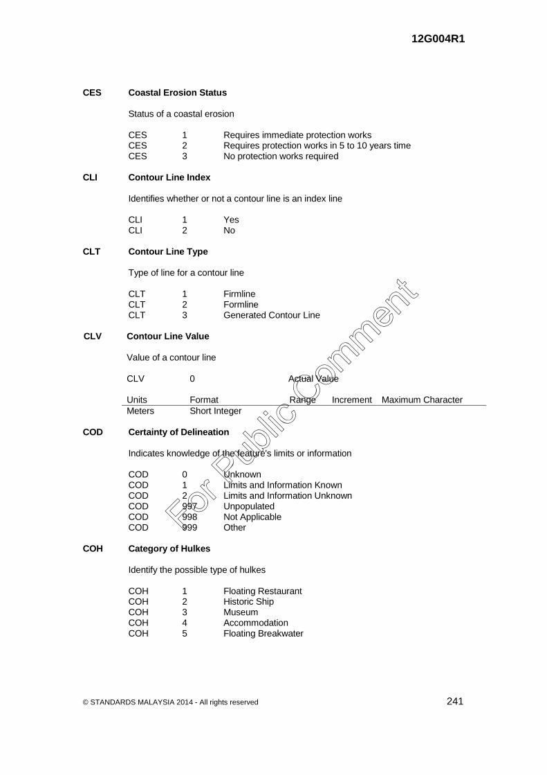
12G004R1
© STANDARDS MALAYSIA 2014 - All rights reserved 241
CES Coastal Erosion Status Status of a coastal erosion CES 1 Requires immediate protection works CES 2 Requires protection works in 5 to 10 years time CES 3 No protection works required CLI Contour Line Index Identifies whether or not a contour line is an index line CLI 1 Yes CLI 2 No CLT Contour Line Type Type of line for a contour line CLT 1 Firmline CLT 2 Formline CLT 3 Generated Contour Line CLV Contour Line Value Value of a contour line CLV 0 Actual Value Units Format Range Increment Maximum Character
Meters Short Integer COD Certainty of Delineation Indicates knowledge of the feature's limits or information COD 0 Unknown COD 1 Limits and Information Known COD 2 Limits and Information Unknown COD 997 Unpopulated COD 998 Not Applicable COD 999 Other COH Category of Hulkes Identify the possible type of hulkes COH 1 Floating Restaurant COH 2 Historic Ship COH 3 Museum COH 4 Accommodation COH 5 Floating Breakwater
For Pub
lic Com
ment

12G004R1
242 © STANDARDS MALAYSIA 2014 - All rights reserved
COL Collector Name of a sampling collector COL 0 Actual Value Units Format Range Increment Maximum Character
Text String ASCII Text 24 Characters COP Category of Pile Possible type of pile category COP 1 Stake COP 2 Snag COP 3 Post COP 4 Tripodal COR Category of Rock Possible type of rock category COR 1 Stone COR 2 Gravel COR 3 Pebbles COR 4 Coral COR 5 Boulder COT Coast Type Type of the edge margin of land next to the sea COT 1 Cliff COT 2 Steep COT 3 Flat COT 4 Rocky CPV Capacity Value The capacity value of passenger car per unit (PCU) during design stage CPV 0 Actual Value Units Format Range Increment Maximum Character
Pcu/hr Real Number 24 Characters CRA Restricted Area Category of restricted area CRA 1 Anchoring CRA 2 Fishing CRA 3 Dredging CRA 4 No Entry Area
For Pub
lic Com
ment

12G004R1
© STANDARDS MALAYSIA 2014 - All rights reserved 243
CRM Crop Mix Identifies the mix of crops in an area CRM 0 Actual Value Units Format Range Increment Maximum Character
Text String ASCII Text 24 Characters CST Construction Suitability Class Type Type of construction suitability classes CST 1 Class I CST 2 Class II CST 3 Class III CST 4 Class IV CTL Center Line To identify a center line CTL 1 Center line between a bank CTL 2 Center line without a bank CTM Camera Type Possible type of camera CTM 1 Surveillance CTM 2 Enforcement CTS Closed Circuit Television Support Possible type of closed circuit television support CTS 1 Owned Pole CTS 2 Sharing with street light pole CTS 3 Sharing with gantry signboard/ VMS CTU Closed Circuit Television Usage Identify the type of closed circuit television usage CTU 1 Public security/general surveillance CTU 2 Traffic Observation CTU 3 Traffic Data Collection CTU 4 Automatic Number Plate Recognition (ANPR) CTV Closed Circuit Television Type Identify the type of closed circuit television CTV 1 Telephoto Camera CTV 2 Dome Camera CTV 3 Fixed Camera
For Pub
lic Com
ment

12G004R1
244 © STANDARDS MALAYSIA 2014 - All rights reserved
CUL Cumulative Track Length Total cumulative length of track contained within confines of the feature, exclusive of the
branch or main trunk lines running into and/or out of the feature CUL 0 Actual Value Units Format Range Increment Maximum Character
Metres Long Integer N/A 1m N/A CUS Custodian The individual, government or organisation which is the custodian of the structures
or facilities. CUS 1 Federal Government Department CUS 2 State Government Agency CUS 3 Local Authority CUS 4 Cooperative CUS 5 Private CWL Water Level Category of water level CWL 1 Partly submerged at high water CWL 2 Always dry CWL 3 Always Under Water CWL 4 Awash CWT Carriageway Type Type of a carriageway CWT 1 Single - without divider CWT 2 Dual - with divider DAE Date of an event/maintenance End Identifies the end date of an event/maintenance DAE 0 Actual Value Units Format Range Increment Maximum Character
Date yyyy /mm/ dd DAS Date of an event/maintenance Start Identifies the starting date of an event/maintenance DAS 0 Actual Value Units Format Range Increment Maximum Character
Date yyyy /mm/ dd
For Pub
lic Com
ment

12G004R1
© STANDARDS MALAYSIA 2014 - All rights reserved 245
DAT Date Identifies the date of an event DAT 0 Actual Value Units Format Range Increment Maximum Character
Date yyyy /mm/ dd DBT Display Board Possible type of display board DBT 1 Message Display Board DBT 2 Message Display Board and Pictogram Display Board DEN Density Measure (% of Tree/Canopy Cover) Canopy cover measured by percent within area of feature during the summer season DEN 0 Actual Value Units Format Range Increment Maximum Character
Percent Short Integer 0 to 100 1 % N/A DEV Developer The name of the developer DEV 0 Actual Value Units Format Range Increment Maximum Character
Text String ASCII Text 50 Characters DFT Dam Face Type Identify the type of dam face DFT 0 Unknown DFT 1 Vertical DFT 2 Slope DFT 997 Unpopulated DFT 998 Not Applicable DFT 999 Other DIP Dip Angle of slope measured from a horizontal plane DIP 0 Actual Value Units Format Range Increment Maximum Character
Degree Floating
For Pub
lic Com
ment
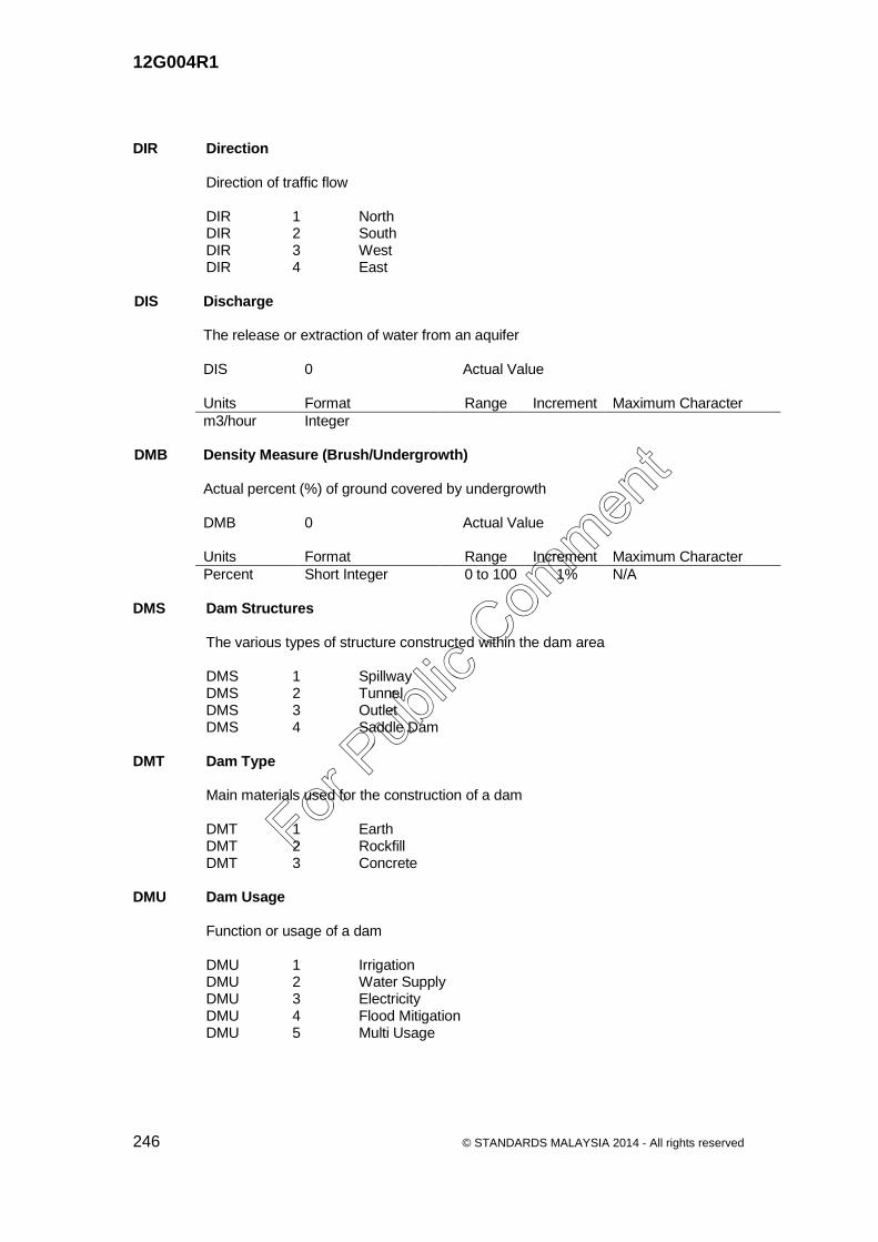
12G004R1
246 © STANDARDS MALAYSIA 2014 - All rights reserved
DIR Direction Direction of traffic flow DIR 1 North DIR 2 South DIR 3 West DIR 4 East DIS Discharge The release or extraction of water from an aquifer DIS 0 Actual Value Units Format Range Increment Maximum Character
m3/hour Integer DMB Density Measure (Brush/Undergrowth) Actual percent (%) of ground covered by undergrowth DMB 0 Actual Value Units Format Range Increment Maximum Character
Percent Short Integer 0 to 100 1% N/A DMS Dam Structures The various types of structure constructed within the dam area DMS 1 Spillway DMS 2 Tunnel DMS 3 Outlet DMS 4 Saddle Dam DMT Dam Type Main materials used for the construction of a dam DMT 1 Earth DMT 2 Rockfill DMT 3 Concrete DMU Dam Usage Function or usage of a dam DMU 1 Irrigation DMU 2 Water Supply DMU 3 Electricity DMU 4 Flood Mitigation DMU 5 Multi Usage
For Pub
lic Com
ment

12G004R1
© STANDARDS MALAYSIA 2014 - All rights reserved 247
DPT Depth Vertical distance measured downward DPT 0 Actual Value Units Format Range Increment Maximum Character
Meters Floating DRC Drain Category Category of a drain DRC 1 Main DRC 2 Secondary DRC 3 Tertiary DRC 4 Roadside DRG Category of Drainage Gate Category of drainage gate DRG 0 Actual Value Units Format Range Increment Maximum Character
Text String ASCII Text 20 Characters DRM Drill Method The method of making inclined or vertical holes for logging and sample collection DRM 1 Augering DRM 2 Jetting DRM 3 Drilling DRS Drain Structures Type of Structures DRS 1 Outfall DRS 2 Manhole DRS 3 Traps/Screens DRS 4 Culverts DRS 5 Control Gate DRU Drain Usage Function of a drain DRU 1 Flood Mitigation DRU 2 Solid Waste Disposal DRU 3 Effluent Quality Control
For Pub
lic Com
ment

12G004R1
248 © STANDARDS MALAYSIA 2014 - All rights reserved
DRV Drain Conveyance A conduit or channel for conveying surplus water away DRV 1 Surface DRV 2 Subsurface DS1 Distance_1 Distance value display on kilometre post DS1 0 Actual Value Units Format Range Increment Maximum Character
Alphanumeric 1 to 10 24 Characters DS2 Distance_2 Distance value display on kilometre post DS2 0 Actual Value Units Format Range Increment Maximum Character
Alphanumeric 1 to 10 24 Characters DSC Slope Drain Category Category of slope drain DSC 1 Toe Drain DSC 2 Berm Drain DSC 3 Inceptor Drain DSC 4 Bench Drain EDB Educational Boarding Facilities Identifies whether an educational set up has a full or semi boarding facility EDB 1 Full Boarding EDB 2 Semi Boarding EDC Educational Category Category of an educational institution EDC 1 Government EDC 2 Private EDL Educational Level The level of an educational institution EDL 1 Pre School EDL 2 Primary EDL 3 Secondary EDL 4 College EDL 5 University College EDL 6 University
For Pub
lic Com
ment

12G004R1
© STANDARDS MALAYSIA 2014 - All rights reserved 249
EDS Educational Stream The stream of an educational institution EDS 1 Technical EDS 2 Vocational EDS 3 Religious EDS 4 Science EDS 5 Military College EDS 6 Special/Spastic EDS 7 National EDS 8 Chinese EDS 9 Tamil EDS 10 International EDT Educational Building Type Type of an educational building EDT 1 Detached EDT 2 Semi Detached EDT 3 Terrace/Link EDT 4 Multi Storey EDT 5 Complex EHP Exploration Hole Purpose Identifies the purpose of an exploration hole EHP 1 Downhole logging EHP 2 Sampling EIA EIA Index Number of EIA index EIA 0 Actual Value Units Format Range Increment Maximum Character
Text String 24 Characters ELC Election Candidate Elected candidate ELC 0 Actual Value Units Format Range Increment Maximum Character
Text String 24 Characters
For Pub
lic Com
ment
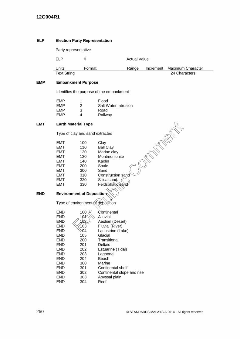
12G004R1
250 © STANDARDS MALAYSIA 2014 - All rights reserved
ELP Election Party Representation Party representative ELP 0 Actual Value Units Format Range Increment Maximum Character
Text String 24 Characters EMP Embankment Purpose Identifies the purpose of the embankment EMP 1 Flood EMP 2 Salt Water Intrusion EMP 3 Road EMP 4 Railway EMT Earth Material Type Type of clay and sand extracted EMT 100 Clay EMT 110 Ball Clay EMT 120 Marine clay EMT 130 Montmorilonite EMT 140 Kaolin EMT 200 Shale EMT 300 Sand EMT 310 Construction sand EMT 320 Silica sand EMT 330 Feldsphatic sand END Environment of Deposition Type of environment of deposition END 100 Continental END 101 Alluvial END 102 Aeolian (Desert) END 103 Fluvial (River) END 104 Lacustrine (Lake) END 105 Glacial END 200 Transitional END 201 Deltaic END 202 Estuarine (Tidal) END 203 Lagoonal END 204 Beach END 300 Marine END 301 Continental shelf END 302 Continental slope and rise END 303 Abyssal plain END 304 Reef
For Pub
lic Com
ment

12G004R1
© STANDARDS MALAYSIA 2014 - All rights reserved 251
EQT Environmental Quality Type Type of environmental quality EQT 1 Air EQT 2 Water EQT 3 Land EQT 4 Industrial EQT 999 Others EST Erosion Type Type of an erosion EST 1 Sheet EST 2 Rill EST 3 Gully ETC Electronic Toll Collection Possible type of electronic toll collection ETC 1 Touch N Go ETC 2 Smart Tag ETC 3 Mixed mode ETC 999 Others ETN Emergency Telephone Network Possible type of emergency telephone network ETN 1 Fibre Optic ETN 2 Wireless (GSM) ETN 3 CAT6 Cable ETS Emergency Telephone Structure Possible type of emergency telephone structure ETS 1 Solar Power System ETS 2 Electric Power System FEM Fence Material Possible type of fence material FEM 1 Concrete FEM 2 Steel FEM 3 Rock FEM 4 Wood FEM 999 Others
For Pub
lic Com
ment

12G004R1
252 © STANDARDS MALAYSIA 2014 - All rights reserved
FET Fence Type Type of fence used to surround a piece of land FET 1 Electrified FET 2 Non Electrified FLT Folding Type Type of a folding FLT 1 Anticline FLT 2 Syncline FLT 3 Overturned FLT 4 Recumbent FLT 5 Boxfold FNO Field Number Non unique reference number of a feature, usually assigned to an area or a project FNO 0 Actual Value Units Format Range Increment Maximum Character
Text String ASCII Text 24 Characters FOH Fossil Habitat Reflect the living environment of a fossil FOH 1 Marine FOH 2 Brackish water FOH 3 Fresh water FOH 4 Continental FOP Fold Plunging Angle Angle of plunge with respect to horizontal plane FOP 0 Actual Value Units Format Range Increment Maximum Character
Degree Integer FOS Fossils Assemblage of fossils found in a lithological unit FOS 0 Actual Value Units Format Range Increment Maximum Character
Text String ASCII Text 80 Characters
For Pub
lic Com
ment

12G004R1
© STANDARDS MALAYSIA 2014 - All rights reserved 253
FOT Fossil Type Type of a fossil FOT 1 Fauna FOT 2 Flora FOT 3 Trace FOT 4 Fossil mixed FOX Fold Axis Direction The direction of fold axis with respect to north in clockwise direction FOX I Actual Value Units Format Range Increment Maximum Character
Degree Integer FSN Forest Species Name Name of the species FSN 0 Actual Value Units Format Range Increment Maximum Character
Text 24 Characters FST Forest Status Human or natural intervention status of the forested area FST 1 Virgin and undisturbed FST 2 Primary, logged >= 30 years FST 3 Secondary, logged < 30 years FST 4 Poor due to activities other than logging. FTD Dryland Forest Type Type of dryland forest FTD 0 Actual Value Units Format Range Increment Maximum Character
Text 24 Characters FTT Fishing Trap Type A fence or enclosure set in water to catch fish FTT 1 Kelong FTT 2 Stackers
For Pub
lic Com
ment

12G004R1
254 © STANDARDS MALAYSIA 2014 - All rights reserved
FTY Faulting Type Type of a faulting FTY 1 Normal FTY 2 Reverse FTY 3 Strike slip FTY 4 Thrust FTY 5 Transcurrent with displacement FYH Forest Year Harvested Identifies the year of forest harvested FYH 0 Actual Value Units Format Range Increment Maximum Character
Year yyyy FYT Forest Year Treated Identifies the year of forest treated FYT 0 Actual Value Units Format Range Increment Maximum Character
Year yyyy GAC Geological Accuracy Degree of accuracy of a geological boundary or feature GAC 1 Observed GAC 2 Defined GAC 3 Approximate GAC 4 Inferred GAM/ Minimum / Maximum Geological Age in Period or Epoch GAX Minimum / Maximum geological age of a feature measured in Period or Epoch GAM / GAX 100 RECENT CENOZOIC GAM / GAX 210 QUATERNARY GAM / GAX 211 Holocene GAM / GAX 212 Pleistocene GAM / GAX 220 TERTIARY GAM / GAX 221 Neogene GAM / GAX 222 Pliocene GAM / GAX 223 Miocene GAM / GAX 224 Palaeogene GAM / GAX 225 Oligocene GAM / GAX 226 Eocene GAM / GAX 227 Paleocene
For Pub
lic Com
ment

12G004R1
© STANDARDS MALAYSIA 2014 - All rights reserved 255
MESOZOIC GAM / GAX 310 CRETACEOUS GAM / GAX 311 Late Cretaceous GAM / GAX 312 Early Cretaceous GAM / GAX 320 JURASSIC GAM / GAX 321 Late Jurassic GAM / GAX 322 Middle Jurassic GAM / GAX 323 Early Jurassic GAM / GAX 330 TRIASSIC GAM / GAX 331 Late Triassic GAM / GAX 332 Middle Triassic GAM / GAX 333 Early Triassic PALAEOZOIC GAM / GAX 410 PERMIAN GAM / GAX 411 Lopingian GAM / GAX 412 Guadalupian GAM / GAX 413 Cisuralian GAM / GAX 420 CARBONIFEROUS GAM / GAX 421 Pennsylvanian GAM / GAX 422 Late Pennsylvanian GAM / GAX 423 Middle Pennsylvanian GAM / GAX 424 Early Pennsylvanian GAM / GAX 425 Mississippian GAM / GAX 426 Late Mississippian GAM / GAX 427 Middle Mississippian GAM / GAX 428 Early Mississippian GAM / GAX 430 DEVONIAN GAM / GAX 431 Late Devonian GAM / GAX 432 Middle Devonian GAM / GAX 433 Early Devonian GAM / GAX 440 SILURIAN GAM / GAX 441 Late Silurian GAM / GAX 442 Pridoli GAM / GAX 443 Ludlow GAM / GAX 444 Early Silurian GAM / GAX 445 Wenlock GAM / GAX 446 Llandovery GAM / GAX 450 ORDOVICIAN GAM / GAX 451 Late Ordovician GAM / GAX 452 Middle Ordovician GAM / GAX 453 Early Ordovician GAM / GAX 460 CAMBRIAN GAM / GAX 461 Late Cambrian GAM / GAX 462 Middle Cambrian GAM / GAX 463 Early Cambrian PROTEROZOIC AND ARCHEAN GAM / GAX 510 PRECAMBRIAN
For Pub
lic Com
ment

12G004R1
256 © STANDARDS MALAYSIA 2014 - All rights reserved
GAS Global Position System Active Station (MASS) Primary class Global Positioning System reference stations tied to the International
GPS framework whose data can be downloaded through JUPEM’s web site for GPS post-processing
GAS 1 Active GAS 2 Not Active GDT Gazette Date Identifies the date of gazette area GDT 0 Actual Value Units Format Range Increment Maximum Character
Date yyyy /mm/ dd GEO Geologist(s) Name of the person in charge of the work GEO 0 Actual Value Units Format Range Increment Maximum Character
Text String ASCII Text 24 Characters GEP Geochemical Survey Area Purpose Identifies the purpose of a geochemical survey area GEP 1 Mineral GEP 2 Environment GET Gas Pipeline Type Type of a gas pipeline GET 1 Transmission GET 2 Distribution GFD Geological Feature Description Detailed description of geological feature(s) GFD 0 Actual Value Units Format Range Increment Maximum Character
Text String ASCII Text 200 Characters GHS Geohazard Status Identifies the status of a geohazard GHS 1 Occurred GHS 2 Potential
For Pub
lic Com
ment

12G004R1
© STANDARDS MALAYSIA 2014 - All rights reserved 257
GHT Geohazard Type Type of a geohazard GHT 1 Landslide GHT 2 Sinkhole GHT 3 Land Subsidence GHT 4 Rockfall GHT 5 Erosion GLL *Geological Lithostratigraphic / Lithodemic Label Unique label (Geo-text) of a stratigraphical unit used in geological map GLL 0 Actual Value Units Format Range Increment Maximum Character
Text String ASCII Text 12 Characters GLN Geological Lithostratigraphic / Lithodemic Name Stratigraphic name of a geological lithostratigraphic or lithodemic unit GLN L
Geographic Name<space> Rank or lithology
Actual Value Uppercase First Letter (Rank/Lithology) for Formal formation/unit such as Semantan Formation or Chuping Limestone Lowercase First Letter (rank/lithology) for informal formation/unit such as Kenny Hill formation or Tiang schist
Units Format Range Increment Maximum Character
Text String ASCII Text 80 Characters GLR Geological Lithostratigraphic / Lithodemic Rank Identifies the rank or stratigraphic level of each defined unit GLR 400 Complex Unranked, but equals to Suite or Supersuite
(Volcanic & Structure Complexes) GLR 100 Supergrou
p Lithostratigraphic Classes Rank (Sedimentary & Pyroclastic tuff)
GLR 200 Group GLR 300 Formation GLR 310 Member GLR 320 Bed GLR 330 Flow GLR 340 Informal
formation GLR 350 Informal
member GLR 105 Supersuite Lithodemic Classes Rank
(Intrusive, Extrusive-Lavaflows & Highly metamorphosed)
GLR 205 Suite GLR 305 Lithodeme
For Pub
lic Com
ment

12G004R1
258 © STANDARDS MALAYSIA 2014 - All rights reserved
GLS Geological Lithostratigraphic / Lithodemic Type Identifies type of a stratigraphic unit GLS 100 Unconsolidated Sediments GLS 110 Clay GLS 120 Mud GLS 130 Silt GLS 140 Loess GLS 150 Sand GLS 160 Gravel GLS 170 Peat GLS 180 Volcanic ash GLS 190 Coral GLS 95 Shell GLS 200 Sedimentary Rocks GLS 210 Argillaceous GLS 220 Arenaceous GLS 230 Rudaceous GLS 240 Calcareous GLS 250 Siliceous GLS 260 Carbonaceous GLS 270 Evaporites GLS 280 Extrusive – pyroclastic GLS 300 Metamorphic Rocks GLS 310 Regional GLS 320 Contact GLS 330 Dynamic GLS 340 Impact GLS 400 Igneous Rocks GLS 410 Intrusive GLS 420 Extrusive igneous - Lavaflows GLS 430 Metamorphic - Highly metamorphosed GLT Groundwater Limit Type Type of a groundwater limit GLT 1 Salt-water interface GLT 2 Hydraulic isopach GMT Gas Marker Type Identify the type of gas pipe marker GMT 1 Type A GMT 2 Type B GMT 3 Flush Type GNU Gazette References Number References number for gazette area GNU 0 Actual Value Units Format Range Increment Maximum Character
Text String ASCII Text
For Pub
lic Com
ment

12G004R1
© STANDARDS MALAYSIA 2014 - All rights reserved 259
GPC Global Position Station System Class Class of GPS point accuracy GPC 1 Primary Global Position System Station GPC 2 Secondary Global Position System Station GPC 3 Tertiary Global Position System Station GPC 4 Base Point Reference Station GPM Geophysical Method Method of geophysical investigation GPM 1 Seismic GPM 2 Surface gravity GPM 3 Aeromagnetic GPM 4 Surface magnetic GPM 5 Electrical GPM 6 Electromagnetic GPM 7 Radiometric GPM 8 Airborne electromagnetic GPM 9 Airborne Radiometric GPM 10 Airborne gravity GPM 11 Downhole logging GPT Geochemical Sample Point Type Method of geochemical sample point GPT 1 Rock GPT 2 Soil GPT 3 Silt GPT 4 Stream Concentrate GPT 5 Stream water GRL Grade Location Identifies the location of a feature with respect to the ground GRL 1 On ground GRL 2 Underground GRL 3 Elevated GRL 4 Buried Underwater GRL 5 Exposed Underwater GRP Gravity Reference Point Class of a gravity point accuracy GRP 1 Absolute GRP 2 First Order GRP 3 Second Order GRP 4 Third Order
For Pub
lic Com
ment

12G004R1
260 © STANDARDS MALAYSIA 2014 - All rights reserved
GRS Gross Polutant Type Possible type of gross polutant GPT 1 Gross Polutant Type 1 GPT 2 Gross Polutant Type 2 GPT 3 Gross Polutant Type 3 GSC Geological Structure Category Category of a geological structure GSC 1 Foliation GSC 2 Schistocity GSC 3 Cleavage GSC 4 Unconformity GSC 5 Disconformity GSC 6 Gneissosity GSS Land Subsidence Site Type Type of land subsidence GSS 0 Actual Value Units Format Range Increment Maximum Character
Text String ASCII Text 24 Characters GST Groundwater Station Type Type of a groundwater station GST 1 Piezometer GST 2 Settlement gauge GWP Groundwater Potential Class Indentifies the class of a groundwater potential GWP 1 Very high GWP 2 High GWP 3 Medium GWP 4 Low GWQ Groundwater Quality Determine the quality of water extracted from a tube well GWQ 1 Fresh, generally potable GWQ 2 Slight saline, marginally potable GWQ 3 Moderately saline, suitable for live stock GWQ 4 Highly saline, generally unsuitable for live stock
For Pub
lic Com
ment

12G004R1
© STANDARDS MALAYSIA 2014 - All rights reserved 261
HEI Height Height of a feature, in meters HEI 0 Actual Value Units Format Range Increment Maximum Character
Meters Floating HFC Hydrographic Form Category Form or configuration of the hydrological feature HFC 0 Unknown HFC 1 Channelized Stream HFC 2 Disappearing HFC 7 Non-Tidal HFC 8 Normal Channel HFC 10 Tidal/Tidal Fluctuating HFC 14 Braided HFC 16 Dissipating HFC 19 Gorge HFC 21 Wadi/Wash HFC 30 Disappearing in sinkhole HFC 31 Disappearing in other than sinkhole HFC 32 Oxbow HFC 33 Split stream HFC 997 Unpopulated HFC 998 Not Applicable HFC 999 Other HMU Highmast Usage Type of highmast usage HMU 1 Park/Recreational HMU 2 Bridge HMU 3 Stadium HMU 4 Street/Highway HMU 5 Airport HMU 6 Rest and Service Area (RSA) HMU 7 Toll Plaza HMU 8 Interchanges HMU 999 Others HNT Hydrogeological Natural Feature Type Type of a hydrogeological natural feature HNT 1 Spring HNT 2 Artesian
For Pub
lic Com
ment

12G004R1
262 © STANDARDS MALAYSIA 2014 - All rights reserved
HOR Host Rock The type of rock in which groundwater accumulated HOR 0 Actual Value Units Format Range Increment Maximum Character
Text String ASCII Text 200 Characters HPT Height Point Type Type of point with height measurement HPT 1 Spot Height (derived by photogrammetric method) HPT 2 Bench Mark HPT 3 Ground control point (derived by ground survey method) HPT 4 Relative height point (derived by photogrammetric method) HPT 5 Tide Gauge Station (STAPS) HSC Historical Site Category Category of a historical site HSC 1 Archaeological HSC 2 Fort HSC 3 Castle HSC 4 Grave HSC 5 Well HSC 6 Cave HSC 7 Heritage HSC 8 Geological Heritage HSC 81 Rock Diversity HSC 811 Sediments HSC 812 Sedimentary Rock HSC 813 Igneous Rock HSC 814 Metamorphic Rock HSC 82 Mineral Diversity HSC 83 Fossil Diversity HSC 831 Fauna Fossil HSC 832 Trace Fossil HSC 833 Flora Fossil HSC 84 Structure Diversity HSC 841 Primary Structure HSC 842 Secondary Structure HSC 85 Landform Diversity HSC 851 Waterfall HSC 852 Beach HSC 853 Mountain Peak HSC 854 Lake HSC 855 Cave HSC 856 Hot spring HSC 86 Landscape Diversity
For Pub
lic Com
ment

12G004R1
© STANDARDS MALAYSIA 2014 - All rights reserved 263
HST Hydrological Station Type Type of a hydrological station HST 1 Rainfall Station HST 2 Water Level Station HST 3 Telemetric Station HST 4 Water Quality Station HST 5 Stream flow Station HST 6 Tidal Station HST 7 Suspended Sediment Station HST 8 Evaporation Station HZT Hydrogeological Zone Type Type of a hydrogeological zone HZT 1 Well field HZT 2 Aquifer zone HZT 3 Protection zone HZT 4 Vulnerability zone IAM ISO Meteorological Amount Measured (IAM) Meteorological value measured of temperature, rainfall, humidity, wind speed, sunshine
hour, solar radiation, evaporation and pressure IAM 0 Actual Value Units Format Range Increment Maximum Character
ASCII Text 12 Characters ICC Irrigation Canal Category Category of canals used for a water distribution ICC 1 Main ICC 2 Secondary ICC 3 Tertiary ICC 4 Quaternary ICS Irrigation Canal Structures Purpose Purpose of structures ICS 1 Conveyance ICS 2 Regulating ICS 3 Water Measuring IDC Category of Industry Category of an industry IDC 1 Light Industry IDC 2 Medium Industry IDC 3 Heavy Industry IDC 4 Service Industry
For Pub
lic Com
ment

12G004R1
264 © STANDARDS MALAYSIA 2014 - All rights reserved
IDC 5 Special Industry IDC 6 Mining and Quarry IDL Industry Permit Status Identifies whether or not an industry is operating with a permit IDL 1 With Permit IDL 2 Without Permit IDN Identification Number Official number assigned to a feature for identification purpose IDN 0 Actual Value Units Format Range Increment Maximum Character
Text String ASCII Text 12 Characters IDP Industrial Planned Category Identifies whether or not an industry is planned IDP 1 Planned IDP 2 Unplanned IDS Industry Tax Status Identifies the tax status of an industry IDS 1 Tax Free IDS 2 Non Tax Free IDT Industrial Building Type Type of building used for industrial activities IDT 1 Detached IDT 2 Semi Detached IDT 3 Terrace/Link IDT 4 Multi Storey IDT 5 Complex IDU Industrial Usage Type of uses of an industrial building IDU 1 Workshop IDU 2 Warehouse or Godown IDU 3 Factory IDU 4 Explosive Magazine
For Pub
lic Com
ment

12G004R1
© STANDARDS MALAYSIA 2014 - All rights reserved 265
IGC Irrigation Scheme Category Category of irrigation scheme IGC 1 Granary IGC 2 Mini Granary IGC 3 Small Scheme IGT Irrigation Scheme Type Type of irrigation scheme IGT 1 Gravity IGT 2 Pumping IGT 3 Mixed INC Institutional Category Category of an institution INC 1 Government INC 2 Private INT Institutional Building Type Identifies the type of building used for institutional purposes INT 1 Detached INT 2 Semi Detached INT 3 Terrace/Link INT 4 Multi-Storey INT 5 Complex IRC Irrigation Drain Category Category of an irrigation drain IRC 1 Main IRC 2 Secondary IRC 3 Field IRG Igneous Rock Group Identifies the group of igneous rocks based on genesis type IRG 1 Intrusive type IRG 2 Extrusive - Lavaflows type IRG 3 Extrusive - Pyroclastic type
For Pub
lic Com
ment

12G004R1
266 © STANDARDS MALAYSIA 2014 - All rights reserved
IRI International Roughness Index Measurement of the degree of roughness of a pavement surface adopting REAM
guidelines IRI 1 0 m/km – 5 m/km (true planar surface) IRI 2 6 m/km – 11 m/km (moderately rough paved roads) IRI 3 12 m/km – 19 m/km (extremely rough paved roads with
potholes & patches) IRI 4 ≥ 20 m/km (extremely rough unpaved roads) IRP Igneous Rock Composition Type Type of an igneous rock based on origin magmatic composition IRP 1 Acid IRP 2 Intermediate IRP 3 Basic IRP 4 Ultrabasic IRS Irrigation Drain Structures Type of Structures IRS 1 Drainage Control IRS 2 Drainage Crossing IRS 3 Drainage Control cum Crossing IRS 4 Drainage Protection IRT Igneous Rock Type Type of an igneous rock ACID INTRUSIVE IRT 401 Granite IRT 402 Dolerite IRT 403 Aplite IRT 404 Pegmatite INTERMEDIATE INTRUSIVE IRT 501 Syenite IRT 502 Granodiorite IRT 503 Diorite IRT 504 Monzonite IRT 505 Monzodiorite IRT 506 Tonalite IRT 507 Adamelite BASIC INTRUSIVE IRT 601 Gabbro IRT 602 Gabbronorite IRT 603 Anorthosite IRT 604 Lamprophyre ULTRABASIC INTRUSIVE IRT 701 Dunite IRT 702 herzolite IRT 703 Harzburgite
For Pub
lic Com
ment

12G004R1
© STANDARDS MALAYSIA 2014 - All rights reserved 267
IRT 704 Pyroxenite IRT 705 Peridotite IRT 706 Hornblendite ACID EXTRUSIVE - FLOW IRT 101 Rhyolite IRT 102 Rhyodacite IRT 103 Ignimbrite INTERMEDIATE EXTRUSIVE - FLOW IRT 201 Andesite IRT 202 Dacite IRT 203 Trachyte IRT 204 Latite BASIC EXTRUSIVE - FLOW IRT 301 Basalt IRT 302 Splite EXTRUSIVE - PYROCLASTIC IRT 801 Tuff IRT 802 Lapili-stone IRT 803 Agglomerate IRT 804 Volcanic bomb GLASSY ACID TO BASIC EXTRUSIVE – FLOW & OTHERS IRT 901 Pumice IRT 902 Scoria IRT 903 Obsidian IRT 904 Vitrophyre IRT 905 Volcanic breccias ISC Intrusive Structure Composition Composition of an intrusive structure ISC L Actual Value Units Format Range Increment Maximum Character
Text String ASCII Text 24 Characters IST Intrusive Structure Type Type of an intrusive structure IST 1 Reef IST 2 Dyke IST 3 Sill IST 4 Vein IST 5 Batholith IST 6 Lacolith IST 7 Lopolith IST 8 Phacolith IST 9 Stock IST 10 Diapir
For Pub
lic Com
ment

12G004R1
268 © STANDARDS MALAYSIA 2014 - All rights reserved
ITT Interchange Type Type of a road interchange ITT 1 Trumpet ITT 2 Ramps in one quadrant ITT 3 Diamond interchange ITT 4 Partial clover leaf ITT 5 Full clover leaf IUT Irrigation Structure Type
Structures constructed in an irrigation area to regulate and remove excess water for paddy cultivation
IUT 1 Drainage Control IUT 2 Drainage Crossing IUT 3 Drainage Control cum Crossing IUT 4 Drainage Protection JYC Jetty Category Category of a jetty JYC 1 Passenger JYC 2 Freight JYC 3 Fishery KCT Kampung Coverage Type Category of a kampung Coverage Type KCT 1 Traditional KCT 2 Fishing KCT 3 Tersusun KCT 4 Atas Air KCT 5 Aboriginal KCT 6 Group Settlement KCT 7 New Village KCT 8 Squatters KCT 9 Estate KMT Kilometer Post/ Marker Type Type of a kilometre post/marker KMT A kilometer post/marker assigned by JKR at every 5 kilometres KMT B kilometre post/marker assigned by JKR at every 1 kilometre KMT C kilometre post/marker assigned by LLM at every 100 metres KMT D kilometre post/marker assigned by LLM at every 1 kilometre KMU Kilometer Post Usage Usage of a kilometer post KMU 1 Road KMU 2 Railway
For Pub
lic Com
ment

12G004R1
© STANDARDS MALAYSIA 2014 - All rights reserved 269
KSK Information Kiosk Availability of information Kiosk KSK 1 Yes KSK 2 No LAN Number of Lane Number of travel lane on a road surface LAN 0 Actual Value Units Format Range Increment Maximum Character
Lane Short Integer 24 Characters LAU Lay-by Usage Usage of a lay-by LAU 1 Taxi LAU 2 Bus LAU 3 Emergency LBL Label Label on the item LBL 0 Actual Value Units Format Range Increment Maximum Character
Text String ASCII Text 24 Characters LBT Landing Base Type Type of a landing base for helicopters LBT 1 On Building LBT 2 On Ground LBT 3 Deck LCC Light Characteristic Category The sequence, grouping and distinctive character of light LCC 1 Alternating LCC 2 Flashing LCC 3 Long-Flashing LCC 4 Occulting LCC 5 Ultra Quick LCC 6 Quick LCC 8 Very Quick LCC 9 Group LCC 10 Composite Group LCC 11 Morse Code LCC 12 Isophase LCC 13 Lighted
For Pub
lic Com
ment

12G004R1
270 © STANDARDS MALAYSIA 2014 - All rights reserved
LCC 14 Unlighted LCC 15 Interrupted LCC 16 Fixed LCC 17 Intensified LCC 18 Directional LEN Length Value of a contour line LEN 0 Actual Value Units Format Range Increment Maximum Character
Meters Floating LIF Lift Facilities Identifies whether or not a building has lift LIF 1 Has Lift LIF 2 Has No Lift LIP Lineament Dip Inclination Inclination of lineament derived from aerial photographs or remotely sensed data LIP 1 Low angle (<30 degrees) LIP 2 Moderate angle (30-60 degrees) LIP 3 Steep angle (>60 degrees) LOC Location Category Status of feature relative to surrounding area or water LOC 0 Unknown LOC 1 Above Surface/Does not Cover (Height Known) LOC 2 Awash at Chart Datum LOC 3 Dries/Covers (Height Unknown) LOC 4 Below Water Surface LOC 5 Covered < 20 Metres LOC 6 Covered >= 20 Metres but < 30 Metres LOC 7 Covered > = 30 Metres LOC 8 On Ground Surface LOC 9 Depth Known LOC 10 Depth Known (Cleared by Drag Wire) LOC 11 Depth Unknown But Safe to Depth Shown LOC 13 Hull Showing LOC 14 Masts Showing LOC 15 On Water Surface/Floating LOC 16 Partially Submerged LOC 17 Sunken/On sea bottom LOC 19 Above Surface/Does not Cover (Height Unknown) LOC 20 Funnel Showing LOC 21 Superstructure Showing LOC 22 Off Shore LOC 23 Below Sea Bottom LOC 24 Suspended or Elevated above sea bottom LOC 25 Suspended or Elevated Above Ground or Water
For Pub
lic Com
ment

12G004R1
© STANDARDS MALAYSIA 2014 - All rights reserved 271
LOC 28 Masts and Funnel Showing LOC 30 Non-Floating LOC 31 Elevated LOC 32 Depressed LOC 33 Not submerged LOC 34 Inland LOC 35 Overhead LOC 36 Height Above Bottom LOC 37 Exact Position Known LOC 38 Exact Position Unknown LOC 39 Depth Unknown LOC 40 Underground LOC 41 Inside of a Tunnel. LOC 42 Inside a building LOC 43 Outside a building LOC 997 Unpopulated LOC 998 Not Applicable LOC 999 Other LPT Lamp Pole Type Identify the type of lamp pole LPT 1 Accent Light LPT 2 Bollard Light LPT 3 Underwater Light LPT 4 Floor Uplight LPT 5 Irideon Light LPT 6 Spot Light LPT 7 Flood Light LPT 8 Uplight LPT 9 Wall Light LPT 999 Others LPU Lamp Pole Usage Type of lamp pole usage LPU 1 Recreational Park LPU 2 Sport Complex LPU 3 Public Area LPU 4 Residential Area LPU 5 Commercial Area LPU 999 Others LST Landslide Type Type of a landslide LST 1 Circular LST 2 Translational LST 3 Compound LST 4 Debris flow LST 5 Mudflow
For Pub
lic Com
ment

12G004R1
272 © STANDARDS MALAYSIA 2014 - All rights reserved
LTY Lineament Type Type of lineament LTY 1 Lineament positive LTY 2 Lineament negative LTY 3 Scarp LUT Land Use Type Type of land use activities for development plan, planning control and regulatory LUT TBA.000 Built Up (Tepu Bina) LUT TRM 000 Residential (Kediaman) LUT TRM 100 Planned Housing (Perumahan Terancang) LUT TRM 101 Planned Housing – Strata Housing (Perumahan Terancang – Perumahan Strata) LUT TRM 102 Planned Housing – Non-Strata Housing (Perumahan Terancang – Perumahan Bukan Strata) LUT TRM 103 Planned Housing – Staff Housing (Perumahan Terancang - Perumahan Kakitangan) LUT TRM 104 Planned Housing – Organized village (Perumahan Terancang - Kampung Tersusun) LUT TRM 105 Planned Housing - Felda village (Perumahan Terancang – Kampung Felda) LUT TRM 106 Planned Housing – New village (Perumahan Terancang – Kampung Baru) LUT TRM 107 Planned Housing - Estate Housing (Perumahan Terancang - Perumahan Ladang / Estet) LUT TRM 200 Unplanned Housing (Perumahan Tidak Terancang) LUT TRM 201 Unplanned Housing – Tradisional village (Perumahan Tidak Terancang – Kampung Tradisi) LUT TRM 202 Unplanned Housing – Fisherman village (Perumahan Tidak Terancang - Kampung Nelayan) LUT TRM 203 Unplanned Housing – Water village (Perumahan Tidak Terancang – Kampung Atas Air) LUT TRM 204 Unplanned Housing – Aboriginal village (Perumahan Tidak Terancang - Kampung Orang Asli) LUT TRM 205 Unplanned Housing - Squatter village (Perumahan Tidak Terancang - Kampung Setinggan) LUT TIN 000 Industry (Industri) LUT TIN 100 Planned Industry (Industri Terancang) LUT TIN 101 Planned Industry - Light (Industri Terancang - Ringan) LUT TIN 102 Planned Industry - Medium (Industri Terancang – Sederhana) LUT TIN 103 Planned Industry - Heavy (Industri Terancang - Berat) LUT TIN 104 Planned Industry - Specific (Industri Terancang – Khas) LUT TIN 105 Planned Industry – Sevice (Industri Terancang – Perkhidmatan) LUT TIN 106 Planned Industry - Cottage /Country
For Pub
lic Com
ment
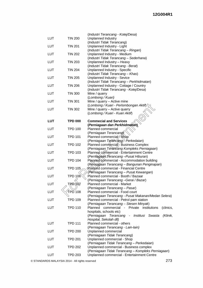
12G004R1
© STANDARDS MALAYSIA 2014 - All rights reserved 273
(Industri Terancang - Kotej/Desa) LUT TIN 200 Unplanned Industry (Industri Tidak Terancang) LUT TIN 201 Unplanned Industry - Light (Industri Tidak Terancang – Ringan) LUT TIN 202 Unplanned Industry - Medium (Industri Tidak Terancang – Sederhana) LUT TIN 203 Unplanned Industry – Heavy (Industri Tidak Terancang - Berat) LUT TIN 204 Unplanned Industry - Specific (Industri Tidak Terancang – Khas) LUT TIN 205 Unplanned Industry - Sevice (Industri Tidak Terancang – Perkhidmatan) LUT TIN 206 Unplanned Industry - Cottage / Country (Industri Tidak Terancang - Kotej/Desa) LUT TIN 300 Mine / quarry (Lombong / Kuari) LUT TIN 301 Mine / quarry – Active mine (Lombong / Kuari - Perlombongan Aktif) LUT TIN 302 Mine / quarry – Active quarry (Lombong / Kuari - Kuari Aktif) LUT TPD 000 Commecial and Services (Perniagaan dan Perkhidmatan) LUT TPD 100 Planned commercial (Perniagaan Terancang) LUT TPD 101 Planned commercial - Shop (Perniagaan Terancang - Perkedaian) LUT TPD 102 Planned commercial - Business Complex (Perniagaan Terancang Kompleks Perniagaan) LUT TPD 103 Planned commercial - Entertainment Centre (Perniagaan Terancang –Pusat Hiburan) LUT TPD 104 Planned commercial - Accommodation building (Perniagaan Terancang – Bangunan Penginapan) LUT TPD 105 Planned commercial - Financial Centre (Perniagaan Terancang – Pusat Kewangan) LUT TPD 106 Planned commercial - Booth / Bazaar (Perniagaan Terancang –Gerai / Bazar) LUT TPD 107 Planned commercial - Market (Perniagaan Terancang – Pasar) LUT TPD 108 Planned commercial - Food court (Perniagaan Terancang - Pusat Makanan/Medan Selera) LUT TPD 109 Planned commercial - Petrol pam station (Perniagaan Terancang – Stesen Minyak) LUT TPD 110 Planned commercial - Private institutions (clinics,
hospitals, schools etc) (Perniagaan Terancang - Institusi Swasta (Klinik,
Hospital, Sekolah dll) LUT TPD 111 Planned commercial - others (Perniagaan Terancang - Lain-lain) LUT TPD 200 Unplanned commercial (Perniagaan Tidak Terancang) LUT TPD 201 Unplanned commercial - Shop (Perniagaan Tidak Terancang – Perkedaian) LUT TPD 202 Unplanned commercial - Business complex (Perniagaan Tidak Terancang – Kompleks Perniagaan) LUT TPD 203 Unplanned commercial - Entertainment Centre
For Pub
lic Com
ment

12G004R1
274 © STANDARDS MALAYSIA 2014 - All rights reserved
(Perniagaan Tidak Terancang - Pusat Hiburan) LUT TPD 204 Unplanned commercial - Accommodation building (Perniagaan Tidak Terancang - Bangunan Penginapan) LUT TPD 205 Unplanned commercial - Financial Centre (Perniagaan Tidak Terancang - Pusat Kewangan) LUT TPD 206 Unplanned commercial - Booth / Bazaar (Perniagaan Tidak Terancang - Gerai / Bazar) LUT TPD 207 Unplanned commercial - Market (Perniagaan Tidak Terancang - Pasar) LUT TPD 208 Unplanned commercial - Food court (Perniagaan Tidak Terancang - Pusat Makanan/Medan
Selera) LUT TPD 209 Unplanned commercial - Petrol pam station (Perniagaan Tidak Terancang - Stesen Minyak) LUT TPD 210 Unplanned commercial - Private institutions (clinics,
hospitals, schools etc) (Perniagaan Tidak Terancang - Institusi Swasta (Klinik,
Hospital, Sekolah dll) LUT TPD 211 Unplanned commercial - others (Perniagaan Tidak Terancang - Lain-lain) LUT TIS 000 Institution and Public Amenity (Institusi dan Kemudahan Masyarakat) LUT TIS 100 Education (Pendidikan) LUT TIS 101 Education - Kindergarten (Pendidikan - Tadika) LUT TIS 102 Education – Primary school (Pendidikan - Sekolah Rendah) LUT TIS 103 Education – Secondary school (Pendidikan - Sekolah Menengah) LUT TIS 104 Education - Religious Schools (Pendidikan - Sekolah Agama) LUT TIS 105 Education – Intergrated school (Pendidikan - Sekolah Bersepadu) LUT TIS 106 Education - Special Education Schools (Pendidikan - Sekolah Pendidikan Khas) LUT TIS 107 Education - College / Institute / (Pendidikan - Kolej/Maktab/Politeknik) LUT TIS 108 Education – Higher Education Institute (Pendidikan - Institut Pendidikan Tinggi) LUT TIS 109 Education – Research Centre (Pendidikan - Pusat Penyelidikan) LUT TIS 110 Education – Training Institute (Pendidikan - Institut Latihan) LUT TIS 111 Education - Others (Pendidikan - Lain-lain) LUT TIS 200 Health (Kesihatan) LUT TIS 201 Health - Rural Clinic (Kesihatan - Klinik Desa) LUT TIS 202 Health - Health Clinic (Kesihatan - Klinik Kesihatan) LUT TIS 203 Health - Dental Clinic (Kesihatan - Klinik Pergigian) LUT TIS 204 Health - Hospital (Kesihatan - Hospital) LUT TIS 205 Health - others
For Pub
lic Com
ment

12G004R1
© STANDARDS MALAYSIA 2014 - All rights reserved 275
(Kesihatan - Lain-lain) LUT TIS 300 Religious (Keagamaan) LUT TIS 301 Religious - Prayers room (Keagamaan - Surau) LUT TIS 302 Religious - Mosque (Keagamaan - Masjid) LUT TIS 303 Religious - Temple (Keagamaan - Kuil) LUT TIS 304 Religious - Temple (tokong) (Keagamaan - Tokong) LUT TIS 305 Religious - Church (Keagamaan - Gereja) LUT TIS 306 Religious – Others (Keagamaan - Lain-lain) LUT TIS 400 Cemetery (Perkuburan) LUT TIS 401 Cemetery - Moslem (Perkuburan - Islam) LUT TIS 402 Cemetery - Sepulcher Chinese / Buddhist (Perkuburan - Jirat Cina/Buddha) LUT TIS 403 Cemetery - Christian (Perkuburan - Kristian) LUT TIS 404 Cemetery - Hindu / Sikh (Perkuburan - Hindu / Sikh) LUT TIS 405 Cemetery – Crematorium (Perkuburan - Krematoria) LUT TIS 406 Cemetery – Others (Perkuburan - Lain-lain) LUT TIS 500 Security (Keselamatan) LUT TIS 501 Security - Police Beat (Keselamatan - Pondok Polis) LUT TIS 502 Security - Police Station (Keselamatan - Balai Polis) LUT TIS 503 Security - State Police Headquarters / District (Keselamatan - Ibu Pejabat Polis Negeri / Daerah) LUT TIS 504 Security - Fire and Rescue Station (Keselamatan - Balai Bomba dan Penyelamat) LUT TIS 505 Security - Prison (Keselamatan - Penjara) LUT TIS 506 Security - Immigration Detention Centre / Special (Keselamatan – Pusat Tahanan Imigresen / Khas) LUT TIS 507 Security - Drug Rehabilitation Centre (Keselamatan - Pusat Serenti Dadah) LUT TIS 508 Security - Training Centre for Military / Police / Fire fighter (Keselamatan - Pusat Latihan Tentera / Polis / Bomba) LUT TIS 509 Security - Military camp (Keselamatan - Kem Tentera) LUT TIS 510 Security - Others (Keselamatan - Lain-lain) LUT TIS 600 Welfare Home (Rumah Kebajikan) LUT TIS 601 Welfare Home - The Orphanage (Rumah Kebajikan - Rumah Anak Yatim) LUT TIS 602 Welfare Home - Elderly home (Rumah Kebajikan - Rumah Warga Emas)
For Pub
lic Com
ment

12G004R1
276 © STANDARDS MALAYSIA 2014 - All rights reserved
LUT TIS 603 Welfare Home - Disabilities Persons House / Special (Rumah Kebajikan - Rumah Orang Kurang Upaya /
Istimewa) LUT TIS 604 Welfare Home - Association / Organization Houses (Rumah Kebajikan - Rumah Persatuan / Pertubuhan) LUT TIS 605 Welfare Home - Rehabilitation Centre (Rumah Kebajikan - Pusat Pemulihan Akhlak) LUT TIS 606 Welfare Home - Others (Rumah Kebajikan - Lain-lain) LUT TIS 700 Use of government / statutory body (Kegunaan Kerajaan / Badan Berkanun) LUT TIS 701 Use of government / statutory body – (Kegunaan Kerajaan / Badan Berkanun - Istana) LUT TIS 702 Use of government / statutory body – (Kegunaan Kerajaan / Badan Berkanun - Muzium) LUT TIS 703 Use of government /statutory body - Government
Office/Government Agencies (Kegunaan Kerajaan / Badan Berkanun - Pejabat
Kerajaan / Agensi Kerajaan) LUT TIS 704 Use of government / statutory body - Statutory Bodies (Kegunaan Kerajaan / Badan Berkanun - Badan
Berkanun) LUT TIS 705 Use of government / statutory body - Others (Kegunaan Kerajaan / Badan Berkanun - Lain-lain) LUT TIS 800 Other Community Facilities (Lain-Lain Kemudahan Masyarakat) LUT TIS 801 Other Community Facilities - Public Multipurpose Hall (Lain-Lain Kemudahan Masyarakat - Dewan Serbaguna
Awam) LUT TIS 802 Other Community Facilities - Public Hall (Lain-Lain Kemudahan Masyarakat - Dewan Orang
Ramai) LUT TIS 803 Other Community Facilities - hall (Lain-Lain Kemudahan Masyarakat - Balai Raya) LUT TIS 804 Other Community Facilities - Public Library (Lain-Lain Kemudahan Masyarakat - Perpustakaan
Awam) LUT TIS 805 Other Community Facilities – Post Office (Lain-Lain Kemudahan Masyarakat - Pejabat Pos) LUT TIS 806 Other Community Facilities – Others (Lain-Lain Kemudahan Masyarakat - Lain-lain) LUT TLR 000 Open Space and Recreation (Tanah Lapang dan Rekreasi) LUT TLR 100 Open Space (Tanah Lapang) LUT TLR 101 Open Space - Playground lot (Tanah Lapang - Lot Permainan) LUT TLR 102 Open Space - Playground (Tanah Lapang - Padang Permainan) LUT TLR 103 Open Space - Neighbourhood fields (Tanah Lapang - Padang Kejiranan) LUT TLR 104 Open Space - Local parks (Tanah Lapang - Taman Tempatan) LUT TLR 105 Open Space - Municipal parks (Tanah Lapang - Taman Bandaran) LUT TLR 106 Open Space - Provincial parks / State (Tanah Lapang - Taman Wilayah / Negeri)
For Pub
lic Com
ment

12G004R1
© STANDARDS MALAYSIA 2014 - All rights reserved 277
LUT TLR 107 Open Space - National parks (Tanah Lapang - Taman Nasional) LUT TLR 108 Open Space - Botanical parks (Tanah Lapang - Taman Botani) LUT TLR 109 Open Space - Special parks (Tanah Lapang - Taman Khas) LUT TLR 110 Open Space - Others (Tanah Lapang - Lain-lain) LUT TLR 200 Sports and Recreation Facilities (Kemudahan Sukan dan Rekreasi) LUT TLR 201 Sports and Recreation Facilities - Stadium (Kemudahan Sukan dan Rekreasi - Stadium) LUT TLR 202 Sports and Recreation Facilities - Sports complex (Kemudahan Sukan dan Rekreasi - Kompleks Sukan) LUT TLR 203 Sports and Recreation Facilities - Racing circuit (Kemudahan Sukan dan Rekreasi - Litar Lumba
Kereta/Motosikal) LUT TLR 204 Sports and Recreation Facilities – Games (Kemudahan Sukan dan Rekreasi - Gelanggang
Permainan) LUT TLR 205 Sports and Recreation Facilities – Golf (Kemudahan Sukan dan Rekreasi - Padang Golf) LUT TLR 206 Sports and Recreation Facilities - Polo
fields/Aquastrian/Horse racing circuit (Kemudahan Sukan dan Rekreasi - Padang
Polo/Aquastrian/Lumba kuda) LUT TLR 207 Sports and Recreation Facilities - Go-Cart circuit (Kemudahan Sukan dan Rekreasi - Gelanggang Go-Kart) LUT TLR 208 Sports and Recreation Facilities - Shooting (Kemudahan Sukan dan Rekreasi - Lapang Sasar) LUT TLR 209 Sports and Recreation Facilities - Theme (Kemudahan Sukan dan Rekreasi - Taman Tema) LUT TLR 210 Sports and Recreation Facilities – (Kemudahan Sukan dan Rekreasi - Zoo) LUT TLR 211 Sports and Recreation Facilities – (Kemudahan Sukan dan Rekreasi - Lain-lain) LUT TLR 300 Green Area (Kawasan Hijau) LUT TLR 301 Green Area - Development excess area (Kawasan Hijau - Kawasan Lebihan Pembangunan) LUT TLR 302 Green Area - Vacant land surround water (Kawasan Hijau - Tanah Kosong Sekitar Badan Air) LUT TLR 303 Green Area - Buffer zone (Kawasan Hijau - Zon Penampan) LUT TTK 000 Vacant Land (Tanah Kosong) LUT TTK 100 Natural Vacant Land (Tanah Kosong Semulajadi) LUT TTK 101 Natural Vacant Land - shrub (Tanah Kosong Semulajadi - Belukar) LUT TTK 102 Natural Vacant Land - Turf / Weeds (Tanah Kosong Semulajadi - Tanah Berumput / Lalang) LUT TTK 200 Made Vacant Land (Tanah Kosong Buatan)
For Pub
lic Com
ment

12G004R1
278 © STANDARDS MALAYSIA 2014 - All rights reserved
LUT TTK 201 Made Vacant Land - Abandoned Project Site (Tanah Kosong Buatan - Tapak Projek Terbengkalai) LUT TTK 202 Made Vacant Land – Construction Project (Tanah Kosong Buatan - Tapak Projek Dalam
Pembinaan) LUT TTK 203 Made Vacant Land - infill site (Tanah Kosong Buatan - Tapak Infill) LUT TTK 204 Made Vacant Land - Former Mine Land (Tanah Kosong Buatan - Tanah Bekas Lombong) LUT IUU 000 Transportation, Infrastructure and Utility (Pengangkutan, Infastruktur dan Utiliti) LUT IPG 000 Transportation (Pengangkutan) LUT IPG 100 Road (Jalan) LUT IPG 101 Road – Highways (Jalan – Lebuhraya) LUT IPG 102 Road – Federal roads (Jalan – Jalan Persekutuan) LUT IPG 103 Road – State roads (Jalan – Jalan Negeri) LUT IPG 104 Road – Municipal roads (Jalan – Jalan Bandaran) LUT IPG 105 Road – Others (Jalan – Lain-lain) LUT IPG 200 Platform (Landasan) LUT IPG 201 Platform – Railways (Landasan – Landasan Keretapi) LUT IPG 202 Platform – Monorail track (Landasan – Landasan Monorail) LUT IPG 203 Platform – LRT/MRT track (Landasan – Landasan LRT/MRT) LUT IPG 204 Platform – Runway (Landasan – Landasan Terbang) LUT IPG 205 Platform – Others (Landasan – Lain-lain) LUT IPG 300 Transportation Facilities (Kemudahan Pengangkutan) LUT IPG 301 Transportation Facilities – Airport (Kemudahan Pengangkutan – Lapangan Terbang) LUT IPG 302 Transportation Facilities – Seaport (Kemudahan Pengangkutan – Pelabuhan Laut) LUT IPG 303 Transportation Facilities – Inland port (Kemudahan Pengangkutan – Pelabuhan Darat) LUT IPG 304 Transportation Facilities – Marina (Kemudahan Pengangkutan – Pusat Marina) LUT IPG 305 Transportation Facilities – Terminal / Bus (Kemudahan Pengangkutan – Terminal / Stesen Bas) LUT IPG 306 Transportation Facilities – Terminal / Taxi station (Kemudahan Pengangkutan – Terminal / Stesen Teksi) LUT IPG 307 Transportation Facilities – Terminal / Train station /
LRT/MRT (Kemudahan Pengangkutan – Terminal /Stesen
Keretapi/LRT/MRT) LUT IPG 308 Transportation Facilities – Bus Depot (Kemudahan Pengangkutan – Depot Bas) LUT IPG 309 Transportation Facilities – Train depot / LRT (Kemudahan Pengangkutan – Depot Keretapi / LRT)
For Pub
lic Com
ment

12G004R1
© STANDARDS MALAYSIA 2014 - All rights reserved 279
LUT IPG 310 Transportation Facilities – Truck depot / Heavy equipment
(Kemudahan Pengangkutan – Depot Lori / Jentera Berat) LUT IPG 311 Transportation Facilities – Terminal / Ferry Jetty (Kemudahan Pengangkutan – Terminal / Jeti Feri) LUT IPG 312 Transportation Facilities – Terminal / Boat Jetty (Kemudahan Pengangkutan – Terminal / Jeti Bot) LUT IPG 313 Transportation Facilities – Intergrated transport terminal (Kemudahan Pengangkutan – Terminal Pengangkutan
Bersepadu) LUT IPG 314 Transportation Facilities – Jetty – fisherman (Kemudahan Pengangkutan – Jeti Nelayan) LUT IPG 315 Transportation Facilities – Ship repair centre (Kemudahan Pengangkutan – Pusat Membaiki Kapal) LUT IPG 316 Transportation Facilities – Parking (Kemudahan Pengangkutan – Tempat Letak Kereta) LUT IPG 317 Transportation Facilities – Stesen Pemindahan Kargo (Kemudahan Pengangkutan – Stesen Pemindahan
Kargo) LUT IPG 318 Transportation Facilities - Cargo transfer station (Kemudahan Pengangkutan – Lain-lain) LUT IFU 000 Infrastructure and Utility (Infrastruktur dan Utiliti) LUT IFU 100 Electricity Supply (Bekalan Elektrik) LUT IFU 101 Electricity Supply – Transmission line 500 kv (Bekalan Elektrik – Talian Rentis 500 kv) LUT IFU 102 Electricity Supply – Transmission line 275 kv (Bekalan Elektrik – Talian Rentis 275 kv) LUT IFU 103 Electricity Supply – Transmission line 132 kv (Bekalan Elektrik – Talian Rentis 132 kv) LUT IFU 104 Electricity Supply – Transmission line 66 kv (Bekalan Elektrik – Talian Rentis 66 kv) LUT IFU 105 Electricity Supply – Electric power plant (Bekalan Elektrik – Loji Janakuasa Elektrik) LUT IFU 106 Electricity Supply – Hydro power plant (Bekalan Elektrik – Loji Janakuasa Hidro) LUT IFU 107 Electricity Supply – Substation main divider (PPU) (Bekalan Elektrik – Pencawang Masuk Utama (PMU)) LUT IFU 108 Electricity Supply – Substation main divider (PPU) (Bekalan Elektrik – Pencawang Pembahagi Utama
(PPU)) LUT IFU 109 Electricity Supply – Electrical substation (PE) (Bekalan Elektrik – Pencawang Elektrik (PE)) LUT IFU 200 Gas suplly (Bekalan Gas) LUT IFU 201 Gas suplly – Gas pipeline Gas PGU I (Bekalan Gas – Laluan Paip Gas PGU I) LUT IFU 202 Gas Supply – Gas pipeline Gas PGU II (Bekalan Gas – Laluan Paip Gas PGU II) LUT IFU 203 Gas Supply –Gas pipeline PGU III (Bekalan Gas – Laluan Paip Gas PGU III) LUT IFU 204 Gas Supply –City Gates (Bekalan Gas – City Gates) LUT IFU 205 Gas Supply – Gas distributor station (Bekalan Gas – Stesen Pengagih Gas) LUT IFU 206 Gas Supply – Others (Bekalan Gas – Lain-lain) LUT IFU 300 Water Supply (Bekalan Air)
For Pub
lic Com
ment

12G004R1
280 © STANDARDS MALAYSIA 2014 - All rights reserved
LUT IFU 301 Water Supply – Dam (Bekalan Air – Empangan) LUT IFU 302 Water Supply – Inter-state / Countries water flow pipe (Bekalan Air – Paip Pengaliran Air Antara Negara /
Negeri) LUT IFU 303 Water Supply – District water flow pipe (Bekalan Air – Paip Pengaliran Air Antara Daerah) LUT IFU 304 Water Supply – Water treatment plant (Bekalan Air – Loji Rawatan Air) LUT IFU 305 Water Supply – Water plant (Bekalan Air – Loji Air) LUT IFU 306 Water Supply – Water intake (Bekalan Air – Takat Pengambilan Air) LUT IFU 307 Water Supply – Groundwater intake (Bekalan Air – Takat Pengambilan Air Bawah Tanah) LUT IFU 308 Water Supply – Water pump house (Bekalan Air – Rumah Pam Bekalan Air) LUT IFU 309 Water Supply – Water Tanks (Bekalan Air – Tangki Air) LUT IFU 400 Irrigation and Drainage (Pengairan dan Perparitan) LUT IFU 401 Irrigation and Drainage – Pool Reservoir (Pengairan dan Perparitan – Kolam Takungan) LUT IFU 402 Irrigation and Drainage – Detention pond (Pengairan dan Perparitan – Kolam Tahanan) LUT IFU 403 Irrigation and Drainage – Pump Station (Pengairan dan Perparitan – Stesen Pam) LUT IFU 404 Irrigation and Drainage – Agricultural Drainage (Pengairan dan Perparitan – Saliran Pertanian) LUT IFU 405 Irrigation and Drainage – Drainage System Network (Pengairan dan Perparitan – Rangkaian Sistem
Perparitan) LUT IFU 500 Telecommunication (Telekomunikasi) LUT IFU 501 Telecommunication – Earth satellite (Telekomunikasi – Satelit Bumi) LUT IFU 502 Telecommunication – VSAT Station (Telekomunikasi – Stesen VSAT) LUT IFU 503 Telecommunication – Cellular radio station (Telekomunikasi – Stesen Radio Selular) LUT IFU 504 Telecommunication – Exchange building (Telekomunikasi – Bangunan Ibu Sawat) LUT IFU 505 Telecommunication – Hill station (Telekomunikasi – Stesen Bukit) LUT IFU 506 Telecommunication – Radio station (Telekomunikasi – Stesen Radio) LUT IFU 507 Telecommunication – Radar tower / Antenna (Telekomunikasi – Menara Radar / Antena) LUT IFU 508 Telecommunication – IT Hub (Telekomunikasi – IT Hub) LUT IFU 509 Telecommunication – Telecommunications transmission
tower (Telekomunikasi – Menara Pemancar Telekomunikasi) LUT IFU 510 Telecommunication – Telecommunications network (Telekomunikasi – Rangkaian Telekomunikasi) LUT IFU 600 Solid Waste Disposal (Pelupusan Sisa Pepejal) LUT IFU 601 Solid Waste Disposal – Solid waste transfer site (Pelupusan Sisa Pepejal – Pusat Pemindahan)
For Pub
lic Com
ment

12G004R1
© STANDARDS MALAYSIA 2014 - All rights reserved 281
LUT IFU 602 Solid Waste Disposal – Solid waste disposal site (Pelupusan Sisa Pepejal – Tapak Pelupusan) LUT IFU 603 Solid Waste Disposal – Solid waste collection site (Pelupusan Sisa Pepejal – Tapak Pusat Pengumpulan) LUT IFU 700 Toxic Waste Disposal (Pelupusan Sisa Toksid) LUT IFU 701 Toxic Waste Disposal – Toxic waste treatment plant -
Chemical / Hazardous (Pelupusan Sisa Toksid – Loji Rawatan – Kimia /
Berbahaya) LUT IFU 702 Toxic Waste Disposal – Toxic waste exchange site -
Chemical / Hazardous (Pelupusan Sisa Toksid – Pusat Pertukaran – Kimia /
Berbahaya) LUT IFU 703 Toxic Waste Disposal – Toxic waste incinerator plant -
Chemical / Hazardous (Pelupusan Sisa Toksid – Loji Incinerator – Kimia /
Berbahaya) LUT IFU 704 Toxic Waste Disposal – Under control toxic waste buried
site – Chemical/Hazardous (Pelupusan Sisa Toksid – Timbus Terkawal – Kimia /
Berbahaya) LUT IFU 705 Toxic Waste Disposal – Toxic waste treatment plant -
Clinical (Pelupusan Sisa Toksid – Loji Rawatan – Klinikal) LUT IFU 706 Toxic Waste Disposal – Toxic waste exchange site -
Clinical (Pelupusan Sisa Toksid – Pusat Pertukaran – Klinikal) LUT IFU 707 Toxic Waste Disposal – Toxic waste incinerator plant -
Clinical (Pelupusan Sisa Toksid – Loji Incinerator – Klinikal) LUT IFU 708 Toxic Waste Disposal – Under control toxic waste buried
site - Clinical (Pelupusan Sisa Toksid – Timbus Terkawal – Klinikal) LUT IFU 709 Toxic Waste Disposal – Toxic waste treatment plant-
Radioactive (Pelupusan Sisa Toksid – Loji Rawatan – Radioaktif) LUT IFU 710 Toxic Waste Disposal – Toxic waste treatment centre -
Radioactive (Pelupusan Sisa Toksid – Pusat Rawatan – Radioaktif) LUT IFU 711 Toxic Waste Disposal – Toxic waste buried site -
Radioactive (Pelupusan Sisa Toksid – Timbus – Radioaktif) LUT IFU 800 Sewerage (Pembentungan) LUT IFU 801 Sewerage – Sewerage treatment plant (Pembentungan – Loji Rawatan Kumbahan) LUT IFU 802 Sewerage – Range pump system (Pembentungan – Stesen Pump Rangkaian) LUT IFU 803 Sewerage – Oxidation ponds (Pembentungan – Kolam Oksidasi) LUT IFU 804 Sewerage – Others (Pembentungan – Lain-lain)
For Pub
lic Com
ment

12G004R1
282 © STANDARDS MALAYSIA 2014 - All rights reserved
LUT PTA 000 Agriculture (Pertanian) LUT PTA 100 Rubber (Getah) LUT PTA 101 Rubber Estate (Ladang Getah) LUT PTA 102 Smallholdings rubber (Kebun Kecil Getah) LUT PTA 103 Others – Rubber (Lain-lain – Getah) LUT PTA 200 Oil palm (Kelapa Sawit) LUT PTA 201 Oil Palm Plantations (Ladang Kelapa Sawit) LUT PTA 202 Smallholdings Oil Palm (Kebun Kecil Kelapa Sawit) LUT PTA 203 Others – Oil Palm (Lain-lain – Kelapa Sawit) LUT PTA 300 Paddy (Padi) LUT PTA 301 Rice Irrigation Scheme (Skim Perairan Padi) LUT PTA 302 Non-Rice Irrigation Scheme (Luar Skim Perairan Padi) LUT PTA 400 Other Types of Agriculture (Lain-lain Jenis Pertanian) LUT PTA 401 Other Types of Agriculture – orchard (Lain-lain Jenis Pertanian – Dusun) LUT PTA 402 Other Types of Agriculture – forest Planting (Lain-lain Jenis Pertanian – Hutan Tanam) LUT PTA 403 Other Types of Agriculture – Coffee (Lain-lain Jenis Pertanian – Kopi) LUT PTA 404 Other Types of Agriculture – Coco (Lain-lain Jenis Pertanian – Koko) LUT PTA 405 Other Types of Agriculture – Tea (Lain-lain Jenis Pertanian – Teh) LUT PTA 406 Other Types of Agriculture – Pine (Lain-lain Jenis Pertanian – Mengkuang) LUT PTA 407 Other Types of Agriculture – Pineapple (Lain-lain Jenis Pertanian – Nenas) LUT PTA 408 Other Types of Agriculture – Tobacco (Lain-lain Jenis Pertanian – Tembakau) LUT PTA 409 Other Types of Agriculture – Sugar Cane (Lain-lain Jenis Pertanian – Tebu) LUT PTA 410 Other Types of Agriculture – Tapioca (Lain-lain Jenis Pertanian – Ubi Kayu) LUT PTA 411 Other Types of Agriculture – Banana (Lain-lain Jenis Pertanian – Pisang) LUT PTA 412 Other Types of Agriculture – Rice Paddy (Lain-lain Jenis Pertanian – Padi Bukit) LUT PTA 413 Other Types of Agriculture – Black Pepper (Lain-lain Jenis Pertanian – Lada Hitam) LUT PTA 414 Other Types of Agriculture – Vegetables (Lain-lain Jenis Pertanian – Sayur-sayuran) LUT PTA 415 Other Types of Agriculture – Cash Crops (Lain-lain Jenis Pertanian – Cash Crops) LUT PTA 416 Other Types of Agriculture – Spice (Lain-lain Jenis Pertanian – Rempah) LUT PTA 417 Other Types of Agriculture – Coconut (Lain-lain Jenis Pertanian – Kelapa) LUT PTA 418 Other Types of Agriculture – Others (Lain-lain Jenis Pertanian – Lain-lain) LUT PTA 500 Vacant Land (Tanah Terbiar) LUT PTA 501 Vacant Land – Not in Operation Agricultural Land (Tanah Terbiar – Tanah Pertanian Tidak Diusahakan) LUT PTA 502 Vacant Land – Undevelop Land (Tanah Terbiar – Tanah Tidak Diusahakan) LUT PAA 000 Livestock and Aquaculture (Penternakan dan Akuakultur) LUT PAA 100 Livestock (Penternakan)
For Pub
lic Com
ment

12G004R1
© STANDARDS MALAYSIA 2014 - All rights reserved 283
LUT PAA 101 Livestock – Poultry (Penternakan – Ternakan Ayam) LUT PAA 102 Livestock – Cattle farm (Penternakan – Ladang Lembu) LUT PAA 103 Livestock – Dairy farm (Penternakan – Ladang Tenusu) LUT PAA 104 Livestock – Pig farm (Penternakan – Ladang Babi) LUT PAA 105 Livestock – Mixed livestock (Penternakan – Ternakan Campuran) LUT PAA 106 Livestock – Duck (Penternakan – Itik) LUT PAA 107 Livestock – goose (Penternakan – Angsa) LUT PAA 108 Livestock – Kambing (Penternakan – Kambing) LUT PAA 109 Livestock – Sheep (Penternakan – Biri-biri) LUT PAA 110 Livestock – Grazing (Penternakan – Padang Ragut) LUT PAA 111 Livestock – Others (Penternakan – Lain-lain Ternakan) LUT PAA 200 Aquaculture (Akuakultur) LUT PAA 201 Aquaculture – Salt Water (Akuakultur Air Masin) LUT PAA 202 Aquaculture – Fresh Water (Akuakultur Air Tawar) LUT PAA 203 Aquaculture - brackish water (Akuakultur Air Payau) LUT HTA 000 Forest (Hutan) LUT HTA 100 Forest Land (Hutan Darat) LUT HTA 101 Forest Land – Reserve forest (Hutan Darat – Hutan Simpan Kekal) LUT HTA 102 Forest Land – State reserve forest (Hutan Darat – Hutan Simpan Negeri) LUT HTA 103 Forest Land – Protected forest zone (Hutan Darat – Kawasan Hutan Perlindungan) LUT HTA 200 Wetlands Forest (Hutan Tanah Lembap) LUT HTA 201 Wetlands Forest – Reserve forest (Hutan Tanah Lembap – Hutan Simpan Kekal) LUT HTA 202 Wetlands Forest – State reserve forest (Hutan Tanah Lembap – Hutan Simpan Negeri) LUT HTA 203 Wetlands Forest – Protected forest zone (Hutan Tanah Lembap – Kawasan Hutan Perlindungan) LUT HTA 300 Peat forests (Hutan Tanah Gambut) LUT HTA 301 Peat forests – Reserve forest (Hutan Tanah Gambut – Hutan Simpan Kekal) LUT HTA 302 Peat forests – State reserve forest (Hutan Tanah Gambut – Hutan Simpan Negeri) LUT HTA 303 Peat forests – Protected forest zone (Hutan Tanah Gambut – Kawasan Hutan Perlindungan) LUT HTA 400 Cleared Forest (Hutan Yang Dibersihkan) LUT BAA 000 Water Body (Badan Air) LUT BAA 100 Natural Water Bodies (Badan Air Semulajadi) LUT BAA 101 Natural Water Bodies – River (Badan Air Semulajadi – Sungai) LUT BAA 102 Natural Water Bodies – Lake (Badan Air Semulajadi – Tasik) LUT BAA 103 Natural Water Bodies – Swamp (Badan Air Semulajadi – Paya) LUT BAA 104 Natural Water Bodies – Lagoon / cape (Badan Air Semulajadi – Lagun / Tanjung) LUT BAA 105 Natural Water Bodies – Sea (Badan Air Semulajadi – Laut)
For Pub
lic Com
ment

12G004R1
284 © STANDARDS MALAYSIA 2014 - All rights reserved
LUT BAA 200 Made Water Bodies (Badan Air Buatan) LUT BAA 201 Made Water Bodies – Fomer mining site (Badan Air Buatan – Bekas Lombong) LUT BAA 202 Made Water Bodies – Recreational lake (Badan Air Buatan – Tasik Rekreasi) LUT BAA 203 Made Water Bodies – Dam lake (Badan Air Buatan – Tasik Empangan) LUT PNA 000 Coast (Pantai) LUT PNA 100 Natural Coast (Pantai Semulajadi) LUT PNA 101 Natural Coast – Public Coast (Pantai Semulajadi – Pantai Awam) LUT PNA 102 Natural Coast – coast Forest (Pantai Semulajadi – Pantai Hutan) LUT PNA 200 Causeway coast (Pantai Tambak) LUT PNA 201 Causeway coast – Public Coast (Pantai Tambak – Pantai Awam) LUT PNA 202 Causeway coast – coast Forest (Pantai Tambak – Pantai Hutan) LVS Level of Service Operating conditions (freedom to maneuver) at the time the traffic is at the design
hour volume LVS A Free Flow with low volumes, densities and high speeds.
Drivers can maintain their disered desire speeds with little or no delay.
LVS B Stable Flow. Operating speeds beginning to be restricted somewhat by traffic conditions. Some slight delay.
LVS C Stable Flow. Speeds and maneuverability are more closely controlled by higher volumes. Acceptable delay.
LVS D Approaching Unstable Flow. Tolerable operating speeds which are considerably affected by operating conditions. Tolerable delay.
LVS E Unstable Flow. Yet lower operating speeds and perhaps stoppages of momentary duration. Volumes are at or near capacity congestion and intolerable delay.
LVS F Forced Flow. Speeds and volume can drop to zero. Stop pages can occur for long periods. Queues of vehicles backing up from, a restriction downstream.
MED Road Median Possible type of road median MED 1 Concrete MED 2 Safety Barrier MED 3 Drain Median MED 4 Vegetation Cover MET Mineral Exploration Block Type Type of a mineral exploration block MET 1 Geological MET 2 Geochemical MET 3 Geophysical
For Pub
lic Com
ment

12G004R1
© STANDARDS MALAYSIA 2014 - All rights reserved 285
MET 4 Prospecting MET 5 Geological Remote Sensing MET 6 Environmental Geology MET 7 Hydrogeology MET 8 Engineering Geology MIC Mineral Category Identifies the category of a mineral MIC 1 Occurrence MIC 2 Prospect MIC 3 Deposit MIC 4 Reserve MIG Mineral Group Identifies the group of minerals MIG 1 Metallic minerals MIG 2 Non-metallic minerals MIG 3 Fertilizer minerals MIG 4 Energy minerals MIG 5 Mixed minerals MIN Mineral Name Identifies the name of a mineral PRECIOUS METAL MIN 111 Gold MIN 112 Silver MIN 113 Platinum MIN 114 Titanium BASE METAL MIN 121 Copper MIN 122 Lead MIN 123 Zink MIN 124 Antimony MIN 125 Mercury MIN 126 Bismuth MIN 127 Galena MIN 128 Barite MIN 129 Barite/Zink LIGHT METAL MIN 131 Bauxite MIN 132 Ilmenite MIN 133 Beryllium MIN 134 Lithium IRON & FERROUS ALLOY MIN 141 Iron MIN 142 Manganese MIN 143 Tungsten MIN 144 Chromium
For Pub
lic Com
ment

12G004R1
286 © STANDARDS MALAYSIA 2014 - All rights reserved
MIN 145 Cobalt MIN 146 Molybdenum MIN 147 Nickel MIN 148 Columbite-tantalum MIN 149 Magnesium TIN & ASSOCIATED MINERAL MIN 151 Tin MIN 152 Tin/Cassiterite MIN 153 Tin/cassiterite & cobaltium RARE METALS MIN 161 Niobium-tantalum MIN 162 Zirconium MIN 163 Yttrium/Thorium MIN 164 Monazite MIN 165 Xenotime MIN 166 Xenotime/Monazite MIN 167 Allanite CLAY-BASED MIN 211 Common clay MIN 212 Ball clay MIN 213 Kaolin MIN 214 Marine clay MIN 215 Kaolinitic clay MIN 216 Shale SAND-BASED MIN 221 Silica sand MIN 222 Sand and gravel MIN 223 Feldsphatic sand ROCK-BASED MIN 231 Dimension stone MIN 232 Rock aggregate MIN 233 Silica rock MIN 234 Quartz sericite MIN 235 Feldspar MIN 236 Baryte MIN 237 Dolomite MIN 238 Jade ENERGY MINERALS MIN 301 Coal MIN 302 Uranium FERTILIZER MINERALS MIN 401 Phosphate/Guano MKT Marker Type Type of an international or state boundary marker MKT 0 Actual Value Units Format Range Increment Maximum Character
Text String ASCII Text 24 Characters
For Pub
lic Com
ment

12G004R1
© STANDARDS MALAYSIA 2014 - All rights reserved 287
MNT Mine Type Type of a mine MNT 1 Surface (other than dredging) MNT 2 Dredging MNT 3 Underground MOS Monument Station Identifies whether or not a surveyed point is monumented MOS 1 Monumented MOS 2 Not Monumented MPT Mine Pit Type Type of a mine pit MPT 1 Surface MPT 2 Underground MRG Metamorphic Rock Group Identifies the group of metamorphic rocks MRG 1 Regional metamorphic rock MRG 2 Contact metamorphic rock MRG 3 Dynamic metamorphic rock MRG 4 Impact metamorphic rock MRT Metamorphic Rock Type Type of a metamorphic rock REGIONAL MET. TYPE MRT 101 Marble MRT 102 Slate MRT 103 Phyllite MRT 104 Schist MRT 105 Gneiss MRT 106 Metasandstone MRT 107 Metaconglomerate MRT 108 Serpentinite CONTACT MET. TYPE MRT 201 Hornfels MRT 202 Greisen MRT 203 Skarn MRT 204 Granulite MRT 205 Migmatite DYNAMIC MET. TYPE MRT 301 Mylonite MRT 302 Phyllonite MRT 303 Cataclasite MRT 304 Pseudotachylite
For Pub
lic Com
ment

12G004R1
288 © STANDARDS MALAYSIA 2014 - All rights reserved
IMPACT MET. TYPE MRT 401 Tektites MRT 402 Suevites MSC Meteorology Station Type Category of a meteorological station MSC 1 Main MSC 2 Auxiliary MSL Mean Sea Level Mean Sea Level measurement MSL 0 Actual Value Units Format Range Increment Maximum Character
Real Number 8 Characters MSS Motorcycle Shelter Structure Type of motorcycle shelter structures MSS 1 Hut-Style Lay By MSS 2 Improvised Space underneath High-level Overpass MTP Mineral Type Type of a mineral MTP 0 Actual Value Units Format Range Increment Maximum Character
Text String ASCII Text 24 Characters MTT Mining Tail Area Type Type of a mining tail area MTT 1 Wet area MTT 2 Dry area MTY Metallic Mineral Type Type of a metallic mineral MTY 1 Precious metals MTY 2 Base metals MTY 3 Light metals MTY 4 Iron & ferrous alloy MTY 5 Tin & associated minerals MTY 6 Rare metals
For Pub
lic Com
ment

12G004R1
© STANDARDS MALAYSIA 2014 - All rights reserved 289
NAM Name Any name to identify a feature NAM 0 Actual Value Units Format Range Increment Maximum Character
Text String ASCII Text 80 Characters NAT Navigation Aid Type Type of a navigation aid NAT 1 Locator NAT 2 Non-Directional Beacon (NDB) NAT 3 VHF Omni-Directional Radio Range (VOR) NAT 4 UHF Tactical Air Navigation Aid (TACAN) NBE Nos of Berm Nos of Berm value NBE 0 Actual Value Units Format Range Increment Maximum Character
Alphanemuric 24 Characters NBR Road Noise Barrier Structure Possible structure of road noise barriers NBS 1 At-grade NBS 2 Elevated NBS Number of Bridge Span Number of span supporting a bridge NBS 0 Actual Value Units Format Range Increment Maximum Character
Span Short Integer NBT Road Noise Barrier Type Possible type of road noise barriers NBT 1 Concrete Masonry Unit NBT 2 Metal
For Pub
lic Com
ment

12G004R1
290 © STANDARDS MALAYSIA 2014 - All rights reserved
NMT Non-Metallic Mineral Type Type of a non-metallic mineral NMT 1 Clay-based NMT 2 Sand-based NMT 3 Rock-based NMT 4 Other non-metallic minerals NOB Number of Berth Number of Berth NOB 0 Actual Value Units Format Range Increment Maximum Character
Alphanemuric 24 Characters NOC Nature of Construction Possible type of nature of construction NOC 1 Masonry NOC 2 Concreted NOC 3 Loose Boulders NOC 4 Hard Surfaced NOC 5 Wooden NOD Number of Direction The total number of directions a vehicle is allowed to proceed at a road junction NOD 0 Actual Value Units Format Range Increment Maximum Character
Span Short Integer NOS Number of Storey Number of storey of a building or man-made structure NOS 0 Actual Value Units Format Range Increment Maximum Character
Storey Floating NUM Number Any number to identify a feature NUM 0 Actual Value Units Format Range Increment Maximum Character
Text String ASCII Text
For Pub
lic Com
ment

12G004R1
© STANDARDS MALAYSIA 2014 - All rights reserved 291
OPS Operational Status Identifies the status of a mine/quarry OPS 1 Active OPS 2 Inactive OPS 3 Abandoned OSM Outer Space Material Type of outer space material OSM 1 Stony (chondrite and achondrite) OSM 2 Stony-iron OSM 3 Iron OSP Offshore Production Type of offshore production OSP 1 Gas OSP 2 Oil PAT Parking Area Type Type of a parking area PAT 1 On Ground PAT 2 Underground PAT 3 Multistorey PAU Passage Usage Usage of an overhead or subway passage PAU 1 Pedestrian PAU 2 Cycle PAU 3 Both PCC Coverage Percentage Percentage of survey area covered PCC 0 Actual Value Units Format Range Increment Maximum Character
Percent Floating
For Pub
lic Com
ment

12G004R1
292 © STANDARDS MALAYSIA 2014 - All rights reserved
PCU Pond Complex Usage Usage of the pond complex PCU 1 Flood Retention PCU 2 Silt Retention PCU 3 Recreational PCU 4 Aquatic Farming PCU 5 Others PD1 Primary Destination_1 Distance value display on kilometre post DS2 0 Actual Value Units Format Range Increment Maximum Character
Alphanumeric 1 to 10 24 Characters PER Person Name of the responsible person PER 0 Actual Value Units Format Range Increment Maximum Character
Text String ASCII Text 24 Characters PGS Playground Services Type of playground services PGS 1 Children PGS 2 Tennis PGS 3 Futsal PGS 4 Takraw PGS 5 Badminton PGS 6 X-game PGS 7 Go-Kart PGS 8 Archery PHU Pump House Usage Usage of a pump house PHU 1 Water Supply PHU 2 Flood PHU 3 Drainage PHU 4 Ground Water PHU 5 Irrigation/Agriculture
For Pub
lic Com
ment

12G004R1
© STANDARDS MALAYSIA 2014 - All rights reserved 293
PIL Pillar Status Status of Pillar PIL 0 Unknown PIL 1 Definate PIL 2 Undefinate PIL 3 Indisbuilt PIL No Define Boundary PLA Power Line Category Category of a power line PLA 1 On Ground PLA 2 Under Ground PLA 3 Elevated PLA 4 Sub Marine PLC Power Line Characteristic Identifies whether the power line is insulated or bare PLC 1 Insulated PLC 2 Bare PLT Power Line Type Type of a power line PLT 1 Transmission PLT 2 Distribution POT Pond Type Type of a pond POT 1 Retention POT 2 Detention POT 3 Aquaculture POT 4 Wastewater POT 5 Mining POU Pole Usage Usage of a pole POU 1 Electricity POU 2 Telecommunication
For Pub
lic Com
ment
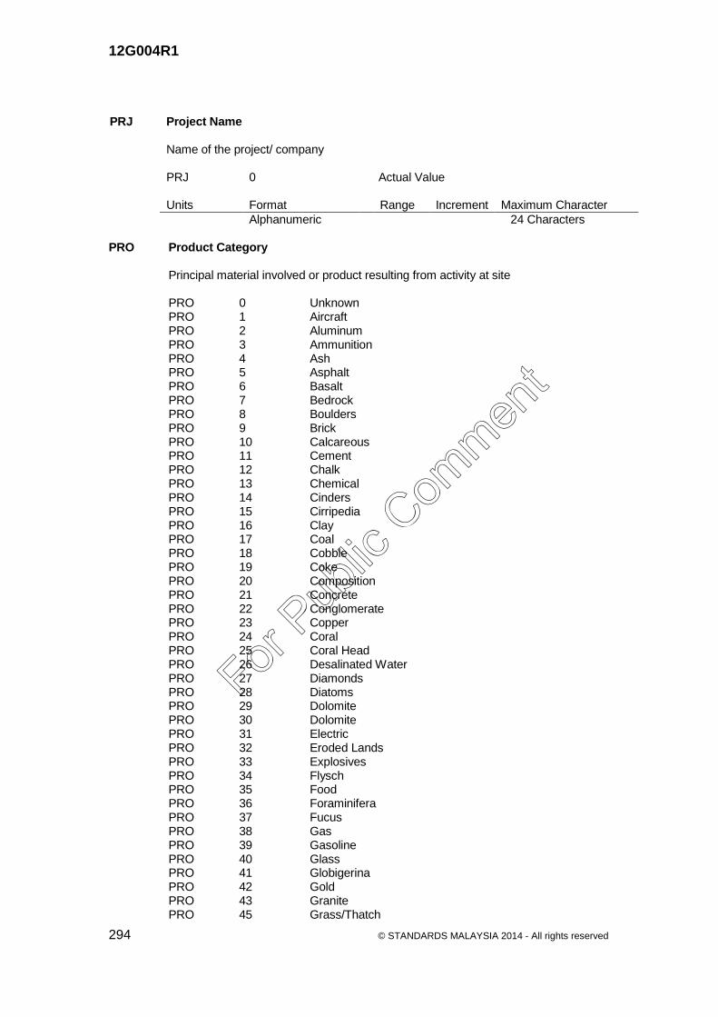
12G004R1
294 © STANDARDS MALAYSIA 2014 - All rights reserved
PRJ Project Name Name of the project/ company PRJ 0 Actual Value Units Format Range Increment Maximum Character
Alphanumeric 24 Characters PRO Product Category Principal material involved or product resulting from activity at site PRO 0 Unknown PRO 1 Aircraft PRO 2 Aluminum PRO 3 Ammunition PRO 4 Ash PRO 5 Asphalt PRO 6 Basalt PRO 7 Bedrock PRO 8 Boulders PRO 9 Brick PRO 10 Calcareous PRO 11 Cement PRO 12 Chalk PRO 13 Chemical PRO 14 Cinders PRO 15 Cirripedia PRO 16 Clay PRO 17 Coal PRO 18 Cobble PRO 19 Coke PRO 20 Composition PRO 21 Concrete PRO 22 Conglomerate PRO 23 Copper PRO 24 Coral PRO 25 Coral Head PRO 26 Desalinated Water PRO 27 Diamonds PRO 28 Diatoms PRO 29 Dolomite PRO 30 Dolomite PRO 31 Electric PRO 32 Eroded Lands PRO 33 Explosives PRO 34 Flysch PRO 35 Food PRO 36 Foraminifera PRO 37 Fucus PRO 38 Gas PRO 39 Gasoline PRO 40 Glass PRO 41 Globigerina PRO 42 Gold PRO 43 Granite PRO 45 Grass/Thatch
For Pub
lic Com
ment

12G004R1
© STANDARDS MALAYSIA 2014 - All rights reserved 295
PRO 46 Gravel PRO 47 Green Rocks PRO 48 Ground PRO 49 Ground (Shells) PRO 50 Heat PRO 51 Iron PRO 52 Lava PRO 54 Lead PRO 55 Loess PRO 56 Lumber PRO 57 Macadam PRO 58 Madrepores PRO 59 Manganese PRO 60 Marble PRO 61 Marl PRO 62 Masonry (Brick/Stone) PRO 63 Mattes PRO 64 Metal PRO 65 Mud PRO 66 Mussels PRO 67 Oil PRO 68 Oil Blister PRO 69 Ooze PRO 70 Oysters PRO 71 Paper PRO 72 Part Metal PRO 73 Pebbles PRO 74 Plastic PRO 75 Polyzoa PRO 76 Porphyry PRO 77 Prestressed Concrete PRO 78 Pteropods PRO 79 Pumice PRO 80 Quartz PRO 81 Radiolaria PRO 82 Radioactive Material PRO 83 Reinforced Concrete PRO 84 Rock/Rocky PRO 85 Rubber PRO 86 Rubble PRO 87 Salt PRO 88 Sand PRO 89 Sandstone PRO 90 Schist PRO 92 Scoria PRO 93 Sea Tangle PRO 94 Seaweed PRO 95 Sewage PRO 96 Shells PRO 98 Shingle PRO 99 Silt PRO 100 Silver PRO 101 Slag PRO 102 Sludge PRO 103 Snow/Ice PRO 104 Soil PRO 105 Spicules
For Pub
lic Com
ment

12G004R1
296 © STANDARDS MALAYSIA 2014 - All rights reserved
PRO 106 Sponge PRO 107 Steel PRO 108 Stone PRO 109 Sugar PRO 110 Travertine PRO 111 Tufa PRO 112 Uranium PRO 113 Vegetation Products PRO 114 Volcanic PRO 115 Volcanic Ash PRO 116 Water PRO 117 Wood PRO 118 Zinc PRO 119 Bauxite PRO 120 Bananas PRO 121 Cotton PRO 122 Bamboo PRO 123 Coffee PRO 124 Common fruit and/or nuts PRO 125 Palms PRO 126 Palmetto PRO 127 Tailings PRO 128 Refuse PRO 129 Tobacco PRO 130 None PRO 131 Personnel PRO 133 Telecommunications PRO 134 Fish PRO 135 Textile PRO 137 Automobiles and Trucks PRO 138 Crustaceans PRO 139 Cultivated Shellfish PRO 140 Ore PRO 141 Drinking Water PRO 142 Milk PRO 143 Sawdust and, or Wood Chips PRO 144 Scrap Metal PRO 145 Liquefied Natural Gas (LNG) PRO 146 Liquefied Petroleum Gas (LPG) PRO 147 Wine PRO 148 Grain PRO 149 Mineral Oil PRO 150 Waste PRO 151 Cultured Pearls Version 2.1: New Attribute Value to map S-57 attribute
CATMFA to FACC. PRO 160 Distilled Water PRO 996 Unpopulated PRO 997 Not Applicable PRO 998 Multiple PRO 999 Other
For Pub
lic Com
ment

12G004R1
© STANDARDS MALAYSIA 2014 - All rights reserved 297
PRT Processing Plant Type Type of a processing plant PRT 1 Liquid Propane Gas (LPG) PRT 2 Natural Gas PSA Principal Submitted Person Contact Address Contact address of the responsible person PSA 0 Actual Value Units Format Range Increment Maximum Character
Text String ASCII Text 100 Characters PSN Principal Submitted Person Contact Number Contact number of the responsible person PSN 0 Actual Value Units Format Range Increment Maximum Character
Text String ASCII Text 20 Characters PSP Principal Submitted Person Contact number of the responsible person PSP 0 Actual Value Units Format Range Increment Maximum Character
Text String ASCII Text 100 Characters PST Power Station Type Type of energy source used to generate power PST 1 Hydroelectric PST 2 Thermal PST 3 Wind PST 4 Solar PST 5 Nuclear PST 999 Others PTY Profile Type Type of a profile PTY 1 Geological cross section PTY 2 Hydrogeological cross section PTY 3 Engineering geology profile PTY 4 Geophysical profile
For Pub
lic Com
ment

12G004R1
298 © STANDARDS MALAYSIA 2014 - All rights reserved
PVT Pavement Surface Type The selection of pavement type is determined by the volume and composition of
traffic etc PVT 1 Asphaltic Concrete Wearing Course PVT 2 Dense Bituminous Macadam PVT 3 Polymer Modified Asphalt PVT 4 Concrete PVT 5 Stone Mastic Asphaltic PVT 6 Continuous Reinforces Concrete Pavement PVT 7 Gravel/Semigrout (unpaved) PVT 8 Interlocking Block (unpaved) PVT 9 Earth (unpaved) PYU Pylon Usage Identifies the usage of a pylon PYU 1 Electricity transmission PYU 2 Cable car QAT Quarry Authorized Type Type of an authorized quarry QAT 1 Lease QAT 2 License QAT 3 Permit QUT Quarry Type Type of a quarry QUT 1 Surface QUT 2 Subsurface QUU Quarry Use Identifies the use of a quarry QUU 1 Aggregate QUU 2 Dimension stone QUU 3 Agricultural application QUU 4 Lime QUU 5 Cement QUU 6 Armour stone RBT Rock Boulders Type Type of a rock boulder RBT 0 Actual Value Units Format Range Increment Maximum Character
Text String ASCII Text 24 Characters
For Pub
lic Com
ment

12G004R1
© STANDARDS MALAYSIA 2014 - All rights reserved 299
RBU Religious Building Usage Usage of a religious building RBU 1 Surau RBU 2 Mosque RBU 3 Chapel or Church RBU 4 Chinese Temple RBU 5 Hindu Temple RBU 6 Buddhist Temple RBU 7 Sikh Temple RBU 8 Thai Temple RBU 9 Bahai Temple RCF Federal Road Category Identifies the category of federal road RCF 1 Major federal road RCF 2 Regional development Scheme Road RCF 3 Access road to Federal Government Institutions RCF 4 Industrial road RCS Road Class Identifies the type of road class RCS 1 Dual Carriage Highway RCS 2 Single Carriage Highway RCS 3 Dual Carriage Road RCS 4 Single Carriage Road RCS 5 Unsealed Road RCS 6 Road Under Construction RCT Religious Burial Ground Type Type of a burial ground RCT 1 Muslim RCT 2 Christian RCT 3 Chinese RCT 4 Hindu RCT 5 Bahai RCT 6 Sikh RCT 7 Orang Asli RCT 8 Mixed RDC Road Category Category of a road RDC 1 Toll Expressway & Toll Highway – Interstate national
network for through traffic with full control of access RDC 2 Federal Trunk Road (Jalan Persekutuan) –Major roads
forming the basic network of the road transportation system within states; link up state capitals & district capitals or other major towns
For Pub
lic Com
ment

12G004R1
300 © STANDARDS MALAYSIA 2014 - All rights reserved
RDC 3 State Road (Jalan Negeri) – Major roads forming the basic network of the road transportation system within districts.
RDC 4 Municipility Road (Jalan PBT) – Major roads which penetrate and serve identifiable neighborhoods, commercial areas and industrial areas.
RDC 5 Private Road – Basic road network owned by certain individuals.
RDC 6 Jalan Kampung / Rural Roads – Basic road network within a neighborhood serves primarily to offer direct access to abutting land.
RDC 7 Loggers Road RDC 8 Farm Road (Jalan Pertanian) RDF Traffic Flow Identifies whether the traffic flow is in one or two direction RDF 1 One Direction RDF 2 Two Direction RDL Road Location Identifies the location of the road RDL 0 Actual Value Units Format Range Increment Maximum Character
Alphanumeric 20 Characters RDS Road Service Area An area where Road Service located RDS 1 Urban RDS 2 Rural REC Record Number Identifies the file or record number REC 0 Actual Value Units Format Range Increment Maximum Character
Text String ASCII Text 12 Characters RES Report Status Identifies the status of a report RES 1 Draft RES 2 Final
For Pub
lic Com
ment

12G004R1
© STANDARDS MALAYSIA 2014 - All rights reserved 301
RET Residential Building Type Type of building used for residential purposes RET 1 Detached RET 2 Semi Detached RET 3 Terrace/Link RET 4 Multi Storey RET 5 Long House RET 6 Cluster RET 7 Town Houses RET 8 Multi Unit REU Residential Usage Usage of a residential building REU 1 Condominium REU 2 Service Apartment REU 3 Apartment REU 4 Low Cost House REU 5 Low Cost Flat REU 6 Public Housing REU 7 Private Housing REU 8 Flat REU 9 Government Quarters REU 10 Squatters REU 11 Transit Housing REU 12 Communal Housing RFC Reef Category Category of a reef RFC 1 Submerged Reef RFC 2 Inter Tidal Reef RFT Rockfall Type Type of a rockfall RFT 1 Toppling RFT 2 Planar RFT 3 Wedge RGS Regulartory Sign RGS Rp.1 Stop At Junction (Berhenti Di Persimpangan) RGS Rp.2a No Left Turn (Dilarang Belok Ke Kiri) RGS Rp.2b No Right Turn (Dilarang Belok Ke Kanan) RGS Rp.3 No 'U'-Turn (Dilarang Berpusing Balik) RGS Rp.4 No Entry (Kenderaan Dilarang Masuk) RGS Rp.5 Vehicle Exceeding - Tonne Kept Out (Kenderaan Melebihi - Tan Dilarang Masuk) RGS Rp.6 Vehicle Exceeding - Altimeter Kept Out (Kenderaan Melebihi - Meter Tinggi dilarang Masuk) RGS Rp.7 Speed Limit (Had Laju)
For Pub
lic Com
ment

12G004R1
302 © STANDARDS MALAYSIA 2014 - All rights reserved
RGS Rp.8a This Type Vehicle Kept Out (Kenderaan Jenis Ini Dilarang Masuk) RGS Rp.8b Motorcycle Kept Out (Motorsikal Dilarang Masuk) RGS Rp.9 Speed Limit End (Had Laju Tamat) RGS Rp.10 Prohibited Park (Dilarang Meletak Kenderaan) RGS Rp.11 Prohibited Stop (Dilarang Berhenti) RGS Rp.12 Prohibited Honking (Dilarang Membunyikan Hon) RGS Rp.13 Give Way (Beri Laluan) RGS Rp.14 Vehicle Exceeding – Meter Broad Kept Out (Kenderaan Melebihi Meter – Lebar Dilarang Masuk) RGS Rp.15 Stop Sign for Children Crossing (Berhenti Kanak-Kanak Melintas) RGS Rp.17 Prohibited Overtake (Dilarang Memotong) RGS Rp.18 Prohibited Fishing (Dilarang Memancing) RGS Rm.1a Arrow (Left/Right) (Ikut Arah) RGS Rm.1b Arrow (Straight) (Ikut Arah) RGS Rm.1c Straight or Turn Right Only (Jalan Terus Atau Belok Ke Kanan Sahaja) RGS Rm.1d Turn Right Only (Belok Ke Kanan Sahaja) RGS Rm.4 Keep Left (Ikut Kiri) RGS Rm.2a Cycle Track (Lorong Basikal Sahaja) RGS Rm.2c Motorcycle Lane (Lorong Motosikal Sahaja) RGT Railway Gate Type Type of a railway gate RGT 1 Manned RGT 2 Unmanned RGU Road Guide Sign RGU G.11 Bus Stop (Perhentian Bas) RGU G.13 Public Phone (Telefon Awam) RGU G.14 Parking Area (Tempat Letak Kenderaan) RGU G.15 Health Centre (Pusat Kesihatan) RGU G.16 Hospital RGU G.17 Petrol Station (Stesen Minyak) RGU G.18 Dead End (Jalan Mati) RGU G.19 U-Turn Sign (Dibenarkan Berpusing Balik) RGU T.1 Road Works (Jalan Sedang Diperbaiki) RGU T.8a Detour Sign (Lencongan) RGU Gd.1 Distance to Reach Destination (Papan Tanda Tempat Tuju/Destinasi) RGU Gd.2 Distance to Reach Destination (Papan Tanda Tempat Tuju/Destinasi) RGU Gt.1 Intersection Direction Sign (Papan Tanda Tunjuk Arah) RGU Gt.2 Signboard Show Direction with Tourism Area Signboard (Papan Tanda Tunjuk Arah Dengan Papan Tanda
Kawasan Perlancongan) RGU Gt.3 Signboard Show Direction with Signboard Show Direction
to Highway (Papan Tanda Tunjuk Arah Dengan Papan Tanda Ke
Lebuh Raya) RGU Gt.4 Signboard Show Circular Path (Papan Tanda Tunjuk Arah Bulatan)
For Pub
lic Com
ment

12G004R1
© STANDARDS MALAYSIA 2014 - All rights reserved 303
RGU Gt.5 Directions Signboard on Gantry (Papan Tanda Panduan Arah Di Atas Gantri ) RGU Gt.6 Direction Signboard on Highways (Papan Tanda Panduan Arah Di Lebuhraya) RGU Gx.1 Distance Signboard (Papan Tanda Jarak) - 2 Routes RGU Gx.2 Distance Signboard (Papan Tanda Jarak) - 1 Route RIT Ridge Type Type of a ridge RIT 1 Outcrop RIT 2 Non Outcrop RKT Rock Type Type of a rock RKT 0 Actual Value Units Format Range Increment Maximum Character
Text String ASCII Text 24 Characters RLH Road Level Height Identifies the level of height RLH 1 Lower level RLH 2 Second level or tier of the road from bottom RLH 3 Third level or tier of the road from bottom RLH 4 Fourth level or tier of the road from bottom RLH 5 Fifth level or tier of the road from bottom RLH 6 Sixth level or tier of the road from bottom RLP Reclaimed Land Purpose Usage of land after reclamation RLP 1 Industrial RLP 2 Residential RLP 3 Recreational RLP 4 Commercial RML Road Marking Location Identify the road marking location RML 1 Left hand side RML 2 Center RML 3 Right hand side RML 4 All
For Pub
lic Com
ment

12G004R1
304 © STANDARDS MALAYSIA 2014 - All rights reserved
RNO Registered Number Unique reference number of a feature RNO 0 Actual Value Units Format Range Increment Maximum Character
Text String ASCII Text 12 Characters ROT Rock Outcrop Type Type of a rock outcrop RNO 0 Actual Value Units Format Range Increment Maximum Character
Text String ASCII Text 24 Characters RPS Portion Class Type of portion class RPS 1 Upper RPS 2 Lower RPS 3 Close RPT Riverbank Protection Type Type of material used for river protection works RPT 1 Concrete RPT 2 Steel RPT 3 Rocks RPT 4 Bakau RPV Road Pavement Type The physical surface type of a road RPV 1 Rigid RPV 2 Flexible RRC Rural Road Category Categories of roads in rural areas RRC 1 Expressway RRC 2 Highway RRC 3 Primary Road RRC 4 Secondary Road RRC 5 Minor Road
For Pub
lic Com
ment

12G004R1
© STANDARDS MALAYSIA 2014 - All rights reserved 305
RSC Road Surface Composition The physical surface composition of a road RSC 1 Paved (sealed) RSC 2 Unpaved (Unsealed) RST Rail Station Type Type of a rail station RST 1 Station RST 2 Halt RTC Rail Track Category Category of a rail track RTC 1 Single Rail RTC 2 Standard Gauge Rail RTC 3 Meter Gauge Rail RTE Rail Track Electrification Identifies whether or not electricity is provided for a rail track RTE 1 Electrified RTE 2 Non Electrified RTF Rail Track Function Type of a rail track in terms of its functionality RTF 1 Main RTF 2 Branch RTF 3 Siding RTF 4 Loop RTF 5 Spurline RTN Route Number Official route number assigned to a route RTN 0 Actual Value Units Format Range Increment Maximum Character
Text String ASCII Text 6Characters RTR Rail Tracking Identifies whether a rail is a single or double track RTR 1 Single Track Rail RTR 2 Double Track Rail RTR 3 Single Track Light Rail RTR 4 Double Track Light Rail RTR 5 High Speed Rail
For Pub
lic Com
ment

12G004R1
306 © STANDARDS MALAYSIA 2014 - All rights reserved
RTU Rail Usage Usage of a rail track, station or terminal RTU 1 Mono Rail RTU 2 Keretapi Tanah Melayu (KTM) RTU 3 Express Rail Link (ERL) RTU 4 Sistem Transit Aliran Ringan RTU 6 Funicular RTU 7 Electrict Train Service (ETS) RTU 8 Mass Rapid Transit (MRT) RTU 9 High Speed Train RVT Reservoir Type Type of a reservoir RVT 1 Reinforced Concrete (RC) RVT 2 Prestressed Concrete RVT 3 Fibreglass Reinforced Polyester (FRP) RVT 4 Glass Coated Steel RVT 5 Galvanised Pressed Steel RVT 999 Others RVU Reservoir Use Use of a reservoir RVU 1 Balancing RVU 2 Principal RVU 3 Service RWC Reservoir/Water Tank Category Reservoir/water tank Category RWC 1 Covered RWC 2 Uncovered RWC 3 Tower RYT River Groyne Type Type of material used for river protection works RYT 1 Permeable RYT 2 Impermeable SCC Submarine Cable Category Category of a submarine cable SCC 1 Power SCC 2 Telecommunication
For Pub
lic Com
ment

12G004R1
© STANDARDS MALAYSIA 2014 - All rights reserved 307
SCG Soil Colour Group Dominant soil matrix colour taken at 50 cm depth from soil surface or just above the
lithic or paralithic contact whichever is shallower SCG DR Dusky Red SCG BR Brown SCG Rd Red SCG RY Red-yellow SCG Yw Yellow SCG Pd Pallid SCG Gy Gray SCG Bk Dark brown-black SCG Gg Greenish grey SCG Ol Olive SCN Scientific Name Scientific Name applied SCN 0 Actual Value Units Format Range Increment Maximum Character
Text String ASCII Text 24Characters SCT Clinic Service Type Category of a Clinic Service Type SCT 1 Rural SCT 2 Dental SCT 3 Maternity SCT 4 Polyclinic SD2 Secondary Destination_2 Distance value display on kilometre post SD2 0 Actual Value Units Format Range Increment Maximum Character
Alphanumeric 1 to 10 24 Characters SDA Submission Date Date of Planning Permission Submission SDA 0 Actual Value Units Format Range Increment Maximum Character
Date yyyy /mm/ dd
For Pub
lic Com
ment
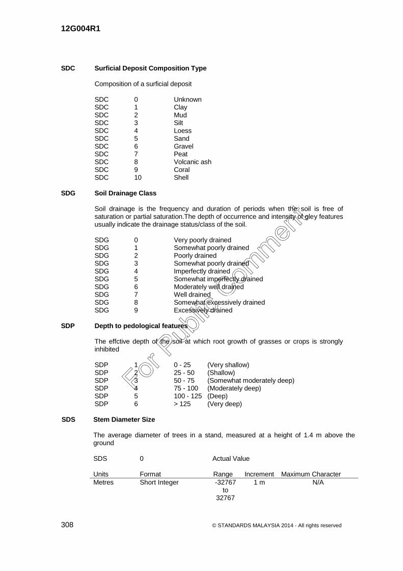
12G004R1
308 © STANDARDS MALAYSIA 2014 - All rights reserved
SDC Surficial Deposit Composition Type Composition of a surficial deposit SDC 0 Unknown SDC 1 Clay SDC 2 Mud SDC 3 Silt SDC 4 Loess SDC 5 Sand SDC 6 Gravel SDC 7 Peat SDC 8 Volcanic ash SDC 9 Coral SDC 10 Shell SDG Soil Drainage Class
Soil drainage is the frequency and duration of periods when the soil is free of saturation or partial saturation.The depth of occurrence and intensity of gley features usually indicate the drainage status/class of the soil.
SDG 0 Very poorly drained SDG 1 Somewhat poorly drained SDG 2 Poorly drained SDG 3 Somewhat poorly drained SDG 4 Imperfectly drained SDG 5 Somewhat imperfectly drained SDG 6 Moderately well drained SDG 7 Well drained SDG 8 Somewhat excessively drained SDG 9 Excessively drained SDP Depth to pedological features
The effctive depth of the soil at which root growth of grasses or crops is strongly inhibited
SDP 1 0 - 25 (Very shallow) SDP 2 25 - 50 (Shallow) SDP 3 50 - 75 (Somewhat moderately deep) SDP 4 75 - 100 (Moderately deep) SDP 5 100 - 125 (Deep) SDP 6 > 125 (Very deep) SDS Stem Diameter Size The average diameter of trees in a stand, measured at a height of 1.4 m above the
ground SDS 0 Actual Value Units Format Range Increment Maximum Character
Metres Short Integer -32767 to
32767
1 m N/A
For Pub
lic Com
ment

12G004R1
© STANDARDS MALAYSIA 2014 - All rights reserved 309
SDT Surficial Deposit Type
Type of a surficial deposit SDT 1 Residual SDT 2 Alluvial SDT 3 Glacial SEC Section Number Official section number assigned to a route by the road authority SEC 0 Actual Value Units Format Range Increment Maximum Character
Real Number 8 Characters SGR Slope Gradient A value representing the gradient of a slope SGR 0 Actual Value Units Format Range Increment Maximum Character
Percentage Floating SHC Structure Shape Category
Geometric form, appearance, or configuration of the feature SHC 0 Unknown SHC 10 Pillar/Spindle SHC 12 Pyramid SHC 15 Solid/filled SHC 17 Spherical (Hemispherical) SHC 18 Truss SHC 19 With Radome SHC 22 Crescent SHC 23 Ferris Wheel SHC 25 Roller Coaster SHC 26 Lateral SHC 27 Mounds SHC 28 Ripple SHC 29 Star SHC 30 Transverse SHC 52 'A' Frame SHC 53 'H' Frame SHC 54 'I' Frame SHC 56 'Y' Frame SHC 60 Mast SHC 61 Tripod SHC 74 'T' Frame SHC 77 Arch SHC 78 Multi-Arch SHC 79 Round SHC 80 Rectangular SHC 81 Dragons Teeth
For Pub
lic Com
ment

12G004R1
310 © STANDARDS MALAYSIA 2014 - All rights reserved
SHC 82 I-Beam SHC 83 Square SHC 84 Irregular SHC 85 Diamond Shaped Buoy SHC 86 Oval SHC 87 Dome SHC 88 Spherical with Column Support SHC 89 Cylindrical or Peaked with tower support SHC 90 High-Rise Building SHC 91 Cylindrical SHC 92 Cubic SHC 93 Pole SHC 94 Board SHC 95 Column (Pillar) SHC 96 Plaque SHC 97 Statue SHC 107 Tower SHC 108 Scanner SHC 109 Obelisk SHC 110 Radome, Tower Mounted SHC 997 Unpopulated SHC 998 Not Applicable SHC 999 Other SHT Shore Type
Tabulates the material type likely to be found at a shore SHT 1 Sandy SHT 2 Stony SHT 3 Muddy SHV Spot Height Value A value representing above mean sea level height, usually for photogrammetrically
derived point SHV 0 Actual Value Units Format Range Increment Maximum Character
Percentage Floating SIG Signalisation
Identifies whether or not a feature is signalized. SIG 1 Signalised SIG 2 Unsignalised SIT Silt Type
Type of silts SIT 1 Undifferentiated SIT 2 Marine SIT 3 Non-marine
For Pub
lic Com
ment

12G004R1
© STANDARDS MALAYSIA 2014 - All rights reserved 311
SKH Sinkhole Type
Types of sinkhole SKH 1 Dissolution SKH 2 Cover-subsidence SKH 3 Cover-collapse SLC Street Light Category
Category of a street light SLC 1 On Ground SLC 2 Under Ground SLD Slope Designation Possible slope designation SLD 0 Actual Value Units Format Range Increment Maximum Character
Alphanumeric 24 Characters SMC Soil Colour Matrix Actual dominant soil matrix colour taken at 50 cm depth from soil surface or just above
the lithic or paralithic contact whichever is shallower using Munsell Soil Colour Chart SMC 0 Actual Value Units Format Range Increment Maximum Character
Text String ASCII Text 50 Characters SMG Mottle Colour Group
Dominant soil mottle colour SMG BR Brown SMG Rd Red SMG Yw Yellow SMG Pd Pallid SMG Gy Gray SMG Ol Olive SMP Soil material type underlying the organic layer/peat
Soil material type or substratum underlying peat/organic layer
SMP 1 Clayey riverine SMP 2 Loamy riverine SMP 3 Sandy riverine SMP 4 Clayey Marine/ Estuarine/ Brackish (Non sulfuric/Non
sulfidic) SMP 5 Loamy Marine/ Estuarine/ Brackish (Non sulfuric/Non
sulfidic)
For Pub
lic Com
ment
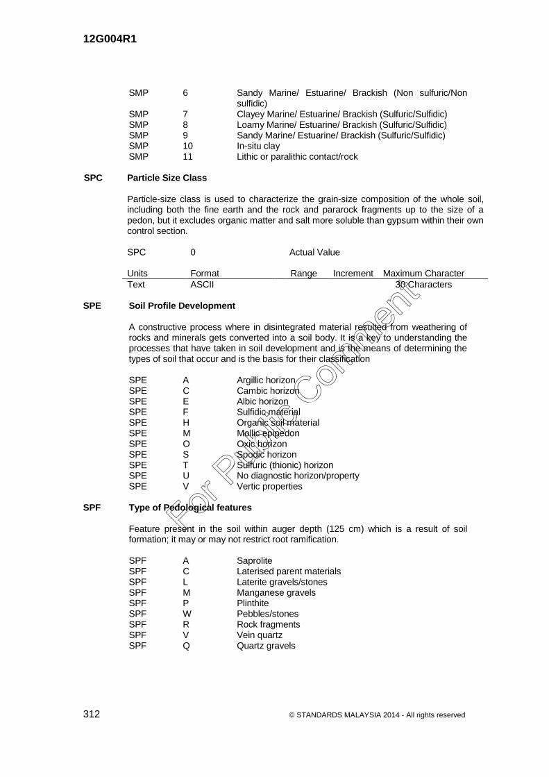
12G004R1
312 © STANDARDS MALAYSIA 2014 - All rights reserved
SMP 6 Sandy Marine/ Estuarine/ Brackish (Non sulfuric/Non sulfidic)
SMP 7 Clayey Marine/ Estuarine/ Brackish (Sulfuric/Sulfidic) SMP 8 Loamy Marine/ Estuarine/ Brackish (Sulfuric/Sulfidic) SMP 9 Sandy Marine/ Estuarine/ Brackish (Sulfuric/Sulfidic) SMP 10 In-situ clay SMP 11 Lithic or paralithic contact/rock SPC Particle Size Class Particle-size class is used to characterize the grain-size composition of the whole soil,
including both the fine earth and the rock and pararock fragments up to the size of a pedon, but it excludes organic matter and salt more soluble than gypsum within their own control section.
SPC 0 Actual Value Units Format Range Increment Maximum Character
Text ASCII 30 Characters SPE Soil Profile Development
A constructive process where in disintegrated material resulted from weathering of rocks and minerals gets converted into a soil body. It is a key to understanding the processes that have taken in soil development and is the means of determining the types of soil that occur and is the basis for their classification
SPE A Argillic horizon SPE C Cambic horizon SPE E Albic horizon SPE F Sulfidic material SPE H Organic soil material SPE M Mollic epipedon SPE O Oxic horizon SPE S Spodic horizon SPE T Sulfuric (thionic) horizon SPE U No diagnostic horizon/property SPE V Vertic properties SPF Type of Pedological features
Feature present in the soil within auger depth (125 cm) which is a result of soil formation; it may or may not restrict root ramification.
SPF A Saprolite SPF C Laterised parent materials SPF L Laterite gravels/stones SPF M Manganese gravels SPF P Plinthite SPF W Pebbles/stones SPF R Rock fragments SPF V Vein quartz SPF Q Quartz gravels
For Pub
lic Com
ment

12G004R1
© STANDARDS MALAYSIA 2014 - All rights reserved 313
SPM Sewerage Pipe Material
Material used for the construction of a sewerage pipe SPM 1 Vitrified Clay SPM 2 Reinforced Concrete SPM 3 High Density Polyethylene SPM 4 Centrifugal Glass Reinforced Plastic SPM 5 Ductile Iron SPM 999 Others SPS Sewerage Pipe Diameter Particle-size class is used to characterize the grain-size composition of the whole soil,
including both the fine earth and the rock and pararock fragments up to the size of a pedon, but it excludes organic matter and salt more soluble than gypsum within their own control section.
SPS 0 Actual Value Units Format Range Increment Maximum Character
Text ASCII 30 Characters SPT Sewerage Pipe Type
Type of a sewerage pipe SPT 1 Trunk SPT 2 Reticulation SPT 3 Lateral Connection SPT 4 Forcemain SRD Surface Roughness Description
Describes the condition of the surface materials that may be used for mobility prediction, construction material and landing sites
SRD 0 Unknown SRD 1 No surface roughness effect SRD 2 Area of high landslide potential SRD 3 Uncohesive surface material/flat SRD 4 Rough SRD 5 Angular SRD 6 Rounded SRD 11 Surface of numerous cobbles and boulders SRD 12 Areas of stony terrain SRD 13 Stony soil with surface rock SRD 14 Stony soil with scattered boulders SRD 15 Stony soil with numerous boulders SRD 16 Numerous boulders SRD 17 Numerous rock outcrops SRD 18 Area of scattered boulders SRD 19 Talus slope SRD 20 Boulder Field SRD 31 Highly fractured rock surface SRD 34 Stony soil with numerous rock outcrops SRD 35 Irregular surface with deep fractures of foliation
For Pub
lic Com
ment

12G004R1
314 © STANDARDS MALAYSIA 2014 - All rights reserved
SRD 36 Rugged terrain with numerous rock outcrops SRD 37 Rugged bedrock surface SRD 38 Sand dunes SRD 63 Playa/dry lake SRD 69 Area of numerous small lakes and ponds SRD 82 Quarries SRD 92 Area of numerous man-made canals/drains/ditches SRD 997 Unpopulated SRD 998 Not Applicable SRD 999 Other SRG Sedimentary Rock Group
Identifies the group of sedimentary rocks SRG 1 Argillaceous SRG 2 Arenaceous SRG 3 Rudaceous SRG 4 Calcareous SRG 5 Siliceous SRG 6 Carbonaceous SRG 7 Evaporites SRT Sedimentary Rock Type
ARGILLACEOUS SRT 101 Mudstone SRT 102 Shale SRT 103 Siltstone SRT 104 Claystone
ARENACEOUS SRT 201 Sandstone SRT 202 Graywacke
RUDACEOUS SRT 301 Conglomerate SRT 302 Sedimentary breccias
CALCAREOUS SRT 401 Limestone SRT 402 Dolomite
SILICEOUS SRT 501 Chert
CARBONACEOUS SRT 601 Coal EVAPORITES SRT 701 Borates SRT 702 Carbonates SRT 703 Halides SRT 704 Nitrates SRT 705 Sulphates
For Pub
lic Com
ment

12G004R1
© STANDARDS MALAYSIA 2014 - All rights reserved 315
SSC Substation Category
Category of a substation SSC 1 Main Intake Substation (PMU) SSC 2 Main Distribution Substation (PPU) SSC 3 Main Switching Station (SSU) SSC 4 Distribution Substation (PCE) SSL Soil Salinity
Measurement of the quantity of mineral salts found in a soil SSL 1 Very low (> 0.5 - 1 dS/m) SSL 2 Low (> 1 - 2 dS/m) SSL 3 Moderate (> 2 - 4 dS/m) SSL 4 High (> 4 dS/m) SST Substation Type
Type of a Substation SST 1 Indoor SST 2 Outdoor SST 3 Pole Mounted SST 4 Underground SST 5 Indoor & Outdoor SST 999 Others STA Status
Operational status of a feature STA 1 In Operation STA 2 To be Constructed STA 3 Under Construction STA 4 Abandon STC Soil Textural Class
Textural classes refers to the fine-earth fraction that reflect the relative proportions of clay (fraction less than 2 microns), silt (2 - 50 microns) and sand (50 - 2,000 microns) in the soil.
STC H Heavy clay STC C Clay, Sandy Clay STC Cf Fine sandy clay STC Cm Medium sandy clay STC Cc Coarse sandy clay STC T Silty clay STC M Sandy Clay Loam STC Mf Fine Sandy Clay Loam STC Mm Medium Sandy Clay Loam STC Mc Coarse Sandy Clay Loam STC O Loam STC L Clay Loam STC I Silty clay loam, Silt loam, Silt
For Pub
lic Com
ment

12G004R1
316 © STANDARDS MALAYSIA 2014 - All rights reserved
STC A Sandy loam STC Af Fine sandy loam STC Ac Coarse sandy loam STC S Loamy sand, Sand STC Sf Fine sand STC Sc Coarse sand STC fS Fine loamy sand STC cS Coarse loamy sand STC Oi Fibric soil material STC Oe Hemic soil material STC Oa Sapric soil material STE Settlement Type
Type of settlement STE 1 City STE 2 Town STE 3 Pekan STE 4 Kampung STO Thickness of Organic Layer
Thickness of organic layer to the underlying soil materials STO 1 0 - 25 cm (Mineral soil) STO 2 25 - 50 cm (Mineral soil) STO 3 50 - 75 cm (Shallow organic soil) STO 4 75 - 100 cm (Shallow organic soil) STO 5 100 - 300 cm (Moderately deep organic soil) STO 6 >300 cm (Deep organic soil) STP Sewerage Treatment Plant Category
Category of a sewerage treatment plant STP 1 Covered STP 2 Uncovered STR Strike Direction or trend taken by a structural surface or line with respect to north in
clockwise direction STR 0 Actual Value Units Format Range Increment Maximum Character
Degree Floating STS Capital Status
Status of Settlement STS 1 Nation Capital STS 2 State Capital STS 3 Division Capital STS 4 District/Jajahan Capital STS 5 Sub District Capital
For Pub
lic Com
ment

12G004R1
© STANDARDS MALAYSIA 2014 - All rights reserved 317
STT Sewerage Treatment Plant Type
Type of a sewerage treatment plant STT 1 Communal Septic Tank STT 2 Omhoff Tank STT 3 Oxidation Ponds STT 4 Bio Drum STT 5 Bio Filter STT 6 Bio Soil STT 7 Trickling Filter STT 8 Rotating Biological Contact STT 9 Acty Bio STT 10 Aerated Lagoon STT 11 Activated Sludge STT 12 Extended Aeration STT 13 Loyal Extended Aeration STT 14 High Kleen STT 15 Oxidation Ditch STT 16 Sewerage Aeration Treatment System STT 17 Sequential Batch Reactor STT 18 Upflow Aerobic Sludge Blanket STY Stockpile Type
Type of a stockpile STY 1 Mining stockpile STY 2 Quarry stockpile SUS Status of Survey
The status of survey for a land parcel or lot SUS 1 Survey completed SUS 2 Survey not yet completed SUT Survey Point Type
Type of a survey point on the ground of known position SUT 1 Tellurometer Traverse Point SUT 2 Bearing Tellurometer Distance Point SUT 3 Photo Control Point SUT 4 Reference Secondary Point SUT 5 Standard Traverse Point SUT 6 Reference Tellurometer Transit Point SUT 7 Reference Standard Traverse Point SUT 8 Tertiary Point SUT 9 Cadastral Boundary Point
For Pub
lic Com
ment

12G004R1
318 © STANDARDS MALAYSIA 2014 - All rights reserved
SVM Small VMS Type Type of small VMS SVM 0 Actual Value Units Format Range Increment Maximum Character
Text String ASCII 20 Characters SVP Survey Phase
Identifies the phase of a survey SVP 1 Reconnaissance SVP 2 Follow-up SVP 3 Detailed SWC Spring/Well Characteristic Category
Type of available water SWC 0 Unknown SWC 1 Alkaline SWC 2 Not Applicable SWC 4 Mineral SWC 9 Freshwater/Potable SWC 10 Salt SWC 11 Fresh SWC 997 Unpopulated SWC 999 Other SWT Swamp Type
Type of a swamp SWT 1 Tidal SWT 2 Non Tidal SZT Supply Zone Type
Type of a supply zone SZT 1 Demand Area SZT 2 Demand Center TAT Tank Type
Type of a tank TAT 1 Ground Tank TAT 2 Tower Tank TAU Tank Usage
Identifies the usage of a tank TAU 1 Water TAU 2 Petroleum
For Pub
lic Com
ment

12G004R1
© STANDARDS MALAYSIA 2014 - All rights reserved 319
TBE Type of Berm
Identifies the type of berm TBE 1 Cutting Area TBE 2 Filling Area TBT Trap Boom Types
The different types of booms TBT 1 Long Boom TBT 2 Trash Screen TBT 3 Trash Rake TCC Track Category
Category of a travel path TCC 1 Motorable TCC 2 Unmotorable TCL Type of Cycle Lane
Identifies the type of cycle lane TCL 1 Exclusive – Segregated motorcycle path separated by a
physical barrier. TCL 2 Non Exclusive - Dedicated motorcycle lane separated
from traffic by lane marking. TCO Telecommunication Operators
Name of Telecomunnication Service providers TCO 1 Telekom Malaysia TCO 2 Time Telekom TCO 3 CELCOM TCO 4 MAXIS TCO 5 DIGI TCO 6 U MOBILE TCO 999 Others TCT Track Type
Type of a travel path TCT 1 Recreational TCT 2 Logging TCT 3 Cycle TDS Total Dissolved Solid
Determine range of total dissolved solid content in a tube well TDS 1 < 1,500 mg/l TDS 2 1,500 - 5,000 mg/l
For Pub
lic Com
ment

12G004R1
320 © STANDARDS MALAYSIA 2014 - All rights reserved
TDS 3 5,000 - 10,000 mg/l TDS 4 > 10,000 mg/l TEX Texture
Identifies the texture of a surficial deposit TEX 1 Clayey TEX 2 Silty TEX 3 Sandy TEX 4 Gravelly TJC Road Junction
Type of Road Junction JCT 1 T-Junction JCT 2 Cross Junction JCT 3 Staggered JCT 999 Others TLA Traffic Light Aspect
Type of traffic light aspect TTA 1 LED (18W) TTA 2 Halogen (50W) TLC Traffic Light Cable
Type of traffic light cable TLC 1 Multi Core TLC 2 Armoured TLN Type of Lane
Identify the type of lanes TLN 1 Fast Lane TLN 2 Middle Lane TLN 3 Slow Lane TLN 4 Emergency Lane TLP Traffic Light Pole
Type of Traffic Light Pole TLP 1 Standard TLP 2 Overhead
For Pub
lic Com
ment

12G004R1
© STANDARDS MALAYSIA 2014 - All rights reserved 321
TLQ Traffic Light Quantity Quantity of Traffic Light Pole TLQ 0 Actual Value Units Format Range Increment Maximum Character
Real Number 24 Characters TLS Transmission Line Suspension
Types of suspension of power transmission lines between pylons TLS 0 Unknown TLS 1 Normal Suspension TLS 2 Catenary (Over Mountains) TLS 3 Catenary (Over Water) TLS 997 Unpopulated TLS 998 Not Applicable TLS 999 Other TNU Tunnel Usage
Usage of a tunnel TNU 1 Railway TNU 2 Road TNU 3 Flood Mitigation TNU 4 Multi Modal TOL Toll
Identifies whether the use of a highway/road is free or charged TOL 1 Toll TOL 2 Free TOP Top Mark
Type of Top Mark TOP 1 Cone TOP 2 Sphere TOP 3 Cylinder TOP 4 Board TOP 5 X-Shape TOS Toll Operating System
Type of TOS TOS 1 Open Toll System TOS 2 Close Toll System
For Pub
lic Com
ment

12G004R1
322 © STANDARDS MALAYSIA 2014 - All rights reserved
TQM Air Quality Monitoring Tunnel
Identifies the type air quality for monitoring tunnel TQM 1 Ground Level TQM 2 Under Ground TRA Traffic Sign Type
Type of a traffic sign TRA 1 Standard Road Sign TRA 2 Variable Message Sign TRM Type of Road Marking Identifies the type of road marking TRM 1 centre line TRM 2 lane line TRM 3 edge line TRM 4 no passing zone line TRM 5 turn line TRM 6 stop line TRM 7 give way line TRM 8 pedestrian crossing markings TRM 9 words and symbol messages TRM 10 arrows TRM 11 painted islands and chevron marking TRM 12 chevron separator for motorcycle lane TRM 13 yellow boxes TRM 14 kerb marking TRM 15 transverse yellow bars TRT Trench Type Type of Trench TRT 1 Covered TRT 2 Uncovered TRU Trench Usage Usage of Trench TRU 1 Utility TRU 999 Others TRV Traversability Indicates whether the feature is traversable by foot TRV 0 Unknown TRV 1 Traversable TRV 2 Non-Traversable TRV 4 Polygon TRV 5 Pond TRV 997 Unpopulated
For Pub
lic Com
ment

12G004R1
© STANDARDS MALAYSIA 2014 - All rights reserved 323
TRV 998 Not Applicable TRV 999 Other TSB Traffic Safety Barriers Possible type of traffic safety barriers TSB 1 Guardrail TSB 2 Wire rope TSB 3 New Jersey barrier TSB 4 Crash Cushion TSC Tree Spacing Category Average distance between adjacent tree centerlines within area of feature TSC 0 Actual Value Units Format Range Increment Maximum Character
Metres Short Integer -32767 to 32767
1 m N/A
TSD Road Traffic Safety Devices Type Possible type of road traffic safety devices TSD 1 Flexible post/ safety bollard TSD 2 Raised Pavement Marker (Tiger eye, Cat Eye) TSD 3 Delineator post TSD 4 Antiglare fence TSD 5 Road stud TSD 6 Amber light TSD 7 Interlocking Paver TSL Street Light Type Type of Street Light TSL 1 Fauna TSL 2 Flora TSL 3 Obor TSL 4 Wau Bulan TSL 999 Others TST Trigonometry Station Type Type of a trigonometric station TST 1 Geodetic Station TST 2 Primary Station TST 3 Secondary Station TST 4 Reference Secondary Point TST 5 Tertiary Station TST 6 Traverse Trigonometry Station TST 7 Brunei Trigonometry Station
For Pub
lic Com
ment

12G004R1
324 © STANDARDS MALAYSIA 2014 - All rights reserved
TYP Type of Slope Proctection TYP 1 Vegetation TYP 2 Retaining Wall TYP 3 Gabion TYP 4 Cement Grouting ULT Underpass Lighting Type Type of Underpass Lighting ULT 1 Brick Light ULT 2 Spot Light ULT 3 Wall Light ULT 4 Flood Light ULT 999 Others VDC Vertical (Sounding) Datum Category The tidal datum to which soundings and drying heights are referenced. It is usually to
correspond to a low water stage of the tide. (Also known as Chart Sounding Datum) VDC 0 Unknown VDC 2 High Water VDC 3 Higher High Water VDC 4 Indian Spring Low Water VDC 5 Low Water VDC 6 Lower Low Water VDC 7 Mean High Water VDC 8 Mean High Water Neaps VDC 9 Mean High Water Springs VDC 10 Mean Higher High Water VDC 11 Mean Low Water VDC 12 Mean Low Water Neaps VDC 13 Mean Low Water Springs VDC 14 Mean Lower Low Water VDC 15 Mean Sea Level VDC 16 Mean Tide Level VDC 17 Neap Tide VDC 18 Spring Tide VDC 19 Mean Lower Low Water Springs VDC 20 Lowest Astronomical Tide VDC 21 Chart Datum (Unspecified) VDC 22 Highest Astronomical Tide (HAT) VDC 24 Mean Higher High Water Springs VDC 26 Highest Normal High Water VDC 27 Lowest Normal Low Water VDC 28 Highest High Water VDC 30 Indian Spring High Water VDC 21 Chart Datum (Unspecified) VDC 90 Lowest Low Water VDC 91 Lowest Low Water Springs VDC 92 Approximate Mean Low Water Springs VDC 93 Low Water Springs VDC 94 Approximate Lowest Astronomical Tide VDC 95 Nearly Lowest Low Water VDC 96 Approximate Mean Low Water VDC 97 Approximate Mean Lower Low Water
For Pub
lic Com
ment
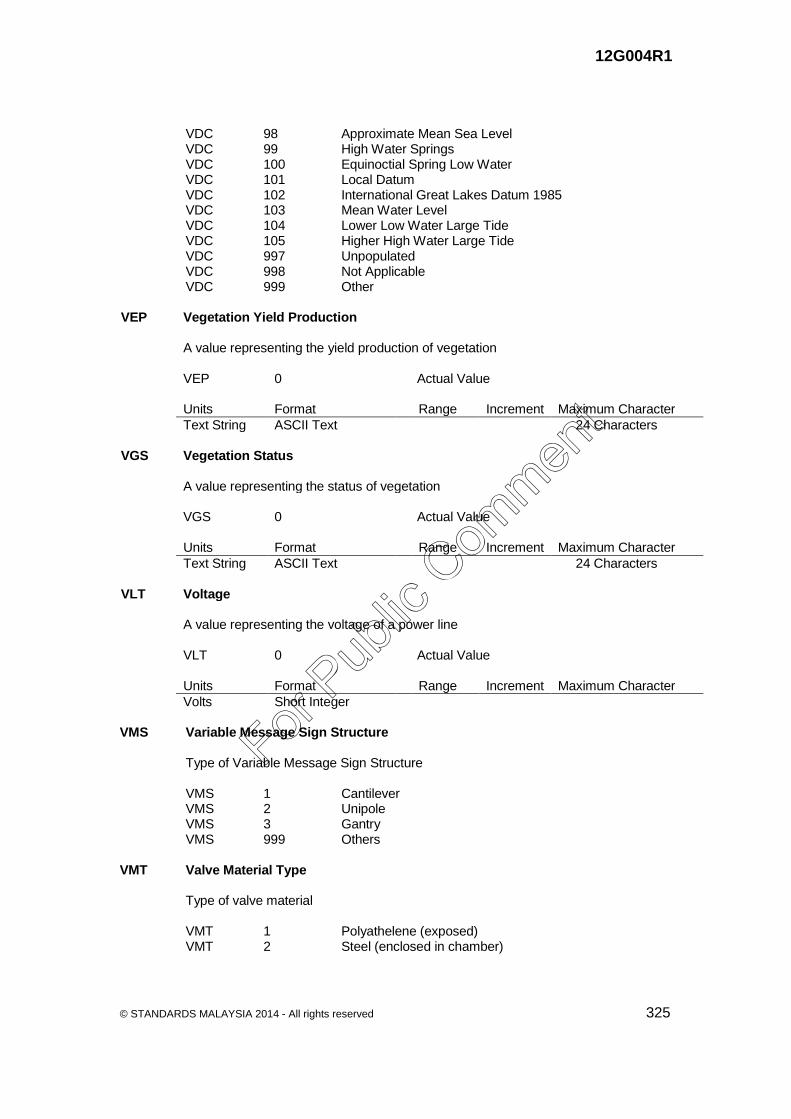
12G004R1
© STANDARDS MALAYSIA 2014 - All rights reserved 325
VDC 98 Approximate Mean Sea Level VDC 99 High Water Springs VDC 100 Equinoctial Spring Low Water VDC 101 Local Datum VDC 102 International Great Lakes Datum 1985 VDC 103 Mean Water Level VDC 104 Lower Low Water Large Tide VDC 105 Higher High Water Large Tide VDC 997 Unpopulated VDC 998 Not Applicable VDC 999 Other VEP Vegetation Yield Production A value representing the yield production of vegetation VEP 0 Actual Value Units Format Range Increment Maximum Character
Text String ASCII Text 24 Characters VGS Vegetation Status A value representing the status of vegetation VGS 0 Actual Value Units Format Range Increment Maximum Character
Text String ASCII Text 24 Characters VLT Voltage A value representing the voltage of a power line VLT 0 Actual Value Units Format Range Increment Maximum Character
Volts Short Integer VMS Variable Message Sign Structure Type of Variable Message Sign Structure VMS 1 Cantilever VMS 2 Unipole VMS 3 Gantry VMS 999 Others VMT Valve Material Type Type of valve material VMT 1 Polyathelene (exposed) VMT 2 Steel (enclosed in chamber)
For Pub
lic Com
ment

12G004R1
326 © STANDARDS MALAYSIA 2014 - All rights reserved
VPT Vegetation Paddy Type Type of Paddy VPT 1 Wet Paddy VPT 2 Dry Paddy VRR Vertical Reference Category Relative location referenced to sounding datum, unless otherwise indicated VRR 0 Unknown VRR 1 Above Surface/Does Not Cover (at High Water) VRR 2 Awash at Sounding Datum VRR 4 Below Surface/Submerged VRR 8 Covers and Uncovers VRR 9 Not Applicable VRR 997 Unpopulated VRR 999 Other VTC Vertical Clearance A value representing the minimum height that is passable to traffic VTC 0 Actual Value Units Format Range Increment Maximum Character
Meter Short Integer VVY Vegetation Variety Any variety to identify a feature VVY 0 Actual Value Units Format Range Increment Maximum Character
Text String ASCII Text VWM Vegetation Water Management Type of vegetation water management VWM 1 Irrigated VWM 2 Rainfed VYP Vegetation Year Planted A value representing the planted year of vegetation VYP 0 Actual Value Units Format Range Increment Maximum Character
Text String ASCII Text 24 Characters
For Pub
lic Com
ment

12G004R1
© STANDARDS MALAYSIA 2014 - All rights reserved 327
WAM Water Level Mark The line along a coast that marks a high or low tide WAM 1 High Water Mark WAM 2 Low Water Mark WAT Waste Type Type of a waste WAT 1 Chemical WAT 2 Hazardous WAT 3 Clinical WAT 4 Radioactive WAT 5 Solid WD3 Military Gap Width The minimum horizontal bridging distance between banks (in decimetres) WD3 0 Actual Value Units Format Range Increment Maximum Character
Decimetres Short Integer -32767 to 32767
1 dm N/A
WD5 Width Top (Captured only if HGT > 5m) The width at the top of a feature (in meters) WD5 0 Actual Value Units Format Range Increment Maximum Character
Metres Short Integer -32767 to 32767
1 m N/A
WID Width Width of a feature, in meters WID 0 Actual Value Units Format Range Increment Maximum Character
Meter Floating WIT Water Pipe Type Type of a water pipe WIT 1 Trunk WIT 2 Distribution WIT 3 Reticulation WIT 4 Communication WIT 5 Raw
For Pub
lic Com
ment

12G004R1
328 © STANDARDS MALAYSIA 2014 - All rights reserved
WKC Wreck Category Category of a wreck WKC 1 Swept WKC 2 Unswept WKD Wreck Depth Identifies whether the depth of a wreck is known or unknown WKD 1 Depth Known WKD 2 Depth Unknown WLN Width of Lane Width of a lane, in meters WLN 0 Actual Value Units Format Range Increment Maximum Character
Meter Real Number 24 Characters WOS Work Status Status of a work WOS 1 Ongoing WOS 2 Completed WPC Water Pump Category Category of a water pump WPC 1 Treatment WPC 2 Raw WPM Water Pipe Material Type of material used for water pipes WPM 1 Acrylonitrile Butadiene Styrene (ABS) WPM 2 Asbestos Cement (AC) WPM 3 Cast Iron WPM 4 Copper WPM 5 Ductile Iron (DI) WPM 6 Galvanized Iron (GI) WPM 7 High Density Polyethylene (HDPE) WPM 8 Mild Steel (MS) WPM 9 Poly Steel WPM 10 Poly Vinyl Chloride (PVC) WPM 11 Polypropylene Random (PPR) WPM 12 Stainless Steel WPM 13 Unplasticized Poly Vinyl Chloride (UPVC) WPM 999 Others
For Pub
lic Com
ment

12G004R1
© STANDARDS MALAYSIA 2014 - All rights reserved 329
WPT Water Pump Type Type of a water pump WPT 1 End Suction WPT 2 Split Casing WPT 3 Submersible WPT 999 Others WRN Road Warning Sign Type of road warning sign WRN Wd.1 Uneven Road (Jalan Tidak Rata) WRN Wd.2 Sharp Meander (Liku Tajam) WRN Wd.3 Cross Road (Simpang Empat) WRN Wd.4 Fenced Railroad Crossing (Lintasan Keretapi Berpagar) WRN Wd.5 Fenced Automatic Railroad Crossing (Lintasan Keretapi Berpagar Automatik) WRN Wd.6 & Wd.7 Railroad Crossing Without Fence (Lintasan Keretapi Tanpa Pagar) WRN Wd.8 Slope Decline (Cerun Menurun) WRN Wd.9 Slope Climbing (Cerun Mendaki) WRN Wd.10a Right Corner (Liku Kanan) WRN Wd.10b Left Corner (Liku Kiri) WRN Wd.11 Winding Road (Jalan Bengkang Bengkok) WRN Wd.12 Soft Shoulder (Bahu Jalan Lembut) WRN Wd.13 Slippery When Wet (Jalan Licin) WRN Wd.14 Pedestrian Crossing (Lintasan Pejalan Kaki) WRN Wd.15 Children Crossing Area (Kawasan Kanak-Kanak Melintas) WRN Wd.16 Caution (Berhati-Hati) WRN Wd.17 Towing Zone (Zon Tunda) WRN Wd.18 Stop Sign Ahead (Papan Tanda Berhenti Di Hadapan) WRN Wd.19 Give Way Sign Ahead (Papan Tanda Beri Laluan Di Hadapan) WRN Wd.20 Narrow Passage Ahead (Laluan Sempit Di Hadapan) WRN Wd.21 Road Narrows on the Left or Right (Jalan Semakin Sempit) WRN Wd.22 Traffic Signals Ahead (Lampu Isyarat Di Hadapan) WRN Wd.23 Obstruction Sign (Halangan Di Hadapan) WRN Wd.24 No Restriction (Tiada Halangan) WRN Wd.25 Staggered Junctions (Simpang Tak Serentak) WRN Wd.26 Staggered Junctions with One No-Entry Sign Is Used (Simpang Tak Serentang Dengan Satu Jalan Di Tutup) WRN Wd.27a 'T' Junction (Simpang Tiga) WRN Wd.27b Right Junction (Simpang Kanan) WRN Wd.27c Left Junction (Simpang Kiri) WRN Wd.27d Right/Straight Optional Lane (Jalan Menyimpang Di Sebelah Kanan) WRN Wd.27e Left/Straight Optional Lane (Jalan Menyimpang Di Sebelah Kiri)
For Pub
lic Com
ment

12G004R1
330 © STANDARDS MALAYSIA 2014 - All rights reserved
WRN Wd.28a Merging Road on the Right (Jalan Kecil Bercantum Di Sebelah Kanan) WRN Wd.28b Merging Road on the Left (Jalan Kecil Bercantum Di Sebelah Kiri) WRN Wd.29 Stone Area / Landslide (Kawasan Batu / Tanah Runtuh) WRN Wd.30 Cattle Crossing Area (Kawasan Lembu Melintas) WRN Wd.31 Circular Intersection (Bulatan Di Hadapan) WRN Wd.32a Lane Climbing (Lorong Mendaki) WRN Wd.32b Lane Decline (Lorong Menurun) WRN Wd.33 Blind People Crossing (Orang Buta Melintas) WRN Wd.34 Disabled Person Path (Lintasan Orang Cacat) WRN Wd.35 Narrow Bridge (Jambatan Sempit) WRN Wd.36 Diverging Traffic (Berpisah Arah) WRN Wd.37 Two-Way Traffic (Jalan Dua Hala) WRN Wd.38a Divided Highway Ends (Jalan Kembar Tamat) WRN Wd.38b Divided Highway (Symbol) (Jalan Kembar Di Hadapan) WRN Wd.39a Chevron (Right Way) (Tanda Arah Selekoh Ke Kanan) WRN Wd.39b Chevron (Left Way) (Tanda Arah Selekoh Ke Kiri) WRN Wd.40 Bridge Deliberate Station (Stesen Jambatan Timbang) WRN Wd.41 Wild Animal Crossing Area (Kawasan Binatang Liar Melintas) WRN Wd.42 Y-Intersection (Simpang Jalan Ke Kiri Dan Ke Kanan) WRN Wd.45 Playground (Padang Permainan) WRN Wd.49 Speed Hump (Bonggol Dihadapan) WRN Wd. 51 Speed Limit Zone (Peringatan Di Zon Had Laju) WRN Wd. 52 Speed Limit Zone Ahead (Zon Had Laju Di Hadapan) WRU Water Route Usage Usage of a water route WRU 1 Ferry WRU 2 Boat WRU 3 Ship WTU Tube Well Use Determine the usage of a tube well WTU 1 Agriculture WTU 2 Domestic WTU 3 Industrial WTU 4 Natural mineral water/bottled WTY Well Type Type of a well WTY 1 Pump WTY 2 Test WTY 3 Production WTY 4 Monitoring
For Pub
lic Com
ment
12G004R1
© STANDARDS MALAYSIA 2014 - All rights reserved 331
WVA Water Velocity Average Average water velocity, estimated in meters/second within delineation of feature
exclusive of high water due to runoff or low water due to drought WVA 0 Actual Value Units Format Range Increment Maximum Character
Metres/Sec. Short Integer -32767 to 32767
1 m/s N/A
WVT Water Valve Type Type of a water valve WVT 1 Foot Valve WVT 2 Air Valve WVT 3 Altitude Valve WVT 4 Sluice Valve WVT 5 Pressure Reducing Valve WVT 6 Non Return Valve WVT 7 Butterfly Valve WVT 8 Scour Valve WVT 999 Others YOA Year of Approval Identifies the approval year of data YOA 0 Actual Value Units Format Range Increment Maximum Character
Year yyyy ZEL Z Ellipsoidal A value representing height above an ellipsoid ZEL 0 Actual Value Units Format Range Increment Maximum Character
Meter Floating 24 Characters ZGP Z Global Positioning System A value representing height obtained from GPS observations ZGP 0 Actual Value Units Format Range Increment Maximum Character
Meter Floating
For Pub
lic Com
ment

12G004R1
332 © STANDARDS MALAYSIA 2014 - All rights reserved
ZOC Zoning Category Category of zoning ZOC 1 Residential ZOC 2 Commercial ZOC 3 Industrial ZOR Z Orthometric A value representing vertical distance (height) of a feature measured the from mean
sea level ZOR 0 Actual Value Units Format Range Increment Maximum Character
Meter Floating ZV2 Highest Z-value (meters) Elevation above a given datum to the highest portion of the feature ZV2 0 Actual Value Units Format Range Increment Maximum Character
Metres Short Integer -400 to 30000
1 m N/A
ZV3 Airfield/Aerodrome Elevation (meters) The highest point of an airport's usable runways measured in meters from mean sea
level ZV3 0 Actual Value Units Format Range Increment Maximum Character
Metres Short Integer -400 to 30000
1 m N/A
For Pub
lic Com
ment

12G004R1
© STANDARDS MALAYSIA 2014 - All rights reserved 333
Bibliography [1] MS ISO 19110, Geographic information - Methodology for feature cataloguing [2] DIGEST Part 4 - Feature and Attribute Coding Catalogue (FACC) [3] United Nation Convention on Laws of the Sea (1982) [4] National Land Code (1965) [5] Laws of Sarawak, Land Code [6] Sabah Land Ordinance (1930) [7] Manual GIS JPBDSM (Kajian Rancangan Pemajuan) [8] Kod Fitur Geologi Tahun 1999/Malaysian Stratigraphic Guide, GSM (Geological
Society Malaysia)
[9] USDA Soil Taxonomy & FAO UNESCO Legend
For Pub
lic Com
ment
12G004R1
334 © STANDARDS MALAYSIA 2014 - All rights reserved
Acknowledgements
Members of Technical Committee on Geographic Information/ Geomatics Name Organisation Datuk Prof Sr Dr Abdul Kadir Taib (Chairman) Department of Survey and Mapping Malaysia Ms Wan Rosmawarni Wan Sulaiman (Secretary)
SIRIM Berhad
Mr Zuraimi Suleiman/ Ms Nik Mazlina Nik Mustapha/ Mr Syariman Samsudin
Agensi Remote Sensing Malaysia
Mr Ismahadi Ismail/ Mr Abdul Malik Yacob
Astronautic Technology (M) Sdn Bhd
Mr As'ari Hassan/ Mr Mohd Safie Bin Mahmud
Department of Agriculture Malaysia
Mr Hasan Jamil / Mr Mohamad Kamali Adimin
Department of Survey and Mapping Malaysia
Dr Sallehi Kassim/ Mr Muhamad Soffi Othman
Department of Town and Country Planning
Mr Daniel Boey ESRI Malaysia Sdn Bhd Ms Badariah Mohd Saufi Jabatan Kerja Raya Malaysia Dr Muhamad Radzali Mispan Malaysian Agricultural Research and
Development Institute Mr Hamdan Abd Aziz Malaysian Centre for Geospatial Data
Infrastructure Mr Mohd Anuar Ishak/ Mr Mohamad Bin Abd. Manap
Minerals and Geoscience Department Malaysia
Ms Fuziah Hj. Abu Hanifah Ministry of Natural Resources and Environment
Dr Noordin Ahmad National Space Agency Assoc Prof Dr Abdul Rashid Mohamad Shariff/ Dr Ahmad Fikri
Universiti Putra Malaysia
Prof Dr Ruslan Rainis Universiti Sains Malaysia Mr Mohamad Ghazali Hashim/ Mr Ivin Amri Musliman
Universiti Teknologi Malaysia
Assoc Prof Dr Khoiri Mohd Dimyati Universiti Teknologi MARA
For Pub
lic Com
ment


![Standard is at Ion for HALAL Food [SIRIM]](https://static.fdocuments.net/doc/165x107/5478d902b379597b2b8b45cc/standard-is-at-ion-for-halal-food-sirim.jpg)