Draft FERC EIS for NEXUS Pipeline
483
FERC/DEIS-270D DRAFT ENVIRONMENTAL IMPACT STATEMENT Volume I NEXUS Gas Transmission Project and Texas Eastern Appalachian Lease Project Source: State of Ohio Office of Information Technology NEXUS Gas Transmission, LLC Docket Nos.: CP16-22-000 Texas Eastern Transmission, LP CP16-23-000 DTE Gas Company CP16-24-000 Vector Pipeline L.P. CP16-102-000 Federal Energy Regulatory Commission Office of Energy Projects Washington, DC 20426 Office of Energy Projects July 2016 Cooperating Agencies: U.S. Environmental Protection Agency U.S. Fish and Wildlife Service
-
Upload
marcellus-drilling-news -
Category
News & Politics
-
view
345 -
download
0
Transcript of Draft FERC EIS for NEXUS Pipeline

FERC/DEIS-270D
DRAFT ENVIRONMENTAL IMPACT STATEMENT
Volume I
NEXUS Gas Transmission Project and
Texas Eastern Appalachian Lease Project
Source: State of Ohio Office of Information Technology
NEXUS Gas Transmission, LLC Docket Nos.: CP16-22-000
Texas Eastern Transmission, LP CP16-23-000
DTE Gas Company CP16-24-000
Vector Pipeline L.P. CP16-102-000
Federal Energy Regulatory Commission
Office of Energy Projects
Washington, DC 20426
Office of
Energy
Projects
July 2016
Cooperating Agencies:
U.S. Environmental Protection Agency U.S. Fish and Wildlife Service

FEDERAL ENERGY REGULATORY COMMISSION WASHINGTON, D.C. 20426
OFFICE OF ENERGY PROJECTS In Reply Refer To: OEP/DG2E/Gas 2 NEXUS Gas Transmission, LLC Texas Eastern Transmission, LP DTE Gas Company Vector Pipeline L.P. Docket Nos. CP16-22-000 CP16-23-000 CP16-24-000 CP16-102-000
FERC/EIS-270D
TO THE PARTY ADDRESSED:
The staff of the Federal Energy Regulatory Commission (FERC or Commission) has prepared a draft environmental impact statement (EIS) for the NEXUS Gas Transmission (NGT) Project and Texas Eastern Appalachian Lease (TEAL) Project (jointly referred to as “Projects”), proposed by NEXUS Gas Transmission, LLC (NEXUS) and Texas Eastern Transmission, LP (Texas Eastern) in the above-referenced dockets. NEXUS and Texas Eastern request authorization to construct a new Greenfield pipeline and expand an existing pipeline system from the Appalachian Basin to deliver 1.5 million dekatherms per day to consuming markets in Northern Ohio, Southeastern Michigan, and Ontario, Canada. DTE Gas Company and Vector Pipeline L.P. are requesting approval to lease capacity on their systems to NEXUS.
The draft EIS assesses the potential environmental effects of the construction and operation of the Projects in accordance with the requirements of the National Environmental Policy Act. The FERC staff concludes that approval of the Projects would result in some adverse environmental impacts; however, most of these impacts would be reduced to less-than-significant levels with the implementation of NEXUS’s and Texas Eastern’s proposed mitigation measures and the additional recommendations in the draft EIS.
Some of the route alternatives suggested during scoping would affect landowners that have not been part of the FERC’s environmental scoping process, as further discussed on page 5. Therefore, by this letter we are notifying these parties of our evaluation and requesting comments about the following alternative routes presented in section 3 of the draft EIS: City of Green Route Alternative, Chippewa Lake C Route Variation, and Reserve Avenue Route Variation.

- 2 -
The U.S. Fish and Wildlife Service (FWS) and U.S. Environmental Protection Agency (EPA) participated as cooperating agencies in the preparation of the draft EIS. Cooperating agencies have jurisdiction by law or special expertise with respect to resources potentially affected by the proposal and participate in the National Environmental Policy Act analysis. Although the FWS and EPA provided input to the conclusions and recommendations presented in the draft EIS, the FWS and EPA will each present its own conclusions and recommendations in its respective record of decision or determination for the Projects.
The draft EIS addresses the potential environmental effects of the construction and operation of both the NGT and TEAL Projects. The NGT Project consists of about 255.9 miles of pipeline composed of the following facilities:
208.9 miles of new 36-inch-diameter natural gas pipeline in Ohio;
47 miles of new 36-inch-diameter natural gas pipeline in Michigan;
associated equipment and facilities.
The TEAL Project would include two main components:
4.4 miles of new 36-inch-diameter loop pipeline in Ohio;
0.3 mile of new 30-inch-diameter interconnecting pipeline Ohio; and
associated equipment and facilities.
The Projects’ proposed aboveground facilities include five new compressor stations in Ohio; additional compression and related modifications to one existing compressor station in Ohio; five new metering and regulating stations in Ohio; one new metering and regulating station in Michigan; and minor modifications at existing aboveground facilities at various locations across Ohio.
The FERC staff mailed copies of the draft EIS to federal, state, and local government representatives and agencies; elected officials; environmental and public interest groups; Native American tribes; potentially affected landowners and other interested individuals and groups; and newspapers and libraries near the Projects. Paper copy versions of this draft EIS were mailed to those specifically requesting them; all others received a CD version. In addition, the draft EIS is available for public viewing on the FERC’s website (www.ferc.gov) using the eLibrary link.

- 3 -
A limited number of copies are available for distribution and public inspection at:
Federal Energy Regulatory Commission Public Reference Room
888 First Street NE, Room 2A Washington, DC 20426
(202) 502-8371
Any person wishing to comment on the draft EIS may do so. To ensure consideration of your comments on the proposal in the final EIS, it is important that the Commission receive your comments on or before August 29, 2016.
For your convenience, there are four methods you can use to submit your comments to the Commission. In all instances, please reference the Projects’ docket numbers (CP16-22-000 for the NGT Project and CP16-23-000 for the TEAL Project) with your submission. The Commission encourages electronic filing of comments and has expert staff available to assist you at (202) 502-8258 or [email protected].
1) You can file your comments electronically using the eComment feature on the Commission's website (www.ferc.gov) under the link to Documents and Filings. This is an easy method for submitting brief, text-only comments on a project.
2) You can file your comments electronically by using the eFiling feature on the Commission's website (www.ferc.gov) under the link to Documents and Filings. With eFiling, you can provide comments in a variety of formats by attaching them as a file with your submission. New eFiling users must first create an account by clicking on “eRegister.” If you are filing a comment on a particular project, please select “Comment on a Filing” as the filing type.
3) You can file a paper copy of your comments by mailing them to the following address:
Nathaniel J. Davis, Sr., Deputy Secretary Federal Energy Regulatory Commission 888 First Street NE, Room 1A Washington, DC 20426
4) In lieu of sending written or electronic comments, the Commission invites you to attend one of the public comment meetings its staff will conduct in the Project areas to receive comments on the draft EIS. We1 encourage
1 “We,” “us,” and “our” refer to the environmental staff of the FERC's Office of
Energy Projects.

- 4 -
interested groups and individuals to attend and present oral comments on the draft EIS at any of the meeting locations provided on page 4.
There will not be a formal start of the meeting nor a formal presentation by Commission staff, but FERC staff will be available to answer your questions about the environmental review process. You may arrive at any time after 5:00 PM and we will stop taking comments at 10:00 PM Eastern Time Zone. The primary goal is to have your verbal environmental comments on the draft EIS documented in the public record.
Date Location August 10, 2016 Swanton High School
604 North Main Street Swanton, OH 43558
(419) 826-3045 August 11, 2016 Tecumseh Center for the Arts
400 North Maumee Street Tecumseh, MI 49286
(517) 423-6617 August 15, 2016 Quality Inn, Freemont
3422 Port Clinton Road Fremont, OH 43420
(419) 332-0601 August 16, 2016 Elyria High School Performing Arts Center
601 Middle Avenue Elyria, OH 44035 (440) 284-5209
August 17, 2016 Wadsworth High School – James A. Mcilvaine Performing Arts Center
625 Broad Street Wadsworth, OH 44281
(330) 335-1369 August 18, 2016 Green High School
1474 Boettler Road Uniontown, OH 44685
(330) 896-7575
Verbal comments will be recorded by court reporter(s) and transcriptions will be placed into the docket for the Projects and made available for public viewing on FERC’s eLibrary system (see page 5 for instructions on using eLibrary). It is important to note that verbal comments hold the same weight as written or electronically submitted comments. If a significant number of people are interested in providing verbal comments, a time limit of 3 to 5 minutes may be implemented for each commenter to

- 5 -
ensure all those wishing to comment have the opportunity to do so within the designated meeting time. Time limits will be strictly enforced if they are implemented.
Any person seeking to become a party to the proceeding must file a motion to intervene pursuant to Rule 214 of the Commission’s Rules of Practice and Procedures (Title 18 Code of Federal Regulations Part 385.214).2 Only intervenors have the right to seek rehearing of the Commission’s decision. The Commission grants affected landowners and others with environmental concerns intervenor status upon showing good cause by stating that they have a clear and direct interest in this proceeding that no other party can adequately represent. Simply filing environmental comments will not give you intervenor status, but you do not need intervenor status to have your comments considered.
Route Alternatives
As indicated on page 1, some landowners are receiving this draft EIS because their property has been identified as potentially being affected by certain route alternatives recommended or being considered by FERC staff to avoid or lessen environmental impacts along NEXUS’s proposed pipeline route in several locations. Refer to discussions in section 3.3.3 of the draft EIS for the City of Green Route Alternative, section 3.4.10 for the Chippewa Lake C Route Variation, and section 3.4.12 for the Reserve Avenue Route Variation. Please note that while staff has recommended the use of the last two listed alternatives, a decision whether or not to recommend the use of the City of Green Route Alternative has not been made. The Commission staff wants to ensure that all potentially affected landowners have the opportunity to participate in the environmental review process, thus staff is soliciting comments to assist with the environmental analysis of these route alternatives, which will be presented in the final EIS.
Questions?
Additional information about the Projects is available from the Commission’s Office of External Affairs, at (866) 208-FERC, or on the FERC website (www.ferc.gov) using the eLibrary link. Click on the eLibrary link, click on “General Search,” and enter the docket number excluding the last three digits in the Docket Number field (i.e., CP16-22). Be sure you have selected an appropriate date range. For assistance, please contact FERC Online Support at [email protected] or toll free at (866) 208-3676; for TTY, contact (202) 502-8659. The eLibrary link also provides access to the texts of formal documents issued by the Commission, such as orders, notices, and rulemakings.
2 See the previous discussion on the methods for filing comments.

- 6 -
In addition, the Commission offers a free service called eSubscription that allows you to keep track of all formal issuances and submittals in specific dockets. This can reduce the amount of time you spend researching proceedings by automatically providing you with notification of these filings, document summaries, and direct links to the documents. Go to www.ferc.gov/docs-filing/esubscription.asp to subscribe.
Nathaniel J. Davis, Sr., Deputy Secretary

TABLE OF CONTENTS
i Table of Contents
NEXUS Gas Transmission, LLC NEXUS Gas Transmission Project
Texas Eastern Transmission, LP Texas Eastern Appalachian Lease Project
VOLUME I
TABLE OF CONTENTS ............................................................................................................................ i
LIST OF APPENDICES ............................................................................................................................ v
LIST OF TABLES .................................................................................................................................... vii
LIST OF FIGURES .................................................................................................................................... x
TECHNICAL ACRONYMS .................................................................................................................... xi
EXECUTIVE SUMMARY .................................................................................................................. ES-1 INTRODUCTION ..................................................................................................................... ES-1 PROPOSED ACTION ............................................................................................................... ES-1 PUBLIC INVOLVEMENT ....................................................................................................... ES-2 ENVIRONMENTAL IMPACTS AND MITIGATION ............................................................ ES-3 ALTERNATIVES.................................................................................................................... ES-15 CONCLUSIONS ..................................................................................................................... ES-16
1.0 INTRODUCTION....................................................................................................................... 1-1 1.1 PROJECT PURPOSE AND NEED ................................................................................. 1-3
1.1.1 NGT Project ........................................................................................................ 1-3 1.1.2 TEAL Project ...................................................................................................... 1-4
1.2 PURPOSE AND SCOPE OF THIS EIS .......................................................................... 1-5 1.2.1 Federal Energy Regulatory Commission ............................................................ 1-5 1.2.2 U.S. Environmental Protection Agency Purpose and Role ................................. 1-6 1.2.3 U.S. Fish and Wildlife Service Purpose and Role .............................................. 1-7
1.3 PUBLIC REVIEW AND COMMENT ............................................................................ 1-7 1.4 NON-JURISDICTIONAL FACILITIES ....................................................................... 1-13 1.5 PERMITS, APPROVALS, AND REGULATORY REQUIREMENTS ....................... 1-14
2.0 DESCRIPTION OF PROPOSED ACTION ............................................................................. 2-1 2.1 PROPOSED FACILITIES ............................................................................................... 2-1
2.1.1 NGT Project ........................................................................................................ 2-1 2.1.2 TEAL Project ...................................................................................................... 2-8
2.2 LAND REQUIREMENTS ............................................................................................... 2-9 2.2.1 NGT Project ...................................................................................................... 2-10 2.2.2 TEAL Project .................................................................................................... 2-12
2.3 CONSTRUCTION PROCEDURES .............................................................................. 2-13 2.3.1 General Pipeline Construction Procedures ....................................................... 2-15

TABLE OF CONTENTS
Table of Contents ii
2.3.2 Special Pipeline Construction Procedures ........................................................ 2-20 2.3.3 Aboveground Facility Construction .................................................................. 2-28
2.4 CONSTRUCTION SCHEDULE AND WORKFORCE ............................................... 2-28 2.5 ENVIRONMENTAL INSPECTION, COMPLIANCE MONITORING, AND POST-
APPROVAL VARIANCES........................................................................................... 2-29 2.5.1 Coordination and Training ................................................................................ 2-29 2.5.2 Environmental Inspection ................................................................................. 2-29 2.5.3 Post-Approval Variance Process ...................................................................... 2-31 2.5.4 Compliance Monitoring .................................................................................... 2-31 2.5.5 Post-construction Monitoring ........................................................................... 2-32
2.6 OPERATION AND MAINTENANCE ......................................................................... 2-32 2.6.1 Pipeline Surveys and Inspections ..................................................................... 2-32 2.6.2 Right-of-way Maintenance ............................................................................... 2-33
3.0 NGT AND TEAL PROJECTS ALTERNATIVES .................................................................. 3-1 3.1 NO ACTION ALTERNATIVE ....................................................................................... 3-3 3.2 SYSTEM ALTERNATIVES ........................................................................................... 3-4
3.2.1 Existing Pipeline Systems ................................................................................... 3-4 3.2.2 Proposed Pipeline Systems ................................................................................. 3-5
3.3 MAJOR ROUTE ALTERNATIVES ............................................................................... 3-7 3.3.1 Rover Route Alternative ................................................................................... 3-11 3.3.2 Southern Route Alternative .............................................................................. 3-18 3.3.3 City of Green Route Alternative ....................................................................... 3-22 3.3.4 Electric Transmission Line Route Alternative .................................................. 3-27 3.3.5 Canton A Route Alternative ............................................................................. 3-30 3.3.6 Canton B Route Alternative .............................................................................. 3-32 3.3.7 Canton C Route Alternative .............................................................................. 3-34 3.3.8 Doylestown Route Alternative .......................................................................... 3-36 3.3.9 Turnpike Route Alternative .............................................................................. 3-38 3.3.10 Oak Openings Route Alternative ...................................................................... 3-41 3.3.11 Waterville Route Alternative ............................................................................ 3-43 3.3.12 CORN Western Route Alternative ................................................................... 3-45
3.4 MINOR ROUTE VARIATIONS .................................................................................. 3-47 3.4.1 Middlebranch Avenue Route Variations .......................................................... 3-47 3.4.2 Electric Transmission Line Route Variation ..................................................... 3-49 3.4.3 Kent Avenue Route Variation ........................................................................... 3-51 3.4.4 Interstate 76 Route Variation ............................................................................ 3-53 3.4.5 Mount Eaton Road Route Variation ................................................................. 3-55 3.4.6 Eastern Road North Route Variation ................................................................ 3-57 3.4.7 Eastern Road South Route Variation ................................................................ 3-59 3.4.8 Pifer Road Route Variation ............................................................................... 3-61 3.4.9 Mennonite Road Route Variation ..................................................................... 3-63 3.4.10 Chippewa Lake Route Variations ..................................................................... 3-65 3.4.11 Kennedy Road Route Variation ........................................................................ 3-73 3.4.12 Reserve Avenue Route Variation ..................................................................... 3-75 3.4.13 Butler Road Route Variation ............................................................................ 3-77 3.4.14 Luckey Road Route Variation .......................................................................... 3-79 3.4.15 Martz Road Route Variation ............................................................................. 3-81
3.5 ABOVEGROUND FACILITY SITE ALTERNATIVES ............................................. 3-83 3.5.1 NGT Compressor Station Alternatives ............................................................. 3-83

TABLE OF CONTENTS
iii Table of Contents
3.5.2 TEAL Compressor Station Alternatives ........................................................... 3-92 3.5.3 Electric Compressors ........................................................................................ 3-94
4.0 ENVIRONMENTAL ANALYSIS ............................................................................................. 4-1 4.1 GEOLOGY ...................................................................................................................... 4-2
4.1.1 Existing Environment ......................................................................................... 4-2 4.1.2 Mineral Resources .............................................................................................. 4-5 4.1.3 Geologic Hazards ................................................................................................ 4-9 4.1.4 Paleontological Resources ................................................................................ 4-16 4.1.5 Impacts and Mitigation ..................................................................................... 4-16
4.2 SOILS ............................................................................................................................ 4-21 4.2.1 Existing Environment ....................................................................................... 4-21 4.2.2 General Impacts and Mitigation........................................................................ 4-28
4.3 WATER RESOURCES ................................................................................................. 4-32 4.3.1 Groundwater Resources .................................................................................... 4-32 4.3.2 Surface Water Resources .................................................................................. 4-40
4.4 WETLANDS ................................................................................................................. 4-56 4.4.1 Existing Wetland Resources ............................................................................. 4-56 4.4.2 General Impacts and Mitigation........................................................................ 4-59 4.4.3 Alternative Measures ........................................................................................ 4-62 4.4.4 Conclusion ........................................................................................................ 4-65
4.5 VEGETATION .............................................................................................................. 4-66 4.5.1 Existing Environment ....................................................................................... 4-66 4.5.2 Impacts and Mitigation ..................................................................................... 4-69 4.5.3 General Construction and Restoration Procedures ........................................... 4-73 4.5.4 Noxious Weeds and Pathogens ......................................................................... 4-74 4.5.5 Fragmentation and Edge Effect ........................................................................ 4-76 4.5.6 Pollinator Habitat .............................................................................................. 4-77 4.5.7 Conclusion ........................................................................................................ 4-78
4.6 WILDLIFE..................................................................................................................... 4-78 4.6.1 Existing Environment ....................................................................................... 4-78 4.6.2 Impacts and Mitigation ..................................................................................... 4-81 4.6.3 Sensitive or Managed Wildlife Habitats ........................................................... 4-83 4.6.4 Habitat Fragmentation and Edge Effect ............................................................ 4-83 4.6.5 Game Species and Game Harvesting ................................................................ 4-84 4.6.6 Migratory Birds................................................................................................. 4-85 4.6.7 Conclusion ........................................................................................................ 4-89
4.7 FISHERIES AND AQUATIC RESOURCES ............................................................... 4-89 4.7.1 Existing environment ........................................................................................ 4-89 4.7.2 Impacts and Mitigation ..................................................................................... 4-90 4.7.3 Conclusion ........................................................................................................ 4-94
4.8 SPECIAL STATUS SPECIES ....................................................................................... 4-94 4.8.1 Federally Listed Threatened and Endangered Species ..................................... 4-94 4.8.2 State-listed Species ......................................................................................... 4-104
4.9 LAND USE, RECREATION, SPECIAL INTEREST AREAS, AND VISUAL RESOURCES .............................................................................................................. 4-109 4.9.1 Environmental Setting .................................................................................... 4-113 4.9.2 Project-specific Impacts and Mitigation ......................................................... 4-117 4.9.3 Land Ownership and Easement Requirements ............................................... 4-119 4.9.4 Existing Residences, Commercial Buildings, and Planned Developments .... 4-120

TABLE OF CONTENTS
Table of Contents iv
4.9.5 Agricultural Areas........................................................................................... 4-126 4.9.6 Roadways and Railroads ................................................................................. 4-134 4.9.7 Recreation and Special Interest Areas ............................................................ 4-137 4.9.8 Coastal Zone Management Areas ................................................................... 4-163 4.9.9 Contaminated Sites ......................................................................................... 4-164 4.9.10 Visual Resources............................................................................................. 4-165
4.10 SOCIOECONOMICS .................................................................................................. 4-171 4.10.1 NGT Project Study Area ................................................................................. 4-172 4.10.2 TEAL Project Study Area ............................................................................... 4-174 4.10.3 Population and Employment ........................................................................... 4-174 4.10.4 Housing 4-178 4.10.5 Public Services ................................................................................................ 4-180 4.10.6 Tourism 4-183 4.10.7 Transportation ................................................................................................. 4-185 4.10.8 Property Values............................................................................................... 4-187 4.10.9 Economy and Tax Revenues ........................................................................... 4-189 4.10.10 Environmental Justice ..................................................................................... 4-191
4.11 CULTURAL RESOURCES ........................................................................................ 4-194 4.11.1 Cultural Resources Surveys ............................................................................ 4-194 4.11.2 Native American Consultations ...................................................................... 4-201 4.11.3 Unanticipated Discovery Plans ....................................................................... 4-203 4.11.4 General Impacts and Mitigation...................................................................... 4-203
4.12 AIR QUALITY AND NOISE ..................................................................................... 4-204 4.12.1 Air Quality ...................................................................................................... 4-204 4.12.2 Noise 4-221
4.13 RELIABILITY AND SAFETY ................................................................................... 4-231 4.13.1 Safety Standards ............................................................................................. 4-232 4.13.2 Pipeline Accident Data ................................................................................... 4-241 4.13.3 Impacts on Public Safety ................................................................................ 4-244 4.13.4 Terrorism ........................................................................................................ 4-245
4.14 CUMULATIVE IMPACTS ......................................................................................... 4-247 4.14.1 Background ..................................................................................................... 4-248 4.14.2 Present and Reasonably Foreseeable Projects ................................................ 4-250 4.14.3 Natural Gas Production ................................................................................... 4-250 4.14.4 FERC Jurisdictional Pipeline Projects ............................................................ 4-252 4.14.5 Non-jurisdictional Project-related Facilities ................................................... 4-254 4.14.6 Energy Projects ............................................................................................... 4-256 4.14.7 Transportation and Commercial/Residential Development Projects .............. 4-256 4.14.8 Potential Cumulative Impacts of the Proposed Action ................................... 4-257 4.14.9 Conclusion ...................................................................................................... 4-272
5.0 CONCLUSIONS AND RECOMMENDATIONS .................................................................... 5-1 5.1 SUMMARY OF THE ENVIRONMENTAL ANALYSIS .............................................. 5-1
5.1.1 Geology ............................................................................................................... 5-1 5.1.2 Soils .................................................................................................................... 5-2 5.1.3 Water Resources ................................................................................................. 5-3 5.1.4 Wetlands ............................................................................................................. 5-5 5.1.5 Vegetation ........................................................................................................... 5-5 5.1.6 Wildlife and Aquatic Resources ......................................................................... 5-6 5.1.7 Threatened, Endangered, and Other Special Status Species ............................... 5-7

TABLE OF CONTENTS
v Table of Contents
5.1.8 Land Use, Recreation, and Visual Resources ..................................................... 5-9 5.1.9 Socioeconomics ................................................................................................ 5-11 5.1.10 Cultural Resources ............................................................................................ 5-12 5.1.11 Air Quality and Noise ....................................................................................... 5-13 5.1.12 Safety and Reliability ........................................................................................ 5-15 5.1.13 Cumulative Impacts .......................................................................................... 5-15 5.1.14 Alternatives ....................................................................................................... 5-17
5.2 FERC STAFF’S RECOMMENDED MITIGATION .................................................... 5-18

LIST OF TABLES
List of Tables vi
Table 1.1.1-1 Contracted Volumes for the NGT Project ..................................................................... 1-4 Table 1.3-1 Environmental Issues and Concerns Raised During Public Scoping for the NGT
and TEAL Projects ...................................................................................................... 1-10 Table 1.5-1 Major Environmental Permits, Licenses, Approvals, and Consultations Required
for the NGT and TEAL Projects ................................................................................. 1-14 Table 2.1.1-1 NGT Project Pipeline Facilities ..................................................................................... 2-4 Table 2.1.1-2 NGT Project Aboveground Facilities ............................................................................ 2-4 Table 2.1.1-3 NGT Project Tee-taps .................................................................................................... 2-7 Table 2.1.2-1 TEAL Project Aboveground Facilities .......................................................................... 2-8 Table 2.2-1 Summary of Land Requirements Associated with the Projects .................................... 2-9 Table 2.2.1-1 NGT Project Aboveground Facility Land Requirements ............................................ 2-11 Table 2.2.2-1 TEAL Project Aboveground Facility Land Requirements .......................................... 2-13 Table 2.3-1 Summary of Proposed Modifications to the FERC’s Plan and Procedures ................ 2-14 Table 2.3-2 Construction, Restoration, and Mitigation Plans Associated with the NGT and
TEAL Projects ............................................................................................................. 2-15 Table 2.3.2-1 NGT Project Horizontal Direction Drill Crossings ..................................................... 2-23 Table 3.3.1-1 Analysis of the Rover Route Alternative ...................................................................... 3-11 Table 3.3.2-1 Analysis of the Southern Route Alternative ................................................................ 3-18 Table 3.3.3-1 Analysis of the City of Green Route Alternative ........................................................ 3-23 Table 3.3.4-1 Analysis of the Electric Transmission Line Route Alternative ................................... 3-28 Table 3.3.5-1 Analysis of the Canton A Route Alternative ............................................................... 3-30 Table 3.3.6-1 Analysis of the Canton B Route Alternative ............................................................... 3-32 Table 3.3.7-1 Analysis of the Canton C Route Alternative ............................................................... 3-34 Table 3.3.8-1 Analysis of the Doylestown Route Alternative ........................................................... 3-36 Table 3.3.9-1 Analysis of the Turnpike Route Alternative ................................................................ 3-38 Table 3.3.10-1 Analysis of the Oak Openings Route Alternative ........................................................... 3-41 Table 3.3.11-1 Analysis of the Waterville Route Alternative ............................................................. 3-43 Table 3.3.12-1 Analysis of the CORN Western Route Alternative ..................................................... 3-45 Table 3.4.1-1 Analysis of the Middlebranch Avenue Route Variation ............................................. 3-47 Table 3.4.2-1 Analysis of the Electric Transmission Line Route Variation ...................................... 3-49 Table 3.4.3-1 Analysis of the Kent Avenue Route Variation ............................................................ 3-51 Table 3.4.4-1 Analysis of the Interstate 76 Route Variation ............................................................. 3-53 Table 3.4.5-1 Analysis of the Mount Eaton Road Route Variation ................................................... 3-55 Table 3.4.6-1 Analysis of the Eastern Road North Route Variation ................................................. 3-57 Table 3.4.7-1 Analysis of the Eastern Road South Route Variation ................................................. 3-59 Table 3.4.8-1 Analysis of the Pifer Road Route Variation ................................................................ 3-61 Table 3.4.9-1 Analysis of the Mennonite Road Route Variation ...................................................... 3-63 Table 3.4.10-1 Chippewa Hydrologic Assessment .............................................................................. 3-65 Table 3.4.10-2 Analysis of the Chippewa Lake A Route Variation .................................................... 3-67 Table 3.4.10-3 Analysis of the Chippewa Lake B Route Variation .................................................... 3-68 Table 3.4.10-4 Analysis of the Chippewa Lake C Route Variation .................................................... 3-69 Table 3.4.11-1 Analysis of the Kennedy Road Route Variation ......................................................... 3-73 Table 3.4.12-1 Analysis of the Reserve Avenue Route Variation ....................................................... 3-75 Table 3.4.13-1 Analysis of the Butler Road Route Variation .............................................................. 3-77 Table 3.4.14-1 Analysis of the Luckey Road Route Variation ............................................................ 3-79 Table 3.4.15-1 Analysis of the Martz Road Route Variation .............................................................. 3-81 Table 3.5.1-1 Comparison of Alternatives for Hanoverton Compressor Station (CS1) ...................... 3-84 Table 3.5.1-2 Comparison of Alternatives for Wadsworth Compressor Station (CS 2) ................... 3-86 Table 3.5.1-3 Comparison of Alternatives for Clyde Compressor Station (CS 3) ............................ 3-88 Table 3.5.1-4 Comparison of Alternatives for Waterville Compressor Station (CS 4) ..................... 3-90 Table 3.5.2-1 Comparison of Alternatives for Salineville Compressor Station ................................ 3-92

LIST OF TABLES
vii List of Tables
Table 4.1.1-1 Surficial Geology of the NGT and TEAL Projects ....................................................... 4-3 Table 4.1.2-1 Non-fuel Mineral Resource Mines within 0.25 mile of the NGT Project ..................... 4-7 Table 4.1.2-2 Inactive or Abandoned Fuel Mineral Resource Mines within 0.25 mile of the NGT
and TEAL Projects and Aboveground Facilities ........................................................... 4-8 Table 4.1.3.4-1 Landslide Susceptibility and Occurrence for the NGT and Teal Projects ................... 4-11 Table 4.1.3-2 Karst Features within 1,500 feet of the NGT Project .................................................. 4-13 Table 4.2.1-1 Summary of Soil Characteristics Affected by Construction of the NGT and TEAL
Projects ........................................................................................................................ 4-23 Table 4.2.1-2 Summary of Soil Characteristics Affected by Operation of the NGT and TEAL
Projects ........................................................................................................................ 4-24 Table 4.2.1-3 Summary of Topsoil Depths within the NGT and TEAL Project Construction
Footprints .................................................................................................................... 4-28 Table 4.3.1-1 Wellhead Protection Areas Crossed by the NGT Project Mainline ............................ 4-35 Table 4.3.2-1 Watersheds Crossed by the NGT and TEAL Projects................................................. 4-42 Table 4.3.2-2 Surface Water Intakes within 3 Miles Downstream of NGT Project Crossings ......... 4-43 Table 4.3.2-3 Sensitive Waters Crossed by the NGT Project Pipeline Facilities .............................. 4-46 Table 4.3.2-4 Summary of Waterbodies Crossed by NGT Project HDDs ........................................ 4-49 Table 4.3.2-5 Potential Sources of HDD and Hydrostatic Test Water for NGT and TEAL
Projects ........................................................................................................................ 4-54 Table 4.4.3-1 Summary of Wetland Impacts Associated with the NGT and TEAL Projects ........... 4-63 Table 4.5.1-1 Vegetation Cover Types Crossed by the NGT Project ................................................. 4-67 Table 4.5.1-2 Vegetation Cover Types Crossed by the TEAL Project ............................................... 4-69 Table 4.5.2-1 Vegetation Communities Affected by Construction and Operation of the NGT and
TEAL Projects ............................................................................................................. 4-71 Table 4.5.4-1 Regulated Noxious and Invasive Species in Ohio and Michigan ................................. 4-75 Table 4.6.1-1 Wildlife Species Potentially Occurring within the NGT Project Area .......................... 4-79 Table 4.6.1-2 Wildlife Species Potentially Occurring within the TEAL Project Area ........................ 4-79 Table 4.6.6-1 Birds of Conservation Concern Potentially Occurring within the NGT Project Area ... 4-86 Table 4.6.6-2 Birds of Conservation Concern Potentially Occurring within the TEAL Project Area . 4-87 Table 4.7.1-1 Typical Fish Species within the NGT and TEAL Projects Area ................................... 4-90 Table 4.8.1-1 Summary of Effects on Federally Listed Species for the NGT Project ......................... 4-96 Table 4.8.1-2 Summary of Effects to Federally Listed Species for the TEAL Project ...................... 4-102 Table 4.9.1-1 Acreage Affected by Construction and Operation of the NGT and TEAL Projects .... 4-110 Table 4.9.1-2 Summary of NGT Project Access Roads ..................................................................... 4-117 Table 4.9.3-1 Septic Systems Crossed by the NGT Project ............................................................... 4-121 Table 4.9.3-2 Organic Farm Lands and Specialty Crop Lands Crossed by the NGT Project ............ 4-127 Table 4.9.3-3 Forest Management Program and Conservation Easement Enrolled Lands Crossed
by the NGT Project ................................................................................................... 4-131 Table 4.9.4-4 Summary of Roadways Crossed by the NGT Project .................................................. 4-135 Table 4.9.4-5 Railroads Crossed by the NGT Project ........................................................................ 4-136 Table 4.9.7-1 Recreation and Special Interest Areas Crossed by the NGT Project ........................... 4-138 Table 4.9.5-2 Recreation and Special Interest Areas within 0.25 Mile of the NGT Project .............. 4-141 Table 4.10.1-1 Counties Crossed and Communities within 10 Miles of the NGT Project ................ 4-172 Table 4.10.2-1 Counties Crossed and Communities within 10 Miles of the TEAL Project .............. 4-174 Table 4.10.3-1 Existing Population Levels and Trends for the NGT and TEAL Projects’
Socioeconomic Study Areas ...................................................................................... 4-175 Table 4.10.3-2 Estimated Populations and Employment of Counties in the NGT and TEAL
Projects Area ............................................................................................................. 4-176 Table 4.10.4-1 Available Housing in the NGT and TEAL Projects Area ......................................... 4-178 Table 4.10.5-1 Public Services Available within 10 Miles of the NGT and TEAL Projects ............ 4-181 Table 4.10.6-1 Tourism Economy in the NGT Project Area ............................................................. 4-184

LIST OF TABLES
List of Tables viii
Table 4.10.6-2 Tourism Economy in the TEAL Project Area ........................................................... 4-185 Table 4.10.9-1 Estimated Economic Effects for Operations for the NGT Project in Ohio ............... 4-190 Table 4.11.2-1 Consultation with Federally Recognized Native American Tribes for the NGT
Project ....................................................................................................................... 4-201 Table 4.11.4-2 Consultation with Federally Recognized Native American Tribes for the TEAL
Project ....................................................................................................................... 4-203 Table 4.12.1-1 Attainment Status of NGT and TEAL Projects Counties .......................................... 4-206 Table 4.12.1-2 General Conformity Applicability Analysis for NGT and TEAL Projects ............... 4-209 Table 4.12.1-3 Estimated Construction Emissions for the NGT and TEAL Projects ....................... 4-212 Table 4.12.1-4 Proposed Hanoverton Compressor Station Emissions Summary (tpy) ..................... 4-213 Table 4.12.1-5 Proposed Wadsworth Compressor Station Emissions Summary (tpy) ..................... 4-214 Table 4.12.1-6 Proposed Clyde Compressor Station Emissions Summary (tpy) .............................. 4-214 Table 4.12.1-7 Proposed Waterville Compressor Station Emissions Summary (tpy) ....................... 4-215 Table 4.12.1-8 Proposed Salineville Compressor Station Emissions Summary (tpy) ....................... 4-215 Table 4.12.1-9 Proposed Colerain Compressor Station Modification Emissions Summary (tpy) .... 4-216 Table 4.12.1-10 AERSCREEN Modeling Results for NGT Project Compressor Stations ................. 4-216 Table 4.12.1-11 AERSCREEN Modeling Results for TEAL Project Compressor Stations ............... 4-217 Table 4.12.1-11 AERSCREEN Modeling Results for TEAL Project Compressor Stations ............... 4-218 Table 4.12.1-12 Estimated Emissions from NGT Project M&R Stations (tpy) .................................. 4-220 Table 4.12.1-13 Estimated Emissions from the NGT and Teal Project Pipelines (tpy) ...................... 4-220 Table 4.12.2-1 Noise Levels of Major Construction Equipment ....................................................... 4-223 Table 4.12.2-2 Estimated Noise Levels for HDD Entry and Exit Sites Along the NGT Project
Route 4-225 Table 4.12.2-3 Estimated Noise Levels for HDDs that Could Exceed the Sound Criterion at the
Closest NSA .............................................................................................................. 4-227 Table 4.12.2-4 Estimated Noise Levels for NGT Project M&R Stations .......................................... 4-228 Table 4.12.2-5 Estimated Noise Levels for NGT Project Compressor Stations ................................ 4-229 Table 4.12.2-6 Estimated Noise Levels for TEAL Project Compressor Stations .............................. 4-230 Table 4.13.1-1 NGT Project Pipeline Class Locations ...................................................................... 4-233 Table 4.13.1-2 Location of High Consequence Areas along the NGT Project Pipeline Facilities .... 4-237 Table 4.13.2-1 Natural Gas Transmission Pipeline Significant Incidents by Cause (1996 to 2015) . 4-242 Table 4.13.2-2 Incidents Caused by External Corrosion and Level of Protection (1970 through
June 1984) ................................................................................................................. 4-243 Table 4.13.2-3 Outside Force Incidents by Cause (1996 to 2015) .................................................... 4-243 Table 4.13.3-1 Injuries and Fatalities – Natural Gas Transmission Pipelines ................................... 4-244 Table 4.13.3-2 Nationwide Accidental Deaths .................................................................................. 4-245 Table 4.14.5-1 Cumulative PTE Emissions from Willow Run M&R Station and DTE Gas’ Willow
Run Compressor Station ............................................................................................ 4-255

LIST OF FIGURES
ix List of Figures
Figure 2.1-1 NGT Project Overview .................................................................................................. 2-2 Figure 2.1-2 TEAL Project Overview ................................................................................................ 2-3 Figure 2.3.1-1 Construction Sequence Overview ............................................................................... 2-18 Figure 3.2.1-1 Existing Pipeline Systems ............................................................................................. 3-6 Figure 3.2.2-1 Proposed Rover System ................................................................................................ 3-8 Figure 3.2.2-2 Proposed Leech Xpress System .................................................................................... 3-9 Figure 3.2.2-3 Proposed ANR East System ........................................................................................ 3-10 Figure 3.3.1-1 Rover Route Alternative .............................................................................................. 3-12 Figure 3.3.2-1 Southern Route Alternative ......................................................................................... 3-19 Figure 3.3.3-1 City of Green Route Alternative ................................................................................. 3-25 Figure 3.3.4-1 Electric Transmission Line Route Alternative ............................................................ 3-29 Figure 3.3.5-1 Canton A Route Alternative ........................................................................................ 3-31 Figure 3.3.6-1 Canton B Route Alternative ........................................................................................ 3-33 Figure 3.3.7-1 Canton C Route Alternative ........................................................................................ 3-35 Figure 3.3.8-1 Doylestown Route Alternative .................................................................................... 3-37 Figure 3.3.9-1 Turnpike Route Alternative ......................................................................................... 3-39 Figure 3.3.10-1 Oak Openings Route Alternative ................................................................................ 3-42 Figure 3.3.11-1 Waterville Route Alternative ...................................................................................... 3-44 Figure 3.3.12-1 CORN Western Route Alternative .............................................................................. 3-46 Figure 3.4.1-1 Middlebranch Avenue Route Variation ...................................................................... 3-48 Figure 3.4.2-1 Electric Transmission Line Route Variation ............................................................... 3-50 Figure 3.4.3-1 Kent Avenue Route Variation ..................................................................................... 3-52 Figure 3.4.4-1 Interstate 76 Route Variation ...................................................................................... 3-54 Figure 3.4.5-1 Mount Eaton Road Route Variation ............................................................................ 3-56 Figure 3.4.6-1 Eastern Road North Route Variation........................................................................... 3-58 Figure 3.4.7-1 Eastern Road South Route Variation........................................................................... 3-60 Figure 3.4.8-1 Pifer Road Route Variation ......................................................................................... 3-62 Figure 3.4.9-1 Mennonite Road Route Variation ............................................................................... 3-64 Figure 3.4.10-1 Chippewa Hydrologic Assessment .............................................................................. 3-66 Figure 3.4.10-2 Chippewa Lake A Route Variation ............................................................................. 3-70 Figure 3.4.10-3 Chippewa Lake B Route Variation ............................................................................. 3-71 Figure 3.4.10-4 Chippewa Lake C Route Variation ............................................................................. 3-72 Figure 3.4.11-1 Kennedy Road Route Variation .................................................................................. 3-74 Figure 3.4.12-1 Reserve Avenue Route Variation ................................................................................ 3-76 Figure 3.4.13-1 Butler Road Route Variation ....................................................................................... 3-78 Figure 3.4.14-1 Luckey Road Route Variation ..................................................................................... 3-80 Figure 3.4.15-1 Martz Road Route Variation ....................................................................................... 3-82 Figure 3.5.1-1 Hanoverton Compressor Station Alternatives ............................................................. 3-85 Figure 3.5.1-2 Wadsworth Compressor Station Alternatives ............................................................. 3-87 Figure 3.5.1-3 Clyde Compressor Station Alternatives ...................................................................... 3-89 Figure 3.5.1-4 Waterville Compressor Station Alternatives ............................................................... 3-91 Figure 3.5.2-1 Salineville Compressor Station Alternatives ............................................................... 3-93 Figure 4.3.1-1 Bedrock Aquifers ........................................................................................................ 4-34 Figure 4.3.2-1 Watersheds .................................................................................................................. 4-41

LIST OF APPENDICES
List of Appendices x
VOLUME I
APPENDIX A Draft EIS Distribution List APPENDIX B NGT and TEAL Project Route Maps APPENDIX C Project Description Tables
APPENDIX C-1 Summary of NGT Pipeline Co-Location with Existing Rights-of-Way
APPENDIX C-2 APPENDIX C-3
Summary of ATWS Associated with the NGT Pipeline Project Pipe/Contractor Yards and Staging Areas for the NGT Project
APPENDIX C-4 Proposed New, Improved, and Private Access Roads for the NGT and TEAL Projects
APPENDIX C-5 Summary of ATWS Associated with the TEAL Pipeline Project
VOLUME II
APPENDIX D Typical Right-of-Way Configurations APPENDIX E Construction, Restoration, and Mitigation Plans
APPENDIX E-1 NGT Project Blasting Plan APPENDIX E-2 TEAL Project Blasting Plan APPENDIX E-3 NGT Project Drain Tile Mitigation Plan APPENDIX E-4 HDD Design Report and HDD Monitoring and Inadvertent
Return Contingency Plan APPENDIX E-5 NGT Residential Construction Plans
APPENDIX F NGT Project Incorporated Route Variations APPENDIX G Geology Tables
APPENDIX G-1 Bedrock Geology of the NGT and TEAL Projects APPENDIX G-2 Oil and Gas Wells within 0.25 mile of the NGT and TEAL
Projects APPENDIX H Water Resource Tables
APPENDIX H-1 Water Supply Wells and Springs within 150 feet of the NGT and TEAL Projects
APPENDIX H-2 Waterbodies Crossed by the NGT and TEAL Projects APPENDIX H-3 Surface Public Water Supply Protection Areas Crossed by NGT
and TEAL Projects APPENDIX H-4 Impaired Surface Waters Crossed by the NGT and TEAL
Projects APPENDIX H-5 FEMA Flood Zones Crossed by the NGT Project APPENDIX H-6 ATWS within 50 Feet of Wetlands and Waterbodies on the NGT
and TEAL Projects APPENDIX I Wetlands Tables
APPENDIX I-1 NGT Project Wetland Impacts APPENDIX I-2 TEAL Project Wetland Impacts

LIST OF APPENDICES
xi List of Appendices
APPENDIX J State-listed Species Potentially Occurring within or near the NGT and TEAL Projects
APPENDIX K Land Use Tables APPENDIX K-1 Summary of Existing Utilities Crossed by the NGT Project APPENDIX K-2 Buildings within 50 Feet of the NGT Project APPENDIX K-3 Planned Developments near the NGT Project APPENDIX K-4 Known FSA-enrolled Lands Crossed by the NGT Project APPENDIX K-5 Agricultural Drain Tiles and Irrigation Systems Crossed by the
NGT Project APPENDIX K-6 Roadways Crossed by the NGT Project APPENDIX K-7 Roadways Crossed by the TEAL Project APPENDIX K-8 Recreation and Special Interest Areas Crossed by the NGT
Project APPENDIX L Socioeconomic Tables
APPENDIX L-1 Average Daily Traffic County on Roads in the NGT Project Area
APPENDIX L-2 Average Daily Traffic County on Roads in the TEAL Project Area
APPENDIX L-3 Racial, Ethnic, and Poverty Statistics for Census Tracts within 1 mile of the NGT Pipeline and Major Aboveground Facilities in Ohio
APPENDIX L-4 Racial, Ethnic, and Poverty Statistics for Census Tracts within 1 Mile of the NGT Pipeline and Major Aboveground Facilities in Michigan
APPENDIX L-5 Racial, Ethnic, and Poverty Statistics for Census Tracts within 1 Mile of the TEAL Pipeline and Major Aboveground Facilities
APPENDIX M NSA Figures APPENDIX N Recently Completed, Current, and Potential Future Projects near the
NGT and TEAL Projects APPENDIX O List of References APPENDIX P List of Preparers

LIST OF ACRONYMS
List of Acronyms xii
°F degrees Fahrenheit μg/m3 micrograms per cubic meter ACHP Advisory Council on Historic Preservation ACR Abandonment and Capacity Restoration Project ACS American Community Survey AG-PEM agricultural palustrine emergent AMSL Above Mean Sea Level ANR ANR Pipeline Co. ANR East ANR East Pipeline Project APBA Applicant-Prepared BA APE area of potential effect AQCR Air Quality Control Regions ATWS additional temporary workspace AWS agricultural water supply BA Biological Assessment BCC Birds of Conservation Concern BGEPA Bald and Golden Eagle Protection Act BMP best management practices CAA Clean Air Act of 1970 and its 1977 and 1990 amendments CAUV Current Agricultural Use Value CAZ critical assessment zone CEQ Council on Environmental Quality Certificate Certificate of Public Convenience and Necessity CFR Code of Federal Regulations cfs cubic feet per second CH4 Methane Chippewa MWCD Chippewa Subdistrict of the Muskingum Watershed Conservancy
District CMNH Cleveland Museum of Natural History CO carbon monoxide CO2 carbon dioxide CO2e carbon dioxide equivalent Columbia Columbia Gas Transmission Commission Federal Energy Regulatory Commission CORN Coalition to Reroute NEXUS CREP Conservation Reserve Enhancement Program

LIST OF ACRONYMS
xiii List of Acronyms
CRP Conservation Reserve Program CS compressor station CVSR Cuyahoga Valley Scenic Railroad CWA Clean Water Act CZMA Coastal Zone Management Area dBA A-weighted decibels dbh diameter at breast height DDAGW Division of Drinking and Ground Water DEO Dominion East Ohio DHHS U.S. Department of Health and Human Services Dominion Dominion Transmission DOE Department of Energy DOT U.S. Department of Transportation DTE Gas DTE Gas Company Dth/d dekatherms per day E&SCP Erosion and Sediment Control Plan EI Environmental Inspector EIS Environmental Impact Statement EM electromagnetic EPA U.S. Environmental Protection Agency ESA Endangered Species Act FEMA Federal Emergency Management Agency FERC Federal Energy Regulatory Commission FERC OEP FERC’s Office of Energy Projects FERC Plan Upland Erosion Control, Revegetation, and Maintenance Plan FERC Procedures Wetland and Waterbody Construction and Mitigation Procedures FHWA Federal Highways Administration FSA Farm Service Agency FWS U.S. Fish and Wildlife Service g gravity GHG greenhouse gases GIS geographic information system gpm gallons per minute GWP global warming potential HAP hazardous air pollutant HCA high-consequence area

LIST OF ACRONYMS
List of Acronyms xiv
HDD horizontal directional drill HDD Plan HDD Monitoring and Inadvertent Return Contingency Plan hp horsepower HPSA Health Professional Shortage Area HUC Hydrologic Unit Code IMP Integrity Management Program IPCC Intergovernmental Panel on Climate Change ISMP Invasive Species Management Plan IWS industrial water supply kV kilovolt Ldn day-night sound level Leq equivalent sound level M&R metering and regulating MAC Michigan Administrative Code MAOP maximum allowable operating pressure MBCP Migratory Bird Conservation Plan MBTA Migratory Bird Treaty Act MDEQ Michigan Department of Environmental Quality MDNR Michigan Department of Natural Resources MDOT Michigan Department of Transportation Memorandum Memorandum of Understanding on Natural Gas Transportation
Facilities MLV mainline valve MMBtu/hr million British thermal units per hour MNFI Michigan Natural Features Inventory MP milepost MUA/P Medically Underserved Area or Population MWH modified warm water habitat N2O nitrous oxide NAAQS National Ambient Air Quality Standards NCNST North Country National Scenic Trail NEPA National Environmental Policy Act NESHAP National Emission Standards for Hazardous Air Pollutants for Source
Categories NEXUS NEXUS Gas Transmission, LLC NGA Natural Gas Act NGT Project NEXUS Gas Transmission Project

LIST OF ACRONYMS
xv List of Acronyms
NHA National Heritage Area NHPA National Historic Preservation Act NMFS National Marine Fisheries Service NNSR Nonattainment New Source Review NOAA National Oceanic and Atmospheric Administration NOI Notice of Intent NOP National Organic Program NOx nitrogen oxides NPDES National Pollutant Discharge Elimination System NPS National Park Service NRCS Natural Resources Conservation Service NRHP National Register of Historic Places NRI National Rivers Inventory NSA noise-sensitive area NSPS New Source Performance Standards NSR New Source Review NWI National Wetland Inventory OAC Ohio Administrative Code OCRM Ocean and Coastal Resource Management ODGS Ohio Division of Geologic Survey ODNR Ohio Department of Natural Resources ODOT Ohio Department of Transportation OEMA Ohio Emergency Management Agency OEP Office of Energy Projects OEPA Ohio Environmental Protection Agency OFTL Ohio Forest Tax Law OPEN Ohio Pipeline Energy Network ORAM Ohio Rapid Assessment Method ORV outstandingly remarkable value OSW Ohio Special Waters PADEP Pennsylvania Department of Environmental Protection Panhandle Eastern Panhandle Eastern Pipe Line Pb (airborne) lead pCi/L picocuries per liter PEM palustrine emergent PFO palustrine forested

LIST OF ACRONYMS
List of Acronyms xvi
PGA peak ground acceleration PHMSA Pipeline and Hazardous Materials Safety Administration PM10 inhalable particulate matter with an aerodynamic diameter less than or
equal to 10 PM2.5 inhalable particulate matter with an aerodynamic diameter less than or
equal to 2.5 ppb parts per billion ppm parts per million PSD Prevention of Significant Deterioration PSS palustrine scrub-shrub PTE potential to emit PTIO Permit-to-Install-and-Operate PUB palustrine unconsolidated bottom PVC polyvinyl chloride PWS Public Water System RACER Revitalizing Auto Communities Environmental Response RCP Residential Construction Plan REX Rockies Express Pipeline RHA Rivers and Harbor Act Rover Rover Pipeline, LLC RR Resource Report SDWA Safe Drinking Water Act SHPO State Historic Preservation Office SO2 sulfur dioxide SPCC Plan Spill Prevention, Control, and Countermeasure Plan SSA sole source aquifer SSURGO Soil Survey Geographic database Structure II-A Muskingum Watershed Conservation District’s Structure II-A SWAP Source Water Assessment Program SWAPP Source Water Assessment and Protection Program TEAL Project Texas Eastern Appalachian Lease Project Texas Eastern Texas Eastern Transmission, LP TGP Tennessee Gas Pipeline Company, LLC tpy tons per year TSA Transportation Safety Administration USACE U.S. Army Corps of Engineers USC United States Code

LIST OF ACRONYMS
xvii List of Acronyms
USDA U.S. Department of Agriculture USGCRP U.S. Global Change Research Program USGS U.S. Geological Survey Vector Vector Pipeline L.P. VOC volatile organic compound WHPA Wellhead Protection Area WHPP Wellhead Protection Program WNS White Nose Syndrome WWH warm water habitat

ES-1 Executive Summary
EXECUTIVE SUMMARY
INTRODUCTION
On November 20, 2015, NEXUS Gas Transmission, LLC (NEXUS) filed an application with the
Federal Energy Regulatory Commission (FERC or Commission) in Docket No. CP16-22-000 pursuant to
Section 7(c) of the Natural Gas Act (NGA) and Parts 157 and 284 of the Commission’s regulations.
NEXUS is seeking a Certificate of Public Convenience and Necessity (Certificate) to construct, own, and
operate a new natural gas pipeline system in Ohio and Michigan. NEXUS’ proposed project is referred to
as the NEXUS Gas Transmission Project (NGT Project).
On November 20, 2015, Texas Eastern Transmission, LP (Texas Eastern) filed an abbreviated
application with FERC in Docket No. CP16-23-000 pursuant to Sections 7(b) and 7(c) of the NGA and
Parts 157 and 284 of the Commission’s regulations for a Certificate to construct, own, and operate a
natural gas pipeline and related facilities in Ohio as well as approval to abandon by lease to NEXUS the
capacity created by the Texas Eastern Appalachian Lease Project (TEAL Project) facilities. Collectively
the applications are referred to as the “Projects.”1
The purpose of this environmental impact statement (EIS) is to inform FERC decision-makers,
the public, and the permitting agencies about the potential adverse and beneficial environmental impacts
of the Projects, as well as alternatives, and recommend mitigation measures that would reduce adverse
impacts to the extent practicable. We2 prepared this EIS to assess the environmental impacts associated
with construction and operation of the Projects as required under the National Environmental Policy Act
of 1969 (NEPA), as amended. Our analysis was based on information provided by the applicants and
further developed from data requests; field investigations; scoping; literature research; contacts with or
comments from federal, state, and local agencies; and comments from individual members of the public.
The U.S. Environmental Protection Agency (EPA) and U.S. Fish and Wildlife Service (FWS) are
participating as cooperating agencies in the preparation of this EIS.3
PROPOSED ACTION
The NGT and TEAL Projects include about 260.6 miles of pipeline composed of the following
facilities:
NEXUS’ mainline, which consists of about 255.7 miles of new 36-inch-diameter
mainline pipeline in Ohio and Michigan;
NEXUS’ interconnecting pipeline, which consists of about 0.9 mile of new 36-inch-
diameter interconnecting pipeline in Ohio;
1 In a related matter, on November 24, 2015, DTE Gas Company (DTE Gas) filed an application with FERC in Docket
No. CP16-24-000 seeking approval of a lease of capacity on DTE Gas’s system to NEXUS. On March 11, 2015,
Vector Pipeline L.P. (Vector) filed an application with FERC in Docket No. CP16-102-000 seeking approval of a lease
of capacity on Vector’s system to NEXUS. Any new or modified facilities associated with these actions are proposed
to be constructed under an existing Blanket Certificate or are under the jurisdiction of another agency or country.
2 “We,” “us,” and “our” refer to the environmental staff of FERC’s Office of Energy Projects.
3 A cooperating agency has jurisdiction by law or special expertise with respect to environmental impacts involved with
the proposed project and is involved in the NEPA analysis.

Executive Summary ES-2
Texas Eastern’s pipeline loop, which comprises about 4.4 miles of new 36-inch-diameter
loop pipeline in Ohio; and
Texas Eastern’s connecting pipeline, which comprises about 0.3 mile of new 30-inch-
diameter interconnecting pipeline in Ohio.
The Projects’ aboveground facilities include:
NEXUS’ 4 new compressor stations, 6 new metering and regulating (M&R) stations, and
17 new mainline valves;
Texas Eastern’s new compressor station, modifications of an existing compressor station,
two new pig4 launchers/receivers, and temporary pig launcher/receiver; and
additional new facilities and modifications, such as pig launchers/receivers,
communication towers, and regulators, installed at other aboveground facility sites.
Subject to the receipt of FERC authorization and all other applicable permits, authorizations, and
approvals, the applicants anticipate starting construction as soon as possible, with an in-service date of
November 2017, except for Texas Eastern’s modifications to its existing compressor station, which has an
in-service date of October 2018.
The Projects would provide for the transportation of 1.5 million dekatherms per day of natural gas
from the Appalachian Basin to consuming markets in Northern Ohio and Southeastern Michigan as well
as the Dawn Hub in Ontario, Canada. Supply also would be able to reach the Chicago Hub in northern
Illinois and other Midwestern markets through interconnections with other pipelines. NEXUS indicated
that the need for the Projects originates from an increase in demand for natural gas in the region for
electric generation, home heating, and industrial use, coupled with a decrease of imports of natural gas to
the region by traditional supply sources, mainly western Canada and the Gulf Coast. The Projects would
meet this need by importing natural gas to the region from newly available sources, mainly the
Appalachian Basin.
PUBLIC INVOLVEMENT
On January 9, 2015, and January 26, 2015, FERC began its pre-filing review of the NGT Project
and TEAL Project, respectively, and established pre-filing Docket Nos. PF15-10-000 and PF15-11-000 to
place information related to the Projects into the public record.
On April 8, 2015, FERC issued a Notice of Intent to Prepare an Environmental Impact Statement
for the Planned Nexus Gas Transmission Project and Texas Eastern Appalachian Lease Project, Request
for Comments on Environmental Issues, and Notice of Public Scoping Meetings (NOI). The NOI was
published in the Federal Register on April 15, 2015, and mailed to 4,319 interested parties, including
federal, state, and local agencies; elected officials; environmental and public interest groups; Native
American tribes; potentially affected landowners; local libraries and newspapers; and other stakeholders
who had indicated an interest in the NGT and TEAL Projects. Publication of the NOI established a 30-
day public comment period for the submission of comments, concerns, and issues related to the
environmental aspects of the Projects.
4 A pig is an internal tool that can be used to clean and dry a pipeline and/or to inspect it for damage or corrosion. A pig
launcher/receiver is an aboveground facility where pigs are inserted into or received from the pipeline.

ES-3 Executive Summary
Between April 28, 2015, and May 7, 2015, FERC conducted public scoping meetings in Grafton,
Wadsworth, Louisville, Swanton, and Fremont, Ohio; and Tecumseh, Michigan to provide an opportunity
for agencies, stakeholders, and the general public to learn more about the planned pipeline Project and
participate in the environmental analysis by commenting on the issues to be addressed in the draft EIS.
On April 15, 2016, the Commission issued a letter to certain affected landowners describing route
modifications on the NGT Project, inviting newly affected landowners to participate in the environmental
review process, and opening an additional 30-day scoping period.
Substantive environmental issues identified through this public review process are addressed in
this EIS. The transcripts of the public scoping meetings and all written comments are part of FERC’s
public record for each Project and are available for viewing using the appropriate docket number.
ENVIRONMENTAL IMPACTS AND MITIGATION
We evaluated the potential impacts of construction and operation of the Projects on geology;
soils; water resources; wetlands; vegetation; wildlife and aquatic resources; threatened, endangered, and
special status species; land use, recreation, and visual resources; socioeconomics; cultural resources; air
quality and noise; reliability and safety; and cumulative impacts. Where necessary, we recommend
additional mitigation measures to minimize or avoid these impacts. In Section 3 of this EIS, we
summarize the evaluation of alternatives to the Projects, including the no-action alternative, system
alternatives, major route alternatives, and minor route variations. Sections 5.1 and 5.2 of the EIS contain
our conclusions and a compilation of our recommended mitigation measures, respectively.
Construction of the Projects would affect a total of 5,250.9 acres of land, including land for the
pipeline facilities, aboveground facilities, contractor yards, staging areas and access roads. Permanent
operations would require about 1,707.4 acres of land, including land for the new permanent pipeline
rights-of-way, aboveground facility sites, and permanent access roads. The remaining 3,543.5 acres of
land disturbed during construction would be restored and allowed to revert to its former use.
Important issues identified as a result of our analyses, scoping comments, and agency
consultations include impacts on geology; water resources, and wetlands; vegetation, wildlife, and aquatic
species; special status species; land use, recreation, and visual resources; cultural resources; air quality
and noise; safety and reliability; and cumulative impacts.
Geology
The overall effect of the Projects on geologic resources would be minor. Geologic impacts would
be limited to disturbance to the existing topography within the Projects area. All areas disturbed during
construction, including in rugged terrain, would be returned as closely as possible to preconstruction
contours during cleanup and restoration.
The removal of bedrock, including by blasting, may be required if bedrock is encountered within
the pipeline trench or at aboveground facility sites. We have reviewed the applicants’ Blasting Plans and
find them acceptable.
The potential for the Projects to be adversely affected by seismic activity, active faults, or soil
liquefaction is low due to the low probability of significant earthquakes in the area. The potential for the
NGT Project to be adversely affected by landslide also is low; however, the TEAL Project is in an area of
elevated landslide risk. During final design, Texas Eastern has committed to conducting geotechnical
investigations to further evaluate landslide risk in areas of steep slopes, and would implement best

Executive Summary ES-4
management practices as outlined in its Erosion and Sediment Control Plan (E&SCP) to manage surface
water and maintain slope stability. We have reviewed the E&SCP and found it consistent with our
Upland Erosion Control, Revegetation, and Maintenance Plan and Wetland and Waterbody Construction
and Mitigation Procedures. Where the E&SCP differed from our plans, we found the modifications
acceptable. To ensure landslide risks are appropriately mitigated, Texas Eastern would file the results of
the geotechnical studies and final landslide mitigation measures with the Commission for review and
approval prior to construction.
There are areas along the NGT Project where a karst hazard may be present; no karst hazards
exist along the TEAL Project. NEXUS has routed the NGT Project to avoid known sinkholes and
conducted electromagnetic geophysical surveys to identify additional karst. All construction supervisory
staff and inspectors would be trained to recognize the signs of sinkhole formation. If previously
undocumented karst features are encountered during construction, NEXUS would implement a minor
reroute, if possible, to avoid the feature, or stabilize the feature to avoid further sinkhole development.
Ground subsidence could occur in areas where abandoned underground mines are crossed.
NEXUS has routed the NGT Project to avoid all known abandoned underground mines. Texas Eastern
has routed the TEAL Project above abandoned underground mines at the same location as its existing
facilities, which have been unaffected by mine subsidence. NEXUS would implement additional
investigation (and mitigation, if necessary) in the event that a previously undocumented abandoned
underground mine is discovered prior to or during construction.
Flash flooding is a potential hazard in the Projects area. NEXUS and Texas Eastern would bury
the pipeline to a depth that would provide at least 5 feet of cover below the existing streambed. In
addition, NEXUS and Texas Eastern would implement the measures in their respective E&SCPs to
reduce the likelihood of sedimentation and erosion during flash flood events.
With the implementation of NEXUS’ and Texas Eastern’s E&SCPs, Blasting Plans, plans to
further evaluate landslide risk, and procedures to be followed in the event of discovery of previously
undocumented karst features or abandoned underground mines, we conclude that impacts on geological
resources would be adequately minimized.
Groundwater, Surface Water, Water Use, and Wetlands
Construction of the Projects could result in increased turbidity and alteration of flow in shallow
aquifers if encountered within trench depth or during grading and excavation at aboveground facilities.
These impacts would be minimized by measures included in the applicants’ E&SCPs. An inadvertent
release of fuel, lubricants, and other substances would be minimized and mitigated by implementing the
applicants’ Project-specific Spill Prevention, Control, and Countermeasure Plans (SPCC Plans) that
identify contractor training, the use of environmental inspectors, procedures for the safe storage and use
of hazardous materials, and remedial actions that would be taken to address a spill. We have reviewed the
SPCC Plans and find them acceptable.
A total of 245 wells and 6 springs were identified within 150 feet of the Projects. Additionally,
the NGT Project would cross 16 wellhead protection areas; the TEAL Project would not cross any
wellhead protection areas. To mitigate impacts on wells, springs, and wellhead protection areas, the
applicants would offer to conduct pre- and post-construction testing of water quality and yield in all wells
within 150 feet of the construction workspace. The applicants would also implement their SPCC Plans to
avoid, minimize, and mitigate any chemical spills, and would prohibit fueling within 200 feet of a private
well and within 400 feet of a public well. In addition, the applicants would repair or replace any wells
that are adversely affected, or would otherwise compensate the well owner.

ES-5 Executive Summary
NEXUS proposes to use the horizontal directional drill (HDD) construction method at several
locations. Texas Eastern would not use the HDD construction method. An inadvertent release of drilling
mud could occur during drilling operations, affecting groundwater quality. NEXUS would implement
measures detailed in its Project-specific HDD Monitoring and Inadvertent Return Contingency Plan to
avoid or minimize the inadvertent release of drilling mud, which we have reviewed and find acceptable.
NEXUS identified 112 sites with known or suspected soil and groundwater contamination within
0.25 mile of the NGT Project. Texas Eastern did not identify any sites within 0.25 mile of the TEAL
Project. The majority of these sites were determined to be unlikely to impact groundwater quality
beneath the NGT Project; however, we recommend that NEXUS further assess the potential for 11 of the
sites to impact groundwater quality beneath the NGT Project and to provide site-specific plans to manage
pre-existing contamination, if applicable, to the Commission for our review and approval.
The Projects would not significantly affect groundwater resources because the majority of
construction would involve shallow, temporary, and localized excavation. Potential impacts would be
avoided or further minimized by the use of construction techniques and mitigation measures described in
the applicants’ E&SCPs, SPCC Plans, and NEXUS’ HDD Monitoring and Inadvertent Return
Contingency Plan, as well as our recommendations.
The Projects would cross a total of 475 waterbodies (208 perennial, 156 intermittent, 90
ephemeral, 1 named reservoir, 5 ponds, and 5 unclassified). The applicants would use the HDD method
at 18 waterbody crossings, including all Section 10 navigable, National River Inventory-designated, and
Ohio Environmental Protection Agency (OEPA)-designated outstanding and superior water quality
streams. The applicants would use the conventional bore method to cross 69 waterbodies. The remaining
waterbodies would be crossed using dry (dam-and-pump or flume) and open-cut wet crossing methods.
Successful implementation of HDD or bore methods would avoid impacts on waterbodies. Impacts on
waterbodies that would be crossed using dry and open-cut wet crossing methods would be minimized by
implementing mitigation measures outlined in the applicants’ E&SCPs and other project-specific plans.
We recommend that NEXUS file additional geotechnical feasibility data at several locations prior to
beginning HDD construction and also file, in the event of an unsuccessful HDD, contingency crossing
plans for these waterbodies, for our review and written approval.
The Projects would cross 12 surface water protection areas and 5 waterbodies that have public
water intakes within 3 miles downstream. The applicants would avoid or minimize impacts by
implementing the BMPs detailed in each Project’s E&SCP and SPCC Plan, and the NGT Project Blasting
Plan, if needed, and would use HDD and conventional bore crossing methods for several stream
crossings.
The applicants requested use of additional temporary workspace (ATWS) in several areas where
they concluded that site-specific conditions do not allow for a 50-foot setback of extra workspace from
waterbodies. Based on our review, we believe that NEXUS has provided adequate justification for the
need of the ATWS at all locations on the NGT Project. We recommend that Texas Eastern provide
further justification for several ATWS on the TEAL Project, or move the workspaces to a distance of 50
feet or greater from waterbodies.
No long-term effects on surface waters would result from construction and operation of the
Project. No designated water uses would be permanently affected. During maintenance activities in or
near streams, the applicants would employ protective measures similar to those proposed for construction
of the Projects. Consequently, we conclude that any maintenance-related effects would be short term.

Executive Summary ES-6
The applicants would use both surface water and water trucks as sources for hydrostatic testing,
the HDD construction method, and dust suppression. The source of water transported by trucks could be
from municipal or groundwater sources. Impacts associated with the withdrawal of surface water would
be effectively minimized by using pumps placed adjacent to the waterbody with hoses placed into the
waterbody with floating intake structures that would be screened to prevent the uptake of aquatic
organisms and fish. Additionally, water withdrawals would be conducted in compliance with all
necessary permits required for surface water extraction. Discharge of water to upland areas could
contribute to erosion, which would be minimized by adhering to the measures contained in the Projects’
E&SCPs.
Based on the mitigation measures developed by the applicants as described in this summary, as
well as our recommendations, we conclude that the Projects would not have significant adverse impacts
on surface water resources.
Construction of the pipeline facilities associated with the Projects would temporarily affect a total
of 191.6 acres of wetlands. No wetlands would be permanently filled. Impacts on emergent wetlands
would be relatively brief because the emergent vegetation would regenerate quickly, typically within one
to three years. Impacts on scrub-shrub and forested wetlands would be long-term or permanent because
the woody vegetation would take several years to grow back. Additionally, the applicants would maintain
a 10-foot-wide corridor centered over the pipeline in an herbaceous state and would selectively cut trees
within 15 feet of the pipeline centerline. Approximately 39.9 acres would be converted from forested or
scrub-shrub wetland to emergent or scrub-shrub wetland.
Construction and operation-related impacts on wetlands would be mitigated by the applicants.
NEXUS would create a project-specific Wetland Mitigation Plan in consultation with the U.S. Army
Corps of Engineers (USACE), Michigan Department of Environmental Quality (MDEQ), and OEPA,
where mitigation would include the purchase of wetland mitigation credits from established wetland
mitigation banks, the use of an in-lieu fee program, or a combination of the two. Texas Eastern would
create a project-specific Wetland Mitigation Plan in consultation with USACE and OEPA. Mitigation
would include the purchase of wetland mitigation credits from established wetland mitigation banks, the
use of an in-lieu fee program, or a combination of the two. We recommend that each applicant file its
final Wetland Mitigation Plan with the Commission prior to construction.
The applicants requested use of ATWS in several areas where they concluded that site-specific
conditions do not allow for a 50-foot setback of extra workspace from wetlands. Based on our review, we
believe that NEXUS has provided adequate justification for the need of the ATWS at all locations on the
NGT Project. We recommend that Texas Eastern provide further justification for several ATWS on the
TEAL Project, or move the workspaces to a distance of 50 feet or greater from wetlands.
Based on the types and amounts of wetlands that would be impacted and the applicants’ measures
to avoid, minimize, and mitigate wetlands impacts as described in their construction and restoration plans,
as well as our recommendations, we conclude that impacts on wetlands would be effectively minimized
or mitigated. These impacts would be further minimized and mitigated by the applicants’ compliance
with USACE Section 404 and state permit requirements, including the purchase of wetland mitigation
credits and use of in-lieu fee programs.
Vegetation, Wildlife, and Aquatic Resources
Construction of the Projects would affect 371.5 acres of forested upland, 43.3 acres of forested
wetland, 571.8 acres of open upland, 43.8 acres of emergent wetland, and 19.5 acres of scrub-shrub
wetland. The remaining 4,202.7 acres are agricultural land, developed land, or open water. Operation of

ES-7 Executive Summary
the Projects would affect 148.0 acres of forested upland, 26.7 acres of forested wetland, 154.5 acres of
open upland, 21.0 acres of emergent wetland, and 10.0 acres of scrub-shrub wetland. The remaining
1,347.4 acres are agricultural land, developed land, or open water.
Impacts on upland open land, emergent wetlands, and agricultural lands would be short term as
these vegetation cover types would likely return to their pre-construction states within one to three
growing seasons after restoration is complete. Impacts on forested uplands, forest wetlands, and scrub-
shrub wetlands would be long-term or permanent. However, due to the prevalence of forested habitats
within the Projects area, the ability to co-locate the proposed facilities adjacent to existing rights-of-way
(46 percent of the route would be co-located), and the eventual regrowth of forested areas outside of the
permanent right-of-way, we conclude that the permanent conversion of forested lands would not result in
a significant impact. In addition, impacts on forested and non-forested vegetation types would be further
mitigated through implementation of the applicants’ construction and restoration plans, as well as our
recommendations.
The NGT Project would cross approximately 9.7 miles of the Oak Openings Region in Henry and
Fulton Counties, Ohio. Roughly 99 percent of the ecosystem has been altered and fragmented by
agricultural development, primarily through tree clearing and wetland draining. Botanical surveys
confirmed two remnant communities totaling about 0.5 mile in length would be crossed by the NGT
Project: the Swamp White Oak-Pin Oak Flatwoods and the Black Oak-White Oak/Blueberry Forest Plant
communities. Neither of these areas contained all of the indicative species that would be present in high-
quality remnant communities, and most of the clearing would be adjacent to the existing forest edge.
Therefore, based on our review, impacts on the Oak Openings Region would be minor.
Construction of the Projects would temporarily impact about 1,049.9 acres of pollinator habitat
(including upland forest, forested wetland, upland open land, emergent wetland, and scrub-shrub
wetland). The applicants would revegetate both the temporary workspaces and permanent rights-of-way
immediately after the pipeline facilities are installed with herbaceous and riparian seed mixes in
consultation with the Natural Resources Conservation Service. Once revegetated, the restored
workspaces and permanent rights-of-way would provide pollinator habitat after the first or second
growing season, and may naturally improve pollinator habitat along the Projects area. We recommend
that the Applicants provide a plan describing the feasibility of incorporating plant seeds that support
pollinators into the seed mixes used for restoration of construction workspaces.
The applicants have identified several areas where noxious weeds or invasive species are present
or are located near the construction right-of-way. NEXUS and Texas Eastern have each developed
Invasive Species Management Plans to minimize and control the spread of the noxious and invasive
species, which we reviewed and find acceptable.
The Projects could have both direct and indirect impacts on wildlife species and their habitats,
including the displacement of wildlife, potential individual mortality, and reduction in habitat. Forest
fragmentation would increase in certain locations due to clearing, thus reducing the amount of habitat
available for interior forest species (i.e. movement and dispersal corridors). With habitat conversion and
forest fragmentation, there is also a risk of intrusion by invasive or noxious species. To minimize wildlife
impacts, the applicants have routed the pipelines to avoid a number of sensitive areas, co-locate with
existing rights-of-way where practical, and reduce workspace in wetlands and interior forest areas. The
applicants also would adhere to their respective E&SCPs and Invasive Species Management Plans.
A variety of migratory bird species, including Birds of Conservation Concern, are associated with
the habitats that would be affected by the Projects. NEXUS has prepared a draft Migratory Bird
Conservation Plan in coordination with the FWS Region 3 office for the portions of the NGT Project in

Executive Summary ES-8
Michigan. The purpose of the plan is to reduce direct and indirect effects on migratory birds and their
habitats. We recommend that NEXUS provide final Migratory Bird Conservation Plans for both
Michigan and Ohio facilities prior to construction. During operations, the applicants would avoid
mortalities or injuries of breeding birds and their eggs or young by conducting vegetation clearing and
maintenance activities outside of the breeding season to the extent practicable, particularly in key habitat
areas. Vegetative maintenance in the permanent right-of-way would take place no more than once every
3 years, and impacts on ground-nesting birds in upland areas would be minimized by conducting
maintenance activities outside the nesting season (i.e., March 31 to August 1).
Based on the presence of suitable adjacent habitat available for use and given the impact
avoidance, minimization, and mitigation measures proposed by NEXUS, as well as our recommendations,
we conclude that the construction and operation of the Projects would not have a significant adverse
effect on wildlife.
The Projects would involve crossing 465 waterbodies, many of which support fisheries and
aquatic habitat. All of the waterbodies are classified as warmwater fisheries. Construction and operation
of the Projects could result in temporary and permanent impacts on fisheries and aquatic habitat. To
minimize impacts on fisheries and aquatic habitat, the applicants would follow their respective E&SCPs.
Further, all waterbodies identified as fisheries of concern (potentially containing federally or state-listed
species) would be crossed using dry crossing methods or HDDs. Based on our review of the potential
impacts, we conclude that construction and operation of the Projects would not significantly impact
fisheries or aquatic resources.
Threatened, Endangered, and Other Special Status Species
To comply with Section 7 of the Endangered Species Act (ESA), we consulted either directly or
indirectly (through the applicants’ informal consultation) with the FWS and state resource agencies
regarding the presence of federally listed, proposed for listing, or state-listed species in the Projects area.
Based on these consultations, we identified 11 federally listed or proposed species as potentially
occurring in the Projects area. We determined that the northern riffleshell, the snuffbox mussel,
Mitchell’s satyr butterfly, the Poweshiek skipperling, the Karner blue butterfly, and the eastern prairie
fringed orchid would not be affected by construction and operation of the Projects. We also determined
that the Projects may affect, but would not likely adversely affect, the Indiana bat, Kirtland’s warbler, the
rayed bean mussel, and the eastern massasauga rattlesnake. The Projects may affect, and are likely to
adversely affect, the northern long-eared bat; however, under the current 4(d) rule, incidental take of this
species is not prohibited.
NEXUS is preparing an Applicant-Prepared Biological Assessment (APBA) as a contingency for
adjustments to construction schedules and constraints regarding access to properties, and in the event the
4(d) rule is no longer applicable for the northern long-eared bat due to pending legal challenges. The
APBA would define anticipated impacts on both Indiana bats and northern long-eared bats in the event
that spring and/or summer clearing may be required, and would provide the data necessary for the FWS to
calculate levels of take for both species. We recommend that NEXUS continue Section 7 consultations
with the FWS and file all results of its consultations with the Secretary for review prior to construction.
In addition, because spring emergence surveys are pending for the eastern massasauga rattlesnake
(currently proposed for listing under the ESA) we recommend that prior to construction of the NGT
Project, NEXUS should file with the Secretary the 2016 survey results and any mitigation measures
developed in consultation with the FWS for the eastern massasauga rattlesnake.

ES-9 Executive Summary
The bald eagle retains federal protection under the Bald and Golden Eagle Protection Act and the
Migratory Bird Treaty Act, which prohibit the taking of eagles, their eggs, or their nests. NEXUS
conducted aerial bald eagle nest surveys along the NGT Project route in spring 2015. No bald eagle nests
were identified within 660 feet of the NGT Project area; therefore, no impact on bald eagles is
anticipated. However, we recommend that prior to construction, NEXUS should conduct additional bald
eagle nest surveys to determine if any new eagle nests are present within 660 feet of the construction
workspace.
A total of 91 state-listed species may occur in the Projects area. Seventy-seven (77) species are
listed at the state level only; 11 species are also listed as federally protected, while 3 are listed as federally
protected, but are not present in the Projects area. The applicants have proposed measures to reduce
habitat and species impacts, and continue to consult with resource agencies to identify and develop
additional conservation and mitigation measures to further minimize impacts on state-listed species. State
permitting agencies have further opportunity during their permit review and authorization processes to
require additional conservation and mitigation measures that would further protect and conserve sensitive
species and their habitats according to each agencies’ mission and conservation goals.
Although a number of other candidate, state-listed, or special concern species were identified as
potentially present in the Projects area, none were detected during surveys and we do not expect any
adverse effects given the applicants’ proposed measures and our recommendations. Based on
implementation of these measures and our recommendations, we conclude that impacts on special-status
species would be adequately avoided or minimized.
Land Use, Recreation, and Visual Resources
Construction of the Projects would affect a total of 5,223.7 acres of land. About 85.6 percent of
this acreage would be utilized for the pipeline facilities, including the construction right-of-way
(59.1 percent) and additional temporary workspace (26.5 percent). The remaining acreage affected during
construction would be associated with contractor yards (4.5 percent), staging areas (0.9 percent), new and
modified aboveground facilities (7.7 percent), and access roads (1.3 percent). During operation, the new
permanent pipeline right-of-way, aboveground facilities, and permanent access roads would affect
1,707.4 acres of land.
The land retained as new permanent right-of-way would generally be allowed to revert to its
former use, except for forest/woodland and tree crops. Certain activities, such as the construction of
permanent structures or the planting of trees, would be prohibited within the permanent right-of-way. To
facilitate pipeline inspection, operation, and maintenance, the entire permanent right-of-way in upland
areas would be maintained in an herbaceous vegetated state. This maintained right-of-way would be
mowed no more than once every 3 years, but a 10-foot-wide strip centered over the pipeline might be
mowed more frequently to facilitate corrosion and other operational surveys.
The NGT Project’s proposed construction work area is within 50 feet of 178 structures including
15 residences and/or their associated structures. The TEAL Project is not within 50 feet of any structure.
NEXUS has developed site-specific residential construction plans for the residential structures within
50 feet of the construction work area. We reviewed these plans and find them acceptable; however, we
are encouraging the owners of each of these residences to provide us comments on the plan specific for
their property (see appendix E-5). Also, to further minimize effects on residences, we recommend that
for all residences located within 10 feet of the construction work area, NEXUS provide evidence of
landowner concurrence with the Site-specific Residential Construction Plans. NEXUS has also
developed an Issue Resolution Plan that identifies how stakeholders can contact pipeline company

Executive Summary ES-10
representatives with questions, concerns, and complaints prior to, during, and after construction. We have
reviewed this plan and find it acceptable.
Sixty-two (62) planned or ongoing residential and commercial/industrial development projects
have been identified within 0.25 mile of the proposed NGT Project facilities. We recommend that
NEXUS continue discussions with landowners/developers and file updated correspondence with the
Commission prior to the end of the draft EIS comment period for review and approval. No planned or
ongoing residential or commercial/industrial development projects were identified within 0.25 mile of the
proposed TEAL Project facilities.
Construction of the Projects would affect a total of 4,016.3 acres of agricultural land, and 1,331.8
acres would be retained during operation of the Project. Agricultural land in the construction rights-of-
way would generally be taken out of production for one growing season and would be restored to
previous use following construction (except fruit and tree crops). NEXUS would provide agricultural
monitors that would be on site to monitor construction activities within agricultural lands.
NEXUS developed a Drain Tile Mitigation Plan, which provides a general overview of the types
of drain tile systems potentially encountered during construction, and describes NEXUS’ drain tile
mitigation strategy during pre-construction, construction, and post-construction. If drain tiles are
damaged during construction, temporary repairs would be conducted immediately and permanent repairs
would be completed following construction. Repairs and restoration to these systems conducted by
NEXUS would be monitored for three years, or until restoration is considered successful, to ensure the
system functions properly. We reviewed this plan and find it acceptable.
The NGT Project crosses four certified organic farms and several specialty crop lands. The
TEAL Project does not cross any certified organic farms or specialty crop lands. We recommend that
NEXUS develop Organic Farm Protection Plans in coordination with organic farm landowners and
applicable certifying agencies for each certified organic farm that would be crossed or be within 1.0 mile
of the NGT Project that has the potential to experience direct and indirect effects as a result of
construction or operation (e.g., pesticide drift, water migration, weeds). Operation of the NGT Project
would affect 96.8 acres of specialty crops. NEXUS would compensate landowners for any project-related
damages and lost production on organic farms and specialty crop lands.
The NGT Project crosses several parcels of land enrolled in the Current Agricultural Use Value
program, the Ohio Forest Tax Law program, or are protected by conservation easements. The NGT
Project also crosses a number of areas enrolled in a variety of Farm Service Agency enrolled land
including Conservation Reserve Program (CRP) lands. On program lands where tree clearing is
necessary, NEXUS would reimburse the landowner the fair market value for any loss of crop or timber
for any area disturbed due to the construction of the pipeline. Also, NEXUS would work with
landowners and local program officials to determine how the crossing of enrolled lands by the NGT
Project affects the continued participation in the program by landowners. Because the information is
pending, we recommend that Texas Eastern file with the Commission for review and approval prior the
end of the draft EIS comment period a list by milepost of the CRP lands that would be crossed by the
TEAL Project, identify construction and operation impacts (acres), and identify mitigation measures
specific to each CRP parcel crossed.
The NGT Project would directly affect numerous trails, conservation and recreation areas, sports
facilities, state parks and forests, nature and heritage areas, municipal parks, and federal- and state-
designated recreation areas. The TEAL Project would not cross or be located within 0.25 mile of any
public or private lands that support recreation or special interests. In general, effects of the NGT Project
on recreational and special interest areas would be temporary and limited to the period of active

ES-11 Executive Summary
construction, which typically lasts several days to several weeks in any one area. These effects would be
minimized by implementing the measures in NEXUS’ E&SCP and site-specific crossing plans, and
working with the landowners of the recreational and special interest areas to avoid, minimize, or mitigate
impacts on these areas. In addition, NEXUS would continue to consult with the owners and managing
agencies of recreation and special interest areas regarding the need for specific construction mitigation
measures. While NEXUS has provided site-specific crossing plans for some recreational and special
interest areas, similar plans have yet to be provided for trails (land and waterway) where closure would be
required during construction. We recommend that prior to the end of the draft EIS comment period
NEXUS file with the Commission for review and approval site-specific crossing plans for trails (land and
waterway) that would be closed during construction that show where a detour or portage would be placed,
show where signage would be placed warning recreationalists of the detour or portage, and provide
documentation that the plan was developed in coordination with the landowner or land-managing agency.
Portions of the NGT Project are subject to a federal Coastal Zone Consistency Review in Ohio;
designated coastal zones in Michigan would not be affected. Because a consistency determination has not
yet been received, we recommend that NEXUS file documentation with the Commission for review and
approval prior to construction of concurrence from the ODNR that the NGT Project is consistent with the
Coastal Zone Management Act.
The NGT Project would be within 0.25 mile of 112 sites listed as potential or known sources of
contamination and hazardous wastes. There are no properties within 0.25 mile of the TEAL Project
facilities that are listed as potential or known sources of contamination. In the event that construction
activities encounter contaminated or hazardous wastes, NEXUS would implement its Hazardous Waste
Management Plan, which includes measures that it would implement in the event contaminated media is
encountered during construction. We have reviewed this plan and find it acceptable. The NGT Project
would cross one site, the former Willow Run Powertrain Plant (also referred to as the Revitalizing Auto
Communities Environmental Response [RACER] Trust site), for approximately 0.8 mile. The site is
managed under the EPA’s Resource Conservation Recovery Act and remediation is overseen by the
MDEQ. To avoid impacting the site and encountering contaminated media, NEXUS is proposing to cross
under the site using the HDD method.
Impacts on visual resources would be greatest where the pipeline routes parallel or cross roads
and the pipeline rights-of-way may be seen by passing motorists, from residences where vegetation used
for visual screening or for ornamental value is removed, and where the pipelines are routed through
forested areas. The visual effects of construction in forested areas would be permanent on the maintained
right-of-way where the regrowth of trees would not be allowed, and would be long term in the temporary
workspaces. After construction, all disturbed areas, including forested areas, would be restored in
compliance with NEXUS’ and Texas Eastern’s E&SCPs; federal, state, and local permits; landowner
agreements; and easement requirements. Generally this would include seeding the restored areas with
grasses and other herbaceous vegetation, after which trees would be allowed to regenerate within the
temporary workspaces.
Visual effects also would occur at rivers, trails, railroads, roads, and historic properties that are
valued for their scenic quality. These include the Maumee River, North Country National Scenic Trail,
Cuyahoga Valley Scenic Railroad, America’s Byway, Lincoln Highway Historic Byway, Maumee Valley
Scenic Byway, and the Abbott-Page house. Visual impacts on these areas would be minimized by co-
location with an existing corridor or use of HDD or bore construction method.
NEXUS has designed aboveground facilities to preserve existing tree buffers within purchased
parcels to the extent practicable. To further mitigate visual impacts, NEXUS would install perimeter
fences, directionally controlled lighting, and slatted fencing at its compressor station sites. Several

Executive Summary ES-12
residents expressed concern about the visual impacts of the Hanoverton, Wadsworth, and Waterville
Compressor Stations. Therefore, we recommend that NEXUS develop visual screening plans for these
stations and that the plans be filed with the Commission for review and approval prior to the end of the
draft EIS comment period.
Cultural Resources
The applicants identified 178 archaeological sites within the study areas. Of the sites, the
applicants recommended 9 as potentially eligible, 165 as not eligible, and 4 were not assessed. The Ohio
State Historic Preservation Officer (SHPO) provided comments on the Ohio portion of the NGT Project.
The Ohio SHPO requested the eligibility of 12 sites be re-assessed and that 2 additional sites are
potentially eligible for the National Register of Historic Place (NRHP) and should be avoided or Phase II
site evaluation would be necessary. The Ohio SHPO has not provided comments on the TEAL Project.
The Michigan SHPO has not provided comments on the eligibility of the identified resources.
The applicants identified 210 historic architectural properties within the study areas. Of the
properties, 3 are NRHP-listed districts, and 5 have been determined eligible. Of the remaining properties,
the applicants recommended 34 as eligible or potentially eligible, 167 as not eligible, and 1 was not
assessed. The Ohio SHPO provided comments on the Ohio portion of the NGT Project. The Ohio SHPO
recommended 13 additional resources for further investigation in order to determine their potential NRHP
eligibility. The Ohio SHPO has not provided comments on the TEAL Project. The Michigan SHPO has
not provided comments on the eligibility of the identified resources.
Both we and NEXUS consulted with 42 federally recognized Native American tribes, as well as
several other non-governmental organizations, local historical societies, historic preservation and heritage
organizations, conservation districts, and other potential interested parties to provide them an opportunity
to comment on the proposed Projects. TEAL consulted with 8 of the 42 federally recognized Native
American tribes that we also contacted. Michigan’s Washtenaw County Office of Community and
Economic Development requested information on three historic properties within proximity to the NGT
Project. NEXUS confirmed all three properties would not be affected. Several tribes requested additional
consultation or information, and the Delaware Nation, Miami Tribe of Oklahoma, and Peoria Tribe of
Indians of Oklahoma requested notification if unanticipated discoveries are encountered during
construction. The Chippewa-Cree Indians of the Rocky Boy’s Reservation responded with a request to be
consulted on the NGT Project due to the potential to affect properties of traditional and cultural
significance. We will continue to consult with the tribes.
The applicants have planned the Projects to avoid impacting resources eligible for listing on the
National Register of Historic Places (NRHP). If NRHP-eligible resources are identified that cannot be
avoided, the applicants would prepare treatment plans. Implementation of a treatment plan would only
occur after certification of the Projects and after FERC provides written notification to proceed.
Compliance with Section 106 of the National Historic Preservation Act (NHPA) has not been completed
for the Projects. To ensure that our responsibilities under Section 106 of the NHPA are met, we
recommend that applicants not begin construction until any additional required surveys are completed,
survey reports and treatment plans (if necessary) have been reviewed by the appropriate parties, and we
provide written notification to proceed. The studies and impact avoidance, minimization, and measures
proposed by NEXUS and Texas Eastern, and our recommendation, would ensure that any adverse effects
on cultural resources would be appropriately mitigated.

ES-13 Executive Summary
Air Quality and Noise
Air quality impacts associated with construction of the Projects would include emissions from
fossil-fueled construction equipment and fugitive dust. NEXUS and Texas Eastern would implement
their respective Fugitive Dust Control Plans to limit impacts associated with particulates. We have
reviewed this plan and find it acceptable. In nonattainment and maintenance areas, estimated construction
emission would not exceed general conformity applicability thresholds.
Operation of the Projects would result in air emissions from stationary equipment (e.g., turbines,
emergency generators, and heaters at compressor and M&R stations), including emissions of nitrogen
oxides, particulate matter, sulfur dioxides, volatile organic compounds, greenhouse gases (including
fugitive methane), and hazardous air pollutants. NEXUS and Texas Eastern submitted air quality
applications to the MDEQ and OEPA in accordance with federal and state requirements. Emissions from
the new aboveground facilities and modifications to existing facilities, including the proposed meter and
regulator stations, would not have a significant impact on local or regional air quality.
Based on the analysis in the EIS and compliance with federal and state air quality regulations, we
conclude that operational emissions would not have a significant impact on local or regional air quality.
Noise would be generated during construction of the pipeline and aboveground facilities, but
would be spread over the length of the pipeline route and would not be concentrated at any one location
for an extended period of time, except at proposed HDD sites and aboveground facility construction sites.
Because mitigated noise levels attributable to the proposed HDDs are anticipated to be below the FERC
55 A-weighted decibles (dBA) day-night sound level (Ldn) sound criterion at all noise sensitive areas
(NSA) within a 0.5-mile radius of the HDD entry and exit points, overnight construction, if necessary, is
not expected to create significant impacts on surrounding NSAs. NEXUS indicated that landowners
within 0.5 mile would be notified in advance of planned nighttime HDD construction activities.
However, we recommend that NEXUS file the results of noise measurements for each HDD entry and
exit site at the start of drilling operations. If the noise measurements exceed 55 dBA or results in a noise
increase greater than 10 decibels over ambient levels, NEXUS should implement additional mitigation
measures.
The Projects would likely require blasting in some areas of the proposed route to dislodge
bedrock, resulting in potential noise and vibration impacts. NEXUS’ and Texas Eastern’s Blasting Plans
include mitigation measures related to blasting activity. Blasting would be conducted in accordance with
applicable agency regulations, including advance public notification and mitigation measures as
necessary.
To ensure that the noise levels during operation of the compressor stations and meter and
regulator stations do not exceed the FERC 55 dBA Ldn sound criterion, we recommend that NEXUS and
Texas Eastern file noise surveys at full load conditions and install additional noise controls if the levels
are exceeded.
We received comments regarding the potential for low frequency vibrations from compressor
stations to cause or exacerbate health issues. FERC regulations state that a new compressor station or
modification of an existing station shall not result in a perceptible increase in vibration at any NSA. This
would apply to compressor stations for both the NGT and TEAL Projects. FERC staff would investigate
noise and vibration complaints and, to the extent that a violation is documented, each company would be
required to address the issue.

Executive Summary ES-14
We received comments about potential impacts on residents due to low frequency sounds waves
generated by high pressure natural gas flowing through a pipeline. This type of noise is typically
associated with reciprocating engines. The proposed compressor units at all compressor stations are
turbines, and this issue would not occur.
Based on the analyses conducted, the proposed mitigation measures, and our recommendations,
we concluded that construction and operation of the Projects would not result in significant noise impacts
on residents and the surrounding environment.
Safety and Reliability
We received several comments about the safety of homes, schools, hospitals, etc., within the
potential impact radius for the NGT Project. The potential impact radius for the NGT Project would be
1,100 feet. For the NGT Project compressor stations, the potential impact radius would be 943 feet.
The pipeline and aboveground facilities associated with the Projects would be designed,
constructed, operated, and maintained to meet the U.S. Department of Transportation (DOT) Minimum
Federal Safety Standards in 49 Code of Federal Regulations (CFR) 192 and other applicable federal and
state regulations. At compressor stations, NEXUS and Texas Eastern would implement measures such as
enclosing each compressors station within a chain-linked fence and installing video cameras and an alarm
system for security, ventilating compressor buildings to prevent accumulating gas in an enclosed area;
equipping the stations with automatic shutdown systems when unsafe conditions are detected; and
installing relief valves to prevent over-pressurizing the pipeline. Based on NEXUS’ and Texas Eastern’s
compliance with federal design and safety standards as well as their implementation of safety measures,
we conclude that constructing and operating the pipeline facilities would not significantly impact public
safety.
NEXUS would develop a Public Awareness Program for its system, which would provide
outreach measures to the affected public, emergency responders, and public officials. NEXUS would also
mail informational brochures to landowners, businesses, potential excavators, and public officials along
the pipeline system each year to inform them of the presence of the pipeline and instruct them on how to
recognize and react to unusual activity in the area. Texas Eastern already has a similar program in place.
We received comments regarding the potential for accidents resulting from pipeline leaks,
particularly leaks near electric power lines. Pipeline leaks typically occur at valve sites, fittings, etc.,
where the gas disperses into the atmosphere (e.g., the gas does not accumulate as it would in an enclosed
space). As a result, the concentration of gas is not likely to result in impacts on power lines.
Cumulative Impacts
Three types of projects (past, present, and reasonably foreseeable projects) could potentially
contribute to a cumulative impact when considered with the Projects. These projects include Marcellus
Shale development (wells and gathering systems), FERC-jurisdictional natural gas pipelines, other natural
gas facilities that are not under the Commission’s jurisdiction, and other actions including electric
transmission and generation projects, transportation projects, and residential and commercial
developments.
A majority of the impacts associated with the proposed Projects in combination with other
projects such as residential developments, wind farms, utility lines, and transportation projects, would be
temporary and relatively minor overall, and we included recommendations in the EIS to further reduce the
environmental impacts associated with the Projects. However, some long-term cumulative impacts would

ES-15 Executive Summary
occur on wetland and forested vegetation and associated wildlife habitats. Also, some long-term
cumulative benefits to the community would be realized from the increased tax revenues, jobs, wages,
and purchases of goods and materials. Emissions associated with the Projects would contribute to
cumulative air quality impacts. There is also the potential, however, that the Projects would contribute to
a cumulative improvement in regional air quality if a portion of the natural gas associated with the
Projects displaces the use of other more polluting fossil fuels.
We received comments regarding the NGT and TEAL Projects’ impacts on climate change. We
also received comments stating that our climate change analysis should include a lifecycle analysis of the
NGT and TEAL Projects. The GHG emissions for construction and operation of the NGT and TEAL
Projects are small (less that 0.1 percent each) when compared with the U.S. Greenhouse Gas Inventory of
6,873 million metric tons of carbon dioxide equivalent for 2014. The Commission staff’s longstanding
practice is to conduct an environmental review for each proposed project, or a number of proposed
projects that are interdependent or otherwise interrelated or connected. NEPA does not, however, require
us to engage in speculative lifecycle analyses or provide information that will not meaningfully inform
the decision-making process.
We received comments regarding cumulative impacts on Ohio peatlands. NEXUS would
implement its Wetland Mitigation Plan, which we recommend be filed with the Commission prior to
construction. Other projects in proximity to the NGT Project would likely be required to implement
similar mitigation measures to minimize wetland impacts. Based on NEXUS’ mitigation measures and
adherence to its project-specific E&SCP, we do not believe there would be a significant cumulative
impact on peatlands in Ohio.
ALTERNATIVES
We evaluated the no-action alternative, system alternatives, major route alternatives, minor route
variations, and alternative compressor station locations as alternatives to the proposed action. While the
no-action alternative would eliminate the short- and long-term environmental impacts identified in the
EIS, the stated objectives of the applicants’ proposals would not be met.
Our analysis of system alternatives included an evaluation of whether existing or proposed
natural gas pipeline systems could meet the Projects’ objectives while offering an environmental
advantage. We determined that six existing and three proposed systems potentially could be used in
various combinations to transport natural gas to and from the markets served by the Projects; however,
none of the existing pipelines have capacity available for transporting the required volumes of natural gas
proposed by the applicants, nor do they service all the required receipt and delivery points. Consequently,
there are no practicable existing or proposed system alternatives that are preferable to the proposed
Projects.
During project planning, NEXUS incorporated many route alternatives and variations into its
original route. In total, NEXUS adopted a total of 239 route changes totaling about 231 miles (91 percent
of the pipeline route) for various reasons, including landowner requests, avoidance of sensitive resources,
or engineering considerations. Texas Eastern did not incorporate route alternatives or variations because
nearly all the pipeline is loop line.
We evaluated 12 major route alternatives to the proposed NEXUS pipeline route. We found that
none of these would offer a major environmental advantage over the proposed route, and we eliminated
them from further consideration. We did not evaluate major route alternatives to the TEAL pipeline route
because nearly all the pipeline is loopline and we did not receive stakeholder comments on the loopline
route.

Executive Summary ES-16
We evaluated 17 minor route variations to the proposed NEXUS pipeline route. We determined
that 15 of these minor route variations would not offer an environmental advantage over the proposed
pipeline route and eliminated them from further consideration. We concluded that two of the minor route
variation would have an environmental advantage and recommend that NEXUS incorporate the variations
into its route. We did not evaluate minor route variations to the TEAL pipeline route because nearly all
the pipeline is loopline and we did not receive stakeholder comments on the loopline route.
Numerous stakeholders commented that the pipeline should be routed in less populated areas
further to the south to minimize the risk of a pipeline incident to the public. DOT safety standards are
intended to ensure adequate protection of the public regardless of proximity to development and that
pipelines must be designed, constructed, operated, and maintained in accordance with these safety
standards.
The City of Green submitted an alternative route to the south of the proposed NEXUS pipeline
route that would minimize the impacts of the pipeline on development in the vicinity of the city. We
conclude that both the proposed route and City of Green Route Alternative are acceptable and
recommended that NEXUS file a specific compressor station site for the City of Green Route Alternative.
Landowners along the City of Green Route Alternative only recently have been added to the
environmental review mailing list. Therefore, we encourage those landowners to provide us additional
comments on the proposed route and City of Green Route Alternative during the draft EIS comment
period.
NEXUS proposes to construct four new compressor stations, and Texas Eastern proposes to
construct one new compressor station. We reviewed two or more alternative sites for each new
compressor station and did not find a substantial environmental advantage over the proposed site in any of
the cases; therefore, the alternative sites were eliminated from further consideration. We did, however,
find both the proposed Hanoverton Compressor Station site and Alternative Site A to the Hanoverton
Compressor Station acceptable and recommend that NEXUS file additional information on both sites.
We received comments suggesting that some of the compressor stations should be relocated to
less populated area because of concerns about air and noise pollution; however, our analyses concluded
that locating the compressor stations at the proposed sites would not have a significant impact on air
quality or noise.
CONCLUSIONS
We determined that construction and operation of the Projects would result in some adverse
environmental impacts, but impacts would be reduced to less-than-significant levels with the
implementation of the applicants’ proposed and our recommended mitigation measures. This
determination is based on a review of the information provided by the applicants and further developed
from data requests, field investigations, scoping, literature research, alternatives analysis, and contacts
with federal, state, and local agencies as well as Indian tribes and individual members of the public.
Although many factors were considered in this determination, the principal reasons are:
About 119.2 miles (46 percent) of the 261.4 miles of project pipeline facilities would be
within or adjacent to existing rights-of-way, consisting of existing pipelines and/or
electric transmission line rights-of-way.
The applicants would minimize impacts on natural and cultural resources during
construction and operation of the Projects by implementing, as required, their respective

ES-17 Executive Summary
E&SCPs, SPCC Plan, Blasting Plan, HDD Monitoring and Inadvertent Return
Contingency Plan, Wetland Mitigation Plan, Invasive Species Management Plan,
Migratory Bird Conservation Plan, Site-specific Residential Construction Plans Issue
Resolution Plan, Drain Tile Mitigation Plan, Organic Farm Protection Plan, Hazardous
Waste Management Plan, Fugitive Dust Control Plans, and Public Awareness Program.
FERC staff would complete the process of complying with Section 7 of the ESA prior to
construction.
FERC staff would complete consultation under Section 106 of the NHPA and
implementing regulations at 36 CFR 800 prior to construction.
The applicants would comply with all applicable DOT safety standards for transportation
of natural gas by pipeline.
The applicants would comply with all applicable air and noise regulatory requirements
during construction and operation of the Projects.
An environmental inspection program would be implemented to ensure compliance with
the mitigation measures that become conditions of FERC’s authorization.
In addition, we recommend 47 project-specific mitigation measures that the applicants should
implement to further reduce the environmental impacts that would otherwise result from construction and
operation of the Projects. We are recommending that certain conditions be met prior to the end of the
draft EIS comment period in order to allow for further assessment in the Final EIS. We conclude that
these measures are necessary to reduce adverse impacts associated with the Projects and, in part, are
basing our conclusions on implementation of these measures. Therefore, we recommend that these
mitigation measures be attached as conditions to any authorization issued by the Commission. These
recommended mitigation measures are presented in section 5.2 of the draft EIS.

1-1 Introduction
1.0 INTRODUCTION
The Federal Energy Regulatory Commission (FERC or Commission) is responsible for authorizing
the construction of interstate natural gas transmission pipeline facilities. As part of its decision-making
process, the Commission is required by the National Environmental Policy Act (NEPA) and its
implementing regulations to consider the environmental impacts resulting from the construction and
operation of a proposed project. The Commission’s environmental staff has prepared this draft
Environmental Impact Statement (EIS) to assess the potential environmental impacts that could result from
the construction and operation of the NEXUS Gas Transmission Project (NGT Project) proposed by
NEXUS Gas Transmission, LLC (NEXUS) and the Texas Eastern Appalachian Lease Project (TEAL
Project) proposed by Texas Eastern Transmission, LP (Texas Eastern). NEXUS is owned by affiliates of
Spectra Energy Partners, LP and DTE Energy Company, while Texas Eastern is an indirect wholly owned
subsidiary of Spectra Energy Partners, LP. Throughout this EIS, NEXUS and Texas Eastern are
collectively referred to as the “applicants,” and the NGT and TEAL Projects are collectively referred to as
the “Projects.”
On November 20, 2015, NEXUS filed an application with the FERC in Docket No. CP16-22-000
pursuant to Section 7(c) of the Natural Gas Act (NGA), and Parts 157 and 284 of the Commission’s
regulations. NEXUS is seeking a Certificate of Public Convenience and Necessity (Certificate) to construct,
own, and operate a new natural gas pipeline utilizing third-party pipelines and greenfield pipeline
construction to provide for the transportation of 1.5 million dekatherms per day (Dth/d) of shale gas from
the Appalachian Basin to consuming markets in Northern Ohio and Southeastern Michigan as well as the
Dawn Hub in Ontario, Canada. According to NEXUS, supply also would be able to reach the Chicago Hub
in northern Illinois and other Midwestern markets through interconnections with other pipelines.
The NGT Project includes the construction of approximately 255.7 miles of new 36-inch-diameter
natural gas transmission mainline pipeline running from Columbiana County, Ohio and connecting to DTE
Gas Company (DTE Gas) in Ypsilanti Township, Michigan; as well as approximately 0.9 mile of new 36-
inch-diameter interconnecting pipeline connecting to Tennessee Gas Pipeline Company near Hanover
Township, Ohio. The NGT Project also includes the installation of 4 new gas turbine compressor stations,
6 new metering and regulating (M&R)1 stations, 4 new pig2 launchers and receiver facilities, and 13 new
tee-taps.3 A detailed description of the NGT Project is presented in section 2.0.
NEXUS is also seeking a Certificate to acquire capacity in lease from Texas Eastern in
Pennsylvania, West Virginia, and Ohio; from DTE Gas in southeastern Michigan; and from Vector Pipeline,
L.P. (Vector) in southeastern Michigan. Outside the United States, NEXUS would use existing capacity
on the Vector system in western Ontario, Canada to access the Dawn Hub. This EIS is specific to the U.S.
portion of the pipeline facilities. The use of facilities in Canada would require approval from the National
Energy Board of Canada.
NEXUS is also asking for a blanket Certificate to construct, operate, acquire, and abandon certain
facilities as described in Part 157, Subpart F and pursuant to Part 284, Subpart G of the Commission’s
1 A metering and regulating station is an aboveground facility that contains the equipment necessary to measure the volume
of gas flowing in a pipeline.
2 A pig is an internal tool that can be used to clean and dry a pipeline and/or to inspect it for damage or corrosion. A pig
launcher/receiver is an aboveground facility where pigs are inserted into or received from the pipeline.
3 A tee-tap typically is an underground fitting installed on a pipeline to facilitate a potential future customer connection,
which may or may not include aboveground components at that location at a later date.

Introduction 1-2
regulations authorizing NEXUS to provide open-access firm and interruptible interstate natural gas
transportation services on a self-implementing basis with pre-granted abandonment for such services.
NEXUS requests that FERC issue an order to grant authorizations by November 1, 2016.
On November 20, 2015, Texas Eastern filed an Abbreviated Application with the FERC in Docket
No. CP16-23-000 pursuant to Section 7(b) and 7(c) of the NGA, and Parts 157 and 284 of the Commission’s
regulations for a Certificate to construct, own, and operate a natural gas pipeline and related facilities as
well as approval to abandon by lease to NEXUS the capacity created by the TEAL Project facilities. The
TEAL Project would involve the construction of 4.4 miles of 36-inch-diameter pipeline loop;4 0.3 miles of
connecting pipeline to connect Texas Eastern’s Line 73 with the NGT Project; an 18,000 horsepower (hp)
Salineville Compressor Station in Franklin Township, Ohio; an additional 9,400 hp of compression at the
existing Colerain Compressor Station in Belmont County, Ohio; piping and other modifications to permit
bi-directional flow on Line 73; and various other related auxiliary facilities. A detailed description of the
TEAL Project is presented in section 2.0.
In a related matter, on November 24, 2015, DTE Gas filed an application with FERC in Docket No.
CP16-24-000 seeking approval of a lease of capacity on DTE Gas’s system to NEXUS. The capacity lease
would utilize existing capacity on DTE Gas’ system as well as expansion capacity created by additional
compression at existing DTE Gas compressor stations. Construction of the expansion capacity is subject
to the jurisdiction of the Michigan Public Service Commission, not FERC, because DTE Gas is a state-
regulated gas utility providing limited interstate transportation service pursuant to Title 18 Code of Federal
Regulations (CFR) Section 284.224. Additional discussion of these non-jurisdictional facilities is included
in section 1.4.
Also in a related matter, on March 11, 2015, Vector filed an application with FERC in Docket No.
CP16-102-000 seeking approval of a lease of capacity on Vector’s system to NEXUS. To accommodate
the lease, Vector intends to modify the existing Milford Meter Station, located in Oakland County,
Michigan. The modifications would include replacing an existing 30-inch ultrasonic meter and replacing
it with two 20-inch ultrasonic, bi-directional meters, as well as adding various yard piping and valves.
Vector also would construct approximately 0.6 mile of 30-inch-diameter pipeline to enable gas originating
from the NGT Project to move to the suction side of Vector’s existing Highland Compressor Station. The
proposed modifications are to be conducted under Vector’s blanket Certificate, which was issued by the
Commission in Docket No. CP98-135-000 using the automatic authorization per 18 CFR 157.203(b).
Vector would provide notice of the modifications after construction is complete and the facilities are placed
in-service.
With regard to Vector’s other facilities in Canada, any planned facilities are subject to the
jurisdiction of Canadian regulators. There is no jurisdictional basis for the Commission to approve, mitigate,
or reject any of the Canada facilities. Not only are these facilities non-jurisdictional to the FERC and other
agencies of the United States federal government, they are extraterritorial and subject to the sovereign rule
of another nation. There is simply no basis we5 are aware of under FERC’s organic legislation, the NGA,
for evaluating these facilities. Neither NEPA nor the Council on Environmental Quality (CEQ) regulations
implementing the procedural provisions of NEPA define agencies’ obligations to analyze the effects of
actions as being limited by administrative boundaries (CEQ, 1997). Based on CEQ Guidance on NEPA
Analyses for Transboundary Effects, it is noted that the entire body of NEPA law directs federal agencies
4 A loop is a segment of pipe that is installed adjacent to an existing pipeline and connected to it at both ends. A loop
generally allows more gas to move through the system.
5 “We,” “us,” and “our” refer to the environmental staff of the FERC’s Office of Energy Projects.

1-3 Introduction
to analyze the effects of proposed actions to the extent they are reasonably foreseeable consequences of the
proposed action, regardless of where those impacts might occur. CEQ guidance suggests that agencies
must include an analysis of reasonably foreseeable transboundary effects of proposed actions in their
analysis of proposed actions in the United States. It does not suggest, however, that agencies must include
an analysis of effects of proposed actions in another country on the United States. That would be the
responsibility of the other country, which is Canada in this case.
1.1 PROJECT PURPOSE AND NEED
The Commission’s purpose for reviewing the Projects is based on its obligations under the NGA.
Because the applicants propose facilities for the transportation of natural gas in interstate commerce that
are subject to the jurisdiction of the Commission, their applications must be considered by the Commission.
In deciding whether to authorize major new natural gas transportation facilities, the Commission balances
public benefits against potential adverse consequences. The Commission’s goal is to give appropriate
consideration in evaluating proposals for new facilities to the enhancement of competitive transportation
alternatives, the possibility of overbuilding, subsidization by existing customers, the applicants’
responsibility for unsubscribed capacity, and the avoidance of unnecessary disruptions to the environment
and the exercise of eminent domain. While this EIS will briefly discuss NEXUS’ and Texas Eastern’s
stated purposes, it will not determine whether the need for the Projects exists, as this will be determined
separately by the Commission.
1.1.1 NGT Project
According to NEXUS, the purpose of the NGT Project would be to transport 1.5 Dth/d of
Appalachian Basin shale gas, including Utica and Marcellus shale gas, to markets in northern Ohio,
southeastern Michigan, and Dawn, Ontario. NEXUS indicates that the need for the NGT Project originates
from an increase in demand for natural gas in the region for electric generation, home heating, and industrial
use, coupled with a decrease of imports of natural gas by traditional supply sources, mainly from western
Canada and the Gulf Coast. The NGT Project would meet this need by importing natural gas to the region
from newly available sources, mainly in the Appalachian Basin.
According to NEXUS, the NGT Project design is based on the contractual commitments generated
during open seasons held with customers, market connections, and other parties that expressed interest in
obtaining natural gas. Open seasons were held October 15 to November 30, 2012; July 23 to August 21,
2014; and January 14 to February 12, 2015 to provide interested bidders an opportunity to obtain capacity
in the NGT Project. The result of the open seasons was for NEXUS to propose construction of facilities to
provide 1.5 million Dth/d of capacity to markets by November 1, 2017. Approximately 835,000 Dth/d of
this capacity (56 percent) has been signed in precedent agreements6 by NEXUS, as summarized in table
1.1.1-1. NEXUS is requesting an in-service date of November 1, 2017 to meet the firm transportation
service requirements of the NGT Project shippers.
6 A precedent agreement is a binding contract under which one or both parties has the ability to terminate the agreement if
certain conditions, such as receipt of regulatory approvals, are not met.

Introduction 1-4
TABLE 1.1.1-1
Contracted Volumes for the NGT Project
Shipper Volume (Dth/d) Term (years)
Confidential Shipper A 200,000 15
Confidential Shipper B 150,000 15
Confidential Shipper C 150,000 15
Confidential Shipper D 110,000 15
Confidential Shipper E 75,000 15
Confidential Shipper F 75,000 15
Confidential Shipper G 75,000 15
Total 835,000
Several comments were received during the scoping period questioning the market for natural gas
and suggesting that a market does not exist at the receipt and delivery points proposed by NEXUS, and
requesting that other receipt and delivery points be considered, particularly so the proposed pipeline could
be moved to a different location. It is important to understand that FERC’s mission is to employ competitive
market forces to establish just, reasonable, and not unduly discriminatory or preferential service. The
Commission’s position is that marketplace competition benefits energy consumers by encouraging diverse
resources, spurring innovation and deployment of new technologies, improving operating performance, and
exerting downward pressure on costs (FERC, 2014). Therefore, the Commission does not direct
development of the gas industry’s infrastructure, neither on a broad regional basis nor a narrow localized
basis. Instead, the Commission responds to the marketplace when an application is filed to provide new or
modified service, and in each application the parameters of the project are determined by the applicant.
Because NEXUS has contractual commitments with customers, we disagree with the commenters
who suggest that a market does not exist at the receipt and delivery points proposed by NEXUS. For the
purposes of our analysis we recognize the difference between definitive receipt and delivery points based
on binding precedent agreements and speculative receipt and delivery points based on the potential for
future customers.
All receipt and delivery points, regardless of whether they are definitive or speculative, can have
legitimate business purpose; however, granting a Certificate with the authority of eminent domain must be
weighed differently for definitive elements of a project than speculative elements. For this reason, we
consider the 6 definitive receipt and delivery points on the NGT Project to be essential to the Project’s
objective, whereas we do not consider the 13 tee-tap sites to be essential. This is an important distinction
because we will not evaluate alternatives in section 3.0 of this EIS if they do not meet the Project’s
objectives. As such, all alternatives must meet the objective of serving the 6 definitive receipt and delivery
points, but they do not need to serve the tee-tap sites.
1.1.2 TEAL Project
According to the Texas Eastern, the TEAL Project would be able to deliver 950,155 Dth/d of natural
gas from Texas Eastern’s system in the Appalachian Basin to NEXUS’ proposed system in Columbiana
County, Ohio. The need for the TEAL Project aligns closely to that of the NGT Project, in that it is
necessary to provide natural gas required by the NGT Project.

1-5 Introduction
1.2 PURPOSE AND SCOPE OF THIS EIS
Our principal purposes in preparing this EIS were to:
identify and assess potential impacts on the natural and human environment that would
result from constructing and operating the NGT and TEAL Projects;
describe and evaluate reasonable alternatives to the NGT and TEAL Projects that would
avoid or substantially reduce adverse effects of the Projects on the environment while still
meeting the Projects’ objectives;
identify and recommend specific mitigation measures, as necessary, to avoid or further
reduce/minimize environmental impacts; and
encourage and facilitate involvement by the public and interested agencies in the
environmental review process.
The environmental topics addressed in this EIS include geology; soils; groundwater and surface
water; wetlands; vegetation; fish and wildlife; threatened, endangered, and other special-status species; land
use and recreation; visual resources; socioeconomics, including environmental justice; cultural resources;
air quality and noise; reliability and safety; and cumulative impacts. This EIS describes the affected
environment as it currently exists based on available information, addresses the environmental
consequences of the NGT and TEAL Projects, and compares the Projects’ potential impacts to those of the
alternatives. The EIS also presents our conclusions and recommended mitigation measures.
Our description of the affected environment is based on a combination of data sources, including
desktop resources such as scientific literature and regulatory agency reports as well as field data collected
by NEXUS and Texas Eastern. At the time the applications were filed with FERC, NEXUS had field
surveyed about 90 percent of the total NGT Project route (about 230 linear miles) and Texas Eastern had
field surveyed its entire route (about 5 linear miles). Completion of field surveys is primarily dependent
upon acquisition of survey permission from landowners. If the necessary access cannot be obtained through
coordination with landowners and the proposed Projects are certificated by FERC, the applicants may use
the right of eminent domain granted to them under Section 7(h) of the NGA to obtain a right-of-way.
Therefore, if the Projects are certificated by the Commission, then it is likely that a portion of the
outstanding surveys for the Projects (and associated agency permitting) would have to be completed after
issuance of the Certificate.
The U.S. Environmental Protection Agency (EPA) and U.S. Fish and Wildlife Service (FWS), are
participating as cooperating agencies in the preparation of this EIS.7 The roles of FERC and the cooperating
agencies in the review process is described in the following sections.
1.2.1 Federal Energy Regulatory Commission
FERC is an independent federal regulatory agency responsible for evaluating applications for
authorization to construct and operate interstate natural gas pipeline facilities. If the Commission
determines that a project is required by the public convenience and necessity, a Certificate would be issued
under Section 7(c) of the NGA and part 157 of the Commission’s regulations. The Commission bases its
decision not only on environmental impact, but also technical competence, financing, rates, market demand,
7 A cooperating agency has jurisdiction by law or special expertise with respect to environmental impacts involved with a
proposed project and is involved in the NEPA analysis.

Introduction 1-6
gas supply, long-term feasibility, and other issues concerning a proposed project. As such, FERC is the
lead federal agency for the preparation of this EIS in compliance with the requirements of NEPA, the CEQ
regulations for implementing the procedural provisions of NEPA (Title 40 CFR Parts 1500–1508), and
FERC’s regulations implementing NEPA (18 CFR 380).
This EIS presents our review of potential environmental impacts and reasonable recommendations
to avoid or mitigate impacts. This EIS will be used as one element in the Commission’s review of the
Projects to determine whether a Certificate for each project would be issued. FERC will also consider non-
environmental issues in its review of the NEXUS and Texas Eastern applications. A Certificate will be
granted if the Commission finds that the evidence produced on financing, rates, market demand, gas supply,
existing facilities and service, environmental impacts, long-term feasibility, and other issues demonstrates
that the NGT and TEAL Projects are required by the public convenience and necessity. Environmental
impact assessment and mitigation development are important factors in the overall public interest
determination.
FERC may impose conditions on any Certificate granted for the NGT and TEAL Projects. These
conditions could include requirements and mitigation measures identified in this EIS to minimize
environmental impacts associated with the NGT and TEAL Projects (see section 5.0). We will recommend
to the Commission that these requirements and mitigation measures (indicated with bold type in the text)
be included as conditions to any approving Certificate issued for the NGT and TEAL Projects. Further,
NEXUS and Texas Eastern would be required to implement the construction procedures and mitigation
measures it has proposed in its filings with FERC, including those in appendices of this EIS, unless
specifically modified by other Certificate conditions.
As applicable, this EIS is also intended to fulfill any cooperating federal agency’s NEPA
obligations in accordance with NEPA and CEQ regulations in 40 CFR 1501.6 (see section 1.2.2). Other
regulatory agencies also may include terms and conditions or stipulations as part of their permits or
approvals. While there would be jurisdictional differences between FERC’s and other agencies’ conditions,
the environmental inspection program for the NGT and TEAL Projects would address all environmental or
construction-related conditions, or other permit requirements placed on the NGT and TEAL Projects by all
regulatory agencies.
We received comments during the scoping period recommending that the potential impacts
associated with natural gas development activities, including production of natural gas from shale
formations via fracking, be evaluated during our review.
1.2.2 U.S. Environmental Protection Agency Purpose and Role
The EPA is an independent federal agency responsible for protecting human health and
safeguarding the natural environment. The EPA has delegated water quality certifications under Section
401 of the Clean Water Act (CWA) to the jurisdiction of individual state agencies, but the EPA may assume
this authority if no state program exists, if the state program is not functioning adequately, or at the request
of a state.
The EPA also oversees the issuance of a National Pollutant Discharge Elimination System
(NPDES) permit by the state agency, under Section 402 of the CWA, for point-source discharge of water
used for hydrostatic testing of pipelines into waterbodies. The EPA has the authority to review and veto
the decisions on Section 404 permits. The EPA also has jurisdictional authority to control air pollution
under the Clean Air Act (CAA) (Title 42 United States Code [USC] Chapter 85) by developing and
enforcing rules and regulations for all entities that emit toxic substances into the air. Under this authority,
the EPA has developed regulations for major sources of air pollution. The EPA has delegated the authority

1-7 Introduction
to implement these regulations to state and local agencies, who are also allowed to develop their own
regulations for non-major sources. The EPA also establishes general conformity applicability thresholds,
with which a federal agency can determine whether a specific action requires a general conformity
assessment.
In addition to its permitting responsibilities, the EPA is required under Section 309 of the CAA to
review and publicly comment on the environmental impacts of major federal actions including actions that
are the subject of draft and final EISs, and is responsible for implementing certain procedural provisions of
NEPA (e.g., publishing the Notices of Availability of the draft and final EISs in the Federal Register) to
establish statutory timeframes for the environmental review process.
1.2.3 U.S. Fish and Wildlife Service Purpose and Role
The FWS is responsible for ensuring compliance with the Endangered Species Act (ESA). Section
7 of the ESA, as amended, states that any project authorized, funded, or conducted by any federal agencies
should not “jeopardize the continued existence of any endangered species or threatened species or result in
the destruction or adverse modification of habitat of such species which is determined…to be critical” (16
USC 1536[a][2]). The FWS also reviews project plans and provides comments regarding protection of fish
and wildlife resources under the provisions of the Fish and Wildlife Coordination Act (16 USC 661 et seq.).
The FWS is responsible for the implementation of the provisions of the Migratory Bird Treaty Act (MBTA)
(16 USC 703) and the Bald and Golden Eagle Protection Act (BGEPA) (16 USC 688).
Section 7 of the ESA requires identification of and consultation on aspects of any federal action
that may have effects on federally listed species, species proposed for federal listing, or their habitat. The
ultimate responsibility for compliance with Section 7 remains with the lead federal agency (i.e., FERC for
these Projects).
As the lead federal agency for the Projects, FERC consulted with the FWS pursuant to Section 7
of the ESA to determine whether federally listed endangered or threatened species or designated critical
habitat are found in the vicinity of the Projects, and to evaluate the proposed action’s potential effects on
those species or critical habitats. FERC coordinated with the FWS regarding other federal trust wildlife
resources, such as migratory birds. The FWS elected to cooperate in preparing this EIS because it has
special expertise with respect to environmental impacts associated with the Projects.
1.3 PUBLIC REVIEW AND COMMENT
NEXUS filed a request on December 30, 2014 and Texas Eastern filed a request on January 16,
2015 to implement the Commission’s pre-filing process for the NGT and TEAL Projects, respectively.
FERC established the pre-filing process to encourage early involvement of interested stakeholders, facilitate
interagency cooperation, and identify and resolve environmental issues before an application is filed with
FERC and facility locations are formally proposed. On January 9, 2015, FERC granted NEXUS the pre-
filing Docket No. PF15-10-000 for the NGT Project. On January 26, 2015, FERC granted Texas Eastern’s
pre-filing Docket No. PF15-11-000 for the TEAL Project.
Prior to and during the pre-filing process, NEXUS and Texas Eastern contacted federal, state, and
local agencies to inform them about their respective Projects and discuss project-specific issues and
concerns. Each applicant also developed a Public and Agency Participation Plan to facilitate stakeholder

Introduction 1-8
communications and make information available to the public and regulatory agencies. The Public and
Agency Participation Plans established:
a single point of contact within the NEXUS and Texas Eastern organizations for the public
or agencies to call or e-mail with questions or concerns;
a publicly accessible website with information about their Projects (including overview
maps) and project status;
regular newsletter mailings for affected landowners and other interested parties; and
a schedule for public open house meetings in the vicinity of the NGT and TEAL Projects.
NEXUS initiated contact in August 2014 with potentially affected landowners prior to entering the
FERC pre-filing process. These initial contacts were in the form of a letter describing the NGT Project and
seeking permission to conduct environmental and cultural resource surveys on landowner property. Texas
Eastern began notifying potential stakeholders, government officials, and other interested persons about the
TEAL Project in January 2015.
NEXUS hosted nine informational meetings for stakeholders in October and November 2014.
NEXUS hosted an additional 10 public open houses along the proposed route in February 2015. Eight of
the NEXUS meetings were held in Ohio in the vicinity of the NGT Project in Columbiana, Erie, Fulton,
Lorain, Lucas, Medina, Sandusky, and Stark Counties. Two were held in Michigan in Lenawee and
Washtenaw Counties. Texas Eastern also held public open houses in February 2015 in Columbiana and
Monroe Counties in Ohio. The purpose of the public open house meetings was to inform landowners,
government officials, and the general public about the NGT and TEAL Projects and invite them to ask
questions and express their concerns. FERC staff participated in the meetings and provided information
regarding NEPA and the FERC’s environmental review process.
On April 8 2015, the FERC issued, in the pre-filing docket, a Notice of Intent to Prepare an
Environmental Impact Statement for the Planned Nexus Gas Transmission Project and Texas Eastern
Appalachian Lease Project, Request for Comments on Environmental Issues, and Notice of Public Scoping
Meetings (NOI). The NOI was published in the Federal Register on April 15, 20158 and mailed to 4,319
interested parties, including federal, state, and local agencies; elected officials; environmental and public
interest groups; Native American tribes; potentially affected landowners; local libraries and newspapers;
and other stakeholders who had indicated an interest in the NGT and TEAL Projects. The NOI briefly
explained the pre-filing process, generally described the planned NGT and TEAL Projects, provided a
preliminary list of issues identified by the FERC staff, requested written comments from the public,
announced the time and location of six public scoping comment meetings, and asked other federal, state,
and local agencies with jurisdiction and/or special expertise to cooperate with the FERC in the preparation
of the EIS, as well as established May 22, 2015 as the closing date for receipt of comments.
We held six public scoping meetings to provide an opportunity for agencies, stakeholders, and the
general public to learn more about the planned pipeline Projects and participate in the environmental
analysis by commenting on the issues to be addressed in the draft EIS. Meetings were held in April and
May 2015 in the following locations:
Grafton, Ohio on April 28;
8 80 Fed. Reg. 20219 (2015).

1-9 Introduction
Wadsworth, Ohio on April 29;
Louisville, Ohio on April 30;
Tecumseh, Michigan on May 5;
Swanton, Ohio on May 6; and
Fremont, Ohio on May 7.
Each meeting was documented by a court reporter and the transcripts were placed into the public
record for the Projects.
On July 10, 2015, the Commission mailed to stakeholders a Project Update for the Nexus Gas
Transmission Project and Texas Eastern Appalachian Lease Project. The purpose of the mailing was to
provide stakeholders with an update on the status of environmental review, the major issues gathered during
scoping, next steps in the review process, and how interested parties can stay informed.
On April 15, 2016, the Commission issued a letter to certain affected landowners briefly describing
a number route modifications on the NGT Project, inviting newly affected landowners to participate in the
environmental review process, and opening a special 30-day limited scoping period.
In addition, during the pre-filing process, we conducted conference calls on an approximately
bi-weekly basis with representatives from NEXUS and Texas Eastern as well as interested agencies to
discuss the pipeline Projects’ progress and issues.
Written scoping comments, transcripts of the public scoping meetings, and any written comments
received after the filing of the applications are part of the public record for the Projects and are available
for viewing on the FERC internet website (http://www.ferc.gov).9
Table 1.3-1 lists the environmental issues that were identified during scoping and indicates the
section of the EIS in which each issue is addressed. Including comments received at the public scoping
meetings, nearly 2,000 written comment submissions and over 50 motions to intervene were filed with the
FERC and placed in the public record for the Projects. Table 1.3-1 also lists issues that were identified
after the formal scoping period closed, including the relevant environmental comments raised by
individuals requesting to be interveners in the Commission’s proceeding. 10 Additional issues we
independently identified are also addressed in the EIS.
9 Using the “eLibrary” link, select “General Search” from the eLibrary menu and enter the docket number excluding the
last three digits in the “Docket Number” field (i.e., PF15-10, PF15-11, CP16-22, or CP16-23). Be sure to select an
appropriate date range.
10 The FERC’s Notice of Application for the Projects was issued in the Federal Register on March 9, 2015, which opened
the 21-day period for intervention. A total of 80 groups and individuals for the NGT Project and 0 for the TEAL Project
requested intervener status. Interveners are official parties to the proceeding and have the right to receive copies of case-
related Commission documents and filings by other interveners.

Introduction 1-10
TABLE 1.3-1
Environmental Issues and Concerns Raised During Public Scoping for the NGT and TEAL Projects
Issue/Concern EIS Section Addressing
Issue
GENERAL
Project purpose and need 1.1
Availability of project-related information to the public 1.3
Exportation and production of natural gas and impacts associated with fracking 2.1, &1.4
Design and location of the pipeline, land requirements, construction techniques 2.1, 2.2 & 2.3
Future pipelines and other utilities 2.1.1.2 & 2.7
Timeframe and schedule for the proposed facilities 2.4
GEOLOGY
Potential for earthquakes to compromise the integrity of the pipeline after construction 4.1.3.1
Potential for landslides to compromise the integrity of the pipeline after construction 4.1.3.4
Potential for surface subsidence from underground mine or karst feature collapse to compromise the integrity of the pipeline after construction
4.1.5.6
Impacts from blasting 4.1.5.1
Impacts on waterbodies from clearing and stormwater runoff, including potential for increased flooding and impacts on flood control structures
4.1.5.7
SOILS
Potential for severe erosion 4.2.1.1 & 4.2.2
Impacts of soil compaction during construction and long-term effects on crop yields 4.2.1.4 & 4.2.2
Impacts on topsoil 4.2.2
Impacts of construction on soil drainage and drainage tiles 4.2.2 & 4.9
WATER RESOURCES
Impacts on groundwater and hydrology from trenching, blasting, drilling, and dewatering 4.3.1.2
Impacts on groundwater from the pipeline coating, a pipeline rupture, or compressor station release
4.3.1.2
Impacts on drinking water wells and septic systems 4.3.1.2
Impacts on waterbodies from construction through the waterbodies 4.3.2.2
Impacts on water sources used for hydrostatic testing 4.3.1.1 & 4.3.2.3
Potential for existing contamination to be encountered and spread during construction 4.3.1.1
Spill prevention and response measures 4.3.1.2 & 4.3.2.2
WETLANDS
Impacts on wetlands 4.4.2.2
Restoration of wetlands including topsoil segregation, vegetation restoration, and invasive species
4.4.2.2
Impacts to fen habitat
Wetland impacts to Singer Lake Bog, to Creek Bend Farm Park, and to the Schleman Nature Preserve
Impacts to Category III wetlands (including fen, peatland, bog, and forested habitats)
4.4.3.1
4.4.3.1
4.4.2.2
VEGETATION
Impacts on vegetation, including the spread of undesirable vegetation and noxious weeds during and after construction
4.5.4
Impacts on old-growth trees and forests 4.5.2.1
Impacts on rare or sensitive plant habitats 4.5.1.1 & 4.6.3
Impacts on threatened and endangered plant species 4.5.1
WILDLIFE
Impacts on wildlife from noise during construction and operation 4.6.2.1
Impacts on wildlife and wildlife habitat from forest fragmentation 4.6.4

1-11 Introduction
TABLE 1.3-1 (cont’d)
Environmental Issues and Concerns Raised During Public Scoping for the NGT and TEAL Projects
Issue/Concern EIS Section Addressing
Issue
Impacts on rare or sensitive habitats 4.6.3
Impacts on migratory birds 4.6.6
Impacts on rare or sensitive wildlife habitats 4.6.2
SPECIAL-STATUS SPECIES
Impacts on federally listed or proposed threatened or endangered species or their critical habitat
4.8.1
Impacts on state-listed species 4.8.2
Agency coordination on special-status species 4.8.1.3 & 4.8.2.1
LAND USE, RECREATION, AND VISUAL RESOURCES
Impacts on densely populated areas (esp. schools, churches, ball fields, parks, day care centers, gun ranges)
4.9.3.1
Impacts on existing residences and structures 4.9.3.1
Impacts on planned future development 4.9.3.1
Impacts on agricultural lands, including drain tiles and crop damage 4.9.3.2
Impacts on specialty crop production (orchards) and organic farms 4.9.3.2
Impacts on lands enrolled in tax incentive programs, including for timber production and maple trees for syrup
4.9.3.3
Impacts on recreational and special interest areas, including wetland mitigation/preservation areas
4.9.4
Potential for existing contamination to be encountered at city parks and the RACER site 4.9.6
Eminent domain and compensation process 4.9.2
Compatibility with local and regional land use and zoning plans 4.9.3.1
Visual impacts of the pipeline right-of-way and aboveground facilities 4.9.7
SOCIOECONOMICS
Impacts on traffic and roads 4.10.5 & 4.10.7
Impacts on public safety and emergency response services 4.10.5 & 4.10.7
Impacts on homes and property values, including ability to obtain and afford homeowner’s insurance
4.10.8
Impacts on businesses 4.10.6 & 4.10.9
Impacts on local economies, including agriculture and tourism 4.10.6
Impacts on minority and low-income populations 4.10.10
Potential tax revenue benefits to local communities 4.10.9
CULTURAL RESOURCES
Impacts on culturally and historically significant properties 4.11.4
AIR QUALITY AND NOISE
Impacts on air quality during construction and operation 4.12.1.3
Health impacts from fugitive dust generated during construction and operation 4.12.1.3
Noise impacts during construction and operation 4.12.2.1
Consistency with emissions limits and standards 4.12.1.3
Methane leaks/blowdowns and greenhouse gas emissions/climate change 4.12.1.3

Introduction 1-12
TABLE 1.3-1 (cont’d)
Environmental Issues and Concerns Raised During Public Scoping for the NGT and TEAL Projects
Issue/Concern EIS Section Addressing
Issue
Emissions from all compressors stations analyzed as a single source 4.12.1.3
Pre- and post-construction testing and air quality monitoring 4.12.1.2
Low frequency vibrations 4.12.2.1
RELIABILITY AND SAFETY
Emergency response plans and coordination with community public safety services 4.13.1
Safety and reliability of pipeline construction and operation/maintenance, particularly given the recent incident in western Pennsylvania
4.13.2
Potential for third-party damage to the pipeline 4.13.2
Who is responsible for damage caused by a pipeline accident 4.13.3
Potential impacts from locating near electrical transmission lines 4.13.3
Hazards associated with living, recreating, going to school, etc. near a natural gas pipeline and the potential for natural gas leaks, spills, and explosions
4.13.3
Impacts of blasting at local quarries on integrity of pipeline 4.13.3
Safety of high-pressure pipelines in or near population centers and/or near schools and child daycare and elderly facilities
4.13.1
ALTERNATIVES
Co-locate with existing utilities 3.0
Creation of a pipeline safety corridor 3.0
Avoidance of populated areas and planned development, including the City of Green 3.0 & 3.3.3
No Action alternative 3.1
Alternative energy sources 3.1
Use of existing pipeline systems 3.2.1
Stakeholder proposed alternative routes 3.3, 3.4
Avoidance of sensitive resources, including Oak Openings 3.3, 3.4 & 3.5
Alternative compressor station sites 3.5
CUMULATIVE IMPACTS
Analysis of cumulative impacts when combining the Projects with other actions in the region 4.14.8 & 4.14.9
Potential for the cleared pipeline right-of-way to contribute to increased erosion and loss of vegetation in the vicinity of the Projects
4.14.3 & 4.14.7
Potential for increased greenhouse gas emissions associated with the natural gas transported in the pipeline to contribute toward climate change
4.14.8
Induced natural gas development 4.14.3
Several of the issues identified both during and after the pre-filing process involved alternative
pipeline routes requested to avoid localized resources such as water wells or wetlands, as well as larger
resource areas such as aquifers, watersheds, and other environmentally sensitive areas (e.g., natural habitat
management areas or designated scenic areas). These concerns were identified by property owners,
stakeholders, FERC staff, and other agency staff. Many of these alternative routes that avoided sensitive
resources were developed early in the process and voluntarily incorporated by NEXUS into its proposed
route. Given this process, subsequent alternative route comparisons often were not necessary if the resource
was avoided or the stakeholder’s concerns were otherwise resolved; however, other alternative routes, both
minor (as in a variation) and major (as in a route alternative), remained viable throughout the course of

1-13 Introduction
planning. Section 3.0 presents our analysis of the alternatives that we evaluated since the beginning of our
review of in December 2014.
1.4 NON-JURISDICTIONAL FACILITIES
Under Section 7 of the NGA, FERC is required to consider, as part of its decision to authorize
interstate natural gas facilities, all factors bearing on the public convenience and necessity. Occasionally,
proposed projects have associated facilities that do not come under the jurisdiction of FERC. These “non-
jurisdictional” facilities may be integral to the project objective (e.g., a new or expanded power plant that
is not under the jurisdiction of FERC at the end of a pipeline) or they may be merely associated as minor,
non-integral components of the jurisdictional facilities that would be constructed and operated with the
proposed facilities (e.g., a meter station constructed by a customer of the pipeline to measure gas off-take).
Non-jurisdictional facilities associated with the NGT and TEAL Projects include the proposed
construction and operation of new compressor units at two existing DTE Gas compressor facilities in
Michigan as well as short connections to distribution lines to secure power to serve compressor stations,
M&R stations, and mainline valves (MLV)11 proposed for the NGT and TEAL Projects.
DTE Gas, in support of the NGT Project, proposes to modify existing facilities including the
Willow Gate Station and the Willow Run Compressor Station located in Ypsilanti Township, Washtenaw
County, Michigan; and the Milford Compressor Station located in Milford Township, Oakland County,
Michigan. All modifications would be constructed entirely within property currently owned by DTE Gas.
The Willow Gate Station would be modified with pipe additions of approximately 2,000 feet of 36-, 30-,
24-, 16-, and 12-inch-diameter pipe and necessary valves along with three new 10 million British thermal
units per hour (MMBtu/hr) water bath line heaters. The Willow Run Compressor Station would be modified
with compressor building and miscellaneous station/unit piping to provide an additional 17,700 hp of new
gas compression that would discharge to the Willow Gate Station with an addition of approximately 2,500
feet of 30-inch-diameter pipe. Modifications to the Milford Compressor station would include an additional
45,000 hp of new gas compression that includes an associated compressor building and miscellaneous
station/unit piping, and would be sent through an additional 2,000 feet of 36-inch suction/discharge header
pipe to an existing DTE Gas transmission pipeline valve nest.
All three facilities are scheduled to be available for the NGT Project on November 1, 2017. The
Willow Gate Station is being scheduled in two phases with the first phase in the summer of 2016 and the
second in the summer of 2017. Both the Willow Run and Milford Compressor Stations are scheduled to
begin construction in the fall of 2016.
The only non-jurisdictional facility associated with the TEAL Project would be the electrical power
needed for the Salineville Compressor Station, which would require a connection to the local electrical
distribution grid. Texas Eastern has sited the compressor station near existing roads with existing electrical
lines to minimize the length of connections to the electrical distribution lines. These facilities, and others,
are addressed in our cumulative impacts analysis in section 4.14 of this EIS.
We received numerous comments requesting that we consider oil and gas production facilities in
the Projects area as related facilities. Our authority under the NGA and the NEPA review requirements
relate only to natural gas facilities that are involved in interstate commerce. The permitting of oil and gas
production facilities is under the jurisdiction of various state and federal agencies where those facilities are
located. Thus, the facilities associated with the production of natural gas are not under FERC jurisdiction
and are not analyzed in this EIS. Commenters recommended that the impacts associated with producing
11 A mainline valve is an aboveground facility that is capable of controlling the flow of gas in a pipeline.

Introduction 1-14
natural gas be included in our environmental review of the Projects. The development of the Appalachian
Basin natural gas, which is regulated by the states, continues to drive the need for takeaway interstate
pipeline capacity to allow the gas to reach markets; therefore, companies are planning and building
interstate transmission facilities in response to this gas supply. In addition, many production facilities have
already been permitted and/or constructed in the region, creating a network through which natural gas may
flow along various pathways to local users or interstate pipeline systems. That is not to say that the
environmental impact of individual production facilities is not assessed. The permitting of oil and gas
production facilities is under the jurisdiction of other agencies, such as the USACE or state agencies.
Although we do not examine the impacts of natural gas production facilities to the same extent as the
Projects’ facilities in this EIS, we have identified existing and proposed production facilities in proximity
to the Projects and have considered them within the context of cumulative impacts in section 4.13 of this
EIS.
1.5 PERMITS, APPROVALS, AND REGULATORY REQUIREMENTS
FERC and other federal agencies that must make a decision on whether the NGT and TEAL
Projects are required to comply with federal statutes, including the CAA, CWA, ESA, MBTA, BGEPA,
Coastal Zone Management Act (CZMA), and the National Historic Preservation Act (NHPA). Each of
these statutes has been taken into account in the preparation of this EIS.
A list of major environmental permits, approvals, and consultations for the NGT and TEAL
Projects is provided in table 1.5-1. NEXUS and Texas Eastern would be responsible for obtaining all
permits and approvals required to construct and operate the Projects, regardless of whether or not they
appear in this table. FERC encourages cooperation between NEXUS and Texas Eastern and state and local
authorities; however, state and local agencies, through the application of state and local laws, may not
prohibit or unreasonably delay the construction or operation of facilities approved by FERC. Any state or
local permits issued with respect to jurisdictional facilities must be consistent with the conditions of any
authorization issued by FERC.12
TABLE 1.5-1
Major Environmental Permits, Licenses, Approvals, and Consultations for the NGT and TEAL Projects
Agency/Permit or Approval
NGT Project TEAL Project
Submittal Receipt Submittal Receipt
FEDERAL
FERC
Certificate under section 7(c) of the NGA 20-Nov-15 (Nov-16) 20-Nov-15 (Nov-16)
U.S. Army Corps of Engineers
Permits under section 404 of the CWA and section 10 of the Rivers and Harbors Act
18-Dec-15 (Sep/Oct-16) (TBD) (Sep/Oct-16)
FWS
Consultation under section 7 of the ESA and coordination under the MBTA
20-Nov-15 (Sep/Oct-16) 20-Nov-15 (Sep/Oct-16)
U.S. National Park Service
Wild and Scenic Rivers Act Section 7(a) Determination 20-Nov-15 (Sep/Oct-16) 20-Nov-15 (Sep/Oct-16)
EPA, Region 3
Oversight of federal and state delegated permits 20-Nov-15 (Sep/Oct-16) 20-Nov-15 (Sep/Oct-16)
12 For example, see Schneidewind v. ANR Pipeline Co., 485 U.S. 293 (1988); National Fuel Gas Supply v. Public Service
Commission, 894 F.2d 571 (2n Cir. 1990); and Iroquois Gas Transmission System, L.P., et al., 52 FERC 61,091 (1990)
and 59 FERC 61,094 (1992).

1-15 Introduction
TABLE 1.5-1 (cont’d)
Major Environmental Permits, Licenses, Approvals, and Consultations for the NGT and TEAL Projects
Agency/Permit or Approval
NGT Project TEAL Project
Submittal Receipt Submittal Receipt
Advisory Council on Historic Properties
Consultation under section 106 of the NHPA 20-Nov-15 (Sep/Oct-16) 20-Nov-15 (Sep/Oct-16)
OHIO
Ohio Environmental Protection Agency
Section 401 Water Quality Certification 17-Dec-15 (Aug/Sep-16) (TBD) (Aug/Sep-16)
CAA, Air Permit-to-Install-and-Operate 14-Jul-15 (Nov-16) (TBD) (Nov-16)
NPDES hydrostatic test water discharge permit (Dec-16) (Jan-17) (2016) (Jan-17)
Ohio Department of Natural Resources
Consultation on threatened and endangered species 20-Nov-15 (Sep/Oct-16) 20-Nov-15 (Sep/Oct-16)
Water withdrawal facility registration (Dec-16) (Jan-17) N/A N/A
Coastal management zone determination 22-Dec-15 (Aug/Sep-16) N/A N/A
Ohio Historic Preservation Office
Section 106 NHPA consultation 20-Nov-15 (Sep/Oct-16) 20-Nov-15 (Sep/Oct-16)
MICHIGAN
Michigan Department of Natural Resources
State-listed species consultation 20-Nov-15 (Aug/Sep-16) N/A N/A
Michigan Department of Environmental Quality
Joint permit for impacts on wetlands, inland lakes, streams and floodplains;
18-Dec-15 (Aug/Sep-16) N/A N/A
NPDES hydrostatic test water discharge permit 18-Dec-15 (Aug/Sep-16) N/A N/A
NPDES permit for storm water discharge from construction activities
18-Dec-15 (Aug/Sep-16) N/A N/A
Water withdrawal authorization 18-Dec-15 (Aug/Sep-16) N/A N/A
Michigan Office of Historic Preservation
Section 106 NHPA Consultation 20-Nov-15 (Sep/Oct-16) N/A N/A
Michigan Natural Resources Inventory
State-listed species consultation 20-Nov-15 (Aug/Sep-16) N/A N/A
Lenawee County
Soil Erosion and Sediment Control Permit (TBD) (TBD) N/A N/A
Monroe County
Soil Erosion and Sediment Control Permit (TBD) (TBD) N/A N/A
Washtenaw County
Soil Erosion and Sediment Control Permit (TBD) (TBD) N/A N/A
Wayne County
Soil Erosion and Sediment Control Permit (TBD) (TBD) N/A N/A
________________________________
TBD = To be determined.
Note: Future/anticipated dates are identified in italic font and parentheses.

2-1 Description of Proposed Action
2.0 DESCRIPTION OF PROPOSED ACTION
2.1 PROPOSED FACILITIES
The proposed Projects evaluated in this EIS include the NGT Project and TEAL Project. The NGT
Project would involve construction and operation of new pipeline, four new compressor stations, six new
M&R stations, and associated aboveground facilities as described in the following sections. The TEAL
Project would involve construction of loop pipeline, connecting pipeline, one new compressor station, and
associated aboveground facilities, as well as modifications at one existing compressor station, as described
in the following sections. Overview maps depicting the locations of these facilities are provided in figures
2.1-1 and 2.1-2. Detailed maps showing the pipeline routes and aboveground facilities are included in
appendix B. The non-jurisdictional facilities associated with the Projects are addressed in section 1.4.
2.1.1 NGT Project
2.1.1.1 Pipeline Facilities
The proposed NGT Project pipeline facilities would include two main components:
the NGT mainline, which consists of about 255 miles of new 36-inch-diameter mainline
pipeline, including about 208 miles of new pipeline in Columbiana, Stark, Summit, Wayne,
Medina, Lorain, Huron, Erie, Sandusky, Wood, Lucas, Henry, and Fulton Counties, Ohio;
and about 47 miles of new pipeline in Lenawee, Monroe, Washtenaw, and Wayne
Counties, Michigan; and
the Tennessee Gas Pipeline Company, LLC (TGP) interconnecting pipeline, which consists
of about 0.9 mile of new 36-inch-diameter interconnecting pipeline between the NGT
mainline and TGP in Columbiana County, Ohio.
The pipeline facilities would be constructed of steel and installed underground for their entire
length, except for small segments of aboveground piping at aboveground facilities. A summary of NGT
Project pipeline facilities is provided in table 2.1.1-1.

Descrip
tion o
f the P
roposed
Pro
ject 2
-2

2
-3
Descrip
tion o
f the P
rop
osed
Pro
ject
.

Description of Proposed Action 2-4
TABLE 2.1.1-1
NGT Project Pipeline Facilities
State/County Component Pipe Diameter (inches) Milepost Range a Length (miles) b
OHIO
Columbiana TGP Interconnecting Pipeline
36 0.0 - 0.9 TGP 0.9
NGT Mainline 36 0 - 12.5 12.6
Stark NGT Mainline 36 12.5 - 34.2 21.7
Summit NGT Mainline 36 34.2 - 50.4 16.3
Wayne NGT Mainline 36 50.4 - 56.6 6.2
NGT Mainline 36 57.2 - 57.7 0.6
Medina NGT Mainline 36 56.6 - 57.2 0.6
NGT Mainline 36 57.7 - 80.5 22.9
Lorain NGT Mainline 36 80.5 - 101.3 21.0
Huron NGT Mainline 36 101.3 - 104.7 3.4
Erie NGT Mainline 36 104.7 - 131.5 26.7
Sandusky NGT Mainline 36 131.5 - 163.7 32.4
Wood NGT Mainline 36 163.7 - 181.4 17.7
Lucas NGT Mainline 36 181.4 - 189.3 7.9
Henry NGT Mainline 36 189.3 - 190.2 0.9
Fulton NGT Mainline 36 190.2 - 208.3 18.0
Ohio Total 208.9
MICHIGAN
Lenawee NGT Mainline 36 208.3 - 230.4 22.1
Monroe NGT Mainline 36 230.4 - 236.9 6.5
Washtenaw NGT Mainline 36 236.9 – 255.0 18.2
Michigan Total 46.8
NGT Project Total 256.6
________________________________
a Mileposts followed by a “TGP” indicate the facility is on the TGP Interconnecting Pipeline. Mileposts without a “TGP” indicate the facility is on the NGT mainline.
b Lengths listed may not correspond exactly to the milepost range due to route variations that have altered the pipeline length.
2.1.1.2 Aboveground Facilities
The proposed NGT Project would include construction of new aboveground facilities, including 4
compressor stations, 6 M&R stations, 17 MLVs, 4 pig launchers, 4 pig receivers, and 5 communication
towers. A summary of NGT Project aboveground facilities is provided in table 2.1.1-2.
TABLE 2.1.1-2
NGT Project Aboveground Facilities
Facility Name County, State Milepost a Description b
COMPRESSOR STATIONS
CS 1 – Hanoverton Columbiana, OH 1.4 Construct compressor station and communication tower.
CS 2 – Wadsworth Medina, OH 63.5 Construct compressor station, pig launcher, pig receiver, and communication tower.
CS 3 – Clyde Sandusky, OH 134.0 Construct compressor station and communication tower.
CS 4 – Waterville Lucas, OH 183.5 Construct compressor station, pig launcher, pig receiver, and communication tower.
METERING AND REGULATING STATIONS
MR01 – TGP Columbiana, OH 0.0 TGP Construct M&R station and pig launcher at beginning of TGP interconnecting pipeline.

2-5 Description of Proposed Action
TABLE 2.1.1-2 (cont’d)
NGT Project Aboveground Facilities
Facility Name County, State Milepost a Description b
MR03 – Texas Eastern Columbiana, OH 0.9 TGP Construct M&R station and pig receiver at end of TGP interconnecting pipeline.
MR02 – Kensington Columbiana, OH 0.0 Construct M&R station and pig launcher at beginning of NGT mainline.
MR05 – Dominion East Ohio Erie, OH 128.8 Construct M&R station delivery point with Dominion East Ohio Gas.
MR06 – Columbia Gas Ohio Sandusky, OH 159.3 Construct M&R station delivery point with Columbia Gas Ohio
MR04 – Willow Run Washtenaw, MI 255.0 Construct M&R station and pig receiver at end of NGT Mainline.
MAINLINE VALVES
MLV 1 Stark , OH 16.7 Construct new MLV.
MLV 2 Stark, OH 32.6 Construct new MLV.
MLV 3 Summit, OH 40.2 Construct new MLV.
MLV 4 Wayne, OH 50.4 Construct new MLV.
MLV 5 Medina, OH 58.0 Construct new MLV.
MLV 6 Medina, OH 71.9 Construct new MLV.
MLV 7 Lorain, OH 89.3 Construct new MLV.
MLV 8 Lorain, OH 96.7 Construct new MLV.
MLV 9 Erie, OH 116.3 Construct new MLV.
MLV 10 Erie, OH 124.8 Construct new MLV.
MLV 11 Sandusky, OH 151.8 Construct new MLV.
MLV 12 Wood, OH 167.8 Construct new MLV.
MLV 13 Lucas, OH 189.2 Construct new MLV.
MLV 14 Lenawee, MI 208.9 Construct new MLV.
MLV 15 Lenawee, MI 228.2 Construct new MLV and communication tower.
MLV 16 Washtenaw, MI 247.4 Construct new MLV.
________________________________
a Mileposts followed by a “TGP” indicate the facility is on the TGP Interconnecting Pipeline. Mileposts without a “TGP” indicate the facility is on the NGT mainline.
b Pig launchers, pig receivers, and communication towers would be co-located with other facilities.
CS = Compressor station
MR = M&R station
Compressor Stations
NEXUS would construct four new compressor stations for the NGT Project. Compressor stations
utilize engines to maintain pressure within the pipeline in order to deliver the contracted volumes of natural
gas to specific points at specific pressures. Compressors are housed in acoustically insulated buildings that
are designed to attenuate noise and allow for operation and maintenance activities. Auxiliary equipment
typically includes a turbine exhaust system with exhaust stack, turbine air intake system, gas piping, and a
unit blowdown silencer for the compressor unit. Compressor stations also include administrative,
maintenance, storage, and communications buildings, and can include metering, pig launching, and pig
receiving facilities, as discussed in the following sections. Stations consist of a developed, fenced area
within a larger parcel of land that remains undeveloped. The location of the compressor station and amount
of compression needed are determined primarily by hydraulic modeling. The general construction
procedures for the compressor stations are discussed in section 2.3.3. Regulatory requirements and impacts
on air quality and noise associated with compressor stations are discussed in section 4.12.
The Hanoverton Compressor Station (CS1) would be located in Columbiana County, Ohio and
consist of two natural gas turbine-driven compressor packages totaling 52,000 hp. The facility would be
located on 27.7 acres within a 119.6-acre parcel of agriculture and open lands that NEXUS would acquire.

Description of Proposed Action 2-6
The Wadsworth Compressor Station (CS2) would be located in Medina County, Ohio and consist
of a single natural gas turbine-driven compressor package totaling 26,000 hp. The facility would be located
on 22.0 acres within a 76.5-acre parcel of agricultural, open, and residential lands that NEXUS would
acquire.
The Clyde Compressor Station (CS3) would be located in Sandusky County, Ohio and consist of a
single natural gas turbine-driven compressor package totaling 26,000 hp. The facility would be located on
37.2 acres within a 50.4-acre parcel of agricultural, open, industrial/commercial that NEXUS would
acquire.
The Waterville Compressor Station (CS4) would be located in Lucas County, Ohio and consist of
a single natural gas turbine-driven compressor package totaling 26,000 hp. The facility would be located
on 33.0 acres within a 48.8-acre parcel of agricultural, open, and industrial/commercial lands that NEXUS
would acquire.
Metering and Regulating Stations
NEXUS would construct six new M&R stations. M&R stations measure the volume of gas added
to or removed from a pipeline system. Most M&R stations consist of a small, fenced, graveled area with
small building(s) that enclose the measurement equipment.
TGP M&R Receipt Station (MR01) is proposed at the beginning of the TGP Interconnecting
Pipeline and would tie-in with TGP’s mainline in Columbiana County, Ohio. 1 The facility would be located
on 3.6 acres within a 35.1-acre parcel of agricultural, open, and industrial/commercial land that NEXUS
would acquire.
Texas Eastern M&R Receipt Station (MR03) is proposed at the end of the TGP interconnecting
pipeline in Columbiana County, Ohio. The MR03 facilities would be located on 5.2 acres of land within a
117.2-acre parcel of agricultural, forested, and industrial/commercial land that NEXUS would acquire.
The Kensington M&R Receipt Station (MR02) is proposed at the beginning of the NGT mainline
and would be immediately adjacent to MR03 in Columbiana County, Ohio. The MR02 facilities would be
co-located on the same 5.2 acres of land within the same 117.2-acre parcel that NEXUS would acquire for
MR03.
The Dominion East Ohio M&R Delivery Station (MR05) is proposed at the delivery point with
Dominion East Ohio Gas in Erie County, Ohio. The facility would be located on 1.8 acres of land within
a 20.2-acre parcel of agricultural land that NEXUS would acquire.
The Columbia Gas Ohio Delivery Station (MR06) is proposed at the delivery point with Columbia
Gas Ohio in Sandusky County, Ohio. The facility would be located on 1.0 acre of land within a 76.9-acre
parcel of agricultural land that NEXUS would acquire.
The Willow Run M&R Delivery Station (MR04) is proposed at the terminus of the NGT mainline
and would tie-in with DTE facilities in Washtenaw County, Michigan. The facility would be located on
0.7 acre of land within a 3.7-acre parcel of open and industrial/commercial that NEXUS would acquire.
1 In this EIS, we generally present information in milepost order. This may be confusing for M&R stations because the
M&R station numbers assigned by NEXUS and Texas Eastern do not represent the milepost order in which they occur
on the Projects.

2-7 Description of Proposed Action
Mainline Valves
The NGT Project would include construction and operation of 17 remote-controlled MLVs. MLVs consist of a system of aboveground and underground piping and valves that control the flow of gas within the
pipeline. MLVs are monitored at a gas control center and can be closed remotely with an electronic command to stop the flow of gas if necessary. MLVs would be installed within other aboveground facilities or in areas
already disturbed by pipeline construction and would be primarily located within the permanent operational
right-of-way.
Pig Launcher and Receivers
The NGT Project would include construction and operation of four pig launchers and four pig
receivers. Launchers and receivers are facilities where internal pipeline cleaning and inspection tools, referred to as “pigs,” can be inserted or retrieved from the pipeline. Pig launchers and receivers consist of aboveground
piping within the pipeline right-of-way or other aboveground facility boundaries. Pig launchers and receivers would be installed at the Wadsworth and Waterville compressor stations. Launcher facilities also would be
installed at MR01 and at MR02, and receiver facilities would be installed at MR03 and MR04.
Communications Towers
The NGT Project would include construction and operation of five communications towers. Communications towers support licensed very high frequency mobile radio transmission equipment for voice
communications. One tower would be installed at each of the compressor stations, and one tower would be installed at MLV 16. All of the towers would be 190 feet tall, except the tower at the Wadsworth Compressor
Station, which would be 140 feet tall.
Tee-Taps
The NGT Project would include construction of 13 tee-taps along the proposed pipeline, as listed in
table 2.1.1-3. Tee-taps typically are underground fittings installed on a pipeline to facilitate potential future connections, which may or may not include aboveground components at that location at a later date. Installing
tee-taps during initial construction eliminates the need to make connections to an operational pipeline while
natural gas is flowing (also known as a hot tap) at a later time. The tee-tap locations on the NGT Project represent locations where NEXUS is presently negotiating gas delivery contracts with potential customers.
These locations do not necessarily represent the locations where gas will eventually be delivered because negotiations may not be successful and result in a gas delivery contract.
TABLE 2.1.1-3
NGT Project Tee-taps
Facility Name County, State Milepost Comments
Dominion East Ohio (DEO) TPL 15 Tap Columbiana, OH 3.2
DEO TPL 13 Tap Wayne, OH 52.4
Brickyard & Rittman Industrial Tap Medina, OH 56.7
Columbia Gas Ohio S Medina Tap Medina, OH 65.8
Columbia Gas Ohio N Medina Tap Medina, OH 75.0
NRG Avon Lake Tap Lorain, OH 88.0
Erie County Industrial Park Tap Erie, OH 120.3
MR05 DEO Delivery Erie, OH 128.8 Co-located with MR05.
Columbia Gas Ohio 1 Tap Sandusky, OH 159.3 Co-located with MR06.
GDF Suez Troy Energy Tap Wood, OH 166.3
Oregon Clean Energy Tap Wood, OH 170.4
Waterville Tap Lucas, OH 182.1
Ohio Gas Tap Fulton, OH 199.3

Description of Proposed Action 2-8
2.1.2 TEAL Project
2.1.2.1 Pipeline Facilities
The TEAL Project pipeline facilities would include two main components:
the TEAL pipeline loop, which comprises about 4.4 miles of new 36-inch-diameter loop
pipeline on Texas Eastern’s Line 15 in Monroe County, Ohio; and
the TEAL connecting pipeline, which comprises about 0.3 mile of new 30-inch-diameter
interconnecting pipeline from Texas Eastern’s Line 73 to the NGT Project pipeline near
MR02 in Columbiana County, Ohio.
As with the NGT Project, the pipeline facilities would be constructed of steel and installed
underground for their entire length, except for small segments of aboveground piping at aboveground
facilities.
2.1.2.2 Aboveground Facilities
The TEAL Project would include one new compressor station, one new communication tower, two
new pig launchers/receivers,2 one temporary pig launcher/receiver, modifications at an existing compressor
station, and modifications at other existing aboveground facility sites. A summary of TEAL Project
aboveground facilities is provided in table 2.1.2-1.
TABLE 2.1.2-1
TEAL Project Aboveground Facilities
Facility Name County, State Description
NEW FACILITIES
Salineville Compressor Station Columbiana, OH Construct new compressor station and communication tower.
Pig Launcher/Receiver Columbiana, OH Install new pig launcher/receiver at beginning of TEAL connecting pipeline.
Pig Launcher/Receiver Columbiana, OH Install new pig launcher/receiver at end of TEAL connecting pipeline.
Pig Launcher/Receiver Monroe, OH Install temporary pig launcher/receiver at beginning of TEAL pipeline loop.
MODIFICATIONS AT EXISTING FACILITIES
Colerain Compressor Station Site Belmont, OH Install new compressor unit and modify piping for bi-directional flow.
Line 30 Launcher/Receiver Site Monroe, OH Remove existing pig launcher/receiver at end of TEAL pipeline loop.
Line 73 Launcher/Receiver Site Monroe, OH Modify piping and install filter separator for bi-directional flow.
Line 73 Regulator Site Monroe, OH Modify piping and install filter separator for bi-directional flow.
Compressor Stations
Texas Eastern would construct and operate one new compressor station. The Salineville Compressor
Station would be located in Columbiana County, Ohio and consist of natural gas turbine-driven compressor
2 A “pig launcher/receiver,” as distinguished from either a “pig launcher” or “pig receiver,” indicates that the facility is
capable of both launching and receiving pigs.

2-9 Description of Proposed Action
packages totaling 18,800 hp. The facility would be located on 11.5 acres within a 48.8-acre parcel of
agricultural and open lands that Texas Eastern would acquire.
Texas Eastern would modify its existing Colerain Compressor Station in Belmont County, Ohio by
installing a new natural gas turbine-driven compressor package providing an additional 9,400 hp of compression. Texas Eastern also would conduct piping modifications at the compressor station to
accommodate bi-directional flow. All work would occur within the existing compressor station site or
adjacent areas previously disturbed by construction of the station.
Pig Launcher/Receivers
Texas Eastern would construct and operate two new pig launcher/receivers and one temporary pig
launcher/receiver, and would remove one existing launcher/receiver. New pig launcher/receiver facilities would be installed at the beginning and end of the TEAL connecting pipeline. A temporary pig launcher/
receiver facility would be installed at the beginning of the TEAL pipeline loop and an existing pig launcher/receiver would be removed from the end of the TEAL pipeline loop. Also, Texas Eastern would conduct
piping modifications and install filter separators at one additional existing launcher/receiver site and at one existing regulator site.
Communications Towers
Texas Eastern would construct and operate one new communication tower. The tower would be
installed at the Salineville Compressor Station site and would be 300 feet tall.
2.2 LAND REQUIREMENTS
Table 2.2-1 summarizes the land use requirements for the pipelines and associated facilities, including
compressor and M&R stations, additional temporary workspace (ATWS), pipe/contractor yards, staging areas, and access roads that are described in sections 2.2.1 through 2.2.4. A more detailed description of the
land use requirements for the Projects is presented in section 4.9.1. If the Projects are approved, the applicants’ construction and operational work areas would be limited to those described in the final EIS and any
subsequent Commission authorizations as described in section 2.5.3.
TABLE 2.2-1
Summary of Land Requirements Associated with the Projects
Project Component Construction Area (acres) Operation Area (acres)
NGT PROJECT
Pipeline Right-of-Way 3,007.2 1,559.8
Additional Temporary Workspace 1,358.1 0.0
Aboveground Facilities 293.8 132.2
Access Roads 68.9 4.0
Pipe/Contractor Yards & Staging Areas 282.8 0.0
NGT Project Total 5,010.8 1,696.0
TEAL PROJECT
Pipeline Right-of-Way 53.3 26.7
Additional Temporary Workspace 34.3 0.0
Aboveground Facilities 113.6 16.2
Access Roads 4.9 1.0
Pipe/Contractor Yards & Staging Areas 0.0 0.0
TEAL Project Total 213.0 45.9
Grand Total 5,223.7 1,741.9
________________________________
Note: The totals shown in this table may not equal the sum of addends due to rounding.

Description of Proposed Action 2-10
2.2.1 NGT Project
2.2.1.1 Pipeline Facilities
Construction of the NGT Project would disturb 5,010.8 acres of land, including pipeline facilities,
ATWS, aboveground facilities, pipe/contractor yards, staging areas, and access roads. Permanent operation
of the NGT Project would require 1,559.8 acres for the permanent right-of-way, 132.2 acres for
aboveground facilities, and 4.0 acres for permanent access roads. The remaining 3,314.8 acres of land
disturbed during construction would be restored and allowed to revert to its pre-construction use.
Co-location with Existing Rights-of-Way
The Commission’s policy encourages the use, enlargement, or extension of existing rights-of-way
over developing new rights-of-way in order to reduce potential impacts on sensitive resources. In general,
the co-location of new pipeline along existing rights-of-way or other linear corridors that have been
previously cleared or used (e.g., pipelines, power lines, roads, or railroads) may be environmentally
preferable to the development of new rights-of-way. Construction-related impacts and cumulative impacts
can normally be reduced by use of previously cleared or disturbed rights-of-way; however, in congested or
environmentally sensitive areas, it may be advantageous to deviate from an existing right-of-way.
Additionally, co-location may be infeasible in some areas due to a lack of or unsuitably oriented existing
corridors, engineering and design considerations, or constructability or permitting issues.
Approximately 45 percent of NGT’s pipeline rights-of-way would be co-located or adjacent to
existing pipeline, roadway, railway, and/or utility rights-of-way. A summary of areas where the NGT
Project would be adjacent to existing rights-of-way is presented in appendix C-1. In these areas, the pipeline
would not be installed within an existing right-of-way, but may utilize the existing utility right-of-way for
temporary construction workspace.
Right-of-Way Configurations
NEXUS proposes to use a 100-foot-wide construction right-of-way. In certain sensitive areas, such
as wetlands and residential lands, NEXUS proposes to reduce its construction right-of-way width to 75 feet.
In areas where full construction right-of-way topsoil stripping would be conducted3 and at steep side-slopes,
NEXUS proposes to increase its construction right-of-way width to 125 to 145 feet. Following
construction, NEXUS would retain a 50-foot-wide permanent right-of-way to operate the pipeline facilities.
Appendix D depicts the typical right-of-way configurations for NEXUS’ pipeline construction.
Additional Temporary Workspace
In addition to the various construction right-of-way configurations described above, NEXUS has
requested 1,358.1 acres of ATWS in several locations due to the presence of wetlands, waterbodies, roads,
railroads, and utilities, and for other site-specific, construction-related reasons. Appendix C-2 identifies
where NEXUS has requested ATWS as well as justification for the use of each.
ATWS beyond those currently identified could be required during construction. Prior to
construction, NEXUS would be required to file a complete and updated list of all extra work areas
3 We note that full construction right-of-way topsoil stripping would be conducted in agricultural land and where the
proposed pipeline is co-located with existing pipeline and powerline easements in accordance with the typical right-of-
way configurations included in appendix D.

2-11 Description of Proposed Action
(including pipe/contractor yards and staging areas) for review and approval (see Post-Approval Variance
Process in section 2.5.3).
Aboveground Facilities
The proposed aboveground facilities for the NGT Project include 4 new compressor stations, 6 new
M&R stations, 17 MLVs, 4 pig launcher, 4 pig receivers, and 5 communication towers (see table 2.2.1-1).
Construction of the compressor and M&R stations would require 292.7 acres of land, 131.5 acres
of which would be used permanently during operation (see table 2.2.1-1). MLVs would be located entirely
within the construction and permanent right-of-way for the pipeline and therefore would not encumber any
additional acreage. Pig launchers, pig receivers, and communication towers would be co-located with other
aboveground facilities and also would not encumber any additional acreage.
TABLE 2.2.1-1
NGT Project Aboveground Facility Land Requirements
State/Facility a Milepost b Construction Area
(acres) Operation Area
(acres)
OHIO
New Compressor Stations
CS 1 – Hanoverton 1.4 93.3 27.7
CS 2 – Wadsworth 63.5 64.0 22.0
CS 3 – Clyde 134.0 59.6 37.2
CS 4 – Waterville 183.5 37.3 33.0
Metering and Regulating Stations
MR01 – TGP 0.0 TGP 10.3 3.6
MR02 – Kensington & MR03 – Texas Eastern c 0.9 TGP / 0.0 10.3 5.2
MR05 – Dominion East Ohio 128.8 10.1 1.8
MR06 – Columbia Gas Ohio 159.3 7.8 1.0
Ohio Total d 292.7 131.5
MICHIGAN
Meter and Regulating Stations
MR04 – Willow Run 255.0 1.0 0.7
NGT Project Total d 293.7 132.2
____________________
a MLVs, pig launchers, pig receivers, and communication towners are not included in this table. MLVs would be located entirely within the construction and permanent rights-of-way for the pipeline and therefore would not encumber any additional acreage. Pig launchers, pig receivers, and communication towers would be co-located with other aboveground facilities and also would not encumber any additional acreage.
b Mileposts followed by a “TGP” indicate the facility is on the TGP Interconnecting Pipeline. Mileposts without a “TGP” indicate the facility is on the NGT mainline.
c The MR02 and MR03 facilities would be co-located on the same 5.2 acres of land within a 10.3-acre parcel
d The totals shown in this table may not equal the sum of addends due to rounding
Pipe/Contractor Yards and Staging Areas
To support construction activities, NEXUS proposes to use eight pipe/contractor yards (also termed
“wareyards” by NEXUS) on a temporary basis. The pipe/contractor yards would be used for equipment,
pipe sections, and construction material and supply storage, as well as for temporary field offices, parking,
and pipe preparation and pre-assembly. The use of these sites would temporarily affect about 282.8 acres
of land (see appendix C-3). These yards are depicted on the maps in appendix B-1.

Description of Proposed Action 2-12
Access Roads
NEXUS would use existing public and private roads to gain access to the Project area. Many of
the existing roads are presently in a condition that can accommodate construction traffic without
modification or improvement. Some roads, however, are dirt or gravel roads that currently are not suitable
for construction traffic. Where necessary, NEXUS would build new roads or improve existing roads
through grading, widening, realigning, graveling, paving, and installing culverts. Access roads would
temporarily impact 0.1 acre of wetland habitat. No permanent wetland impacts due to access roads would
occur. NEXUS is proposing to build 73 new roads and modify 68 existing roads; of these, 22 new roads
and 4 modified roads would be maintained on a permanent basis as access roads to aboveground facilities.
Appendix C-4 identifies access road and road improvements proposed for the NGT Project.
2.2.2 TEAL Project
2.2.2.1 Pipeline Facilities
Construction of the TEAL Project would disturb 213.0 acres of land, which includes pipeline
facilities, ATWS, aboveground facilities, pipe/contractor yards, and access roads. Permanent operation of
the TEAL Project would require 26.7 acres for permanent right-of-way, 16.2 acres for aboveground
facilities, and 1.0 acre for permanent access roads. The remaining 167.1 acres of land disturbed during
construction would be restored and allowed to revert to its pre-construction use.
Co-location with Existing Rights-of-Way
Approximately 94 percent of NGT’s pipeline rights-of-way would be co-located with Texas
Eastern’s existing pipeline. Specifically, the entire 4.4-mile-long TEAL pipeline loop in Monroe County,
Ohio would be co-located with Texas Eastern’s Line 15. Conversely, the 0.3-mile-long TEAL connecting
pipeline in Columbiana County, Ohio would not be co-located with existing right-of-way.
Right-of-Way Configurations
Texas Eastern proposes to use a 100-foot-wide construction right-of-way. In wetlands, Texas
Eastern proposes to reduce its construction right-of-way width to 75 feet. Following construction, Texas
Eastern would retain a 50-foot-wide permanent right-of-way to operate the pipeline facilities. The
permanent right-of-way would overlap onto the existing Line 15 permanent right-of-way where co-located.
Appendix D depicts the typical right-of-way configurations for Texas Eastern’s pipeline construction.
Additional Temporary Workspace
In addition to the various construction right-of-way configurations described above, Texas Eastern
has requested 39.5 acres of ATWS in several locations due to the presence of wetlands, waterbodies, roads,
railroads, and utilities, and for other site-specific, construction-related reasons. Appendix C-5 identifies
where Texas Eastern has requested ATWS as well as justification for the use of each.
ATWS beyond those currently identified could be required during construction. Prior to
construction, Texas Eastern would be required to file a complete and updated list of all extra work areas
(including pipe/contractor yards) for review and approval (see Post-Approval Variance Process in section
2.5.3).

2-13 Description of Proposed Action
Aboveground Facilities
The proposed aboveground facilities for the TEAL Project include one new compressor station,
one new communication tower, two new pig launchers/receivers, one temporary pig launcher/receiver,
modifications at an existing compressor station, and modifications at other existing aboveground facility
sites (see table 2.2.2-1).
Construction of the new compressor station and modification of the existing compressor station,
pig launcher/receiver, and regulator would require 113.6 acres of land, 16.2 acres of which would be used
permanently during operation (see table 2.2.2-1). Installation of the new pig launcher/receivers and removal
of existing pig launcher/receivers would be located entirely within the construction and permanent rights-
of-way for the pipelines and therefore would not encumber any additional acreage. The new
communication tower would be co-located with the new compressor station and also would not encumber
any additional acreage.
TABLE 2.2.2-1
TEAL Project Aboveground Facility Land Requirements
Facility Name County, State Construction Area (acres) Operation Area (acres)
NEW FACILITIES
New Salineville Compressor Station Columbiana, OH 41.0 11.5
New Pig Launcher/Receiver Columbiana, OH 0.0 0.0
New Pig Launcher/Receiver Columbiana, OH 0.0 0.0
New Pig Launcher/Receiver (temporary) Monroe, OH 0.0 0.0
New Facilities Total 41.0 11.5
MODIFICATIONS AT EXISTING FACILITIES
Modify Colerain Compressor Station Belmont, OH 62.1 0.0
Remove Line 30 Launcher/Receiver Monroe, OH 0.0 0.0
Modify Line 73 Launcher/Receiver Site Monroe, OH 1.1 0.0
Modify Line 73 Regulator Site Monroe, OH 9.4 4.7
Modifications at Existing Facilities Total 72.6 4.7
TEAL Project Total 113.6 16.2
Pipe/Contractor Yards and Staging Areas
Texas Eastern is not proposing to use pipe/contractor yards and would stage construction within its
existing and proposed facility sites.
Access Roads
Texas Eastern is proposing to modify six existing roads. Of the six roads, two would be maintained
on a permanent basis as access roads to aboveground facilities. No road improvements would be conducted
in wetlands. Appendix C-4 identifies access road and road improvements proposed on the TEAL Project.
2.3 CONSTRUCTION PROCEDURES
The NGT and TEAL Projects would be designed, constructed, tested, and operated in accordance
with all applicable requirements included in the U.S. Department of Transportation’s (DOT) Transportation
of Natural and Other Gas by Pipeline: Minimum Federal Safety Standards regulations in 49 CFR 192,4 and
4 Pipe design regulations for steel pipe are contained in CFR subpart C, Part 192. Section 192.105 contains a design formula
for the pipeline’s design pressure. Sections 192.107 through 192.115 contain the components of the design formula,

Description of Proposed Action 2-14
other applicable federal and state regulations, including U.S. Department of Labor Occupational Safety and
Health Administration requirements. These regulations are intended to ensure adequate protection for the
public. Among other design standards, Part 192 specifies pipeline material and qualification; minimum
design requirements; and protection from internal, external, and atmospheric corrosion.
To reduce construction impacts, NEXUS and Texas Eastern would implement their respective
Erosion and Sediment Control Plans (E&SCP). These plans are based on our Upland Erosion Control,
Revegetation, and Maintenance Plan (FERC Plan or Plan) and Wetland and Waterbody Construction and
Mitigation Procedures (FERC Procedures or Procedures).5 The intent of NEXUS’ and Texas Eastern’s
E&SCPs are to identify baseline mitigation measures and construction techniques that incorporate
guidelines recommended by various resource agencies (such as proper disposal of construction materials
and debris), as well as other guidelines and plans tailored to project-specific issues. The E&SCPs contain
numerous measures designed to prevent or minimize potential impacts on resources. As indicated in table
2.3-1, the applicants’ E&SCPs include some alternative measures that differ from the FERC’s standard
Plan and Procedures, such as the construction sequencing for minimizing duration of open trench and
methods for disposing excess woody debris from clearing activities. The applicants’ E&SCPs also include
deviations from our standard Plan and Procedures not listed in table 2.3-1, but they are more protective
than our requirements and we have found them to be acceptable.
Consistent with the FERC’s standard Plan and Procedures’ sections V.B.2.b and VI.B.1.a, NEXUS
and Texas Eastern provided site-specific justification for each additional temporary workspace within 50
feet from the edge of a wetland or waterbody (unless the adjacent upland consists of cultivated or rotated
cropland or other disturbed land, in which case no justification is required). We found most of the site-
specific justifications provided by NEXUS to be acceptable. NEXUS moved additional temporary
workspaces outside of the 50-foot setback where we did not find the justification to be acceptable. We
have not found the site-specific justification provided by Texas Eastern to be acceptable and are requesting
additional information from the applicant. Additional detail is provided in appendix H-6 and discussed in
sections 4.3.2.2 and 4.4.3.
TABLE 2.3-1
Summary of Proposed Modifications to the FERC’s Plan and Procedures
Applicable FERC Plan/Procedures
Section Resource
Issue Description FERC
Recommendation EIS Section Discussed
Plan, at Section III.A.3
Construction Sequencing
Proposal to trench prior to stringing, which increases the time a trench is open. NEXUS proposes to minimize open trench by managing crew spacing.
Acceptable. 2.2.1
Procedures, at Section IV.F.4.e
Wood Chipping
Proposal discusses hauling wood chips off site but does not specify that the location be FERC approved.
Acceptable. 4.4.4
In addition to their baseline E&SCPs, NEXUS and Texas Eastern prepared several other plans or
developed and described other measures identified in table 2.3-2 that would be implemented to further
including yield strength, wall thickness, design factor, longitudinal joint factor, and temperature derating factor, which
are adjusted according to the project design conditions, such as pipe manufacturing specifications, steel specifications,
class location, and operating conditions. Pipeline operating regulations are contained in subpart L, Part 192.
5 FERC’s Plan and Procedures are a set of construction and mitigation measures that were developed in collaboration with
other federal and state agencies and the natural gas pipeline industry to minimize the potential environmental impacts of the
construction of pipeline projects in general. The FERC Plan and Procedures can both be viewed on the FERC website at:
https://www.ferc.gov/industries/gas/enviro/guidelines.asp

2-15 Description of Proposed Action
reduce potential environmental impacts. The E&SCPs and additional plans and procedures are collectively
referred to in this EIS as NEXUS’ and Texas Eastern’s construction and restoration plans.
TABLE 2.3-2
Construction, Restoration, and Mitigation Plans Associated with the NGT and TEAL Projects
General Plan Name NGT Project-specific Plan Name TEAL Project-specific Plan Name
E&SCP E&SCP (Resource Report [RR] 1, appendix 1B1; Accession No. 20151120-5299)
E&SCP (RR 1, appendix 1B1; Accession No. 20151120-5254)
Spill Plan Spill Prevention Control and Countermeasure (SPCC Plan) (RR 1, appendix 1B2; Accession No. 20151120-5299)
SPCC Plan (RR1, appendix 1B2; Accession No. 20151120-5254)
Blasting Plan Appendix E-1 Appendix E-2
Drain Tile Mitigation Plan Appendix E-3 N/A
Dust Control Plan/Procedure Fugitive Dust Control Plan (RR 1, appendix 1B5; Accession No. 20151120-5299)
Fugitive Dust Plan; (RR1, appendix 1B4; Accession No. 20151120-5254
Winter Construction Plan Winter Construction Plan (RR 1, appendix 1B6; Accession No. 20151120-5299)
Winter Construction Plan (RR 1, appendix 1B5; Accession No. 20151120-5254)
Invasive Species Management Plan Invasive Plant Species Management Plan (IPSMP) (RR1, appendix 1B7; Accession No. 20151120-5299)
IPSMP (RR1, appendix 1B6; Accession No. 20151120-5254))
HDD Design Reports and HDD Monitoring and Inadvertent Return Contingency Plan
Appendix E-4 N/A
Unanticipated Discovery Plan Procedures Guiding the Discovery of Unanticipated Cultural Resources and Human Remains (RR4, appendix 4.C; Accession No. 20151120-5299)
Procedures Guiding the Discovery of Unanticipated Cultural Resources and Human Remains (RR4, appendix 4C; Accession No. 20151120-5254)
Residential Construction Plan Appendix E-5 N/A
Landowner Complaint Resolution Procedure
Issue Resolution Plan for the NEXUS Project (RR8, appendix 8D; Accession No. 20151120-5299)
Issue Resolution Plan for the TEAL Project (RR 8, appendix 8A; Accession No. 20151120-5254)
Migratory Bird Conservation Plan Appendix E-6 [pending receipt] Appendix E-6 [pending receipt]
________________________________
N/A = Not applicable
2.3.1 General Pipeline Construction Procedures
Constructing the pipelines would generally be completed using sequential pipeline construction
techniques, which include survey and staking; clearing and grading; trenching; pipe stringing, bending, and
welding and coating; lowering-in and backfilling; hydrostatic testing; commissioning; and cleanup and
restoration (see figure 2.3.1-1). These construction techniques would generally proceed in an assembly line
fashion and construction crews would move down the construction right-of-way as work progresses.
Construction at any single point along the pipelines, from surveying and staking to cleanup and restoration,
could last from approximately 8 to 16 weeks.
2.3.1.1 Survey and Staking
The first step of construction involves survey crews staking the limits of the construction right-of-
way, the centerline of the proposed trench, ATWSs, and other approved work areas. NEXUS and Texas
Eastern would mark approved access roads using temporary signs or flagging as well as the limits of
approved disturbance on any access roads requiring widening. NEXUS and Texas Eastern would mark
other environmentally sensitive areas (e.g., waterbodies, cultural resources, sensitive species), where

Description of Proposed Action 2-16
appropriate. NEXUS and Texas Eastern would contact the One Call system for each state to locate, identify,
and flag existing underground utilities to prevent accidental damage during pipeline construction.
2.3.1.2 Clearing and Grading
Clearing and grading would remove trees, shrubs, brush, roots, and large rocks from the
construction work area and would level the right-of-way surface to allow operation of construction
equipment. Vegetation would generally be cut or scraped flush with the surface of the ground, leaving
rootstock in place where possible. Brush and other materials cleared from the construction corridor would
be burned, chipped, or mulched within the construction right-of-way, or hauled to an appropriate disposal
location. Burning would be conducted in accordance with applicable state and local regulations and project
plans.
Grading would be conducted where necessary to provide a reasonably level work surface.
Extensive grading may be required in uneven terrain and where the right-of-way traverses steep slopes and
side slopes. NEXUS and Texas Eastern have indicated that they would separate topsoil from subsoil in
agricultural and residential areas. They would segregate at least the top 12 inches of topsoil where 12 or
more inches of topsoil is present. In areas with less than 12 inches of topsoil, NEXUS and Texas Eastern
would segregate the entire topsoil layer. During backfilling, subsoil would be returned to the trench first.
Topsoil would follow such that spoil would be returned to its original horizon.
Temporary erosion controls would be installed along the construction right-of-way immediately
after initial disturbance of the soil and would be maintained throughout construction. Temporary erosion
control measures would remain in place until permanent erosion controls are installed or restoration is
completed. NEXUS and Texas Eastern have committed to employing Environmental Inspectors (EI) during
construction to help determine the need for erosion controls and ensure that they are properly installed and
maintained. Additional discussion of EI responsibilities is provided in section 2.5.2.
2.3.1.3 Trenching
Soil and bedrock would be removed to create a trench into which the pipeline would be placed. A
rotary trenching machine, track-mounted excavator, or similar equipment would be used to dig the pipeline
trench. When rock is encountered, tractor-mounted mechanical rippers or rock trenchers would be used to
fracture the rock prior to excavation. Blasting would be required in areas where mechanical equipment
cannot break up or loosen the bedrock. Excavated materials would be stockpiled along the right-of-way on
the side of the trench away from the construction traffic.
The trench would be excavated to a depth that would provide sufficient cover over the pipeline in
accordance with DOT standards in 49 CFR 192.327. Typically, the trench would range from 6 to 8 feet
deep, depending on the substrate and resource being crossed. Excavations could be deeper in certain
locations, such as at road and stream crossings. Generally, the pipeline would be installed with a minimum
of 3 feet of cover, except where consolidated rock prevents this depth of cover from being achieved.
Additional cover would be provided at road and waterbody crossings. Additional cover (above DOT
standards) could also be negotiated at a landowner’s request to accommodate land use practices. Additional
depth of cover generally requires a wider construction right-of-way to store the additional spoil.

2-1
7
Descrip
tion o
f the P
rop
osed
Pro
ject

Description of Proposed Action 2-18
NEXUS and Texas Eastern would each implement their project-specific Blasting Plan in
accordance with industry accepted standards, applicable regulations, and permit requirements (see
appendices E-1 and E-2). NEXUS and Texas Eastern would adhere to strict safety precautions during
blasting and would exercise care to prevent damage to nearby structures, utilities, wells, springs, and other
important resources. Blasting would only be conducted during daylight hours and would not begin until
landowners and tenants have been provided sufficient advanced notice to protect property or livestock.
Blasting mats or padding would be used where necessary to prevent fly rock from scattering. All blasting
activities would be performed in compliance with federal, state, and local codes, ordinances, and permits;
the manufacturers’ prescribed safety procedures; and industry practices. Impacts of blasting on various
resources and details about the measures to mitigate the impacts of blasting on these resources are discussed
in sections 4.1, 4.3, and 4.5.
2.3.1.4 Pipe Stringing, Bending, Welding, and Coating
After trenching, sections of pipe typically between 40 and 80 feet long (also referred to as “joints”)
would be transported to the right-of-way by truck and strung beside the trench in a continuous line. The
pipe would be delivered to the job site with a protective coating of fusion-bonded epoxy or other approved
coating that would inhibit corrosion by preventing moisture from coming into direct contact with the steel.
Individual sections of pipe would be bent to conform to the contours of the ground after the joints
of pipe sections are strung alongside the trench. Workers would use a track-mounted, hydraulic pipe-
bending machine to bend the pipe. Where multiple or complex bends are required, bending would be
conducted at the pipe fabrication factory, and the pipe would be shipped to the Projects area pre-bent.
After the pipe joints are bent, they would be aligned, welded together into a long segment, and
placed on temporary supports at the edge of the trench. NEXUS and Texas Eastern would use welders who
are qualified according to applicable standards in 49 CFR 192 Subpart E, American Petroleum Standard
1104, and other requirements.
Once the welds are made, a coating crew would coat the area around the weld before the pipeline
is lowered into the trench. Prior to application, the coating crew would thoroughly clean the bare pipe with
a power wire brush or sandblast machine to remove dirt, mill scale, and debris. The crew would then apply
the coating and allow the coating to dry. The pipeline would be inspected electronically (also referred to
as “jeeped” because of the sound of the alarm on the testing equipment) for faults or voids in the coating
and would be visually inspected for scratches and other defects. NEXUS and Texas Eastern would repair
damage to the coating before the pipeline is lowered into the trench.
2.3.1.5 Lowering-In and Backfilling
The trench would be inspected to be sure it is free of rocks and other debris that could damage the
pipe or protective coating before the pipe would be lowered into the trench. Trench dewatering may be
necessary to inspect the bottom of the trench in areas where water has accumulated. Trench water
discharges would be directed to well-vegetated areas and away from waterbodies to minimize the potential
for runoff and sedimentation. The pipeline would then be lowered into the trench by a series of side-boom
tractors (tracked vehicles with hoists on one side and counterweights on the other), which would carefully
lift the pipeline and place it on the bottom of the trench.
Trench breakers (stacked sand bags or polyurethane foam) would then be installed in the trench on
slopes at specified intervals to prevent subsurface water movement along the pipeline. The trench would
then be backfilled using the excavated material. At locations where topsoil had been separated from subsoil
during the clearing process, subsoil would be returned to the trench first, followed by topsoil. A crown of
soil about the width of the trench and up to 1 foot high may be left over the trench in non-agricultural areas

2-19 Description of Proposed Action
to compensate for settling. Appropriately spaced breaks may be left in the crown to prevent interference
with stormwater runoff.
In rocky areas or where the trench contains bedrock, padding material such as sand, approved foam,
or other protective materials would be placed in the bottom of the trench to protect the pipeline. Once the
pipe is sufficiently covered with suitable material, the excavated rocky soil would be used for backfill within
the original rocky soil horizon. Topsoil would not be used for padding.
We received comments during the scoping period expressing concern that coal ash would be used
to fill the trench following pipe installation. In accordance with the respective project E&SCPs, backfilling
material would consist of the earth removed from the trench or with other fill material hauled to the site
when the existing trench spoil is not adequate for backfill. Neither NEXUS nor Texas Eastern have stated
that they would use coal ash during construction.
2.3.1.6 Hydrostatic Testing
NEXUS and Texas Eastern would hydrostatically test the pipeline after backfilling to ensure the
system is capable of withstanding the operating pressure for which it was designed. Hydrostatic testing
typically involves filling the pipeline with water to a designated test pressure and maintaining that pressure
for approximately 8 hours. Actual test pressures and durations would be consistent with the requirements
of 49 CFR 192. Any leaks would be repaired and the section of pipe retested until the required
specifications are met.
Water for hydrostatic testing would be obtained from surface waterbodies and municipal water
sources. Following satisfactory completion of hydrostatic testing, the test water would be discharged in
vegetated upland areas through a dewatering structure designed to slow the flow of water. If discharging
directly to receiving waters, NEXUS and Texas Eastern would use diffusers (energy diverters) to minimize
the potential for stream scour. All testing activities would be conducted within the parameter of the
applicable water withdrawal and discharge permits. Section 4.3.2.3 provides more information on
hydrostatic testing.
2.3.1.7 Cleanup and Restoration
Within 20 days of backfilling the trench (10 days in residential areas) all work areas would be
graded and restored to preconstruction contours and natural drainage patterns as closely as possible. If
seasonal or other weather conditions prevent compliance with these timeframes, temporary erosion controls
would be maintained until conditions allow completion of final cleanup. Topsoil and subsoil would be
tested for compaction at regular intervals in agricultural and residential areas disturbed by construction
activities. Severely compacted agricultural areas would be plowed and appropriate soil compaction
mitigation would be performed in residential areas. Cut and scraped vegetation would be spread back
across the right-of-way. Some large shrubs and trees cut during clearing may be spread back across the
right-of-way to impede vehicular traffic and other unauthorized access, or hauled away for disposal in
accordance with applicable laws. Surplus construction material and debris would be removed from the
right-of-way unless the landowner or land-managing agency approves otherwise. Excess rock and stone
would be removed from at least the top 12 inches of soils in agricultural and residential areas and, at the
landowner’s request, in other areas, such that the size, density, and distribution of rock on the construction
right-of-way would be similar to adjacent non-right-of-way areas. Landowners may be able to negotiate
certain specific construction requirements and restoration measures directly with NEXUS and Texas
Eastern.
NEXUS and Texas Eastern would conduct restoration activities in accordance with landowner
agreements, permit requirements, and written recommendations on seeding mixes, rates, and dates obtained

Description of Proposed Action 2-20
from the local conservation authority or other duly authorized agency and in accordance with NEXUS and
Texas Eastern construction and restoration plans. The right-of-way would be seeded within 6 working days
following final grading, weather and soil conditions permitting. Alternative seed mixes specifically
requested by the landowner or required by agencies may be used. Any soil disturbance that occurs outside
the permanent seeding season or any bare soil left unstabilized by vegetation would be mulched in
accordance with NEXUS and Texas Eastern construction and restoration plans. Additional discussion of
restoration activities is provided in section 4.2.2.
Markers showing the location of the pipeline would be installed at fence and road crossings to
identify the owner of the pipeline and convey emergency information in accordance with applicable
governmental regulations, including DOT safety requirements. Special markers providing information and
guidance for aerial patrol pilots would also be installed.
NEXUS and Texas Eastern would install cathodic protection equipment along the pipeline to
prevent the corrosion of metal surfaces over time. Cathodic protection equipment could consist of
underground cased deep well or conventional ground beds, linear anode cable systems, aboveground
junction boxes, and rectifiers. According to the applicants, construction and operation of cathodic
protection beds would occur within the construction rights-of-way and permanent easements.
Landowners would be compensated for damages in accordance with individual landowner
agreements. Following construction, temporary access roads would be restored to their preconstruction
condition unless the landowner or land-managing agency requests that the improvements be left in place.
2.3.1.8 Commissioning
Test manifolds would be removed and final pipeline tie-ins would be completed after hydrostatic
testing. The pipeline then would be cleaned and dried using mechanical tools (pigs) that are moved through
the pipeline with pressurized dry air. Pigs also would be used to internally inspect the pipeline to detect
any abnormalities or damage. Any problems or concerns would be addressed as appropriate. Pipeline
commissioning would then commence. Commissioning involves verifying that equipment has been
properly installed and is working, verifying that controls and communications systems are functioning, and
confirming that the pipeline is ready for service. In the final step, the pipeline would be prepared for service
by purging the pipeline of air and loading it with natural gas. NEXUS and Texas Eastern would not be
authorized to place the pipeline facilities into service until they have received written permission from the
Director of the FERC’s Office of Energy Projects (OEP).
2.3.2 Special Pipeline Construction Procedures
Special construction techniques are required when a pipeline is installed across waterbodies,
wetlands, roads, major utilities, steep slopes, residences, agricultural lands, and other sensitive
environmental resources. In general, ATWS adjacent to the construction right-of-way would be used at
most of these areas for staging construction, stockpiling spoil, storing materials, maneuvering equipment,
and fabricating pipe.
2.3.2.1 Waterbody Crossings
Waterbody crossings would be completed in accordance with the measures described in NEXUS’
and Texas Eastern’s construction plans as summarized below and in accordance with federal, state, and
local permits. The waterbodies that would be crossed, and NEXUS’ and Texas Eastern’s proposed crossing
methods for each are discussed in sections 2.3 and 4.3.2.

2-21 Description of Proposed Action
ATWS necessary for waterbody crossings would be located a minimum of 50 feet from the
waterbody edge, except where adjacent upland consists of actively cultivated or rotated cropland or other
disturbed land. The 50-foot setback would be maintained unless site-specific approval for a reduced setback
is granted by the FERC and other jurisdictional agencies (see section 4.3.2.2).
To prevent sedimentation caused by equipment traffic crossing through waterbodies, NEXUS and
Texas Eastern would install temporary equipment bridges. Bridges may include clean rock fill over
culverts, equipment pads, wooden mats, free-spanning bridges, and other types of spans. Equipment
bridges would be maintained throughout construction. Each bridge would be designed to accommodate
normal to high streamflow (from storm events) and would be maintained to prevent soil from entering the
waterbody and to prevent restriction of flow during the period of time the bridge is in use.
Sediment barriers would be installed immediately after initial disturbance of the waterbody or
adjacent upland. Sediment barriers would be properly maintained throughout construction and reinstalled
as necessary until replaced by permanent erosion controls or restoration of adjacent upland areas is complete
and revegetation has stabilized the disturbed areas.
For waterbodies without flow at the time of construction, NEXUS and Texas Eastern would utilize
the general construction methods described in section 2.3.1. After backfilling, the streambanks would be
re-established to approximate preconstruction contours and stabilized, and erosion and sediment control
measures would be installed across the construction right-of-way to reduce streambank and upland erosion
and sediment transport into the waterbody.
Flume Construction Method
The flume method is a standard dry waterbody crossing method that involves diverting the flow of
water across the in-stream construction work area through one or more flume pipes placed in the waterbody.
The first step in the flume crossing method would involve placing a sufficient number of adequately sized
flume pipes in the waterbody to accommodate the highest anticipated flow during construction. After
placing the pipe in the waterbody, sand bags or equivalent dam diversion structures would be placed in the
waterbody upstream and downstream of the trench area. These devices would serve to dam the stream and
divert the water flow through the flume pipes, thereby isolating the water flow from the construction area
between the dams. Flume pipes would be left in place during pipeline installation until final cleanup of the
streambed is complete.
Dam and Pump Construction Method
The dam and pump method is another dry crossing method similar to the flume crossing method
except that pumps and hoses would be used instead of flumes to move water across the in-stream
construction work area. The technique involves damming of the waterbody with sandbags and/or clean
gravel with a plastic liner upstream and downstream of the trench area. Pumps would be set up at the
upstream dam with the discharge line routed through the construction area to discharge water immediately
downstream of the downstream dam. An energy dissipation device would be used to prevent scouring of
the streambed at the discharge location. Water flow would be maintained through all but a short reach of
the waterbody at the actual crossing. The pipeline would be installed and backfilled. After backfilling, the
dams would be removed and the banks restored and stabilized.
Wet Open-cut Construction Method
The wet open-cut construction method involves trench excavation, pipeline installation, and
backfilling in a waterbody without controlling or diverting streamflow (i.e., the stream would flow through
the work area throughout the construction period). With the wet open-cut method, the trench would be

Description of Proposed Action 2-22
excavated across the flowing stream using trackhoes or draglines working within the waterbody, on
equipment bridges, and/or from the streambanks. Once trench excavation across the entire waterbody is
complete, a pre-fabricated section of pipe would be lowered into the trench. The trench would then be
backfilled with the previously excavated material, and the pipe section tied-in to the pipeline. Following
pipe installation and backfilling, the streambanks would be re-established to approximate preconstruction
contours and stabilized. Erosion and sediment control measures would be installed across the right-of-way
to reduce streambank and upland erosion and sediment transport into the waterbody.
Conventional Bore Method
The conventional bore method is a trenchless crossing method that involves excavating large bell
holes on each side of a waterbody that are deep enough for the bore equipment to auger a hole horizontally
from one bell hole to the other a minimum of 5 feet below the bed of a waterbody. Once the bore hole has
been created, the pipeline would be pushed or pulled through the hole. Due to the depth of the bell holes
and proximity to water resources, this method may require use of sheet pile to maintain the integrity of the
bell holes, and use of well point dewatering systems to avoid flooding of the bell holes.
Horizontal Directional Drill Construction Method
A horizontal directional drill (HDD) is a trenchless crossing method that involves drilling a hole
under the waterbody (or other sensitive feature) and installing a pre-fabricated pipe segment through the
hole. NEXUS proposes to use the HDD method at 18 locations; the TEAL Project would not include HDD
crossings (see table 2.3.2-1).
The first step in an HDD is to drill a small diameter pilot hole from one side of the crossing to the
other using a drill rig. As the pilot hole progresses, segments of drill pipe are inserted into the hole to
extend the length of the drill. The drill bit is steered and monitored throughout the process until the desired
pilot hole had been completed. The pilot hole is then enlarged using several passes of successively larger
reaming tools. Once reamed to a sufficient size, a pre-fabricated segment of pipe is attached to the drill
string on the exit side of the hole and pulled back through the drill hole toward the drill rig. Depending on
the substrate, drilling and pull back can last anywhere from a few days to a few weeks.
The HDD method utilizes a slurry referred to as drilling mud, which is composed of water and
bentonite, a naturally occurring clay mineral that can absorb up to 10 times its weight in water. Bentonite-
based drilling mud is a non-toxic, non-hazardous material that is also used to construct potable water wells
throughout the United States. The drilling mud is pumped under pressure through the inside of the drill
pipe, and flows back (returns) to the drill entry point along the outside of the drill pipe. The purpose of the
drilling mud is to lubricate the drill bit and convey the drill cuttings back to the drill entry point where the
mud is reconditioned and re-used in a closed, circulating process. It also forms a cake on the rock surface
of the borehole, which helps to keep the drill hole open and maintain circulation of the drilling mud system.
Because the drilling mud is pressurized, it can seep into the surrounding matrix, resulting in an inadvertent
release of fluid if the drill path encounters fractures or fissures that offer a path of least resistance, or near
the drill entry and exit points where the drill path has the least amount of ground cover.
The potential for an inadvertent release is typically greatest during drilling of the initial pilot hole,
and decreases once the pilot hole has been completed. The volume of mud lost would be dependent on a
number of factors, including the size of the fault, the permeability of the geologic material, the viscosity of
the drilling mud, and the pressure of the drilling system. A drop in drilling pressure would indicate that an
inadvertent release may be occurring and if the mud moves laterally, the release may not be evident from
the ground surface. For a release to be evident there must be a fault or pathway extending vertically to the
surface.

2-23 Description of Proposed Action
TABLE 2.3.2-1
NGT Project Horizontal Direction Drill Crossings
State/Facility Feature Crossed Pipeline Diameter
(inches) Entry
Milepost Exit Milepost Length (miles)
OHIO
Mainline Wetland 36 7.9 8.4 0.6
Nimisila Reservoir 36 41.0 41.3 0.3
Tuscarawas River 36 47.8 48.4 0.6
Wetland 36 71.1 71.4 0.3
East Branch Black River 36 86.9 86.5 0.3
West Branch Black River 36 92.5 92.2 0.3
Vermilion River 36 104.1 104.7 0.6
Interstate 80 36 110.3 110.1 0.3
Huron River 36 116.8 117.3 0.5
Sandusky River 36 146.3 145.8 0.5
Portage River 36 162.6 162.4 0.3
Findlay Road 36 180.1 179.8 0.3
Maumee River 36 181.2 181.9 0.8
Ohio Total 5.7
MICHIGAN
Mainline River Raisin 36 215.0 215.3 0.3
Saline River 36 237.4 237.7 0.3
Hydro Park 36 250.7 251.1 0.4
Interstate 94 36 251.5 251.8 0.3
Highway 12/RACER Property 36 254.4 254.1 0.3
Michigan Total 1.6
NGT Project Total 7.3
In the event of a drilling mud release, pits or containment structures could be constructed to contain
drilling mud released to the surface of the ground, and a pump may be required to transfer the drilling mud
from the pit or the structure to a containment vessel. A release underground would be more difficult to
contain and would be addressed by thickening the drilling mud, stopping drilling all together, or continuing
to drill past the fault or blockage to re-establish the bore hole as the path of least resistance. In the event of
lost drilling mud, NEXUS may introduce additives into the drilling mud to stop or reduce the amount of
drilling mud loss. These additives could include walnut shells, paper, other biodegradable solids, or
approved polymers that would increase the viscosity and gel strength of the drilling mud. The corrective
actions and clean up measures that NEXUS would implement in the event of an inadvertent release of
drilling mud, are outlined in NEXUS’ HDD Design Report and HDD Monitoring and Inadvertent Return
Contingency Plan and further discussed in section 4.3.2.2.
It is possible for HDD operations to fail, primarily due to encountering unexpected geologic
conditions during drilling or the pipe becoming lodged in the hole during pullback operations. NEXUS
would be required to seek approval from the Commission and other applicable agencies prior to abandoning
any HDD crossing in favor of a new location, or using another construction method should a second attempt
fail. If any of the HDD crossings are found to be infeasible, NEXUS would be required to submit specific
proposed alternate construction methods for review and approval by the Commission and other applicable
agencies.

Description of Proposed Action 2-24
2.3.2.2 Wetland Crossings
Wetland crossings would be completed in accordance with federal and state permits and follow the
measures described in NEXUS’ and Texas Eastern’s construction plans. The wetlands that would be
crossed are discussed further in section 4.4.1.
NEXUS and Texas Eastern would typically use a 75-foot-wide construction right-of-way through
wetlands unless site-specific approval for an increased right-of-way width is granted by the FERC and other
jurisdictional agencies (see section 4.4.2). ATWS may be required on both sides of wetlands to stage
construction equipment, fabricate the pipeline, and store materials. ATWS for wetland crossings would be
located in upland areas a minimum of 50 feet from the wetland edge unless site-specific approval for a
reduced setback is granted by the FERC and other jurisdictional agencies (see section 4.4.2).
Clearing of vegetation in wetlands would be limited to trees and shrubs, which would be cut flush
with the surface of the ground and removed from the wetland. Stump removal, grading, topsoil segregation,
and excavation would be limited to the area immediately over the trenchline. A limited amount of stump
removal and grading may be conducted in other areas to ensure a safe working environment.
During clearing, sediment barriers, such as silt fence and staked straw bales, would be installed and
maintained adjacent to wetlands and within temporary extra workspaces as necessary to minimize the
potential for sediment runoff. Sediment barriers would be installed across the full width of the construction
right-of-way at the base of slopes adjacent to wetland boundaries. Silt fence or straw bales installed across
the working side of the right-of-way would be removed during the day when vehicle traffic is present and
would be replaced each night. Sediment barriers would also be installed within wetlands along the edge of
the right-of-way, where necessary, to minimize the potential for sediment to run off the construction right-
of-way and into wetland areas outside the construction work area. If trench dewatering is necessary in
wetlands, the trench water would be discharged in stable, vegetated, upland areas and/or filtered through a
filter bag or siltation barrier. No heavily silt-laden water would be allowed to flow into a wetland.
Construction equipment working in wetlands would be limited to that essential for right-of-way
clearing, excavating the trench, fabricating and installing the pipeline, backfilling the trench, and restoring
the right-of-way. The method of pipeline construction used in wetlands would depend largely on the
stability of the soils at the time of construction. In areas of saturated soils or standing water, low-ground-
weight construction equipment and/or timber riprap, pre-fabricated equipment mats, or terra mats would be
used to reduce rutting and the mixing of topsoil and subsoil. In unsaturated wetlands, the top 12 inches of
topsoil from the trenchline would be stripped and stored separately from the subsoil. Topsoil segregation
generally would not be possible in saturated soils.
Where wetland soils are saturated and/or inundated, the pipeline may be installed using the push-
pull technique. The push-pull technique would involve stringing and welding the pipeline outside of the
wetland and excavating the trench through the wetland using a backhoe supported by equipment mats. The
water that seeps into the trench would be used as the vehicle to “float” the pipeline into place together with
a winch and flotation devices that would be attached to the pipe. After the pipeline is floated into place,
the floats would be removed and the pipeline would sink into place. Pipe installed in saturated wetlands is
typically coated with concrete or equipped with set-on weights to provide negative buoyancy. After the
pipeline sinks to the bottom of the trench, a trackhoe working on equipment mats would backfill the trench
and complete cleanup.
Prior to backfilling, trench breakers would be installed where necessary to prevent the subsurface
drainage of water from wetlands. Where topsoil has been segregated from subsoil, the subsoil would be

2-25 Description of Proposed Action
backfilled first followed by the topsoil. Equipment mats, terra mats, and timber riprap would be removed
from wetlands following backfilling.
Where wetlands are located at the base of slopes, permanent interceptor dikes and trench plugs
would be installed in upland areas adjacent to the wetland boundary. Temporary sediment barriers would
be installed where necessary until revegetation of adjacent upland areas is successful. Once revegetation
is successful, sediment barriers would be removed from the right-of-way and disposed of properly.
2.3.2.3 Road and Railroad Crossings
Construction across roads would be conducted in accordance with the requirements of road and
railroad crossing permits obtained by NEXUS and Texas Eastern and applicable laws and regulations.
Generally, paved roads, unpaved roads where traffic cannot be detoured, and railroads would be crossed by
boring beneath the road or railroad without disturbing the road or rail bed or disrupting traffic. Boring
would involve excavating a pit on each side of the road or railroad, placing the boring equipment in the pit,
and then boring a hole under the road or railroad that is at least equal to the diameter of the pipe. Once the
hole is bored, a pre-fabricated section of pipe would be pushed through the borehole. At particularly long
crossings, pipe sections may be welded onto the pipe string just before being pushed through. Borings
would typically occur during normal construction work hours. However, if necessary as required by field
conditions, borings could be conducted 24 hours per day, 7 days per week until completed. Each bore
crossing typically would require between 2 and 10 days to complete from start to finish.
In addition to the conventional bore method, NEXUS has identified the cased crossing and hammer
technique for road crossings. The cased crossing would be similar to a bored crossing; however, a section
of steel casing pipe that is several inches in diameter greater than the pipeline width would be bored into
place. The pipeline would then be pulled through the casing pipe. With the hammer technique, a casing
pipe is driven under the roadway with a horizontal air operated reciprocating hammer. The material inside
the casing pipe is then removed and the pipeline is pulled through the casing. Following installation, the
casing pipe may be left in place or removed.
Most gravel and dirt roads would be crossed by the open-cut method, which would require
temporary closure of the road and the establishment of detours. Roads would be closed only where allowed
by permit or landowner/land-managing agency consent. Most open-cut road crossings require only 1 or 2
days to complete, although resurfacing could require several weeks to allow for soil settlement and
compaction. In residential areas, landowners would be provided continued access to their properties
throughout construction.
NEXUS and Texas Eastern would construct all road and railroad crossings in accordance with DOT
safety standards and would coordinate traffic control measures with the appropriate state and local agencies.
Where heavy equipment is known to use a road crossed by the pipeline, special safety measures, such as
thicker-walled pipe or additional cover over the pipe, would be required.
2.3.2.4 Steep Slopes
Segments of the NGT and TEAL Projects pipeline facilities would cross areas with slopes greater
than 5 percent. In these areas, NEXUS and Texas Eastern would install and maintain specific temporary
and permanent controls to minimize erosion and sedimentation, which can increase due to clearing, grading,
and trenching on steep slopes. During construction, temporary slope and trench breakers consisting of
compacted earth, sandbags, or other materials would be placed to reduce runoff velocity and divert water
off of the construction right-of-way. Temporary trench plugs consisting of compacted earth or similar low-
permeability material would be installed at the entry and exit points of wetlands and waterbodies to

Description of Proposed Action 2-26
minimize channeling along the ditch and maintain subsurface hydrology patterns. Additional types of
temporary erosion control such as super silt fence, erosion control matting, and hydro-mulching may be
used. Upon installation of the pipeline, permanent trench breakers and plugs consisting of sandbags, gravel,
foam, cement, or cement-filled sacks would be installed over and around the pipeline and permanent slope
breakers generally consisting of compacted earth and rock would be installed across the right-of-way during
grade restoration. Surface contours and topsoil would be returned to preconstruction conditions and
revegetation of the right-of-way would commence. NEXUS and Texas Eastern would monitor the right-
of-way during operation and take measures as necessary to ensure the effectiveness of erosion control and
revegetation.
NEXUS and Texas Eastern may also implement the two-tone construction method in areas of steep
side slopes. During grading, the upslope side of the right-of-way would be cut and the material placed on
the downslope side to create a safe, level work area. This method could require additional ATWS to
accommodate the downslope spoil. After installation of the pipeline, the spoil would be returned to the
upslope cut and the overall grade restored. Any springs or seeps found in the upslope cut would be carried
downslope through polyvinyl chloride (PVC) pipe and/or gravel French drains during restoration.
2.3.2.5 Agricultural Areas
Agricultural areas crossed by the NGT and TEAL Projects are identified in section 4.9. As
discussed in their respective E&SCPs, NEXUS and Texas Eastern would conserve topsoil in all actively
cultivated and rotated croplands, pastures, and hayfields. NEXUS and Texas Eastern would also segregate
topsoil at the specific request of the landowner or land management agency. The topsoil would be stored
in separate windrows on the construction right-of-way. The depth of the trench would vary with the stability
of the soil, but in all cases it would be sufficiently deep to allow for at least 3 feet of cover over the pipe.
We received several comments during the scoping period expressing concern about agricultural
drain tiles being damaged during construction and interrupting flow to agricultural fields. In areas where
irrigation or drainage systems would be crossed, NEXUS and Texas Eastern would identify crossing
locations during civil surveys and prior to construction. In the event irrigation and drainage systems are
damaged as a result of construction, they would be permanently repaired during backfill and cleanup.
Section 4.2.2 provides additional discussion of drain tiles and NEXUS’ and Texas Eastern’s proposed
mitigation measures, including implementation of NEXUS’ Drain Tile Mitigation Plan.
We received comments during the scoping period expressing concern about organic farm crossings
and the Projects’ potential to affect landowners’ continued production of organic crops. Section 4.9.3.2
identifies the locations of where known organic farms would be crossed and NEXUS’ and Texas Eastern’s
proposed mitigation measures at these locations.
2.3.2.6 Major Utilities
The pipelines would be constructed across or parallel to numerous utility lines. Prior to
construction, NEXUS’ and Texas Eastern’s construction contractors would call the One Call systems in
each state to identify and flag buried utilities before ground-disturbing activities. Where the pipeline is
installed near a buried utility, NEXUS and Texas Eastern would install the pipeline with at least 12 inches
of clearance from any other underground structure not associated with the pipeline, as required by 49 CFR
192.325. Section 4.9.1.1 discusses the major utilities that would be crossed by the NGT and TEAL Projects.

2-27 Description of Proposed Action
2.3.2.7 Residential Construction
Construction through or near residential areas would be done in a manner to ensure that all
construction activities minimize adverse impacts on residences and that cleanup is prompt and thorough.
Access to homes would be maintained, except for the brief periods essential for laying the new pipeline.
NEXUS and Texas Eastern would implement measures to minimize construction-related impacts
on all residences and other structures located within 50 feet of the construction right-of-way, including:
install safety fence at the edge of the construction right-of-way for a distance of 100 feet
on either side of the residence or business establishment;
fence the boundary of the construction work area to ensure that construction equipment
and materials, including the spoil pile, remain within the construction work area;
attempt to leave mature trees and landscaping intact within the construction work area
unless the trees and landscaping interfere with the installation techniques or present unsafe
working conditions;
ensure piping is welded and installed as quickly as reasonably possible to minimize the
amount of time a neighborhood is affected by construction;
backfill the trench as soon as possible after the pipe is laid or temporarily place steel plates
over the trench;
complete final cleanup, grading, and installation of permanent erosion control devices
within 10 days after backfilling the trench, weather permitting; and
restore private property such as fences, gates, driveways, and roads disturbed by pipeline
construction to original or better condition upon completion of construction activities.
In addition, NEXUS and Texas Eastern have provided site-specific Residential Construction Plans
to inform affected landowners of proposed measures to minimize disruption and to maintain access to the
residences located within 50 feet of the construction work area. These plans are described in section 4.9.3.1
and included in appendix E-5.
2.3.2.8 Karst Sensitive Areas
The NGT Project would cross areas of karst geology in Ohio and Michigan between MPs 124.3
and 190.2 and MPs 224.5 and 247.7. Sections 4.1 and 4.3 detail the project-specific construction and
restoration methods that would be implemented to address karst features encountered during trenching.
2.3.2.9 Winter Construction
NEXUS and Texas Eastern have proposed to place their Projects into service by November 2017,
and would seek approval to begin construction by November 2016 as soon as all necessary federal, state,
and local approvals can be obtained. Based on the schedule provided, construction during the winter of
2016/2017 would be required. Therefore, NEXUS and Texas Eastern have each developed a project-
specific Winter Construction Plan to address specialized methods and procedures that would be used to
protect resources during the winter season (see table 2.3-2 for accession numbers relating to both
documents). The key elements of the Winter Construction Plans include:

Description of Proposed Action 2-28
winter construction procedures (e.g., snow handling and removal, access road construction
and maintenance, soil handling under saturated or frozen conditions, topsoil stripping);
stabilization and monitoring procedures if ground conditions would delay restoration until
the following spring (e.g., mulching and erosion controls, inspection and reporting,
stormwater control during spring thaw conditions); and
final restoration procedures (e.g., subsidence and compaction repair, topsoil replacement,
seeding).
We have reviewed the Winter Construction Plans and have found them acceptable.
2.3.3 Aboveground Facility Construction
Construction activities at the proposed compressor station sites would include access road
construction; site clearing; grading; installing concrete foundations; erecting metal buildings; and installing
compressors, metering facilities, and appurtenances. Initial work at the compressor stations would focus
on preparing foundations for the buildings and equipment. Building foundations and pipe trenches would
be excavated with standard construction earthmoving equipment. Following foundation work, station
equipment and buildings would be brought to the site and installed, using any necessary trailers or cranes
for delivery and installation. Following installation of the buildings and primary facilities, associated
equipment, piping, and electrical systems would be installed. Necessary equipment testing and start-up
activities would occur on a concurrent basis.
Construction of the other proposed aboveground facilities, including the M&R stations, MLVs, and
pig launchers/receivers, would involve site clearing and grading as needed to establish appropriate contours
for the facilities. Following installation of the equipment, the sites would be graveled, as necessary, and
fenced. MLVs would be installed at intervals specified by the DOT or as needed for customer deliveries.
2.4 CONSTRUCTION SCHEDULE AND WORKFORCE
NEXUS and Texas Eastern would seek approval to begin construction as soon as possible after
receiving all necessary federal authorizations and have proposed an in-service date of November 2017 for
the proposed facilities, except that the increased compression proposed by Texas Eastern would be placed
in-service in October 2018. Construction of mainline pipeline and compressor stations is scheduled to begin
in the first quarter of 2017, followed by M&R stations and launcher and receiver stations. Restoration
efforts would commence following construction and continue until all workspaces are compliant with the
FERC Plan and Procedures.
NEXUS and Texas Eastern would seek to begin construction of their Projects dependent upon:
whether the Commission decides to authorize a Certificate;
subsequent acquisition of additional survey access and easement agreements;
completion of field surveys and submittal of permit applications;
receipt of all necessary federal, state, and local authorizations;

2-29 Description of Proposed Action
other Projects-specific requirements such as waterbody, migratory bird, and rare bat
construction window restrictions (see sections 4.3.3, 4.6, and 4.7);
satisfaction of all pre-construction conditions of any Certificate issued for the Projects;
and
the FERC’s separate post-Certificate authorization that construction may begin.
Section 4.10.3 details the estimated construction workforce for each phase of the NGT and TEAL
Projects. The total construction workforce of over 2,700 workers would occur during construction in 2017
for both projects and in both states affected by the NGT and TEAL Projects. In 2018, a total construction
workforce of 120 workers would be required for the TEAL Project. The total construction workforce would
vary on any given day depending on the phase of construction. As the pipeline spread moves along,
construction at any single point would last approximately 8 to 16 weeks; however, the duration of
construction may be longer at aboveground facility sites and at hydrostatic test tie-in locations.
Construction crews would typically work 10 hours per day, 6 days per week. Work would be conducted
during daylight hours, except where the pipe would be installed using the HDD and bore methods, which
require around-the-clock operations and typically last a few days to a few weeks.
2.5 ENVIRONMENTAL INSPECTION, COMPLIANCE MONITORING, AND POST-
APPROVAL VARIANCES
2.5.1 Coordination and Training
NEXUS and Texas Eastern would incorporate into their construction drawings and specifications
the mitigation measures identified in their permit applications, as well as additional requirements of federal,
state, and local agencies. NEXUS and Texas Eastern would also provide copies of applicable
environmental permits and construction drawings and specifications to their construction contractors.
Each of the applicants would develop environmental training programs tailored to their respective
proposed Project and the requirements for each. The programs would be designed to ensure that:
qualified environmental training personnel provide thorough and focused training sessions
regarding the environmental requirements applicable to the trainees’ activities;
all individuals receive environmental training before they begin work on any construction
workspaces;
adequate training records are kept; and
refresher training is provided as needed to maintain high awareness of environmental
requirements.
The applicants would also conduct training for construction personnel regarding proper field
implementation of NEXUS’ and Texas Eastern’s construction and restoration plans and other Projects-
specific plans and mitigation measures.
2.5.2 Environmental Inspection
NEXUS and Texas Eastern have each proposed to employ EIs on their Projects to ensure that
construction complies with the procedures and mitigation measures identified in their respective

Description of Proposed Action 2-30
applications, the FERC Certificates, other environmental permits and approvals, and environmental
requirements in landowner easement agreements. A minimum of one EI would be assigned to each
construction spread, which equates to four EIs on the NGT Project and two EIs on the TEAL Project. EIs
would have peer status with all other activity inspectors. EIs would have the authority to stop activities that
violate the environmental conditions of the FERC Certificate, other permits, or landowner requirements,
and to order the appropriate corrective action. At a minimum, the EI would be responsible for:
ensuring compliance with the measures set forth in NEXUS’ and Texas Eastern’s E&SCPs
and all other environmental permits and approvals, as well as environmental requirements
in landowner agreements;
identifying, documenting, and overseeing corrective actions as necessary to bring an
activity back into compliance;
verifying that the limits of authorized construction work areas and locations of access roads
are properly marked before clearing;
verifying the locations of signs and highly visible flagging to mark the boundaries of
sensitive resource areas, waterbodies, wetlands, or areas with special requirements along
the construction work area;
identifying erosion/sediment control and stabilization needs in all areas;
locating dewatering structures and slope breakers to ensure that they would not direct water
into sensitive areas, such as known cultural resource sites or sensitive species habitat;
verifying that trench dewatering activities do not result in deposition of sand, silt, and/or
sediment near the point of discharge in a wetland or waterbody. If such deposition is
occurring, the EI would stop the dewatering activity and take corrective action to prevent
a reoccurrence;
advising the Chief Construction Inspector when conditions (such as wet or frozen weather)
make it advisable to restrict construction activities to avoid excessive rutting;
approving imported soils and verifying that the soil is certified free of noxious weeds and
soil pests, unless otherwise specified by the landowner;
determining the need for and ensuring that erosion controls are properly installed, as
necessary, to prevent sediment flow into wetlands, waterbodies, and sensitive areas, and
onto roads;
inspecting and ensuring the maintenance of temporary erosion control measures at least
daily in areas of active construction or equipment operation, on a weekly basis in areas
with no construction or equipment operation; and within 24 hours of each 0.5 inch or
greater of rainfall;
ensuring restoration of contours and topsoil;
ensuring the repair of all ineffective temporary erosion control measures as soon as possible
but not longer than 24 hours after identification;

2-31 Description of Proposed Action
ensuring that subsoil and topsoil are tested in agricultural and residential areas to measure
compaction and determine the need for corrective action;
keeping records of compliance with conditions of all environmental permits and approvals
during active construction and restoration; and
identifying areas that should be given special attention to ensure stabilization and
restoration after the construction phase.
2.5.3 Post-Approval Variance Process
The pipeline alignment and work areas identified in this EIS should be sufficient for construction
and operation (including maintenance) of the Projects and ancillary facilities. However, minor route
realignments and other workspace refinements often continue past the Projects’ planning phase and into the
construction phase. As a result, the Projects’ locations and areas of disturbance described in this EIS may
require refinement after the Projects are approved (assuming they are approved). These changes frequently
involve minor route realignments, shifting or adding new ATWS, or adding additional access roads. We
have developed a procedure for assessing impacts on those areas that have not been evaluated in this EIS
and for approving or denying their use.
In general, biological and cultural resource surveys were conducted using a survey corridor larger
than that necessary to construct the pipeline. If NEXUS or Texas Eastern shifts any ATWS or requires
unanticipated workspace subsequent to any regulatory approval, these areas would typically be within the
previously surveyed area. Such requests would be reviewed using a post-approval variance process.
NEXUS and Texas Eastern would prepare its request for route realignments or ATWS locations,
including a copy of the survey results, and forward it to the FERC (and other federal land-managing
agencies as applicable) in the form of a “variance request” in compliance with environmental
recommendation number 5 in section 5.2 of this EIS. Any variance activity by the applicants and
subsequent FERC action would be available on the FERC’s e-library webpage under the docket number for
the respective Project (CP16-22 or CP16-23).
Typically, no further resource agency consultation would be required if the requested change is
within previously surveyed areas as long as no sensitive species or features were present. The procedures
used for assessing impacts on work areas outside the survey corridor and for approving their use are similar
to those described previously, except that additional surveys, analyses, and resource agency consultations
would be performed to ensure that impacts on biological, cultural, and other sensitive resources are avoided
or minimized to the maximum extent practicable. After the applicants complete any additional surveys,
landowner consultation, analyses, and/or resource agency consultations, the new work area(s) and
supporting documentation (including a statement of landowner approval) would be submitted to FERC in
the form of a formal variance request, which would be evaluated in the manner described previously for
approval or denial.
2.5.4 Compliance Monitoring
NEXUS filed information with the Commission on June 12, 2015 indicating it would like to
implement a third-party compliance monitoring program on the NGT Project. The overall objective of a
third-party compliance monitoring program is threefold: to assess environmental compliance during
construction in order to achieve a higher level of environmental compliance throughout a project; to assist
FERC staff in screening and processing variance requests during construction; and to create and maintain
a database of daily reports documenting compliance and instances of noncompliance.

Description of Proposed Action 2-32
In addition to the EIs, FERC third-party monitors typically would conduct periodic field inspections
during construction and restoration. The monitors would report on the effectiveness of the environmental
inspection program and help ensure compliance with the terms and conditions of the FERC Certificate.
Third-party compliance monitors would report to FERC; would have authority to approve simple variance
requests (see section 2.5.3); and would have the authority to stop any activity that violates an environmental
condition of the FERC Certificate. FERC environmental staff would also visit the site periodically during
construction and restoration. The FERC monitor would be present on the ground throughout construction.
Other federal, state, and local agencies also may monitor the Projects to the extent determined necessary
by the agency.
Texas Eastern is not proposing to implement a third-party compliance monitoring program;
therefore, Texas Eastern would not gain the benefits of expedited processing of variance requests during
construction.
Other regulatory agencies also may include terms and conditions or stipulations as part of their
permits or approvals. While there would be jurisdictional differences between the FERC’s and other
agencies’ conditions, the environmental inspection program for the Projects would address all
environmental or construction-related conditions or other permit requirements placed on the Projects by all
regulatory agencies.
2.5.5 Post-construction Monitoring
NEXUS and Texas Eastern would conduct follow-up inspections and monitor disturbed areas after
the first and second growing seasons at a minimum, including until revegetation thresholds are met and
temporary erosion control devices are removed. NEXUS and Texas Eastern would submit quarterly
monitoring reports for at least 2 years following construction. Restoration is deemed complete when the
density and cover of non-nuisance vegetation are similar in density and cover to adjacent, undisturbed areas.
We would monitor the rights-of-way following construction for issues such as vegetation cover,
invasive species, soil settling, soil compaction, excessively rocky soils, and drainage problems. We would
also continue oversight of the NGT and TEAL Projects area after construction by reviewing NEXUS’ and
Texas Eastern’s monitoring reports and conducting compliance inspections. We would require NEXUS
and Texas Eastern to continue revegetation efforts until we determine that restoration is successful.
We recognize that during and after construction, issues or complaints may develop that were not
addressed during the environmental proceedings at the Commission, and it is important that landowners
have an avenue to contact NEXUS and Texas Eastern representatives. Should the NGT and TEAL Projects
be approved, we are interested in ensuring that landowner issues and complaints received during and after
construction are resolved in a timely and efficient manner. Resolution of landowner issues and complaints
are discussed further in section 4.9.
2.6 OPERATION AND MAINTENANCE
The NGT and TEAL Projects’ pipelines and aboveground facilities would be operated and
maintained in accordance with DOT regulations in 49 CFR 192, the Commission’s guidance in 18 CFR
380.15, and NEXUS and Texas Eastern construction and restoration plans.
2.6.1 Pipeline Surveys and Inspections
As required by 49 CFR 192.615, NEXUS and Texas Eastern would establish an operation and
maintenance plan as well as an emergency plan for each Project that includes procedures to minimize the

2-33 Description of Proposed Action
hazards in a natural gas pipeline emergency. As a part of pipeline operations and maintenance, NEXUS
and Texas Eastern would conduct regular patrols of the pipeline rights-of-way. The patrol program would
be conducted in accordance with DOT requirements and include aerial and ground patrols of the pipeline
facilities to survey surface conditions on and adjacent to the pipeline right-of-way for evidence of leaks,
unauthorized excavation activities, erosion and wash-out areas, areas of sparse vegetation, damage to
permanent erosion control devices, exposed pipe, missing markers and signs, new residential developments,
and other conditions that might affect the safety or operation of the pipeline. The cathodic protection system
would also be inspected to ensure that it is functioning properly. In addition, pigs are sent through the
pipeline to check for corrosion and irregularities in the pipe in accordance with DOT requirements. All
MLVs along the NGT Project would be installed with equipment such that they may be remotely operated
from a control center. All MLVs along the NGT Project would be equipped with line break control that
would automatically close the MLV in the event of a major leak or break. NEXUS and Texas Eastern
would be required to keep detailed records of all inspections and supplements to the corrosion protection
system as necessary to meet the requirements of 49 CFR 192.
NEXUS and Texas Eastern would also maintain a liaison with the appropriate fire, police, and
public officials as part of each of their emergency operating procedures. Communications with these parties
would include the potential hazards associated with NEXUS’ and Texas Eastern’s facilities located in their
service area and prevention measures undertaken, the types of emergencies that may occur on or near the
new pipeline facilities, the purpose of pipeline markers and the information contained on them, pipeline
location information, recognition of and response to pipeline emergencies, and procedures to contact
NEXUS and Texas Eastern for more information.
In addition, NEXUS and Texas Eastern would install a supervisory control and data acquisition
system on each pipeline system that would continuously monitor gas pressure, temperature, and volume at
specific locations along the pipeline. These systems would be continuously monitored from each NEXUS’
and Texas Eastern’s gas control center. The systems would provide continuous information to the control
center operators and has threshold and alarm values set to warn operators if critical parameters are exceeded.
2.6.2 Right-of-way Maintenance
In addition to the survey, inspection, and repair activities described previously, operation of the
pipelines would include right-of-way maintenance. The rights-of-way would be allowed to revegetate after
restoration; however, larger shrubs and brush may be periodically removed near the pipeline. The
frequency of the vegetation maintenance would depend upon the vegetation growth rate. NEXUS and
Texas Eastern have indicated that they would not need to maintain vegetation (i.e., mow) within the 50-
foot-wide permanent right-of-way in most land uses types. However, in accordance with NEXUS’ and
Texas Eastern’s construction and restoration plans, routine vegetation maintenance clearing of the
permanent right-of-way is allowed but would not be done more frequently than every 3 years. To facilitate
periodic corrosion and leak surveys, a corridor not exceeding 10 feet in width centered on the pipeline may
be maintained annually in an herbaceous state. In no case would routine vegetation maintenance clearing
occur between April 15 and August 1 of any year. Vegetation management is discussed further in section
4.5.2.
Pipeline facilities would be clearly marked at line-of-sight intervals and at crossings of roads,
railroads, and other key points. The markers would clearly indicate the presence of the pipeline and provide
a telephone number and address where a company representative may be reached in the event of an
emergency or prior to any excavation in the area of the pipeline by a third party. NEXUS and Texas Eastern
would participate in the national and state One Call systems in the states in which they operate.

3-1 Alternatives
3.0 NGT AND TEAL PROJECTS ALTERNATIVES
In accordance with NEPA, FERC policy, and CWA 404(b)(1) guidelines, we identified and
evaluated alternatives to the proposed Projects to determine whether the alternatives would be reasonable
and environmentally preferable to the proposed action while still meeting project objectives. These
alternatives included the No Action Alternative, system alternatives, major route alternatives, minor route
variations, and aboveground facility site alternatives. The analysis of alternatives is based on information
provided by NEXUS and Texas Eastern, as well as input from cooperating agencies, public scoping, site
visits, and our own assessments. We compared each of the alternatives to the Projects using the following
three criteria:
Does the alternative have the ability to meet the Projects’ objectives?
Is the alternative technically and economically feasible and practical?
Does the alternative offer a substantial environmental advantage over the proposed
Projects?
The stated objectives of the Projects, described in greater detail in section 1.1, are to provide for
the transportation of 1.5 million Dth/d of Appalachian Basin shale gas to consuming markets in northern
Ohio and southeastern Michigan, and to the Dawn Hub in Ontario, Canada. Therefore, a preferable
alternative must be able to meet this objective. A preferable alternative also would need to provide the
services within a reasonably similar timeframe. It is important to recognize that not all conceivable
alternatives have the ability to meet the objective and an alternative that does not meet the Projects’
objectives cannot be considered a reasonable alternative and is not considered in our evaluation.
Many alternatives are technically and economically feasible. Technically practical alternatives,
with exceptions, would generally require the use of common construction methods. An alternative that
would require the use of a new, unique, or experimental construction method may not be technically
practical because the required technology is not available or is unproven. Economically practical
alternatives would result in an action that generally maintains the price competitive nature of the proposed
action. Generally, we do not consider the cost of an alternative as a critical factor unless the sum total cost
to construct and operate the alternative would render the project economically impractical.
Determining if an alternative provides a significant environmental advantage requires a comparison
of the impacts on each resource as well as an analysis of impacts on resources that are not common to the
alternatives being considered. The determination must then balance the overall impacts and all other
relevant considerations. In comparing the impact between resources (factors), we also considered the
degree of impact anticipated on each resource. Ultimately, an alternative that results in equal or only minor
advantages in terms of environmental impact would not compel us to shift the impacts from the current set
of landowners affected by the proposed Projects to a new set of landowners.
To ensure a consistent environmental comparison and to normalize the comparison factors, we
generally use desktop sources of information when evaluating alternatives against the proposed route (e.g.,
publicly available data, Geographic Information Systems (GIS) data, aerial imagery) and assume the same
right-of-way widths and general workspace requirements. As described previously, our environmental
analysis and this evaluation consider quantitative data (e.g., acreage, mileage, or numbers of residences)
and use common comparative factors such as total length, amount of co-location, and land requirements.
The total length of an alternative as well as the length of greenfield construction provides a baseline for
which to evaluate, at a high level, the anticipated impacts from construction and operation. A longer a route
or a route with more greenfield construction suggests a greater amount and intensity of impacts. We also

Alternatives 3-2
often evaluate the total mileage of steep slopes and sidehill construction because such areas generally
require substantially more workspace and suggest greater impacts.
Our evaluation also considers impacts on both natural and human environments. Impacts on the
natural environment include wetlands, waterbodies, aquifers, forested lands, karst geology, and other
common environmental resources. Impacts on the human environment include proximity to residences and
crossings of designated forests or parks. In recognition of the competing interests and the different nature
of impacts resulting from an alternative that sometimes exists (i.e., impacts on the natural environment
versus impacts on the human environment), we also considered other factors that are relevant to a particular
alternative or discount or eliminate factors that are not relevant or may have less weight or significance.
We received thousands of comments during scoping expressing concern about the Projects, many
of which requested that we evaluate alternatives to the Projects, the proposed pipeline routes, and the
aboveground facility locations. In response to many of these comments, we required NEXUS and Texas
Eastern to provide additional environmental information, requested they assess the feasibility of alternatives
as proposed by the commenters, conducted site visits and field investigations, met with affected landowners
and local representatives and officials, consulted with federal and state regulatory agencies, and sought
additional public input. These efforts, along with NEXUS’ and Texas Eastern’s continued assessments of
their respective projects, resulted in numerous changes to the proposed actions. During the course of the
pre-filing processes and the issuance of this draft EIS, over 239 route alternatives and variations were
adopted (see sections 3.3 and 3.4).
Some of the comments we received during scoping suggested that the FERC should establish an
energy corridor through Ohio and Michigan where the NGT Project as well as other pipelines could be
safely and efficiently routed. It is important to understand that the Commission does not direct development
of the gas industry’s infrastructure, neither on a broad regional basis through the establishment of energy
corridors, nor on a more local scale in the design of specific projects. Instead, the Commission responds
when an application is filed with the FERC and in each application the parameters of the project are
determined by the applicant. Typically, a project presented to the FERC represents one way to get certain
gas supplies to certain markets, and, in some cases, may be the only option. This does not mean that we
cannot recommend a modification to a project or different routing option and, as required by NEPA, the
Commission evaluates a full range of practical and feasible alternatives to applicant proposals. However,
part of our review is to make sure any recommended modifications or alternatives would meet the
applicant’s objectives. Ultimately, the Commission (not FERC staff) determines whether a project’s
objectives are in the public interest.
We also received comments stating that the pipeline and compressor stations should be routed away
from population centers and relocated to more rural, less populated areas due to the potential for a pipeline
accident. Each of the alternatives evaluated in this section includes a comparison of resources affected by
the proposed action and the alterative. Within these tables, we have included the number of residential-
type structures (including detached dwellings, garages, sheds, and other buildings often associated with a
residence) within 150 feet of the pipeline centerline. However, this information is included to characterize
the potential construction-related impacts on residential land use. As discussed in section 4.13, the
transportation of natural gas by pipeline involves some incremental risk to the public due to the potential
for an accident; the DOT is the federal agency responsible for administering the national regulatory program
to ensure the safe transportation of natural gas. DOT safety standards are intended to ensure adequate
protection for the public and account for population density in the vicinity of the pipeline and aboveground
facilities. The safety standards specify more rigorous safety requirements for populated areas and areas
where a gas pipeline accident could do considerable harm to people and their property (e.g., near multiple
residences, schools, churches, retirement homes, airports). The pipelines and aboveground facilities

3-3 Alternatives
associated with the NGT and TEAL Projects must be designed, constructed, operated, and maintained in
accordance with these safety standards.
Factors that must be considered in pipeline routing are specified in 18 CFR 380.15; however,
proximity to people is not specified in these regulations. Because public safety is addressed by compliance
with DOT safety standards, it is not a primary consideration for siting alternatives. The pipeline facilities
would be built according to the class location and high-consequence area safety as defined in 49 CFR 192
(see section 4.13.1). Proximity to people is not a factor with respect to public safety because the pipeline
must meet DOT safety standards.
With regard to co-location in particular, we frequently evaluate alternatives that minimize the
creation of new rights-of-way (i.e., greenfield1 routes) by routing pipelines within or adjacent to existing
rights-of-way. Installation of new pipeline along an existing, cleared right-of-way (such as another pipeline,
electric transmission line, road, or railroad) may be environmentally preferable to construction along a new
right-of-way, and construction effects and cumulative impacts can normally be reduced by use of a
previously cleared right-of-way. Likewise, long-term or permanent environmental impacts may be reduced
by avoiding the creation of new right-of-way through previously undisturbed areas.
Finally, we received comments during scoping suggesting that the receipt and delivery points
identified by NEXUS are baseless, and that other receipt and delivery points could or should be considered.
We recognize the difference between definitive receipt and delivery points based on binding precedent
agreements and speculative receipt and delivery points based on the potential for future customers. As
identified earlier, we consider the six definitive receipt and delivery points on the NGT Project to be
essential to the Project’s objective, whereas we do not consider the 13 potential future receipt and delivery
points to be essential. This is an important distinction because for this EIS we have decided to not evaluate
alternatives they do not meet the Projects’ objectives; however, we will evaluate other alternatives that do.
As such, all alternatives must meet the objective of serving the 6 definitive receipt and delivery points, but
they may not need to serve the 13 speculative sites.
3.1 NO ACTION ALTERNATIVE
The Commission has two possible courses of action in processing applications under Section 7 of
the NGA: 1) deny the requested authorizations (i.e., the No Action Alternative), or 2) grant the Certificate
with or without conditions. If the Commission denies the NEXUS and Texas Eastern applications, the
environmental impacts identified in this EIS would not occur nor would the Projects’ objectives be met.
Although a Commission decision to deny the proposed action would avoid the immediate environmental
impacts addressed in this EIS, other natural gas companies could construct projects in substitute for the
natural gas supplies offered by the NGT and TEAL Projects. Such alternative projects could require the
construction of additional and/or new pipeline facilities in the same or other locations to transport the gas
volumes proposed by the Projects. These projects would result in their own set of specific environmental
impacts that could be less than, equal to, or greater than those described for the current proposal.
If the applicants’ proposed facilities are not constructed, the Projects’ shippers would presumably
need to obtain an equivalent supply of natural gas from new or existing pipeline systems. In response, the
applicants or another natural gas transmission company would likely develop a new project or projects to
provide the volume of natural gas contracted through the Projects’ binding precedent agreements with the
shippers. As more fully evaluated in the following sections, construction of new pipelines or other natural
gas infrastructure would result in environmental impacts equal to or greater than those of the Projects, and
1 A greenfield pipeline crosses land previously untouched by linear infrastructure (e.g., pipelines, electric
power lines, roads, railroads) rather than using existing rights-of-way.

Alternatives 3-4
therefore would not be preferable to the proposed Projects. For these reasons, we are not recommending
the no-action alternative.
The Commission received comments suggesting that other types of energy, such as electricity
generated from renewable sources, could eliminate the need for the Projects and that the use of these energy
sources as well as gains realized from increased energy efficiency and conservation should be considered
as alternatives to the Projects. The generation of electricity from renewable energy sources is a reasonable
alternative for a review of generating facilities powered by fossil fuels. The siting, construction, and
operation of generating facilities are regulated by the states. Authorizations related to how markets would
meet demands for electricity are not part of the applications before the Commission and their consideration
is outside the scope of this draft EIS. Therefore, because the purpose of the Projects is to transport natural
gas, and the generation of electricity from renewable energy resources or the gains realized from increased
energy efficiency and conservation are not transportation alternatives, they are not considered or evaluated
further in this analysis.
3.2 SYSTEM ALTERNATIVES
System alternatives are alternatives to a proposed action that would make use of existing, modified,
or other proposed natural gas transmission systems to meet the stated objectives of the proposed Projects.
A system alternative would make it unnecessary to construct all or part of the proposed Projects, although
some modifications or additions to another pipeline system may be required, or another entirely new system
may need to be constructed. Such modifications or additions would result in environmental impacts that
could be less than, similar to, or greater than the impacts associated with construction of the proposed
Projects. The purpose of identifying and evaluating system alternatives is to determine whether the
environmental impacts associated with the construction and operation of the proposed Projects would be
avoided or reduced by using existing, modified, or other proposed pipeline systems.
A viable system alternative to the Projects would have to provide the pipeline capacity necessary
to transport an additional 1.5 million Dth/d of natural gas at the contracted volumes from the production
areas of the Appalachian Basin to the delivery points required by the precedent agreements signed by the
Projects’ shippers.
We identified and evaluated several other interstate natural gas pipeline system alternatives, as
described in the following sections and corresponding figures.
Although we are evaluating system alternatives, we recognize that NEXUS and Texas Eastern are
already making use of their existing systems as a means of meeting the project objectives. In addition to
constructing new facilities, the Projects involve contracting existing and expanded capacity on pipeline
systems in Pennsylvania, West Virginia, Ohio, and Michigan.
3.2.1 Existing Pipeline Systems
Six existing pipeline systems presently operate in the vicinity of the Projects that could potentially
transport natural gas from the Appalachian Basin to markets in northern Ohio and southeastern Michigan,
and to the Dawn Hub in Ontario, Canada (see figure 3.2.1-1). These six systems include:
ANR Pipeline Co. (ANR), which consists of about 9,400 miles of pipeline between Texas
and Michigan;
Columbia Gas Transmission (Columbia), which consists of about 12,700 miles of pipeline
between Kentucky and New York;

3-5 Alternatives
Dominion Transmission (Dominion), which consists of about 7,800 mile of pipeline
between Ohio and New York;
Panhandle Eastern Pipe Line (Panhandle Eastern), which consists of about 6,000 miles of
pipeline between the Texas and Michigan;
Rockies Express Pipeline (REX), which consists of about 1,700 miles of pipeline between
Colorado and Ohio; and
Texas Eastern, which consists of about 9,100 miles of pipeline between Texas and New
Jersey.
Conceivably, these six systems could be used in various combinations to transport natural gas to
and from the markets served by the Projects; however, the main constraint limiting the viability of these
systems is that none of these existing pipelines have capacity available for transporting the required volumes
of natural gas needed by the Projects and subsequently would also require expansion of facilities.
Furthermore, these existing systems do not service all the proposed receipt and delivery points; therefore,
additional pipeline lateral facilities from the mainline pipelines to the receipt and delivery points would be
needed. For these reasons, use of these systems is not technically feasible without substantial modifications
and the construction of new natural gas transmission infrastructure, including new mainline, pipeline loop,
lateral pipeline, and compression. Under the best scenario, we estimate that about 300 miles of new pipeline
or pipeline loop would be required to achieve the Projects’ objectives, which is substantially more than the
proposed Projects. Further, these systems may not be economically viable due to higher capital cost, rate
stacking, and fuel retention. These systems, therefore, are not reasonable alternatives to the Projects and
we eliminated them from further consideration.
3.2.2 Proposed Pipeline Systems
Two different proposed and one planned pipeline systems are presently being planned in the
vicinity of the Projects that could be used to transport natural gas from the Appalachian Basin to markets
in northern Ohio and southeastern Michigan, and to the Dawn Hub in Ontario, Canada. These three systems
include:
Rover Pipeline Project (FERC Docket No. CP15-93-000);
Leach XPress Project (FERC Docket No. CP15-514-000); and
ANR East Pipeline Project (ANR East) (not yet entered pre-filling with FERC)

Alternatives 3-6

3-7 Alternatives
Rover Pipeline, LLC (Rover) is proposing to construct a new natural gas system that would consist
of about 511 miles of new 24-, 30-, 36-, and 42-inch-diameter pipeline, 10 new compressor stations, and
other related facilities in West Virginia, Pennsylvania, Ohio, and Michigan (figure 3.2.2-1). Rover
proposed to place its new system in service on or before June 2017; however, we note that this date is not
likely feasible as its review is still pending at the FERC. Rover has executed precedent agreements with
shippers representing 3.2 million Dth/d of the 3.4 million Dth/d total capacity of the new system.
Columbia is proposing its Leach Xpress Project to construct new natural gas transportation facilities
that would consist of approximately 160 miles of 30- and 36-inch-diameter pipeline, three new compressor
stations, one existing compressor station upgrade, and other related facilities in West Virginia and Ohio
(see figure 3.2.2-2). Columbia is proposing to place its new facilities in service on or before November
2017, pending any delays. Columbia has executed precedent agreements with shippers representing 1.4
million Dth/d of the 1.5 million Dth/d total capacity of the new pipeline system.
TransCanada is planning to construct ANR East to transport natural gas from Utica and Marcellus
shale producers to the Gulf Coast and other Midwestern markets and would consist of 320 miles of large
diameter pipeline (figure 3.2.2-3). TransCanada initially planned an in service date for the project in late
2017. However, we note that this date is not likely feasible as the project is still being developed and has
not yet entered the pre-filling process with the FERC.
Conceivably, these proposed or planned pipelines could be used to transport natural gas to and from
the markets served by the Projects. However, the main constraints limiting the viability of these pipelines
is the same as those limiting the viability of existing system pipelines: they already are almost fully
subscribed and do not serve the required definitive receipt and delivery points. For these reasons, use of
the other proposed or planned pipelines is not technically feasible without significant modifications to their
design and the construction of new additional infrastructure and new additional pipeline to serve NEXUS’
and Texas Eastern’s customers. We also note that the ANR East Project would not be in-service within a
timeframe reasonably similar to the Projects. The proposed and planned pipelines, therefore, are not a
reasonable alternative to the Projects. Because we received several comments during scoping suggesting
that the NGT Project could be realigned to follow the Rover pipeline route, we have included a more
detailed discussion of this alternative in section 3.3.1.
3.3 MAJOR ROUTE ALTERNATIVES
We considered other routes for the Projects to determine if the route alternatives would avoid or
reduce impacts on environmentally sensitive resources. Route alternatives are typically only recommended
if the alternative confers a substantial environmental advantage over the proposed route. Otherwise, such
an alternative merely represents a shift in impacts from one area or resource to another. We note that all
major route alternatives evaluated in this EIS are along the NGT mainline. We found no reason of our own
nor any compelling reason based on stakeholder comments to evaluate major route alternatives for 0.9 mile
of TGP interconnecting pipeline, the 4.4 miles of TEAL pipeline loop, or 0.3 mile of TEAL connecting
pipeline.

Alternatives 3-8

3-9 Alternatives

Alternatives 3-10

3-11 Alternatives
3.3.1 Rover Route Alternative
The Rover Route Alternative was developed to address several stakeholder comments to co-locate the proposed pipeline with the proposed Rover Pipeline. The proposed Rover Pipeline route extends across Ohio and into Michigan south of the NGT Project. The two projects potentially could be routed in the same corridor being evaluated for Rover. The Rover Route Alternative would diverge from the NGT mainline at MP 0.0 in Columbiana County, Ohio and rejoin the NGT mainline at MP 255.0 in Washtenaw County, Michigan (see figure 3.3.1-1 and table 3.3.1-1). All four compressor stations would need to be re-sited to accommodate this alternative. Also, in order to meet the Projects’ objective of delivering gas to MR04, MR05, and MR06, which would otherwise be bypassed by this alternative, approximately 137 miles of lateral pipelines extending from the alternative mainline to the M&R stations would be required. These lateral pipelines are included in our environmental analysis.
TABLE 3.3.1-1
Analysis of the Rover Route Alternative
Factor Alternative Proposed Route
Length (miles) 385.0 255.7
Greenfield Construction (miles) a 274.0 142.0
Wetland Affected (acres) b 110.0 38.2
Perennial Waterbody Crossings (no.) 140 116
WHPA (no.) c 47 22
Agricultural Land (acres) d 4,469.7 3,071.2
Forested Land (acres) b 409.1 279.1
Wildlife Management Areas (no./miles) 0/0.0 1/0.1 e
State Parks and Forest (no./mile) 0/0.0 2/0.8 f
County/Metro Parks (no./mile) 2/0.2 g 7/0.8 h
Steep Slopes (miles) i 4.0 1.3
Sidehill Construction (miles) j 5.7 2.2
Residential-type Structures within 150 feet Pipe Centerline (no.) k 495 247
________________________________
a Based on the absence of adjacent or parallel rights-of-way within 300 feet of the pipe centerline. If the Rover Project is approved and constructed, the mileage of greenfield construction for the alternative route would drop substantially.
b Based on a 75-foot-wide construction right-of-way in wetlands and forested land.
c WHPA = wellhead protection area.
d Based on a 125-foot-wide construction right-of-way in agricultural land.
e Missionary Island Wildlife Area.
f Portage Lakes State Park; Maumee State Forest.
g Canal Corridor; Apple Ridge Park.
h Ariss Park; Greensburg Park; Singer Lake Preserve; Chippewa Lake Nature Area; Buckeye Woods Park; Farnsworth Metropark; North Hydro Park.
i Calculated by identifying slopes greater than 20 percent.
j Calculated by identifying slopes greater than 20 percent, and determining if the pipeline direction differed from the direction of the ground aspect.
k Includes dwellings, detached dwellings, garages, sheds, and other buildings often associated with a residence.
The Rover Route Alternative, including laterals, is 385.0 miles in length. The route alternative and proposed route would cross relatively similar amounts of steep slopes and have similar amounts of sidehill construction. The primary advantages of the route alternative is that it would not cross any wildlife management areas or state parks/forests, and 5 fewer county/metro parks. Conversely, the major disadvantages of the alternative are that it is 129.3 miles longer, has 132 miles more of greenfield construction, 71.8 acres more wetlands crossed, 24 more perennial waterbodies crossed, 25 more wellhead protection areas crossed, 1,398.5 acres more agricultural land, 130.0 acres more forested land, and is near 248 more residential-type structures. Based on our review of these routes and the need for 137 miles of lateral pipelines, we do not find the Rover Route Alternative provides a significant environmental advantage when compared to the proposed route and do not recommend that this alternative be incorporated as part of the Projects.

Alternatives
3-12

3-13
Alternatives

Alternatives
3-14

3-15
Alternatives

Alternatives
3-16

3-17
Alternatives

Alternatives 3-18
3.3.2 Southern Route Alternative
During scoping, we received a number of comments requesting that the NGT Project be routed
through less densely populated areas south of the proposed route. Many of the commenters cited pipeline
safety as the main reason for the alternative route. We analyzed the Southern Route Alternative (see figure
3.3.2-1 and table 3.3.2-1) to determine if it would provide a significant environmental advantage. The
Southern Route Alternative diverges from the proposed NGT mainline at MP 1.4 in Columbiana County
and connects back to the proposed NGT mainline at MP 170.5 in Wood County. Two compressor stations
would need to be re-sited to accommodate this alternative. Also, in order to meet the objectives of
delivering gas to MR05 and MR06, which would otherwise be bypassed by this alternative, approximately
29.7 miles of lateral pipelines extending from the alternative mainline to the M&R stations would be
required. These lateral pipelines are included in our environmental analysis.
TABLE 3.3.2-1
Analysis of the Southern Route Alternative
Factor Alternative Proposed Route
Length (miles) 198.0 169.8
Greenfield Construction (miles) a 79.6 98.9
Wetland Affected (acres) b 15.5 28.2
Perennial Waterbody Crossings (no.) 88 89
WHPA (no.) 22 19
Agricultural Land (acres) c 2,369.7 1,962.1
Forested Land (acres) b 242.7 241.8
State Parks and Forest (no./mile) 0/0.0 1/0.3 d
County/Metro Parks (no./mile) 1/0.2 e 5/0.6 f
Steep Slopes (miles) g 4.1 1.1
Sidehill Construction (miles) h 5.5 2.0
Residential-type Structures within 150 feet Pipe Centerline (no.) i 208 218
________________________________
a Based on the absence of adjacent or parallel rights-of-way within 300 feet of the pipe centerline.
b Based on a 75-foot-wide construction right-of-way in wetlands and forested land.
c Based on a 125-foot-wide construction right-of-way in agricultural land.
d Portage Lakes State Park.
e Canal Corridor.
f Ariss Park; Greensburg Park; Singer Lake Preserve; Chippewa Lake Nature Area; Buckeye Woods Park.
g Calculated by identifying slopes greater than 20 percent.
h Calculated by identifying slopes greater than 20 percent, and determining if the pipeline direction differed from the direction of the ground aspect.
i Includes dwellings, detached dwellings, garages, sheds, and other buildings often associated with a residence.

3-19
Alternatives

Alternatives
3-20

3-21
Alternatives

Alternatives 3-22
The Southern Route Alternative, including laterals, is 198.0 miles long. Both routes would affect
similar amounts of perennial waterbodies, forested land, and residential-type structures within 150 feet of
the pipeline centerline. The main advantages of the alternative are that it would have 19.3 miles less
greenfield construction, cross 12.7 acres less wetlands, no state parks/forests, and 4 fewer county/metro parks.
Conversely, the disadvantages of the alternative are that it is 28.2 miles longer, has 3 more wellhead protection
areas (WHPA), 407.6 acres more agricultural land, 3 miles more of steep slopes, and 3.5 miles more of sidehill
construction. The purpose of the alternative was to route through less densely populated areas; however,
given the laterals necessary to reach the required delivery points, only 10 fewer residential-type structures
would be affected by the alternative. Therefore, based on these factors, we do not find the Southern Route
Alternative provides a significant environmental advantage when compared to the corresponding segment of
the proposed route and do not recommend that this alternative be incorporated as part of the Projects.
3.3.3 City of Green Route Alternative
The City of Green Route Alternative was proposed to minimize the impacts of the NGT Project on areas
zoned for future development in the vicinity of the City of Green. Prior to the route alternative, NEXUS met
with city officials and other stakeholders during the pre-filing planning process to address specific routing
issues and siting concerns with the proposed route. NEXUS, however, was not able to address all issues or
concerns. Thus, City of Green officials submitted the route alternative to the FERC’s docket during the pre-
filing period in a letter dated March 23, 2015. After the route alternative was submitted, NEXUS continued to
communicate with city officials and other stakeholders regarding issues and concerns. Notwithstanding,
NEXUS has not able to address all concerns, and City of Green officials and other stakeholders continue to
maintain support for the route alternative.
The City of Green limits extend from about MP 34.2 to 42.1 along the proposed route. As a result of
the meetings between NEXUS and stakeholders, about 66 percent of the proposed route within the city limits
has been adjusted via minor route variations since NEXUS entered the pre-filing process. During pre-filing,
NEXUS realigned the proposed route between MP 36.3 and 37.2 at a landowner’s request in order to parallel
a property boundary rather than cutting across it. NEXUS incorporated additional route variations at MPs
40.7 to 41.3 and MPs 41.3 to 42.6 to avoid impacts to the Nimisila Reservoir by adding an HDD and
maintaining the proper offset from Dominion East Ohio Gas facilities, respectively. NEXUS incorporated
two additional minor route variations at MPs 35.8 to 36.6 and MPs 36.7 to 37.0 after the formal application
was filed to avoid conflict with proposed business expansions. One additional route variation was then
adopted between MP 39.7 and 41.9 based on stakeholder input and to avoid a Category III wetland. NEXUS,
however, was not able to avoid all areas of concern that were identified by the City of Green, such as some
areas identified for future residential, commercial, and industrial development, as well as Ariss Park,
Greensburg Park, and Singer Lake Preserve (see section 4.9.3.1).
The City of Green Route Alternative diverges from the proposed NGT mainline at MP 1.8 in
Columbiana County. The alternative heads in a westerly direction for approximately 62 miles, turns north for
approximately 40.9 miles, and rejoins the proposed NGT mainline at MP 98.7 in Lorain County (see figure
3.3.3-1 and table 3.3.3-1 for a comparison of the alternative and proposed route). About 33.3 miles of the City
of Green Route Alternative would follow the proposed Rover pipeline route. One compressor station would
need to be re-sited to accommodate this alternative. Re-siting of the compressor station is discussed further
below.

3-23 Alternatives
TABLE 3.3.3-1
Analysis of the City of Green Route Alternative
Factor Alternative Proposed Route
Length (miles) 102.8 97.3
Greenfield Construction (miles) a 78.9 62.7
Wetland Affected (acres) b 10.0 21.8
Perennial Waterbody Crossings (no.) 55 49
WHPA (no.) 6 7
Agricultural Land (acres) c 1,039.4 1,027.3
Forested Land (acres) b 234.5 181.8
State Parks and Forest (no./mile) 0/0.0 1/0.3 d
County/Metro Parks (no./mile) 1/0.2 e 5/0.6 f
Steep Slopes (miles) g 5.6 1.0
Sidehill Construction (miles) h 7.4 1.6
Dwellings within 50 feet of the Pipe Centerline (no.) 4 1
Dwellings within 100 feet of the Pipe Centerline (no.) 12 12
Dwellings within 150 feet of the Pipe Centerline (no.) 31 66
Other Residential-type Structures within 150 feet (no.) i 57 91
________________________________
a Based on the absence of adjacent or parallel rights-of-way within 300 feet of the pipe centerline.
b Based on a 75-foot-wide construction right-of-way in wetlands and forested land.
c Based on a 125-foot-wide construction right-of-way in agricultural land.
d Portage Lakes State Park.
e Canal Corridor.
f Ariss Park; Greensburg Park; Singer Lake Preserve; Chippewa Lake Nature Area; Buckeye Woods Park.
g Calculated by identifying slopes greater than 20 percent.
h Calculated by identifying slopes greater than 20 percent, and determining if the pipeline direction differed from the direction of the ground aspect.
i Includes detached dwellings, garages, sheds, and other buildings often associated with a residence.
The City of Green Alternative is 102.8 miles in length. The route alternative and proposed route are
similar and length and would cross a similar number of perennial waterbodies. The primary advantages of
the route alternative are that it would cross 11.8 acres less wetlands, 1 less WHPA, no state parks/forest lands,
4 fewer county/metro parks, and 35 less homes within 150 feet. Conversely, the main disadvantages of the
alternative are that it would have 16.2 miles more greenfield construction, 52.7 acres more forested land, 4.6
more miles of steep slopes, and 5.8 more miles of sidehill construction.
Pipeline safety in the proximity to residential, commercial, and industrial development is a primary
concern raised by many stakeholders who commented in support of the City of Green Alternative. DOT
safety standards are intended to ensure adequate protection regardless of proximity to development. The
pipelines and aboveground facilities associated with the NGT and TEAL Projects must be designed,
constructed, operated, and maintained in accordance with these safety standards. Therefore, we find that
either route is safe, regardless of population density (see section 4.13). However, an important consideration
in routing a natural gas transmission pipeline instead is the impact on land use.
Impacts on developed areas include mainly temporary disruption and inconveniences on residents
and businesses during construction (see section 4.9.3.1). Some aboveground structures (e.g., fences, sheds,
playgrounds, trailers) and landscaping may be removed for construction; however, no residents or businesses
would be temporarily or permanently displaced. We are particularly concerned where the construction work
area is within 10 feet of residences due to the increased potential for construction to disrupt the residences and
to ensure that property owners have adequate input to a construction activity occurring so close to their homes.
In these areas, we have recommend in section 4.9.4.1 that, prior to construction, NEXUS should file with the
FERC evidence of landowner concurrence with the site-specific residential construction plans.

Alternatives 3-24
NEXUS would compensate landowners for an easement on their property. The easement acquisition
process is designed to provide fair compensation to the landowner for the right to use the property for pipeline
construction and operation (see section 4.9.3.1). Appraisal methods used to value land are typically based on
objective characteristics of the property and any improvements. Landowners would continue to have use of
their property following construction provided it does not interfere with the easement rights granted to
NEXUS for construction and operation of the pipeline facilities. For example, no new trees or structures
would be allowed within the permanent right-of-way, including houses, decks, playgrounds, tool sheds,
garages, poles, guy wires, catch basins, swimming pools, trailers, leach fields, septic tanks, or other structures
not easily removed. Semi-permanent structures that would be permitted to be used on the permanent right-
of-way include items such as swing sets, sporting equipment, miniature swimming pools, doghouses, and
gardens that are easily removed.
Rerouting the pipeline to less developed areas would shift impacts to other land uses, mainly
forest/woodland, open land, and agricultural land. Impacts on forest/woodland would constitute the most
pronounced effect (see section 4.9.1). Tree removal and ground disturbance would increase edge effects,
and reduce the amount of available wildlife habitat. Trees would be cleared along the construction right-
of-way and replaced by herbaceous plants, shrubs, saplings, and other successional species until trees can
again flourish, which can take several decades or longer to occur. Forested areas within the permanent
right-of-way would not be allowed to reestablish and would be permanently converted to open/edge habitat.
Impact on open land would be less pronounced (see section 4.9.1). Open land would be affected
during construction by removing vegetation and disturbing soils. Following construction, open land would
be restored to pre-construction conditions. Since the permanent pipeline right-of-way would be maintained
as open land, there would be no permanent change in land use. During operations, these areas would
continue to function as open land.
Impacts on agricultural land also would be mostly minor and temporary to short-term (see section
4.9.1). Crops within the construction work areas would be taken out of production for one growing season
while construction occurs and landowners would be compensated for the lost crops. If irrigation lines are
damaged during construction, temporary repairs would be conducted immediately and permanent repairs
would be completed following construction. Following construction, impacted agricultural land (except
certain specialty crops, such as fruit and Christmas trees) would be restored to pre-construction conditions
allowing continued use of farming activities.

3-25
Alternatives

Alternatives 3-26
One compressor station would need to be re-sited to accommodate the City of Green Route Alternative.
According to NEXUS, the Wadsworth Compressor Station would need to be relocated to a site in the vicinity of
Millbrook Road southwest of Wooster, Ohio. NEXUS indicated that the current land uses in this area include
residential properties, mature forest, and agricultural lands. However, our review of the area suggests there
are a number adequate sites in the general vicinity of Millbrook Road where impacts on residential properties
and mature forest could be minimized while meeting the engineering and hydraulic requirements of the system.
NEXUS also indicated that four laterals would be required on the City of Green Route Alternative
to deliver natural gas to market area connections located along the proposed route. The market area
connections referred to by NEXUS are speculative receipt and delivery points based on the potential for
future customers. None of these market area connections are based on binding precedent agreements. As
such we do not consider them to be essential to the Project’s objective and we find the City of Green Route
Alternative to be viable as proposed, and we find no basis for evaluating laterals to market area connections
that may never occur.
The City of Green commissioned an economic analysis of the impacts of the Projects and submitted
it to the FERC. Most of the “highly relevant studies” used in the analysis to estimate the economic effects
of the Projects were based on property value changes after pipeline incidents. Three of the five studies
involved petroleum pipelines that resulted in surface or groundwater contamination and are not relevant to
the type of incidents associated with natural gas pipelines. One of the studies involved a gasoline pipeline
that ruptured into a stream and is not relevant to natural gas pipelines. The remaining study involved a
natural gas pipeline. It showed no price effect on property values before or after the accident. Although
pipelines have inherent risks (see section 4.13), we do not find the studies used in the analysis relevant to
assessing the effects of constructing a new natural gas pipeline.
Additionally, we found the evaluation problematic because it appears to assume all developable
property would be developed to its maximum potential within 50 years, and that parts of the City of Green
development code would be amended in 10 years to allow an even greater density of development than is
currently allowed. In making such assumptions, the analysis then fails to consider the additional energy or
infrastructure that may be necessary to support this level of development. Furthermore, the analysis appears
to assume that property or portions of property could not be developed after pipeline installation, insinuating
that driveways or roads cannot be constructed over a pipeline and, therefore, certain portions of the property
that otherwise would have been developed become “cut off” from development. This is not necessarily
true because, in fact, it is possible to install roads and driveways over pipelines. The pipeline easement
generally restricts constructing permanent or immobile buildings or planting/growing trees within 25 feet
of the pipeline, but otherwise does not completely restrict use of the property.
Finally, the report seems to suggest that the proposed route would leave the City of Green to
disproportionately suffer the effects of the Projects because the city is more affluent than other areas of the
state. The report cites higher home values, higher employment rates, more buying power, and faster growth
than other parts of the state. Conversely, relocating the route from more affluent areas to those that are less
affluent presents an entirely different set of impacts. On the whole, we did not find the economic analysis
compelling.
Perhaps the most compelling aspects of the alternative route are that 35 fewer homes would be
within 150 feet of the proposed pipeline and 11.8 miles less wetlands would be crossed by the pipeline.
Conversely, the most compelling aspects of the proposed route are it has 16.2 miles less greenfield
construction and crosses 52.7 acres less forested land. We also note that, based on our review, although the
alternative route has fewer home within 150 of the centerline, the proposed route actually has fewer home
within a closer proximity that would experience greater construction impacts: both the proposed and
alternative routes have 12 homes within 100 feet, and the proposed route has only one home within 50 feet,

3-27 Alternatives
whereas the alternative route has four. Based on our analysis, we find both routes acceptable and recognize
that the routes have their trade-offs, but overall are comparable. As described earlier in section 3.0, the
alternative appears to shifts impacts from one area, group of landowners, and set of resources to another
area, group of landowners, and set of resources. Based on the information available to us at this time, the
alternative, while comparable, does not present a significant environmental advantage over the proposed
route. However, we recognize that a more detailed routing analysis of the alternative route to avoid forested
areas and other impacts, including a presentation of a proposed compressor station location, could improve
the advantages of the alternative. Therefore, we recommend that:
Prior to the end of the draft EIS comment period, NEXUS should file with the
Secretary:
a. a specific compressor station site on the City of Green Route Alternative
between MPs 1.8 and MP 98.7. NEXUS should attempt to avoid or minimize
impacts on environmental resources while adequately meeting the
engineering and hydraulic requirements of the proposed pipeline system.
NEXUS should identify the range of flexibility it has in moving the
compressor station site on the route alternative; and
b. minor route adjustments and realignments to the City of Green Route
Alternative in order to minimize impacts on residences, forests, and other
environmental resources.
We also note that we have received a fair amount of landowner input along the proposed route
because these landowners have been on the Projects’ mailing list early in the environmental review process;
however, landowners along the City of Green Route Alternative only recently have been added to the
mailing list. We encourage the landowners along the City of Green Route Alternative to provide us
additional comments on the proposed route and City of Green Route Alternative during the draft
EIS comment period.
3.3.4 Electric Transmission Line Route Alternative
The Electric Transmission Line Route Alternative was evaluated to address stakeholders’
comments requesting the Project follow an existing electric transmission line right-of-way in Columbiana
and Stark Counties, Ohio. Many stakeholders suggested that co-locating with the existing power line would
be preferable to the proposed route. The Electric Transmission Line Alternative diverges from the proposed
NGT mainline at MP 1.8 in Columbiana County. It heads west/southwest to an existing powerline right-
of-way and follows the powerline right-of-way for approximately 22.0 miles where rejoins the proposed
NGT mainline at MP 29.7 in Stark County (see figure 3.3.4-1 and table 3.3.4-1).

Alternatives 3-28
TABLE 3.3.4-1
Analysis of the Electric Transmission Line Route Alternative
Factor Alternative Proposed Route
Length (miles) 27.6 27.9
Greenfield Construction (miles) a 0.2 18.8
Wetland Affected (acres) b 6.4 6.4
Perennial Waterbody Crossings (no.) 19 24
WHPA (no.) 3 0
Agricultural Land (acres) c 27.3 25.8
Forested Land (acres) b 42.7 38.2
Steep Slopes (miles) e 0.9 0.3
Sidehill Construction (miles) e 1.2 0.7
Residential-type Structures within 150 feet Pipe Centerline (no.) f 115 23
________________________________
a Based on the absence of adjacent or parallel rights-of-way within 300 feet of the pipe centerline.
b Based on a 75-foot-wide construction right-of-way in wetlands and forested land.
c Based on a 125-foot-wide construction right-of-way in agricultural land.
d Calculated by identifying slopes greater than 20 percent.
e Calculated by identifying slopes greater than 20 percent, and determining if the pipeline direction differed from the direction of the ground aspect.
f Includes dwellings, detached dwellings, garages, sheds, and other buildings often associated with a residence.
The Electric Transmission Line Route Alternative is 27.6 miles in length. The route alternative
and proposed route are similar in length and amount of wetlands, agricultural land, and steep slopes affected.
The main advantages of the route alternative are that it would have 18.6 miles less greenfield construction
and crosses 5 fewer perennial waterbodies. Conversely, the disadvantages of the alternative are that it
would cross 3 more WHPA, 4.5 acres more forested land, and is near 92 more residential-type structures.
As previously mentioned, many stakeholders suggested that co-locating with the existing power line would
be preferable to proposed route. Although co-locating with an existing utility often can be a means of
limiting impacts on sensitive resources, it does not appear to provide an environmental advantage in this
case. Rather, it is merely shifting impacts from one area, group of landowners, and set of resources to
another area, group of landowners, and set of resources. While limiting greenfield construction, this
alternative also would greatly increase construction impacts on residential land. Based on our review, we
find that the Electric Transmission Route Alternative would not provide a significant environmental
advantage when compared to the corresponding segment of the proposed route and do not recommend that
this alternative be incorporated as part of the Project.

3-29
Alternatives

Alternatives 3-30
3.3.5 Canton A Route Alternative
The Canton A Route Alternative was proposed by a stakeholder to minimize the impacts on the
City of Green, Canton, and other populated areas. The stakeholder submitted a high-level overview map
of the alternative. The Canton A Route Alternative diverges from the proposed NGT mainline at MP 2.2
in Columbiana County, runs south of the City of Canton, and rejoins the proposed NGT mainline at MP
51.3 in Wayne County (see figure 3.3.5-1 and table 3.3.5-1).
TABLE 3.3.5-1
Analysis of the Canton A Route Alternative
Factor Alternative Proposed Route
Length (miles) 57.5 49.2
Greenfield Construction (miles) a 33.3 29.9
Wetland Affected (acres) b 17.3 12.7
Perennial Waterbody Crossings (no.) 40 31
WHPA (no.) 3 3
Agricultural Land (acres) c 493.9 474.2
Forested Land (acres) b 150.9 109.1
State Parks and Forest (no./mile) 0/0.0 1/0.3 e
County/Metro Parks (no./mile) 2/0.3 e 3/0.5 f
Steep Slopes (miles) g 16.6 6.7
Sidehill Construction (miles) h 5.2 1.2
Residential-type Structures within 150 feet Pipe Centerline (no.) i 191 116
________________________________
a Based on the absence of adjacent or parallel rights-of-way within 300 feet of the pipe centerline.
b Based on a 75-foot-wide construction right-of-way in wetlands and forested land.
c Based on a 125-foot-wide construction right-of-way in agricultural land.
d Portage Lakes State Park.
e Canal Corridor, Warwick Park.
f Ariss Park, Singer Lake Preserve, Greensburg Park.
g Calculated by identifying slopes greater than 20 percent.
h Calculated by identifying slopes greater than 20 percent, and determining if the pipeline direction differed from the direction of the ground aspect.
i Includes dwellings, detached dwellings, garages, sheds, and other buildings often associated with a residence.
The Canton A Route Alternative is 57.5 miles in length. The route alternative and proposed route
would both cross the same number of WHPAs. The primary advantages of the route alternative are that
would cross no state parks/forests and 1 fewer county/metro park than the proposed route. Conversely, the
main disadvantages of the alternative are that it is 8.3 miles longer, has 3.4 miles more greenfield
construction, crosses 4.5 acres more wetlands, crosses 9 more perennial waterbodies, 19.7 acres more
agricultural land, 41.8 acres more forested land, 9.9 miles more steep slope, 4.0 miles more sidehill
construction, and is near 75 more residential-type structures. Although the route avoids the City of Green
and Canton, it increases impacts on residential land and would affect more environmental resources overall
than the proposed route. Based on our review, the Canton A Route Alternative would not provide a
significant environmental advantage when compared to the corresponding segment of the proposed route
and do not recommend that this alternative be incorporated as part of the Project.

3-31
Alternatives

Alternatives 3-32
3.3.6 Canton B Route Alternative
The Canton B Route Alternative was developed by FERC staff to address the concerns of
stakeholders over impacts on the City of Green, Canton, and other populated areas. The goal of the
alternative was to identify a route that avoided populated areas, while minimizing other environmental
impacts. The Canton B Route Alternative diverges from the proposed NGT mainline at MP 1.4 in
Columbiana County and runs south and west of Canton and rejoins the proposed NGT mainline at MP 62.1
in Medina County (see figure 3.3.6-1 and table 3.3.6-1).
TABLE 3.3.6-1
Analysis of the Canton B Route Alternative
Factor Alternative Proposed Route
Length (miles) 68.4 60.8
Greenfield Construction (miles) a 47.1 37.7
Wetland Affected (acres) b 11.8 14.5
Perennial Waterbody Crossings (no.) 37 35
WHPA (no.) 0 5
Agricultural Land (acres) c 734.8 590.9
Forested Land (acres) b 135.5 130.9
State Parks and Forest (no./mile) 0/0.0 1/0.3 d
County/Metro Parks (no./mile) 1/0.1 e 3/0.5 f
Steep Slopes (miles) g 5.5 1.3
Sidehill Construction (miles) h 4.2 0.7
Residential-type Structures within 150 feet Pipe Centerline (no.) i 72 154
________________________________
a Based on the absence of adjacent or parallel rights-of-way within 300 feet of the pipe centerline.
b Based on a 75-foot-wide construction right-of-way in wetlands and forested land.
c Based on a 125-foot-wide construction right-of-way in agricultural land.
d Portage Lakes State Park.
e Canal Corridor.
f Ariss Park; Greensburg Park; Singer Lake Preserve.
g Calculated by identifying slopes greater than 20 percent.
h Calculated by identifying slopes greater than 20 percent, and determining if the pipeline direction differed from the direction of the ground aspect.
i Includes dwellings, detached dwellings, garages, sheds, and other buildings often associated with a residence.
The Canton B Route Alternative is 68.4 miles in length. The primary advantages of the route
alternative are that it would cross 5 fewer WHPAs, cross 2.7 acres less wetlands, no state parks/forests, 2 fewer county/metro parks, and would be near 82 fewer residential-type structures. Conversely, the main disadvantages of the alternative are that it would be 7.6 miles longer, cross 143.9 acres more agricultural land, 4.5 acres more forested land, 4.2 miles more steep slope, 3.5 miles more sidehill construction, and would have 9.4 more miles of greenfield construction. Our goal was to identify an alternative route that avoided resources associated with populated areas, while minimizing environmental impacts on other areas. In this case, temporary construction impacts on residences, wells, wetlands, and designated parks would be reduced. However, construction impacts on farms and waterbodies, and long-term impacts on forested land and rugged terrain would be increased. This represents a shift of impacts from one area, group of landowners, and set of resources to another area, group of landowners, and set of resources. The alternative also transitions from temporary construction impacts to increased long-term impacts. The route alternative would also be longer and would require more greenfield construction. For these reasons, we do not find the Canton B Route Alternative to have an environmental advantage when compared to the corresponding segment of the proposed route and do not recommend that this alternative be incorporated as part of the Project.

3-33
Alternatives

Alternatives 3-34
3.3.7 Canton C Route Alternative
The Canton C Route Alternative was proposed by the same stakeholder that proposed the Canton
A Route Alternative for the same reasons. The purpose of the Canton C Route Alternative is to minimize
impacts on the City of Green, Canton, and other populated areas. The Canton C Route Alternative diverges
from the proposed NGT mainline at MP 2.2 in Columbiana County, runs south of the City of Canton, and
rejoins the proposed NGT mainline at MP 87.6 in Lorain County (see figure 3.3.7-1 and table 3.3.7-1). One
compressor station would need to be re-sited to accommodate this alternative.
TABLE 3.3.7-1
Analysis of the Canton C Route Alternative
Factor Alternative Proposed Route
Length (miles) 92.3 85.6
Greenfield Construction (miles) a 59.9 56.5
Wetland Affected (acres) b 19.1 20.0
Perennial Waterbody Crossings (no.) 48 39
WHPA (no.) 3 7
Agricultural Land (acres) c 851.5 883.3
Forested Land (acres) b 225.5 169.1
Wildlife Management Areas (no./miles) 1/0.6 d 0/0.0
State Parks and Forest (no./mile) 0/0.0 1/0.3 e
County/Metro Parks (no./mile) 1/0.2 f 5/0.6 g
Steep Slopes (miles) h 5.2 1.5
Sidehill Construction (miles) i 3.9 0.8
Residential-type Structures within 150 feet Pipe Centerline (no.) j 296 197
________________________________
a Based on the absence of adjacent or parallel rights-of-way within 300 feet of the pipe centerline.
b Based on a 75-foot-wide construction right-of-way in wetlands and forested land.
c Based on a 125-foot-wide construction right-of-way in agricultural land.
d Camp Beldon Wildlife Management Area.
e Portage Lakes State Park.
f Canal Corridor.
g Ariss Park; Greensburg Park; Singer Lake Preserve; Chippewa Lake Nature Area; Buckeye Woods Park.
h Calculated by identifying slopes greater than 20 percent.
i Calculated by identifying slopes greater than 20 percent, and determining if the pipeline direction differed from the direction of the ground aspect.
j Includes dwellings, detached dwellings, garages, sheds, and other buildings often associated with a residence.
The Canton C Route Alternative is 92.3 miles in length, which is 6.7 miles longer than the proposed
route. The route alternative and proposed route would require a similar amount of greenfield construction
and would have similar impacts on wetlands. The primary advantages of the route alternative are that it
would cross 4 fewer WHPAs, no state parks/forests, and 4 fewer county/metro parks. Conversely, the main
disadvantages of the alternative are that would cross, 9 more perennial waterbodies, 56.4 acres more
forested land, 1 more wildlife management area, 3.7 miles more steep slopes, 3.1 miles more sidehill
construction, and is near 99 more residential-type structures. Although the route avoids the City of Green
and Canton, it crosses other populated areas and affects other important environmental resources as
compared to the proposed route. Based on our review of these routes, we do not find the Canton C Route
Alternative provides a significant environmental advantage when compared to the corresponding segment
of the proposed route and do not recommend that this alternative be incorporated as part of the Projects.

3-35
Alternatives

Alternatives 3-36
3.3.8 Doylestown Route Alternative
The Doylestown Route Alternative was developed after a stakeholder requested the proposed route
be moved to a less populated area made up of predominately farm fields. The stakeholder submitted an
overview map of the alternative. The route alternative diverges from the NGT mainline MP 41.8 in Summit
County and continues south of the proposed route until it rejoins the NGT mainline at MP 65.6 in Medina
County (see figure 3.3.8-1 and table 3.3.8-1). One compressor station would need to be re-sited to
accommodate this alternative.
TABLE 3.3.8-1
Analysis of the Doylestown Route Alternative
Factor Alternative Proposed Route
Length (miles) 24.0 23.8
Greenfield Construction (miles) a 20.6 14.1
Wetland Affected (acres) b 39.1 2.7
Perennial Waterbody Crossings (no.) 17 8
WHPA (no.) 3 2
Agricultural Land (acres) c 219.7 231.8
Forested Land (acres) b 67.3 51.8
County/Metro Parks (no./mile) 2/0.1 d 0/0.0
Steep Slopes (miles) e 0.4 0.2
Sidehill Construction (miles) f 0.5 0.3
Residential-type Structures within 150 feet Pipe Centerline (no.) g 61 80
________________________________
a Based on the absence of adjacent or parallel rights-of-way within 300 feet of the pipe centerline.
b Based on a 75-foot-wide construction right-of-way in wetlands and forested land.
c Based on a 125-foot-wide construction right-of-way in agricultural land.
d Franklin-Clinton Area; Ohio and Erie Canal.
e Calculated by identifying slopes greater than 20 percent.
f Calculated by identifying slopes greater than 20 percent, and determining if the pipeline direction differed from the direction of the ground aspect.
g Includes dwellings, detached dwellings, garages, sheds, and other buildings often associated with a residence.
The Doylestown Route Alternative is 24.0 miles in length. The route alternative and proposed
route are similar in length and amount of slopes crossed. The main advantages of the alternative are that it
would cross 12.1 acres less agricultural land and would be near 19 fewer residential-type structures.
Conversely, the primary disadvantages of the alternative are that it would cross 36.4 acres more wetlands,
9 more perennial waterbodies, 1 more WHPA, 15.5 acres more forested land, and 2 more county/metro
parks. The alternative route would also require 6.5 miles more greenfield construction. Although this route
is in a less populated area made up of predominately farm fields, it has several disadvantages that outweigh
the advantages. Based on our review of these routes, we do not find the Doylestown Route Alternative
provides a significant environmental advantage when compared to the corresponding segment of the
proposed route and do not recommend that this alternative be incorporated as part of the Projects.

3-37
Alternatives

Alternatives 3-38
3.3.9 Turnpike Route Alternative
During scoping, we received several comments from stakeholders requesting that the NGT Project
be routed along Interstate 80/90 in Erie, Sandusky, and Ottawa Counties, Ohio. The Turnpike Route
Alternative was developed by NEXUS to address these comments. The Turnpike Alternative diverges from
the NGT mainline at MP 88.5 in Lorain County and extends north and west along Interstate 80/90 until it
rejoins the NGT mainline at MP 167.0 in Wood County (see figure 3.3.9-1 and table 3.3.9-1). One
compressor station would need to be re-sited to accommodate this alternative.
TABLE 3.3.9-1
Analysis of the Turnpike Route Alternative
Factor Alternative Proposed Route
Length (miles) 79.8 79.0
Greenfield Construction (miles) a 25.0 40.9
Wetland Affected (acres) b 16.4 6.4
Perennial Waterbody Crossings (no.) 44 44
WHPA (no.) 11 12
Agricultural Land (acres) c 737.9 1,019.7
Forested Land (acres) b 60.0 65.5
Waterfowl/Wildlife Production Areas (no./miles) 1/0.3 d 0/0.0
County/Metro Parks (no./mile) 2/1.2 e 0/0.0
Steep Slopes (miles) f 0.4 0.3
Sidehill Construction (miles) g 1.0 0.5
Residential-type Structures within 150 feet Pipe Centerline (no.) h 52 51
________________________________
a Based on the absence of adjacent or parallel rights-of-way within 300 feet of the pipe centerline.
b Based on a 75-foot-wide construction right-of-way in wetlands and forested land.
c Based on a 125-foot-wide construction right-of-way in agricultural land.
d Wildlife Production Area 30.
e Carlisle Reservation Park; Schendel Gardens and Arboretum.
f Calculated by identifying slopes greater than 20 percent.
g Calculated by identifying slopes greater than 20 percent, and determining if the pipeline direction differed from the direction of the ground aspect.
h Includes dwellings, detached dwellings, garages, sheds, and other buildings often associated with a residence.
The Turnpike Route Alternative is 79.8 miles in length. The route alternative and proposed route
are similar in length, number of waterbodies crossed, and amount of steep slopes. The main advantages of
the route alternative are that it would have 15.9 less miles of greenfield construction, cross 1 fewer WHPA,
281.8 acres less agricultural land, and 5.5 acres less forested land. Conversely, the primary disadvantages
of the alternative are that it would cross 10.0 acres more wetlands, one more waterfowl/wildlife production
area, and 2 more county/metro parks. Although following an existing road often can be a means of limiting
impacts on sensitive resources, it does not appear to provide an environmental advantage in this case. Rather
it is merely shifting impacts from one area, group of landowners, and set of resources to another area, group
of landowners, and set of resources. Based on our review of these routes, we do not find the Turnpike Route
Alternative provides a significant environmental advantage when compared to the corresponding segment
of the proposed route and do not recommend that this alternative be incorporated as part of the Projects.

3-39
Alternatives

Alternatives
3-40

3-41 Alternatives
3.3.10 Oak Openings Route Alternative
During scoping, we received several comments from concerned stakeholders about the proposed route’s impacts on the Oak Openings Region. The Oak Openings Route Alternative was proposed by NEXUS to address concerns with crossing the Oak Openings Region. The Oak Openings Region is an area of prairie and oak savanna surrounded by wetland forests in northwestern Ohio. The Oak Openings Region was originally made up of several unique ecological communities that contain numerous rare, endemic species. Presently, about 99 percent of the ecosystem has been altered and fragmented by development, primarily through tree clearing and wetland draining. Section 4.5.1.1 contains additional information about the Oak Openings Region. During pre-filing, NEXUS adjusted its route in several locations (see Appendix F) to reduce wetland and forest land impacts within the Oak Openings Region. The route alternative diverges from the NGT mainline at MP 159.3 in Sandusky County and runs south and west before rejoining the NGT mainline at MP 200.0 in Fulton County (see figure 3.3.10-1 and table 3.3.10-1). One compressor station would need to be re-sited to accommodate this alternative.
TABLE 3.3.10-1
Analysis of the Oak Openings Route Alternative
Factor Alternative Proposed Route
Length (miles) 54.0 40.6
Greenfield Construction (miles) a 48.8 19.7
Wetland Affected (acres) b 4.5 4.5
Perennial Waterbody Crossings (no.) 24 25
WHPA (no.) 7 5
Agricultural Land (acres) c 771.2 537.9
Forested Land (acres) b 3.6 27.3
Wildlife Management Areas (no./miles) 0/0.0 1/0.1 d
State Parks and Forest (no./mile) 0/0.0 1/0.4 e
County/Metro Parks (no./mile) 0/0.0 1/0.1 f
Residential-type Structures within 150 feet Pipe Centerline (no.) g 6 14
________________________________
a Based on not having an adjacent or parallel rights-of-way within 300 feet of the pipe centerline.
b Based on a 75-foot-wide construction right-of-way in wetlands and forested land.
c Based on a 125-foot-wide construction right-of-way in agricultural land.
d Missionary Island Wildlife Area.
e Maumee State Forest.
f Farnsworth Metropark.
g Includes dwellings, detached dwellings, garages, sheds, and other buildings often associated with a residence.
The Oak Openings Route Alternative is 54.0 miles in length. The route alternative and proposed route are similar in amount of wetlands crossed. The advantages of the route alternative are that it has 23.6 acres less forested land, no wildlife management areas, no state parks/forest, no county/metro parks, and is near 8 fewer residential-type structures. Conversely, the disadvantages of the alternative are that it would be 13.4 miles longer, have 29.1 miles more greenfield construction, and cross 2 more WHPAs.
Although this route alternative largely would be located outside the historic Oak Openings Region, the proposed route also would affect very little remnant Oak Openings communities. Almost all of the region already has been converted to agricultural and urban land uses. While portions of the region continue to support ecological diversity and rare species, these areas are generally limited to conservation lands such as preserves and state forests. Botanical surveys of the NGT mainline route conducted in 2015 identified two areas where the NGT Project would cross remnant Oak Openings communities. The first is located near MP 189, where characteristic species such as pin oak, red maple, spicebush, and fowl mannagrass were identified; however, non-characteristic species such as silver maple and cottonwood were also present along with invasive species such as common buckthorn and multiflora rose. The second location is near

Alternatives
3-42

3-43 Alternatives
MP 193, where the NGT Project crosses about 2,400 feet along the edge of a woodlot on the eastern
edge of the Maumee State Forest. Component species such as pin oak, red maple, winterberry, spicebush,
and common lake sedge were found. Neither of these areas contained all of the indicative species that
would be present in high-quality remnant communities. Based on these factors, we do not find the Oak
Openings Route Alternative provides a significant environmental advantage when compared to the
corresponding segment of the proposed route and do not recommend that this alternative be incorporated
as part of the Projects.
3.3.11 Waterville Route Alternative
The Waterville Route Alternative was developed at the request of stakeholders that wanted the
proposed route and the corresponding Waterville Compressor Station moved farther away from the
populated area of the town of Waterville. The route alternative diverges from the NGT mainline at MP 178
in Lucas County and goes south and west until it rejoins the NGT mainline at MP 200.0 in Fulton County
(see figure 3.3.11-1 and table 3.3.11-1).
TABLE 3.3.11-1
Analysis of the Waterville Route Alternative
Factor Alternative Proposed Route
Length (miles) 41.2 22.0
Greenfield Construction (miles) a 20.6 18.0
Wetland Affected (acres) b 7.3 2.7
Perennial Waterbody Crossings (no.) 14 15
WHPA (no.) 1 0
Agricultural Land (acres) c 365.2 295.5
Forested Land (acres) b 6.4 11.8
Wildlife Management Areas (no./miles) 0/0.0 1/0.1 d
State Parks and Forest (no./mile) 1/0.1 e 1/0.4 f
County/Metro Parks (no./mile) 0/0.0 1/0.1 g
Steep Slopes (miles) h 0.1 0.0
Residential-type Structures within 150 feet Pipe Centerline (no.) i 274 5
________________________________
a Based on the absence of adjacent or parallel rights-of-way within 300 feet of the pipe centerline.
b Based on a 75-foot-wide construction right-of-way in wetlands and forested land.
c Based on a 125-foot-wide construction right-of-way in agricultural land.
d Missionary Island Wildlife Area.
e North Turkeyfoot State Park.
f Maumee State Forest.
g Farnsworth Metropark.
h Calculated by identifying slopes greater than 20 percent.
i Includes dwellings, detached dwellings, garages, sheds, and other buildings often associated with a residence.
The Waterville Route Alternative is 41.2 miles in length. The route alternative and proposed route
would be similar in number of perennial waterbodies and amount of steep slopes crossed. The advantages of
the route alternative are that it would not cross any wildlife management areas or county/metro parks, and
would impact 5.5 acres less forested land. Conversely, the disadvantages of the alternative are that it would
be 19.2 miles longer, have 2.6 miles more greenfield construction, cross 4.5 acres more wetlands, 1 more
WHPA, 69.7 acres more agricultural land, and is near 269 more residential-type structures. Although the
route and compressor station site would be farther away from the populated area of the town of Waterville, it
affects more residences and environmental resources in other than areas than the proposed route. This
represent merely a shift of impacts from one area, group of landowners, and set of resources to another area,
group of landowners, and set of resources. Based on our review of these routes, we do not find the Waterville
Route provides a significant environmental advantage when compared to the corresponding segment of the
proposed route and do not recommend that this alternative be incorporated as part of the Projects.

Alternatives
3-44

3-45 Alternatives
3.3.12 CORN Western Route Alternative
The Coalition to Reroute NEXUS (CORN) Western Route Alternative was developed by CORN
to avoid the historical Oak Openings Region (also see section 3.3.10). The route alternative diverges from
the NGT mainline at MP 189.8 in Henry County, Ohio and runs west and north until it returns to the
proposed NGT mainline at MP 210.0 in Lenawee County, Michigan (see figure 3.3.12-1 and table 3.3.12-
1).
TABLE 3.3.12-1
Analysis of the CORN Western Route Alternative
Factor Alternative Proposed Route
Length (miles) 31.1 20.2
Greenfield Construction (miles) a 13.6 11.1
Wetland Affected (acres) b 1.8 0.9
Perennial Waterbody Crossings (no.) 10 7
WHPA (no.) 1 0
Agricultural Land (acres) c 437.9 284.8
Forested Land (acres) b 10.9 5.5
State Parks and Forest (no./mile) 1/0.3 d 1/0.4 d
Potential for Subsidence (miles) 9.7 11.9
Residential-type Structures within 150 feet Pipe Centerline (no.) e 12 3
________________________________
a Based on the absence of adjacent or parallel rights-of-way within 300 feet of the pipe centerline.
b Based on a 75-foot-wide construction right-of-way in wetlands and forested land.
c Based on a 125-foot-wide construction right-of-way in agricultural land.
d Maumee State Forest.
e Includes dwellings, detached dwellings, garages, sheds, and other buildings often associated with a residence.
The CORN Western Alternative is 31.1 miles in length. There do not appear to be any substantial
advantages to the route alternative. The disadvantages of the alternative are that it would be 10.9 miles
longer, have 2.5 miles more greenfield construction, cross 3 more perennial waterbodies, 1 more WHPA,
153.0 acres more agricultural land, 5.5 acres more forested land, and is near 9 more residential-type
structures. Based on our review of these routes and for reasons similar to those discussed in section 3.3.10,
we do not find the CORN Western Route Alternative provides a significant environmental advantage when
compared to the corresponding segment of the proposed route and do not recommend that this alternative
be incorporated as part of the Projects.

Alternatives
3-46

3-47 Alternatives
3.4 MINOR ROUTE VARIATIONS
Although they can extend for several miles, minor route variations are different from major route
alternatives in that they are usually shorter and are often designed to avoid a site-specific environmental
resource or engineering constraint. They also typically remain within the same general area as the proposed
route. As with major route alternatives, all minor route variations evaluated in this EIS are along the NGT
mainline. We found no reason of our own nor any compelling reason based on stakeholder comments to
evaluate minor route variations for the 0.9 mile of TGP interconnecting pipeline, the 4.4 miles of TEAL
pipeline loop, or 0.3 mile of TEAL connecting pipeline.
During project planning, NEXUS incorporated many route alternatives and variations into its
original route. In total, NEXUS adopted a total of 239 route changes totaling about 231 miles (91 percent
of the Projects’ route) for various reasons, including landowner requests, avoidance of sensitive resources,
or engineering considerations. Appendix F lists the variations already incorporated into the route.
3.4.1 Middlebranch Avenue Route Variations
The Middlebranch Avenue Route Variation was considered at the request of a landowner to
minimize impacts on wetlands, a waterbody, and forested areas by routing the pipeline partially along an
existing electrical powerline south and west of the proposed route. This variation diverges from the NGT
mainline at MP 26.7 and rejoins the NGT mainline at MP 29.8 (see figure 3.4.1-1 and table 3.4.1-1).
TABLE 3.4.1-1
Analysis of the Middlebranch Avenue Route Variation
Factor Route Variation Proposed Route
Length (miles) 3.0 3.1
Greenfield Construction (miles) a 1.2 2.8
Wetland Affected (acres) b 0.9 0.9
Perennial Waterbody Crossings (no.) 1 1
Agricultural Land (acres) c 33.3 34.8
Forested Land (acres) b 3.6 4.5
Steep Slopes (miles) d <0.1 0.0
Residential-type Structures within 150 feet Pipe Centerline (no.) e 19 3
________________________________
a Based on the absence of adjacent or parallel rights-of-way within 300 feet of the pipe centerline.
b Based on a 75-foot-wide construction right-of-way in wetlands and forested land.
c Based on a 125-foot-wide construction right-of-way in agricultural land.
d Calculated by identifying slopes greater than 20 percent.
e Includes dwellings, detached dwellings, garages, sheds, and other buildings often associated with a residence.
The Middlebranch Avenue Route Variation is 3.0 miles in length. The route variation and proposed
route are similar in length and would affect the similar amount of wetlands, waterbodies, agricultural land,
and steep slopes. The advantage of the route variation is that it would require 1.6 miles less greenfield
construction. Conversely, the disadvantage of the variation is that it would be near 16 more residential-
type structures. The purpose of the alternative was to minimize impacts on wetlands, a waterbody, and
forested areas. Only impacts on forested areas would be slightly reduced (less than one acre), whereas
impacts on wetlands and waterbodies appear to be about the same. Based on our review of these factors,
we do not find the Middlebranch Avenue Route Variation provides a significant environmental advantage
when compared to the corresponding segment of the proposed route and do not recommend that this
variation be incorporated as part of the Projects.

Alternatives
3-48

3-49 Alternatives
3.4.2 Electric Transmission Line Route Variation
The Electric Transmission Line Route Variation is in the same vicinity as the Middlebranch Avenue
Route Variation. The route variation was suggested by a landowner as a means of co-locating the pipeline
along the electric transmission line corridor off of and west of their property. The variation diverges from
the NGT mainline at MP 27.5 and rejoins the NGT mainline at MP 29.8 (see figure 3.4.2-1 and table 3.4.2-
1).
TABLE 3.4.2-1
Analysis of the Electric Transmission Line Route Variation
Factor Route Variation Proposed Route
Length (miles) 2.5 2.3
Greenfield Construction (miles) a 0.8 2.1
Wetland Affected (acres) b 0.5 0.9
Agricultural Land (acres) c 27.3 25.8
Forested Land (acres) b 3.6 4.5
Steep Slopes (miles) d <0.1 0.0
Residential-type Structures within 150 feet Pipe Centerline (no.) e 6 3
________________________________
a Based on the absence of adjacent or parallel rights-of-way within 300 feet of the pipe centerline.
b Based on a 75-foot-wide construction right-of-way in wetlands and forested land.
c Based on a 125-foot-wide construction right-of-way in agricultural land.
d Calculated by identifying slopes greater than 20 percent.
e Includes dwellings, detached dwellings, garages, sheds, and other buildings often associated with a residence.
The Electric Transmission Line Route Variation is 2.5 miles long. The main advantage of the route
variation is that it would have 1.3 less miles of greenfield construction. It also would affect slightly less
wetland and forested land. The main disadvantage of the variation is that it would be near 3 more residential-
type structures. It also would be slightly longer and affect more agricultural land and steep slopes.
Although co-locating with an existing utility often can be a means of limiting impacting on sensitive
resources, it does not appear to provide a substantial environmental advantage in this case. The variation
merely transfers impacts from one area, group of landowners, and set of resource to another. Based on our
review of this routes, we do not find that the Electric Transmission Line Route Variation provides a
significant environmental advantage when compared to the corresponding segment of the proposed route
and do not recommend that this variation be incorporated as part of the Projects.

Alternatives
3-50

3-51 Alternatives
3.4.3 Kent Avenue Route Variation
The Kent Avenue Route Variation is in the same vicinity as the Middlebranch Avenue Route
Variation and Electric Transmission Line Route Variation. The variation was proposed by a stakeholder
who suggested that route the pipeline along a nearby electrical powerline would minimize impacts on
wetlands and forested land. The variation diverges from the NGT mainline at MP 27.7 and rejoins the NGT
mainline at MP 29.7 (see figure 3.4.3-1 and 3.4.3-1).
TABLE 3.4.3-1
Analysis of the Kent Avenue Route Variation
Factor Route Variation Proposed Route
Length (miles) 2.0 2.0
Greenfield Construction (miles) a 1.0 1.8
Wetland Affected (acres) b 0.5 0.9
Agricultural Land (acres) c 21.2 21.2
Forested Land (acres) b 4.5 4.5
Residential-type Structures within 150 feet Pipe Centerline (no.) d 7 3
________________________________
a Based on the absence of adjacent or parallel rights-of-way within 300 feet of the pipe centerline.
b Based on a 75-foot-wide construction right-of-way in wetlands and forested land.
c Based on a 125-foot-wide construction right-of-way in agricultural land.
d Includes dwellings, detached dwellings, garages, sheds, and other buildings often associated with a residence.
Both the proposed route and the Kent Avenue Route Variation would be of equal length and their
impacts on waterbodies, forested land, and public roads would be identical or similar. The advantages of
the route variation is that it would have 0.8 less miles of greenfield construction and would cross slightly
less wetland. Conversely, the disadvantage of the variation is that it is near 4 more residential-type
structures. Based on our review of these routes, it appears that the route variation would merely shift
impacts away from wetlands to residential land use. Therefore, we do not find that the Kent Avenue Route
Variation provides a significant environmental advantage when compared to the corresponding segment of
the proposed route and do not recommend that this variation be incorporated as part of the Projects.

Alternatives
3-52

3-53 Alternatives
3.4.4 Interstate 76 Route Variation
The Interstate 76 Route Variation was requested by a landowner based on a concern that placement
of the proposed route on their property would preclude them from constructing a private natural gas well
on their property. The variation diverges from the NGT mainline at MP 52.7 and head north along the
eastern edge of the city of Wadsworth until it reaches U.S. Interstate 76, where it travels west along the
interstate and eventually rejoin the NGT mainline at MP 63.2 (see figure 3.4.4-1 and table 3.4.4-1).
TABLE 3.4.4-1
Analysis of the Interstate 76 Route Variation
Factor Route Variation Proposed Route
Length (miles) 12.2 10.5
Greenfield Construction (miles) a 0.4 8.4
Wetland Affected (acres) b 0.8 0.8
Perennial Waterbody Crossings (no.) 3 1
WHPA (no.) 3 0
Agricultural Land (acres) c 50.0 116.7
Forested Land (acres) b 8.2 14.5
County/Metro Parks (no./mile) 3/0.8 d 0/0.0
Steep Slopes (miles) e 1.0 0.1
Sidehill Construction (miles) f 1.0 0.1
Residential-type Structures within 150 feet Pipe Centerline (no.) g 82 34
________________________________
a Based on the absence of adjacent or parallel rights-of-way within 300 feet of the pipe centerline.
b Based on a 75-foot-wide construction right-of-way in wetlands and forested land.
c Based on a 125-foot-wide construction right-of-way in agricultural land.
d Sliver Creek Metropark; Silver Creek North Metropark; Holmsbrook Park.
e Calculated by identifying slopes greater than 20 percent.
f Calculated by identifying slopes greater than 20 percent, and determining if the pipeline direction differed from the direction of the ground aspect.
g Includes dwellings, detached dwellings, garages, sheds, and other buildings often associated with a residence.
The Interstate 76 Route Variation is approximately 12.2 miles long. The route variation and
proposed route would have similar impacts on wetlands. The advantages of the route variation are that that
is would cross 66.7 acres less agricultural land, 6.4 acres less forested land, and would require 8.0 miles
less greenfield construction. Conversely, the disadvantages of the variation are that it would cross 2 more
perennial waterbodies, 3 more WHPA, 3 more county/metro parks, 0.9 miles more steep slopes, 0.9 miles
more sidehill construction, and is near 48 more residential-type buildings. The purpose of the route variation
is to avoid a potential conflict with a future natural gas well on a landowner’s property. Although
landowners would continue to have use of their property following construction, the use cannot interfere
with the easement rights granted to NEXUS for construction and operation of the pipeline facilities. As
such, landowners would be prohibited from installing natural gas wells within the 50-foot-wide permanent
right-of-way. However, natural gas is a deeply buried resource that likely also could be access by wells
adjacent to the permanent right-of-way. If the route variation were adopted, it would merely shift easement
restrictions from one group of landowners to another. Based on our review of both routes, we do not find
the Interstate 76 Route Variation provides a significant environmental advantage when compared to the
corresponding segment of the proposed route and do not recommend that this variation be incorporated as
part of the Projects.

Alternatives
3-54

3-55 Alternatives
3.4.5 Mount Eaton Road Route Variation
The Mount Eaton Road Variation was proposed by a landowner who is concerned about how the
proposed pipeline would impact the flow of runoff water above and below ground near their property and
about safety issues related to having the proposed pipeline routed in close proximity to the residence. The
proposed variation runs north of the proposed route diverging from the NGT mainline at MP 54.5 and
rejoining the NGT mainline at MP 56.1 (see figure 3.4.5-1 and table 3.4.5-1).
TABLE 3.4.5-1
Analysis of the Mount Eaton Road Route Variation
Factor Route Variation Proposed Route
Length (miles) 1.5 1.5
Greenfield Construction (miles) a 1.4 1.4
Perennial Waterbody Crossings (no.) 1 1
Agricultural Land (acres) b 20 20
Forested Land (acres) c 0.9 0.9
Steep Slopes (miles) d <0.1 <0.1
Sidehill Construction (miles) e <0.1 <0.1
Residential-type Structures within 150 feet Pipe Centerline (no.) f 4 3
________________________________
a Based on the absence of adjacent or parallel rights-of-way within 300 feet of the pipe centerline.
b Based on a 125-foot-wide construction right-of-way in agricultural land.
c Based on a 75-foot-wide construction right-of-way in forested land.
d Calculated by identifying slopes greater than 20 percent.
e Calculated by identifying slopes greater than 20 percent, and determining if the pipeline direction differed from the direction of the ground aspect.
f Includes dwellings, detached dwellings, garages, sheds, and other buildings often associated with a residence.
The Mount Eaton Road Route Variation and the corresponding portion of the proposed route are
of equal length and their impact on most environmental features would be nearly identical (see table 3.4.5-
1). There appears to be no advantage to the route variation, whereas the only disadvantage to the variation
is that it would be near one additional residence-type structure. This represents merely a shift of impacts
from one area and group of landowners to another area and group of landowners. To address the
landowner’s concerns about the flow of runoff water on their property, NEXUS would implement erosion
control and revegetation procedures outlined in its E&SCP to ensure that construction and operation of the
pipeline does not create drainage problems along the pipeline route and the proposed pipeline does not
impact surface or subsurface water quality or quantities. Based on our review of the routes, we do not find
the Mount Eaton Road Route Variation provides a significant environmental advantage when compared to
the corresponding segment of the proposed route and do not recommend that this variation be incorporated
as part of the Projects.

Alternatives
3-56

3-57 Alternatives
3.4.6 Eastern Road North Route Variation
The Eastern Road North Route Variation was suggested by a landowner concerned about impacts
on forested areas and wildlife on their property. Furthermore, the landowner is concerned that placement
of the proposed route would restrict their ability to construct additional buildings on their property. The
variation diverges from the NGT mainline at MP 55.7 and runs north of the proposed route before it crosses
to the south side and rejoins the NGT mainline at MP 62.0 (see figure 3.4.6-1 and table 3.4.6-1).
TABLE 3.4.6-1
Analysis of the Eastern Road North Route Variation
Factor Route Variation Proposed Route
Length (miles) 7.7 6.3
Greenfield Construction (miles) a 6.6 5.2
Wetland Affected (acres) b 0.0 0.6
Perennial Waterbody Crossings (no.) 1 1
WHPA (no.) 2 2
Agricultural Land (acres) c 90.9 77.3
Forested Land (acres) b 2.7 5.5
Steep Slopes (miles) d 0.2 <0.1
Sidehill Construction (miles) e 0.2 0.0
Residential-type Structures within 150 feet Pipe Centerline (no.) f 20 14
________________________________
a Based on the absence of adjacent or parallel rights-of-way within 300 feet of the pipe centerline.
b Based on a 75-foot-wide construction right-of-way in wetlands and forested land.
c Based on a 125-foot-wide construction right-of-way in agricultural land.
d Calculated by identifying slopes greater than 20 percent.
e Calculated by identifying slopes greater than 20 percent, and determining if the pipeline direction differed from the direction of the ground aspect.
f Includes dwellings, detached dwellings, garages, sheds, and other buildings often associated with a residence.
The Eastern Road North Route Variation is 7.7 miles in length. The routes would have similar
impacts on perennial waterbodies, WHPAs, and rugged terrain. The advantages of the route variation are
that it would cross no wetlands and 2.7 acres less forested land. Conversely, the disadvantages of the
variation are that it would be 1.4 miles longer, have 1.4 miles more greenfield construction, cross 13.6 acres
more agricultural land and would be near six more residential-type structures. The purpose of the route
variation is to minimize impacts on forested land, wildlife, and future development. Although it may meet
some of these objectives, it would also affect more land and shift greater impacts to agricultural land and
residential areas. Regarding future development, landowners would continue to be able to develop their
property following construction provided it does not interfere with the easement rights granted to NEXUS
for construction and operation of the pipeline facilities. Based on our review of the routes, we do not find
the Eastern Road North Route Variation provides a significant environmental advantage when compared to
the corresponding segment of the proposed route and do not recommend that this variation be incorporated
as part of the Projects.

Alternatives
3-58

3-59 Alternatives
3.4.7 Eastern Road South Route Variation
The Eastern Road South Route Variation was proposed by the same landowner that proposed the
Eastern Road North Route Variation, and for the same reasons. The route variation diverges from the NGT
mainline at MP 55.7 and runs south of the proposed route until it rejoins the NGT mainline at MP 62.0 (see
figure 3.4.7-1 and table 3.4.7-1).
TABLE 3.4.7-1
Analysis of the Eastern Road South Route Variation
Factor Route Variation Proposed Route
Length (miles) 9.9 6.3
Greenfield Construction (miles) a 6.3 5.2
Wetland Affected (acres) b 0 0.8
Perennial Waterbody Crossings (no.) 1 1
WHPA (no.) 2 2
Agricultural Land (acres) c 86.4 77.3
Forested Land (acres) b 9.1 5.5
Steep Slopes (miles) d 0.3 <0.1
Sidehill Construction (miles) e 0.2 0.0
Residential-type Structures within 150 feet Pipe Centerline (no.) f 29 14
________________________________
a Based on the absence of adjacent or parallel rights-of-way within 300 feet of the pipe centerline.
b Based on a 75-foot-wide construction right-of-way in wetlands and forested land.
c Based on a 125-foot-wide construction right-of-way in agricultural land.
d Calculated by identifying slopes greater than 20 percent.
e Calculated by identifying slopes greater than 20 percent, and determining if the pipeline direction differed from the direction of the ground aspect.
f Includes dwellings, detached dwellings, garages, sheds, and other buildings often associated with a residence.
The Eastern Road South Route Variation is 9.9 mile in length. The routes would have similar
impacts on perennial waterbodies, WHPAs, and rugged terrain. The advantage of the route variation is that
it crosses no wetlands. Conversely, the disadvantages of the variation are that it would be 3.6 miles longer
than the proposed route, have 1.1 miles more greenfield construction, 9.1 acre more agricultural land, 3.6
acre more forested land, and is near 15 more residential structures. The purpose of the route variation is to
minimize impacts on forested land, wildlife, and future development. The route variation does not meet
these objectives and would increase impacts on other resources. Regarding future development, landowners
would continue to be able to develop their property following construction provided it does not interfere
with the easement rights granted to NEXUS for construction and operation of the pipeline facilities. Based
on our review of these routes, we do not find the Eastern Road South Route Variation provides a significant
environmental advantage when compared to the corresponding segment of the proposed route and do not
recommend that this variation be incorporated as part of the Projects.

Alternatives
3-60

3-61 Alternatives
3.4.8 Pifer Road Route Variation
The Pifer Road Route Variation was proposed by a landowner that was concerned about the impacts
on wildlife and spring fed wells located on their property. The variation diverges from the NGT mainline
at MP 56.0 and runs north and then west along a sewer line easement until it rejoins the NGT mainline at
MP 56.8 (see figure 3.4.8-1 and table 3.4.8-1).
TABLE 3.4.8-1
Analysis of the Pifer Road Route Variation
Factor Route Variation Proposed Route
Length (miles) 1.0 0.8
Greenfield Construction (miles) a 0.7 0.6
Agricultural Land (acres) b 6.1 7.6
Forested Land (acres) c 4.5 1.8
Steep Slopes (miles) d 0.0 <0.1
Sidehill Construction (miles) e 0.0 <0.1
Residential-type Structures within 150 feet Pipe Centerline (no.) f 1 4
________________________________
a Based on the absence of adjacent or parallel rights-of-way within 300 feet of the pipe centerline.
b Based on a 125-foot-wide construction right-of-way in agricultural land.
c Based on a 75-foot-wide construction right-of-way in forested land.
d Calculated by identifying slopes greater than 20 percent.
e Calculated by identifying slopes greater than 20 percent, and determining if the pipeline direction differed from the direction of the ground aspect.
f Includes dwellings, detached dwellings, garages, sheds, and other buildings often associated with a residence.
The Pifer Road Route Variation is 1.0 mile in length. The route variation and proposed route would
have similar impacts on most resources. The main advantages of the route variation are that it would cross
1.5 acres less agricultural land and is near three fewer residential-type structures. Conversely, the main
disadvantage of route variation is that it has crosses 2.7 acres more forested land. The purpose of the route
variation is to reduce impacts on wildlife and spring fed wells located on their property. We note that the
proposed route is not within 150 feet of any recorded wells on the landowner’s property and the additional
forest clearing associated with the variation may actually increase impacts on wildlife. Further, the
variation appears to merely shift impacts to a different group of landowners. Based on our comparison of
the environmental impacts of the two routes, we do not find the Pifer Road Route Variation provides a
significant environmental advantage when compared to the corresponding segment of the proposed route
and do not recommend that this variation be incorporated as part of the Projects.

Alternatives
3-62

3-63 Alternatives
3.4.9 Mennonite Road Route Variation
The Mennonite Road Route Variation was proposed by a landowner with concerns about the
potential impacts the proposed route would have on the watershed and drain tile subsystem located on his
property. This variation diverges from the NGT mainline at MP 59.6 and rejoins NGT mainline at MP 60.2
(see figure 3.4.9-1 and table 3.4.9-1).
TABLE 3.4.9-1
Analysis of the Mennonite Road Route Variation
Factor Route Variation Proposed Route
Length (miles) 0.6 0.6
Greenfield Construction (miles) a 0.6 0.6
Agricultural Land (acres) b 9.1 7.6
Forested Land (acres) c 0.5 0.5
________________________________
a Based on not having an adjacent or parallel rights-of-way within 300 feet of the pipe centerline.
b Based on a 125-foot-wide construction right-of-way in agricultural land.
c Based on a 75-foot-wide construction right-of-way in forested land.
The Mennonite Road Route Variation is the same length as the proposed route and the impacts on
environmental features would be identical, except that the route variation crosses 1.5 acres more agricultural
land. The variation appears to merely shift impacts from one group of landowners to a different group of
landowners. NEXUS developed a Drain Tile Mitigation Plan to address landowner concerns about impacts
on drain tile systems. The plan identifies procedures to be implemented before, during, and after
construction to minimize impacts on drain tile systems. Prior to the start of construction, NEXUS would
work with landowners to identify the type of drain system in place and to develop strategies to mitigate
impacts. After completion of construction, NEXUS would repair drain tiles, as needed, restore the area to
preconstruction conditions, and conduct post-construction monitoring to ensure successful restoration of
the area. Based on our comparison of the environmental impacts of each route, and our review of NEXUS’
Drain Tile Mitigation Plan, we do not find the Mennonite Road Route Variation provides a significant
environmental advantage when compared to the corresponding segment of the proposed route and do not
recommend that this variation be incorporated as part of the Projects.

Alternatives
3-64

3-65 Alternatives
3.4.10 Chippewa Lake Route Variations
Stakeholders expressed concern regarding the impacts that the proposed route would have near
Chippewa Lake on the local hydrology and flooding, the watershed district, Buck Creek, Chippewa Lake,
Buckeye Woods Park, and a number of housing developments and other facilities. One landowner was
particularly concerned that forest clearing upstream of the Muskingum Watershed Conservancy District’s
Flood Control Structure II-A (Structure II-A) could adversely affect runoff and exacerbate the already
problematic flooding that occurs periodically in the area. Stakeholders and NEXUS suggested various route
variations to address these issues. Those route variations are the subject of the Chippewa Lake A, Chippewa
Lake B, and Chippewa Lake C Route Variations discussed below.
The Chippewa Subdistrict of the Muskingum Watershed Conservancy District (Chippewa MWCD)
operates eight different flood control dams throughout the 120,320-acre watershed (Chippewa MWCD,
2016). Structure II-A was constructed along Buck Creek in 1969 and has an upstream drainage area of
1,665 acres. The landowner has also expressed concern that the proposed pipeline route would increase
flooding upstream of Structure II-A by converting the permanent right-of-way from forested land to an
open grassland.
The proposed project intersects forested land within the 1,616-acre watershed that drains into
Structure II-A for a total of 0.7 mile. The permanent easement throughout the subwatershed would be 50
feet wide, resulting in the conversion of 4.0 acres of forest to grassland. The change in runoff that would
result from this conversion was calculated using the rational method (Chin, 2000). The rational method is
one of the most commonly used procedures for calculating peak discharge from small watersheds and
calculates discharge based on a combination of rainfall intensity, drainage area, and a runoff coefficient
specific to land use.
Small drainages ranging from 285.6 to 616.9 acres were delineated for the proposed route based on
topography in order to assess the impacts of right-of-way conversion on peak discharge using the rational
method. The 10-year, 1-hour rainfall for this part of Ohio is approximately 1.7 inches and the 100-year, 1-
hour rainfall is approximately 2.6 inches. The post-construction analysis involved converting all forested
land (runoff coefficient of 0.15) within the 50-foot permanent right-of-way to maintained grassland (runoff
coefficient of 0.30). The proposed project crosses Drainages B, C, and D (see figure 3.4.10-1). The analysis
evaluates the relative changes in rainfall-runoff processes as a result of the proposed project.
Table 3.4.10-1 shows that the impact of converting the right-of way from forested to grassland
within the Structure II-A drainage area is minor; it only increases the 10-year flood flow by 1.1 cubic feet
per second (cfs) (0.15 percent) and increases the 100-year flood flow by 1.7 cfs (0.14 percent).
TABLE 3.4.10-1
Chippewa Hydrologic Assessment
Measurement Drainage A Drainage B Drainage C Drainage D Total
Size (acres) 616.9 285.6 400.9 312.9 1616.3
Pre-construction
Runoff Coefficient 0.2870 0.2505 0.2447 0.2837 0.2694 (area weighted avg.)
10-year peak discharge (cfs) 301.0 121.6 166.7 150.9 740.2
100-year peak discharge (cfs) 478.0 193.1 264.8 239.7 1175.6
Post-construction
Runoff Coefficient 0.2870 0.2506 0.2457 0.2842 0.2698 (area weighted avg.)
10-year peak discharge (cfs) 301.0 121.7 167.5 151.2 741.3
100-year peak discharge (cfs) 478.0 193.2 266.0 240.1 1177.3

Alternatives 3-66

3-67 Alternatives
The Chippewa Lake A Route Variation diverges from the NGT Mainline at MP 66.1 and runs east
of the proposed route, then rejoins the NGT mainline at MP 71.4. The Chippewa Lake B Route Variation
is similar to the Chippewa Lake A Route variation as it deviates from the proposed route at MP 66.1, but
rejoins the route farther to the north at MP 73.6. The Chippewa Lake C Route Variation diverges from the
NGT Mainline at MP 66.1 and runs east of the proposed route, then rejoins the NGT mainline at MP 72.5.
See figures 3.4.10-2 through 3.4.10-4 and tables 3.4.10-2 through 3.4.10-4 for comparisons of each
variation and the proposed route.
TABLE 3.4.10-2
Analysis of the Chippewa Lake A Route Variation
Factor Route Variation Proposed Route
Length (miles) 5.8 5.4
Greenfield Construction (miles) a 4.7 4.9
Wetland Affected (acres) b 4.5 4.5
Perennial Waterbody Crossings (no.) 1 4
Agricultural Land (acres) c 54.5 53.0
Forested Land (acres) b 12.7 14.5
County/Metro Parks (no./mile) 1/0.7 d 2/0.2 e
Steep Slopes (miles) f <0.1 0.1
Sidehill Construction (miles) g <0.1 0.1
Residential-type Structures within 150 feet Pipe Centerline (no.) h 12 18
________________________________
a Based on the absence of adjacent or parallel rights-of-way within 300 feet of the pipe centerline.
b Based on a 75-foot-wide construction right-of-way in wetlands and forested land.
c Based on a 125-foot-wide construction right-of-way in agricultural land.
d Buckeye Woods Park.
e Buckeye Woods Park; Chippewa Lake Nature Areas.
f Calculated by identifying slopes greater than 20 percent.
g Calculated by identifying slopes greater than 20 percent, and determining if the pipeline direction differed from the direction of the ground aspect.
h Includes dwellings, detached dwellings, garages, sheds, and other buildings often associated with a residence.
The Chippewa Lake A Route Variation is 5.8 miles in length, which is 0.4 mile longer than the
proposed route. Both routes would cross equal amounts of wetlands and would result in similar impact
from greenfield construction, crossing steep slopes, and sidehill construction. The advantages of the route
variation are that it would cross three fewer perennial waterbodies, minimizes construction impacts on
residential areas, avoids one designated nature area, and reduces impacts associated with crossing forested
land. Although the variation would avoid crossing the Chippewa Lake Nature Areas, it increases the
crossing and impacts on Buckeye Woods Park. Overall, it appears that the proposed route meets more
stakeholder concerns than the route alternative in that it would have only minor impacts on local hydrology,
flooding, and the watershed district; the proposed route does not directly cross Buck Creek or Chippewa
Lake; and the proposed route minimizes the crossing of Buckeye Woods Park. Therefore, we do not
recommend that the Chippewa Lake A Route Variation be incorporated as part of the Projects.

Alternatives 3-68
TABLE 3.4.10-3
Analysis of the Chippewa Lake B Route Variation
Factor Route Variation Proposed Route
Length (miles) 7.5 7.6
Greenfield Construction (miles) a 4.0 6.5
Wetland Affected (acres) b 0.2 0.6
Perennial Waterbody Crossings (no.) 1 4
Agricultural Land (acres) c 4.1 4.9
Forested Land (acres) b 2.4 2.1
County/Metro Parks (no./mile) 0/0.0 2/0.2 d
Steep Slopes (miles) e 0.1 0.1
Sidehill Construction (miles) f 0.1 0.2
Residential-type Structures within 150 feet Pipe Centerline (no.) g 18 28
________________________________
a Based on the absence of adjacent or parallel rights-of-way within 300 feet of the pipe centerline.
b Based on a 75-foot-wide construction right-of-way in wetlands and forested land.
c Based on a 125-foot-wide construction right-of-way in agricultural land.
d Buckeye Woods Park; Chippewa Lake Nature Areas.
e Calculated by identifying slopes greater than 20 percent.
f Calculated by identifying slopes greater than 20 percent, and determining if the pipeline direction differed from the direction of the ground aspect.
g Includes dwellings, detached dwellings, garages, sheds, and other buildings often associated with a residence.
The Chippewa Lake B Route Variation is 7.5 miles long, which is similar in length to the proposed
route and would result in similar impacts from crossing steep slopes and sidehill construction. The
advantages of the route variation are that it would have 2.5 fewer miles of greenfield construction, cross
3.6 acres less wetlands, 3 fewer perennial waterbodies, 2 fewer WHPAs, 12.1 acres less agricultural land,
and is near 10 fewer residential-type structures. The variation also completely avoids the crossing of
county/metro parks. Conversely, the primary disadvantages of the route variation are that it would result
in clearing 2.7 acres more forested land. Based on the environmental comparison of the two routes, it
appears that the Chippewa Lake B Route Variation may be preferable; however, the Chippewa Lake C
Route Variation (see below), which shares much of the same route as Chippewa Lake B, appears to have
an even greater advantage and has been recommended for incorporation in the Projects. Based on the
recommendation to adopt the Chippewa Lake C Route Variation below, we do not recommend that the
Chippewa Lake B Route Variation be incorporated as part of the Projects.
The Chippewa Lake C Route Variation is 7.2 miles in length, which is 0.7 miles longer than the
proposed route. The routes would have similar impacts related to crossing steep slopes and sidehill
construction. The advantages of the route variation are that it would have 1.5 fewer miles of greenfield
construction, crosses 3 fewer perennial waterbodies, minimizes wetland crossings, and reduces construction
impacts on residential areas by about half. The variation would also completely avoids the crossing of
county/metro parks. Conversely, the minor disadvantages of the variation are the long-term impacts for
crossing 1.8 acres more forested land and the construction related impacts associated with longer length.

3-69 Alternatives
TABLE 3.4.10-4
Analysis of the Chippewa Lake C Route Variation
Factor Route Variation Proposed Route
Length (miles) 7.2 6.5
Greenfield Construction (miles) a 4.4 5.9
Wetland Affected (acres) b 0.9 4.5
Perennial Waterbody Crossings (no.) 1 4
Agricultural Land (acres) c 59.1 62.1
Forested Land (acres) b 19.1 17.3
County/Metro Parks (no./mile) 0/0 2/0.2 e
Steep Slopes (miles) e <0.1 0.1
Sidehill Construction (miles) f <0.1 0.1
Residential-type Structures within 150 feet Pipe Centerline (no.) g 10 23
________________________________
a Based on the absence of adjacent or parallel rights-of-way within 300 feet of the pipe centerline.
b Based on a 75-foot-wide construction right-of-way in wetlands and forested land.
c Based on a 125-foot-wide construction right-of-way in agricultural land.
d Buckeye Woods Park; Chippewa Lake Nature Areas.
e Calculated by identifying slopes greater than 20 percent.
f Calculated by identifying slopes greater than 20 percent, and determining if the pipeline direction differed from the direction of the ground aspect.
g Includes dwellings, detached dwellings, garages, sheds, and other buildings often associated with a residence.
Overall, it appears that the Chippewa Lake C Route Variation offers a significant environmental
advantage in comparison to the corresponding segment of the proposed route. Therefore, we recommend
that:
Prior to the end of the draft EIS comment period, NEXUS should incorporate into
the NGT Project route the Chippewa Lake C Route Variation between MPs 66.1 and
72.5, as depicted in figure 3.4.10-4 of the draft EIS. NEXUS should file with the
Secretary revised alignment sheets and updated land use and resource tables.
NEXUS should also provide documentation that newly affected landowners have been
notified in accordance with 18 CFR 157.6(d).

Alternatives
3-70

3-71
Alternatives

Alternatives
3-72

3-73 Alternatives
3.4.11 Kennedy Road Route Variation
The Kennedy Road Route Variation was proposed by a landowner with concerns about the
proximity of the proposed route to their residence and the potential for damage to drain tile systems within
their agricultural fields. The variation diverges from the NGT mainline at MP 79.3 and rejoins the NGT
mainline at MP 80.1 (see figure 3.4.11-1 and table 3.4.11-1).
TABLE 3.4.11-1
Analysis of the Kennedy Road Route Variation
Factor Route Variation Proposed Route
Length (miles) 0.9 0.8
Greenfield Construction (miles) a 0.5 0.5
Agricultural Land (acres) b 10.6 12.1
Forested Land (acres) c 1.8 0.0
________________________________
a Based on the absence of adjacent or parallel rights-of-way within 300 feet of the pipe centerline.
b Based on a 125-foot-wide construction right-of-way in agricultural land.
c Based on a 75-foot-wide construction right-of-way in forested land.
The Kennedy Road Route Variation is 0.9 mile long. The routes have similar impacts related on
most resources, except that less agricultural land and more forested land would be affected by the route
variation.. Overall, the route variation appears to merely shift impacts from one set of landowners to another.
The landowner who requested the route variation has a home that is about 325 feet from the proposed route
centerline. The pipeline must be designed, constructed, operated, and maintained in accordance with DOT
safety standards, which are intended to ensure adequate protection for the public and nearby homeowners.
With regard to drain tiles, NEXUS developed a Drain Tile Mitigation Plan that identifies procedures to be
implemented before, during, and after construction to minimize impacts on drain tile systems. Based on
our environmental review of both routes, we do not find the Kennedy Road Route Variation provides a
significant environmental advantage when compared to the corresponding segment of the proposed route
and do not recommend that this variation be incorporated as part of the Projects.

Alternatives
3-74

3-75 Alternatives
3.4.12 Reserve Avenue Route Variation
The Reserve Avenue Route Variation was proposed by a condominium owner who is concerned
with the close proximity of the proposed route to their residence and other single family residences in the
area. The landowner’s primary concern is that the proposed route would be unsafe and would negatively
impact their property values. The variation diverges from the NGT mainline at MP 94.6 and rejoins the
NGT mainline at MP 96.0 (see figure 3.4.12-1 and table 3.4.12-1).
TABLE 3.4.12-1
Analysis of the Reserve Avenue Route Variation
Factor Route Variation Proposed Route
Length (miles) 1.7 1.6
Greenfield Construction (miles) a 0.2 1.2
Co-location with Existing Utility b 1.5 0.4
Agricultural Land (acres) d 22.7 19.7
Forested Land (acres) c 0.0 1.8
Residential-type Structures within 150 feet Pipe Centerline (no.) e 9 25
________________________________
a Based on the absence of adjacent or parallel rights-of-way within 300 feet of the pipe centerline.
b Based on the presence of adjacent or parallel rights-of-way within 300 feet of the pipe centerline.
c Based on a 75-foot-wide construction right-of-way in wetlands and forested land.
d Based on a 125-foot-wide construction right-of-way in agricultural land.
e Includes dwellings, detached dwellings, garages, sheds, and other buildings often associated with a residence.
The Reserve Avenue Route Variation is 1.7 miles long, which is 0.1 mile longer than the proposed
route. The routes have similar impacts on most resources, except that the route variation would have 1.0
fewer miles of greenfield construction, would have no impact on forested land, and reduces construction
impacts on residential areas compared to the proposed route. The disadvantages of the route variation are
that it is 0.1 mile longer and crosses 0.2 more mile of agricultural land. As we discussed for the Chippewa
Lake Variations, the Projects must be constructed in accordance with DOT's safety regulations, and would
be considered safe regardless of population density. However, based on the comparison of these two routes
and the fact that the route variation largely would be co-located with a nearby utility, we have determined
that the Reserve Avenue Route Variation provides a significant environmental advantage to the
corresponding segment of the propose route. Therefore, we recommend that:
Prior to the end of the draft EIS comment period, NEXUS should incorporate into
the NGT Project route the Reserve Avenue Route Variation between MPs 94.6 and
96.0, as depicted in figure 3.4.12-1 of the draft EIS. NEXUS should file with the
Secretary revised alignment sheets and updated land use and resource tables.
NEXUS should also provide documentation that newly affected landowners have been
notified in accordance with 18 CFR 157.6(d).

Alternatives
3-76

3-77 Alternatives
3.4.13 Butler Road Route Variation
The Butler Road Route Variation was developed at the request of a landowner with concerns about
the proposed route crossing their land. This variation proposed by the landowner would reroute the
proposed pipeline behind a forested area which would act as a buffer between the landowner’s residences
and would not limit the use of their land for farming. The route variation diverges from the NGT mainline
at MP 102.4 and rejoins NGT mainline at MP 103.7 (see figure 3.4.13-1 and table 3.4.13-1).
TABLE 3.4.13-1
Analysis of the Butler Road Route Variation
Factor Route Variation Proposed Route
Length (miles) 1.4 1.4
Greenfield Construction (miles) a 1.4 1.4
Agricultural Land (acres) b 21.2 25.8
________________________________
a Based on the absence of adjacent or parallel rights-of-way within 300 feet of the pipe centerline.
b Based on a 125-foot-wide construction right-of-way in agricultural land.
The Butler Road Route Variation is 1.4 miles in length, which is the same as the proposed route.
The environmental effects of the route variation and proposed route are similar, except that the route crosses
slightly less agricultural land than the proposed route. Based on our environmental review of both routes,
we do not find the Butler Road Route Variation provides a significant environmental advantage when
compared to the corresponding segment of the proposed route and do not recommend that this variation be
incorporated as part of the Projects.

Alternatives
3-78

3-79 Alternatives
3.4.14 Luckey Road Route Variation
The Luckey Road Route Variation was proposed by a landowner concerned about impacts on drain tiles, a deep ditch, and Conservation Reserve Program (CRP) filter strips on their property adjacent to Luckey Road. The variation diverges from the NGT mainline at MP 168.1 and rejoins the NGT mainline at MP 168.5 (see figure 3.4.14-1 and table 3.4.14-1).
TABLE 3.4.14-1
Analysis of the Luckey Road Route Variation
Factor Route Variation Proposed Route
Length (miles) 0.5 0.4
Total Waterbody Crossings (no.) 1 1
Agricultural Land (acres) a 7.6 6.1
Potential for Subsidence (miles) 0.5 0.4
________________________________ a Based on a 125-foot-wide construction right-of-way in agricultural land.
The Luckey Road Route Variation is 0.5 miles in length, which is about 0.1 mile longer than the proposed route. The environmental effect of the route variation and proposed route are similar, except that the route variation crosses slightly more agricultural land and more land with the potential for subsidence. With regard to drain tiles, NEXUS developed a Drain Tile Mitigation Plan that identifies procedures to be implemented before, during, and after construction to minimize impacts on drain tile systems. With regard to CRP land, NEXUS would restore the right-of-way to meet the long-term objectives for the land enrolled in this program. However, some enrolled lands may have provisions for tree plantings that overlap the permanent right-of-way. Construction of the pipeline would not change the general use of the land but trees would be not allowed to be maintained within the permanent right-of-way. Because tree removal within the permanent right-of-way could preclude enrollment in the program, we recommended in section 4.9.5.3 that NEXUS should provide the FERC with a discussion of how construction and operation of the NGT Project would affect landowners’ continued participation in the CRP. Based on our environmental review of both routes and because the Luckey Road Route Variation appears to affect an additional landowner, we do not find the route variation provides a significant environmental advantage when compared to the corresponding segment of the proposed route and do not recommend that this variation be incorporated as part of the Projects.

Alternatives
3-80

3-81 Alternatives
3.4.15 Martz Road Route Variation
The Martz Road Route Variation was proposed by a landowner that was concerned the proposed route running diagonally through their land would preclude their ability to subdivide the land and allow their children to build on their property. The variation diverges from the NGT mainline at MP 248.3 and rejoins the NGT mainline at MP 248.6 (see figure 3.4.15-1 and table 3.4.15-1).
TABLE 3.4.15-1
Analysis of the Martz Road Route Variation
Factor Route Variation Proposed Route
Length (miles) 0.3 0.3
Greenfield Construction (miles) a 0.3 0.3
Agricultural Land (acres) b 3.0 3.0
Forested Land (acres) c 0.9 0.9
________________________________ a Based on the absence of adjacent or parallel rights-of-way within 300 feet of the pipe centerline. b Based on a 125-foot-wide construction right-of-way in agricultural land. c Based on a 75-foot-wide construction right-of-way in forested land.
The Martz Road Route Variation is 0.3 mile in length, which is the same as the proposed route. Both the route variation and proposed route would have virtually identical impacts. Based on our environmental review of both routes, we do not find the Martz Road Route Variation provides a significant environmental advantage when compared to the corresponding segment of the proposed route and do not recommend that this variation be incorporated as part of the Projects.

Alternatives
3-82

3-83 Alternatives
3.5 ABOVEGROUND FACILITY SITE ALTERNATIVES
An evaluation of the siting process for the layout and location of the aboveground facilities along the proposed route was conducted for the NGT and TEAL Projects. We evaluated the locations of the five proposed new compressor station sites (four on the NGT Project and one on the TEAL Project) to determine whether environmental impacts would be reduced or mitigated by the use of alternative sites for these facilities. Our evaluation involved inspection of aerial photography and mapping. The following sections address the placement of the compressor stations.
We did not evaluate alternative locations for other aboveground facility sites. The locations of the six new M&R station sites are limited to those locations where shippers have indicated they would deliver or receive natural gas; these locations are essential to the project objective as previously discussed. We also did not evaluate alternative locations for new MLVs, pig launchers, pig receivers, or communication towers because they are either co-located with other aboveground facilities, are located entirely within the permanent pipeline right-of-way, or their locations are partly determined by regulations. For example, for MLVs, DOT regulations specify the maximum distance between sectionalizing block valves and require that these facilities be located in readily accessible areas. All MLVs are proposed within the permanent pipeline right-of-way and we did not identify any significant environmental constraints with the proposed valve locations. Further, we did not receive comments concerning the locations of the valves. Given these considerations, alternatives to their locations were not evaluated.
Finally, we did not evaluate alternative locations where modification to existing aboveground facilities are being proposed. Additional work would be required at or immediately adjacent to those sites and we did not identify any significant environmental constraints with the proposed locations. Further, we did not receive comments concerning those locations. Given these considerations, alternatives to their locations were not evaluated.
3.5.1 NGT Compressor Station Alternatives
NEXUS proposed four compressor stations along the proposed routes. During the pre-filing process, NEXUS identified and evaluated alternative locations for all four compressor stations as part of its site-selection process. Our analysis of alternative compressor sites was driven by comments discussing specific issues of concern with the sites and our independent consideration of the sites’ impacts. As a result, we considered all the alternative sites evaluated by NEXUS and also considered our own alternative to one of the sites. Consideration of alternative sites concentrates on avoiding or minimizing impacts on forested land, wetlands, waterbodies, and noise sensitive areas (NSA). Additionally, evaluation of potential sites must consider presence of suitable access roads; availability of nearby ancillary facilities, such as electric distribution lines; and whether the parcel is available for purchase.
3.5.1.1 Hanoverton Compressor Station (CS 1, Columbiana County)
Three alternative sites were evaluated for the Hanoverton Compressor Station (see figure 3.5.1-1 and table 3.5.1-1). NEXUS considered two alternatives, while we added an additional alternative based on stakeholders’ requests to place the compressor station adjacent to the existing cryogenic plant near the town of Hanoverton.

Alternatives 3-84
TABLE 3.5.1-1
Comparison of Alternatives for Hanoverton Compressor Station (CS1)
Property and Resources Evaluated Alternative Site A Alternative Site B
Alternative Site C (adjacent to existing
cryogenic plant) Proposed Site
Approximate Milepost 3.3 3.6 0.4 1.4
Property Size (acres) 37.0 54.5 68.9 93.3
Wetlands (acres) 0.0 0.0 3.9 0.0
Waterbodies (linear feet) 0 0 1,706 1,245
Agricultural Land (acres) 31.3 43.6 63.0 75.6
Forested Land (acres) 4.9 9.2 5.9 0.0
Open Land (acres) 0.8 1.7 0.0 16.0
Distance to Pipeline (feet) 200 75 0 (intersects) 0 (intersects)
Distance to Nearest NSA (feet) 350 a 180 a 423 a 1,040
Potentially Available for Purchase Unknown Yes Unknown Yes
________________________________ a Distance from the property boundary to the nearest NSA.
The proposed site for the Hanoverton Compressor Station encompasses 93.3 acres (see table 3.5.1-1). The primary advantages of the proposed site are that it is situated on top of the proposed pipeline route (i.e., it wouldn’t require realigning the proposed route or building suction/discharge lines to the compressor station) and would not affect wetlands or forested land. The disadvantages of the proposed site are that it is the largest of all the sites and contains a waterbody within the site boundaries. According to NEXUS, the site would be developed without affecting forested land or wetlands; however, NEXUS did not indicated whether the site would be developed without affecting the waterbody.
As discussed in section 4.12.2.2, the sound contribution of operating the compressor station at the proposed site (including blowdowns) would remain below our 55 A-weighted decibels (dBA) day-night sound level (Ldn) criterion at the nearest NSAs (e.g., schools, hospitals, residences). The EPA has indicated that an Ldn of 55 dBA protects the public from indoor and outdoor activity interference. Our acoustical analysis of the proposed site in section 4.12.2.2 estimates an increase in noise at the nearest NSA of 5.9 dB. Although the increase in noise would be noticeable, it would not be significant.
Based on our review of the sites, we have concluded that we need more information from NEXUS on the proposed site and Alternative Site A. Regarding the proposed site, NEXUS did not indicate whether the site could be developed without permanently filling or altering the waterbody on site. Regarding Alternative Site A, the site is the smallest of the alternatives, but it is unknown whether the parcel is available for purchase, whether the site could be develop without forest clearing, and what impacts would be associated with realigning the proposed pipeline to the site or building suction/discharge lines to the pipeline. For these reasons, we recommend that:
Prior to the end of the draft EIS comment period, NEXUS should file with the Secretary an analysis indicating: o whether the proposed Hanoverton Compressor Station site at MP 1.4 could be
developed without permanently filling or altering the waterbody on the site, and if not, the types of permanent waterbody impacts that would be required; and
o whether Alternative Site A to the Hanoverton Compressor Station, as depicted on figure 3.5.1-1 of the draft EIS, could be purchased and developed without forest clearing, and what impacts would be associated with realigning the proposed pipeline to the site or building suction/discharge lines from the site to the proposed pipeline.

3-85
Alternatives

Alternatives 3-86
3.5.1.2 Wadsworth Compressor Station (CS 2, Medina County)
Two alternative sites were analyzed for the Wadsworth Compressor Station (see figure 3.5.1-2 and table 3.5.1-2). NEXUS was the originator of both alternatives. We received a number of comments suggesting that the Wadsworth Compressor Station should be relocated to a less populated area because of concerns about potential air and noise pollution caused by the facility. We also received a comment suggesting that the Wadsworth Compressor Station should be moved out of the Upper Chippewa Creek Watershed in accordance with the Upper Chippewa Creek Balanced Growth Plan. These concerns are discussed below.
TABLE 3.5.1-2
Comparison of Alternatives for Wadsworth Compressor Station (CS 2)
Property and Resources Evaluated Alternative Site A Alternative Site B Proposed Site
Approximate Milepost 65.0 66.1 63.3
Property Size (acres) 60.1 42.8 63.8
Wetlands (acres) 1.2 1.9 0.0
Waterbodies (linear feet) 1,687 912 0
Agricultural Lansd (acres) 46.7 31.3 63.0
Forested Land (acres) 13.4 5.1 0.0
Open Land (acres) 0.0 5.0 0.3
Distance to Nearest NSA (feet) 112 a 615 a 1,800
Potentially Available for Purchase Unknown Unknown Yes
________________________________ a Distance from the property boundary to the nearest NSA.
The proposed site for the Wadsworth Compressor Station encompasses 63.8 acres. According to NEXUS, the site would be developed without affecting wetlands, waterbodies, or forested land. As discussed in section 4.12.1.3, potential impacts on air quality associated with construction and operation of the Wadsworth Compressor Station would be minimized by strict adherence to all applicable federal and state regulations that are designed to be protective of air quality. NEXUS’ facilities would comply with the National Ambient Air Quality Standards (NAAQS) that were designed to protect human health, including sensitive populations, and the environment. The compressor station would be a minor source under all federal air quality permitting programs. Based on the analysis presented in section 4.12.1.3, the compressor station would not have a significant impact on regional air quality.
As discussed above and in section 4.12.2.2, the sound contribution of operating the compressor station would remain below our 55 dBA Ldn criterion at the nearest NSA, which protects the public from indoor and outdoor activity interference. Our acoustical analysis of the proposed site in section 4.12.2.2 estimates an increase in noise at the nearby NSAs of up to 1.9 dB. This increase would barely be perceivable. Based on the analysis presented in section 4.12.2.2, we conclude that the noise resulting from operation of the compressor station would not have a significant impact on the surrounding ambient noise environment.

3-87
Alternatives

Alternatives 3-88
Regarding moving the compressor station out of the Upper Chippewa Creek Watershed in accordance with the Upper Chippewa Creek Balanced Growth Plan, the Ohio Balanced Growth Program is a program for watershed-based regional planning and water quality-oriented best local land use practices. The goal of the program is to protect and restore Lake Erie, the Ohio River, and Ohio’s watersheds and drinking water source areas to assure long-term economic competitiveness, ecological health, and quality of life. The Chippewa Creek Watershed Balanced Growth Plan targets areas in the following categories: conservation, agricultural, and development. Some land falls into one or more of these categories; however, much of the land within the watershed does not fall into any category. In the case of the proposed Wadsworth Compressor Station, the site does not fall into any category: the land is not targeted for conservation, agriculture, or development. Therefore, we have concluded that the proposed compressor station site is not inconsistent with the Upper Chippewa Creek Balanced Growth Plan.
There do not appear to be substantial disadvantages to the proposed site as compared to the alternative sites; therefore, the alternative sites are not evaluated further.
3.5.1.3 Clyde Compressor Station (CS 3, Erie and Sandusky Counties)
Two alternative sites were analyzed for the Clyde Compressor Station (see figure 3.5.1-3 and table 3.5.1-3). NEXUS was the originator of both alternatives. We did not receive stakeholder comments specific to the location or siting of the Clyde Compressor Station.
TABLE 3.5.1-3
Comparison of Alternatives for Clyde Compressor Station (CS 3)
Property and Resources Evaluated Alternative Site A Alternative Site B Proposed Site
Approximate Milepost 129.0 131.6 133.9
Property Size (acres) 58.7 71.9 59.4
Waterbodies (linear feet) 1,069 0 0
Agricultural Land (acres) 56.6 70.6 54.5
Open Land (acres) 1.0 0.5 4.8
Within Floodplain Yes Yes No
Distance to Nearest NSA (feet) 0 a 40 a 810
Potentially Available for Purchase Yes No Yes
________________________________ a Distance from the property boundary to the nearest NSA.
The proposed site for the Clyde Compressor Station encompasses 59.4 acres. According to NEXUS, the site would be developed without affecting wetlands, waterbodies, floodplains, or forested land. As with other proposed compressor station sites, the sound contribution of operating the compressor station would remain below our 55 dBA Ldn criterion at the nearest NSA. Our acoustical analysis of the proposed site in section 4.12.2.2 estimates an increase in noise at the nearby NSAs of up to 3.5 dB, which would be minor. There do not appear to be disadvantages to the proposed site as compared to the alternative sites; therefore, the alternative sites are not evaluated further.

3-89
Alternatives

Alternatives 3-90
3.5.1.4 Waterville Compressor Station (CS 4, Lucas County)
Two alternative sites were analyzed for the Waterville Compressor Station (see figure 3.5.1-4 and table 3.5.1-4). NEXUS was the originator of both alternatives. We received a number of comments suggesting that the compressor station should be relocated to a less populated area because of concerns about potential air and noise pollution caused by the facility. These concerns are discussed below.
TABLE 3.5.1-4
Comparison of Alternatives for Waterville Compressor Station (CS 4)
Property and Resources Evaluated Alternative Site A Alternative Site B Proposed Site
Approximate Milepost 183.4 186.6 183.5
Property Size (acres) 44.4 76.2 37.3
Wetlands (acres) 0.0 12.1 0.0
Waterbodies (linear feet) 1,735 1,810 0
Agricultural Land (acres) 44.1 62.8 37.3
Forested Land (acres) 0.0 11.8 0.0
Open Land (acres) 0.2 0.9 0.0
Distance to Nearest NSA (feet) 1,085 a 158 a 1,390
Within Floodplain No Yes No
Potentially Available for Purchase Yes Yes Yes
________________________________ a Distance from the property boundary to the nearest NSA.
The site proposed for the Waterville Compressor Station encompasses 37.3 acres. According to NEXUS, the site would be developed without affecting wetlands, waterbodies, floodplains, or forested land. The proposed site also has good access to public roads, water, electric lines, whereas the alternatives have limited access.
Regarding comments about relocating the compressor station to a less populated area because of concerns about potential air and noise pollution, we have concluded the compressor station would not have a significant impact on air quality or noise. As discussed in section 4.12.1.3, potential impacts on air quality associated with construction and operation of the Waterville Compressor Station would be minimized by strict adherence to all applicable federal and state regulations that are designed to be protective of air quality. NEXUS’ facilities would comply with the NAAQS that were designed to protect human health, including sensitive populations, and the environment. The compressor station would be a minor source under all federal air quality permitting programs. Based on the analysis presented in section 4.12.1.3, the compressor station would not have a significant impact on regional air quality.
As discussed above and in section 4.12.2.2, the sound contribution of operating the compressor station would remain below our 55 dBA Ldn criterion at the nearest NSA, which protects the public from indoor and outdoor activity interference. Our acoustical analysis of the proposed site in section 4.12.2.2 estimates an increase in noise at the nearby NSAs of up to 1.3 dB. This increase would not be noticeable. Based on the analysis presented in section 4.12.2.2, we conclude that the noise resulting from operation of the compressor station would not have a significant impact on the surrounding ambient noise environment.
There do not appear to be any substantial disadvantages to the proposed site as comparted to the alternative sites; therefore, the alternative sites are not evaluated further.

3-91
Alternatives

Alternatives 3-92
3.5.2 TEAL Compressor Station Alternatives
Four alternative sites were analyzed for the Salineville Compressor Station (see figure 3.5.2-1 and table 3.5.2-1). NEXUS was the originator of all the alternatives. We did not receive stakeholder comments specific to the location or siting of the Salineville Compressor Station.
TABLE 3.5.2-1
Comparison of Alternatives for Salineville Compressor Station
Property and Resources Evaluated
Alternative Site A
Alternative Site B
Alternative Site C
Alternative Site D
Proposed Alternative
Property Size (acres) 32.3 40.1 46.4 28.0 47.3
Wetlands (acres) 0.0 3.2 0.0 0.0 0.0
Waterbodies (linear feet) 0 1,235 357 0 0
Agricultural Land (acres) 30.3 34.8 30.1 24.3 44.7
Forested Land (acres) 0.3 5.1 15.0 2.9 0.0
Open Land (acres) 2.4 0.2 1.3 0.8 0.5
Cultural Resources Sites 1 0 0 2 2
Distance to Nearest NSA (feet) 80 a 95 a 50 a 0 a 1,490
Potentially Available for Purchase Unknown Unknown Unknown Unknown Yes
________________________________ a Distance from the property boundary to the nearest NSA.
The proposed site for the Salineville Compressor Station encompasses 47.3 acres. According to Texas Eastern, the site would be developed without affecting wetlands, waterbodies, or forested land. Also, the cultural resources at the proposed site isolated finds are not eligible for listing on the National Register of Historic Properties. For these reasons, there do not appear to be any substantial disadvantages to the proposed site as comparted to the alternative sites; therefore, the alternative sites are not evaluated further.

3-93 Alternatives

Alternatives 3-94
3.5.3 Electric Compressors
Because electric compressors have the ability to reduce air and noise impacts, we analyzed the feasibility of using electric motor-driven compressor units in lieu of the proposed natural gas-fired compressor units at the NGT and TEAL compressor stations. Although technically feasible, the use of electric units would require additional time to install and require electrical supply to each compressor station site as well as the greater capital and operating costs associated with electric units.
Electric power required to operate each compressor station would exceed local electric distribution grids’ ability to meet the demand. The existing overhead single phase service would need to be converted to three phase service and other constructed electric transmission facilities could be necessary. A utility power system study would be needed in order to determine the capability of the existing transmission system. Any new facilities would likely result in additional environmental impacts and additional burdens on landowners. The proposed gas-driven compressor stations could be supported with the existing power lines located in proximity to the selected sites.
Finally, gas-driven turbines provide reliable, uninterrupted natural gas transmission because the fuel supply does not require a third-party for operation. Gas-driven emergency generators with capacity to power electric compressors would be infeasible and significantly larger than the proposed turbines. Gas turbines would not be affected by an electrical outage at the compressor station. For these reasons, we conclude that electric-driven compressor units at the proposed NGT and TEAL compressor stations would not offer a significant environmental advantage over the proposed gas-driven turbines.

4-1 Geology
4.0 ENVIRONMENTAL ANALYSIS
This section of the EIS primarily provides our analysis of impacts associated with construction and operation of the NGT and TEAL Projects. NEXUS is also seeking a Certificate to acquire capacity in lease from Texas Eastern in Pennsylvania, West Virginia, and Ohio; from DTE Gas in southeastern Michigan; and from Vector in southeastern Michigan. Outside the United States, NEXUS would use existing capacity on the Vector system in western Ontario, Canada to access the Dawn Hub. The capacity lease of capacity would require expansion of DTE Gas’ system by adding compression at an existing compressor stations. It also would involve modification of Vector’s system by modifying an existing meter station and constructing approximately 0.6 mile of 30-inch-diameter pipeline. Construction of DTE Gas’ expansion capacity is subject to the jurisdiction of the Michigan Public Service Commission, not the FERC, because DTE Gas is a state-regulated gas utility providing limited interstate transportation service pursuant to Title 18 CFR Section 284.224. Modification of Vector’s facilities are to be conducted under Vector’s blanket Certificate, which was issued by the Commission in Docket No. CP98-135-000. Vector would provide notice of the modifications after construction is complete and the facilities are placed in-service. With regard to Vector’s other facilities in Canada, this EIS is specific to the United States portion of the pipeline facilities. The use of facilities in Canada would require approval from the National Energy Board of Canada. An analysis of effects of proposed actions in Canada would be the responsibility of the Canadian government.
This section describes the affected environment as it currently exists and the environmental consequences of the Projects. The section is organized by the following major resource topics: geology; soils; water resources; wetlands; vegetation; wildlife and aquatic resources; special status species; land use, recreation, special interest areas, and visual resources; socioeconomics; cultural resources; air quality and noise; reliability and safety; and cumulative impacts.
The environmental consequences of constructing and operating the Projects would vary in duration and significance. Four levels of impact duration were considered: temporary, short-term, long-term, and permanent. Temporary impacts generally occur during construction with the resource returning to pre-construction condition almost immediately afterward. Short-term impacts could continue for up to 3 years following construction. Impacts were considered long-term if the resource would require more than 3 years to recover. A permanent impact could occur as a result of any activity that modifies a resource to the extent that it would not return to pre-construction conditions during the life of the Projects.
We considered an impact to be significant if it would result in a substantial adverse change in the physical environment. The applicants, as part of their proposals, developed certain mitigation measures to reduce the impact of the Projects. In some cases, we determined that additional mitigation measures could further reduce the Projects’ impacts. Our additional mitigation measures appear as bulleted, boldfaced paragraphs in the text of this section and are also included in section 5.2. We will recommend to the Commission that these measures be included as specific conditions in any Certificate the Commission may issue to the applicants for these Projects.
The conclusions in the EIS are based on our analysis of the environmental impact and the following assumptions:
• the applicants would comply with all applicable laws and regulations;
• the proposed facilities would be constructed as described in section 2.0 of the EIS;
• the applicants would implement the mitigation measures included in their applications and supplemental submittals to the FERC and cooperating agencies, and in other applicable permits and approvals; and
• the applicants would comply with our recommended mitigation measures.

Geology 4-2
4.1 GEOLOGY
4.1.1 Existing Environment
4.1.1.1 Physiography and Topography
NGT Project
The NGT Project occurs in two physiographic provinces, or large areas with characteristic landforms and similar geology, including the Appalachian Plateau Province (MP 0.0 to MP 79.0) and the Central Lowland Province (MP 79.0 to MP 255.0) (Fenneman, 1928; Milstein, 1987; Brockman, 1998; and Nicholson, et al., 2005).
The Appalachian Plateau Province forms the northwestern flank of the Appalachian Mountains from western New York to northern Alabama and is characterized by elevated, planar sedimentary rocks with differing levels of stream dissection. The Appalachian Plateau Province in the area of the NGT Project is further comprised of two sections: the Kanawha Section and the Southern New York Section. The Kanawha Section (MP 0.0 to MP 15.0) is an unglaciated plateau with moderate to high relief (300 feet to 800 feet) and elevations ranging from 1,140 to 1,310 feet above mean sea level (AMSL) in the area of the NGT Project. The Southern New York Section (MP 15.0 to MP 79.0) is a glaciated plateau with low to moderate relief (20 feet to 300 feet) and elevations ranging from 950 to 1,300 feet AMSL in the area of the NGT Project.
The Central Lowland Province occupies relatively lower elevations of the eastern interior of the United States and is characterized as having generally low relief. The Central Lowland Province in the area of the NGT Project is further comprised of two sections: the Till Plains Section and the Eastern Lake Section. The Till Plains Section (MP 79.0 to MP 110.0) consists of glacial deposits forming broad plains with little relief (20 feet to 30 feet) and localized uplands with moderate relief (up to 250 feet). The elevation of the Till Plains Section in the area of the NGT Project ranges from 575 to 1,300 feet AMSL. The Eastern Lakes Section (MP 110.0 to MP 255.0) consists largely of lacustrine deposits with only 5 to 10 feet of local relief. The elevation of the Eastern Lake Section in the area of the NGT Project ranges from 750 to 970 feet AMSL.
TEAL Project
The TEAL Project occurs entirely within the Kanawha Section of the Appalachian Plateau Province, as described above. The elevation of the Kanawha Section in the area of the TEAL Project ranges from 540 to 1,400 feet AMSL.
4.1.1.2 Bedrock Geology
NGT Project
Bedrock geologic units underlying the NGT Project are predominantly Paleozoic sedimentary rock, including siltstone, shale, sandstone, dolostone, limestone, and evaporate (Brockman, 1998) (see appendix G-1). These bedrock units were deposited in warm shallow tropical to subtropical marine seas, tidal flats, large coal-forming coastal swamps, and near-shore deltas (Slucher et al., 2006). Bedrock occurs intermittently within 10 feet of the land surface beneath 38.2 miles (22 percent) of the pipeline route between MP 0.0 and MP 175.0 (see table 4.1.1-1).

4-3
Geology
TABLE 4.1.1-1
Surficial Geology of the NGT and TEAL Projects
Project, State, Component Milepost (mile) Thickness (feet) Geology Age Unit Name
NGT PROJECT
Ohio
TGP Interconnect 0 - 0.9
Discontinuous or patchy
Holocene to Tertiary Colluvialb sediments, discontinuous
Mainline 0 - 4.6 <100 Holocene to Tertiary Colluvial sediments, thin
4.6 - 12.2 <100 Late-Wisconsinan to pre-Illinoian Glacial till sediments, mostly silty, thin
12.2 - 15.7 <100 Late-Wisconsinan to pre-Illinoian Glacial till sediments, mostly clayey, thin
15.7 - 18.5 >100 Late-Wisconsinan to pre-Illinoian Glacial till sediments, mostly clayey, thick
18.5 - 19.2 >100 Late-Wisconsinan to pre-Illinoian Glacial till sediments, mostly silty, thick
19.2 - 19.4 >100 Late-Wisconsinan to pre-Illinoian Glacial till sediments, mostly clayey, thick
19.4 - 31.6 <100 Late-Wisconsinan to pre-Illinoian Glacial till sediments, mostly silty, thin
31.6 - 33.5 <100 Late-Wisconsinan to Illinoian Glaciofluvialc ice-contact sediments, mostly sand and gravel, thin
33.5 - 34.5 <100 Late-Wisconsinan to pre-Illinoian Proglaciald sediments, mostly coarse-grained, thin
34.5 - 35.7 <100 Late-Wisconsinan to pre-Illinoian Glacial till sediments, mostly clayey, thin
35.7 - 37.4 <100 Late-Wisconsinan to Illinoian Glaciofluvial ice-contact sediments, mostly sand and gravel, thin
37.4 - 41.7 >100 Late-Wisconsinan to Illinoian Glaciofluvial ice-contact sediments, mostly sand and gravel, thick
41.7 - 42.7 <100 Late-Wisconsinan to Illinoian Glaciofluvial ice-contact sediments, mostly sand and gravel, thin
42.7 - 44.4 <100 Late-Wisconsinan to pre-Illinoian Glacial till sediments, mostly clayey, thin
44.4 - 44.7 <100 Late-Wisconsinan to Illinoian Glaciofluvial ice-contact sediments, mostly sand and gravel, thin
44.7 - 54.5 <100 Late-Wisconsinan to pre-Illinoian Glacial till sediments, mostly clayey, thin
54.5 - 68.5 <100 Late-Wisconsinan to pre-Illinoian Glacial till sediments, mostly silty, thin
68.5 - 69.5 <100 Late-Wisconsinan to pre-Illinoian Glacial till sediments, mostly clayey, thin
69.5 - 70.8 >100 Late-Wisconsinan to pre-Illinoian Proglacial sediments, mostly fine grained, thick
70.8 - 72 <100 Late-Wisconsinan to pre-Illinoian Proglacial sediments, mostly fine grained, thin
72 - 91.9 <100 Late-Wisconsinan to pre-Illinoian Glacial till sediments, mostly clayey, thin
91.9 - 93.6 >100 Late-Wisconsinan to pre-Illinoian Glacial till sediments, mostly clayey, thick
93.6 - 99.2 <100 Late-Wisconsinan to pre-Illinoian Glacial till sediments, mostly clayey, thin
99.2 - 99.9 >100 Late-Wisconsinan to pre-Illinoian Glacial till sediments, mostly clayey, thick
99.9 - 113.6 <100 Late-Wisconsinan to pre-Illinoian Glacial till sediments, mostly clayey, thin
113.6 - 113.9 <100 Late-Wisconsinan to pre-Illinoian Proglacial sediments, mostly fine grained, thin
113.9 - 118.9 <100 Late-Wisconsinan to pre-Illinoian Proglacial sediments, mostly coarse-grained, thin
118.9 - 120.7 <100 Late-Wisconsinan to pre-Illinoian Proglacial sediments, mostly fine grained, thin
120.7 - 136.3 <100 Late-Wisconsinan to pre-Illinoian Glacial till sediments, mostly clayey, thin
136.3 - 150.5 <100 Late-Wisconsinan to pre-Illinoian Proglacial sediments, mostly fine grained, thin
150.5 - 181 <100 Late-Wisconsinan to pre-Illinoian Glacial till sediments, mostly clayey, thin
181 - 181.8 <100 Late-Wisconsinan to pre-Illinoian Proglacial sediments, mostly fine grained, thin
181.8 - 198.2 <100 Late-Wisconsinan to pre-Illinoian Proglacial sediments, mostly coarse-grained, thin
198.2 - 207.9 >100 Late-Wisconsinan to pre-Illinoian Proglacial sediments, mostly coarse-grained, thick

Geology
4-4
TABLE 4.1.1-1 (continued) Surficial Geology of the NGT and TEAL Projects
Project, State, Component Milepost (mile) Thickness (feet) Geology Age Unit Name
Mainline (cont’d) 207.9 – 208.3 >100 Late-Wisconsinan to pre-Illinoian Proglacial sediments, mostly fine grained, thick
Hanoverton Compressor Station (CS-1) 1.4 <100 Holocene to Tertiary Colluvial sediments, thin
Wadsworth Compressor Station (CS-2) 63.5 <100 Late-Wisconsinan to pre-Illinoian Glacial till sediments, mostly silty, thin
Clyde Compressor Station (CS-3) 134.0 <100 Late-Wisconsinan to pre-Illinoian Glacial till sediments, mostly clayey, thin
Waterville Compressor Station (CS-4) 183.5 <100 Late-Wisconsinan to pre-Illinoian Proglacial sediments, mostly coarse-grained, thin
Michigan
Mainline 208.3 - 214.3 >100 Late-Wisconsinan to pre-Illinoian Proglacial sediments, mostly fine grained, thick
214.3 - 221 >100 Late-Wisconsinan to pre-Illinoian Proglacial sediments, mostly coarse-grained, thick
221 - 223.2 >100 Late-Wisconsinan to pre-Illinoian Proglacial sediments, mostly fine grained, thick
223.2 - 231.1 <100 Late-Wisconsinan to pre-Illinoian Proglacial sediments, mostly fine grained, thin
231.1 - 249.1 >100 Late-Wisconsinan to pre-Illinoian Proglacial sediments, mostly fine grained, thick
249.1 - 255.2 >100 Late-Wisconsinan to pre-Illinoian Proglacial sediments, mostly coarse-grained, thick
TEAL PROJECT a
Ohio
Pipeline Loop 0.0 - 4.4 Discontinuous, or patchy in distribution
Holocene to Tertiary Colluvial sediments, discontinuous
Connecting Pipeline 0.0 - 0.3 Colluvial sediments, discontinuous
Holocene to Tertiary Discontinuous, or patchy in distribution
Salineville Compressor Station 5.9 Discontinuous, or patchy in distribution
Holocene to Tertiary Colluvial sediments, discontinuous
Colerain Compressor Station 49.9 Discontinuous, or patchy in distribution
Holocene to Tertiary Colluvial sediments, discontinuous
________________________________
a Line 73 Pipeline milepost designations are used
b Colluvial: Loose deposits at base of slopes or cliffs, principally de .
c Glaciofluvial: Deposits produced by streams fed by melting glaciers.
d Proglacial: Deposits just beyond outer limits of glacier and formed by or derived from glacier ice.
Source: USGS, 2009

4-5 Geology
TEAL Project
Bedrock geologic units underlying the TEAL Project are predominantly Paleozoic sedimentary rocks, including siltstone, shale, and mudstone (Nicholson et al., 2005; Ohio Division of Geologic Survey [ODGS], 1998) (see appendix G-1). These bedrock units were deposited in warm shallow tropical to subtropical marine seas, tidal flats, large coal-forming coastal swamps, and near-shore deltas built from periods of glacial melt (ODGS, 2006). Bedrock occurs within 10 feet of the land surface beneath 4 miles (89 percent) of the pipeline route (see table 4.1.1-1).
Blasting
NEXUS and Texas Eastern would attempt to remove shallow bedrock during pipeline installation and construction of aboveground facilities using conventional backhoe excavation, ripping, or hammering followed by backhoe excavation. Blasting may be necessary where shallow, hard, non-rippable bedrock occurs. As discussed in section 4.1.5, blasting could pose a safety hazard to nearby personnel and residents, damage nearby structures and infrastructure, or trigger ground subsidence. NEXUS and Texas Eastern would mitigate potential blasting-related impacts by implementing specific measures detailed in their project-specific Blasting Plans (see section 4.1.5).
4.1.1.3 Surficial Geology
NGT Project
Unconsolidated sand, gravel, silt, and clay occur at the land surface in the NGT Project area. These geologic materials were deposited as ice sheet moraine and till deposits, and stratified glacial (streams and lakes) melt deposits during the Pleistocene with alluvium in floodplains and swamps (ODGS, 2005) (see table 4.1.1-1).
In north central Ohio and southern Michigan (MP 110.0 to MP 255.0), the surficial geologic materials were deposited in glacial lakes Maumee and Wayne, and their associated environments. These deposits are comprised of wave-planed clay, silt, and sand overlain by beach and eolian (wind-blown) sands that were deposited as the glacial lakes receded toward present-day Lake Erie (Kelley and Farrand, 1967). An area of the NGT Project of particular geologic interest is in the Oak Openings region (MP 186.6 to MP 196.3) where a unique ecosystem of sand dunes, swamp forest, and wet prairies exists where beach ridge sands overlie lacustrine clays. Oak Openings is further discussed in section 4.5.1.1.
TEAL Project
Unconsolidated surficial deposits in the TEAL Project area consist of colluvium derived from the weathering and breakdown of the underlying bedrock and parent material (ODGS, 2005) (see table 4.1.1-1).
4.1.2 Mineral Resources
Mineral resources found in the vicinity of the Projects include non-fuel and fuel mineral resources as outlined in the following sections. Non-fuel resources include sand and gravel, clay, crushed stone, salt, sandstone, and limestone in Ohio, as well as sand and gravel, limestone, and clay in Michigan. Fuel mineral resources include coal, oil, and natural gas.
Ohio has a long history of coal production and numerous commercial coal mining operations (surface and underground) have operated since the first reported state coal production in 1800. Approximately 3.7 billion tons of coal have been mined since 1800, with underground mining accounting

Geology 4-6
for 2.3 billion tons and surface mining accounting for the remaining 1.4 billion tons (Crowell, 2005). Coal production peaked in Ohio in 1970 with 55 million tons produced that year. Since 1970, coal production in Ohio has been declining, with 25.1 million tons of coal produced in 2013 (U.S. Department of Energy [DOE], 2013). The majority of coal production has historically taken place in southeastern Ohio; however, as discussed below, coal mining has occurred in proximity to the Projects. Subsidence associated with underground mine workings poses a geologic hazard, as discussed in section 4.1.3.6.
Oil and gas have been produced from conventional and unconventional reservoirs in Ohio and Michigan. Conventional production typically involves drilling vertical wells into sandstone and limestone reservoirs, whereas unconventional production involves drilling horizontally into shale deposits and hydraulically fracturing the shale to stimulate production. Conventional drilling for oil and natural gas resources has occurred in the Projects area since the 1860s, and from 1895 to 1903 more oil was produced in Ohio than in any other state. Over the last 5 years, the use of horizontal drilling and hydraulic fracturing have resulted in oil and natural gas production from the Marcellus Shale and Utica Shale in eastern and north-central Ohio.
NGT Project
Five non-fuel mineral resource surface mines are located within 0.25 mile of the NGT Project facilities (table 4.1.2-1). As detailed below, four of these mines are active, and the remaining mine is no longer active and is undergoing restoration.
• The proposed pipeline would be 0.1 mile from the active area of the Johnson Stone Products facility near MP 99.0. In April 2016, NEXUS revised its proposed route to further avoid mining activities at this facility.
• The proposed pipeline would be 0.2 mile from the Hanson Aggregate Midwest facility near MP 127.0, but would be separated from the mine by the Ohio Turnpike and other commercial facilities.
• The proposed pipeline would be less than 0.1 mile from the Carmeuse Lime mine near MP 160.0, but would be on the opposite side of an existing right-of-way occupied by two pipelines owned by Dominion and Ohio East Gas Company.
• The proposed pipeline would be less than 0.1 mile from the former Sandco Sand & Topsoil facility near MP 192.0; however, mining activity has ceased and site restoration is underway at the facility.
• The proposed pipeline would be less than 0.1 mile from the J&T Aggregate facility near MP 248.9, but would be on the opposite side of an existing right-of-way occupied by a natural gas pipeline owned by Michcon Storage and Transportation.

4-7 Geology
TABLE 4.1.2-1
Non-fuel Mineral Resource Mines within 0.25 mile of the NGT Project
Project, State, Component Milepost (mile) a
Distance from Project (mile)
Mine Type (Above Ground
or Under Ground)
Resource Type Status Producer
OHIO
Mainline 98.8 - 98.9 0.1 Above Ground Limestone Active Johnson Stone Products
127.3 0.1 Above Ground Limestone Active Hanson Aggregates Midwest, LLC
159.7 - 160.3 <0.1 Above Ground Lime and Limestone
Active Carmeuse Lime, Inc.
192.0 <0.1 Above Ground Sand and Gravel
Inactive Sandco Sand and Topsoil Inc.
MICHIGAN
Mainline 248.9 <0.1 Above Ground
Sand and Gravel
Active J&T Aggregate, LLC
_______________________ a Line 73 Pipeline milepost designations are used. Sources: Ohio Department of Natural Resources (ODNR), 2013a; Michigan Department of Environmental Quality (MDEQ), 2015
No non-fuel surface mineral mines are located within 0.25 mile of any aboveground facilities.
Table 4.1.2-2 summarizes the locations of known underground and surface fuel mineral mines within 0.25 mile of the NGT Project pipeline and aboveground facilities, all of which are either inactive or abandoned coal mines. No active, inactive, or abandoned fuel mineral mines are within 0.25 mile of aboveground facilities.
We received comments expressing concern that the NGT Project could cross the former underground coal mines including the Overholt Mine in Green County, Ohio, and the Myers, Theo, & Son Mine and Shotmacher Mine in the area of North Canton, Ohio. As indicated in table 4.1.2-2, the Overholt Mine is 0.2 mile from the proposed pipeline. Available data also indicates that the Myers, Theo, & Son Mine is more than 1 mile from the pipeline route, and the former Shotmacher Mine is 0.4 mile from the route. Thus, none of the proposed facilities would cross the abandoned mines raised by commenters.
Based on Ohio Department of Natural Resources (ODNR) and Michigan Department of Environmental Quality (MDEQ) data, 419 active and 480 inactive or abandoned oil and gas wells are located within 0.25 mile of the NGT Project, 765 (86 percent) of which occur between MP 0.0 and MP 100.0. A total of 11 active and 18 inactive or abandoned oil and gas wells occur within the NGT Project workspace (see appendix G-2). In addition to well pads, oil and gas facilities in the NGT Project area include gathering lines and other production facilities.
TEAL Project
No active or abandoned non-fuel mineral resource mines or active fuel mineral resource mines were identified within 0.25 mile of the TEAL Project.

Geology
4-8
TABLE 4.1.2-2
Inactive or Abandoned Fuel Mineral Resource Mines within 0.25 mile of the NGT Project and TEAL Project Pipelines and Aboveground Facilities
Project, State, Component Milepost (mile) -a
Distance from Project (mile)
Mine Type (Above Ground or Under Ground) Resource Type Status Producer
NGT PROJECT
Ohio
Mainline 1.9 <0.1 Above Ground Coal Abandoned John Glenn Mining Co
2.5 0.2 Above Ground Coal Inactive Blum Coal Co
2.5 0.1 Above Ground Coal Inactive General Mines Inc.
7.9 <0.1 Under Ground Coal Abandoned King & Perien
7.9 0.1 Under Ground Coal Abandoned Stone, J.S., Coal Co.
35.5 0.1 Under Ground Coal Abandoned R And T Coal Company
35.7 0.2 Under Ground Coal Abandoned Overholt Coal Company
42.4 0.2 Under Ground Coal Abandoned Massillon - Akron Coal Company
44.7 0.1 Under Ground Coal Abandoned Akron - Massillon Coal Company
45.5 0.2 Under Ground Coal Abandoned Massillon Coal Mining Company
50.9 0.2 Under Ground Coal Abandoned Jones, J.D. Coal Co.
52.1 0.2 Under Ground Coal Abandoned Loomis, H.E.
53.7 <0.1 Under Ground Coal Abandoned Ohio Salt Co./Wayne No. 2 TEAL PROJECT b
Ohio
Pipeline Loop 0.2 0.2 Above Ground Coal Inactive Consolidation Coal Co
0.5 - 2.4 Crosses Under Ground Coal Abandoned Quarto Mining Co
2.5 - 4.4 Crosses Under Ground Coal Abandoned Quarto Mining Co
Colerain Compressor Station
49.9 0.1 Above Ground Coal Abandoned Landers Coal Co
49.9 Crosses Above Ground Coal Inactive b Marietta Coal Company
49.9 0.1 Above Ground Coal Inactive Mc Kim Coal Co
49.9 Crosses Above Ground Coal Inactive Ohio Coal & Const Corp
49.9 0.2 Above Ground Coal Inactive R & F Coal Co
49.9 Crosses Under Ground Coal Abandoned Y & O Coal Co
49.9 0.1 Under Ground Coal Abandoned Barton Mining Co
________________________________ a Line 73 Pipeline milepost designations are used. b ODNR database lists the Marietta Coal Company mine as active, but field reconnaissance by Texas Eastern determined mining has been completed and the area has
been restored. Sources: ODNR, 2013a; MDEQ, 2015

4-9 Geology
Table 4.1.2-2 summarizes inactive and abandoned coal mines within 0.25 mile of the TEAL Project based on data obtained from the ODNR. According to the ODNR, the proposed pipeline facilities cross abandoned underground coal mines between MP 0.5 and MP 4.4, and aboveground and underground coal mining occurred at the Colerain Compressor Station site. ODNR data also indicates that all of the nearby coal mines are either abandoned or inactive with the exception of Marietta Coal Company mine, which is listed as an active aboveground mine that is located within the boundary of the Colerain Compressor Station; however, Texas Eastern constructed the Colerain Compressor Station in 2015 and stated that coal mining ceased and the site was previously restored. Texas Eastern also conducted a geotechnical investigation of the Colerain Compressor Station site and found mine tailings overlying bedrock, but no indication of underground mine workings.
A total of 26 known active and inactive oil and gas wells have been identified within 0.25 mile of the TEAL Project (see appendix G-2); however Texas Eastern indicates that none within the workspace. Oil and gas facilities in the TEAL Project area may include gathering lines and other production facilities.
4.1.3 Geologic Hazards
Geologic hazards are natural, physical conditions that can result in damage to land and structures or injury to people. Potential geologic hazards in the NGT and TEAL Projects area include earthquakes, surface faults, soil liquefaction, karst, landslides, ground subsidence associated with historic underground coal mining, and flash flooding. In general, the potential for geologic hazards to significantly affect construction or operation of the proposed NGT and TEAL Projects’ facilities is low.
4.1.3.1 Earthquakes and Faults
The majority of significant earthquakes around the world are associated with tectonic subduction zones, where one crustal plate is overriding another (e.g., the Japanese islands), where tectonic plates are sliding past each other (e.g., California), or where tectonic plates are converging (e.g., the Indian Sub-continent). Unlike these highly active tectonic regions, the Midwest region of the United States occurs approximately in the middle of the North American tectonic plate, which is relatively quiet. While the Midwest of the United States is relatively seismically quiet, earthquakes do occur in the Projects area, largely due to trailing edge tectonics and residual stress released from past orogenic events. The largest recorded earthquake in Ohio was a magnitude 5.4 event that occurred on March 9, 1937 in the area of the town of Anna, approximately 75 miles south from the NGT Project. The largest recorded earthquake in Michigan was a magnitude 4.6 event that occurred on August 10, 1947 in the area of the town of Kalamazoo, approximately 60 miles west of the NGT Project. Both of these earthquakes resulted in cracked foundations, cracked plaster, broken windows, and toppled chimneys in the area of the epicenters.
Earthquakes have also been associated with the deep injection of brine and other fluids derived from oil and gas production activities, most notably in Oklahoma. In Ohio, one injection well in the area of a dormant fault zone in the area of Youngstown, Ohio may have caused up to 12 earthquakes in 2011, with a maximum magnitude of 4.0 (ODNR, 2012). The injection well was ordered to be shut down in 2012 by the ODNR and the State of Ohio has since changed its rules to prohibit the drilling of injection wells into Precambrian bedrock, where dormant faults may be located.
The shaking during an earthquake can be expressed in terms of the acceleration due to gravity (g). Seismic risk can be quantified by the motions experienced by the ground surface or structures during a given earthquake, expressed in terms of g. For reference, peak ground acceleration (PGA) of 10 percent of gravity (0.1 g) is generally considered the minimum threshold for damage to older structures or structures not made to resist earthquakes.

Geology 4-10
The U.S. Geological Survey (USGS) estimates there is a 2 percent chance for an earthquake to occur within the Projects area in the next 50 years (i.e., a recurrence interval of 2,500 years) that would result in a PGA between 0.05 g and 0.07 g on the NGT Project and PGA between 0.04 and 0.06 g on the TEAL Project (Petersen et al., 2015). The USGS also estimates there is a 10 percent chance for an earthquake to occur in the next 50 years (i.e., a recurrence interval of 475 years) that would result in a PGA of between 0.01 g and 0.02 g. in the Projects area. In addition, the USGS has assessed the potential for deep fluid injection to contribute to earthquake activity in the United States, and determined there is less than a 1 percent chance for a damaging earthquake with a PGA of 0.12 g to occur in the Projects area due to combined natural or induced causes within the next year (Petersen et al., 2016). The USGS will continue to monitor induced earthquake activity and revise its risk assessment annually.
Earthquakes can result in the displacement of bedrock along fault lines. For a fault to be considered active, displacement must have taken place in the last 10,000 years (USGS, 2008). Sub-surface or blind faults are considered to present generally less potential for displacement of bedrock during earthquakes, in contrast to surface faults.
NGT Project
The NGT Project would not intersect any known, mapped, or inferred active fault lines (USGS, 2006).
Several comments were received regarding faults in the NGT Project area, specifically the Bowling Green Fault, which, in Ohio, extends from the Michigan state line in the area of Toledo, southward into Hardin County. The NGT Project crosses the Bowling Green Fault at MP 180.8 near the Maumee River. The Bowling Green Fault is not visible in surficial geology and only identified in basement rock, which is approximately 2,200 to 2,300 feet below ground surface in the area (Baranoski, 2013). The Bowling Green Fault was active between 443 to 416 million years ago (USGS, 2006). No other faults in proximity to the NGT Project exhibit evidence of activity within the last 1.6 million years, and there is no clear association between faults and small earthquakes that occur in the region (Hansen, 2015).
TEAL Project
The TEAL Project would not intersect any known, mapped, or inferred active fault lines (USGS, 2006). Mapped faults in the area of the TEAL Project area include the Highlandtown Fault in southern Columbiana County and an unnamed fault in the area of the border of Jefferson and Belmont Counties. These faults are not visible in surface geology and only identified in basement rock, which is approximately 9,000 to 11,500 feet below ground surface in the area (Baranoski, 2013). No faults identified in Ohio exhibit evidence of activity within the last 1.6 million years, and there is no clear association between faults and small earthquakes that occur in the region (Hansen, 2015).
4.1.3.2 Soil Liquefaction
Soil liquefaction is a phenomenon that occurs when granular, saturated soils temporarily lose strength and liquefy (i.e., behave like a viscous liquid) when subject to strong and prolonged shaking as may occur during an earthquake. Areas susceptible to liquefaction may include soils that are generally sandy or silty and are generally located along rivers, streams, lakes, and shorelines, or in areas with shallow groundwater (University of Washington, 2000). Structures located on or within an area experiencing soil liquefaction could sustain damage due to loss of underlying soil strength.
Granular soils with a shallow water table are expected to be found in floodplains associated with medium to large streams along NGT Project area; however, the potential for soil liquefaction to occur is

4-11 Geology
low based on the low seismicity of the region and no occurrences of soil liquefaction have been documented in the NGT Project area.
The potential for soil liquefaction to occur is low based on the low seismicity of the region and no occurrences of soil liquefaction have been documented in the TEAL Project area.
4.1.3.3 Landslides
A landslide is defined as the movement of a mass of rock, debris, or earth down a slope. Landslides can be initiated by heavy rainfall, earthquakes, changes in groundwater conditions (i.e., seasonal high water tables), and/or slope disturbance resulting from construction activity. Information on landslide incidence and susceptibility rate for the Projects was obtained from the USGS (Radbruch-Hall et al., 1982). The physiology of eastern Ohio is characterized by fine-grained clastic bedrock and high vertical relief, making the region more subject to landslides in the form of rotational slumps and earthflows (Hansen, 1995).
NGT Project
As indicated in table 4.1.3-1, the NGT Project crosses areas where geologic and topographic conditions result in low, moderate, or high susceptibility to landslides; however, the entire NGT Project is within an area where the actual incidence of landslide activity is low. The only NGT Project facilities located in an area characterized by a high susceptibility to landslides are between MP 0.0 and MP 9.0 of the proposed mainline, including the proposed Hanoverton Compressor Station, and the TGP Interconnect. Although the Hanoverton Compressor Station is within an area of high landslide susceptibility, the site of the compressor station is on open, cultivated land with approximately 50 feet of local relief. As discussed in section 4.1.5, NEXUS has committed to conducting geotechnical studies to further assess the potential for landslides to impact the proposed facilities and would implement site-specific measures to avoid or mitigate landslide risk.
TABLE 4.1.3-1
Landslide Susceptibility and Incidence for the NGT and TEAL Projects
Project, State, Component Milepost (mile) Susceptibility to Landslide Incidence to Landslide a
NGT PROJECT
TGP Interconnect 0 - 0.9 High Low
Mainline 0 – 9.0 High Low
9.0 – 134.0 Low Low
134.0 – 148.0 Moderate Low
148..0 – 185.0 Low Low
185.0 – 193.0 Moderate Low
193.0 – 255.0 Low Low
Hanoverton Compressor Station 1.4 High Low
Wadsworth Compressor Station 63.5 Low Low
Clyde Compressor Station 134 Low Low
Waterville Compressor Station 183.5 Low Low
TEAL PROJECT b
Pipeline Loop 0.0 – 4.4 High High
Connecting Pipeline 0.0 – 0.3 High Low
Salineville Compressor Station 5.9 High High
Colerain Compressor Station 49.9 High High
_______________________________
a Low means <1.5% area involved in landsliding; Moderate means 1.5 – 15% area involved in landsliding; High means >15% Area involved in landsliding.
b Line 73 Pipeline milepost designations are used
Source: Landslide Overview Map of the Conterminous United States (Radbruch-Hall et al., 1982)

Geology 4-12
TEAL Project
As indicated in table 4.1.3-1, the TEAL Project is located in an area characterized by high susceptibility and incidence of landslide activity. Although the Salineville and Colerain Compressor Stations are within areas of high landslide susceptibility and incidence, the Colerain Compressor Station is an existing facility situated on a generally level parcel, and the proposed Salinville Compressor Station site is on generally level, cultivated land. As discussed in section 4.1.5, Texas Eastern has committed to conducting geotechnical studies to further assess the potential for landslides to impact the proposed facilities and would implement site-specific measures to avoid or mitigate landslide risk.
4.1.3.4 Karst
Karst terraine and physiography result from the dissolution of soluble bedrock, such as limestone, dolomite, marble, or gypsum, through the circulation of groundwater that has become slightly acidic as a result of atmospheric carbon dioxide being dissolved in the water. Karst terraine is characterized by the presence of sinkholes, caverns, an irregular “pinnacled” bedrock surface, and springs. Any landscape that is underlain by soluble bedrock has the potential to develop karst landforms.
NGT Project
The density and type of karst features present in the NGT Project area are primarily related to the presence, thickness, and permeability of geologic units overlying the carbonate bedrock. Fracture systems within the bedrock are commonly manifested in the surface topography as lineaments. Additionally, since the flow of water through the fracture system network enhances the dissolution of soluble bedrock, karst features commonly occur in greater density along fracture and joint planes.
The most prominent type of karst features in the NGT Project area are dolines or sinkholes, which comprise the greatest potential geological hazard to any type of construction in karst terraine. Sinkholes fall into two broad categories: cover-subsidence sinkholes and vault-collapse sinkholes. The most common sinkhole type, a cover-subsidence sinkhole, forms from the migration of fine soil particles from upper soils into solution channels lower down in the bedrock. The resulting voids from this process are filled gradually over time with the surrounding soil materials (a process called piping) and form a noticeable depression on the land surface. Vault-collapse sinkholes form in areas where the overlying unconsolidated material is clay-rich. In this case, the voids are filled, but there is no subsidence, and the clay acts as a bridge or roof as the cavity migrates toward the surface until the unconsolidated clay can no longer support the span. Eventually, the bridge or roof fails, causing the rapid displacement of surface materials into the resulting void.
Sinkhole formation is slower in areas where the overlying unconsolidated material is thick or contains more clay. This natural process can be exacerbated by disturbances such as:
• an increase in water flow or redirection of overland surface water flow (e.g., due to surficial grading) or subsurface flow that could accelerate the raveling of soil fines;
• removal of vegetative cover and topsoil (e.g., stripping or grubbing), which can reduce the cohesive strength of soils; and
• sudden decrease in the water table elevation (e.g., due to drought, over-pumping of wells, or quarry dewatering), which decreases the natural buoyancy of the water supporting a soil plug in a conduit, and may result in rapid and catastrophic soil collapse.

4-13 Geology
Effects of glaciation also influence the development and preservation of karst features in the eastern and Midwestern United States. The surface expression of sinkholes is unlikely in areas where carbonate bedrock is covered by more than 50 feet of glacially derived sediments such as stratified drift and till (Weary and Doctor, 2014). Research performed in a portion of the NGT Project area concluded that sinkholes are commonly expressed when drift is less than 25 feet thick (Aden, 2013).
The USGS identifies two areas of karst terraine that would be traversed by the NGT Project (Weary and Doctor, 2014):
• Between MPs 124.0 and 202.0 in Erie, Sandusky, Wood, Lucas, and Henry Counties in Ohio. From MP 124.0 to MP 135.0 the NGT Project would cross an area referred to as the Bellevue-Castalia Karst Plain.
• Between MPs 224.0 and 248.0 in Lenawee, Monroe, and Washtenaw Counties in Michigan. Whereas the USGS identifies this area as karst terraine, the carbonate bedrock in the area of Michigan would be crossed by the NGT Project is covered by more than 50 feet of glacial sediment, and sinkholes are absent or likely absent (Monroe County, 2010; Albert et al., 2008).
Karst features within 1,500 feet of the NGT Project mainline within the Bellevue-Castalia Karst Plain are summarized in table 4.1.3-2 (Aden, 2013). As indicated in the table, the proposed pipeline would not cross any karst features. We also examined digital aerial photography of the proposed pipeline route across the Bellevue-Castalia Karst Plain and did not identify any obvious sinkholes along the pipeline alignment. Following the initial characterization of karst features via desktop analysis based on USGS and ODNR mapping (Weary and Doctor, 2014; Aden, 2013), NEXUS conducted an electromagnetic (EM) geophysical survey to identify areas of shallow bedrock between MP 124.0 and MP 202.0, including within the Bellevue-Castalia Karst Plain. These EM data are currently being analyzed to identify possible karst features along the alignment that might warrant further field investigation and engineering design.
TABLE 4.1.3-2
Karst Features within 1,500 feet of the NGT Project
Project, State, Component Milepost (mile) Distance to Project (feet) Feature
OHIO
Mainline 126.6 255 Field verified sinkhole
127.9 260 Spring
128.6 790 Field verified sinkhole
130.3 800 Suspect sinkhole - field visited
130.4 230 Field verified sinkhole
130.7 1,475 Suspect sinkhole - field visited
130.7 1,450 Suspect sinkhole - field visited
130.8 980 Suspect sinkhole - field visited
130.9 350 Suspect sinkhole - field visited
130.9 460 Suspect sinkhole - field visited
131.0 830 Field verified sinkhole
131.0 460 Suspect sinkhole - field visited
131.0 1,230 Suspect sinkhole - field visited
131.2 990 Suspect sinkhole - field visited
131.5 1,475 Suspect sinkhole - field visited
131.5 1,175 Field verified sinkhole
131.6 320 Suspect sinkhole - field visited
131.6 1,425 Suspect sinkhole - field visited
131.6 1,440 Suspect sinkhole - field visited
132.2 75 Spring
Clyde Compressor Station 133.8 1,420 Spring
________________________________ Source: Aden, 2013

Geology 4-14
NEXUS contacted county and state highway engineers from Erie County, Sandusky County, the Ohio Department of Transportation (ODOT), and the Ohio Turnpike Authority to determine if there have been any karst impacts on their road systems. None of these officials were aware of pavement distress within the area of the Bellevue-Castalia Karst Plain that could be attributed to karst impacts. The county engineers for Erie and Sandusky Counties, as well as the engineer for the Ohio Turnpike Authority, all reported no pavement distress within their systems attributable to karst activity. ODOT representatives reported road damage due to gypsum-related karst activity along the shore of Lake Erie in Sandusky County, at least 3 miles from the NGT Project, and in Ashland County, which is not crossed by the NGT Project.
The engineers of Sandusky and Erie Counties noted that surface flooding due to groundwater rising and flowing from karst springs is the only karst-related issue in the vicinity of the NGT Project. An example of this occurred in Bellevue, Ohio, approximately 5 miles south of the NGT Project (Pavey et al., 2012). Record high winter precipitation resulted in groundwater levels rising to a 30-year high and several flooding events occurred during the spring and summer of 2008, when groundwater welled up through several springs. This type of flooding has been recorded in the Bellevue area approximately six times since 1800 (Pavey et al., 2012). NEXUS is evaluating whether pipeline construction methods should include buoyancy control measures in closed depressions located in the Bellevue-Castalia Karst Plain and would install buoyancy control where appropriate. Current analyses indicate buoyancy control measures would only be required in situations where the trench is partially or fully water-filled during construction and would not be necessary as mitigation for flood events after construction.
TEAL Project
The bedrock beneath the TEAL Project consists of the Conemaugh, Dunkard, and Monogahela groups, which are mainly comprised of siltstone, shale, and mudstone, though individual units are locally calcareous (Nicholson et al., 2005). Thus, karst features would not be expected to have developed in the TEAL Project area. Furthermore, the TEAL Project occurs in an area not known to contain karst features (ODGS, 1999); therefore, karst geologic conditions would not be expected to impact the TEAL Project.
4.1.3.5 Surface Subsidence – Underground Mines
Underground coal mining has occurred in Ohio since the early 1800s, including in the NGT and TEAL Projects area, and is the most common method for coal extraction in Ohio today (ODGS, 2012). Ground surface subsidence over underground mine workings has been documented in Ohio, ranging from small, localized areas of collapse to broad, regional lowering of the land surface.
The two primary methods for the extraction of coal in underground mining operations are room-and-pillar mining and longwall mining. Room-and-pillar mining is the most common method used in Ohio and is one of the oldest underground mining techniques. Mine structural integrity is maintained by leaving pillars (including timbers) of the minable coal resource to provide ceiling support. The primary disadvantages of room-and-pillar mining are an increased danger of roof rock collapse and possible surface subsidence after mining ceases due to the deterioration of the supporting columns and timbers. Longwall mining is a more modern practice, results in a greater yield of the minable resource, and has become the predominant method for large-scale underground coal mines in Ohio. During active mining, a hydraulic system is used to support the roof of the mine. After coal extraction, the hydraulic system is removed, allowing the roof to collapse and potentially causing subsidence of the overlying ground surface.
The Ohio Emergency Management Agency (OEMA) estimates that there are over 7,000 underground mines across Ohio, with approximately 50 percent recorded in the ODNR database and no mapping completed for approximately 2,700 underground mines (OEMA, 2011). Therefore, it is anticipated there are additional older unidentified and unmapped underground coal mines in the eastern

4-15 Geology
portion of the NGT Project area and the entire TEAL Project area where no accurate or official records exist. The older abandoned coal mines are expected to be small room-and-pillar mines, based on the mining methods used at the time.
NGT Project
No active underground coal mines are located within 0.25 mile of the NGT Project area. Ten (10) known abandoned underground coal mines were identified within 0.25 mile of the NGT Project area between MP 0.0 and MP 52.0 (see table 4.1.2-2), but the NGT Project does not cross any of these known abandoned underground mines.
TEAL Project
No active underground coal mines are located within 0.25 mile of the TEAL Project area. However, as indicated in table 4.1.2-2, the TEAL Project overlies known, abandoned underground coal mines as summarized below:
• The former Powhaton No. 4 longwall coal mine, which was last operated by Quatro Mining Company in 1999, underlies 3.9 miles (89 percent) of the proposed loop. Texas Eastern has stated that there has been no evidence of ground subsidence along the existing mainline pipeline, which was installed in 1943.
• The Colerain Compressor Station overlies the former Y&O Coal Company room and pillar coal mine, which was abandoned in 1960. Texas Eastern performed geotechnical borings at the compressor station site that extended to a depth of approximately 60 feet and encountered approximately 40 feet of mine tailings overlying bedrock, with no indication of underground mine workings; however, underground mining occurred approximately 280 feet below the land surface at the site.
No known underground mining has occurred at the Salineville Compressor Station site and geotechnical borings installed to a maximum depth of 30 feet by Texas Eastern did not identify any mine tailings or indication of underground mine workings. Thus, surface subsidence due to underground mines would not be expected in the area of the Salineville Compressor Station.
4.1.3.6 Flash Flooding
Flash flooding has the potential to occur in streams within the Projects area, particularly in areas with narrow river valleys steep slopes, and rock bottoms. Flash flooding can also increase the likelihood of landslides within the Projects area by scouring steep slopes and eroding bedrock. Past coal strip mining in the eastern end of the Projects, mainly in Columbiana County, Ohio, has resulted in the increase of anthropogenic impacts on flooding potential by slope over-steepening as well as overburden reduction and disturbance.
Appendix H-5 identifies Federal Emergency Management Agency (FEMA) 100-year flood zones crossed by the NGT Project. All proposed aboveground facilities have been sited outside of FEMA 100-year flood zones. Small portions of pipe/contractor yards 2-1 and 3-2, which would only be used as temporary workspace, are located within mapped flood zones.
All TEAL Project facilities would be located outside of the FEMA 100-year flood zone.

Geology 4-16
4.1.4 Paleontological Resources
Many geologic formations have the potential to contain paleontological resources; however, those containing vertebrate fossils are generally considered to be the most scientifically significant.
Potential paleontological resources along the NGT Project area include Paleozoic invertebrate fossils in sedimentary rock and Pleistocene bones in glacial sediments. Paleozoic invertebrate fossils are common and not considered significant. No Mesozoic age rocks are present in Ohio and southern Michigan (ODNR, 2014); therefore, large vertebrate fossils such as dinosaurs are not present in the area of the NGT Project route. Pleistocene vertebrate fossils, including mastodons, woolly mammoths, horses, birds, reptiles, deer, caribou, bison, elk, and others have been identified in counties within the NGT Project route; however, exact locations of the finds are not available (Hansen, 1992).
Potential paleontological resources along the TEAL Project are predominantly Paleozoic invertebrate fossils in sedimentary rock. Paleozoic invertebrate fossils are common and not considered significant. Pleistocene vertebrate fossils, including mastodons, woolly mammoths, horses, tapir, deer, and flat-headed peccary have been found in some of the counties within the TEAL Project area; however, exact locations of the finds are not available (Hansen, 1992). The TEAL Project is located beyond the southern edge of the Pleistocene ice margin; therefore, surficial geology is composed of colluvium derived from the breakdown and weathering of the underlying bedrock or parent material and is often not suitable for the preservation of fossils, further limiting the potential for significant fossils to be found.
4.1.5 Impacts and Mitigation
4.1.5.1 Geology/Bedrock Geology/Surface Geology
Construction and operation of the NGT and TEAL Projects would not materially alter existing geologic conditions in the area. In addition, the overall effect of the Projects on topography would be minor. The primary impact would be limited to construction activities and would include temporary disturbance of slopes within the rights-of-way resulting from grading and trenching operations. The applicants would minimize the impacts by returning contours to preconstruction conditions to the maximum extent practicable. Grading and filling may be required to permanently create a safe and stable land surface to support aboveground facilities; however, these impacts would be minor and localized to the immediate area of the aboveground facilities.
The removal of bedrock, including by the use of blasting, may also be required if encountered within the trench depth of the pipeline facilities or during construction of aboveground facilities. Impacts on bedrock units would be minor and limited to the immediate area of construction.
In addition to bedrock removal, blasting could potentially damage nearby pipelines and other structures and could initiate landslides, karst activity, or ground subsidence over underground mines. The applicants have prepared project-specific Blasting Plans (see appendices E-1 and E-2) to avoid and minimize the potential effects of blasting and would comply with all federal, state, and local regulations governing the use of explosives and fugitive dust control measures. The applicants would implement the following measures, among others, to avoid and minimize potential blasting-related impacts:
• Evaluate nearby areas to blasting to assess any potential hazard to people and damage to property.

4-17 Geology
• Contact the owners of pipelines, utilities, other infrastructure, and buildings within close proximity of the work area at least 24 hours prior to blasting. Verbal notice would be confirmed with written notice.
• Request authorization from landowners to inspect any aboveground structures within 150 feet of the right-of-way (or farther, if required by local or state regulations) before and after blasting.
• Design and control the blast to focus the energy of the blast to the rock within the trench and to limit ground accelerations outside the trench. The applicants would avoid blasting within 25 feet of an existing in-service pipeline except in the case where precise, pre-blasting measurements have been taken to ensure that blasting would not impact the pipeline.
• Monitor measure peak particle velocity and decibel readings at nearby structures during blasting, and protect them from potential fly rock by using blasting mats or soil padding on the right-of-way.
• Conduct post-blasting inspections and repair damages sustained through blasting and/or compensate the landowner.
Rock excavated from the trench may be used to backfill the trench only to the top of the existing bedrock profile, provided the pipe is padded to prevent damage where there is shallow or exposed bedrock in areas of steep slopes. Rock that is not returned to the trench would be considered construction debris, unless approved for use as rock barriers to act as a right-of-way use deterrent or for some other use on the construction work areas by the landowner or land-managing agency, and would be managed in accordance with the applicants’ E&SCPs.
As previously stated, the applicants would first attempt to remove shallow bedrock using conventional backhoe excavation, ripping, or hammering followed by backhoe excavation; however, blasting may be necessary where shallow, hard, non-rippable bedrock occurs. In those cases, the applicants would conduct blasting in accordance with applicable state and federal protocols as well as their project-specific Blasting Plans. We have reviewed these Blasting Plans and find that implementation of the measures contained therein would adequately avoid or minimize potential blasting-related impacts on existing structures, karst features, unstable slopes, and underground mines in the area.
4.1.5.2 Mineral Resources
The NGT Project does not cross any active fuel or non-fuel mineral resource mines. As discussed in section 4.1.2, the NGT Project would be in close proximity to four active non-fuel mines but the proposed facilities are sited to avoid conflicts with mining operations by routing around the property or co-locating the pipeline along existing utility or highway corridors that already constrain the mine operation. NEXUS sited the proposed facilities to avoid oil and gas facilities where feasible; however, 11 active and 18 inactive or abandoned oil and gas wells occur with the proposed NGT Project workspace. NEXUS would consult with the well owners to revise construction workspace to avoid the well, or route around the well site by an agreed-upon buffering distance. Construction of the NGT Project would require shallow excavation, and as a result, no impact would occur on the relatively deep oil and gas resources or the associated wells.
The TEAL Project does not cross any active non-fuel or fuel mineral resource mines. Several oil and gas wells are identified within 0.25 mile of the TEAL Project, but none are located within the construction workspace. If any additional wells are located, Texas Eastern would consult with the well

Geology 4-18
owner to revise construction workspace to avoid the well, or route around the well site by an agreed-upon buffering distance. Construction of the TEAL Project would require shallow excavation, and as a result, no impact would occur on the relatively deep oil and gas resources or the associated wells.
4.1.5.3 Seismic Hazards
Seismic activity, including earthquakes, surface faulting, and soil liquefaction, has the potential to damage the proposed NGT and TEAL Projects facilities, creating a possible safety hazard to nearby residents. Many comments were received concerning the safety of the pipelines during potential seismic events; however, as discussed in sections 4.1.3.1 and 4.1.3.2, the region of the Projects is relatively seismically inactive, no faults identified in Ohio or Michigan exhibit evidence of activity within the last 1.6 million years, and there is no clear correlation between faults, including the Bowling Green and Highlandtown faults, and small earthquakes that occur in the region (Hansen, 2015). In addition, the State of Ohio has prohibited the injection of drilling fluids in Precambrian rock, which had previously been associated with the occurrence of small earthquakes. The recorded magnitude of earthquakes in the NGT Project area is relatively low and the associated ground vibration would not pose a risk for a modern arc-welded steel pipeline. In a study after the Northbridge, California earthquake of January 17, 1994, which included 11 earthquakes with a magnitude of 5.8 or greater, it was found that modern, arc-welded steel pipelines did not experience breaks or leaks as a result of either traveling ground waves or permanent ground deformation (O’Rourke and Palmer, 1994). Although granular, saturated soils occur in the NGT and TEAL Projects area, the low potential for strong seismic activity indicates a low risk for soil liquefaction to occur.
Project facilities would be constructed to meet DOT’s Minimum Federal Standards outlined in 49 CFR 192, further reducing the potential for seismic-related damage to occur. These are the same regulations that govern the construction and operation of natural gas pipelines throughout the country, including areas with greater seismic hazards.
In conclusion, due to the low level of seismic activity in the region and construction of the proposed facilities using modern materials in accordance with current industry standards, the potential for seismic hazards to impact the NGT and TEAL Projects is low.
4.1.5.4 Landslides
As discussed in section 4.1.3.4, the NGT Project would be located in an area with a low incidence of landslide activity, whereas the TEAL Project occurs in an area with high susceptibility and incidence of landslides. A naturally occurring landslide could damage the proposed facilities and create a potential safety hazard to nearby residents. Pipeline construction on steep slopes could also initiate localized slope movement.
During the design phase, the applicants would conduct geotechnical investigations to identify and delineate areas of steep slopes and landslide risk. Based on these results, the applicants would implement measures outlined in their respective E&SCPs to ensure slope stability and minimize landslide risk, such as the use of slope breakers, temporary and permanent trench plugs, matting, rip rap, and other methods to control surface water runoff. To further reduce the risk of slope failure in areas of steep slopes, the upslope side of the construction right-of-way would be cut during grading and used to fill the downslope side of the right-of-way, thereby providing a safe and level surface on which to operate heavy construction equipment. During grade restoration, the spoil would be placed back in the cut, compacted to restore original contours, and reseeded. Once grade and drainage patterns have been reestablished, permanent erosion controls (e.g. slope breakers) would be installed as needed.

4-19 Geology
The construction contractor’s field supervisory personnel as well as the applicants’ supervisory personnel, including the Chief Inspector, Craft Inspectors, and EIs, would be trained to identify potential landslide conditions that could develop during construction. The applicants’ Geotechnical Engineer(s) would be notified when potential landslide conditions are discovered and would develop appropriate measures to mitigate the risk.
Further, the proposed facilities would be constructed of modern materials in accordance with the DOT’s Minimum Federal Standards presented in 49 CFR 192, which are designed to provide adequate protection from washouts, floods, unstable soils, or landslides. Pipeline installation techniques, especially padding and use of rock-free backfill, effectively insulate the pipe from minor earth movements.
We conclude that construction of the proposed facilities in accordance with applicable regulations, and implementation of the measures described previously would adequately reduce the potential for construction-related activities to trigger landslides or other slope instability.
4.1.5.5 Karst
In karst sensitive areas, the primary impact that could affect the NGT Project pipeline and aboveground facilities is the sudden development of a sinkhole that damages the facilities and poses a safety risk. In addition, flooding within closed depressions and other karst features could pose a buoyancy concern to the pipeline facilities. Other subsidence features could develop more gradually over time, but would not pose an immediate risk to the proposed facilities. Karst features could be initiated by the physical disturbance associated with trenching, grading, or HDD activity, or by diverting or discharging Project-related water into otherwise stable karst features.
NEXUS has routed the NGT Project pipeline to avoid known sinkholes. Additionally, during construction, NEXUS would implement awareness-level training for supervisory staff and all inspectors. The purpose of the training would be to understand the potential for, and consequences of, construction activities to initiate sinkhole formation, and to train staff to recognize the signs of sinkhole formation. If previously unidentified solution cavities or sinkholes are encountered during trenching, NEXUS would implement a minor reroute if possible to avoid the feature, or mitigate the feature using common practices, including first cleaning the void of unconsolidated material and backfilling to fill the void to prevent further sinkhole development.
Regarding the potential for karst activity to damage NGT Project facilities during operation and create a potential safety hazard, the NGT Project pipeline and aboveground facilities would be designed, constructed, monitored, and maintained in accordance with DOT Pipeline and Hazardous Materials Safety Administration (PHMSA) and industry standards that are protective of public safety, which would reduce the potential for karst conditions to adversely impact the facilities. Specifically, in the NGT Project area, the largest sinkhole located during field reconnaissance within the Bellevue-Castalia Karst Plain has a maximum width of 30 to 35 feet. NEXUS calculated the proposed pipeline (36-inch-diameter, grade X70 steel with a 0.5-inch wall thickness) could span approximately 125 feet unsupported while covered with 3 feet of soil without potentially compromising the integrity of the pipeline. Based on the size of sinkholes in the NGT Project area, this span strength would further reduce the potential for a serious pipeline incident under most sinkhole development scenarios. During operations, NEXUS would conduct route surveillance of installed pipeline facilities, in accordance with 49 CFR Part 192.613. Surveillance personnel would be trained to monitor the right-of-way for indications of sinkhole formation, which could include subsidence, surface cracks, and/or depressions. The NGT Project Geotechnical Engineer would be notified if these conditions are observed, and appropriate measures would be implemented to achieve stress-free conditions.

Geology 4-20
Based on NEXUS routing to avoid known sinkholes and the relatively low density of sinkholes in the area, the overall risk for karst activity to impact the NGT Project is low. The potential risk posed by karst activity would be further reduced by constructing and operating the facilities with modern materials and in accordance with applicable regulations, and by monitoring the facilities during operation as proposed by NEXUS. Thus, we conclude the potential for karst activity to damage the NGT Project has been adequately minimized.
4.1.5.6 Surface Subsidence – Underground Mines
Subsidence or collapse of underground mines could threaten the integrity of the proposed NGT and TEAL Projects’ facilities, creating a potential safety hazard. NEXUS and Texas Eastern have routed the proposed pipeline and sited the aboveground facilities to avoid known underground mines; however, the locations of all underground mines have not been fully documented. NEXUS and Texas Eastern would implement the following measures in the event of the discovery of a previously undocumented abandoned underground mine during construction:
• Conduct a geophysical survey (potentially combined with geotechnical borings) to identify the mine footprint, depth to mine roof, and depth to mine floor.
• Reroute the pipeline to completely avoid the mine footprint, or bore/HDD beneath the mine. If either are impractical, the pipeline would be rerouted where sufficient cover is present over the mine roof so that the calculated vertical stress on the mine roof would not increase the current calculated vertical stress by more than 10 percent.
• If rerouting is infeasible, NEXUS and/or Texas Eastern would perform detailed studies to characterize and assess the mine in accordance with the Manual for Abandoned Underground Mine Inventory and Risk Assessment (FHWA IF-99-007) (ODOT, 1998). Following these studies, mine remediation would be completed in accordance with ODOT, 1998.
Most of the TEAL Project’s 36-inch-diameter mainline pipeline loop would be located over the former Powhaton No. 4 longwall coal mine that last operated in 1999. As a longwall mine, roof support systems would have been removed as mining was completed, allowing for potential collapse to occur, and Texas Eastern has stated that there has been no evidence that the existing pipeline system has been affected by ground subsidence. According to ODNR, longwall mining typically causes surface subsidence simultaneously with active mining, and does not factor into future subsidence issues (ODNR, 2009). The Colerain Compressor Station would be located over the former Y&O Coal Company room and pillar mine that was abandoned in 1960. Given the absence of near surface mine workings in the geotechnical borings and the known depth of former mine operation (280 feet below land surface), surface subsidence due to underground mines in the area of the Colerain Compressor Station would not be expected.
In summary, the NGT Project is in the area of, but does not cross, any known underground mines, whereas the TEAL Project would cross known underground mines at the same locations of its existing facilities, which have been unaffected by mine subsidence. NEXUS and/or Texas Eastern would also implement additional investigation and mitigation measures in the event that a previously undocumented underground mine is discovered prior to or during construction, and both companies would design, construct, and monitor the facilities in accordance with applicable industry standards and PHMSA regulations that are protective of public safety. Therefore, we conclude that the potential for underground mine collapse to damage the proposed facilities has been adequately avoided and minimized.

4-21 Geology
4.1.5.7 Flash Flooding
Seasonal and flash flooding hazards are a potential concern where the pipelines would cross or be located in the area of major streams and small watersheds. Additional discussion regarding flooding and flash floods is also provided in section 4.1.3.7. Although flooding itself does not generally present a risk to pipeline facilities, bank erosion, and/or scour could expose the pipeline or cause sections of pipe to become unsupported. All pipeline facilities are required to be designed and constructed in accordance with DOT’s regulations in 49 CFR 192. These regulations include specifications for installing the pipeline at a sufficient depth to avoid possible scour at waterbody crossings.
In addition, NEXUS would implement several mitigation measures within floodplains to minimize potential impacts from flood events. These measures include:
• clearing only the vegetation needed for safe construction of the pipeline;
• installing and maintaining erosion and sediment control structures;
• restoring floodplain contours and waterbody banks to their pre-construction condition; and
• conducting post-construction monitoring to ensure successful revegetation.
By implementing these measures, we conclude that the potential for flash floods to damage the proposed pipeline facilities or aboveground facilities has been adequately minimized.
4.1.5.8 Paleontological Resources
Potential impacts on fossil resources could include direct impacts such as damage to, or destruction of, fossils resulting from construction activities, including excavation, trenching, or grading. Indirect effects on fossil beds could result from erosion caused by slope regrading, vegetation clearing, and/or unauthorized collection. No specific sites containing significant paleontological resources were identified in the NGT and TEAL Projects area. The applicants noted the slight potential for Pleistocene fossils to be discovered during construction and have developed project-specific Unanticipated Discovery Plans that outline the procedures for handling vertebrate remains. We have reviewed these plans and find that significant paleontological resources would be adequately protected, if encountered.
4.1.5.9 Conclusion
We conclude that constructing and operating the NGT and TEAL Projects in accordance with the applicants’ proposed plans would not result in a significant impact on existing geologic conditions and resources, or result in a significant risk to public safety due to the presence of geologic hazards.
4.2 SOILS
4.2.1 Existing Environment
The types and characteristics of soils impacted by the NGT and TEAL Projects were identified using the U.S. Department of Agriculture (USDA) NRCS Soil Surveys and Soil Survey Geographic (SSURGO) databases for each county affected by the Projects. SSURGO data provides the most detailed level of information of soil mapping available from the NRCS and was designed primarily for farm and ranch landowner/user, township, county, or parish natural resource planning and management.

Soils 4-22
Based on information contained in the SSURGO database, the NGT Project would cross about 494 individual soil map units consisting of one major soil type or complexes of 2 or more soil types that can contain a minor percentage (generally not more than 10 percent) of dissimilar soils. The TEAL Project would cross about 43 individual soil map units. Our analysis focused on the major soil characteristics for the dominant soils within the map unit.
Soils in the region possess characteristics that could impact construction and restoration of the NGT and TEAL Projects, including soils that are susceptible to water and wind erosion; prime farmland; hydric soils; compaction prone soils; soils that are stony, rocky, or underlain by shallow bedrock; droughty soils; and soils with poor revegetation potential. Tables 4.2.1-1 and 4.2.1-2 identify the characteristics of soils that would be impacted by construction and operation of the Projects, respectively.
4.2.1.1 Erosion Potential
Erosion is a natural process where surface soils are worn away, generally resulting from water and wind forces that can be accelerated by human disturbance. Factors that influence the magnitude of erosion include soil texture, soil structure, length and percent of slope, existing vegetative cover, and rainfall. The most erosion-prone soils are generally bare or sparsely vegetated, non-cohesive, fine textured, and situated on moderate to steep slopes. Soils on steep, long slopes are much more susceptible to water erosion than those on short slopes because the steeper slopes accelerate the flow of surface runoff. Soils more resistant to erosion include those that are well-vegetated, well-structured with high percolation rates, and situated on flat to nearly level terrain.
Approximately 604.8 acres (12 percent) of the soils that would be crossed by the NGT Project are highly susceptible to water erosion, and 390.4 acres (8 percent) are highly susceptible to wind erosion (see table 4.2.1-1). Permanent access roads, cathodic protection sites, and aboveground facilities would permanently impact 28.5 acres of soils susceptible to water erosion and 3.4 acres of soils susceptible to wind erosion (see table 4.2.1-2).
Approximately 169.6 acres (80 percent) of the soils that would be crossed by the TEAL Project are highly susceptible to water erosion, and none of the soils are highly susceptible to wind erosion (see table 4.2.1-1). Permanent access roads, cathodic protection sites, and aboveground facilities would permanently impact 8.4 acres of soils susceptible to water erosion. There would not be any permanent impacts on soils susceptible to wind erosion (see table 4.2.1-2).
4.2.1.1 Prime Farmland
According to the NRCS, prime farmland soils consist of soils classified as those best suited for production of food, feed, forage, fiber, and oilseed crops. These soils generate the highest yields with the least amount of expenditure. Prime farmland soils generally meet the following criteria: they have an adequate water supply, either from precipitation or irrigation; contain few or no rocks; are permeable to water and air; are not excessively erodible or saturated for long time periods; and either do not flood frequently or are protected from flooding.
The NRCS also recognizes unique farmlands and farmlands of statewide importance. Unique farmlands are defined as lands other than prime farmland that are used for production of specific high-value food and fiber crops (e.g., citrus, tree nuts, olives, fruits, and vegetables). Unique farmlands have the special combination of soil quality, location, growing season, and moisture supply needed to economically produce sustained high quality or high yields of specific crops when treated and managed according to acceptable farming methods. Farmland of statewide importance is similar to prime farmland but with minor shortcomings such as greater slopes or lesser ability to store soil moisture.

4-23
Soils
TABLE 4.2.1-1
Summary of Soil Characteristics Affected by Construction of the NGT and TEAL Projects (in acres) a
Project, State, Component Total Acreage
Highly Erodible Farmland Classifications
Hydric f Compaction
Prone g Stony/Rocky h Shallow
Bedrock i Revegetation
Concern j Water b Wind c Prime
Farmland d Unique
Farmland e
NGT PROJECT
Ohio
Mainline 3,518.3 469.1 251.7 2718.2 193.9 1,151.3 1,775.0 65.6 241.9 294.0
TGP Interconnect 15.6 13.2 0.0 2.5 0.0 0.1 1.3 11.1 14.4 5.9
Staging Areas 208.2 20.0 44.9 177.9 3.3 100.1 92.6 2.9 4.5 4.0
Access Roads k 59.7 11.3 0.7 45.4 2.2 15.0 24.8 1.3 6.2 4.6
Aboveground Facilities l
292.9 90.6 4.3 198.0 2.9 61.6 61.2 26.1 62.6 51.8
Ohio Total 4,094.7 604.3 301.6 3,142.0 202.3 1,328.0 1,954.9 107.1 329.5 360.4
Michigan
Mainline 831.1 0.5 71.4 593.6 191.6 400.6 334.5 0.0 0.0 7.9
Staging Areas 74.5 0.0 16.1 48.8 24.8 49.5 46.6 0.0 0.0 0.0
Access Roads k 9.2 0.0 1.3 4.8 3.4 3.2 2.3 0.0 0.0 0.0
Aboveground Facilities l
1.1 0.0 0.0 0.1 1.0 0.1 0.1 0.0 0.0 0.0
Michigan Total 915.9 0.5 88.8 647.3 220.8 453.3 383.5 0.0 0.0 7.9
NGT Project Total
5,010.6 604.8 390.4 3,789.3 423.1 1,781.3 2,338.4 107.1 329.5 368.3
TEAL PROJECT
Pipeline Loop 80.3 78.8 0.0 1.5 0.0 0.0 0.4 53.0 72.1 73.9
Connecting Pipeline to NGT
14.2 13.5 0.0 0.7 0.0 0.0 0.7 7.2 13.5 7.1
Access Roads k 4.9 4.5 0.0 0.4 0.0 0.0 0.2 3.4 4.3 4.4
Aboveground Facilities l
113.7 72.8 0.0 40.9 0.0 0.0 0.4 22.6 111.0 17.7
TEAL Project Total 213.0 169.6 0.0 43.4 0.0 0.0 1.8 86.3 200.8 103.0
NGT and TEAL Projects Total
5223.6 774.4 390.4 3832.8 423.1 1781.3 2340.2 193.3 530.3 471.4

Soils 4-24
TABLE 4.2.1-1 (continued)
Summary of Soil Characteristics Affected by Construction of the NGT and TEAL Projects (in acres) a
Project, State, Component Total Acreage
Highly Erodible Farmland Classifications
Hydric f Compaction
Prone g Stony/Rocky h Shallow
Bedrock i Revegetation
Concern j Water b Wind c Prime
Farmland d Unique
Farmland e
________________________________
a Soil map units analyzed have multiple characteristics. As a result, the sum of the rows will not equal the total acreages presented in this table.
b Includes soils with a non-irrigated land capability classification of 4e through 8e or a slope class of >8-15% or greater
c Includes soils in wind erodibility groups 1 and 2
d Includes soils classified in the SSURGO database as prime farmland, or prime farmland if a limiting factor is mitigated
e Includes soils classified in the SSURGO database as farmland of local importance or farmland of unique importance
f Includes soils that are classified in the SSURGO database as hydric
g Includes soils that have a clay loam or finer surface texture and somewhat poor, poor, or very poor drainage class
h Includes soils with a cobbley, stony, bouldery, shaly, channery, very gravelly, or extremely gravelly modifier to the textural class of the surface layer and/or that have a surface layer that contains greater than 5 percent by weight rock fragments larger than 3 inches
i Includes soils that have lithic or paralithic bedrock within 60 inches of the soil surface
j Includes soils with a land capability classification of 4 or greater
k Includes temporary and permanent access roads
l Aboveground facilities include compressor stations and meter stations
Note: Sum of addends may not equal total due to rounding.
TABLE 4.2.1-2
Summary of Soil Characteristics Affected by Operation of the NGT and TEAL Projects (in acres) a
Project, State, Component
Total Acreage
Highly Erodible Farmland Classifications
Hydric f Compaction
Prone g Stony/Rocky h Shallow
Bedrock i Revegetation
Concern j Water b Wind c Prime
Farmland d Unique
Farmland e
NGT PROJECT
Ohio
Mainline 6.7 1.0 0.5 5.2 0.7 1.7 3.6 0.0 0.1 0.6
TGP Interconnect 0.0 0.0 0.0 0.0 0.0 0.0 0.0 0.0 0.0 0.0
Staging Areas 0.0 0.0 0.0 0.0 0.0 0.0 0.0 0.0 0.0 0.0
Access Roads k 3.7 0.3 0.5 3.0 0.1 1.1 1.8 0.1 0.9 0.1
Aboveground Facilities l
131.7 27.1 2.4 103.0 0.1 32.6 20.9 7.3 18.5 12.4
Ohio Total 142.2 28.5 3.4 111.1 1.0 35.4 26.3 7.5 19.5 13.1
Michigan
Mainline 1.2 0.0 0.0 0.8 0.4 0.3 0.3 0.0 0.0 0.0
Staging Areas 0.0 0.0 0.0 0.0 0.0 0.0 0.0 0.0 0.0 0.0

4-25
Soils
TABLE 4.2.1-2 (cont’d)
Summary of Soil Characteristics Affected by Operation of the NGT and TEAL Projects (in acres) a
Project, State, Component
Total Acreage
Highly Erodible Farmland Classifications
Hydric f Compaction
Prone g Stony/Rocky h Shallow
Bedrock i Revegetation
Concern j Water b Wind c Prime
Farmland d Unique
Farmland e
Access Roads k 0.3 0.0 0.0 0.0 0.3 0.0 0.0 0.0 0.0 0.0
Aboveground Facilities l
0.8 0.0 0.0 0.1 0.7 0.1 0.1 0.0 0.0 0.0
Michigan Total 2.3 0.0 0.0 0.9 1.4 0.3 0.3 0.0 0.0 0.0
NGT Project Total 144.5 28.5 3.4 112.0 2.4 35.7 26.6 7.5 19.5 13.1
TEAL PROJECT
Pipeline Loop 0.0 0.0 0.0 0.0 0.0 0.0 0.0 0.0 0.0 0.0
Connecting Pipeline to NGT
0.0 0.0 0.0 0.0 0.0 0.0 0.0 0.0 0.0 0.0
Access Roads k 1.0 1.0 0.0 0.0 0.0 0.0 0.0 0.5 0.5 0.8
Aboveground Facilities l
16.2 7.4 0.0 8.7 0.0 0.0 0.0 3.3 15.0 4.1
TEAL Project Total 17.1 8.4 0.0 8.7 0.0 0.0 0.0 3.8 15.5 4.9
NGT and TEAL Projects Total
161.6 36.9 3.4 120.8 2.4 35.7 26.6 11.3 35.0 18.0
________________________________
a Soil map units analyzed have multiple characteristics. As a result, the sum of the rows will not equal the total acreages presented in this table.
b Includes soils with a non-irrigated land capability classification of 4e through 8e or a slope class of >8-15% or greater
c Includes soils in wind erodibility groups 1 and 2
d Includes soils classified in the SSURGO database as prime farmland, or prime farmland if a limiting factor is mitigated
e Includes soils classified in the SSURGO database as farmland of local importance or farmland of unique importance
f Includes soils that are classified in the SSURGO database as hydric
g Includes soils that have a clay loam or finer surface texture and somewhat poor, poor or very poor drainage class
h Includes soils with a cobbley, stony, bouldery, shaly, channery, very gravelly, or extremely gravelly modifier to the textural class of the surface layer and/or that have a surface layer that contains greater than 5 percent by weight rock fragments larger than 3 inches
i Includes soils that have lithic or paralithic bedrock within 60 inches of the soil surface
j Includes soils with a land capability classification of 4 or greater
k Includes permanent access roads
l Aboveground facilities include compressor stations and meter stations
Note: Sum of addends may not equal total due to rounding.

Soils 4-26
The NRCS also recognizes unique farmlands and farmlands of statewide importance. Unique farmlands are defined as lands other than prime farmland that are used for production of specific high-value food and fiber crops (e.g., citrus, tree nuts, olives, fruits, and vegetables). Unique farmlands have the special combination of soil quality, location, growing season, and moisture supply needed to economically produce sustained high quality or high yields of specific crops when treated and managed according to acceptable farming methods. Farmland of statewide importance is similar to prime farmland but with minor shortcomings such as greater slopes or lesser ability to store soil moisture.
The NGT Project would cross approximately 3,789.3 acres (76 percent) of soils classified as prime farmland, or prime farmland if a limiting factor is mitigated. An additional 423.1 acres (8 percent) of the soils that would be crossed are classified as local or unique farmland. There are no soils classified as farmland of statewide importance along the proposed NGT Project route (see table 4.2.1-1). Permanent access roads, cathodic protection sites, and aboveground facilities would permanently impact 112.0 acres of soils classified as prime farmland and 2.4 acres of soils classified as local or unique farmland (see table 4.2.1-2).
The TEAL Project would cross approximately 43.4 acres (20 percent) of soils classified as prime farmland, or prime farmland if a limiting factor is mitigated. None of the soils that would be crossed are classified as local or unique farmland or farmland of statewide importance (see table 4.2.1-1). Permanent access roads, cathodic protection sites, and aboveground facilities would permanently impact 8.7 acres of soils classified as prime farmland (see table 4.2.1-2).
4.2.1.2 Hydric Soils
Hydric soils are soils that are formed under conditions of saturation, flooding, or ponding long enough during the growing season to develop anaerobic conditions in the upper part (NRCS, 1994). Also, soils in which the hydrology has been artificially modified are hydric if the soil, in an unaltered state, was hydric. Some soils designated as hydric have phases that are not hydric depending on water table, flooding, and ponding characteristics. A combination of hydric soil, hydrophytic vegetation, and hydrologic properties define wetlands as described in the National Food Security Act Manual (Soil Conservation Service, 1994).
The NGT Project would cross approximately 1,781.3 acres (36 percent) of soils that are considered hydric (see table 4.2.1-1). Permanent access roads, cathodic protection sites, and aboveground facilities would permanently impact 35.7 acres of hydric soils (see table 4.2.1-2).
The TEAL Project would not cross any soils that are considered hydric (see tables 4.2.1-1 and 4.2.1-2).
4.2.1.3 Compaction-prone Soils
Soil compaction is the compression of soil particles and the reduction of a soil’s total pore space. Similarly, rutting is caused by the plastic deformation of soil when subject to an external load. The potential for soils to become compacted in the NGT and TEAL Projects area was evaluated based on SSURGO data using texture and drainage class data. Soils that are prone to compaction include sandy loams and finer soils that are classified as very poorly drained, poorly drained, and somewhat poorly drained. In general, compaction and rutting become more pronounced when soils are wet.
The NGT Project would cross approximately 2,338.4 acres (47 percent) of soils that are considered compaction prone (see table 4.2.1-1). Permanent access roads, cathodic protection sites, and aboveground facilities would permanently impact 26.6 acres of compaction prone soils (see table 4.2.1-2).

4-27 Soils
The TEAL Project would cross approximately 1.8 acres (1 percent) of soils that are considered compaction prone (see table 4.2.1-1). There would not be any permanent impacts on compaction-prone soils (see table 4.2.1-2).
4.2.1.4 Stony/Rocky Soils and Shallow Bedrock Soils
Soils considered stony/rocky include soils with a cobbley, stony, bouldery, shaly, channery, very gravelly, or extremely gravelly modifier to the textural class of the surface layer and/or those with a surface layer that contains greater than 5 percent by weight rock fragments larger than 3 inches. Shallow bedrock is considered prevalent where the depth to bedrock is less than 5 feet below the ground surface.
The NGT Project would cross approximately 107.1 acres (2 percent) of the soils that are classified as stony/rocky and approximately 329.5 acres (7 percent) of soils that have shallow depth to bedrock (see table 4.2.1-1). Permanent access roads, cathodic protection sites, and aboveground facilities would permanently impact 7.5 acres of stony/rocky soils and 19.5 acres of soils underlain by shallow bedrock (see table 4.2.1-2).
The TEAL Project would cross approximately 86.3 acres (41 percent) of soils that are classified as stony/rocky and approximately 200.8 acres (94 percent) of soils that have shallow depth to bedrock (see table 4.2.1-1). Permanent access roads, cathodic protection sites, and aboveground facilities would permanently impact 3.8 acres of stony/rocky soils and 15.5 acres of soils underlain by shallow bedrock (see table 4.2.1-2).
4.2.1.5 Poor Revegetation Potential
The vegetation potential of soils is based on several characteristics, including topsoil thickness, soil texture, available water capacity, wetness, susceptibility to flooding, soil temperature, and slope. Some soils have characteristics that cause a high seed mortality. Areas with soils that have poor revegetation potential may be difficult to revegetate and need additional management.
The NGT Project would cross approximately 368.3 acres (7 percent) of soils that are considered to have poor revegetation potential (see table 4.2.1-1). Permanent access roads, cathodic protection sites, and aboveground facilities would permanently impact 13.1 acres of soils with poor revegetation potential (see table 4.2.1-2).
The TEAL Project would cross approximately 103.0 acres (48 percent) of soils that are considered to have poor revegetation potential (see table 4.2.1-1). Permanent access roads, cathodic protection sites, and aboveground facilities would permanently impact 4.9 acres of soils with poor revegetation potential (see table 4.2.1-2).
4.2.1.6 Topsoil
Topsoil is the uppermost layer of soil and typically has the highest concentration of organic materials with generally greater biological productivity than subsurface soils. Microorganisms and other biological material found in topsoil, in addition to inorganic soil components, provide the bulk of the necessary nutrients to vegetation. Topsoil also has the highest concentration of plant roots and seeds. Topsoil preservation is important especially for restoration of natural vegetation and cropland as well as range or pasture lands, especially in areas where topsoil is limited in extent or depth.

Soils 4-28
The NGT Project would cross approximately 4,918.5 acres (98 percent) of soils that have topsoil depths greater than 12 inches, while only 52.7 acres (1 percent) of the soils crossed have topsoil depths less than 6 inches (see table 4.2.1-3).
The TEAL Project would cross approximately 195.5 acres (92 percent) of soils that have topsoil depths greater than 12 inches while only 12.3 acres (6 percent) of the soils have topsoil depths less than 6 inches (see table 4.2.1-3).
TABLE 4.2.1-3
Summary of Topsoil Depths within the NGT and TEAL Project Construction Footprints (in acres)
Project, State, Component Total Acreage 0-6 inches >6-12 inches >12-18 inches >18 inches
NGT PROJECT
Ohio
Mainline 3,518.3 39.2 25.5 691.2 2,762.3
TGP Interconnect 15.6 0.0 0.6 10.6 4.4
Staging Areas 208.2 0.2 2.6 24.0 181.4
Access Roads 59.7 0.7 0.4 11.2 47.3
Aboveground Facilities a 292.9 0.2 10.1 13.7 268.9
Ohio Total 4,094.7 40.2 39.4 750.8 3,264.3
Michigan
Mainline 831.1 12.5 0.0 39.4 779.2
Staging Areas 74.5 0.0 0.0 0.3 74.2
Access Roads 9.2 0.0 0.0 0.3 8.9
Aboveground Facilities a 1.1 0.0 0.0 0.0 1.1
Michigan Total 915.9 12.5 0.0 40.0 863.4
NGT Project Total 5,010.6 52.7 39.4 790.8 4,127.7
TEAL PROJECT
Pipeline Loop 80.3 12.3 0.0 7.5 60.5
Connecting Pipeline to NGT 14.2 0.0 0.0 7.2 6.9
Access Roads 4.9 0.5 0.0 1.1 3.3
Aboveground Facilities a 113.7 0.0 5.3 60.3 48.1
TEAL Project Total 213.0 12.8 5.3 76.1 118.8
NGT and TEAL Projects Total 5,223.6 65.5 44.6 866.9 4,246.5
____________________
a Aboveground facilities include compressor stations and meter stations. Note: Sum of addends may not equal total due to rounding.
4.2.2 General Impacts and Mitigation
Constructing pipelines and aboveground facilities could impact soil resources. Potential impacts include soil erosion, soil compaction, reduction of soil fertility, and changes to other soil characteristics. The majority of these impacts are temporary and related to construction activities; however, as previously noted in this document and by commenters, there would be permanent impacts at certain access roads, cathodic protection sites, and aboveground facilities. These permanent impacts comprise approximately 161.6 acres (3 percent) of the total footprint for the NGT and TEAL Projects.
Clearing and grading removes protective vegetation cover and exposes the soil to the effects of wind and rain, resulting in an increased potential for erosion within the workspace and deposition/sedimentation into nearby sensitive areas such as wetlands and waterbodies. The clearing and grading of soils with poor revegetation potential could result in a lack of adequate vegetation following construction and restoration of the right-of-way, which could lead to increased erosion and sedimentation, a reduction in wildlife habitat, and adverse visual impacts. The movement of equipment on the right-of-way also can accelerate the erosion process. Additionally, the loss of topsoil due to erosion reduces soil fertility,

4-29 Soils
potentially inhibiting revegetation of the right-of-way and reducing agricultural yields. Soils on moderate to steep slopes would be more prone to water-related erosion. Dry, coarse textured soils in open areas, including trench spoil stockpiles, would be more prone to wind erosion and the creation of dust.
Construction activities such as grading, trenching, and backfilling can also cause mixing of soil horizons. Mixing of topsoil with subsoil, particularly in agricultural lands, dilutes the chemical and physical properties of the topsoil, lowers soil fertility, and decreases the ability of disturbed soils to revegetate successfully. Soil fertility could also be affected by fuel or other hazardous material spills during construction or operations at aboveground facilities where hazardous materials are stored and used, or when constructing in areas of pre-existing soil contamination.
Rock fragments at the surface and in the surface layer may be encountered during grading, trenching, and backfilling. Trenching or blasting of stony or shallow-depth-to-bedrock soils can bring stones or rock fragments to the surface that could interfere with agricultural practices and further reduce soil fertility. Introducing stones and other rock fragments to surface soil layers may reduce soil moisture holding capacity, resulting in a reduction of soil productivity. Agricultural equipment could also be damaged by contact with large rocks and stones.
Construction activities such as grading, spoil storage, and heavy equipment traffic can compact soil, reducing porosity and percolation rates while increasing runoff potential. Operating heavy equipment under wet soil conditions could cause deep soil compaction and topsoil/subsoil mixing in agricultural areas. Hydric soils and soils that have been recently wet from precipitation would be more prone to compaction and rutting. Compaction can impede plant root establishment, thereby inhibiting revegetation of the right-of-way or reducing crop yields.
We received comments regarding potential soil impacts related to agricultural production. Commenters expressed concern that construction of the Projects could damage soil structure and lead to compression and compaction of soils, soil subsidence, mixing of subsoil with topsoil, and increased erosion potential, which could in turn lead to decreased agricultural production.
In general, the applicants would reduce impacts on soils by limiting the area of disturbance to the area needed for safe construction of the proposed facilities, co-locating the workspace with previously disturbed areas where possible, initiating restoration as soon as reasonably possible after final grading, and utilizing existing roads for temporary and permanent access to the extent possible. The applicants would further minimize impacts on soil resources by constructing and operating the NGT and TEAL Projects in accordance with the applicants’ E&SCPs discussed throughout this EIS. The measures applicable to soils include, but are not limited to:
• Removing topsoil from either the full work area or from the trench and subsoil storage area in cultivated or rotated cropland and managed pastures, residential areas, hayfields, or other areas at the landowner’s or land managing agency’s request. At least 12 inches of topsoil would be removed in areas of deep topsoil and every effort would be made to segregate the entire topsoil layer in soils with less than 12 inches of topsoil. Topsoil piles would be segregated from subsoil throughout construction activities and would be stabilized with sediment barriers, mulch, temporary seeding, tackifiers, and functional equivalents, where necessary.
• Segregating the top 12 inches of topsoil from the area of the trench in wetlands, except where standing water is present or soils are saturated.

Soils 4-30
• In general, trenching deep enough (approximately 7 feet) to provide a minimum of 3 feet of cover over the pipelines and comply with the requirements of 49 CFR Part 192 of the DOT’s regulations.
• Installing temporary erosion control devices within the trench and workspace immediately after initial disturbance of the soil and maintaining the devices throughout construction until replacement by permanent controls or completion of restoration. Temporary and permanent controls may include slope breakers, trench plugs, sediment barriers, and mulch.
• Controlling rock removed during blasting operations.
• Using excavated rock to backfill the trench only to the top of the existing bedrock profile. Excess rock would be considered construction debris unless approved for use on the right-of-way by the landowner or managing agency. Excess rock would also be removed from the top 12 inches of soil in all cultivated or rotated cropland, managed pastures, hayfields, residential areas, and other areas at landowner request. The size, density, and distribution of rock within the restored right-of-way would be similar to adjacent areas.
• Testing topsoil and subsoil for compaction at regular intervals in agricultural and residential areas. Severely compacted soils in agricultural areas would be plowed with a paraplow or other deep tillage equipment; the subsoil would be plowed in areas where topsoil has been segregated prior to topsoil replacement. Appropriate soil compaction mitigation would also be conducted in severely compacted residential areas.
• Implementing a post-construction monitoring program to identify and correct instances of soil subsidence.
• Implementing a post-construction vegetation monitoring program to identify and correct revegetation issues.
• Conducting trench dewatering in a manner that does not cause erosion.
We received comments expressing concern that construction of the NGT and TEAL Projects would damage existing drain tile systems and lead to decreased agricultural productivity. Drain tile is installed in agricultural areas to help improve drainage in soils with high groundwater and/or poor drainage. NEXUS developed a Drain Tile Mitigation Plan, which is provided in appendix E-3. Project-specific impacts on and proposed mitigation measures related to drain tile systems can be found in section 4.9.3.5 and include, but are not limited to:
• Contacting affected landowners in advance of construction activities to gain an understanding and knowledge of existing and planned drainage systems traversed by the proposed Projects.
• Repairing drain tile damages that result from construction-related activities so that they are at least equivalent to their pre-construction condition, using materials comparable to those currently in place.
• After the replacement of topsoil in the right-of-way, monitoring drain tile repaired and replaced within the right-of-way for 3 years, or until restoration is considered successful, to assess any drain tile settling, crop production, and drainage issues.

4-31 Soils
We received comments expressing concern that freeze/thaw cycles could cause the ground to heave and expose the buried pipeline over time. Ground heaving is the uplifting of soil, typically based on the development and growth of ice lenses underneath the upper soil layer. Ground heaving or frost heaving is based on soil saturation, soil characteristics, and freezing temperatures. The maximum depth of frost penetration within the area of the NGT and TEAL Projects does not exceed 5 feet and in most years it is approximately 4 feet or less (National Oceanic and Atmospheric Administration [NOAA], 1978). The pipeline would have a typical bottom depth of 7 feet and the likelihood of frost affecting soils completely surrounding the buried pipeline is low. Additionally, the ground surrounding the buried pipeline would be warmed by natural gas flow in the winter. Based on these circumstances, the risk of ground heaving and associated potential impacts on or from a pipeline due to freeze/thaw action is low.
We received comments expressing concern that construction and operation of the NGT and TEAL Projects would result in contamination of the soil and pollution of agricultural lands, including areas designated as organic farms. The applicants would limit the potential for contamination through implementation of their SPCC Plans. In general, the applicants would manage fuel and other hazardous materials in accordance with applicable regulations designed to prevent inadvertent spills and by implementing specific measures to limit and cleanup any spills that occur as well as manage pre-existing soil contamination, if encountered. The SPCC Plans are described in more detail in section 4.3.1.2.
We received several comments regarding possible impacts on certified organic farms. See section 4.9.3.2 for a discussion of certified organic farms, potential impacts, and mitigation methods.
4.2.1.2 Conclusions
Construction activities associated with the NGT and TEAL Projects could adversely affect soil resources by causing erosion, compaction, and introduction of excess rock or fill material to the surface, which could hinder restoration. However, the applicants would implement the mitigation measures contained in their respective E&SCPs to control erosion, enhance successful revegetation, and minimize any potential adverse impacts on soil resources.
Impacts to soils caused by the NGT and TEAL Projects during post-construction operations are expected to be minimal. Permanent impacts from the Projects would occur as a result of the conversion of non-industrial land use to industrial land use at aboveground facilities for operational purposes; however, as no additional ground would be excavated during operation of the aboveground facilities, no impacts are expected during operations.
In conclusion, construction and operation of the NGT and TEAL Projects would have some impacts on soil resources, most of which would be temporary. Soil impacts would be mitigated through measures such as topsoil segregation, temporary and permanent erosion controls, and post-construction restoration and revegetation of construction work areas. Additionally, the applicants would implement their SPCC Plans during construction and operation to prevent and contain, and if necessary clean up, accidental spills of any material that may contaminate soils. Based on the overall soil conditions present in the area of the NGT and TEAL Projects and the applicants’ proposed construction and operation methods, we conclude that construction and operation of the Projects would not significantly alter the soils of the region.

Water Resources 4-32
4.3 WATER RESOURCES
4.3.1 Groundwater resources
4.3.1.1 Existing Environment
Hydrogeologic Setting
NGT Project
Groundwater is an important resource in Ohio, where 42 percent of the population relies on groundwater for its water source (ODNR, 2016a), and in Michigan, where 50 percent of the population relies on groundwater (USGS, 1995b). The principal aquifers crossed by the NGT Project are comprised either of unconsolidated surficial sediments derived primarily from glacial, lacustrine, and alluvial deposits or consolidated and partially consolidated bedrock units confined by siltstone, shale, sandstone, limestone, and dolomite bedrock (Farrand and Bell, 1982; USGS, 1995a; USGS, 1995b).
The uppermost surficial aquifers along the NGT Project occur in glacial sediments deposited during the advance and retreat of continental ice sheets, or in lacustrine sediments. The glacial deposits are comprised of till, end moraine, and glacio-fluvial deposits and range in thickness from less than 100 to 600 feet in Ohio (USGS, 1995a) and 50 to 400 feet in Michigan (USGS, 1995b). Aquifers typically occur in sand and gravel deposited under glacio-fluvial conditions during periods of glacial retreat and melting. The lacustrine deposits consist of clay, silt, sand, and gravel derived from ancestral Lake Erie. Additionally, alluvial aquifers can occur in the valleys and floodplains of present-day rivers and streams. Although the surficial aquifers tend to be numerous and can locally serve as important aquifers, they tend to limited in areal extent (ODNR, 2016b). The most productive sand and gravel aquifers typically occur in alluvial deposits within buried bedrock valleys. Sand and gravel aquifers can yield well discharges ranging from 500 to 1,000 gallons per minute (gpm) where deposits are thickest, but lower yielding sand gravel aquifers are typically more common (Ohio Environmental Protection Agency [OEPA], 2014a). As discussed in section 4.3.1.2, an important surficial aquifer is located in the Oak Opening beach ridge sand deposits (approximate MP 181.0 to 191.0) formed by ancestral Lake Erie.
Figure 4.3.1-1 illustrates the principal bedrock aquifers crossed by the NGT Project (USGS, 2013). The predominant aquifers of eastern Ohio are comprised of confined Mississippian and Pennsylvanian sandstone units containing numerous siltstone and sandstone beds that vary in thickness and are typically separated by layers of shale and minor amounts of limestone, clay, and coal. Although some of the thicker sandstone and conglomerate aquifers can yield up to 50 to 100 gpm, 25 gpm is more typical of the well yields in the higher yielding sandstone aquifers.
Carbonate bedrock units, typically Silurian and Devonian limestone and dolomite, comprise the dominant aquifer type in western Ohio. These units have a total thickness of 300 to 600 feet. Although these aquifers can yield from 100 to over 500 gpm, where crossed by the NGT Project, they yield between 0 to 100 gpm. Higher well yields are commonly associated with the development of karst features that have increased secondary porosity created by fractures and dissolution features as described in section 4.1.3.4. However, some karst aquifers are more susceptible to contamination from the ground surface and, consequently, can produce water that is of poor quality that is not used for drinking water.
Bedrock confining layers comprise the first bedrock beneath the majority of the NGT Project route in Michigan where they are relatively impermeable and are not considered significant aquifers. Between MP 225.0 and MP 245.0, the NGT Project traverses the Silurian-Devonian bedrock aquifer, consisting mostly of dolomite and limestone approximately 300 to 400 feet thick with yields typically less than 50 gpm. Portions

4-33 Water Resources
of the aquifer are unconfined and are overlain by surficial aquifers. At these locations the Silurian-Devonian aquifer tends to be more susceptible to contamination originating from the land surface than the portions that are overlain by confining units.
TEAL Project
The TEAL Project is underlain by Pennsylvanian sandstone bedrock aquifers that are typically confined and interbedded with siltstones and shales (OEPA, 2014a) (see figure 4.3.1-1). Wells in these aquifers typically yield 25 gpm but can range up to 50 to 100 gpm in areas where the aquifer is thicker. Well yields are typically less than 5 gpm where the aquifer contains thin bedded shales, limestones, sandstones, clays, and coal deposits.
Sole Source Aquifers
The EPA defines a sole source aquifer (SSA) or principal source aquifer area as one that supplies at least 50 percent of the drinking water consumed in the area overlying the aquifer, where contamination of the aquifer could create a significant hazard to public health, and where there are no alternative water sources that could reasonably be expected to replace the water supplied by the aquifer (EPA, 2015a). The NGT Project would not cross any designated SSAs (EPA, 2015b). On February 20, 2014, the Tuscarawas River Buried Valley Watershed Council petitioned the EPA to list the Tuscarawas River Buried Aquifer in Stark, Tuscarawas, and Wayne Counties as an SSA. The TEAL Project does not traverse any EPA-designated SSAs (EPA, 2015b).
Wellhead and Aquifer Protection Areas
Under the Safe Drinking Water Act (SDWA), each state is required to develop and implement a Wellhead Protection Program in order to identify the land and recharge areas contributing to public supply wells and prevent the contamination of drinking water supplies. The SDWA was updated in 1996 with an amendment requiring the development of a broader-based Source Water Assessment Program (SWAP), which includes the assessment of potential contamination to both groundwater and surface water through a watershed approach. A Wellhead Protection Area (WHPA) encompasses the area around a drinking water well where contaminants could enter and pollute the well.
In Ohio, the OEPA’s Division of Drinking and Ground Water (DDAGW) mandates public groundwater and surface water supply systems to establish a Source Water Assessment and Protection Program (SWAPP), which includes defining the well recharge area, identifying and managing potential sources of pollution, conducting groundwater monitoring, and developing a contingency plan.
In Michigan, the MDEQ Wellhead Protection Program (WHPP) is a voluntary program in which communities may choose to develop an approved local WHPP according to the guidelines established by the state, including delineation of WHPAs (MDEQ, 2012).
WHPAs crossed by the NGT Project in Ohio were identified using GIS data from the OEPA (2016) and are summarized in table 4.3.1-1. The NGT Project mainline would cross 15 WHPAs at 25 locations in Ohio. Four (4) of the WHPAs crossed are for non-community wells, and the remaining 12 are for community wells. None of the proposed compressor stations would be within a designated WHPA. The NGT Project would cross one WHPA in Monroe and Washtenaw Counties in Michigan (MDEQ, 2016).
The TEAL Project would not traverse any WHPAs.

Water Resources
4-34
Figure 4.3.1-1 Bedrock Aquifers

4-35
Water Resources
TABLE 4.3.1-1
Wellhead Protection Areas Crossed by the NGT Project Mainline
State/County From MP To MP Crossing Length (feet) Water Supply Type Name
Summit, OH 37.2 37.4 1,076 Community Country View South Apartments
Summit, OH 37.4 37.6 1,435 Community Greentree Place 4900 PWS a
Wayne, OH 57.4 57.7 1,297 Community Rittman City PWS a
Wayne, OH 57.6 57.7 606 Community Rittman City PWS a
Medina, OH 57.7 59.1 7,337 Community Rittman City PWS a
Medina, OH 57.7 59.1 7,381 Community Rittman City PWS a
Medina, OH 68.7 69.2 2,922 Community Medina Co/Southern Water District PWS a
Medina, OH 68.9 69.2 1,799 Community Medina Co/Southern Water District PWS a
Erie, OH 116.7 117.3 2,972 Community Riverview Manor Apartments
Erie, OH 125.5 131.5 31,831 Community Bloomville Village PWS a
Erie, OH 125.5 131.5 31,831 Community Flat Rock Care Center
Erie, OH 125.5 131.5 31,831 Community Republic Village
Erie, OH 125.5 131.5 31,831 Noncommunity Ebenezer United Methodist Church
Erie, OH 125.5 131.5 31,831 Noncommunity Melmore United Methodist Church
Sandusky, OH 131.5 133.4 10,072 Community Bloomville Village PWS a
Sandusky, OH 131.5 133.4 10,072 Community Flat Rock Care Center
Sandusky, OH 131.5 133.4 10,072 Community Republic Village
Sandusky, OH 131.5 133.4 10,072 Noncommunity Ebenezer United Methodist Church
Sandusky, OH 131.5 133.4 10,072 Noncommunity Melmore United Methodist Church
Sandusky, OH 153.4 155.2 9,649 Community Lindsey Village Water
Sandusky, OH 154.6 160.2 29,568 Community Gibsonburg Village PWS a
Sandusky, OH 160.2 163.5 17,161 Community Woodville Village
Wood, OH 164.8 164.9 538 Noncommunity Sycamore Grove Bar
Wood, OH 173.0 173.5 2,596 Noncommunity Tanglewood Golf Club
Monroe and Washtenaw, MI 236.3 238.8 12,830 Unknown Milan
__________________________________
a Public Water System
Sources: OEPA (2016); USGS and MDEQ (2002).

Water Resources 4-36
Water Supply Wells and Springs
GIS data from the OEPA (2016), ODNR (2016c), MDEQ (2016), and Michigan Department of Technology, Management, & Budget (2016), as well as preliminary field survey results from NEXUS and Texas Eastern, were used to identify public and private water supply wells and springs within 150 feet of construction workspaces (see appendix H-1). NEXUS and Texas Eastern would continue to identify nearby water supply sources through ongoing surveys and landowner communications.
NGT Project
As indicated in appendix H-1, 156 wells and 3 springs have been identified to date within 150 feet of the NGT Project mainline construction workspace in Ohio. The three springs are likely used for agricultural purposes. There are 43 wells within 150 feet of access roads and another 18 wells are within 150 feet of aboveground facilities, staging areas, or pipe/contractor yards.
In Michigan, 21 wells have been identified to date within 150 feet of the NGT Project mainline construction workspace. Additionally, as indicated in appendix H-1, one well is within 150 feet of the Willow Run M&R Station, three wells are within 150 feet of Ware Yard 4-1, and two wells are in the vicinity of access roads. No springs or seeps used for drinking water or agricultural purposes were identified near the NGT Project in Michigan.
TEAL Project
One private well and three springs have been identified within 150 feet of the TEAL Project construction workspace to date. The springs are likely being used by cattle.
Contaminated Groundwater
We accessed federal, state, and local government databases to identify facilities with potential and/or actual existing sources of contamination that may affect groundwater quality near the NGT and TEAL Projects. As discussed in section 4.9.6, numerous sites with known or suspected soil and groundwater contamination were identified within 0.25 mile of the NGT Project. Based on distance, regulatory status, and other information, the majority of these sites are unlikely to impact groundwater quality beneath the NGT Project. In section 4.9.6, we recommend that NEXUS further assess the potential for 11 of the sites to impact groundwater quality beneath the NGT Project and to provide site-specific contamination management plans for those sites determined to pose a risk to groundwater quality beneath the Project. One of these sites recommended for further review is a crude oil spill approximately 50 feet from the NGT Project at MP 37.4., which is in proximity to the WHPA for the Greentree Place 4900 Public Water System (MP 37.4 to 37.6). No known, contaminated sites with the potential to impact groundwater quality were identified within 0.25 mile of the TEAL Project.
Groundwater Use
Construction of the NGT and TEAL Projects would require approximately 70.1 million gallons of water for hydrostatic testing, HDD installations, and construction of aboveground facilities (see table 4.3.2-5). As discussed in section 4.3.2.1, approximately 67.0 million gallons (96 percent) of construction-related water would be obtained from surface water sources. The sources of the remaining 3.1 million gallons (4 percent) necessary for construction have not been identified to date, but could include groundwater resources. Operational groundwater requirements at existing or modified aboveground facilities would be minimal as none of the facility operations would require significant water use.

4-37 Water Resources
4.3.1.2 Impacts and Mitigation
Construction of the NGT and TEAL Projects would occur mostly above the water table; however, where the water table is within trench or grading depth, the elevation and flow characteristics of shallow groundwater resources could be affected by dewatering. Excavation could also increase turbidity within the resource. These impacts would be temporary, minor, and localized to the area near to construction, and would be further reduced by restoring surface contours to pre-construction conditions and implementing the applicants’ E&SCPs, which include measures to avoid or minimize soil erosion in the trench and on the right-of-way, control the discharge of water in nearby uplands, and encourage revegetation after construction. After construction activities are complete, the applicants would restore the ground surface as closely as practicable to original contours and revegetate any previously vegetated, exposed soils to restore pre-construction overland flow patterns as well as groundwater recharge. Therefore, groundwater recharge is not expected to be impacted. Additionally, any impacts to groundwater flow resulting from the trench intersecting the water table would be minor and localized, and would not be expected to discernably impact the groundwater flow regime, or the quantity or quality of groundwater that is used for residential potable water supply. Since residential wells are screened at depths greater than the bottom of the pipeline trench, impacts to well yields are not anticipated even if the trench penetrates below the water table. In areas where backfill materials are more permeable than the substrate, trench breakers would be installed to eliminate preferential flow paths for shallow groundwater within the pipeline trench. As indicated in section 4.3.1.1, a crude oil release near a WHPA at MP 37.4 may have potential for contaminating groundwater near the NGT Project. Although not anticipated, if contaminated soil or groundwater is encountered during construction, the applicable agencies and FERC will be notified, and NEXUS would implement its SPCC Plan to manage and minimize the potential effects on groundwater from any existing contaminated sites and potential spills during construction. Additionally, if contaminated groundwater would occur within the backfilled trench, the trench breakers would mitigate its spread to uncontaminated portions of the surficial aquifer.
Construction of the NGT and TEAL Projects could increase turbidity and reduce capacity in nearby water supply wells. The applicants have identified wells within 150 feet of the construction workspaces and would verify well locations through final civil surveys and landowner communication. Blasting would be conducted in accordance with the Projects’ Blasting Plans (see appendices E-1 and E-2) and specific plans designed to avoid damage to nearby structures including wells. The applicants would offer to conduct pre- and post-construction testing of water quality and yield in all wells within 150 feet of the construction workspace, and would repair or replace any wells that are damaged, or otherwise compensate the well owner. The applicants would file a report with the Secretary within 30 days of placing the facilities in service, discussing whether any complaints were received concerning well yield or water quality and how each was resolved. Fueling would be prohibited within 200 feet of a private well and within 400 feet of a public well. We anticipate that any increased turbidity or capacity reduction in wells would be minor and temporary, and conclude that the applicants’ well identification, testing, and mitigation procedures would avoid or adequately address any impacts on wells.
An inadvertent release of fuel, lubricants, and other substances could impact groundwater quality. The degree of impact would depend on the type, amount, and duration of material released; the type of soil or geologic material at the land surface; the depth to groundwater; and the characteristics of the underlying aquifer. The potential for a release to impact groundwater is greater in areas of shallow groundwater, such as where the NGT Project would cross the Oak Openings area of western Ohio. To minimize and mitigate impacts, the applicants provided Project-specific SPCC Plans that specify contractor training, the use of environmental inspectors, procedures for the safe storage and use of hazardous materials, and remedial actions that would be taken to address a spill. We have reviewed these plans and find that they would sufficiently protect groundwater resources during construction of the NGT and TEAL Projects.

Water Resources 4-38
As indicated in table 2.3.2-1, NEXUS would use the HDD method to install its pipeline facilities at 18 locations; Texas Eastern would not utilize the HDD method. The HDD method is commonly used throughout the U.S. and involves the use of drilling mud to remove drill cuttings, lubricate the drill bit, and maintain the borehole. Drilling mud is comprised of water containing less than 2 percent high yield bentonite by volume. Bentonite is a naturally occurring, non-toxic, and non-hazardous clay mineral that is commonly used in the installation of potable water wells. Other additives may be incorporated into the drilling mud, including viscosifiers that are typically comprised of polymers.
Under normal conditions, drilling mud is recirculated and reused throughout the HDD process, with a small amount being retained in the immediate area of the borehole. If the drill bit encounters highly coarse materials, large fractures, or other large voids, drilling mud can be lost in the subsurface environment and potentially return to the land surface or wetlands and waterbodies along the drill path (referred to as inadvertent returns). The primary impact that lost drilling mud would have on groundwater quality would be increased turbidity. In general, the magnitude and duration of increased turbidity would depend on the volume of mud lost, and would diminish with distance and time from the point of loss. Water supply wells located downgradient from the point of loss could also experience increased turbidity and reduced capacity. NEXUS determined in its HDD Design Report (see appendix E-4) that the HDDs at the Sandusky, Portage, and Maumee Rivers would penetrate carbonate bedrock formations, where the potential for lost drilling mud would increase if large fractures or voids in the formation are encountered.
NEXUS has conducted geotechnical investigations at 15 of the 18 proposed HDD crossing locations to date and will complete geotechnical review of the remaining locations. Based on these geotechnical studies, site-specific HDD engineering plans were developed for each location and selected the drill path to minimize the potential for inadvertent returns, as presented in its HDD Design Report. NEXUS also developed a Project-specific HDD Monitoring and Inadvertent Return Contingency Plan, which details the measures that NEXUS would implement to monitor drilling progress and minimize the potential for inadvertent returns to occur. These measures would include:
• sizing the hole frequently by advancing and retracting the drill string in order to keep the annulus clean and unobstructed;
• when drilling mud flow has been suspended, establishing circulation slowly before advancing;
• operating at low annular pressures by minimizing density and flow losses. Viscosity should be minimized, consistent with hole cleaning and stabilization requirements;
• minimizing gel strength;
• controlling penetration rates, travel speeds, and balling of material on bits, reaming tools, and pipe in order to prevent a plunger effect from occurring;
• sealing a zone of lost circulation using a high viscosity bentonite plug or lost circulation materials, such as wood fibers, cotton seed husks, ground walnut, or special polymers; and
• suspending drilling activities for a period of 6 to 8 hours.
We have reviewed the site-specific HDD designs in the HDD Design Report and the HDD Monitoring and Inadvertent Return Contingency Plan prepared by NEXUS based on the current geotechnical evaluations and find that implementation of these plans would adequately protect groundwater resources in the NGT Project area. However, we are recommending in section 4.3.2.2 that NEXUS file the

4-39 Water Resources
results of the outstanding geotechnical feasibility evaluations for our review and written approval, prior to beginning HDD construction at those locations.
Comments were received concerning potential impacts that construction of the NGT Project could have on public water supply systems for the City of Wadsworth, Ohio; the Village of Chippewa Lake, Ohio; and Sandusky County, Ohio. The City of Wadsworth is concerned that possible blasting during installation of the NGT Project mainline could adversely impact nearby municipal wells. Based on well data obtained from the ODNR, the nearest Wadsworth municipal well would be approximately 2 miles (near MP 56.1) from the NGT Project mainline; therefore, blasting would not be expected to impact the Wadsworth municipal well system.
The proposed mainline of NGT Project would traverse the Medina County Southern Water District Public Water Supply WHPA, which provides the water supply for Chippewa Lake, Ohio. For this and other reasons, we recommend in section 3.4.11 that the Chippewa Lake C Route Variation be used instead, which falls outside of that WHPA. Additionally, as noted previously, NEXUS would implement measures within its E&SCP and SPCC Plan to avoid or minimize impacts on groundwater resources. By following these mitigation measures and our recommendation for an alternative route, construction and operation of the NGT Project would not be expected to impact the Chippewa Lake water supply system.
Sandusky County raised concerns with the original routing of the NGT Project across the WHPA of two of its wells. In response to these concerns, NEXUS adopted a reroute that avoids the Sandusky County WHPAs, and states that the reroute is acceptable to Sandusky County. NEXUS would also implement measures in its E&SCP and SPCC Plan to avoid or minimize impacts on groundwater resources. Therefore, construction and operation of the NGT Project would not be expected to impact the Sandusky County water supply system.
In section 4.9.6, we recommend that NEXUS further assess whether 11 contaminated sites in the vicinity of the NGT Project could include contaminated groundwater and to develop site-specific plans to properly manage any contaminated groundwater, if necessary. Upon our review and approval of this additional information, any pre-existing contaminated groundwater that would be encountered would be properly managed or avoided.
Construction of the NGT and TEAL Projects could require the use of up to 3.1 million gallons of groundwater. This relatively small water withdrawal would be obtained from multiple sources throughout the Projects area and at various times during construction and, therefore, would not be expected to impact groundwater availability or the performance of existing wells in the area. In addition, water used during construction would be discharged in the area where it is used, further minimizing any effects on groundwater availability.
We received comments concerning the potential impact of a natural gas release from the proposed pipeline facilities on groundwater resources. The NGT and TEAL Projects would transport natural gas, not a liquid. Unlike a spill from a pipeline that conveys a liquid such as oil or gasoline, a leak of natural gas from a pipeline would dissipate quickly upwards to the atmosphere and not contaminate surrounding media.
Operational groundwater requirements at existing or modified aboveground facilities would be minimal because none of the facility operations involve process water. In addition, hazardous materials storage and use at aboveground facilities during construction and operation would be conducted in accordance with applicable regulations, which would include specifically designed containers and secondary containment structures, where necessary. Therefore, aboveground facilities operation is not expected to impact the availability of groundwater resources in the area nor pose a significant risk to groundwater quality.

Water Resources 4-40
4.3.1.3 Conclusions
In conclusion, construction and operation of the NGT and TEAL Projects could impact groundwater resources; however, as discussed previously, these impacts are expected to be minor, localized, and temporary, and would be avoided, minimized, or mitigated by implementation of the applicants’ proposed construction and restoration plans and our additional recommendations, which are included in sections 3.4.11, 4.3.2.2, and 4.9.6. Therefore, construction and operation of the Projects is not expected to result in any significant impacts on groundwater resources.
4.3.2 Surface Water Resources
4.3.2.1 Existing Surface Water Resources
Surface water resources were identified using USGS topographic maps and verified by field surveys. Surface water resources documented in the NGT and TEAL Projects area include major rivers, streams, ponds, and tributaries. This section describes the surface water resources in the vicinity of the Projects.
The United States is divided and subdivided into successively smaller watershed units that are identified by the USGS using the Hydrologic Unit Code (HUC). Each hydrologic unit is identified by a unique HUC number consisting of 2 to 12 digits based on these 6 levels of classification: 2-digit HUC first-level (region), 4-digit HUC second-level (subregion), 6-digit HUC third-level (accounting unit or basin), and 8-digit HUC fourth-level (cataloguing unit), which are used herein to define watersheds for the NGT and TEAL Projects (USGS, 2014).
We define a waterbody as any natural or artificial stream, river, or drainage with perceptible flow at the time of crossing, and other permanent waterbodies such as ponds and lakes. Waterbodies include streams with perennial, intermittent, or ephemeral flow. Perennial streams flow year-round. Typically, intermittent streams flow continuously during wet seasons, but may be dry for a portion of the year. Ephemeral streams flow only for a short period following major rainfall events. Intermittent and ephemeral streams may be dry at the time of construction, depending on the time of year and precipitation conditions. We also define waterbodies as major, intermediate, and minor based on the width of the water crossing at the time of construction. Major waterbodies are those that are greater than 100 feet wide, intermediate waterbodies are greater than 10 feet wide but less than or equal to 100 feet wide, and minor waterbodies are those that are less than or equal to 10 feet wide.
NGT Project
The NGT Project facilities are located within the Ohio River and Great Lakes regional drainage basins, and are further subdivided into HUC-8 watersheds as illustrated in figure 4.3.2-1 and presented in table 4.3.2-1, which provides the beginning and end MP for each watershed crossed by the pipeline facilities.
Approximately 90 percent of the NGT Project facilities were surveyed for the presence of waterbodies along the route during the 2014 and 2015 field seasons. Field surveys for the remaining 10 percent would be conducted pending survey access and weather conditions. NEXUS used publically available USGS topographic quadrangles, 2-foot contour LIDAR mapping data, and aerial photography to approximate waterbody boundaries where field surveys have not yet been conducted. The waterbodies crossed by the pipeline facilities are listed in appendix H-2, including approximate MP, waterbody widths, flow classifications, crossings methods, and other state and federal designations.

4-41
Water Resources
Figure 4.3.2-1

Water Resources 4-42
TABLE 4.3.2-1
Watersheds Crossed by the NGT and TEAL Projects
State, Project, Facility From MP To MP Crossing
Length (mi) HUC 8
Identifier Watershed (HUC 8) Name
OHIO
NGT Project
TGP Interconnect 0.0 0.9 0.9 05030100 Upper Ohio
Mainline 0.0 0.3 0.3 05030101 Upper Ohio
0.3 7.0 6.7 05040001 Tuscarawas
7.0 7.1 0.1 05030103 Mahoning
7.1 7.6 0.5 05040001 Tuscarawas
7.6 8.6 1.0 05030103 Mahoning
8.6 8.7 0.1 05040001 Tuscarawas
8.7 8.8 0.1 05030103 Mahoning
8.8 14.3 5.4 05040001 Tuscarawas
14.3 14.3 0.1 05030103 Mahoning
14.3 14.3 0.0 05040001 Tuscarawas
14.3 21.2 6.9 05030103 Mahoning
21.2 72.7 51.4 05040001 Tuscarawas
72.7 97.7 25.0 04110001 Black-Rocky
97.7 119.8 22.1 04100012 Huron-Vermilion
119.8 154.8 35.0 04100011 Sandusky
154.8 176.6 21.8 04100010 Cedar-Portage
176.6 203.5 26.9 04100009 Lower Maumee
203.5 208.3 4.8 04100001 Ottawa-Stony
TEAL Project
Proposed Pipeline Loop
0.0 0.4 0.4 05030201 Little Muskingum-Middle Island
Connecting Pipeline N/A N/A 0.3 05030100 Upper Ohio
MICHIGAN
NGT Project
Mainline 208.3 209.4 1.1 04100001 Ottawa-Stony
209.4 237.9 28.4 04100002 Raisin
237.9 249.2 11.3 04100001 Ottawa-Stony
249.2 253.7 4.5 04090005 Huron
253.7 255.0 1.3 04090004 Detroit
________________________________
N/A = Not applicable
Source: USGS, 2014
The NGT pipeline would cross a total of 107 different waterbodies and/or their tributaries (at 360
locations) in Ohio and 40 different waterbodies and/or their tributaries (at 90 locations) in Michigan. Of the 450 waterbody crossings, 198 are perennial, 151 are intermittent, 90 are ephemeral, five are classified as ponds, one is a reservoir, and five are unclassified. The NGT Project would cross a total of eight major waterbodies (at 10 locations): Huron River in Ohio, Sandusky River, tributary to Sandusky (classified as a pond), Portage River, Maumee River, Huron River in Michigan, Willow Run (classified as a pond) and a Tributary to Willow Run (classified as a pond).
As indicated in appendix H-2, 10 waterbodies would be crossed by temporary access roads and none by permanent access roads. No waterbodies were identified within the compressor station sites, M&R stations, MLV sites, or pipe/contractor yards.

4-43 Water Resources
TEAL Project
The TEAL Project facilities are located within the Upper Ohio-Beaver and Upper Ohio-Little Kanawha drainage basins (see figure 4.3.1-1) and cross three watersheds (8-digit HUC) as indicated in table 4.3.2-1.
Appendix H-2 lists 4 waterbodies and/or their tributaries (at 15 locations) that would be crossed by the TEAL pipeline facilities which include 10 perennial and 5 intermittent waterbodies. Twelve (12) of the 15 waterbodies crossed by the TEAL pipelines are classified as minor waterbodies and 3 are intermediate; none are major waterbodies. None of the TEAL aboveground facilities or access roads would impact waterbodies.
Surface Water Supplies and Surface Water Protection Areas
NGT Project
Public surface water intakes located within 3 miles downstream of the NGT Project mainline are summarized in table 4.3.2-2. Four surface water intakes in Ohio and one in Michigan would be located within 3 miles downstream of the NGT Project crossings.
TABLE 4.3.2-2
Surface Water Intakes within 3 Miles Downstream of NGT Project Crossings
County Nearest MP Municipality Waterbody Intake
Lorain County, OH 91.4 Oberlin Water Department West Branch Black River
Lorain County, OH 92.9 Oberlin Water Department West Branch Black River
Fulton County, OH 197.2 Swanton Village Swan Creek
Fulton County, OH 197.2 Swanton Village Swanton Reservoir
Lenawee County, MI 215.6 Blissfield River Raisin
________________________________
Sources: Ohio: OEPA, 2016
Michigan: USGS and MDEQ, 2002
The NGT Project is located approximately 20.5 miles from the nearest Ohio River surface water intake (East Liverpool, Columbiana County, Ohio). Additionally, the NGT Project is located approximately 7 miles from the nearest Mahoning River surface water intake (Alliance, Stark County, Ohio).
Surface water protection areas crossed by the NGT Project are presented in appendix H-3. Surface public water systems are regulated by OEPA’s DDAGW. The OEPA requires that a SWAPP be established for all public surface water supply systems. Public watershed areas in Ohio include municipal watersheds and associated reservoirs as well as state and locally designated surface water protection areas. Based on OEPA GIS data (OEPA, 2016), the NGT Project crosses surface water protection areas located within the greater Ohio River SWAPPs, Mahoning River SWAPPs, West Branch Black River SWAPP, and Swanton Reservoir SWAPP.
Surface water protection areas for intakes in Michigan, determined by identifying the watershed upstream from a surface water intake, are defined as a critical assessment zone (CAZ). A 3,000-foot radius is applied to a CAZ for river intakes and a 1,000- to 3,000-foot radius is applied to lake intakes (USGS and MDEQ, 2002).

Water Resources 4-44
TEAL Project
No public surface water intakes are located within 3 miles downstream of the TEAL Project waterbody crossing locations. As listed in appendix H-3, one surface water protection area would be crossed within the greater Ohio River SWAPP between MP 0.0 to 0.3. No aboveground facilities are located within surface water protection areas.
Water Classifications
Water quality classifications established by the states of Ohio and Michigan are also presented in appendix H-2 for the waterbodies crossed by the Projects. Water use designations for aquatic life habitat in Ohio include:
• Warmwater Habitat (WWH): waters that are capable of supporting and maintaining a balanced, integrated, adaptive community of warmwater aquatic organisms having a species composition, diversity, and functional organization comparable to the 25th percentile of the identified reference sites within each of the following ecoregions: the interior plateau ecoregion, the Erie/Ontario lake plains ecoregion, the western Allegheny plateau ecoregion, and the eastern corn belt plains ecoregion. For the Huron/Erie lake plains ecoregion, the comparable species composition, diversity, and functional organization are based upon the 90th percentile of all sites within the region.
• Modified Warmwater Habitat (MWH): applies to extensively modified habitats that are capable of supporting the semblance of a warmwater biological community, but fall short of attaining WWH because of functional and structural deficiencies due primarily to altered macrohabitats.
The water use quality designations for aquatic life habitat in the state of Michigan includes WWH, defined there as all surface waters of the state that are designated and protected for warm water fisheries. Although there are specific rivers and inland lakes that are designated and protected for cold water fisheries, none are crossed by the NGT Project in Michigan.
The states of Michigan and Ohio assume that all streams support agricultural and industrial water supply uses. The only water supply designation types that are crossed by the NGT Project are:
• Agricultural Water Supply (AWS): waters suitable for irrigation and livestock watering without treatment.
• Industrial Water Supply (IWS): waters suitable for commercial and industrial uses, with or without treatment. Criteria for the support of the industrial water supply use designation will vary with the type of industry involved.
Designations for state recreation classification in Ohio are only in effect during the recreation season, which is the period from May 1 to October 31. Primary Contact Classes A, B, and Secondary Contact recreational uses are crossed by the NGT Project. Primary Contact waters, during the recreation season, are suitable for one or more full-body contact recreation activities such as, but not limited to, wading, swimming, boating, water skiing, canoeing, kayaking, and scuba diving. Three classes of Primary Contact Recreation use are defined to reflect differences in the observed and potential frequency and

4-45 Water Resources
intensity of usage. State recreation classifications are identified in rules 3745-1-08 to 3745-1-30 of the Ohio Administrative Code (OAC) and defined as follows:
• Primary Contact A: These are waters that support, or potentially support, frequent primary contact recreation activities. These streams and rivers are popular paddling streams with public access points developed, maintained, and publicized by governmental entities.
• Primary Contact B: These are waters that support, or potentially support, occasional primary contact recreation activities. All surface waters of the state are designated as Class B Primary Contact Recreation (unless otherwise designated as bathing waters), Class A Primary Contact Recreation, Class C Primary Contact Recreation, or Secondary Contact Recreation.
• Secondary Contact: These are waters that result in minimal exposure potential to water-borne pathogens because the waters are rarely used for water-based recreation (e.g., wading); are situated in remote, sparsely populated areas; have restricted access points; and have insufficient depth to provide full body immersion, thereby greatly limiting the potential for water-based recreation activities.
At a minimum, all surface waters in Michigan are designated and protected by the MDEQ for the partial-body contact recreation and total-body contact recreation designations. Partial body contact recreation is designated throughout the year and total-body recreation is designated from May 1 through October 1. Most designations have two or more types of assessment that may be used to determine support. These types of assessment include biological, physical/chemical, toxicological, pathogen, other public health, and other aquatic health indicators. These designations are defined as follows:
• Partial Body Contact: These are waters that support, or potentially support, occasional partial body contact recreation activities. Partial body recreation activities include, but are not limited to, paddling, canoeing, and kayaking, and are protected in all surface waters year-round in Michigan.
• Total Body Contact: These are waters that support, or potentially support, occasional total-body contact recreation activities. Total body contact recreation activities include activities such as swimming, and all surface waters in Michigan are protected from May 1 through October 1 for such activities.
Sensitive Surface Waters
Sensitive surface waters include waterbodies that have been designated for intensive water quality management, waters containing federally or state-listed threatened or endangered species and/or critical habitats, any waters afforded national or state designated status, and Section 10 Navigable Waterways. Table 4.3.2-3 summarizes the sensitive surface waters crossed by the NGT and TEAL Projects by milepost and applicable designated categories. NEXUS and Texas Eastern have indicated that all of these waterbodies would be crossed by the HDD method except for the East Fork Vermillion River, which would be crossed using the dry cut method.
The FWS, ODNR, and Michigan Department of Natural Resources (MDNR) identified that the NGT and TEAL Projects are located within the range of federal- and state-listed species. Survey work for federal and state listed species is ongoing for waterbodies located along the NGT Project route. Information regarding federal and state listed species that may be associated with waterbodies crossed by the NGT and TEAL Projects is presented in section 4.8.

Water Resources
4-46
TABLE 4.3.2-3
Sensitive Waters Crossed by the NGT Project Pipeline Facilities
State, Facility County Milepost Waterbody ID Waterbody Name NRI ORV a State
Designation b Crossing Method
OHIO
Mainline Lorain 86.7 A14-50-S1 East Branch Black River S, R, H N/A HDD
Lorain 92.4 C15-8-S4 West Branch Black River S, G, W, H N/A HDD
Lorain 99.3 C15-66-S1 East Fork Vermillion River S, F, R N/A Dry Cut
Huron 104.4 C15-56-S4 Vermillion River S, F, R OSW-E HDD
Erie 116.9 A14-186-S1/AS-ER-
19 c Huron River N/A N/A HDD
Sandusky 145.9 AS-SA-699 c Sandusky River R, H N/A HDD
Wood/Lucas
181.5 E14-55-S1 c Maumee River N/A OSW-R HDD
MICHIGAN
TGP Interconnecting Pipeline
Washtenaw 250.9 D15-21-S1 Huron River R, F, H N/A HDD
________________________________
a NRI ORV Definitions
Scenery (S): The landscape elements of landform, vegetation, water, color, and related factors result in notable or exemplary visual features and/or attractions. When analyzing scenic values, additional factors—such as seasonal variations in vegetation, scale of cultural modifications, and the length of time negative intrusions are viewed—may be considered. Scenery and visual attractions may be highly diverse over the majority of the river or river segment.
Recreation (R): Recreational opportunities are, or have the potential to be, popular enough to attract visitors from throughout or beyond the region of comparison or are unique or rare within the region. Visitors are willing to travel long distances to use the river resources for recreational purposes. River-related opportunities could include, but are not limited to, sightseeing, wildlife observation, camping, photography, hiking, fishing, and boating.
Geology (G): The river, or the area within the river corridor, contains one or more example of a geologic feature, process, or phenomenon that is unique or rare within the region of comparison. The feature(s) may be in an unusually active stage of development, represent a "textbook" example, and/or represent a unique or rare combination of geologic features (erosional, volcanic, glacial, or other geologic structures).
Fish (F): Fish values may be judged on the relative merits of either fish populations, habitat, or a combination of these river-related conditions.
Wildlife (W): Wildlife values may be judged on the relative merits of either terrestrial or aquatic wildlife populations, habitat, or a combination of these conditions.
History (H): The river or area within the river corridor contains a site(s) or feature(s) associated with a significant event, an important person, or a cultural activity of the past that was rare or one-of-a-kind in the region. Many such sites are listed on the National Register of Historic Places. A historic site(s) and/or features(s) is 50 years old or older in most cases.
b State Designations are based on the OEPA Antidegradation Rule definitions.
Ohio Special Waters (OSW)-E: Waters that have special significance for the state because of their exceptional ecological values.
OSW-R: Waters that have special significance for the state because of their exceptional recreational values.
c Waterbodies designated as Navigable under USACE Section 10 of the Rivers and Harbors Act.
NRI = National Rivers Inventory
ORV = Outstandingly remarkable value
USACE = U.S. Army Corps of Engineers
Sources: NPS, 2011; National Wild and Scenic Rivers System; 2014 (unless otherwise noted)

4-47 Water Resources
NGT Project
We reviewed, the National Rivers Inventory (NRI) (National Park Service [NPS], 2011), National Wild and Scenic River System (2014) maps, and available state regulations and mapping to identify federal and state exceptional quality waters crossed by the NGT Project. The NRI is an inventory of over 3,400 free-flowing river segments in the U.S. designated as having outstandingly remarkable values (ORV) due to the presence of cultural or natural resources considered to be more than local or regional in their significance. Federal agencies are required to avoid or mitigate actions that would adversely affect one or more NRI segments (NPS, 2011). Table 4.3.2-3 identifies the six NRI river segments that the NGT Project would cross, as well as their ORV characteristics.
A review of the National Wild and Scenic River list (National Wild and Scenic Rivers System, 2014) determined that there are no federally designated Wild and Scenic Rivers crossed by the NGT Project in Ohio.
The OEPA Antidegradation Rule 3745-1-05 of the OAC identifies stream segments that have exceptional water quality, special ecological significance, or recreational value. The NGT Project crosses two stream segments of exceptional value: the Vermillion and Maumee Rivers (see table 4.3.2-3).
We also reviewed MDNR’s list of designated natural streams (MDNR, 2015) as well as National Wild and Scenic Rivers System (2014) listings, and determined that the NGT Project does not cross any waterbodies designated as such.
The NGT Project crosses three navigable waterbodies in Ohio as defined in Section 10 Rivers and Harbors Act of 1899: the Huron River (MP 116.9), Sandusky River (MP 145.9), and Maumee River (MP 181.6). There are no navigable waters crossed in Michigan.
TEAL Project
The TEAL Project does not cross any designated NRI outstandingly remarkable waterbodies; waters designated by the state of Ohio as having exceptional water quality, special ecological significance, or recreational value; National Wild and Scenic Rivers; or navigable waters.
Impaired Surface Waters
Waters that do not meet state water quality standards are considered impaired. Section 303(c) of the Clean Water Act requires states to develop and maintain lists of waters that are impaired and do not meet water quality requirements. Appendix H-4 lists the Ohio (OEPA, 2014b) and Michigan 2014 Section 303(d) lists of impaired streams that would be crossed by the NGT and TEAL Projects, including the cause of impairment for each. We identified a total of 317 impaired stream crossings in Ohio along the NGT Project mainline pipeline, 2 of which are attributable to the TGP Interconnect pipeline and some which may represent more than 1 crossing of the same stream. The NGT Project would cross 32 impaired waterbodies in Michigan. The TEAL Project would cross only one impaired stream in Ohio.
Federal Emergency Management Agency Flood Zones
Federal digital flood data was reviewed to identify where the Projects facilities would be located in areas subject to flooding, as defined by the FEMA according to varying levels of flood risk and type of flooding. These zones are depicted on the FEMA’s Flood Insurance Rate Maps or Flood Hazard Boundary Maps as Special Flood Hazard Areas that have a 1-percent-annual chance of flooding (FEMA, 2016). Appendix H-5 identifies FEMA Flood Zones crossed by the NGT pipeline facilities, by MP range, and

Water Resources 4-48
includes 122 locations. All of the aboveground facilities would be sited outside of FEMA flood zones. No TEAL Project facilities would be located within a flood zone.
4.3.2.2 Impacts and Mitigation
Construction
Pipeline construction across rivers and streams or adjacent to surface waters can result in temporary and long-term adverse environmental impacts if not properly completed. Construction activities including clearing and grading of adjacent land, in-stream trenching, trench dewatering, and backfilling would temporarily increase sedimentation and turbidity rates, decrease dissolved oxygen concentrations, result in the loss and modification of aquatic habitat, and increase the potential for the introduction of fuels and oils from accidental spills. Indirect or secondary impacts could occur to fisheries and other aquatic organisms that utilize the water resources. However, proper construction techniques and timing can ensure that any such effects are both temporary and minor.
The applicants would use one of three general methods to install the proposed pipeline across waterbodies, including the open-cut wet method, dry crossing method (flumed and dam and pump), and boring methods, which could be either the conventional bore or the HDD method. The proposed crossing method for each waterbody crossed is identified in appendix H-2.
The wet open-cut method uses conventional construction techniques with no temporary diversion structures (e.g., flume pipes, cofferdams) during construction of the crossing. Wet open-cut would be used to cross waterbodies that are dry during the time of the crossing and that have no discernible or anticipated flow regardless of the crossing method listed in appendix H-2.
Dry open-cut waterbody crossings are conducted by installing a flume pipe(s) and/or a dam and pump prior to trenching to divert the stream flow to the downstream side of the crossing during construction, creating drier conditions by isolating the construction area from the stream flow, as detailed in the Projects’ E&SCPs. The pipe string would be prefabricated into one continuous section on one bank and either pulled across the stream bottom to the opposite bank, floated across the isolated portion of the stream, or carried into place and lowered into the trench. Diversion devices would be left in place during pipeline installation until final cleanup of the streambed is complete.
Impacts of the open-cut construction method would generally be localized, short-term, and minor. The degree of impact would depend, in part, on the flow volume during construction and the waterbody substrate that would be affected by the crossing. If construction occurs during a dry period, most of the impacts on streams would be avoided.
Waterbodies would be crossed as quickly and safely as possible to minimize potential impacts on surface waters. With the exception of the initial clearing equipment, only equipment necessary for in-stream excavation and backfilling would be allowed in a stream channel. All other equipment would cross waterbodies on temporary equipment bridges that would be constructed in accordance with the applicants’ construction plans. In addition, where access roads would be in close proximity to a waterbody, the applicants would install silt fence along the edge of the access road to avoid impacts on the waterbody and minimize sedimentation.
As indicated in appendix H-2, the conventional bore method is proposed for crossing 69 waterbodies of the NGT Project, but not proposed for any of the waterbodies crossed by the TEAL Project. The bore method employs specialized boring equipment to advance a borehole in which the pipe would be

4-49 Water Resources
installed and requires that bore pits be excavated on each side of the waterbody to allow installation of the pipeline beneath the waterbody.
Although the majority of the waterbodies along the NGT Project would be crossed with either dry or wet open-cut construction methods, 30 waterbodies would be crossed using the HDD method at 16 locations, as addressed in section 2.3.2.1 and summarized in table 4.3.2-4. The HDD Design Report (see appendix E-4) provides further details specific to each HDD crossing, including crossing diagrams.
TABLE 4.3.2-4
Summary of Waterbodies Crossed by NGT Project HDDs
State, Waterbody ID Waterbody Name HDD Name Milepost
OHIO
AS-SU-200 Nimisila Reservoir Nimisila Reservoir 41.1
C15-28-S1 Tuscarawas River Tuscarawas River 48.1
C15-44-S1 Unnamed Wetland 71.1
A14-46-S2 Unnamed Wetland 71.3
A14-46-S1 Unnamed Wetland 71.4
A14-50-S1 East Branch Black River East Branch Black River 86.7
C15-8-S2 Tributary to West Branch Black River West Branch Black River 92.3
C15-8-S3 Tributary to West Branch Black River West Branch Black River 92.3
C15-8-S4 West Branch Black River West Branch Black River 92.4
C15-56-S1 Vermilion River Vermilion River 104.2
C15-56-S4 Vermilion River Vermilion River 104.4
C15-56-S4B Vermilion River Vermilion River 104.4
C15-56-S4A Vermilion River Vermilion River 104.5
B15-115-S1 Unnamed Interstate 80 110.3
AS-ER-19 Huron River Huron River 116.9
A14-186-S1 Huron River Huron River 116.9
AS-ER-20A Unnamed Tributary to Huron River Huron River 117.0
AS-ER-20 Unnamed Tributary to Huron River Huron River 117.1
AS-SA-699 Sandusky River Sandusky River 145.9
AP-SA-700 Unnamed Tributary to Sandusky River Sandusky River 146.0
D15-26-S1 Portage River Portage River 162.5
E15-8-S1 Unnamed Findlay Road 179.9
D15-101-S1 Unnamed Findlay Road 180.0
D15-99-S1 Unnamed Findlay Road 180.1
E14-55-S1 Maumee River Maumee River 181.6
D15-48-S1 Maumee River Maumee River 181.9
MICHIGAN
E14-140-S1 River Raisin River Raisin 215.2
E14-157-S1 Saline River Saline River 237.3
D15-21-S1 Huron River Hydro Park 250.9
AS-WA-401 Unnamed Highway 12/RACER Property 254.3
Waterbody crossings completed using the HDD method generally avoid and significantly minimize surface water impacts resulting from erosion, sedimentation, and/or excess turbidity by limiting the surface disturbance in and immediately adjacent to the waterbody. Bentonite drilling mud is circulated in the borehole during drilling to lubricate the drill bit, stabilize the borehole, and remove the cuttings. There is potential for the HDD method to result in an inadvertent release of drilling mud to the ground surface or waterbody. Accidental releases of drilling mud can result in negative impacts on waterbodies. When drilling mud is released into a waterbody, it may settle out and disperse downstream by the current depending on the nature of the waterbody (e.g., stream size and flow rate). The effects of releasing drilling mud to a waterbody could range from localized turbidity and sedimentation, which could be quickly diluted

Water Resources 4-50
by the waterbody’s flow, to significant turbidity and sedimentation, which could be carried farther downstream. Small or slow moving waterbodies may exhibit minimal dispersal of drilling mud, and thus increased sedimentation at the release point. Large-scale drilling mud releases could be capable of killing fish, altering water chemistry, changing water temperature, and altering habitat.
To avoid or minimize impacts, NEXUS has developed a site-specific HDD Design Report (see appendix E-4) that outlines specific procedures and methods for each HDD crossing, including measures that NEXUS would implement to monitor drilling progress and minimize the potential for inadvertent returns to occur. These measures are further described in sections 2.3.2.1 and 4.3.1.2. NEXUS would obtain the necessary USACE and state permits, and would conduct drilling in accordance with permit conditions. Additionally, NEXUS would follow the monitoring and response action protocols of the HDD Monitoring and Inadvertent Return Contingency Plan (see appendix E-4) during all HDD drilling operations. According to the HDD Design Report, none of the sites have subsurface conditions that are expected to prevent installation by HDD, based on the subsurface data collected to date, though some HDDs have a higher risk of experiencing difficulty during installation. NEXUS was not able to adequately characterize risk at four of the proposed HDD sites, including the Nimisila Reservoir (MP 41.1), Tuscarawas River (MP 48.1), West Branch of the Black River (MP 92.4), and the U.S. Highway 12/RACER site (MP 254.3). Therefore, we recommend that:
• Prior to the end of draft EIS comment period, NEXUS should file with the Secretary geotechnical feasibility studies for the Nimisila Reservoir (MP 41.1), Tuscarawas River (MP 48.1), West Branch of the Black River (MP 92.4), and the U.S. Highway 12/RACER site (MP 254.3).
NEXUS would implement measures detailed in its Project-specific HDD Monitoring and Inadvertent Return Contingency Plan to avoid or minimize the inadvertent release of drilling mud. This includes general procedures for the containment and cleanup of drilling mud should a release occur at one or more of the HDD sites. We have reviewed this plan and find it acceptable. In the event that an HDD were to fail at a particular location, NEXUS would abandon the drill hole, relocate the HDD operation to an adjacent area within the approved workspace, and commence drilling a new hole. If that is unsuccessful, a different crossing method, such as wet trench construction, would be required.
NEXUS characterized three HDD sites as high risk of experiencing difficulty during construction, including the Sandusky River (MP 145.9), Maumee River (MP 181.6), and Huron River (MP 250.9). Each of these rivers is designated as senisitive for fish, recreation, and/or historic values. Because these waterbodies are sensitive and the sites are high risk, we recommend that:
• Prior to the end of the draft EIS comment period, NEXUS should file with the Secretary an assessment of why HDD is the preferred crossing method for the Sandusky River (MP 145.9), Maumee River (MP 181.6), and Huron River (MP 250.9), as opposed to an alternative crossing method, such as winter wet trench construction or direct pipe installation.
NEXUS indicated in its E&SCP that it would prepare a contingency crossing plan for each HDD of a waterbody or wetland in the event HDD is unsuccessful. To date, NEXUS has not submitted any alternative contingency crossing plans to the FERC. Therefore, we recommend that:
• In the event of an unsuccessful directional drill, NEXUS should file with the Secretary a plan for the crossing of the waterbody. This should be a site-specific plan that includes scaled drawings identifying all areas that would be disturbed by construction. NEXUS should file this plan concurrent with submission of its

4-51 Water Resources
application to the USACE for a permit to construct using this plan. The Director of OEP must review and approve this plan in writing before construction of the crossing.
Geotechnical drilling would be conducted near the stream banks to identify the need for drilling or blasting. If the presence of rock indicates the need for blasting, the ditch crew would prepare the trench line. If in-water blasting is determined to be necessary, the applicants would follow mitigation measures provided in the Projects’ Blasting Plans (appendices E-1 and E-2, respectively) to avoid or minimize impacts on surface waters.
Spills of gas, lubricants, and other materials during construction have the potential to impact surface water quality and aquatic organisms. As previously described, the applicants have prepared Project-specific SPCC Plans detailing procedures for fueling, storage, containment, and cleanup of hazardous materials to minimize the potential for a release into a waterbody. Measures prescribed in these SPCC Plans include storing any hazardous materials, chemicals, lubricating oils, solvents, or fuels used during construction in upland areas at least 100 feet from wetlands and waterbodies. Additionally, refueling or lubricating of vehicles or equipment would be prohibited within 100 feet of a waterbody except where absolutely necessary.
Sedimentation of waterbodies would be minimized by placing trench spoil excavated from streambeds and banks at least 10 feet from the top of the waterbody bank or within the ATWS located 50 feet from the water’s edge, except where the adjacent upland consists of cultivated or rotated cropland or other disturbed land. Additionally, silt fences and other best management practices (BMP) would be implemented at the edges of the spoil piles to prevent sediment from entering the waterbody.
Following placement of the pipeline across the waterbody, the stockpiled spoil material would be placed back in the trench, and the stream banks and streambed would be restored as close to their pre-construction contours as feasible. Stream banks and riparian areas would be revegetated in compliance with the Projects’ E&SCPs, as well as with any permit and agency requirements. If the open trench accumulates water from either precipitation or groundwater discharge, the trench would be dewatered periodically to allow for proper and safe construction. Any necessary trench dewatering would be monitored and the water would be discharged into appropriate receiving structures for filtration prior to release and directed into well vegetated areas and allowed to infiltrate. Additionally, as previously indicated, HDD would be used to cross major waterbodies and specially designated surface waters to avoid in-stream disturbance and to minimize tree clearing at the stream banks.
Adherence to the measures described previously, as well as the Projects’ E&SCPs and permit and agency regulatory requirements, would adequately reduce potential impacts on waterbodies by minimizing streamside vegetation clearing, requiring installation and maintenance of temporary and permanent erosion controls, and minimizing the duration of in-stream construction. Disruption to water flow would be limited to only that necessary to construct the crossing and would reduce the suspension and deposition of sediments downstream of the crossing location. Adequate flow rates would be maintained in streams to limit the potential impacts on aquatic life. Temporary equipment crossing bridges would be installed to allow equipment access across waterbodies.
Implementation of the NGT Project E&SCP, crossing methods, and distance between waterbody crossings and surface water intakes are mitigating factors for protecting water quality at public surface water intakes downstream of waterbody crossings. Using the Michigan’s Source-Water Assessment Program- Surface-Water Assessments Leading to Protection Initiatives 2002 report, it was determined that, although the Blissfield surface water intake along the River Raisin (MP 215.2) is located within 3 miles of the NGT Project pipeline facilities, its CAZ intake is located outside of the NGT Project crossing. In addition, NEXUS is proposing to use the HDD method for crossing of the River Raisin to avoid impacts on

Water Resources 4-52
the river or the Blissfield surface water intake and water supply. There are no other identified public surface water intakes within 3 miles of the NGT Project. HDD would also be used to cross the West Branch Black, and conventional bore techniques would be used to cross Swan Creek, avoiding direct impacts on these public source water streams. Although Swanton Reservoir is downstream and lies within 3 miles of two waterbody crossings, the actual distance downstream following the channel centerline is approximately 3.5 miles. Because of this distance, we conclude that the waterbody crossings would not impact water quality at the intake in Swanton Reservoir.
Following installation and backfilling of the pipeline, suspended sediments and turbidity within waterbodies would decline to pre-construction levels. Waterbody banks would be stabilized within 24 hours of backfilling in accordance with the Projects’ E&SCPs, weather and soil conditions permitting. Permanent erosion control structures would be installed in accordance with the applicants’ construction plans. Stabilization, restoration, and revegetation of the pipeline rights-of-way and extra workspaces would also be completed in accordance with these measures and state stormwater discharge permits. During operation of the facilities, a 25-foot-wide riparian strip adjacent to waterbodies would be allowed to revegetate with native plant species within the construction right-of-way, and a 10-foot-wide corridor above the pipeline may be maintained to allow pipeline corrosion/leak surveys. No in-water work would be expected during maintenance and operation of the Projects’ facilities.
Seasonal and flash flooding hazards are a potential concern where the pipeline would cross or be near major streams and small watersheds. As noted in section 4.3.2.1, the NGT Project traverses flood zones as defined by FEMA, which are listed in appendix H-5. Impacts and mitigation pertaining to flooding and flash floods are addressed in section 4.1.5.7.
ATWS would be required adjacent to waterbody crossings to facilitate pipeline construction techniques used for crossing these resource areas. Typically, ATWS is used for staging equipment, assembly and fabrication of the pipe section(s), or for spoil storage. The FERC Procedures require that ATWS be setback at least 50 feet from the edge of waterbodies; however, in some instances those setback distances may not be met due to site-specific conditions (e.g., topographic conditions, proximity to other features such as roadways). The applicants have requested approval for specific modifications to the requirements of our Procedures in regard to 53 specific instances for the NGT Project and 16 instances for the TEAL Project of placing ATWS within 50 feet of waterbodies where the adjacent upland does not consist of cultivated or rotated cropland or other disturbed land.
The Projects’ E&SCPs specify that extra workspace should not be within 50 feet of waterbodies on previously undisturbed land except where an alternative measure has been requested by NEXUS or Texas Eastern and approved by the FERC. Areas where NEXUS or Texas Eastern have requested extra workspace and stated that a 50-foot setback from waterbodies is infeasible (including its justification) are identified in appendix H-6. We have reviewed the justifications and deem them acceptable for the NGT Project due to site-specific conditions such as topographic conditions, proximity to other features such as roadways, foreign utility crossings, existing building structures, and other justifications provided in appendix H-6. To date, Texas Eastern has not fully justified its request to locate ATWS within 50 feet from a total of seven workspaces. Therefore, in order to determine whether the ATWS is necessary, we recommend that:
• Prior to the end of the draft EIS comment period, Texas Eastern should file with the Secretary additional justification for ATWS-13, 14, 18, 19, 35, 36, and 37 or move those workspaces to a distance of 50 feet or greater from wetlands and waterbodies.

4-53 Water Resources
4.3.2.3 Water Withdrawal
Constructing the Projects would require the use of water for hydrostatic testing, dust control, and the HDD construction method. The DOT requires hydrostatic testing to be completed on pipeline segments before they are placed in service under 49 CFR Part 192. Hydrostatic testing involves the use of water that is pressurized within pipeline segments to determine that the installed pipeline is free from leakage and possesses the strength to safely operate at the proposed maximum allowable operating pressure. Water withdrawal would also be required for dust control and for mixing the bentonite slurry used as drilling mud for the HDD construction method. Each state administers programs to regulate the withdrawal and discharge of water used for hydrostatic testing under the federal NPDES.
Surface waterbody withdrawals would be conducted by using pumps placed adjacent to the waterbody with hoses placed into the waterbody. Intake structures would be floated so they are not laying on the streambed, and would be screened to prevent the uptake of aquatic organisms and fish. Water withdrawals would be conducted in compliance with all necessary permits required for surface water extraction. In order to minimize impacts associated from water uses, low flow conditions would be avoided. Efforts would be made to reuse water between test segments to decrease water withdrawal volumes. After the testing is complete, the discharges would be directed to dewatering structures located in well-vegetated upland areas and within the same watershed as the source. No significant water quality impacts are anticipated as a result of discharge from hydrostatic testing. The new pipeline installed as part of the Projects would consist of new steel pipe that would be free of chemicals or lubricant and no additives would be used. Moreover, the applicants do not anticipate using chemicals for testing or for drying the pipelines following hydrostatic testing. Potential impacts resulting from the discharge of water to upland areas would generally be limited to erosion of soils, which would be minimized by adhering to the measures contained in the Projects’ E&SCPs. Mitigation measures would include discharging test water to a well-vegetated and stabilized area, maintaining at least a 50-foot vegetated buffer from adjacent waterbody/wetland areas, using sediment barriers or similar erosion control measures, regulating discharge rate, and using energy dissipating device(s).
The source waters would be located in proximity to the construction areas and required test sections, and based on their ability to supply a sufficient volume of water for the testing process without compromising normal waterbody dynamics and ecology. Table 4.3.2-5 presents approximate MPs, estimated withdrawals, and water sources for the proposed hydrostatic test waters for pipeline segments, aboveground facilities, and HDD segments for the Projects. In total, the Projects would require approximately 67.5 million gallons of water for hydrostatic testing of the pipeline facilities, 0.8 million gallons for testing the aboveground facilities, and 1.8 million gallons for HDD crossings. Test sections are selected based on several factors, including pipe parameters, the elevation changes within the alignment, the target design pressure, and the class locations of the pipeline facilities.
NGT Project
To the extent practicable, NEXUS would transfer hydrostatic test water from one test segment to the next, which would reduce the volume of test water required.
NEXUS’ preliminary evaluations have identified municipal water sources and nine different waterbodies as potential hydrostatic test water sources for the NGT Project pipeline facilities. Hydrostatic test waters used for the proposed compressor and M&R stations likely would be obtained from municipal water sources. NEXUS is investigating the option of installing on-site water wells at the Wadsworth and Clyde Compressor Stations that would provide the source water for hydrostatic testing. For the NGT Project HDDs, water would be obtained from the waterbody being crossed or trucked in from an approved Project source. NEXUS would obtain the appropriate NPDES general permit from the OEPA and MDEQ for discharge of the hydrostatic test water following the hydrostatic testing.

Water Resources 4-54
TABLE 4.3.2-5
Potential Sources of HDD and Hydrostatic Test Water for NGT and TEAL Projects
State, Project, Facility Approximate MP/Facility Name Potential Source(s) a, b Estimated Volume Uptake (gallons) c
NGT PROJECT
OHIO Mainline MP 25.2 Unnamed Lake 13,841,520
MP 92.3 Tributary to West Branch Black River 10,846,130
MP 86.7 East Branch of Black River Unknown
MP 116.9 Huron River 9,644,494
MP 123.4 Unnamed Lake Unknown
MP 145.9 Sandusky River 8,421,233
MP 181.6 Maumee River 11,137,999
MP 162.5 Portage River Unknown
Interconnect Pipeline to TGP
MP N/A Water Truck 232,848
Compressor Stations
Hanoverton Water Truck 154,211 d
Wadsworth Water Truck 85,545 d
Clyde Water Truck 129,552 d
Waterville Water Truck 104,407 d
M&R Stations MR01 Water Truck 27,056 e
MR02 Water Truck 31,497 e
MR03 Water Truck 32,257 e
MR04 Water Truck 44,669 e
MR05 Water Truck 27,056 e
HDDs MP 7.7 Category III Wetland (MP 8.4) Water Truck 149,341
Nimisila Reservoir (MP 41.1) Water Truck 77,875
RR and Tuscarawas River (MP 48.1) Water Truck 166,753
MP 70.4 Category III Wetland (MP 71.2) Water Truck 82,266
East Branch of Black River (MP 86.7) East Branch of Black River 94,985
West Branch of Black River (MP 92.4) West Branch of Black River 84,840
Vermillion River (MP 104.4) Water Truck 153,580
Interstate 80 (MP 110.3) Water Truck 72,626
Huron River (MP 116.9) Huron River 122,995
Sandusky River (MP 145.9) Sandusky River 109,621
Portage River (MP 162.5) Portage River 91,149
Findley Road/State Hwy 64 (MP 180.1) Maumee River 77,219
Maumee River (MP 181.6) Maumee River 202,788
Ohio NGT Project Total 56,246,512
Michigan
Mainline MP 237.5 Saline River 9,280,849
MP 251.1 Ford Lake 2,830,950
MP 215.2 River Raisin Unknown
HDDs River Raisin (MP 215.2) River Raisin 74,948
Saline River (MP 237.5) Saline River 66,620
Hydro Park (MP 250.9) Ford Lake 115,627
I-94 (MP 251.7) Water Truck 72,475
U.S. Hwy 12 (MP 254.4) Unknown Unknown
Michigan NGT Project Total 12,441,469
NGT Project Total 68,687,981
TEAL PROJECT
Michigan
Mainline Entire Pipeline Ohio River or municipal source 1,200,000
Connecting Pipeline
Entire Pipeline Ohio River or municipal source 80,000

4-55 Water Resources
TABLE 4.3.2-5 (cont’d)
Potential Sources of HDD and Hydrostatic Test Water for NGT and TEAL Projects
State, Project, Facility Approximate MP/Facility Name Potential Source(s) a, b Estimated Volume Uptake (gallons) c
Compressor Stations
Colerain Water Truck 45,000
Salineville Water Truck 90,000
TEAL Project Total 1,415,000
NGT and TEAL Projects Grand Total 70,102,981
________________________________
a The NGT Project may use additional waterbodies to those included in the above table depending on conditions encountered during construction. All waterbodies used as sources would be registered and permitted as required for withdrawal of hydrostatic test water. Known alternative water sources have been identified for Project use and are included in this table.
b Water would be trucked in from a municipal or other approved Project source.
c Volumes of potential water sources may vary from this table depending on Project use of alternative water sources and conditions encountered during construction.
d Assume 30 percent water re-use for NGT Project compressor stations.
e Volumes for Meter Stations do not include skid piping. This piping is tested during initial fabrication prior to arriving at the Project site. Testing as part of the Project installation is not anticipated.
TEAL Project
Texas Eastern would use the Ohio River or a municipal source as a potential source of water for hydrostatic testing and dust control for the TEAL Project facilities. Texas Eastern would obtain permits required through the state of Ohio for water appropriations. As indicated in table 4.3.2-5, hydrostatic test water would be required for the mainline and connecting pipeline and the two compressor stations. Additionally, Texas Eastern would obtain the appropriate NPDES general permit from the OEPA for discharge of the hydrostatic test water following the hydrostatic testing.
4.3.2.4 Conclusions
Minor long-term effects associated with pipeline operations and maintenance would largely be restricted to periodic clearing of vegetation within the permanent right-of-way up to 25 feet from waterbody crossings as described earlier in this section. These maintenance activities would be consistent with the FERC Procedures, which have been integrated into the E&SCPs for the Projects.
Surface water sources and surface water protection areas can be impacted by activities with potential to adversely affect water quality. As discussed previously, these impacts would be avoided or minimized by implementing the BMPs detailed in the Projects’ SPCC Plans, E&SCPs, and Blasting Plans, if needed. To avoid and minimize direct impacts on surface waters and intakes downstream of the NGT Project crossings, NEXUS would adhere to its E&SCP along the entire NGT Project and would use HDD and conventional bore crossing methods for several stream crossings, as indicated in appendix H-2. Because of this, as well as the significant distance from the NGT Project from the SWAPPs and associated intakes, the NGT Project is not expected to impact water supplies within the Ohio River SWAPPs. Additionally, NEXUS would use an HDD crossing at the West Branch Black River and a conventional bore crossing method for the Swan Creek crossing (intake for Swanton Reservoir) to avoid direct impacts on these public source water streams.
NEXUS is proposing to use the HDD crossing method for all of the NRI designated streams, streams designated by OEPA as outstanding and superior water quality, and navigable waters crossed by the NGT Project (waterbody crossing methods are summarized in appendix H-2). The HDD Design Report provides further details regarding each HDD crossing. NEXUS would implement monitoring and mitigation protocols specified in the HDD Monitoring and Inadvertent Return Contingency Plan as previously discussed. Successful implementation of HDD for these crossings would avoid impacts on these

Water Resources 4-56
sensitive water resources. If an inadvertent return or loss of drilling mud circulation occurs during drilling, NEXUS would follow the protocols established in the HDD Monitoring and Inadvertent Return Contingency Plan to minimize environmental impacts on waterbodies.
Because the applicants have located all compressor station sites, M&R stations, MLV sites, and pipe/contractor yards to avoid impacts on surface waters, no direct or indirect impacts on waterbodies associated with the construction or operation of these facilities are anticipated.
By conducting all proposed waterbody crossings in compliance with the BMPs described above, potential impacts on impaired waterbodies from construction would be mitigated and the current status of the impaired waters crossed is not expected to be impacted.
The NGT Project pipeline facilities would be buried underground so they are not expected to have any permanent impact on the flood zones. Because the portions of the NGT Project pipe/contractor yards 2-1 and 3-2 would only be used as temporary workspace, there would be no permanent change to the flood storage capacity and mitigation would not be required. TEAL Project facilities lie outside of the 100-year flood zone; therefore, no mitigation would be required.
In summary, the applicants would implement a variety of measures to minimize impacts on aquatic habitats and water quality, including the use of dry-crossing methods to ensure that aquatic species are not directly affected by construction, HDD crossings to avoid disruption of habitat, restoration of disturbed habitat to preconstruction conditions to the extent practicable, minimization of vegetation clearing along waterbodies, setbacks from waterbodies for storage and use of potentially hazardous materials, and implementation of erosion and sediment control measures to avoid sedimentation. Further, as discussed previously, NEXUS would implement the measures in its HDD Monitoring and Inadvertent Return Contingency Plan to avoid or minimize the risk of drilling mud release, as well as procedures that would be followed if an inadvertent release does occur. Therefore, through implementation of these measures and compliance with all applicable water quality permits, we conclude that impacts on aquatic and riparian habitats, and water quality would be acceptably mitigated.
4.4 WETLANDS
Wetlands are defined as areas inundated or saturated by surface water or groundwater at a frequency and duration sufficient to support, and in normal conditions do support, a prevalence of vegetation adapted for life in saturated soil conditions (Environmental Laboratory, 1987). Wetlands serve a multitude of functions and values, including, but not limited to, groundwater recharge/discharge, flood flow alteration, sediment and toxicant retention, nutrient storage and removal, promoting floral biodiversity and interspersion, and serving as habitat for fish, shellfish, and wildlife (USACE, 1999).
Wetlands impacted by the NGT and TEAL Projects are federally and state-regulated. On the federal level, USACE regulates wetlands under Section 404 of the CWA and Section 10 of the Rivers and Harbor Act (RHA), and the EPA shares responsibility to administer and enforce the Section 404 program. Wetland activities under Section 401 of the CWA are delegated to the appropriate state agencies: the OEPA in Ohio and MDEQ in Michigan.
4.4.1 Existing Wetland Resources
The applicants conducted wetland surveys during the 2014 and 2015 growing seasons, as landowner permissions allowed, to identify and determine the extent of wetlands crossed along the pipeline routes, temporary access roads, permanent access roads, ATWS, aboveground facility sites (i.e., compressor stations, MLV sites, and M&R stations), and pipe/contractor yards. Surveyed areas consist generally of a

4-57 Wetlands
300-foot-wide corridor along the proposed pipeline route that includes the construction and permanent rights-of-way, temporary workspaces for aboveground facilities, and a 50-foot-wide corridor along proposed access roads. In areas where field survey was not possible due to lack of landowner permission, NWI data, USGS topographic maps, SSURGO data, project-specific LIDAR topographic mapping, and high resolution photography were used to approximate the locations and boundaries of wetlands within the NGT and TEAL Projects area.
Wetlands were delineated per the methods set forth in the USACE 1987 Wetland Delineation Manual (Environmental Laboratory, 1987), applicable Regional Supplements: Regional Supplement to the Corps of Engineers Wetland Delineation Manual: North Central and Northeast Region (Version 2.0) (USACE, 2012), and the Regional Supplement to the Corps of Engineers Wetland Delineation Manual: Midwest (Version 2.0) (USACE, 2010). Wetlands were classified according to Classification of Wetlands and Deepwater Habitats of the United States (Cowardin et al., 1979). Additionally, the functionality of wetlands in Ohio was assessed and quantified in accordance with OEPA’s Ohio Rapid Assessment Method (ORAM) for Wetlands V.5.0 (Mack, 2011).
The NGT and TEAL Projects predominantly would cross five wetland types, as described by Cowardin et al. (1979). These include palustrine emergent (PEM), agricultural PEM (AG-PEM), palustrine unconsolidated bottom (PUB), palustrine scrub-shrub (PSS), and palustrine forested (PFO) wetlands, which are described in the following subsection.
4.4.1.1 Wetland Types
Five wetland types would be impacted by construction and operation of the NGT and TEAL Projects in Ohio and Michigan. PFO and PEM wetlands are respectively the most common types of wetlands that would be impacted by construction of the NGT and TEAL Projects. Many of the PEM wetlands that would be impacted occur in conjunction with other wetland types (PSS or PFO) and along open water or streams/rivers. In addition, many of these PEM wetlands occur within active agricultural fields and therefore have evidence of altered hydrology, soils, and/or stunted or stressed vegetation.
Palustrine Emergent Wetlands
PEM wetlands are generally dominated by erect, rooted, herbaceous, perennial hydrophytic vegetation and are located within the utility corridors throughout the NGT and TEAL Projects area. This wetland type has a variety of species that occupy it, and the following list of species are the most common species observed in PEM wetlands throughout Ohio and Michigan: jewel weed (Impatiens capensis), deer tongue grass (Dichanthelium clandestinum), tearthumb (Polygonum spp.), Joe pye weed (Eupatorium purpureum), reed canary grass (Phalaris arundinacae), rice cut grass (Leersia oryzoides), white cutgrass (Leersia oryzoides), common rush (Juncus effusus), fowl mannagrass (Glyceria striata), woolgrass (Scirpus cyperinus), Canada goldenrod, (Solidago canadensis), gray goldenrod (S. nemoralis), sensitive fern (Onoclea sensibilis), narrow-leaf cattail (Typha angustifolia), bluejoint grass (Calamagrostis canadensis), gray’s sedge (Carex grayii), fox sedge (Carex vulpinoidea), poison ivy (Toxidendron radicans), Frank’s sedge (Carex frankii), green bulrush (Scirpus atrovirens), and common reed (Phragmites australis). The PEM wetlands delineated throughout the NGT and TEAL Projects area vary in terms of functionality, as they were identified in disturbed areas such as agricultural fields and roadside wetlands, but were also delineated in diverse wooded and grassland habitat areas.
AG-PEM wetlands are dominated by stunted and stressed row crops and various hydrophytic grass species that exist within active agricultural fields. The characteristics of an AG-PEM wetland tend to be of lower functionality and often consist of disturbed settings, including presence of soils that are disturbed on a regular basis due to plowing and field maintenance, evidence that the hydrology has been altered by tile

Wetlands 4-58
drains or ditches, and evidence of stressed vegetation (e.g., stunted plants or failed row crops). Common species observed in AG-PEM wetlands throughout Ohio and Michigan include barnyard grass (Echinochloa spp.), yellow foxtail grass (Setaria pumila), fall panic grass (Panicum dichotomiflorum), cattails (Typha spp.), reed canary grass (P. arundinacea), as well as stressed corn (Zea mays) and soybean (Glycine max) row crops.
Palustrine Unconsolidated Bottom Wetlands
PUB wetlands are generally sparsely vegetated and may consist of species including submerged aquatic vegetation, algae, and submerged mosses. A small number of PUB wetlands were identified along the route and include small, shallow depressional areas that are seasonally to permanently flooded. PUB wetlands are generally anthropogenic in origin and are the result of mining activity, railroad or road construction excavations, and agricultural activities. PUB wetlands generally exhibit lower functionality due to hydrological modifications, point and non-point source pollutants (e.g., fertilizer, pesticides, manure leachate), and livestock disturbance.
PUB areas are dominated by mineral soils with a small percentage of the soil surface covered by vegetation. Generally the edges of the PUB components are vegetated with black willow (Salix nigra), ash-leaf maple (Viburnum acernifolium), American sycamore (Platanus occidentalis), honeysuckle (Lonicera tatarica), black cherry (Prunus serotina), black raspberry (Rubus occidentalis), reed canary grass, asters (Aster spp.), green bulrush, field horsetail (Equisetum arvense), grass species, narrow-leaf cattail, Fuller’s teasel (Dipsacus fullonum), watercress (Nasturtium officinale), jewel weed, common boneset (Eupatorium perfoliatum), and fringed willowherb (Epilobium ciliatum).
Palustrine Scrub-shrub Wetlands
PSS wetlands are dominated by woody vegetation that is less than 20 feet tall, including tree shrubs, young trees, and trees or shrubs that are small due to environmental conditions, and are often found along riverine systems or adjacent to forested habitats (Cowardin et al., 1979). Vegetation communities for PSS wetlands in Ohio and Michigan typically consist of the following species: steeple bush (Spiraea latifolia), buttonbush (Cephalanthus occidentalis), redoiser dogwood (Cornus sericea), gray dogwood (Cornus racemosa), silky dogwood (Cornus amomum), green ash (Fraxinus pennsylvanica), red maple (Acer rubrum), black raspberry (Rubus occidentalis), red raspberry (Rubus idaeus), multiflora rose (Rosa multiflora), and various species of willow (Salix spp.). PSS communities within the NGT and TEAL Projects area also vary in functional quality, as PSS wetlands were identified adjacent to roads and agricultural fields, but were also delineated in higher-quality areas such as woodland habitats.
Palustrine Forested Wetlands
PFO wetlands are dominated by woody vegetation that is equal to or greater than 20 feet tall, and are typically found along floodplains and poorly drained basins (depressions). Generally, these wetlands have seasonally flooded inorganic, poorly drained mineral soils. The trees often associated with PFO wetland communities in Ohio and Michigan are typically broad-leaved deciduous species, including red maple, slippery elm (Ulmus rubra), American elm (Ulmus americana) green ash, black willow, eastern cottonwood (Populus deltoides), pin oak (Quercus palustris), shagbark hickory (Carya ovata), silver maple (Acer sacharinum), and box elder (Acer negundo).
Shrub species observed in PFO wetlands can consist of spice bush (Lindera benzoin), multiflora rose, and redosier dogwood. Depending on canopy cover, hydrology, and soil characteristics, the following species can be observed as an herbaceous layer in PFO wetlands: skunk cabbage (Symplocarpus foetidus), fowl mannagrass (Glyceria striata), stout wood reed (Cinna arundinacea), garlic mustard (Allaria

4-59 Wetlands
petiolata), white avens (Geum canadense), sensitive fern, poison ivy, yellow avens (Geum aleppicum), jewel weed, and various sedge species (Carex spp.).
Ohio Rapid Assessment Methodology
Wetlands in Ohio are categorized by using the ORAM as a quantitative tool to determine the quality of wetlands, and also outline the functionality of those wetlands. The quality and functionality of wetlands enact differing levels of protection and are utilized as part of the review process for compensatory mitigation where impacts to wetlands are unavoidable. There are three wetland categories (i.e., Category 1, Category 2, and Category 3) where quality directly correlates to minimal, good, and superior quality wetlands, respectively (Mack, 2001). Each category is explained in detail below.
Category 1 Wetlands
Category 1 wetlands are generally defined as limited quality waters, that support minimal hydrologic functions (e.g., water retention, flood flow alteration, flood storage), minimal wildlife habitat (e.g., no threatened or endangered species, or their habitat; no wildlife use), and minimal recreational purpose. Typically Category 1 wetlands are often hydrologically isolated, degraded habitats that foster low species diversity, non-native plant species, and limited potential for wetland functionality (Mack, 2001).
Category 2 Wetlands
Broadly defined as good quality wetland habitats, Category 2 wetlands could support moderate wildlife habitat, hydrological functions, and recreation. Category 2 wetlands are commonly dominated by native plant species, they may contain threatened or endangered species, or may serve as habitat for threatened, rare, or endangered wildlife. While there is likely to be some degradation in these wetland types, a moderate level of species diversity, hydrological connectivity, and flood flow alteration would be upheld (Mack, 2001).
Category 3 Wetlands
Category 3 wetlands are of superior habitat, hydrological, and recreational functions that support native species, threatened and endangered species, and their habitats. Examples of such wetlands would be forested wetlands, bogs, fens, and vernal pools, where species diversity is high, the flora and fauna are native species, and the hydrological, groundwater, wildlife, and recreational functions are of high value (Mack, 2001).
4.4.2 General Impacts and Mitigation
4.4.2.1 Avoidance and Minimization
Consistent with state and federal guidelines and regulations, the applicants routed their respective pipelines and sited their associated aboveground facilities to avoid wetlands to the extent practicable. Where wetlands could not be avoided, impacts would be minimized to the extent practicable.
After proposing several pipeline route alternatives, where wetland avoidance was a routing consideration, wetland impacts have been avoided to the extent practicable. Where wetland impacts could not be avoided, impacts would be minimized by implementing the applicants’ E&SCPs and the SPCC

Wetlands 4-60
Plans, which are generally consistent with our Plan and Procedures, as summarized below. These procedures include:
• generally using a reduced, 75-foot-wide, construction right-of-way through wetlands;
• locating ATWS at least 50 feet away from the wetland edge where practicable;
• segregating the top 12 inches of topsoil excavated from the trench line in non-saturated wetlands and returning it to the appropriate horizon upon backfill of the trench;
• utilizing timber mats to support equipment in inundated or saturated wetlands;
• sealing the trench line at upland/wetland boundaries to maintain wetland hydrology;
• installing erosion and sediment control devices, as necessary (e.g., trench breakers, slope breakers, silt fences, and/or stacked hay bales);
• storing hazardous materials, including fuels, chemicals, and lubricating fluids, a minimum of 100 feet from any wetland boundary;
• prohibiting parking or refueling of vehicles within 100 feet of a wetland unless the on-site EI determines that there is no practicable alternative;
• implementing procedures to prevent the introduction and spread of invasive species;
• limiting construction equipment travel and operation within wetlands;
• restoring pre-construction contours to the extent practicable; and
• performing post-construction invasive species monitoring and control.
In addition to the routing and alternatives review, construction crossing methods were also considered for minimizing wetland impacts. Under appropriate circumstances, HDDa can be utilized to avoid impacts on sensitive wetland habitat. Furthermore, workspace boundaries surrounding aboveground facilities generally avoid placement within wetlands, thus avoiding and minimizing wetland impacts.
4.4.2.2 General Impacts and Mitigation Measures
Construction and operation of the NGT and TEAL Projects would temporarily and permanently impact wetlands. Construction activities would temporarily and permanently impact wetland vegetation and habitats, and could temporarily impact wetland soils characteristics, hydrology, and water quality. The effects on wetland vegetation would be greatest during and immediately following construction. In general, wetland vegetation would eventually transition back into a community with a function similar to that of the wetland before construction. PEM wetlands would recover to their pre-existing vegetative conditions in a relatively short period (typically within 1 to 2 years). PSS wetlands could take 2 to 4 years to reach functionality similar to pre-construction conditions depending on the age and complexity of the system. In PFO wetlands, the impact of construction would be long term due to the time needed to regenerate a forest community, although operation may not allow for PFO restoration in all areas. Given the species that dominate the PFO wetlands crossed by the NGT and TEAL Projects, regeneration to pre-construction conditions may take 30 years or longer for construction. PFO wetlands directly within the operation corridor would not restore to PFO, but would still function as PEM or PSS wetlands in order to maintain

4-61 Wetlands
the vegetation along the right-of-way for operation. Impacts on the vegetative communities may also include changes in the density, type, and biodiversity of vegetation, including invasive species. Impacts on habitats may occur due to fragmentation, loss of riparian vegetation, and microclimate changes associated with gaps in canopy.
Wetland soils would be restored to their original profile to the extent possible. During construction, failure to segregate topsoil could result in the mixing of the topsoil with the subsoil. This disturbance could result in reduced biological productivity or modify chemical conditions in wetland soils that could affect the reestablishment and natural recruitment of native wetland vegetation. In addition, inadvertent compaction and rutting of soils during construction could result from the movement of heavy machinery and the transportation of pipe sections. The resulting alteration of the natural hydrologic patterns of the wetlands could inhibit seed germination and regeneration of vegetative species. The discharge of stormwater, trench water, or hydrostatic test water could also increase the potential for sediment-laden water to enter wetlands and cover native soils and vegetation. Finally, construction clearing activities and disturbance of wetland vegetation could also temporarily impact a wetland’s capacity to buffer flood flows and control erosion. Wetland hydrology would be maintained by installation of trench breakers at the wetland/upland boundary, sealing the trench bottom where necessary, and by restoring wetlands to original contours without adding new drainage features that were not present prior to construction. Impacts on water quality may include changes in temperature, biochemistry, or water chemistry; sedimentation or release of hazardous materials (e.g., fuels, lubricants); addition of nutrients; and turbidity (see section 4.3.2.1).
Secondary and indirect effects are impacts on adjacent or other nearby environmental resources, such as sedimentation to water resources down-gradient of disturbed areas, habitat loss due to clearing of forested vegetation and fragmentation, and microclimate changes from removal of canopy cover and maintenance mowing immediately over the pipeline that affect vegetative species composition, density, interspersion, and biodiversity, including noxious weeds. The applicants propose measures in their construction and restoration plans to prevent secondary and indirect impacts on adjacent wetland areas. These include such measures as minimizing the length of open trench at any given time, using HDD installation methods in sensitive areas, installing trench breakers, employing erosion and sediment control measures to prevent discharge of sediment into adjacent wetlands and waterbodies, and limiting refueling and storage of hazardous materials. In addition, where secondary and indirect effects cannot be avoided or minimized, they would be mitigated as part of the applicable USACE and state wetland impact mitigation requirements described below.
Operation of the NGT and TEAL Projects would require periodic vegetation maintenance over the pipeline centerline to facilitate aerial inspections of the pipeline and prevent roots from compromising the integrity of the pipeline. The applicants would conduct annual vegetative maintenance to maintain herbaceous vegetation within a 10-foot-wide strip centered over the pipeline. Existing herbaceous wetland vegetation would not need to be mowed or otherwise maintained, and therefore would not be permanently impacted. PSS wetlands would be allowed to regenerate but would be impacted by maintenance of the 10-foot-wide strip. In PFO wetlands, trees within 15 feet of the pipeline centerline that are greater than 15 feet tall would be selectively cut and removed once every 3 years. Therefore, by maintaining the right-of-way and limiting revegetation of a portion of PSS and PFO wetlands, some of the functions of these wetlands (primarily habitat) would be permanently altered by conversion to scrub-shrub and/or PEM wetlands. Vegetation communities outside of the 10- and 30-foot-wide corridors would be allowed to transition back to pre-construction conditions.
The USACE, MDEQ, and OEPA would determine mitigation requirements depending on the types of impacts associated with construction and operation of the NGT and TEAL Projects. Ongoing consultations with the OEPA and MDEQ have indicated that restoration ratios of 1:1 would be required for temporary wetland impacts. Additional wetland mitigation would be required for any wetland conversion

Wetlands 4-62
from PFO to PEM or PSS wetlands, pursuant to USACE permitting processes. In Ohio, the applicants plan to utilize in-lieu fee programs to address wetland mitigation requirements. In Michigan, NEXUS would include the purchase of wetland mitigation credits from USACE-approved wetland mitigation banks, would utilize in-lieu fee programs, or would implement a combination of both. A summary of the specific wetland impacts and potential mitigation banks that may be used for the NGT and TEAL Projects’ components is provided in the following subsections.
4.4.3 Alternative Measures
The applicants have requested approval for specific modifications to the requirements of our Procedures, most commonly in regard to placing ATWS within wetlands or within 50 feet of wetlands. The specific modifications, their supporting justifications, and our acceptance status are summarized in appendix H-6 for both the NGT and TEAL Projects.
The FERC Procedures specify that extra workspace should not be within 50 feet of wetlands except where an alternative measure has been requested by the applicants and approved by the FERC. Areas where NEXUS and Texas Eastern have requested extra workspace and stated that a 50-foot setback from wetlands is infeasible (including its justification) are identified in appendix H-6. We have reviewed these and deem them acceptable for the NGT and TEAL Projects, as discussed in section 2.2.1.1; however, we recommend additional justification for certain ATWS within 50 feet of a wetland or waterbody as identified in section 4.3.2.2.
4.4.3.1 Project-specific Impacts and Mitigation
As presented in table 4.4.3-1, a total of 191.6 acres of wetlands would be impacted by construction of the NGT and TEAL Projects, including 171.4 acres in Ohio and 20.1 acres in Michigan. Operation of the NGT and TEAL Projects would impact 39.9 acres of wetlands, including up to 29.4 acres of wetland conversion impacts from PFO wetlands to PEM or PSS, as discussed in the following sections. Wetland impacts from operation would be limited to PFO wetland conversion impacts but would not result in any net loss of wetlands, although the associated vegetation communities may not be able to fully restore due to maintenance mowing. To a lesser degree, PSS wetlands would incur minimal wetland conversion impacts as well, where pipeline maintenance would affect a 10-foot-wide corridor centered on the pipe. No permanent impacts to PEM, AG-PEM, or PUB wetlands would be incurred as a result of operation because vegetation would be allowed to regenerate following construction.
The tables in appendix I detail each individual wetland impacted by construction and operation of the NGT and TEAL Projects, respectively, including impacts associated with the pipeline facilities, additional temporary workspace, access roads, and aboveground facilities. A discussion of these construction and operation impacts for each Project is provided in the following subsections.
NGT Project
Construction of the NGT Project would temporarily impact 190.2 acres of wetlands, including 63.5 acres of PEM wetlands, 24.1 acres of AG-PEM wetlands, 0.2 acre of PUB wetlands, 1.7 acres of PEM/PSS wetlands, 28.3 acres of PSS wetlands, and 72.4 acres of PFO wetlands (see appendix I-1). Following construction, wetlands would be allowed to return to pre-construction conditions, with the exception of PFO wetlands and some areas of PSS wetlands. Vegetative maintenance along the pipeline centerline during operations would result in a permanent conversion of 29.3 acres of PFO wetlands to PEM/PSS wetlands as a result of vegetation maintenance. Total operational impacts on PSS and PEM/PSS wetlands may be less than 9.8 acres and 0.7 acre, respectively, due to limited maintenance clearing of a 10-foot-wide corridor centered over the pipeline.

4-63 Wetlands
TABLE 4.4.3-1
Summary of Wetland Impacts Associated with the NGT and TEAL Projects
Type/State a Construction (acres) Operation (acres)
PEM WETLANDS
Ohio 60.5 0.0
Michigan 4.2 0.0
Total PEM Wetland Impacts 64.7 0.0
AG-PEM WETLANDS
Ohio 22.8 0.0
Michigan 1.4 0.0
Total AG-PEM Wetland Impacts 24.1 0.0
PUB WETLANDS
Ohio 0.2 0.0
Michigan 0.0 0.0
Total PUB Wetland Impacts 0.2 0.0
PEM/PSS WETLANDS
Ohio 1.7 0.7
Michigan 0.0 0.0
Total PEM/PSS Wetland Impacts 1.7 0.7
PSS WETLANDS
Ohio 25.4 8.9
Michigan 3.0 1.0
Total PSS Wetland Impacts 28.4 9.9b
PFO WETLANDS
Ohio 60.8 25.6
Michigan 11.6 3.7
Total PFO Wetland Impacts 72.4 29.4
Total Ohio Impacts 171.4 35.2
Total Michigan Impacts 20.1 4.7
Projects Grand Total for Wetland Impacts
191.6 39.9
____________________
a Wetland classification according to Cowardin et al., (1979): PEM = Palustrine Emergent Wetland; AG-PEM = Agricultiral Palustrine Emergent Wetland; PSS = Palustrine Scrub-Shrub Wetland; PFO = Palustrine Forested Wetland.
b Total operational impacts on PEM/PSS and PSS acreage may be less than reflected in the table due to limited maintenance clearing of a 10-foot-wide corridor centered over the pipeline.
Note: Sum of addends may not equal total due to rounding.
Access roads associated with the NGT Project would temporarily impact less than 0.1 acre of wetlands, including PEM and AG-PEM wetlands in Ohio and PFO wetlands in Michigan. No permanent impacts due to access roads would occur.
The aboveground NGT Project facilities in Ohio and Michigan would not result in the permanent loss of any wetlands (i.e., conversion to upland). However, a total of 0.2 acre of PEM wetlands would be temporarily impacted by construction of MR04. No other wetland impacts are anticipated for construction or operation of any aboveground NGT Project facilities including compressor stations, MLV sites, M&R stations, and pipe/contractor yards in Ohio and Michigan.
During scoping, we received comments from the City of Green expressing concern about potential NGT Project impacts on Singer Lake Bog located in the City of Green in Summit County, Ohio. Singer Lake Bog is a 343.9-acre nature preserve owned by the Cleveland Museum of Natural History (CMNH) (CMNH, 2016) that is not directly crossed by the NGT Project route but is within 450 feet of the NGT Project area. Therefore, no direct impacts on Singer Lake Bog are anticipated as a result of construction of the NGT Project. The NGT Project route would cross several wetlands (AWB-SU-202, AWB-SU-221,

Wetlands 4-64
AWB-SU-222, and AWB-SU-203) that may be associated with Singer Lake Bog. Implementation of special construction techniques described in NEXUS’ E&SCP, such as installation of trench plugs, and restoration of wetland soils, vegetation, and contours following the completion of construction, would minimize impacts on wetlands that may be associated with Singer Lake Bog. Based on the construction and mitigation measures described previously, and our review of the issues raised by the City of Green, we do not anticipate that wetland hydrology and existing flows would be adversely impacted by construction of the NGT Project.
We received comments from Sandusky County Park District expressing concern about potential NGT Project impacts on PFO wetlands within Creek Bend Farm Park. The proposed NGT Project route would cross a PFO wetland (E14-43) and Muddy Creek (E14-43), a perennial stream, for a combined length of approximately 80 feet. Construction of the NGT Project would require clearing of trees within the construction right-of-way. As stated in section 4.4.2.2, NEXUS would maintain the permanent right-of-way in a vegetative state, clear of trees and large shrubs. In PFO wetlands, this would result in permanent vegetation conversion in PFO wetlands, but would not result in a net loss of wetlands because they would be converted to PEM and/or PSS wetlands. Additionally, NEXUS is developing a Wetland Mitigation Plan that outlines the mitigation measures that would be implemented to further minimize impacts on wetlands. Additionally, our determination of whether or not impacts are being minimized to the extent practicable is pending until the Wetland Mitigation Plan is filed.
We received comments expressing concern about the potential for impacts on fen habitat in the vicinity of Killinger Road, City of Green, Summit County, Ohio. The wetland crossing along Killinger Road (AWB-SU-13) is a PEM and PSS wetland complex; however, its classification (e.g., bog, fen, peatland, OEPA ORAM classifications) is undetermined at this point. The NGT Project would cross the wetland near MP 40.
Fens and peatlands are described as peat-forming wetlands that receive nutrients from sources other than precipitation, such as upslope drainage from surrounding mineral soils and groundwater movement, and are host to a diverse plant and animal community (EPA, 2015c). Peatlands are characterized by soils made up of partially decomposed plant remains that retain water (Andreas and Knoop, 1992). Research conducted by Andreas and Knoop shows the greatest impacts on peatlands in Ohio are from agriculture, water level control (e.g., dams, impoundments), mining and development, and recreation, in that order.
Pursuant to 33 CFR 332.3(e)(3), impacts on difficult-to-replace resources (e.g., fens and peatlands) would need to be appropriately mitigated via in-kind methods. Additionally, NEXUS has developed a Wetland Mitigation Plan that outlines the mitigation measures that would be implemented to further minimize impacts on wetlands. Based on these measures, we anticipate this wetland would be restored within one to three growing seasons and would not experience long-term impact. Additionally, our determination of whether impacts are being minimized to the extent practicable is pending until the Wetland Mitigation Plan is filed.
NEXUS would create a project-specific Wetland Mitigation Plan in consultation with USACE, MDEQ, and OEPA. Mitigation would include the purchase of wetland mitigation credits from established wetland mitigation banks, the use of an in-lieu fee program, or a combination of the two. However, because this mitigation plan has not been finalized, we recommend that:
• Prior to construction of the NGT Project, NEXUS should file with the Secretary a copy of its final Wetland Mitigation Plan including and comments and required approvals from the USACE, MDEQ, and OEPA, as applicable.

4-65 Wetlands
TEAL Project
Based on a review of field data, construction of the TEAL Project would temporarily impact 1.3 acres of wetlands, including 1.2 acres of PEM wetlands, <0.1 acre of PSS wetlands, and <0.1 acre of PFO wetlands (see appendix I-2). No wetland impacts are anticipated as a result of the construction or operation of aboveground facilities, pipe/contractor yards, or access roads associated with the TEAL Project.
Following construction, wetlands would be returned to pre-construction conditions, hydrological conditions of wetlands would be restored, and no net loss of wetlands is anticipated. However, less than 0.1 acre of PFO wetlands would be permanently converted to either PEM or PSS wetlands within the permanent right-of-way due to vegetative maintenance for pipeline operations (see appendix I-2).
Texas Eastern would create a project-specific Wetland Mitigation Plan in consultation with USACE and OEPA. Mitigation would include the purchase of wetland mitigation credits from established wetland mitigation banks, the use of an in-lieu fee program, or a combination of the two. However, because this mitigation plan has not been finalized, we recommend that:
• Prior to construction of the TEAL Project, Texas Eastern should file with the Secretary a copy of its final Wetland Mitigation Plan including any comments and required approvals from the USACE and OEPA.
4.4.4 Conclusion
Construction of the NGT Project would temporarily impact a total of about 190.2 acres of wetlands, and construction of the TEAL Project would temporarily impact a total of about 1.3 acres of wetlands. Emergent and scrub-shrub wetlands impacted by the Projects would be allowed to revegetate naturally, with limited operational impacts on PSS wetlands due to maintenance clearing of a 10-foot-wide corridor centered over the pipeline. The 29.3 acres of PFO wetlands within the permanent right-of-way would be converted to PEM or PSS wetlands, as no trees would be allowed to regrow. Additionally, while the remaining 43.0 acres of forested wetlands outside of the permanent right-of-way would be allowed to revegetate, it could take years to decades to revert to preconstruction conditions.
Operating the NGT and TEAL Projects would permanently impact only PFO, PSS, and PEM/PSS wetlands due to vegetative maintenance activities. As described in section 4.4.2.2, forested vegetation would be maintained within 15 feet of the pipeline centerline where trees taller than 15 feet may be selectively cut and removed. Additionally, the applicants would maintain a 10-foot-wide corridor centered over the pipeline as herbaceous vegetation, impacting PFO and PSS wetlands during operation. Wetland impacts specific to each Project are described in section 4.4.2.3.
Based on the types and amounts of wetlands that would be impacted and the applicants’ measures to avoid, minimize, and mitigate wetlands impacts as described previously and in their construction and restoration plans, as well as our recommendations, we have determined that the NGT and TEAL Projects would not significantly impact wetlands. These impacts would be further minimized and mitigated by the applicants’ compliance with USACE Section 404 and state permit requirements, including the purchase of wetland mitigation credits and use of in-lieu fee programs.

Vegetation 4-66
4.5 VEGETATION
4.5.1 Existing Environment
4.5.1.1 NGT Project
The NGT Project would be located in the Huron/Erie Lake Plains (53 percent of the Projects area), Erie/Ontario Drift and Lake Plains (37 percent of the Projects area), Eastern Corn Belt Plains (5 percent of the Projects area), Eastern Great Lakes Lowlands (5 percent of the Projects area), and the Western Allegheny Plateau (less than 1 percent of the Projects area). The Huron/Erie Lake Plains ecoregion has broad land uses, including farmland for crops such as corn, winter wheat, soybeans, hay, sugar beets, field and seed beans, canning crops, and fruit. The area was previously swampland but has largely been drain tiled for agricultural use. The Erie/Ontario Drift and Lake Plains ecoregion consists of rolling to level terrain with scattered woodlands. Lakes, wetlands, and swampy streams are often present in flat areas. Urban development, industrial development, and agricultural land uses are common. The Eastern Corn Belt Plains ecoregion consists primarily of agricultural land, with major crops being corn and soybeans. Other land uses include permanent pasture, small woodlots, and developed areas. The Eastern Great Lakes Lowlands ecoregion is a mix of forest, agricultural land, and developed areas. Major crops grown in the region include apples, cherries, pears, plums, corn, hay, wheat, oats, barley, soybeans, cabbage, and potatoes. The Western Allegheny Plateau ecoregion is primarily comprised of mixed temperate and oak forests on rugged hills with dairy, livestock, farming, and residential development concentrated in the valleys (Omernik, 2012).
The NGT Project has been categorized into six primary vegetative cover types: upland forest, forested wetlands, upland open land, agriculture, scrub-shrub wetlands, and emergent wetlands. While developed land (including commercial/industrial land and residential areas) is not a designated vegetation type, it is a land use category in which vegetation may be affected. Wetland cover types are further described in section 4.4.1.1. Descriptions of each vegetation cover type crossed by the NGT Project are provided in table 4.5.1-1.
Agricultural land is the most common vegetation type that would be affected by construction and operation of the pipeline facilities, followed by upland forest and upland open land (see section 4.5.1.2). Compressor stations and M&R stations would be located primarily in agricultural and upland open land. The Hanover Compressor Station (CS 1) and Willow Run M&R Station each contain small areas of wetland habitat. Access roads and yards would be primarily located in agricultural land and upland open land.
Vegetation Communities of Special Concern or Value
Sensitive vegetation communities that could be affected by the NGT Project include the historical Oak Openings Region. No vegetation communities of special concern or value were identified in the vicinity of the NGT Project, although state-listed plant species were identified. Threatened and endangered plant species are analyzed in section 4.8.
The NGT Project would cross approximately 9.7 miles of the Oak Openings Region between MPs 186.6 and 196.3 in Henry and Fulton Counties. Roughly 99 percent of the ecosystem has been altered and fragmented by agricultural development, primarily through tree clearing and wetland draining. Several areas of remaining higher-quality Oak Openings Region ecosystem are protected, including the Oak Opening Preserve Metropark (located approximately 2.5 miles east of the proposed Project), Kitty Todd State Nature Preserve (located approximately 7.7 miles northeast of the proposed Project), Irwin Prairie State Nature Preserve (located approximately 9.3 miles northeast of the proposed Project), and the Maumee State Forest/adjacent ODNR-owned parcels. Additional details about these recreation and special interest areas are provided in section 4.9.

4-67 Vegetation
TABLE 4.5.1-1
Vegetation Cover Types Crossed by the NGT Project
Vegetation Cover Types State Cover Type and Common Vegetation Species
Upland Forest Ohio Midwestern Dry and Dry-mesic Oak Forests, dominated by northern red oak, white oak, and shagbark hickory.
Midwestern Mesic Hardwood Forests, dominated by American beech and sugar maple, can include red maple, eastern cottonwood, shagbark hickory, black cherry, and American elm.
Midwestern Mesic Oak and Oak-Maple Forests, dominated by red oak, sugar maple, and elm species.
Appalachian Highlands Dry-mesic Oak Forests, dominated by red oak, sugar maple, and yellow poplar.
Appalachian Highlands Mixed Mesophytic/Cove Forests, dominated by sugar maple, red maple, American beech, white ash, yellow poplar, black cherry, white oak, and northern red oak.
Michigan Mesic Southern Forests, dominated by American beech, and sugar maple, can include bitternut hickory, yellow poplar, white oak, and red oak.
Dry-mesic Southern Forests, dominated by white oak, black oak, red oak, and hickory tree species.
Forested Wetland
Ohio Midwestern Rich Hardwood Swamps, dominated by red maple, American elm, green ash, black willow, pin oak, shagbark hickory, silver maple, and other oak species (see section 4.4.1.1).
Midwestern Riverfront Floodplain Forests, dominated by silver maple, eastern cottonwood, American sycamore, American elm, black willow, boxelder, river birch, hackberry, and green ash.
Midwestern Bottomland Hardwood Forests, dominated by maple species, hickory, and pawpaw.
Midwestern Wet Flatwoods, dominated by American beech, sugar maple, swamp white oak, and red maple (see section 4.4.1.1).
Michigan Southern Hardwood Swamps, dominated by red maple, eastern cottonwood, pin oak, American sycamore, and silver maple (see section 4.4.1.1).
Upland Open Land
Ohio and Michigan
Open upland includes fallow crop fields, utility rights-of-way, vegetated roadway medians, and railroad rights-of-way. Common herbaceous species include Canada goldenrod, poison ivy, common dandelion, common cinquefoil, Queen Anne’s lace, tall fescue, garlic mustard, smooth brome, Kentucky bluegrass, Canada thistle, red fescue, and common plantain.
Emergent Wetland
Ohio Midwestern Deep Emergent Marsh, emergent wetlands, and depression marshes, including species such as jewel weed, deer tongue grass, arrowleaf tearthumb, joe pye weed, reed canary grass, rice cutgrass, common rush, fowl mannagrass, woolgrass, sensitive fern, narrowleaf cattail, fowl bluegrass, Canada bluejoint, giant goldenrod, Canada goldenrod, gray’s sedge, and green bullrush (see section 4.4.1.1).
Michigan Characterized by gray’s sedge, Canada bluejoint, reed canary grass, and common reed (see section 4.4.1.1).
Scrub-shrub Wetland
Ohio Midwestern Rich Shrub Swamps, dominated by steeple bush, redosier dogwood, gray dogwood, silky dogwood, red maple, buttonbush, black raspberry, multiflora rose, willow, and elderberry (see section 4.4.1.1).
Michigan Small components of larger wetland complexes, understory/edge of southern hardwood swamps (see section 4.4.1.1).
Agriculture Land Ohio and Michigan
Agricultural land includes actively cultivated cropland and hay fields, orchards, and specialty crop farms.
Developed Land Ohio and Michigan
Developed land include residential lands, industrial and commercial lands, utility stations, manufacturing or industrial plants, landfills, mines, quarries, and commercial or retail facilities.
The Oak Openings Region is characterized by sandy dunes and swales on top of a clay layer that assists in moisture retention. Oak savannahs and sand barrens were common where the sand layer is deep, and wet prairies were located in areas of shallow sand that kept the water tables at higher levels. Originally covering approximately 833,000 acres, the Oak Openings Region was made up of several unique ecological communities that contain numerous rare species endemic to this ecosystem (EPA, 2015d). Botanical surveys confirmed two of these unique communities would be crossed by the NGT Project: the Swamp White Oak-Pin Oak Flatwoods and the Black Oak-White Oak/Blueberry Forest Plant communities. Botanical surveys confirmed that the Twig-rush Wet Meadows, Mesic Sand Tallgrass Prairies, Midwest Sand Barrens, or Black Oak-Lupine Barrens Plant Communities would not be crossed by the NGT Project.

Vegetation 4-68
The Swamp White Oak-Pin Oak Flatwoods community is a forested wetland community typically dominated by swamp white oak, pin oak, red maple, American elm, and winterberry. In its original state, this community had a sparse understory and relatively open canopy. Fire suppression has resulted in more closed canopies and many of the communities have been cleared and drained for agricultural use (Michigan Natural Features Inventory [MNFI], 2010a).
Botanical surveys conducted in 2015 identified two areas where the NGT Project would cross components of Swamp White Oak-Pin Oak Flatwoods. The first is located near MP 189.0, where characteristic species such as pin oak, red maple, spicebush, and fowl mannagrass were identified; however, non-characteristic species such as silver maple and cottonwood were also present along with invasive species such as common buckthorn and multiflora rose. The second location was near MP 193.0, where the NGT Project crosses through approximately 2,400 feet of the Maumee State Forest. Component species such as pin oak, red maple, winterberry, spicebush, and common lake sedge were found. Neither of these areas contained all of the indicative species that would be present in high-quality Oak Flatwoods communities. The NGT Project would affect approximately 4.7 acres of the Maumee State Forest during construction, permanently converting approximately 2.8 acres of forested land to open land.
The Black Oak-White Oak/Blueberry Forest community typically has a closed canopy and low species diversity, dominated by black oak and white oak. The shrub layer is dominated by lowbush blueberry and hillside blueberry. Due to fire suppression, this community type has become more common than it was historically (MNFI, 2010b). Four Black Oak-White Oak/Blueberry Forest Plant communities were identified in the survey corridor. One of the four sites was avoided to reduce impacts to the plant community. The remaining three sites included some indicative species and showed evidence of prior disturbance, as well as the spread of invasive species.
Public comments identified concerns regarding impacts on threatened and endangered vegetation species associated within the Singer Lake Bog near MP 38.5. These species include the spotted pondweed, grass-leaved pondweed, and swaying bulrush, which are listed as endangered by the state of Ohio. Owned by the CMNH, the bog is a 344-acre nature preserve that features several threatened and endangered plant species. The Singer Lake Bog is located approximately 0.3 mile southwest of the NGT Project. Although the NGT Project would not cross the bog, the public comments identified concerns regarding impacts on forested wetlands that may be associated with the bog. Forested wetlands have been identified along the right-of-way and they would be affected by construction and operations. Impacts within the construction right-of-way would be long term, lasting until the wetlands revegetate. Impacts within the operations right-of-way would be permanent, as forested wetland areas would be maintained in an herbaceous state as discussed in section 4.5.2.1. Botanical surveys did not identify any threatened/endangered or invasive plant species in the wetlands adjacent to the Singer Lake Bog.
4.5.1.2 TEAL Project
The TEAL Project would be located in the Western Allegheny Plateau ecoregion. As discussed previously, the Western Allegheny Plateau ecoregion is primarily comprised of mixed temperate and oak forests on rugged hills with dairy, livestock, farming, and residential development concentrated in the valleys (Omernik, 2012).
As with the NGT Project discussed previously, the TEAL Project area has been categorized into six primary vegetative cover types: upland forest, forested wetlands, upland open land, emergent wetlands, scrub-shrub wetlands, and agriculture land. Developed land (including commercial/industrial land and residential areas) is not a designated vegetation type, although it is a land use category in which vegetation may be affected. Wetland cover types are described in section 4.4.1.1. Descriptions of each vegetation cover type crossed by the TEAL Project are provided in table 4.5.1-2.

4-69 Vegetation
TABLE 4.5.1-2
Vegetation Cover Types Crossed by the TEAL Project
Vegetation Cover Types Cover Type and Common Vegetation Species
Upland Forest High Allegheny Rich Red Oak-Sugar Maple Forest, dominated by American beech, American elm, eastern cottonwood, northern red oak, red maple, shagbark hickory, white oak, and white pine.
Forested Wetland Woody vegetation 20 feet or taller, including American elm, black willow, box elder, eastern cottonwood, green ash, pin oak, red maple, shagbark hickory, and silver maple (see section 4.4.1.1).
Upland Open Land Fallow crop fields, utility rights-of-way, vegetated roadway medians, and railroad rights-of-way. Common herbaceous species include blackberries, brambles, multiflora rose, and viburnum species.
Emergent Wetland Species such as sedges, common rush, dotted knotweed, jewelweed, woolyfruit sedge, aster species, creeping jenny, false mermaidweed, fowl bluegrass, reed canary grass, sensitive fern, and yellow avens (see section 4.4.1.1).
Scrub-Shrub Wetland Species such as black raspberry, elderberry, green ash, multiflora rose, redosier dogwood, spicebush, and steeple bush (see section 4.4.1.1).
Agriculture Land Cultivated cropland and hay fields, orchards, and specialty crop farms.
Developed Land Developed land include residential lands, industrial and commercial lands, utility stations, manufacturing or industrial plants, landfills, mines, quarries, and commercial or retail facilities.
Of the land that would be required for construction and operation of the TEAL Project facilities, upland open land is the most common vegetation type that would be affected by the pipeline followed by forested land and agricultural land (see section 4.5.2.2). Compressor stations and M&R stations would be located primarily in agricultural and upland open land.
4.5.2 Impacts and Mitigation
4.5.2.1 NGT Project
Table 4.5.2-1 identifies the amount and types of vegetation that would be affected by construction and operation of the NGT Project. Cutting, clearing, and removing existing vegetation for construction would temporarily and permanently impact vegetation. Removing vegetation would increase the potential for soil erosion (see section 4.2), the introduction and establishment of noxious or invasive species (see section 4.5.4), and edge effects (see section 4.5.5), as well as reduce the amount of available wildlife habitat (see section 4.6). The degree of impact depends on the type and amount of vegetation affected, the rate at which vegetation regenerates after construction, and the frequency of vegetation maintenance conducted on the right-of-way during pipeline operation. Site-specific conditions such as grazing, rainfall amounts, elevation, weeds, and soil types would also influence the length of time required to achieve successful revegetation.
Construction of the NGT Project would affect the following vegetative types: upland forest, forested wetland, upland open land, emergent wetland, scrub-shrub wetland, agriculture, and other (including developed land and open water). During construction, the pipeline routes and infrastructure for the NGT Project would affect 3,952.6 acres of agricultural land, 461.8 acres of upland open land, 332.2 of forested land, 157.7 acres of developed land and open water, 43.1 acres of forested wetland, 42.6 acres of emergent wetland, and 19.5 acres of scrub-shrub wetland. Impacts on upland open land, emergent wetlands, and agricultural lands would be short term as these vegetation cover types would likely return to their pre-construction states within one to three growing seasons after restoration is complete. Impacts on these communities during operation of the pipeline facilities would be minimal because these areas would be allowed to recover following construction and would typically not require maintenance mowing. The construction or modification of aboveground facilities would result in the permanent loss of vegetation and would convert open land vegetation into industrial facility use.

Vegetation 4-70
Regeneration of shrub areas within upland open land and scrub-shrub wetland may take 2 to 4 years or longer. Permanent impacts on shrub vegetation would result primarily from right-of-way maintenance activities and the construction of aboveground facilities.
Impacts on upland forest and forested wetland would constitute the most pronounced change in vegetation strata, appearance, and habitat. Trees would be cleared along the construction right-of-way and replaced by herbaceous plants, shrubs, saplings, and other successional species until trees can again flourish, which can take several decades or longer to occur. As specified in the applicants’ construction and restoration plans, vegetation maintenance activities may be conducted annually over a 10-foot-wide corridor centered over the pipeline, and vegetation clearing may occur every 3 years within the 50-foot-wide permanent right-of-way in non-riparian areas. The applicants would maintain a 30-foot-wide pipeline right-of-way in forested wetland areas. These clearing activities would prevent the establishment of larger woody species within the maintained pipeline right-of-way. The temporary and permanent removal of shrub and forested vegetation from construction and operation of the project facilities would result in habitat fragmentation, loss of wildlife habitat (see section 4.6.4), loss of natural noise barriers and buffers, and other impacts as described at the beginning of this section. The FWS has determined that, based on its definition, the NGT Project would not fragment any upland forests.
We received several comments expressing concern about the loss of mature trees and potential “old growth” forests. Old-growth forest is a subjective term describing forests that are relatively old and undisturbed by humans. Old-growth forests are characterized by the presence of large trees of late-successional (climax) species; living trees of multiple ages; decaying and large dead standing trees; and downed trees in various stages of decay (Shifley, 2016). Based on our review of recent and past aerial photographs, we observed isolated mature forested areas and older trees, but did not identify large contiguous old-growth forests; therefore, we have determined that constructing and operating the NGT Project would not impact old-growth forest.
NEXUS has discussed the expected impacts of the NGT Projects with the FWS. The FWS has used a Habitat Equivalency Analysis (HEA) to estimate the impact to forested habitat used by migratory birds and listed species. The FWS has provided recommendations to NEXUS regarding mitigation of those impacts through avoidance, minimization, and mitigation funding to replace or provide substitute resources for the impacted forested habitat. In several meetings with the FWS, NEXUS has committed to mitigate for loss of forested habitat, which is detailed further in section 4.6.
4.5.2.2 TEAL Project
The TEAL Project would be co-located with existing cleared right-of-way. A total of 29.8 acres of forested land would be cleared for construction, with 24.8 acres allowed to revegetate and return to forested land. As such, 5.0 acres of forested land would be converted to open land.
Similar to the impacts discussed previously for the NGT Project, impacts on upland open land (103.4 acres), emergent wetlands (1.0 acres), and agricultural lands (63.7 acres) would be short-term as these vegetation cover types would likely return to their pre-construction states within one to three growing seasons after construction is complete. These areas would be allowed to recover following construction and would typically not require maintenance mowing. The construction or modification of aboveground facilities would result in the permanent loss of vegetation and conversion of open land vegetation to industrial facility use.
Regeneration of shrub areas within upland open land may take 10 to 15 years or longer. Permanent impacts on shrub vegetation would result primarily from right-of-way maintenance activities and the construction of aboveground facilities.

4-71
Vegetation
TABLE 4.5.2-1
Vegetation Communities Affected by Construction and Operation of the NGT and TEAL Projects (in acres)
Project, State, Facility
Upland Forest Forested Wetland
Upland Open Land
Emergent Wetland
Scrub-Shrub Wetland a Agriculture Other b Project Totals
Con. Op. Con. Op. Con. Op. Con. Op. Con. Op. Con. Op. Con. Ops Con. Ops.
NGT PROJECT
Ohio
Mainline Right-of-Way c 251.8 134.1 33.2 25.6 207.4 103.3 30.4 19.9 14.0 9.5 1849.0 947.1 59.1 30.4 2444.7 1269.9
Mainline Additional Workspaces 43.9 0 2 0 90.2 0 9.7 0 3.5 0 897.8 0 26.6 0 1073.8 0
TGP Interconnect Pipeline Right-of-Way
1.1 0.4 0 0 4 2.3 <0.1 <0.1 0 0 5.3 2.7 0.3 0.1 10.7 5.4
TGP Interconnect ATWS 0.8 0 0 0 1.9 0 0 0 0 0 2 0 0.2 0 4.9 0
Aboveground Facilities 0 0 0 0 23.8 3.7 0 0 0 0 262.6 127.8 6.1 0 292.7 131.5
Access Roads 0.8 0 <0.1 0 20.6 1.1 0.2 0 0 0 27.5 2.5 10.6 0.1 59.7 3.7
Pipe/Contractor Yards and Staging Areas
0 0 0 0 9.6 0 0 0 0 0 196.5 0 1.2 0 208 0
Ohio NGT Project Total 298.4 134.5 35.2 25.6 357.5 110.4 40.3 19.9 17.5 9.5 3240.7 1080.1 104.1 30.6 4093.7 1410.6
Michigan
Mainline Right-of-Way c 22.5 11.8 5.4 3.8 46.6 23.7 2.0 1.7 1.3 1.0 454.5 232.2 19.5 10.1 551.8 284.3
Additional Workspaces 10.6 0.0 2.4 0.0 52.8 0.0 0.3 0.0 0.7 0.0 191.1 0.0 21.5 0.0 279.4 0.0
Aboveground Facilities 0.0 0.0 0.0 0.0 0.4 0.3 0.0 0.0 0.0 0.0 0.0 0.0 0.6 0.3 1.0 0.7
Access Roads 0.6 0.0 0.1 0.0 3.2 <0.1 0.0 0.0 0.0 0.0 3.7 0.0 1.5 0.3 9.2 0.3
Pipe/Contractor Yards and Staging Areas
0.1 0.0 0.0 0.0 1.3 0.0 0.0 0.0 0.0 0.0 62.6 0.0 10.5 0.0 74.7 0.0
Michigan NGT Project Total 33.8 11.8 7.9 3.8 104.3 24.0 2.3 1.7 2.0 1.0 711.9 232.2 53.6 10.7 915.8 285.2
NGT Project Total 332.2 146.3 43.1 29.4 461.8 134.4 42.6 21.6 19.5 10.5 3952.6 1312.3 157.7 41.3 5010.7 1696.0 TEAL PROJECT
Ohio
Pipeline Loop Right-of-Way c 17.0 4.8 0.1 0.1 29.5 18.1 0.8 0.5 0.0 0.0 5.3 2.8 0.6 0.3 53.3 26.7
Connecting Pipeline Right-of-Way
0.0 0.0 0.0 0.0 0.9 0.3 0.2 0.1 0.0 0.0 4.6 1.5 1.1 0.1 6.9 2.0
Additional Workspaces 11.3 0.0 0.0 0.0 8.7 0.0 0.0 0.0 0.0 0.0 13.5 0.0 0.7 0.0 34.2 0.0
Aboveground Facilities 0.0 0.0 0.0 0.0 62.1 4.7 0.0 0.0 0.0 0.0 39.8 11.4 11.9 0.1 113.8 16.2
Access Roads 1.4 0.1 0.0 0.0 2.3 0.0 0.0 0.0 0.0 0.0 0.5 0.5 0.7 0.3 4.9 1.0
Pipe/Contractor Yards and Staging Areas
0.0 0.0 0.0 0.0 0.0 0.0 0.0 0.0 0.0 0.0 0.0 0.0 0.0 0.0 0.0 0.0
TEAL Project Total 29.7 4.9 0.1 0.1 103.4 23.1 1.0 0.6 0.0 0.0 63.7 16.2 15.0 0.8 213.0 45.9 Ohio Total 328.1 139.4 35.3 25.7 460.9 133.5 41.3 20.5 17.5 9.5 3304.4 1096.4 119.1 31.4 4306.6 1456.3
Michigan Total 33.8 11.8 7.9 3.8 104.3 24.0 2.3 1.7 2.0 1.0 711.9 232.2 53.6 10.7 915.8 285.2
NGT and TEAL Projects Grand Total
361.9 151.2 43.2 29.5 565.2 157.5 43.6 22.2 19.5 10.5 4016.3 1328.6 172.7 42.1 5223.8 1741.9

Vegetation 4-72
TABLE 4.5.2-1 (cont’d)
Vegetation Communities Affected by Construction and Operation of the NGT and TEAL Projects (in acres)
Project, State, Facility
Upland Forest Forested Wetland
Upland Open Land
Emergent Wetland
Scrub-Shrub Wetland a Agriculture Other b Project Totals
Con. Op. Con. Op. Con. Op. Con. Op. Con. Op. Con. Op. Con. Ops Con. Ops.
________________________________
a Impacts for mosaic wetlands (i.e., those consisting of a mix of emergent and scrub-shrub wetland components) have been combined with scrub-shrub wetland impact totals for comparison.
b The “Other” category includes developed land and open water. Although not typically considered vegetation components, these areas may include vegetation and have been included for comparison.
c Project-specific construction right-of-way widths are discussed in the previous project-specific sections. Note that impacts presented are based on a typical construction right-of-way width (i.e., 100 feet) for the entire length of the pipeline; however, the construction right-of-way would be reduced at certain locations (e.g., wetlands), some portions of the right-of-way would overlap with existing rights-of-way that have been previously disturbed, and/or the HDD method would be used to avoid direct impacts on vegetation.

4-73 Vegetation
Impacts on upland forest (29.7 acres) and forested wetland (0.1 acre) would constitute the most pronounced change in vegetation strata, appearance, and habitat. Trees would be cleared along the construction right-of-way and replaced by herbaceous plants, shrubs, saplings, and other successional species until trees can again flourish, which can take several decades or longer to occur. As specified in the applicants’ construction and restoration plans, vegetation maintenance activities may be conducted annually over a 10-foot-wide corridor centered over the pipeline, and vegetation clearing may occur every 3 years within the 50-foot-wide permanent right-of-way in non-riparian areas. The applicants would maintain a 30-foot-wide pipeline right-of-way in forested wetland areas. These clearing activities would prevent the establishment of larger woody species within the maintained pipeline right-of-way.
Similar to the consultations described in 4.5.2.1, Texas Eastern has discussed the expected impacts of the TEAL Project with the FWS and has committed to mitigate for loss of forested habitat, which is detailed further in section 4.6.
4.5.3 General Construction and Restoration Procedures
Vegetation clearing impacts can be minimized by using special construction techniques, proper restoration measures, and post-construction monitoring. The applicants’ E&SCPs include specific measures for construction and restoration in upland and wetland areas, plans to control invasive species, and plans to prevent or mitigate spills of hazardous substances (see section 2.3). The applicants have proposed, at a minimum, to segregate topsoil in residential areas, agricultural areas, and wetlands (except where standing water or saturated soils are present) as discussed in section 4.2. The existing seedbank within the replaced topsoil should increase revegetation success; however, the results of this process can be less than favorable. Weedy species are among the largest component of grassland seed banks. The presence of noxious and invasive weed species identified during environmental field surveys indicate that weed colonization or at least initial recruitment in disturbed sites would likely occur. Noxious and invasive weed mitigation is discussed further in section 4.5.4.
Seeding would be the primary method of re-establishing vegetation on affected lands. Following construction, the applicants would revegetate disturbed areas according to their E&SCP. Disturbed areas would be seeded within 6 working days after final grading is complete, weather and soil conditions permitting. If construction is completed outside of the permanent seeding season, a mulch would be applied to stabilize the soils. Fertilizer and soil pH modifiers would be used in accordance with seeding recommendation for the northern zone.
Revegetation would be considered successful when the cover and density of non-noxious vegetation within the construction right-of-way is similar to the adjacent undisturbed land. According to each applicants’ restoration plans and procedures, the applicants would monitor disturbed areas for the first and second growing seasons after construction. It should be noted that this monitoring timeframe is the minimum baseline requirement adopted from the FERC Plan; the applicants would be required to monitor the success of revegetation and restore all disturbed areas until restoration and revegetation is deemed successful, regardless of the length of time this may take. During the restoration phase of the Projects, landowners may identify areas where additional seeding or restoration actions may be required, including areas of weed infestation. The FERC and various land managing agencies, as appropriate, would also monitor restoration and revegetation success and would determine when restoration is successful. If revegetation efforts are not successful after the second growing season, the applicants may need to conduct additional soil compaction mitigation and/or apply soil additives and additional seeding.

Vegetation 4-74
4.5.4 Noxious Weeds and Pathogens
Invasive species are those that display rapid growth and spread, becoming established over large areas (USDA, 2006). Most commonly they are exotic species that have been introduced from another part of the United States, another region, or another continent, although some native species that exhibit rapid growth and spread are also considered invasive. Invasive plant species can change or degrade natural vegetation communities, which can reduce the quality of habitat for wildlife and native plant species. Similar to invasive species, noxious weeds are frequently introduced but occasionally are native. Noxious weeds are defined as those that are injurious to commercial crops, livestock, or natural habitats and typically grow aggressively in the absence of natural controls (USDA, 2016a).
Executive Order 13112 directs federal agencies to prevent the introduction of invasive species, provide for their control, and minimize the economic, ecological, and human health impacts that invasive species can cause. The Executive Order further specifies that federal agencies shall not authorize, fund, or carry out actions likely to cause or promote the introduction or spread of invasive species in the United States or elsewhere unless it has been determined that the benefits of such actions outweigh the potential harm caused by invasive species, and that all feasible and prudent measures to minimize the risk of harm would be taken in conjunction with the actions.
Per the administrative code, the State of Ohio has identified a list of Prohibited Noxious weeds (see table 4.5.4-1). These species present problems to agriculture or other human activity and are subject to federal, state, and local regulations. Additionally, although not mandated by state law, the ODNR has identified the top 10 most invasive species of concern: Japanese honeysuckle, Japanese knotweed, Autumn-olive, buckthorn, purple loosestrife, common reed/phragmites, reed canary grass, garlic mustard, multiflora rose, and bush honeysuckle.
The State of Michigan has laws regulating the sale and possession of certain plants. Per the Natural Resource and Environmental Protection Act (451 of 1994, as amended), prohibited plants cannot be grown or sold in the state, and may not be present in agricultural seed offered for sale (see table 4.5.4-1). Restricted species are limited to one seed per 2,000 in agricultural seed for sale.
4.5.4.1 NGT Project
Vegetation communities are more susceptible to infestations of invasive or noxious weed species following soil disturbances. Vegetation removal and soil disturbance during construction of the NGT Project could create optimal conditions for the establishment or spread of undesirable species. Invasive or noxious plants could negatively affect habitat by competing for resources such as water and light, changing the community composition, eliminating or reducing native plants, or changing the vegetation structure. The changes in community composition or vegetation structure could reduce native plant populations and can also negatively affect wildlife habitat. Equipment movement along the construction right-of-way and access roads also could provide opportunities for seed transport into un-infested areas. Due to the connectivity of lands by access roads and equipment transport, the potential to spread invasive or noxious weeds would not be limited to the NGT Project’s area of disturbance.
Through field surveys and evaluation of habitats crossed by the NGT Project, the applicants have identified several areas where noxious weeds or invasive species are present or are located near the construction right-of-way.

4-75 Vegetation
TABLE 4.5.4-1
Regulated Noxious and Invasive Species in Ohio and Michigan
Regulation Status Species
OHIO
Prohibited Noxious Weeds (OH Admin. Code 901:5-37-01)
Shatter cane (Sorghum bicolor), Russian thistle (Salsola Kali var. tenuifolia), Johnsongrass (Sorghum halepense L. (Pers.)), wild parsnip (Pastinaca sativa), wild carrot (Queen Annes lace) (Daucus carota L.), oxeye daisy (Chrysanthermum leucanthemum var. pinnatifidum), wild mustard (Brassica kaber var. pinnatifida), grapevines (Vitis spp) (when growing in groups of 100 or more and not pruned, sprayed, cultivated, or otherwise maintained for 2 consecutive years), Canada thistle (Cirsium arvense L. (Scop.)), poison hemlock (Conium maculatum), cressleaf groundsel (Senecio glabellus), musk thistle (Carduus nutans), purple loosestrife (Lythrum salicaria), mile-a-minute weed (Polygonum perfoliatum), giant hogweed (Heracleum mantegazzianum), apple of Peru (Nicandra physalodes), marestail (Conyza canadensis), kochia (Bassia scoparia), Palmer amaranth (Amaranthus palmeri), kudzu (Pueraria montana var. lobata), and Japanese knotweed (Polygonum cuspidatum).
MICHIGAN
Prohibited Plant Species (MI Natural Resource. and Environmental Protection Act; 451 of 1994, as amended)
Fanwort (Cabomba caroliniana), cylindro (Cylindrospermopsis raciborskii), Brazilian elodea (Egeria densa), Japanese knotweed (Fallopia japonica), giant hogweed (Heracleum mantegazzianum), hydrilla (Hydrilla verticillata), European frogbit (Hydrocharis morsus-ranae), African oxygen weed (Lagarosiphon major), parrot's feather (Myriophyllum aquaticum), starry stonewort (Nitellopsis obtusa), yellow floating heart (Nymphoides peltata), giant salvinia (Salvinia molesta, auriculata, biloba, or herzogii), and Water Chestnut (Trapa natans).
Restricted Plant Species (MI Natural Resource and Environmental Protection Act; 451 of 1994, as amended)
Flowering rush (Butomus umbellatus), purple loosestrife (Lythrum salicaria), Eurasian watermilfoil (Myriophyllum spicatum), phragmites/common reed (Phragmites australis), and curly leaf pondweed (Potamogeton crispus).
Noxious Weeds (MI Natural Resource and Environmental Protection Act; 451 of 1994, as amended)
Quackgrass (Agropyron repens, Elytrigia repens), whitetop/hoary cress/perennial peppergrass (Cardaria draba), plumeless thistle (Carduus acanthoides), musk thistle (Carduus nutans), spotted knapweed (Centaurea maculosa), Russian knapweed (Centaurea picris), Canada thistle (Cirsium arvense), bull thistle (Cirsium vulgare), field bindweed (Convolvulus arvensis), hedge bindweed (Convolvulus sepium), dodder (Cuscuta spp), yellow nutsedge/chufa (Cyperus esculentus), leafy spurge (Euphorbia esula), morning glory (Ipomea species), serrated tussock (Nasella trachoma), horsenettle (Solanum carolinense), perennial sowthistle (Sonchus arvensis), johnsongrass (Sorghum halapense), and puncturevine (Tribulus terrestris).
Restricted Noxious Weeds (MI Natural Resource and Environmental Protection Act; 451 of 1994, as amended)
Velvetleaf (Abutilon theophrasti), wild onion (Allium canadense), wild garlic (Allium vineale), wild oat (Avena fatua), yellow rocket (Barbarea vulgaris), hoary alyssum (Berteroa incana), Indian mustard (Brassica juncea), black mustard (Brassica nigra), jimsonweed (Datura stramonium), wild carrot (Daucus carota), buckhorn plantain (Plantago lanceolata), wild radish (Raphanus raphanistrum), curled dock (Rumex crispus), giant foxtail (Seteria faberii), charlock (Sinapis arvensis), bitter nightshade (Solanum dulcamara), silver leaf nightshade (Solanum eleagnifolium), black nightshade (Solanum nigrum), Eastern black nightshade (Solanum ptycanthum), hairy nightshade (Solanum sarrachoides), and cocklebur (Xanthium strumarium).
________________________________
Source: Ohio Administrative Code; Michigan Department of Agriculture & Rural Development
NEXUS has developed an ISMP to minimize and control the spread of the noxious and invasive species. Some of the management and control measures that would be implemented are discussed below.
• NEXUS would inform and train construction personnel regarding noxious weed and invasive species identification and the protocols to prevent or control the spread of invasive species. EIs would be employed during construction to monitor and provide oversight and implementation of the ISMP.
• Vehicles and equipment would be inspected for remnant soils, vegetation, and debris, and would be cleaned of these materials before they are brought to the NGT Project area.
• Equipment cleaning stations would be set up in yards/staging areas and would be monitored by the EIs.

Vegetation 4-76
• NEXUS would ensure that straw or hay bales used for sediment barrier installations or mulch distribution, where appropriate, are certified weed-free and obtained from state-cleared sources.
• Post-construction monitoring of invasive plant species populations and colonization of the right-of-way would be conducted during the second full growing season. Monitoring reports detailing the success of right-of-way restoration and revegetation measures would identify invasive plant species’ colonization locations and densities as well as the management measures that would be implemented to control the identified populations.
• NEXUS would utilize mechanical treatment or herbicide application to control the spread of invasive species during and after construction. Herbicides would be applied according to the manufacturer’s printed recommendations and in accordance with applicable agency regulations governing herbicide application.
With the implementation of the procedures identified above and NEXUS’ ISMP, we conclude the spread of noxious and invasive species should be adequately prevented and controlled.
4.5.4.2 TEAL Project
The TEAL Project is located along existing pipeline right-of-way. Field surveys found existing invasive species, primarily multiflora rose and reed canary grass, in and adjacent to the Project area. Texas Eastern has developed an ISMP to minimize and control the spread of the noxious and invasive species. Some of the management and control measures that would be implemented by Texas Eastern are identical to the NEXUS mitigation and control measures discussed above. With the implementation of the procedures identified above and Texas Eastern’s ISMP, we conclude that the spread of noxious and invasive species should be adequately prevented and controlled.
4.5.5 Fragmentation and Edge Effect
The breaking up of contiguous vegetation cover types into smaller patches results in vegetation fragmentation and forest edges. Forest edges play a crucial role in ecosystem interactions and landscape function, including the distribution of plants and animals, fire spread, vegetation structure, and wildlife habitat. Creation of new forest edge along dense canopy forests could impact microclimate factors such as wind, humidity, and light, and could lead to a change in vegetation species composition within the adjacent forest or increase the spread of invasive species. Vegetation along forest edges receives more direct solar radiation during the day, loses more long-wave radiation at night, receives less short-wave radiation than areas in the forest interior, and has lower humidity. Increased solar radiation and wind could desiccate vegetation by increasing evapotranspiration, affecting species that survive along the edge (typically favoring shade intolerant species) and impacting soil characteristics. Fragmentation and a loss of habitat connectivity could also impact wildlife.
4.5.5.1 NGT Project
The landscape that would be crossed by the NGT Project has already experienced fragmentation in the form of existing roads, other utility rights-of-way, residential and commercial development, and timber clear cuts. Construction and operation of the NGT Project pipeline facilities would create a new, cleared corridor and new forest edge in areas where the pipelines would not be co-located with existing linear infrastructure or corridors. Temporary construction workspace would also contribute to fragmentation by creating larger open patches within contiguous forested habitats.

4-77 Vegetation
In areas where the pipeline facilities would be co-located with existing cleared corridors, the NGT Project generally would not increase the amount of forest edges, but would incrementally widen existing corridors typically by 25 to 50 feet for operation.
To minimize fragmentation effects, NEXUS has co-located approximately 45 percent of the pipeline facilities adjacent to existing pipeline and transmission line rights-of-way. An additional 42 percent of the route would cross agricultural land. NEXUS would restore shrub and forested habitat within the temporary construction workspace. On May 11, 2016, NEXUS filed meeting notes with the FWS (Docket No. CP16-22-000), indicating that mitigation associated with forest fragmentation would not apply for this project since NEXUS has been successful in avoiding forest fragmentation in their routing plans. Therefore, we conclude that fragmentation effects would be minimized to the greatest extent practicable and would not be significant. The FWS has determined that, based upon its definition, the NGT Project would not fragment any upland forests.
4.5.5.2 TEAL Project
The TEAL Project has been sited along existing pipeline right-of-way, with existing edge habitat established. Construction and operation of the TEAL Project pipeline facilities would not result in the creation of new forest edge, but would widen the gap between existing forested areas. Temporary construction workspace would also contribute to fragmentation by creating larger open patches.
Because pipeline facilities would be entirely co-located with existing cleared corridors, the TEAL Project would not increase the amount of edge, but would incrementally widen existing corridors typically by 25 to 50 feet for operation. Texas Eastern would restore shrub and forested habitat within the temporary construction workspace. Therefore, we conclude that fragmentation effects would be minimized to the greatest extent practicable and would not be significant. The FWS has determined that, based on its definition, the TEAL Project would not fragment any upland forests.
4.5.6 Pollinator Habitat
On June 20, 2014, President Barack Obama signed the Presidential Memorandum Creating a Federal Strategy to Promote the Health of Honey Bees and Other Pollinators (The White House – Office of the Press Secretary, 2014). According to the memorandum, “there has been a significant loss of pollinators, including honey bees, native bees, birds, bats, and butterflies, from the environment.” The memorandum also states that “given the breadth, severity, and persistence of pollinator losses, it is critical to expand Federal efforts and take new steps to reverse pollinator losses and help restore populations to healthy levels.” In response to the Presidential Memorandum, the federal Pollinator Health Task Force published a National Strategy to Promote the Health of Honey Bees and Other Pollinators in May 2015. This strategy established a process to increase and improve pollinator habitat.
Pollinator habitat in and adjacent to the Projects area can be found in a variety of vegetation types, including upland open land, forested land, forested wetland, emergent wetland, and scrub-shrub wetland.
4.5.6.1 NGT Project
Constructing the NGT Project would temporarily impact about 899.2 acres of pollinator habitat, including upland forest, forested wetland, upland open land, emergent wetland, and scrub-shrub wetland. The temporary loss of this habitat would increase the rates of stress, injury, and mortality experienced by honey bees and other pollinators. NEXUS would revegetate both the temporary workspace and permanent rights-of-way immediately after the pipeline facilities are installed with herbaceous and riparian seed mixes in consultation with the NRCS. Once revegetated, the restored workspace and permanent rights-of-way

Vegetation 4-78
would provide pollinator habitat after the first or second growing season, and may naturally improve pollinator habitat along the Project area. The USFWS, a cooperating agency on this EIS, commented that revegetation of disturbed areas should include nectar-producing plants and milkweed endemic to the area in order to assist butterflies, bees, and other pollinators. To ensure the impacts on pollinator habitat are sufficiently minimized, and consistent with the USFWS recommendation and Presidential Memorandum and subsequent strategy regarding pollinators, we recommend that:
• Prior to construction of the NGT Project, NEXUS should provide a plan describing the feasibility of incorporating plant seeds that support pollinators into the seed mixes used for restoration of construction workspaces. This plan should also describe NEXUS’ consultations with the relevant federal and/or state regulatory agencies.
4.5.6.2 TEAL Project
The TEAL Project would temporarily impact about 134.2 acres of pollinator habitat, including upland forest, forested wetland, upland open land, emergent wetland, and scrub-shrub wetland. The temporary loss of this habitat would increase the rates of stress, injury, and mortality experienced by honey bees and other pollinators. Similar to NEXUS, Texas Eastern would revegetate both the temporary workspace and permanent rights-of-way immediately after the pipeline facilities are installed with herbaceous and riparian seed mixes in consultation with the NRCS. As discussed above, the USFWS, a cooperating agency on this EIS, commented that revegetation of disturbed areas should include nectar-producing plants and milkweed endemic to the area in order to assist butterflies, bees, and other pollinators. To ensure the impacts on pollinator habitat are sufficiently minimized, and consistent with the USFWS recommendation and Presidential Memorandum and subsequent strategy regarding pollinators, we recommend that:
• Prior to construction of the TEAL Project, Texas Eastern should provide a plan describing the feasibility of incorporating plant seeds that support pollinators into the seed mixes used for restoration of construction workspaces. This plan should also describe Texas Eastern’s consultations with the relevant federal and/or state regulatory agencies.
4.5.7 Conclusion
Based on our review of the potential impacts on vegetation as described above, we conclude that the primary impact from construction and operation would be on forested lands. However, due to the prevalence of forested habitats within the NGT and TEAL Projects area, the ability to co-locate the proposed facilities adjacent to existing rights-of-way, and the eventual regrowth of forested areas outside of the permanent right-of-way, we conclude that the permanent conversion of forested lands would not result in a significant impact on the vegetative resources within the NGT and TEAL Projects area. In addition, impacts on forested and non-forested vegetation types would be further mitigated through implementation of the applicants’ E&SCPs and our recommendations.
4.6 WILDLIFE
4.6.1 Existing Environment
The NGT and TEAL Projects area contains a diversity of wildlife, including large and small mammals, reptiles and amphibians, and birds (e.g., raptors, waterfowl, and songbirds). Wildlife is dependent on available habitat that is generally associated with existing vegetation cover types. The

4-79 Wildlife
vegetation characteristics of each cover type are the most important factors for determining the presence or absence of a species at a particular site.
As described in sections 4.4 and 4.5, as well as in the following sections, the Projects would cross several distinct upland and wetland vegetation cover types. These include upland forest, open upland, forested wetlands, scrub-shrub wetlands, emergent wetlands, agricultural and developed land. Tables 4.6.1-1 and 4.6.1-2 identify the terrestrial wildlife species commonly occurring in these vegetation cover types. Open water areas also provide wildlife habitat for several species of waterfowl and wading birds.
TABLE 4.6.1-1
Wildlife Species Potentially Occurring within the NGT Project Area
Vegetation Cover Types Affected by the NGT
Project Wildlife Species
Upland Forest White-tailed deer, Virginia opossum, common raccoon, gray squirrel, red-bellied woodpecker, wild turkey, great crested flycatcher, wood thrush
Upland Open Land White-tailed deer, coyote, eastern cottontail, gray fox, red fox, eastern box turtle, wild turkey, blue-winged warbler, field sparrow, prairie warbler, eastern towhee, American kestrel, red-tailed hawk, and sharp-shinned hawk
Forested Wetland Wood frog, red-spotted newt, garter snake, little brown bat, raccoon, white-tailed deer, wild turkey, wood duck
Scrub-shrub Wetland Pickerel frog, spring peeper, red-winged blackbird
Emergent Wetland Common grackle, killdeer, red-winged blackbird, American mink, muskrat, raccoon, star-nosed mole, while-tailed deer, American bullfrog, common snapping turtle, painted turtle, pickerel frog
Agricultural Land White-tailed deer, eastern cottontail, eastern mole, ground dove, mourning dove, mockingbird, tree swallow, kestrel, black vulture, eastern bluebird, common crow
Developed Land Raccoon, striped skunk, squirrels and rat species, white-tailed deer, raccoon, European starling, house sparrow, rock pigeon, mourning dove, northern mockingbird
TABLE 4.6.1-2
Wildlife Species Potentially Occurring within the TEAL Project Area
Vegetation Cover Types Affected by the TEAL
Project Wildlife Species
Upland Forest White-tailed deer, gray squirrel, opossum, raccoon, blue jay, red-bellied woodpecker, wild turkey, great crested flycatcher, wood thrush
Upland Open Land Eastern cottontail, eastern meadowlark, song sparrow, yellow-breasted chat, coyote, gray fox, red fox, wild turkey, field sparrow, American kestrel, red-tailed hawk, sharp-shinned hawk
Forested Wetland Beaver, great blue heron, kingbird, raccoon, white-tailed deer, wood duck
Scrub-shrub Wetland Brown thrasher, common yellowthroat, red-winged blackbird
Emergent Wetland Common grackle, red-winged blackbird, mink, muskrat, raccoon, star-nosed mole, white-tailed deer, bullfrog, snapping turtle, northern spring peeper
Agricultural Land White-tailed deer, eastern cottontail, eastern mole, ground dove, mourning dove, mockingbird, tree swallow, kestrel, black vulture, eastern bluebird, common crow
Developed Land Raccoon, striped skunk, squirrels and rat species, white-tailed deer, raccoon, European starling, house sparrow, rock pigeon, mourning dove, northern mockingbird
4.6.1.1 Upland Forest
The upland forests in the NGT and TEAL Projects area provide moderate quality habitat for a variety of mammals, birds, amphibians, reptiles, and invertebrates. The predominance of oak is an important habitat component in the Projects area. Some mammals rely directly on oak mast as a food source, while amphibians and invertebrates rely on the soil chemistry of an oak forest. Predatory species, such as raptors and red fox, are also attracted to oak-dominated forests and their edges due to the abundance and diversity of prey species. Tree and shrub layers provide food and cover for birds and larger mammals,

Wildlife 4-80
such as white-tailed deer. Detritus provides food and cover for invertebrates, amphibians, reptiles, and smaller mammals.
The NGT Project crosses the Oak Opening Region of northwestern Ohio. The Oak Openings Region is known to support a diversity of wildlife, including rare species. Historically, this region supported a variety of habitats, including oak savanna, oak woodland, wet prairie, oak barrens, and floodplain forest that supported abundant wildlife. However, much of the region has been converted to agricultural land uses and developed for urban use, resulting in habitat conversion and fragmentation. While portions of the region continue to support wildlife diversity and rare species, these areas are generally limited to conservation lands such as preserves and state forests.
4.6.1.2 Upland Open Land
This habitat type includes all non-forested vegetation; grasslands, pasture, agricultural land; shrublands; and maintained utility rights-of-way. Although row crops generally provide poor to moderate habitat, they often provide forage for a number of species. On landscapes where intensive row crop agriculture is the dominant land use, these strip habitats are extremely important for grassland birds and other wildlife. Hayfields, small grains, fallow and old fields, pastures, idled croplands, and grasslands provide nesting and foraging habitats for grassland birds (USDA, 1999). Utility rights-of-way maintained in early successional communities also provide valuable nesting and foraging habitats for grassland bird species (USDA, 1999). Grasslands and old fields can be utilized as foraging and denning habitat by mammals and also provide nesting and breeding habitat to upland game birds such as pheasants. Shrublands provide sources of food and nesting sites for various birds, as well as cover for invertebrates, reptiles, and amphibians. Open fields and shrublands provide habitat for small mammal species such as mice, rabbits, and voles, which make them prime hunting grounds for predator species such as foxes, coyotes, and raptors.
Wetlands
Forested wetlands provide a diverse assemblage of vegetation and an abundance of food and water sources for wildlife. Mammals such as mink, muskrat, raccoon, and white-tailed deer use these areas for foraging. Many waterfowl and wading birds use forested wetlands adjacent to scrub-shrub and emergent wetlands for nesting and foraging. Forested wetland communities are also important habitats for reptiles and amphibians including the American bullfrog and various salamander species.
Scrub-shrub wetlands provide nesting and roosting habitat for a variety of bird species, as well as aquatic habitat and cover for frog species and other amphibians.
Emergent wetlands provide important habitat for waterfowl, muskrats, herons, frogs, and salamanders. Bird species such as red-winged blackbird and grey catbird also utilize emergent wetland habitat.
Open water areas crossed by the Projects include creeks, streams, and rivers. In addition to the aquatic resources discussed in section 4.7, the open water cover type provides important foraging and breeding habitat for various terrestrial species, including waterfowl, reptiles, amphibians, and some mammals.
Developed Land
Developed lands consist of industrial/commercial areas, residential areas, and road crossings provide minimal habitat for wildlife species. Wildlife diversity is often limited to species that are adapted to human disturbance, such as paved and landscaped areas.

4-81 Wildlife
4.6.2 Impacts and Mitigation
4.6.2.1 NGT and TEAL Projects
General Impacts
The impact of the Projects on wildlife is dependent on a species’ ability to leave project work areas and successfully utilize adjacent habitats during project construction and restoration. Much of the wildlife that would be displaced by construction would relocate to similar adjacent habitats; however, lower survival rates may result if there were a lack of adequate territorial space, inter- and intra-specific competition, or lower reproductive success. Where similar adjacent habitat is present, displacement impacts would generally be short term for species that utilize herbaceous habitats and long term for species that utilize scrub or forested habitats, as restoration of wooded areas would require a greater amount of time. Upon successful restoration, wildlife would be expected to return and colonize habitats that were temporarily affected by construction.
Constructing the Projects may result in mortality of less mobile animals, such as small rodents, reptiles, amphibians, and invertebrates that may be unable to escape the immediate construction area, and disruption of bird courting, breeding, or nesting behaviors within and adjacent to construction work areas. These impacts would primarily occur during construction but may also occur during restoration.
Constructing the Projects would disturb approximately 5,223.8 acres of potential habitat. The temporary loss of habitat would reduce (protective) cover and foraging habitat in the immediate Projects area. Changes to wildlife habitat, whether by vegetation removal, conversion of one type to another, or degradation, also impact wildlife populations. The degree of impact would depend on the type and quantity of habitat affected and the rate at which vegetation regenerates after construction. Habitat that is converted to an aboveground facility would be permanently affected where it is maintained along the 50-foot-wide permanent pipeline right-of-way or is permanently altered by the construction of access roads.
Based on our restoration monitoring efforts along previous pipeline rights-of-way, we have found that wetland and upland herbaceous open land cover types typically restore to a pre-construction structural condition in a relatively short time (i.e., one to three growing seasons). Impacts on species that utilize agricultural land would be minor and temporary as these areas are regularly disturbed and would be replanted during the next growing season. The effect on forest-dwelling wildlife species would be greater because forest habitat would take a comparatively longer time to regenerate and would be prevented from reestablishing along maintained portions of the pipeline rights-of-way. Restoring the temporary construction areas to forest habitats could take 30 years or longer, depending on site-specific conditions such as rainfall, elevation, grazing, and weed introduction. The impacts on shrub-dwelling species would be comparable to impacts on forest-dwelling species due to the lengthy regeneration timeframes of these habitats. The fragmentation and edge effects of maintaining the pipeline rights-of-way are further discussed in the following section.
Noise
Noise could impact wildlife during all phases of the Projects. Certain species rely on hearing for courtship and mating, prey location, predator detection, and/or homing. These life functions could be affected by project construction and operational noise.
Research has demonstrated various wildlife reactions to noise from traffic, airplanes, sonic booms, helicopters, military activities, and blasting; however, specific noise studies from pipeline construction have not been conducted. Studies show that some species avoid roadways due to noise from a few meters to

Wildlife 4-82
over 3 kilometers in distance. These species appear to be most sensitive during the breeding season. Conversely, the abundance of small mammals and birds (e.g., starlings, house sparrows, song sparrows, red-winged blackbirds) increases closer to the roadway, possibly due to increased availability of prey species such as insects. Construction-related sounds may have an adverse impact on raptors and bird species during nesting and breeding. These impacts occur when noise levels substantially exceed ambient conditions that existed prior to a project (i.e., by 20 to 25 dB, as experienced by the animal) and/or when the total sound level exceeds 90 dB. Such impacts could result in nest abandonment, egg failure, reduced juvenile growth and survival, or malnutrition or starvation of the young. During construction, these impacts are generally related to areas immediately adjacent to the construction right-of-way, but can extend to greater distances for activities such as blasting.
Noise generated from construction of the Projects would result from heavy equipment and machinery use. Most construction activities would be limited to daytime hours, with the exception of a limited number of 24-hour activities, such as water pump operation, road bores, and HDD installations. Construction is anticipated to occur throughout the year and would generally last 6 to 12 weeks at any given location. Noise levels along the construction right-of-way are expected to vary depending on the phase of work, number of locations of operating equipment, distance from noise receptors, and intervening topography. The worst-case noise level for the construction is estimated at 85 dB at 50 feet from NGT and TEAL Projects work area (see section 4.12.2.1).
The proposed compressor stations would generate noise on a continuous basis once in operation. The noise impacts associated with the compressor stations would be limited to the general vicinity of the facilities; however, certain operations, such as blow-downs, would generate infrequent, but high noise levels that would extend for a greater distance from the compressor stations. Noise emissions associated with compressor stations are described in section 4.12.2.1. While compressor station noise could affect birds in the area, we expect that in subsequent years, birds and other wildlife would either be habituated to the noise source, or would move into similar available habitat farther from the noise source. This, in turn, could lead to increased competition for preferred habitats, depending on the amount of habitat available.
During pipeline operation, noise emissions also would be generated during monitoring and maintenance activities, such as vegetation clearing on the permanent right-of-way, or during ground or air surveillance of the pipeline, as required by regulations.
In conclusion, construction and operation of the Projects would result in short- and long-term impacts on wildlife and wildlife habitat. These impacts are expected to be minor given the mobile nature of most wildlife in the area, the availability of similar habitat adjacent to and near the NGT and TEAL Projects area, and the compatible nature of the restored right-of-way with species occurring in the area. In order to minimize permanent impacts on forested and other habitats, the majority of the Projects would be routed along existing corridors and agricultural lands. They would be constructed in accordance with the E&SCPs, and vegetative maintenance in the permanent right-of-way would take place no more than once every 3 years. Impacts on ground-nesting birds in upland areas would be minimized by conducting maintenance activities outside the nesting season (i.e., March 31 to August 1).
Noxious and Invasive Species
Short- or long-term impacts on wildlife habitat could occur if pipeline construction spreads noxious weeds and other invasive species (see section 4.5.4 for a discussion regarding noxious weed impacts on vegetation). Noxious weeds can out-compete native vegetation and displace native species by spreading rapidly and co-opting resources (i.e., nutrients, water, and sunlight) that can eventually lead to a weed-dominated monoculture. Such transformed habitat can be unsuitable to former wildlife inhabitants. Often, as habitat quality degenerates, wildlife diversity declines. Invasive plant species can form dense

4-83 Wildlife
monocultures that inhibit native vegetation from flourishing, cause a decrease in species diversity, limit water flow and wildlife access to water, and in some instances make waterfowl nesting areas unsuitable.
The applicants have developed ISMPs to prevent the introduction or spread of noxious or invasive species. We have reviewed these plans and find them acceptable. Therefore, we conclude that wildlife impacts due to invasive species would not be significant.
4.6.3 Sensitive or Managed Wildlife Habitats
Sensitive or managed wildlife habitats, such as national wildlife refuges, state parks and forests, wildlife management areas, and reserve program lands, are generally established to protect lands and waters that have a high potential for wildlife production, public hunting, trapping, fishing, and other compatible recreational uses. The NGT Project would cross the Missionary Island State Wildlife Preserve, an island within the Maumee River that is managed by ODNR. The Maumee River, and consequently, the Missionary Island State Wildlife Preserve, would be crossed utilizing HDD construction methods; therefore, no impacts on the preserve or any wooded buffers along the Maumee River would occur.
Approximately 1 percent of natural communities remain intact within the Oak Openings Region, while the remaining 99 percent of its plant communities have been converted to agricultural, commercial, and industrial land use. The NGT Project has been sited to minimize protected lands within the Oak Openings Region, and NEXUS has developed a crossing plan specific to this region. The 0.5 mile of forest conversion in the Maumee State Forest would not increase edge effect or fragmentation as the NGT Project route is sited at the edge of the woodland. See section 4.9 for more information on sensitive or managed lands.
4.6.4 Habitat Fragmentation and Edge Effect
4.6.4.1 NGT Project
Fragmenting contiguous wildlife habitats into smaller units could alter wildlife habitat. Many wildlife species require large, undisturbed habitats. When these habitats are affected, wildlife may be subject to increased predation, parasitism, or inter-specific competition; reduced pairing, nesting, and reproductive success; inhibited migration, dispersal, and foraging; and expansion of non-native vegetation.
Fragmentation generally affects birds by creating dispersal barriers, resulting in smaller suitable microhabitats, smaller population sizes, and edge effects (Degraaf and Healy, 1990). Edge effects can cause interactions between birds that nest in the interior of forests and species that inhabit surrounding landscapes, typically lowering the reproductive success of the interior species. Other evidence suggests that certain mammals, amphibians, reptiles, and plants are also adversely affected by forest fragmentation. Species that require large tracts of unbroken forest land may be forced to seek suitable habitat elsewhere. Less mobile species, such as reptiles and amphibians, could experience greater impacts from habitat fragmentation, as they are less mobile and less likely to relocate to more suitable habitat. The loss of forest habitat, expansion of existing corridors, and the creation of open, early successional and induced edge habitats could decrease the quality of habitat for forest interior wildlife species in a corridor much wider than the actual cleared right-of-way. The distance an edge effect extends into a woodland is variable, but most studies point to at least 300 feet (Rodewald, 2001; Jones, et al., 2000; Ontario Ministry of Natural Resources, 2000; Robbins, 1988; Rosenberg, et al., 1999). Edge effects within this distance could include a change in available habitat for some species due to an increase in light and temperature levels on the forest floor and the subsequent reduction in soil moisture, thereby resulting in habitat that would no longer be suitable for species that require these specific habitat conditions, such as salamanders and amphibians. An alteration of habitat

Wildlife 4-84
could affect the fitness of some species and increase competition both within and between species, possibly resulting in an overall change to the structure of the forest community.
Potential positive impacts from creating or widening utility rights-of-way would include increased diversity and density of bird species, increased access to a variety of food resources, and increased ground cover, which would favor ground-nesting species (Rosenberg and Raphael, 1986). The close proximity of cover and forage areas at forest edges provides ideal habitat for many bird and game species. For example, bird species diversity in power line corridors through forested vegetation was found to be higher in the corridor than within the adjacent forest (Kroodsma, 1984). Higher levels of flower and fruit production, pollinator, and frugivore densities are often found along the edge.
For the NGT Project, habitat fragmentation would generally occur where the pipeline facilities are not co-located with existing rights-of-way and forested and scrub habitats would be affected. As outlined in section 2.0, the NGT Project pipeline would be co-located with existing, maintained rights-of-way and corridors for 44 percent of their total length, which would reduce fragmentation effects. When co-located with existing corridors, it is unlikely that the relatively small widening of existing permanently cleared right-of-way would impede the movement of most wildlife species. Where the facilities would create a new corridor through shrub and forested habitats, wildlife composition would shift from those species favoring shrub and forest habitat to those favoring edge habitat or open areas.
As discussed in section 4.5.5, to adequately minimize fragmentation impacts and restore the construction right-of-way, NEXUS would restore the construction right-of-way according to its E&SCP, which includes reseeding measures using site-specific seed mixtures recommended by local seeding authorities, augmented by recommendations from the FWS, land-managing agency, and/or landowner to enhance wildlife habitat. Additionally, NEXUS would monitor the pipeline rights-of-way for at least 2 years following initial seeding or until required by FERC and other permit restoration criteria is achieved. With NEXUS’ ability to co-locate the proposed facilities and the commitment to implement and adhere to the measures outlined in the construction and restoration plans and other permit requirements, we conclude that habitat fragmentation and edge effect impacts that could result from construction and operation of the NGT Project would be adequately minimized.
4.6.4.2 TEAL Project
Construction of the TEAL Project would fragment habitat where the pipeline facilities are not co-located with existing right-of-way; forested and scrub habitats would be affected. As outlined in section 2.0, the TEAL Project is a looping project, and as such is co-located throughout its 4.4-mile length, which would reduce fragmentation effects. When co-located with existing corridors, it is unlikely that the relatively small widening of existing permanently cleared right-of-way would impede the movement of most wildlife species. Where the facilities would create a new corridor through shrub and forested habitats, wildlife composition would shift from those species favoring shrub and forest habitat to those favoring edge habitat or open areas.
4.6.5 Game Species and Game Harvesting
Certain wildlife species, as well as other wildlife furbearers and migratory birds, are important game animals in the NGT and TEAL Projects area. They include the white-tailed deer, bobcat, gray squirrel, raccoon, cottontail rabbit, opossum, wild turkey, bobwhite, mourning dove, and various waterfowl (e.g., ducks and geese).
The potential impacts on game species would be similar to those discussed previously for general wildlife species. Game species would be subject to temporary displacement and habitat loss until

4-85 Wildlife
restoration is complete and native vegetation is reestablished. However, if adjacent habitats are at or near carrying capacity, displacement of or stress on game species could cause reduction in wildlife populations. Permanent habitat impacts would occur where the pipeline rights-of-way are maintained, aboveground facilities are constructed, and where fragmentation occurs. In most instances, suitable adjacent habitat would be available for wildlife species until grasses and woody vegetation are reestablished. Forage vegetation would be expected to recolonize quickly. Following construction, game species would utilize the newly established right-of-way for foraging and travel. Restored pipeline rights-of-way generally provide an opportunity for developing high-quality feeding areas for game species, especially if noxious weeds are controlled and native forage is seeded.
Construction activities that coincide with hunting seasons, which vary in the NGT and TEAL Projects area depending on species and location, may impact the hunters’ experience and success by temporarily restricting access to hunting areas and temporarily affecting the spatial distribution of game species. Construction-related disturbance likely would displace game species from adjacent habitats. In general, game species would be expected to return to habitats they vacated after construction and restoration efforts are completed, and success rates would likely be similar to pre-construction success rates.
The new pipeline right-of-way could increase access to remote or previously inaccessible hunting areas, which could result in increased hunting success. In addition, game species that use a cleared right-of-way could be more likely harvested. Increased public recreation along cleared rights-of-way in the hunting season, especially near crossings of existing access points, has been documented elsewhere (Crabtree, 1984). Increased public access along the new pipeline rights-of-way could increase poaching of game and non-game wildlife. This impact would be greater on smaller game species because they typically have smaller home ranges and movement areas than larger species and could experience greater population impacts from habitat loss and fragmentation.
4.6.6 Migratory Birds
4.6.6.1 Existing Environment
NGT Project
Migratory birds are protected under the MBTA (16 USC 703-711). The MBTA, as amended, prohibits the taking, killing, possession, transportation, and importation of migratory birds, their eggs, parts, or nests unless authorized under a FWS permit. Bald and golden eagles are additionally protected under the BGEPA (16 USC 668-668d). Executive Order 13186 (66 Federal Register 3853) directs federal agencies to identify where unintentional take is likely to have a measurable negative effect on migratory bird populations and to avoid or minimize adverse impacts on migratory birds through enhanced collaboration with the FWS and to restore and enhance their habitat. The Executive Order states that emphasis should be placed on species of concern, priority habitats, and key risk factors, and that particular focus should be given to addressing population-level impacts.
On March 30, 2011, the FWS and the Commission entered into a Memorandum of Understanding that focuses on avoiding or minimizing adverse impacts on migratory birds and protected bat species and strengthening migratory bird conservation through enhanced collaboration between the two agencies. This voluntary agreement does not waive legal requirements under the MBTA, BGEPA, ESA, Federal Power Act, NGA, or any other statutes and does not authorize the take of migratory birds.
The 1988 amendment to the Fish and Wildlife Conservation Act mandates that the FWS “identify species, subspecies, and populations of all migratory nongame birds that, without additional conservation actions, are likely to become candidates for listing under the Endangered Species Act of 1973.” As a result

Wildlife 4-86
of this mandate, the FWS created the Birds of Conservation Concern (BCC) list (FWS, 2008a). The goal of the BCC list is to prevent or remove the need for additional ESA bird listings by implementing proactive management and conservation actions and coordinating consultations in accordance with Executive Order 13186. As outlined in table 4.6.6-1, a total of 10 BCC species within FWS Region 3 are known to breed in Michigan and Ohio and may occur within the NGT Project area.
A variety of migratory birds, including forest-interior birds, BCCs, and waterfowl use or could use the wildlife habitats affected by the NGT Project. These birds use these habitats for resting (stopover), sheltering, foraging, breeding, and nesting.
TABLE 4.6.6-1
Birds of Conservation Concern Potentially Occurring within the NGT Project Area a
Bird Species
Confirmed Breeding in State
Preferred Habitat Michigan b Ohio c
Bald Eagle Yes Yes Breeds in forested areas near large bodies of water. Breeds/nests from October 1 to May 15.
Black-capped Chickadee
Yes Yes Any habitat that has trees or woody shrubs, from forests and woodlots to residential neighborhoods and parks. Breeds/nests from May to September.
Blue-winged Warbler Yes Yes Breeds at forest and field edges, often shaded by large trees. Breeds/nests from April to July.
Cerulean Warbler Yes Yes Breeds in forests with tall deciduous trees and open understory, such as we bottomlands and dry slopes. Breeds/nests from May to August.
Field Sparrow Yes Yes “Old-field” specialists – tall grass and brush, particularly thorny shrubs. Breeds/nests from May to September.
Louisiana Waterthrush
Yes Yes Breeds along gravel-bottomed streams flowing through deciduous forest. Breeds/nests from May to August.
Peregrine Falcon Yes Yes Habitat generalist, but requires artificial structures or cliffs for nesting. Breeds/nests from April to August.
Northern Flicker Yes Yes Open habitats near trees, including woodlands, edges, yards, and parks. Breeds/nests May to August.
Red-headed Woodpecker
Yes Yes Old trees in open areas. Breeds/nests from February to September.
Wood Thrush Yes Yes Heavy deciduous or mixed forested areas, including riparian or wetlands. Breeds/nests from April to August.
________________________________
a Based on the FWS Region 3 (Midwest Region) BCC 2008 List (FWS, 2008a)
b Based on Michigan Breeding Bird Atlas II (Chartier et al., 2011)
c Based on the Ohio Bird Records Committee Checklist (Whan and Harlan, 2004)
NEXUS conducted aerial bald eagle nest surveys along the NGT Project route in spring 2015. No bald eagle nests were identified within 660 feet of the NGT Project area; however, seven nests were identified greater than 660 feet from the area. One nest observed in Lorain County, Ohio is at a distance of approximately 750 feet from the edge of the construction corridor. Therefore, at this time, no impact on bald eagles is anticipated from the NGT Project.
Because it is possible that new bald eagle nests could be built within or near the NGT Project area before construction begins, we recommend that:
• Prior to construction of the NGT Project, NEXUS should conduct additional bald eagle nest surveys to determine if any new eagle nests are present within 660 feet of the construction workspace. If bald eagle nests are identified within 660 feet of the construction workspace, NEXUS should consult with the relevant FWS Field Office

4-87 Wildlife
and file with the Secretary the results of its consultation for review and written approval from the Director of OEP.
TEAL Project
As outlined in table 4.6.6-2, a total of 12 BCC species within FWS Region 3 are known to breed within the TEAL Project vicinity.
TABLE 4.6.6-2
Birds of Conservation Concern Potentially Occurring within the TEAL Project Area a
Bird Species Breeding Potential in Ohio b Preferred Habitat
Bald Eagle Yes – ODNR and FWS confirmed no bald eagle nests in the project vicinity
Breeds in forested areas near large bodies of water. Breeds/nests from October 1 to May 15.
Black-capped Chickadee
Yes Any habitat that has trees or woody shrubs, from forests and woodlots to residential neighborhoods and parks. Breeds/nests from May to September.
Canada Warbler Yes Moist thickets including riparian thickets, brushy ravines, and forest bogs. Breeds/nests from June to July.
Cerulean Warbler Yes Breeds in forests with tall deciduous trees and open understory, such as we bottomlands and dry slopes. Breeds/nests from May to August.
Kentucky Warbler Yes Ground nest in moist, deciduous woodlands. Breeds/nests from May to July.
Louisiana Waterthrush Yes Breeds along gravel-bottomed streams flowing through deciduous forest. Breeds/nests from May to August.
Olive-sided Flycatcher Yes c Open woodlands, particularly burned forests. Breeds/nests from March to July.
Red Crossbill Yes d Mature coniferous forests. Breeds/nests from January to August.
Red-headed Woodpecker
Yes Old trees in open areas. Breeds/nests from February to September.
Whip-poor-whill Yes Deciduous and mixed-pine forests, often in areas with sandy soil and open understories. Breeds/nests from May to July.
Wood Thrush Yes Heavy deciduous or mixed forested areas, including riparian or wetlands. Breeds/nests from April to August.
Worm-eating Warbler Yes Breeds in mature deciduous or mixed deciduous-coniferous forest with patches of dense understory, usually on a steep hillside. Breeds/nests from May to July.
________________________________
a Based on the FWS Region 3 (Midwest Region) BCC 2008 List (FWS, 2008a)
b Based on the Ohio Bird Records Committee Checklist (Whan and Harlan, 2004)
c One confirmed breeding record in the state (Ashtabula County, 1932)
d One confirmed breeding record in the state (Ross County, 1973)
A variety of migratory birds, including forest-interior birds and BCC-listed birds use or could use the wildlife habitats affected by the TEAL Project. These birds use these habitats for resting (stopover), sheltering, foraging, breeding, and nesting.
Texas Eastern conducted a bald eagle desktop habitat assessment and determined that habitat for the bald eagle is unlikely to be affected by the TEAL Project; therefore, a bald eagle nest survey was deemed unnecessary by the FWS Columbus Field Office. Effects on bald eagles are not anticipated along the TEAL Project.

Wildlife 4-88
4.6.6.2 Impacts and Mitigation
The NGT and TEAL Projects construction schedules would overlap with the migratory bird nesting season (generally between February and August). Construction of the NGT Project would result in the loss of approximately 332.2 acres of upland forest and 43.1 acres of forested wetlands, and construction of the TEAL Project would result in the loss of approximately 29.7 acres of upland forest and 0.1 acre of forested wetlands. The impacts of forested habitat loss are considered long-term due to the amount of time required for the forested habitat to return to its previous state, often taking decades. The impacts associated with pipeline and aboveground facility construction would have long-term effects on migratory birds that depend on forest habitats. Vegetation clearing and other construction activities could affect egg and young survival. Bird displacement could impact bird migration, nesting, foraging, and mating behaviors. Behavior changes could increase the amount of stress, injury, and mortality experienced by migratory birds. Construction would also reduce the amount of habitat available for foraging and predator protection and would temporarily displace birds into adjacent habitats, which could increase the competition for food and other resources. This in turn could increase stress and susceptibility to predation, as well as negatively impact reproductive success.
Additionally, increased human presence and noise from construction activities could disturb actively nesting birds. Impacts would not be significant for non-nesting birds, as these individuals would temporarily relocate to avoid construction activities. However, construction activity near active nests during incubation or brood rearing could result in nest abandonment; overheating, chilling, or desiccation of unattended eggs or young, causing nestling mortality; premature fledging; and/or ejection of eggs or young from the nest.
Migratory birds, including BCC-listed birds, could also be affected during project operations. The NGT Project would permanently convert 146.3 acres of upland forest and 29.4 acres of forested wetland, while the TEAL Project would convert 4.9 acres of upland forest. These areas would be maintained in an herbaceous state. The reduction in forest habitat could result in increased competition, parasitic bird species, edge effects (as previously discussed in sections 4.5.5 and 4.6.4). 185.9 acres of upland forest and 13.7 acres of forested wetland would be allowed to regenerate along the NGT Project route, and 24.8 acres of upland forest and 0.1 acres of forested wetlands would be allowed to regenerate along the TEAL Project route. The FWS has determined that, using their definitions, there will be no fragmentation of upland forest habitat.
To address FWS concerns about migratory birds, the applicants have prepared a draft Migratory Bird Conservation Plan (MBCP) for the Michigan portions of the Project (see appendix E-6). The MBCP is being developed as a contingency to be used in the event that clearing cannot be completed within the September 1 to March 31 window for migratory birds. The May 11, 2016 filing from (Docket No. CP16-22-000), the FWS details the process by which the applicants completed the draft MBCP for the Michigan portions of the NGT Project. To construct the draft MBCP, NEXUS concentrated on BCC-listed birds, as well as federal- and state-listed species. Using the Ohio and Michigan breeding bird atlases and the National Audubon Society’s Important Bird Area Program, NEXUS identified potentially suitable habitat along the NGT Project route. Species and nesting periods that might be associated with these areas were identified, and target clearing windows were determined to avoid impacts to nesting birds of concern. FWS region 3 and field office staff approved of the methodology used to develop the MBCP for the Michigan portion of the Projects. NEXUS is using this same methodology to develop a draft MBCP for the Ohio portion of the Projects. Coordination regarding migratory birds and the MBCP is ongoing and the applicants may adopt additional measures as necessary, or require different measures for facilities located in Ohio.

4-89 Wildlife
The applicants have committed to implementing the following measures to protect migratory bird species:
• Routing project facilities to avoid sensitive resources where possible;
• Maximizing the use of existing pipeline and utility rights-of-way;
• Limiting the construction and operational right-of-way widths to the minimum necessary;
• Adhering to measures outlined in the applicants’ E&SCPs;
• Limiting routine right-of-way maintenance clearing and prohibiting clearing during the migratory bird nesting season (i.e., March 31 to August 1); and
• Actively working on a Memorandum of Understanding (MOU) whereby NEXUS agrees to mitigate for loss of forested habitat, including avoidance and minimization of impacts, and providing mitigation funding for loss of forested migratory bird habitat.
Since the final MBCPs for Michigan and Ohio are not yet complete, and to ensure the impacts on migratory bird upland forest habitat are sufficiently minimized, and consistent with the E.O. 13186 and the resulting MOU between FERC and the FWS, we recommend that:
• Prior to construction of the NGT Project, NEXUS should file with the Secretary its final MBCPs developed in consultation with the FWS incorporating any additional avoidance or mitigation measures incorporated into the plans.
Impacts on non-special status bird species that do not have significantly reduced populations would not result in long-term or significant population-level effect, given the stability of local populations, the abundance of available habitat outside the proposed rights-of-way, and the linear nature of the Projects over a large geographic range. While the Projects would not likely result in population-level impacts on migratory bird species, it is acknowledged that pipeline construction during the migratory bird breeding season could impact individual birds and/or nests. Habitat loss could have a greater impact on BCC species due to their limited populations in the area and more restrictive habitat needs. However, with the implementation of the measures outlined previously, including mitigation funding for loss of migratory bird habitat, we conclude that constructing and operating the Projects would likely not result in population-level impacts or significant measureable negative impacts on BCC-listed or migratory birds.
4.6.7 Conclusion
Overall, constructing and operating the Projects is not expected to significantly impact wildlife as a significant amount of similar adjacent habitat is available for use. The applicants would minimize wildlife and habitat impacts by implementing their E&SCPs, routing the pipeline to minimize impacts on sensitive areas, co-locating the pipeline with other rights-of-way where feasible, reducing the construction right-of-way through wetlands, and providing mitigation funding for loss of migratory bird upland forest habitat.
4.7 FISHERIES AND AQUATIC RESOURCES
4.7.1 Existing environment
Fisheries and aquatic habitats are typically characterized by water temperature (warmwater or coldwater), salinity (freshwater, marine, or estuarine), types of fishing uses (commercial or recreational),

Fisheries and Aquatic Resources 4-90
and utilization by open water marine fishes that require freshwater upstream areas to spawn (anadromous species) or freshwater species that migrate to marine waters for reproduction (catadromous species).
4.7.1.1 NGT Project
As described in section 4.3, construction and operation the NGT Project would require 450 waterbody crossings, many of which support fisheries and aquatic habitat. All of the waterbodies crossed by the NGT Project are classified as warmwater fisheries, which generally support fish able to tolerate water temperatures above 80 degrees Fahrenheit (°F). Fish species commonly found in the waterbodies crossed by the project are listed in table 4.7.1-1.
The National Marine Fisheries Service (NMFS) does not manage any waterbodies that would be crossed by the NGT Project, nor do the crossed waterbodies support essential fish habitat as defined under the Magnuson-Stevens Fishery Conservation and Management Act (Public Law 94-265, as amended through January 12, 2007). In addition, no commercial, saltwater marine, or estuarine fisheries would be affected by the NGT Project. Threatened and endangered fish species are discussed in section 4.8.
TABLE 4.7.1-1
Typical Fish Species within the NGT and TEAL Projects Area
State Species a
Ohio Black bullhead (Ameiurus melas), black crappie (Poxomis nigromaculatus), bluntnose minnow (Pimephales notatus), central stoneroller (Campostoma anomalum), common carp (Cyprinus carpio), creek chub (Semotilus atromaculatus), gizzard shad (Dorosoma cepedianum), green sunfish (Lepomis cyanellus), Johnny darter (Etheostoma nigrum), largemouth bass (Micropterus salmoides salmoides), logperch darter (Percina caprodes), mottled sculpin (Cottus bairdii), northern hogsucker (Hypentelium nigricans), pumpkinseed sunfish (Lepomis gibbosus), rock bass (Ambloplites rupestris), smallmouth bass (Micropterus dolomieu), spotfin shiner (Cyprinella spiloptera), stonecat madtom (Noturus flavus), striped shiner (Luxilus chrysocephalus), sunfish bluegill (Lepomis macrochirus), white crappie (Poxomis annularis), white sucker (Catostomus commersonii), yellow bullhead (Ameiurus natalis), and yellow perch (Perca flavescens).
Michigan Black crappie (Poxomis nigromaculatus), bluntnose minnow (Pimephales notatus), blacknose dace (Rhinichthys atratulus), blacknose shiner (Notropis heterolepis), common shiner (Luxilus comutus), creek chub (Semotilus atromaculatus), emerald shiner (Notropis atherinoides), grass pickerel (Esox americanus vermiculatus), horneyhead chub (Nocomis biguttatus), largemouth bass (Micropterus salmoides salmoides), rock bass (Ambloplites rupestris), smallmouth bass (Micropterus dolomieu), spotfin shiner (Cyprinella spiloptera), stonecat madtom (Noturus flavus), sunfish bluegill (Lepomis macrochirus), white crappie (Poxomis annularis), white sucker (Catostomus commersonii), and yellow perch (Perca flavescens).
________________________________
a Bolded species may be present in the vicinity of the smaller streams and waterbodies crossed by the TEAL Project.
4.7.1.2 TEAL Project
Constructing and operating the TEAL Project would require 15 waterbody crossings. Of these, five are intermittent waterbodies and the remaining nine are classified as warmwater fisheries. Fish species that would occur in these waterbodies typically prefer small streams with gravel or cobble substrates. Species that may be present in waterbodies crossed by the TEAL Project are listed in table 4.7.1-1.
4.7.2 Impacts and Mitigation
4.7.2.1 NGT Project
Construction and operation the NGT Project could result in temporary and permanent impacts on fisheries and aquatic resources. Sedimentation and turbidity, alteration or removal of instream and stream bank cover, stream bank erosion, introduction of water pollutants, water depletions, and entrainment of small fishes during water withdrawals resulting from project activities would increase stress, injury, and

4-91 Fisheries and Aquatic Resources
mortality of stream biota. The degree of impact on fisheries from construction activities would depend on the waterbody crossing method, the existing conditions at each crossing location, the restoration procedures and mitigation measures employed, and the timing of construction. The discussions in the following sections further describe construction impacts on fisheries and aquatic resources and the measures that would be implemented to minimize impacts.
Sedimentation and Turbidity
Increased sedimentation and turbidity from in-stream and adjacent construction activities would impact fisheries resources. Sedimentation could smother fish eggs and other benthic biota, as well as alter stream bottom characteristics, such as converting sand, gravel, or rock substrate to silt or mud substrate. These habitat alterations could reduce juvenile fish survival, spawning habitat, and benthic community diversity and health. Fish and other stream biota would be displaced to similar habitat upstream or downstream of the pipeline crossing, which could lead to increased competition for habitat and food sources, affecting fish survival and health.
Increased turbidity could temporarily reduce dissolved oxygen levels in the water column and reduce respiratory functions in stream biota, which could temporarily displace fish to unaffected stream segments, reduce fish health, or increase fish mortality. Turbid conditions could also reduce the ability for biota to find food sources or avoid prey. The extent of impacts from sedimentation and turbidity would depend on sediment loads, stream flows, stream bank and stream bed composition, sediment particle size, and the duration of the disturbances. Waterbody crossing methods are discussed in detail in section 2.3.2.1.
The wet open-cut crossing method would generate the highest amount of sediment and turbidity, but the elevated levels would be short-term and occur over a short distances downstream of the crossing. Furthermore, the warmwater species found in these streams are typically resilient to turbid conditions. According to construction plans, NEXUS would complete all in-stream work in less than 24 hours for minor streams (less than 10 feet across) and less than 48 hours for intermediate streams (between 10 and 100 feet across). Trench spoil would be stored above the banks of waterbodies and would be protected with erosion control devices that prevent, or significantly reduce, sediment runoff from entering the waterbody.
The dry open-cut crossing methods (e.g., fluming, dam and pump) would further reduce sedimentation and turbidity impacts on fisheries by temporarily rerouting water flow and conducting construction activities in a dry waterbody environment.
The HDD method would involve drilling under a waterbody, avoiding work (and impacts) within the feature. The HDD method would avoid direct sedimentation and turbidity impacts on fisheries but could release drilling fluid, a naturally occurring clayey material called bentonite, into a waterbody. In the event of an inadvertent release, NEXUS would implement the HDD Monitoring and Inadvertent Return Contingency Plan (see appendix E-4) to prevent, minimize, or mitigate inadvertent losses of drilling fluid. All waterbodies identified as fisheries of concern (potentially containing federal or state-listed species) would be crossed using dry crossing methods or HDDs. The HDD Monitoring and Inadvertent Return Contingency Plan indicates that if inadvertent returns occur within a waterway, NEXUS would notify appropriate parties and evaluate the potential impact of the returns in order to determine an appropriate course of action. In general, NEXUS does not believe that it is environmentally beneficial to try to contain and collect drilling fluid returns in a waterway, as HDD drilling fluids are nontoxic and discharge of the amounts normally associated with inadvertent returns, in most cases, do not pose a threat to the environment or public health and safety. NEXUS also contends that placement of containment structures and attempts to collect drilling fluid within a waterway often result in greater environmental impact than simply allowing the drilling fluid returns to dissipate naturally.

Fisheries and Aquatic Resources 4-92
Overall, the impact of construction on fish and stream biota is expected to be localized and short term because in-stream conditions and suspended sediment concentrations would return to background condition levels soon after in-stream construction has been completed.
Loss of Stream Bank Cover
Stream bank vegetation and structure such as logs, rocks, and undercut banks provide important habitat for fish and stream biota. Open-cut construction through waterbodies would temporarily remove this habitat, which could displace fish and other stream biota to similar habitat upstream or downstream of the pipeline crossing. Displacement would result in increased competition for habitat and food sources, which could affect fish health and survival. Clearing of stream bank cover may also result in locally elevated water temperatures. Approximately 70.5 acres of riparian habitat (within 100 feet of waterbody banks) would be affected by the NGT Project.
Once construction is complete, streambeds and banks would be restored to pre-construction conditions to the fullest extent possible. Substrate such as rock and gravel would be returned to the stream. Stream bank vegetation is expected to recover over several months to a few years, although a 10-foot-wide area centered over the pipeline would be maintained in an herbaceous state in order to conduct periodic pipeline corrosion and leak surveys.
Fuel and Chemical Spills
An inadvertent release of fuel or equipment related fluids could impact water quality. The chemicals released during spills could have acute fish impacts, such as altered behavior, changes in physiological processes, or changes in food sources. Fish could also experience greater mortality if a large volume of hazardous liquid is spilled into a waterbody. Furthermore, ingestion of large numbers of contaminated fish could impact fish predators in the food chain.
NEXUS has developed and would implement a SPCC Plan that includes preventive measures such as personnel training, equipment inspection, and refueling procedures to reduce the likelihood of spills, as well as mitigation measures such as containment and cleanup to minimize potential impacts should a spill occur. Adherence to the SPCC Plan would prevent a large spill from occurring near surface waters because construction equipment fueling would be prohibited within 100 feet of the waterbody banks (except for water pumps, which would be placed in secondary containment structures), and hazardous material storage would be prohibited within 100 feet of waterbodies. If a small spill were to occur, adherence to measures in the SPCC Plan would decrease the response time for control and cleanup, thus avoiding or minimizing the effects of a spill on aquatic resources. Additionally, the SPCC Plan requires adequate supplies be available on all construction spreads of suitable absorbent material and any other supplies and equipment necessary for the immediate containment and cleanup of inadvertent spills. Training and lines of communication to facilitate the prevention, response, containment, and cleanup of spills during construction activities also are described in the SPCC Plan.
Hydrostatic Testing and Water Withdrawals
NEXUS would utilize surface waters for dust control and/or hydrostatic testing of the pipeline (see section 4.3). Surface water withdrawals could reduce stream flows and water levels and could entrain or impinge stream biota. Hydrostatic test water discharges to surface waters could change water temperature and dissolved oxygen levels, increase turbidity and stream flows, and contribute to stream bank and substrate scour. Additionally, the discharge of hydrostatic test water to different watershed basins could contribute to the spread of nuisance exotic and invasive organisms. These impacts could reduce fish and biota health or result in injury or mortality.

4-93 Fisheries and Aquatic Resources
Impacts from surface water withdrawals and hydrostatic test water discharges would be minimized by:
• adhering to the measures in NEXUS’ construction and restoration plans, which prevent water withdrawals from and discharges to exceptional value waters or waters that provide habitat for federally listed threatened and endangered species, unless approved by applicable resource and permitting agencies;
• screening and positioning water intakes at the water surface to prevent the entrapment of fish and other biota;
• maintaining adequate flow rates to protect aquatic species;
• placing water pumps in secondary containment devices to minimize the potential for fuel spills or leaks;
• regulating discharge rates; and
• using energy dissipating devices and sediment barriers to prevent erosion, streambed scour, and sedimentation.
NEXUS also would be required to obtain and comply with state water withdrawal and discharge permits.
Aboveground Facilities and Access Roads
Construction of aboveground facilities would not cause noticeable fisheries impacts. NEXUS would implement its E&SCP to prevent sediment from entering adjacent waterbodies. Access road use and the placement of temporary or permanent bridges could temporarily impact waterbodies by increasing sedimentation and turbidity, reducing available stream habitat, and limiting fish passage. These impacts would displace fish and other stream biota to similar habitat upstream or downstream of the bridges, which could lead to increased competition for habitat and food sources, affecting fish survival and health.
Blasting
If blasting would be required adjacent to waterbodies, stream flow would be maintained and care would be taken to avoid damage to springs and other surface water resources. The contractor would comply with waterbody crossing timing windows and would conduct operations in accordance with the NGT Project E&SCP. Blasting procedures are discussed further in sections 2.3.1.3 and 4.3.1.2.
4.7.2.2 TEAL Project
The TEAL Project would cross 15 waterbodies, 5 of which are small, intermittent waterbodies, none of which are part of commercial fisheries or essential fish habitat. While the TEAL Project is within range of the channel darter, a state-listed species, the Project would not cross any waterbodies with channel darter habitat. The wet (open-cut) crossing method would be used on dry and/or minor waterbodies. In-stream work must be completed within 24 hours. The three larger waterbodies would be crossed using dry cuts methods. The flume or dam-and-pump dry crossing methods would minimize impacts on fish species by reducing sedimentation effects. Although fish passage would be restricted during crossing operations, dry cut crossings would be completed within 48 hours. Impacts on fish passage are expected to be minor and temporary. Texas Eastern does not anticipate that blasting would be necessary for any waterbody crossings. Hydrostatic test water would be taken from municipal sources or the Ohio River, and no streams

Fisheries and Aquatic Resources 4-94
in the TEAL Project area would be used for withdrawal. Implementation of Texas Eastern’s SPCC Plan would further prevent impacts to fisheries and aquatic resources.
4.7.3 Conclusion
Based on our review of the potential impacts discussed previously, we conclude that construction and operation of the Projects would not significantly impact fisheries or aquatic resources. As described previously, the applicants have proposed several measures to avoid or minimize impacts on fisheries, and would be required to implement construction, mitigation, and restoration measures required by the USACE or state permitting agencies that would further minimize impacts. Based on our review, we also conclude that the measures the applicants would implement would not significantly impact fisheries of special concern, which are more sensitive to construction impacts or are held to a higher level of value or protection by state agencies.
4.8 SPECIAL STATUS SPECIES
Special status species are afforded protection by law, regulation, or policy by state and federal agencies. Special status species generally include federally listed species that are protected under the ESA, proposed or petitioned for listing under the ESA, considered as candidates for such listing by the FWS or NMFS, or state-listed as threatened, endangered, or other designations.
To assist in compliance with Section 7 of the ESA, the applicants, acting as the FERC’s non-federal representative, initiated informal consultation with the FWS regarding federally listed species and designated critical habitat. The applicants also consulted with state agencies to identify state-listed and sensitive species that are known to occur in the general vicinity of the Projects. Prior to commencing field studies, the applicants consulted with the FWS Columbus Field Office and East Lansing Field Office, ODNR, MNFI, and MDNR to request known federal or state species records within a 1-mile-wide corridor of the proposed pipeline route. ODNR provided Natural Heritage Inventory information on November 13, 2014 and June 26, 2015, while MNFI provided data on October 9, 2014. Based on the information received from the agencies, the applicants evaluated the potential occurrence of protected species and their locations relative to the proposed pipeline route and facilities. Based on information from the agencies, 11 federally listed species (including proposed, petitioned, or candidate species) and 77 species protected at the state level could occur in the NGT and TEAL Projects area.
The applicants surveyed the NGT and TEAL Projects area to determine whether special status species habitat would be affected, using a generally 300-foot-wide survey corridor. Based on special status species habitat preferences and the results of the habitat surveys, the applicants, FWS, and state agencies determined which special status species have the greatest potential to be affected by the NGT and TEAL Projects. The narrowed list of special status species was then used to develop survey requirements and protocols. The survey plans identified which special status species required species-specific surveys, where the surveys should be conducted, and what time of year the surveys should be completed.
The applicants completed habitat and species surveys in 2015 and filed survey reports that outlined the survey methodologies, locations where surveys were conducted, and survey results. Surveys for protected species are ongoing during 2016. The applicants would file the results of any remaining surveys as they are available.
4.8.1 Federally Listed Threatened and Endangered Species
Federal agencies, in consultation with the FWS and/or NMFS, are required by ESA Section 7(a)(2) to ensure that any action authorized, funded, or carried out by the agency would not jeopardize the continued existence of a federally listed threatened or endangered species or species proposed for listing, or result in

4-95 Land Use, Recreation, Special Interest Areas, and Visual Resources
the destruction or adverse modification of designated critical habitat. As the lead federal agency, the FERC is responsible for consulting with the FWS and/or NMFS to determine whether any federally listed endangered or threatened species or any of their designated critical habitats are near the proposed action, and to determine the proposed action’s potential effects on those species or critical habitats. As stated in section 4.7.1.1, none of the waters in the NGT Project area are managed by the NMFS; therefore, consultation with NMFS is not required under the ESA.
For actions involving major construction activities that may affect listed species or critical habitats, a Biological Assessment (BA) must be prepared for those species that may be affected. NEXUS would prepare an Applicant-Prepared BA (APBA) for submittal to FERC and the FWS and, if it is determined the action may adversely affect a federally listed species, the lead agency must submit a request for formal consultation to comply with Section 7 of the ESA. FERC will prepare a final BA to submit to FWS. In response to our BA, the FWS would issue a Biological Opinion as to whether or not the federal action would likely adversely affect or jeopardize the continued existence of a listed species, or result in the destruction or adverse modification of designated critical habitat. We determined the Projects may affect federally listed species and their designated critical habitats.
Although proposed, petitioned, and candidate species and proposed critical habitat do not receive federal protection through the ESA, we considered the potential effects on these species and habitats so that Section 7 consultation could be facilitated in the event one or more of these species become listed before or during construction of the Projects. Should a federally listed, proposed, petitioned, or candidate species be identified during construction that has not been previously identified during field surveys or assessed through consultation and project activities could adversely affect the species, the applicants are required to suspend the construction activity and notify the Commission and the FWS of the potential effects. The construction activity would not resume until the Commission completes its consultation with the FWS.
One proposed species, the eastern massasauga rattlesnake, has been identified as potentially occurring in the Projects area. In order to facilitate Section 7 requirements for the proposed eastern massasauga rattlesnake in the event the species becomes listed or the critical habitat becomes designated before or during project activity, potential effects on the species have been evaluated and mitigation measures are proposed as part of this draft EIS.
4.8.1.1 NGT Project
NEXUS, as the non-federal representative to the FERC, initiated informal consultation with the FWS. In a January 6, 2016 letter to the FERC, the FWS identified 10 federally listed species and 1 proposed species that are within the NGT Project area (FWS, 2016). These species are summarized in table 4.8.1-1.
Indiana Bat
The Indiana bat is a federally listed endangered species and is state-listed endangered in both Ohio and Michigan. The Indiana bat occurs in forests and caves from the east coast to Midwestern United States, primarily inhabiting regions in the Midwest (FWS, 2006). During the fall, from August through October, Indiana bats congregate at hibernation sites (i.e., hibernaculum) including caves and abandoned mine shafts, where bats engage in mating activities. During this time, bats also forage the surrounding areas to build fat reserves needed for hibernation (FWS, 2006). From October through April, Indiana bats hibernate in these areas, preferring cool, humid caves with stable temperatures under 50 °F. There are hibernacula located within Ohio and Michigan, and potential for this species to be located within each of the counties crossed by the NGT Project (FWS, 2006). Indiana bats emerge from hibernacula between mid-April and late May and again forage in areas typically within 10 miles of hibernaculum sites. Small maternity colonies are then formed under exfoliating bark for the duration of the summer months (FWS, 2006). Roosting colonies are commonly found in bottomland or riparian areas, but may also include some upland forests and pastures.

Special Status Species 4-96
TABLE 4.8.1-1
Summary of Effects on Federally Listed Species for the NGT Project
Species FWS
Status a State
Status b State
Occurrence Habitat Comments
Indiana bat (Myotis sodalis)
E OH – E MI – E
Ohio and Michigan
Inhabits caves and abandoned mines that provide cool and stable temperature during winter and then inhabit under loose bark of exfoliating trees or in tree hollows during the summer.
TBD – determination pending
Northern long-eared bat (Myotis septentionalis)
T OH – T MI – T
Ohio and Michigan
Hibernation sites used during the winter (caves, mines) and roosting sites for reproduction (tree cavities) during the summer.
TBD – determination pending
Kirtland’s warbler (Setophaga kirtlandii)
E OH - E Ohio Kirtland’s warblers are known to migrate along the Lake Eire shoreline through Ohio in late April-May and late August-early October.
May Affect, Not Likely to Adversely Affect
Rayed bean mussel (Villosa fabalis)
E OH – E MI – E
Ohio and Michigan
Small headwater creeks, but they are sometimes found in large rivers.
May affect, Not Likely to Adversely Affect
Northern riffleshell mussel (Epioblasma torulosa rangiana)
E MI – E Michigan Large streams and small rivers in firm sand of riffle areas; also occurs in Lake Erie.
No Effect
Snuffbox mussel (Epioblasma triquetra)
E OH – E MI – E
Michigan Small- to medium-sized creeds in areas with a swift current and some larger rivers.
No Effect
Mitchell’s satyr butterfly (Neonympha mitchellii michellii)
E MI – E Michigan Fens; wetlands characterized by calcareous soils that are fed by carbonate-rich water from seeps and springs.
No Effect
Powesheik skipperling (Oarisma poweshiek)
E MI – T Michigan Wet prairie fens. No Effect
Karner blue butterfly (Lycaeides melissa samuelis)
E OH – E MI – T
Michigan Pine barrens and oak savannas on sandy soils and containing wild lupines (Lupinus perennis).
No Effect
Eastern prairie fringed orchid (Platanthera leucophae)
T OH – T MI – E
Ohio and Michigan
Wet prairies, sedge meadows, and moist roadside ditches. Typically restricted to sandy or peaty lakeshores or bogs.
No Effect
Eastern massasauga rattlesnake (Sistrurus catenatus)
P OH – E MI – SC
Ohio and Michigan
Wet prairies, sedge meadows, and early successional fields, preferred wetland habitats are marshes and fens.
TBD – determination will be made once surveys are complete
________________________________
a Federal Status: E = Endangered, T = Threatened, P = Proposed.
b State Status: E = Endangered, T = Threatened, SC = Special Concern.
Source: FWS, 2016
Roost trees commonly include mixed mesophytic hardwoods and mixed hardwood-pine stands (FWS, 2006). According to the FWS, potential roosting habitats are those with at least 16 suitable trees per acre. Suitable trees include live shagbark hickory over 9 inches in diameter at breast height (dbh); dead, dying, or damaged trees of any species over 9 inches dbh with at least 10 percent exfoliating bark; den trees, broken trees, or stumps over 9 inches in dbh and over 9 feet in height; or live trees of any species over 26 inches dbh (FWS, 2006).
Indiana bats often forage in both riparian and upland forests, as well as cropland borders and wooded fencerows. Preferred habitat include streams and associated floodplain forests, and impounded bodies of water, including ponds and reservoirs. Indiana bats search for flying insects at or near the canopy

4-97 Land Use, Recreation, Special Interest Areas, and Visual Resources
at night and similar to other bat species, utilize openings in the forest, such as stream corridors and rights-of-way to feed (FWS, 2006).
NEXUS conducted mist net surveys in 2015 in areas along the NGT Project route. Surveys were not required in areas where the Indiana bat had previously been confirmed. Surveys were conducted outside of previous capture areas in Wayne, Medina, Lorain, Erie, Sandusky, Wood, Lucas, and Fulton Counties, Ohio, and in all Michigan counties associated with the NGT Project route. NEXUS drafted a survey plan following FWS and ODNR guidance and MDNR deferred to FWS regarding the mist net survey protocols. Survey reports were submitted to FWS on December 14, 2015. No Indiana bats were detected during the 2015 summer presence/absence surveys, demonstrating probable absence of Indiana bats in these portions bat of the NGT Project area. Mist-net surveys to demonstrate presence/probable absence will continue in 2016. NEXUS would also conduct habitat assessment surveys within areas where there are known Indiana bat records. Additionally, portal searches in 2015 determined that no caves or abandoned mines would be affected by the NGT Project. NEXUS commits to conducting all tree clearing within the winter clearing timeframe (i.e., October 1 through March 31). Tree clearing would be prioritized to clear known Indiana bat habitat first.
Additionally, NEXUS has avoided impacting greenfield forested areas to the extent practicable, which is evidenced by 92 percent of the NGT Project route being either co-located with existing utility corridors or located in active agricultural areas. Where possible, the NGT Project has been designed to avoid isolated woodlots in areas with heavy agricultural use. In several locations, the NGT Project has been routed away from existing utility corridors and into agricultural fields to avoid unnecessary impacts on forested areas. The routing, in conjunction with the seasonal tree clearing in confirmed occupied habitat, would ensure that any effects on Indiana bats are insignificant or discountable.
As discussed in the May 11, 2016 filing (Docket No. CP16-22-000, Accession No. 20160511-5301), NEXUS is preparing an APBA as a contingency for adjustments to construction schedules and constraints regarding access to properties. The APBA would define anticipated impacts on Indiana bats in the event that spring and/or summer clearing may be required. Impacts would be measured based on the amount of quality suitable habitat utilized by Indiana bats in the Projects area. Indiana bats would be assumed present until presence/probable absence surveys are complete and absence can be assumed based on negative survey findings. Impacts to the species are expected only if tree clearing in occupied suitable habitat takes place in spring and/or summer. A determination cannot be made at this time due to incomplete survey data. Our BA will make the final effects determination for the Indiana bat, and is expected to be complete in July or August 2016.
Northern Long-eared Bat
The northern long-eared bat is a federally-listed threatened species and is state-listed threatened in Ohio and Michigan. In Ohio, the northern long-eared bat is assumed present wherever suitable habitat occurs unless a presence/absence survey has been performed to document absence. Suitable summer habitat for northern long-eared bats consists of a wide variety of forested/wooded habitats that are used for roosting, foraging, and travel. This includes forests and woodlots containing potential roosts (i.e., live trees and/or snags greater than 3 feet dbh that have any exfoliating bark, cracks, crevices, hollows and/or cavities), as well as linear features such as fencerows, riparian forests, and other wooded corridors. These wooded areas may be dense or loose aggregates of trees with variable amounts of canopy closure. Individual trees may be considered suitable habitat when they exhibit the characteristics of a potential roost tree and are located within 1,000 feet (305 meters) of other forested/wooded habitat. Suitable habitat may also include some adjacent and interspersed non-forested habitats such as emergent wetland, agricultural fields, old fields, and pasture. Northern long-eared bats have also been observed roosting in human-made structures, such as

Special Status Species 4-98
buildings, barns, bridges, and bat houses; therefore, these structures should also be considered potential summer habitat. In the winter, northern long-eared bats hibernate in caves and abandoned mines.
The NGT Project is near several confirmed northern long-eared bat records in Sandusky, Erie, Wayne, Summit, Stark, Columbiana, and Carroll Counties, Ohio. The FWS Columbus Field Office provided detailed information on where the NGT Project intersects known northern long-eared bat habitat and for these areas has recommended not clearing, to the maximum extent possible, upland and lowland woodlots and tree-lined corridors that provide forage sites to avoid adverse effects on the bat.
NEXUS conducted desktop and field surveys for portals (e.g., hibernacula) within the NGT Project area. No portals were identified during the surveys; therefore, no potential hibernacula would be affected by the NGT Project. NEXUS also conducted summer presence/absence surveys in 2015 within the NGT Project area that fall outside the northern long-eared bat record buffers. NEXUS drafted a survey plan following FWS and ODNR guidance. Four northern long-eared bats were captured in Ohio during the survey; three were successfully radio-tracked, resulting in the identification of multiple roost trees. No northern long-eared bats were captured in Michigan. There are, however, recent records within the range of the NGT Project in the MNFI database.
The northern long-eared bat was federally listed as a threatened species in May, 2015 with an interim 4(d) rule; effective February 16, 2016, the FWS finalized the 4(d) rule. The FWS has developed a map identifying counties containing hibernacula where bats have been found to exhibit White Nose Syndrome (WNS) and/or have tested positive for the fungus that causes WNS. These counties have been buffered by approximately 150 miles; within this area, the northern long-eared bat is considered to be at greater risk of population decline. For areas within the WNS zone, incidental take is prohibited under the circumstances described below. The FWS identified activities within the conditions below as “take prohibitions” that require incidental take permits and additional formal consultation:
• If take occurs within a hibernacula, regardless of season;
• If take results from tree-removal activities and the activity occurs within 0.25 mile of a known, occupied hibernacula; or,
• The activity cuts or destroys a known, occupied maternity roost tree or other trees within a 150-foot radius from the maternity roost tree during the pup season from June 1 through July 31.
NEXUS has verified with the FWS Columbus and East Lansing Field Offices there are no known hibernacula within 0.25 mile and no maternity roost trees within 150 feet of the NGT Project. In addition, NEXUS has committed to clearing trees for the NGT Project between October 1 and March 31.
Impacts to the species are expected only if tree clearing in occupied suitable habitat takes place in spring and/or summer. NEXUS would utilize the final 4(d) rule for the northern long-eared bat in the event that winter clearing timelines cannot be adhered to, and would institute the summer clearing restrictions as defined in the final 4(d) rule. As discussed in the May 11, 2016 filing (Docket No. CP16-22-000, Accession No. 20160511-5301), NEXUS is preparing an APBA as a contingency for adjustments to construction schedules and constraints regarding access to properties, and in the event the 4(d) rule is no longer applicable due to pending legal challenges. The APBA would define anticipated impacts to northern long-eared bats in the event that spring and/or summer clearing may be required, and would provide the data necessary for the FWS to calculate levels of adverse impacts for the species. A determination cannot be made at this time due to incomplete survey data. Our BA will make the final effects determination for the northern long-eared bat, and is expected to be complete in July or August 2016.

4-99 Land Use, Recreation, Special Interest Areas, and Visual Resources
Kirtland’s Warbler
The Kirtland’s warbler is a federally listed endangered species and is state-listed endangered in Ohio. This small blue-gray songbird has a bright yellow-colored breast and is found in low scrub, thickets, and deciduous woodland (Mayfield, 1992). This warbler migrates through Ohio in the spring and fall, traveling between breeding grounds in north-central North America and wintering grounds in the Bahamas. While migration occurs in a broad front across the entire state, approximately half of all observations in Ohio are within 3 miles of Lake Erie. During migration, individual birds usually forage in scrub-shrub or forested habitats and only stay in the area for a few days.
The current location of the NGT Project is more than 3 miles from Lake Erie; therefore, we conclude the NGT Project may affect, but is unlikely to adversely affect the Kirtland’s warbler.
Rayed Bean
The rayed bean is a federally listed endangered species and is state-listed endangered in both Ohio and Michigan. The rayed bean is a small freshwater mussel about 1.5 inches long as an adult. The shell can be brown, green, or yellow-greenish in coloration with wavy, dark-green lines. Sand or gravel and margins of water willow beds of headwater creeks and larger rivers make up the typical habitat of this species. In Ohio, the rayed bean is known to occur in the Lake Erie basin including recent records in Swan Creek, which flows through Fulton and Lucas Counties, Ohio. In Michigan, the rayed bean mussel is known to occur in the Huron River and River Raisin.
NEXUS conducted mussel surveys in Swan Creek, the Huron River, and the Sandusky River in Ohio between August and September 2015; no live rayed bean mussels were identified in these areas. Surveys conducted in the Vermillion River identified rayed bean shell fragments within the waterbody. In Michigan, live individuals were present in the River Raisin during mussel surveys. The Vermillion River and River Raisin would all be crossed using HDD methods, which would avoid any direct impacts on this species. Potential impacts from inadvertent releases of drilling mud during the HDD activities would be minimized by the implementation of NEXUS’ HDD Monitoring and Inadvertent Return Contingency Plan. This plan states that in the event of an inadvertent drilling fluid return within a waterway, NEXUS would immediately contact applicable agencies by telephone and/or e-mail detailing the location and nature of the inadvertent return, corrective actions being taken, and whether the inadvertent return poses any threat to the environment or public health and safety.
The applicant has performed a risk identification and assessment for each waterbody being crossed utilizing HDD methods. The River Raisin crossing is considered to have a “low” level of risk of an inadvertent return. The Vermilion River crossing is determined to have an “average” level of risk. Per guidance from FWS Region 3, the possibility of an inadvertent return from an HDD crossing must be considered “discountable” in order to make a determination of not likely to affect for the species. Under these circumstances, the risk assessment of the Vermilion River cannot be considered discountable. Therefore we conclude that the NGT Project may affect, and is likely to adversely affect the rayed bean mussel.
Northern Riffleshell
The northern riffleshell is a federally listed endangered species and is state-listed endangered in Michigan. The northern riffleshell is considered a moderately sized mussel reaching 2 inches. The shell of the northern riffleshell is ovate to quadrate in shape and becomes thicker toward the anterior. The color of the shell can range from light greenish-yellow to an olive green, with narrow, dark, closed-spaces rays. The northern riffleshell is typically observed in well-oxygenated large streams or rivers with sand and

Special Status Species 4-100
coarse gravel. The species historically occurred in Macon Creek, a tributary of River Raisin, as well as the Huron River in Michigan.
NEXUS completed mussel surveys in Macon Creek and the Huron River in September 2015. No northern riffleshells were observed during the surveys. Additionally, the Huron River would be crossed by the HDD method. Therefore, we conclude that the NGT Project would have no effect on the northern riffleshell mussel.
Snuffbox
The snuffbox mussel is a federally listed endangered species and is state-listed endangered in both Ohio and Michigan. The snuffbox is a thick-shelled and triangular shaped species that is about 2 inches in length, with males typically larger than females. Coloration is light yellowish with numerous dark-green rays that are broken intermediately. This mussel inhabits small- to medium-sized rivers but can be found in larger waterbodies. During project coordination, the FWS indicated this species could occur in the Huron River near the NGT Project area in Michigan. Surveys were completed in 2015 and no snuffbox or its habitat were identified. Furthermore, the Huron River would be crossed by the HDD method. Therefore, we conclude that the NGT Project would have no effect on the snuffbox mussel.
Mitchell’s Satyr Butterfly
The Mitchell’s satyr butterfly is a federally listed endangered species and is state-listed endangered in Michigan. Mitchell’s satyr is a medium-sized, brown butterfly with black circular eyespots outlines in distinctive orange rings. This butterfly inhabits prairie fens, geologically and biologically unique wetland communities. Hydrological processes are critical in maintaining the vegetative structure and ultimately the habitat for the Mitchell’s satyr. Even minor alterations of the hydrology in these areas can significantly alter and even eliminate suitable fen habitat and increase woody plant species incompatible with the butterfly’s life cycles.
The FWS identified a historic occurrence element for the species in Washtenaw County, Michigan, and indicated the Mitchell’s satyr could occur near the NGT Project. NEXUS completed botanical surveys and confirmed that no prairie fens or large undisturbed grasslands would be affected by the NGT Project. Due to lack of suitable habitat, we conclude that the NGT Project would have no effect on the Mitchell’s satyr.
Poweshiek Skipperling
The Poweshiek skipperling is a federally listed endangered species and is state-listed threatened in Michigan. The Poweshiek skipperling is a small butterfly with dark brown and orange wings with a lighter brown and prominent white veins on the underside of the wing. This butterfly lives in high-quality prairie habitats and is typically found in select upland or wet tallgrass prairies. In Michigan, the skipperling has been found mainly in prairie fen habitats. The FWS noted occurrence records for Washtenaw County, Michigan. The majority of the NGT Project route in Michigan is within active agriculture, commercial, or industrial land uses. NEXUS completed botanical surveys and confirmed that no prairie fens or large undisturbed grasslands would be affected by the NGT Project. Therefore, we conclude that the NGT Project would have no effect on the Poweshiek skipperling.
Karner Blue Butterfly
The Karner blue butterfly is a federally listed endangered species, is state-listed endangered in Ohio, and is state-listed threatened in Michigan. The Karner blue butterfly has four stages in its lifecycle:

4-101 Land Use, Recreation, Special Interest Areas, and Visual Resources
the egg, larva, pupa, and adult. There are two generations per year, with the first adults appearing in late May to mid-June. The second brood of adults, emerging in mid-July to early August, lay their eggs singly in dried lupine seed pods or near the ground on the lupine stems. Eggs of the second brood hatch the following May. Additionally, although the Karner blue adults are nectar-feeders, the larvae are highly specialized and feed exclusively on the wild lupine (Lupinus perenis) leaves. Without lupine, the butterfly populations would not survive (FWS, 2008b).
According to the FWS, no impacts on this species are anticipated in Ohio (FWS, 2014). In Michigan, the species distribution is limited to pine and scrub oak habitats scattered among open grassy areas, commonly within wild lupine habitat (FWS, 2008b). The FWS identified this species as potentially occurring near the NGT Project in Michigan. NEXUS conducted botanical surveys and confirmed that neither oak savanna nor wild lupine is located within the NGT Project area. Therefore, we conclude that the NGT Project would have no effect on the Karner blue butterfly.
Eastern Prairie Fringed Orchid
The eastern prairie fringed orchid is a perennial, upright, leafy stem plant that ranges from 8 to 40 inches in height. This plant has 3- to 8-inch lance-shaped leaved with one single flower cluster called an inflorescence. More specifically, the single flower spike is comprised of anywhere from 5 to 40 creamy-white flowers. The eastern prairie fringed orchid is primarily located in sandy or peaty lakeshores or bogs. The orchid thrives in low-competition and grass- and sedge-dominated communities where natural processes, such as seasonal flooding or disturbance, maintain the early successional stage (Penskar and Higman, 2000).
Previous records place the orchid in Wayne and Sandusky Counties in Ohio, and Monroe and Washtenaw Counties in Michigan. NEXUS completed eastern prairie fringed orchid surveys, including habitat assessment and meander surveys, in all areas identified as potential habitat along the NGT Project route. No individuals were located within the NGT Project area. Therefore, we conclude that the NGT Project would have no effect on eastern prairie fringed orchid.
Eastern Massasauga Rattlesnake
The eastern massasauga rattlesnake is currently proposed for listing as threatened under the ESA; critical habitat has not been proposed at this time. While proposed species are not afforded protections under the ESA, once a listing becomes effective, prohibitions against take and jeopardizing the species’ continued existence apply. A final decision whether to list the species is expected in 2016; if the species is listed as threatened, as proposed, Section 7 consultation will need to be reinitiated for the species.
The eastern massasauga exists in disjunctive population segments near both wetland habitats and along forest edges in Michigan and Ohio (MNFI, 2007). Populations in southern Michigan and Ohio typically use shallow, sedge- or grass-dominated wetlands, while those in northern Michigan prefer lowland coniferous forests. This species also requires sunny areas with scattered shade to exist with thermoregulation, so it will avoid heavily wooded or closed canopy areas. It is typical for massasauga to hibernate from the end of October through April in the hummocked wetland landscapes and move to drier upland areas along fields and old wood edges for hunting purposes in the summer months (New York State Department of Environmental Conservation, 2015).
NEXUS performed a habitat analysis to determine if suitable habitat for eastern massasauga would be impacted by the NGT Project. No suitable habitat for this species was found in Ohio along the NGT Project route. In Michigan, 10 potential habitat sites were identified through desktop review and 2 sites were confirmed as suitable massasauga habitat during field habitat surveys. Fall season presence/absence

Special Status Species 4-102
surveys were conducted at the two sites with confirmed suitable habitat and no individuals observed. Spring emergence surveys will be conducted in 2016 at both locations.
At this time, the FWS recommends project applicants in the range of eastern massasauga rattlesnake to consider voluntary conservation measures in areas of known or suspected massasauga habitat. These include minimizing ground disturbance in areas of potential massasauga habitat, and limiting the operation of vehicles and equipment, clearing of trees, and other construction-related activities in known or presumed occupied massasauga habitat to between October 31 - March 15 and when the ground is frozen and air temperatures are less than 45°F. During this time, under these conditions, eastern massasaugas are most likely underground and are less likely to be impacted by these activities.
Based on current survey findings, the FWS has stated the NGT Project in Ohio is unlikely to have an effect on the species. However, surveys for the eastern massasauga rattlesnake in Michigan are not yet complete. Therefore, we recommend that:
• Prior to construction of the NGT Project, NEXUS should file with the Secretary 2016 survey results and any mitigation measures developed in consultation with the FWS for the eastern massasauga rattlesnake.
4.8.1.2 TEAL Project
Texas Eastern, as the non-federal representative to the FERC, initiated informal consultation with the FWS. In a January 6, 2016 letter to the FERC, the FWS identified 10 federally listed species and 1 proposed species within range of the TEAL Project. These species are summarized in table 4.8.1-2.
TABLE 4.8.1-2
Summary of Effects to Federally Listed Species for the TEAL Project
Species FWS Status a State Status b Habitat Comments
Indiana bat (Myotis sodalis)
E OH – E Inhabits caves and abandoned mines that provide cool and stable temperature during winter, and then inhabits under loose bark of exfoliating trees or in tree hollows during the summer.
TBD – determination pending
Northern long-eared bat (Myotis septentionalis)
T OH – T Hibernation sites used during the winter (caves, mines) and roosting sites for reproduction (tree cavities) during the summer.
TBD – determination pending
Eastern massasauga rattlesnake (Sistrurus catenatus)
P OH – E Wet prairies, sedge meadows, and early successional fields, preferred wetland habitats are marshes and fens.
No Impact
____________________
a Federal Status: E = Endangered, T = Threatened, P = Proposed.
b State Status: E = Endangered, T = Threatened Source: FWS, 2016
Indiana Bat
Life history information for Indiana bat is included in the previous NGT Project-specific section.
Due to previous Indiana bat records in the TEAL Project vicinity, presence/absence surveys were not required, as presence is presumed in these areas. Texas Eastern conducted portal searches during spring 2015 and no cave/mine portals were identified. Texas Eastern has also committed to winter tree clearing (i.e., October 1 through March 31).

4-103 Land Use, Recreation, Special Interest Areas, and Visual Resources
Texas Eastern is preparing an APBA as a contingency for adjustments to construction schedules and constraints regarding access to properties. The APBA would define anticipated impacts to Indiana bats in the event that spring and/or summer clearing may be required. Impacts would be measured based on the amount of quality suitable habitat utilized by Indiana bats in the Projects area. Impacts to the species are expected only if tree clearing in occupied suitable habitat takes place in spring and/or summer. A determination cannot be made at this time. Our BA will make the final effects determination for the Indiana bat, and is expected to be complete in July or August 2016.
Northern Long-eared Bat
Life history information for northern long-eared bat is included in the previous NGT Project-specific section.
Texas Eastern conducted portal searches during spring 2015 and no cave/mine portals were identified. Texas Eastern has verified with the FWS Columbus Field Office that there are no known hibernacula within 0.25 mile and no maternity roost trees within 150 feet of the TEAL Project. Texas Eastern has committed to clearing trees for the TEAL Project between October 1 and March 31. Impacts to the species are expected only if tree clearing in occupied suitable habitat takes place in spring and/or summer. Texas Eastern would utilize the final 4(d) rule for the northern long-eared bat in the event that it cannot adhere to winter clearing timelines. Texas Eastern would institute the summer clearing restrictions as defined in the final 4(d) rule. Texas Eastern is being preparing an APBA as a contingency for adjustments to construction schedules and constraints regarding access to properties, and in the event the 4(d) rule is no longer applicable due to pending legal challenges. The APBA would define anticipated impacts to northern long-eared bats in the event that spring and/or summer clearing may be required, and would provide the data necessary for the FWS to calculate levels of adverse impacts for the species. Impacts to the species are expected only if tree clearing in occupied suitable habitat takes place in spring and/or summer. A determination cannot be made at this time. Our BA will make the final effects determination for the northern long-eared bat, and is expected to be complete in July or August 2016.
Eastern massasauga rattlesnake
Life history information for the eastern massasauga rattlesnake is included above in the previous NGT Project-specific section.
Although the TEAL Project is within the range of the eastern massasauga rattlesnake, the FWS has indicated that the TEAL Project area does not contain suitable habitat for the species (FWS, 2015). Therefore, the TEAL Project would have no effect on eastern massasauga rattlesnake.
4.8.1.3 Conclusion
We have recommended avoidance and mitigation measures where we believe the Projects, as proposed, would not adequately support certain federally listed species’ conservation needs or agency-recommended conservation measures, or where additional habitat data or species-specific surveys are necessary. We note that implementation of these recommendations would minimize impacts on federally listed species and their habitat associations (e.g., wetlands, waterbodies, sand ridges). Thus, we conclude that the Projects-related impacts on federally listed species would be reduced to levels that would not threaten a species population viability, or contribute to trends toward extinction.

Special Status Species 4-104
Because surveys and our consultations are ongoing for federally listed species, we recommend that:
• NEXUS should not begin construction activities until:
a) all outstanding biological surveys have been completed;
b) the staff receives comments from the FWS regarding the proposed actions;
c) the staff completes formal consultation with the FWS; and
d) NEXUS has received written notification from the Director of OEP that construction or use of mitigation may begin.
• Texas Eastern should not begin construction activities until:
a) all outstanding biological surveys have been completed;
b) the staff receives comments from the FWS regarding the proposed actions;
c) the staff completes formal consultation with the FWS; and
d) Texas Eastern has received written notification from the Director of OEP that construction or use of mitigation may begin.
4.8.2 State-listed Species
In Ohio, the Ohio Division of Wildlife (OHDW) has legal authority over Ohio’s fish and wildlife, while the Ohio Division of Natural Areas and Preserves (OHDNAP) has authority over rare plants. In Michigan, the MIDNR is responsible for special status plant and animal species. Records of rare species and unique natural features are maintained in the Michigan Natural Features Inventory (MNFI) natural heritage database, administered by the Michigan State University Extension service.
Ninety-one species that are state-listed as threatened, endangered, or of special concern have been identified as potentially present in the Projects area (see appendix J-1). Fourteen (14) of these species are also federally listed or proposed for federal listing. Eleven (11) of these are discussed above in section 4.8.1 and 3 federally listed were determined to not be present in the Projects area. The Projects will not impact 58 species; suitable habitat is not present in the Projects area, surveys have determined the absence of individuals, or the Projects have been routed to avoid suitable habitat. The remaining 19 species which may be impacted by the Projects are discussed in greater detail below.
Impacts on state-listed species may be greater than impacts on other vegetation and wildlife because these species may be more sensitive to disturbance, more specific to a habitat, and less able to move to unaffected suitable habitat that may not be available (or currently exists only in small tracts). Disturbances could therefore have a greater impact on a species’ population. Potential impacts that could affect a species’ conservation needs or decrease a population’s viability include habitat fragmentation, loss, or degradation; decreased breeding or nesting success; increased predation or decreased food sources; and injury or mortality.
Potential impacts and corresponding minimization or mitigation measures are often related to a species’ habitat associations. For example, the clearing and removal of grassland could have similar effects

4-105 Land Use, Recreation, Special Interest Areas, and Visual Resources
on the grasshopper sparrow, regal fritillary, Canadian milk vetch, and other grassland species. Corresponding measures to minimize impacts on scrub habitat, particularly within high-quality or important habitat, often benefit all grassland associate species. Similarly, measures that are implemented to minimize impacts on freshwater marshes would benefit all species within that habitat association.
The applicants have proposed measures to reduce habitat and species impacts, and continue to consult with resource agencies to identify and develop additional conservation and mitigation measures to further minimize impacts on state-listed species. For instance, the applicants have committed to following ODNR recommendations to prevent impacts on the barn owl by avoiding barns, silos, and abandoned structures in areas with documented records of this owl. Additionally, the applicants have committed to tree clearing restrictions to avoid adverse impacts on sensitive species. State permitting agencies have further opportunity during their permit review and authorization processes to require additional conservation and mitigation measures that would further protect and conserve sensitive species and their habitats according to each agencies’ mission and conservation goals.
Mammals
The evening bat is the only exclusively state-listed mammal species identified in the NGT Project area as being potentially impacted by the Projects. The federally-listed northern long-eared bat and the Indiana bat are also listed as threatened and endangered at the state level in Ohio, respectively; potential impacts on these species has been discussed above in section 4.8.1.
The evening bat (Nycticeius humeralis) is listed as threatened in the state of Michigan. The evening bat is a small, forest-dwelling bat found in the U.S. from the East Coast west to eastern Nebraska and south through East Texas; in Michigan, it is found only in the southern portion of the state (Sargent and Carter 1999). The pelage is bicolored above (dark brown at the base and dull grayish brown at the tips) and lighter brown below (TPWD 2016). The species is differentiated from most other small bats by a curved and rounded tragus and two upper incisors as opposed to the four present in many myotids (TPWD 2016, MNFI 2007, Sargent and Carter 1999). The evening bat roosts behind loose bark and tree crevices, and can sometimes be found roosting in buildings. The species does not utilize caves, but may participate in swarming activities at cave entrances in late summer (TPWD 2016, Arroyo-Cabrales and Álvarez-Castañeda 2008). Evening bats utilize echolocation to identify beetles, moths leafhoppers and flies, which they capture and consume in flight (Neely 2003). In the northern portions of the range, evening bats may be migratory. Female evening bats migrate north to maternity colonies in spring, while males stay in the southern portion of the range year-round. Females tend to migrate south from northern colonies in October (Neely 2003).
Mist-net surveys were conducted in summer, 2015 at 35 sites in the Project survey area in Michigan; two evening bats were captured and radio-tagged, neither of which were successfully tracked back to roost trees. Evening bats may be impacted by the Project; however, modifications made to the route to avoid potentially suitable habitat have reduced the potential impact on the species. NEXUS commits to conducting all tree clearing within the winter clearing timeframe (i.e., October 1 through March 31); migratory evening bats are unlikely to be present on the landscape at this time, further minimizing impacts to the species. Impacts on the species are expected only if tree clearing in occupied suitable habitat takes place in spring and/or summer. Based on our recommendation below, we conclude that impacts on the evening bat would be temporary and minor.
Birds
Eight state-listed bird species have been identified in the Projects area as being potentially impacted by the Projects; 7 in Ohio and 1 in Michigan. The American bittern, black tern, king rail, northern harrier,

Special Status Species 4-106
sandhill crane, trumpeter swan, and upland sandpiper all have the potential to occur in the Project area in Ohio (ODNR, 2015A). A review of the MNFI identified records for the grasshopper sparrow within 1 mile of the Project route in Michigan; it is state-listed as a species of special concern. Impacts on habitat that supports these species should be avoided during the relevant timeframes, to the extent practicable, to avoid impacts on the species as discussed below.
The NGT and TEAL Projects are within the range of the American bittern (Botaurus lentiginosus), state-listed as endangered in Ohio. The bittern is a stocky, medium-sized heron found in large, undisturbed wetlands with scattered small pools and dense vegetation. Coloration is brown with tan stripes, and is well-camouflaged. The species also occasionally occupy bogs, large wet meadows, and dense shrubby swamps. These habitats could potentially exist within the NGT Project area. ODNR recommends if these types of habitats occur along the pipeline route, construction be avoided during the nesting period of May 1 to July 31 (ODNR, 2015A). Based on our recommendation below, we conclude that impacts on the American bittern would be temporary and minor.
The NGT Project is within the range of the black tern (Chlidonias niger), state-listed as endangered in Ohio. The species is found in large, undisturbed, densely vegetated inland marshes with pockets of open water. Cattail marshes are preferred for nesting, but will utilize various kinds of marsh vegetation. Nests are built on top of muskrat houses or over floating vegetation. ODNR recommends if these types of habitats occur along the pipeline route, construction be avoided during the nesting period of April 1 to June 30 (ODNR, 2015A). Based on our recommendation below, we conclude that impacts from the Project would be temporary and minor for the black tern.
The NGT Project is within the range of the king rail (Rallus elegans), state-listed as endangered in Ohio. Found in freshwater wetland habitats, the species is primarily associated with dense cattails stands and other thick marsh vegetation. The king rail constructs deep, bowl-shaped nests out of grass; these are well-hidden in marsh vegetation. ODNR recommends if these types of habitats occur along the pipeline route, construction be avoided during the nesting period of May 1 to August 1 (ODNR, 2015A). Based on our recommendation below, we conclude that impacts from the Project would be temporary and minor for the king rail.
The NGT Project is within the range of the northern harrier (Circus cyaneus), state-listed as endangered in Ohio and is a common migrant and winter species in the state. The northern harrier rarely nests in the area, but may occasionally breed in large marshes and grasslands. ODNR recommends if these types of habitats occur along the pipeline route, construction be avoided during the nesting period of May 15 to August 1 (ODNR, 2015A). Based on our recommendation below, we conclude that impacts from the Project would be temporary and minor for the northern harrier.
The NGT Project is within the range of the sandhill crane (Grus canadensis), state-listed as endangered in Ohio. Primarily a wetland-dependent species, sandhill cranes utilize large tracts of wet meadow, shallow marsh, or bog wetlands for breeding and nesting. In the winter, sandhill cranes will forage in agricultural fields; however, they roost in shallow, standing water or moist bottomlands. If grassland, prairie, or wetland habitat will be impacted, construction should be avoided in this habitat during the species’ nesting period of April 1 to September 1. With avoidance of nesting periods, the Project is not likely to have an impact on this species (ODNR, 2015A). Based on our recommendation below, we conclude that impacts from the Project would be temporary and minor for the sandhill crane.
The NGT Project is within the range of the trumpeter swan (Cygnus buccinator), state-listed as threatened in Ohio. Trumpeter swans inhabit large, shallow marshes, lakes, and wetlands ranging in size from 40 to 150 acres. They prefer a diverse mix of emergent and submergent vegetation and open water. If this type of habitat will be impacted, construction should be avoided in this habitat during the species’

4-107 Land Use, Recreation, Special Interest Areas, and Visual Resources
nesting period of April 15 to June 15. With avoidance of nesting periods, the Project is not likely to have an impact on this species (ODNR, 2015A). Based on our recommendation below, we conclude that impacts from the Project would be temporary and minor for the trumpeter swan.
The upland sandpiper (Bartramia longicauda) is state-listed as endangered in Ohio. A review of the ODNR Natural Heritage Database identified multiple records for this species within 1 mile of the NGT Project corridor. Nesting upland sandpipers utilize dry grasslands including native grasslands, seeded grasslands, grazed and ungrazed pasture, hayfields, and grasslands established through the Conservation Reserve Program (CRP). These habitats may occur within the Project area. ODNR requested that construction should be avoided in this habitat during the species’ nesting period of April 15 to July 31 (ODNR, 2015A). Based on our recommendation below, we conclude that impacts from the Project would be temporary and minor for the upland sandpiper.
The grasshopper sparrow (Ammodramus savannarum) is state-listed as special concern in Michigan. A review of the MNFI database documented the species within 1 mile of the Project area. Special concern species are not protected under the state’s endangered species legislation, but efforts should be taken to minimize all potential impacts to the species and its habitats (MNFI 2014). Based on our recommendation below, we conclude that impacts from the Project would be temporary and minor for the grasshopper sparrow.
Reptiles and Amphibians
Two exclusively state-listed reptiles have been identified in the Projects area in Ohio as being potentially impacted by the NGT Project. No exclusively state-listed reptile or amphibian species are expected to be impacted within the Project area in Michigan. The federally proposed eastern massasauga rattlesnake is also listed as endangered at the state level in Ohio; potential impacts on this species has been discussed above in section 4.8.1.
The Blanding’s turtle (Emydoidea blandingii) is state-listed as threatened in Ohio. A review of the ODNR Natural Heritage Database identified multiple records for the Blanding’s turtle within 1 mile of the NGT Project corridor (ODNR, 2015A). Blanding’s turtles inhabit marshes, ponds, lakes, streams, wet meadows, and swampy forests but are also found in dry areas while moving from one wetland to another. The ODNR recommends that a habitat suitability survey be conducted by an approved herpetologist (ODNR, 2015A). Wetland data collected during field surveys has been evaluated for the presence of potentially suitable habitat for the species. The ODNR has requested that if suitable habitat is found to be present along the project route, presence/absence surveys be conducted for individual Blanding’s turtles. Based on our recommendation below, we conclude that impacts from the Projects would be temporary and minor for the Blanding’s turtle. NEXUS would be required to continue consulting with the state of Ohio to identify the need for any species-specific mitigation measures based on the outcome of the surveys.
The spotted turtle (Clemmys guttata) is state-listed as threatened in Ohio. A review of the ODNR Natural Heritage Database identified multiple records for the spotted turtle within 1 mile of the NGT Project corridor. Much of the pipeline is within the range of the spotted turtle (ODNR, 2015A). Spotted turtles prefer fens, bogs, and marshes but may also inhabit wet prairies, meadows, pond edges, wet woodlands, and shallow, slow-moving streams or ditches. The ODNR recommends that the habitat suitability survey be conducted by an approved herpetologist. If suitable habitat is found, the ODNR recommends that presence/absence survey for individual spotted turtles be conducted; the results of all surveys would be submitted to ODNR. Based on our recommendation below, we conclude that impacts from the Projects would be temporary and minor for the spotted turtle. NEXUS would be required to continue consulting with the state of Ohio to identify the need for any species-specific mitigation measures based on the outcome of the surveys.

Special Status Species 4-108
Insects
Ohio and Michigan state-listed insects may be impacted by the NGT Project. The ODNR Natural Heritage Database has records within 1 mile of the proposed pipeline corridor for the chalk-fronted corporal (Ladona julia), a state endangered dragonfly, the elfin skimmer (Nannothemis bella), a state endangered dragonfly, the marsh bluet (Enallagma ebrium), a state threatened damselfly, and the racket-tailed emerald (Dorocordulia libera), a state endangered dragonfly. Impacts to wetlands should be avoided and/or minimized to the fullest extent possible to avoid impacts these species (ODNR, 2015A). Based on our recommendation below, we conclude that impacts from the Project would be temporary and minor for state-listed dragonfly and damselfly species.
The proposed NGT pipeline route is within the range of Ohio state-listed butterflies, including the purplish copper (Lycaena helloides). Due to the location, and the type of work proposed, we do not anticipate impacts to the purplish copper butterfly species (ODNR, 2015A).
The pipevine swallowtail (Ammodramus savannarum) is state-listed as special concern in Michigan. A review of the MNFI database documented the species within 1 mile of the Project area. Special concern species are not protected under the state’s endangered species legislation, but efforts should be taken to minimize all potential impacts to the species and its habitats (MNFI 2014). Based on our recommendation below, we conclude that impacts from the Project would be temporary and minor for the pipevine swallowtail.
Plants
No state-listed plant species are expected to be impacted within Projects area in Ohio (see appendix J-1). Two state-listed plants have been identified in the Projects area in Michigan as being potentially impacted by the Projects.
The cup plant (Silphium perfoliatum) is state-listed as threatened in Michigan. A review of the MNFI database documented the species within 1 mile of the Project area, and the plant was identified during 2015 botanical field surveys. Native occurrences are all associated with rivers, particularly the Huron, Raisin, and Galien Rivers. However, the species can also be found as chance introductions along weedy railroad rights of way (Penskar and Crispin 2010). Based on our recommendation below, we conclude that impacts from the Projects would be temporary and minor for the cup plant. NEXUS would be required to continue consulting with the state of Michigan to identify the need for any species-specific mitigation measures, based on the positive findings of the 2015 field surveys.
Ginseng (Panax quinquefolius) is state-listed as threatened in Michigan. A review of the MNFI database documented the species within 1 mile of the Project area, and the plant was identified during 2015 botanical field surveys. The species is predominantly found in rich hardwoods, often on slopes or ravines, ranging even into swampy portions. It also occurs in wooded dune hollows and leeward slopes along the Lake Michigan shoreline (Penskar and Higman 1996). Based on our recommendation below, we conclude that impacts from the Projects would be temporary and minor for ginsing. NEXUS would be required to continue consulting with the state of Michigan to identify the need for any species-specific mitigation measures, based on the positive findings of the 2015 field surveys.
Based on the above discussion, we conclude that the NGT Project could impact certain state-listed threatened and endangered species. Defining the magnitude, intensity, and duration of impacts on special status species would depend upon the outcome of ongoing habitat surveys and special status species

4-109 Land Use, Recreation, Special Interest Areas, and Visual Resources
surveys, as well as avoidance, conservation, and mitigation plans being completed by the applicants. Therefore, we recommend that:
• Prior to construction of the NGT Project, NEXUS should finalize its results of consultations with the applicable state agencies that identifies any additional mitigation measures for state-protected species in Ohio and Michigan. The results of such consultations and any outstanding surveys should be filed with the Secretary.
• Prior to construction of the TEAL Project, Texas Eastern should finalize its results of consultations with the applicable state agencies that identifies any additional mitigation measures for state-protected species in Ohio. The results of such consultations and any outstanding surveys should be filed with the Secretary.
4.9 LAND USE, RECREATION, SPECIAL INTEREST AREAS, AND VISUAL RESOURCES
As discussed in section 2.1.1, NEXUS is proposing to construct approximately 255 miles of new 36-inch-diameter natural gas pipeline and approximately 0.9 mile of new 36-inch-diameter interconnecting pipeline to the existing TGP system. Aboveground facilities associated with the NGT Project would include 4 new compressor stations, 5 new M&R Stations, 17 MLVs, 4 pig launchers, 4 pig receiver facilities, and 5 communication towers (see table 2.1.1-2 NGT Project Aboveground Facilities). The NGT Project pipeline would originate in Columbiana County, Ohio, extend through Ohio and Michigan, and connect with the existing DTE Gas system in Wayne County, Michigan.
In conjunction with the NGT Project, Texas Eastern is proposing to construct approximately 4.4 miles of 36-inch-diameter pipeline loop; 1,790 feet of 30-inch-diameter interconnecting pipeline to Texas Eastern’s existing Line 73 with the NGT Project; one new compressor station; modifications to an existing compressor station; two pig launchers; and two pig receivers; to remove an existing launcher/receiver site; and to conduct piping modifications (see section 2.1.2). The TEAL Project would originate in Monroe County, Ohio, include portions of Belmont County, and terminate in Columbiana County, Ohio.
This section discusses the land requirements for construction and operation of the Projects, describes the current use of those lands, and provides an evaluation of project-related impacts. This section quantifies the acreage of each land use type that would be affected and discusses measures that would be taken to avoid, minimize, or mitigate land use impacts. Impacts on recreational and special interest areas, as well as impacts on visual resources, are also presented.

Land Use, Recreation, Special
4-110 Interest Areas, and Visual Resources
TABLE 4.9.1-1
Acreage Affected by Construction and Operation of the NGT and TEAL Projects
Project, Facility, State, Component
Forest/Woodland Open Land Agricultural Industrial/
Commercial Residential Open Water Total
Const. b Op. c Const. Op. Const. Op. Const. Op. Const. Op. Const. Op. Const. Op.
NGT PROJECT
Pipeline Facilities a
Ohio
Mainline 330.7 157.9 355.6 132.0 2,746.4 949.3 25.1 9.3 52.5 16.9 8.2 4.4 3,518.5 1,269.7
TGP Interconnect 1.9 0.3 6.0 2.3 7.3 2.7 0.4 0.1 0.0 0.0 0.0 0.0 15.6 5.5
Michigan
Mainline 41.0 15.6 103.6 25.9 645.6 232.5 33.9 7.1 3.3 0.9 3.8 2.0 831.2 284.0
Pipeline Facility Total 373.6 173.8 465.2 160.2 3,399.3 1,184.5 59.4 16.5 55.8 17.8 12.0 6.4 4,365.3 1,559.1
Access Roads
Ohio
Access Roads 0.8 0.0 20.8 1.1 27.5 2.5 3.0 <0.1 7.6 0.1 <0.1 0.0 59.7 3.7
Michigan
Access Roads 0.8 0.0 3.2 0.0 3.7 0.0 1.2 0.3 0.3 0.0 0.0 0.0 9.2 0.3
Access Road Total 1.6 0.0 24.0 1.1 31.2 2.5 4.2 0.3 7.9 0.1 0.0 0.0 68.9 4.0
Pipe/Contractor Yards
Ohio
Yard 1-1 0.0 0.0 0.2 0.0 17.0 0.0 0.0 0.0 0.0 0.0 0.0 0.0 17.2 0.0
Yard 2-1 0.0 0.0 <0.1 0.0 16.0 0.0 0.0 0.0 0.0 0.0 0.0 0.0 16.0 0.0
Yard 3-1a 0.0 0.0 0.1 0.0 22.1 0.0 0.2 0.0 0.0 0.0 0.0 0.0 22.4 0.0
Yard 3-1b 0.0 0.0 0.8 0.0 37.2 0.0 0.0 0.0 0.0 0.0 0.0 0.0 38.0 0.0
Yard 3-2 0.0 0.0 0.0 0.0 75.3 0.0 0.0 0.0 0.0 0.0 0.0 0.0 75.3 0.0
Michigan
Yard 4-1 0.0 0.0 0.4 0.0 40.9 0.0 0.6 0.0 0.0 0.0 0.0 0.0 41.9 0.0
Yard 4-3 0.1 0.0 0.0 0.0 13.3 0.0 0.0 0.0 0.0 0.0 0.0 0.0 13.4 0.0
Yard 4-4 0.0 0.0 <0.1 0.0 0.0 0.0 9.9 0.0 0.0 0.0 0.0 0.0 9.9 0.0
Pipe/Contractor Yards Total 0.1 0.0 1.5 0.0 221.8 0.0 10.7 0.0 0.0 0.0 0.0 0.0 234.1 0.0
Meter, Regulation, and Receipt Stations
Ohio
MR01 0.0 0.0 <0.1 0.0 10.3 3.5 <0.1 0.0 0.0 0.0 0.0 0.0 10.3 3.5
MR02&03 0.0 0.0 <0.1 0.0 10.2 5.3 0.1 0.0 0.0 0.0 0.0 0.0 10.3 5.3
MR05 0.0 0.0 0.1 0.0 9.9 1.9 < 0.1 0.0 0.0 0.0 0.0 0.0 10.0 1.9
MR06 0.0 0.0 0.0 0.0 7.8 1.1 0.0 0.0 0.0 0.0 0.0 0.0 7.8 1.1
Michigan
MR04 0.0 0.0 0.4 0.4 0.0 0.0 0.6 0.3 0.0 0.0 0.0 0.0 1.0 0.7
Meter Station Total 0.0 0.0 0.5 0.4 38.2 11.4 0.7 0.3 0.0 0.0 0.0 0.0 39.4 12.5

4-111
Land Use, Recreation, Special
Interest Areas, and Visual Resources
TABLE 4.9.1-1 (cont’d)
Acreage Affected by Construction and Operation of the NGT and TEAL Projects
Project, Facility, State, Component
Forest/Woodland Open Land Agricultural Industrial/
Commercial Residential Open Water Total
Const. b Op. c Const. Op. Const. Op. Const. Op. Const. Op. Const. Op. Const. Op.
Compressor Stations
Ohio
Hanoverton (CS1) 0.0 0.0 8.5 2.7 84.8 25.0 0.0 0.0 0.0 0.0 0.0 0.0 93.3 27.7
Wadsworth (CS2) 0.0 0.0 14.8 0.9 43.5 21.1 0.1 0.0 5.6 0.0 0.0 0.0 64.0 22.0
Clyde (CS3) 0.0 0.0 0.4 0.1 59.1 37.1 0.1 0.0 0.0 0.0 0.0 0.0 59.6 37.2
Waterville (CS4) 0.0 0.0 0.1 0.0 37.1 33.0 0.1 0.0 0.0 0.0 0.0 0.0 37.3 33.0
Compressor Station Total 0.0 0.0 23.8 3.7 224.5 116.2 0.3 0.0 5.6 0.0 0.0 0.0 254.2 119.9
Staging Areas
Ohio
Staging Areas 0.0 0.0 8.8 0.0 29.0 0.0 0.3 0.0 1.0 0.0 0.0 0.0 39.3 0.0
Michigan
Staging Areas 0.0 0.0 1.0 0.0 8.4 0.0 0.1 0.0 0.0 0.0 0.0 0.0 9.5 0.0
Staging Areas Total 0.0 0.0 9.8 0.0 37.4 0.0 0.4 0.0 1.0 0.0 0.0 0.0 48.8 0.0
NGT Project Total 375.3 173.8 524.8 165.4 3,952.4 1,315.5 75.7 17.1 70.3 17.9 12.0 6.4 5,010.7 1,696.0
TEAL PROJECT
Proposed Pipeline Loop 17.0 4.9 30.4 18.7 5.3 2.8 0.2 0.1 N/A N/A 0.4 0.2 53.3 26.7
Connecting Pipeline to NGT 0.0 0.0 1.0 0.4 4.7 1.5 1.1 0.1 N/A N/A 0.0 0.0 6.9 2.0
ATWS 11.3 0.0 8.7 0.0 13.5 0.0 0.8 0.0 N/A N/A 0.0 0.0 34.3 0.0
Access Roads 1.4 0.1 2.4 0.0 0.5 0.5 0.6 0.4 N/A N/A 0.0 0.0 4.9 1.0
Proposed Salineville Compressor Station
0.0 0.0 1.2 0.0 39.8 11.5 0.1 0.1 N/A N/A
0.0 0.0 41.0 11.6
Existing Colerain Compressor Station
0.0 0.0 51.2 0.0 0.0 0.0 10.9 0.0 N/A N/A
0.0 0.0 62.1 0.0
Line 73 Launcher/Receiver Site
0.0 0.0 0.7 0.0 0.0 0.0 0.5 0.0 N/A N/A
0.0 0.0 1.1 0.0
Line 73 Regulator site 0.0 0.0 9.0 4.7 0.0 0.0 0.4 0.0 N/A N/A 0.0 0.0 9.4 4.7
TEAL Project Total 29.7 5.0 104.5 23.8 63.9 16.3 14.5 0.6 N/A N/A 0.4 0.2 213.0 45.9
NGT and TEAL Projects Total 405.0 178.8 629.3 189.1 4,016.3 1,331.8 90.2 17.7 70.3 17.9 12.4 6.6 5,223.7 1,741.9

Land Use, Recreation, Special
4-112 Interest Areas, and Visual Resources
TABLE 4.9.1-1 (cont’d)
Acreage Affected by Construction and Operation of the NGT and TEAL Projects
Project, Facility, State, Component
Forest/Woodland Open Land Agricultural Industrial/
Commercial Residential Open Water Total
Const. b Op. c Const. Op. Const. Op. Const. Op. Const. Op. Const. Op. Const. Op.
________________________________
a Pipeline facility acreages include impacts from ATWS and MLVs.
b Project-specific construction right-of-way widths are discussed in the following sections. Note that impacts presented are based on the construction right-of-way widths for the entire length of both Projects’ pipelines; however, the construction right-of-way would be reduced at certain locations (e.g., wetlands), some portions of the right-of-way would overlap with existing rights-of-way that have been previously disturbed, and/or the HDD method would be used to avoid direct impacts on land use.
c Project-specific permanent right-of-way widths are discussed in the following sections. Note that impacts presented are based on a typical permanent right-of-way width of 50 feet for the entire length of both Projects’ pipelines; however, most land use types would be allowed to revert to pre-construction conditions, limited vegetation maintenance would be allowed in wetlands, some portions of the right-of-way would overlap with existing rights-of-way that are maintained, and/or the HDD method would be used to avoid direct impacts on land use.
Note: Due to rounding, some addends may be off by 0.1.
N/A = not applicable

4-113 Land Use, Recreation, Special Interest Areas, and Visual Resources
4.9.1 Environmental Setting
Six general land use types would be affected by the NGT and TEAL Projects. Table 4.9.1-1 summarizes the acreage of each land use type that would be affected. The definitions of each land use type are as follows:
• Forest/Woodland: Upland and wetland forest.
• Open Land: Utility rights-of-way, open fields, pasture, vacant land, herbaceous and scrub-shrub uplands, non-forested lands, emergent wetland, and scrub-shrub wetland.
• Agricultural: Active hayfields and cultivated cropland, including specialty crops.
• Industrial/Commercial: Developed areas, natural gas utility facilities, quarries, roads and paved areas, manufacturing or industrial plants, auto salvage and scrap yards, electric power facilities, railroads and rail yards, and commercial or retail facilities.
• Residential: Existing and planned residential development areas; low-, medium-, and high-density residential neighborhoods; and residentially zoned areas.
• Open Water: Waterbody crossings visible on recent aerial photography.
Construction of the Projects would temporarily affect a total of 5,223.7 acres of land, including 405.0 acres of forest/woodland, 629.3 acres of open land, 4,016.3 acres of agricultural land, 90.2 acres of industrial/commercial land, 70.3 acres of residential land, and 12.4 acres of open water. On a state-by-state basis, construction of the Projects would temporarily affect 4,307 acres in Ohio and 916 acres in Michigan.
Operation of the Projects would affect a total of 1,741.9 acres of land, including 178.8 acres of forest/woodland, 189.1 acres of open land, 1,331.8 acres of agricultural land, 17.7 acres of industrial/commercial land, 17.5 acres of residential land, and 6.6 acres of open water. Following construction, lands outside of the permanent right-of-way and at ATWS, staging areas, pipe/contractor yards, and temporary access roads would be allowed to revert to their original land use types. Pipeline operation would not change the general land use but would preclude construction of aboveground structures within the 50-foot-wide permanent right-of-way.
This section summarizes the impacts on each land use type as defined above. Section 4.3 provides more detailed information regarding Projects-related impacts on waterbodies, wetlands are discussed in more detail in section 4.4, and quarries are discussed in more detail in section 4.1. Also, section 4.5 provides a detailed discussion of the various vegetation types and communities affected by the Projects.
Lands required for construction would experience temporary to long-term impacts based on the time it would take the land to recover to pre-construction conditions. Impacts are generally considered temporary if the affected resource would recover to pre-construction conditions almost immediately after construction. Short-term impacts generally occur during construction with the resource returning to pre-construction conditions within 3 years following construction. Long-term impacts require anywhere from an estimated 3 to 50 years to return to pre-construction conditions. Permanent impacts would occur as a result of activities that modify resources to the extent that they would not return to pre-construction conditions within 50 years, such as clearing of old growth forest or conversion of land to an aboveground facility site.

Land Use, Recreation, Special 4-114 Interest Areas,and Visual Resources
4.9.1.1 Pipeline Facilities
Land use-related impacts associated with the NGT and TEAL Projects would include disturbance of existing uses within the right-of-way during construction and creation of a new permanent right-of-way for operation of the pipeline. NEXUS and Texas Eastern propose to generally use a 100-foot-wide construction right-of-way that includes the 50-foot-wide permanent right-of-way. In wetland areas, NEXUS and Texas Eastern would use a 75-foot-wide construction right-of-way.
NGT Project
The NGT Project would consist of 255.9 miles of 36-inch-diameter pipe. Predominant land uses are agricultural land (76.7 percent), open land (12.1 percent), and forest/woodland (7.9 percent). Residences and other structures within 50 feet of the construction workspace are discussed in section 4.9.4.1. The remaining 3.2 percent of the land is comprised of commercial/industrial, residential, and open water.
In general, land use-related impacts associated with the NGT Project would include disturbance of existing land uses within the construction right-of-way during construction and retention of a new permanent right-of-way for operation of the pipeline. In addition to the typical construction right-of-way, ATWS adjacent to the outer dimensions of the construction right-of-way would be required to facilitate construction at road, railroad, utility, wetland, and waterbody crossings, as well as for areas requiring specialized construction techniques such as steep side slopes, bedrock outcrops, and HDDs. A list of ATWS areas for the NGT Project is located in appendix C-2.
About 113.0 miles (44 percent) of the right-of-way would be co-located with (i.e., overlap or abut) existing utility rights-of-way such as overhead electric transmission lines, pipelines, and railroads. Appendix C-1 lists locations where the construction right-of-way would be co-located with other existing utility rights-of-way and quantifies the amount of workspace overlapping existing rights-of-way. Appendix K-1 identifies specific locations where the NGT Project would cross existing utility rights-of-way.
We received comments from FirstEnergy expressing concern over the NGT Project disturbing existing or future FirstEnergy utility facilities, and not having enough information to evaluate the potential impacts of the NGT Project. The Hayes-West Fremont Transmission Line Project includes construction of a new 138-kilovolt (kV) transmission line that would extend approximately 30 miles from FirstEnergy’s proposed new Hayes Substation in Erie County to the existing West Fremont Substation in Sandusky County, with a connection to a proposed distribution substation. The transmission line would be located within a 60-foot-wide right-of-way and would be built primarily on wooden poles. Clearing of the proposed right-of-way is scheduled for February 2017, and construction of the transmission line is scheduled for May 2017 (FirstEnergy, 2016a). Regarding disturbance of existing or future FirstEnergy utility facilities, FirstEnergy requested the NGT Project pipeline and facilities be located adjacent to, not across, FirstEnergy’s existing utility rights-of-way that are owned in fee or by easement by FirstEnergy or their affiliated companies. Regarding additional information, FirstEnergy requested the identification of mileposts, facility names, distances from pipeline centerline to utility rights-of-way, depths of the pipeline, crossing distances, construction techniques, and limits of construction right-of-way.
The NGT Project pipeline and FirstEnergy’s transmission line generally follow similar linear routes between MPs 127.0 and MP 148.0 along the north and south sides of Interstate 80 through Erie and Sandusky counties. NEXUS has routed the pipeline to avoid overlapping parallel utility rights-of-way, with the exception of five locations where the NGT Project would cross the transmission line right-of-way at MPs 127.3, 135.9, 137.5, 137.9, and 144.8. NEXUS has indicated it would work with FirstEnergy to

4-115 Land Use, Recreation, Special Interest Areas, and Visual Resources
coordinate construction activities. Because consultations are ongoing, and more information is needed in order to evaluate potential impacts from the NGT Project, we recommend that:
• Prior to the start of construction of the NGT Project, NEXUS should provide updated consultation documentation from FirstEnergy regarding coordination of construction activities where the NGT Project and FirstEnergy’s transmission lines would cross.
TEAL Project
The TEAL Project would consist of 4.7 miles of 30- and 36-inch-diameter pipe. Predominant land uses are open land (45.6 percent), agricultural land (32.1 percent), and forest/woodland (16.3 percent). The remaining 6.0 percent of the land is comprised of commercial/industrial and open water.
General land use impacts associated with the TEAL Project would be the same as described earlier in this section and for the NGT Project. A list of ATWS areas for the TEAL Project is presented in appendix C-4. All of Texas Eastern’s proposed pipeline facilities would be co-located within or adjacent to existing utility rights-of-way.
4.9.1.2 Aboveground Facilities
NGT Project
Construction of aboveground facilities for the NGT Project would affect a total of 293.6 acres of land. Of this total, 132.4 acres of land would be permanently retained for operation. NEXUS proposes to construct four new compressor stations in Ohio. The four compressor stations would temporarily affect 254.2 acres of land (88.3 percent of which is agricultural land) and would permanently convert 119.9 acres of land into industrial/commercial land. Land located outside the permanent right-of-way would be allowed to revert to pre-construction land use.
Thirty-five (35) other aboveground facilities would be constructed as part of the NGT Project, including 5 M&R stations, 4 pig launchers, 4 pig receiver facilities, 17 MLVs, and 5 communication towers (see table 2.2.1-1). MLVs would be installed at other proposed aboveground facility sites or within the permanent right-of-way. The pig launcher and receiver sites and communication towers would be located within the limits of the compressor and M&R stations. Therefore, land use effects associated with pig launchers and receivers and communication towers are included within those associated with the applicable compressor or M&R station. Land located outside the permanent right-of-way of the M&R stations would be allowed to revert to pre-construction land uses. New facilities would result in a permanent land use conversion to industrial/commercial land. Aboveground facilities are further described in section 2.1.
TEAL Project
Construction of aboveground facilities for the TEAL Project would affect a total of 113.6 acres of land. Of this total, 16.3 acres of land would be permanently retained for operation. Texas Eastern would construct one new compressor station (Salineville Compressor Station) and upgrade one existing compressor station (Colerain Compressor Station) as part of the TEAL Project. Modifications to the Colerain Compressor Station would not result in any land use impacts or changes.
Other aboveground facilities associated with the TEAL Project include two new pig launchers, two new pig receivers, and one communication tower. Also, Texas Eastern would conduct modifications to an existing regulation facility and remove an existing launcher/receiver facility. Land use at the removed

Land Use, Recreation, Special 4-116 Interest Areas,and Visual Resources
launcher/receiver would be allowed to revert back to agricultural land. Aboveground facilities are further described in section 2.1.2.2.
4.9.1.3 Pipe/Contractor Yards and Staging Areas
NGT Project
To support construction activities, NEXUS proposes to use 8 pipe/contractor yards and 82 staging areas (72 in Ohio and 10 in Michigan). The pipe/contractor yards and staging areas would temporarily affect 282.9 acres of land, including 259.2 acres of agricultural land, 0.1 acre of forest/woodland, 11.3 acres of open land, 11.1 acres of industrial/commercial land, and 1.0 acre of residential land. Following construction, these areas would be restored according to NEXUS’ E&SCP or allowed to revert to pre-construction conditions or as requested by the landowner or land-managing agency. Pipe/contractor yards and staging areas are further described in section 2.2.1.1.
TEAL Project
There are no pipe/contractor yards associated with the TEAL Project.
4.9.1.4 Access Roads
NGT Project
In addition to public roads, NEXUS proposes to use 26 permanent access roads and 115 temporary access roads (see table 4.9.1-2). Of the 115 temporary access roads, 51 would be newly constructed, 28 would require expansion of existing roads, and 36 would be existing roads. The new and expanded temporary access roads would impact 68.9 acres of land. Following construction, these temporary roads would be restored and reseeded according to NEXUS’ E&SCP. Of the 26 permanent access roads, 22 of them would be newly constructed, 3 would be partially new and partially existing roads that would require expansion, and 1 would be an existing road that would require expansion. Permanent access roads would encumber 4.0 acres, of which 3.8 acres would be associated with the 22 newly constructed roads and the 3 partially new and partially existing roads, and 0.2 acre would be associated with the existing road. Generally, roads would be up to 25 feet wide. NEXUS’ proposed temporary and permanent access roads and their required improvements are listed in appendix C-3, summarized in table 4.9.1-2 below, and discussed additionally in Section 2.2.1.
TEAL Project
In addition to public roads, Texas Eastern proposes to use two permanent access roads and four temporary access roads. Of the 4 temporary access roads, 3 would be newly constructed and 1 would require expansion of existing roads. The new and expanded temporary access roads would impact 4.9 acres of land. Following construction, these temporary roads would be restored and reseeded according to Texas Eastern’s E&SCP. The proposed access roads are listed in appendix C-3 and discussed further in section 2.2.2. The 2 permanent access roads would be newly constructed and would encumber 1.0 acre. Generally, roads would be up to 25 feet wide.
During operation, Texas Eastern would permanently maintain two roads to access the pig launcher site at MP 0.1 on the loop pipeline near Headley Ridge Road and the two filter separator sites (aboveground facilities) at MP 4.5 on the loop pipeline. No new access roads would be required for the Colerain Compressor Station. Permanent access roads would affect 0.3 acre of land. Section 2.2.2 describes the permanent facilities needed for the TEAL Project.

4-117 Land Use, Recreation, Special Interest Areas, and Visual Resources
TABLE 4.9.1-2
Summary of NGT Project Access Roads
State, Facility Temporary Access Roads Permanent Access Roads
OHIO
Mainline
Columbiana 9 0
Erie 13 0
Fulton 2 0
Lorain 11 0
Lucas 2 0
Medina 18 0
Sandusky 8 0
Stark 9 0
Summit 8 0
Wayne 4 0
Wood 13 0
Compressor Stations
Columbiana 0 1
Lucas 0 1
Medina 0 1
Sandusky 0 1
Mainline Valve Stations
Erie 0 2
Lorain 0 2
Lucas/Henry 0 1
Medina 0 2
Sandusky 0 1
Stark 0 2
Summit 0 2
Wood 0 1
Cathodic Protection Site
Wayne 0 1
M&R Stations
Columbiana 0 2
Erie 0 1
Sandusky 0 1
Ohio Total 97 22
MICHIGAN
Mainline
Lenawee 5 0
Monroe 1 0
Washtenaw 12 0
Mainline Valve Stations
Lenawee 0 2
Washtenaw 0 1
M&R Stations
Washtenaw 0 1
Michigan Total 18 4
Grand Total 115 26
4.9.2 Project-specific Impacts and Mitigation
Constructing and operating the Projects would result in temporary and permanent land use impacts. In general, the effects of pipeline construction on open, agricultural, industrial/commercial, residential land, and open water would be minor and temporary to short term. Temporary to short-term impacts would be

Land Use, Recreation, Special 4-118 Interest Areas,and Visual Resources
confined primarily to the duration of construction and would result from clearing of existing vegetation, row crops, and landscaping; ground disturbance from grading, creating the pipeline trench, and backfilling the pipeline trench; and increased equipment traffic associated with construction activities. Construction impacts would include temporary loss of land use, disturbance of the visual landscape, increased noise and dust, and increased local traffic congestion. Construction-related impacts would end after the right-of-way is restored and revegetated, and temporary work areas are relinquished to landowners. Following construction, the land for the temporary construction right-of-way, ATWS, staging areas, pipe/contractor yards, and temporary access roads would be restored and allowed to revert to prior uses.
Open land would be affected during construction by removing vegetation and disturbing soils. Impacts on open land would be minor and temporary to short term, and would be minimized by the implementation of NEXUS' and Texas Eastern’s E&SCPs, which are consistent with the requirements of FERC’s Plan and Procedures, and any specific requirements associated with applicable permits and regulations, or identified by landowners during easement negotiations. Temporary fencing would be used in affected pasture areas, with alternative feeding or boarding arrangements made if necessary, as negotiated with the landowner. Following construction, open land would be restored to pre-construction conditions. During operations of the Projects, routine mowing or vegetation clearing would not occur over the full width of the permanent right-of-way in wetlands or riparian areas. Since the permanent right-of-way would be maintained as open land, there would be no permanent change in land use. During operations, these areas would continue to function as open land.
Impacts on agricultural land would be minor and temporary to short term. Agricultural land would be affected during construction by crop removal, soil disturbance, increased dust, and interruption of drainage and irrigation systems along the pipeline route. Crops within the construction work areas would be taken out of production for one growing season while construction occurs and landowners would be compensated for the lost crops. If irrigation lines are damaged during construction, temporary repairs would be conducted immediately and permanent repairs would be completed following construction. NEXUS and Texas Eastern would minimize temporary impacts on agricultural land by maintaining landowner access to fields, storage areas, and other agricultural facilities during construction. Following construction, impacted agricultural land (except fruit and Christmas trees within the permanent right-of-way) would be restored to pre-construction conditions, in accordance with NEXUS’ and Texas Eastern’s E&SCPs, NEXUS’ Drain Tile Mitigation Plan, and any specific requirements associated with applicable permits and regulations, or identified by landowners during easement negotiations. Given that landowners would be permitted to grow commonly cultivated and most specialty crops on the pipeline right-of-way during pipeline operations, there would be little permanent change in the land use of agricultural areas. Impacts on specialty crop land (including organic farms) are discussed by individual project in section 4.9.5. Impacts on and mitigation for prime farmlands and statewide important farmlands are discussed in section 4.2.1.2.
Based on the estimated sound levels, adherence to local noise regulations, and our recommendations, we believe that the noise attributable to operation of the Hanoverton, Wadsworth, Clyde, Waterville, Salineville, and Colerain (existing) Compressor Stations would not cause a significant impact on the noise environment in the Projects area.
Residential lands that would be affected are discussed by individual project in the following sections. Construction methods proposed for residential areas are described in section 4.9.4.
Impacts on commercial/industrial land would be minor and temporary. Commercial/industrial land would be affected during construction by increased dust from exposed soils, construction noise, and traffic congestion. NEXUS and Texas Eastern would minimize impacts on industrial/commercial land uses by timing construction to avoid peak use periods, maintaining access to businesses at all times, expediting

4-119 Land Use, Recreation, Special Interest Areas, and Visual Resources
construction through these areas, and coordinating with the affected industrial/commercial landowners. NEXUS and Texas Eastern would coordinate directly with affected commercial/industrial landowners on an individual basis to further reduce potential adverse effects of construction and operations and to address the specific needs of each commercial/industrial facility. Following construction, commercial/business operations on the Projects’ rights-of-way would be allowed to continue.
Open water affected by the Projects is discussed by individual project in the following sections. Construction methods proposed for waterbodies are described in section 4.3.2.2.
Forest/woodland would be affected during construction by tree removal within the construction rights-of-way and in ATWS areas, staging areas, pipe/contractor yards, aboveground facility sites, and new or modified access roads. The amount of tree clearing required for construction and operation is dependent on the width of the construction and permanent rights-of-way, and the degree to which these areas overlap other existing cleared rights-of-way.
Following construction, forested areas affected within temporary construction workspaces, including ATWS, staging areas, pipe/contractor yards and temporary access roads, would be allowed to reestablish as forest. Forested areas within the permanent right-of-way, aboveground facility sites, and new permanent access roads would not be allowed to revert to pre-construction conditions. Post-construction maintenance of the permanent right-of-way would prevent the reestablishment of trees, including orchards and tree crops.
Construction and operation of aboveground facilities and new access roads would result in minor to moderate and permanent impacts on land uses as a result of converting the area to a commercial/industrial use.
NEXUS and Texas Eastern would work with landowners to maintain access to the forest/woodland portions of their property during pipeline construction and landowners would be compensated for the value of felled trees. The felled trees would be available to landowners upon request. NEXUS and Texas Eastern would restore temporary access roads that are cleared of trees, including logging roads, which are impacted during construction. Following construction, landowners would be required to contact NEXUS and Texas Eastern prior to commencing logging or the use of logging roads that pass over the permanent right-of-way. Impacts on tree and shrub specialty crops are discussed in section 4.9.5.
Land encumbrances associated with use restrictions on the permanent right-of-way and aboveground facility sites would permanently impact land uses. Landowners would have use of the permanent right-of-way, though permanent fencing and structures such as houses, trailers, garages, tool sheds, poles, guy wires, catch basins, septic tanks, leech fields, and swimming pools would not be permitted above the pipeline. Also, the tree planting within the permanent right-of-way would not be allowed. The permanent right-of-way would remain accessible for maintenance and inspection and for emergency response access. Maintenance activities would be conducted in accordance with NEXUS’ and Texas Eastern’s respective E&SCPs.
The following discussion provides additional detail to the impacts and mitigation measures described in section 4.9.2 and is unique to each project.
4.9.3 Land Ownership and Easement Requirements
Most of the lands affected by the NGT Project are privately owned. Public land affected by the NGT Project includes public road crossings; state land managed by the ODNR and ODOT; county lands owned by Stark, Medina, Lorain, Erie, Sandusky, Summit, and Toledo Counties; and municipal lands

Land Use, Recreation, Special 4-120 Interest Areas,and Visual Resources
owned by the City of Green. No federally owned, tribally owned, or reservation land would be crossed or affected by the NGT Project. With the exception of public road crossings, all lands affected by the TEAL Project are privately owned. Section 4.9.7 discusses recreational and public interest areas located on public and private land.
Pipeline operators must obtain easements from landowners to construct and operate natural gas facilities, or acquire the land on which the facilities would be located. Easements can be temporary, granting the operator the use of the land during construction (e.g., for temporary workspace, access roads, pipe/contractor yards), or permanent, granting the operator the right to operate and maintain the facilities after construction. The applicants would need to acquire long-term easements and/or special use permits to construct and operate the new project facilities. These authorizations would convey temporary and permanent rights-of-way to NEXUS and Texas Eastern for construction and operation of the proposed facilities.
An easement agreement between a company and a landowner typically specifies compensation for losses resulting from construction, including losses of non-renewable and other resources, damages to property during construction, and restrictions on existing uses that would not be permitted on the permanent right-of-way after construction. The easement would give the company the right to construct, operate, and maintain the pipeline, and establish a permanent right-of-way. Landowners would be compensated for the use of their land through the easement negotiation process.
If an easement cannot be negotiated with a landowner and the Projects have been certificated by FERC, then NEXUS and Texas Eastern may use the right of eminent domain granted to it under Section 7(h) of the NGA and the procedure set forth under the Federal Rules of Civil Procedure (Rule 71A) to obtain the areas needed for construction and operation. NEXUS and Texas Eastern would still be required to compensate the landowner for the right-of-way and for any damages incurred during construction; however, the level of compensation would be determined by a court according to state or federal law. In either case, the landowner would be compensated for the use of the land. Eminent domain would not apply to lands under federal ownership.
4.9.4 Existing Residences, Commercial Buildings, and Planned Developments
4.9.4.1 Existing Residences
NGT Project
As currently designed, approximately 70.3 acres of residential lands would be affected by construction of the NGT Project. Following construction, 17.9 acres of residential land would be within the permanent right-of-way and would be subject to restrictions such as planting trees or placement of certain structures. The remaining 52.4 acres of land would not be subject to any restrictions. All residential lands would be restored to pre-construction conditions.
NEXUS’ construction work area would be within 50 feet of 178 residential structures (including homes, garages, and associated structures), 15 of which would be within or on the edge of the construction work area. No homes are within the proposed construction work areas. These structures are listed in appendix K-2.
The construction workspace would be within or less than 10 feet of 7 residences because of construction constraints along those portions of the NGT Project route. Because of the increased potential

4-121 Land Use, Recreation, Special Interest Areas, and Visual Resources
for construction of the NGT Project to disrupt these residences and to ensure that property owners have adequate input to a construction activity occurring so close to their homes, we recommend that:
• Prior to construction of the NGT Project, NEXUS should file with the Secretary, for review and written approval by the Director of OEP, evidence of landowner concurrence with the site-specific residential construction plans for all locations in appendix K-2 of the draft EIS where NGT Project construction work areas would be within 10 feet of a residence.
During initial discussions with landowners, NEXUS identified a total of 65 septic systems within 150 feet of the NGT Project, including 52 systems in Ohio and 13 systems in Michigan. Table 4.9.3-1 lists the known septic systems by county, tract, and milepost. Prior to construction, NEXUS would verify the locations of septic systems. NEXUS would attempt to avoid septic systems. If avoidance is not possible, NEXUS would relocate the septic system prior to construction or provide a replacement system. In the event of damage during construction, NEXUS would provide a temporary repair of the septic system. Permanent repairs would occur as soon as practicable during the backfill/rough clean-up phase of construction. NEXUS would continue to work with landowners prior to construction to identify and verify the locations of septic systems.
TABLE 4.9.3-1
Septic Systems Crossed by the NGT Project a
State, Facility, County Milepost Start b Milepost End b Tract Number(s)
OHIO
Mainline
Columbiana 5.5 5.6 OH-CO-046.0010
6.3 6.4 OH-CO-055.0100
Stark 18.4 18.6 OH-ST-047.0000
18.6 18.6 OH-ST-049.0000
28.1 28.2 OH-ST-110.0000
31.1 31.4 OH-ST-130.0000
Summit 44.8 44.9 OH-SU-143.0000
Wayne 52.9 52.9 OH-WA-020.0000
54.4 54.5 OH-WA-036.0000
55.7 55.7 OH-WA-046.0000
56.4 56.5 OH-WA-053.0000
56.5 56.6 OH-WA-054.0000
Medina 59.2 59.3 OH-ME-017.0000
59.3 59.4 OH-ME-018.0000
68.3 68.3 OH-ME-110.0000
71.4 71.8 OH-ME-144.0000, OH-ME-144.0000-PAR-3-71.8, ME-144.0000-HTAR-2
71.8 71.9 OH-ME-144.0010, OH-ME-144.0010-HTAR-2
71.9 72.5 OH-ME-147.0000, OH-ME-147.0000-AB-2
72.6 72.6 OH-ME-149.0000
72.6 72.6 OH-ME-150.0000
72.6 72.7 OH-ME-151.0000
72.7 72.8 OH-ME-153.0000
73.4 73.7 OH-ME-161.0000
73.9 74.0 OH-ME-165.0000
76.3 76.5 OH-ME-181.0010

Land Use, Recreation, Special 4-122 Interest Areas,and Visual Resources
TABLE 4.9.3-1 (cont’d)
Septic Systems Crossed by the NGT Project a
State, Facility, County Milepost Start b Milepost End b Tract Number(s)
Lorain 82.6 82.7 OH-LO-015.0000
83.8 83.9 OH-LO-024.0000
84.4 84.5 OH-LO-027.0000
88.1 88.2 OH-LO-050.0010
89.1 89.2 OH-LO-060.0000
100.4 100.6 OH-LO-128.0000
Erie 125.7 125.8 OH-ER-135.0000
125.8 125.8 OH-ER-136.0000
125.8 125.9 OH-ER-138.0000
125.8 125.9 OH-ER-139.0000
126.3 126.3 OH-ER-144.0010
128.8 129.2 OH-ER-160.0000, OH-ER-160.0000-TAR-14-128.9, OH-ER-160.0000-CS,
OH-ER-000.0001-SA-8-SPRD2
Sandusky 150.3 150.5 OH-SA-122.0000
155.8 155.9 OH-SA-159.0020
157.6 157.7 OH-SA-170.0000
162.8 162.9 OH-SA-208.0000
163.7 163.7 OH-SA-217.0010
Wood 169.3 169.4 OH-WO-041.0010
170.9 171.2 OH-WO-053.0000, OH-WO-053.0000-TAR-4-171.2
171.5 171.7 OH-WO-058.0000
173.5 173.6 OH-WO-078.0000
Lucas 189.1 189.3 OH-LC-063.0010
Fulton 193.7 193.8 OH-FU-015.0000
194.3 194.8 OH-FU-019.0000
196.2 196.7 OH-FU-029.0000
200.9 201.4 OH-FU-057.0000
204.9 205.3 OH-FU-079.0000
MICHIGAN
Mainline
Lenawee 210.5 211.0 MI-LE-012.0000
218.4 218.9 MI-LE-042.0000
225.7 226.1 MI-LE-091.0000
229.9 230.1 MI-LE-113.0000
Monroe 233.2 233.3 MI-MR-028.0000
234.3 234.6 MI-MR-035.0000
236.3 236.4 MI-MR-046.0010
Washtenaw 243.3 243.3 MI-WA-042.0010
247.1 247.4 MI-WA-067.0000, MI-WA-000.0001-SA-5-SPRD4, MI-WA-067.0000-MLV-17,
OH-WA-067.0000-PAR-1-247.4
247.4 247.6 MI-WA-068.0010
248.2 248.2 MI-WA-081.0020
248.7 248.7 MI-WA-094.0010
252.0 252.0 MI-WA-118.0000
________________________________
a NEXUS identified the approximate location of septic systems located within 150 feet of the NGT Project centerline through landowner consultation, field survey data for properties where landowners have granted access for survey, and review of aerial photography and Lidar imagery for properties where landowner permission has not been granted.
b Mileposts are approximate.

4-123 Land Use, Recreation, Special Interest Areas, and Visual Resources
TEAL Project
The TEAL Project does not cross any residential or commercial areas and is not within 50 feet of any residential or commercial building or septic system.
Impacts and Mitigation
Temporary impacts on residential areas would include inconveniences caused by noise and dust generated by construction equipment; disruption to access of homes and businesses; increased localized traffic from transporting workers, equipment, and materials to the work site; disturbance of lawns, landscaping, gardens, and visual character caused by the removal of soil, turf, shrubs, trees, and/or other landscaping between residences and businesses and adjacent rights-of-way; potential damage to existing septic systems, wells, and other utilities; and removal of aboveground structures such as fences, sheds, playgrounds, or trailers from within the construction right-of-way.
NEXUS would use special construction methods while working in residential areas to minimize disruptions and to reduce impacts during construction. Specialized construction techniques such as the stove-pipe or drag-section may be used through residential areas to minimize impacts. The stove-pipe construction method is used when the pipeline is to be installed in very close proximity to existing structures. The drag-section technique is another method to reduce the width of the construction right-of-way. Special construction methods are described in more detail in section 2.3.2.
NEXUS developed Residential Construction Plans (RCP) for residential and commercial structures within 50 feet of the construction workspace (see appendix E-5). These RCPs include a dimensioned drawing depicting each residence and structure in relation to the pipeline construction, workspace boundaries, the proposed permanent right-of-way, and other nearby residences, structures, roads, and miscellaneous features (e.g., other utilities, playgrounds, catch basins, and sewers).
As discussed in the E&SCPs and/or shown in the RCPs, NEXUS and Texas Eastern would implement the following general measures to minimize construction-related impacts on residential areas:
• Notify landowners of planned construction activities prior to construction, including any scheduled disruption of household utilities. The duration of the interruption would be kept as brief as possible. Local utility companies would be invited to be on site during construction when necessary.
• Maintain access to homes except for the brief periods essential for laying the new pipeline, which would be coordinated with landowners.
• Install safety fence at the edge of the construction right-of-way for a distance of 100 feet on either side of a residence or business establishment.
• For a distance of 100 feet on either side any residence or business establishment, maintain a minimum distance of 25 feet between any structure and the edge of the construction work area.
• Attempt to leave mature trees and landscaping intact within the construction work area unless the trees and landscaping interfere with the installation techniques or present unsafe working conditions, or as specified in landowner agreements.

Land Use, Recreation, Special 4-124 Interest Areas,and Visual Resources
• Accommodate any special concerns regarding private landscaping and compensate landowners for unavoidable impacts.
• Minimize the time the trench is left open.
• Control dust in accordance with NEXUS’ and Texas Eastern’s Fugitive Dust Plans.
• If crushed stone/rock access pads are used in residential areas, place rock on non-woven synthetic geotextile fabric to facilitate rock removal after construction.
• Restore residential areas in accordance with landowner agreements, including landscaping, fences, driveways, stone walls, sidewalks, and water supply and septic systems.
• Remove all construction debris.
We have reviewed the site-specific RCPs and generally find them acceptable. However, we encourage the owners of each of these residences to provide us comments on the RCP specific for their property.
We note that certain information is omitted that should be included on two of the RCPs (HANO-P-8004-1B at MP 6.3, and WADS-P-8033-1B at MP 113.2), such as distances from structures such as pools, and incorrect distances between structures and the construction workspace and pipeline centerline in areas where the pipeline route has changed since NEXUS filed their application in November 2015. Because these RCPs are incomplete, we recommend that:
• Prior to the end of the draft EIS comment period, NEXUS should provide revised RCPs that accurately show the distance and direction from the construction workspace and pipeline centerline of all structures on Drawings HANO-P-8004-1B (MP 6.3) and WADS-P-8033-1B (MP 113.2).
Construction would typically occur between 7:00 a.m. and 6:00 p.m. (6 days a week), with the exception of HDD crossings, hydrostatic testing, and pipeline commissioning activities. Where the pipeline centerline is within 25 feet of a residence, NEXUS and Texas Eastern would not excavate the trench until the pipe is ready for installation and would backfill the trench immediately after pipe installation or place temporary steel plates over the trench to maintain landowner access. Other activities such as tree trimming, clearing activities, and right-of-way restoration activities would be completed in accordance with state and federal timing restrictions and weather permitting.
Following construction, landowners would continue to have use of the permanent right-of-way provided it does not interfere with the easement rights granted to NEXUS and Texas Eastern for operation and maintenance of the pipeline facilities. For example, no structures would be allowed on the permanent right-of-way, including houses, decks, playgrounds, tool sheds, garages, poles, guy wires, catch basins, swimming pools, trailers, leach fields, septic tanks, or other structures not easily removed. Semi-permanent structures that would be permitted to be used on the permanent right-of-way include items such as swing sets, sporting equipment, miniature swimming pools, doghouses, and gardens that are easily removed.
In addition, NEXUS and Texas Eastern have prepared Issue Resolution Plans. The plans identify a toll-free Landowner Hotline through which landowners can contact project representatives with questions, concerns, and complaints during construction. NEXUS and Texas Eastern personnel would staff the hotline Monday through Friday from 7:00 a.m. to 5:00 p.m., and Saturday from 7:00 a.m. to 12:00 p.m. After hours, an answering machine would be available to receive calls. If the identified issue cannot be

4-125 Land Use, Recreation, Special Interest Areas, and Visual Resources
immediately responded to, NEXUS and/or Texas Eastern personnel would attempt to contact the caller the same business day and no later than 24 hours after the initial call. Once documented, NEXUS and/or Texas Eastern personnel would work with the landowner until the issue is resolved. In the event NEXUS’ and/or Texas Eastern’s response is not satisfactory to the landowner, the landowner would have the opportunity to contact FERC’s Landowner Helpline.
We conclude that with implementation of NEXUS’ proposed construction methods, revised site-specific RCPs, Issue Resolution Plan, and our recommendations, construction impacts on residents and landowners would be minimized to the greatest extent practicable, and would mostly be temporary.
4.9.4.2 Planned Developments
NEXUS and Texas Eastern contacted local and county officials in the affected municipalities, conducted research of publically available websites, and coordinated with local landowners to identify planned residential, commercial, or industrial developments within 0.25 mile of the proposed project facilities. The developments that were identified are discussed below.
NGT Project
Based on consultations with landowners and local officials, the NGT Project would be located within 0.25 mile of 62 planned or ongoing residential and commercial/industrial developments. Appendix K-3 describes the identified ongoing or planned developments and provides the status of construction or completion. These include:
• 33 residential developments, 11 commercial/industrial developments, 3 recreational areas, 2 protected natural areas, 2 mixed-use developments, 2 roadway projects, 2 wetlands/ponds, 2 airport expansions, 2 mining operations, an orchard, a sewage line, and an unknown development;
• 29 developments have no plans on file or are in the pre-planning stage;
• 24 developments have no status given;
• 5 development plans are in process or approved but construction start dates are unknown;
• 3 development plans are in process or approved and the construction start date is known; and
• 1 development is constructed.
We received comments concerning project impacts on planned developments. These included general concerns about precluding future development on private landowners’ properties and identification of specific planned developments. The primary impact that a pipeline project could have on a proposed development would be to place permanent right-of-way on lots set aside for development, which could affect the constructability of the lots. Depending on the number and location of affected lots, the developer could choose to redesign the affected portion of the development. Depending on the stage of the development, this redesign could require additional review and approval by local permitting officials, which could delay the development. The pipeline project could also impact approved and proposed developments if the construction schedules for the project and development projects coincide.

Land Use, Recreation, Special 4-126 Interest Areas,and Visual Resources
Temporary impacts on commercial areas would include inconveniences caused by noise and dust generated by construction equipment; disruption to access of homes and businesses; increased localized traffic from transporting workers, equipment, and materials to the work site; disturbance of lawns, landscaping, gardens, and visual character caused by the removal of soil, turf, shrubs, trees, and/or other landscaping between businesses and adjacent rights-of-way; potential damage to existing septic systems, wells, and other utilities; and removal of aboveground structures such as fences, sheds, or trailers from within the right-of-way.
Impacts due to construction and operation of the NGT Project would vary depending upon the stage of the planned developments, ownership of the parcels, and status of easement negotiations at the time of construction. In any situation, NEXUS would obtain the appropriate state or county permits (rezoning, development plan, etc.), and would either purchase the property or negotiate an easement from the current landowner in order to construct and operate the NGT Project.
While NEXUS has provided information on planned developments, we have reviewed the information in appendix K-3 and find that certain information is omitted that should be included, such as proximity of some planned developments to the most recent recently proposed construction workspace. Therefore, we recommend that:
• Prior to construction of the NGT Project, NEXUS should provide an update on consultations with developer(s) regarding development construction timing and any requested mitigation measures for any planned developments that are crossed by the NGT Project and listed in Appendix K-3 of the EIS.
NEXUS would also implement the mitigation measures contained in its E&SCP and any additional measures as arranged with specific landowners. We conclude that implementation of the identified mitigation measures would minimize or mitigate the impacts of pipeline construction on planned residential and commercial developments to less than significant levels. Operational impacts would be limited to the encumbrance of a permanent right-of-way, which would prevent the construction of permanent structures within the right-of-way.
TEAL Project
No planned residential or commercial developments were identified within 0.25 mile of the TEAL Project.
4.9.5 Agricultural Areas
4.9.5.1 Organic Farm Lands and Specialty Crops
NGT Project
The NGT Project would cross land that supports four certified organic farms and several tracts of land supporting specialty crops. Farms can be certified organic by the USDA if they fulfill a set of standards outlined as part of the National Organic Program (NOP). Organic farms produce products using methods that preserve the environment and avoid most synthetic materials, such as pesticides and antibiotics. Organic farmers, ranchers, and food processors must follow a defined set of standards to produce organic food and fiber (USDA, 2016b). The Specialty Crops Competitiveness Act of 2004 (7 USC 1621 note) and amended under section 10010 of the Agricultural Act of 2014, Public Law 113-79 (the Farm Bill) defines specialty crops as “fruits and vegetables, tree nuts, dried fruits, horticulture, and nursery crops (including floriculture).” Eligible plants must be cultivated or managed and used by people for food, medicinal purposes, and/or aesthetic gratification to be considered specialty crops (USDA AMS, 2016).
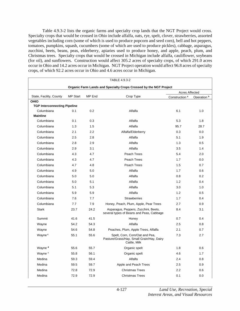
4-127 Land Use, Recreation, Special Interest Areas, and Visual Resources
Table 4.9.3-2 lists the organic farms and specialty crop lands that the NGT Project would cross. Specialty crops that would be crossed in Ohio include alfalfa, oats, rye, spelt, clover, strawberries, assorted vegetables including corn (some of which is used to produce popcorn and seed corn), bell and hot peppers, tomatoes, pumpkins, squash, cucumbers (some of which are used to produce pickles), cabbage, asparagus, zucchini, beets, beans, peas, elderberry, apiaries used to produce honey, and apple, peach, plum, and Christmas trees. Specialty crops that would be crossed in Michigan include alfalfa, cauliflower, soybeans (for oil), and sunflowers. Construction would affect 305.2 acres of specialty crops, of which 291.0 acres occur in Ohio and 14.2 acres occur in Michigan. NGT Project operation would affect 96.8 acres of specialty crops, of which 92.2 acres occur in Ohio and 4.6 acres occur in Michigan.
TABLE 4.9.3-2
Organic Farm Lands and Specialty Crops Crossed by the NGT Project
State, Facility, County MP Start MP End Crop Type
Acres Affected
Construction a Operation b
OHIO
TGP Interconnecting Pipeline
Columbiana 0.1 0.2 Alfalfa 6.1 1.0
Mainline
Columbiana 0.1 0.3 Alfalfa 5.3 1.8
Columbiana 1.3 1.5 Alfalfa 95.7 28.7
Columbiana 2.1 2.2 Alfalfa/Elderberry 0.3 0.0
Columbiana 2.5 2.8 Alfalfa 5.1 1.9
Columbiana 2.8 2.9 Alfalfa 1.3 0.5
Columbiana 2.9 3.1 Alfalfa 3.5 1.4
Columbiana 4.3 4.7 Peach Trees 5.4 2.0
Columbiana 4.3 4.7 Peach Trees 1.7 0.0
Columbiana 4.7 4.8 Peach Trees 1.5 0.7
Columbiana 4.9 5.0 Alfalfa 1.7 0.6
Columbiana 5.0 5.0 Alfalfa 0.8 0.2
Columbiana 5.0 5.1 Alfalfa 1.2 0.4
Columbiana 5.1 5.3 Alfalfa 3.0 1.0
Columbiana 5.9 5.9 Alfalfa 1.2 0.5
Columbiana 7.6 7.7 Strawberries 1.7 0.4
Columbiana 7.7 7.9 Honey, Peach, Plum, Apple, Pear Trees 2.7 0.9
Stark 23.7 24.2 Asparagus, Peppers, Zucchini, Beets, several types of Beans and Peas, Cabbage
8.4 3.1
Summit 41.6 41.5 Honey 0.7 0.4
Wayne 54.2 54.3 Alfalfa 2.5 0.8
Wayne 54.6 54.8 Peaches, Plum, Apple Trees, Alfalfa 2.1 0.7
Wayne c 55.1 55.6 Spelt, Corn, Corn/Oat and Pea, Pasture/Grass/Hay, Small Grain/Hay, Dairy
Cattle, Milk
7.3 2.7
Wayne d 55.6 55.7 Organic spelt 1.8 0.6
Wayne e 55.8 56.1 Organic spelt 4.6 1.7
Medina 59.3 59.4 Alfalfa 2.4 0.8
Medina 59.5 59.7 Apple and Peach Trees 2.5 0.9
Medina 72.8 72.9 Christmas Trees 2.2 0.6
Medina 72.9 72.9 Christmas Trees 0.1 0.0

Land Use, Recreation, Special 4-128 Interest Areas,and Visual Resources
TABLE 4.9.3-2 (cont’d)
Organic Farm Lands and Specialty Crops Crossed by the NGT Project
State, Facility, County MP Start MP End Crop Type
Acres Affected
Construction a Operation b
Erie 108.0 108.0 Apple Trees 0.2 0.0
Erie 108.0 108.4 Apple Trees 6.4 2.4
Erie 110.3 110.3 Honey - 3-4 hives located in SW part of property
8.0 1.8
Erie 110.8 110.9 Apple and Peach Trees 4.0 1.3
Erie 111.1 111.4 Fruit Trees 4.6 1.5
Erie 111.7 111.8 Honey 1.6 0.7
Erie 111.9 111.9 Honey 0.2 0.1
Erie 117.2 117.7 Rye 11.6 2.7
Erie 117.7 118.1 Rye 10.4 2.7
Erie 118.3 118.4 Popcorn 2.5 0.7
Erie 118.9 119.2 Popcorn 4.4 1.5
Erie 122.0 122.0 Popcorn 0.5 0.1
Erie 122.3 122.5 Clover 3.0 1.2
Erie 124.9 125.4 Seed Corn 6.6 2.6
Erie 129.7 130.0 Bell Peppers, Tomatoes, Pumpkins 6.3 2.4
Erie 130.1 130.2 Squash, Cucumbers, Cabbage 2.3 0.8
Sandusky 136.9 137.4 Cabbage, Pumpkins, Squash, Cucumbers, Peppers (Jalapeños, Bell, and Banana)
8.1 3.0
Sandusky 137.4 137.5 Cabbage, Pumpkins, Squash, Cucumbers, Peppers (Jalapeños, Bell, and Banana)
1.9 0.4
Sandusky 142.2 142.5 Strawberries 4.1 1.6
Sandusky 142.5 142.6 Strawberries 1.5 0.7
Sandusky 142.6 142.7 Strawberries 1.7 0.5
Sandusky 160.3 160.4 Peppers, Pickles 2.4 0.7
Sandusky 160.4 160.8 Peppers, Pickles 5.8 2.3
Sandusky 160.8 160.8 Peppers/Pickles 0.9 0.4
Wood f 164.7 164.9 Organic grains and produce 4.2 1.6
Wood 177.8 178.1 Oats/Alfalfa 4.1 1.6
Wood 178.1 178.3 Oats/Alfalfa 3.9 1.5
Wood 178.3 178.4 Oats/Alfalfa 1.0 0.4
Fulton 202.8 203.0 Alfalfa 2.0 0.8
Fulton 202.9 203.2 Alfalfa 4.0 1.6
Ohio Total 291.0 92.2
MICHIGAN
Mainline
Lenawee 219.5 219.6 Cauliflower 2.5 0.8
Monroe 233.2 233.3 Alfalfa 2.0 0.6
Washtenaw 245.8 246.3 Soybean (for oil) 9.6 3.2
Washtenaw 247.4 247.4 Sunflowers 0.1 0.0
Michigan Total 14.2 4.6
Project Total 305.2 96.8

4-129 Land Use, Recreation, Special Interest Areas, and Visual Resources
TABLE 4.9.3-2 (cont’d)
Organic Farm Lands and Specialty Crops Crossed by the NGT Project
State, Facility, County MP Start MP End Crop Type
Acres Affected
Construction a Operation b
__________________________
a Land affected during construction for pipeline facilities is comprised of the permanent right-of-way, temporary workspace, and ATWS where applicable.
b Land affected during operation of the pipeline includes only the permanent right-of-way.
c Sunbeam Organic Farm is certified in organic crops (corn, corn/oat and pea, pasture/grass/hay, and small grain/hay) and in livestock (dairy cattle, milk). Specialty crops include spelt.
d Koger organic farm grows organic spelt.
e Sauer/Stauffer organic farm grows organic spelt.
f Hirzel Farms is certified in organic crops (cabbage, rye seed, soybeans, spelt, spring wheat, and yellow corn) and in handling (broker: yellow corn, cereals, cleaning and bagging of grains, clover, dry beans, oats, oilseeds, rye seed, soybeans, spelt, sunflowers, vetch, wheat). Specialty crops include organic grains and produce.
Based on a review of the NOP’s 2014 list of certified organic operations in Ohio and Michigan as well as NEXUS’ landowner consultations, the NGT Project would cross four organic farms (see table 4.9.3-2) and would be within 1.0 mile of six others within Ohio: Toledo Alfalfa Mills, Joe Curfman Farm, White Oak Farm, Infinite Garden Farm, Weihl Farm, and Naked and Happy Eggs.
No certified organic farms were identified within 1.0 mile of the NGT Project in Michigan.
The organic certification process involves developing and implementing an individualized Organic System Plan. The Organic System Plan outlines the practices and procedures to be performed and maintained, a list of each substance to be used as a production or handling input, a description of monitoring practices, the record-keeping systems, and management practices and physical barriers established to prevent commingling and contact with prohibited substances (7 CFR 205.201). Organic System Plans are proprietary in nature.
To promote continued participation in the NOP, NEXUS would coordinate with certified organic farm operators to identify construction and operations practices that are consistent with organic farm certification practices. In addition to the general construction measures identified in NEXUS’s E&SCP, mitigation measures specific to organic farms may include the following:
• Coordinate with landowners to maintain access to fields, storage areas, structures, and other agricultural facilities during construction;
• Maintain irrigation and drainage systems that cross the right-of-way;
• Protect active pasture land by installing temporary fencing, using alternative locations for livestock to cross the construction workspace, and/or alternating feeding arrangements, as negotiated with the landowner;
• Segregate and store topsoil such that only topsoil from the organic farm is replaced; and
• Use landowner-approved seed during restoration.
NEXUS would work with affected landowners to avoid and minimize potential impacts on specialty crops. NEXUS would compensate landowners for any project-related damages and lost production on organic farms and specialty crop lands. NEXUS would compensate organic farm landowners for any damages resulting from construction of the NGT Project.

Land Use, Recreation, Special 4-130 Interest Areas,and Visual Resources
NEXUS has provided site-specific crossing plans for the Sunbeam Organic Dairy Farm and Hirzel Farm. These plans consist of notes for wash station and entry locations to minimize potential for invasive species infestations; references to restoration being conducted in accordance with an environmental management plan and landowner stipulations for prohibited substances; use of standard soil handling techniques; and environmental monitors to be used on organic farms during construction. We conclude these plans may require additional measures based on consultation with affected farm owners. It is possible that herbicides used during operations could drift or runoff into an organic farm, or that seeding used in immediately adjacent areas could transfer to an organic farm. Because consultations are ongoing with organic farm landowners, including those for which we have received draft plans, and because site-specific mitigation for these areas have not been finalized, we recommend that:
• Prior to the end of the draft EIS comment period, NEXUS should file with the Secretary site-specific Organic Farm Protection Plans developed in coordination with organic farm landowners and applicable certifying agencies for each certified organic farm that would be crossed or immediately adjacent to the Project that has the potential to experience direct and indirect effects as a result of construction or operation (e.g., pesticide drift, water migration, weeds). The plans should, at a minimum, identify:
a) prohibited substances (both during construction and operation);
b) soil handling procedures;
c) buffer zones;
d) noxious invasive species control;
e) erosion control;
f) off right-of-way water migration;
g) restoration methods, including seeding and preventing introduction of disease vectors; and
h) operation and maintenance practices, including avoidance of herbicides or other agency or landowner approved methods.
The plan should also describe how properties would be monitored for compliance with the provisions of the plan (e.g., use of an agricultural monitor) during construction.
Following construction, organic farming and specialty crop production would resume within the permanent right-of-way, with the exception of tree and shrub specialty crops such as Christmas trees or apple trees, in accordance with landowner agreements.
We conclude that with implementation of NEXUS’ proposed construction methods, the creation of site-specific Organic Farm Protection Plans, implementation of NEXUS’s E&SCP, and our recommendations, impacts on organic farms and specialty crop lands would be minimized to the greatest extent practicable and would not be significant.

4-131 Land Use, Recreation, Special Interest Areas, and Visual Resources
TEAL Project
The TEAL Project does not cross any certified organic farms or specialty crop lands.
4.9.5.2 Forest and Agricultural Management Programs
The State of Ohio has two voluntary programs that offer tax reductions to landowners for qualifying forest and agricultural lands. The Current Agricultural Use Value (CAUV) program offers tax relief to landowners for qualifying agricultural lands containing 10 or more acres that are devoted exclusively to commercial production of crops and animals, or commercial agricultural lands under 10 acres that meet the minimum yearly gross income requirements (State of Ohio, 2016). Lands enrolled in the CAUV program are appraised based on production capacity of the soil and the market value. Thus, the value is dependent upon the soil type, region, slope, and erosion factors of the land.
Similarly, the Ohio Forest Tax Law (OFTL) program provides tax relief to landowners for qualifying forestland that is devoted exclusively to forestry with a primary object of timber production and may include, but is not limited to, maple syrup production, wildlife conservation, recreation, and aesthetics. Eligible land that meets the definition of forestland and landowners who meet the program requirements in order to have land certified under the OFTL. Eligible land must be 10 or more contiguous acres and not less than 120 feet wide, and must include the minimum number of approved trees or square footage for plantations (ODNR, 2016d). Commercial orchards and Christmas tree plantations do not qualify as forestland under the OTFL.
Additionally, landowners can enroll their land into conservation easements. Conservation easements constitute a legally binding agreement that limits certain types of uses or prevents development from taking place on the land in perpetuity while the land remains in private ownership. Conservation easements protect land for future generations while allowing owners to retain many private property rights, live on and use their land, and potentially providing landowners with tax benefits (Nature Conservancy, 2016).
NGT Project
The NGT Project pipeline would cross several parcels of land enrolled in the CAUV/OFTL forest management programs or protected by conservation easements. The total acreage of these parcels amounts to 182.4 acres.
As listed in table 4.9.3-3, construction of the NGT Project would affect 13.0 acres of enrolled land and operations would affect 5.2 acres.
TABLE 4.9.3-3
Forest Management Program and Conservation Easement Enrolled Lands Crossed by the NGT Project
County Approximate Milepost
Range Program Name Parcel Size (acres)
Total
Construction Operation
Stark 33.6 – 34.0 CAUV / OFTL 21.4 4.8 2.4
Summit 38.8 – 38.8 Conservation Easement 19.4 1.2 0.5
Summit 38.8 – 39.0 Conservation Easement 78.9 3.0 0.8
Lorain 95.4 – 95.5 Conservation Easement 54.0 2.1 0.7
Lorain 95.5 – 95.6 Conservation Easement 8.7 1.9 0.8
Total 182.4 13.0 5.2
NEXUS would work with landowners to determine how the NGT Project crossing of CAUV/OFTL and conservation easements affects the continued participation in the program by landowners. NEXUS would compensate landowners for damages during construction and maintenance of the NGT Project,

Land Use, Recreation, Special 4-132 Interest Areas,and Visual Resources
including lost incentives based on the specific terms of the easement or related agreements as negotiated between the parties, or determined by a court.
We conclude that with implementation of NEXUS’ proposed mitigation measures and E&SCP, impacts on forest management programs and conservation easements would be minimized to the greatest extent practicable.
TEAL Project
Texas Eastern has not identified if any lands crossed by the TEAL Project are enrolled in forest management programs or conservation easements, and specific mitigation for such areas has not yet been identified. In order to assess the impacts on any potential areas, we recommend that:
• Prior to the end of the draft EIS comment period, Texas Eastern should file with the Secretary a list by milepost of the forest management program or conservation easements that would be crossed by the TEAL Project, along with construction and operation impacts (acres), discussion of mitigation measures specific to each area crossed that Texas Eastern would use to restore the right-of-way and compensate for lost incentives, and discussion of how construction and operation of the TEAL Project would affect landowners’ status pertaining to these programs or easements.
4.9.5.3 Conservation Reserve Program and Conservation Reserve Enhancement Program
The Conservation Reserve Program (CRP) is a land conservation program administered by the USDA’s Farm Service Agency (FSA). In exchange for a yearly rental payment, landowners enrolled in the program agree to remove environmentally sensitive land from agricultural production and plant species that would improve environmental health and quality. The long-term goal of the program is to re-establish valuable land cover to help improve water quality, prevent soil erosion, and reduce loss of wildlife habitat. The Conservation Reserve Enhancement Program (CREP), which is a subset of the CRP and also administered by the FSA, is focused on targeting high-priority conservation issues identified by local, state, or tribal governments or non-governmental organizations (FSA, 2015).
CRP lands occur primarily in agricultural areas and, therefore, the impacts and mitigation measures NEXUS would implement on these lands would be similar to those described for general agricultural areas (see section 4.9.2) and described in its E&SCP.
NGT Project
As listed in appendix K-4, construction of the NGT Project would affect a total of 524.5 acres of FSA-enrolled lands, including 292.4 acres in Ohio and 232.1 acres in Michigan. Operation of the NGT Project would affect a total of 185.6 acres of FSA-enrolled lands, including 104.8 acres in Ohio and 80.8 acres in Michigan.
Following construction, NEXUS would restore the right-of-way to meet the long-term objectives for the land enrolled in this program. However, some enrolled lands may have provisions for tree plantings that overlap the permanent right-of-way. Construction of the pipeline would not change the general use of the land but trees would be not allowed to be maintained within the permanent right-of-way. As such, if the right-of-way is currently maintained with trees, the program agreement may need to be altered to accommodate the pipeline. On FSA-enrolled lands where tree clearing is necessary, NEXUS would reimburse the landowner for lost yearly rental payments, plus related penalties (if applicable). Also, NEXUS is currently working with landowners and local FSA and NRCS officials to determine how the

4-133 Land Use, Recreation, Special Interest Areas, and Visual Resources
crossing of enrolled lands by the NGT Project affects the continued participation in the program by landowners.
Because tree removal within the permanent right-of-way could preclude enrollment in the program, we recommend that:
• Prior to the end of the draft EIS comment period, NEXUS should file with the Secretary a discussion of how construction and operation of the NGT Project would affect landowners’ continued participation in the Conservation Reserve Program.
While NEXUS has provided information on FSA-enrolled lands, our review of the information in appendix K-4 shows that the information does not reflect changes in the proposed pipeline route as represented in supplemental filings submitted to the FERC after the November 2015 application. Therefore, we recommend that:
• Prior to the end of the draft EIS comment period, NEXUS should file a revised FSA-enrolled lands table and ensure the table includes the mileposts, tract number, type of program, and acres affected. For any FSA-enrolled lands crossed, provide an update on NEXUS’ consultations with landowners and local FSA and NRCS officials regarding the landowners’ continued participation in the program, and any requested mitigation measures.
We conclude that with implementation of NEXUS’ updated proposed construction and mitigation measures, such as its E&SCP, impacts on FSA-enrolled lands that consists of non-forest land uses, would be minimized to the greatest extent practicable and would not be significant. An impact conclusion for forested FSA-enrolled lands is pending NEXUS’ response to our recommendation.
TEAL Project
Because consultations are ongoing with the landowners to determine if any lands crossed by the TEAL Project are enrolled in FSA lands, and specific mitigation for these areas has not yet been identified, we recommend that:
• Prior to the end of the draft EIS comment period, Texas Eastern should file with the Secretary a list of the FSA lands that would be crossed by the TEAL Project by milepost, along with construction and operation impacts (acres), discussion of mitigation measures specific to each FSA Program parcel crossed that Texas Eastern would use to restore the right-of-way, and discussion of how construction and operation of the TEAL Project would affect landowners’ status pertaining to the FSA Program.
4.9.5.4 Agricultural Drain Tiles and Irrigation Structures
NGT Project
NEXUS developed a Drain Tile Mitigation Plan (see appendix E-3) that provides a general overview of the types of drain tile systems potentially encountered during construction, and describes NEXUS’ drain tile mitigation strategy during pre-construction, construction, and post-construction. The Drain Tile Mitigation Plan describes how NEXUS would communicate with landowners, perform preliminary drain tile assessments, identify existing drain tiles, repair damaged drain tiles, and monitor the NGT Project. We reviewed the plan and find it acceptable.

Land Use, Recreation, Special 4-134 Interest Areas,and Visual Resources
We received comments regarding concerns over damage to existing drain tiles as a result of construction. Concerns focused on issues of crop loss as a result of disrupting the drainage system, flooding, timing of and procedures for drain tile repair and replacement, loss of prime farmland, and landowner compensation.
Known agricultural drain tiles crossed by the NGT Project are listed in appendix K-5. Based on the information provided by NEXUS, the Project would not cross any known irrigation systems. Construction activities such as trenching could have the potential to damage these systems. To avoid cutting or damaging these systems, NEXUS would work with individual landowners prior to construction to identify and mark drain tile systems. Existing systems would be checked for pre-existing damage. If damaged during construction, NEXUS would temporarily repair the drain tile(s) until the pipe is lowered into the trench and permanent repairs can be completed and hydrology restored. System interruptions would typically last one day. NEXUS would compensate the landowner for the costs associated with repairing drain tile damages directly related to construction.
Following construction, the depth of cover over the new pipelines would be sufficient to avoid interference with the drain tile systems. Repairs and restoration to these systems conducted by NEXUS would be monitored for 3 years, or until restoration is considered successful, to ensure the system functions properly.
We received comments during the scoping period concerning installation criteria and mitigation requests for specific tracts of land with drain tile. In addition to the general measures listed above and committed to in NEXUS’ Drain Tile Mitigation Plan, landowners have the opportunity during easement negotiations to request that site-specific factors and/or development plans for their property be considered, and that specific measures be taken into account.
We conclude that with implementation of NEXUS’ proposed construction and mitigation measures, such as NEXUS’ Drain Tile Mitigation Plan and E&SCP, impacts on drain tile systems would be minimized to the greatest extent practicable.
TEAL Project
There are no agricultural drain tiles or irrigation/drainage structures crossed by the TEAL Project.
4.9.6 Roadways and Railroads
The NGT and TEAL Projects would cross 362 public roads and 112 private roads. Of these, 242 would be crossed using the bore method, 202 would be crossed using the open-cut method, and 30 would be crossed using the HDD method. A description of each crossing method is provided in section 2.3.2.6.
Potential effects associated with roadway crossings include temporary disruption of traffic flow, disturbance of existing underground utilities (i.e., water and sewer lines), and hindrance of emergency vehicle access. During construction, NEXUS and Texas Eastern would maintain passage of emergency vehicles by creating temporary travel lanes or placing of steel plate bridges to allow continued traffic flow during open trenching. Traffic lanes and residential access would be maintained throughout construction, except for the temporary periods essential for pipeline installation, which would be coordinated with the landowner. Construction debris including mud would be kept off paved roads at access points used by construction equipment. See section 4.10.7 for a discussion on transportation and traffic-related impacts.

4-135 Land Use, Recreation, Special Interest Areas, and Visual Resources
NGT Project
Table 4.9.6-1 summarizes the number of roads that would be crossed by the NGT Project in each county. Of the 468 roads crossed, 379 are in Ohio and 89 are in Michigan. These roads range from maintained dirt and gravel to paved county and township roads, state highways, and interstate highways. Appendix K-6 identifies all roadways (public and private) crossed by the NGT Project along with the associated crossing method. There are no anticipated permanent effects on existing uses of the roadways crossed by the NGT Project.
In areas where traffic volumes are high or other circumstances (e.g., congested areas) exist, NEXUS would obtain the assistance of law enforcement to ensure traffic flow and the safety of pedestrians and vehicles. NEXUS would obtain the necessary permits to access, modify, and/or work within road rights-of-way in coordination with the Ohio and Michigan state and county transportation departments.
TABLE 4.9.6-1
Summary of Roadways Crossed by the NGT Project
State, County Number of Roadways Crossed Total Number of
Roadways Crossed Private Public
OHIO
Columbiana 21 20 41
Stark 13 33 46
Summit 13 24 37
Wayne 7 12 19
Medina 4 32 46
Lorain 2 21 23
Huron 0 4 4
Erie 13 30 43
Sandusky 7 49 56
Wood 3 21 24
Lucas 4 12 16
Henry 0 1 1
Fulton 1 22 23
Ohio Total 98 281 379
MICHIGAN
Lenawee 1 27 28
Lenawee/Monroe 0 1 1
Monroe 1 10 11
Washtenaw 11 38 49
Michigan Total 13 76 89
Project Total 111 357 468
The NGT Project would cross 24 active railroads (18 in Ohio and 6 in Michigan) and 4 inactive railroads (3 in Ohio and 1 in Michigan), which would be crossed using the conventional bore or HDD method (see table 4.9.6-2). Use of bore and HDD methods would avoid impacting the normal operation of the active railroads during construction.

Land Use, Recreation, Special 4-136 Interest Areas,and Visual Resources
TABLE 4.9.6-2
Railroads Crossed by the NGT Project
State, County Approx. Milepost Name
Active/ Inactive
Proposed Construction Method
OHIO
Columbiana 11.2 Norfolk Southern Corporation Active Bore
Stark 18.6 Norfolk Southern Corporation Active Bore
Stark 28.1 Wheeling & Lake Erie Railway Company Active Bore
Summit 34.3 Metro Regional Transit Authority RR (Cuyahoga Valley Scenic Railroad)
Inactive (Until 2019)
Bore
Summit 48.2 CSX Transportation Inc. Active HDD
Medina 56.8 Wheeling & Lake Erie Railway Company Active Bore
Medina 69.5 CSX Transportation, Inc. Active Bore
Medina 72.8 Wheeling & Lake Erie Railway Company Active Bore
Medina 73.6 CSX Transportation, Inc. Active Bore
Medina 75.5 CSX Transportation, Inc. Active Bore
Lorain 87.1 CSX Transportation, Inc. Active Bore
Lorain 96.3 Lake Shore Railway Association Inc. (Amherst-Wellington Connector)
Inactive Bore
Erie 115.9 Norfolk And Western RR Active Bore
Erie 128.4 Norfolk And Western RR Active Bore
Sandusky 147.6 Norfolk Southern Corporation Active Bore
Sandusky 159.5 Northern Ohio & Western RR Active Bore
Wood 166.8 CSX Transportation, Inc. Active Bore
Wood 173.9 CSX Transportation, Inc. Active Bore
Wood 179.1 CSX Transportation, Inc. Active Bore
Lucas 182.1 Toledo Lake Erie Western RR Inactive Bore
Fulton 197.8 Norfolk Southern Corporation Active Bore
MICHIGAN
Lenawee 210.0 Genesee & Wyoming Railroad Services Inc. Active Bore
Lenawee 217.1 Adrian & Blissfield RR Active Bore
Monroe 233.0 Norfolk & Western RR Active Bore
Washtenaw 238.5 Omega Rail Management Active Bore
Washtenaw 249.7 Norfolk Southern Corporation Inactive Bore
Washtenaw 254.3 Norfolk Southern Corporation Active HDD
Washtenaw 254.3 Amtrak RR (Michigan Department of Transportation [MDOT] Owned)
Active Bore
We conclude that with implementation of NEXUS’ proposed construction and mitigation measures as well as its E&SCP, impacts on roadways and railroads would be minimized to the greatest extent practicable and would not be significant. Additionally, NEXUS would obtain the necessary permits and approvals from federal, state, and local agencies.
TEAL Project
As listed in appendix K-7, the TEAL Project would cross five public roads and one private road; no railroads would be crossed.
Similar to the NGT Project, Texas Eastern would obtain the assistance of law enforcement to ensure traffic flow and the safety of pedestrians and vehicles in areas where traffic volumes are high or other circumstances (e.g., congested areas) exist. Texas Eastern would obtain the necessary permits to access, modify, and/or work within road rights-of-way in coordination with the Ohio state and county transportation departments.

4-137 Land Use, Recreation, Special Interest Areas, and Visual Resources
We conclude that with implementation of Texas Eastern’s proposed construction and mitigation measures as well as its E&SCP, impacts on roadways and railroads would be minimized to the greatest extent practicable and would not be significant. Additionally, Texas Eastern would obtain the necessary permits and approvals from federal, state, and local agencies.
4.9.7 Recreation and Special Interest Areas
The NGT Project would not cross any national or state-designated Wild and Scenic Rivers, or lands managed by or associated with the U.S. Bureau of Land Management, Wetland Reserve Program, Emergency Conservation Program, Grassland Reserve Program, national forests, national parks, or Indian Reservations. However, it would cross or be located within 0.25 mile of public and private lands that support recreation or special interests. Features directly affected include trails, conservation and recreation areas, sports facilities, places of worship, a cemetery, scenic and historic byways, a scenic river, state parks and forests, nature areas/preserves, a national heritage area, and municipal parks, as listed in table 4.9.7-1. Waterbodies crossed and included on the NRI are discussed in section 4.3.2.1.
The TEAL Project would not cross or be located within 0.25 mile of any public or private lands that support recreation or special interests. Therefore, with the exception of general recreation (e.g., hunting) discussed below, it is no longer addressed in this section.
The primary concern when crossing recreation and special interest areas is the impact of construction on the purpose for which the area was established (e.g., the recreational activities, public access, and resources the area aims to protect). Construction would temporarily limit recreational use in a specific area; could generate dust and noise, which could be a nuisance to recreational users; and could interfere with or diminish the quality of the recreational experience by affecting wildlife movements or disturbing trails and their users. Construction could also alter visual aesthetics by removing existing vegetation and disturbing soils.
In general, project impacts on recreational and special interest areas occurring outside of forest/woodland would be minor and temporary (limited to the period of active construction), which typically would last only several days to several weeks in any one area. These impacts would primarily be minimized by implementing NEXUS’ E&SCP, which describes topsoil and subsoil segregation, erosion control measures, waterbody and wetland crossings, etc. In addition, NEXUS has proposed specific mitigation measures as described below for some of the recreation and special interest areas that would be affected.
Following construction, most land uses disturbed would be restored and able to revert to their former uses. Forest/woodland affected by construction within the temporary right-of-way and ATWS areas, however, would experience long-term impacts because of the time required for the forest/woodland to regenerate to its pre-construction condition, and forest/woodland within the permanent right-of-way would experience permanent impacts because it would be precluded from being reestablished at the site or within the maintained portion of the right-of-way.

Land Use, Recreation, Special
4-138 Interest Areas, and Visual Resources
TABLE 4.9.7-1
Recreation and Special Interest Areas Crossed by the NGT Project
State, Agency Facility County
MP Start MP End Name of Area Land Ownership / Land Management
Crossing Method
Acreage Affected by Construction
Con. Op.
OHIO
Federal
Federal Highway Administration
Mainline Summit 47.9 47.9 Ohio & Erie Canalway America's Byway Federal Highway Administration HDD <0.1 a 0.0
State
Ohio Department of Natural Resources
Mainline Wood / Lucas
181.4 181.5 Maumee State Scenic River ODNR HDD <0.1 a 0.0
Mainline Lucas 181.5 181.7 Missionary Island Wildlife Area ODNR HDD <0.1 a 0.0
Mainline Lucas 181.7 181.8 Maumee State Scenic River ODNR HDD <0.1 a 0.0
Mainline Summit 41.0 41.2 Portage Lakes State Park (Nimisila Reservoir) ODNR HDD <0.1 a 0.0
Mainline Summit 41.6 41.7 Portage Lakes State Park (Nimisila Creek) ODNR Flume or Dam and
Pump
2.6 0.9
Mainline Henry 190.0 190.3 ODNR Property (adjacent to Maumee State Forest) ODNR Open-Cut 3.9 1.4
Mainline Fulton 190.3 190.5 ODNR Property ODNR Open-Cut 5.2 1.6
Mainline Fulton 193.3 193.7 Maumee State Forest ODNR Open-Cut 4.7 2.8
Ohio Department of Transportation
Mainline Columbiana 2.0 2.0 Lincoln Highway Historic Byway (Ohio State Route 9/U.S. Route 30)
ODOT Bore 0.2 0.1
Mainline Wood 181.2 181.2 Maumee Valley Scenic Byway (West River Road) ODOT / Maumee Valley Heritage Corridor
HDD <0.1 a 0.0
Mainline Lucas 181.8 181.8 Maumee Valley Scenic Byway (South River Road) ODOT / Maumee Valley Heritage Corridor
HDD <0.1 a 0.0
County/Municipal
Stark County Park District
Mainline Stark 16.2 16.2 Stark Farmland Trail (proposed) Stark County Park District Bore 0.1 <0.1
Mainline Stark 17.0 17.0 Iron Horse Trail Stark County Park District Open-Cut <0.1 <0.1
Mainline Stark 18.3 18.3 Stark Electric Railway Trail (proposed) Stark County Park District Bore 0.1 <0.1
Mainline Stark 27.2 27.2 Upper Middle Branch Trail (proposed) Stark County Park District Bore 0.1 <0.1
Summit County Metro Parks
Mainline Summit 48.2 48.2 Ohio & Erie Canal / Towpath Trail Summit Metro Parks / Private Landowners
HDD <0.1 a 0.0
Medina County Park District
Mainline Medina 68.8 68.8 Chippewa Rail Trail Medina County Park District Open Cut 0.2 0.1

4-139
Land Use, Recreation, Special
Interest Areas, and Visual Resources
TABLE 4.9.7-1 (cont’d)
Recreation and Special Interest Areas Crossed by the NGT Project
State, Agency Facility County
MP Start MP End Name of Area Land Ownership / Land Management
Crossing Method
Acreage Affected by Construction
Con. Op.
Mainline Medina 68.9 69.0 Chippewa Lake Nature Area Medina County Park District / Western Land Conservancy
Open Cut 0.7 0.3
Mainline Medina 69.6 69.7 Chippewa Lake Nature Area Medina County Park District Open Cut 7.8 2.6
Mainline Medina 70.3 70.6 Chippewa Lake Nature Area Medina County Park District Open Cut 6.8 2.8
Mainline Medina 70.8 70.8 Chippewa Inlet Trail Medina County Park District Open Cut <0.1 <0.1
Mainline Medina 71.1 71.3 Buckeye Woods Park / Schleman Nature Preserve Medina County Park District HDD <0.1 a 0.0
Lorain County Metro Parks
Mainline Lorain 98.1 98.1 North Coast Inland Trail Lorain County Metro Park District Open Cut 0.2 0.1
Sandusky County Park District
Mainline Sandusky 151.2 151.3 North Coast Inland Trail Sandusky County Park District Open Cut 0.2 0.1
Mainline Sandusky 153.2 153.4 Creek Bend Farm Sandusky County Park District Open Cut 3.0 1.3
Metroparks of the Toledo Area
Mainline Lucas 181.7 181.8 Farnsworth Metropark / Towpath Trail Metroparks of the Toledo Area HDD <0.1 a 0.0
City of Green
Mainline Summit 35.3 35.4 Ariss Park City of Green Open Cut 3.1 0.9
Mainline Summit 35.5 35.6 Ariss Park / Hwy 77 City of Green Open Cut / Bore
1.7 0.6
Mainline Summit 37.1 37.1 Greensburg Park City of Green Open Cut <0.1 <0.1
Private/Other
Mainline Columbiana 3.5 3.5 North Country National Scenic Trail (on Buffalo Road)
Private Landowners / Hanover Township, Columbiana County Board of Trustees
Open Cut 0.3 0.1
Mainline Columbiana 8.0 8.0 Statewide Bike Routes- J Columbiana County Engineer HDD <0.1 a 0.0
Mainline Stark 33.0 33.0 Buckeye Trail Private Landowners Open Cut 0.1 <0.1
Mainline Summit, Stark
33.4 35.4 Ohio & Erie Canalway National Heritage Area Private Ownership / NPS Management Open Cut 35.3 12.2
Mainline Stark 34.0 34.0 Buckeye Trail Private Landowners Bore 0.1 <0.1
Mainline Summit 34.3 34.3 Cuyahoga Valley Scenic Railroad Metro Regional Transit Authority Bore 0.0 <0.1
Mainline Summit 38.8 39.0 Singer Lake Bog Cleveland Museum of Natural History Open Cut 3.9 1.3
Mainline Summit 41.2 41.2 Buckeye Trail Private Landowners HDD <0.1 a 0.0
Mainline Summit 41.5 49.6 Ohio & Erie Canalway National Heritage Area Private Ownership / NPS Management
Open Cut 128.3 49.3
Mainline Summit 47.9 47.9 Buckeye Trail / Ohio to Erie Trail Private Landowners HDD <0.1 a 0.0
Mainline Medina 68.0 68.0 Chippewa Lake Baptist Church Private Landowners Open Cut 0.9 0.9
Mainline Medina 68.3 68.3 State Wide Bike Route- C Lafayette Township, Board of Trustees Bore <0.1 <0.1
Mainline Medina 78.0 78.0 Buckeye Trail Private Landowners / York Township, Board of Trustees
Bore 0.1 <0.1

Land Use, Recreation, Special
4-140 Interest Areas, and Visual Resources
TABLE 4.9.7-1 (cont’d)
Recreation and Special Interest Areas Crossed by the NGT Project
State, Agency Facility County
MP Start MP End Name of Area Land Ownership / Land Management
Crossing Method
Acreage Affected by Construction
Con. Op.
Mainline Lorain 83.9 84.4 Western Reserve Land Conservancy Private Landowners/ Western Reserve Land Conservancy
Open Cut 7.8 3.0
Mainline Lorain 95.4 95.6 Western Reserve Land Conservancy (also encompasses Black Swamp Woods)
Private Landowners/ Western Reserve Land Conservancy
Open Cut 4.1 1.5
Mainline Lorain 96.3 96.3 Amherst-Wellington Connector Lake Shore Railway Association Bore 0.1 <0.1
Mainline Erie 110.2 110.2 Statewide Bike Route- N Erie County Engineer HDD <0.1 a 0.0
Mainline Erie 116.3 116.3 Statewide Bike Routes N-CP Erie County Engineer Bore 0.1 <0.1
Mainline Erie 118.5 118.8 Erie County Conservation League Erie County Conservation League Open Cut 4.6 1.7
Mainline Erie 122.0 122.0 St. John's United Church of Christ Milan Ohio Inc. Private Landowners Open Cut 0.5 0.1
Mainline Erie 128.8 128.8 Statewide Bike Route N-CP Groton Township, Board of Trustees Bore 0.1 <0.1
Mainline Sandusky 151.7 151.7 Buckeye Trail Private Landowners / Sandusky County Engineers
Bore 0.1 <0.1
Mainline Sandusky 162.4 162.4 Buckeye Trail Private Landowners / Sandusky County Engineers
HDD <0.1 a 0.0
Mainline Wood 177.3 177.3 Statewide Bike Route E Middleton Township Bore 0.1 <0.1
Mainline Wood 178.1 178.1 Bowling Green- Perrysburg Connector (proposed) Middleton Township Bore 0.1 <0.1
Mainline Wood 179.9 179.9 Buckeye Trail Private Landowners / ODOT HDD <0.1 a 0.0
Mainline Wood 180.8 180.8 Riverby Hills Golf Club Private Landowners Open Cut 0.1 <0.1
Mainline Lucas 181.8 181.8 Highland Memory Gardens Cemetery Private Landowners HDD <0.1 a 0.0
Mainline Lucas 183.1 183.1 Statewide Trail A Various county, city or township offices Bore 0.1 <0.1
Mainline Henry 190.0 190.0 North Country National Scenic Trail; Wabash Cannonball Trail
Northwestern Ohio Rails To Trails Association, Inc.
Open Cut 0.1 <0.1
Mainline Fulton 195.9 195.9 North Country National Scenic Trail; Wabash Cannonball Trail
Northwestern Ohio Rails To Trails Association, Inc.
Bore 0.1 <0.1
Ohio Total 226.9 86.1
MICHIGAN
Mainline Washtenaw 249.1 249.1 Community Free Will Baptist Church Private Landowners Open Cut 0.8 0.4
Mainline Washtenaw 250.3 250.3 South Hydro Park Charter Twp of Ypsilanti Staging Area
0.4 0.0
Mainline Washtenaw 250.9 251.1 North Hydro Park Charter Twp of Ypsilanti HDD <0.1 a 0.0
Mainline Washtenaw 251.2 251.4 The Ponds at Lakeshore Disc Golf Course Private Landowners Open Cut 3.1 1.1
Michigan Total 4.3 1.5
NGT Project Total 231.2 87.6
________________________________
a Construction and operation impacts <0.1 acre represent minor hand cutting of brush to lay a guide wire for the HDD, which may consist of a pathway measuring a few feet in width in densely vegetated areas..

4-141 Land Use, Recreation, Special Interest Areas, and Visual Resources
NEXUS would work with the landowners of the recreational and special interest areas to avoid, minimize, or mitigate impacts on these areas, as requested. Each recreational or special interest area is discussed below, along with any site-specific measures that NEXUS would adopt to avoid or minimize construction-related impacts on the feature. NEXUS would attempt to maintain access to the areas during construction of the pipeline. NEXUS would compensate landowners for any loss of crop or timber for any area disturbed during construction. In addition to the areas directly affected, table 4.9.7-2 lists the recreational and special interest areas that are within 0.25 mile of the NGT Project.
TABLE 4.9.7-2
Recreation and Special Interest Areas within 0.25 Mile of the NGT Project
State, Facility, County Ownership/Management Name of Area
Distance in feet and Direction from Nearest Point of Construction ROW
OHIO
Mainline
Stark Stark County Park District Stark Farmland Trail (proposed)
267 East from Access Road; 760 West from MP 14.8
Stark Private Landowners Sportsman's Rod & Gun Club 112 South from MP 25.4
Stark Multiple Landowners Statewide Bike Route 988 Southwest from MP 27.3
Stark Private Landowners Lake O' Pines Park 881 North from MP 30.2
Summit City of Green Green Youth Sports Complex 697 East from MP 36.8
Summit City of Green Boettler Park and Southgate Park
353 Southeast from MP 38.0
Summit Cleveland Museum of Natural History
Singer Lake Bog 1,158 South from MP 38.2
Summit Private Landowners Loyola Retreat House 500 Northwest from MP 40.4
Summit Private Landowners Camp Y-NOAH (YMCA) 38 South from Access Road; 942 South from MP 40.9
Summit Private Landowners Spring Hills Golf and Tennis Club
311 South from MP 49.3
Wayne Village of Doylestown Doylestown Park 1,054 South from MP 53.4
Medina Private Landowners Romeyn Recreational Enterprises Inc.
575 West from MP 65.1
Medina Medina County Park District Chippewa Lake Nature Area 368 West from MP 69.0
Medina Medina County Park District Chippewa Lake Nature Area 544 South from MP 69.5
Medina Private Landowners Medina Country Club 369 East from MP 69.2
Lorain Private Landowners Gordon Blackhall Memorial Range
966 Southwest from MP 81.2
Lorain Lorain County Metro Park District Midview Soccer League Complex
213 South from MP 86.0
Lorain Lorain County Metro Park District Indian Hollow Reservation and Sheldon Woods
562 Northeast from MP 87.7
Lorain Multiple Landowners Statewide Bike Route 560 North from MP 90.8
Lorain Lorain County Metro Park District Carlisle Preservation 0' West from MP 91.4
Lorain City of Oberlin Oberlin Recreational Complex
369 North from MP 94.6
Erie Private Landowners Western Reserve Land Conservancy
230 East from MP 110.1
Erie Erie County Metro Parks Board Edison Woods Preserve 17 Northeast from MP 112.1
Sandusky State of Ohio Wildlife Habitat Restoration Program Murray, P.
530 North from MP 144.2
Sandusky Private Landowners Black Swamp Conservancy, Placemark
438 North from MP 153.8
Sandusky Private Landowners Black Swamp Conservancy, CBR Farms
429 North from MP 154.2
Sandusky Private Landowners Black Swamp Conservancy, Toledo Alfalfa Mills Farm
0' North from MP 155.6
Sandusky Private Landowners Black Swamp Conservancy, Chet Mauch Farm
49 South from MP 156.6

Land Use, Recreation, Special 4-142 Interest Areal Resources
TABLE 4.9.7-2 (cont’d)
Recreation and Special Interest Areas within 0.25 Mile of the NGT Project
State, Facility, County Ownership/Management Name of Area
Distance in feet and Direction from Nearest Point of Construction ROW
Wood Private Landowners Tanglewood Golf Course 724 North from MP 173.2
Henry ODNR Maumee State Forest 817 South from MP 189.3
Henry ODNR Maumee State Forest 670 Southwest from MP 190
Fulton Private Landowners White Pine Golf Course 207 Southwest from MP 190.5
Fulton ODNR Maumee State Forest 416 Northeast from MP 191.7
Fulton ODNR Maumee State Forest 696 East from MP 192.8
Fulton ODNR Maumee State Forest 634 East from MP 193.3
Fulton State of Ohio Fulton Pond Wildlife Area 8 East from MP 198.8
Aboveground Facilities
Columbiana ODOT Lincoln Highway Historic Byway
1,171 Northwest from Hanoverton Compressor Station boundary
Erie Multiple Landowners Statewide Bike Route N-CP 206 East from MR05 boundary
Lucas Private Landowners Statewide Trail A 529 East from Waterville Compressor Station boundary
MICHIGAN
Mainline
Washtenaw Washtenaw County Parks and Recreation
Draper-Houston Meadows Preserve & Nature Park
47 East from MP 237.4
Direct effects would not occur on areas located within 0.25 mile of the NGT Project and outside of the construction right-of-way. However, during pipeline construction, indirect impacts from noise and visual impacts would occur; these would be temporary and limited to the time of construction. During operation, moderate and permanent visual and noise impacts would result from clearing of trees from the permanent right-of-way and, if applicable, the placement of permanent facilities such as compressor stations or MLVs within proximity to the recreation and special interest areas. NEXUS would implement the measures outlined in its E&SCP to prevent disturbance to off-site areas.
No public hunting or game management areas would be crossed by the NGT or TEAL Projects. However, construction of the Projects may affect general recreational activities such as hunting and fishing. For example, construction of the pipeline may affect hunting activities that occur on private land if the hunting season occurs within the construction time frame. Hunting seasons in Ohio and Michigan vary depending by species. For example, deer hunting is allowed between September and February; turkey hunting is allowed between September and November and April and May; and most small game species hunting is allowed between September and January (ODNR Division of Wildlife, 2016a; MDNR, 2016). Currently, construction of the TEAL Project is planned from March 2017 through October 2017. Construction of the NGT Project is planned from March 2017 through November 2017. To minimize conflicts with hunting activities, NEXUS and Texas Eastern would notify adjacent landowners prior to construction.
In addition, recreational fishing occurs in the NGT and TEAL Project areas. Common fish species occurring in the waterbodies affected by the Projects are discussed in section 4.7.1 and listed in table 4.7.1-1. Sections 4.3.2.2 and 4.7.2.1 discuss construction methods proposed at waterbodies and project-related impacts on waterbodies and fisheries, respectively.
The following discussions describe recreational and special interest areas designated by federal, state, and county/municipal entities, and the opportunities available at each area crossed by the NGT Project. As stated above, no federal, state, or county/municipal designated recreational or special interest areas would be crossed by the TEAL Project. NEXUS has proposed general mitigation measures and

4-143 Land Use, Recreation, Special Interest Areas, and Visual Resources
provided site-specific crossing plans that are being completed in consultation with the applicable landowner or managing agency (see appendix P). Site-specific crossing plans have not been provided for Chippewa Lake Baptist Church, St. John’s United Church of Christ Milan, and the Community Free Will Baptist Church. Because some of these plans have not been completed, we are recommending in the following discussions that NEXUS file outstanding site-specific crossing plans for certain features. We have included draft versions of the available site-specific crossing plans in appendix E-5. We encourage the owners/managers of each recreation and special interest area to provide us comments on the plan(s) specific to their property of ownership or management during the draft EIS comment period.
While NEXUS has provided site-specific crossing plans for most recreational and special interest areas, similar plans have yet to be provided for trails where closure would be required during construction. Because construction could limit recreational users’ access to and use of trails, we recommend that:
• Prior to construction of the NGT Project, NEXUS should file with the Secretary for review and written approval by the Director of OEP, site-specific crossing plans for trails that would be closed during construction that show where a detour or portage would be placed, shows where signage would be placed warning recreationalists of the detour or portage, and provide documentation that the plan was developed in coordination with the landowner or land-managing agency.
4.9.7.1 Federal
Federal Highway Administration
Ohio & Erie Canalway America's Byway
The Ohio & Erie Canalway America’s Byway is a 110-mile route that was designated in 1996 as a State Scenic Byway by the ODOT and designated as Ohio & Erie Canalway America’s Byway in 2000 by U.S. Secretary of Transportation. Ohio & Erie Canalway America's Byway is a collection of 150 roads that recognize certain roads as All-American Roads or National Scenic Byways based on one or more archeological, cultural, historic, natural, recreational and scenic qualities. The Ohio & Erie Canalway America's Byway is recognized as a National Scenic Byway, and is administered by the Federal Highway Administration of the DOT (Ohio & Erie Canal Association, 2016a). The Ohio & Erie Canalway America’s Byway travels through the Ohio & Erie Canal National Heritage Area (NHA).
As listed in table 4.9.7-1, the NGT Project would cross Ohio & Erie Canalway America’s Byway at MP 47.9 (Van Buren Road at this location) using the HDD method, as described in section 2.3.2.6. Land use on either side of the byway crossing consists of open land, agricultural land, and residential land. This crossing also includes crossing of the Tuscarawas River and the Ohio-to-Erie Trail (Buckeye Trail at this location). The trails are discussed individually below.
Direct impacts would be avoided; however, byway travelers may experience temporary visual and noise impacts associated with construction personnel and equipment and HDD activities. Also, as a result of the HDD method, tree clearing and vegetation maintenance within the permanent right-of-way on either side of the crossing would not be necessary, thus avoiding permanent visual impacts on recreational users. Recreational uses of the byway would not be affected by operations.

Land Use, Recreation, Special 4-144 Interest Areal Resources
4.9.7.2 State
Ohio Department of Natural Resources
Maumee State Scenic River
The Maumee State Scenic River is located in northwestern Ohio and flows northeasterly through portions of Paulding, Defiance, Henry, Wood and Lucas Counties. Scenic rivers are classified according to the outstanding qualities a stream possesses including the stream's length, adjacent forest cover, biological characteristics, water quality, present use, and natural conditions. Ohio’s Scenic Rivers Act provides three categories for river classification: wild, scenic and recreational (ODNR Division of Watercraft, 2016). The ODNR Division of Watercraft administers the state scenic rivers program.
As listed in table 4.9.7-1, the NGT Project would cross the Maumee State Scenic River at two locations between MPs 181.4 and 181.8 using the HDD method. The Maumee State Scenic River is designated as a "recreational river” at this crossing. A recreational river includes those rivers or sections of rivers that are readily accessible by road or railroad, that may have some development along their shorelines, and that may have undergone some impoundment or diversion in the past (State of Ohio, 2016). Land use at this crossing consists of forest/woodland (Missionary Island Wildlife Area and along the river banks) and open water (Maumee River). Project-related impacts would be similar to those described for other areas crossed using the HDD method. Recreational uses of the river would not be affected by operations.
Missionary Island Wildlife Area
The Missionary Island Wildlife Area includes 296 acres of land located along the Maumee River in Lucas and Wood Counties, and is owned and managed by the ODNR Division of Wildlife. Recreational opportunities include wildlife watching, hunting, trapping, fishing, and boating (ODNR Division of Wildlife, 2016b).
As listed in table 4.9.7-1, the NGT Project would cross the Missionary Island Wildlife Area between MPs 181.5 to 181.7 using the HDD method. Land use at this crossing consists of forest/woodland. Project-related impacts would be similar to those described for other areas crossed using the HDD method. Recreational uses of the wildlife area would not be affected by operations.
Portage Lakes State Park
Portage Lakes State Park is a 411-acre state park located in Summit County and is owned and managed by the ODNR Division of Parks and Recreation. The park offers recreational experiences such as boating, swimming, hunting and fishing, and wildlife viewing (ODNR Division of Parks and Recreation, 2016).
As listed in table 4.9.7-1, the NGT Project would cross the southern portion of Portage Lakes State Park in two locations between MPs 41.0 and 41.2 and between MPs 41.6 and 41.7. The first crossing between MPs 41.0 and 41.2 consists of the Nimisila Reservoir and would be crossed using the HDD method. Land use at the first crossing consists of agricultural land, open water (Nimisila Reservoir), and forest/woodland.
Direct impacts would be avoided at the first crossing where the reservoir would be crossed using the HDD method; however, a small portion of ATWS associated with HDD entry/exit point at MP 40.9 is located within the park and would impact agricultural land. Where land use is agricultural, land uses would

4-145 Land Use, Recreation, Special Interest Areas, and Visual Resources
return to pre-construction conditions. Recreational users may experience temporary visual and noise impacts associated with construction personnel and equipment and HDD activities. Recreational uses of the park would not be affected by operations.
The second crossing between MPs 41.6 and 41.7 consists of Nimisila Creek, which would be crossed using the flume or dam and pump method, as described in section 2.3.2. Land use at the second crossing consists of forest/woodland, open water (Nimisila Creek), and open land. The open land portions of each crossing are associated with an existing utility right-of-way.
Construction would affect 2.6 acres and operations would affect 0.9 acre at the Nimisila Creek crossing. Project-related construction and operation impacts associated with the second crossing include clearing and tree removal of the construction workspace, and routine vegetation maintenance within the permanent right-of-way required during pipeline operation. As a result, the NGT Project would cause the conversion of forest/woodland to open land within the permanent right-of-way. Impacts associated with tree clearing and vegetation maintenance would be a long-term to permanent impact. Following construction, the area would be restored, and areas outside of the permanent right-of-way would be returned to pre-construction conditions in accordance with NEXUS’ E&SCP. Additionally, NEXUS would compensate the land managing agency for the value of trees removed by construction and operation of the project. Recreational users would be temporarily affected by Project-related noise, dust, traffic, and visual impacts. These impacts would be limited to the time of construction. Recreational uses of the park would not be affected by operations; however, long-term impacts associated with tree removal would be visible.
ODNR Property
As listed in table 4.9.7-1, the pipeline crosses two parcels owned by the ODNR between MPs 190.0 and 190.3 and between MPs 190.3 and 190.5 using the open-cut method as described in section 2.3.1. This area is also within the Historic Oak Openings Region (see section 4.5.1.1) and adjacent to the Maumee State Forest. The first crossing at MP 190.0 coincides with the North Country National Scenic Trail and Wabash Cannonball Trail. Land use at the first crossing consists of forest/woodland and agricultural land. Land use at the second crossing consists of agricultural land and commercial/industrial (County Road A).
Construction would affect 9.1 acres and operations would affect 3.0 acres at the ODNR Property crossings. Project-related construction and operation impacts would be similar to those described in section 4.9.2, depending on the specific land use type affected throughout the area, and to those described for other areas crossed using the open-cut method. Following construction, these areas would be restored, and areas outside of the permanent right-of-way would be returned to pre-construction conditions in accordance with NEXUS’ E&SCP. Recreational uses of the trail would be allowed to continue; however, long-term impacts associated with tree removal would be visible.
An alternative route for the pipeline at the first crossing is under consideration as discussed in section 3.0. This alternative route would shift the pipeline east and bisect a contiguous portion of forest/woodland within the Maumee State Forest.
Maumee State Forest
The Maumee State Forest includes a combination of several parcels totaling 3,194 acres in Fulton and Henry Counties, and is owned and managed by the ODNR’s Division of Forestry. Recreational opportunities offered by the forest include fishing, hunting, camping, hiking, biking, picnicking, winter recreation, wildlife observations, horseback riding, and all-purpose vehicle use (ODNR Division of Forestry, 2016a). The Maumee State Forest is managed under the multiple-use concept including, but not

Land Use, Recreation, Special 4-146 Interest Areal Resources
limited to, timber, wildlife habitat, forestry research, demonstration of good forest management, soil and water protection, recreational use, and unique natural features (ODNR Division of Forestry, 2016b).
As listed in table 4.9.7-1, the NGT Project would cross the Maumee State Forest boundary between MPs 193.3 and 193.7 using the open-cut method. This portion of the Maumee State Forest is designated as land management area Compartment A2 and is located within the Historic Oak Openings Region (see section 4.5.1.1). Land use at this crossing consists of forest/woodland.
According to the Maumee State Forest 2016 Work Plan, several areas within Compartment A2 are being considered for prescribed burning in 2016. These areas include the Stewardship Trail Demo Area, a phragmites (common reed grass) patch near Road 4, and the Rusin Tract Old Fields. The Stewardship Trail is approximately 650 feet west of the construction workspace, and the nearest facility, the Maumee State Forest office building, is approximately 665 feet west of the construction workspace.
Construction would affect 4.7 acres and operations would affect 2.8 acres at the state forest crossing. Project-related construction and operation impacts would be similar to those described in section 4.9.2, depending on the specific land use type affected throughout the area, and to those described for other areas using the open-cut method. Following construction, these areas would be restored, and areas outside of the permanent right-of-way would be returned to pre-construction conditions in accordance with NEXUS’ E&SCP. Recreational uses of the forest would be allowed to continue; however, long-term impacts associated with tree removal would be visible.
Ohio Department of Transportation
Lincoln Highway Historic Byway (Ohio State Route 9/U.S. Route 30)
The 241-mile-long Lincoln Highway Historic Byway in Ohio was established in March 2004 after being awarded the state-designated byway status through the ODOT (Ohio Lincoln Highway Heritage Corridor, 2016; ODOT, 2016a). The byway is also referred to as Ohio State Route 9 and U.S. Route 30. Much of U.S. Route 30 has been rebuilt as a four-lane divided highway, but several original brick paved sections still exist (Lincoln Highway Association, 2016). The ODOT manages the Lincoln Highway Historic Byway and partners with organizations to preserve, protect, and enhance the intrinsic resources of the byway.
As listed in table 4.9.7-1, the NGT Project would cross the Lincoln Highway Historic Byway at MP 2.0 using the bore method, as described in section 2.3.2.6. At this crossing, the byway is a two-lane divided paved road. Land use on either side of the byway crossing consists of open land and open water (Sandy Creek). Direct impacts on the byway would be avoided through use of the bore method and traffic would continue during construction; however, scenic travelers may experience temporary visual and noise impacts associated with construction personnel and equipment and bore activities. Following construction, recreational uses of the byway would not be affected by operations. The ATWS associated with the bore crossing would result in minor and temporary residential tree removal.
Maumee Valley Scenic Byway (West and South River Roads)
The Maumee Valley Scenic Byway is part of Ohio Scenic Byway Program. The nearly 90-mile route begins on the north side of the Maumee River in Defiance and follows River Road until it ends in Maumee. On the south side of the Maumee River, the byway starts at Napoleon and ends in Rossford (ODOT, 2016b).

4-147 Land Use, Recreation, Special Interest Areas, and Visual Resources
As listed in table 4.9.7-1, the NGT Project would cross the Maumee Valley Scenic Byway in two locations at MP 181.2 and MP 181.8 using the HDD method. The first crossing at MP 181.2 (West River Road in this location) is a two-lane divided paved road. Land use at the first crossing consists of agricultural and forest/woodland. The second crossing at MP 181.8 (South River Road in this location) is also a two-lane divided paved road. Land use at the second crossing consists of open land. The byway segments crossed by the NGT Project are managed by the Maumee Valley Heritage Corridor (Maumee Valley Heritage Corridor, 2016).
Project-related impacts would be similar to those described for other areas crossed using the bore method. Recreational uses of the byway would not be affected by operations. The access road associated with the HDD crossing would require minor tree removal along West River Road.
4.9.7.3 County/Municipal
Stark County Park District
Stark Farmland Trail (Proposed)
The Stark Farmland Trail is a proposed on-road trail that would provide a north-south connection between Alliance and Minerva using rural roadways, and would be an alternate to the Iron Horse Trail (Stark County Park District, 2016a). According to the Stark County Transportation Plan (Stark County Area Transportation Study, 2013), the proposed Stark Farmland Trail would be completed in 2040. The Stark County Park District would own and manage the Stark Farmland Trail. As listed in table 4.9.7-1, the NGT Project would cross a future segment of the Stark Farmland Trail at MP 16.2R (Beechwood Ave NE at this location) using the bore method. Land use on either side of the road/future trail consists of agricultural land.
Project-related impacts would be the same as those described throughout this section for agricultural land, and those that would be crossed using the bore method. Following construction, vehicular uses of the road and future uses of the trail would not be affected by operations.
Iron Horse Trail
The Iron Horse Trail is a former railroad right-of-way that once connected Alliance to Minerva (Stark County Park District, 2016b). Recreational activities along the natural surface trail include hiking and walking. The Stark County Park District owns and manages the Iron Horse Trail. As listed in table 4.9.7-1, the NGT Project would cross the Iron Horse Trail at MP 17.0 using the open-cut method. Land use on either side of the trail consists of forest/woodland.
Construction would affect 0.04 acre and operations would affect 0.03 acre at the Iron Horse Trail crossing. Project-related construction and operation impacts would be similar to those described in section 4.9.2, depending on the specific land use type affected throughout the area, and to those described for other areas crossed using the open-cut method. Following construction, these areas would be restored, and areas outside of the permanent right-of-way would be returned to pre-construction conditions in accordance with NEXUS’ E&SCP. Recreational uses of the trail would not be affected by operations.
Stark Electric Railway Trail (Proposed)
The Stark Electric Railway Trail is a proposed recreational trail that would connect Canton, Louisville and Alliance. According to the Stark County Transportation Plan (Stark County, 2013), the Stark Farmland Trail would be completed in 2030. The Stark County Parks District would own and manage

Land Use, Recreation, Special 4-148 Interest Areal Resources
the Stark Electric Railway Trail. As listed in table 4.9.7-1, the NGT Project would cross a future segment of the Stark Electric Railway Trail at MP 18.3 (Easton Street NE in this location) using the bore method. Land use on either side of the trail consists of open land and residential land.
Project-related impacts would be similar to those described for other areas crossed using the bore method. Following construction, vehicular uses of the road and future uses of the trail would not be affected by operations.
Upper Middle Branch Trail (Proposed)
The proposed Upper Middle Branch Trail would become a primary north-south connector within the center of Stark County. It would connect Hartville to Canton at Riverside Park. Much of the route would parallel the Middle Branch of the Nimishillen Creek (Stark County Park District, 2016c). As listed in table 4.9.7-1, the NGT Project would cross the proposed Upper Middle Branch Trail at MP 27.2 (Gans Avenue NE at this location) using the bore method. Land use on either side of the road/future trail consists of open and agricultural land.
Project-related impacts would be similar to those described for other areas crossed using the bore method. Following construction, vehicular uses of the road and future uses of the trail would not be affected by operations.
Summit County Metro Parks
Ohio & Erie Canal Towpath Trail
The Ohio & Erie Canal Towpath Trail is one of Ohio’s longest and most popular scenic bikeways. The “towpath,” as it is more commonly known, is part of the larger Ohio-to-Erie Trail (Ohio Bikeways, 2016) and the Buckeye Trail system. About 41 miles of the towpath trail are in Summit County and managed by Summit Metro Parks. The trail segment crossed by the NGT Project is on land leased by Metro Parks from PPG Industries (Summit Metro Parks, 2016).
As listed in table 4.9.7-1, the NGT Project would cross the trail at MP 48.2 using the HDD crossing method. Land use adjacent to the trail crossing consists of open water (Tuscarawas River) and forest/woodland. The crossing of the trail is adjacent to and parallel with overhead wires. Project-related impacts would be similar to those described for other areas crossed using the HDD method. Recreational uses of the wildlife area would not be affected by operations. Recreational uses of the trail and river would not be affected by operations.
Medina County Park District
The Medina County Park District owns and manages more than 6,300 acres of land, including 17 open parks and preserves and 12 additional sites set aside for future development (Medina County Park District, 2016a). As listed in table 4.9.7-1, the NGT Project would cross several tracts of Medina County Park District land from MPs 68.8 to 71.3 including the Chippewa Rail Trail, Chippewa Lake Nature Area, Chippewa Inlet Trail, and Buckeye Woods Park/Schleman Nature Preserve. Each of these areas are described individually below.
Chippewa Rail Trail
The Chippewa Rail Trail is a former railroad line that was purchased by the Medina County Park District in 1992. Funds from an ODOT grant were used to develop the Chippewa Rail Trail from Chippewa

4-149 Land Use, Recreation, Special Interest Areas, and Visual Resources
Road to Wycliffe Drive in Lafayette Township. The 10-foot-wide by 2.75-mile-long asphalt trail offers hiking, biking, and rollerblading (Medina County Park District, 2016b).
As listed in table 4.9.7-1, the NGT Project would cross the Chippewa Rail Trail at MP 68.8 using the open-cut method. Land use on either side of the trail consists of forest/woodland.
Construction would affect 0.2 acre and operations would affect 0.1 acre at the Chippewa Rail Trail crossing. Project-related construction and operation impacts would be similar to those described in section 4.9.2, depending on the specific land use type affected throughout the area, and to those described for other areas crossed using the open-cut method. Following construction, these areas would be restored, and areas outside of the permanent right-of-way would be returned to pre-construction conditions in accordance with NEXUS’ E&SCP. Recreational uses of the trail would not be affected by operations. The ATWS associated with the bore crossing would be located such that tree removal would be required starting about 30 feet from each side of the trail.
Chippewa Lake Nature Area
The Chippewa Lake Nature Area is located south of Buckeye Woods Park and on the west and north side of Chippewa Lake. As listed in table 4.9.7-1, the NGT Project would cross the Chippewa Lake Nature Area in three locations between MPs 68.9 and 69.0, MPs 69.6 and 69.7, and MPs 70.3 and 70.6 using the open-cut method. The first crossing between MPs 68.9 and 69.0 includes a parcel that was acquired through a partnership with the Western Reserve Land Conservancy (Western Reserve Land Conservancy, 2016). This parcel is located between the Chippewa Rail Trail and Lake Road. Land use at this crossing consists of agricultural land and forest/woodland. Land use at the second crossing (MPs 69.6 and 69.7) and third crossing (MPs 70.3 and 70.6) consists of open land and forest/woodland.
Construction would affect 15.3 acres and operations would affect 5.7 acres at the Chippewa Lake Nature Area crossings. Project-related construction and operation impacts would be similar to those described in section 4.9.2, depending on the specific land use type affected throughout the area, and to those described for other areas crossed using the open-cut method. Following construction, these areas would be restored, and areas outside of the permanent right-of-way would be returned to pre-construction conditions in accordance with NEXUS’ E&SCP. Recreational uses of the areas would be allowed to continue; however, long-term impacts associated with tree removal would be visible.
Chippewa Inlet Trail
The 3.95-mile Chippewa Inlet Trail runs north-south along the western edge of Buckeye Woods and connects Buckeye Woods Park and the Chippewa Lake Nature Area (Medina County Park District, 2016c). As listed in table 4.9.7-1, the NGT Project would cross the Chippewa Inlet Trail at MP 70.8 using the open-cut method. Land use on either side of the trail crossing consists of open land and open water (The Inlet).
Construction would affect <0.1 acre and operations would affect less than 0.1 acre at the Chippewa Inlet Trail crossing. Project-related construction and operation impacts would be similar to those described in section 4.9.2, depending on the specific land use type affected throughout the area, and to those described for other areas crossed using the open-cut method. Following construction, these areas would be restored, and areas outside of the permanent right-of-way would be returned to pre-construction conditions in accordance with NEXUS’ E&SCP. Recreational uses of the trail would not be affected by operations.

Land Use, Recreation, Special 4-150 Interest Areal Resources
Buckeye Woods Park / Schleman Nature Preserve
Buckeye Woods Park is the largest park in the Medina County park system and includes the Schleman Nature Preserve. The preserve, located along the western boundary of Buckeye Woods Park, was donated to the Medina County Park District to remain undeveloped for the enjoyment of nature and wildlife viewing. Recreational trails within the preserve include the 1.5-mile Green Trail and the 1.0-mile Yellow Trail. The Green Trail connects to the Chippewa Inlet Trail in Buckeye Woods Park (Medina County Park District, 2016c).
As listed in table 4.9.7-1, the NGT Project would cross the Schleman Nature Preserve between MPs 71.1 and 71.3 using the HDD method. Land use at this crossing consists of forest/woodland. Project-related impacts would be similar to those described for other areas crossed using the HDD method.
We received several comments from Medina County Park District during scoping that expressed concern over impacts on the Schleman Nature Preserve and a wetland mitigation area, as well as crossing the Chippewa Rail and Chippewa Inlet Trails. More specifically, Medina County Park District noted the long-term impacts of clearing trees within, and north of, the Schleman Nature Preserve; potential impacts to a wetland mitigation project that was constructed and currently maintained by Medina County Park District; steep slopes near the Chippewa Rail Trail crossing that would make it difficult to construct within and repair the slopes; and due to the proximity of the Chippewa Inlet Trail to the Chippewa Inlet (a waterbody), the Park District is opposed to an aboveground crossing of the Inlet waterbody, and has requested the trails remain open during construction.
Regarding the crossing of Schleman Nature Reserve and the private forested land north of the preserve, NEXUS proposes to cross the area using the HDD method to avoid impacts (see table 4.9.7-1). Regarding the wetland mitigation area, NEXUS has rerouted the NGT Project to avoid impacts to the wetland mitigation area. Wetlands and the Inlet waterbody crossings are discussed in sections 4.3 and 4.4. Regarding the crossing of the trails, NEXUS proposes to cross the Chippewa Rail Trail and Chippewa Inlet Trail using the open-cut method. NEXUS has indicated it is reviewing the Park District's request to keep the trails open to the general public during construction.
Because consultations are ongoing, the feasibility of using the bore method at the Chippewa Rail Trail and Chippewa Inlet Trail has yet to be determined, and the trails would be temporarily closed and specific migration measures such as detour have not yet been identified, we recommend that:
• Prior to the end of the draft EIS comment period, NEXUS should file with the Secretary an evaluation of the feasibility of crossing the Chippewa Rail Trail and Chippewa Inlet Trail using the bore method. If the bore method is not feasible, NEXUS should file a site-specific alternate crossing plan that identifies the location(s) of a detour, public notification, signage, and consideration of avoiding days of peak usage.
Lorain County Metro Parks and Sandusky County Park District
North Coast Inland Trail
The 65-mile North Coast Inland Trail is a 12-foot-wide asphalt paved trail that was built over abandoned railroad tracks and extends from Elyria to Toledo. The NGT Project would cross the trail at two locations in Lorain and Sandusky Counties. Lorain County Metro Parks manages a 13-mile segment from Elyria to Kipton (Lorain County Metro Parks, 2016), and Sandusky County Park District manages a 28-mile segment from Bellevue to Elmore (Sandusky County Park District, 2016a).

4-151 Land Use, Recreation, Special Interest Areas, and Visual Resources
As listed in table 4.9.7-1, the NGT Project would cross the North Coast Inland Trail twice using the open-cut method. The first crossing at MP 98.1 is located in Lorain County. Land use on either side of the first trail crossing consists of forest/woodland. The second crossing at MP 151.2 is located in Sandusky County and coincides with the Buckeye Trail at this location. Land use on either side of the second trail crossing consists of open land and forest/woodland.
Construction would affect 0.4 acre and operations would affect 0.2 acre. Project-related construction and operation impacts would be similar to those described in section 4.9.2, depending on the specific land use type affected throughout the area, and to those described for other areas crossed using the open-cut method. Following construction, these areas would be restored, and areas outside of the permanent right-of-way would be returned to pre-construction conditions in accordance with NEXUS’ E&SCP. Recreational uses of the trail would not be affected by operations. The ATWS associated with the bore crossing appear to be located such that tree removal would not be required.
Sandusky County Park District
Creek Bend Farm
Creek Bend Farm is located along a 2-mile stretch of Muddy River in Sandusky County. The 310-acre park includes grass walking trails, food plots, Muddy Creek, a tree farm, farm grounds and buildings, and a pasture. The park also includes the recently constructed Wilson Nature Center. The property, listed on the National Register of Historic Places, was the home of Fran Roush and Bob Roush, former Sandusky County Commissioner (Sandusky County Park District, 2016b). Creek Bend Farm is managed by Sandusky County Park District.
As listed in table 4.9.7-1, the NGT Project would cross the Creek Bend Farm between MPs 153.2 and 153.4 using the open-cut method. Land uses at the crossing include forest/woodland, open land (warm season grasses and a grass trail), and open water (Muddy Creek).
Construction would affect 3.0 acres and operations would affect 1.3 acres of the farm crossing. Project-related construction and operation impacts would be similar to those described in section 4.9.2, depending on the specific land use type affected throughout the area, and to those described for other areas crossed using the open-cut method. Following construction, these areas would be restored, and areas outside of the permanent right-of-way would be returned to pre-construction conditions in accordance with NEXUS’ E&SCP. To minimize impacts associated with construction and creation of a new right-of-way, the NGT Project would parallel an existing cleared utility right-of-way at this crossing. Following construction, recreational uses of the grass trail and farm land would be allowed to continue; however, long-term impacts associated with tree removal would be visible.
We received comments from Sandusky County Park District during scoping expressing concern over impacts on the Muddy Creek Corridor, which runs through Creek Bend Farm and is part of ongoing research and monitoring programs, trail use during construction, proposed crossing methods, and an existing deed restriction on Creek Bend Farm. More specifically, Sandusky County Park District requested that NEXUS consider using the bore method to cross the North Coast Inland Trail and Creek Bend Farm to accommodate continued recreational use of the area during construction, and noted that there are development restrictions on Creek Bend Farm that prohibit granting of utility easements.
Regarding the Muddy Creek Corridor crossing, NEXUS would use the flume or dam and pump method to cross Muddy Creek, as described in sections 2.3.2.1. Comments received regarding wetland crossings within Creek Bend Farm have been addressed in section 4.4.3.1. Regarding the use of the bore method to cross North Coast Inland Trail and Creek Bend Farm, NEXUS has indicated it is currently

Land Use, Recreation, Special 4-152 Interest Areal Resources
reviewing the feasibility of this request. Regarding utility easement restrictions, NEXUS indicated there are no special interest areas that prohibit pipeline and other utility easements impacted by the NGT Project.
Because consultations are ongoing, the feasibility of using the bore method at the North Coast Inland Trail and Creek Bend Farm has yet to be determined, and the trail would be temporarily closed and specific migration measures such as detour have not yet been identified, we recommend that:
• Prior to the end of the draft EIS comment period, NEXUS should file with the Secretary an evaluation of the feasibility of crossing the North Coast Inland Trail and Creek Bend Farm using the bore method. If the bore method is not feasible, NEXUS should file a site-specific alternate crossing plan that identifies the location(s) of a detour, public notification, signage, and consideration of avoiding days of peak usage.
Metroparks of the Toledo Area
Farnsworth Metropark and Towpath Trail
Farnsworth Metropark is a narrow park located along the Maumee River that includes the Towpath Trail, a boat launch, fishing, a playground, picnic shelters, and primitive camping sites. The 8.3-mile-long Towpath Trail is part of the Buckeye Trail system and follows the remains of the Miami and Erie Canal. The trail connects Farnsworth, Bend View, and Providence metroparks. Metroparks of the Toledo Area owns and manages Farnsworth Metropark and the Towpath Trail (Metroparks of the Toledo Area, 2016).
As listed in table 4.9.7-1, the NGT Project would cross the park and trail between MPs 181.7 and 181.8 using the HDD method. Land use at this crossing consists of forest/woodland, open land, and commercial/industrial (parking lot). Project-related impacts would be similar to those described for other areas crossed using the HDD method. Recreational uses of the park and trail would not be affected by operations.
City of Green
Ariss Park
Ariss Park is owned and maintained by the City of Green and is located east and west of Interstate Highway 77 on Wise Road. The 80-acre park includes a 0.5-mile limestone walking trail loop, three tackle football fields, two flag football fields, restrooms, a concession stand, and a press box (City of Green, 2016a).
As listed in table 4.9.7-1, the NGT Project would cross Ariss Park in two locations using the open-cut and bore methods. The first crossing is along the southern border of Ariss Park between MPs 35.3 and 35.4 and would be crossed using the open-cut method. Land use at the first crossing consists of a mix of forest/woodland and active agricultural fields. The pipeline would cross approximately 1,200 feet south and southeast of the closest playing field and parking area.
The second crossing between MPs 35.5 and 35.6 includes Interstate Highway 77 and would be crossed using the bore method across the highway and the open-cut method from MP 35.6 to the park boundary. Land use at the second crossing consists of commercial/industrial (Interstate Highway 77), forest/woodland, and open land associated with an existing utility right-of-way.
Construction would affect 4.8 acres and operations would affect 1.5 acres of the park. At the first crossing, Project-related construction and operation impacts would be similar to those described in section

4-153 Land Use, Recreation, Special Interest Areas, and Visual Resources
4.9.2, depending on the specific land use type affected throughout the area, and to those described for other areas using the open-cut method. At the second crossing, Project-related impacts would be the same as those described for other areas crossed using the bore and open-cut methods. Following construction, these areas would be restored and areas outside of the permanent right-of-way would be returned to pre-construction conditions in accordance with NEXUS’ E&SCP. Where land use is open and agricultural at the crossing, land uses would be allowed to return to pre-construction conditions.
To minimize impacts associated with construction and creation of a new right-of-way at the second crossing (MPs 35.5 and 35.6), the pipeline would be co-located with an existing electric transmission line right-of-way. However, clearing and tree removal of the Project workspace would still be required during construction, and routine vegetation maintenance of forested areas within the permanent right-of-way would be required during pipeline operations. As a result, the NGT Project would require the conversion of forest land to open land within the permanent right-of-way. Impacts associated with tree clearing and vegetation maintenance would be long term to permanent as well as incremental to and consistent with the existing co-located right-of-way features. Following construction, recreational uses of the park would be allowed to continue; however, long-term impacts associated with tree removal would be visible.
While the bore method would result in avoiding direct impacts on Interstate Highway 77 and park facilities, the construction right-of-way and ATWS at the west end of the bore as currently planned would be located in forest/woodland. To further reduce impacts on forest/woodland, we recommend that:
• Prior to the end of the draft EIS comment period, NEXUS should file with the Secretary an evaluation of the feasibility of extending the bore further west to avoid impacting forest/woodland on the west side of Highway 77.
We received comments from the City of Green during scoping expressing concern over past contamination within the park. Specifically, when the City of Green first developed the park for fields and parking, the Ohio EPA required soil testing for all disturbed areas based on reports of illegal dumping of industrial waste from Akron Rubber in the 1960s. To date, test results have not detected soil contamination. In the event contaminated media is encountered during construction, NEXUS would stop work and contact the appropriate state and federal agencies and would develop a site-specific Hazardous Waste Management Plan in consultation with applicable agencies to address management and disposal of hazardous materials in accordance with applicable regulations.
Greensburg Park
Greensburg Park is owned and maintained by the City of Green and is located south of Greensburg Road on Massillon Road. The 27.9-acre park includes a pavilion, playground, soccer and baseball fields, batting cages, and a concession stand (City of Green, 2016b).
As listed in table 4.9.7-1, the NGT Project would cross the southeastern corner of the park at MP 37.1 using the open-cut method. Land use at this crossing consists of forest/woodland. The construction right-of-way would be located approximately 75 feet southeast of the closest baseball field.
Construction would affect <0.1 acre and operations would affect <0.1 acre of the park. Project-related construction and operation impacts would be similar to those described in section 4.9.2, depending on the specific land use type affected throughout the area, and to those described for other areas crossed using the open-cut method. Following construction, these areas would be restored, and areas outside of the permanent right-of-way would be returned to pre-construction conditions in accordance with NEXUS’ E&SCP. Recreational uses of the park would be allowed to continue; however, long-term impacts associated with tree removal would be visible.

Land Use, Recreation, Special 4-154 Interest Areal Resources
4.9.7.4 Private and Other
Ohio
North Country National Scenic Trail
The North Country National Scenic Trail (NCNST) crosses seven states, beginning in New York and ending in North Dakota (NPS, 2016). Much of the NCNST in Ohio is followed through roaded rural areas, and on or adjacent to roaded areas (North Country Trail Association, 2016). The trail is administered by the NPS in cooperation with other government agencies, private organizations, and individual landowners. The North Country Trail Association is a neutral non-profit organization that works in partnership with the NPS to build, maintain, and promote the NCNST. Because numerous public agencies and private interests are participating in the NCNST’s development, the type of trail, available support facilities, and rules and regulations governing the use of the trail vary from segment to segment (ODNR, 2005).
As listed in table 4.9.7-1, the NGT Project would cross the NCNST at three locations:
• MP 3.5, Buffalo Road would be crossed using the open-cut method;
• MP 190.0, coincides with the Wabash Cannonball Trail and an existing utility right-of-way and is located within the Historic Oak Openings Region, would be crossed using the open-cut method; and
• MP 195.9, coincides with the Wabash Cannonball Trail and is located within the Historic Oak Openings Region, would be crossed using the bore method.
Land uses on either side of the trail at these crossings consists of open land, agricultural land, and forest/woodland.
Construction at MPs 3.5 and 190.0 would affect 0.4 acre and operations would affect 0.1 acre of land. Where land use is forest/woodland (MPs 3.5 and 190.0), clearing and tree removal would be required during construction, and routine vegetation maintenance of forest/woodland within the permanent right-of-way would be required during pipeline operations. Project-related construction and operation impacts at MPs 3.5 and 190.0 would be similar to those described in section 4.9.2, depending on the specific land use type affected throughout the area, and to those described for other areas crossed using the open-cut method. Following construction, these areas would be restored, and areas outside of the permanent right-of-way would be returned to pre-construction conditions in accordance with NEXUS’ E&SCP. To reduce impacts on the scenic trail, the NGT Project would cross an existing electric transmission line right-of-way at MP 190.0.
Project-related impacts at MP 195.5 would be similar to those described for other areas crossed using the bore method. Following construction, recreational uses of the trail would not be affected by operations.
The crossing at MP 3.5, which is Buffalo Road, would require a temporary trail closure due to the use of the open-cut crossing method. NEXUS has indicated that hikers of the NCNST at MP 3.5 could walk along the side of Buffalo Road during construction. While NEXUS would coordinate with local officials to have traffic safety personnel on hand during periods of construction, they have not committed to establishing a detour or posting construction warning signs. Due to safety concerns, we conclude that

4-155 Land Use, Recreation, Special Interest Areas, and Visual Resources
additional mitigation is necessary. Because the trail at MP 3.5 would be temporarily closed and specific mitigation measures, such as a detour, have not yet been identified, we recommend that:
• Prior to construction of the NGT Project, NEXUS should file with the Secretary a site-specific crossing plan for the NCNST at MP 3.5 that identifies the location(s) of a detour, public notification procedures, signage, and consideration of avoiding days of peak usage. The crossing plan shall be developed in consultation with the landowner and trail managing agencies.
Statewide Bike Routes
As listed in table 4.9.7-1, the NGT Project would cross the following state-designated bike routes:
• Statewide Bike Route J at MP 8.0, Knox School Road, which would be crossed using the HDD method;
• Statewide Bike Route C at MP 68.3, Ryan Road at this location, which would be crossed by the bore method;
• Statewide Bike Route N at MP 110.2, Main Road, which would be crossed by the HDD method;
• Statewide Bike Routes N-CP at MP 116.3, River Road, which would be crossed by the bore method;
• Statewide Bike Route N-CP at MP 128.8, Billings Road, which would be crossed by the HDD method;
• Statewide Bike Route E at MP 177.3, Pargillis Road, which would be crossed by the bore method; and
• Statewide Trail A at MP 183.1, Noward Road at this location, which would be crossed by the bore method.
Where NEXUS would use the HDD crossing method (Statewide Bike Routes J and N), direct impacts on the bike routes would be avoided and use would be allowed to continue throughout construction. However, recreational users may experience temporary visual and noise impacts associated with construction personnel and equipment and HDD activities. Recreational uses of the bike route would not be affected by operations. Also, because the bike routes would be crossed by the HDD method, tree clearing and vegetation maintenance within the permanent right-of-way on either side of the crossing would not be necessary, thus avoiding permanent visual impacts on recreational users.
Where NEXUS would use the bore crossing method (Statewide Bike Routes C, N-CP, E, and Statewide Trail A), direct impacts on the bike routes would be avoided and use would be allowed to continue throughout construction. However, recreational users may experience temporary visual and noise impacts associated with construction personnel and equipment and bore activities. Recreational users of Bike Routes N-CP may experience temporary and permanent visual and noise impacts from the proposed M&R station (MR05) along Billings Road and the proposed mainline valve (MLV-9) remote blowoff facility. Following construction, recreational uses of the bike routes would continue throughout project operation.

Land Use, Recreation, Special 4-156 Interest Areal Resources
ATWS and access roads associated with the trail crossings appear to be located such that no tree removal would be required adjacent to the trails, with the exception of the crossing at MP 68.3 (State Bike Route C) where minor tree removal appears to be required along Chippewa Road, about 75 feet east of Ryan Road.
Buckeye Trail
The Buckeye Trail was first envisioned in the 1950s as a trail from the Ohio River to Lake Erie. Today, the Buckeye Trail is over 1,444 miles long and forms a loop through 49 of Ohio’s 88 counties. The Buckeye Trail is a dedicated, recognized, and protected route that is developed and maintained by the Buckeye Trail Association. Because numerous public agencies and private interests host portions of the trail, ownership varies from segment to segment (Buckeye Trail Association, 2016).
As listed in table 4.9.7-1, the NGT Project would cross the Buckeye Trail in nine locations. Of these crossings, two (MP 34.0 and MP 47.9) are located within the Ohio & Erie Canalway NHA. Land uses at the trail crossings consist of forest/woodland, agricultural land, commercial/industrial, and open land.
Construction would affect 1.0 acre and operations would affect <0.1 acre of land at the MP 33.0 crossing. Project-related construction and operation impacts would be similar to those described in section 4.9.2, depending on the specific land use type affected throughout the area, and to those described for other areas crossed using the open-cut method. Following construction, these areas would be restored, and areas outside of the permanent right-of-way would be returned to pre-construction conditions in accordance with NEXUS’ E&SCP. Where the trail would be crossed using the HDD or bore methods, NGT Project-related impacts would be similar to those described for other areas crossed using the HDD or bore methods, respectively. ATWS and access roads associated with all but one of the bike route crossings appear to be located primarily in agricultural land with no tree removal required adjacent to the trails. The trail crossing at MP 151.7 appears to include tree removal within the construction workspace, about 25 feet east of the trail. Recreational uses of the trail would not be affected by operations.
Erie Canalway National Heritage Area
In 1996, Congress designated the Ohio & Erie Canalway as an NHA to help preserve the rails, trails, landscapes, towns, and sites along the first 110 miles of the canal. Recreational opportunities within the NHA include birding and hiking along the Ohio & Erie Canal Towpath Trail or riding on the Cuyahoga Valley Scenic Railroad. While the federal government designated this area as a NHA, the Ohio & Erie Canalway NHA is independently managed and operated through local organizations and receives technical assistance from the Cuyahoga Valley National Park (Ohio & Erie Canalway Association, 2016b). The Ohio & Erie Canalway Association is the official management entity for the heritage area (Ohio & Erie Canalway Association, 2009).
As listed in table 4.9.7-1, the NGT Project crosses the Ohio & Erie Canalway NHA at two locations between MPs 33.4 and 35.4 in Stark and Summit Counties, and between MPs 41.5 and 49.6 in Summit County. The first crossing between MPs 33.4R and 35.4R includes the Buckeye Trail and Cuyahoga Valley Scenic Railroad. The second crossing between MPs 41.5 and 49.6 includes Portage Lakes State Park, the Ohio to Erie Trail, the Buckeye Trail/Ohio to Erie Trail, the Ohio & Erie Canalway America's Byway, and the Towpath Trail. Crossing methods and impacts along the NHA would vary and are discussed by individual feature below.
In total, NGT Project construction for all features crossed within the NHA would affect 163.5 acres of forest/woodland, agricultural land, open land, open water, commercial/industrial land, and residential

4-157 Land Use, Recreation, Special Interest Areas, and Visual Resources
land. In general, construction impacts and mitigation measures that NEXUS would implement would be similar to those described for the land uses discussed in section 4.9.2. Following construction, permanent impacts in the NHA would total 61.5 acres as a result of the conversion of the existing forest/woodland to open land within the permanent right-of-way. These areas would be restored, and areas outside of the permanent right-of-way would be returned to pre-construction conditions in accordance with NEXUS’ E&SCP. Forest/woodland clearing required along the NHA would result in a change to the surrounding visual character.
Cuyahoga Valley Scenic Railroad
The Cuyahoga Valley Scenic Railroad (CVSR) is one of the oldest tourist excursion railways in the country. CVSR operates on 51 miles of track from Independence south through Cuyahoga Valley National Park to Akron and Canton on the Sandyville Line. The CVSR offers regularly scheduled excursions, events and tours throughout the year. The Akron Metro Regional Transit Authority owns the rail line (Ohio & Erie Canalway Association, 2016c).
As listed in table 4.9.7-1, the NGT Project would cross the scenic railroad at MP 34.3 using the bore crossing method. Land use at this crossing consists of open land and forest/woodland. Project-related impacts would be similar to those described for other areas crossed using the bore method. Tree clearing associated with the bore method would primarily be limited to the ATWS needed to complete the crossing.
Singer Lake Bog
The 344-acre Singer Lake Bog is owned and protected by the Cleveland Museum of Natural History in partnership with the City of Green. The preserve includes 50 acres of leatherleaf-bog and a 5-acre kettle lake. Many rare wildlife and plant species are located within the bog.
As listed in table 4.9.7-1, the NGT Project would cross the preserve between MPs 38.8 and 39.0, about 230 feet northeast of the bog within the preserve property; the bog itself would not be crossed. The preserve would be crossed using the open-cut method. Land use at this crossing consists predominantly of agricultural land and smaller areas of forest/woodland associated with the ATWS.
Construction would affect 3.9 acres and operations would affect 1.3 acres at the preserve crossing. Project-related construction and operation impacts would be similar to those described in section 4.9.2, depending on the specific land use type affected throughout the area, and to those described for other areas crossed using the open-cut method. Following construction, these areas would be restored, and areas outside of the permanent right-of-way would be returned to pre-construction conditions in accordance with NEXUS’ E&SCP. Recreational uses of the preserve would be allowed to continue; however, long-term impacts associated with tree removal would be visible.
An alternative route for the pipeline in this area is under consideration that would avoid impacts on the Singer Lake Bog as discussed in section 3.0.
Comments received during the scoping period expressing concern over impacts to the bog and nearby forested wetlands are addressed in section 4.5.
Chippewa Lake Baptist Church
The Chippewa Lake Baptist Church holds church and prayer services, Sunday school, and various adult and child-oriented services, as well as a youth camp (Chippewa Lake Baptist Church, 2016).

Land Use, Recreation, Special 4-158 Interest Areal Resources
As listed in table 4.9.7-1, the southern half of the parcel owned by Chippewa Lake Baptist Church would be crossed by the NGT Project pipeline at MP 68.0 using the open-cut method. Land use at this crossing consists of open land. The proposed pipeline is located south of church structures and associated parking lot by approximately 620 feet and 515 feet, respectively.
Construction would affect 0.9 acre and operations would affect 0.9 acre at this crossing. Project-related construction and operation impacts would be similar to those described in section 4.9.2, depending on the specific land use type affected throughout the area, and to those described for other areas crossed using the open-cut method. Following construction, these areas would be restored, and areas outside of the permanent right-of-way would be returned to pre-construction conditions in accordance with NEXUS’ E&SCP. A sparsely wooded landscaped area is located between the pipeline and the church and would provide some visual screening.
Western Reserve Land Conservancy
The Western Reserve Land Conservancy works with landowners, communities, government agencies, park systems, and other nonprofit organizations to permanently protect natural areas and farmland. Created in 2006 by the merger of eight local land trusts, the Western Reserve Land Conservancy has grown to become the largest land trust in Ohio and one of the largest in the United States. The Land Conservancy’s goal is to preserve about 400,000 acres in northern Ohio and to create an interconnected network of protected property throughout the region. About 200,000 acres have been preserved by park systems, other government agencies, and land trusts such as the Land Conservancy (Western Reserve Land Conservancy, 2016).
As listed in table 4.9.7-1, the NGT Project would cross privately owned lands between MPs 83.9 and 84.4 and MPs 95.4 and 95.6 using the open-cut method. Land use at the first crossing between MPs 83.9 and 84.4 is privately owned and land use consists of agricultural land, forest/woodland, and open land. The second crossing between MPs 95.4 and MP 95.6 is a private preserve and land use consists of agricultural land and forest/woodland.
Construction would affect 11.9 acres and operations would affect 4.5 acres at the crossing. Project-
related construction and operation impacts would be similar to those described in section 4.9.2, depending on the specific land use type affected throughout the area, and to those described for other areas crossed using the open-cut method. Following construction, these areas would be restored, and areas outside of the permanent right-of-way would be returned to pre-construction conditions in accordance with NEXUS’ E&SCP. Following construction, land uses would be allowed to continue; however, long-term impacts associated with tree removal would be visible.
Amherst-Wellington Connector
The Amherst-Wellington Connector references the abandoned Lorain and West Virginia Railroad that connected the Wheeling and Lake Erie Railroad at Wellington, Ohio and the steel plants at Lorain on Lake Erie. Shipments of coal and steel started in 1906. When the railroad was purchased by Norfolk and Western in 1963, the route was used more as a connecter than for major product shipment. The 1969 flood severely damaged the track near Wellington, and the railroad was formally abandoned in 1979 (Abandoned Rails, 2016). Today, the Lake Shore Railway Association owns 20 miles of the abandoned railroad and manages a 6-mile segment, about 1.7 miles south of the NGT Project, as a tourist railroad between the City of Wellington and Hughes Road (Lake Shore Railway Association, 2016).

4-159 Land Use, Recreation, Special Interest Areas, and Visual Resources
As listed in table 4.9.7-1, the NGT Project would cross an abandoned segment of the Amherst-Wellington Connector at MP 96.3 using the bore method. At this crossing, the railroad is inactive and abandoned. Land use on either side of the railroad crossing consists of forest/woodland and open land.
Project-related impacts would be similar to those described for other areas crossed using the bore method. Impacts associated with tree clearing would be long-term to permanent.
Erie County Conservation League
The Erie County Conservation League was founded in 1948 with the purpose of conserving soil, water, air, and wildlife; improving of hunting, fishing and outdoor recreational activities; and supporting firearms ownership and teaching safe, responsible use of firearms. The facilities include trap and skeet shooting ranges, an archery range, and several rifle shooting ranges of various distances (Erie County Conservation League, 2016). The Erie County Conservation League facilities are privately owned and managed.
As listed in table 4.9.7-1, the NGT Project would cross the parcel between MPs 118.5 and 118.8 using the open-cut method. Land use at this crossing consists of agricultural land, open land, and forest/woodland.
Construction would affect 4.6 acres and operations would affect 1.7 acres of land. Project-related construction and operation impacts would be similar to those described in section 4.9.2, depending on the specific land use type affected throughout the area, and to those described for other areas crossed using the open-cut method. Following construction, these areas would be restored, and areas outside of the permanent right-of-way would be returned to pre-construction conditions in accordance with NEXUS’ E&SCP. Recreational uses of the facilities would be allowed to continue; however, long-term impacts associated with tree removal would be visible.
St. John's United Church of Christ Milan Ohio Inc.
The St. John's United Church of Christ, Milan, Ohio, Inc. was established in 1865 and incorporated in 1998. The church property includes the church, cemetery, parking lot, a park with tennis, volleyball, and shuffleboard courts, a picnic shelter, and agricultural land (St. John’s United Church of Christ, 2016).
As listed in table 4.9.7-1, the NGT Project would cross the southwestern corner of the church parcel at MP 122.0 using the open-cut method. The proposed pipeline is located southwest of church structures and associated parking lot by approximately 1,180 feet and 1,080 feet, respectively. Land use at the crossing is agricultural.
Construction would affect 0.5 acre and operations would affect 0.1 acre at this crossing. Project-related construction and operation impacts would be similar to those described in section 4.9.2, depending on the specific land use type affected throughout the area, and to those described for other areas crossed using the open-cut method. Following construction, these areas would be restored, and areas outside of the permanent right-of-way would be returned to pre-construction conditions in accordance with NEXUS’ E&SCP.
Bowling Green-Perrysburg Connector (Proposed)
The Bowling Green-Perrysburg Connector is a proposed non-motorized trail facility along Hull Prairie Road between River Road south and Hannah Road, that travels east to Brim Road, and then south

Land Use, Recreation, Special 4-160 Interest Areal Resources
to the Bowling Green bike network. Trail construction is scheduled between 2016 and 2025 (Toledo Metropolitan Area Council of Governments, 2016).
As listed in table 4.9.7-1, the NGT Project would cross the proposed Bowling Green-Perrysburg Connector trail at 178.1 (along Hull Prairie Road) using the bore method. Land use on either side of the road crossing consists of agricultural land and open land.
Project-related impacts would be similar to those described for other areas crossed using the bore method. Following construction, vehicular uses of the road and future uses of the trail would not be affected by operations.
Riverby Hills Golf Club
The Riverby Hills Golf Course in Bowling Green, Ohio is a privately run 18-hole golf course established in 1925 (Golf Link, 2016).
As listed in table 4.9.7-1, the NGT Project would cross the Riverby Hills Golf Course at MP 180.8 using the open-cut method. Land use at this crossing consists of open land and forest/woodland.
Construction would affect 0.6 acre and operations would affect 0.1 acre of land. Project-related construction and operation impacts would be similar to those described in section 4.9.2, depending on the specific land use type affected throughout the area, and to those described for other areas crossed using the open-cut method. Following construction, these areas would be restored, and areas outside of the permanent right-of-way would be returned to pre-construction conditions in accordance with NEXUS’ E&SCP. Following construction, recreational uses of the golf course would be allowed to continue; however, long-term impacts associated with tree removal adjacent to the southern boundary would be visible.
Wabash Cannonball Trail
The Wabash Cannonball Trail is one of Ohio’s longest rail-trails, covering 63 miles in Northwest Ohio. The multi-use recreational trail provides non-motorized access to hikers, bikers, equestrians, and cross-country skiers. The trail is owned by several partners within Fulton, Henry, Lucas, and Williams Counties and administered by the Northwestern Ohio Rails-to-Trails Association, Inc. in the areas crossed by the NGT Project. The land-owning partners of the Wabash Cannonball Trail are Lucas County, the city of Maumee, Northwestern Ohio Rails-to-Trails Association, Inc., the Metropark District of the Toledo Area, the city of Wauseon, and the village of Whitehouse. Portions of the trail are also certified segments of the North Country National Scenic Trail.
As listed in table 4.9.7-1, the NGT Project would cross the Wabash Cannonball Trail in two locations at MP 190.0 and MP 195.9 using the open-cut method. The Wabash Cannonball Trail coincides with the North Country National Scenic Trail at these two locations. The first trail crossing would occur at MP 190.0 where the pipeline crosses an existing electric transmission line. The second trail crossing would occur at MP 195.9 where the trail is located on an old railroad bed within a linear forest/woodland surrounded by agricultural land. The crossings are located in the Historic Oak Openings Region (see section 4.5.1.1). Land uses adjacent to these crossings consist of forest/woodland, open land, and agricultural land.
Project-related impacts would be similar to those described above for the North Country National Scenic Trail.

4-161 Land Use, Recreation, Special Interest Areas, and Visual Resources
Highland Memory Gardens Cemetery
Highland Memory Gardens Cemetery is a privately owned cemetery located adjacent to the Maumee Valley Scenic Byway (South River Road).
As listed in table 4.9.7-1, the NGT Project would cross the southwest corner of the cemetery at MP 181.8 using the HDD method. The pipeline would not cross burial plots. Additionally, the pipeline would be installed below the depth typically required for burial plots (about 6 feet). Land use at this crossing consists of open land.
Project-related impacts would be similar to those described for other areas crossed using the HDD method.
Michigan
Community Free Will Baptist Church
Community Free Will Baptist Church was founded in 1987 and has been at the current location since 2000 (Community Free Will Baptist Church, 2016).
As listed in table 4.9.7-1, the Community Free Will Baptist Church be crossed by the NGT Project pipeline at MP 249.1 using the open-cut method. The proposed pipeline is located in an open field east of church and associated parking lot by approximately 750 feet and 630 feet, respectively. Land use at this crossing consists of open land.
Construction would affect 0.8 acre and operations would affect 0.4 acre of land. Project-related construction and operation impacts would be similar to those described in section 4.9.2, depending on the specific land use type affected throughout the area, and to those described for other areas crossed using the open-cut method. Following construction, these areas would be restored, and areas outside of the permanent right-of-way would be returned to pre-construction conditions in accordance with NEXUS’ E&SCP.
South Hydro Park
The 2.8-acre South Hydro Park is located on Textile Road east of the Ford Lake Dam and south of the Huron River in Washtenaw County. The undeveloped park offers opportunities for fishing and canoe/kayak launching.
As listed in table 4.9.7-1, the NGT Project would cross the park at MP 250.3 using the open-cut method. The pipeline would not cross South Hydro Park, however, a temporary staging area is partially within an open area of the park near MP 250.3. Land use within the temporary staging area is agricultural.
Construction would affect 0.4 acre and operations would not affect the property. Project-related construction and operation impacts would be similar to those described in section 4.9.2, depending on the specific land use type affected throughout the area, and to those described for other areas crossed using the open-cut method. Following construction, these areas would be restored, and areas outside of the permanent right-of-way would be returned to pre-construction conditions in accordance with NEXUS’ E&SCP. Recreational use of the temporary staging area would be allowed to continue during construction. After construction, the staging area would be seeded and allowed to revegetate with no further maintenance or disturbance associated with the pipeline. The ATWS associated with the staging area appears to be

Land Use, Recreation, Special 4-162 Interest Areal Resources
located such that minor tree removal would be required adjacent to the existing access road, outside the park boundary.
North Hydro Park
The 46.6-acre North Hydro Park is located east of the Ford Lake Dam and on the north shores of the Huron River in Washtenaw County. The park was recently renovated and includes a boardwalk, paved trails, interpretive signage, a canoe/kayak launch, fishing, a pavilion, several picnic areas, and natural features (Ypsilanti Township Parks and Recreation, 2016).
As listed in table 4.9.7-1, the NGT Project would cross the park between MPs 250.9 and 251.1 using the HDD method. Land use at this crossing consists of forest/woodland, open land, and open water (Huron River). Project-related impacts would be similar to those described for other areas crossed using the HDD method. Following construction, recreational uses of the park would be allowed to continue. The ATWS associated with the HDD crossing appears to be located such that tree removal would be required outside the park boundary, east of the river.
The Ponds at Lakeshore Disc Golf Course
The Ponds at Lakeshore Disc Golf Course in Ypsilanti, Michigan is a privately run, 30-hole disc golf course established in 2009 on a former ball golf course and is open to the public.
As listed in table 4.9.7-1, the NGT Project would cross the disc golf course between MPs 251.2 and 251.4 using the open-cut method. Land use at this crossing consists of open land with interspersed trees, and forest/woodland along the southern property boundary.
Construction would affect 3.1 acres and operations would affect 1.1 acres of land. Project-related construction and operation impacts would be similar to those described in section 4.9.2, depending on the specific land use type affected throughout the area, and to those described for other areas crossed using the open-cut method. Following construction, these areas would be restored, and areas outside of the permanent right-of-way would be returned to pre-construction conditions in accordance with NEXUS’ E&SCP. The ATWS associated with the crossing appears to avoid tree clearing within the forest/woodland. Recreational uses of the facility would be allowed to continue; however, long-term impacts associated with tree removal would be visible.
4.9.7.5 Conclusion
In general, recreation areas and special use areas crossed by the NGT Project are expected to experience some temporary impacts during construction, such as clearing of trees, noise, dust, and limited access, which may prevent or curtail recreational activities. Users of these areas, such as hikers, wildlife enthusiasts, sightseers, bikers, and other recreationalists, may be prevented from use of the immediate area around the temporary right-of-way during construction. Nearby recreation areas and special use areas are expected to experience similar temporary impacts as areas are crossed, but as the distance from the construction work area increases, these impacts would generally decrease.
NEXUS would continue to consult with the appropriate federal, state, and managing agencies to develop and implement measures to mitigate and reduce impacts on these areas as needed. Direct access to some entry points within these areas may be temporarily limited or restricted due to increased traffic or road closures during construction. For further discussion of transportation impacts and mitigation measures, refer to section 4.9.4.

4-163 Land Use, Recreation, Special Interest Areas, and Visual Resources
4.9.8 Coastal Zone Management Areas
In 1972, Congress passed the Coastal Zone Management Act to “preserve, protect, develop, and where possible, to restore or enhance, the resources of the nation’s coastal zone for this and succeeding generations” and to “encourage and assist the states to exercise effectively their responsibilities in the coastal zone through the development and implementation of management programs to achieve wise use of the land and water resources of the coastal zone” (16 USC 1452, Section 303 (1) and (2)).
Section 307 (c)(3)(A) of the Coastal Zone Management Act states that “any applicant for a required federal license or permit to conduct an activity, in or outside the coastal zone, affecting any land or water use or natural resource of the coastal zone of that state shall provide a certification that the proposed activity complies with the enforceable policies of the state’s approved program and that such activity would be conducted in a manner consistent with the program.” In order to participate in the Coastal Zone Management Program, a state is required to prepare a program management plan for approval by the National Oceanic and Atmospheric Administration’s (NOAA) Office of Ocean and Coastal Resource Management (OCRM). Once the OCRM has approved a state’s plan, including its enforceable program policies, the state program gains “federal consistency” jurisdiction. This means that any federal action (e.g., a project requiring federally issued licenses or permits) that takes place within the state’s coastal zone must be found to be consistent with state coastal policies before the action can take place.
NGT Project
Portions of the NGT Project are subject to a federal Coastal Zone Consistency Review because it would: 1) involve activities within the coastal zone of Ohio; and 2) require several federal permits and approvals (see permits listed in table 1.5-1). The NGT Project would not cross or be located within 0.25 mile of a designated coastal zone in Michigan. Ohio has approved CZMPs administered by the ODNR. A description of the Ohio program, the applicable NGT Project activities, and information provided by NEXUS regarding consistency of the NGT Project with state policies is provided below.
The ODNR, through the Office of Coastal Management, is the lead agency for administering the Ohio Coastal Management Program (OCMP), as approved by NOAA in 1997 and updated through subsequent filings. This program provides ODNR with the authority to review federal projects affecting the Ohio coast to ensure consistency with state policies.
The Lake Erie CZMA includes portions of nine counties bordering Lake Erie and its tributaries. The NGT Project pipeline crosses about 9,342 feet (1.8 miles) of the Lake Erie CZMA that includes the Sandusky River.
NEXUS plans to cross the Sandusky River using the HDD method, from MP 145.7 to 146.1, to avoid impacts on aquatic resources. NEXUS filed its Federal Consistency review with ODNR on March 17, 2016. To ensure the NGT Project is consistent with the Coastal Zone Management Act, we recommend that:
• Prior to construction of the NGT Project, NEXUS should file with the Secretary documentation of concurrence from the ODNR that the NGT Project is consistent with the Coastal Zone Management Act.
TEAL Project
The TEAL Project would not cross or be located within 0.25 mile of a designated coastal zone.

Land Use, Recreation, Special 4-164 Interest Areal Resources
4.9.9 Contaminated Sites
NGT Project
Based on database research, NEXUS identified 112 sites listed as potential or known sources of contamination within 0.25 mile of the NGT Project pipeline and aboveground facilities. The extent and magnitude of contamination at several of the sites have not been determined, as discussed below.
One of the sites, the former Willow Run Powertrain Plant, would be crossed between MPs 253.3 and 254.1 using the HDD method. The plant was originally constructed by Henry Ford for the production of B-24 bombers during World War II. After World War II the plant was used to produce automobiles, C-119 and C-123 military aircraft, automobile transmissions as well as the machining, cleaning, and painting of metal parts and products. General Motors renovated the main building in 2005 but ceased operations at the plant in December 2010. In March 2011, Revitalizing Auto Communities Environmental Response (RACER) Trust acquired the property as part of a national program to rehabilitate former General Motors plants and has since been responsible for maintaining and rehabilitating the property. The site is being administered under the EPA’s Resource Conservation Recovery Act and overseen by the MDEQ.
There have been numerous environmental assessments of the Willow Run site during the past 30 years and a number of concerns have been identified (University of Michigan, 2013):
• Oil accumulation underneath portions of the main plant building;
• Presence of light non-aqueous phase liquid containing low levels of polychlorinated biphenyls (PCB) and some metals in soil around the site;
• Chlorinated volatile organic compounds (VOC) were found on-site, particularly in areas where parts cleaning units once operated; however, recent surveys suggest that the levels of these compounds are low and are not detected in perimeter monitoring wells; and
• Historic soil and groundwater suggest the presence of benzene, aluminum, mercury, and others pollutants.
Based on NEXUS’ preliminary evaluation of readily available analytical data, and conversations with RACER representatives, NEXUS would now avoid the site by installing the pipeline using the HDD method. Extra workspace areas associated with HDD entry and exit points would be located outside the known parameters of the RACER site.
In addition to the RACER site, NEXUS identified 11 other sites where file reviews were recommended to assess the potential for existing contamination on soil and groundwater resources that could impact the NGT Project. Because information regarding the extent and degree of contamination is pending, in order to determine if project construction and operation could encounter contamination, we recommend that:
• Prior to the end of the draft EIS comment period, NEXUS should file with the Secretary results of file reviews for the 11 other sites identified by NEXUS and site-specific plans to properly manage any contaminated soil or groundwater in compliance with applicable regulations, if necessary.

4-165 Land Use, Recreation, Special Interest Areas, and Visual Resources
If needed, NEXUS would develop a site-specific Hazardous Waste Management Plan, which would include measures that would be implemented in the event contaminated media is encountered during construction.
We received comments regarding illegal dumping near the intersection of Grill Road and Hametown Road, about 0.3 mile north of the pipeline near MP 51.2. Specifically, landowners were concerned that construction of the NGT Project would impact buried barrels of unknown contaminants that may be leaching and impacting drinking water supplies on nearby farms. We recommend that:
• Prior to construction of the NGT Project, NEXUS should coordinate with the landowner(s) near MP 51.2, where the dumping of unknown contaminants occurred, and file with the Secretary a site-specific plan to properly manage any contaminated soil or groundwater in compliance with applicable regulations or demonstrate that a site-specific plan is not needed.
Section 4.9.7.3 discusses comments received from the City of Green expressing concern over past dumping at Ariss Park.
TEAL Project
Based on field and database research, there are no properties within 0.25 mile of the TEAL Project facilities that are listed as potential or known sources of contamination.
4.9.10 Visual Resources
Visual resources refers to the composite of basic terrain features, geologic features, hydrologic features, vegetation patterns, and anthropogenic features that influence the visual appeal of an area for residents or visitors. The visual quality or character of the landscape is the baseline against which the visual impacts of a proposed action or its alternatives is measured. Existing visual character is used as a point of reference to determine if a proposed project would be compatible or inconsistent with the exiting visual character of an area.
The proposed Projects would cross federal, state-, county-, and privately owned lands in Ohio and Michigan. The Projects would cross federal lands that include one designated national scenic trail administered by the NPS and the American Byway administered by the FHWA. The Projects would also cross a national scenic trail administered by the NPS.
Visual impacts to non-designated areas are discussed in section 4.9.7.
4.9.10.1 Pipeline
Visual resources within the Projects are a function of geology, climate, and historical processes, and include topographic relief, vegetation, water, wildlife, land use, and human uses and development. Portions of the NGT Project and all of the TEAL Project would be co-located or adjacent to existing pipeline and/or utility rights-of-way. As a result, the visual resources along those portions of the Project routes have been previously affected by other similar activities.
The width of the construction right-of-way would vary depending on the size of the pipe, the number of pipes to be installed, and the topography and land use type of the area. Construction right-of-way widths would vary from 75 to 145 feet. NEXUS and Texas Eastern would maintain 50-foot-wide permanent rights-of-way during operations.

Land Use, Recreation, Special 4-166 Interest Areal Resources
Visual impacts associated with the construction right-of-way and extra workspaces include the removal of existing vegetation and the exposure of bare soils, as well as earthwork and grading scars associated with heavy equipment tracks, trenching, blasting (if required), and machinery and tool storage. Other visual effects could result from the removal of large individual trees that have intrinsic aesthetic value, the removal or alteration of vegetation that may currently provide a visual barrier, or landform changes that introduce contrasts in visual scale, spatial characteristics, form, line, color, or texture.
Visual impacts would be greatest where the pipeline route parallels or crosses roads and the construction right-of-way may be seen by passing motorists, from residences where vegetation used for visual screening or for ornamental value is removed, and where the pipeline is routed through forested areas. The duration of visual impacts would depend on the type of vegetation that is cleared or altered and would be shortest in open areas where the re-establishment of vegetation following construction would be relatively rapid (generally less than 5 years). The duration would be greater in forested land, which would take many years or decades to regenerate. The greatest potential visual impact would result from the removal of large specimen trees, which would take longer than other vegetation to regenerate and would be prevented from re-establishing within the permanent right-of-way.
The area crossed by the pipelines is predominately agricultural land and forested lands. While trees cleared within temporary construction workspace would be allowed to regenerate to pre-construction conditions following construction, impacts on forest resources within these areas would last for many years. The forested setting would help to minimize the number of visual receptors along the forested portion of the right-of-way. The visual effect of the pipeline would also be mitigated by the HDD crossings, where surface impacts and impacts on visual resources between the entry and exit holes would be avoided. After construction, all disturbed areas would be restored, and areas outside of the permanent right-of-way would be returned to pre-construction conditions in compliance with federal, state, and local permits; landowner agreements; and NEXUS’ and Texas Eastern’s easement requirements, with the exception of aboveground facility sites.
4.9.10.2 Aboveground Facilities
A total of 5 new compressor stations (with associated communication towers), 5 new meter stations, 17 mainline valves, and 6 launcher/receiver facilities would be constructed for the NGT and TEAL Projects. Adjacent residents and motorists would be able to view construction equipment and personnel during the construction phase, as well as view some of the facilities while in operation.
NEXUS would construct four new compressor stations for the NGT Project. Texas Eastern would construct one new compressor station and upgrade an existing station. Compressor station sites typically include several buildings, piping, meter stations, mainline valves, exhaust stacks, and pig launcher/receiver facilities. Each site would be enclosed by slatted chain-link fencing. Comments received during scoping identified concerns regarding the visual impacts associated with the construction and operation of compressor stations.
Construction of NEXUS’ Hanoverton Compressor Station (CS1) would impact a total of 93.3 acres of mainly open and agricultural land during construction. A total of and 27.7 acres would be used during operations. There are several residences west of the site, including the community of Kensington; however, the site is well-screened by forested land between these residences and the compressor station, which would limit visual impacts on residents. The closest residence is located 360 feet east of the station. Slatted fencing would also be installed around the perimeter of the station, further reducing visual impacts.
NEXUS’ Wadsworth Compressor Station (CS2) would be located in open and agricultural land. A total of 60.0 acres would be affected during construction and 22.0 acres during operations. Vegetation

4-167 Land Use, Recreation, Special Interest Areas, and Visual Resources
would screen the southern and eastern sides of compressor station from view. Occupants of the homes adjacent to the western side of the station (along Guilford Road) may be able to view construction activities as well as several of the structures and fencing at the compressor station. A communication tower would also be constructed at the Wadsworth Compressor Station. These factors would represent a minor, but permanent impact on the viewshed of the adjacent residences and users of Guilford Road.
NEXUS’ Clyde Compressor Station (CS3) would be constructed on 59.6 acres of open and agricultural land, with 37.2 acres impacted by operations. The site is open with no vegetative buffer. The nearest residence is located 340 feet south of the station and could potentially experience some visual impacts. During construction, residents would likely be able to view construction vehicles and workers. Though NEXUS would install slatted fencing, the compressor station and associated communication tower would be visible during operations from Interstate 80/90, N County Road 294, and State Highway 101 East. These impacts are anticipated to be a minor but permanent.
Construction of NEXUS’ Waterville Compressor Station (CS4) would take place primarily within agricultural lands, but also affecting a small amount of open land and industrial/commercial land. A total of 37.3 acres would be impacted during construction, with 33.0 acres permanently impacted during operations. The nearest residence is located approximately 600 feet east of the station, across U.S. Highway 24 and could potentially experience some visual impacts. During construction, residents would likely be able to view construction vehicles and workers. Though NEXUS would install slatted fencing, the compressor station and associated communication tower would be visible during operations and would also be visible from U.S. Highway 24. As such, these impacts are anticipated to be a minor but permanent.
NEXUS has designed aboveground facilities to preserve existing tree buffers within purchased parcels to the extent practicable. To further mitigate visual impacts, NEXUS would install perimeter fences, directionally controlled lighting, and slatted fencing at its compressor station sites. Several residents expressed concern about the visual impacts of the Hanoverton, Wadsworth, and Waterville Compressor Stations and a review of the sites indicate there is a direct line of sight between a number of homes and each of the compressor stations; therefore, we recommend that:
• Prior to the end of the draft EIS comment period, NEXUS should file with the Secretary visual screening plans developed for the Hanoverton, Wadsworth, and Waterville Compressor Stations that would provide screening to nearby residences from the stations.
Texas Eastern’s Salineville Compressor Station would be constructed on 41.0 acres of open land, agricultural land, and industrial/commercial land. A total of 11.5 acres would be impacted by operations. The site is open with no vegetative buffer. The nearest residence is located 470 feet north of the station and could potentially experience some visual impacts. During construction, residents would likely be able to view construction vehicles and workers. Texas Eastern would install colored slatted fencing and plant vegetative screening if needed. As such, visual impacts are anticipated to be a minor but permanent.
The Colerain Compressor Station is an existing aboveground facility that would be upgraded as a part of the TEAL Project. A total of 62.0 acres would be used during construction, but no additional area would be added to the existing footprint during operations. No further visual impacts are anticipated.
The NGT Project would require construction of five new M&R stations. These facilities are primarily located in agricultural land and would affect 7.8 to 10.3 acres during construction. During operations, M&R stations would affect 1.0 to 5.2 acres. Of these meter stations, the Kensington M&R Station and the Texas Eastern M&R Receipt Station would be built adjacent to the existing Kensington Processing Plant, with existing disturbance to the local viewshed. Visual impacts resulting from the

Land Use, Recreation, Special 4-168 Interest Areal Resources
construction of the new M&R stations is expected to be minimal but permanent. Similarly, the Willow Run M&R station would be constructed adjacent to the existing DTE Gas Company facility and a rail yard. Due to the existing visual impact to this area, visual impacts resulting from the construction of the new M&R station are expected to be minimal but permanent. The TGP M&R Station would be constructed in an agricultural field. Some existing vegetative buffer would be left in place and there are relatively few residences in the area. As such, visual impacts from construction of the TGP M&R Station would be minor but permanent. The Dominion East Ohio M&R Station would be constructed in an agricultural field with no existing vegetation buffer. The station would be visible from the I-80/I-90 corridor located 300 feet to the south. The nearest residence would be located 200 feet to the west. Though slatted fencing would be installed, residents and passing motorists could potentially experience some visual impacts. These impacts would be moderate and permanent.
Pig launchers and pig receivers would be constructed within M&R site boundaries. Visual impacts resulting from construction and operation of these facilities are included with the M&R discussions above.
A total of 17 MLVs would be constructed for the NGT Project. Impacts on visual resources resulting from the construction and operation of the MLVs would be minimal as each site is small (typically less than 0.1 acre) and would be operated within the permanent right-of-way or within an aboveground facility (e.g., compressor or meter station site). Mainline valves along the permanent right-of-way would be painted to blend in with the surrounding landscape and if needed, vegetative buffers would be planted. As such, visual impacts are expected to be minor but permanent.
The TEAL Project would require modifications of a regulator site and a launcher/receiver site. No land use modifications would be made and no additional visual impacts would be created. Additionally, one launcher/receiver site would be removed and the landscape restored, reducing the visual impact in the area.
4.9.10.3 Pipe/Contractor Yards and Staging Areas
With the exception of 1.1 acre, pipe/contractor yards and staging areas would be located on lands classified as agricultural, open, and industrial/commercial. With the possible exception of minor grading activities and surfacing (e.g., gravelling), soils at the pipe/contractor yards and staging areas would not be disturbed. As a result, there would be no permanent impacts on visual resources associated with the use of these sites. The only impacts at the sites would be temporary when trailers, vehicles, pipe, and other construction-related materials are stored at these sites during construction.
4.9.10.4 Access Roads
The NGT Project would require use of 115 roads for access to the pipeline rights-of-way and associated facilities during construction, of which 26 would be for access to the permanent right-of-way and aboveground facilities during operation. Of the access roads, 68 are existing roads that are currently paved, graveled, or have dirt surfaces; would require minor improvements; and would not have a significant impact on visual resources. Alternatively, 51 temporary access roads and 22 permanent access roads would be newly constructed. Construction of these roads would require some tree clearing in addition to grading and graveling, impacting 68.9 acres. After construction, temporary access roads would be returned to pre-construction conditions unless another arrangement is mutually agreed upon with the landowner. The permanent access roads retained for operation would result in the creation of 4.0 acres of roadway.
Similarly, the TEAL Project would require use of six roads for access to the pipeline rights-of-way and associated facilities during construction, of which two would be for maintained for access to the permanent right-of-way and aboveground facilities during operation. These are existing roads that are

4-169 Land Use, Recreation, Special Interest Areas, and Visual Resources
currently paved, graveled, or have dirt surfaces; would require minor improvements; and would not have a significant impact on visual resources. Modification of these roads would require some tree clearing in addition to grading and graveling, impacting 4.9 acres. The permanent access roads retained for operation would also result in the creation of 4.9 acres of roadway.
4.9.10.5 Agricultural Lands and Open Land
About 44 percent of the NGT Project and 100 percent of the TEAL Project would be collocated or adjacent to existing rights-of-way for pipelines, electric transmission lines, or railroads. Approximately 89 percent of the NGT and TEAL Projects would affect agricultural and open land uses. Visual impacts associated with pipeline construction in agricultural and open land areas along the route would be temporary and would result from the presence of construction equipment and post-construction visual scarring. In agricultural land, any visual scarring would remain within the right-of-way until new crops are planted. After replanting crops, any remaining visual impact from pipeline construction would be minor, but visual evidence of construction may last for a few years.
4.9.10.6 Forested Land
Approximately 8 percent of The NGT and TEAL Projects would affect forested land during construction. Trees within the construction right-of-way would be cleared but allowed to re-grow following construction; however, larger trees likely would not grow to maturity within the construction right-of-way for many decades. The permanent right-of-way would be periodically mowed thereby preventing regeneration of trees for the life of the NGT and TEAL Projects. Removal of trees along both the permanent and construction rights-of-way in otherwise forested areas would leave a corridor that would persist for the duration of pipeline operation and that would be visible from some vantage points in the NGT and TEAL Projects area. As identified by scoping comments, the removal of trees related to pipeline construction may result in visual impacts to residences from adjacent non-pipeline sources (e.g., such as roads, buildings). Overall, the visual impacts related to the construction right-of-way would be long term, but minor and localized, while the visual impact related to the permanent right-of-way would be permanent, but relatively minor and localized.
4.9.10.7 Scenic Byways
At MP 47.9, the NGT Project would cross the Ohio & Erie Canalway America’s Byway, which is administered by the DOT Federal Highway Administration. This Scenic Byway is discussed in further detail in section 4.9.7.1. Land use on either side of the byway crossing consists of open land, agricultural land, and residential land. NEXUS proposes to use the HDD crossing method at this location. During construction, byway travelers may experience temporary visual impacts associated with personnel, equipment, and HDD activities. As a result of using the HDD crossing method, tree clearing and vegetation maintenance within the permanent right-of-way on either side of the crossing would not be necessary, thus avoiding permanent visual impacts on recreational uses of the byway.
The NGT Project would cross the Ohio-designated Lincoln Highway Historic Byway at MP 2.0. This ODOT-managed byway is discussed in more detail in section 4.9.7.2. The byway would be crossed using the bore method. At this crossing, the byway is a two-lane divided paved road and land use on either side consists of open land and open water. Direct impacts on the byway would be avoided through use of the bore method and traffic would continue during construction; however, scenic travelers may experience temporary visual impacts associated with construction personnel and equipment, as well as bore activities. Following construction, recreational uses of the byway would not be affected by operations.

Land Use, Recreation, Special 4-170 Interest Areal Resources
The NGT Project would also cross the Maumee Valley Scenic Byway in two locations: MPs 181.2 and 181.8. Both crossings of the byway would be completed using the HDD crossing method. Direct impacts would be avoided; however, scenic travelers may experience temporary visual and noise impacts associated with construction personnel and equipment, as well as HDD activities. Also, as a result of the HDD method, tree clearing and vegetation maintenance within the permanent right-of-way on either side of the crossing would not be necessary, thus avoiding permanent visual impacts on scenic travelers. Recreational uses of the byway would not be affected by operations. The access road associated with the HDD crossing would require minor and temporary tree removal along West River Road.
4.9.10.8 North Country National Scenic Trail
The NGT Project would cross the NCNST at three locations. The crossings at MP 3.5 and 190.0 would be constructed using the open-cut method, and the crossing at MP 195.9 would be constructed using the bore method. Visual impacts associated with pipeline construction at these crossing locations would be temporary and would include construction vehicles and workers. The crossing at MP 190 would affect open and agricultural land uses, resulting in minor visual impacts after construction, until the right-of-way is revegetated to pre-construction conditions. The crossings at MPs 3.5 and 190.0 would occur through forested land use. Clearing and tree removal would be required during construction, and routine vegetation maintenance of forest/woodland within the permanent right-of-way would be required during pipeline operations. This would result in moderate and permanent visual impacts. To reduce impacts on the scenic trail, the NGT Project would cross an existing electric transmission line right-of-way at MP 190.0.
4.9.10.9 Maumee State Scenic River
The Maumee State Scenic River is located in Henry, Wood, and Lucas Counties. Ohio’s Scenic Rivers Act provides three categories for river classification: wild, scenic, and recreational (ODNR Division of Watercraft, 2016). The ODNR Division of Watercraft administers the state scenic rivers program. The NGT Project would cross the Maumee State Scenic River at two locations between MPs 181.4 and 181.8 using the HDD method. The Maumee State Scenic River is designated as a "recreational river” at this crossing. A recreational river includes those rivers or sections of rivers that are readily accessible by road or railroad, that may have some development along their shorelines, and that may have undergone some impoundment or diversion in the past (State of Ohio, 2016). The HDD entry and exit points would be located in agricultural areas on either side of the river. Impacts to scenic travelers would be temporary. Also, as a result of the HDD method, tree clearing and vegetation maintenance within the permanent right-of-way on either side of the crossing would not be necessary, thus avoiding permanent visual impacts on scenic travelers.
4.9.10.10 Cuyahoga Valley Scenic Railroad
The Cuyahoga Valley Scenic Railroad (CVSR) operates on 51 miles of track from Independence south through Cuyahoga Valley National Park to Akron and Canton on the Sandyville Line. The NGT Project would cross the scenic railroad at MP 34.3 using the bore crossing method. Land use at this crossing consists of open land and forest/woodland. Tree clearing associated with the bore method would primarily be limited to the ATWS needed to complete the crossing. Direct impacts on the railroad would be avoided through use of the bore method and use would continue during construction; however, rail users may experience temporary visual impacts associated with construction personnel and equipment, as well as bore activities.

4-171 Land Use, Recreation, Special Interest Areas, and Visual Resources
4.9.10.11 The Abbott Page House
The Abbott-Page House is located in Huron, Ohio. This historic place is located approximately 330 feet south of the proposed permanent right-of-way for the NGT Project. The Abbott-Page House is currently under NRHP review for an amendment to expand the site from a listed property to a historic district. Fries’ Landing was located on the Page property along the Huron River in the 1870s and was the center of shipbuilding and shipping local goods to markets via the Milan Canal. NEXUS proposes to install the NGT pipeline via an HDD that would extend from the west side of Mudbrook Road to the east side of the Huron River. As a result of the HDD method, tree clearing and vegetation maintenance within the permanent right-of-way on either side of the crossing would not be necessary, thus avoiding permanent visual impacts on scenic resources associated with the Abbott Page House.
4.9.10.12 Conclusion
Based on our review of the potential impacts on visual resources as described in this section, we conclude that visual impacts would be greatest where the pipeline route parallels or crosses roads and the construction right-of-way may be seen by passing motorists, from residences where vegetation used for visual screening or for ornamental value is removed, and where the pipeline is routed through forested areas. The duration of visual impacts would depend on the type of vegetation cleared or altered and would be shortest in open areas where the re-establishment of vegetation following construction would be relatively rapid (i.e., generally less than 5 years). The duration would be greater in forested land, which would take many years or decades to regenerate. The greatest potential visual impact would result from the removal of large specimen trees, which would take longer than other vegetation to regenerate and would be prevented from re-establishing within the permanent right-of-way. Construction and operation of aboveground facilities would result in adjacent residents and motorists impacted by a view of construction equipment and personnel during the construction phase, as well as view some of the facilities while in operation.
NEXUS proposes to use the HDD crossing method for the America’s Byway, Maumee Valley Scenic Byway, Maumee State Scenic River, and Abbott Page House. During construction, users may experience temporary visual impacts associated with personnel, equipment, and HDD activities. As a result of using the HDD crossing method, tree clearing and vegetation maintenance within the permanent right-of-way at these crossings would not be necessary, thus avoiding permanent visual impacts on recreational uses. The Lincoln Highway Historic Byway, Cuyahoga Valley Scenic Railroad, and NCNST would be crossed using the bore method. Use of the features would continue during construction; however, scenic travelers may experience temporary visual impacts associated with construction personnel and equipment. Depending upon land use adjacent to the crossings, tree clearing in the permanent right-of-way may result in minor but permanent visual impacts.
4.10 SOCIOECONOMICS
Several socioeconomic effects could occur in the region of influence during construction of the NGT and TEAL Projects. These include fluctuations of population levels or local demographics, increased employment opportunities, increased demand for housing and public services, transportation impacts, and an increase in government revenue associated with sales and payroll taxes. Potential socioeconomic effects associated with operation of the NGT and TEAL Projects could include ongoing local expenditures by the operating company and an increased tax base. Section 4.10.10 contains the environmental justice review.
The socioeconomic study area that we considered for this analysis includes counties containing project facilities. We have also identified communities within a 10-mile radius centered on the pipeline centerline and major aboveground project facilities, which we have determined to be a reasonable driving

Socioeconomics 4-172
distance to neighboring communities where services and goods may need to be obtained because many parts of the NGT and TEAL Projects are located in rural areas. We also recognize that some workers may have a greater threshold for commuting, which we have identified as 100 miles, due to the temporary nature of the construction phase. However, this analysis focuses on the counties where project facilities are located and the economic impacts would be concentrated.
4.10.1 NGT Project Study Area
The NGT Project area is comprised of 13 counties in Ohio and 3 counties in Michigan, including several communities within a 10-mile radius, which would contain project facilities and therefore make up the socioeconomic study area. A detailed project description can be found in section 2.1.1. Table 4.10.1-1 identifies the counties crossed by and communities within 10 miles of the NGT Project.
TABLE 4.10.1-1
Counties Crossed and Communities within 10 Miles of the NGT Project
Facility, State, Site a Milepost County Communities within 10 Miles of the NGT Project b
PIPELINES
Ohio
Mainline 0.0 - 12.5 Columbiana Butler, Center, Elkrun, Franklin, Hanover, Knox, Madison, Perry, Salem, Washington, Wayne, West
12.5 - 34.2 Stark Alliance, Canton (City and Township), Jackson, Lake, Lawrence, Lexington, Louisville, Marlboro, Massillon, Nimishillen, Osnaburg, Paris, Perry, Plain, Tuscarawas, Washington
34.2 - 50.4 Summit Akron, Barberton, Bath, Clinton, Copley, Coventry, Fairlawn, Green, Lakemore, Mogadore (Village), New Franklin, Norton, Springfield, Tallmadge
50.4 - 56.5,
57.3 - 57.7
Wayne Baughman, Canaan, Chippewa, Congress, Green, Milton, Norton, Rittman, Sugar Creek, Wayne
56.5 - 57.3,
57.7 - 80.5
Medina Brunswick, Brunswick Hills, Canaan, Chatham, Chippewa Lake, Gloria Glens Park, Granger, Guilford, Harrisville, Hinckley, Homer, Lafayette, Litchfield, Liverpool, Lodi, Medina, Medina City, Montville, Rittman, Seville Village, Sharon, Spencer (Village and Township), Wadsworth (City and Township), Westfield, Westfield Center, York
80.5 - 101.3 Lorain Amherst (City and Township), Brighton, Brownhelm, Camden, Carlisle, Columbia, Eaton, Elyria (City and Township), Grafton (Village and Township), Henrietta, Huntington, LaGrange, Lorain, New Russia, North Ridgeville, Oberlin, Penfield, Pittsfield, Rochester, Wellington
101.3 - 104.7 Huron Bellevue (City), Bronson, Clarksfield, Fitchville, Hartland, Lyme, New London, Norwalk (City and Township), Peru, Ridgefield, Sherman, Townsend, Wakeman
104.7 - 131.5 Erie Bellevue, Berlin, Florence, Groton, Huron, Margaretta, Milan, Oxford, Perkins, Sandusky, Vermilion (City and Township)
131.5 - 163.7 Sandusky Ballville, Bellevue, Clyde, Fremont, Green Creek, Green Springs, Jackson, Madison, Rice, Riley, Sandusky, Scott, Townsend, Washington, Woodville, York
163.7 - 181.4 Wood Bowling Green, Center, Freedom, Grand Rapids, Lake, Liberty, Middleton, Milton, Montgomery, Northwood, Perrysburg (City and Township), Plain, Portage, Rossford, Troy, Washington, Webster, Weston
181.4 - 189.3 Lucas Harding, Maumee, Monclova, Oregon, Providence, Richfield, Spencer, Springfield, Swanton, Sylvania, Toledo, Waterville
189.3 - 190.2 Henry Damascus, Harrison, Liberty, Richfield, Washington
190.2 - 208.3 Fulton Amboy, Chesterfield, Clinton, Dover, Fulton, Pike, Royalton, Swan Creek, York
NA Jefferson c Brush Creek
NA Carroll c Augusta, Brown, East, Fox, Harrison, and Washington
NA Mahoning c Goshen, Sebring, and Smith

4-173 Socioeconomics
TABLE 4.10.1-1 (cont’d)
Counties Crossed and Communities within 10 Miles of the NGT Project
Facility, State, Site a Milepost County Communities within 10 Miles of the NGT Project b
Mainline (cont’d) NA Portage c Atwater, Brimfield, Deerfield, Mogadore, Randolph, Rootstown, Suffield, and Tallmadge
NA Cuyahoga c North Olmsted, Olmsted, Olmsted Falls, and Strongsville
NA Seneca c Adams, Green Springs, Liberty, Pleasant, and Thompson
NA Ottawa c Allen, Bay, Benton, Carroll, Clay, Danbury, Erie, Harris, Portage, Port Clinton, and Salem
Interconnecting Pipeline
0.0 - 0.9 Columbiana Butler, Center, Elkrun, Franklin, Hanover, Knox, Madison, Perry, Salem, Washington, Wayne, West
Michigan
Mainline 208.3 - 230.4 Lenawee Adrian (City and Township), Blissfield, Clinton, Deerfield, Fairfield, Franklin, Macon, Madison, Ogden, Palmyra, Raisin, Ridgeway, Riga, Tecumseh (City and Township)
230.4 - 236.9 Monroe Ash, Dundee, Exeter, Ida, London, Milan (City and Township), Petersburg, Raisinville, Summerfield, Whiteford
236.9 - 254.5, 255.1 - 255.2
Washtenaw Ann Arbor (City and Charter Township), Augusta, Bridgewater, Lodi, Milan, Northfield, Pittsfield, Salem, Saline (City and Township), Superior, York, Ypsilanti (City and Charter Township)
ABOVEGROUND FACILITIES
Ohio
TGP M&R Station (MR01)
TGP 0.0 Columbiana Butler, Center, Elkrun, Franklin, Hanover, Knox, Madison, Salem, Washington, Wayne, West
Kensington M&R Station (MR02)
0.0 Columbiana Butler, Center, Elkrun, Franklin, Hanover, Knox, Madison, Perry, Salem, Washington, Wayne, West
Texas Eastern M&R Station (MR03)
TGP 0.9 Columbiana Butler, Center, Elkrun, Franklin, Hanover, Knox, Madison, Perry, Salem, Washington, Wayne, West
Hanoverton Compressor Station (CS1)
1.4 Columbiana Butler, Center, Franklin, Hanover, Knox, Perry, Salem, Washington, Wayne, West
Wadsworth Compressor Station (CS2)
63.5 Medina Canaan, Chatham, Chippewa Lake, Gloria Glens Park, Granger, Guilford, Harrisville, Lafayette, Lodi, Medina, Medina City, Montville, Rittman, Seville Village, Sharon, Wadsworth (City and Township), Westfield, Westfield Center, York
Dominion East Ohio M&R Station (MR05)
128.8 Erie Bellevue, Groton, Huron, Margaretta, Milan, Oxford, Perkins, Sandusky
Clyde Compressor Station (CS3)
134.0 Sandusky Ballville, Bellevue, Clyde, Fremont, Green Creek, Green Springs, Rice, Riley, Sandusky, Townsend, York
Waterville Compressor Station (CS4)
183.5 Lucas Harding, Maumee, Monclova, Providence, Spencer, Springfield, Swanton, Toledo, Waterville
Michigan
Willow Run M&R Station (MR04)
255.2 Washtenaw Ann Arbor (City and Charter Township), Augusta, Northfield, Pittsfield, Salem, Superior, York, and Ypsilanti (City and Charter Township)
________________________________
a Unless noted, other project-related facilities, such as MLVs, pig launchers/receivers, pipe/contractor yards, staging areas, and access roads, would be within the same socioeconomic study area as the counties and communities listed for the pipeline.
b Communities within 10 miles of the NGT Project were provided by NEXUS in its FERC application.
c County is not directly affected by project facilities but contains communities within 10 miles of the NGT Project and are therefore included in the area of analysis.

Socioeconomics 4-174
4.10.2 TEAL Project Study Area
The TEAL Project would cross Columbiana, Monroe, and Belmont Counties in Ohio. Table 4.10.2-1 identifies the portions of pipeline by milepost and facilities proposed for construction in relation to the counties crossed by and communities within 10 miles of the TEAL Project.
TABLE 4.10.2-1
Counties Crossed and Communities within 10 Miles of the TEAL Project
Facility, Site a Milepost County Communities within 10 Miles
of TEAL Project b
PIPELINES
Connecting Pipeline 0.0 – 0.3 Columbiana Butler, Center, Elkrun, Franklin, Hanover, Knox, Madison, Perry, Salem, Washington, Wayne, West
Proposed Pipeline Loop 0.0 – 4.4 Monroe Adams, Center, Green, Lee, Malaga, Ohio, Perry, Salem, Sunsbury, Switzerland, Wayne
ABOVEGROUND FACILITIES
Salineville Compressor Station
5.9 Columbiana Butler, Center, Elkrun, Franklin, Hanover, Madison, Salem, Washington, Wayne, West, Yellow Creek
Colerain Compressor Station (additional compression and flow reversal)
49.9 Belmont Colerain, Pease, Pultney, Richland, Smith, Wheeling
NA Carroll c Augusta, Brown, East, Fox, Lee, and Washington
NA Jefferson c Brush Creek, Ross, Saline, and Springfield
NA Harrison c Athens, Green, Short Creek, Mount Pleasant, Smithfield, Warren, and Wells
NA Stark c Paris
________________________________
a Counties and communities within close proximity to proposed piping modifications that are exclusively part of flow reversal work are not included in the socioeconomics analysis due to the limited scope of the modifications.
b Communities within 10 miles of the TEAL Project were provided by Texas Eastern in its application.
c County is not directly affected by project facilities but contains communities within 10 miles of the TEAL Project and, therefore, included in the area of analysis.
4.10.3 Population and Employment
Construction activities associated with the NGT and TEAL Projects would occur in rural areas generally, which the U.S. Census Bureau classifies as an area with a population less than 50,000 (2015). The 20101 population and population density of the 13 Ohio counties within the study area for the NGT Project range from 28,215 people in Henry County with a population of 67.8 people per square mile to 541,781 people in Summit County (where the Akron metropolitan area is located) with a population of 1,312.6 people per square mile (U.S. Census Bureau, 2010). The total estimated 2013 population of all 13 counties is 2,447,483 people or about 21 percent of the state population. The 2010 population and population densities for the Michigan counties within the study area range from 99,892 people in Lenawee County with 133.3 persons per square mile to 344,791 people in Washtenaw County with 488.4 persons per square mile.
Most of the counties within the NGT study area in Ohio saw a population decrease between 2000 and 2013 as well as between 2010 and 2013. Columbiana County, with a 2013 estimated population of 107,078, experienced the greatest population decrease (-4.5 percent) between 2000 and 2013. Other counties with population decreases between those years include Erie, Henry, Huron, Lucas, Sandusky,
1 The 2010 U.S. census data is presented here because the census is conducted every 10 years, which provides the official
count of the population. Population counts provided by the American Community Survey (ACS) in between the decennial censuses are estimates. Both the 2010 census and ACS population estimates are appropriate to use to identify population trends.

4-175 Socioeconomics
Stark, and Summit. Medina County, with a 2013 estimated population of 173,252, experienced the greatest population increase (14.7 percent) during the same time period. Other counties in the study area with population increases during this time period were Fulton, Lorain, Wayne, and Wood.
Between 2010 and 2013, Columbiana County again saw the greatest population decrease at -0.7 percent. Other counties in the study area with population decreases during this time include Erie, Fulton, Henry, Huron Lucas, Sandusky, and Stark. Wood County, with a 2013 estimated population of 127,325, experienced the greatest population increase between 2010 and 2013 at 1.5 percent. Other counties in the study area that experienced population increases during this time period were Lorain, Medina, and Wayne. Summit County experienced less than -0.1 percent (effectively 0 percent) population growth between 2010 and 2013.
All three of the counties within the study area in Michigan saw a population increase between 2000 and 2013, except between 2010 and 2013 when Lenawee and Washtenaw Counties in Michigan experienced a minor population decrease of -0.4 percent. Washtenaw County, with a 2013 estimated population of 348,560, was the only county in the study area to experience a small population increase (1.1 percent) between 2010 and 2013. Table 4.10.3-1 presents existing population levels and trends for counties in the study area for the NGT Project.
TABLE 4.10.3-1
Existing Population Levels and Trends for the NGT and TEAL Projects’ Socioeconomic Study Areas
Location 2000
Population a 2010
Population b
2013 Population Estimate c
2010 Population Density
(persons/sq. mi.) b
2000-2013 Population
Change (%)
2010-2013 Population
Change (%)
FEDERAL
U.S. 281,421,906 308,746,065 311,536,594 87.4 10.7 0.9
STATE
Ohio 11,353,140 11,536,504 11,549,590 282.3 1.7 0.1
Michigan 9,938,444 9,883,706 9,886,095 174.8 -0.5 0.0
COUNTY
Belmont, OH 70,226 70,400 69,990 132.3 -0.3 -0.6
Columbiana, OH 112,075 107,841 107,078 202.7 -4.5 -0.7
Erie, OH 79,551 77,079 76,634 306.4 -3.7 -0.6
Fulton, OH 42,084 42,698 42,601 105.3 1.2 -0.2
Henry, OH 29,210 28,215 28,164 67.8 -3.6 -0.2
Huron, OH 59,487 59,626 58,889 121.3 -1.0 -1.2
Lorain, OH 284,664 301,356 301,720 613.6 6.0 0.1
Lucas, OH 455,054 441,815 439,511 1,296.2 -3.4 -0.5
Medina, OH 151,095 172,332 173,252 409.0 14.7 0.5
Monroe, OH 15,180 14,642 14,646 32.1 -3.5 0.0
Sandusky, OH 61,792 60,944 60,619 149.2 -1.9 -0.5
Stark, OH 378,098 375,586 375,348 652.9 -0.7 -0.1
Summit, OH 542,899 541,781 541,592 1,312.6 -0.2 0.0
Wayne, OH 111,564 114,520 114,750 206.4 2.9 0.2
Wood, OH 121,065 125,488 127,325 203.3 5.2 1.5
Lenawee, MI 98,890 99,892 99,505 133.3 0.6 -0.4
Monroe, MI 145,945 152,021 151,408 276.7 3.7 -0.4
Washtenaw, MI 322,895 344,791 348,560 488.4 7.9 1.1
________________________________
a U.S. Census Bureau, 2000
b U.S. Census Bureau, 2010
c U.S. Census Bureau, 2013a
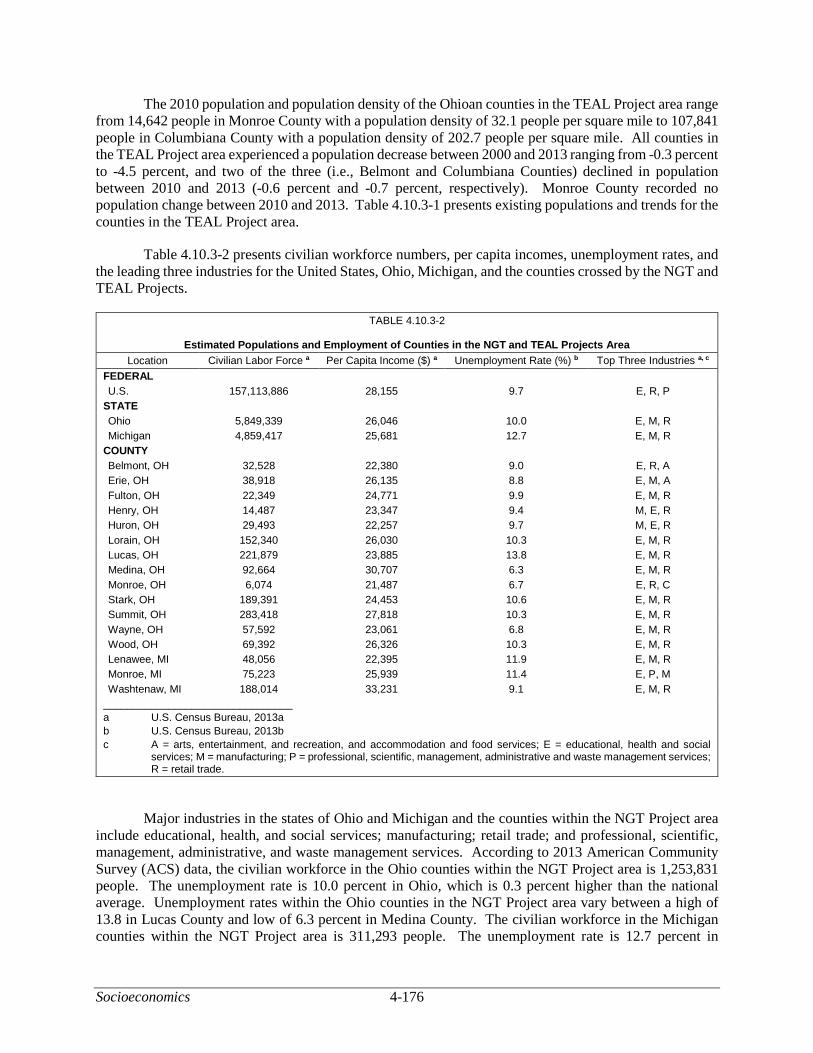
Socioeconomics 4-176
The 2010 population and population density of the Ohioan counties in the TEAL Project area range from 14,642 people in Monroe County with a population density of 32.1 people per square mile to 107,841 people in Columbiana County with a population density of 202.7 people per square mile. All counties in the TEAL Project area experienced a population decrease between 2000 and 2013 ranging from -0.3 percent to -4.5 percent, and two of the three (i.e., Belmont and Columbiana Counties) declined in population between 2010 and 2013 (-0.6 percent and -0.7 percent, respectively). Monroe County recorded no population change between 2010 and 2013. Table 4.10.3-1 presents existing populations and trends for the counties in the TEAL Project area.
Table 4.10.3-2 presents civilian workforce numbers, per capita incomes, unemployment rates, and the leading three industries for the United States, Ohio, Michigan, and the counties crossed by the NGT and TEAL Projects.
TABLE 4.10.3-2
Estimated Populations and Employment of Counties in the NGT and TEAL Projects Area
Location Civilian Labor Force a Per Capita Income ($) a Unemployment Rate (%) b Top Three Industries a, c
FEDERAL
U.S. 157,113,886 28,155 9.7 E, R, P
STATE
Ohio 5,849,339 26,046 10.0 E, M, R
Michigan 4,859,417 25,681 12.7 E, M, R
COUNTY
Belmont, OH 32,528 22,380 9.0 E, R, A
Erie, OH 38,918 26,135 8.8 E, M, A
Fulton, OH 22,349 24,771 9.9 E, M, R
Henry, OH 14,487 23,347 9.4 M, E, R
Huron, OH 29,493 22,257 9.7 M, E, R
Lorain, OH 152,340 26,030 10.3 E, M, R
Lucas, OH 221,879 23,885 13.8 E, M, R
Medina, OH 92,664 30,707 6.3 E, M, R
Monroe, OH 6,074 21,487 6.7 E, R, C
Stark, OH 189,391 24,453 10.6 E, M, R
Summit, OH 283,418 27,818 10.3 E, M, R
Wayne, OH 57,592 23,061 6.8 E, M, R
Wood, OH 69,392 26,326 10.3 E, M, R
Lenawee, MI 48,056 22,395 11.9 E, M, R
Monroe, MI 75,223 25,939 11.4 E, P, M
Washtenaw, MI 188,014 33,231 9.1 E, M, R
________________________________
a U.S. Census Bureau, 2013a
b U.S. Census Bureau, 2013b
c A = arts, entertainment, and recreation, and accommodation and food services; E = educational, health and social services; M = manufacturing; P = professional, scientific, management, administrative and waste management services; R = retail trade.
Major industries in the states of Ohio and Michigan and the counties within the NGT Project area include educational, health, and social services; manufacturing; retail trade; and professional, scientific, management, administrative, and waste management services. According to 2013 American Community Survey (ACS) data, the civilian workforce in the Ohio counties within the NGT Project area is 1,253,831 people. The unemployment rate is 10.0 percent in Ohio, which is 0.3 percent higher than the national average. Unemployment rates within the Ohio counties in the NGT Project area vary between a high of 13.8 in Lucas County and low of 6.3 percent in Medina County. The civilian workforce in the Michigan counties within the NGT Project area is 311,293 people. The unemployment rate is 12.7 percent in

4-177 Socioeconomics
Michigan, which is 3.0 percent higher than the national average. Unemployment rates within the Michigan counties in the NGT Project area vary between a high of 11.9 in Lenawee County and low of 9.1 percent in Washtenaw County.
Based on 2013 ACS data, the primary industries in the Ohio counties the TEAL Project would cross are arts, entertainment, and recreation, and accommodation and food services; construction; educational, health, and social services; manufacturing; and retail trade. The total civilian workforce in these counties is 89,720 people. Unemployment rates within the counties in the TEAL Project area vary between a high of 10.8 percent in Columbiana County and low of 6.7 percent in Monroe County.
Ohio counties in the NGT Project area record the estimated per capita income in 2013 as ranging from $21,575 in Columbiana County to $30,707 in Medina County (U.S. Census Bureau, 2013b). Nine of the Ohio counties in the NGT Project area have lower per capita incomes than the state average of $26,046.
Michigan counties in the NGT Project area record the estimated per capita income in 2013 as ranging from $22,395 in Lenawee County to $33,231 in Washtenaw County (U.S. Census Bureau, 2013b). Lenawee County has a lower per capita income than the state average of $25,681. Average worker wages during construction of the NGT Project are estimated at approximately $275 per day or about $71,500 annually, thus overall wage rates for the counties in both Ohio and Michigan would be temporarily increased (Bowen et al., 2015).
The estimated per capita income in 2013 in Ohio counties in the TEAL Project area range from $21,487 in Monroe County to $22,380 in Belmont County. All three counties in the TEAL Project area have per capita incomes that are below the state per capita income of $26,046.
Construction of the NGT Project would take place between February and May 2017 and would require a total peak workforce of 3,360 construction workers with 2,770 in Ohio and 590 in Michigan. Population impacts as a result of construction of the NGT Project are expected to be temporary and, given the existing populations of counties in the study area, minor. The effect on population would include the influx of non-local construction workers and any family members accompanying them. Pipeline construction is mobile, of a short duration, and in our experience most non-local workers would not travel with their families to the NGT Project study area, thus minimizing temporary impacts on the local populations. Based on the county populations within the NGT Project area, in the event some construction workers do temporarily relocate to the area, the increase in population would not be significant. In addition, any temporary increase in population would be distributed throughout the NGT Project area and would not have a permanent impact on any one population.
During the operations and maintenance phase of the NGT Project, NEXUS estimates that 36 permanent employees would be employed in Ohio, of which 22 to 60 percent would be hired from the local area. As such, 8 to 22 people would be employed locally, with the remaining employment needs filled by non-local employees. Based on the county populations within the NGT Project study area and the limited number of new permanent employees required, we expect that the permanent population effects as a result of operation of the NGT Project would be minor even with non-local employees relocating with their families.
Construction of the TEAL Project would require a total direct workforce of 320 to 470 construction workers, of which Texas Eastern estimates 40 to 60 percent would be local hires (i.e., 128 to 282 local employees). Construction supervisory personnel and inspectors are positions that may need to be hired non-locally and those workers would temporarily relocate to the TEAL Project area. Temporary small increases to population levels in the TEAL Project area would be experienced. As a result of the relatively short length and construction period (4.4 miles total, over 5 to 6 months in 2017), non-local workers would

Socioeconomics 4-178
likely not travel with their families to the TEAL Project area, thus minimizing some impacts on local populations. Monroe County has no facilities that would be constructed, thus any population increases would be experienced for approximately 6 months or less in 2017 only.
Construction of the new compressor station and upgrades to the existing compressor station in the TEAL Project area would take place in 2018 over 8 to 10 months. Slight population increases could be noticed in the counties, particularly in communities closest to the sites. Some impacts on affected counties or communities are unavoidable; however, they would be temporary and limited to the period of construction. Five employees are estimated to be hired locally for operation of the TEAL Project and, therefore, no effects on the population is anticipated and employment effects would be negligible.
We reasonably expect a temporary decrease in unemployment resulting from local hiring of construction workers and temporary increased needs for services. Indirect employment, including hiring additional staff in the retail and service industries to accommodate the influx of people to the area, as well as purchases made by non-local workers on food, clothing, lodging, gasoline, and entertainment, would have a temporary stimulating effect on local economies. These jobs would represent a temporary, minor increase in employment opportunities within the NGT and TEAL Projects area, as discussed in section 4.10.9.
4.10.4 Housing
Housing statistics for the NGT and TEAL Projects study area are listed in table 4.10.4-1. At least 284 hotels, motels, and campgrounds are available within the NGT Project study area and at least 455 hotels, motels, and campgrounds are available within the TEAL Project study area, along with thousands of rental housing units located in the affected counties. While the study area is concentrated to a 10-mile radius around the NGT and TEAL Projects, we expect some construction workers would commute up to 100 miles. Major metropolitan (metro) areas within 100 miles of the NGT Project include Detroit, Toledo, Sandusky, Akron, and Canton. These metro areas provide many options for hotels and motels if options are not available in smaller communities in the study area and would be sufficient to accommodate the estimated non-local construction workforce and non-local operations workforce.
TABLE 4.10.4-1
Available Housing in the NGT and TEAL Projects Area
Location Total Housing
Units a Owner
Occupied a Renter
Occupied a Median Gross
Rent a ($)
Rental Vacancy
Rate a (%)
Vacant Housing
Units Hotels and
Motels b Campgrounds c
STATE
Ohio 5,124,221 3,074,792 1,482,863 718 7.8 N/A N/A N/A
Michigan 4,529,311 2,757,062 1,066,218 768 7.8 N/A N/A N/A
COUNTY
Belmont 32,327 21,143 7,186 533 6.0 3,998 0 0
Columbiana, OH 46,882 30,560 11,535 589 5.3 4,787 1 2
Erie, OH 37,767 22,063 9,909 696 5.7 5,795 >50 9
Fulton, OH 17,370 13,041 3,244 668 7.0 1,085 3 0
Henry, OH 11,918 8,738 2,268 673 3.1 912 2 0
Huron, OH 25,127 16,293 6,068 619 12.2 2,766 6 2
Lorain, OH 127,282 83,523 33,182 733 5.6 10,577 13 4
Lucas, OH 202,196 110,797 67,304 649 8.7 24,095 >100 0
Medina, OH 69,494 52,107 13,392 821 4.4 3,955 14 8
Monroe 7,523 4,830 1,281 506 10.4 1,412 0 0
Sandusky, OH 26,305 18,110 5,796 613 10.4 2,399 >50 4
Stark, OH 165,036 104,991 45,012 666 6.8 15,033 >100 2

4-179 Socioeconomics
TABLE 4.10.4-1 (cont’d)
Available Housing in the NGT and TEAL Projects Area
Location Total Housing
Units a Owner
Occupied a Renter
Occupied a Median Gross
Rent a ($)
Rental Vacancy
Rate a (%)
Vacant Housing
Units Hotels and
Motels b Campgrounds c
Summit, OH 244,910 149,549 70,826 741 8.6 24,535 >100 1
Wayne, OH 45,781 31,103 11,384 665 4.1 3,294 0 0
Wood, OH 53,419 33,171 15,915 718 6.6 4,333 21 2
Lenawee, MI 43,390 29,336 8,388 710 5.0 5,636 7 2
Monroe, MI 63,089 46,471 12,231 777 9.8 4,387 5 2
Washtenaw, MI 147,978 82,851 53,219 910 4.9 12,178 33 0
LOCALd
Canton-Massillon, OH Metro Area
178,664 113,744 47,366 663 6.4 N/A 223 N/A
Weirton-Steubenville, WV-OH Metro Area
58,111 37,956 13,228 582 5.0 N/A 144 N/A
Wheeling, WV-OH Metro Area
69,311 44,903 16,021 530 7.0 N/A 87 N/A
________________________________
a U.S. Census Bureau, 2013a
b www.hotels.com, 2015
c Ohio.Camper.com 2015; RV Park Reviews, 2015
d Metropolitan Statistical Areas within approximately 50 miles of TEAL Project facilities
Note: Inventory of hotels, motels, and campgrounds was collected for only those counties where facilities are located and the pipeline crosses. Data was not collected for states.
N/A = Not applicable
A comment was received during scoping stating that www.hotels.com should not be considered a valid source for identifying the number of hotels in the NGT Project area. Housing data identified in this section such as total housing units, owner- and renter-occupied housing, median gross rent, and vacancy rates were identified using the 2013 5-year ACS data, which is a widely accepted and regularly used U.S. Census Bureau source. No such government-sponsored survey or data source exists maintaining a consistent inventory of hotels, motels, and campgrounds at a local level. Thus, we used www.hotels.com to compile a reasonable inventory in the NGT Project area, as it is a publicly available and reliable source that would be used to identify accommodations when traveling. The FERC acknowledges the number of hotels, motels, and campgrounds may vary from what is presented in table 4.10.4-1; however, we believe the table provides a reasonable indication of the temporary accommodations in the NGT Project area. In addition, other available temporary housing options such as bed and breakfasts, lodges, and seasonal or vacation properties available in these or neighboring counties within a reasonable commuting distance are not included. Thus, the actual availability of temporary housing is greater than what is presented in the table.
The availability of housing may vary and fluctuate during tourist seasons or local events, or as a result of demand for housing by other industries. Huron County, Ohio and Monroe County, Michigan have the highest rental vacancy rates (i.e., 12.2 percent and 9.8 percent, respectively) for each state, and Henry County, Ohio and Washtenaw County, Michigan have the lowest rates (i.e., 3.1 percent and 4.9 percent, respectively). The average vacancy rate is 6.7 percent throughout the NGT Project area. The counties included in the TEAL Project area have rental vacancy ranging from 10.4 percent in Monroe County to 5.3 percent in Columbiana County. See table 4.10.4-1 for the rental vacancy rates of each county in the NGT and TEAL Projects area.
NEXUS estimates that approximately 40 percent of the Ohio construction workforce and 25 percent of the Michigan construction workforce would be non-local. That equates to roughly 1,108 non-local workers in Ohio and 148 in Michigan, which would represent a demand for temporary housing from 1,256

Socioeconomics 4-180
non-local workers in the NGT Project study area. Using a conservative estimate of 25 units per hotel, motel, or campground, of which there are approximately 284 shown in table 4.10.4-1, we estimate that there are at least 7,100 rooms or sites available. Based on rental vacancy rates in the affected counties (3.1 percent to 12.2 percent), there were over 125,000 vacant rental units in the NGT Project area in 2013. Therefore, in counties where the number of hotels, motels, and campgrounds do not cover the estimated demand for 1,256 rooms or sites, there are sufficient vacant housing units.
Between 128 and 282 non-local construction personnel would use temporary housing. While there are very few identified hotels and motels in the TEAL Project area (i.e., two in Columbiana County), there are a substantial number in the three metro areas within approximately 50 miles of the TEAL Project facilities. There are approximately 454 hotels and motels in the three metro areas and, using a conservative estimate of 25 units per hotel/motel, we estimate there would be at least 11,350 rooms at the time of construction. In addition, based on 2013 Census data and rental vacancy rates of the affected counties, there were over 10,000 vacant housing units in the TEAL Project area in 2013 (U.S. Census Bureau, 2013a).
In the event that non-local workers prefer to house in a hotel, motel, or campground and the number identified in this analysis does not meet the need for that county, it can be reasonably expected that construction workers would house in nearby larger populated or metro areas. For instance, the Canton metro area can support non-local employees working in Columbiana County; Swanton in Lucas and Fulton Counties or the Toledo metro area are within reasonable commuting distances (i.e., 100 miles or less) for non-local employees working in Henry County; both Akron and Canton are within reasonable commuting distances for Wayne and Medina Counties; the Cleveland metro area (in Cuyahoga County, which is not crossed by the pipeline) can reasonably serve employees working in Medina and Lorain Counties; and the Toledo metro area can reasonably serve employees working in Wood, Lucas, and Fulton Counties. In Michigan, the Ann Arbor and Detroit metro areas can reasonably serve non-local employees working in Lenawee, Monroe, and Washentaw Counties.
The influx of non-local construction workers to both the NGT and TEAL Projects area could result in a temporary increase in demand for rental housing, hotel and motel rooms, and campground sites. While this would benefit the proprietors of the local motels, hotels, and other rental units through increased revenue, it could increase competition for units (and cost) and could decrease housing availability for tourists, recreationalists, and local renters or residents. While some construction activity would be conducted during the peak tourism season, sufficient temporary housing is still likely to be available; however, it may be more difficult to find (particularly on short notice) or more expensive to secure.
Based on the large number of accommodations in the NGT and TEAL Projects study area, we determined the housing accommodations along with hotels, motels, and campgrounds, would be sufficient to house the construction workforce without significantly displacing tourists, recreationalists, or local workers. The incremental housing, hotel, motel, and campground demand from construction workers during the NGT and TEAL Projects would be temporary and minor to moderate. In addition, we conclude that the estimated 14 to 28 non-local employees and 5 non-local employees needed for NGT and TEAL Projects operations, respectively, would not have a noticeable impact on housing availability in the area.
4.10.5 Public Services
Public services and facilities in the NGT and TEAL Projects study area include law enforcement, fire departments, medical facilities (e.g., hospitals and emergency services), and schools (see table 4.10.5-1). All counties in the NGT and TEAL Projects’ study area have police or sheriff departments and fire stations. Nine (9) of the 13 counties in the NGT study area in Ohio, all of the counties in the study area in Michigan, and 1 of the 3 counties in the TEAL study area have a hospital or major medical facility.

4-181 Socioeconomics
In Ohio, 62 police or sheriff departments are located within 10 miles of the NGT Project, with the greatest number occurring in Lorain and Stark Counties, and the least in Henry and Fulton Counties. Approximately 231 fire stations are within the NGT Project study area, with Stark County having the most and Henry County the least (49 and 1, respectively). Stark and Summit Counties also contain the greatest number of hospitals or medical facilities within the NGT Project study area, while there are none within the study area in Henry, Columbiana, Wayne, and Fulton Counties. However, the NGT Project crosses a relatively small portion of these counties (typically along the edge or across a corner of the county) and personnel would be able to access nearby hospitals in neighboring counties. There are more than 750 public schools in the NGT Project study area, located primarily in Wayne and Summit Counties, with the least amount in Henry County.
In Michigan, 14 police or sheriff departments are within the NGT Project study area, with the greatest number occurring in Washtenaw County and the least in Monroe County. The number of local fire stations ranges from 19 in Washtenaw County to 4 in Monroe County, for a total of 33 within the NGT Project study area in Michigan. There are 11 medical facilities in Michigan in the NGT Project study area, primarily in Washtenaw County. The greatest number of public schools in the vicinity are in Washtenaw County and the least number in Lenawee County.
There are seven police or sheriff departments within 10 miles of the TEAL Project area, with the greatest number occurring in Belmont County and only one in Monroe County. Twenty-two (22) fire stations are located in the counties within the TEAL Project area, ranging from 14 in Belmont County to one in Monroe County. There are 71 public schools in the counties within the TEAL Project area, with the most in Belmont and Columbiana Counties and the fewest in Monroe County.
TABLE 4.10.5-1
Public Services Available within 10 Miles of the NGT and TEAL Projects
Location
No. of Police & Sheriff Dept. a
Dist. to Nearest Police or
Sheriff Dept. No. of Fire Stations b
Dist. to Nearest
Fire Station
No. of Hospitals
and Medical Facilities c
Distance to Nearest
Hospital or Medical Facility
Number of Public Schools d
Belmont County, OH 4 5.3 14 1.3 3 5.4 23
Columbiana County, OH 2 8.2 7 0.5 0 N/A 39
Erie County, OH 4 0.4 16 0.3 2 6.5 26
Fulton County, OH 1 2.2 11 0.8 0 N/A 21
Henry County, OH 1 8.1 1 6.6 0 N/A 14
Huron County, OH 4 1.8 3 2.0 2 7.6 23
Lorain County, OH 8 1 20 0.3 3 1.4 94
Lucas County, OH 5 0.9 34 0.5 1 5.5 136
Medina County, OH 5 1.7 23 0.6 3 2.0 43
Monroe County, OH 1 8.4 1 3.8 0 N/A 9
Sandusky County, OH 5 1.5 11 1.2 3 4.0 23
Stark County, OH 8 2.8 49 0.1 5 2.8 108
Summit County, OH 7 1.6 30 1.0 5 3.5 144
Wayne County, OH 3 1.3 8 0.2 0 N/A 43
Wood County, OH 9 1.0 18 1.0 1 6.8 40
Lenawee County, MI 3 2.1 10 1.8 2 6.8 45
Monroe County, MI 1 1.3 4 1.3 1 6.3 49
Washtenaw County, MI 4 2.9 19 1.0 8 2.0 88
________________________________
a PoliceOne, 2015; USGS, 2015
b FireDepartment.net, 2015; U.S. Fire Administration, 2015; USGS, 2015
c American Hospital Directory, 2015; USGS 2015
d National Center for Education Statistics, 2015
NA = Not Applicable

Socioeconomics 4-182
Primary care Health Professional Shortage Areas (HPSA) and Medically Underserved Areas or Populations (MUA/P) are designated by the U.S. Department of Health and Human Services (DHHS). A HPSA is a geographic area, population group, or health care facility that has been designated by the federal government as having a shortage of health professionals. An MUA/P is an area or population designated by the federal government as having shortages of primary medical care, dental, or mental health providers. HPSAs and MUP/As are designated by geographic areas (e.g., census tracts, counties). One hundred MUA/P-designated census tracts are located within the NGT Project area in Columbiana, Erie, Lorain, Lucas, Medina, Sandusky, Stark, Summit, and Wood Counties in Ohio. Washtenaw and Monroe Counties in Michigan have 13 MUA/P-designated census tracts in the NGT Project area (DHHS, 2016a). There are four MUA/Ps within the TEAL Project area (DHHS, 2016a).
The HPSA database identified several primary care HPSA-designated areas in 8 of the 13 counties in the NGT Project area in Ohio, including Columbiana, Erie, Lorain, Lucas, Medina, Stark, Summit, and Wood Counties. None of the HPSA-designated census tracts are within the NGT Project area in Ohio. Within the NGT Project area in Michigan, five HPSAs for primary care were identified in Lenawee County, Michigan (DHHS, 2016b). Monroe County and one comprehensive health center are HPSAs in the TEAL Project area (DHHS, 2016b).
Access to medical services in the NGT Project study area is available in all counties except in Columbiana, Fulton, Henry, and Wayne Counties, Ohio and Monroe County, Michigan. Should a medical emergency occur during construction in these counties, we anticipate that medical services would be sought in communities in neighboring counties (e.g., Lucas, Wood, Medina, Summit, Stark, and Carroll Counties in Ohio, or Lenawee and Washtenaw Counties in Michigan, respectively). Belmont County is the only county that has hospitals or medical facilities in the TEAL Project area.
Based on the number and location of police departments, fire stations, hospitals, and schools, there is adequate public service infrastructure in the NGT and TEAL Projects study area to meet the temporary needs of non-local construction and long-term needs of non-local operations and maintenance workers. Further, NEXUS and Texas Eastern would require each of its contractors to have a health and safety plan, covering location- or work-specific requirements to minimize the potential for on-the-job accidents. Contractors and NEXUS’ and Texas Eastern’s site safety staff are responsible for monitoring compliance with the plans. In the event of an accident, police, fire, and/or medical services would be necessary; however, the anticipated demand for these services is not expected to exceed existing capabilities in the NGT and TEAL Projects study area.
Temporary increased demand on local public services may occur because police may be required to direct traffic during construction at road crossings or respond to emergencies associated with pipeline construction. Fire departments may have to respond to project-related fires or other emergencies, and medical services may be necessary for workforce personnel illnesses or injuries. NEXUS and Texas Eastern would work with local law enforcement, fire departments, and emergency medical services prior to construction to coordinate for effective emergency response. Due to the relatively short duration of project construction and workforce dispersion across multiple counties and states, significant effects on public services in the affected counties or communities would not be anticipated.
Most non-local construction workers are not expected to relocate their families temporarily during the construction period, and as such we do not anticipate that the NGT or TEAL Projects would increase demand for school-related services. As indicated previously, a small number (i.e., 14 to 28 for the NGT Project and 5 for the TEAL Project) of non-local permanent operations employees and potentially their families would relocate to areas in Ohio. We conclude there would not be significant increased demand for school-related services resulting from non-local operations employees relocating to the NGT and TEAL Projects area.

4-183 Socioeconomics
We received several comments about the safety of a high-pressure pipeline in or near population centers and/or near schools and child daycare and elderly facilities. As further discussed in section 4.13 (Reliability and Safety), NEXUS and Texas Eastern would construct, operate, maintain, and inspect the proposed facilities to meet or exceed PHMSA’s safety requirements, which have pipeline design requirements that are dependent on the population levels and facilities crossed.
We received several comments where residents in Whitehouse and Waterville, Ohio (Lucas County) expressed concerns about the costs and ability for emergency public services to respond in the event of a catastrophic accident at the proposed Waterville Compressor Station or along the pipeline in Lucas County. As discussed in section 4.13, a catastrophic accident is unlikely based on statistical data. NEXUS would develop, maintain, and implement emergency response plans as required by applicable DOT regulations. NEXUS would also communicate regularly with the public who live and work near the pipelines and facilities about pipeline safety and emergency response plans. NEXUS employees would join local emergency response personnel for emergency drills to test staff readiness and identify improvement opportunities.
Concerning costs for improving local emergency services, NEXUS estimates $2.1 billion in property tax revenues would be generated in the first 60 years of service on the greenfield portion of the NGT Project. We expect government officials would allocate appropriate tax revenues to address community priorities.
4.10.6 Tourism
Tourism is defined as federal, state, and local special interest areas as well as businesses that depend on year-round or seasonal tourists. Both Ohio and Michigan offer year-round tourism attractions; however, the peak season is typically from the spring through fall (April through September) (Smartertravel.com, 2016). Tourism is not listed as a major economic industry for any of the counties in Ohio or Michigan within the NGT and TEAL Projects area. The counties within the NGT and TEAL Projects area generally offer similar tourist attractions, including recreational activities such as parks, golfing, and kayaking; shopping and eateries; various museums and historical attractions; winery, farm, and orchard tours; amusement and waterparks; and festivals. Notable major tourist attractions in the NGT Project area include the following:
• Pro Football Hall of Fame in Canton, Stark County (Stark County Convention and Visitor’s Bureau, 2016);
• 33,000-acre Cuyahoga Valley National Park near Akron, which had over 2.2 million recreation visitors in 2015 in Summit County (National Park Service, 2015);
• Amish Country in Wayne County (Wayne County Convention and Visitors Bureau, 2016);
• Cedar Point Amusement Park in Erie County on the Lake Erie shore, which is the second oldest amusement park in North America and known as the Roller Coaster Capital of the World (Cedar Point, 2016);
• Toledo Zoo in Lucas County is recognized as one of the 10 best zoos in the United States (Toledo.com, 2016); and
• Lake Erie, offering a number of beaches and marinas, ferries and cruises, sightseeing and fishing charters, and recreational activities such as sailing, kayaking, boating, swimming, and fishing (Lake Erie Shores and Islands, 2016).

Socioeconomics 4-184
Notable major tourist attractions in the TEAL Project area include the following:
• Official state byways – Drovers’ Trail, Historic National Road, and the Ohio River Scenic Byway;
• Shaeffer/Campbell Covered Bridge, the Underground Railroad Museum, and the Barkcamp State Park;
• Wheeling, West Virginia (6 miles southeast of the Colerain Compressor Station) offers many tourist attractions such as museums, a zoo, racetrack, casino, many parks, markets, and a year-round resort (Wheeling Convention and Visitors Bureau, 2016); and
• Weirton-Steubenville Metro Area is another nearby metro area to the Colerain Compressor Station that has historical sites, museums, a casino resort, recreation such as golf courses and parks, and wineries (Top of West Virginia Convention and Visitor’s Bureau, 2016; Steubenville Visitor Center, 2016).
No major tourist attractions would experience restricted or denied access resulting from NGT or TEAL Project construction. There may be some recreational areas such as parks that experience temporary impacts on access resulting from construction, which is discussed in section 4.9.
Tables 4.10.6-1 and 4.10.6-2 summarize the tourism economies in the NGT and TEAL Projects area.
TABLE 4.10.6-1
Tourism Economy in the NGT Project Area a
County Sales ($ million) Wages ($ million)
Columbiana, OH 193.6 42.6
Stark, OH 1,600 280.5
Summit, OH 2,100 478.2
Wayne, OH 224.5 57.8
Medina, OH 486.2 123.6
Lorain, OH 499.4 154.1
Huron, OH 100.1 28.5
Erie, OH 1,500 255.2
Sandusky, OH 136 34.3
Wood, OH 446.5 129.2
Lucas, OH 1,800 421.8
Henry, OH 21.8 8.4
Fulton, OH 111.7 28.8
Lenawee, MI 114.7 52.9
Monroe, MI 212.9 88.6
Washtenaw, MI 684.5 391.0
NGT Project Area Total 10,095.9 2,541.2
________________________________
a Tourism Economics, 2014a; 2014b; 2014c; 2014d; 2014e; 2014f; 2014g; 2014i.

4-185 Socioeconomics
TABLE 4.10.6-2
Tourism Economy in the TEAL Project Area a
County Sales ($ million) Employment Personal Income ($ million) Tax Revenue ($ million)
Belmont, OH 187.2 2,376 49.3 24.8
Columbiana, OH 193.6 2,391 42.6 24.5
Monroe, OH 7.3 154 2.2 1.0
TEAL Project Area Total 388.1 4,921 94.1 50.3
________________________________
a Tourism Economics, 2014h
The influx of construction workers would be limited to the time of construction and dispersed across the NGT Project area throughout the relatively short construction period of February through May. The demand for temporary housing by non-local workers would not exceed the available number of hotels, motels, and campground units in the NGT Project area, but accommodations could experience some minor limited availability at the end of the planned construction in spring and early summer, which is the front end of the time period considered the peak tourism season in Ohio. These strains would be most likely experienced in the Lake Erie region, specifically in Erie and Sandusky Counties; however, sufficient temporary housing accommodations exist in these counties and in the metro areas where major tourism activities exist. Affected land uses would be restored and activities allowed to continue following construction and, depending on easement negotiations, landowners could be compensated for losses resulting from construction.
Effects on tourism resulting from the TEAL Project are unlikely as there are no tourist attractions that would experience restricted access as a result of project construction. Major tourist attractions are located in surrounding metro areas, which are 15 or more miles from the pipeline route and facilities locations; therefore, we do not expect construction activities would disrupt visitor experiences at tourist locations resulting from restricted access or safety concerns. Impacts on public enjoyment of the tourist attractions outside the TEAL Project area would be negligible and limited to the potential for the temporary non-local workforce contributing to increased demand for accommodations such as hotels, motels, and campgrounds; however, as discussed in section 4.10.4 and based on the number of hotels, motels, campgrounds, and vacant rental units in the TEAL Project area, the demand for temporary housing from non-local workers required for project construction would not exceed available supply.
Commenters voiced concerns during scoping that any negative effects on water quality in Lake Erie would negatively affect tourism in Ohio and Michigan. Specific water quality and fisheries and aquatic resources effects and mitigation are discussed in sections 4.3 and section 4.7. Effects to tourism on Lake Erie would likely not occur as a result of the NGT Project because there would not be restricted access to Lake Erie attractions, nor would temporary construction disrupt the visitor experience associated with tourism activities taking place on Lake Erie as the NGT Project is about 3 miles from the shoreline at its closest point.
4.10.7 Transportation
A daily total of 1,311 commuter vehicles (875 in Ohio and 436 in Michigan) is estimated to be used to transport the construction workforce to NGT Project sites. NEXUS also anticipates a daily total of 414 material and equipment delivery vehicles (275 in Ohio and 139 in Michigan) would make two round trips per day between pipe/contractor yards and the right-of-way. Vehicles would include stringing trucks, welding rigs, water trucks, fuel trucks, mechanic trucks, flatbed and lowboy trailer trucks, motor graders, hydrostatic equipment trucks, and contractor buses, as well as inspector, foreman, contractor, environmental monitor, and cultural monitor vehicles. NEXUS anticipates that some personnel would carpool to the

Socioeconomics 4-186
construction area, thereby reducing passenger vehicle traffic on local roads. Vehicle use would primarily be confined to just before, during, and just after construction hours (i.e., typically 7:00 a.m. to 6:00 p.m., 6 days a week), with exceptions made for specific activities such as HDDs or hydrostatic testing. During construction, vehicles would be distributed across the NGT Project according to the specific construction method used. See appendix L-1 for average daily traffic counts on roads in the NGT Project area.
The daily total for material and equipment delivery vehicles is estimated to be 152 at peak construction with an estimated daily maximum total of 375 commuter vehicles, to be used to transport the construction workforce to TEAL Project sites. Construction activities would be scheduled for transportation in a manner similar to the NGT Project, as discussed above. See appendix L-2 for average daily traffic counts on roads in the TEAL Project area.
Construction activities would result in temporary effects on local transportation infrastructure and vehicle traffic, including disruptions from increased transportation of construction equipment, materials, and crew members; disruptions from construction of pipeline facilities at or across existing roads; and damage to local roads caused by heavy machinery and materials.
Public roads used by construction vehicles to travel to and from workspaces could experience increased sediment tracking/build-up and surface damage. Paved roads are the most durable and generally stand up well to periodic surges in traffic and heavy use; unpaved roads, on the other hand, are much less durable. Most states fund road repairs with motor fuel taxes, motor vehicle registration fees, and compensatory fees paid by commercial carriers. Commercial carriers need registrations to operate in each state and may need special permits for oversize and overweight vehicles, temporary trip permits within the state, or to haul hazardous materials. NEXUS and Texas Eastern would coordinate with state and local departments of transportation and land-managing agencies to obtain the required permits to operate trucks on public roads.
To minimize and mitigate these potential impacts, NEXUS and Texas Eastern would limit construction activities to daylight hours to the extent practicable; therefore, workers would travel to and from the site earlier and later in the day, outside of peak traffic hours thus minimizing their contribution to traffic congestion. NEXUS and Texas Eastern would also encourage its workforce to carpool. Some construction activities (e.g., hydrostatic testing, directional drilling, and tie-ins) could occur at unspecified times and/or outside of normal construction hours; however, NEXUS and Texas Eastern would attempt to schedule these activities to minimize impacts on local traffic.
During scoping, we received a comment that expressed concern over costs to local governments due to the effects of heavy equipment on local roads and bridges. The NGT and TEAL Projects would cross larger, typically paved roads (e.g., county roads, interstate highways) via the bore or HDD method (described in section 2.3.2.6), which would result in little to no disruption to traffic or road impacts. Smaller roads would be crossed using the open-cut method, which usually requires temporary road closures and/or detours. Where detours are infeasible, crews would leave at least one road lane open to maintain traffic flow, except when installing the pipeline, and use the necessary signage and traffic control measures, or install steel plate bridges over the open-cut area to ensure continued traffic flow during construction. Most open-cut crossings take 1 to 2 days to complete, but final road resurfacing following backfill could take weeks to allow for settling and compaction. NEXUS and Texas Eastern would coordinate with local police departments in areas of high traffic volume to avoid traffic flow interruptions and ensure the safety of pedestrians and vehicles and passing emergency vehicles. NEXUS and Texas Eastern would also employ traffic control measures, such as flagmen and signs, as necessary to ensure safety of local traffic. Additionally, NEXUS and Texas Eastern would be responsible for restoring roads in accordance with permit conditions and as requested by landowners or agencies. NEXUS and Texas Eastern would periodically inspect roads near crossings and make repair as necessary to damages caused by construction

4-187 Socioeconomics
activities. NEXUS and Texas Eastern would coordinate with local officials to avoid traffic interruptions and ensure the safety of pedestrians, motorists, and emergency vehicles in the NGT and TEAL Projects area. Road crossings and proposed crossings methods for the NGT and TEAL Projects are listed in table 4.9.4-4.
NEXUS would improve or modify 141 existing roads and Texas Eastern would improve or modify 6 existing roads to accommodate construction vehicle traffic. Traffic disruptions similar to those previously described could occur and NEXUS and Texas Eastern would employ similar minimization and mitigation techniques to maintain traffic flow.
As a result of measures and methods described in this section, we anticipate that construction activities related to the NGT and TEAL Projects would result in minor and temporary to short-term impacts on transportation infrastructure.
4.10.8 Property Values
We received numerous comments from stakeholders voicing concern that the NGT and TEAL Projects would have negative effects on property values, potentially decreasing values from 25 percent to 100 percent and that local governments would lose tax revenue because of decreased property values. Typically, an easement would be used to convey both temporary (construction-related) and permanent rights-of-way to NEXUS or Texas Eastern. As further discussed in section 4.9, the easement would give NEXUS or Texas Eastern the right to access, construct, operate, and maintain their respective pipelines. In return, NEXUS or Texas Eastern would compensate the landowner. If the NGT and/or TEAL Projects are issued a Certificate, an easement could be obtained by use of eminent domain. In that case, the property owner would still be compensated by NEXUS or Texas Eastern but the amount of compensation would be determined by the courts.
The effect that a pipeline easement may have on property value is a damage-related issue that would be negotiated between the parties during the easement acquisition process, which is designed to provide fair compensation to the landowner for the right to use the property for pipeline construction and operation. Appraisal methods used to value land are typically based on objective characteristics of the property and any improvements. The impact a pipeline could have on a property’s value would depend on many factors including the size of the tract, the values of adjacent properties, the presence of other utilities, the current value of the land, and the current land use. Subjective valuation is generally not considered in appraisals. A potential purchaser of property may make a decision to purchase land based on his or her planned use. An industrial user might find the pipeline (i.e., a potential source of energy for an industrial plant) preferable; a farmer looking for land for grazing or cropland may or may not find it objectionable. If the presence of a pipeline renders a planned use infeasible, it is possible that a potential purchaser would decide not to purchase the property; however, each potential purchaser has different criteria and differing capabilities to purchase land.
Property taxes for a piece of property are generally based on the actual use of the land. Construction of the pipeline would not change the general use of the land but would preclude construction of aboveground structures on the permanent right-of-way. If a landowner believes that the presence of a pipeline easement impacts the value of his or her land, resulting in an overpayment of property taxes, he or she could appeal the issue of the assessment and subsequent property taxation to the local property tax agency.
Several studies examined the effects of pipeline easements on sales and property values, and evaluated the impact of natural gas pipelines on real estate. The first study, Pipeline Impact Study: Study of a Williams Natural Gas Pipeline on Residential Real Estate: Saddle Ride Subdivision, Dallas Township,

Socioeconomics 4-188
Luzerne County, Pennsylvania prepared by the firm of Allen, Williford & Seale, Inc., assessed the impact on the sale price of undeveloped lots and single-family residences that have a natural gas transmission line easement on the property (Allen, Williford & Seale, Inc., 2014). The report compared units in a subdivision in Luzerne County that had an existing natural gas transmission line located within it. Differences between the sale prices of undeveloped lots and houses with the pipeline easement and those that did not have an easement were analyzed. The report found that, when the sales prices of the encumbered residences were compared with the sales prices of the unencumbered residences, there was no indication that the pipeline easement had any effect on the sales prices of homes in Saddle Ridge. Likewise, when the sales prices of encumbered lots were compared with the sales prices of unencumbered lots, the differential in price could be explained by the reduction in lot size associated with the easement area.
One study, Diskin et al. in 2011, looked at the effects of natural gas transmission pipelines on residential values in Arizona. The study concluded that there was no identifiable systemic relationship between proximity to a pipeline and residential sale price or value.
Studies conducted in 2008 by PGP Valuation Inc. (PGP, 2008) for Palomar Gas Transmission, Inc. and by Ecowest for the Oregon LNG Project reached similar conclusions. Both studies evaluated the potential effect on property values of a natural gas pipeline that was constructed in 2003/2004 in northwestern Oregon, including along the western edge of the Portland metro area. The PGP study found that:
• there was no measurable long-term impact on property values resulting from natural gas pipelines for the particular pipeline project studied;
• interviews with buyers and brokers indicated no measurable impact on value or price; and
• there was no trend in the data to suggest an extension of marketing periods (i.e., time while the property is on sale) for properties with gas pipeline easements.
The Ecowest study concluded that the pipeline had no statistically significant or economically significant impact on residential properties. The study also concluded that there was no relationship between proximity to the pipeline and sale price (Fruits, 2008).
Another study (Hansen et al., 2006) analyzed property sales near a pipeline accident location in Washington State, using methodologies that considered proximity and persistence over time. This study noted a decline in property values following the incident; however, the effect was very localized and declined as the distance from the affected pipeline increased. The effect also diminished over time in the years following the incident.
For the purposes of another EIS analysis the FERC published in 2014 (with a project area in Pennsylvania and New York), several appraisers were contacted about the potential impacts on property values due to the presence of a natural gas pipeline (FERC, 2014). One appraiser who teaches seminars for appraisers and realtors, including discussions of mineral rights and pipeline easements, provided information on the subject. According to the appraiser, “the empirical evidence indicates no difference in value attributable to the existence of the pipeline easement.” The appraiser further noted that he was not aware of appraisers making adjustments in the appraiser reports for the existence of a pipeline easement. He stated that the large number of variables that impact home values make it difficult to determine the incremental effect that any one variable may have on a home’s value. Regardless, it is possible that the perceived safety issues or the limitations on land use within the permanent easement could reduce the number of potential buyers for a property, which may extend the number of days a property is on the market.

4-189 Socioeconomics
Based on the research we have reviewed, we find no conclusive evidence indicating that natural gas pipeline easements would have a negative impact on property values.
We also received comments voicing concern that insurance premiums would increase and/or insurance companies would not insure properties. The FERC has examined these concerns on other projects by contacting insurance offices to pose the question. We asked whether the presence of a utility crossing would change the terms of an existing or new residential insurance policy, which types of utilities may cause a change, how a policy might change, and what factors would influence a change in the policy terms, including the potential for a policy to be dropped completely. Results of this initial investigation suggested that the potential for a residential insurance policy to be affected could exist, but the extent of any action and corresponding corrective action would depend upon several factors, including the terms of the individual landowner’s policy and the terms of the applicant’s own policy. Insurance company contacts were not able to speak directly to the potential factors that could cause a change in a policy (e.g., type of utility, proximity of residence to utility), or provide quantitative information on the potential change in a policy premium (in dollars or percent). As such, there is no conclusive evidence indicating that insurance premiums would be affected by the presence of a natural gas pipeline easement.
4.10.9 Economy and Tax Revenues
4.10.9.1 NGT Project
During scoping, many commenters voiced concerns that the economic effects on the NGT Project area would be fiscally devastating because people would not want to move to and live in the area. We also heard that no long-term benefits would be realized and that the NGT Project would not produce significant local employment in Medina County.
An economic analysis commissioned by NEXUS was completed by Economic and Policy Resources in May 2015. The scope of the analysis covered 11 of the 13 counties that are in the NGT Project area in Ohio.2 The economic analysis commissioned by NEXUS for the NGT Project’s economic effects in Michigan was completed in April 2015 by the Michigan State University Land Policy Institute and Center for Economic Analysis. The scope of this analysis covered the three counties in the NGT Project area in Michigan, as well as the entire state of Michigan for the greenfield activity.
Construction and operation of the NGT Project would have a beneficial, short-term impact on local sales tax revenues. Payroll taxes would also be collected from workers employed on the NGT Project, resulting in additional beneficial, short-term effects. NEXUS anticipates that its total payroll would be approximately $668 million during the construction phase and an estimated total annual payroll of $3.1 million during operation. Economic effects resulting from construction and operation of the NGT Project would be beneficial at the local and county levels in the form of increased sales and payroll taxes. Direct payroll and materials expenditures related to the NGT Project would have an immediate impact on local economies. NEXUS would purchase goods, materials, and services locally when possible. Workers would also most likely spend a portion of their pay in local communities on items such as housing, food, automobile expenses, entertainment, and miscellaneous other items. NEXUS estimates that about 5.0 to 7.5 percent of the total construction cost would be spent on locally purchased consumables (e.g., fuel, tires, concrete, sand, gravel, office supplies) in Ohio and Michigan, respectively. These direct impacts would stimulate indirect impacts within the region as inventories are restocked and new workers are hired to meet demands. NEXUS estimates that over $449.6 million would be spent toward direct construction labor
2 The economic analysis completed by Economic and Policy Resources did not include Henry and Huron Counties in
Ohio. These counties are crossed by the NGT Project for approximately 0.9 and 3.4 miles, respectively, and there are no major aboveground facilities located in these counties.

Socioeconomics 4-190
income with approximately $400.6 million in Ohio and approximately $49 million in Michigan. Operations employees would not be required for the Michigan portion of the NGT Project.
Though installation of the underground pipeline would have temporary surface impacts on roads, project-related damages would be repaired. Once installed, the pipeline would not impede normal surface traffic or access to businesses, and most pre-construction property uses would be allowed to continue.
The long-term positive economic impacts from the NGT Project include an increase in property taxes that would benefit local governments and their annual budgets for the life of the NGT Project. When broken down by construction and operation, the direct,3 indirect,4 and induced5 economic benefits in Ohio include 5,325 jobs with $565 million in labor income and $697 million in value added for construction, and 59 jobs with $3.8 million in labor income and $5 million in value added for operation.
Table 4.10.9-1 presents the estimated total annual economic effects (i.e., the sum of the direct, indirect, and induced economic impacts) of the NGT Project during operation in Ohio. Economic impacts during operations would be focused to four counties that would have compressor stations.
TABLE 4.10.9-1
Estimated Economic Effects for Operations for the NGT Project in Ohio a
County Jobs Labor Income ($) Value Added ($) Annual Estimated Property Tax ($)
Columbiana 21 1,313,600 1,699,600 97,300
Lucas 14 883,500 1,145,400 65,600
Medina 12 825,800 1,053,500 60,300
Sandusky 12 825,800 1,053,500 60,300
Total 59 3,848,700 4,952,000 283,500
________________________________
a Economic & Policy Resources, 2015
Another indicator of the economic impacts of a project is to calculate the total project output. Output is calculated by applying a multiplier6 to the total expenditures on goods and services directly related to construction of the NGT Project. The purpose of calculating output is to capture the indirect impact that these expenditures could have on the local economy beyond their direct effect (e.g., purchases). For example, the total output of the NGT Project in Michigan is estimated to be $254 million in the state and $183 million in the southeast Michigan region (i.e., Lenawee, Monroe, and Washtenaw Counties). Statewide, the jobs that would be created resulting from the NGT Project are estimated at 1,533 with a total labor income of approximately $97 million. For the three-county southeast region, jobs created are estimated at 1,189 with projected labor income of $71 million for the duration of the NGT Project.
3 Direct effects are the initial economic changes resulting from the activity or policy that takes place associated with the
industry immediately affected.
4 Indirect effects are secondary economic changes associated with the purchase of materials and supplies and services for production of the NGT Project.
5 Induced effects are economic changes associated with the disposable income that new workers with the NGT Project and linked businesses spend on household goods and services.
6 Output is calculated using Regional Input-Output Modeling System multipliers developed by the U.S. Department of Commerce’s Bureau of Economic Analysis. Regional Input-Output Modeling System multipliers are available by state, region, county, and metropolitan area throughout the United States: www.bea.gov/index.htm.

4-191 Socioeconomics
Tax impacts would also be generated by ad valorem taxes, which are property taxes that would be assessed per year, resulting in additional long-term benefits to the local and regional economy. The ad valorem experienced would depend on the length and amount of project facilities in a county. The total estimated ad valorem tax associated with the NGT Project would generate approximately $2.1 billion in the first 60 years of service, with approximately $1.9 billion distributed in Ohio and approximately $0.2 billion in Michigan.
Overall, the NGT Project would result in beneficial economic effects on the state and local economies by creating a short-term stimulus to the affected areas through payroll expenditures, local purchases of consumables and project-specific materials, and sales tax. Furthermore, operation of the NGT Project would result in long-term ad valorem property tax benefits for the counties in the NGT Project area.
4.10.9.2 TEAL Project
Construction and operation of the TEAL Project would have a beneficial economic effect on local sales tax revenue. Texas Eastern estimates that during construction, over $45 million in direct construction labor would be spent. Additional economic effects would be realized through the local purchase of construction materials. Texas Eastern estimates that a total of $47.5 million would be spent on construction materials, of which about $4.7 million would be spent locally. Although most construction materials would be purchased from outside vendors, common supplies (e.g., stone and concrete) would likely be purchased from local and state vendors. Economic effects would be realized through payroll and sales taxes, which may be beneficial at the local, county, and state levels; however, these effects would be limited to the duration of the construction period.
During operations and maintenance, Texas Eastern estimates five employees would be needed and the total annual income would be approximately $400,000. Approximately $981,000 is estimated in annual expenditure during operations, although the local proportion has not yet been determined. Property taxes for the first 60 years of the TEAL Project are estimated to generate $184 million.
As with the NGT Project, no long-term negative economic effects are expected. Any damage to local infrastructure would be repaired and most pre-construction property uses would be allowed.
4.10.10 Environmental Justice
Executive Order 12898 Federal Action to Address Environmental Justice in Minority Populations and Low-Income Populations requires federal agencies to consider if impacts on human health or the environment (including social and economic aspects) would be disproportionately high and adverse for minority and low-income populations and appreciably exceed impacts on the general population or other comparison group. Consistent with Executive Order 12898, the CEQ called on federal agencies to actively scrutinize the following issues with respect to environmental justice (CEQ, 1997a):
• The racial and economic composition of affected communities;
• Health-related issues that may amplify project effects on minority or low-income individuals; and
• Public participation strategies, including community or tribal participation in the process.

Socioeconomics 4-192
The EPA’s Environmental Justice Policies focus on enhancing opportunities for residents to participate in decision making. The EPA states that Environmental Justice involves meaningful involvement so that:
(1) potentially affected community residents have an appropriate opportunity to participate in decisions about a proposed activity that would affect their environment and/or health; (2) the public’s contributions can influence the regulatory agency’s decision; (3) the concerns of all participants involved would be considered in the decision-making process; and (4) the decision-makers seek out and facilitate the involvement of those potentially affected (EPA, 2011).
As described in section 1.3, there have been many opportunities for the public to comment on and provide input about the Projects. All public documents, notices, and meetings were made readily available to the public during our review of the Project. NEXUS and Texas Eastern met with many different stakeholders during the initial development of the route including local residents and affected landowners. These efforts included NEXUS and Texas Eastern holding a number of open houses in the Projects area for the affected communities and local authorities. NEXUS and Texas Eastern also established, and are maintaining, a website to share information about the Projects with the public.
NEXUS and Texas Eastern also used the FERC’s pre-filing process (see section 1.3). One of the major goals of this process is to increase public awareness and encourage public input regarding every aspect of a project before an application is filed. As part of this process, FERC staff participated in all of NEXUS’ and Texas Eastern’s open houses to receive input from the public about the Projects and to explain FERC’s review process and the opportunities it provides for public input. Interested parties have had, and will continue to be given, opportunities to participate in the NEPA review process. To date, this has included the opportunity to participate in FERC’s public scoping meetings to identify concerns and issues that should be covered in the EIS, as well as the opportunity to submit written comments about the Projects to FERC. Interested parties will also be invited to comment on the draft EIS either electronically, in writing, or at the draft EIS comment meetings, which will be held in the Projects area several weeks after the issuance of the draft EIS. All comments on the draft EIS will be responded to in the final EIS.
Based on published EPA guidance concerning environmental justice reviews (1998), we used a three-step approach to conduct our review. These steps are:
1. Determine the existence of minority and low-income populations.
2. Determine if resource impacts are high and adverse.
3. Determine if the impacts fall disproportionately on environmental justice populations.
In this review, a low-income population exists when the percentage of all persons living below the poverty level is more than the percentage for the state where the census tract is located. For the purposes of this review, a minority population exists when the:
1. total racial minorities in a U.S. Census Bureau-defined census tract (U.S. Census Bureau, 2013a) are more than 50 percent of the tract’s population;
2. percentage of a racial minority in a census tract is “meaningfully greater”7 than in the comparison group;
7 “Meaningfully greater” is defined in this analysis as minority or ethnic populations that are at least 10 percentage points
more than in the comparison group, which was the population of the county where the census tract was located.

4-193 Socioeconomics
3. total ethnic minorities in a census tract are more than 50 percent of tract's population; or
4. percentage of ethnic minorities in a census tract is meaningfully greater than in the comparison group.
Racial and ethnic minorities include: African American/Black, Native American or Alaska Native, Asian, Native Hawaiian and Other Pacific Islander, two or more races, and other races, as well as the Hispanic or Latino ethnicity.
The tables in appendices L-3 to L-5 provide an overview of the racial and economic characteristics of the population in the census tracts within a 1-mile radius of NGT and TEAL Projects facilities. In Ohio, minorities comprise 17.1 percent of the total population. The percentage of minorities in the Ohio census tracts that would be crossed by NGT Project facilities ranges from 0.9 to 36.1 percent. In 1 of the 64 census tracts, the minority population is meaningfully greater than that of the state. In Michigan, minorities comprise 20.7 percent of the total population. The percentage of minorities in the Michigan census tracts that would be crossed by NGT Project facilities ranges from 0.0 to 77.6 percent. In 12 of the 28 census tracts, the minority population is meaningfully greater than that of the state. No census tract within 1 mile of TEAL Project facilities have minority populations that meet the thresholds discussed in this section.
As stated previously, for the purpose of this analysis, a low-income population exists when the percentage of all persons living below the poverty level is greater than the percentage for the state where the census tract is located. In Ohio, 15.8 percent of all persons live below the poverty level. Four (4) of the 64 census tracts in Ohio within a 1-mile radius of NGT Project facilities have a higher percentage of persons living below the poverty level when compared to the state. In Michigan, 16.8 percent of all persons live below the poverty level. Eight (8) of the 28 census tracts in Michigan within a 1-mile radius of NGT Project facilities have a higher percentage of persons living below poverty-level when compared to the state. Two census tracts in Ohio within 1 mile of TEAL Project facilities have a higher percentage of persons living below poverty-level when compared to the state.
Section 4.12 describes the localized risks to public safety that could result from a pipeline failure and describes how applicable safety regulations and standards would minimize the potential for these risks. Because the Projects would generally traverse rural areas, the number of persons who would be at risk of injury due to a pipeline failure would be low, and there is no evidence that such risks would be disproportionately borne by any racial, ethnic, or socioeconomic group.
NEXUS and Texas Eastern would implement a series of measures that would minimize potential impacts on the nearby communities, including environmental justice communities located near Project facilities. For instance, NEXUS and Texas Eastern propose to employ proven construction-related practices to control fugitive dust, such as application of water or other commercially available dust control agents on unpaved areas subject to frequent vehicle traffic. Similarly, noise control measures would be implemented by NEXUS and Texas Eastern during construction and operation of the Projects. Additionally, NEXUS and Texas Eastern would ensure that the noise attributable to the compressor stations would be less than 55 dBA Ldn at nearby NSAs, and the increase in the overall noise due to the new stations would be well below the threshold considered perceptible to the human ear.
Based on the estimated emissions from operation of the proposed Projects facilities and our review of NEXUS’ and Texas Eastern’s modeling analysis, we have determined that the Projects would comply with NAAQS, which are protective of human health, including children, the elderly, and sensitive populations (see section 2.7.1). The Projects facilities would also be designed, constructed, operated, and maintained in accordance with or to exceed PHMSA’s minimum federal safety standards in 49 CFR 192. These regulations, which are intended to protect the public and to prevent natural gas facility accidents and

Socioeconomics 4-194
failures, apply to all areas along the proposed pipeline routes regardless of the presence or absence of minority or low income populations.
The impacts on the natural and human environment from constructing and operating the NGT and TEAL Projects are identified and discussed throughout the environmental analysis section of this document. As discussed throughout this EIS, potentially adverse environmental effects associated with the NGT and TEAL Projects would be minimized and/or mitigated, as applicable, and are not characterized as high and adverse. Although the racial and economic composition of the counties and census tracts that would be crossed by Projects facilities have racial, ethnic, and economic deviations from state-level statistics, there is no evidence that the Projects would cause a disproportionate share of high and adverse environmental or socioeconomic impacts on any racial, ethnic, or socioeconomic group.
Construction of the Projects would result in minor positive impacts on the local economy due to increases in payroll taxes, purchases made by the workforce, and expenses associated with the acquisition of material goods and equipment. Operation of the Projects would also have a minor to moderate positive effect on the counties and local communities due to the increase to property taxes that would be collected.
4.11 CULTURAL RESOURCES
Section 106 of the NHPA, as amended, requires the FERC to take into account the effects of its undertakings on properties listed or eligible for listing on the NRHP and to afford the Advisory Council on Historic Preservation (ACHP) an opportunity to comment on the undertaking. NEXUS and Texas Eastern, as non-federal parties, are assisting the FERC in meeting our obligations under Section 106 by preparing the necessary information, analyses, and recommendations, as allowed by the ACHP’s regulations for implementing Section 106 at 36 CFR 800.2(a)(3).
4.11.1 Cultural Resources Surveys
4.11.1.1 NGT Project
NEXUS identified the archaeological area of potential effect (APE) for direct project effects as the right-of-way for construction of the pipeline and the footprint of off-corridor facilities and extra workspaces. To ensure full coverage of the APE, NEXUS surveyed a 300-foot-wide corridor with expansions of the corridor as needed for crossing waterbodies or manmade features. NEXUS surveyed a 50-foot-wide corridor centered on proposed access roads and the entire footprint of compressor stations and ancillary facilities. The APE for indirect project effects includes the APE for direct effects, plus those properties immediately adjacent to the pipeline corridor, off-corridor facilities, and access roads. NEXUS has completed Phase I cultural resources surveys of 77 percent of the archaeological APE in Michigan and 92 percent of the archaeological APE in Ohio. NEXUS would survey the remaining mainline route and ancillary facilities and submit the results of surveys in future survey reports.
The APE for historic architectural properties consists of the 300-foot-wide study corridor, plus any areas where changes to the landscape (through removal of vegetation or modifications of surface topography, for example) lie within view of a historic resource, which is defined as any building or structure at least 50 years of age. Viewsheds to and from the NGT Project corridor(s) were terminated where vegetation and/or topography obstructed lines-of-sight, up to 0.8 kilometer (0.5 mile) on each side of the study corridor. The architectural APE also includes a distance of up to 0.8 kilometer (0.5 mile) surrounding the proposed aboveground facilities, including the compressor station and M&R station sites, MLVs, access roads, and proposed communication towers. NEXUS has completed 100 percent of the surveys of the historic architectural properties APEs in Michigan and Ohio.

4-195 Cultural Resources
NEXUS submitted a Phase I Cultural Resources Survey report covering both archaeological resources and historic architectural properties for Michigan to the FERC and Michigan State Historic Preservation Office (SHPO). Subsequently, NEXUS submitted an Addendum Phase I report to the FERC and the Michigan SHPO. NEXUS submitted a Phase I Archaeological Survey report and an Historic Architectural Survey report for Ohio to the FERC and the Ohio SHPO. Subsequently, NEXUS submitted an Addendum Phase I report to the FERC and the Ohio SHPO.
Michigan Archaeological Resources
Four cultural resources were newly identified during the archaeological surveys in Michigan, including two associated with the pre-contact period (20WA478 and 20WA479) and two associated with the post-contact period (20LE392 and 20WA480). Site 20WA480 is associated with the 1930-1940s Camp Willow Run and the Martha and Mary Chapel developed by Henry Ford. The area was converted for use during World War II as the 3509th Army Airbase. Avoidance or additional evaluation testing of this site was recommended in order to assess its NRHP-eligibility. The remaining three sites have been recommended as not eligible for the NRHP, and no further work was recommended.
One previously recorded pre-contact site, 20LE258, was located within the mainline route corridor; however, survey of the site area has not yet been completed. Additional work was recommended for this site to assess its NRHP-eligibility. NEXUS has not yet filed the Michigan SHPO’s comments on the archaeological aspects of the Phase I report or Addendum report.
Michigan Historic Architectural Properties
A total of 66 historic architectural properties were identified during the architectural survey in Michigan. Five additional resources were identified prior to a realignment of the pipeline survey corridor that resulted in removal of these properties from the APE; as such, they were not assessed.
Sixty-three (63) of the historic architectural properties identified were recommended as not eligible for the NRHP, and no additional evaluation was recommended. Of these, CAN-070 represents a saddle dam associated with archaeological site 20WA480, discussed above; the NGT Project would avoid the dam. The remaining 62 historic architectural properties represent 22 farmsteads, 33 residences or residential complexes, 2 silos, 3 commercial/industrial properties, and 2 barns. Three historic architectural properties were recommended as eligible for the NRHP.
The Willow Run Tri-Level Grade Separation Historic District (CAN-071), listed on the NRHP, encompasses the Willow Run Expressway that was built to provide direct access to the Willow Run airport and now razed industrial complex (associated with newly identified site 20WA480). Two discontinuous interchanges include tri-level grade separation structures that allow three layers of traffic over and under U.S. Highway 12. The eastern tri-level bridge interchange is between 100 and 270 feet east of the NGT Project survey corridor, and thus would be avoided. In addition, NEXUS proposes to utilize the HDD technique to cross U.S. Highway 12. The western tri-level bridge interchange is over 700 feet west of the survey corridor and was therefore not surveyed or assessed.
The remaining two historic architectural properties (CAN-022 and CAN-026) were recommended as eligible for the NRHP. Both properties were characterized as farmstead complexes dating from the turn of the 19th century. The NGT Project centerline is 460 feet east of CAN-022 and 475 feet southwest (due to a project alignment modification) of CAN-026 within open agricultural fields; as such, both properties would be avoided. In addition, due to the alignment modification, NEXUS no longer plans to cross the row of trees northwest of the CAN-026 building complex. NEXUS has not yet filed the Michigan SHPO’s comments on the architectural aspects of the Phase I report or Addendum report.

Cultural Resources 4-196
In a letter dated October 28, 2015, the Washtenaw County Office of Community and Economic Development responded to our NOI. They confirmed that the NGT Project does not cross any designated NRHP-eligible or state-listed properties or historic districts within Washtenaw County. However, they requested additional consideration of three properties on Tuttle Hill Road and Judd Road that were adjacent to the NGT Project corridor. NEXUS’ historic architectural properties survey reviewed each property and its proximity to the NGT Project APE. All three properties are situated outside of the architectural APE for the pipeline corridor and the viewsheds of each property are obstructed by either trees or distance; as a result, these properties were not further assessed for eligibility for the NRHP. In addition, NEXUS contacted the Washtenaw County Office of Community and Economic Development requesting information about any historic structures, sacred sites, archaeological sites, or other areas of sensitivity. NEXUS has not received a response.
Ohio Archaeological Resources
Archaeological surveys in Ohio resulted in the identification of 172 archaeological resources: 129 pre-contact archaeological sites or isolated finds; 28 post-contact archaeological sites (including one site identified by two broken headstones [33ER586]) or isolated finds; and 15 pre- and post-contact archaeological sites or isolated finds. NEXUS recommended 9 archaeological sites in Ohio as potentially eligible for the NRHP; 159 of the archaeological sites or isolated finds as not eligible for the NRHP; and 4 resources (33ME416, 33SU614, 33SU617, and 33SU621) have not been assessed for NRHP-eligibility as they extend into abutting parcels where landowners have denied survey permission. Site 33ER586, associated with the Squire family, was identified within the mainline route study corridor; however, it is not located within the permanent easement or construction workspace and would be avoided and preserved in place.
Of the nine archaeological sites in Ohio recommended as potentially eligible for the NRHP, seven sites (33SA618, 33SA626, 33SA627, 33ST766, 33ST1095, 33CO975, and 33CO976) have been avoided through route modifications or restricting workspace and would be preserved in place. Mainline construction would avoid site 33ER600 by utilizing HDD beneath the adjacent Huron River. NEXUS indicated that one site (33ER613) could not be avoided by the NGT Project and conducted Phase II investigations at this site. As a result of these investigations, the site was recommended as not eligible for the NRHP. NEXUS has not yet provided the resulting Phase II report to the FERC and Ohio SHPO.
In a letter dated February 1, 2016, the Ohio SHPO commented on the Phase I Archaeological Survey report and concurred with the majority of eligibility and further work recommendations, but recommended Phase II testing and evaluation of two additional sites, 33ER609 and 33LN325, as well as a re-assessment of NRHP-eligibility and recommendations for 12 sites (33CO971, 33ER621, 33FU193, 33FU198, 33FU204, 33FU207, 33LN316, 33ME402, 33SA63, 33SA405, 33SA622, and 33ST1096). The SHPO also requested avoidance plans and additional information. NEXUS has not yet provided documentation that it has addressed the SHPO’s comments or provided the SHPO’s comments on the Addendum report.
During the scoping period, we received comments related to known archaeological sites and cultural resources that may be affected by the NGT Project. Specifically, commenters were concerned about several locations in Ohio with unique resources that may be affected by the NGT Project, including:
• NRHP-listed Dodge Site (33WO09/NRHP 87000693);
• Roche De Boeuf and the Interurban Bridge;
• Fallen Timber Battlefield;

4-197 Cultural Resources
• Missionary Island; and
• the City of Green’s Ariss Park area.
The NRHP-listed Dodge Site is located approximately 0.3 mile north of the NGT Project area; Roche de Beouf and the Interurban Bridge are approximately 0.4 mile north of the NGT Project Mainline Route; and the Fallen Timbers Battlefield is located approximately 5.5 miles from the Waterville Compressor Station and 4.9 miles north of the location where the NGT Project crosses the Maumee River. Neither the NGT Project’s Mainline Route nor its proposed ancillary facilities cross the Dodge Site, Roche De Boeuf, or the Fallen Timber Battlefield properties. As such, these resources would not be directly or indirectly impacted by construction of the NGT Project. NEXUS proposes to utilize the HDD technique to cross the Maumee River and Missionary Island. Utilization of the HDD technique would avoid any direct or indirect impacts on the surface of Missionary Island and its unique resources.
We received several comments regarding the unique resources within the City of Green’s Ariss Park area (i.e., archaeological sites and areas with religious significance to Native Americans, and old growth forests within the park area and near the Mucklow properties). Section 4.9.5.3 discusses impacts associated with tree clearing. At this time, NEXUS has not conducted an archaeological survey of this property. If cultural resources are identified as a result of the archaeological survey, NEXUS would avoid or mitigate impacts on any significant cultural resources. In the absence of more specific information, it is not possible to determine what culturally significant resources are being referenced by commenters.
A commenter indicated a potential 1870- to 1890-era petroleum exploration and extraction site may be located on private farmland that would be crossed by the NGT Project. At this time, NEXUS has not conducted an archaeological survey of this property because landowner permission for survey is pending; however, the Ohio SHPO has no record of an archaeological site being recorded on the property. If cultural resources are identified as a result of the archaeological survey, NEXUS would avoid or mitigate impacts on any significant cultural resources.
A commenter expressed concern regarding potential impacts on six archaeological sites located on private property in Fulton County, Ohio (33FU189-33FU194) that were previously excavated by the University of Toledo in conjunction with the Fulton County Historical Society. Archaeological surveys conducted by NEXUS relocated site 33FU193 within the APE and recommended the site as not eligible for the NRHP. The Ohio SHPO, in its letter of February 1, 2016, requested additional discussion of the site’s significance and integrity. This information is currently pending. The remaining sites are located outside of the APE and, as such, would not be directly or indirectly affected by the NGT Project.
Ohio Historic Architectural Properties
NEXUS identified 128 historic architectural properties within the NGT Project study areas in Ohio. Of these 128 historic architectural properties, 2 are NRHP-listed historic districts; 3 properties have been determined as eligible for the NRHP; and 34 properties (including 1 cemetery) have been recommended as potentially eligible for the NRHP. One resource (STA0381408) could not be assessed for NRHP-eligibility due to lack of access to the property. The remaining 88 historic architectural resources identified represent 42 farmstead complexes, 41 private residences, 2 cemeteries, 1 school/church, 1 abandoned railroad, and a segment of Neapolis-Waterville Road. All were recommended as not eligible for the NRHP, and no further work is recommended.
The Valley Railroad Historic District (NR85001123) and the John Isham Farmstead Historic District (NR92001159) are currently listed on the NRHP. The Valley Railroad Historic District represents an active railroad segment of the Valley Railway, currently operated by Conrail, whose NRHP-listed

Cultural Resources 4-198
boundaries are currently over 11 miles northwest of the NGT Project pipeline crossing. While the NGT Project would have no direct or indirect impacts on the District itself, NEXUS proposes to use the boring method to install the proposed pipeline below a rail segment that is recommended as eligible for the NRHP for its association with the District. The John Isham Farmstead Historic District was listed for its significance in the area of exploration and settlement by New England settlers in the 19th century. NEXUS proposes to install the pipeline via open trench and HDD. All activity would be within an active agricultural field, with no proposed impacts on the contributing wooded lots surrounding the farmstead. Therefore, it was recommended that neither of these properties would be adversely affected by the NGT Project.
Two properties have been previously determined as eligible for, but not currently listed on, the NRHP. These include the St. Joseph School (STA0019208) and Archner Farmhouse (SAN0007402). The St. Joseph School and the associated parish house (STA0380808) that was recommended as potentially eligible contribute to the history of early French Catholic settlement in Maximo, Ohio. The Archner Farmhouse is significant for its Pre-Classic I-house type. As no permanent effects to the viewshed would occur because the pipeline would be installed underground within cultivated fields, it was recommended that none of these structures would be adversely affected by the NGT Project.
Two farmstead complexes (STA0380908 and STA0380105), one barn (FUL0037512), and the Mountain of Faith Hope Church (SUM0370119) have been recommended as eligible or potentially eligible for the NRHP. Because no permanent effects to the viewshed would occur as the pipeline would be installed underground within cultivated fields that are visually obstructed from the structures by distance or vegetative screens, it was recommended that none of these structures would be adversely affected by the NGT Project. An additional potentially eligible farmstead (ERI0264607) would be located along a proposed access road. Because the road is existing, no adverse effect was recommended.
A total of 15 active historic railroad segments have been identified by NEXUS and recommended as potentially eligible for the NRHP. These segments represent the Baltimore and Ohio Railroad (WOO0092912), Akron Barberton Cluster Railway (MED0067918), Conrail Railroad (COL0099501 and STA0381211), CSX Railroad (LOR0231514, SUM0370619, WOO0093118, and WOO0094010), Northern Ohio & Western Railroad (SAN0059502), Norfolk Southern Railroad (ERI0265302, ERI0265507, FUL0044710, and SAN0059707), and the Wheeling & Lake Erie Railway (MED0067710 and STA0381111). NEXUS plans to construct the pipeline by boring or HDD beneath these active railroad segments. Therefore, it was recommended that there would be no adverse effect to these railroad resources.
Twelve aboveground resources characterized as inactive or abandoned railroads have been recommended as potentially eligible for the NRHP. Of these, four inactive railroad segments (ERI0265406, LUC0470615, SAN0059807, and WOO0093910) and three abandoned railroads that have been repurposed as recreational trails (STA0381308 HEN0065003, and SAN0059607) would be crossed by the open-cut trenching method. Each segment would be restored to its pre-existing condition and, if applicable, returned to operation as a recreational trail upon NGT Project completion. MED0067810 is characterized as both an active railroad line with a cut-off segment converted to a trail; NEXUS proposes to install the pipeline via HDD and open trench, respectively. The remaining four railroad segments would be avoided during construction by directionally boring under each property. Of these, ERI0265607 and LOR0231413 are inactive rail lines, while LOR0231320 and FUL0044109 represent railroad segments that have been converted to recreational trails. Therefore, it was recommended that there would be no adverse effect for these abandoned railroad or rail/trail segments.
Two additional transportation-related properties would be crossed by the NGT Project. The Ohio and Erie Canal and Towpath (SUM0249119) has been determined eligible for, but not currently listed on, the NRHP, while the Milan Canal and Towpath (ERI0264807) has been recommended as potentially

4-199 Cultural Resources
eligible for the NRHP. NEXUS plans to construct the pipeline by boring or HDD beneath these features. Therefore, it was recommended there would be no adverse effect.
Three resources are historic/modern Euro-American cemeteries (STA0380205, STA0380608, and SUM0369619). One of these, the St. Joseph’s Cemetery (STA0380608) was recommended as potentially eligible for the NRHP. All three would be avoided by the construction workspace. Due to the proximity of the pipeline corridor to each cemetery, NEXUS would institute a buffer zone (from 60 to 110 feet, depending on the surrounding conditions) between the cemeteries and the construction workspace to prohibit inadvertent encroachment on these properties.
In its letter of February 1, 2016, the Ohio SHPO concurred with most of the recommendations and conclusions in the Historic Architectural Survey report, but requested additional information and assessment of 13 properties (STA0380908, STA0381408, STA0380105, STA0380505, ERI0265108, ERI0265008, ERI0264908, ERI0264607, SAN0007402, LUC0337318, MED0019710, NR75001383 [Abbott-Page House], and NR92001159 [John Isham Farmstead Historic District]). The SHPO also requested additional information regarding canal crossings and an avoidance plan for the identified cemeteries. NEXUS has not yet provided documentation that it has addressed the SHPO’s comments or provided the SHPO’s comments on the Addendum report.
During the scoping period, we received comments related to known historic architectural resources that may be affected by the NGT Project. Specifically, commenters were concerned about several locations in Ohio with unique resources that may be affected by the NGT Project:
• Dunlap Farmstead (33WO41);
• Abbott-Page House (NR75001383) and Fries’ Landing; and
• Overmyer-Waggoner-Roush Farm Historic District (Creek Bend Farm Park) (NR83002055).
Neither NGT Project’s Mainline Route nor its proposed ancillary facilities cross the Dunlap Farmstead property; therefore, this resource would not be impacted by construction of the NGT Project.
The NRHP-listed Abbott-Page House is located approximately 330 feet south of the proposed permanent right-of-way for the NGT Project. The Abbott-Page House is currently under NRHP review for an amendment to expand the site from a listed property to a historic district. Fries’ Landing was located on the Page property along the Huron River in the 1870s and was the center of shipbuilding and shipping local goods to markets via the Milan Canal. In this area, NEXUS proposes to install the NGT Project pipeline via an HDD that would extend from the west side of Mudbrook Road to the east side of the Huron River. The HDD would extend below potential archaeological deposits associated with Fries’ Landing and would minimize viewshed impacts on the Abbott-Page House. At this time, NEXUS has not conducted a visual assessment of this property due to denied access.
As currently proposed, the permanent right-of-way of the NGT Project’s Mainline Route is located approximately 430 feet south of the NRHP-listed Overmyer-Waggoner-Roush Farm Historic District (also known as the Creek Bend Farm Park), and the main house and associated outbuildings and the Nature Center are located approximately 0.7 mile north of the proposed right-of-way. NEXUS proposes to cross Muddy Creek using the open-cut method during construction and would reduce the width of the construction workspace to minimize impacts on the riparian corridor. Following completion of construction, the crossing of Muddy Creek would be restored to preconstruction conditions in accordance with NEXUS’ E&SCP.

Cultural Resources 4-200
During the scoping period, we received comments that there may be an abandoned graveyard on a parcel impacted by the NGT Project. The lot referenced by the commenter is located in Middletown Township, Wood County, Ohio and is approximately 2.25 miles north of the NGT Project APE. As such, there would be no impacts by the NGT Project to potential burials on this property.
4.11.1.2 TEAL Project
Texas Eastern identified the APE for direct effects on cultural resources as a 300-foot-wide survey corridor for the pipeline with expansions of the corridor as needed for crossing waterbodies or manmade features, a 50-foot-wide corridor for access roads, and the actual footprint of all aboveground facilities. The APE for indirect project effects includes the APE for direct effects, plus those properties immediately adjacent to the pipeline corridor, off-corridor facilities, and access roads.
Following background research, Texas Eastern conducted a pedestrian walkover and systematic shovel testing for those areas without sufficient surface visibility and the potential for subsurface cultural material. Texas Eastern followed Phase I cultural resources survey methods mandated in the Ohio state guidelines using a standard 15-meter survey transect, conducting pedestrian survey for those areas with greater than 50 percent ground visibility, and systematic shovel testing in areas with less than 50 percent ground visibility. Texas Eastern has completed surveys for 100 percent of the archaeological APE in Ohio.
The APE for effects on architectural resources was defined as the APE for direct effects, plus areas where land use may change and any locations from which the TEAL Project may be visible up to 0.5 mile surrounding the aboveground facility. Texas Eastern has completed 100 percent of the surveys for the architectural properties APE.
Texas Eastern submitted a Phase I Cultural Resource Survey report covering both archaeological resources and architectural properties to the FERC and Ohio SHPO.
Ohio Archaeological Resources
Two pre-contact isolated finds (33CO965 and 33CO966) were identified during the archaeological surveys for the TEAL Project, both near the Salineville Compressor Station. No other archaeological resources were identified at any of the other TEAL Project components. Both isolated finds have been recommended as not eligible for the NRHP, and no further work was recommended. Texas Eastern has not yet filed the SHPO’s comments on the archaeological aspects of the Phase I report.
Ohio Historic Architectural Properties
Texas Eastern identified 16 historic architectural properties within the TEAL Project study area. The 16 identified properties are characterized as previously recorded residences (BEL0165703, MOE0027104, MOE0048203, and MOE0050004); previously recorded farmsteads (JEF0097615, JEF0097715, MOE0028804, MOE0047204, MOE0049704, MOE0049904, and MOE0050104); and newly recorded private residences (COL0099312, COL0099612, COL0099712, MOE0053804, and MOE0053904). All 16 properties were recommended as not eligible for the NRHP, and no further work was recommended. Texas Eastern has not yet filed the SHPO’s comments on the architectural aspects of the Phase I report.

4-201 Cultural Resources
4.11.2 Native American Consultations
4.11.2.1 NGT Project
On April 8, 2015 and between February 22 and 24, 2016, we sent our NOI and follow-up letters, respectively, to the 42 federally recognized Native American tribes identified on table 4.11.4-1. The Leech Lake Band of the Minnesota Chippewa Tribe, Saginaw Chippewa Indian Tribe of Michigan, and Seneca Nation of Indians responded that there are no known sites of religious or cultural importance in these areas, or had no issues; however, they requested notification if unanticipated discoveries are encountered during construction. The Bois Forte Band of the Minnesota Chippewa Tribe indicated they were not interested in consulting on the NGT Project. No further responses have been received to date.
In addition to our contacts with the tribes, NEXUS contacted the same 42 tribes to provide them an opportunity to identify any concerns related to properties of traditional religious or cultural significance that may be affected by the NGT Project. A summary of correspondence with the tribes is provided in table 4.11.2-1.
TABLE 4.11.2-1
Consultation with Federally Recognized Native American Tribes for the NGT Project
Tribe Name Date(s) Correspondence Sent Date(s) Response Received
Absentee-Shawnee Tribe of Oklahoma 10/28/2014; 4/8/2015; 2/22/2016 No response received to date.
Bad River Band of the Lake Superior Tribe of Chippewa Indians of the Bad River Reservation
12/11/2014; 4/8/2015; 2/22/2016 No response received to date.
Bay Mills Indian Community 12/11/2014; 4/8/2015; 2/22/2016 2/25/2015; 3/12/2015
Bois Forte Band (Nett Lake) of the Minnesota Chippewa Tribe
12/11/2014; 4/8/2015; 2/22/2016 2/29/2016
Chippewa-Cree Indians of the Rocky Boy’s Reservation
12/11/2014; 4/8/2015; 2/8/2016; 2/22/2016
2/2/2015; 3/25/2015
Citizen Potawatomi Nation 10/28/2014; 4/8/2015; 2/22/2016 No response received to date.
Delaware Nation 10/28/2014; 1/27/2015; 4/8/2015; 2/22/2016
1/6/2015; 2/10/2015; 2/11/2015
Delaware Tribe of Indians 10/28/2014; 11/6/2014; 4/8/2015; 2/8/2016; 2/22/2016
11/17/2014; 1/28/2015; 3/16/16
Eastern Shawnee Tribe of Oklahoma 10/28/2014; 4/8/2015; 2/22/2016 No response received to date.
Fond du Lac Band of the Minnesota Chippewa Tribe 12/11/2014; 4/8/2015; 2/22/2016 No response received to date.
Forest County Potawatomi 10/28/2014; 4/8/2015; 2/22/2016 No response received to date.
Grand Portage Band of the Minnesota Chippewa Tribe
12/11/2014; 4/8/2015; 2/22/2016 No response received to date.
Grand Traverse Band of Ottawa and Chippewa Indians
12/11/2014; 2/4/2015; 4/8/2015; 2/22/2016
No response received to date.
Hannahville Indian Community 10/28/2014; 4/8/2015; 2/22/2016 No response received to date.
Keweenaw Bay Indian Community 12/11/2014; 4/8/2015; 2/22/2016 No response received to date.
Lac Courte Oreilles Band of Lake Superior Chippewa Indians of Wisconsin
12/11/2014; 4/8/2015; 2/23/2016 No response received to date.
Lac du Flambeau Band of Lake Superior Chippewa Indians of the Lac du Flambeau Reservation of Wisconsin
12/11/2014; 4/8/2015; 2/23/2016 No response received to date.
Lac Vieux Desert Band of Lake Superior Chippewa Indians
12/11/2014; 4/8/2015; 2/23/2016 12/29/2014
Leech Lake Band of the Minnesota Chippewa Tribe 12/11/2014; 4/8/2015; 2/23/2016 2/13/2015
Match-e-be-nash-she-wish Band of Potawatomi Indians of Michigan
12/11/2014; 4/8/2015; 2/23/2016 No response received to date.
Miami Tribe of Oklahoma 10/28/2014; 4/8/2015; 2/23/2016 3/17/2016
Mille Lacs Band of the Minnesota Chippewa Tribe 12/11/2014; 4/8/2015; 2/23/2016 No response received to date.

Cultural Resources 4-202
TABLE 4.11.2-1 (cont’d)
Consultation with Federally Recognized Native American Tribes for the NGT Project
Tribe Name Date(s) Correspondence Sent Date(s) Response Received
Minnesota Chippewa Tribe 12/11/2014; 4/8/2015; 2/23/2016 No response received to date.
Nottawaseppi Huron Band of the Potawatomi 12/11/2014; 12/16/2014; 4/8/2015; 2/8/2016; 2/23/2016
12/4/2014
Ottawa Tribe of Oklahoma 10/28/2014; 4/8/2015; 2/23/2016 No response received to date.
Peoria Tribe of Indians of Oklahoma 10/28/2014; 4/8/2015; 2/23/2016 11/7/2014
Pokagon Band of Potawatomi Indians 10/28/2014; 3/3/2015; 4/8/2015; 2/8/2016; 2/23/2016
11/26/2014; 2/25/2015; 2/26/2015; 3/2/2015
Prairie Band of Potawatomi Nation 10/28/2014; 4/8/2015; 2/22/2016 No response received to date.
Quechan Tribe of the Fort Yuma Indian Reservation 12/11/2014; 4/8/2015; 2/23/2016 No response received to date.
Red Cliff Band of Lake Superior Chippewa Indians of Wisconsin
12/11/2014; 4/8/2015; 2/23/2016 No response received to date.
Red Lake Band of Chippewa Indians 12/11/2014; 4/8/2015; 2/23/2016 No response received to date.
Saginaw Chippewa Indian Tribe of Michigan 10/28/2014; 12/11/2014; 4/8/2015; 2/24/2016
3/3/2015
Sault Ste. Marie Tribe of Chippewa Indians of Michigan
12/11/2014; 4/8/2015; 2/24/2016 No response received to date.
Seneca-Cayuga Tribe of Oklahoma 10/28/2014; 4/8/2015; 2/24/2016 No response received to date.
Seneca Nation of Indians 10/28/2014; 11/12/2014; 4/8/2015; 2/24/2016
3/8/2016
Shawnee Tribe 10/28/2014; 4/8/2015; 2/24/2016 No response received to date.
Sokaogon Chippewa Community 12/11/2014; 4/8/2015; 2/24/2016 No response received to date.
St. Croix Chippewa Indians of Wisconsin 12/11/2014; 4/8/2015; 2/24/2016 No response received to date.
Tonawanda Band of Seneca Indians of New York 10/28/2014; 4/8/2015; 2/24/2016 No response received to date.
Turtle Mountain Band of Chippewa Indians of North Dakota
12/11/2014; 4/8/2015; 2/24/2016 No response received to date.
White Earth Band of Minnesota Chippewa Tribe 12/11/2015; 4/8/2015; 2/24/2016 1/5/2015
Wyandotte Nation 10/28/2014; 4/8/2015; 2/24/2016 No response received to date.
Of the 42 contacted tribes, the Bay Mills Indian Community, the Delaware Tribe of Indians, Lac Vieux Desert Band of Lake Superior Chippewa Indians of Wisconsin, Nottawaseppi Huron Band of the Potawatomi, and Pokagon Band of Potawatomi Indians requested additional information including a copy of the technical report to enable an evaluation of the NGT Project and its potential impacts on properties of traditional and cultural significance. NEXUS provided additional NGT Project information to the Pokagon Band of Potawatomi Indians on March 3, 2015, and to the Chippewa-Cree Indians of the Rocky Boy’s Reservation on February 2, 2015. The Chippewa-Cree Tribe responded with a request to be consulted on the NGT Project due to the potential to affect properties of traditional and cultural significance. NEXUS provided the Phase I report to the Chippewa-Cree Indians of the Rocky Boy’s Reservation, Delaware Tribe of Indians, Nottawaseppi Huron Band of the Potawatomi, and Pokagon Band of Potawatomi Indians on February 8, 2016. The Delaware Nation, Miami Tribe of Oklahoma, and Peoria Tribe of Indians of Oklahoma responded that no known sites of religious or cultural importance are located in the NGT Project area; however, they requested notification if unanticipated discoveries are encountered during construction. The White Earth Band of Minnesota Chippewa Tribe responded that no known sites of religious or cultural importance to their tribe are located in the NGT Project area. No response has been received from the 29 other Native American tribes.
4.11.2.2 TEAL Project
We sent our NOI for the TEAL Project to tribes in April 2015, and between February 22 and 24, 2016 we sent follow-up letters to the same 42 federally recognized tribes listed in table 4.11.2-1. The Bois Forte Band of the Minnesota Chippewa Tribe indicated they were not interested in consulting on the TEAL Project. No further responses have been received to date.

4-203 Cultural Resources
In addition to our contacts with the tribes, Texas Eastern provided information about the TEAL Project to eight federally recognized Native American tribes and offered an opportunity to identify traditional properties or provide comments about the TEAL Project. Tribes contacted included the Absentee-Shawnee Tribe of Oklahoma, Delaware Tribe of Indians, Delaware Nation, Eastern Shawnee Tribe of Oklahoma, Seneca-Cayuga Tribe of Oklahoma, Seneca Nation of Indians, Shawnee Tribe, and the Tonawanda Band of Seneca Indians of New York. The Delaware Tribe of Indians requested initiation of consultation on January 28, 2015, and they requested a copy of the technical report on February 20, 2015, to enable a reevaluation of the TEAL Project and its potential impacts on archaeological and human remains. The Phase I report was submitted to the tribe on February 8, 2016. No additional responses from Native American tribes have been received.
Table 4.11.4-2 provides the details regarding consultation with Native American tribes for the TEAL Project.
TABLE 4.11.2-2
Consultation with Federally Recognized Native American Tribes for the TEAL Project
Tribe Name Date(s) Correspondence Sent Date(s) Responses Received
Absentee-Shawnee Tribe of Oklahoma 1/20/2015; 2/22/2016 No response received to date.
Delaware Nation 1/20/2015; 2/22/2016 No response received to date.
Delaware Tribe of Indians 1/20/2015; 2/8/2016; 2/22/2016 1/28/2015; 2/20/2015
Eastern Shawnee Tribe of Oklahoma 1/20/2015; 2/22/2016 No response received to date.
Seneca-Cayuga Tribe of Oklahoma 1/20/2015; 2/22/2016 No response received to date.
Seneca Nation of Indians 1/20/2015; 2/22/2016 No response received to date.
Shawnee Tribe 1/20/2015; 2/22/2016 No response received to date.
Tonawanda Band of Seneca Indians of New York 1/20/2015; 2/22/2016 No response received to date.
4.11.3 Unanticipated Discovery Plans
The applicants provided plans for unanticipated discoveries addressing measures that would be implemented in the event that cultural resources or human remains are encountered during construction, and providing for the notification of interested parties, including Native American tribes, in the event of any discovery. NEXUS submitted the Procedures Guiding the Discovery of Unanticipated Cultural Resources and Human Remains to the FERC and Michigan and Ohio SHPOs. We requested revisions to the plan, and NEXUS resubmitted a revised plan. The SHPOs have not commented on the plan to date. Texas Eastern submitted the Procedures Guiding the Discovery of Unanticipated Cultural Resources and Human Remains to the FERC and Ohio SHPO. We requested revisions to the plan, and Texas Eastern resubmitted a revised plan. The Ohio SHPO has not commented on the plan to date. We find the revised plans to be acceptable.
4.11.4 General Impacts and Mitigation
Construction and operation of the NGT and TEAL Projects could potentially affect historic properties (i.e., cultural resources listed on or eligible for the NRHP). These historic properties could include prehistoric or historic archaeological sites, districts, buildings, structures, and objects, as well as locations with traditional value to Native Americans or other groups. Direct effects could include destruction or damage to all, or a portion, of an historic property. Indirect effects could include the introduction of visual, atmospheric, or audible elements that affect the setting or character of an historic property.

Cultural Resources 4-204
If NRHP-eligible resources are identified that cannot be avoided, the applicants would prepare treatment plans. Implementation of a treatment plan would only occur after certification of the project(s) and after the FERC provides written notification to proceed.
Compliance with Section 106 of the NHPA has not been completed for the Projects. NEXUS has not completed cultural resources surveys and/or NRHP evaluations, and consultation with the SHPOs for both Projects is not yet complete. To ensure that the FERC’s responsibilities under the NHPA and its implementing regulations are met, we recommend that:
• The applicants should not begin implementation of any treatment plans/measures (including archaeological data recovery); construction of facilities; or use staging, storage or temporary work areas and new or to-be-improved access roads until:
a. Texas Eastern files with the Secretary, the Ohio SHPO’s comments on the Phase I survey report for the TEAL Project;
b. NEXUS files with the Secretary:
i. the Michigan SHPO’s comments on the Michigan Phase I survey report and Addendum report, and the Ohio SHPO’s comments on the Ohio Addendum report;
ii. documentation addressing the Ohio SHPO’s February 1, 2016 comments, and any resulting SHPO comments on the documentation;
iii. all outstanding survey reports, special studies, evaluation reports, and avoidance/treatment plans; and
iv. comments on survey reports, special studies, evaluation reports, and avoidance/treatment plans from the Michigan and Ohio SHPOs, as applicable, as well as any comments from federally recognized Indian tribes;
c. the ACHP is afforded an opportunity to comment on the undertaking if historic properties would be adversely affected; and
d. the FERC staff reviews and the Director of OEP approves all cultural resources reports and plans and notifies the applicants in writing that treatment plans/mitigation measures may be implemented and/or construction may proceed.
All material filed with the Commission that contains location, character, and ownership information about cultural resources must have the cover and any relevant pages therein clearly labeled in bold lettering “CONTAINS PRIVILEGED INFORMATION – DO NOT RELEASE.”
4.12 AIR QUALITY AND NOISE
4.12.1 Air Quality
Temporary air emissions would be generated during project construction, which would occur over a period of 2 years and across two states; however, most air emissions associated with the NGT and TEAL

4-205 Air Quality and Noise
Projects would result from the long-term operation of the new and modified compressor stations. Construction and operation air emissions and mitigation measures are discussed in section 4.12.1.3.
4.12.1.1 Existing Air Quality
Regional Climate
The NGT and TEAL Projects would be constructed in the continental Midwest portion of the United States. This region has four distinct seasons, each of which can produce potentially dangerous storms. Large temperature and precipitation extremes are common in the region, although precipitation is generally distributed evenly throughout the year. The mean annual precipitation averages about 40 inches annually, with between 17 and 37 inches of snowfall. Average daily temperatures are generally lowest in January and highest in July. Summers are warm and humid, with temperatures in excess 90 °F, and tend to be the rainiest season. During winter months, the average temperatures range from 8 °F to 35 °F, with occurrences of temperatures below 0 °F. Snowstorms and blizzards occur during winter months and droughts, tornadoes, and thunderstorms are characteristic of the region during the other seasons (NOAA, 2016).
Ambient Air Quality Standards
Ambient air quality is protected by federal and state regulations. The EPA has established NAAQS to protect human health and welfare. The NAAQS include primary standards that are designed to protect human health, including the health of "sensitive" individuals such as children, the elderly, and those with chronic respiratory problems. The NAAQS also include secondary standards designed to protect public welfare, including visibility, vegetation, animal species, economic interests, and other concerns not related to human health.
Standards have been set for seven principal pollutants that are called “criteria pollutants.” These criteria pollutants are ground-level ozone, carbon monoxide (CO), oxides of nitrogen (NOX), sulfur dioxide (SO2), fine particulate matter (inhalable particulate matter with an aerodynamic diameter less than or equal to 10 microns [PM10] and less than or equal to 2.5 microns [PM2.5]), and airborne lead (Pb). Ozone is not emitted into the atmosphere from an emissions source; it develops as a result of a chemical reaction between NOX and VOCs in the presence of sunlight. Therefore, NOX and VOCs are often referred to as ozone precursors and are regulated to control the potential for ozone formation. The current NAAQS are listed on the EPA’s website at www.epa.gov/criteria-air-pollutants/naaqs-table (EPA, 2015e).
Air quality control regions (AQCR) are areas established by the EPA and local agencies for air quality planning purposes, in which State Implementation Plans describe how the NAAQS would be achieved and maintained. The AQCRs are intra- and interstate regions such as large metropolitan areas where improvement of the air quality in one portion of the AQCR requires emission reductions throughout the AQCR. Each AQCR, or smaller portion within an AQCR (such as a county or multiple counties), is designated, based on compliance with the NAAQS, as attainment, unclassifiable, maintenance, or nonattainment, on a pollutant-by-pollutant basis. Areas in compliance, or below the NAAQS, are designated as attainment, while areas not in compliance, or above the NAAQS, are designated as nonattainment. Areas previously designated as nonattainment that have since demonstrated compliance with the NAAQS are designated as maintenance for that pollutant. Maintenance areas may be subject to more stringent regulatory requirements similar to nonattainment areas to ensure continued attainment of the NAAQS. Areas that lack sufficient data are considered unclassifiable and are treated as attainment areas.

Air Quality and Noise 4-206
The MDEQ and the OEPA have adopted the NAAQS. Counties designated as nonattainment and maintenance with the NAAQS are shown in table 4.12.1-1 (EPA, 2015f). All other counties are in attainment with the NAAQS. All counties affected by the TEAL Project are in attainment with the NAAQS.
TABLE 4.12.1-1
Attainment Status of NGT and TEAL Projects Counties
Control Region Facility County Nonattainment Maintenance
OHIO
Canton-Massillon, OH
NGT Mainline Route Stark PM2.5
Cleveland-Akron-Lorain, OH
NGT Mainline Route Summit 2008 Ozone PM2.5
NGT Mainline Route
NGT Wadsworth Compressor Station
Medina
Mainline Route Lorain 2012 PM2.5 2008 Ozone
Wheeling, WV-OH Colerain Compressor Station Belmont PM2.5
MICHIGAN
Detroit- Ann Arbor, MI
NGT Mainline Route Monroe PM2.5
NGT Mainline Route
NGT NEXUS/Willow Run M&R Station
Washtenaw
NGT Mainline Route Wayne 2010 SO2 a PM2.5
CO b
____________________
a Wayne County, Michigan is in partial nonattainment with the 2010 SO2 standard. No portion of the mainline would go through the designated SO2 nonattainment area.
b Wayne County, Michigan is in partial maintenance with the CO standard. No portion of the mainline goes through the designated CO maintenance area.
The EPA now defines air pollution to include the mix of six long-lived and directly emitted greenhouse gases (GHG), finding that the presence of the following GHGs in the atmosphere may endanger public health and welfare through climate change: carbon dioxide (CO2), methane (CH4), nitrous oxide (N2O), hydrofluorocarbons, perfluorocarbons, and sulfur hexafluoride. As with any fossil-fuel fired project or activity, the Projects would contribute GHG emissions. The principle GHGs that would be produced by the Projects are CO2, CH4, and N2O. No fluorinated gases would be emitted by the Projects. GHG emissions are quantified and regulated in units of CO2 equivalents (CO2e). The CO2e takes into account the global warming potential (GWP) of each GHG. The GWP is a ratio relative to CO2 of a particular GHG’s ability to absorb solar radiation as well its residence time within the atmosphere. Thus, CO2 has a GWP of 1, CH4 has a GWP of 25, and N2O has a GWP of 298 (EPA, 2016).8 We received comments on the amount and impacts of GHG emission the Projects would contribute. In compliance with EPA’s definition of air pollution to include GHGs, we have provided estimates of GHG emissions for construction and operation, as discussed throughout this section. Impacts from GHG emissions (i.e., climate change) are discussed in more detail in section 4.14.8.9.
Air Quality Monitoring and Existing Air Quality
The majority of operational emissions from the Projects would result from the compressor stations. The EPA, state, and local agencies have established a network of ambient air quality monitoring stations to measure and track the background concentrations of criteria pollutants across the United States. The Lucas
8 These GWPs are based on a 100-year time period. We have selected their use over other published GWPs
for other timeframes because these are the GWPs that the EPA has established for reporting of GHG emissions and air permitting requirements. This allows for a consistent comparison with these regulatory requirements.

4-207 Air Quality and Noise
County Health Department requested monitoring and disclosure of existing concentrations of pollutants. Data were obtained from representative air quality monitoring stations to characterize the background air quality for each compressor station and are presented in tables 4.12.1-10 and 4.12.1-11 in combination with the Projects’ impact for comparison with the NAAQS.
4.12.1.2 Regulatory Requirements for Air Quality
New Source Review
New Source Review (NSR) is a pre-construction permitting program designed to protect air quality when air pollutant emissions are increased either through the modification of existing sources or through the construction of a new source of air pollution. In areas with good air quality, NSR ensures that the new emissions do not degrade the air quality, which is achieved through the implementation of the Prevention of Significant Deterioration (PSD) permitting program or state minor permit programs. In areas with poor air quality, Nonattainment NSR (NNSR) ensures that the new emissions do not inhibit progress toward cleaner air. In addition, NSR ensures that any large, new, or modified industrial source uses air pollution control technology. Air permitting of stationary sources has been delegated to each state. Based on the operating emissions presented in tables 4.12.1-4 through 4.12.1-9, an NSR permit would not be required for any of NEXUS’ or Texas Eastern’s compressor stations.
Commenters requested that all compressor stations associated with the NGT Project be considered a single source with respect to federal air quality permitting. Most states, including Michigan and Ohio, have been delegated authority by the EPA to implement federal air quality regulations. NEXUS and Texas Eastern submitted air quality applications to MDEQ and OEPA in accordance with federal and state requirements. Each state permitting agency is responsible for determining the facilities applicable under each permit.
Title V Operating Permits
Title V is an operating permit program run by each state. Texas Eastern’s Colerain Compressor Station is an existing Title V minor source and would remain a minor source upon completion of the TEAL Project. The potential to emit (PTE) at the new NGT and TEAL Project compressor stations and the new M&R stations would not be subject to Title V.
The EPA issued the Title V GHG Tailoring Rule, which established permitting requirements and thresholds for GHGs. On June 23, 2014, the U.S. Supreme Court ruled that a facility may not be required to obtain a Title V permit based solely on GHG emissions; however, if a facility is a major stationary source based on the PTE of other regulated pollutants, a Title V permit may include permit requirements for GHGs.
New Source Performance Standards
The EPA promulgates New Source Performance Standards (NSPS) that establish emission limits and fuel, monitoring, notification, reporting, and recordkeeping requirements for new or significantly modified stationary source types or categories. NSPS Subpart JJJJ (Standards of Performance for Stationary Spark Ignition Internal Combustion Engines) sets emission standards for NOX, CO, and VOC. Subpart JJJJ would apply to the emergency generators at each of the new NGT and TEAL compressor and M&R stations. NEXUS and Texas Eastern would comply with all applicable requirements of Subpart JJJJ. Subpart KKKK, Standards of Performance for Stationary Combustion Turbines, regulates emissions of NOX and SO2. This subpart would apply to the new and modified compressor units installed at the NGT and TEAL Projects compressor stations. NEXUS and Texas Eastern would be required to comply with applicable emission limits and monitoring, reporting, and testing requirements of this subpart.

Air Quality and Noise 4-208
National Emission Standards for Hazardous Air Pollutants
The CAA Amendments established a list of 189 hazardous air pollutants (HAP), resulting in the promulgation of National Emission Standards for Hazardous Air Pollutants for Source Categories (NESHAP). NESHAPs regulate HAP emissions from stationary sources by setting emission limits, monitoring, testing, recordkeeping, and notification requirements. Subpart ZZZZ (National Emissions Standards for Hazardous Air Pollutants for Stationary Reciprocating Internal Combustion Engines) would apply to the emergency electrical power generators at each compressor station. NEXUS and Texas Eastern would be subject to all applicable Subpart ZZZZ monitoring, recordkeeping, and reporting requirements and/or would comply with NESHAPs Subpart ZZZZ by complying with NSPS Subpart JJJJ requirements.
General Conformity
The General Conformity Rule was developed to ensure that federal actions in nonattainment and maintenance areas do not impede states' attainment of the NAAQS. A conformity determination must be conducted by the lead federal agency if a federal action’s construction and operation activities are likely to result in generating direct and indirect emissions that would exceed the conformity applicability threshold level of the pollutant(s) for which an air basin is designated as nonattainment or maintenance. Conforming activities or actions should not, through additional air pollutant emissions:
• cause or contribute to new violations of the NAAQS in any area;
• increase the frequency or severity of any existing violation of any NAAQS; or
• delay timely attainment of any NAAQS or interim emission reductions.
The General Conformity Rule entails both an applicability analysis and a subsequent conformity determination, if applicable. According to the conformity regulations, emissions from sources that are subject to any NNSR or PSD permitting/licensing (major or minor) are exempt and are deemed to have conformed. A General Conformity Determination must be completed when the total direct and indirect emissions of a project would equal or exceed the specified pollutant thresholds on a calendar year basis for each nonattainment or maintenance area.
All non-permitted emissions that would occur within a nonattainment area were considered in the general conformity applicability analysis. Table 4.12.1-2 provides the results of the general conformity applicability review for the NGT and TEAL Projects. Based on the results in table 4.12.1-2, the emissions that would occur in nonattainment or maintenance areas would not exceed the general conformity applicability thresholds for any criteria pollutant in a single calendar year. Therefore, general conformity would not apply to the NGT and TEAL Projects.
Mandatory Greenhouse Gas Reporting Rule
The EPA established the final Mandatory Greenhouse Gas Reporting Rule, requiring the reporting of operational GHG emissions from applicable sources that emit greater than or equal to 25,000 metric tons of CO2e in 1 year. Recent additions to the Mandatory Reporting Rule effective for calendar year 2016 require reporting of GHG emissions generated during operation of natural gas pipeline transmission system, which would include blowdown emissions, equipment leaks, and vent emissions at compressor stations, as well as blowdown emissions between compressor stations. The applicability of the reporting rule would apply to the entire NEXUS or Texas Eastern system.

4-209 Air Quality and Noise
TABLE 4.12.1-2
General Conformity Applicability Analysis for NGT and TEAL Projects a
Designated Pollutant Designated Area
Threshold (tpy)
Pollutant or Precursor
2017 Total Non-Exempt Emissions
2018 Total Non-Exempt Emissions
Ongoing Non-Exempt
Operational Emissions
Ozoneb Cleveland-Akron-Lorain,
OH
100 VOC 8.2 1.8 1.8
100 NOX 32.8 0.0 0.0
PM2.5c Wheeling, WV-
OH 100 PM2.5 2.9 0.2 0.0
100 SO2 0.1 <0.1 0.0
100 NOX 32.3 1.4 0.0
Cleveland-Akron-Lorain,
OH
100 PM2.5 45.1 0.0 0.0
100 SO2 0.06 0.0 0.0
100 NOX 32.8 0.0 0.0
Canton-Massillon, OH
100 PM2.5 12.8 0.0 0.0
100 SO2 0.02 0.0 0.0
100 NOX 7.5 0.0 0.0
Detroit-Ann Arbor, MI
100 PM2.5 24.1 <0.1 <0.1
100 SO2 0.03 <0.1 <0.1
100 NOX 19.5 3.0 3.0
________________________________
a This table presents a summary of emission estimates. Detailed calculations may be found in Appendix 9B of Resource Report 9 in NEXUS' November 2015 Application, updated in the March 3 Response to Staff Environmental Data Requests.
b NOx and VOC are ozone precursors.
c PM, SO2, and NOX are PM2.5 precursors.
Although the rule does not apply to construction emissions, we have provided GHG construction emission estimates, as CO2e, for accounting and disclosure purposes in section 4.12.1.3 and table 4.12.1-3. Operational GHG emission estimates for the Projects are presented, as CO2e, in section 4.12.1.3. Based on the emission estimates presented, actual GHG emissions from operation of each NGT or TEAL Project compressor station, each considered as a separate stationary source, has the potential to exceed the 25,000-metric tons per year (tpy) reporting threshold for the Mandatory Reporting Rule. Therefore, if the actual operational emissions from any compressor station or the NEXUS or Texas Eastern system are greater than 25,000 metric tpy, NEXUS and/or Texas Eastern would be required to report GHG emissions.
State Regulations
NEXUS and Texas Eastern would be required to obtain an air quality permit from the applicable air permitting authority for each of the new and modified compressor stations. The process of obtaining the air permit would involve the review and implementation of state regulations. Air quality rules in Ohio and Michigan are outlined in the Ohio Administrative Code (OAC) and the Michigan Administrative Code (MAC), respectively. State air quality regulations that would establish emission limits or other restrictions that may be in addition to those required under federal regulations are summarized below.
In addition to PSD and NNSR permitting requirements, Ohio administers its own construction permitting requirements within Chapter 3745-31 of the OAC. At a minimum, new or modified stationary sources with potential emissions of any air pollutant that exceed the de minimis permitting thresholds of 10 pounds per day from a single source or 25 tpy from a group of sources at the same facility, or 1 tpy of HAP, are required to obtain a Permit-to-Install or Permit-to-Install-and-Operate (PTIO).

Air Quality and Noise 4-210
The emissions from the compressor stations and three of the M&R stations to be constructed in Ohio indicate that each facility would be required to obtain a PTIO. Launcher/receiver facilities located at the Wadsworth and Waterville Compressor Stations would be incorporated into the PTIO for the respective stations. The potential air emissions from the MLV sites in Ohio would not require air permits. Based on NEXUS’ initial design, the NEXUS/Dominion East Ohio M&R Station and the remaining launcher/receiver facilities would not require a permit. However, if the final design results in air emissions above the de minimis levels, NEXUS would obtain the required PTIO.
Ohio Air Quality Rules
The Ohio facilities would also be subject to Ohio state regulations including, but not limited to, the following (OEPA, 2010):
• OAC 3745-15 (General Provisions on Air Pollution Control) contains definitions, purpose, submission of emission information, measurement of emission of air contaminants, exemptions, malfunction, maintenance and reporting requirements, prohibitions, and circumvention requirements;
• OAC 3745-16 (Stack Height Requirements) establishes good engineering practice stack height requirements;
• OAC 3745-17 (Particulate Matter Standards) establishes particulate matter definitions, measurement methods and procedures, compliance time schedules, control of visible emissions, and restricts fugitive dust;
• OAC 3745-18 (Sulfur Dioxide Regulations) establishes sulfur dioxide definitions, compliance time schedules, measurement methods and procedures, ambient monitoring requirements, and emission limits by county;
• OAC 3745-19 (Open Burning Standards) establishes open burning standards including definitions, open burning requirement in restricted and unrestricted areas, and relationship to other prohibitions;
• OAC 3745-21 (Carbon Monoxide, Ozone, Hydrocarbon Air Quality Standards, and Related Emissions Standards) establishes ambient air emission standards, measurement methods, compliance time schedules, region classifications, and control methods;
• OAC 3745-23 (Nitrogen Oxide Standards) establishes measurement methods for NOX;
• OAC 3745-24 (Nitrogen Oxide Emission Statements) established applicability, deadlines, and emission standard requirements for NOX emission statements;
• OAC 3745-21 (VOC Emission Standards) establishes standards for storage of volatile organic liquids in fixed and floating roof tanks; and
• OAC 3745-113 (Standards for Architectural and Industrial Maintenance Coatings) establishes VOC content limits for coatings.

4-211 Air Quality and Noise
Michigan Air Quality Rules
The Michigan facilities would also be subject to MDEQ regulations including, but not limited to, the following (MDEQ, 2016):
• MAC Rule 336.201 – 336.205 (Annual Reporting) establishes requirements for annual emissions reports;
• MAC Rule 336.1224 (T-BACT Requirements [Air Toxics]) establishes emissions limits and exemptions for air toxics;
• MAC Rule 336.1371 and 336.1372 (Fugitive Dust Control Program) establishes requirements for a fugitive dust control program, including record keeping, and describes acceptable control methods that may be implemented;
• MAC Rule 336.1310 (Open Burning Standards) establishes requirements and exceptions for open burning;
• MAC Rule 301 (Opacity Standards) establishes density/visibility limits for emissions; and
• MAC Rule 702 (VOC Emission Standards) establishes VOC emission rates for new sources.
4.12.1.3 Air Quality Impacts and Mitigation
Construction Emissions
Construction of the NGT and TEAL Projects would result in temporary increases of pollutant emissions from the use of diesel- and gas-fueled equipment, blowdown and purging activities, open burning, as well as temporary increases in fugitive dust emissions from earth/roadway surface disturbance. Indirect emissions would be generated from vehicles associated with construction workers traveling to and from work sites. The volume of fugitive dust generated would be dependent upon the area disturbed and the type of construction activity, along with the soil’s silt and moisture content, wind speed, and the nature of vehicular/equipment traffic. Fugitive particulate emissions of PM10 and PM2.5 were calculated using the EPA AP-42 recommended emission factors for heavy construction equipment, combined with estimates of the extent and duration of active surface disturbance during construction. These emission factors tend to be conservative and can overestimate potential fugitive dust generated by the Projects. Combustion emissions from construction equipment operation were estimated using emission factors generated by USEPA’s NONROAD2008a model. Combustion emissions from on-road delivery and material removal vehicles were estimated using the USEP Motor Vehicle Emission Simulator (MOVES) model. Construction emissions are shown in table 4.12.1-3 below.9
NEXUS and Texas Eastern would implement measures to control fugitive dust emissions. Each company has prepared separate project-specific Fugitive Dust Control Plans. NEXUS and Texas Eastern would implement emission reduction measures such as water suppression, covering truckloads during transit, limiting on-site vehicle speed, stabilizing exposed soil, and removing track-out on public roads. We have reviewed the Fugitive Dust Control Plans and found them acceptable. Further, NEXUS, Texas 9 Detailed emission calculations were provided in NEXUS’ and Texas Eastern’s applications each filed on November 20,
2015, and NEXUS’ supplemental filing dated March 21, 2016. Detailed emissions calculations can be found on the FERC eLibrary website using Accession Numbers 20151120-5253 and 20151201-5125 (NGT Project) and 20151120-5254 (TEAL Project).

Air Quality and Noise 4-212
Eastern, and their contractors would ensure that construction equipment would be properly tuned and operated only on an as-needed basis to minimize the combustion emissions from diesel and gasoline engines.
Both NEXUS and Texas Eastern may utilize open burning to dispose of construction debris. Ohio and Michigan each regulate open burning, and NEXUS and Texas Eastern would comply with applicable regulations. Open burning emissions are estimated for the NGT and TEAL Projects in table 4.12.1-3.
TABLE 4.12.1-3
Estimated Construction Emissions for the NGT and TEAL Projects
Year/Activity
Emissions (tpy)
SO2 PM10 PM2.5 NOX CO VOC CO2e
OHIO 2017
NGT Project
Non-road and On-road Construction Vehicle Equipment and Commuting Vehicles
0.6 6.6 6.4 115.7 334.6 16.9 32,783.2
Fugitive Dust N/A 1,203.2 126.6 N/A N/A N/A N/A
Blowdown and Purge N/A N/A N/A N/A N/A 8.9 17,235.4
Open Burning N/A 19.6 19.6 5.6 202.6 4.9 N/A
NGT Project Total 0.6 1,222.8 152.6 121.3 537.2 30.7 50,018.6
TEAL Project
Fugitive Dust N/A 62.8 6.5 1.4 N/A N/A N/A
Non-road and On-road Construction vehicle Equipment
0.2 N/A 5.5 106.2 185.2 13.0 24,345
Commuting Vehicles <0.1 a 0.1 2.7 28.1 1.0 2,429
Open Burning N/A a 4.8 1.4 48.8 1.2 N/A
NGT Project Total 0.2 62.8 16.9 111.7 262.1 15.2 26,774
Ohio 2017 Grand Total 0.8 1,285.6 169.5 233.0 799.3 45.9 76,792.6
MICHIGAN 2017
NGT Project
Non-road and On-road Construction Vehicle Equipment and Commuting Vehicles
<0.1 1.3 1.3 24.8 46.1 3.1 6,914.5
Fugitive Dust N/A 230.7 24.6 N/A N/A N/A N/A
Blowdown and Purge N/A N/A N/A N/A N/A 2.4 5,775.1
Open Burning N/A 10.1 10.1 5.17 104.1 2.5 N/A
Michigan 2017 Grand Total <0.1 242.1 36.0 30.0 150.2 8.0 12,689.9
OHIO 2018
TEAL Project
Fugitive Dust N/A 1.0 0.1 N/A N/A N/A N/A
Non-road and On-road Construction vehicle Equipment
<0.1 a 0.1 2.3 7.6 0.4 498
Commuting Vehicles <0.1 a <0.1 0.1 0.6 0.02 53
Ohio 2018 Grand Total <0.1 1.0 0.2 2.4 8.2 0.4 551
Grand Total (2017 and 2018) 0.8 1,528.7 205.7 2,65.4 957.7 54.3 90,033.5
________________________________
a Emissions for PM10 and PM2.5 have been combined.
Note: The sum of the addends may not total due to rounding.
N/A = Not applicable
Construction of the NGT Project would take place over several months in 2017, while the TEAL Project would be phased over 2 years (2017 and 2018); however, pipeline construction at any given location would generally last from 6 to 10 weeks. Construction at aboveground facilities and the use of construction support areas would occur over a longer period of time but at specific locations. Therefore, most

4-213 Air Quality and Noise
construction related emissions would be temporary and localized, and would dissipate with time and distance from areas of active construction. Further, construction emissions along the pipelines would subside once construction is complete. Following construction at the compressor stations, emissions would transition to operating emissions. Based on the mitigation measures outlined in NEXUS’ and Texas Eastern’s Fugitive Dust Control Plans and the temporary nature of construction, we conclude that construction of the NGT and TEAL Projects would not have a significant impact on air quality.
Operation Emissions
Operation of the project facilities at the Hanoverton, Wadsworth, Clyde, Waterville, Salineville, and Colerain Compressor Stations and the new and modified M&R Stations would result in air emission increases over existing emissions levels.10 The turbines at the NGT and TEAL Projects compressor stations would incorporate SoLoNOX (i.e., dry low NOX or lean pre-mix) combustors to control NOX emissions.
Air pollutant emissions from operation of NEXUS’ proposed compressor stations were calculated using emissions factors from vendor data, the EPA’s Compilation of Air Pollutant Emission Factors (AP-42) and 40 CFR 98. The PTE emissions resulting from the NGT and TEAL Projects’ compressor stations are summarized in tables 4.12.1-4 through 4.12.1-9.
TABLE 4.12.1-4
Proposed Hanoverton Compressor Station Emissions Summary (tpy)
Description
Maximum Potential Emissions
NOX CO VOC SO2 PM / PM10 /
PM2.5 CO2e Hexane a Total HAP
Combustion Turbine #1 31.1 7.8 3.3 3.2 6.3 112,281 N/A 0.6
Combustion Turbine #2 31.1 7.8 3.3 3.2 6.3 112,281 N/A 0.6
Emergency Generator 1.3 2.6 1.2 0.0 0.0 576 0.0 0.7
Gas Releases N/A N/A 24.6 N/A N/A 19,114 0.7 2.0
Equipment Leaks N/A N/A 10.1 N/A N/A 1,419 0.2 1.2
Separator Vessel #1 N/A N/A 0.1 N/A N/A 7 0.0 0.0
Separator Vessel #2 N/A N/A 0.1 N/A N/A 7 0.0 0.0
Separator Vessel #3 N/A N/A 0.1 N/A N/A 6 0.0 0.0
Separator Vessel #4 N/A N/A 0.6 N/A N/A 18 0.0 0.0
Separator Vessel #5 N/A N/A 0.0 N/A N/A 1 0.0 0.0
Storage Tank #1 N/A N/A 0.3 N/A N/A 14 0.0 0.0
Storage Tank #2 N/A N/A 0.0 N/A N/A N/A N/A N/A
Storage Tank #3 N/A N/A 0.0 N/A N/A N/A N/A N/A
Storage Tank #4 N/A N/A 0.0 N/A N/A N/A N/A N/A
Process Heater #1 0.7 0.4 0.2 0.0 0.0 554 0.0 0.0
Process Heater #2 0.7 0.4 0.2 0.0 0.0 554 0.0 0.0
Parts Washer N/A N/A 0.4 N/A N/A N/A N/A N/A
Loading Operation N/A N/A 0.0 N/A N/A N/A 0.0 0.0
Total 65.0 19.1 44.5 6.4 12.6 246,832 1.0 5.3
________________________________
a Hexane (n-) emissions are presented for worst-case Individual HAP
N/A = Not applicable
10 Each of the new M&R Stations would include an emergency generator with a natural gas-fired heater.

Air Quality and Noise 4-214
TABLE 4.12.1-5
Proposed Wadsworth Compressor Station Emissions Summary (tpy)
Description
Maximum Potential Emissions
NOX CO VOC SO2 PM / PM10 /
PM2.5 CO2e Hexane a Total HAP
Combustion Turbine 31.0 7.8 3.3 3.2 6.2 112,925 N/A 0.6
Emergency Generator 1.0 1.9 0.9 0.0 0.0 432 0.0 0.5
Gas Releases N/A N/A 19.8 N/A N/A 15,401 0.6 1.6
Equipment Leaks N/A N/A 6.3 N/A N/A 997 0.1 0.8
Separator Vessel #1 N/A N/A 0.1 N/A N/A 8 0.0 0.0
Separator Vessel #2 N/A N/A 0.1 N/A N/A 8 0.0 0.0
Separator Vessel #3 N/A N/A 0.1 N/A N/A 6 0.0 0.0
Separator Vessel #4 N/A N/A 0.6 N/A N/A 18 0.0 0.0
Separator Vessel #5 N/A N/A 0.0 N/A N/A 1 0.0 0.0
Storage Tank #1 N/A N/A 0.3 N/A N/A 15 0.0 0.0
Storage Tank #2 N/A N/A 0.0 N/A N/A N/A N/A N/A
Storage Tank #3 N/A N/A 0.0 N/A N/A N/A N/A N/A
Process Heater 0.7 0.4 0.2 0.0 0.0 554 0.0 0.0
Parts Washer N/A N/A 0.4 N/A N/A N/A N/A N/A
Loading Operation N/A N/A 0.0 N/A N/A 1 0.0 0.0
Total 32.7 10.2 32.2 3.2 6.3 129,365 0.8 3.6
________________________________
a Hexane(n-) emissions are presented for worst-case Individual HAP
N/A = Not applicable
TABLE 4.12.1-6
Proposed Clyde Compressor Station Emissions Summary (tpy)
Description
Maximum Potential Emissions
NOX CO VOC SO2 PM / PM10 /
PM2.5 CO2e Hexane a Total HAP
Combustion Turbine 31.1 7.8 3.3 3.2 6.3 112,238 N/A 0.6
Emergency Generator 1.0 1.9 0.9 0.0 0.0 432 0.0 0.5
Gas Releases N/A N/A 19.8 N/A N/A 15,401 0.6 1.6
Equipment Leaks N/A N/A 6.3 N/A N/A 997 0.1 0.8
Separator Vessel #1 N/A N/A 0.1 N/A N/A 8 0.0 0.0
Separator Vessel #2 N/A N/A 0.1 N/A N/A 8 0.0 0.0
Separator Vessel #3 N/A N/A 0.1 N/A N/A 6 0.0 0.0
Separator Vessel #4 N/A N/A 0.6 N/A N/A 18 0.0 0.0
Separator Vessel #5 N/A N/A 0.0 N/A N/A 1 0.0 0.0
Storage Tank #1 N/A N/A 0.3 N/A N/A 15 0.0 0.0
Storage Tank #2 N/A N/A 0.0 N/A N/A N/A N/A N/A
Storage Tank #3 N/A N/A 0.0 N/A N/A N/A N/A N/A
Process Heater 0.7 0.4 0.2 0.0 0.0 554 0.0 0.0
Parts Washer N/A N/A 0.4 N/A N/A N/A N/A N/A
Loading Operation N/A N/A 0.0 N/A N/A 1 0.0 0.0
Total 32.8 10.2 32.2 3.2 6.3 129,678 0.8 3.6
______________________________
a Hexane(n-) emissions are presented for worst-case Individual HAP
N/A = Not applicable

4-215 Air Quality and Noise
TABLE 4.12.1-7
Proposed Waterville Compressor Station Emissions Summary (tpy)
Description
Maximum Potential Emissions
NOX CO VOC SO2 PM / PM10 /
PM2.5 CO2e Hexane a Total HAP
Combustion Turbine 31.1 7.8 3.3 3.2 6.3 112,240 N/A 0.6
Emergency Generator 1.0 1.9 0.9 0.0 0.0 432 0.0 0.5
Gas Releases N/A N/A 19.8 N/A N/A 15,401 0.6 1.6
Equipment Leaks N/A N/A 6.3 N/A N/A 997 0.1 0.8
Separator Vessel #1 N/A N/A 0.1 N/A N/A 8 0.0 0.0
Separator Vessel #2 N/A N/A 0.1 N/A N/A 8 0.0 0.0
Separator Vessel #3 N/A N/A 0.1 N/A N/A 6 0.0 0.0
Separator Vessel #4 N/A N/A 0.6 N/A N/A 18 0.0 0.0
Separator Vessel #5 N/A N/A 0.0 N/A N/A 1 0.0 0.0
Storage Tank #1 N/A N/A 0.3 N/A N/A 15 0.0 0.0
Storage Tank #2 N/A N/A 0.0 N/A N/A N/A N/A N/A
Storage Tank #3 N/A N/A 0.0 N/A N/A N/A N/A N/A
Process Heater 0.7 0.4 0.2 0.0 0.0 554 0.0 0.0
Parts Washer N/A N/A 0.4 N/A N/A N/A N/A N/A
Loading Operation N/A N/A 0.0 N/A N/A 1 0.0 0.0
Total 32.8 10.2 32.2 3.2 6.3 129,680 0.8 3.6
______________________________
a Hexane(n-) emissions are presented for worst-case Individual HAP
N/A = Not applicable
TABLE 4.12.1-8
Proposed Salineville Compressor Station Emissions Summary (tpy)
Description
Maximum Potential Emissions
NOX CO VOC SO2 PM / PM10 /
PM2.5 CO2e Toluene a Total HAP
Combustion Turbine #1 20.7 13.3 1.5 1.3 2.5 42,250 0.1 0.3
Combustion Turbine #2 20.7 13.3 1.5 1.3 2.5 42,250 0.1 0.3
Emergency Generator 1.0 1.9 0.9 0.0 0.0 432 0.0 0.5
Gas Releases N/A N/A 24.6 N/A N/A 19,114 0.5 2.0
Equipment Leaks N/A N/A 10.1 N/A N/A 1,419 0.4 1.2
Separator Vessel #1 N/A N/A 0.3 N/A N/A 16 0.0 0.0
Separator Vessel #2 N/A N/A 0.3 N/A N/A 16 0.0 0.0
Separator Vessel #3 N/A N/A 0.1 N/A N/A 4 0.0 0.0
Separator Vessel #4 N/A N/A 0.1 N/A N/A 4 0.0 0.0
Separator Vessel #5 N/A N/A 0.7 N/A N/A 23 0.0 0.0
Separator Vessel #6 N/A N/A 0.1 N/A N/A 8 0.0 0.0
Storage Tank #1 N/A N/A 0.3 N/A N/A 17 0.0 0.0
Storage Tank #2 N/A N/A 0.0 N/A N/A N/A N/A N/A
Storage Tank #3 N/A N/A 0.0 N/A N/A N/A N/A N/A
Storage Tank #4 N/A N/A 0.0 N/A N/A N/A N/A N/A
Parts Washer N/A N/A 0.4 N/A N/A N/A N/A N/A
Loading Operation N/A N/A 0.0 N/A N/A 1 0.0 0.0
Total 42.5 28.6 41.0 2.6 5.1 111,553 1.0 4.5
________________________________
a Toluene emissions are presented for worst-case Individual HAP
N/A = Not applicable

Air Quality and Noise 4-216
TABLE 4.12.1-9
Proposed Colerain Compressor Station Modification Emissions Summary (tpy)
Description
Maximum Potential Emissions
NOX CO VOC SO2 PM / PM10 /
PM2.5 CO2e Toluene a Total HAP
Combustion Turbine #1 20.8 10.9 1.5 1.3 2.5 45,255 0.1 0.3
Combustion Turbine #2 20.8 10.9 1.5 1.3 2.5 45,255 0.1 0.3
Emergency Generator 1.0 1.9 0.9 0.0 0.0 432 0.0 0.5
Separator Vessel #1 N/A N/A 0.3 N/A N/A 16 0.0 0.0
Separator Vessel #2 N/A N/A 0.3 N/A N/A 16 0.0 0.0
Separator Vessel #3 N/A N/A 0.1 N/A N/A 4 0.0 0.0
Separator Vessel #4S N/A N/A 0.1 N/A N/A 4 0.0 0.0
Separator Vessel #4D N/A N/A 0.7 N/A N/A 23 0.0 0.0
Separator Vessel #6 N/A N/A 0.1 N/A N/A 8 0.0 0.0
Storage Tank #1 N/A N/A 0.3 N/A N/A 17 0.0 0.0
Storage Tank #2 N/A N/A 0.0 N/A N/A N/A N/A N/A
Storage Tank #3 N/A N/A 0.0 N/A N/A N/A N/A N/A
Parts Washer N/A N/A 0.4 N/A N/A N/A N/A N/A
Maximum Post-Project Potential Emissions – Modified Sources
Gas Releases N/A N/A 29.4 N/A N/A 22,827 0.5 2.4
Equipment Leaks N/A N/A 14.0 N/A N/A 1,841 0.5 1.7
Loading Operation N/A N/A 0.0 N/A N/A 1 0.0 0.0
Combustion Turbine #3 20.8 10.9 1.5 1.3 2.5 45,255 0.1 0.3
Separator Vessel #7 N/A N/A 0.1 N/A N/A 4 0.0 0.0
Storage Tank #4 N/A N/A 0.0 N/A N/A N/A N/A N/A
Total 63.3 34.6 51.1 3.9 7.6 160,956 1.4 5.6
________________________________
a Toluene emissions are presented for worst-case Individual HAP.
N/A = Not applicable
Air Quality Modeling
NEXUS and Texas Eastern performed air quality screening analyses for each of the compressor stations using the EPA approved AERSCREEN Model. AERSCREEN provides results based on 1‐hour, 3‐hour, 8‐hour, 24‐hour, and annual averaging periods. AERSCREEN is a screening level modeling tool that provides “worst case” impact estimates and often presents conservative results that overestimate compacts. NEXUS and Texas Eastern modeled the operational emissions from the compressor stations and compared the result for each pollutant and averaging period to the NAAQS. Tables 4.12.1-10 and 4.12.1-11 present the results of the modeling analyses for the compressor stations associated with the NGT and TEAL Projects, respectively, including the current ambient monitored data, the compressor station impact, the combined concentration, and a comparison with the NAAQS.
TABLE 4.12.1-10
AERSCREEN Modeling Results for NGT Project Compressor Stations
Pollutant Averaging Period
Background Concentration
(µg/m3) AERSCREEN Modeled
Impact (µg/m3) Combined Impact
(µg/m3) NAAQS (µg/m3)
Hanoverton Compressor Station
NO2 Annual 5.7 2.9 8.7 100
1‐hour 45.9 29.3 75.2 188
CO 8‐hour 1280.9 44.7 1325.5 10,000
1‐hour 1746.7 49.6 1796.3 40,000

4-217 Air Quality and Noise
TABLE 4.12.1-10 (cont’d)
AERSCREEN Modeling Results for NGT Project Compressor Stations
Pollutant Averaging Period
Background Concentration
(µg/m3) AERSCREEN Modeled
Impact (µg/m3) Combined Impact
(µg/m3) NAAQS (µg/m3)
SO2 3‐hour 69.3 3.1 72.3 1,300
1‐hour 69.3 3.1 72.3 196
PM2.5 Annual 10.4 0.6 11.0 12
24‐hour 24.0 3.6 27.6 35
PM10 24‐hour 40.3 3.6 43.9 150
Wadsworth Compressor Station
NO2 Annual 5.7 2.2 7.9 100
1‐hour 45.9 22.0 67.9 188
CO 8‐hour 931.6 33.4 965.0 10,000
1‐hour 1630.2 37.1 1667.3 40,000
SO2 3‐hour 58.6 2.3 60.9 1,300
1‐hour 58.6 2.3 60.9 196
PM2.5 Annual 9.5 0.5 10.0 12
24‐hour 22.0 2.7 24.7 35
PM10 24‐hour 29.0 2.7 31.7 150
Clyde Compressor Station
NO2 Annual 5.7 2.1 7.8 100
1‐hour 45.9 20.8 66.7 188
CO 8‐hour 4308.5 31.6 4340.1 10,000
1‐hour 8267.6 35.1 8302.7 40,000
SO2
3‐hour 186.4 2.2 188.6 1,300
1‐hour 186.4 2.2 188.6 196
PM2.5 Annual 9.5 0.4 9.9 12
24‐hour 22.0 2.5 24.5 35
PM10 24‐hour 29.0 2.5 31.5 150
Waterville Compressor Station
NO2 Annual 5.7 2.1 7.9 100
1‐hour 45.9 21.4 67.3 188
CO 8‐hour 1280.9 32.6 1313.5 10,000
1‐hour 1746.7 36.2 1782.9 40,000
SO2 3‐hour 29.3 2.2 31.5 1,300
1‐hour 29.3 2.2 31.5 196
PM2.5 Annual 9.9 0.4 10.3 12
24‐hour 24.0 2.6 26.6 35
PM10 24‐hour 30.3 2.6 32.9 150
________________________________
µg/m3 = micrograms per cubic meter
TABLE 4.12.1-11
AERSCREEN Modeling Results for TEAL Project Compressor Stations
Pollutant Averaging Period Background
Concentration (µg/m3)
AERSCREEN Modeled Impact
(µg/m3) Combined
Impact (µg/m3) NAAQS (µg/m3)
Salineville Compressor Station
NO2 Annual 5.7 5.0 10.7 100
1‐hour 45.9 49.7 95.6 188
CO 8‐hour 931.6 45.4 977.0 10,000
1‐hour 1164.5 50.5 1214.9 40,000
SO2 3‐hour 69.3 3.1 72.4 1,300
1‐hour 69.3 3.1 72.4 196

Air Quality and Noise 4-218
TABLE 4.12.1-11
AERSCREEN Modeling Results for TEAL Project Compressor Stations
Pollutant Averaging Period Background
Concentration (µg/m3)
AERSCREEN Modeled Impact
(µg/m3) Combined
Impact (µg/m3) NAAQS (µg/m3)
PM2.5 Annual 10.4 0.6 11.0 12
24‐hour 24.0 3.6 27.6 35
PM10 24‐hour 40.3 3.6 44.0 150
Colerain Compressor Station
NO2 Annual 5.7 2.8 8.5 100
1‐hour 45.9 27.8 73.7 188
CO 8‐hour 931.6 25.4 956.9 10,000
1‐hour 1164.5 28.2 1192.6 40,000
SO2 3‐hour 61.3 1.7 63.0 1,300
1‐hour 61.3 1.7 63.0 196
PM2.5 Annual 11.1 0.3 11.4 12
24‐hour 24.0 2.0 26.0 35
PM10 24‐hour 39.0 2.0 41.0 150
________________________________
µg/m3 = micrograms per cubic meter
As shown in tables 4.12.1-10 and 4.12.1-11, the screening analysis concentration for each modeling run is below the applicable NAAQS for all compressor stations for the NGT and TEAL Projects and the Projects area would continue to remain protective of human health and public welfare for all listed pollutants.
The Lucas County Health Department requested post-construction air quality monitoring and reporting at the NGT Project facilities. As discussed above, the EPA, state, and local agencies have an established network of air quality monitors around the country. The OEPA would determine any long-term monitoring requirements during its air permit review and may choose to install additional air monitors, as it deems appropriate throughout the state. The OEPA would also enforce its requirements for stack testing, emission limits, monitoring, and recordkeeping in accordance with any air permit it issues.
One commenter states that Lucas County, Ohio already experiences “Ozone Action Days”, and believes that emissions from the Waterville Compressor Station may exacerbate this problem. Action days may be established under a wide range of conditions including: 1) days when air quality is moderate but may approach levels that are considered unhealthy for sensitive groups; 2) days when air quality is unhealthy for sensitive groups; or 3) days when air quality may be unhealthy for the general population. Each air pollution control agency determines under which conditions it would identify an action day for cities participating in the Action Day Program. No cities in Lucas County, Ohio participate in the EPA Action Day Program; however, the City of Toledo has its own Ozone Action Season Program. It is unclear under what air quality conditions Toledo enacts ozone action days under its program. However, upon review of nearby ozone monitoring data and ozone air quality maps for Ohio,11 ozone levels have not exceeded the NAAQS or reached levels that were unhealthy for sensitive groups over the past 3 years. Further, NEXUS would be required to obtain an air permit for the Waterville Compressor Station through OEPA.
Numerous commenters expressed concern with public health impacts resulting from operational and intermittent blowdown emissions of HAPs and criteria pollutants in populated areas. One commenter 11 Maps are provided through the AirNow system developed by the EPA; NOAA; NPS; and tribal, state, and local agencies
(AirNow, 2016)

4-219 Air Quality and Noise
expressed concern for the health of a child diagnosed with alpha-1 antitrypsin deficiency and the health implications associated with emissions from the Waterville Compressor Station. Based on tables 4.12.1-4 through 4.12.1-7, the Hanoverton, Wadsworth, Clyde, and Waterville Compressor Stations would all be minor sources of air emissions under all federal programs. Operation of the NGT and TEAL Projects would not result in an exceedance of the NAAQS at any location. Methane, the primary component of natural gas, would be released during a blowdown event, as station blowdowns do not involve combustion. Methane is non-toxic but is classified as a simple asphyxiate if concentrated in a confined space. However, methane is buoyant and rapidly rises in air. Blowdown events are infrequent aspects of compressor station operation and can last for several minutes. However, methane is a GHG, which tends to have less localized effects. Methane emissions from blowdown activities are estimated in tables 4.12.1-12 and 4.12.1-13. The estimated emissions are relatively minor, because blowdowns occur infrequently (i.e., not part of normal, everyday operation), and we conclude they would not have a significant impact on air quality or public health. With respect to the Waterville Compressor Station and the potential health impacts on sensitive populations, the National Heart, Lung, and Blood Institute (a division under the U.S. Department of Health and Human Services [DHHS]) indicates that symptoms of alpha-1 antitrypsin deficiency include lung function deterioration, difficulty breathing, and sensitivity to smoking, air pollution, and allergens (DHHS, 2011). As previously discussed, the primary NAAQS were established to protect human health, including sensitive populations such as the elderly, children, and those with chronic respiratory illnesses. As shown in table 4.12.1-10, the AERSCREEN results indicate that the Waterville Compressor Station would not contribute to an exceedance of the NAAQS and would be below the OEPA’s Acceptable Incremental Impact levels.
We received a comment indicating that an “oily vapor” would coat lawns in the vicinity of the pipeline and compressor station. While pipeline fugitive methane leaks (e.g., from valves and fittings) and compressor station natural gas combustion emissions would occur, these do not produce oily vapors. The commenter did not provide evidence of such an occurrence involving natural gas pipelines or compression, and based on extensive experience, we conclude that this is unlikely to occur as a result of the NGT and TEAL Projects.
We received a comment stating that Medina County, Ohio is in marginal nonattainment with the NAAQS, and because the Ohio E-Check system is required in Medina County in an attempt to offset its emissions, the Wadsworth Compressor Station should not be constructed at its proposed location. In addition, the commenter states that the compressor station would result in further NAAQS violations characterizing the proposed PTE for the station as high. As discussed throughout section 4.12.1, the emissions associated with the Wadsworth Compressor Station (and the NGT and TEAL Projects as a whole) would not contribute or cause a violation of the NAAQS. According to the OEPA website, the E-Check program was implemented to identify vehicles that emit excessive levels of pollutants into the air. With respect to pollution contributions, the Wadsworth Compressor Station would emit far less than the vehicles tested under the E-Check program as of 2014 (based on the report attached to the comment letter). In 2014, 815,316 vehicles were tested under E-Check. Using the EPA’s average emissions factors for standard passenger vehicles (EPA, 2008), this resulted in more than 10,000 metric tpy of VOC and 6,775 metric tpy of NOX. By comparison, the Wadsworth Compressor Station would emit 32.7 tpy of NOX and 32.2 tpy of VOC. Further, the E-Check system is designed for passenger vehicles and is not applicable to stationary pipeline facilities.
We received comments about emissions from blowdowns at the NGT Project compressor stations. NEXUS has included startup and shutdown emissions in the air permit applications for the compressor stations, and blowdown estimates are included in the emissions presented in tables 4.12.1-4 through 4.12.1-9.

Air Quality and Noise 4-220
We received comments concerning potential leaks and emissions from the NGT Project pipelines. The EPA requested that we utilize the DOE’s National Energy Technology Laboratory studies on exporting natural gas, particularly liquefied natural gas to evaluate GHG emissions. The DOE expressly states that these reports are not intended NEPA purposes. Further, the proposed Projects do not involve the export of liquefied natural gas, and the FERC has routinely determined that upstream production and downstream consumption of natural gas are not casually connected to a project. Therefore, we continue to find the use of these reports inappropriate. GHG emission estimates from the NGT Project compressor stations are shown in tables 4.12.1-4 through 4.12.1-9. Pipeline GHG emissions are shown in table 4.12.1-13. Fugitive GHG emissions from the pipeline were calculated using the Interstate Natural Gas Association of America’s Greenhouse Gas Emission Estimation Guidelines for Natural Gas Transmission and Storage. Although not subject to stationary source permitting, these emissions are well below major stationary source permitting levels and would occur across a large distance.
Tables 4.12.1-12 and 4.12.1-13 show estimates of CO2e and VOC emissions by for the NGT M&R stations and the NGT and TEAL Projects pipelines.
TABLE 4.12.1-12
Estimated Emissions from NGT Project M&R Stations (tpy)
Source VOC CO2e
Gas Releases (Blowdowns) 1.7 2,336
Equipment Leaks 12.5 2,099
Storage Tanks 2.4 72
Liquid Loading 6.7 4
Combustion Sources 6.7 N/A
Total 23.5 4,511
Emissions generated during operation of the NGT and TEAL Projects would include emissions from natural gas combustion, fugitive CO2e emissions (from valves, fittings, etc.), and CO2e emissions resulting from planned, non-routine station blowdowns. Table 4.12.1-13 provides an estimate of operational emissions for the NGT and TEAL Projects pipelines.
TABLE 4.12.1-13
Estimated Emissions from the NGT and TEAL Project Pipelines (tpy)
Project, Source VOC CO2e
NGT Project
Fugitives 0.1 76.2
Non-Routine (blowdowns) 7.3 5,676
NGT Project Total 7.4 5,752
TEAL Project
Fugitives <0.1 1.4
Non-Routine (blowdowns) 0.1 107.0
TEAL Project Total 0.1 108.4
In conclusion, potential impacts on air quality associated with construction and operation of the NGT and TEAL Projects would be minimized by strict adherence to all applicable federal and state regulations that are designed to be protective of air quality. NEXUS’ and Texas Eastern’s facilities would comply with the NAAQS that were designed to protect human health, including sensitive populations, and the environment. Each compressor station would be a minor source under all federal air quality permitting programs. Based on the analysis presented above, operation of the new Hanoverton, Wadsworth, Clyde, Waterville, Salineville, and modified Colerain Compressor Stations and the new M&R Stations would not have a significant impact on regional air quality.

4-221 Air Quality and Noise
4.12.1.4 Radon Exposure
We received comments about the potential exposure to released radon gas. We have recently evaluated general background information, studies, and literature on radon in natural gas in several past project EISs.12 These studies include samples taken at well sites, pre-processing, post processing, and transmission pipelines and the recent Pennsylvania Department of Environmental Protection’s (PADEP) Technologically Enhanced Naturally Occurring Radioactive Materials Study Report issued in January 2015 (PADEP, 2015). This PADEP report is consistent with past studies, which identify indoor radon concentrations ranging from 0.0042 picocuries per liter (pCi/L) to 0.13 pCi/L.
The EPA has set the indoor action level for radon at 4 pCi/L. If concentrations of radon are high enough to exceed these activity levels, the EPA recommends implementing remedial actions, such as improved ventilation, to reduce levels below this threshold. Further, the Indoor Radon Abatement Act established the long-term goal that indoor air radon levels be equal to or better than outdoor air radon levels. The average home in the United States has a radon activity level of 1.3 pCi/L, while outdoor levels average approximately 0.4 pCi/L. Past studies demonstrate that indoor radon concentrations from Marcellus Shale sourced gas would remain below the EPA action level and the Indoor Radon Abatement Act long-term goal. Therefore, we find that the risk of exposure to radon in natural gas is not significant.
We also received comments concerning the potential buildup of decay products (progeny) within the pipeline and the risk of releasing these products to the environment either during pipeline maintenance or the removal of existing pipe. First, we note that without a significant presence of the parent radionuclide (i.e. radon), it is unlikely for there to be a significant presence of progeny. However, to further address this potential, the applicants would clean the pipeline to be removed prior to its being reused for another purpose. The applicants also conduct annual inspections and regular cleaning of their operational pipelines. Any liquids or solids removed during these cleanings would be collected and treated as hazardous material that would be disposed of at a licensed facility in accordance with federal, state, and local regulations. These measures would minimize the risk that any radioactive solids would be released into the environment.
4.12.2 Noise
Construction and operation of the NGT and TEAL Projects may affect overall noise levels in the Projects area. The ambient sound level of a region is defined by the total noise generated within the specific environment and is comprised of natural and man-made sounds. At any location, both the magnitude and frequency of environmental noise may vary considerably over the course of a day and throughout the week. This variation is caused in part by changing weather conditions and the effect of seasonal vegetation cover. As a point of reference, a person’s threshold of perception for a noticeable change in loudness is about 3 dBA, whereas a 5 dBA change is clearly noticeable and a 10 dBA change is perceived as either twice or half as loud.
Two measurements used by some federal agencies to relate the time-varying quality of environmental noise to its known effects on people are the equivalent sound level (Leq) and the Ldn. The Leq is a sound level over a specific time period corresponding to the same sound energy as measured for an instantaneous sound level assuming it is a constant noise source. Sound levels are perceived differently, depending on the length of exposure and time of day. The Ldn takes into account the time of day and duration the noise is encountered. Specifically, in calculation of the Ldn, late night and early morning (10:00 p.m. to 7:00 a.m.) noise exposures are increased by 10 dBA to account for people’s greater sensitivity to 12 New Jersey-New York Expansion Project Final Environmental Impact Statement (Docket CP1156) issued March 2012,
Rockaway Delivery Lateral and Northeast Connector Projects Final Environmental Impact Statement (Dockets CP13-36 and CP13-132) issued February 2014, and the Algonquin Incremental Market Project Final Environmental Impact Statement (Docket CP14-96) issued January 2015.

Air Quality and Noise 4-222
sound during nighttime hours. Due to the 10 dBA nighttime penalty added prior to calculation of the Ldn, for a facility to meet the 55 dBA Ldn limit, the facility must be designed such that the constant 24-hour noise level does not exceed an Leq of 48.6 dBA at any NSA. The A-weighted scale is used because human hearing is less sensitive to low and high frequencies than mid-range frequencies.
Federal Regulations
In 1974, the EPA published its Information on Levels of Environmental Noise Requisite to Protect Public Health and Welfare with an Adequate Margin of Safety. This document provides information for state and local governments to use in developing their own ambient noise standards. The EPA has indicated that an Ldn of 55 dBA protects the public from indoor and outdoor activity interference. We have adopted this criterion and used it to evaluate to potential noise impacts from the proposed Projects at pre-existing NSAs such as schools, hospitals, and residences. In addition, Commission regulations state that operation of compressor stations may not result in any perceptible increase in vibration at any NSA.
State and Local Regulations
The Michigan Public Service Commission has established Rule 324.1015 Nuisance noise and Rule 324.1016 Construction standards for noise abatement at compressors associated with surface facilities in the Michigan Oil and Gas Regulations. Rule 1015 regulates noise from surface facilities associated with the production of oil, gas, or brine. The NGT Project is not associated with oil, gas, or brine production. Ohio has not established noise regulations that would be applicable to the construction or operation of the NGT and TEAL Projects facilities located in the state.
Ypsilanti Charter Township, Michigan established a local ordinance requiring that noise is limited to 75 dBA during daytime and 70 dBA during nighttime at the property line. However, our noise criterion is generally more stringent. Therefore compliance with the 55 dBA Ldn limit at the nearest NSA would result in compliance with this ordinance.
Columbiana County, Ohio requires that noise must be limited to 50 dBA between 10:00 p.m. and 7:00 a.m. or 60 dBA between 7:00 a.m. and 10:00 a.m. at the property boundary of the nearest noise-sensitive receptor. Columbiana County provides exceptions to the ordinance, which include construction organizations/workers during normal operations and permitted blasting activities
Monroe County, Ohio maintains a noise ordinance in its Code of Ordinances, Part 6 – General Offenses, Chapter 632 – Noise Control. This rule prohibits noise between the hours of 10:00 p.m. and 8:00 a.m. that is plainly audible at a distance of 75 feet, including construction noise. Texas Eastern would comply with this ordinance by constructing during daytime hours and meeting the FERC noise criterion. If construction is required prior to 8:00 a.m., Texas Eastern should work with the county to determine appropriate mitigation measures.
No other local noise ordinances were identified. However, if additional local noise ordinances are identified through local permitting processes, NEXUS and Texas Eastern would address them during consultations with the local government.
4.12.2.1 Construction Noise Impacts and Mitigation
Noise would be generated during construction of the pipeline and the aboveground facilities for the NGT and TEAL Projects. Noise levels would be highest in the immediate vicinity of construction activities and would diminish with distance from the work area. These impacts would be localized and temporary. The changing number and type of construction equipment at these sites would result in varying levels of

4-223 Air Quality and Noise
noise. Construction activities associated with the Projects would be performed with standard heavy equipment such as track-excavators, backhoes, cranes, bulldozers, dump trucks, boring equipment, and cement trucks. In addition, various powered pumps would be used to control water in the workspace or during hydrostatic testing activities. Noise would also be generated by trucks and other light vehicles traveling in and near areas under construction. Construction would generally not affect nighttime noise levels as it would be limited to daylight hours, with the exception of HDD activities.
Surface topography, vegetation cover, wind, and weather conditions would also affect the distance that construction-related noise would extend from the workspace. Tall, dense vegetation and rolling topography typically attenuates noise when compared to less vegetated, open land. Typically, the most prevalent sound source during construction would be the internal combustion engines used to power the construction equipment. Table 4.12.2-1 provides estimated noise levels (50 feet from the source) for typical construction equipment.
TABLE 4.12.2-1
Noise Levels of Major Construction Equipment a
Equipment Type Sound Level at 50 Feet (dBA)
Trucks 85
Crane 85
Roller 85
Bulldozers 85
Pickup Trucks 55
Backhoes 80
Grader 85
Portable generators 84
Jackhammer 89
Pumps 81
Horizontal Boring Hydraulic Jack 82
________________________________
a FHWA, 2011
Pipeline installation would typically be completed within 6 to 10 weeks at any given location, with the exception of HDD activities discussed below. Construction equipment noise levels would typically be about 85 dBA at 50 feet when equipment is operating at full load, which could be heard by people in nearby buildings. However, most pipeline construction noise would be localized. NEXUS and Texas Eastern would mitigate pipeline construction noise by ensuring that sound muffling devices, which would be provided as standard equipment by the construction equipment manufacturer, are kept in good working order and by limiting the majority of construction to daylight hours. Some discrete activities (e.g., hydrostatic testing, tie-ins, and purge and packing the pipeline) may require 24 hours of activity for limited periods of time. However, these activities would be short-term. Due to the temporary, transitory nature of pipeline construction, we conclude that construction noise would not have a significant impact on nearby landowners.
Blasting
NEXUS and Texas Eastern indicate that blasting could potentially be required in areas of shallow bedrock. As discussed in section 4.1.1.2, blasting would be conducted according to the NGT and TEAL Projects’ Blasting Plans. Instantaneous sounds levels from blasting would vary based on a number of factors, but typical construction blasting operations have been documented at about 94 dBA at a distance of 50 feet (FHWA, 2011). If necessary, blasting would be relatively instantaneous and short-term in duration and nearby landowners would be notified prior to any blasting activities. Noise from blasting

Air Quality and Noise 4-224
would occur infrequently for very short durations. Based on the limited scope and short-term nature of noise associated with blasting and NEXUS’ and Texas Eastern’s adherence to its Blasting Plans, we conclude that blasting would not result in significant noise impacts on nearby landowners.
Aboveground Facilities
Construction of the compressor stations and M&R stations associated with the NGT Project would occur over a period of several weeks to several months and would occur during daylight hours. Figures 4.12.2-1 through 4.12.2-4 in appendix M depict the NSAs within 0.5 mile of the Hanoverton, Wadsworth, Clyde, and Waterville Compressor Stations, respectively. Figures 4.12.2-5 through 4.12.2-8 in appendix M depict the NSAs within a 0.5-mile radius of M&R Stations MR01, MR02, MR03, MR04, and MR05, respectively. MR02 and MR03 are directly adjacent and are shown in the same figure (figure 4.12.2-6). Noise impacts associated with the NGT Project M&R stations would be short-term and temporary. Figures 4.12.2-9 and 4.12.2-10 depict the NSAs within a 0.5 mile of the Salineville and Colerain Compressor Stations, respectively.
Based on an acoustical analysis for the NGT and TEAL Projects, the noise associated with construction of the compressor stations at the nearest NSA to each station would be as follows:
• Hanoverton Compressor Station: 53 dBA
• Wadsworth Compressor Station: 45 dBA
• Clyde Compressor Station: 54 dBA
• Waterville Compressor Station: 47 dBA
• Salineville Compressor Station: 47 dBA
• Colerain Compressor Station: 55 dBA
Based on the analysis above, the temporary nature of construction and compliance with the 55 dBA Ldn criterion, we conclude that construction noise at the aboveground facility sites would not have a significant impact on nearby landowners.
HDD Operations
The NGT Project would include 18 HDD locations. HDD operations would generate noise at drill entry and exit points at specific locations (see table 2.3.2-1 for the location of the proposed HDDs). HDD activities in any one area could last from several weeks to several months depending on the length of the drill and the hardness of the substrate being drilled. Typical equipment used at HDD entry sites includes:
• drilling rig and engine-driven hydraulic power unit;
• engine-driven mud pump(s) and engine-driven generator set(s);
• mud mixing/cleaning equipment;
• mobile equipment including a crane, backhoe, front loader, forklift, and/or trucks(s);
• frac tanks; and
• engine-driven lights.
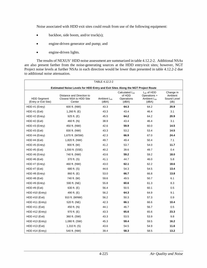
4-225 Air Quality and Noise
Noise associated with HDD exit sites could result from use of the following equipment:
• backhoe, side boom, and/or truck(s);
• engine-driven generator and pump; and
• engine-driven lights.
The results of NEXUS’ HDD noise assessment are summarized in table 4.12.2-2. Additional NSAs are also present farther from the noise-generating sources at the HDD entry/exit sites; however, NGT Project noise levels at further NSAs in each direction would be lower than presented in table 4.12.2-2 due to additional noise attenuation.
TABLE 4.12.2-2
Estimated Noise Levels for HDD Entry and Exit Sites Along the NGT Project Route
HDD Segment (Entry or Exit Site)
Distance and Direction to Closest NSA to HDD Site
Center Ambient Ldn
(dBA)
Calculated Ldn of HDD
Operations (dBA)
Ldn of HDD Operations + Ambient Ldn
(dBA)
Change in Ambient
Sound Level (db)
HDD #1 (Entry) 600 ft. (NW) 43.3 64.3 64.2 20.9
HDD #1 (Exit) 1,260 ft. (E) 43.3 43.4 46.4 3.1
HDD #2 (Entry) 925 ft. (E) 45.5 64.2 64.2 20.9
HDD #2 (Exit) 460 ft. (N) 38.9 43.4 46.4 3.1
HDD #3 (Entry) 450 ft. (NW) 42.6 59.9 60.0 14.5
HDD #3 (Exit) 830 ft. (NW) 43.3 53.2 53.4 14.5
HDD #4 (Entry) 1,670 ft. (WSW) 42.3 66.9 67.0 24.4
HDD #4 (Exit) 1,820 ft. (NW) 49.7 49.4 50.4 7.1
HDD #5 (Entry) 900 ft. (W) 41.2 53.7 54.0 11.7
HDD #5 (Exit) 1,550 ft. (SSE) 40.2 39.6 49.7 0.4
HDD #6 (Entry) 740 ft. (NW) 43.6 59.2 59.2 18.0
HDD #6 (Exit) 370 ft. (S) 41.1 44.7 46.0 5.8
HDD #7 (Entry) 460 ft. (NW) 43.0 62.1 62.2 18.6
HDD #7 (Exit) 680 ft. (S) 44.6 54.3 54.5 13.4
HDD #8 (Entry) 860 ft. (E) 53.0 66.7 66.8 13.8
HDD #8 (Exit) 740 ft. (W) 59.6 49.5 50.7 6.1
HDD #9 (Entry) 590 ft. (NE) 55.8 60.6 61.3 8.3
HDD #9 (Exit) 630 ft. (E) 56.4 50.5 60.1 0.5
HDD #10 (Entry) 490 ft. (E) 56.2 64.3 64.9 9.1
HDD #10 (Exit) 910 ft. (WNW) 56.2 50.3 57.3 0.9
HDD #11 (Entry) 520 ft. (NE) 42.3 66.1 66.6 10.4
HDD #11 (Exit) 450 ft. (N) 44.1 46.7 56.7 0.5
HDD #12 (Entry) 970 ft. (E) 43.3 65.6 65.6 23.3
HDD #12 (Exit) 360 ft. (SW) 43.3 53.5 53.9 9.8
HDD #13 (Entry) 1,080 ft. (SW) 45.3 59.4 59.5 16.2
HDD #13 (Exit) 1,310 ft. (S) 43.6 54.5 54.9 11.6
HDD #14 (Entry) 540 ft. (NW) 39.4 58.3 58.5 13.2

Air Quality and Noise 4-226
TABLE 4.12.2-2 (cont’d)
Estimated Noise Levels for HDD Entry and Exit Sites Along the NGT Project Route
HDD Segment (Entry or Exit Site)
Distance and Direction to Closest NSA to HDD Site
Center Ambient Ldn
(dBA)
Calculated Ldn of HDD
Operations (dBA)
Ldn of HDD Operations + Ambient Ldn
(dBA)
Change in Ambient
Sound Level (db)
HDD #14 (Exit) 1,080 ft. (S) 39.4 44.8 47.3 3.7
HDD #15 (Entry) 460 ft. (NW) 40.8 65.2 65.2 25.8
HDD #15 (Exit) 720 ft. (S) 46.3 45.0 46.0 6.6
HDD #16 (Entry) 1,300 ft. (NW) 49.0 66.7 66.7 25.9
HDD #16 (Exit) 800 ft. (NE) 53.1 49.0 50.8 4.5
HDD #17 (Entry) 220 ft. (W) 51.1 52.5 54.1 5.1
HDD #17 (Exit) 250 ft. (NW) 60.6 47.9 54.3 1.2
HDD #18 (Entry) 970 ft. (NW) 56.9 75.1 75.1 24.0
HDD #18 (Exit) >1/2 mile N/A 62.2 64.5 3.9
________________________________
Note: Bold values indicate sites that could exceed FERC’s 55 dBA Ldn noise guideline at the nearest NSA
As indicated (in bold) in table 4.12.2-2, 17 of the HDD entry or exit sites could exceed the FERC’s 55 dBA Ldn noise guideline at the nearest NSA. NEXUS estimates that the work associated with HDD installations would range from 14 to 89 days.
NEXUS is evaluating implementation of specific noise mitigation measures for the proposed HDDs that exceed 55 dBA Ldn. The mitigation measures considered include:
• a temporary noise barrier constructed of plywood panels or a sound-absorptive material designed with a minimum Sound Transmission Class rating of 20-31;
• a temporary noise-reducing tent lined with sound-absorptive material covering the workspace or equipment;
• a partial noise barrier or enclosure constructed of plywood panels or a sound-absorptive material placed around the hydraulic power unit and engine-driven pumps;
• “low noise” generators (i.e., with factory designed enclosures);
• residential-grade exhaust silencers on any engines associated with the HDD equipment;
• relocation of the mud mixing/cleaning rig and/or locating equipment, such as the mud rig (if must be outside the workspace tent), such that the tent provides sound shielding; and
• limiting HDD operations to daytime hours, if feasible.
NEXUS would employ these mitigation measures, or other measures that would provide equal reductions, to demonstrate compliance with the FERC’s 55 dBA Ldn noise standard. The mitigated noise impacts for the 15 referenced HDD entry or exit locations are estimated in table 4.12.2-3.

4-227 Air Quality and Noise
TABLE 4.12.2-3
Estimated Noise Levels for HDDs that Could Exceed the Sound Criterion at the Closest NSA a
HDD Segment (Entry or Exit Site)
Calculated Ldn of HDD Operations
(dBA)a
Ldn of HDD Operations + Ambient Ldn
(dBA)
Change in Ambient Sound Level
(dBA)
HDD #1 (Entry) 52.1 52.7 9.4
HDD #2 (Entry) 48.0 49.9 4.4
HDD #3 (Entry) 53.5 53.8 11.2
HDD #5 (Entry) 49.2 49.9 8.7
HDD #6 (Entry) 50.2 51.0 7.4
HDD #7 (Entry) 54.3 54.6 11.6
HDD #8 (Entry) 47.7 54.1 1.1
HDD #9 (Entry) 52.3 57.4 1.6
HDD #10 (Entry) 52.2 57.6 1.4
HDD #11 (Entry) 51.4 51.9 9.6
HDD #12 (Entry) 49.5 50.5 7.2
HDD #13 (Entry) 48.7 50.3 5.0
HDD #14 (Entry) 53.1 53.3 13.9
HDD #15 (Entry) 51.1 51.5 10.7
HDD #17 (Entry) 53.3 55.3 4.2
HDD #17 (Exit) 50.1 61.0 0.4
________________________________
a Assumes additional noise mitigation measures employed to meet the FERC noise criterion.
In addition to noise mitigation measures, NEXUS would provide affected landowners written notification at least 2 weeks prior to any necessary nighttime HDD operations, including in-person notifications and telephone calls as a secondary means of communication. To ensure that HDD noise levels are not significant, we recommend that:
• NEXUS should file in the weekly construction status reports the following for each HDD entry and exit site:
a. the noise measurements from the nearest NSA for each drill entry/exit site, obtained at the start of drilling operations;
b. the noise mitigation that NEXUS implemented at the start of drilling operations; and
c. any additional mitigation measures that NEXUS would implement if the initial noise measurements exceeded an Ldn of 55 dBA at the nearest NSA and/or increased noise is greater than 10 dBA over ambient conditions.
4.12.2.2 Operational Impacts and Mitigation
Pipeline Facilities
Operation of the NGT and TEAL Project pipelines would not typically cause noise impacts, except during pipeline blowdown events at MLV sites, which would occur periodically. However, this noise is

Air Quality and Noise 4-228
localized and short-term, lasting minutes. We received comments about potential impacts on residents due to low frequency sounds waves generated by high pressure natural gas flowing through a pipeline. This type of noise is typically associated with compressor stations that include reciprocating engines, which have been reported to result in a “thumping” or “pulsing” effect along the pipeline downstream from the compressor station. There are mitigation measures that can be installed at these types of compressor stations; however, the proposed compressor units at all compressor stations are turbines, and this issue would not occur.
Aboveground Facilities
A noise analysis was completed for each of the NGT Project M&R stations. Table 4.12.2-4 below summarizes the results. Figures 4.12.2-5 through 4.12.2-8 in appendix M display the nearest NSA to each M&R station.
TABLE 4.12.2-4
Estimated Noise Levels for NGT Project M&R Stations
M&R Station Distance (ft.)/
Direction Ambient Ldn
(dBA)
Estimated Ldn due to M&R
Station (dBA)
M&R Station Ldn +
Ambient Ldn (dBA)
Change in Ambient Sound
Level (dB)
NEXUS/TGP
M&R Station (MR01)
850 ft./ (West)
45.0 32.0 45.2 0.2
NEXUS/Kensington M&R Station (MR02) and NEXUS/Texas Eastern M&R Station (MR03)a
700 ft. (Northeast)
60.0 35.5 60.0 0.0
NEXUS/Dominion East Ohio M&R Station (MR05)
270 ft. (West) 56.7 49.2 57.4 0.7
Columbia Gas of Ohio M&R Delivery Station
2,200 ft. (Southeast)
41.8 26.0 41.9 0.1
NEXUS/Willow Run M&R Station (MR04)
270 ft. (East) 54.2 43.9 54.6 0.4
_______________________________
a MR03 would be directly adjacent to MR02 and would impact the same NSA.
Based on the M&R station configuration and mitigation measures, the noise attributable to each M&R station would not exceed the FERC criterion of 55 dBA Ldn at the nearest NSAs and would not result in a perceptible noise increase at the nearby NSAs.
To ensure that the actual noise levels resulting from operation of the M&R Stations comply with our noise guidelines, we recommend that:
• NEXUS should file a noise survey with the Secretary no later than 60 days after placing the new M&R stations into service. If the noise attributable to the operation of all of the equipment at each M&R station exceeds 55 dBA Ldn at the nearest NSA, NEXUS should file a report on what changes are needed and should install the additional noise controls to meet the level within 1 year of the in-service date. NEXUS should confirm compliance with the above requirement by filing a second noise survey for each station with the Secretary no later than 60 days after it installs the additional noise controls.

4-229 Air Quality and Noise
The noise impact evaluation for the NGT and TEAL Projects considers the noise produced by all significant sound sources associated with the proposed compressor stations that could impact the sound contribution at nearby NSAs. Significant sound sources include the turbine-driven compressor units, gas cooling equipment, and aboveground gas piping at each station. The noise evaluation incorporates reductions from the proposed noise controls. Noise controls for the compressor buildings include acoustical specifications for wall, roof, and entry door materials; prohibition of windows or skylights; and acoustical specifications for the ventilation system. Noise mitigation for the compressor equipment include the use of mufflers and silencers on turbine exhaust and blowdown units and acoustic blankets for exterior aboveground piping. Table 4.12.2-5 shows the estimated noise impact at the nearest NSAs due to the full load operation of the Hanoverton, Wadsworth, Clyde, and Waterville Compressor Stations. Table 4.12.2-6 shows the estimated noise impact at the nearest NSAs due to the full load operation of the Salineville and Colerain Compressor Stations.
TABLE 4.12.2-5
Estimated Noise Levels for NGT Project Compressor Stations
Nearest NSA
Distance (ft.)/
Direction
Ambient Sound Level
(dBA Ldn)
Sound Level During Operation (dBA Ldn)
Station Ldn + Ambient Ldn
(dBA) Noise Increase
(dB)
Hanoverton Compressor Station
NSA #1 1,040 ft./south-southeast 46.4 51.0 52.3 5.9
NSA #2 1,680 ft./west 45.5 45.9 48.7 3.2
NSA #3 1,800 ft./northeast 41.1 45.2 46.6 5.5
NSA #4 1,740 ft./south 45.5 45.6 48.5 3.0
NSA #5 1,900 ft./southwest 45.5 44.7 48.1 2.6
Wadsworth Compressor Station
NSA #1 1,800 ft./west 56.7 44.5 57.0 0.3
NSA #2 1,840 ft./west-northwest 46.9 44.2 48.8 1.9
NSA #3 2,490 ft./northeast 48.5 40.7 49.2 0.7
Clyde Compressor Station
NSA #1 1,450 ft./north-northwest 63.2 46.4 63.3 0.1
NSA #2 810 ft./southwest 51.8 52.7 55.3 3.5
NSA #3 1,160 ft./southeast 53.4 48.9 54.7 1.3
Waterville Compressor Station
NSA #1 1,390 ft./east 60.6 48.0 60.8 0.2
NSA #2 1,990 ft./north 48.6 43.8 49.9 1.3
NSA #3 3,790 ft./west 41.5 36.0 42.6 1.1
NSA #4 1,600 ft./southeast 60.6 46.0 60.7 0.1

Air Quality and Noise 4-230
TABLE 4.12.2-6
Estimated Noise Levels for TEAL Project Compressor Stations
Nearest NSA Distance (ft)/ Direction
Ambient Sound Level
Ldn (dBA)
Estimated Ldn of Station during
Operation (dBA)
Station Ldn + Ambient Ldn
(dBA)
Change in Ambient Sound Level
(dB)
Salineville Compressor Station
NSA #1 1,490 ft./north 39.7 43.7 45.2 5.5
NSA #2 1,660 ft./west 43.8 42.6 46.2 2.4
NSA #3 1,910 ft./west-northwest 43.8 41.0 45.6 1.8
NSA #4 2,200 ft./northeast 39.7 39.4 42.6 2.9
Colerain Compressor Station a
NSA #1 1,880 ft./west 45.0 b 42.2 46.8 1.8
NSA #2 2,140 ft./south-southeast 43.6 b 40.3 45.3 1.7
NSA #3 2,100 ft./north-northeast 43.7 b 41.7 45.8 2.1
________________________________
a Existing station sound level at the NSA is based on previously measured ambient sound data and the results of a recent acoustical analysis of the compressor station for the OPEN Project, FERC Docket No. CP14-68-000.
The results of the acoustical analyses indicate that the sound contribution of the compressor stations would remain below our 55 dBA Ldn criterion at the nearest NSAs during operation. The highest increase in noise would occur at NSA 1 for the Hanoverton Compressor Station (5.9 dBA). While the increase at this NSA would be noticeable, it would not be significant.
Landowners near the proposed Hanoverton Compressor Station expressed concern with the noise levels resulting from compressor station operations and blowdowns, and that loud and unpredictable noises from a blowdown may startle horses and cause injury. A blowdown involves the venting of natural gas from compressor station components into the atmosphere. Most blowdowns occur as a result of system testing or maintenance activities, and NEXUS would incorporate blowdown silencers to minimize noise during planned blowdowns. In addition, projected sound levels associated with planned blowdown events are also estimated to remain below 55 dBA Ldn at the nearest NSAs at each compressor station and would be infrequent, lasting from 1 to 5 minutes. Unsilenced station blowdowns would occur in the event of an emergency. Horses and cattle may be close to blowdown events and experience noise levels greater than the 55 dBA Ldn criterion.
Landowners near the Waterville Compressor Station expressed concern regarding the potential for excessive noise levels in the vicinity of the Waterville Compressor Station. The results in table 4.12.2-5 indicate that the Waterville Compressor Station would be below the FERC criterion and would represent an increase of 1.3 dBA or less at the nearest NSA (i.e., would not result in a noticeable increase in noise).
We received comments regarding the potential for low frequency vibrations to cause or exacerbate health issues near compressor stations associated with the Projects. FERC regulations state that a new compressor station or modification of an existing station shall not result in a perceptible increase in vibration at any NSA. This would apply to both the NGT and TEAL Projects compressor stations. FERC staff would investigate noise and vibration complaints, and to the extent that a violation is documented, each company would be required to address the issue.

4-231 Air Quality and Noise
To ensure that the actual noise levels resulting from operation of the Hanoverton, Wadsworth, Clyde, and Waterville Compressor Stations are not significant, we recommend that:
• NEXUS should file a noise survey with the Secretary no later than 60 days after placing each of the NGT Project compressor stations in service. If a full load condition noise survey is not possible, NEXUS should instead file an interim survey at the maximum possible hp load and file the full load survey within 6 months. If the noise attributable to the operation of all of the equipment at any station under interim or full hp load exceeds 55 dBA Ldn at any nearby NSA, NEXUS should file a report on what changes are needed and should install the additional noise controls to meet the level within 1 year of the in-service date. NEXUS should confirm compliance with the 55 dBA Ldn requirement by filing a second noise survey with the Secretary no later than 60 days after it installs the additional noise controls.
To ensure that the actual noise levels resulting from operation of the Salineville and Colerain Compressor Stations are not significant, we recommend that:
• Texas Eastern should file a noise survey with the Secretary no later than 60 days after placing each of the TEAL Project compressor stations in service. If a full load condition noise survey of the entire station is not possible, Texas Eastern should instead file an interim survey at the maximum possible hp load and file the full load survey within 6 months. If the noise attributable to the operation of all of the equipment at any compressor station under interim or full hp load conditions exceeds 55 dBA Ldn at any nearby NSAs, Texas Eastern should file a report on what changes are needed and should install the additional noise controls to meet the level within 1 year of the in-service date. Texas Eastern should confirm compliance with the 55 dBA Ldn requirement by filing a second noise survey with the Secretary no later than 60 days after it installs the additional noise controls.
Based on the noise analyses for the NGT and TEAL Projects M&R Stations and compressor stations, mitigation measures NEXUS and Texas Eastern would employ, and adherence to our noise criterion of 55 dBA Ldn (including station blowdowns), we conclude that the noise resulting from operation of the NGT and TEAL Projects would not have a significant impact on the surrounding ambient noise environment.
4.13 RELIABILITY AND SAFETY
The transportation of natural gas by pipeline involves some incremental risk to the public due to the potential for an accidental release of natural gas. The greatest hazard is a fire or explosion following a major pipeline rupture.
CH4, the primary component of natural gas, is colorless, odorless, and tasteless. It is not toxic but is classified as a simple asphyxiate, possessing a slight inhalation hazard. If breathed in high concentration, oxygen deficiency can result in serious injury or death.
CH4 has an auto-ignition temperature of 1,000 °F and is flammable at concentrations between 5.0 and 15.0 percent in air. At atmospheric temperatures, CH4 is buoyant and disperses rapidly in air. An unconfined mixture of CH4 and air is not explosive; however, it may ignite if there is an ignition source. A flammable concentration within an enclosed space in the presence of an ignition source can explode.

Reliability and Safety 4-232
4.13.1 Safety Standards
The DOT is mandated to provide pipeline safety under Title 49 USC Chapter 601. PHMSA’s Office of Pipeline Safety administers the national regulatory program to ensure the safe transportation of natural gas and other hazardous materials by pipeline. It develops safety regulations and other approaches to risk management that ensure safety in the design, construction, testing, operation, maintenance, and emergency response of pipeline facilities. Many of the regulations are written as performance standards that set the level of safety to be attained and allow the pipeline operator to use various technologies to achieve the required safety standard.
We received comments from landowners about the need for safety inspections of the construction activities. PHMSA ensures that people and the environment are protected from the risk of pipeline incidents. This work is shared with state agency partners and others at the federal, state, and local level. The DOT provides for a state agency to assume all aspects of the safety program for intrastate facilities by adopting and enforcing the federal standards. A state may also act as the DOT’s agent to inspect interstate facilities within its boundaries. Ohio and Michigan perform inspections on interstate natural gas pipeline facilities. The DOT is also responsible for enforcement action in all of the Projects' states. In addition to DOT inspections, NEXUS’ and Texas Eastern’s contractors, including construction workers, would be required to adhere to federal and state safety regulations and recommendations.
The DOT pipeline standards are published in 49 CFR 190-199. Part 192 specifically addresses the minimum federal safety standards for transportation of natural gas by pipeline. Under a Memorandum of Understanding on Natural Gas Transportation Facilities (Memorandum) dated January 15, 1993, between DOT and FERC, DOT has the exclusive authority to promulgate federal safety standards used in the transportation of natural gas. Section 157.14(a)(9)(vi) of FERC’s regulations requires that an applicant certify that it would design, install, inspect, test, construct, operate, replace, and maintain the facility for which a Certificate is requested in accordance with federal safety standards and plans for maintenance and inspection, or certify that it has been granted a waiver of the requirements of the safety standards by the DOT in accordance with section 3(e) of the Natural Gas Pipeline Safety Act. FERC accepts this certification and does not impose additional safety standards. If the Commission becomes aware of an existing or potential safety problem, there is a provision in the Memorandum to promptly alert DOT. The Memorandum also provides for referring complaints and inquiries made by state and local governments and the general public involving safety matters related to pipelines under the Commission's jurisdiction.
FERC also participates as a member of the DOT's Technical Pipeline Safety Standards Committee, which determines if proposed safety regulations are reasonable, feasible, and practicable.
The pipeline and aboveground facilities associated with the NGT and TEAL Projects must be designed, constructed, operated, and maintained in accordance with the DOT Minimum Federal Safety Standards in 49 CFR 192. The regulations are intended to ensure adequate protection for the public and to prevent natural gas facility accidents and failures. The DOT specifies material selection and qualification, minimum design requirements, and protection from internal, external, and atmospheric corrosion. NEXUS and Texas Eastern have stated that the project facilities would be designed, constructed, operated, and maintained in accordance with 49 CFR 192.
The DOT also defines area classifications, based on population density in the vicinity of pipeline facilities, and specifies more rigorous safety requirements for populated areas. The class location unit is an

4-233 Reliability and Safety
area that extends 220 yards on either side of the centerline of any continuous 1-mile length of pipeline. The four area classifications are defined as:
• Class 1: Location with 10 or fewer buildings intended for human occupancy.
• Class 2: Location with more than 10 but less than 46 buildings intended for human occupancy.
• Class 3: Location with 46 or more buildings intended for human occupancy or where the pipeline lies within 100 yards of any building, or small well-defined outside area occupied by 20 or more people on at least 5 days a week for 10 weeks in any 12-month period.
• Class 4: Location where buildings with four or more stories aboveground are prevalent.
Class locations representing more populated areas require higher safety factors in pipeline design, testing, and operation. For example, pipelines constructed on land in Class 1 locations must be installed with a minimum depth of cover of 30 inches in normal soil and 18 inches in consolidated rock. Class 2, 3, and 4 locations, as well as drainage ditches of public roads and railroad crossings, require a minimum cover of 36 inches in normal soil and 24 inches in consolidated rock.
Class locations also specify the maximum distance to a sectionalizing block valve (i.e., 10.0 miles in Class 1, 7.5 miles in Class 2, 4.0 miles in Class 3, and 2.5 miles in Class 4 locations). Pipe wall thickness and pipeline design pressures, hydrostatic test pressures, Maximum Allowable Operating Pressure (MAOP), inspection and testing of welds, and frequency of pipeline patrols and leak surveys must also conform to higher standards in more populated areas.
Class locations for the NGT and TEAL Projects have been determined based on the relationship of the pipeline centerline to other nearby structures and manmade features. Table 4.13.1-1 provides the class locations by milepost for the NGT Project pipeline. In addition, each of the proposed NGT Project compressor stations would be in Class 1 areas. The TEAL Project would only consist of Class 1 pipe.
TABLE 4.13.1-1
NGT Project Pipeline Class Locations
State, County
Class 1 a Class 2 a Class 3 a
MP Start b MP End b Length
(miles) c MP Start b MP End b Length
(miles) c MP Start b MP End b Length
(miles) c
OHIO
Columbiana 0.0 0.9 0.9 0.1 0.2 0.1 0.2 0.5 0.3
0.0 0.1 0.1 0.5 0.6 0.1 N/A N/A N/A
0.6 0.9 0.3 0.9 1.3 0.4 N/A N/A N/A
1.3 1.5 0.2 1.5 3.0 1.5 N/A N/A N/A
3.0 4.6 1.6 4.6 4.8 0.2 N/A N/A N/A
4.8 5.3 0.5 5.3 5.8 0.5 N/A N/A N/A
5.8 6.1 0.3 6.1 6.6 0.5 N/A N/A N/A
6.6 6.8 0.2 6.8 7.3 0.5 N/A N/A N/A
7.3 7.5 0.2 7.5 7.9 0.4 N/A N/A N/A
7.9 9.7 1.8 9.7 10.7 1.0 N/A N/A N/A
10.7 11.0 0.3 11.0 11.6 0.6 N/A N/A N/A
11.6 12.3 0.7 12.3 12.5 0.2 N/A N/A N/A
Stark 12.7 13.0 0.3 12.5 12.7 0.1 31.9 34.1 2.2
13.6 13.8 0.2 13.0 13.6 0.6 N/A N/A N/A
14.5 18.2 3.7 13.8 14.5 0.7 N/A N/A N/A

Reliability and Safety 4-234
TABLE 4.13.1-1 (cont’d)
NGT Project Pipeline Class Locations
State, County
Class 1 a Class 2 a Class 3 a
MP Start b MP End b Length
(miles) c MP Start b MP End b Length
(miles) c MP Start b MP End b Length
(miles) c
Stark (cont’d)
18.7 21.8 3.1 18.2 18.7 0.6 N/A N/A N/A
22.4 26.3 3.8 21.8 22.4 0.6 N/A N/A N/A
26.5 26.8 0.2 26.3 26.5 0.2 N/A N/A N/A
27.4 29.2 1.8 26.8 27.4 0.7 N/A N/A N/A
29.5 30.0 0.5 29.2 29.5 0.3 N/A N/A N/A
30.5 31.1 0.6 30.0 30.5 0.5 N/A N/A N/A
31.5 31.9 0.5 31.1 31.5 0.4 31.9 33.5 1.6
N/A N/A N/A 33.5 33.6 0.1 33.6 34.2 0.6
Summit 34.2 34.5 0.3 34.5 35.3 0.8 34.2 34.2 0.02
35.3 35.8 0.5 35.8 36.4 0.6 36.4 37.6 1.2
40.4 41.0 0.6 41.0 41.9 0.9 41.8 43.0 1.2
41.9 41.9 0.04 36.4 37.0 0.6 41.9 43.0 1.1
N/A N/A N/A 43.0 43.2 0.2 43.2 43.8 0.6
N/A N/A N/A 43.8 43.9 0.1 N/A N/A N/A
43.9 44.1 0.2 44.1 45.8 1.6 N/A N/A N/A
45.8 45.9 0.1 45.9 47.1 1.1 N/A N/A N/A
47.1 48.6 1.6 48.6 49.0 0.4 N/A N/A N/A
49.0 49.2 0.2 48.6 49.0 0.4 49.2 50.2 1.0
N/A N/A N/A 50.2 50.4 0.1 N/A N/A N/A
Wayne 50.6 51.2 0.6 50.4 50.6 0.2 N/A N/A N/A
51.7 51.8 0.1 51.2 51.7 0.5 N/A N/A N/A
52.2 52.4 0.2 51.8 52.2 0.4 52.4 54.0 1.6
55.0 55.5 .05 54.0 55.0 1.0 N/A N/A N/A
55.9 56.2 0.3 55.5 55.9 0.4 N/A N/A N/A
N/A N/A N/A 56.2 56.6 0.4 N/A N/A N/A
N/A N/A N/A 57.2 57.3 0.1 57.3 57.5 0.
N/A N/A N/A 57.5 57.7 0.2 N/A N/A N/A
N/A N/A N/A 56.6 57.2 0.6 N/A N/A N/A
Medina 58.6 59.2 0.6 57.7 58.6 0.9 N/A N/A N/A
59.7 60.0 0.3 59.2 59.7 0.5 N/A N/A N/A
60.5 65.3 4.9 60.0 60.5 0.5 N/A N/A N/A
66.1 67.5 1.5 65.3 66.1 0.7 N/A N/A N/A
68.6 71.6 3.0 67.5 67.9 0.4 67.9 68.9 0.9
73.0 73.4 0.4 68.9 69.5 0.7 N/A N/A N/A
69.5 71.6 2.2 71.6 73.0 1.4 N/A N/A N/A
73.0 73.3 0.3 73.3 74.3 1.0 N/A N/A N/A
74.3 75.8 1.4 75.8 76.6 0.8 N/A N/A N/A
76.6 76.8 0.2 76.8 77.2 0.4 N/A N/A N/A
77.2 80.5 3.3 N/A N/A N/A N/A N/A N/A
Lorain 80.5 82.4 2.0 82.4 82.9 0.4 N/A N/A N/A
82.9 93.3 10.4 93.5 93.8 0.3 93.3 93.5 0.2
93.8 94.4 0.6 95.3 95.4 0.1 94.4 95.4 1.0
95.4 98.3 2.9 98.3 98.7 0.4 N/A N/A N/A
98.7 98.9 0.2 98.9 99.4 0.5 N/A N/A N/A
99.4 99.8 0.5 99.8 100.2 0.3 N/A N/A N/A
100.2 100.4 0.2 100.4 100.8 0.4 N/A N/A N/A
100.8 101.1 0.3 101.1 101.3 0.2 N/A N/A N/A
Huron 101.5 104.7 3.2 101.3 101.5 0.2 N/A N/A N/A
Erie 104.7 111.0 6.3 111.0 111.4 0.4 N/A N/A N/A
111.4 111.6 0.3 111.6 112.3 0.7 N/A N/A N/A
112.3 116.8 4.5 116.8 117.5 0.7 N/A N/A N/A

4-235 Reliability and Safety
TABLE 4.13.1-1 (cont’d)
NGT Project Pipeline Class Locations
State, County
Class 1 a Class 2 a Class 3 a
MP Start b MP End b Length
(miles) c MP Start b MP End b Length
(miles) c MP Start b MP End b Length
(miles) c
Erie (cont’d)
117.5 125.6 8.0 125.6 126.0 0.4 N/A N/A N/A
126.0 126.1 0.1 126.1 126.5 0.3 N/A N/A N/A
126.5 127.3 0.8 127.3 127.9 0.6 N/A N/A N/A
127.9 129.9 2.0 129.9 131.0 1.1 N/A N/A N/A
131.0 131.5 0.5 N/A N/A N/A N/A N/A N/A
Sandusky 131.5 145.8 14.3 145.8 146.6 0.8 N/A N/A N/A
146.6 147.2 0.6 146.3 146.6 0.3 N/A N/A N/A
147.7 153.6 5.9 147.2 147.7 0.5 N/A N/A N/A
155.0 157.3 2.3 153.6 154.0 0.5 154.0 155.0 1.0
157.8 158.0 0.1 157.3 157.8 0.5 N/A N/A N/A
158.3 162.7 4.4 158.0 158.3 0.4 N/A N/A N/A
163.3 163.5 0.2 162.7 163.3 0.5 N/A N/A N/A
N/A N/A N/A 163.5 163.7 0.2 N/A N/A N/A
Wood 164.0 164.2 0.2 163.7 164.0 0.2 N/A N/A N/A
164.8 165.0 0.2 164.2 164.8 0.7 164.8 165.0 0.2
165.3 173.3 8.0 165.0 165.3 0.3 N/A N/A N/A
173.7 173.8 0.1 173.3 173.7 0.4 N/A N/A N/A
174.1 181.5 7.3 173.8 174.1 0.3 N/A N/A N/A
Lucas 181.5 181.6 0.2 N/A N/A N/A 181.6 181.9 0.2
181.9 187.2 5.3 187.8 189.0 1.2 187.2 187.8 0.6
189.0 189.0 0.1 189.0 189.3 0.3 N/A N/A N/A
Henry 189.5 190.0 0.5 189.3 189.5 0.2 N/A N/A N/A
N/A N/A N/A 190.0 190.2 0.2 N/A N/A N/A
Fulton 190.4 193.2 2.8 190.2 190.4 0.2 N/A N/A N/A
194.0 194.6 0.7 193.2 194.0 0.8 N/A N/A N/A
195.0 195.1 0.1 194.6 195.0 0.3 N/A N/A N/A
196.4 204.7 8.3 195.1 196.4 1.3 N/A N/A N/A
205.1 208.3 3.2 204.7 205.1 0.4 N/A N/A N/A
MICHIGAN
Lenawee 208.3 230.4 22.1 N/A N/A N/A N/A N/A N/A
Monroe 230.4 236.8 6.5 N/A N/A N/A N/A N/A N/A
N/A N/A N/A N/A N/A N/A N/A N/A N/A
Washtenaw
236.8 244.2 7.4 244.2 244.5 0.4 N/A N/A N/A
244.5 244.7 0.1 244.7 245.2 0.5 245.2 245.3 0.1
245.5 247.2 1.7 245.3 245.5 0.2 249.6 250.3 0.7
248.4 248.5 0.1 247.2 247.6 0.4 247.6 248.2 0.6
248.4 248.5 0.1 248.2 248.4 0.2 248.5 248.9 0.4
249.3 249.4 0.1 248.9 249.3 0.5 N/A N/A N/A
250.3 250.8 0.5 249.4 249.6 0.2 249.6 250.3 0.7
N/A N/A N/A N/A N/A N/A 250.8 253.0 2.2
253.3 253.7 0.4 253.0 253.3 0.3 253.7 253.9 0.2
253.9 254.5 0.6 254.5 254.7 0.2 254.7 254.9 0.2
254.9 255.0 0.1 N/A N/A N/A N/A N/A N/A
________________________________
a Class 1: Location with 10 or fewer buildings for human occupancy Class 2: Location with more than 10 but fewer than 46 buildings intended for human occupancy Class 3: Location with 46 or more buildings intended for human occupancy or where pipeline lies within 100 yards of any building, or small, well-defined outside area occupied by 20 or more people during normal use Class 4: Location where buildings with four or more stories aboveground are prevalent
b Approximate milepost along the proposed pipeline rounded to the nearest 0.1 mile
c Crossing length of each pipeline class within each county
N/A = not applicable

Reliability and Safety 4-236
If a subsequent increase in population density adjacent to the right-of-way results in a change in class location for the pipeline, NEXUS and Texas Eastern would reduce the MAOP or replace the segment with pipe of sufficient grade and wall thickness, if required to comply with DOT requirements for the new class location.
The DOT Pipeline Safety Regulations require operators to develop and follow a written Integrity Management Program (IMP) that contains all the elements described in 49 CFR 192.911 and addresses the risks on each transmission pipeline segment. Specifically, the rule establishes an IMP that applies to all high-consequence areas (HCA).
The DOT has published rules in 49 CFR 192.903 that define HCAs where a gas pipeline accident could do considerable harm to people and their property, and requires an IMP to minimize the potential for an accident. This definition satisfies, in part, the Congressional mandate for DOT to prescribe standards that establish criteria for identifying each gas pipeline facility in a high-density population area.
The HCAs may be defined in one of two ways. In the first method, an HCA includes:
• current Class 3 and 4 locations;
• any area in Class 1 or 2 where the potential impact radius13 is greater than 660 feet and there are 20 or more buildings intended for human occupancy within the potential impact circle14; or
• any area in Class 1 or 2 where the potential impact circle includes an identified site.
An “identified site” is an outside area or open structure that is occupied by 20 or more persons on at least 50 days in any 12-month period; a building that is occupied by 20 or more persons on at least 5 days a week for any 10 weeks in any 12-month period; or a facility that is occupied by persons who are confined, are of impaired mobility, or would be difficult to evacuate.
In the second method, an HCA includes any area within a potential impact circle that contains:
• 20 or more buildings intended for human occupancy; or
• an identified site.
We received numerous comments regarding the safety of homes, schools, hospitals, etc., that would be within the potential impact radius for the NGT Project pipeline, which would be 1,100 feet. For the NGT Project compressor stations, the potential impact radius would be 943 feet. The potential impact radius is designed to identify locations where additional safety measures are required to ensure and promote pipeline safety in populated areas. NEXUS would develop a Public Awareness Program as outlined in 49 CFR 192.616, which would provide outreach measures to the affected public, emergency responders, and public officials. NEXUS’ program would use multiple media channels (e.g., direct mail, e-mail, social networking, public service announcements, print advertisement, and public meetings) to engage these core audiences. In addition, NEXUS would also mail informational brochures to landowners, businesses, potential excavators, and public officials along the pipeline system each year to inform them of the presence of the pipeline and instruct them on how to recognize and react to unusual activity in the area. These 13 The potential impact radius is calculated as the product of 0.69 and the square root of the MAOP of the pipeline in pounds
per square inch (gauge), multiplied by the square of the pipeline diameter in inches.
14 The potential impact circle is a circle of radius equal to the potential impact radius.

4-237 Reliability and Safety
brochures would provide emergency contact phone numbers and reinforce the need for excavators to use the “811 Call Before You Dig” service.
We also received numerous comments regarding the need for required setbacks for homes and structures in relation to pipelines, in reference to 49 CFR 195.210; however this regulation is only applicable to pipelines transporting hazardous liquids. The DOT regulations applicable to the NEXUS and TEAL Projects under 49 CFR 192 for pipelines transporting natural gas do not have a similar setback provision. As discussed throughout this section, the DOT maintains and enforces pipeline safety regulations. The Commission sites pipelines in cooperation with the DOT under a memorandum of understanding. At this time there are no established setback requirements for natural gas pipeline facilities.
Once a pipeline operator has determined the HCAs along its pipeline, it must apply the elements of its IMP to those sections of the pipeline within HCAs. DOT regulations specify the requirements for the IMP at section 192.911. The HCAs for the Projects have been determined based on the relationship of the pipeline centerline to other nearby structures and identified sites. Table 4.13.1-2 lists the HCAs for the NGT Project, which have been determined using the second method. The NGT Project compressor stations would not be constructed in HCAs. There are no HCAs located along the proposed facilities associated with the TEAL Project.
TABLE 4.13.1-2
Location of High Consequence Areas along the NGT Project Pipeline Facilities
State, Facility Name, County Milepost Start a Milepost End a Length (miles) b
OHIO
Mainline
Columbiana 0.0 0.8 0.8
Columbiana 1.5 2.4 0.9
Stark 18.1 18.9 0.8
Stark 29.2 29.8 0.6
Stark 31.9 34.2 2.3
Summit 34.2 34.3 0.1
Summit 34.8 35.3 0.5
Summit 36.3 37.8 1.4
Summit 38.4 38.8 0.4
Summit 38.8 39.4 0.6
Summit 39.6 40.1 0.5
Summit 41.1 41.8 0.8
Summit 42.0 43.3 1.3
Summit 43.3 43.9 0.7
Summit 44.7 45.2 0.5
Summit 49.1 50.2 1.1
Wayne 51.7 52.1 0.5
Wayne 52.3 54.1 1.8
Wayne 56.3 56.5 0.3
Medina 57.0 57.3 0.3
Wayne 57.3 57.7 0.4
Medina 62.3 62.8 0.5
Medina 64.6 65.1 0.5
Medina 67.7 69.1 1.5
Medina 70.0 71.4 1.4

Reliability and Safety 4-238
TABLE 4.13.1-2 (cont’d)
Location of High Consequence Areas along the NGT Project Pipeline Facilities
State, Facility Name, County Milepost Start a Milepost End a Length (miles) b
Medina 72.9 74.0 1.1
Medina 76.1 76.5 0.4
Lorain 93.0 93.8 0.8
Lorain 94.3 95.6 1.3
Erie 116.8 117.8 1.0
Erie 118.2 119.6 1.4
Erie 120.1 120.6 0.5
Erie 130.5 131.1 0.6
Sandusky 138.6 139.2 0.6
Sandusky 145.9 146.6 0.8
Sandusky 153.9 155.1 1.2
Wood 164.5 165.3 0.8
Wood 181.4 181.5 0.1
Lucas 181.5 182.2 0.7
Lucas 187.2 188.0 0.8
Ohio Total 32.9
MICHIGAN
Mainline
Washtenaw 244.5 245.7 1.2
Washtenaw 247.6 255.0 7.4
Michigan Total 8.6
Project Total 41.5
________________________________
a Approximate mileposts along the proposed pipeline have been rounded to the nearest 0.1 mile
b Crossing length of segment within county
As previously discussed and required by PHMSA regulations, the pipelines and aboveground
facilities would be designed, constructed, operated, and maintained to meet or exceed the requirements at 49 CFR 192. The general construction methods that NEXUS and Texas Eastern would implement to ensure the safety of the Projects are described in section 2.3, including welding, inspection, and integrity testing procedures. NEXUS and Texas Eastern identified the following voluntary safety measures that would be implemented and are more stringent than the requirements in 49 CFR 192:
• minimum depth of cover of 36 inches is required over the proposed pipeline for all pipeline Class locations and geological conditions;
• all welding, coating, and backfilling activities would be inspected;
• all welds would be non-destructively examined by an independent radiographic inspection company, regardless of Class location;
• remote-controlled valves and monitoring equipment would be installed for all mainline valves;
• spacing of mainline valves would be based on population density and 49 CFR 192 area classifications;
• valves would be installed as close to roads as possible to provide good access;

4-239 Reliability and Safety
• all mainline piping would have at least 16 mils nominal thickness of epoxy coating; and
• the minimum pressure for pressure tests, based upon the pipeline MAOP, would be greater than the operating pressure of the pipeline.
The DOT prescribes the minimum standards for operating and maintaining pipeline facilities, including the requirement to establish a written plan governing these activities. Each pipeline operator is required to establish an emergency plan that includes procedures to minimize the hazards in a natural gas pipeline emergency. Key elements of the plan include procedures for:
• identifying and classifying emergency events, gas leakage, fires, explosions, and natural disasters;
• establishing and maintaining communications with local fire, police, and public officials, and coordinating emergency response;
• emergency system shutdown and safe restoration of service;
• making personnel, equipment, tools, and materials available at the scene of an emergency; and
• protecting people first and then property, and making them safe from actual or potential hazards.
We received several comments indicating that local first responders along the NGT Project pipeline route were not capable of responding to a pipeline incident. NEXUS stated that its employees and local emergency response personnel would meet for emergency drills periodically to test staff readiness and identify improvement opportunities. In accordance with 49 CFR 192.615, NEXUS would develop, maintain, and implement a written emergency response plan to minimize the hazards from a pipeline emergency. Key features would include:
• identifying, verifying, and classifying emergency events – leaks, fires, explosions, or natural disasters;
• managing communications with emergency responders and public officials to establish incident command and coordinate response efforts;
• making personnel, equipment, tools, and materials available for emergencies;
• ensuring that response efforts focus on public safety first; and
• ensuring emergency shutdown actions are taken in a timely manner.
The DOT regulations specified in 49 CFR 192 require that pipeline operators establish and maintain liaison with appropriate fire, police, and public officials to learn the resources and responsibilities of each organization that may respond to a natural gas pipeline emergency and to coordinate mutual assistance. Pipeline operators must also establish a continuing education program to enable customers, the public, government officials, and those engaged in excavation activities to recognize a gas pipeline emergency and report it to appropriate public officials. NEXUS and Texas Eastern would provide the appropriate training to local emergency service personnel before the pipeline is placed in service. In addition pipeline markers identifying the owner of the pipe and a 24-hour telephone number would be placed for “line of sight” visibility

Reliability and Safety 4-240
along the entire pipeline length, except in active agricultural crop locations and in waterbodies, in accordance with DOT requirements. NEXUS would also provide pipeline location information in the National Pipeline Mapping System to inform the public and others of the general location of their pipeline facilities.
The DOT also requires pipeline operators to place pipeline markers at frequent intervals along pipeline rights-of-way, such as where a pipeline intersects a street, highway, railway or waterway, and at other prominent points along the route. Pipeline right-of-way markers can help prevent encroachment and excavation-related damage to pipelines. Because the right-of-way is much wider than the pipeline itself and a pipeline can be anywhere within the right-of-way, state laws require excavators to call their state One Call center well in advance of digging to locate underground utilities and ensure it is safe for the contractor to dig in that location.
We received several comments regarding the potential for pipeline leaks. Several commenters expressed concern regarding methane leaks from the pipeline causing soil and waterbody contamination. Commenters also expressed concern for pipeline leaks resulting in power line accidents where the proposed pipeline would be co-located with power lines. In accordance with DOT regulations, NGT and TEAL Projects facilities would be regularly inspected for leakage as part of scheduled operations and maintenance, including:
• physically walking and inspecting the pipeline corridor periodically;
• conducting fly-over inspections of the right-of-way as required; and
• conducting leak surveys at least once every calendar year or as required by regulations.
In addition to the DOT-required surveys described previously, NEXUS and Texas Eastern would monitor portions of its pipeline system using a supervisory control and data acquisition system. This system would gather information related to system pressures, flows, and customer deliveries 24 hours per day, 365 days per year. Finally, methane is lighter than air and at typical pipeline burial depths (i.e., 30 to 36 inches) it migrates through soil and water before dispersing into the atmosphere. Further, fugitive pipeline leaks generally occur at valves sites, fittings, and other aboveground and/or connection points at very low levels. Because methane is lighter than air, the gas would disperse into the atmosphere; therefore the methane concentration would not be high enough to cause a power line incident. Pipeline operators use in-line inspection tools to detect internal pipe anomalies, including deformations and metal loss. In addition, there are remote-controlled valves along the route and should a major leak occur, natural gas can be isolated and evacuated from that portion of the line to allow for repairs. For these reasons, it is unlikely that a pipeline leak would result in methane levels in soil or water that would cause significant environmental impacts on these resources along the pipeline routes; it is also unlikely that a pipeline leak would result in a power line incident.
We received comments from numerous citizens expressing concern about impacts on residences and public safety resulting from operation of the proposed compressor stations associated with the NGT and TEAL Projects. Residents expressed concerns for public recreation areas, schools, homes, businesses, and large populations in the event of a pipeline accident. As discussed previously, the compressor stations for the NGT and TEAL Projects would be designed, constructed, operated, and maintained in accordance with the DOT Minimum Federal Safety Standards in 49 CFR 192. These regulations include more stringent design criteria for facilities located near populated areas, public use areas, and schools. In addition to the general safety procedures discussed previously, NEXUS and Texas Eastern would also implement the following specific safety measures at its proposed compressor stations:
• Each compressor station would be completely surrounded by a chain link fence with barbed wire to maintain the safety of the facility and workers.

4-241 Reliability and Safety
• A controlled access system and intrusion alarm network would be installed to restrict access to authorized personnel and the facilities would be monitored with video cameras.
• Compressor buildings would be constructed of noncombustible material and ventilated to minimize the potential of gas accumulating in enclosed areas.
• Compressor stations would be equipped with automatic emergency detection and shutdown systems that include sensors for detecting natural gas concentrations as well as sensors for detecting flames. The system would be maintained and tested routinely to ensure proper operation.
• Compressor station equipment would be designed to shut down automatically if system operation deviates from its designed operating limits, which could cause a mechanical failure and pose risk to personnel and equipment, or otherwise constitute a hazard. The compressor stations would also be equipped with relief valves to protect the piping from over-pressurization.
• Fire protection, first aid, and safety equipment would be maintained at the compressor stations, and NEXUS’ and Texas Eastern’s emergency response personnel would be trained in proper equipment use and in first aid.
The most effective and immediate way to begin to address a gas pipeline rupture is to shut off the gas source. NEXUS would have valves spaced along the pipeline that can be used to shut off the gas and isolate each pipeline segment. In an emergency, NEXUS and Texas Eastern would rely on the local emergency services (e.g., fire and police) to communicate with the public.
We received comments from landowners about the need for safety inspections of the construction activities. NEXUS’ and Texas Eastern’s contractors, including construction workers, would be required to adhere to federal and state safety regulations and recommendations. In addition, FERC staff or its contractors would routinely inspect construction activities to ensure environmental compliance.
Based on NEXUS’ and Texas Eastern’s compliance with federal design and safety standards and their implementation of the aforementioned safety measures, we conclude that constructing and operating the pipeline facilities would not significantly impact public safety.
4.13.2 Pipeline Accident Data
The DOT requires all operators of natural gas transmission pipelines to notify the National Response Center at the earliest practicable moment following the discovery of an incident and to submit a report within 30 days to PHMSA. Incidents are defined as any leaks that:
• cause a death or personal injury requiring hospitalization; or
• involve property damage, including cost of gas lost of more than $50,000 in 1984 dollars.15
During the 20-year period from 1996 through 2015, a total of 1,312 significant incidents were reported on the more than 300,000 total miles of natural gas transmission pipelines nationwide. To provide
15 The equivalent of $50,000 in 1984 is approximately $114,060 in 2015 (Bureau of Labor Statistics, 2016).

Reliability and Safety 4-242
perspective, there were 30 incidents in Michigan and 24 incidents in Ohio during this same time period (DOT, 2015a).
Additional insight into the nature of service incidents may be found by examining the primary factors that caused the failures. Table 4.13.2-1 provides a distribution of the causal factors as well as the number of each incident by cause from 1996 to 2015.
We received numerous comments regarding potential pipeline accidents, including explosions, fires, and ruptures, among others. The dominant causes of pipeline incidents from 1996 to 2015 were corrosion and pipeline material, weld, or equipment failure, constituting 50.9 percent of all significant incidents. The pipelines included in the data set in table 4.13.2-1 vary widely in terms of age, diameter, and level of corrosion control. Each variable influences the incident frequency that may be expected for a specific segment of pipeline.
TABLE 4.13.2-1
Natural Gas Transmission Pipeline Significant Incidents by Cause (1996 to 2015) a
Cause Number of Incidents Percentage
Corrosion b 311 23.7
Excavation 210 16.0
Pipeline material, weld, or equipment failure 357 27.2
Natural force damage 146 11.1
Outside Force c 84 6.4
Incorrect operation 41 3.1
All other causes d 163 12.4
Total 1,312 100
________________________________
a All data gathered from PHMSA Significant Incident files, March 30, 2016
b Includes third-party damage
c Fire, explosion, vehicle damage, previous damage, or intentional damage
d Miscellaneous causes or other unknown causes
Source: DOT, 2016a
The frequency of significant incidents is strongly dependent on pipeline age. Older pipelines have
a higher frequency of corrosion incidents because corrosion is a time-dependent process. Jones et al. (1986) compared reported incidents with the presence or absence of cathodic protection16 and protective coatings. The results of that study, summarized in table 4.13.2-2, indicated that corrosion control was effective in reducing the incidence of failures caused by external corrosion. The use of both an external protective coating and a cathodic protection system, required on all pipelines installed after July 1971, significantly reduces the corrosion rate compared to unprotected or partially protected pipe. The data also indicate that cathodically protected pipe without a protective coating actually has a higher corrosion rate than unprotected pipe. This anomaly reflects the retrofitting of cathodic protection to actively corroding spots on pipes.
16 Cathodic protection is a technique to reduce corrosion (rust) of the natural gas pipeline that includes the use of an induced
current and/or a sacrificial anode that corrodes preferentially.

4-243 Reliability and Safety
TABLE 4.13.2-2
Incidents Caused by External Corrosion and Level of Protection (1970 through June 1984)
Corrosion Control Incidents per 1,000 Miles per Year
None – bare pipe 0.4
Cathodic protection only 1.0
Coated only 0.4
Coated and cathodic protection 0.1
________________________________
Source: Jones, et al., 1986
Older pipelines also have a higher frequency of outside force incidents partly because their location may be less well-known and less well-marked than newer lines. In addition, the older pipelines contain a disproportionate number of smaller diameter pipelines, which are more easily crushed or broken by mechanical equipment or earth movements.
We received comments stating that the pipelines could rust, resulting in soil contamination. To prevent corrosion, the NGT and TEAL Projects would be constructed using pipe with an external coating capable of withstanding stress from a variety of environmental sources, including oxygen, water, and other chemicals. NEXUS would also install cathodic protection along the entire length of the NGT Project pipeline and Texas Eastern would connect the TEAL pipeline to its existing cathodic protection system. In addition, the applicants would complete annual surveys of their pipelines for evidence of corrosion. Based on NEXUS’ and Texas Eastern’s use of cathodic protection and external pipeline coating, we do not believe that the pipeline would be subject to extensive rusting or cause soil contamination.
Outside force, excavation, and natural forces were the cause in 33.4 percent of significant pipeline incidents from 1996 to 2015. These result from the encroachment of mechanical equipment such as bulldozers and backhoes; earth movements due to soil settlement, washouts, or geological hazards; weather effects such as winds, storms, and thermal strains; and willful damage. Table 4.13.2-3 provides a breakdown of outside force incidents by cause.
TABLE 4.13.2-3
Outside Force Incidents by Cause a (1996 to 2015)
Cause Number of Incidents Percent of All Incidents
Third party excavation damage 172 13.1
Operator excavation damage 25 1.9
Unspecified excavation damage/Previous damage 13 1.0
Heavy Rain/Floods 74 5.6
Earth Movement 32 1.4
Lightning/Temperature/High Winds 27 2.1
Other/Unspecified natural force damage 13 1.0
Vehicle (not engaged with excavation) 49 3.7
Fire/Explosion 9 0.7
Previous mechanical damage 6 0.5
Maritime equipment, vessel adrift, fishing, or maritime activity 9 0.7
Intentional damage 1 0.1
Electrical arcing from other equipment/facility 1 0.1
Unspecified/Other outside force 9 0.7
Total b 438 33.5
________________________________
a Derived from Excavation, Outside Force, and Natural Force categories in table 4.13.2-1
b Sum of addends may not total due to rounding
Source: DOT, 2016a; 2016b

Reliability and Safety 4-244
Since 1982, operators have been required to participate in One Call public utility programs in populated areas to minimize unauthorized excavation activities in the vicinity of pipelines. The One Call program is a service used by public utilities and some private sector companies (e.g., oil pipelines and cable television) to provide preconstruction information to contractors or other maintenance workers on the underground location of pipes, cables, and culverts.
We received comments regarding the safety history on Spectra’s existing pipeline systems. Spectra is the parent company to Texas Eastern and partial owner of NEXUS. The Commission reviews each project based on its own merits and has siting authority for interstate natural gas infrastructure. PHMSA would be notified of and investigate all pipeline accidents and take any necessary action. In addition, pipeline operator compliance and incident history is publically available at www.phmsa.dot.gov/pipeline.
4.13.3 Impacts on Public Safety
The service incident data summarized in table 4.13.2-3 include pipeline failures of all magnitudes with widely varying consequences. Table 4.13.3-1 presents the average annual fatalities that occurred on natural gas transmission pipelines between 2011 and 2015. The data have been separated into employees and nonemployees to better identify a fatality rate experienced by the general public. Fatalities among the public averaged two per year over the 20-year period from 1996 to 2015. There were no injuries in Michigan and five in Ohio during this time period; however, there were no fatalities in either state.
TABLE 4.13.3-1
Injuries and Fatalities – Natural Gas Transmission Pipelines
Year
Injuries Fatalities
Employees Public Employees Public
2011 1 0 0 0
2012 1 6 0 0
2013 0 2 0 0
2014 1 0 0 0
2015 1 13 1 2
_______________________________
Source: DOT, 2016b
Note: On April 29, 2016, a segment along Texas Eastern’s Penn-Jersey Line exploded, resulting in 1 injury. PHMSA is currently investigating the pipeline incident.
The majority of fatalities from natural gas pipelines are associated with local distribution pipelines. These pipelines are not regulated by FERC; they distribute natural gas to homes and businesses after transportation through interstate transmission pipelines. In general, these distribution lines are smaller-diameter pipes and/or plastic pipes and are more susceptible to damage. In addition, local distribution systems do not have large rights-of-way and pipeline markers common to FERC-regulated interstate natural gas transmission pipelines.
The nationwide totals of accidental fatalities from various anthropogenic and natural hazards are listed in table 4.13.3-2 in order to provide a relative measure of the industry-wide safety of natural gas transmission pipelines. However, direct comparisons between accident categories should be made cautiously, because individual exposures to hazards are not uniform among all categories. As indicated in table 4.13.3-2, the number of fatalities associated with natural gas facilities is much lower than the fatalities from natural hazards such as lightning, tornados, floods, earthquakes, etc.

4-245 Reliability and Safety
TABLE 4.13.3-2
Nationwide Accidental Deaths a
Type of Accident Annual No. of Deaths
All accidents 130,557
Poisoning 38,851
Motor vehicle 33,804
Falls 30,208
Drowning 3,391
Fire, smoke inhalation, burns 2,760
Floods b 81
Lightning b 49
Tornado b 72
Natural gas distribution lines c 14
Natural gas transmission pipelines c 2
________________________________
a All data, unless otherwise noted, reflects 2013 statistics from U.S. Department of Health and Human Services (2016)
b Reflects 30 Year Average (1985 to 2014) statistics from U.S. Department of Commerce, NOAA, National Weather Service (2016)
c 20-year average, 1996-2015 (DOT, 2015c; 2015d)
We received comments expressing concern that pipeline integrity would be compromised due to vibration from blasting at the Waterville Stone Quarry. The NGT Project pipeline route would be about 0.5 mile away from the quarry and, as a result, activities would not impact the pipeline.
Several commenters expressed concern that the NEXUS pipeline route would cross abandoned or unmapped mine shafts, resulting in pipeline bending, sinkholes, and failure. We also received comments regarding karst and the potential for subsidence to impact the pipeline. Routing across potentially unmapped mine shafts and karst terrain are addressed in sections 4.1.3.5 (Karst Topography), 4.1.3.6 (Surface Subsidence – Underground Mines), and 4.1.5 (Impacts and Mitigation) and would not affect the pipelines.
Although incidents have occurred on natural gas transmission systems, the available data show that natural gas transmission pipelines continue to be a safe, reliable means of energy transportation. From 1996 to 2015, there were an average of 63 significant incidents and 2 fatalities per year. The number of significant incidents distributed over the more than 300,000 miles of natural gas transmission pipelines indicates the risk is low for an incident at any given location. The rate of total fatalities for the nationwide natural gas transmission lines in service is approximately 0.01 per year per 1,000 miles of pipeline. The operation of the NGT and TEAL Projects would represent only a slight increase in risk to the nearby public.
4.13.4 Terrorism
We received comments regarding concerns that the Projects’ facilities could be used in a terrorist attack. We received a comment from CORN requesting that FERC require NEXUS to conduct a Security Vulnerability Assessment comparing the proposed route to the City of Green alternative route. Safety and security concerns have changed the way pipeline operators as well as regulators must consider terrorism, both in approving new projects and in operating existing facilities.
The U.S. Department of Homeland Security is tasked with the mission of coordinating the efforts of all executive departments and agencies to detect, prepare for, prevent, protect against, respond to, and recover from terrorist attacks within the United States. The Commission, in cooperation with other federal agencies, industry trade groups, and interstate natural gas companies, is working to improve pipeline security practices, strengthen communications with the industry, and extend public outreach in an ongoing effort to secure pipeline infrastructure.

Reliability and Safety 4-246
The Commission, like other federal agencies, is faced with a dilemma in how much information can be offered to the public while still providing a significant level of protection to the facility. Consequently, the Commission has taken measures to limit the distribution of information to the public regarding facility design and layout location information to minimize the risk of sabotage. Facility design and location information has been removed from FERC’s website to ensure that sensitive information filed as Critical Energy Infrastructure Information is not readily available to the public (Docket No. RM06-23-000, issued October 30, 2007 and effective as of December 14, 2007).
NEXUS and Texas Eastern, through their parent company Spectra, would continue to participate in various activities in close collaboration with the U.S. Department of Homeland Security’s Transportation Safety Administration (TSA) and key industry groups concerning security as part of the Projects. This would include:
• complying with the TSA’s Pipeline Security Division’s Security Guidelines;
• participating in monthly intelligence meetings with both the U.S. Department of Homeland Security’s Intelligence Program and the TSA’s Pipeline Security Division’s monthly update conference calls;
• attending classified briefings with the U.S. Department of Homeland Security for the industry, annually, and as needed;
• chairing the Interstate Natural Gas Association of America Security Committee and participating in the American Gas Association Security Committee, as well as the Oil and Natural Gas Sector Coordinating Council’s Pipeline Working Group;
• participating in the production of a new video, sponsored by TSA, aimed at training law enforcement officers to respond to security events at pipeline facilities;
• participating annually in TSA’s International Pipeline Security Forum;
• reporting suspicious incidents to the Transportation Security Operations Center; and
• conducting major crisis management drills, at least annually, within the company.
In accordance with DOT surveillance requirements, NEXUS and Texas Eastern would also incorporate air and ground inspection of their proposed facilities into their inspection and maintenance program. Security measures at the new aboveground facilities would include secure fencing and camera surveillance.
Safety and security are important considerations in any action undertaken by FERC. However, the likelihood of future acts of terrorism or sabotage occurring at the proposed facilities, or at any of the myriad natural gas pipeline or energy facilities throughout the United States, is unpredictable given the disparate motives and abilities of terrorist groups. The continuing need to construct facilities to support future natural gas pipeline infrastructure is not diminished from the ongoing potential for terrorist acts. The efforts of the Commission, the DOT, and the Office of Homeland Security to continually improve pipeline safety would minimize the risk of terrorist sabotage of the NGT and TEAL Projects to the maximum extent practical, while still meeting the country’s natural gas needs.

4-247 Reliability and Safety
4.14 CUMULATIVE IMPACTS
In accordance with NEPA, we identified other actions in the vicinity of NGT and TEAL Projects’ facilities and evaluated the potential for a cumulative effect on the environment. As defined by the CEQ, a cumulative effect is the impact on the environment that results from the incremental impact of the action when added to other past, present, and reasonably foreseeable future actions regardless of what agency or person undertakes such other actions (CEQ, 1997b). In this analysis, we consider the impacts of past projects within the regions of influence as part of the affected environment (environmental baseline) that was described and evaluated in the preceding environmental analysis. However, present effects of past actions that are relevant and useful are also considered. This cumulative impacts analysis uses an approach consistent with the methodology set forth in relevant guidance. Under these guidelines, inclusion of actions within the analysis is based on identifying commonalities of impacts from other actions to potential impacts that would result from the Projects.
To avoid unnecessary discussions of insignificant impacts and projects, and to adequately address and accomplish the purposes of this analysis, the cumulative impacts analysis for the NGT and TEAL Projects was conducted using the following guidelines:
• A project must impact the same resource category as the NGT and TEAL Projects for there to be a cumulative impact on that resource category. Typically this occurs when other projects are in the same region or area as the proposed actions. The effects of more distant projects generally are not assessed because their impacts would be localized and would not contribute significantly to impacts in the NGT and TEAL Projects area. An exception is air quality, which can affect larger areas; therefore, air quality was considered based on the county and/or air basin. Another exception is loss and fragmentation of migratory bird habitat. Similar species will utilize the forests of the Marcellus and Utica shale formations. Birds of Conservation Concern (BCCs) have already declining populations and loss and fragmentation of additional forested habitat has a possibility of continuing this decline with impacts at the population level.
• The distance into the past and future that other projects could cumulatively impact the area of the Projects is based on whether the impacts are short term, long term, or permanent. Most of the impacts associated with the NGT and TEAL Projects, other than forest clearing and air quality, are short-term effects that would occur during the period of construction.
• Where a potential for cumulative impacts exists, those impacts are quantified to the extent practicable; however, in some cases the potential impact can only be described qualitatively. This is particularly the case for projects that are in the planning stages; are contingent on economic conditions, availability of financing, and/or the issuance of permits; or for which there is a lack of comprehensive information available.
• The scope of the cumulative impact assessment depends on the availability of information about other projects. For this assessment, other projects were identified from information provided by the applicants, field reconnaissance, internet research, and communications with federal, state, and local agencies.
Projects meeting one or more of the following criteria were considered in this cumulative analysis. These criteria define the NGT and TEAL Projects’ region of influence, which will be used in this analysis to describe the general area where projects could potentially contribute to cumulative impacts with the NGT

Reliability and Safety 4-248
and TEAL Projects. The region of influence varies depending on the resource being discussed. Specifically, we included:
• minor projects, including residential development, small commercial development, and small transportation projects, within 0.5 mile of the NGT and TEAL Projects area;
• major projects, such as large commercial, industrial, transportation and energy development projects (including production well, gathering lines, and access roads), requiring more than 10 acres of land within 10 miles of the NGT and TEAL Projects area;
• major projects within watersheds crossed by the NGT and TEAL Projects; and
• projects with potential to result in longer-term impacts on air quality (for example, natural gas pipeline compressor stations) located within an AQCR crossed by the NGT and TEAL Projects area and loss of forested migratory bird habitat.
4.14.1 Background
The Midwest region of the United States has been affected by human activity for thousands of years. Today, approximately 21.5 million people reside in Michigan and Ohio (Census Bureau, 2014). These two states have a combined annual gross domestic product of approximately $1 trillion based on farming, transportation, construction, commerce, tourism, education, health, and other industries. The Midwest economy is traditionally heavily industrial, although other areas such as education and medicine are becoming more prevalent. Although the region has been significantly affected by human activity, valuable natural resources remain.
Actions located outside the regions of influence are generally not evaluated because their potential to contribute to a cumulative impact diminishes with increasing distance from the NGT and TEAL Projects. For example, we received comments recommending that we evaluate the cumulative impacts of the NGT and TEAL Projects and shale gas production in the Appalachian Basin. While shale gas production may impact the same resources affected by the NGT and TEAL Projects, these impacts are so far removed from the Projects area that the effects are not additive. Furthermore, impacts from natural gas production are generally neither caused by a proposed pipeline project nor are they reasonably foreseeable consequences of the Commission’s approval of an infrastructure project. Therefore, we do not address these activities in this analysis.
About 45 percent of the NGT Project pipeline would be co-located with existing utilities (e.g., overhead electric transmission lines, pipelines, and railroads), while the TEAL Project would primarily consist of pipeline loops (parallel to existing pipe) with the exception of some reroutes implemented to avoid construction constraints. Co-location reduces impacts across most, if not all, environmental resources. Based on NEXUS’ and Texas Eastern’s implementation of impact avoidance, minimization, and mitigation measures as described in their construction and restoration plans, and their adherence to our recommendations, we find that with the exception of temporary socioeconomic impacts (e.g., housing, traffic, public services) and long-term air emissions, the impacts of the NGT and TEAL Projects would be largely limited to a narrow corridor that extends for about 255 miles across two states. Furthermore, because the impacts of the NGT and TEAL Projects would generally be localized, they would only contribute incrementally to a cumulative impact in the region of influence. As a result, we have related the scope of our analysis to the magnitude of the aforementioned environmental impacts.

4-249 Reliability and Safety
Based on the impacts of the NGT and TEAL Projects as identified and described in this EIS and consistent with CEQ guidance, we have determined that the following resource-specific regions of influence are appropriate to assess cumulative impacts:
• Impacts on geology, soils, wetlands, vegetation, and terrestrial wildlife would be largely contained within or adjacent to proposed NGT and TEAL Projects’ workspaces. Impacts on water resources (primarily increased turbidity) could extend outside of the workspaces but would also be contained to a relatively small area. Therefore, for these resources we evaluated other projects/actions within the HUC 12 sub-watersheds crossed by the NGT and TEAL Projects.
• Loss and fragmentation of upland forests would result in impacts on BCCs and migratory birds in the region, and could potentially result in significant impacts on bird populations.
• Impacts on cultural resources would also be largely contained within or adjacent to proposed workspaces. Therefore, we evaluated other projects/actions that overlapped with known cultural features potentially affected by the NGT and TEAL Projects.
• Temporary impacts on air quality, including fugitive dust, would be largely limited to areas immediately around active construction. Long-term impacts on air quality would be largely contained within about a 30-mile radius. We evaluated other projects/actions that overlap in time and location with construction activities and those with potentially significant long-term stationary emission sources within a 30 mile radius of the NGT and TEAL Projects.
• Long-term impacts on NSAs were evaluated by identifying other stationary source projects with the potential to result in significant noise that would affect the same NSAs within 0.5 mile of the NGT and TEAL Projects’ compressor stations. None were identified; therefore we do not consider long-term cumulative noise impacts further in this analysis. However, we did consider areas where the temporary noise from construction of the NGT and TEAL Projects would overlap with noise from other construction projects.
• Communities that could be affected by the increased workforce were considered in our analysis (socioeconomics). In more rural locations of the NGT and TEAL Projects, these communities could be located numerous miles from the NGT and TEAL Projects’ workspaces.
In addition to the geographic relationship between the NGT and TEAL Projects and other projects in the area, we also considered the temporal relationship. The NGT and TEAL Projects would begin construction in the first quarter of 2016, with an in-service date of November 1, 2017. The majority of impacts associated with the NGT and TEAL Projects would occur during construction and most resources (with exceptions) would return to pre-construction conditions shortly after or within 3 years of construction. Thus, construction-related cumulative impacts could occur if other projects in the regions of influence would impact the same resources within these timeframes. Additionally, permanent impacts resulting from the operation of the NGT and TEAL Projects could contribute to a cumulative impact in the regions of influence. Specifically, permanent impacts on air quality and forest resources from operation of the NGT and TEAL Projects could contribute to a cumulative impact in the regions of influence for those resources.
Four types of projects that would potentially cause a cumulative impact when considered with the NGT and TEAL Projects are identified in appendix N-1. These are: 1) natural gas production; 2) FERC

Reliability and Safety 4-250
jurisdictional and non-jurisdictional linear pipeline projects; 3) energy projects; and 4) major residential, commercial, and industrial development projects within counties affected by the Projects.
4.14.2 Present and Reasonably Foreseeable Projects
The table in appendix N-1 identifies present and reasonably foreseeable projects or actions that occur within the region of influence. These projects were identified by a review of publicly available information; consultations with federal, state, and local agencies and development authorities; and information provided by NEXUS and Texas Eastern, affected landowners, and concerned citizens. These projects, their impacts, and our determinations of cumulative impact are discussed in the following sections.
We received comments requesting that our cumulative impacts analysis take a “hard look” at the potential impacts of other projects as described in relevant guidance. NEPA requires “reasonable forecasting,” but an agency is not required “to engage in speculative analysis” or “to do the impractical, if not enough information is available to permit meaningful consideration.” For example and as discussed below, the actual timing and final scope of many development projects in the NGT and TEAL Projects’ region of influence are simply unknown. Therefore, the impacts that may result from these projects, and their potential cumulative effects, are speculative and would not permit meaningful consideration of the potential cumulative effects with the NGT and TEAL Projects.
4.14.3 Natural Gas Production
4.14.3.1 Shale Formations
Several shale formations occur in the NGT and TEAL Projects area, including the well-known Marcellus and Utica Shales and to a lesser extent the Antrim Shale formation. The Marcellus Shale is an approximately 385-million-year-old, organic-rich shale formation that exists beneath 145,313 square miles of Pennsylvania, southern New York, eastern Ohio, and northern West Virginia. The Utica Shale is an older formation at approximately 460 million years old and is over twice the size of the Marcellus Shale. The Utica Shale largely overlaps the range of Marcellus Shale at greater depths, but extends farther west into Ohio and farther north into New York. The Antrim Shale in Michigan was formed approximately 360 million years ago and covers approximately 39,000 square miles of the state. Over geologic time and with the pressure and temperature associated with deep burial, oil and natural gas is generated within organic-rich shale formations.
Because shale is generally impermeable (fluids do not readily flow through the formation), the oil and natural gas contained in these types of rocks cannot be economically produced using conventional well drilling and completion methods. Within the last 20 years, however, the petroleum industry has developed the horizontal drilling technique in conjunction with hydraulic fracturing (fracking), which has been in use for over 50 years, to recover natural gas from shale reservoirs. Fracking involves the injection of fluids and sand under high pressure to fracture the shale around the wellbore, thus enabling the flow of natural gas to the well. Where the Utica and Marcellus Shales overlap, the Marcellus Shale has been the first target of development since it occurs at shallower depths and is therefore easier to drill. Marcellus Shale development has focused on the formation in Pennsylvania, West Virginia, and New York, while the Utica Shale formation is a larger focus in Ohio because the Marcellus Shale is only located along the eastern edge of the state. The smaller Antrim Shale in Michigan has been the primary focus of development in that state.
The USGS has estimated that the Marcellus Shale contains about 84 trillion cubic feet of technically recoverable natural gas. An additional 38 trillion cubic feet of recoverable natural gas was estimated to be locked within the Utica Shale according to USGS estimates. For comparison, in 2015 the United States consumed approximately 27.5 trillion cubic feet of natural gas (EIA, 2015a); thus, the Marcellus and Utica

4-251 Reliability and Safety
Shales represents a significant natural gas deposit in close proximity to the high population centers of the northeastern United States. Production and gathering activities, and the pipelines and facilities used for these activities, are not regulated by the FERC but are overseen by the affected region’s state and local agencies with jurisdiction over the management and extraction of the Marcellus and Utica Shale gas resources. The FERC’s authority under the NGA review requirements relate only to natural gas facilities that are involved in interstate commerce. Thus, the facilities associated with the production of natural gas are not under FERC-jurisdiction.
The EIA maintains records of energy production and usage on a national and state level. Those records document the rise in the production rates in the states where the NEXUS and TEAL Projects would be located. Although it does not identify the source of the shale gas, be it Marcellus or Utica Shale, the EIA does identify natural gas developed by “Shale Gas Wells” as a whole (EIA, 2015b). In Ohio gas development occurs primarily within the Utica Shale. Natural gas from shale gas wells in Ohio accounted for 441 bcf of production in 2014, which was an increase from the 101 bcf produced in the state in 2013. Michigan wells are drilled to tap into the Antrim Shale formation which sits in the state’s Upper Peninsula. Although a sizeable formation, the production rates have been declining since 2007. Michigan produced 96 bcf from its shale gas wells in 2014, which was a slight decrease from 101 bcf produced in 2013.
Each of the states that contain Marcellus and Utica shale gas resource development have specific offices within their respective environmental departments that handle the permitting as well as and enforcement of applicable laws. In each of the states, there are specific branches of local government tasked with permitting of gas resources, which includes:
• in Michigan – DEQ’s Office of Oil, Gas, and Minerals;
• in Ohio – ODNR’s Division of Oil & Gas Resources
Each organization has developed BMPs for the construction and operation of upstream oil and gas production facilities as part of their permitting process. These BMPs include erosion and sediment control practices; setback requirements from springs, wetlands, and waterbodies; wetland and waterbody crossing procedures; access road construction practices; soil amendment procedures; and right-of-way restoration measures.
Although we do not examine the impacts of Marcellus and Utica Shale upstream facilities to the same extent as the NGT and TEAL Projects in this EIS, we considered the general development of the Marcellus and Utica Shale in proximity to the Projects within the context of cumulative impacts throughout section 4.14. A more specific analysis of Marcellus and Utica Shale upstream facilities is outside the scope of this analysis because the exact location, scale, and timing of future facilities are unknown.
4.14.3.2 Wells
Multiple FERC non-jurisdictional intrastate natural gas wells and gathering/interconnection systems are either proposed, under construction, or have been constructed in the vicinity of the NGT and TEAL Projects. It is likely that development activities would continue through the construction of the proposed Projects, but the exact extent of such drilling is unknown.
Based on our review of publicly available data (ODNR, 2016e), there are numerous wells permitted in proximity to the NGT and TEAL Projects. In the Utica-Point Pleasant shale play in Ohio, about 650 drilling permits have been issued. These wells are in various stages of production (permitted, drilling, or producing) in counties traversed by the Projects including Columbiana, Medina, Stark, Belmont, Jefferson, Wayne, and Monroe Counties. The Utica-Point Pleasant shale horizontal wells are varying distances from

Reliability and Safety 4-252
the proposed Projects. In the Marcellus shale play, there are 43 wells permitted, of which 22 have been drilled and 14 are producing. These wells are located in Monroe, Belmont, and Jefferson Counties, Ohio and are varying distances from the NGT and TEAL Projects.
Marcellus and Utica Shale production wells involve improvement or construction of roads, preparation of a well pad, and drilling and completion of the well. It is likely that drilling would continue through the construction of the proposed Projects. It is difficult to provide a qualitative analysis of well-drilling activities because the exact extent of such drilling is unknown; however, the potential impacts of well-drilling and associated activities are qualitatively analyzed in this EIS.
We received several comments regarding the proposed Projects and whether they would result in or cause additional well drilling in the Projects area. Indirect effects of shale formation development activities may include growth-inducing effects and other effects related to induced changes in the pattern of land use, population density or growth rate, and related effects on air and water and other natural systems, including ecosystems (40 CFR 1508.8[b]). Typically, the growth-inducing potential of a project would be considered adverse if it fosters growth or a concentration of population above what is assumed in local and regional land use plans, or in projections made by regional planning authorities. Growth impacts could also occur if a project provides infrastructure or service capacity to accommodate growth levels beyond those permitted by local or regional plans and policies. The purpose of the proposed Projects is to meet market demand for the transportation of natural gas supplies from the production region to areas of higher demand, premium markets. The Projects area is already served by various natural gas transmission lines so the Projects would not extend public service to areas currently unserved by natural gas transmission lines. However, local distribution companies may build additional lines to serve new customers, but it is highly speculative to assume where the new lines would go and predict any resulting impacts. Further, economic activity is already taking place. The demand for energy and the proposed Projects are a result of, rather than a precursor to, development in this region. Therefore, the Projects would not result in adverse growth-inducing effects.
4.14.3.3 Intrastate Pipeline Systems
We received several comments regarding the cumulative impact of North Coast Gas Transmission, LLC’s (a subsidiary of Somerset Gas Transmission Company, LLC) pipeline and the NGT and TEAL Projects. North Coast, an intrastate pipeline regulated by the Public Utility Commission of Ohio, operates 280 miles of pipeline in northern Ohio (North Coast Gas Transmission, 2014). The pipeline was originally used to transport petroleum products; however in September 1998, North Coast Gas Transmission, LLC acquired the pipeline and converted it to natural gas (North Coast Gas Transmission, LLC, 2013). Although North Coast Gas Transmission, LLC took ownership of the pipeline in 1998, it is unclear exactly when the pipeline was constructed. Because the pipeline has likely been in operation for at least 18 years, it is part of the baseline for the NGT and TEAL Projects.
4.14.4 FERC Jurisdictional Pipeline Projects
There are nine planned, proposed, or existing FERC-jurisdictional natural gas transmission projects that could potentially have cumulative environmental impacts with the proposed Projects. In addition to the following project summaries, additional details regarding each project filed with the Commission can be obtained through our website at http://www.ferc.gov/ by utilizing the docket number given for each project.
Energy Transfer’s Rover Pipeline Project (FERC docket no. CP15-93-000) consists of 711 miles of pipeline, 10 compressor stations, numerous valves, M&R Stations, and auxiliary facilities in Ohio, Michigan, Pennsylvania, and West Virginia. The Rover pipeline specifically includes about 142 miles of

4-253 Reliability and Safety
pipeline in NEXUS and TEAL Projects-affected counties in Ohio (i.e., Monroe, Belmont, Wayne, Stark, and Fulton), and 56.8 miles in Washtenaw and Lenawee Counties, Michigan. The Rover Pipeline Project would be about 7 miles from the NEXUS Project at its closest point (i.e., Wood County, Ohio) and 0.1 mile from the TEAL Project.
Texas Eastern’s Ohio Pipeline Energy Network (OPEN) Project (FERC Docket No. CP14-68-000) is currently under construction. A portion of the OPEN Project includes facilities in Columbiana, Belmont, Jefferson, and Monroe Counties, Ohio. Specifically 12.9 miles of 36-inch-diameter pipeline in Columbiana County, 24.5 miles of pipe in Belmont County, 35.5 miles of pipe in Jefferson County, and 2.7 miles of pipe in Monroe County. The OPEN Project would be approximately 0.3 mile from the proposed NEXUS pipeline and M&R Stations. In addition, Texas Eastern’s Colerain Compressor Station was constructed under the OPEN Project. Other aboveground facilities, such as MLVs, a pig launcher, and pipeline taps, were constructed in Belmont, Jefferson, and Monroe Counties.
Columbia Gas Transmission, LLC’s Leach XPress Project (FERC docket no. CP15-514-000) would involve construction of about 127 miles of greenfield pipeline as well as 2 loops totaling 30 miles, abandonment of 27 miles of pipeline, construction of 3 new compressor stations, and modifications at 2 existing stations. The Columbia Leach Xpress Project would consist of about 28 miles of pipeline in Monroe County, Ohio, approximately 0.1 mile from the TEAL Project pipeline loop.
Columbia Pipeline Group’s Pipeline Improvement Project includes several pipeline replacements in Wood, Lucas, Huron, Erie, Medina, and Lorain Counties, Ohio. These projects range from 1 to 20 miles from the facilities associated with the NGT and TEAL Projects and involve replacements of up to about 18 mile-long pipeline segments.
Dominion Transmission, Inc.’s Clarington Project (FERC docket no. CP14-496-000) added an additional 10,000 hp of compression to the existing Mullett Compressor Station in Monroe County, Ohio and 6,130 hp at an existing station in West Virginia. In addition, Dominion will add two new M&R stations and 5,368 feet of suction/discharge pipe in Monroe County.
Texas Eastern’s Access South, Adair Southwest, and Lebanon Extension Projects (Access South Project) (FERC docket no. CP16-3-000) consist of 15.8 miles of pipeline looping, modifications to 12 existing compressor stations, launchers/receivers and valves, and auxiliary facilities. Modification to the Berne Compressor Station, would be constructed in Monroe county Ohio. At its nearest point, these projects would be about 0.7 mile from the TEAL Project.
TransCanada Corporation’s ANR East would include the construction of 320 miles of new pipeline and 140,000 hp of compression originating in Clarington or Cadiz, Ohio (depending on the final design), through northern Ohio, terminating at the ANR Joliet Hub in Lake County, Indiana. Since TransCanada has not yet filed with the FERC, there is no docket number associated with this project at this time.
Kinder Morgan’s Utopia East Project (FERC docket no. OR15-28-000) would likely involve a 240-mile-long, 12-inch-diameter pipeline from Harrison County, Ohio, to Kinder Morgan’s Cochin Pipeline near Riga, Michigan, where the company would then move product eastward to Windsor, Ontario, Canada. Kinder Morgan has not requested to enter the FERC’s pre-filing process at this time. The project would cross several counties in Ohio affected by the NGT Project, including Fulton, Henry, Wayne, Stark, Sandusky, and Huron. Kinder Morgan has petitioned for a Declaratory Order with FERC.
Tennessee Gas Pipeline’s Abandonment and Capacity Restoration (ACR) Project (FERC docket no. CP15-88-000) and Kinder Morgan’s Utica Marcellus Texas Pipeline Project involve the abandonment and conversion of over 1,000 miles of natural gas service on Tennessee Gas pipelines to natural gas liquids.

Reliability and Safety 4-254
These projects would involve construction of about 200 miles of new pipeline from Louisiana to Texas, and 155 miles of new laterals in Pennsylvania, Ohio, and West Virginia.
4.14.5 Non-jurisdictional Project-related Facilities
To support the NGT and TEAL Projects, DTE Gas would make modifications to three existing facilities: Willow Gate, Willow Run, and Milford Compressor Stations. In addition, Vector U.S. would make modifications to the existing Milford Meter Station in Oakland County, Michigan to support the NGT and TEAL Projects. While FERC has no jurisdiction over these planned modifications, we disclose the potential cumulative impacts below.
4.14.5.1 DTE Gas Company Modifications
DTE Gas would modify its existing Willow Gate Station, Willow Run Compressor Station, and Milford Compressor to accommodate the NGT and TEAL Projects. These modifications are non-jurisdictional and would be permitted through various federal and state agencies, including the MDEQ, Michigan Public Service Commission, PHMSA, FWS, and county/local agencies, among others.
Existing Willow Gate Station Modifications (Washtenaw County, Michigan)
Construction at the Willow Gate Station would occur in two phases. Phase 1 (bath line heaters, relocation of storage tank, and tie-in to existing DTE Gas pipelines) would begin in summer 2016 and Phase 2 (interconnecting pipeline, tie-ins for NEXUS pipelines, and metering facilities) would begin in summer 2017. Modifications to the Willow Gate Station would be constructed entirely within property currently owned by DTE Gas and would include:
• pipe additions totaling approximately 2,000 linear feet of 36-inch, 30-inch, 24-inch, 16-inch, and 12-inch-diameter pipe and necessary valves; and
• three new 10 MMBtu/hr water bath line heaters to replace two existing heaters.
Existing Willow Run Compressor Station Modifications (Washtenaw County, Michigan)
Construction at the Willow Run Compressor Station is planned to begin in fall 2016 and would be available for service by November 1, 2017. Modifications to the Willow Run Compressor Station would be constructed entirely within property currently owned by DTE Gas and would include:
• addition of up to 17,700-hp of gas compression and associated compressor buildings;
• miscellaneous station/unit piping; and
• about 2,500 linear feet of 30-inch-diameter station discharge piping to Willow Gate Station.
Table 4.14.5-1 provides the estimated cumulative emissions for the proposed Willow Run M&R Station and DTE Gas’ Willow Run Compressor Station. The operational emissions associated with the modifications at DTE Gas’ Willow Run Gate Station would be minor.

4-255 Reliability and Safety
TABLE 4.14.5-1
Cumulative PTE Emissions from Willow Run M&R Station and DTE Gas’ Willow Run Compressor Station (tpy)
Facility NOx VOC CO SO2 PM10/PM2.5 CO2e
Total HAPs
Willow Run Compressor Station Post-Project PTE a
159.7 104.2 124.0 2.8 5.0 90,855 12.8
Willow Run M&R Delivery Station PTE 3.0 2.9 0.4 <0.01 0.03 782 0.3
Cumulative Post-Project PTE 162.7 107.1 124.4 2.8 5.0 91,637 13.1
Willow Run Compressor Station Existing Station PTE b
89.0 89.0 89.0 0.1 0.02 24,462 12.5
Cumulative Change in PTE 73.7 18.1 35.4 2.7 5.0 67,175 0.6
________________________________
a Emissions represented are based on the air permit application submitted to the MDEQ and are based on current design; changes may occur to proposed equipment and emissions.
b Facility operates under a PTI with a permit site limit of 89 tpy of NOx, CO, and VOC.
Construction at the Willow Run Compressor and Gate Stations would result in cumulative air quality and noise impacts with construction at NEXUS’ Willow Run M&R Station; however, these impacts would be localized and temporary. The common NSA for the compressor and M&R stations would experience a 0.4 dBA increase in ambient noise level during operation. The emissions associated with DTE Gas’ Willow Run Compressor Station would be minor under PSD regulations. We conclude that DTE Gas’ modifications and the NGT Project facilities in Washtenaw County, Michigan would not result in a significant cumulative impact on environmental resources.
Existing Milford Compressor Station Modifications (Oakland County, Michigan)
Construction at the Milford Compressor Station is planned to begin in fall 2016 and would be available for service by November 1, 2017. Modifications to the Milford Compressor Station would be constructed entirely within property currently owned by DTE Gas and would include:
• addition of up to 45,000 hp of new gas compression including associated compressor buildings;
• miscellaneous station/unit piping; and
• about 2,000 linear feet of 36-inch-diameter suction/discharge header piping to existing DTE Gas transmission pipeline(s) valve nest.
The Milford Compressor Station is approximately 20 miles from the nearest NGT Project facility. While there is the potential for some cumulative impact on air quality, it is not expected to be significant.
4.14.5.2 Vector U.S. Modifications
Vector U.S. would make modifications to the existing Milford Meter Station in Oakland County, Michigan to support the NGT and TEAL Projects. The Milford Meter Station is approximately 20 miles from the proposed NGT facilities. The modifications include replacing an existing 30-inch ultrasonic meter with two 20-inch ultrasonic meters; the addition of bi-directional meters; and station piping and valves. Vector would make these modifications under its blanket Certificate (issued by FERC in Docket No. CP98-135-000 on May 27, 1999). Modifications at Vector’s facilities would result in minor impacts on air quality and noise during construction and operation. We conclude that Vector’s modifications and the NGT Project facilities in Oakland County, Michigan would not result in a significant cumulative impact on environmental resources in the area.

Reliability and Safety 4-256
4.14.6 Energy Projects
FirstEnergy Corporation’s Hayes-West Fremont Transmission Project includes construction of about 30 miles of a 138-kV electric transmission line in Sandusky and Erie Counties, Ohio (FirstEnergy, 2016a). FirstEnergy states that its projects are needed (as identified by PJM, the region’s regional transmission organization) to enhance system reliability due to the deactivation of several power plants in the region, including nine FirstEnergy plants. The power line would require a 60-foot-wide right-of-way and would be supported primarily by wood pole structures. Construction would begin in mid-2017, with an anticipated in-service date of August 31, 2018.
FirstEnergy Corporation’s Glenwillow-Bruce Mansfield Transmission Project was constructed, in part, in Columbiana County, Ohio approximately 16.5 miles from the TEAL Project. The project involved construction of 119 miles of 345 kV electric transmission line from the Bruce Mansfield Plant in Pennsylvania to a new Glenwillow Substation in Ohio. According to FirstEnergy, 70 percent of the project involved adding a new line to existing infrastructure to minimize impact. FirstEnergy began construction in the spring of 2013 and placed the facilities in service on June 1, 2015.
FirstEnergy Corporation’s Dowling Substation and Transmission Line involved extending an existing 345 kV and 138 kV electric transmission line by 150 feet, constructing a new substation, and extending a third 138 kV power line 3 miles to the new substation. The project was placed into service on June 1, 2015 and is approximately 5 miles from the nearest NGT Project facility in Wood County, Ohio.
4.14.7 Transportation and Commercial/Residential Development Projects
Transportation and commercial/residential development projects (see appendix N-1) typically consist of short-term, localized activities that require state or local approval and that BMPs would be implemented to minimize environmental impacts such as erosion and sedimentation.
4.14.7.1 Transportation Projects
ODOT and MDOT are overseeing multiple ongoing and proposed infrastructure projects in the region of influence for the NGT and TEAL Projects in addition, some counties and localities are performing transportation/road work in the Projects area. The scopes of these projects are limited to work on existing infrastructure, including road widening and additional highway lanes, bridge reconstruction, a new railroad underpass, culvert replacements, and repaving, among other activities.
The majority of the projects listed in appendix N-1 have been completed, are currently under construction, or would be completed prior to construction of the NGT and TEAL Projects. Of the listed transportation projects, those that are located in counties crossed by the NGT and TEAL Projects were evaluated according to the guidelines and criteria established for this cumulative analysis. These projects have the potential to impact traffic in the Projects area and are discussed in the relevant section of this cumulative analysis.
4.14.7.2 Commercial/Residential Development Projects
NEXUS and Texas Eastern contacted county planning departments and other sources to identify whether residential or commercial developments are planned near their Projects (see appendix N-1). There are several residential and commercial developments in various stages of planning along the Project routes. Many of these projects are in the conceptual and/or preliminary stages (no plans filed with the county). The commercial/residential projects range from small additions to single-landowner properties to large subdivisions and commercial spaces. The NGT and TEAL Projects would be adjacent to and potentially

4-257 Reliability and Safety
cross some of these planned projects. The potential cumulative impacts associated with these residential and commercial development projects are discussed in the relevant section of this cumulative analysis.
4.14.8 Potential Cumulative Impacts of the Proposed Action
The potential impacts that we consider as part of our cumulative review pertain to geology and soils; groundwater, surface water, and wetlands; vegetation; wildlife; land use, recreation, special interest areas, and visual resources; socioeconomics; cultural resources; and air quality and noise. In the following analysis, we discuss the potential cumulative impacts associated with the projects mentioned above and their contribution to impacts on sensitive resources in conjunction with NGT and TEAL Projects.
4.14.8.1 Geology and Soils
Cumulative effects on geology affected by the NGT and TEAL Projects would be limited primarily to the combined impacts of construction projects located within the same construction footprint as the proposed Projects, and recently completed or concurrent construction activities along the same route as the proposed Projects. These include natural gas wells, energy projects, and state DOT projects. The facilities associated with the NGT and TEAL Projects are expected to have a temporary but direct impact on near-surface geology and soils. The soil stabilization and revegetation requirements included in the NGT and TEAL construction plans would prevent or minimize any indirect impacts. Because the direct effects would be highly localized and limited primarily to the period of construction, cumulative impacts on geology and soils would primarily occur if other projects are constructed at the same time and place as the NGT and TEAL Projects. Construction of some of the projects listed in appendix N-1, such as some state DOT and local road construction projects as well as the Leach Xpress, Rover, and Access South Projects, would occur within 0.25 mile of either NGT or TEAL Projects facilities for limited distances. The OPEN Project, placed in service in November 2015, involved construction of the Colerain Compressor Station, which would be subsequently modified as part of the TEAL Project. As a result, direct cumulative impacts at this site would occur. In addition, projects that require significant excavation or grading would have temporary, direct impacts on near-surface geology and soils, although like the NGT and TEAL Projects, the duration and effect of these projects would be minimized by the implementation of erosion control and restoration measures. However, in general, the potential for cumulative soil impacts resulting from one or more of these projects is low and primarily temporary because construction of other pipeline facilities would generally not result in loss of soils.
The Marcellus and Utica shale well drilling activities are various distances from the NGT and TEAL Projects facilities. Ohio and Michigan have specific offices within their respective environmental departments that handle the permitting and enforcement of applicable laws. In each state, there are specific branches of local government tasked with permitting of gas resources, which include the ODNR’s Division of Oil & Gas Resources and the MDEQ’s Office of Oil, Gas, and Minerals. Each organization has developed BMPs for the construction and operation of upstream oil and gas production facilities as part of their permitting process. These BMPs include erosion and sediment control practices; setback requirements from springs, wetlands, and waterbodies; wetland and waterbody crossing procedures; access road construction practices; soil amendment procedures; and right-of-way restoration measures. Implementation of these measures, in combination with the measures outlined in NEXUS’ and Texas Eastern’s construction plans, would avoid or minimize cumulative impacts of shale development activities on geology and soil resources in the area of the NGT and TEAL Projects, particularly where there are adjacent workspaces.
The NGT and TEAL Projects, along with other projects described previously, could result in some loss of productive soils from the additions of impervious surfaces (e.g., compressor station sites and road widening/lane additions); however, these would be limited in scope. Furthermore, land impacted by pipeline projects would be restored to previous uses, with some exceptions (forested areas), thereby

Reliability and Safety 4-258
minimizing permanent impact. The potential for cumulative soil impacts resulting from the projects combined with the NGT and TEAL Projects is low and primarily temporary because construction of these projects would generally not result in loss of soils. NEXUS and Texas Eastern would follow the recommended procedures and take the necessary precautions to avoid and mitigate soil impacts, therefore, the NGT and TEAL Projects are not expected to significantly contribute to the potential cumulative impact on soils. Consequently, the cumulative effect of the NGT and TEAL Projects on geological resources and soils would be temporary and minor.
4.14.8.2 Water Resources
Construction and operation of the NGT and TEAL Projects would likely result in only short-term impacts on water resources (see section 4.3.2.2). These impacts, such as increased turbidity, would return to baseline levels over a period of days or weeks following construction.
Groundwater
Projects listed in appendix N-1 that are within the same watersheds as the NGT and TEAL Projects and involve ground disturbance or excavation could result in cumulative impacts on groundwater resources. The major pipeline construction activities that could affect groundwater include the clearing of vegetation, excavation and dewatering of the trench and bore pits, soil mixing and compaction, heavy equipment and associated fuels, and hazardous material handling. Implementation of proper storage, containment, and handling procedures would minimize the chance of such releases. NEXUS’ and Texas Eastern’s SPCC Plans address the preventative and mitigative measures that would be implemented to avoid or minimize the potential impacts of hazardous material spills during construction. In addition, NEXUS and Texas Eastern would adhere to FERC’s Procedures to ensure protection of wetlands and waterbodies during construction. Therefore, impacts from the NGT and TEAL Projects are expected to be short-term and minor. All of the major projects (such as the other FERC projects and the Utica and Marcellus wells) would be required to obtain water use and discharge permits and would implement their various SPCC Plans as mandated by federal and state agencies.
For these reasons, we conclude that the NGT and TEAL Projects would only contribute to minor and temporary cumulative impacts on groundwater when combined with the planned projects in the area.
Wetlands, Waterbodies, Fisheries, and Aquatic Resources
Generally, impacts resulting from pipeline construction across waterbodies are localized and short-term. Cumulative impacts would only occur in the event that more than one project crossing the same waterbody are constructed within a similar period of time. The NGT and TEAL Projects would require 475 separate waterbody crossings in Ohio and Michigan. These include 208 perennial stream crossings and 8 major waterbody crossings (100 feet or greater), with the remaining crossings consisting of small intermittent or ephemeral streams. The majority of these would be crossed using either the open-cut method or a dry-cut method; however, waterbodies would be crossed via the HDD method at 18 locations.
Most of the projects listed in appendix N-1 are within watersheds crossed by the NGT and TEAL Projects and could result in impacts on wetlands and surface waters. Several of these could be under construction during the same time as the NGT and TEAL Projects, including some of the Marcellus and Utica Shale well drilling, several state DOT and local/county road projects, FirstEnergy’s transmission projects, and FERC-jurisdictional pipeline projects. However, the NGT and TEAL Projects would contribute little to the long-term cumulative impacts on wetlands and waterbodies because the majority of construction impacts would be temporary and end shortly after pipeline installation. Further, FirstEnergy’s transmission projects and non-jurisdictional project-related facilities would likely follow BMPs similar to

4-259 Reliability and Safety
those proposed by NEXUS and Texas Eastern, which would further minimize impacts on waterbodies. Other FERC-regulated projects would be required to adhere to our Procedures, which minimize impacts on waterbodies and wetlands. Therefore, we conclude that the cumulative impacts on wetland and waterbody resources would be temporary and minor.
We received comments regarding cumulative impacts on Ohio peatlands. Over a 100-year timeframe, impacts from mining and development activities only contributed approximately 3 percent of peatland loss in Ohio. Further, pursuant to 33 CFR 332.3(e)(3), impacts on difficult-to-replace resources (e.g., fens and peatlands) would need to be appropriately mitigated via in-kind methods. NEXUS would implement its Wetland Mitigation Plan, which we have recommended be filed with the Secretary prior to construction. The projects listed in appendix N-1 would likely be required to implement similar mitigation measures to minimize wetland impacts. Based on NEXUS’ mitigation measures and adherence to its project-specific E&SCP, we do not believe there would be a significant cumulative impact on peatlands in Ohio.
The proposed Projects would minimize fisheries impacts through adherence to timing restrictions for construction, as well as implementation of appropriate setbacks, erosion and sediment control measures, BMPs, and restoration requirements. In addition, the other FERC-regulated projects, such as the Rover, ANR East, and Leach Xpress projects, would be designed to minimize impacts on waterbodies, and subsequently fisheries, to the extent possible. For example, Rover recommended dry crossings in cold water fisheries and trout sensitive fisheries. Any impacts on waterbodies that could not be avoided would be minimized through implementation of BMPs and restoration practices in accordance with the respective federal, state, and local regulatory requirements.
Therefore, we conclude that the fishery impacts discussed in this section are not expected to be cumulatively significant because of the limited overlap of construction activities affecting the same sensitive resources, the temporary nature of impacts, and the avoidance and mitigation measures that would be implemented. Further, operation of the proposed NGT and TEAL Projects would not result in any additional impacts unless maintenance activities occur in or near streams.
4.14.8.3 Vegetation
Cumulative impacts on vegetation disturbed by the NGT and TEAL Projects would be limited primarily to the combined impacts of construction projects located within the same region of influence (i.e., 10 miles) as the NGT and TEAL Projects and recently completed or concurrent construction activities along the same route as the NGT and TEAL Projects. While the vegetation impacts of the projects discussed previously and the NGT and TEAL Projects would not be inconsequential, the overall impact of these projects would be considered minor in comparison to the abundance of comparable habitat in the area. The applicants would be required to restore vegetation in temporarily disturbed areas, and non-jurisdictional project-related facilities would likely be held to similar standards by state permitting agencies. The FERC-jurisdictional projects would be held to the same restoration standards as the NGT and TEAL Projects.
Implementation of NEXUS’ and Texas Eastern’s E&SCPs would promote revegetation of rights-of-way and aboveground facilities following construction and each applicant would provide mitigation funding to address loss of forest habitat. Shale development and non-jurisdictional project-related facilities would also likely be required to implement mitigation measures designed to minimize the potential for long-term erosion and resource loss, increase the stability of site conditions, and revegetate disturbed areas, thereby minimizing the degree and duration of the impacts of the NGT and TEAL Projects. Thus, cumulative impacts on vegetation resulting from the NGT and TEAL Projects, Marcellus and Utica Shale development, state DOT and local road construction projects, the FirstEnergy projects, and the other FERC-jurisdictional projects are expected to be minor, with the exception of forested impacts discussed in section

Reliability and Safety 4-260
4.14.8.6. Further, considering the limited area impacted within the region of influence and that these projects are expected to take the required precautions and mitigation measures in accordance with federal and state regulations, the incremental and cumulative impacts on vegetation would not be significant.
4.14.8.4 Wildlife
Cumulative impacts on wildlife would occur where projects are constructed in the same general proximity and timeframe, or which represent permanent or long-term loss of habitat types important to wildlife. These include the Marcellus and Utica Shale gathering systems projects, several state DOT projects, the Black Fork Wind Project, and the other FERC-jurisdictional projects listed in appendix N-1. Construction activities such as right-of-way and other workspace clearing and grading would result in loss of vegetation cover and soil disturbance, alteration of wildlife habitat, displacement of wildlife species from the construction zone and adjacent areas, mortality of less mobile species, and other potential indirect effects as a result of noise created by construction and human activity in the area. Overall impacts would be greatest where projects are constructed in the same timeframe and area as the NGT and TEAL Projects or that have long-term or permanent impacts on the same or similar habitat types.
In general, wildlife is expected to return to affected areas following construction of the NGT and TEAL Projects and other projects in the area. Clearing and grading of the construction rights-of-way for the NGT and TEAL Projects and other nearby projects would result in a loss of wildlife habitat. This is most likely to occur in locations where the NGT and TEAL Projects would be constructed in proximity to other projects. For example, the planned intersection at 53 and Ohio Turnpike in Sandusky County, Ohio, FirstEnergy’s planned power line in Erie County, Ohio, the Lucas County, Ohio road work, and the OPEN Project would each be within 1 mile of the NGT or TEAL facilities (see appendix N-1 for project details and locations). The effect of workspace clearing on forest-dwelling wildlife species would be greater than on open habitat wildlife species since forested lands could take decades to return to pre-construction condition in areas used for temporary workspace and would be permanently prevented from re-establishing on the permanent right-of-way. This may result in the cumulative loss of individuals of small mammal species, amphibians, reptiles, nesting birds, and non-mobile species. However, we expect that any projects constructed in the area would be required to restore some vegetation cover to the disturbed areas unless they are covered by buildings or impervious surfaces. Once the area is restored, some wildlife displaced during construction of any of the projects would return to the newly disturbed area and adjacent, undisturbed habitats after completion of construction.
NEXUS has verbally committed to fully mitigate the impacts to forested areas, including avoidance and minimization of impacts to the extent practicable, as well as provide mitigation funding to replace or provide substitute resources for the impacted forested habitat. Assuming the habitat impacts would be fully mitigated, the negative impacts of this project on wildlife would be considered minor by FWS.
The aboveground facilities associated with the NGT and TEAL Projects would result in some permanent impacts on wildlife habitat. The Rover, ACP, Clarington, OPEN, and Access South Projects would also have associated aboveground facilities; however, due to the limited size of these facilities, some of which include modifications to existing facilities, and the prevalence of similar habitats in adjacent areas, the permanent conversion of forested lands would not be a cumulatively significant impact on wildlife resources within the area of the NGT and TEAL Projects.
Construction of any shale development projects would also result in some long-term loss of wildlife habitat due to aboveground structures and well pads. The FirstEnergy projects (ranging from 0.5 to 17 miles from the NGT Project) would also result in impacts on wildlife habitat, but because the primary construction would be of overhead powerlines with limited vegetative clearing and permanent land requirements, only minor permanent impacts would occur.

4-261 Reliability and Safety
Impacts on wildlife species from construction of any of the projects listed in appendix N-1 would be local, temporary, and minor; therefore, cumulative impacts are expected to be negligible for any individual wildlife species relative to the population in the region of influence.
4.14.8.5 Special Status Species
The species discussed in section 4.8 could potentially be affected by construction and operation of other projects occurring within the same area as the NGT and TEAL Projects. NEXUS and Texas Eastern, and all other companies, are required to consult with the appropriate federal, state, and local agencies to evaluate the types of species that may be found in the area of the projects; identify potential impacts from construction and operation of the projects on any species identified; and implement measures to avoid, minimize, or mitigate impacts on special status species and their habitat. Based on projected impacts and proposed mitigation measures, the majority of federally and state-listed endangered and threatened species were determined to be either unaffected or not adversely affected by the NGT and TEAL Projects.
All federal projects are required by law to coordinate with the FWS, which will take into account regional activity and changing baseline conditions in determining the extent of impacts on a federally listed or proposed species. Non-federal projects are also required to adhere to the ESA, although the FWS has a different mechanism for evaluating and minimizing impacts. Consequently, we conclude that past and present projects in combination with the NGT and TEAL Projects would have minor cumulative impacts on special status species.
4.14.8.6 Land Use and Visual Resources
Land Use
Projects with permanent aboveground components, such as turbines, buildings, residential projects, roads, and aboveground electrical transmission lines, would generally have greater impacts on land use than the operational impacts of a pipeline (such as gathering lines for Marcellus and Utica Shale development and other FERC-jurisdictional projects) that would be buried and thus allow for most uses of the land following construction. Therefore, with the exception of aboveground facilities and the permanent right-of-way, pipeline projects typically only have temporary impacts on land use. The majority of long-term or permanent impacts on land use are associated with vegetation clearing and maintenance of the pipeline right-of-way.
The projects listed in appendix N-1 would disturb hundreds of acres of land affecting a variety of land uses. Of the projects listed in appendix N-1, those with the greatest potential for impacts include the Marcellus and Utica Shale development projects, linear infrastructure facilities such as those associated with the FERC-regulated projects, the FirstEnergy electric transmission line projects, and the ANR East Project.
The OPEN Project impacted about 209 acres of agricultural lands, 590 acres of open lands, 10 acres of wetlands, and 610 acres of upland forested lands during construction; and 74 acres of agricultural lands, 186 acres of open lands, 6 acres of wetlands, and 225 acres of upland forested lands during operation. The ACR Project would impact about 105 acres of agricultural lands, 66 acres of open lands, 10 acres of wetlands, and 106 acres of upland forested lands during construction; and 36 acres of agricultural lands, 22 acres of open lands, 4 acres of wetlands, and 47 acres of upland forested lands during operation. We estimate the ANR East Project could impact 360 acres of forest land, 1,930 acres of agricultural lands, 70 acres of open lands, and 40 acres of wetlands during construction; and 160 acres of forest land, 780 acres of agricultural lands, 30 acres of open lands, and 20 acres of wetlands during operation. The Rover Project would impact 2,919 acres of forested land, 5,135 acres of agricultural land, 450.5 acres of open land, and

Reliability and Safety 4-262
18 acres of open water during construction; and 1,172.6 acres of forested land, 1,939.8 acres of agricultural land, 178.9 acres of open land, and 12.6 acres of open water during operation. The Clarington Project would occur at existing aboveground facilities, so greenfield impacts would be minimal. Additionally, the Columba Pipeline Improvement Projects would generally involve in-ditch pipeline replacements of existing pipelines, thereby limiting new impacts.
Cumulative impacts on forested lands could occur if these projects are constructed around the same time as the NGT and TEAL Projects. Unlike other resources, the NGT and TEAL Projects’ impacts on forested land would be long term. From 2006 to 2011, Ohio’s overall land mass was recorded as consisting of 8.1 million acres of forested land, covering approximately 30 percent of the state (Widmann, et al., 2014). In that same timeframe, Ohio’s forest cover increased by 2.1 percent and the net volume of trees increased by 7.0 percent, totaling 15.9 billion cubic feet (Widmann, et al., 2014). According to the study Ohio Forests 2011, Ohio will continue to see an increase in forested land, continuing a decades-long trend, as well as a net annual growth in tree volume; however, threats such as a shift in tree species (away from oak) and thousand cankers disease could be issues of concern moving forward. According to the MDNR, about half of Michigan’s 36.4 million acres are forested. Construction and operation of the NGT Project would impact a very small portion of available forested land in Michigan.
Ohio currently has extensive forest cover that is projected to grow and the impact of the NGT and TEAL Projects on Ohio’s forested area (375.3 of 8.1 million acres) would be limited. In Michigan, the forest impacts associated with the NGT Project would impact less than 0.1 percent of the available resource. Adding the NGT and TEAL Projects’ impacts on forest with the forest clearing of other projects and actions would contribute to a cumulative impact within the region of influence. While there would be a large amount of forested land cleared when considering the proposed projects with other FERC-regulated projects, the impacts would occur over a large area. The actual amount and timing of forest clearing and the restoration or mitigation measures that other FERC non-jurisdictional project proponents may implement is unknown.
Constructing the NGT and TEAL Projects would affect, in aggregate, 405.0 acres of forest during construction, and about 178.8 acres (41 percent) would be permanently impacted during operation of the facilities. In Ohio, construction would impact 363.1 acres, with 163.2 permanently impacted during operation. In Michigan, construction would impact 41.9 acres of forested land and 15.6 would be permanently converted during operation of the facilities. However, the proposed Projects primarily impact agricultural land and avoids forested areas to the extent practicable. The NGT and TEAL Projects would impact 4,016.3 acres of agricultural land during construction and 1,331.8 acres for operation. Agricultural land would be restored to pre-construction conditions and would return to previous uses after construction. However, we do acknowledge that natural gas production in the region, including construction of well pads and access roads, contributes to deforestation and forest fragmentation. Impacts on migratory birds and BCCs would result from these ongoing activities. However, based on the linear nature of the NGT and TEAL Projects and the impacts of the projects as discussed in this section, we have determined that the NGT and TEAL Projects would not contribute to a significant cumulative impact on land use, including interior forest land.
The majority of the NGT and TEAL Projects’ impacts on agricultural land and other non-forested land use types would be temporary, as most land uses would be allowed to revert to prior uses following construction. Any impacts would be minimized or mitigated to the greatest extent practicable through the use of construction plans and consultation with federal and state agencies and landowners. It is anticipated that other projects in the region of influence would be required to implement similar construction and restoration practices to minimize impacts on land use. The FERC-jurisdictional projects would be required to adhere to our Plan (or implement a plan that provides equal or greater protection) so as to minimize impacts on agricultural land and other non-forested land uses.

4-263 Reliability and Safety
Interior Forest Impacts
Interior forest habitat is not managed as a federal- or state-regulated sensitive area, but does provide habitat for a variety of wildlife species. We are defining interior forests as forested areas greater than 300 feet from the influence of forest edges or open habitat (Jones et al., 2001). These habitats provide protection from disturbance and predation, food resources, and brooding habitat for wildlife. Clearing or fragmentation of interior forests creates more edge habitat and smaller forested tracts, which can impact availability and quality of feeding and nesting habitat for certain species as well as isolate species populations (Rosenberg et al., 1999). Interior forest has a higher habitat value for some wildlife species and is generally considered more rare in the environment compared to edge forest which has a lower habitat value for many species and can be created immediately with disturbance (Landowner Resource Center, 2000; Sprague et al., 2006).
Although breeding habitat for interior forest birds varies significantly, ranging in size from 3 to 6,200 forested acres, in general forest tracts of 100 acres or larger (Jones et al., 2001) represent adequate forest interior dwelling bird habitat.
In the late 1700s (pre-settlement), Ohio was approximately 95% forested; however, this forest cover steadily declined to a low of 12% in 1940 due to settlement (ODNR, 2013b). About 100 different bird species nest in various stages of forested habitat in Ohio, but forest fragmentation has impacted the number and distribution of bird species. Species restricted to the interiors of mature woodlands may disappear from fragmented forests or suffer high rates of nest predation or parasitism (ODNR, 2013b). Since 1940, Ohio has seen a dramatic increase in forest cover; however, this coverage occurs in isolated patches of 20 acr.es or less, and some forest interior birds require relatively large, contiguous expanses of forest (ODNR, 2013b)
In order to minimize and reduce impacts on sensitive habitat, NGT has implemented a number of measures to reduce adverse effects of construction and operation of the NEXUS Project on forest species, including interior forest species:
• Project facilities have been routed to avoid sensitive environmental resources where possible;
• Pipelines would be co-located with existing rights-of-way where possible;
• construction and operation rights-of-way widths and temporary land requirements for installation would be limited to the minimum necessary, e.g. 150 feet in agricultural land and 75 feet in forested wetlands;
• avoidance of forested areas, especially contiguous forested areas to the extent possible;
• providing mitigation for impacts on sensitive environmental resources, including compensatory mitigation for impacts on migratory bird and listed species habitat;
• following the measures outlined in NGT’s and Texas Eastern’s Plans and Procedures during construction and operation of the Project; and
• prohibiting right-of-way maintenance during the bird nesting season (April 15 through August 1).
In addition to direct impacts on interior forest tracts by the proposed clearing during construction and maintenance operations, indirect impacts also would occur on interior forest tracts. Newly created edge habitats would be established by maintenance of the permanent right-of-way and the indirect impacts could

Reliability and Safety 4-264
extend for 300 feet on each side (600 feet total) of the new corridor into remaining interior forest blocks. The actual indirect impacts could be less or more depending upon the size, shape, and post-construction status of the remaining, adjacent forested areas in relation to the permanent right-of-way. These adjacent areas could remain classified as forest interior blocks with some indirect impacts or their classification as forest interior could be changed altogether based on a reduction in block size. While the indirectly affected lands adjacent to the right-of-way would remain forested, they would have reduced habitat value compared to pre-construction conditions. The creation of edge habitat could increase the risk of establishment of invasive species and other impacts on wildlife species. Section 4.6.4 describes potential impacts of edge habitat on wildlife.
Although NEXUS and Texas Eastern have attempted to route the Project adjacent to existing disturbance and outside of forested areas, impacts on the upland forest habitat and migratory birds and other wildlife that use this habitat would still occur. In addition, the permanent clearing of a 30- to 50-foot-wide right-of-way may result in effectively disconnected forested tracts (Jones et al., 2001).
On July 6, 2015, NEXUS and Texas Eastern filed a Draft Migratory Bird Conservation Plan that details impacts on upland forest habitat and measures proposed to reduce impacts and offset temporary and permanent impacts through conservation.
To reduce impacts on forest habitat, NEXUS and Texas Eastern would implement its general avoidance and impact minimization measures and upland forest conservation measures as described in their respective Migratory Bird Conservation Plans. A final plan developed in coordination with the applicable agencies prior to construction would identify compensatory mitigation for forest habitat loss.
Visual Impacts
The visual character of the existing landscape is defined by historic and current land uses such as recreation, conservation, and development. The visual qualities of the landscape are further influenced by existing linear installations such as highways, railroads, pipelines, and electrical transmission and distribution lines. Within this context, the pipelines and electrical transmission lines listed in appendix N-1 would have the greatest cumulative impact on visual resources in the NGT and TEAL Projects area. The NGT and TEAL Projects’ facilities (e.g., compressor stations and meter stations) would add incrementally to this impact, but the overall contribution would be relatively minor given that the majority of the NGT and TEAL Projects involve buried pipeline. Existing vegetation around the NGT and TEAL Projects’ aboveground facilities would provide adequate visual shielding for surrounding areas, where appropriate. In addition, disturbed areas would be revegetated according to the NGT and TEAL Projects’ E&SCPs. The impact of Marcellus and Utica Shale development activities on land use, recreation, special interest areas, and visual resources would vary widely depending on the location of specific facilities and access roads, but they would be minimized to the extent possible through the appropriate state’s review and permitting process. One advantage of the type of drilling technique used in the Marcellus and Utica Shale is that numerous wells can be drilled from a single well pad, thereby reducing the land use requirements and visual impacts for access roads, gathering pipelines, and individual well pads.
Although the visual impact of Marcellus and Utica Shale production may be long-term, only a minor visual impact would occur due to the operation of the NGT and TEAL Projects, primarily resulting from the conversion of forested land to scrub-shrub or herbaceous vegetation types. Non-jurisdictional project-related facilities would restore disturbed areas in accordance with state permitting agency requirements, thereby limiting permanent visual impacts on those areas where previously existing forest would not be allowed to reestablish within the new permanent right-of-way. ANR East Project would be about 23 miles from the NGT Project at its nearest point; therefore, we do not anticipate any visual cumulative visual impacts. The OPEN Project involved construction of the Colerain Compressor Station

4-265 Reliability and Safety
(which would be subsequently modified as part of the TEAL Project) and four new meter stations, as well as modifications to five existing compressor stations and one existing meter station. Permanent visual impacts would also occur to a lesser extent as a result of the development projects listed, where permanent structures (e.g., transmission line posts) would remain. Other recently completed or proposed aboveground facilities would, for the most part, likely be located adjacent to an existing right-of-way, at existing paved commercial/industrial sites, in remote locations, and/or within a permanent right-of-way. Whereas these permanent visual impacts may be locally noticed, generally they would be consistent with the existing visual character of the area. Therefore, the NGT and TEAL Projects’ contribution to cumulative impacts on land use, recreation, special interest areas, and visual resources would mostly be limited to the construction phase and would be temporary and minor.
4.14.8.7 Socioeconomics
Present and reasonably foreseeable future projects and activities could cumulatively impact socioeconomic conditions in the region of influence for the NGT and TEAL Projects. The socioeconomic issues considered in the area of the NGT and TEAL Projects were employment, housing, public services, transportation, property values, economy and tax revenues, and environmental justice.
Employment
The projects considered in this section would have cumulative effects on employment during construction if more than one project is built at the same time. NEXUS and Texas Eastern estimate that the NGT and TEAL Projects would create about 5,325 jobs with $565 million in labor income for construction and 59 jobs with $3.8 million in labor income for operation. Approximately 36 permanent employees would work in Ohio, with up to 60 percent being local hires.
Local hires and local union halls would supply approximately 50 percent of the workforce for such jobs as surveyors, welders, equipment operators, and general laborers. Approximately 38 new permanent employees would be hired to operate the new pipeline system, which would not have a measurable impact on the economy or employment.
The construction and operation of the projects listed in appendix N-1 would result in a temporary increase in employment during construction, including both local and non-local hires depending on the project. Operation of pipeline projects typically do not require a large local workforce as pipeline facilities are generally monitored remotely. The number of permanent employees required for any given project (e.g., residential, commercial, and energy projects) after completion would be limited and would not materially impact employment levels in the project areas.
Temporary Housing
Temporary housing would be required for construction workers drawn from outside the local area. Given the current vacancy rates, the number of rental housing units in the area, and the number of hotel/motel rooms available in the vicinity of the NGT and TEAL Projects, construction workers should not encounter difficulty in finding temporary housing. If construction occurs concurrently with other projects, particularly during peak tourist periods, temporary housing would still be available but may be slightly more difficult to find and/or more expensive to secure. These effects would be temporary, lasting only for the duration of construction, and there would be no long-term cumulative impact on housing.

Reliability and Safety 4-266
Infrastructure and Public Services
The cumulative impacts of the NGT and TEAL Projects and the other projects listed in appendix N-1 on infrastructure and public services would depend on the number of projects under construction at one time. The small incremental demands of several projects occurring at the same time could become difficult for police, fire, and emergency service personnel to address. The problem would be temporary, occurring only for the duration of construction; however, if the projects are constructed consecutively, then this impact would likely be minimized. The NGT and TEAL Projects, along with other FERC-regulated projects and non-jurisdictional project facilities, would adhere to OSHA guidelines to ensure safety. Contractors for NEXUS and Texas Eastern would be required to attend safety and environmental training prior to entering the rights-of-way. Presumably other projects, such as FirstEnergy’s transmission projects and Marcellus and Utica drilling work, would also adhere to OSHA’s safety guidelines, further minimizing the need for public services. In addition, the need for public services would be mitigated, to some extent, by the fact that the NGT and TEAL Projects and those considered in this cumulative impacts analysis would occur over a large geographic area, reducing the impacts on any single locality. No long-term cumulative effect on infrastructure and public services is anticipated.
Increased use of local roadways from multiple projects could accelerate degradation of roadways and require early replacement of road surfaces. NEXUS and Texas Eastern would repair any roadways damaged during installation of the pipelines and would coordinate with local authorities regarding any project-related impacts on roads.
Transportation and Traffic
Construction of the NGT and TEAL Projects could result in temporary impacts on road traffic in some areas and could contribute to cumulative traffic, parking, and transit impacts if other projects are scheduled to take place at the same time and in the same area. The local road and highway system in the vicinity of the NGT and TEAL Projects is readily accessible by interstate highways, U.S. highways, state highways, secondary state highways, county roads, and private roads. However, portions of the NGT and TEAL Projects are located in rural areas and some of the impacted roads would be county or private roads. NEXUS and Texas Eastern would use major highways, as well as the construction right-of-way to the extent practicable, to reduce impacts on local roadways.
The addition of traffic associated with construction personnel commuting to and from the NGT and TEAL Projects could also contribute to cumulative regional traffic congestion; however, the cumulative traffic impacts would be temporary and short-term. Workers associated with the NGT and TEAL Projects would generally commute to and from the pipeline rights-of-way, pipe/contractor yards, or aboveground facility sites during off-peak traffic hours (e.g., before 7:00 AM and after 6:00 PM). It is unlikely that other projects listed in appendix N-1 would have similar commuting schedules or reach peak traffic conditions simultaneously. Highway and road work that would occur in the same timeframe and in the general vicinity of the NGT and TEAL Projects could result in additional traffic (above normal conditions) due to reroutes and road closures. NEXUS and Texas Eastern would adhere to regulations and guidance from state and local authorities with respect to traffic impacts (e.g., reroutes and closures). Increased traffic due to the NGT and TEAL Projects and/or state and local highway/road construction would be temporary.
The NGT and TEAL Projects would not contribute to any long-term cumulative impacts on the transportation infrastructure, because only a small number of new permanent employees would be required to operate the NGT and TEAL Projects at select locations.

4-267 Reliability and Safety
4.14.8.8 Cultural Resources
Cumulative impacts on cultural resources would only occur if other projects were to impact the same historic properties impacted by the NGT and TEAL Projects. The currently proposed projects listed in appendix N-1 that are defined as federal actions would include mitigation measures designed to avoid or minimize additional direct impacts on cultural resources. Where direct impacts on significant cultural resources are unavoidable, mitigation (e.g., recovery of data and curation of materials) would occur before construction. The federal projects listed in appendix N-1 would be required to adhere to the NHPA, and non-federal actions would need to comply with any mitigation measures required by the affected states. NEXUS and Texas Eastern have each developed project-specific plans to address unanticipated discoveries of cultural resources and human remains in the event they are discovered during construction and have conducted surveys to identify sensitive cultural resources and historic properties. The NGT and TEAL Projects may incrementally add to the cumulative effects of other projects that may occur at the same time in proximity to the proposed facilities; however, this incremental increase would not be significant.
4.14.8.9 Air Quality and Noise
Air Quality
Construction of the NGT and TEAL Projects and the projects listed in appendix N-1 would involve the use of heavy equipment that would generate air emissions, including fugitive dust. The majority of these impacts, with the exception of HDD installations, would be minimized because the construction activities would occur over a large geographical area and would be transient in nature. The construction emissions associated with the NGT and TEAL Projects would be temporary and would be minimized by mitigation measures such as using properly maintained vehicles and commercial gasoline and diesel fuel products with specifications to control pollutants.
Air emissions resulting from diesel- and gasoline-fueled construction equipment and vehicles would be minimized by federal design standards required at the time of manufacture of the equipment and vehicles and would comply with the EPA’s mobile and non-road emission regulations found in 40 CFR Parts 85, 86, and 89. While fugitive dust impacts would also be temporary and not expected to affect local or regional air quality, implementation of NEXUS’ and Texas Eastern’s respective Fugitive Dust Control Plans in construction work areas would minimize the effects of fugitive dust emissions. Fugitive dust generated by other projects in the area would be limited to the vicinity of the construction activities. The NGT and TEAL Projects construction schedules would overlap with some of the projects listed in appendix N-1 and would be constructed in close proximity; however, many of those projects are minor (e.g., road construction) and would not result in significant cumulative impacts.
With the exception of GHG emissions, air impacts from construction of the NGT and TEAL Projects would be localized and confined primarily to the airsheds where the activities occur. In all counties crossed, the NGT and TEAL Projects’ estimated emissions would be below the de minimus threshold for a general conformity determination, therefore impacts would not be expected to result in a significant impact on local or regional air quality. The combined effect of multiple construction projects occurring in the same airshed, ACQR, and timeframe as the NGT and TEAL Projects could temporarily add to the ongoing air quality effects of existing activities. However, the contribution of the NGT and TEAL Projects to the cumulative effect of all foreseeable projects would be temporary. The projects listed in appendix N-1 have varying construction schedules and would take place over a relatively large geographic area, further reducing any potential cumulative impacts on air quality.
It is likely that mitigation measures similar to those employed for the NGT and TEAL Projects would be required for other projects to protect ambient air quality, thereby reducing the extent of cumulative

Reliability and Safety 4-268
impacts on air quality that could occur if projects are being constructed within the same timeframe and within the same region of influence. Industrial-type projects, including the project-related non-jurisdictional compressor station modifications to be constructed by DTE Gas, would be required to adhere with any applicable regulations promulgated by the CAA. As established throughout section 4.12.1 and further demonstrated by air quality modeling, construction of the NGT and TEAL Projects would not have a significant long-term, adverse impact on air quality and would not add significantly to the long-term cumulative impact of other projects.
Operation of the NGT and TEAL Projects’ pipelines would generate emissions from maintenance vehicles and equipment, as well as vented and fugitive GHG emissions. The NGT and TEAL Projects’ compressor stations would primarily generate GHG, NOX, VOC, CO, HAP, and PM emissions, and to a lesser extent, SO2 emissions. However, none of the NGT and TEAL Projects’ compressor stations would trigger PSD permitting requirements for any pollutant. Emissions associated with the various FERC-regulated projects would result in cumulative operational impacts on air quality; however, each compressor station would be required to comply with permit conditions based on CAA regulations and Ohio and Michigan’s State Implementation Plans. Fugitive pipeline emissions would be limited to GHG, which would not necessarily translate to impacts on local air quality (climate change and cumulative GHG emissions are discussed below). FirstEnergy’s transmission line projects would not result in operational emissions.
Ongoing drilling activities of Marcellus and Utica Shale natural gas reserves and other projects in the area such as non-jurisdictional project-related facilities would involve the use of heavy equipment that would generate emissions of air contaminants and fugitive dust during construction. Because pipeline construction moves through an area quickly, air emissions associated with pipelines would be intermittent and short term. The majority of these impacts would be minimized further because the construction activities would occur over a large geographical area and, in many cases, construction schedules would not directly overlap. Although these projects would result in short-term construction air emissions, they are not likely to significantly affect long-term air quality in the region. Operation of the NGT and TEAL Projects, Marcellus and Utica Shale drilling activities, other FERC-jurisdictional projects, and other nearby projects would also contribute cumulatively to existing air emissions. As with the operational impacts of the NGT and TEAL Projects, operation of other nearby, similar projects would generate emissions from maintenance vehicles and equipment, as well as vented and fugitive GHG emissions, which would contribute to cumulative impacts on air quality within the region of influence. We expect that operation of nearby, similar projects would be required to comply with the same permit requirements and mitigation measures as the NGT and TEAL Projects.
We received comments requesting that we consider cumulative air quality impacts while taking into account the Ohio E-Check requirements. As discussed in section 4.12.1, the E-Check system was established specifically for passenger vehicles and would not be applicable to industrial-type projects.
Climate Change
We received several comments expressing concern about the NGT and TEAL Projects’ contribution to global climate change. Climate change is the change in climate over time, whether due to natural variability or as a result of human activity, and cannot be represented by single annual events or individual anomalies. For example, a single large flood event or particularly hot summer are not indications of climate change, while a series of floods or warm years that statistically change the average precipitation or temperature over years or decades may indicate climate change.
The Intergovernmental Panel on Climate Change (IPCC) is the leading international, multi-governmental scientific body for the assessment of climate change. The United States is a member of the

4-269 Reliability and Safety
IPCC and participates in the IPCC working groups to develop reports. The leading U.S. scientific body on climate change is the U.S. Global Change Research Program (USGCRP). Thirteen federal departments and agencies17 participate in the USGCRP, which began as a presidential initiative in 1989 and was mandated by Congress in the Global Change Research Act of 1990.
The IPCC and USGCRP have recognized that:
• globally, GHGs have been accumulating in the atmosphere since the beginning of the industrial era (circa 1750);
• combustion of fossil fuels (coal, petroleum, and natural gas), combined with agriculture and clearing of forests, is primarily responsible for this accumulation of GHG;
• these anthropogenic GHG emissions are the primary contributing factor to climate change; and
• impacts extend beyond atmospheric climate change alone, and include changes to water resources, transportation, agriculture, ecosystems, and human health.
In May 2014, the USGCRP issued a report, Climate Change Impacts in the United States, summarizing the impacts that climate change has already had on the United States and what projected impacts climate change may have in the future (USGCRP, 2014). The report includes a breakdown of overall impacts by resource and impacts described for various regions of the United States. Although climate change is a global concern, for this cumulative analysis, we will focus on the potential cumulative impacts of climate change in the NEXUS and TEAL Project areas.
The USGCRP’s report notes the following observations of environmental impacts with a high or very high level of confidence that may be attributed to climate change in the Midwest region:
• Average temperatures have risen about 1.5 °F between 1900 and 2010 and are projected to increase another 4 to 5 °F over the next several decades;
• an increase in health risks due to projected additional heat stress and poor air quality;
• the agricultural crop growing season has lengthened since 1950 and is projected to continue lengthening due to the earlier occurrence of the last spring freeze, potentially increasing crop production in the short term;
• increased temperature stress, wetter springs, and the continued occurrence of springtime cold air outbreaks are projected may reduce crop yields overall in the long term (particularly corn and soybeans);
• a change in range and/or elevation is projected for many tree species with potential declines in paper birch, quaking aspen, balsam fir, and black spruce and increases in oaks and pines;
17 The following departments comprise the USGCRP: the EPA, DOE, U.S. Department of Commerce, U.S.
Department of Defense, USDA, U.S. Department of the Interior, U.S. Department of State, PHMSA, Department of Health and Human Services, National Aeronautics and Space Administration, National Science Foundation, Smithsonian Institution, and Agency for International Development.

Reliability and Safety 4-270
• tree species in flat terrain may have difficulty migrating the long distances needed to reach temperatures suitable for the species, resulting in some potential decline in forests;
• increased insect outbreaks, forest fires, and drought may result in increased tree mortality and the reduction in beneficial carbon sinks;
• annual precipitation has increased by about 20 percent over the past century, particularly from increased high-intensity rainfall events, and this trend is projected to continue;
• surface water temperatures in the Great Lakes have increased several degrees between 1968 and 2002, and are projected to increase by about 7 to 12 degrees by the end of the century; and
• increased surface water temperatures, increased precipitation, and longer growing seasons are projected to result in an increase in blue-green and toxic algae in the Great Leaks, harming fish and reducing water quality.
The GHG emissions associated with construction and operation of the NGT and TEAL Projects are discussed in more detail in section 4.12.1.3. GHG emissions from the proposed Projects and other regional projects would not have any direct impacts on the environment in the Projects area. Currently, there is no standard methodology to determine how a project’s relatively small incremental contribution to GHGs would translate into physical effects on the global environment.
Conversely, the USGCRP report states that in the Midwest region “per capita GHG emissions are 22 percent higher than the national average due, in part, to the reliance on fossil fuels, particularly coal for electricity generation” (USGCRP, 2014). Natural gas emits less CO2 compared to other fuel sources (e.g., fuel oil or coal); therefore, the USGCRP report also notes that increased use of natural gas in the Midwest may reduce emissions of GHGs. We find that the Projects, along with other planned natural gas projects in the Midwest region, may result in the displacement of some coal use or encourage the use of lower carbon fuel for new growth areas, thereby regionally offsetting some GHG emissions.
The GHG emissions for construction of the NGT and TEAL Projects are small (less that 0.1 percent) when compared with the U.S. Greenhouse Gas Inventory of 6,873 million metric tons of CO2e for 2014 (EPA, 2016). The estimated GHG emissions for operation of the NGT and TEAL Projects are also small (less than 0.1 percent) when compared with the U.S. Greenhouse Gas Inventory.
We received comments stating that our climate change analysis should include a lifecycle analysis of the NGT and TEAL Projects. The Commission staff’s longstanding practice is to conduct an environmental review for each proposed project, or a number of proposed projects that are interdependent or otherwise interrelated or connected. Actions are “connected” if they: “automatically trigger other actions which may require environmental impact statements;” “cannot or will not proceed unless other actions are taken previously or simultaneously;” or “are interdependent parts of a larger action and depend on the larger action for their justification.”18 NEPA does not, however, require us to engage in speculative analyses or provide information that will not meaningfully inform the decision-making process. Even if we were to find a sufficient connected relationship between the NGT and TEAL Projects and upstream development or downstream end-use, it would still be difficult to meaningfully consider these impacts, primarily because emission estimates would be largely influenced by assumptions rather than direct parameters about the NGT and TEAL Projects. Stakeholders and interested parties should review the U.S. DOE’s National Energy Technology Laboratory’s May 29, 2014 report Life Cycle Analysis of Natural Gas Extraction and 18 40 CFR § 1508.25(a)(1)(i)-(iii).

4-271 Reliability and Safety
Power Generation. The report looks at the lifecycle of natural gas from various sources and compares the lifecycle GHG emissions to other fuels used for energy production (most notably coal). The report indicates that, although natural gas may have higher upstream GHG emissions than coal, the total lifecycle GHG emissions from electricity production using natural gas is significantly lower than that of electricity from coal. In addition, emissions of criteria pollutants and HAPs are significantly lower from natural gas combustion than from coal. For a typical (baseload) case, the report indicates that the lifecycle emissions of electricity from natural gas are less than half that of coal.
Based on these factors, we conclude that the NGT and TEAL Projects would not significantly contribute to GHG cumulative impacts.
Noise
The NGT and TEAL Projects could contribute to cumulative noise impacts; however, the impact of noise is highly localized and attenuates quickly as the distance from the noise source increases; therefore, cumulative impacts are unlikely unless one or more of the projects listed in appendix N-1 are constructed at the same time and location. Based on the schedule and proximity of these activities to the pipeline route, there may be some cumulative noise impacts. However, since the majority of noise impacts associated with the projects would be limited to the period of construction and most construction activities would occur during daytime hours and be intermittent rather than continuous, the contribution from the NGT and TEAL Projects to cumulative noise impacts would primarily be for only short periods of time when construction activities are occurring at a given location.
Operation of the NGT and TEAL Projects’ compressor stations would result in noise from the engines, gas aftercoolers, utility coolers, fuel gas regulation skids, discharge and suction piping, blowdown vents, engine air intakes, engine exhaust systems, and compressor and engine casings. Based on the analyses conducted and mitigation measures proposed, we conclude that the compressor stations would not result in significant noise impacts on residents, or the surrounding communities during operation as noise levels are expected to be below our 55 dBA Ldn requirement, and they are not expected to result in a perceptible noise increase at the nearest NSAs. In addition, NGT and TEAL Projects’ operations are not expected to result in a perceptible increase in vibration at any NSA. In order for there to be a cumulative impact, noise associated with the NGT and TEAL Projects and any of those listed in appendix N-1 would have to affect the same NSAs. The closest facilities to the NGT and TEAL Projects (within about 0.5 mile) are transportation (i.e., highway/road work) and pipelines, which would either have temporary noise impacts or no perceptible noise impacts at nearby NSAs. We did not identify locations where compressor stations for the NGT and TEAL Projects would impact the same NSAs as other projects during operation. In addition, construction and operation of other FERC-jurisdictional projects would be required to adhere to similar noise requirements and mitigations measures as the NGT and TEAL Projects.
4.14.8.10 Reliability and Safety
Impacts on reliability and public safety would be mitigated through the use of the DOT Minimum Federal Safety Standards in 49 CFR 192, which are intended to protect the public and to prevent natural gas facility accidents and failures. In addition, NEXUS’ and Texas Eastern’s construction contractors would be required to comply with OSHA’s Safety and Health Regulations for Construction in 29 CFR 1926. No significant cumulative impacts on safety and reliability are anticipated to occur as a result of the NGT and TEAL Projects.

Reliability and Safety 4-272
4.14.9 Conclusion
For the NGT and TEAL Projects, the majority of cumulative impacts would be temporary and minor when considered in combination with past, present, and reasonably foreseeable activities; however, some long-term cumulative impacts would occur on wetland and upland forested vegetation and associated wildlife habitats. Short-term cumulative benefits would also be realized through jobs and wages and purchases of goods and materials. There is also potential for contributing to a cumulative improvement in regional air quality if a portion of the natural gas associated with the NGT and TEAL Projects displaces the use of other more polluting fossil fuels.

5-1 Conclusions and Recommendations
5.0 CONCLUSIONS AND RECOMMENDATIONS
5.1 SUMMARY OF THE ENVIRONMENTAL ANALYSIS
The conclusions and recommendations presented in this section are those of the FERC
environmental staff. Our conclusions and recommendations were developed with input from the EPA and
FWS as cooperating agencies. A cooperating agency may adopt the EIS per 40 CFR 1506.3 if, after an
independent review of the document, it concludes that its permitting requirements and/or regulatory
responsibilities have been satisfied. However, each cooperating agency would present its own
conclusions and recommendations in its respective and applicable record of decision. Otherwise, it may
elect to conduct its own supplemental environmental analysis, if necessary.
We determined that construction and operation of the Projects would result in some adverse
environmental impacts. Most of these environmental impacts would be temporary or short term during
construction and operation, but long-term and potentially permanent environmental impacts on
vegetation, land use, visual resources, and air quality and noise would also result from the Projects.
However, if the Projects are constructed and operated in accordance with applicable laws and regulations,
the mitigation measures discussed in this EIS, and our recommendations, these impacts would be reduced
to less than significant levels. This determination is based on a review of the information provided by
NEXUS and Texas Eastern and further developed from data requests; field investigations; scoping;
literature research; alternatives analysis; and contacts with federal, state, and local agencies, as well as
individual members of the public. As part of our review, we developed specific mitigation measures that
we determined would appropriately and reasonably reduce the environmental impacts resulting from
construction and operation of the Projects. We therefore recommend that our mitigation measures be
attached as conditions to any authorization issued by the Commission. A summary of the anticipated
impacts and our conclusions is provided below, by resource area.
5.1.1 Geology
The overall effect of the Projects on geologic resources would be minor. Geologic impacts would
be limited to disturbance to the existing topography within the Project areas. All areas disturbed during
construction, including in rugged terrain, would be returned as closely as possible to preconstruction
contours during cleanup and restoration.
The removal of bedrock, including by blasting, may be required if bedrock is encountered within
the pipeline trench or at aboveground facility sites. If uncontrolled, blasting could damage nearby
pipelines and other structures, and could initiate landslides or ground subsidence over karst features or
underground mines. However, blasting events would be designed to break up only the amount of bedrock
needed for construction, and impacts on bedrock would be minor and limited to the immediate area of
construction. NEXUS and Texas Eastern would comply with all federal, state, and local blasting
regulations and have developed Blasting Plans that describe the measures that would be implemented to
minimize potential blasting-related impacts. We have reviewed the applicants’ Blasting Plans and find
them acceptable. NEXUS and Texas Eastern also would prepare site-specific blasting plans where
required by local permit requirements.
We do not anticipate that the Projects would impact active mineral resource operations.
The potential for seismic activity, active faults, or soil liquefaction to adversely affect the Projects
is low due to the low probability of significant earthquakes in the area. The facilities would be designed
and constructed with modern methods and materials and would be capable of withstanding the low level
of ground movement that could occur in conjunction with earthquakes in the area.

Conclusions and Recommendations 5-2
The potential for landslides to adversely affect the NGT Project also is low; however, the TEAL
Project is in an area of elevated landslide risk. During final design, Texas Eastern has committed to
conducting geotechnical investigations to further evaluate landslide risk in areas of steep slopes, and
would implement best management practices as outlined in its E&SCP to manage surface water and
maintain slope stability. We have reviewed the E&SCP and found it consistent with our Upland Erosion
Control, Revegetation, and Maintenance Plan and Wetland and Waterbody Construction and Mitigation
Procedures. Where the E&SCP differed from our plans, we found the modifications acceptable. To
ensure landslide risks are appropriately mitigated, Texas Eastern would file the results of the geotechnical
studies and final landslide mitigation measures with the Commission for review and approval prior to
construction.
There are areas along the NGT Project where a karst hazard may be present; no karst hazards
exist along the TEAL Project. NEXUS has routed the NGT Project to avoid known sinkholes and
conducted electromagnetic geophysical surveys to identify additional karst. All construction supervisory
staff and inspectors would be trained to recognize the signs of sinkhole formation. If previously
undocumented karst features are encountered during construction, NEXUS would implement a minor
reroute if possible to avoid the feature, or stabilize the feature to avoid further sinkhole development.
Ground subsidence could occur in areas where abandoned underground mines are crossed.
NEXUS has routed the NGT Project to avoid all known abandoned underground mines. Texas Eastern
has routed the TEAL Project above abandoned underground mines at the same location as its existing
facilities, which have been unaffected by mine subsidence. NEXUS would implement additional
investigation (and mitigation, if necessary) in the event that a previously undocumented abandoned
underground mine is discovered prior to, or during construction.
Flash flooding is a potential hazard in the Project areas. NEXUS and Texas Eastern would bury
the pipeline to a depth that would provide at least 5 feet of cover below the existing streambed to
minimize impacts from flash flooding, scouring, and high flow velocities. In addition, NEXUS and Texas
Eastern would implement the measures in their respective E&SCPs to reduce the likelihood of
sedimentation and erosion during flash flood events.
With the implementation of NEXUS’ and Texas Eastern’s E&SCPs, Blasting Plans, plans to
further evaluate landslide risk, and procedures to be followed in the event of discovery of previously
undocumented karst features or abandoned underground mines, we conclude that impacts on geological
resources would be adequately minimized.
Paleontological resources in the vicinity of the NGT and TEAL Projects are limited to Pleistocene
bones found in glacial sediments. No specific sites containing significant paleontological resources were
identified in the NGT and TEAL Project areas, thus impacts on significant paleontological resources
would be unlikely.
5.1.2 Soils
The Projects would traverse a variety of soil types and conditions. Construction activities could
adversely affect soil resources by causing erosion, compaction, and introduction of excess rock or fill
material to the surface, which could hinder restoration. However, the applicants would implement the
mitigation measures contained in their respective E&SCPs to control erosion, segregate topsoil, enhance
successful revegetation, and minimize any potential adverse impacts on soil resources, including any
impacts on crop productivity. Additionally, the applicants would implement their respective SPCC Plans
during construction and operation to prevent and contain, and if necessary clean up, accidental spills of
any material that may contaminate soils. Given these measures, we conclude that construction of the

5-3 Conclusions and Recommendations
Projects would not significantly alter the soils of the region. We have reviewed the SPCC Plans and find
them acceptable.
Permanent impacts on soils would mainly occur at the aboveground facilities where the sites
would be graveled and converted to industrial use. Implementation of the E&SCPs, as well as other
Project-specific plans, would adequately avoid, minimize, or mitigate construction impacts on soil
resources in the remainder of the area of the Projects. Based on our analysis of the applicants’ proposed
measures, we conclude that potential impacts on soils would be avoided or effectively minimized or
mitigated.
5.1.3 Water Resources
Groundwater
Groundwater resources in the Project areas include unconsolidated glacial, lacustrine, and alluvial
deposits or consolidated and partially consolidated bedrock units confined by siltstone, shale, sandstone,
limestone, and dolomite bedrock. None of the Projects’ facilities would be within SSAs or state-
designated aquifers. Construction of the Projects could result in increased turbidity and alteration of flow
in shallow aquifers if encountered within trench depth or during grading and excavation at aboveground
facilities. These impacts would be minimized by measures included in the applicants’ E&SCP. An
inadvertent release of fuel, lubricants, and other substances would be minimized and mitigated by
implementing the applicants’ Project-specific SPCC Plans that identify contractor training; the use of
environmental inspectors; procedures for the safe storage and use of hazardous materials; and remedial
actions that would be taken to address a spill.
A total of 245 wells and 6 springs were identified within 150 feet of the Projects. Additionally,
the NGT Project would cross 16 wellhead protection areas; the TEAL Project would not cross any
wellhead protection areas. To mitigate impacts on wells, springs, and wellhead protection areas, the
applicants would offer to conduct pre- and post-construction testing of water quality and yield in all wells
within 150 feet of the construction workspace. The applicants would also implement their SPCC Plans to
avoid, minimize, and mitigate any chemical spills, and would prohibit fueling within 200 feet of a private
well and within 400 feet of a public well. In addition, the applicants would repair or replace any wells
that are adversely affected, or would otherwise compensate the well owner. We conclude that these
measures would be protective of nearby wells and springs.
NEXUS proposes to use the HDD method at 18 locations, whereas Texas Eastern would not use
the HDD method. An inadvertent release of drilling mud could occur during drilling operations, affecting
groundwater turbidity, which would diminish with time and distance from the point of release. NEXUS
would implement measures detailed in its Project-specific HDD Design Report and HDD Monitoring and
Inadvertent Return Contingency Plan to avoid or minimize the inadvertent release of drilling mud. We
have reviewed the plans and find that it would be protective of groundwater resources in the NGT Project
area.
NEXUS identified 112 sites with known or suspected soil and groundwater contamination within
0.25 mile of the NGT Project. Texas Eastern did not identify any sites within 0.25 mile of the TEAL
Project. The majority of these sites were determined to be unlikely to impact groundwater quality
beneath the NGT Project. However, we recommend that NEXUS further assess the potential for 11 of the
sites to impact groundwater quality beneath the NGT Project and to provide site-specific plans to manage
pre-existing contamination, if applicable, to the Commission for our review and approval.

Conclusions and Recommendations 5-4
The Projects would not significantly affect groundwater resources because the majority of
construction would involve shallow, temporary, and localized excavation. Potential impacts would be
avoided or further minimized by the use of construction techniques and mitigation measures described in
the applicants’ E&SCPs and SPCC Plans, and NEXUS’ HDD Design Report and HDD Monitoring and
Inadvertent Return Contingency Plan, as well as our recommendations.
Surface Waters
The Projects would cross a total of 475 waterbodies (208 perennial, 156 intermittent, 95
ephemeral, 1 named reservoir, 5 ponds, and 5 unclassified). The applicants would use the HDD method
to cross waterbodies at 18 locations, including all Section 10 navigable, NRI-designated, and Ohio EPA-
designated outstanding and superior water quality streams. The applicants would use the conventional
bore method to cross 69 waterbodies. The remaining waterbodies would be crossed using dry (dam-and-
pump or flume) and open-cut wet crossing methods. Successful implementation of HDD or bore methods
would avoid impacts on waterbodies. Impacts on waterbodies that would be crossed using dry and open-
cut wet crossing methods would be minimized by implementing mitigation measures outlined in the
applicants’ E&SCPs and other project-specific plans. We recommend that NEXUS file additional
geotechnical feasibility data at several locations prior to beginning HDD construction and also file, in the
event of an unsuccessful HDD, contingency crossing plans for these waterbodies, for our review and
written approval.
The Projects would cross 12 surface water protection areas and 5 waterbodies that have public
water intakes within 3 miles downstream. The applicants would avoid or minimize impacts by
implementing the BMPs detailed in each Projects’ E&SCP and SPCC Plan, and the NEXUS Project
Blasting Plan, if needed, and would use HDD and conventional bore crossing methods for several stream
crossings.
The applicants requested use of additional temporary workspace (ATWS) in several areas where
it concluded that site-specific conditions do not allow for a 50-foot setback of extra workspace from
waterbodies. Based on our review, we believe that NEXUS has provided adequate justification for the
need of the ATWS at all locations on the NGT Project. We recommend that Texas Eastern provide
further justification for several ATWSs on the TEAL Project, or move the workspaces to a distance of 50
feet or greater from waterbodies.
No long-term effects on surface waters would result from construction and operation of the
Project. No designated water uses would be permanently affected. During maintenance activities in or
near streams, the applicants would employ protective measures similar to those proposed for construction
of the Projects. Consequently, we conclude that any maintenance-related effects would be short term.
Surface Water Uses During Construction
The applicants would use both surface water and water trucks as sources for hydrostatic testing
(about 68.3 million gallons), the HDD construction method (about 1.8 million gallons), and dust
suppression (amount would be highly variable based on the conditions at the time of construction). The
source of water transported by trucks could be from municipal or groundwater sources. Impacts
associated with the withdrawal of surface water would be effectively minimized by using pumps placed
adjacent to the waterbody with hoses placed into the waterbody with floating intake structures that would
be screened to prevent the uptake of aquatic organisms and fish. Additionally, water withdrawals would
be conducted in compliance with all necessary permits required for surface water extraction. Discharge
of water to upland areas could contribute to erosion, which would be minimized by adhering to the
measures contained in the Projects’ E&SCPs.

5-5 Conclusions and Recommendations
Based on the mitigation measures developed by the applicants as described above, as well as our
recommendations, we conclude that the Projects would not have a significant adverse impacts on surface
water resources.
5.1.4 Wetlands
Construction of the pipeline facilities associated with the Projects would temporarily affect a total
of 191.6 acres of wetlands, including 72.4 acres of PFO wetlands, 64.7 acres of PEM wetlands, 28.4 acres
of PSS wetlands, 24.1 acres of AG-PEM wetlands, 0.2 acre of PUB wetlands, and 1.7 of PEM/PSS
complex wetlands. No wetlands would be permanently filled. Impacts on emergent wetlands would be
relatively brief because the emergent vegetation would regenerate quickly, typically within one to three
years. Impacts on scrub-shrub and forested wetlands would be long-term or permanent because the
woody vegetation would take several years to grow back. Additionally, the applicants would maintain a
10-foot-wide corridor centered over the pipeline in an herbaceous state and would selectively cut trees
within 15 feet of the pipeline centerline. Approximately 39.9 acres would be converted from PFO or PSS
to PEM or PSS wetland habitat.
Construction and operation-related impacts on wetlands would be mitigated by the applicants.
NEXUS would create a project-specific Wetland Mitigation Plan in consultation with the USACE,
MDEQ, and Ohio EPA, where mitigation would include the purchase of wetland mitigation credits from
established wetland mitigation banks, the use of an in-lieu fee program, or a combination of the two.
Texas Eastern would create a project-specific Wetland Mitigation Plan in consultation with USACE and
Ohio EPA. Mitigation would include the purchase of wetland mitigation credits from established wetland
mitigation banks, the use of an in-lieu fee program, or a combination of the two. We recommend that
each applicant file its final Wetland Mitigation Plan with the Commission prior to construction.
The applicants requested use of ATWS in several areas where they concluded that site-specific
conditions do not allow for a 50-foot setback of extra workspace from wetlands. Based on our review, we
believe that NEXUS has provided adequate justification for the need of the ATWS at all locations on the
NGT Project. We recommend that Texas Eastern provide further justification for several ATWSs on the
TEAL Project, or move the workspaces to a distance of 50 feet or greater from wetlands.
Based on the types and amounts of wetlands that would be impacted and the applicants’ measures
to avoid, minimize, and mitigate wetlands impacts as described in their construction and restoration plans,
as well as our recommendations, we conclude that impacts on wetlands would be effectively minimized
or mitigated. These impacts would be further minimized and mitigated by the applicants’ compliance
with USACE section 404 and state permit requirements, including the purchase of wetland mitigation
credits and use of in-lieu fee programs.
5.1.5 Vegetation
Construction of the Projects would affect 371.5 acres of forested upland, 43.3 acres of forested
wetland, 571.8 acres of open upland, 43.8 acres of emergent wetland, and 19.5 acres of scrub-shrub
wetland. The remaining 4,202.7 acres are agricultural land, developed land, or open water. Operation of
the Projects would affect 148.0 acres of forested upland, 26.7 acres of forested wetland, 154.5 acres of
open upland, 21.0 acres of emergent wetland, and 10.0 acres of scrub-shrub wetland. The remaining
1,347.4 acres are agricultural land, developed land, or open water.
Impacts on upland open land, emergent wetlands, and agricultural lands would be short-term as
these vegetation cover types would likely return to their pre-construction states within one to three
growing seasons after restoration is complete and typically not require maintenance mowing. The

Conclusions and Recommendations 5-6
exception would be at aboveground facilities where construction would permanently convert existing
vegetation cover into an industrial site.
Impacts on forested uplands, forested wetlands, and scrub-shrub wetlands would be long-term or
permanent and would constitute the most pronounced change in vegetation strata, appearance, and habitat.
Trees would be cleared with the construction area and replaced by herbaceous plants, shrubs, saplings,
and other successional species until trees can again flourish, which can take several decades or longer to
occur. Regeneration of scrub-shrub wetlands would take two to four years or longer. Forested uplands
and wetland would take several more years to grow back. Moreover, the forest land on the permanent
right-of-way would be permanently impacted by ongoing vegetation maintenance during operations,
which would preclude the re-establishment of trees on the right-of-way. Due to the prevalence of forested
habitats within the Project areas, the ability to co-locate the proposed facilities adjacent to existing rights-
of-way (46 percent of the route would be co-located), and the eventual regrowth of forested areas outside
of the permanent right-of-way, we conclude that the permanent conversion of forested lands would not
result in a significant impact. In addition, impacts on forested and non-forested vegetation types would be
further mitigated through implementation of the applicants’ construction and restoration plans and our
recommendations.
The NGT Project would cross approximately 9.7 miles of the Oak Openings Region in Henry and
Fulton Counties, Ohio. Roughly 99 percent of the ecosystem has been altered and fragmented by
agricultural development, primarily through tree clearing and wetland draining. Botanical surveys
confirmed two remnant communities totaling about 0.5 miles in length would be crossed by the NGT
Project: the Swamp White Oak-Pin Oak Flatwoods and the Black Oak-White Oak/Blueberry Forest Plant
communities. Neither of these areas contained all of the indicative species that would be present in high-
quality remnant communities, and most of the clearing would be adjacent to the existing forest edge.
Therefore, based on our review, impacts on the Oak Openings Region would be minor.
Construction of the Projects would temporarily impact about 1,049.9 acres of pollinator habitat
(including upland forest, forested wetland, upland open land, emergent wetland, and scrub-shrub
wetland). The temporary loss of this habitat would increase the rates of stress, injury, and mortality
experienced by honey bees and other pollinators. The applicants would revegetate both the temporary
workspaces and permanent rights-of-way immediately after the pipeline facilities are installed with
herbaceous and riparian seed mixes in consultation with the NRCS. Once revegetated, the restored
workspaces and permanent rights-of-way would provide pollinator habitat after the first or second
growing season, and may naturally improve pollinator habitat along the Project areas. 21. We
recommended prior to construction of the Projects, the applicants shall provide plans describing the
feasibility of incorporating plant seeds that support pollinators into the seed mixes used for restoration of
construction workspaces.
The applicants have identified several areas where noxious weeds or invasive species are present
or are located near the construction right-of-way. NEXUS and Texas Eastern have each developed an
ISMP to minimize and control the spread of the noxious and invasive species, which we reviewed and
find acceptable.
5.1.6 Wildlife and Aquatic Resources
The Projects could have both direct and indirect impacts on wildlife species and their habitats,
including the displacement of wildlife, potential individual mortality, and reduction in habitat. Forest
fragmentation would increase in certain locations due to clearing, thus reducing the amount of habitat
available for interior forest species (i.e. movement and dispersal corridors). With habitat conversion and
forest fragmentation, there is also a risk of intrusion by invasive or noxious species. To minimize wildlife

5-7 Conclusions and Recommendations
impacts, the applicants have routed the pipelines to avoid a number of sensitive areas, co-locate with
existing rights-of-way where practical, and reduce workspace in wetlands and interior forest areas. The
applicants also would adhere to their E&SCPs and respective Invasive Species Management Plans.
A variety of migratory bird species, including Birds of Conservation Concern, are associated with
the habitats that would be affected by the Projects. NEXUS has prepared a draft Migratory Bird
Conservation Plan in coordination with the FWS Region 3 office for portions of the NGT Project in
Michigan. The purpose of the plan is to reduce direct and indirect effects on migratory birds and their
habitats. We recommend that NEXUS provide final Migratory Bird Conservation Plans for both
Michigan and Ohio facilities prior to construction. During operations, the applicants would avoid
mortalities or injuries of breeding birds and their eggs or young by conducting vegetation clearing and
maintenance activities outside of the breeding season to the extent practicable, particularly in key habitat
areas. Vegetative maintenance in the permanent right-of-way would take place no more than once every
3 years, and impacts on ground-nesting birds in upland areas would be minimized by conducting
maintenance activities outside the nesting season (March 31 to August 1).
The Projects would involve 465 waterbody crossings, many of which support fisheries and
aquatic habitat. All of the waterbodies are classified as warmwater fisheries. Construction and operation
the Projects could result in temporary and permanent impacts on fisheries and aquatic habitat, including
increasing sedimentation and turbidity, alteration or removal of instream and stream bank cover, stream
bank erosion, introduction of water pollutants, water depletions, and entrainment of small fishes during
water withdrawals resulting. These impacts could indirectly increase stress, injury, and mortality of
stream biota. The degree of impact on fisheries from construction activities would depend on the
waterbody crossing method, the existing conditions at each crossing location, the restoration procedures
and mitigation measures employed, and the timing of construction. To minimize impacts on fisheries and
aquatic habitat, the applicants would follow their respective E&SCPs. Further, all waterbodies identified
as fisheries of concern (potentially containing federal or state-listed species) would be crossed using dry
crossing methods or HDDs. Based on our review of the potential impacts, we conclude that construction
and operation of the Projects would not significantly impact fisheries or aquatic resources.
Based on the presence of suitable adjacent habitat available for use and given the impact
avoidance, minimization, and mitigation measures proposed by NEXUS, as well as our recommendations,
we conclude that the construction and operation of the Projects would not have a significant adverse
effect on wildlife or aquatic species.
5.1.7 Threatened, Endangered, and Other Special Status Species
To comply with section 7 of the ESA, we consulted either directly or indirectly (through the
applicants’ informal consultation) with the FWS and state resource agencies regarding the presence of
federally listed, proposed for listing, or state-listed species in the Project areas. Based on these
consultations, we identified 11 federally listed or proposed species as potentially occurring in the Project
areas. We determined that the northern riffleshell, the snuffbox mussel, Mitchell’s satyr butterfly, the
Poweshiek skipperling, the Karner blue butterfly, and the eastern prairie fringed orchid would not be
affected by construction and operation of the Projects. We also determined that the Projects may affect,
but would not likely adversely affect the Indiana bat, Kirtland’s warbler, the rayed bean mussel, and the
eastern massasauga rattlesnake. The Projects may affect, and are likely to adversely affect the northern
long-eared bat; however, under the current 4(d) rule, incidental take of this species is not prohibited.
The Indiana bat and the northern long-eared bat are known to occur in the Project areas. Portal
surveys to identify hibernacula for both the Indiana bat and northern long-eared bat were conducted in
2015. No portals were identified during the surveys for either species, and therefore, no potential

Conclusions and Recommendations 5-8
hibernacula would be affected by the Projects. Mist-net surveys for the Indiana bat also were conducted
in 2015; no Indiana bats were detected during the summer presence/absence surveys, demonstrating
probable absence of Indiana bats in these portions of the NGT Project area. Mist-net surveys were
conducted for the northern long-eared bat in 2015; four northern long-eared bats were captured and radio-
tagged; telemetry surveys successfully tracked three of the bats to roost trees. NEXUS would utilize the
final 4(d) rule for the northern long-eared bat in the event that winter clearing timelines cannot be adhered
to, and would institute the summer clearing restrictions as defined in the final 4(d) rule. NEXUS is
preparing an Applicant Prepared Biological Assessment (APBA) as a contingency for adjustments to
construction schedules and constraints regarding access to properties, and in the event the 4(d) rule is no
longer applicable for the northern long-eared bat due to pending legal challenges. The APBA would
define anticipated impacts to both Indiana bats and northern long-eared bats in the event that spring
and/or summer clearing may be required, and would provide the data necessary for the FWS to calculate
levels of take for both species. We recommend that NEXUS continue Section 7 consultations with the
FWS and file all results of its consultation with the Commission for review prior to construction.
The Kirtland’s warbler migrates through Ohio and primarily utilizes areas within 3 miles of the
Lake Erie lakeshore. The NGT Project falls over three miles from Lake Erie, and therefore, impacts
onthis species are expected to be minimal.
The rayed bean mussel is known to occur in the vicinity of the Project facilities. NEXUS
conducted mussel surveys for this species in waterbodies crossed by the NGT Project in fall of 2015.
Surveys identified both shell fragments and live individuals of the rayed bean mussel at one waterbody.
NEXUS anticipates avoiding impacts at this location by using the HDD crossing method. Any potential
impacts from inadvertent releases of drilling mud during the HDD activities would be minimized by the
implementation of NEXUS’ HDD Monitoring and Inadvertent Return Contingency Plan.
The eastern massasauga rattlesnake is currently proposed for listing under the ESA. The
applicants performed a desktop analysis to identify potentially suitable habitat. No areas of potentially
suitable habitat were found in Ohio; ten sites were identified along the NGT Project route in Michigan.
Field surveys in 2015 confirmed that two of these sites provided suitable massasauga habitat.
Presence/absence surveys conducted in the fall of 2015 did not identify any individuals; spring emergence
surveys are planned for early 2016. We recommend that prior to construction of the NGT Project,
NEXUS should file with the Secretary the 2016 survey results and any mitigation measures developed in
consultation with the FWS for the eastern massasauga rattlesnake.
The bald eagle retains federal protection under the Bald and Golden Eagle Protection Act and the
MBTA, which prohibit the taking of eagles, their eggs, or their nests. NEXUS conducted aerial bald
eagle nest surveys along the NGT Project route in spring 2015. No bald eagle nests were identified
within 660 feet of the NGT Project area; therefore, no impact on bald eagles is anticipated. However, we
recommend that prior to construction, NEXUS should conduct additional bald eagle nest surveys to
determine if any new eagle nests are present within 660 feet of the construction workspace.
A total of 91 state-listed species may occur in the Project areas. Seventy-seven species are listed
at the state level only; 11 species are also listed as federally protected and are discussed above, while 3
are listed as federally protected, but are not present in the Project areas). Of these species, 58 species
either do not have suitable habitat within the Project areas or have habitat would be avoided by
implementing special construction techniques (e.g., HDD). For the remaining 19 species, the applicants
have proposed measures to reduce habitat and species impacts, and continue to consult with resource
agencies to identify and develop additional conservation and mitigation measures to further minimize
impacts on state-listed species. State permitting agencies have further opportunity during their permit
review and authorization processes to require additional conservation and mitigation measures that would

5-9 Conclusions and Recommendations
further protect and conserve sensitive species and their habitats according to each agencies’ mission and
conservation goals.
Although a number of other candidate, state-listed, or special concern species were identified as
potentially present in the Project areas, none were detected during surveys and we do not expect any
adverse effects given the applicants’ proposed measures and our recommendations. Based on
implementation of these measures and our recommendations, we conclude that impacts on special-status
species would be adequately avoided or minimized.
5.1.8 Land Use, Recreation, and Visual Resources
Construction of the Projects would affect a total of 5,223.7 acres of land. About 85.6 percent of
this acreage would be utilized for the pipeline facilities, including the construction right-of-way
(59.1 percent) and additional temporary workspace (26.5 percent). The remaining acreage affected during
construction would be associated with contractor yards (4.5 percent), staging areas (0.9 percent), new and
modified aboveground facilities (7.7 percent), and access roads (1.3 percent). During operation, the new
permanent pipeline right-of-way, aboveground facilities, and permanent access roads would affect
1,741.9 acres of land.
The land retained as new permanent right-of-way would generally be allowed to revert to its
former use, except for forest/woodland and tree crops. Certain activities, such as the construction of
permanent structures or the planting of trees, would be prohibited within the permanent right-of-way. To
facilitate pipeline inspection, operation, and maintenance, the entire permanent right-of-way in upland
areas would be maintained in an herbaceous vegetated state. This maintained right-of-way would be
mowed no more than once every 3 years, but a 10-foot-wide strip centered over the pipeline might be
mowed more frequently to facilitate corrosion and other operational surveys.
The NGT Project’s proposed construction work area is within 50 feet of 178 structures including
15 residences and/or their associated structures. The TEAL Project is not within 50 feet of any structure.
NEXUS has developed site-specific residential construction plans for the residential structures within
50 feet of the construction work area. We reviewed these plans and find them acceptable. However, we
are encouraging the owners of each of these residences to provide us comments on the plan specific for
their property (see appendix E-5). Also, to further minimize effects on residences, we recommend that
for all residences located within 10 feet of the construction work area, NEXUS provide evidence of
landowner concurrence with the site-specific residential construction plans. NEXUS has also developed
an Issue Resolution Plan that identifies how stakeholders can contact pipeline company representatives
with questions, concerns, and complaints prior to, during, and after construction. We have reviewed this
plan and find it acceptable.
Sixty-two planned or ongoing residential and commercial/industrial development projects have
been identified within 0.25 mile of the proposed NGT Project facilities. We recommend that NEXUS
continue discussions with landowners/developers and file updated correspondence with the Commission
prior the end of the draft EIS comment period for review and approval. No planned or ongoing
residential or commercial/industrial development projects were identified within 0.25 mile of the
proposed TEAL Project facilities.
Construction of the Projects would affect a total of 4,016.3 acres of agricultural land, and 1,331.8
acres would be retained during operation of the Project. Agricultural land in the construction rights-of-
way would generally be taken out of production for one growing season and would be restored to
previous use following construction (except fruit and tree crops). NEXUS would provide agricultural
monitors that would be on site to monitor construction activities within agricultural lands.

Conclusions and Recommendations 5-10
NEXUS developed a Drain Tile Mitigation Plan, which provides a general overview of the types
of drain tile systems potentially encountered during construction, and describes NEXUS’ drain tile
mitigation strategy during pre-construction, construction, and post-construction. If drain tiles are
damaged during construction, temporary repairs would be conducted immediately and permanent repairs
would be completed following construction. Repairs and restoration to these systems conducted by
NEXUS would be monitored for three years, or until restoration is considered successful, to ensure the
system functions properly. We have reviewed this plan and find it acceptable.
The NGT Project crosses four certified organic farms and several specialty crop lands. The
TEAL Project does not cross any certified organic farms or specialty crop lands. We recommend that
NEXUS develop Organic Farm Protection Plans in coordination with organic farm landowners and
applicable certifying agencies for each certified organic farm that would be crossed or be within 1.0 mile
of the NGT Project that has the potential to experience direct and indirect effects as a result of
construction or operation (e.g., pesticide drift, water migration, weeds). Operation of the NGT Project
would affect 96.8 acres of specialty crops. NEXUS would compensate landowners for any project-related
damages and lost production on organic farms and specialty crop lands.
The NGT Project crosses several parcels of land enrolled in the Current Agricultural Use Value
program, the Ohio Forest Tax Law program, or are protected by conservation easements. The NGT
Project also crosses a number of areas enrolled in a variety of Farm Service Agency (FSA) enrolled land
including CRP/CREP lands. On program lands where tree clearing is necessary, NEXUS would
reimburse the landowner the fair market value for any loss of crop or timber for any area disturbed due to
the construction of the pipeline. Also, NEXUS would work with landowners and local program officials
to determine how the crossing of enrolled lands by the NGT Project affects the continued participation in
the program by landowners. Because the information is pending, we recommend that Texas Eastern file
with the Commission for review and approval prior the end of the draft EIS comment period a list by
milepost of the CRP lands that would be crossed by the TEAL Project, identify construction and
operation impacts (acres), and identify mitigation measures specific to each CRP parcel crossed.
The NGT Project would directly affect numerous trails, conservation and recreation areas, sports
facilities, state parks and forests, nature and heritage areas, municipal parks, and federal- and state-
designated recreation areas. The TEAL Project would not cross or be located within 0.25 mile of any
public or private lands that support recreation or special interests. In general, effects of the NGT Project
on recreational and special interest areas would be temporary and limited to the period of active
construction, which typically lasts several days to several weeks in any one area. These effects would be
minimized by implementing the measures in NEXUS’ E&SCP and site-specific crossing plans, and
working with the landowners of the recreational and special interest areas to avoid, minimize, or mitigate
impacts on these areas. In addition, NEXUS would continue to consult with the owners and managing
agencies of recreation and special interest areas regarding the need for specific construction mitigation
measures. While NEXUS has provided site-specific crossing plans for some recreational and special
interest areas, similar plans have yet to be provided for trails (land and waterway) where closure would be
required during construction. We recommend that NEXUS file with the Commission for review and
approval prior to the end of the draft EIS comment period, site-specific crossing plans for trails (land and
waterway) that would be closed during construction that shows where a detour or portage would be
placed, shows where signage would be placed warning recreationalists of the detour or portage, and
provide documentation that the plan was developed in coordination with the landowner or land-managing
agency.
Portions of the NGT Project are subject to a federal Coastal Zone Consistency Review in Ohio;
designated coastal zones in Michigan would not be affected. Because a consistency determination has not
yet been received, we recommend that NEXUS file documentation with the Commission for review and

5-11 Conclusions and Recommendations
approval prior to construction of concurrence from the ODNR that the NGT Project is consistent with the
Coastal Zone Management Act.
The NGT Project would be within 0.25 mile of 112 sites listed as potential or known sources of
contamination and hazardous wastes. There are no properties within 0.25 mile of the TEAL Project
facilities that are listed as potential or known sources of contamination. In the event that construction
activities encounter contaminated or hazardous wastes, NEXUS would implement its Hazardous Waste
Management Plan, which includes measures that it would implement in the event contaminated media is
encountered during construction. We have reviewed this plan and find it acceptable. The NGT Project
would cross one site, the former Willow Run Powertrain Plant (also referred to as the Revitalizing Auto
Communities Environmental Response (RACER) Trust site), for approximately 0.8 mile. The site is
managed under the EPA’s Resource Conservation Recovery Act and remediation is overseen by the
Michigan Department of Environmental Quality (MDEQ). To avoid impacting the site and encountering
contaminated media, NEXUS is proposing to cross under the site using the HDD method.
Impacts on visual resources would be greatest where the pipeline routes parallel or crosse roads
and the pipeline rights-of-way may be seen by passing motorists; from residences where vegetation used
for visual screening or for ornamental value is removed; and where the pipelines are routed through
forested areas. A portion of pipelines (about 45 percent) would be installed within or parallel to existing
rights-of-way. As a result, the visual resources along this portion of the Projects have been previously
affected by other similar activities. In other areas, the visual effects of construction in forests would be
permanent on the maintained right-of-way where the regrowth of trees would not be allowed, and would
be long term in the temporary workspaces. After construction, all disturbed areas, including forested
areas, would be restored in compliance with NEXUS and Texas Eastern’s E&SCPs; federal, state, and
local permits; landowner agreements; and easement requirements. Generally this would include seeding
the restored areas with grasses and other herbaceous vegetation, after which trees would be allowed to
regenerate within the temporary workspaces.
Visual effects also would occur at rivers, trails, railroads, roads, and historic properties that are
valued for their scenic quality. These include the Maumee River, North Country National Scenic Trail,
Cuyahoga Valley Scenic Railroad, America’s Byway, Lincoln Highway Historic Byway, Maumee Valley
Scenic Byway, and the Abbott-Page house. Visual impacts on these areas would be minimized by co-
location with an existing corridor or use of HDD or bore construction method.
NEXUS has designed aboveground facilities to preserve existing tree buffers within purchased
parcels to the extent practicable. To further mitigate visual impacts, NEXUS would install perimeter
fences, directionally controlled lighting, and slatted fencing at its compressor station sites. Several
residents expressed concern about the visual impacts of the Hanoverton, Wadsworth, and Waterville
compressor stations. Therefore, we recommend that NEXUS develop visual screening plans for these
stations and that the plans be filed with the Commission for review and approval prior to the end of the
draft EIS comment period.
5.1.9 Socioeconomics
Construction of the Projects would not have significant adverse impacts on local populations,
housing, employment, or the provision of community services. There would be temporary increases in
demand for housing such as hotels, motels, and other rental units due to the influx of construction
workers. Also, there would be temporary increases in traffic levels due to the commuting of the
construction workforce to the areas of the Projects, as well as the movement of construction vehicles and
delivery of equipment and materials to the construction right-of-way. To address and mitigate traffic
impacts related to in-street construction, NEXUS and Texas Eastern would coordinate with local officials

Conclusions and Recommendations 5-12
to avoid traffic interruptions and ensure the safety of pedestrians, motorists, and emergency vehicles in
the Project areas.
We received comments concerning the potential effect of the Projects on property values,
mortgages, and property insurance. We assessed available studies regarding property values and have not
been able to document adverse effects of pipelines on property values, mortgages, or the ability of
landowners to obtain mortgages for similar projects. In addition, we have no insurance industry data to
suggest that the Projects would adversely affect homeowners’ insurance rates, the ability to acquire a new
homeowner’s insurance policy, or that insurance policies would be discontinued due to the presence of a
natural gas pipeline on a property.
We received comments expressing concern about potentially adverse impacts on environmental
justice populations in the Project areas. Based on our research and analysis, there is no evidence that the
Projects would result in disproportionately high and adverse health or environmental effects on minority
or low-income communities.
The long-term socioeconomic effects of the Projects are likely to be beneficial, based on the
increase in tax revenues that would accrue in the counties affected by the Projects.
Overall, we conclude that the Projects would not have a significant adverse effect on the
socioeconomic conditions of the Project areas.
5.1.10 Cultural Resources
NEXUS and Texas Eastern conducted archival research and archaeological and architectural
resource surveys for the Projects to identify previously recorded historic aboveground resources and
locations with the potential for prehistoric and historic archaeological sites. Surveys have been completed
for 85 percent of the NGT Project area and 100 percent of the TEAL Project area.
The applicants identified 178 archaeological sites within the study areas. Of the sites, the
applicants recommended 9 as potentially eligible, 165 as not eligible, and 4 were not assessed. The Ohio
SHPO provided comments on the Ohio portion of the NGT Project. The Ohio SHPO requested the
eligibility of 12 sites be re-assessed and that 2 additional sites are potentially eligible for the NRHP and
should be avoided or Phase II site evaluation would be necessary. The Ohio SHPO has not provided
comments on the TEAL Project. The Michigan SHPO has not provided comments on the eligibility of
the identified resources.
The applicants identified 210 historic architectural properties within the study areas. Of the
properties, 3 are NRHP-listed districts, and 5 have been determined eligible. Of the remaining properties,
the applicants recommended 34 as eligible or potentially eligible, 167 as not eligible, and 1 was not
assessed. The Ohio SHPO provided comments on the Ohio portion of the NGT Project. The Ohio SHPO
recommended 13 additional resources for further investigation in order to determine their potential NRHP
eligibility. The Ohio SHPO has not provided comments on the TEAL Project. The Michigan SHPO has
not provided comments on the eligibility of the identified resources.
Both we and NEXUS consulted with 42 federally recognized Native American tribes, as well as
several other non-governmental organizations, local historical societies, historic preservation and heritage
organizations, conservation districts, and other potential interested parties to provide them an opportunity
to comment on the proposed Projects. TEAL consulted with 8 of the 42 federally recognized Native
American tribes that we also contacted. Michigan’s Washtenaw County Office of Community and
Economic Development requested information on three historic properties within proximity to the NGT

5-13 Conclusions and Recommendations
Project. NEXUS confirmed all three properties would not be affected. Several tribes requested additional
consultation or information, and the Delaware Nation, Miami Tribe of Oklahoma, and Peoria Tribe of
Indians of Oklahoma requested notification if unanticipated discoveries are encountered during
construction. The Chippewa-Cree Indians of the Rocky Boy’s Reservation responded with a request to be
consulted on the NGT Project due to the potential to affect properties of traditional and cultural
significance. We will continue to consult with the tribes.
The applicants have planned the Projects to avoid impacting NRHP-eligible resources. If NRHP-
eligible resources are identified that cannot be avoided, the applicants would prepare treatment plans.
Implementation of a treatment plan would only occur after certification of the Project(s) and after the
FERC provides written notification to proceed. Compliance with section 106 of the NHPA has not been
completed for the Projects. To ensure that our responsibilities under section 106 of the NHPA are met,
we recommend that applicants not begin construction until any additional required surveys are completed,
survey reports and treatment plans (if necessary) have been reviewed by the appropriate parties, and we
provide written notification to proceed. The studies and impact avoidance, minimization, and measures
proposed by NEXUS and Texas Eastern, and our recommendation, would ensure that any adverse effects
on cultural resources would be appropriately mitigated.
5.1.11 Air Quality and Noise
Air Quality
Air quality impacts associated with construction of the Projects would include emissions from
fossil-fueled construction equipment and fugitive dust. Local emissions may be elevated, and nearby
residents may notice elevated levels of fugitive dust, but these would not be significant, and air quality
impacts would be temporary and localized. NEXUS and TEAL would implement their respective
Fugitive Dust Control Plans. We have reviewed this plan and find it acceptable. In nonattainment and
maintenance areas, estimated construction emission would not exceed general conformity applicability
thresholds.
Operation of the Projects would result in long-term air emissions from stationary equipment
(e.g., turbines, emergency generators, and heaters at compressor and M&R stations), including emissions
of NOX, CO, particulate matter, SO2, VOCs, GHGs (including fugitive methane), and HAPs. The
proposed and modified compressor stations and M&R stations would be a minor source of air emissions
under federal air quality programs and would not have a significant impact on local or regional air quality.
Commenters requested that all compressor stations associated with the NGT Project be
considered a single source with respect to federal air quality permitting. Michigan and Ohio have been
delegated authority by the EPA to implement federal air quality regulations. NEXUS and Texas Eastern
submitted air quality applications to MDEQ and Ohio EPA in accordance with federal and state
requirements.
We received comments expressing concern with public health impacts resulting from operation of
the Waterville Compressor Station, including blowdowns. The Waterville Compressor Station, along
with all the compressor stations associated with the NGT and TEAL Projects, would be a minor source of
air emissions under all federal air quality programs. The station would also comply with the NAAQS,
which were established to protect human health. Methane, the primary component of natural gas, would
be released during a blowdown event. Blowdown events are infrequent aspects of compressor station
operation and can last for several minutes. However, methane is a GHG, which tend to have less
localized effects. The estimated GHG emissions are relatively minor, because blowdowns occur

Conclusions and Recommendations 5-14
infrequently (i.e., not part of normal, everyday operation), and we conclude they would not have a
significant impact on air quality or public health.
Based on the analysis in the EIS and compliance with federal and state air quality regulations, we
conclude that operational emissions would not have a significant impact on local or regional air quality.
Noise
Noise would be generated during construction of the pipeline and aboveground facilities.
Construction noise associated with the pipeline would be spread over the length of the pipeline route and
would not be concentrated at any one location for an extended period of time, except at the proposed
HDD sites. Construction noise associated with aboveground facilities would be more concentrated in the
vicinity of compressor and M&R stations and would extend for several months, but would vary
depending on the specific activities taking place at any given time.
At HDD sites, construction activity and noise may be prolonged (several days to several weeks
depending on site-specific conditions) and extend overnight. However, significant noise impacts on
surrounding NSAs is not expected to be significant because mitigated noise levels attributable to the
proposed HDDs are anticipated to be below the FERC 55 dBA Ldn sound criterion at all NSAs within a
0.5-mile radius of the HDD entry and exit points. Further, NEXUS indicated that landowners within 0.5
mile of the NGT Project would be notified in advance of planned nighttime HDD construction activities.
We further recommend that NEXUS and Texas Eastern file the results of noise measurements for each
HDD entry and exit site at the start of drilling operations. If the noise measurements exceed 55 dBA or
results in a noise increase greater than 10 dB over ambient levels, NEXUS and Texas Eastern should
implement additional mitigation measures to attenuate noise below those levels.
The Projects would likely require blasting in some areas of the proposed route to dislodge
bedrock resulting in potential noise and vibration impacts. NEXUS’ and Texas Eastern’s Blasting Plans
include mitigation measures related to blasting activity. Blasting would be conducted in accordance with
applicable agency regulations, including advance public notification and mitigation measures as
necessary.
To ensure that the noise levels during operation of the compressor stations and M&R stations do
not exceed the FERC 55 dBA Ldn sound criterion, we recommend that NEXUS and Texas Eastern file
noise surveys at full load conditions and install additional noise controls if the levels are exceeded.
We received comments regarding the potential for low frequency vibrations from compressor
stations to cause or exacerbate health issues. FERC regulations state that a new compressor station or
modification of an existing station shall not result in a perceptible increase in vibration at any NSA. This
would apply to both the NGT and TEAL Project compressor stations. FERC staff would investigate noise
and vibration complaints and, to the extent that a violation is documented, each company would be
required to address the issue.
We received comments about potential impacts on residents due to low frequency sounds waves
generated by high pressure natural gas flowing through a pipeline. This type of noise is typically
associated with reciprocating engines. The proposed compressor units at all compressor stations are
turbines, and this issue would not occur.
Based on the analyses conducted, the proposed mitigation measures, and our recommendations,
we concluded that construction and operation of the Projects would not result in significant noise impacts
on residents and the surrounding environment.

5-15 Conclusions and Recommendations
5.1.12 Safety and Reliability
The pipeline and aboveground facilities associated with the Projects would be designed,
constructed, operated, and maintained to meet the DOT Minimum Federal Safety Standards in 49 CFR
192 and other applicable federal and state regulations. These regulations include specifications for
material selection and qualification; minimum design requirements; and protection of the pipeline from
internal, external, and atmospheric corrosion. Each compressor station would be enclosed within a chain-
linked fence and equipped with security cameras, an alarm system, ventilating equipment, automatic
shutdown systems, and relief valves. Several commenters expressed concern about how the pipeline
would be maintained over time and the long-term safety of operations. The DOT rules require regular
inspection and maintenance, including repairs as necessary, to ensure the pipeline has adequate strength to
transport the natural gas safely. Based on NEXUS’ and Texas Eastern’s compliance with federal design
and safety standards and their implementation of safety measures, we conclude that constructing and
operating the pipeline facilities would not significantly impact public safety.
We received several comments about the safety of homes, schools, hospitals, etc., within the
potential impact radius for the NGT Project. The potential impact radius for the NGT Project would be
1,100 feet. For the NGT Project compressor stations, the potential impact radius would be 943 feet.
DOT safety standards specify more rigorous safety requirements for populated areas and areas where a
gas pipeline accident could do considerable harm to people and their property (e.g., near multiple
residences, schools, churches, retirement homes, airports). The pipelines and aboveground facilities
associated with the Projects must be designed, constructed, operated, and maintained in accordance with
these safety standards.
NEXUS would develop a Public Awareness Program for its system, which would provide
outreach measures to the affected public, emergency responders, and public officials. NEXUS would also
mail informational brochures to landowners, businesses, potential excavators, and public officials along
the pipeline system each year to inform them of the presence of the pipeline and instruct them on how to
recognize and react to unusual activity in the area. Texas Eastern already has a similar program in place.
We received comments regarding the potential for accidents resulting from pipeline leaks,
particularly leaks near electric power lines. Pipeline leaks typically occur at valve sites, fittings, etc.,
where the gas disperses into the atmosphere (e.g., the gas does not accumulate as it would in an enclosed
space). As a result, the concentration of gas is not likely to result in impacts on power lines.
5.1.13 Cumulative Impacts
Three types of projects (past, present, and reasonably foreseeable projects) could potentially
contribute to a cumulative impact when considered with the proposed Projects. These projects include
Marcellus Shale development (wells and gathering systems); FERC-jurisdictional natural gas pipelines;
other natural gas facilities that are not under the Commission’s jurisdiction; and other actions including
electric transmission and generation projects, transportation projects, and residential and commercial
developments. The region of influence for cumulative impacts varied depending on the resource being
discussed. Specifically, we included:
minor actions, such as residential development, small commercial development, and
small transportation projects within 0.5 mile of the Projects;
major actions, such as large commercial, industrial, transportation, and energy
development projects within 10 miles of the Projects. This includes natural gas well
permitting and development projects;

Conclusions and Recommendations 5-16
major actions within watersheds that would be crossed by the Projects; and
actions with potential to result in longer-term impacts on air quality (for example, natural
gas pipeline compressor stations) located within an AQCR crossed by the Projects.
A majority of the impacts associated with the proposed Projects in combination with other
projects such as residential developments, wind farms, utility lines, and transportation projects, would be
temporary and relatively minor overall, and we included recommendations in the EIS to further reduce the
environmental impacts associated with the Projects. However, some long-term cumulative impacts would
occur on wetland and forested vegetation and associated wildlife habitats. Also, some long-term
cumulative benefits to the community would be realized from the increased tax revenues, jobs, wages,
and purchases of goods and materials. Emissions associated with the Projects would contribute to
cumulative air quality impacts. There is also the potential, however, that the Projects would contribute to
a cumulative improvement in regional air quality if a portion of the natural gas associated with the
Projects displaces the use of other more polluting fossil fuels.
We received comments regarding cumulative impacts on Ohio peatlands. Over a 100-year
timeframe, impacts from mining and development activities only contributed approximately 3 percent of
peatland loss in Ohio. Further, pursuant to 33 CFR 332.3(e)(3), impacts on difficult-to-replace resources
(e.g., fens and peatlands) would need to be appropriately mitigated via in-kind methods. We received
comments regarding cumulative impacts on Ohio peatlands. NEXUS would implement its Wetland
Mitigation Plan, which we recommend be filed with the Commission prior to construction. Other
projects in proximity to the NGT Project would likely be required to implement similar mitigation
measures to minimize wetland impacts. Based on NEXUS’ mitigation measures and adherence to its
project-specific E&SCP, we do not believe there would be a significant cumulative impact on peatlands in
Ohio.
We received comments regarding the NGT and TEAL Projects’ impacts on climate change. We
also received comments stating that our climate change analysis should include a lifecycle analysis of the
NGT and TEAL Projects. Currently, there is no standard methodology to determine how a project’s
relatively small incremental contribution to GHGs would translate into physical effects on the global
environment. The GHG emissions for construction and operation of the NGT and TEAL Projects are
small (less that 0.1 percent each) when compared with the U.S. Greenhouse Gas Inventory of 6,873
million metric tons of CO2e for 2014. The Commission staff’s longstanding practice is to conduct an
environmental review for each proposed project, or a number of proposed projects that are interdependent
or otherwise interrelated or connected. NEPA does not, however, require us to engage in speculative
lifecycle analyses or provide information that will not meaningfully inform the decision-making process.
Stakeholders and interested parties should review the U.S. Department of Energy’s National Energy
Technology Laboratory’s May 29, 2014 report Life Cycle Analysis of Natural Gas Extraction and Power
Generation. The report looks at the lifecycle of natural gas from various sources and compares the
lifecycle GHG emissions to other fuels used for energy production (most notably coal). For a typical
(baseload) case, the report indicates that the lifecycle emissions of electricity from natural gas are less
than half that of coal.
We received comments concerning the development of natural gas reserves in the Marcellus and
Utica Shale. Development of the Marcellus and Utica Shale natural gas resource is not the subject of this
EIS nor is the issue directly related to the Projects. Production and gathering activities, and the pipelines
and facilities used for these activities, are not regulated by FERC but are overseen by the affected region’s
state and local agencies with jurisdiction over the management and extraction of the Marcellus Shale gas
resource. FERC’s jurisdiction is further restricted to facilities used for the transportation of natural gas in
interstate commerce and does not typically extend to facilities used for intrastate transportation.

5-17 Conclusions and Recommendations
We received comments requesting that we consider cumulative air quality impacts while taking
into account the Ohio E-Check requirements. As discussed in section 4.12.1, the E-Check system was
established specifically for passenger vehicles and would not be applicable to industrial-type projects.
5.1.14 Alternatives
We evaluated the no-action alternative, system alternatives, major route alternatives,
aboveground facility site alternatives, minor route variations, and alternative compressor station locations
as alternatives to the proposed action. While the no-action alternative would eliminate the short- and
long-term environmental impacts identified in the EIS, the stated objectives of the applicants’ proposals
would not be met.
Our analysis of system alternatives included an evaluation of whether existing or proposed
natural gas pipeline systems could meet the Projects’ objectives while offering an environmental
advantage. We determined that six existing and three proposed systems potentially could be used in
various combinations to transport natural gas to and from the markets served by the Projects. However,
none of existing pipelines have capacity available for transporting the required volumes of natural gas
proposed by the applicants, nor do they service all the required receipt and delivery points. Consequently,
there are no practicable existing or proposed system alternatives that are preferable to the proposed
Projects.
During project planning, NEXUS incorporated many route alternatives and variations into its
original route. In total, NEXUS adopted a total of 239 route changes totaling about 231 miles (91 percent
of the pipeline route) for various reasons, including landowner requests, avoidance of sensitive resources,
or engineering considerations. Texas Eastern did not incorporate route alternatives or variations because
nearly all the pipeline is loop line.
We evaluated 12 major route alternatives to the proposed pipeline route. We found that none of
these would offer a major environmental advantage over the proposed route, and we eliminated them
from further consideration. We did not evaluate major route alternatives to the TEAL pipeline route
because nearly all the pipeline is loop line and we did not receive stakeholder comments on the loop line
route.
We evaluated 17 minor route variations to the proposed pipeline route. We determined that 15 of
these minor route variations would not offer an environmental advantage over the proposed pipeline route
and eliminated them from further consideration. We concluded that 2 of the minor route variation may
have an environmental advantage and recommend that NEXUS complete more work and/or incorporate
the variations into its route. We did not evaluate minor route variations to the TEAL pipeline route
because nearly all the pipeline is loop line and we did not receive stakeholder comments on the loop line
route.
Numerous stakeholders commented that the pipeline should be routed in less populated areas
further to the south to minimize the risk of a pipeline incident to the public. DOT safety standards are
intended to ensure adequate protection of the public regardless of proximity to development and pipelines
must be designed, constructed, operated, and maintained in accordance with these safety standards.
The City of Green submitted an alternative route to the south of the proposed NEXUS pipeline
route that would minimize the impacts of the pipeline on development in the vicinity of the city. We
conclude that both the proposed route and City of Green Route Alternative are acceptable and
recommended that NEXUS file a specific compressor station site for the City of Green Route Alternative.
Landowners along the City of Green Route Alternative only recently have been added to the

Conclusions and Recommendations 5-18
environmental review mailing list. Therefore, we encourage those landowners to provide us additional
comments on the proposed route and City of Green Route Alternative during the draft EIS comment
period.
NEXUS proposes to construct four new compressor stations, and Texas Eastern proposes to
construct one new compressor station. We reviewed two or more alternative sites for each new
compressor station and did not find a substantial environmental advantage over the proposed site in any of
the cases; therefore, the alternative sites were eliminated from further consideration. We did, however,
find both the proposed Hanoverton Compressor Station site and Alternative Site A to the Hanoverton
Compressor Station acceptable and recommend that NEXUS file additional information on both sites.
We received comments suggesting that some of the compressor stations should be relocated to
less populated area because of concerns about air and noise pollution; however, our analyses concluded
that locating the compressor stations at the proposed sites would not have a significant impact on air
quality or noise.
Construction and modifications of other aboveground facilities would primarily occur within or
directly adjacent to existing facility sites or the pipeline right-of-way and either no new permanent land
would be required or no sensitive resources we be affected; therefore, no alternative sites were identified
or evaluated.
5.2 FERC STAFF’S RECOMMENDED MITIGATION
If the Commission authorizes the Projects, we recommend that the following measures be
included as specific conditions in the Commission’s Order. We conclude that these measures would
further mitigate the environmental impacts associated with the construction and operation of the Projects.
We have included several recommendations that require the applicants to provide updated information
and/or documents prior to the end of the draft EIS comment period. We do not expect that the applicants’
responses would materially change any of the conclusions presented in this draft EIS; instead, the
requested information is primarily related to ensuring that our final EIS is complete with up-to-date
information on the applicants’ ongoing efforts to minimize the impacts of their Projects and to comply
with FERC regulations.
1. The applicants shall follow the construction procedures and mitigation measures described in its
application and supplements (including responses to staff data requests) and as identified in the
EIS, unless modified by the Order. The applicants must:
a. request any modification to these procedures, measures, or conditions in a filing with the
Secretary;
b. justify each modification relative to site-specific conditions;
c. explain how that modification provides an equal or greater level of environmental
protection than the original measure; and
d. receive approval in writing from the Director of OEP before using that modification.
2. The Director of OEP has delegated authority to take whatever steps are necessary to ensure the
protection of all environmental resources during construction and operation of the Projects. This
authority shall allow:
a. the modification of conditions of the Order; and

5-19 Conclusions and Recommendations
b. the design and implementation of any additional measures deemed necessary (including
stop-work authority) to assure continued compliance with the intent of the environmental
conditions as well as the avoidance or mitigation of adverse environmental impact
resulting from Projects construction (and operation).
3. Prior to any construction, each applicant shall file an affirmative statement with the Secretary,
certified by senior company officials, that all company personnel, EIs, and contractor personnel
would be informed of the EIs’ authority and have been or would be trained on the implementation
of the environmental mitigation measures appropriate to their jobs before becoming involved with
construction and restoration activities.
4. The authorized facility location(s) shall be as shown in the EIS, as supplemented by filed
alignment sheets. As soon as they are available, and before the start of construction, the
applicants shall file with the Secretary any revised detailed survey alignment maps/sheets at a
scale not smaller than 1:6,000 with station positions for all facilities approved by the Order. All
requests for modifications of environmental conditions of the Order or site-specific clearances
must be written and must reference locations designated on these alignment maps/sheets.
NEXUS’ and Texas Eastern’s exercise of eminent domain authority granted under NGA Section
7(h) in any condemnation proceedings related to the Order must be consistent with these
authorized facilities and locations. NEXUS’ and Texas Eastern’s right of eminent domain
granted under NGA Section 7(h) does not authorize them to increase the size of their natural gas
facilities to accommodate future needs or to acquire a right-of-way for a pipeline to transport a
commodity other than natural gas.
5. Each applicant shall file with the Secretary detailed alignment maps/sheets and aerial photographs
at a scale not smaller than 1:6,000 identifying all route realignments or facility relocations;
staging areas; pipe storage yards; new access roads; and other areas that would be used or
disturbed and have not been previously identified in filings with the Secretary. Approval for each
of these areas must be explicitly requested in writing. For each area, the request must include a
description of the existing land use/cover type, documentation of landowner approval, whether
any cultural resources or federally-listed threatened or endangered species would be affected, and
whether any other environmentally sensitive areas are within or abutting the area. All areas shall
be clearly identified on the maps/sheets/aerial photographs. Each area must be approved in
writing by the Director of OEP before construction in or near that area.
This requirement does not apply to extra workspace allowed by the applicants’ respective
E&SCPs and/or minor field realignments per landowner needs and requirements that do not affect
other landowners or sensitive environmental areas such as wetlands.
Examples of alterations requiring approval include all route realignments and facility location
changes resulting from:
a. implementation of cultural resources mitigation measures;
b. implementation of endangered, threatened, or special concern species mitigation
measures;
c. recommendations by state regulatory authorities; and
d. agreements with individual landowners that affect other landowners or could affect
sensitive environmental areas.

Conclusions and Recommendations 5-20
6. Within 60 days of the acceptance of the Certificate and before construction begins, the
applicants shall file their respective Implementation Plans with the Secretary for review and
written approval by the Director of OEP. The applicants must file revisions to their plans as
schedules change. The plans shall identify:
a. how the applicants would implement the construction procedures and mitigation
measures described in its application and supplements (including responses to staff data
requests), identified in the EIS, and required by the Order;
b. how the applicants would incorporate these requirements into the contract bid documents,
construction contracts (especially penalty clauses and specifications), and construction
drawings so that the mitigation required at each site is clear to on-site construction and
inspection personnel;
c. the number of EIs assigned per spread and how the company would ensure that sufficient
personnel are available to implement the environmental mitigation;
d. the number of company personnel, including EIs and contractors, who would receive
copies of the appropriate material;
e. the location and dates of the environmental compliance training and instructions the
applicants would give to all personnel involved with construction and restoration (initial
and refresher training as the Projects progress and personnel change), with the
opportunity for OEP staff to participate in the training session(s);
f. the company personnel (if known) and specific portion of the applicants’ organization
having responsibility for compliance;
g. the procedures (including use of contract penalties) the applicants would follow if
noncompliance occurs; and
h. for each discrete facility, a Gantt or PERT chart (or similar project scheduling diagram)
and dates for:
i. the completion of all required surveys and reports;
ii. the environmental compliance training of on-site personnel;
iii. the start of construction; and
iv. the start and completion of restoration.
7. Each applicant shall employ a team of EIs (i.e., two or more or as may be established by the
Director of OEP) per construction spread. The EI(s) shall be:
a. responsible for monitoring and ensuring compliance with all mitigation measures
required by the Order and other grants, permits, certificates, or other authorizing
documents;
b. responsible for evaluating the construction contractor’s implementation of the
environmental mitigation measures required in the contract (see condition 6 above) and
any other authorizing document;
c. empowered to order correction of acts that violate the environmental conditions of the
Order, and any other authorizing document;

5-21 Conclusions and Recommendations
d. a full-time position, separate from all other activity inspectors;
e. responsible for documenting compliance with the environmental conditions of the Order,
as well as any environmental conditions/permit requirements imposed by other federal,
state, or local agencies; and
f. responsible for maintaining status reports.
8. Beginning with the filing of the Implementation Plans, the applicants shall each file updated
status reports with the Secretary on a weekly basis until all construction and restoration activities
are complete. On request, these status reports would also be provided to other federal and state
agencies with permitting responsibilities. Status reports shall include:
a. an update on the applicants’ efforts to obtain the necessary federal authorizations;
b. the construction status of each spread, work planned for the following reporting period,
and any schedule changes for stream crossings or work in other environmentally sensitive
areas;
c. a listing of all problems encountered and each instance of noncompliance observed by the
EIs during the reporting period (both for the conditions imposed by the Commission and
any environmental conditions/permit requirements imposed by other federal, state, or
local agencies);
d. a description of the corrective actions implemented in response to all instances of
noncompliance, and their cost;
e. the effectiveness of all corrective actions implemented;
f. a description of any landowner/resident complaints that may relate to compliance with
the requirements of the Order, and the measures taken to satisfy their concerns; and
g. copies of any correspondence received by NEXUS and Texas Eastern from other federal,
state, or local permitting agencies concerning instances of noncompliance, and the
applicants’ response.
9. Each applicant shall develop and implement an environmental complaint resolution procedure.
The procedure shall provide landowners with clear and simple directions for identifying and
resolving their environmental mitigation problems/concerns during construction of the Projects
and restoration of the right-of-way. Prior to construction, the applicants shall each mail the
complaint procedures to each landowner whose property would be crossed by the Projects.
a. In its letter to affected landowners, the applicants shall:
i. provide a local contact that the landowners should call first with their concerns;
the letter should indicate how soon a landowner should expect a response;
ii. instruct the landowners that if they are not satisfied with the response, they
should call NEXUS’ and Texas Eastern's Hotline; the letter should indicate how
soon to expect a response; and

Conclusions and Recommendations 5-22
iii. instruct the landowners that if they are still not satisfied with the response from
NEXUS’ and Texas Eastern’s Hotline, they should contact the Commission’s
Landowner Helpline at 877-337-2237 or at [email protected].
b. In addition, the applicants shall include in their weekly status report a copy of a table that
contains the following information for each problem/concern:
i. the identity of the caller and date of the call;
ii. the location by milepost and identification number from the authorized alignment
sheet(s) of the affected property;
iii. a description of the problem/concern; and
iv. an explanation of how and when the problem was resolved, would be resolved, or
why it has not been resolved.
10. Prior to receiving written authorization from the Director of OEP to commence
construction of any project facilities, each applicant shall file with the Secretary documentation
that it has received all applicable authorizations required under federal law (or evidence of waiver
thereof).
11. Each applicant must receive written authorization from the Director of OEP before placing its
respective Project into service. Such authorization would only be granted following a
determination that rehabilitation and restoration of the right-of-way and other areas affected by
the Project are proceeding satisfactorily.
12. Within 30 days of placing the authorized facilities in service, each applicant shall file an
affirmative statement with the Secretary, certified by a senior company official:
a. that the facilities have been constructed in compliance with all applicable conditions, and
that continuing activities would be consistent with all applicable conditions; or
b. identifying which of the Certificate conditions the applicant has complied with or would
comply with. This statement shall also identify any areas affected by their respective
Projects where compliance measures were not properly implemented, if not previously
identified in filed status reports, and the reason for noncompliance.
13. Prior to the end of the draft EIS comment period, NEXUS should file with the Secretary:
a. a specific compressor station site on the City of Green Route Alternative between MPs
1.8 and MP 98.7. NEXUS should attempt to avoid or minimize impacts on
environmental resources while adequately meeting the requirements of the proposed
pipeline system. NEXUS should identify the range of engineering and hydraulic
flexibility it has in moving the compressor station site on the route alternative; and
b. minor route adjustments and realignments to the City of Green Route Alternative in order
to minimize impacts on residences, forests, and other environmental resources (Section
3.3.3)
14. Prior to the end of the draft EIS comment period, NEXUS shall incorporate into the NGT
Project route:

5-23 Conclusions and Recommendations
a. the Chippewa Lake C Route Variation between MPs 66.1 and 72.5, as depicted in
figure 3.4.10-4 of the draft EIS. NEXUS shall file with the Secretary revised
alignment sheets and updated land use and resource tables. NEXUS should also
provide documentation that newly affected landowners have been notified in
accordance with 18 CFR 157.6(d). (Section 3.4.10)
b. the Reserve Road Route Variation between MPs 94.6 and 96.0, as depicted in
figure 3.4.12-1 of the draft EIS. NEXUS shall file with the Secretary revised
alignment sheets and updated land use and resource tables. NEXUS should also
provide documentation that newly affected landowners have been notified in
accordance with 18 CFR 157.6(d). (Section 3.4.12)
15. Prior to the end of the draft EIS comment period, NEXUS shall file with the Secretary an
analysis indicating:
a. whether the proposed Hanoverton Compressor Station site at MP 1.4 could be
developed without permanently filling or altering the waterbody on the site, and
if not, the types of permanent waterbody impacts that would be required; and
b. whether Alternative Site A to the Hanoverton Compressor Station, as depicted on
figure 3.5.1-1 of the draft EIS, could be purchased and developed without forest
clearing, and what impacts would be associated with realigning the proposed
pipeline to the site or building suction/discharge lines from the site to the
proposed pipeline (Section 3.5.1)
16. Prior to the end of draft EIS comment period, NEXUS shall file with the Secretary
geotechnical feasibility studies for the Nimisila Reservoir (MP 41.1), Tuscarawas River (MP
48.1), West Branch of the Black River (MP 92.4), and the U.S. Highway 12/RACER site (MP
254.3). (Section 4.3.2.2)
17. Prior to the end of the draft EIS comment period, NEXUS shall file with the Secretary an
assessment of why HDD is the preferred crossing method for the Sandusky River (MP 145.9),
Maumee River (MP 181.2), and Huron River (MP 250.9), as opposed to an alternative crossing
method, such as winter wet trench construction or direct pipe installation. (Section 4.3.2.2)
18. In the event of an unsuccessful directional drill, NEXUS should file with the Secretary a plan for
the crossing of the waterbody. This should be a site-specific plan that includes scaled drawings
identifying all areas that would be disturbed by construction. NEXUS should file this plan
concurrent with submission of its application to the USACE for a permit to construct using this
plan. The Director of OEP must review and approve this plan in writing before construction of
the crossing. (Section 4.3.2.2)
19. Prior to the end of the draft EIS comment period, Texas Eastern shall file with the Secretary
additional justification for ATWS-13, 14, 18, 19, 35, 36, and 37 or move those workspaces to a
distance of 50 feet or greater from wetlands and waterbodies. (Section 4.3.2.2)
20. Prior to construction of the Projects, the applicants shall file with the Secretary copies of their
final Wetland Mitigation Plans including and comments and required approvals from the
USACE, MDEQ, and OEPA, as applicable. (Section 4.4.3.1)

Conclusions and Recommendations 5-24
21. Prior to construction of the Projects, the applicants shall provide plans describing the
feasibility of incorporating plant seeds that support pollinators into the seed mixes used for
restoration of construction workspaces. The plans shall also describe the applicants’
consultations with the relevant federal and/or state regulatory agencies. (Sections 4.5.6.1 and
4.5.6.2)
22. Prior to construction of the NGT Project, NEXUS shall conduct additional bald eagle nest
surveys to determine if any new eagle nests are present within 660 feet of the construction
workspace. If bald eagle nests are identified within 660 feet of the construction workspace,
NEXUS shall consult with the relevant FWS Field Office and file with the Secretary the results of
its consultation for review and written approval from the Director of OEP. (Section 4.6.6.1)
23. Prior to construction of the NGT Project, NEXUS shall file with the Secretary its final MBCPs
developed in consultation with the FWS incorporating any additional avoidance or mitigation
measures incorporated into the plans. (Section 4.6.6.2)
24. Prior to construction of the NGT Project, NEXUS shall file with the Secretary 2016 survey
results and any mitigation measures developed in consultation with the FWS for the eastern
massasauga rattlesnake. (Section 4.8.1.1)
25. The applicants shall not begin construction activities until:
a. all outstanding biological surveys have been completed;
b. the staff receives comments from the FWS regarding the proposed actions;
c. the staff completes formal consultation with the FWS; and
d. the applicants have received written notification from the Director of OEP that
construction or use of mitigation may begin. (Section 4.8.1.3)
26. Prior to construction of the Projects, the applicants shall finalize its results of consultations
with the applicable state agencies that identifies any additional mitigation measures for state-
protected species in Ohio and Michigan, as applicable. The results of such consultations and any
outstanding surveys shall be filed with the Secretary. (Section 4.8.2)
27. Prior to construction of the NGT Project, NEXUS shall provide updated consultation
documentation from FirstEnergy regarding coordination of construction activities where the NGT
Project and FirstEnergy’s transmission lines would cross. (Section 4.9.1.1)
28. Prior to construction of the NGT Project, NEXUS shall file with the Secretary, for review and
written approval by the Director of OEP, evidence of landowner concurrence with the site-
specific residential construction plans for all locations in appendix K-2 of the draft EIS where
NGT Project construction work areas would be within 10 feet of a residence. (Section 4.9.4.1)
29. Prior to the end of the draft EIS comment period, NEXUS shall provide revised RCPs that
accurately show the distance and direction from the construction workspace and pipeline
centerline of all structures on Drawings HANO-P-8004-1B (MP 6.3) and WADS-P-8033-1B (MP
113.2). (Section 4.9.4.1)
30. Prior to Construction of the NGT Project, NEXUS shall provide an update on consultations
with developer(s) regarding development construction timing and any requested mitigation

5-25 Conclusions and Recommendations
measures for any planned developments that are crossed by the NGT Project and listed in
Appendix K-3 of the EIS. (Section 4.9.4.2)
31. Prior to the end of the draft EIS comment period, NEXUS shall file with the Secretary site-
specific Organic Farm Protection Plans developed in coordination with organic farm landowners
and applicable certifying agencies for each certified organic farm that would be crossed or
immediately adjacent to the Project that has the potential to experience direct and indirect effects
as a result of construction or operation (e.g., pesticide drift, water migration, weeds). The plans
shall, at a minimum, identify:
a. prohibited substances (both during construction and operation);
b. soil handling procedures;
c. buffer zones;
d. noxious invasive species control;
e. erosion control;
f. off right-of-way water migration;
g. restoration methods, including seeding and preventing introduction of disease
vectors; and
h. operation and maintenance practices, including avoidance of herbicides or other
agency or landowner approved methods.
The plan shall also describe how properties would be monitored for compliance with the
provisions of the plan (e.g., use of an agricultural monitor) during construction. (Section 4.9.5.1)
32. Prior to the end of the draft EIS comment period, Texas Eastern shall file with the Secretary a
list by milepost of the forest management program or conservation easements that would be
crossed by the TEAL Project, along with construction and operation impacts (acres), discussion
of mitigation measures specific to each area crossed that Texas Eastern would use to restore the
right-of-way and compensate for lost incentives, and discussion of how construction and
operation of the TEAL Project would affect landowners’ status pertaining to these programs or
easements. (Section 4.9.5.2)
33. Prior to the end of the draft EIS comment period, NEXUS shall file with the Secretary a
discussion of how construction and operation of the NGT Project would affect landowners’
continued participation in the Conservation Reserve Program. (Section 4.9.5.3)
34. Prior to the end of the draft EIS comment period, NEXUS shall file a revised FSA-enrolled
lands table and ensure the table includes the mileposts, tract number, type of program, and acres
affected. For any FSA-enrolled lands crossed, provide an update on NEXUS’ consultations with
landowners and local FSA and NRCS officials regarding the landowners’ continued participation
in the program, and any requested mitigation measures. (Section 4.9.5.3)
35. Prior to the end of the draft EIS comment period, Texas Eastern shall file with the Secretary a
list of the FSA lands that would be crossed by the TEAL Project by milepost, along with
construction and operation impacts (acres), discussion of mitigation measures specific to each

Conclusions and Recommendations 5-26
FSA Program parcel crossed that Texas Eastern would use to restore the right-of-way, and
discussion of how construction and operation of the TEAL Project would affect landowners’
status pertaining to the FSA Program. (Section 4.9.5.3)
36. Prior to construction of the NGT Project, NEXUS shall file with the Secretary for review and
written approval by the Director of OEP, site-specific crossing plans for trails that would be
closed during construction that show where a detour or portage would be placed, shows where
signage would be placed warning recreationalists of the detour or portage, and provide
documentation that the plan was developed in coordination with the landowner or land-managing
agency. (Section 4.9.7)
37. Prior to the end of the draft EIS comment period, NEXUS shall file with the Secretary an
evaluation of the feasibility of crossing the Chippewa Rail Trail, Chippewa Inlet Trail, North
Coast Inland Trail, and Creek Bend Farm using the bore method. If the bore method is not
feasible, NEXUS shall file a site-specific alternate crossing plans that identifies the location(s) of
a detour, public notification, signage, and consideration of avoiding days of peak usage. (Section
4.9.7.3)
38. Prior to the end of the draft EIS comment period, NEXUS shall file with the Secretary an
evaluation of the feasibility of extending the bore further west to avoid impacting
forest/woodland on the west side of Highway 77. (Section 4.9.7.3)
39. Prior to construction of the NGT Project, NEXUS shall file with the Secretary a site-specific
crossing plan for the NCNST at MP 3.5 that identifies the location(s) of a detour, public
notification procedures, signage, and consideration of avoiding days of peak usage. The crossing
plan shall be developed in consultation with the landowner and trail managing agencies. (Section
4.9.7.4)
40. Prior to construction of the NGT Project, NEXUS shall file with the Secretary documentation
of concurrence from the ODNR that the NGT Project is consistent with the Coastal Zone
Management Act. (Section 4.9.8)
41. Prior to the end of the draft EIS comment period, NEXUS shall file with the Secretary results
of file reviews for the 11 other sites identified by NEXUS and site-specific plans to properly
manage any contaminated soil or groundwater in compliance with applicable regulations, if
necessary. (Section 4.9.9)
42. Prior to the construction of the NGT Project, NEXUS shall coordinate with the landowner(s)
near MP 51.2, where the dumping of unknown contaminants occurred, and file with the Secretary
a site-specific plan to properly manage any contaminated soil or groundwater in compliance with
applicable regulations or demonstrate that a site-specific plan is not needed. (Section 4.9.9)
43. Prior to the end of the draft EIS comment period, NEXUS shall file with the Secretary visual
screening plans developed for the Hanoverton, Wadsworth, and Waterville Compressor Stations
that would provide screening to nearby residences from the stations. (Section 4.9.10.2)
44. The applicants shall not begin implementation of any treatment plans/measures (including
archaeological data recovery); construction of facilities; or use staging, storage or temporary
work areas and new or to-be-improved access roads until:

5-27 Conclusions and Recommendations
a. Texas Eastern files with the Secretary, the Ohio SHPO’s comments on the Phase
I survey report for the TEAL Project;
b. NEXUS files with the Secretary:
i. the Michigan SHPO’s comments on the Michigan Phase I survey report
and Addendum report, and the Ohio SHPO’s comments on the Ohio
Addendum report;
ii. documentation addressing the Ohio SHPO’s February 1, 2016 comments,
and any resulting SHPO comments on the documentation;
iii. all outstanding survey reports, special studies, evaluation reports, and
avoidance/treatment plans; and
iv. comments on survey reports, special studies, evaluation reports, and
avoidance/treatment plans from the Michigan and Ohio SHPOs, as
applicable, as well as any comments from federally recognized Indian
tribes;
c. the ACHP is afforded an opportunity to comment on the undertaking if historic
properties would be adversely affected; and
d. the FERC staff reviews and the Director of OEP approves all cultural resources
reports and plans and notifies the applicants in writing that treatment
plans/mitigation measures may be implemented and/or construction may
proceed.
All material filed with the Commission that contains location, character, and ownership
information about cultural resources must have the cover and any relevant pages therein clearly
labeled in bold lettering “CONTAINS PRIVILEGED INFORMATION – DO NOT
RELEASE.” (Section 4.11.4)
45. NEXUS shall file in the weekly construction status reports the following for each HDD entry
and exit site:
a. the noise measurements from the nearest NSA for each drill entry/exit site,
obtained at the start of drilling operations;
b. the noise mitigation that NEXUS implemented at the start of drilling operations;
and
c. any additional mitigation measures that NEXUS would implement if the initial
noise measurements exceeded an Ldn of 55 dBA at the nearest NSA and/or
increased noise is greater than 10 dBA over ambient conditions. (Section
4.12.2.1)
46. NEXUS shall file a noise survey with the Secretary no later than 60 days after placing the new
M&R stations into service. If the noise attributable to the operation of all of the equipment at
each M&R station exceeds 55 dBA Ldn at the nearest NSA, NEXUS shall file a report on what
changes are needed and shall install the additional noise controls to meet the level within 1 year

Conclusions and Recommendations 5-28
of the in-service date. NEXUS shall confirm compliance with the above requirement by filing a
second noise survey for each station with the Secretary no later than 60 days after it installs the
additional noise controls. (Section 4.12.2.2)
47. The applicants shall file noise surveys with the Secretary no later than 60 days after placing
each of the compressor stations in service. If a full load condition noise survey is not possible,
the applicants shall instead file an interim survey at the maximum possible hp load and file the
full load survey within 6 months. If the noise attributable to the operation of all of the
equipment at any station under interim or full hp load exceeds 55 dBA Ldn at any nearby NSA,
the applicants shall file a report on what changes are needed and shall install the additional noise
controls to meet the level within 1 year of the in-service date. The applicants shall confirm
compliance with the 55 dBA Ldn requirement by filing a second noise survey with the Secretary
no later than 60 days after it installs the additional noise controls. (Section 4.12.2.2)