DRAFT February 2012 Warrawong Town Centre – Urban Design ... · DRAFT Warrawong Town Centre Urban...
39
DRAFT Warrawong Town Centre Urban Design Analysis 2012 DRAFT February 2012 Warrawong Town Centre – Urban Design Analysis Opening of Warrawong Woolworths 1960 (www.picasa.com)
Transcript of DRAFT February 2012 Warrawong Town Centre – Urban Design ... · DRAFT Warrawong Town Centre Urban...

DRAFT Warrawong Town Centre Urban Design Analysis 2012
DRAFT February 2012 Warrawong Town Centre – Urban Design Analysis
Opening of Warrawong Woolworths 1960 (www.picasa.com)

DRAFT Warrawong Town Centre Urban Design Analysis 2012
CONTENTS EXECUTIVE SUMMARY
01 INTRODUCTION 02 SITE & CONTEXT 2.1 LOCATION AND SETTING 2.2 DEFINING THE STUDY AREA 2.3 HISTORIC CONTEXT 03 PLANNING POLICY CONTEXT 3.1 INTRODUCATION 3.2 ILLAWARRA REGIONAL STRATEGY 3.3 WOLLONGONG LOCAL ENVIRONMENTAL PLAN 3.4 ILLAWARRA TRANSPORT PLANNING PRINCIPLES 3.5 CITY OF WOLLONGONG BIKE PLAN 3.6 MOVING TOGETHER 3.7 WOLLONGONG PLANNING PEOPLE PLACES 3.8 WOLLONGONG CITY HOUSING STRATEGY 3.9 DEVELOPMENT AND ACTIVE LIVING 3.10 HEALTHY URBAN DEVELOPMENT CHECKLIST 3.11 DRAFT CENTRES GUIDELINES 04 ANALYSIS 4.1 INTRODUCTION 4.2 ROAD HIERARCHY 4.3 OPEN SPACE 4.4 COUNCIL OWNED LAND 4.5 PUBLIC TRANSPORT 4.6 TOPOGRAPHY 4.7 CONSOLIDATED LAND HOLDINGS 4.8 ENVIRONMENTAL CONSIDERATIONS 4.9 ECONOMIC CONSIDERATIONS 4.10 SOCIAL CONSIDERATIONS 4.11 SUMMARY OF OBSERVATIONS 05 TOWN CENTRE VISION 5.1 INTRODUCATION 5.2 COMMUNITY VISION – SOUTHERN SUBURBS 2015 5.3 URBAN DESIGN PRINCIPLES 5.4 KEY STRATEGIES 1 5.5 KEY STRATEGIES 2 06 NEXT STEPS 6.1 NEXT STEPS APPENDICES APPENDIX A – SUMMARY OF PERMISSIBLE LAND USES

DRAFT Warrawong Town Centre Urban Design Analysis 2012
EXECUTIVE SUMMARY 01 INTRODUCTION Wollongong Council resolved in June 2010 to undertake detailed review of the planning controls for commercial centres and other precincts over a number of years. Council have commenced preparation of key town and village plans, with Warrawong Town Centre the first key priority.
The Warrawong Town Centre Study will take the form of a detailed urban design analysis and master plan. These documents will then guide policy refinement.
The Warrawong Town Centre Study will:
- assist in defining the regional role and identity of Warrawong; - guide built form over the next 30 years; - respond to the current and future needs of residents and visitors to
the town centre; and - address public domain, open space and transportation
requirements. 02 LOCATION AND SETTING Warrawong is located in the southern suburbs of Wollongong Local Government Area. The suburb is located approximately six (6) kilometres south of the Wollongong City centre and some 12 kilometres north of Shellharbour
03 ANALYSIS
Summary of Observations
– King Street is a major barrier dividing the town in two – Residents and visitors are encouraged to drive (with large amount of car
parking creating a drive-in and drive-out mentality) – Town centre is under developed and there is a lot of vacant tenancies – Public transport networks established, however limited services and poor
patronage – Security/surveillance to be strengthened and upgraded – Strong structure to create a liveable and healthy centre – need to build on
legibility and accessibility – No quality community meeting spaces – No main street or ‘town centre’ – Public domain ‘operational’ but in need of upgrade – to improve accessibility,
create identity and a ‘sense of place’ – Beautiful natural setting not connected to the town centre (lake, escarpment,
beach) – Pedestrian access inhibited – Library disconnected from the town centre – The activity is limited to the ‘big box’ – with poor connectivity back to the
town centre – Multicultural community – but not represented – Located in close proximity to Wollongong City Centre – Quality retail along Cowper Street – need to build on this – Social Housing – high concentration – Limited connectivity to the Lake Illawarra; Port Kembla; and other key
destinations – View opportunities – Access to sporting grounds and recreation open spaces adjacent to the Lake
04 DRAFT URBAN DESIGN PRINCIPLES The Urban Design Analysis presents the following urban design principles for community discussion and to inform future master planning of Warrawong Town Centre. 1. Re-establish Cowper Street as the ‘main street’; 2. Create community meeting places either side of King Street; 3. Improve legibility of the town centre – walkability and accessibility; 4. Create a safe town centre for all to enjoy; 5. Promote a sense of community; 6. Promote improved public transport; 7. Enhance the existing (quality) features of Warrawong Town Centre; 8. Reinforce the character of Warrawong represented by its community
and history; 9. Connect the town centre with key destinations including Lake Illawarra,
Port Kembla Main Street, Port Kembla Beach, Wollongong, Darcy Wentworth Park etc); and
10. Reconnect Westfield’s with the town centre. 05 NEXT STEPS The draft strategies and urban design principles presented by this urban design analysis report provide a range of responses to the future of Warrawong Town Centre. In order to successfully promote positive change which will meet community needs, it is essential to engage with the community to confirm and identify the key priorities and issues facing their town centre and which will shape the future. Following internal review and Councillor input, it is intended that the initial analysis presented in this report will be exhibited for public input. This will be delivered through a comprehensive community engagement strategy to ensure that the opinions of this very diverse community are represented. Based on feedback and ongoing technical analysis, Council will refine a preferred structure and built form outcome for the town centre which will require policy refinement.

01 INTRODUCTION

01 Introduction
DRAFT Warrawong Town Centre Urban Design Analysis 2012
- 1 -
01 INTRODUCTION
Wollongong Council resolved in June 2010 to undertake detailed review of the planning controls for commercial centres and other precincts over a number of years. Council have commenced preparation of key town and village plans, with Warrawong Town Centre the first key priority. The Warrawong Town Centre Study will take the form of a detailed urban design analysis and master plan. These documents will then guide policy refinement. The Warrawong Town Centre Study will: - assist in defining the regional role and identity of Warrawong; - guide built form over the next 30 years; - respond to the current and future needs of residents and visitors to the town centre; and - address public domain, open space and transportation requirements. What is an Urban Design Analysis? An urban design analysis is a document which sets out the key analysis of a place or site to assist in the development of urban design principles and strategic direction which will guide the longer term development of an area. The urban design analysis is prepared with reference to technical background papers, review of policy and relevant strategic literature. Combining technical drawings, illustrations and written statements, this urban design analysis is a detailed document which communicates priorities for movement through the town centre, open spaces, land use, landscape and infrastructure, with a concern for responsible, sustainable and compatible growth. The findings of this urban design analysis will be presented to key stakeholders and the community for input and comment to enable a Master Plan for the Warrawong Town Centre to be refined. What is a Master Plan? The Warrawong Master Plan will provide detailed information to clearly demonstrate how the buildings, open space and movement between these will be planned into the future. It will be a set of refined drawings which clearly demonstrate preferred building heights and setbacks, priority streets for outdoor dining and walking, and put forward ideas relating to where public transport stops will be located. The Master Plan will be prepared in conjunction with an implementation strategy which will be used by Council to direct priorities in policy amendments; funding and key site investigations. The Warrawong Master Plan will guide the preparation of detailed controls for future development within the town centre. These controls will be prepared as an amendment to the Wollongong Development Control Plan 2009 and Wollongong Local Environmental Plan 2009.

02 SITE & CONTEXT
02 Site & Context
DRAFT Warrawong Town Centre Urban Design Analysis 2012
‘’ Two meanings are given for the Aboriginal word Warrawong, "a whiting" and
the "side of a hill” ‘’
(Place Names of the Wollongong Region". Wollongong City Library)
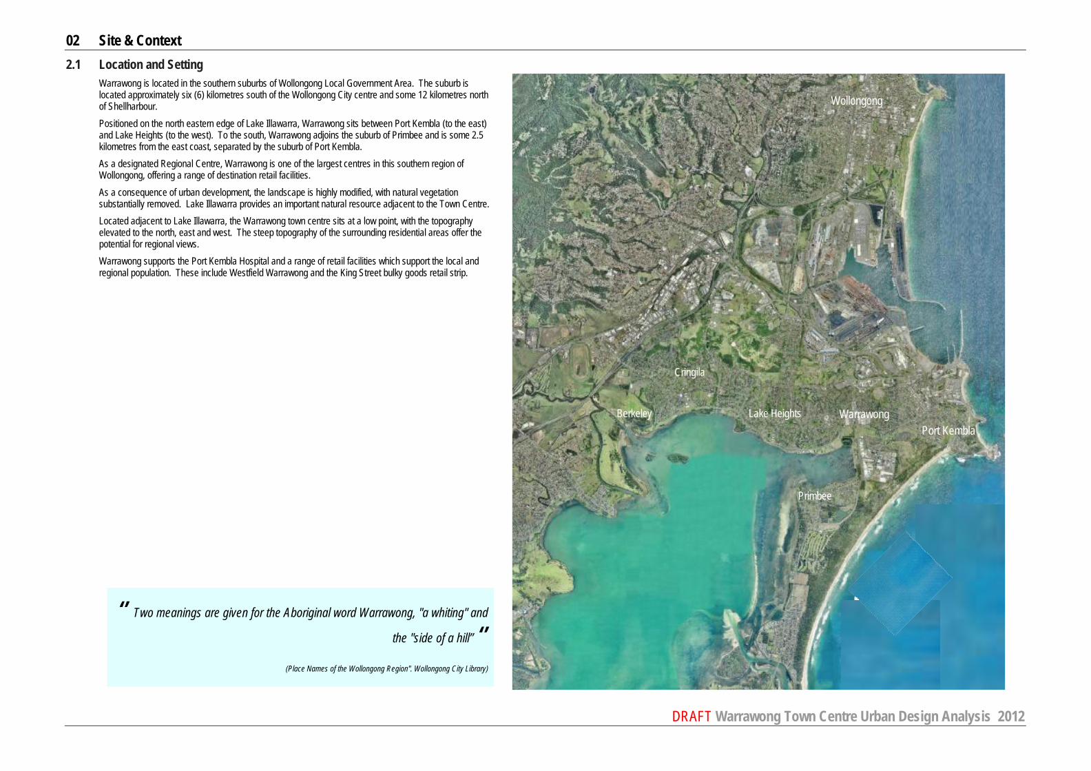
2.1 Location and Setting Warrawong is located in the southern suburbs of Wollongong Local Government Area. The suburb is located approximately six (6) kilometres south of the Wollongong City centre and some 12 kilometres north of Shellharbour. Positioned on the north eastern edge of Lake Illawarra, Warrawong sits between Port Kembla (to the east) and Lake Heights (to the west). To the south, Warrawong adjoins the suburb of Primbee and is some 2.5 kilometres from the east coast, separated by the suburb of Port Kembla. As a designated Regional Centre, Warrawong is one of the largest centres in this southern region of Wollongong, offering a range of destination retail facilities. As a consequence of urban development, the landscape is highly modified, with natural vegetation substantially removed. Lake Illawarra provides an important natural resource adjacent to the Town Centre. Located adjacent to Lake Illawarra, the Warrawong town centre sits at a low point, with the topography elevated to the north, east and west. The steep topography of the surrounding residential areas offer the potential for regional views. Warrawong supports the Port Kembla Hospital and a range of retail facilities which support the local and regional population. These include Westfield Warrawong and the King Street bulky goods retail strip.
Wollongong
Warrawong Port Kembla
Berkeley Lake Heights
Cringila
Primbee

02 Site & Context
DRAFT Warrawong Town Centre Urban Design Analysis 2012
Warrawong Town Centre
2.2 Defining the Study Area The Warrawong Town Centre is identified by retail land uses established along Cowper and King Streets and extends south to include the King Street bulky goods precinct. The centre has changed over time. The Warrawong Town Centre is defined by a concentration of retail and commercial uses along King Street and Cowper Streets. The core area of the Centre includes sections of Greene Street and land along the northern side of Northcliffe Drive. The core study area is defined on the adjacent map. The Master Plan will propose specific design solutions and projects to guide future development to deliver high quality public domain, compatible building form and scale, appropriate land uses, and an efficient movement system and access for vehicles. Consideration will also be given to the interface of the town centre with adjacent open spaces south of Northcliffe Drive. A town centre does not sit or function in isolation. It is important to consider the Warrawong Town Centre in context of surrounding lands (conscious of their form and function), to ensure optimal outcomes can be achieved. The Warrawong Regional Centre ‘Support’ includes land on the periphery of the defined town centre, including retail lands, retail uses and community facilities which are in close proximity of the Town Centre. This area has been defined to ensure that appropriate links, associations and opportunities of land outside of the Warrawong Town Centre are considered as part of this study. These periphery lands include Lake Illawarra foreshore, King Street bulky goods retail strip, specialty services (such as health and medical facilities), civic, community and residential uses (including detached dwellings and townhouses). While this study does not propose built form outcomes for lands outside of the Warrawong Town Centre, it considers the future relationship of this land with the town centre. These periphery lands provide a transition between the higher intensity function and scale of the town centre and surrounding residential and recreation uses. Key elements of the support area include: – King Street bulky goods retail corridor – Port Kembla Hospital – Surrounding residential lands\ – Lake Illawarra Foreshore interface (at the Northcliffe Drive and King Streets intersection) – Coomaditchie Lagoon – Darcy Wentworth Park and Noel Mulligan Oval and Warrawong Library. The largest area of parkland within the town
centre located adjacent to a newly relocated community library. The Study and urban form options will consider design strategies and principles that these periphery areas can adopt to promote cohesion with the Warrawong Town Centre.

02 Site & Context
DRAFT Warrawong Town Centre Urban Design Analysis 2012
King Street is the major north south road dissecting Warrawong.
King Street is an RTA Classified Road. Land uses established along King Street vary from residential (north of Turpin Avenue); to a mix of retail uses (from car yards and service stations to small tenancy retail); to open space (south of Northcliffe Drive). The King Street bulky goods retail strip defines the south eastern side of King Street. The amenity of King Street is compromised by the highly trafficked vehicle corridor. No on street parking is permitted. While footpaths are serviceable, they are outdated and do not always provide adequate kerb ramps. North of Cowper Street (generally to Greene Street), a continuous awning is provided on both sides of King Street. Buildings are typically one and two storeys with some three storey elements. Buildings do not define or activate the street. Levels above ground appear to have limited occupation or activation. The Westfield’s site has a substantial frontage to both King and Cowper Streets. This building does not address King Street nor does it achieve an active frontage. North of Greene Street, the form and use of buildings results in limited street address and activation (car yards, service stations, fire station and medical practices). Along this section of King Street, pedestrian paths are interrupted by vehicular crossings. The median strip along King Street (north and south of Cowper Street intersection) has a pedestrian safety fence to restrict pedestrians crossing the road resulting in poor east/ west connectivity for pedestrians. North of Turpin Avenue, King Street is characterised by single and two storey residential development. There is no defined entry or gateway to the town centre from the north or south along King Street. There is evidence of established street trees in isolated locations adjacent to the Westfield’s boundary and at the corner of King and Northcliffe Drive. Signage along King Street dominates the streetscape. Signage is not coordinated, and is of varying finishes and forms.
Photos 1. Southern view along King Street from
Turpine. 2. Southern view along King Street from
Turpine. 3. King Street – looking South. 4. Retail established along King Street
(north of Cowper Street intersection). 5. King Street residential (looking north). 6. King Street bulky goods retail (looking
north). 7. Medical centre - eastern elevation. 8. Awning and small retail tenancies
established on western elevation, north of Cowper Street intersection.
9. Eastern Streetscape, north of Cowper Street intersection
9.
1.
8. 7.
6.
5.
4.
3.
2.

02 Site & Context
DRAFT Warrawong Town Centre Urban Design Analysis 2012
Cowper Street forms the key east west corridor of the Warrawong Town Centre. Development established along the northern side of the street is characterised by a continuous strip of two storey development, with smaller retail tenancies at ground level, addressing the street. A continuous awning is established along the northern streetscape. The southern side of the street comprises Westfield’s (eastern part) and the Bunnings and Liquor Land buildings (western part) which provides limited activation of the street. These larger buildings are generally set back from the street. Footpaths along Cowper Street are established, and are functional, however they do not provide accessible movement through the town centre, with steps required to access retail tenancies and poor quality kerb ramps. The eastern end of Cowper Street has a pedestrian barrier restricting pedestrian crossing of the road to one crossing point – adjacent to Westfield’s. Cowper Street is four to six lanes (total) and supports substantial traffic movements connecting vehicles to King Street. On street parking is available along the majority of the northern side of Cowper Street. A bus stop and taxi stand are established at the southern side of Cowper Street, adjacent to Westfield’s. There is evidence of established street trees in isolated locations – adjacent to the Westfield’s development.
Photos 1. Eastern view toward the Hospital. 2. King and Cowper Street intersection,
easterly view. 3. Westfield’s under croft adjacent to bus
stop and taxi stand. 4. Cowper Street retail strip – looking
west. 5. Eastern view along Cowper Street. 6. Cowper Street - Northern elevation. 7. Cowper Street pedestrian crossing. 8. Looking west along Cowper Street
toward the Hospital (west of King Street).
9. Retail established along northern elevation (west of King Street).
10. Retail established at the north western corner of Cowper and King Streets.
11. Bunning’s established along the southern elevation of Cowper Street (west of King).
1.
3.
2.
5.
4.
6.
7.
8. 9.
10.
11.

02 Site & Context
DRAFT Warrawong Town Centre Urban Design Analysis 2012
Greene Street
Greene Street supports a range of community and residential uses, with the Community Centre and Legal Centre located on the southern side of the street with residential along the north (eastern end). Limited activation of the street frontage is achieved with buildings set back and not addressing the streetscape. On street parking is provided on both sides of the road. Street tree planting is established on the northern side of the street, adjacent to residential uses.
Northcliffe Drive Northcliffe Drive is poorly activated, with Westfield’s back of house and car parking established along this major thoroughfare. There are substantial areas of open space and active recreation lands established along the southern side of Northcliffe Drive in the form of Darcy Wentworth Park, as well as recreational and vacant lands adjacent to Lake Illawarra. On the northern side of Northcliffe Drive, Westfield’s, Bunnings and McDonalds dominate the streetscape, with substantial areas of car parking and loading docks which do not provide any activation of the public domain. Built form is ad hoc and dominated by Westfield’s and Bunnings developments. Pedestrian access is provided in some locations, with limited amenity. There is poor pedestrian movement available, with crossing only available at the main King Street intersection. A triangular open space has been established adjacent to the King Street intersection ‘Lions Park’ which is not utilised.
Photos 1. Greene Street – looking west. 2. Greene Street – eastern perspective. 3. Community Centre. 4. Northcliffe Drive – looking west from King Street
intersection. 5. Northcliffe Drive – western perspective from
Westfield’s vehicular entry. 6. Westfield’s external stairs fronting Northcliffe Drive. 7. Westfield’s vehicular entry – eastern perspective. 8. Northcliffe Drive – eastern perspective.
1.
2.
3.
5.
4.
6. 7. 8.

02 Site & Context
DRAFT Warrawong Town Centre Urban Design Analysis 2012
Laneways provide north south links through the Town Centre. Laneways have limited activation, with typical ‘back of house’ functions. Laneways are used for both formal and informal on site parking, delivery and loading docks and for garbage storage. Mowbray Lane and Lane 130 are dominated by service and staff vehicles and are poorly designed with limited or no vehicle turning areas. The northern end of Mowbray Lane (at Montgomery Avenue) is in part activated by a small courtyard in the pub. Lane 129 provides access to the medical practices established along King Street with the northern end of the Lane dominated by a blank brick wall. Laneways provide important mid block north / south pedestrian movement corridors, but provide an unsafe environment with evidence of graffiti and anti social behaviour. There are two pedestrian only laneways established. One sits at the north of the Town Centre, linking pedestrians from King Street to Bent Street. The second (Lane 127) runs north south, parallel to King Street, linking this northern pedestrian link to Greene Street. These lanes are poorly lit and are not activated, and do not provide a safe environment.
Photos 1. Retail tenancies on western side of Montgomery
Lane. 2. Lane 130 provides informal parking; back of
house; and loading/ garbage storage facilities. 3. Pub on Montgomery Lane. 4. Lane 130. 5. Lane 129. 6. Lane 127. 7. Pedestrian lane linking King Street to Bent Street. 8. Lane 127 extending south of Greene Street. 9. Lane 127. 10. Lane 127 on site parking areas.
1.
2.
3.
5.
6.
4.
7.
8.
9. 10.

02 Site & Context
DRAFT Warrawong Town Centre Urban Design Analysis 2012
2.3 Historic Context Aboriginal sites are located throughout all landforms within the Illawarra Region from the coastal strip to the sandstone plateau (Wollongong City Aboriginal Heritage Planning Study, 1995). While there are no items or areas of Aboriginal heritage listed within the immediate Warrawong Town Centre, there are areas identified to likely have Aboriginal heritage significance in proximity to the town centre. The Commaditchie Lagoon has strong connections with Aboriginal community. The Coomaditchie United Aboriginal Corporation is based in the old Kemblawarra Community Hall and are custodians of the Coomaditchie Lagoon. Lake Illawarra, the Commaditchie Lagoon, Hill 60 and the coastline are all areas which offer Aboriginal heritage significance. Since the time of European heritage, the area of Warrawong has been known by various names including ‘Steeltown’, ‘Kembla Estate’, ‘New Kembla. Originally this region was a large land grant used for grazing cattle and growing crops. With the establishment of the Electrolic Refining Smelting Company and the construction of a steelworks in Port Kembla, Warrawong became a residential settlement for workers and their families from the mid-1930s. By the late 1960s, Warrawong was a major town in the area supporting a significant shopping centre and the largest hospital on the south coast. Today, Warrawong is designated as a regional centre which provides services and facilities to the local community and neighbouring towns. 1816/17 Surveyor General John Oxley marked out the first three large land grants in the region. Warrawong and Port
Kembla were situated as part of David Allen’s 2,200 acre grant named ‘Illawarra Farm’. Allen grazed cattle and cleared 600 acres of the grant.
1828 ‘Illawarra Farm’ sold to William Charles Wentworth 1880s D’Arcy Wentworth inherited this land grant. Growing crops - wheat, oats and potatoes - around the lake, fishing
and dairying were the main industries. 1883 The first shipment of coal on the ‘S.S. Arawata’ departed Port Kembla 1890s Attempts were made to make Lake Illawarra a sea port. The project was abandoned in 1902 due to the
ongoing problem of sand blocking the lake entrance channel. 1895 Decision made to develop Port Kembla as the deep water port for southern coalfields rather than the smaller
Wollongong Harbour. 1907 Electroylic Refining and Smelting Co began operations at Port Kembla. 1927 Australian Iron and Steel reached an agreement with the State government to build a steelworks at Port
Kembla. This company merged with BHP in 1935. 1934 First houses were built in Steeltown (Warrawong) 1935 Wentworth IV subdivided part of his land to be sold. This included some unusual features for the time such as
wide streets, kerb and guttering and underground drainage. Wentworth also granted 4 acres of land for ‘Steeltown’ (Warrawong) Public School located in Flagstaff Road. The school transferred to Cowper Street in 1946.
1936 ‘Steeltown’ (Warrawong) had a Post Office, a Public School and the first shop in the shopping centre opened. 1939 Open Hearth Hotel, King Street Warrawong built by the Wentworth family as a boarding house to provide
accommodation for Commonwealth Rolling Mills engineers and their families, it be came a hotel in 1948. 1940s St Andrews Anglican Church built (demolished 1999) and Odeon Theatre opened. 1960 Warrawong shopping centre opens and the prominent landmark Port Kembla smoke stack owned by ER&S is
constructed to a height of 650 feet. 1965 Port Kembla District Hospital on Cowper Street designed by Government Architect E.H. Farmer was opened. It
was the biggest hospital on the south coast and cost almost £2 million. 1972 Gala Cinema established by owners the Waghorn family and Warrawong High School opens 1988 Westfield Shoppingtown opens including Hoyts cinema complex and the library 1988 Bulky Goods precinct along King Street established
Warrawong … Source Illawarra Images, Wollongong City Library website
03 PLANNING POLICY CONTEXT

03 Planning Policy Context
DRAFT Warrawong Town Centre Urban Design Analysis 2012
3.1 Introduction
This section of the report provides an overview of relevant strategic planning policy in context of the outcomes of this Study.
3.2 Illawarra Regional Strategy 2006 – 2031
The Illawarra Regional Strategy applies to the local government areas of Kiama, Shellharbour and Wollongong. Prepared by the Department of Planning in 2007, this Strategy aims to ensure adequate land is available and appropriately located to sustainably accommodate the projected housing and employment needs of the Illawarra Region over a 25 year period. The Strategy designates a hierarchy of centres throughout the Illawarra Region, mapping employment lands; new release areas; rural and natural resource areas; biodiversity outside of conservation areas; and extractive mineral resources. Warrawong is designated as a Major Regional Centre. It is noted that Warrawong town centre is an important commercial and retail centre (particularly in relation to bulky goods) and that this role is to be maintained. A Major Regional Centre is identified to be: A concentration of medium to high density living, business, employment, professional services, department stores, specialised shops including discount department stores and associated warehouses, transport logistics and bulky goods operations. Focal point for subregional road and transport networks and servicing for a number of districts. (refer Illawarra Regional Strategy Map) Shellharbour City Centre is also designated as a Major Regional Centre. It is noted that: Shellharbour City Centre has grown rapidly over the last 30 years. It plays an important role in servicing the southern part of the Region. As the current residential estates reach completion, the focus for Shellharbour will shift towards urban renewal opportunities. (refer Illawarra Regional Strategy Map). Dapto is designated as a planned Major Regional Centre. Dapto – With revitalisation and consolidation, Dapto town centre has the potential to develop into a Major Regional Centre. Residential growth at West Dapto and development of employment land at Kembla Grange will support this new role. (refer Illawarra Regional Strategy Map). The industrial and retail lands within Warrawong town centre are designated as Employment Lands by the Strategy. It is noted that these sites are to provide a range of employment activities and will be protected by avoiding fragmentation or rezoning to non-employment related uses.
3.2.1 Economic Development and Growth
The Illawarra Regional Strategy outlines the key functions of Warrawong as a Major Regional Centre as: A concentration of mid to higher density living, business, employment, professional services and specialised shops, including discount department stores and associated warehouses, transport logistics and bulky goods operations. Focal point for subregional road and transport networks, and servicing a number of districts.
Warrawong is already of a significant size with respect to its commercial and retail capacity. With its proximity to Wollongong City Centre, any further major expansion of its retail and commercial functions needs to be evaluated against the potential impacts on the retail capacity of Wollongong City Centre. It has a significant role as a major bulky goods centre for the Region. (refer page 16)
It is noted that the land around the Warrawong town centre, including the industrial lands and retail bulky goods to the south, and Port Kembla to the north, support Employment Lands.

03 Planning Policy Context
DRAFT Warrawong Town Centre Urban Design Analysis 2012
3.3 Wollongong Local Environmental Plan 2009
The Wollongong LEP 2009 is the statutory planning document that sets the framework for the land use structure within the Local Government Area, including Warrawong. The plan includes a set of land use zones and provides requirements for development. It also establishes what types of development may be permitted on a particular parcel of land with the consent of Council. The aims of this plan are:
- encourage business and economic development, - encourage a range of housing choices, - improve the quality of life, and - conserve and enhance our significant landscapes, flora and fauna and heritage
3.3.1 Permissible Zoning – LEP 2009
The majority of land within Warrawong Town Centre is zoned Commercial Core (B3, blue). The western end of Cowper Street is zoned for Mixed Use (B4, purple) and the retail bulky goods precinct along King Street has an Enterprise Corridor zoning (B6). Land adjacent to Lake Illawarra is zoned Tourist and Public Recreation. Darcy Wentworth Park is also zoned Public Recreation.
Residential lands surrounding the town centre are typically Low Density Residential. One Medium Density site is identified adjacent to the north eastern end of the town centre
Permissible land uses within each zone are outlined over page.
3.3.2 Permissible Building Height
The height of established buildings across the Town Centre are typically two storey, with some single and three storey buildings interspersed. The permissible building heights prescribed by Wollongong LEP 2009 are defined in the map below. Permissible heights range from 24 metres in the commercial core (pale pink), to 20 metres along the Lake Illawarra foreshore for lands zoned Tourist (brown), and down to 9 metres for the Mixed Use zoned lands and surrounding Low Density Residential lands (green). The King Street Bulky Goods corridor has a height limit of 11 metres.
3.3.3 Permissible Floor Space Ratio – LEP 2009
The floor space ratio permitted across the Warrawong Town Centre vary from 2.5:1 for the central commercial lands, to 0.75:1 for Mixed Use lands and 1.5:1 for land zoned for Tourist. The Enterprise Corridor lands, being the King Street bulky goods has a permissible floor space ratio of 0.5:1. Surrounding residential floor space ratios is predominantly 0.5:1 with pockets up to 0.75:1.
3.3.4 Permissible Lot Size– LEP 2009
Lot sizes are not prescribed for the majority of the Warrawong Town Centre. The western end, zoned to support mixed uses has a maximum lot size of 449 square metres, and the King Street bulky goods precinct has a maximum lot size of 3,999 square metres. Residential lands surrounding the Town Centre have a minimum permissible lot size of 449 square metres.
3.3.5 Hydrology
Warrawong town centre is located in a low-lying area adjacent to Lake Illawarra. A significant portion of the town centre is prone to flooding, particularly the west side of King Street between Northcliffe Drive and Green Street.

03 Planning Policy Context
DRAFT Warrawong Town Centre Urban Design Analysis 2012
3.3.6 Acid Sulfate Soils
Lands classified as acid sulfate soils are identified within and adjoining the Warrawong Town Centre. Any lands classified as potentially contaminated require development consent and certain works would require an Acid Sulfate Soils Management Plan. While this is an issues which would need to be considered in the future development of lands, it does not affect the urban form outcomes or design opportunities.
3.3.7 Bushfire Prone Land
Bushfire prone land is limited to a category 2 prone area southwest of the major intersection of Northcliffe Road and King Street Warrawong, approximately between 200 – 400 metres from the town centre. This bushfire prone land is located on open space highly vegetated with mature trees and shrubs within close proximity to the shore of Lake Illawarra.
3.3.8 Contaminated Lands
Contaminated lands within the town centre are confined to a few small pockets including the funeral parlour and Bunnings outdoor garden area located on Cowper Street, a small lot located in Westfield’s which is incorporated into the building and a strip of commercial/retail premises including a service station and the fire station on the west side of King Street north of Green Street. Contamination is not considered to inhibit or restrict the urban form opportunities of the Town Centre.
3.4 Wollongong Development Control Plan 2009
The Wollongong DCP provides guidelines and controls for development within the whole of the Wollongong Local Government Area. Part B4 of the DCP contains guidelines on the development within Business Zones, the hierarchy of centres and broad place-based requirements for these centres. Section 5.2 focuses on the Warrawong Major Regional Centre including precincts within the town centre. These precincts outline present and potential future land uses and types of development. Floor space ratios, setbacks, parking and access is also addressed for each precinct. The DCP promotes a range of heights across the town centre area, from 3 storeys at the northern end (along King Street), to 8 storeys on the Westfield’s site, with floor space ratios ranging from 1.5:1 to 2.5:1. These vary from the LEP controls. Street activation, setbacks and vehicular access are specified by Precinct. This Study will inform the review and, if necessary, amendment of these controls.

03 Planning Policy Context
DRAFT Warrawong Town Centre Urban Design Analysis 2012
3.4 Illawarra Transport Planning Principles (2003) The Illawarra Transport Taskforce prepared these principles in 2003 in order to assist decision makers, planners and the development industry develop plans which facilitate transport choice and reduce travel distances. The following principles have been integrated into the study.
- Concentrate in centres. Locate the centres within a walking distance of 400 metres of the junction of major bus routes.
- Mix uses in centres - Plan and design to support public transport - Provide and improve pedestrian access - Provide and improve cycle access - Manage parking supply - Provide efficient low impact freight movement - Provide and improve access to education and public facilities .
3.5 City of Wollongong Bicycle Plan 2006 – 2011 This plan was created to provide strategic direction regarding existing and proposed cycleways and bicycle facilities within the Wollongong Local Government Area. This plan encourages active transport options such as public transport, walking and cycling to reduce short car journeys and therefore contribute to a more sustainable community. This plan sets out eight goals:
- To facilitate bicycle network development - To facilitate bicycle network maintenance - To create safer training routes for competitive and longer ride cyclists - To improve bicycle parking facilities, shower and locker amenities - To promote cycling as a healthy activity and a viable alternative transport options - Raise safety awareness among cyclists and road users - Improve bicycle tourism opportunities - To develop partnerships with key organisations to promote and fund cycling routes
The goals of the Plan have been considered in the progression of this study, underpinning the key urban design principles. 3.6 Moving Together (2009)
This document, prepared in 2009 by Bitzios Consulting, prepared on behalf of Council, outlines goals for the next 5 years and 25 years and will impact upon the future planning, development, employment, population settlement and growth strategies for the region with the objective to inform and reflect policy and investment decisions that support the region. The following six strategies are outlined:
- Transport and land use are integrated in order to: - Identify corridors where higher density and mixed development can be encouraged to support public
transport corridors and nodes. - Develop new urban growth areas in line with existing or planned transport infrastructure - New transport infrastructure and new public transport services to be delivered in sequence with new urban
growth areas - A mix of housing, employment, retail, services and public facilities accessible at town centre - Education and other public facilities are highly accessible by non-motorised modes.
- Economic development is supported and encouraged
- Encourage adoption of more flexible working arrangements to reduce number of trips but increase business daily operating hours
- New urban growth areas must be planned and delivered as integrated communities with access to employment locations
- Manage parking supply in activity centres to promote public and active transport - Social inclusion and equity is enhanced - Public transport provision supports residents without access to private vehicles - Active transport travel options are encouraged and supported with walkable environments that are suitable
for people with disabilities and also on and off-road cycle routes with priority - Transport system is optimised and infrastructure decisions deliver ‘value for money’ - Transport network upgrades support the most efficient movement of people and goods - Improve decision making, planning, evaluation and funding
- A safe and secure transport network - Targeted investment to improve personal security for pedestrians, cyclists and public transport passengers - Ensuring the transport network is resilient - Reducing the dependence on non-renewable energy sources
- Environmental impacts of the transport system are minimised - Encouraging alternative modes of transport for short to medium length trips - Protecting natural resources through design - Protecting liveability and amenity
The key principles underpinning the urban design review and revitalisation of the Warrawong town centre are to remain consistent with the six identified strategies.
3.7 Wollongong Planning People Places: A strategic framework for open space, recreation facilities and
community facilities (2006) Prepared by Suter and Associates Leisure and Tourism Planners in 2006 for Council, this document was prepared to provide a strategic direction for open space, key recreational facilities and indoor sport and recreation centres and key community facilities. This 20 year strategy document will guide Council in its future policy and decision making, resource allocations and provide a framework for partnerships with the community and other levels of government. The Warrawong town centre is identified within Area 7 – Berkeley, Cringila, Lake Heights, Port Kembla, Primbee, Warrawong and Windang The relevant Strategic Directions outlined for Area 7 are outlined below:
- Enhance the quality and appeal of open space around Lake Illawarra - Review the provision of playgrounds. Consider whether any should be consolidated, whilst maintaining a good
spread of facilities within a reasonable distance of local areas - Initiate and strengthen projects that support lower socio-economic groups and Aboriginal communities - Focus on improving the quality and accessibility of existing open space and facilities - Open space lacking in Warrawong suburb. - Low supply of tennis courts and may need to consider additional facilities - - Key Actions were identified by Wollongong Planning People Places which are relevant to establishing principles
and vision for the Warrawong town centre: - Continue to plan for, establish and maintain district foreshore settings that provide a focus for recreation
including Lake Illawarra King Street Foreshore Heritage Park - Maintain and strengthen the trail links around Lake Illawarra

03 Planning Policy Context
DRAFT Warrawong Town Centre Urban Design Analysis 2012
- Opportunities to obtain smaller areas of land in suburbs such as Warrawong which lacks local and neighbourhood parks
- Lack of provision for young people. Need to consider opportunities and youth facilities to cater for Port Kembla and Warrawong areas
- Incorporate art and culture in the design of buildings and places in accordance with broader design principles - Improve quality and access to sites around Lake Illawarra - Possible Demand Implications - Likely demand for a range of places and facilities to support different age and interest groups (areas that are
not family orientated as well as family orientated) yet there is a very high supply of community facilities in each suburb. Should consider rationalisation or alternative use where there is duplication in suburbs
- Likely demand for facilities and services to support older people (affordable) - The number of children and young people will justify facilities for these age groups - Potential cultural interests and needs, e.g. community gardens, places for social gatherings - Affordability is likely to be a key issue particularly for one parent families, people who are unemployed and
older people - People could need recreation and community activity opportunities due to time availability. However, they may
not have the resources to do so. - Likely demand for facilities and services to support Aboriginal and Torres Strait Islander people - Likely demand for outdoor spaces for people living in flats, units and apartments. Warrawong lacks a local park. - A larger proportion of households will be constrained by a lack of private transport
The findings of Wollongong Planning People Places remain relevant. The full range of key issues and actions identified by Wollongong Planning People Places need to be recognised by, and underpin the Warrawong Regional Centre Review.
3.8 Wollongong City Housing Strategy (2005) SGS Economics and Planning were commissioned by Wollongong City Council in 2005 to prepare the Wollongong City Housing Strategy. The purpose of this study was to provide future strategic direction and inform subsequent planning instruments including the Wollongong Local Environmental Plan 2009 and the Wollongong Development Control Plan 2009. The objective of this study was to provide a mix of housing choice for a broad demographic range including the provision of opportunities for affordable housing now and in the future. Aims for the City include:
- Urban consolidation with an emphasis on areas with a high level of access to urban goods and services. This includes looking at live-work policies which consider ways in which mixed use space can be ensured for the future (eg shop top housing).
- Provide housing diversity that caters for all segments of Wollongong society, through the provision of accommodation that is affordable, accessible, and suited to the needs of all groups within the community, including those that are disadvantaged in the housing market. This includes developing an’ Older Persons Housing Strategy’ and a ‘Homelessness Strategy’.
- Regenerate degraded housing areas to provide a safe and attractive environment within which communities can prosper by Council working together with the Department of Housing, and developing policies to address issues such as urban design guidelines, lighting and surveillance.
- To enhance community capacity in Wollongong to contribute towards community development through developing a Communication Strategy for engaging the community in the decision-making surrounding the development of their neighbourhood and also developing a Housing Advocacy Programme.
3.9 Development & Active Living (2010) This document was prepared by James Lette, BBC Consulting Planners and Dr Danny Wiggins for the Premier’s Council for Active Living NSW in June 2010. The purpose of this document was to assist councils in implementing Active Living policies within existing or new policies and assist with design to promote Active Living in development proposals. Development and Active Living highlighted the following principles:
1. Walkability and Connectivity –potential destinations and walking and cycling catchments should be identified and contributions made to the network to encourage people to walk.
2. Active travel alternatives – consideration should be given to managing parking demand, promote the use of public transport, cycling and walking.
3. Legibility – the location of facilities and direct routes including clear signage of landmarks, public transport stops and timetables and directions to walking/cycling routes to promote wayfinding.
4. Quality Public Domain – consideration of Crime Prevention through Environmental Design (CPTED) principles can provide safe walking and cycling environments (day and night). Attractive streetscapes with appropriate planting and well designed local open space and community facilities are required in order to create attractive destinations.
5. Social Interaction and Inclusion – physical environments should encourage people meeting together and be inclusive of all ages, ethnicities and ability levels. This includes active street frontages and communal areas with a range of facilities.
3.10 Healthy Urban Development Checklist (2009)
This document was prepared by NSW Health Department and Sydney South West Area Health Service with the purpose of providing a development checklist that will guide future urban planning and early large-scale development to positively impact upon the health of the community. Four key principles that guide the development and implementation of this checklist include:
1. Equity – access to all aspects of a community is fair to all residents regardless of socioeconomic status, cultural background, gender, age or ability. Urban development policies and plans need to recognise the importance of equity and ensure new and existing communities have access to a range of facilities and services.
2. Early engagement – the ability to consider health issues at the initial stages of a development project’s inception is an effective approach.
3. Interdependence – it is important to maintain an understanding of the links between elements of the space and interaction with this space. Such factors include transport access to work, education, health services, recreation and opportunities for social interaction.
4. Building partnerships – cross-sectional partnerships between health workers and planners is essential to ensure relevancy and beneficial outcomes in the long term.
3.11 Draft Centres Design Guidelines (2011)
These guidelines were prepared by the NSW Department of Planning in 2011 to improve the form and function of existing and identified new centres. It identifies principles of urban design and planning that can deliver attractive, sustainable and liveable centres and set a benchmark about what is good design for centres. In developing this report, the intent and concepts within this document have been applied.

04 ANALYSIS

04 Analysis
DRAFT Warrawong Town Centre Urban Design Analysis 2012
4.1 INTRODUCTION This section of the report provides an analysis of a range of built form, structural, environmental and social issues relevant to the Warrawong Town Centre.
4.2 Road Hierarchy
King Street, running north south is an arterial road which supports four lanes of traffic between Turpin Avenue and Northcliffe Drive, and six lanes of traffic north of Turpine Avenue and south of Northcliffe Drive. Cowper Street and Northcliffe Drive are sub arterial roads connecting east/ west traffic links.
Pedestrian links are focussed around signalled intersections. Two pedestrian crossing points are identified along King Street north of Cowper Street to provide for east west crossing, however, the majority of King Street has restricted pedestrian crossing points with a pedestrian barrier running along King Street. Cowper Street, east of the King Street intersection has restricted pedestrian crossing points with a barrier fence established in the median strip. Two pedestrian only laneways are identified, however one of these is understood to have been sold to the Housing NSW (Lane 127).
AECOM were commissioned by Wollongong Council to undertake an Access and Movement Study (Stage1 Issues Report June 2010). The purpose of this study was to identify current and future access and movement issues within Warrawong Town Centre for all modes of transport. The main issues identified in this report with regard to the road hierarchy, traffic and parking are outlined below. Traffic
- King Street/ Northcliffe Drive and King Street/Cowper Street intersections currently at or approaching capacity during peak hours.
- Vehicle congestion at schools in the area during school peak periods. - Lack of turn right opportunities for north bound traffic along King Street. - Lack of signage along King Street to retail and recreational areas and other services. - Direct property access causes high risk of rear end shunt type accidents along King Street. - Congestion on Cowper Street eastbound due to isolated pedestrian crossing point. - Lack of north-south road connections through residential areas particularly on the west side of King Street.
Walking
- Lack of formal footpaths in residential streets - King Street acts as a major barrier to east-west pedestrian movements with a limited number of crossing opportunities - Improvements could be made to improve the amenity of King Street/Cowper Street intersection which is the focus of
pedestrian movement in the town centre. Improvements to weathered pedestrian crossings and the lack of tactile paving is noted.
- Lack of street lighting along main pedestrian routes, such as Cowper Street - Potential future issues of lack of pedestrian linkages across King Street between the bulky goods strip on the east side
and the potential development on the Lake Illawarra Authority land on the west side - Pedestrian movement and safety risks at Greene Street/ King Street intersection and on Greene Street (related to the
public housing estate). - Poor pedestrian mid block crossings – north south.
Parking
- Underutilised off-street car parks outside peak hours and on-street parking on Saturday morning and Thursday evening
- Lack of off-street car park signage - Overflow parking issues around the Illawarra Regional Hospital - Over-supply of parking in the area can discourage use of public transport
Priorities for the Study
Review opportunities to soften the impact of traffic along King, Cowper and Northcliffe Drive Strengthen pedestrian links across streets within the town centre and to key destinations. Improve pedestrian links through town centre blocks.
04 Analysis
DRAFT Warrawong Town Centre Urban Design Analysis 2012
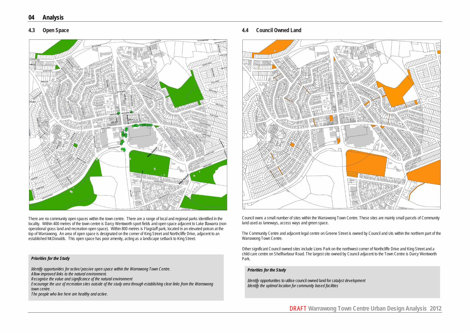
4.3 Open Space
There are no community open spaces within the town centre. There are a range of local and regional parks identified in the locality. Within 400 metres of the town centre is Darcy Wentworth sport fields and open space adjacent to Lake Illawarra (non operational grass land and recreation open space). Within 800 metres is Flagstaff park, located in an elevated poison at the top of Warrawong. An area of open space is designated on the corner of King Street and Northcliffe Drive, adjacent to an established McDonalds. This open space has poor amenity, acting as a landscape setback to King Street.
4.4 Council Owned Land
Council owns a small number of sites within the Warrawong Town Centre. These sites are mainly small parcels of Community land used as laneways, access ways and green space.
The Community Centre and adjacent legal centre on Greene Street is owned by Council and sits within the northern part of the Warrawong Town Centre.
Other significant Council owned sites include Lions Park on the northwest corner of Northcliffe Drive and King Street and a child care centre on Shellharbour Road. The largest site owned by Council adjacent to the Town Centre is Darcy Wentworth Park.
Priorities for the Study
Identify opportunities for active/ passive open space within the Warrawong Town Centre. Allow improved links to the natural environment. Recognise the value and significance of the natural environment Encourage the use of recreation sites outside of the study area through establishing clear links from the Warrawong town centre. The people who live here are healthy and active.
Priorities for the Study
Identify opportunities to utilise council owned land for catalyst development Identify the optimal location for community based facilities

04 Analysis
DRAFT Warrawong Town Centre Urban Design Analysis 2012
4.5 Public Transport
With Warrawong not located along any established train lines, public transport is heavily dependent upon bus routes and taxi availability.
Bus stops are located along the major roads within Warrawong including King Street, Northcliffe Road, Cowper Street and Shellharbour Road. Buses play a vital roll servicing the community residing in smaller towns in the vicinity of Warrawong including Lake Heights, Berkeley, Cringila, Port Kembla, Windang and Primbee. Limited shelters and seating is provided for waiting commuters.
An established shared bicycle and pedestrian route around Lake Illawarra encourages sustainable transport options. This pathway runs along Northcliffe Road and joins King Street at the major intersection diagonally opposite Westfields Shopping Centre within 400 metres of Warrawong town centre.
AECOM were commissioned by Wollongong Council to undertake an Access and Movement Study (Stage1 Issues Report June 2010). The Stage 1 report identified current and future issues for all modes of transport.
The key issues identified with regard to public transport and cycling are outlined below. Public Transport
- King Street is a strategic bus corridor, therefore potential for bus priority improvements in the long term - Lack of bus services to the south during summer bus timetable (4 months of the year). - Lack of facilities at bus shelters in terms of weather protection and a lack of routing information - Limited number of bus services after the evening peak period and perceived lack of security of bus stops and on
buses - Limited east-west road connections within the study area limits the opportunities to have more direct bus access to
Warrawong through other neighbouring suburbs. - Buses operating during the weekday afternoon and weekend mornings are currently under-utilised
Cycling
- Lack of cycle facilities, such as cycle parking, cycle signage formal and direct cycleways and formal crossing opportunities for cyclists particularly along King Street (north of Northcliffe Drive)
- Potential for cycling to and from work should be investigated; BHP currently has a cycle group - Lack of continuity of existing, off road cycle routes to connect the study area with major services, transport facilities
and surrounding suburbs. - Lack of formal and direct cycleways ( in particular, on road cycleways) within the area, in particular along King Street
(north of Northcliffe Drive)
Priorities for the Study
Identify optimal location for bus stops Investigate bus interchange opportunities Review bus Identify high-demand bus stops requiring a shelter and public outdoor furniture. To strengthen bicycle and pedestrian links between Warrawong town centre and Lake Illawarra.

04 Analysis
DRAFT Warrawong Town Centre Urban Design Analysis 2012
4.6 Topography
Warrawong is topographically a diverse environment with undulating hills to the north, west and northeast and the low lying Lake Illawarra to the southwest. This natural topography provides outlooks over to the town centre toward Lake Illawarra and the escarpment from the surrounding residential areas.
4.7 Consolidated Land Holdings
Understanding land ownership patterns is important in the implementation of renewal projects. Improving the urban environment often requires redevelopment, and this is typically inhibited by small land holdings which require amalgamation to achieve optimal height and floor space opportunities as well as on site parking and access requirements.
Small allotments located along King Street (north of Greene Street), are consolidated under single ownership to create larger land holdings. Westfield’s secure the largest land holdings, centrally within Warrawong Town Centre. Several small allotment ownership remains along Cowper Street (northern side).
Priorities for the Study
Maintain and promote existing view corridors and outlooks to low lying areas and Lake Illawarra. Identify new view corridors which can be achieved to improve the amenity of the town centre and surrounding residential areas.
Priorities for the Study
Promote urban form outcomes which can be achieved through current land ownership patterns. Identify opportunity for amalgamation where benefits to the urban form can be identified.

04 Analysis
DRAFT Warrawong Town Centre Urban Design Analysis 2012
4.8 Environmental Considerations
There are no items or features within the town centre which have been identified as being environmentally sensitive. Consideration has been given to environmental considerations in context of the wider environment and locality.
Coomaditchie Lagoon is the only remaining perched dunal lake in the Illawarra and is one of the primary breeding grounds of the endangered green and golden bell frog.
Four Endangered Ecological Communities (EECs) have been identified outside the Warrawong Town Centre. These include:
• A Coastal Sand Freshwater wetland of high disturbance on the northern side of Commiditchie Lagoon located less than 1 kilometre southeast of Warrawong Town Centre
• A Coastal Swamp Oak Forest has also been assessed as high disturbance located on the southeast side of Lake Illawarra opposite the bulky goods precinct located approximately 1.3 kilometres south of Warrawong Town Centre
• Estuarine Alluvial Wetland located adjacent to the Coastal Swamp Oak Forest included as a threatened community (no assessment has been determined regarding disturbance class)
• A Floodplain Wetland located at the northern end of Jackson Avenue (near the hospital) approximately 900m from the Town Centre (no assessment has been determined regarding disturbance class)
Threatened fauna have also been located within the Warrawong Town Centre and in close proximity of the centre including:
• Broad-Billed Sandpiper (a small wading bird) on the east side of Lake Illawarra opposite the Bulky goods area along King Street and also on the north side of the Lake approximately 1 kilometre from the Town Centre
• Freckled Duck and Swift parrot located near the corner of Montgomery and Churchill Avenues within the Town Centre • Green and Golden Bell Frog discovered in various locations surrounding the town centre including Coomiditchie
Lagoon, a park/former builders’ dump (approximately 600 metres northeast of the town centre) and neighbouring streets northeast of the Town Centre
Port Kembla has the most significant Illawarra population of the Green and Golden Bell Frog based on population size and area distribution. (Gaia Research Pty Ltd, March 2009). The Green and Golden Bell Frog (litoria aurea) is listed as an endangered species under Schedule 1 of the NSW Threatened Species Conservation Act 1995 and at a national level, the species is listed as vulnerable under Schedule 1 Part 2 of the Environment Protection and Biodiversity Conservation Act 1999. The Green and Golden Bell Frog have been identified at various locations in North Port Kembla including Boilers Point, Coomaditchie Lagoon, Inner Harbour, Korrongulla Wetland (Primbee) and as north as Wollongong Golf Club. This species can move over highly disturbed landscapes such as industrial areas, roads and grasslands hence it is critically important to consider the entire area where the frog exists for the conservation of the Port Kembla Green and Golden Bell Frog population. (Gaia Research Pty Ltd, March 2009) More than 12 sightings of this endangered species have been noted in and around Warrawong Town Centre as noted above as a threatened fauna. A White-flowered Wax Plant which is identified as a threatened flora has been located outside the town centre (west of the hospital).
Natural Resource Sensitivity – no natural resource sensitivity areas have been identified within the existing built-up town centre. However some small areas of sensitivity do exist around Lake Illawarra and surrounding Coomiditchie Lagoon (approximately 1 kilometre northeast of the town centre). Those areas noted as sensitive within the vicinity of the Lake include the grassland/wetland on the north side of the lake south of Northcliffe Drive and further south of the town centre opposite the bulky goods precinct on the eastern side of the Lake (approximately 1 kilometre south of the town centre).
4.9 Economic Considerations
The core catchment for Warrawong is defined by HillPDA (2004) as containing around 36,000 people. Typically core catchments of such a size contain 2-3 supermarkets and a discount department store. Westfield Warrawong provides 2 supermarkets and two discount department stores. According to HillPDA the centre has a total of around 54,000 square metres of retail floorspace. This is high for a catchment of 36,000 people. Given that growth projections in the catchment are modest with most of the growth in the region occurring outside the core catchment area and subject to the competitive influences of other centres, a retail-only revitalisation strategy is not available for the town centre based on catchment growth. There are a number of factors which have influenced the decline of the Warrawong town centre, these include the access-denied nature of the major regional arterial of King Street; the internalisation of Westfield Warrawong; the introduction of competing retail in the region; and local employment decline. It will be important to consider indirect strategies that improve the image, context and capacity of the town centre, requiring the evaluation of long term strategies that change the basis under which the town performs; structural changes to relationships within the town centre; catalysts outside of retail expansion that may improve the dynamics of the centre. The Westfield, and Town Centre’s performance suffers from poor context and urban setting. It also suffers from a low socio-economic catchment profile. A part of the reason for this profile is the poor urban setting of the town centre that has in part been caused by the mall. Therefore a balance needs to be found between the amenity depleting characteristics of the mall and a more active and attractive town centre. The town centre has an eclectic mix of retailers and businesses. Given the nature of King Street and the dynamics imposed by the RTA and the poor design interface of Westfield’s, it is unlikely that any meaningful relationship could be developed between the two sides. The town does have two very high quality food service operators, being a signature deli and signature butchery. Both of these operators would not be out of place in any fashionable or high amenity location. These operators sit on Cowper Street opposite the main pedestrian mall entrance. The best opportunity for a redesigned relationship with Westfield exists around this Cowper Street entrance, and to an extent these retailers can provide some of the inspiration for change. The centre has a reasonable street pattern with rear lanes and a modified rectilinear grid. The land use transition between retail and commercial and residential is quite hard with little commercial activity found outside of the core blocks of the centre. If Warrawong wishes to improve its overall performance as an economic and social facility for the community then the urban qualities that come from active public realm, need to be improved. This means that controls are required over the way Westfield’s responds to the town centre now and in the future. If these controls are not in place then Warrawong’s future is simply a continuation of what can be seen today. The challenge for the future planning and development of the Warrawong centre is to foster a process of consolidation, rather than dispersal and fragmentation and implement a more cohesive strategy to enhance overall environmental amenity of the centre at large. It is therefore recommended that:
Priorities for the Study
The emphasis for the Warrawong Town Centre Review is to identify ways to consolidate and enhance the established retail lands/ business lands within the Town Centre. Special emphasis be directed towards a consolidation of discrete precincts for retail activity and peripheral sales, rather than a continued expansion. Enhance building form and public domain to support improved retail and commercial facilities. Identify opportunities to renew and improve retail and commercial stock without increasing supply/ capacity of the retail floor area. Review and identify improvements to access and movement between retail and commercial facilities in Warrawong, and the broader region. Ensure that any identified opportunities for renewal of retail floor space within the Warrawong Town Centre are assessed with regard to potential impacts upon the viability of Wollongong City Centre. Review opportunities to renew retail occupancy and to promote a diverse and vibrant mix of businesses. Further planning should acknowledge that the future demand for floor space will most likely be focussed on and around Dapto Town Centre.
Priorities for the Study
Investigations are to take into consideration the wider impacts of development on the contextual environment.

04 Analysis
DRAFT Warrawong Town Centre Urban Design Analysis 2012
4.10 Social Considerations
Source: ABS Census of Population and Housing, 2006 Warrawong and the southern suburbs have a diverse resident population. The local community is diverse, supporting a mix of cultures, socio economic status, employment and languages. Statistically, Warrawong supports a disadvantage community. It is essential that the town centre which supports the southern suburbs and in particular Warrawong population meets their needs, and is focussed on enabling the local community to use and access facilities that are a priority to them.
Warrawong has the highest level of socio-economic disadvantage in NSW with a SEIFA Index Score of 747. This index measures the level of disadvantage in terms of income, high unemployment and low levels of education.
Warrawong has a high unemployment level of 19.1% compared to 7.6% for the Wollongong LGA.
Almost 40% of the population were born overseas compared to 22% for the Wollongong LGA making it one of the City’s most culturally diverse suburbs.
Approximately 44.2% of the population speak another language at home compared to 16.2% for the entire city.
In 2006 43.4% of the Warrawong population were renting compared to 28.4% for the Wollongong LGA
Warrawong has an ageing population. Approximately 1 in 5 people (20.9%) are between 65 and 84 yrs of age compared to 13.8% for the Wollongong LGA.
Warrawong has a significant percentage of households with no vehicles. 30.5% of households have no vehicle compared to 12.8% for the Wollongong LGA
Approximately 27% of households or 1 in 4 households are one parent families compared to 17% for the Wollongong LGA.
Approximately 74.9% (3 in 4) of the Warrawong population have an income less than $600 per week compared to 59.4% for the Wollongong LGA.
Warrawong has a low level of internet connectivity. 30.4% of households have access to the internet compared to 55.1% for the Wollongong LGA.
A third (33.6%) of the Warrawong population live in lone person households compared to approximately 24.7% for the Wollongong LGA.
Priorities for the Study
Provide Social Facilities which promote service delivery that recognises the social, economic and cultural diversity of the community and
- are functional, multipurpose and flexible - encourage co-location and clustering - encourage participation & facilitate a sense of community - are accessible and safe - offer high quality amenity and - contribute to civic identity (extract from Social Justice Principles paper)
04 Analysis
DRAFT Warrawong Town Centre Urban Design Analysis 2012
4.11 Summary of Observations
A summary of key observations arising from background analysis have been divided into three categories – People, Place and Movement.
People - The socioeconomic disadvantage index (SEIFA) of the Wollongong LGA is 984. Several suburbs in the LGA have
much lower SEIFA index values and include Berkeley (860), Koonawarra (841), Cringila (790) and Warrawong (747). - Unemployment in Wollongong LGA is 7.6%. The Warrawong unemployment rate stands at 19.1%. - 22% for the population in Wollongong LGA were born overseas. Almost 40% of the Warrawong population were born
overseas, making it one of the City’s most culturally diverse suburbs. - A significant proportion of Warrawong residents speak a language other than English at home (approximately 44%
compared to the city average of 16%). - Wollongong LGA supports a number of successful district level community facilities such as the Thirroul and Dapto
centres. These centres have a strong community focus. At Warrawong, the community facilities consist of a library on leased land in a recently fitted out building the Warrawong Community Centre on Green St and the Warrawong Children’s House. The community centre and child care centre are inadequate in respects to size. An exciting challenge is to establish a district level community facility that co-locates the library, community centre and possibly the child care centre
- 20.9% of Warrawong population are aged between 65 and 84 years. The Wollongong LGA average is 13.8%. - Approximately 24.7% of households in Warrawong and 23.9% in Berkeley rent from a Government authority. This is
compared to the Wollongong average of 8.2%. - 21.3% of households in Wollongong have no vehicles. In Warrawong no vehicle households total 30.5% and in
Cringila, 22.1%. - 1.7% of the Wollongong population is Aboriginal. The highest concentrations of Aboriginal persons living in
Wollongong LGA live in the southern suburbs and include: - Koonawarra 5.8% (206) - Berkeley 3.8% (278) - Warrawong 3.1% (145); and - Port Kembla 2.8% (124).
Place
- Lack of outdoor community meeting places, community spaces in the town centre - No children play areas within the town centre. - Many buildings do not define or activate the street. - Emphasis on improvements to and consolidation of retail and business lands rather than expansion. - King Street is a major barrier dividing the town centre – barrier for pedestrians, vehicles, public transport and creates
an amenity concern for people using King street. - Warrawong is under developed and has high vacancies. No known impetus for renewal. - Security / surveillance needs to be strengthened. - Warrawong has a strong structure to create a liveable and healthy centre – need to build on legibility and accessibility. - Limited connectivity – to Lake Illawarra, Port Kembla, Library, and other key destinations.
- Public domain operational but in need of upgrade – to improve accessibility, create identity and a ‘sense of place’, and to promote walking/ cycling etc.
- Coomaditchie Lagoon is the only remaining perched dunal lake in the Illawarra and is one of the primary breeding grounds of the endangered green and golden bell frog.
- No main street. - The activity of the ‘town centre’ is limited to the big box (i.e. Westfield’s). - Beautiful natural setting not connected to the town centre (lake, escarpment, beach, recreation space). - Library disconnected to the town centre.
Movement - Lake Illawarra provides high quality walking and cycling facilities. - The pedestrian network has limited connectivity throughout the town centre - crossing opportunities limited along King
Street, Northcliffe Drive and Cowper Street. - Footpaths are operational but in need of upgrade. Kerb ramps do not meet accessibility requirements. - Safe pedestrian crossing points to Lake Illawarra and other key destinations is restricted to major intersections. - Laneways provide strong north south-connections. These could be upgraded to promote better connectivity, safety
and amenity. - Vehicle speeds along Cowper Street and King Street compromise pedestrian safety and amenity. - Residential streets do not support formal footpaths. - The town centre does not have high quality bicycle facilities such as cycle lanes, cycle parking, signage, formal
connections to broader cycle way network. - The dominant form of public transport in Warrawong is bus. - Bus stop facilities are varied with some shelters provided. - Bus pick up and drop off points do not integrate with pedestrian routes through the town centre. - King Street supports a significant amount of through traffic and varies between 4 and 6 lanes of traffic through the
town centre. - Warrawong is predominantly accessed by cars. - Limited directional signage for vehicles, cyclists and pedestrians. - Generous supply of off street car parking in the town centre.

05 TOWN CENTRE VISION
" A strategic objective for Sustainable Communities is to create an attractive, high quality environment
where people feel safe and which provides the conditions for health and social wellbeing. "
Vital and viable: a good practice guide for breathing new life into cities and towns

05 Town Centre Vision
DRAFT Warrawong Town Centre Urban Design Analysis 2012
5.1 Introduction The vision for the future of Warrawong Town Centre needs to build from the analysis and observations of the centre and importantly, community aspirations. In response to the findings of the earlier sections of this report, the following initial principles have been formulated. The purpose of defining these is to enable community engagement and discussion around these to inform a community vision for its town centre.
5.2 Community Vision – Southern Suburbs 2015 Council have engaged with the community of the southern suburbs of Wollongong through various projects. The information gained through these forums has been insightful and has consistently demonstrated themes and issues facing the southern suburbs community. In 2007, detailed workshops and community engagement was held with the Southern Suburbs Community to inform the preparation of a report on Place Management in the Southern Suburbs identified a clear Vision for the Community. The community were asked to define their vision for the southern suburbs in 2015 (refer extract from Place Management in the Southern Suburbs Final Report, prepared by Urbis in 2007) Below is a summary of the points raised, grouped into themes.
Housing § Less concentration and density of public housing in the Southern Suburbs (although with the same net amount in the
Illawarra region as a whole) § The public housing in the Southern Suburbs is seen as desirable; higher demand. § The private housing market has risen in some areas (eg Port Kembla) Transport § Transport options meet community need
− within the Southern Suburbs − between the Southern Suburbs and Wollongong CBD, Northern Suburbs, Shellharbour, Dapto etc
Reputation and image § The area is seen as a good place to live, work and play, eg
− people can get a good coffee, shop, eat, socialise − it is an area of choice to live in − Northern Suburbs residents wish they had bought there earlier, encourage their kids to move there
§ The area is seen to be ‘getting better all the time’; no stigma Community strength § Local people feel part of the community and are active in community life § Community spaces are well designed, well utilised and meet community needs (eg coffee shops, yoga, meetings, plaza,
social connection centres). − Berkeley’s community centre has been upgraded and now links beautifully with the pool and the shopping centre − Warrawong’s community centre has also been re-done, and now includes a children’s centre
§ Active Indigenous custodianship of significant sites – joint Indigenous management of the council reserves, walking tracks, Indigenous guides, economic infrastructure
Governance § Strong representation, contribution and collaboration between and within different levels of government, business,
NGOs and the community § An award has been won for social renewal and partnerships § Social programs are adequately funded, focused on the priority issues and outcomes, well designed, clear § There is a new generation of community workers implementing well-documented strategies that have strong community
support
Community Vision 2015 (URBIS 2007) Environment § The area has a healthy natural environment that people recognise as valuable/beautiful and use (including the lake)
§ Landcare groups are still going strong
§ There are new/improved recreation destination sites (eg Hill 60); also newly revegetated areas (eg Berkeley) Physical health § The people who live here are healthy and active § The area is well serviced by primary health, hospital and community services. § Services for older people have increased in line with demographic shifts; local young people work in this field (which contributes to
lower rates of youth unemployment). The economy § The area has a strong, stable and growing economic base; including small business that is not (fully) reliant on heavy industry
§ Commercial lands are in demand § Quality jobs are being created and local people are filling the positions. There are good local jobs for young people
§ The unemployment rate for the area (youth and total) is the same as the urban average § Locality/suburb-based retail is in place and viable – particularly Wentworth St (Port Kembla) § Cultural tourism is established, with tangible economic benefits for locals Education § Participation and outcomes are at the State average for urban areas § Locals have the right skills to work locally
§ The 2007 Berkeley Boys have technical skills training and are working locally Crime and safety § The area feels safe, and is safe
§ Certain crimes are down, eg domestic violence, car theft, break and enter. § Policing is more case-managed and statistics-managed; intelligence driven. Mental health, social and emotional wellbeing § Services for at-risk people are available and effective (eg drug and alcohol, mental health) § Adverse personal circumstances do not escalate to crisis (a product of effective early intervention and case management by
community agencies, as opposed to reactive ‘crisis management’)

05 Town Centre Vision
DRAFT Warrawong Town Centre Urban Design Analysis 2012
5.3 DRAFT Urban Design Principles To delivery the Community Vision, the following series of Urban Design Principles have been drafted to inform discussion with key stakeholders and the community around the desired future of Warrawong Town Centre.
2. Create community meeting places either side of King Street
- activated/ functional spaces
- accessible to all for the community used by the community
1. Re-establish Cowper Street ‘main street’
- Connect the Big Box with the town centre
- Cowper Street – focus for retail/ outdoor dining
3. Improve legibility of the town centre
- safe, accessible & activated public domain
- links with public transport
- link with residential
- link to Lake Illawarra/ open space
- strengthen links to Port Kembla
4. A connected and accessible Town Centre which is safe for all
- Create improved connectivity through and to the town centre for pedestrians, reinforcing east /west connections and creating and redefining north /south connections.
- Safe environment
- Create an accessible Town Centre
- Connection to key destinations outside of the core town centre
- Promote traffic calming through public domain improvements and other appropriate strategies
- Reduce vehicular speed by widening the footpaths along Cowper St, thus allowing outdoor seating areas for cafes and restaurants
5. Promote a sense of Community
- Cultural Identity/ sense of community – multicultural community; indigenous identity
- Create focal points for community activity
- Identify and create a town square/ community meeting space for a diverse population
- Deliver a multi purpose community facility which is accessible and caters to the community needs.
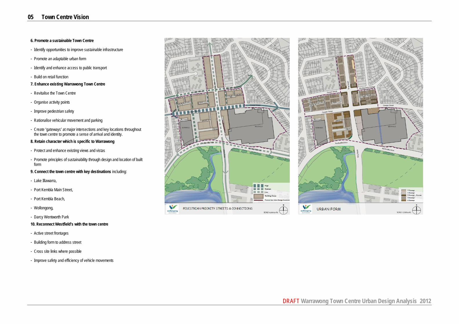
05 Town Centre Vision
DRAFT Warrawong Town Centre Urban Design Analysis 2012
6. Promote a sustainable Town Centre
- Identify opportunities to improve sustainable infrastructure
- Promote an adaptable urban form
- Identify and enhance access to public transport
- Build on retail function 7. Enhance existing Warrawong Town Centre
- Revitalise the Town Centre
- Organise activity points
- Improve pedestrian safety
- Rationalise vehicular movement and parking
- Create ‘gateways’ at major intersections and key locations throughout the town centre to promote a sense of arrival and identity.
8. Retain character which is specific to Warrawong
- Protect and enhance existing views and vistas
- Promote principles of sustainability through design and location of built form
9. Connect the town centre with key destinations including:
- Lake Illawarra,
- Port Kembla Main Street,
- Port Kembla Beach,
- Wollongong,
- Darcy Wentworth Park 10. Reconnect Westfield’s with the town centre
- Active street frontages
- Building form to address street
- Cross site links where possible
- Improve safety and efficiency of vehicle movements

05 Town Centre Vision
DRAFT Warrawong Town Centre Urban Design Analysis 2012
5.4 DRAFT Key Strategies - Urban Structure
1. Provide a continuous north – south pedestrian link between Cowper Street and Northcliffe Drive to connect to Lake Illawarra Lands.
2. Create a major urban space that links Cowper Street to Lake Illawarra in north - south orientation along buildings
for community gatherings, weekly markets, bands, children’s play, casual dining, etc.
3. Provide a continuous north - south pedestrian link through the future redevelopment or renovation of Westfield. 4. Provide additional ‘bus only’ lane for north bound and south bound destinations. 5. Create an urban space at Westfield frontage along Cowper Street for outdoor dining and community gathering. 6. Establish Cowper Street as Main Street by strengthening its role through major public domain upgrades which
will facilitate high level of retail and pedestrian activity Key items to include:
- Improve the northern side of Cowper Street by providing quality footpath materials create off street parking bays interspersed with landscaping
- Widen the footpath along south side of Cowper Street to provide outdoor seating for cafes 7. Pedestrian links to be upgraded with safety and security. 8. Create a future bus interchange which is accessible and integrated with the town centre.
9. Create town centre gateways/ points of arrival.
10. Create a community facility which caters for a range of community needs and is accessible and integrated with
the town centre.
11. Strengthen connections between the town centre and key destinations (for example Lake Illawarra, Port Kembla, local schools, hospital and surrounding residential areas).
12. Strengthen the integration between the town centre and the Lake Illawarra Authority lands to the south.
9
9
9
9
9

05 Town Centre Vision
DRAFT Warrawong Town Centre Urban Design Analysis 2012
5.5 DRAFT Key Strategies – Land Use
A Future development with residential focus & character having ground floor activation through same home-office type uses, professional suites & residential fronting the streets.
B Future development consisting of ground and first floor retail/commercial addressing the streets & residential at
upper levels with optional first floor residential. C Future development consisting of ground and first floor retail/commercial addressing the streets & residential at
upper levels with optional first floor residential.
Cowper Street & the public space along with the strong pedestrian North-South link to Lake Illawarra. D Future development consisting of ground floor retail, first floor commercial and residential at upper levels. Ground
floor retail to address the Cowper street & provide fine grain smaller shop widths. E Main focus on retail development.
DRAFT Warrawong Town Centre Urban Design Analysis 2012
06 NEXT STEPS

06 Next Steps
DRAFT Warrawong Town Centre Urban Design Analysis 2012
6.1 Next Steps
The draft strategies and urban design principles presented by this urban design analysis report provide a range of responses to the future of Warrawong Town Centre. In order to successfully promote positive change which will meet community needs, it is essential to engage with the community to confirm and identify the key priorities and issues facing their town centre and which will shape its future. Following internal review and Councillor input, it is intended that the initial analysis presented in this report will be exhibited for public input, comment and contribution. This will be delivered through a comprehensive community engagement strategy to ensure that the opinions of this very diverse community are represented. Based on feedback and ongoing technical analysis, Council will refine a preferred structure and built form outcome for the town centre which will require policy refinement.

APPENDICES
DRAFT Warrawong Town Centre Urban Design Analysis 2012
APPENDIX A Summary of Permissible Land Uses

DRAFT Warrawong Town Centre Urban Design Analysis 2012
Table 2.1 - Summary of permissible land uses Zone
The objectives of the zone Permitted without consent Permitted with consent
Commercial Core – Zone B3
§ To provide a wide range of retail, business, office, entertainment, community and other suitable land uses that serve the needs of the local and wider community. § To encourage appropriate employment opportunities in accessible locations § To maximise public transport patronage and encourage walking and cycling. § To strengthen the role of the Wollongong city centre as the regional business, retail and cultural
centre of the Illawarra region. § To provide for high density residential development within a mixed use development if it:
(a) is in a location that is accessible to public transport, employment, retail, commercial and service facilities, and (b) contributes to the vitality of the Wollongong city centre.
Building identification signs; Business identification signs.
Advertisements; Advertising structures; Amusement centres; Boarding houses; Bulky goods premises; Business premises; Car parks; Child care centres; Community facilities; Educational establishments; Entertainment facilities; Exhibition homes; Function centres; Funeral chapels; Funeral homes; Helipads; Hostels; Hotel or motel accommodation; Information and education facilities; Landscape and garden supplies; Office premises; Passenger transport facilities; Places of public worship; Pubs; Recreation areas; Recreation facilities (indoor); Recreation facilities (outdoor); Registered clubs; Restricted premises; Retail premises; Roads; Self-storage units; Seniors housing; Service stations; Sex services premises; Shop top housing; Timber and building supplies; Tourist and visitor accommodation; Vehicle sales or hire premises; Veterinary hospitals; Wholesale supplies.
Mixed Use – Zone B4
§ To provide a mixture of compatible land uses. § To integrate suitable business, office, residential, retail and other development in accessible
locations so as to maximise public transport patronage and encourage walking and cycling. § To support nearby or adjacent commercial centres without adversely impacting on the viability of
those centres.
Building identification signs; Business identification signs
Advertisements; Advertising structures; Amusement centres; Boarding houses; Bulky goods premises; Business premises; Car parks; Child care centres; Community facilities; Educational establishments; Entertainment facilities; Environmental facilities; Exhibition homes; Function centres; Funeral chapels; Funeral homes; Hostels; Hotel or motel accommodation; Information and education facilities; Landscape and garden supplies; Multi dwelling housing; Office premises; Passenger transport facilities; Places of public worship; Recreation areas; Recreation facilities (indoor); Registered clubs; Residential flat buildings; Retail premises; Roads; Self-storage units; Seniors housing; Service stations; Shop top housing; Tourist and visitor accommodation; Vehicle body repair workshops; Vehicle repair stations; Vehicle sales or hire premises; Veterinary hospitals; Wholesale supplies.
Enterprise Corridor – Zone B6
§ To promote businesses along main roads and to encourage a mix of compatible uses. § To provide a range of employment uses (including business, office, retail and light industrial
uses) and residential uses (but only as part of a mixed use development). § To maintain the economic strength of centres by limiting retailing activity. § To encourage activities which will contribute to the economic and employment growth of
Wollongong. § To allow some diversity of activities that will not: (a) significantly detract from the operation of existing or proposed development, or (b) significantly detract from the amenity of nearby residents, or (c) have an adverse impact upon the efficient operation of the surrounding road system.
Building identification signs; Business identification signs
Advertisements; Advertising structures; Bulky goods premises; Business premises; Car parks; Child care centres; Community facilities; Depots; Entertainment facilities; Environmental facilities; Hotel or motel accommodation; Industrial retail outlets; Landscape and garden supplies; Light industries; Office premises; Passenger transport facilities; Places of public worship; Recreation areas; Recreation facilities (indoor); Recreational facilities (outdoor); Registered clubs; Roads; Service stations; Serviced apartments; Sex services premises; Shop top housing; Storage premises; Take away food and drink premises; Timber and building supplies; Transport depots; Truck depots; Vehicle sales or hire premises; Veterinary hospitals; Warehouse or distribution centres
Tourist – Zone SP3
§ To provide for a variety of tourist-oriented development and related uses. Building identification signs; Business identification signs
Advertisements; Advertising structures; Amusement centres; Boat repair facilities; Boat sheds; Caravan parks; Cellar door premises; Charter and tourism boating facilities; Child care centres; Community facilities; Entertainment facilities; Food and drink premises; Function centres; Information and education facilities; Kiosks; Marinas; Markets; Moorings; Neighbourhood shops; Recreation areas; Recreation facilities (indoor); Recreation facilities (major); Recreation facilities (outdoor); Registered clubs; Roads; Tourist and visitor accommodation; Water recreation structures
Public Recreation – Zone RE1
§ To enable land to be used for public open space or recreational purposes. § To provide a range of recreational settings and activities and compatible land uses. § To protect and enhance the natural environment for recreational purposes. § To cater for the development of a wide range of uses and facilities within open spaces for the
benefit of the community.
Nil Boat sheds; Caravan parks; Child care centres; Community facilities; Environmental facilities; Environmental protection works; Extensive agriculture; Helipads; Information and education facilities; Kiosks; Markets; Recreation areas; Recreation facilities (indoor); Recreation facilities (major); Recreational facilities (outdoor); Restaurants; Roads; Signage; Take away food and drink premises; Water recreation structures
DRAFT Warrawong Town Centre Urban Design Analysis 2012