DRAFT ENVIRONMENTAL IMPACT STATEMENT - SUMMARY
20
I-75 from M-102 to M-59 Oakland County Prepared by Michigan Department of Transportation In Cooperation with U.S. DEPARTMENT OF TRANSPORTATION FEDERAL HIGHWAY ADMINISTRATION December 2003 DRAFT ENVIRONMENTAL IMPACT STATEMENT - SUMMARY
Transcript of DRAFT ENVIRONMENTAL IMPACT STATEMENT - SUMMARY

I-75 from M-102 to M-59 Oakland County
Prepared by
Michigan Department of Transportation
In Cooperation with
U.S. DEPARTMENT OF TRANSPORTATION FEDERAL HIGHWAY ADMINISTRATION
December 2003
DRAFT ENVIRONMENTAL IMPACT STATEMENT - SUMMARY


I-75 Draft Environmental Impact Statement 1-1
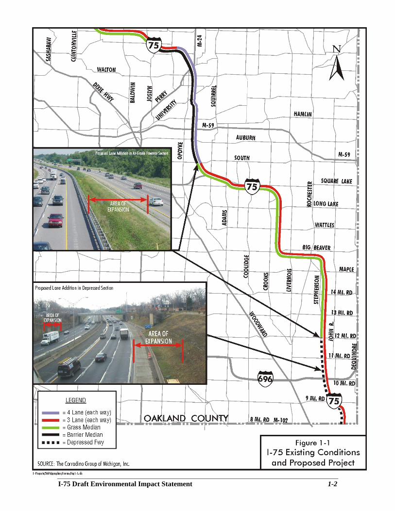
I-75 ENVIRONMENTAL IMPACT STUDY SUMMARY 1.1 Description of the Proposed Project I-75, the main north-south roadway through Oakland County, is experiencing congestion in the peak periods that will get more severe and extend through greater portions of the day as the future unfolds. It provides three lanes in each direction through most of the county except for a section between Square Lake Road and a point west of M-24 (Figure 1-1). A fourth lane also is present between M-102 (8 Mile Road) and I-696, but this lane is considered an auxiliary lane,1 not a through travel lane, as it serves the weave movements to and from the many ramps in this section. The I-75 Corridor Study in Oakland County (Feasibility Study),2 completed in November 2000, recommended providing four through travel lanes in each direction throughout Oakland County. It also recommended the improvement of several interchanges and arterial streets near I-75. The federal action proposed by the Michigan Department of Transportation (MDOT) and covered by this Draft Environmental Impact Statement (DEIS) addresses the reconstruction of I-75 and its widening of I-75 from three to four through travel lanes in each direction between M-102 (8 Mile Road - exit 59) and M-59 (exit 77), a distance of 18 miles. The next six miles, north to Joslyn Road (exit 83) has already been widened to four through travel lanes. The Feasibility Study recommended that MDOT widen I-75 north of Joslyn Road. The proposed improvements between M-102 and M-59 have independent utility, i.e., they can stand alone and provide transportation benefits without relying upon the development of other projects. The proposed project will connect with the four-lane section north of Square Lake Road and south of M-102. The proposed improvements include reconstructing the 12 Mile and 14 Mile Road interchanges. Modifications to the Crooks/Long Lake interchange and the I-75/M-59 interchange are separate projects and, as such, are not covered in this DEIS. The I-75/M-59 project extends south to about South Boulevard. Therefore, the environmental analysis of the proposed project covered in this DEIS extends north to South Boulevard from M-102. Other independent, but related MDOT projects in the area include a new pedestrian bridge over I-75 south of Auburn Road and noise mitigation in the Square Lake Road area. This DEIS is a product of the I-75 Oakland County Planning/Environmental Study, which is listed in the Southeast Michigan Council of Government’s (SEMCOG’s) 2025 Regional Transportation Plan, in SEMCOG’s Transportation Improvement Program (TIP), and in the Michigan Department of Transportation’s (MDOT’s) Five-Year Road & Bridge Program (Volume V – 2003 to 2007) for the Metro Region. This section summarizes the DEIS, addressing: 1) the project purpose and need; 2) alternatives considered; 3) the affected environment and project impacts; 4) areas of controversy; 5) permits and proposed mitigation; 6) unresolved issues; and, 7) the project’s status.
1 An auxiliary lane is one that begins as an on-ramp, but never fully merges with the mainline. Instead it continues as the rightmost lane of the freeway to the next exit, where is becomes an “exit only” lane. So it functions as a travel lane between two interchanges. The advantage is that it adds some mainline capacity and lengthens the decision-making distance and time for merges and diverges. 2 I-75 Corridor Study in Oakland County; The Corradino Group for the Michigan Department of Transportation, the Southeast Michigan Council of Governments, the Road Commission for Oakland County and the Traffic Improvement Association; November 2000.
I-75 Draft Environmental Impact Statement 1-2
Figure 1-1 Existing Conditions and Proposed Project L:\projects\3070\graphics\Enviro\Fig1-1.cdr

I-75 Draft Environmental Impact Statement 1-3
1.2 Alternatives This section summarizes the alternatives considered. More detail is provided in Section 3. No Build, Mass Transit, and several “build” alternatives were analyzed for this DEIS, together with Transportation Systems Management (TSM) techniques, Transportation Demand Management (TDM) techniques, and Intelligent Transportation System (ITS) measures. TSM techniques are designed to maximize the efficiency of the arterial street system. TDM involves strategies for managing transportation demand - usually to reduce it or to shift it to different times, locations, routes, or modes. ITS measures involve the collection and dissemination of information to drivers in real time (overhead message boards on freeways), incident management (clearing crashes quickly), traffic signal systems that respond to demand, and similar measures. A recommended alternative will not be selected until after the public hearing and comment period are concluded and all comments have been considered. 1.2.1 No Build Alternative The No Build Alternative consists of continued regular maintenance of I-75. Built in the 1960s, I-75 needs major reconstruction. The No Build Alternative would require no additional right-of-way. It would result in a breakdown of traffic flow through much of the day. 1.2.2 Transportation Systems Management (TSM) Techniques Transportation Systems Management (TSM) techniques apply to the arterial street system, which, in large part, is under the control of local units of government and the Road Commission for Oakland County. Maximizing capacity on the arterial network cannot meet the project purpose and need. Only a lane addition on I-75 can meet that need. TSM techniques are and will continue to be included as area roadway improvements are made. 1.2.3 Transportation Demand Management (TDM) Techniques Transportation Demand Management (TDM) means reducing demand or shifting it to different times, locations, routes, or modes. It focuses principally on administrative actions, such as working with major employers to support carpool and vanpool programs, or programs that encourage transit use. MDOT works actively with SEMCOG to promote alternative transportation modes. TDM techniques will continue, but will not alone meet the project purpose and need. These activities would expand, if the High-Occupancy Vehicle (HOV) Lane Alternative were selected. 1.2.4 Intelligent Transportation Systems Intelligent Transportation System (ITS) measures often involve the use of technology in transportation to save lives, time, and money. The measures have particular utility for freeways. Techniques include the collection and dissemination of information to drivers in real time (overhead message boards on freeways), incident management (clearing crashes and stopped vehicles quickly), coordinating traffic signals at ramp ends with the surrounding signal system, providing intelligent signal systems that adjust to traffic demand, and other similar measures. ITS maximizes use of the existing transportation infrastructure, but cannot substitute for physical

I-75 Draft Environmental Impact Statement 1-4
expansion of roadway capacity, once efficiency is maximized. For this reason, while ITS will be an ongoing component of traffic management on I-75 and on the surrounding roadway network, it will not alone meet the project purpose and need. 1.2.5 Mass Transit This DEIS analyzed whether a rapid transit system can meet the purpose and need for the project. Rapid transit has potential in the Woodward Corridor (which parallels I-75) south of 9 Mile Road, but analysis shows rapid transit and an extensive supporting bus system have little effect on the traffic volumes on I-75 and do not eliminate the need for the proposed lane addition on I-75 between M-102 (8 Mile Road) and M-59. 3 Principal reasons are: 1) Oakland County residential development is dispersed; 2) many trips are internal to Oakland County and not easily diverted to transit; and, 3) demand in the I-75 corridor exceeds capacity, so any diversion to transit would be quickly replaced by others wishing to use I-75. 1.2.6 Build Alternatives The “build alternatives” include adding a through travel lane between M-102 (8 Mile Road) and M-59 to bring the total lanes to four in each direction.4 The lane could be used by all vehicles or be restricted to use by High-Occupancy Vehicles (HOV), with two or more persons, in peak hours. The proposed project includes reconstruction of the 12 Mile and 14 Mile Road interchanges, modification of the ramps from eastbound and westbound I-696 to northbound I-75, reconstruction of the existing pedestrian bridges over I-75,5 and separation of the storm water from I-75 from the combined sewer system in the south section of the corridor. The project also considers modifying curves on I-75 near 9 Mile Road and Big Beaver Road, changing ramps at Square Lake Road. The planned connections to the separate I-75/M-59 project are discussed. The build alternatives will be referred to henceforth as the GP (General Purpose lane) and HOV (High-Occupancy Vehicle lane) alternatives. I-75 Lane Addition for General Purpose Use – GP Alternative Between M-102 (8 Mile Road) and Gardenia Avenue (the first cross street south of 12 Mile Road) I-75 is in a “cut” section, i.e., below grade level. The addition of a fourth through lane would occur by cutting into the existing side slopes. North of Gardenia Avenue, I-75 comes to grade or is elevated (refer to Figure 1-1). The lane addition would be constructed in the existing median from this point to Square Lake Road. From Square Lake Road to beyond M-59 there are already four through lanes and a lane addition is not required. The north limit of this I-75 lane addition project is north of South Boulevard, where the two lanes (eastbound-to-northbound) from Square Lake Road join the four northbound lanes of I-75 to form the six lanes planned with the I-75/M-59 project. This alternative would meet full, modern standards with the exception of the “S” curve south of 9 Mile Road.
3 I-75 Corridor Planning/Environmental Study Refined Analysis of Transit and HOV Concepts (Technical Memorandum No. 2) by The Corradino Group for the Michigan Department of Transportation, October 2002. 4 During the 2000 Feasibility Study the concept of a reversible lane was considered. However, north-south travel demand is so balanced that a reversible lane was not reasonable. 5 Reconstruction of the Harry Avenue pedestrian bridge would require relocation of three homes, so an option is not to replace this bridge.

I-75 Draft Environmental Impact Statement 1-5
Redesigning the north section of the “S” curve south of 9 Mile Road to meet current standards would push I-75 into the adjacent neighborhood to the west. More than 150 parcels, including approximately 100 homes and 20 businesses, would likely be affected. Therefore, redesigning this curve was not considered practical. I-75 Lane Addition for HOV Use – HOV Alternative The proposed fourth through lane could be dedicated to use only by high-occupancy vehicles in peak traffic hours. The proposal is to limit the use of this lane to vehicles carrying two or more persons (carpools, vanpools, and buses) during the morning and afternoon peak periods (preliminary analysis of traffic data suggest a morning period of 7 to 9 AM, and an afternoon period of 4 to 6 PM). So, for twenty hours of the day, the HOV lane would operate as a general purpose lane like the other lanes. Analysis indicates that limiting the HOV lane to 3 or more persons restricted its use to the point that the lane is not viable.
HOV Lane
Three HOV options, varying in their length of application and the degree to which direct access is provided, were considered.6 Analysis concluded that special facilities such as exclusive HOV ramps generated little additional use of the HOV lane, but led to substantial relocations, impacts and costs. As these impacts could not be justified, only the basic HOV concept was advanced for consideration in this DEIS. For the HOV lane to be effective, enforcement must be strict.7 1.2.7 Additional Design Considerations Several design options considered for inclusion in the build alternatives are discussed below. Ten-Foot Median Shoulders Ten-foot inside shoulders meet modern design standards, but 12-foot inside (median) shoulders are preferred to 10-foot shoulders when more than 250 trucks are present in the peak travel hour, as would be the case on I-75. I-75 is now designed with 10-foot shoulders. To add the two feet would require total reconstruction of all the bridges from 12 Mile Road north to the north project limit (rather than widening), result in an inconsistent cross section along I-75 in Wayne and Oakland counties, affect four church and four residential parcels, likely cause the relocation of Our Savior Lutheran Church, and potentially cost up to $100 million. 6 Ibid. 7 I-75 Corridor Planning/Environmental Study Refined Analysis of Transit and HOV Concepts (Technical Memorandum No. 2) by The Corradino Group for MDOT, October 2002.

I-75 Draft Environmental Impact Statement 1-6
Curve at Big Beaver Road I-75 at Big Beaver Road was originally considered a rural highway section. It is now urbanized. Redesigning the curve south of the Big Beaver Road interchange to rural standards would require at least partial reconstruction of the interchange. Depending on the design approach, a motel and buildings of the City of Troy government complex on the inside of the curve would be affected, or, the ramp curves within the interchange would be tightened, increasing the potential for more crashes. Redesigning this curve, especially as it is now urban, was not considered practical. Eliminating the Left Exit/Entrance on Northbound I-75 at Square Lake Road For safety reasons, left exits and entrances are not desirable. To convert the left exit and entrance to a right exit and entrance on northbound I-75 at Square Lake Road would require the construction of flyovers, one for a right exit, another for a right entrance. Both would require new right-of-way and result in substantial relocations. An examination of travel patterns (movements from Square Lake Road to M-59, I-75 to M-59, and the reverse movements) supported the existing design. Therefore, the recommendation was to leave the left exit and left entrance as they are. Changing the exit and entrance was not considered practical. Auxiliary Lanes, I-75 from M-59 to Square Lake Road The M-59 interchange with I-75 is a separate project. The five southbound lanes of that project will match the five southbound lanes of the proposed project near South Boulevard. Similarly, northbound, two lanes from Square Lake Road will join the three existing, plus one proposed, lanes of I-75 to form the six-lane section that will match to the I-75/M-59 project north of South Boulevard. Therefore, the build alternatives would not require any additional changes north of South Boulevard beyond those planned for the separate I-75/M-59 interchange project. I-696 Interchange Traffic exiting eastbound I-696 to northbound I-75 backs up frequently. The primary cause of backups at this location is an inability to merge into the northbound traffic flow on I-75. The recommendation is to have the northbound off-ramp to 11 Mile Road pass under the northbound on-ramps from I-696 to prevent merge/diverge conflicts. This is called “braiding” the ramps (see figure on next page). 12 Mile Road and 14 Mile Road Interchanges There are two options at the 12 Mile Road interchange. It could be reconstructed to retain some of its existing geometrics, or be rebuilt as a Single-Point Urban Interchange (SPUI). A SPUI brings all ramp ends together at a single point and provides for a three-phase signal operation at the resulting intersection. The three phases control: 1) left turns from the ramps ends; 2) left turns to the entrance ramps; and, 3) the through movement of 12 Mile Road. This control aids pedestrian movements. Optionally, the interchange could retain some of its current configuration. As the southbound exit ramp to 12 Mile Road is now positioned too close to Stephenson Highway, the loop ramp serving westbound to southbound traffic would be eliminated. This would allow the southbound off-ramp to shift east, away from Stephenson Highway. The westbound to southbound movement would be accommodated instead by a left turn from 12 Mile Road to the southbound entrance ramp in the southwest quadrant of the interchange (see figure on next page).

I-75 Draft Environmental Impact Statement 1-7
The I-75 Feasibility Study (2000) anticipated the 14 Mile Road interchange would benefit from a SPUI design. However, more detailed analysis found that a modification of the existing interchange would serve traffic better. So, through capacity is proposed to be added on 14 Mile Road, and left-turn capacity from 14 Mile Road to I-75 would be increased. These changes will necessitate the reconstruction of the I-75 bridges over 14 Mile Road. Other improvements to 14 Mile Road are being addressed independently with the stakeholders on 14 Mile Road, as it is under the jurisdiction of the Road Commission for Oakland County.
Ramp Braiding North of I-696
Single Point Urban Interchange
1.2.8 Practical Alternatives Analysis finds that mass transit is viable in the Woodward Corridor, but clearly shows that even under the best-case scenario a Mass Transit Alternative cannot eliminate the need for four travel lanes in each direction through the project length. Nevertheless, the transit concept has been included in the background system, along with the roadways in the cost-feasible Regional Transportation Plan. TSM, TDM, and ITS are also incorporated into all alternatives. The practical alternatives carried forward through this DEIS are:
• No Build – Continued regular maintenance with no capacity improvements. • GP Alternative – Addition of a general-purpose travel lane between M-102 and north of
Square Lake Road to bring the number of through travel lanes to four in each direction.

I-75 Draft Environmental Impact Statement 1-8
• HOV Alternative – Addition of an HOV lane in the same manner as the GP lane, but signed and striped for HOV use during peak hours (7-9 AM and 4-6 PM). The northbound HOV lane is carried through the Square Lake Road interchange.
The GP and HOV alternatives would be accompanied by improvements at the 12 Mile and 14 Mile Road interchanges, the ramp braiding north of I-696, reconstruction of the pedestrian bridges over the depressed section of the freeway, construction of a new storm water system in the south part of the corridor, and new storm water retention in the north section of the corridor. Both alternatives would tie to auxiliary lanes that are planned with the separate I-75/M-59 project. The I-75/M-59 and Crooks/Long Lake interchanges, while not part of this project and DEIS, are considered part of the background system. The designs of all three projects will be integrated, although each has independent utility. These practical alternatives will be carried to the public hearing. 1.3 Impacts The following is a summary of the impacts associated with the No Build Alternative, the GP Alternative, and the HOV Alternative (Table 1-1). The GP and HOV alternatives have almost the same impacts. A more detailed description of impacts is found in Section 4. Proposed mitigation measures are found in Section 5. 1.3.1 Traffic and Safety Either build alternative will improve traffic flow over the No Build Alternative.8 The mainline lanes over most of the corridor will operate at a Level of Service (LOS) D or better in the design year (2025), with the GP or HOV Alternative, compared to breakdown conditions (LOS F) with the No Build Alternative. A Crash Analysis has identified patterns and concentrations of crashes and developed a set of countermeasures to improve safety with project construction.9 Countermeasures are summarized in Section 2.2.6. They include such measures as glare screens, warnings signs and flashers, and lengthening ramps. 1.3.2 Relocations and Community Cohesion Right-of-way acquisition and access changes can affect the cohesion of a neighborhood. Physical features of the I-75 project that will require new or additional right-of-way are:
• The lane addition; • 12 Mile Road and I-75 interchange; • “Braiding” of ramps north of I-696; • Reconstruction of pedestrian bridges; and • Storm water detention.
The proposed lane addition itself will not require relocation of dwelling units, but two businesses in Hazel Park would be relocated. Parking from several businesses and a church would also be necessary. Right-of-way acquisition for the lane addition will be only about an acre.
8 Traffic Analysis Report, The Corradino Group, November 2003. 9 Crash Analysis, The Corradino Group, June 2003.

I-75 Draft Environmental Impact Statement 1-9
Table 1-1
Summary of Impacts – General Purpose & HOV Lane Alternatives
Impact Category Expected Impact
Traffic and Safety Mainline I-75 Level of Service D or better (exception I-696 to 11 Mile Road), compared to LOS F with No Build. Safety will improve.
Relocations Eleven single-family residences and two businesses. Community Cohesion Improved access across I-75 for pedestrians and bicyclists.
Environmental Justice No disproportionately high and adverse human health or environmental effects on minority or low-income populations.
Land Use Consistent with local and regional planning documents. Farmland/Act 451, Part 361
Land No prime or unique farmlands. No Act 451, Part 361 lands.
Economics Added capacity responds to growth and supports the focal point of Michigan’s economic growth. Tax base losses insignificant.
Air Quality Lower emissions from improved traffic flow. No violations of the National Ambient Air Quality Standard for carbon monoxide.
Noise
430 dwelling units, 1 school, and 5 churches would be exposed to noise levels exceeding the 66 dBA criterion under future no build conditions compared to 466 dwelling units, 1 school, and 5 churches with the project. Mitigation would substantially reduce impacts under build conditions.
Surface Water Impacts
Two crossings of River Rouge and 10 of county drains. Storm water quantity will increase, flow rate will not. Storm water in depressed section will be separated from current combined sewer system.
Wetlands
HOV Alternative affects 0.41 acres of Palustrine Emergent, and Palustrine Shrub-Scrub. Potential 0.61 acres of mitigation at an identified site. The GP and No Build have no impacts.
Threat/Endangered Species None. Cultural Resources No potential National Register eligible sites or districts affected.
Parks/Recreation No effect on any park. No Section 4(f) involvement.
Visual Conditions
Reduction of grassy banks and landscape plantings from 8 Mile to 12 Mile (depressed section) and grass median north to Square Lake Road (at-grade and elevated section).
Contaminated Sites One site recommended for Phase II testing.
Soils
Cutting into banks of depressed section could undermine some existing noise walls, requiring stabilization or reconstruction. Poor soils in north project area, potentially affecting noise wall cost, but no anticipated problems with roadway construction.
Utility Systems
Utility relocation on I-75 bridges. No effect on high-tension electric line at 12 Mile Road or any cell towers. Relocation of MDOT traffic surveillance equipment necessary.
Indirect and Cumulative
Project responds to growth, consistent with local planning. Together with other regional projects there will be future impacts to resources from development, subject to local, state, and federal laws and regulations.
Energy Energy used during construction. Fuel savings upon opening.
Project Costs (2003 dollars) Approximately $530 million. A SPUI at 12 Mile Road adds $6 million. HOV adds $6 million
Source: The Corradino Group of Michigan, Inc.

I-75 Draft Environmental Impact Statement 1-10
Right–of-way acquisition will be required for the “braiding” of ramps north of I-696. This safety and operational improvement could involve relocation of occupants of eight single-family dwellings in Madison Heights and a total of approximately 1.5 acres of land. Right-of-way would be acquired with reconstruction of six pedestrian bridges. Reconstruction must conform to the Americans with Disabilities Act (ADA), which requires gradually sloping ramps and therefore, more land. Steps, in addition to the ramps, will be provided where feasible, to allow more direct movements for ambulatory persons. The right-of-way acquisition could affect three dwelling units and approximately an acre of land in Hazel Park. These impacts will be refined during the design phase when more detailed information is available. Storm water detention requirements in the north section of the project may require as much as seven acres of right-of-way acquisition. This acquisition in Troy would relocate no homes or businesses. In summary, the braid would take eight homes, a pedestrian bridge three more, and the lane addition two businesses. Community cohesion will not change appreciably as the basic footprint of I-75 will not change. Access across the freeway will be improved where bridges are replaced with the project. Sidewalks or shoulders will be provided on bridges. 1.3.3 Land Use Rapid growth in mid- and north Oakland County puts continued pressure on I-75. Much of this growth has occurred while no significant capacity improvement in the project length has occurred since construction in the 1960s. While communities in the northern and western parts of Oakland County have grown, a number of communities in the southern part of the corridor have shown population declines. SEMCOG attributes land use changes during the period 1990-2000 to:10
• Local planning and zoning; • Land availability; • Transportation; • Sewer and water services; and, • Social and policy dynamics, including:
Residential segregation by race and income; Federal tax subsidies for home mortgage interest and property taxes; School funding and quality; Crime and public safety; Societal ideals of lifestyle and urban design; Constitutional protection of property rights; Infrastructure financing policies; and, The extent of personal vehicle ownership and use.
The cumulative impact analysis found that some farmland conversion occurs because the land is uneconomic for farming purposes. Further, the farming community is aging, and it is likely that some farmers are selling their farms as they move toward retirement.11 10 Land Use Change in Southeast Michigan: Causes and Consequences, SEMCOG, March 2003. 11 Draft Environmental Impact Statement, M-15 from I-75 to I-69 – Oakland and Genesee Counties, The Corradino Group, December 2001.
I-75 Draft Environmental Impact Statement 1-11
SEMCOG concludes that undeveloped land will continue to develop as population shifts north and west in Oakland County, as well as to areas in western Wayne County, central Macomb County, Ann Arbor, and southeast Livingston County. Job growth will not be as dispersed as population growth. New jobs will be concentrated in fewer suburban communities, reflecting the stronger role of transportation access and the need to centralize jobs. The City of Detroit will experience continued job loss until 2020, when the situation will become more stable.12 The proposed improvements to I-75 are consistent with local and regional transportation and land use planning, including Oakland County’s Composite Master Plan Map and SEMCOG’s Regional Transportation Plan. 1.3.4 Environmental Justice The project will not result in disproportionately high and/or adverse human health or environmental effects on minority or low-income populations. Nevertheless, a continuing effort will be made to identify disproportionately high and adverse impacts to minority and low-income populations during subsequent phases of this project. If such effects are identified, every effort will be made to actively involve minority or low-income populations in the project development process, and to avoid or mitigate any potential disproportionately adverse impacts that may result from the proposed project. 1.3.5 Economics Economic activity in the project area is generated by a variety of market sectors including retail trade, services, distribution, industry, education, and public administration. The corridor has been subject to rapid development at its north end. South of M-59 this trend is expected to slow.13 Further north, where developable land is available, and where local planning and zoning permits (and sometimes encourages), this growth is expected to continue.14 Between M-102 and M-59, I-75 provides access to substantial residential concentrations, linking these to jobs both south (Detroit) and north (especially near I-75 interchanges such as Big Beaver Road, Crooks Road, and University Drive). Commercial activities, such as the Oakland Mall and the Great Lakes Crossing Mall (and associated retail areas) are heavy generators of traffic. Adding capacity to I-75 is a response to the growth that has already occurred and the growth predicted by the local political jurisdictions in the corridor. Property acquisition will result in a reduction in real property tax revenues of about $121,000, based on the right-of-way cost estimate. This represents only very minor percentages of the property taxes collected by Hazel Park, Royal Oak, Madison Heights, and Troy. The largest effect in terms of the percent of tax base would be on Hazel Park, at two hundredths of one percent. Any loss is important to that community, but the increase in State Equalized Value of properties over the coming years will outweigh potential losses. Because there are few anticipated business or residential relocations, replacement commercial space and housing is available and is not an issue. 12 2030 Regional Development Forecasts, SEMCOG. 13 Ibid. 14 Land Use Change in Southeast Michigan: Causes and Consequences, SEMCOG, March 2003.

I-75 Draft Environmental Impact Statement 1-12
1.3.6 Air Quality Air quality along I-75 will improve to the extent there will be less idling and smoother traffic flow. A test of carbon monoxide (CO) concentrations along I-75 and at the busiest intersections near I-75, at locations where humans might be present for periods of an hour or more, found one-hour and eight-hour ambient air quality standards for CO would not be violated under either build or no build conditions. The differences between the HOV and GP Alternatives are negligible. However, on a regional basis, the HOV Alternative would be associated with a slightly lower pollutant burden, as the same number of trips would be made in fewer vehicles. Approval of the Final EIS requires that the project be added to the Transportation Improvement Program (TIP) and Regional Transportation Plan of the Southeast Michigan Council of Governments (SEMCOG) after a determination of air quality conformity. 1.3.7 Noise There would be no discernable difference between the HOV and GP alternatives with respect to noise. For most of the corridor the noise levels with the project will increase in an imperceptible way. In a situation where noise is already continuous, a doubling of traffic in the loudest hour must occur before most people can discern an increase in noise. This equates to a 3-decibel increase. Based on the proposed improvement in roadway capacity, the noise increase will be just over one decibel in most locations. Nevertheless, because many homes are already exposed to noise levels above abatement criteria, abatement is warranted in several locations. The analysis found that 430 dwelling units, one school, and five churches would be exposed to noise levels exceeding the 66 dBA criterion (the threshold for determining residential impacts) under future no build conditions compared to 466 dwelling units, one school, and five churches with the proposed project. With the build alternatives, noise mitigation, likely walls, will be included as a normal part of the project’s federal funding (subject to local review and approval of property owners). This mitigation will reduce the number of dwelling units exposed to undesirable noise levels by about 400 dwelling units. With the No Build Alternative, mitigation would be considered “Type II.” This means that mitigation would be a “retrofit” project and not be eligible for federal funding. While MDOT does undertake Type II projects, funding is very limited. Under the MDOT’s Noise Policy15 only the southern section of the corridor would be eligible for walls, as the communities to the north allowed residential development to occur in areas too close to the freeway. A Noise Study16 using the FHWA’s TNM2.1 computer model finds that approximately 4.3 miles of noise walls are warranted. These would provide at least a six-decibel noise reduction in the loudest hour, and “benefit” (defined as a 5-decibel reduction) about 400 dwelling units. 1.3.8 Ecological Resources Forty-one wetland areas were identified between 12 Mile Road and South Boulevard.17 South of 12 Mile Road, I-75 is depressed and there are no wetlands. North of South Boulevard, changes to I-75 are a part of the separate I-75/M-59 project. Most wetlands in the corridor are associated 15 Noise Abatement, Michigan State Transportation Commission Policy, July 31, 2003. 16 Noise Study Report, The Corradino Group, October 2003. 17 Wetland Report, Tilton & Associates, Inc., October 2003.

I-75 Draft Environmental Impact Statement 1-13
with roadside ditches. As the proposal is to widen I-75 using the median, effects on wetlands are limited to the proposed HOV lane through the Square Lake Road interchange. Approximately 0.41 acres of wetlands would be directly affected by the HOV Alternative as the HOV lane traverses the Square Lake Road interchange. Neither the GP Alternative, nor the No Build Alternative would affect wetlands, other than the increased pollutant load from storm water runoff from increased traffic volumes. Affected wetlands will require replacement through agreement with the Michigan Department of Environmental Quality (MDEQ). No known federal threatened or endangered species or state-listed species will be affected. The project traverses a developed, largely urbanized corridor. 1.3.9 Storm Water The No Build Alternative would not change existing drainage patterns or flow. However, storm water will increase with the project due to the increased impervious surface of the additional lanes. A Drainage Study18 was performed to determine how best to handle the increase in storm water runoff from the GP or HOV alternatives (which would have almost identical impacts). In the south section of the corridor (the depressed section) storm water now flows into the combined (sewage and storm water) sewer system in that section of the corridor. The proposed project will separate I-75 storm water from this system. The combined system flow now goes through Detroit’s regional treatment plant. During storms, the plant cannot accommodate the flow rates and the overflow of sewage and storm water there bypasses the plant. By providing its own system for I-75 storm water, MDOT will positively affect water quality by: 1) reducing flow in the combined sewer system so that overflows of sewage into the Red Run Drain occur less frequently; and, 2) reducing flow to the Detroit wastewater treatment plant, so that facility treats less storm water. In the north section, where I-75 has a rural design, the proposed project will reduce the retention area now provided by the median and increase impervious surface. Both actions will increase storm water flow. Therefore, detention has been included at a number of locations to maintain existing flow rates. This will prevent peak flows during storm events (50-year storms) from exceeding existing rates. 1.3.10 Cultural Resources and Parkland A Cultural Resources Survey found no evidence of adverse effects to archaeological (below ground) resources. 19 It also found that of the 165 buildings and structures surveyed within the approved Area of Potential Effect (APE), none are potentially eligible for the National Register of Historic Places. Resources that are eligible for the Register are afforded special protection under federal law. The State Historic Preservation Officer has concurred in these findings (see letters dated October 1, 2002 and May 14, 2003 in Appendix B, Section 2). Maddock Park in Royal Oak is adjacent to the southbound I-75 service drive. It is separated from I-75 by a noise wall. A grading permit may be necessary along the park, but effects on the park will be avoided. The Troy Family Aquatic Center and Huber Park in Troy are adjacent to 18 Drainage Study, Orchard, Hiltz & McCliment and Rowe, Inc., October 2003. 19 Phase I Cultural Resources Survey of the Proposed I-75 Freeway Improvements, Oakland County, Michigan, Commonwealth Cultural Resources Group, Inc., December 2002.

I-75 Draft Environmental Impact Statement 1-14
northbound I-75, but are separated from the road by a berm. This recreation area will not be affected. 1.3.11 Visual Conditions Visual effects relate to the view of the road and from the road for each of I-75’s two distinct sections. The southern, depressed section, between M-102 and 12 Mile Road, is now flanked by grassy banks and occasional ornamental trees (Figure 1-1). Drivers see only the road, bridges over I-75, embankments on either side, and adjacent buildings. With the project some remnants of grassy banks may remain in wider areas of the depressed section, but overall there will be a more monolithic concrete visual environment, including a concrete median safety barrier. Portions of the depressed section between I-696 and Gardenia are bordered by brick noise walls at the top of the grassy banks. The noise walls will remain (though some may be relocated). Additional noise walls will be built, subject to final analysis and community acceptance. The view of the road in the depressed section is limited, as the road is below grade level. This will change where noise walls are added. The walls will be evident from the surrounding area with the project. The northern at-grade/elevated section has a grassy median. Construction of either build alternative will remove this vegetation. North of 12 Mile Road, I-75 is generally above the surrounding landscape at cross roads, so the adjacent land uses are visible. These views will not change as a result of the project. Since construction during the 1960s, vegetation has grown up along the fence lines. The mature vegetation along fence lines should not be disturbed with the project except in areas where noise walls are built. The view from the road would change only in these areas where noise walls are built. Likewise the view of the road will not change as the widening is within the median. Some clearance of vegetation is recommended for safety purposes (sight distance) within interchanges at Big Beaver Road and Rochester Road. Design elements of the proposed project would be refined in conjunction with the Crooks/Long Lake I-75 Interchange Project and the I-75/M-59 Interchange Project for continuity. 1.3.12 Hazardous Materials No substantial problems with contaminated materials are anticipated. One site in Royal Oak where right-of-way acquisition is expected was identified as a possible former gas station with underground storage tanks. This site was rated medium/high for contamination potential and additional investigation of the site (Phase II) is recommended. 1.3.13 Soils and Utilities Mucky and peat soils are present in some locations in the north portion of the corridor. This could affect the cost of noise wall construction, but is not expected to affect roadway construction. Geotechnical studies have been performed to support project cost estimates. A high-tension electrical line in the north section of the 12 Mile Road interchange would not be affected as the towers are not affected. Similarly, a cell tower at Square Lake Road and Adams Road that is close to I-75 would not be affected. Other cell towers are similarly unaffected.

I-75 Draft Environmental Impact Statement 1-15
There will, however, be an effect on MDOT traffic monitoring equipment, some of which is located in the median. Effects on utilities will be consistent with normal utility relocation for roadway projects. Particularly, in the depressed section as utilities are carried across I-75 on the crossroad bridges. 1.3.14 Indirect and Cumulative Impacts Indirect impacts have been examined by determining which roads might be affected by a capacity increase (lane addition) on I-75. The effects of the GP and HOV alternatives are very similar. Roads that would experience an increase in congestion and would be over capacity, were identified. The assumption is that if congestion increases, the next step would be to widen a road and create impacts. Where this was the case, the impacts of roadway widening were estimated. These indirect impacts are summarized in Section 4-18. Cumulative effects occur when other planned improvements are examined in conjunction with the lane addition to I-75. Regardless of changes to I-75, growth will continue to occur as individuals and commercial entities develop their properties, consistent with local zoning. The population in the project area has grown dramatically for years with no improvement to I-75. In response, many roadway projects are planned. Analysis found that when these projects are combined with the lane addition on I-75, additional links not identified in the indirect impact modeling show congestion increases. Effects of widening these additional links have been estimated and are considered cumulative impacts. A review of trends in the economy including: the auto industry; population shifts away from the core of Detroit, especially during the 1970s; the decline in farming and conversion of land to residential and commercial uses; the implementation of wetland protection; and other factors, finds that development along I-75 reflects a complex mix of forces, such that widening I-75 will not have significant cumulative effects. Cumulative effects are discussed further in Section 4.18. 1.3.15 Energy Fuel savings to motorists should be realized in the long term due to improved traffic flow and more constant traveling speeds. 1.3.16 Cost The base cost of the build alternatives would be about $530 million (2003 dollars). This includes right-of-way and relocation costs of $11 million. If the 12 Mile Interchange were built as a SPUI the cost would be approximately $6 million more than if it were reconstructed in its same general configuration. The cost associated with the signing and striping for the HOV, plus the cost of building bridges to carry an HOV lane north through the Square Lake Road interchange, would be $6 million. Note that the costs of separating I-75 storm water from the combined sewer system in the south section of the corridor are built into the overall construction costs, but amount to $11 million.

I-75 Draft Environmental Impact Statement 1-16
1.4 Areas of Controversy A principle concern expressed by citizens attending public meetings is that noise walls be constructed with the project. Noise walls will be constructed in accordance with established noise criteria and warrants as contained in MDOT’s Noise Policy.20 Several studies in the past have called for rapid transit development in the Detroit-Ann Arbor corridor and Woodward corridor.21 Extensive analysis of mass transit performed for this DEIS supports the view that transit is viable along the Woodward Corridor, but that it cannot substantially change the need for the I-75 project. A concern expressed by some transit supporters is that spending highway dollars diminishes the potential for mass transit development, but major transit projects generally draw largely from distinct (non-highway) federal funding sources. Major transit projects may draw upon Surface Transportation Program funding that is usually used for highway purposes. However, there is most often a capital expenditure on the part of the Federal Transit Administration through “new start” funding authorized by Congress separately from highway funds. 1.5 Permits Proposed construction activities will involve the need for permits. Impacts on bodies of water such as rivers, drains, and wetlands will require permits under federal and state law:
• Federal Executive Order 11990 protects wetlands. • The federal Clean Water Act of 1977, as amended requires: state Water Quality
Certification of projects (Section 401); permitting of the quality of storm water (Section 402(p) - National Pollutant Discharge Elimination System); and, avoidance, minimization, and mitigation of wetland impacts (Section 404).
• Michigan Natural Resources and Environmental Protection Act, 1994 PA 451, as amended, Part 31, Water Resource Protection, regulates placement of fill material within any part of a floodplain with a drainage area of two square miles or more.
• PA 451, Part 301, Inland Lakes and Streams, regulates work below the ordinary high-water mark of any inland lake, stream, or drain, including the placement of any permanent or temporary river or stream structure.
• PA Act 451, Part 303, Wetland Protection, regulates any wetland disturbance, permanent, as well as temporary. The Part 303 permit is reviewed and issued with the Part 301 permit.
• PA Act 451, Part 365, Endangered Species Protection, is required from the MDNR Wildlife Division for any activity that may affect a state-listed threatened or endangered fish, plant, or animal species. No endangered or threatened species were found; however, if any were identified during project implementation, all activity in the immediate area would cease. Coordination with the U.S. Fish and Wildlife Service would be initiated as required by Section 7 of the Endangered Species Act of 1973, and appropriate state and federal permits would be sought.
20 Michigan Department of Transportation’s Procedures and Rules for Implementation of the State Transportation Commission Policy 10136 – Noise Abatement, July 2003. 21 Improving Transit in Southeast Michigan: A Framework for Action, SEMCOG, October 2001.

I-75 Draft Environmental Impact Statement 1-17
Final mitigation measures proposed in areas requiring the above permits will be developed in consultation with the appropriate agencies, and will be included in the permit application for implementing the project. Permits will also be required where Oakland County Roads are involved and where Oakland County drains are involved. These come from the Road Commission for Oakland County and the Oakland County Drain Commission, respectively. 1.6 Project Status Before this project can receive environmental clearance, it must be included in SEMCOG’s Transportation Improvement Program (TIP) and Regional Transportation Plan (RTP) for construction. It is presently in these plans as a study. The project must be shown to be in conformance with the Clean Air Act. When a Final EIS is completed, a Record of Decision (ROD) for the project is signed, and funding is identified, final design and right-of-way acquisition can begin. This project is listed as a study in MDOT’s Five-Year Road and Bridge Program (Volume V – 2003 to 2007), which outlines roadway expenditures over the next five years. Design and construction of the proposed improvement is not yet scheduled. If the outcome of the public hearing for this project is to reconstruct I-75, design and construction will await available funding. A number of capacity improvement projects statewide have been deferred, as MDOT is dedicated to a “preserve first” philosophy. This philosophy is to improve the existing infrastructure, and the goal is to restore 95 percent of Michigan’s freeways and 85 percent of its non-freeways to a “good” condition by 2007. Deferred projects will be added to the Five-Year Program on a priority basis, based on available funding, when MDOT can meet and sustain the condition goal and when additional revenues are available.