Draft Environmental Impact Statement and Land Use Plan ...€¦ · 8 Transmission Line Project ......
28
B2H Draft EIS and LUP Amendments Summary S-1 Summary 1 I NTRODUCTION 2 This Boardman to Hemingway Draft Environmental Impact Statement (Draft EIS) and Land Use Plan 3 Amendments has been prepared in response to an Application for Transportation and Utility Systems 4 and Facilities on Federal Lands (Standard Form 299) submitted by Idaho Power Company (IPC) to the 5 Bureau of Land Management (BLM), United States Forest Service (USFS), and the Bureau of 6 Reclamation. IPC proposes to construct, operate, and maintain the Boardman to Hemingway 7 Transmission Line Project (the B2H Project), that is approximately 305 miles long. The line would be a 8 single-circuit alternating-current, 500-kilovolt (kV) overhead electric transmission line with ancillary 9 facilities. The transmission line would be constructed to connect the Grassland Substation, that is under 10 construction by Portland General Electric Company (PGE), near the near the city of Boardman, Morrow 11 County, Oregon, to the existing Hemingway Substation, near the city of Melba in Owyhee County, 12 Idaho. The proposed B2H Project would include relocating approximately 4.5 miles of existing 138-kV 13 transmission line to a newly constructed double circuit 138/69-kV transmission line in the existing right- 14 of-way in the vicinity of Weatherby, Oregon. 15 The B2H Project is proposed to cross federal, state, and private lands in five counties in Oregon and 16 one county in Idaho. Approximately 93 miles (33 percent) of the lands the proposed B2H Project would 17 cross are administered by federal agencies, including the BLM, USFS, and the Bureau of Reclamation. 18 The B2H Project may also affect lands and military Special Use Airspace administered by the U.S. 19 Department of the Navy. 20 The BLM is the lead federal agency responsible for preparing this Draft EIS in accordance with the 21 National Environmental Policy Act (NEPA) of 1969 (42 U.S. Code [U.S.C.] 4321-4347 et seq., as 22 amended); with Council on Environmental Quality regulations for implementing NEPA (40 Code of 23 Federal Regulations [CFR] 1500–1508); and with other pertinent laws, regulations, and policies. NEPA 24 requires that federal agencies take a hard look and consider the impacts of an action on the human and 25 natural environment before decisions are made. Twenty-three entities, including the USFS, are 26 participating as cooperating agencies in the preparation of the Draft EIS. 27 In addition to analyzing and disclosing the potential impacts on the natural and human environment that 28 could result from the B2H Project, this Draft EIS analyzes the consistency of the project with the 29 applicable BLM resource management plans (RMPs) and the USFS Land and Resource Management 30 Plan (LRMP) and the potential need for amendments to these plans in order to approve the proposed 31 B2H Project. 32 A PPLICANT ’ S I NTERESTS AND O BJECTIVES 33 IPC’s objective for the B2H Project is to provide additional capacity to connect the Pacific Northwest 34 region with the Intermountain region of southern Idaho to alleviate existing transmission constraints 35 between the two areas and to ensure sufficient capacity so that IPC can meet present and forecasted 36 increases in customer demand. IPC’s proposed transmission lines northern terminus would connect to 37
-
Upload
nguyenkiet -
Category
Documents
-
view
215 -
download
0
Transcript of Draft Environmental Impact Statement and Land Use Plan ...€¦ · 8 Transmission Line Project ......
B2H Draft EIS and LUP Amendments Summary
S-1
Summary 1
INTRODUCTION 2
This Boardman to Hemingway Draft Environmental Impact Statement (Draft EIS) and Land Use Plan 3 Amendments has been prepared in response to an Application for Transportation and Utility Systems 4 and Facilities on Federal Lands (Standard Form 299) submitted by Idaho Power Company (IPC) to the 5 Bureau of Land Management (BLM), United States Forest Service (USFS), and the Bureau of 6 Reclamation. IPC proposes to construct, operate, and maintain the Boardman to Hemingway 7 Transmission Line Project (the B2H Project), that is approximately 305 miles long. The line would be a 8 single-circuit alternating-current, 500-kilovolt (kV) overhead electric transmission line with ancillary 9 facilities. The transmission line would be constructed to connect the Grassland Substation, that is under 10 construction by Portland General Electric Company (PGE), near the near the city of Boardman, Morrow 11 County, Oregon, to the existing Hemingway Substation, near the city of Melba in Owyhee County, 12 Idaho. The proposed B2H Project would include relocating approximately 4.5 miles of existing 138-kV 13 transmission line to a newly constructed double circuit 138/69-kV transmission line in the existing right-14 of-way in the vicinity of Weatherby, Oregon. 15
The B2H Project is proposed to cross federal, state, and private lands in five counties in Oregon and 16 one county in Idaho. Approximately 93 miles (33 percent) of the lands the proposed B2H Project would 17 cross are administered by federal agencies, including the BLM, USFS, and the Bureau of Reclamation. 18 The B2H Project may also affect lands and military Special Use Airspace administered by the U.S. 19 Department of the Navy. 20
The BLM is the lead federal agency responsible for preparing this Draft EIS in accordance with the 21 National Environmental Policy Act (NEPA) of 1969 (42 U.S. Code [U.S.C.] 4321-4347 et seq., as 22 amended); with Council on Environmental Quality regulations for implementing NEPA (40 Code of 23 Federal Regulations [CFR] 1500–1508); and with other pertinent laws, regulations, and policies. NEPA 24 requires that federal agencies take a hard look and consider the impacts of an action on the human and 25 natural environment before decisions are made. Twenty-three entities, including the USFS, are 26 participating as cooperating agencies in the preparation of the Draft EIS. 27
In addition to analyzing and disclosing the potential impacts on the natural and human environment that 28 could result from the B2H Project, this Draft EIS analyzes the consistency of the project with the 29 applicable BLM resource management plans (RMPs) and the USFS Land and Resource Management 30 Plan (LRMP) and the potential need for amendments to these plans in order to approve the proposed 31 B2H Project. 32
APPLICANT ’S INTERESTS AND OBJECTIVES 33
IPC’s objective for the B2H Project is to provide additional capacity to connect the Pacific Northwest 34 region with the Intermountain region of southern Idaho to alleviate existing transmission constraints 35 between the two areas and to ensure sufficient capacity so that IPC can meet present and forecasted 36 increases in customer demand. IPC’s proposed transmission lines northern terminus would connect to 37
B2H Draft EIS and LUP Amendments Summary
S-2
PGEs Grassland Substation, or one of two alternative substations near Boardman, Oregon. The 1 transmission line would then connect to the existing Hemingway Substation at the southern terminus 2 near Melba, Idaho. These connections would permit transmission of electricity on a regional scale, 3 would serve a growing number of customers, and would provide reliable electrical service. 4
The B2H Project is neither required to support any particular new power generation project nor justified 5 by any particular existing power generation project. Rather, the B2H Project would meet IPC’s 6 obligations to meet Federal Energy Regulatory Commission, Oregon Public Utility Commission, and the 7 Idaho Public Utility Commission requirements. IPC would meet these requirements by providing a high-8 capacity connection between two key points in the existing bulk electric system, adding capacity to 9 transmit electricity during periods of high demand and accommodate third-party transmission requests. 10
AGENCIES ’ PURPOSE AND NEED 11
The need for BLM action is to respond to IPC's application for right-of-way access across federally 12 managed lands. The purpose of the BLM’s action would be to grant, grant with modifications, or deny 13 the IPC application for use of BLM-managed public lands for the proposed B2H Project. 14
The need for USFS action is to respond to IPC's application for a special-use authorization. The 15 purpose of the USFS action is to determine whether to grant a special-use authorization on National 16 Forest System lands. 17
The Bureau of Reclamation would need to respond to the application submitted by Idaho Power 18 Company for a use authorization. The purpose of the Bureau of Reclamation’s action is to determine 19 whether to grant, grant with modifications, or deny IPC’s for use of the Bureau of Reclamation-20 managed lands. 21
IPC may need to file an application for a use authorization with the Department of the Navy. The U.S. 22 Navy’s need is to consider applications filed for a use authorization. The purpose of the Navy’s actions 23 is to determine whether to grant, grant with modifications, or deny such application. 24
The U.S. Army Corps of Engineers’ (USACE) need is to respond to IPC’s application for a Section 10 25 permit, a Section 404 permit, or both permits as needed. The purpose of USACE’s action is to 26 determine the terms and conditions of applicable permits if granted. 27
The Bonneville Power Administration’s (BPA) need is to determine whether to participate in ownership 28 of the proposed B2H Project to continue to serve its customers in southeastern Idaho. In evaluating the 29 need for action, BPA will consider the transmission system reliability and performance, contractual and 30 statutory obligations, impacts on the environment, and costs to meet BPA’s power and transmission 31 service needs. 32
DECISIONS TO BE MADE 33
The BLM, USFS, Bureau of Reclamation, U.S. Navy, USACE, and BPA would use analyses in this 34 Draft EIS and the Final EIS to support decisions related to the proposed B2H Project. 35

B2H Draft EIS and LUP Amendments Summary
S-3
The BLM will decide whether or not to grant the requested right-of-way on public lands for the 1 construction, operation, and maintenance of the Proposed Action or any alternatives ultimately 2 selected. If the BLM determines to grant the requested right-of-way, the BLM will determine the terms, 3 conditions, and stipulations of the right-of-way grant. As part of the decision-making process, the BLM 4 will determine whether the B2H Project conforms to RMPs for the management areas through which it 5 passes. If the project does not conform to an existing RMP, the project may be modified for 6 conformance, the applicable RMP may be amended, or the application may be denied. The BLM’s 7 decisions would be documented in a Record of Decision (ROD). 8
The USFS will decide whether to grant a special-use authorization on National Forest System lands for 9 the construction, operation, and maintenance of the Proposed Action or an alternative. Furthermore, 10 the USFS will determine the terms, conditions, and stipulations of the special-use authorization that 11 would be in the public interest. As part of the decision-making process for the special-use authorization, 12 the USFS will determine whether the Proposed Action and alternatives conform to its 1990 LRMP for 13 the Wallowa-Whitman National Forest. If the Proposed Action or alternatives are not in conformance 14 with the existing LRMP, the project may be modified for conformance, the LRMP may be amended, or 15 the application may be denied and the LRMP may not be amended. The USFS decision would be 16 documented in a separate ROD. 17
Other federal agencies may rely on the Draft EIS and Final EIS to make decisions regarding authorizing 18 the use of lands they manage (U.S. Navy, Bureau of Reclamation), issuing permits (USACE) or 19 determining whether to acquire a portion of the agency selected alternative to meet its needs (BPA). 20 These decisions would be documented in separate Records of Decision or other decision documents. 21
APPLICANT ’S PROPOSED ACTION 22
PROJECT DEVELOPMENT 23 IPC submitted an Application for Transportation and Utility Systems and Facilities on Federal Lands 24 (Standard Form 299, or SF 299) and a preliminary plan of development (POD) for the B2H Project to 25 the BLM Vale District Office (IPC 2007a, 2007b) on December 19, 2007, and to the USFS Wallowa-26 Whitman National Forest on March 25, 2008. In response to public feedback during the initial scoping 27 period in 2008, IPC sent a letter to the BLM in April 2009 stating its proposal to remove the proposed 28 Sand Hollow Substation from the project and announced the institution of the IPC-sponsored 29 Community Advisory Process (CAP) to solicit additional input from the public regarding routing (the 30 placement) of a transmission line. IPC conducted the CAP, separately from the BLM NEPA process, to 31 consider alternatives to its initial proposed route and to identify a revised routing location for the 32 proposed B2H Project. 33
IPC then submitted a revised SF 299 and POD to BLM, USFS, and the Bureau of Reclamation on June 34 21, 2010. Based on additional information, IPC submitted a second revised SF 299 application in 35 February 2011 to BLM, USFS, and the Bureau of Reclamation. After additional landowner and 36 stakeholder meetings, IPC submitted a third revised SF299 and a revised POD to the BLM on 37 November 21, 2011 (Revised POD). In July, 2013 IPC proposed a variation to an alternative to address 38
B2H Draft EIS and LUP Amendments Summary
S-4
concerns about encroachment on military airspace and effects to agricultural operations. This route 1 variation would parallel existing transmission infrastructure. 2
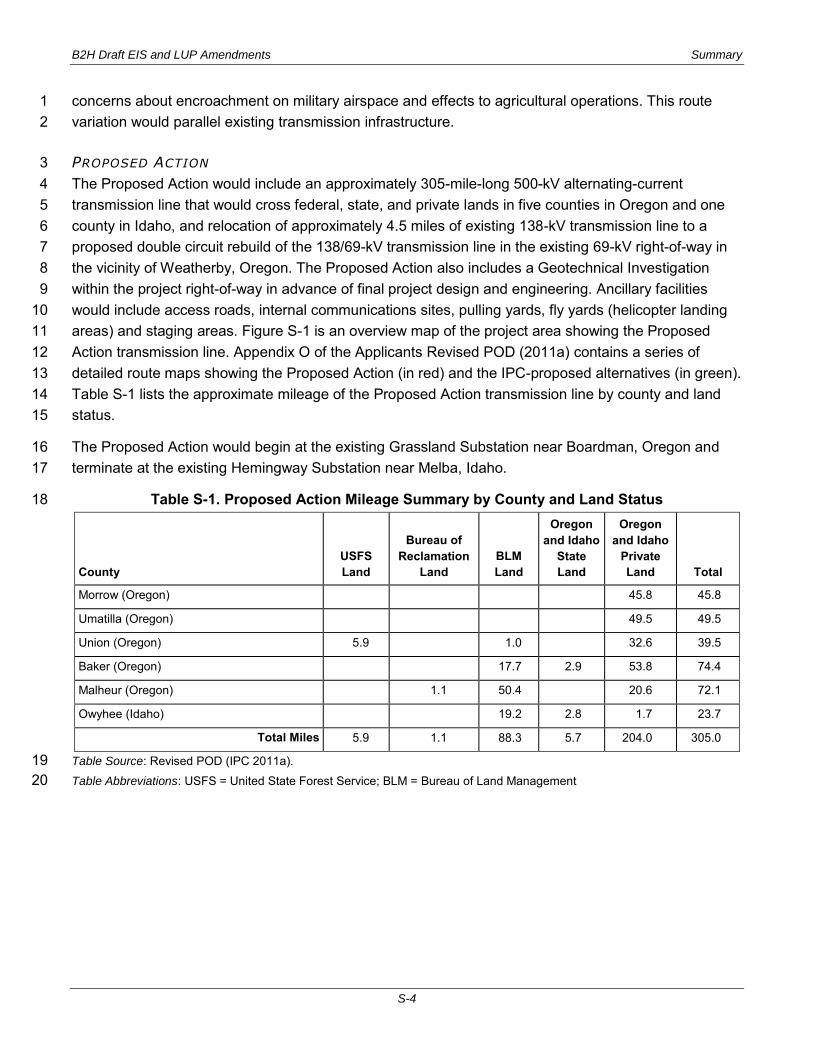
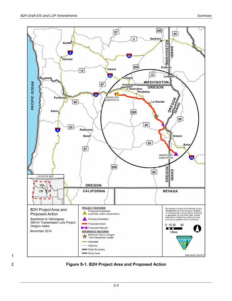
PROPOSED ACTION 3 The Proposed Action would include an approximately 305-mile-long 500-kV alternating-current 4 transmission line that would cross federal, state, and private lands in five counties in Oregon and one 5 county in Idaho, and relocation of approximately 4.5 miles of existing 138-kV transmission line to a 6 proposed double circuit rebuild of the 138/69-kV transmission line in the existing 69-kV right-of-way in 7 the vicinity of Weatherby, Oregon. The Proposed Action also includes a Geotechnical Investigation 8 within the project right-of-way in advance of final project design and engineering. Ancillary facilities 9 would include access roads, internal communications sites, pulling yards, fly yards (helicopter landing 10 areas) and staging areas. Figure S-1 is an overview map of the project area showing the Proposed 11 Action transmission line. Appendix O of the Applicants Revised POD (2011a) contains a series of 12 detailed route maps showing the Proposed Action (in red) and the IPC-proposed alternatives (in green). 13 Table S-1 lists the approximate mileage of the Proposed Action transmission line by county and land 14 status. 15
The Proposed Action would begin at the existing Grassland Substation near Boardman, Oregon and 16 terminate at the existing Hemingway Substation near Melba, Idaho. 17
Table S-1. Proposed Action Mileage Summary by County and Land Status 18
County USFS Land
Bureau of Reclamation
Land BLM Land
Oregon and Idaho
State Land
Oregon and Idaho
Private Land Total
Morrow (Oregon) 45.8 45.8
Umatilla (Oregon) 49.5 49.5
Union (Oregon) 5.9 1.0 32.6 39.5
Baker (Oregon) 17.7 2.9 53.8 74.4
Malheur (Oregon) 1.1 50.4 20.6 72.1
Owyhee (Idaho) 19.2 2.8 1.7 23.7
Total Miles 5.9 1.1 88.3 5.7 204.0 305.0
Table Source: Revised POD (IPC 2011a). 19 Table Abbreviations: USFS = United State Forest Service; BLM = Bureau of Land Management 20
B2H Draft EIS and LUP Amendments Summary
S-5
1
Figure S-1. B2H Project Area and Proposed Action 2
B2H Draft EIS and LUP Amendments Summary
S-6
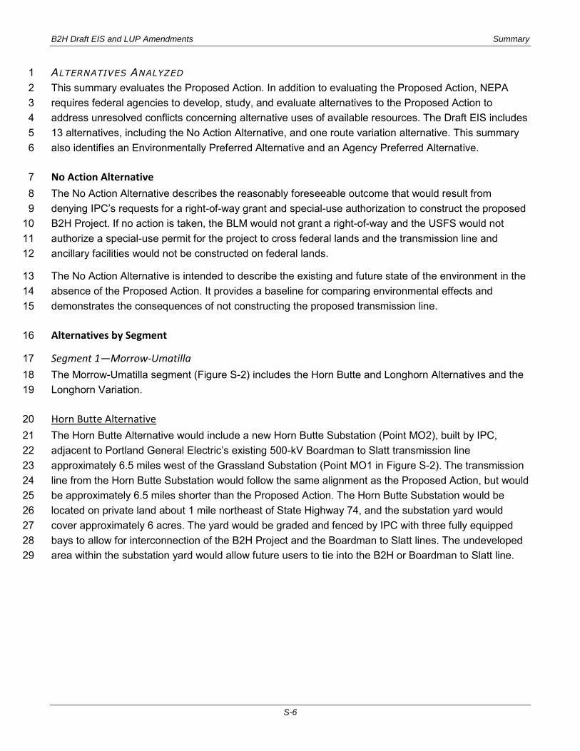
ALTERNATIVES ANALYZED 1 This summary evaluates the Proposed Action. In addition to evaluating the Proposed Action, NEPA 2 requires federal agencies to develop, study, and evaluate alternatives to the Proposed Action to 3 address unresolved conflicts concerning alternative uses of available resources. The Draft EIS includes 4 13 alternatives, including the No Action Alternative, and one route variation alternative. This summary 5 also identifies an Environmentally Preferred Alternative and an Agency Preferred Alternative. 6
No Action Alternative 7 The No Action Alternative describes the reasonably foreseeable outcome that would result from 8 denying IPC’s requests for a right-of-way grant and special-use authorization to construct the proposed 9 B2H Project. If no action is taken, the BLM would not grant a right-of-way and the USFS would not 10 authorize a special-use permit for the project to cross federal lands and the transmission line and 11 ancillary facilities would not be constructed on federal lands. 12
The No Action Alternative is intended to describe the existing and future state of the environment in the 13 absence of the Proposed Action. It provides a baseline for comparing environmental effects and 14 demonstrates the consequences of not constructing the proposed transmission line. 15
Alternatives by Segment 16
Segment 1—Morrow-Umatilla 17 The Morrow-Umatilla segment (Figure S-2) includes the Horn Butte and Longhorn Alternatives and the 18 Longhorn Variation. 19
Horn Butte Alternative 20 The Horn Butte Alternative would include a new Horn Butte Substation (Point MO2), built by IPC, 21 adjacent to Portland General Electric’s existing 500-kV Boardman to Slatt transmission line 22 approximately 6.5 miles west of the Grassland Substation (Point MO1 in Figure S-2). The transmission 23 line from the Horn Butte Substation would follow the same alignment as the Proposed Action, but would 24 be approximately 6.5 miles shorter than the Proposed Action. The Horn Butte Substation would be 25 located on private land about 1 mile northeast of State Highway 74, and the substation yard would 26 cover approximately 6 acres. The yard would be graded and fenced by IPC with three fully equipped 27 bays to allow for interconnection of the B2H Project and the Boardman to Slatt lines. The undeveloped 28 area within the substation yard would allow future users to tie into the B2H or Boardman to Slatt line. 29
B2H Draft EIS and LUP Amendments Summary
S-7
Longhorn Alternative 1 The Longhorn Alternative would be an 18.4-mile-long line located predominantly on private land in 2 Morrow County (MO4 to MO3 on Figure S-2), except where the alignment crosses a canal and land 3 managed by the Bureau of Reclamation for approximately 0.02 miles (107 feet). The Longhorn 4 Alternative would cross 2.9 miles of a Department of the Navy Approach Zone Easement on private 5 property adjacent to the Naval Weapons Systems Training Facility Boardman. The terms of the 6 approach zone easement limit structure heights within the easement to a maximum of 35 feet above 7 grade; this height limitation may affect the design of structures in the easement area. 8
IPC identified BPA’s proposed Longhorn Substation as a potential alternative northern terminus of the 9 B2H Project for analysis in this Draft EIS. The Longhorn Substation would be located on BPA-owned 10 land just west of the Port of Morrow due north of the Boardman Bombing Range road, about 0.25 to 0.5 11 mile north of I-84 (Point MO4 in Figure S-2). The substation would be adjacent to an existing 12 transmission corridor composed of one 500-kV line and two 230-kV lines. BPA would provide 2 acres 13 within the proposed Longhorn Substation site for the B2H Project. 14
The Revised POD presumes that the Longhorn Substation would be constructed prior to 15 interconnection of B2H. BPA has not made a decision to construct the substation, therefore has not yet 16 finalized plans or a schedule for construction. 17
Longhorn Variation Alternative 18 The Longhorn Variation Alternative was developed to address concerns raised by the Navy with the 19 Longhorn Alternative about encroachment on military airspace, to minimize effects to irrigated 20 agriculture in the area, and to align with an existing transmission corridor. The Longhorn Variation is 21 22.6-miles-long located predominantly on private land in Morrow County on the east boundary of the 22 Naval Weapons Training Facility on Bombing Range Road (Figure S-2). The Longhorn Variation, 23 although closer to the Naval Weapons Systems Training Facility, would align with an existing 24 transmission line. The centerline of the Longhorn Variation does not extend onto the Training Facility, 25 yet the right-of-way would extend onto land managed by the Naval Weapons Systems Training Facility. 26
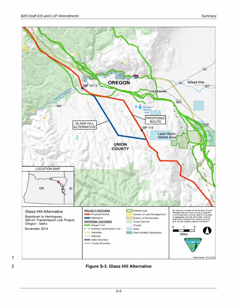
Segment 2—Blue Mountains 27 The Blue Mountains segment includes the Glass Hill Alternative (Figure S-3). 28
Glass Hill Alternative 29 The Glass Hill Alternative was developed to address concerns about the Proposed Action’s proximity to 30 the Ladd Marsh Wildlife Management Area and visibility concerns from La Grande in Union County. 31 The Glass Hill Alternative is approximately 7.5-miles-long located to the west of the Proposed Action on 32 private land in Union County near La Grande, Oregon. The Glass Hill Alternative is the same length as 33 the Proposed Action. 34

B2H Draft EIS and LUP Amendments Summary
S-8
1
Figure S-2. Longhorn Alternative, Longhorn Variation, and Horn Butte Alternative 2
3
B2H Draft EIS and LUP Amendments Summary
S-9
1
Figure S-3. Glass Hill Alternative 2
B2H Draft EIS and LUP Amendments Summary
S-10
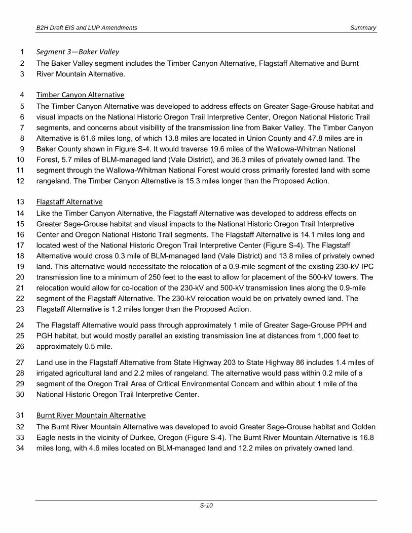
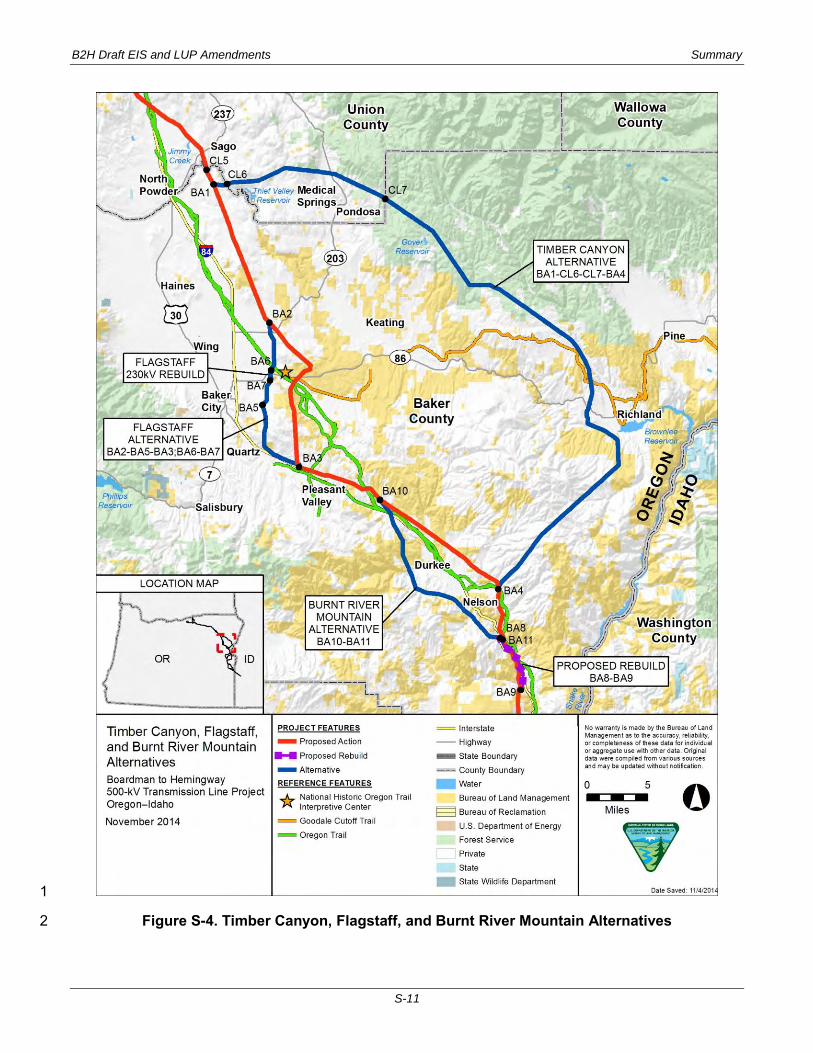
Segment 3—Baker Valley 1 The Baker Valley segment includes the Timber Canyon Alternative, Flagstaff Alternative and Burnt 2 River Mountain Alternative. 3
Timber Canyon Alternative 4 The Timber Canyon Alternative was developed to address effects on Greater Sage-Grouse habitat and 5 visual impacts on the National Historic Oregon Trail Interpretive Center, Oregon National Historic Trail 6 segments, and concerns about visibility of the transmission line from Baker Valley. The Timber Canyon 7 Alternative is 61.6 miles long, of which 13.8 miles are located in Union County and 47.8 miles are in 8 Baker County shown in Figure S-4. It would traverse 19.6 miles of the Wallowa-Whitman National 9 Forest, 5.7 miles of BLM-managed land (Vale District), and 36.3 miles of privately owned land. The 10 segment through the Wallowa-Whitman National Forest would cross primarily forested land with some 11 rangeland. The Timber Canyon Alternative is 15.3 miles longer than the Proposed Action. 12
Flagstaff Alternative 13 Like the Timber Canyon Alternative, the Flagstaff Alternative was developed to address effects on 14 Greater Sage-Grouse habitat and visual impacts to the National Historic Oregon Trail Interpretive 15 Center and Oregon National Historic Trail segments. The Flagstaff Alternative is 14.1 miles long and 16 located west of the National Historic Oregon Trail Interpretive Center (Figure S-4). The Flagstaff 17 Alternative would cross 0.3 mile of BLM-managed land (Vale District) and 13.8 miles of privately owned 18 land. This alternative would necessitate the relocation of a 0.9-mile segment of the existing 230-kV IPC 19 transmission line to a minimum of 250 feet to the east to allow for placement of the 500-kV towers. The 20 relocation would allow for co-location of the 230-kV and 500-kV transmission lines along the 0.9-mile 21 segment of the Flagstaff Alternative. The 230-kV relocation would be on privately owned land. The 22 Flagstaff Alternative is 1.2 miles longer than the Proposed Action. 23
The Flagstaff Alternative would pass through approximately 1 mile of Greater Sage-Grouse PPH and 24 PGH habitat, but would mostly parallel an existing transmission line at distances from 1,000 feet to 25 approximately 0.5 mile. 26
Land use in the Flagstaff Alternative from State Highway 203 to State Highway 86 includes 1.4 miles of 27 irrigated agricultural land and 2.2 miles of rangeland. The alternative would pass within 0.2 mile of a 28 segment of the Oregon Trail Area of Critical Environmental Concern and within about 1 mile of the 29 National Historic Oregon Trail Interpretive Center. 30
Burnt River Mountain Alternative 31 The Burnt River Mountain Alternative was developed to avoid Greater Sage-Grouse habitat and Golden 32 Eagle nests in the vicinity of Durkee, Oregon (Figure S-4). The Burnt River Mountain Alternative is 16.8 33 miles long, with 4.6 miles located on BLM-managed land and 12.2 miles on privately owned land. 34
B2H Draft EIS and LUP Amendments Summary
S-11
1
Figure S-4. Timber Canyon, Flagstaff, and Burnt River Mountain Alternatives 2
B2H Draft EIS and LUP Amendments Summary
S-12
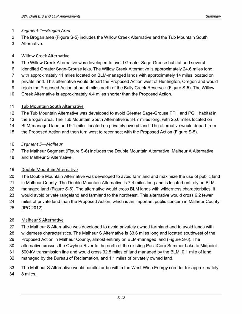
Segment 4—Brogan Area 1 The Brogan area (Figure S-5) includes the Willow Creek Alternative and the Tub Mountain South 2 Alternative. 3
Willow Creek Alternative 4 The Willow Creek Alternative was developed to avoid Greater Sage-Grouse habitat and several 5 identified Greater Sage-Grouse leks. The Willow Creek Alternative is approximately 24.6 miles long, 6 with approximately 11 miles located on BLM-managed lands with approximately 14 miles located on 7 private land. This alternative would depart the Proposed Action west of Huntington, Oregon and would 8 rejoin the Proposed Action about 4 miles north of the Bully Creek Reservoir (Figure S-5). The Willow 9 Creek Alternative is approximately 4.4 miles shorter than the Proposed Action. 10
Tub Mountain South Alternative 11 The Tub Mountain Alternative was developed to avoid Greater Sage-Grouse PPH and PGH habitat in 12 the Brogan area. The Tub Mountain South Alternative is 34.7 miles long, with 25.6 miles located on 13 BLM-managed land and 9.1 miles located on privately owned land. The alternative would depart from 14 the Proposed Action and then turn west to reconnect with the Proposed Action (Figure S-5). 15
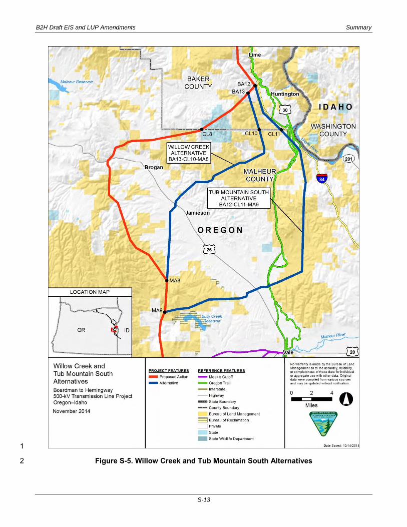
Segment 5—Malheur 16 The Malheur Segment (Figure S-6) includes the Double Mountain Alternative, Malheur A Alternative, 17 and Malheur S Alternative. 18
Double Mountain Alternative 19 The Double Mountain Alternative was developed to avoid farmland and maximize the use of public land 20 in Malheur County. The Double Mountain Alternative is 7.4 miles long and is located entirely on BLM-21 managed land (Figure S-6). The alternative would cross BLM lands with wilderness characteristics; it 22 would avoid private rangeland and farmland to the northeast. This alternative would cross 6.2 fewer 23 miles of private land than the Proposed Action, which is an important public concern in Malheur County 24 (IPC 2012). 25
Malheur S Alternative 26 The Malheur S Alternative was developed to avoid privately owned farmland and to avoid lands with 27 wilderness characteristics. The Malheur S Alternative is 33.6 miles long and located southwest of the 28 Proposed Action in Malheur County, almost entirely on BLM-managed land (Figure S-6). The 29 alternative crosses the Owyhee River to the north of the existing PacifiCorp Summer Lake to Midpoint 30 500-kV transmission line and would cross 32.5 miles of land managed by the BLM, 0.1 mile of land 31 managed by the Bureau of Reclamation, and 1.1 miles of privately owned land. 32
The Malheur S Alternative would parallel or be within the West-Wide Energy corridor for approximately 33 8 miles. 34
B2H Draft EIS and LUP Amendments Summary
S-13
1
Figure S-5. Willow Creek and Tub Mountain South Alternatives 2
B2H Draft EIS and LUP Amendments Summary
S-14
1
Figure S-6. Double Mountain, Malheur S, and Malheur A Alternatives 2

B2H Draft EIS and LUP Amendments Summary
S-15
Malheur A Alternative 1 The Malheur A Alternative (Figure S-6) was developed to be within or closely paralleling the West-Wide 2 Energy corridor in the vicinity of the Owyhee Dam. 3
The Malheur A Alternative is 33.2 miles long and would be located almost entirely on BLM-managed 4 land, with 0.4 mile located on land managed by the Bureau of Reclamation and 1.5 miles located on 5 privately owned land. The vast majority of this alternative would traverse severe terrain, rangeland, and 6 sagebrush habitat with little existing development and would avoid lands with wilderness 7 characteristics. 8
Segment 6—Treasure Valley 9 There are no alternatives to the Proposed Action in Segment 6. 10
SUMMARY OF RESIDUAL IMPACTS 11
EARTH RESOURCES 12
Geologic Hazards 13 The risk interval for geological hazards during construction is approximately 2 years and is therefore 14 temporary and short term. With preconstruction site analysis, site-specific design, and incorporation of 15 the design features the risk of landslide damage to B2H project infrastructure during construction and 16 operations would be low for the Proposed Action and the alternatives. While still rated as low for 17 landslide risk, the Timber Canyon and Malheur A Alternatives have a higher landslide risk than the 18 Proposed Action. 19
Soils 20 In most project segments, the disturbances to soils and potential for reclamation success of the 21 alternatives are generally similar for all alternatives. Direct and indirect erosion impacts on soils caused 22 by construction of the Proposed Action and alternatives would be short term during the construction 23 period and localized in the construction areas. Short-term effects would therefore be moderate with 24 effective implementation of the required erosion control design standards and BMPs. With effective 25 reclamation and implementation and long-term maintenance of erosion control measures, long-term 26 effects on soils during operations would be low. 27
Minerals 28 Direct and indirect, short-term and long-term effects on mineral resources and extractive activities for 29 the proposed B2H Project as a whole would be low because construction and operation of the 30 Proposed Action or the alternatives would not displace mineral operations. 31
Paleontological Resources 32 The potential disturbances to paleontological resources due to the Proposed Action and the alternatives 33 are generally similar in character, with minor variations due to the relative lengths of the alternatives in 34 areas of high potential fossil yield as compared with the Proposed Action. Preconstruction surveys of 35

B2H Draft EIS and LUP Amendments Summary
S-16
high potential fossil yield areas, successful implementation of the Paleontological Monitoring and 1 Mitigation Plan and Unanticipated Discovery Plan and construction monitoring in areas of high potential 2 for fossil occurrence would minimize adverse effects on paleontological resources and the potential for 3 adverse effects would be low. 4
WATER RESOURCES 5
Surface Water 6 With implementation and maintenance of the SWPPP, ESCP, SPCC and appropriate design features in 7 the analysis area during construction, short-term effects on surface water quality as a result of 8 construction of stream crossings would be moderate in localized areas of surface disturbance and 9 short-term during the period of construction of each individual stream-crossing structure. Other ground 10 disturbing activities in the vicinity of surface waters would result in low effects to water quality. Thinning 11 or removal of vegetation adjacent to surface water bodies would be managed to adequately protect 12 water quality and minimize water temperature effects. Buffers of riparian vegetation would be provided 13 in accordance with either default buffers established by jurisdictional agencies or buffers determined 14 through site-specific analysis. 15
Section 303(d) Listed Streams 16 Vegetation removal associated with crossings in forested settings is expected to be minimal and 17 localized and is not expected to produce an overall increase in stream water temperatures. Because 18 less than 1 acre of forested riparian vegetation adjacent to a Section 303 (d) temperature-listed stream 19 would be disturbed by construction of the proposed B2H Project, construction effects on temperature 20 limited streams are expected to be low. Operation effects are anticipated to be negligible. 21
With effective implementation and maintenance of design features and the measures contained in the 22 SWPPP and ESCP, proposed B2H Project construction and operation effects on Section 303(d) 23 sediment–impaired streams are expected to be low and short-term. 24
Groundwater 25 The construction and operations effects of most of the alternatives on groundwater generally would be 26 the same as for the Proposed Action, with minor quantitative variations based on the relative lengths of 27 the alternatives as compared to the Proposed Action. The Longhorn and Timber Canyon Alternatives, 28 however, would have a noticeably higher potential effect on groundwater drinking water sources than 29 the Proposed Action. However, with effective implementation of mitigation measures, the construction 30 effects on groundwater for any of the alternatives would be low. 31

B2H Draft EIS and LUP Amendments Summary
S-17
Wetlands 1 Construction effects to wetlands would be short-term, limited to the area of construction activity, and 2 would therefore be moderate for the Proposed Action and all alternatives. Operation of the Proposed 3 Action would have a long-term impact to 5.31 acres of wetlands. Approximately 1.09 acres of the 5.31 4 acres would be long-term loss of emergent wetlands and approximately 0.97 acres would be long-term 5 loss of scrub-shrub wetlands. Because these effects would be long-term, they would constitute a 6 moderate impact to wetlands in the B2H Project area. 7
VEGETATION 8
Vegetation Communities 9 Sensitive vegetation, including riparian communities, would be avoided or spanned and vegetation 10 clearing would be limited in riparian habitats to minimize adverse impacts. Application of these 11 mitigation measures would allow sensitive vegetation to remain undisturbed by the B2H Project and 12 available for use by wildlife. Avoiding or spanning these resources also would lower the risk of 13 introduction of weeds and invasive species and would reduce overall habitat fragmentation associated 14 with the project. 15
Federally Listed, Candidate Species and Special Status Species 16 Effects to listed species will be consistent regardless of listing status. Pre-construction surveys for ESA 17 Candidate species would be conducted along the selected alternative for the transmission line and 18 associated facilities. Appropriate action would be taken to avoid adverse impacts on ESA Candidate 19 species and their habitats. If federally listed or ESA Candidate species are discovered, IPC would 20 establish a spatial buffer zone and immediately contact the appropriate land-managing agency. 21
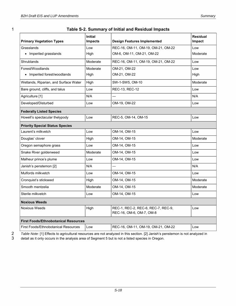
Impacts to resources will be addressed by implementation of design features where applicable. These 22 design features are meant to reduce project impacts to the lowest level possible. In some cases the 23 implementation of design features may not significantly reduce the level of effect, resulting in residual 24 impacts. The summary of residual impacts is provided in Table S-2. 25
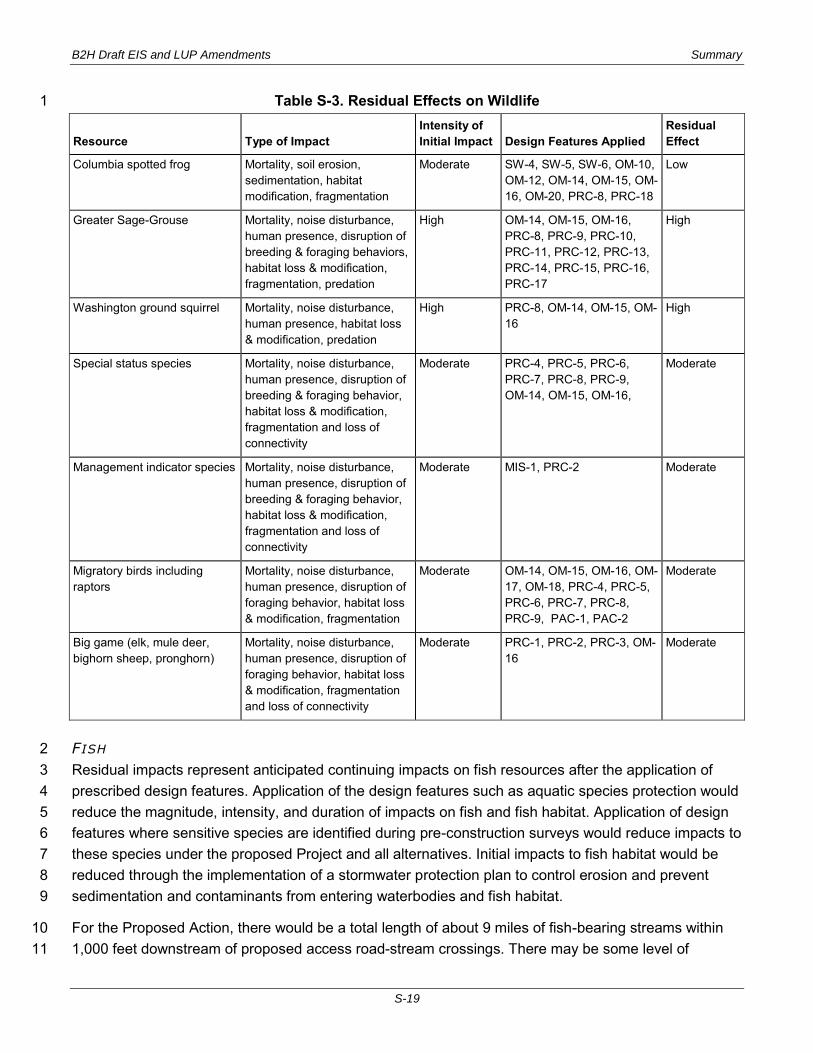
WILDLIFE 26 Impacts to resources will be addressed by implementation of design features, where applicable. These 27 design features are meant to reduce project impacts to the lowest level possible. In some cases, the 28 implementation of design features may not significantly reduce the level of effect, resulting in residual 29 effects. The summary of residual effects is provided in Table S-3. Residual effects to wildlife habitat are 30 the same as residual effects to the primary vegetation communities discussed in the Vegetation Section 31 (Section 3.2.3). Residual effects are the same for the Proposed Action and all alternatives so no 32 distinction is made among alternatives. 33
B2H Draft EIS and LUP Amendments Summary
S-18
Table S-2. Summary of Initial and Residual Impacts 1
Primary Vegetation Types Initial Impacts Design Features Implemented
Residual Impact
Grasslands
Imperiled grasslands
Low
High
REC-16, OM-11, OM-19, OM-21, OM-22
OM-6, OM-11, OM-21, OM-22
Low
Moderate
Shrublands Moderate REC-16, OM-11, OM-19, OM-21, OM-22 Low
Forest/Woodlands
Imperiled forest/woodlands
Moderate
High
OM-21, OM-22
OM-21, OM-22
Low
High
Wetlands, Riparian, and Surface Water High SW-1-SW5, OM-10 Moderate
Bare ground, cliffs, and talus Low REC-13, REC-12 Low
Agriculture [1] N/A — N/A
Developed/Disturbed Low OM-19, OM-22 Low
Federally Listed Species Howell’s spectacular thelypody Low REC-5, OM-14, OM-15 Low
Priority Special Status Species Laurent’s milkvetch Low OM-14, OM-15 Low
Douglas’ clover High OM-14, OM-15 Moderate
Oregon semaphore grass Low OM-14, OM-15 Low
Snake River goldenweed Moderate OM-14, OM-15 Low
Malheur prince’s plume Low OM-14, OM-15 Low
Janish’s penstemon [2] N/A — N/A
Mulfords milkvetch Low OM-14, OM-15 Low
Cronquist’s stickseed High OM-14, OM-15 Moderate
Smooth mentzelia Moderate OM-14, OM-15 Moderate
Sterile milkvetch Low OM-14, OM-15 Low
Noxious Weeds Noxious Weeds High REC-1, REC-2, REC-6, REC-7, REC-9,
REC-16, OM-6, OM-7, OM-8 Low
First Foods/Ethnobotanical Resources First Foods/Ethnobotanical Resources Low REC-16, OM-11, OM-19, OM-21, OM-22 Low
Table Note: [1] Effects to agricultural resources are not analyzed in this section. [2] Janish’s penstemon is not analyzed in 2 detail as it only occurs in the analysis area of Segment 5 but is not a listed species in Oregon. 3
B2H Draft EIS and LUP Amendments Summary
S-19
Table S-3. Residual Effects on Wildlife 1
Resource Type of Impact Intensity of Initial Impact Design Features Applied
Residual Effect
Columbia spotted frog Mortality, soil erosion, sedimentation, habitat modification, fragmentation
Moderate SW-4, SW-5, SW-6, OM-10, OM-12, OM-14, OM-15, OM-16, OM-20, PRC-8, PRC-18
Low
Greater Sage-Grouse Mortality, noise disturbance, human presence, disruption of breeding & foraging behaviors, habitat loss & modification, fragmentation, predation
High OM-14, OM-15, OM-16, PRC-8, PRC-9, PRC-10, PRC-11, PRC-12, PRC-13, PRC-14, PRC-15, PRC-16, PRC-17
High
Washington ground squirrel Mortality, noise disturbance, human presence, habitat loss & modification, predation
High PRC-8, OM-14, OM-15, OM-16
High
Special status species Mortality, noise disturbance, human presence, disruption of breeding & foraging behavior, habitat loss & modification, fragmentation and loss of connectivity
Moderate PRC-4, PRC-5, PRC-6, PRC-7, PRC-8, PRC-9, OM-14, OM-15, OM-16,
Moderate
Management indicator species Mortality, noise disturbance, human presence, disruption of breeding & foraging behavior, habitat loss & modification, fragmentation and loss of connectivity
Moderate MIS-1, PRC-2 Moderate
Migratory birds including raptors
Mortality, noise disturbance, human presence, disruption of foraging behavior, habitat loss & modification, fragmentation
Moderate OM-14, OM-15, OM-16, OM-17, OM-18, PRC-4, PRC-5, PRC-6, PRC-7, PRC-8, PRC-9, PAC-1, PAC-2
Moderate
Big game (elk, mule deer, bighorn sheep, pronghorn)
Mortality, noise disturbance, human presence, disruption of foraging behavior, habitat loss & modification, fragmentation and loss of connectivity
Moderate PRC-1, PRC-2, PRC-3, OM-16
Moderate
FISH 2 Residual impacts represent anticipated continuing impacts on fish resources after the application of 3 prescribed design features. Application of the design features such as aquatic species protection would 4 reduce the magnitude, intensity, and duration of impacts on fish and fish habitat. Application of design 5 features where sensitive species are identified during pre-construction surveys would reduce impacts to 6 these species under the proposed Project and all alternatives. Initial impacts to fish habitat would be 7 reduced through the implementation of a stormwater protection plan to control erosion and prevent 8 sedimentation and contaminants from entering waterbodies and fish habitat. 9
For the Proposed Action, there would be a total length of about 9 miles of fish-bearing streams within 10 1,000 feet downstream of proposed access road-stream crossings. There may be some level of 11
B2H Draft EIS and LUP Amendments Summary
S-20
residual effects to fish species and fish habitat due to construction of culvert-type stream crossings for 1 these proposed access roads. Approximately 4 miles total of affected stream length within all Project 2 Segments would be in intermittent streams which would primarily use ford-type crossings for access 3 roads. These streams would be unlikely to have any direct effects from sediment moving downstream 4 due to crossing construction, because the crossings would be constructed during the dry season when 5 flows would not be present. However, there may be some short-term or long-term effects to fish 6 passage at stream ford-type road crossings for any intermittent streams occupied by seasonally 7 migratory fish species. 8
Within all Project Segments of the Proposed Action, there would also be potential effects to fish species 9 and habitats in perennial streams and some intermittent streams resulting from ground disturbance due 10 to proposed access roads that do not cross streams, but are within 500 feet of these streams. These 11 streams and associated riparian vegetation areas may also be affected by construction, operation, and 12 maintenance of other project facilities within 500 feet. Accurate calculations related to the amount of 13 this ground disturbance within 500 feet of streams are currently not available for this Draft EIS. 14 However, the total amount of this proposed disturbance (area adjacent to streams and affected stream 15 length) may be relatively large within all Project Segments. 16
Access roads associated with the Proposed Action would cross streams primarily with culverts at or 17 within 1,000 feet upstream of fish bearing stream reaches: 8 total stream reaches occupied by 18 steelhead, 4 by Pacific lamprey, and at least 48 by redband trout. While some other fish species may 19 be present in some of these streams, specific species designations are not indicated in the ODFW or 20 StreamNet databases. A final site assessment and final engineering design of each access road-21 stream crossing would be conducted prior to construction in order to identify the fish species present 22 and the appropriate design features to apply to reduce and avoid impacts. This assessment would 23 include consideration of site specific conditions which may indicate the need for maintaining and/or 24 improving passage for native migratory fish at some proposed road crossings of fish-bearing 25 intermittent streams. 26
LAND USE, AGRICULTURE, RECREATION, TRANSPORTATION 27
Land Use 28 The short-term direct and indirect construction effects on general land uses would be moderate, in that 29 they would create an indirect conflict with residential, commercial, agriculture and military uses; would 30 create temporary impacts on agricultural and grazing operations and would indirectly affect applicable 31 adopted policies and management goals of the affected land-management agencies. 32
The areas impacted by operations and maintenance activities would be smaller than the areas 33 disturbed for construction. Overall, effects to general land uses in the B2H Project area would be low in 34 that the effects, while long-term, would not preclude use of the area for other agricultural, grazing and 35 resource development uses. 36

B2H Draft EIS and LUP Amendments Summary
S-21
Agriculture 1 The short-term direct effects of construction of the Proposed Action are anticipated to directly affect a 2 total of 1,130 acres of all types of agricultural operations during the construction period and would have 3 a moderate impact on agriculture. Impacts on agricultural and grazing operations would be short-term 4 during the construction period and limited to areas of construction activity. 5
Project operations of the Proposed Action are expected to remove approximately 600 acres of prime 6 farmland and 45 acres of irrigated agriculture from production and approximately 100 acres of dryland 7 farming. Operations of the B2H Project would permanently occupy the lands on which project facilities 8 are constructed, but some agricultural activities could continue within the right-of-way. The overall 9 operations effects of the Proposed Action to all agricultural lands would be long-term but would have a 10 low overall effect on agricultural operations, given the available agricultural lands in the project analysis 11 area. 12
Recreation 13 Construction could have short-term and localized disruptions to recreation activities. Direct effects 14 within the 250-foot right of way and indirect effects within the analysis area would be short-term (during 15 the construction period) and limited to those times when construction would occur in the immediate 16 vicinity of specific recreation areas. Access to recreation areas could be temporarily and intermittently 17 affected by construction activities. Construction could result in intermittent access delays during 18 construction. There could be temporary traffic impacts during construction. Because construction 19 effects would be short-term and localized construction is anticipated to have moderate overall effects 20 on recreational visitor experiences in the analysis area. 21
The operation and maintenance of the B2H Project would cause minimal disruption to recreational 22 activities. Routine and emergency maintenance activities within the right-of-way, including access to 23 transmission structures and lines by maintenance vehicles on local roads and access roads, could 24 temporarily disrupt recreational activities in the immediate vicinity causing low to moderate effects. 25
Transportation 26 The localized direct and indirect effects of new road construction and road improvements for the 27 Proposed Action would be high, but limited to the area of active construction and temporary during the 28 period of construction at that location. Construction, particularly the installation of structures and the 29 stringing of conductors, could affect the ground-transportation system. The direct effects of construction 30 activities within rights-of-way of public roads and highways could include temporary road closures. In 31 addition, truck delivery of large equipment and materials would require temporary road closures. During 32 construction, the overall impact to transportation would be moderate and temporary during project 33 construction. 34
Operations effects on local traffic would be short-term and low. After construction is completed, IPC 35 would work with the BLM, USFS, and Reclamation to identify new and improved construction roads that 36 should be left open to become part of the agency road system, and those that should be closed either 37

B2H Draft EIS and LUP Amendments Summary
S-22
permanently or temporarily with gates or other barricades to prevent unauthorized access on public 1 lands. 2
VISUAL RESOURCES 3 Visual resources would be impacted by the construction, operation, and maintenance of the Project. 4 Construction of the Project would potentially introduce short-term and long-term impacts on visual 5 resources. Tower construction, line stringing, equipment operation, equipment/material transport, 6 construction-related dust, and material stockpiling would attract attention resulting in short-term impacts 7 on visual resources. Ground disturbing activities related to construction and access road 8 development/improvement could result in permanent adverse impacts on visual resources. 9
After construction, the presence of large transmission towers would potentially introduce long-term 10 impacts on visual resources. Maintenance activities such as transmission line replacement/re-stringing, 11 potential transmission tower replacement, ongoing vegetative clearing within the right-of-way, and 12 vehicular access could attract attention resulting in short-term impacts on visual resources. 13
CULTURAL RESOURCES 14 Construction of the transmission line and its ancillary facilities could directly impact existing cultural 15 resources. The Cultural Resources section in Chapter 3 (Section 3.2.8.7) describes the methodology 16 used to analyze and compare impacts across segments and alternatives, for which data on previously 17 identified cultural resources is variable. Table S-4 summarizes the potential impacts to each segment 18 and alternative. Construction or other ground-disturbing activities could directly or indirectly impact a 19 wide range of cultural resources including traditional cultural properties, First Foods gathering areas, 20 Native American and emigrant trails, and buried cultural resources that have not been previously 21 identified. Such impacts are likely to be adverse. Increased use of existing and new access roads may 22 encourage unauthorized site access, artifact collection, and vandalism. Vibrations from construction 23 equipment and construction activities (such as blasting or drilling) may also impact cultural resources, 24 especially historic period resources with standing architecture or prehistoric rockshelters. Impacts on 25 the setting and feeling of cultural resources may be introduced through the addition of the project’s 26 structural elements to the landscape. Construction of transmission line towers may introduce an indirect 27 (visual) impact upon existing cultural resources, including historic trails, cultural landscapes, and 28 traditional cultural properties. 29
Once the transmission line has been constructed, the presence of large transmission towers may 30 introduce long-term impacts to the setting of certain cultural resources particularly sensitive to changes 31 in the visual field. These cultural resources could include historic trails, traditional cultural properties, 32 and cultural landscapes. Consultation with parties participating in Section 106 of the NHPA review 33 process, including OCTA and OHTAC, has indicated a concern with the B2H Project’s potential impact 34 to the Oregon NHT, and the Goodale’s and Meek Cutoff Study Trail, segments of which are located 35 within the viewshed of the proposed action and alternatives. Through Government to government 36 consultation with the BLM, Native American tribes have indicated that the introduction of electrical fields 37 in areas where power lines would be constructed could impact the ability of tribal members to use these 38 areas for traditional cultural and religious practice. 39

B2H Draft EIS and LUP Amendments Summary
S-23
Table S-4. Potential Impact Scores from the Class II and 1 Reconnaissance Level Survey/Class I Data 2
Segment and Alternative
Class II Potential Impact Index
RLS and Class I Potential Impact Index
Combined Potential Impact Index
Potential Impact Assessment
Segment 1−Morrow-Umatilla Horn Butte Alternative 0 1 1 Low
Proposed Action Compared to Horn Butte 0 0 0 Low
Longhorn Variation Alternative NS 2 – Medium*
Proposed Action Compared to Longhorn Variation 0 0 – Low*
Longhorn Alternative 3 6 9 High
Proposed Action Compared to Longhorn 0 1 1 Low
Segment 2−Blue Mountains Glass Hill Alternative 3 3 – Medium*
Proposed Action Compared to Glass Hill NS 3 – Medium*
Segment 3−Baker Valley Timber Canyon Alternative 1 3 4 Medium
Proposed Action Compared to Timber Canyon 2 3 5 High
Flagstaff Alternative NS 5 – High*
Proposed Action Compared to Flagstaff 0 4 – High*
Burnt River Mountain Alternative 2 4 6 High
Proposed Action Compared to Burnt River Mountain 10 6 16 Very High
Segment 4−Brogan Area Willow Creek Alternative 0 2 2 Medium
Proposed Action Compared to Willow Creek 1 2 3 Medium
Tub Mountain South Alternative 4 2 6 High
Proposed Action Compared to Tub Mountain South 1 2 3 Medium
Segment 5−Malheur Malheur A Alternative 1 1 2 Medium
Proposed Action Compared to Malheur A 1 2 3 Medium
Malheur S Alternative 2 2 4 Medium
Proposed Action Compared to Malheur S 2 1 3 Medium
Double Mountain Alternative 0 0 0 Low
Proposed Action Compared to Double Mountain 0 0 0 Low
Segment 6−Treasure Valley 3 6 9 High
Table Abbreviations: RLS = reconnaissance level survey; NS = No 15 percent Class II survey segments were included along 3 route. 4 Table Note: Asterisk (*) indicates that the potential impact assessment for those alternatives is based on distribution of 5 RLS/Class I index scores only (see text). Index scores could not be combined for those alternatives because no Class II 6 survey was conducted along either the Proposed Action or alternative route. 7
B2H Draft EIS and LUP Amendments Summary
S-24
Indirect effects related to operation and maintenance could consist of increased off-road traffic, which 1 would promote access to cultural resources and consequently inadvertent site impacts and intentional 2 vandalism. Auditory impacts may consist of transmission line “buzzing” or “humming” that could detract 3 from the remote sense of feeling contributing to the character-defining qualities of certain cultural 4 resources, such as historic trails, traditional cultural properties, and cultural landscapes. Continued use 5 of access roads for maintenance may also promote erosion, which could impact cultural resources 6 located along the margins of roads. Other maintenance activities, such as vegetation removal could 7 create ground disturbance, which could in turn, impact both previously identified and unidentified 8 resources. Through government to government consultation with the BLM, some Native American 9 tribes have expressed concerns that construction, operation, and maintenance activities will reduce the 10 number of plant and animal species considered sacred to them and will restrict tribal-member access 11 and use of sacred areas and First Food collection areas. 12
NATIONAL HISTORIC TRAILS 13 Construction would potentially introduce temporary impacts on visual resources, recreational 14 experiences, and historic and cultural settings, as well as permanent impacts on historic properties. 15 Construction would attract attention within the analysis area, resulting in short-term impacts on visual 16 resources and historic and cultural settings. Ground disturbing activities related to construction and 17 access road development/improvement could result in long-term impacts on unidentified NHT-18 associated historic and cultural resources, particularly those that are buried. 19
After construction, the presence of large transmission towers would potentially introduce permanent 20 impacts on visual resources, recreational experiences, and historic and cultural settings. Maintenance 21 activities could attract attention within the analysis area and could detract from the sense of feeling 22 contributing to the historic character of NHT resources. 23
Oregon National Historic Trail 24 The Proposed Action and all the alternatives with the exception of the Double Mountain Alternative 25 would contain some portion of the Oregon NHT within their respective analysis areas. The Glass Hill, 26 Malheur A, Malheur S, and Willow Creek Alternatives would have substantially less impact on the 27 landscape setting as viewed from the Oregon NHT than the Proposed Action and remaining 28 alternatives. 29
Lewis and Clark National Historic Trail 30 The Longhorn Alternative and Longhorn Variation would have low to moderate impacts to this relatively 31 small portion (2.2 miles) of the Lewis and Clark NHT in Washington. These alternatives would not 32 compromise the landscape setting of the Lewis and Clark Trail NHT. 33
Goodale’s Cutoff Study Trail 34 The Proposed Action and the Timber Canyon, Flagstaff, Willow Creek, and Tub Mountain South 35 alternatives would be visible from the Goodale’s Cutoff Study Trail. The project components associated 36 with the Proposed Action and the Timber Canyon Alternative would dominant the landscape in the 37

B2H Draft EIS and LUP Amendments Summary
S-25
foreground of the trail and create strong visual contrast as compared to other features in the existing 1 landscape. The Willow Creek and Tub Mountain South alternatives would not be seen from the 2 foreground of the trail. 3
Meek Cutoff Study Trail 4 The Proposed Action and the Malheur A and Malheur S Alternatives would be the only alternatives that 5 would impact the Meek Cutoff Study Trail. The project components associated with the Malheur A and 6 Malheur S Alternatives would not be visually evident in the existing landscape setting, but the 7 alternatives would be seen for more than 80 percent of the total miles of Trail within the analysis areas. 8
AIR QUALITY AND CLIMATE CHANGE 9 Construction activities that would generate emissions include land clearing, ground excavation, and cut 10 and fill operations. The intermittent and short-term emissions generated by these activities would 11 include dust from soil disruption and combustion emissions from the construction equipment. Emissions 12 associated with construction equipment include PM10, PM2.5 (particulate matter less than 2.5 microns), 13 nitrogen oxides, carbon monoxide, volatile organic compounds, sulfur oxides, and small amounts of air 14 toxic pollutants. These emissions could result in low, short-term impacts on air quality in the immediate 15 vicinity of project construction. 16
SOCIOECONOMICS AND ENVIRONMENTAL JUSTICE 17 The construction of the B2H could affect the population, temporary housing, and the economy. The 18 temporary construction workforce would increase the population by approximately 494 people, which 19 represents less than a 0.5 percent increase. The short-term increase of temporary workers would 20 increase the demand for temporary housing. However, based on the adequate supply of local housing 21 and lodging, the impacts would be short-term, and low. 22
Project-related expenditures, employment, and construction-related earnings from the B2H Project 23 would have a positive impact on the local economy and employment for the duration of construction. 24 Long-term economic impacts from the B2H Project would be associated with operation and 25 maintenance-related expenditures on materials and supplies. These economic impacts would be small, 26 especially when compared to the construction-related impacts. 27
PUBLIC HEALTH AND SAFETY 28 Energizing the transmission lines creates electromagnetic fields that would vary based on the time of 29 year, line loading, and environmental factors. The modeled electromagnetic fields are within the 30 established standards. As a result, the impacts would be low. 31
SUMMARY COMPARISON OF ALTERNATIVES 32
Based on the analysis presented in Chapter 3, the alternatives were compared to determine the 33 Environmentally Preferred Alternative and the selection of the Agency Preferred Alternative. Key 34 resource criteria were identified and comparatively quantified to compare relative impacts between 35 alternatives. Resource specialists used their on-the-ground knowledge, special expertise, available 36
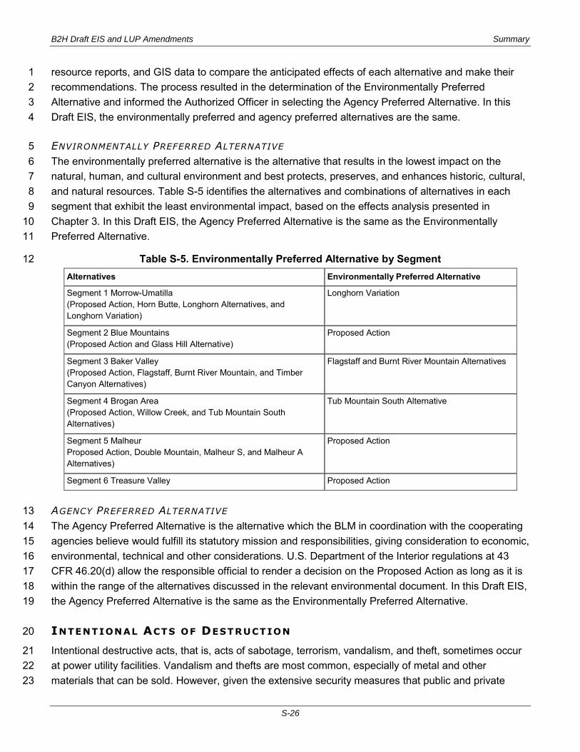
B2H Draft EIS and LUP Amendments Summary
S-26
resource reports, and GIS data to compare the anticipated effects of each alternative and make their 1 recommendations. The process resulted in the determination of the Environmentally Preferred 2 Alternative and informed the Authorized Officer in selecting the Agency Preferred Alternative. In this 3 Draft EIS, the environmentally preferred and agency preferred alternatives are the same. 4
ENVIRONMENTALLY PREFERRED ALTERNATIVE 5 The environmentally preferred alternative is the alternative that results in the lowest impact on the 6 natural, human, and cultural environment and best protects, preserves, and enhances historic, cultural, 7 and natural resources. Table S-5 identifies the alternatives and combinations of alternatives in each 8 segment that exhibit the least environmental impact, based on the effects analysis presented in 9 Chapter 3. In this Draft EIS, the Agency Preferred Alternative is the same as the Environmentally 10 Preferred Alternative. 11
Table S-5. Environmentally Preferred Alternative by Segment 12 Alternatives Environmentally Preferred Alternative
Segment 1 Morrow-Umatilla (Proposed Action, Horn Butte, Longhorn Alternatives, and Longhorn Variation)
Longhorn Variation
Segment 2 Blue Mountains (Proposed Action and Glass Hill Alternative)
Proposed Action
Segment 3 Baker Valley (Proposed Action, Flagstaff, Burnt River Mountain, and Timber Canyon Alternatives)
Flagstaff and Burnt River Mountain Alternatives
Segment 4 Brogan Area (Proposed Action, Willow Creek, and Tub Mountain South Alternatives)
Tub Mountain South Alternative
Segment 5 Malheur Proposed Action, Double Mountain, Malheur S, and Malheur A Alternatives)
Proposed Action
Segment 6 Treasure Valley Proposed Action
AGENCY PREFERRED ALTERNATIVE 13 The Agency Preferred Alternative is the alternative which the BLM in coordination with the cooperating 14 agencies believe would fulfill its statutory mission and responsibilities, giving consideration to economic, 15 environmental, technical and other considerations. U.S. Department of the Interior regulations at 43 16 CFR 46.20(d) allow the responsible official to render a decision on the Proposed Action as long as it is 17 within the range of the alternatives discussed in the relevant environmental document. In this Draft EIS, 18 the Agency Preferred Alternative is the same as the Environmentally Preferred Alternative. 19
INTENTIONAL ACTS OF DESTRUCTION 20
Intentional destructive acts, that is, acts of sabotage, terrorism, vandalism, and theft, sometimes occur 21 at power utility facilities. Vandalism and thefts are most common, especially of metal and other 22 materials that can be sold. However, given the extensive security measures that public and private 23
B2H Draft EIS and LUP Amendments Summary
S-27
utilities, energy resource developers, and federal agencies such as the U.S .Department of Homeland 1 Security have and are continuing to implement to help prevent such acts and protect their facilities, 2 along with the inherent difficulty in significantly affecting such large and well-constructed facilities as 3 transmission towers and substation sites, it is considered extremely remote and unlikely that a 4 significant terrorist or sabotage act would occur. 5
PLAN AMENDMENTS 6
Several aspects of the Proposed Action and alternatives would likely require plan amendments to the 7 following federal land use plans: 8
BLM Baker Resource Management Plan 9
BLM Southeastern Oregon Resource Management Plan 10
Wallowa-Whitman National Forest Land and Resource Management Plan 11
BLM BAKER RESOURCE MANAGEMENT PLAN 12 Because of the visual contrast, the Proposed Action would not be in conformance with VRM Class III 13 objectives established in the RMP for the area near the National Historic Oregon Trail Interpretive 14 Center near Baker, Oregon. The purpose of the RMP amendment would be to modify the Baker RMP 15 regarding visual resource management in order to grant a right-of-way for the Proposed Action across 16 BLM-administered lands managed under the Baker RMP. Amending the land-use plan would result in 17 70 less acres in VRM Class III and 70 more acres in VRM Class IV. 18
BLM SOUTHEAST OREGON RESOURCE MANAGEMENT PLAN 19 Due to the visual contrast produced by the project, after the application of appropriate selective 20 mitigation measures the visual effects of the following areas would not be compliant with the Visual 21 Resource Management Class for these areas. The Tub Mountain South Alternative would not be in 22 conformance with VRM Class III objectives established in the RMP for areas near segments of the 23 National Historic Oregon Trail ACEC. The Proposed Action would not be in conformance with Class II 24 objectives established for the suitable Owyhee River Below the Dam Wild and Scenic River Segment. 25 The Malheur A and Malheur S Alternatives would not be in conformance with Class II objectives 26 established for the Owyhee River Below the Dam ACEC and the suitable Owyhee River Below the Dam 27 Wild and Scenic River Segment. 28
In order to grant a right-of-way for the Proposed Action, the Tub Mountain South Alternative, the 29 Malheur S Alternative, or the Malheur A Alternative the visual resources classification would need to be 30 modified. 31
For the Proposed Action, the portion of the 250-feet-right-of-way within VRM Class II in lands in the 32 Owyhee River Below the Dam ACEC would be amended to VRM Class IV. This change would affect 33 approximately 15 acres. 34

B2H Draft EIS and LUP Amendments Summary
S-28
For the Tub Mountain South Alternative, the portion of the 250-feet-wide right-of-way within VRM Class 1 III in the vicinity of the National Historic Oregon Trail ACEC would be amended to VRM Class IV. 2 Approximately 112 acres would be affected. 3
For the Malheur S Alternative, the portion of the 250-feet-wide right-of-way within VRM Class II in the 4 Owyhee River Below the Dam ACEC would be amended to VRM Class IV. Approximately 23 acres 5 would be affected. 6
For the Malheur A Alternative, the portion of the 250-feet-right-of-way within VRM Class II land in the 7 Owyhee River Below the Dam ACEC would be amended to VRM Class IV. Approximately 79 acres 8 would be affected. 9
WALLOWA-WHITMAN NATIONAL FOREST LAND AND RESOURCE MANAGEMENT PLAN 10 In order to authorize the Proposed Action, the Wallowa-Whitman National Forest LRMP would need to 11 be amended to re-designate 110 acres of VQO Partial Retention to VQO Modification. The location of 12 the re-designations would be in an existing utility corridor through the Blue Mountains generally 13 paralleling I-84 and which includes an existing transmission line. 14
To authorize the Timber Canyon Alternative, the Wallowa-Whitman National Forest LRMP would likely 15 be amended to reallocate approximately 344 acres of National Forest System from five Management 16 Area allocations to Management Area 17 and to re-designate VQO designations of Partial Retention 17 and Modification to Maximum Modification. 18
CONSULTATION AND COORDINATION 19
In addition to the planning, analysis, and review activities of the EIS preparation, the BLM is conducting 20 consultation, coordination, and public participation. This started with public scoping and will continue 21 throughout the EIS process. The purpose of the consultation and coordination program is to encourage 22 interaction between the BLM and other federal, state, and local agencies; Native American tribes; and 23 the public. BLM’s initiative is to inform the public about the project and solicit input to assist in analysis 24 and decision making. 25
The BLM has made formal and informal efforts to involve, consult, and coordinate with other agencies, 26 tribes, and the public. These efforts ensure that the most appropriate data have been gathered and 27 analyzed and that agency policy and public sentiment and values are considered and incorporated. 28