Draft Environmental Impact Report/ Environmental Assessment and
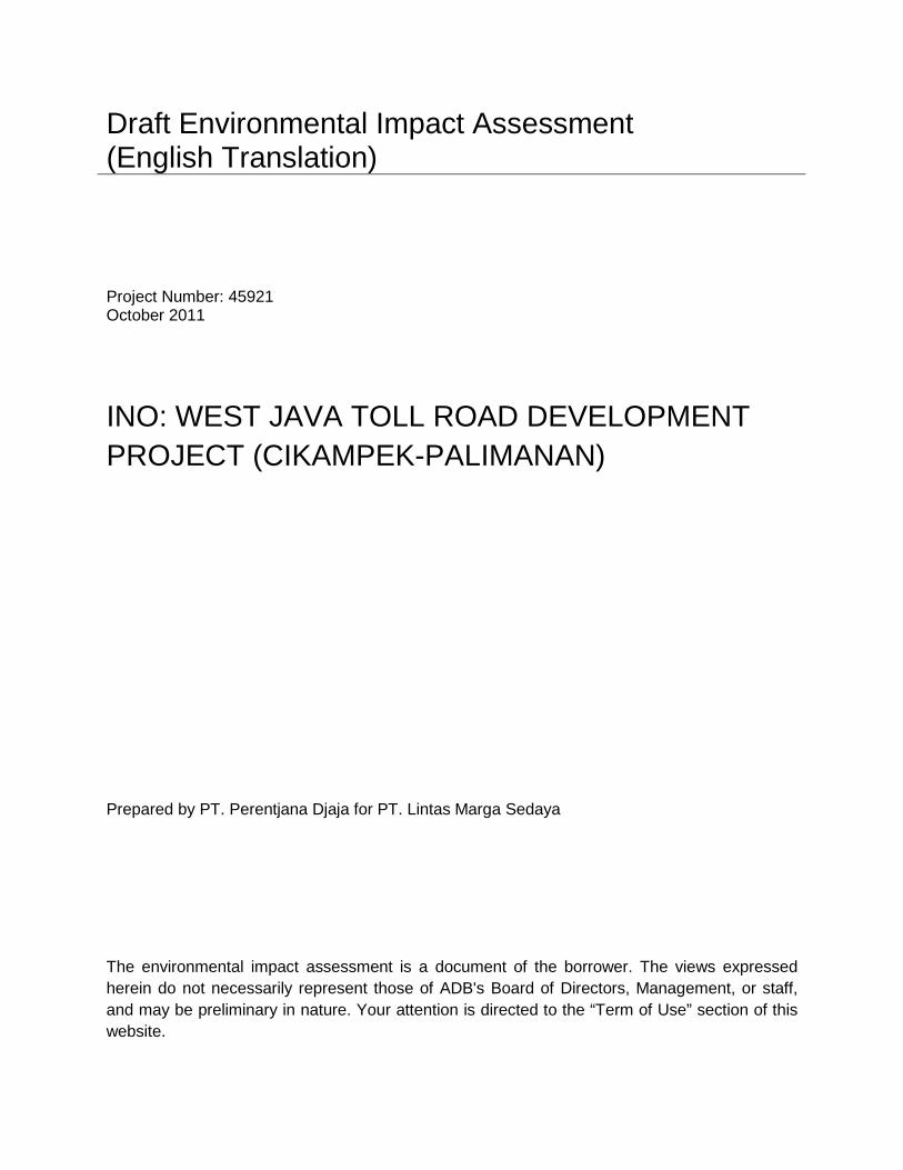
Draft Environmental Impact Assessment (English Translation) Project Number: 45921 October 2011
INO: WEST JAVA TOLL ROAD DEVELOPMENT PROJECT (CIKAMPEK-PALIMANAN) Prepared by PT. Perentjana Djaja for PT. Lintas Marga Sedaya
The environmental impact assessment is a document of the borrower. The views expressed herein do not necessarily represent those of ADB's Board of Directors, Management, or staff, and may be preliminary in nature. Your attention is directed to the “Term of Use” section of this website.
EIA I-1
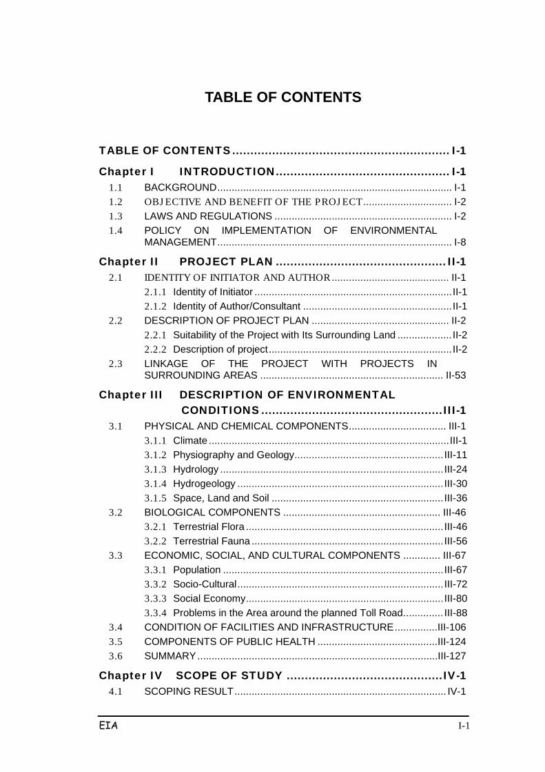
TABLE OF CONTENTS
TABLE OF CONTENTS ............................................................ I-1
Chapter I INTRODUCTION ................................................ I-1 1.1 BACKGROUND .................................................................................. I-1 1.2 OBJ ECTIVE AND BENEFIT OF THE PROJ ECT ............................... I-2 1.3 LAWS AND REGULATIONS .............................................................. I-2 1.4 POLICY ON IMPLEMENTATION OF ENVIRONMENTAL
MANAGEMENT .................................................................................. I-8
Chapter II PROJECT PLAN ............................................... II-1 2.1 IDENTITY OF INITIATOR AND AUTHOR ......................................... II-1
2.1.1 Identity of Initiator ..................................................................... II-1 2.1.2 Identity of Author/Consultant .................................................... II-1
2.2 DESCRIPTION OF PROJECT PLAN ................................................ II-2 2.2.1 Suitability of the Project with Its Surrounding Land ................... II-2 2.2.2 Description of project ................................................................ II-2
2.3 LINKAGE OF THE PROJECT WITH PROJECTS IN SURROUNDING AREAS ................................................................ II-53
Chapter III DESCRIPTION OF ENVIRONMENTAL CONDITIONS .................................................. III-1
3.1 PHYSICAL AND CHEMICAL COMPONENTS .................................. III-1 3.1.1 Climate .................................................................................... III-1 3.1.2 Physiography and Geology .................................................... III-11 3.1.3 Hydrology .............................................................................. III-24 3.1.4 Hydrogeology ........................................................................ III-30 3.1.5 Space, Land and Soil ............................................................ III-36
3.2 BIOLOGICAL COMPONENTS ....................................................... III-46 3.2.1 Terrestrial Flora ..................................................................... III-46 3.2.2 Terrestrial Fauna ................................................................... III-56
3.3 ECONOMIC, SOCIAL, AND CULTURAL COMPONENTS ............. III-67 3.3.1 Population ............................................................................. III-67 3.3.2 Socio-Cultural ........................................................................ III-72 3.3.3 Social Economy ..................................................................... III-80 3.3.4 Problems in the Area around the planned Toll Road .............. III-88
3.4 CONDITION OF FACILITIES AND INFRASTRUCTURE ...............III-106 3.5 COMPONENTS OF PUBLIC HEALTH ..........................................III-124 3.6 SUMMARY ....................................................................................III-127
Chapter IV SCOPE OF STUDY ........................................... IV-1 4.1 SCOPING RESULT .......................................................................... IV-1
EIA I-2
4.2 SCOPE OF STUDY AREA ............................................................... IV-2
Chapter V FORECASTING SIGNIFICANT IMPACTS .......... V-1 5.1 FORECASTING IMPACTS ................................................................ V-1 5.2 PRE-CONSTRUCTION PHASE ........................................................ V-1 5.3 Construction Phase ........................................................................... V-5
5.3.1 Impacts on Physical-Chemical Components ............................ V-5
Table 5.1 Estimated Maximum Concentration (ug/m3) ........ V-6 5.3.2 Biological Environment Components ..................................... V-30 5.3.3 Socio-Economic and Cultural Component ............................. V-35 5.3.4 Components of Public Health ................................................ V-43
5.4 POST-Construction Phase .............................................................. V-44 5.4.1 Physical-Chemical Environmental Components .................... V-44 5.4.2 Social-Economic and Cultural Component ............................ V-56
5.5 SUMMARY ...................................................................................... V-61
Chapter VI EVALUATION OF SIGNIFICANT IMPACTS .... VI-79 6.1 IMPACT EVALUATION CRITERIA ................................................. VI-79
6.1.1 Holistic Assessment ..............................................................VI-79 6.1.2 Causative Assessment ..........................................................VI-80
6.2 REVIEW OF IMPACTS ................................................................... VI-80 6.2.1 Pre-Construction Phase.........................................................VI-80 6.2.2 Post-Construction Phase .......................................................VI-84
6.3 TOLL ROAD OPERATION ............................................................. VI-87 6.4 OPERATION OF TOLL ROAD EXITS ............................................ VI-87 6.5 OTHER PROJECT-RELATED ACTIVITIES .................................... VI-87 6.6 FORMULATION OF STUDY RESULTS AND REFERRALS TO
HANDLE SIGNIFICANT IMPACTS ................................................. VI-87 6.6.1 Community Groups that may be Affected ..............................VI-87 6.6.2 Impact Evaluation Results .....................................................VI-89 6.6.3 Quantification of Evaluation Results ......................................VI-91
EIA I-1
Chapter I
INTRODUCTION
1.1 BACKGROUND
Cikampek-Palimanan Toll Road is an alternative way to provide an efficient
highway transportation system with a high level of service to support national
economic growth, while supporting the realization of the Trans-Java road network.
Externally, the road network in the Pantura region is part of the planned Trans-
Java road network connecting Sumatra, Java and Bali, which serves to
accommodate the flow of goods and people between the islands. In the intra-
region context, the existence of the northern road network which is supported by
the provincial road network indicates the spatial relationship between the city and
the growth of existing centers. So according to the physical condition of this
territory, expanding the road network patterns will affect the development of towns
along the northern coast region. Therefore, to support the accessibility of goods
and people an alternative to the construction of the highway is needed.
The Government of the Republic of Indonesia through the Toll Road Regulatory
Body (BPJT) and Department of Public Works in collaboration with investor PT.
Lintas Marga Sedaya, seeks the realization of Cikampek-Palimanan toll road -
which connects Purwakarta, Subang, Majalengka, Cirebon, and Indramayu along
± 116.4 km.
Realizing that any construction activities will not only have positive effect impacts
on the growth and development of national and regional economic development,
but also will have negative influences (impacts) on the conservation of nature and
the environment, and in accordance with environmentally sound development
policies as regulated by Law no. 23, 1997 on Natural Environmental Management
and Government Regulation no. 27 of 1999 concerning Environmental Impact
Assessment, environmental management is necessary to be completed.
Based on the Decree of the Minister of Environment No. 11 of 2006 on Types of
Business Plan and / or Activity which must be Equipped With an Environmental
Impact Analysis, which for this type is highway infrastructure activities, the
EIA I-2
Cikampek-Palimanan Toll Road Development plan along +116 km must be
accompanied by an Environmental Impact Assessment Study (EIA).
In addition to the abovementioned, Environmental Impact Assessment Study (EIA)
also refers to the decisions of the Minister of Environment No. 8 Year 2006 on
Guidelines for Preparing Environmental Impact Assessment, which includes the
Terms of Reference for Environmental Impact Analysis (KA-ANDAL),
Environmental Impact Assessment (EIA), Environmental Management Plan (RKL),
Environmental Monitoring Plan (RPL), and Executive Summary.
1.2 OBJ ECTIVE AND BENEFIT OF THE PROJ ECT
The objective of the Cikampek-Palimanan Toll Road Development Project is as an
alternative to providing an efficient transport system to support national economic
growth.
The Benefit of the project is to facilitate the movement of traffic and goods as well
as residents from Java to Sumatra and support functions of the external road
network of the northern region in order to accommodate the movement of goods
and services across the provinces, as well as to support the development of cities
in West Java Province.
1.3 LAWS AND REGULATIONS
Legislation used in the EIA Study includes:
a.
1. Law of the Republic of Indonesia No. 5 of 1960, about Agrarian
Affairs. As a reference to determine the type of land for land
acquisition.
Law
2. Law of the Republic of Indonesia No. 1 of 1970 on Labor. As a
reference in the recruitment of labor.
3. Law of the Republic of Indonesia No. 5 of 1990, about the
conservation of Natural Resources and Ecosystems. As a
benchmark for environmental management.
4. Law of the Republic of Indonesia Number 23 of 1997 on
Environmental Management. As a benchmark for environmental
management.
5. Law of the Republic of Indonesia No. 25 of 1999 on Financial

EIA I-3
Balance between Central and Local Government. As a benchmark
for environmental management according to their respective
responsibilities.
6. Law of the Republic of Indonesia Number 17 of 2004, on Water
Resources. As a reference for water resource conservation.
7. Law of the Republic of Indonesia Number 32 of 2004 on Regional
Government. As a benchmark for environmental management
according to their respective responsibilities.
8. Law of the Republic of Indonesia Number 36 of 2004, on Roads. As
a benchmark for environmental management relating to the
geometric design of the road.
9. Law of the Republic of Indonesia No. 26 of 2007 on Spatial
Planning. As a reference in the implementation of environmentally
sound development.
b.
1. Indonesian Government Regulation No. 6 of 1988, on Vertical
Coordination Agency Activities in the Region. As a reference in the
implementation of land acquisition.
Government Regulation
2. Indonesian Government Regulation No. 35 of 1991, on Rivers. As a
reference for the management of surface water environments.
3. Indonesian Government Regulation No. 69 of 1996, on the
Implementation of the Rights and Obligations and Forms and
Procedures for Public Participation in Spatial Planning. As a
reference for development by involving the community.
4. Indonesian Government Regulation Number 18 of 1999, regarding
Management of Hazardous and Toxic Wastes. As a reference in
environmental management.
5. Indonesian Government Regulation No. 27 of 1999, concerning
Environmental Impact Analysis. As a reference in the preparation of
EIA documents.
6. Indonesian Government Regulation No. 41 of 1999, concerning
Control of Air Pollution. As a national reference for air quality
management.
7. Indonesian Government Regulation No. 25 of 2000, the
EIA I-4
Government Authority and Provincial Authority as Autonomous
Regions. As a rule for authorities in West Java Provincial
Government.
8. Indonesian Government Regulation No. 82 of 2001, regarding
Management of Water Quality and Water Pollution Control. As a
rule for the National Water Quality Management.
9. Indonesian Government Regulation Number 16 of 2004, regarding
Land Stewardship. As a rule for determining the type of land.
10. Indonesian Government Regulation No. 15 of 2005, on Toll Roads.
As a reference for the implementation of toll road development.
c.
1. Decree of the President of the Republic of Indonesia Number 32 of
1990, on the Management of Protected Areas. As a rule for
conservation management of protected areas.
Presidential Decree
2. Decree of the President of the Republic of Indonesia No. 05 year
1992 concerning Land Acquisition. As a reference in land
acquisition.
3. Decree of the President of the Republic of Indonesia No. 75 of
1993, on the coordination of National Spatial Management. As a
reference for implementation of environmentally sound
development.
4. Decree of the President of the Republic of Indonesia No. 36 Jo. No.
65, 2006 on Land Procurement for Implementation of Development
for Public Interest. As a reference in land acquisition.
d.
1. Regulation of the Minister of Health Republic of Indonesia Number:
4167 MENKES / PER / IX / 1990, on Terms of Water Quality
Monitoring. As a rule of Water Management.
Ministerial Regulation
2. Public Works Ministerial Decree No. 779/KPTS/1990 Rl, on
Technical Guidelines for EIA Field Road and Bridge. As a reference
for preparation of environmental impact documents.
EIA I-5
3. Decision of the National Land Agency Number: 02 of 1990,
concerning Permit Location. As a reference for implementation of
the development.
4. Head of Bapedal Decision No. 056 of 1994, on Guidelines
Regarding Impacts Size Importance. As a reference for preparation
of EIA documents.
5. Decree of the Minister of Public Works Rl Number: 56/KPTS/1995,
the EIA Procedure Guide Department of Public Works. As a
reference for preparation of EIA documents.
6. Decree of the Minister of Environment / Head of Bapedal Number:
KM-48/MENLH/11/1996, about Raw Noise Level. As a reference in
environmental management of noise.
7. Decree of the Minister of Environment Number: KEP-299/11 / 1996.
Technical Guidelines Review Social Aspects In the preparation of
Environmental Impact Assessment. As a reference preparation of
environmental impact of social aspects.
8. Decree of the Minister of Environment Number Kep-45/MENLH /
10/1997, regarding Air Pollution Standard Index. As a national
reference for air quality management.
9. Decree of the Minister of Environment Number: KEP-124/11 / 1997.
Technical Guidelines Review of Public Health Aspects of the
Preparation of Environmental Impact Assessment. As reference for
the preparation of the EIA documents for societal health aspects.
10. Decree of the Head of Environmental Impact Management Agency
Number Kep-107/KABAPEDAL/11/1997, Technical Guidelines for
Calculation and Reporting and Information Air Pollution Standards
Index. As a benchmark for environmental management.
11. Decree of the Minister of Environment Number. 41/1999 on Air
Pollution Control.
12. Decree of the Minister of Environment No. 2 of 2000, the EIA
Document Assessment Guide. As a reference for preparation of
EIA documents.
13. Decree of the Head of Environmental Impact Management Agency:
Number 08 of 2000, regarding Community Involvement and
Information Disclosure in Environmental Impact Analysis Process.
As a reference in execution of socialization.
EIA I-6
14. Decree of the Head of Environmental Impact Management Agency
No. 40 of 2000, concerning Guidelines for Administration of EIA
Appraisal Commission. As a reference for environmental impact
assessment document.
15. Decree of the Minister of Environment No. 41 year 2000, on
Guidelines for Establishment of Commission for EIA Appraisal
District. As a reference for the Assessment Team.
16. Decree of the Minister of Environment Number. 45/2005 on
Guidelines for Preparation of Consolidated RKL and RPL.
17. Decree of the Minister of Public Works 295/PRT/M Rl No. 2005, on
the Toll Road. As a reference preparation of the EIA document.
18. Decision of the Minister of Public Works no. 369/KPTS/M/2005,
General Plan of the National Road Network. As a benchmark to
determine the classification of the road.
19. Regulation of the Minister of State for Environment, No: 8 of 2006,
concerning Guidelines for Preparation of Environmental Impact
Assessment. As a reference for preparation of EIA documents.
20. Regulation of the Minister of State for Environment, No: 11 of 2006,
concerning Types of Business and / or activities, which are to be
equipped with a Mandatory Environmental Impact Assessment. As
reference for the preparation of EIA documents.
EIA I-7
e.
1. West Java Provincial Regulation No. 3 of 1988 on Taking Control of
Ground Water, Surface Water and Sewerage. As a benchmark for
environmental management.
Provincial and Local Regulation
2. West Java Provincial Regulation No. 12 of 1989 on the Procedure
of Setting Water. As a benchmark for environmental management.
3. Local Regulation of the Province of West Java No.1 of 1990 on
Environmental Management in the Province of West Java. As a
benchmark for environmental management.
4. Governor Decree No level I West Java. 38 of 1991 on Water
Appropriation and Water Quality on Water Resources in West Java.
As a benchmark for environmental management.
5. West Java Governor Decree No. 38 of 1993 on Regulation of the
Use of Roads. As a reference in execution of development.
6. West Java Governor Decree No. 17 of 1993 on Attraction and traffic
generation. As a reference pattern of traffic movement.
7. West Java Governor Decree Number: 620/Kep.184-Sarek/2008,
concerning Amendment to Decree No. 620/Kep.538-Sarek/2006
Governor of West Java, on determiniation of Cikopo - Palimanan
Toll Road Construction Location (SP2LP)
8. West Java Governor Decree No. 18 Year 1993 on Implementation
of Traffic Control Equipment. As a reference for traffic regulation.
9. West Java Provincial Regulation No. 15 of 1994 Concerning the
Regional Road Traffic in West Java Province. As a rule of traffic
planning.
10. West Java Governor Decree No. 21 of 2001 on Road Use
Regulation. As a guideline for traffic planning.
11. West Java Provincial Regulation No.2 of 2003 on spatial planning in
West Java 2010. As a guideline for construction in the province of
West Java.
12. West Java Provincial Regulation No. 8 year 2005 concerning
Border Water Resources. As a reference for the environmental
management of rivers.
13. West Java Provincial Regulation No.2 of 2006 on the Management
EIA I-8
of Protected Areas. As a rule for protected area management.
14. Decision of Head of BPN (National Land Agency) Regulation. 3 /
2007 concerning Land Procurement for Implementation of Public
Development.
1.4 POLICY ON IMPLEMENTATION OF ENVIRONMENTAL MANAGEMENT
The Development Policy of the Palimanan-Cikampek toll road is based on
environmentally-sound principles, to achieve sustainability and provide guarantees
for present and future. This is contained in PROPERNAS and the Law of
Environmental Management, which among others states that the Indonesian
people want a harmonious relationship between man and God, between human
beings, and with the surrounding environment.
Based on spatial planning (RTRW) in West Java Province, it has been confirmed
that the construction / development of the region around the northern highways
and roads must take into account that the growth of the road must not interfere
with:
• The smooth flow of goods and services
• Aesthetics (beauty) and architecture
• Environment.

EIA II-1
Chapter II
PROJECT PLAN
2.1 IDENTITY OF INITIATOR AND AUTHOR
2.1.1 Identity of Initiator
Company Name : PT. LINTAS MARGA SEDAYA
Person In-charge : CEO of PT. Lintas Marga Sedaya
Address : Jalan Cibitung III No. 34 Kebayoran Baru, Jakarta Selatan, Telp. 021-7245870 Fax. 021-7222436
2.1.2 Identity of Author/Consultant
Author/consultant of the Environmental Impact Assessment for the Cikampek-Palimanan Toll Road Development is as follows:
Company Name : PT. Perentjana Djaja
Person In-Charge : CEO of PT. Perentjana Djaja
Address : Wisma Pede Lantai 4
Jl. MT. Haryono Kav. 17, Jakarta Selatan
Telp. 021-8290442 Fax. 021-8297124
The composition of the complete team in this EIA Study of the Cikampek-
Palimanan Toll Road Development is given in Table 2.1.
Table 2-1 EIA Team No. Position Name Expertise 1 Team Leader, Environment
Ir. M. Waladi Road Network Expert, Amdal-B
2 Transportation Expert Ir. Dwi Endro BW Road Network Planning Expert 3 Urban and regional Planning
Ir. Maskur Urban and Regional Expert
4 Socioeconomic Expert-1 Drs Edwir Irfan Msi Socioeconomic analyst Amdal-A 5 Socioeconomic Expert-1 Ir. Witono Socioeconomic analyst, Amdal-A 6 Chemistry-Physics Expert Ir. Sri Sukaeni Chemical-Physical Analyst, Amdal -
7 Biology Expert Dra. Yuli Hastuti Biology Analyst, Amdal-B 8 Hydrology and Drainage Expert Ir. Bambang HS Hydrology Expert

EIA II-2
No. Position Name Expertise 9. Geology Expert Ir. Wisoko Geology Expert
10. Public Health Expert dr. Rina Kurniasri, Mkes Public Health Expert
2.2 DESCRIPTION OF PROJECT PLAN
2.2.1 Suitability of the Project with Its Surrounding Land
Based on the West Java Governor Decree Number: 620/Kep.184-Sarek / 2008, on
Amendment to the West Java Governor Decree No. 620/Kep.538-Sarek/2006,
concerning Determination of Cikopo - Palimanan Highway Construction Site
(SP2LP), the plan for the Cikampek-Palimanan toll road alignment location is in
accordance with the 2003 - 2010 spatial planning of West Java province and
revised master plan for West Java province (Perda no.3 of 1994). The route of this
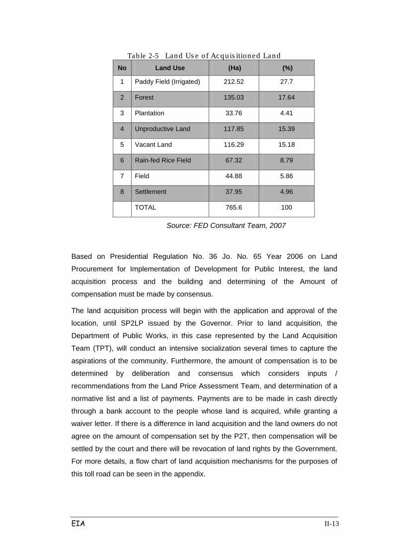
highway will go through several diverse land types, namely: rice irrigation (27.7%),
plantation (4.41%), forest (17.64%), shrubs (15.39%), vacant land (15.18%), rain-
fed rice fields (8.79%), fields (5.86%) and housing (4.96%). Areas of Perhutani-
owned forest and plantation areas can be seen in the appendix.
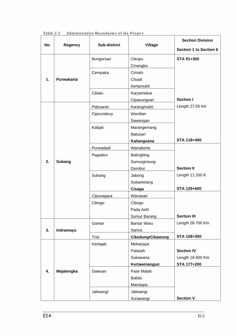
Location of the Palimanan Cikampek Toll Road alignment based on its
administration area can be seen in Table 2.2, while the Cikampek Palimanan Toll
Road Plan Location Map is in Figure 2.1.
2.2.2 Description of project
2.2.2.1 Technical Plan of the project
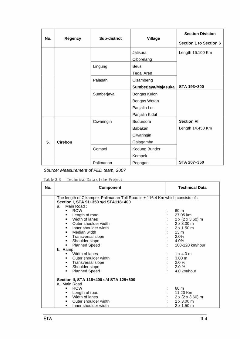
1. Technical Specification of the Project
Technical data based on data and detailed project engineering design (DED) can
be seen in Table 2.3, while the cross section of the highway is presented in Figure
2.2.
EIA II-3
Table 2-2 Admin is tra tive Bounda rie s o f the P ro jec t
No. Regency Sub-district Village Section Division
Section 1 to Section 6
1. Purwakarta
Bungursari Cikopo
Cinangka
STA 91+350
Section I Length 27.05 km
STA 118+400
Cempaka Cimahi
Cisaat
Kertamukti
Cibatu Karyamekar
Cipasungsari
2. Subang
Pabuaran Karangmukti
Cipeundeuy Wantilan
Sawangan
Kalijati Marangemang
Batusari
Kaliangsana
Purwadadi Wanakerta
Section II Length 11.200 K
STA 129+600
Pagaden Balingbing
Sumurgintung
Gembor
Subang Jabong
Sukamelang
Cisaga
Cipunagara Wanasari
Section III Length 28.700 Km
STA 158+300
Cibogo Cibogo
Pada Asih
Sumur Barang
3. Indramayu Gantar Bantar Waru
Sanca
Trisi Cikedung/Cikawung
4. Majalengka
Kertajati Mekarjaya
Palasah
Sukawana
Kertawinangun
Section IV Length 18.900 Km
STA 177+200
Dawuan Pasir Malati
Balida
Mandapa
Section V Jatiwangi Jatiwangi
Surawangi
EIA II-4
No. Regency Sub-district Village Section Division
Section 1 to Section 6
Jatisura
Ciborelang
Length 16.100 Km
STA 193+300
Lingung Beusi
Tegal Aren
Palasah Cisambeng
Sumberjaya/Majasuka
Sumberjaya Bongas Kulon
Bongas Wetan
Panjalin Lor
Panjalin Kidul
Section VI Length 14.450 Km
STA 207+350
5. Cirebon
Ciwaringin Budursora
Babakan
Ciwaringin
Galagamba
Gempol Kedung Bunder
Kempek
Palimanan Pegagan
Source: Measurement of FED team, 2007
Table 2-3 Technica l Data o f the Pro jec t
No. Component Technical Data
The length of Cikampek-Palimanan Toll Road is ± 116.4 Km which consists of : Section I, STA 91+350 s/d STA118+400 a. Main Road :
ROW : 60 m Length of road : 27.05 km Width of lanes : 2 x (2 x 3.60) m Outer shoulder width : 2 x 3.00 m Inner shoulder width : 2 x 1.50 m Median width : 13 m Transversal slope : 2.0% Shoulder slope : 4.0% Planned Speed : 100-120 km/hour
b. Ramp : Width of lanes : 1 x 4.0 m Outer shoulder width : 3.00 m Transversal slope : 2.0 % Shoulder slope : 2.0 % Planned Speed : 4.0 km/hour
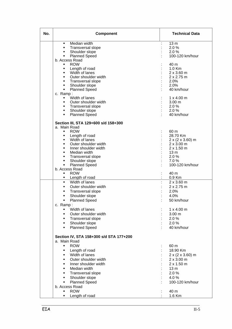
Section II, STA 118+400 s/d STA 129+600 a. Main Road
ROW : 60 m Length of road : 11.20 Km Width of lanes : 2 x (2 x 3.60) m Outer shoulder width : 2 x 3.00 m Inner shoulder width : 2 x 1.50 m
EIA II-5
No. Component Technical Data
Median width : 13 m Transversal slope : 2.0 % Shoulder slope : 2.0 % Planned Speed : 100-120 km/hour
b. Access Road ROW : 40 m Length of road : 1.0 Km Width of lanes : 2 x 3.60 m Outer shoulder width : 2 x 2.75 m Transversal slope : 2.0% Shoulder slope : 2.0% Planned Speed : 40 km/hour
c. Ramp : Width of lanes : 1 x 4.00 m Outer shoulder width : 3.00 m Transversal slope : 2.0 % Shoulder slope : 2.0 % Planned Speed : 40 km/hour
Section III, STA 129+600 s/d 158+300 a. Main Road
ROW : 60 m Length of road : 28.70 Km Width of lanes : 2 x (2 x 3.60) m Outer shoulder width : 2 x 3.00 m Inner shoulder width : 2 x 1.50 m Median width : 13 m Transversal slope : 2.0 % Shoulder slope : 7.0 % Planned Speed : 100-120 km/hour
b. Access Road ROW : 40 m Length of road : 0.9 Km
Width of lanes : 2 x 3.60 m Outer shoulder width : 2 x 2.75 m Transversal slope : 2.0% Shoulder slope : 4.0% Planned Speed : 50 km/hour
c. Ramp : Width of lanes : 1 x 4.00 m Outer shoulder width : 3.00 m Transversal slope : 2.0 % Shoulder slope : 2.0 % Planned Speed : 40 km/hour
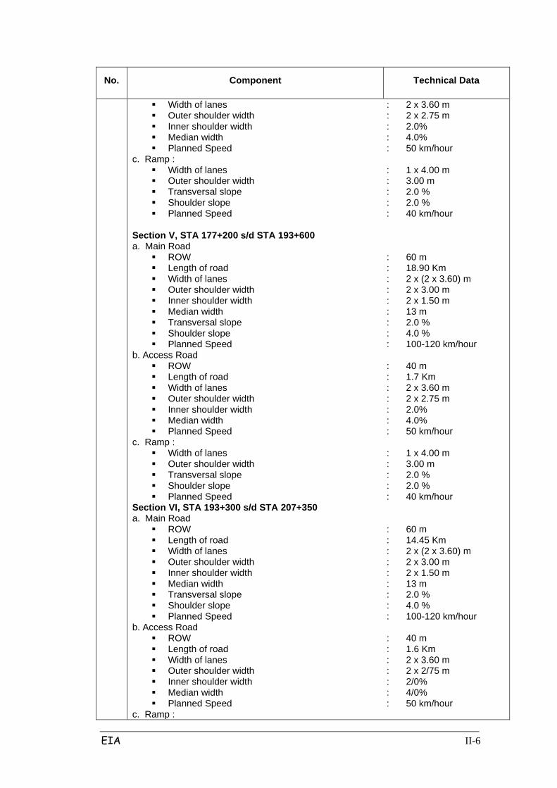
Section IV, STA 158+300 s/d STA 177+200 a. Main Road
ROW : 60 m Length of road : 18.90 Km Width of lanes : 2 x (2 x 3.60) m Outer shoulder width : 2 x 3.00 m Inner shoulder width : 2 x 1.50 m Median width : 13 m Transversal slope : 2.0 % Shoulder slope : 4.0 % Planned Speed : 100-120 km/hour
b. Access Road ROW : 40 m Length of road : 1.6 Km
EIA II-6
No. Component Technical Data
Width of lanes : 2 x 3.60 m Outer shoulder width : 2 x 2.75 m Inner shoulder width : 2.0% Median width : 4.0% Planned Speed : 50 km/hour
c. Ramp : Width of lanes : 1 x 4.00 m Outer shoulder width : 3.00 m Transversal slope : 2.0 % Shoulder slope : 2.0 % Planned Speed : 40 km/hour
Section V, STA 177+200 s/d STA 193+600 a. Main Road
ROW : 60 m Length of road : 18.90 Km Width of lanes : 2 x (2 x 3.60) m Outer shoulder width : 2 x 3.00 m Inner shoulder width : 2 x 1.50 m Median width : 13 m Transversal slope : 2.0 % Shoulder slope : 4.0 % Planned Speed : 100-120 km/hour
b. Access Road ROW : 40 m Length of road : 1.7 Km Width of lanes : 2 x 3.60 m Outer shoulder width : 2 x 2.75 m Inner shoulder width : 2.0% Median width : 4.0% Planned Speed : 50 km/hour
c. Ramp : Width of lanes : 1 x 4.00 m Outer shoulder width : 3.00 m Transversal slope : 2.0 % Shoulder slope : 2.0 % Planned Speed : 40 km/hour
Section VI, STA 193+300 s/d STA 207+350 a. Main Road
ROW : 60 m Length of road : 14.45 Km Width of lanes : 2 x (2 x 3.60) m Outer shoulder width : 2 x 3.00 m Inner shoulder width : 2 x 1.50 m Median width : 13 m Transversal slope : 2.0 % Shoulder slope : 4.0 % Planned Speed : 100-120 km/hour
b. Access Road ROW : 40 m Length of road : 1.6 Km Width of lanes : 2 x 3.60 m Outer shoulder width : 2 x 2/75 m Inner shoulder width : 2/0% Median width : 4/0% Planned Speed : 50 km/hour
c. Ramp :
EIA II-7
No. Component Technical Data
Width of lanes : 1 x 4.00 m Outer shoulder width : 3.00 m Transversal slope : 2.0 % Shoulder slope : 2.0 % Planned Speed : 40 km/hour
Toll Road Facilities Inter change : 7 unit On & off ramp : 28 unit Overpass : 65 unit Underpass : 20 unit Bridge : 17 unit Box Culvert : 127 unit Drainage Tunnel : 130 unit Crossing Bridge : 20 unit Toll Gate : 28 unit Toll Plaza : 1 unit Barrier Gate : 2 unit Rest Area : 8 unit
Source: FED Consultant Team, 2007
2. Schedule of Development
The concession agreement between the Toll Road Regulatory Body (BPJT) - Dep.
PU and PT. Lintas Marga Sedaya (investor) was established in July 2006.
Implementation of land acquisition was planned to run from August 2007 to July
2008, starting in the east (section VI). The time provided for implementation of
physical development of the Palimanan Cikampek toll road is 30 calendar months
from July 2008 until December 2010. More details can be viewed in the
construction schedule presented in Table 2.4.
2.2.2.2 Stages of Development
1. Pre-construction Stage
1). Survey and measurement location situation
This work is preceded, among others, by collecting primary data, including an
inventory of the land to be used for RUMIJA toll, and the carrying capacity of the
soil investigation. At this stage this aims to determine the location of the road
alignment to be constructed and the measurement of land area required for
detailed design. Some of these surveys include: topographical surveys, road
surveys, geological surveys, hydrological surveys, environmental surveys and

EIA II-8
surveys of land ownership.
2). Land acquisition
Land acquisition as part of the Toll Road project plans to transfer the land rights of
the people/residents to the government, the estates of the Ministry of SOEs and
forest land from the Ministry of Forestry to the Government (Ministry of Public
Works.) Land that will be acquired is ± 765.6 ha; the current land use of this land is
shown in Table 2.5. Included in these activities is the transfer of land acquisition
and / or elevation of Tower SUIT at some point that is; SUTT 150 kV Cikumpay
Pabuaran between tower-A24-D25, 70 kV Arjawinangun SUTT Duchy between
tower-D62-A63, 70 kV Arjowinangun SUTT-Duchy of tower D60-D61, 70 kV
Arjawinangun SUTT Cement Palimanan between tower-D14-A15, and SUTT
Mandirancan 150 kV tower-Jatibarang between D59-D60. In the implementation of
the elevation and transfer towers, the project will follow the procedure established
by PLN, so as not to cause disruption to customers and surrounding communities.
Location crosses with SUTT can be seen in the appendix.
In addition to land acquisition, in the area there are gas pipelines owned by
Pertamina and private companies; these pipes will be protected with the portal
construction so as not to cause interference in both construction and operation
phase. More details can be seen in Figure 2.3.
EIA II-9
Source: Consultant Planner / MCI
Figure 2-1 Typical Cros s Sec tional Cut of Cikampek --- Pa limanan Toll Road
EIA II-10
Figure 2-2 Porta l fo r pro tec tion o f gas p ipe line
EIA II-11
Table 2- 4 Development Schedule of Cikampek-Palimanan Toll Road
NO Work Description
2007 2008 2009 2010 2011
KETERANGAN 1 2 3 4 5 6 1 2 3 4 5 8 7 8 9 10 11 12 1 2 3 4 5 8 7 8 9 10 11 12 1 2 3 4 5 8 7 8 9 10 11 12 1 2
1
2.
3.
Consession agreement between BPJT and PT. Lintas Marga Sedaya
Land Acquisition
Section I (Cikampek-Kalijati) 27,05 Km
Section II (Kalijati-Subang) 11,2 Km
Section III (Subang-Cikedung) 28,7 Km
Section IV (Cikedung-Kertajati) 18,9 Km
Section V (Kertajati Sumber Jaya) 16,1 Km
Section VI (Sumberjaya-Palimanan) 14, 45 Km
Physical Construction Stage
1 Preparation Stage :
- Heavy Equipment mobilization
- Labor Mobilization
- Basecamp Construction
2 Construction :
- Land & Soil Preparation Cleaning
- Transportation of Land & Materials
- Heap Work
- Road & Pavement Works Agency
July 2006
Starting from Section IV

EIA II-12
NO Work Description
2007 2008 2009 2010 2011
KETERANGAN 1 2 3 4 5 6 1 2 3 4 5 8 7 8 9 10 11 12 1 2 3 4 5 8 7 8 9 10 11 12 1 2 3 4 5 8 7 8 9 10 11 12 1 2
4.
- Drainage Works
- Bridge Works
- OP & UP Work
- Interchanges Work
- Construction of Highway Facilities
Toll Road Operation
EIA II-13
Table 2-5 Land Us e of Acquis itioned Land No Land Use (Ha) (%)
1 Paddy Field (Irrigated) 212.52 27.7
2 Forest 135.03 17.64
3 Plantation 33.76 4.41
4 Unproductive Land 117.85 15.39
5 Vacant Land 116.29 15.18
6 Rain-fed Rice Field 67.32 8.79
7 Field 44.88 5.86
8 Settlement 37.95 4.96
TOTAL 765.6 100
Source: FED Consultant Team, 2007
Based on Presidential Regulation No. 36 Jo. No. 65 Year 2006 on Land
Procurement for Implementation of Development for Public Interest, the land
acquisition process and the building and determining of the Amount of
compensation must be made by consensus.
The land acquisition process will begin with the application and approval of the
location, until SP2LP issued by the Governor. Prior to land acquisition, the
Department of Public Works, in this case represented by the Land Acquisition
Team (TPT), will conduct an intensive socialization several times to capture the
aspirations of the community. Furthermore, the amount of compensation is to be
determined by deliberation and consensus which considers inputs /
recommendations from the Land Price Assessment Team, and determination of a
normative list and a list of payments. Payments are to be made in cash directly
through a bank account to the people whose land is acquired, while granting a
waiver letter. If there is a difference in land acquisition and the land owners do not
agree on the amount of compensation set by the P2T, then compensation will be
settled by the court and there will be revocation of land rights by the Government.
For more details, a flow chart of land acquisition mechanisms for the purposes of
this toll road can be seen in the appendix.

EIA II-14
2. Construction Stage
1). Mobilization of Heavy Equipment
Heavy equipment is a tool that cannot be avoided, especially in completing the
construction of highway. The dominant tools are driven by engines and can usually
be used for various types of work, while the other tools in this project are tools that
are not driven by an engine, and these are used according to their needs (such as
hoes and others). The main tools to be used in this project from section 1 to 6,
include among others:
1. Bulldozer : 4 unit
2. Excavator : 4 unit
3. Stake pole : 2 unit
4. Dump truck : 15 unit
5. Pick Up : 2 unit
6. Compressor : 2 unit
2. Concrete mixer : 4 unit
3. Concrete pump : 2 unit
4. Cutting machine : 1 unit
5. Generating set : 2 unit
6. Crane : 2 unit
7. Concrete breaker : 1 unit
8. Hoes : 2 unit
9. Wheel loader : 3 unit
10. Motor grader : 2 unit
11. Stamper : 4 unit
12. Concrete vibrator : 4 unit
13. Prime mover : 2 unit
14. Tire roller : 2 unit
EIA II-15
15. Tandem Roller : 2 unit
16. Asphalt mixing plan : 1 unit
17. Asphalt finisher : 1 unit
18. Water/full tank truck : 1 unit
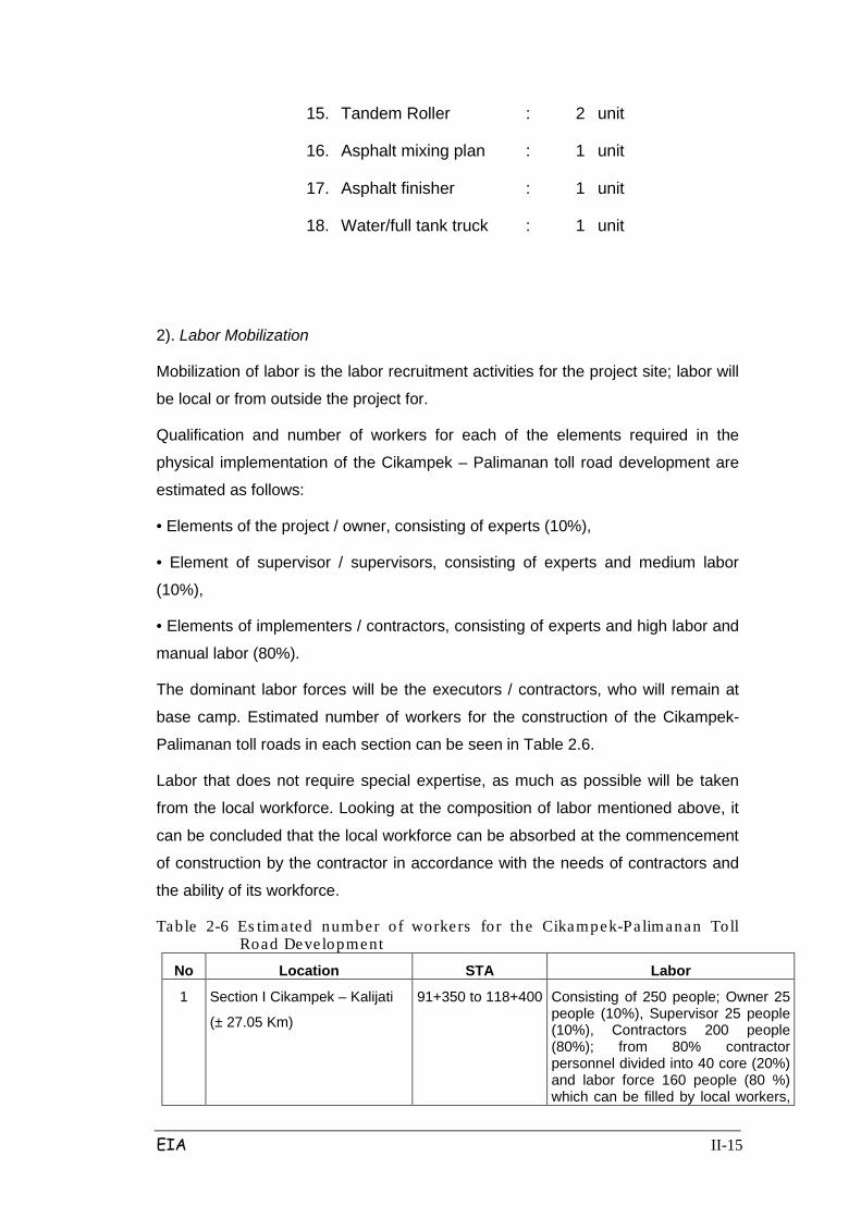
2). Labor Mobilization
Mobilization of labor is the labor recruitment activities for the project site; labor will
be local or from outside the project for.
Qualification and number of workers for each of the elements required in the
physical implementation of the Cikampek – Palimanan toll road development are
estimated as follows:
• Elements of the project / owner, consisting of experts (10%),
• Element of supervisor / supervisors, consisting of experts and medium labor
(10%),
• Elements of implementers / contractors, consisting of experts and high labor and
manual labor (80%).
The dominant labor forces will be the executors / contractors, who will remain at
base camp. Estimated number of workers for the construction of the Cikampek-
Palimanan toll roads in each section can be seen in Table 2.6.
Labor that does not require special expertise, as much as possible will be taken
from the local workforce. Looking at the composition of labor mentioned above, it
can be concluded that the local workforce can be absorbed at the commencement
of construction by the contractor in accordance with the needs of contractors and
the ability of its workforce.
Table 2-6 Es timated number of workers for the Cikampek-Palimanan Toll Road Development
No Location STA Labor
1 Section I Cikampek – Kalijati
(± 27.05 Km)
91+350 to 118+400 Consisting of 250 people; Owner 25 people (10%), Supervisor 25 people (10%), Contractors 200 people (80%); from 80% contractor personnel divided into 40 core (20%) and labor force 160 people (80 %) which can be filled by local workers,
EIA II-16
No Location STA Labor according to the needs and expertise
2 Section II Kalijati - Subang
(± 11.2 Km)
118+400 to 129+600
Consisting of 150 people; Owner 15 people (10%), Supervisor 15 people (10%), Contractors 120 people (80%), from 80% contractor divided into 24 core workers (20%) and labor force 96 people (80 %) which can be filled by local workers, according to the needs
3 Section III Subang - Cikedung
(± 28.7 Km)
129+600 to 158+300
Consisting of 250 people; Owner 25 people (10%), Supervisor 25 people (10%), Contractors 200 people (80%), from 80% contractor personnel are divided into 40'orang core (20%) and labor force 160 people (80%) which can be filled by local workers, according to the needs
4 Section IV Cikedung – Kertajati
(± 18.9 Km)
158+300 to 177+200
Consisting of 225 persons; Owner 23 people (10%), Supervisor 23 people (10%), Contractors 179 people (80%), from 80% of contractors are divided into 36 core workers (20%) and labor force 143 people (80 %) which can be filled by local workers, according to the needs and expertise.
5 Section V Kertajati – Sumberjaya (± 16.1 Km)
177+200 to 193+300
200 people consisting of; Owner 20 people (10%), Supervisor 20 People (10%), Contractors 160 people (80%), from 80% of contractors are divided into 32 core workers (20%) and the 128 labor force (80 %) which can be filled by local workers, according to the needs and expertise.
6 Section VI Sumberjaya –
Palimanan (± 14.05 Km)
193+300 to 207+350
150 people consisting of; Owner 15 people (10%), Supervisor 15 people (10%), Contractors 120 people (80%), from 80% contractor divided into 24 core workers (20%) and labor force 96 people (80 %) which can be filled by personnel lok £ l, according to the needs and expertise.
Source: FED Consultant Team, 2007
3). Construction / Operation of Base Camp
EIA II-17
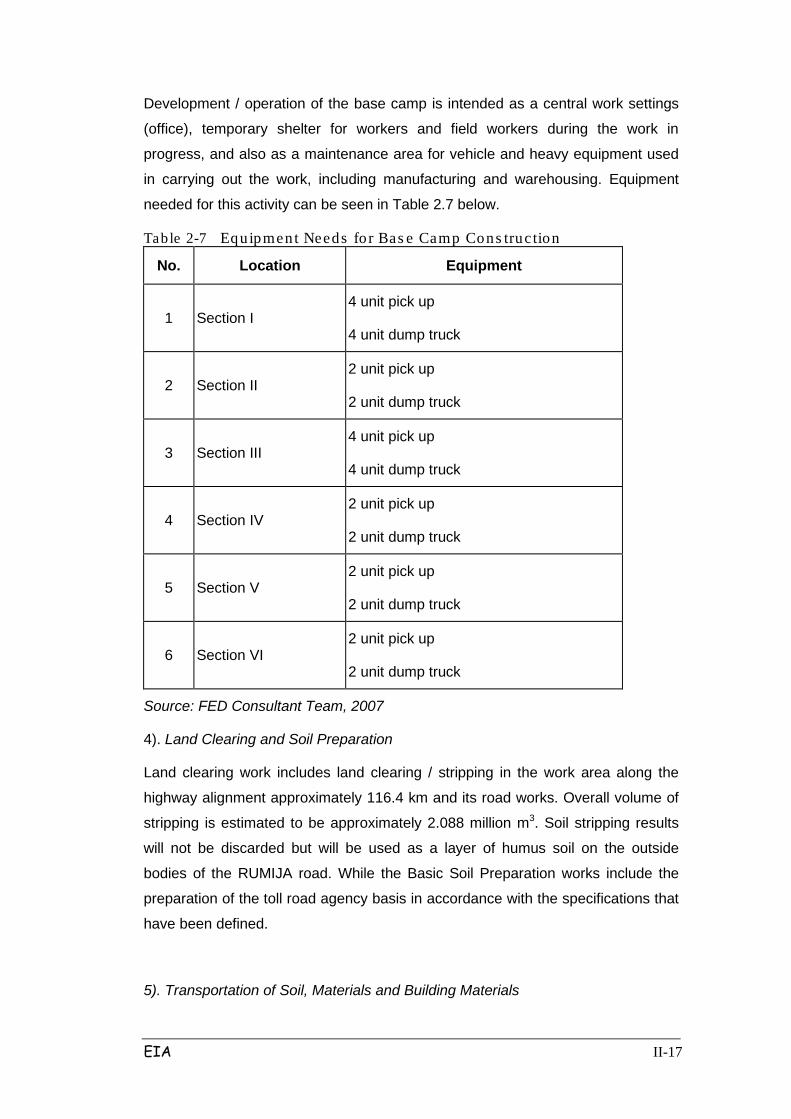
Development / operation of the base camp is intended as a central work settings
(office), temporary shelter for workers and field workers during the work in
progress, and also as a maintenance area for vehicle and heavy equipment used
in carrying out the work, including manufacturing and warehousing. Equipment
needed for this activity can be seen in Table 2.7 below.
Table 2-7 Equipment Needs fo r Bas e Camp Cons truc tion
No. Location Equipment
1 Section I 4 unit pick up
4 unit dump truck
2 Section II 2 unit pick up
2 unit dump truck
3 Section III 4 unit pick up
4 unit dump truck
4 Section IV 2 unit pick up
2 unit dump truck
5 Section V 2 unit pick up
2 unit dump truck
6 Section VI 2 unit pick up
2 unit dump truck
Source: FED Consultant Team, 2007
4). Land Clearing and Soil Preparation
Land clearing work includes land clearing / stripping in the work area along the
highway alignment approximately 116.4 km and its road works. Overall volume of
stripping is estimated to be approximately 2.088 million m3. Soil stripping results
will not be discarded but will be used as a layer of humus soil on the outside
bodies of the RUMIJA road. While the Basic Soil Preparation works include the
preparation of the toll road agency basis in accordance with the specifications that
have been defined.
5). Transportation of Soil, Materials and Building Materials

EIA II-18
Minerals / materials will be obtained from the slope cutting. Material requirements
for the Cikampek-Palimanan Toll Road project are shown in Table 2.8 below:
Table 2- 8 Materia l Requirements
No. Type of Material Unit Volume
1 Sand
m3
334,004
2 Cement
m3
66,658
3 Aggregate / Stones
m3
613,587
4 Iron
Ton
53,224
5 Concrete
m3
1,230,487
6 Asphalt
Ton
140,792
Source: FED Consultant Team, 2007
Supporting materials such as cement and steel / iron will be imported from the
local city or other locations. Transportation of the aggregate / crushed stone and
sand to site will take advantage of village roads / local roads that exist along the
planned Cikampek – Palimanan toll road. In the implementation of transportation,
it is planned to conduct periodic road watering 2 times a day so as not to cause
dust pollution due to tire friction with the ground.
To bring the above materials, the commonly used mean will be transport dump
trucks with capacity of 10 tons (MST). The route that is used is estimated via the
National road / street provinces such as northern roads, Cikampek-Purwakarta-
Subang streets, Sadang-Majalengka road, and Cirebon - Bandung road. For
district roads that pass between the other-way include Kalijati-Pamanukan
Subang, Subang-Pagaden road, Cikawung-Cikamurang road, Jatisura road to the
village, the road to Sumberjaya, the road to Pesantren Babakan, and others who
could pass the truck.
6). Quarry and Embankment Work
Quarry and Embankment work covers all activities including ground work
necessary for the establishment of toll roads.
To align the condition of the highway in accordance with planning criteria, in some
places excavation work is required, and elsewhere will be required heaping. Soil
excavation, which technically qualifies as a material, will be used immediately after
cleaning and piling of topsoil and residual vegetation.
EIA II-19
Based on geological data on the condition of the soil layer below the surface, it
shows that building materials can be obtained at various locations along the
alignment of the Cikampek - Palimanan Toll road. For this project, only the
aggregate with good or fairly good quality can be calculated. Aggregate with good
quality is strong and free of material damage and is of good enough quality to be
used in asphalt mixtures, the surface layer, base layer for roads, and structural
concrete. Good quality aggregate is strong and can be used for base layer with a
lower specification and for with no structural concrete.
In general, all materials will be sourced from an embankment located 20 km from
the planned alignment. Local sources of this material can generally be achieved
with four-wheel vehicle or a truck loaded with 10 tons, and can usually be obtained
by way of purchase from the quarry businesses.
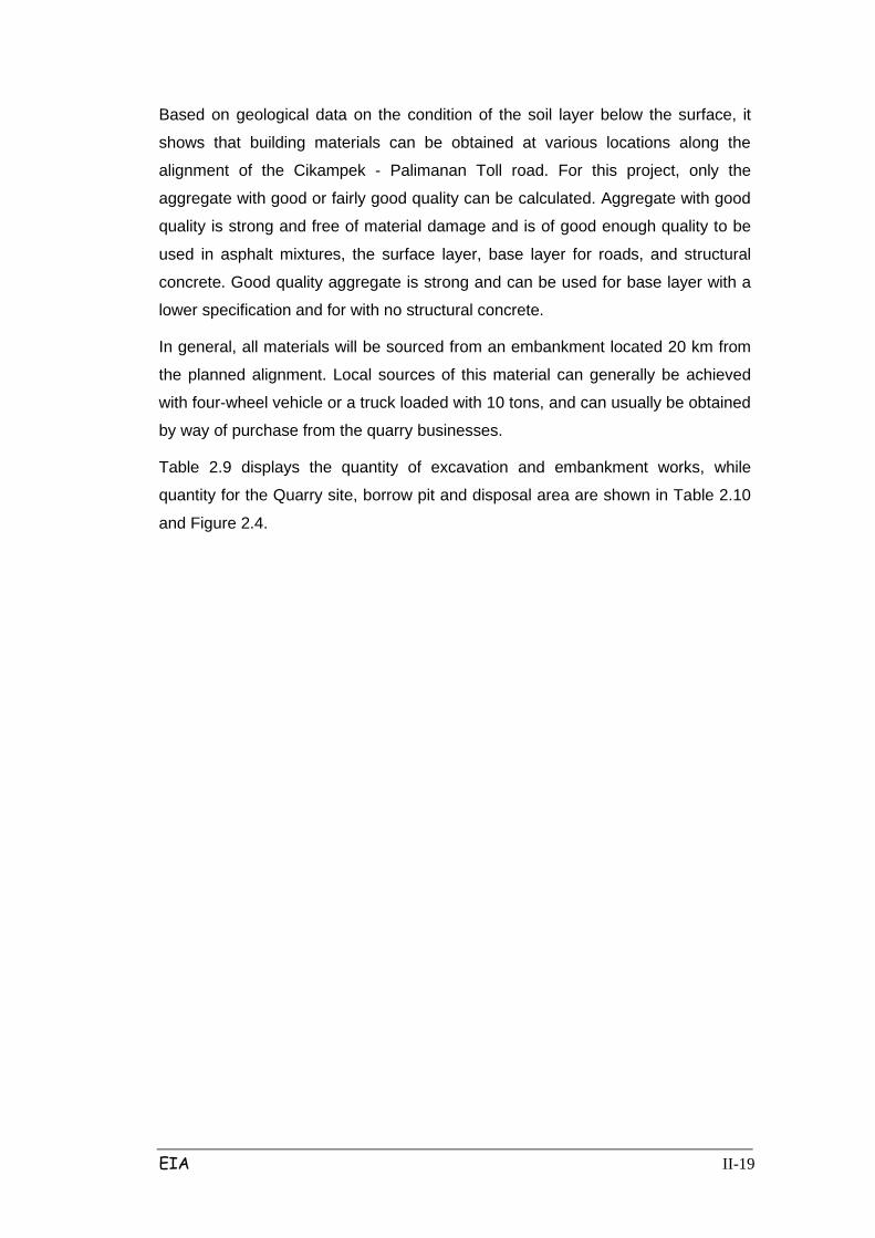
Table 2.9 displays the quantity of excavation and embankment works, while
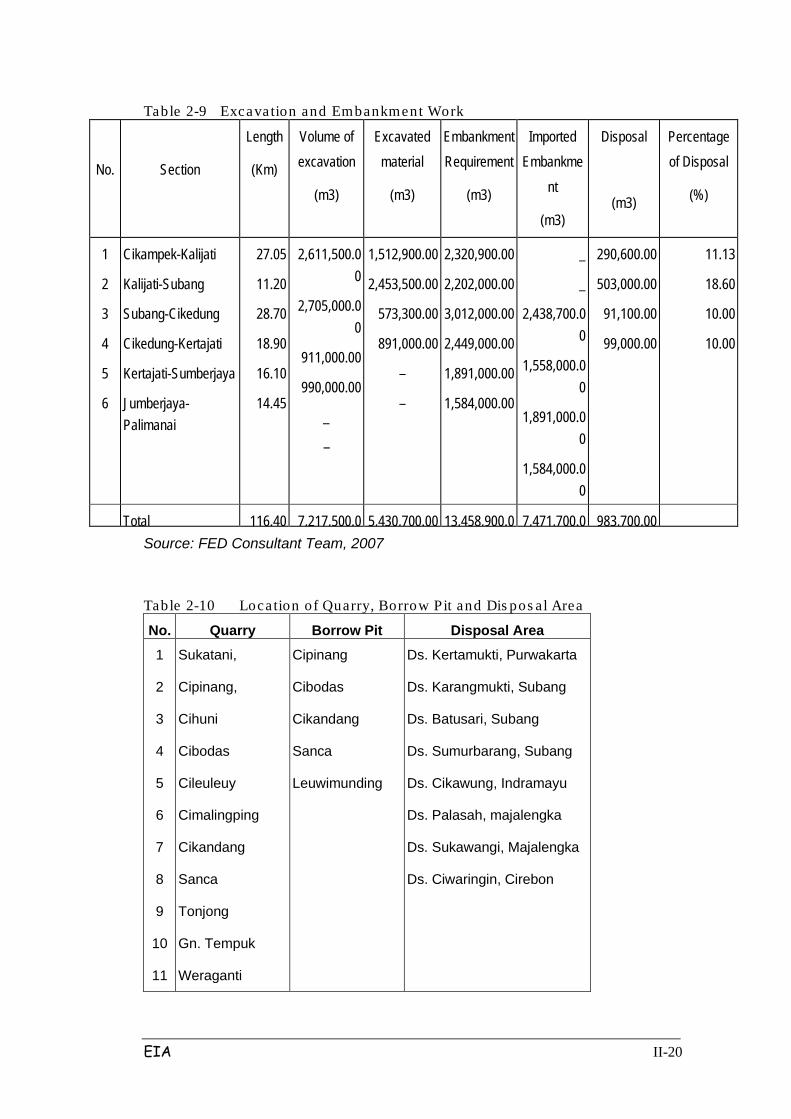
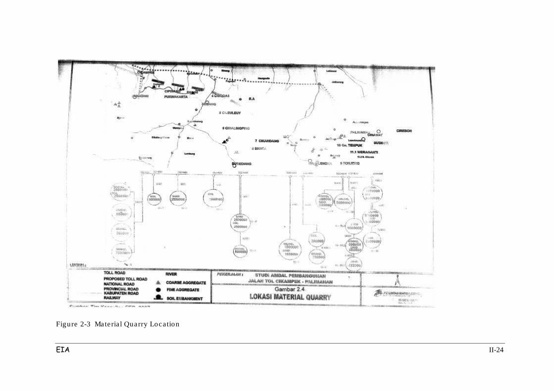
quantity for the Quarry site, borrow pit and disposal area are shown in Table 2.10
and Figure 2.4.
EIA II-20
Table 2-9 Excavation and Embankment Work
No.
Section
Length
(Km)
Volume of excavation
(m3)
Excavated material
(m3)
Embankment Requirement
(m3)
Imported Embankme
nt
(m3)
Disposal
(m3)
Percentage of Disposal
(%)
1
2
3
4
5
6
Cikampek-Kalijati
Kalijati-Subang
Subang-Cikedung
Cikedung-Kertajati
Kertajati-Sumberjaya
Jumberjaya-Palimanai
27.05
11.20
28.70
18.90
16.10
14.45
2,611,500.00
2,705,000.00
911,000.00
990,000.00
_
–
1,512,900.00
2,453,500.00
573,300.00
891,000.00
–
–
2,320,900.00
2,202,000.00
3,012,000.00
2,449,000.00
1,891,000.00
1,584,000.00
_
_
2,438,700.00
1,558,000.00
1,891,000.00
1,584,000.00
290,600.00
503,000.00
91,100.00
99,000.00
11.13
18.60
10.00
10.00
Total
116.40 7,217,500.0
5,430,700.00 13,458,900.0
7,471,700.0
983,700.00 Source: FED Consultant Team, 2007
Table 2-10 Location of Quarry, Borrow Pit and Dis pos al Area
No. Quarry Borrow Pit Disposal Area
1
2
3
4
5
6
7
8
9
10
11
Sukatani,
Cipinang,
Cihuni
Cibodas
Cileuleuy
Cimalingping
Cikandang
Sanca
Tonjong
Gn. Tempuk
Weraganti
Cipinang
Cibodas
Cikandang
Sanca
Leuwimunding
Ds. Kertamukti, Purwakarta
Ds. Karangmukti, Subang
Ds. Batusari, Subang
Ds. Sumurbarang, Subang
Ds. Cikawung, Indramayu
Ds. Palasah, majalengka
Ds. Sukawangi, Majalengka
Ds. Ciwaringin, Cirebon
EIA II-21
No. Quarry Borrow Pit Disposal Area
12
13
S. Cikeruh
Leuwimunding
Source: FED Consultant Team, 2007
Category C type minerals that exist include among others:
- Coarse Aggregate
Coarse aggregate materials are often found in the district, in Purwakarta, Subang,
Majalengka and Cirebon. In general, these aggregates have a good quality.
Stone-breaking machines are found in many locations, except in Cihuni,
Cimalingping, Cikandang, Gn. Tempuk, Tonjong and Weragati where it is dug by
hand.
- Fine Aggregate
Similar with course aggregates, fine aggregate are also encountered in 4 districts.
Most of the fine aggregate processing uses machines, except in Cihuni,
Cimalingping, Cikandang, Gn. Tempuk, Tonjong and Weragati where it is dug by
hand.
- Soil Embankment
This material is mostly located in areas close to Cirawat Palimanan and Subang
(approximately 5 million m3). It is also available in the area of Subang namely
Cibodas, Cileuleuy, Cikandang and Python (about 3.45 million m3), and near
Purwakarta namely Cipinang (about 250,000 m3).
7). Construction Works for Roads and Pavement Layer
Pavement type specified in Palimanan Cikampek toll road can be explained as
follows:
a. The main road, ramp and access will be rigid pavement and flexible
pavement. For rigid pavement, the road is planned to consist of:
• Base Course / Aggregate A: 25 cm
• Lean Concrete layer: 10 cm
• Concrete layer: 30 cm
For flexible pavement, the road is planned as follows:
• Sub Base: 40 cm
• Base Course / Aggregate A: 20 cm
EIA II-22
• ATB Layer: 15 cm
• Asphalt Binder Course Layer: 5 cm
• Asphalt Concrete layer: 5 cm
b. Shoulder of the main road, ramp and access is a flexible pavement which
is planned to consist of:
• Base Course / Aggregate A: 55 cm
• Layer ATB: 10cm
Implementation of pavement layers work will be as follows:
a. Preparation of base course
Covers the implementation of a special foundation layer with or without a binder.
Before overlaying concrete, the subgrade or sub base and cross-sectional shape
density shall be checked. Layer beneath the concrete should always be free from
foreign objects, remnants of concrete and other debris.
b. Pavement layers Work, including:
- Installation of longitudinal and transverse connection
- Installation of spokes (dowel) and coating trellis (dowel coating)
- Installation of reinforcement
- Stirring the transport of concrete and concrete mixture
- Casting
- Overlaying
- Solidified
- Completion end, forming a surface texture of the fire edge.
c. Care and Maintenance
After the final settlement is completed and the final layer evaporates from the
surface or immediately after sticking with the concrete does not happen, then the
entire surface of the concrete should be immediately closed and maintained. The
period of treatment will be carried out for 28 days, but this time can be shortened if
the 70% compressive strength or flexural concrete can be achieved by adding
substances earlier.

EIA II-23
d. Protection of finished pavement
Pavement that has been completed and its equipment must be protected from
general traffic through traffic enforcement. This protection includes the provision of
personnel to regulate traffic and to install and maintain warning signs, lights,
barriers, and so forth.
8). Drainage Works
• Crossings with rivers and creeks to flood return periods calculated 50s. In
the existing flow is maintained wet cross-sectional shape of the existing
flow with the following criteria:
• River / tributary width greater than or equal to 25 m made the bridge
construction.
• River / tributary width of less than 25 m is made box culvert.
• For irrigation canal culverts created a customized with existing capacity.
• Inundation caused by road construction will be made to flow toward the
side channel of the river nearby.
EIA II-24
Figure 2-3 Material Quarry Location

EIA II-25
Making of the drainage channels on the Cikampek-Palimanan toll road includes:
1. Cross drain installed every 500 m distance, with the construction of the
sewer diameter of 1:00 m.
2. Side channel of the soil material with a trapezoidal geometry. For the steep
terrain made construction of stone masonry and waterfall times when
needed.
3. Median tract of land covered with grass material with curved geometry
parabola fitted with culverts he 0.60m towards the side channel. These
channels are made in the area superelevation.
As a whole list of security also includes the drainage crossing irrigation channels
for each section can be seen in Tables 2.11 – 2.20.
Table 2-11 Lis t of Cros s ing Drainage on Sec tion I Kab. Purwakarta
No. Name Station (STA) Crossing
Type
1
2
3
4
5
6
7
8
9
10
11
12
13
14
15
Drain Canal
Drain Canal
Drain Canal
Ciherang River
Drain Canal
Drain Canal
Drain Canal
Drain Canal
Cilandak River
Drain Canal
Drain Canal
Drain Canal
Drain Canal
Drain Canal Cilamaya River
91 + 805
93 + 512
94 + 285
95 + 006
95 + 258
96 + 180
97 + 175
98 + 040
99 + 030
99 + 650
100 + 431
100 + 634
100 + 879
101 + 494
101 + 902
Pipe Culvert
Pipe Culvert
Box Culvert
Bridge
Box Culvert
Box Culvert
Box Culvert
Box Culvert
Bridge
Pipe Culvert
Box Culvert
Pipe Culvert
Box Culvert
Box Culvert
Bridge
Source: Planning Consultant (PT.MCI) 2007

EIA II-26
Table 2-12 Lis t of Cros s ing Dra inage on Sec tion I Kab. Subang
No. Name Station (STA) Crossing
Type
1
2
3
4
5
6
7
8
9
10
11
12
13
14
15
16
17
18
19
20
21
22
23
24
25
26
27
28
29
30
31
32
Drain Canal
Irr.+Village road
Cisiluman River
Drain Canal
Kalijati River
Drain Canal
Pakuharja River
Drain Canal
Cicadas River
Drain Canal
Drain Canal
Cibeunying River
Cijengkol River
Cibeuleutok River
Drain Canal
Drain Canal
Drain Canal
Drain Canal
Drain Canal
Cibuang River
Cibuang River
Drain Canal
Drain Canal
Ciburangrang River
Drain Canal
Drain Canal
Drain Canal
Drain Canal+Ped.Acces
Drain Canal
Ciracas River
Drain Canal
Irr+Ped.Acces
102 + 658
103 + 389
104 + 304
104 + 673
105 + 009
105 + 292
106 + 073
106 + 290
106 + 652
107 + 125
107 + 382
107 + 575
107 + 779
107 + 905
108 + 708
108 + 735
109 + 120
109 + 161
109 + 890
109 + 950
110 + 175
111 + 015
111 + 630
111 + 665
111 + 742
113 + 010
113 + 068
114 + 013
114 + 360
114 + 432
115 + 275
115 + 314
Pipe Culvert
Box Culvert
Box Culvert
Box Culvert
Box Culvert
Box Culvert
Box Culvert
Pipe Culvert
Box Culvert
Box Culvert
Pipe Culvert
Bridge
Bridge
Box Culvert
Pipe Culvert
Pipe Culvert
Box Culvert
Box Culvert
Box Culvert
Box Culvert
Box Culvert
Pipe Culvert
Pipe Culvert
Box Culvert
Pipe Culvert
Pipe Culvert
Box Culvert
Box Culvert
Pipe Culvert
Box Culvert
Box Culvert
Box Culvert

EIA II-27
No. Name Station (STA) Crossing
Type
33
34
35
Kalijambe Pembawa
Kalijambe Pembuang
Drain Canal
116 + 350
116 + 714
117 + 667
Box Culvert
Box Culvert
Pipe Culvert
Source: Planning Consultant (PT.MCI) 2007
Table 2-13 Lis t of Cros s ing Dra inage on Sec tion II Kab. Subang
No. Nama Sungai /Alur Drainase/ Irigasi
Station (STA) Crossing
Type Bangunan
1
2
3
4
5
6
7
8
g
10
11
12
13
14
15
16
17
18
19
20
21
Irr. canal
Cicongek River
Drainage+Ped. Access
Cilarangan River
Cibodas River
Irr. canal
Cigintung River
Aquaduct Irr.
Drain Canal
Drain Canal
Cibening River
Irr.canal + insp.road
Ciasem River
Irr. Canal
Sampan River
Drain Canal
Irr. canal
Drain Canal
Irr. canal
Drain Canal
Irr. canal
118 + 541
118 + 579
120 + 108
120 + 224
120 + 624
120 + 854
120 + 912
121 + 160
121 + 464
122 + 402
122 + 745
123 + 250
123 + 458
123 + 696
124 + 227
124 + 542
124 + 813
124 + 930
125 + 134
125 + 373
125 + 584
Pipe Culvert
Box Culvert
Box Culvert
Box Culvert
Bridge
Pipe Culvert
Box Culvert
Pipe Culvert
Pipe Culvert
Pipe Culvert
Box Culvert
Box Culvert
Bridge
Pipe Culvert
Box Culvert
Pipe Culvert
Box Culvert
Pipe Culvert
Pipe Culvert
Box Culvert
Pipe Culvert
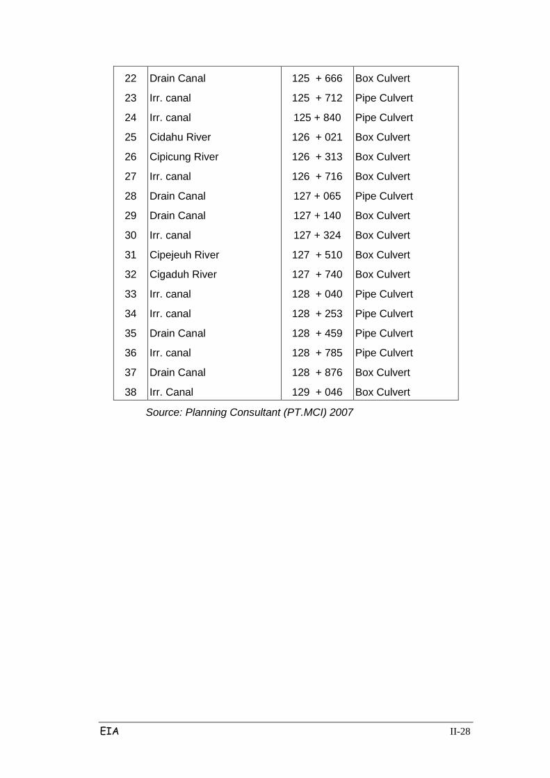
EIA II-28
22
23
24
25
26
27
28
29
30
31
32
33
34
35
36
37
38
Drain Canal
Irr. canal
Irr. canal
Cidahu River
Cipicung River
Irr. canal
Drain Canal
Drain Canal
Irr. canal
Cipejeuh River
Cigaduh River
Irr. canal
Irr. canal
Drain Canal
Irr. canal
Drain Canal
Irr. Canal
125 + 666
125 + 712
125 + 840
126 + 021
126 + 313
126 + 716
127 + 065
127 + 140
127 + 324
127 + 510
127 + 740
128 + 040
128 + 253
128 + 459
128 + 785
128 + 876
129 + 046
Box Culvert
Pipe Culvert
Pipe Culvert
Box Culvert
Box Culvert
Box Culvert
Pipe Culvert
Box Culvert
Box Culvert
Box Culvert
Box Culvert
Pipe Culvert
Pipe Culvert
Pipe Culvert
Pipe Culvert
Box Culvert
Box Culvert
Source: Planning Consultant (PT.MCI) 2007
EIA II-29
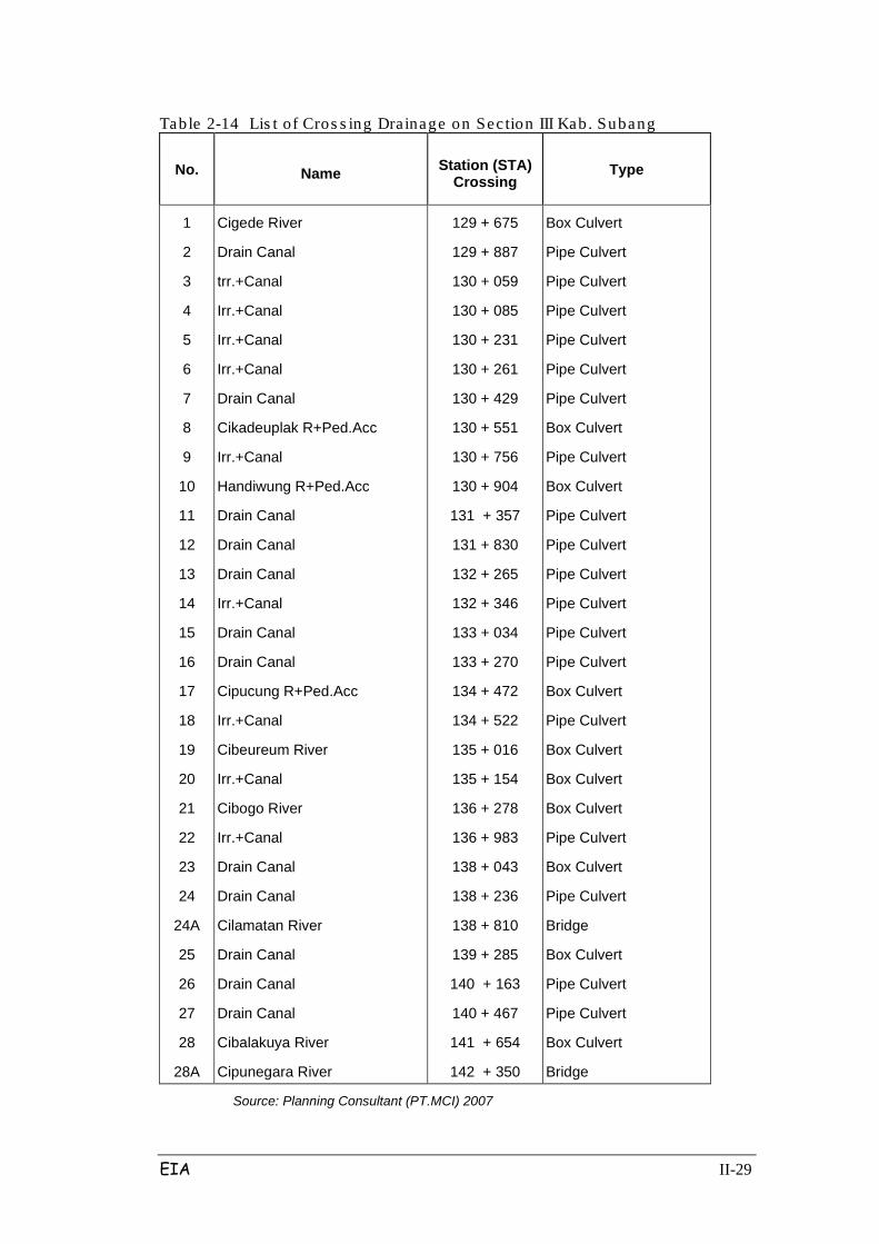
Table 2-14 Lis t of Cros s ing Drainage on Sec tion III Kab. Subang
No. Name Station (STA) Crossing
Type
1
2
3
4
5
6
7
8
9
10
11
12
13
14
15
16
17
18
19
20
21
22
23
24
24A
25
26
27
28
28A
Cigede River
Drain Canal
trr.+Canal
Irr.+Canal
Irr.+Canal
Irr.+Canal
Drain Canal
Cikadeuplak R+Ped.Acc
Irr.+Canal
Handiwung R+Ped.Acc
Drain Canal
Drain Canal
Drain Canal
Irr.+Canal
Drain Canal
Drain Canal
Cipucung R+Ped.Acc
Irr.+Canal
Cibeureum River
Irr.+Canal
Cibogo River
Irr.+Canal
Drain Canal
Drain Canal
Cilamatan River
Drain Canal
Drain Canal
Drain Canal
Cibalakuya River
Cipunegara River
129 + 675
129 + 887
130 + 059
130 + 085
130 + 231
130 + 261
130 + 429
130 + 551
130 + 756
130 + 904
131 + 357
131 + 830
132 + 265
132 + 346
133 + 034
133 + 270
134 + 472
134 + 522
135 + 016
135 + 154
136 + 278
136 + 983
138 + 043
138 + 236
138 + 810
139 + 285
140 + 163
140 + 467
141 + 654
142 + 350
Box Culvert
Pipe Culvert
Pipe Culvert
Pipe Culvert
Pipe Culvert
Pipe Culvert
Pipe Culvert
Box Culvert
Pipe Culvert
Box Culvert
Pipe Culvert
Pipe Culvert
Pipe Culvert
Pipe Culvert
Pipe Culvert
Pipe Culvert
Box Culvert
Pipe Culvert
Box Culvert
Box Culvert
Box Culvert
Pipe Culvert
Box Culvert
Pipe Culvert
Bridge
Box Culvert
Pipe Culvert
Pipe Culvert
Box Culvert
Bridge
Source: Planning Consultant (PT.MCI) 2007
EIA II-30
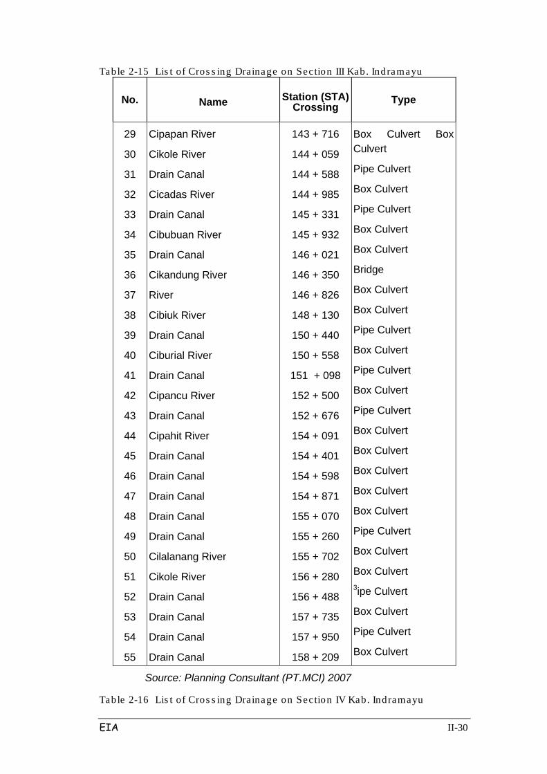
Table 2-15 Lis t of Cros s ing Drainage on Sec tion III Kab. Indramayu
No. Name Station (STA) Crossing
Type
29
30
31
32
33
34
35
36
37
38
39
40
41
42
43
44
45
46
47
48
49
50
51
52
53
54
55
Cipapan River
Cikole River
Drain Canal
Cicadas River
Drain Canal
Cibubuan River
Drain Canal
Cikandung River
River
Cibiuk River
Drain Canal
Ciburial River
Drain Canal
Cipancu River
Drain Canal
Cipahit River
Drain Canal
Drain Canal
Drain Canal
Drain Canal
Drain Canal
Cilalanang River
Cikole River
Drain Canal
Drain Canal
Drain Canal
Drain Canal
143 + 716
144 + 059
144 + 588
144 + 985
145 + 331
145 + 932
146 + 021
146 + 350
146 + 826
148 + 130
150 + 440
150 + 558
151 + 098
152 + 500
152 + 676
154 + 091
154 + 401
154 + 598
154 + 871
155 + 070
155 + 260
155 + 702
156 + 280
156 + 488
157 + 735
157 + 950
158 + 209
Box Culvert Box Culvert
Pipe Culvert
Box Culvert
Pipe Culvert
Box Culvert
Box Culvert
Bridge
Box Culvert
Box Culvert
Pipe Culvert
Box Culvert
Pipe Culvert
Box Culvert
Pipe Culvert
Box Culvert
Box Culvert
Box Culvert
Box Culvert
Box Culvert
Pipe Culvert
Box Culvert
Box Culvert 3ipe Culvert
Box Culvert
Pipe Culvert
Box Culvert
Source: Planning Consultant (PT.MCI) 2007
Table 2-16 Lis t of Cros s ing Drainage on Sec tion IV Kab. Indramayu
EIA II-31
No. Name Station (STA) Crossing
Type
1
2
3
4
5
6
7
8
9
10
11
12
13
Drain Canal
Drain Canal
Drain Canal
Drain Canal
Drain Canal
Drain Canal
Cipondoh River
Drain Canal
Drain Canal
Drain Canal
Drain Canal
Ciluncat River
Drain Canal
158 + 500
158 + 691
158 + 967
159 + 015
159 + 188
159 + 430
159 + 500
159 + 707
159 + 930
160 + 225
160 * 425
160 + 578
161 + 132
Pipe Culvert
Pipe Culvert
Pipe Culvert
Pipe Culvert
Pipe Culvert
Pipe Culvert
Box Culvert
Pipe Culvert
Box Culvert
Pipe Culvert
Pipe Culvert
Box Culvert
Box Culvert
Source: Planning Consultant (PT.MCI) 2007
Table 2-17 Lis t of Cros s ing Drainage on Sec tion IV Kab. Maja lengka
No. Name Station (STA) Crossing Type
14
15
16
17
18
19
20
21
Cipanas River
Drain Canal
Drain Canal
Drain Canal
Drain Canal
River
Drain Canal
Drain Canal
161 + 500
162 + 183
162 + 660
162 + 886
163 + 186
164 + 140
164 + 425
164 + 600
Bridge
Box Culvert
Pipe Culvert
Pipe Culvert
Pipe Culvert
Box Culvert
Pipe Culvert
Pipe Culvert
EIA II-32
No. Name Station (STA) Crossing Type
22
23
24
25
26
27
28
29
30
31
32
33
34
35
36
37
38
Drain Canal
Drain Canal
Drain Canal
Kepuh River
Drain Canal
Drain Canal
Drain Canal
River
Drain Canal
Cuyu River 1
Cuyu River 2
Cuyu River 3
Cidudut River
Drain Canal
Drain Canal
Drain Canal
Drain Canal
165 + 480
166 + 188
166 + 600
167 + 062
167 + 400
170 + 245
170 + 600
171 + 610
172 + 932
173 + 857 173 + 992
174 + 334 175 + 165
175 + 355
176 + 290
176 + 495
176 + 697
Pipe Culvert
Pipe Culvert
Pipe Culvert
Box Culvert
Pipe Culvert
Pipe Culvert
Pipe Culvert
Box Culvert
Pipe Culvert
Box Culvert
Box Culvert
Culvert
Bridge
Box Culvert
Box Culvert
Box Culvert
Box Culvert
Source: Planning Consultant (PT.MCI) 2007
Table 2-18 Lis t of Cros s ing Dra inage on Sec tion V Kab. Maja lengka
No. Name Station (STA) Crossing
Type
1
2
3
4
5
6
Cilamaning River + Ped. Acces
Irrigation Canal
Lebak River+Ped. Acces
Irrigation Canal Cilutung
River+Ped. Acces
Irrigation Canal
177 + 890
178 + 159
178 + 229
179 + 064
179 + 692
179 + 930
Box Culvert
Box Culvert
Box Culvert
Pipe Culvert
Box Culvert
Pipe Culvert
EIA II-33
No. Name Station (STA) Crossing
Type
7
8
9
10
11
12
13
14
15
16
17
18
19
20
21
22
23
24
25
26
27
28
29
30
31
32
33
34
35
35A
36
Irrigation Canal
Cimanuk River
Drain Canal
Cicadas River
Irrigation Canal
Drain Canal
Cibuluh River
Cilutung Canal+lns. Road
Irrigation Canal
Irrigation Canal
Irrigation Canal
Irrigation Canal
Irrigation Canal
Irrigation Canal
Irr. Canal+Ped. Acces
Cibogor River
Irrigation Canal
Ciranggon River
Irrigation Canal
Irrigation Canal
Irrigation Canal
Irrigation Canal
Cibunut River
Drain Canal
Cikeruh River
Drain Canal
Drain Canal
Irrigation Canal
Irrigation Canal
Drain Canal
Irrigation Canal
180 + 260
180 + 700
180 + 925
181 + 652
182 + 180
182 + 710
183 + 235
184 + 802
185 + 345
185 + 672
185 + 800
186 + 180
186 + 478
186 + 715
186 + 975
187 + 075
187 + 345
187 + 750
188 + 385
188 + 480
189 + 020
189 + 345
190 + 226
190 + 820
191 + 060
191 + 910
191 + 960
192 + 111
192 + 355
192 + 570
192 + 680
Pipe Culvert
Bridge
Box Culvert
Box Culvert
Pipe Culvert
Box Culvert
Box Culvert
Bridge
Pipe Culvert
Pipe Culvert
Pipe Culvert
Pipe Culvert
Pipe Culvert
Pipe Culvert
Box Culvert
Box Culvert
Box Culvert
Bridge
Box Culvert
Box Culvert
Pipe Culvert
Pipe Culvert
Box Culvert
Box Culvert
Bridge
Box Culvert
Box Culvert
Pipe Culvert
Pipe Culvert
Box Culvert
Box Culvert

EIA II-34
No. Name Station (STA) Crossing
Type
37 Irrigation Canal 193 + 050 Pipe Culvert
Source: Planning Consultant (PT.MCI) 2007
Table 2-19 Lis t of Cros s ing Drainage on Sec tion VI Kab. Majalengka
No. Name Station (STA) Crossing
Type
1
2
3
4
5
6
7
8
9
10
11
12
13
14
15
16
17
17A
18
19
20
21
22
Irr.Tertiary canal
S.Cibayawak
Irr.Teriary canal
Irr.Primary canal Ireng+ped.
Drain canal
S. Cikawangi
Irr.canal
Irr.canal
Irr.canal
Irr.canal
Ciporang Kecil
Cibugang
Irr.Teriary canal BLK1.KI.2
Irr.Teriary canal BLK1.KI.1
Irr.Primary canal Lojikobong
Drainage canal
Irr.canal
Swampy /rawa
Irr.canal
Drainage canal
Irr.canal
Irr.canal
S. Ciranggon
193 + 333
193 + 542
194 + 066
194 + 125
194 + 682
194 + 852
194 + 903
195 + 047
195 + 163
195 + 216
195 + 402
195 + 536
195 + 655
195 + 848
195 + 942
196 + 144
196 + 304
196 + 465
196 + 586
196 + 648
196 + 827
197 + 208
197 + 575
Pipe Culvert Box Culvert
Pipe Culvert
Pipe Culvert
Box Culvert
Bridge
Pipe Culvert
Pipe Culvert
Pipe Culvert
Pipe Culvert
Box Culvert
Box Culvert
Pipe Culvert
Pipe Culvert
Pipe Culvert
Pipe Culvert
Pipe Culvert
Pipe Culvert
Pipe Culvert
Box Culvert
Pipe Culvert
Pipe Culvert
Box Culvert

EIA II-35
No. Name Station (STA) Crossing
Type
23
24
25
26
27
28
29
30
31
32
Irr.Secondary canal Muncang
Irr.Supply canal Cidenok
Irr.Secondary canal Walini
S. Cikawung
S. Cikadondong
Irr.Teriary canal JS.2.Ki.A1
Irr.Kwarter canal
Irr.Teriary canal JS.2.Ki.A2
Irr.Teriary canal JS.2.Ka
Irr.Primary canal Jasem
197 + 729
197 + 844
197 + 982
198 + 389
198 + 758
199 + 408
199 + 556
199 + 561
199 + 782
199 + 928
Pipe Culvert
Box Culvert
Pipe Culvert
Box Culvert
Box Culvert
Pipe Culvert
Pipe Culvert
Pipe Culvert
Pipe Culvert
Bridge
Source: Planning Consultant (PT.MCI) 2007
Table 2-20 Lis t o f Cros s ing Dra inage on Section VI Kab. Cirebon
No. Name Station (STA) Crossing
Type
1
2
3
4
5
6
7
8
9
10
11
12
13
14
Rawa
Rawa
S. Ciwaringin
Irr.canal Tersier
Irr.canal Tersier
S. Cikaranti
Irr.canal Tersier KM.6
Irr.canal Tersier KM.7
Irr.canal Tersier KM.2
Irr.Sec. canal Kembang
Irr.canal Tersier
S. Ciseng
S. Winong
Drain canal
200 + 300
200 + 450
201 + 200
201 + 881
202 + 363
202 + 526
202 + 809
203 + 120
203 + 525
203 + 833
204 + 253
204 + 454
205 + 237
205 + 384
Box Culvert
Box Culvert
Bridge
Box Culvert
Pipe Culvert
Box Culvert
Pipe Culvert
Pipe Culvert
Box Culvert
Pipe Culvert
Box Culvert
Box Culvert
Bridge
Box Culvert
EIA II-36
No. Name Station (STA) Crossing
Type
15
16
17
18
19
20
21
22
23
24
25
26
Irr.canal
Irr.canal
Irr.canal Tersier
Irr.canal Tersier
S. Caplek
Drainage canal
Irr.canal
Irr.canal Tersier
S. Wadas
Irr.canal
Drain canal (As.Wadas)
Irr.canal
205 + 472
205 + 596
205 + 744
205 + 806
206 + 038
206 + 257
206 + 387
206 + 449
206 + 658
206 + 743
206 + 867
207 + 012
Pipe Culvert
Pipe Culvert
Pipe Culvert
Pipe Culvert
Box Culvert
Pipe Culvert
Pipe Culvert
Pipe Culvert
Box Culvert
Pipe Culvert
Pipe Culvert
Pipe Culvert
Source: Planning Consultant (PT.MCI) 2007
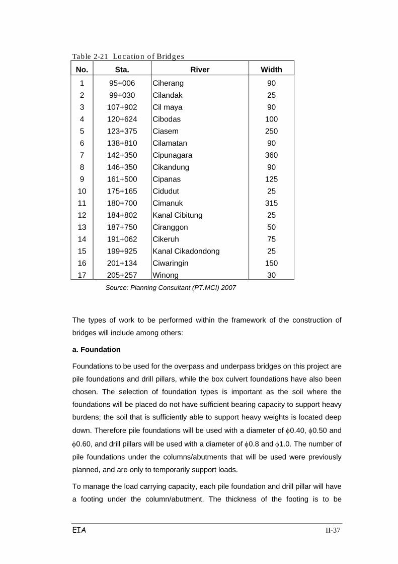
9) Bridge Construction Work
The number of bridges crossing the river and canal is 17 pieces, and there will be
only one railroad crossing at STA 1992 +258.
The shortest bridge will span 25 m across the river at Cidudut Cilandak, while the
longest will be 360 m across the river at Cipunagara. All girder bridges will use a
beam of concrete with a maximum span length of 30 m, except the bridge on the
Ciasem River which will use steel of 70m in length. The location of the bridges can
be seen in Table 2.21 below.
EIA II-37
Table 2-21 Location o f Bridges
No. Sta. River Width
1 2 3 4 5 6 7 8 9
10 11 12 13 14 15 16 17
95+006 99+030
107+902 120+624 123+375 138+810 142+350 146+350 161+500 175+165 180+700 184+802 187+750 191+062 199+925 201+134 205+257
Ciherang Cilandak Cil maya Cibodas Ciasem Cilamatan Cipunagara Cikandung Cipanas Cidudut Cimanuk Kanal Cibitung Ciranggon Cikeruh Kanal Cikadondong Ciwaringin Winong
90 25 90
100 250 90
360 90
125 25
315 25 50 75 25
150 30
Source: Planning Consultant (PT.MCI) 2007
The types of work to be performed within the framework of the construction of
bridges will include among others:
a. Foundation
Foundations to be used for the overpass and underpass bridges on this project are
pile foundations and drill pillars, while the box culvert foundations have also been
chosen. The selection of foundation types is important as the soil where the
foundations will be placed do not have sufficient bearing capacity to support heavy
burdens; the soil that is sufficiently able to support heavy weights is located deep
down. Therefore pile foundations will be used with a diameter of φ0.40, φ0.50 and
φ0.60, and drill pillars will be used with a diameter of φ0.8 and φ1.0. The number of
pile foundations under the columns/abutments that will be used were previously
planned, and are only to temporarily support loads.
To manage the load carrying capacity, each pile foundation and drill pillar will have
a footing under the column/abutment. The thickness of the footing is to be

EIA II-38
calculated based on the load received and distributed to each pile.
b. Column
The column serves as a buffer from the building above. The diameter of the
column is adjusted with the load carried by the column.
Manufacturing of the columns will involve:
• Making the iron framework for the columns
• Column iron
• Installation of formwork
• Casting, using a concrete pump
• Vibrating, using a vibrator
• Removal of formwork
c. Pierhead
Pierheads will be located on top of the columns and serve as beams for the
overpasses/underpasses. Pierhead length will be tailored to the width of the toll
road. Manufacturing of the pierheads will involve:
• Installation of scaffolding
• Installation of basic formwork to support the scaffolding
• Installation of the sides of the formwork
• Casting of the pierheads, using a concrete pump
• Removal of the formwork
d. Girder
Girders will be placed longitudinally on the pierheads. Girders will be made of pre-
tensed concrete. The size of the girders will be adjusted to the distance between
the pierhead. Materials to construct the girders will be concrete that adheres to
established specifications.
Manufacturing of the girders will involve:

EIA II-39
• Mounting the base forms on the ground
• Ironwork
• Installation of the strands
• Installation of sides and ends of the formwork
• Casting
• Tensing the strand
• Removal of the base form
Girders will then be transported to the project site. Girders will be raised to the
pierheads using a crane previously mounted on the pierhead as bearing
placement.
e. RC Plate and Slab
RC Plates will be used as a tool to cast the concrete slabs of the
overbridges/underbridges.
Manufacturing the concrete slabs will involve:
• Installation of RC plate
• Skeletoning/Ironing
• Casting
After the concrete dries, the concrete surface will be smoothed by using a
concrete finisher.
f. Abutment
Abutments are a part of the overbridges/underbridges. Structural stability will be
completely reviewed to identify and ensure the strength and stability of the
structure, so that they do not move because of work loads.
Construction methods specific to the construction of the toll road bridge
intersection with the Jakarta-Bandung (PT. KAI) railway line at Sta.92 +258
(between km 88+300 and km 88+400 of the Jakarta-Cikampek toll road) will
involve:
- Bore pile foundation work. Train schedules will be adjusted to
accommodate this work (see Figure 2.5).
- Foundation (footing) work. Before digging the soil for the outer footings (on
the circumference of the excavation site), sheet piles will be installed for
EIA II-40
protection against landslides during the work (see Figure 2.6).
- Column and pierhead work. Scaffolding will be installed outside the free
zone which will be determined by the requirements of PT. KAI (see Figure
2.7).
- Installation of beam girders:
- Installation of beam girders will obey a tight schedule so the rail is not
crossed by the train.
- 2 kinds of installation methods will be used (see Figure 2.8), namely:
o Launching Method, which will pull the girders from the opposite side
using rails and cranes.
o Erection Method, which will use 2 cranes on the two opposite sides
to erect the girders.
10). Underpass / Overpass (UP / OP) Work
This toll road alignment plan will pass through numerous public roads. As such, 65
overpasses and 20 underpasses are needed. Work will include:
a. Development of underpass / overpass structures
b. Type, length and number of foundation / pile which will be used in the structure
of underpass / overpass,
c. The type, capacity and number of equipment used.
d. Method of execution of work underpass / overpass.
Details for the crossing of roads, both national roads and district roads, are
presented in Tables 2.22 to 2.26.
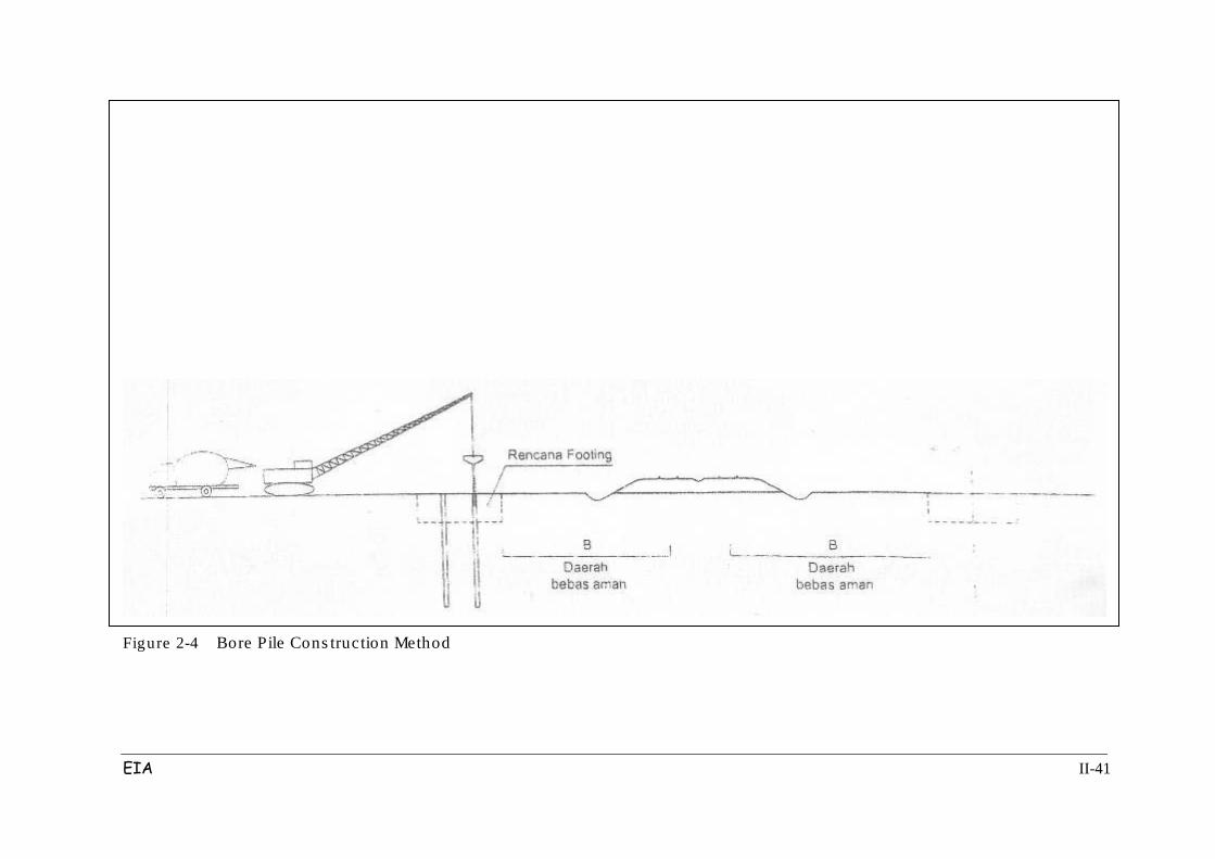
EIA II-41
Figure 2-4 Bore Pile Cons truction Method
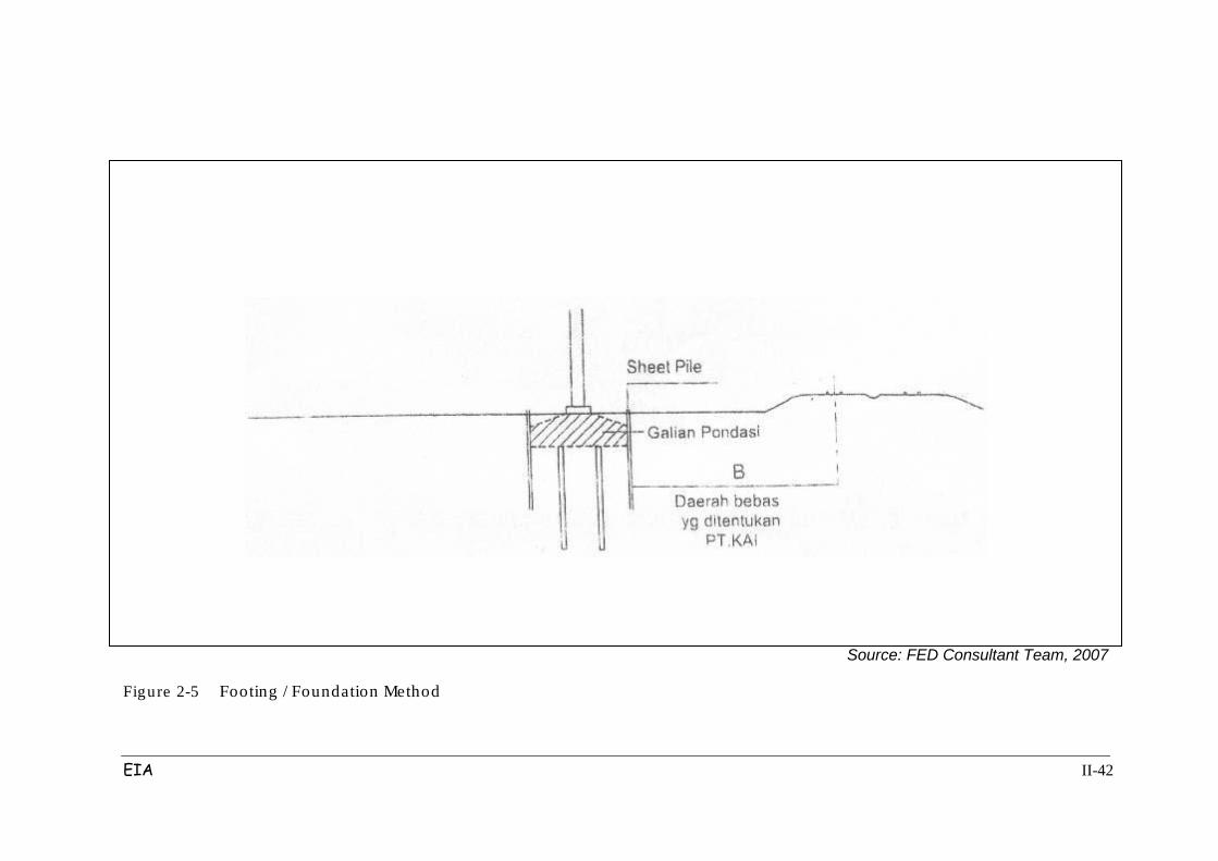
EIA II-42
Source: FED Consultant Team, 2007
Figure 2-5 Footing / Foundation Method
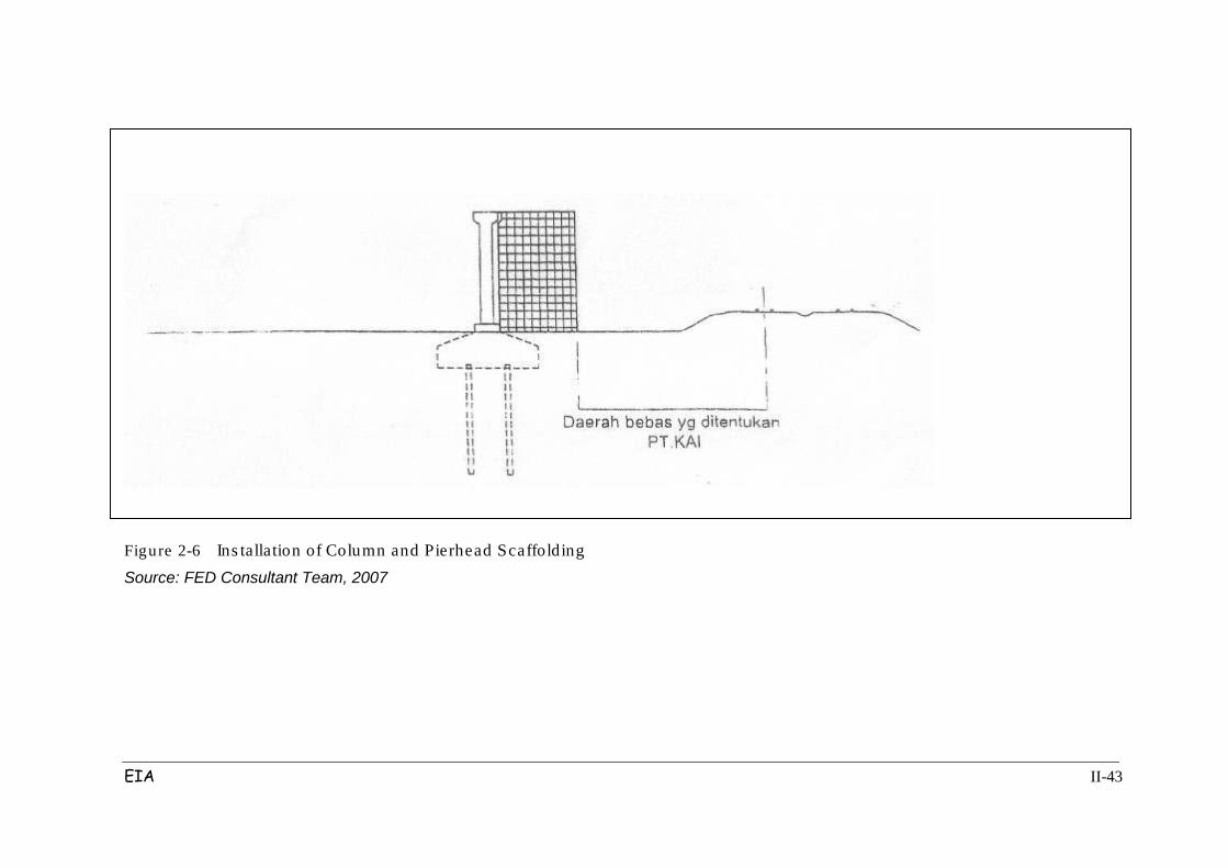
EIA II-43
Figure 2-6 Ins tallation of Column and Pierhead Scaffolding Source: FED Consultant Team, 2007
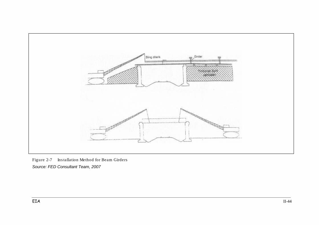
EIA II-44
Figure 2-7 Ins tallation Method for Beam Girders
Source: FED Consultant Team, 2007
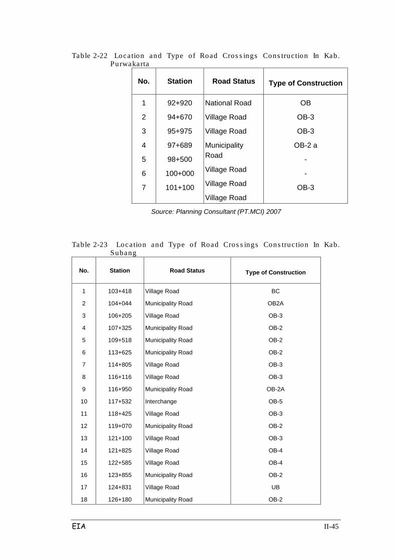
EIA II-45
Table 2-22 Loca tion and Type of Road Cros s ings Cons truc tion In Kab. Purwakarta
No. Station Road Status Type of Construction
1
2
3
4
5
6
7
92+920
94+670
95+975
97+689
98+500
100+000
101+100
National Road
Village Road
Village Road
Municipality Road
Village Road
Village Road
Village Road
OB
OB-3
OB-3
OB-2 a
-
-
OB-3
Source: Planning Consultant (PT.MCI) 2007
Table 2-23 Loca tion and Type of Road Cros s ings Cons truc tion In Kab. Subang
No. Station Road Status Type of Construction
1
2
3
4
5
6
7
8
9
10
11
12
13
14
15
16
17
18
103+418
104+044
106+205
107+325
109+518
113+625
114+805
116+116
116+950
117+532
118+425
119+070
121+100
121+825
122+585
123+855
124+831
126+180
Village Road
Municipality Road
Village Road
Municipality Road
Municipality Road
Municipality Road
Village Road
Village Road
Municipality Road
Interchange
Village Road
Municipality Road
Village Road
Village Road
Village Road
Municipality Road
Village Road
Municipality Road
BC
OB2A
OB-3
OB-2
OB-2
OB-2
OB-3
OB-3
OB-2A
OB-5
OB-3
OB-2
OB-3
OB-4
OB-4
OB-2
UB
OB-2

EIA II-46
No. Station Road Status Type of Construction
19
20
21
22
23
127+350
128+286
128+550
129+122
130+012
Village Road
Municipality Road
Village Road
Interchange
Municipality Road
OB-4
OB-2A
BC
OB-5
OB-2A
No. Station Road Status Type of Construction
24
25
26
27
28
29
30
31
32
33
131+575
133+100
133+566
134+735
136+135
136+870
138+433
139+389
139+806
140+860
Village Road
Village Road
Village Road
Village Road
Municipality Road
Village Road
Village Road
Village Road
Municipality Road
Village Road
OB-3
BC
OB-3
OB-3
OB-2A
BC
OB-3
OB-3
OB-2
OB-3
Source: Planning Consultant (PT.MCI) 2007
Table 2-24 Loca tion and Type of Road Cros s ings Cons truc tion In Kab. Indramayu
No. Station Road Status Type of Construction
1
2
3
4
5
6
7
8
9
142+736
144+800
147+863
149+711
153+453
154+250
155+480
158+888
160+845
National Road
Village Road
Village Road
National Road
Village Road
Village Road
Village Road
National Road
Village Road
OB-1
OB-4
OB-3
OB-1
OB-3
OB-3
OB-3
OB-1
OB-4
Table 2-25 Loca tion and Type of Road Cros s ings Cons truc tion In Kab. Majalengka
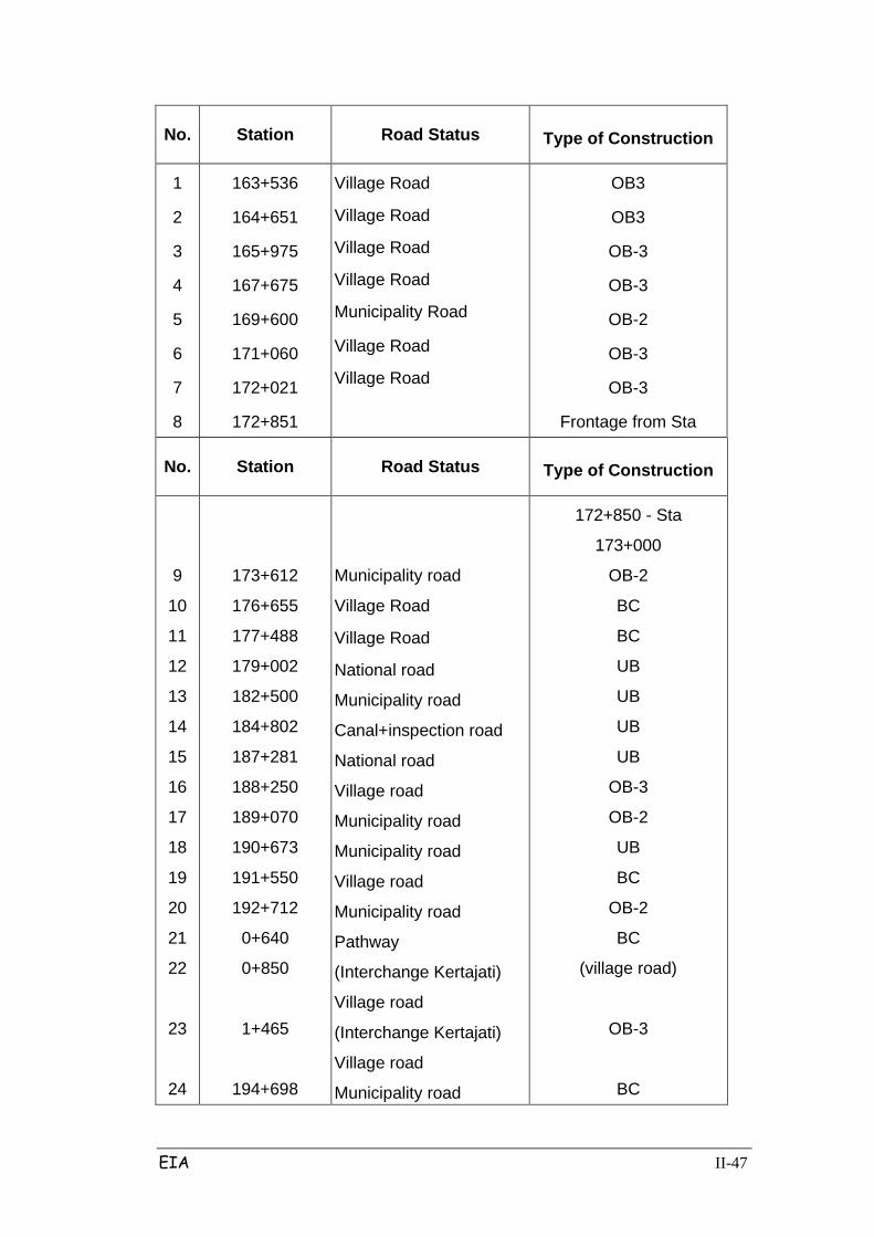
EIA II-47
No. Station Road Status Type of Construction
1
2
3
4
5
6
7
8
163+536
164+651
165+975
167+675
169+600
171+060
172+021
172+851
Village Road
Village Road
Village Road
Village Road
Municipality Road
Village Road
Village Road
OB3
OB3
OB-3
OB-3
OB-2
OB-3
OB-3
Frontage from Sta
No. Station Road Status Type of Construction
9
10
11
12
13
14
15
16
17
18
19
20
21
22
23
24
173+612
176+655
177+488
179+002
182+500
184+802
187+281
188+250
189+070
190+673
191+550
192+712
0+640
0+850
1+465
194+698
Municipality road
Village Road
Village Road
National road
Municipality road
Canal+inspection road
National road
Village road
Municipality road
Municipality road
Village road
Municipality road
Pathway
(Interchange Kertajati)
Village road
(Interchange Kertajati)
Village road
Municipality road
172+850 - Sta
173+000
OB-2
BC
BC
UB
UB
UB
UB
OB-3
OB-2
UB
BC
OB-2
BC
(village road)
OB-3
BC

EIA II-48
No. Station Road Status Type of Construction
25
26
27
28
29
30
31
195+289
195+938
196+425
197+289
198+191
199+446
200+030
Village road
Village road
Village road
Village road
Village road
Municipality road
OB-2
BC
OB-3
OB-3
OB-3
OB-3
UB
Table 2-26 Location and Type of Road Cros s ings Cons truc tion In Kab. Cirebon
No. Station Road Status Type of Construction
1
2
3
4
5
6
200+030
200+716
201+535
202+123
205+776
206+418
Municipality road
Municipality road
Municipality road
Municipality road
Village road
Municipality road
UB
BC
UB
UB
OB3
OB-2
11) Inter Change (IC) Work
7 Interchanges will be built on Palimanan Cikampek toll road: 1C Cikopo, 1C
Kalijati, 1C Subang, 1C Cikedung, 1C Kertajati, 1C Sumberjaya, 1C, Palimanan.
Work includes:
- The type of construction that will be used.
- Construction materials and dimensions of construction elements.
- The type, capacity and number of equipment used.
- Method of construction work.
12). Making highway facilities, such as:

EIA II-49
a. Making People-Crossing Bridges (JPO)
JPOs must be suitably placed every 1 km from road crossings (OP / UP or BC). 20
JPOs will be built and placed in various locations as seen in Table 2.27 below.
Table 2-27 Location of People-Cros s ing Bridge (J PO)
No Sta. Sub-district/Village
1 98+000 Sub-district Campaka, Cisaat/Cimahi Village
2 103+150 Sub-district Campaka, Karangmukti/Sukamukti Village
3 108+075 Sub-district Cipeundeuy, Sukasari Village
4 113+750 Sub-district Kalijati, Marangmang
5 119+850 Sub-district Purwadadi, Ciruluk Village
6 122+300 Sub-district Purwadadi, Batusari Village
7 126+400 Sub-district Pagaden, Sumurgintung Village
8 127+900 Sub-district Pagaden, Jabong Village
9 132+000 Sub-district Pagaden, Gembor/Mayasari Village
10 169+750 Sub-district Kertajati, Palasah Village
11 172+300 Sub-district Kertajati, Palasan Village
12 191+050
Sub-district Palasah, Cisambeng Village
13
196+050
Sub-district Sumberjaya, Bagaswetan Village
14
197+400
Sub-district Sumberjaya, Bagaswetan Village
No Sta. Sub-district/Village
15
198+350
Sub-district Sumberjaya, Panjalunlor Village
16
201+300
Sub-district Ciwaringin, Ciwaringin Village
17
203+300
Sub-district Ciwaringin, Galagamba Village
Source: Planning Consultant (PT.MCI) 2007
b. Construction of 28 tollgates. Tollgates will be built at each site entrance or exit
of the road while office buildings will be built in Cikampek
EIA II-50
c. Installation of security fencing along the right-left of the highway
d. Installation of 2 Toll Barrier units (in Cikampek and Palimanan)
e. Construction of Rest Area
To give the user convenience, there will be 8 rest area units provided, consisting
of 4 Type A units and 4 Type B units. The location of each rest area can be seen
in Table 2.28 below.
Table 2-28 Location of Res t Areas
No Location Area (Ha) Type Description
1 112 + 400 North Side
110 + 900 South Side
200x100 = 2 ha
201x100 = 2ha B
Cutting area (± 4m) Cutting
area (± 4m)
2 143 + 000 North Side
139 + 600 South Side
250 x 160 = 4 ha
251x160 = 4 ha A
Cutting area (± 4m) Cutting
area (± 5m)
3 160 + 200 North Side
153 + 000 South Side
200 x 100 = 2 ha 201
x 100 = 2 ha B
Cutting area (± 4m) Cutting
area (± 3m)
4 186 + 000 North Side
184 + 000 South Side
250x160 = 4 ha
251x160 = 4 ha A
Fill area (< 0.5 m)
Fill area (< 1 m)
Source: Planning Consultant (PT.MCI) 2007
f. Construction of Toll Plaza (including the Office of Cikampek-Palimanan toll road)
will be in Purwakarta.
g. Installation of road markings and traffic signs.
h. Installation of street lighting including the making of fence, and landscaping.
3. Post-construction Stage
1). Operation of Toll Road
With the operation of Palimanan Cikampek toll road, it is estimated to be traversed
by vehicles whose numbers continue to rise. Rest areas and amenities such as
parking lots, toilets, canteens, shops, vehicle service areas, the Palimanan
Cikampek toll road Office, and so forth will be operated.
At the time of operation the toll road workers will include computer operators, for
EIA II-51
the withdrawal of tickets for use of the highway, crane officers, ambulance teams,
technical staff, security patrols and hygiene staff members. These employee
numbers will increase with the improved highway service.
2) Toll Road Maintenance
Maintenance activities include maintenance of the highway pavement layers, by
overlay, as well as maintenance of the bridge, overpass / underpass, interchange
and auxiliary buildings (facilities) such as drainage, safety fencing, plants and
landscape, and the RUMIJA.
Highway maintenance activities will include:
Road maintenance carried out every day / week / month and non-structural nature.
1. Routine Maintenance
(A) Field pavement
- Patching holes / patching asphalt roads
- Closure of cracked concrete roads.
(B) Area bridges
- Maintenance and repair of tunnels or bridges.
- Maintenance and repair of connection expansion.
- Maintenance and repair of beams, slabs, walls, and bridge safety fence.
(C) Field roads
- Maintenance and repair of concrete barrier.
- Maintenance and repair of guide post, kilometer pegs, traffic signs and retaining
glare.
- Maintenance and repair of RUMIJA fences.
(D) Field Drainage
- Maintenance and cleaning line
(E) Environment Field
- Cutting grass at RUMIJA
- Striping Shoulder
EIA II-52
- Maintenance and repair of roads
- Cleaning road tot
- Maintenance of plants in RUMIJA
- Sweeping and trash collection
(F) Field Equipment and PJU
- Maintenance and repair of work equipment
- Maintenance of mechanical and electrical installation
- Maintenance and repair PJU
Maintenance is carried out to restore the structural strength of the road back to a
steady state after disrepair that will occur over time and heavy use.
2. Periodic Maintenance
(A) Field Road Pavement
- Re-coating the road
- Scrapping and filling
(B) Field Bridge
- Replacement of expansion connection
- Leveling of the pit bridge
(C) Field roads
- Painting road markings
- Replacement of traffic signs
(D) Environmental Affairs
- The arrangement of plants in RUMIJA
(E) Field equipment and PJU
- Replacement of equipment components
- Replacement of components PJU
EIA II-53
2.3 LINKAGE OF THE PROJECT WITH PROJECTS IN SURROUNDING AREAS
The planned toll road development activities are linked with other activities such
as:
1. The presence of Type C Mining Material / Quarry
In the vicinity of the study sites, there are some mining activities such as the Type
C quarry, located about 20 km away. This type of quarry also exists in numerous
other surrounding areas. For more details, the location of the quarries can be seen
in Figure 2.4.
Given the location of the planned toll road through flat areas and rice fields, the
volume of material would require a fairly large pile. To meet this it is required that
the source-quarry is operated by other business entities that have a business
license. In fulfillment of this material requirement, the project should consider the
transport of material from the quarry site to the project site.
2. International Airport Development Plan in Kertajati, Majalengka.
An area in Kertajati, Majalengka has now received permission from the Minister of
Transportation as the location for the construction of the West Java International
Airport (BUB). Selection of this area was done through research, both for technical
feasibility of aviation operational safety and technical aspects of the airport
operation study.
In terms of physiography, the area that will be used as the airport is at a height of
40 meters above sea level and on flat surface which is ideal for drainage purposes
and the power of the runway. As the wind speed in the last 6 years in the sub-
district of Kertajati showed an average of 10 knots, the landing process can be
performed safely throughout the year.
Development in Kertajati is in accordance with the regional spatial planning for the
Majalengka District of West Java Province, and integrates with transportation
arrangements. Transportation to the airport location is supported by the
construction of the Cisumdawu (Cileunyi-Sumedang Dawuan) toll road which will
connect to the Cikacir (Cikampek-Cirebon) highway on the northern coastline.
Construction of a two-lane highway segment is expected to be completed before
the development of the airport is finished; as such, the BUB will later be located
EIA II-54
about 15 km north of the capital of Kadipaten district, so that it can be reached in
just 30 to 45 minutes from Bandung. The city of Cirebon is even closer, so that
people and businessmen from the western part of Central Java such as Brebes
can legally use BUB Kertajati for the traffic of people and goods.
3. Islamic School Activities in Babakan Ciwaringin
There is a Pesantren (School of Integrated Islamic Education) in the Babakan
Ciwaringin area.
EIA III-1
Chapter III
DESCRIPTION OF ENVIRONMENTAL CONDITIONS
3.1 PHYSICAL AND CHEMICAL COMPONENTS
3.1.1 Climate
The Study area is located in a tropical climate with two seasons, dry season and
rainy season. Based on the data series for the last 10 years, the climatic
parameters in the study area are as follows: the highest monthly rainfall for 10
years in Purwakarta region occurred in January (369 mm) with 16 days of rain and
the lowest in July and August (43 mm) with 3 and 1 day of rain respectively.
The highest rainfall in Subang area occurred in January with 15 days of rain at 325
mm, and the lowest occurred in August with 26 mm to 1 day of rain. In Indramayu
the highest rainfall (288 mm) occurred in March with 24 days of rain and lowest in
August (51 mm) with 5 days of rain. In Cirebon the highest rainfall was in January
(348 mm) with 19 rainy days and the lowest at 50 mm with 3-day rainfall in August.
In Majalengka the highest rainfall of 351 mm with 17 rainy days is in January and
lowest in August by 58 mm by 5 days of rain. Indonesian climate is classified
based on the number of wet and dry months, where the wet months is the month
with a total rainfall of more than 100 mm, while the dry months is the month with a
total rainfall of less than 60 mm.
The ratio between wet and dry months was given the symbol Q. Analysis results
obtained for Purwakarta Regency indicated Q was 0.20 in zone B with wet climate
conditions. In Subang Regency the Q ratio was 0.33 in zone B with a wet climate.
Indramayu Regency had a Q ratio of 0.30 in zone B with a wet climate.
Majalengka Regency had a Q value as high as 0.09 which is considered in Zone A
with a very wet climate. Cirebon Regency had a Q value of 0.09 which is also
classified as zone A with a very wet climate.
Temperature, Wind Direction and Speed
Average maximum temperature in the study area ranged between 28.6-30.9oC,
while the average minimum temperature ranged between 19.2-21.8oC. Average
wind speed in the study area ranged from 3.4-4.6 km / hour with general wind
direction from the West, East, Northwest, and Southeast.
EIA III-2
a. Air Quality
To determine the air quality in the area around the planned Palimanan Cikampek
toll road site in the Andal study, direct measurements were taken at 10 locations
on 20 September to 3 October 2007, which in general show air quality parameters
are still below the standards of Government Regulations (PP) No. Rl. 41 of 1999.
The measurement results are presented in Table 3.1.
Table 3.1 shows that at certain sampling locations such as U10 in Palimanan there
are already quite high levels of CO, reaching 1030 ug/m3, as well as in sampling
locations U8 and U9 in Ciwaringin and Ligun districts which reached 916 ug/m3.
Dust levels are high at the sampling points U1 and U9, which reached 90 and 154
ug/m3; it is assumed these values are high because the sampling locations were in
urban areas.
b. Noise
Table 3.2 shows the results of noise measurements at several points along the
proposed highway route; these sampling activities were carried out to determine
the level of noise in the environment all along the ± 116.4 km Palimanan-
Cikampek toll road alignment, measured directly in 10 locations. The
measurement results appear to in general still be below the quality standards of
PP No.41/1999.
However the location at Cinangka village measured 55.9 dB (A), and Wanakerta
Village, District Purwadadi, Subang regency (STA 117 +000) also measured 76.3
dB (A). These are well above the noise level standards of PP Rl No.41 / 1999
which requires that residential areas are 55 dB (A). These high levels are likely
due to the time of measurement which was affected by the activities of motor
vehicles.
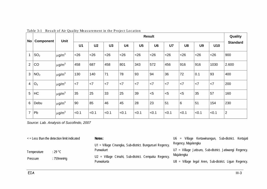
EIA III-3
Table 3-1 Res ult of Air Quality Meas urement in the Projec t Location
No Component Unit Result Quality
Standard U1 U2 U3 U4 U5 U6 U7 U8 U9 U10
1 SO2 µg/m3 <26 <26 <26 <26 <26 <26 <26 <26 <26 <26 900
2 CO µg/m3 458 687 458 801 343 572 456 916 916 1030 2.600
3 NO2 µg/m3 130 140 71 78 93 94 36 72 0.1 93 400
4 O3 µg/m3 <7 <7 <7 <7 <7 <7 <7 <7 <7 <7 200
5 HC µg/m3 35 25 33 25 39 <5 <5 <5 35 57 160
6 Debu µg/m3 90 85 46 45 28 23 51 6 51 154 230
7 Pb µg/m3 <0.1 <0.1 <0.1 <0.1 <0.1 <0.1 <0.1 <0.1 <0.1 <0.1 2
Source: Lab. Analysis of Sucofindo, 2007
< = Less than the detection limit indicated
Temperature : 29 °C
Pressure : 759mmHg
Notes:
U1 = Village Cinangka, Sub-district. Bungursari Regency. Purwakart
U2 = Village Cimahi, Sub-district. Cempaka Regency. Purwakarta
U6 = Village Kertawinangun, Sub-district. Kertajati Regency. Majalengka
U7 = Village Jatisuro, Sub-district. Jatiwangi Regency. Majalengka
U8 = Village legal Aren, Sub-district. Ligun Regency.
EIA III-4
Humidity : 61 %
Wind Speed : 1 - m/s
Wind Direction : East
Weather : Bright
U3 = Village Wanakerta, Sub-district. Purwadadi Regency. Subang
U4 = Village Wanasari, Sub-district. Cipunegara Regency. Subang
U5 = Village Cikawung, Sub-district. Trisi Regency. Indramayu
Majalengka
U9 = Village Babakan, Sub-district. Ciwaringin Regency. Cirebon
U10 = Village Pegagan, Sub-district. Palimanan Regency. Cirebon

EIA III-5
c. Surface/ River Water Quality
The quality of surface/river water was observed around the site of the planned
Palimanan-Cikampek toll road. Measurements of surface water quality were
conducted in 10 locations as shown in Table 3.3. The results were compared with
the quality standards of Government Regulation No. 82/2001. In general, surface
water quality parameters are still below the PP No.82/2001 standards.
Overall, river water is still in good condition, when compared with the quality
standards, but some rivers such as the Cipanas River and Cipunegara River have
quite high levels of chloride and total density.
Likewise with coli bacterial contamination, almost every river in the sampling area
was contaminated with coli bacteria. For example the Cibodas River had levels of
coli contamination as high as 42,000/100 ml; 25,000/100 ml in the Cilmaya River;
and 1,300/100 ml in the Ciherang River. These conditions indicate that the aquatic
environment, particularly surface water, has been polluted by domestic waste,
especially human excrement, and the spread of disease through water is probable.
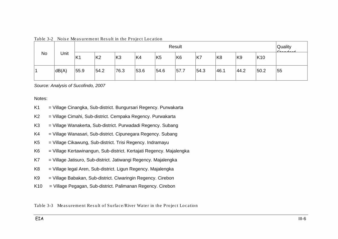
EIA III-6
Table 3-2 Nois e Meas urement Res ult in the Pro ject Location
No Unit Result
Quality Standard
K1
K2
K3
K4
K5
K6
K7
K8
K9
K10
1
dB(A)
55.9
54.2
76.3
53.6
54.6
57.7
54.3
46.1
44.2
50.2
55
Source: Analysis of Sucofindo, 2007
Notes:
K1 = Village Cinangka, Sub-district. Bungursari Regency. Purwakarta
K2 = Village Cimahi, Sub-district. Cempaka Regency. Purwakarta
K3 = Village Wanakerta, Sub-district. Purwadadi Regency. Subang
K4 = Village Wanasari, Sub-district. Cipunegara Regency. Subang
K5 = Village Cikawung, Sub-district. Trisi Regency. Indramayu
K6 = Village Kertawinangun, Sub-district. Kertajati Regency. Majalengka
K7 = Village Jatisuro, Sub-district. Jatiwangi Regency. Majalengka
K8 = Village legal Aren, Sub-district. Ligun Regency. Majalengka
K9 = Village Babakan, Sub-district. Ciwaringin Regency. Cirebon
K10 = Village Pegagan, Sub-district. Palimanan Regency. Cirebon
Table 3-3 Meas urement Res ult of Surface/River Water in the Pro ject Location
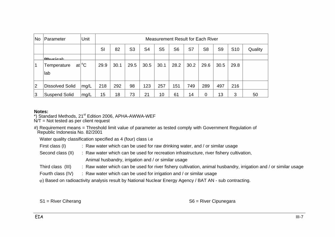
EIA III-7
No
Parameter
Unit
Measurement Result for Each River
SI 82 S3 S4 S5 S6 S7 S8 S9 S10 Quality
Physical:
1
Temperature at
lab
oC
29.9
30.1
29.5
30.5
30.1
28.2
30.2
29.6
30.5
29.8
2
Dissolved Solid mg/L
218
292
98
123
257
151
749
289
497
216
3
Suspend Solid
mg/L
15
18
73
21
10
61
14
0
13
3
50
Notes: *) Standard Methods, 21st Edition 2006, APHA-AWWA-WEF N/T = Not tested as per client request #) Requirement means = Threshold limit value of parameter as tested comply with Government Regulation of
Republic Indonesia No. 82/2001 Water quality classification specified as 4 (four) class i.e First class (I) : Raw water which can be used for raw drinking water, and / or similar usage Second class (II) : Raw water which can be used for recreation infrastructure, river fishery cultivation, Animal husbandry, irrigation and / or similar usage Third class (III) : Raw water which can be used for river fishery cultivation, animal husbandry, irrigation and / or similar usage Fourth class (IV) : Raw water which can be used for irrigation and / or similar usage ϕ) Based on radioactivity analysis result by National Nuclear Energy Agency / BAT AN - sub contracting. S1 = River Ciherang S6 = River Cipunegara

EIA III-8
S2 = River Cilamaya S7 = River Cipanas S3 = River Cibodas S8 = River Cimanuk S4 = River Ciasem S9 = Kanal Ciliwung S5 = River Cilamatan S10 = River Ciwaringin
EIA III-9
d. Shallow Ground Water Quality
Groundwater quality was observed in residential wells around the planned
Cikampek-Palimanan toll road; it is feared that changes will occur in groundwater
quality due to construction activities and operations. Measurement of ground water
quality was conducted at 10 locations. Results of analysis of ground water quality
are shown in Table 3.4, as compared with quality standards from the Minister of
Health Regulation No. 4167 Menkes / Per / IX / 1990. The results are in general
still below the standards.
From the results, it is seen that the L10 location in the village of Pegagan village,
District Palimanan, has shallow ground water that is already visible in color, thus
indicating the water has begun to be polluted.
Sampling location L6 in Kertawinangun Village has dissolved solids that exceed
the threshold (1,500 mg/l) with a measured level of 2284 mg/l, so that there is an
excess of 784 mg/l.
Levels of nitrate in 5 locations (L1, L2, L4, L8 and L10) also exceed the threshold,
with the highest levels found in Cikopo-Purwakarta (24.8 mg/l) and Palimanan (31
mg/l). This shows that the region has already started contaminating their water
source with domestic waste from human activities.
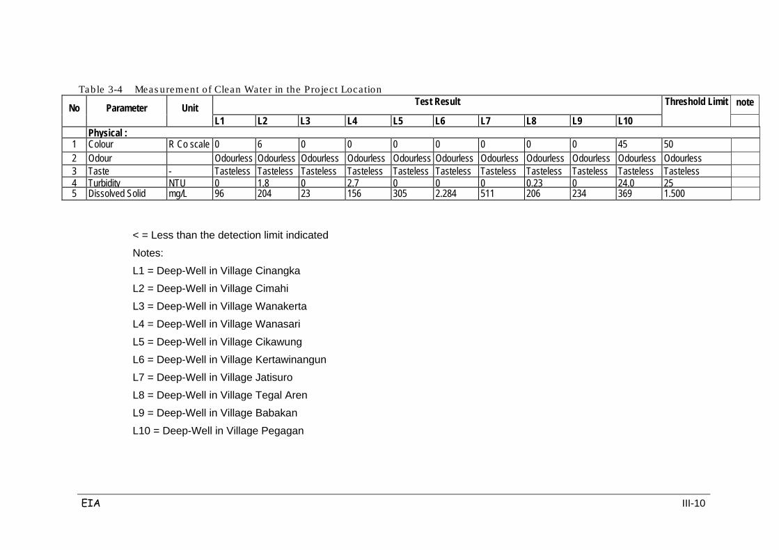
EIA III-10
Table 3-4 Meas urement of Clean Water in the Project Location
No Parameter Unit Test Result Threshold Limit
note
L1
L2
L3
L4
L5
L6
L7
L8
L9
L10
Physical :
1
Colour
R Co scale
0
6
0
0
0
0
0
0
0
45
50
2 Odour Odourless Odourless Odourless Odourless Odourless Odourless Odourless Odourless Odourless Odourless Odourless
3
Taste
-
Tasteless
Tasteless
Tasteless
Tasteless
Tasteless
Tasteless
Tasteless
Tasteless
Tasteless
Tasteless
Tasteless
4
Turbidity
NTU
0
1.8
0
2.7
0
0
0
0.23
0
24.0
25
5
Dissolved Solid
mg/L
96
204
23
156
305
2.284
511
206
234
369
1.500
< = Less than the detection limit indicated
Notes:
L1 = Deep-Well in Village Cinangka
L2 = Deep-Well in Village Cimahi
L3 = Deep-Well in Village Wanakerta
L4 = Deep-Well in Village Wanasari
L5 = Deep-Well in Village Cikawung
L6 = Deep-Well in Village Kertawinangun
L7 = Deep-Well in Village Jatisuro
L8 = Deep-Well in Village Tegal Aren
L9 = Deep-Well in Village Babakan
L10 = Deep-Well in Village Pegagan
EIA III-11
3.1.2 Physiography and Geology
A. Physiography
Broadly speaking, geomorphology and surrounding areas along the Cikampek-
Palimanan Toll Road plan can be divided into the following geomorphological units
(see Table 3.5):
1) Unit morphology lowlands and river plains, in the form of alluvium with a slope
of 0-3%.
2) Unit wavy morphology, formed by young volcanic rocks with a slope of 3-5%.
3) Unit morphology hills and mountains with fine reliefs, formed by young volcanic
rocks and sandstone with a slope of 5-15%.
4) Unit morphology hills and mountains with a relief of moderate, formed by tuff,
sandy tuff and breccia with a slope of 15-30%.
5) Unit morphology hills and mountains with high relief, formed by sandy tuff,
breccia and andesite with a slope of 30-70%.
Table 3-5 Mophology a long the planned Toll Road
No. Morphology Slope
%
Elevation Above
Sea Level (m)
Lithology % of Length
Note
1 Lowlands and river plains
0-3
27.50-95.50
Aluvium, tuf, tufan, breksi volcano
86,94
On the east side, generally as paddy field and plantations
2 Countoured area 3-5
38.50-82.00
Tuf, tufaan and aluvium
7,72
On the east side, as rubber plantations
3 Hill and mountainous w/ low reliefs
5-15
45.50-68.00
Tuf, pasir tufaan dan breksi
3,75
On the west and middle part of the project location
4 Hill and mountainous w/ medium reliefs
15-30
70.00-70.50
Sand rock, tuf and tufaan
1,27
On the west and middle part of the project location
5 Hill and mountainous w/ high reliefs
30-70
90.00-100.00
tufaan, breksi and andesit
0,32
On the west side, in the form of protected forest.
Source: Geology and Environment Agency of Bandung
EIA III-12
The average profile for the existing ground conditions along the toll road plan can
be seen in Figure 3.1. Overall, the profile is quite hilly. The depth differences along
the path vary from 80 meters to a maximum of 100 meters above sea level,
generally in the northern town of Subang (± Sta. 116 +000), and 20 meters in the
eastern coastal plain town of this experiment.
For low-lying areas like Sta. 102 +000, 138 +000 -143 +000, and Sta. 181 +000,
they include river valleys like the Cimalaya, Cilamatan and Cipunagara rivers and
the plains of the Cimanuk river reservoir from the mountains to the south. This
river flows on an alluvial flood plains reservoir. Cimanuk valley is in the eastern
region where the surface elevation rises again and finally falls on the plains in the
east coast of the city in this experiment.
Highlands can be correlated with each of the mountain peaks to the south which
form a lowland that stretches to the north.
Figure 3-1 Topographica l Conditions in the Pro ject Location
In the plains area there is a dominance of residential land and rice fields. In the
residential area there is rolling terrain, paddies, fields and bushes.
Overall the planned toll road runs through 57.900 km (49.91%) of rolling terrain
and 58.100 km (50.09%) of floodplains.
EIA III-13
Geologically the area is dominated by flat alluvial river deposits consisting of clay,
silt, sand and gravel that are still loose. Although the area is hilly and choppy,
there are also other alluvium deposits such as clay stone and tufa that have been
weathered. Coarse-grained rocks are at distances ranging from 10 to 40 km south
of the highway alignment. These rocks have high potential for use as building
materials during the toll road construction. Coarse aggregates are found around
Plered Purwakarta, around Kuningan town, and also (although less so) around
Tanjungsiang. Fine aggregates (sand) are found near Plered Purwakarta, the area
south of Subang city, and around the city Majalengka. Urug soil (for sub-grade) is
found to the south of Subang city, around Majalengka city, and around Sumedang
city.
Morphological conditions along this highway project consist of five different
locations, as can be seen in Table 3.6.
The below table shows that low-lying areas and river banks cover 86.94% of the
total length of the highway. These locations are generally composed of layers of
alluvium, tuff, sand tuffaan, breccia, and the rest are widespread volcanic. On the
other hand, hills and mountain areas cover only 0.32% of the area, and are
generally located below the timber plantations and forests.
B. Geology
In 5 (five) regions to be traversed by the Cikampek-Palimanan toll road there are
several types of geology, namely: gabbro, Pliocene sedimentary facies, Miocene
limestone facies, Pleistocene sedimentary facies, Pleistocene volcanic facies, the
old quarter volcano, alluvium volcanic facies, facies Miocene sediments, andesite
and alluvium. The geology along the Cikampek – Palimanan toll road plan includes
younger and older rock formations as follows:
1. River sediment (Qa) consisting of clay, silt, sand, mud and gravel; all of which is
an array of Holocene river sediment.
2. Young volcanic rocks (Qyu) consisting of breccia, andesite and basalt lavas,
tuffaceous sandstone and lapili, originating from Mount Tampomas (in Bandung
LBR) and Mount Cireme. Usually these rocks form the plains or low hills with soil
that is gray and reddish yellow.
3. Tuffaceous sandstone, clay and conglomerates (Qv)
Table 3-6 Geologica l Age and Formation of the Pro ject Location
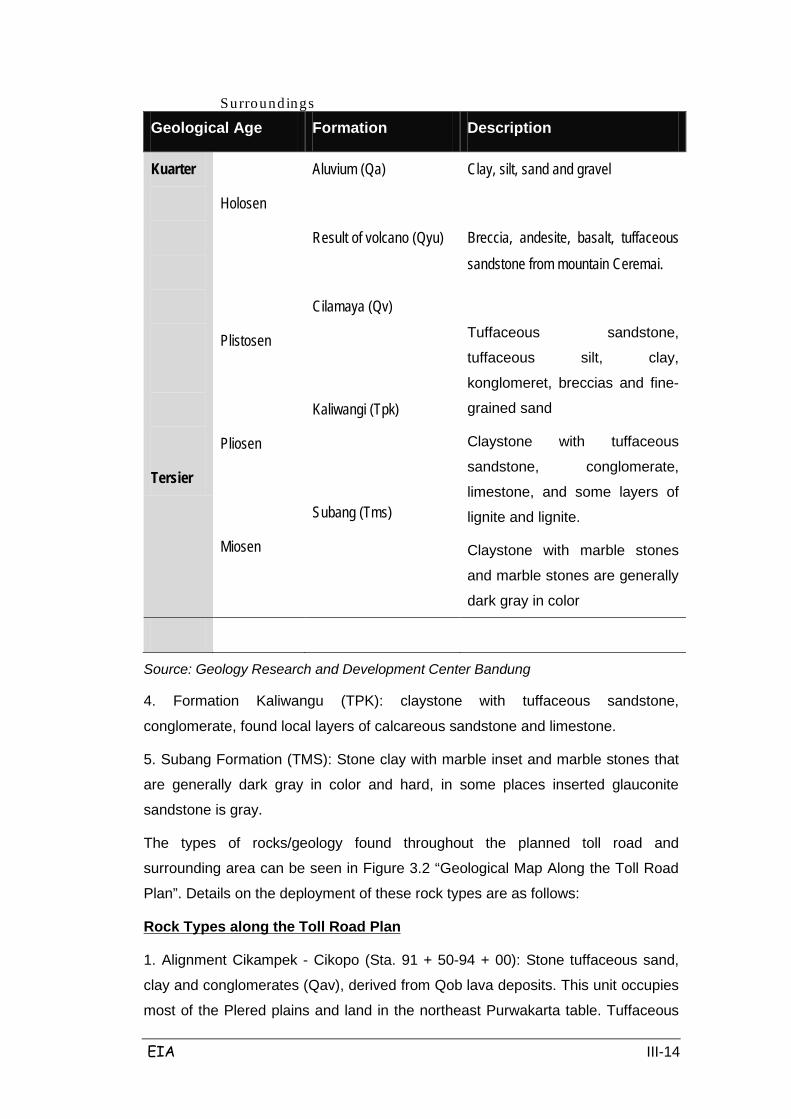
EIA III-14
Surroundings
Geological Age Formation Description
Kuarter
Tersier
Holosen
Plistosen
Pliosen
Miosen
Aluvium (Qa)
Result of volcano (Qyu)
Cilamaya (Qv)
Kaliwangi (Tpk)
Subang (Tms)
Clay, silt, sand and gravel
Breccia, andesite, basalt, tuffaceous sandstone from mountain Ceremai.
Tuffaceous sandstone,
tuffaceous silt, clay,
konglomeret, breccias and fine-
grained sand
Claystone with tuffaceous
sandstone, conglomerate,
limestone, and some layers of
lignite and lignite.
Claystone with marble stones
and marble stones are generally
dark gray in color
Source: Geology Research and Development Center Bandung
4. Formation Kaliwangu (TPK): claystone with tuffaceous sandstone,
conglomerate, found local layers of calcareous sandstone and limestone.
5. Subang Formation (TMS): Stone clay with marble inset and marble stones that
are generally dark gray in color and hard, in some places inserted glauconite
sandstone is gray.
The types of rocks/geology found throughout the planned toll road and
surrounding area can be seen in Figure 3.2 “Geological Map Along the Toll Road
Plan”. Details on the deployment of these rock types are as follows:
1. Alignment Cikampek - Cikopo (Sta. 91 + 50-94 + 00): Stone tuffaceous sand,
clay and conglomerates (Qav), derived from Qob lava deposits. This unit occupies
most of the Plered plains and land in the northeast Purwakarta table. Tuffaceous
Rock Types along the Toll Road Plan
EIA III-15
sandstones sometimes contain pumice; clay containing the remains of plants;
conglomerates, breccias and fine sand, layered horizontal / virtually flat.
2. Alignment Cikopo (Bungursari) - Cimahi (Campaka) (Sta.94 + 300 -96 +100)
along the Ciherang valley: Subang Formation (TMS), which consists of limestone
with marble inset and marble stones that are generally dark gray in color and hard,
some places inserted with gray glauconite sandstone.
3. Alignment Cimahi (Campaka) – Cipunagara River (Sta.96 + 100 -142 + 50):
Tuffaceous sandstone, clay and conglomerates (Qav)
• Alignment of Cilamaya River (Sta. 101 + 902) Campaka district,
Purwakarta: Deposition River (Qa) consists of clay, silt, sand, mud and
gravel, in the form of the composition of Holocene river sediments. River is
tipped from G. Tangkuban Perahu.
• Alignment of Ciasem River (Sta. 123 + 458) Pagaden district, Subang:
Deposition River (Qa) consists of clay, silt, sand, mud and gravel,
Holocene river deposits in the form of composition. River is tipped from G.
Tangkuban Perahu.
• Alignment of Cipicung River (Sta. 126 + 313) Pagaden district, Subang,
and Cipunagara River (Sta. 142 + 350) Campaka district, Purwakarta:
River sediments (Qa) consists of clay, silt, sand, mud and gravel, in the
form of the composition of Holocene river sediments. River is tipped from
Buligir and G. G. Tampomas.
4. Alignment Cipunagara River (Sta. 142 +350), Cipunagara district, Subang -
(Sta. 152 + 850) Compiled by tuffaceous sandstones, clays and conglomerates
(Qav), derived from Qob lava deposits. This unit occupies most of the terrain and
soil and the Plered table in Northeast Purwakarta. Tuffaceous sandstones
sometimes contain pumice; clay containing the remains of plants; conglomerates,
breccias and fine sand, breccia and smooth sand. Flat / almost flat layering.
5. Alignment Kertajati – Road intersection. Kertajati – Jati Tujuh (Sta. 178 + 000 -
Sta. 179 + 002): River Sediment (Qa) clay, silt, sand, mud and hook, a
composition of Holocene river sediments.
6. Alignment Jatitujuh - Cimanuk River - River Cikeruh (Sta. 179 + 002 - Sta. 191 +
060) Cisambeng district, Majalengka: Alluvium (Qa): clay, silt, sand, gravel,
especially Holocene river sediments.
7. Alignment of Cikeruh River - Sta. 193 + 960: Irreducibly Young Volcanic (Qyu):
EIA III-16
breccia, andesite and basalt lavas, tuffaceous sand, originating from Mount
Tampomas lapili (in Bandung LBR) and Mount Cireme. Usually these rocks
formed plains or low hills with soil that is gray and reddish yellow.
8. Alignment Sta. 193 + 960 sd Sta. 195 + 960: Kaliwangu Formation (TPK):
claystone with tuffaceous sandstone, conglomerate. Found a local layer of
calcareous sandstone and limestone.
9. Alignment Sta. 195 + 960 - Sta. 198 + 460: Irreducibly Young Volcanic (Qyu)
consisting of breccias, lavas are andesite and basalt, tuffaceous sand, originating
from Mount Tampomas lapili (in Bandung LBR) and Mount Cireme. Usually these
rocks form plains or low hills with soil that is gray and reddish yellow.
10. Alignment Sta. 198 + 460 - Sta. 203 + 960: Kaliwangu Formation (TPK):
claystone with tuffaceous sandstone, conglomerate. Found a local layer of
calcareous sandstone and limestone.
11. Alignment Sta. 203 + 960 – Palimanan: Irreducibly Young Volcanic (Qyu):
breccia, lavas are andesite and basalt, tuffaceous sand, originating from Mount
Tampomas lapili (in Bandung LBR) and Mount Cireme. Usually these rocks form
plains or the hills with soil that is gray and reddish yellow.
Throughout the Cikampek - Palimanan Toll Road plan starting from Purwakarta
Regency, Subang, Indramayu, Majalengka and Cirebon, there are no direct
intersecting geological structures. Only in Ciwaringin there is a shear fault which
almost cuts off the Gaza plan for the toll road, namely by a fault trending north -
south on the southern slope of Mount Kromong exactly south of the toll road plan.
This fault was found in the rocks of the Kaliwangu Formation compiled by
claystone with tuffaceous sandstones and conglomerates. This fault zone is a
weak zone that potentially threatens the movement of soil in this region, and along
the fault lines there was found oil seepage and hot springs. The other sections
along the toll road plan are not interrupted by geological structures, where the
nearest existing structure is south of the toll road route plan with a distance of 8-9
km. This geological structure in the Technical Geological Map is indicated by red
lines.
Other potential impacts are related to the "alert area of the eruption of Mount
Tangkuban Perahu" which flows along the Cidahu River in Subang Regency and
intersects with the planned toll road and the Cidahu River in Cidahu and
Batununggal. The flow of lava from eruptions from Mount Tangkuban Perahu
should be anticipated. Another potential impact is related to the fact that an area is

EIA III-17
subject to "the possibility of potential flow of debris from hazardous eruptions from
Mount Cereme"; the areas subject to this volcanic flow line are the rivers that
cross the planned toll road at Dawuan, Jatiwangi, Sumberjaya and Plumbon.
Technical Geology
Technical Geology is concerned with the physical / mechanical nature of the soil
and rock. The details of the discussion are represented by the Technical
Geological Map (see attachment). The details of each engineering geology unit
along the Toll Road plan are outlined as follows:
• Sandy clay and clay sand [As (sc)]: Endaparr natural levee / embankment
river, between 1-10 meters thick, brownish gray to gray-black, very fine to
coarse grained, rounded to angular, graded bad, high permeability, solid
density. Allowable soil bearing capacity is low to moderate, easily
excavated with non-mechanical equipment. The depth of the shallow
ground water is free until it is influenced by river water. This Engineering
Geology Unit has the potential for local flooding and potential mudslides on
river cliffs lateral to river erosion.
• Sandy clayey silt and silt [R (me) (cm)]: Soil residue is a hash weathering
tuffaceous sandstone, tuff, conglomerate, agglomerate, and breccia lapili,
between 2-20 meters thick. In the center and south of this unit contains a
lot of gravel and boulders of igneous rocks, reddish brown, with medium-
high plasticity, low permeability, is firm to stiff, and has an allowable soil
bearing capacity of low – moderate. Digging is a bit difficult if you use non
mechanical equipment, the depth of ground water is free.
• Clay [Re]: Soil is a product of residual weathering of claystone, between 1-
3 meters thick, brown to blackish brown color, containing local shale and
sandstone fragments, plasticity and permeability are low, firm consistency.
Allowable soil bearing capacity is low - moderate, soil is easy to dig but a
little difficult if you use non-mechanical equipment. The depth of ground
water is not free. This local geological unit has local potential for ground
movement.
• Sandstone, conglomerate and tuffaceous sandstone [SS, CG]: It is a
Quaternary volcanic sediment deposition and Tertiary Formation Citalang
deposition. Subang Formation is a sandstone member. Blackish brown
conglomerate with components that consist of andesite, basalt, sandstone
and other rocks, measuring 1-5 meters, rounded to angular, high porosity,
low cementation and low hardness. Sandstone and tuffaceous sandstone

EIA III-18
are yellowish brown, fine to coarse grained, angular to rounded sole,
composed of feldspar composition, volcanic ash and a little black minerals,
with moderate to high porosity, cementation is rather hard. Carrying
capacity is high and digging is a little difficult if you use non-mechanical
equipment. The depth of ground water is free although in some places is
not found at all.
• Claystone [Cs]: It is a tertiary sedimentary deposit from the Kaliwangu and
Earring Formations, gray-green, bedding is not clear, containing local iron
concretion, molluscs and pieces of gypsum, low severity, low rock bearing
capacity, digging is a bit difficult when using non-mechanical equipment.
Free ground water is difficult to obtain, the slope is less stable and there is
high potential for landslides.
Breccia and Lava [BX, LH]: local interspersed agglomerate, lapili and lava, a
volcanic deposit from Tangkuban Perahu Mountain and Tampomas. Generally
blackish brown, the component consists of andesite basalt, pumice-sized gravel to
boulders, sand tufa base period, is rounded and angled hearted, low to moderate
porosity, low to moderate hardness. Carrying capacity is high. Excavation is
difficult when using non-mechanical equipment. Free ground water is hard to come
by, except at the foot of the mountain. This local geological unit includes Geological Hazards.
1. Settlement Hazards
Land subsidence is the vertical decline from the structure due additional surface
loading or due to they type of rock/soil, although it is more correct to call that
“settlement”. This potentially occurs in backfilled clay lithology. Settlement could
therefore could occur in locations where backfill is placed on top of clay
interspersed with local tuffaceous sandstone and conglomerates. Within the
planned Cikampek – Palimanan Toll Road area these potential hazard are namely:
1. Cikampek Alignment (Sta. 91 500) to Cipunagara River (Sta. 142 + 350)
Cipunagara district, Subang: tuffaceous sandstones, clays and
conglomerates (Qav)
2. Embankment at Sta. 152 + 850 near Kamerang until Sta. 178 +000 near
Kertajati: tuffaceous sandstones, clays and conglomerates (Qav)
3. The possibility occurred in embankment at Sta. 193 + 960 until Sta. 195 +
960 Represent Kaliwangu Formation (TPK): claystone with tuffaceous
sandstone, conglomerate, found local layer - a layer of calcareous

EIA III-19
sandstone and limestone.
4. Embankment at i on Sta. 198 + 460 until Sta. 203 + 960 forms the
Kaliwangu Formation (TPK): claystone with tuffaceous sandstone,
conglomerate. Found local layers of calcareous sandstones and
limestones.
5. The possibility of the pile in alignment Cikampek (Sta. 91 500 Ciherang-
River (Sta. 95 + 006) Campaka district, Purwakarta until Cipunagara River
(Sta. 142 + 350) Cipunagara district, Subang: tuffaceous sandstones, clays
and conglomerates (Qav)
6. Embankment at Sta. 152 + 850 Kamerang until near Sta. 178 +000 near
Kertajati, tuffaceous sandstones, clays and conglomerates (Qav)
7. The possibility of the pile in Sta. 193 + 960 until Sta. 195 + 960: Kaliwangu
Formation (TPK): claystone with tuffaceous sandstone, conglomerate.
Found local layer of calcareous sandstone and limestone.
8. Embankment at Sta. 198 + 460 until Sta. 203 + 960 from Kaliwangu
Formation (TPK): claystone with tuffaceous sandstone, conglomerate.
Found local layers of calcareous sandstones and limestones.
While the danger of land subsidence has "little possibility of happening", if it does
occur it is likely to be due to the existing land degradation in the vast majority of
the area. The main reason for this land degradation is the drastic reduction in local
groundwater; compressibility is generally on high ground.
2. Landslide Hazards in the Subang Claystone Formation
Landslide hazards could potentially occur in blackish gray claystone which easily
expands when hit by water and is brittle and fragile when dry. This event was seen
in Sta. 91 Cipularang Tol which was exacerbated by the presence of
conglomerates in the wet clay which meant that conglomerates accumulated in the
groundwater in the boundary clay (clay is water-resistant and easy to inflate), so
the limits expanded causing it to collapse under that toll road segment. This type
of clay is found in one location in the planned Cikampek – Palimanan Toll Road
route, namely: Ciherang Valley between the Cikopo Village, Bungursari district,
and Cimahi village, Campaka district, Purwakarta Regency, precisely Station 94 +
350 until Station 96 +100.
3. Liquefaction Hazard
From the distribution of rock types that have been outlined above there is no
potential "liquefaction" to be caused by the vibrations from pile installation or
EIA III-20
earthquakes. Soils that can potentially induce “liquefaction” are uniform fine-
grained sand soils, with low density and underground water, of which do not occur
along the toll road location.
4. Seismicity
Seismicity along the 116.4 km planned Cikampek – Palimanan toll road includes
Quaternary and Tertiary rocks.
The entire Toll Road is in region 4 with a basic seismic coefficient of 0.15g for soft
soil and 0.1g for hard soil. Seismic forces in this region are not strong and the
structure is planned as a Type B or C structure as classified by BMS7-K art. 1.8.3
earthquake points are potentially in the region planned to be used by the toll road,
not for teriepas from seismotectonic patterns in Indonesia, especially the Wast
Java seismotectonic pattern.
From the seismic tectonic map issued by the Indonesian Geological Research and
Development Centre in Bandung for 100 year earthquake events, the seismic
points having the most potential impacts (as much as 29 points) are described
below:
1. Earthquake with 5-6 magnitude with shallow depth (00-90 km) : there are 7
points along the northern plains, from Depok - Karawang until Cirebon-
Pemalang.
2. Earthquake with 5-6 magnitude with a medium depth (90-150 km) : there
are 7 points along the northern plains, from Tangerang - Depok to
Indramayu - Cirebon - Pemalang.
3. Earthquake with 5-6 magnitude with shallow depth (00-90 km) : there are 4
points in the Java Sea with 1 point off the coast of Serang and 3 points
offshore from Indramayu.
4. Earthquake with 5-6 magnitude with medium depth (90-150 km) : there are
3 points in the Java Sea with 1 point off the coast of Bekasi and 2 points off
the coast of Cirebon - Pemalang.
5. Earthquake with >6 magnitude with a shallow depth (00-90 km) : there are
2 points in the Java Sea off the coast of Jakarta far at sea or in the middle
between Jakarta and the island of Belitung.
6. Earthquake with 5-6 magnitude with depth of 150-650 km : there are 5
points in the Java Sea off the coast of Jakarta, and off the coast of
Karawang and Indramayu.
EIA III-21
7. Earthquake with >6 magnitude with depth of 150-650 km : there is 1 point
located at a distant point in the Java Sea off the coast of Karawang.
The above points of potential significant earthquakes demonstrate that there is
less potential for impacts on the Cikampek - Palimanan Toll Road than there is for
the mountain region located at the southern part of Java and in the Indian Ocean
off the coast of Pandeglang - Suregencyumi and Garut - Cilacap. More details can
be seen in Figure 3.3, the seismic tectonic map of Java.
5. Floodplains
The "Cimanuk River Flood Control Project (1995)" was concerned with flooding
under the weir crossing in Cimanuk, which is downstream from the trajectory map
of the toll road. Areas that are lower than the Cimanuk dam include the
levees/embankments upstream of the weir crossing and the tributaries of the Cuyu
and Cisambeng rivers.
Because the levees/embankments are low and are still incomplete, they provide
very little flood protection. The existing levee/embankment is designed to
withstand 25-year event floods with a maximum height of 1.00m, and the
insufficiency of this flood protection was seen when floods in 1993 caused great
damage. The extent of the flooding event in 1993 in the region is presented in
Figure 3.4.
EIA III-22
Figure 3-2 Pe ta Se is motektonik J awa
EIA III-23
EXTENT OF FLOODING IN 1993 IN CIMANUK BASIN UPSTREAM OF RENTANG WEIR SOURCE : CIMANUK RIVER FLOOD CONTROL SUB-PROJECT : DESIGN REPORT 1995 DIRECTION OF OVERLAND FLOW (decuded) SCALE 1 : 100,000 FLOOD EMBANKMENT IN VICINITY OF CPTR
Source : Evaluation of Assessment, 1996.
Figure 3-3 Flood Embankment in the vic in ity o f the p rojec t
EIA III-24
3.1.3 Hydrology
In the area along and around the Cikampek-Palimana toll road plan there are
water catchment areas as well as a region upstream from the river that intersects
with the toll road. These can be divided into two catchment areas, namely:
1. Peak absorption area (recharge area), characterized by the flow of a river
into 1 that merged into/became 2 and is upstream from the rivers. The area
has very tight contours and 30-45% slope, with an irregular ridge pattern,
shape and morphology of the valley V cone, for example in the vicinity of
Mount Tangkuban Perahu, Mt Sanggabuana, Mount Tampomas and in the
Kromong Mountains.
2. Downslope area, serves as a catchment area in the middle of the river
flow, characterized by river order 1, 2 and 3. Density contours are rare,
with a slope between 5-15%. In this area many springs are found upstream
of the numerous tributaries. The river flow pattern is near dendritic - sub-
dendritic. This area is also part of the upstream parts of Cisiluman tributary,
Cicadas, Cibuang, Cibodas, Cipicung, Cipapan, Ciluncat, Cubunut,
Cibugang and Cikaranti rivers. There is a hilly morphology with fine reliefs,
such as Pagaden, Kroja and Jatiwangi.
Based on studies conducted by IWACO, annual groundwater recharge (Agr) in the
Purwakarta district amounted to 276 million m3/year. Wanayasa District has the
highest Agr with 67 million m3/year, while Tegalwaru District had the lowest Agr
with 13 million m3/year.
a. Rivers
In the five districts that will be passed by the Cikampek-Palimanan toll road, there
are 7 River Basins (DAS); the Ciherang / Cilamaya watershed in Purwakarta
District, the Ciasem and Cipunagara watersheds in Subang regency, the Cipancuh
watershed in Indramayu District, the Cipanas watershed and Cimanuk catchment
in Majalengka, and the Ciwaringin watershed in Cirebon District (see Figure 3.5).
All are divided into 73 main rivers, including the Cilandak River in Purwakarta
Regency, Cisiluman and Cibalakuya Rivers in Subang Regency, the Cipahit and
Cipapan Rivers in Indramayu District, the Cipanas and Cikadongdong Rivers in
Majalengka, and the Cikaranti and Wadas Rivers in Cirebon. These rivers
generally have a dendritic stream pattern with a flow direction from south to north
from the mountainous region of Mount Tangkuban Perahu, Mt Burangrang, Mount
Sunda, Mount Tampomas and the Kromong Mountains, until the northern coast

EIA III-25
where they empty into the Java Sea.
Figure 3.5 presents a map of the rivers in the region, and in Table 3.7 can be seen
a list of rivers which intersect with the planned toll road.

EIA III-26
Figure 3-4 Map of River Bas ins Around The Pro jec t Location
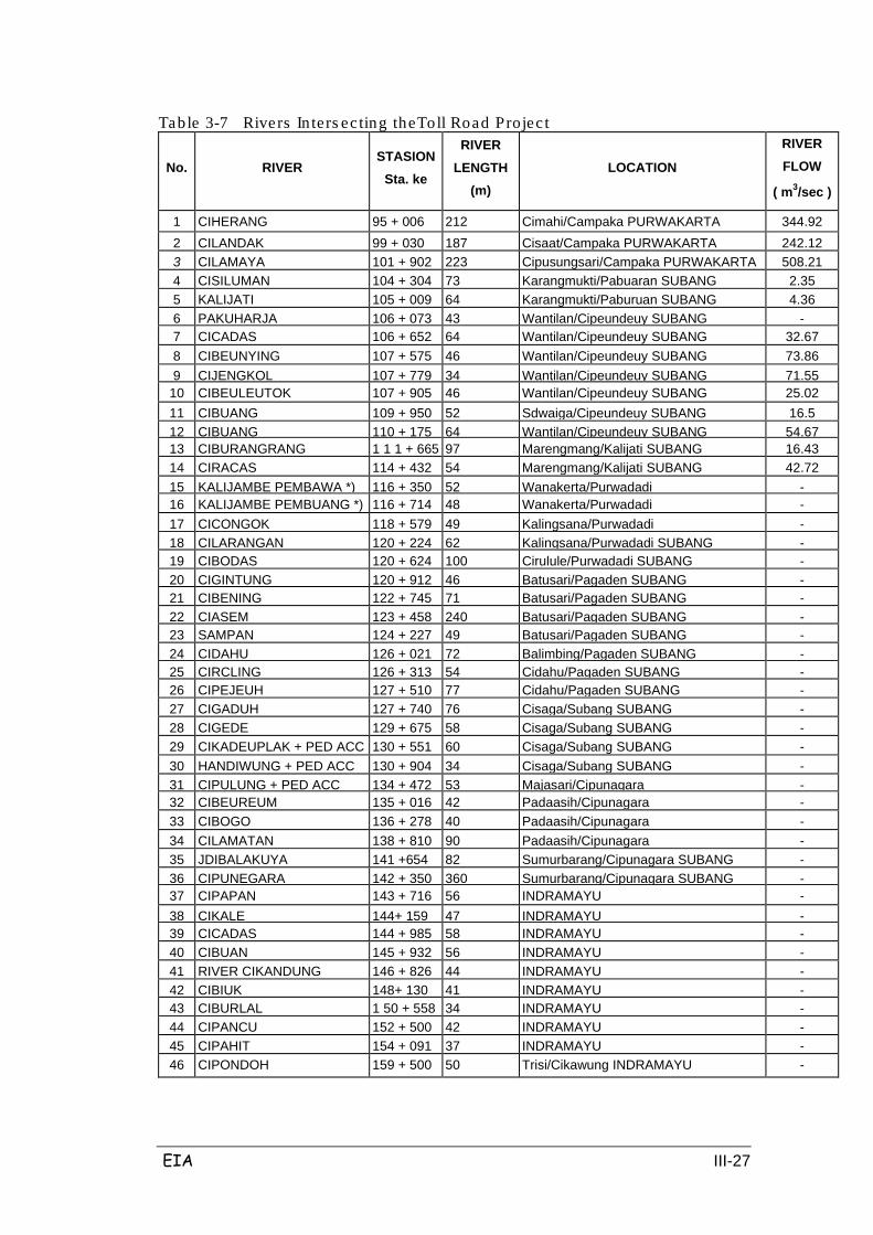
EIA III-27
Table 3-7 Rivers In ters ec ting theToll Road Projec t
No. RIVER STASION
Sta. ke
RIVER LENGTH
(m)
LOCATION
RIVER FLOW
( m3/sec )
1 CIHERANG
95 + 006
212
Cimahi/Campaka PURWAKARTA
344.92
2 CILANDAK
99 + 030
187
Cisaat/Campaka PURWAKARTA
242.12
3 CILAMAYA
101 + 902
223
Cipusungsari/Campaka PURWAKARTA
508.21
4 CISILUMAN
104 + 304
73
Karangmukti/Pabuaran SUBANG
2.35
5 KALIJATI
105 + 009
64
Karangmukti/Paburuan SUBANG
4.36
6 PAKUHARJA
106 + 073
43
Wantilan/Cipeundeuy SUBANG
-
7 CICADAS
106 + 652
64
Wantilan/Cipeundeuy SUBANG
32.67
8 CIBEUNYING
107 + 575
46
Wantilan/Cipeundeuy SUBANG
73.86
9 CIJENGKOL
107 + 779
34
Wantilan/Cipeundeuy SUBANG
71.55
10 CIBEULEUTOK
107 + 905
46
Wantilan/Cipeundeuy SUBANG
25.02
11 CIBUANG
109 + 950
52
Sdwaiga/Cipeundeuy SUBANG
16.5
12 CIBUANG
110 + 175
64
Wantilan/Cipeundeuy SUBANG
54.67
13 CIBURANGRANG
1 1 1 + 665
97
Marengmang/Kalijati SUBANG
16.43
14 CIRACAS
114 + 432
54
Marengmang/Kalijati SUBANG
42.72
15 KALIJAMBE PEMBAWA *)
116 + 350
52
Wanakerta/Purwadadi
- 16 KALIJAMBE PEMBUANG *)
116 + 714
48
Wanakerta/Purwadadi
- 17 CICONGOK
118 + 579
49
Kalingsana/Purwadadi
- 18 CILARANGAN
120 + 224
62
Kalingsana/Purwadadi SUBANG
- 19 CIBODAS
120 + 624
100
Cirulule/Purwadadi SUBANG
- 20 CIGINTUNG
120 + 912
46
Batusari/Pagaden SUBANG
- 21 CIBENING
122 + 745
71
Batusari/Pagaden SUBANG
- 22 CIASEM
123 + 458
240
Batusari/Pagaden SUBANG
- 23 SAMPAN
124 + 227
49
Batusari/Pagaden SUBANG
- 24 CIDAHU
126 + 021
72
Balimbing/Pagaden SUBANG
- 25 CIRCLING
126 + 313
54
Cidahu/Pagaden SUBANG
- 26 CIPEJEUH
127 + 510
77
Cidahu/Pagaden SUBANG
- 27 CIGADUH
127 + 740
76
Cisaga/Subang SUBANG
- 28 CIGEDE
129 + 675
58
Cisaga/Subang SUBANG
- 29 CIKADEUPLAK + PED ACC
130 + 551
60
Cisaga/Subang SUBANG
- 30 HANDIWUNG + PED ACC
130 + 904
34
Cisaga/Subang SUBANG
- 31 CIPULUNG + PED ACC
134 + 472
53
Majasari/Cipunagara
- 32 CIBEUREUM
135 + 016
42
Padaasih/Cipunagara
- 33 CIBOGO
136 + 278
40
Padaasih/Cipunagara
- 34 CILAMATAN
138 + 810
90
Padaasih/Cipunagara
- 35 JDIBALAKUYA
141 +654
82
Sumurbarang/Cipunagara SUBANG
- 36 CIPUNEGARA
142 + 350
360
Sumurbarang/Cipunagara SUBANG
- 37 CIPAPAN
143 + 716
56
INDRAMAYU
- 38 CIKALE
144+ 159
47
INDRAMAYU
- 39 CICADAS
144 + 985
58
INDRAMAYU
- 40 CIBUAN
145 + 932
56
INDRAMAYU
- 41 RIVER CIKANDUNG
146 + 826
44
INDRAMAYU
- 42 CIBIUK
148+ 130
41
INDRAMAYU
- 43 CIBURLAL
1 50 + 558
34
INDRAMAYU
- 44 CIPANCU
152 + 500
42
INDRAMAYU
- 45 CIPAHIT
154 + 091
37
INDRAMAYU
- 46 CIPONDOH
159 + 500
50
Trisi/Cikawung INDRAMAYU
-
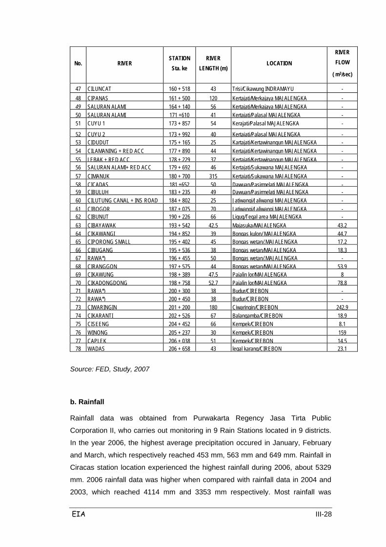
EIA III-28
No. RIVER STATION
Sta. ke RIVER
LENGTH (m) LOCATION
RIVER FLOW
( m3/sec)
47 CILUNCAT
160 + 518
43
Trisi/Cikawung INDRAMAYU
- 48 CIPANAS
161 + 500
120
Kertajati/Merkajaya MAJALENGKA
- 49 SALURAN ALAMI
164 + 140
56
Kertajati/Merkajaya MAJALENGKA
- 50 SALURAN ALAMI
171 +610
41
Kertajati/Palasal MAJALENGKA
- 51 CUYU 1
173 + 857
54
Kerajati/Palasal MAJALENGKA
-
52 CUYU 2
173 + 992
40
Kertajati/Palasal MAJALENGKA
- 53 CIDUDUT
175 + 165
25
Kartajati/Kertawinangun MAJALENGKA
- 54 CILAMANING + RED ACC
177 + 890
44
Kertajati/Kertawinangun MAJALENGKA
- 55 LEBAK + RED ACC
178 + 229
37
Kertajati/Kertawinangun MAJALENGKA
- 56 SALURAN ALAMI+ RED ACC
179 + 692
46
Kertajati/Sukawana MAJALENGKA
- 57 CIMANUK
180 + 700
315
Kertajati/Sukawana MAJALENGKA
- 58 CICADAS
181 +652
50
Dawuan/Pasirmelati MAJALENGKA
- 59 CIBULUH
183 + 235
49
Dawuan/Pasirmelati MAJALENGKA
- 60 CILUTUNG CANAL + INS ROAD
184 + 802
25
Jatiwangi/Jaliwangi MAJALENGKA
- 61 CIBOGOR
187 + 075
70
Jatiwangi/Jaliwangi MAJALENGKA
- 62 CIBUNUT
190 + 226
66
Ligug/Tegal area MAJALENGKA
- 63 CIBAYAWAK
193 + 542
42.5
Majasuka/MAJALENGKA
43.2
64 CIKAWANGI
194 + 852
39
Bongas kulon/ MAJALENGKA
44.7
65 CIPORONG SMALL
195 + 402
45
Bongas wetan/.MAJALENGKA
17.2
66 CIBUGANG
195 + 536
38
Bongas wetan/MAJALENGKA
18.3
67 RAWA*)
196 + 455
50
Bongas wetan/.MAJALENGKA
-
68 CIRANGGON
197 + 575
44
Bongas wetan/MAJALENGKA
53.9
69 CIKAWUNG
198 + 389
47.5
Pajalin lor/MAJALENGKA
8
70 CIKADONGDONG
198 + 758
52.7
Pajalin lor/MAJALENGKA
78.8
71 RAWA*)
200 + 300
38
Budur/CIREBON
-
72 RAWA*)
200 + 450
38
Budur/CIREBON
-
73 CIWARINGIN
201 + 200
180
Ciwaringin/CIREBON
242.9
74 CIKARANTI
202 + 526
67
Balangamba/CIREBON
18.9
75 CISEENG
204 + 452
66
Kempek/CIREBON
8.1
76 WINONG
205 + 237
30
Kempek/CIREBON
159
77 CAPLEK
206 + 038
51
Kempek/CIREBON
14.5
78 WADAS
206 + 658
43
legal karang/CIREBON
23.1
Source: FED, Study, 2007
b. Rainfall
Rainfall data was obtained from Purwakarta Regency Jasa Tirta Public
Corporation II, who carries out monitoring in 9 Rain Stations located in 9 districts.
In the year 2006, the highest average precipitation occured in January, February
and March, which respectively reached 453 mm, 563 mm and 649 mm. Rainfall in
Ciracas station location experienced the highest rainfall during 2006, about 5329
mm. 2006 rainfall data was higher when compared with rainfall data in 2004 and
2003, which reached 4114 mm and 3353 mm respectively. Most rainfall was
EIA III-29
recorded at the Wanayasa station location, 189 days of rainfall, which is higher
than in 2004 which saw 141 days of rainfall. Rainfall in other districts is not much
different from the rainfall in Purwakarta Regency.
The highest rainfall in the Subang area was 325 mm which occurred in January
with 15 days of rain, and the lowest occurred in August with 26 mm over 1 day of
rain. In Indramayu District the highest rainfall (288 mm) occurred in March with 24
days of rain and the lowest in August (51 mm) with 5 days of rain.
Referring to the data from Majalengka in Figures Year 2002, this region has a
tropical climate with temperatures ranging from 21.9 to 35.4°C. The annual
average of rainfall was 2016 mm over an average of 11 rainy days per month.
Rainfall conditions are not much different when compared with the Jatiwangi
rainfall station which showed a very high average rainfall of 397.8 mm with the dry
months between July and September. In Cirebon the highest rainfall was in
January (348 mm) with 19 rainy days, and the lowest was 50 mm with 3 days of
rainfall in August.
c. River and River Basin
The river basins intersecting the planned Cikampek-Palimanan highway include
the Cilamaya River, Cipunagara River and Cimanuk River basins, with the flow
direction generally trending south - north, starting in the mountainous region of
Tangkuban Perahu, Sundanese, and Kromong Tampomas, and flowing to the
coastal plain in the north. The Toll Road plan can be divided into 7 river basins,
from north to south, as follows:
• Ciherang Watershed in Purwakarta Regency, including: Cilandak and
Cilamaya Rivers and Tributaries, cut by alinemen in the middle of the river
basin. This zone occupies the plains region (-1%), but is sometimes
undulating (1-4%) in the upstream watershed. Land used as rice fields,
fields, or plantations on clay soil.
• Ciasem Watershed in Subang Regency, including: Cijengkol, Cibenying,
Cibuang and Cibodas rivers and tributaries. Topography in this area is hilly,
with intensive dry land crops at or near flood plains.
• Cipunagara Watershed in Subang Regency, including: Cipicung, Cilamatan
and Cikandun rivers and tributaries.
• Cipancuh Watershed in Indramayu Regency, which includes little sub

EIA III-30
rivers that flow into the Cipancuh River.
• Cipanas Watershed in Majalengka Regency: this river basin flows between
the Ciluncat and Kepuh Rivers which empty into the Cipanas River.
• Cimanuk Watershed in Majalengka Regency: this river basin flows
between the Cipari, Cipelang, Cisambeng, Ciranggon, Cikeruh, Cibayawak
and Cikemanggi rivers.
• Ciwaringin Watershed in the Palimanan region of Cirebun Regency, where
the river empties into the Kromong Mountains.
3.1.4 Hydrogeology
The main aquifer lithology in the shallow aquifer system in the coastal plain region
which intersects the toll road is sand and gravel filling ancient river and delta
deposits, which generally are used to meet the everyday demand for clean water
by local people. The aquifer and aquifer productivity in the coastal plain area is
characterized by delta sediment characteristics, with vertical and horizontal
distribution of the random between layers of rock with a layer of water pressed in
clay which is water-resistant.
In the aquifer system, there are indications that as time runs on, static ground
water level will decrease and the capacity of wells will also be reduced, which is
expected because of deteriorating borehole constructions. Indications of this were
found by Pramono (1981), where several wells were drilled to tap the most
productive aquifers at depths between 60-100 m before 1980 to produce
discharge 50-70 l/min with high pisometril - 1.3 m.aml, and in the last decade the
average discharge decreased to 10-30 l/min with a height of 0.75 pisometri m.aml.
Aquifer productivity in the hilly areas is low, with a few water-bearing soils found
only locally. Exploration drilling has been done for sugar cane plantations in
Jatitujuh and Loyang Forest (near North Kadipaten) which resulted in a discharge
of 5 I/sec.
Areas classified as groundwater-scarce regions culminate in G. Tangkuban
Perahu and G. Tampomas, as the hills are formed by marl, claystone, and other
solid rock. In volcanic strata regions, aquifer productivity rises naturally toward the
foot of the volcano.
The details of each aquifer and its type are specified in hydrogeological detail
below:
1. Alignment Sta. 91 + .500 until Sta. 101 + 902 (Cilamaya River) Campaka

EIA III-31
district, Purwakarta: the aquifer (slotted or nest) has low productivity (D1); of the
aquifer with low productivity.
2. Alignment Sta. 101 + 902 (Cilamaya River) until Sta. 138 + 810 (Cilamatan
River) Cipunagara district, Subang: the aquifer (slotted or nest) has low
productivity (D1); of the aquifer with low productivity.
(Sta. 91 +500 until 158 + 810)
Discharge Area (Groundwater Discharge Area)
Groundwater content may potentially be affected by road construction to the north
of the planned road route, because from a hydrogeological perspective the area
serves as the regional groundwater discharge area, whereas the particle area
(recharge area) is located to the south of the planned Cikampek – Palimanan toll
road. Details for the discharge areas in and around Sta. 91.00 until the Cilamatan
River (Sta. 138 + 810) are as follows:
• Aquifer which flow through the spaces between the grains and has medium
productivity (A3) is located + 7 km from the planned toll road.
• Aquifer which flows through spaces between the grains and has medium
productivity and widespread distribution (A2) is located ± 8 km from the
planned toll road.
• Aquifer which flows through spaces between the grains has low
productivity and widespread distribution (A3) is located + 10 km from the
planned toll road. The Cilamaya Watershed lies between Cirojak -
Gempalsari - Gembongan is an A1 aquifer as it is productive and has
widespread distribution. This aquifer has moderate transmissivity, open
groundwater or high pizometri groundwater near or above ground level,
reaching 2.4 meters above local ground level and a well discharge
generally of 5 liters / second.
• Artosis flow limit is + 15 km north of the planned toll road.
• Groundwater supplies in this region come from the south, thus the direction
of groundwater flow is from the south (recharge area). As such when the
toll road is built it may potentially cause disruptions to groundwater flow if
the flow of surfacewater and groundwater are not handled properly. This
impact is potentially likely if the southern recharge area is disturbed by the
transport of road materials from the Quarry.
EIA III-32
• Potential other impacts may include a decline in ground water, reduction of
ground water discharge, reduction of transmissivity, boundary artosis flow
lines may shift to the north, and shallow groundwater may be polluted.
(Sta. 91 +500 until 138 + 810)
Recharge Area (Regional groundwater affixes)
Regional groundwater recharge in the soil is located at the south of the planned
toll road, with recharge areas in and around Sta. 91 500 until Cilamatan River (Sta.
138 + 810) in the south which are mainly derived from the summit of Mount
Tangkuban Perahu (2076 meters), where the type of aquifers that developed from
the Peak are a D2 aquifer, B2 aquifer, B1 aquifer, and D1 aquifer. Details about
these aquifers are as follows:
• D2 aquifer, regional groundwater is scarce or insignificant. Located at the
top of Mount Tangkuban Perahu.
• B2 aquifer flows through fissures and spaces between the grains. It is a
locally productive aquifer, transmissivity is very diverse, and groundwater is
generally not utilized because the ground and spring water river flow is
generally small.
• B1 aquifer flows through fissures and spaces between the grains. It has
medium productivity and widespread distribution, and transmissivity is very
diverse. The ground water is generally deep, with diverse appearances of
springs, and is generally large in vesicular lava flows, some reaching more
from 100 liters/sec. Discharge wells are generally less than 5 liters / sec.
• Several lakes are found around the northern part of the proposed toll road,
namely 2 lakes in the Kertamukti village, Campaka District, Purwakarta
(DAS Cimalaya) which are + 4.5 km from the planned toll road. 2 lakes are
also found in Citapen and Wanakerta villages, Purwadadi District, Subang.
The four lakes could be potentially affected by the toll road handling
procedure if the water is not handled properly. Potential impacts could
include the reduction of river discharge and heavy sedimentation of water.
• A number of lakes are found in the Cilamatan watershed, namely: Sango
lake in Cidahu village, Subang District; Cikalong lake and Ijan lake in
Gunung Sembung village, Pagaden District; Kalembuah, Bugang and Jati
lakes in Gembor village, Pagaden district; and Peundeuy lake in
Padamulya village, Cipunagara district. These lakes are about 7 to 15 km

EIA III-33
from the planned toll road and may potentially be impacted by toll road
construction.
3. Alignment Sta. 138 + 810 (Cilamatan River) until Sta. 180 + 700 (- 200 m from
the Cimanuk River): the aquifer (slotted or nest) has low productivity (D1). The
aquifer is 5-9 km wide at the north side of the planned toll road and as wide as 2.5
- 9 km on the south side of the toll road plan.
(Sta. 138 +810 until 180 + 700)
Regional groundwater discharge for this alignment:
Regional groundwater discharge around the alignment of Cilamatan River (Sta.
138 +810) until (- 200 m) Cimanuk River (Sta. 180 + 700) in the north, has several
aquifers as detailed below:
• A3 aquifer flows through spaces between the grains. The local aquifer is
productive and is +10 km from the toll road plan.
• A2 aquifer flowd through the space between the grain and has a wide
distribution, and is + 11 km from the toll road plan.
• Cipancuh Reservoir (DAS Cikondang) in the Districts of Situradja, Kroja
and Indramayu.
• The reservoirs and type A aquifers could be subject to potential impacts
due to the construction of the toll road if the water system (mainly surface)
is not handled properly. Potential impacts could include a decline in water
levels and reduced potential for ground water and reservoirs in the
Cikondang watershed.
• Discharge productive areas are in the A1 aquifer in the Kroja - Pangauban
- Losarang - Kedung Dawa River region which flows to the Cibenoang,
Cilalanang and Ciloncat Rivers. The artesian line is parallel to the planned
toll road at a distance of +15 km. Many artesian wells in this region spread
from Sukaslamat until Losarang.
Areas of potential groundwater will be subject to potential impacts if the water
system during the construction of the toll road is not handled properly. To the east
of this region (east of Cipanas River) are several swamps. These swamps include
the Kedung Bima Swamp, Cibogor Swamp, Cigembor swamps, Cicadas Swamp
and all of the swamps in the Mekarmulya village, Kertajati district, Majalengka
Regency.
Regional Supplement Groundwater of this alignment:

EIA III-34
(Sta. 138 +810 until 180 + 700)
• Regional augmentation around this alignment is in part derived from the
region south of Mount Canggak (1618 m) and Mountain Region Tampomas
(1854 m) with the types of aquifer sorted as D2, D1, B1, B2 and D1
aquifers.
4. Sta. 180 + 500 in Kertajati, Majalengka (- 200 m Cimanuk River) until Cikeruh
River (Sta. 191 + 060): A2 aquifer which flows through spaces between the grains.
It is a productive aquifer with broad dissemination and medium transmissivity, high
groundwater pisometriks near or above ground level. Wells generally have a river
flow of less than 5 liters / sec.
(Sta. 180 + 500 until 191 + 060)
Regional Groundwater discharge in this alignment is:
This regional discharge area is also located in the planned toll road area, to the
north of the Cimanuk watershed, where the groundwater from the north of Kertajati
Village, Kertajati district and the north of Kertasari village, Ligung district form an
AI aquifer (productive aquifer).
• In this region there are many swamps, found on the west side of the
Cimanuk River. In Kertajati District these include the Surapago Swamp in
Sukakerta Village, Citamiang Swamp in Bantarjati Lor Village, Jawura and
Cimanuk Swamps in Kertajati Village, and the Cicabe and Telik Swamps in
Pasiripis Village. In Jatitujuh District there are four swamps amongst the
Kulampok Swamp and Tambakan Swamp in Babajang Village.
(Sta. 180 + 500 until 191 + 060)
Recharge Area (Affix Area):
• Upper Basin of the Cimanuk.
• Mount Tampomas and Mount Kromong with dominant type D2 aquifers.
• Dominant type D2 and B2 aquifers resulting in scarce groundwater
although aquifers are productive.
5. Cikeruh River (Sta. 191 + 060) until the foot of Gunung Kromong in the east
(Walahar Village, Ciwaringin): Dominant aquifer flows through fissures and spaces
between the grains, with medium productivity and broad distribution (B1); aquifers
with transmissivity are very diverse, generally in ground water; there are numerous
appearances of springs with a variety of river flow levels; generally large in
EIA III-35
vesicular lava (reaching more than 100 liters / sec), but the wells generally
discharge less than 5 liters / sec.
The discharge areas in this region include the planned toll road alignment, thus the
construction of this toll road may have potential impacts on groundwater and
surface water, especially for areas to the north of the road, if handling of the water
system is inadequate. Recharge areas in this region are from the Mountain
Kromong aquifer which is dominated by D2 and B2.
6. Eastern foot of Mount Kromong (Walahar Village, Ciwaringin) until Palimanan:
aquifer flows through fissures and spaces between the grains with medium
productivity and broad distribution (B1): aquifer transmissivity is very diverse,
generally in ground water; river flow levels of springs are varied but generally large
in vesicular lava (reaching more than 100 liters / sec), but the wells generally
discharge less than 5 liters / sec.
Discharge areas in this region include the toll road plan and the area north of the
A2 aquifer. A2 aquifer is located ± 500 meters from the toll road plan, with
lamparan include Palimanan Region - South Suramenggala - Arjawinangun. This
area is the Basin of the Ciwaringin River and if handling of the water system is not
adequate then the toll road will have a potential impact on ground water in the
region.
Recharge areas in this region are mainly derived from upstream of the Ciwaringin
River watershed and the Kromong Mountains Region. When this region is
disrupted potential impacts will include flooding during the rainy season and water
shortages in dry soil.
For more details Figure 3.6 shows the geohydrological conditions along the
Cikampek-Palimanan highway plan.
Free ground water in areas along the toll roads are frequently used by many
people as to dig wells. Dug wells located along the Toll Road and surroundings
have ground water levels ranging from 0.5 to 5 meters below ground level with
seasonal fluctuations ranging from 0.5 to 3 meters; however most of these dug
wells are dry during drought. Groundwater with this potential in the Cilamaya river
watershed is between Cirojak - Gempalsari - Gembongan to the north of the
planned toll road. Groundwater with this potential is also found in the Kroya -
Pangauban - Losarang - Kedung Dawa area of the Cibenoang and Cilalanang
rivers watershed. In this second region a lot of groundwater has been widely
exploited by way of well construction.
EIA III-36
3.1.5 Space, Land and Soil
Systems development in towns is aimed at bringing a balance and harmony
among regions according to environmental functions such as adaptation and
carrying capacity, to support the spatial structure that has been planned.
Plans for system development in towns in West Java are:
1. Organizing and directing the development of activities towards centers in
the northern and central regions.
2. Develop a limited basis centers in the south.
3. Reforming the distribution of national and regional development in the
region to support harmonious development between regions.
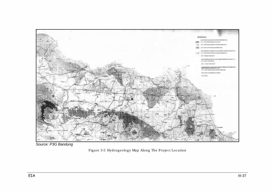
EIA III-37
Source: P3G Bandung
Figure 3-5 Hydrogeology Map Along The Projec t Loca tion
EIA III-38
The regional plan in West Java consists of a structural plan and spatial plan. The
development plan covers the structure of spatial system development planning in
the city, infrastructure development, development of key regions and development
of defense and security; while the spatial pattern includes a spatial pattern of
protected areas, farming areas, and plans for carrying capacity and environmental
carrying capacity.
In general, the West Java region is divided into several key regions which are
dominated by different sectors, as follows in Table 3.8.
Table 3-8 Key Regions in Wes t J ava Province
No. Region Prominent Sector 1.
Bogor-Depok-Beksasi and vicinity.
Industry, tourism, trade and services,
education and knowledge.
2.
Bogor-Puncak-Cianjur and vicinity.
Agricultural crops, tourism, plantation and
fi h
3.
Suregencyumi and vicinity
Marine fisheries, animal husbandry,
tourism, agriculture, industry (agro) and
agricultural crops.
4.
Cianjur-lndramayu-Majalengka-Kuningan and vicinity.
Industry, trade and services, fisheries, sea
and land, agricultural crops, forestry,
plantation and livestock.
5.
Bandung and vicinity.
Industry, trade and services, tourism,
agriculture, horticulture, forestry, plantation,
livestock, and education and knowledge.
6.
Priangan Timur and vicinity Agricultural crops, forestry, plantation,
animal husbandry, fishery and tourism sea
and land.
7. Pangandaran and vicinity. Tourism and marine fisheries.
8.
Purwakarta-Subang-Majalengka
(planned)
Industry, tourism, aquaculture, agricultural
crops, forestry, plantation, livestock and
marine business.
Source: West Java Masterplan
Plan for environmental carrying capacity in West Java province aims to maintain
EIA III-39
an environmental balance and encourage sustainable development activities that
utilize natural resources in protected areas and cultivation areas.
Plans for carrying capacity and environmental carrying capacity are:
1. Controlling the use of space and natural resources.
2. Controlling population growth rate.
3. Realizing the population distribution according to their capacity.
4. Controlling the social and economic development activities in accordance
with the population carrying capacity.
5. Controlling the use of coastal and marine resources.
Targets in improving carrying capacity and environmental carrying capacity in the
region of West Java Province are:
1. Control of the use of space and natural resources in northern, central and
southern West Java.
2. Uncontrolled population growth.
3. Realization of the population distribution according to its maximum
capacity.
4. Unbridled economic and social development activities in accordance with
the population carrying capacity.
5. Control of the use of coastal and marine resources.
The conditions of land use in the 5 districts of the study area are described in
Table 3.9 below. This table generally describes land use in each district that the
toll road alignment passes through, with the general picture as follows;
• Purwakarta Regency: 21% of the entire district is paddy (rice). Settlements
in the city and public facilities are in proportion of the developing region.
• Subang Regency: 57% of the land used for paddy (rice) and mainly located
in the coastal strip and to the north of the highway alignment plans.
Settlements and public facilities are the next most extensive land use
totalling 10% of the area. Subang is the largest city in the district followed
by Pamanukan located at the intersection of the North Coast and northern
routes to the the South into Subang and Bandung.
• Majalengka Regency: 41% of the district used for rice crops including land
which is close to the planned toll road alignment. Settlements / public
facilities area total 17% of the territory, mainly in Majalengka city. Industry
in the region is located around Majalengka and the main road between
Bandung and Cirebon.

EIA III-40
• Indramayu Regency: This district is the region's most widely used for plant
irrigation, covering 127 ha or 63% of the entire region. Indramayu and
Jatibarang are the most extensive settlements, with public facilities totaling
under 9% of this region. This makes this region least like a city and more
like a rural area than any other district in the study area.
• Cirebon Regency: 50% of Cirebon is devoted to rice cultivation. This
district has the highest proportion of residential / public facilities in the
corridor area, representing approximately 27% of land use in Cirebon.
Given all the regencies mentioned above, the type of dominant land use is rice
cultivation, totalling 45% of the area. This region also has vast forest resources,
natural forests and plants, which amounts to 14% of the area. Conservation Areas
are also an important factor, totalling 10% of the entire region. Residential and
public facilities together occupy 12% of land use in the region.
Table 3-9 Exis ting Land Us e in the Regency Surrounding the Pro ject Plan
Land Use Total
(Ha)
Purwakarta (Ha)
Subang (Ha) Majalengka
(Ha) Indramayu
(Ha) Cirebon (Ha)
Conservation Area
90,946.89
30,859
20,693
6,100
12,901
10,420
Development Area 783 115 91
66 314
184 483
114 324
187 198
88 551
Settlement
83,673.73
10,202
15,996
14,324
13,654
20,200
Public Facilities
23,460.00
2,500
4,949
6,176
3,150
6,200
Industry
5,417.50
150
118
425
220
4,300
Recreation
1,125.00 300 50 275,968 150 200 Fishery
7,502.08
1,000
797
968
3,507
1,000
Livestock 559.78 100 - 135 100 150
Rice field
394 112 61
20 733
117 478
49 608
126 623
49 500
Plantation
67 575 22
13 700
18 721
14 691
6 850
1 700
Secondary crops
78 850 79
729
6 684
11 639
12 583
3 300
Forest
120,801.79
16,920
19,385
16,082
20,609
2,001
TOTAL 874 061 80
97 273
205 176
120 424
200 099
98 971
Source: data Compilation, 2007
Existing land use of West Java Province is graphically displayed in Figure 3.7.
Existing land use along the highway alignment plan is listed in Table 3.10. This
data shows that the amount of land area affected by this highway project is 765.6
ha, consisting of irrigated land 212.52 ha, 135.03 ha forest, plantation 33.76
hectares, 117.85 hectares of unproductive land, vacant land 116.29 hectares, 8.79
hectares of Rain fed rice fields, Field 44.88 ha, and 37.95 Ha of settlements. The
pattern of spatial planning in West Java can be seen in Figure 3.8.
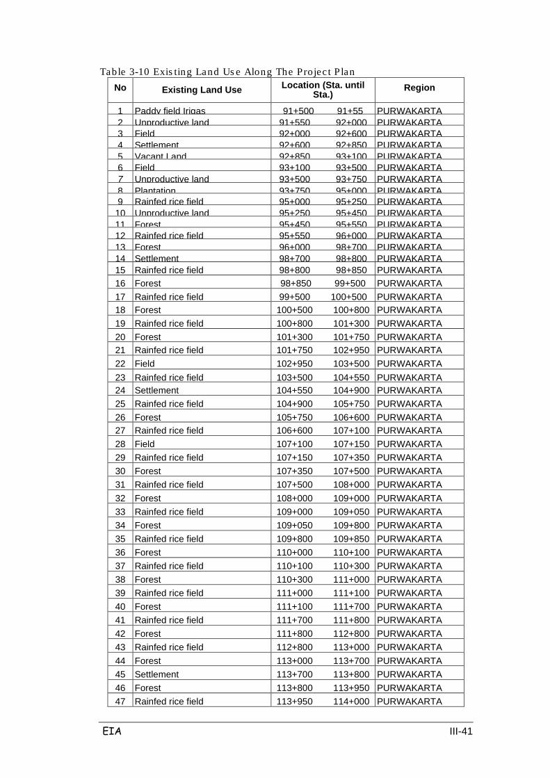
EIA III-41
Table 3-10 Exis ting Land Us e Along The Projec t P lan No Existing Land Use Location (Sta. until
Sta.) Region
1 Paddy field Irigas 91+500 91+55 PURWAKARTA 2
Unproductive land
91+550 92+000
PURWAKARTA
3
Field
92+000 92+600
PURWAKARTA
4
Settlement
92+600 92+850
PURWAKARTA
5
Vacant Land
92+850 93+100
PURWAKARTA
6
Field
93+100 93+500
PURWAKARTA
7
Unproductive land
93+500 93+750
PURWAKARTA
8 Plantation
93+750 95+000
PURWAKARTA
9
Rainfed rice field
95+000 95+250
PURWAKARTA
10
Unproductive land
95+250 95+450
PURWAKARTA
11
Forest
95+450 95+550
PURWAKARTA
12
Rainfed rice field
95+550 96+000
PURWAKARTA
13
Forest
96+000 98+700
PURWAKARTA
14
Settlement
98+700 98+800
PURWAKARTA
15 Rainfed rice field
98+800 98+850 PURWAKARTA 16 Forest
98+850 99+500
PURWAKARTA
17 Rainfed rice field
99+500 100+500
PURWAKARTA
18 Forest
100+500 100+800
PURWAKARTA
19 Rainfed rice field
100+800 101+300
PURWAKARTA
20 Forest
101+300 101+750
PURWAKARTA
21 Rainfed rice field
101+750 102+950
PURWAKARTA
22 Field
102+950 103+500
PURWAKARTA
23 Rainfed rice field
103+500 104+550
PURWAKARTA
24 Settlement
104+550 104+900
PURWAKARTA
25 Rainfed rice field
104+900 105+750
PURWAKARTA
26 Forest
105+750 106+600
PURWAKARTA
27 Rainfed rice field
106+600 107+100
PURWAKARTA
28 Field
107+100 107+150
PURWAKARTA
29 Rainfed rice field
107+150 107+350
PURWAKARTA
30 Forest
107+350 107+500
PURWAKARTA
31 Rainfed rice field
107+500 108+000
PURWAKARTA
32 Forest
108+000 109+000
PURWAKARTA
33 Rainfed rice field
109+000 109+050
PURWAKARTA
34 Forest
109+050 109+800
PURWAKARTA
35 Rainfed rice field
109+800 109+850
PURWAKARTA
36 Forest
110+000 110+100
PURWAKARTA
37 Rainfed rice field
110+100 110+300
PURWAKARTA
38 Forest
110+300 111+000
PURWAKARTA
39 Rainfed rice field
111+000 111+100
PURWAKARTA
40 Forest
111+100 111+700
PURWAKARTA
41 Rainfed rice field
111+700 111+800
PURWAKARTA
42 Forest
111+800 112+800
PURWAKARTA
43 Rainfed rice field
112+800 113+000
PURWAKARTA
44 Forest
113+000 113+700
PURWAKARTA
45 Settlement
113+700 113+800
PURWAKARTA
46 Forest
113+800 113+950
PURWAKARTA
47 Rainfed rice field
113+950 114+000
PURWAKARTA

EIA III-42
No Existing Land Use Location (Sta. until Sta.)
Region
48 Forest
114+000 114+300
PURWAKARTA
49 Rainfed rice field
114+300 114+350
PURWAKARTA
50 Forest
114+350 115+200
PURWAKARTA
51 Rainfed rice field
115+200 115+250
PURWAKARTA
52 Forest
115+250 116+500
PURWAKARTA
53 Rainfed rice field
116+500 116+700
PURWAKARTA
54 Plantation
116+700 116+800
PURWAKARTA
55 Settlement
116+800 116+900.
PURWAKARTA
56 Plantation
116+900 117+600
PURWAKARTA
57 Rainfed rice field
117+600 117+650
PURWAKARTA
58 Plantation
117+650 117+950
PURWAKARTA
59 Unproductive land
117+950 118+050
PURWAKARTA
60 Rainfed rice field
118+050 118+100
PURWAKARTA
61 Plantation
118+100 118+500
PURWAKARTA
62 Paddy field
118+500 118+550
PURWAKARTA
63 Plantation
118+550 120+150
PURWAKARTA
64 Irrigated paddy field
120+150 120+300
PURWAKARTA
65 Plantation
120+300 120+600
PURWAKARTA
66 Rainfed rice field
120+600 121+150
PURWAKARTA
67 Plantation
121+150 122+450
PURWAKARTA
68 Settlement
122+450 122+600
PURWAKARTA
69 Plantation
122+600 122+700
PURWAKARTA
70 Irrigated paddy field
122+700 123+300
PURWAKARTA
71 Plantation
123+300 123+550
PURWAKARTA
72 Settlement
123+550 123+700
PURWAKARTA
73 Irrigated paddy field
123+700 126+300
PURWAKARTA
74 Settlement
126+300 126+350
PURWAKARTA
75 Plantation
126+350 126+400
PURWAKARTA
76 Settlement
126+400 126+450
PURWAKARTA
77 Plantation
126+450 126+550
PURWAKARTA
78 Settlement
126+550 126+650
PURWAKARTA
79 Plantation
126+650 126+700
PURWAKARTA
80 Irrigated paddy field
126+700 127+550
PURWAKARTA
81 Danau
127+550 127+600
PURWAKARTA
82 Irrigated paddy field
127+600 128+450
PURWAKARTA
83 Plantation
128+450 128+800
PURWAKARTA
84 Irrigated paddy field
128+800 129+000
PURWAKARTA
85 Plantation
129+000 129+200
PURWAKARTA
86 Irrigated paddy field
129+200 129+950
PURWAKARTA
87 Settlement
129+950 130+000
PURWAKARTA
88 Irrigated paddy field
130+000 130+850
SUBANG
89 Plantation
130+850 131+000
SUBANG
90 Irrigated paddy field
131+000 131+200
SUBANG
91 Plantation
131+200 131+400
SUBANG
92 Settlement
131+400 131+500
SUBANG

EIA III-43
No Existing Land Use Location (Sta. until Sta.)
Region
93 Irrigated paddy field
131+500 131+900
SUBANG
94 Plantation
131+900 132+050
SUBANG
95 Settlement
132+050 132+150
SUBANG
96 Plantation
132+150 132+200
SUBANG
97 Irrigated paddy field
132+200 132+300
SUBANG
98 Settlement
132+300 132+450
SUBANG
99 Irrigated paddy field
132+450 132+600
SUBANG
100 Settlement
132+600 132+650
SUBANG
101 Irrigated paddy field
132+650 132+950
SUBANG
102 Plantation
132+950 134+400
SUBANG
103 Irrigated paddy field
134+400 134+500
SUBANG
104 Plantation
134+500 135+250
SUBANG
105 Irrigated paddy field
135+250 135+300
SUBANG
106 Plantation
135+300 135+750
SUBANG
107 Field
135+750 136+000
SUBANG
108 Rainfed rice field
136+000 136+700
SUBANG
109 Settlement
136+700 136+900
SUBANG
110 Rainfed rice field
136+900 138+350
SUBANG
111 Field
138+350 138+550
SUBANG
112 Irrigated paddy field
138+550 139+700
SUBANG
113 Field
139+700 139+900
SUBANG
114 Plantation
139+900 140+100
SUBANG
115 Rainfed rice field
140+100 140+150
SUBANG
116 Plantation
140+150 140+450
SUBANG
117 Rainfed rice field
140+450 140+500.
SUBANG
118 Plantation
140+500 142+000
SUBANG
119 Rainfed rice field
142+000 142+750
INDRAMAYU
120 Plantation
142+750 143+500
INDRAMAYU
121 Rainfed rice field
143+500 144+050
INDRAMAYU
122 Plantation
144+050 149+700
INDRAMAYU
123 Rainfed rice field
149+700 149+800
INDRAMAYU
124 Settlement
149+800 149+950
INDRAMAYU
125 Rainfed rice field
149+950 150+100
INDRAMAYU
126 Plantation
150+100 152+200
INDRAMAYU
127 Rainfed rice field
152+200 152+350
INDRAMAYU
128 Unproductive land
152+350 152+750
INDRAMAYU
129 Unproductive land
152+750 153+075
INDRAMAYU
130 Plantation
153+075 153+250
INDRAMAYU
131 Unproductive land
153+250 153+400
INDRAMAYU
132 Plantation
153+400 158+100
INDRAMAYU
133 Field
158+100 158+350
MAJALENGKA
134 Plantation
158+350 158+500
MAJALENGKA
135 Field
158+500 158+600
MAJALENGKA
136 Forest
158+600 161+400
MAJALENGKA
137 Unproductive land
161+400 162+050
MAJALENGKA /

EIA III-44
No Existing Land Use Location (Sta. until Sta.)
Region
138 Forest
162+050 164+600
MAJALENGKA
139 Unproductive land
164+600 164+700
MAJALENGKA
140 Forest
164+700 165+700
MAJALENGKA
141 Unproductive land
165+700 166+200
MAJALENGKA
142 Forest
166+200 167+500
MAJALENGKA
143 Unproductive land
167+500 167+600
MAJALENGKA
144 Forest
167+600 168+400
MAJALENGKA
145 Field
168+400 168+500
MAJALENGKA
146 Irrigated paddy field
168+500 169+000
MAJALENGKA
147 Field
169+000 169+200
MAJALENGKA
148 Irrigated paddy field
169+200 174+500
MAJALENGKA
149 Forest
174+500 176+950
MAJALENGKA
150 Irrigated paddy field
176+950 177+000
MAJALENGKA
151 Forest
177+000 178+100
MAJALENGKA
152 Irrigated paddy field
178+100 179+800
MAJALENGKA
153 Field
179+800 180+300
MAJALENGKA
154 Settlement
180+300 180+600
MAJALENGKA
155 Field
180+600 182+050
MAJALENGKA
156 Irrigated paddy field
182+050 182+500
MAJALENGKA
157 Forest
182+500 183+150
MAJALENGKA
158 Irrigated paddy field
183+150 186+050
MAJALENGKA
159 Field
186+050 186+500,
MAJALENGKA
160 Irrigated paddy field
186+500 186+800
MAJALENGKA
161 Field
186+800 187+000
MAJALENGKA
162 Settlement
187+000 187+400
MAJALENGKA
163 Field
187+400 188+200
MAJALENGKA
164 Settlement
188+200 188+550
MAJALENGKA
165 Irrigated paddy field
188+550 188+700
MAJALENGKA
166 Settlement
188+700 189+000
MAJALENGKA
167 Irrigated paddy field
189+000 189+800
MAJALENGKA
168 Settlement
189+800 190+200
MAJALENGKA
169 Irrigated paddy field
190+200 191+100
MAJALENGKA
170 Forest
191+100 191+400
MAJALENGKA
171 Irrigated paddy field
191+400 191+700
MAJALENGKA
172 Field
191+700 192+050
MAJALENGKA
173 Irrigated paddy field
192+050 194+750
MAJALENGKA
174 Settlement
194+750 194+800
MAJALENGKA
175 Forest
194+800 195+000
MAJALENGKA
176 Irrigated paddy field
195+000 198+000
MAJALENGKA
177 Settlement
198+000 198+050
MAJALENGKA
178 Forest
198+050 198+100
MAJALENGKA
179 Irrigated paddy field
198+100 198+150
MAJALENGKA,.-
180 Plantation
198+150 198+450
MAJALENGKA
181 Irrigated paddy field
198+450 198+550
MAJALENGKA
182 Forest
198+550 198+700
MAJALENGKA
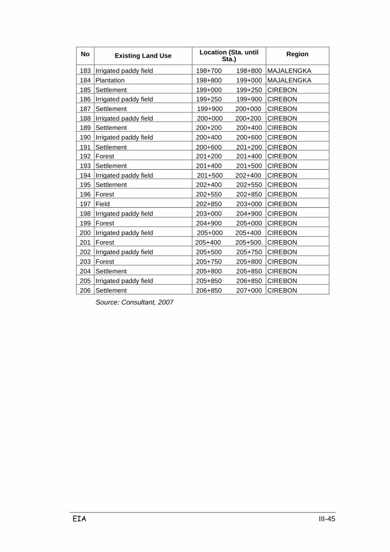
EIA III-45
No Existing Land Use Location (Sta. until Sta.)
Region
183 Irrigated paddy field
198+700 198+800
MAJALENGKA
184 Plantation
198+800 199+000
MAJALENGKA
185 Settlement
199+000 199+250
CIREBON
186 Irrigated paddy field
199+250 199+900
CIREBON
187 Settlement
199+900 200+000
CIREBON
188 Irrigated paddy field
200+000 200+200
CIREBON
189 Settlement
200+200 200+400
CIREBON
190 Irrigated paddy field
200+400 200+600
CIREBON
191 Settlement
200+600 201+200
CIREBON
192 Forest
201+200 201+400
CIREBON
193 Settlement
201+400 201+500
CIREBON
194 Irrigated paddy field
201+500 202+400
CIREBON
195 Settlement
202+400 202+550
CIREBON
196 Forest
202+550 202+850
CIREBON
197 Field
202+850 203+000
CIREBON
198 Irrigated paddy field
203+000 204+900
CIREBON
199 Forest
204+900 205+000
CIREBON
200 Irrigated paddy field
205+000 205+400
CIREBON
201 Forest
205+400 205+500.
CIREBON
202 Irrigated paddy field
205+500 205+750
CIREBON
203 Forest
205+750 205+800
CIREBON
204 Settlement
205+800 205+850
CIREBON
205 Irrigated paddy field
205+850 206+850
CIREBON
206 Settlement
206+850 207+000
CIREBON
Source: Consultant, 2007

EIA III-46
3.2 BIOLOGICAL COMPONENTS
3.2.1 Terrestrial Flora
The use of land that makes up the local ecosystem found along the project
alignment consists of paddy fields both technically-irrigated and rain-fed, fields,
gardens, grass, forest and plantations. Types of plants encountered in the study
area include food crops, vegetables, medicinal plants and spices as well as edible
and decorative. Plantation crops encountered include rubber, sugar cane, cocoa
and forest/timber; both cultivated privately by the people or by people who work
with local governments such as on teak and acacia plantations.
Distributions of crop areas in each section are mentioned below:
Section I: Irrigated paddy field area totals 0.3 hectares, 40.2 hectares rainfed
ricefields; fields total 9.6ha, 6.0ha are unproductive land, 1.5 hectares are vacant
land and forest area totals 75.3 Ha.
Section II: Irrigated paddy fields total 36.3 ha, rainfed ricefields total 3.0ha, and
forest totals 25.8 ha. There are no fields or unproductive lands.
Section III: Irrigated paddy fields total 13.5 hectares, 17.7 hectares are rainfed
ricefields; fields total 5.4 ha, 28.5 ha are unproductive land, forest totals 79.5
hectares, and 33.15 hectares are gardens.
Section IV: Irrigated paddy fields total 35.1 ha; fields total 2.4 ha, 8.1ha are
unproductive lands, and 65.4 ha are forest. There are no rainfed ricefields.
Section V: Irrigated paddy fields total 42.3 ha, 22.5 ha are fields and forest totals
12.3 ha.
Section VI: Irrigated paddy fields total 50.7 ha, 0.9 ha are fields and forest totals
9.1 ha. There are no rainfed ricefields.
Secondary data (CPM) revealed information on upland food crops which are found
in the study area, which include maize, cassava, sweet potato, soybeans and
green beans. Fruit crops include mango, rambutan, durian, guava, banana,
papaya, sapodilla, jackfruit and other potential commodities such as red peppers
and red onion. Plantation crops include clove, coconut, coffee, cotton, bamboo,
palm, tobacco and sugarcane.
Although West Java has a very high diversity of flora, the toll road alignment does
not cross any protected areas. Observation revealed that the composition of

EIA III-47
flora/vegetation in the study area did not include any type of vegetation protected
under Government Regulation No. 7 / 1999.
Based on vegetation coverage, the study area is generally dominated by
vegetative ecosystems such as partner cultivation on agricultural land (annual
crops), mixed gardens and yards, plantation crop land, forest and state forest
(chronic perennials). The types that have a high IMP include banana, coconut,
teak, bamboo, clove and cashew nuts. In Indramayu the mango crop is quite
prominent. The composition of vegetation in the study area is presented in Tables
3.11 and 3.12 below.
Table 3.11 shows that the diversity of plants cultivated around the study area (all
sections) are evenly distributed, with an ID value between 3362-3452. However in
Indramayu (sections III and IV) the density of plants per hectare is lower than in
other sections. Data on terrestrial flora in the study area is presented in Tables
3.11 and 3.12.
Table 3-11 Types of Cultiva ted Plants No Local Name Scientific Name Note
I Rice and Secondary Crops 1 Rice Oryra sativa var IR 64; Ciherang.
Sadane Food Crop
2 Corn Zea mays Food Crop
3 Sugar Cane Sacc/iarum ofHcinarum Food Crop
4 Sweet Potato / Buled Ipomoae batatas Food Crop
5 Cassava/Capu/Sampeu Manihot escu/anta Food Crop
II Vegetable and Spices
1 Spinach Amaranthus lividus Vegetable Crop
2 Onion Leaves Altium fistutosum Vegetable Crop
3 Bonteng Cucumis sativus Vegetable Crop
4 Bean Phaseolus vulgaris Vegetable Crop
5 Big Chili Capsicum annuum Vegetable Crop
6 Rawit Chili Capsicum frutescens Vegetable Crop
7 Ginger Zingiber officinaie Vegetable Crop
8 Squash Luffa acutangula Vegetable Crop
9 Velvetleaf Limnocharis Have Vegetable Crop
10 Green Bean Phaseolus radiatus Legumes/Nuts
11 Red Bean Phaseolus lunatus Legumes/Nuts
12 Long Bean Vigna sinensis Legumes/Nuts
13 Peanut Arachis hypogaeae Legumes/Nuts
EIA III-48
No Local Name Scientific Name Note 14 Water Spinach Ipomoea aquatica Vegetable Crop
15 Kapol Amomum compactum
16 Soybean Glycine max Legumes/Nuts
17 Kencur/Cikur Kaempferia galanga Medicinal Plant
18 Kunci Boesenbergia rotunda Medicinal Plant
19 Turmeric Curcuma tonga Medicinal Plant 20 Konyal Passiflora edulis -
21 Cabbage/Engkol Brassica oleracea var. capitata Vegetable Crop
22 Siem Pumpkin Sechium edule Vegetable Crop
23 Pepper Piper nigrum Herb Plant
24 Galangal/Laja/Laos Alpinia galanga Herb Plant
25 Radish Raphanus sativus Vegetable Crop
26 Pineapple Ananas comusus Fruit Crop
27 Paria/Pare Momordica charantia Vegetable Crop
28 Chinese Cabbage / Mustard Brassica chinensis Vegetable Crop
29 Watermelon Citrullus tanatus Fruit Crop
30 Lemongrass Cymbopogon nardus Medicinal Plant
31 Eggplant/Encung Solatium melongena Vegetable Crop
32 Tomato Solatium lycopersicum Fruit Crop
33 Pumpkin Cucurbita moschata Vegetable Crop
34 Carrot Daucus carota Vegetable Crop
III. Herbs, bush reeds
1 Alang-alang (reed) Imperata cylindrica Weed
2 Buntut tikus (rat tail) Stachytarpheta jamaicensis Weed
3 Water Hyacinth Eiclmrrnia crassipes Weed
4 Gelagah (reed) Saccharum spontaneum Weed / Water Herb
5 Hanjuang Cordyline fruticosa Biased Divider Crop
6 Haredong Melastoma malabathricum Perdu
7 Kiambang SaMnras pp. Water Herb
8 Kirinyuh Eupahatorium odoratum Weed
9 Pakis pedang N&phrolepis biserrata Weed
10 Pakis resam Gleichenia linearis Weed
11 Pis Kucing Mimosa invisa Weed
12 Rerumputan (grass) Famili: Poaceae Weed
13 Sente Alocasia spp -
14 Sikejut Mimosa pudica Weed
15 Taleus Colocasia spp. Ornamental Plant
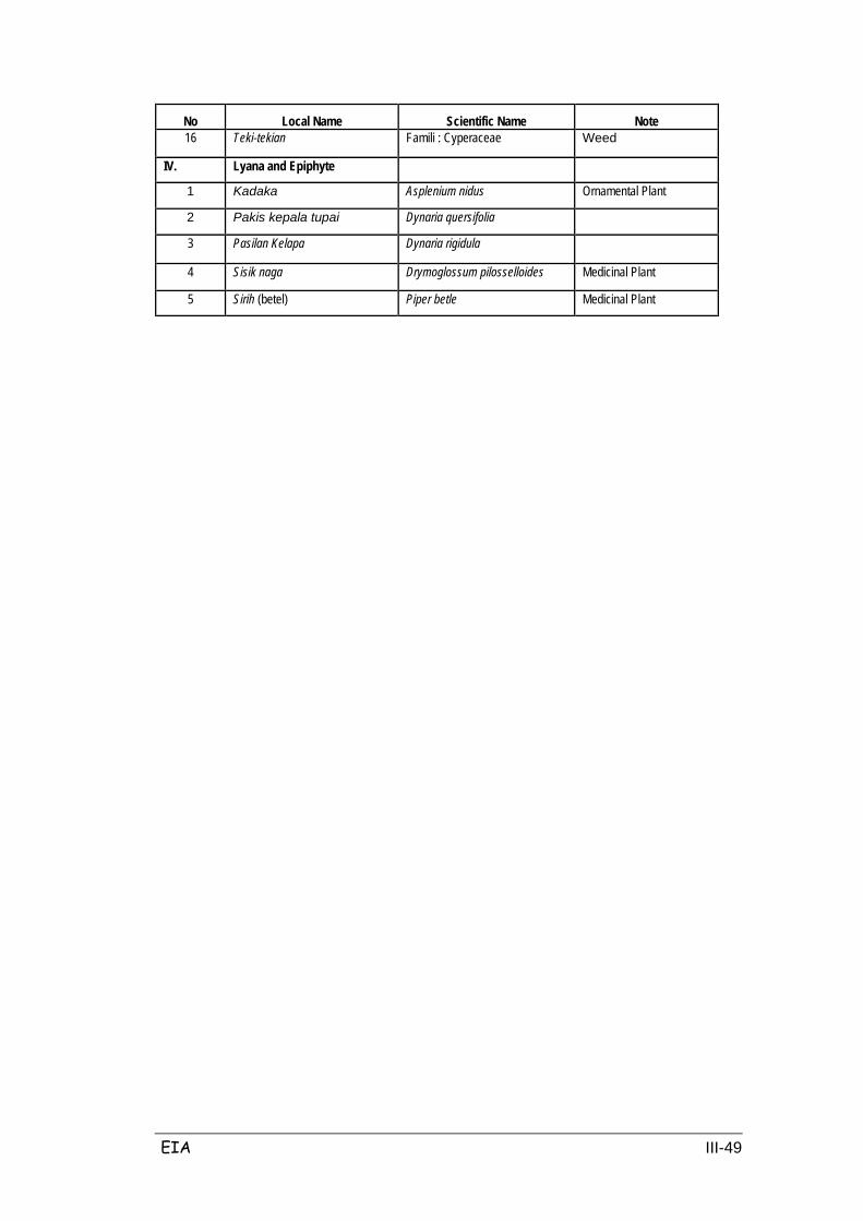
EIA III-49
No Local Name Scientific Name Note 16 Teki-tekian Famili : Cyperaceae Weed
IV. Lyana and Epiphyte
1 Kadaka Asplenium nidus Ornamental Plant
2 Pakis kepala tupai Dynaria quersifolia
3 Pasilan Kelapa Dynaria rigidula
4 Sisik naga Drymoglossum pilosselloides Medicinal Plant
5 Sirih (betel) Piper betle Medicinal Plant
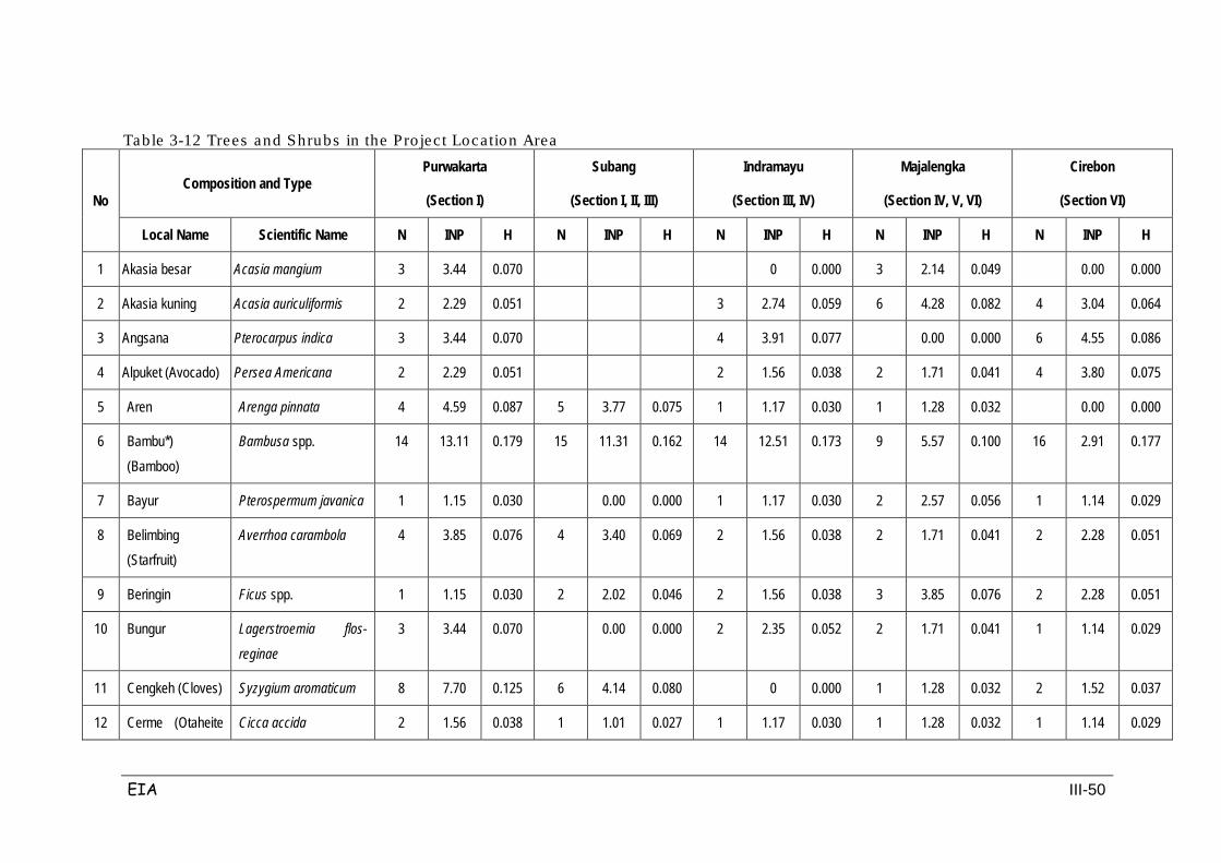
EIA III-50
Table 3-12 Trees and Shrubs in the Pro ject Location Area
No Composition and Type
Purwakarta
(Section I)
Subang
(Section I, II, III)
Indramayu
(Section III, IV)
Majalengka
(Section IV, V, VI)
Cirebon
(Section VI)
Local Name Scientific Name N INP H N INP H N INP H N INP H N INP H
1 Akasia besar Acasia mangium 3 3.44 0.070 0 0.000 3 2.14 0.049 0.00 0.000
2 Akasia kuning Acasia auriculiformis 2 2.29 0.051 3 2.74 0.059 6 4.28 0.082 4 3.04 0.064
3 Angsana Pterocarpus indica 3 3.44 0.070 4 3.91 0.077 0.00 0.000 6 4.55 0.086
4 Alpuket (Avocado) Persea Americana 2 2.29 0.051 2 1.56 0.038 2 1.71 0.041 4 3.80 0.075
5 Aren Arenga pinnata 4 4.59 0.087 5 3.77 0.075 1 1.17 0.030 1 1.28 0.032 0.00 0.000
6 Bambu*) (Bamboo)
Bambusa spp. 14 13.11 0.179 15 11.31 0.162 14 12.51 0.173 9 5.57 0.100 16 2.91 0.177
7 Bayur Pterospermum javanica 1 1.15 0.030 0.00 0.000 1 1.17 0.030 2 2.57 0.056 1 1.14 0.029
8 Belimbing (Starfruit)
Averrhoa carambola 4 3.85 0.076 4 3.40 0.069 2 1.56 0.038 2 1.71 0.041 2 2.28 0.051
9 Beringin Ficus spp. 1 1.15 0.030 2 2.02 0.046 2 1.56 0.038 3 3.85 0.076 2 2.28 0.051
10 Bungur Lagerstroemia flos-
reginae
3 3.44 0.070 0.00 0.000 2 2.35 0.052 2 1.71 0.041 1 1.14 0.029
11 Cengkeh (Cloves) Syzygium aromaticum 8 7.70 0.125 6 4.14 0.080 0 0.000 1 1.28 0.032 2 1.52 0.037
12 Cerme (Otaheite Cicca accida 2 1.56 0.038 1 1.01 0.027 1 1.17 0.030 1 1.28 0.032 1 1.14 0.029
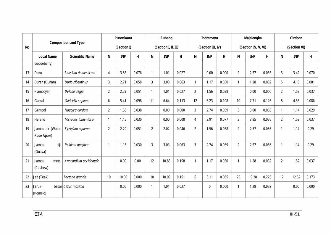
EIA III-51
No Composition and Type
Purwakarta
(Section I)
Subang
(Section I, II, III)
Indramayu
(Section III, IV)
Majalengka
(Section IV, V, VI)
Cirebon
(Section VI)
Local Name Scientific Name N INP H N INP H N INP H N INP H N INP H
Gooseberry)
13 Duku Lansium domesticum 4 3.85 0.076 1 1.01 0.027 0.00 0.000 2 2.57 0.056 3 3.42 0.070
14 Duren (Durian) Durio zibethinus 3 2.71 0.058 3 3.03 0.063 1 1.17 0.030 1 1.28 0.032 5 4.18 0.081
15 Flamboyan Delonix regia 2 2.29 0.051 1 1.01 0.027 2 1.56 0.038 0.00 0.000 2 1.52 0.037
16 Gamal Gliricidia sepium 6 5.41 0.098 11 6.64 0.113 12 6.23 0.108 10 7.71 0.126 8 4.55 0.086
17 Gempol Nauclea cordata 2 1.56 0.038 0.00 0.000 3 2.74 0.059 3 3.00 0.063 1 1.14 0.029
18 Hereno Microcos tomentosa 1 1.15 0.030 0.00 0.000 4 3.91 0.077 3 3.85 0.076 2 1.52 0.037
19 Jambu air (Water Rose Apple)
Syzigium aqueum 2 2.29 0.051 2 2.02 0.046 2 1.56 0.038 2 2.57 0.056 1 1.14 0.29
20 Jambu biji (Guava)
Psidium guajava 1 1.15 0.030 3 3.03 0.063 3 2.74 0.059 2 2.57 0.056 1 1.14 0.29
21 Jambu mete (Cashew)
Anacardium occidentale 0.00 0.00 12 10.83 0.158 1 1.17 0.030 1 1.28 0.032 2 1.52 0.037
22 Jati (Teak) Tectona grandis 10 10.00 0.000 10 10.09 0.151 6 3.11 0.065 25 19.28 0.225 17 12.52 0.173
23 Jeruk besar (Pomelo)
Citrus maxima 0.00 0.000 1 1.01 0.027 0 0.000 1 1.28 0.032 0.00 0.000
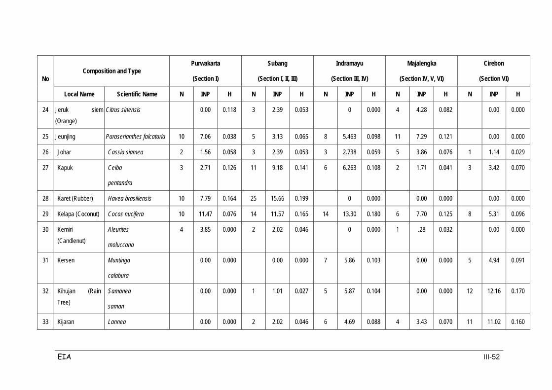
EIA III-52
No Composition and Type
Purwakarta
(Section I)
Subang
(Section I, II, III)
Indramayu
(Section III, IV)
Majalengka
(Section IV, V, VI)
Cirebon
(Section VI)
Local Name Scientific Name N INP H N INP H N INP H N INP H N INP H
24 Jeruk siem (Orange)
Citrus sinensis 0.00 0.118 3 2.39 0.053 0 0.000 4 4.28 0.082 0.00 0.000
25 Jeunjing Paraserianthes falcataria 10 7.06 0.038 5 3.13 0.065 8 5.463 0.098 11 7.29 0.121 0.00 0.000
26 Johar Cassia siamea 2 1.56 0.058 3 2.39 0.053 3 2.738 0.059 5 3.86 0.076 1 1.14 0.029
27 Kapuk Ceiba
pentandra
3 2.71 0.126 11 9.18 0.141 6 6.263 0.108 2 1.71 0.041 3 3.42 0.070
28 Karet (Rubber) Havea brasiliensis 10 7.79 0.164 25 15.66 0.199 0 0.000 0.00 0.000 0.00 0.000
29 Kelapa (Coconut) Cocos nucifera 10 11.47 0.076 14 11.57 0.165 14 13.30 0.180 6 7.70 0.125 8 5.31 0.096
30 Kemiri (Candlenut)
Aleurites
moluccana
4 3.85 0.000 2 2.02 0.046 0 0.000 1 .28 0.032 0.00 0.000
31 Kersen Muntinga
calabura
0.00 0.000 0.00 0.000 7 5.86 0.103 0.00 0.000 5 4.94 0.091
32 Kihujan (Rain Tree)
Samanea
saman
0.00 0.000 1 1.01 0.027 5 5.87 0.104 0.00 0.000 12 12.16 0.170
33 Kijaran Lannea 0.00 0.000 2 2.02 0.046 6 4.69 0.088 4 3.43 0.070 11 11.02 0.160
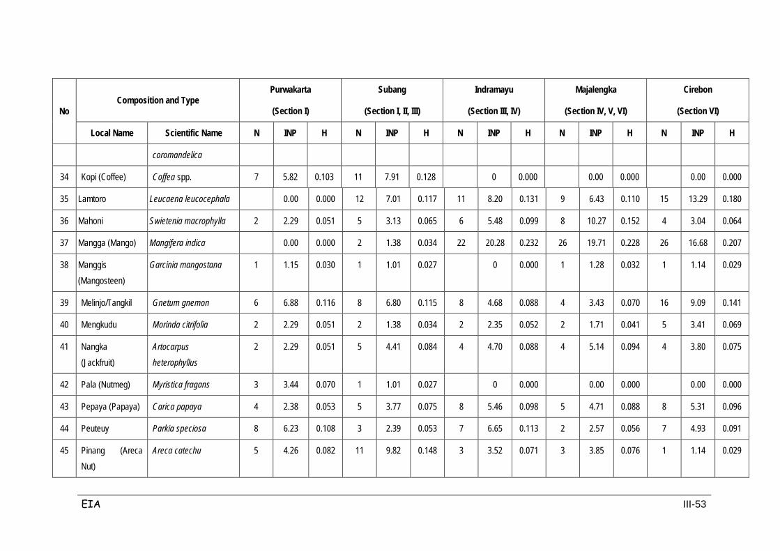
EIA III-53
No Composition and Type
Purwakarta
(Section I)
Subang
(Section I, II, III)
Indramayu
(Section III, IV)
Majalengka
(Section IV, V, VI)
Cirebon
(Section VI)
Local Name Scientific Name N INP H N INP H N INP H N INP H N INP H
coromandelica
34 Kopi (Coffee) Coffea spp. 7 5.82 0.103 11 7.91 0.128 0 0.000 0.00 0.000 0.00 0.000
35 Lamtoro Leucaena leucocephala 0.00 0.000 12 7.01 0.117 11 8.20 0.131 9 6.43 0.110 15 13.29 0.180
36 Mahoni Swietenia macrophylla 2 2.29 0.051 5 3.13 0.065 6 5.48 0.099 8 10.27 0.152 4 3.04 0.064
37 Mangga (Mango) Mangifera indica 0.00 0.000 2 1.38 0.034 22 20.28 0.232 26 19.71 0.228 26 16.68 0.207
38 Manggis (Mangosteen)
Garcinia mangostana 1 1.15 0.030 1 1.01 0.027 0 0.000 1 1.28 0.032 1 1.14 0.029
39 Melinjo/Tangkil Gnetum gnemon 6 6.88 0.116 8 6.80 0.115 8 4.68 0.088 4 3.43 0.070 16 9.09 0.141
40 Mengkudu Morinda citrifolia 2 2.29 0.051 2 1.38 0.034 2 2.35 0.052 2 1.71 0.041 5 3.41 0.069
41 Nangka (Jackfruit)
Artocarpus
heterophyllus
2 2.29 0.051 5 4.41 0.084 4 4.70 0.088 4 5.14 0.094 4 3.80 0.075
42 Pala (Nutmeg) Myristica fragans 3 3.44 0.070 1 1.01 0.027 0 0.000 0.00 0.000 0.00 0.000
43 Pepaya (Papaya) Carica papaya 4 2.38 0.053 5 3.77 0.075 8 5.46 0.098 5 4.71 0.088 8 5.31 0.096
44 Peuteuy Parkia speciosa 8 6.23 0.108 3 2.39 0.053 7 6.65 0.113 2 2.57 0.056 7 4.93 0.091
45 Pinang (Areca Nut)
Areca catechu 5 4.26 0.082 11 9.82 0.148 3 3.52 0.071 3 3.85 0.076 1 1.14 0.029
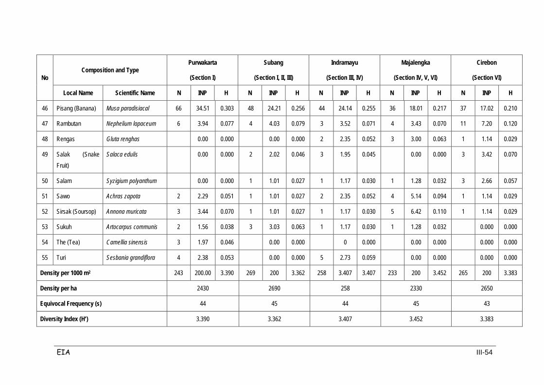
EIA III-54
No Composition and Type
Purwakarta
(Section I)
Subang
(Section I, II, III)
Indramayu
(Section III, IV)
Majalengka
(Section IV, V, VI)
Cirebon
(Section VI)
Local Name Scientific Name N INP H N INP H N INP H N INP H N INP H
46 Pisang (Banana) Musa paradisiacal 66 34.51 0.303 48 24.21 0.256 44 24.14 0.255 36 18.01 0.217 37 17.02 0.210
47 Rambutan Nephelium lapaceum 6 3.94 0.077 4 4.03 0.079 3 3.52 0.071 4 3.43 0.070 11 7.20 0.120
48 Rengas Gluta renghas 0.00 0.000 0.00 0.000 2 2.35 0.052 3 3.00 0.063 1 1.14 0.029
49 Salak (Snake Fruit)
Salaca edulis 0.00 0.000 2 2.02 0.046 3 1.95 0.045 0.00 0.000 3 3.42 0.070
50 Salam Syzigium polyanthum 0.00 0.000 1 1.01 0.027 1 1.17 0.030 1 1.28 0.032 3 2.66 0.057
51 Sawo Achras zapota 2 2.29 0.051 1 1.01 0.027 2 2.35 0.052 4 5.14 0.094 1 1.14 0.029
52 Sirsak (Soursop) Annona muricata 3 3.44 0.070 1 1.01 0.027 1 1.17 0.030 5 6.42 0.110 1 1.14 0.029
53 Sukuh Artocarpus communis 2 1.56 0.038 3 3.03 0.063 1 1.17 0.030 1 1.28 0.032 0.000 0.000
54 The (Tea) Camellia sinensis 3 1.97 0.046 0.00 0.000 0 0.000 0.00 0.000 0.000 0.000
55 Turi Sesbania grandiflora 4 2.38 0.053 0.00 0.000 5 2.73 0.059 0.00 0.000 0.000 0.000
Density per 1000 m2 243 200.00 3.390 269 200 3.362 258 3.407 3.407 233 200 3.452 265 200 3.383
Density per ha 2430 2690 258 2330 2650
Equivocal Frequency (s) 44 45 44 45 43
Diversity Index (H’) 3.390 3.362 3.407 3.452 3.383
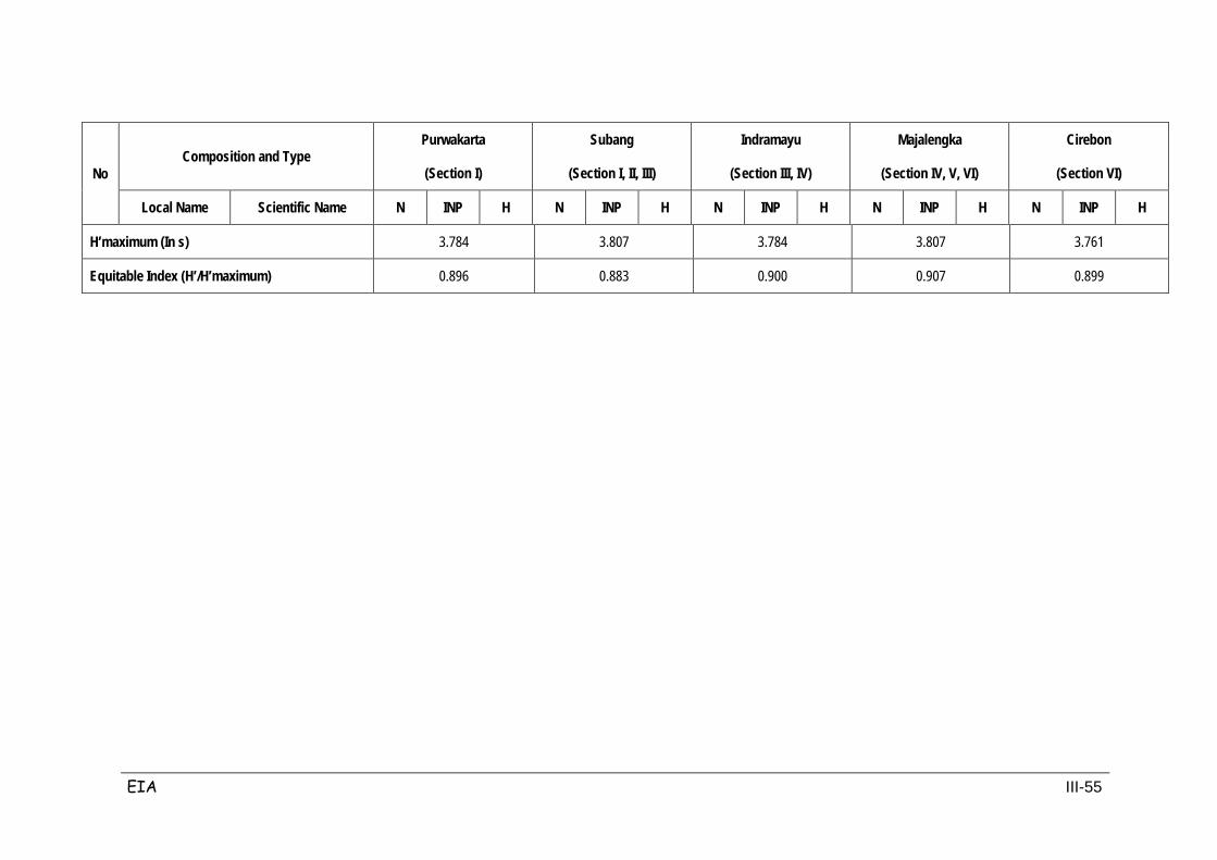
EIA III-55
No Composition and Type
Purwakarta
(Section I)
Subang
(Section I, II, III)
Indramayu
(Section III, IV)
Majalengka
(Section IV, V, VI)
Cirebon
(Section VI)
Local Name Scientific Name N INP H N INP H N INP H N INP H N INP H
H’maximum (In s) 3.784 3.807 3.784 3.807 3.761
Equitable Index (H’/H’maximum) 0.896 0.883 0.900 0.907 0.899
EIA III-56
3.2.2 Terrestrial Fauna
As for flora, data collected on fauna in the study area was based on secondary
data and inventories of species of mammals (animals that produce milk).
Herpetofauna consists of amphibians and reptiles and many species of birds.
Mammal species include among others the classes Erinaceidae, Soricidae,
Tupaiidae (squirrel) Pteropodidae, Emballonuridae, Nycteridae, Rhinolophidae,
Mustelidae (weasels), and others. Observations on the existence of fauna habitat
conditions found that the majority of fauna species resided in paddy fields, fields,
mixed yards/gardens, and shrubbery. Data collection on the diversity of
fauna/wildlife identified that diversity of species from the classes of insects,
amphibians, reptiles, aves / birds and mammals, including domestic pets.
Fauna data was collected using methods such as direct encounter, listening for
sound, tracking footsteps, finding former nests and conducting direct interviews
with residents near the location at the time of observation.
Data acquired on the diversity of wildlife in the study area showed that there are 9
(nine) species of aves that are protected under Government Regulation No. 7 /
1999. These protected bird species include: Kestrel (alap-alap), Intermediate Egret
(blekok), Sun bird (burung madu), Collared Kingfisher (cekakak), Brahminy Kite
(elang bondol), Brown-throated Sunbird (sesap madu kelapa) and Blue-eared
Kingfisher (tetengket).
Pets/domesticated animals that are often encountered in the study area include:
goats (Capra Capra domestica), cow (Bos Sagittarius), buffalo (Bos bubalis), dogs
(Canis canis familiaris), cats (Felis felis familiaris), domestic poultry (Gallus Gallus
domesticus), ducks (Anas luzonica), Indonesian Teal Ducks (Anas gibberifrons)
and geese (Anas sp.).
Table 3.13 displays information on fauna identified in the project area.

EIA III-57
Table 3-13 Fauna Compos ition in the Projec t Area
No Class and Type Obervation Kind of
Encounter Note Local Name Scientific Name I II III
I. INSECT
1 Belalang coklat (Brown Grasshopper)
Rana limnocharis ⊕ ⊕ ⊕ PL pest
2 Capung (Dragonfly) Ordo : Odonata ⊕ ⊕ ⊕ PL predator pest
3 Kupu-kupu (Butterfly) Ordo : Lepidoptera ⊕ ⊕ ⊕ PL pollinator
4 Kumbang (Beetle) Ordo : Coleoptera ⊕ ⊕ ⊕ PL pest
5 Lebah (Western Honey Bee) Aphis mellifera ⊕ ⊕ ⊕ PL pollinator
6 Lalat besar (Big Fly) Sarcophagus sp. ⊕ ⊕ ⊕ PL vector disease
5 Lalat hijau (Horse Fly) Tabanus sp. ⊕ ⊕ ⊕ PL vector disease
7 Lalat rumah (Common House Fly) Musca domestica ⊕ ⊕ ⊕ PL vector disease
8 Lembing Ordo : Hemipetera ⊕ ⊕ ⊕ PL pest
9 Nyamuk (Mosquito) Aedes spp., Anopheles
spp., Culex i ⊕ ⊕ ⊕ PL vector disease
II. AMPHIBIAN
1 Bancet Microhylla sp. ⊕ PL predator insect
2 Katak paddy field (Crab-Eating Frog) Rana cancrivora ⊕ PL predator insect
3 Katak hijau (Cricket Frog) Rana limnocharis ⊕ PL predator insect
4 Katak pohon (Tree Frog) Rachophorus spp. ⊕ PL predator insect
5 Kodok budug (Common Asiatic Toad)
Bufo melanostictus ⊕ ⊕ PL predator insect
6 REPTILES
7 Byawak (Water Monitor) Varanus salvator ⊕ ⊕ W predator pest
8 Bunglon (Chameleon) Calotes jubatus ⊕ PL predator pest
9 Cicak pohon (Common House Gecko)
Hemydactylus frenatus ⊕ PL, S predator pest
10 Cicak terbang (Flying Dragon) Draco volans ⊕ PL predator pest
11 Kadal (Skink) Mabouya multifasciata ⊕ ⊕ ⊕ PL predator pest
12 Tokek Pohon (Tokey Gecko) Gecko gecko ⊕ PL, S predator pest
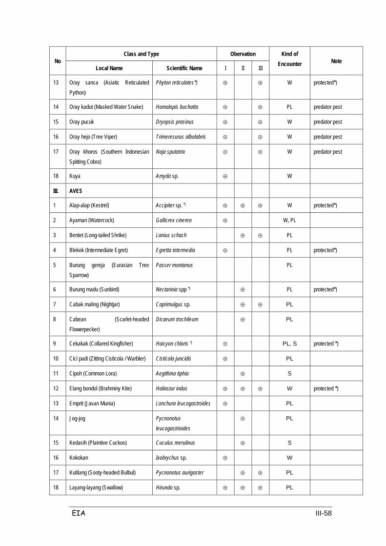
EIA III-58
No Class and Type Obervation Kind of
Encounter Note Local Name Scientific Name I II III
13 Oray sanca (Asiatic Reticulated Python)
Phyton reticulates*) ⊕ ⊕ W protected*)
14 Oray kadut (Masked Water Snake) Homalopis buchatta ⊕ ⊕ PL predator pest
15 Oray pucuk Dryopsis prasinus ⊕ ⊕ W predator pest
16 Oray hejo (Tree Viper) Trimeresurus albolabris ⊕ ⊕ W predator pest
17 Oray khoros (Southern Indonesian Spitting Cobra)
Naja sputatrix ⊕ ⊕ W predator pest
18 Kuya Amyda sp. ⊕ W
III. AVES
1 Alap-alap (Kestrel) Accipiter sp. *) ⊕ ⊕ ⊕ W protected*)
2 Ayaman (Watercock) Gallicrex cinerea ⊕ W, PL
3 Bentet (Long-tailed Shrike) Lanius schach ⊕ ⊕ PL
4 Blekok (Intermediate Egret) Egretta intermedia ⊕ PL protected*)
5 Burung gereja (Eurasian Tree Sparrow)
Passer montanus PL
6 Burung madu (Sunbird) Nectarinia spp *) ⊕ PL protected*)
7 Cabak maling (Nightjar) Caprimulgus sp. ⊕ ⊕ PL
8 Cabean (Scarlet-headed Flowerpecker)
Dicaeum trochileum ⊕ PL
9 Cekakak (Collared Kingfisher) Haicyon chloris *) ⊕ PL, S protected *)
10 Cici padi (Zitting Cisticola / Warbler) Cisticola juncidis ⊕ PL
11 Cipoh (Common Lora) Aegithina tiphia ⊕ S
12 Elang bondol (Brahminy Kite) Haliastur indus ⊕ ⊕ ⊕ W protected *)
13 Emprit (Javan Munia) Lonchura leucogastroides ⊕ PL
14 Jog-jog Pycnonotus
leucogastrioides
⊕ PL
15 Kedasih (Plaintive Cuckoo) Cuculus merulinus ⊕ S
16 Kokokan Ixobrychus sp. ⊕ W
17 Kutilang (Sooty-headed Bulbul) Pycnonotus aurigaster ⊕ ⊕ PL
18 Layang-layang (Swallow) Hirundo sp. ⊕ ⊕ ⊕ PL
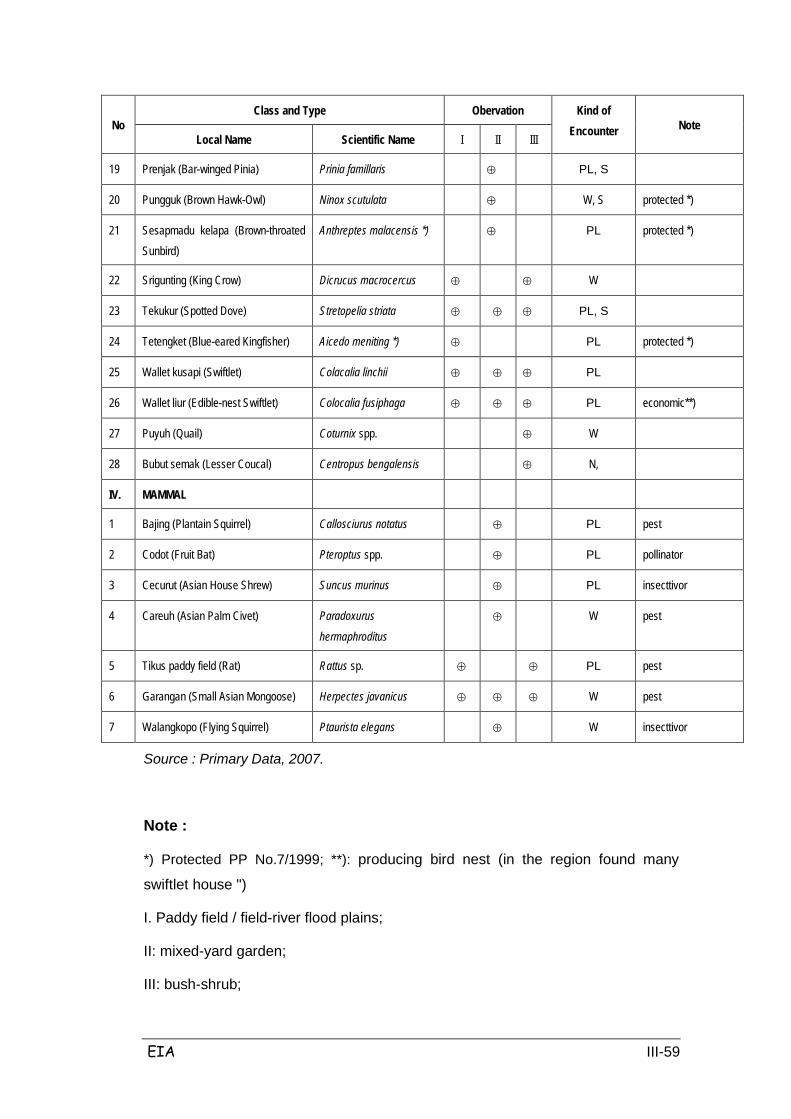
EIA III-59
No Class and Type Obervation Kind of
Encounter Note Local Name Scientific Name I II III
19 Prenjak (Bar-winged Pinia) Prinia famillaris ⊕ PL, S
20 Pungguk (Brown Hawk-Owl) Ninox scutulata ⊕ W, S protected *)
21 Sesapmadu kelapa (Brown-throated Sunbird)
Anthreptes malacensis *) ⊕ PL protected *)
22 Srigunting (King Crow) Dicrucus macrocercus ⊕ ⊕ W
23 Tekukur (Spotted Dove) Stretopelia striata ⊕ ⊕ ⊕ PL, S
24 Tetengket (Blue-eared Kingfisher) Aicedo meniting *) ⊕ PL protected *)
25 Wallet kusapi (Swiftlet) Colacalia linchii ⊕ ⊕ ⊕ PL
26 Wallet liur (Edible-nest Swiftlet) Colocalia fusiphaga ⊕ ⊕ ⊕ PL economic**)
27 Puyuh (Quail) Coturnix spp. ⊕ W
28 Bubut semak (Lesser Coucal) Centropus bengalensis ⊕ N,
IV. MAMMAL
1 Bajing (Plantain Squirrel) Callosciurus notatus ⊕ PL pest
2 Codot (Fruit Bat) Pteroptus spp. ⊕ PL pollinator
3 Cecurut (Asian House Shrew) Suncus murinus ⊕ PL insecttivor
4 Careuh (Asian Palm Civet) Paradoxurus
hermaphroditus
⊕ W pest
5 Tikus paddy field (Rat) Rattus sp. ⊕ ⊕ PL pest
6 Garangan (Small Asian Mongoose) Herpectes javanicus ⊕ ⊕ ⊕ W pest
7 Walangkopo (Flying Squirrel) Ptaurista elegans ⊕ W insecttivor
Source : Primary Data, 2007.
Note :
*) Protected PP No.7/1999; **): producing bird nest (in the region found many
swiftlet house ")
I. Paddy field / field-river flood plains;
II: mixed-yard garden;
III: bush-shrub;
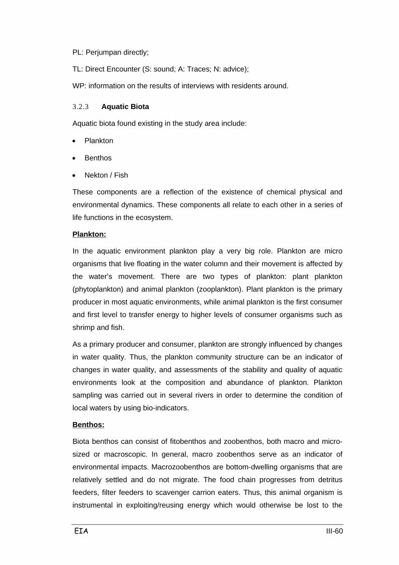
EIA III-60
PL: Perjumpan directly;
TL: Direct Encounter (S: sound; A: Traces; N: advice);
WP: information on the results of interviews with residents around.
3.2.3 Aquatic Biota
Aquatic biota found existing in the study area include:
• Plankton
• Benthos
• Nekton / Fish
These components are a reflection of the existence of chemical physical and
environmental dynamics. These components all relate to each other in a series of
life functions in the ecosystem.
In the aquatic environment plankton play a very big role. Plankton are micro
organisms that live floating in the water column and their movement is affected by
the water’s movement. There are two types of plankton: plant plankton
(phytoplankton) and animal plankton (zooplankton). Plant plankton is the primary
producer in most aquatic environments, while animal plankton is the first consumer
and first level to transfer energy to higher levels of consumer organisms such as
shrimp and fish.
Plankton:
As a primary producer and consumer, plankton are strongly influenced by changes
in water quality. Thus, the plankton community structure can be an indicator of
changes in water quality, and assessments of the stability and quality of aquatic
environments look at the composition and abundance of plankton. Plankton
sampling was carried out in several rivers in order to determine the condition of
local waters by using bio-indicators.
Biota benthos can consist of fitobenthos and zoobenthos, both macro and micro-
sized or macroscopic. In general, macro zoobenthos serve as an indicator of
environmental impacts. Macrozoobenthos are bottom-dwelling organisms that are
relatively settled and do not migrate. The food chain progresses from detritus
feeders, filter feeders to scavenger carrion eaters. Thus, this animal organism is
instrumental in exploiting/reusing energy which would otherwise be lost to the
Benthos:
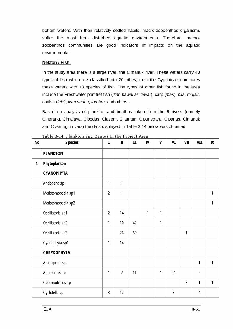
EIA III-61
bottom waters. With their relatively settled habits, macro-zoobenthos organisms
suffer the most from disturbed aquatic environments. Therefore, macro-
zoobenthos communities are good indicators of impacts on the aquatic
environmental.
In the study area there is a large river, the Cimanuk river. These waters carry 40
types of fish which are classified into 20 tribes; the tribe Cyprinidae dominates
these waters with 13 species of fish. The types of other fish found in the area
include the Freshwater pomfret fish (ikan bawal air tawar), carp (mas), nila, mujair,
catfish (lele), ikan seribu, tambra, and others.
Nekton / Fish:
Based on analysis of plankton and benthos taken from the 9 rivers (namely
Ciherang, Cimalaya, Cibodas, Ciasem, Cilamtan, Cipunegara, Cipanas, Cimanuk
and Ciwaringin rivers) the data displayed in Table 3.14 below was obtained.
Table 3-14 P lankton and Bentos In the Pro ject Area No Species I II III IV V VI VII VIII IX
PLANKTON
1. Phytoplanton
CYANOPHYTA
Anabaena sp 1 1
Meristomopedia sp1 2 1 1
Meristomopedia sp2 1
Oscillatoria sp1 2 14 1 1
Oscillatoria sp2 1 10 42 1
Oscillatoria sp3 26 69 1
Cyanophyta sp1 1 14
CHRYSOPHYTA
Amphiprora sp 1 1
Anemoneis sp 1 2 11 1 94 2
Coscinodiscus sp 8 1 1
Cyclotella sp 3 12 3 4

EIA III-62
No Species I II III IV V VI VII VIII IX
Cymbella sp 1 14 47 10 18 7 114 6
Diatoma sp1 4 1 4 14 37
Diatoma sp2 6 12 157 18 4
Fragillaria sp1 60 4 21 57 9 73 72 129 42
No Species I II III IV V VI VII VIII IX
Fragillaria sp2 55 Fragillaria sp3 14 44 4 49 36 28 Frustulia sp2 1 1 Frustulia sp3 1 Gamphonema sp1 1 2 2 1 3 Gamphonema sp2 1 Gyrosigma sp1 2 1 Gyrosigma sp2 3 3 43 11 11 5 Navicula sp1 1 1 1 1 1 1 Navicula sp2 1 15 62 51 11 53 9 81 7 Navicula sp3 22 Navicula sp4 1 1 1 1 1 Nitzchia sp1 2 1 43 17 5 Nitzchia sp2 11 11 Pleurosigma sp1 2 2 8 1 2 Pleurosigma sp2 2 8 78 18 4 22 56 Pleurosigma sp4 1 Surirella sp1 2 2 17 8 6 261 47 48 Surirella sp2 22 3 2 123 31 42 Surirella sp3 6 Surirella sp4 13 Synedra sp1 18 2 17 1 55 114 Synedra sp2 2 2 1 2 1 1 4 2 2 Synedra sp3 3 2 101 23 1 25 8 82 7 Closterium sp1 3 3 1 Golenkinia sp 6 8 Pediastrum sp 7 71 1 1 1 1 Scenedesmus sp 3 3 82
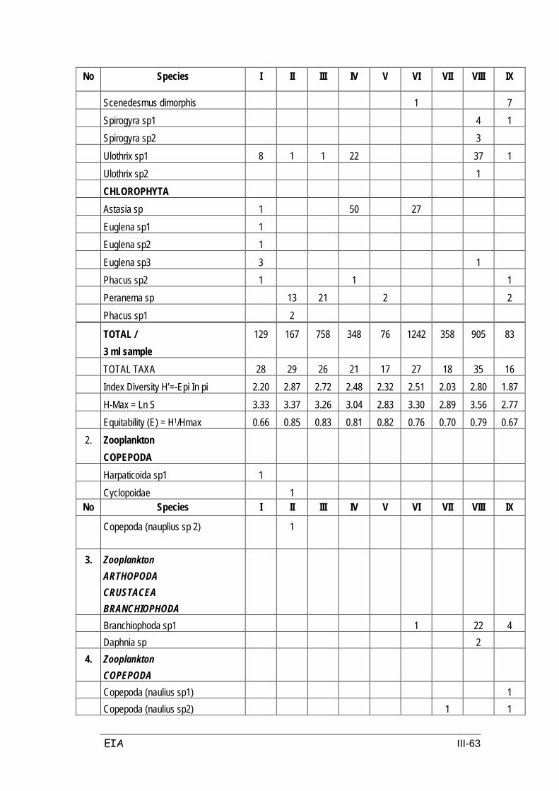
EIA III-63
No Species I II III IV V VI VII VIII IX
Scenedesmus dimorphis 1 7 Spirogyra sp1 4 1 Spirogyra sp2 3 Ulothrix sp1 8 1 1 22 37 1 Ulothrix sp2 1 CHLOROPHYTA
Astasia sp 1 50 27 Euglena sp1 1
Euglena sp2 1 Euglena sp3 3 1
Phacus sp2 1 1 1 Peranema sp 13 21 2 2
Phacus sp1 2
TOTAL / 3 ml sample
129 167 758 348 76 1242 358 905 83
TOTAL TAXA 28 29 26 21 17 27 18 35 16 Index Diversity H’=-Epi In pi 2.20 2.87 2.72 2.48 2.32 2.51 2.03 2.80 1.87
H-Max = Ln S 3.33 3.37 3.26 3.04 2.83 3.30 2.89 3.56 2.77 Equitability (E) = H1/Hmax 0.66 0.85 0.83 0.81 0.82 0.76 0.70 0.79 0.67
2. Zooplankton COPEPODA
Harpaticoida sp1 1 Cyclopoidae 1 No Species I II III IV V VI VII VIII IX
Copepoda (nauplius sp 2)
1
3. Zooplankton ARTHOPODA CRUSTACEA BRANCHIOPHODA
Branchiophoda sp1 1 22 4 Daphnia sp 2
4. Zooplankton COPEPODA
Copepoda (naulius sp1) 1 Copepoda (naulius sp2) 1 1

EIA III-64
No Species I II III IV V VI VII VIII IX
PROTOZOA CILIOPHORA
Lionotus sp1 28 2 Lionotus sp2 6 Lionotus sp3 6 Colpotidae 21 9 30 105 53 5 81 Euplotidae 2 4 1 Nassulidae sp1 12 1 Nassulidae sp2 1 3 Stetor sp 18 2 24 Vorticella sp1 9 2 1 Vorticella sp2 11 Ciliophora sp1 1 10 Ciliophora sp2 1 2 Ciliophora sp3 1 40 22 59 Ciliophora sp4 1 HELIOZOA 3 Actinophrys sp 5 42 15 169 16 33 10 65 Actispherium sp 8 1 RHIZOPODA Amoeba sp 2 4 3 101 15 Arcella sp1 4 43 1 80 2 3 1 1 41 Arcella sp2 1 1 1 5 4 1 Arcella sp3 18 20 10 5 Arcella sp4 13 9 Arcella sp5 22 22 Arcella sp6 1 1 30 Centropyxis sp 1 1 3
Diflugia sp1 1 3 Diflugia sp2 2 3 2
Eugypha sp1 2 6 Eugypha sp2
Rhizopoda sp1 1 3 Rhizopoda sp2 7
Rhizopoda sp3 1 TROCHELMINTES ROTATORIA
Branchionus sp 4 1 2
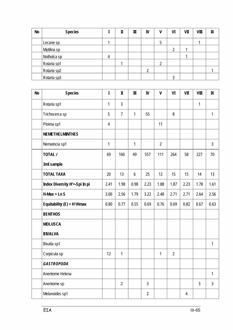
EIA III-65
No Species I II III IV V VI VII VIII IX
Lecane sp 1 5 1 Mytilina sp 2 1
Notholca sp 4 1 Rotaria sp1 1 2 Rotaria sp2 2 1
Rotaria sp3 3
No Species I II III IV V VI VII VIII IX
Rotaria sp1 1 3 1
Trichocerca sp 5 7 1 55 8 1
Ploima sp1 4 11
NEMETHELMINTHES
Nematocia sp1 1 1 2 3
TOTAL /
3ml sample
69 160 49 557 111 264 58 227 70
TOTAL TAXA 20 13 6 25 12 15 15 14 13
Index Diversity H’=-Spi In pi 2.41 1.98 0.98 2.23 1.88 1.87 2.23 1.78 1.61
H-Max = Ln S 3.00 2.56 1.79 3.22 2.48 2.71 2.71 2.64 2.56
Equitability (E) = H1/Hmax 0.80 0.77 0.55 0.69 0.76 0.69 0.82 0.67 0.63
BENTHOS
MOLUSCA
BIVALVA
Bivalia sp1 1
Corpicula sp 12 1 1 2
GASTROPODA
Anentome Helena 1
Anentome sp 2 3 3 3
Melanoides sp1 2 4

EIA III-66
No Species I II III IV V VI VII VIII IX
Melanoides sp2 2 1 6 6 8 6
Melanoides sp3 5 5 2 1
Thiara sp 1
ANNELIDA
OLYGOCHAETA
Branchiura sowerbyii 12
Tubificudae sp1 6
Tubificudae sp2 1
Olygochaeta sp1 1
ARTHROPODHA
INSECTTA
DIPTERA
Chironomidae sp1 1 2 1 1
Chironomidae sp2 1
NEMATHELMINTHES
Nematoda sp1 1 1 2 3
Nematoda sp1
TOTAL /
3ml sample
16 4 2 25 14 4 17 13 16
TOTAL TAXA 4 3 2 6 4 2 5 3 7
Diversity Index H’=-Spi In pi 0.82 1.04 0.69 1.41 1.20 0.69 1.40 0.93 1.69
H-Max = Ln S 1.39 1.10 0.69 1.79 1.39 0.69 1.61 1.10 1.95
Equitability (E) = H1/Hmax 0.59 0.95 1.00 0.79 0.86 1.00 0.87 0.84 0.87
Source : Sampling Sucofindo, 2007
Note : I = River Ciherang, II = S. Cimalaya; III = S. Cibodas; IV = S. Ciasem; V = S. Cilamatan; VI = S. Cipunegara; VII = S. Cipanas; VIII = S. Cimanuk dan IX = S. Ciwaringin
EIA III-67
From the analysis above the value H ' varies in the nine rivers between 0.69 –
1.41, which demonstrates that the waters can be classified as polluted, and the
quality standards demonstrate that there are some parameters which have passed
the threshold, such as BOD and phosphate.
3.3 ECONOMIC, SOCIAL, AND CULTURAL COMPONENTS
The planned Cikampek-Palimanan toll-road is one form of supporting
infrastructure for economic growth especially in West Java. The position of West
Java is geographically located in a strategic position because it is close to the
capital city of Jakarta. In other words, West Java enjoys geographical and political
proximity to the economic center and national government. At the macro level,
West Java has the potential for extraordinary economic capabilities and for
capturing optimal investment opportunities. A general description of the potential
of West Java province is, among others:
1. In the Industrial sector, the province of West Java is one of the largest
manufacturing base in Indonesia;
2. In the field of commerce, West Java is the basis of National Non Oil Export.
3. In education, West Java is one of the national education bases as most of
the private universities are in the region.
4. West Java has large potential of tourism so that is a Tourist Destination
Region Community Capital of the State.
5. West Java has powerful human resources and potential for industrial
activities.
6. In terms of West Java territorial revenue: Spill Over both the infrastructure
and settlement and transportation.
Seeing the tremendous potential, the existence of the toll road is a strategic
infrastructure improvement that can be used for strengthening the region's
economy. The following is the socio-economic environmental setting of the study
area based on BPS data for each district last year (output BPS).
3.3.1 Population
The population of West Java in 2006 was 38.47 million people with a population
growth rate on average of 1.29%. Largest population is the Bandung District with
as much as 4.09 million people, and the smallest is in Banjar district with as many
as 0.16 million people. The number of households in 2006 in West Java reached
EIA III-68
10,196,064 households. The highest was in Bandung regency ie 1,058,816
households, followed by 904,608 in Bogor District and then in Suregencyumi
district with 584,384 households. Population density in West Java reached
1,314.09 people per km2. Bandung Regency is the area with the highest
population density; 13296.55 people/km2, while the lowest was at 666.02
people/km2 in Ciamis district.
The population and territory profile of each district is as follows:
Residents of Subang Regency in 2006 amounted to 1,391,997 persons, with the
composition of the 699,783 men and 692,214 women. Population density in the
Regency reached 678.44 people/km2; whereas Subang district was the most
densely populated district with 2200.40people/km2, followed by 1073.78
people/km2 in Pamanukan District. The Legon District has the lowest population
density levels with 323.33 people/km2. The sex ratio (shows the number of
resident males per 100 females) in Subang Regency is at 101.09.
Subang Regency
Judging from the composition of age groups, Subang regency population consists
of 27.41% children (0-14 years); 8.02% teens (15-19 years); 33.83% youth (20-39
years) and 30.74% of old and elderly.
Population conditions in the Regency are as follows: Subang District has 120,296
inhabitants; followed by Pangaden district (81,316 inhabitants) and Pabuaran
(67,764 inhabitants). The district with the smallest population, of 27,736 people, is
Kalijati District. Likewise the largest population density in the study area is Subang
District, and the Sub district of Pabuaran Pangaden. Population characteristics for
Subang Regency are compared by district in Table 3.15.
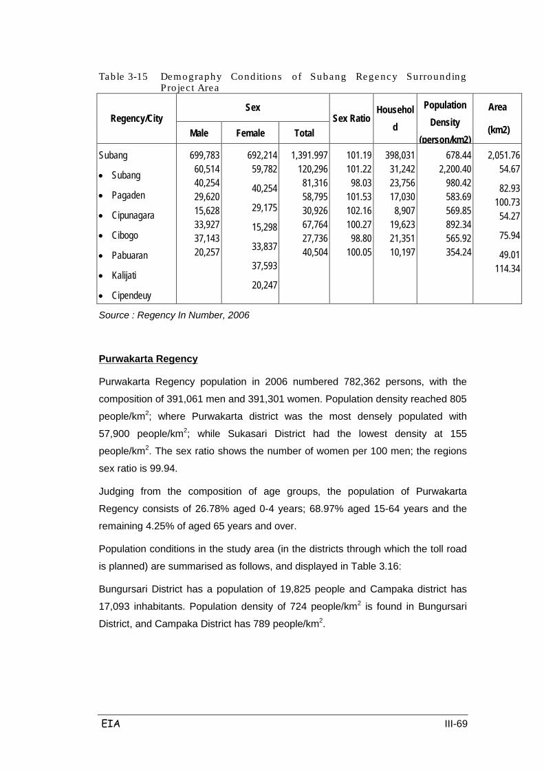
EIA III-69
Table 3-15 Demography Conditions of Subang Regency Surrounding Pro jec t Area
Regency/City Sex
Sex Ratio Househol
d
Population Density
(person/km2)
Area
(km2) Male Female Total
Subang
• Subang
• Pagaden
• Cipunagara
• Cibogo
• Pabuaran
• Kalijati
• Cipendeuy
699,783 60,514 40,254 29,620 15,628 33,927 37,143 20,257
692,214 59,782
40,254
29,175
15,298
33,837
37,593
20,247
1,391.997 120,296
81,316 58,795 30,926 67,764 27,736 40,504
101.19 101.22
98.03 101.53 102.16 100.27
98.80 100.05
398,031 31,242 23,756 17,030
8,907 19,623 21,351 10,197
678.44 2,200.40
980.42 583.69 569.85 892.34 565.92 354.24
2,051.76 54.67
82.93 100.73
54.27
75.94
49.01 114.34
Source : Regency In Number, 2006
Purwakarta Regency population in 2006 numbered 782,362 persons, with the
composition of 391,061 men and 391,301 women. Population density reached 805
people/km2; where Purwakarta district was the most densely populated with
57,900 people/km2; while Sukasari District had the lowest density at 155
people/km2. The sex ratio shows the number of women per 100 men; the regions
sex ratio is 99.94.
Purwakarta Regency
Judging from the composition of age groups, the population of Purwakarta
Regency consists of 26.78% aged 0-4 years; 68.97% aged 15-64 years and the
remaining 4.25% of aged 65 years and over.
Population conditions in the study area (in the districts through which the toll road
is planned) are summarised as follows, and displayed in Table 3.16:
Bungursari District has a population of 19,825 people and Campaka district has
17,093 inhabitants. Population density of 724 people/km2 is found in Bungursari
District, and Campaka District has 789 people/km2.
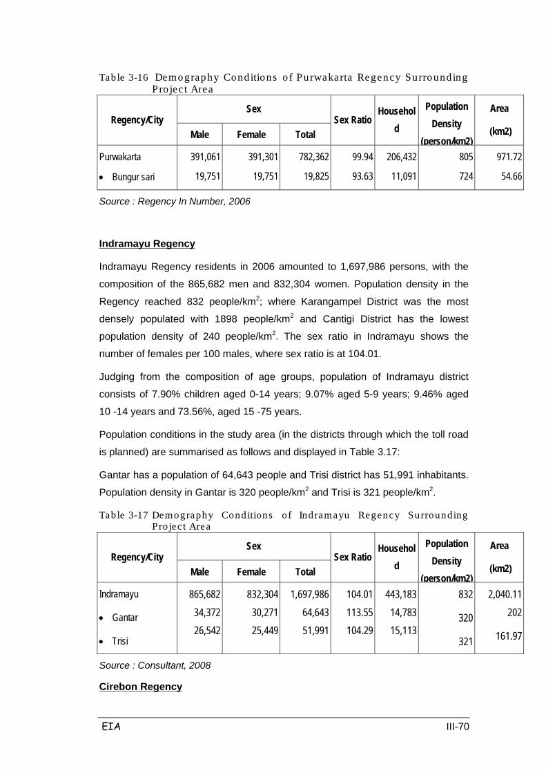
EIA III-70
Table 3-16 Demography Conditions o f Purwakarta Regency Surrounding Pro jec t Area
Regency/City Sex
Sex Ratio Househol
d
Population Density
(person/km2)
Area
(km2) Male Female Total
Purwakarta
• Bungur sari
391,061
19,751
391,301
19,751
782,362
19,825
99.94
93.63
206,432
11,091
805
724
971.72
54.66
Source : Regency In Number, 2006
Indramayu Regency residents in 2006 amounted to 1,697,986 persons, with the
composition of the 865,682 men and 832,304 women. Population density in the
Regency reached 832 people/km2; where Karangampel District was the most
densely populated with 1898 people/km2 and Cantigi District has the lowest
population density of 240 people/km2. The sex ratio in Indramayu shows the
number of females per 100 males, where sex ratio is at 104.01.
Indramayu Regency
Judging from the composition of age groups, population of Indramayu district
consists of 7.90% children aged 0-14 years; 9.07% aged 5-9 years; 9.46% aged
10 -14 years and 73.56%, aged 15 -75 years.
Population conditions in the study area (in the districts through which the toll road
is planned) are summarised as follows and displayed in Table 3.17:
Gantar has a population of 64,643 people and Trisi district has 51,991 inhabitants.
Population density in Gantar is 320 people/km2 and Trisi is 321 people/km2.
Table 3-17 Demography Conditions of Indramayu Regency Surrounding Pro jec t Area
Regency/City Sex
Sex Ratio Househol
d
Population Density
(person/km2)
Area
(km2) Male Female Total
Indramayu
• Gantar
• Trisi
865,682 34,372 26,542
832,304 30,271 25,449
1,697,986 64,643 51,991
104.01 113.55 104.29
443,183 14,783 15,113
832
320
321
2,040.11 202
161.97
Source : Consultant, 2008
Cirebon Regency

EIA III-71
Residents of Cirebon in 2006 amounted to 2,029,953 persons, with the
composition of 1,014,672 men and 1,015,281 women. Population density reached
2049 people/km2; where Weru District is also a densely populated region with 5963 people/km2; Pasaleman District is an area with the lowest density level at
810.68 people/km2. The sex ratio in Cirebon shows the number of women per 100
population of men, where the sex ratio of 99.94.
Population conditions in the study area (in the districts through which the toll road
is planned) are summarized as follows and displayed in Table 3.18:
Palimanan district has a population of 54,662 inhabitants; there are 53,313 people
in Ciwaringin; and 26,764 people in Gempol. Population density in Palimanan is
3181.72 people/km2, Ciwaringin is 2996.79 people/km2, and Gempol is 870.94
people/km2.
Table 3-18 Demography Conditions of Cirebon Regency Surrounding Pro ject Area
Regency/City Sex
Sex Ratio Househol
d
Population Density
(person/km2)
Area
(km2) Male Female Total
Cirebon
• Ciwaringin
• Gempol
• Palimanan
1,014,672 27,483 13,269 27,592
1,015,281 27,830
13,495
27,070
2,029,953 53,313 26,764 54,662
99.94 98.75 98.33
101.93
534,407 9,055
11,410 14,849
2,049 2,996.79
870.94 3,181.72
990.36 17.79
30.73
17.18
Source : Tim Consultant, 2008
Majalengka population in 2006 numbered 1,169,337 people, with the composition
of 577,633 men and 591,704 women; Majalengka saw a population increase of
0.75% when compared to the population of the previous year. The number of
households increased to a high of 339,072 RT in 2004 to 392,544 RT in 2006, an
increase of 15.77%. Population density reached 971 people/km2; Jatiwangi District
is a densely populated district of 2032 people/km2; while Kertajati District is an
area with the lowest density of 322 people/km2. The sex ratio shows the number of
women per 100 men, is 97.62.
Majalengka Regency
Population conditions in the study area (in the districts through which the toll road
is planned) are summarised as follows and displayed in Table 3.19:
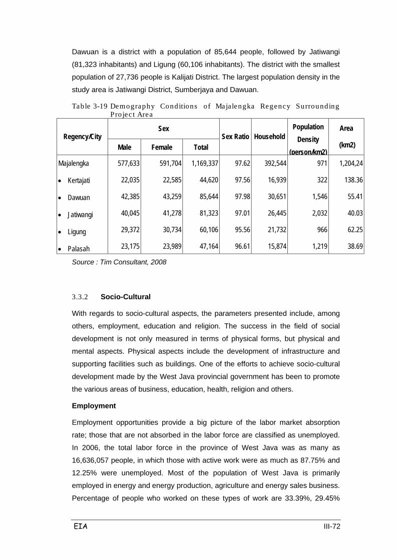
EIA III-72
Dawuan is a district with a population of 85,644 people, followed by Jatiwangi
(81,323 inhabitants) and Ligung (60,106 inhabitants). The district with the smallest
population of 27,736 people is Kalijati District. The largest population density in the
study area is Jatiwangi District, Sumberjaya and Dawuan.
Table 3-19 Demography Conditions of Majalengka Regency Surrounding Pro jec t Area
Regency/City Sex
Sex Ratio Household Population
Density (person/km2)
Area
(km2) Male Female Total
Majalengka
• Kertajati
• Dawuan
• Jatiwangi
• Ligung
• Palasah
577,633
22,035
42,385
40,045
29,372
23,175
591,704
22,585
43,259
41,278
30,734
23,989
1,169,337
44,620
85,644
81,323
60,106
47,164
97.62
97.56
97.98
97.01
95.56
96.61
392,544
16,939
30,651
26,445
21,732
15,874
971
322
1,546
2,032
966
1,219
1,204,24
138.36
55.41
40.03
62.25
38.69
Source : Tim Consultant, 2008
3.3.2 Socio-Cultural
With regards to socio-cultural aspects, the parameters presented include, among
others, employment, education and religion. The success in the field of social
development is not only measured in terms of physical forms, but physical and
mental aspects. Physical aspects include the development of infrastructure and
supporting facilities such as buildings. One of the efforts to achieve socio-cultural
development made by the West Java provincial government has been to promote
the various areas of business, education, health, religion and others.
Employment
Employment opportunities provide a big picture of the labor market absorption
rate; those that are not absorbed in the labor force are classified as unemployed.
In 2006, the total labor force in the province of West Java was as many as
16,636,057 people, in which those with active work were as much as 87.75% and
12.25% were unemployed. Most of the population of West Java is primarily
employed in energy and energy production, agriculture and energy sales business.
Percentage of people who worked on these types of work are 33.39%, 29.45%
EIA III-73
and 21.91%, respectively. Professionals are totaled at 3.81%. The number of
unemployed people looking for work in West Java province is as many as
4,219,610 people. Of this number of job seekers, 69.3% are high school
graduates; 11.6% are Bachelor graduates; and 10.2% are SLIP graduates or
others.
Based on data from the Department of Social and Labor in 2006, the number of
unemployed job seekers is as many as 16,170, with levels of education varying
from primary to vocational school. The study area is still facing problems, and a
large number of unemployed in the region. The number of job seekers in the
District of Gantar and Trisi are many as 3715 people, with various levels of
education. Most of the workers were employed in the agricultural sector where
they were farmers and tenants.
Indramayu Regency
In 2006 there were 15,595 people jobseekers, 53.76% of whom are women. Of
these, 46.77% female job seekers have a high school education level or equal.
Meanwhile, the number of male job seekers who have a high school education
level or equal amount to 70.67%. In total, the majority of job seekers have a high
school education level, about 57.82%. Subsequently in 2006, the largest amount
of job placements were filled by women who are high school educated or
equivalent; 61.42%.
Purwakarta Regency
Job seekers registered in 2006 reached 829 people, consisting of 500 women and
329 men. The list of job seekers by level of education can be seen in Table 3.20.
Majalengka Regency
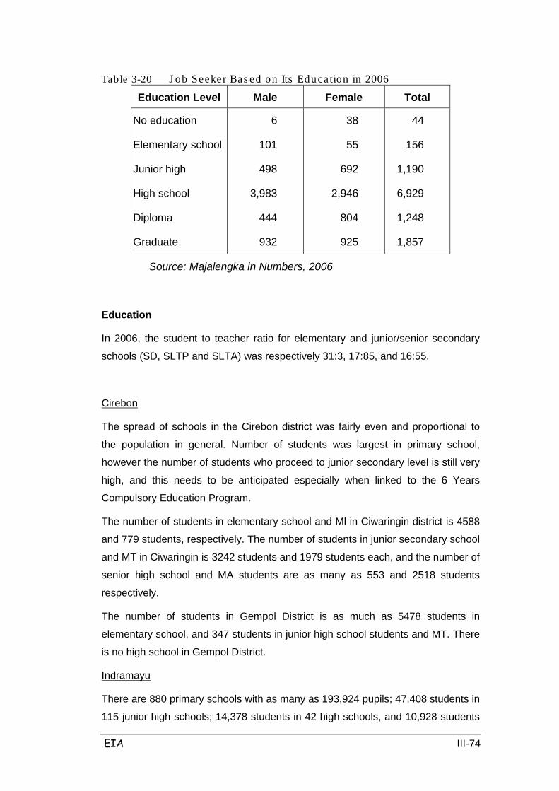
EIA III-74
Table 3-20 J ob Seeker Bas ed on Its Education in 2006
Education Level Male Female Total
No education
Elementary school
Junior high
High school
Diploma
Graduate
6
101
498
3,983
444
932
38
55
692
2,946
804
925
44
156
1,190
6,929
1,248
1,857
Source: Majalengka in Numbers, 2006
Education
In 2006, the student to teacher ratio for elementary and junior/senior secondary
schools (SD, SLTP and SLTA) was respectively 31:3, 17:85, and 16:55.
The spread of schools in the Cirebon district was fairly even and proportional to
the population in general. Number of students was largest in primary school,
however the number of students who proceed to junior secondary level is still very
high, and this needs to be anticipated especially when linked to the 6 Years
Compulsory Education Program.
Cirebon
The number of students in elementary school and Ml in Ciwaringin district is 4588
and 779 students, respectively. The number of students in junior secondary school
and MT in Ciwaringin is 3242 students and 1979 students each, and the number of
senior high school and MA students are as many as 553 and 2518 students
respectively.
The number of students in Gempol District is as much as 5478 students in
elementary school, and 347 students in junior high school students and MT. There
is no high school in Gempol District.
There are 880 primary schools with as many as 193,924 pupils; 47,408 students in
115 junior high schools; 14,378 students in 42 high schools, and 10,928 students
Indramayu
EIA III-75
in 32 vocational schools. There are 11,550 teachers, with as many as 9712
teaching in primary schools, and the rest in junior / senior high / vocational
schools.
The number of elementary schools (both public and private) in the District of
Gantar totals 33 schools. The number of students in elementary schools (public
and private) is as much as 6281. The number of teachers in elementary schools
(public and private) are as many as 277. The number of students in junior high
schools (public and private) are as many as 1253. The number of teachers in
junior high schools (public and private) as many as 85 people. There are no senior
high schools in Gantar District.
The number of elementary schools (public and private) in Trisi District is as much
as 29 schools. The number of students in elementary school (public and private) is
as much as 5862, and the number of teachers in elementary school (public and
private) is as many as 235 people. Meanwhile, the number of students in junior
high schools (public and private) are as many as 2416, and the number of
teachers in junior high schools (public and private) are as many as 144.
Meanwhile, the number of senior high school students (public and private) are as
many as 477, and the number of teachers in senior high schools (public and
private) are as many as 38.
In 2006, in Purwakarta Regency there were 536 schools ranging from elementary
to senior secondary level, both public and private institutions, with a total of
147,115 students. Student-teacher ratio at the primary level is the ratio of students
to teachers; and at the SLIP is 25, SMU 17 and CMS 17.
Purwakarta Regency
When viewed in general, the situation in 2006 compared with 2003 saw the
number of schools increase by 2.29% and the number of students increase by
4.01%. The number of teachers increased to 8.42%.
The number of elementary schools (public and private) in Bungursari District
totalled 18 schools. The number of students in elementary school (public and
private) was as much as 4464. The number of teachers in elementary school
(public and private) were as many as 155. Meanwhile, there were only 2 public
junior high schools. The number of students in secondary schools (public) was as
much as 1439. The number of teachers in secondary schools (public) was as
much as 68. There public) was as much as 259. Senior public high school
teachers were as much as 31 people.

EIA III-76
There were 19 public elementary schools in Campaka District. The number of
students in Campaka District public elementary schools was 3764 students. State
elementary school teachers numbered 154 people; meanwhile, the number of
students in secondary schools (public and private) was as many as 2416 students.
There were only 2 Junior High Schools, with 1665 students and 54 teachers.
Meanwhile, there was no senior high school in Campaka District.
In 2006, the number of kindergarten schools in the district of Subang was as much
as 83 schools, with 2995 students and 230 teachers. There were 892 public and
private primary schools, with 152 769 students. There were 75 junior high schools
with 43,771 students and 1897 teachers. There were 26 senior high schools with
14,276 students and 646 teachers. There were 24 graduate schools (SMK) with
8984 students and 583 teachers.
Subang Regency
There were 80 primary schools (public and private) in Subang district, with14,264
students and 690 teachers. Meanwhile, the number of junior high schools (public
and private) was as many as 12, with 5701 students and 45 teachers. There were
7 senior high schools (public and private) with 6778 students and 248 teachers.
There were 49 public and private elementary schools in Pangaden District, with
8028 students and 320 teachers; in the meantime, there were 2866 Junior High
School students in 4 junior high schools, with 118 teachers. There was 1 senior
high school with an enrollment of 871 students and 31 teachers.
There were 31 public elementary schools in Cipunagara District, with 6097
students and 159 teachers; in the meantime, there were 3 public junior high
schools with 1318 students and 35 teachers. There is no senior high school in
Cipunaraga District.
There are 20 state elementary schools in Cibogo District, with 2963 students and
167 teachers; meanwhile, there were 2416 students in 2 secondary schools
(public and private). There were 757 junior high school students and 45 teachers.
There is no senior high school in Cibogo District. There are 45 state elementary
schools in Pabuaran District, with 7998 students and 242 teachers; in the
meantime, there were 4 public junior high schools with 3030 students and 43
teachers. There was 1 private senior high school with 280 students and 7
teachers.
There were 52 state elementary schools in Kalijati District, with 8214 students and
EIA III-77
408 teachers. There were 6 public and private junior high schools with 3560
students and 158 teachers. There were 2 private senior high schools. 587
students attended both public and private senior high schools, with 30 teachers.
There were 27 state elementary schools in Cipandeuy District, with 4600 students
and 163 teachers; in the meantime, there were 1496 Junior High School students
in 2 junior high schools, with 34 teachers. There was 1 senior high school, with
411 students and 12 teachers.
In Majalengka, available educational facilities include elementary, junior and senior
high schools and universities. There were 834 elementary schools with 126,664
students, 6160 teachers and a student-teacher ratio of 21. There were 68 junior
high schools, with 31,493 students and 1299 teachers and a student-teacher ratio
of 25. There were 20 senior high schools with 10,948 students and 23 teachers.
Majalengka
There were 33 elementary schools in Kartajati District, with 4431 students and 23
teachers; meanwhile, there were 977 Junior High School students in 2 junior high
schools with 64 teachers. There was no senior high school in Kartajati District.
There were 56 state elementary schools in Dawuan District, with 9217 students
and 385 teachers; in the meantime, there were 4 public junior high schools with
1906 students and 78 teachers. There was 1 senior high school, with as many as
716 students and 38 teachers.
There were 61 state elementary schools in Jatiwangi District, with 9470 students
and 436 teachers; in the meantime, there were 4 junior high schools with 3065
students and 112 teachers. There was 1 senior high school, with as many as 833
students and 42 teachers.
There are 46 state elementary schools in Ligung District, with 6690 students and
242 teachers; in the meantime, the number of public junior high schools was 3,
with 1830 students and 64 teachers. There was 1 senior high school with a total of
200 students and 6 teachers.
There were 52 state elementary schools in Palasah District 52 schools, with 8214
students and 408 teachers; Meanwhile, the number of students in junior high
schools (public and private) was as many as 3560, in 6 schools, with 158
teachers. There were 2 public and private senior high schools, with 587 students
and 30 teachers.
There were 27 state elementary schools in Sumberjaya District, with 4600

EIA III-78
students and 163 teachers; in the meantime, there were 1496 students in 2 Junior
High Schools with 34 teachers. There was 1 public senior high school with 411
students and 12 teachers.
Religion
In 2006, the number of places of worship for Muslims in West Java province was
recorded at 110,021, which consisted of 42,605 mosques, 86,671 prayer rooms
and 23,350 small mosques. There were 1,808 places of worship for other faiths,
including 1521 Protestant churches; 103 Catholic churches, 25 Hindu temples,
and 159 Buddhist monasteries.
A total of 99.71% of the population in Cirebon regency converted to Islam, with
Protestants accounting for 0.16%, 0.09% Catholic, 0.02% Hindu and 0.02%
Buddhist. As for places of worship, there were 687 mosques, 5507 small
mosques, 6 catholic churches and 3 others (temples and monasteries).
Cirebon
The number of adherents of Islam in Ciwaringin sub-district is as many as 66,042
people, with 2 Hindus and Buddhists. The number of adherents of Islam in Gempol
is as many as 50,529 people, and there are no other faiths.
The majority of the population is Muslim, at as many as 1,691,185 people,
followed by a Protestant population of 4762 people, 1647 Catholics, 142 Hindus,
232 Buddhists and 18 Confucians.
Indramayu
As for places of worship, there were 778 mosques, 3782 prayer rooms, 242 small
mosques, 17 Protestant churches, 9 Catholic churches and 4 monasteries. Islamic
boarding schools were scattered in almost all districts, except in Cantigi and
Balongan. There were 111 Islamic boarding schools with a total of 23,538
students.
The number of adherents of Islam in Gantar is as many as 64,588 people; with 38
Protestans, 7 Catholics, 4 Hindus and 6 Buddhists. The number of adherents of
Islam in Terisi is many as 51,913 people; with 44 Protestants, 2 Catholics, and no
Hindus or Buddhists.
The percentage of Muslim population in Purwakarta Regency is 98.98%, while the
Catholic Christian population is 0.21%, Protestant Christianity is 0.73%, Hindus
Purwakarta Regency

EIA III-79
are 0.02%, and Buddhists are 0.06%. Places of worship include 846 mosques,
1046 surau, 12 churches, 1 temple and 3 monasteries.
The number of adherents of Islam in Bungursari is as much as 97.66%;
Protestants as much as 0.44%, Catholics as much as 1.87%, and 0.04% are
Hindu.
The number of adherents of Islam in Campaka is as much as 99.79%; Protestant
as much as 0.06%; Catholics as much as 0.15%, and 0.01% Hindu.
The population of Muslims is the majority with as much as 99.74%, followed by
Catholic faiths 0.012%; Protestant Christian faiths 0.013% and the rest are Hindus
and Buddhists.
Subang Regency
Places of worship include 1713 mosques; 2378 prayer rooms; 1224 small
mosques and 21 churches.
The number of adherents of Islam in Subang is as many as 119,097 people,
followed by 461 Catholics, 692 Protestants, and the rest (23) are Hindu and
Buddhist. The number of adherents of Islam in Pangaden is as many as 81,316
people; there are no other faiths in; the number of adherents of Islam in
Cipunagara is 58,795 with no other religious believers. The number of religious
believers of Islam in Cibogo is as much as 30,926 people with no other religious
believers. The number of adherents of Islam in Pabuaran is as many as 67,764
people with no other religious believers. The number of adherents of Islam in
Kalijati is as much as 74,458 people, followed by 64 Catholic religious adherents
and 214 followers of Protestant Christianity. The number of adherents of Islam in
Cipandeuy is as many as 40,495 people, followed by 7 Catholic religious followers
and 2 Protestant Christians.
A total of 99.75% of the Majalengka population converted to Islam, with 1.28%
Protestant Christian, 0.08% adherents of the Catholic religion, and the rest Hindu
and Buddhist religions. As for places of worship there are 1133 mosques; 4700
prayer rooms / small mosques, 12 churches and 2 monasteries. The number of
adherents of Islam in Kartajati is as many as 44,620 people; there are no other
religious believers. The number of adherents of Islam in Dawuan is as many as
84,688 people, followed by 144 Catholics, 810 Protestants; and 2 Buddhists. The
number of adherents of Islam in Jatiwangi is 84,688, with 330 Catholis, 213
Majalengka

EIA III-80
followers of Protestant Christianity, 18 Hindus and 67 Buddhists. The number of
adherents of Islam in Ligung is as many as 60,093 people; with 13 Protestant
Christians. The number of adherents of Islam in Palasah is as many as 47,164
people with no other faiths in this district. The number of adherents of Islam in
Sumberjaya is as many as 56,279 people, with 22 Protestant Christian.
3.3.3 Social Economy
Economic development in the agricultural sector is aimed at increasing agricultural
incomes and development success of rural distribution. This is based on the fact
that of the economic structure of West Java, the agricultural sector is the dominant
sector's third-largest after industry and trade. Efforts are already running in the
government in that direction to implement a program of intensification,
diversification and rehabilitation.
Socio-economic conditions in the study area are dominated by agricultural
activities, such as paddy field, plantation and fisheries.
Agriculture
Agricultural products include food crops, vegetables and fruits. Food crops consist
of cereals, maize, tubers and nuts. Land area using irrigation continued to
increase compared to previous years and reached 383,261 ha; 41.20% of the total
land area was paddy field. Non-irrigated land area was predominantly agricultural
fields/plantations, and took up 612,151 ha, or 23.35% of the total land; this was
followed by 577,110 ha (22.41%) of forest, and the smallest land use is non-
cultivated land at 10 534 ha.
In Cirebon District, food products include food crops (cereals, maize, tubers, bulbs
and nuts), vegetables and fruit. Gegesik sub-district has a land area of 5206 ha
paddy field with 100% irrigation using technical irrigation techniques. Total
production capability of these paddy rice fields in the district is 56,187 tons of rice
using a harvested area of 10,461 Ha. Most common crop type was cassava, with
cassava production reaching 5608 tons. Cirebon is famous for its mango and
capable of producing as many as 136,714 quintals to 30,909 quintals of mangoes.
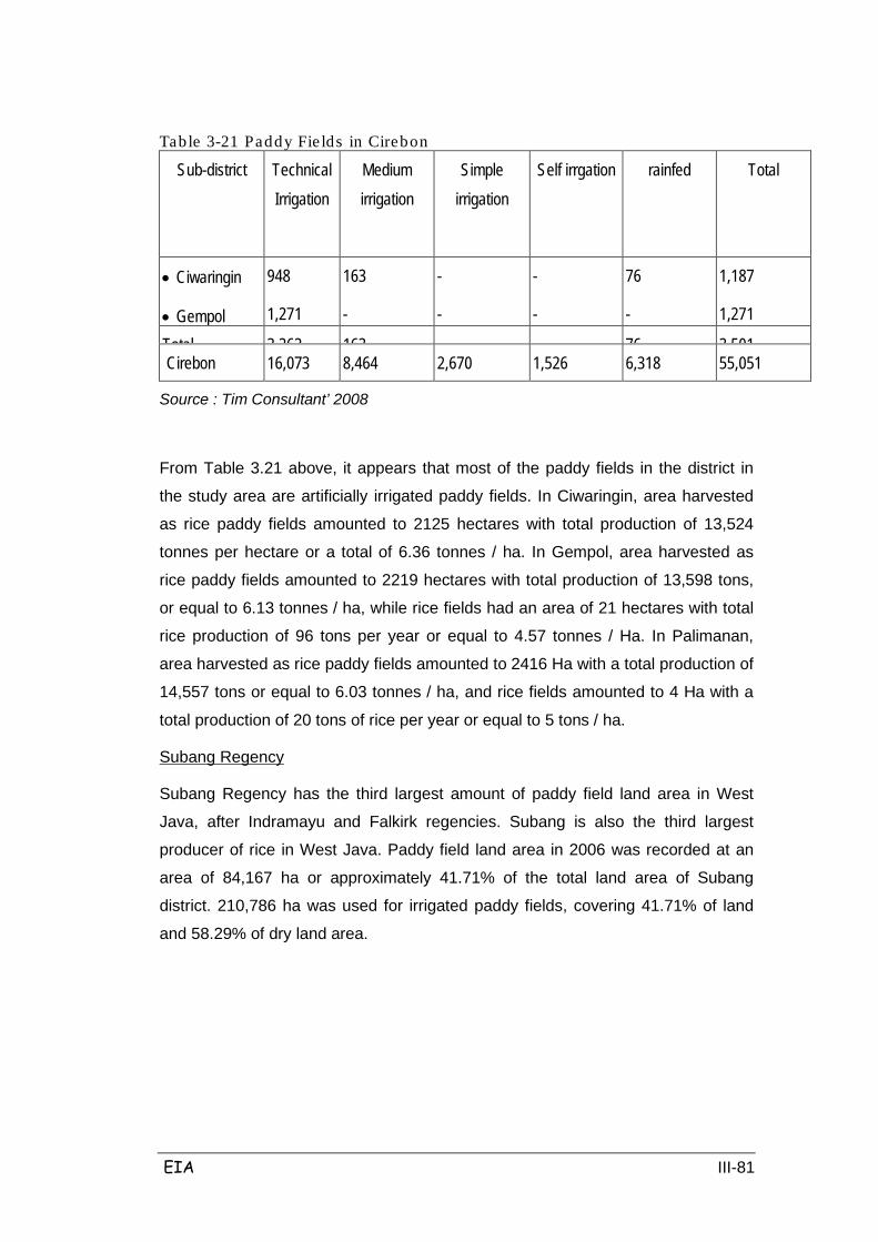
EIA III-81
Table 3-21 Paddy Fie lds in Cirebon
Sub-district Technical Irrigation
Medium irrigation
Simple irrigation
Self irrgation
rainfed
Total
• Ciwaringin
• Gempol
948
1,271
163
-
-
-
-
-
76
-
1,187
1,271
Total 3 262
163
76
3 501
Cirebon 16,073
8,464
2,670
1,526
6,318
55,051
Source : Tim Consultant’ 2008
From Table 3.21 above, it appears that most of the paddy fields in the district in
the study area are artificially irrigated paddy fields. In Ciwaringin, area harvested
as rice paddy fields amounted to 2125 hectares with total production of 13,524
tonnes per hectare or a total of 6.36 tonnes / ha. In Gempol, area harvested as
rice paddy fields amounted to 2219 hectares with total production of 13,598 tons,
or equal to 6.13 tonnes / ha, while rice fields had an area of 21 hectares with total
rice production of 96 tons per year or equal to 4.57 tonnes / Ha. In Palimanan,
area harvested as rice paddy fields amounted to 2416 Ha with a total production of
14,557 tons or equal to 6.03 tonnes / ha, and rice fields amounted to 4 Ha with a
total production of 20 tons of rice per year or equal to 5 tons / ha.
Subang Regency has the third largest amount of paddy field land area in West
Java, after Indramayu and Falkirk regencies. Subang is also the third largest
producer of rice in West Java. Paddy field land area in 2006 was recorded at an
area of 84,167 ha or approximately 41.71% of the total land area of Subang
district. 210,786 ha was used for irrigated paddy fields, covering 41.71% of land
and 58.29% of dry land area.
Subang Regency

EIA III-82
Table 3-22 Paddy Fie lds in Subang Sub-district Technical
Irrigation Medium irrigation
Simple irrigation Self irrgation
Rainfed
Total
• Subang
• Pangaden
• Cipunagara
• Cibogo
2,046 3,539
618
408
1,530 2,037
-
491
1,732
1,632
508
431
128
-
-
90
-
-
106
-
-
303
120
2,748
1,037
2,131
230
2,677
5,377
4,989
2,043
4,395
Frequency 10 178
5 342
1 131
551
6 450
23 175
Subang 57,033 9,905 4,650 8,648 3,931 84,167
Source : Tim Consultant’ 2008
Table 3.22 above describes the amount of paddy field harvested in Subang
Regency by district. In Subang District, the harvested area of rice paddy field
amounted to 5664 ha with total production of 31,227 tons equal to 5.51 tonnes /
ha. In Pangaden, area harvested as rice paddy fields amounted to 8370 ha, with
total production of 48,349 tons equal to 5.78 tonnes / ha. In Cipunagara, the area
harvested as rice paddy fields amounted to 9949 ha, with total production of
45,545 tons equal to 4.58 tonnes / ha.
In Cibogo, area harvested as rice paddy fields amounted to 3976 ha with total
production of 16,520 tons equal to 4.15 tonnes / ha. In Pabuaran, area harvested
as rice paddy fields amounted to 8713 ha, with total production of 54,718 tonnes
per annum equal to 6.28 tonnes / ha.
In Kalijati, area harvested as rice paddy fields amounted to 5895 ha with total
production of 35,146 tons equal to 5.96 tonnes / ha. In Cipandeuy, harvested area
of rice paddy fields amounted to 3533 ha, with total production of 16,750 tons
equal to 4.74 tonnes / ha.
Indramayu produces several types of cultivated crops, including paddy, maize,
cassava, peanuts and soybeans. Majority of agricultural production in Indramayu
is rice, producing as much as 1,264,685.81 tons of rice, which means an increase
of 186% from 1,240,873.41 tons in 2004. The harvested land area, which dropped
from 200,458 ha to 195,254 ha, was supported by productivity increases of 61.90
kw / ha in 2004 to 64.77 kw / ha in 2006. This situation can be understood as the
Indramayu
EIA III-83
total area for paddy rice is much larger than the amount of land planted with other
crops, as an area of 195,254 ha is used for rice, while other food crops range from
100 to 3,000 ha only. Cassava is the main commodity with the highest production,
followed by maize, peanuts, green beans, soybeans and sweet potatoes.
While rice dominates the agricultural production scene, Indramayu also produces
other crops such as mango, banana, red chilies, red onions, corn and soybeans.
Plantation crops such as palm, hybrid coconut, cotton, cloves, cashew nuts,
coffee, sugar cane and melinjo are also cultivated.
In Gantar sub district, area harvested for rice was 7821 ha with a production
amounting to 44,077.97 tons of rice. In Terisi sub district, area harvested for rice
was 4843 ha with a production of 46,018.57 tons.
Plantation in the study area are also highly developed considering there is ample
land to develop the plantation sector in the region.
In 2006, rice production reached 191 966 tons of dry milled grain. This shows that
there has been a decline in production by 6.22% when compared to 2004. In
general, the decline was due to a reduced harvested area accompanied by a
decline in productivity. Further, both paddy fields and rice paddy fields decreased
in total harvested area and productivity. In total in 2006, the rice harvested area
decreased by 5.39% compared to 2004. Meanwhile, extensive damage to paddy
field areas increased by 70.56%, mainly driven by insect and rat plagues, and
bacterial leaf blights (BLB).
Purwakarta
In the plantation sector, the acreage and yield of plantation experienced changes,
except for the rubber plant. Tea, pepper, vanilla, ginger and turmeric acreage
increased, followed by increased production of these crops; while kapolaga,
hazelnut, nutmeg and kencur increased in total area but production decreased.
Cloves, coffee, palm and melinjo in 2006 saw a decline in acreage but production
increased.
EIA III-84
Table 3-23 Paddy Fie lds in Purwakarta
Sub-district Technical Irrigation
Medium irrigation
Simple irrigation
Self irrgation
Rainfed
• Bungursari
186
60
228
89
43
136
35
85
337
500 Frequency 246
317
179
120
837
Purwakarta 1,932 2,961 3,183 1,520 5,888
Source : Tim Consultant’ 2008
In the study area, most paddy fields were rain-fed, followed by artificially irrigated
fields. In Bungursari, area harvested as rice paddy fields amounted to 1445 ha
with a production of 7916 tons. Meanwhile, in Campaka, area harvested as rice
paddy fields amounted to 1382 ha with a production of 7289 tons.
Rice production decreased by 1.89% from 2004 to 2006, whereas harvested areas
for other crops increased by 0.71%. This is caused by a decrease in productivity
as indicated by the yield per hectare which declined by 2.59% in line with that
experienced decline in rice production of 36.89%.
Majalengka
Production of other food crops has increased, including for corn, soybeans, green
beans, cassava and sweet potatoes. On the other hand, groundnut production
decreased by 31.26%.
In Kertajati, area harvested as paddy field amounted to 9441 ha with a production
of 47,428 tons. In Dawuan, area harvested as paddy field amounted to 1822 ha
with a production of 12,366 tons. In Jatiwangi, area harvested as rice paddy fields
amounted to 3520 ha with a production of 18,858 tons. In Ligung, area harvested
as rice paddy fields amounted to 4716 ha with a production of 25,478 tons. In
Palasah, area harvested as rice paddy fields amounted to 1555 ha with a
production of 10,247 tons. In Sumberjaya, area harvested as rice paddy fields
amounted to 4862 ha with a production of 25,605 tons.
Fisheries
One source of foreign exchange for Cirebon Regency is the fisheries sector,
including aquaculture (ponds and reservoirs), fishing ponds, marine fisheries and
fish processing. Fish processing is the fisheries sub-sector with the largest
Cirebon
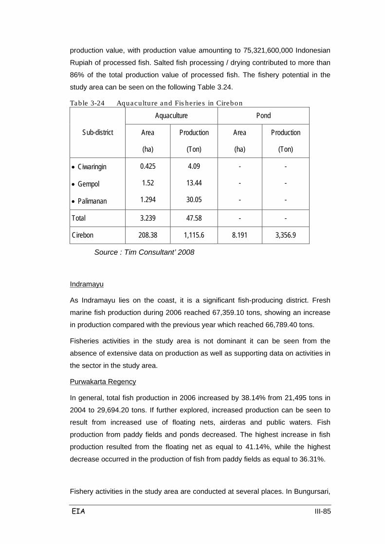
EIA III-85
production value, with production value amounting to 75,321,600,000 Indonesian
Rupiah of processed fish. Salted fish processing / drying contributed to more than
86% of the total production value of processed fish. The fishery potential in the
study area can be seen on the following Table 3.24.
Table 3-24 Aquaculture and Fis heries in Cirebon
Sub-district
Aquaculture Pond
Area
(ha)
Production
(Ton)
Area
(ha)
Production
(Ton)
• Ciwaringin
• Gempol
• Palimanan
0.425
1.52
1.294
4.09
13.44
30.05
-
-
-
-
-
-
Total 3.239 47.58 - -
Cirebon 208.38 1,115.6 8.191 3,356.9
Source : Tim Consultant’ 2008
As Indramayu lies on the coast, it is a significant fish-producing district. Fresh
marine fish production during 2006 reached 67,359.10 tons, showing an increase
in production compared with the previous year which reached 66,789.40 tons.
Indramayu
Fisheries activities in the study area is not dominant it can be seen from the
absence of extensive data on production as well as supporting data on activities in
the sector in the study area.
In general, total fish production in 2006 increased by 38.14% from 21,495 tons in
2004 to 29,694.20 tons. If further explored, increased production can be seen to
result from increased use of floating nets, airderas and public waters. Fish
production from paddy fields and ponds decreased. The highest increase in fish
production resulted from the floating net as equal to 41.14%, while the highest
decrease occurred in the production of fish from paddy fields as equal to 36.31%.
Purwakarta Regency
Fishery activities in the study area are conducted at several places. In Bungursari,

EIA III-86
fishery activities in paddy field areas amounted to 26 ha with a production of 0.70
tons; in calm water ponds an area of 3.54 ha was used with a production of 5.28
tons; and in open water area 16.50 hectares was used with a production of 3.05
tons. In Cempaka, fishery activities in paddy fields amounted to 32 ha with a
production of 0.30 tons; in calm water ponds an area of 20.5 ha was used,
producing 6.28 tonnes; and in open water 59.15 hectares was used with a
production of 4.25 tons.
The total fishery production in 2006 reached 36,000 tons. Total production
increased by 0.19% compared with production in 2004. Production from marine
fisheries is still the largest production source (48.75%) of all products. However,
when considering the value, production ponds in fact have the greatest value than
others. This is because the products from fishery ponds are largely high value fish
types.
Subang Regency
Fishery activities in the study area are not too dominant as the location of areas
are not too close to the potential for fisheries.
Judging from the topography, Majalengka does not have a strong marine fisheries
industry. Aquaculture production in 2006 was dominated by fish ponds with a
production of 3,327.09 tons. Commodity types were dominated by carp (ikan mas),
tilapia (nila) and nilem; production amounted to 1,167.88 tons, 2,311.05 tons and
307.24 tons, respectively.
Majalengka
Table 3-25 Fis hery Production in Majalengka (Ton)
Sub-district Pond Water
Paddy field Flowing Water
River
• Kertajati
• Dawuan
• Jatiwangi
• Ligung
108.77
112.37
20.90
29.42
75.27
16.30
1.98
-
8.06
20.93
-
-
-
-
-
3.19
89.41
15.41
39.74
15.41
Total 351.71 47.27 164.88
Majalengka
351.71
47.27
164.88
Source: Tim Consultant, 2008
EIA III-87
Industry and Trade
Cirebon Regency has an excellent industrial sector, namely in non-metal mineral
goods and rattan products, as the export of non-oil products is dominated by
Cirebon Regency such as batik, embroidery and fisheries (frozen shrimp). Of the
total 251 large industrial companies, they are mostly engaged in the furniture and
other manufacturing industries. Workers amounted to as many as 53,536 people,
with 14,515 of them working in fields with a value-added of 408 388 521 000
rupiah.
Cirebon
The industrial sector is one sector that is now in great demand as a means of
achieving regional autonomy. This situation can be seen from the increasing
number of large industrial companies, which was recorded at 35 from around 330
companies founded by Department of Labor.
Indramayu
In 2006, the manufacturing industry included large and medium companies,
amounting to about 161 companies with a total workforce of 38,764. The
population and number of workers have decreased when compared to 2004,
where the number of companies decreased by 1.23% coupled with a decrease in
the number of workers amounting to 2.92%. Decrease in the number of large and
medium enterprises was due to closures.
Purwakarta Regency
Large and medium establishments in the Purwakarta are scattered around the 9
sub-districts, but concentrated in industrial centers such as Tegalwaru, Plered and
Bukit Indah town in Bungursari sub-district. Plered and Tegalwaru are industrial
centres where most of the industry falls in the medium industry category with the
number of workers between 20 to 99 people. Meanwhile, in Jatiluhur and
Bungursari there are mostly large industries with a workforce of 100 people more.
Data showed an increase in small industries in both the formal sector business
unit and its production rate, whereas the informal sector declined.
In 2006, there were a number of large and medium industrial enterprises operating
commercially in the district. Subang recorded as many as 27 units with a total
workforce of 79,227 people. Compared with 2004 this number decreased. The
Subang Regency
EIA III-88
condition is Subang can be viewed as relatively unchanged since 2004, but
employment numbers have decreased. Judging from the composition of business
units, based on the status of foreign investment, there are 7 domestic (PMA), 12
small industries (PMDN), 16 non-facility companies, 1462 small formal industries,
and 8994 small informal industries.
In 2006, the number of large industries in Majalengka was as many as 10
industries, with as as many as 344 companies. Total workers were as much as
15,267 people; in addition 89.93% of the companies were large and medium tile
industries.
Majalengka
3.3.4 Problems in the Area around the planned Toll Road
Section I (STA 1991 +500 - STA 118 +550)
Section I Cikampek - Kalijati (27.05 km) includes the districts Bungursari,
Campaka, Cibatu (Purwakarta Regency), and Pabuaran, Cipeundeuy and Kalijati
(Purwakarta Regency).
Most of the areas affected by the project are the plantation and agriculture areas.
Most people are farmers. There are fears amongst the public about the problem of
land acquisition and the loss of agricultural land and the related loss of income.
In the villages of Kertamukti and Ciparungsari where land acquisition will occur,
approximately 2 ha of land will be cut off by the road. This situation is feared to
disrupt the mobility of people around and in the two villages.
Section II (STA 129+ 750)
Section II includes the districts Pangaden, Subang (Subang Regency). In Subang
Area, there are 8 (eight) districts that are in the location of the planned highway
construction such as Pabuaran District and the village Karangmukti, Cipenduy
District and the villages Wantilan and Sawangan; Kalijati District and the villages
Marengmang, Kaliangsana, Batusari; Purwadadi District and the village
Wanakerta; Pagaden District and the villages Balingbing, Sumurgintung, Gembor;
Subang District and the villages Jabong, Sukamelang and Cisaga; Cipunagara
District and the village Wanasari; Cibogo District and the villagse Ciboqo, Pada
Asih, and Sumur Barang. The Subang areas included in Section II Kalijati -
Subang (± 11.2 km) start from STA 118 +400 in Kalijati District, Subang regency,
and go until STA 129 +600 in the Subang District, Subang Regency. The
EIA III-89
characteristics of the region in this section are:
• Irrigated paddy rice fields covering an area of 396,000 m2
• Lake area of 3300 m2
• Settlement area of 33,000 m2
• Plantation area of 283,800 m2
• Rainfed rice field area of 36,300 m2
Given the vast amount of paddy fields affected by the land acquisition, many
farmers will be affected by losing their livelihoods. In addition, the acquisition of
agricultural land can also reduce the productivity of agriculture in this region.
Construction of roads and culverts to be done does not interfere with farming
activities. Flooding problems should be anticipated in the artificially-irrigated paddy
fields considering this problem occurs frequently (almost every year).
In this region there is a path that many people use to get around which needs
attention paid to so that people do not lose road access.
In Puwodadi District there are areas of PTPN VIII where the community is also
involved by working on these plantations.
Section III (STA 158 +450)
Section III includes districts Cibogo, Gantar and Trisi in Indramayu Regency. The
characteristics of the region in this section are:
• Irrigated paddy rice fields covering an area of 148,500 m2
• Shrubs area of 31,350 m2
• Field covering an area of 59,400 m2
• Settlement area of 52,800 m2
• Plantation area of 1,196,550 m2
• Rainfed rice field area of 191,700 m2
The impact of the toll road is related to economic growth where income may be
decreased, land prices may decline, etc. The economic activities that exist in the
area include stalls, shops, restaurants and others. In addition, it was found that the
general route was utilized both within communities and between regions.
EIA III-90
Gantar district has a lack of water sources and is the least developed region. Road
access infrastructure is still lacking, making it hard for community mobility.
In Bantarwaru village there is a strong bird's nest economic activity. It is expected
that construction of the toll road will not disturb the activities of the community
given the amount of the economic potential for local communities.
Section IV (STA 177 +350)
Section IV includes the district Kertajati in Majalengka Regency. Majalengka is
included in Section IV Cikedung - Kertajati (+ 18.9 km) from STA 158 +300 in Trisi
District of Indramayu Regency, until STA 177 +200 in Kertajati District,
Majalengka Regency.
Section V (STA 193 +450)
Section V includes the Districts Dawuan, Jatiwangi, Ligung, Palasah and
Sumberjaya in Majalengka Regency. The characteristics of the region in section IV
are:
• Irrigated paddy rice fields covering an area of 498,300 m2
• Shrubs area of 89,100 m2
• Field covering an area of 26,400 m2
• Plantation area of 792,000 m2
While the characteristics of the region in section V are;
• Irrigated paddy rice fields covering an area of 561,000 m2
• Field covering an area of 247,500 m2
• Settlement area of 115,500 m2
• Plantation area of 62,700 m2
In this region the village access roads are still limited by poor road infrastructure in
the region. Therefore, managers need to consider the possibility that the toll road
may cut off village roads.
Given the vast amount of paddy fields affected by the land acquisition, many
farmers will be affected by losing their livelihoods. In addition, the acquisition of
agricultural land can also reduce the productivity of agriculture in this region. For
that, irrigated paddy fields should be considered in order not to cause detrimental
socio-economic impacts on local communities.
EIA III-91
Flooding problems often occur almost every year. It is expected that floods in
Cikeruh can be overcome.
Section VI (STA 207 +900)
Section VI includes the Districts Palimanan, Ciwaringin and Gempol in Cirebon
Regency. In Cirebon Regency, there are 3 (three) Districts that are in the highway
development plan, such as Ciwaringin District and the villages Budursora,
Babakan, Ciwaringin and Galagamba; Gempol District and the rural villages
Kempek and Kedung Bunder; Palimanan District and the village Pegagan. The
Cirebon region included in the section VI Sumberjaya - Palimanan (+ 14.45 km)
starts from STA 193 +300 in Sumberjaya District, Majalengka Regency, and ends
at STA 207 +750 in Palimanan District, Cirebon regency. The characteristics of the
region in this section are:
• Irrigated paddy rice fields covering an area of 577,500 m2
• Field covering an area of 99,000 m2
• Settlement area of 112,200 m2
• Plantation area of 108,900 m2
Currently in the village of Babakan Ciwaringin there is community unrest over the
land acquisition plan for the development of the community-owned toll road.
The problem is that the land acquisition plan has been rejected, particularly in the
case of the Islamic boarding school (pesantren) area in Babakan Ciwaringin in
Cirebon. The issue raised is not about the aspects of the highway construction
plan, but the land acquisition plan which passes near the pesantren. For people in
the area, the existence of the pesantren is considered a symbol of pride for the
local community who is known for community students. As is known, some
complaints or protests of refusal have been made by the students and scholars in
Babakan Village, District Ciwaringin, Cirebon regency. Rejection happened
because according to the plan, the toll road would acquire about three acres of
land that pass around the boarding area.
1). Social Culture
The populations (community) around the planned project are mostly people in the
agricultural sector. The daily livelihood-earning habits of the population will be
affected. Since most of the population earns a meager living as a farmer, their
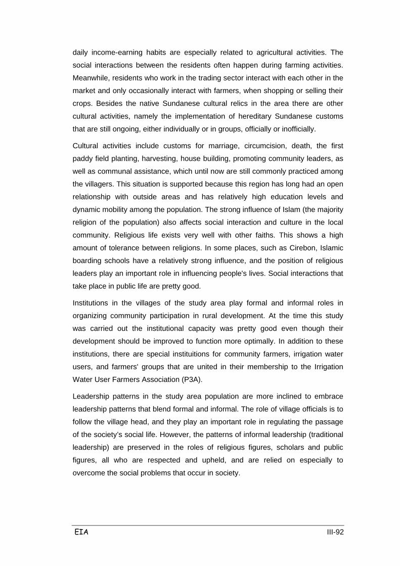
EIA III-92
daily income-earning habits are especially related to agricultural activities. The
social interactions between the residents often happen during farming activities.
Meanwhile, residents who work in the trading sector interact with each other in the
market and only occasionally interact with farmers, when shopping or selling their
crops. Besides the native Sundanese cultural relics in the area there are other
cultural activities, namely the implementation of hereditary Sundanese customs
that are still ongoing, either individually or in groups, officially or inofficially.
Cultural activities include customs for marriage, circumcision, death, the first
paddy field planting, harvesting, house building, promoting community leaders, as
well as communal assistance, which until now are still commonly practiced among
the villagers. This situation is supported because this region has long had an open
relationship with outside areas and has relatively high education levels and
dynamic mobility among the population. The strong influence of Islam (the majority
religion of the population) also affects social interaction and culture in the local
community. Religious life exists very well with other faiths. This shows a high
amount of tolerance between religions. In some places, such as Cirebon, Islamic
boarding schools have a relatively strong influence, and the position of religious
leaders play an important role in influencing people's lives. Social interactions that
take place in public life are pretty good.
Institutions in the villages of the study area play formal and informal roles in
organizing community participation in rural development. At the time this study
was carried out the institutional capacity was pretty good even though their
development should be improved to function more optimally. In addition to these
institutions, there are special instituitions for community farmers, irrigation water
users, and farmers' groups that are united in their membership to the Irrigation
Water User Farmers Association (P3A).
Leadership patterns in the study area population are more inclined to embrace
leadership patterns that blend formal and informal. The role of village officials is to
follow the village head, and they play an important role in regulating the passage
of the society’s social life. However, the patterns of informal leadership (traditional
leadership) are preserved in the roles of religious figures, scholars and public
figures, all who are respected and upheld, and are relied on especially to
overcome the social problems that occur in society.
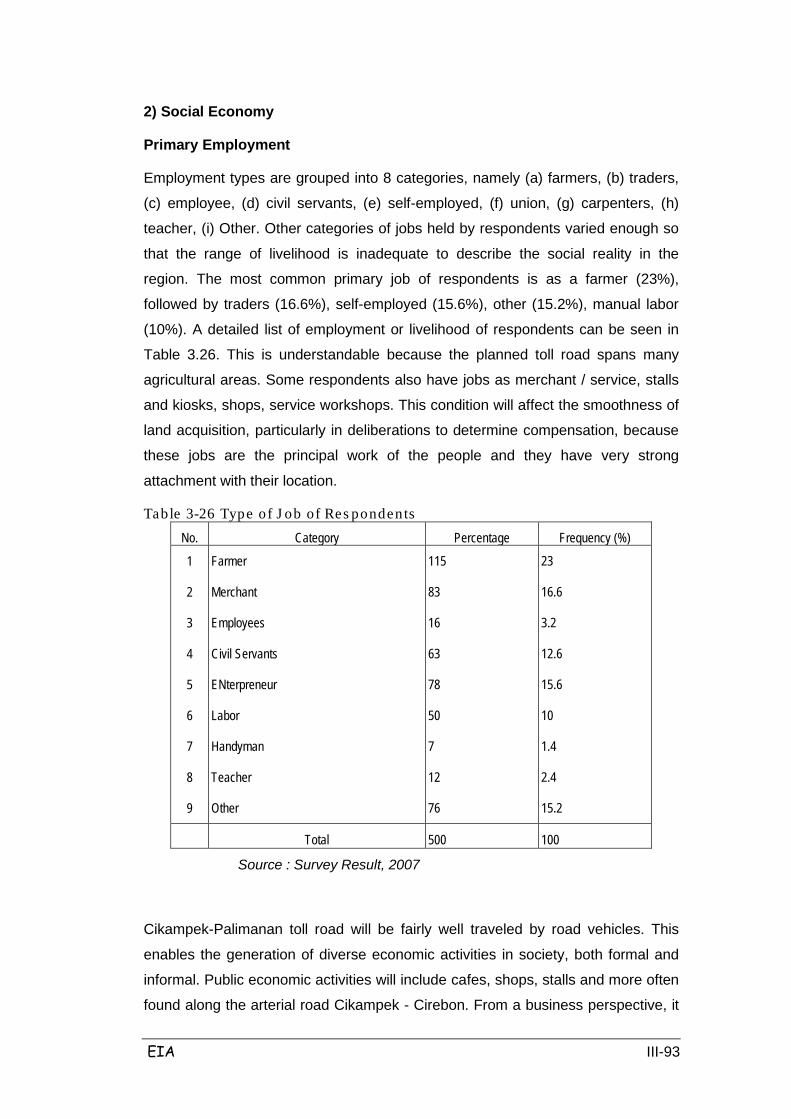
EIA III-93
2) Social Economy
Primary Employment
Employment types are grouped into 8 categories, namely (a) farmers, (b) traders,
(c) employee, (d) civil servants, (e) self-employed, (f) union, (g) carpenters, (h)
teacher, (i) Other. Other categories of jobs held by respondents varied enough so
that the range of livelihood is inadequate to describe the social reality in the
region. The most common primary job of respondents is as a farmer (23%),
followed by traders (16.6%), self-employed (15.6%), other (15.2%), manual labor
(10%). A detailed list of employment or livelihood of respondents can be seen in
Table 3.26. This is understandable because the planned toll road spans many
agricultural areas. Some respondents also have jobs as merchant / service, stalls
and kiosks, shops, service workshops. This condition will affect the smoothness of
land acquisition, particularly in deliberations to determine compensation, because
these jobs are the principal work of the people and they have very strong
attachment with their location.
Table 3-26 Type of J ob of Res pondents No. Category Percentage Frequency (%)
1
2
3
4
5
6
7
8
9
Farmer
Merchant
Employees
Civil Servants
ENterpreneur
Labor
Handyman
Teacher
Other
115
83
16
63
78
50
7
12
76
23
16.6
3.2
12.6
15.6
10
1.4
2.4
15.2
Total
500
100
Source : Survey Result, 2007
Cikampek-Palimanan toll road will be fairly well traveled by road vehicles. This
enables the generation of diverse economic activities in society, both formal and
informal. Public economic activities will include cafes, shops, stalls and more often
found along the arterial road Cikampek - Cirebon. From a business perspective, it
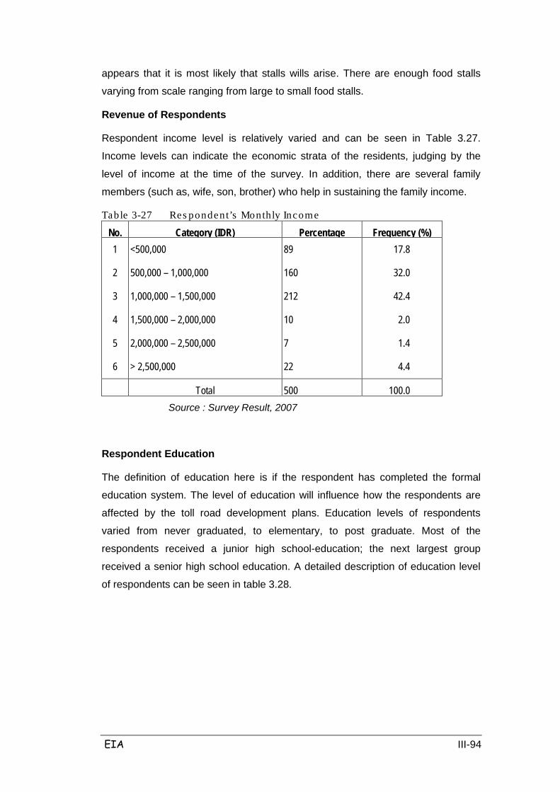
EIA III-94
appears that it is most likely that stalls wills arise. There are enough food stalls
varying from scale ranging from large to small food stalls.
Revenue of Respondents
Respondent income level is relatively varied and can be seen in Table 3.27.
Income levels can indicate the economic strata of the residents, judging by the
level of income at the time of the survey. In addition, there are several family
members (such as, wife, son, brother) who help in sustaining the family income.
Table 3-27 Res pondent’s Monthly Income
No. Category (IDR) Percentage Frequency (%) 1
2
3
4
5
6
<500,000
500,000 – 1,000,000
1,000,000 – 1,500,000
1,500,000 – 2,000,000
2,000,000 – 2,500,000
> 2,500,000
89
160
212
10
7
22
17.8
32.0
42.4
2.0
1.4
4.4
Total
500
100.0
Source : Survey Result, 2007
Respondent Education
The definition of education here is if the respondent has completed the formal
education system. The level of education will influence how the respondents are
affected by the toll road development plans. Education levels of respondents
varied from never graduated, to elementary, to post graduate. Most of the
respondents received a junior high school-education; the next largest group
received a senior high school education. A detailed description of education level
of respondents can be seen in table 3.28.
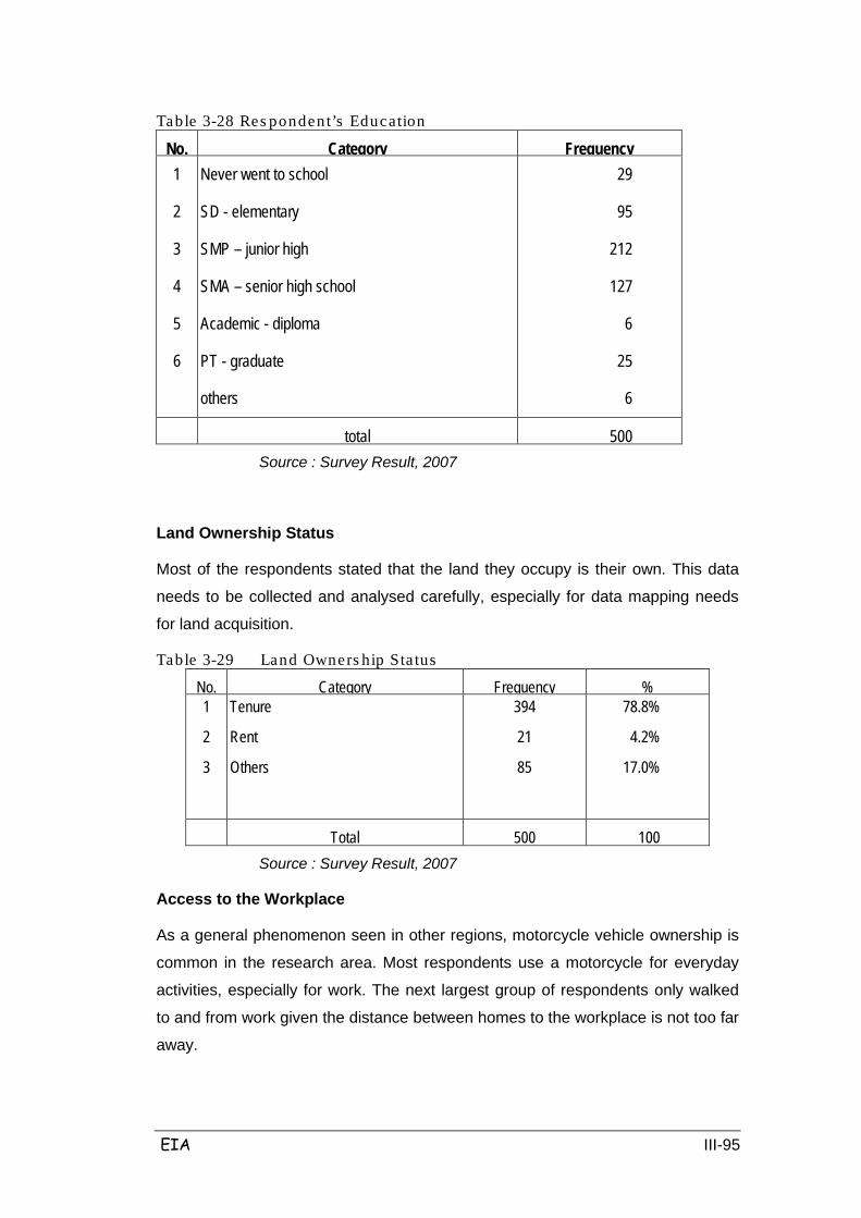
EIA III-95
Table 3-28 Res pondent’s Education
No. Category Frequency 1
2
3
4
5
6
Never went to school
SD - elementary
SMP – junior high
SMA – senior high school
Academic - diploma
PT - graduate
others
29
95
212
127
6
25
6
total
500
Source : Survey Result, 2007
Land Ownership Status
Most of the respondents stated that the land they occupy is their own. This data
needs to be collected and analysed carefully, especially for data mapping needs
for land acquisition.
Table 3-29 Land Owners hip Sta tus
No. Category Frequency % 1
2
3
Tenure
Rent
Others
394
21
85
78.8%
4.2%
17.0%
Total
500
100
Source : Survey Result, 2007
Access to the Workplace
As a general phenomenon seen in other regions, motorcycle vehicle ownership is
common in the research area. Most respondents use a motorcycle for everyday
activities, especially for work. The next largest group of respondents only walked
to and from work given the distance between homes to the workplace is not too far
away.
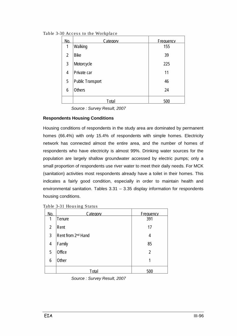
EIA III-96
Table 3-30 Acces s to the Workplace
No. Category Frequency 1
2
3
4
5
6
Walking
Bike
Motorcycle
Private car
Public Transport
Others
155
39
225
11
46
24
Total
500
Source : Survey Result, 2007
Respondents Housing Conditions
Housing conditions of respondents in the study area are dominated by permanent
homes (66.4%) with only 15.4% of respondents with simple homes. Electricity
network has connected almost the entire area, and the number of homes of
respondents who have electricity is almost 99%. Drinking water sources for the
population are largely shallow groundwater accessed by electric pumps; only a
small proportion of respondents use river water to meet their daily needs. For MCK
(sanitation) activities most respondents already have a toilet in their homes. This
indicates a fairly good condition, especially in order to maintain health and
environmental sanitation. Tables 3.31 – 3.35 display information for respondents
housing conditions.
Table 3-31 Hous ing Status
No. Category Frequency 1
2
3
4
5
6
Tenure
Rent
Rent from 2nd Hand
Family
Office
Other
391
17
4
85
2
1
Total
500
Source : Survey Result, 2007
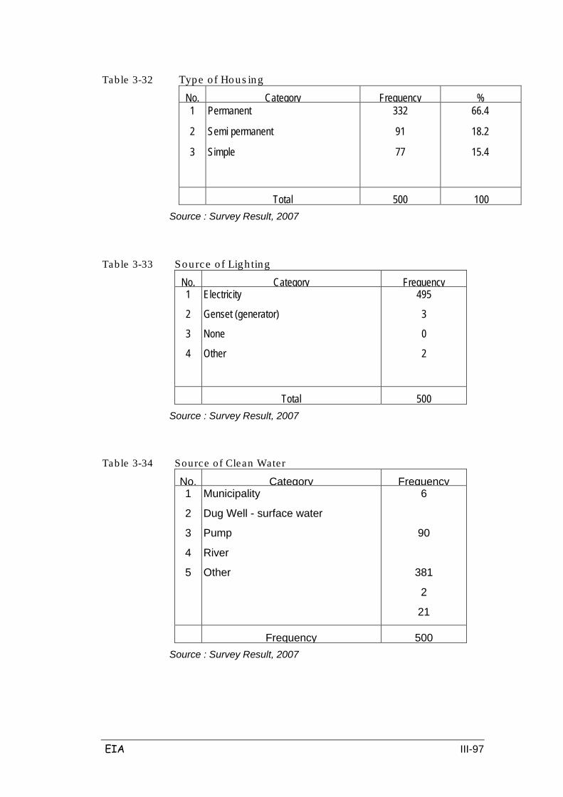
EIA III-97
Table 3-32 Type of Hous ing
No. Category Frequency % 1
2
3
Permanent
Semi permanent
Simple
332
91
77
66.4
18.2
15.4
Total
500
100 Source : Survey Result, 2007
Table 3-33 Source o f Ligh ting
No. Category Frequency 1
2
3
4
Electricity
Genset (generator)
None
Other
495
3
0
2
Total
500
Source : Survey Result, 2007
Table 3-34 Source of Clean Water
No. Category Frequency 1
2
3
4
5
Municipality
Dug Well - surface water
Pump
River
Other
6
90
381
2
21
Frequency
500
Source : Survey Result, 2007
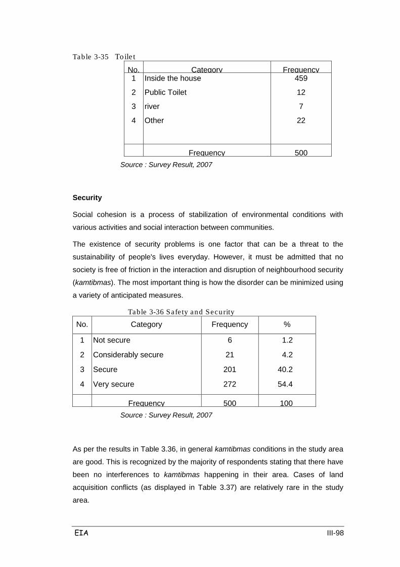
EIA III-98
Table 3-35 To ile t
No. Category Frequency 1
2
3
4
Inside the house
Public Toilet
river
Other
459
12
7
22
Frequency
500
Source : Survey Result, 2007
Security
Social cohesion is a process of stabilization of environmental conditions with
various activities and social interaction between communities.
The existence of security problems is one factor that can be a threat to the
sustainability of people's lives everyday. However, it must be admitted that no
society is free of friction in the interaction and disruption of neighbourhood security
(kamtibmas). The most important thing is how the disorder can be minimized using
a variety of anticipated measures.
Table 3-36 Safe ty and Security
No. Category Frequency %
1
2
3
4
Not secure
Considerably secure
Secure
Very secure
6
21
201
272
1.2
4.2
40.2
54.4
Frequency
500
100 Source : Survey Result, 2007
As per the results in Table 3.36, in general kamtibmas conditions in the study area
are good. This is recognized by the majority of respondents stating that there have
been no interferences to kamtibmas happening in their area. Cases of land
acquisition conflicts (as displayed in Table 3.37) are relatively rare in the study
area.

EIA III-99
Table 3-37 Land Conflic ts No. Category Frequency %
1
2
3
Yes
No
Do not Know
35
464
1
7
92.8
0.2
Frequency
500
100
Source : Survey Result, 2007
Public Perceptions of Toll Road Construction and Respondent Knowledge of Toll Road Development Plan
The most important aspect for the success of the planned Toll Road Development
is the optimal support of all residents living in the planned development area. This
is especially true for all citizens that may benefit from these development plans. It
is necessary to disseminate information on the Development Plan for the toll road.
From the study results, it is known that most respondents were aware of the toll
road construction plan in their region (88%). This can be used as a basis for
optimizing capital dissemination activities towards the development plans. The
respondents who were directly affected by land acquisition, among others, have
also been informed about the plans for the Toll Road Development. table 3.38
presents these results.
Table 3-38 Knowledge of Toll Road Development
No. Category Frequency 1
2
Yes, I Know
No, I don’t Know
440
60
Frequency
500
Source : Survey Result, 2007
Based on respondents who know about the toll road development plan, it is known
that their information is obtained from the District / local village authorities and
mass media. However, there is a perceived lack of socialization of the project
particularly amongst the poor who have not received full information and details. It
is therefore deemed appropriate that the respondents receive project socialization
through face to face meetings and from the village officials. This relates to the

EIA III-100
proximity of the delivery of information which is relatively easily understood by the
community. Table 3.39 presents the basis for these conclusions.
Table 3-39 Suitab le Media for Socia lization of the Pro ject
No. Category Frequency % 1
2
3
4
Mass media
Public Meeting
Via Local Government
Others
7
256
230
7
1.4
51.2
46
1.4
Frequency
500
100
Source : Survey Result, 2007
Most respondents (92%) expressed agreement with the existence of the planned
Toll Road development. Only a small proportion (8%) stated they do not agree
with the plans. Details of the opinions of respondents can be seen in Table 3.40.
Table 3-40 Perception towards Toll Road Development Plan
No. Category Frequency % 1
2
Not agree
Agree
40
460
8.0
90
Frequency
500
100
Source : Survey Result, 2007
For those respondents that stated they agree with the Project, several reasons
were stated, including, among others, improved regional economy. Meanwhile,
those that stated they disagree with the Project suggested reasons such as the
discrepancy between indemnities; disruption to security, loss of revenue (mainly
from stalls around the old road which are threatened of losing customers because
of the toll road).
1. Affected Project Population
Residents directly affected by the project are as follows: In Section I there are as
many as 230 households. In Section II, there are164 households; 216 households
in Section III; in Section IV which consists mostly of forest and paddy fields, there
are no settled residents that will be affected by the project; 450 households in
Section V; and in Section VI there will be as much as 458 households.
From interviews with residents in the study area with a response rate of 500
people, they raised concerns/problems over land acquisition activities (as

EIA III-101
displayed in Table 3.41), including:
- Suitability of land prices between the bid price of the project whose value is
based on the Tax Object Sale Value (NJOP) with the price of
compensation requested by the land owner (community). NJOP Prices are
usually lower than the asking price of land owners or land prices in the
market.
- The cutting of lands of farmers / community. Where farmers have extensive
lands, the cuts do not cause problems, but in this region the farmers are
not relatively large land owners and this is a problem especially for small
land that will be cut off.
Most respondents do not mind if their land is used for the toll road purposes
provided that the project is in accordance with their aspirations. As many as 89.2%
of respondents agreed on the condition, while 10.2% rejected (disagree) and the
remaining 0.6% stated not known. In general, the concerns of the respondents,
among others, include:
- Compensation should be in accordance with their agreements, and
indemnity coverage should extend among others to land, buildings, plants
and other assets.
- Payment of compensation shall be undertaken after agreement is reached.
Based on the results of interviews with local officials it was noted that there is a
diversity of areas affected by the land acquisition and land prices, both based on
NJOP and market prices.
Table 3-41 Perception towards Land Acquis ition for Toll Road Development
No. Category Frequency % 1
2
3
Not agree
agree
do not know
51
446
3
10.2
89.2
0.6
Frequency
500
100
Source : Survey Result, 2007
There were several opinions expressed by various communities concerning
acquisition for the highway. The following is a summary of public opinions in the
area:
Subang
In general, residents approve of the plan to build the toll road. Socialization of
EIA III-102
perceptions needs to be done, particularly on aspects with regards to land
acquisition procedures, land prices and timing of acquisition. This is to prevent
public unrest and to avoid brokering or land speculators. To that end, it is
suggested that there is a need for the land assessment team to involve village
officials and community representatives in the consultations.
In addition, more details need to be clarified regarding the cross border that
became a benchmark of where the subject is sited, the facilities that are taxable
because there is no cross / official peg. With regards to the number of trees
affected by the project it is expected that compensation will include replanting.
Cirebon
The main land acquisition problem in this region is an objection by residents of the
Babakan Ciwaringin boarding school (pesantren) against land acquisition. Various
protests have been filed by the pesantren and community leaders and citizens. It
will require wisdom, socialization and intensive meetings between the manager of
the boarding school residents to find a good solution.
The problem of planned activities (including land acquisition) was addressed in
meetings conducted in Purwakarta, 2006, at which a comparison found a different
picture of the affected villages with villages that had already been socialized. It is
planned to continue to identify and disseminate information in order to obtain
accurate data about the villages affected by land acquisition. Another thing that
was questioned by citizens affected by land acquisition is the problem of land
acquisition.
Indramayu
With regards to the issue of land acquisition, the concerns posed by citizens are
similar to those in other areas; such as procedural aspects, compensation costs
and timing of execution. In this region, residents expressed the hope that the
agricultural land affected by construction of the toll road will be replaced in other
locations in the surrounding area.
Related to the forestry sector, there needs to be clarity of detail on how the
planned routh will affect forestry, particularly given the amount of community forest
activities in the region.
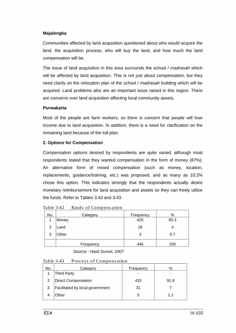
EIA III-103
Majalengka
Communities affected by land acquisition questioned about who would acquire the
land, the acquisition process, who will buy the land, and how much the land
compensation will be.
The issue of land acquisition in this area surrounds the school / madrasah which
will be affected by land acquisition. This is not just about compensation, but they
need clarity on the relocation plan of the school / madrasah building which will be
acquired. Land problems also are an important issue raised in this region. There
are concerns over land acquisition affecting local community assets.
Purwakarta
Most of the people are farm workers, so there is concern that people will lose
income due to land acquisition. In addition, there is a need for clarification on the
remaining land because of the toll plan.
2. Options for Compensation
Compensation options desired by respondents are quite varied, although most
respondents stated that they wanted compensation in the form of money (87%).
An alternative form of mixed compensation (such as money, location,
replacements, guidance/training, etc.) was proposed, and as many as 10.2%
chose this option. This indicates strongly that the respondents actually desire
monetary reimbursement for land acquisition and assets so they can freely utilize
the funds. Refer to Tables 3.42 and 3.43.
Table 3-42 Kinds o f Compens ation No. Category Frequency % 1
2
3
Money
Land
Other
425
18
3
95.3
4
0.7
Frequency
446
100
Source : Hasil Survei, 2007
Table 3-43 Proces s o f Compens ation No. Category Frequency % 1
2
3
4
Third Party
Direct Compensation
Facilitated by local government
Other
-
410
31
5
-
91.9
7
1.1
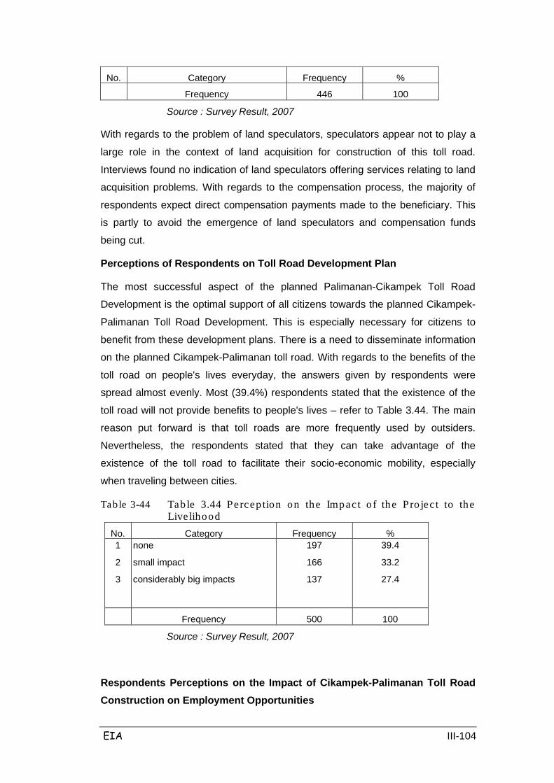
EIA III-104
No. Category Frequency %
Frequency
446
100
Source : Survey Result, 2007
With regards to the problem of land speculators, speculators appear not to play a
large role in the context of land acquisition for construction of this toll road.
Interviews found no indication of land speculators offering services relating to land
acquisition problems. With regards to the compensation process, the majority of
respondents expect direct compensation payments made to the beneficiary. This
is partly to avoid the emergence of land speculators and compensation funds
being cut.
Perceptions of Respondents on Toll Road Development Plan
The most successful aspect of the planned Palimanan-Cikampek Toll Road
Development is the optimal support of all citizens towards the planned Cikampek-
Palimanan Toll Road Development. This is especially necessary for citizens to
benefit from these development plans. There is a need to disseminate information
on the planned Cikampek-Palimanan toll road. With regards to the benefits of the
toll road on people's lives everyday, the answers given by respondents were
spread almost evenly. Most (39.4%) respondents stated that the existence of the
toll road will not provide benefits to people's lives – refer to Table 3.44. The main
reason put forward is that toll roads are more frequently used by outsiders.
Nevertheless, the respondents stated that they can take advantage of the
existence of the toll road to facilitate their socio-economic mobility, especially
when traveling between cities.
Table 3-44 Tab le 3.44 Percep tion on the Impact o f the Pro jec t to the Live lihood
No. Category Frequency % 1
2
3
none
small impact
considerably big impacts
197
166
137
39.4
33.2
27.4
Frequency
500
100
Source : Survey Result, 2007
Respondents Perceptions on the Impact of Cikampek-Palimanan Toll Road Construction on Employment Opportunities

EIA III-105
Labor issues are still a major problem in the study area. From interviews, it was
found that the respondents stated that unemployment is a major problem in the
study area given the lack of employment opportunities in the region. The presence
of the Cikampek - Palimanan Toll Road Development is expected to help the
unemployment problem in the region by opening employment opportunities for
local workers. Therefore, according to respondents, the impacts of Cikampek-
Palimanan Toll Road Development on opportunities are considered important and
very important (78.6%) – refer to Table 3.45.
Table 3-45 Percep tion on the Impact o f the Projec t to the Employment Opportunities
No. Category Frequency % 1
2
3
Yes
No
Do not know
254
242
4
50.8
48.4
0.8
Frequency
500
100
Source : Survey Result, 2007
Respondents Perceptions on the Impact of Cikampek-Palimanan Toll Road Construction on Environment
In general, respondents said that the Cikampek-Palimanan Toll Road
Development will have an impact on the environment. The result of interviews with
some 500 respondents showed that 50.8% claimed to know the impact of
Cikampek-Palimanan Toll Road Development on the environment, while as much
as 48.4% stating there is no impact and the remaining stating they do not know
(0.8%). From interviews of respondents it was found that environmental problems
are less a concern in comparison to development in the region and lack of
socialization of these. In general, respondents said that the impacts of Cikampek-
Palimanan Toll Road Development on environmental aspects are important. Refer
to Table 3.46.
Table 3-46 Perception on the Impact of the Projec t to the Environment No. Category Frequency % 1
2
Yes
No
254
242
50.8
48.4
EIA III-106
3 Do not know 4 0.8
Frequency
500
100
Source : Hasil Survei, 2007
On Cikampek-Palimanan Toll Road Development impacts on the air component,
53.6% stated the impact is categorized as important and 45.8% stated the impact
is very important. From the results of interviews, the types of air pollution of
concern amongst the respondents are the emergence of dust due to the mobility of
the trucks and excavation of land.
On the Cikampek-Palimanan Toll Road Development impact on Noise, 58.6% of
respondents said that its impact is important. This needs to be considered,
especially at the time of execution of construction work such as fixing the poles,
where they will need to pay attention to local conditions given that some of the
project activities are quite close to settlement areas.
Community Economic Activities around the planned Toll Road
Cikampek-Palimanan toll road Corridor is fairly well-traveled by road vehicles. This
raises the generation of diverse economic activities in society, both formal and
informal. Public economic activities such as cafes, shops, stalls etc are often found
along the road. The toll road development plan is expected to result in reduced
public economic activities, especially along arterial roads in Cikampek-Cirebon.
Usually, road users often use the services of public economic activities, for
example stopping for a meal break or other activities.
3.4 CONDITION OF FACILITIES AND INFRASTRUCTURE
A. Road Infrastructure
To support development strategies and development of traffic infrastructure and
the economy, local access roads are important. Therefore, development of
infrastructure facilities and the special road which connects Cikampek –
Palimanan, needs to be a continued effort to ensure the smooth movement of
goods and services as well as humans from Cikampek-Palimanan. The planned
toll road location is all situated in the province of West Java and the end of the toll
in the east is in Palimanan, approximately a 50 km border with Central Java
Province.
The beginning of the planned Cikampek-Palimanan toll road is in Sta 91+350 at
EIA III-107
the Jakarta-Cikampek toll road, and the starting point is an interchange with a half
horn.
The existing conditions of village and district roads that will intersect with the
planned toll roads in each district are as follows:
- Purwakarta Regency, from STA 92 +920 in Cikopo Village, Bungursari
District, up to STA 101 +100 in Karyamekar Village, District Campaka.
Status of road consists of national roads, village roads and district roads
with a width of 3 m to 12 m, and the type of pavement of the national road
is asphalt, and the regional roads are asphalt, while village roads are still
dirt roads. Width of national and regional roads and lanes are 2x2 lanes,
while for rural roads are 2x1 lane.
- Subang Regency, starting from STA 103 +418 in Karangmukti Village,
District Pabuaran, until Kaliangsana Village, District Kalijati. Status of road
that cuts the highway are primarily district roads and village roads. Type of
district roads are asphalt pavement, while village roads are still dirt roads.
The width of the regional roads ranges from 7 to 13 meters with the details
(3 m + 7 m left shoulder and 3 m-street right shoulder). Rural roads have a
width of 2.5 meters to 7 meters (1.0 m left shoulder + 5 m and 1.0 m-street
right shoulder).
- Majalengka Regency, starting from STA 169 +600 in Mekarjana Village,
District Kertajati, up to STA 196 +390 in Panjalin Lor Village, District
Sumberjaya. Status of the roads that cross the toll road consist of regional
roads and rural roads and national roads in the villages Sukawana and
Jatisura. The type of national and regional road pavement is asphalt, while
most types of the rural road pavement is dirt, and a small village road is
made of sand in Palasah, District Kertajati. Village road width ranges from
4 m to 5 meters, the regional road has a width of 7 meters, while the
national roads have an average width of 12m.
- Indramayu Regency, starting from STA 142 +736 in the village of Bantar
Waru, Gantar District, up until Cikawung Village, District Trisi at STA 160
+845. Status of road that cross the toll road consists of National roads and
village roads, and regional roads which cross at STA 155 +480 in
Cikawung Village, District Trisi. National road width is 5 m to 9 m plus the
shoulder of the road an average of 2 m on each side of the street. The
width of village roads are on average 4 m, while the condition of regional
roads have a width of 6 m by 1m shoulder of the road on the left and right.
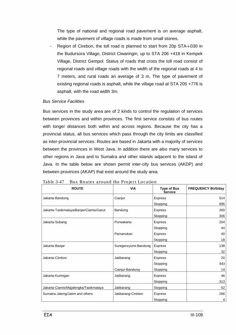
EIA III-108
The type of national and regional road pavement is on average asphalt,
while the pavement of village roads is made from small stones.
- Region of Cirebon, the toll road is planned to start from 20p STA-i-030 in
the Budursora Village, District Ciwaringin, up to STA 206 +418 in Kempek
Village, District Gempol. Status of roads that cross the toll road consist of
regional roads and village roads with the width of the regional roads at 4 to
7 meters, and rural roads an average of 3 m. The type of pavement of
existing regional roads is asphalt, while the village road at STA 205 +776 is
asphalt, with the road width 3m.
Bus Service Facilities
Bus services in the study area are of 2 kinds to control the regulation of services
between provinces and within provinces. The first service consists of bus routes
with longer distances both within and across regions. Because the city has a
provincial status, all bus services which pass through the city limits are classified
as inter-provincial services. Routes are based in Jakarta with a majority of services
between the provinces in West Java. In addition there are also many services to
other regions in Java and to Sumatra and other islands adjacent to the island of
Java. In the table below are shown permit inter-city bus services (AKDP) and
between provinces (AKAP) that exist around the study area.
Table 3-47 Bus Routes a round the Pro jec t Location ROUTE VIA Type of Bus
Service FREQUENCY BUS/day
Jakarta-Bandung Cianjur Express
Stopping
514
695
Jakarta-Tasikmalaya/Banjar/Ciamis/Garut Bandung Express
Stopping
260
306
Jakarta-Subang Purwakarta
Pamanukan
Express
Stopping
Express
Stopping
204
44
40
18
Jakarta-Banjar Suregencyumi-Bandung Express
Stopping
138
32
Jakarta-Cirebon Jatibarang
Cianjur-Bandung
Express
Stopping
Stopping
20
443
14
Jakarta-Kuningan Jatibarang Express
Stopping
46
313
Jakarta-Ciamis/Majalengka/Tasikmalaya Jatibarang Stopping 52
Sumatra-Jateng/Jatim and others Jatibarang-Cirebon
Express
Stopping
266
4

EIA III-109
Purwakarta-Bandung
Cianjur-Bandung
Express
Express
18
10
Jakarta-Central/Jatim and others Cianjur-Bandung
Purwakarta-Bandung
Jatibarang-Cirebon
Express
Stopping
Express
Stopping
Express
Stopping
5
12
12
9
1593
569
Sumatra-Bandung Purwakarta
Cianjur
Express
Stopping
Express
Stopping
28
10
31
2
Sumatra-Cirebon Jatibarang Express 8
Sumatra-Banjar Cianjur Express
Stopping
6
4
Merak-Jateng/Jatim and others Jatibarang Express
Stopping
166
89
Bogor-Jateng/Jatim and others Jatibarang
Suregencyumi-Bandung
Express
Stopping
Express
Stopping
154
68
4
2
Bandung- Jateng/Jatim and others Sumedang
Tasikmalaya
Express
Stopping
Express
126
207
24
Suregencyumi- Jateng/Jatim and others Purwakarta Express
Stopping
14
16
Suregencyumi Jateng/Jatim and others Jatibarang Express
Stopping
10
18
Source: Review of Feasibility Study and Final Engineering Plans Toll Road
Cikampek-Palimanan
Railway Facilities
One alternative transport for the population is to use the Jakarta and Cirebon
connection train. The volume of passengers using the railway has been high
enough with an average of ± 300,000 people / year.
In the study area there are 2 main lines: the northern coastal strip (Merak-Jakarta-
Cirebon-Semarang-Surabaya). The second pathway takes a route parallel to the
south of Bandung via Yogyakarta to Surabaya and then to Banyuwangi. Both lines
are single track lanes with no electricity necessary. There are a few north-south
connections between these two main lines and two from the line close to the
corridor study Cikampek to Bandung and Cirebon to Kroya.
PT. KAI is planning a railway sector growth of 7% including the improvement and

EIA III-110
rehabilitation of approximately 840 km railway trains and construction of 350 km of
railroads. The development of this thought is roughly equivalent to that estimated
for highway traffic.
One of the highest priorities for the double-tracking is a path between Cikampek
and Cirebon, where currently there is a problem in terms of capacity. Double-
tracking the construction of the 135 km of track in Cikampek-Cirebon and 19 km
double-tracking between Cikampek and Purwakarta. The figures show the
projected growth of more cargo movements at a faster rate than passenger traffic
for several years to come of this. This suggests that economy-class train travel
between Jakarta and Cirebon would continue to be limited by lack of capacity.
As for other infrastructure located near and in the middle of the RUMIJA highway
is a network of gas pipelines owned by PT. Perum Gas Negara, water pipelines,
irrigation flows to paddy fields, Pertamina fuel network, and local roads that
intersect with the street the toll road plan.
Traffic
The transportation sector is the backbone for growth and development of other
sectors; the transportation sector serves to connect an economic region with other
regions and the production site to the location of product marketing, which in turn
will increase economies of scale throughout the region.
Transportation system includes road transport, rail transport and sea transport, but
the main form of transport is road transport. In the table below, statistics are
shown on road and road surface type in West Java and Central Java and
Indonesia, as overall public roads in the country, about 20% are state or provincial
roads, almost all of which are sealed roads. 63% of the roads in this country are in
good condition.
West Java and Central Java together own 15% of the total length of roads in
Indonesia. 39% of regional roads in this region are unsealed, and 28.6% of
regional roads roads are in disrepair and concern. In West Java, the regional and
city roads make up 88% of the total length of roads in the province. 93% of the
national/provincial roads are good / moderate, compared with 74% of regional/city
roads. In the table below is shown the status and type of road surface that is in
West Java and Central Java.
Table 3-48 Type of Road in Wes t J ava and Centra l J ava Province Road Status TYPE OF ROAD SURFACE (km)
Asphalt
Rock
Soil
Other
TOTAL
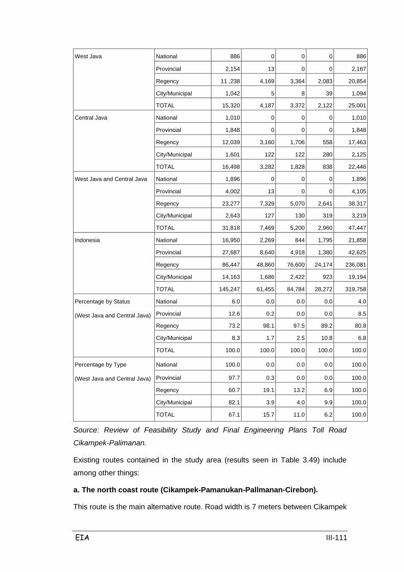
EIA III-111
West Java National
886
0
0
0
886
Provincial
2,154
13
0
0
2,167
Regency
11 ,238
4,169
3,364
2,083
20,854
City/Municipal
1,042
5
8
39
1,094
TOTAL
15,320
4,187
3,372
2,122
25,001
Central Java National
1,010
0
0
0
1,010
Provincial
1,848
0
0
0
1,848
Regency
12,039
3,160
1,706
558
17,463
City/Municipal
1,601
122
122
280
2,125
TOTAL
16,498
3,282
1,828
838
22,446
West Java and Central Java National
1,896
0
0
0
1,896
Provincial
4,002
13
0
0
4,105
Regency
23,277
7,329
5,070
2,641
38,317
City/Municipal
2,643
127
130
319
3,219
TOTAL
31,818
7,469
5,200
2,960
47,447
Indonesia National
16,950
2,269
844
1,795
21,858
Provincial
27,687
8,640
4,918
1,380
42,625
Regency
86,447
48,860
76,600
24,174
236,081
City/Municipal
14,163
1,686
2,422
923
19,194
TOTAL
145,247
61,455
84,784
28,272
319,758
Percentage by Status
(West Java and Central Java)
National
6.0
0.0
0.0
0.0
4.0
Provincial
12.6
0.2
0.0
0.0
8.5
Regency
73.2
98.1
97.5
89.2
80.8
City/Municipal
8.3
1.7
2.5
10.8
6.8
TOTAL 100.0 100.0 100.0 100.0 100.0
Percentage by Type
(West Java and Central Java)
National
100.0
0.0
0.0
0.0
100.0
Provincial
97.7
0.3
0.0
0.0
100.0
Regency
60.7
19.1
13.2
6.9
100.0
City/Municipal
82.1
3.9
4.0
9.9
100.0
TOTAL 67.1 15.7 11.0 6.2 100.0
Source: Review of Feasibility Study and Final Engineering Plans Toll Road
Cikampek-Palimanan.
Existing routes contained in the study area (results seen in Table 3.49) include
among other things:
a. The north coast route (Cikampek-Pamanukan-Pallmanan-Cirebon).
This route is the main alternative route. Road width is 7 meters between Cikampek
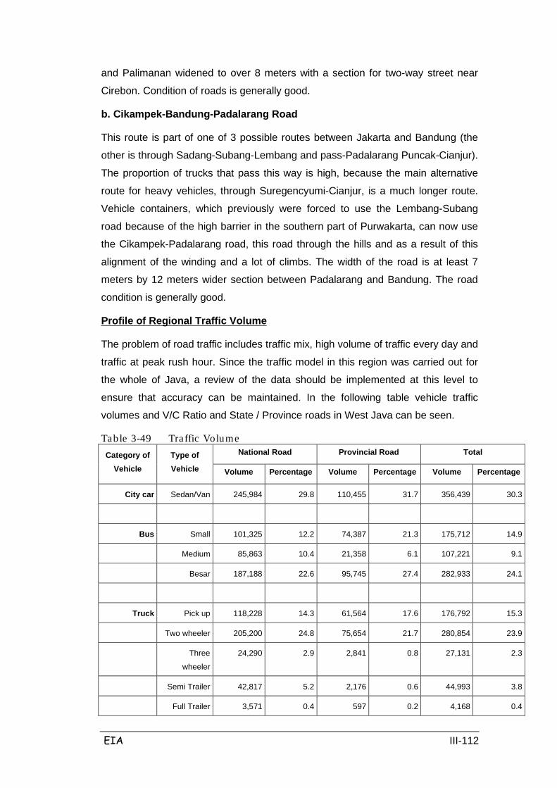
EIA III-112
and Palimanan widened to over 8 meters with a section for two-way street near
Cirebon. Condition of roads is generally good.
b. Cikampek-Bandung-Padalarang Road
This route is part of one of 3 possible routes between Jakarta and Bandung (the
other is through Sadang-Subang-Lembang and pass-Padalarang Puncak-Cianjur).
The proportion of trucks that pass this way is high, because the main alternative
route for heavy vehicles, through Suregencyumi-Cianjur, is a much longer route.
Vehicle containers, which previously were forced to use the Lembang-Subang
road because of the high barrier in the southern part of Purwakarta, can now use
the Cikampek-Padalarang road, this road through the hills and as a result of this
alignment of the winding and a lot of climbs. The width of the road is at least 7
meters by 12 meters wider section between Padalarang and Bandung. The road
condition is generally good.
The problem of road traffic includes traffic mix, high volume of traffic every day and
traffic at peak rush hour. Since the traffic model in this region was carried out for
the whole of Java, a review of the data should be implemented at this level to
ensure that accuracy can be maintained. In the following table vehicle traffic
volumes and V/C Ratio and State / Province roads in West Java can be seen.
Profile of Regional Traffic Volume
Table 3-49 Traffic Volume Category of
Vehicle Type of Vehicle
National Road Provincial Road Total
Volume Percentage Volume Percentage Volume Percentage
City car Sedan/Van 245,984 29.8 110,455 31.7 356,439 30.3
Bus Small 101,325 12.2 74,387 21.3 175,712 14.9
Medium 85,863 10.4 21,358 6.1 107,221 9.1
Besar 187,188 22.6 95,745 27.4 282,933 24.1
Truck Pick up 118,228 14.3 61,564 17.6 176,792 15.3
Two wheeler 205,200 24.8 75,654 21.7 280,854 23.9
Three
wheeler
24,290 2.9 2,841 0.8 27,131 2.3
Semi Trailer 42,817 5.2 2,176 0.6 44,993 3.8
Full Trailer 3,571 0.4 597 0.2 4,168 0.4

EIA III-113
Category of Vehicle
Type of Vehicle
National Road Provincial Road Total
Volume Percentage Volume Percentage Volume Percentage
Sub Total 394,06 47.6 142,832 40.9 536,938 45.6
Total 827,278 100.0 349,032 100.0 1,176,310 100.0
Frequency 81 114 195
ACTIVITY AVERAGE
10,213 3,062 6,031
Source: Review of Feasibility Study and Final Engineering Plans Toll Road
Cikampek-Palimanan
Table 3-50 Analys is of V/C Ratio in Wes t J ava Province Roads
V/C Ratio
width (m) Total
< 5.0
(km)
5.0 – 6.1
(km)
6.2 – 7.2
(km)
7.2-12.0
(km)
>12.0
(km)
Length
(km) Percentage
>1.0 4 49 120 52 0 225 6.61
0.8-1.0 9 10 49 28 19 15 3.39
0.6-0.8 0 45 192 71 17 324 9.52
0.4-0.6 77 165 206 115 19 582 17.09
0.2-0.4 107 274 146 77 31 634 18.62
0-0.2 724 570 152 62 16 1525 44.76
Total 922 1113 864 405 103 3407 100.00
Percentage 27.8 32.66 25.36 11.89 3.01 100.0
Source: Review of Feasibility Study and Final Engineering Plans Toll Road Cikampek-Palimanan
In Table 3.50 above it includes an analysis of the ratio of capacity / volume on the
state and provincial roads in West Java province. This shows that:
• 10% of the network has reached the limit of effective capacity (V / C ratio>
0.8).
• Another 9.5% have a ratio of V / C is about 0.6 to 0.8 and a lot of these
streets can be expected to reach capacity (V? C ratio> 0.9) is less than 4
years.
• 63% of the road network has a V / C ratio of 0.4 or less, although many of
these streets (78%) is a small part of the road network and has a width of
6.1 meters or less.

EIA III-114
Types of existing public transport include Mini Bus, Public Van, Medium Bus and
Inter-City Bus. Problems in the highway transportation system faced by the West
Java region is the road network system and the existence of several critical points
of congestion at certain hours that occur along primary arterial roads. Therefore,
one solution to this problem is the construction of the highway.
Elucidation of the primary survey of traffic conditions at several sample points are as follows:
a. Vehicle traffic on the crossing road (intersection traffic count) Survey of
intersection traffic count (ITC) or the movement of the intersection of the survey
carried out at the link below:
• Simpang Sadang
There is high traffic volume at this intersection because it is a main entrance and
exit for vehicles, especially for large public transportation bus types, minibuses etc
from outside cities such as Jakarta, Subang, Purwakarta and Indramayu, but also
due to the activities of residents and vendor (kaki lima) merchants, and
passengers waiting for buses near the intersection.
• Simpang Jatisari
This intersection is located on the arterial roads Cikampek Pamanukan. The traffic
condition at this intersection is fairly heavy, plus the intersection is located in an
area of trade and the road is narrow, causing bottleneck traffic.
• Simpang Pamanukan
This intersection diverts Cikampek vehicle movement towards Indramayu and
Subang regencies. There are dense traffic conditions but it does not experience
significant congestion.
• Simpang Karang Ampel
This intersection arguably does not experience heavy traffic, because the
movement in and out of the intersection is not so dominant. Instead there is
continuous flow from both directions toward Indramayu and Cirebon and vice
versa.
b. Travel time and delays that occur on roads
From the results of the survey and travel time delay (TTD), the journey from
Cikampek and Palimanan with the distance to 134 km along the existing arterial
roads, with speeds of between 40.71 to 66.25 km / h, then the latency is between

EIA III-115
121.38 to 197.52 minutes. When compared to the planned toll road that has a 116
km distance and speed between 80-100 km / h, then latency is 69.6-87 minutes
(the journey can be shortened). So with the toll road there will occur an
improvement to time efficiency (saving time) of 51.78-110.52 minutes or about 43-
56%. More data on travel time and delays that occur on the existing roads (travel
time and delay) are presented in Table 3.51 below.
Table 3-51 Travel Time and Delay (TTD)
Time of Survey
Distance
(Km)
Travel Time
(Km)
Speed
(km/hour)
Trip
Cikampek –
Palimanan
Trip
Palimanan –
Cikampek
Trip
Cikampek –
Palimanan
Trip
Palimanan –
Cikampek
Trip
Cikampek –
Palimanan
Trip
Palimanan –
Cikampek
Peak
morning
134 134 162.12 154.80 49.59 51.93
Off
Peak
noon
134 134 153.72 152.82 52.30 52.61
Peak
evening
134 134 197.52 152.81 40.71 52.62
Off
Peak
night
134 134 23.30 121.38 65.21 66.25
Source: Review of Feasibility Study and Final Engineering Plans Toll Road Cikampek-Palimanan
c. Vehicle traffic on the road (cross sectional vehicle traffic count)
From the survey and traffic counts, data was obtained on daily traffic volume for
each segment which was on average surveyed for 3 x 24 hours for each type of
vehicle. The results from processing the primary data traffic count survey
subsequently became the basis of the traffic analysis and prediction of traffic. The
summary results of traffic count in the eighth section of Cikampek – Palimanan
road are presented in Table 3.52:
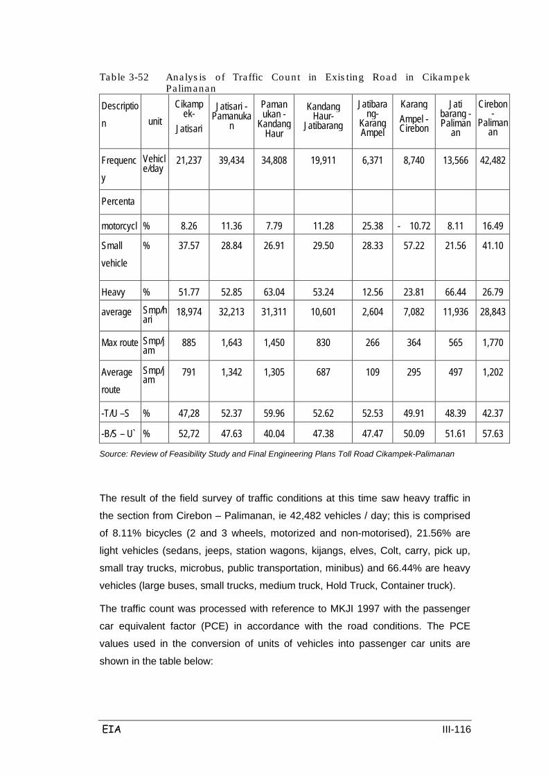
EIA III-116
Table 3-52 Analys is of Traffic Count in Exis ting Road in Cikampek Pa limanan
Description unit
Cikamp ek-
Jatisari
Jatisari -Pamanuka
n
Paman ukan -
Kandang Haur
Kandang Haur-
Jatibarang
Jatibara ng-
Karang Ampel
Karang Ampel -Cirebon
Jati barang -Paliman
an
Cirebon -
Palimanan
Frequency
Vehicle/day
21,237
39,434
34,808
19,911
6,371
8,740
13,566
42,482
Percenta
motorcycl
% 8.26
11.36
7.79
11.28
25.38
- 10.72
8.11
16.49
Small vehicle
% 37.57
28.84
26.91
29.50
28.33
57.22
21.56
41.10
Heavy
% 51.77
52.85
63.04
53.24
12.56
23.81
66.44
26.79
average Smp/hari
18,974
32,213
31,311
10,601
2,604
7,082
11,936
28,843
Max route Smp/j
am 885
1,643
1,450
830
266
364
565
1,770
Average route
Smp/jam
791
1,342
1,305
687
109
295
497
1,202
-T/U –S % 47,28
52.37
59.96
52.62
52.53
49.91
48.39
42.37
-B/S – U` % 52,72
47.63
40.04
47.38
47.47
50.09
51.61
57.63
Source: Review of Feasibility Study and Final Engineering Plans Toll Road Cikampek-Palimanan
The result of the field survey of traffic conditions at this time saw heavy traffic in
the section from Cirebon – Palimanan, ie 42,482 vehicles / day; this is comprised
of 8.11% bicycles (2 and 3 wheels, motorized and non-motorised), 21.56% are
light vehicles (sedans, jeeps, station wagons, kijangs, elves, Colt, carry, pick up,
small tray trucks, microbus, public transportation, minibus) and 66.44% are heavy
vehicles (large buses, small trucks, medium truck, Hold Truck, Container truck).
The traffic count was processed with reference to MKJI 1997 with the passenger
car equivalent factor (PCE) in accordance with the road conditions. The PCE
values used in the conversion of units of vehicles into passenger car units are
shown in the table below:
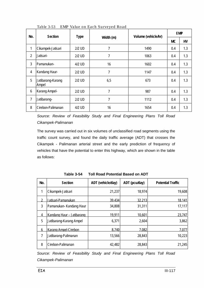
EIA III-117
Table 3-53 EMP Value on Each Surveyed Road
No. Section Type Width (m) Volume (vehicle/hr) EMP
MC
HV
1 Cikampek-Jatisari 2/2 UD
7
1490
0.4
1.3
2 Jatisari-
2/2 UD
7
1063
0.4
1.3
3 Pamanukan-
4/2 UD
16
1602
0.4
1.3
4 Kandang Haur-
2/2 UD
7
1147
0.4
1.3
5 Jatibarang-Karang Ampel
2/2 UD
6,5
673
0.4
1.3
6 Karang Ampel-
2/2 UD
7
987
0.4
1.3
7 Jatibarang-
2/2 UD
7
1112
0.4
1.3
8 Cirebon-Palimanan 4/2 UD
16
1654
0.4
1.3
Source: Review of Feasibility Study and Final Engineering Plans Toll Road
Cikampek-Palimanan
The survey was carried out in six volumes of unclassified road segments using the
traffic count survey, and found the daily traffic average (ADT) that crosses the
Cikampek - Palimanan arterial street and the early prediction of frequency of
vehicles that have the potential to enter this highway, which are shown in the table
as follows:
Table 3-54 Toll Road Potential Based on ADT
No. Section ADT (vehicle/day) ADT (pcu/day)
Potential Traffic
1 Cikampek-Jatisari 21,237 18,974 19,608
2 Jatisari-Pamanukan 39,434 32,213 18,141 3 Pamanukan- Kandang Haur 34,808 31,311 17,117
4 Kandang Haur – Jatibarang 19,911 10,601 23,747 5 Jatibarang-Karang Ampel 6,371 2,604 3,862
6 Karang Ampel-Cirebon 8,740 7,082 7,077 7 Jatibarang-Palimanan 13,566 28,843 10,223
8 Cirebon-Palimanan 42,482 28,843 21,245
Source: Review of Feasibility Study and Final Engineering Plans Toll Road
Cikampek-Palimanan
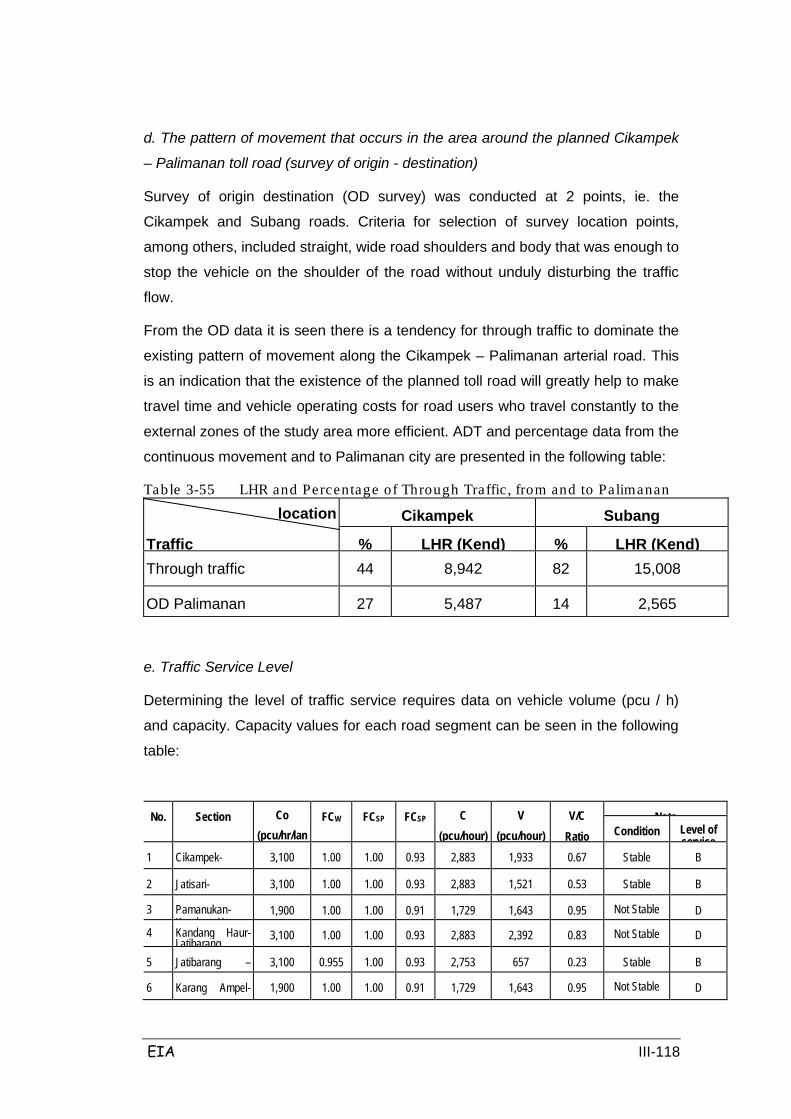
EIA III-118
d. The pattern of movement that occurs in the area around the planned Cikampek
– Palimanan toll road (survey of origin - destination)
Survey of origin destination (OD survey) was conducted at 2 points, ie. the
Cikampek and Subang roads. Criteria for selection of survey location points,
among others, included straight, wide road shoulders and body that was enough to
stop the vehicle on the shoulder of the road without unduly disturbing the traffic
flow.
From the OD data it is seen there is a tendency for through traffic to dominate the
existing pattern of movement along the Cikampek – Palimanan arterial road. This
is an indication that the existence of the planned toll road will greatly help to make
travel time and vehicle operating costs for road users who travel constantly to the
external zones of the study area more efficient. ADT and percentage data from the
continuous movement and to Palimanan city are presented in the following table:
Table 3-55 LHR and Percentage of Through Traffic , from and to Palimanan
location Cikampek
Subang
Traffic
%
LHR (Kend)
%
LHR (Kend)
Through traffic
44
8,942
82
15,008
OD Palimanan
27
5,487
14
2,565
e. Traffic Service Level
Determining the level of traffic service requires data on vehicle volume (pcu / h)
and capacity. Capacity values for each road segment can be seen in the following
table:
No. Section
Co (pcu/hr/lan
FCW
FCSP
FCSP
C (pcu/hour)
V (pcu/hour)
V/C Ratio
Note
Condition
Level of service
1 Cikampek-
3,100
1.00
1.00
0.93
2,883
1,933
0.67
Stable
B
2 Jatisari-
3,100
1.00
1.00
0.93
2,883
1,521
0.53
Stable
B
3 Pamanukan-K d H
1,900
1.00
1.00
0.91
1,729
1,643
0.95
Not Stable
D
4 Kandang Haur-Jatibarang 3,100
1.00
1.00
0.93
2,883
2,392
0.83
Not Stable
D
5 Jatibarang –
3,100
0.955
1.00
0.93
2,753
657
0.23
Stable
B
6 Karang Ampel-
1,900
1.00
1.00
0.91
1,729
1,643
0.95
Not Stable
D

EIA III-119
7 Jatibarang-P li
3,100
1.00
1.00
0.93
2,883
1,933
0.67
Stable
B
8 Cirebon-P li
3,100
0.955
1.00
0.93
2,753
675
0.23
Stable
B
Source: Review of Feasibility Study and Final Engineering Plans Toll Road
Cikampek-Palimanan
From the results of such calculations as shown in the table above, traffic that
remains stable at peak hours (V / C ratio <0.8) is usually located at the links from
Cikampek - Jatisari, Jatisari - Pamanukan, Jatibarang - Karang Ampel, Jatibarang
- Palimanan and Cirebon-Palimanan. These roads can be categorised at the level
of service B because the flow is steady with medium traffic volume, but the pace
has begun to be restricted by traffic conditions. The roads that have unstable
traffic at peak hours (V / C ratio> 0.8) are the roads Pamanukan – Kandang Haur,
Kandang Haur - Jatibarang and Karang Ampel - Cirebon. These roads can be
categorized at the level of service D as the current approach is not stable with high
traffic volumes and speeds that are still tolerated, but these roads are strongly
influenced by changes in current conditions.
B. Public Utilities
The condition of public utilities located in the vicinity of the study area and which
will be affected by the planned Cikampek-Palimanan toll road was determined
based on data available from the Review of Feasibility Studies and the Final
Technical Engineering Plan for the Cikampek-Palimanan toll road; these results
can be seen in the Table below:
Table 3-56 Public Utilities Location/STA PLN Telkom PDAM Pertamina Notes
SECTION I
STA 89.139 3 x 20 kV
(3x380 V)
- - - Twisted cable 220, 380v contribution from 20 kV with transformer
STA 90.100 3 x 20 kV
- - - -
STA 90.150 3 x 20 kV
- - - -
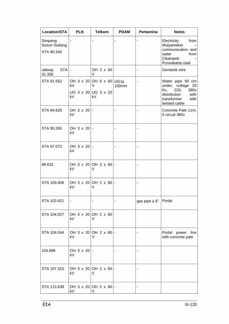
EIA III-120
Location/STA PLN Telkom PDAM Pertamina Notes
Simpang Susun Sadang
STA 90.340
- - - - Electricity from Mulyamekar – communication and water from Cikampek – Purwakarta road
railway STA 91.356
- OH 2 x 60 V
- - Gentanik wire
STA 91.552 OH 3 x 20 kV
UG 3 x 20 kV
OH 6 x 60 V
UG 3 x 20 kV
UG1φ 100mm
- Water pipe 90 cm under, voltage 20 Kv, 220, 380v distribution with transformer with twisted cable
STA 94.825 OH 3 x 20 kV
- - - Concrete Pale 11m, 6 circuit 380v
STA 95.265
OH 3 x 20 kV
- - -
STA 97.072
OH 3 x 20 kV
-
- -
98.632
OH 3 x 20 kV
OH 2 x 60 V
- -
STA 103.406 OH 3 x 20 kV
OH 2 x 60 V
- -
STA 103.421
- - - gas pipe φ 6” Portal
STA 104.027
OH 3 x 20 kV
OH 2 x 60 V
STA 104.044 OH 3 x 20 kV
OH 2 x 60 V
- - Portal power line with concrete pale
104.696 OH 3 x 20 kV
- - -
STA 107.315 OH 3 x 20 kV
OH 2 x 60 V
- -
STA 113.638 OH 3 x 20 kV
OH 2 x 60 V
- -

EIA III-121
Location/STA PLN Telkom PDAM Pertamina Notes
STA 116.115 OH 3 x 20 kV
-
- -
STA 16.928
OH 3 x 20 kV
UG 3 x 20 kV
OH 2 x 60 V
- -
SECTION II
STA 118.423
-
- -
STA 123.670 OH 3 x 20 kV
OH 2 x 60 V
- -
STA 126.122 - - - Gas pipe
STA 127.212 - - - Gas pipe
STA 129.310 OH 3 x 20 kV
OH 2 x 60 V
- -
STA 129.310 - - - - To supply power for lighting 3 locations interchanges should be prepared:
- From the street Province (Subang - Palimanan)
- From the Village Cilameri
- From the Village Sukamelang
SECTION III
STA 130.044 OH 3 x 20 kV
OH 2 x 60 V
- -
STA 130.901 - - - Gas pipe φ 6” planned
STA 131.355 OH 3 x 20 kV
- - Distribution to each village ranging from 20kV to 220, 380v with transformer and cables twisted
STA 136.134 OH 3 x 20 kV
OH 2 x 60 V
-
STA 138.432 OH 3 x 20 - -

EIA III-122
Location/STA PLN Telkom PDAM Pertamina Notes kV
STA 139.820 OH 3 x 20 kV
OH 2 x 60 V
-
STA 142.747
OH 3 x 20 kV
- -
STA 149.722
OH 3 x 20 kV
-
STA 149.742
OH 3 x 20 kV
OH 2 x 60 V
-
SECTION IV
-
- -
STA 167.650 OH 3 x 20 kV
- - -
SECTION V
STA 178.400 - - -
STA 179.005 OH 3 x 20 kV
OH 2 x 60 V
-
STA 180.169 OH 3 x 20 kV
- -
STA 187.290 OH 3 x 20 kV
OH 2 x 60 V
- -
STA 189.089 OH 3 x 20 kV
OH 2 x 60 V
- -
STA 190.690 OH 3 x 20 kV
OH 2 x 60 V
- -
SECTION VI
STA 194.706 OH 3 x 20 kV
- - -
STA 195.298 OH 3 x 20 kV
OH 2 x 60 V
- -
STA 195.952 OH 3 x 20 kV
- - -
STA 196.496 - - - gas pipe Portal
STA 197.399 OH 3 x 20 kV
- -
STA 200.011 OH 3 x 20 kV
OH 2 x 60 V
-
STA 200.692 OH 3 x 20 kV
- -
STA 201.499 OH 3 x 20 kV
- -
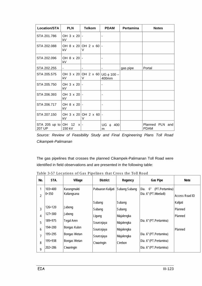
EIA III-123
Location/STA PLN Telkom PDAM Pertamina Notes
STA 201.786 OH 3 x 20 kV
- -
STA 202.088
OH 8 x 20 kV
OH 2 x 60 V
-
STA 202.096 OH 8 x 20 kV
- -
STA 202.255 - - - gas pipe Portal
STA 205.575 OH 3 x 20 kV
OH 2 x 60 V
UG φ 100 – 400mm
STA 205.750 OH 3 x 20 kV
- -
STA 206.393 OH 3 x 20 kV
- -
STA 206.717 OH 8 x 20 kV
- -
STA 207.150 OH 3 x 20 kV
OH 2 x 60 V
-
STA 205 up to 207 UP
OH 12 x 150 kV
- UG φ 400 m
Planned PLN and PDAM
Source: Review of Feasibility Study and Final Engineering Plans Toll Road
Cikampek-Palimanan
The gas pipelines that crosses the planned Cikampek-Palimanan Toll Road were
identified in field observations and are presented in the following table:
Table 3-57 Locations of Gas Pipelines that Cros s the Toll Road
No. STA. Village District Regency Gas Pipe Note
1
2
3
4
5
6
7
8
9
103+400 0+350
126+120
127+300
189+975
194+200
195+295
195+938
202+286
Karangmukti Kaliangsana
Jabong
Jabong
Tegal Aren
Bongas Kulon
Bongas Wetan
Bongas Wetan
Ciwaringin
Pabuaran Kalijati
Subang
Subang
Ligung
Sourcejaya
Sourcejaya
Sourcejaya
Ciwaringin
Subang Subang
Subang
Subang
Majalengka
Majalengka
Majalengka
Majalengka
Cirebon
Dia. 6" (PT.Pertamina) Dia. 6" (PT.Moeladi)
Dia. 6" (PT.Pertamina)
Dia. 6" (PT.Pertamina)
Dia. 6" (PT.Pertamina)
Dia. 6" (PT.Pertamina)
Access Road IO
Kalijati
Planned
Planned
Planned
EIA III-124
3.5 COMPONENTS OF PUBLIC HEALTH
Public health conditions in the study area as based on secondary data are shown
to be relatively good. This can be seen due to the existence of many adequate
health facilities in the 5 regencies that are traversed by the planned Cikampek-
Palimanan toll road in West Java province, namely: Subang, Indramayu,
Purwakarta, Cirebon and Majalengka. The existing health facilities in these 5
Regencies include government-owned General Hospitals, district health centers
(puskesmas), health centers (puskesmas pembantu), mobile health centers,
health centers with sleeping/overnight facilities and medicinal centers, and medics
and paramedics.
The trend of diseases that affect most people in the study area are ARI (Upper
Respiratory Tract Infection), gastritis (stomach ulcer), Influenza, Dermatitis (Skin
Disease), myalgia (aching joints) and diarrhea. The nutritional status of the
population is generally described by the class of population which is susceptible to
malnutrition, especially among children aged under 5 years old. The percentage of
children who are experiencing malnutrition varied from 0.5% -1.01% in the 5
regencies. (Source: Regency in Figures, 2006, for each Regency)
Sanitation facilities in the area primarily support the purposes of bathing, washing
and toilet (MCK); in general the population use public restrooms or a public
bathrooms, and occasionally a private bathroom on private properties which
suggests a healthy home.
Meeting the needs of clean water is crucial to people's lives; in the 5 districts
people utilize clean water sourced from dug wells / pumps (ground water) and
subscription-managed piped water taps, where most of the water comes from river
water. The details of the health situation in the 5 regencies to be traversed by the
planned Cikampek – Palimanan toll road in West Java Province is as follows:
Existing health care facilities in Purwakarta Regency include 2 General Hospital,
13 Rumah Bersalain, 19 community health centers (puskesmas) and 41
community health assistance centres (puskesmas pembantu). Medical personnel
and physicians included 34 general practitioners, 14 PTT Doctors, 10 PNS
Dentists and 12 PTT dentists; there were also 17 specialist doctors but they were
Purwakarta Regency

EIA III-125
found only in the Bayu Asih hospital (RSUD).
Nutritional status in children aged under five reflects that the nutritional status of
the population is poor; 0.7% are poorly nutritioned and 1% are underweight. When
viewed from the previous year these numbers have decreased.
Environmental sanitation in the area is measured as family ownership of toilet and
waste management facilities, which was 60% and 57.6% respectively. Awareness
to improve housing conditions in accordance with the criteria of a healthy home
reached 60% of the population. Clean water for drinking water was generally
sourced from PDAM water subscriptions rather than ground water, and some
water sources are managed from river water.
With a population density 805 people/km2 this also has the potential to facilitate
the transmission of disease via air from air pollution, which is increasing as well.
There are 3 hospital facilities in the Regency, 2 in Subang and 1 in Kalijati, with
335 beds total. There are several community health centers and clinics in the 22
districts, including 39 public health centers (puskesmas inpres), 72 community
health assistance centers (puskesmas pembantu), 34 mobil health centers and 17
general medicinal clinics. There are 25 PNS doctors and 21 PTT doctors, 3 PNS
dentists and 11 PTT dentists; there are a total of 691 paramedics including PNS /
PTT midwives and PNS / contract nurses.
Subang Regency
Nutritional status is measured as the nutrition of vulnerable groups namely
children under five years (toddlers); the percentage of toddlers that are severely
malnourished and underweight was 0.61% and 7.47% respectively. The most
common diseases in this area are ARI, Gastritis and Influenza. Looking at the
existing density of population (678.44 people/km2) then the risk of disease
transmission through the air becomes greater, especially in areas that will be
affected by the toll road plans. Air pollution in the vicinity of the construction will
potentially exacerbate the transmission of diseases.
Environmental sanitation includes clean water supply and disposal and
management of solid waste. PDAM water supplies 14 districts, and those which
are not served rely on groundwater sources. RT waste water management uses
sewers, but these have not been well integrated, so that when rain falls this
potentially causes puddles. Likewise the disposal of waste is managed by each RT
EIA III-126
which burns the waste collected by cleaners, which is then dumped in one place
for intensive management via open dumping.
As for health care facilities in the 31 districts there are 49 community health
centers (puskesmas), 67 community health assistance centers (puskesmas
pembantu) with 75 medical personnel / doctors, 27 dentists, 388 paramedics /
midwives and 436 nurses. Nutritional status of the vulnerable children in
Indramayu sees as much as 1.01% and 10.8% nutritionally poor and underweight,
respectively. This is the one regency of the 5 regencies planned to be traversed by
the Cikampek-Palimanan toll road with the highest level of malnutrition among
children under five.
Indramayu Regency
Source of clean water generally comes from ground water, waste is managed by
SPAL of RT although this has not been well integrated so that there is potential to
cause puddles when heavy rains.
Population density in Indramayu is around 832 people/km2, and this also has the
potential to facilitate disease transmission through the air like respiratory
infections. Given the general land to be affected by the planned toll road is
agricultural land, in the dry season this has the potential to be dry and dusty.
Data on health centres in 2004/2006 showed that in the 23 districts there aer 29
community health centers (puskesmas inpres) with a capacity for 76 treatment
beds, 73 community health assistance centres (puskesmas pembantu), 28 mobile
health center, and 35 medical personnel / general practitioners, 6 dentists, 285
paramedic / midwives and 32 village midwives. With community participation
activities at the community level there are 1479 posyandu, and 3 Hospitals with a
capacity of 273 beds.
Majalengka Regency
Population density in Indramayu is around 971 people/km2 where the highest
density found in the Jatiwangi district (2032 people/km2), which includes urban
areas; this could potentially facilitate disease transmission through the air like
respiratory infection. Given the general land to be affected by the planned toll road
is agricultural land, in the dry season this has the potential to be dry and dusty.
EIA III-127
In Cirebon there are 6 hospitals (including RS Paru-Paru), 53 Public community
Health Centers (Puskesmas Umum), 63 community health assistance centers
(puskesmas pembantu), 44 mobile health centers, 137 medicinal centres and 7
maternity clinics. Health personnel include 168 general practitioners, 32 dentists,
570 general nurses, 34 dental nurses and 553 midwives.
Cirebon Regency
The most common disease is diarrhea (suspected cholera).
Source of clean water for the public is generally subscriptions to PDAM water and
ground water. In general the SPAL are there but not well integrated, thus
potentially causing puddles in the rain. Waste disposal systems are operated by
the sanitation workers, who transport and then dispose waste to landfill for open
dumping. It is also common that waste is not collected by sanitation workers, and
is instead burned.
3.6 SUMMARY
Cikampek - Palimanan Toll Road Development Plan is planned along ± 116.4 km,
starting from the Cikopo Toll (Jakarta-Cikampek) in Purwakarta Regency, to be
connected with the Kanci Toll (Pamanukan-Cirebon) in Palimanan, Cirebon
regency. In general, the toll roads is divided into 6 (six sections), each divided by
an Interchange (IC) which includes a vehicle access gate to be operated during
the later operational phase.
The environmental, physical chemistry, biology, social, economic and culture
conditions of each Section (STA) in the study area are described in Table 3.59 as
follows:
a. Section I
Section I starts from STA 91+500 to STA 118+550, from Purwakarta Regency,
Bungursari district, Cikopo village, to Subang regency, Kalijati district, Kaliangsana
village.
b. Section II
Section II starts from STA 118+550 to STA 129+750, from Subang regency,
District Kalijati, Kaliangsana village, until Subang regency, Cisaga village.
c. Section III
Section III starts from STA 129+750 to STA 158+450, from Regency Subang,
Subang district, Cisaga village, to Indramayu regency, Trisi district, Cikawung
EIA III-128
village (Cikedung 1C).
d. Section IV
Section IV starts from STA 158+450 to STA 177+350, from Indramayu regency,
Trisi district, Cikawung village, until Majalengka regency, Kertajati district,
Kertawinangun village.
e. Section V
Section V starts from STA 177+350 to STA 193+450, from Majalengka regency,
Kertajati district, Kertawinangun village, until Majalengka regency, Palasah district,
Sumberjaya village.
f. Section VI
Section VI begins from STA 193+450 to STA 207+900, from Majalengka regency,
Palasah district, Sumberjaya village, until Cirebon regency, Palimanan district,
Pegagan village.
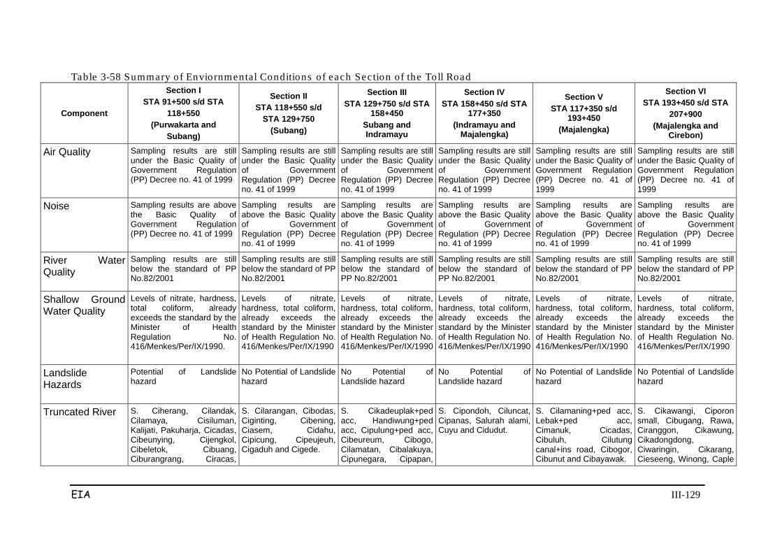
EIA III-129
Table 3-58 Summary of Enviornmental Conditions of each Sec tion of the Toll Road
Component
Section I STA 91+500 s/d STA
118+550 (Purwakarta and
Subang)
Section II STA 118+550 s/d
STA 129+750 (Subang)
Section III STA 129+750 s/d STA
158+450 Subang and Indramayu
Section IV STA 158+450 s/d STA
177+350 (Indramayu and
Majalengka)
Section V STA 117+350 s/d
193+450 (Majalengka)
Section VI STA 193+450 s/d STA
207+900 (Majalengka and
Cirebon)
Air Quality
Sampling results are still under the Basic Quality of Government Regulation (PP) Decree no. 41 of 1999
Sampling results are still under the Basic Quality of Government Regulation (PP) Decree no. 41 of 1999
Sampling results are still under the Basic Quality of Government Regulation (PP) Decree no. 41 of 1999
Sampling results are still under the Basic Quality of Government Regulation (PP) Decree no. 41 of 1999
Sampling results are still under the Basic Quality of Government Regulation (PP) Decree no. 41 of 1999
Sampling results are still under the Basic Quality of Government Regulation (PP) Decree no. 41 of 1999
Noise
Sampling results are above the Basic Quality of Government Regulation (PP) Decree no. 41 of 1999
Sampling results are above the Basic Quality of Government Regulation (PP) Decree no. 41 of 1999
Sampling results are above the Basic Quality of Government Regulation (PP) Decree no. 41 of 1999
Sampling results are above the Basic Quality of Government Regulation (PP) Decree no. 41 of 1999
Sampling results are above the Basic Quality of Government Regulation (PP) Decree no. 41 of 1999
Sampling results are above the Basic Quality of Government Regulation (PP) Decree no. 41 of 1999
River Water Quality
Sampling results are still below the standard of PP No.82/2001
Sampling results are still below the standard of PP No.82/2001
Sampling results are still below the standard of PP No.82/2001
Sampling results are still below the standard of PP No.82/2001
Sampling results are still below the standard of PP No.82/2001
Sampling results are still below the standard of PP No.82/2001
Shallow Ground Water Quality
Levels of nitrate, hardness, total coliform, already exceeds the standard by the Minister of Health Regulation No. 416/Menkes/Per/IX/1990.
Levels of nitrate, hardness, total coliform, already exceeds the standard by the Minister of Health Regulation No. 416/Menkes/Per/IX/1990
Levels of nitrate, hardness, total coliform, already exceeds the standard by the Minister of Health Regulation No. 416/Menkes/Per/IX/1990
Levels of nitrate, hardness, total coliform, already exceeds the standard by the Minister of Health Regulation No. 416/Menkes/Per/IX/1990
Levels of nitrate, hardness, total coliform, already exceeds the standard by the Minister of Health Regulation No. 416/Menkes/Per/IX/1990
Levels of nitrate, hardness, total coliform, already exceeds the standard by the Minister of Health Regulation No. 416/Menkes/Per/IX/1990
Landslide Hazards
Potential of Landslide hazard
No Potential of Landslide hazard
No Potential of Landslide hazard
No Potential of Landslide hazard
No Potential of Landslide hazard
No Potential of Landslide hazard
Truncated River S. Ciherang, Cilandak, Cilamaya, Cisiluman, Kalijati, Pakuharja, Cicadas, Cibeunying, Cijengkol, Cibeletok, Cibuang, Ciburangrang, Ciracas,
S. Cilarangan, Cibodas, Ciginting, Cibening, Ciasem, Cidahu, Cipicung, Cipeujeuh, Cigaduh and Cigede.
S. Cikadeuplak+ped acc, Handiwung+ped acc, Cipulung+ped acc, Cibeureum, Cibogo, Cilamatan, Cibalakuya, Cipunegara, Cipapan,
S. Cipondoh, Ciluncat, Cipanas, Salurah alami, Cuyu and Cidudut.
S. Cilamaning+ped acc, Lebak+ped acc, Cimanuk, Cicadas, Cibuluh, Cilutung canal+ins road, Cibogor, Cibunut and Cibayawak.
S. Cikawangi, Ciporon small, Cibugang, Rawa, Ciranggon, Cikawung, Cikadongdong, Ciwaringin, Cikarang, Cieseeng, Winong, Caple

EIA III-130
Component
Section I STA 91+500 s/d STA
118+550 (Purwakarta and
Subang)
Section II STA 118+550 s/d
STA 129+750 (Subang)
Section III STA 129+750 s/d STA
158+450 Subang and Indramayu
Section IV STA 158+450 s/d STA
177+350 (Indramayu and
Majalengka)
Section V STA 117+350 s/d
193+450 (Majalengka)
Section VI STA 193+450 s/d STA
207+900 (Majalengka and
Cirebon) Kalijambe
Cikale, Cicadas, and Wadas.
Component
Section I STA 91+500 s/d STA
118+550 (Purwakarta and
Subang)
Section II STA 118+550 s/d
STA 129+750 (Subang)
Section III STA 129+750 s/d STA
158+450 Subang and Indramayu
Section IV STA 158+450 s/d STA
177+350 (Indramayu and
Majalengka)
Section V STA 117+350 s/d
193+450 (Majalengka)
Section VI STA 193+450 s/d STA
207+900 (Majalengka and
Cirebon)
Pembawa *) and S. Cicongok.
Cibuan, Cikandung, Cibiuk, Ciburial, Cipancu and Cipahit,
Land Use Area of paddy field irrigated 0.3 hectares, 40.2 hectares rainfed rice field; field is 9.6 ha, 6.0 ha unproductive land, vacant land 1.5 hectares, and forest area to reach 75.3 Ha
Irrigated paddy field 36.3 Ha; rainfed rice field 3.0; forest 25.8 Ha. Unused field and unproductive land.
Irrigated paddy field 13.5 Ha; rainfed rice field 17.7 Ha; field 5.4 Ha; unproductive land 28.5 Ha; forest 79.5 Ha, plantation 33.15 Ha.
Irrigated paddy field 35.1 Ha; field 2.4 Ha; unproductive land 8.1 Ha; forest 65.4 Ha. There is no rainfed rice field.
Irrigated paddy field 42.3 Ha, field 22.5 Ha, forest 12.3 Ha.
Irrigated paddy field 50.7 Ha, field 0.9 Ha, forest 9.1 Ha. There are no rainfed rice fields.
Vegetation Type Density per ha was 2430, with a frequency of taxa (s) 44, an index of diversity (H) 3390, H 'Maximum (In s) 3784, Equatabilitas index is 0.896.
Density per Ha was 2.450, with a frequency taxa (s) 43, diversity index (H) 3.390 H’ Maximum (In s) 3.874, Equatability Index is 0,886.
Density per Ha was 2.590, with frequency taksa (s) 43, indeks diversitas (H) 3.372, H’ Maksimum (In s) 3.705, Indeks Ekuatabilitas was 0,883.
Density per Ha was 2.690, with frequency taksa (s) 45, indeks diversitas (H) 3.362, H’ Maksimum (In s) 3.807, Indeks Ekuatabilitas was 0,873.
Density per Ha was 2.330, with frequency taksa (s) 45 indeks diversitas (H) 3.452, H’ Maksimum (In s) 3.807, Indeks Ekuatabilitas was 0,907.
Density per Ha was 2.650, with frequency taksa (s) 43, indeks diversitas (H) 3.383, H’ Maksimum (In s) 3.761, Indeks Ekuatabilitas was 0,899.
Fauna Type Many common insects, including Grasshopper, Dragonflies, Butterflies, Beetles, Bees, Flies, big,
Many common insects, including Grasshopper, Dragonflies, Butterflies, Beetles, Bees, Flies,
Many common insects, including Grasshopper, Dragonflies, Butterflies, Beetles, Bees, Flies,
Many common insects, including Grasshopper, Dragonflies, Butterflies, Beetles, Bees, Flies,
Many common insects, including Grasshopper, Dragonflies, Butterflies, Beetles, Bees, Flies,
Many common insects, including Grasshopper, Dragonflies, Butterflies, Beetles, Bees, Flies,
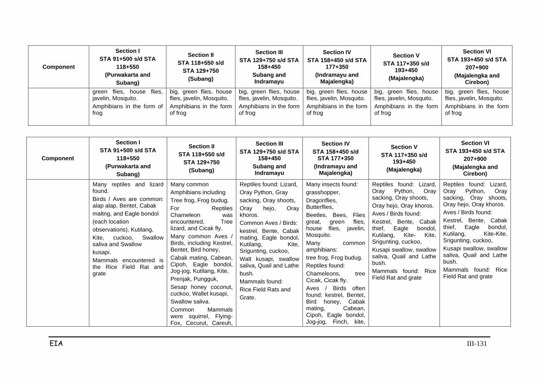
EIA III-131
Component
Section I STA 91+500 s/d STA
118+550 (Purwakarta and
Subang)
Section II STA 118+550 s/d
STA 129+750 (Subang)
Section III STA 129+750 s/d STA
158+450 Subang and Indramayu
Section IV STA 158+450 s/d STA
177+350 (Indramayu and
Majalengka)
Section V STA 117+350 s/d
193+450 (Majalengka)
Section VI STA 193+450 s/d STA
207+900 (Majalengka and
Cirebon) green flies, house flies, javelin, Mosquito. Amphibians in the form of frog
big, green flies, house flies, javelin, Mosquito. Amphibians in the form of frog
big, green flies, house flies, javelin, Mosquito. Amphibians in the form of frog
big, green flies, house flies, javelin, Mosquito. Amphibians in the form of frog
big, green flies, house flies, javelin, Mosquito. Amphibians in the form of frog
big, green flies, house flies, javelin, Mosquito. Amphibians in the form of frog
Component
Section I STA 91+500 s/d STA
118+550 (Purwakarta and
Subang)
Section II STA 118+550 s/d
STA 129+750 (Subang)
Section III STA 129+750 s/d STA
158+450 Subang and Indramayu
Section IV STA 158+450 s/d
STA 177+350 (Indramayu and
Majalengka)
Section V STA 117+350 s/d
193+450 (Majalengka)
Section VI STA 193+450 s/d STA
207+900 (Majalengka and
Cirebon)
Many reptiles and lizard found. Birds / Aves are common: alap alap, Bentet, Cabak maltng, and Eagle bondol (each location observations), Kutilang, Kite, cuckoo, Swallow saliva and Swallow kusapi. Mammals encountered is the Rice Field Rat and grate
Many common Amphibians including Tree frog, Frog budug. For Reptiles Chameleon was encountered, Tree lizard, and Cicak fly. Many common Aves / Birds, including Kestrel, Bentet, Bird honey, Cabak mating, Cabean, Cipoh, Eagle bondol, Jog-jog, Kutilang, Kite, Prenjak, Pungguk, Sesap honey coconut, cuckoo, Wallet kusapi, Swallow saliva. Common Mammals were squirrel, Flying-Fox, Cecurut, Careuh,
Reptiles found: Lizard, Oray Python, Gray sacking, Oray shoots, Oray hejo, Oray khoros. Common Aves / Birds: kestrel, Bente, Cabak mating, Eagle bondol, Kutilang, Kite, Srigunting, cuckoo, Walt kusapi, swallow saliva, Quail and Lathe bush. Mammals found: Rice Field Rats and Grate.
Many insects found: grasshopper, Dragonflies, Butterflies, Beetles, Bees, Flies great, green flies, house flies, javelin, Mosquito. Many common amphibians: tree frog, Frog budug. Reptiles found: Chameleons, tree Cicak, Cicak fly. Aves / Birds often found: kestrel, Bentet, Bird honey, Cabak mating, Cabean, Cipoh, Eagle bondol, Jog-jog, Finch, kite,
Reptiles found: Lizard, Oray Python, Oray sacking, Oray shoots, Oray hejo, Oray khoros. Aves / Birds found: Kestrel, Bente, Cabak thief, Eagle bondol, Kutilang, Kite- Kite, Srigunting, cuckoo, Kusapi swallow, swallow saliva, Quail and Lathe bush. Mammals found: Rice Field Rat and grate
Reptiles found: Lizard, Oray Python, Oray sacking, Oray shoots, Oray hejo, Oray khoros. Aves / Birds found: Kestrel, Bente, Cabak thief, Eagle bondol, Kutilang, Kite-Kite, Srigunting, cuckoo, Kusapi swallow, swallow saliva, Quail and Lathe bush. Mammals found: Rice Field Rat and grate
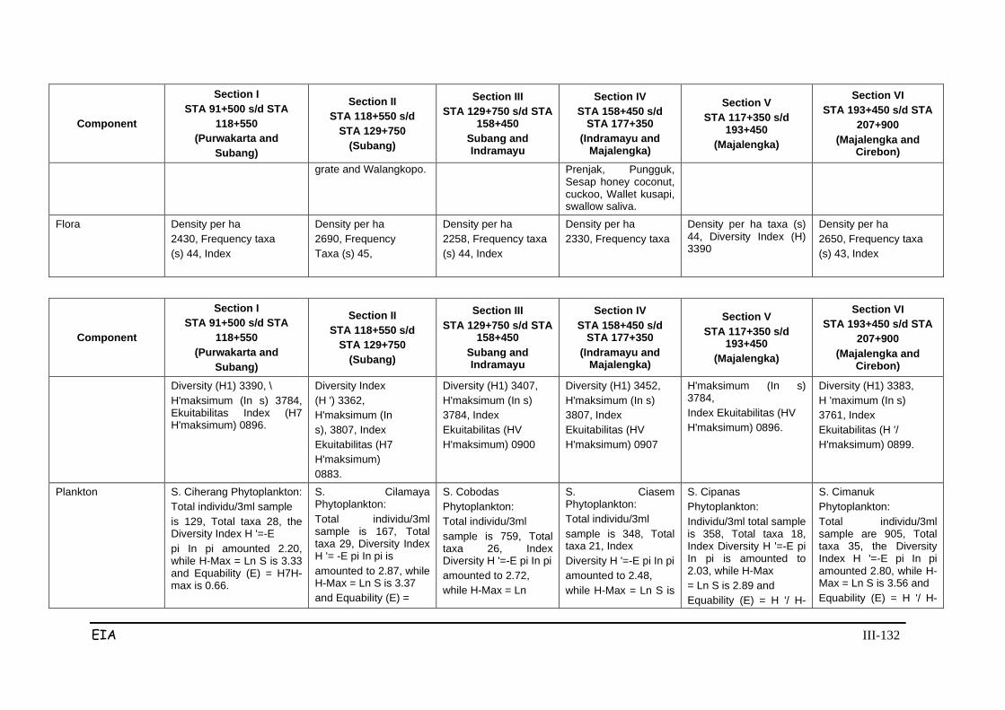
EIA III-132
Component
Section I STA 91+500 s/d STA
118+550 (Purwakarta and
Subang)
Section II STA 118+550 s/d
STA 129+750 (Subang)
Section III STA 129+750 s/d STA
158+450 Subang and Indramayu
Section IV STA 158+450 s/d
STA 177+350 (Indramayu and
Majalengka)
Section V STA 117+350 s/d
193+450 (Majalengka)
Section VI STA 193+450 s/d STA
207+900 (Majalengka and
Cirebon) grate and Walangkopo.
Prenjak, Pungguk, Sesap honey coconut, cuckoo, Wallet kusapi, swallow saliva.
Flora
Density per ha 2430, Frequency taxa (s) 44, Index
Density per ha 2690, Frequency Taxa (s) 45,
Density per ha 2258, Frequency taxa (s) 44, Index
Density per ha 2330, Frequency taxa
Density per ha taxa (s) 44, Diversity Index (H) 3390
Density per ha 2650, Frequency taxa (s) 43, Index
Component
Section I STA 91+500 s/d STA
118+550 (Purwakarta and
Subang)
Section II STA 118+550 s/d
STA 129+750 (Subang)
Section III STA 129+750 s/d STA
158+450 Subang and Indramayu
Section IV STA 158+450 s/d
STA 177+350 (Indramayu and
Majalengka)
Section V STA 117+350 s/d
193+450 (Majalengka)
Section VI STA 193+450 s/d STA
207+900 (Majalengka and
Cirebon)
Diversity (H1) 3390, \ H'maksimum (In s) 3784, Ekuitabilitas Index (H7 H'maksimum) 0896.
Diversity Index (H ') 3362, H'maksimum (In s), 3807, Index Ekuitabilitas (H7 H'maksimum) 0883.
Diversity (H1) 3407, H'maksimum (In s) 3784, Index Ekuitabilitas (HV H'maksimum) 0900
Diversity (H1) 3452, H'maksimum (In s) 3807, Index Ekuitabilitas (HV H'maksimum) 0907
H'maksimum (In s) 3784, Index Ekuitabilitas (HV H'maksimum) 0896.
Diversity (H1) 3383, H 'maximum (In s) 3761, Index Ekuitabilitas (H '/ H'maksimum) 0899.
Plankton
S. Ciherang Phytoplankton: Total individu/3ml sample is 129, Total taxa 28, the Diversity Index H '=-E pi In pi amounted 2.20, while H-Max = Ln S is 3.33 and Equability (E) = H7H-max is 0.66.
S. Cilamaya Phytoplankton: Total individu/3ml sample is 167, Total taxa 29, Diversity Index H '= -E pi In pi is amounted to 2.87, while H-Max = Ln S is 3.37 and Equability (E) =
S. Cobodas Phytoplankton: Total individu/3ml sample is 759, Total taxa 26, Index Diversity H '=-E pi In pi amounted to 2.72, while H-Max = Ln
S. Ciasem Phytoplankton: Total individu/3ml sample is 348, Total taxa 21, Index Diversity H '=-E pi In pi amounted to 2.48, while H-Max = Ln S is
S. Cipanas Phytoplankton: Individu/3ml total sample is 358, Total taxa 18, Index Diversity H '=-E pi In pi is amounted to 2.03, while H-Max = Ln S is 2.89 and Equability (E) = H '/ H-
S. Cimanuk Phytoplankton: Total individu/3ml sample are 905, Total taxa 35, the Diversity Index H '=-E pi In pi amounted 2.80, while H-Max = Ln S is 3.56 and Equability (E) = H '/ H-
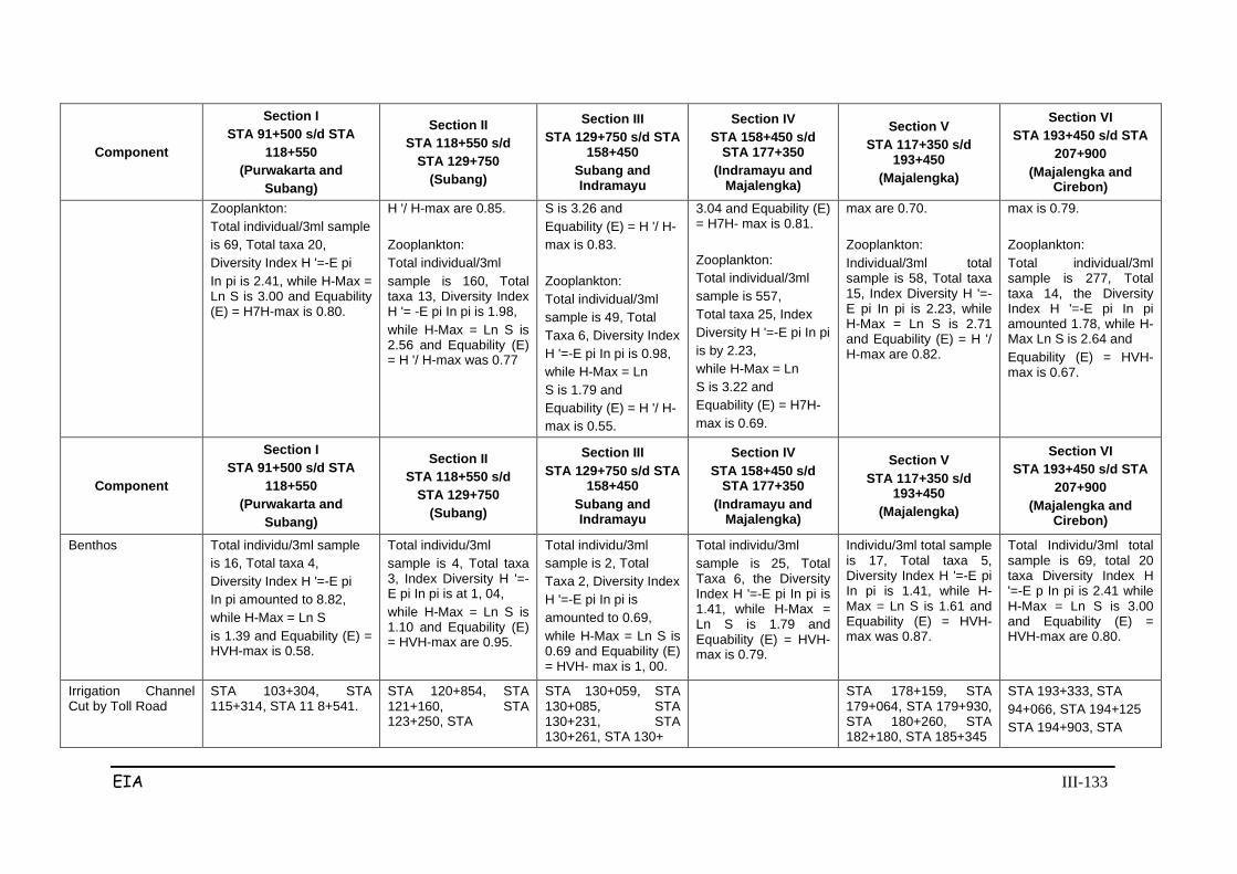
EIA III-133
Component
Section I STA 91+500 s/d STA
118+550 (Purwakarta and
Subang)
Section II STA 118+550 s/d
STA 129+750 (Subang)
Section III STA 129+750 s/d STA
158+450 Subang and Indramayu
Section IV STA 158+450 s/d
STA 177+350 (Indramayu and
Majalengka)
Section V STA 117+350 s/d
193+450 (Majalengka)
Section VI STA 193+450 s/d STA
207+900 (Majalengka and
Cirebon) Zooplankton: Total individual/3ml sample is 69, Total taxa 20, Diversity Index H '=-E pi In pi is 2.41, while H-Max = Ln S is 3.00 and Equability (E) = H7H-max is 0.80.
H '/ H-max are 0.85. Zooplankton: Total individual/3ml sample is 160, Total taxa 13, Diversity Index H '= -E pi In pi is 1.98, while H-Max = Ln S is 2.56 and Equability (E) = H '/ H-max was 0.77
S is 3.26 and Equability (E) = H '/ H- max is 0.83. Zooplankton: Total individual/3ml sample is 49, Total Taxa 6, Diversity Index H '=-E pi In pi is 0.98, while H-Max = Ln S is 1.79 and Equability (E) = H '/ H- max is 0.55.
3.04 and Equability (E) = H7H- max is 0.81. Zooplankton: Total individual/3ml sample is 557, Total taxa 25, Index Diversity H '=-E pi In pi is by 2.23, while H-Max = Ln S is 3.22 and Equability (E) = H7H- max is 0.69.
max are 0.70. Zooplankton: Individual/3ml total sample is 58, Total taxa 15, Index Diversity H '=-E pi In pi is 2.23, while H-Max = Ln S is 2.71 and Equability (E) = H '/ H-max are 0.82.
max is 0.79. Zooplankton: Total individual/3ml sample is 277, Total taxa 14, the Diversity Index H '=-E pi In pi amounted 1.78, while H-Max Ln S is 2.64 and Equability (E) = HVH-max is 0.67.
Component
Section I STA 91+500 s/d STA
118+550 (Purwakarta and
Subang)
Section II STA 118+550 s/d
STA 129+750 (Subang)
Section III STA 129+750 s/d STA
158+450 Subang and Indramayu
Section IV STA 158+450 s/d
STA 177+350 (Indramayu and
Majalengka)
Section V STA 117+350 s/d
193+450 (Majalengka)
Section VI STA 193+450 s/d STA
207+900 (Majalengka and
Cirebon)
Benthos Total individu/3ml sample is 16, Total taxa 4, Diversity Index H '=-E pi In pi amounted to 8.82, while H-Max = Ln S is 1.39 and Equability (E) = HVH-max is 0.58.
Total individu/3ml sample is 4, Total taxa 3, Index Diversity H '=-E pi In pi is at 1, 04, while H-Max = Ln S is 1.10 and Equability (E) = HVH-max are 0.95.
Total individu/3ml sample is 2, Total Taxa 2, Diversity Index H '=-E pi In pi is amounted to 0.69, while H-Max = Ln S is 0.69 and Equability (E) = HVH- max is 1, 00.
Total individu/3ml sample is 25, Total Taxa 6, the Diversity Index H '=-E pi In pi is 1.41, while H-Max = Ln S is 1.79 and Equability (E) = HVH-max is 0.79.
Individu/3ml total sample is 17, Total taxa 5, Diversity Index H '=-E pi In pi is 1.41, while H-Max = Ln S is 1.61 and Equability (E) = HVH-max was 0.87.
Total Individu/3ml total sample is 69, total 20 taxa Diversity Index H '=-E p In pi is 2.41 while H-Max = Ln S is 3.00 and Equability (E) = HVH-max are 0.80.
Irrigation Channel Cut by Toll Road
STA 103+304, STA 115+314, STA 11 8+541.
STA 120+854, STA 121+160, STA 123+250, STA
STA 130+059, STA 130+085, STA 130+231, STA 130+261, STA 130+
STA 178+159, STA 179+064, STA 179+930, STA 180+260, STA 182+180, STA 185+345
STA 193+333, STA 94+066, STA 194+125 STA 194+903, STA
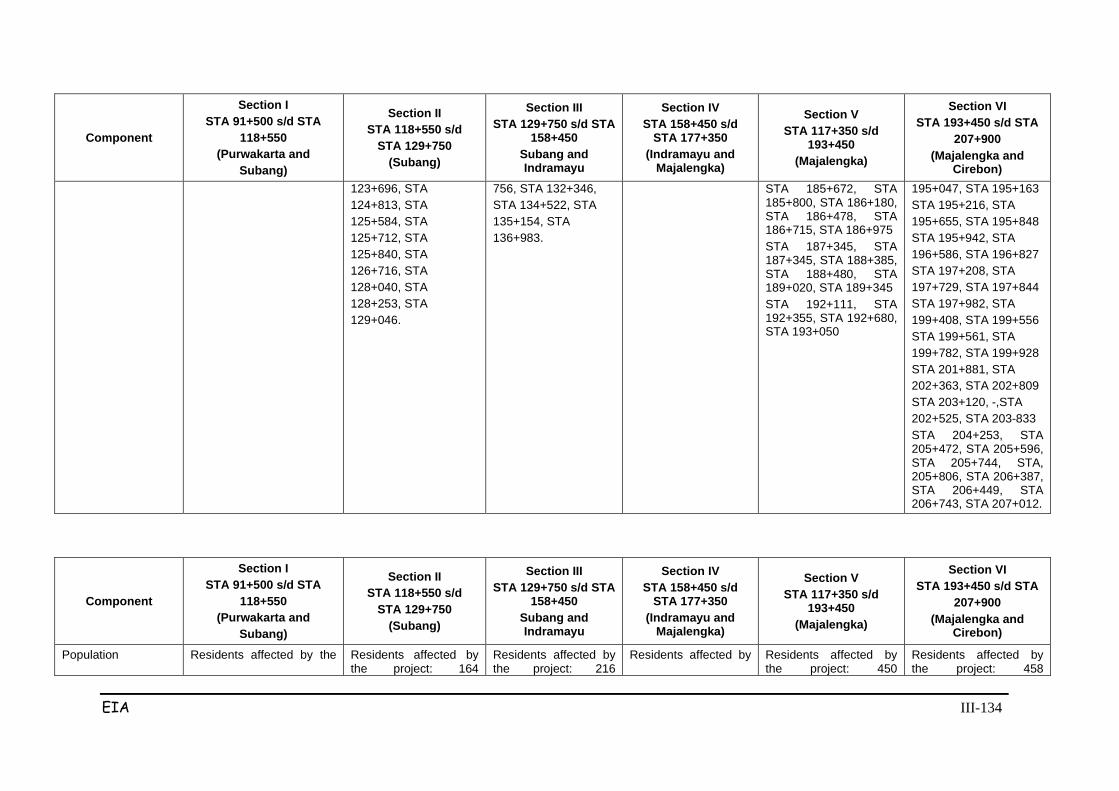
EIA III-134
Component
Section I STA 91+500 s/d STA
118+550 (Purwakarta and
Subang)
Section II STA 118+550 s/d
STA 129+750 (Subang)
Section III STA 129+750 s/d STA
158+450 Subang and Indramayu
Section IV STA 158+450 s/d
STA 177+350 (Indramayu and
Majalengka)
Section V STA 117+350 s/d
193+450 (Majalengka)
Section VI STA 193+450 s/d STA
207+900 (Majalengka and
Cirebon) 123+696, STA 124+813, STA 125+584, STA 125+712, STA 125+840, STA 126+716, STA 128+040, STA 128+253, STA 129+046.
756, STA 132+346, STA 134+522, STA 135+154, STA 136+983.
STA 185+672, STA 185+800, STA 186+180, STA 186+478, STA 186+715, STA 186+975 STA 187+345, STA 187+345, STA 188+385, STA 188+480, STA 189+020, STA 189+345 STA 192+111, STA 192+355, STA 192+680, STA 193+050
195+047, STA 195+163 STA 195+216, STA 195+655, STA 195+848 STA 195+942, STA 196+586, STA 196+827 STA 197+208, STA 197+729, STA 197+844 STA 197+982, STA 199+408, STA 199+556 STA 199+561, STA 199+782, STA 199+928 STA 201+881, STA 202+363, STA 202+809 STA 203+120, -,STA 202+525, STA 203-833 STA 204+253, STA 205+472, STA 205+596, STA 205+744, STA, 205+806, STA 206+387, STA 206+449, STA 206+743, STA 207+012.
Component
Section I STA 91+500 s/d STA
118+550 (Purwakarta and
Subang)
Section II STA 118+550 s/d
STA 129+750 (Subang)
Section III STA 129+750 s/d STA
158+450 Subang and Indramayu
Section IV STA 158+450 s/d
STA 177+350 (Indramayu and
Majalengka)
Section V STA 117+350 s/d
193+450 (Majalengka)
Section VI STA 193+450 s/d STA
207+900 (Majalengka and
Cirebon)
Population Residents affected by the Residents affected by the project: 164
Residents affected by the project: 216
Residents affected by Residents affected by the project: 450
Residents affected by the project: 458
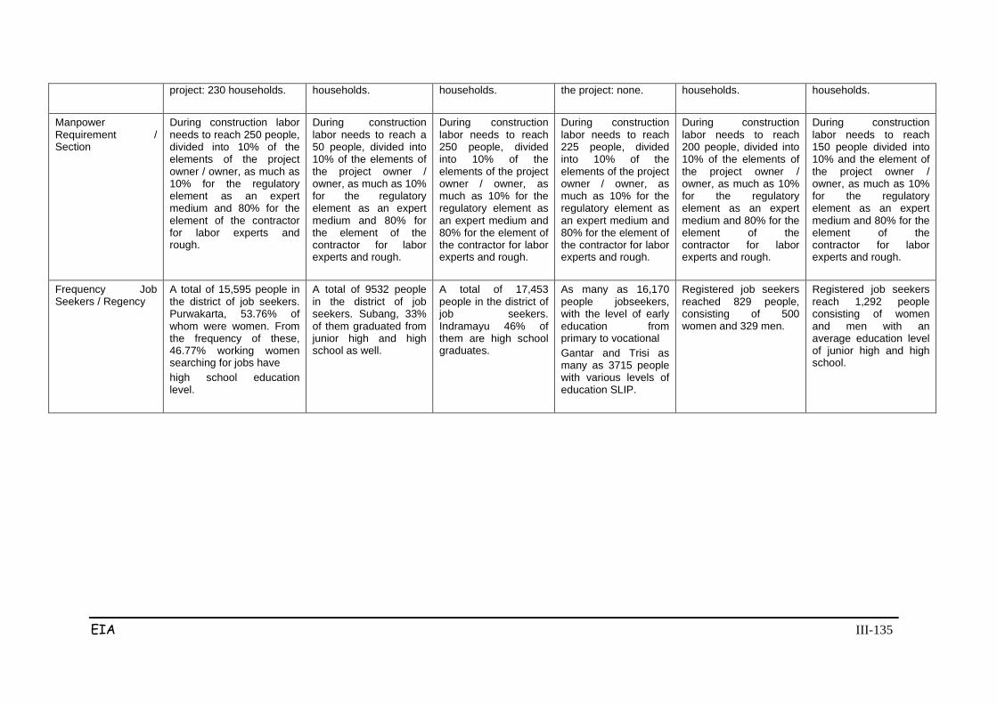
EIA III-135
project: 230 households.
households.
households.
the project: none.
households.
households.
Manpower Requirement / Section
During construction labor needs to reach 250 people, divided into 10% of the elements of the project owner / owner, as much as 10% for the regulatory element as an expert medium and 80% for the element of the contractor for labor experts and rough.
During construction labor needs to reach a 50 people, divided into 10% of the elements of the project owner / owner, as much as 10% for the regulatory element as an expert medium and 80% for the element of the contractor for labor experts and rough.
During construction labor needs to reach 250 people, divided into 10% of the elements of the project owner / owner, as much as 10% for the regulatory element as an expert medium and 80% for the element of the contractor for labor experts and rough.
During construction labor needs to reach 225 people, divided into 10% of the elements of the project owner / owner, as much as 10% for the regulatory element as an expert medium and 80% for the element of the contractor for labor experts and rough.
During construction labor needs to reach 200 people, divided into 10% of the elements of the project owner / owner, as much as 10% for the regulatory element as an expert medium and 80% for the element of the contractor for labor experts and rough.
During construction labor needs to reach 150 people divided into 10% and the element of the project owner / owner, as much as 10% for the regulatory element as an expert medium and 80% for the element of the contractor for labor experts and rough.
Frequency Job Seekers / Regency
A total of 15,595 people in the district of job seekers. Purwakarta, 53.76% of whom were women. From the frequency of these, 46.77% working women searching for jobs have high school education level.
A total of 9532 people in the district of job seekers. Subang, 33% of them graduated from junior high and high school as well.
A total of 17,453 people in the district of job seekers. Indramayu 46% of them are high school graduates.
As many as 16,170 people jobseekers, with the level of early education from primary to vocational Gantar and Trisi as many as 3715 people with various levels of education SLIP.
Registered job seekers reached 829 people, consisting of 500 women and 329 men.
Registered job seekers reach 1,292 people consisting of women and men with an average education level of junior high and high school.

EIA III-136
Component
Section I STA 91+500 s/d STA
118+550 (Purwakarta and
Subang)
Section II STA 118+550 s/d
STA 129+750 (Subang)
Section III STA 129+750 s/d STA
158+450 Subang and Indramayu
Section IV STA 158+450 s/d
STA 177+350 (Indramayu and
Majalengka)
Section V STA 117+350 s/d
193+450 (Majalengka)
Section VI STA 193+450 s/d STA
207+900 (Majalengka and
Cirebon)
Religion
Percentage population Muslim in Purwakarta Regency amounted to 98.98%; temporary resident Catholic Christian 0.21%; adherent Protestant Christianity amounted to 0.73%; Hindu 0.02% and Buddhist 0.06%.
In Regency. Subang frequency Muslim population is majority that is as much as 99.74%; followed by 0.012% Catholic faiths; Christian religions Protestant registration 0.013% and the remaining adherent Hindu religion and Buddhist.
Indramayu Moslem population of 1,691,185 people, followed the soul 4762 Protestant, Catholic soul 1647, soul 142 Hindu, Buddhist and Confucian soul 18 232 inhabitants.
The majority of the population in Indramayu Regency are Muslims with as many as 1,691,185 souls followed by Protestant residents at 4762 souls, Catholic 1647 souls, Hindu 142 soul, the soul of Buddha 232, and Confucian 18 souls
A total of 99.75% of the population in Majalengka Regency embrace Islam, as many Protestant Christian faiths 1.28%, adherents of the Catholic religion as much as 0.08%, the rest Hindu and Buddhist religions total 99,710 residents
A total of 99,710 residents of Cirebon embrace Islam, Protestants, adherents at 0.16%, Catholic religion 0.09%, Hindu religious adherents 0.02% and adherent Buddhist 0.02%.
Agriculture
The total area irrigated paddy fields 0.3 hectares; rain fed paddy field 40.2 ha of; field is 9.6 ha; 6.0 hectares of not productive soils, vacant 1.5 ha and forest area reached 75.3 ha.
Area of paddy field area irrigation reaches 36.3 ha; rainfed paddy field 3.0 ha and forest 25.8 Ha. Not found field or farm
Area of paddy field area irrigation of 13.5 hectares, 17.7 hectares rainfed rice field; field is 5.4 ha; unproductive 28.5 ha and forest reached 79.5 ha,
land area of paddy field area irrigation of 35.1 hectares; field is 2.4 ha, 8.1 ha unproductive land, and forest to reach 65.4 Ha. There is no rainfed rice field.
total area irrigated paddy field is 42.3 Ha, 22.5 ha field and forest an area of 12.3 ha
The total area irrigated paddy fields covering an area of 50.7 ha, 0.9 ha field and forest of 9.1 ha. There is no rain-fed paddy field
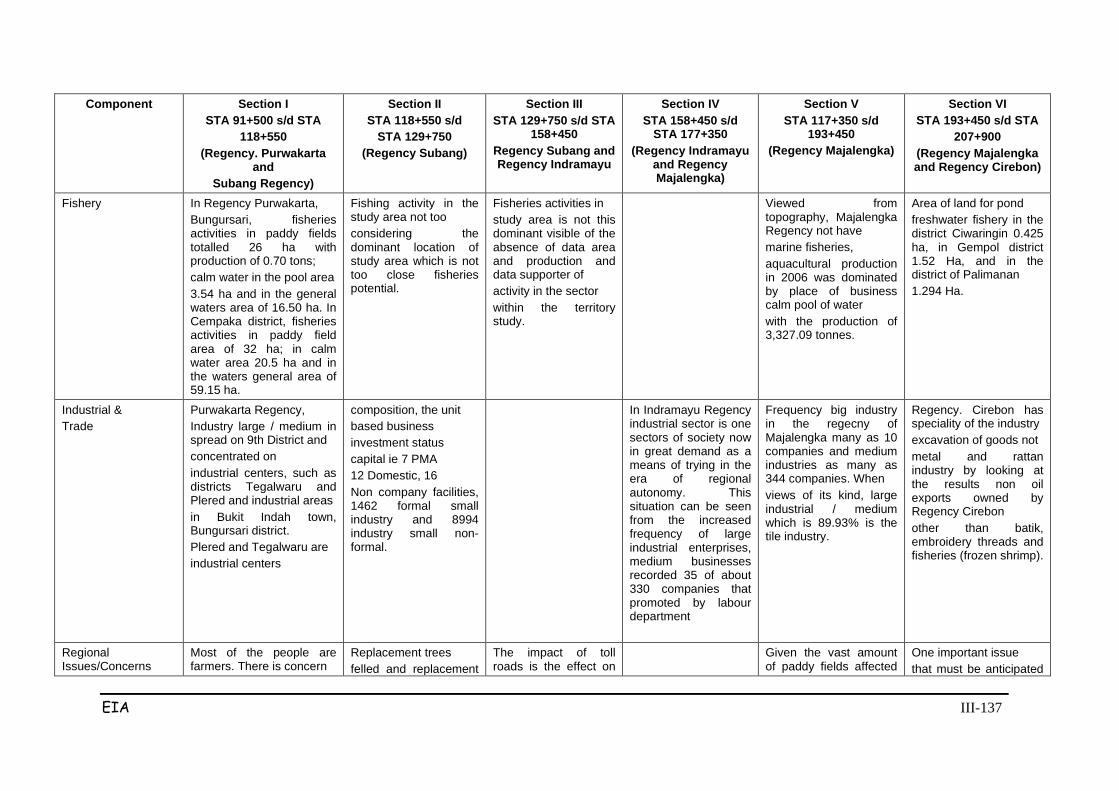
EIA III-137
Component Section I STA 91+500 s/d STA
118+550 (Regency. Purwakarta
and Subang Regency)
Section II STA 118+550 s/d
STA 129+750 (Regency Subang)
Section III STA 129+750 s/d STA
158+450 Regency Subang and Regency Indramayu
Section IV STA 158+450 s/d
STA 177+350 (Regency Indramayu
and Regency Majalengka)
Section V STA 117+350 s/d
193+450 (Regency Majalengka)
Section VI STA 193+450 s/d STA
207+900 (Regency Majalengka and Regency Cirebon)
Fishery
In Regency Purwakarta, Bungursari, fisheries activities in paddy fields totalled 26 ha with production of 0.70 tons; calm water in the pool area 3.54 ha and in the general waters area of 16.50 ha. In Cempaka district, fisheries activities in paddy field area of 32 ha; in calm water area 20.5 ha and in the waters general area of 59.15 ha.
Fishing activity in the study area not too considering the dominant location of study area which is not too close fisheries potential.
Fisheries activities in study area is not this dominant visible of the absence of data area and production and data supporter of activity in the sector within the territory study.
Viewed from topography, Majalengka Regency not have marine fisheries, aquacultural production in 2006 was dominated by place of business calm pool of water with the production of 3,327.09 tonnes.
Area of land for pond freshwater fishery in the district Ciwaringin 0.425 ha, in Gempol district 1.52 Ha, and in the district of Palimanan 1.294 Ha.
Industrial & Trade
Purwakarta Regency, Industry large / medium in spread on 9th District and concentrated on industrial centers, such as districts Tegalwaru and Plered and industrial areas in Bukit Indah town, Bungursari district. Plered and Tegalwaru are industrial centers
composition, the unit based business investment status capital ie 7 PMA 12 Domestic, 16 Non company facilities, 1462 formal small industry and 8994 industry small non-formal.
In Indramayu Regency industrial sector is one sectors of society now in great demand as a means of trying in the era of regional autonomy. This situation can be seen from the increased frequency of large industrial enterprises, medium businesses recorded 35 of about 330 companies that promoted by labour department
Frequency big industry in the regecny of Majalengka many as 10 companies and medium industries as many as 344 companies. When views of its kind, large industrial / medium which is 89.93% is the tile industry.
Regency. Cirebon has speciality of the industry excavation of goods not metal and rattan industry by looking at the results non oil exports owned by Regency Cirebon other than batik, embroidery threads and fisheries (frozen shrimp).
Regional Issues/Concerns
Most of the people are farmers. There is concern
Replacement trees felled and replacement
The impact of toll roads is the effect on
Given the vast amount of paddy fields affected
One important issue that must be anticipated

EIA III-138
community against problem of liberation land due to land release agriculture resulted in their income be reduced where productivity results agriculture partly become lost.
standards tree needs to get clarity with involve community formulate change loss. Given the vast amount of paddy fields affected exemption, then some farmers be affected impact of lost their livelihoods
economic growth in the lane artery that becomes income decline, declining land prices, etc. Economic activity that exists in some lines include stalls, shops, restaurants and others.
by the exemption, so some farmers will be affected lose their livelihoods. In addition, the exemption of agricultural land can also reduce the productivity results agriculture in the region.
against the plan highway construction Cikampek - Palimanan is the issue of liberation land. Pembeba rejection problem of land-san is especially true in the boarding area Babakan Ciwaringin Cirebon Issues raised not to the aspect development plan highways, but there release plan crossing or crossing land boarding them.
Social Cultural
Customary activities such as marriage, circumcision, death, down to paddy field, harvest, build houses, appointment of leaders society, and nature mutual help community until now now there are many there among village community. This situation is supported therefore this area has long been open relationship with the region outside and the level education relative height and mobility between population is more dynamic.
Customary activities such as marriage, circumcision, death, down to paddy field, harvest, build houses, appointment of leaders society, and nature mutual help community until now now there are many there among village community. This situation is supported therefore this area has long been open relationship with the region outside and the level education relative height and mobility between population is more dynamic.
Customary activities such as marriage, circumcision, death, down to paddy field, harvest, build houses, appointment of leaders society, and nature mutual help community until now now there are many there among village community. This situation is supported therefore this area has long been open relationship with the region outside and the level education relative height and mobility between population is more dynamic.
Customary activities such as marriage, circumcision, death, down to paddy field, harvest, build houses, appointment of leaders society, and nature mutual help community until now now there are many there among village community. This situation is supported therefore this area has long been open relationship with the region outside and the level education relative height and mobility between population is more dynamic.
Customary activities such as marriage, circumcision, death, down to paddy field, harvest, build houses, appointment of leaders society, and nature mutual help community until now now there are many there among village community. This situation is supported therefore this area has long been open relationship with the region outside and the level education relative height and mobility between population is more dynamic.
Customary activities such as marriage, circumcision, death, down to paddy field, harvest, build houses, appointment of leaders society, and nature mutual help community until now now there are many there among village community. This situation is supported therefore this area has long been open relationship with the region outside and the level education relative height and mobility between population is more dynamic.

EIA III-139
Socioeconomic Type of work is grouped in 8 category, namely (a) farmers, (B) traders, (c) Employees, (d) civil servants (e) self-employed, (f) workers, (g) carpenters, (h) teachers, (i) Other. category type of work owned by respondents simply vary so range of livelihood is adequate describing reality social in the region. The largest respondent is a farmer registration; followed by traders; entrepreneur; etc. and labor.
Type of work is grouped in 8 category, namely (a) farmers, (B) traders, (c) Employees, (d) civil servants (e) self-employed, (f) workers, (g) carpenters, (h) teachers, (i) Other. category type of work owned by respondents simply vary so range of livelihood is adequate describing reality social in the region. Respondents largest as farmers registration; merchants; self-employed and others.
Type of work is grouped in 8 category, namely (a) farmers, (B) traders, (c) Employees, (d) civil servants (e) self-employed, (f) workers, (g) carpenters, (h) teachers, (i) Other. category type of work owned by respondents simply vary so range of livelihood is adequate describing reality social in the region.
Type of work is grouped in 8 category, namely (a) farmers, (B) traders, (c) Employees, (d) civil servants (e) self-employed, (f) workers, (g) carpenters, (h) teachers, (i) Other. category type of work owned by respondents simply vary so range of livelihood is adequate describing reality social in the region. The largest are the main respondent most farmers, traders, self-employed etc. and labor.
Type of work is grouped in 8 category, namely (a) farmers, (B) traders, (c) Employees, (d) civil servants (e) self-employed, (f) workers, (g) carpenters, (h) teachers, (i) Other. category type of work owned by respondents simply vary so range of livelihood is adequate describing reality social in the region.
Type of work is grouped in 8 category, namely (a) farmers, (B) traders, (c) Employees, (d) civil servants (e) self-employed, (f) workers, (g) carpenters, (h) teachers, (i) Other. category type of work owned by respondents simply vary so range of livelihood is adequate describing reality social in the region. Respondent's main job is as a farmer of the largest registration, traders, entrepreneurs and others work as laborers.
Land ownership
78.8% owned, leased 4.2% and others 17.0%.
Own 87%, lease 2.1% and Another 10.9%.
Own 89.7%, lease 2.4% and 7.9% other
Own 80.6%, rent 2.3% and others 17.1%.
Own 78.4%, 3.2% rental and others 18.4%.
Own 79.2%, rental 2.2% and other 18.6%.
Respondents Opinions About Toll Road
Agree on implementation highway construction as much as 92% and not agree 8.0%
Agree on implementation highway construction as much as 92% and not agree 8.0%
Agree on implementation highway construction as much as 92% and not agree 8.0%
Agree on implementation highway construction as much as 92% and not agree 8.0%
Agree on implementation highway construction as much as 92% and not agree 8.0%
Agree on implementation highway construction as much as 92% and not agree 8.0%
Compensations Compensation shall be in accordance with the agreement, and indemnity coverage among others to land, buildings, plants and other assets. Payment of compensation
Compensation shall be in accordance with the agreement, and indemnity coverage among others to land, buildings, plants and other assets.
Compensation shall be in accordance with the agreement, and indemnity coverage among others to land, buildings, plants and other assets.
Compensation shall be in accordance with the agreement, and indemnity coverage among others to land, buildings, plants and other assets.
Compensation shall be in accordance with the agreement, and indemnity coverage among others to land, buildings, plants and other assets.
Compensation shall be in accordance with the agreement, and indemnity coverage among others for building soil, plants and other assets.
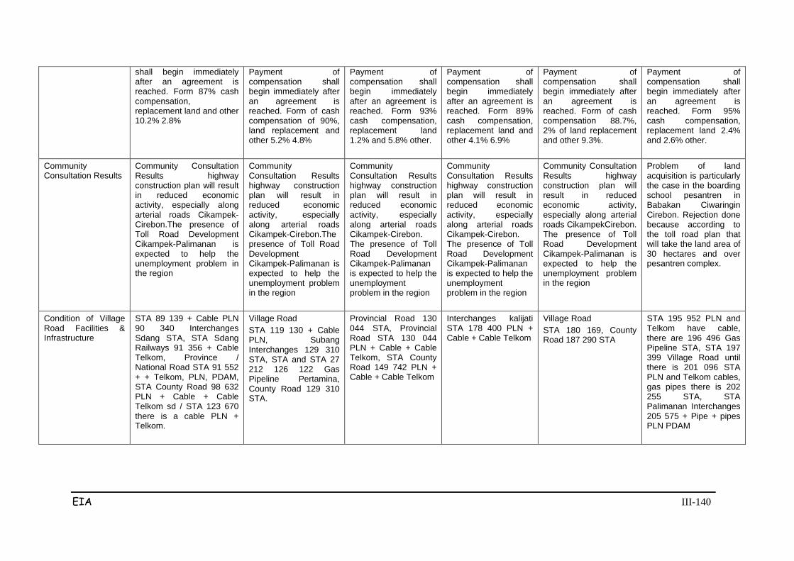
EIA III-140
shall begin immediately after an agreement is reached. Form 87% cash compensation, replacement land and other 10.2% 2.8%
Payment of compensation shall begin immediately after an agreement is reached. Form of cash compensation of 90%, land replacement and other 5.2% 4.8%
Payment of compensation shall begin immediately after an agreement is reached. Form 93% cash compensation, replacement land 1.2% and 5.8% other.
Payment of compensation shall begin immediately after an agreement is reached. Form 89% cash compensation, replacement land and other 4.1% 6.9%
Payment of compensation shall begin immediately after an agreement is reached. Form of cash compensation 88.7%, 2% of land replacement and other 9.3%.
Payment of compensation shall begin immediately after an agreement is reached. Form 95% cash compensation, replacement land 2.4% and 2.6% other.
Community Consultation Results
Community Consultation Results highway construction plan will result in reduced economic activity, especially along arterial roads Cikampek-Cirebon.The presence of Toll Road Development Cikampek-Palimanan is expected to help the unemployment problem in the region
Community Consultation Results highway construction plan will result in reduced economic activity, especially along arterial roads Cikampek-Cirebon.The presence of Toll Road Development Cikampek-Palimanan is expected to help the unemployment problem in the region
Community Consultation Results highway construction plan will result in reduced economic activity, especially along arterial roads Cikampek-Cirebon. The presence of Toll Road Development Cikampek-Palimanan is expected to help the unemployment problem in the region
Community Consultation Results highway construction plan will result in reduced economic activity, especially along arterial roads Cikampek-Cirebon. The presence of Toll Road Development Cikampek-Palimanan is expected to help the unemployment problem in the region
Community Consultation Results highway construction plan will result in reduced economic activity, especially along arterial roads CikampekCirebon. The presence of Toll Road Development Cikampek-Palimanan is expected to help the unemployment problem in the region
Problem of land acquisition is particularly the case in the boarding school pesantren in Babakan Ciwaringin Cirebon. Rejection done because according to the toll road plan that will take the land area of 30 hectares and over pesantren complex.
Condition of Village Road Facilities & Infrastructure
STA 89 139 + Cable PLN 90 340 Interchanges Sdang STA, STA Sdang Railways 91 356 + Cable Telkom, Province / National Road STA 91 552 + + Telkom, PLN, PDAM, STA County Road 98 632 PLN + Cable + Cable Telkom sd / STA 123 670 there is a cable PLN + Telkom.
Village Road STA 119 130 + Cable PLN, Subang Interchanges 129 310 STA, STA and STA 27 212 126 122 Gas Pipeline Pertamina, County Road 129 310 STA.
Provincial Road 130 044 STA, Provincial Road STA 130 044 PLN + Cable + Cable Telkom, STA County Road 149 742 PLN + Cable + Cable Telkom
Interchanges kalijati STA 178 400 PLN + Cable + Cable Telkom
Village Road STA 180 169, County Road 187 290 STA
STA 195 952 PLN and Telkom have cable, there are 196 496 Gas Pipeline STA, STA 197 399 Village Road until there is 201 096 STA PLN and Telkom cables, gas pipes there is 202 255 STA, STA Palimanan Interchanges 205 575 + Pipe + pipes PLN PDAM
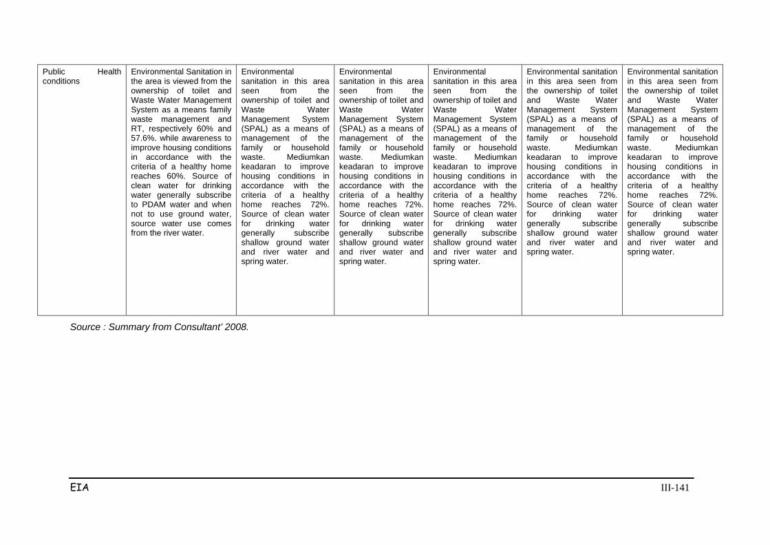
EIA III-141
Public Health conditions
Environmental Sanitation in the area is viewed from the ownership of toilet and Waste Water Management System as a means family waste management and RT, respectively 60% and 57.6%. while awareness to improve housing conditions in accordance with the criteria of a healthy home reaches 60%. Source of clean water for drinking water generally subscribe to PDAM water and when not to use ground water, source water use comes from the river water.
Environmental sanitation in this area seen from the ownership of toilet and Waste Water Management System (SPAL) as a means of management of the family or household waste. Mediumkan keadaran to improve housing conditions in accordance with the criteria of a healthy home reaches 72%. Source of clean water for drinking water generally subscribe shallow ground water and river water and spring water.
Environmental sanitation in this area seen from the ownership of toilet and Waste Water Management System (SPAL) as a means of management of the family or household waste. Mediumkan keadaran to improve housing conditions in accordance with the criteria of a healthy home reaches 72%. Source of clean water for drinking water generally subscribe shallow ground water and river water and spring water.
Environmental sanitation in this area seen from the ownership of toilet and Waste Water Management System (SPAL) as a means of management of the family or household waste. Mediumkan keadaran to improve housing conditions in accordance with the criteria of a healthy home reaches 72%. Source of clean water for drinking water generally subscribe shallow ground water and river water and spring water.
Environmental sanitation in this area seen from the ownership of toilet and Waste Water Management System (SPAL) as a means of management of the family or household waste. Mediumkan keadaran to improve housing conditions in accordance with the criteria of a healthy home reaches 72%. Source of clean water for drinking water generally subscribe shallow ground water and river water and spring water.
Environmental sanitation in this area seen from the ownership of toilet and Waste Water Management System (SPAL) as a means of management of the family or household waste. Mediumkan keadaran to improve housing conditions in accordance with the criteria of a healthy home reaches 72%. Source of clean water for drinking water generally subscribe shallow ground water and river water and spring water.
Source : Summary from Consultant’ 2008.
EIA IV-1
Chapter IV
SCOPE OF STUDY
4.1 SCOPING RESULT
The result of scoping has been done previously at the time of preparing the KA-
ANDAL as described in Figure 4.1 “Diagram of Impact Scoping Process for the
Cikampek-Palimanan Toll Road Development”. Furthermore, the impact
forecasting study identified two effects that were originally in the KA-ANDAL,
including one impact of hypothetical importance, but after the re-examination it
was found not to be a priority or significant impact that should be studied further.
Both impacts are:
a. The emergence of land speculators
Understanding the mechanism for land acquisition based on Presidential
Regulation No. 36 Jo. No. 65 Year 2006 on Land Procurement for the
implementation of Development for Public Interest, it will be difficult for the
emergence of opportunities for land speculators. This is considering the phasing of
land acquisition activities under Presidential Regulation which are very clear and
tight, where the presence of TPT and P2T observe the process of land acquisition.
The phasing is as follows:
Phase I: Approval and request location
Phase II: Dissemination, inventory and Land Price Assessment Team
Phase III: Deliberation and Normative List
Stage IV: Payment and Release of Rights Letter (SPH)
Phase V: UGR Custody Court
b. The emergence of public disappointment about the land compensation values
Based on Presidential Regulation No. 36 Jo. No. 65 In 2006, the value of
compensation is to be based on two aspects:

EIA IV-2
1. Local market price based on the real price recommendations by the Land
Price Appraisal Team.
2. Discussions/consultations
Therefore the land acquisition prices are expected to comply with the regulations
and agreements with the community. In the event of a dispute this will be resolved
legally. Thus the land compensation values must be a collective agreement that is
acceptable by all parties.
4.2 SCOPE OF STUDY AREA
The scope of the study area boundary is required in order to focus the assessment
on an object of study from a particular area. The study area boundaries identified
below are the result of the study undertaken as displayed in Figure 4.2.
1. Project Boundaries
Project boundaries are namely the scope of where the project activities will be
carried out during pre-construction, construction, and operation. This project
boundary includes a 60m wide ROW along ± 16.4 km.
2. Ecological Boundaries
Ecological limits are set based on the distribution of impacts through air and noise
(± 200m left and right of way), and water in the vicinity of the location within a
radius of 500m. Field observations indicated that the distribution of pollutants and
direction of emissions are parallel with the road, because of the influence of
movement caused by the flow of traffic. These limits are also based on the
forecasted distribution of vehicle emissions to air and water, which is an ecological
boundary.
3. Social Boundaries
Social boundaries are the space around the activity site and footprint, where social
interactions are based on the socio-economic and cultural dynamics of the
community groups. These groups are expected to experience a fundamental
change because of the development activities of the Cikampek-Palimanan toll
road. The major and significant impacts on the social component have been taken
into consideration when identifying the social boundaries, of which they include:
• Loss of property rights / land tenure, livelihoods and reduced incomes that
will lead to the increase in dissociative processes due to land acquisition
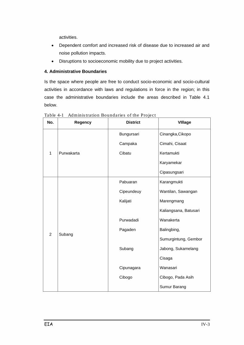
EIA IV-3
activities.
• Dependent comfort and increased risk of disease due to increased air and
noise pollution impacts.
• Disruptions to socioeconomic mobility due to project activities.
4. Administrative Boundaries
Is the space where people are free to conduct socio-economic and socio-cultural
activities in accordance with laws and regulations in force in the region; in this
case the administrative boundaries include the areas described in Table 4.1
below.
Table 4-1 Adminis tration Boundaries of the Pro ject No. Regency District VIllage
1 Purwakarta
Bungursari
Campaka
Cibatu
Cinangka,Cikopo
Cimahi, Cisaat
Kertamukti
Karyamekar
Cipasungsari
2 Subang
Pabuaran
Cipeundeuy
Kalijati
Purwadadi
Pagaden
Subang
Cipunagara
Cibogo
Karangmukti
Wantilan, Sawangan
Marengmang
Kaliangsana, Batusari
Wanakerta
Balingbing,
Sumurgintung, Gembor
Jabong, Sukamelang
Cisaga
Wanasari
Cibogo, Pada Asih
Sumur Barang
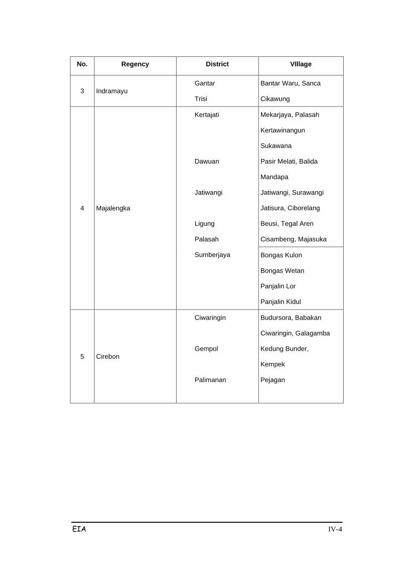
EIA IV-4
No. Regency District VIllage
3 Indramayu Gantar
Trisi
Bantar Waru, Sanca
Cikawung
4 Majalengka
Kertajati
Dawuan
Jatiwangi
Ligung
Palasah
Sumberjaya
Mekarjaya, Palasah
Kertawinangun
Sukawana
Pasir Melati, Balida
Mandapa
Jatiwangi, Surawangi
Jatisura, Ciborelang
Beusi, Tegal Aren
Cisambeng, Majasuka
Bongas Kulon
Bongas Wetan
Panjalin Lor
Panjalin Kidul
5 Cirebon
Ciwaringin
Gempol
Palimanan
Budursora, Babakan
Ciwaringin, Galagamba
Kedung Bunder,
Kempek
Pejagan
EIA IV-5
Figure 4-1 Diagram of Impact Scop ing Proces s fo r the Cikampek-Palimanan Toll Road Development
EIA V-1
Chapter V
FORECASTING SIGNIFICANT IMPACTS
5.1 FORECASTING IMPACTS
The hypothetical impacts for the Cikampek-Palimanan Toll Road Development
Project pre-construction, construction and operational activities were identified and
used to forecast the predicted significant impacts of the Project. The hypothetical
impacts identified during the previous scoping exercise have been narrowed down
to the following predicted significant impacts:
5.2 PRE-CONSTRUCTION PHASE
Impacts forecasted during the pre-construction phase occur along the route
determined by the Governor of West Java Province. The size and land use of land
that will be acquired by the Project can be seen in Table 2.5 (Chapter 2).
Most of the land to be impacted by the Cikampek-Palimanan toll road is
agricultural land (irrigated rice fields) and HGU controlled by large companies
(such as forestry companies). Community-owned land generally is a mixture of
garden land and vacant land controlled by the community population. Residents
who reside near the planned toll route but who were not resettled are generally
located where the planned toll route intersects with national/regional roads. The
number of people directly affected by the project is as follows:
1. Section I, as many as 230 households
2. Section II, as many as 164 households
3. Section III, as many as 216 households
4. Section IV, none
5. Section V, as many as 454 households
6. Section VI, as many as 454 households
As previously described in the scoping results, pre-construction stage activities
that will have impacts are the surveys and measurements of the planned toll road
route, and land acquisition activities. Impacts expected to arise are as follows:
EIA V-2
a. The emergence of community unrest
The planned locations that the Cikampek-Palimanan Toll Road Development
Project will fall in include Purwakarta, Subang, Majalengka, Cirebon and
Indramayu Regencies in West Java, starting from Cikampek (Sta. 91+500)
extending up to Palimanan area (Sta. 207+000). In general, the planned width of
the toll road (ROW) is about 60 m. The toll road segments that will involve
excavation (deep cuttings), will have a rumija width of 100 m. Therefore
construction of this toll road will need ±765.6 ha of land.
Activities that pose a significant impact during the pre-construction phase include:
1) Surveys and measurements to determine the planned road alignment/route
which are needed for technical planning and to determine the extent of
land and buildings that need to be acquired.
2) Acquisition of ±765.6 ha of land, consisting of yard/garden areas,
settlements, rice fields, houses, bush land, forest and mixed
farms/gardens.
- There will be cases of partial acquisition of farming/community land that
will cut the existings plots.
The partial acquisition (cutting) of land does not pose a problem for those
landowners with large/vast plots, but does for those landowners/farmers
who have relatively narrow or small land.
These issues can lead to further problems such as implementation/work delays,
social unrest and/or poor public perceptions of the project.
At the time that the community preferences survey was undertaken, the land and
building owners/users to be affected by the project claimed to be concerned,
particularly over the possibility of losing their source of livelihood and the
possibility that they may not receive sufficient or satisfactory compensation.
However, the survey respondents claimed that they had no objection to the project
land acquisition if they were provided with “appropriate compensation for both land
and buildings”. This clearly indicates that there has been previous unrest among
the local land/buildings owners and users. This social dissociative process impact
is expected to be addressed through socializations, which if not conducted
properly can potentially turn the social dissociative process into open community
unrest.
EIA V-3
From this description, it can be concluded that the potential impact of social unrest
is quite large, considering that the original quality of the social environment which
was classified as good (no anxiety), became worse because of the dissociative
process where local residents expressed their anxieties and issues of unrest
openly. The number of people expected to be affected by this spread of negative
anxiety and unrest in this region is relatively small considering the size of the
project area (Section I, II, III, V, VI). However, this can have cumulative impacts
when combined with the impacts caused by other activities (such as land
procurement/acquisition), and can in turn lead to the emergence of social conflicts
that could disrupt social safety and security, and could be of such an intensive-
scale to hinder the implementation of the project. Therefore, the nature of this
impact on the social-cultural component is considered significant negative (B /-P).
b. The emergence of social conflict
The planned Cikampek-Palimanan toll road development faces an obstacle in the
form of rejection of the land acquisition plan, particularly around the Babakan
Ciwaringin islamic boarding school. Various responses and reactions opposing the
land acquisition plan have been raised several times primarily by the boarding
school community. This issue requires special attention by both government and
the project proponent in order to obtain a solution. This issue has nothing to do
with rejection of the Cikampek-Palimanan highway construction, it involves the
planned route and proposed land acquisition. As such it is expected that an
alternative route must be proposed that does not pass through or interfere with the
boarding school area.
This problem needs to be examined properly in order to avoid the emergence of
social conflict. This impact is expected to arise from the technical planning and
environmental surveys and the inventories and measurements for the land
procurement/acquisition process. The community preference survey results
indicated that the respondents did not object to the planned toll road in general, as
long as the land acquisition does not relocate or disrupt the activities of the
boarding school. If this issue is not handled properly, it has the potential to turn the
dissociatve process of dissociative into open social conflicts.
From this description it can be concluded that the potential impact of rejection of
land acquisition in the boarding school area will worsen the existing social

EIA V-4
environment (which is classified as good (no anxiety) under normal conditions)
due to the escalation of the social dissociative process into conflicts expressed by
the residents. The number of people expected to be negatively affected is
relatively small over the entire project region (Section I, II, III, V, VI). However, this
impact is also cumulative when combined with the impact of other activities (such
as land procurement/acquisition), and in turn can lead to the emergence of social
conflicts that could disrupt local security and order (kamtibmas), and could be of
such an intensive-scale to hinder the implementation of the project. Therefore, the
nature of this impact on the social-cultural component is considered significant negative (B /-P).
c. Reduced community income
While land acquisition activities will affect housing and buildings, land acquisition
will also affect community farms/plantation/gardens where the majority of plants in
the region are crops of economic value and serve as a source of income for the
community. The acqusition of plantation/crop/farm land will certainly eliminate a
source of livelihood for those families and in turn reduce the income level of locals.
The acquisition of plants of economic value will occur mainly where the toll road
route passes through commercial production land, such as coconut plantations. As
a result of this land acquisition the plantations will be narrowed/reduced resulting
in an income decline.
This impact can be categorized as large, considering those with a previous source
of livelihood and income will have this source lost due to project land acquisition.
However, the provision of compensation for income-generating land is expected to
be diverted by the receipients into new productive assets that can be used to
generate income.
Similar to the impact on economic activities, the number of people expected to be
affected by this project impact are also limited as they are not dispersed throught
the whole project area (Section I, II, III, V, VI), they are limited to a small area.
Nevertheless, the impact is considered significant negative (B /-P), due to the
following considerations:
• Greater intensity of impact due to the loss of livelihood and income which
will greatly affect the socio-economics of the affected population;
• Impact is time consuming, as more than one stage is needed for the land
acquisition plan, and the process can drag on if mitigation is not conducted
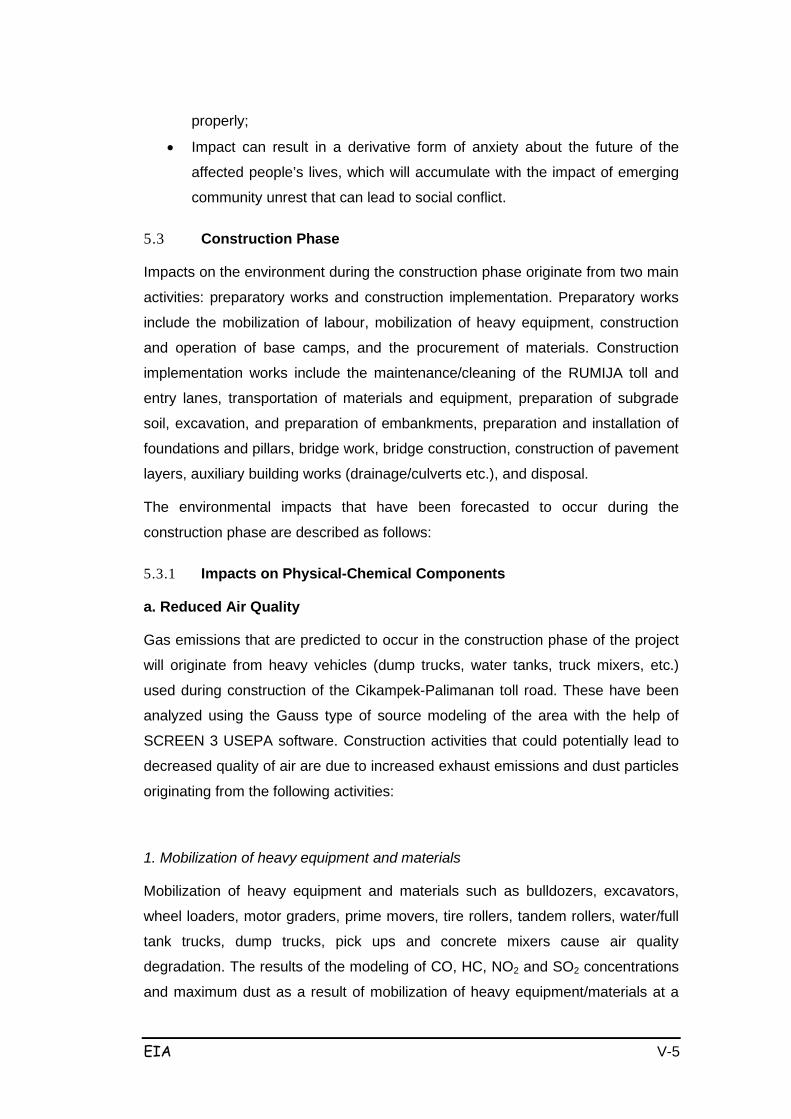
EIA V-5
properly;
• Impact can result in a derivative form of anxiety about the future of the
affected people’s lives, which will accumulate with the impact of emerging
community unrest that can lead to social conflict.
5.3 Construction Phase
Impacts on the environment during the construction phase originate from two main
activities: preparatory works and construction implementation. Preparatory works
include the mobilization of labour, mobilization of heavy equipment, construction
and operation of base camps, and the procurement of materials. Construction
implementation works include the maintenance/cleaning of the RUMIJA toll and
entry lanes, transportation of materials and equipment, preparation of subgrade
soil, excavation, and preparation of embankments, preparation and installation of
foundations and pillars, bridge work, bridge construction, construction of pavement
layers, auxiliary building works (drainage/culverts etc.), and disposal.
The environmental impacts that have been forecasted to occur during the
construction phase are described as follows:
5.3.1 Impacts on Physical-Chemical Components
a. Reduced Air Quality
Gas emissions that are predicted to occur in the construction phase of the project
will originate from heavy vehicles (dump trucks, water tanks, truck mixers, etc.)
used during construction of the Cikampek-Palimanan toll road. These have been
analyzed using the Gauss type of source modeling of the area with the help of
SCREEN 3 USEPA software. Construction activities that could potentially lead to
decreased quality of air are due to increased exhaust emissions and dust particles
originating from the following activities:
1. Mobilization of heavy equipment and materials
Mobilization of heavy equipment and materials such as bulldozers, excavators,
wheel loaders, motor graders, prime movers, tire rollers, tandem rollers, water/full
tank trucks, dump trucks, pick ups and concrete mixers cause air quality
degradation. The results of the modeling of CO, HC, NO2 and SO2 concentrations
and maximum dust as a result of mobilization of heavy equipment/materials at a
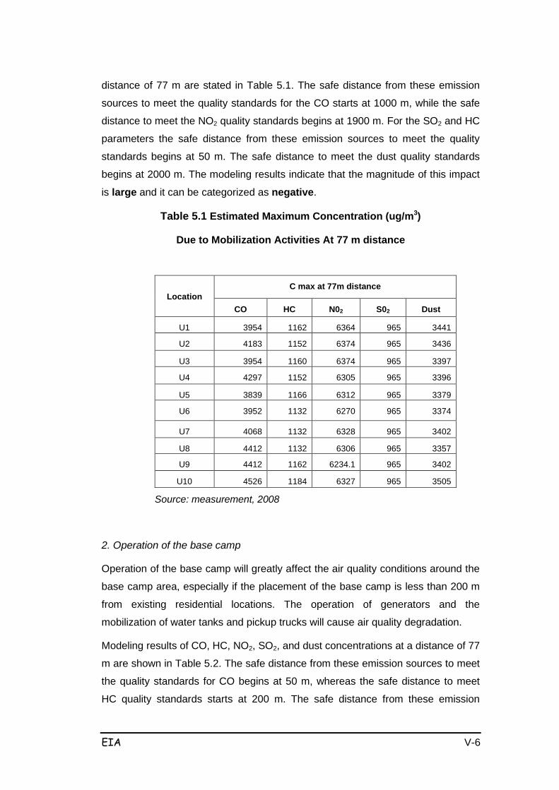
EIA V-6
distance of 77 m are stated in Table 5.1. The safe distance from these emission
sources to meet the quality standards for the CO starts at 1000 m, while the safe
distance to meet the NO2 quality standards begins at 1900 m. For the SO2 and HC
parameters the safe distance from these emission sources to meet the quality
standards begins at 50 m. The safe distance to meet the dust quality standards
begins at 2000 m. The modeling results indicate that the magnitude of this impact
is large and it can be categorized as negative.
Table 5.1 Estimated Maximum Concentration (ug/m3)
Due to Mobilization Activities At 77 m distance
Location C max at 77m distance
CO
HC
N02
S02
Dust
U1
3954
1162
6364
965
3441
U2
4183
1152
6374
965
3436
U3
3954
1160
6374
965
3397
U4
4297
1152
6305
965
3396
U5
3839
1166
6312
965
3379
U6
3952
1132
6270
965
3374
U7
4068
1132
6328
965
3402
U8
4412
1132
6306
965
3357
U9
4412
1162
6234.1
965
3402
U10
4526
1184
6327
965
3505
Source: measurement, 2008
2. Operation of the base camp
Operation of the base camp will greatly affect the air quality conditions around the
base camp area, especially if the placement of the base camp is less than 200 m
from existing residential locations. The operation of generators and the
mobilization of water tanks and pickup trucks will cause air quality degradation.
Modeling results of CO, HC, NO2, SO2, and dust concentrations at a distance of 77
m are shown in Table 5.2. The safe distance from these emission sources to meet
the quality standards for CO begins at 50 m, whereas the safe distance to meet
HC quality standards starts at 200 m. The safe distance from these emission
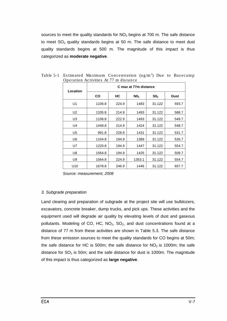
EIA V-7
sources to meet the quality standards for NO2 begins at 700 m. The safe distance
to meet SO2 quality standards begins at 50 m. The safe distance to meet dust
quality standards begins at 500 m. The magnitude of this impact is thus
categorized as moderate negative.
Table 5-1 Es timated Maximum Concentra tion (ug/m 3) Due to Bas ecamp Operation Activities At 77 m dis tance
Location C max at 77m distance
CO
HC
N02
S02
Dust
U1
1106.8
224.9
1483
31.122
593.7
U2
1335.8
214.9
1493
31.122
588.7
U3
1106.8
222.9
1493
31.122
549.7
U4
1449.8
214.9
1424
31.122
548.7
U5
991.8
228.9
1431
31.122
531.7
U6
1104.8
194.9
1389
31.122
526.7
U7
1220.8
194.9
1447
31.122
554.7
U8
1564.8
194.9
1425
31.122
509.7
U9
1564.8
224.9
1353.1
31.122
554.7
U10
1678.8
246.9
1446
31.122
657.7
Source: measurement, 2008
3. Subgrade preparation
Land clearing and preparation of subgrade at the project site will use bulldozers,
excavators, concrete breaker, dump trucks, and pick ups. These activities and the
equipment used will degrade air quality by elevating levels of dust and gaseous
pollutants. Modeling of CO, HC, NO2, SO2, and dust concentrations found at a
distance of 77 m from these activities are shown in Table 5.3. The safe distance
from these emission sources to meet the quality standards for CO begins at 50m;
the safe distance for HC is 500m; the safe distance for NO2 is 1000m; the safe
distance for SO2 is 50m; and the safe distance for dust is 1000m. The magnitude
of this impact is thus categorized as large negative.
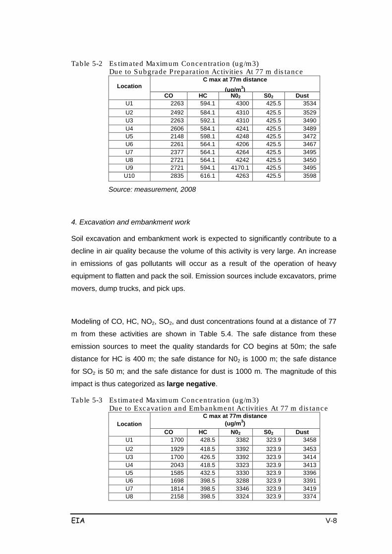
EIA V-8
Table 5-2 Es timated Maximum Concentra tion (ug/m3) Due to Subgrade Prepara tion Activities At 77 m dis tance
Location C max at 77m distance
(ug/m3) CO
HC
N02
S02
Dust
U1
2263
594.1
4300
425.5
3534
U2
2492
584.1
4310
425.5
3529
U3
2263
592.1
4310
425.5
3490
U4
2606
584.1
4241
425.5
3489
U5
2148
598.1
4248
425.5
3472
U6
2261
564.1
4206
425.5
3467
U7
2377
564.1
4264
425.5
3495
U8
2721
564.1
4242
425.5
3450
U9
2721
594.1
4170.1
425.5
3495
U10
2835
616.1
4263
425.5
3598
Source: measurement, 2008
4. Excavation and embankment work
Soil excavation and embankment work is expected to significantly contribute to a
decline in air quality because the volume of this activity is very large. An increase
in emissions of gas pollutants will occur as a result of the operation of heavy
equipment to flatten and pack the soil. Emission sources include excavators, prime
movers, dump trucks, and pick ups.
Modeling of CO, HC, NO2, SO2, and dust concentrations found at a distance of 77
m from these activities are shown in Table 5.4. The safe distance from these
emission sources to meet the quality standards for CO begins at 50m; the safe
distance for HC is 400 m; the safe distance for N02 is 1000 m; the safe distance
for SO2 is 50 m; and the safe distance for dust is 1000 m. The magnitude of this
impact is thus categorized as large negative.
Table 5-3 Es timated Maximum Concentra tion (ug/m3) Due to Excavation and Embankment Activities At 77 m dis tance
Location C max at 77m distance
(ug/m3) CO
HC
N02
S02
Dust
U1
1700
428.5
3382
323.9
3458 U2
1929
418.5
3392
323.9
3453
U3
1700
426.5
3392
323.9
3414 U4
2043
418.5
3323
323.9
3413
U5
1585
432.5
3330
323.9
3396 U6
1698
398.5
3288
323.9
3391
U7
1814
398.5
3346
323.9
3419 U8
2158
398.5
3324
323.9
3374
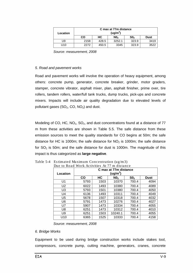
EIA V-9
Location C max at 77m distance
(ug/m3) CO
HC
N02
S02
Dust
U9
2158
428.5
3252.1
323.9
3419 U10
2272
450.5
3345
323.9
3522
Source: measurement, 2008
5. Road and pavement works
Road and pavement works will involve the operation of heavy equipment, among
others: concrete pump, generator, concrete breaker, grinder, motor graders,
stamper, concrete vibrator, asphalt mixer, plan, asphalt finisher, prime over, tire
rollers, tandem rollers, water/full tank trucks, dump trucks, pick-ups and concrete
mixers. Impacts will include air quality degradation due to elevated levels of
pollutant gases (SO2, CO, NO2) and dust.
Modeling of CO, HC, NO2, SO2, and dust concentrations found at a distance of 77
m from these activities are shown in Table 5.5. The safe distance from these
emission sources to meet the quality standards for CO begins at 50m; the safe
distance for HC is 1000m; the safe distance for NO2 is 1000m; the safe distance
for SO2 is 50m; and the safe distance for dust is 1000m. The magnitude of this
impact is thus categorized as large negative.
Table 5-4 Es timated Maximum Concentra tion (ug/m3) Due to Road Work Activities At 77 m dis tance
Location C max at 77m distance
(ug/m3) CO
HC
N02
S02
Dust
U1
5793
1503
10370
700.4
4094 U2
6022
1493
10380
700.4
4089
U3
5793
1501
10380
700.4
4050 U4
6136
1493
10311
700.4
4049
U5
5678
1507
10318
700.4
4032 U6
5791
1473
10276
700.4
4027
U7
5907
1473
10334
700.4
4055 U8
6251
1473
10312
700.4
4010
U9
6251
1503
10240.1
700.4
4055 U10
6365
1525
10333
700.4
4158
Source: measurement, 2008
6. Bridge Works
Equipment to be used during bridge construction works include stakes tool,
compressors, concrete pump, cutting machine, generators, cranes, concrete
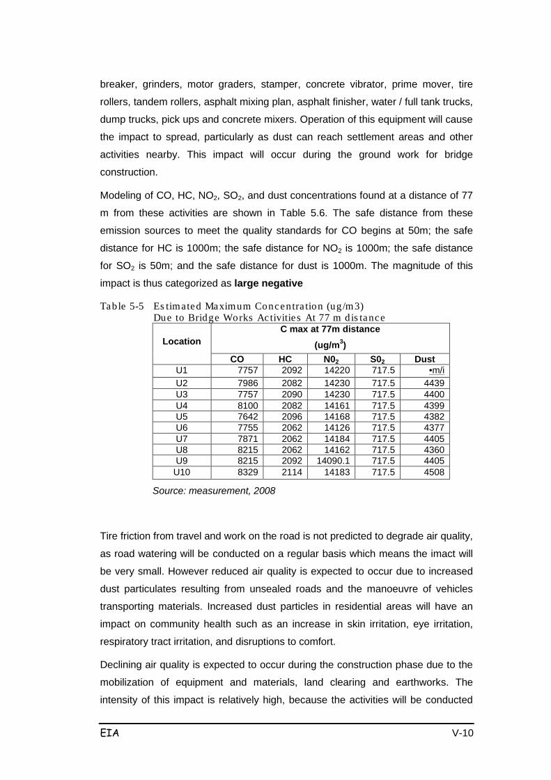
EIA V-10
breaker, grinders, motor graders, stamper, concrete vibrator, prime mover, tire
rollers, tandem rollers, asphalt mixing plan, asphalt finisher, water / full tank trucks,
dump trucks, pick ups and concrete mixers. Operation of this equipment will cause
the impact to spread, particularly as dust can reach settlement areas and other
activities nearby. This impact will occur during the ground work for bridge
construction.
Modeling of CO, HC, NO2, SO2, and dust concentrations found at a distance of 77
m from these activities are shown in Table 5.6. The safe distance from these
emission sources to meet the quality standards for CO begins at 50m; the safe
distance for HC is 1000m; the safe distance for NO2 is 1000m; the safe distance
for SO2 is 50m; and the safe distance for dust is 1000m. The magnitude of this
impact is thus categorized as large negative
Table 5-5 Es timated Maximum Concentra tion (ug/m3) Due to Bridge Works Activities At 77 m dis tance
Location C max at 77m distance
(ug/m3) CO
HC
N02
S02
Dust
U1
7757
2092
14220
717.5
•m/i U2
7986
2082
14230
717.5
4439
U3
7757
2090
14230
717.5
4400
U4
8100
2082
14161
717.5
4399
U5
7642
2096
14168
717.5
4382
U6
7755
2062
14126
717.5
4377
U7
7871
2062
14184
717.5
4405
U8
8215
2062
14162
717.5
4360
U9
8215
2092
14090.1
717.5
4405
U10
8329
2114
14183
717.5
4508
Source: measurement, 2008
Tire friction from travel and work on the road is not predicted to degrade air quality,
as road watering will be conducted on a regular basis which means the imact will
be very small. However reduced air quality is expected to occur due to increased
dust particulates resulting from unsealed roads and the manoeuvre of vehicles
transporting materials. Increased dust particles in residential areas will have an
impact on community health such as an increase in skin irritation, eye irritation,
respiratory tract irritation, and disruptions to comfort.
Declining air quality is expected to occur during the construction phase due to the
mobilization of equipment and materials, land clearing and earthworks. The
intensity of this impact is relatively high, because the activities will be conducted
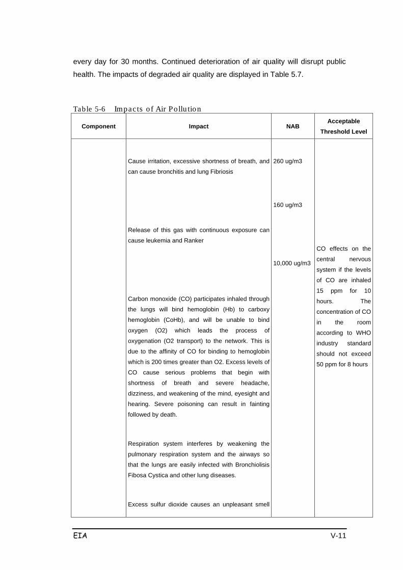
EIA V-11
every day for 30 months. Continued deterioration of air quality will disrupt public
health. The impacts of degraded air quality are displayed in Table 5.7.
Table 5-6 Impacts o f Air Pollu tion
Component Impact NAB Acceptable
Threshold Level
Cause irritation, excessive shortness of breath, and
can cause bronchitis and lung Fibriosis
Release of this gas with continuous exposure can
cause leukemia and Ranker
Carbon monoxide (CO) participates inhaled through
the lungs will bind hemoglobin (Hb) to carboxy
hemoglobin (CoHb), and will be unable to bind
oxygen (O2) which leads the process of
oxygenation (O2 transport) to the network. This is
due to the affinity of CO for binding to hemoglobin
which is 200 times greater than O2. Excess levels of
CO cause serious problems that begin with
shortness of breath and severe headache,
dizziness, and weakening of the mind, eyesight and
hearing. Severe poisoning can result in fainting
followed by death.
Respiration system interferes by weakening the
pulmonary respiration system and the airways so
that the lungs are easily infected with Bronchiolisis
Fibosa Cystica and other lung diseases.
Excess sulfur dioxide causes an unpleasant smell
260 ug/m3
160 ug/m3
10,000 ug/m3
CO effects on the
central nervous
system if the levels
of CO are inhaled
15 ppm for 10
hours. The
concentration of CO
in the room
according to WHO
industry standard
should not exceed
50 ppm for 8 hours

EIA V-12
Component Impact NAB Acceptable
Threshold Level
and can cause eye conjunctivitis, dizziness, nausea,
coughing, staggering, and pulmonary edema and
can result in death.
Excess Flour can accelerate the corrosion process.
In plants it leads to the death of the cells of
sponges, followed by a lower surface stomata
associated with epidermis, followed by destruction
of chloroplasts and palisade tissue damage. Then it
damages the vascular tissue.
100 ug/m3
265 ug/m3
The smell was
detected at levels of
1 ppm, less
comfortable in the
chest at the level of
15 ppm for 1 hour,
discomfort in the
levels of 25ppm
and the levels of
SO ppm for 1
minute of pain
arising in the
substrunal area.
SO2 gas is felt at
the threshold of 0.1
ppm. At levels of
0.19 ppm for 24
hours several days
in a row, can cause
death. WHO
standard sets 10-13
mg/m3 for 8 hours /
day. At a
concentration of 6-
12 ppm can cause
irritation to the nose
and throat,
inflammation of the
eyes (at a
concentration of 20
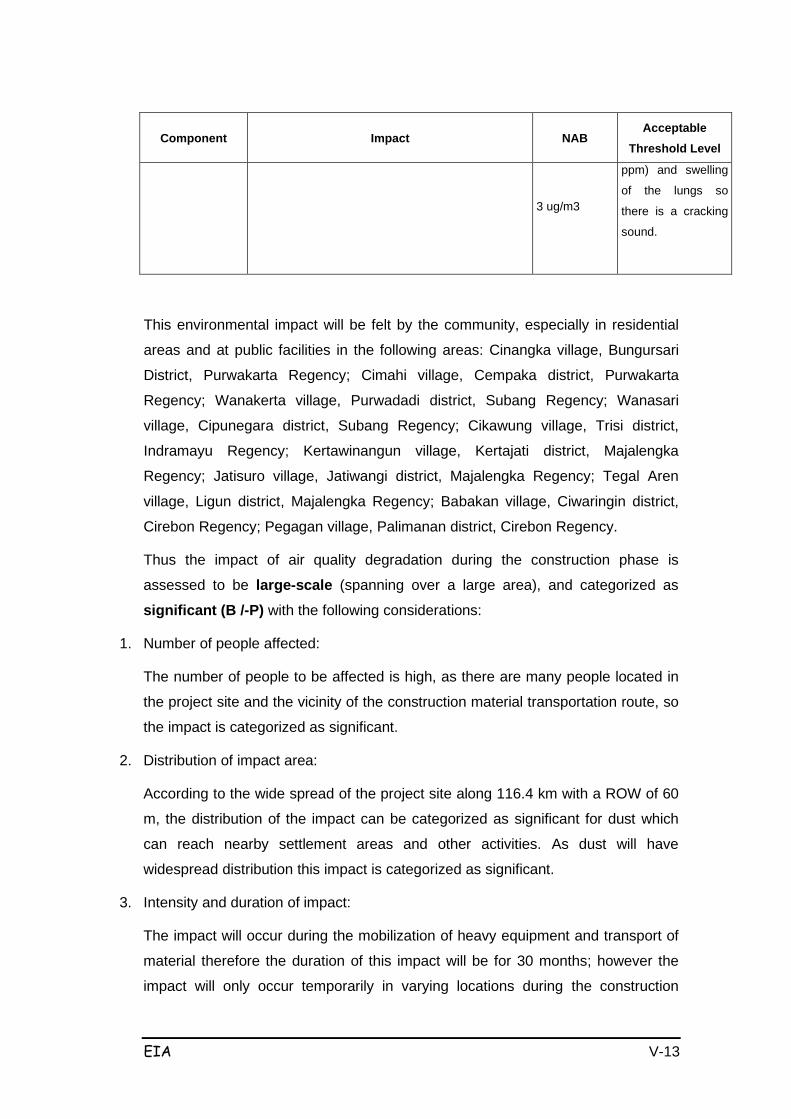
EIA V-13
Component Impact NAB Acceptable
Threshold Level
3 ug/m3
ppm) and swelling
of the lungs so
there is a cracking
sound.
This environmental impact will be felt by the community, especially in residential
areas and at public facilities in the following areas: Cinangka village, Bungursari
District, Purwakarta Regency; Cimahi village, Cempaka district, Purwakarta
Regency; Wanakerta village, Purwadadi district, Subang Regency; Wanasari
village, Cipunegara district, Subang Regency; Cikawung village, Trisi district,
Indramayu Regency; Kertawinangun village, Kertajati district, Majalengka
Regency; Jatisuro village, Jatiwangi district, Majalengka Regency; Tegal Aren
village, Ligun district, Majalengka Regency; Babakan village, Ciwaringin district,
Cirebon Regency; Pegagan village, Palimanan district, Cirebon Regency.
Thus the impact of air quality degradation during the construction phase is
assessed to be large-scale (spanning over a large area), and categorized as
significant (B /-P) with the following considerations:
1. Number of people affected:
The number of people to be affected is high, as there are many people located in
the project site and the vicinity of the construction material transportation route, so
the impact is categorized as significant.
2. Distribution of impact area:
According to the wide spread of the project site along 116.4 km with a ROW of 60
m, the distribution of the impact can be categorized as significant for dust which
can reach nearby settlement areas and other activities. As dust will have
widespread distribution this impact is categorized as significant.
3. Intensity and duration of impact:
The impact will occur during the mobilization of heavy equipment and transport of
material therefore the duration of this impact will be for 30 months; however the
impact will only occur temporarily in varying locations during the construction

EIA V-14
stage. Therefore the impact can be categorized as not significant.
In terms of intensity of the impact there will be a decline in air quality (due to
increased levels of lead, hydrocarbons, SO2 and NO2), although the decline will be
very small. Dust and Carbon Monoxide (CO) will significantly increase and affect
air quality, therefore the impact is predicted to be quite significant.
4. In terms of the number of environmental components affected by the impact, there
are several components that may be impacted. The impact is thus considered
important.
5. The impact is cumulative, and thus considered significant.
6. The impact can, in general, can be reversed after the implementation of regular
and appropriate management activities, therefore with regards to reversibility the
impact is categorized as not significant.
b. Increased Noise
Construction activities that are potential sources of increased noise are as follows:
1. Mobilization of heavy equipment and materials
Mobilization of heavy equipment and materials such as bulldozers, excavators,
wheel loaders, motor graders, prime mover, tire rollers, tandem rollers, water / full
tank trucks, dump trucks, pick ups, concrete mixer will result in increased noise.
The results seen in Figure 5.1 show that the predicted noise level generated from
the operation of equipment and movement of materials is 93 dB (A) at a distance
of 15 m from the noise source. This predicted noise level is compared to the
current (exiting) average noise level of about 76.5 dB (A); therefore the impact is
categorized as large negative.
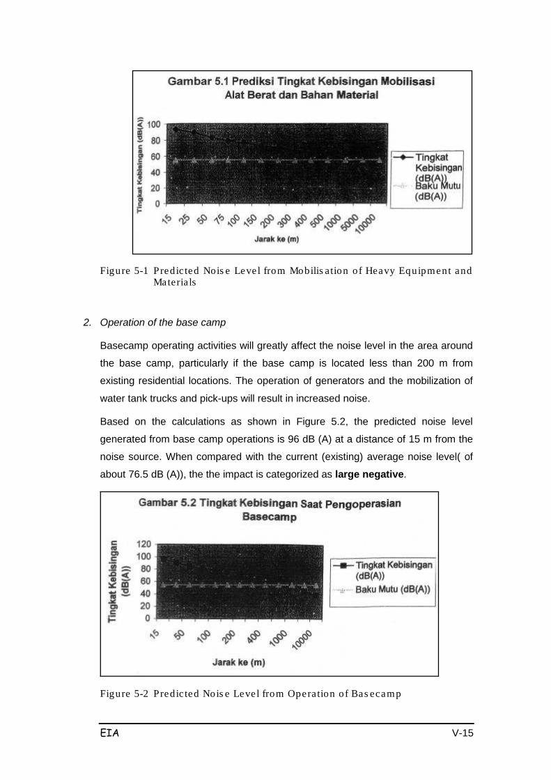
EIA V-15
Figure 5-1 Predic ted Nois e Level from Mobilis ation of Heavy Equipment and Materials
2. Operation of the base camp
Basecamp operating activities will greatly affect the noise level in the area around
the base camp, particularly if the base camp is located less than 200 m from
existing residential locations. The operation of generators and the mobilization of
water tank trucks and pick-ups will result in increased noise.
Based on the calculations as shown in Figure 5.2, the predicted noise level
generated from base camp operations is 96 dB (A) at a distance of 15 m from the
noise source. When compared with the current (existing) average noise level( of
about 76.5 dB (A)), the the impact is categorized as large negative.
Figure 5-2 Predic ted Nois e Level from Operation of Bas ecamp
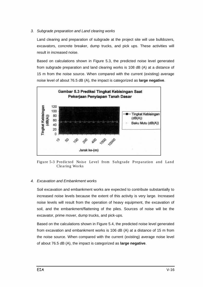
EIA V-16
3. Subgrade preparation and Land clearing works
Land clearing and preparation of subgrade at the project site will use bulldozers,
excavators, concrete breaker, dump trucks, and pick ups. These activities will
result in increased noise.
Based on calculations shown in Figure 5.3, the predicted noise level generated
from subgrade preparation and land clearing works is 108 dB (A) at a distance of
15 m from the noise source. When compared with the current (existing) average
noise level of about 76.5 dB (A), the impact is categorized as large negative.
Figure 5-3 Predic ted Nois e Level from Subgrade Prepara tion and Land Clearing Works
4. Excavation and Embankment works
Soil excavation and embankment works are expected to contribute substantially to
increased noise levels because the extent of this activity is very large. Increased
noise levels will result from the operation of heavy equipment, the excavation of
soil, and the embankment/flattening of the piles. Sources of noise will be the
excavator, prime mover, dump trucks, and pick-ups.
Based on the calculations shown in Figure 5.4, the predicted noise level generated
from excavation and embankment works is 106 dB (A) at a distance of 15 m from
the noise source. When compared with the current (existing) average noise level
of about 76.5 dB (A), the impact is categorized as large negative.

EIA V-17
Figure 5-4 Predic ted Nois e Level from Excavation and Embankment Works
5. Road and pavement works
Road and pavement works will use heavy equipment such as concrete pump,
generator, concrete breaker, grinders, motor graders, stamper, concrete vibrator,
asphalt mixing plan, asphalt finisher, prime over, tire rollers, tandem rollers, water /
full tank trucks, dump trucks, pick-ups and concrete mixers. The operation of this
equipment will increase noise levels.
Based on the calculations shown in Figure 5.5, the predicted noise level generated
from road and pavement works is 108 dB (A) at a distance of 15m from the noise
source. When compared with the current (existing) average noise level of about
76.5 dB (A), the impact is categorized as large negative.

EIA V-18
Figure 5-5 Pred ic ted Nois e Level from Road and Pavement Works
6. Bridge Works
Equipment used during bridge construction works will include piles tool,
compressors, concrete pump, cutting machine, generators, cranes, concrete
breaker, grinders, motor graders, stamper, concrete vibrator, prime mover, tire
rollers, tandem rollers, asphalt mixing plan, asphalt finisher, water / full tank trucks,
dump trucks, pick ups and concrete mixers. Operation of this equipment will result
in increased noise at the job site which will also reach nearby residential and other
areas. Based on the calculations shown in Figure 5.6, the predicted noise level
generated from the operation of bridge works equipment is 112 dB (A) at a
distance of 15m from the noise source. When compared with the current (existing)
average noise level of about 76.5 dB (A), the impact is categorized as large negative.
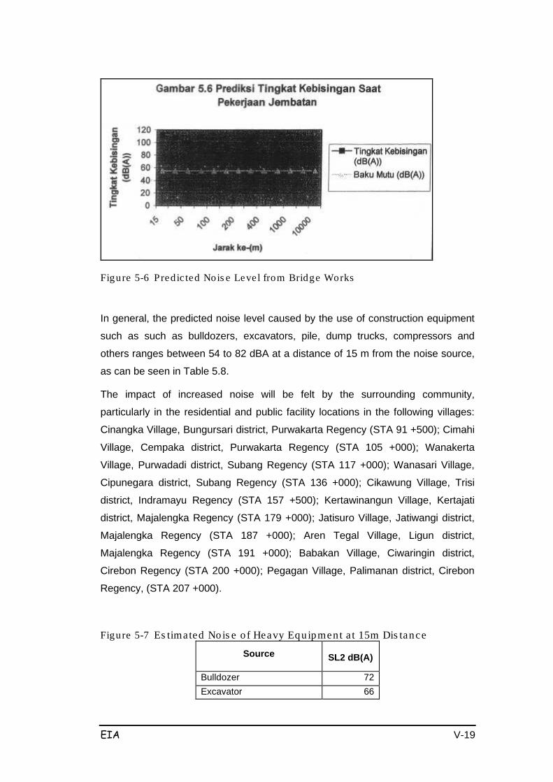
EIA V-19
Figure 5-6 Predic ted Nois e Level from Bridge Works
In general, the predicted noise level caused by the use of construction equipment
such as such as bulldozers, excavators, pile, dump trucks, compressors and
others ranges between 54 to 82 dBA at a distance of 15 m from the noise source,
as can be seen in Table 5.8.
The impact of increased noise will be felt by the surrounding community,
particularly in the residential and public facility locations in the following villages:
Cinangka Village, Bungursari district, Purwakarta Regency (STA 91 +500); Cimahi
Village, Cempaka district, Purwakarta Regency (STA 105 +000); Wanakerta
Village, Purwadadi district, Subang Regency (STA 117 +000); Wanasari Village,
Cipunegara district, Subang Regency (STA 136 +000); Cikawung Village, Trisi
district, Indramayu Regency (STA 157 +500); Kertawinangun Village, Kertajati
district, Majalengka Regency (STA 179 +000); Jatisuro Village, Jatiwangi district,
Majalengka Regency (STA 187 +000); Aren Tegal Village, Ligun district,
Majalengka Regency (STA 191 +000); Babakan Village, Ciwaringin district,
Cirebon Regency (STA 200 +000); Pegagan Village, Palimanan district, Cirebon
Regency, (STA 207 +000).
Figure 5-7 Es timated Nois e o f Heavy Equipment a t 15m Dis tance
Source SL2 dB(A)
Bulldozer
72
Excavator
66
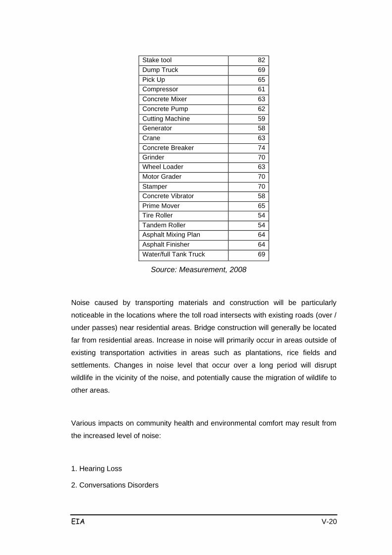
EIA V-20
Stake tool
82
Dump Truck
69
Pick Up
65
Compressor
61
Concrete Mixer
63
Concrete Pump
62
Cutting Machine
59
Generator
58
Crane
63
Concrete Breaker
74
Grinder
70
Wheel Loader
63
Motor Grader
70
Stamper
70
Concrete Vibrator
58
Prime Mover
65
Tire Roller
54
Tandem Roller
54
Asphalt Mixing Plan
64
Asphalt Finisher
64
Water/full Tank Truck
69
Source: Measurement, 2008
Noise caused by transporting materials and construction will be particularly
noticeable in the locations where the toll road intersects with existing roads (over /
under passes) near residential areas. Bridge construction will generally be located
far from residential areas. Increase in noise will primarily occur in areas outside of
existing transportation activities in areas such as plantations, rice fields and
settlements. Changes in noise level that occur over a long period will disrupt
wildlife in the vicinity of the noise, and potentially cause the migration of wildlife to
other areas.
Various impacts on community health and environmental comfort may result from
the increased level of noise:
1. Hearing Loss
2. Conversations Disorders
EIA V-21
3. Sleep Disorders
4. Psychological Disorders
5. Disruption of work productivity
6. Health Problems
The predicted impact of increased noise is classified as a major (big) and significant impact (B /-P), because its intensity will exceed environmental noise
standards and result in disruptions to public health and comfort. The following
considerations were used as a basis to classify this impact:
1. Number of people affected:
The number of people affected is quite a lot, particularly as many people
are located near the project site and in the vicinity of the construction
material transportation routes; therefore the impact is considered
significant.
2. Distribution of impact area:
The project site impacts are wide spread along the 116.4 km with ROW of
60 m, therefore the distribution of the impact can be categorized as
particularly significant as noise will reach the nearby residential and other
areas. Therefore the impact is categorized significant.
3. Intensity and duration of impact:
The impact will occur throughout the mobilization of heavy equipment and
material period with duration of 30 months. However the impact will be
temporary, restricted only to the construction stage, therefore the impact is
categorized as not important. However in terms of intensity, the impact will
continually increase and contribute to an increase in noise, therefore the
impact is considered quite important.
4. In terms of the number of environmental components affected by the
impact, there are several components that may be impacted. The impact is
thus considered important.
5. The impact is cumulative, and thus considered significant.
6. The impact can, in general, can be reversed after the implementation of
regular and appropriate management activities, therefore with regards to

EIA V-22
reversibility the impact is categorized as not significant.
c. Reduced Surface Water Quality
The construction phase can potentially degrade the quality of surface water due to
the construction and operation of the base camp, the mobilization of heavy
equipment, subgrade preparation and land clearing works, excavation and fill
works, the transport of soil and building materials, road and pavement works, and
drainage works.
Excavation and fill activities will reduce the quality of surface water due to soil
erosion, which will increase the turbidity of rivers in the project area.
The base camp is expected to accommodate around 1,225 workers (from section I
to section VI). It will threefore be necessary to have facilities that meet the workers
sanitation and accommodation needs, in addition to facilities to conduct
maintenance of heavy vehicles. These activities (accommodation, sanitation and
vehicle maintenance) will interfere with existing surface water and groundwater in
the area.
Surface water in the area is in the form of rivers. The quality of river water around
the Palimanan-Cikampek toll road development site was observed and measured
in 10 locations, with results displayed in Table 5.9 below.
Figure 5-8 River Water Quality from each river s ampling loca tion
No Parameter Unit Result
S1 S2 S3 S4 S5 S6 S7 SB S9 S10
Physical :
1
Suspend Solid
mg/L 15 18 73 21 10 61 14 0 13 3
Note:
Regulation of Republic Indonesia No. 82/2001
Water quality classification specified as 4 (four) class i.e
- First class (I) : Raw water which can be used for raw drinking
water, and / or similar usage

EIA V-23
- Second class (II) : Raw water which can be used for recreation
infrastructure, river fishery cultivation, Animal
husbandry, irrigation and / or similar usage
- Third class: (III) : Raw water which can be used for river fishery
cultivation, animal husbandry, irrigation and / or
similar usage
- Fourth class (IV) : Raw water which can be used for irrigation and /
or similar usage
- ϕ) Based on radioactivity analysis result by National Nuclear Energy
Agency / BATAN - sub contracting
S1 = River Ciherang S6 = River Cipunegara
S2 = River Cilamaya S7 = River Cipanas
S3 = River Cibodas S8 = River Cimanuk
S4 = River Ciasem S9 = Ciliwung Canal
S5 = River Cilamatan S10 = River Ciwaringin
The degradation of water quality will be due to the spill of materials and the
activities of domestic workers. Material spills will increase the amount of
suspension solids (TSS) in rivers around the project site. Based on the TSS values
measured at each sampling point location as described in Table 5.9 above, the
predicted increase in TSS is as follows:
Given:
1. TSS levels measured in the recipient water bodies (C1)
2. Water discharge in receiving water bodies (Q1)
3. Construction Waste discharge (Q2): 10 m3/day
4. TSS levels of construction (studies analogue) (C2): 60 mg/l
The resulting TSS levels (C3) in each water body was based on the following
formula, with results shown in Table 5.10.
EIA V-24
( ) ( )( )21
22113QQ
QCQCC+
×+×=
Figure 5-9 Produced TSS leve ls (C3) in each water body c1 Q1 Q1 Q2 C1*q2 C2*q2 q1+q2 c3 %
increase 15 344.92
65
10
5173.8
650
354.92
16.41
9.39
18 508.21
65
10
9147.78
650
518.21
18.91
5.04
73 105.42
65
10
7695.66
650
115.42
72.31
0.95
21 203.73
65
10
4278.33
650
213.73
23.06
9.80
0 120.54
65
10
1205.4
650
130.54
14.21
42.13
61 389.24
65
10
23743.64
650
399.24
61.10
0.16
14 146.45
65
10
2050.3
650
156.45
17.26
23.28
0 495.56
65
10
0
650
505.56
1.29
120.00
13 465.56
65
10
6052.28
650
475.56
14.09
8.41
3 232.56
65
10
697.68
650
242.56
5.56
85.20
When compared with the existing levels of TSS in the bodies of water, the
increased levels of TSS due to site activities will result in a change of less than
30%, based on the descriptions above. The impact is therefore classified as
moderate. Construction phase activities are expected to impact surface water
quality temporarily. This impact is classified as Significant and Moderate (K /-P), based on the following six criteria.
1. Number of people affected:
The number of people affected is the population who live in and near the project
site, therefore the impact is considered important.
2. Distribution of impact area:
The project site impacts are wide spread along the 116.4 km with ROW of 60 m,
therefore the distribution of the impact can be categorized as significant.
3. Intensity and duration of impact:
The impact will occur throughout the mobilization of heavy equipment and material
period with duration of 30 months. However the impact will be temporary,
restricted only to the construction stage, therefore the impact is categorized as not
important. However in terms of intensity, the impact will increase (although not
greatly) and contribute to a degradation of surface water quality, therefore the
impact is considered quite important.
4. In terms of the number of environmental components affected by the impact, there
EIA V-25
are several components that may be impacted. The impact is thus considered not
important.
5. The impact is cumulative, and thus considered significant.
6. The impact can, in general, can be reversed after the implementation of regular
and appropriate management activities, therefore with regards to reversibility the
impact is categorized as not significant.
d. Impaired Surface Water Flow
Disruption of surface water flow will be caused by the clearing and preparation of
land, earthworks (excavation / embankment), construction work and road paving.
Landscape changes will be caused by the stripping of vegetation that covers the
soil, increasing slopes (through excavation / fill), soil compaction and soil surface
coating, which will have an impact by increasing rainwater runoff ( runoff
coefficient ). Rainwater runoff will occur along the toll road (116.4 km) with a width
of 60-100 meters. This impact will occur continuously up until the toll road
operation.
The runoff coefficient (SNI 03-3424 - 1994) is predicted for roads with concrete or
asphalt pavement to be 0.70 - 0.95 and for earthen roads to be 0.40 -0.70. This is
compared with the suburbs (0.60-0.70), gardens (0.45 - 0.60), and hills (0.70 -
0.80). Upon this comparison it can be predicted that during the land leveling
process along the planned toll road corridor there will be a decline in run-off
discharge, however during the road paving process there will be an increase in
run-off discharge.
The impact of increased runoff discharge on the natural flow of the rivers will not
have much effect. Thus, the development process for this toll road is expected to
have small negative impacts. The effect and distribution of this impact will be
localised, therefore this impact is categorized as not significant (K /-TP).
Other hydrological impacts include disruption to the flow of surface and ground
water flow caused by the accumulation and compaction of the road. These
activities will create a weir effect that will result in changes in the direction of water
runoff and increasing water levels. As explained in chapter IV, the existing roads
have led to the emergence of a new pool area where the road intersects with the
river in an undulating hilly area, and has improved the surface water / flood plain
area which mainly occurs during the rainy season. In the area that intersects with
EIA V-26
the tributaries of the lowland river, the accumulation of soil will be required to
support the road due to the absence of appropriate engineering techniques, which
will create new pools.
The emergence of this new overflow area will cause changes to the environment
by converting dry land into a wetland environment, thereby causing a decrease in
certain wildlife and improving the lives of other wildlife such as mosquitoes and
other aquatic animals.
Environmental conditions in this area have already been degraded to the point
where there is an imbalance of water availability in the dry and rainy seasons; the
existence of these new pools will provide increased availability of water during the
dry season (small reservoirs).
In the plains / basin, the acquisition and use of land by road agencies has
hindered the flow of surface water thus increasing surface water levels and
causing flooding. This may potentially occur in the Cimanuk and Ciwaringin river
valley and the wetlands between Indramayu and Majalengka.
Increased water levels caused by the increase of national road agencies between
Cikampek - Cirebon has led to increased water levels in the rainy season as high
as one meter. The presence of such high water levels over a long period has
resulted in the deaths of several types of plant species.
The pooling/weir impact is big (B). The nature of this impact is quite extensive,
continuous, cumulative and not reversible, therefore this impact is categorized as
negative significant (B /-P).
e. Erosion
Erosion is the transfer of soil from one place to another that can be caused by a
mechanical process, such as the flow of water and wind.
Erosion caused by mining deposits is associated with cut and fill activities which
will be quite intensive in the undulating hill geomorphology unit with relatively
erosive texture and structure and high-intensity rainfall. In general the land in this
region has already been eroded, with a rate of erosion reaching between 10
tons/ha/year to 45 tons/ha/year.
Changes to erosion rates will be due to land clearing activities, characterized by
loss of land cover or factor "C", which several calculations predicted to cause
EIA V-27
increased erosion of more than 100%. Increased levels of erosion are due to
excavation and embankment activities which cause loss of forest cover, changes
in land management factors and changes in soil structure reaching a magnitude of
more than 300%. This increase will be due to land preparation activities (grading)
which will cause a change in the slope of the land, the slope being increased up to
265%. Increased erosion rates will cause increased sedimentation.
In addition to quarry management activities, land stripping, excavation and
embankment in this area will result in a large impact with regards to an increase in
the rate of erosion. With regard to land stability, this impact is considered negative significant (B /-P).
f. Distruption to Environmental Aesthetics
Changes in land use will result from land clearing, excavation and fill and road
paving. Land used for the road which was originally used for plantation crops,
forest production, dry fields, mixed farms, housing and public facilities will turn into
the toll road.
These land use changes will have impacts such as disturbance to flora and fauna,
disturbance to the microclimate in the vicinity of the road (edge effects) primarily
temperature and humidity, changes to environmental aesthetics, public
accessibility problems, and declining revenue.
The aesthetic impacts on the environment caused by the project procurement
activities include the scattering of soil on main roads and the scattering of dust
which will cover above-ground objects (buildings, plants) in the vicinity of the route
used by material transport vehicles.
Embankment and fill materials will be imported from outside the project site using
material transport vehicles (dump trucks). Judging from the amount of material to
be removed and the relatively high frequency of transport, the spread of material
on impassable roads can also cause traffic accidents. This impact will occur during
the material transport phase and can be reversed when the job is completed.
Aesthetic impacts will only occur in segments where existing roads intersect with
entry lanes.
Considering the many other impacts this impact is considered small and
negatives, as such is classified as not significant (K /-TP).
g. Disturbance to Groundwater Flow
EIA V-28
Embankment and excavation works
Given the location of this project partly through hilly areas, development will
include excavating up to about 20 m (depth). The soil excavation activities
conducted for this road may cause disruption to groundwater flow and alter
groundwater flow patterns.
This change will cause flow resistance of the land at the bottom of the hills. In
addition, disruption to ground water can also damage the road/street construction
because surface water is not channeled to the balk. These conditions will also
affect the provision of clean water to communities in the southern part of this toll
road site.
Soil excavation/filling will achieve levels that are higher or lower than the planned
stockpiles. Excavation / compacting of ground will be done by bulldozers, and the
excavated soil will be pushed to a lower place. In some places soil excavation will
be carried out on layers of the aquifer with potentiall for ground water, thus
resulting in an increase in groundwater discharge flow. Ground water discharge on
the excavated slopes of this toll road will result in these slopes becoming unstable
and increasing the llikelihood of landslides. The magnitude of this potential impact
is estimated to be large. Significance of this impact was determined through the
following criteria:
1. Number of people affected:
The number of people affected is large because the project will be conducted in
several locations with many productive aquifers to be truncated.
2. Distribution of impact area:
The distribution of this impact is wide because the project will be conducted in
several locations with many productive aquifers to be truncated.
3. Intensity and duration of impact:
In terms of intensity, this impact will cause increases and decreases to ground
water flow and levels due to excavation. The impact will occur during the
excavation phase however the impact will last long after the work has been
discontinued.
This impact will affect other components such as residential water supply as
nearby residential areas rely on dug wells for their clean water source. In addition
groundwater discharge may cause landslides on the slopes where springs

EIA V-29
emerge.
4. The impact is permanent and irreversible.
Thus, interference with the flow of ground water due to work excavation, fill and
stockpiling can be considered a large and negative significant impact (B /-P).
h. Slope Stability Disorders
To meet the required toll road gradient (maximum of 4%), construction activities
will require cutting the ridge slope and stockpiling in the area (cut and fill). Cut and
fill activities will change the landscape and the original land form along the 116.4
km with a width between 80 to 100 meters.
Cut and fill work includes land clearing and preparation, soil surface compaction to
form the basis for the traffic lane (including lane stops and intersections). In
addition this work also includes excavation and embankment followed by
formation, compaction, grained soil/material testing, and maintenance of the
prepared surface until the pavement material is placed on top.
Earthworks include excavation and embankment to form the basis of the road
surface, compaction of soil, excavation for canals and other utilities, and
materials/sand transportation. These activities will have an impact on
physiographic conditions in the form of decreased land stability, increased soil
erosion, subsidence / settlement and increased sedimentation.
The impact of slope stability problems will continue to impact the stability of the
soil. Hill cutting or trimming activities will result in a decrease in slope stability
compared with existing conditions. Similarly, fill/accumulation in low areas to form
street landscapes will also lead to the instability of these heaps/piles when
compared with existing conditions. The impact of slope stability problems could
result in continued toll road transportation problems during the operation phase as
for the naturally existing roads.
More than half of the planned toll road route will pass through undulating hills of
low slope above 15 degrees, and steep valleys with slopes over 60 degrees.
Landslides in the excavated and cut&fill areas may occur given the type of rock
layers which form a loop between the gravel containing gravel, sand and clay, and
given the slope of the bedding planes of rock.
From the discussion above, the impact of earthworks (excavation / embankment)
will be related to continuous soil stability problems which are considered to be
EIA V-30
great; therefore this impact is considered significant negative (B /-P).
5.3.2 Biological Environment Components
a. Reduced Aquaculture Vegetation Species or Changes to Land Use/Function from Farming Agriculture and Natural Vegetation
Land Works
The planned toll road will cross several areas that contain many types of
productive land, rice fields and gardens. Rice fields in the northern coastal part of
West Java that lie within the planned toll road route such as Subang and
Indramayu Regencies are the primary source of food commodities. The
agricultural commodity crops grown and produced for food include rice (Oryza
sativa var IR 64, Ciherang, Sadane) and other agricultural commodities such as
maize (Zea mays), yams (Ipomoeae batatas) and cassava (Manihot esculenta), as
well as vegetables such as spinach, long beans, chili, soy, ginger and others. Land
works will include the cleaning and stripping of land, excavation and stockpiling,
and soil preparation; this will convert the existing land use from agricultural rice
fields to paved road areas, and will reduce the amount of productive land.
The irrigated rice fields also have socio-economic functions that are important to
local society as they relate to the provision of jobs for farmers, cultivators and
agricultural labourers to cultivate the paddy fields. Thus the clearing of this land for
the road has a wide-ranging impact on livelihoods, land use and declining food
production.
Cikampek-Palimanan Toll Road is expected to result in land use change covering
an area of 239.6 ha. The reduction in agricultural land is a big impact as in Section
I the extent of irrigated agricultural land and rain-fed rice fields to be converted is
40.5ha, in Section II it is 39.8ha, in Section III it is 31.2ha, in Section IV it is
35.1ha, in Section V it is 42.3ha, and in Section VI it is 50.7ha. As the total of all
agricultural land in the study area is about 27.513 ha, this impact is considered
small. Meanwhile, in terms of intensity and duration the impact will be on an
ongoing basis; in terms of number of people affected by land clearing, the affected
people are limited to the project site. The impact is thus categorized as not
significant negative. In terms of the number of environmental components affected
by the impact there are many components that may potentially be affected,
therefore the impact can be considered important. There will however be no
EIA V-31
cumulative impacts from land acquisition as the land owners will mutually agree on
the compensation value. On the basis of the impact analysis above, it can be
argued that on a whole the impact of loss/reduction of vegetative species and
agricultural vegetation land due to land clearing is categorized as small negative
and significant impact (K / - P).
In addition to the rice fields, other productive land that will also be affected
includes mixed farms with cash crops such as bamboo, cashew, teak, rubber,
sugarcane, cocoa, coconut, mango, banana and lamtoro. The estimated area of
mixed farms to be cut off is approximately ± 33.15 ha, occurring primarily in the
surrounding areas of Subang and Indramayu. The area to be acquired and
converted will also result in loss of forest consisting of teak and acacia forests
which have partly been cultivated by the local community, with estimated area of
15.6 hectares of teak forest located at STA 91 +350 to 129 +600 as well as from
STA 129 +600 to 177 +200; the estimated acacia area is 28.0 hectares located
from STA 239 +600 to 177 +200. The impact of land clearing to cut the
gardens/farms will establish/open boundary lines. This activity will remove or
destroy the existing vegetation over the long-term (permanent) which will have
medium effects that will modify the microclimate due to changes in the length of
irradiation. Poor/inappropriate and cleaning and stripping will also encourage
landslides and a decrease in ground water levels.
Based on a review of the importance of this impact with regard to the loss of
natural vegetation, the following considerations were made: First in terms of the
number of people affected by the impact, the number of people affected is limited
to the location of land clearing, and because the amount is not large the impact is
categorized as less important. Second, the impact will spread around the areas
around the project site where the area is vulnerable to environmental changes, so
that the impact is considered important. In terms of intensity and duration of the
impact, the impact will only last throughout the land clearing stage during
construction; therefore the impact can be categorized as not important. When
reviewed in terms of the number of environmental components affected by the
impact, mnay components will be affected therefore the impact can be considered
important. However, the impact will not be cumulative, so it is categorized as not
important. The impact is generally reversible if regular and appropriate
management activities are undertaken, therefore it is categorized as not important.
By analyzing the impact as above, then on a whole it can be argued that the
EIA V-32
impact of loss/reduction of natural vegetation from land clearing is categorized as
a minor negative and insignificant impact (K /-TP).
b. Disturbance of Fauna
1. Ground Works
Ground work includes the clearing and stripping of land, excavation and
stockpiling using bulldozers, saws, dump trucks, rollers, loaders and others. Land
clearing and land preparation will involve the cutting and removal of brushwood
using chain saws, while the clearing of roots and stumps will use excavators.
These activities will lead to increased noise, however their impact on fauna is less
important.
Excavation of the soil layer as well as logging and land clearing will result in the
loss of some plants that serve as habitat for some animals and groups of reptiles,
aves and other insects. As a further result when variations of flora / fauna or
vegetation is lost, the next generation will also be disrupted due to the loss of
plants that serve as nesting places and food sources for certain types of birds, and
the separation / fragmentation of wildlife habitats by roads.
In terms of impact distribution, the impact will cover the project site, so that we can
say the impact is considered important. In terms of intensity and duration, the
impact will occur during the construction and land clearing phases, therefore the
impact can be categorized as not important. In terms of the number of
environmental components affected by the impact, there may be several
components that may be impacted, such as the protected species of birds;
therefore this impact can be considered important. The impact is, in general,
reversible if regular and appropriate management activities are undertaken; so it
can be categorized as not important.
By analyzing the impact as above, on the whole it can be argued that the impact of
the loss / decrease in wildlife due to land clearing work is categorized as a minor negative and insignificant impact (K /-TP).
c. Impaired Water Biota
1. Basecamp Operations
The Cikampek-Palimanan toll road development may potentially disrupt aquatic
biota due to the degradation of the quality of surface water (rivers, lakes), which in
EIA V-33
turn may affect the biota in the water; this may result from the operation of the
base camp, including the worker accommodation and equipment/vehicle/fuel
storage and maintenance facilities. The 116km-long toll road will transport
thousands of liters of fuel and other petroleum products during construction and
operation, with fuels such as oil and other fuels potentially contaminating surface
water such as the Cimanuk, Ciherang, Cilamatan, Cipanas and Cipunegara rivers
and lakes. Domestic waste from the base camp and other toxic substances
originating from oil spills or heavy equipment as well as from liquid material/thinner
storage facilities are expected to affect the water quality of the receiving water
bodies with subsequent impacts on aquatic biota.
Secondary data for Purwakarta regency shows that the fisheries sector depends
highly on floating nets, rushing water and public waters while the aquaculture
sector (ponds and reservoirs) forms the mainstay of the Cirebon regency
economy. The analysis of aquatic biota (planton, benthos) shows that some rivers
such as Cipunagara and Cimanuk still have a relatively high diversity index.
Impairment of / disturbance to aquatic biota, based on a review of this impact
(significance of impact), can be classified as follows:
1. Number of people affected:
The number of people who will be affected by impaired aquatic biota live
around the project site, therefore the impact is not considered important.
2. Distribution of impact area:
Distribution of this impact is widespread as it is not only limited to the
receiving water bodies near the basecamp area, but also those water
bodies all along the planned project route; but we can say that the impact
is not considered important.
3. Intensity and duration of the impact:
The impact will occur during the construction and operation of the base
camp, where the impact can be categorized as not important.
4. In terms of the number of environmental components affected by the
impact, there are several components that may be impacted therefore it
can be considered important.
5. The impact will be cumulative, so it is considered important.
6. The impact can, in general, can be reversed if regular and appropriate
management activities are undertaken; therefore it can be categorized as
not important.

EIA V-34
By analyzing the impact as above, on the whole it can be argued that the impact
on surface water quality degradation due to operation of the base camp is
categorized as a minor negative impact and insignificant (K /-TP).
2. Land works including land clearing
Land clearing at the project site will involve cutting shrubs using chain saws, and
clearing roots and stumps using excavators and bulldozers. These activities will
result in the release of clay soil which will carry over into the river and rainwater
and which can cause increased levels of turbidity in surface water. In addition,
stockpiling of soil can lead to embanked natural channels, and excavation of
hills/slopes can be expected to increase the risk of erosion or landslides which will
subsequently have an impact on surface water bodies. This will thus disrupt
aquatic biota.
Based on a review of the significance of disturbances to and/or decrease in
aquatic biota, there are the following considerations:
1. Number of people affected:
The number of people affected is limited to the location of the groundworks
(embankment excavation and land clearing around the project site), and to
the location of surface water bodies around the toll project activity. The
impact is not considered important
2. Distribution of impact area:
This impact is not confined to the project site but will also occur in the
receiving water bodies around the project site, so we can say the impact is
considered important.
3. Intensity and duration of the impact:
The impact will occur during the construction excavation and embankment
works. Although this impact is temporary and can be fully recovered once
the work is stopped, the volume of work and extent/scale of the impact is
quite large. If management of surface water is undertaken, then the impact
can be categorized as not important.
4. In terms of the number of environmental components affected there are
several that may be impacted; therefore it can be considered important.
5. This impact is not cumulative, so it can be categorized as not important.
6. The impact is, in general, reversible if regular and appropriate
management activities are undertaken, so that impact can be categorized
EIA V-35
as not important.
By analyzing the impact as above, on the whole it can be argued that the impact
on surface water quality degradation due to excavation and embankment can be
categorized as a minor negative impact and insignificant (K /-TP).
5.3.3 Socio-Economic and Cultural Component
The toll road construction will have an impact on the socio-economic and cultural
components of the local population, including the general livelihood of the
community, regional economy, social culture, social unrest, public health, and
traffic/transport infrastructure and facilities. This impact can be negative or
positive.
In this phase the activities that will have an impact on the socio-economic-cultural
component are preparatory activities (including: the construction/operation of the
base camp, mobilization of heavy equipment and manpower mobilization) and
implementation activities (including: the procurement of materials, subgrade
preparation, excavation and embankment, bridge works, road works, paving and
drainage/culvert works). The hypothetical predicted significant impacts are as
follows:
a. Increasing Employment Opportunities
The project will emply approximately 150-250 workers per section (depending on
the size of the section, and with as many as up to 6 sections) consisting of various
levels of skills such as technical personnel, supervision, service, field workers and
so on. Workers will either be imported from outside the area or will be local power.
The qualifications and number of workers for each section is estimated as follows:
• Project / owner, consisting of imported experts and local labour,
• Supervisors, consisting of imported experts and local labour,
• Implementers/contractors, consisting of imported experts, local labour, and
manual labour.
Usually the supervisors will reside at the base camp or rent residential houses
near the project site. The employment of local labour is very meaningful for the
local community particularly as unemployment levels are quite high in the study
area. The magnitude of the impact of labor absorption is quite large. The nature of
the impact can be categorized as an important positive (B / + P), with the
following considerations:

EIA V-36
• the impact is cumulative with the impacts of other activities;
• intensity of the impact is high, as the impact is broadly distributed around
the project site and nearby areas;
• the impact can contribute positively to the socio-economic coniditions of
the local community, such as towards revenue and business opportunities,
as well as project a positive image.
b. Increased Business Opportunities
The construction stage will require substantial materials such as category C
minerals, rocks, gravel and other building materials such as cement, asphalt, iron,
and others. It is planned to aquire about 40% of the materials from the local area,
which will additionally result in opening up opportunities associated with project
activities, such as for building materials and the like.
The magnitude of the impact of these activities is quite big. This impact is judged
to be an important positive impact (B / + P), with the following considerations:
• the impact is cumulative with the impacts of other activities;
• intensity of impact is high, in terms of the broad distribution of the impact
along the project site and neighbouring areas;
• the impact can contribute positively to the socio-economic conditions of the
local community, such as revenue and business opportunities, as well as
project a positive image.
New business opportunities will also occur related to the transport of
materials/equipment and other transportation needs. People who have the ability
to conduct businesses that supplement/support the toll road can exploit this
business opportunity.
c. The emergence of Social Jealousy
This impact will arise if labor recruitment activities do not consider the aspirations
of local residents around the project site. The EIA socialization sessions and social
surveys revealed that there are many different aspirations that have been
articulated by local residents.
This will be a relatively large scale impact, considering not only the social jealousy
that will arise from job seekers in the districts around the toll road site, but also
from those in other regions. The nature of this impact is considered significant negative (B /-P) with the following considerations:
EIA V-37
• the number of people affected will be fewer than the number of those who
will benefit directly from the Cikampek Palimanan Toll Road;
• intensity of impact is high, in terms of a broad distribution of impacts that
may exceed the project site area;
• the impact of social jealousy will be cumulative with community unrest and
have the potential to cause social conflicts and disrupt social safety and
security.
d. Disruptions to mobility/accessibility
This impact will arise primarily where the toll road will cut off existing local roads,
which will necessitate the construction of 5 underpasses/overpasses which will
prevent access to existing roads during the construction period. In addition, the
construction of interchanges (1C) may potentially have an impact on local
mobility/accessibility. 6 Interchanges will be constructed namely: Kalijati 1C,
Subang 1C, Cikedung 1C, Kertajati 1C, Sumberjaya 1C and Palimanan1C. Many
people use the existing road infrastructure for daily mobility, primarily to transport
agricultural products either by public vehicles or motorcycles, etc.
The magnitude of this impact is probably quite small, considering that these
construction activities will be done in stages. In addition, the construction of
interchanges is expected to replace the roads that are used by the local people
and will reduce the potential impact so that it is insignificant negative (K /-TP),
based on the following consideratios:
• the number of people affected will be fewer than the number of those who
will benefit directly from the Cikampek Palimanan Toll Road development
activities;
• intensity of impact is classified as moderate, in terms of the broad
distribution of the impact occurring in the vicinity of the project site area;
e. Traffic disruption
Mobilization of heavy equipment and transportation of materials
The transportation of materials and project equipment will increase the density /
volume of traffic on segments of the existing roads and can cause disruptions to
the smooth flow of traffic.
During construction heavy equipment will be mobilized for earthwork activities
(such as: bulldozers, excavators, dump trucks, motor graders, tandem rollers,
EIA V-38
vibro rollers, and water tank) and concrete paving (such as: cranes, truck trailers,
concrete dump trucks, concrete mixer trucks, concrete finisher).
During the construction of the Cikampek-Palimanan toll road, the impact on traffic
flow in the intersections/junctions of the existings road as a whole is not too large,
because the construction site of the new road will be outside of the largest existing
roads. The impact will occur in the junctions where the new road meets with
national roads, particulary in the interchange, bridge (overpass) and underpass
construction sites as shown on the map above which outlines the planned toll road
route. The impact will additionally occur at the access roads to the project site
(which are usually located around the start point and end point of the project), and
at intersections with local roads, farm roads, and roads used by plantation and
mining companies. Disturbance will occur due to the number of vehicles that
operate in and out of the project site through this access road.
Based on project estimates that have been made, the vehicle capacities that are
required have been estimated : soil transportation requires a 5 m3/truck, and
pecan stone/asphalt transportation requires an 8 ton/truck. The vehicles needed to
transport minerals and soil deposits as well as road and bridge construction
materials are presented in Table 5.11. Construction of the Cikampek - Palimanan
planned toll road will have a 30 month duration. The traffic volume on the haul
roads will increase due to the existence of material transport vehicle traffic. Traffic
volume is not expected to significantly increase on the primary arterial roads, but
Regency and Village roads will experience traffic volume increased significantly
from 50% to 100%. This impact will be very influential on the level of service of the
regency and village roads. The impact of traffic disruption has been assessed as
large.
The following considerations form the basis for the assessment of the impact
category:
• The number of people affected includes residents along the highway and
residents outside the study area, whose land will be traversed by material
transport vehicles.
• The total area of distribution of the impact will spread to the outside of the
study area along the highway and other roads outside the study area
through the material transport vehicles.
• The impact is going to occur at high intensity during the transportation
EIA V-39
phase due to the addition of ± 24 transport vehicles on the roads every
day.
• There are several other components of the environment that may be
affected by this impact.
• This impact has a cumulative nature
• This impact is reversible
Based on the above description, the impact of increased traffic density due to the
mobilization of materials/equipment is classified as negative (B/- P).
Except for the addition of increeased volume of traffic as mentioned above, other
effects of material transportation activities include accelerated damage to public
roads, decreased ambient air quality in the dry season, and an increasing number
of traffic accidents and congestion.
Table 5-7 Es timated Additiona l Vehic le Trips
No Type of Activities Unite
Volume
Trip
Vehicle/day
1
Soil Work
Excavation
Embankment
Road Exvacation
M3
M3
M3
3.5 million
7.0 million
2.5 million
700,000
1,400,000
500,000
233
467
167
2 ROW work
ROW preparation
Class A Aggregate Base
M2
M3
3.4 million
1.1 million
137,500
46
3 Asphalt Pavement work
Bituminous prime coat
Bituminous tack coat
Asphalt treated base course 10 cm
Asphalt concrete binder course 6 cm
Asphalt concrete surface course 5
cm
It
It
ton
ton
ton
4.0 million
2.4 million
0.35 million
0.2 million
0.2 million
500,000
300,000
43,750
25,000
25,000
167
100
15
8
8
4 Concrete Construction
Pre-press Steeling
M3
Kg
20,000
5,000
2,500
626
8
2
EIA V-40
No Type of Activities Unite
Volume
Trip
Vehicle/day
5 Total 1221
Source: Engineering Estimation, September, 2007
Bridge, Overpass, Underpass and Interchange Construction
Construction of bridges, overpasses, underpasses and interchanges is expected
to disrupt traffic, especially on existing roads (regency/village/neighborhood roads)
that intersect and overlap with the toll road.
Traffic disruption will occur at the commencement of construction works and in the
specific locations where work will be carried out. The additional traffic will cause
queuing and traffic disruption, especially if work is conducted at rush hour. This
impact has been assessed as moderate.
The following considerations formed the basis for determining the significance of
the impact:
• The number of people affected includes the existing road users.
• Distribution of the impact will be localized to the vicinity of the work.
• The impact will occur during the implementation of work with low intensity
• Several components of the environment will be impacted, such as the
infrastructure of existing roads and road users' comfort.
• Nature of impact is not cumulative and is reversible.
Based on the description above, the impact of disruption to traffic is significant negative (S / - P).
f. Damage to Public Roads
Mobilization and demobilization of heavy equipment and construction materials will
mainly be via public road infrastructure as they are transported from the category
C mineral mining area to the location of the project site. Material transportation
activities are expected to degrade the existing road infrastructure, particularly
village streets that have a smaller carrying capacity. Given the roads in the study
area are in stable condition, especially those roads through which the transport of
EIA V-41
construction materials will occur, it is predicted that project transportation will
cause >10% damage to the existing road infrastructure, therefore the impact can
be categorized as moderate.
The following considerations were used as the basis for determining the
significance of the impact:
• The number of people affected includes residents along the highway and
residents outside the study area, whose land will be traversed by the
material transport vehicles.
• The distribution of the impact spreads to the outside of the study area
along the toll road and to other roads outside the study area through which
material transport vehicle will travel. The impact will occur during the
transportation activities at high intensity due to the presence of passing
vehicles per day.
• Several other components of the environment will be further impacted.
• The impact nature is cumulative
• The impact is reversible
Based on the above description, the impact on road infrastructure due to
mobilization of materials is considered an important negative impact (S /-P).
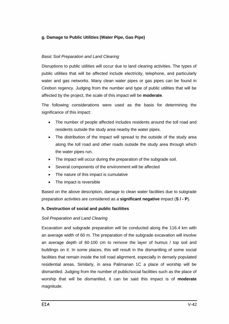
EIA V-42
g. Damage to Public Utilities (Water Pipe, Gas Pipe)
Basic Soil Preparation and Land Clearing
Disruptions to public utilities will occur due to land clearing activities. The types of
public utilities that will be affected include electricity, telephone, and particularly
water and gas networks. Many clean water pipes or gas pipes can be found in
Cirebon regency. Judging from the number and type of public utilities that will be
affected by the project, the scale of this impact will be moderate.
The following considerations were used as the basis for determining the
significance of this impact:
• The number of people affected includes residents around the toll road and
residents outside the study area nearby the water pipes.
• The distribution of the impact will spread to the outside of the study area
along the toll road and other roads outside the study area through which
the water pipes run.
• The impact will occur during the preparation of the subgrade soil.
• Several components of the environment will be affected
• The nature of this impact is cumulative
• The impact is reversible
Based on the above description, damage to clean water facilities due to subgrade
preparation activities are considered as a significant negative impact (S / - P).
h. Destruction of social and public facilities
Soil Preparation and Land Clearing
Excavation and subgrade preparation will be conducted along the 116.4 km with
an average width of 60 m. The preparation of the subgrade excavation will involve
an average depth of 60-100 cm to remove the layer of humus / top soil and
buildings on it. In some places, this will result in the dismantling of some social
facilities that remain inside the toll road alignment, especially in densely populated
residential areas. Similarly, in area Palimanan 1C a place of worship will be
dismantled. Judging from the number of public/social facilities such as the place of
worship that will be dismantled, it can be said this impact is of moderate
magnitude.

EIA V-43
The following considerations formed the basis for determining the significance of
this impact:
• The number of people affected includes residents around the toll road and
residents located nearby that use the public/social facilities.
• The distribution of the impact will spread to outside of the study area where
there are people that use the public/social facilities.
• The impact will occur during the preparation of the subgrade soil.
• Several omponents of the environment may be affected
• The nature of this impact is cumulative
• The impact is reversible
Based on the above description, the impact on public/social facilities due to soil
preparation activities is a significant negative impact (S /-P).
5.3.4 Components of Public Health
a. Increased ARI Patients
An increased prevalence of diseases will result from a declining state of
environmental cleanliness, pools/accumulation of water due to constraints on river
flow, and increased levels of dust due to construction of the Cikampek- Palimanan
toll road along the road and near or through residential areas. As a result these
incidents can cause changes to disease health and hygiene amongst the local
community, such as increased occurrences of diarrhea or gastroenteritis and the
emergence of mosquito breeding places. This may facilitate the occurrence of
disease caused by mosquito bites, especially accompanied by extreme climate
change. Increased levels of dust particles can cause irritation of the respiratory
tract and eventually cause respiratory tract infections. If seen from the number of
people who will be affected, which will reach 500 families (<10% of the population
along the toll road corridor), then this impact can be categorized as small.
The following considerations formed the basis for determining the significance of
this impact:
• The number of people affected includes residents around the toll road and
residents outside the study area.
• The distribution of the impact will spread to the outside of the study area.
• The impact will occur during the preparation of the subgrade.
• Several components of the environment will be affected, such as public
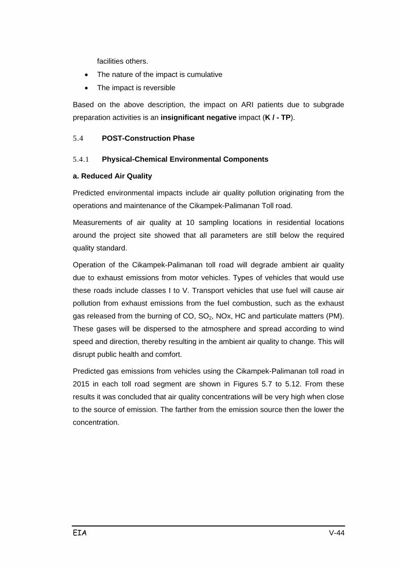
EIA V-44
facilities others.
• The nature of the impact is cumulative
• The impact is reversible
Based on the above description, the impact on ARI patients due to subgrade
preparation activities is an insignificant negative impact (K / - TP).
5.4 POST-Construction Phase
5.4.1 Physical-Chemical Environmental Components
a. Reduced Air Quality
Predicted environmental impacts include air quality pollution originating from the
operations and maintenance of the Cikampek-Palimanan Toll road.
Measurements of air quality at 10 sampling locations in residential locations
around the project site showed that all parameters are still below the required
quality standard.
Operation of the Cikampek-Palimanan toll road will degrade ambient air quality
due to exhaust emissions from motor vehicles. Types of vehicles that would use
these roads include classes I to V. Transport vehicles that use fuel will cause air
pollution from exhaust emissions from the fuel combustion, such as the exhaust
gas released from the burning of CO, SO2, NOx, HC and particulate matters (PM).
These gases will be dispersed to the atmosphere and spread according to wind
speed and direction, thereby resulting in the ambient air quality to change. This will
disrupt public health and comfort.
Predicted gas emissions from vehicles using the Cikampek-Palimanan toll road in
2015 in each toll road segment are shown in Figures 5.7 to 5.12. From these
results it was concluded that air quality concentrations will be very high when close
to the source of emission. The farther from the emission source then the lower the
concentration.

EIA V-45
Figure 5-10 Es timated Air Quality in the Sadang-Kalija ti Sec tion in 2015
Figure 5-11 Es timated Air Quality in the Kalija ti-Subang Section in 2015
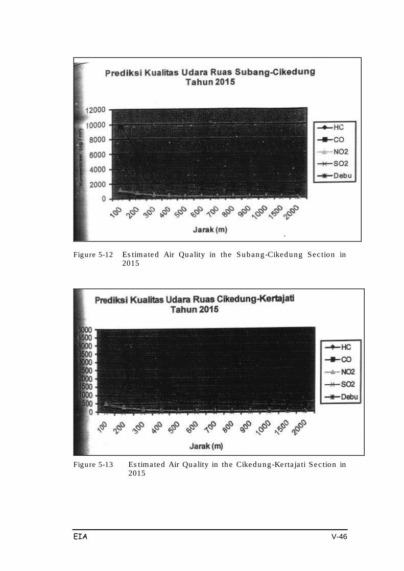
EIA V-46
Figure 5-12 Es timated Air Quality in the Subang-Cikedung Section in 2015
Figure 5-13 Es timated Air Quality in the Cikedung-Kerta ja ti Sec tion in
2015
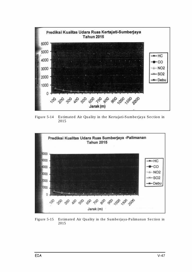
EIA V-47
Figure 5-14 Es timated Air Quality in the Kerta ja ti-Sumberjaya Section in 2015
Figure 5-15 Es timated Air Quality in the Sumberjaya-Palimanan Sec tion in 2015
EIA V-48
Air pollution will mainly be caused by an increased content of dust particles which
will affect the health of residents living near the Cikampek-Palimanan toll road,
such as with skin irritation, eye irritation and disturbance of the respiratory tract.
Another component that will be affected by declining air quality due to emissions
from vehicles using the toll road is the vegetation that grows in the surrounding
area. The impact on plants due to air pollution is different depending on the
pollutant:
1. Impact of O3
- Pale surface on the upper and lower leaves and patches of necrosis
- Occurrence of chlorosis leaf so the color turns yellow
- Creation of spots or patches on the leaves until the leaves are purple, dark
brown or red.
This leaf damage occurs in young leaves and old leaves of plants that are
sensitive to O3, such as vegetable crops (tomato, spinach, peanut, onion), crops
(corn) and ornamentals (chrisantenum, petunias, pine).
2. Impact of SO2
SO2 can cause acute damage to vegetation in the form of necrosis and drying of
leaf tissue. After a time this will cause death of the leaves of certain types of plants
that are sensitive to SO2 in the air, such as are ornamental plants (cosmos /
cottonwoods, daisies, violets, flowers butterflies), plants fruit/vegetables and food
crops (sweet potatoes, spinach, squash, peppers, carrots and bean salad).
3. Impacts of NO2
High content of NO2 in the air can cause leaf blisters, necrosis and leaf fall. With a
concentration of 2ppm of NO2-2 ppm with an exposure time of 2 hours, damage
can be caused to tomato leaves, beans and cucumbers. The types of plants that
are categorized as sensitive to NO2 include vegetable crops (lettuce, red beans
and cabbage), ornamental plants (Hibiscus, Azalea, sunflower and Malaleuca),
and fruitcrops (citrus). Source: Effect of Pullution on plants, Jhon Naeeke 1993.
4. Impact of Fluor (not from vehicle exhaust emissions)
Fluorines and hydrogen-fluorides can accelerate the corrosion process of plants,
by causing the collapse of sponge cells, followed by the lower surface stomata
associated with the epidermis, followed by chloroplast damage and palisade tissue
damage and damaged vascular tissues.

EIA V-49
The predicted percentage increase in air quality was measured at each section
along the Cikampek-Palimanan Toll Road Plan by comparing data from the
Environment Rona with predicted data as follows in Tables 5.12 – 5.17:
Table 5-8 Air Quality Improvement in Cikampek-Kalija ti Sec tion
% Improvement
Distance
HC
CO
N02
SO2
Dust
100
1110.54
1158.12
421.46
-72.54
3607.28
200
636.12
665.05
217.10
-83.30
2154.38
300
385.98
405.08
109.35
-88.98
1388.31
400
263.24
277.52
56.47
-91.76
1012.43
500
190.13
201.54
24.98
-93.42
788.53
600
152.12
162.03
8.60
-94.28
672.11
700
131.87
140.98
-0.12
-94.74
610.11
800
106.95
115.09
-10.85
-95.31
533.79
900
93.12
100.71
-16.81
-95.62
491.43
1000
81.02
88.14
-22.02
-95.89
454.38
1500
44.76
50.45
-37.64
-96.72
343.33
2000
15.78
20.33
-50.13
-97.37
254.57
Table 5-9 Air Quality Improvement in Kalija ti-Subang Sec tion
% improvement
Distance
HC
CO
N02
SO2
Dust
100
1181.57
1155.82
853.05
-72.59
7140.16
200
679.31
663.66
479.55
-83.34
4302.70
300
414.49
404.16
282.61
-89.00
2806.61
400
284.55
276.83
185.98
-91.78
2072.52
500
207.16
200.99
128.42
-93.43
1635.27
600
166.91
161.55
98.49
-94.29
1407.89
700
145.48
140.55
82.55
-94.75
1286.81
800
119.10
114.69
62.93
-95.31
1137.77
900
104.45
100.34
52.04
-95.63
1055.04
1000
91.64
87.79
42.52
-95.90
982.69
1500
53.25
50.18
13.97
-96.72
765.81
2000
22.57
20.11
-8.85
-97.38
592.47

EIA V-50
Table 5-10 Air Quality Improvement in Subang-Cikedung Sec tion
% improvement
Distance
HC
CO
N02
SO2
Dust
100
2758.54
1113.36
1365.92
-53.69
12406.10
200
1638.26
637.84
791.42
-71.84
7504.89
300
1047.58
387.11
488.50
-81.41
4920.65
400
757.75
264.09
339.87
-86.10
3652.64
500
585.11
190.81
251.34
-88.90
2897.37
600
495.34
152.70
205.30
-90.36
2504.62
700
447.54
132.41
180.79
-91.13
2295.47
800
388.69
107.44
150.61
-92.08
2038.03
900
356.03
93.57
133.86
-92.61
1895.13
1000
327.46
81.44
119.21
-93.08
1770.15
1500
241.83
45.10
75.30
-94.46
1395.53
2000
173.40
16.05
40.20
-95.57
1096.12
Table 5-11 Air Quality Improvement in Cikedung-Kertajati Sec tion
% improvement
Distance
HC
CO
N02
SO2
Dust
100
782.44
1264.56
492.09
-77.70
9579.25
200
436.61
729.78
260.05
-86.44
5785.90
300
254.26
447.81
137.70
-91.05
3785.80
400
164.79
309.46
77.66
-93.31
2804.40
500
111.50
227.05
41.91
-94.66
2219.85
600
83.78
184.20
23.31
-95.36
1915.88
700
69.03
161.37
-13.41
-95.73
1754.00
800
50.86
133.28
1.22
-96.19
1554.76
900
40.78
117.69
-5.54
-96.44
1444.15
1000
31.96
104.06
-11.46
-96.67
1347.42
1500
5.53
63.18
-29.20
-97.33
1057.48
2000
-15.60
30.51
-43.37
-97.87
825.75
Table 5-12 Air Quality Improvement in Kerta jati-Sumberjaya Sec tion
% improvement
Distance
HC
CO
N02
SO2
Dust
100
7277.14
978.10
1506.58
-76.58
5481.67
200
4386.00
555.58
876.95
-85.76
3294.18
300
2861.60
332.81
544.97
-90.60
2140.80
400
2113.62
223.50
382.08
-92.97
1574.86
500
1668.10
158.39
285.05
-94.39
1237.77
600
1436.42
124.53
234.60
-95.12
1062.48
700
1313.05
106.50
207.73
-95.51
969.14
800
1161.19
84.31
174.66
-96.00
854.24
EIA V-51
900
1076.89
71.99
156.30
-96.26
790.46
1000
1003.17
61.22
140.25
-96.50
734.68
1500
782.19
28.92
92.12
-97.20
567.48
2000
605.57
3.11
53.66
-97.76
433.85
Table 5-13 Air Quality Improvement in Sumberjaya-Palimanan Sec tion
% improvement
Distance
HC
CO
N02
SO2
Dust
100
555.04
393.00
542.36
-75.81
1809.29
200
298.33
199.79
290.62
-85.29
1061.03
300
162.97
97.92
157.88
-90.29
666.50
400
96.55
47.93
92.75
-92.74
472.91
500
57.00
18.16
53.96
-94.20
357.61
600
36.42
2.68
33.78
-94.96
297.64
700
25.47
-5.57
23.04
-95.37
265.71
800
11.99
-15.72
9.82
-95.86
226.41
900
4.50
-21.35
2.48
-96.14
204.59
1000
-2.05
-26.28
-3.94
-96.38
185.51
1500
-21.67
-41.05
-23.18
-97.11
128.32
2000
-37.35
-52.85
-38.56
-97.69
82.61
From the tables above it can be seen that the air quality parameters that need to
be managed properly are HC, CO, NO2 and Dust. This is because an
improvement with an average of over 30% can be seen in the data when
measured at a distance of 2000 m.
From this data it can be seen that several air pollutants with long exposure at low
concentrations can cause damage to the productivity of vegetation through their
flowers, fruit and leaves.
The impact of the toll road operations in the form of air pollution and vehicle
exhaust gas emission will be relatively long-term as the lifespan of the Palimanan-
Cikampek toll road is over 20 years.
The Cikampek-Palimanan toll road operation has the potential to reduce air quality
and potentially exceed the standards. If the initial conditions are coupled with the
activities and operation of the toll road, with residential areas, commerce, shops,
and industrial and public facilities and vegetation as well as mixed farms being
exposed to the emissions every day (24 hours), then this will negatively affect
public health.
EIA V-52
In addition to affecting public health, air pollution due to exhaust emissions from
motor vehicles and highways will also impact on vegetation around the Cikampek-
Palimanan toll road. Vegetation that will be affected by air pollution are mainly
located in roadside areas; the vegetation types including gardens and yards with
socio-economic, aesthetic and/or ecological value. Thus the effect of reduced air
quality due to activities and operation of Cikampek-Palimanan toll roads is
classified as a large and negative important impact (B /-P) with the following
considerations:
1. Number of people affected:
The number of people affected is quite a lot around the toll road, so the
effect is considered important.
2. Distribution of impact area:
Distribution of the impact will be widespread and can be categorized as
particularly important for dust which can reach the nearby residential and
other land, so that the impact is categorized as important.
3. Intensity and duration of the impact:
The impact will last throughout the toll road operations, is permanent, and
so the impact can be categorized as critical. But in terms of intensity, the
impact intensity will decline (lead, hydrocarbons, gas, SO2, CO, NO2),
although this reduction will be very small. Dust and Carbon Oxide (CO) will
increase by a greater amount and will significantly contribute to declining
air quality, therefore the impact is considered quite important.
4. In terms of the number of environmental components affected, there are
several components that will be affected thus the impact is considered
important.
5. The impact is cumulative, so it can be considered important.
6. The impact is reversible if regular and appropriate management activities
are conducted, so it is categorized as not important.
b. Increased Noise
Increased noise is expected to occur due to the sound from vehicle engines during
the Cikampek-Palimanan toll road operations. Noise will be heard by residents
who live or move around the toll road within a distance of less than 25 m
(population at risk). The noise will come from the engines of Class I to V vehicles
passing through the Cikampek-Palimanan over 24 hours.

EIA V-53
Predicted noise levels during operation are shown in Figure 5.13; this figure shows
that the noise level at a distance of 5 m high will equal to 94 dB (A), but the noise
level will decrease when farther away from the noise source.
Figure 5-16 Predic ted Nois e During Opera tional S tage
Predicted percentage improvements to noise were measured for each section
along the Cikampek-Palimanan Toll Road Plan with data obtained by comparing
data from the Environment Rona and results displayed in Tables 5.18-5.23 as
follows:
Table 5-14 Improvement o f Nois e
Cikampek-Kalijati Section Distance
% improvement
5
68.21
25
43.20
50
32.43
75
26.13
100
21.66
150
15.36
200
10.89
300
4.59
400
0.12
500
-3.34
Table 5-15 Improvement of Noise
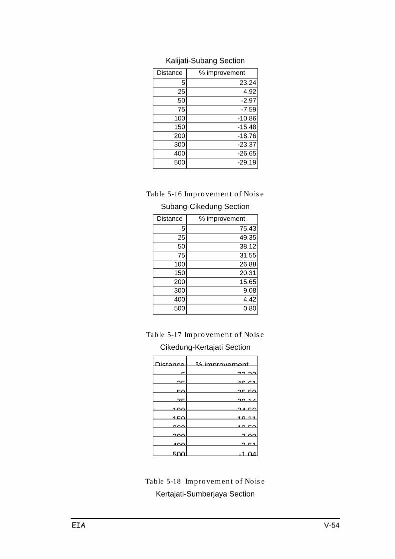
EIA V-54
Kalijati-Subang Section Distance
% improvement
5
23.24 25
4.92
50
-2.97 75
-7.59
100
-10.86 150
-15.48
200
-18.76 300
-23.37
400
-26.65 500
-29.19
Table 5-16 Improvement o f Nois e
Subang-Cikedung Section Distance
% improvement
5
75.43
25
49.35
50
38.12
75
31.55
100
26.88
150
20.31
200
15.65
300
9.08
400
4.42
500
0.80
Table 5-17 Improvement o f Nois e
Cikedung-Kertajati Section
Distance
% improvement
5
72 22
25
46 61
50
35 59
75
29 14
100
24 56
150
18 11
200
13 53
300
7 08
400
2 51
500
-1 04
Table 5-18 Improvement o f Nois e
Kertajati-Sumberjaya Section
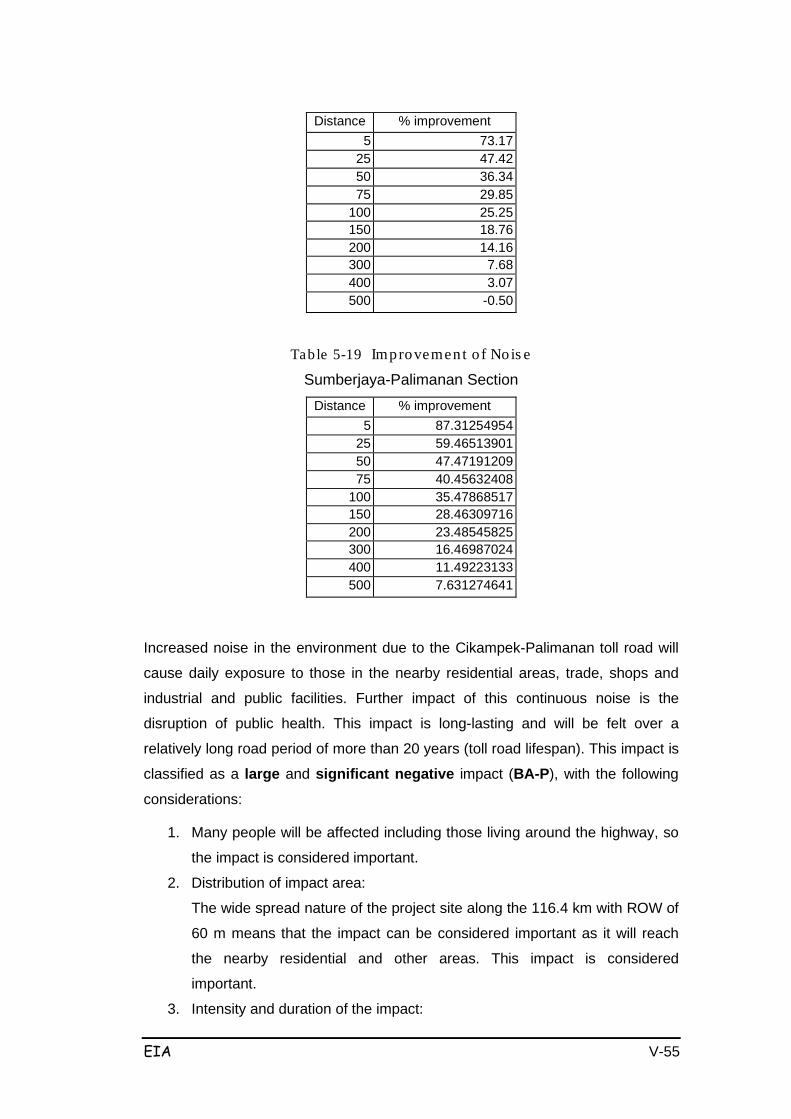
EIA V-55
Distance
% improvement
5
73.17
25
47.42
50
36.34
75
29.85
100
25.25
150
18.76
200
14.16
300
7.68
400
3.07
500
-0.50
Table 5-19 Improvement o f Nois e
Sumberjaya-Palimanan Section Distance
% improvement
5
87.31254954
25
59.46513901
50
47.47191209
75
40.45632408
100
35.47868517
150
28.46309716
200
23.48545825
300
16.46987024
400
11.49223133
500
7.631274641
Increased noise in the environment due to the Cikampek-Palimanan toll road will
cause daily exposure to those in the nearby residential areas, trade, shops and
industrial and public facilities. Further impact of this continuous noise is the
disruption of public health. This impact is long-lasting and will be felt over a
relatively long road period of more than 20 years (toll road lifespan). This impact is
classified as a large and significant negative impact (BA-P), with the following
considerations:
1. Many people will be affected including those living around the highway, so
the impact is considered important.
2. Distribution of impact area:
The wide spread nature of the project site along the 116.4 km with ROW of
60 m means that the impact can be considered important as it will reach
the nearby residential and other areas. This impact is considered
important.
3. Intensity and duration of the impact:
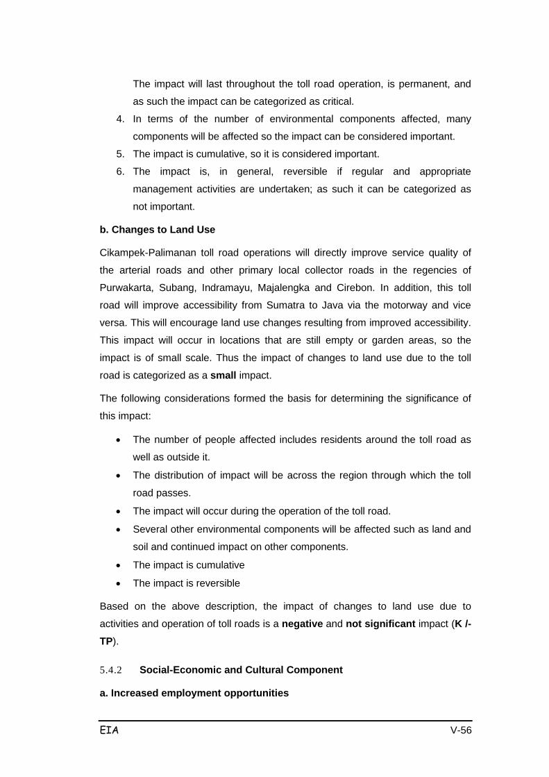
EIA V-56
The impact will last throughout the toll road operation, is permanent, and
as such the impact can be categorized as critical.
4. In terms of the number of environmental components affected, many
components will be affected so the impact can be considered important.
5. The impact is cumulative, so it is considered important.
6. The impact is, in general, reversible if regular and appropriate
management activities are undertaken; as such it can be categorized as
not important.
b. Changes to Land Use
Cikampek-Palimanan toll road operations will directly improve service quality of
the arterial roads and other primary local collector roads in the regencies of
Purwakarta, Subang, Indramayu, Majalengka and Cirebon. In addition, this toll
road will improve accessibility from Sumatra to Java via the motorway and vice
versa. This will encourage land use changes resulting from improved accessibility.
This impact will occur in locations that are still empty or garden areas, so the
impact is of small scale. Thus the impact of changes to land use due to the toll
road is categorized as a small impact.
The following considerations formed the basis for determining the significance of
this impact:
• The number of people affected includes residents around the toll road as
well as outside it.
• The distribution of impact will be across the region through which the toll
road passes.
• The impact will occur during the operation of the toll road.
• Several other environmental components will be affected such as land and
soil and continued impact on other components.
• The impact is cumulative
• The impact is reversible
Based on the above description, the impact of changes to land use due to
activities and operation of toll roads is a negative and not significant impact (K /-TP).
5.4.2 Social-Economic and Cultural Component
a. Increased employment opportunities
EIA V-57
Toll road operations will require both administrative and operational personnel in
the field. A diversity of labor depending on a variety of qualifications, expertise /
skills is needed. Employee training will be required. The main priority of
recruitment will be to hire local from the project area.
Taking into account the number of people that can be hired and the number of job
seekers in the project area (including those who are unemployed), it can be
concluded that the impact on employment is quite broad. Meanwhile, it can be
categorized as an important positive impact (B / + P), with the following
considerations:
• the impact is cumulative with the impacts of other activities;
• intensity of impact is high, in terms of having a broad distribution that may
exceed the project site;
• the impact can contribute positively to the socio-economic conditions of the
local community, such as revenue and business opportunities, as well as
promote a positive image of the toll road.
In addition, the resultant employment and business opportunities are estimated to
increase economic activities in the region. They can also cause secondary effects
such as improvement of incomes. Amid the current economic difficulties, the need
for job opportunities, and the estimated number of workers to be recruited by this
activity, the impact can be considered important positive (B / + P), with the
following considerations:
• the impact is cumulative with the impacts of other activities;
• intensity of impact is high, in terms of having a broad distribution that may
exceed the project site;
• the impact can contribute positively to the socio-economic conditions of the
local community, such as revenue and business opportunities, as well as
promote a positive image of the toll road.
b. Disruption of kinship
Communities around the project have very strong kinship ties, internally and
externally, and strong social relationships among residents. The toll road will
divide the territories in the villages, and villagers suspect the toll road will disrupt
their kinship ties. This impact will arise primarily where accessibility is high and
mobility between villages across the streets will be disturbed.

EIA V-58
The magnitude of this impact is relatively large, given the high dependence of the
population on accessing the old roads. The nature of the impact is negative and
quite important (B /-P).
c. Changes in Public Perception
The toll road is expected to increase the accessibility of the community and
enhance the region's economy. In addition, the existence of employment and
business opportunities is estimated to increase economic activities in the region. It
can also cause secondary effects such as improvement of incomes. The nature of
this impact is broad and can be categorized as an important positive (+ P), with
the following considerations:
• the impact is cumulative with the impacts of other activities;
• intensity of impact is high, in terms of having a broad distribution that may
exceed the project site;
• the impact can contribute positively to the socio-economic conditions of the
local community, such as revenue and business opportunities, as well as
promote a positive image of the toll road.
d. Occurrence of Traffic Accidents
At the beginning of the operation of the Cikampek-Palimanan toll road, road users
will be likely to use this road at maximum speed (100 km/h). The road surface
(made of layers of concrete) will increase friction with the car wheels, resulting in
cars with non-standard tires experiencing accidents (broken tires). Similarly, the
integration of the toll road with arterial roads (road intersections) is usually not
sufficiently sign-posted, so at the beginning road users may easily have accidents
with vehicles leaving the toll road. Considering the density and improvement to
traffic service levels generated by the toll road operations, the changes to traffic
conditions will have a small scale impact. Therefore the impact is a small negative impact.
e. Traffic disruption
Toll Road operation
Operation of the toll road is expected to affect vehicle traffic on access roads
around the entrances and the exits, resulting in traffic congestion on the toll road.
Traffic disruption will occur during the operation of the toll road. Traffic congestion
will cause queues and interrupt the smooth flow of traffic on access roads around

EIA V-59
the toll booths, and will last as long as there are no management efforts to resolve
the issue. The impact is considered to be moderate.
The following considerations formed the basis for determining the significance of
this impact:
• The number of people affected include those who use the access roads
and the toll road
• The impact distribution will be localized to the vicinity of the toll road. The
impact will occur safely with low intensity.
• Other environmental components that may be impacted are the
infrastructure which will be further impacted by the problems of access and
convenience of road users on the toll road.
• The nature of this impact is not cumulative and is reversible
Based on the above description, the impact of road maintenance work on traffic is
negative and not significant (S /-TP).
Along with developments in areas surrounding the toll road, which are either linked
directly or indirectly to the existence of the toll road, the frequency/volume of traffic
on the toll road will also increase. Increases to traffic volume can reduce the level
of highway service, at the least to the level of C which does not meet toll road
standards.
In a relatively short time (± 5 years), traffic volume on the toll road is estimated
improve fairly rapidly. This estimate in based on an analogy with the improvement
in traffic volume on toll roads such as the Padalarang - Cileunyi toll road in West
Java, where traffic volume improved by an average of 28.5% per year. The daily
volume of traffic using the toll road, based on traffic loading models using the help
of Transportation Planning (TRANPLAN) computer software, for each projected
year, is presented in Table 5.24 below.
Table 5-20 Projec t Daily Traffic Volumes INTERCHANGE: Cikampek-Kalijati
Year Type I
(vehicle)
Type II-A
(vehicle)
Gol M-B
(vehicle)
Total
(Vehicle) 2008
4,087
951
3,908
8,996
2010
4,905
1,141
4,690
9,926
2015
6,631
1,543
6,340
14,514
2025 13,264 3,087 12,683 29,034

EIA V-60
2035 21,776 5,067 20,823 47,666
INTERCHANGE Kalijati-Subang 2008
5,613
1,306
5,368
12,287
2010
7,295
1,698
6,976
15,969
2015
9,852
2,292
9,420
21,564
2025
17,924
4,171
17,139
39,234
2035
24,732
5,755
23,649
54,136
INTERCHANGE Subang-Haur Selatan
2008
2,074
483
1,983
4,540
2010
2,881
670
2,755
6,306
2015
4,376
1,018
4,185
9,579
2025
10,195
2,372
9,749
22,316
2035
17,783
4,138
17,004
38,925
INTERCHANGE Haur Selatan-Palimanan
2008
2,699
628
2,581
5,908 2010
2,881
670
2,755
6,306 2015
3,855
897
3,686
15,310 2025
6,994
1,628
6,688
15,310
2035
12,259
2,853
11,722
26,834
Source : SID Cikampek – Palimanan section 116 Km, year 2007.
In relation to the improvement of traffic volume as described above, if the driver's
behavior has no concern for driving on the highway, then congestion and potential
accidents may occur. The analysis above shows that the volume and scale of the
impact is quite significant, and the impact will occur continuously during the
operation of the toll road.
Toll Road Maintenance
Toll road maintenance activities are expected to have an impact on facilities and
infrastructure in the form of traffic disruption, especially during road repair work.
Traffic disruption will occur when road maintenance work is carried out and in the
locations where the work is carried out. The concentration of this traffic will cause
queuing and traffic disruption, especially if the repair work is done at rush hour.
This impacts is assessed as large. The following considerations formed the basis
for determining the significance of this impact:
• The number of people affected includes the toll road users because the
highway is a freeway proper, where travel by road should not be any
interference.
• The distribution of the impact is localized to the vicinity of the repair work.
• The impact will occur during the implementation of repair work with low
intensity.
• Other environmental components that may be affected are the toll road

EIA V-61
infrastructure which will impact further on the comfort of toll road users.
• Nature of the impact is not cumulative and is reversible
Based on the above description, the impact of road maintenance work on traffic is
negative and not significant (B /-TP).
5.5 SUMMARY
The Cikampek - Palimanan Toll Road Development Plan runs along ± 116.4 km
and consists of 6 sections, starting from Cikopo Village (Jakarta-Cikampek Toll 91
+350) in Purwakarta Regency, to Pegagan Village (Cirebon-Palimanan Toll Sta
207 +350) in Cirebon Regency. The length of each section is respectively as
follows:
• Section I Cikampek - Kalijati (27.05 km)
This section begins (STA 91 +350) in Cikopo Village, Bungursari district,
Purwakarta Regency (Cikampek Junction) and meets the Jakarta-Cikampek toll
road and ends at STA 118 +400 at Kaliangsana Village, Kalijati district, Subang
Regency.
• Section II Kalijati - Subang (+ 11.2 km)
Starting from the STA 118 +400 in the Village Kaliangsana Sub-district of Subang
Regency kalijati until at Village STA 129 +600 Cisaga Sub-district of Subang
Regency Subang.
• Section III Subang - Cikedung (+ 28.7 km)
This section begins from STA 129 +600 in the Cisaga Village, Subang district,
Subang regency, and runs until STA 158 +300 in Cikawung Village, Trisi district,
Indramayu regency.
• Section IV Cikedung - Kertajati (+ 18.9 km)
This section starts from STA 158 +300 in Cikawung Village, Trisi district,
Indramayu Regency and runs to STA 177 +200 in Kertawinangun Village, Kertajati
district, Majalengka Regency.
• Section V Kertajati - Sumberjaya (± 16.1 km)
This section starts from STA 177 +200 in Kertawinangun Village, Kertajati district,
Majalengka Regency and runs until STA193 +300 at Sumberjaya Village,
Sumberjaya district, Majalengka Regency.

EIA V-62
• Section VI Sumberjaya - Palimanan (+ 14.45 km)
This section starts from STA 193 +300 in Sumberjaya Village, Sumberjaya district,
Majalengka Regency and runs until STA 207 +750 in Pegagan Village, Palimanan
district, Cirebon Regency.
The predicted impacts that will arise and the location of their occurrence for each
toll road section can be seen in Tables 5.25 until 5.27.
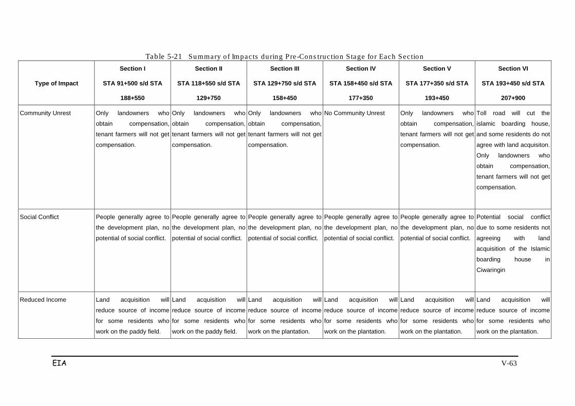
EIA V-63
Table 5-21 Summary of Impac ts during Pre -Cons truc tion S tage fo r Each Sec tion
Type of Impact
Section I
STA 91+500 s/d STA
188+550
Section II
STA 118+550 s/d STA
129+750
Section III
STA 129+750 s/d STA
158+450
Section IV
STA 158+450 s/d STA
177+350
Section V
STA 177+350 s/d STA
193+450
Section VI
STA 193+450 s/d STA
207+900
Community Unrest Only landowners who
obtain compensation,
tenant farmers will not get
compensation.
Only landowners who
obtain compensation,
tenant farmers will not get
compensation.
Only landowners who
obtain compensation,
tenant farmers will not get
compensation.
No Community Unrest Only landowners who
obtain compensation,
tenant farmers will not get
compensation.
Toll road will cut the
islamic boarding house,
and some residents do not
agree with land acquisiton.
Only landowners who
obtain compensation,
tenant farmers will not get
compensation.
Social Conflict People generally agree to
the development plan, no
potential of social conflict.
People generally agree to
the development plan, no
potential of social conflict.
People generally agree to
the development plan, no
potential of social conflict.
People generally agree to
the development plan, no
potential of social conflict.
People generally agree to
the development plan, no
potential of social conflict.
Potential social conflict
due to some residents not
agreeing with land
acquisition of the Islamic
boarding house in
Ciwaringin
Reduced Income Land acquisition will
reduce source of income
for some residents who
work on the paddy field.
Land acquisition will
reduce source of income
for some residents who
work on the paddy field.
Land acquisition will
reduce source of income
for some residents who
work on the plantation.
Land acquisition will
reduce source of income
for some residents who
work on the plantation.
Land acquisition will
reduce source of income
for some residents who
work on the plantation.
Land acquisition will
reduce source of income
for some residents who
work on the plantation.
EIA V-64
EIA V-65
Table 5-22 Summary of Impac ts during Cons truc tion S tage fo r Each Sec tion
Type of Impact
Section I
STA 91+500 s/d STA
188+550
Section II
STA 118+550 s/d STA
129+750
Section III
STA 129+750 s/d STA
158+450
Section IV
STA 158+450 s/d STA
177+350
Section V
STA 177+350 s/d STA
193+450
Section VI
STA 193+450 s/d STA
207+900
Reduced Air Quality Impact caused by
Mobilization heavy
equipment and materials,
Operation of the base
camp, ground preparation
work, foundation,
excavation and
embankment work, and
Bridge Works
(Sta. 92+600-92+850,
Sta 98+700-98+800,
Sta 1 04+550-1 04+900,
Sta 11 3+700-1 13+800,
Sta 11 6+800-1 16+900)
Impact caused by
Mobilization heavy
equipment and materials,
Operation of the base
camp, ground preparation
work, foundation,
excavation and
embankment work, and
Bridge Works
Sta 122+450-122+600
Sta 123+550-1 23+700
Sta 126+300-126+650
Impact caused by
Mobilization heavy
equipment and materials,
Operation of the base
camp, ground preparation
work, foundation,
excavation and
embankment work, and
Bridge Works
Sta 129+950-1 30+000
Sta 131 +400-1 31 +500
Sta 132+050-132+150
Sta 132+300-1 32+450
Sta 132+600-1 32+700
Sta 136+700-136+900
Sta 149+800-149+950
No settlements in Sta
158+450-1 77+350
Impact caused by
Mobilization heavy
equipment and materials,
Operation of the base
camp, ground preparation
work, foundation,
excavation and
embankment work, and
Bridge Works
Sta 180+300-180+600
Sta 187+000-187+400
Sta 188+200-188+550
Sta 188+700-1 89+000
189+800-190+200
Impact caused by
Mobilization heavy
equipment and materials,
Operation of the base
camp, ground preparation
work, foundation,
excavation and
embankment work, and
Bridge Works
Sta 194+700-1 94+800
Sta 198+000-1 98+050
Sta 199+000-1 99+250
Sta 199+900-200+000
Sta 200+200-200+400
Sta 200+600-201 +200
Sta 201 +400-201 +500
Sta 202+400-202+550
Sta 205+800-205+850
EIA V-66
Type of Impact
Section I
STA 91+500 s/d STA
188+550
Section II
STA 118+550 s/d STA
129+750
Section III
STA 129+750 s/d STA
158+450
Section IV
STA 158+450 s/d STA
177+350
Section V
STA 177+350 s/d STA
193+450
Section VI
STA 193+450 s/d STA
207+900
Sta 206+850-207+000
Increased Noise
Impact caused by
Mobilization heavy
equipment and materials,
Operation of the base
camp, ground preparation
work, foundation,
excavation and
embankment work, and
Bridge Works, road works,
and pavement work
(Sta. 92+600-92+850,
Sta 98+700-98+800.
Sta 104+550-1 04+900,
Sta 11 3+700-1 13+800,
Sta 11 6+800-1 16+900)
Impact caused by
Mobilization heavy
equipment and materials,
Operation of the base
camp, ground preparation
work, foundation,
excavation and
embankment work, and
Bridge Works, road works,
and pavement work
Sta 122+450-1 22+600
Sta 123+550-1 23+700
Sta 126+300-126+650
D Impact caused by
Mobilization heavy
equipment and materials,
Operation of the base
camp, ground preparation
work, foundation,
excavation and
embankment work, and
Bridge Works, road works,
and pavement work
Sta 129+950-130+000
Sta 131 +400-1 31 +500
Sta 132+050-132+150
Sta 132+300-1 32+450
Sta 132+600-132+700
No settlements in Sta
158+450-1 77+350
Impact caused by
Mobilization heavy
equipment and materials,
Operation of the base
camp, ground preparation
work, foundation,
excavation and
embankment work, and
Bridge Works, road works,
and pavement work
.Sta 180+300-1 80+600
Sta 187+000-187+400
Sta 188+200-1 88+550
Sta 188+700-1 89+000
189+800-190+200
Impact caused by
Mobilization heavy
equipment and materials,
Operation of the base
camp, ground preparation
work, foundation,
excavation and
embankment work, and
Bridge Works, road works,
and pavement work
Sta 194+700-194+800
Sta 198+000-198+050
Sta 199+000-199+250
Sta 199+900-200+000
Sta 200+200-200+400

EIA V-67
Type of Impact
Section I
STA 91+500 s/d STA
188+550
Section II
STA 118+550 s/d STA
129+750
Section III
STA 129+750 s/d STA
158+450
Section IV
STA 158+450 s/d STA
177+350
Section V
STA 177+350 s/d STA
193+450
Section VI
STA 193+450 s/d STA
207+900
Sta 136+700-1 36+900 Sta 149+800-149+950
Sta 200+600-201+200
Sta 201+400-201+500
Sta 202+400-202+550
Sta 205+800-205+850
Sta 206+850-207+000
Reduced Water Quality
Impact caused by
Mobilization heavy
equipment and materials,
Operation of the base camp, ground preparation work, foundation, excavation and embankment work, River Ciherang (STA 95+000), River Cilamaya JSTA. 102+500).
Impact caused by
Mobilization heavy
equipment and materials,
Operation of the base camp, ground preparation work, foundation, excavation and embankment work, River Cibodas (STA 120+000), River Ciasem (STA.123+000)
Impact caused by
Mobilization heavy
equipment and materials,
Operation of the base camp, ground preparation work, foundation, excavation and embankment work, River Cilamatan (STA 138+500), River Cipunegara (STA 142+0001
Impact caused by
Mobilization heavy
equipment and materials,
Operation of the base camp, ground preparation work, foundation, excavation and embankment work, River Cipanas (STA 161+500)
Impact caused by
Mobilization heavy
equipment and materials,
Operation of the base camp, ground preparation work, foundation, excavation and embankment work, River Cimanuk (STA 180+000)
Impact caused by
Mobilization heavy
equipment and materials,
Operation of the base camp, ground preparation work, foundation, excavation and embankment work, River Ciwaringin (STA 201+000), Kanal Ciliwung (STA 205+500)
Disruption of Ground Water flow
Caused by clearing and
land preparation activities,
earthwork (excavation /
embankment),
construction work and the
road pavement. (In all the
irrigation channels that are
cut off)
Caused by clearing and
land preparation activities,
earthwork (excavation /
embankment),
construction work and the
road pavement. (In all the
irrigation channels that are
cut off)
Caused by clearing and
land preparation activities,
earthwork (excavation /
embankment),
construction work and the
road pavement. (In all the
irrigation channels that are
cut off)
Caused by clearing and
land preparation activities,
earthwork (excavation /
embankment),
construction work and the
road pavement. (In all the
irrigation channels that are
cut off)
Caused by clearing and
land preparation activities,
earthwork (excavation /
embankment),
construction work and the
road pavement. (In all the
irrigation channels that are
cut off)
Caused by clearing and
land preparation activities,
earthwork (excavation /
embankment),
construction work and the
road pavement. (In all the
irrigation channels that are
cut off)
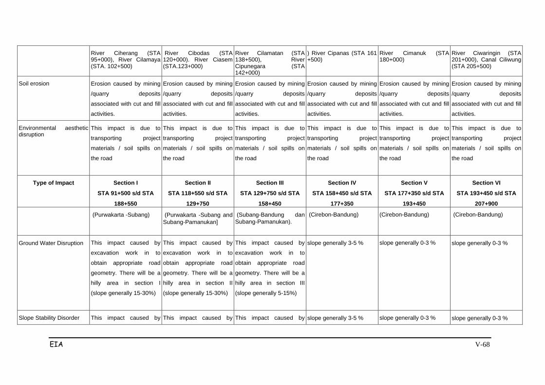
EIA V-68
River Ciherang (STA 95+000), River Cilamaya (STA. 102+500)
River Cibodas (STA 120+000). River Ciasem (STA.123+000)
River Cilamatan (STA 138+500), River Cipunegara (STA 142+000)
) River Cipanas (STA 161 +500)
River Cimanuk (STA 180+000)
River Ciwaringin (STA 201+000), Canal Ciliwung (STA 205+500)
Soil erosion Erosion caused by mining
/quarry deposits
associated with cut and fill
activities.
Erosion caused by mining
/quarry deposits
associated with cut and fill
activities.
Erosion caused by mining
/quarry deposits
associated with cut and fill
activities.
Erosion caused by mining
/quarry deposits
associated with cut and fill
activities.
Erosion caused by mining
/quarry deposits
associated with cut and fill
activities.
Erosion caused by mining
/quarry deposits
associated with cut and fill
activities.
Environmental aesthetic disruption
This impact is due to
transporting project
materials / soil spills on
the road
This impact is due to
transporting project
materials / soil spills on
the road
This impact is due to
transporting project
materials / soil spills on
the road
This impact is due to
transporting project
materials / soil spills on
the road
This impact is due to
transporting project
materials / soil spills on
the road
This impact is due to
transporting project
materials / soil spills on
the road
Type of Impact Section I
STA 91+500 s/d STA
188+550
Section II
STA 118+550 s/d STA
129+750
Section III
STA 129+750 s/d STA
158+450
Section IV
STA 158+450 s/d STA
177+350
Section V
STA 177+350 s/d STA
193+450
Section VI
STA 193+450 s/d STA
207+900
(Purwakarta -Subang)
(Purwakarta -Subang and Subang-Pamanukan]
(Subang-Bandung dan Subang-Pamanukan).
(Cirebon-Bandung)
(Cirebon-Bandung)
(Cirebon-Bandung)
Ground Water Disruption
This impact caused by
excavation work in to
obtain appropriate road
geometry. There will be a
hilly area in section I
(slope generally 15-30%)
This impact caused by
excavation work in to
obtain appropriate road
geometry. There will be a
hilly area in section II
(slope generally 15-30%)
This impact caused by
excavation work in to
obtain appropriate road
geometry. There will be a
hilly area in section III
(slope generally 5-15%)
slope generally 3-5 %
slope generally 0-3 %
slope generally 0-3 %
Slope Stability Disorder This impact caused by This impact caused by This impact caused by slope generally 3-5 % slope generally 0-3 % slope generally 0-3 %
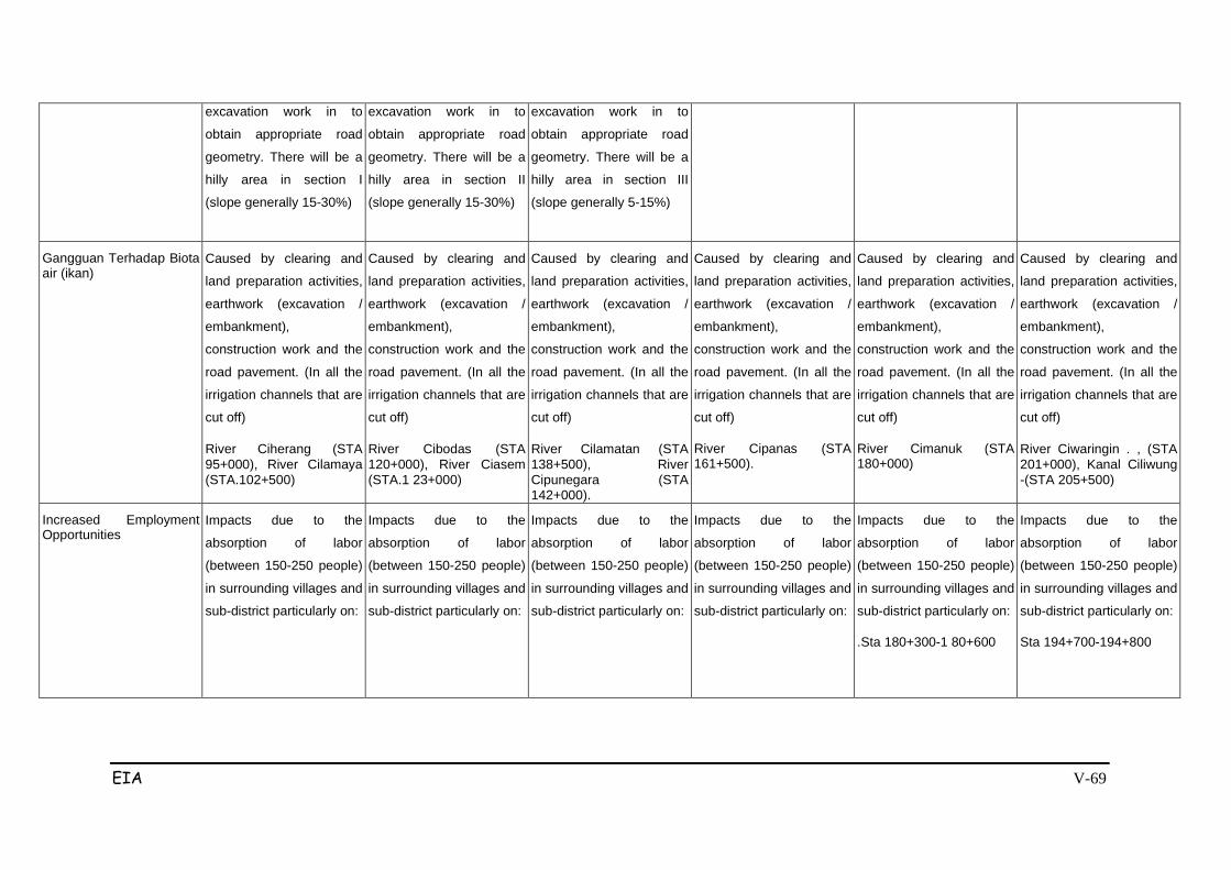
EIA V-69
excavation work in to
obtain appropriate road
geometry. There will be a
hilly area in section I
(slope generally 15-30%)
excavation work in to
obtain appropriate road
geometry. There will be a
hilly area in section II
(slope generally 15-30%)
excavation work in to
obtain appropriate road
geometry. There will be a
hilly area in section III
(slope generally 5-15%)
Gangguan Terhadap Biota air (ikan)
Caused by clearing and
land preparation activities,
earthwork (excavation /
embankment),
construction work and the
road pavement. (In all the
irrigation channels that are
cut off)
River Ciherang (STA 95+000), River Cilamaya (STA.102+500)
Caused by clearing and
land preparation activities,
earthwork (excavation /
embankment),
construction work and the
road pavement. (In all the
irrigation channels that are
cut off)
River Cibodas (STA 120+000), River Ciasem (STA.1 23+000)
Caused by clearing and
land preparation activities,
earthwork (excavation /
embankment),
construction work and the
road pavement. (In all the
irrigation channels that are
cut off)
River Cilamatan (STA 138+500), River Cipunegara (STA 142+000).
Caused by clearing and
land preparation activities,
earthwork (excavation /
embankment),
construction work and the
road pavement. (In all the
irrigation channels that are
cut off)
River Cipanas (STA 161+500).
Caused by clearing and
land preparation activities,
earthwork (excavation /
embankment),
construction work and the
road pavement. (In all the
irrigation channels that are
cut off)
River Cimanuk (STA 180+000)
Caused by clearing and
land preparation activities,
earthwork (excavation /
embankment),
construction work and the
road pavement. (In all the
irrigation channels that are
cut off)
River Ciwaringin . , (STA 201+000), Kanal Ciliwung -(STA 205+500)
Increased Employment Opportunities
Impacts due to the
absorption of labor
(between 150-250 people)
in surrounding villages and
sub-district particularly on:
Impacts due to the
absorption of labor
(between 150-250 people)
in surrounding villages and
sub-district particularly on:
Impacts due to the
absorption of labor
(between 150-250 people)
in surrounding villages and
sub-district particularly on:
Impacts due to the
absorption of labor
(between 150-250 people)
in surrounding villages and
sub-district particularly on:
Impacts due to the
absorption of labor
(between 150-250 people)
in surrounding villages and
sub-district particularly on:
.Sta 180+300-1 80+600
Impacts due to the
absorption of labor
(between 150-250 people)
in surrounding villages and
sub-district particularly on:
Sta 194+700-194+800

EIA V-70
Type of Impact Section I
STA 91+500 s/d STA
188+550
Section II
STA 118+550 s/d STA
129+750
Section III
STA 129+750 s/d STA
158+450
Section IV
STA 158+450 s/d STA
177+350
Section V
STA 177+350 s/d STA
193+450
Section VI
STA 193+450 s/d STA
207+900
(Sta. 92+600-92+650, Sta
98+700-98+600,
Sta 104+550-104+900,
Sta 113+700-113+600,
Sta 116+600-116+900)
Sta 122+450-122+600 Sta
123+550-123+700 Sta
126+300-126+650
Sta 129+950-130+000 Sta
131+400-131+500 Sta
132+050-132+150 Sta
132+300-132+450 Sta
132+600-132+700 Sta
136+700-136+900 Sta
149+800-149+950
Sta 187+000-187+400 Sta
188+200-188+550 Sta
188+700-189+000
189+800-190+200
Sta 198+000-198+050 Sta
199+000-199+250 Sta
199+900-200+000 Sta
200+200-200+400 Sta
200+600-201+200 Sta
201+400-201+500 Sta
202+400-202+550 Sta
205+600-205+650 Sta
206+650-207+000
Improvement of Business
Opportunity
Impact due to the need for
material supply
For excavation category C
materials (stone, gravel) or
Concrete materials
(cement, asphalt, iron),
in surrounding villages and
sub-district
Impact due to the need for
material supply
For excavation category C
materials (stone, gravel) or
Concrete materials
(cement, asphalt, iron),
in surrounding villages and
sub-district
Impact due to the need for
material supply
For excavation category C
materials (stone, gravel) or
Concrete materials
(cement, asphalt, iron),
in surrounding villages and
sub-district
Impact due to the need for
material supply
For excavation category C
materials (stone, gravel) or
Concrete materials
(cement, asphalt, iron),
in surrounding villages
and sub-district
Impact due to the need for
material supply
For excavation category C
materials (stone, gravel) or
Concrete materials
(cement, asphalt, iron),
in surrounding villages
and sub-district
Impact due to the need for
material supply
For excavation category C
materials (stone, gravel) or
Concrete materials
(cement, asphalt, iron),
in surrounding villages
and sub-district
Social Jealousy Impacts due to the
absorption of labor coming
not from surrounding
villages and sub-district
Impacts due to the
absorption of labor
(between 150-250 people)
in surrounding villages
and sub-district
Impacts due to the
absorption of labor
(between 150-250 people)
in surrounding villages
and sub-district
Impacts due to the
absorption of labor
(between 150-250 people)
in surrounding villages
Impacts due to the
absorption of labor
(between 150-250 people)
in surrounding villages
Impacts due to the
absorption of labor
(between 150-250 people)
in surrounding villages

EIA V-71
particularly on:
(Sta. 92+600-92+850,
Sta 98+700-98+800, Sta
104+550-104+900, Sta
113+700-113+800, Sta
116+600-116+900)
particularly on:: Sta
122+450-122+600 Sta
123+550-123+700 Sta
126+300-126+650
particularly on:Sta
129+950-130+000 Sta
131+400-131+500 Sta
132+050-132+150 Sta
132+300-132+450 Sta
132+600-132+700 Sta
136+700-136+900 Sta
149+800-149+950
and sub-district particularly
on:
and sub-district
particularly on:. Sta 180+-
300-180+600 Sta
187+000-187+400 Sta
188+200-188+550 Sta
188+700-189+000
189+800-190+200
and sub-district
particularly on:Sta
194+700-194+800
Sta 198+000-198+050
Sta 199+000-199+250
Sta 199+900-200+000
Sta 200+200-200+400
Sta 200+600-201+200
Sta 201+400-201+500
Sta 202+400-202+550
Sta 205+800-205+650
Sta 206+850-207+000
Type of Impact
Section I
STA 91+500 s/d STA
188+550
Section II
STA 118+550 s/d STA
129+750
Section III
STA 129+750 s/d STA
158+450
Section IV
STA 158+450 s/d STA
177+350
Section V
STA 177+350 s/d STA
193+450
Section VI
STA 193+450 s/d STA
207+900
Accessibility Disruption These impacts will arise
especially in underpass
/overpass work activities
where the toll road
alignment plan will cut
many public roads,
especially on
These impacts will arise
especially in underpass
/overpass work activities
where the toll road
alignment plan will cut
many public roads,
especially on
These impacts will arise
especially in underpass
/overpass work activities
where the toll road
alignment plan will cut
many public roads,
especially on
These impacts will arise
especially in underpass
/overpass work activities
where the toll road
alignment plan will cut
many public roads,
especially on
These impacts will arise
especially in underpass
/overpass work activities
where the toll road
alignment plan will cut
many public roads,
especially on
These impacts will arise
especially in underpass
/overpass work activities
where the toll road
alignment plan will cut
many public roads,
especially on

EIA V-72
Sta:
92+920; 94+670;95+975;
97+S89;98+500;100+000;
101+100,103+418, 104+044, 106+205, 107+325, 109+518
113+525,114+805, 116+116, 116+950, 117+532
Sta:
118+425,119+070, 121+100, 121+825, 122+585, 123+855
124+831, 126+180, 127+350, 128+286, 128+550, 129+122
Sta
130+012,131+575,
133+100, 133+566, 134+735,136+135
136+870,138+433,139+389
139+806,140+860,142+736
144+800,147+863,149+711
153+453,154+250,155+480
158+888,
Sta:
160+845,163+536,
164+651,165+975, 167+675,169+500,
171+060, 172+021, 172+851, 173-112,
176-155, 177+488
Sta 179+002,182+500,184+802,187+281,188+250,
189+070, 190+673,191+ 550,192+712
Sta:
194+698,195+289,195+
938, 196+425,197+289, 198+191, 199+446, 200+030,200+030
200+716,201+535,202+
123, 205+776,206+418
Impact caused by
Mobilization heavy
equipment and materials,
Sta:
92+920,97+589, 104+044,
107+325,109+518, 113+525 116+950
Impact caused by
Mobilization heavy
equipment and materials,
Sta:
119+070,123+855 126+180,128+286
Impact caused by
Mobilization heavy
equipment and materials,
Sta:
130+012,136+135
139+806,142+736
149+711
Impact caused by
Mobilization heavy
equipment and materials,
Sta:
158+888,169^00 173+512
Impact caused by
Mobilization heavy
equipment and materials,
Sta:
179+002,182+500
184+802,187+281
189+070,190+573
192+712.
Impact caused by
Mobilization heavy
equipment and materials,
Sta:
195+289,200+030
Impact caused by
Mobilization heavy
equipment and materials,
Sta;
92+920;94+670;95+975; 97+589; 98+500; 100+000; 101+100, 103+418 104+044, 106+205. 107+325
Impact caused by
Mobilization heavy
equipment and materials,
Sta:
118+425,119+070 121+100,121+825 122+585,123+855 124+831,126+180
Impact caused by
Mobilization heavy
equipment and materials,
Sta:
130+012,131+575
133+100,133+566
134+735,136+135
136+870.138+433
Impact caused by
Mobilization heavy
equipment and materials,
Sta: 160+845,163+536
164+651,165+975 167+575,169+500 171+060,172+021
Impact caused by
Mobilization heavy
equipment and materials,
Sta:
179+002,182+500 184+802,187+281 188+250,189+070 190+573,191+550 192+712.
Impact caused by
Mobilization heavy
equipment and materials,
Sta:

EIA V-73
Type of Impact
Section I
STA 91+500 s/d STA
188+550
Section II
STA 118+550 s/d STA
129+750
Section III
STA 129+750 s/d STA
158+450
Section IV
STA 158+450 s/d STA
177+350
Section V
STA 177+350 s/d STA
193+450
Section VI
STA 193+450 s/d STA
207+900
109518,113+625,114+805 116+116,116+950,117+532
127+350,128+286 128+550,129+122
139+389,139+806 140+860,142+736 144+800,147+363 149+711,153+453 154+250,155+480 158+888
172+651,173+612 176+655,177+488
201+535,202+123 205+776, 206+418
Caused by clearing and land preparation activities, earthwork (excavation / embankment), Sta 91+552 (PDAM) Sta 103+421 (Gas) PLN
Caused by clearing and land preparation activities, earthwork (excavation / embankment), Sta 126+122 (Gas) 127+212 (Gas) PLN
Caused by clearing and land preparation activities, earthwork (excavation / embankment), Sta 130+901 (Gas) PLN
Caused by clearing and land preparation activities, earthwork (excavation / embankment), PLN
Caused by clearing and land preparation activities, earthwork (excavation / embankment),
Caused by clearing and land preparation activities, earthwork (excavation / embankment),
Gas :
Sta 196+496 dan 202+255
Dampak ini terjadi akibat keg. penyiapan tanah dasar dan pembersihan lahan pada jembatan lama yang menghubungkan antara dua village.
Caused by clearing and land preparation activities, earthwork (excavation / embankment),
Caused by clearing and land preparation activities, earthwork (excavation / embankment),
No settlements in Sta
158+450-1 77+350
Caused by clearing and land preparation activities, earthwork (excavation / embankment), near school
Caused by clearing and land preparation activities, earthwork (excavation / embankment), near mosque
Increased ARI patients
The impact of derivatives
decreasing cleanliness
environment, the
occurrence of puddle of
water due constraints on
river flow and
improvement dust levels
due to construction of toll
roads
The impact of derivatives
decreasing cleanliness
environment, the
occurrence of puddle of
water due constraints on
river flow and
improvement dust levels
due to construction of toll
roads
The impact of derivatives
decreasing cleanliness
environment, the
occurrence of puddle of
water due constraints on
river flow and
improvement dust levels
due to construction of toll
roads
No settlements in Sta
158+450-1 77+350
The impact of derivatives
decreasing cleanliness
environment, the
occurrence of puddle of
water due constraints on
river flow and
improvement dust levels
due to construction of toll
roads
The impact of derivatives
decreasing cleanliness
environment, the
occurrence of puddle of
water due constraints on
river flow and
improvement dust levels
due to construction of toll
roads
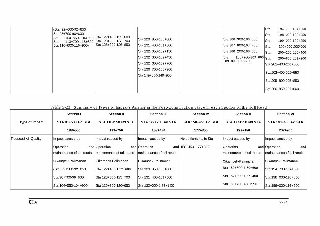
EIA V-74
(Sta. 92+600-92+850, Sta 98+700-98+800, Sta 104+550-104+900, Sta 113+700-113+800, Sta 116+800-116+900)
Sta 122+450-122+600 Sta 123+550-123+700 Sta 126+300-126+650
Sta 129+950-130+000
Sta 131+400-131+500
Sta 132+050-132+150
Sta 132+300-132+450
Sta 132+600-132+700
Sta 136+700-136+900
Sta 149+800-149+950
Sta 180+300-180+500
Sta 187+000-187+400
Sta 188+200-188+550
Sta 188+700-189+000 189+800-190+200
Sta 194+700-194+600
Sta 198+000-198+050
Sta 199+000-199+250
Sta 199+900-200*000
Sta 200+200-200+400
Sta 200+600-201+200
Sta 201+400-201+500
Sta 202+400-202+550
Sta 205+800-205+850
Sta 206+850-207+000
Table 5-23 Summary of Types o f Impac ts Aris ing in the Pos t-Cons truc tion S tage in each Sec tion o f the Toll Road
Type of Impact
Section I
STA 91+500 s/d STA
188+550
Section II
STA 118+550 s/d STA
129+750
Section III
STA 129+750 s/d STA
158+450
Section IV
STA 158+450 s/d STA
177+350
Section V
STA 177+350 s/d STA
193+450
Section VI
STA 193+450 s/d STA
207+900
Reduced Air Quality Impact caused by
Operation and
maintenance of toll roads
Cikampek-Palimanan
(Sta. 92+500-92+850,
Sta 98+700-98+800,
Sta 104+550-104+900,
Impact caused by
Operation and
maintenance of toll roads
Cikampek-Palimanan
Sta 122+450-1 22+600
Sta 123+550-123+700
Sta 126+300-126+650
Impact caused by
Operation and
maintenance of toll roads
Cikampek-Palimanan
Sta 129+950-130+000
Sta 131+400-131+500
Sta 132+050-1 32+1 50
No settlements in Sta
158+450-1 77+350
Impact caused by
Operation and
maintenance of toll roads
Cikampek-Palimanan
Sta 180+300-1 80+600
Sta 187+000-1 87+400
Sta 188+200-188+550
Impact caused by
Operation and
maintenance of toll roads
Cikampek-Palimanan
Sta 194+700-194+800
Sta 198+000-198+050
Sta 199+000-199+250
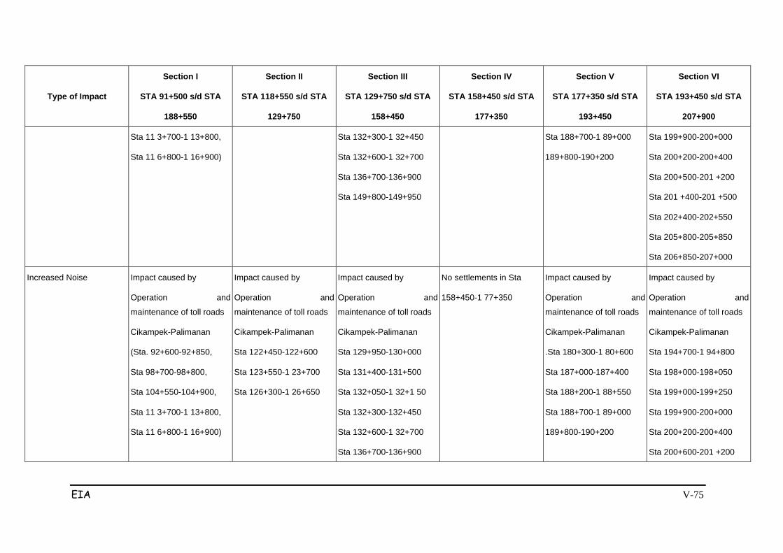
EIA V-75
Type of Impact
Section I
STA 91+500 s/d STA
188+550
Section II
STA 118+550 s/d STA
129+750
Section III
STA 129+750 s/d STA
158+450
Section IV
STA 158+450 s/d STA
177+350
Section V
STA 177+350 s/d STA
193+450
Section VI
STA 193+450 s/d STA
207+900
Sta 11 3+700-1 13+800,
Sta 11 6+800-1 16+900)
Sta 132+300-1 32+450
Sta 132+600-1 32+700
Sta 136+700-136+900
Sta 149+800-149+950
Sta 188+700-1 89+000
189+800-190+200
Sta 199+900-200+000
Sta 200+200-200+400
Sta 200+500-201 +200
Sta 201 +400-201 +500
Sta 202+400-202+550
Sta 205+800-205+850
Sta 206+850-207+000
Increased Noise
Impact caused by
Operation and
maintenance of toll roads
Cikampek-Palimanan
(Sta. 92+600-92+850,
Sta 98+700-98+800,
Sta 104+550-104+900,
Sta 11 3+700-1 13+800,
Sta 11 6+800-1 16+900)
Impact caused by
Operation and
maintenance of toll roads
Cikampek-Palimanan
Sta 122+450-122+600
Sta 123+550-1 23+700
Sta 126+300-1 26+650
Impact caused by
Operation and
maintenance of toll roads
Cikampek-Palimanan
Sta 129+950-130+000
Sta 131+400-131+500
Sta 132+050-1 32+1 50
Sta 132+300-132+450
Sta 132+600-1 32+700
Sta 136+700-136+900
No settlements in Sta
158+450-1 77+350
Impact caused by
Operation and
maintenance of toll roads
Cikampek-Palimanan
.Sta 180+300-1 80+600
Sta 187+000-187+400
Sta 188+200-1 88+550
Sta 188+700-1 89+000
189+800-190+200
Impact caused by
Operation and
maintenance of toll roads
Cikampek-Palimanan
Sta 194+700-1 94+800
Sta 198+000-198+050
Sta 199+000-199+250
Sta 199+900-200+000
Sta 200+200-200+400
Sta 200+600-201 +200
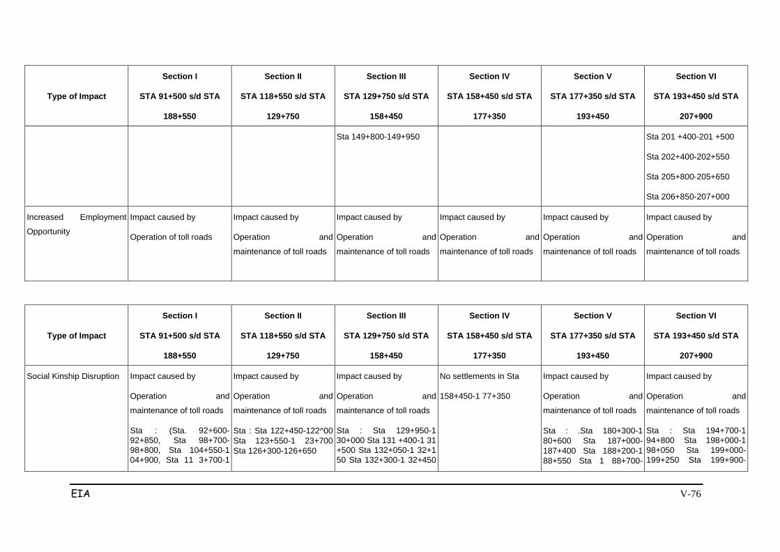
EIA V-76
Type of Impact
Section I
STA 91+500 s/d STA
188+550
Section II
STA 118+550 s/d STA
129+750
Section III
STA 129+750 s/d STA
158+450
Section IV
STA 158+450 s/d STA
177+350
Section V
STA 177+350 s/d STA
193+450
Section VI
STA 193+450 s/d STA
207+900
Sta 149+800-149+950 Sta 201 +400-201 +500
Sta 202+400-202+550
Sta 205+800-205+650
Sta 206+850-207+000
Increased Employment
Opportunity
Impact caused by
Operation of toll roads
Impact caused by
Operation and
maintenance of toll roads
Impact caused by
Operation and
maintenance of toll roads
Impact caused by
Operation and
maintenance of toll roads
Impact caused by
Operation and
maintenance of toll roads
Impact caused by
Operation and
maintenance of toll roads
Type of Impact
Section I
STA 91+500 s/d STA
188+550
Section II
STA 118+550 s/d STA
129+750
Section III
STA 129+750 s/d STA
158+450
Section IV
STA 158+450 s/d STA
177+350
Section V
STA 177+350 s/d STA
193+450
Section VI
STA 193+450 s/d STA
207+900
Social Kinship Disruption
Impact caused by
Operation and
maintenance of toll roads
Sta : (Sta. 92+600-92+850, Sta 98+700-98+800, Sta 104+550-1 04+900, Sta 11 3+700-1
Impact caused by
Operation and
maintenance of toll roads
Sta : Sta 122+450-122^00 Sta 123+550-1 23+700 Sta 126+300-126+650
Impact caused by
Operation and
maintenance of toll roads
Sta : Sta 129+950-1 30+000 Sta 131 +400-1 31 +500 Sta 132+050-1 32+1 50 Sta 132+300-1 32+450
No settlements in Sta
158+450-1 77+350
Impact caused by
Operation and
maintenance of toll roads
Sta : .Sta 180+300-1 80+600 Sta 187+000-187+400 Sta 188+200-1 88+550 Sta 1 88+700-
Impact caused by
Operation and
maintenance of toll roads
Sta : Sta 194+700-1 94+800 Sta 198+000-1 98+050 Sta 199+000-199+250 Sta 199+900-
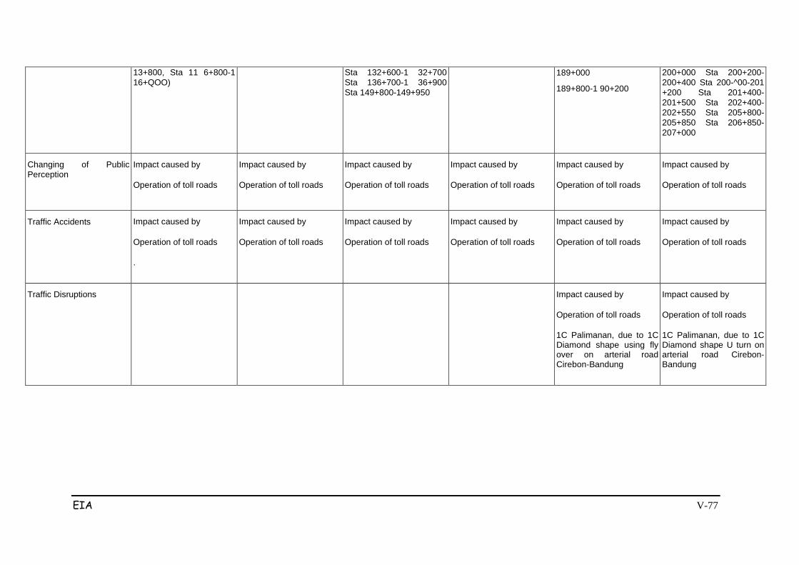
EIA V-77
13+800, Sta 11 6+800-1 16+QOO)
Sta 132+600-1 32+700 Sta 136+700-1 36+900 Sta 149+800-149+950
189+000
189+800-1 90+200
200+000 Sta 200+200-200+400 Sta 200-^00-201 +200 Sta 201+400-201+500 Sta 202+400-202+550 Sta 205+800-205+850 Sta 206+850-207+000
Changing of Public Perception
Impact caused by
Operation of toll roads
Impact caused by
Operation of toll roads
Impact caused by
Operation of toll roads
Impact caused by
Operation of toll roads
Impact caused by
Operation of toll roads
Impact caused by
Operation of toll roads
Traffic Accidents
Impact caused by
Operation of toll roads
.
Impact caused by
Operation of toll roads
Impact caused by
Operation of toll roads
Impact caused by
Operation of toll roads
Impact caused by
Operation of toll roads
Impact caused by
Operation of toll roads
Traffic Disruptions
Impact caused by
Operation of toll roads
1C Palimanan, due to 1C Diamond shape using fly over on arterial road Cirebon-Bandung
Impact caused by
Operation of toll roads
1C Palimanan, due to 1C Diamond shape U turn on arterial road Cirebon-Bandung

EIA V-78

EIA VI-79
Chapter VI
EVALUATION OF SIGNIFICANT IMPACTS
6.1 IMPACT EVALUATION CRITERIA
Significant impact evaluation has been conducted holistically and causatively while
referring to the decision of the Head of Bappedal No. 56 in 1994, on Guidelines on
Rating Impacts Size. Priorities for handling the impacts were set using a Leopolt
matrix that has been modified by including the size of impacts as follows: Large =
3, Moderate = 2 and Minor = 1; and to rate the significance of the impacts as
follows: Significant impact = 2, the Insignificant impact = 1.
6.1.1 Holistic Assessment
Holistic assessment is the assessment of all significant impacts arising from
construction and operation of the project as a unified whole, interrelated,
influencing each other, and with a mutually reinforcing nature (sinergitis) or
weakening each other (antagonitis). This holistic evaluation was conducted by
reviewing the scale and significance of impacts that have been estimated to occur
as described in Chapter V as a whole (comprehensively). Holistic evaluation is
based on the magnitude and significance of the criteria formulated by existing
regulations.
The results of the holistic evaluation of significant impacts that are expected to
occur in the project showed that with regard to the physical-chemical environment,
the most prominent impact is associated with changes in the physiographic region.
Other significant impacts are in the form of disruptions to the flow of surface water
and groundwater that could cause new pools or floods, breakdown of social
relations in the study area and disruptions to traffic.
Next is associated with the procurement of paddy fields and plantations where the
route passes through or bypasses the area. Judging from the activities that have
the most impact, construction activities, excavation/stockpiling and the transport of
soil and building materials will cause the greatest impact.

EIA VI-80
6.1.2 Causative Assessment
This assessment is intended as an assessment of the causal relationships
between the activities and the environmental components undergoing fundamental
change, so the occurrence of primary, secondary, tertiary and derivative impacts is
known.
6.2 REVIEW OF IMPACTS
6.2.1 Pre-Construction Phase
Pre-construction activities are essentially the process of acquiring land for the
construction of the toll road. This is a significant impact that has been divided into
two parts. The first is the land survey and measurement activities; the second part
is the land acquisition activities. More details can be seen in Figure 6.1 below.
a. Land Survey and Measurements
Survey activities and measurements are cumulative within a specified period.
These activities are usually undertaken after there is definitive clarity about the
planned location/route of the Toll Road alignment.
The number of people who will be affected will include people who have emotional
ties to the land and the objects of measurement, with a total area of 765.6 ha (see
Table 2.5). This activity will primarily impact public perceptions, and will have
secondary effects of public unrest.
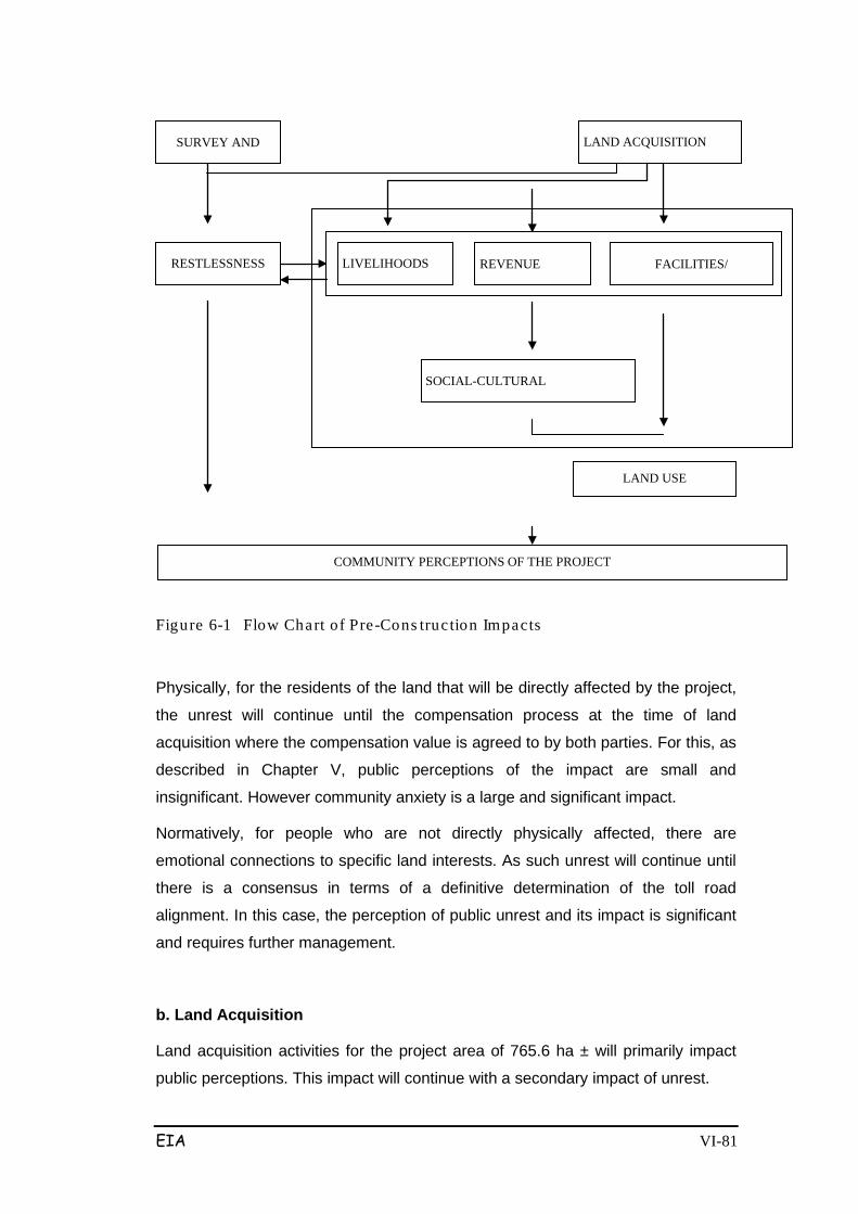
EIA VI-81
Figure 6-1 Flow Chart of Pre-Cons truc tion Impacts
Physically, for the residents of the land that will be directly affected by the project,
the unrest will continue until the compensation process at the time of land
acquisition where the compensation value is agreed to by both parties. For this, as
described in Chapter V, public perceptions of the impact are small and
insignificant. However community anxiety is a large and significant impact.
Normatively, for people who are not directly physically affected, there are
emotional connections to specific land interests. As such unrest will continue until
there is a consensus in terms of a definitive determination of the toll road
alignment. In this case, the perception of public unrest and its impact is significant
and requires further management.
b. Land Acquisition
Land acquisition activities for the project area of 765.6 ha ± will primarily impact
public perceptions. This impact will continue with a secondary impact of unrest.
LAND USE
COMMUNITY PERCEPTIONS OF THE PROJECT
RESTLESSNESS FACILITIES/
REVENUE
LIVELIHOODS
SOCIAL-CULTURAL
SURVEY AND
LAND ACQUISITION

EIA VI-82
Noise will be high and will continue to disrupt the comfort of the residential
population. The impact of noise can continue with secondary effects of hearing
loss and/or psychological disorders. Residents who are potentially vulnerable to
the impacts of noise are children and housewives, as this group is more quiet at
home. Family members who are ill or physically or psychologically impaired and in
need of medical treatment will need to pay for medical expenses. This is a tertiary
effect.
Traffic disruption
Disruptions to traffic by project vehicles will mainly occur on new roads and
existing roads in Stas 92 +920, 97 +689, 104 +044, 107 +325, 116 +950, 119
+070, In addition, this impact will also occur in the area of the access roads to the
project sites, usually in the vicinity of the starting point and end point of the project,
or on existing roads that intersect with the planned Toll Road.
Disruptions to traffic activity are in the form of traffic congestion as the primary
impact. Subsequent impacts include time wastage (as a long time is wasted during
congestion) and wasted fuel, so it travel costs become more expensive for people
using private cars. If on public transportation, this will result in revenue losses
incurred due to long travel time.
Therefore the impact of traffic disruption is a major negative and significant impact,
and it must be managed as mentioned above.
Impaired Kinship Relations
Kinship is a dominant pattern of social relationship in the study area and can be
disturbed by the construction phase because of the fragmentation of settlements.
Similarly, the grazing habits of cattle in open areas and the locations of adequate
fodder lie across the project area. Trails must be made in anticipation of residents
crossing the project area in relative proximity to the location of settlements.
A secondary or advanced impact is the disruption of traffic on the toll road
because people do not use the pedestrian bridge that has been provided but
select a shortcut. If this happens it will interfere with the toll road and pedestrians.
This impact could happen everywhere like on the Jagorawi, Cipularang and other
tolls. Subsequent impacts will be negative perceptions arising from the locals.
Settlements which pass through the toll road are generally ribbon patterned and
located on either side of the road. With the construction of over/under passes, this
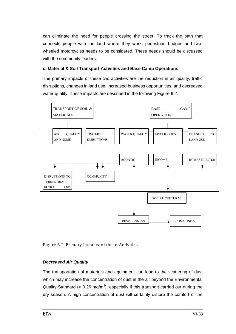
EIA VI-83
can eliminate the need for people crossing the street. To track the path that
connects people with the land where they work, pedestrian bridges and two-
wheeled motorcycles needs to be considered. These needs should be discussed
with the community leaders.
c. Material & Soil Transport Activities and Base Camp Operations
The primary impacts of these two activities are the reduction in air quality, traffic
disruptions, changes in land use, increased business opportunities, and decreased
water quality. These impacts are described in the following Figure 6.2.
Figure 6-2 Primary Impacts of thes e Activities
Decreased Air Quality
The transportation of materials and equipment can lead to the scattering of dust
which may increase the concentration of dust in the air beyond the Environmental
Quality Standard (> 0.26 mq/m3), especially if this transport carried out during the
dry season. A high concentration of dust will certainly disturb the comfort of the
COMMUNITY
SOCIAL CULTURAL
DISRUPTIONS TO
TERRESTRIAL
FLORA AND
COMMUNITY
RESTLESSNESS
TRANSPORT OF SOIL &
MATERIALS
BASE CAMP
OPERATIONS
CHANGES TO
LAND USE
LIVELIHOODS WATER QUALITY TRAFFIC
DISRUPTIONS
AIR QUALITY
AND NOISE
INFRASTRUCTUR
INCOME AQUATIC

EIA VI-84
people residing around the project location.
As described above the decline in air quality will have further impacts on public
health, the cost of living and people's perceptions.
Traffic Disruption
Disruptions to traffic will primarily result from increased traffic volumes due to the
transport of materials/soil and base camp operations. It is estimated that the
increase in traffic volume will be 15%.
Other disturbances to traffic are related to land spills. During the rainy season
these spills will interfere with the convenience of motorists. This situation will also
lead to traffic jams that could disrupt traffic and cause traffic accidents.
Traffic accidents may also cause an increased cost of living for those experiencing
traffic accidents. Traffic jams also cause air pollution due to exhaust emissions
from motor vehicles. Air pollution affects public health, particularly in the form of
respiratory infections, and the cost of living thus increases.
Decreased Water Quality
Operation of the base camp to meet the daily needs of workers, vehicle
maintenance, and disposal of waste materials, will result in declining water quality
if these activities are not controlled or managed. This impact is localised.
6.2.2 Post-Construction Phase
The post-construction phase will result in changing environmental conditions.
Operation of the Cikampek-Palimanan toll road will certainly lead to some impacts.
These impacts are illustrated in Figure 6.3.
TOLL ROAD
OPERATION
TOLL ROAD
MAINTENANCE
AIR QUALITY
AND NOISE
LIVELIHOODS INTERFERENC
E WITH
DISRUPTIONS
TO SURFACE
SETTLEMENT
COMMUNITY
INCOME DISRUPTIONS
TO TRAFFIC STAGNANT
PLANTATION /
PADDY FIELD
AREA
MICRO
CLIMATE
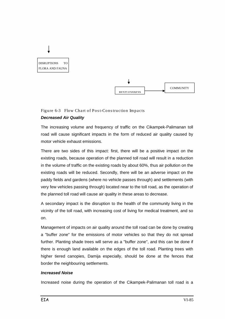
EIA VI-85
Figure 6-3 Flow Chart of Pos t-Cons truction Impacts
Decreased Air Quality
The increasing volume and frequency of traffic on the Cikampek-Palimanan toll
road will cause significant impacts in the form of reduced air quality caused by
motor vehicle exhaust emissions.
There are two sides of this impact: first, there will be a positive impact on the
existing roads, because operation of the planned toll road will result in a reduction
in the volume of traffic on the existing roads by about 60%, thus air pollution on the
existing roads will be reduced. Secondly, there will be an adverse impact on the
paddy fields and gardens (where no vehicle passes through) and settlements (with
very few vehicles passing through) located near to the toll road, as the operation of
the planned toll road will cause air quality in these areas to decrease.
A secondary impact is the disruption to the health of the community living in the
vicinity of the toll road, with increasing cost of living for medical treatment, and so
on.
Management of impacts on air quality around the toll road can be done by creating
a "buffer zone" for the emissions of motor vehicles so that they do not spread
further. Planting shade trees will serve as a "buffer zone", and this can be done if
there is enough land available on the edges of the toll road. Planting trees with
higher tiered canopies, Damija especially, should be done at the fences that
border the neighbouring settlements.
Increased Noise
Increased noise during the operation of the Cikampek-Palimanan toll road is a
COMMUNITY
RESTLESSNESS
DISRUPTIONS TO
FLORA AND FAUNA
EIA VI-86
significant impact that must be managed given that the noise will continue to
increase with the number of vehicles.
As described above the impact of noise will have secondary impacts on public
health (physical or hearing impairments and psychological disorders). This
disturbance will occur continuously during the operation of the toll road, despite
fluctuations. Another secondary impact is the increased cost of living for treatment
of onset of discomfort due to noise interference.
Efforts to suppress the anticipated noise impacts that will continue to increase
include the planting of shade trees bordering the toll road fence to serve as a
damper, particularly in locations adjacent to residential areas, educational facilities
(such as boarding schools) , and retaining walls should be made.
Impaired Kinship Relations
Operation of the Cikampek-Palimanan toll road will divide settlements and cause
disruptions to social interactions and community activities, particularly kinship
relations.
Inter-group relations with families that are separated is a habit that can not
possibly be eliminated within a relatively short time. Such community habits are
common in the rural and suburban communities neighbouring the toll road. Kinship
among the residents who are separated by the highway needs to be protected,
namely by building pedestrian bridges (JPO) at locations near residential areas
that are divided by the toll road.
These impacts will occur during the operation of the toll road. This impact will
result in less frequent face-to-face communication between the residential
communities. It is necessary to accommodate the aspirations of local communities
by building pedestrian bridges (JPO) in appropriate locations, and assisting the
community through a CD (Community Development) program.
Traffic disruption
Traffic disruption due to the operation of the Cikampek-Palimanan toll road is
associated with the toll road’s level of service, which is determined by several
factors, namely: traffic volumes, level of smoothness and roughness of the road
surface, supporting facilities, toll road operations officers, and the behavior of
drivers who do not heed the traffic rules.

EIA VI-87
6.3 TOLL ROAD OPERATION
The Cikampek-Palimanan toll road will operate under a closed system, meaning
that vehicles will enter the toll road only by stopping to pick up tickets/cards at the
Entrance Toll, which will then be paid at the Exit Toll. The problems that may arise
with this are generally associated with service time at these gateways, and if the
quantity is not adequate for the number of vehicles that will use the Toll Road.
6.4 OPERATION OF TOLL ROAD EXITS
At peak hours, the performance of the toll gates is decisive in creating long queues
due to the distance between vehicles becoming narrower while the service time is
relatively fixed. These conditions will cause delays and travel time to become
longer, creating bored motorists.
This will reduce the value of the toll road’s level of service. If the queues are up to
the toll road agency, they will reduce traffic on the motorway from a minimum
speed of 60 km to less than 20 km. In addition queues at rush hours increase the
occurence of drivers not paying with exact change at toll booths. If the congestion
occurs at the toll gates repeatedly at the same time, eg. morning or afternoon,
then management can add to the toll booths.
6.5 OTHER PROJECT-RELATED ACTIVITIES
Construction of the Cikampek - Palimanan toll road will traverse irrigated rice
fields, plantations and settlements, so it will have important implications. The
linkage of the toll road to the existing Pantura road and the Cirebon-Bandung-
Purwakarta arterial roads, will cause disruptions to traffic on these existing roads
so that it is classified as a significant impact. Efforts to address this impact will
involve coordination amongst related agencies, so that all roads (both the Toll
Road and the National and Provincial Roads) may go according to plan.
6.6 FORMULATION OF STUDY RESULTS AND REFERRALS TO HANDLE SIGNIFICANT IMPACTS
6.6.1 Community Groups that may be Affected
The community groups that will be negatively affected due to construction of the
Cikampek-Palimanan toll road are namely:
1. Communities living and doing activities around the project site; who may
EIA VI-88
experience interrupted breathing, eye irritation, and reduced comfort and
durability against infectious diseases.
2. The general public that uses the roads will be disturbed by the presence
of material transport vehicles.
However the community groups that will be affected positively by the construction
of the Cikampek-Palimanan toll road are namely residents living in Purwakarta,
Subang, Indramayu, Majalengka and Cirebon regencies, as well as the general
population living in West Java who can take advantage of employment
opportunities and business opportunities both in the form of formal and informal
employment and entrepreneurial activities related to the toll road. Negative
impacts caused by construction of the Cikampek-Palimanan toll road are on the
physical-chemical aspects, biology, public health and local social-cultural aspects
surrounding the project site. These communities (village administrations and
districts) are displayed in Table 6.1.
Table 6-1 Admin is tra tive Regions tha t a re p red ic ted to be Nega tive ly Affec ted by the Cikampek-Pa limanan Toll Road
No. Regency District Village
1. Purwakarta Bungursari
Campaka
Cibatu
Cinangka
Cikopo
Cimahi
Cisaat
Kertamukti
Karyamekar
Cipasungsari
2 Subang Pabuaran
Cipeundeuy
Kalijati
Purwadadi
Pagaden
Subang
Cipunagara
Cibogo
Karangmukti
Wantilan
Sawangan
Marengmang
Kaliangsana
Batusari
Wanakerta
Balingbing
Sumurgintung
Gembor
Jabong
Sukamelang
Cisaga
Wanasari
Cibogo
EIA VI-89
Pada Asih
Sumur Barang
3 Indramayu Gantar
Trisi
Bantar Waru
Sanca
Cikawung
4 Majalengka
Kertajati
Dawuan
Jatiwangi
Ligung
Palasah
Sumberjaya
Mekarjaya
Palasah
Kertawinangun
Sukawana
Pasir Malati
Balida
Mandapa
Jatiwangi
Surawangi
Jatisura
Ciborelang
Beusi
Tegal Aren
Cisambeng
Majasuka
Bongas Kulon
Bongas Wetan
Panjalin Lor
Panjalin Kidul
No. Regency District Village
5
Cirebon Ciwaringin
Gem pot Palimanan
Budursora
Babakan
Ciwaringin
Galagamba
Kedung Bunder
Kempek
Pegagan
6.6.2 Impact Evaluation Results
Significant impacts that must be managed and monitored due to construction of
EIA VI-90
the Cikampek-Palimanan Toll Road are as follows:
A. Pre-Construction Phase
a.1. Social-Cultural components:
1. The emergence of public unrest
2. The emergence of Social Conflict
3. The decline in income
B. Construction Phase
b.1. Physical-Chemical components:
1. Decreased Air Quality
2. Increased Noise
3. Decreased Quality of Surface Water
4. Impaired Surface Water Flow
5. Occurrence of Soil Erosion
6. Groundwater Flow Disorders
7. Slope Stability Disorders
b.2. Biological components:
1. Reduced Aquaculture Vegetation Types
b.3. Economic Social and Cultural components:
1. Increasing Employment Opportunities
2. The emergence of Social Jealousy
3. Increased Business Opportunities
4. Traffic disruption
5. Damage to Public Roads
6. Damage to Public Utilities (Water Pipe)
7. Damage to public and social facilities
C. Post-Construction Phase
c.1. Physical-Chemical components:

EIA VI-91
1. Decreased Air Quality
2. Increased Noise
3. Changing Land Use
c.2. Economic Social and Cultural components:
1. Increasing Employment and Opportunities
2. Public Perceptions
6.6.3 Quantification of Evaluation Results
The results of partial evaluation of the scale and magnitude and degree of the
significant impacts have been holistically integrated to obtain the overall value of
each component of the affected environment and the cause of the impacts. These
are summarized in Table 6.2.
Based on Table 6.2, it appears that the sum (in the vertical column) indicates the
type of activity that contributes to the onset of the impact. The evaluation results
are shown in Table 6.3.
Guidelines have been formulated and established (as seen in Table 6.3). The
sequence of activities for each potential impact and its management that must be
considered are: Land clearing & preparation of subgrade, excavation and
embankment work, transportation of soil and materials, operation of toll roads,
mobilization of heavy equipment, and other works that follow.
From the evaluation of significant impacts it can be seen that the sum (in the
horizontal column) indicates the impacts that must be prioritised for management.
These are presented in Table 6.4.

EIA VI-92
Table 6-2 Environmental Component 1 2 3 4 5 6 7 8 9 10 11 12 13 14 15 16 SUM Activity Type
I. CHEMICAL PHYSICAL PRE-CONSTRUCTION :
1. Survey measurements
2. Land Acquisition
CONSTRUCTION :
3. Mobilisation of heavy equipment
4. Mobilisation of manpower
5. Construction of base camp
6. Land clearing & preparation of subgrade
7. Transport of soil and material
8. Excavation and embankment
9. Road and Paving work
10. Drainage work
11. Bridge work
12. Underpass/ Overpass work
13. Interchange/ 1C work
14. Toll Road Facility work
POST-CONSTRUCTION :
15. Toll Road operation
1. Decreased Air Quality 3\2 3\2 3\2 3\2 3\2 1\1 2\2 3\2 41
2. Increased Noise 2\2 3\2 2\2 2\2 1\1 2\2 23
3. Decreased Surface Water Quality 1\1 1\1 2\1 1\1 1\1 6
4. Disruption to Surface Water Flow 1\1 3\2 1\1 2\2 2\1 4
5. Occurrence of Soil Erosion 3\1 3\2 1\2
6. Disruption to Environmental Aesthetics
1\1 1
7. Disruption to Ground Water Flow 1\2 8
8. Slope Stability Disorders 1\2 8
9. Changing Land Use 2 II. BIOLOGICAL
1. Reduced Cultivated & Natural Vegetation
1\2 1\2 2
2. Disturbances to Fauna 2\1 2
3. Disruptions to Aquatic Biota 2\2 2\2 8 III. SOCIAL-CULTURAL
1. Emergence of Community Unrest 3\2 6
2. Emergence of Social Conflicts 3\2 6
3. Emergence of Land Speculation 1\1 1
4. Community Disappointment 3\2 6
5. Reduced Community Revenue 3\1 3
6. Increased Employment +3\2 +1\2 8
7. Increased Business Opportunities +3\2 6
8. Emergence of Social Jealousies 3\2 6
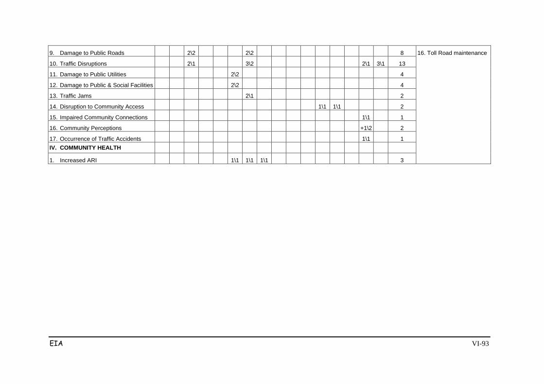
EIA VI-93
9. Damage to Public Roads 2\2 2\2 8 16. Toll Road maintenance
10. Traffic Disruptions 2\1 3\2 2\1 3\1 13
11. Damage to Public Utilities 2\2 4
12. Damage to Public & Social Facilities 2\2 4
13. Traffic Jams 2\1 2
14. Disruption to Community Access 1\1 1\1 2
15. Impaired Community Connections 1\1 1
16. Community Perceptions +1\2 2
17. Occurrence of Traffic Accidents 1\1 1 IV. COMMUNITY HEALTH
1. Increased ARI 1\1 1\1 1\1 3
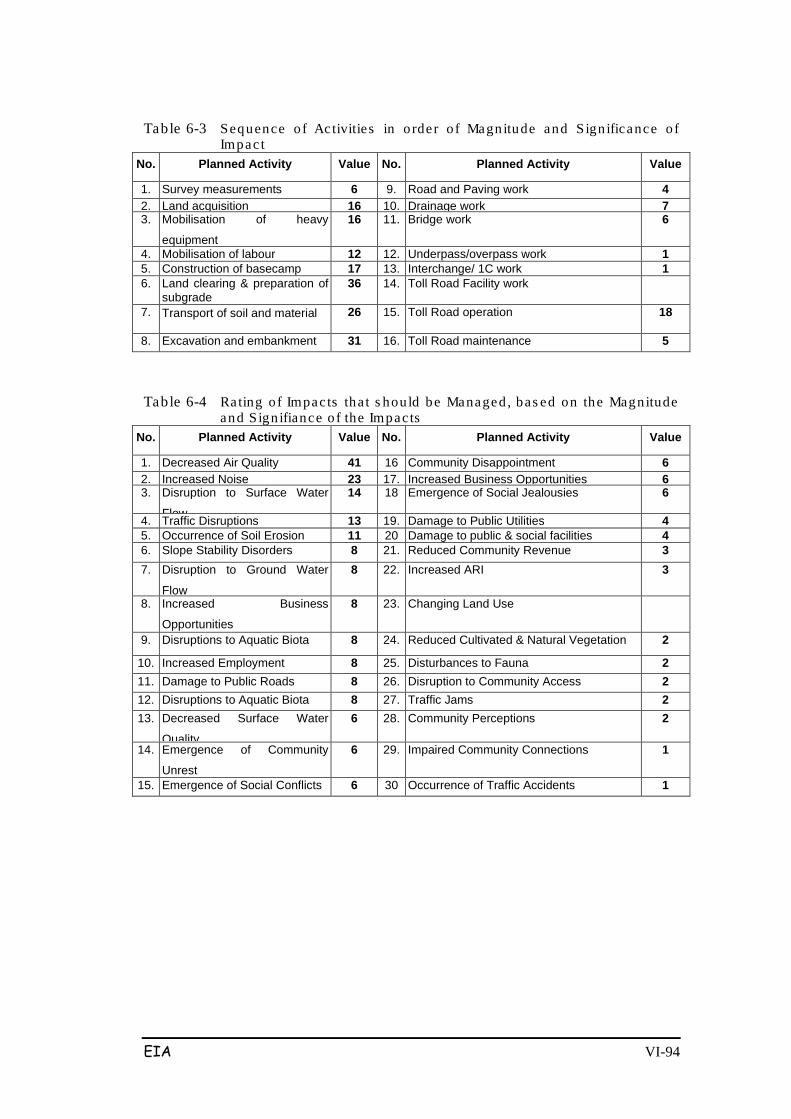
EIA VI-94
Table 6-3 Sequence o f Activities in o rder o f Magnitude and S ign ificance o f Impac t
No. Planned Activity Value No. Planned Activity Value
1. Survey measurements
6
9.
Road and Paving work
4
2. Land acquisition
16
10.
Drainage work
7 3. Mobilisation of heavy
equipment
16
11.
Bridge work 6
4. Mobilisation of labour
12
12.
Underpass/overpass work
1
5. Construction of basecamp
17
13.
Interchange/ 1C work 1
6. Land clearing & preparation of subgrade
36
14.
Toll Road Facility work
7. Transport of soil and material 26
15.
Toll Road operation 18
8. Excavation and embankment 31
16.
Toll Road maintenance 5
Table 6-4 Rating o f Impac ts tha t s hou ld be Managed , bas ed on the Magnitude and S ign ifiance o f the Impac ts
No. Planned Activity Value No. Planned Activity Value
1. Decreased Air Quality 41
16
Community Disappointment 6 2. Increased Noise 23
17.
Increased Business Opportunities
6 3. Disruption to Surface Water
Flow
14
18
Emergence of Social Jealousies 6 4. Traffic Disruptions 13
19.
Damage to Public Utilities 4
5. Occurrence of Soil Erosion 11
20
Damage to public & social facilities 4
6. Slope Stability Disorders 8 21. Reduced Community Revenue 3 7. Disruption to Ground Water
Flow
8 22. Increased ARI 3
8. Increased Business
Opportunities
8
23.
Changing Land Use
9. Disruptions to Aquatic Biota
8
24.
Reduced Cultivated & Natural Vegetation 2 10. Increased Employment
8
25.
Disturbances to Fauna 2 11. Damage to Public Roads 8
26.
Disruption to Community Access 2 12. Disruptions to Aquatic Biota
8
27.
Traffic Jams 2
13. Decreased Surface Water
Quality
6
28.
Community Perceptions 2
14. Emergence of Community
Unrest
6
29.
Impaired Community Connections 1
15. Emergence of Social Conflicts 6
30
Occurrence of Traffic Accidents 1

ii
TABLE OF CONTENT
Page number PREFACE .................................................................................................................... i
TABLE OF CONTENT ............................................................................................... ii
CHAPTER I INTRODUCTION
1.1. Background. ....................................................................................... I-1
1.2. Purpose and Objective ....................................................................... I-2
1.2.1. Purpose of Environmental Management ................................ I-2
1.2.2. Objective of Environmental Management. ............................ 1-2
CHAPTER II ENVIRONMENTAL MANAGEMENT APPROACH
2.1. Technological Approach. ................................................................... II-1
2.2. Socio-Economic Approach ................................................................ II-1
2.3. Institutional Approach. ...................................................................... II-2
CHAPTER III ENVIRONMENTAL MANAGEMENT PLAN
3.1. Pre-Construction Phase ...................................................................... III-1
3.1.1. Survey and Land Measurement .............................................. III-1
3.2. Construction Phase ............................................................................ III-6
3.3. Post Construction Phase (Operation) ................................................ III-30
Appendix :
Environmental Management Plan (Figure)

iii
LIST OF TABLES
Page number Table 3.1. Type of Vegetation for Greenery along Toll Road ................................. III-20
Table 3.2. Environmental Management Plan Matrix ............................................... III-38
Environmental Management Plan of Cikampek-Palimanan Toll Road West Java Province
I - 1
CHAPTER I
INTRODUCTION
1.1. Background
Background of the implementation plan for Cikampek - Palimanan toll road
development activities throughout ± 116.4 km, in West Java Province, among others, is to
provide the highway transportation system that efficiently with a high level of service to
support the national economy.
Cikampek - Palimanan Toll Road Development Plan is one of the toll road network
improvement program in Indonesia, initiated by the Government of the Republic of
Indonesia through the Toll Road Regulatory Body (BPJT), while supporting the
establishment of road networks connecting Sumatra, Java and Bali.
Location of Toll Road Development plan covers five regencies: Purwakarta, Subang,
Majalengka, Indramayu and Cirebon with an area of land needed is ± 765.6 ha. With the
construction of Cikampek - Palimanan toll roads connecting Jakarta to Cikampek from
Cikopo to Kanci toll road, with lane width 2 x (2x 3.6) m, is expected to support the
national highway development program and speed up the distance between regions on
the island of Java.
In order to preserve natural resources and increase the carrying capacity, and considering
that Cikampek-Palimanan toll road construction activities are expected to have impacts,
both effects are positive or negative for each stage of the project activity. It is necessary to
study the environment in accordance with the Decree of the Minister of Environment
Number Kep-17/MENLH/2001.
In an effort to reduce negative impacts, the proponent acting as a license holder in its
implementation would complement its activities with the Environmental Management Plan
and Environmental Monitoring Plans (RKL and RPL). Through this study, some
environmental problems can be identified early, so it can be anticipated by arranging step
handling. Thus is created a model of sustainable development and environmentally
sound. Preparation of RKL-RPL of Palimanan Cikampek toll road refers to the Regulation
of the Minister of Environment No.08 Year 2006 on Guidelines for Preparing
Environmental Management Plan and Environmental Monitoring Plan (RKL-RPL) and the
Environmental Management Plan of Cikampek-Palimanan Toll Road West Java Province
I - 2
Decree of the Minister of Environment No. 17 of 2001 on Types of Business Plan And / Or
Activity That Must Complete The Environmental Impact Analysis.
1.2. Purpose and Objective of Environmental Management
1.2.1. Purpose of Environmental Management
• Ensuring that activities Cikampek-Palimanan Manager Toll will comply with the
provisions of environmentally sustainable development with natural resource
management so that they can be utilized as well as possible for economic and
social development.
• Manage the environmental changes brought about by the construction and
development of Cikampek - Palimanan toll roads, so that environmental quality is
really protected.
• Increase the positive impact (benefit) and control or mitigate the negative impacts
(risks).
• Comply with all applicable laws relating to pollution control, waste management
and environmental quality control.
1.2.2. Environmental Management Objectives
• Ensuring that environmental changes caused by Cikampek-Palimanan Toll Road
development activities which is located in five regencies (Purwakarta-Subang-
Majalengka-Indramayu-Cirebon) West Java Province still maintain the quality of
the environment.
• Maintain and preserve the environmental quality around the Palimanan Cikampek
toll road development site and development along the corridor of ± 116.4 km.
• Improve or develop positive impact and control the negative impacts due to
construction activities of Cikampek-Palimanan Toll Road and the development
along these corridors.
• Applying the proposed mechanism for coordination of environmental impact
management activities with related agencies in the implementation of
environmental management.
Environmental Management Plan of Cikampek-Palimanan Toll Road West Java Province
II - 1
CHAPTER II
ENVIRONMENTAL MANAGEMENT APPROACH
Environmental Management Approach
To address the significant impacts that have been evaluated in EIA study, it can use one
or several environmental management approaches namely, technological, social and
economic, and institutional.
2.1. Technology Approach
Environmental management through technology approach is the application of science
and engineering in finding practical solutions to overcome the effects arising from the
construction of Peudada-Suplesi-Nalan line and development of Cikampek-Palimanan toll
roads throughout ± 116.4 km, in five districts (Purwakarta-Subang-Majalengka -
Indramayu-Cirebon), West Java Province.
2.2. Socio-Economic Approach
This approach includes the steps to be taken by the proponent as an effort to overcome
the significant environmental impacts, through measures based on social interaction,
economics and culture and supports the role of government. The activities include:
1) Enter into management based on social interaction, by way of involving
communities around the location of activities. How this is done in order to get a
sense of community participation in environmental management around the
location of activities.
2) Perform community restitution of all property affected by construction activities,
with the compensation given to the principle of mutual benefit.
3) Trying to establish harmonious social relationships with people that are around the
location of activities, intended so to avoid any jealousy towards activities undertaken on
site activities.
Environmental Management Plan of Cikampek-Palimanan Toll Road West Java Province
II - 2
2.3. Institutional Approach
This approach is the institutional mechanism that will be the proponent’s efforts in order to
overcome the large and important impact of the environment, the activities include:
(1) Cooperation with agencies concerned and related to environmental management,
in areas in five regencies (Purwakarta-Subang-Majalengka-Indramayu-Cirebon)
and West Java Province.
(2) The monitoring of the performance of environmental management by the relevant
authorities.
(3) Reporting the results of environmental management on a regular basis to the
parties concerned.
(4) Establish the organizational unit (division) is responsible in the field of
environmental management.
(5) Delivery of the members / staff of the environmental division for training (training)
in the environmental field.
(6) Reporting the results of environmental management that have been made to the
appropriate authorities and interested parties.
Environmental Management Plan of Cikampek-Palimanan Toll Road West Java Province
III - 1
CHAPTER III
ENVIRONMENTAL MANAGEMENT PLAN
In the environmental management plan prepared in a structured way the various aspects
that need to be managed as the following:
a. Significant impacts and sources of significant impacts
• Environmental Components
• Source impact
b. Measurement of impact
c. The purpose of the environmental management plan
d. Environmental management
e. Location of environmental management
f. Periods of environmental management
g. Financing of environmental management
h. Institutions for environmental management
• Implementing environmental management
• Supervision of environmental management
• Reporting the results of environmental management
3.1. Pre-Construction Stage
In the pre-construction components that need to be managed is the restlessness of
society as a result of activity measurement and installation of stakes and land preparation.
3.1.1. Land Survey and Measurement
1. The emergence of community unrest
(1) Source of Significant Impacts
Components of the Environment : Socio-Cultural.
Impact Source : Survey of land measurement
(2) Measurement of Impact
Community unrest can be observed in society with the emergence of public opinion about
the likelihood and extent of public land that will be affected by development.
Environmental Management Plan of Cikampek-Palimanan Toll Road West Java Province
III - 2
(3) Environmental Management Objectives
Management was conducted in order to suppress the emergence of unrest community as
small as possible, so that people can accept with a good plan to build Cikampek-
Palimanan toll roads and development in five regencies; Purwakarta, Subang,
Majalengka, Indramayu and Cirebon.
(4) Environmental Management
Management Efforts are made to anticipate the impact by:
- Perform persuasive approach and give an explanation to the public about the
purposes and objectives of Cikampek-Palimanan toll road development along the
corridor ± 116.4 km, which is to meet transportation needs in West Java in
particular and National general.
- Provide clear information about the activities of measuring and installation of
stakes and area limit of Cikampek-Palimanan toll road development activities.
- Explaining to the public about the need for the required land for the construction of
Cikampek-Palimanan toll road, and development areas along the corridor of ±
116.4 km, and other complementary buildings to be constructed such as flood
control drainage channels, bridges, (JPO), rest area (resting place) Interchange
(IC) and others.
Hence, the development activities will not cause unrest to the emergence of a negative
impact if these buildings were built.
(5) Location of Environmental Management
Location management at field sites used for the physical buildings of Cikampek-
Palimanan toll road and other auxiliary buildings and the residential population in the sub-
district to village level in five regions of the district.
(6) Period of Environmental Management
It begins since toll road development plans and corridors ± 116.4 km and each week
delivered at the time of measurement activities and the installation of stakes in the
location.
(7) Implementing Institution of Environmental Management
Executor: Proponent of Cikampek-Palimanan toll road construction
Environmental Management Plan of Cikampek-Palimanan Toll Road West Java Province
III - 3
Village and Sub-district Head of 5 Regencies
Land Agency in 5 Regencies
Supervisor: Office of Public Works and Social Service in 5 regencies
Reporting: Environmental Protection Agency West Java Province
BPLHD, Regent of Purwakarta, Subang, Majalengka,
Indramayu and Cirebon
BPJT-Department of Public Works
2. The emergence of Social Conflict
(1) Source of Significant Impacts
Components of the Environment: Social economic and cultural
Source of Impact: The procurement of land for construction of toll roads
(2) Benchmark Impact
Public unrest, especially in Babakan village Ciwaringin, with the emergence of public
opinion who disagrees toll road route through the nearby Islamic boarding House of
Babakan Ciwaringin so there are pros and cons of land acquisition carried out by the TPT.
(3) Environmental Management Objectives
Environmental management was conducted in order to suppress small as possible
occurrence of horizontal violence in rural communities Babakan due to land acquisition
activities for the construction of Cikampek toll road.
(4) Environmental Management
Management Efforts are made to anticipate these impacts by:
- Perform persuasive approach and give an explanation to the public about the
mechanism of land acquisition by the government.
- Provide clear information about the activities of the determination of compensation
value of the land as government policy areas and the central government.
(5) Location of Environmental Management
Location management is in Babakan village, particularly around Islamic boarding schools
Environmental Management Plan of Cikampek-Palimanan Toll Road West Java Province
III - 4
of Ciwaringin.
(6) Period of Environmental Management
Made since the initial plan of land acquisition for highway purposes and periodically
carried out every single month.
7) Environmental management institutions
Executor: Proponent of Cikampek-Palimanan toll road development, Sub-destrict head of
Ciwaringin, and BPN Cirebon
Supervisor: Office of Public Works and Highways Office of Cirebon, Environmental
Protection Agency of Cirebon
Reporting: BPLHD West Java Province, regent of Cirebon, BPJT-Department of Public
Works
3. Reduced Income
(1) Source of Significant Impacts
Components of the Environment: Social economic and cultural
Impact Source: Land Acquisition for Toll Road Development
(2) Benchmark Impact
Unrest that emerged in communities occurs due acquisitions of farmer-owned land such
as rice fields and gardens and others.
(3) Environmental Management Objectives
Environmental management is intended to make rice fields which is a source of income
for residents receive appropriate compensation value, and irrigation networks that passed
the motorway network can be maintained smoothness.
(4) Environmental Management
Management Efforts are made to anticipate the impact by:
- To socialize continuously since the preparation of land acquisition through the
implementation process of land acquisition, about the toll road development plans
and the value of wetland compensation to be received by a resident of lowland rice
fields affected by the project.
Environmental Management Plan of Cikampek-Palimanan Toll Road West Java Province
III - 5
- Create technical designs that accommodate the interests of the smooth process of
the drainage of irrigation water in paddy field population.
- Together with relevant agencies both at the central provincial and district levels, to
disseminate the results of the utilization of land compensation money, in the form
of counseling.
(5) Location of Environmental Management
Location Management of the village across the fields affected by land acquisition for the
project needs.
(6) Period of Environmental Management
Period Management conducted periodically every month during the land acquisition
activities is conducted.
(7) Institution of Environmental management
Executor: Proponent Palimanan Cikampek toll road construction, Sub-district heads and
village heads in the 5 regencies, Land Agency in 5 regencies and West Java Province.
Supervisors: Public Works Department of Highways, Department of Environment in 5
regencies
Reporting: BPLHD West Java Province, Regent of Purwakarta, Subang, Majalengka,
Indramayu and Cirebon, BPJT-Department of Public Works.
3.2. Construction Phase
At the construction stage there are significant negative impacts and positive impacts that
need to be managed for significant negative impacts can be minimized or eliminated and
the positive impact of improved. The negative impact that emerges is a negative
perception of society, and the decline in public health, while positive impacts include
increased revenue, opening up employment and try and increase the livelihoods of local
communities.
A. Components of Physical - Chemical
1. Reduced Air Quality
(1) Source of Impact
Environmental Management Plan of Cikampek-Palimanan Toll Road West Java Province
III - 6
Components of the Environment: Air Quality
Source Impact: Operational project vehicles
(2) Benchmark Impact
Air dust levels were observed visually (observation) and the complaints from the public
due to the many dust or air dust concentration measurements of air quality monitoring
results.
(3) Environmental Management Objectives
To prevent or reduce the occurrence of elevated levels of dust in the air because the
roads are not paved over, particularly those close to residential areas, reducing the
negative perception of society towards the project and further prevent the situation was
not an aesthetic as well as decline in public health.
(4) Environmental Management
Efforts are made to handle the impact of increased dust is as follows:
• Air trucks must have a cover with plastic or tarps;
• The volume of cargo tonnage or height does not exceed the truck;
• Clean the tires first project vehicles before entering a public road.
• Reduce vehicle speed to 20 km / h, especially in the vicinity of human settlement;
• Watering the road vehicle through which the road project with water especially
near and through the settlement in the dry season;
• In the rainy season, road damage easily occurs, for example, road potholes,
muddy, so the project should fix it immediately.
(5) Location of Environmental Management
Performed along the road passed by the project vehicles, especially those that pass
through residential villages in 5 regencies; Purwakarta, Subang, Majalengka, Indramayu
and Cirebon.
(6) Period of Environmental Management
Made at any time or as needed, followed by related activities during the construction
phase.
(7) Institute of Environmental management

Environmental Management Plan of Cikampek-Palimanan Toll Road West Java Province
III - 7
Executing: Executing Contractor Toll Road Development.
Supervisor: Environmental Office in 5 regencies, Department of Health in 5 regencies.
Reporting: BPLHD West Java Province, Regent of Purwakarta, Subang, Majalengka,
Indramayu and Cirebon, BPJT-Department of Public Works
2. Increased Noise
(1) Source Impact
Components of the Environment: Noise Quality
Source of Impact: Cleaning and Preparation of the subgrade and Operations project
vehicles.
(2) Benchmark Impact
The increased noise at the location of settlements and access roads.
(3) Environmental Management Objectives
Minimize the noise level that occurred in residential areas.
(4) Environmental Management
Efforts are made to handle the impact of increased noise is as follows:
- Setting the implementation of good construction and adequate.
- Locations of batching plants are far from settlements.
- Setting heavy vehicle operations and vehicle projects for the noise that comes
from these vehicles do not disturb residents in the nearest settlement, where
operating hours are socialized with the local community.
(5) Location of Environmental Management
Conducted along the path traversed by the vehicle projects, particularly those in rural
residential areas through five regencies; Purwakarta, Subang, Majalengka, Indramayu
and Cirebon.
(6) Period of Environmental Management
Made at any time or as needed, follow-related activities during the construction phase of
every 1-month.

Environmental Management Plan of Cikampek-Palimanan Toll Road West Java Province
III - 8
(7) Institution of Environmental management
Executing: Executing activities Contractor
Supervisor: Office of Public Works Highways, Proponent of Toll road
Reporting: EPA of West Java Province, Regent of Purwakarta, Subang, Majalengka,
Indramayu and Cirebon, Governor of West Java Province
3. Reduced Surface Water Quality
(1) Source Impact
Components of the Environment: The quality of river water and river water quality.
Source of Impact: Cleaning of land, construction of toll roads and buildings complement.
(2) Benchmark Impact
Decreasing water quality that is on the highway alignment.
(3) Environmental Management Objectives
Prevent / reduce the change of surface water and groundwater.
(4) Environmental Management
Efforts are made to mitigate water quality degradation of the river are as follows:
- Setting a good implementation
- Making channels gatherer
- Making temporary dike
(5) Location of Environmental Management
Carried out along the highway alignment, in the village, subdistrict in 5 regencies;
Purwakarta, Subang, Majalengka, Indramayu and Cirebon.
(6) Period of Environmental Management
Made at any time or as needed, following the course of construction activities.
(7) Institution of Environmental management:
Executing: Executing activities Contractor
Supervisor: Office of Public Works, Proponent Toll road operator
Reporting: BPLHD West Java Province, Regent of Purwakarta, Subang, Majalengka,
Environmental Management Plan of Cikampek-Palimanan Toll Road West Java Province
III - 9
Indramayu and Cirebon, Governor of West Java Province
4. Impaired Surface Water Flow
(1) Source Impact
Components of the Environment: The quality of river water and river water quality.
Source of Impact: Cleaning of land, construction of toll roads and buildings complement.
(2) Benchmark Impact
Disturbance of vegetation has resulted in changes in surface water flow patterns, and
disruption of farming communities cropping pattern in the study area. The occurrence of
local inundation has resulted from disruption of the flow of surface water by extractive
materials.
(3) Environmental Management Objectives
Reduce / minimize disruption to plant rice field drainage into the population, also made in
order that the drainage remain smooth and well directed in accorandce with its original
state.
(4) Environmental Management
Efforts are made to mitigate water quality degradation of the river are as follows:
- Setting of construction activity, adjusted for planting and harvesting schedules.
- To coordinate with related agencies for the management of technical irrigation
channel in the alignment of the highway.
- Make surface water drainage in accorandce with the direction of pre-existing
natural flow with the appropriate dimensions.
(5) Location of Environmental Management
Carried out along the highway alignment, in the villages, sub-districts, in 5 regencies;
Purwakarta, Subang, Majalengka, Indramayu and Cirebon.
(6) Period of Environmental Management
Made at any time or as needed during the construction progress, and follow the activities
of the construction phase, at least 3 months.
Environmental Management Plan of Cikampek-Palimanan Toll Road West Java Province
III - 10
(7) Institution of Environmental management:
Executing: Executing activities Contractor
Supervisors: Public Works Department of Highways, Proponent of Toll road
Reporting: BPLHD West Java Province, Regent of Purwakarta, Subang, Majalengka,
Indramayu and Cirebon. Governor of West Java Province, BPJT-Department of Public
Works
5. Occurrence of Soil Erosion
(1) Source Impact
Components of the Environment: The quality of river water and river water quality
Source of Impact: Cleaning of land, excavation and embankment.
(2) Benchmark Impact
Disturbance of slope stability and increased sediment in surface runoff and rivers are
crossed by the highway plan.
(3) Environmental Management Objectives
In an effort to prevent soil erosion caused by excavation and embankment work on the
cliff. Prevent the run-off of sediment in surface water and river channel crossed by the
highway plan.
(4) Environmental Management
Efforts are made to mitigate soil erosion are as follows:
- Do not cut too steep cliff
- Create a cap on the cliff excavation results by planting trees or by sloop protection
(retaining wall) of masonry or reinforced concrete.
(5) Location of Environmental Management
Location management in a location which made cutting the cliff and at locations that are
too upright embankment along the highway.
(6) Period of Environmental Management
Management during the construction period lasts and is permanent, at least 3 months.
(7) Institution of Environmental management:
Environmental Management Plan of Cikampek-Palimanan Toll Road West Java Province
III - 11
Executing: Executing activities Contractor
Supervisors: Public Works Department of Highways, District Environmental Office,
Proponent of Toll road operator.
Reporting: BPLHD West Java Province, Regent of Purwakarta, Subang, Majalengka,
Indramayu and Cirebon. Governor of West Java Province, BPJT-Department of Public
Works
6. Groundwater Flow Disturbance
(1) Source Impact
Environmental Components: The quantity of shallow groundwater
Source of impact: Activities soil excavation and embankment for the road
(2) Benchmark Impact
Inhibition of ground water flow resulting in disruption of water sources such as springs,
wells population and construction of the road damage due to ground water flow is
obstructed.
(3) Environmental Management Objectives
Prevent disruption of water sources such as springs, wells resident of the damage, as well
as prevent damage to the road resulting from the destructive force of ground water which
clogged the road building.
(4) Environmental Management
Efforts are made to handle the impact is as follows:
- Creating an underground drainage channel that is placed in accorandce with the original
flow pattern.
- Construction is built considering the direction of the drainage so it does not block the
drainage of groundwater, such as creating a permanent filter (drain belt) to menggindari
avalanches.
(5) Location of Environmental Management
Location management is along the highway alignment plan where there is a deep
excavation.
(6) Period of Environmental Management

Environmental Management Plan of Cikampek-Palimanan Toll Road West Java Province
III - 12
Period management is during the construction phase lasts, at least 3 months.
(7) Institution of Environmental management:
Executing: Executing activities Contractor
Supervisors: Public Works Department of Highways District, District Environmental Office,
Proponent Toll road operator, BPLHD West Java Province
Reporting: BPLHD West Java Province, Regent of Purwakarta, Subang, Majalengka,
Indramayu and Cirebon. Governor of West Java Province, BPJT-Department of Public
Works
7. Slope Stability Disorders
(1) Source Impact
Components of the Environment: The stability of slopes
Source Impact: Excavation and stockpiling of land base.
(2) Benchmark Impact
Disturbance of slope stability in areas that require cutting. Also on sloping areas that
require landfill.
(3) Environmental Management Objectives
Prevent the occurrence of landslides / soil erosion
(4) Environmental Management
Efforts are made to handle the impact of slope stability problems are as follows:
- Making / excavation is not steep cliff
- The surface of the lid is open
(5) Location of Environmental Management
Carried out along the highway alignment, in the village, subdistrict in 5 regencies;
Purwakarta, Subang, Majalengka, Indramayu and Cirebon.
(6) Period of Environmental Management
Made at any time or as needed, following the course of construction activities.
Environmental Management Plan of Cikampek-Palimanan Toll Road West Java Province
III - 13
(7) Institution of Environmental management:
Executing: Executing activities Contractor
Supervisors: Public Works Department of Highways District, District Environmental Office,
Proponent Toll road operator, BPLHD West Java Province
Reporting: BPLHD West Java Province, Regent of Purwakarta, Subang, Majalengka,
Indramayu and Cirebon. Governor of West Java Province, BPJT-Department of Public
Works
B. Biological Components
1. Reduced Cultivation Vegetation
(1) Source Impact
Type of impact that will be managed is the reduction of flora / vegetation, the transfer
function of the area of productive land into roads. Sources of impact are earthwork
activities include land clearing and preparation of subgrade, subgrade preparation and
excavation and embankment. Types of flora which would shrink the area includes the area
of productive land in the form of rice, mixed farms and their fields, such as teak, rubber,
coconut plantations, mango with an area of approximately 168.79 ha, whereas the area of
rice fields around 279.8.
(2) Benchmark Impact
Measure of impact is the reduced area region covering paddy fields and mixed garden
crops (rubber, teak and other plants)
(3) Environmental Management Objectives
The purposes of environmental management are:
- Preventing shrinkage or reduction in land area and rice fields plantation crops
- Preventing unwanted plant damage found in the street outside ROW Maintaining
the sustainability of productivity of paddy fields
- Maintain or prevent secondary impacts resulting from the decline of vegetation /
flora that there is climate change micro / local and reduced function of the plant as
a runoff for water / flood.
- Similarly green belt that will be made to function other than for aesthetic purposes
as well as a filter for vehicle exhaust gases, dust and noise, can be muted so as
Environmental Management Plan of Cikampek-Palimanan Toll Road West Java Province
III - 14
not to disturb the people who stay in the surrounding streets.
- Development of green belt also aims to contribute to the need of oxygen and
absorption of CO released by the fumes. By planting the kinds of plants in
accorandce with the physical and chemical conditions of the local environment,
local plant species diversity, and plant maintenance capabilities to the green belt
will be able to provide a positive impact on the operation of green belt along the toll
roads.
- Provides services and provide improved aesthetic environment of safety from
traffic accidents, and to reduce public health problems due to vehicle exhaust
gases, dust and noise.
(4) Environmental Management
Environmental management is the following:
- Cleaning and stripping done on the local plants are needed for the job.
- Restricting logging vegetation during construction.
- Avoiding logging manner that could damage other plants that are not desired
(outside ROW) by considering logging techniques by observing changes in plant
- Avoid the use of wetland area, the garden as a site entrance, and / or road access
- Avoiding the use of wetland area as a base camp location, footprint quarry location
- Minimize footprint area of work in the area of rice fields, gardens in accorandce
with the requirements for construction, and provide compensation to landowners
relating to the site needs work area.
- Ensuring the separation of top soil layer to facilitate replanting.
- Conduct replanting / re-vegetation in areas that are prepared or above the median
of the road after work or in conjunction with construction work done.
In addition to the above management is also necessary that the reforestation program is
implemented after the construction activity or at the final stage of construction for the
purpose of rehabilitation or re-vegetation along the highway and surrounding locations.
The effort needs to be done in this greening program include:
- Placement of greenery on the edge of the road or in the median area of the road
with a safe distance from the edge of the road, spacing between trees on the same
line about 5 m.
- Selecting the type of plants suitable for green belt along the Toll Road Cikampek -
Environmental Management Plan of Cikampek-Palimanan Toll Road West Java Province
III - 15
Palimanan.
- Select plant species that are categorized as not to abort a lot of leaves, is more
advisable than the autochthonous species than exotic plants.
- Conduct watering of plants along the green line.
- Perform pruning
- Shuffling dead plants with new plants.
Some types of green belt plants that are suggested to be planted along the highway can
be seen in Table 3.1.
Tabel 3.1 Type of Vegetation for Greenery along Toll Road
No. Indonesian Name Scientific Name
Big tree (Water and soil conservation)
1 Turi Sesbania granifloria
2 Rambutan Nephelium lappaceum
3 Sawo kecik Manilkara kaukii
4 Damar Agathis sp
5 Mahoni Swietenia mahagoni
6 Dadap merah Erithrina crystagali
7 Tusam Pinus merkusii
13 Glodokan Polyalthia longifolia
14 Asam laudi Phthecellobium juice
15 Ketapang Terminalia catappa
16 Kembang merak Caesalpinea pulcherrima
17 Bougenville Bougenvillea spectabilis
18 Angsana Pterocarpus indicus
19 Johar Cassia siamea
20 Pinus Pinus mercusii
22 Flamboyan Delomix regia
23 Sonokeling Dalbergia spp
Shrubs (Land Covering)
Environmental Management Plan of Cikampek-Palimanan Toll Road West Java Province
III - 16
1 Rumput gajah Axonopus copmresus
2 Pangkas kuning Duranta variegate
3 Bayam merah Iresine herbstii
4 Taiwan Beauty Cuphea hyssopfolia
5 Kembang sepatu Hibiscus rosa sinensis
6 Soka Ixora sp.
7 Krokot Alternanthera sp
(5) Location of Environmental Management
Location of environmental management is on the sides of the street / road ROW and the
road segment that is being done primarily at a location nearby neighborhood. While the
area of environmental management for greening performed on green belt that is placed
along Cikampek – Palimanan Toll road.
(6) Period of Environmental Management
Periods of environmental management is in the construction stage, namely when the land
clearing and execution time / together with minor works or construction work performed
and a final pitch. Landscape. Also performed during the operation of roads, including for
the green line.
(7) Institute of Environmental management
Executing: Contractor, the Office of Parks in related regencies,
Supervisor: Office of Public Works Highways, Agricultural Office in related regencies,
Proponent Toll road operator
Reporting: BPLHD West Java Province
Regent of Purwakarta, Subang, Majalengka, Indramayu and Cirebon, Governor of West
Java Province
C. Components of Social, Economic and Cultural Rights.
1. Improved Emploement Opportunities
(1) Source Impact

Environmental Management Plan of Cikampek-Palimanan Toll Road West Java Province
III - 17
Components of the Environment: Social economic and cultural
Source of Impact: The involvement of local communities in employment.
(2) Benchmark Impact
Is the ratio of labor income and business actors before and during the construction of
Cikampek- Palimanan toll road e and construction of infrastructure networks.
(3) Environmental Management Objectives
Maintain and provide value-added income residents around the location of activity, so be
on incomes that meet the needs of residents in the village environment.
(4) Environmental Management
- Giving priority to local residents to work on construction activities in advance,
before bringing in labor from outside the region;
- Provide opportunities for local people to make transport services and provision of
daily necessities of life;
(5) Location of Environmental Management
In the villages around the location of activities, especially in a nearby village in the five
regencies; Purwakarta, Subang, Majalengka, Indramayu and Cirebon.
(6) Period of Environmental Management
Made at any time in accorandce with the needs of recruitment during construction.
(7) Institutions for Environmental Management
Executor: Proponent Activity Toll Road
Supervisor: Regency Labor Office, Department of Labor in 5 districts
Reporting: BPLHD West Java Province
Regent of Purwakarta, Subang, Majalengka, Indramayu and Cirebon, Governor of West
Java Province
2. The emergence of Social Jealousy
(1) Source Impact
Components of the Environment: Social economic and cultural
Source Impact: Mobilization of labor and business opportunity.
Environmental Management Plan of Cikampek-Palimanan Toll Road West Java Province
III - 18
(2) Benchmark Impact
Work and business opportunities for residents around the location of highway construction
activities, the administrative area that exceeded alignment.
(3) Environmental Management Objectives
Pressing the smallest possible negative social impacts arising from highway construction
activities and supporting facilities.
(4) Environmental Management
Efforts are made to handle the impact of social envy and tried are as follows:
- Focusing on recruitment to the people affected by the project and its surroundings, in
accorandce with the expertise and work opportunities.
- Provide opportunities for local entrepreneurs trying to society to participate in
construction activities.
(5) Location of Environmental Management
Carried out along the highway alignment, in the village, subdistrict in 5 districts; District
Purwakarta, Subang, Majalengka, Indramayu and Cirebon regency.
(6) Period of Environmental Management
Made at any time or as needed, follow-related activities during the construction phase.
(7) Institute of Environmental management
Executing: Executing Contractor activities, management-related activities and village
officials.
Supervisor: Regencies office of Labor, toll road proponent manager.
Reporting: BPLHD West Java Province
Regent of Purwakarta, Subang, Majalengka, Indramayu and Cirebon, Governor of West
Java Province
3. Increased Business Opportunities
(1) Source Impact
Components of the Environment: Social economic and cultural
Source Impact: Mobilization of labor, use of local building materials (quarry).
Environmental Management Plan of Cikampek-Palimanan Toll Road West Java Province
III - 19
(2) Benchmark Impact
Work and business opportunities for residents around the location of highway construction
activities.
(3) Environmental Management Objectives
Increased positive impact on the openness of employment and business opportunities for
the community around the study location.
(4) Environmental Management
Efforts are made to mitigate the negative impacts of increased employment opportunities
as follows:
- Utilization of local materials and labor
- Outreach to take advantage of business opportunity
(5) Location of Environmental Management
Carried out along the highway alignment, in the village, subdistrict in 5 regencies;
Purwakarta, Subang, Majalengka, Indramayu and Cirebon.
(6) Period of Environmental Management
Made at any time or as needed, follow-related activities during the construction phase
(7) Institute of Environmental management
Executing: Executing Contractor activities, management-related activities and village
officials.
Supervisor: Regencies office of Labor, toll road proponent manager.
Reporting: BPLHD West Java Province
Regent of Purwakarta, Subang, Majalengka, Indramayu and Cirebon, Governor of West
Java Province
4. Traffic disruption
(1) Source Impact
Components of the Environment: Traffic Flows
Source of Impact: Cleaning and Preparation of the subgrade and the environment
Environmental Management Plan of Cikampek-Palimanan Toll Road West Java Province
III - 20
(2) Benchmark Impact
Interference with traffic congestion on public roads direction to the project site.
(3) Environmental Management Objectives
Minimize disruption of traffic jams that disrupt economic activity
(4) Environmental Management
Efforts are made to mitigate traffic congestion is as follows:
- Setting appropriate activities
- Setting time transporting building materials
- Installation of signs and traffic diversion
- On location Babakan Ciwaringin Islamic boarding school area, it will construct over pass
and access roads in the form of rural road upgrading and new road construction, and
made a box culvert under the highway to, in order to connect the two boarding area.
(5) Location of Environmental Management
Conducted along the path traversed by the vehicle projects, particularly those in rural
areas through five residential areas; regency of Purwakarta, Subang, Majalengka,
Indramayu and Cirebon.
At the Babakan Ciwaringin Islamic boarding school area namely in STA 200 +700 s / d
STA 201 +055.
(6) Period of Environmental Management
Made at any time or as needed, follow-related activities during the construction phase.
(7) Institution of Environmental management
Executing: Executing activities Contractor, Managers and community of Babakan
Ciwaringin Islamic boarding school.
Supervisor: Office of Public Works (Highways), Environmental Office, Proponent of Toll
road, Social services offices in 5 regencies.
Reporting: BPLHD West Java Province, Regent of Purwakarta, Subang, Majalengka,
Indramayu and Cirebon. Governor of West Java Province, BPJT-Department of Public
Works

Environmental Management Plan of Cikampek-Palimanan Toll Road West Java Province
III - 21
5. Damage to Public Road (local road or village roads, district roads)
(1) Source Impact
Environmental components: public road facilities
Source Impact: Transportation of construction materials
(2) Benchmark Impact
Is the integrity of the road on the quality of 80%. Further reviews of the functions for
society, then the other benchmarks were not disruption of the smooth transportation and
security for road users.
(3) Environmental Management Objectives
Maintaining the condition of roads and transportation as well as avoiding obstacles
prevent the negative attitude of society because of the disruption of transport in rural
areas.
(4) Environmental Management
The management is carried out include:
- Set the tonnage of vehicles tailored to the ability of roads to be traversed,
especially on roads that are not paved;
- Adjust the vehicle speed, especially on rural roads and through the settlement;
- If there is damage to the road to be fixed;
- Prioritizing the other road users if traffic;
- Create traffic signs specifically related to the execution of construction to prevent
the risk of accidents;
- Not allowing people hitchhiked transportation projects persuasive manner.
(5) Location of Environmental Management
Performed on the vehicle traveled along the road that crosses the project primarily or near
settlements.
(6) Period of Environmental Management
On a regular basis any time during the development period of Palimanan Cikampek toll
road and toll road network development (during construction) and adjusted for the
occurrence of damage to roads.

Environmental Management Plan of Cikampek-Palimanan Toll Road West Java Province
III - 22
(7) Institution of Environmental management
Executing: Executing activities Contractor,
Supervisor: Office of Public Works (Highways)
Reporting: BPLHD West Java Province, Regent of Purwakarta, Subang, Majalengka,
Indramayu and Cirebon. Governor of West Java Province, BPJT-Department of Public
Works
6. Damage to Public Utilities (Water Pipe)
(1) Source Impact
Components of the Environment: Traffic congestion
Source of Impact: Cleaning of land for highway construction.
(2) Benchmark Impact
Degrading condition of public utilities such as electricity networks, telephone, water
networks, irrigation and others.
(3) Environmental Management Objectives
Reducing the smallest possible disturbance to public utilities.
(4) Environmental Management
Efforts are made to the handling of traffic impacts are as follows:
Create technical handling, such as the transfer of electrical substations, making the box
culvert to avoid disruption of clean water and irrigation channels that meet their individual
needs.
(5) Location of Environmental Management
Location management is in place along the intended utility of the highway.
(6) Period of Environmental Management
Management during the construction period lasted, at least 3 months.
(7) Institution of Environmental management
Executing: Executing activities Contractor,

Environmental Management Plan of Cikampek-Palimanan Toll Road West Java Province
III - 23
Supervisor: Office of Public Works (Highways)
Reporting: BPLHD West Java Province, Regent of Purwakarta, Subang, Majalengka,
Indramayu and Cirebon. Governor of West Java Province, BPJT-Department of Public
Works
7. Public-destruction of social facilities (Facilities Social and Public Facilities)
(1) Source of Impact
Components of the Environment: Traffic congestion
Source of Impact: Excavation and site preparation.
(2) Benchmark Impact
Reduced social facilities and public facilities, such as the Mosque, Village Office, Health
Center, School and others.
(3) Environmental Management Objectives
Reducing the negative social impact as small as possible due to the disruption of the
facilities in question.
(4) Environmental Management
Efforts are made to handle the impact is as follows:
- To coordinate with local governments in order to obtain replacement land to
rebuild the facilities in question.
- Pay compensation according to the price according to the policy agreed by both
parties, between community and government.
(5) Location of Environmental Management
Location management is a toll road along which there are special facilities intended.
(6) Period of Environmental Management
Period management is during the construction period lasts.
(7) Institution of Environmental management
Executing: Executing activities Contractor,
Supervisor: Office of Public Works (Highways)
Reporting: BPLHD West Java Province, Regent of Purwakarta, Subang, Majalengka,

Environmental Management Plan of Cikampek-Palimanan Toll Road West Java Province
III - 24
Indramayu and Cirebon. Governor of West Java Province, BPJT-Department of
Public Works
3.3. Post-Construction Phase (Operations)
A. Chemical Physical Components
1. Reduced Air Quality
(1) Source Impact
Components of the Environment: Air Quality
Source Impact: Operational project vehicles
(2) Benchmark Impact
Dust levels were observed visually (observation) and the complaints from the public due
to the many dust or air dust concentration measurements of air quality monitoring results.
(3) Environmental Management Objectives
To prevent or reduce the occurrence of elevated levels of dust in the air because the
roads are not paved over, particularly those close to residential areas, reducing the
negative perception of society towards the project and further prevent the situation was
not an aesthetic as well as decline in public health.
(4) Environmental Management
Efforts are made to handle the impact of increased dust is as follows:
- Air trucks must have a cover with plastic or tarps;
- The volume of cargo tonnage or height does not exceed the truck;
- Reduce vehicle speed to 20 km / h, especially in the vicinity of human settlement;
- Watering the road vehicle through which the road project with water especially
near and through the settlement in the dry season;
- In the rainy season, road damage easily occur, for example, if the road is muddy,
so the project should fix it immediately.
(5) Location of Environmental Management
Environmental Management Plan of Cikampek-Palimanan Toll Road West Java Province
III - 25
Conducted along the path traversed by vehicles, especially those in rural areas through
five regencies; Purwakarta, Subang, Majalengka, Indramayu and Cirebon.
(6) Period of Environmental Management
Made at any time or as needed, followed by related activities during the operational stage
6 months.
(7) Institution of Environmental management
Executing: Executing activities Contractor,
Supervisor: Office of Public Works (Highways), Office of Environmental DIvision
Reporting: BPLHD West Java Province, Regent of Purwakarta, Subang, Majalengka,
Indramayu and Cirebon. Governor of West Java Province, BPJT-Department of
Public Works
2. Increased Noise
(1) Source Impact
Components of the Environment: Noise Quality
Source Impact: Operating vehicle on the highway.
(2) Benchmark Impact
The increased noise at the location of settlements and access roads.
(3) Environmental Management Objectives
Minimize the noise level in a neighborhood adjacent to settlements.
(4) Environmental Management
Efforts are made to handle the impact of increased noise is as follows:
- Planting trees on the left side of the road toll, especially on the location of settlements.
(5) Location of Environmental Management
Conducted along the path traversed by vehicles, especially those in rural areas through
five regencies; Purwakarta, Subang, Majalengka, Indramayu and Cirebon.

Environmental Management Plan of Cikampek-Palimanan Toll Road West Java Province
III - 26
(6) Period of Environmental Management
Made at any time or as needed, followed by related activities during the operational stage
6 months.
(7) Institution of Environmental management
Executing: Executing activities Contractor,
Supervisor: Office of Public Works (Highways), Office of Environmental DIvision
Reporting: BPLHD West Java Province, Regent of Purwakarta, Subang, Majalengka,
Indramayu and Cirebon. Governor of West Java Province, BPJT-Department of Public
Works
3. Changing Land Use
(1) Source Impact
Components of the Environment: Land use
Source Impact: Changes in land use resulting from the operation of toll roads.
(2) Benchmark Impact
Changing land use and government population along the alignment along the 116.4 km
highway, which was originally paddy fields into residential areas, which was originally the
garden of mixture and other trade areas.
(3) Environmental Management Objectives
Directing the use of land so as not to overlap and synergize each other.
Avoid land use change so as not to disturb the economic culture of local communities.
(4) Environmental Management
- Conduct monitoring and controlling land use to refer to the local spatial plan.
- Create a land use policy in synergy with the use of toll roads for better highway
performance, for example by not making too many entrance toll due to demand
from the region woke up along the highway alignment.
(5) Location Management
Location management is the alignment along the highways, as well kuliaras access toll
Environmental Management Plan of Cikampek-Palimanan Toll Road West Java Province
III - 27
road (interchange).
(6) Period of Environmental Management
Made at any time or as needed, followed by related activities during the operational stage
6 months.
(7) Institution of Environmental management
Executing: Executing activities Contractor,
Supervisor: Office of Planning
Reporting: BPLHD West Java Province, Regent of Purwakarta, Subang, Majalengka,
Indramayu and Cirebon. Governor of West Java Province, BPJT-Department of Public
Works
B. Components of Social, Economic and Cultural Rights
1. Increasing employment opportunities and business opportunity
It includes the existence of employment opportunities for people around the location of
highways, including the acceptance of employment as a clerk for the management of toll
roads. In addition, business opportunities, especially in the service sector during the
operation of Cikampek - Palimanan toll roads will result in positive changes in the
environment. resident outside the Toll Road area also will get follow-up impact of the
increasing activities and agricultural production in this region, among other trading
activities and output of farm inputs and transportation services. In turn, this impact will
increase the dynamics of the region's economy and society in general to increase
revenue, earned from business conducted in other fields.
(1) Source Impact
Components of the Environment: Social economic and cultural.
Source of Impact: The existence of employment opportunities for surrounding
communities and business opportunities in the service sector.
(2) Benchmark Impact
- Increasing the number of local workers who absorbed
- Number of business opportunities that are available for the local economy

Environmental Management Plan of Cikampek-Palimanan Toll Road West Java Province
III - 28
(3) Environmental Management Objectives
Further improve the economic condition of society again.
Optimize employment opportunities and business opportunity for local people in order to
foster economic activity by region.
(4) Environmental Management
Manager Toll roads could provide employment opportunities to the people who meet
the qualifications (in accorandce with the qualifications and requirements).
Informing the public about employment opportunities following the qualification of labor
needed to install an information sheet about the vacancy on the board's
announcement at the Village Office or the District in each project area.
Counseling and information about business opportunities in the population
Provide appropriate MSEs wage (Minimum Wage of City), education level and skills of
workers.
Involve the employees in the employees' social security
(5) Location Management
Management is done by targeting the population of toll roads in the villages that had
access toll road, which is located in the sub-district in 5 regencies.
(6) Period of Environmental Management
Done periodically between three to six months and intensively during the operation.
(7) Institution of Environmental management
Executing Agency: Office of Economic Affairs and related District Highway Manager.
Supervisor: Regional Revenue Office, Environmental Office.
Reporting: BPLHD West Java Province, Reggent of Purwakarta, Subang, Majalengka,
Indramayu and Cirebon
2. Public Perception
Operation of Cikampek - Palimanan toll roads and building facilities and infrastructure to
support the toll road will lead to a positive perception on the surrounding environment.
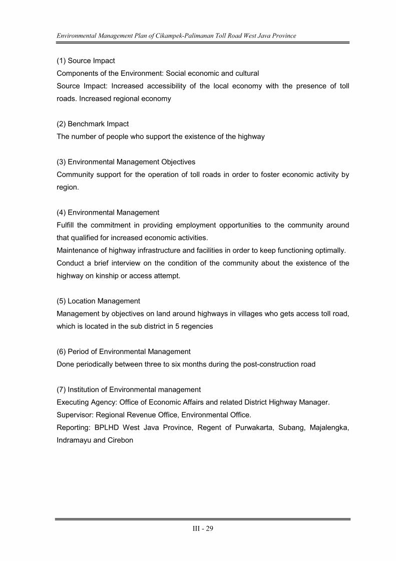
Environmental Management Plan of Cikampek-Palimanan Toll Road West Java Province
III - 29
(1) Source Impact
Components of the Environment: Social economic and cultural
Source Impact: Increased accessibility of the local economy with the presence of toll
roads. Increased regional economy
(2) Benchmark Impact
The number of people who support the existence of the highway
(3) Environmental Management Objectives
Community support for the operation of toll roads in order to foster economic activity by
region.
(4) Environmental Management
Fulfill the commitment in providing employment opportunities to the community around
that qualified for increased economic activities.
Maintenance of highway infrastructure and facilities in order to keep functioning optimally.
Conduct a brief interview on the condition of the community about the existence of the
highway on kinship or access attempt.
(5) Location Management
Management by objectives on land around highways in villages who gets access toll road,
which is located in the sub district in 5 regencies
(6) Period of Environmental Management
Done periodically between three to six months during the post-construction road
(7) Institution of Environmental management
Executing Agency: Office of Economic Affairs and related District Highway Manager.
Supervisor: Regional Revenue Office, Environmental Office.
Reporting: BPLHD West Java Province, Regent of Purwakarta, Subang, Majalengka,
Indramayu and Cirebon
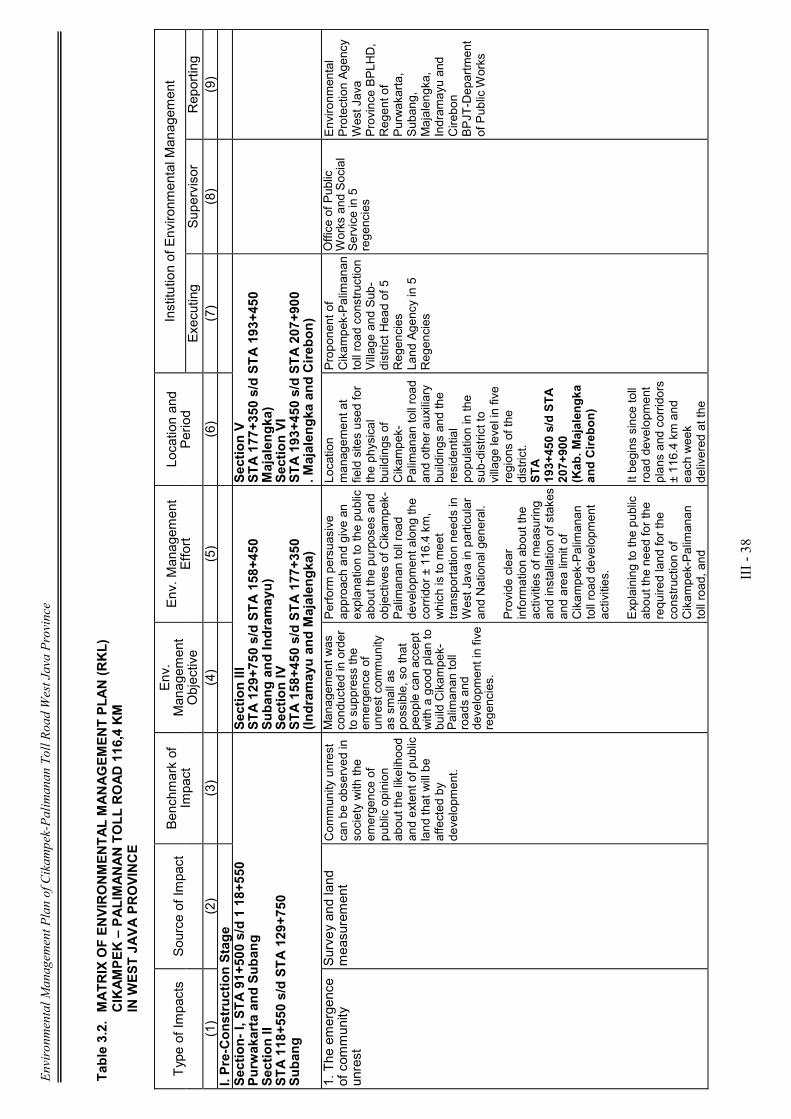
Environmental Management Plan of Cikampek-Palimanan Toll Road West Java Province
III - 38
Table 3.2. MATRIX OF ENVIRONMENTAL MANAGEMENT PLAN (RKL)
CIKAMPEK – PALIMANAN TOLL ROAD 116,4 KM
IN W
EST JAVA PROVINCE
Type of Im
pacts
Source of Im
pact
Benchmark of
Impact
Env.
Managem
ent
Objective
Env. M
anagem
ent
Effort
Location and
Period
Institution of Environm
ental M
anagem
ent
Executing
Supervisor
Reporting
(1)
(2)
(3)
(4)
(5)
(6)
(7)
(8)
(9)
I. Pre-Construction Stage
Section- I, STA 91+500 s/d 1 18+550
Purwakarta and Subang
Section II
STA 118+550 s/d STA 129+750
Subang
Section III
STA 129+750 s/d STA 158+450
Subang and Indramayu)
Section IV
STA 158+450 s/d STA 177+350
(Indramayu and Majalengka)
Section V
STA 177+350 s/d STA 193+450
Majalengka)
Section VI
STA 193+450 s/d STA 207+900
. Majalengka and Cirebon)
1. The emergence
of com
munity
unrest
Survey and land
measurement
Com
munity unrest
can be observed in
society with the
emergence of
public opinion
about the likelihood
and extent of public
land that will be
affected by
developm
ent.
Managem
ent was
conducted in order
to suppress the
emergence of
unrest com
munity
as small as
possible, so that
people can accept
with a good plan to
build Cikam
pek-
Palimanan toll
roads and
developm
ent in five
regencies.
Perform persuasive
approach and give an
explanation to the public
about the purposes and
objectives of Cikam
pek-
Palimanan toll road
developm
ent along the
corridor ± 116.4 km,
which is to meet
transportation needs in
West Java in particular
and National general.
Provide clear
information about the
activities of m
easuring
and installation of stakes
and area limit of
Cikam
pek-Palimanan
toll road development
activities.
Explaining to the public
about the need for the
required land for the
construction of
Cikam
pek-Palimanan
toll road, and
Location
managem
ent at
field sites used for
the physical
buildings of
Cikam
pek-
Palimanan toll road
and other auxiliary
buildings and the
residential
population in the
sub-district to
village level in five
regions of the
district.
STA
193+450 s/d STA
207+900
(Kab. M
ajalengka
and Cirebon)
It begins since toll
road development
plans and corridors
± 116.4 km and
each week
delivered at the
Proponent of
Cikam
pek-Palimanan
toll road construction
Village and Sub-
district Head of 5
Regencies
Land Agency in 5
Regencies
Office of Public
Works and Social
Service in 5
regencies
Environm
ental
Protection Agency
West Java
Province BPLHD,
Regent of
Purwakarta,
Subang,
Majalengka,
Indram
ayu and
Cirebon
BPJT-Department
of Public Works

Environmental Management Plan of Cikampek-Palimanan Toll Road West Java Province
III - 39
Type of Im
pacts
Source of Im
pact
Benchmark of
Impact
Env.
Managem
ent
Objective
Env. M
anagem
ent
Effort
Location and
Period
Institution of Environm
ental M
anagem
ent
Executing
Supervisor
Reporting
(1)
(2)
(3)
(4)
(5)
(6)
(7)
(8)
(9)
developm
ent areas
along the corridor of ±
116.4 km, and other
complem
entary
buildings to be
constructed such as
flood control drainage
channels, bridges,
(JPO), rest area (resting
place) Interchange (IC)
and others.
time of
measurement
activities and the
installation of
stakes in the
location.
2. The em
ergence
of Social Conflict
The procurement of
land for construction
of toll roads
Public unrest,
especially in
Babakan village
Ciwaringin, with the
emergence of
public opinion who
disagrees toll road
route through the
nearby Islamic
boarding House of
Babakan
Ciwaringin so there
are pros and cons
of land acquisition
carried out by the
TPT.
Environm
ental
managem
ent was
conducted in order
to suppress small
as possible
occurrence of
horizontal violence
in rural
communities
Babakan due to
land acquisition
activities for the
construction of
Cikam
pek toll road.
Perform persuasive
approach and give an
explanation to the public
about the mechanism of
land acquisition by the
government.
Provide clear
information about the
activities of the
determination of
compensation value of
the land as government
policy areas and the
central governm
ent.
Location
managem
ent is in
Babakan village,
particularly around
Islamic boarding
schools of
Ciwaringin.
Made since the
initial plan of land
acquisition for
highway purposes
and periodically
carried out every
single month.
Proponent of
Cikam
pek-Palimanan
toll road
developm
ent, Sub-
destrict head of
Ciwaringin, and BPN
Cirebon
Office of Public
Works and
Highways Office of
Cirebon,
Environm
ental
Protection Agency
of Cirebon
BPLHD West Java
Province, regent of
Cirebon, BPJT-
Department of
Public Works
3. Reduced
Income
Land Acquisition
for Toll Road
Development
Unrest that
emerged in
communities
occurs due
acquisitions of
farmer-owned
land such as
rice fields and
gardens and
others.
Environm
ental
managem
ent
is intended to
make rice
fields which is
a source of
income for
residents
receive
appropriate
compensation
To socialize
continuously since
the preparation of
land acquisition
through the
implem
entation
process of land
acquisition, about
the toll road
developm
ent plans
and the value of
Location
Managem
ent of
the village
across the
fields affected
by land
acquisition for
the project
needs.
Period
Managem
ent
Proponent
Palimanan
Cikam
pek toll
road
construction,
Sub-district
heads and
village heads in
the 5 regencies,
Land Agency in
5 regencies and
Public Works
Department of
Highways,
Department of
Environm
ent in
5 regencies
BPLHD West
Java Province,
Regent of
Purwakarta,
Subang,
Majalengka,
Indram
ayu and
Cirebon,
BPJT-
Department of
Public Works
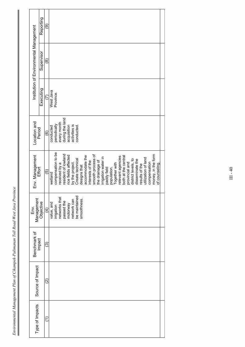
Environmental Management Plan of Cikampek-Palimanan Toll Road West Java Province
III - 40
Type of Im
pacts
Source of Im
pact
Benchmark of
Impact
Env.
Managem
ent
Objective
Env. M
anagem
ent
Effort
Location and
Period
Institution of Environm
ental M
anagem
ent
Executing
Supervisor
Reporting
(1)
(2)
(3)
(4)
(5)
(6)
(7)
(8)
(9)
value, and
irrigation
networks that
passed the
motorway
network can
be maintained
smoothness.
wetland
compensation to be
received by a
resident of lowland
rice fields affected
by the project.
Create technical
designs that
accommodate the
interests of the
smooth process of
the drainage of
irrigation water in
paddy field
population.
Together with
relevant agencies
both at the central
provincial and
district levels, to
dissem
inate the
results of the
utilization of land
compensation
money, in the form
of counseling.
conducted
periodically
every month
during the land
acquisition
activities is
conducted.
West Java
Province.

Environmental Management Plan of Cikampek-Palimanan Toll Road West Java Province
III - 41
Type of Im
pacts
Source of Im
pact
Benchmark of
Impact
Env.
Managem
ent
Objective
Env. M
anagem
ent
Effort
Location and Period
Institution of Environm
ental M
anagem
ent
Executing
Pengawas
Penerima Laporan
(1)
(2)
(3)
(4)
(5)
(6)
(7)
(8)
(9)
II. Construction Stage
Section- I, STA 91+500 s/d 1 18+550
Purwakarta and Subang
Section II
STA 118+550 s/d STA 129+750
Subang
Section III
STA 129+750 s/d STA 158+450
Subang and Indramayu)
Section IV
STA 158+450 s/d STA 177+350
(Indramayu and Majalengka)
Section V
STA 177+350 s/d STA 193+450
Majalengka)
Section VI
STA 193+450 s/d STA 207+900
. Majalengka and Cirebon)
A. C
omponents of
Physical - Chem
ical
1. Reduced Air
Quality
Mobilization of
weight equipment
And transportation
of construction
materials.
Operating base
camp,
Preparation of soil
foundation,
excavation and
heap,
baand jobs
roads and layers
pavement, and
bridge work
Air dust levels were
observed visually
(observation) and the
complaints from
the
public due to the
many dust or air dust
concentration
measurements of air
quality monitoring
results.
To prevent or
reduce the
occurrence of
elevated levels of
dust in the air
because the roads
are not paved over,
particularly those
close to residential
areas, reducing the
negative perception
of society towards
the project and
further prevent the
situation was not
an aesthetic as well
as decline in public
health.
Air trucks must have a
cover with plastic or
tarps;
The volum
e of cargo
tonnage or height does
not exceed the truck;
Clean the tires first
project vehicles before
entering a public road.
Reduce vehicle speed
to 20 km / h, especially
in the vicinity of hum
an
settlem
ent;
Watering the road
vehicle through which
the road project with
water especially near
and through the
settlem
ent in the dry
season;
In the rainy season,
road dam
age easily
occurs, for example,
road potholes, muddy,
so the project should fix
it immediately.
Performed along the road
passed by the project
vehicles, especially those
that pass through
residential villages in 5
regencies
Sta. 92+600-
92+850,
Sta 98+700-98+800,
Sta 104+550-104+900,
Sta 11 3+700- 11 3+800,
Sta 116+800-116+900
Purwakarta & Subang Sta
122+450-122+600
Sta 123+550-123+700
Sta 126+300-126+650,
Indram
ayu Sta 129+950-
30+000
Sta 13 1+400-3 1+500
Sta 132+050-32+ 150
Sta 132+300-32+450
Sta 132+600-32-t 700
Sta 136+700-36+900
Stal 49+800- 149+950,
Majalengka
Executing
Contractor Toll
Road
Development.
Environm
ental
Office
in
5 regencies,
Department
of
Health
in
5 regencies.
BPLHD West Java
Province, Regent
of Purwakarta,
Subang,
Majalengka,
Indram
ayu and
Cirebon, BPJT-
Department of
Public Works
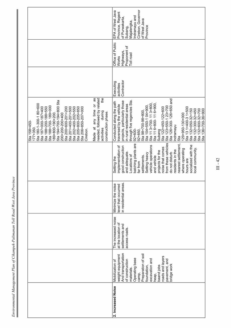
Environmental Management Plan of Cikampek-Palimanan Toll Road West Java Province
III - 42
Sta 158+450-
177+350.
Sta 180-1-300-1 80+600
Sta 187+000-187+400
Sta 188+200-188+550
Sta 188+700- 189+000
189+800-190+200.
Sta 194+700-194+800 Sta
200+200-200+400
Sta 200+600-201+200
Sta 201+400-201+500
Sta 202+400-202+550
Sta 205+800-205+850
Sta 206+850-207+000
Cirebon.
Made at any tim
e or as
needed, followed by related
activities
during
the
construction phase.
2. Increased Noise
Mobilization of
weight equipment
And transportation
of construction
materials.
Operating base
camp,
Preparation of soil
foundation,
excavation and
heap,
baand jobs
roads and layers
pavement, and
bridge work
The increased noise
at the location of
settlem
ents and
access roads.
Minimize the noise
level that occurred
in residential areas.
Setting the
implem
entation of
good construction
and adequate.
Locations of
batching plants are
far from
settlem
ents.
Setting heavy
vehicle operations
and vehicle
projects for the
noise that com
es
from
these vehicles
do not disturb
residents in the
nearest settlement,
where operating
hours are
socialized with the
local com
munity.
Conducted along the path
traversed by the vehicle
projects, particularly those
in rural residential areas
through five regencies Sta.
92+600-
92+850,
Sta 98+700-98+800,
Sta 104+550-1 04+900,
Sta 11 3+700- 11 3+800,
Sta 11 6+800- 11 6+900,
Subang
Sta 122+450-122+600
Sta 123+550-1 23+700
Sta 126+300- 126+650 and
Indram
ayu
Sta
129+950-130+000
Sta 13 1+400-3 1+500
Sta 132+050-32+150
Sta 132+300-32+450
Sta 132+600-32+700
Sta 136+700-36+900
Executing
activities
Contractor
Office of Public
Works
Highways,
Proponent of
Toll road
EPA of W
est Java
Province, Regent
of Purwakarta,
Subang,
Majalengka,
Indram
ayu and
Cirebon, Governor
of West Java
Province
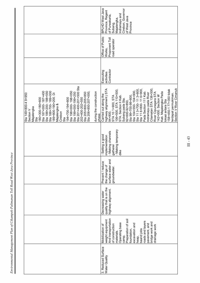
Environmental Management Plan of Cikampek-Palimanan Toll Road West Java Province
III - 43
Sta 149+800-4 9+950
Section V
Majalengka
Sta
180+300-180+600
Sta 187+000- 187+400
Sta 188+200- 188+550
Sta 188+700- 189+000
189+800-190+200. Di
Majalengka &
Cirebon
Sta
194+700-194+800
Sta 198+000- 198+050
Sta 199+000-199+250
Sta 201+400-201+500 Sta
202+400-202+550
Sta 205+800-205+850
Sta 206+850-207+000,
during the construction
phase.
3. Reduced Surface
Water Quality
Mobilization of
weight equipment
And transportation
of construction
materials.
Operating base
camp,
Preparation of soil
foundation,
excavation and
heap,
baand jobs
roads and layers
pavement, and
bridge work and
drainage work
Decreasing water
quality that is on the
highway alignm
ent.
Prevent / reduce
the change of
surface water and
groundwater.
- Setting a good
implem
entation
- Making channels
gatherer
- Making temporary
dike
Carried out along the
highway alignm
ent j STA
94+800,
STA 10 1+900, STA
106+500, STA 110+500,
STA. Section II Kab.
Subang pada Sta.
92+600-92+850,
Sta 98+700-98+800,
Sta 104+550- 104+900,
Sta 11 3+700- 11 3+800,
Sta 11 6+800- 11 6+900,
Pada Section 111 Kab.
Indram
ayu pada River
Cilamatan STA 138+500,
River Cipunegara STA
142+000. Section W
Kab. M
ajalengka Pada
lokasi antara Sta
158+450-1 77+350 tidak
terdapat permukiman.
Section V River Cimanuk
Executing
activities
Contractor
Office of Public
Works,
Proponent Toll
road operator
BPLHD West Java
Province, Regent
of Purwakarta,
Subang,
Majalengka,
Indram
ayu and
Cirebon, Governor
of West Java
Province
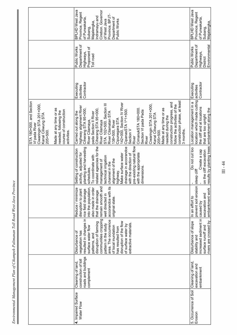
Environmental Management Plan of Cikampek-Palimanan Toll Road West Java Province
III - 44
STA 180+000. and Section
VI pada River
Ciwaringin STA 201+000,
Kanal Ciliwung STA
205+500.
Made at any time or as
needed, following the
course of construction
activities.
4. Im
paired Surface
Water Flow
Cleaning of land,
construction of toll
roads and buildings
complem
ent
Disturbance of
vegetation has
resulted in changes in
surface water flow
patterns, and
disruption of farming
communities cropping
pattern in the study
area. The occurrence
of local inundation
has resulted from
disruption of the flow
of surface water by
extractive materials.
Reduce / m
inimize
disruption to plant
rice field drainage
into the population,
also made in order
that the drainage
remain smooth and
well directed in
accorandce with its
original state.
Setting of construction
activity, adjusted for
planting and harvesting
schedules.
To coordinate with
related agencies for the
managem
ent of
technical irrigation
channel in the
alignm
ent of the
highway.
Make surface water
drainage in accorandce
with the direction of
pre-existing natural flow
with the appropriate
dimensions.
Carried out along the
highway alignm
ent River
Ciherang STA 95+000,
River Cilamaya,
pada Section II River
Ciherang STA 95+000,
River Cilamaya
STA. 102+500. Section III
River Cilamatan STA
138+500, River
Cipunegara STA
142+000, Section IV River
CipanasSTA 1^1+500.
Section V
River
CimanukSTA 180+000.
Section VI pada Pada
River
Ciwaringin STA 201+000,
Kanal Ciliwung STA
205+500.
Made at any time or as
needed during the
construction progress, and
follow the activities of the
construction phase, at least
3 months.
Executing
activities
Contractor
Public Works
Department of
Highways,
Proponent of
Toll road
BPLHD West Java
Province, Regent
of Purwakarta,
Subang,
Majalengka,
Indram
ayu and
Cirebon. Governor
of West Java
Province, BPJT-
Department of
Public Works
5. Occurrence of Soil
Erosion
Cleaning of land,
excavation and
embankment
Disturbance of slope
stability and
increased sediment in
surface runoff and
rivers are crossed by
In an effort to
prevent soil erosion
caused by
excavation and
embankment work
- Do not cut too
steep cliff
- Create a cap
on the cliff excavation
results by planting trees
Location managem
ent in a
location which made cutting
the cliff and at locations
that are too upright
embankment along the
Executing
activities
Contractor
Public Works
Department of
Highways,
District
Environm
ental
BPLHD West Java
Province, Regent
of Purwakarta,
Subang,
Majalengka,
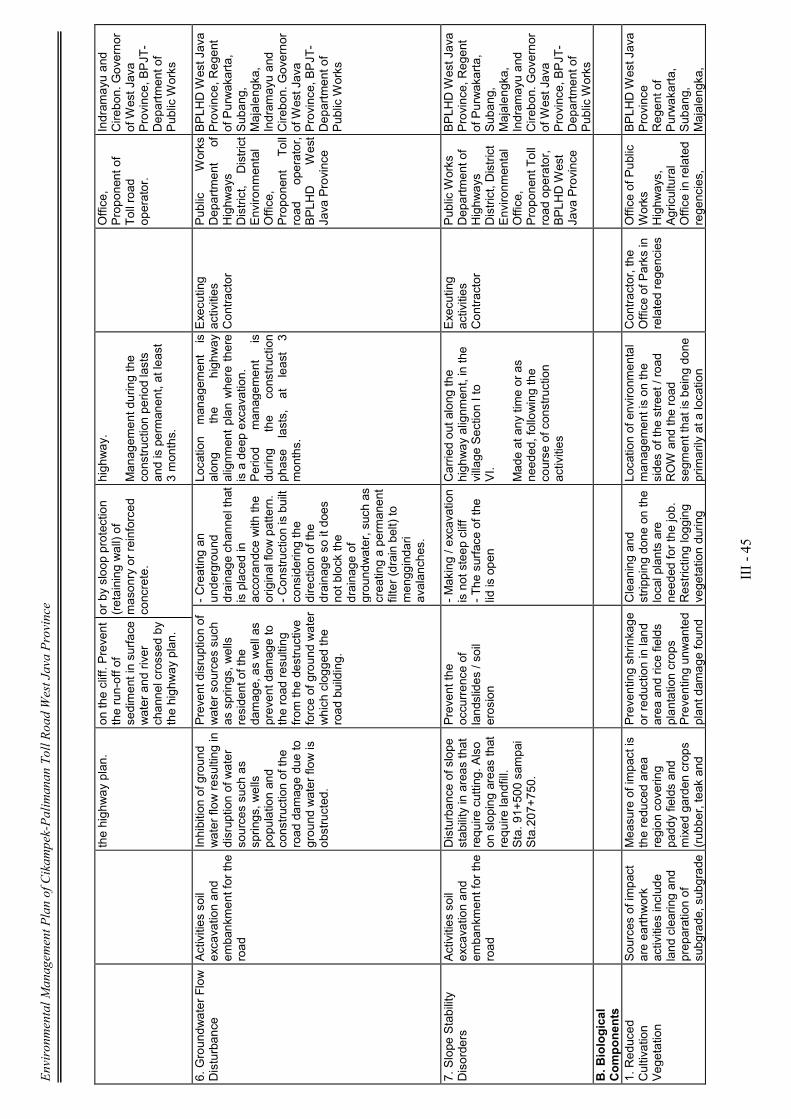
Environmental Management Plan of Cikampek-Palimanan Toll Road West Java Province
III - 45
the highway plan.
on the cliff. Prevent
the run-off of
sediment in surface
water and river
channel crossed by
the highway plan.
or by sloop protection
(retaining wall) of
masonry or reinforced
concrete.
highway.
Managem
ent during the
construction period lasts
and is permanent, at least
3 months.
Office,
Proponent of
Toll road
operator.
Indram
ayu and
Cirebon. Governor
of West Java
Province, BPJT-
Department of
Public Works
6. Groundwater Flow
Disturbance
Activities soil
excavation and
embankment for the
road
Inhibition of ground
water flow resulting in
disruption of water
sources such as
springs, wells
population and
construction of the
road dam
age due to
ground water flow is
obstructed.
Prevent disruption of
water sources such
as springs, wells
resident of the
damage, as well as
prevent dam
age to
the road resulting
from
the destructive
force of ground water
which clogged the
road building.
- Creating an
underground
drainage channel that
is placed in
accorandce with the
original flow pattern.
- Construction is built
considering the
direction of the
drainage so it does
not block the
drainage of
groundwater, such as
creating a permanent
filter (drain belt) to
menggindari
avalanches.
Location
managem
ent is
along
the
highway
alignm
ent plan where there
is a deep excavation.
Period
managem
ent
is
during
the
construction
phase
lasts, at least 3
months.
Executing
activities
Contractor
Public
Works
Department
of
Highways
District,
District
Environm
ental
Office,
Proponent Toll
road
operator,
BPLHD
West
Java Province
BPLHD West Java
Province, Regent
of Purwakarta,
Subang,
Majalengka,
Indram
ayu and
Cirebon. Governor
of West Java
Province, BPJT-
Department of
Public Works
7. Slope Stability
Disorders
Activities soil
excavation and
embankment for the
road
Disturbance of slope
stability in areas that
require cutting. Also
on sloping areas that
require landfill.
Sta. 91+500 sampai
Sta.207+750.
Prevent the
occurrence of
landslides / soil
erosion
- Making / excavation
is not steep cliff
- The surface of the
lid is open
Carried out along the
highway alignm
ent, in the
village Section I to
VI. Made at any time or as
needed, following the
course of construction
activities
Executing
activities
Contractor
Public Works
Department of
Highways
District, District
Environm
ental
Office,
Proponent Toll
road operator,
BPLHD West
Java Province
BPLHD West Java
Province, Regent
of Purwakarta,
Subang,
Majalengka,
Indram
ayu and
Cirebon. Governor
of West Java
Province, BPJT-
Department of
Public Works
B. B
iological
Components
1. Reduced
Cultivation
Vegetation
Sources of impact
are earthwork
activities include
land clearing and
preparation of
subgrade, subgrade
Measure of impact is
the reduced area
region covering
paddy fields and
mixed garden crops
(rubber, teak and
Preventing shrinkage
or reduction in land
area and rice fields
plantation crops
Preventing unwanted
plant dam
age found
Cleaning and
stripping done on the
local plants are
needed for the job.
Restricting logging
vegetation during
Location of environm
ental
managem
ent is on the
sides of the street / road
ROW and the road
segm
ent that is being done
primarily at a location
Contractor, the
Office of Parks in
related regencies
Office of Public
Works
Highways,
Agricultural
Office in related
regencies,
BPLHD West Java
Province
Regent of
Purwakarta,
Subang,
Majalengka,
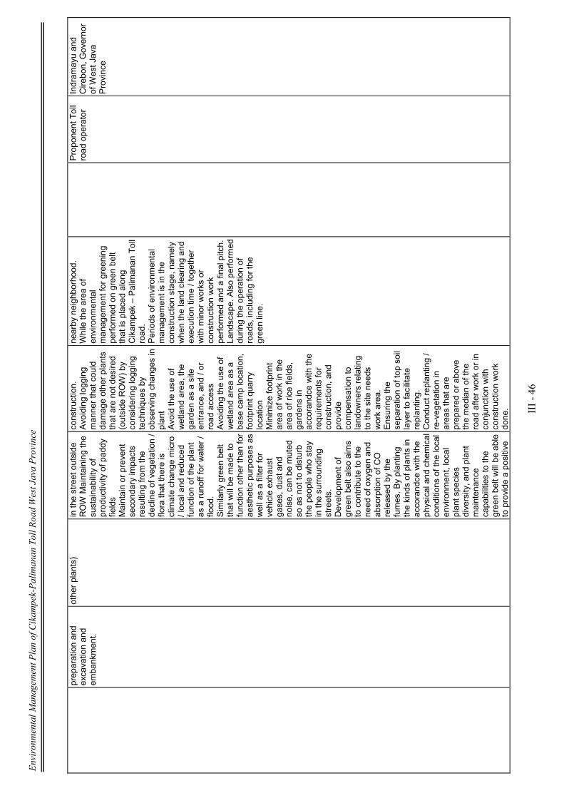
Environmental Management Plan of Cikampek-Palimanan Toll Road West Java Province
III - 46
preparation and
excavation and
embankment.
other plants)
in the street outside
ROW Maintaining the
sustainability of
productivity of paddy
fields
Maintain or prevent
secondary impacts
resulting from
the
decline of vegetation /
flora that there is
climate change micro
/ local and reduced
function of the plant
as a runoff for water /
flood.
Similarly green belt
that will be made to
function other than for
aesthetic purposes as
well as a filter for
vehicle exhaust
gases, dust and
noise, can be muted
so as not to disturb
the people who stay
in the surrounding
streets.
Development of
green belt also aims
to contribute to the
need of oxygen and
absorption of CO
released by the
fumes. By planting
the kinds of plants in
accorandce with the
physical and chemical
conditions of the local
environm
ent, local
plant species
diversity, and plant
maintenance
capabilities to the
green belt will be able
to provide a positive
construction.
Avoiding logging
manner that could
damage other plants
that are not desired
(outside ROW) by
considering logging
techniques by
observing changes in
plant
Avoid the use of
wetland area, the
garden as a site
entrance, and / or
road access
Avoiding the use of
wetland area as a
base cam
p location,
footprint quarry
location
Minimize footprint
area of work in the
area of rice fields,
gardens in
accorandce with the
requirements for
construction, and
provide
compensation to
landowners relating
to the site needs
work area.
Ensuring the
separation of top soil
layer to facilitate
replanting.
Conduct replanting /
re-vegetation in
areas that are
prepared or above
the median of the
road after work or in
conjunction with
construction work
done.
nearby neighborhood.
While the area of
environm
ental
managem
ent for greening
performed on green belt
that is placed along
Cikam
pek – Palimanan Toll
road.
Periods of environm
ental
managem
ent is in the
construction stage, nam
ely
when the land clearing and
execution time / together
with minor works or
construction work
performed and a final pitch.
Landscape. Also performed
during the operation of
roads, including for the
green line.
Proponent Toll
road operator
Indram
ayu and
Cirebon, Governor
of West Java
Province

Environmental Management Plan of Cikampek-Palimanan Toll Road West Java Province
III - 47
impact on the
operation of green
belt along the toll
roads.
Provides services and
provide improved
aesthetic environm
ent
of safety from
traffic
accidents, and to
reduce public health
problems due to
vehicle exhaust
gases, dust and
noise.
C. Com
ponents of
Social, Economic
and Cultural Rights.
1. Im
proved
Emploement
Opportunities
The involvem
ent of
local com
munities in
employment
Is the ratio of labor
income and business
actors before and
during the
construction of
Cikam
pek- Palimanan
toll road e and
construction of
infrastructure
networks.
Efforts to
increase
opportunities
work for the
community
local, with
number of occasions
work reaches ± 1225
people, then the
absorption of local
components pursued
more and more.
Giving priority to
local residents to
work on construction
activities in advance,
before bringing in
labor from
outside
the region;
Provide opportunities
for local people to
make transport
services and
provision of daily
necessities of life;
.
In the villages around the
location of activities Sta.
92+600-92+850,
Sta 98+700-98+800,
Sta 104+550- 104+900,
Sta 11 3+700- 11 3+800,
Sta 116+800-116+900.
Section II Sta
122+450-122+600
Sta 123+550-123+700
Sta 126+300-126+650.
Section III
Sta 129+950-130+000
Sta 13 1+400-1 3 1+500
Sta 132+050-132+150
Sta 132+300-132+450
Sta 132+600-132+700
Sta 136+700-1 36+900
Sta 149+800-149+950.
Section IV
Section V Sta
180+300-180+600
Sta 187+000- 187+400
Sta 188+200-1 88+550
Sta 188+700- 189+000
Proponent Activity
Toll Road
Regency Labor
Office,
Department of
Labor in 5
districts
BPLHD West Java
Province
Regent of
Purwakarta,
Subang,
Majalengka,
Indram
ayu and
Cirebon, Governor
of West Java
Province
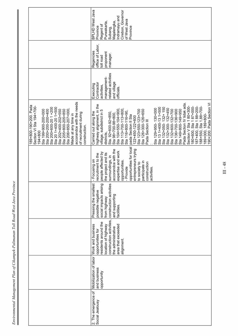
Environmental Management Plan of Cikampek-Palimanan Toll Road West Java Province
III - 48
189+800-190+200. Pada
Section VI Sta 194+700-
194+800
Sta 199+900-200+000
Sta 200+200-200+400
Sta 200+600-20 1 +200
Sta 20 1+400-20 1+500
Sta 202+400-202+550
Sta 205+800-205+850
Sta 206+850-207+000,
Made at any time in
accorandce with the needs
of recruitment during
construction.
2. The emergence of
Social Jealousy
Mobilization of labor
and business
opportunity
Work and business
opportunities for
residents around the
location of highway
construction activities,
the administrative
area that exceeded
alignm
ent.
Pressing the smallest
possible negative
social impacts arising
from
highway
construction activities
and supporting
facilities.
- Focusing on
recruitment to the
people affected by
the project and its
surroundings, in
accorandce with the
expertise and work
opportunities.
- Provide
opportunities for local
entrepreneurs trying
to society to
participate in
construction
activities.
Carried out along the
highway alignm
ent, in the
village, subdistrict in 5
districts,
Sta. 92+600-92+850,
Sta 98+700-98+800,
Sta 104+550-104+900,
Sta 113+700-113+800,
Sta 116+800-116+90,
pada Section II Sta
122+450-122+600
Sta 123+550-123+700
Sta 126+300-126+650
Pada Section III
: Sta 129+950- 130+000
Sta 13 1+400-13 1+500
Sta 132+050- 132+ 150
Sta 132+300- 132+450
Sta 132+600-132+700
Sta 136+700-136+900
Sta 149+800-149+950
Pada Section IV tidak ada.
Section V Sta 1 80+300-
180+600, Sta 1 87+000-
187+400, Sta 1 88+200-
188+550, Sta 1,88+700-
189+000, 189+800-
190+200. Pada Section VI
Executing
Contractor
activities,
managem
ent-
related activities
and village
officials.
Regencies
office of Labor,
toll road
proponent
manager.
BPLHD West Java
Province
Regent of
Purwakarta,
Subang,
Majalengka,
Indram
ayu and
Cirebon, Governor
of West Java
Province
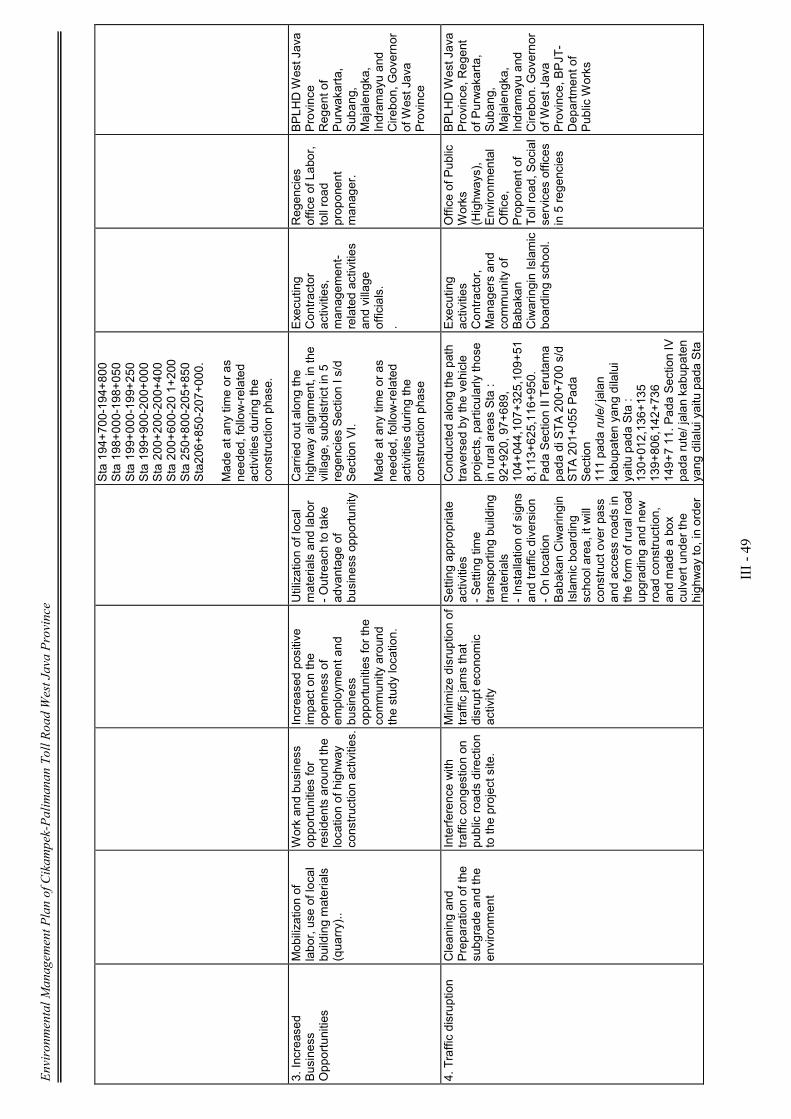
Environmental Management Plan of Cikampek-Palimanan Toll Road West Java Province
III - 49
Sta 194+700-194+800
Sta 198+000-198+050
Sta 199+000-199+250
Sta 199+900-200+000
Sta 200+200-200+400
Sta 200+600-20 1+200
Sta 250+800-205+850
Sta206+850-207+000.
Made at any time or as
needed, follow-related
activities during the
construction phase.
3. Increased
Business
Opportunities
Mobilization of
labor, use of local
building materials
(quarry)..
Work and business
opportunities for
residents around the
location of highway
construction activities.
Increased positive
impact on the
openness of
employment and
business
opportunities for the
community around
the study location.
Utilization of local
materials and labor
- Outreach to take
advantage of
business opportunity
Carried out along the
highway alignm
ent, in the
village, subdistrict in 5
regencies Section I s/d
Section VI.
Made at any time or as
needed, follow-related
activities during the
construction phase
Executing
Contractor
activities,
managem
ent-
related activities
and village
officials.
.
Regencies
office of Labor,
toll road
proponent
manager.
BPLHD West Java
Province
Regent of
Purwakarta,
Subang,
Majalengka,
Indram
ayu and
Cirebon, Governor
of West Java
Province
4. Traffic disruption
Cleaning and
Preparation of the
subgrade and the
environm
ent
Interference with
traffic congestion on
public roads direction
to the project site.
Minimize disruption of
traffic jams that
disrupt economic
activity
Setting appropriate
activities
- Setting time
transporting building
materials
- Installation of signs
and traffic diversion
- On location
Babakan Ciwaringin
Islamic boarding
school area, it will
construct over pass
and access roads in
the form of rural road
upgrading and new
road construction,
and made a box
culvert under the
highway to, in order
Conducted along the path
traversed by the vehicle
projects, particularly those
in rural areas Sta :
92+920, 97+689,
104+044,107+325,109+51
8,113+625,116+950.
Pada Section II Terutam
a pada di STA 200+700 s/d
STA 201+055 Pada
Section
111 pada rule/ jalan
kabupaten yang dilalui
yaitu pada Sta :
130+012,136+135
139+806,142+736
149+7 11. Pada Section IV
pada rute/ jalan kabupaten
yang dilalui yaitu pada Sta
Executing
activities
Contractor,
Managers and
community of
Babakan
Ciwaringin Islamic
boarding school.
Office of Public
Works
(Highways),
Environm
ental
Office,
Proponent of
Toll road, Social
services offices
in 5 regencies
BPLHD West Java
Province, Regent
of Purwakarta,
Subang,
Majalengka,
Indram
ayu and
Cirebon. Governor
of West Java
Province, BPJT-
Department of
Public Works
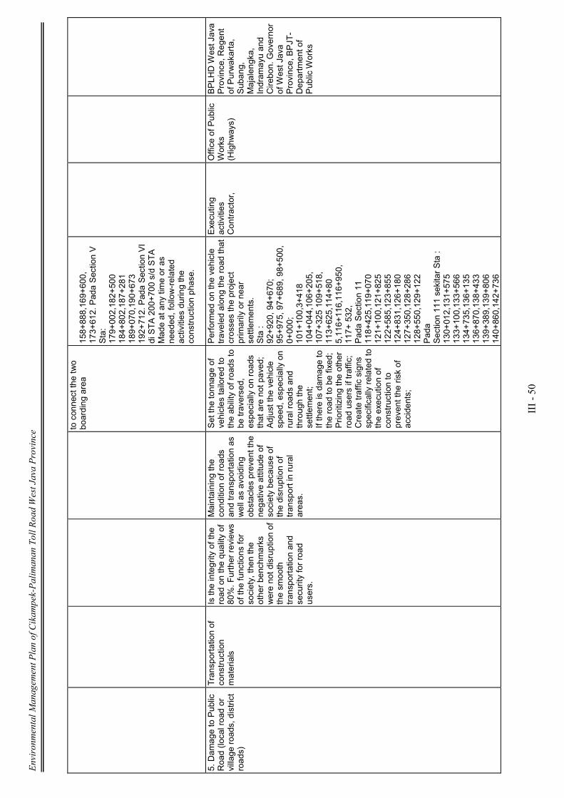
Environmental Management Plan of Cikampek-Palimanan Toll Road West Java Province
III - 50
to connect the two
boarding area
158+888,169+600,
173+612. Pada Section V
Sta:
179+002,182+500
184+802,187+281
189+070,190+673
192+712. Pada Section VI
di STA 200+700 s/d STA
Made at any time or as
needed, follow-related
activities during the
construction phase.
5. Dam
age to Public
Road (local road or
village roads, district
roads)
Transportation of
construction
materials
Is the integrity of the
road on the quality of
80%. Further reviews
of the functions for
society, then the
other benchm
arks
were not disruption of
the smooth
transportation and
security for road
users.
Maintaining the
condition of roads
and transportation as
well as avoiding
obstacles prevent the
negative attitude of
society because of
the disruption of
transport in rural
areas.
Set the tonnage of
vehicles tailored to
the ability of roads to
be traversed,
especially on roads
that are not paved;
Adjust the vehicle
speed, especially on
rural roads and
through the
settlem
ent;
If there is dam
age to
the road to be fixed;
Prioritizing the other
road users if traffic;
Create traffic signs
specifically related to
the execution of
construction to
prevent the risk of
accidents;
Performed on the vehicle
traveled along the road that
crosses the project
primarily or near
settlem
ents.
Sta :
92+920, 94+670;
95+975, 97+689, 98+500,
0+000;
101+100,3+418
104+044,106+205,
107+325 109+518,
113+625,114+80
5,116+116,116+950,
117+ 532,
Pada Section 11
118+425,119+070
121+100,121+825
122+585,123+855
124+831,126+180
127+350,128+286
128+550,129+122
Pada
Section 111 sekitar Sta :
130+012,131+575
133+100,133+566
134+735,136+135
136+870,138+433
139+389,139+806
140+860,142+736
Executing
activities
Contractor,
Office of Public
Works
(Highways)
BPLHD West Java
Province, Regent
of Purwakarta,
Subang,
Majalengka,
Indram
ayu and
Cirebon. Governor
of West Java
Province, BPJT-
Department of
Public Works

Environmental Management Plan of Cikampek-Palimanan Toll Road West Java Province
III - 51
144+800,147+863
149+711,153+453
154+250,155+480
158+888. Pada
Section IV Sta :
160+845,163+536
164+651,165+975
167+675,169+600
171+060,172+021
172+851,173+612
176+655,177+488.
Pada
Section V Sta :
188+230, 189+070
190+673,191+550
92+712. Pada Section VI
Sta :
194+698,195+289
195+938,196+425
197+289,198+191
199+446,200+030
200+030,200+716
201+535,202+123
205+776,206+418.
Periode pengelolaan
adalah selam
a kegiatan
konstruksi berlangsung.
6. Dam
age to Public
Utilities (W
ater Pipe)
Cleaning of land for
highway
construction
Degrading condition
of public utilities such
as electricity
networks, telephone,
water networks,
irrigation and others.
Reducing the
smallest possible
disturbance to public
utilities.
Create technical
handling, such as the
transfer of electrical
substations, m
aking
the box culvert to
avoid disruption of
clean water and
irrigation channels
that meet their
individual needs.
Location managem
ent is in
place along the intended
utility of the highway.
Sta 91+552
(pipa PDAM), Sta
103+421 (Gas), PLN pada
setiap perpotongan,
dengan
jalan kab./ jl desa. Pada
Section 11 di sekitar Sta
126+ 122 (Gas)
127+2 12 (Gas)
Section III
Sta 130+901
Section
Executing
activities
Contractor.
Office of Public
Works
(Highways)
BPLHD West Java
Province, Regent
of Purwakarta,
Subang,
Majalengka,
Indram
ayu and
Cirebon. Governor
of West Java
Province, BPJT-
Department of
Public Works
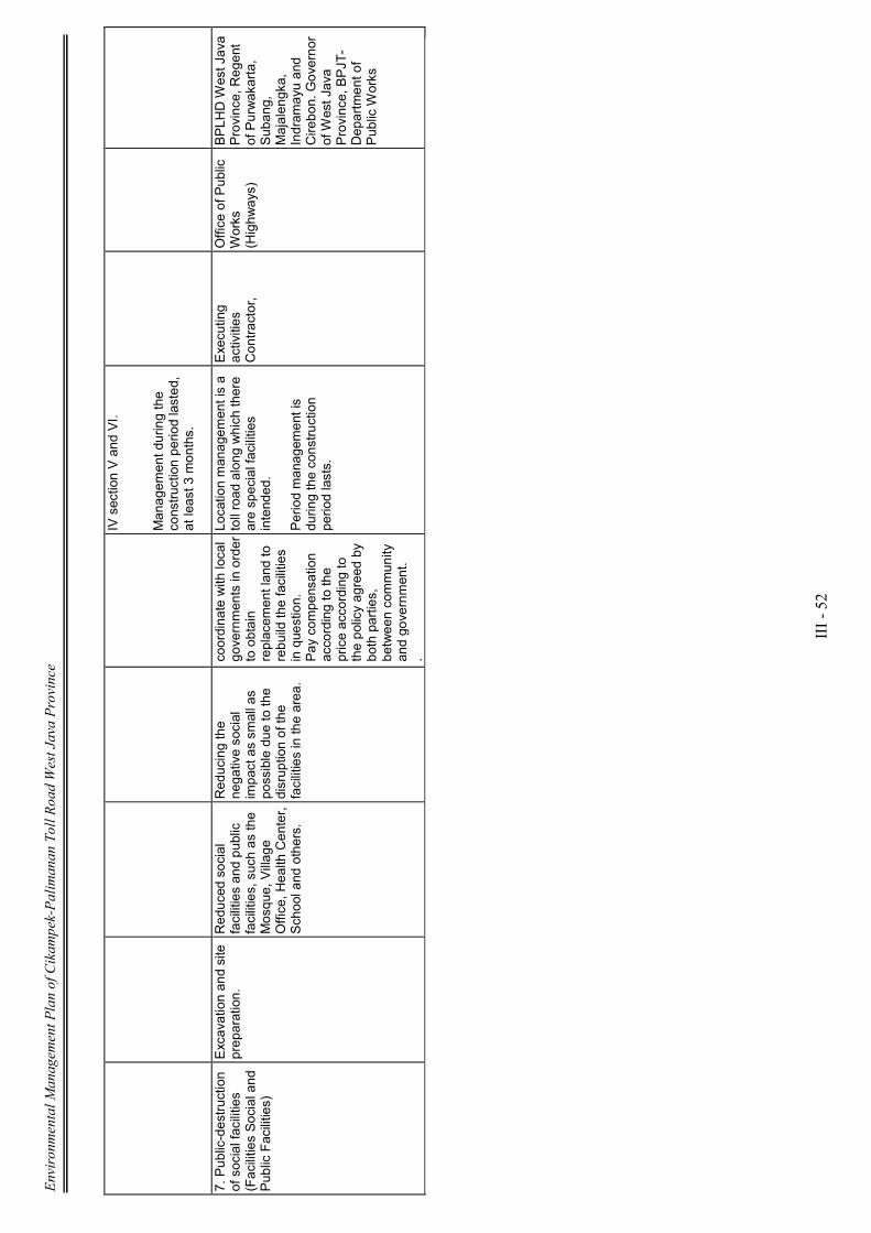
Environmental Management Plan of Cikampek-Palimanan Toll Road West Java Province
III - 52
IV section V and VI.
Managem
ent during the
construction period lasted,
at least 3 months.
7. Public-destruction
of social facilities
(Facilities Social and
Public Facilities)
Excavation and site
preparation.
Reduced social
facilities and public
facilities, such as the
Mosque, Village
Office, Health Center,
School and others.
Reducing the
negative social
impact as sm
all as
possible due to the
disruption of the
facilities in the area.
coordinate with local
governments in order
to obtain
replacem
ent land to
rebuild the facilities
in question.
Pay com
pensation
according to the
price according to
the policy agreed by
both parties,
between community
and government.
.
Location managem
ent is a
toll road along which there
are special facilities
intended.
Period managem
ent is
during the construction
period lasts.
Executing
activities
Contractor,
Office of Public
Works
(Highways)
BPLHD West Java
Province, Regent
of Purwakarta,
Subang,
Majalengka,
Indram
ayu and
Cirebon. Governor
of West Java
Province, BPJT-
Department of
Public Works
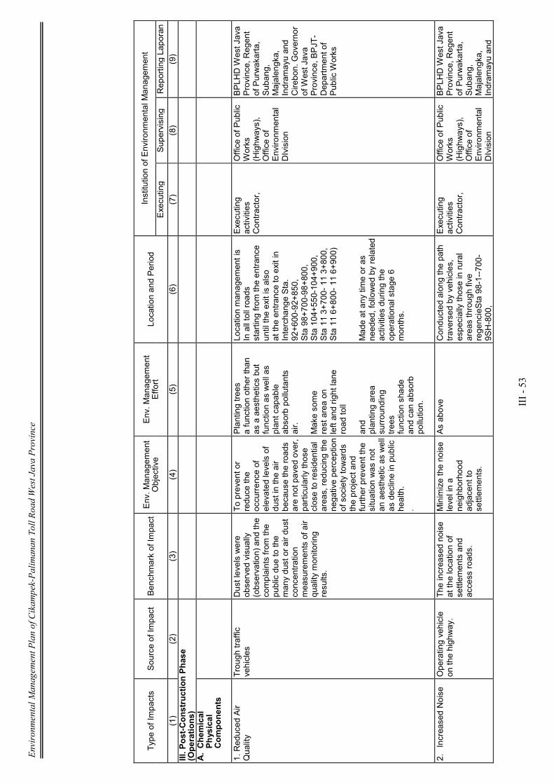
Environmental Management Plan of Cikampek-Palimanan Toll Road West Java Province
III - 53
Type of Im
pacts
Source of Im
pact
Benchmark of Im
pact Env. M
anagem
ent
Objective
Env. M
anagem
ent
Effort
Location and Period
Institution of Environm
ental Managem
ent
Executing
Supervising
Reporting Laporan
(1)
(2)
(3)
(4)
(5)
(6)
(7)
(8)
(9)
III. P
ost-Construction Phase
(Operations)
A. Chem
ical
Physical
Components
1. Reduced Air
Quality
Trough traffic
vehicles
Dust levels were
observed visually
(observation) and the
complaints from
the
public due to the
many dust or air dust
concentration
measurements of air
quality monitoring
results.
To prevent or
reduce the
occurrence of
elevated levels of
dust in the air
because the roads
are not paved over,
particularly those
close to residential
areas, reducing the
negative perception
of society towards
the project and
further prevent the
situation was not
a n aesthetic as well
as decline in public
health.
.
Planting trees
a function other than
as a aesthetics but
function as well as
plant capable
absorb pollutants
air.
Make some
rest area on
left and right lane
road toll
and
planting area
surrounding
trees
function shade
and can absorb
pollution.
Location managem
ent is
In all toll roads
starting from
the entrance
until the exit is also
at the entrance to exit in
Interchange Sta.
92+600-92+850,
Sta 98+700-98+800,
Sta 104+550-104+900,
Sta 11 3+700- 11 3+800,
Sta 11 6+800- 11 6+900)
Made at any time or as
needed, followed by related
activities during the
operational stage 6
months.
Executing
activities
Contractor,
Office of Public
Works
(Highways),
Office of
Environm
ental
DIvision
BPLHD West Java
Province, Regent
of Purwakarta,
Subang,
Majalengka,
Indram
ayu and
Cirebon. Governor
of West Java
Province, BPJT-
Department of
Public Works
2. Increased Noise Operating vehicle
on the highway.
The increased noise
at the location of
settlem
ents and
access roads.
Minimize the noise
level in a
neighborhood
adjacent to
settlem
ents.
As above
Conducted along the path
traversed by vehicles,
especially those in rural
areas through five
regencieSta 98-1--700-
9SH-800,
Executing
activities
Contractor,
Office of Public
Works
(Highways),
Office of
Environm
ental
DIvision
BPLHD West Java
Province, Regent
of Purwakarta,
Subang,
Majalengka,
Indram
ayu and
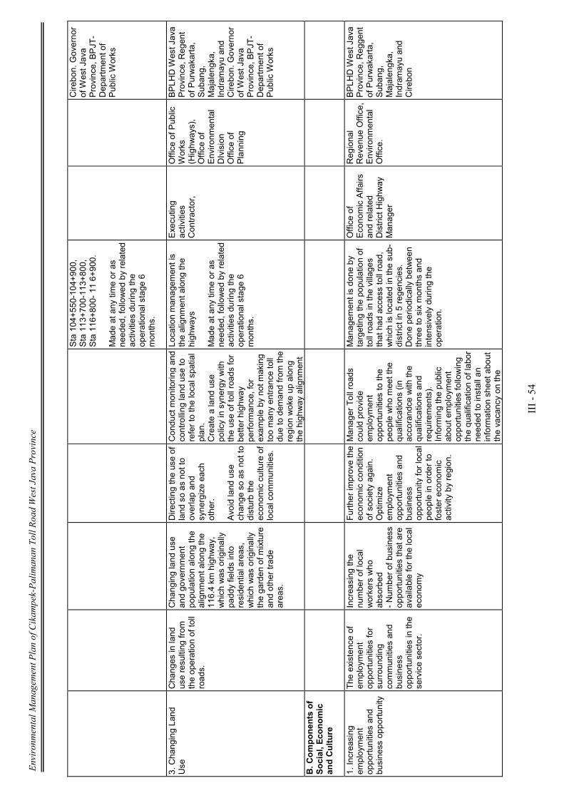
Environmental Management Plan of Cikampek-Palimanan Toll Road West Java Province
III - 54
Sta 104+550-104+900,
Sta 113+700-113+800,
Sta 116+800- 11 6+900.
Made at any time or as
needed, followed by related
activities during the
operational stage 6
months.
Cirebon. Governor
of West Java
Province, BPJT-
Department of
Public Works
3. Changing Land
Use
Changes in land
use resulting from
the operation of toll
roads.
Changing land use
and government
population along the
alignm
ent along the
116.4 km highway,
which was originally
paddy fields into
residential areas,
which was originally
the garden of m
ixture
and other trade
areas.
Directing the use of
land so as not to
overlap and
synergize each
other.
Avoid land use
c hange so as not to
disturb the
econom
ic culture of
local com
munities.
Conduct monitoring and
controlling land use to
refer to the local spatial
plan.
Create a land use
policy in synergy with
the use of toll roads for
better highway
performance, for
exam
ple by not making
too many entrance toll
due to dem
and from
the
region woke up along
the highway alignm
ent
Location managem
ent is
the alignm
ent along the
highways
Made at any time or as
needed, followed by related
activities during the
operational stage 6
months.
Executing
activities
Contractor,
Office of Public
Works
(Highways),
Office of
Environm
ental
DIvision
Office of
Planning
BPLHD West Java
Province, Regent
of Purwakarta,
Subang,
Majalengka,
Indram
ayu and
Cirebon. Governor
of West Java
Province, BPJT-
Department of
Public Works
B. C
omponents of
Social, Economic
and Culture
1. Increasing
employment
opportunities and
business opportunity
The existence of
employment
opportunities for
surrounding
communities and
business
opportunities in the
service sector.
Increasing the
number of local
workers who
absorbed
- Num
ber of business
opportunities that are
available for the local
econom
y
Further improve the
econom
ic condition
of society again.
Optimize
employment
opportunities and
business
opportunity for local
people in order to
foster economic
activity by region.
Manager Toll roads
could provide
employment
opportunities to the
people who meet the
qualifications (in
accorandce with the
qualifications and
requirements).
Informing the public
about employment
opportunities following
the qualification of labor
needed to install an
information sheet about
the vacancy on the
Managem
ent is done by
targeting the population of
toll roads in the villages
that had access toll road,
which is located in the sub-
district in 5 regencies.
Done periodically between
three to six months and
intensively during the
operation.
Office of
Economic Affairs
and related
District Highway
Manager
Regional
Revenue Office,
Environm
ental
Office.
BPLHD West Java
Province, Reggent
of Purwakarta,
Subang,
Majalengka,
Indram
ayu and
Cirebon

Environmental Management Plan of Cikampek-Palimanan Toll Road West Java Province
III - 55
board's announcement
at the Village Office or
the District in each
project area.
Counseling and
information about
business opportunities
in the population
Provide appropriate
MSEs wage (Minimum
Wage of City),
education level and
skills of workers.
Involve the em
ployees
in the em
ployees' social
security
2. Public Perception
Increased
accessibility of the
local economy with
the presence of toll
roads. Increased
regional economy
The num
ber of people
who support the
existence of the
highway
Com
munity support
for the operation of
toll roads in order
to foster economic
activity by region.
Fulfill the com
mitment
in providing
employment
opportunities to the
community around that
qualified for increased
econom
ic activities.
Maintenance of
highway infrastructure
and facilities in order to
keep functioning
optimally.
Conduct a brief
interview on the
condition of the
community about the
existence of the
highway on kinship or
access attempt.
Managem
ent by objectives
on land around highways in
villages who gets access
toll road, which is located in
the sub district in 5
regencies
Done periodically between
three to six months during
the post-construction road
Office of
Economic Affairs
and related
District Highway
Manager.
Regional
Revenue Office,
Environm
ental
Office.
BPLHD West Java
Province, Regent
of Purwakarta,
Subang,
Majalengka,
Indram
ayu and
Cirebon BPJT-
Departemen PU.
Environmental Monitoring Plan of Cikampek-Palimanan Toll Road West Java Province
iii
TABLE OF CONTENT
PREFACE .................................................................................................................... i
TABLE OF CONTENT ............................................................................................... iii
CHAPTER I INTRODUCTION
1.1. Background ....................................................................................... I-1
1.2. Objectives of Environmental Monitoring Plan ................................. I-1
1.3. Benefits of Environmental Monitoring Plan . ................................... I-1
1.3.1. Benefits to Initiator ............................................................. I-1
1.3.2. Benefits to Relevant Agencies ............................................ I-2
1.3.3. Benefits to Affected Communities ..................................... I-2
BAB II ENVIRONMENTAL MONITORING PLAN
2.1. Pre-Construction Stage .................................................................... II-2
2.2. Construction Stage ............................................................................ II-6
2.3. Post Construction Stage .................................................................... II-28
Appendix:
Figure of Environmental Monitoring Plan

Environmental Monitoring Plan of Cikampek-Palimanan Toll Road West Java Province
iv
DAFTAR TABEL
Tabel 2.1. Matrik Rencana Pemantauan Lingkungan (RPL) ..................................... III-36
Environmental Monitoring Plan of Cikampek-Palimanan Toll Road West Java Province
v
DAFTAR GAMBAR
Lampiran
Tabel 3.1. Peta Rencana Pemantauan Lingkungan ................................................... 1
Environmental Monitoring Plan of Cikampek-Palimanan Toll Road West Java Province
I - 1
CHAPTER I
INTRODUCTION
1.1. Background
In an effort to reduce the negative impact to a minimum and develop its positive impact,
then the Manager of Cikampek-Palimanan toll road as the initiator in its completion of EIA
study, prepared the RPL and RPL as a guideline in conducting environmental monitoring
of the impact arising from the construction of toll roads along the Cikampek-Palimanan
116.4 km along with its supporting infrastructure.
1.2. Objectives of Environmental Monitoring Plan
- Formulate measures or precautions, prevention and control negative impacts and
enhance positive impacts resulting from development activities Cikampek toll road
- in this experiment.
- Improvement of the environmental control system inside or out of bounds through
the monitoring activities as feedback.
1.3. Benefits of Environmental Monitoring Plan
Usefulness of monitoring the implementation of the environment is not only felt by the
proponent, but also by the relevant agencies and affected communities.
1.3.1. Benefits for Initiator
Importance of Environmental Monitoring Plan is to:
a. As a means to evaluate the effectiveness of activity used in the management /
control negative impacts and positive impacts of development as stated in the
Environmental Management Plan (RKL).
b. As an early indicator for the presence of undesirable environmental changes, thus
overcoming the impact of these steps can be implemented effectively. c. As

Environmental Monitoring Plan of Cikampek-Palimanan Toll Road West Java Province
I - 2
guidelines for the proponent to carry out cooperation in environmental monitoring
activities and the surrounding area with relevant agencies in conserving the
environment.
c. To meet the requirements of applicable law.
d. As a means to collect relevant evidence in cases of prosecution and defense.
e. As a means to take further policy for the development of these activities.
1.3.2. Benefits to Relevant Agencies
a. As a means of feedback to relevant agencies in determining the policy steps to be
taken to improve environmental quality / environmental conservation efforts and
natural resources.
b. As a means of feedback to relevant agencies and the security officers in
anticipating and evaluating the various activities that will arise and have to be more
easily conduct preventive measures (prevention) as well as supervision of
environmental management.
c. To assist monitoring agencies in the development of environmental monitoring.
1.3.3. Benefits to Affected Communities
a. To increase community participation in efforts to monitor safety, hygiene, health
and environmental sustainability.
b. To use the community as a social control, in order to maximize positive impacts
and minimize negative impacts.
Environmental Monitoring Plan of Cikampek-Palimanan Toll Road West Java Province
II - 1
CHAPTER II
ENVIRONMENTAL MONITORING PLAN
Implementation of development Cikampek- Palimanan Toll Road and the supporting
infrastructure, will work well if environmental management efforts and the success of
environmental management undertaken by the proponent in accordance with the
guidelines that have been raised in Environmental Management Plan and monitored in a
monitoring activity.
Guidelines for monitoring of major and significant impacts outlined in the document
Environmental Monitoring Plan.
The description of the monitoring to be performed on components that impact these
activities will be conducted based on the phases of activity in the construction of
Cikampek - Palimanan toll roads along the 116.4 km.
In the environmental monitoring plan is some impact and sources of impacts to the
implementing agencies and recipient management reports, itemized by discussion as the
following:
a. Significant impacts are monitored
• Types of components / parameters of the environment
• important indicator of the impact of the monitored components
b. Source impact
c. Environmental parameters monitored
d. The purpose of environmental monitoring plan
e. Methods for environmental monitoring:
• method of data collection and analysis
• The location of environmental monitoring
• Duration and frequency of monitoring
f. Institutions for environmental monitoring
• Implementing environmental monitoring
• Supervision of environmental monitoring
• Reporting the results of environmental monitoring
Environmental Monitoring Plan of Cikampek-Palimanan Toll Road West Java Province
II - 2
In more details, location of environmental monitoring in each section since from Section I
to Section VI, can be seen on the attachment.
2.1 Pre-Construction Stage
1. The emergence of community unrest
(1) Significant impacts are monitored:
Component Type / Parameter Environment: Attitudes and perceptions of society, both
negative and positive.
Significant Impact Indicators: Socialization to the community affected.
(2) Source of Significant Impacts
This community unrest arises mainly from people who are in the location of site activities.
The source is the cause of the impact of implementation activities since the survey,
measurement and installation of stakes, have spread the information that the land around
the site of activities will be exempted. But the information is not sure when the time land
preparation is carried out, this raises concerns that land people used as sources of
livelihood.
(3) Environmental parameters are monitored:
Knowledge and understanding of the overall community of Cikampek - Palimanan Toll
Road Development and building facilities and supporting infrastructure.
The creation of proper perception about Palimanan Cikampek toll road development and a
positive attitude towards such development.
(4) Environmental Monitoring Objectives
Knowing the development, type and level of disquiet in society a result of the activities of
land survey and measurement.
(5) Method of Environmental Monitoring
a) Methods of data collection and analysis
To determine the condition of the public unrest is done through a limited survey using
questionnaires and interview tools to local residents.
- Levels of public unrest that occurred
Environmental Monitoring Plan of Cikampek-Palimanan Toll Road West Java Province
II - 3
- The issues that arise in society
- Finding information developed in the community about Cikampek toll road construction
work - experiment.
b). Location of environmental monitoring
Held at the villages in the area of Purwakarta Regency, Subang, Majalengka, Indramayu
and Cirebon Regency.
c) The duration and frequency of monitoring
Done periodically within one month after the survey and measurement and the installation
of stakes.
(6) Institution of Environmental Monitoring
Executing: Toll Road Operating Board (BUJT) / Operator-Palimanan Cikampek toll road,
and the relevant village officials in the 5 regencies.
Supervisor: Office of LH in Purwakarta Regency, Subang, Majalengka, Indramayu and
Cirebon Regency. Police party in the 5 regions regency.
Reporting: Regent in 5 Regency, BPLHD regency of West Java Province. BPJT-
Department of Public Works
2. The emergence of Social Conflict
(1) Significant impacts are monitored:
Component Type / Parameter Environment: Social economic and cultural
Impact Indicators Important: There is a horizontal conflict between those who opposed
and who agree with the land acquisition for highway.
(2) Source of Significant Impacts
Procurement of land for the construction of the highway.
(3) environmental parameters are monitored:
Level of public unrest which led to the occurrence of horizontal conflicts caused by those
who opposed the land acquisition activities while other groups receive.
(4) Environmental Monitoring Objectives
Avoid open conflict between the parties, which do not correspond to understand.
Tapping the potential for interference of security conflict.

Environmental Monitoring Plan of Cikampek-Palimanan Toll Road West Java Province
II - 4
(5) Method of Environmental Monitoring
a) Methods of data collection and analysis
Field observations along with interviews with residents about the presence or absence of
potential conflict.
b). Location of environmental monitoring
Location of monitoring in all districts in 5 regencies, especially in rural districts Babakan
Ciwaringin Cirebon regency.
c) The duration and frequency of monitoring
Performed 1 time per month during the land acquisition phase implemented.
(6) Institution of Environmental Monitoring
Implementing: Ministry of Public Works (Land Acquisition Committee / TPT), Manager
Toll-Palimanan Cikampek,
Supervisor: Department of Land and National Land Aggency in Purwakarta Regency,
Subang, Majalengka, Indramayu and Cirebon Regency.
Reporting: BPLHD West Java Province
Toll Road Regulatory Agency (BPJT) - Department of Public Works
3. Reduced Income
(1) Significant impacts are monitored:
Component Type / Parameter Environment: public unrest with uncertain value of land
compensation.
Impact Indicators Important: The difference of the value of compensation land between
the consensual and the market price.
(2) Source of Significant Impacts
Activities of land acquisition for the highway project needs.
(3) environmental parameters monitored:
Obtaining information about the situation earlier public unrest due to the value of land
compensation.
(4) Environmental Monitoring Objectives
Environmental Monitoring Plan of Cikampek-Palimanan Toll Road West Java Province
II - 5
Avoid open conflict between the parties, which do not correspond to understand.
Tapping the potential for interference of security.
(5) Method of Environmental Monitoring
a) Methods of data collection and analysis
Field observations along with interviews with residents about the presence or absence of
public complaints.
b). Location of environmental monitoring
Location of monitoring in all districts in 5 regencies.
c) The duration and frequency of monitoring
Performed 1 time in 3 months during land acquisition phase.
(6) Institution of Environmental Monitoring
Executing: Toll Road Operating Board (BUJT) / Operator-Palimanan Cikampek toll road,
and the Land Acquisition Committee.
Supervisor: Department of Land Affairs in Purwakarta Regency, Subang, Majalengka,
Indramayu and Cirebon Regency, Directorate General of Highways Department of Public
Works.
Reporting: BPLHD West Java Province, Toll Road Regulatory Agency (BPJT) -
Department of Public Works
2.2. Construction Phase
A. Components of Physical - Chemical
1. Reduced Air Quality
(1) Significant impacts are monitored:
- Types Component / Parameter Environment: Air quality at the site access road
- Significant Impact Indicators: Reduced air quality at nearby residential
(2) Source of Significant Impacts
Increased air pollution is attributed to the escape of dust particles from the surface of the
road due to vehicles transporting material and activities, also due to exhaust emissions
Environmental Monitoring Plan of Cikampek-Palimanan Toll Road West Java Province
II - 6
from vehicles that transport materials through the village streets and roads as
transportation routes regency material.
(3) environmental parameters monitored:
- Levels of dust and ambient air
- Negative perceptions surrounding community access roads used to transport
materials and building materials.
- Layers of dust visible in the precarious and houses are also on the leaves at the
curb.
(4) Environmental Monitoring Objectives
- Reducing the ambient air pollutant concentrations caused by material transportation
activities and vehicle operating projects.
- Preventing health problems for workers around the location of the dam community.
(5) Method of Environmental Monitoring
a) Methods of data collection and analysis
Taking samples of dust, analyzed in the laboratory, and compared with quality
based on government regulation No.41 of 1999, regarding the National Air Quality
Standards.
b) Location of environmental monitoring
In and around the location of activities, especially villages that are in alignment
territory road transport, as well as the location where the interchange.
c) The duration and frequency of monitoring
1 times in one month for Cikampek-Palimanan progress toll road development
activities.
(6) Institute of Environmental Monitoring
Executing: Toll Road Operating Board (BUJT) / Operator Toll
Supervisor: Environmental Office on 5 Regency, Department of Public Works of West
Java Province
Reporting: BPLHD Prov. West Java, Regent on 5 regions regency, Toll Road Regulatory
Agency (BPJT) - Department of Public Works
Environmental Monitoring Plan of Cikampek-Palimanan Toll Road West Java Province
II - 7
2. Increased Noise
(1) Significant impacts are monitored:
- Types Component / Environmental Parameters: The quality of noise on the access road
- Significant Impact Indicators: Increased noise
(2) Source of Significant Impacts
Increasing noise caused by transportation vehicles in addition to materials and activities
and operation base camp, also a result of project vehicles carrying construction workers
out of the project.
(3) environmental parameters monitored:
- Levels of noise in residential areas and also in certain locations that are considered
important to monitor such as the location of plantations and rice fields associated with
terrestrial fauna.
- Negative perceptions surrounding community access roads used to transport materials
and building materials.
(4) Environmental Monitoring Objectives
- Reducing the concentration of noise generated from transportation activities and vehicle
operating materials project.
- Preventing health problems for workers around the location of the dam which caused the
noise.
- To know the level of success of environmental management that have been
implemented.
(5) Method of Environmental Monitoring
a) Methods of data collection and analysis
Direct observation in the field to determine the concentration of noise that occurs as
compared with the Threshold Value permitted in accordance with Kep.MenLH No. Kep-
48/MENLH/l 1 / 1998.
b). Location of environmental monitoring
In and around the location of activities, especially villages that are in alignment territory
road transport, as well as the location where the interchange.
Environmental Monitoring Plan of Cikampek-Palimanan Toll Road West Java Province
II - 8
c) The duration and frequency of monitoring
1 times in one month for Cikampek-Palimanan progress toll road development activities.
(6) Institute of Environmental Monitoring
Executing: Toll Road Operating Board (BUJT) / Operator Toll
Supervisor: Environmental Office on 5 Regency
Reporting: BPLHD Prov. West Java, Regent on 5 regions regency, Toll Road Regulatory
Agency (BPJT) - Department of Public Works
3. Reduced Surface Water Quality
(1) Significant impacts are monitored:
- Component / Environmental Parameters: The quality of river water and surface water
- Key Indicators of Impact: Reduced water quality
(2) Source of Significant Impacts
Cleaning and preparation of the subgrade.
Construction of highway throughout ± 116.4 km and its supporting infrastructure.
(3) environmental parameters are monitored:
The quality of river water at bridge construction site and on the rivers that pass by the
highway network alignment.
(4) Environmental Monitoring Objectives
- Knowing the toll road network development impacts on surface water quality / river in its
path.
- Avoid interference with surface water drainage / river due sedimantasi and erosion.
- Detecting unrest residents who use the river water source as a source of raw water daily.
(5) Method of Environmental Monitoring
a) Methods of data collection and analysis
Direct observation by taking samples of river water on the highway network path.
Results of laboratory analysis of water samples and then compared with the Water Quality
Standards, based on Government Regulation No. 82 Year 2001, on Threshold Limit
Environmental Monitoring Plan of Cikampek-Palimanan Toll Road West Java Province
II - 9
Values for raw water.
b). Location of environmental monitoring
In the channel crossed by river water that toll road network, especially those that are
always flowing throughout the year and large capacity.
c) The duration and frequency of monitoring
1 times in three months during construction activities progress.of Cikampek-Palimanan
Toll Road
(6) Institution of Environmental Monitoring
Executing: Toll Road Operating Board (BUJT) / Palimanan Cikampek toll road Operator.
Environmental Office on 5 Regency related
Supervisors: Public Health Service on 5 Regency related
Reporting: BPLHD Prov. West Java
Regent on 5 regions regency
Toll Road Regulatory Agency (BPJT) - Department of Public Works
4. Impaired Surface Water Flow
(1) Significant impacts are monitored:
- Types Component / Environmental Parameters: The flow of surface water either artificial
or natural drainage, as well as river flow
- Impact Indicators Important: Changing the direction flux
(2) Source of Significant Impacts
- Cleaning and preparation of the subgrade.
- Preparation of highway agencies throughout the 116,4 km and its supporting
infrastructure.
(3) environmental parameters are monitored:
Changes in surface water flow at specific locations affected by highway construction
activities.
(4) Environmental Monitoring Objectives
Knowing the impact that occurs on surface water flow and also the river due to
construction of highways, and where the direction of flow is controlled in order to maintain
Environmental Monitoring Plan of Cikampek-Palimanan Toll Road West Java Province
II - 10
its existence.
(5) Method of Environmental Monitoring
a) Methods of data collection and analysis
Observed directly in the field in coordination with the implementing work / contractors also
relevant agencies.
b). Location of environmental monitoring
Monitoring conducted at locations where surface water flow changes both natural and
artificial drainage is also in contradiction with the rivers.
c) The duration and frequency of monitoring
Performed 1 time in 3 months, during the construction period lasts.
(6) Institution of Environmental Monitoring
Executing: Executing / contractor of the project,
Supervisor: Office of Public Works Highways West Java Province Irrigation Office in 5
regions regencies, Toll Road Operating Board (BUJT) / Palimanan Cikampek toll road
Operator
Reporting: BPLHD Prov. West Java
Regent on 5 regions regency
Toll Road Regulatory Agency (BPJT) - Department of Public Works
5. Occurrence of Soil Erosion
(1) Significant impacts are monitored:
- Types Component / Environmental Parameters: The occurrence of landslide of soil
material
- Significant Impact Indicators: The occurrence of sedimentation in drainage channels and
rivers
(2) Source of Significant Impacts
- Cleaning and preparation of subgrade, as well as soil excavation and landfill.
- Preparation of the body along the 116.4 km of toll roads and their supporting
infrastructure.
(3) environmental parameters monitored:
Environmental Monitoring Plan of Cikampek-Palimanan Toll Road West Java Province
II - 11
Impaired drainage of surface water flow which is due to sedimentation, and disruption of
river water quality.
(4) Environmental Monitoring Objectives
Knowing early on how far the influence of erosion occurred on the occurrence of
sedimentation on the existing drainage channel, and to know that there are sedimentation
in river body.
(5) Method of Environmental Monitoring
a) Methods of data collection and analysis
Make observations and measurements directly in the field and collaboratingwith related
agencies.
b). Location of environmental monitoring
Monitoring sites are along the toll roads where there are surface water channels and
rivers that cut by toll roads.
c) The duration and frequency of monitoring
Monitoring carried out during construction activities take place, at least 3 months.
(6) Institute of Environmental Monitoring
Executing: Executing / contractor of the project,
Supervisor: Office of Public Works Highways West Java Province
Regency Irrigation Office in 5 regency, Toll Road Operating Board (BUJT) / Operator-
Palimanan Cikampek toll road.
Reporting: BPLHD Prov. West Java, Regent on 5 regions regency, Toll Road Regulatory
Agency (BPJT) - Department of Public Works
6. Groundwater Flow Disturbance
(1) Significant impacts are monitored:
- Types Component / Environmental Parameters
: Reduced quantity of ground water
- Significant Impact Indicators: The occurrence of water shortages in the residential
neighborhood.
Environmental Monitoring Plan of Cikampek-Palimanan Toll Road West Java Province
II - 12
(2) Source of Significant Impacts
- Cleaning and preparation of subgrade, as well as soil excavation and landfill.
- Preparation of the ROW along the 116.4 km of toll roads and their supporting
infrastructure.
(3) environmental parameters monitored:
Changes in the direction of groundwater flow and reduced the quantity of ground water.
(4) Environmental Monitoring Objectives
Knowing early on changes in soil water availability, both in the residential neighborhood,
area residents and businesses within the base camp and office construction workers.
(5) Method of Environmental Monitoring
a) Methods of data collection and analysis
To monitor directly in the field, especially in shallow wells the location of the population as
a source of water, also the location of the source of spring water around the study area (if
any).
b). Location of environmental monitoring
Monitoring conducted on residential location and also the location where there is a spring,
which is the source of water for the needs of residents, both bathing, washing and toilet
facilities and to need watering.
c). Duration and frequency of monitoring
Monitoring carried out for 3 months, during the construction period lasts.
(6) Institute of Environmental Monitoring
Executing: Executing / contractor of the project.
Supervisor: Office of Public Works Highways West Java Province, Environmental Office in
5 regencies
Reporting: BPLHD Prov. West Java, Regent Cq. Institutions LH in 5 Regencies. Toll Road
Regulatory Agency (BPJT).
7. Slope Stability Disorders
(1) Significant impacts are monitored:

Environmental Monitoring Plan of Cikampek-Palimanan Toll Road West Java Province
II - 13
- Types Component / Environmental Parameters: The stability of slopes
- Significant Impact Indicators: Disruptions of slope stability at a particular location
(2) Source of Impact
Cleaning and preparation of subgrade, excavation and stockpiling of soil, and construction
activities along the highway agency facilities and supporting infrastructure.
(3) environmental parameters monitored:
Disturbance of slope stability in areas that require cutting cliffs and sloping areas that
require landfill.
(4) Environmental Monitoring Objectives
Detect catastrophic landslide and soil erosion on the location or construction activities
alignment of the highway.
(5) Method of Environmental Monitoring
a) Methods of data collection and analysis
- To monitor directly in the field.
- Observe the condition of the drainage flow of surface water / river.
- Direct Observation of sedimentation in river body.
b). Location of environmental monitoring
In locations where there is a river bridge, and at locations that have treated the cut and fill
that stands out.
c) The duration and frequency of monitoring
1 times in every month for Cikampek-Palimanan toll road development activities progress.
(6) Institution of Environmental Monitoring
Executing: Toll Road Operating Board (BUJT) / Operator-Palimanan Cikampek toll road.
Department of Mines in 5 regions Regency
Supervisor: Environmental Office in 5 Regencies, Directorate of Environmental Geology of
West Java Province.
Reporting: BPLHD Prov. West Java, Regent Cq. Environmental Office in 5 Areas
Regency, Toll Road Regulatory Agency (BPJT).
Environmental Monitoring Plan of Cikampek-Palimanan Toll Road West Java Province
II - 14
B. Biological Components
1. Reduced Cultivation Vegetation Types
(1) Significant impacts are monitored:
- Types Component / Environmental Parameters: The number and type of vegetation
cultivation
- Indicators of Significant Impacts: Decreasing the amount of vegetation existing at the
time of cultivation land clearing activities
(2) Source of Significant Impacts
Work subgrade preparation, excavation and embankment work, operation of basecamp.
(3) environmental parameters monitored:
The reduced amount of existing vegetation.
(4) Environmental Monitoring Objectives
- Monitoring the secondary impact due to a reduction in the amount of cultivated
vegetation during road construction activities that potentially disturb terrestrial
ecosystems.
- Giving feedback of monitoring for the effects can be reduced.
(5) Method of Environmental Monitoring
a). Methods of data collection and analysis
- To conduct field observations Interviews with the community.
b). Location of environmental monitoring
- Forests, plantations and rice fields in the area of project site
c). Duration and frequency of monitoring
1 time every 3 months during construction activities Cikampek-Palimanan.Toll Road
(6). Environmental Monitoring institution
Implementing: Ministry of Public Works (TPT), Manager Toll Road Cikampek-Palimanan,
Department of Agriculture and Forestry in 5 related Regencies
Supervisor: BPLHD Prov. West Java, DGH Dep. Public Works, Environmental Office
Environmental Monitoring Plan of Cikampek-Palimanan Toll Road West Java Province
II - 15
Regency in 5 regions.
Reporting: BPLHD Prov. West Java, Regent Cq. Institutions LH in 5 Areas Regency, Toll
Road Regulatory Agency (BPJT).
C. Components of Social, Economic and Cultural
1. Increasing Employment Opportunities
(1). Significant impacts to be monitored:
- Types Component / Environmental Parameters: Employment opportunities for local
residents in the project sites.
- Significant Impact Indicators: The amount of job opportunities that are utilized by
residents around the project site.
(2). Source of Significant Impacts
Highway construction activity along the 116.4 km starting from. Purwakarta to Cirebon
Regency.
(3). Environmental parameters are monitored:
The number of workers that can be absorbed by the project both from immigrant labor and
local labor, and other types of business opportunities provided by the community in the
project area.
(4). Objectives of Environmental Monitoring
To find out how far the project can absorb the local and immigrant labor. How far the
project to empower local communities in the partnership business.
To prevent social unrest because of the presence of immigrant labor.
(5). Methods of Environmental Monitoring
- Conduct observations and interviews with residents and labor migrants in order to find
out whether there is any indication of social jealousy among them.
- Conduct an employment record that is received by the contractor / contractors, to
determine the ratio of local workers and migrants.
(6). Environmental Monitoring institutions
Environmental Monitoring Plan of Cikampek-Palimanan Toll Road West Java Province
II - 16
Executing: Toll Road Operating Board (BUJT) / Operator-Palimanan Cikampek toll road,
Department of Labor in related Regencies
Supervisor: BPLHD Prov. West Java, DGH Dep. PU, Environmental Office Regency LH in
5 regions.
Reporting: BPLHD Prov. West Java, Regent Cq. Institutions LH in 5 Areas Regency, Toll
Road Regulatory Agency (BPJT).
2. The emergence of Social Jealousy
(1). Significant impacts to be monitored:
- Types Component / Environmental Parameters: Social Jealousy
- Significant Impact Indicators: The acceptance of labor and immigrants who are not in
balance with local recruitment.
(2). Source of Significant Impacts
Acceptance of construction labor and construction services business partnership
activities.
(3). Environmental parameters are monitored:
- The number of local employment and labor migrants working in the project.
- Opportunity to have partnership efforts between the local business community with the
project.
(4). Objectives of Environmental Monitoring
To find the number of workers absorbed by the project during the construction phase and
magnitude of energy absorption of local projects.
(5). Methods of Environmental Monitoring
a). Methods of data collection and analysis
Observation and direct interviews with residents around, and with village officials in the
district is also related to the project to get an idea of employment and business
opportunities that can be filled by local communities.
b). Location of environmental monitoring
Monitoring sites are in all districts in 5 regencies.
c). Duration and frequency of monitoring
Environmental Monitoring Plan of Cikampek-Palimanan Toll Road West Java Province
II - 17
1 times in three months during construction activities Cikampek- Palimanan toll road
progress.
(6). Environmental Monitoring institutional
Executing: Toll Road Operating Board (BUJT) / Palimanan Cikampek toll road Operator,
Social Service in 5 regions Regency
Supervisor: BPLHD Prov. West Java, DG Highway Dep. Public Works. Environmental
Office Institutions in 5 Regencies
Reporting: BPLHD Prov. West Java Regent Cq. Environmental Office Institutions in 5
Regencies, Toll Road Regulatory Agency (BPJT).
3. Increased Business Opportunities
(1). Significant impacts to be monitored
- Types Component / Environmental Parameters: Employment opportunities.
- Significant Impact Indicators: The amount of job opportunities to surrounding people.
(2). Source of Significant Impacts
Implementation of highway construction and the supporting infrastructure facilities along
the 116.4 km.
(3). Environmental parameters are monitored:
The number of workers that can be absorbed by the project both from immigrant labor and
local labor, and other types of business opportunities provided by the community in the
project area.
(4). Objectives of Environmental Monitoring
- To know how far the project can absorb the local and immigrant labor.
- How far the project to empower local communities in the partnership business.
- To prevent social unrest because of the presence of immigrant labor.
(5). Methods of Environmental Monitoring
a). Methods of data collection and analysis
Conduct observations and interviews with residents and labor migrants in order to find out
Environmental Monitoring Plan of Cikampek-Palimanan Toll Road West Java Province
II - 18
whether there is any indication of social jealousy among them.
To examine employment records received by the contractor / contractors, to determine the
ratio of local workers and migrants.
b). Location of environmental monitoring
Conducted in all districts in the 5 related regencies.
c). Duration and frequency of monitoring
1 times in three months during construction activities Palimanan-Cikampek toll road
progress.
(6). Environmental Monitoring institutional
Executing: Toll Road Operating Board (BUJT) / Palimanan Cikampek Toll-Operator
Supervisor: BPLHD Prov. West Java, DGH Dep. PU. Environmental Office in 5 regencies.
Reporting: BPLHD Prov. West Java
Regent Cq Environmental Office in 5 regencies, toll Road Regulatory Agency (BPJT).
DGH Dep. PU.
4. Traffic disruption
(1). Significant impacts to be monitored:
- Types Component / Environmental Parameters: Disordered Traffic
- Significant Impact Indicators: The occurrence of traffic congestion and disruption on
public roads in the village street.
(2). Source of Significant Impacts
Implementation of highway construction and the supporting infrastructure facilities along
the 116.4 km, and the mobilization of heavy vehicles of the project.
(3). Environmental parameters are monitored:
The condition of traffic jams and other disturbances that occur on roads that became the
route of transportation projects and traffic disruption on the village road access.
(4). Objectives of Environmental Monitoring
- To find out how much the project may affect traffic conditions.
- Knowing the earliest possible disruption of traffic conditions before they become sources
of public unrest.
Environmental Monitoring Plan of Cikampek-Palimanan Toll Road West Java Province
II - 19
- To prevent social unrest because of the presence of t vehicle on a public road projects.
(5). Methods of Environmental Monitoring
a). Methods of data collection and analysis
Conduct observations and interviews with residents and road users society, social unrest
and find data that occur in the project environment.
To examine a record number of vehicles received by the contractor / contractors, in order
to compare the number of vehicles and public transport projects.
b). Location of environmental monitoring
Conducted in all road vehicle through which funds projects in areas of Islamic boarding
school in Babakan Ciwaringin STA 200 +700 s / d STA 201 +055.
c). Duration and frequency of monitoring
1 times in three months during construction activities of Cikampek-Palimanan Toll Road
progress.
(6). Environmental Monitoring institutional
Executing: Toll Road Operating Board (BUJT) / Operator-Palimanan Cikampek toll road,
Department of Labor relating Regencies
Supervisor: BPLHD Prov. West Java, DGH Dep. PU, Environmental Office Regency LH in
5 regions.
Reporting: BPLHD Prov. West Java, Regent Cq. Institutions LH in 5 Areas Regency, Toll
Road Regulatory Agency (BPJT).
5. Damage to Public Roads (Local Roads / Village)
(1). Significant impacts to be monitored:
- Types Component / Environmental Parameters: public unrest
- Indicators of Significant Impacts: Damage to public roads used as access roads by the
project
(2). Source of Significant Impacts
Land clearing and preparation of basic soil preparation is also base camp for highway
construction needs.
(3). Environmental parameters are monitored:

Environmental Monitoring Plan of Cikampek-Palimanan Toll Road West Java Province
II - 20
Traffic density and speed of construction materials transport vehicle, as well as volume
and length of roads were damaged.
(4). Objectives of Environmental Monitoring
- To obtain information in order to improve the management system when creating ACTs
are not allowed.
- Calculate the distance of road damage on the location of access road transport.
Analyzing the causes of damage to access roads.
(5). Methods of Environmental Monitoring
a). Methods of data collection and analysis
Calculating the burden of transportation vehicles and materials tailored to the class path
by considering the burden that is allowed. Provide speed limit of vehicles through the
access road transport materials for the project.
b). Location of environmental monitoring
Monitoring sites are in all districts in 5 regencies, especially access roads used as vehicle
transportation route of construction materials.
c). Duration and frequency of monitoring
1 time per month during construction work.
(6). Environmental Monitoring institution
Executing: Toll Road Operating Board (BUJT) / Operator-Palimanan Cikampek toll road,
Department of Labor relating Regencies
Supervisor: BPLHD Prov. West Java, DGH Dep. PU, Environmental Office Regency LH in
5 regions.
Reporting: BPLHD Prov. West Java, Regent Cq. Institutions LH in 5 Areas Regency, Toll
Road Regulatory Agency (BPJT).
6. Damage to Public Utilities (Water Pipe)
(1). Significant impacts to be monitored:
- Types Component / Parameter Environment: Damage to infrastructure and public
utilities.
- Significant Impact Indicators: Disorders of service.
Environmental Monitoring Plan of Cikampek-Palimanan Toll Road West Java Province
II - 21
(2). Source of Significant Impacts
Highway construction activities such as excavation, disposal and land clearing.
(3). Environmental parameters are monitored:
Disruption of performance of public utilities such as PLN, PDAM, gas pipelines, irrigation
channels, Telkom and others.
(4). Objectives of Environmental Monitoring
Knowing the early disruption of public utilities infrastructure contained in the study area.
(5). Methods of Environmental Monitoring
a). Methods of data collection and analysis
To review directly to the field at the point where there is a contradiction with the public
utility concerned.
b). Location of environmental monitoring
Monitoring sites are along the highways, especially at locations that are crossing with the
utility lines/ channels.
c). Duration and frequency of monitoring
Monitoring carried out during the construction phase lasts, 3 months.
(6). Environmental Monitoring institutional
Executing: Toll Road Operating Board (BUJT) / Operator-Palimanan Cikampek toll road,
Department of Labor relating Regencies
Supervisor: BPLHD Prov. West Java, DGH Dep. PU, Environmental Office Regency LH in
5 regions.
Reporting: BPLHD Prov. West Java, Regent Cq. Institutions LH in 5 Areas Regency, Toll
Road Regulatory Agency (BPJT).
7. Damage to Social Facilities and Public Facilities
(1). Significant impacts to be monitored:
- Types Component / Parameter Environment: The existence of public facilities and social
amenities.
- Significant Impact Indicators: Diminishing the existence of social and public facilities.

Environmental Monitoring Plan of Cikampek-Palimanan Toll Road West Java Province
II - 22
(2). Source of Significant Impacts
Activities of land acquisition for construction of the highway.
(3). Environmental parameters monitored:
Public unrest due to reduction in the presence of public facilities and social environment.
(4). Objectives of Environmental Monitoring
Knowing how big the need for social facilities and public facilities such as mosques,
schools, neighborhood health center in rural areas, so that people's aspirations can be
accommodated from the outset.
(5). Methods of Environmental Monitoring
a). Methods of data collection and analysis
Direct observation in the field by doing the data collection for the facility is lost and how
much should be replaced or rebuilt and new development location.
b). Location of environmental monitoring
Residential areas, residents who have social facilities and public facilities affected by the
project.
c). Duration and frequency of monitoring
Monitoring carried out during the construction period, at least 3 months.
(6). Environmental Monitoring institution
Executing: Toll Road Operating Board (BUJT) / Operator-Palimanan Cikampek toll road,
Department of Labor relating Regencies
Supervisor: BPLHD Prov. West Java, DGH Dep. PU, Environmental Office Regency LH in
5 regions.
Reporting: BPLHD Prov. West Java, Regent Cq. Institutions LH in 5 Areas Regency, Toll
Road Regulatory Agency (BPJT).

Environmental Monitoring Plan of Cikampek-Palimanan Toll Road West Java Province
II - 23
3. Post-Construction Stage (Operations)
A. Components of Physical - Chemical
1. Reduced Air Quality
(1). Significant impacts to be monitored:
- Types Component / Parameter Environment: Air quality in environmental toll roads.
- Significant Impact Indicators: Reduced air quality at nearby settlements.
(2). Source of Significant Impacts
Increased air pollution is attributed to the escape of dust particles from the surface of the
road due to vehicles through the toll road, also due to exhaust emissions from other
vehicles through the village street and road regency as lane road used to transport people
and goods to and from the highway.
(3). Environmental parameters are monitored:
- Increasing levels of SOx, NOx, COx, and particulate dust in the air around the study
area.
- Negative perceptions surrounding community access roads used to transport materials
and building materials.
- Layers of dust visible in the precarious and houses are also on the leaves at the curb.
(4). Objectives of Environmental Monitoring
- Reducing the concentration of ambient air pollutants generated from transportation
activities of people and goods through road approach that uses a toll or toll roads.
- Preventing health problems for workers and communities around the location of toll
activities that are near the toll road and interchange.
(5). Methods of Environmental Monitoring
a). Methods of data collection and analysis
Make observations and measurements directly in the field at certain points representing.
Perform laboratory analysis of the results of field measurements of air samples.
Take air samples, analyzed in the laboratory, and compared with standard PPRI No.41 of
1999, regarding the National Air Quality Standards.
Environmental Monitoring Plan of Cikampek-Palimanan Toll Road West Java Province
II - 24
b). Location of environmental monitoring
In and around the location of activities, in particular villages in the area of the highway
alignment, as well as the location where the interchange.
c). Duration and frequency of monitoring
1 time in 6 months during operation of toll roads Cikampek-Palimanan progress.
(6). Environmental Monitoring institution
Executing: Toll Road Operating Board (BUJT) / Operator-Palimanan Cikampek toll road,
Department of Labor relating Regencies
Supervisor: BPLHD Prov. West Java, DGH Dep. PU, Environmental Office Regency LH in
5 regions.
Reporting: BPLHD Prov. West Java, Regent Cq. Institutions LH in 5 Areas Regency, Toll
Road Regulatory Agency (BPJT).
2. Increased Noise
(1). Significant impacts to be monitored:
- Types Component / Parameter Environment: Air quality noise at the location of the
building material transportation access alignment.
- Significant Impact Indicators: Increased noise at the location of access road transport
material.
(2). Source of Significant Impacts
- Activities of clearing land and making the driveway.
- The operation of the base camp.
(3). Environmental parameters are monitored:
Air quality conditions, particularly noise at residential locations.
(4). Objectives of Environmental Monitoring
- To find elevated levels of noise
- To know the level of successful management
(5). Methods of Environmental Monitoring
a) Methods of data collection and analysis
Environmental Monitoring Plan of Cikampek-Palimanan Toll Road West Java Province
II - 25
- Make noise measurements with a sound level meter
- Comparing the measurements with Threshold Value permitted in accordance with
Ministry of Environment Decree No. Kep-48/MENLH/11/1998.
b) Location of environmental monitoring
At the beginning of the project until the end of the project, especially on settlements.
c) The duration and frequency of monitoring
1 times in one month for Cikampek-Palimanan toll road development activities progress.
(6). Environmental Monitoring institutional
Executing: Toll Road Operating Board (BUJT) / Operator-Palimanan Cikampek toll road,
Department of Labor relating Regencies
Supervisor: BPLHD Prov. West Java, DGH Dep. PU, Environmental Office Regency LH in
5 regions.
Reporting: BPLHD Prov. West Java, Regent Cq. Institutions LH in 5 Areas Regency, Toll
Road Regulatory Agency (BPJT).
3. Changing Land Use
(1) Significant impacts are monitored:
- Types Component / Environmental Parameters: The condition of land use around the
location of the toll road route.
- Significant Impact Indicators: The occurrence of land use change
(2). Source of Significant Impacts
- Activities of toll road operations.
(3). Environmental parameters are monitored:
The condition of the allotment of land around the highway alignment.
(4). Objectives of Environmental Monitoring
- To know the level of land use change that occurred
- To know the level of success of environmental management
(5). Methods of Environmental Monitoring
a) Methods of data collection and analysis
Environmental Monitoring Plan of Cikampek-Palimanan Toll Road West Java Province
II - 26
- Making observations and measurements
- Comparing with the local regency spatial planning policy.
b) Location of environmental monitoring
At the beginning of the project until the end of the project, especially around the entrance
and exit of the highway.
c) The duration and frequency of monitoring
1 times in six months during the activities and operation of Cikampek - Palimanan.toll
roads
(6). Environmental Monitoring institution
Executing: Toll Road Operating Board (BUJT) / Operator-Palimanan Cikampek toll road,
Department of Labor relating Regencies
Supervisor: BPLHD Prov. West Java, DGH Dep. PU, Environmental Office Regency LH in
5 regions.
Reporting: BPLHD Prov. West Java, Regent Cq. Institutions LH in 5 Areas Regency, Toll
Road Regulatory Agency (BPJT).
B. Components of Social, Economic and Cultural
1. Increasing Employment Opportunities and Opportunity Employer
(1). Significant impacts to be monitored:
- Types Component / Parameter Environment: Job opportunities.
- Significant Impact Indicators: The amount of job opportunities to surrounding people.
(2). Source of Significant Impacts
Activities and operation of toll roads and supporting infrastructure throughout the 116.4
km.
(3). Environmental parameters are monitored:
The number of workers that can be absorbed by the project both from immigrant labor and
local labor, and other types of business opportunities provided by the community in the
project area.
(4). Objectives of Environmental Monitoring
Environmental Monitoring Plan of Cikampek-Palimanan Toll Road West Java Province
II - 27
- To know how far the project can absorb the local and immigrant labor.
- How far the project to empower local communities in the partnership business.
- To prevent social unrest because of the presence of immigrant labor.
(5). Methods of Environmental Monitoring
a). Methods of data collection and analysis
Conduct observations and interviews with residents and labor migrants in order to find out
whether there is any indication of social jealousy among them.
To examine employment records received by the contractor / contractors, to determine the
ratio of local workers and migrants.
b). Location of environmental monitoring
Monitoring sites along the toll roads following the toll access road leading to the regency
or provincial roads. The location of the monitoring conducted in all districts in the 5-related
regency.
c). Duration and frequency of monitoring
1 times in six months during the activities and operation of Cikampek-Palimanan toll roads
progress.
(6). Environmental Monitoring institutional
Executing: Toll Road Operating Board (BUJT) / Operator-Palimanan Cikampek toll road,
Department of Labor relating Regencies
Supervisor: BPLHD Prov. West Java, DGH Dep. PU, Environmental Office Regency LH in
5 regions.
Reporting: BPLHD Prov. West Java, Regent Cq. Institutions LH in 5 Areas Regency, Toll
Road Regulatory Agency (BPJT).
2. Public Perception
(1). Significant impacts to be monitored:
- Types Component / Parameter Environment: The Economy in community around the
study location.
- Significant Impact Indicators: The creation of businesses and new jobs
(2). Source of Significant Impacts
The operations of toll roads and facilities and supporting infrastructure.
Environmental Monitoring Plan of Cikampek-Palimanan Toll Road West Java Province
II - 28
(3). Environmental parameters are monitored:
- The opening of the employment and new business places for farming communities
around the study area, due to the operation of toll roads Cikampek-Palimanan.
- Increased incomes in the study area and around the study sites.
(4). Objectives of Environmental Monitoring
Knowing the public perception in the study area and around the study sites, as well as
business that flourished in the villages with the Toll Road, as well as helped by the
facilities of the local economy was built on the toll roads like the rest area.
(5). Methods of Environmental Monitoring
a). Methods of data collection and analysis
- Interview with village chief and sub-district heads and sub-district, and villages in the
district whose territory a place other resort locations highway (rest area).
- Conduct analysis of data from source data obtained from relevant agencies such as
Department of Agriculture and of Section Regencies.
b). Location of environmental monitoring
Monitoring conducted on neighborhoods where residents whose territory is affected by the
toll road alignment from the beginning to the end of the project.
At the location of Islamic Boarding School of Babakan Ciwaringin STA 200 +700 s / d STA
201 +055.
c). Duration and frequency of monitoring
1 times in six months during the activities' operating Cikampek - Palimanan toll roads
progress.
(6). Environmental Monitoring institutional
Executing: Toll Road Operating Board (BUJT) / Operator-Palimanan Cikampek toll road,
Department of Labor relating Regencies
Supervisor: BPLHD Prov. West Java, DGH Dep. PU, Environmental Office Regency LH in
5 regions.
Reporting: BPLHD Prov. West Java, Regent Cq. Institutions LH in 5 Areas Regency, Toll
Road Regulatory Agency (BPJT).

Environmental Monitoring Plan of Cikampek-Palimanan Toll Road West Java Province
II - 29
Table 2.1.
Tab
el 3.2.
MATRIX OF ENVIRONMENTAL M
ONITORING PLAN (RPL)
CIKAMPEK – PALIM
ANAN TOLL ROAD 116
,4 KM
IN W
EST JAVA PROVINCE
Stage
Significan
t Im
pact to be
monitored
Source
Param
eter
s monitored
Objectives
of
environmen
tal
monitoring
Method of Environmen
tal M
onitoring
Institution
Componen
t/
Param
eter
Significan
t Im
pact
Indicator
Data
collection
and analysis
Location
Duration and
Frequen
cy Exe
cuting S
upervisin
g
Rep
orting
I. Pre-Construction
Stage
Section- I, STA 91+
500 s/d 1
18+5
50
Purw
akarta and Suban
g
Section II
STA 118
+550
s/d STA
129+
750
Suban
g
Section III
STA 129
+750
s/d STA
158+
450
Suban
g and In
dramayu)
Section IV
STA 158
+450
s/d STA
177+
350
(Indramayu and
Majalen
gka)
Section V
STA 177
+350
s/d STA
193+
450
Majalen
gka)
Section VI
STA 193
+450
s/d STA
207+
900
(Majalen
gka and Cireb
on)
1. The emergence of
community unrest
Attitudes and
perceptions of
society, both
negative and
positive.
Socialization to
the community
daffected
Implementation
activities since
the survey,
measurement
and installation
of stakes, have
spread the
information that
the land around
the site of
activities will be
exempted.
Knowledge
and
understandin
g of the
overall
community of
Cikampek -
Palimanan
Toll Road
Development
and building
facilities and
supporting
infrastructure
. The creation
of proper
perception
about
Palimanan
Cikampek toll
road
development
Knowing the
development,
type and level
of disquiet in
society a result
of the activities
of land survey
and
measurement.
To determine
the condition of
the public
unrest is done
through a
limited survey
using
questionnaires
and interview
tools to local
residents.
- Levels of
public unrest
that occurred
- The issues
that arise in
society
- Finding
information
developed in
the community
about
Cikampek toll
Held at the villages
in the area of
Purwakarta
Regency, Subang,
Majalengka,
Indramayu and
Cirebon Regency.
Tepatnya pada
STA 193+450 s/d
STA 207+900
(Majalengka
Cirebon)
Done
periodically
within one
month after the
survey and
measurement
and the
installation of
stakes.
Toll Road
Operating
Board
(BUJT) /
Operator-
Palimanan
Cikampek toll
road, and the
relevant
village
officials in
the 5
regencies
Office of LH
in Purwakarta
Regency,
Subang,
Majalengka,
Indramayu
and Cirebon
Regency.
Police party
in the 5
regions
regency
Regent in 5
Regencies,
BPLHD regency
of West Java
Province. BPJT-
Department of
Public Works
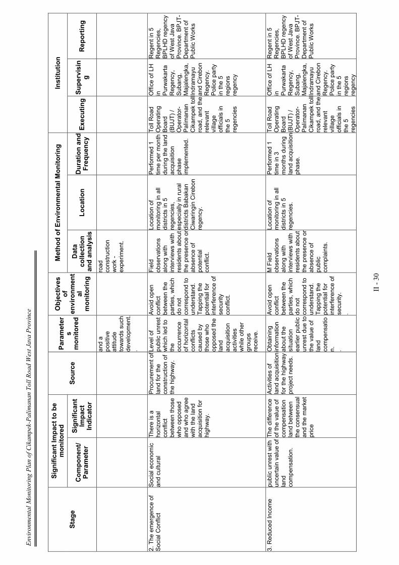
Environmental Monitoring Plan of Cikampek-Palimanan Toll Road West Java Province
II - 30
Stage
Significan
t Im
pact to be
monitored
Source
Param
eter
s monitored
Objectives
of
environmen
tal
monitoring
Method of Environmen
tal M
onitoring
Institution
Componen
t/
Param
eter
Significan
t Im
pact
Indicator
Data
collection
and analysis
Location
Duration and
Frequen
cy Exe
cuting S
upervisin
g
Rep
orting
and a
positive
attitude
towards such
development.
.
road
construction
work -
experiment.
2. The emergence of
Social Conflict
Social economic
and cultural
There is a
horizontal
conflict
between those
who opposed
and who agree
with the land
acquisition for
highway.
Procurement of
land for the
construction of
the highway.
Level of
public unrest
which led to
the
occurrence
of horizontal
conflicts
caused by
those who
opposed the
land
acquisition
activities
while other
groups
receive.
Avoid open
conflict
between the
parties, which
do not
correspond to
understand.
Tapping the
potential for
interference of
security
conflict.
Field
observations
along with
interviews with
residents about
the presence or
absence of
potential
conflict.
Location of
monitoring in all
districts in 5
regencies,
especially in rural
districts Babakan
Ciwaringin Cirebon
regency.
Performed 1
time per month
during the land
acquisition
phase
implemented.
Toll Road
Operating
Board
(BUJT) /
Operator-
Palimanan
Cikampek toll
road, and the
relevant
village
officials in
the 5
regencies
Office of LH
in Purwakarta
Regency,
Subang,
Majalengka,
Indramayu
and Cirebon
Regency.
Police party
in the 5
regions
regency
Regent in 5
Regencies,
BPLHD regency
of West Java
Province. BPJT-
Department of
Public Works
3. Reduced Income
public unrest with
uncertain value of
land
compensation.
The difference
of the value of
compensation
land between
the consensual
and the market
price
Activities of
land acquisition
for the highway
project needs.
Obtaining
information
about the
situation
earlier public
unrest due to
the value of
land
compensatio
n.
.
Avoid open
conflict
between the
parties, which
do not
correspond to
understand.
Tapping the
potential for
interference of
security.
.
M Field
observations
along with
interviews with
residents about
the presence or
absence of
public
complaints.
Location of
monitoring in all
districts in 5
regencies.
Performed 1
time in 3
months during
land acquisition
phase.
Toll Road
Operating
Board
(BUJT) /
Operator-
Palimanan
Cikampek toll
road, and the
relevant
village
officials in
the 5
regencies
Office of LH
in Purwakarta
Regency,
Subang,
Majalengka,
Indramayu
and Cirebon
Regency.
Police party
in the 5
regions
regency
Regent in 5
Regencies,
BPLHD regency
of West Java
Province. BPJT-
Department of
Public Works
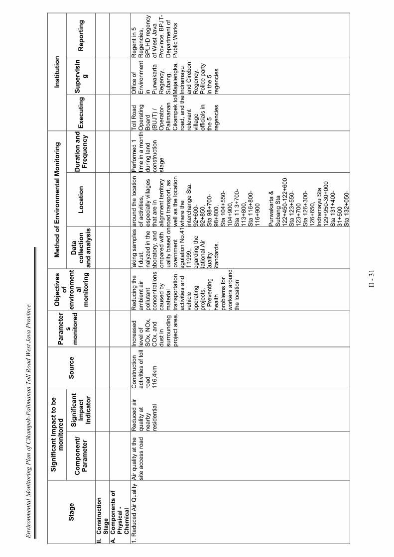
Environmental Monitoring Plan of Cikampek-Palimanan Toll Road West Java Province
II - 31
Stage
Significan
t Im
pact to be
monitored
Source
Param
eter
s monitored
Objectives
of
environmen
tal
monitoring
Method of Environmen
tal M
onitoring
Institution
Componen
t/
Param
eter
Significan
t Im
pact
Indicator
Data
collection
and analysis
Location
Duration and
Frequen
cy Exe
cuting S
upervisin
g
Rep
orting
II. Construction
Stage
A. Componen
ts of
Physical -
Chem
ical
1. Reduced Air Quality
Air quality at the
site access road Reduced air
quality at
nearby
residential
Construction
activities of toll
road
116,4km
Increased
level of
SOx, NOx,
COx, and
dust in
surrounding
project area. Reducing the
ambient air
pollutant
concentrations
caused by
material
transportation
activities and
vehicle
operating
projects.
- Preventing
health
problems for
workers around
the location
Taking samples
of dust,
analyzed in the
laboratory, and
compared with
quality based on
government
regulation No.41
of 1999,
regarding the
National Air
Quality
Standards.
around the location
of activities,
especially villages
that are in
alignment territory
road transport, as
well as the location
where the
interchange Sta.
92+600-
92+850,
Sta 98+700-
98+800,
Sta 104+550-
104+900,
Sta 11 3+700-
113+800,
Sta 116+800-
116+900
Purwakarta &
Subang Sta
122+450-122+600
Sta 123+550-
123+700
Sta 126+300-
126+650,
Indramayu Sta
129+950-30+000
Sta 131+400-
31+500
Sta 132+050-
Performed 1
time in a month
during land
construction
stage
Toll Road
Operating
Board
(BUJT) /
Operator-
Palimanan
Cikampek toll
road, and the
relevant
village
officials in
the 5
regencies
Office of
Environment
in Purwakarta
Regency,
Subang,
Majalengka,
Indramayu
and Cirebon
Regency.
Police party
in the 5
regencies
Regent in 5
Regencies,
BPLHD regency
of West Java
Province. BPJT-
Department of
Public Works

Environmental Monitoring Plan of Cikampek-Palimanan Toll Road West Java Province
II - 32
Stage
Significan
t Im
pact to be
monitored
Source
Param
eter
s monitored
Objectives
of
environmen
tal
monitoring
Method of Environmen
tal M
onitoring
Institution
Componen
t/
Param
eter
Significan
t Im
pact
Indicator
Data
collection
and analysis
Location
Duration and
Frequen
cy Exe
cuting S
upervisin
g
Rep
orting
32+150
Sta 132+300-
32+450
Sta 132+600-
32+700
Sta 136+700-
36+900
Sta l49+800-
149+950,
Majalengka Sta
158+450-
177+350.
Sta 180+300-
180+600
Sta 187+000-
187+400
Sta 188+200-
188+550
Sta 188+700-
189+000
189+800-190+200.
Sta 194+700-
194+800
Sta 198+000-
198+050
Sta 199+000-
199+250
Sta 199+900-
200+000
Sta 200+200-
200+400
Sta 200+600-
201+200
Sta 20 1+400-
201+500
Sta 202+400-
202+550
Sta 205+800-

Environmental Monitoring Plan of Cikampek-Palimanan Toll Road West Java Province
II - 33
Stage
Significan
t Im
pact to be
monitored
Source
Param
eter
s monitored
Objectives
of
environmen
tal
monitoring
Method of Environmen
tal M
onitoring
Institution
Componen
t/
Param
eter
Significan
t Im
pact
Indicator
Data
collection
and analysis
Location
Duration and
Frequen
cy Exe
cuting S
upervisin
g
Rep
orting
205+850
Sta 206+850-
207+000
Cirebon.
2. Increased Noise
The quality of
noise on the
access road
Increased noise transportation
vehicles in
addition to
materials and
activities and
operation base
camp, also a
result of project
vehicles
carrying
construction
workers out of
the project.
.
Levels of
noise in
residential
areas and
also in
certain
locations that
are
considered
important to
monitor such
as the
location of
plantations
and rice
fields
associated
with
terrestrial
fauna..
Reducing the
concentration
of noise
generated from
transportation
activities and
vehicle
operating
materials
project.
- Preventing
health
problems for
workers around
the location of
the dam which
caused the
noise.
.
Direct
observation in
the field to
determine the
concentration
of noise that
occurs as
compared with
the Threshold
Value
permitted in
accordance
with
Kep.MenLH
No. Kep-
48/MENLH/l 1 /
1998
around the location
of activities,
especially villages
that are in
alignment territory
road transport, as
well as the location
where the
interchange Sta.
92+600-
92+850,
Sta 98+700-
98+800,
Sta 104+550-
104+900,
Sta 11 3+700-
113+800,
Sta 116+800-
116+900
Purwakarta &
Subang Sta
122+450-122+600
Sta 123+550-
123+700
Sta 126+300-
126+650,
Indramayu Sta
129+950-30+000
Sta 131+400-
31+500
Sta 132+050-
32+150
Sta 132+300-
Performed 1
time in a month
during land
construction
stage
Toll Road
Operating
Board
(BUJT) /
Operator-
Palimanan
Cikampek toll
road, and the
relevant
village
officials in
the 5
regencies
Office of
Environment
in Purwakarta
Regency,
Subang,
Majalengka,
Indramayu
and Cirebon
Regency.
Police party
in the 5
regencies
Regent in 5
Regencies,
BPLHD regency
of West Java
Province. BPJT-
Department of
Public Works
Environmental Monitoring Plan of Cikampek-Palimanan Toll Road West Java Province
II - 34
Stage
Significan
t Im
pact to be
monitored
Source
Param
eter
s monitored
Objectives
of
environmen
tal
monitoring
Method of Environmen
tal M
onitoring
Institution
Componen
t/
Param
eter
Significan
t Im
pact
Indicator
Data
collection
and analysis
Location
Duration and
Frequen
cy Exe
cuting S
upervisin
g
Rep
orting
32+450
Sta 132+600-
32+700
Sta 136+700-
36+900
Sta l49+800-
149+950,
Majalengka Sta
158+450-
177+350.
Sta 180+300-
180+600
Sta 187+000-
187+400
Sta 188+200-
188+550
Sta 188+700-
189+000
189+800-190+200.
Sta 194+700-
194+800
Sta 198+000-
198+050
Sta 199+000-
199+250
Sta 199+900-
200+000
Sta 200+200-
200+400
Sta 200+600-
201+200
Sta 20 1+400-
201+500
Sta 202+400-
202+550
Sta 205+800-
205+850
Sta 206+850-
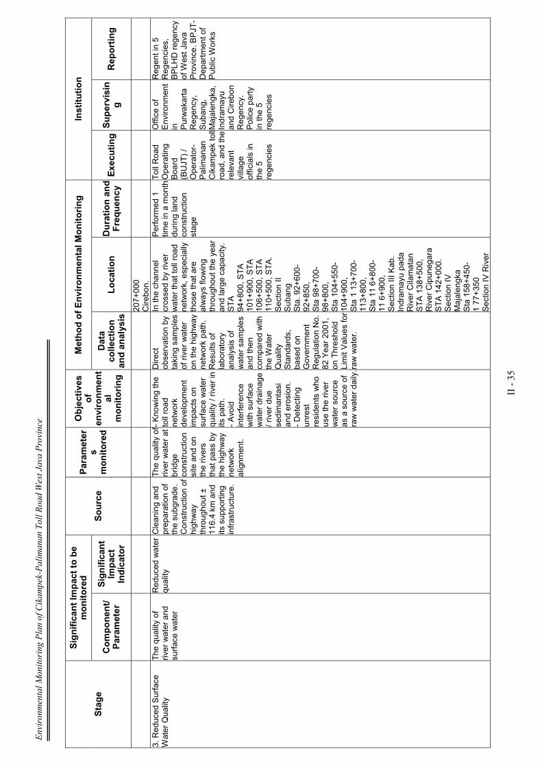
Environmental Monitoring Plan of Cikampek-Palimanan Toll Road West Java Province
II - 35
Stage
Significan
t Im
pact to be
monitored
Source
Param
eter
s monitored
Objectives
of
environmen
tal
monitoring
Method of Environmen
tal M
onitoring
Institution
Componen
t/
Param
eter
Significan
t Im
pact
Indicator
Data
collection
and analysis
Location
Duration and
Frequen
cy Exe
cuting S
upervisin
g
Rep
orting
207+000
Cirebon.
3. Reduced Surface
Water Quality
The quality of
river water and
surface water
Reduced water
quality
Cleaning and
preparation of
the subgrade.
Construction of
highway
throughout ±
116.4 km and
its supporting
infrastructure.
The quality of
river water at
bridge
construction
site and on
the rivers
that pass by
the highway
network
alignment.
- Knowing the
toll road
network
development
impacts on
surface water
quality / river in
its path.
- Avoid
interference
with surface
water drainage
/ river due
sedimantasi
and erosion.
- Detecting
unrest
residents who
use the river
water source
as a source of
raw water daily.
Direct
observation by
taking samples
of river water
on the highway
network path.
Results of
laboratory
analysis of
water samples
and then
compared with
the Water
Quality
Standards,
based on
Government
Regulation No.
82 Year 2001,
on Threshold
Limit Values for
raw water.
In the channel
crossed by river
water that toll road
network, especially
those that are
always flowing
throughout the year
and large capacity.
STA
94+800, STA
101+900, STA
106+500, STA
110+500, STA.
Section II
Subang
Sta. 92+600-
92+850,
Sta 98+700-
98+800,
Sta 104+550-
104+900,
Sta 1 13+700-
113+800,
Sta 11 6+800-
11 6+900,
Section III Kab.
Indramayu pada
River Cilamatan
STA 138+500,
River Cipunegara
STA 142+000.
Section IV
Majalengka
Sta 158+450-
1 77+350
Section IV River
Performed 1
time in a month
during land
construction
stage
Toll Road
Operating
Board
(BUJT) /
Operator-
Palimanan
Cikampek toll
road, and the
relevant
village
officials in
the 5
regencies
Office of
Environment
in Purwakarta
Regency,
Subang,
Majalengka,
Indramayu
and Cirebon
Regency.
Police party
in the 5
regencies
Regent in 5
Regencies,
BPLHD regency
of West Java
Province. BPJT-
Department of
Public Works
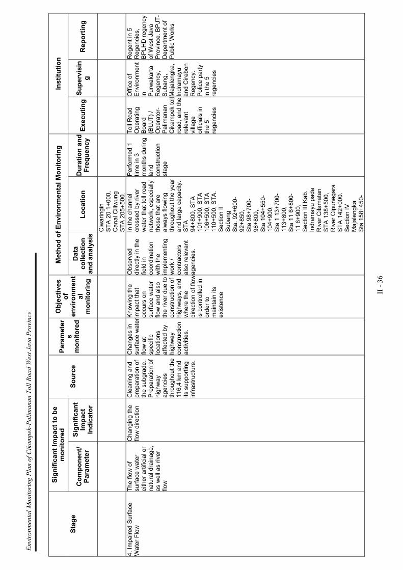
Environmental Monitoring Plan of Cikampek-Palimanan Toll Road West Java Province
II - 36
Stage
Significan
t Im
pact to be
monitored
Source
Param
eter
s monitored
Objectives
of
environmen
tal
monitoring
Method of Environmen
tal M
onitoring
Institution
Componen
t/
Param
eter
Significan
t Im
pact
Indicator
Data
collection
and analysis
Location
Duration and
Frequen
cy Exe
cuting S
upervisin
g
Rep
orting
Ciwaringin
STA 20 1+000,
Canal Ciliwung
STA 205+500.
4. Impaired Surface
Water Flow
The flow of
surface water
either artificial or
natural drainage,
as well as river
flow
Changing the
flow direction Cleaning and
preparation of
the subgrade.
Preparation of
highway
agencies
throughout the
116,4 km and
its supporting
infrastructure.
Changes in
surface water
flow at
specific
locations
affected by
highway
construction
activities.
Knowing the
impact that
occurs on
surface water
flow and also
the river due to
construction of
highways, and
where the
direction of flow
is controlled in
order to
maintain its
existence
Observed
directly in the
field in
coordination
with the
implementing
work /
contractors
also relevant
agencies.
In the channel
crossed by river
water that toll road
network, especially
those that are
always flowing
throughout the year
and large capacity.
STA
94+800, STA
101+900, STA
106+500, STA
110+500, STA.
Section II
Subang
Sta. 92+600-
92+850,
Sta 98+700-
98+800,
Sta 104+550-
104+900,
Sta 1 13+700-
113+800,
Sta 11 6+800-
11 6+900,
Section III Kab.
Indramayu pada
River Cilamatan
STA 138+500,
River Cipunegara
STA 142+000.
Section IV
Majalengka
Sta 158+450-
Performed 1
time in 3
months during
land
construction
stage
Toll Road
Operating
Board
(BUJT) /
Operator-
Palimanan
Cikampek toll
road, and the
relevant
village
officials in
the 5
regencies
Office of
Environment
in Purwakarta
Regency,
Subang,
Majalengka,
Indramayu
and Cirebon
Regency.
Police party
in the 5
regencies
Regent in 5
Regencies,
BPLHD regency
of West Java
Province. BPJT-
Department of
Public Works
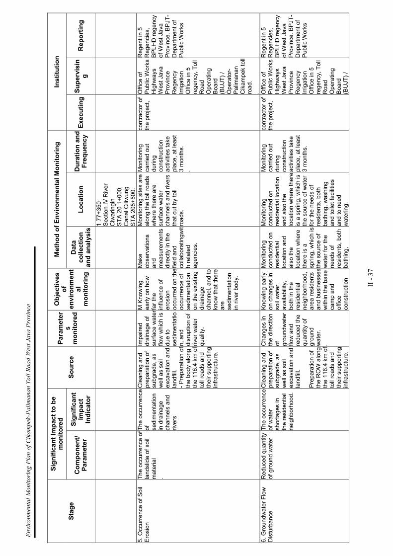
Environmental Monitoring Plan of Cikampek-Palimanan Toll Road West Java Province
II - 37
Stage
Significan
t Im
pact to be
monitored
Source
Param
eter
s monitored
Objectives
of
environmen
tal
monitoring
Method of Environmen
tal M
onitoring
Institution
Componen
t/
Param
eter
Significan
t Im
pact
Indicator
Data
collection
and analysis
Location
Duration and
Frequen
cy Exe
cuting S
upervisin
g
Rep
orting
1 77+350
Section IV River
Ciwaringin
STA 20 1+000,
Canal Ciliwung
STA 205+500.
5. Occurrence of Soil
Erosion
The occurrence of
landslide of soil
material
.
The occurrence
of
sedimentation
in drainage
channels and
rivers
Cleaning and
preparation of
subgrade, as
well as soil
excavation and
landfill.
- Preparation of
the body along
the 116.4 km of
toll roads and
their supporting
infrastructure.
Impaired
drainage of
surface water
flow which is
due to
sedimentatio
n, and
disruption of
river water
quality.
M Knowing
early on how
far the
influence of
erosion
occurred on the
occurrence of
sedimentation
on the existing
drainage
channel, and to
know that there
are
sedimentation
in river body.
Make
observations
and
measurements
directly in the
field and
collaboratingwit
h related
agencies.
Monitoring sites are
along the toll roads
where there are
surface water
channels and rivers
that cut by toll
roads.
Monitoring
carried out
during
construction
activities take
place, at least
3 months.
.
contractor of
the project,
Office of
Public Works
Highways
West Java
Province
Regency
Irrigation
Office in 5
regency, Toll
Road
Operating
Board
(BUJT) /
Operator-
Palimanan
Cikampek toll
road.
.
Regent in 5
Regencies,
BPLHD regency
of West Java
Province. BPJT-
Department of
Public Works
6. Groundwater Flow
Disturbance
Reduced quantity
of ground water The occurrence
of water
shortages in
the residential
neighborhood.
Cleaning and
preparation of
subgrade, as
well as soil
excavation and
landfill.
Preparation of
the ROW along
the 116.4 km of
toll roads and
their supporting
infrastructure.
Changes in
the direction
of
groundwater
flow and
reduced the
quantity of
ground
water.
.
Knowing early
on changes in
soil water
availability,
both in the
residential
neighborhood,
area residents
and businesses
within the base
camp and
office
construction
Monitoring
conducted on
residential
location and
also the
location where
there is a
spring, which is
the source of
water for the
needs of
residents, both
bathing,
Monitoring
conducted on
residential location
and also the
location where there
is a spring, which is
the source of water
for the needs of
residents, both
bathing, washing
and toilet facilities
and to need
watering.
Monitoring
carried out
during
construction
activities take
place, at least
3 months.
contractor of
the project,
Office of
Public Works
Highways
West Java
Province
Regency
Irrigation
Office in 5
regency, Toll
Road
Operating
Board
(BUJT) /
Regent in 5
Regencies,
BPLHD regency
of West Java
Province. BPJT-
Department of
Public Works
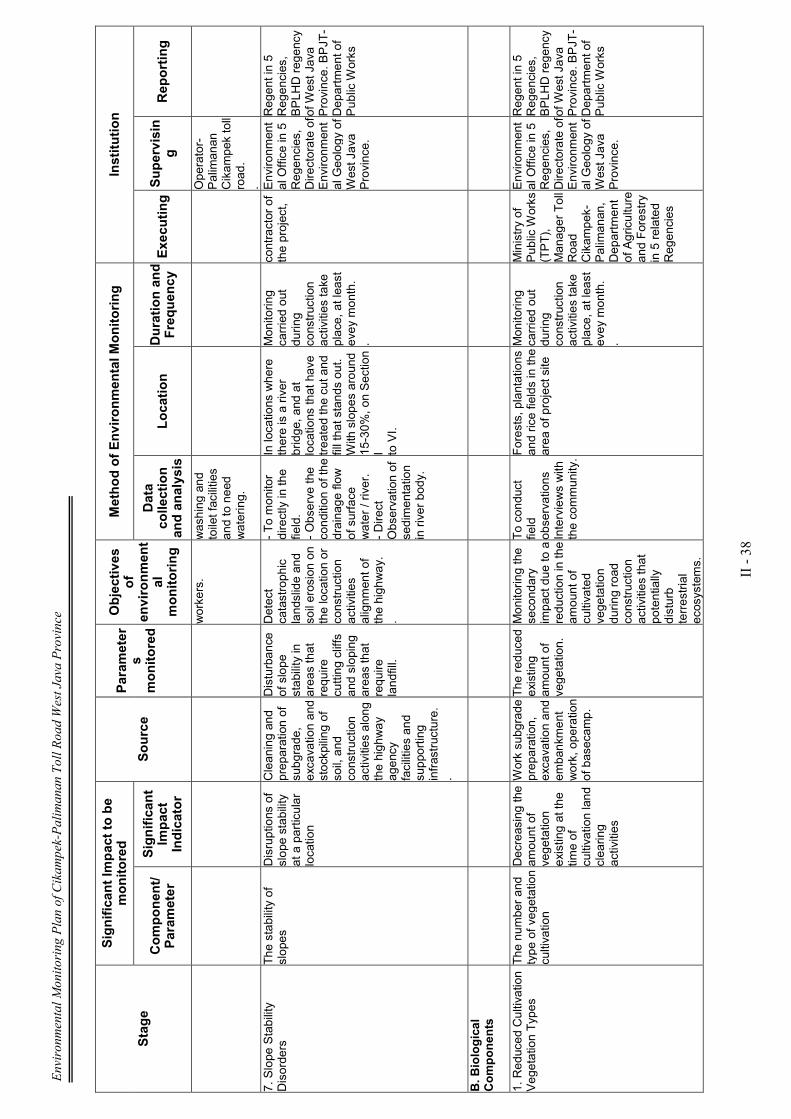
Environmental Monitoring Plan of Cikampek-Palimanan Toll Road West Java Province
II - 38
Stage
Significan
t Im
pact to be
monitored
Source
Param
eter
s monitored
Objectives
of
environmen
tal
monitoring
Method of Environmen
tal M
onitoring
Institution
Componen
t/
Param
eter
Significan
t Im
pact
Indicator
Data
collection
and analysis
Location
Duration and
Frequen
cy Exe
cuting S
upervisin
g
Rep
orting
workers.
washing and
toilet facilities
and to need
watering.
Operator-
Palimanan
Cikampek toll
road.
. 7. Slope Stability
Disorders
The stability of
slopes
Disruptions of
slope stability
at a particular
location
Cleaning and
preparation of
subgrade,
excavation and
stockpiling of
soil, and
construction
activities along
the highway
agency
facilities and
supporting
infrastructure.
.
Disturbance
of slope
stability in
areas that
require
cutting cliffs
and sloping
areas that
require
landfill.
Detect
catastrophic
landslide and
soil erosion on
the location or
construction
activities
alignment of
the highway.
.
- To monitor
directly in the
field.
- Observe the
condition of the
drainage flow
of surface
water / river.
- Direct
Observation of
sedimentation
in river body.
In locations where
there is a river
bridge, and at
locations that have
treated the cut and
fill that stands out.
With slopes around
15-30%, on Section
I to VI.
Monitoring
carried out
during
construction
activities take
place, at least
evey month.
.
contractor of
the project,
Environment
al Office in 5
Regencies,
Directorate of
Environment
al Geology of
West Java
Province.
Regent in 5
Regencies,
BPLHD regency
of West Java
Province. BPJT-
Department of
Public Works
B. B
iological
Componen
ts
1. Reduced Cultivation
Vegetation Types
The number and
type of vegetation
cultivation
Decreasing the
amount of
vegetation
existing at the
time of
cultivation land
clearing
activities
Work subgrade
preparation,
excavation and
embankment
work, operation
of basecamp.
The reduced
existing
amount of
vegetation.
Monitoring the
secondary
impact due to a
reduction in the
amount of
cultivated
vegetation
during road
construction
activities that
potentially
disturb
terrestrial
ecosystems.
To conduct
field
observations
Interviews with
the community.
Forests, plantations
and rice fields in the
area of project site
Monitoring
carried out
during
construction
activities take
place, at least
evey month.
.
Ministry of
Public Works
(TPT),
Manager Toll
Road
Cikampek-
Palimanan,
Department
of Agriculture
and Forestry
in 5 related
Regencies
Environment
al Office in 5
Regencies,
Directorate of
Environment
al Geology of
West Java
Province.
Regent in 5
Regencies,
BPLHD regency
of West Java
Province. BPJT-
Department of
Public Works
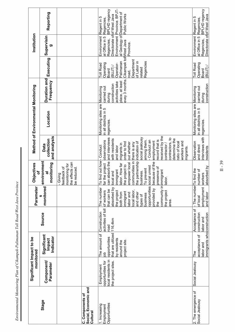
Environmental Monitoring Plan of Cikampek-Palimanan Toll Road West Java Province
II - 39
Stage
Significan
t Im
pact to be
monitored
Source
Param
eter
s monitored
Objectives
of
environmen
tal
monitoring
Method of Environmen
tal M
onitoring
Institution
Componen
t/
Param
eter
Significan
t Im
pact
Indicator
Data
collection
and analysis
Location
Duration and
Frequen
cy Exe
cuting S
upervisin
g
Rep
orting
- Giving
feedback of
monitoring for
the effects can
be reduced.
C. C
omponen
ts of
Social, E
conomic and
Cultural
1. Increasing
Employment
Opportunities
: Employment
opportunities for
local residents in
the project sites.
The amount of
job opportunities
that are utilized
by residents
around the
project site.
Construction
activities of toll
road
116,4km
The number
of workers
that can be
absorbed by
the project
both from
immigrant
labor and
local labor,
and other
types of
business
opportunities
provided by
the
community in
the project
area.
To find out how
far the project
can absorb the
local and
immigrant
labor. How far
the project to
empower local
communities in
the partnership
business.
To prevent
social unrest
because of the
presence of
immigrant
labor.
- Conduct
observations
and interviews
with residents
and labor
migrants in
order to find
out whether
there is any
indication of
social jealousy
among them.
- Conduct an
employment
record that is
received by the
contractor /
contractors, to
determine the
ratio of local
workers and
migrants.
Monitoring sites are
in all districts in 5
regencies.
Monitoring
carried out
during
construction
activities take
place, at least
evey 3 months.
Toll Road
Operating
Board
(BUJT) /
Operator-
Palimanan
Cikampek toll
road,
Department
of Labor in
related
Regencies
Environment
al Office in 5
Regencies,
Directorate of
Environment
al Geology of
West Java
Province.
Regent in 5
Regencies,
BPLHD regency
of West Java
Province. BPJT-
Department of
Public Works
2. The emergence of
Social Jealousy
Social Jealousy
The
acceptance of
labor and
immigrants who Acceptance of
construction
labor and
construction
- The number
of local
employment
and labor
To find the
number of
workers
absorbed by
Observation
and direct
interviews with
residents
Monitoring sites are
in all districts in 5
regencies.
Monitoring
carried out
during
construction
Toll Road
Operating
Board
(BUJT) /
Environment
al Office in 5
Regencies,
Directorate of Regent in 5
Regencies,
BPLHD regency
of West Java

Environmental Monitoring Plan of Cikampek-Palimanan Toll Road West Java Province
II - 40
Stage
Significan
t Im
pact to be
monitored
Source
Param
eter
s monitored
Objectives
of
environmen
tal
monitoring
Method of Environmen
tal M
onitoring
Institution
Componen
t/
Param
eter
Significan
t Im
pact
Indicator
Data
collection
and analysis
Location
Duration and
Frequen
cy Exe
cuting S
upervisin
g
Rep
orting
are not in
balance with
local
recruitment..
services
business
partnership
activities.
.
migrants
working in
the project.
- Opportunity
to have
partnership
efforts
between the
local
business
community
with the
project.
the project
during the
construction
phase and
magnitude of
energy
absorption of
local projects.
around, and
with village
officials in the
district is also
related to the
project to get
an idea of
employment
and business
opportunities
that can be
filled by local
communities.
activities take
place, at least
evey month.
Palimanan
Cikampek toll
road
Operator,
Social
Service in 5
regions
Regency
Environment
al Geology of
West Java
Province.
Province. BPJT-
Department of
Public Works
3. Increased Business
Opportunities
Employment
opportunities.
The amount of
job opportunities to
surrounding
people.
Implementation
of highway
construction
and the
supporting
infrastructure
facilities along
the 116.4 km.
The number
of workers
that can be
absorbed by
the project
both from
immigrant
labor and
local labor,
and other
types of
business
opportunities
provided by
the
community in
the project
area.
.
- To know how
far the project
can absorb the
local and
immigrant
labor.
- How far the
project to
empower local
communities in
the partnership
business.
- To prevent
social unrest
because of the
presence of
immigrant
labor.
Conduct
observations
and interviews
with residents
and labor
migrants in
order to find
out whether
there is any
indication of
social jealousy
among them.
To examine
employment
records
received by the
contractor /
contractors, to
determine the
ratio of local
workers and
migrants.
Conducted in all
districts in the 5
related regencies.
From Section I
to Section VI.
Monitoring
carried out
during
construction
activities take
place, at least
evey 3 months.
Toll Road
Operating
Board
(BUJT) /
Palimanan
Cikampek
Toll-Operator Environment
al Office in 5
Regencies,
Directorate of
Environment
al Geology of
West Java
Province.
Regent in 5
Regencies,
BPLHD regency
of West Java
Province. BPJT-
Department of
Public Works
Environmental Monitoring Plan of Cikampek-Palimanan Toll Road West Java Province
II - 41
Stage
Significan
t Im
pact to be
monitored
Source
Param
eter
s monitored
Objectives
of
environmen
tal
monitoring
Method of Environmen
tal M
onitoring
Institution
Componen
t/
Param
eter
Significan
t Im
pact
Indicator
Data
collection
and analysis
Location
Duration and
Frequen
cy Exe
cuting S
upervisin
g
Rep
orting
4. Traffic disruption
Disordered Traffic The occurrence
of traffic
congestion and
disruption on
public roads in
the village
street.
.
Implementation
of highway
construction
and the
supporting
infrastructure
facilities along
the 116.4 km,
and the
mobilization of
heavy vehicles
of the project.
The condition
of traffic jams
and other
disturbances
that occur on
roads that
became the
route of
transportatio
n projects
and traffic
disruption on
the village
road access.
.
- To find out
how much the
project may
affect traffic
conditions.
- Knowing the
earliest
possible
disruption of
traffic
conditions
before they
become
sources of
public unrest.
- To prevent
social unrest
because of the
presence of t
vehicle on a
public road
projects.
.
Conduct
observations
and interviews
with residents
and road users
society, social
unrest and find
data that occur
in the project
environment.
To examine a
record number
of vehicles
received by the
contractor /
contractors, in
order to
compare the
number of
vehicles and
public transport
projects.
Conducted in all
road vehicle
through which funds
projects in areas of
Islamic boarding
school in Babakan
Ciwaringin STA 200
+700 s / d STA 201
+055.
Monitoring
carried out
during
operation stage
activities take
place, at least
evey 3 months.
Toll Road
Operating
Board
(BUJT) /
Palimanan
Cikampek
Toll-Operator Environment
al Office in 5
Regencies,
Directorate of
Environment
al Geology of
West Java
Province.
Regent in 5
Regencies,
BPLHD regency
of West Java
Province. BPJT-
Department of
Public Works
Environmental Monitoring Plan of Cikampek-Palimanan Toll Road West Java Province
II - 42
Stage
Significan
t Im
pact to be
monitored
Source
Param
eter
s monitored
Objectives
of
environmen
tal
monitoring
Location
Method of Environmen
tal M
onitoring
Institution
Componen
t/
Param
eter
Significan
t Im
pact
Indicator
Duration and
Frequen
cy
Location
Duration and
Frequen
cy Exe
cuting Supervisin
g
Rep
orting
5. Damage to Public
Roads (Local Roads /
Village)
public unrest
Damage to
public roads
used as access
roads by the
project
.
Land clearing
and
preparation of
basic soil
preparation is
also base
camp for
highway
construction
needs.
Traffic
density and
speed of
construction
materials
transport
vehicle, as
well as
volume and
length of
roads were
damaged.
- To obtain
information in
order to
improve the
management
system when
creating ACTs
are not
allowed.
- Calculate the
distance of
road damage
on the location
of access road
transport.
Analyzing the
causes of
damage to
access roads.
.
Calculating the
burden of
transportation
vehicles and
materials
tailored to the
class path by
considering the
burden that is
allowed.
Provide speed
limit of vehicles
through the
access road
transport
materials for
the project.
Monitoring sites are
in all districts in 5
regencies,
especially access
roads used as
vehicle
transportation route
of construction
materials.
.
1 time per
month during
construction
work.
Toll Road
Operating
Board
(BUJT) /
Palimanan
Cikampek
Toll-Operator Environment
al Office in 5
Regencies,
Directorate of
Environment
al Geology of
West Java
Province.
Regent in 5
Regencies,
BPLHD regency
of West Java
Province. BPJT-
Department of
Public Works
6. Damage to Public
Utilities (Water Pipe)
Damage to
infrastructure and
public utilities.
.
Disorders of
service.
Highway
construction
activities such
as excavation,
disposal and
land clearing.
Disruption of
performance
of public
utilities such
as PLN,
PDAM, gas
pipelines,
irrigation
channels,
Telkom and
others.
.
Knowing the
early disruption
of public
utilities
infrastructure
contained in
the study area.
To review
directly to the
field at the
point where
there is a
contradiction
with the public
utility
concerned.
Monitoring sites are
along the highways,
especially at
locations that are
crossing with the
utility lines/
channels.
1 time per
month during
construction
work.
Toll Road
Operating
Board
(BUJT) /
Palimanan
Cikampek
Toll-Operator Environment
al Office in 5
Regencies,
Directorate of
Environment
al Geology of
West Java
Province.
Regent in 5
Regencies,
BPLHD regency
of West Java
Province. BPJT-
Department of
Public Works
Environmental Monitoring Plan of Cikampek-Palimanan Toll Road West Java Province
II - 43
Stage
Significan
t Im
pact to be
monitored
Source
Param
eter
s monitored
Objectives
of
environmen
tal
monitoring
Location
Method of Environmen
tal M
onitoring
Institution
Componen
t/
Param
eter
Significan
t Im
pact
Indicator
Duration and
Frequen
cy
Location
Duration and
Frequen
cy Exe
cuting Supervisin
g
Rep
orting
7. Damage to Social
Facilities and Public
Facilities
The existence of
public facilities
and social
amenities.
Diminishing the
existence of
social and
public facilities Activities of
land acquisition
for construction
of the highway.
Public unrest
due to
reduction in
the presence
of public
facilities and
social
environment.
Knowing how
big the need for
social facilities
and public
facilities such
as mosques,
schools,
neighborhood
health center in
rural areas, so
that people's
aspirations can
be
accommodated
from the outset.
.
Direct
observation in
the field by
doing the data
collection for
the facility is
lost and how
much should
be replaced or
rebuilt and new
development
location.
Residential areas,
residents who have
social facilities and
public facilities
affected by the
project.
1 time per 3
months during
construction
work.
.
Toll Road
Operating
Board
(BUJT) /
Palimanan
Cikampek
Toll-Operator Environment
al Office in 5
Regencies,
Directorate of
Environment
al Geology of
West Java
Province.
Regent in 5
Regencies,
BPLHD regency
of West Java
Province. BPJT-
Department of
Public Works
3. Post-Construction
Stage
(Operations)
A. C
omponen
ts of
Physical - Chem
ical
1. Reduced Air Quality
Air quality in
environmental toll
roads
Reduced air
quality at
nearby
settlements.
exhaust
emissions from
other vehicles
through the
village street
and road
regency as
lane road used
to transport
people and
goods to and
from the
highway.
- Increasing
levels of
SOx, NOx,
COx, and
particulate
dust in the air
around the
study area.
- Negative
perceptions
surrounding
community
access roads
used to
- Reducing the
concentration
of ambient air
pollutants
generated from
transportation
activities of
people and
goods through
road approach
that uses a toll
or toll roads.
- Preventing
health
Make
observations
and
measurements
directly in the
field at certain
points
representing.
Perform
laboratory
analysis of the
results of field
measurements
of air samples.
In and around the
location of activities,
in particular villages
in the area of the
highway alignment,
as well as the
location where the
interchange.
c). Duration and
frequency of
monitoring
1 time in 6
months during
operation of toll
roads
Cikampek-
Palimanan
progress.
Toll Road
Operating
Board
(BUJT) /
Palimanan
Cikampek
Toll-Operator Environment
al Office in 5
Regencies,
Directorate of
Environment
al Geology of
West Java
Province.
Regent in 5
Regencies,
BPLHD regency
of West Java
Province. BPJT-
Department of
Public Works
Environmental Monitoring Plan of Cikampek-Palimanan Toll Road West Java Province
II - 44
Stage
Significan
t Im
pact to be
monitored
Source
Param
eter
s monitored
Objectives
of
environmen
tal
monitoring
Location
Method of Environmen
tal M
onitoring
Institution
Componen
t/
Param
eter
Significan
t Im
pact
Indicator
Duration and
Frequen
cy
Location
Duration and
Frequen
cy Exe
cuting Supervisin
g
Rep
orting
transport
materials and
building
materials.
- Layers of
dust visible in
the
precarious
and houses
are also on
the leaves at
the curb.
problems for
workers and
communities
around the
location of toll
activities that
are near the toll
road and
interchange.
Take air
samples,
analyzed in the
laboratory, and
compared with
standard PPRI
No.41 of 1999,
regarding the
National Air
Quality
Standards.
2. Increased Noise
Air quality noise
at the location of
the building
material
transportation
access alignment.
Increased noise
at the location
of access road
transport
material.
- Activities of
clearing land
and making the
driveway.
- The operation
of the base
camp.
K Air quality
conditions,
particularly
noise at
residential
locations.
- To find
elevated levels
of noise
- To know the
level of
successful
management
- Make noise
measurements
with a sound
level meter
- Comparing
the
measurements
with Threshold
Value
permitted in
accordance
with Ministry of
Environment
Decree No.
Kep-
48/MENLH/11/
1998.
At the beginning of
the project until the
end of the project,
especially on
settlements.
Sta. 92+600-
92+850,
Sta 98+700-
98+800,
Sta 104+550-
104+900,
Sta 11 3+700-
1 13+800,
Sta 1 16+800-
116+900.
1 time in 6
months during
operation of toll
roads
Cikampek-
Palimanan
progress.
Toll Road
Operating
Board
(BUJT) /
Palimanan
Cikampek
Toll-Operator Environment
al Office in 5
Regencies,
Directorate of
Environment
al Geology of
West Java
Province.
Regent in 5
Regencies,
BPLHD regency
of West Java
Province. BPJT-
Department of
Public Works
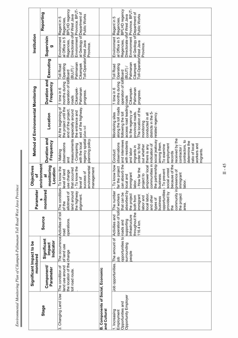
Environmental Monitoring Plan of Cikampek-Palimanan Toll Road West Java Province
II - 45
Stage
Significan
t Im
pact to be
monitored
Source
Param
eter
s monitored
Objectives
of
environmen
tal
monitoring
Location
Method of Environmen
tal M
onitoring
Institution
Componen
t/
Param
eter
Significan
t Im
pact
Indicator
Duration and
Frequen
cy
Location
Duration and
Frequen
cy Exe
cuting Supervisin
g
Rep
orting
3. Changing Land Use
The condition of
land use around
the location of the
toll road route.
.
The occurrence
of land use
change
Activities of toll
road
operations.
The condition
of the
allotment of
land around
the highway
alignment.
- To know the
level of land
use change
that occurred
- To know the
level of
success of
environmental
management
- Making
observations
and
measurements
- Comparing
with the local
regency spatial
planning policy.
At the beginning of
the project until the
end of the project,
especially around
the entrance and
exit of the highway.
jalan tol
1 time in 6
months during
operation of toll
roads
Cikampek-
Palimanan
progress.
Toll Road
Operating
Board
(BUJT) /
Palimanan
Cikampek
Toll-Operator Environment
al Office in 5
Regencies,
Directorate of
Environment
al Geology of
West Java
Province.
Regent in 5
Regencies,
BPLHD regency
of West Java
Province. BPJT-
Department of
Public Works
B. C
omponen
ts of Social, E
conomic
and Cultural
1. Increasing
Employment
Opportunities and
Opportunity Employer
Job opportunities. The amount of
job opportunities to
surrounding
people
Activities and
operation of toll
roads and
supporting
infrastructure
throughout the
116.4 km.
The number
of workers
that can be
absorbed by
the project
both from
immigrant
labor and
local labor,
and other
types of
business
opportunities
provided by
the
community in
the project
area.
- To know how
far the project
can absorb the
local and
immigrant
labor.
- How far the
project to
empower local
communities in
the partnership
business.
- To prevent
social unrest
because of the
presence of
immigrant
labor.
Conduct
observations
and interviews
with residents
and labor
migrants in
order to find
out whether
there is any
indication of
social jealousy
among them.
To examine
employment
records
received by the
contractor /
contractors, to
determine the
ratio of local
workers and
migrants.
Monitoring sites
along the toll roads
following the toll
access road leading
to the regency or
provincial roads.
The location of the
monitoring
conducted in all
districts in the 5-
related regency.
1 time in 6
months during
operation of toll
roads
Cikampek-
Palimanan
progress.
Toll Road
Operating
Board
(BUJT) /
Palimanan
Cikampek
Toll-Operator Environment
al Office in 5
Regencies,
Directorate of
Environment
al Geology of
West Java
Province.
Regent in 5
Regencies,
BPLHD regency
of West Java
Province. BPJT-
Department of
Public Works

Environmental Monitoring Plan of Cikampek-Palimanan Toll Road West Java Province
II - 46
Stage
Significan
t Im
pact to be
monitored
Source
Param
eter
s monitored
Objectives
of
environmen
tal
monitoring
Location
Method of Environmen
tal M
onitoring
Institution
Componen
t/
Param
eter
Significan
t Im
pact
Indicator
Duration and
Frequen
cy
Location
Duration and
Frequen
cy Exe
cuting Supervisin
g
Rep
orting
2. Public Perception
The Economy in
community
around the study
location.
The creation of
businesses and
new jobs
The operations
of toll roads
and facilities
and supporting
infrastructure.
- The
opening of
the
employment
and new
business
places for
farming
communities
around the
study area,
due to the
operation of
toll roads
Cikampek-
Palimanan.
- Increased
incomes in
the study
area and
around the
study sites.
Knowing the
public
perception in
the study area
and around the
study sites, as
well as
business that
flourished in
the villages
with the Toll
Road, as well
as helped by
the facilities of
the local
economy was
built on the toll
roads like the
rest area.
- Interview with
village chief
and sub-district
heads and sub-
district, and
villages in the
district whose
territory a place
other resort
locations
highway (rest
area).
- Conduct
analysis of data
from source
data obtained
from relevant
agencies such
as Department
of Agriculture
and of Section
Regencies.
)
Monitoring
conducted on
neighborhoods
where residents
whose territory is
affected by the toll
road alignment from
the beginning to the
end of the project.
At the location of
Islamic Boarding
School of Babakan
Ciwaringin STA 200
+700 s / d STA 201
+055.
1 time in 6
months during
operation of toll
roads
Cikampek-
Palimanan
progress.
Toll Road
Operating
Board
(BUJT) /
Palimanan
Cikampek
Toll-Operator Environment
al Office in 5
Regencies,
Directorate of
Environment
al Geology of
West Java
Province.
Regent in 5
Regencies,
BPLHD regency
of West Java
Province. BPJT-
Department of
Public Works