Draft Environmental Assessment · List of Acronyms . ACHP Advisory ... Field Manager Klamath Falls...
41
New Cingular-AT&T Cell Tower at Harpold Pit ENVIRONMENTAL ASSESSMENT (#DOI-BLM-OR-L040-2009-0021-EA) UNITED STATES DEPARTMENT OF THE INTERIOR BUREAU OF LAND MANAGEMENT LAKEVIEW DISTRICT - Klamath Falls Resource Area ABSTRACT: This environmental assessment analyzes the construction of an unstaffed telecommunications facility consisting of a 150-foot self-supporting lattice tower, a three-sector antenna array with four antennas per sector, and a 12-foot-by-26-foot equipment shelter within the 60-foot-by-60 foot project site. In addition to the cell tower, the Proposed Action would include access road improvements, a 6,610-foot underground power run, and a 4,776-foot power and telco trench that would extend along the 0.50-mile natural surface and chipsealed access road leading to the project site. The proposed power trench would also extend for 1,835 feet along North Poe Valley Road. FOR FURTHER INFORMATION CONTACT: Klamath Falls Resource Area, BLM 2795 Anderson Avenue, Bldg. 25 Klamath Falls, OR 97603 541-883-6916 FREEDOM OF INFORMATION ACT AND RESPONDENT’S PERSONAL PRIVACY INTERESTS: The U.S. Bureau of Land Management is soliciting comments on this environmental assessment. Comments, including names and street addresses of respondents, will be available for public review at the above address during regular business hours. Individual respondents may request confidentiality. If you wish to withhold your name or street address from public review or from disclosure under the Freedom of Information Act, you must state this prominently at the beginning of your written comment. Such requests will be honored to the extent allowed by law. All submissions from organizations or businesses, and from individuals identifying themselves as representatives or officials of organizations or businesses, will be made available for public inspection in their entirety.
-
Upload
nguyenthien -
Category
Documents
-
view
219 -
download
0
Transcript of Draft Environmental Assessment · List of Acronyms . ACHP Advisory ... Field Manager Klamath Falls...
New Cingular-AT&T Cell Tower at Harpold Pit
ENVIRONMENTAL ASSESSMENT (#DOI-BLM-OR-L040-2009-0021-EA)
UNITED STATES DEPARTMENT OF THE INTERIOR
BUREAU OF LAND MANAGEMENT
LAKEVIEW DISTRICT - Klamath Falls Resource Area
ABSTRACT: This environmental assessment analyzes the construction of an unstaffed telecommunications facility consisting of a 150-foot self-supporting lattice tower, a three-sector antenna array with four antennas per sector, and a 12-foot-by-26-foot equipment shelter within the 60-foot-by-60 foot project site. In addition to the cell tower, the Proposed Action would include access road improvements, a 6,610-foot underground power run, and a 4,776-foot power and telco trench that would extend along the 0.50-mile natural surface and chipsealed access road leading to the project site. The proposed power trench would also extend for 1,835 feet along North Poe Valley Road.
FOR FURTHER INFORMATION CONTACT:
Klamath Falls Resource Area, BLM
2795 Anderson Avenue, Bldg. 25
Klamath Falls, OR 97603
541-883-6916
FREEDOM OF INFORMATION ACT AND RESPONDENT’S PERSONAL PRIVACY INTERESTS:
The U.S. Bureau of Land Management is soliciting comments on this environmental assessment. Comments, including names and street addresses of respondents, will be available for public review at the above address during regular business hours. Individual respondents may request confidentiality. If you wish to withhold your name or street address from public review or from disclosure under the Freedom of Information Act, you must state this prominently at the beginning of your written comment. Such requests will be honored to the extent allowed by law. All submissions from organizations or businesses, and from individuals identifying themselves as representatives or officials of organizations or businesses, will be made available for public inspection in their entirety.

DOI-BLM-OR-L040-2009-0021-EA (New AT&T Cell Tower at Harpold Pit) Page i
Table of Contents CHAPTER 1 - INTRODUCTION ..................................................................................................... 1
Description and Location ............................................................................................................... 1 Purpose, Need for Action and Decision to Be Made ..................................................................... 2 Management Direction and Conformance with Existing Plans ..................................................... 4 Public Input Summary and Issue Development ............................................................................. 4
CHAPTER 2 - PROPOSED ACTION and ALTERNATIVES ......................................................... 7 Proposed Action ............................................................................................................................. 7 No Action Alternative .................................................................................................................... 7 Other Alternatives Considered But Not Analyzed in Detail .......................................................... 8
CHAPTER 3 – AFFECTED ENVIRONMENT and ENVIRONMENTAL CONSEQUENCES ..... 9 Introduction .................................................................................................................................... 9 Project Site and Project Area ......................................................................................................... 9 Cumulative Actions Considered..................................................................................................... 9 Vegetation .................................................................................................................................... 10 Terrestrial Wildlife Species .......................................................................................................... 11 Soils .............................................................................................................................................. 13 Hydrology..................................................................................................................................... 14 Air Quality.................................................................................................................................... 15 Roads ............................................................................................................................................ 16 Noise............................................................................................................................................. 16 Grazing Management ................................................................................................................... 19 Cultural Resources ....................................................................................................................... 19 Recreation Resources ................................................................................................................... 23 Visual Resources .......................................................................................................................... 24 Land Uses ..................................................................................................................................... 27 Socioeconomics ............................................................................................................................ 27
CHAPTER 4 – CONSULTATION ................................................................................................. 29 Endangered Species Act Consultation ......................................................................................... 29
CHAPTER 5 – LIST OF PREPARERS/CONTRIBUTORS .......................................................... 31 ICF International .......................................................................................................................... 31 The U.S. Bureau of Land Management........................................................................................ 31 Persons/Agencies Consulted ........................................................................................................ 32
CHAPTER 6 – REFERENCES ....................................................................................................... 33

Table of Contents
DOI-BLM-OR-L040-2009-0021-EA (New Cingular-AT&T Cell Tower at Harpold Pit) Page ii
APPENDIX A – BEST MANAGEMENT PRACTICES AND PROJECT DESIGN FEATURES 35 Roads ............................................................................................................................................ 35 Soil Resources .............................................................................................................................. 35 Wildlife......................................................................................................................................... 35 Noxious Weeds ............................................................................................................................ 36 Cultural Resources ....................................................................................................................... 36 Visual Resources .......................................................................................................................... 36

Table of Contents
DOI-BLM-OR-L040-2009-0021-EA (New Cingular-AT&T Cell Tower at Harpold Pit) Page iii
List of Tables
Table 1. Assumed Background Noise Levels .................................................................................. 17
Table 2. Calculated Generator Noise Levels ................................................................................... 18
Table 3. Location of BLM-Administered Land Uses ...................................................................... 27
List of Figures
Figure 1. General Location Map of the Proposed Project ................................................................. 2
Figure 2. Project Location (Cell Tower, Access Road and Power Cable Locations) ........................ 3
Figure 3. Photo-Simulation at Highway 70 and Burgdorf Road ..................................................... 26
Figure 4. Photo-Simulation at 5011 Burgdorf Road ........................................................................ 26

Table of Contents
DOI-BLM-OR-L040-2009-0021-EA (New Cingular-AT&T Cell Tower at Harpold Pit) Page iv
List of Acronyms ACHP Advisory Council on Historic Preservation
APE area of potential effects
BC before Christ
BLM U.S. Bureau of Land Management
BMPs best management practices
BP before present
CEQ Council on Environmental Quality
CFR Code of Federal Regulations
dB decibel
dBA A-weighted decibel
EA environmental assessment
EPA U.S. Environmental Protection Agency
ESA Endangered Species Act
FCC Federal Communications Commission
FHWA Federal Highway Administration
Field Manager Klamath Falls Resource Area Field Manager
kWe kilowatt
Leq equivalent sound level
Ln percent exceeded level
NEPA National Environmental Policy Act
NHPA National Historic Preservation Act
NRHP National Register of Historic Places
OAR Oregon Administrative Rules
OHV off-highway vehicle
PDFs project design features
Proposed Action New AT&T Cell Tower at Harpold Pit
RMP/FEIS Resource Management Plan and Final Environmental Impact Statement
SHPO State Historic Preservation Office
USC United States Code

CHAPTER 1 - INTRODUCTION The U.S. Bureau of Land Management (BLM) has received an application to construct a cell phone tower to meet the public need for increased communications capabilities in a rural area in southern Oregon.
This environmental assessment (EA) is designed to provide the information needed for the authorized officer, the Klamath Falls Resource Area Field Manager (Field Manager), to determine whether to approve the development of the New Cingular - AT&T Cell Tower at Harpold Pit (Proposed Action). The Field Manager must decide whether to implement the Proposed Action as requested or whether to select the No Action Alternative. The Field Manager will consider whether the Proposed Action is compliant with applicable federal and state laws and consistent with management direction for BLM-administered lands (43 Code of Federal Regulations [CFR] 2804.25 (d)(1) and 43 CFR 2804.26 (1)).
This EA documents the environmental analysis conducted to estimate the site-specific effects on the human and natural environment that may result from the implementation of the Proposed Action. This document complies with the Council on Environmental Quality’s (CEQ) Regulations for Implementing the Procedural Provisions of the National Environmental Policy Act (40 CFR Parts 1500-1508) and the U.S. Department of the Interior’s guidance manual on the National Environmental Policy Act of 1969 (NEPA) (516 DM 1-7).
Description and Location
Description Specifically, the Proposed Action is proposed to provide cell phone coverage for Harpold Road and Poe Valley (between North and South Poe Valley roads). The Proposed Action supports a growing need for communications capabilities in this rural area of Oregon. There are currently no other cellular towers located within close proximity of the community near Harpold Pit although one associated with a different cellular company is located northwest of bonanza, Oregon. This tower would provide needed communications availability for local residents.
Location The Proposed Action would occur in rural south-central Oregon at the top of the hill above Harpold Pit, a gravel pit and storage site permitted from the BLM by the Klamath County Public Works Department (Figure 1). Figure 1 displays a General Location map for the project site in southeast Klamath County, Oregon.
DOI-BLM-OR-L040-2009-0021-EA (New AT&T Cell Tower at Harpold Pit) Page 1

1 – Introduction
DOI-BLM-OR-L040-2009-0021-EA (New Cingular-AT&T Cell Tower at Harpold Pit) Page 2
Figure 1. General Location Map of the Proposed Project
Purpose, Need for Action and Decision to Be Made
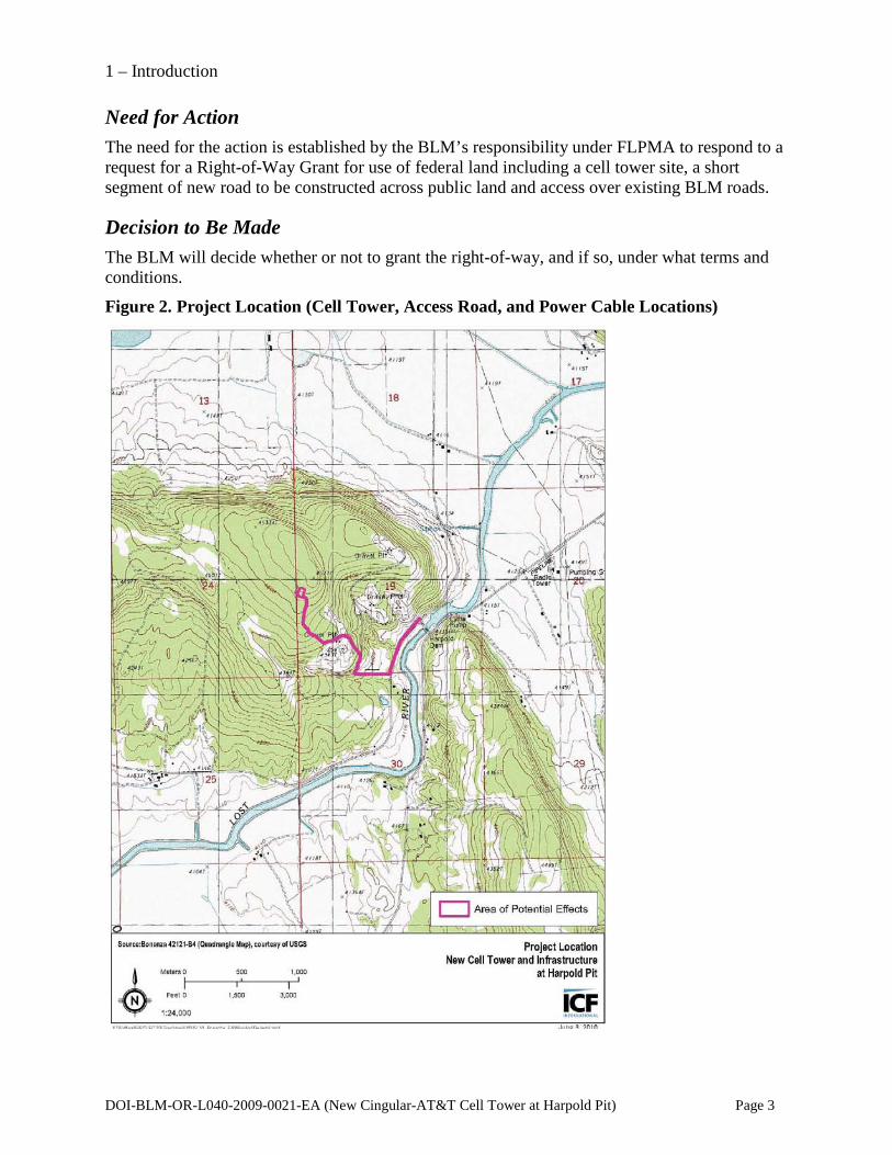
Purpose The purpose of the action is to reply to the applicant about their requested right-of-way or “grant” for use and legal access across public land managed by the BLM (Figure 2). Figure 2 displays the area potentially affected by the cell tower and other infrastructure (access road and power cable).
Site
1 – Introduction
DOI-BLM-OR-L040-2009-0021-EA (New Cingular-AT&T Cell Tower at Harpold Pit) Page 3
Need for Action The need for the action is established by the BLM’s responsibility under FLPMA to respond to a request for a Right-of-Way Grant for use of federal land including a cell tower site, a short segment of new road to be constructed across public land and access over existing BLM roads.
Decision to Be Made
The BLM will decide whether or not to grant the right-of-way, and if so, under what terms and conditions.
Figure 2. Project Location (Cell Tower, Access Road, and Power Cable Locations)

1 – Introduction
Management Direction and Conformance with Existing Plans The Klamath Falls Resource Area initiated planning and design for this project to conform and be consistent with the Klamath Falls Resource Area Record of Decision and Resource Management Plan (1995 ROD/RMP). The RMP provides management direction and recommendations for project design and implementation. This project was also designed to be in conformance with the Record of Decision and Resource Management Plan, Klamath Falls Resource Area (2008 ROD/RMP) and the Final Environmental Impact Statement for the Revision of the Resource Management Plans of the Western Oregon Bureau of Land Management (2008 FEIS). Following the March 31, 2011 decision by the United States District Court for the District of Columbia in Douglas Timber Operators et al. v. Salazar, which vacated and remanded the administrative withdrawal of the 2008 ROD and RMP, the KFRA evaluated this project for consistency with both the 1995 RMP and the 2008 ROD and RMP. Based upon this review, the Field Manager determined that the project is consistent with the Klamath Falls Resource Area’s 1995 RMP and the 2008 ROD/RMP.
Documents with supporting information or additional direction include the following:
• Klamath Falls Resource Area Integrated Weed Control Plan EA (BLM 1993). • Range Reform Final Environmental Impact Statement (BLM 1995). • Final Environmental Impact Statement, Vegetation Treatment on BLM Lands in Thirteen
Western States (BLM 1991).
Public Input Summary and Issue Development The BLM sent a scoping letter to approximately 140 people in the vicinity of Bonanza and the Poe Valley on October 6, 2009. The letter outlined the proposed cell tower and asked the general public for comments. Comments from various individuals were received. The following issues and the responses to those issues are summarized below. Further information is provided in Chapter 3, Affected Environment and Environmental Consequences.
Noise • Issue: Minimize noise generated by the operation of the tower and associated generators. • Response: The New Cingular-ATT tower would primarily be powered by electrical service
brought in via underground cable in the existing ditch adjacent to the access road. However, the Federal Communications Commission (FCC) requires that cellular service facilities have at least 8 hours of backup power in case of loss of electrical service. To address this requirement, there will also be an on-site generator that would only be used in the event of loss of electrical service. This generator would be housed in a 10-foot-by-12-foot room inside the control building. This enclosure would minimize the potential noise.
DOI-BLM-OR-L040-2009-0021-EA (New Cingular-AT&T Cell Tower at Harpold Pit) Page 4

1 – Introduction
Visual Resources • Issue: Potential visual disturbances would be caused by lights on the cell tower. • Response: According to FAA and Oregon Department of Aviation requirements, the New
Cingular-ATT tower would not require a light on top, thereby reducing the primary impact on visual disturbance.
Wildlife • Issue: Construction and maintenance would disrupt mule deer migration using this route. • Response: Construction may temporarily affect this route; however, construction is typically
3 to 4 weeks in duration, and effects on mule deer migration would be minimal and not sustained.
Recreational Use • Issue: Will the development cause public use to increase on the public lands and thus
increase use and damage on adjacent private land? • Response: The proposed site is behind a gate that is locked year-round except for access to
the county gravel pit and periodic BLM administrative use. The proponent will be instructed to only access through the gate for project construction, operation and maintenance. No additional public use should result in the surrounding area as a result of this project.
DOI-BLM-OR-L040-2009-0021-EA (New Cingular-AT&T Cell Tower at Harpold Pit) Page 5


DOI-BLM-OR-L040-2009-0021-EA (New AT&T Cell Tower at Harpold Pit) Page 7
CHAPTER 2 - PROPOSED ACTION AND ALTERNATIVES
Proposed Action Under the Proposed Action, the BLM would authorize the construction of a cellular telephone tower at the end of an existing natural surface road approximately 0.4 mile upslope from Harpold Pit and the gravel storage areas currently used by Klamath County Public Works Department, located on North Poe Valley Road (Figure 1).
The Proposed Action would construct an unstaffed telecommunications facility consisting of a 150-foot self-supporting lattice tower, a three-sector antenna array with four antennas per sector, a 16-foot-by-4-foot, 1,000-gallon propane tank, and a 12-foot-by-26-foot equipment shelter within the 60-foot-by-60-foot project site. According to the Oregon Department of Aviation marking and lighting are not necessary. A 12-foot-by-30-foot site road would be constructed to connect the project site with the existing natural surface access road.
To improve access to the proposed project site for construction and year-round access for maintenance and emergency repairs, the existing natural surface and chipsealed road (approximately 4,775 feet total) would need to be graded, widened in some places, and five water dips with ditch runouts constructed. The average road width would be 12 feet with an additional 3 feet for the utility ditch. There are two spots that would need spot rock along existing road. The permittee would need to rock the entire natural surface portion of the access road because of the need to potentially access the site during inclement weather.
Seasonal road maintenance would be required and includes grading, spot-rocking, and maintaining the new water dips and ditchouts to assure adequate drainage and reduce potential sediment runoff.
The entire project site would be fenced with cyclone fence topped with barbed wire. In addition to the cell tower, the Proposed Action would include a 6,610-foot underground power run, and a 4,776-foot power and telco trench that would extend along the natural surface access road leading to the project site. The proposed power trench would also extend for 1,835 feet along North Poe Valley Road.
Construction of the project is estimated to take 3 to 4 weeks. Once construction is completed site restoration and rehabilitation would be required as a standard project design feature. The RMP provides direction for reducing water quality impacts through implementation of best management practices (BMPs). The project site would be accessed once or twice a month for maintenance and repairs; more frequently in the case of an emergency, outage, or equipment failure. Maintenance and repair visits typically entail one truck visiting the site.
No Action Alternative The BLM National Environmental Policy Act Handbook (BLM 2008) recommends the inclusion and analysis of a No Action Alternative when assessing the impacts of a proposed action. Under the No Action Alternative, the proposed project would not occur. However, activities proposed in and adjacent to the project area that have been analyzed and approved in other NEPA documents would still occur, such as routine road maintenance, vegetation management (e.g., juniper removal), and recreational use. Selection of the No Action Alternative would not change the BLM management plans for these lands.

2 – Proposed Action and Alternatives
DOI-BLM-OR-L040-2009-0021-EA (New Cingular-AT&T Cell Tower at Harpold Pit) Page 8
Other Alternatives Considered But Not Analyzed in Detail Two other alternative locations for the cell tower were considered, but ultimately dropped from further analysis because they did not provide adequate coverage (they did not meet the project need). The first alternative (Alternative 1) would be located on private land on the north side of the hill (to the north of the Proposed Action), and the second alternative (Alternative 2) is the existing Verizon site in Bonanza. Alternative 2, the Verizon site, is the only other cell site in the area. Both of these alternative sites do not provide coverage to Harpold Road, nor to Poe Valley (between North and South Poe Valley roads), both of which are coverage objectives (i.e., purpose of the project) for the Proposed Action.

DOI-BLM-OR-L040-2009-0021-EA (New AT&T Cell Tower at Harpold Pit) Page 9
CHAPTER 3 – AFFECTED ENVIRONMENT AND ENVIRONMENTAL CONSEQUENCES
Introduction The description of the affected environment reflects the effects of all past natural events and management actions within the project area (and/or fifth field watershed). These actions include natural and human-caused fires, fire suppression actions, road building, grazing, fuel reduction treatments, and the recreational use. A catalog of all past actions and their effects is unnecessary in this EA. Such detail would not inform a rational decision maker about alternatives. The value of this EA is to describe and evaluate the effects of the alternatives on those resources as they exist today, in order to determine if project effects and/or cumulative effects would be significant or greater than those analyzed in the RMP/FEIS (BLM 2008).
Resources that are either not present in the project area, or would not be affected by the proposed alternatives are floodplains, wilderness study areas, areas of critical environmental concern, research natural areas, special-status and special-attention species habitat, prime or unique farmlands, wild horses, wild and scenic rivers, aquatic resources, and minerals. There are no known hazardous waste sites in the project area. No direct or indirect disproportionately high or adverse human health or environmental effects on minority or low-income populations are expected to result from implementation of the Proposed Action or the No Action Alternative. Consequently, these resources are not evaluated in this EA.
The resources that may be affected by the Proposed Action are listed and discussed in further detail below. In addition, the contribution of the Proposed Action to cumulative impacts on these resources is considered.
Project Site and Project Area The project site is a 3,600-square-foot area on the 250.12-acre Tax Lot #1600 in the NW 1/4 of Section 19, Township 39S, Range 11E (Figure 1), west of Bonanza, Oregon. This project site was selected for its relatively high position, flat terrain at the top of the slope, and distance from known resource conflicts such as rural residences. The project area is extended to include the natural surface road used to access the project site and a portion of North Poe Valley Road, in order to assess impacts resulting from the power and telecommunications trench and the underground power cabling associated with the project.
Cumulative Actions Considered Cumulative actions are those known federal actions, or reasonably foreseeable actions that would occur on federal lands in addition to the Proposed Action. In the project area, these include juniper removal, and gravel development at Harpold Pit.

3 – Affected Environment and Environmental Consequences
DOI-BLM-OR-L040-2009-0021-EA (New Cingular-AT&T Cell Tower at Harpold Pit) Page 10
Vegetation
Affected Environment
Upland Vegetation Forested areas surrounding and within the project area are sparsely vegetated by western juniper (Juniperus occidentalis), with elkbrush (Ceanothus cuneatus) and an herbaceous layer dominated by bunchgrasses such as Idaho fescue (Festuca idahoensis), crested wheatgrass (Agropyron cristatus) and squirreltail (Elymus elymoides ssp. elymoides).
Special-Status Plant Species Special-status plant species are defined as those listed by federal or state agencies as endangered, threatened or candidate species; and BLM-listed sensitive species.
Vascular Plants No special-status vascular plants have been documented in proximity to the project area. A botanical survey of the immediate project area (ICF International 2009) found no special-status plants or important ethnobotanical resources.
Nonvascular Plants The dominant nonvascular plant in proximity to the project area is wolf lichen (Letharia vulpina), which was observed growing on the bark of mature juniper trees. This lichen was historically used by Klamath and Modoc Indians to dye porcupine quills for basket-making (many indigenous people across North America derived yellow dye from this lichen) (Barrett 1910). No special-status nonvascular plants have been documented in the project area.
Noxious Weeds Noxious weeds are present in the general vicinity of the Bonanza area, but no populations were observed during botanical surveys of the project site (ICF International 2009).
Environmental Consequences
No Action Alternative Under the No Action Alternative, there would be no effect on vegetation in the project area.
Proposed Action
Upland Vegetation and Special-Status Species Construction of the proposed tower and associated outbuildings would result in less than an acre of removal of upland herbaceous vegetation, although trees would be avoided to the extent practicable. Location of the fence could be accomplished with a minimal amount of disturbance to vegetation, including pruning or removal of individual shrubs or juniper trees. No known populations of special-status plant species occur in the project area, and no effects on special-status plants are anticipated.

3 – Affected Environment and Environmental Consequences
DOI-BLM-OR-L040-2009-0021-EA (New Cingular-AT&T Cell Tower at Harpold Pit) Page 11
Noxious Weeds No known populations of noxious weeds occur at the project site, although any ground disturbance has the potential to introduce noxious weed seeds and propagules. Vehicles and heavy machinery traveling in the project area would disturb soil along roadsides. This could result in colonization of noxious weeds in the project area. However, seeding and planting native species would provide competition against noxious weed invasion.
If new populations of noxious weeds are noted prior to the implementation of the Proposed Action, these populations should be flagged for avoidance or treated to remove the possibility of spread. Soil excavated for the tower construction and/or road widening should be surveyed and treated for noxious weeds wherever it is relocated.
Implementation of BMPs (Appendix A) will minimize any effects to a less-than-significant level.
Cumulative Effects Because of the small spatial scale of the project site and lack of special-status plants in the project area, the Proposed Action would have no measurable cumulative impacts upon vegetation resources.
Terrestrial Wildlife Species
Affected Environment This section focuses on special-status wildlife species listed under the Endangered Species Act (ESA) (e.g., listed, proposed, and candidate species), those listed under the BLM special-status species policy and considered to be BLM-sensitive or land birds listed by the U.S. Fish and Wildlife Service (2008) as birds of concern.
Threatened and Endangered Species No listed, or candidate terrestrial wildlife species or designated critical habitat have been documented as occurring within the project area, and the proposed project would not affect any listed species.
No habitat for listed species occurs within the project area.
Other Wildlife Species The project area provides winter range habitat for mule deer. A variety of bird species and small mammals use the area as well, including bats and migratory birds. None of these are special-status species.
Environmental Consequences
No Action Alternative Under the No Action Alternative, there would be no effect on terrestrial wildlife in the project area.

3 – Affected Environment and Environmental Consequences
DOI-BLM-OR-L040-2009-0021-EA (New Cingular-AT&T Cell Tower at Harpold Pit) Page 12
Proposed Action
Threatened and Endangered Species There are no listed, proposed, or candidate terrestrial wildlife species in the project area or that would be affected by the Proposed Action. Therefore, the Proposed Action would not affect any of these species.
Other Terrestrial Wildlife Species Because of the small spatial scale of the project site, no effects on populations of birds of conservation concern or mule deer are anticipated. The Proposed Action would remove approximately 3,600 square feet of juniper/shrub/grass/scabrock habitat and temporarily disturb approximately 1.7 acres of the existing natural surface access road (Riddle pers. comm.). Noise and human presence during construction may temporarily deter wildlife use of the area, but it is anticipated that wildlife would return to the area during operation of the tower. Construction and maintenance could disrupt mule deer using or migrating through this area. Construction noise and disturbance from vehicles, equipment and workers may temporarily affect use of this area; however, construction is typically 3 to 4 weeks in duration, and effects on mule deer migration would be minimal and not sustained. Ongoing annual and emergency maintenance could cause disruption to deer from access by vehicles and use of equipment. Regular maintenance inside the building should have no impact. In the case of loss of power the backup generators could cause short term “startling” as they start up, but the disruption from noise should be very short term.
As documented by hundreds of studies since the 1970s (and annotated in a bibliography by Avery et al. 1980), communications towers pose a collision risk to avifauna. Potential deleterious effects include direct risks such as collision, electrocution and radiation, but also indirect impacts related to light and disturbance and fragmentation of habitat (Manville 2009).
Direct risks are greater at taller towers, but are increased even at shorter (200-foot) cell towers during inclement weather (Manville 2009); however, a study cited by Manville (2007) suggests that these higher mortalities were actually attributed to the use of steady red lights (versus blinking) at cell towers. Steady red lights are not part of the design of the proposed cell phone tower.
Low-level, non-thermal radiation from the standard 915 MHz cell phone frequency has shown lethal effects in some domestic chicken embryos (Gallus domesticus) under laboratory conditions (DiCarlo et al. 2002). And Balmori (2005) showed strong negative correlations between levels of tower-emitted microwave radiation and bird breeding, nesting, and roosting in the vicinity of the electromagnetic fields. However, there are no nesting sites for special-status avifauna within proximity of the proposed project, so this will not likely have an effect.
Although frequently difficult to quantify, the following potential indirect impacts of habitat fragmentation have been identified by Manville (2009): 1) reduced nesting/breeding densities; 2) loss of population vigor and overall density; 3) habitat and site abandonment, and increased isolation between patches; 4) loss of refugia; 5) attraction to modified habitats; 6) behavior effects including stress, interruption, and behavioral modification; and 7) disturbance and displacement resulting in habitat unsuitability. Due to the very small spatial scale of the project (and lack of special-status species documented within the project area), habitat fragmentation

3 – Affected Environment and Environmental Consequences
DOI-BLM-OR-L040-2009-0021-EA (New Cingular-AT&T Cell Tower at Harpold Pit) Page 13
related to the proposed project is unlikely to occur or have any of these effects of special-status avifauna.
The tower will be designed to be free-standing rather than anchored by guy wires in order to minimize the risk of avian and bat collision. Preliminary data collected by Gehring et al. (2009) suggest that the unguyed towers are not involved in large numbers of avifauna fatalities. The tower has been designed in a way that is consistent with the USFWS "gold standard" for communications towers (Manville 2009): "…unguyed, unlit, and < 61 m AGL (200 ft) wherever possible..." Therefore the tower, as designed, would pose minimal risk to special-status birds and bats.
Cumulative Effects The proposed project would have no measurable cumulative effects on listed, proposed, or candidate terrestrial wildlife species, bats or migratory birds, nor would it have measurable cumulative effects on terrestrial wildlife, bats or migratory birds. Occasional (rare) access by humans on foot (hunting and hiking) or by vehicle for administrative uses is low. Therefore, the cumulative effects of construction and maintenance noise and disturbance from vehicles, equipment and workers would be low on the deer population. The nearest tower is a radio tower approximately 1.5 miles to the east and a similar communication tower is approximately 4 miles to the northeast. Power lines and associated towers are sparsely located in the surrounding valleys. The cumulative effects of this proposed tower plus other similar towers on wildlife species, bats or migratory birds should be relatively low because the number of towers is relatively low and very dispersed.
Soils
Affected Environment The Web Soil Survey (Natural Resources Conservation Service 2009) identified one soil mapping unit in the project area, 50E. This unit consists of Lorella very stony loam. Slopes consist of 2% to 35% south. This soil type is very cobbly with gravelly colluviums and residuum derived from basalt and tuff. This is well-drained soil with a depth to the water table of more than 80 inches.
The project area is within Seismic Zone D, the appropriate zone for this type of project, as confirmed by Klamath County.
Environmental Consequences
No Action Alternative Under the No Action Alternative there would be no direct effects on soil resources.
Proposed Action The Proposed Action would affect a 3,600-square-foot surface area for the cell tower and associated structures, 6,610 linear feet of ground for the buried power cabling and 4,776 linear feet for the telecommunications trench. There would be minimal effects on soils from building this new 30 feet of road (approximately 360 square feet) as natural soil would change from
3 – Affected Environment and Environmental Consequences
DOI-BLM-OR-L040-2009-0021-EA (New Cingular-AT&T Cell Tower at Harpold Pit) Page 14
growing native grass/shrub vegetation, to serving as the base for the tower foundation and a road. The change in soil production for the road and the cell tower site is very small. Because of the relatively flat terrain, the converted road would not noticeably change the overland flow characteristics and thus soil erosion should change minimally. In addition, soil would be disturbed along 1,835 feet for the power trench along North Poe Valley Road. Other small, localized areas of soil disturbance may occur if vehicles are driven or parked off the road during construction. These soil impacts will be mitigated with restoration and rehabilitation for reducing water quality impacts through implementation of BMPs (Appendix A). The requirement to grade and rock the access road will cause minimal impacts on currently undisturbed soils. Construction of approximately five ditchouts will cause some minor additional disturbance to soils outside the existing road prism. Implementation of BMPs for soils would reduce impacts on low levels and no mitigation is required.
Cumulative Effects The proposed project would not have measurable cumulative effects on soil resources.
Hydrology
Affected Environment There are no water resources on the project site or along the existing access road. The nearest water resource is the Lost River, located approximately 0.50 mile to the east of the project and on the opposite side of the paved and ditched county road.
Environmental Consequences
No Action Under this alternative there would be no direct effects on hydrologic resources.
Proposed Action Within the 60-foot-by-60-foot fenced leased area, the land cover would be converted from pervious to impervious by the following project elements: three, 3-foot-diameter concrete footers for the new self-support lattice tower, a 16-foot-by-4-foot concrete slab on which a 1,000-gallon propane tank would be mounted, and a 12-foot-by-26-foot equipment shelter. In addition, a 12-foot-by-30-foot graveled site road would be constructed to connect the project site with the existing natural surface access road. There will be no measurable effects on hydrology from building this new 30 feet of road, because of the general flat terrain at the local site; thus runoff is not a concern. The very small change on ground surface area converted to road will not noticeably change the hydrologic flow characteristics. Because these features are on relatively flat ground and 0.50 mile from the river, and BMP’s, listed in Appendix A, to mitigate stormwater runoff will be implemented, there should be no sediment laden runnoff associated with these new structures.
The existing natural surface road leading to the project site would need to be graded, widened in some places, and at least five water dips with ditch runouts constructed. Following this the permittee will need to rock the entire natural surface portion of the access road with gravel that meets BLM specifications because of the potential need to access the site during inclement
3 – Affected Environment and Environmental Consequences
DOI-BLM-OR-L040-2009-0021-EA (New Cingular-AT&T Cell Tower at Harpold Pit) Page 15
weather. Conversion of the natural surface area to a different type of pervious surface, such as gravel, will still allow some infiltration, but subsequent use and compaction of the road may increase runoff compared to the existing condition of the road. The requirement to construct runoff ditches (designed to divert water from the road surface to areas where it can infiltrate into the soil) should prevent water from being delivered to the county road. Any water runoff from the lowest section of the existing access road, the approximately 1,000 feet of old chipseal should be captured by the ditch along the shoulder of the paved county road. All of these designs should prevent water being delivered to the Lost River. As a result of the underlying well drained soil, distance to the receiving water body, road and drainage design standards and BMPs outlined in the RMP, there are no hydrologic impacts expected as a result of the proposed project.
Cumulative Effects The proposed project would not have measurable cumulative effects on hydrologic resources.
Air Quality
Affected Environment This is a Class II airshed, with the closest Class I airshed, Gearhart Wilderness, located 24 miles to the east. Air quality is a sensitive issue in the Upper Klamath Basin primarily because of the recent designation of part of the county as nonattainment for PM2.5. This area of non-attainment is located 15 miles west of the analysis area. Potential air quality consequences are important for the preservation of high quality visual values for the region. To comply with air quality standards and minimize impacts on either the non-attainment area of Klamath Falls or the Class I airshed, the KFRA reports to the Oregon Department of Forestry (ODF) an estimate of the tonnage it expects to consume for each proposed project. Burn days are selected in coordination with the ODF Smoke Management to minimize the probability of sending smoke into these smoke sensitive areas.
Environmental Consequences
No Action Alternative Under the No Action Alternative there would be no direct effects on air resources.
Proposed Action The Proposed Action would require activities that could generate dust including road construction and maintenance, and equipment use for grading the site. Because of the very limited amount of work over a very short duration, impacts from are expected to be very low in the immediate airshed and would have no measurable effects on air resources in the non-attainment area or the closest Class I airshed.
Cumulative Effects The proposed project would not have measurable cumulative effects on air resources.

3 – Affected Environment and Environmental Consequences
DOI-BLM-OR-L040-2009-0021-EA (New Cingular-AT&T Cell Tower at Harpold Pit) Page 16
Roads
Affected Environment The site is accessed from the North Poe Valley Road, a Klamath County-maintained paved road. Leaving the county road, approximately 0.5 mile of local access road includes a short section of old chipseal approximately 1,000 feet. The next 0.4 mile is a natural-surface road with ruts forming due to a lack of road drainage, surfacing and maintenance. Total length is approximately 4,775 feet. The entire road is a low standard road that typically only receives maintenance to Klamath County’s rock stockpiles, approximately 300 feet from the main county road. The access to the site requires personnel to open and close a locked gate along the main county road. This access road width varies from 9 to 15 feet wide but will be improved and maintained to an average road width of 12 feet with an additional 3 feet for the utility ditch. Acreage impacted by the access road is approximately 1.7 acres.
Environmental Consequences
No Action Alternative Under the No Action Alternative there would be no direct effects on roads.
Proposed Action Under the Proposed Action, surrounding roads may be affected by a temporary increase in traffic during construction.
The proposed project site would require access for construction as well as year-round access for maintenance and emergency repairs. To provide access to the site, the existing road would need to be upgraded, and a new 12-foot-by-30-foot site road would need to be constructed. Upgrading would include grading, rocking, and construction of new water dips and ditchouts to assure adequate drainage.
Seasonal road maintenance would be required to include grading, spot-rocking, and maintaining the water dips and ditchouts to assure adequate drainage and reduce sediment runoff.
Implementation of BMPs (Appendix A) would minimize any effects to low level. The proposed seasonal road maintenance would improve water drainage off the road and reduce the risk of sediment runoff during inclement weather.
Cumulative Effects The proposed project would not have measurable cumulative effects on roads.
Noise
Affected Environment
Noise Terminology Sound is characterized by various parameters that include the amplitude and frequency. The decibel (dB) scale is used to quantify sound levels. Because sound pressure can vary enormously

3 – Affected Environment and Environmental Consequences
DOI-BLM-OR-L040-2009-0021-EA (New Cingular-AT&T Cell Tower at Harpold Pit) Page 17
within the range of human hearing, the logarithmic decibel scale is used to keep sound intensity numbers at a convenient and manageable level. The human ear is not equally sensitive to all frequencies in the entire spectrum, so noise measurements are weighted more heavily for frequencies to which humans are sensitive in a process called A-weighting. A-weighted decibel (dBA) levels represent how humans hear.
Different types of measurements are used to characterize the time-varying nature of sound. These measurements include the equivalent sound level (Leq), and the percent exceeded level (Ln). The Leq represents the average noise level during a monitoring period. The Ln indicates the noise level that is exceeded for n percent of the time during the monitoring period.
Closest Noise-Sensitive Receivers and Background Noise Levels The project site is located in sparsely populated forest land. The closest homes are dispersed farm houses along Burgdorf Road, located roughly 3,000 feet north of the project site. Background noise levels at the closest homes were estimated based on published data (U.S. Environmental Protection Agency 1971). For that document, the U.S. Environmental Protection Agency (EPA) conducted baseline noise measurements at a large variety of land uses, ranging from dense urban areas to unpopulated wilderness areas. The dispersed farm houses at the project site most resemble EPA’s land use category Farm in Valley. The measured background noise levels for that land use category are listed in Table 1. These noise levels are assumed to represent typical conditions at the homes closest to the project site.
Table 1. Assumed Background Noise Levels
Time of Day Average Leq Noise Level, dBA
Average L50 Noise Level, dBA
Daytime (7 a.m. to 10 p.m.) 45 38 Nighttime (10 p.m. to 7 a.m.) 34 32
Source: U.S. Environmental Protection Agency 1971
Noise Regulations Noise in Klamath County is governed by two regulations: the Klamath County Code, and the Oregon statewide noise regulation. The Klamath County Code does not include any numerical noise limits, and limits its scope to the prohibition of nuisance noises such as barking dogs. That type of noise regulation does not prevent noise effects from commercial equipment such as the backup generator at the project site. Therefore, for purposes of regulating community noise levels such as those caused by the generator, the Oregon State Noise Control Regulation was applied. This regulation (Oregon Administrative Rules [OAR] 340-35, Noise Control Regulations) specifies the following allowable noise limits at the receiving property for new commercial and industrial equipment (the more restrictive of the two conditions applies):
• the L50 background noise level at the receiving property can be increased by no more than 10 dBA above existing background levels, or
• the new equipment can cause an L50 noise level up to 55 dBA during the day (7:00 a.m. to 10:00 p.m.) and 50 dBA at night.

3 – Affected Environment and Environmental Consequences
DOI-BLM-OR-L040-2009-0021-EA (New Cingular-AT&T Cell Tower at Harpold Pit) Page 18
The first condition (10 dBA increase above the background L50 noise level) is more restrictive, and is used for this analysis. The generator could operate at any time of the day or night, so the generator noise level at the closest homes would be allowed to increase the nighttime background level by no more than 10 dBA. Because the assumed nighttime background L50 is 32 dBA, the generator would not be allowed to cause noise levels at the closest home to exceed 42 dBA.
Environmental Consequences
No Action Alternative Under the No Action Alternative the facility would not be installed, and noise levels would not be affected.
Proposed Action The facility would include a small, 60-kilowatt (kWe) propane-fired backup generator (Cummins Model GGHE), which would be inside the building with its exhaust stack extended through the roof. Noise from a typical generator is emitted from three sources: the casing of the generator, the exhaust stack, and the air intake vent. The generator at the proposed tower site would be inside the building, with only its exhaust stack exposed. However, to be conservative, the noise analysis assumed the generator would be outdoors, with all of its noise sources exposed.
Noise emissions from generators are commonly specified by the manufacturer as the dBA noise level at a 7-meter reference distance from the unit. Factory-supplied noise data for the Cummins Model GGHE generator are not available. However, noise data from other similar generators (e.g., generic generators between 40 kWe to 100 kWe) are available and were used for this assessment. Noise emissions from small generators (in the 60- to 100-kWe size range) emit noises of typically 65 to 72 dBA at 23 feet. For this analysis the upper-bound noise level for a small generator was used (72 dBA at 23 feet).
If it is conservatively assumed that noise propagates away from the generator in a hemispherical pattern without any attenuation by ground or vegetation between the generator and the receiver, then the ambient noise level would decrease by 6 dBA for every doubling of distance from the generator. Based on that worst-case relationship, Table 2 shows the ambient noise levels at various distances.
Table 2. Calculated Generator Noise Levels
Distance (feet) Noise Level (L50, dBA)
23 (reference distance) 72 100 59 1,000 38 3,000 (nearest home) 30 Oregon State Limit 42
Even assuming upper-bound noise emissions and worst-case sound propagation conditions, the ambient noise level at the closest home (3,000 feet away) would be only 30 dBA. This is well

3 – Affected Environment and Environmental Consequences
DOI-BLM-OR-L040-2009-0021-EA (New Cingular-AT&T Cell Tower at Harpold Pit) Page 19
below the allowable Oregon state limit of 42 dBA, and is likely less than the typical background noise level. Under worst-case conditions the generator noise might be slightly discernible at the closest houses, but the noise levels would be well below the state noise limits and therefore, the noise impacts are considered low. No noise mitigation would be required, even if the generator was placed outside; however, the generator would be installed inside the building.
Cumulative Effects If the population density in the surrounding rural neighborhoods were to increase, then background noise levels would also increase. This would not affect the conclusion that the project’s backup generator noise effects would be low.
Grazing Management
Affected Environment The project site is within the existing Ketcham grazing allotment, number 835. This allotment allows 20 animal unit months, or 13 pair of cattle. The season for this allotment is May 1 to June 15.
Environmental Consequences
No Action Alternative The No Action Alternative would have no effect on BLM-administered livestock grazing.
Proposed Action The Proposed Action would have no effect on BLM-administered livestock grazing. Although the project site is within a grazing allotment, the project site itself would be fenced off and the proposed cell tower would be gated. The Proposed Action would permanently remove 2,500 feet (0.06 acre) of grazing land from the allotment. This acreage is minimal and would not affect overall use and management of grazing land. The season for the allotment is relatively short. Assuming that construction would not be conducted during this 6-week season, there would be no effects on livestock grazing.
Cumulative Effects The proposed project would not have measurable cumulative effects on grazing management.
Cultural Resources Cultural resources in this document refer to all historical and archaeological resources, regardless of their significance. The term historic property refers to those cultural resources that are eligible for listing in the National Register of Historic Places (NRHP) and must be considered under Section 106 of the National Historic Preservation Act (NHPA) and NEPA.
The primary sources of information for this section are BLM records, a records search conducted at the Oregon State Historic Preservation Office (SHPO) (see Background Research/Cultural Context), and an archaeological survey of the project area of potential effects (APE) (see Archaeological Survey).

3 – Affected Environment and Environmental Consequences
DOI-BLM-OR-L040-2009-0021-EA (New Cingular-AT&T Cell Tower at Harpold Pit) Page 20
Affected Environment
Regulatory Setting Construction of the new AT&T cell tower at Harpold Pit requires federal permits and must satisfy the requirements established under NEPA (42 United States Code [USC] 4321-4347) and Section 106 of the National Historic Preservation Act (NHPA) of 1966, as amended (16 USC 470 et seq.), hereinafter referred to as Section 106. Section 106 is the primary mandate governing projects under federal jurisdiction that might affect historic properties. The purpose of this report is to identify and evaluate cultural resources to determine if they qualify as historic properties and, if so, to assess the potential effects of the project on those historic properties, thus fulfilling part of the requirements of NEPA and Section 106.
Federal Regulations
National Environmental Policy Act NEPA requires that all major actions sponsored, funded, permitted, or approved by federal agencies—generally referred to as federal undertakings—undergo planning to ensure that environmental considerations, such as impacts on historical, cultural, and archaeological resources, are given due weight in decision-making. The federal implementation regulations for NEPA are in 40 CFR 1500-1508 CEQ, and, for Federal Highway Administration (FHWA) actions, 23 CFR 771. The CEQ regulations include sections on urban quality, historic and cultural resources, and the design of the built environment (Sec. 1502.16[g]). The NHPA Section 106 process will be used for analysis of historic properties.
Section 106 of the National Historic Preservation Act Section 106 of the NHPA requires federal agencies to consider the effects of actions that the agencies fund or approve on any district, site, building, structure, or object that is listed in or eligible for listing in the NRHP. The regulations implementing Section 106 are codified as 36 CFR 800. The Section 106 review process involves four steps:
1. Initiate the Section 106 process by establishing the undertaking, developing a plan for public involvement, and identifying other consulting parties.
2. Identify historic properties by determining the scope of effects, identifying cultural resources, and evaluating their eligibility for inclusion in the NRHP.
3. Assess adverse effects by applying the criteria for adverse effect to historic properties (resources that are eligible for inclusion in the NRHP).
4. Resolve adverse effects by consulting with the SHPO and other consulting agencies, including the Advisory Council on Historic Preservation (ACHP), if necessary, to develop an agreement that addresses the treatment of historic properties.
To determine whether an undertaking could affect NRHP-eligible properties, cultural resources (including archaeological, historic, and ethnographic resources) must be inventoried and evaluated to determine if the meet the criteria for listing in the NRHP.

3 – Affected Environment and Environmental Consequences
DOI-BLM-OR-L040-2009-0021-EA (New Cingular-AT&T Cell Tower at Harpold Pit) Page 21
Background Research/Cultural Context In October 2009, Meris Mullaley conducted a records search for archaeological sites at the Oregon SHPO and at the Klamath Falls Resource Area BLM office, and performed surveys within the APE. A single existing archaeological survey, implemented on behalf of the BLM, overlapped the APE. Eight archaeological surveys have occurred within a mile of the APE. Fourteen archaeological sites are located within 1.5 miles of the project APE. No archaeological sites were identified within the APE. A cultural resource survey in 2000 on behalf of the BLM, Lakeview District, Klamath Falls Resource Area (Jones 2000) located four sites (35KL2155, 2156, 2158, and 2159, Figure 1 of the Cultural Resources Report) adjacent to the APE.
Historical Context Archaeological evidence suggests that there has been continuous human occupation in the Klamath Basin from at least 5000 years before Christ (BC) (7000 before present [BP]). This region is the traditional territory of the Modoc and Klamath peoples. The borders between them were likely not permanent; however the project area is commonly shown within Modoc territory (Jones 1999; Ray 1963; Stern 1998). The Modoc and Klamath share cultural practices with Plateau and California tribes.
Given the productive environment of the Klamath Basin, various subsistence resources were abundant year-round. The Modoc and Klamath followed a seasonal round of hunting, fishing, and gathering, making use of seasonal fish and bird migrations and plant growth (Jones 1999). The Modoc depended more on hunting and gathering seeds, as the salmon runs did not reach the rivers in Modoc territories (Stern 1998). They lived in larger winter villages, and dispersed in smaller groups during the spring and summer seasons for hunting and gathering in higher elevations (Jones 1999; Stern 1998). Ethnographic accounts refer to the use of uplands for spiritual practices, one archaeological manifestation of which are stacked rock features (Jones 1999; Stern 1998). Some such features were found in the surrounding general area at similar elevations to the project area (Jones 1999).
Euro-American settlers and explorers first arrived in the Klamath Basin in the 1820s and in 1864 the Modoc and Klamath tribes signed the Klamath Lake Treaty, ceding their lands to the United States and moving to the reservation. One Modoc group tried to return to the Tule Lake region in Northern California. When the U.S. government tried to take them back to the reservation the Modoc War (1872–1873) began (Stern 1998). Specifically within the APE, Euro-American exploration began in 1843 and settlement did not start until 1873.
Archaeological Survey ICF archaeologists, who meet the Secretary of Interior’s Standards for work in archaeology, conducted the pedestrian surveys of the APE using standard, BLM-accepted methods, as described below. These methods are appropriate for identifying and recording cultural resources in the survey area. The pedestrian survey included walking transects in the APE to find exposed ground surface, exposed cultural materials, and areas that a have high probability for having buried deposits that could contain cultural materials. Pedestrian survey transects were placed at intervals no greater than 10 meters. Sediments exposed through rodent burrowing within the pedestrian survey transects were inspected for cultural materials.

3 – Affected Environment and Environmental Consequences
DOI-BLM-OR-L040-2009-0021-EA (New Cingular-AT&T Cell Tower at Harpold Pit) Page 22
2009 Survey
Methods On October 5, 2009, Meredith Mullaley conducted an archaeological survey of the ground surface of the proposed footprint for a cellular phone tower and adjacent ground surface. Given the size of the footprint, transects were spaced at 1 meter. An additional 2-meter buffer around the proposed cell tower was inspected.
Conditions and Findings The proposed footprint was marked by three corner lath stakes, while the fourth stake was missing. Ground surface visibility was good (75% to 90%). Exposed bedrock and small stands of grass were scattered across the APE.
No cultural materials were identified as a result of this survey.
2010 Survey
Methods On May 26, 2010, J. Tait Elder, M.A., conducted an archaeological survey of the ground surface of two areas proposed for the utility trench:
• The land directly adjacent to the west side of a 540-meter section of North Poe Valley Road, starting at the intersection of Burgdorf Road and North Poe Valley Road to the north, and ending at a small gravel turnout to the south.
• Along both sides of a natural surfaced road extending west from the gravel turnout listed above to the location of a proposed cellular phone tower.
• A pedestrian survey of the proposed footprint for the proposed telecommunication facility (60-foot-by-60-foot area).
A single linear pedestrian survey transect (10 meters by 3,500 meters) was used to survey the areas listed above.
Conditions and Findings Surface vegetation was sparse throughout the APE, and as a result, ground surface was visible (ranging from 50% to 90% visibility) in all areas surveyed.
Visual inspection of the area adjacent to North Poe Valley Road and the area to the north of the road indicate that the valley margins were removed in order to construct North Poe Valley Road. At least 2 meters of sediment and underlying bedrock was removed. Cut walls were clearly visible in numerous locations along the road, revealing a very thin layer of sediment (less than 10 centimeters) underlain by bedrock. In addition, existing buried telephone boxes are located on the west side of the road, indicating that recent ground disturbance has occurred within the area. In vegetated areas, around 50% of the surface was visible.
The landscape that the eastern half of the access road runs through has been heavily modified through road construction and use as a rock quarry. Undisturbed land surface was not encountered until reaching the top of a plateau, upon which the western half of the road sits. Recent heavy rains helped to clean off all gravels and increase visibility. The sediments

3 – Affected Environment and Environmental Consequences
DOI-BLM-OR-L040-2009-0021-EA (New Cingular-AT&T Cell Tower at Harpold Pit) Page 23
encountered during this survey were very shallow (less than 10 centimeters), and were either underlain by basalt or shale.
No cultural materials were identified as a result of this survey.
Environmental Consequences
No Action Alternative The No Action Alternative would not affect the project site, and would therefore, have no effect on cultural resources.
Proposed Action The construction associated with the Proposed Action would disturb sediments within the immediate 3,600-square-foot project site, in the trenches carrying cabling to the site, and on the road constructed for access to the site. However, no archaeological sites or isolates were identified during 2009/2010 cultural resource surveys of the project APE (Elder and Mullaley 2010). Therefore, the proposed action would have no effect on cultural resources.
Cumulative Effects Since no archaeological sites or isolates were identified within the project APE, the proposed project would have no measurable cumulative effects on cultural resources.
Recreation Resources
Affected Environment Recreation activities on and surrounding the project site include dispersed motorized and non-motorized uses such as camping, hiking, hunting, fishing, and wildlife viewing. The project area is designated as off-highway vehicle (OHV) “limited” in the Klamath Falls Resource Area Record of Decision and RMP Map Packet (BLM 2008). However, the project site is within a gated area, which also encompasses Harpold Pit and the gravel storage areas currently used by Klamath County Public Works Department. People can access the site on foot at any time. If the gate is left open, then the public can legally access the area with motorized vehicles. The project site is not located in a recreation area or site.
Environmental Consequences
No Action Alternative The No Action Alternative would have no effect on recreational resources.
Proposed Action The proposed site is behind a gate that is locked year-round except for access to the county gravel pit and periodic BLM administrative use. The proponent will be instructed to only access through the gate for project construction, operation and maintenance. No additional public use should result in the surrounding area as a result of this project. While OHV use is mostly prevented as a result of the property being gated, other non-motorized uses are still allowed.

3 – Affected Environment and Environmental Consequences
DOI-BLM-OR-L040-2009-0021-EA (New Cingular-AT&T Cell Tower at Harpold Pit) Page 24
Operation of the project site would not affect recreational uses on site or off site, nor would it prevent existing users from using the property. Construction may temporarily disturb some recreation uses; however, construction would last 3 to 4 weeks, and effects would be minimal, would not be sustained, and therefore, would be less than significant.
Cumulative Effects The proposed project would not have measurable cumulative effects on recreation resources.
Visual Resources
Affected Environment Visual resources consist of views of the upper hillslope and surrounding areas. Many viewsheds and viewer groups may be affected by the Proposed Action; therefore, the study area for visual resources extends well beyond the project site.
The Record of Decision and Resource Area Management Plan (BLM 2008) defines Visual Resource Management Classes, and specifies objectives for each class. The project area is located in a Class III area where a project must “partially retain the existing character of landscapes.” The RMP also states, “Manage Visual Resource Management Class III lands for moderate levels of change to the characteristic landscape. Management activities may attract attention but should not dominate the view of the casual observer. Changes should repeat the basic elements of form, line, color, texture, and scale found in the predominant natural features of the characteristic landscape.”
Views of the project area were inventoried during a site visit that took place during May 2010, by identifying the locations and photographing views of and from the surrounding areas. In order to generate the photo simulations, a balloon test was administered. A 5-foot-diameter red weather balloon filled with helium was flown at the height of the tower (150 feet) at the location of the proposed tower. High resolution photos were taken from various vantage points. This analysis focuses on representative vantages from where views of the proposed project are present. The closest homes are dispersed farm houses along Burgdorf Road, located roughly 3,000 feet north of the project site. Representative views embody impacts on a given viewer group or number of viewer groups, and are illustrative in describing the effect, absence of effect, or severity of effect on certain vantages.
Environmental Consequences As previously described, the Proposed Action is located at the top of the hill above Harpold Pit. This project location was selected, in part, because of its relatively high position, its flat terrain at the top of the slope, and its distance from rural residences. Despite siting the tower to minimize visual impacts, a detailed visual analysis was performed to address public concerns raised during scoping about the potential visual impacts associated with the Proposed Action.
No Action Alternative The No Action Alternative would have no effect on visual resources.
3 – Affected Environment and Environmental Consequences
DOI-BLM-OR-L040-2009-0021-EA (New Cingular-AT&T Cell Tower at Harpold Pit) Page 25
Proposed Action Photo-realistic simulations of representative photos for vantages of the study area have been chosen to the best degree possible to depict (a) existing conditions and (b) project conditions for the purpose of illustrating the impact of the Proposed Action upon the landscape and as seen by all viewer groups.
The proposed tower does not alter the existing quality of scenic vistas and views of and from designated scenic areas, such as federally designated scenic areas and scenic roadways or byways.
The proposed tower would barely be visible from most of the points analyzed. It would be more visible from two vantage points displayed in Figures 3 and 4. Figure 3 is at Highway 70 and Burgdorf Road (simulation #2 in the Visual Analysis) and Figure 4 is near 5011 Burgdorf Road (simulation #4 in the Visual Analysis), both located northeast of the project site. The proposed tower will alter the existing natural viewshed. This alteration does create a moderate level of change to the characteristic landscape. The constructed tower would attract attention but should not dominate the view of the casual observer, and therefore would meet VRM Class III objectives. The Proposed Action is not visible or barely visible in the distance in the other photo simulations. Therefore, there would be minimal effects to visual resources from these vantage points. The project area is located in a Class III area (Klamath Falls Resource Area Record of Decision and RMP Map Packet), where a project must “partially retain the existing character of landscapes.” This project would meet the VRM Class III objectives.
According to Oregon Department of Aviation requirements, the New AT&T tower would not require a light on top (Larson pers. comm.). Therefore, the Proposed Action would not result in increased light or glare in the project vicinity or result in backscatter light into the nighttime sky.
Cumulative Effects No other actions are known that would impact visual resources in the area.

3 – Affected Environment and Environmental Consequences
DOI-BLM-OR-L040-2009-0021-EA (New Cingular-AT&T Cell Tower at Harpold Pit) Page 26
Figure 3. Photo Simulation at Highway 70 and Burgdorf Road
Figure 4. Photo Simulation at 5011 Burgdorf Road

3 – Affected Environment and Environmental Consequences
DOI-BLM-OR-L040-2009-0021-EA (New Cingular-AT&T Cell Tower at Harpold Pit) Page 27
Land Uses
Affected Environment Existing land uses in the vicinity of the proposed project are listed in Table 3.
Table 3. Location of BLM-Administered Land Uses
Case Number Name Legal Description Case Type
Total Acres
OR 55101
Century Telephone of Eastern Oregon
T39S,R11E,Sec 19 SESE Telephone, fiber Optic Lines
0.69
OR 62864
Pacific Power T39S,R11E,Sec 19 N2N2N2, NE
Power line 0.49
OR 50394
ANR Land Management T39S,R11E,Sec 19 N2N2N2, NE; T39S,R11 ½ E,Sec 17 SE; T39S,R11 ½ E Sec 22 N2N2NE, NENW; T39S,R11 ½ E Sec 23 NENENE
O & G Pipeline 89.78
OR 20254
BR-Mid Pacific Region - Klamath Project
T39S,R11E,Sec 19 NWSE,NESE
Horsefly/Harpold Diversion Dam
80.0
OR 23839
Pacific Power T39S,R11E,Sec 17 SWSW Power line 0.16
Environmental Consequences None of the existing land uses in the vicinity of the proposed cell tower would be affected under either the No Action or Proposed Action Alternatives. If the Proposed Action is implemented, adjacent BLM-administered lands will continue to be made available for management and other needed rights-of-way identified in the ROD/RMP, Klamath Falls Resource Area.
Socioeconomics
Affected Environment According to the Record of Decision and RMP, Klamath Falls Resource Area there are no specific land use allocations related to socioeconomic conditions. However, allocations such as the Administratively Withdrawn Areas including rangelands can assist in meeting socioeconomic objectives.
Environmental Consequences
No Action Alternative The No Action Alternative would have no impact on socioeconomic resources.

3 – Affected Environment and Environmental Consequences
DOI-BLM-OR-L040-2009-0021-EA (New Cingular-AT&T Cell Tower at Harpold Pit) Page 28
Proposed Action The Proposed Action will not impact those land uses that may assist in meeting socio economic objectives for the Klamath Falls Resource Area such as recreational resources or grazing management as discussed in previous sections of this EA.
Depending upon the cell tower coverage, it could significantly improve cell phone reception in the Gerber area which would be a benefit to BLM and the public. The proposed project would potentially provide for enhanced socioeconomic conditions by providing improved cell reception to businesses and residents.
Cumulative Effects No other projects are known that would have measurable cumulative effects on socioeconomics.

DOI-BLM-OR-L040-2009-0021-EA (New AT&T Cell Tower at Harpold Pit) Page 29
CHAPTER 4 – CONSULTATION
Endangered Species Act Consultation A “No Effect” determination was made by the BLM for all listed species and designated critical habitat. Therefore, Endangered Species Act consultation with the U.S. Fish and Wildlife Service for the Proposed Action is not required.


DOI-BLM-OR-L040-2009-0021-EA (New AT&T Cell Tower at Harpold Pit) Page 31
CHAPTER 5 – LIST OF PREPARERS/CONTRIBUTORS This EA was prepared under a third-party contract by ICF International. Contracting may be used for the preparation of a NEPA document or for certain portions of the analyses (BLM 2008). The BLM has the responsibility for assuring that the documentation meets NEPA and BLM requirements. The BLM is responsible for the scope and content of the analysis within this NEPA document and the supporting materials including the administrative record. Additionally, subsequent decisions and findings are those of the BLM, not of the contractor, which will reflect a review of the underlying NEPA document.
ICF International ICF International specialists responsible for providing input and preparing the document:
Greg Summers Project Director
Heather Arndt Anderson Project Manager/Vegetation and Wildlife Specialist
Meredith Mullaley Cultural Resources
Tait Elder Cultural Resources
Jim Wilder Noise
Becca Fisher Project Manager
Mark Matthies Senior Vegetation and Wildlife Specialist
The U.S. Bureau of Land Management The BLM has independently evaluated environmental issues and the information submitted. BLM resource specialists responsible for providing guidance, resource data, and evaluation of the document:
Brooke Brown Archaeologist
Eric Johnson Fuels Management Specialist
Don Hoffheins Planner
Steve Hayner Wildlife: Special-Status Species
Dana Eckard Range Conservationist
Andy Hamilton Hydrologist
Brian McCarty Engineer
Scott Senter Recreation and Visual Resources
Molly Boyter Noxious Weeds and Special Status Plants
Shane Durant Forester
Rob Roninger Fisheries Biologist

5 – List of Preparers/Contributors
DOI-BLM-OR-L040-2009-0021-EA (New Cingular-AT&T Cell Tower at Harpold Pit) Page 32
Persons/Agencies Consulted Allan Brown Klamath County Plans Examiner
Kristinae Toomians Klamath County Planner
Perry Chocktoot The Klamath Tribes

DOI-BLM-OR-L040-2009-0021-EA (New AT&T Cell Tower at Harpold Pit) Page 33
CHAPTER 6 – REFERENCES Avery, M.L., P.F. Springer, and N.S. Dailey. 1980. Avian mortality at man-made structures: an annotated bibliography (revised). U.S. Fish and Wildlife Service, Biological Services Program, National Power Plant Team. FWS/OBS-80/54. 152 pp.
Barret, S.A. 1910. The material culture of the Klamath Lake and Modoc Indians of northeastern California and southern Oregon. American Archaeology and Ethnology (5)4:239-292. University of California Publications. The University Press. Berkeley, California.
Bureau of Land Management, U.S. Department of Interior (BLM). 1991. Final Environmental Impact Statement, Vegetation Treatment on BLM Lands in Thirteen Western States. Washington, D.C.
Bureau of Land Management, U.S. Department of Interior (BLM). 1993. Klamath Falls Resource Area Integrated Weed Control Plan Environmental Assessment (EA# OR-014-93-09). Klamath Falls, OR.
Bureau of Land Management, U.S. Department of Interior (BLM). 2008. Final Environmental Impact Statement for the Revision of the Resource Management Plans of the Western Oregon Bureau of Land Management, Vol. I-IV. (October 2008). Klamath Falls, OR.
Bureau of Land Management, U.S. Department of Interior (BLM). 2008. Record of Decision and Resource Management Plan, Klamath Falls Resource Area (October 2008). Klamath Falls, OR.
Bureau of Land Management, U.S. Department of Interior (BLM). 2008. National Environmental Policy Act Handbook. H-1790-1 (January 2008). Washington, D.C.
Jones, John W. 1999. Harpold West Cultural Resource Survey Klamath County, Oregon. Prepared for USDI Bureau of Land Management, Lakeview District, Klamath Falls Resource Area.
Manville, A.M., II. 2007a. Comments of the U.S. Fish and Wildlife Service submitted electronically to the FCC on 47 CFR Parts 1 and 17, WT Docket No. 03-187, FCC 06-164, Notice of Proposed Rulemaking, “Effects of Communication Towers on Migratory Birds.” February 2, 2007.
Manville, A.M., II. 2009. Towers, turbines, power lines, and buildings – steps being taken by the U.S. Fish and Wildlife Service to avoid or minimize take of migratory birds at these structures. In C.J. Ralph and T.D. Rich (editors). Proceedings 4th International Partners in Flight Conference, February 2008, McAllen, TX.
Migratory Bird Management, Arlington, Virginia. 99 pp. Online version available at http://migratorybirds.fws.gov/reports/bcc2002.pdf.Soil Survey Staff, Natural Resources Conservation Service, United States Department of Agriculture. 2009. Web Soil Survey. Available at: http://websoilsurvey.nrcs.usda.gov/. Accessed: November 15, 2009.
Ray, Verne. 1963. Primitive Pragmatists, The Modoc Indians of Northern California. University of Washington Press, Seattle, Washington.
Stern, Theodore. 1998. Klamath and Modoc in Handbook of North American Indians, Vol 12 Plateau. Deward E Walker, Jr. Washington, Smithsonian Institution.
6 – References
DOI-BLM-OR-L040-2009-0021-EA (New Cingular-AT&T Cell Tower at Harpold Pit) Page 34
U.S. Environmental Protection Agency (EPA). 1971. Community Noise. EPA Report NTID 300.3. December.
U.S. Fish and Wildlife Service (USFWS). 2002. Birds of conservation concern 2002. Division of
Personal Communication:
Larson, Sandra. Aviation Planning Analyst. November 22, 2010—letter to Joe Riddle, Cascadia PM regarding proposed construction of a 150-foot antenna tower near Bonanza, Oregon.
Riddle, Joe. Cascadia PM. August 16, 2010—personal communication.

DOI-BLM-OR-L040-2009-0021-EA (New AT&T Cell Tower at Harpold Pit) Page 35
APPENDIX A – BEST MANAGEMENT PRACTICES AND PROJECT DESIGN FEATURES Best management practices (BMPs) are “designed to achieve the objectives of maintaining or improving water quality and soil productivity and the protection of riparian-wetland areas”. BMPs are defined as methods, measures, or practices selected on the basis of site-specific conditions to ensure that water quality will be maintained at its highest practicable level. In addition to BMPs that focus on water quality and soil production, the interdisciplinary team also develops project design features (PDFs) with the objective of meeting other resource goals. For instance, the PDFs listed below under Wildlife and Vegetation are designed to meet resource objectives associated with these resources and not necessarily water quality. In addition, the PDFs listed under Recreation and Visual Resources are designed to meet objectives stated in the RMP for these respective resources. The list below is not an exclusive list of BMPs or PDFs for the proposed New Cingular-ATT Cell Tower at Harpold Pit. It is a list of the BMPs and PDFs that the interdisciplinary team found to be most pertinent for the Proposed Action.
Roads Seasonally restricting construction and renovation activities to low runoff periods is recommended to eliminate sediment transportation to streams.
Installing drainage dips in accordance with RMP BMPs to reduce surface and ditchline runoffs is recommended.
Surfacing roads in accordance with the RMP is recommended for all naturally surfaced roads not proposed for decommissioning or closure, to allow use during all seasons and is expected to minimize erosion from the road surfaces.
Soil Resources Limit mechanical operations to periods when the soil moisture is below 20% at a 6-inch depth.
To protect soil resources and water quality, close unsurfaced roads during the wet season (October 30 to June 1) unless waived by authorized personnel.
Retain and establish adequate vegetative cover to reduce erosion.
Seed and/or mulch all exposed and disturbed soil surfaces following construction and maintenance activities. Use native seed and certified weed-free mulch unless approved in advance by the BLM.
Wildlife
Seasonal Restrictions Seasonal restrictions will be required where the following wildlife species are actively nesting: bald eagle, northern spotted owl, northern goshawk, osprey, and special status species.
Nesting Areas Protect nesting areas as described in the RMP.

Appendix A
DOI-BLM-OR-L040-2009-0021-EA (New Cingular-AT&T Cell Tower at Harpold Pit) Page 36
Noxious Weeds Require cleaning of all equipment and vehicles prior to moving on-site to prevent spread of noxious weeds. Also, if the job site includes a noxious weed infestation, require cleaning of all logging and construction equipment and vehicles prior to leaving the job site. Removal of all dirt, grease, and plant parts that may carry noxious weed seeds or vegetative parts could be accomplished by using a pressure hose to clean the equipment.
Mow noxious weeds in the immediate area of yarding operations to ground level prior to seed development.
Conduct monitoring activities related to proposed treatments as described in the Klamath Falls ROD/RMP.
Road graders used for road construction or maintenance would grade toward any known noxious weed infestations. If no good turn around area exists within 0.50 mile that would allow the operator to grade toward the noxious weed infestation, then the operator would leave the material that is being moved within the boundaries of the noxious weed infestation.
Cultural Resources Follow procedures for cultural protection and management outlined in the KFRA ROD/RMP, and protect identified sites by buffering.
In accordance with guidelines and directives in the Klamath Falls Resource Area RMP, BLM regulations, and the NHPA, areas not included in previous archaeological surveys will be surveyed before any ground-disturbing action is undertaken.
Visual Resources Where possible, maintain visual screening along roadways.
All treatments will meet appropriate Visual Class objectives specified in the KFRA ROD/RMP. Utilize non-reflecting coatings to the tower, antennas, building and associated structures where possible.