DRAFT ENVIRONMENTAL ASSESSMENT FOR HYDROPOWER …
207
DRAFT ENVIRONMENTAL ASSESSMENT FOR HYDROPOWER LICENSE Shawmut Hydroelectric Project, P-2322-069 Maine Federal Energy Regulatory Commission Office of Energy Projects Division of Hydropower Licensing 888 First Street, NE Washington, D.C. 20426 July 2021
Transcript of DRAFT ENVIRONMENTAL ASSESSMENT FOR HYDROPOWER …

DRAFT ENVIRONMENTAL ASSESSMENT FOR HYDROPOWER LICENSE
Shawmut Hydroelectric Project, P-2322-069
Maine
Federal Energy Regulatory Commission Office of Energy Projects
Division of Hydropower Licensing 888 First Street, NE
Washington, D.C. 20426
July 2021

ii
TABLE OF CONTENTS
TABLE OF CONTENTS...................................................................................................... ii ACRONYMS AND ABBREVIATIONS ........................................................................... vi 1.0 INTRODUCTION ................................................................................................. 1
1.1 APPLICATION ..................................................................................................... 1 1.2 PURPOSE OF ACTION AND NEED FOR POWER .......................................... 1
1.2.1 Purpose of Action ........................................................................................... 1 1.2.2 Need for Power ............................................................................................... 3
1.3 STATUTORY AND REGULATORY REQUIREMENTS ................................. 4 1.4 PUBLIC REVIEW AND COMMENT ................................................................. 4
1.4.1 Scoping ........................................................................................................... 4 1.4.2 Interventions ................................................................................................... 5 1.4.3 Comments on the Applications ...................................................................... 5
2.0 PROPOSED ACTION AND ALTERNATIVES ................................................. 6 2.1 NO ACTION ALTERNATIVE ............................................................................. 6
2.1.1 Existing Project Facilities............................................................................... 6 2.1.2 Current Project Boundary............................................................................. 12 2.1.3 Project Safety ................................................................................................ 12 2.1.4 Current Project Operation ............................................................................ 12
2.2 APPLICANTS’ PROPOSAL .............................................................................. 14 2.2.1 Proposed Facility and Project Boundary Modifications .............................. 14 2.2.2 Proposed Operation and Environmental Measures...................................... 14
2.3 STAFF ALTERNATIVE ..................................................................................... 17 2.4 STAFF ALTERNATIVE WITH MANDATORY CONDITIONS .................... 19 2.5 ALTERNATIVE CONSIDERED BUT ELIMINATED FROM DETAILED
ANALYSIS .......................................................................................................... 22 3.0 ENVIRONMENTAL ANALYSIS ..................................................................... 22
3.1 GENERAL DESCRIPTION OF THE RIVER BASIN ...................................... 22 3.2 SCOPE OF CUMULATIVE EFFECTS ANALYSIS ........................................ 24
3.2.1 Geographic Scope ......................................................................................... 24 3.2.2 Temporal Scope ............................................................................................ 24
3.3 PROPOSED ACTION AND ACTION ALTERNATIVES ............................... 25 3.3.1 Aquatic Resources ........................................................................................ 25 3.3.2 Terrestrial Resources .................................................................................... 78 3.3.3 Threatened and Endangered Species............................................................ 81 3.3.4 Land Use and Recreation ............................................................................. 87 3.3.5 Cultural Resources........................................................................................ 92
4.0 DEVELOPMENTAL ANALYSIS ..................................................................... 98 4.1 POWER AND DEVELOPMENTAL BENEFITS OF THE PROJECT ............ 99 4.2 COMPARISON OF ALTERNATIVES ............................................................ 101
4.2.1 No-Action Alternative ................................................................................ 102 4.2.2 Applicant’s Proposal .................................................................................. 102

iii
4.2.3 Staff Alternative ......................................................................................... 102 4.2.4 Staff Alternative With Mandatory Conditions........................................... 102
4.3 COST OF ENVIRONMENTAL MEASURES................................................. 103 5.0 CONCLUSION AND RECOMMENDATIONS ............................................. 104
5.1 COMPREHENSIVE DEVELOPMENT AND RECOMMENDED ALTERNATIVE................................................................................................ 104
5.1.1 Measures Proposed by Brookfield ............................................................. 104 5.1.2 Additional Measures Recommended by Staff ........................................... 106 5.1.3 Measures Not Recommended .................................................................... 117
5.2 UNAVOIDABLE ADVERSE IMPACTS ........................................................ 129 5.3 FISH AND WILDLIFE AGENCY RECOMMENDATIONS ......................... 129 5.4 CONSISTENCY WITH COMPREHENSIVE PLANS ................................... 140
6.0 FINDING OF NO SIGNIFICANT IMPACT ................................................... 143 APPENDIX A, STATUTORY AND REGULATORY REQUIREMENTS .................. 144 APPENDIX B, U.S. DEPARTMENT OF THE INTERIOR’S SECTION 18 PRELIMINARY FISHWAY PRESCRIPTIONS ............................................................ 149 APPENDIX C, U.S. DEPARTMENT OF COMMERCE’S SECTION 18 PRELIMINARY FISHWAY PRESCRIPTIONS ............................................................ 154 APPENDIX D, SUMMARY OF COST OF ENVIRONMENTAL MEASURES ......... 160 APPENDIX E, DRAFT LICENSE CONDITIONS RECOMMENDED BY STAFF .... 181 APPENDIX F, ALTERNATIVES CONSIDERED BUT ELIMINATED FROM DETAILED ANALYSIS .................................................................................................. 187 APPENDIX G, LITERATURE CITED ........................................................................... 193 APPENDIX H, LIST OF PREPARERS .......................................................................... 201

iv
LIST OF FIGURES
Figure 1. Location of Shawmut and other FERC-licensed hydroelectric projects on the mainstem Kennebec River. .................................................................................. 2
Figure 2. Shawmut Hydroelectric Project facilities. ........................................................... 8 Figure 3. Discharge locations of downstream fish passage facilities at the Shawmut
Hydroelectric Project. ........................................................................................ 10 Figure 4. Plunge pool located immediately below the forebay bypass gates at the
Shawmut Project. ............................................................................................... 11 Figure 5. Location of Recreational Facilities at the Shawmut Hydroelectric Project. ..... 89

v
LIST OF TABLES
Table 1. Dams on the Kennebec River. ........................................................................... 23 Table 2. Average, minimum, and maximum daily inflow for the project based on
prorated gage data for the period 2004-2019 .................................................... 26 Table 3. Summary of water classifications and water quality criteria. ........................... 27 Table 4. Estimated number of adult Atlantic salmon effectively passing upstream of the
Weston Project under existing and proposed passage effectiveness scenarios. 41 Table 5. Estimated number of fish effectively passing upstream of Shawmut Project
under existing and proposed passage effectiveness scenarios. ......................... 42 Table 6. Salmon smolt passage route utilization and survival rates for the Shawmut
Project from 2013 – 2015.. ................................................................................ 51 Table 7. Immediate turbine passage survival rates of fish based on turbine type and fish
size. ..................................................................................................................... 54 Table 8. Minimum sizes of anadromous fishes (total length) physically excluded from
trash racks with 1-inch, 1.5-inch, and 3.5-inch bar spacing, based on the body width scaling factors in Smith (1985)................................................................ 54
Table 9. Estimated through screen velocities (fps) under different trash rack spacing alternatives ......................................................................................................... 56
Table 10. Overview of Previously Approved and Ongoing Fish Passage Measures at Lockwood, Hydro-Kennebec, and Weston Projects ......................................... 75
Table 11. Parameters for economic analysis of the project. ............................................ 100 Table 12. Summary of the annual cost of alternative power and annual project cost for
four alternatives for the Shawmut Project. ...................................................... 101 Table 13. Analysis of fish and wildlife agency recommendations for the Shawmut Project
.......................................................................................................................... 130 Table 14. Costa of environmental measures considered in assessing the environmental
effects of operating the Shawmut Project ........................................................ 160

vi
ACRONYMS AND ABBREVIATIONS
APE area of potential effect ℃ degrees Celsius certification water quality certification CFR Code of Federal Regulations cfs cubic feet per second Commerce U.S. Department of Commerce Commission Federal Energy Regulatory Commission CWA Clean Water Act CZMA Coastal Zone Management Act DO dissolved oxygen EA environmental assessment EFH Essential Fish Habitat EIA U.S. Energy Information Administration ESA Endangered Species Act ℉ degrees Fahrenheit FERC Federal Energy Regulatory Commission FPA Federal Power Act FWS U.S. Fish and Wildlife Service HPMP Historic Properties Management Plan Interior U.S. Department of the Interior IPaC Information for Planning and Consultation kV kilovolts kW kilowatt Maine DEP Maine Department of Environmental Protection Maine DMR Maine Department of Marine Resources mg/L milligrams per liter msl mean sea level MW megawatt MWh megawatt-hours National Register National Register of Historic Places NERC North American Electric Reliability Corporation NHPA National Historic Preservation Act NMFS National Marine Fisheries Service NPCC-New England Northeast Power Coordinating Council’s New England region PA Programmatic Agreement RM river mile SCORP Statewide Comprehensive Outdoor Recreation Plan SHPO State Historic Preservation Officer sq ft square feet USGS U.S. Geological Survey

1
DRAFT ENVIRONMENTAL ASSESSMENT Federal Energy Regulatory Commission
Office of Energy Projects Division of Hydropower Licensing
Washington, DC
Shawmut Hydroelectric Project, P-2322-069 Maine
1.0 INTRODUCTION
1.1 APPLICATION
On January 31, 2020, Brookfield White Pine Hydro LLC (Brookfield) filed an application with the Federal Energy Regulatory Commission (Commission) for a new license to continue to operate and maintain the Shawmut Hydroelectric Project No. 2322 (Shawmut Project).1 The 8.65-megawatt (MW)2 project is located on the Kennebec River near the town of Fairfield in Kennebec and Somerset Counties, Maine (figure 1). The project does not occupy federal land.
1.2 PURPOSE OF ACTION AND NEED FOR POWER
1.2.1 Purpose of Action
The purpose of the Shawmut Project is to provide a source of hydroelectric power. Therefore, under the provisions of the Federal Power Act (FPA), the Commission must decide whether to issue a new license to Brookfield for the project and what conditions should be placed on any license issued. In deciding whether to issue a license for a hydroelectric project, the Commission must determine that the project would be best adapted to a comprehensive plan for improving or developing a waterway.
1 The Commission issued the current license for the Shawmut Project on
January 5, 1981, with an effective date of February 1, 1981, and a term of 40 years, expiring on January 31, 2021. Central Maine Power Company, 14 FERC ¶ 62,004 (1981). On December 11, 2018, the license term was extended by one year to January 31, 2022. Brookfield White Pine Hydro, LLC, 165 FERC ¶ 62,152 (2018).
2 By Order Approving As-Built Exhibits (25 FERC ¶ 62,417 (1983)), the
Commission authorized an installed capacity of 8.775 MW for the Project. Since 1983, the Commission has revised how authorized installed capacity is defined; it is now calculated as the lesser of the turbine or generator unit ratings (18 C.F.R. §11.1(i)). Based on this definition the authorized installed capacity of the project is 8.65 MW.

2
Figure 1. Location of Shawmut and other FERC-licensed hydroelectric projects on the mainstem Kennebec River (Source: Staff).

3
In addition to the power and developmental purposes for which licenses are issued (such as flood control, irrigation, or water supply), the Commission must give equal consideration to the purposes of: (1) energy conservation; (2) the protection of, mitigation of damage to, and enhancement of fish and wildlife resources; (3) the protection of recreational opportunities; and (4) the preservation of other aspects of environmental quality.
Issuing a new license for the Shawmut Project would allow Brookfield to
continue to generate electricity at the project for the term of the new license, making electric power from a renewable resource available.
This draft environmental assessment (DEA) has been prepared in compliance with
the National Environmental Policy Act of 19693 to assess the environmental and economic effects associated with operation of the project, and alternatives to the proposed project. It includes recommendations to the Commission on whether to issue a new license, and if so, recommends terms and conditions to become part of any issued license.
In this EA, we assess the environmental and economic effects of continuing to
operate the project: (1) as proposed by the applicant, (2) as proposed by the applicant with staff-recommended measures (staff alternative), and (3) with staff-recommended measures as modified by U.S. Department of Commerce’s (Commerce) and U.S. Department of the Interior’s (Interior) mandatory conditions (staff alternative with mandatory conditions). We also consider the effects of the no-action alternative. Under the no-action alternative, the project would continue to operate as it does now under the existing license, and no new environmental protection, mitigation, or enhancement measures would be implemented. The primary issues associated with relicensing the project are upstream and downstream passage for diadromous fish, including: Atlantic salmon, alewife, blueback herring, American shad, American eel, and sea lamprey.
1.2.2 Need for Power
The Shawmut Project provides hydroelectric generation to meet part of the region’s power requirements, resource diversity, and capacity needs. The Shawmut
3 On July 16, 2020, the Council on Environmental Quality (CEQ) issued a final
rule, Update to the Regulations Implementing the Procedural Provisions of the National Environmental Policy Act (Final Rule, 85 Fed. Reg. 43304), which was effective as of September 14, 2020; however, the NEPA review of this project was in process at that time and therefore this EA was prepared pursuant to CEQ’s 1978 NEPA regulations.

4
Project has a generating capacity of 8.65 MW and generates approximately 51,058 megawatt-hours (MWh) per year.
The U.S. Energy Information Administration (EIA) provides estimates of electrical supply and demand nationally and regionally for a 10-year period in its Annual Energy Outlook Report. The Shawmut Project is located within the Northeast Power Coordinating Council’s New England region (NPCC-New England), which is one of six regional reliability councils. According to EIA’s 2021 Energy Outlook Report, electric demand in the NPCC-New England region is projected to increase by about 21 percent over the 10-year period from 2020 to 2030 (EIA, 2021).
If its relicensed, power from the Shawmut Project would continue to help meet the need for power in the NPCC-New England region in both the short- and long-term. The project would continue to provide low-cost power that displaces generation from non-renewable sources. Displacing the operation of non-renewable facilities may avoid some power plant emissions, thus creating an environmental benefit.
1.3 STATUTORY AND REGULATORY REQUIREMENTS
Any new license for the project would be subject to numerous requirements under the FPA and other applicable statutes. The major regulatory and statutory requirements are described in Appendix A. 1.4 PUBLIC REVIEW AND COMMENT
The Commission’s regulations (18 C.F.R. §§ 5.1-5.16) require applicants to consult with appropriate resource agencies, tribes, and other entities before filing an application for a license. This consultation is the first step in complying with the Fish and Wildlife Coordination Act, Endangered Species Act (ESA), National Historic Preservation Act (NHPA), and other federal statutes. Pre-filing consultation must be completed and documented according to the Commission’s regulations.
1.4.1 Scoping
Before preparing this DEA, staff conducted scoping for the project to determine what issues and alternatives should be addressed. Scoping Document 1 (SD1) was distributed on November 20, 2015. Three scoping meetings were held to obtain comments on the project: two on December 16, 2015, in Skowhegan and Augusta, Maine; and one on February 9, 2016, in Skowhegan, Maine. A court reporter recorded all comments and statements made at the scoping meetings, and a transcript is part of the Commission’s public record for the project. In addition to the comments provided at the scoping meetings, the following entities provided written comments:
Commenting Entity Date

5
Maine Department of Marine Resources (Maine DMR) January 12, 2016 Maine Department of Environmental Protection (Maine DEP) January 19, 2016 Maine Rivers January 19, 2016 Atlantic Salmon Federation, Natural Resources Council of Maine, Trout Unlimited January 19, 2016 Maine Department of Inland Fisheries & Wildlife (Maine DIFW) January 19, 2016 U.S. Fish and Wildlife Service (FWS) January 19, 2016 Brookfield January 19, 2016 National Marine Fisheries Service (NMFS) January 27, 2016 Mr. Douglas H. Watts January 28, 2016 A revised scoping document (SD2), addressing these comments was issued on
August 9, 2016. 1.4.2 Interventions
On July 1, 2020, the Commission issued a notice accepting the application to relicense the Shawmut Project and setting August 31, 2020,4 as the deadline for filing motions to intervene and protests. Maine DMR and NMFS filed notices of intervention on August 28, 2020; Interior filed a notice of intervention on August 31, 2020.5 The Kennebec Coalition6 filed a motion to intervene in opposition on August 31, 2020.
1.4.3 Comments on the Applications
The July 1, 2020 notice also requested comments, recommendations, terms and conditions, and prescriptions. Interior filed comments, preliminary prescriptions, and
4 The Commission’s Rules of Practice and Procedure provide that if a filing
deadline falls on a Saturday, Sunday, holiday, or other day when the Commission is closed for business, the filing deadline does not end until the close of business on the next business day. 18 C.F.R. § 385.2007(a)(2). Because the 60-day filing deadline fell on a Sunday (i.e., August 30, 2020), the filing deadline was extended until the close of business on Monday, August 31, 2020.
5 Interior filed a notice of intervention on behalf of its component bureaus, the FWS and the Bureau of Indian Affairs
6 The Kennebec Coalition consists of: the Atlantic Salmon Federation including Maine Council of the Atlantic Salmon Federation, the Kennebec Valley Chapter of Trout Unlimited, the Natural Resources Council of Maine, and Maine Rivers.

6
recommendations on August 27, 2020; NMFS filed comments, recommendations, and preliminary prescriptions on August 28, 2020; Maine DMR filed comments and recommendations on August 28, 2020; and the Kennebec Coalition filed comments on August 31, 2020.
Brookfield filed reply comments on October 14, 2020.
2.0 PROPOSED ACTION AND ALTERNATIVES
2.1 NO ACTION ALTERNATIVE
Under the no-action alternative, the project would continue to operate under the terms and conditions of the current license, and no new environmental protection, mitigation, or enhancement measures would be implemented. We use this alternative to establish baseline environmental conditions for comparison with other alternatives and to judge the benefit and costs of any measures that might be required under a new license.
2.1.1 Existing Project Facilities
Dam and Impoundment Shawmut Dam is a concrete gravity type structure. Most of the dam is designed as
an overflow structure with a fixed crest elevation of 108 feet.7 The dam primarily consists of the following five sections with a total length of 1,435 feet (starting from the west bank): (1) a 196-foot-long headworks structure with a top elevation of 122 feet, equipped with six 10-foot by 12.5-foot headgates and five 10-foot by 15.5-foot headgates that regulate flow into the powerhouse forebay; (2) a 104-foot-long, 30-foot-high non-overflow section with a crest elevation of 118 feet; (3) a 380-foot-long, 19-foot-high spillway section with 4-foot-high hinged flashboards and a crest elevation of 112 feet at the top of the flashboards (108 feet when the flashboards are lowered); (4) a 25-foot-long log sluice with a crest elevation of 104 feet equipped with a timber and steel gate; and (5) a 730-foot-long spillway section topped with three sections of inflatable bladder, each 4.46 feet high when inflated, and a crest elevation of 112.46 feet at the top of the bladder (108 feet when deflated). The dam also includes a concrete retaining wall and an earthen dike with a concrete core wall along the west river bank.
The dam creates an approximately 12-mile-long impoundment. At a normal full
pool elevation of 112.0 feet, the impoundment has a surface area of 1,310 acres and a storage capacity of 4,960-acre-feet.
7 Unless otherwise noted, all elevations are referenced to the U.S. Geological
Survey Datum.

7
Forebay and Powerhouses The forebay is located immediately downstream of the headgate structure on the
west bank and is enclosed by two powerhouses on the east and south sides, a gated forebay bypass structure connecting the two powerhouses, and a 240-foot-long concrete retaining wall on the west side along the river bank. The 1912 Powerhouse is located on the east side of the forebay and contains five horizontal Francis-type turbine-generator units rated at 750 kilowatts (kW) each, and one horizontal Francis-type turbine generator rated at 900 kW (together, Units 1 through 6), for a total authorized capacity of 4,650 kW. The powerhouse intake structure consists of six open flumes, each fitted with two 10.5-foot-high by 14-foot-wide double leaf slide gates. The intake structure is fitted with a 19.5-foot-high by 142-foot-long steel trash rack with 1.5-inch bar spacing to screen the six turbine intakes.
The 1982 Powerhouse is located on the south side of the forebay and contains two
horizontal tube-type turbine-generator units (Units 7 and 8) each rated at 2,000 kW, for a total authorized capacity of 4,000 kW. The powerhouse intake is a reinforced concrete structure with two openings fitted with vertical headgates approximately 12 feet high by 12 feet wide. The intake is equipped with a 27.5-foot-tall by 37.5-foot-wide steel trash rack with 3.5-inch bar spacing.
Flow used for power generation discharges to two tailraces that are separated by an island. The 1912 Powerhouse discharges toward the middle of the Kennebec River via an approximately 140-foot-wide by 12-foot-deep excavated tailrace that extends 175 feet into the river. The 1982 Powerhouse discharges along the west river bank via an approximately 45-foot-wide, 12-foot-deep excavated tailrace. Figure 2 shows the location of the project features.

8
Figure 2. Shawmut Hydroelectric Project facilities (Source: License Application).
Fish Passage Facilities There are no existing upstream fish passage facilities for anadromous fish at the
project. There are two upstream eelways installed at and near the dam that are seasonally operated from June 15 to September 15. One is located between the west end of the hinged flashboard section and the Unit 1 tailrace. The other is located between the two

9
powerhouses. Downstream fish passage for diadromous fish species is primarily provided8 by releasing flow through three different gates located in the forebay (collectively, forebay bypass gates) between the two powerhouses: (1) a 22-inch-high by 4-foot-wide sluice gate, (2) a 10-foot-high by 7-foot-wide Tainter gate, and (3) a 6-foot-high by 6-foot-wide deep gate (located under the Tainter gate). The sluice gate is located adjacent to the 1912 Powerhouse. The Tainter and deep gates are located next to the sluice gate and the 1982 Powerhouse.
Fish and flows exit the three gates into two plunge pools. The Tainter and deep gates discharge to a plunge pool that is an excavated area of the river channel about 4 feet deep, 10 feet wide, and 8 feet long. The sluice gate discharges to a boxed plunge pool that is 3 feet deep and about 10 feet wide and 10 feet long. The boxed plunge pool flows into the excavated plunge pool below the Tainter and deep gates.
The discharge location9 of the downstream fish passage facilities is shown on
figure 3. The plunge pool configuration is shown on figure 4.
8 Fish are also passed downstream via spill over the dam.
9 Although the deep gate is not shown in figure 2, it is located directly underneath the Tainter gate and discharges to the same location denoted as “Taintor gate discharge” in figure 3.

10
Figure 3. Discharge locations of downstream fish passage facilities at the Shawmut Hydroelectric Project (Source: License Application).

11
Figure 4. Plunge pool located immediately below the forebay bypass gates at the Shawmut Project. (Source: License Application).
Transmission System Power is transmitted from the powerhouses to the grid by 250-foot-long overhead
generator lead transmission lines that extend from the 1912 Powerhouse to three step-up transformers located in the non-project Central Maine Power Company substation which is adjacent to, but outside, the Shawmut Project boundary.
Recreation Facilities There is one project recreation facility – the Hinckley boat launch – located about
5 miles upstream of the dam on the reservoir.10 It consists of a concrete boat launch and gravel parking lot with 15 parking spaces.
10 The construction of the Hinckley boat launch was approved on October 13,
1992 (61 FERC ⁋ 62,024).

12
There is also a canoe portage at the dam that is located within the project boundary
and is maintained by Brookfield, but it is not a licensed recreation facility. The portage includes a put-in above the dam, a take-out below the dam, a trail connecting the put-in and take-out (Shawmut Canoe Portage), a bank fishing area, and a parking area.
2.1.2 Current Project Boundary
The project boundary currently encompasses 1,757.6 acres and extends about 12.3 miles upstream of the dam and about 4,000 feet downstream. The project boundary generally follows the 113-foot or 114-foot contour elevations, and encloses the dam, powerhouses, transmission system, Hinckley boat launch, and portions of the canoe portage. The project boundary also includes two parcels of land on the east and west banks of the upper reservoir above the 114-foot contour elevation. The east side parcel is 2.2 acres in size and consists of a narrow strip of forested land between the reservoir and U.S. Route 2. The west side parcel is 26.4 acres and forested.
2.1.3 Project Safety
The Shawmut Project has been operating for more than 40 years under the existing license. During this time, Commission staff has conducted operational inspections focusing on the continued safety of the structures, identification of unauthorized modifications, efficiency and safety of operations, compliance with the terms of the licenses, and proper maintenance.
As part of the licensing process, Commission staff will evaluate the continued adequacy of the project’s facilities under a new license. Special articles will be included in any license issued, as appropriate. Commission staff will continue to inspect the project during the term of any new license to assure continued adherence to Commission-approved plans and specifications, special license articles relating to construction (if any), operation and maintenance, and accepted engineering practices and procedures.
2.1.4 Current Project Operation
The Shawmut Project operates as a run-of-river facility, with a normal full pond elevation of 112.0 feet USGS datum. During normal operation the impoundment is maintained within 1 foot of the normal full pond elevation of 112 feet. The hydraulic capacity of the eight turbines is 6,991 cubic feet per second (cfs). After maximum flow to the turbines has been achieved, excess water is spilled through the existing log sluice up to its maximum capacity of about 1,840 cfs. If the log sluice is opened and water levels continue to rise, Brookfield closes the log sluice and either manually drops hinged flashboard sections (if an operator is on site) or the rubber bladder sections automatically

13
deflate to pass additional water. The project units and spillway can pass approximately 40,000 cfs while maintaining a pond level of approximately 112.0 feet.
The Shawmut Project is operated for power generation and to provide dedicated bypass and spill flows to facilitate the downstream passage of diadromous fish species. As described in detail in section 3.3.1.2, during the April 1 to June 15 and November 1 to December 31 downstream passage season for Atlantic salmon smolts and kelts, Brookfield currently bypasses a flow equal to at least 6% of all powerhouse flows (herein referred to as Station Unit Flow) through the forebay Tainter gate and forebay sluice gate to provide a surface bypass route for downstream migrating anadromous fish. Additionally, Brookfield spills a total of 560 cfs through four sections of hinged flashboard from April 1 to June 15 to provide an additional passage route for Atlantic salmon smolts. Brookfield also shuts down Units 7 and 8 and spills about 425 cfs through the forebay deep gate for at least 8 hours at night for 6 weeks from September 15 to November 15 to aid in downstream passage of adult eels.
Once any seasonal fish passage obligations are met, Brookfield prioritizes operation of Units 7 and 8 in the 1982 Powerhouse before starting up Units 1 through 6 in the 1912 Powerhouse. Therefore, when there is sufficient inflow to operate, Brookfield first turns on Units 7 and 8 at their combined maximum hydraulic capacity of 2,659 cfs,11 followed by Units 1-6 up to their maximum hydraulic capacity of 4,032 cfs.
When inflow exceeds the maximum hydraulic capacity of the turbines plus any required fish bypass and spill flows, water is passed over the spillway sections starting with the log sluice and then over the hinged flashboard and/or inflatable bladder sections as described above.
The hinged flashboard section of the spillway consists of 3 sections each containing 24 4-foot-tall hinged flashboards. Each flashboard is capable of passing 140 cfs for a total capacity of 3,360 cfs per section and 10,080 cfs total capacity for all 3 sections. The hinged flashboards can be manually dropped if an operator is on site; they are also designed to automatically drop if the impoundment elevation reaches 113.0 feet.
Each of the three sections of inflatable flashboard can only be operated in a fully inflated or fully deflated position; each section is capable of passing up to approximately 7,000 cfs when deflated and the impoundment elevation is at 112.0 feet. When inflated, the top elevation of the flashboards is 112.46 feet to allow a freeboard of about 6 inches above the normal pool elevation of the impoundment. The inflatable bladders are
11 Brookfield operates Units 7 and 8 in either full-on or full-off mode. These units
are not operated incrementally as inflows increase or decrease.

14
designed to automatically deflate one at a time if the impoundment elevation reaches 112.5 feet and the water level continues to rise.
The project generates about 51,058 megawatt-hours (MWh) of energy per year.
2.2 APPLICANTS’ PROPOSAL
2.2.1 Proposed Facility and Project Boundary Modifications
Brookfield proposes to extend the existing concrete spillway for the forebay Tainter and deep gates by about 80 feet. The extension would reroute the discharge location of the forebay Tainter and deep gates from the existing plunge pools between the two powerhouses to a new location in the 1982 Powerhouse tailrace to allow installation of a new upstream anadromous fish lift.
Brookfield also proposes to modify the project boundary to remove the east and west parcels of land above the 114-foot contour located near the upper end of the reservoir because they are not needed for project purposes. The modification would remove 28.6 acres from the boundary, resulting in a modified project boundary that would comprise 1,729 acres.
2.2.2 Proposed Operation and Environmental Measures
• Continue to operate the project in run-of-river mode with impoundment drawdowns limited to no more than 1 foot to protect aquatic resources.
• Implement the Operations Monitoring Plan filed with the license application to monitor compliance with project operation requirements.
• Construct a new upstream anadromous fish lift adjacent to the 1912 Powerhouse to provide volitional upstream passage for approximately 1,540,000 blueback herring, 134,000 alewife, 177,000 American shad, and 12,000 Atlantic salmon.12
12 Construction of an anadromous upstream fish passage facility at the Shawmut
Project was previously authorized by a 2016 license amendment and was to be completed by May 2019. However, construction was delayed and Brookfield requested an extension of time to complete construction. By order issued July 13, 2020, Commission staff denied Brookfield’s request for an extension of time and notified Brookfield that any further action on upstream fish passage facility construction at the Shawmut Project would be considered during the relicensing proceeding. Therefore, construction of the previously authorized upstream fish passage facility is part of the proposed relicensing

15
• Construct a new concrete upstream fish passage flume to provide volitional passage from the 1982 Powerhouse tailrace across an island to the 1912 Powerhouse tailrace so fish can access the new fish lift entrance.
• Operate the new upstream fish lift and upstream passage flume from May 1 to October 31 each year.
• Achieve an adult salmon upstream survival standard of 95% for the Shawmut Project and a cumulative adult upstream survival standard of 81.4% for the four lower Kennebec River Projects combined.13,14
• Conduct up to two years of qualitative passage effectiveness studies using up to 20 adult salmon to evaluate the performance of the new fish lift.
• Once sufficient numbers of returning adult salmon are available (i.e., about 200 fish), conduct a quantitative adult salmon upstream passage study to evaluate the cumulative upstream passage effectiveness of the fish passage facilities at the Shawmut Project and the other three lower Kennebec River Projects.
• Install a fish guidance boom in the forebay upstream of the 1982 Powerhouse to direct downstream migrating fish away from the turbines and toward the forebay Tainter and surface sluice gates. The guidance boom would consist of 10-foot-deep rigid panels with 0.5-inch perforations and 48% open area.
• After the new fish lift and guidance boom are constructed and tested and the Tainter and deep gate spillway extensions are completed, prioritize operation of the generating units in the 1912 Powerhouse such that Unit 1 is the first on
action.
13 The four lower Kennebec River Projects consist of the Shawmut Project, Hydro-
Kennebec Project (FERC No. 2611), Lockwood Project (FERC No. 2574), and Weston Project (FERC No. 2325). The Hydro-Kennebec and Lockwood Projects are located 5.5 and 6.5 river miles, respectively, downstream of Shawmut, and the Weston Project is located about 12 river miles upstream of Shawmut.
14 On December 31, 2019, Brookfield filed a Final Species Protection Plan (Final SPP) for the four projects. By letter issued July 13, 2020, Commission staff rejected the Final SPP with respect to the other three projects and indicated that any further action on the Final SPP measures for the Shawmut Project would be considered in the relicensing proceeding. Therefore, the proposed action in this EA includes the measures Brookfield proposes in its license application as well as those in the Final SPP that pertain to the Shawmut Project.

16
and last off, followed consecutively by Units 2 through 6, from May 1 to October 31 to increase attraction to the new fish lift entrance.
• Continue to operate the existing forebay surface sluice gate at maximum capacity to pass up to 35 cfs15 from April 1 to December 31 to provide a continuous surface bypass route for downstream migrating fish.
• Continue to spill 600 cfs through the existing forebay Tainter gate from April 1 to June 15 to provide a safe passage route for Atlantic salmon smolts.
• Continue to provide a total of 6% of Station Unit Flow (about 400 cfs at maximum generation) through the combined discharge of the forebay Tainter and surface sluice gates from November 1 to December 31 to provide a safe passage route for Atlantic salmon kelts.
• During the interim period between license issuance and the installation of the new fish guidance boom, continue to lower four sections of hinged flashboards to pass 560 cfs via spill from April 1 to June 15 to provide a safe passage route for Atlantic salmon smolts.
• Conduct up to three years of downstream passage studies to evaluate the effectiveness of new downstream passage measures at meeting a juvenile salmon downstream survival standard of 96% at the Shawmut Project, and a cumulative downstream survival standard of 84.9% for the four lower Kennebec River Projects combined.
• Continue to operate the existing eel upstream fishways from June 15 to September 15 each year to provide upstream passage for American eels.
• Continue to pass approximately 425 cfs through the forebay deep gate and shut
down Units 7 and 8 for 8 hours during the night for 6 weeks between September 15 and November 15 for downstream adult eel passage.
• Consult with NMFS, FWS, and Maine DMR on additional measures, if
needed, to improve upstream and downstream passage effectiveness to achieve performance standards.
15 Brookfield states that a flow of 30-35 cfs passes through the gate when all stop
logs are removed and it is operating at maximum capacity.

17
• Implement the Fish Passage Operations and Maintenance Plan filed with the December 13, 2019 fish lift design drawings.
• Prepare annual fishway monitoring reports.
• Implement the Recreation Facilities Management Plan (RFMP) filed with the license application, which includes provisions for continued maintenance and management of the Hinckley Boat Launch and Shawmut Canoe Portage.
• Implement the Historic Properties Management Plan (HPMP) filed with the license application to protect and preserve cultural resources, which includes conducting a Phase II surveys four pre-contact archaeological sites and the Noble’s Ferry West cultural site to determine eligibility for listing on the National Register.
2.3 STAFF ALTERNATIVE
Under the Staff Alternative, the new license would require Brookfield’s proposed measures described above in section 2.2, except achieving the cumulative upstream and downstream passage performance standards for the Shawmut Project and the other three lower Kennebec River Projects combined.
The Staff Alternative also includes the following modifications and additional measures:
• Revise the Operation Monitoring Plan to include: a detailed description of how the licensee will monitor compliance with the operating requirements of the license, procedures for maintaining and calibrating all monitoring equipment, and revised reporting procedures that include reporting requirements for all deviations from the operating requirements of the license.
• Operate the new anadromous upstream fish lift and upstream passage flume from May 1 to November 10 (rather than October 31 as proposed) to include the entire upstream migration period for Atlantic salmon in Maine.
• Install new trash racks or overlays with 1.5-inch clear bar spacing on the intakes for Units 7 and 8 to protect downstream migrating Atlantic salmon kelts and adult American shad from entrainment.
• Prioritize operation of Units 1 through 6 from April 1 to December 31 (rather than May 1 to October 31 as proposed) to improve both upstream and downstream passage of anadromous fish.

18
• Develop study plans for the fishway effectiveness testing studies of upstream passage of adult Atlantic salmon and downstream passage of Atlantic salmon smolts.
• After construction of the new upstream anadromous fishways and an initial “one-year shakedown” operation period, develop study plans and conduct one year of siting studies to verify that eels continue to congregate near the location of existing upstream eelways.
• Following the eel siting studies, construct up to two volitional upstream eelways that are designed in accordance with the FWS’s Design Criteria Manual to provide volitional upstream eel passage at the project.
• Operate the existing and new eel upstream fishways from June 1 (rather than June 15 as proposed) to September 15 to include the entire upstream migration period for American eel in Maine.
• Shut down Units 7 and 8 at night and spill through the forebay deep gate from August 15 to October 31 (rather than for 6 weeks only between September 15 and November 15 as proposed) to improve downstream eel migration.
• Revise the Fishway Operation and Maintenance Plan to include: the operating dates required by the mandatory fishway prescriptions, operation and maintenance procedures for all fishways required by the fishway prescriptions, and emergency and power outage procedures.
• To enable the Commission to consider the benefits and costs of measures and any potential effects they might have on dam safety, obtain Commission approval prior to implementing any modifications to project facilities or operations to improve passage effectiveness and achieve performance standards.
• Continue to pass large woody debris that accumulates at the project downstream to enhance aquatic habitat in the Kennebec River.
• Revise the Recreation Facilities Management Plan to designate the Hinckley Boat Launch and Shawmut Canoe Portage as project facilities and include a description of the methods that would be used to monitor recreational use every ten years, how the monitoring results would be distributed, and a schedule for conducting monitoring and filing the results and any recommended modifications with the Commission for approval.

19
2.4 STAFF ALTERNATIVE WITH MANDATORY CONDITIONS
We recognize that the Commission is required to include all section 18 fishway prescriptions in any license issued for the project. Therefore, the Staff Alternative with Mandatory Conditions includes all the mandatory conditions provided by Interior and NMFS (Appendices B and C, respectively) and would be made part of any license issued, unless modified by the conditioning agency.
Section 18 Prescriptions
Interior
Interior’s section 18 prescriptions would require Brookfield to provide upstream and downstream passage for American eel. Interior’s prescriptions are consistent with Brookfield’s proposed eel passage measures, except Interior would require Brookfield to:
• Operate the existing and any new upstream eel fishways from June 1 to September 15 (instead of June 15 to September 15 as proposed by Brookfield).
• After completion of the new upstream anadromous fishways and any other new fish passage facilities required by the license, conduct “extensive”16 siting studies to determine areas where eels congregate below the dam, and then construct any upstream eelways required by Interior. Conduct two years of effectiveness studies after completion of any required new upstream eel fishways.
• Until all new anadromous fish downstream passage measures required by the license have been constructed and operated for a one year shakedown period, shut down all generating units and spill 425 cfs through the forebay deep gate at night from August 15 to October 31 (instead of shutting down Units 7 and 8 only for 8 hours during the night for 6 weeks between September 15 and November 15 as proposed) for downstream eel passage. After the shakedown period for the new anadromous facilities, conduct balloon tag and radio telemetry studies to determine eel passage routes and survival rates, and then implement any downstream eel passage measures required by Interior. Conduct two years of effectiveness studies after completion of any required new upstream eelways.
16 Interior does not specify the number of years of siting studies required by its
prescription, but states that siting studies would continue until Interior determines that they are no longer needed.

20
• Develop a fishway operation and maintenance plan for eelways at the project.
• Provide FWS personnel, and its designated representatives, access to the project site and to pertinent project records for the purpose of inspecting the fish passage facilities and to determine compliance with the fishway prescriptions.
• Design fish passage facilities to be consistent with the FWS’s Fish Passage Engineering Design Criteria Manual.
NMFS
NMFS’s preliminary section 18 prescriptions would require Brookfield to provide upstream and downstream passage facilities for anadromous fish (alewife, blueback herring, American shad, Atlantic salmon, and sea lamprey). NMFS’s prescriptions are consistent with Brookfield’s proposal, except NMFS would require Brookfield to:
• Construct and begin operation of an upstream fish passage facility within 2 years of license issuance and operate it from May 1 to November 1017 (instead of May 1 to October 31 as proposed).
• Ensure that upstream fish passage facilities meet a performance standard of
96% passage effectiveness for Atlantic salmon and 70% for alosines.
• Construct, operate, and maintain downstream fish passage facilities for diadromous fish species within 2 years of license issuance.
• Prioritize operation of Units 1 through 6 from April 1 to December 31 (rather than May 1 to October 31 as proposed) to enhance downstream anadromous fish passage survival.
• Install new trash racks or trash rack overlays on the 1982 Powerhouse intake
with either 1-inch or 1.5-inch bar spacing. The determination on the appropriate spacing of the new trash racks would be made by NMFS based on
17 NMFS approved Brookfield’s 90% drawings for the new fish lift and
acknowledges that the proposed fish lift and appurtenant facilities containing the specifications filed by Brookfield with the Commission on December 31, 2019 and July 30, 2020, could potentially satisfy the standard of a safe, timely, and effective fishway.

21
an evaluation of the approach velocities in front of the intake18 and whether, in NMFS’s opinion, the approach velocities with its preferred 1-inch bar spacing would be too high to prevent impingement (i.e., NMFS makes a determination that 1-inch trash racks are “infeasible”).19 If NMFS determines that 1-inch-spaced trash racks are feasible, then install the 1-inch-spaced trash racks. If NMFS determines that the 1-inch-spaced trash racks are infeasible, then install new trash racks or trash rack overlays with 1.5-inch bar spacing and extend the depth of the new forebay guidance boom in front of the 1982 Powerhouse by an additional 10 feet to 20 feet.
• Determine the approach velocities in front of the 1912 Powerhouse intake to
assess whether the approach velocities with a new trash rack with 1-inch bar spacing would be too high to prevent impingement (i.e., NMFS makes a determination that a 1-inch-spaced trash rack is “infeasible”). If NMFS determines that the 1-inch-spaced trash racks are feasible, then install the 1-inch-spaced trash racks on the 1912 Powerhouse. If NMFS determines that the 1-inch-spaced trash racks are infeasible, then leave the existing 1.5-inch-spaced trash racks on the 1912 Powerhouse and implement additional downstream passage measures specified by NMFS. These measures could include, but are not limited to: (1) alternate unit operating prioritization, (2) unit shutdowns, (3) lowering sections of hinged flashboards, (4) replacing the upward-opening Tainter gate with a downward-opening slide gate, or (5) installing a guidance boom or new trash rack structure upstream of the headworks to direct downstream migrants away from the forebay and powerhouses.
• Ensure that downstream fish passage facilities meet a performance standard of 97% passage effectiveness for juvenile Atlantic salmon and 95% for juvenile alosines.
• Develop study plans for monitoring studies to ensure compliance with
performance standards. The monitoring studies must begin at the start of the first migratory season after each fishway is operational and continue for up to 3 years or as otherwise required by NMFS.
18 NMFS states that there is insufficient information available at this time to
determine the approach velocities in front of the powerhouse intakes.
19 NMFS does not specify the velocity threshold it would use in determining whether the approach velocity is too high to prevent impingement, and therefore, whether the trashracks are feasible or infeasible.
22
• Prepare annual fish passage reports that include passage counts for each
species, daily river flow conditions, fishway operational settings, and information on project operation.
In addition to the specific fish passage measures listed above, NMFS and Interior
have reserved their authority to prescribe fishways at the project under section 18 of the FPA during the term of any new license.
This alternative would also include the staff recommended modifications and additional measures described above in section 2.3, except for the measures that are superseded by the mandatory fishway prescriptions.
2.5 ALTERNATIVE CONSIDERED BUT ELIMINATED FROM DETAILED ANALYSIS
Certain alternatives to Brookfield’s proposal were considered but eliminated from further analysis because they are not reasonable in this case. These alternatives are presented in Appendix F.
3.0 ENVIRONMENTAL ANALYSIS
This section includes: (1) a general description of the project vicinity, (2) an
explanation of the scope of our cumulative effects analysis, and (3) our analysis of the proposed action and other recommended environmental measures. Sections are organized by resource area (aquatic, recreation, etc.). Historic and current conditions are described under each resource area. The existing conditions are the baseline against which the environmental effects of the proposed action and alternatives are compared, including an assessment of the effects of proposed protection, mitigation, and enhancement measures, and any cumulative effects of the proposed action and alternatives. Staff conclusions and recommended measures are discussed in section 5.1, Comprehensive Development and Recommended Alternative.20
3.1 GENERAL DESCRIPTION OF THE RIVER BASIN
The Shawmut Project is located at river mile (RM) 69.5 on the Kennebec River in Kennebec and Somerset Counties, Maine. The Kennebec River begins at the outlet to Moosehead Lake and flows south for approximately 167 RMs where it joins the
20 Unless otherwise indicated, our information is taken from the application for
license filed by Brookfield on January 31, 2020; responses to requests for additional information filed on June 01, 2020 and February 24, 2021; and Brookfield’s reply comments filed on October 14, 2020.
23
Androscoggin River and several smaller rivers to form Merrymeeting Bay. Water from Merrymeeting Bay empties into the Atlantic Ocean through another section of the Kennebec River that is essentially a saltwater tidal channel.
The Kennebec River Basin has a total drainage area of about 5,890 square miles,
and a drainage area of about 4,200 square miles at Shawmut Dam. Major rivers in the Kennebec River Basin include Moose River, Dead River, Carrabassett River, Sandy River, and Sebasticook River. Major lakes within the basin include Moosehead Lake, Flagstaff Lake, Brassau Lake, Sebasticook Lake, the Belgrade Lakes, China Lake, and Cobbosseecontee Lake.
The topography of the Kennebec River Basin is characterized by hilly,
mountainous terrain in the upper basin and rolling coastal plains in the lower basin. The Shawmut Project is located along the lower portion of the basin. The lands adjacent to the project boundary primarily consist of agricultural areas, undeveloped woodlands, residential areas, and some industrial land. Developed lands near the project are mostly concentrated within the town of Skowhegan upstream of the project.
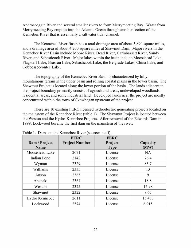
There are 10 existing FERC licensed hydroelectric generating projects located on
the mainstem of the Kennebec River (table 1). The Shawmut Project is located between the Weston and the Hydro-Kennebec Projects. After removal of the Edwards Dam in 1999, Lockwood became the first dam on the mainstem of the river.
Table 1. Dams on the Kennebec River (source: staff).
Dam / Project
Name
FERC Project Number
FERC Project Type
Capacity (MW)
Moosehead Lake 2671 License NA Indian Pond 2142 License 76.4
Wyman 2329 License 83.7 Williams 2335 License 13
Anson 2365 License 9 Abenaki 2364 License 18.8 Weston 2325 License 15.98
Shawmut 2322 License 8.65 Hydro Kennebec 2611 License 15.433
Lockwood 2574 License 6.915

24
3.2 SCOPE OF CUMULATIVE EFFECTS ANALYSIS
According to the Council on Environmental Quality’s regulations for implementing the National Environmental Policy Act,21 a cumulative effect is the impact on the environment that results from the incremental impact of the action when added to other past, present, and reasonably foreseeable future actions, regardless of what agency (federal or non-federal) or person undertakes such other actions. Cumulative effects can result from individually minor but collectively significant actions taking place over a period of time, including hydropower and other land and water development activities.
Based on our review of the license application, we have identified diadromous fish species as resources that could be cumulatively affected by continued operation of the Shawmut Project in combination with other past, present, and foreseeable future activities, such as the operation of other hydroelectric dams, wastewater discharges from agricultural activities, industrial and commercial development, and fish harvest.
In section 3.3.1.2, Aquatic Resources- Environmental Effects, we discuss the cumulative effects of licensing the project on migratory fish.
3.2.1 Geographic Scope
The geographic scope of the cumulative effects analysis defines the physical limits or boundaries of the proposed action’s effect on the resources and contributing effects from other hydropower and non-hydropower activities within the Kennebec River Basin.
We have identified the geographic scope for migratory fish to include the historical range of Atlantic salmon in the Kennebec River Basin. Specifically, this would include the mainstem Kennebec River from the outlet of Harris Station Dam to the Gulf of Maine. It would also include all of the tributaries. The major tributaries within the geographic scope of analysis include: Carrabassett River, Sandy River, Sebasticook River, Messalonskee Stream, Seven Mile Stream, and Cobbosseecontee Stream. We chose this geographic scope because the operation and maintenance of the Shawmut Project, in combination with other dams located both upstream and downstream of the project affect diadromous fish migration, habitat availability, and survival within this area of the basin.
3.2.2 Temporal Scope
The temporal scope of our cumulative effects analysis includes a discussion of past, present, and future actions and their effects on aquatic resources. Based on the term
21 As noted above, the NEPA review of this project was prepared pursuant to
CEQ’s 1978 regulations.

25
of the proposed license, we will look 30 to 50 years into the future, concentrating on the effects on water quality and migratory fish from reasonably foreseeable future actions. The historical discussion is limited, by necessity, to the amount of available information. We identified the present resource conditions based on the license application, agency comments, and comprehensive plans.
3.3 PROPOSED ACTION AND ACTION ALTERNATIVES
In this section, we discuss the project-specific effects of the project alternatives on environmental resources. For each resource, we first describe the affected environment, which is the existing condition and baseline against which we measure project effects. We then discuss and analyze the site-specific environmental issues.
Only the resources that would be affected, or about which comments have been received, are addressed in detail in this EA. Based on this, we have determined that aquatic resources, terrestrial resources, threatened and endangered species, land use and recreation, and cultural resources would be affected by the proposed actions and alternatives. We have not identified any substantive issues related to geology and soils, aesthetic resources, or socioeconomics associated with the proposed actions; therefore, these resources are not addressed in the EA. We present our recommendations in section 5.1, Comprehensive Development and Recommended Alternative.
3.3.1 Aquatic Resources
3.3.1.1 Affected Environment
Water Quantity
The Shawmut Project impoundment extends about 12 miles upstream of the dam and has a surface are of approximately 1,310 acres. The impoundment has a volume of approximately 4,960 acre-feet; however, because the project is operated as a run-of-river facility there is no usable storage capacity under normal operating conditions. Daily inflow to the impoundment varies seasonally based largely upon Kennebec River flows, the operation of upstream storage facilities and hydroelectric projects, and unregulated tributary inflow. The maximum hydraulic capacity of the two powerhouses combined is approximately 6,691 cfs. The closest operating stream gage to the project is USGS gage no. 01049265 located about 12.9 miles downstream at North Sidney, Maine. To provide current data on streamflows in the project reach, Brookfield estimated inflow at the project using 15 years of prorated data from the North Sydney gage for the period of

26
January 2004 – December 2019.22 Table 2 summarizes monthly flow data for the Kennebec River at the project based on the prorated data.
Table 2. Average, minimum, and maximum daily inflow for the project based on prorated gage data for the period 2004-2019 (source: license application). Month Average (cfs) Minimum (cfs) Maximum (cfs) January 7,897 3,385 33,696 February 7,137 2,980 26,754 March 9,286 2,558 43,290 April 18,668 2,590 68,406 May 11,952 2,418 59,358 June 8,199 1,888 50,232 July 5,357 1,599 32,916 August 4,509 1,381 41,964 September 4,301 1,248 32,214 October 7,370 1,154 52,182 November 9,557 1,989 45,552 December 8,830 2,714 61,620 Annual 8,582 1,154 68,406
Water Withdrawals and Discharges
SD Warren’s Somerset Operations Mill (doing business as SAPPI Fine Paper) withdraws process water and discharges secondary treated waste water to the Kennebec River at approximately the mid-point of the project impoundment. The Skowhegan wastewater treatment plant discharges treated water to the river immediately upstream of the project boundary.
Water Quality
Maine’s water quality laws (38 M.R.S.A. §464 et. seq.) establish the State’s classification system for surface waters. The Kennebec River from the upper reach of the Shawmut impoundment to the Fairfield-Skowhegan town boundary (approximately midway along the Shawmut impoundment) is classified as a Class B water. The Kennebec River from the Fairfield-Skowhegan town boundary to Shawmut Dam is classified as a Class C water. The Kennebec River downstream of the Shawmut Dam is classified as a Class B water. Designated uses of Class B and C waters include drinking
22 The drainage area at the North Sydney gage is 5,403 square miles, while the
drainage area at Shawmut Dam is 4,200 square miles. Therefore, the data were prorated by a factor of 0.78 to reflect the difference in drainage areas between the gage and the project site (i.e., 4,200/5,403=0.78).
27
water after treatment, fishing, agriculture, recreation in and on the water, industrial process and cooling water supply, hydroelectric power generation, navigation, and habitat for fish and other aquatic life.
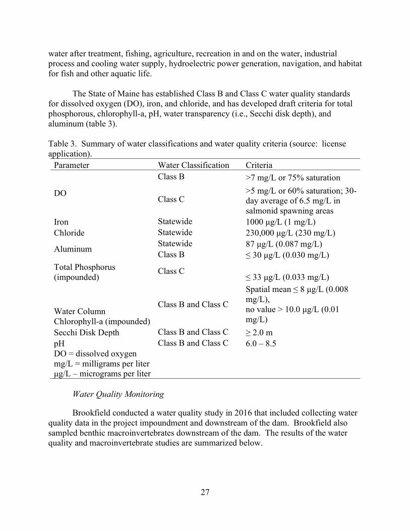
The State of Maine has established Class B and Class C water quality standards
for dissolved oxygen (DO), iron, and chloride, and has developed draft criteria for total phosphorous, chlorophyll-a, pH, water transparency (i.e., Secchi disk depth), and aluminum (table 3).
Table 3. Summary of water classifications and water quality criteria (source: license application).
Parameter Water Classification Criteria
DO
Class B >7 mg/L or 75% saturation
Class C >5 mg/L or 60% saturation; 30-day average of 6.5 mg/L in salmonid spawning areas
Iron Statewide 1000 μg/L (1 mg/L) Chloride Statewide 230,000 μg/L (230 mg/L)
Aluminum Statewide 87 μg/L (0.087 mg/L) Class B ≤ 30 μg/L (0.030 mg/L)
Total Phosphorus (impounded)
Class C ≤ 33 μg/L (0.033 mg/L)
Water Column Chlorophyll-a (impounded)
Class B and Class C
Spatial mean ≤ 8 μg/L (0.008 mg/L), no value > 10.0 μg/L (0.01 mg/L)
Secchi Disk Depth Class B and Class C ≥ 2.0 m pH Class B and Class C 6.0 – 8.5 DO = dissolved oxygen mg/L = milligrams per liter μg/L – micrograms per liter
Water Quality Monitoring
Brookfield conducted a water quality study in 2016 that included collecting water quality data in the project impoundment and downstream of the dam. Brookfield also sampled benthic macroinvertebrates downstream of the dam. The results of the water quality and macroinvertebrate studies are summarized below.

28
Impoundment
Impoundment Trophic Sampling
Brookfield sampled the impoundment twice a month between June 2016 and October 2016 at a location about 1,600 feet upstream from the project dam in a water depth ranging from 6 to 9 meters. Brookfield took a composite sample of the water column using an epilimnetic core23 and measured total phosphorus, chlorophyll-a, and pH, in addition to other parameters. During each impoundment trophic sampling event, Brookfield also collected Secchi disk transparency measurements and dissolved oxygen profiles at one meter intervals from the top to the bottom of the water column.
During the sample period, total phosphorus ranged from 0.011 to 0.021 milligrams
per liter (mg/L) with an average 0.016 mg/L, chlorophyll-a ranged from 0.0016 mg/L to 0.0090 mg/L with an average of 0.0034 mg/L, and pH ranged from 6.4 to 7.0 with an average of 6.7. Secchi disk transparency ranged from 2.6 to 4.4 meters with an average of 3.8 meters.
Measurements of chlorophyll-a, total phosphorus, and Secchi disk transparency
indicate that the impoundment is mesotrophic (i.e., moderately productive). With the exception of one chlorophyll-a sample (collected on September 22, 2016), the total phosphorus, chlorophyll-a, and Secchi disk transparency met the thresholds established by the state standards.
Throughout the sample period, the DO concentration at the trophic sampling
location in the impoundment ranged from 1.4 mg/L to 9.7 mg/L. Low DO measurements (1.4 mg/L, and 3.0 mg/L) were measured on June 30 near the bottom of the impoundment. The highest DO concentration in the impoundment was 9.7 mg/L on October 18. The average DO concentration throughout the water column ranged from 7.0 mg/L on June 30 to 9.6 mg/L on October 18. With the exception of two low DO measurements near the bottom of the impoundment on June 30, the DO concentrations exceeded the state standard of 5 mg/L for Class C waters.
Impoundment Water Temperature Sampling
Brookfield measured and developed vertical profiles of water temperature twice a month between June 2016 and October 2016 at 15 locations throughout the impoundment. The water temperature throughout the impoundment ranged from a minimum of 13.5º Celsius (C) (56.3° Fahrenheit (F)) in October to a maximum of 28.4ºC
23 An epilimnetic core generally comprises small diameter tubing with a weighted
end that is deployed vertically into the water column to collect a sample of water.

29
(83.1ºF) in July. The maximum water temperature during the study (28.4ºC) was measured on July 27 approximately three inches below the surface. The water temperature steadily decreased throughout late August, September, and October. The average water temperature throughout the water column at all 15 sample locations in the impoundment ranged from 13.9ºC (57.0ºF) on October 18 to 24.5ºC (76.1ºF) on July 27. Overall, water temperatures were relatively uniform throughout the water column and generally varied by only 1ºC to 3ºC.
Downstream of Dam
Riverine Dissolved Oxygen and Water Temperature
Brookfield measured DO and water temperature downstream of the dam hourly from June through August 2016. During this period, DO ranged from a minimum of 6.8 mg/L in August to a maximum of 9.6 mg/L in June. Average monthly DO concentrations ranged from 7.6 mg/L in August to 8.9 mg/L in June. Water temperatures during this period ranged from a minimum of 15.8°C (60.4°F) in June to a maximum of 26.2°C (79.1°F) in August. Average monthly water temperatures ranged from 18.9°C (66°F) in June to 24.2°C (75.5°F) in August.
Benthic Macroinvertebrates In 2016, Brookfield collected and processed benthic macroinvertebrate samples
from two locations (site 1 and site 2) in the Shawmut tailwater area to determine if the waters are in attainment of the designated aquatic life uses of its water classification. The sample results show that individuals from the orders Ephemeroptera, Plecoptera, and Trichoptera24 assemblage were present at both sampling locations, composing 40.3 to 67.7 percent of the total number of specimens at the sampling locations. Based on the sampling results, Maine DEP determined that the benthic community at site 1 meets Class A water quality standards and the community at site 2 meets Class B water quality standards.
Aquatic Habitat
Impoundment
The Shawmut impoundment is approximately 12 miles long, with an average width of approximately 750 feet and an average depth of approximately 20 feet. Near the
24 Invertebrates belonging to the orders Ephemeroptera, Plecoptera, and
Trichoptera are generally sensitive to pollution and can provide information on the condition of the benthic macroinvertebrate community.

30
dam, the impoundment is approximately 1,800 feet wide and 30 feet deep. The impoundment is characterized by typical littoral and shoreline habitats such as mud flats, tributary deltas, islands, and submerged aquatic vegetation beds. Substrates near the upper end of the impoundment consist primarily of large gravels and cobbles with some interspersed fine sediment. The substrates in the middle and lower reaches of the impoundment are primarily fine-grained sediment (i.e., sands, silts, clay). Marsh and wetland communities along the impoundment include waterlily and macrophyte beds, pickerelweed marsh, bulrush marsh and grassy shrub marsh (i.e., palustrine emergent wetland). Three small tributaries, Wesserunsett, Martin, and Carrabassett streams, discharge into the Kennebec River within the Shawmut impoundment.
Tailwater
The Kennebec River in the tailwater area immediately below the dam is approximately 1,000 feet wide. The river is shallow with several bedrock shoals, cobble and boulder beds, and riffle habitat.
Fish Community
Resident Fish
The resident fish community includes coldwater and warmwater game and non-game species. In 2019, Brookfield conducted electrofishing surveys to characterize the occurrence, distribution, and relative abundance of fish species within the Shawmut impoundment and the Shawmut tailwater downstream to a point approximately 4,000 feet below the dam. A total of 798 fish representing 14 species were collected in the impoundment. The fish assemblage consists mostly of yellow perch (51 percent) followed by largemouth bass (12 percent), golden shiner (10 percent), black crappie (5 percent) and alewife (5 percent). Other fish species collected in lower abundance included pumpkinseed, fallfish, smallmouth bass, chain pickerel, white sucker, American eel, redbreast sunfish, Lepomis spp., and banded killifish.
The fish survey in the tailwater resulted in the collection of a total of 51 fish
representing seven species. The most abundant fish species collected in the tailwater reach included fallfish (55 percent), smallmouth bass (14 percent), American eel (10 percent) and white sucker (10 percent). Other fish species collected in lower abundance included yellow perch, alewife, and redbreast sunfish.
Maine DIFW maintains a brown trout population upstream of Shawmut Dam by stocking 1,000 to 2,000 spring-yearling fish each year. From 1992 to 2007, Maine DIFW infrequently stocked brown trout fry, fall-yearlings, and adults downstream of the dam. During the same period, the Kennebec Valley Chapter of Trout Unlimited also stocked 1,000 to 2,000 rainbow trout upstream of Shawmut Dam. In the Kennebec River Basin

31
upstream of Shawmut Dam, Maine DIFW maintains a trout fishery in Wesserunsett Stream and Wesserunsett Lake by stocking brook and brown trout regularly during the fall. Maine DIFW also regularly stocks yearling brook trout in the spring in Carrabassett Stream.
Migratory Fish
The lower Kennebec River, including the Shawmut Project waters, supports runs of diadromous fish species, including American shad, blueback herring, alewives, Atlantic salmon, American eel, and sea lamprey. With the exception of the catadromous American eel, all other diadromous fish species in the Kennebec River are anadromous and are transported into habitats upstream of the Lockwood Project via trap and haul operations conducted at the Lockwood fish lift. Atlantic and shortnose sturgeon also occur in the Kennebec River but they do not occur upstream of Lockwood.
Atlantic salmon
Anadromous Atlantic salmon in the Kennebec River are listed as endangered under the ESA and are part of the Gulf of Maine Distinct Population Segment (GOM DPS). In 2009, NMFS designated critical habitat in the Kennebec River that extends from the mouth of the Kennebec River upstream to the Carrabassett River near Madison, Maine, and includes the river reach within the Shawmut project boundary. As part of the recovery strategy, NMFS partitioned the GOM DPS into three salmon habitat recovery units (SHRUs) based on geo-ecological and subpopulation factors known at the time of the listing. The Shawmut Project is located within the Merrymeeting Bay SHRU which includes parts of the Kennebec, Androscoggin, and Sheepscot Rivers, as well as several additional coastal watersheds west of Penobscot Bay. According to NMFS’s August 28, 2020 filing, designated critical habitat within the Kennebec River contains about 90,000 modeled Atlantic salmon rearing habitat units, of which 63,000 habitat units occur upstream of the Shawmut Dam.
The historical upstream barrier to Atlantic salmon on the upper Kennebec River is
a set of falls known as “the Hulling Machine” (currently impounded by Harris Station Dam25 about 85 river miles upstream of Shawmut).
Currently, Atlantic salmon are captured at the downstream Lockwood facility and
trucked to the Sandy River located about 25 miles upstream of Shawmut Dam. From 2006 to 2019, a total of 346 adult Atlantic salmon were captured at the Lockwood fish lift. During this period, the total number of annual returns of adult salmon ranged from 5 to 64 individuals, of which 33 to 100 percent of adults collected were naturally reared
25 Harris Station Dam is part of the Indian Pond Hydroelectric Project.

32
returns.26 The recent 10-year average (from 2011-2020) of annual adults returns at the Lockwood fish lift is 32 fish, with a 2019 total count of 56 adult salmon and a 2020 total count of 51 adult salmon (Maine DMR, 2020).
In addition to the transport of returning adult Atlantic salmon to the Sandy River,
Maine DMR has stocked a total of 145,900 fry and 8,187,501 eggs in the Sandy River from 2003 to 2019. To successfully reach the ocean, Atlantic salmon smolts must survive a variety of natural causes of mortality (e.g., predation, disease, water temperature), as well as passage downstream through four powerhouses and dams. Once Atlantic salmon leave the riverine environment, and enter the estuarine environment, mortality rates increase, primarily because of high predation risk (Hawkes et al., 2013) and physiological stress in transitioning to a salt water environment (Handeland et al., 1997). If Atlantic salmon survive the freshwater and estuarine environment, they must then survive the marine environment, which has become an increasingly difficult challenge, as indicated by declines in marine survival, possibly caused by changing ocean conditions (ICES, 2011; Miller et al., 2012). NMFS (2013) estimated that the existing median marine survival rate of Atlantic salmon is 0.4 percent.
After spawning, some adults survive, journey back to the ocean, and return again
to spawn after at least one year in the ocean. Surviving adults are referred to as “kelts” during their downstream migration. From 1967 to 2016, approximately 1.9 percent of the wild and naturally reared adult anadromous Atlantic salmon returning to U.S. rivers were repeat spawners, but these fish have become increasingly rare (USASAC, 2017).
River Herring Blueback herring and alewife27 are anadromous fish that spend most of their lives
at sea, but return to their natal (home) rivers along the eastern seaboard of North America to reproduce (Melvin et al., 1986; Greene et al., 2009). Historically, alewives ascended the Kennebec River as far as Norridgewock Falls, 89 miles from the sea on the mainstem (Foster & Atkins, 1869 as cited by NMFS, 2020). In the Sandy River, alewives historically ascended as far as Farmington and spawned in Temple Pond until a dam was built in New Sharon in 1804 (NMFS, 2020). The historical range of blueback herring in the Kennebec River is unknown, but it was likely similar to the range of alewives (Maine DMR, 2020a). In New England, blueback herring primarily spawn in shallow areas with moderate currents in mainstem rivers, whereas alewives generally spawn in lake or pond habitats within a river basin (Loesch, 1987). Spawning runs of alewife occur earlier
26 See Maine DMR’s August 28, 2020 filing.
27 Blueback herring and alewife are difficult to distinguish visually and, therefore, are often collectively referred to as river herring.

33
(May through June in Maine) than those of blueback herring (June through July) (Loesch, 1987; Saunders et al., 2006). Downstream migration of juvenile and post-spawn adult alewives in Maine rivers occurs from mid-July through the end of November (Mullen et al., 1986; Saunders et al., 2006).
Currently, Maine DMR captures adult river herring at the Lockwood fish lift and
releases them into the Hydro-Kennebec and Shawmut impoundments or other suitable habitat in the watershed. From 2006 to 2019, the annual number of adult river herring captured at the Lockwood fish lift ranged from 3,152 to 238,953 individuals (Maine DMR, 2020a). From 2008 to 2019, a total of 510,371 adult river herring captured at the Lockwood fish lift were released into the Shawmut impoundment and a total of 392,776 adult river herring were released into the Hydro-Kennebec impoundment.
American shad
The anadromous American shad exhibit a similar life history to blueback herring,
spending most of their lives at sea but returning to their natal river to spawn, with spawning generally occurring in a mainstem river. The spawning runs of American shad in Maine rivers generally occur from June through July and outmigration of juvenile and adult shad generally occurs from mid-July through October. Historically, American shad ascended to about RM 98 of the Kennebec River, to about RM 47 in the Sandy River, and to about RM 32 in the Sebasticook River (Maine DMR, 2020a).
From 1987 to 2007, Maine DMR stocked American shad into historic habitat
above the Edwards Dam site at RM 43 on the Kennebec River, including 7,879 adults, about 37 million fry, and 198,176 fingerlings. Currently, American shad collected at the Lockwood fish lift are transported to the Sandy River. From 2006 to 2019, Maine DMR captured a total of 1,599 American shad (ranging from 0 to 836 individuals per year) at the Lockwood fish lift and released them into spawning habitat in the Sandy River.
American eel
The migratory American eel, a catadromous species, occurs upstream and downstream of Shawmut Dam. Although the historic upstream limit of American eel in the Kennebec River Basin is unknown, Interior indicates in its August 27, 2020 filing that American eels have been found in the Williams Project impoundment located about 45 miles upstream of the Shawmut Project. American eels spawn in the ocean, specifically in the Sargasso Sea, but spend the majority of their lives in freshwater or estuarine habitats. In New England, juvenile American eels migrate upstream in rivers from March through October (Richkus and Whalen, 1999), and adult eels migrate downstream from mid-August to December (Haro et al., 2003; GMCME, 2007). The Kennebec River Basin serves as rearing habitat for eels that eventually migrate downstream to return to the ocean as adults and spawn.

34
In 2003, Brookfield installed an upstream eel passage system at the Shawmut
Project. After installation of the inflatable bladders along the spillway, Brookfield replaced the upstream eel passage system with a seasonal eelway in 2010. Following juvenile eel surveys in 2019, Brookfield installed a second seasonal eelway at the project. From 2007 to 2019,28 Brookfield collected and passed 130,498 juvenile eels at the Shawmut Project. During this period, the number of juvenile eels captured annually has ranged from 16 in 2007 to 39,266 in 2014.
Sea Lamprey Sea lamprey are native to coastal rivers of Maine, including the Kennebec River
Basin; however, the historical abundance and distribution of sea lamprey in the Kennebec River is unknown. Sea lamprey spend most of their adult life at sea; however, unlike other anadromous species, they do not home to their natal waters to reproduce. Sea lamprey move into gravel areas of tributary streams during spring and early summer to spawn (Great Lakes Fishery Commission, 2000). Immediately after spawning, females drop downstream and soon die, while males may remain on the nests for a short period before dying. After the egg and larval life stages, sea lamprey move out to sea for the parasitic phase of its life (up to 2 years). According to the 2019 fish passage report for the Kennebec River Projects, 8 sea lamprey were collected in the Lockwood fish lift in 2019 (Brookfield, 2020a).
3.3.1.2 Environmental Effects
Run-of-River Operation and Impoundment Levels
Flow fluctuations during the operation of hydropower projects can affect shoreline littoral and riverine habitat in impoundments and downstream reaches by exposing them to periodic dewatering, making them unsuitable for aquatic biota.
Brookfield proposes to continue operating the project in run-of-river mode where outflow approximates inflow, and to continue to maintain the impoundment elevation within 1 foot of the normal full pool elevation of 112.0 feet. Brookfield also proposes to continue monitoring impoundment levels, generation, inflows, and outflows at the project to maintain run-of-river operation.
NMFS and Maine DMR support Brookfield’s proposal to minimize impoundment
level fluctuations by operating the project in run-of-river mode. However, Interior
28 Upstream eel passage was not available in 2009 because of construction of the
inflatable bladder dam along the spillway.

35
recommends that Brookfield operate the project in an instantaneous run-of-river mode and maintain impoundment levels at all times during normal operations at the normal full pool elevation of 112.0 feet.
Our Analysis
Continuing to operate the project in run-of-river mode would minimize fluctuations in the project impoundment and in the Kennebec River downstream of the project. Maintaining relatively stable impoundment levels within 1-foot of the normal full pool elevation would protect shoreline habitat and fish and other aquatic organisms that rely on near-shore habitat in the impoundment for spawning, foraging, and cover. Minimizing flow fluctuations downstream of the powerhouses would also protect aquatic habitat, minimize fish stranding potential, and provide stable passage routes for migratory fish.
Even though the project is operated as a run-of-river facility, total outflow can vary to a limited extent as units, gates, and spillway mechanisms (i.e., flashboards and rubber bladder sections) are raised and lowered to manage pond levels. However, even with these adjustments, Brookfield is able to consistently maintain impoundment elevations within 1 foot of the normal impoundment elevation of 112.0 feet 99% of the time.29
Operating the project in an instantaneous run-of-river mode where outflow always
equals inflow would essentially eliminate any of the minor fluctuations that currently occur when adjustments are made to project facilities. However, there is no indication that the project is technologically capable of operating under conditions where outflow from the project instantaneously equals inflow, rather than approximates it. Further, there is no evidence to suggest that current, minor fluctuations are adversely affecting habitat in the impoundment or downstream of the dam. Therefore, there would be no incremental benefit to littoral and aquatic habitat in converting from current run-of-river operations to instantaneous run-of-river operation.
Brookfield’s proposal to continue to monitor water level in the impoundment and
inflow and outflow would ensure that the project continues to operate in a run-of-river mode to minimize reservoir surface elevation and downstream flow fluctuations, which would maintain habitat stability in the impoundment and downstream of the dam.
29 Brookfield analyzed hourly impoundment elevation variations below the normal
full pond impoundment level for the period January 1, 2010, to December 31, 2015 and found on an annual basis, deviations of 0.5-foot or more and 1-foot or more occurred approximately 4 percent and 1 percent of the time, respectively.

36
Project Operation Monitoring Although Brookfield currently monitors compliance with run-of-river operation
and impoundment levels using sensors and generation output, Brookfield does not have established monitoring protocols or reporting requirements to verify compliance with its operational requirements. To document compliance with project operation, Brookfield proposes to implement the Operations Monitoring Plan filed with the license application.30 The plan includes provisions for: (1) maintaining run-of-river operation and impoundment levels, (2) high water operations, (3) low water operations, (4) maintenance operations, (5) turbine shutdowns, (6) impoundment drawdowns, (7) fish passage operations, (8) unscheduled operations, (9) operation monitoring, (10) reporting, and (11) agency consultation.
Our Analysis
Although compliance measures do not directly affect environmental resources, they assist the Commission in determining whether a licensee is complying with the environmental requirements of a license. Therefore, operational compliance monitoring and reporting are typical requirements in Commission-issued licenses. The operation protocols included in the Operations Monitoring Plan would formalize the project’s operating requirements and the methods for monitoring and reporting compliance with those requirements under various conditions. However, as written the plan does not currently describe the mechanisms and structures to be used to monitor compliance with impoundment elevation limits and run-of-river operation (i.e., type and exact locations of all flow and impoundment elevation monitoring equipment and gages), nor does it include procedures for maintaining and calibrating such monitoring equipment. Additionally, the plan does not include provisions for reporting deviations from all project operating requirements. Revising Brookfield’s proposed plan to include these additional provisions would ensure that operation monitoring and reporting procedures are adequate to facilitate the Commission’s administration of the license.
Upstream Anadromous Fish Passage Currently, there are no upstream passage facilities for anadromous fish at the
Shawmut Project. Brookfield filed an Interim Species Protection Plan (SPP) for the Shawmut Project in 2013, which was incorporated into the existing Shawmut license by a license amendment in 2016.31 The license amendment authorized construction of a new upstream anadromous fishway at the project that was to be completed by May 2019.
30 See Final License Application, Appendix E-6.
31 Merimil Limited Partnership, 155 FERC ¶ 61,185 (2016).

37
However, construction was delayed and Brookfield requested an extension of time to complete construction. By order issued July 13, 2020, Commission staff denied Brookfield’s request for an extension of time and notified Brookfield that any further action on upstream fish passage facility construction at the Shawmut Project would be considered during the relicensing proceeding.
A fish lift was completed at the Hydro-Kennebec Project in 2017, but it has yet to
be operated pending construction of upstream fishways at the Shawmut and Weston Projects and an additional upstream fishway at the Lockwood Project. Upstream fishway construction at the Lockwood and Weston Projects is currently scheduled for completion by May 31, 2022.32
Currently, all Atlantic salmon trapped at the Lockwood Project are transported to
the Sandy River, a tributary to the Kennebec River located about 25 miles upstream of the Shawmut Project. The Sandy River contains much of the high quality spawning and rearing habitat for salmon in the basin. Alosines are also currently captured at the Lockwood Project and transported to lakes and impoundments throughout the basin (including the Shawmut impoundment).
As part of its proposed relicensing action, Brookfield proposes to construct the
previously authorized upstream fish passage facilities at the Shawmut Project. The passage facilities were designed in consultation with NMFS, Interior, and Maine DMR from 2016 to 2019, and in accordance with the FWS’s Design Criteria Manual. Brookfield filed final design plans for the fishways on December 31, 2019.
The upstream anadromous fishways would consist of a new fish lift adjacent to the
1912 Powerhouse and a concrete bypass channel through the island separating the two powerhouse tailraces. The concrete bypass channel would enable fish migrating upstream in the 1982 Powerhouse tailrace to move across the island and into the 1912 Powerhouse tailrace where they could access the new fish lift entrance to be passed over the dam.
NMFS’s fishway prescription stipulates that Brookfield construct, operate, and
maintain upstream fishways to provide “safe, timely, and effective” passage for anadromous fish at the project. The fishways must be designed to pass sea lamprey and approximately 1.54 million blueback herring, 134,000 alewife, 177,000 American shad, and 12,000 Atlantic salmon per year. NMFS acknowledges that it has reviewed and approved the designs for Brookfield’s proposed fish lift and states that Brookfield’s proposed fishway, with its required performance monitoring and adaptive management
32 See July 13, 2020, Order on Requests for Extensions of Time to Install Fish
Passage.

38
provisions, meets the intent of its prescription. Maine DMR recommends that Brookfield construct an anadromous upstream
fishway at the project that is designed to the same specifications stipulated by NMFS. Our Analysis Brookfield designed its proposed upstream fishways through an extensive design
review process. The final fishway design and location was selected based on: (1) the results of a radio telemetry study using adult alewives to identify areas below the dam where upstream migrating anadromous alewives congregated, (2) a 3-dimensional hydraulic model of the selected area to visually depict future hydraulic conditions and ensure that there were no obvious hydraulic limitations to successful passage, and (3) extensive agency consultation and a design review process to obtain agency input on the fishway design alternatives.
The results of these efforts led to the development of fishways that were designed
consistent with current standards for upstream passage of anadromous fish and are reasonably certain to facilitate fish passage on an annual basis for the numbers of each species specified by NMFS and recommended by Maine DMR.
Upstream Anadromous Fishway Performance Standards
Fishway performance standards can be used to assess the performance of a fishway at facilitating passage for a given fish species. Brookfield proposes to achieve 95 percent adult salmon upstream survival for the Shawmut Project. Brookfield does not propose any upstream performance standards for alosines or any other anadromous species.
NMFS’s fishway prescription states that it is currently developing upstream performance standards that would likely be finalized during ESA consultation, but without elaboration states that it anticipates that the performance standards will likely include 96 percent adult salmon upstream survival and 70 percent alosine upstream survival. The standards would be based on the number of fish successfully passing the project within 48 hours of approaching project works.
Maine DMR states that it would consider the Shawmut fishways to be operating
“effectively” if the following performance standards are met: (1) 99 percent passage effectiveness for Atlantic salmon, (2) 75 percent passage effectiveness for American shad, and (3) 80 percent passage effectiveness for sea lamprey. Passage effectiveness would be determined by the number of adult fish of each target species that successfully pass upstream of Shawmut Dam within 48 hours of approaching within 200 meters of the Shawmut powerhouses. For Atlantic salmon, Maine DMR bases its performance

39
standards on the results of its desktop analysis that assessed passage survival of smolts and adults using assumptions from Nieland et al. (2013; 2020).33 Maine DMR states that its analysis shows that with “high” freshwater and “high” marine survival coinciding with upstream and downstream fishway efficiencies of 99 percent at six dams on the Kennebec River, Maine DMR could meet its goal of a minimum of 2,000 adult salmon34 returning to their home waters. For American shad, Maine DMR bases its upstream performance standard for Shawmut on those developed for fishways on the Connecticut River and anticipates that applying this standard would meet its population abundance goal of 261,000 returning adult shad above Shawmut Dam. For sea lamprey, Maine DMR’s recommended upstream performance standard is based on the performance achieved at the Milford fish lift in 2020; however, Maine DMR provided no information on how this standard would affect population recovery goals for sea lamprey in the Kennebec River. In addition to these specified performance standards for adult Atlantic salmon, American shad, and sea lamprey, Maine DMR also recommends (as discussed below in our analysis of Upstream Fishway Effectiveness Testing) that Brookfield evaluate the effectiveness of the project’s upstream anadromous fishways for adult alewife and adult blueback herring. However, Maine DMR does not specify the performance standards that would be used to determine passage effectiveness for either of these species.
If Brookfield is unable to meet the upstream fishway performance standards, then
NMFS’s fishway prescription stipulates and Maine DMR recommends that Brookfield implement additional adaptive management measures in consultation with the resource agencies. Neither agency describes what specific additional measures would be required, but NMFS states that such measures could include operational modifications, structural enhancements, additional fishway entrances, or additional fishways.
In its reply comments, Brookfield asserts that both NMFS’s and Maine DMR’s
standards for salmon are arbitrary and appear to be set unrealistically high in order to justify the agencies’ recommendations for dam removal. Brookfield states that it chose its upstream performance standard for salmon because it was directed by NMFS to use performance standards that are comparable to those used for dams on the Penobscot River. Brookfield states that the SPPs for six dams on the Penobscot River include upstream performance standards of 95% for each dam. A 95% performance standard for
33 Maine DMR’s desktop analysis included assumptions on salmon smolt
production, natural riverine and estuarine mortality, dam passage efficiency, and marine survival.
34 Maine DMR states “a census size of 2,000 naturally reared adults would be the minimum needed to withstand downturns in marine survival.”

40
Shawmut and the other three lower Kennebec River projects would equate to a cumulative survival standard of 81.4% for the four projects combined.
Brookfield also states that the analyses it used to design the new upstream
fishways were completed in consultation with the agencies and in accordance with the FWS’s Design Criteria Manual, and that it already demonstrated throughout the design review process that the proposed fishway designs would meet a performance standard of 95% for Atlantic salmon.
Our Analysis Brookfield conducted studies to inform the location of the fish lift and designed
the facility in accordance with the FWS’s Design Criteria Manual and in close consultation with NMFS, Interior, and Maine DMR based on the agencies’ direction at the time that Brookfield should plan to achieve a 95% upstream passage effectiveness standard for Atlantic salmon. This performance standard was the same standard applied at six hydropower projects on the nearby Penobscot River. Although most of the adult salmon returning to the Penobscot River are of hatchery origin, current returns to the Penobscot River are the highest of all rivers in the State of Maine, averaging 846 adults per year from 2014-2020,35 with a 2020 count of 1,602 salmon (Maine DMR, 2020b). In the Kennebec River, the number of Atlantic salmon captured at the Lockwood fish lift have averaged 35 adults per year (ranging from 11 to 51 adult salmon per year) from 2014-2020. Tagging studies in 2016 and 2017 found the Lockwood lift was 79 percent effective at passing Atlantic salmon. Applying this passage efficiency to the average annual number of salmon captured at the Lockwood lift would result in an average annual return of 44 salmon to the Kennebec River. Assuming a cumulative upstream performance standard of 95 percent survival at all four dams on the Kennebec River below the Sandy River, about 36 adults salmon would survive passage through all four dams compared to 35 adults using existing trap-and-haul methods (table 4). This represents about a 2.9 percent increase in survival relative to existing conditions.
35 Based on combined yearly counts at the Orono and Milford fish lifts on the
lower Penobscot River.

41
Table 4. Estimated number of adult Atlantic salmon effectively passing upstream of the Weston Project under existing and proposed passage effectiveness scenarios
Species
Estimated Average Returnb
Performance Standard (%)a Baselinec Brookfield NMFS Maine DMR
79% 95% 96% 99% Atlantic Salmond 44 35 36 37 42 aAssumes the same upstream fishway passage efficiency at Lockwood, Hydro-Kennebec, Shawmut, and Weston Dams. bBased on average of 7-year returns at Lockwood Fish Lift (2014-2020) and adjusted for baseline fishway efficiency c Based on the estimated efficiency of Lockwood Fish Lift from the 2016 and 2017 Atlantic salmon radio-telemetry studies (Brookfield et. al., 2019)
d Includes both wild and hatchery-origin Atlantic salmon collected at Lockwood Fish Lift
Under a 96 and 99 percent upstream survival standards, the average number of
returning salmon surviving passage through all four dams would increase to about 37 to 42 adult salmon, respectively. This would represent an increase in survival of about 5.7 percent to 20 percent over existing conditions. Maine DMR’s goal for Atlantic salmon is to restore a minimum population of 2,000 adults annually to historic high-quality habitats in the Kennebec River above Weston Dam (Maine DMR, 2020a). Likewise, Commerce chose 2,000 spawners as a number that can weather downturns in survival (74 CFR 29300). Thus, the average return for 2014-2020 represent about two percent of the restoration goal of 2,000 adult salmon. Based on these existing low run sizes compared to the restoration goals, the higher performance standards stipulated by NMFS and recommended by Maine DMR would provide minimal benefits to the Atlantic salmon population at this time.
The only other “state of the art” fish lift that we are aware of that was recently
constructed (i.e., 2013) and tested on a project with a similar configuration as Shawmut was at Milford Dam (FERC No. 2534) on the Penobscot River.36 Two years of radio telemetry studies in 2014 and 2015 at Milford Dam showed that the fish lift was 95.5% effective in the first year (21 of 22 tagged adults) and 100% effective in the second year (50 of 50 tagged adults) at passing salmon that approached within 200 meters of the
36 Both Shawmut and Milford are low head dams on large mainstem rivers with
long sections of overflow spillway and no bypassed reaches. In both cases, the fish lift design included installing the fish lift adjacent to a powerhouse.

42
project (Izzo et al., 2016). These data suggest that Brookfield’s proposed “state of the art” fish lift is designed to pass at least 95% of salmon that approach within 200 meters of the project.
As previously discussed, most adult river herring and American shad collected at
the Lockwood fish lift facility are transported to suitable habitat areas within the Kennebec River Basin, including the Hydro-Kennebec and Shawmut impoundments. Some portion of the collected alosines are also returned downstream of the Lockwood Dam or transported to other river basins. From 2014-2020, river herring and American shad captured at the Lockwood fish lift annually averaged 201,349 and 248 adults, respectively. Maine DMR’s target run sizes for alewife and blueback herring in the Kennebec River below the Weston Project are 134,000 and 1,535,000 fish, respectively. Maine DMR’s target run size for American shad below the Weston Project is 177,000 fish. To understand the effects of existing and proposed fish passage alternatives on the upstream migrating alosine population, we estimated the number of river herring and American shad that could potentially reach habitat above the Shawmut Project under existing trap and transport operations, and under the performance standards recommended by Maine DMR and prescribed by NMFS for volitional passage (table 5). Because there is no site-specific information on collection efficiency of the Lockwood fish lift for these species we used the results of a telemetry study of shad passage at the Lockwood fish lift in 2010 that showed that of 37 tagged shad that approached the fish lift only one entered it (2.7%) (FPL Energy Maine, 2010). For river herring we used the results of a 2019 passage effectiveness study at the Pejepscot Project (FERC No. 4784) that determined that passage effectiveness for river herring at the project’s fish lift was 19.8% (Brookfield, 2020b).
Table 5. Estimated number of fish effectively passing upstream of Shawmut Project under existing and proposed passage effectiveness scenarios.
Species Estimated
Total Returna
Estimated Baseline Passage Effectiveness
(%) Performance Standard (%)b
NMFS Maine DMR 2.7% 19.8% 70% 75%
American Shad 9,185 248 N/A 3,151 3,875 River Herringc 1,016,914 N/A 201,349 348,802 N/A Note: Baseline assumes continued trap and transport operation; mortality resulting from handling and transport was not included since it was generally reported to be less than 1 percent for alosines. a Based on the average of 7 years (2014-2020) of fish captured at the Lockwood fish lift and the lift's estimated passage effectiveness

43
b Assumes the same upstream fishway passage efficiency at Lockwood, Hydro-Kennebec, and Shawmut Projects. c Includes both alewife and blueback herring
N/A = Not Applicable For American shad, achieving either NMFS’s or Maine DMR’s performance
standard would substantially increase the number American shad successfully passing upstream of the Shawmut Project compared to the number of shad currently collected at the Lockwood fish lift and transported upstream. Similarly, for river herring, the existing passage conditions would likely pass less river herring upstream of the Shawmut Project than volitional passage facilities at all three dams if the 70 percent performance standard stipulated by NMFS was achieved. However, these estimates don’t account for natural in-river mortality as fish continue to move upstream of the projects in search of suitable habitat, or the fact that most suitable upstream habitat for alewife would still be inaccessible after passage through the mainstem projects, compared to existing trap and transport operations.
Further, American shad are typically a difficult species to pass through fishways
even when facilities are both specifically designed to account for them as a target species, and when the facilities are otherwise passing other species (e.g., river herring, salmon). For example, the 2019 passage effectiveness study at the Pejepscot Project determined that nearfield attraction effectiveness and passage effectiveness for shad was 32% and 0%, respectively (Brookfield, 2020b). Similarly, the 2007 to 2016 10-year average count for upstream passage of river herring at the Brunswick Project (FERC No. 2284) on the Androscoggin River is 79,326 adult fish, while the 10-year average count for shad is only 122 adult fish (FERC, 2019). Telemetry studies of shad tagged below the Brunswick Project fishway indicate that shad make many attempts to enter the vertical slot fishway, but very few are successful (ASMFC, 2007). As mentioned above, a telemetry study of shad passage at the Lockwood Project’s fish lift in 2010 showed that 2 of 37 tagged shad approached the fish lift and only one entered it, in spite of a substantial number of shad congregating and spawning just downstream of the project (FPL Energy Maine, 2010).
For sea lamprey their relative abundance in the basin and importance of upstream
habitat to the historical and existing sea lamprey population is not known. Because the abundance and importance of upstream habitat is not known, the benefit of passing sea lamprey upstream of the project to its population cannot be determined based on available information.. Regardless, similar to the Pacific lamprey that occurs along the Pacific coast of the United States, sea lamprey do not appear to exhibit site fidelity to natal streams (Hansen et. al., 2016). This could affect their motivation to migrate upstream after tagging and ultimately factor into the effectiveness testing results for the Shawmut fishways. Studies performed in the Columbia River on the anadromous Pacific lamprey found that fewer than 5% of individuals passed all four of the lowest dams on

44
the river, although some that did not pass entered tributaries below the dams and presumably spawned there (Keefer et al., 2009). Research on Pacific lamprey migrations suggests that high velocity and turbulence at fishways adversely affect Pacific lamprey passage, but there are additional factors that also affect passage success, including: hydraulic cues, predators, water temperatures, and motivation (Pacific Lamprey Technical Working Group, 2017). Keefer et al. (2012) found that much of the apparent fishway rejection at Bonneville Dam, which is the first of the four dams on the Columbia River, occurs in the low velocity/low turbulence environments of collection channels and transition pools within the fishways, which supports the notion that other unknown factors besides high velocity and turbulence adversely affect lamprey passage.
This information suggests that achievement of performance standards for
American shad and sea lamprey might not be realistically achievable due to factors that are unrelated to the design of the fishways, such as: (1) lack of motivation to continue to migrate upstream after capture, tagging, and release for effectiveness studies, (2) inability or lack of motivation to pass a fishway due to the energetic demand from migrating long distances upstream and passing multiple dams during the migration, or (3) inability or lack of motivation to pass a fishway due to other factors that are poorly understood.
Under NMFS’s fishway prescriptions and Maine DMR’s recommendations, Brookfield would need to modify project operations, modify existing fishways, or construct additional fishways if it is not meeting the prescribed or recommended performance standards for any of the target species. NMFS states that fishway modifications could generally include structural enhancements or additional fishway entrances. Maine DMR does not describe any measures that could be implemented to modify the fishways.
Constructing additional fishways could improve passage effectiveness for any of the target species especially if fish are failing to find the fishway entrances and are being falsely attracted to or are congregating in other areas below the dam (e.g., spillways or powerhouse tailraces). While any of the types of modifications described by NMFS could theoretically improve passage for some of the species, the measures are too general to specifically evaluate their potential benefits at this time. Additionally, under NMFS’s prescription and Maine DMR’s recommendation, even if Brookfield is meeting performance standards for some species such as the federally listed Atlantic salmon, it might not for others, and therefore, could need to modify the fishways to attempt to improve passage. Any such modifications could affect the effectiveness of the fishways for passing federally listed Atlantic salmon, possibly even reducing passage effectiveness below performance standards in an attempt to improve passage conditions for other non-

45
listed species. Upstream Fishway Effectiveness Testing To test the effectiveness of the Shawmut upstream fishways at meeting its
proposed performance measures, Brookfield proposes to conduct a preliminary “qualitative” passage study for two years using up to 20 adult salmon collected at the Lockwood Project each year using radio telemetry or a similar method. The preliminary study would begin the first full passage season after upstream fishways are constructed at all four projects. Brookfield also proposes to conduct additional “quantitative” passage studies once sufficient numbers of returning adult salmon are available (i.e., about 200 fish) to complete such studies.
To verify achievement of performance standards, NMFS’s prescription would
require Brookfield to do the following: (1) develop study plans in consultation with NMFS and state and federal resource agencies; (2) complete all monitoring using scientifically accepted practices; (3) begin monitoring at the start of the first migratory season after the Shawmut fishway is operational and continue for up to three years or as otherwise required through further consultation; and (4) prepare reports on the study results.
Maine DMR recommends that Brookfield evaluate fishway effectiveness by
conducting three consecutive years of testing using radio telemetry studies for each of the five anadromous fish species. The studies would begin once upstream passage facilities are operational at the two downstream hydro projects (i.e., Hydro-Kennebec and Lockwood). If the results of the studies show that the fishway is not meeting performance standards, Maine DMR recommends that Brookfield implement any modifications to the fishway specified by Maine DMR and the other resource agencies that the agencies believe are necessary to ensure compliance with the performance standards. Once any modifications are complete, Maine DMR recommends three additional years of effectiveness testing for each of the five target species.
In its reply comments, Brookfield acknowledges that there is a need to test the
effectiveness of the upstream fishways to ensure that they are meeting its proposed performance standards for Atlantic salmon, but objects to Maine DMR’s recommended three consecutive years of testing for salmon (as opposed to two years) and the recommended level of testing effort for all other species. Brookfield states that Maine DMR provides no support to justify why three years of effectiveness studies are needed for five different species (i.e., 15 total radio-telemetry study events). Brookfield also points out that passage studies for two of the species (shad and lamprey) routinely provide inconclusive results and new studies for those species would rely on new and

46
unproven methodologies. Our Analysis Brookfield’s proposal to conduct an initial qualitative testing effort for 2 years
using up to 20 adult fish per year of Kennebec River origin would indicate whether the Shawmut fishways are meeting performance standards. Given that recent returns to the Lockwood trap have averaged a little over 30 fish per year for the last 10 years, there should be sufficient numbers of adult salmon available to test the fishways immediately after their completion. Expanding the testing effort to include up to 200 adult salmon per year, once sufficient numbers of returning adults are available, would provide a larger sample size and more data to draw conclusions on fishway effectiveness.
If the results of the effectiveness testing show that the fishways are not meeting
performance standards for Atlantic salmon, then Brookfield could consult with the agencies and develop measures to improve and further test passage effectiveness after implementation of such measures. However, any such measures would need to be filed with the Commission for approval prior to implementation.
Although Brookfield proposes some general parameters for the fishway
effectiveness testing studies (e.g., sample size of up to 20 adult salmon using radio telemetry or a similar methodology), we are not aware of any final study plans that have been developed for the proposed effectiveness testing effort. Developing study plans in consultation with NMFS, Maine DMR, and Interior would allow the agencies to share their expertise to help ensure that the studies are implemented using scientifically accepted practices and would provide reliable results.
Testing the upstream passage effectiveness for American shad, alewife, blueback
herring, and sea lamprey for three consecutive years would document the levels at which the fishways are passing all four of these species. However, Maine DMR does not recommend any performance standards for two of its target species (alewife, blueback herring); therefore, without specific performance standards to evaluate, there is no information to analyze and no information to determine whether effectiveness testing would or would not provide benefits to alewife and blueback herring..
Upstream Anadromous Fishway Operating Schedule Brookfield proposes to operate the upstream anadromous fishways from May 1 to
October 31 each year. NMFS specifies that the upstream anadromous fishways must be constructed and
operational within two years of license issuance, and be operated from May 1 to

47
November 10 each year. Maine DMR recommends a different operating schedule that would include 24-
hour-per-day operation from April 1 to July 30 and daytime only operation from September 1 to November 30.
In its reply comments, Brookfield states that it generally supports NMFS’s
fishway prescriptions for upstream fish passage including its specified operating schedule. However, Brookfield disagrees with Maine DMR’s recommended operating schedule. Brookfield states that Maine DMR provides no information to support this particular operating schedule, and points out that both early April and late November can be subject to extreme flow and ice conditions, which could limit the ability to operate the facilities effectively. Brookfield also states that no upstream passage facility in the Kennebec River Basin currently operates on a 24-hour basis, including the facility at Benton Falls on the Sebasticook River, which is operated by Maine DMR.
Brookfield states that its proposed operating schedule coincides with the
Lockwood passage facility schedule, which is May 1 to October 31, and, based on its experience at Milford Dam on the Penobscot River, any 24-hour operation of the facility should be limited to May 15 to June 30 for sea lamprey, and perhaps extended through July 30 for American eel passage, if eels are observed utilizing the anadromous fish lift facility for upstream passage.
Our Analysis In the Kennebec River, adult Atlantic salmon, alewife, American shad, and sea
lamprey generally begin their upstream migrations in May. Although Maine DMR recommends that Brookfield begin operation of the upstream fish lift on April 1 of each year, it does not provide any specific justification for why it would be beneficial to operate the fish lift one month earlier than proposed by Brookfield or specified by NMFS. Brookfield begins operating the Lockwood fish lift on May 1 of each year unless inflow to the project exceeds the 24,000-cfs maximum operating range of the fish lift. According to the 2019 fish passage report for the Lockwood fish lift, the fish lift was shut down until May 7 due to high flows. When it began operating on May 7, 140 river herring were captured. The first American shad was collected on June 16, and the first Atlantic salmon was collected on June 3. The report does not provide any data on the collection dates for the 8 sea lamprey collected in 2019. Nevertheless, because the Lockwood fishway does not begin operating until May 1, and any anadromous fish migrating to the Shawmut Project would first need to pass through the Lockwood facility, there would be no fishery-related benefit to operating the Shawmut fishway one month prior to the start of the Lockwood facility.
The 2019 Lockwood passage report indicates that the last date of collection for

48
river herring was July 12, for American shad was September 1, and for Atlantic salmon was October 24. Therefore, the end date of the annual fish lift operation is dictated by when Atlantic salmon end their upstream migration. In the Penobscot River, daily monitoring at the Mattaceunk Project (FERC No. 2520) from 1983 to 2012 indicates that upstream migration of Atlantic salmon peaks during July and in late September, with limited movement occurring in early June, August, and mid to late October (FERC, 2018). The 2019 fish passage report for the Lockwood fish lift shows that only 2 out of 56 total salmon collected in the trap were captured in October.
Neither NMFS nor Maine DMR provide any project-specific evidence to support
extending the upstream fishway operation to November 10 (NMFS) or November 30 (Maine DMR). However, considering there was a recent documented occurrence of Atlantic salmon last entering the Lockwood trap toward the end of October, the upstream movement speeds of salmon (e.g., in the Penobscot River below Milford Dam the median upstream movement speed ranged from 0.1 to 0.6 mile per hour), the 6.5 river miles upstream distance from Lockwood to Shawmut, and the existing daytime-hours operating schedules of the fishways, extending the operating period for the Shawmut fish lift to November 10 would provide the last remaining salmon that passed Lockwood ample time to reach and pass Shawmut Dam. Extending the operating period an additional 20 days to November 30 would provide no apparent benefit because it would be very unlikely that salmon passing the Lockwood Project in late October would still be migrating upstream to the Shawmut Project after November 10.
There is little available information on sea lamprey upstream migration timing in
the Kennebec River to determine the benefits of operating the fish lift for 24 hours a day between April 1 and July 30. As noted above, the 2019 Lockwood fish passage report indicates that 8 sea lamprey were collected in the trap in 2019, but provides no information on the specific date or time of the day that they were collected. There is some information from the Connecticut River and river systems in Europe to suggest that sea lamprey exhibit nocturnal migratory behavior (Boulêtreau et al., 2020; Castro-Santos et al., 2016). However, there is no information on lamprey passage at night in the Kennebec River because no anadromous fishways are currently operated at night. Further, it is unknown whether sea lamprey that cannot pass a fishway at night would instead pass during the day if it were the only passage opportunity available to them. Lastly, because sea lamprey do not home to natal spawning sites, they could move back downstream if unable to pass Shawmut Dam and spawn elsewhere instead. For these reasons, there is no evidence to support operating the anadromous fishways for sea lamprey 24 hours per day from May 1 through July 30.
Downstream Anadromous Fish Passage Brookfield currently provides downstream passage for anadromous fish by
providing dedicated spill flows through the forebay surface sluice gate and Tainter gate

49
(herein referred to as the forebay bypass gates). The surface sluice is continually operated to provide about 35 cfs from April 1 to December 31. The Tainter gate is operated to provide about 600 cfs from April 1 to June 15 for smolt passage, and a flow equal to about 6% of the total powerhouse discharge from November 1 to December 31 for downstream kelt passage.37 To provide an additional dedicated passage route during the April 1 to June 15 Atlantic salmon smolt migration season, Brookfield also lowers four sections of hinged flashboards to spill an additional 560 cfs. Brookfield proposes to continue to implement these measures as part of its proposed action; however, Brookfield would only lower the hinged flashboards during the interim period between license issuance and the installation of the proposed forebay fish guidance boom (discussed below). Additional downstream passage routes at the project include both powerhouses and, when flows are high and Brookfield is spilling, the three spillway sections, (i.e., hinged flashboard, log sluice, and inflatable bladder).
To enhance downstream passage at the project, Brookfield proposes to construct a
permanent guidance boom in the forebay to direct downstream migrating fish to the forebay bypass gates. The guidance boom would be 210 feet long and consist of a series of suspended 10-foot-deep rigid panels with 0.5-inch perforations and an anchoring system. The upstream end of the boom would begin just downstream of and near the west side of the headworks structure. The boom would extend at an angle across the forebay in front of Units 7 and 8 to its terminus at the forebay bypass gates.
NMFS’s fishway prescription stipulates that Brookfield must implement its
proposed downstream passage measures, but also requires the following additional measures: (1) install new trash racks or overlays with 1-inch bar spacing (or 1.5-inch if 1-inch is infeasible) on the Units 7 and 8 intakes; (2) potentially install new trash racks or overlays with 1-inch bar spacing on the Units 1 through 6 intakes;38 and (3) prioritize operation of Units 1 through 6 in the 1912 Powerhouse so that Unit 1 is operated first on last off, followed consecutively by Units 2 through 6.
In support of these measures, NMFS states that the use of a guidance boom has
been shown to be relatively effective at reducing turbine entrainment at other projects in the Kennebec River including at the Lockwood, Hydro Kennebec, and Weston Projects. NMFS, however, adds that because salmon smolts, kelts, and American shad are likely to
37 Brookfield provides the 6% of total powerhouse discharge through the
combined spill of the surface sluice and Tainter gates. For example, if the powerhouses are operating at the maximum capacity of 6,991 cfs, Brookfield would spill about 420 cfs combined through the surface sluice (35 cfs) and the Tainter gate (385 cfs).
38 If installation of the 1-inch bar spacing on the Units 1 through 6 intakes is infeasible, the licensee would instead implement adaptive measures.

50
use water column depths up 20 feet, a 10-foot deep boom is not sufficient to prevent even fish that are typically surface-oriented from sounding under the panels and coming within the vicinity of the various units at the project. NMFS asserts that a proportion of fish would still be entrained in the units and killed. Therefore, NMFS requires the installation of trash racks with 1-inch clear spacing because this close rack spacing is consistent with FWS guidelines (FWS, 2019), would be narrow enough to exclude salmon kelts and most adult alosines, and would be sufficient to minimize entrainment of juvenile alosines, adult American eel, and adult sea lamprey through the stimulation of avoidance behavior (FWS, 2019).
NMFS would determine the appropriate spacing of the new trash racks on the
intakes for Units 7 and 8 based on an evaluation of the approach velocities in front of the intakes39 and whether, in NMFS’s opinion, the approach velocities with its preferred 1-inch bar spacing would be too high to prevent impingement (i.e., NMFS makes a determination that 1-inch trash racks are “infeasible”).40 If NMFS determines that 1-inch-spaced trash racks are feasible, then Brookfield would install the 1-inch-spaced trash racks. If NMFS determines that the 1-inch-spaced trash racks are infeasible, then Brookfield would install new trash racks or overlays with 1.5-inch bar spacing and extend the depth of the new forebay guidance boom by an additional 10 feet to a total depth of 20 feet.
NMFS would use the same methods described above to determine whether it is
feasible to install new 1-inch spaced trash racks or overlays on the intakes for Units 1 through 6. If NMFS determines that new trash racks are feasible, then Brookfield would install the 1-inch spaced trash racks. If NMFS determines that new trash racks are infeasible, then Brookfield would leave the existing 1.5-inch-spaced trash racks in place and implement additional downstream passage measures specified by NMFS. These measures could include, but are not limited to: (1) alternate unit operating prioritization, (2) unit shutdowns, (3) lowering sections of hinged flashboards, (4) replacing the upward-opening Tainter gate with a downward-opening slide gate, and (5) installing a guidance boom or new trash rack structure upstream of the headworks to direct downstream migrants away from the forebay and powerhouses and toward the spillway.
Maine DMR recommends that Brookfield operate a volitional downstream fish
passage facility capable of passing adult and juvenile Atlantic salmon (kelts and smolts),
39 NMFS states that there is insufficient information available at this time to
determine the approach velocities in front of the powerhouse intakes.
40 NMFS does not specify the velocity threshold it would use in determining whether the approach velocity is too high to prevent impingement, and therefore, whether the trashracks are feasible or infeasible.

51
adult and juvenile American shad, adult and juvenile blueback herring, adult and juvenile alewife, and juvenile macrophthalmia sea lamprey from April 1 through November 30. Maine DMR does not describe the fish passage facility.
Our Analysis Atlantic Salmon Smolt Survival Atlantic salmon smolts migrate downstream through the project area from April
through about mid-June, with peak passage generally occurring in May. Atlantic salmon smolt sizes generally range from 5 to 9 inches long at the timing of outmigration (Everhart, 1976).
Brookfield conducted a series of radio telemetry studies beginning in 2012 and
continuing through 2015 to evaluate smolt passage survival at the project and at the other three lower Kennebec River Projects. The results specific to the Shawmut Project from years 2013 through 2015 are shown in table 6. The table shows the average utilization for each passage route and the corresponding average salmon smolt survival rate for all three study years.
Table 6. Salmon smolt passage route utilization and survival rates for the Shawmut Project from 2013 – 2015. (Source: Brookfield; as modified by Staff). Route Detected
Smolts (n) Percent Utilization Percent Survivalb
Forebay bypass gates
273 38.7 97.4
Units 1 through 6 82 11.6 92.1
Units 7 and 8 149 21.1 93.1
Hinged flashboard section
37 5.2 86.7
Log sluice and inflatable bladder sections
151 21.4 100
Unknown routea 13 1.8 N/A
Total Detected Smolts
705 Whole Station Survival
93.9c,d
a Unknown route represents smolts that failed to pass or were undetected when doing so. b Route-specific percent (%) survival values are based on smolts released upstream and downstream of Weston and immediately upstream of Shawmut and are adjusted to
52
account for background in-river mortality between the dam and first downstream receiver. c Whole station survival values represent the three year average at each project location based upon the subset of smolts released immediately upstream of each dam and adjusted for background mortality using passage success of a concurrent subset of smolts released immediately downstream of each dam. d Brookfield states that whole station survival averaged 93.5%, but we calculated average survival to be 93.9% based on the values in the table. N/A = Not Applicable
Average smolt survival for the three study years was 93.9%, with the highest
survival occurring in 2013 (96.3%) followed by 2014 (93.6%) and 2015 (90.6%). Brookfield also developed a desktop model to assess how route utilization and
survival rates would change with the installation of the proposed forebay guidance boom across a range of flow conditions (25% to 75% exceedance flows). The model assumed that the distribution of smolts through the various passage routes followed a 1:1 ratio proportional to the distribution of river flow through the passage routes. The model also assumed, based on studies at the Lockwood Project, that the boom would be 53% effective41 at guiding fish entrained into the powerhouses during the telemetry studies to the bypass gates.42 This would mean that about one-half of the fish that passed through Units 7 and 8 (93.1% survival rate) and Units 1 through 6 (92.1% survival rate) during the 2013-2015 telemetry studies, would instead be directed to the forebay bypass gates at an average survival rate of 97.4%. Under these assumptions, the model results predict that whole station survival of smolts would increase to an average of 96 to 96.3%.
Because the boom would provide a 10-foot-deep screen and sweeping velocities to
direct surface oriented smolts toward the bypass gates and away from Units 7 and 8 where most of the project’s turbine entrainment occurs, it is likely that the boom would increase overall smolt survival through the project by about 2.5 to 2.8 percent. Additionally, Brookfield proposes to discontinue dedicated spill and smolt passage through the hinged flashboards that have the lowest survival of all routes at 86%. Some
41 Brookfield installed similar guidance booms at the Weston, Hydro-Kennebec,
and Lockwood Projects on the Kennebec River to reduce the entrainment of Atlantic salmon smolts. The overall effectiveness of the booms at guiding fish to downstream bypass facilities at the three projects ranged from 33.1 to 69.2%, with an overall average effectiveness of 57.6% (Brookfield Renewable Energy Group, 2013; 2014; 2015; 2016).
42 The model defined bypass effectiveness as the sum of the existing bypass utilization plus 53% of the smolts that passed through all of the project’s generating units during the telemetry studies.

53
proportion of fish that passed via the hinged flashboard spillway would instead pass via the new attraction water spillway for the new fish lift. If the fish lift spillway is designed with an appropriately sized plunge pool (e.g., for safe transfer of fish from a bypass to receiving water, USFWS (2019) requires plunge pool depth to be equal to 25% of the fall height or 4 feet, whichever is greater) we expect it should have much higher survival than the hinged flashboard spillway, likely approaching 100 percent.43
Juvenile Alosine Passage Survival
Juvenile alosines outmigrate from the Kennebec River from about mid-July through November. Outmigrating young-of-year alosines are predominately 1 to 6 inches in length, with fish generally being smaller at the beginning of the outmigration and gradually increasing in length as the season progresses and they grow in size. Downstream migrants typically congregate in schools that are oriented toward the water’s surface. There are no field studies of juvenile alosine passage survival at the project. Instead, we used the FWS’s Turbine Blade Strike Analysis (TBSA) Model44 (Towler and Pica, 2018) and information from the literature to assess juvenile alosine survival rates through the project’s powerhouses. For non-powerhouse passage routes, we assume that alosine survival would be similar to smolt survival rates. For Units 7 and 8, the TBSA model predicted that fish within the size range of juvenile alosines45 passing through the propeller turbines would have an average survival of 97.5%, which is consistent with the range of survival rates for similarly sized fish passing through propeller-type turbines reported by Winchell et al. (2000) (table 7).
For Units 1 through 6, the TBSA Model predicted that juvenile alosines passing through the Francis units would have an average survival of 91.9%, which is also consistent with the range of survival rates for similarly sized fish passing through Francis turbines reported by Winchell et. al. (2000) (table 7).
43 It is unknown why mortality through the hinged flashboard section of the
spillway is so high, but it could be the result of insufficient water depths beneath the spillway causing fish to strike the stream bed.
44 The model inputs included the turbine type, runner diameters, number of blades, net head, turbine discharge, turbine rotational speeds, and fish length.
45 In general, the total length of downstream migrating juvenile alosines (alewife, blueback herring, and American shad) ranges from about 1 to 6 inches. For the model, we used a mean length of 3.98 inches with a standard deviation of ±0.54 inch.

54
Table 7. Immediate turbine passage survival rates of fish based on turbine type and fish size. (Source: Winchell et al., 2000; as modified by staff)
Turbine Type
Runner Speed (RPM)
Hydraulic Capacity
(cfs) Fish Size
(in)
% Survival
Min Max Mean Axial-flowa <300 636-1,203 <4 94.1 98 95.4
Francis <250 440-1,600 <4 85.9 100 93.9 a Includes Kaplan, fixed blade propeller, bulb, and tube turbines.
Trash Racks Currently, the trash racks on the intakes for Units 7 and 8 have 3.5-inch bar
spacing and the trash racks on the intakes for Units 1 through 6 have 1.5-inch bar spacing. To evaluate the potential fish exclusion benefits from installing new trash racks on both powerhouses as specified by NMFS, we compared the body sizes of downstream migrating fish species to the bar spacing of the existing and new trash rack alternatives (table 8).
Table 8. Minimum sizes of anadromous fishes (total length) physically excluded from trash racks with 1-inch, 1.5-inch, and 3.5-inch bar spacing, based on the body width scaling factors in Smith (1985).
Species Length Rangea 1-inch trash racks
1.5-inch trash racks
3.5 inch trash racks
Alewife 9 to 15 inches 11.6 inches NE NE Blueback Herring 8 to 12 inches 11.4 inches NE NE
American shad 14 to 30 inches 7.4 inches 11.2 inches 26 inches
Atlantic salmon 28 to 37 inches 9.6 inches 14.4 inches 33.5 inches
Notes: Outmigrating Atlantic salmon smolts, juvenile alosines, and juvenile sea lamprey were not included in table because they would not be physically excluded by any of the trash rack spacing alternatives.
a Length ranges adapted from Turek et al. (2016). NE = None excluded (i.e., all sizes of a given species could pass through the
trash racks) because the minimum exclusion size exceeds the maximum reported sizes. Of the three trash rack alternatives, none would physical exclude any Atlantic
salmon smolts, juvenile alosines, or juvenile sea lamprey because all would be small enough to fit through any of the trash rack openings.

55
For adult alewife and blueback herring, neither a 3.5-inch or 1.5-inch spaced trash rack would exclude any alewife or blueback herring, while a 1-inch spaced trash rack would exclude about 50% of the size range of alewife and only the largest sizes of blueback herring that are between 11.4 to 12 inches in length.
For adult American shad and Atlantic salmon, a 3.5-inch spaced trash rack would
exclude only the largest shad and salmon, while both the 1-inch and 1.5-inch spaced trash racks would exclude all sizes ranges of both species.
Overall, replacing the 3.5-inch trash racks on the Units 7 and 8 intakes with either
a 1-inch- or 1.5-inch-spaced trash rack would provide the greatest incremental screening benefits by preventing turbine entrainment for all adult salmon and shad, of which only the largest individuals are excluded under existing conditions. A 1-inch bar spacing would provide incremental screening benefits over the 1.5-inch bar spacing by also excluding about 50% of the size ranges of alewife as well as the largest blueback herring.
Replacing the existing 1.5-inch trash racks on the intakes for Units 1 through 6
with 1-inch trash racks would: (1) not benefit adult salmon and shad as all size ranges of these species are already excluded under existing conditions, (2) minimally benefit blueback herring by excluding only the largest individuals of this species (i.e., fish sizes of between 11.4 and 12 inches), and (3) benefit some alewife by excluding about half of the size ranges of this species that are currently not excluded under existing conditions.
Although the existing trash racks would not physically exclude any juvenile
anadromous fish and would only exclude some adults, some individuals approaching the trash racks could be deterred by the trash racks and attempt to avoid entrainment by swimming to the surface bypass gates. To determine whether any of the anadromous species could avoid intake entrainment, we compare the fishes’ swimming capabilities with the estimated velocities in front of and through the trash racks.
The approach velocities at powerhouse intakes are generally defined as the
average water velocity measured a few inches in front of the trash racks taken in the same direction as inflow (EPRI, 2000). This definition of approach velocity describes the velocity experienced by the fish as it swims freely near the front of the trash racks (EPRI, 2000). Approach velocities can be estimated by dividing the maximum hydraulic capacity by the total intake area (EPRI, 2000). Using this methodology, Brookfield estimates the approach velocity in front of the Units 1 through 6 to be 1.6 fps, while we estimate the approach velocity in front of Units 7 and 8 to be 3.5 fps.
The velocities through the open spaces of the trash racks (i.e., “through screen
velocities”) are higher than the approach velocities for each trash rack because the bars reduce the open area where water can flow through into the intakes. We calculated the through screen velocities for the existing trash racks at the maximum hydraulic capacities

56
for Units 1 through 6 to be 2.0 fps and for Units 7 and 8 to be 4.1 fps. Table 9 shows the calculated through screen velocities for both powerhouses with the existing trash racks and the two potential trash rack alternatives stipulated by NMFS.
Table 9. Estimated through screen velocities (fps) under different trash rack spacing alternatives (source: staff).
Units Bar Spacing 1 through 6 7 and 8
1 inch 2.2 5.4 1.5 inch 2.0 4.8 3.5 inch -- 4.1
To assess the potential for downstream migrating anadromous fish to overcome
the intake velocities and avoid entrainment, we compared the swim speeds of each species to the calculated through screen velocities. Through screen velocities were used as they would represent the worst case scenario that fish would need to overcome in order to avoid impingement or entrainment.
Downstream migrating juvenile and adult Atlantic salmon would be able to
overcome through screen velocities and avoid impingement on the trashracks and entrainment into the turbines, as smolts have a burst speed of 6.0 fps and kelts have a burst speed of 16.5 to 19.7 to fps (Peake et al., 1997; Wolter and Arlinghaus, 2003).
Adult alewife, blueback herring, and American shad would be able to avoid
impingement on the trashracks and entrainment into the turbines because alewives and blueback herring have a burst speed of 8 to 15.4 fps, which is higher than the maximum through screen velocities for the various trash rake spacings (Clough et. al., 2004; Bell, 1991). However, juvenile alewive, blueback herring, and American shad would not be able to avoid entrainment as they have reported burst speeds of 1.4 to 1.6 fps (alewife and blueback herring) and 1.5 to 2.5 fps (shad) (Griffiths, 1979; Bell, 1991), which is not sufficient to overcome the maximum intake velocity.
Turbine Operation Prioritization As a downstream fish passage measure, NMFS’s fishway prescription requires
Brookfield to prioritize operation of generating Units 1 through 6, where the unit closest to the proposed upstream fish lift entrance (Unit 1) will be operated first-on and last-off, followed consecutively by Units 2 through 6. NMFS does not specify the time period during the fish passage season when this measure would be required, but because it is a downstream passage measure we assume that their intent is for Brookfield to operate the 1912 Powerhouse in this manner throughout the entire April 1 to December 31 downstream fish passage season.

57
Brookfield does not propose to prioritize operation of Units 1 through 6 as a downstream passage measure, but does propose this unit prioritization measure from May 1 through October 31 to benefit upstream passage by ensuring that Unit 1 is the first on and last off in order to provide additional attraction flow to the new fish lift entrance.
Our Analysis As noted above, Brookfield’s radio-tagging studies conducted from 2013 to 2015
using Atlantic salmon smolts indicated that the highest percentage of tagged fish utilized the forebay bypass gates (38.7%) compared to other routes, and smolts that utilized this route had an immediate survival of 97.4 percent. However, to reach the forebay bypass gates, fish must first pass by the Units 1 through 6 powerhouse intakes without being entrained into the units. The units within the 1912 Powerhouse are generally oriented in an upstream to downstream direction with Unit 1 the farthest upstream and closest to the headworks and Unit 6 the farthest downstream and closest to the surface bypass gates and 1982 Powerhouse. Brookfield’s tracking studies found that 11.6 percent of tagged smolts passing the project were entrained into Units 1 through 6 with an immediate survival of 92.1 percent. Thus, the forebay bypass gates provide a safer passage route than Units 1 through 6. Because the forebay bypass gates are located close to Unit 6, it is likely that flows up to the 667-cfs maximum capacity of the unit are competing with attraction flows through the bypass gates. Therefore, whenever Unit 6 is operating, it is likely drawing some downstream migrants into the intake and away from the safer passage routes provided by the bypass gates. Operating Unit 6 as the last on and first off would, therefore, minimize the amount of time that Unit 6 is competing with attraction flows through the safer passage routes of the forebay bypass gates.
Brookfield proposes to discontinue prioritizing operation of Units 1 through 6 on October 31 of each year, which is the end of its proposed upstream operating period for the fish lift. Continuing unit prioritization to the end of December would benefit downstream migrating juvenile alosines that are still migrating during November by minimizing entrainment into Unit 6, which has a lower juvenile alosine survival rate (91.9%) than the forebay bypass gates (97.4%). This measure would also benefit salmon kelts migrating downstream during November and December by providing additional attraction to the forebay bypass gates, which Brookfield proposes to specifically operate during these months to provide a safe passage route for kelts.
In addition to the downstream passage benefits described above, prioritizing operation of Unit 1 as the first on and last off would also likely benefit upstream passage for anadromous fish during the upstream passage season. This is because the Unit 1 tailrace is the closest of the 6 units to the proposed location of the new fish lift entrance. Therefore, prioritizing Unit 1 as first on and last off would ensure that whenever any units within the 1912 Powerhouse are operating, there would always be some additional attraction flow provided by the powerhouse to the fish lift entrance. This would

58
minimize the potential for one of the other unit tailraces that is farther away from the fish lift (e.g., Unit 6) to cause false attraction away from the fish lift.
Downstream Anadromous Fish Passage Performance Standards
Brookfield proposes to achieve an Atlantic salmon smolt downstream survival standard of 96% for the Shawmut Project. Brookfield does not propose any downstream performance standards for alosines or any other anadromous species.
NMFS’s fishway prescription states that it is currently developing downstream performance standards that would likely be finalized during ESA consultation, but without elaboration anticipates survival standards of at least 97% for Atlantic salmon smolts and 95% for alosines will be required.
Maine DMR states that it would consider downstream fish passage at Shawmut to
be operating effectively if the following performance standards are met: (1) 99% passage effectiveness for Atlantic salmon smolts, and (2) 95% passage effectiveness for juvenile and adult American shad. Passage effectiveness would be determined by the number of fish of each target species that successfully pass downstream of Shawmut Dam within 24 hours of approaching within 200 meters of the Shawmut spillway.
In addition to these specified performance standards for Atlantic salmon smolts
and juvenile and adult American shad, Maine DMR also recommends (as discussed below in our analysis of Downstream Fish Passage Effectiveness Testing) that Brookfield evaluate the effectiveness of the project’s downstream fish passage facilities for Atlantic salmon kelts, juvenile and adult alewife, juvenile and adult blueback herring, and juvenile sea lamprey macrophthalmia;46 however, it does not specify the performance standards that would be used to determine passage effectiveness for any of these 6 additional life stages for these species.
If Brookfield is unable to meet the downstream fishway performance standards,
then NMFS’s fishway prescription stipulates and Maine DMR recommends that Brookfield implement additional adaptive management measures in consultation with the resource agencies. Neither agency describes what specific additional measures might be required, but NMFS states that such measures could include alternate unit prioritization, unit curtailment or shutdowns, lowering hinged flashboards along the spillway, replacing the upward-opening Tainter gate with a downward-opening slide gate, or limiting passage
46 Macrophthalmia is the juvenile phase of sea lamprey that migrate from rearing
habitats in freshwater streams to the open ocean.

59
into the project forebay by installing a guidance boom or rigid rack structure upstream of the headworks.
In its reply comments, Brookfield asserts that both NMFS’s and Maine DMR’s
standards for salmon are arbitrary and appear to be set unrealistically high in order to justify the agencies’ recommendations for dam removal. Brookfield states that it chose its downstream performance standard for salmon because it was directed by NMFS to use performance standards that are comparable to those used for dams on the Penobscot River. Brookfield states that the SPPs for six dams on the Penobscot River include downstream performance standards of 96% for each dam and that a 96% performance standard for Shawmut and the other three lower Kennebec River projects would equate to a cumulative survival standard of 84.9% for the four projects combined. Brookfield argues that its proposed standard is realistically achievable, consistent with performance standards for salmon passage at other hydroelectric projects in Maine, and provides a reasonable balance with its need to produce electricity.
Our Analysis
Brookfield’s downstream survival studies indicate that whole station survival of
juvenile salmon through the Shawmut Project has never consistently exceeded 96%; its passage efforts have resulted in an average survival rate of 93.9% under existing conditions. Therefore, Brookfield’s proposed, NMFS’s prescribed, and Maine DMR’s recommended survival standards would represent an increase in juvenile salmon passage survival through the project of 2.1, 3.1, and 5.1 percentage points, respectively. However, neither NMFS nor Maine DMR demonstrated how the higher survival standards would benefit the downstream migrating Atlantic salmon smolt population. To compare these survival standards, we used an initial population of 18,420 smolts migrating downstream from the mouth of the Sandy River through all four dams.47 Based on a natural freshwater mortality rate of 0.33% of smolts per kilometer (Stevens et al., 2019), the population potentially surviving below Lockwood Dam using a 96, 97, and 99 percent survival standard would be 13,187 smolts, 13,745 smolts, and 14,914 smolts, respectively. When accounting for estimates of estuarine mortality (1.15% per kilometer) based on Stevens et. al. (2019) and marine survival of smolts (0.4%) based on NMFS (2013), the number of adult salmon returning to Lockwood Dam under a 96, 97, and 99% downstream smolt survival standard would be 24, 25, and 27 adults, respectively. Thus, the incremental gains in survival rates of 1 and 3 percentage points that would accrue through NMFS’s prescribed and Maine DMR’s recommended performance standards, respectively, would be negligible.
47 In the FLA, Brookfield estimated that the 2018 egg stockings in the Sandy River would produce 18,420 Atlantic salmon smolts.

60
As indicated in our discussion of Atlantic Salmon Smolt Survival above, the results of Brookfield’s desktop model indicate that continuing to operate the existing downstream passage measures and installing a new fish guidance boom in the forebay is predicted to increase whole station survival of Atlantic salmon smolts to 96-96.3% across a wide range of flow conditions (from 25 percent up to 75 percent exceedance flows), while still allowing Brookfield to operate both powerhouses during the smolt passage season. However, even if it achieved the maximum anticipated survival rate of 96.3% under its proposed action, Brookfield would still be 0.7 to 2.7 percentage points lower than the survival rates specified by NMFS’s prescription or recommended by Maine DMR.
Our analysis of downstream passage survival through the various passage routes at
the project suggests that the only passage routes that have smolt survival rates that exceed 97% are spill through the forebay Tainter and sluice gates (97.4 % survival), and the spillway log sluice, inflatable bladder spillway sections, and the new fish lift spillway when it is operating (100% survival). Therefore, shutting down some or all units and spilling additional flows through these routes during the April 1 to June 15 smolt passage season could be the only feasible alternative to achieve the higher performance standards prescribed by NMFS or recommended by Maine DMR. There is no information available to predict the survival rates and determine the benefits of the other possible alternative measures identified by NMFS.
Regarding NMFS’s stipulated performance standard of 95% survival for
downstream migrating alosines, and Maine DMR’s recommended 95% survival rate for juvenile American shad, as stated above in our analysis of Juvenile Alosine Passage Survival, under existing conditions the survival rate of juvenile alosines (including American shad) passing through all routes (including turbine passage) is already high, ranging from about 92% to 98% through both powerhouses and 97% to 100% through all spillway sections except the hinged flashboards, which would be discontinued as a dedicated downstream passage route after installation of the proposed guidance boom and fish lift.
In regard to a 95% performance standard for downstream survival of adult
American shad, there are no site-specific field studies to assess adult shad survival at the project. Further, with the low number of returning adults captured at the Lockwood fish lift and transported to habitat upstream of Shawmut coupled with the unknown proportion of adults that migrate downstream through the project, there is no evidence to indicate any additional benefit to the adult shad population under a 95 percent survival standard compared to survival under existing conditions. Regardless, our analysis indicates that the existing 1.5-inch spaced trash racks on the intakes for Units 1 through 6 would exclude all sizes of adult American shad. For Units 7 and 8, all but the largest shad would fit through the existing 3.5-inch spaced trash racks, but either of the new trash rack alternatives (i.e., 1-inch or 1.5-inch) stipulated by NMFS’s fishway prescription would

61
physically exclude all adult American shad from turbine entrainment. Therefore, with NMFS’s mandatory conditions, all adult American shad would be physically excluded from entrainment into all of the project’s generating units and would instead pass the project via spill, which is the safest available passage route.
Downstream Anadromous Fish Passage Effectiveness Testing
Brookfield proposes to conduct up to three years of Atlantic salmon smolt passage
studies to evaluate whether downstream measures are meeting its proposed performance standard of 96% project survival for Atlantic salmon smolts. If the study results indicate that it is not meeting its proposed performance standards, then Brookfield would implement “minor structural or operational modifications” to further improve passage effectiveness.
NMFS’s prescription would require Brookfield to do the following to verify achievement of performance standards: (1) develop study plans in consultation with NMFS and state and federal resource agencies; (2) complete all monitoring using scientifically accepted practices; (3) begin monitoring at the start of the first migratory season after the Shawmut fishway is operational and continue for up to three years or as otherwise required through further consultation with NMFS; and (4) prepare reports on the study results. NMFS’s downstream effectiveness testing studies would apply to Atlantic salmon smolts and juvenile alosines, with up to three years of studies for each (i.e., up to six total radio-telemetry study events). As stated above, NMFS indicates that its performance standards for these two species and life stages would likely be 97% survival for salmon smolts and 95% survival for juvenile alosines.
Maine DMR recommends that Brookfield evaluate fishway effectiveness by
conducting three consecutive years of studies using radio telemetry or equivalent methods for Atlantic salmon kelts and smolts, adult and juvenile American shad, adult and juvenile blueback herring, adult and juvenile alewife, and juvenile macrophthalmia lamprey. This level of testing effort would equate to 27 total radio-telemetry study events. As stated above, Maine DMR only specified performance standards for Atlantic salmon smolts (99% downstream survival) and juvenile and adult American shad (95% downstream survival). Maine DMR does not provide performance standards for the other life stages and species that would be evaluated.
If the results of the studies show that the fishway is not meeting performance
standards, Maine DMR recommends that Brookfield implement any modifications to the fishway recommended by Maine DMR and the other resource agencies that the agencies believe are necessary to ensure compliance with the performance standards. Once any modifications are complete, Maine DMR recommends three additional years of effectiveness testing for each of the five target species.

62
In its reply comments, Brookfield acknowledges that there is a need to test the effectiveness of the downstream fish passage facilities to ensure that they are meeting its proposed performance standards for Atlantic salmon smolts, but objects to NMFS’s and Maine DMR’s recommended effectiveness testing for all other species and life stages. Brookfield states that Maine DMR provides no support to justify why three years of downstream effectiveness studies are needed for the eight additional life stages of anadromous fish species. Brookfield also points out that downstream passage studies for juvenile lamprey have never been conducted in Maine, and it objects to any study for which a reproducible methodology has not been established.
Our Analysis Conducting three years of effectiveness monitoring for downstream passage of
Atlantic salmon smolts would be sufficient to verify whether Brookfield is meeting any required performance standards for Atlantic salmon smolts. If the results of the effectiveness testing show that the downstream fish passage facility is not meeting performance standards for Atlantic salmon smolts, then Brookfield could consult with the agencies and develop additional measures to improve and further test passage effectiveness.
Because we are not aware of any final study plans that have been developed for
Brookfield’s proposed effectiveness testing effort, developing study plans in consultation with NMFS, Maine DMR, and Interior would provide a mechanism to finalize the study methods and help to ensure that they are implemented using scientifically accepted practices and would provide reliable results.
Including testing of the passage effectiveness for three consecutive years for the
eight additional life stages of anadromous fish (i.e., 24 separate study events) recommended by Maine DMR, would document the levels at which the fish passage facilities are safely passing multiple life stages of Maine DMR’s target species. However, Maine DMR does not recommend any performance standards for 6 of the 8 life stages of its target species to be evaluated by its recommended effectiveness studies (i.e., Atlantic salmon kelts, juvenile and adult blueback herring, juvenile and adult alewife, and juvenile macropthalmia sea lamprey). Therefore, there would be no standards for which to compare the testing results for these seven additional life stages of anadromous fish.
Upstream Eel Passage Measures
Dams can affect American eel populations by limiting upstream movement of juveniles migrating from the marine environment to freshwater habitat necessary for growth and development (Hitt et al., 2012). Brookfield currently operates two upstream eel passage facilities at the Shawmut Project from June 15 to September 15. One is located between the hinged flashboard spillway section and Unit 1 tailrace. The other is

63
located between the two powerhouses and adjacent to one of the plunge pools. Both of the facilities consist of a 6-foot-long by 1-foot-wide angled wood or aluminum trough leading to a collection bucket that functions as an eel trap. Attraction water is provided by hoses connected to drains or pumps. Under its proposed action, Brookfield would continue to operate the two eelways as it does under existing conditions.
Interior stipulates and Maine DMR recommends that Brookfield continue to
operate the existing upstream eel passage facilities until any new upstream and downstream fish passage facilities (e.g., new anadromous fish lift and upstream passage flume) are completed and have been operated for a one-year shakedown period. After the shakedown period, Interior stipulates and Maine DMR recommends that Brookfield conduct siting studies to determine the best locations for upstream eel passage, and then construct new volitional upstream eelways at the project (Maine DMR) or construct any new fishways stipulated by Interior at the time based on the results of the siting studies (Interior). Interior states that the siting studies should be “extensive” and should be conducted until Interior determines that they are no longer needed. The fishways must be designed to be consistent with the FWS’s Design Criteria Manual. Interior stipulates and Maine DMR recommends that any existing or new upstream eel fishways be operated from June 1 to September 15.
In its reply comments, Brookfield states that, while it does not specifically propose
to conduct additional siting studies and potentially construct new eelways after the new anadromous fish passage facilities are constructed, it does not object to such a measure provided that siting studies are limited to one or two years. Brookfield disagrees that siting studies need to be “extensive” as Interior specifies in its prescription. Brookfield also states that it is opposed to any requirement to begin operation of the upstream eelways on June 1, instead of June 15, because this would be inconsistent with the operating schedule for all other upstream eelways in the Kennebec River Basin.
Our Analysis According to the 2019 fish passage report, Brookfield’s operating procedures for
the existing eelways include counting and releasing eels captured in the buckets three times per week, or more often if needed based on the numbers of migrating eels. In 2019, Brookfield collected approximately 14,145 juvenile eels; the recent 10-year average from 2010 to 2019 was 13,016 eels and the highest annual count during this period was 39,266 eels.48 This information suggests that the existing eel trapping facilities can accommodate and pass large numbers of eels. The resource agencies have not established specific management goals for passing eels above Shawmut Dam to evaluate whether or how many additional eel passage facilities need to be provided. However,
48 See FWS’s August 28, 2020 filing.

64
neither of the existing facilities is capable of providing volitional upstream passage, and, under existing conditions, eels can sit in the buckets for up to three days causing delay in their upstream migration.
The existing eelways are currently sited based on areas where eels have
historically congregated below the dam. However, construction and operation of the new fish lift is likely to require relocating the eelway that is currently located near the Unit 1 tailrace. Additionally, construction and operation of the fish lift, upstream fish passage flume, and extended Tainter and deep gate spillway could alter the flow patterns below the dam sufficiently that eels might not use the existing fishways as well as they have in the past. Therefore, conducting additional nighttime surveys after Brookfield’s proposed new fishways are constructed and have been operating for a year would allow Brookfield to verify that eels continue to congregate in areas where the eelways were installed in the past.
Neither FWS nor Maine DMR specifies a level of effort for the siting studies, but
FWS indicates that such studies should be “extensive” given the large number of juvenile eels that are known to migrate through the project area. A large body of existing information on eel congregation sites in the project tailrace already exists and new information would continue to be gathered while the new fish lift is constructed and tested. All the new fishways would discharge to areas where eels currently congregate. Therefore, the wealth of existing information coupled with one additional year of siting studies should be sufficient to verify the locations where eels congregate below the dam.
According to FWS’s Design Criteria Manual, an upstream eel passage facility
generally consists of a covered metal or plastic volitional ramp lined with a wetted substrate that is 100 feet long or less, and angled at a maximum slope of 45 degrees with 1-inch-deep resting pools sized to the width of the ramp every 10 feet. The Design Criteria Manual also suggests sizing the width of the ramp to accommodate a maximum capacity of 5,000 eels per day (FWS, 2019). Designing any new eel passage facilities according to these criteria should be sufficient to effectively attract and pass eels upstream of the project dam and minimize passage delay. A volitional ramp as recommended by Maine DMR that meets FWS design criteria would eliminate the delay that can now occur with the existing fishways when trapped eels can be held in buckets for up to three days before being released.
There appears to be little site-specific information available in the project record on the timing of upstream eel migrations in the Kennebec River. The 2019 fish passage report indicates that 14,145 eel were captured at the Shawmut eel traps in 2019, but the report provides no information on the timing of the captures. Neither Maine DMR nor Interior explain why the upstream eelways should begin operation on June 1 instead of June 15 as Brookfield proposes. Brookfield states that its proposed start date of June 15 is based on the existing operating dates for the eelways at the downstream Hydro-
65
Kennebec and Lockwood Projects. However, unlike upstream migrating anadromous fish, juvenile eel are capable of climbing over and around dams (GMCME, 2007). Therefore, eels could be migrating to Shawmut Dam prior to June 15, even if the dedicated eelways at the Lockwood and Hydro-Kennebec Projects are not operating until this time. At the American Tissue Project (FERC No. 2809) on Cobbosseecontee Stream, a tributary of the lower Kennebec River, eels were observed as early as June 9 and 11 during an eel passage study in 2015. These data suggest that eels could be present at the Shawmut Project prior to June 15.
Upstream Eelway Effectiveness Testing and Eelway Monitoring Interior specifies that Brookfield develop study plans for conducting a minimum
of two years of effectiveness testing of any new upstream eelways. Maine DMR recommends that Brookfield conduct one year of monitoring and effectiveness testing to determine the effectiveness of any new fishways and the number and size distribution of American eels using the fishways.
Brookfield states that it does not object to completing up to two years of
effectiveness studies for any new upstream eelways at the project. Our Analysis Interior and Maine DMR state that the effectiveness testing is needed to determine
the performance of any new eelways, but they do not include any specific performance standards that would be used to test the effectiveness of new upstream eelways.
Regardless, eels are not difficult to pass. Brookfield has captured nearly
40,000 eels at the project in one year using the existing facilities. Designing the new eelways in accordance with proven, species-specific design criteria from the FWS’s Design Criteria Manual, and Brookfield’s 18 years of successfully passing eels at the project in largely the same areas where the new eelways would be constructed, indicate that there is sufficient existing information to conclude that any upstream eelways at the project would effectively pass eels. Therefore, there is little reason for effectiveness testing
Conducting one year of monitoring to determine the number and size distribution
of eels using the upstream fishways, as recommended by Maine DMR, could be used by the resource agencies to manage the fishery resources of the Kennebec River. However, such information would not be useful in reducing the effects of the project on eels or evaluating the effectiveness of passing eels.

66
Downstream Eel Passage
Brookfield proposes to continue to provide for downstream passage of American eel at the project by opening the forebay deep gate to pass 425 cfs and shutting down Units 7 and 8 during nighttime hours for a six-week period between September 15 and November 15.
Interior’s fishway prescription stipulates that Brookfield must implement the following interim downstream eel passage measures until the completion and initial operation for a one-season shakedown period of any new upstream or downstream fish passage facilities for anadromous fish at the project: (1) shut down all units from August 15 through October 31 for 8 hours at night, (2) open the deep gate at least 2.5 feet to allow at least 425 cfs to pass, and (3) pass excess flow via the spillway. After the shakedown period for the new anadromous facilities, Brookfield would conduct at least one year of downstream passage studies at the project using balloon tagging and radio telemetry methods to determine eel passage route selection and survival rates. Based on the study results, Interior states that it might require new as-yet unspecified eel passage measures. If new eel passage measures are required, Brookfield would then conduct at least 2 years of post-construction effectiveness studies to again determine eel survival rates.
Interior states that new or modified project facilities would create new flow
patterns at the dam, which could affect downstream passage of eels. Specifically, Interior asserts that the new fish lift and its attraction water spillway would provide a significant new downstream bypass route. Interior is also concerned that extending the Tainter and deep gate spillway would affect eel passage.
Maine DMR recommends that Brookfield be responsible for providing, operating,
maintaining, and evaluating a volitional downstream fish passage facility at the Shawmut Project that is capable of passing adult American eel and that the facility be operated during nighttime hours from August 15 through October 31. Maine DMR does not describe the fish passage facility. Maine DMR also recommends that Brookfield develop study plans in consultation with the resource agencies and conduct three consecutive years of effectiveness testing for downstream eel passage using radio telemetry studies. If the results of the studies show that eel passage measures are not performing effectively, Maine DMR recommends that Brookfield implement any modifications to project facilities or additional measures specified by Maine DMR and the other resource agencies that the agencies believe are necessary to ensure compliance with the performance standards. Once any modifications are complete, Maine DMR recommends three additional years of effectiveness testing.
67
Neither Interior nor Maine DMR specify the performance standards for downstream eel passage survival that would be used to determine if additional measures are needed.
Our Analysis Downstream Eel Passage Measures and Effectiveness Testing Downstream passage routes for adult eels migrating through the project include:
(1) the spillway when the project spills, (2) the forebay surface sluice and deep gates,49 and (3) the turbines. A radio-telemetry study of outmigrating adult American eels at the Shawmut Project in 2007 found that the majority (93 percent) of eels released upstream of the project passed via the propeller turbines in Units 7 and 8 with an immediate estimated survival of 69 percent. A second radio-telemetry study in 2008 to evaluate the effectiveness of opening the deep gate at various flows while shutting down Units 7 and 8 and operating Units 1 through 6 indicates that opening the deep gate to 2.5 feet (approximately 425 cfs) increased the use of the deep gate to 83 percent and resulted in an immediate survival rate of 92 percent. The immediate survival rate through Units 1 through 6 was 90 percent.50 The immediate survival rate through the spillway was 86 percent. Together this information suggests that the highest survival rate at the project occurs when Units 7 and 8 are shut down, the deep gate is passing 425 cfs, and Units 1 through 6 are operating.
Also shutting down Units 1 through 6 at night would prevent any eels from
passing through the project’s turbines. Instead, all eels would pass via the deep gate or surface sluice if they enter the forebay, or over the spillway. No entity is proposing, recommending, or requiring that the Tainter gate be operated during the late summer and fall so this passage route would not be available to eels.
As stated above, the survival rate through Units 1 through 6 is 90%, the deep gate
survival rate is 92%, and the spillway survival rate is 86%. Surface sluice survival is unknown because no eels were confirmed to have used this passage route during the studies, but the data suggests that few if any eels use this route. Therefore, shutting down Units 1 through 6 would most likely increase survival by 2 percentage points for the eels that pass the deep gate (rather than Units 1 through 6), and lower survival by 4
49 The Tainter gate is not used during the late summer and early fall.
50 Eel survival through the Francis Units 1 through 6 at the project was comparable to the results of Heisey et al. (2017), which evaluated turbine survival for American eel and European eel at five different hydroelectric projects and determined that 48-hour eel survival for turbine passage ranged from 90 to 98 percent.

68
percentage points for those that pass the spillway instead. It is unknown what proportion of eels would pass via each route, but when all units are shut down, most flow would pass the spillway rather than entering the forebay. This would cause less attraction flow into the forebay and likely lead to more eels passing the spillway, which has the lowest survival rate of all known passage routes. Therefore, shutting down Units 1 through 6 as an interim measure to facilitate eel passage would likely reduce the number of eels that use the deep gate (currently 83% of total), which has the highest survival rate of any known passage route at the project, thereby reducing overall eel survival at the project.
The new project facility modifications and anadromous fish passage measures that
could potentially affect eel passage include: (1) extending the Tainter and deep gate spillway so that it discharges to the Units 7 and 8 tailrace, (2) installing the new forebay guidance boom, (3) potentially replacing the existing trash rack on the intakes for Units 1 through 6 with a new trash rack with 1-inch spacing, (4) replacing the existing trash rack on the intakes for Units 7 and 8 with a new trash rack with 1-inch or 1.5-inch spacing, (5) prioritizing operation of Units 1 through 6, and (6) operating the new fish lift and attraction water spillway.
There is no evidence to suggest that any of these facilities would negatively affect
survival rates for downstream migrating eels. Extending the spillway would not change the water depths within the existing spillway, rather it would just extend the length and relocate the spillway exit to the Units 7 and 8 tailrace instead of the existing plunge pools. This would likely increase the relatively high survival that occurs through the deep gate because the Units 7 and 8 tailrace is substantially larger and deeper than the existing plunge pools, which are believed to be too small or too shallow to adequately cushion eels from striking the stream bed or the edges of the plunge pool when they exit the deep gate.
The new forebay guidance boom would not affect eel passage because the intent
of the boom is to direct downstream migrants away from Units 7 and 8 and toward the forebay bypass gates; however, Units 7 and 8 would already be shut down at night during the eel passage season.
Replacing the existing trash racks on both powerhouses, if required by NMFS,
would reduce the bar spacing of the existing trash racks, and therefore, provide additional screening benefits to eels and likely reduce turbine entrainment mortality. Prioritizing operation of Units 1 through 6 would enhance eel passage by reducing the amount of time that Unit 6 is operating and competing with attraction flows to the forebay bypass gates, including the deep gate where most eels pass.
In regard to the fish lift, most eels pass downstream through the project at night,
and Brookfield is not proposing, nor is any other entity recommending or requiring, that the fish lift be operated at night during the downstream eel passage season of late summer

69
through early fall. Moreover, even if eels were to pass through the new attraction water spillway or the fish lift when these facilities are operating, there is no reason to believe that a fish lift or its spillway that are designed in accordance with the FWS’s Design Criteria Manual would adversely affect downstream migrating eels. In fact, the fish lift spillway is specifically designed to provide an additional safe passage route for downstream migrating fish. For these reasons, any new or modified fish passage facilities at the project would not reduce the existing passage survival rates for downstream migrating eels at the project, and therefore, there would be no benefit from requiring additional effectiveness studies to determine downstream eel passage survival at the project.
Downstream Eel Passage Operating Period
In Maine, adult eels generally migrate downstream to spawning grounds from August through October (Haro et al., 2003). Brookfield proposes to continue to implement downstream eel passage measures from September 15 through November 15. Interior stipulates and Maine DMR recommends that Brookfield implement downstream eel passage measures from August 15 through October 31. Interior states that its prescription for the downstream eel passage period is based on statewide and Kennebec River watershed specific data. Maine DMR states that, based on commercial eel harvest data for the Kennebec River, about 94 percent of downstream migrating silver eels were caught between August 15 and October 31.
Providing downstream passage measures starting on August 15 instead of September 15 would protect eels from project-related injury and mortality during the initial period of the migration season. However, providing downstream passage measures until November 15 as proposed by Brookfield instead of October 31, as stipulated by Interior and recommended Maine DMR, would not benefit downstream migrating eels since the passage season typically only extends through October in Maine. Implementing downstream passage measures from August 15 through October 31 is consistent with the known passage season and would ensure that downstream migrating eels are protected for the duration of the migration season.
Fish Passage Operation and Maintenance Plan Brookfield developed procedures for fishway operation and maintenance in its Fish Passage Facilities Operation and Maintenance Plan filed with its final fishway design drawings on December 31, 2019. The proposed plan describes how Brookfield would operate and maintain the existing and proposed upstream and downstream fish passage facilities, including: (1) the operating period for upstream flume and fish lift and the downstream bypass; (2) start-up and shut-down procedures; (3) schedule and protocols for routine inspection, maintenance, and debris management; (4) record keeping and reporting procedures; and (5) safety rules and procedures. The plan also

70
includes a daily inspection form, a list of on-site spare parts for the fish passage facilities, a fish stranding plan, a fish disposal plan, and list of Brookfield and agency contacts.
Interior’s prescription specifies that Brookfield develop a fishway operation and maintenance plan within 12 months of license issuance that includes measures for operating and maintaining the upstream and downstream fish passage facilities that are in operation at the time. Specific provisions of the plan would include: (1) a schedule for routine fishway maintenance to ensure fishways are ready for operation at the start of migration season, (2) procedures for routine upstream and downstream fishway operations, and (3) procedures for monitoring and reporting on the operation and maintenance of the facilities as they affect fish passage. Interior’s prescription stipulates that Brookfield submit the fishway operation and maintenance plan to FWS for review and approval prior to submitting it to the Commission for its approval, and to update the plan annually to reflect any changes in operation and maintenance planned for the year. The prescription also stipulates that, if FWS requests a modification to the fishway operation and maintenance plan, Brookfield must amend the plan within 30 days and receive FWS approval prior to implementing any other modifications to the plan. Brookfield would also be required to provide FWS with information on fish passage operation and any project operating conditions that may affect fish passage within 10 days of any such request from FWS.
Neither NMFS nor Maine DMR recommend any specific measures for developing an operation and maintenance plan for the project’s fish passage facilities. However, NMFS’s fishway prescription stipulates that Brookfield keep the fish passage facilities at the project in proper working order and clear of trash, logs, and material that would hinder passage.
Our Analysis
To be effective in passing fish, fishways need to be properly operated and maintained. Brookfield’s proposed Fish Passage Operation and Maintenance Plan would help ensure that the fishways are in proper working order before and during the migratory fish season. However, the plan as written does not include all of the operating dates for fishways required by the mandatory fishway prescriptions, nor does it include operation and maintenance procedures for all of the fish passage facilities that would be required by the prescriptions. Lastly, the plan does not include operating procedures for emergency situations and power outages. Updating the plan to include these additional provisions would help to ensure that the project’s fish passage facilities are operated and maintained to provide effective fish passage at the project.
Annual Fish Passage Reports

71
NMFS’s fishway prescription stipulates that Brookfield prepare annual fish passage reports consisting of passage counts for each species, daily river flow conditions, fishway operational settings, and project operating conditions. Brookfield also proposes to prepare annual fish passage reports; however, it provides no specificity on what would be included in the reports.
Our Analysis
NMFS does not identify a specific need or benefit of Brookfield preparing annual fish passage reports. Further, Brookfield would operate and maintain all fish passage facilities by following specific operation and maintenance plans that are developed in consultation with the resource agencies, and approved by the Commission. With proper operation and maintenance, there is no reason to believe that the fish passage facilities would not perform as designed. Further, providing annual fish passage reports to NMFS would provide no direct benefit to the fishery.
Fish Stocking
Interior, NMFS, and Maine DMR recommend that Brookfield develop a plan, in consultation with FWS, NMFS, Maine DMR, and the Penobscot Indian Nation, to acquire uniquely marked Atlantic salmon smolts (or other appropriate life stage) for stocking upstream of the Shawmut Project. The agencies state that these fish will serve as a source of imprinted adult fish (i.e., fish homing to areas upstream of Shawmut Dam) needed to support any required upstream effectiveness testing.
In its reply comments, Brookfield states that it did not include a stocking plan as a proposed measure in its license application, but that it did include such a plan as part of its proposed Final SPP for all four of the lower Kennebec River Projects. Brookfield states that it originally proposed this measure after discussions with the fisheries agencies as a temporary effort to cover a lapse in agency funding for smolt stocking in the Kennebec River for five years.
Brookfield states that it understands that Atlantic salmon stocking in the Kennebec River basin is an important element of the overall salmon restoration effort, but Brookfield does not specifically propose any stocking measures as part of the Shawmut relicensing because it does not believe that stocking would address any specific effect of the Shawmut Project. Therefore, Brookfield continues to assert that any stocking measures would be best addressed through development of a final SPP for the lower Kennebec Projects. Lastly, Brookfield points out that the stocking recommendation provides no specificity regarding the numbers of stocked fish that Brookfield would be obligated to produce, nor does it provide an implementation schedule. Therefore, Brookfield states there is no way to evaluate the level of effort needed to implement the measure or its effects on salmon restoration.

72
Our Analysis
While stocking of hatchery smolts could help to ensure that there are sufficient numbers of returning adults to test the effectiveness of the Shawmut upstream fishways, as we said in our analysis of upstream passage performance measures, current adult salmon returns to the Lockwood trap were 51 individuals in 2020, with a recent 10-year-average of 32 fish from 2011-2020. These data suggest that there should be sufficient numbers of returning adult salmon to test the effectiveness of the fishway (using up to 20 adult fish as Brookfield proposes) immediately after it is constructed and put into operation. Therefore, there is no need for Brookfield to stock additional smolts for the purpose of assisting the effectiveness evaluations.
Large Woody Debris Management
Large woody debris plays an important role in aquatic ecosystems in both riverine and reservoir habitats. Large woody debris provides refuge for various life history stages of fish, helps in the formation of islands and side channels by redirecting flow and trapping sediments, and contributes to overall habitat complexity.
To ensure that large woody debris that accumulates at the project is used to enhance aquatic habitat, NMFS recommends that Brookfield develop a plan for managing large woody debris at the project. The plan would include provisions for: (1) passing (e.g., sluicing) large woody debris downstream of the project, (2) storing beneficial woody debris and disposing of unused debris, and (3) procedures for transporting stored beneficial woody debris to habitat enhancement sites throughout the Kennebec River Basin.
Brookfield is opposed to a large woody debris management plan because it states that it already has procedures in place for managing large woody debris that accumulates on project structures. Brookfield states that it does not remove or otherwise dispose of large woody debris that accumulates on project structures but instead sluices it all downstream. Large woody debris that accumulates on the head gate structure is moved to the spillway where it is sluiced downstream. Any debris that accumulates on the powerhouse intake trash racks is flushed through the forebay Tainter gate.
Our Analysis
Both NMFS’s recommended plan and Brookfield’s proposal for continuing to pass large woody debris downstream of the project would benefit aquatic resources by ensuring that large wood accumulated on project structures remains in the river system. The primary difference between Brookfield’s proposal and NMFS’s recommendation is that NMFS’s recommended plan would include additional provisions for identifying, stockpiling, and transporting certain types of “beneficial” large woody debris for use in habitat enhancement projects elsewhere in the Kennebec River Basin. These provisions

73
could provide additional benefits to aquatic resources by requiring Brookfield to set aside certain categories of large wood (e.g., greater than 30 feet in length and with an intact rood wad) for use in unidentified habitat enhancement sites.
Cumulative Effects The Kennebec River Basin has been extensively developed since the late 1700s for
industrial use, including driving of logs and pulpwood, mills, and hydroelectric power production. These historic uses of the river have affected water quality, flows, and habitat conditions. In the past several decades, however, changes in watershed management and new environmental regulations have resulted in significant improvements in river water quality and flow conditions. Today, water quality at the Shawmut Project and those waters upstream and downstream are at levels that are consistent with the levels stipulated by state water quality standards. Kennebec River flows have also significantly benefitted from the coordinated operation of the upper basin storage reservoirs, reregulation of flows at the Williams Project, and run-of-river operation of all the lower river hydropower projects, including Shawmut.
In the Kennebec River, as in the other Maine rivers, runs of Atlantic salmon,
American shad, and other diadromous species have declined since the late 1700s and early 1800s with the industrialization of the river and the effects of many types of human development and human activity. From 1837 to 1999, Edwards Dam completely blocked Atlantic salmon, American shad, and other diadromous fish passage into the Kennebec River Basin above about RM 43, which limited the range of anadromous fish species to the river basin downstream of the dam.
NMFS states that continuing adverse effects to Atlantic salmon in the Kennebec
River Basin include a loss of habitat connectivity due to dams and other obstructions, habitat alteration, water quantity reductions, water quality degradation, over-harvest, disease, predation, aquaculture, low marine survival, and other ecological changes such as climate change (NMFS, 2009). Many of these same actions have adversely affected runs of other diadromous species including American shad, alewife, blueback herring, and American eel.
With the removal of Edwards Dam, anadromous fish were again provided access
to the lower river between the river mouth and Lockwood Dam at RM 63. Lockwood Dam also historically lacked upstream fish passage facilities until a fish lift was constructed in 2006. Operation of the fish lift since 2006 has allowed the capture and transport of alosines and Atlantic salmon into the Kennebec River Basin upstream of the the Lockwood Project from adults returning to the fish lift.
As discussed in section 3.3.1.2, Upstream Anadromous Fish Passage, Brookfield
began studying and implementing fish passage measures to increase habitat connectivity

74
and improve survival of anadromous fish species through the four projects after Atlantic salmon were listed in 2009. The Interim SPPs for the four projects were incorporated into the current licenses through amendments in 2013 (Hydro-Kennebec) and 2016 (Lockwood, Shawmut, and Weston). Since that time, Brookfield has been implementing measures to enhance upstream and downstream passage through the projects such that the need for trapping and transporting adults from the Lockwood fish lift would likely be eliminated within the next few years. Additional measures to enhance Atlantic salmon

75
passage would likely be developed through ongoing preparation of Final SPPs for the three other lower Kennebec River projects.
Table 10 summarizes the major fish passage measures that have been constructed
or were authorized as part of the Interim SPPs for the Lockwood, Hydro-Kennebec, and Weston Projects.
Table 10. Overview of Previously Approved and Ongoing Fish Passage Measures at Lockwood, Hydro-Kennebec, and Weston Projects (source: BWPH, 2019b) Project Upstream Passage Measures Downstream Passage Measures Lockwood Design, install, and operate an
additional volitional fishway by May 31, 2022 Continue to operate the main channel fish lift for trap and transport of adult fish to spawning habitat throughout the basin. Operate the additional volitional fishway after completion of new passage facilities at Shawmut and Weston.
Forebay guidance boom installed in 2009. Continue to operate the existing downstream fish passage facilities.
Hydro-Kennebec Fish lift installed in 2017. Operate the fish lift after completion of new passage facilities at Lockwood, Shawmut, and Weston.
Forebay guidance boom installed in 2006. Continue to operate the existing downstream fish passage facilities.
Weston Design, install, and operate permanent fish passage facility by May 31, 2022 Operate the new passage facility after completion of passage facilities at Lockwood and Shawmut
Forebay guidance boom installed in 2011. Continue to operate the existing downstream fish passage facilities
Atlantic Salmon

76
Since 2006, returns of adult Atlantic salmon to the Kennebec River have ranged from 5 to 64 fish at the Lockwood trap, with a 10-year average from 2011-2020 of 32 fish. However, the last two years’ returns have totaled 51 and 56 fish, which is an increase of about 60-75% over the 10-year average, and suggests that fish passage and restoration activities in the basin are helping the salmon population. Proposed fish passage improvements at all four projects will further federal and state agency efforts to restore diadromous fish species to historic habitats and thereby increase populations of these species in the basin. While most of the mainstem habitat consists of impoundments created by the four projects and appears to contain minimal spawning habitat for Atlantic salmon, there could be some benefits from allowing salmon to recolonize the short segments of unimpounded riverine habitat in the tailraces of the Abenaki, Weston, Shawmut, and Hydro-Kennebec Projects.
Downstream Atlantic salmon smolt studies demonstrate that smolt passage
survival through the four lower Kennebec Projects is relatively high under existing conditions. Results of radio telemetry studies conducted between 2012-2015 found that average whole station survival rates at the Lockwood, Hydro-Kennebec, Shawmut, and Weston Projects ranged from a low of 93.9% at Shawmut to a high of 98.6% at Lockwood. The additional downstream passage measures for Shawmut that are included in the staff alternative with mandatory conditions would further improve smolt passage survival at the Shawmut Project as they would require Brookfield to achieve a downstream smolt survival rate of at least 96%, which is an increase in average survival of 2.1 percentage points over existing conditions. Based on our smolt passage survival analysis in section 3.3.1.2, Environmental Effects, Downstream Anadromous Fish Passage Performance Standards, this would equate to an increase of 641 surviving smolts, which would contribute to the goal of restoring a minimum of 2,000 adults annually to historic high-quality habitats in the Kennebec River above Weston Dam.
Together, the measures included in the staff alternative with mandatory conditions
combined with the ongoing measures Brookfield is implementing at the other three lower Kennebec River Projects would continue to enhance upstream and downstream salmon passage in the Kennebec River and aid in the recovery of Atlantic salmon populations in the GOM DPS. There would likely be additional measures that cumulatively enhance salmon passage survival in the Final SPPs for Lockwood, Hydro-Kennebec, and Weston that Brookfield is currently developing.
Alosines The Shawmut Project lies upstream and downstream of mainstem and tributary
habitats, lakes, and ponds that provide a mix of lotic and lentic habitats where American shad, blueback herring, and alewife historically spawned. Currently, alosines returning to the Kennebec River have significant amounts of habitat available for spawning in the 63 miles of mainstem river downstream of the Lockwood Project, as well as in lower

77
river tributaries such as the Sebasticook River. Fish that migrate to Lockwood and enter the fish lift are trapped and trucked to a variety of upstream spawning habitats. These habitats include the mainstem river (including impoundments of the lower Kennebec Projects) and tributaries upstream of Lockwood.
Because American shad, blueback herring, and alewife are already stocked into
habitats upstream of Lockwood, relicensing the Shawmut Project under the staff alternative with mandatory conditions would provide minor benefits to these species’ upstream migrations. There would be additional benefits to downstream passage survival of juvenile and adult post-spawn alosines through the implementation of the downstream passage measures (e.g., forebay guidance boom, new trash racks on the turbine intakes, new fish lift spillway). Overall, relicensing the project would benefit American shad, blueback herring, and alewife populations in the Kennebec River and would reduce cumulative adverse effects on these species.
American Eel Pursuant to the 1998 Kennebec Agreement, Brookfield studied and installed
upstream eel passage facilities at all four of the lower Kennebec Projects. Of these, Shawmut is the only project that does not provide volitional upstream passage because the existing eelways function as traps consisting of ramps that terminate in collection buckets. For downstream passage, Brookfield also studied and developed dedicated downstream eel passage measures (e.g., nightly turbine shutdowns and bypass gate operations) to provide safe passage routes for eels at each of the four projects.
Counts from the Shawmut Project eel traps suggest that eel abundance in the
Kennebec River within the geographic scope of analysis is high, averaging 13,016 juvenile eels during the 10-year period from 2010 to 2019, with a count of nearly 40,000 eels in 2014.
Relicensing the project under the staff alternative with mandatory conditions
would further benefit American eels predominately through implementation of additional eel passage measures (e.g., shutting down all generating units during the eel passage season during the interim period between license issuance and completion and testing of any new anadromous passage facilities, installing new trash racks on Units 7 and 8 (and potentially Units 1 through 6) with narrower bar spacing, expanding the duration of the eel passage season from about 6 weeks to about 10 weeks, providing an additional dedicated passage route through the new fish lift spillway, and changing the discharge location of the deep gate that is the primary eel passage route to the tailrace of Units 7

78
and 8 rather than the existing plunge pools). Overall, these measures would improve eel passage and collectively reduce cumulative effects on eels in the lower Kennebec River.
3.3.2 Terrestrial Resources
3.3.2.1 Affected Environment
Brookfield surveyed terrestrial habitat within a 200-foot-wide zone from the river from about 12 miles upstream from Shawmut Dam to about 1,200 feet downstream from the dam. Terrestrial habitat within the project boundary is predominantly oak-northern hardwood forest, silver maple floodplain forest, and hardwood floodplain terrace forest. Oak-northern hardwood habitat, which occurs on steeply sloping areas, is a mixture of deciduous and coniferous trees, such as red oak, white pine, and maple species, with a closed canopy and sparse shrub and herbaceous layers. Some silver maple floodplain forest is found along shores and islands influenced by seasonal flooding, and its dominant species is silver maple, with green ash, American basswood, and American elm also present.
Wetland types found in the project area include forested wetlands (i.e., silver maple hardwood forest, hardwood seepage forest), scrub-shrub wetlands (i.e., alder floodplain), emergent wetlands (i.e., pickerelweed, bulrush, cattail, and grassy shrub marshes), and aquatic bed wetlands (i.e., waterlily/macrophyte marsh).
Brookfield identified 10 invasive plant species in the project boundary, the most common of which are Japanese knotweed, Morrow’s honeysuckle, and Tartarian honeysuckle. Invasive plants are distributed patchily throughout the study area and do not appear to be associated with any project facility. However, purple loosestrife grows in the non-project transmission line right-of-way near the project powerhouses. The submerged aquatic invasive plant curly pondweed was observed in a bed on the west side of the reservoir upstream from Hinckley. Long-leaved bluet, which is a Maine species of special concern, has been identified in river-shore outcrop habitat more than 1,000 feet downstream from Shawmut Dam. No other rare plant species were identified during field surveys of the project.
Wildlife
Upland, riparian, and wetland habitats in the vicinity of the Shawmut Project support a variety of wildlife species, including residential and migratory birds, herptiles, and small and large mammals. More than 125 bird species may occur in the region at various times of the year, and habitats within the project boundary may provide breeding, foraging, migratory stopover, and wintering habitat for a variety of neotropical songbirds, waterfowl, birds of prey, and resident species. Herptiles common to the area include spotted salamander, American toad, green frog, painted turtle, northern water snake, and

79
garter snake. Mammals common to the area include eastern chipmunk, red and grey squirrels, muskrat, red fox, raccoon, coyote, and white-tailed deer. A beaver lodge was identified in the Kennebec River downstream from Shawmut Dam.
Five Maine special-concern bird species were documented during Brookfield’s surveys: great blue heron, bald eagle, common loon, white-throated sparrow, and wood thrush. Great blue heron were observed within the project boundary. Bald eagle individuals and three nests were identified along the reservoir. Loons have been observed on the reservoir, but no nests were located. White-throated sparrow and wood thrush were heard but not seen during Brookfield’s surveys.
3.3.2.2 Environmental Effects
Wetland and Riparian Habitat
Flow fluctuations during operation of hydropower projects can affect wetland and riparian habitat at the edge of reservoirs and downstream reaches by exposing them to periodic water level changes, decreasing the area of such habitat and its wildlife value.
Brookfield proposes to continue to operate the project in a run-of-river mode (see section 2.1.4, Current Project Operation) with inflow approximating outflow and reservoir fluctuations limited to one foot. Interior states that its goal for terrestrial resources is to reduce the effect of the reservoir fluctuation zone on wildlife habitat and seek opportunities to enhance this habitat. Interior recommends an instantaneous run-of-river operation, whereby inflow to the reservoir is equal to outflow from the project on an instantaneous basis, and during normal operation, the reservoir should always be maintained at elevation 112 foot dam.
Our Analysis
Operating the project in a run-of-river mode would continue to maintain stable reservoir levels and minimize effects on wetland and riparian habitat along the reservoir and the Kennebec River downstream of the project.
Brookfield currently maintains the reservoir elevation within 1 foot of the normal full pond elevation of 112 feet. As noted in section 3.3.1.2, even with required adjustments through the various gates, Brookfield is able to consistently maintain impoundment elevations within 1 foot of the normal impoundment elevation of 112.0 feet 99% of the time. There is no evidence in the record that this operational mode adversely affects wildlife habitat. Continuing to operate as Brookfield has historically would maintain existing wetland and riparian wildlife habitat in and along the reservoir and downstream of the project. Operating the project in an instantaneous run-of-river mode where outflow always equals inflow would essentially eliminate any of the minor fluctuations that currently occur when adjustments are made to project facilities.

80
However, because such fluctuations are infrequent and the area affected small, the benefits to riparian habitat and the wildlife it supports would be minor.
Invasive Species
Ground-disturbing activities such as construction have the potential to introduce and spread invasive plants. Non-native invasive plant species can out-compete and displace native species, thereby reducing biodiversity and altering compositions of existing native plant and animal communities. The only ground-disturbing activities proposed by Brookfield are the construction of a new fish lift on the north side of the 1912 Powerhouse, and a new concrete upstream fish passage flume on the north side of the 1982 Powerhouse that would extend across the vegetated island. This construction could provide an opportunity for the introduction and spread of invasive plants. Brookfield has not proposed any measures to monitor or control invasive plant species at the project. No recommendations concerning invasive species were filed in response to the REA notice.
Our Analysis
Brookfield’s surveys did not identify any invasive species in the areas where the fish lift and fish passage flume would be constructed. Because these areas are likely subject to repeated disturbances (i.e., human activity and flooding), it provides little value for wildlife habitat. Therefore, there is no indication that monitoring and managing for invasive species is warranted at the project at this time.
State-listed Plants and Wildlife
Construction activities can disturb and crush plants and displace animals. As noted above, the only construction proposed at the project is associated with the new fish lift and fish passage flume. Brookfield did not propose and no one recommended any measures to protect state species of concern.
Our Analysis
The long-leaved bluet population found during Brookfield’s surveys is located on the opposite side of the river from the fish lift and passage flume; therefore, construction of those facilities would not affect this plant. Further, no project maintenance or other project-related activity would occur in the vicinity of the population.
As noted above, the area of the new fish lift and passage flume is highly disturbed, and subject to frequent human activity. Therefore, it is unlikely to provide suitable habitat or to be used by any of the state-listed birds found in the area. Thus, any construction-related disturbance is likely to be negligible.

81
3.3.3 Threatened and Endangered Species
3.3.3.1 Affected Environment
The federally endangered Gulf of Maine Distinct Population Segment (GOM DPS) of anadromous Atlantic salmon currently occupies the Kennebec River Basin and occurs within the project area. The project area is also designated critical habitat for Atlantic salmon. The federally threatened northern long-eared bat (NLEB) could also occur in the project area.
Atlantic Salmon
The GOM DPS of Atlantic salmon were initially listed as endangered on November 17, 2000, in eight coastal Maine watersheds by NMFS and the FWS.51 NMFS and FWS later expanded the listing to include Atlantic salmon that inhabit large Maine rivers (Androscoggin, Kennebec, and Penobscot) that were partially or wholly excluded in the initial listing.52 Currently, the GOM DPS includes Atlantic salmon that occupy freshwater from the Androscoggin River to the Dennys River, as well as anywhere Atlantic salmon occur in the estuarine and marine environments. Specifically, in the Kennebec River Basin, the historical freshwater upstream limit of Atlantic salmon is delimited by the un-named falls (impounded by Indian Pond Dam) immediately above the Kennebec River Gorge in the town of Indian Stream Township on the mainstem Kennebec River and Grand Falls on the Dead River.
Recovery Plan
The 2019 Final Recovery Plan for the Gulf of Maine Distinct Population Segment of Atlantic Salmon (Salmo salar) (FWS and NMFS, 2018) focuses on the three statutory requirements in the ESA, including: (1) site-specific recovery actions; (2) objective, measurable criteria for delisting; and (3) time and cost estimates to achieve recovery and intermediate steps. The main objective of the final recovery plan is to maintain self-sustaining, wild populations with access to sufficient suitable habitat in each salmon habitat recovery unit, and ensure that necessary management options for marine survival are in place. In addition, the plan seeks to reduce or eliminate all threats that either individually or in combination might endanger the GOM DPS (FWS and NMFS, 2018).
The final recovery plan recommends the following major actions:
51 65 Fed. Reg. 69,459.
52 74 Fed. Reg. 29,344 (June 19, 2009).

82
• Improve connections between the ocean and freshwater habitats important for salmon recovery;
• Maintain genetic diversity of Atlantic salmon populations over time; • Increase the number of reproducing adults through the conservation hatchery
program; • Increase the number of reproducing adults through the freshwater production of
smolts; • Increase Atlantic salmon survival by improving the understanding of marine
ecosystems and the factors that affect salmon in the ocean; and • Collaborate with partners and involve interested parties in recovery efforts.
Critical Habitat
Critical habitat was designated for Atlantic salmon on June 19, 2009.53 The
critical habitat designation includes 45 specific areas occupied by the GOM DPS that comprise approximately 12,161 miles of perennial river, stream, and estuary habitat and 197,437 acres of lake habitat. Within the occupied areas there are known physical and biological features that are essential to the conservation of the species, which are called primary constituent elements (PCEs). Atlantic salmon critical habitat PCEs include sites for spawning, incubation, and juvenile rearing, and sites for migration. Critical habitat within the mainstem of the Kennebec River was designated for the GOM DPS and extends from the river mouth upstream to the Carrabassett River near Madison, Maine, which includes the portion of the river within the Shawmut Project boundary. Critical habitat in the Kennebec River is included in the Merrymeeting Bay Salmon Habitat Recovery Unit (SHRU).
Essential Fish Habitat
Essential fish habitat (EFH) refers to those waters and substrate necessary to fish
for spawning, breeding, feeding, or growth to maturity and covers a species’ full life cycle.54 EFH for Atlantic salmon has been defined as, “all waters currently or historically accessible to Atlantic salmon within the streams, rivers, lakes, ponds, wetlands, and other water bodies of Maine, New Hampshire, Vermont, Massachusetts, Rhode Island and Connecticut.” The Shawmut project area constitutes EFH for Atlantic salmon because it is currently occupied by downstream migrating juvenile salmon.
Northern Long-eared Bat (NLEB)
53 74 Fed. Reg. 29,300.
54 50 C.F.R. § 600.10.

83
The NLEB was listed as a federally threatened species on May 4, 2015.55 In January 2016, the FWS finalized the ESA section 4(d) rule for this species, which focuses on preventing effects on bats in hibernacula associated with the spread of white-nose syndrome56 and effects of tree removal on roosting bats or maternity colonies (FWS, 2016a). As part of the 4(d) rule, take incidental to certain activities conducted in accordance with the following habitat conservation measures, as applicable, would not be prohibited: (1) occurs more than 0.25 mile from a known, occupied hibernacula; (2) avoids cutting or destroying known, occupied maternity roost trees during the pup season (June 1 – July 31);57 and (3) avoids cutting or destroying any tree within a 150-foot radius of a known, occupied maternity tree during the pup season.
Traditional ranges for the NLEB include most of the central and eastern U.S., as well as the southern and central provinces of Canada, coinciding with the greatest abundance of forested areas. The NLEB, whose habitat includes large tracts of mature, upland forests, typically feeds on moths, flies, and other insects. These bats are flexible in selecting roost sites, choosing roost trees that provide cavities and crevices, and trees with a diameter of 3 inches or greater at breast height.58 Human-made structures, such as buildings, barns, bridges, and bat houses can be considered potential summer habitat. However, trees found in highly developed urban areas (e.g., street trees, downtown areas) are unlikely to be suitable NLEB habitat (FWS, 2014). NLEB are generally active from April through October (FWS, 2015, FWS, 2016b), and hibernate over the winter season.
55 80 Fed. Reg. 17,974.
56 A hibernaculum is where a bat hibernates over the winter, such as in a cave. White-nose syndrome is a fungal infection that agitates hibernating bats, causing them to rouse prematurely and burn fat supplies. Mortality results from starvation or, in some cases, exposure.
57 Pup season refers to the period when bats birth their young.
58 Diameter at breast height refers to the tree diameter as measured about 4 to 4.5 feet above the ground.

84
Winter hibernation typically occurs in caves and areas around them and can be used for fall-swarming59 and spring-staging.60
The project is located within the white-nose syndrome buffer zone for this species.61 In its letter filed February 1, 2021, FWS indicates that no known NLEB hibernacula sites occur within 0.25 mile of the project, and no known maternity roost trees occur within 150 feet of the project. Further, no critical habitat has been designated for NLEB. Although there is no documentation of NLEB use of habitat at or near the project, upland forests within the project boundary may provide suitable habitat for NLEB summer roosting and foraging activities.
3.3.3.2 Environmental Effects
The following discussion addresses environmental effects on threatened and endangered species that would result from relicensing the Shawmut Project under the Staff Alternative with Mandatory Conditions for the purposes of consultation under section 7 of the ESA. This alternative includes relicensing the project with all staff-recommended environmental measures and modifications to Brookfield’s proposal as outlined in section 2.3 of this draft EA, as well as all mandatory measures that the Commission is required to include in any license issued for the project as outlined in section 2.4 of this draft EA.
Our Analysis
Atlantic Salmon
In section 3.3.1.2, Aquatic Resources, Environmental Effects, we evaluate the effects of Brookfield’s proposal and the agencies’ recommended and stipulated environmental measures on aquatic resources, including federally listed Atlantic salmon
59 Fall-swarming fills the time between summer and winter hibernation. The
purpose of swarming behavior may include: introduction of juveniles to potential hibernacula; copulation; and gathering at stop-over sites on migratory pathways between summer and winter regions.
60 Spring-staging is the time period between winter hibernation and migration to summer habitat. During this time, bats begin to gradually emerge from hibernation and exit the hibernacula to feed, but re-enter the same or alternative hibernacula to resume daily bouts of torpor (i.e., a state of mental or physical inactivity).
61 The white-nose syndrome buffer zone encompasses counties within 150 miles of a U.S. county or Canadian district in which white-nose syndrome or the fungus that causes white-nose syndrome is known to have infected bat hibernacula.

85
and Atlantic salmon critical habitat. Our analysis indicates that most of these measures would likely benefit Atlantic salmon and its designated critical habitat during the term of any license issued.
Continuing to operate the project in a run-of-river mode where outflow approximates inflow and maintaining impoundment levels within 1 foot of the normal impoundment elevation of 112.0 feet would minimize unnatural fluctuations in the Kennebec River downstream of the powerhouse, maintain aquatic habitat and stable passage routes for Atlantic salmon, and help maintain water quality conditions to support salmon migration habitat.
Constructing and operating an upstream fish passage facility as proposed by Brookfield and stipulated by Interior and NMFS would improve habitat connectivity by allowing Atlantic salmon passing upstream of the Hydro-Kennebec Project to access a 12-mile-long reach of the Kennebec River between Shawmut and Weston Dams that is currently not accessible to this species.
Installing a fish guidance boom to improve the effectiveness of the existing downstream fish passage facility would enhance downstream passage of Atlantic salmon smolts and kelts past the dam and minimize the potential for impingement and entrainment at the intakes compared to existing conditions. Installing new trashracks or overlays with either 1-inch or 1.5-inch clear bar spacing, if feasible, in front of all the unit intakes would prevent entrainment of Atlantic salmon kelts into the turbines. Prioritizing the operation of the generating units, so that the unit closest to the downstream bypass gates (Unit 6) is last on and first off, would minimize competing attraction flows between the generating units and the downstream bypass or the upstream fish lift entrance. This would increase attraction to the safest downstream passage routes provided by the forebay bypass gates. These measures together with continued implementation of other existing downstream passage operations (e.g., dedicated spill through the forebay bypass gates) during the April 1 to June 15 smolt passage season and November 1 to December 31 kelt passage season, would minimize entrainment of smolts and kelts into the project’s eight generating units.
Operating the upstream fish passage facilities from May 1 to November 10 would encompass the entire upstream migration period for Atlantic salmon in the Kennebec River. Providing swim through upstream passage at the Shawmut Project, together with passage at the other 3 lower Kennebec Projects, would benefit Atlantic salmon by eliminating the handling stress that currently occurs when fish are captured, sorted, and transported via truck to spawning habitats upstream. Swim through passage at Shawmut would also enable salmon to recolonize the limited areas of potentially suitable spawning habitat in the tailrace of the Weston Project just upstream of the Shawmut impoundment.
A Fish Passage Facilities Operation and Maintenance Plan would stipulate
procedures that Brookfield must implement to ensure that all fish passage facilities are

86
operated as designed. The plan would also stipulate procedures that Brookfield must implement to maintain the facilities in proper working order during the Atlantic salmon passage season. The reporting provisions included in the plan would provide resource agencies and the Commission with a mechanism for reviewing the operation and maintenance history for all fish passage facilities at the project. This would enable the Commission to ensure that Brookfield is operating the facilities as specified in the approved plan.
Overall, the Staff Alternative with Mandatory Conditions would maintain and improve aquatic habitat in the project area and enhance fish passage over the long term, which would cumulatively benefit Atlantic salmon in the basin and would not conflict with the recovery goals for the species.
In spite of the benefits of the measures discussed above, relicensing the project as proposed with staff-recommended measures and mandatory conditions is likely to adversely affect the GOM DPS of Atlantic salmon because of unavoidable injury and mortality that would be sustained by downstream migrating juvenile and adult kelts passing through the turbines or the spill routes that have less than a 100% survival rate (e.g., Tainter gate, hinged-flashboards) during project operation.
Atlantic Salmon Critical Habitat
As discussed in section 3.3.1.2, Aquatic Resources, Environmental Effects, continuing to operate the project in run-of-river mode, with impoundment fluctuations that are minimal and maintained within 1 foot of the normal impoundment elevation of 112.0 feet, prevents rapid fluctuations in the impoundment, and thus prevents migrating salmon from being stranded along the shore. Continued run-of-river operation also prevents rapidly fluctuating water levels from occurring downstream of the project, which prevents stranding of Atlantic salmon as they migrate upstream or downstream, or dewatering of any spawning habitat that might be present downstream of the project. Further, Brookfield’s proposed Operations Monitoring Plan with staff’s recommended additional reporting procedures would ensure that Brookfield consistently maintains the impoundment elevation and downstream flows at levels that are protective of Atlantic salmon.
Installing, operating, and maintaining new upstream and downstream fish passage facilities for Atlantic salmon would also improve salmon critical habitat. Enhancements include improving connectivity between the ocean and freshwater habitats important for salmon recovery, increasing the number of returning adult salmon through higher in-river survival, and improving migration habitat for Atlantic salmon migrating through the project area. Regardless, for the same reason described above, we conclude that relicensing the project under the staff alternative with mandatory conditions is likely to adversely affect designated critical habitat for Atlantic salmon in the Kennebec River due to continued adverse effects on salmon migration habitat during project operation.

87
Essential Fish Habitat
For the reasons stated above, the Staff Alternative with Mandatory Conditions would enhance migration conditions at the project and improve average downstream survival rates of Atlantic salmon from about 93.9% under existing conditions to at least 96% average survival under the relicensing action. Overall, these measures would enhance Atlantic salmon EFH over the term of any new license issued for the project; however, there would still be some unavoidable adverse effects on salmon migration habitat during downstream passage through the project. Therefore, we conclude that licensing the project under the staff alternative with mandatory conditions may adversely affect EFH.
Northern Long-eared Bat (NLEB)
Maintenance activities at the Shawmut Project during the term of a new license would require periodic mowing and tree trimming, but no tree removal would affect NLEB maternity roost habitat. Therefore, we conclude that relicensing the Shawmut Project may affect the NLEB, but any incidental take that may result is not prohibited by the final 4(d) rule.
3.3.4 Land Use and Recreation
3.3.4.1 Affected Environment
The Kennebec River Valley offers numerous recreation opportunities including hiking, boating, hunting, fishing, mountain biking, and all-terrain vehicle (ATV) use. Parks within the project vicinity include the privately-owned Eaton Mountain Ski Area and Two Rivers Campground, the Town of Skowhegan’s DeBe Park, and the Halifax State Historic Site in Winslow, Maine, as well as several networks of recreational trails including the Skowhegan River Walk (in DeBe Park), the Kennebec River Trail, the Hills to Sea Trail, and the Goodwill-Hinckley Trails system.
The primary recreational uses within the project boundary include boating (motorized and non-motorized) and fishing. A creel census conducted by the Maine DIFW in May and June 2014, recorded 993 angler days in the project tailrace. There are four developed recreation sites located either within or adjacent to the project boundary. Two of these sites, the Hinckley Boat Launch and the Shawmut Canoe Portage (including a take-out and put-in area), are operated and maintained by Brookfield. The other two sites include the Skowhegan Boat Launch and the Skowhegan Route 2 Wayside Picnic Area. The Skowhegan Boat Launch is owned by the Maine Department of Agriculture, Conservation and Forestry and managed by the Somerset Woods Trustees. The Skowhegan Route 2 Wayside Picnic Area is owned by the Somerset Woods Trustees and managed by the Somerset Woods Trustees, Maine Department of Transportation (Maine DOT), and the Town of Skowhegan. Three informal, unimproved pubic access areas are

88
also located at the project: the Route 2 Informal Fishing Access Area (including Route 2 East Roadside Access Area and the Route 2 West Roadside Access Area), owned and managed by the Maine DOT; the River Road Angler Access Area, accessed via a Maine DOT pull-off adjacent to River Road; and the East Abutment Informal Angler Access Area, accessible only through gated roads on private land (figure 5).

89
Figure 5. Location of Recreational Facilities at the Shawmut Hydroelectric Project (source: license application).
The Hinckley Boat Launch is located on the west side of the project impoundment
approximately five miles upstream of the dam where State Route 23 crosses the Kennebec River. Both the launch and associated parking area are located within the project boundary. The site consists of a single lane, 10-foot-wide, concrete boat launch and an ADA-compliant 44-foot-wide, 44-foot-long concrete dock, as well as a parking area with three spaces for vehicles with trailers and five spaces for vehicles without trailers. There is also a wooden kiosk and trash can at the site.
The Shawmut Canoe Portage is located on the west side of Shawmut Dam. The portage take-out is located approximately 430-feet upstream of the dam and the put-in is approximately 600 feet downstream of the dam at the lower end of the powerhouse tailrace. The access road to the take-out is a two-laned paved road that turns into a gravel road and there is a parking area for approximately eight vehicles. The access road into the put-in turns into a single-lane unpaved parking area for approximately five vehicles. There are signs marking the canoe take-out and put-in locations. The portage between the two areas is a quarter-mile-long dirt and gravel pathway. The portage trail is located partially on project lands and partially on state lands administered by the Maine DIFW. Angler access is provided at both the take-out and put-in locations and a portable toilet is available at the put-in site.
The Skowhegan Boat Launch is located on the east side of the impoundment about 11 miles upstream of the dam and consists of a single lane concrete boat ramp parking area for two vehicles with trailers, a portable toilet, and information signage. Adjacent to the Skowhegan Boat Launch is the Skowhegan Route 2 Wayside Picnic Area. The site provides informal fishing access to the project impoundment, a paved parking lot with 23 designated spaces, nine picnic tables, three grills, a portable toilet, and information signage.
There are two gravel road-side parking pull-offs that provide angler access to the impoundment. There are several informal foot trails from these two parking areas to the impoundment but not formal amenities. The pull-off located further east (Route 2 East Roadside Informal Fishing Access Area) can accommodate three vehicles. The pull-off further west (Route 2 West Roadside Informal Fishing Access Area) can accommodate approximately nine or ten vehicles.
The River Road Angler Access Area is also an informal, non-project access area and consists of a gravel Maine DOT pull-off located on River Road (a two-lane paved road) on the east side of the river, about a half mile downstream of the dam. The shoreline along the access area is within the project boundary. Parking at the pull-off can

90
accommodate approximately four vehicles. There are several informal foot trails leading from this parking area to the Kennebec River below the dam.
The East Abutment Informal Angler Access Area is accessed by anglers from several informal ATV tracks and trails through privately-owned lands and via a gated road through privately-owned woods. The site provides access for anglers to the shoreline on the eastern side of the project tailrace, just below the dam.
Recreation use data collected by Brookfield (2018) between June 2016 and May 2017 at each of the recreation sites and informal access areas showed that the combined use of all sites was 26,350 recreation days. Total recreation use at the project recreation sites (Hinckley Boat Launch and canoe portage put-in and take-out) was estimated to be 5,709 recreation days. Use was highest in the summer (60.9 percent), followed by the fall (23.8 percent), spring (10.9 percent) and winter (4.4 percent). The most popular recreation sites were the Skowhegan Route 2 Wayside Picnic Area (8,581 recreation days or 33 percent of total recreation days), followed by the Skowhegan Boat Launch (4,274 recreation days, or 16 percent of total recreation days), Route 2 West Roadside Access (3,471 recreation days or 13 percent of total recreation days), the Hinckley Boat Launch (2,849 recreation days or 11 percent of total recreation days), and the canoe portage put-in (2,810 recreation days, or 11 percent of total recreation days). The most popular recreational activity at the surveyed areas was sightseeing (43.8 percent of use), followed by picnicking (18 percent), fishing (10.6 percent), motorboating (9.1 percent), walking/hiking/jogging (8.0 percent), and non-motorized boating (6.5 percent) . Brookfield’s (2018) study also showed that the sites were accommodating existing demand with room to handle additional future use. The highest use occurred at the Skowhegan Boat Launch, which had an average summer weekend utilization of 54 percent of capacity. The parking area at the Hinckley Boat Launch had the next highest use at 50 percent capacity on average summer weekends. All of the other recreation sites were utilized at 15 percent capacity or less. Brookfield found that all sites were in good condition, meeting their intended function, and used within capacity limits even during peak use times. Land use surrounding the project area is primarily agricultural, with some residential and commercial development. The lands immediately adjacent to and within the project boundary are predominantly undeveloped woodlands except for the developed land immediately adjacent to the dam and Hinckley Boat Launch.

91
3.3.4.2 Environmental Effects
To meet recreational needs in the project area, Brookfield proposes to continue to provide public access to the project site for recreation and maintain the Hinckley Boat Launch and Shawmut Canoe Portage. Maintenance of these facilities would include vegetation management, litter clean up, and sign maintenance. Brookfield filed a draft Recreation Facilities Management Plan (RFMP) with its application that includes these provisions. As part of its RFMP, Brookfield also proposes to evaluate the need for additional access and improvements every ten years during the license term, and to update the plan as needed. Brookfield proposes to include in the updated plan any proposed changes to recreation facilities to meet existing demand based on the monitoring results. Brookfield proposes to employ several possible methodologies to monitor recreational use such as trail cameras, spot counts, drone/aerial counts, or other readily available and cost effective technology.
Our Analysis
Project effects on recreation and land use are expected to be minimal and temporary because there would be no change in project operation and the only new construction that could affect recreation would be the fish lift and upstream fish passage flume. Noise and traffic related to the construction of the fish passage facilities could temporally disturb and disrupt recreationists in the immediate vicinity of construction activities, such as in the portage take-out area, which would be used by barges making deliveries during construction.
The removal of the two parcels of land in the area of the upper reservoir would not
impact recreation resources because these lands do not contain recreational facilities or provide recreational access.
Existing recreation facilities are meeting current recreation demand with room to
handle future growth. Implementing Brookfield’s Recreation Facilities Management Plan would ensure that the project recreation facilities (Hinckley Boat Launch and Shawmut Canoe Portage) would continue to be maintained over the course of any new license issued for the project.
Brookfield’s proposal to monitor recreation use at 10-year intervals would be
adequate to determine if recreation facilities at the project are keeping up with demand. However, Brookfield’s Recreation Facilities Management Plan does not commit to the type of monitoring it would conduct, sharing the monitoring results with resource agencies, or a schedule for conducting the monitoring and filing the results with the Commission. Including this information would facilitate Commission administration of the license.

92
3.3.5 Cultural Resources
3.3.5.1 Affected Environment
Section 106 of the NHPA requires that the Commission evaluate the potential effects on properties listed or eligible for listing in the National Register. Such properties listed or eligible for listing in the National Register are called historic properties. In this document, we also use the term “cultural resources” for properties that have not been evaluated for eligibility for listing in the National Register. Cultural resources represent things, structures, places, or archaeological sites that can be either prehistoric or historic in origin. In most cases, cultural resources less than 50 years old are not considered historic. Section 106 also requires that the Commission seek concurrence with the state historic preservation office (SHPO) on any finding of effects on historic properties and allow the Advisory Council on Historic Preservation an opportunity to comment on any finding of effects on historic properties. If Native American (i.e., aboriginal) properties have been identified, section 106 requires that the Commission consult with interested Indian tribes that might attach religious or cultural significance to such properties.
Area of Potential Effects (APE)
Pursuant to section 106, the Commission must take into account whether any historic property could be affected by the issuance of a proposed license within a project’s APE. The APE is determined in consultation with the SHPO and is defined as the geographic area or areas within which an undertaking may directly or indirectly cause alternation in the character or use of historic properties, if any such properties exist. The APE consists of all areas within the project boundary, as well as areas outside of the project boundary that could be directly affected. In this case, the APE extends from 1.2 kilometers (km) below the project dam to 1.5 km east of Weston Dam and includes both banks of the Kennebec River within 50 feet of the high water mark, or within the project boundary, whichever is greater. The Maine SHPO concurred with the APE on May 10, 2016.62
Cultural and Historical Background63
62 See email from Kirk Mohney, Maine State Historic Preservation Officer, Maine
Historic Preservation Commission, to Patricia Leppert, Outdoor Recreation Planner, Federal Energy Regulatory Commission, filed with the Commission on September 1, 2016.
63 The cultural and historical background is taken and generalized from the draft HPMP filed on January 31, 2020, as part of the application.

93
Aboriginal Settlement
The archaeological record of Maine dates back to more than 10,000 years ago and is divided into three major periods known as the Paleoindian, the Archaic, and the Ceramic cultural periods. The Paleoindian period dates from 11,500 to 9,500 years ago. The Paleoindian people were highly mobile hunter-gatherers relying mainly on caribou for subsistence and camping in short-term habitations typically removed from present day water bodies (Spiess, Wilson, and Bradley, 1998). A 10,000-year-old Paleoindian period archaeological site has been reported on the Kennebec River north of the Shawmut Project (Will et al., 2001) and Late Paleoindian remains have been identified downstream (Spiess, 1990).
The Archaic Period (9,500 to 3,000 years ago) represents the longest cultural period in the region. Although early and middle Archaic people probably continued a nomadic hunter gatherer lifestyle, their subsistence and settlement patterns were located along present-day water bodies and the occupants relied on aquatic species as a food source. Sites dating to the middle Archaic have been found east of the Kennebec River.
The close of the late Archaic period is characterized by the Susquehanna Tradition (Bourque 1995; Sanger 1979) which was widespread in Maine and New England. The people of the Susquehanna Tradition appear to have been focused more on a terrestrial, rather than a maritime, economy. Sites related to this tradition exist in the middle and lower Kennebec River.
During the Ceramic Period (3,000 to 450 years ago), pottery was first manufactured and used. Cultures in Maine during the Ceramic period continued to rely primarily on hunting and gathering. Ceramics persisted until European contact when clay pots were replaced by iron and copper kettles that were traded for beaver pelts and other furs. Ceramic period sites are abundant in Maine, both on the coast and in the interior. Interior sites are common along waterways, ponds, and lakes and are well-documented along the Kennebec River.
Euro-American Settlement and Occupation
The first permanent European settlement of the Kennebec River began in the 1770s when a small group of pioneers from Massachusetts established a small settlement in present-day Fairfield. During the American Revolution in 1775, Colonel Benedict Arnold and his troops travelled up the Kennebec River, passing through the project area on their way to the ill-fated Battle of Quebec (Roberts, 1953). Following the Revolutionary War, the Kennebec River Valley, including the towns of Fairfield and Skowhegan, developed as trade and agricultural towns. The Kennebec River was utilized as a major transportation route for the timber industry beginning in the early 1800s (Calvert, 1986). Abundant waterpower allowed log-driving companies and related sawmills to flourish and spurred considerable industrial and commercial development

94
along the river banks. By the 1880s, the river supported a number of industrial villages, the nearest to the dam being Somerset Mills. A branch of the Maine Central Railroad ran parallel to the river connecting Waterville and Skowhegan and facilitating trade (Varney, 1881). The current Shawmut Dam was built in 1914 by the Shawmut Manufacturing Company. Historic maps (Colby, 1883) show the dam originating at the edge of the commercial center of Somerset Mills (now part of Fairfield) adjacent to large sawmills.
Archaeological and Historic Investigations
The applicant conducted a Pre-Contact Archaeological survey, a Historic Archaeological Resources survey, and a Historic Architectural Resources survey within the project APE. A description of each survey and its findings are discussed below.
Pre-Contact Archaeological Survey
Brookfield conducted a Pre-Contact period Phase IA archaeological investigation in 2017 (Will, 2017) that identified more than a dozen previously recorded Pre-Contact period archaeological sites near the project. The Phase IA investigation recommended a Phase IB investigation to re-locate the previously-recorded sites to determine whether the sites are located within the APE, to evaluate their erosion status, and to determine whether a Phase II investigation was necessary to determine National Register eligibility. In October 2019, Brookfield conducted the Phase IB study. Testing was conducted in 9 of 17 locations within the APE identified as likely containing archaeological resources that could be subject to project-related erosion (TRC Environmental Corporation 2020). Eight sites could not be accessed due to a lack of landowner permission.
In total, four pre-contact period sites were discovered during the Phase IB survey and these sites were recommended for further study (a Phase II investigation) to determine their National Register eligibility. These sites include the following: (1) Site 70.42, located on the west side of the Kennebec River on a high and level terrace, which consists of 29 pieces of debitage along with a broken felsite biface preform; (2) Site 70.44, located on the north end of the easternmost of the Oak Islands, which includes a scatter of four fragments of fire cracked rock which may indicate human activity; (3) Site 70.43, located on the westernmost of the Oak Islands, which consists of ten pre-contact chards, two pieces of fire-cracked rock, two potential features associated with the Middle Ceramic period (decorated dentate impressions on an exterior surface), and dark staining of soil and charcoal fragments which indicate a possible buried feature; and (4) Site 53.97, located on the east side of the Kennebec River in the Town of Skowhegan, which consists of two pieces of debitage and 17 felsite flakes showing striking platforms that could suggest early stage biface reduction taking place at this site.

95
By letter dated March 2, 2020, the Maine SHPO concurred with the applicant’s pre-contact archaeological survey findings and recommendations for Phase II investigations.64
Historic (Post-Contact) Archaeological Resources Survey
The applicant conducted a Phase 0 archaeological sensitivity assessment (Gray and Pape 2019) and a Phase I historic archaeological reconnaissance survey for post-contact period resources (Gray and Pape 2020). The APE for this survey included the project reach of the Kennebec River between the towns of Fairfield and Skowhegan, approximately 21.3 river kilometers. The Phase 0 assessment was conducted in September 2017 and the Phase I reconnaissance survey was conducted between October and November, 2019. During the Phase 0 assessment, background environmental and cultural research was conducted, followed by a pedestrian survey using shovel tests to identify stratigraphy. The survey identified 23 river bank areas and five river islands that appeared to have high sensitivity for the presence of historical period archeological resources. These sites were recommended for subsurface archaeological testing (Phase I) and included areas associated with the initial Euro-American settlement of the region, the 1775 Benedict Arnold Expedition to Quebec, two historical ferry crossing locations, and a previously-identified site ME 151-003 (a presumed fortification).
The Phase I reconnaissance archaeological survey consisted of two district field methodologies – a shovel pit survey supplemented with excavations, and a metal detection survey. The primary goal of the testing was to identify significant historical resources in areas that were previously determined to have the potential to be affected by significant bank erosion. A total of 76 shovel test pits and two excavation units were excavated within seven testing areas. A total of 223 historical artifacts were recovered. A total of 43 acres were surveyed via metal detection with 1,091 buried metal signals identified; of these signals, 379 were ground-truthed and a total of 163 historical artifacts were recovered. One newly-identified historical resource was discovered – the site of a river ferry crossing. Because preserved historic ferry sites in Maine are rare as most have been destroyed by development, the applicant determined that it could have historical significance and therefore recommended a Phase II archaeological investigation of the site to determine its eligibility for listing on the National Register. The previously-identified site ME 151-003 was found to not be a historical fort or other military earthen works, but instead part of a late nineteenth/early twentieth Century industrial site, possibly associated with the Good-Will Hinckley School and the Maine Central Railroad’s Skowhegan Branch. A metal detection survey of areas identified as possible
64 See March 2, 2020, letter from Arthur Spiess, Senior Archaeologist, Maine
Historic Preservation Commission, to Frank Dunlap, Licensing Specialist, Brookfield White Pine Hydro, LLC, filed with the Commission on February 25, 2021.

96
camps associated with troop movements of the 1775 Arnold Expedition to Quebec resulted in the identification of several scatters of historical artifact that may represent either the location of a structure or general refuse disposal. Because no conclusive determination could be made as to these sites’ cultural origin, the applicant did not recommend further study (Phase II).
By letter dated February 21, 2020, the Maine SHPO concurred with the applicant’s post-contact archaeological survey findings and recommendations.65
Historic Architectural Resources
The applicant conducted an architectural survey of the APE in August 2016 (Price 2016). The Shawmut Project facilities were surveyed at the intensive level and the remainder of the project APE was surveyed at the reconnaissance level to document previously-unidentified resources. Previously identified resources included the 1775 Arnold Trail to Quebec, which was listed on the National Register in 1969, and the Shawmut Project facilities, which had been surveyed in 2010 but did not receive a formal determination of eligibility. The survey identified five architectural resources 50 years or older within the project APE, including the Arnold Trail and the Shawmut dam and powerhouse. Newly identified resources included 10 log driving piers located immediately upstream from the project, and two Maine DOT 1930s era reinforced concrete slab bridges that cross small tributaries within the project boundary.
Benedict Arnold Trail
As previously mentioned, the Benedict Arnold Trail was listed on the National Register in 1969. The trail is 194 miles long; however, the section that lies within the project APE does not include any extant architectural or landscape features.
Shawmut Hydroelectric Project and ten log driving piers
The Shawmut Hydroelectric facility is recommended as eligible for listing in the National Register under Criterion A at the local level of significance for its association with the early twentieth century history of a hydroelectric power and industrial development along the Kennebec River in Maine. The facilities include a concrete gravity type dam, concrete headworks structure, concrete forebay structure, the 1912 Powerhouse, the 1982 Powerhouse, and two tailraces. The facilities are in good condition.
65 See February 21, 2020, letter from J. N. Leith Smith, Maine Historic
Preservation Commission to Frank H. Dunlap, Brookfield White Pine Hydro, LLC, filed with the Commission as Attachment 8 of supplemental information on June 1, 2020.

97
The ten log-driving piers are also recommended for listing on the National Register as contributing elements to the Shawmut Project, as they are functionally and historically related to the dam’s operation and design, which includes a log sluice formerly used to pass logs through the dam and down the river. The timber-crib and stone piers range in condition from poor to good.
Maine Department of Transportation Bridge No. 2225 and Bridge No. 2508
The two surveyed bridges in the APE do not have any unusual or distinctive features, nor are they associated with any significant historical events. They are located in sparsely developed settings that do not have the consistency or concentration of buildings that might define a potential historic district. Therefore, the applicant did not find the bridges eligible for listing on the National Register.
3.3.5.2 Environmental Effects
To protect cultural resources during the term of the license, Brookfield proposes to implement the draft HPMP filed with its application which includes the following: (1) provisions to conduct Phase II surveys of the Noble’s Ferry West site, and pre-contact sites 70.42, 70.44, 70.43, and 53.97; (2) provisions to limit data recovery procedures at the Noble Ferry’s West site as recommended by the Maine SHPO; (3) provisions to try to obtain permission from adjoining landowners to conduct Class IB surveys on the 8 culturally-sensitive sites that could not accessed; (4) protocols for handling of previously-undiscovered cultural resources; (5) protocols for protecting cultural resources from future project-related activities or modifications; (6) provisions to train project personnel in cultural resource management; (7) consultation protocols; (8) and a schedule to report annually on activities conducted under the HPMP.
In its February 21, 2020 letter, the Maine SHPO concurred with Brookfield’s recommendations to conduct a Phase II survey of the Noble’s Ferry West site, post-relicensing, to determine National Register eligibility. The Maine SHPO recommended that Brookfield not excavate more than one percent of the site during data recovery efforts in order to preserve its integrity for future study. The Maine SHPO also concurred with Brookfield’s proposal to conduct a post-licensing Phase II survey on pre-contact sites 70.42, 70.44, 70.43, and 53.97, and to periodically attempt to gain landowner permission to conduct a Phase IB survey of the areas that could not be surveyed during pre-filing studies.
Construction of the fish lift at the dam to allow upstream passage of anadromous fish would not require modification of the 1912 Powerhouse but would require some minor modification of the dam. As noted above, the dam is eligible for listing on the National Register under Criterion A due to its association with early 20th century hydroelectric power and industrial development along the Kennebec River in Maine. The Maine SHPO did not comment on the effects of constructing the upstream fish passage

98
facility on the dam. Brookfield’s draft HPMP provides for the management of historic properties within the APE over the license term on a case-by-case basis, including National Register-eligible properties; but the draft HPMP does not specifically address the possible effects of constructing a fish passage facility on the historic properties of the dam.
Our Analysis
We agree that the Noble’s Ferry West site is potentially eligible for listing on the National Register given the rarity of preserved ferry crossing sites in Maine. We also agree that pre-contact sites 70.42, 70.44, 70.43, and 53.97 are potentially eligible because artifacts found at these sites could offer valuable information about pre-contact human use patterns in the area. Conducting a Phase II survey of these sites would determine their eligibility for listing on the National Register and if protection measures are warranted. Minimizing data recovery efforts to one percent of the Noble’s Ferry West site, as recommended by the Maine SHPO, would ensure that enough of the site is preserved for future study.
The culturally-sensitive sites within the APE that could not be accessed by Brookfield during pre-filing studies could be affected by project-related maintenance activities (such as reservoir drawdowns) over any new license term and could hold important information for the archaeological record. Periodically attempting to obtain landowner permission to conduct Phase IB surveys, as proposed by Brookfield, could make it possible for Brookfield to survey all or some of these sites to determine whether National Register-eligible resources are present that require protection.
Constructing the fish lift would require cutting an approximate 10- to 16-foot wide section out of the non-overflow portion of the dam and installing additional equipment. The addition of the fish lift would be consistent with the appearance, function, and characteristics of the dam. Therefore, the fish lift would not adversely affect the integrity of the historic properties of the dam that make it eligible for listing on the National Register
4.0 DEVELOPMENTAL ANALYSIS
In this section, we look at the project’s use of the Kennebec River for hydropower generation to see what effect various proposed or recommended environmental measures would have on the cost to operate and maintain the project and on the project’s power generation. Under the Commission’s approach to evaluating the economics of

99
hydropower projects, as articulated in Mead Corporation.,66 the Commission compares the current cost to produce project power to an estimate of the cost to provide the same amount of energy and capacity67 for the region using the most likely alternative source of power (cost of alternative power). In keeping with the policy described in Mead Corporation., our economic analysis is based on current electric power cost conditions and does not anticipate or estimate changes in fuel costs that could occur during a project’s license term.
For each of the licensing alternatives, our analysis includes an estimate of: (1) the annualized cost of providing the individual measures considered in the EA; (2) the cost of the most likely alternative source of project power; (3) the total annual project cost (i.e., for construction, operation, maintenance, and environmental measures); and (4) the difference between the cost of the current alternative source of project power and the total annual project cost. If the difference between the cost to produce an equivalent amount of power from an alternative source and the total annual project cost is positive, the project produces power at a cost less than the cost of producing power from the most likely least-cost source of alternative power. If the difference between the alternative source of power’s annual cost and the total annual project cost is negative, the project costs more to produce power than the cost to produce an equivalent amount of power from the most likely least-cost source of alternative power. This estimate helps support an informed decision concerning what is in the public interest with respect to a proposed license. However, project economics is only one of many public interest factors the Commission considers in determining whether, and under what conditions, to issue a license.
4.1 POWER AND DEVELOPMENTAL BENEFITS OF THE PROJECT
Table 11 summarizes the assumptions and economic information used in the analysis. Most of this information is provided by the applicant in its license application. Some is developed by Commission staff. The values provided by the applicant are typically reasonable for the purposes of our analysis. If they are not, it is noted below. Cost items common to all alternatives include taxes and insurance; estimated capital investment required to develop the project or major modifications for relicensing; licensing costs; normal operation and maintenance cost; and Commission fees. All costs are adjusted to current year dollars.
66 See Mead Corporation., 72 FERC ¶ 61,027 (July 13, 1995). In most cases,
electricity from hydropower would displace some form of fossil-fueled generation, in which fuel cost is the largest component of the cost of electricity production.
67 We use the term “Capacity benefit” to describe the benefit a project receives for providing capacity to the grid, which may be in the form of a dependable capacity credit or credit for monthly capacity provided.

100
Table 11. Parameters for economic analysis of the project (source: Applicant, and staff).
Parameter Value Installed Capacity 8.65 MW Average annual generation (under no action alternative)
51,058 MWh
Period of analysis 30 years Federal income tax rate 33 % Local Tax Rate 3% Insurance rate Included in the Operation and
Maintenance (O&M) cost Interest rate 5.5 % Construction cost a $17,100,000 Application cost $770,000
Operation and maintenance b $790,000/yr
Estimated Commission annual charges c $24,186/yr Cost of Alternative Power (2020) d, e 1) Energy cost (2021) $49.64/MWh 2) Dependable Capacity Cost (2021) $146.94/kW-yr
a Based on the Brookfield’s remaining undepreciated net investment. Excludes protection, mitigation, and enhancement measures and licensing cost.
b The annual O&M cost includes local property and real estate taxes, but excludes income taxes and cost of financing.
c The Commission collects an annual administration charge for all licensed projects which is based on the authorized installed capacity of the project and amount of federal land occupied by the project.
d The alternative source of power cost is based on the current cost of providing the same amount of generation and capacity from a natural gas-fired combined cycle plant, as reported by The U.S. Energy Information Administration (EIA), Annual Energy Outlook 2021, for the Division 1, New England Region. The alternative source of power cost reported in table 11 is a combination of the cost of energy and capacity benefit.
e The applicant provided no estimate of the value of power.

101
4.2 COMPARISON OF ALTERNATIVES
Table 12 summarizes the installed capacity, annual generation, capacity benefit, alternative source of power’s cost, estimated total project cost, and difference between the alternative source of power’s cost and total project cost for each of the alternatives considered in this EA: no-action, the applicant’s proposal, the staff alternative, and staff alternative with mandatory conditions.
Table 12. Summary of the annual cost of alternative power and annual project cost for four alternatives for the Shawmut Project (source: staff).
No Action Applicant’s
Proposal Staff
Alternative
Staff Alternative
With Mandatory Conditions
Installed capacity 8.65 MW 8.65 MW 8.65 MW 8.65 MW Annual generation 51,058
MW/yr 48,508 MW/yr
48,052 MW/yr
36,842 MW/yr
Capacity benefit a 6.7 MW 6.7 MW 6.7 MW 6.7 MW Current alternative source of power costb
$3,519,017
$3,392,435
$3,369,799
2,813,335
Total annual project cost (2021) c
$2,043,738
$3,097,152 $3,060,133
$4,238,105
Difference between the alternative source of power cost and total annual project cost d
$1,475,279
$295,283
$309,666 ($1,424,770)
a Staff estimated the capacity benefit based on the ratio of the median flow available for generation for each of 12 months, and the hydraulic capacity of the project. This ratio is multiplied by the authorized installed capacity to determine the capacity benefit.
b The alternative source of power cost for the Shawmut Project is based on the alternative source of power cost in the New England Region, as identified in table 11 above.
c Project costs include the cost of environmental measures listed in table 14 in Appendix D, and the costs identified in table 11. All project costs were adjusted to 2021 dollars.
d A number in parentheses denotes that the difference between the alternative source of power cost and total project cost is negative, thus the project’s cost to produce power is greater than the alternative source of power cost.

102
4.2.1 No-Action Alternative
Under the No Action alternative, the project has an installed capacity of 8.65 MW, a capacity benefit of 6.7 MW, and an average annual generation of 51,058 MWh. The alternative source of power’s current cost to produce the same amount of energy and provide the same capacity benefit is $3,519,017. The total annual project cost is $2,043,738. Subtracting the total annual project cost from the alternative source of power’s current cost, the project’s cost to produce power and capacity is $1,475,279 less than that of the alternative source of power’s cost.
4.2.2 Applicant’s Proposal
Under the applicant’s proposal, the project would have a total installed capacity of 8.65 MW, a capacity benefit of 6.7 MW, and an average annual generation of 48,508 MWh. When compared to current conditions, generation would be reduced by 2,550 MWh/yr as result of flows being redirected from the powerhouses to the upstream anadromous fish passage facilities. The alternative source of power’s current cost to produce the same amount of energy and provide the same capacity benefit would be $3,392,435. The total annual project cost would be $3,087,152. Subtracting the total annual project cost from the alternative source of power’s current cost, the project’s cost to produce 48,508 MWh of power and 6.7 MW of capacity would be $295,283 less than that of the alternative source of power’s cost.
4.2.3 Staff Alternative
Under the staff-recommended alternative, the project would have a total installed capacity of 8.65 MW, a capacity benefit of 6.7 MW, and an average annual generation of 48,052 MWh. When compared to current conditions, generation would be reduced by 2,688 MWh/yr as a result of flows being redirected from the powerhouses to the upstream anadromous fish passage facilities, and 318 MWh/yr as a result of flows being redirected from the powerhouses to the downstream eel passage facilities. The alternative source of power’s current cost to produce the same amount of energy and provide the same capacity benefit would be $3,369,799. The total annual project cost would be $3,060,133. Subtracting the total annual project cost from the alternative source of power’s current cost, the project’s cost to produce 48,052 MWh of power and 6.7 MW of capacity would be $309,666 less than that of the alternative source of power’s cost.
4.2.4 Staff Alternative With Mandatory Conditions
Under the staff-recommended alternative with Mandatory Conditions, the project would have a total installed capacity of 8.35 MW, a capacity benefit of 6.7 MW, and an average annual generation of 36,842 MWh. When compared to current conditions,

103
generation would be reduced by 11,920 MWh as a result of flows redirected from the powerhouses to the downstream fishways to meet certain fish passage performance standards, 249 MWh/yr as a result of flows redirected from the powerhouse to downstream eel passage facilities, and 2,047 MWh/yr as a result of flows being redirected from the powerhouse to upstream anadromous passage facilities,68 for a total of 14,216 MWh per year in generation losses relative to the no action alternative. The alternative source of power’s current cost to produce the same amount of energy and provide the same capacity benefit would be $2,813,335. The total annual project cost would be $4,238,105. Subtracting the total annual project cost from the alternative source of power’s current cost, the project’s cost to produce 36,842 MWh of power and provide a 6.7 MW capacity would be $1,424,770 more than that of the alternative source of power’s cost.
4.3 COST OF ENVIRONMENTAL MEASURES
Table 14 in Appendix D presents the cost of each of the environmental enhancement measures considered in our analysis for the Shawmut Project. All costs are in 2021 dollars. We convert all costs to equal annual (levelized) values over a 30-year period of analysis to give a uniform basis for comparing the benefits of a measure to its cost.
68 The generation losses for upstream anadromous passage for the period May 1
through November 10 have been reduced from 2,688 MWh/year to 2,047 MWh/year to account for overlapping periods of turbine shutdown likely needed to achieve NMFS’s downstream performance standards which would require turbine shutdown for the period April 1 through June 15.

104
5.0 CONCLUSION AND RECOMMENDATIONS
5.1 COMPREHENSIVE DEVELOPMENT AND RECOMMENDED ALTERNATIVE
Sections 4(e) and 10(a)(1) of the FPA require the Commission to give equal consideration to the power development purposes and to the purposes of energy conservation; the protection, mitigation of damage to, and enhancement of fish and wildlife; the protection of recreational opportunities; and the preservation of other aspects of environmental quality. Any license issued shall be such as in the Commission’s judgment will be best adapted to a comprehensive plan for improving or developing a waterway or waterways for all beneficial public uses. This section contains the basis for, and a summary of, our recommendations for relicensing the project. We weigh the costs and benefits of our recommended alternative against other proposed measures.
Based on our independent review of agency and public comments filed on the project and our review of the environmental and economic effects of the proposed project and project alternatives, we selected the staff alternative as the preferred alternative for the Shawmut Project. We recommend this alternative because: (1) issuing a new license would allow the applicant to continue operating the project as a beneficial and dependable source of electrical energy; (2) the 8.65-MW of electric capacity of the Shawmut Project comes from renewable resources that do not contribute to atmospheric pollution; (3) the public benefits of the staff alternative would exceed those of the no-action alternative; and (4) the recommended measures would protect and enhance fish and wildlife, recreation, and cultural resources at the project.
In the following sections, we make recommendations as to which environmental measures proposed by Brookfield, or recommended or prescribed by agencies should be included in any license issued for the project. We also recommend additional environmental measures to be included in any license issued for the project.
5.1.1 Measures Proposed by Brookfield
Based on our environmental analysis of Brookfield’s proposal in section 3.0, Environmental Analysis, and the costs presented in section 4.0, Developmental Analysis, we conclude that the following environmental measures proposed by Brookfield would protect or enhance environmental resources and would be worth the cost. Therefore, we recommend including these measures in any license issued for the project.
• Continue to operate the project in run-of-river mode with impoundment drawdowns limited to no more than 1 foot to protect aquatic resources.
• Implement the Operations Monitoring Plan filed with the license application to monitor compliance with project operation requirements.

105
• Construct a new upstream anadromous fish lift adjacent to the 1912 Powerhouse to provide volitional upstream passage for approximately 1,540,000 blueback herring, 134,000 alewife, 177,000 American shad, and 12,000 Atlantic salmon.
• Construct a new concrete upstream fish passage flume to provide volitional passage from the 1982 Powerhouse tailrace across an island to the 1912 Powerhouse tailrace so fish can access the new fish lift entrance.
• Operate the new upstream fish lift and fish passage flume from May 1 to October 31 each year.
• Conduct three years of upstream passage studies to evaluate effectiveness of new upstream fish passage facilities at meeting an adult Atlantic salmon upstream passage standard of 95% at the Shawmut Project
• Install a fish guidance boom in the forebay upstream of the 1982 Powerhouse to direct downstream migrating fish away from the turbines and toward the surface bypass facilities. The guidance boom would consist of 10-foot-deep rigid panels with 0.5-inch perforations and 48% open area.
• After the new fish lift and guidance boom are constructed and tested and Tainter gate and deep gate spillway extensions are completed, prioritize operation of the generating units in the 1912 Powerhouse such that Unit 1 is the first on and last off, followed consecutively by Units 2 through 6, from May 1 to October 31 to increase attraction to the new fish lift entrance.
• Continue to operate the existing forebay surface sluice gate at maximum capacity to pass up to 35 cfs from April 1 to December 31 to provide a continuous surface bypass route for downstream migrating fish.
• Continue to spill 600 cfs through the existing forebay Tainter gate from April 1 to June 15 to provide a safe downstream passage route for Atlantic salmon smolts.
• During the interim period between license issuance and the installation of the new fish guidance boom, continue to lower four sections of hinged flashboards to pass 560 cfs via spill from April 1 to June 15 to provide a dedicated spill route for Atlantic salmon smolts.
• Continue to provide a total of 6% of Station Unit Flow (about 400 cfs at maximum generation) through the combined discharge of the forebay Tainter and surface sluice gates for downstream kelt passage from November 1 to December 31.

106
• Continue to operate the existing upstream eelways from June 15 to September 15 each year to provide upstream passage for American eel.
• Continue to pass approximately 425 cfs through the forebay deep gate and shut down Units 7 and 8 for 8 hours during the night for 6 weeks between September 15 and November 15 for downstream adult eel passage.
• Conduct up to three years of downstream passage studies to evaluate effectiveness of new downstream passage measures at meeting a juvenile salmon downstream survival standard of 96% at the Shawmut Project.
• Implement the Fish Passage Operations and Maintenance Plan filed with the December 13, 2019 fish lift design drawings.
• Prepare annual fishway monitoring reports.
• Consult with NMFS, FWS, and Maine DMR to develop additional measures, such as minor structural or operational modifications to project facilities or operations, to improve downstream passage effectiveness to achieve juvenile salmon performance standards.
• Implement the RFMP filed with the license application that includes provisions for continued maintenance and management of the Hinckley Boat Launch and Shawmut Canoe Portage.
• Implement the HPMP filed with the license application to protect and preserve cultural resources, which includes conducting Phase II surveys at four pre-contact archaeological sites and the Noble’s Ferry West cultural site to determine eligibility for listing on the National Register.
5.1.2 Additional Measures Recommended by Staff
In addition to Brookfield’s proposed measures noted above, we recommend including the following additions or modifications to the proposed measures:
• Operate the new anadromous upstream fish lift and upstream passage flume from May 1 to November 10 (rather than October 31 as proposed) to encompass the entire upstream migration period for Atlantic salmon in Maine.
• Install new trash racks or overlays with 1.5-inch clear bar spacing on the intakes for Units 7 and 8 to protect downstream migrating Atlantic salmon kelts and adult American shad from entrainment.

107
• Prioritize operation of Units 1 through 6 from April 1 to December 31 (rather than May 1 to October 31 as proposed) to improve both upstream and downstream passage of anadromous fish.
• Develop study plans for fishway effectiveness testing studies for upstream and downstream passage of Atlantic salmon.
• After construction of the new upstream anadromous fishways and an initial “one-year shakedown” operation period, develop study plans and conduct one year of siting studies to verify that eels continue to congregate near the location of existing upstream eelways.
• Following the eel siting studies, construct up to two volitional upstream eelways that are designed in accordance with the FWS’s Design Criteria Manual to provide volitional upstream eel passage at the project.
• Operate the existing and new eel upstream fishways from June 1 (rather than June 15) to September 15 to encompass the entire upstream migration period for American eel in Maine.
• Shut down Units 7 and 8 at night and spill through the forebay deep gate from August 15 to October 31 (rather than for 6 weeks only between September 15 and November 15 as proposed) to improve downstream eel migration.
• Revise the Fishway Operation and Maintenance Plan to include: the operating dates required by the mandatory fishway prescriptions, operation and maintenance procedures for all fishways required by the fishway prescriptions, and emergency and power outage procedures.
• Revise the Operations Monitoring Plan to include: a detailed description of how the licensee will monitor compliance with the operating requirements of the license, procedures for maintaining and calibrating all monitoring equipment, and revised reporting procedures that include reporting requirements for all deviations from the operational requirements of the license.
• Obtain prior Commission approval before implementing any modifications to project facilities or operations, if needed, to improve passage effectiveness and achieve fish passage performance standards.
• Continue to pass large woody debris that accumulates at the project downstream to enhance aquatic habitat in the Kennebec River.

108
• Revise the RFMP to designate the Hinckley Boat Launch and Shawmut Canoe Portage as project facilities and include a description of the methods that would be used to monitor recreational use every ten years, how monitoring results would be shared with resource agencies, and a schedule for conducting monitoring and filing results with the Commission for approval.
Below we discuss the reasons for recommending the additions or modifications to Brookfield’s proposal.
Operation Compliance Monitoring Plan
Brookfield’s proposed Operations Monitoring Plan filed with the license application generally describes the project and protocols for: (1) maintaining run-of-river operation and impoundment levels, (2) high water operation, (3) low water operation, (4) maintenance operation, (5) turbine shutdowns, (6) impoundment drawdowns, (7) fish passage operations, (8) unscheduled operations (e.g., emergencies, unexpected unit trips, line fault, equipment failure), (9) operation monitoring, (10) reporting, and (11) agency consultation. However, the plan only describes Brookfield’s proposed operational measures, and does not necessarily reflect the conditions that are likely to be required in any new license issued for the project. For example, the plan does not describe the type and locations of flow and impoundment elevation monitoring equipment and gages, and procedures for maintaining and calibrating the equipment. Lastly, the plan does not include provisions for reporting deviations from all project operating requirements that would be necessary for the Commission to determine compliance with the terms of the license. Therefore, to more clearly ensure compliance with the operational requirements of the license and avoid misunderstandings, we recommend that the proposed Operations Monitoring Plan be revised to include these features. The cost to includes these provisions would be negligible.
Upstream Fishway Operating Schedule for Atlantic Salmon
Currently the only operating anadromous upstream fishway on the lower Kennebec River is the Lockwood trap and sorting facility which is located 6.5 river miles downstream of the Shawmut Project and is currently operated from May 1 to October 31. Brookfield proposes to operate the new Shawmut upstream anadromous fishways according to the same schedule. NMFS specifies in its fishway prescription that Brookfield extend the proposed operating period for the Shawmut upstream fishways by 10 days to November 10. Maine DMR recommends that Brookfield extend the operating period by 30 days to November 30.
Our analysis in section 3.3.1.2 shows that upstream migration of Atlantic salmon in 2019 was mostly completed by October, with only 2 of the 56 salmon trapped in 2019 collected during this month, the latest of which was collected on October 24. This information suggests that Atlantic salmon could still be migrating upstream through the

109
Shawmut Project area by early November, and therefore, there would be some benefit to Atlantic salmon passage from extending the operating period of the fishways until November 10. In Appendix D, we estimate that the generation losses from extending the operating period by an additional 10 days per year would be 138 MWh/year with an opportunity cost of $6,850/year, and conclude that the benefits to Atlantic salmon would be justified.
However, because the Lockwood and Shawmut Projects are only 6.5 miles apart,
any salmon passing the Lockwood facility at the end of October would likely have already completed their upstream migration through the project area by November 10. Therefore, there would be no benefit to justify the additional lost generation of 279 MWh/year having an opportunity cost of $13,850 for continuing to operate the fishways until November 30 as recommended by Maine DMR. For this reason, we do not recommend that Brookfield also extend the operating period for the upstream anadromous fishways to November 30.
Study Plans for Passage Effectiveness Studies NMFS’s fishway prescription stipulates that Brookfield develop fishway
effectiveness study plans in consultation with NMFS and state and federal resource agencies. Maine DMR recommends that Brookfield prepare the plans in consultation with, and subject to the approval of the resource agencies.
Although Brookfield proposes to conduct fish passage effectiveness studies, there
is nothing in the record that indicates that the final study plans have been developed. We estimate that the levelized annual cost of developing the plans for the fishway effectiveness studies for the species and life stages that we recommend (upstream and downstream passage effectiveness for salmon) would be $344, and conclude that the benefits justify the cost.
However, while we agree that the plans should be developed in consultation with
the agencies, there is no need to require Maine DMR approval of such plans as final approval of the study plans is the responsibility of the Commission.
Adaptive Management Measures and Modifications to Project Facilities,
Fishways, or Operations
If the results of Brookfield’s proposed fish passage effectiveness testing shows that the new upstream fish passage facilities are not meeting the proposed performance standards, Brookfield proposes to consult with NMFS, FWS, and Maine DMR to develop additional measures, such as minor structural or operational modifications to project

110
facilities or operations, to improve upstream and downstream passage effectiveness to achieve performance standards.
NMFS’s fishway prescription stipulates that Brookfield must implement additional adaptive management measures if it cannot meet it prescribed upstream and downstream fishway performance standards, and to conduct additional testing using either field or desktop studies to determine the effectiveness of the additional measures. Maine DMR recommends that Brookfield implement any modifications to project facilities that it determines are necessary to meet recommended performance standards. Maine DMR also recommends that Brookfield conduct three additional years of testing after any modifications are implemented to try and achieve performance standards.
If the results of the effectiveness testing show that the upstream and downstream fish passage facilities are not meeting performance standards, then we agree that Brookfield should consult with the agencies to identify and propose to the Commission, measures to improve passage effectiveness as well as to potentially conduct further testing after any additional measures are implemented. However, the extent and cost of the additional measures likely necessary to achieve the performance standards are unknown and cannot be determined until the fish passage facilities are constructed and operating. Depending on the proposed measures, there could be dam safety considerations. Thus, modifications to the fish passage facilities to achieve the performance standards would likely require a license amendment and prior Commission approval before implementing the measures. Because the need for additional effectiveness testing would be dependent on numerous factors such as the extent of the modification and how close Brookfield is to meeting performance standards prior to the modification, Brookfield should include with any amendment application any proposals for additional effectiveness testing after the modifications are complete.
Unit Prioritization for Upstream and Downstream Fish Passage To improve attraction to the new fish lift entrance during the upstream
anadromous passage season (May 1-October 31), Brookfield proposes to prioritize operation of Units 1 through 6 in the 1912 Powerhouse such that Unit 1 is first on and last off, followed consecutively by Units 2 through 6.
NMFS’s fishway prescription also requires Brookfield to prioritize operation of
the 1912 Powerhouse; however, NMFS characterizes unit prioritization as a “downstream passage measure” and does not specify the time period during the fish passage season when this measure would be required. Therefore, we assume that NMFS’s intent is for Brookfield to implement this measure throughout the entire April 1 to December 31

111
downstream fish passage season. Extending the operating period for unit prioritization would benefit the
downstream passage of Atlantic salmon smolts during April, juvenile alosines during November, and salmon kelts during November and December, by minimizing the amount of time that Unit 6 is competing with attraction flows to the forebay bypass gates.
While there might be some additional maintenance needed to clear debris from the Unit 1 intake because it accumulates the most debris, there would be no lost generation from this measure. Therefore, there should be no additional cost for extending the time period of unit prioritization each year. We conclude that the downstream passage benefits from prioritizing unit operation from April 1 to December 31 are justified.
New Trash Racks or Overlays for Downstream Fish Passage Facility
The trash rack on the intakes for Units 1 through 6 has 1.5-inch clear bar spacing and the trash rack on the intakes for Units 7 and 8 has 3.5-inch clear bar spacing. Brookfield does not propose to modify or replace any of the existing trash racks.
NMFS’s fishway prescription stipulates that Brookfield install new trash racks or overlays on the intakes for Units 7 and 8 with either 1-inch or 1.5-inch clear bar spacing, and that it potentially install new trash racks or overlays on the intakes for Units 1 through 6 with 1-inch clear bar spacing. NMFS would determine the appropriate trash racks for each of the powerhouse intakes based on its determination of whether a 1-inch spaced trash rack would increase approach velocities and cause fish to be impinged on the new trash racks. NMFS does not specify the velocity criteria it would use to determine whether approach velocities would be too high and cause impingement. If NMFS determines that approach velocities with a 1-inch spaced trash rack are too high, then it would require Brookfield to install a 1.5-inch trash rack on the intakes for Units 7 and 8 and extend the guidance boom depth to 20 feet. For the intakes on Units 1 through 6, if approach velocities with a 1-inch spaced trash rack are too high, then NMFS would require Brookfield to leave the existing 1.5-inch spaced trash rack in place and implement additional measures to improve downstream passage survival.
As stated above in section 3.3.1.2, the average approach velocity across the intake area is calculated by dividing the maximum intake hydraulic capacity by the total intake area. Because there are no proposed changes to the size of the intakes or the maximum hydraulic capacities of any of the units, the average approach velocity in front of the trash racks would not change under any of the trash rack spacing alternatives.
We assessed the screening (i.e., exclusion) benefits of installing new trash racks
by comparing the body sizes of juvenile and adult salmon and alosines to the trash rack spacing alternatives to determine whether these life stages and species would be physically excluded from turbine entrainment. Neither of the new trash rack spacing

112
alternatives would exclude juvenile alosines and Atlantic salmon because all juvenile alosines and salmon are small enough to fit through a 1.5-inch or 1-inch opening.
For adult alosines and salmon kelts, replacing the 3.5-inch trash racks on the
intakes for Units 7 and 8 with a 1-inch or 1.5-inch spaced trash rack would benefit adult salmon and shad by preventing turbine entrainment for all sizes of these species, only the largest of which are currently excluded by the existing trash rack. A 1-inch bar spacing would additionally exclude about 50% of the size range of alewife and only the larger sized blueback herring that approach the maximum length of this species (11.4 – 12 inches), neither of which would be excluded by a 1.5-inch or 3.5-inch spaced trash rack. Replacing the 1.5-inch spaced trash rack on the intakes for Units 1 through 6 with a 1-inch trash rack would provide the same benefits to alewife and blueback herring described above.
In Appendix D, we estimate that the levelized annual costs of new trash racks or
overlays on the intakes for Units 7 and 8 would be $22,362 for 1-inch spacing and $16,513 for 1.5-inch spacing. The costs for a new trash rack or overlays on the intakes for Units 1 through 6 with 1-inch spacing would be $75,686.
Installing new trash racks with 1.5-inch bar spacing on the intakes for Units 7 and
8 would be a reasonable balance between protecting adult post-spawn anadromous fish from turbine entrainment and the costs to the project from installing the new trash racks. This is because a 1.5-inch spaced trash rack would provide similar exclusion benefits to the 1-inch spaced trash rack for endangered Atlantic salmon kelts and adult American shad (of which only the largest individuals are excluded now) at a lower cost. Therefore, we conclude that the screening benefits of a new 1.5-inch spaced trash rack on the intakes for Units 7 and 8 are worth the cost. The incremental additional screening benefits of a 1-inch-spaced trash rack to adult alewife and blueback herring are not justified by the additional costs.
For the same reasons, we conclude that the additional exclusion benefits to post-
spawn adult alewife and blueback herring from replacing the existing 1.5-inch spaced trash rack with a new 1-inch spaced trash rack on the intakes for Units 1 through 6 are not worth the cost.
Upstream Eelways
Brookfield currently provides upstream eel passage at the project by operating two eel traps. One trap is located between the hinged flashboard section of the dam and the 1912 Powerhouse tailrace. The other is located between the two powerhouses and adjacent to one of the plunge pools. Both traps consist of 6-foot-long by 1-foot-wide angled wooden or metal troughs leading to collection buckets. Neither are considered volitional because they require that somebody physically move the trapped eels from the

113
collection buckets to a release location in the impoundment upstream of the dam. Brookfield proposes to continue to operate the upstream eel traps as it does currently.
Interior’s fishway prescription states that construction and operation of the new upstream fish passage facilities could modify the flow conditions in the tailrace, which could affect areas where eels congregate and/or the effectiveness of the eel traps. Therefore, Interior’s fishway prescription stipulates that Brookfield conduct “extensive” siting studies after the initial operation of the new upstream anadromous fish passage facilities to verify the locations where eels congregate below the dam. The studies would continue until such time as Interior determines that they are no longer needed. After completing the siting studies, Brookfield could be required to construct new eelways.
Maine DMR recommends that Brookfield continue to operate the existing eel traps until any new upstream and downstream fish passage facilities recommended by Maine DMR are constructed and have been operated for a one-year shakedown period. After the shakedown period, Maine DMR recommends that Brookfield conduct siting studies to determine the locations where eels congregate below the dam, and then construct new upstream eelway(s) that are capable of providing volitional “safe, timely, and effective” eel passage.
In response, Brookfield states that, while it does not specifically propose these measures, it does not object to them except for Interior’s characterization of the siting studies as “extensive.” Brookfield states that it would propose instead that siting studies occur for one or two years.
Conducting additional siting studies after the constructing and operating the new upstream and downstream fish passage facilities for a year would allow Brookfield to reassess the best locations for installing upstream eel passage facilities at the project. The siting studies would supplement existing information on eel congregation sites below the dam and would allow Brookfield to assess any changes in locations where eels congregate after the new anadromous fish passage facilities are constructed. Interior and Maine DMR do not specify the number of years that studies would be needed, but both seem to indicate that studies would need to continue for multiple years. While the flow patterns in the tailrace could change slightly due to the new fish lift, upstream passage flume, and extension of the Tainter and deep gate spillway, all of these facilities would discharge to locations in the tailrace where other project facilities currently discharge and where eels currently congregate. Additionally, none of these facilities would significantly change the volume of flow that currently discharges to the general area where eels currently congregate. Therefore, changes in eel congregation patterns are not likely to change significantly. For these reasons, one additional year of siting studies should be sufficient to verify the location where eels congregate below the dam in order to site the eel fishways. In Appendix D, we estimate that the levelized annual cost of developing a study plan in consultation with Maine DMR and Interior to guide one year of eel passage siting studies would be $1,376, and conclude that the benefits to eel

114
passage justify the cost. While the existing eel traps appear to be very effective because they capture large
numbers of eels (e.g., over 14,000 were collected in 2019), the traps as currently configured and operated do not provide volitional upstream passage, which can delay upstream migration. Constructing new volitional upstream eelways that are designed in accordance with FWS’s Design Criteria Manual, as recommended by Maine DMR, would enhance upstream eel passage at the project. In Appendix D, we estimate that the levelized annual cost of replacing the two existing eel traps with up to two new volitional eelways that are designed in accordance with the FWS’s Design Criteria Manual would be $10,321, and conclude that the benefits of providing volitional eel passage at the project would justify the cost.
Operating Period for Upstream Eelways
Brookfield proposes to continue to operate the existing or new upstream eelways at the project from June 15 to September 15 of each year. Maine DMR recommends and Interior would require that Brookfield extend the operating period of the eelways by 15 days to begin on June 1.
There is little site-specific information available in the project record on the timing of upstream eel migrations at the project. The 2019 fish passage report indicates that 14,145 eel were captured by the Shawmut eel traps in 2019, but the report provides no information on the timing of the captures. Neither Maine DMR nor Interior explain why the upstream eelways should begin operation on June 1. Brookfield states that its proposed start date of June 15 is based on the existing operating dates for the eelways at the downstream Hydro-Kennebec and Lockwood Projects. However, unlike upstream migrating anadromous fish, juvenile eel are capable of climbing over and around dams. Therefore, eels could be migrating to Shawmut Dam prior to June 15, even if the dedicated eelways at the Lockwood and Hydro-Kennebec Projects are not operating until June 15. Additionally, an eel passage study completed in 2015 at the American Tissue Project (FERC No. 2809) on Cobbosseecontee Stream, a tributary to the lower Kennebec River, observed eels as early as June 9 and 11. The data from the lower Kennebec River suggest that eels could be present at the Shawmut Project prior to June 15, and therefore, there would be some eel passage benefits from operating the Shawmut eelways prior to June 15. In Appendix D, we estimate that the generation losses from operating the fishways for an additional 14 days per year (i.e., starting June 1 rather than June 15) would be negligible, and conclude that the eel passage benefits are justified.
Operating Period for Downstream Eel Passage Measures
Brookfield proposes to continue to implement downstream eel passage measures at night for 6 total weeks (i.e., 42 days) between September 15 and November 15. Interior would require and Maine DMR recommends that Brookfield implement any

115
required downstream eel passage measures during all nights between August 15 to October 31 (77 days). As discussed in section 3.3.1.2, the primary passage season for downstream migrating eels in the Kennebec River is August 15 through October 31. In Appendix D, we estimate that the incremental generation losses of extending the period for Brookfield’s proposed and staff’s recommended downstream eel passage measures by an additional 35 days would be 318 MWh/year with an opportunity cost of $15,786, and conclude that the benefits to eel passage justify the lost generation and associated opportunity cost.
Fishway Operation and Maintenance Plan To provide safe, timely, and effective fish passage, fishways need to be properly
operated and maintained. Interior’s and NMFS’s preliminary fishway prescriptions and Maine DMR’s section 10(j) recommendation include specific provisions for operation and maintenance of the new and existing upstream and downstream fish passageways. Brookfield developed procedures for fishway operation and maintenance in its Fish Passage Facilities Operation and Maintenance Plan filed with its final fishway design drawings on December 31, 2019. The proposed plan describes how Brookfield would operate and maintain the existing and proposed upstream and downstream fish passage facilities, including: the operating period for the upstream fish lift and flume and the downstream bypass facilities; start-up and shut-down procedures; schedule and protocols for routine inspection, maintenance, and debris management; record keeping and reporting procedures; and safety rules and procedures. The plan also includes a daily inspection form, a list of on-site spare parts for the fish passage facilities, a fish stranding plan, a fish disposal plan, and a list of Brookfield and agency contacts.
However, the plan’s proposed operating period for the upstream passage of
Atlantic salmon, and upstream and downstream passage of American eel, does not align with the operating period specified by Interior’s and NMFS’s fishway prescriptions and recommended by staff. Further, Brookfield’s draft plan does not include procedures for operating and maintaining all new or modified fish passage facilities required by Interior’s and NMFS’s fishway prescriptions, or procedures for operating fishways during emergencies and project outages. Therefore, we recommend that Brookfield modify the Fish Passage Operation and Maintenance Plan to include this information. We estimate that the cost to modify the plan would be negligible, and conclude that the benefits are justified.
Large Woody Debris Management
NMFS recommends that Brookfield develop a plan for managing large woody debris at the project. The plan would include provisions for: (1) passing (e.g., sluicing) large woody debris downstream of the project, (2) storing beneficial woody debris and
116
disposing of unused debris, and (3) procedures for transporting stored woody debris to habitat enhancement sites throughout the Kennebec River Basin.
Brookfield is opposed to a large woody debris management plan because it already has procedures in place for managing large woody debris that accumulates on project structures. Specifically, Brookfield states that it does not remove or otherwise dispose of large woody debris that accumulates on project structures and instead sluices it all downstream.
Large woody debris plays an important role in aquatic ecosystems in both riverine and reservoir habitats, and both NMFS’s recommended plan and Brookfield’s proposal for managing large woody debris would both benefit aquatic resources by ensuring that large wood accumulated on project structures is not removed from the river system. The major difference between Brookfield’s proposal and NMFS’s recommendation is that NMFS’s recommended plan would include an additional provision for stockpiling large woody debris on site for later transport to other locations throughout the basin, presumably at the expense of Brookfield. While generally there could be some benefits to aquatic resources elsewhere in the basin from transporting the project’s large woody debris to habitat enhancement sites throughout the basin, NMFS provides no specific information on the location of such sites and their relationship to the project. Therefore, there is no project-related basis for requiring Brookfield to stockpile and transport large woody debris outside of the project.
Instead, we recommend a license condition requiring that Brookfield continue to pass all large woody debris that accumulates at the project downstream of the dam. Because this is the current practice, there would be no additional cost to implement the measure.
Recreation Monitoring and RFMP updates
Brookfield proposes, as part of its RFMP, to evaluate recreation needs every ten years and file an updated RFMP with the Commission. The updated RFMP would include the evaluation results and any proposed modifications to the plan to meet recreational demand. Brookfield proposes several options for monitoring recreation but does not commit to a specific monitoring methodology or include a schedule for completing the monitoring, or sharing the monitoring results and any recommended changes to the RFMP with agencies before filing the updated RFMP for Commission approval. Revising the RFMP to include this information would ensure that an appropriate monitoring methodology and schedule is implemented and that any proposed measures are adequate to accommodate recreation needs. The cost to revise the plan to include this information would be negligible and would ensure that recreation needs are adequately met over the license term.

117
The Shawmut Canoe Portage has not been designated as a project recreation facility. We recommend that the RFMP designate the portage as a project recreation facility.
Project Boundary Modifications
Brookfield proposes to modify the project boundary to remove two parcels of land on the east (2.2 acres) and west (26.4 acres) banks of the Kennebec River located near the upper end of the reservoir because they are not needed for project purposes. Both parcels are wooded and neither support any sensitive environmental or cultural resources or substantial recreation. Because the lands do not serve any project purpose, we recommend authorizing their removal from the project boundary.
5.1.3 Measures Not Recommended
Some of the measures proposed by Brookfield, or recommended or prescribed by NMFS, Interior, and Maine DMR do not have a sufficient connection to a project effect, or would not result in benefits to non-power resources that would justify their cost. The following discussion includes the basis for staff’s conclusion not to recommend such measures.
Project Operation and Impoundment Levels
Brookfield proposes to continue operating the project in run-of-river mode where outflow approximates inflow, and to continue to maintain the impoundment elevation within 1 foot of the normal full pool elevation of 112.0 feet. Brookfield also proposes to continue monitoring impoundment levels, generation, inflows, and outflows at the project to maintain run-of-river operation. Interior recommends that Brookfield operate the project in an instantaneous run-of-river mode and maintain impoundment levels at the normal full pool elevation of 112.0 feet.
As discussed in section 3.3.1.2, run-of-river operation minimizes fluctuations in the project impoundment and downstream of the project, which protects shoreline spawning, foraging and cover habitat for fish and other aquatic organisms, minimizes fish stranding, and provides stable passage routes for migratory fish. As currently operated, total outflow can vary to a limited extent as units, gates, and spillway mechanisms (i.e., flashboards and rubber bladder sections) are raised and lowered to manage pond levels. However, even with these adjustments, Brookfield is able to consistently maintain impoundment elevations within 1 foot of the normal impoundment elevation of 112.0 feet 99% of the time. There is no evidence in the record to suggest that current operations, which are nearly instantaneous, are adversely affecting littoral and riparian habitats. If instantaneous run-of-river could be achieved, the reduced fluctuations that would result would have minor benefits on littoral and riparian habitats. Deviations from normal full pond are an artifact of the delays in operating the various units, gates, and spillway

118
mechanisms to manage pond levels. There is no indication that the project is technologically or mechanically capable of operating under conditions where outflow from the project equals inflow on an instantaneous basis. For these reasons, there is no substantial evidence to support the recommended measure.
Atlantic Salmon Upstream Passage Performance Standards Brookfield proposes to meet 95% upstream passage effectiveness for Atlantic
salmon at the project, which is determined by the number of adult salmon that successfully pass upstream of Shawmut Dam within 48 hours of approaching within 200 meters of the Shawmut powerhouses.
NMFS’s fishway prescription states without elaboration that it is currently
developing upstream passage performance standards that would likely be finalized during ESA consultation, but the best available information from other river systems suggests that upstream passage effectiveness would likely need to meet or exceed 96% for Atlantic salmon.
Maine DMR states that it would consider the Shawmut fishways to be operating
effectively if Brookfield achieves 99% passage effectiveness for Atlantic salmon. As discussed in section 3.3.1, under current conditions, the Lockwood fish lift
along with fish transport operations result in an average of 35 fish being successfully passed above all four projects on the lower Kennebec. Upstream fishways at all four projects that achieve an effective passage standard of 95 percent would likely pass an average of 36 salmon per year; at an effective passage standard of 96 and 99 percent the average number of fish successfully passing would increase from 36 to 37 and 42, respectively. However, as we said in section 3.3.1.2, the fish lift was designed to meet a passage effectiveness standard for Atlantic salmon of 95% and our analysis shows that, while Brookfield should be able to meet this proposed standard, there is no guarantee that the new fish lift would be able to meet the higher standards specified by NMFS’s prescription or recommended by Maine DMR. If Brookfield is unable to achieve the higher standards, then Brookfield would likely need to construct additional fishways such as a second fish lift to attempt to meet them. In Appendix D, we estimate that the levelized annual costs of construction alone (not including generation losses for operating the facility) for a second fish lift would be $894,470.
The incremental gains in passage of 1 to 6 additional Atlantic salmon, on average,
per year that could occur under NMFS’s prescribed and Maine DMR’s recommended performance standards, respectively, would provide minimal benefits to the population as a whole. The minimal benefits to the population do not justify the annual costs of up to $894,740 for constructing an additional fishway that could be necessary to achieve them.

119
For these reasons, we do not recommend a license condition requiring a 96% or 99% performance standard for upstream Atlantic salmon passage. We recommend instead that the upstream passage facility be required to achieve a 95% effectiveness for which it was designed.
Alosine and Sea Lamprey Upstream Passage Performance Standards and
Effectiveness Testing NMFS’s fishway prescription states without elaboration that the best available
information from other river systems suggests that upstream passage effectiveness would likely need to meet or exceed 70% for alosines. NMFS’s fishway prescription requires Brookfield to conduct up to three years of effectiveness testing to determine compliance with this standard.
Maine DMR recommends a passage effectiveness standard of 75% and 80%,
respectively, for adult American shad and sea lamprey, but provides no performance standards for adult alewife and blueback herring. Maine DMR recommends that Brookfield conduct three consecutive years of studies for each of the four adult anadromous species (American shad, alewife, blueback herring, and sea lamprey) to test fishway effectiveness (12 total study events).
Brookfield did not propose performance standards or effectiveness testing for
alosines or sea lamprey. While Brookfield also considered the upstream passage needs of alosines, it specifically designed its proposed upstream passage facilities and operations to meet a 95% passage effectiveness standard for the federally listed Atlantic salmon.
As discussed in section 3.3.1, under current conditions, the annual number of river
herring and American shad collected at the Lockwood fish lift and transported elsewhere average 201,349 and 248 adults, respectively. Using passage effectiveness studies of alosines at a project on the Androscoggin River, we estimated that this equates to passing about 19.8% of the estimated total number of river herring (1,016,914) approaching the fish lift at Lockwood (table 5). Based on telemetry studies of shad at Lockwood, we estimated that the Lockwood fish lift successfully passed 2.7% of the estimated total number of shad (9,185) that approached the fish lift. Achieving a 70% passage effectiveness for river herring at Lockwood, Hydro-Kennebec, and Shawmut Dams would increase the number of river herring successfully passing above Shawmut to 348,802. Achieving a 70% passage effectiveness as prescribed by NMFS would increase the number of shad passing the lower three dams from 248 to 3,151; a 75% standard as recommended Maine DMR would increase the number of shad passing Shawmut to 3,875.
For sea lamprey, their relative abundance in the basin and importance of upstream habitat to the historical and existing sea lamprey population is not known. Without this

120
information, the benefit of achieving an 80% passage effectiveness at Shawmut and the other lower Kennebec River Projects to the sea lamprey population cannot be determined.
However, achieving the standards prescribed by NMFS and recommended by
Maine DMR for alosines and lamprey may not be realistic, and continuing to modify the fish lift and its operations to achieve the effectiveness standards for alosines and lamprey could jeopardize passage effectiveness for Atlantic salmon. Upstream migrating sea lamprey and American shad, are either difficult to effectively pass or are difficult to document that they are effectively passed, for reasons that could be completely unrelated to the design of the fishway. Examples of these include, but are not necessarily limited to: (1) lack of motivation to continue to migrate upstream after capture, tagging, and release for effectiveness studies, (2) inability or lack of motivation to pass a fishway due to the energetic demand from migrating about 70 river miles upstream to the project site and passing multiple dams (Lockwood and Hydro-Kennebec) during the migration, or (3) inability or lack of motivation to pass a fishway due to other factors that are poorly understood. Therefore, regardless of the reason, if Brookfield does not achieve passage performance standards for these species, then it could need to continually modify project operations, modify existing fishways, or construct additional fishways in order to attempt to achieve performance standards. Depending on the modifications, they could reduce salmon passage effectiveness in an attempt to improve passage for other non-listed species.
Although there is insufficient information to determine the costs for all future
potential modifications to project operations or the project’s fishways that might be required to attempt to meet the recommended or prescribed alosine and sea lamprey passage standards, it is possible that Brookfield would not be able to meet such high passage standards regardless of how many times it modifies the fishways or project operations. If this were the case, then Brookfield would likely need to construct additional fishways such as a second fish lift to attempt to meet the standards. In Appendix D, we estimate that the levelized annual costs of construction alone (not including generation losses for operating the facility) for a second fish lift would be $894,470. There would also be additional levelized costs of at least $82,568 for conducting the initial effectiveness testing for 3 years to determine whether the project is meeting performance standards for three species of alosines and sea lamprey. If Brookfield does not meet performance standards based on the initial testing, there would be additional testing costs in subsequent years after it modifies or constructs additional fishways to determine again whether it is meeting performance standards.
We conclude that any potential passage benefits of performance standards for
alosines (including shad) and sea lamprey are not justified by the additional levelized costs of up to $894,470 that could be incurred, plus any effectiveness testing costs (minimum of $82,568) that would be needed to test fishways for these species. For these

121
reasons, we do not recommend any upstream passage performance standards or effectiveness testing for alosines or sea lamprey.
Upstream Anadromous Fishway Operating Schedule for Sea Lamprey
To improve lamprey passage, Maine DMR recommends that Brookfield begin operation of the proposed upstream anadromous fishways on April 1 instead of May 1 as Brookfield proposes for the term of the license. Additionally, Maine DMR recommends that the facilities be operated 24 hours per day from April 1 through July 30, instead of daylight hours only as Brookfield proposes.
The Lockwood upstream anadromous fishway is currently operated from May 1 to October 31. Therefore, there is no basis for beginning operation prior to May 1, as no anadromous fish species would be passing the Lockwood facility and be present in the Shawmut Project area prior to May 1.
In regard to 24-hour-per-day operation of the fish lift from May 1 through July 30,
our analysis shows that there is some information available in the literature to suggest that sea lamprey exhibit nocturnal migratory behavior. However, Maine DMR provides no specific information on nocturnal passage behavior or migration timing of sea lamprey in the Kennebec River, and we are not aware of any information in the project record on the timing of sea lamprey passage through the Lockwood fish trap. The 2019 passage report indicates that 8 sea lamprey were collected in 2019, but the report provides no specific information on the time of day or dates that they were collected. Additionally, even if sea lamprey prefer to pass fishways at night, it is possible that they would also pass during the day if they were motivated to migrate upstream and it were the only opportunity available to them. Therefore, there is insufficient information to determine what specific sea lamprey passage benefits would accrue from operating the upstream fishways 24 hours per day May 1 through July 30.
In Appendix D, we estimate that the incremental loss in generation from operating
the fish lift 24 hours per day from April 1 to July 30 would be 3,343 MWh/year with an opportunity cost of $165,947/year, when compared to the costs for daylight hours only from May 1 to July 30 as Brookfield proposes. We conclude that because of the low abundance of this species in the Kennebec River, and the unknown passage benefits that 24-hour-per-day operation would provide for sea lamprey, the generation losses from operating the upstream anadromous fishways in this manner are not justified.
Fishway Passage Counts
NMFS’s fishway prescription stipulates that Brookfield include in its proposed annual fish passage reports, the passage counts for all species that utilize the project’s new fish lift. Brookfield did not comment on this measure in its reply comments and it

122
is unclear based on our review of the project record whether Brookfield is proposing to install a fish counting device. Nevertheless, while counting fish would provide data to the agencies on the timing and number of fish passing the fish lift, which may be useful for management considerations, counting fish would not reduce or mitigate any project effects. In Appendix D, we estimate that the levelized annual costs of operating a counting facility to count all fish that pass the fish lift during our recommended operating period of May 1 through November 10 would be $35,000. We conclude that the lack of any specific benefit to Kennebec River fish populations from counting fish at the project does not justify the cost.
Atlantic Salmon Downstream Passage Performance Standards Brookfield proposes to meet a downstream passage performance standard of 96%
survival for juvenile Atlantic salmon at the project. NMFS’s fishway prescription states that it is still developing a juvenile salmon downstream passage performance standard that would be finalized during ESA consultation, but the performance standard would likely be a minimum survival rate of 97%. Maine DMR states that it would consider the Shawmut downstream fish passage facilities to be operating effectively if 99% of the juvenile salmon that approach within 200 meters of the Shawmut spillway survive passage through the project.
As discussed in section 3.3.1.2, based on our estimate of the current number of
smolts produced in the Sandy River (18,420) in a year, the number of smolts surviving downstream passage through the four projects under a 96, 97, and 99% survival standard would be 13,187 smolts, 13,745 smolts, and 14,914 smolts, respectively. When accounting for estimates of natural freshwater, estuarine, and marine survival of smolts, the number of adult salmon returning to the Lockwood Project under a 96, 97, and 99% smolt survival standard would be 24, 25, and 27 adults, respectively. Thus, our analysis indicates that the incremental gains in survival rates of 1 and 3 percentage points that would accrue through NMFS’s prescribed and Maine DMR’s recommended performance standards, respectively, would be negligible. Further, of these three alternatives, Brookfield’s proposed standard would likely be the only one that could realistically be achieved while also allowing it to operate both powerhouses during the April 1 to June 15 smolt passage season. This is because the only passage routes that would exceed 97% smolt survival are spill routes, which would likely require Brookfield to shut down some or possibly all generating units and pass the additional flow via spill during the April 1 to June 15 smolt passage season. In Appendix D, we estimate that the generation losses from shutting down both powerhouses and spilling all inflows during the smolt passage season would be 11,920 MWh/year with an opportunity cost of $591,709.
Therefore, the incremental gains in survival rates of 1 and 3 percentage points that
would accrue through NMFS’s prescribed and Maine DMR’s recommended performance standards, respectively, do not justify the generation losses and associated opportunity

123
costs that would be necessary to achieve them. For these reasons, we do not recommend a license condition requiring a 97% or 99% performance standard for downstream Atlantic salmon smolt passage.
Cumulative Atlantic Salmon Passage Performance Standards for the Lower Kennebec River Projects Because many of the upstream and all of the downstream migrating salmon at the
Shawmut Project would also need to pass the other three lower Kennebec River projects, Brookfield proposes to meet a cumulative upstream passage effectiveness standard of 81.4%, and a cumulative downstream passage effectiveness standard of 84.9%, for the Shawmut Project and the other three lower Kennebec River Projects combined.69 While a cumulative passage standard would ensure that the same performance standards proposed for the Shawmut Project (i.e., 95% upstream, 96% downstream) are also achieved at the three other projects, the Commission has no authority to require, through the Shawmut Project license, any passage performance standards or any changes in project operations or facilities that might be needed to meet such standards at the other three projects. Therefore, there is no basis for a license condition for the Shawmut Project that would require Brookfield to meet a cumulative upstream or downstream performance standard for all four lower Kennebec River Projects combined.
Alosine and Sea Lamprey Downstream Passage Performance Standards and Effectiveness Testing NMFS’s prescription stipulates that Brookfield test the effectiveness of the
project’s downstream fish passage facilities for up to three years to show that the project is meeting a downstream survival standard of 95% for juvenile alosines.
Maine DMR recommends three years of effectiveness testing for two different life
stages (juvenile and adult) of all three alosine species, as well as Atlantic salmon kelts and juvenile sea lamprey (i.e., 24 total study events). Maine DMR does not specify the performance standards for any of these species and life stages except for juvenile and adult American shad (95% survival).
Brookfield does not propose any downstream passage performance standards or
effectiveness studies for juvenile or adult alosines, juvenile sea lamprey, or Atlantic salmon kelts.
69 These are the same cumulative passage performance standards proposed by
Brookfield in its final SPP for the four lower Kennebec River Projects that was filed with the Commission on December 31, 2019.

124
Juvenile alosine downstream survival rates (including shad) are already high under current project operation, with survival rates of about 92-98% through both powerhouses and 97-100% through most of the project’s spill routes (e.g., forebay bypass gates, inflatable bladder, and log sluice). Because the project is already achieving high survival rates for juvenile alosines, which should be higher with the measures proposed by Brookfield and stipulated by NMFS’s and Interior’s fishway prescriptions, there is no need for a license condition requiring downstream passage performance standards or effectiveness testing for alosines.
For adult American shad, there is no existing site-specific information on the
downstream survival rate of this species through the project, but our analysis shows that some adult shad could be entrained into Units 7 and 8 and injured or killed during turbine passage because the existing 3.5-inch trash rack spacing is too large to screen most sizes of shad. However, we are recommending that Brookfield replace the existing trash rack on the intakes for Units 7 and 8 with a new trash rack with 1.5-inch bar spacing. This new trash rack coupled with the existing 1.5-inch spaced trash rack on the intakes for Units 1 through 6 would screen all sizes of adult shad from turbine entrainment; therefore, the only means for adult shad to pass the project would be via spill routes that already provide the safest passage routes available to downstream migrants. In addition, the studies that would be needed to document compliance with the performance standard would be difficult if not impossible.70 For these reasons, there is no justification for requiring Brookfield to achieve a downstream passage survival standard of 95% for adult American shad at the project.
For Atlantic salmon kelts, adult alewife and blueback herring, and juvenile sea lamprey, Maine DMR does not specify any performance standards. Without specific performance standards to evaluate, there is no basis for requiring them. Therefore, we do not recommend any performance standards or effectiveness testing for salmon kelts, adult alosines, or juvenile sea lamprey.
Additional Downstream Measures
70 We are not aware of any way to effectively study downstream passage survival
of adult post-spawn American shad at the project. Shad abundance upstream of the Shawmut Project is very low, ranging from 0 to 836 fish stocked per year since 2006. And, in order to conduct such a study, Brookfield would need to somehow collect sufficient numbers of these fish (that are in good enough condition post-spawning to survive the tagging event) while they are sporadically migrating downstream over a period of two months, and are spread out across a river channel that is over 1,400 feet wide at the project site when doing so.

125
As stated above, if NMFS does not require new 1-inch spaced trash racks on either powerhouse intake, then Brookfield would be required to install new 1.5-inch spaced trash racks on the intakes for Units 7 and 8, and leave in place the existing 1.5-inch spaced trash racks on the intakes for Units 1 through 6. In that case, NMFS’s prescription would require Brookfield to implement additional downstream passage measures to help it achieve the performance standards. For Units 7 and 8, this would include extending the forebay guidance boom by an additional 10 feet to a total depth of 20 feet. For Units 1 through 6, Brookfield would be required to implement one or multiple of the following measures: (1) alternate unit prioritization, (2) unit shutdowns, (3) lowering sections of hinged flashboards, (4) replacing the Tainter gate with a downward opening slide gate, and (5) installing a guidance boom or new trash rack structure.
While most of these measures71 could theoretically improve downstream passage
survival at the project, we are already recommending several new downstream passage measures to reduce entrainment and increase downstream survival at the project. These include: (1) installing a 10-foot-deep forebay guidance boom to direct downstream migrants away from Units 7 and 8 and toward the forebay bypass gates, (2) replacing the 3.5-inch spaced trash racks on the intakes for Units 7 and 8 with 1.5-inch spaced trash racks, (3) prioritizing operation of Units 1 through 6 to reduce the potential for competing attraction between Unit 6 and the forebay bypass gates, and (4) spilling flow through the new fish lift spillway to provide an additional safe downstream passage route when the fish lift is operating. Altogether, these measures would enhance downstream passage survival of juvenile and adult anadromous fish and help Brookfield achieve downstream passage performance standards. However, until Brookfield has implemented and tested the effectiveness of the measures described above at achieving performance standards, it would be premature to require the additional measures specified by NMFS. Therefore, we have no basis for recommending the additional measures stipulated by NMFS at this time.
Additional Downstream Eel Passage Measures and Effectiveness Testing To protect downstream migrating adult eels, Brookfield proposes to continue its
current practice of shutting down Units 7 and 8 and spilling 425 cfs through the forebay deep gate during nighttime hours for 6 weeks between September 15 and November 15.
Interior’s fishway prescription states that, “At this time it is unknown what the
final downstream passage measures for salmon and alosines will be at the Project and
71 Spillway passage survival through the hinged flashboard section is the lowest of
any of the passage routes at the project so it is unclear why this measure might be included as long-term measure to improve passage survival.

126
these determinations will influence downstream eel passage facilities and measures”. Therefore, Interior’s prescription stipulates that Brookfield implement “interim measures” until all anadromous fish downstream passage measures required by any new license have been constructed and operated for a one year shakedown period. Specifically, these interim measures would include continuing to implement Brookfield’s existing eel passage measures described above, but also shutting down Units 1 through 6 at night, and modifying the operating period for the eel passage measures to August 15 to October 31. After the shakedown period for the new anadromous facilities, Interior’s prescription would require Brookfield to conduct additional balloon tag and radio telemetry studies to determine the passage routes and survival rates of eels through the project. Based on the study results, Interior states that it might require additional as-yet unspecified passage measures followed by effectiveness studies for 2 years to determine passage survival after the new measures are implemented. Interior does not indicate whether such measures would include continued shutdown of all generating units at night during the eel passage season.
Maine DMR recommends that Brookfield construct a downstream fish passage
facility that is designed in accordance with FWS’s Design Criteria Manual and operate it at night from August 15 to October 31. Maine DMR does not specify what the facility would consist of. Maine DMR also recommends that Brookfield develop effectiveness study plans and conduct three consecutive years of radio telemetry studies to evaluate the effectiveness of the project’s downstream passage facilities at meeting eel passage performance standards. If the results of the studies show that the eel passage facility is not performing effectively, Maine DMR recommends that Brookfield implement any modifications to the fishway specified by Maine DMR and the other resource agencies that they believe are necessary to ensure compliance with the performance standards.
Neither Interior nor Maine DMR specify the performance standards for downstream eel passage survival that would be used to determine whether the fish passage facilities are operating effectively or new measures are required.
Brookfield does not propose to conduct any effectiveness testing studies to determine downstream eel passage survival through the project’s facilities.
Existing survival rates under Brookfield’s proposed eel passage measures are 92% for most (83%) downstream migrating eels. Survival rates for the other 17% of eels that pass the project are either 90% through Units 1 through 6, or 86% through the spillway. The new project facility modifications and downstream anadromous fish passage measures that could potentially affect eel passage include: (1) extending the Tainter and deep gate spillway so that it discharges to the Units 7 and 8 tailrace, (2) installing the new forebay guidance boom, (3) potentially replacing the existing trash rack on the intakes for Units 1 through 6 with a new trash rack with 1-inch spacing, (4) replacing the existing trash rack on the intakes for Units 7 and 8 with a new trash rack with 1-inch or 1.5-inch

127
spacing, (5) prioritizing operation of Units 1 through 6, and (6) operating the attraction water spillway for the new fish lift.
As discussed in our analysis in section 3.3.1.2, there is no evidence that any of these facilities would adversely affect downstream eel passage. In fact, all of these measures should enhance downstream eel passage survival over existing conditions. Therefore, there is no justification for requiring Brookfield to shut down Units 1 through 6 at night during the eel passage season, conduct additional balloon tag and radio telemetry studies for eel passage, or develop additional as-yet unspecified measures and conduct effectiveness testing of such measures following their implementation. For these reasons, we do not recommend Interior’s interim eel measures or studies.
Upstream Eelway Effectiveness Studies Interior’s prescription stipulates that Brookfield must conduct at least 2 years of
effectiveness studies after any new upstream eelways are constructed at the project. Maine DMR recommends that Brookfield consult with the agencies on the study design and conduct one year of effectiveness monitoring of the new eelways. Maine DMR also recommends that Brookfield conduct one year of monitoring to determine the number and size distribution of American eels using the new eel upstream fishways.
Brookfield has been successfully trapping and passing juvenile eels at the
Shawmut Project since 2003, with about 14,145 eels collected in 2019. Designing the new eelways in accordance with proven, species-specific design criteria from the FWS’s Design Criteria Manual, and Brookfield’s 18 years of successfully passing eels at the project in largely the same areas where the new eelways would be constructed, indicates that there is sufficient existing information to conclude that any upstream eelways at the project would provide safe, timely, and effective passage without effectiveness testing. Further, we are recommending that Brookfield operate and maintain any eelways in accordance with a fish passage operation and maintenance plan that was developed in consultation with the resource agencies.
For these reasons, we conclude that there is sufficient information to determine
that any new eelways constructed at the project would provide safe, timely, and effective eel passage; therefore, there is no basis for requiring effectiveness testing of any new upstream eelways at the project.
Regarding Maine DMR’s recommendation for Brookfield to conduct one year of
monitoring to determine the number and size distribution of eels using the new upstream fishways, our analysis in section 3.3.1.2 indicates that collecting data on eel size and the number of eels using the project fishways would provide no specific benefit to eels as it relates to the effects of the Shawmut Project. In Appendix D we estimate that the levelized annual cost of collecting this information for one year would be $1,376, and

128
conclude that the lack of any benefits to American eel does not justify the cost. Agency Access to Project Site for Fishway Inspections NMFS and Interior stipulate that Brookfield provide agency personnel and their
designated representatives with site access for inspecting the fish passage facilities and determining compliance with the fishway prescriptions. The Commission’s standard terms and conditions for a hydropower license require the licensee to provide federal employees access to project land and works in performance of their official duties. This standard article would apply to site access for NMFS and FWS and their designated representatives to inspect fish passage facilities.
Fish Stocking Plan
NMFS, Interior, and Maine DMR recommend that Brookfield develop a plan to acquire uniquely marked juvenile Atlantic salmon for stocking upstream of the Shawmut Project. The stocked fish would serve as a source of imprinted adult fish (i.e., fish homing to areas upstream of Shawmut Dam) needed to support any required effectiveness testing to show compliance with upstream passage performance standards.
Brookfield does not propose to develop a stocking plan solely for the Shawmut Project. However, Brookfield states that it did propose a stocking plan in its Final SPP for the four lower Kennebec River Projects as a temporary measure to cover a lapse in agency funding for smolt stocking in the Kennebec River for five years.
Brookfield states that it understands that Atlantic salmon stocking in the Kennebec River Basin is an important element of the overall salmon restoration effort, but did not specifically propose stocking measures as part of the Shawmut Project relicensing because it does not believe that stocking would address a specific effect of the Shawmut Project. Therefore, Brookfield continues to assert that any stocking measures would be best addressed through development of a final SPP for the lower Kennebec River Projects. Lastly, Brookfield states that the stocking recommendation provides no specificity regarding the numbers of stocked fish that Brookfield would be obligated to produce, nor does it provide an implementation schedule. Therefore, there is no way to evaluate the level of effort needed to implement the measure or its effects on salmon restoration.
In section 3.3.1.2, our analysis indicates that stocking hatchery smolts could help to ensure that there are sufficient numbers of returning adult salmon to test the effectiveness of the Shawmut upstream fishways. However, based on recent average annual returns of adult salmon to the Lockwood trap, there already should be sufficient numbers of returning adult salmon to test the effectiveness of the fishway (using up to 20 adult fish as Brookfield proposes) immediately after it is put into operation.
129
Therefore, there is no need to develop a stocking plan to provide additional adult fish to use in such evaluations.
5.2 UNAVOIDABLE ADVERSE IMPACTS
Continued operation of the project would results in some unavoidable entrainment injury or mortality to diadromous fish species migrating downstream, even with downstream passage measures for these species. Impoundment fluctuations associated with project operation could reduce near-shore aquatic habitat; however, Brookfield’s proposal to continue to operate in a run-of-river mode with impoundment fluctuations limited to no more than 1 foot below the normal reservoir level would result in infrequent and minimal disturbances to aquatic and riparian habitat.
5.3 FISH AND WILDLIFE AGENCY RECOMMENDATIONS
Under the provisions of section 10(j) of the FPA, each hydroelectric license issued by the Commission shall include conditions based on recommendations provided by federal and state fish and wildlife agencies for the protection, mitigation, or enhancement of fish and wildlife resources affected by the project.
Section 10(j) of the FPA states that whenever the Commission finds that any fish and wildlife agency recommendation is inconsistent with the purposes and the requirements of the FPA or other applicable law, the Commission and the agency shall attempt to resolve any such inconsistency, giving due weight to the recommendations, expertise, and statutory responsibilities of the agency.
In response to our July 1, 2020, ready for environmental analysis notice accepting the relicense application and soliciting motions to intervene, protests, comments, recommendations, preliminary terms and conditions, and preliminary fishway prescriptions, Interior filed two section 10(j) recommendations on August 27, 2020, NMFS filed three section 10(j) recommendations on August 28, 2020, and Maine DMR filed eighteen section 10(j) recommendations on August 28, 2020. Table 13 lists the recommendations filed pursuant to section 10(j), and indicates whether the recommendations are included under the staff alternative, as well as the basis for our preliminary determinations concerning measures that we consider inconsistent with section 10(j). Environmental recommendations that we consider outside the scope of section 10(j) have been considered under section 10(a) of the FPA and are addressed in the specific resource sections of this document.
130
Table 13. Analysis of fish and wildlife agency recommendations for the Shawmut Project (source: staff).
Recommendation Agency Within scope of section 10(j)?
Levelized Annual Cost
Recommend Adopting? And Basis for
Preliminary Determination of Inconsistency
Continue to operate the project in a run-of-river mode with impoundment drawdowns limited to no more than 1 foot.
NMFS Yes $0 Yes
Operate the project in an instantaneous run-of-river mode and always maintain the impoundment level at elevation of 112 foot during normal operations.
Interior Yes Unknown - Costs related to any required new or upgraded equipment to comply with the measure cannot be accurately estimated
Nob
Construct, operate, and maintain a volitional upstream fishway for anadromous fish that is designed in accordance with the FWS Design Criteria Manual.
Maine DMR Yes $894,470 Yes

131
Recommendation Agency Within scope of section 10(j)?
Levelized Annual Cost
Recommend Adopting? And Basis for
Preliminary Determination of Inconsistency
Operate the upstream anadromous fishway 24 hours per day from April 1 to July 30 and daylight hours only through November 30.
Maine DMR Yes 4,594 MWh/year reduced generation ($228,046 levelized cost)
Adopt in part. We are recommending that Brookfield operate the fishway during daylight hours only from May 1 to November 10.a
Achieve a performance standard of 99% downstream passage effectiveness for juvenile Atlantic salmon and 95% effectiveness for juvenile and adult American shad, and conduct three years of effectiveness testing for each species to document that standards have been met (9 testing events).
Maine DMR Yes Unknown – under worst case, project would shut down from April 1 to June 15 which reduces generation by 11,920 MWh/yr ($591,709 levelized cost) to meet the 99% standard for smolts. $61,926 levelized cost for nine effectiveness testing events.
No.a Instead, we recommend three years of effectiveness testing for juvenile salmon and a 96% downstream survival standard. We do not recommend any downstream passage performance standards or effectiveness testing for juvenile or adult shad.
Achieve a performance standard of 99% upstream passage effectiveness for adult Atlantic salmon, 75% for American shad, and 80% for sea lamprey. Conduct three years of upstream fishway
Maine DMR Yes Depends on modification or additional measure needed to meet the standards, but could be up to $13,000,000 capital ($894,470 levelized cost) if a second fish lift is required at the dam.
No.a Instead, we recommend a 95% upstream passage effectiveness standard for adult Atlantic salmon and three years of effectiveness testing for this species. We do not recommend any upstream passage performance standards or
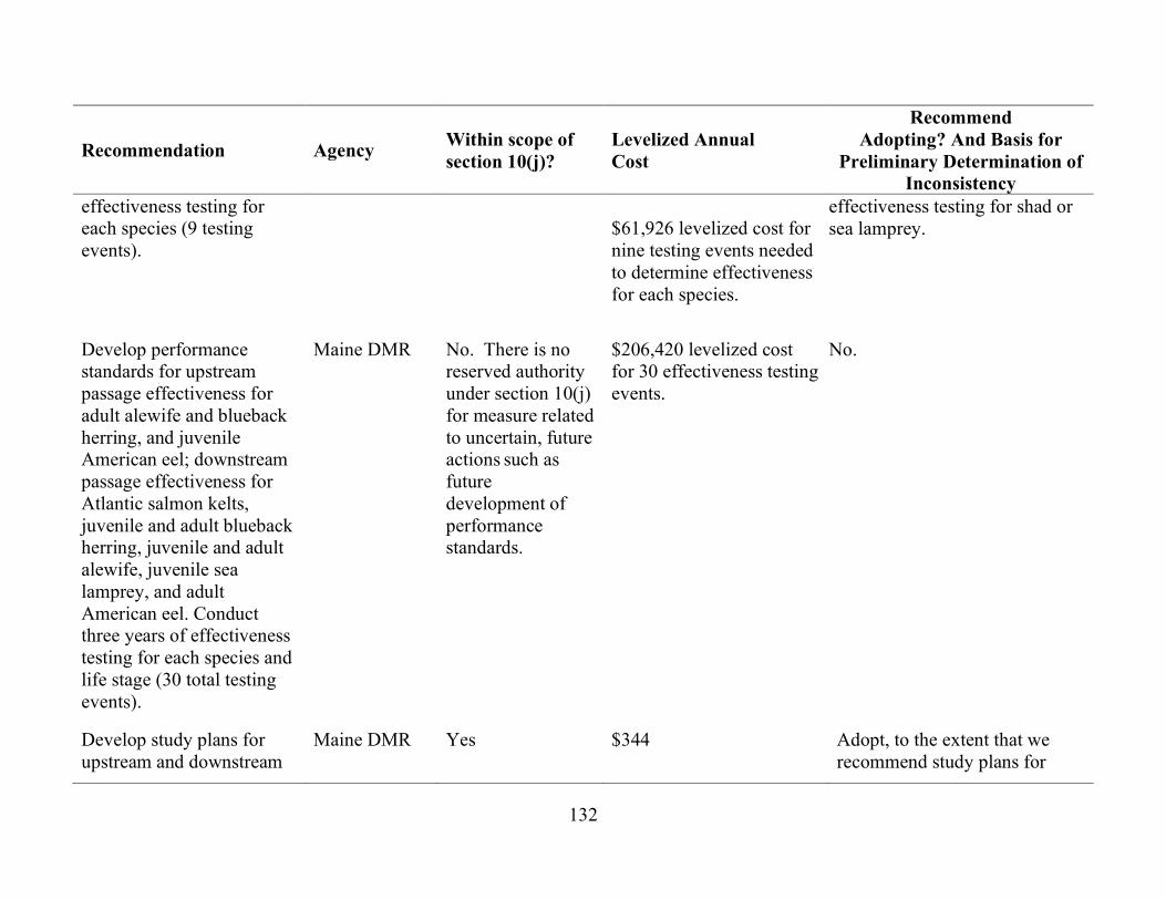
132
Recommendation Agency Within scope of section 10(j)?
Levelized Annual Cost
Recommend Adopting? And Basis for
Preliminary Determination of Inconsistency
effectiveness testing for each species (9 testing events).
$61,926 levelized cost for nine testing events needed to determine effectiveness for each species.
effectiveness testing for shad or sea lamprey.
Develop performance standards for upstream passage effectiveness for adult alewife and blueback herring, and juvenile American eel; downstream passage effectiveness for Atlantic salmon kelts, juvenile and adult blueback herring, juvenile and adult alewife, juvenile sea lamprey, and adult American eel. Conduct three years of effectiveness testing for each species and life stage (30 total testing events).
Maine DMR No. There is no reserved authority under section 10(j) for measure related to uncertain, future actions such as future development of performance standards.
$206,420 levelized cost for 30 effectiveness testing events.
No.
Develop study plans for upstream and downstream
Maine DMR Yes
$344 Adopt, to the extent that we recommend study plans for

133
Recommendation Agency Within scope of section 10(j)?
Levelized Annual Cost
Recommend Adopting? And Basis for
Preliminary Determination of Inconsistency
fishway effectiveness testing in consultation with the resource agencies.
juvenile and adult salmon effectiveness testing to ensure achievement of staff’s recommended passage performance standards for this species only.
Require resource agency approval of study plans for fishway effectiveness testing and reserve authority to the agencies to modify the study plans based on the study results.
Maine DMR No. There is no reserved authority under section 10(j) for measure related to uncertain, future actions such as future modification of study plans.
$0 No. Instead, we recommend that Brookfield consult with the agencies during study plan development and on the need to modify the study plans based on the study results.
Implement any structural or operational modifications to upstream or downstream fish passage facilities deemed necessary by the resource agencies to achieve performance standards.
Maine DMR No. The provisions of this recommendation are generic and uncertain. In addition, there is no reserved authority under section 10(j) for future, uncertain actions such as
Unknown – lacks specificity needed to determine a cost.
No. Any future potential modifications to project facilities could only be implemented after prior Commission authorization.

134
Recommendation Agency Within scope of section 10(j)?
Levelized Annual Cost
Recommend Adopting? And Basis for
Preliminary Determination of Inconsistency
modification of the facilities.
Conduct three additional years of fishway effectiveness testing for each of the applicable life stages of the six diadromous species following implementation of any modifications to the upstream or downstream fish passage facilities.
Maine DMR No. There is no reserved authority under section 10(j) for measure related to uncertain, future actions. Measures instituted at a time conditioned on future events that might never occur, are outside the scope of section 10(j).
Unknown – the cost of the studies would depend on the extent of the modification and which species and life stages are affected.
No. The need for additional testing would depend on the extent of the modification, which would only be known after it is proposed.

135
Recommendation Agency Within scope of section 10(j)?
Levelized Annual Cost
Recommend Adopting? And Basis for
Preliminary Determination of Inconsistency
Construct, operate, and maintain a downstream fish passage facility that is designed in accordance with FWS’s Design Criteria Manual that can pass adult and juvenile Atlantic salmon and alosines, adult American eel, and juvenile sea lamprey in a safe, timely and effective manner.
Maine DMR No. The recommendation is non-specific with respect to what measures are needed to meet the “safe, timely, and effective” standard.
Unknown – measure lacks specificity needed to determine a cost.
No. Instead, we are recommending that Brookfield construct the forebay guidance boom and implement other downstream passage measures included in the staff alternative (e.g., new 1.5-inch spaced trash tracks on the intakes for Units 7 and 8, unit prioritization, and operation of the new fish lift spillway).
Operate the downstream passage facility from April 1 through November 30, and implement eel passage measures during the nighttime hours from August 15 through October 31 (77 days).
Maine DMR No. The recommendation is non-specific with respect to what measures would be implemented during the operating period.
Unknown – measure lacks specificity needed to determine a cost.
No. However, we are recommending that Brookfield implement specific downstream passage measures during the time periods specified by Maine DMR (e.g., dedicated spill through the forebay bypass gates and fish lift spillway from April 1 to December 31, installation and operation of a forebay guidance boom, installation of 1.5-inch spaced trash racks on Units 7 and 8, and shutting down Units 7 and 8 and spilling 425 cfs through

136
Recommendation Agency Within scope of section 10(j)?
Levelized Annual Cost
Recommend Adopting? And Basis for
Preliminary Determination of Inconsistency
the forebay deep gate during nighttime hours from August 15 to October 31.
Conduct siting studies, designed in consultation with the resource agencies, to determine the best location for upstream eelways.
Maine DMR Yes $1,376 Yes
Construct, operate, and maintain new upstream eelways designed in accordance with FWS’s Design Criteria Manual to provide “safe, timely, and effective” upstream eel passage.
Maine DMR Yes $10,321 Yes
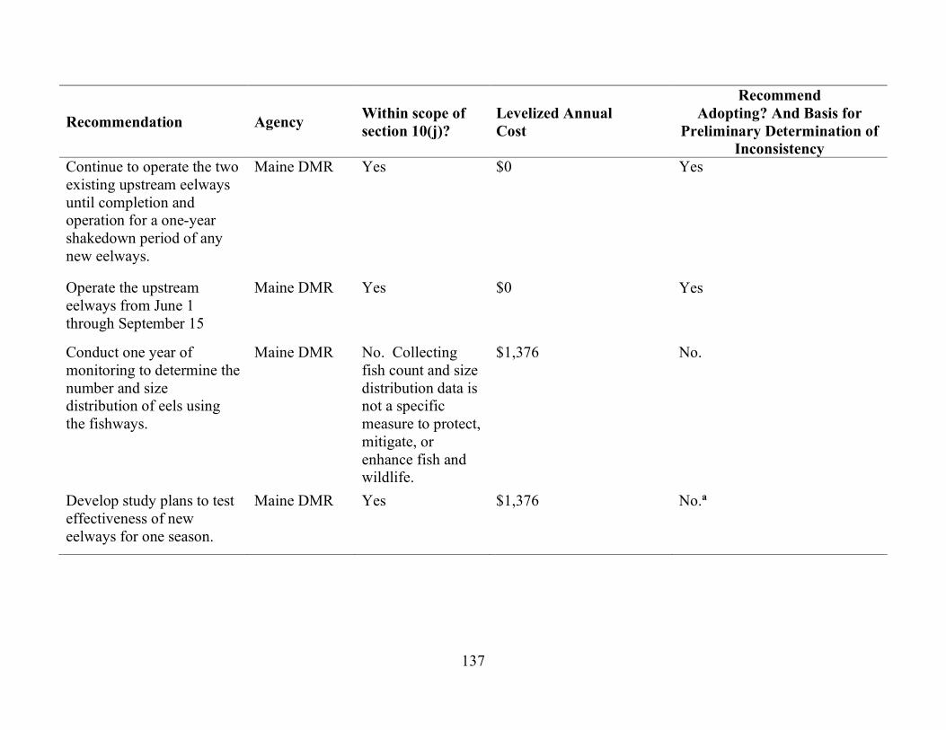
137
Recommendation Agency Within scope of section 10(j)?
Levelized Annual Cost
Recommend Adopting? And Basis for
Preliminary Determination of Inconsistency
Continue to operate the two existing upstream eelways until completion and operation for a one-year shakedown period of any new eelways.
Maine DMR Yes $0 Yes
Operate the upstream eelways from June 1 through September 15
Maine DMR Yes $0 Yes
Conduct one year of monitoring to determine the number and size distribution of eels using the fishways.
Maine DMR No. Collecting fish count and size distribution data is not a specific measure to protect, mitigate, or enhance fish and wildlife.
$1,376 No.
Develop study plans to test effectiveness of new eelways for one season.
Maine DMR Yes $1,376 No.a

138
Recommendation Agency Within scope of section 10(j)?
Levelized Annual Cost
Recommend Adopting? And Basis for
Preliminary Determination of Inconsistency
Develop a plan in consultation with the FWS, NMFS, Maine DMR, and the Penobscot Indian Nation, to acquire uniquely marked Atlantic salmon smolts (or other appropriate life stage) for stocking upstream of the Shawmut Project to serve as a source of imprinted adult fish for any required upstream effectiveness testing.
Maine DMR, NMFS, Interior
Yes $9,626 No.b
Develop a large woody debris management plan.
NMFS Yes $344 No.b Instead we recommend that Brookfield pass all woody debris that accumulates at the project.
a Preliminary findings that recommendations found to be within the scope of section 10(j) are inconsistent with the comprehensive planning standard of section 10(a) of the FPA, including the equal consideration provision of section 4(e) of the FPA are based on staff’s determination that the costs of the measures outweigh the expected benefits.
b Preliminary findings that recommendations found to be within the scope of section 10(j) are inconsistent with the substantial evidence standards of section 313(b) of the FPA are based on a lack of evidence to support the reasonableness of the recommendation or a lack of justification for the measure.

139

140
5.4 CONSISTENCY WITH COMPREHENSIVE PLANS
Section 10(a)(2)(A) of the FPA, 16 U.S.C., § 803(a)(2)(A), requires the Commission to consider the extent to which a project is consistent with federal or state comprehensive plans for improving, developing, or conserving a waterway or waterways affected by the projects. We reviewed the following 21 comprehensive plans that are applicable to the Shawmut Project. No inconsistencies were found.
Atlantic States Marine Fisheries Commission. 1999. Amendment 1 to the Interstate Fishery Management Plan for shad and river herring. (Report No. 35). April 1999.
Atlantic States Marine Fisheries Commission. 2000. Interstate Fishery Management Plan for American eel (Anguilla rostrata). (Report No. 36). April 2000.
Atlantic States Marine Fisheries Commission. 2000. Technical Addendum 1 to Amendment 1 of the Interstate Fishery Management Plan for shad and river herring. February 9, 2000.
Atlantic States Marine Fisheries Commission. 2008. Amendment 2 to the Interstate Fishery Management Plan for American eel. Arlington, Virginia. October 2008.
Atlantic States Marine Fisheries Commission. 2009. Amendment 2 to the Interstate
Fishery Management Plan for shad and river herring, Arlington, Virginia. May 2009.
Atlantic States Marine Fisheries Commission. 2010. Amendment 3 to the Interstate Fishery Management Plan for shad and river herring, Arlington, Virginia. February 2010.
Atlantic States Marine Fisheries Commission. 2013. Amendment 3 to the Interstate Fishery Management Plan for American eel. Arlington, Virginia. August 2013.
Atlantic States Marine Fisheries Commission. 2014. Amendment 4 to the Interstate Fishery Management Plan for American eel. Arlington, Virginia. October 2014. Department of the Army, Corps of Engineers. New England Division. 1985.
Hydrology of floods - Kennebec River Basin, Maine. Waltham, Massachusetts. October 1985.
Department of the Army, Corps of Engineers. New England Division. 1988. Hydrology
of floods - Kennebec River Basin, Maine, Part II. Waltham, Massachusetts. May 1988.

141
Department of the Army, Corps of Engineers. New England Division. 1989. Water resources study - Kennebec River Basin, Maine (reconnaissance report). Waltham, Massachusetts. March 1989.
Maine Atlantic Sea-Run Salmon Commission. 1984. Strategic plan for management
of Atlantic salmon in the State of Maine. Augusta, Maine. July 1984. Maine Department of Agriculture, Conservation, & Forestry. Maine State
Comprehensive Outdoor Recreation Plan (SCORP): 2014-2019. Augusta, Maine.
Maine Department of Conservation. 1982. Maine Rivers Study-final report. Augusta,
Maine. May 1982. Maine State Planning Office. 1987. Maine Comprehensive Rivers Management Plan
Vols 1-3. Augusta, Maine. May 1987. Maine State Planning Office. 1992. Maine Comprehensive Rivers Management
Plan. Volume 4. Augusta, Maine. December 1992. Maine State Planning Office. 1993. Kennebec River Resource Management Plan.
Augusta, Maine. February 1993. National Marine Fisheries Service. 1998. Final Amendment #11 to the Northeast Multi-
species Fishery Management Plan; Amendment #9 to the Atlantic sea scallop Fishery Management Plan; Amendment #1 to the monkfish Fishery Management Plan; Amendment #1 to the Atlantic salmon Fishery Management Plan; and Components of the Proposed Atlantic herring Fishery Management Plan for Essential Fish Habitat. Volume 1. October 7, 1998.
National Marine Fisheries Service. 2018. Recovery Plan for the Gulf of Maine Distinct
Population Segment of Atlantic Salmon. Hadley, Massachusetts. January 2019. National Park Service. The Nationwide Rivers Inventory. Department of the Interior,
Washington, D.C. 1993. U.S. Fish and Wildlife Service. 1989. Atlantic salmon restoration in New England:
Final environmental impact statement 1989-2021. Department of the Interior, Newton Corner, Massachusetts. May 1989.
U.S. Fish and Wildlife Service. Canadian Wildlife Service. 1986. North American waterfowl management plan. Department of the Interior. Environment Canada.
May 1986.

142
U.S. Fish and Wildlife Service. n.d. Fisheries USA: the recreational fisheries policy of
the U.S. Fish and Wildlife Service. Washington, D.C.

143
6.0 FINDING OF NO SIGNIFICANT IMPACT
If the Shawmut Project is issued a new license as proposed with the additional staff-recommended measures, the project would continue to operate while providing enhancements to fish and aquatic resources, and protection of recreation, cultural, and historic resources in the project area.
Based on our independent analysis, we find that the issuance of a new license for the Shawmut Project, with additional staff-recommended environmental measures, would not constitute a major federal action significantly affecting the quality of the human environment.

144
APPENDIX A
STATUTORY AND REGULATORY REQUIREMENTS
Federal Power Act
Section 18 Fishway Prescriptions
Section 18 of the FPA, 16 U.S.C. § 811, states that the Commission is to require construction, operation, and maintenance by a licensee of such fishways as may be prescribed by the Secretaries of the U.S. Department of Commerce (Commerce) or the U.S. Department of the Interior (Interior). On August 27 and August 28, 2020, Interior and Commerce’s National Marine Fisheries Service (NMFS) respectively, each timely filed preliminary fishway prescriptions for the project and requested that the Commission include a reservation of authority to prescribe fishways under section 18 in any license issued for the project. Interior’s and Commerce’s prescriptions are included in Appendix B and C respectively and summarized in section 2.4, Modifications to Applicants’ Proposals – Mandatory Conditions.
Section 10(j) Recommendations
Under section 10(j) of the FPA, 16 U.S.C. § 803(j)(1), each hydroelectric license issued by the Commission must include conditions based on recommendations provided by federal and state fish and wildlife agencies for the protection, mitigation, or enhancement of fish and wildlife resources affected by the project. The Commission is required to include these conditions in any new or subsequent license unless it determines that they are inconsistent with the purposes and requirements of the FPA or other applicable law. Before rejecting or modifying an agency recommendation, the Commission is required to attempt to resolve any such inconsistency with the agency, giving due weight to the recommendations, expertise, and statutory responsibilities of such agency.
Interior timely filed recommendations under section 10(j) on August 27, 2020, and NMFS and Maine Department of Marine Resources (Maine DMR) timely filed 10(j) recommendations on August 28, 2020. These recommendations are summarized in table 13. In section 5.3, Fish and Wildlife Agency Recommendations, we discuss how we address the agencies’ recommendations and comply with section 10(j).
Clean Water Act
Under section 401(a)(1) of the Clean Water Act (CWA), 33 U.S.C. § 1341(a)(1), a license applicant must obtain either a water quality certification (certification) from the appropriate state pollution control agency verifying that any discharge from the project would comply with applicable provisions of the CWA, or a waiver of such certification.
145
A waiver occurs if the state agency does not act on a request for certification within a reasonable period of time, not to exceed one year after receipt of such request.
On August 28, 2020, Brookfield applied to the Maine Department of Environmental Protection (Maine DEP) for water quality certification (certification) for the project, which Maine DEP received on the same day. Maine DEP has not yet acted on the certification request. The certification is due by August 28, 2021.
Endangered Species Act Section 7 of the Endangered Species Act (ESA), 16 U.S.C. § 1536, requires
federal agencies to ensure that their actions are not likely to jeopardize the continued existence of endangered or threatened species or result in the destruction or adverse modification of the critical habitat of such species. On January 30, 2021, we accessed the U.S. Fish and Wildlife Service’s (FWS) Information for Planning and Consultation (IPaC) database to determine whether any federally listed species could occur in vicinity of the project. According to the IPaC database, the federally endangered Atlantic salmon and its designated critical habitat, and the threatened northern long-eared bat (NLEB) may occur in the vicinity of the project.72 No critical habitat has been designated for the NLEB.
Our analysis of the impacts of the project on the Atlantic salmon and its critical
habitat and the NLEB is presented in section 3.3.3, Threatened and Endangered Species, Environmental Effects, and our recommendations are included in section 5.1, Comprehensive Development and Recommended Alternative. Based on available information, we conclude that relicensing the project as proposed with staff-recommended measures and mandatory conditions is likely to adversely affect the GOM DPS of Atlantic salmon because of unavoidable injury and mortality that would be sustained by downstream migrating juvenile and adult kelts passing through the turbines or the spill routes that have less than a 100% survival rate (e.g., Tainter gate, hinged-flashboards) during project operation. We are requesting formal consultation with NMFS regarding effects of the project on Atlantic salmon under the staff alternative with mandatory conditions.
Although the measures included in the staff alternative with mandatory conditions,
such as continued maintenance of stable impoundment and tailwater elevations through run-of-river operation, swim-through upstream passage, and improved downstream passage survival from the new forebay guidance boom and intake trash racks, would
72 See Interior’s official lists of threatened and endangered species, accessed by
staff using the IPaC database (https://ecos.fws.gov/ipac/) on January 30, 2021, and placed into the records for Docket No. P-2322-069 on February 1, 2021.
146
enhance the existing migration corridor at the project, some smolts and kelts would still be injured and killed during downstream passage. Therefore, we conclude that relicensing the project under the staff alternative with mandatory conditions is likely to adversely affect designated critical habitat for Atlantic salmon in the Kennebec River due to continued adverse effects on salmon migration habitat during project operation.
Maintenance activities at the Shawmut Project during the term of a new license
would require periodic mowing and tree trimming, but no tree removal that may affect NLEB habitat. We conclude that licensing the Shawmut Project may affect the NLEB, but any incidental take that may result from maintenance activities is not prohibited by the final 4(d) rule of the ESA.73
Magnuson-Stevens Fishery Conservation and Management Act
Section 305 of the Magnuson-Stevens Fishery Conservation and Management Act, 16 U.S.C. § 1855(b)(2), requires federal agencies to consult with NMFS on all actions that may adversely affect Essential Fish Habitat (EFH). EFH for Atlantic salmon has been defined as, “all waters currently or historically accessible to Atlantic salmon within the streams, rivers, lakes, ponds, wetlands, and other water bodies of Maine, New Hampshire, Vermont, Massachusetts, Rhode Island and Connecticut,” which includes the project area.
EFH for Atlantic salmon is present both upstream of and downstream from the Shawmut Project, and Atlantic salmon use habitat in the immediate vicinity of the project for migration. Our analysis of project effects on Atlantic salmon EFH is presented in section 3.3.3. For the same reasons described above, we conclude that the measures included in the staff alternative with mandatory conditions would provide an overall net benefit to salmon EFH over the long term, but there would still be some unavoidable adverse effects on salmon migration habitat during downstream passage through the project. Therefore, we conclude that licensing the project under the staff alternative with mandatory conditions would adversely affect EFH. We are providing NMFS with our EFH assessment and requesting that NMFS provide any EFH recommendations
Coastal Zone Management Act
Under section 307(c)(3)(A) of the Coastal Zone Management Act (CZMA), 16 U.S.C. § 1456(c)(3)(A), the Commission cannot issue a license for a project within or affecting a state’s coastal zone unless the state CZMA agency concurs with the license applicant’s certification of consistency with the state’s CZMA Program, or the agency’s
73 81 Fed. Reg. 1900-22 (Jan. 14, 2016).

147
concurrence is conclusively presumed by its failure to act within 180 days of its receipt of the applicant’s certification.
In a January 26, 2021 email to the applicant, the Maine Coastal Program stated that the Shawmut Project is not located within Maine’s CZMA-designated coastal area and a consistency review is not required.74
National Historic Preservation Act
Section 106 of the National Historic Preservation Act (NHPA), 54 U.S.C. § 306108, requires that every federal agency “take into account” how each of its undertakings could affect historic properties. Historic properties are districts, sites, buildings, structures, traditional cultural properties, and objects significant in American history, architecture, engineering, and culture that are eligible for inclusion in the National Register of Historic Places (National Register).
In response to Brookfield’s September 21, 2015, request, Commission staff designated Brookfield as its non-federal representative for the purposes of conducting section 106 consultation under the NHPA on January 21, 2016. Pursuant to section 106, and as the Commission’s designated non-federal representative, Brookfield initiated consultation with the Maine Historic Preservation Officer (Maine SHPO) to identify historic properties, determine National Register eligibility, and assess potential adverse effects on historic properties within the project’s area of potential effects. The results of Brookfield’s cultural resources investigations indicate that continued operation and maintenance of the project would have no effect on five potentially National Register-eligible sites. Brookfield’s investigations also identified eight culturally-sensitive areas located around the impoundment, but the sites could not be surveyed because permission could not be obtained from landowners to access these areas.
Brookfield proposes to implement a Historic Properties Management Plan
(HPMP) that includes conducting follow-up Phase II surveys of the five identified cultural sites to determine National Register eligibility and to periodically request landowner permission over any new license term to survey the remaining eight archaeologically-sensitive areas it could not access.
The Maine SHPO concurred with Brookfield’s findings of no effect for the
potentially eligible sites provided Brookfield conducts Phase II surveys post-licensing to
74 See Brookfield’s letter filed on January 26, 2021, for a copy of the email.

148
confirm their eligibility.75 The Maine SHPO also recommends that Brookfield complete a post-licensing Phase IB survey of the eight culturally-sensitive areas once it obtains land-owner permission.76 Our analysis in section 3.3.5 and 5.1 of this EA concurs with both of Brookfield’s findings of no effect and its recommendations to conduct further surveys as part of the HPMP.
The proposed construction of a fish lift to allow upstream passage of anadromous
fish could require modification of the project dam, which is eligible for listing on the National Register. However, as discussed in our analysis in section 3.3.5 and 5.1, any modification would be minor and would not adversely affect the historical integrity of the dam. We will seek the Maine SHPO concurrence on our finding of no effect for constructing the fish lift.
75 See February 21, 2020 letter from J. N. Leith Smith, Maine Historic
Preservation Commission to Frank H. Dunlap, Brookfield White Pine Hydro, LLC, filed with the Commission on February 25, 2021.
76 See March 2, 2020, letter from Arthur Spiess, Senior Archaeologist, Maine Historic Preservation Commission, to Frank Dunlap, Licensing Specialist, Brookfield White Pine Hydro, LLC, filed with the Commission on February 25, 2021.

149
APPENDIX B
U.S. DEPARTMENT OF THE INTERIOR’S SECTION 18 PRELIMINARY FISHWAY PRESCRIPTIONS
11 PRELIMININARY PRESCRIPTION FOR FISHWAYS Pursuant to Section 18 of the Federal Power Act, as amended, the Secretary of the
Department of the Interior, as delegated to the Service, hereby exercises his authority to prescribe the construction, operation, and maintenance of such fishways as deemed necessary.
11.1 UPSTREAM AND DOWNSTREAM PASSAGE
The Licensee will construct (if necessary), operate, maintain, and periodically test the effectiveness of fishways for American eels as described below. If studies show that new eelways are needed they will be designed, constructed, maintained, and operated (which includes Project operations) to effectively pass eels both upstream and downstream through the zone of passage in a safe, timely, and effective manner at the Licensee’s expense.
11.2 DESIGN POPULATIONS
Determination of the American eel populations in the Kennebec River is not possible at this time. However, current eel passage technologies should allow for sufficient passage. As noted in the Service’s Engineering Fish Passage Manual (USFWS, 2019, Section 6.6 Fishway Capacity, p 6-11), capacity is a key component of a fishway to ensure that the biological goals for the target species can be achieved. The capacity for technical fishways that pass species other than American eel (e.g., alosines, Atlantic salmon) are derived based on an estimated rate of ascent as well as their body size. Typically, only a small number of fish can pass over a weir or through a section of fishway.
For example, the annual biological capacity of a Model A Steeppass for river
herring is estimated to be 50,000 individuals (page 6-15, Table 5). This number is small compared to a larger fishway like the Denil, with an estimated capacity of 250,000 river herring. The higher value of the Denil is due to the fact that multiple river herring can pass through the fishway at one time.
A comparable estimate of capacity associated with the American eel does not
exist. This is due to the fact that upstream migrating eel can vary in size, some being less than 6 inches. This allows them to congregate in very large numbers, making it feasible

150
for their rate of ascent to be much higher than that of Alosines. Also, the timing of American eel migration is more spread out in time than for alosines. It is for this reason that, if placed in the correct location(s) and designed and operated correctly, one (or is some cases two) fishways for American eel can have the capacity to pass 10’s, even 100’s of thousands of eels. In 2017, an estimated 11,500 American eel were observed passing the eel ladder at the Stillwater Project on the Stillwater Branch of the Penobscot River (HDR, 2017, page 8).
Therefore, even though the Service has not determined a design population for
eels, the Service believes that a properly located, designed, operated, and installed upstream eelway(s) will provide enough capacity for the eel population in the Kennebec River. 11.3 FISH PASSAGE OPERATING PERIODS
The eelways shall be operational during the peak migration windows. Migration depends on geographic location, water temperature, river flow and other habitat cues. These dates may change based on new information, improved access at the lower dams, evaluation of new literature, and agency consultation. Based on statewide and Kennebec River watershed specific data, approved fish passage protective measures shall be operational during the following migration windows (See Table 2): Table 2. Summary of migration periods for American eels.* Species Upstream Migration Period Downstream Migration Period American eel June 1-September 15 August 15-October 31
*These dates are subject to change based on new information, improved access at the lower dams, evaluation of the literature, and agency consultation. 11.4 FISHWAY OPERATION AND MAINTENANCE PLAN
Within 12 months of license issuance, the Licensee will prepare and provide to the Service a Fishway Operation and Maintenance Plan (FOMP) covering all operations and maintenance of the upstream and downstream fish passage facilities in operation at the time. The FOMP shall include:
a. A schedule for routine fishway maintenance to ensure the fishways are ready for operation at the start of the migration season;
b. Procedures for routine upstream and downstream fishway operations; c. Procedures for monitoring and reporting on the operation and maintenance of
the facilities as they affect fish passage.
The FOMP shall be submitted to the Service for review and approval prior to submitting the FOMP to the Commission for its approval. Thereafter, the Licensee will

151
keep the FOMP updated on an annual basis to reflect any changes in fishway operation and maintenance planned for the year or if any additional fish passage structures have been completed. If the Service requests a modification of the FOMP, the Licensee shall amend the FOMP within 30 days of the request and send a copy of the revised FOMP to the Service. Any modifications to the FOMP by the Licensee will require the approval of the Service prior to implementation and prior to submitting the revised FOMP to the Commission for its approval.
Upon written request from the Service or other resource agencies, the Licensee shall provide information on fish passage operations, and project generating operations that may affect fish passage. Such information shall be provided within 10 calendar days of the request, or upon a mutually agreed upon schedule. 11.5 INSPECTION
The Licensee shall provide Service personnel, and its designated representatives, access to the project site and to pertinent project records for the purpose of inspecting the fish passage facilities and to determine compliance with the Prescription. FISHWAY DESIGN REVIEW
The Licensee shall submit design plans to the Service and other resource agencies for review and approval during the conceptual, 30, 60, and 90 percent design stages. Designs shall be consistent with the 2019 Fish Passage Engineering Design Criteria Manual (FWS 2019, entire) or updated version.
Since it is unclear when new upstream and downstream eel passage measures will be constructed, the Licensee shall adhere to the following design milestone schedule once there is certainity on the construction timeline:
a. Conceptual design within 6 months of the Service determination that new facilities
are needed; b. 30 percent design within 3 months of (a) above; c. 60 percent design within 6 months of (a) above and a basis of design report (if
requested); d. 90 percent design within 12 months of (a) above.
Following approval by the Service and the other resource agencies, the Licensee shall
submit final design plans to the Commission for its approval prior to the commencement of fishway construction activities. Once the fishway is constructed, final as-built drawings that accurately reflect the project as constructed shall be sent to the Service and the other resource agencies.

152
11.6 FISH PASSAGE EFFECTIVENESS MEASURES
Effectiveness testing of both upstream and downstream American eel passage is critical to evaluating the passage success, diagnosing problems, determining when fish passage modifications are needed, and what modifications are most likely to be effective. It is essential to ensuring the effectiveness of fishways over the term of the license, particularly in cases where changing fish population sizes may change fish passage efficiency or limit effectiveness.
Effectiveness testing and evaluation plans shall be developed by the Licensee, in consultation with the Service at the time of license issuance. If fish passage facilities are not completed by this time, then effectiveness testing can be delayed until all relevant information is available. The Licensee must submit effectiveness testing and evaluation plans to the Service. These plans must be reviewed, accepted, and approved by the Service prior to implementation. The Licensee shall begin implementing effectiveness testing measures at the start of the first migratory season after a fishway is operational and shall conduct quantitative fish passage effectiveness testing and evaluation for a minimum of two years.
The Licensee shall meet annually, in the late fall, with the Service and the other resource agencies to report on the occurrence of fish passage maintenance and operations, monitoring results, and review the operating plan. Any changes and planned maintenance will be completed 30 days prior to the start of the next migratory season. 11.7 DOWNSTREAM AMERICAN EEL PASSAGE
At this time it is unclear what the final downstream passage measures and
facilities for salmon and alosines will be at the Project and these determinations will influence downstream eel passage facilities and measures. The new fish lift, expected to be operational by May 1, 2022, will likely provide an additional safe downstream passage route but it is unclear if outmigrating eels will use it. The new fish lift will need to be tested for usage by eels once it is completed. Within the forebay, the deep gate and Tainter gate flows will be rerouted to exit in the Units 7 and 8 tailrace. It is unclear if outmigrating eels will use this and whether it will be safe. Based on these yet to be determined outcomes the Service prescribes the following:
1. Interim downstream passage measures shall be in effect until new downstream
passage measures are constructed. 2. The Licensee shall implement the following interim downstream passage
measures: All Units shall be shut down between August 15 and October 31 for 8 hours at night; the deep gate shall be open at least 2.5 feet allowing at least 425 cfs to pass; excess spill shall be passed via the spillway.

153
3. After the completion of the new upstream lift (expected by spring 2022), and if additional fish passage measures are needed, the Licensee shall conduct a one year shakedown period of all facilities.
4. The year following the shakedown, Licensee shall conduct downstream passage studies. These will include Hi-Z tagging for immediate and long-term survival and radio telemetry to determine route selection and delays. Study plans will be coordinated and approved by the Service and additional years of studies are predicated on acceptance of the previous year’s results. Inconclusive results or delays due to weather or other unforeseen events will require another year of studies.
5. Any new downstream facility(ies) needing construction shall be designed in consultation with the Service and the resource agencies and constructed by the Licensee. All entities shall review the conceptual, 30 percent, 60 percent, and 90 percent drawings which are to be consistent with the Service’s current Passage Engineering Design Criteria Manual. Construction of any new downstream measures shall be completed within 2 years of acceptance of the 90 percent design drawings.
6. If new facilities are needed the Licensee shall conduct at least 2 years of post-construction effectiveness studies of these new facilities.
11.8 UPSTREAM AMERICAN EEL PASSAGE
1. The Licensee shall continue using the existing upstream eel passage facilities until the new upstream fishlift is constructed.
2. After completion of the new upstream fishlift (by May 1, 2022) or completion of other fish passage measures, the licensee shall conduct juvenile eel location studies to determine where to place upstream eel passage facilities.
3. After the Service determines that no more studies are needed, the Service will develop upstream eel passage measures that the Licensee shall construct.
4. If new upstream passage facilities are needed, or need to be relocated, the Licensee shall consult with the Service and complete construction within 1 year of approval by the Service of 90 percent designs of any new facilities.
5. If new facilities are needed the Licensee shall conduct at least 2 years of effectiveness studies after completed construction.

154
APPENDIX C
U.S. DEPARTMENT OF COMMERCE’S SECTION 18 PRELIMINARY FISHWAY PRESCRIPTIONS
9.3. SECTION 18 PRESCRIPTION FOR FISHWAYS 9.3.1. UPSTREAM FISH PASSAGE - DIADROMOUS SPECIES
The Licensee shall construct, operate, and maintain upstream fish passage facilities that pass diadromous fish species in a safe, timely, and effective manner. The size of the fishway shall accommodate the anticipated production potential of the Kennebec River: approximately 1.54 million blueback herring, 134,000 alewife, 177,000 American shad, 12,000 Atlantic salmon, and other resident or target species (Attachment B). The design elements of the fishway shall ensure successful passage of river herring, American shad, Atlantic salmon, and sea lamprey. The movement of sea lamprey is improved by ensuring edges are rounded and surfaces are smooth (PLTW, 2017). Incorporation of these design considerations should also provide benefits to other upstream migrating fish by reducing potential sources of injury. The fishway shall operate for the full range of design flows based on the migratory season for each species in accordance with provisions of Section 8.3.5. The fishway shall be constructed and operational within two years of license issuance. This deadline for operation of the new upstream fishway is to ensure sufficient time for a shakedown and evaluation before implementing potential fish passage requirements contained within any new license for the Shawmut Project. The operation date also recognizes that substantial progress has already been made to design this fishway in cooperation with the resource agencies; however, it may change in consultation with the agencies. Any additional design review will proceed consistent with the provisions in Section 9.3.5.
The Licensee shall keep the fishways in proper order and shall keep fishway areas
clear of trash, logs, and material that would hinder passage. Anticipated maintenance shall be performed in sufficient time before a migratory period such that fishways can be tested and inspected and will properly operate prior to the migratory periods. If the defined performance standards described in Section 9.3.4 have not been met after three years of testing, additional adaptive measures will be implemented, in consultation with the resource agencies, to further improve fish passage and reduce delay. Such measures may include, but are not limited to operational modifications, structural enhancements, additional fishway entrances, or additional fishways.
Additional protective measures or alternative actions may be necessary for
Atlantic salmon pending analysis of the Commission’s proposed action under section 7 of the ESA and conclusions of our anticipated Biological Opinion.

155
The Licensee did not propose upstream fish passage facilities for diadromous fish
in its license application. However, in 2016, the Commission ordered an amendment to the license for the Shawmut Project and required the construction of an upstream fishway77. On December 31, 2019, Brookfield filed the final design drawings and operations and maintenance plans for the required upstream fishway (Accession # 20200107-0019). In letters dated July 13 and 23, 2020, the Commission indicated that it would instead require the consideration of the unconstructed upstream fishway in relicensing (Accession #s 20200713-3022, 20200713-3034, and 20200723-5012). The Licensee’s proposed fishway, with our required performance monitoring and adaptive management provisions, meets the intent of our prescription. 9.3.2. DOWNSTREAM FISH PASSAGE
The Licensee shall construct, operate, and maintain downstream fish passage facilities for diadromous fish species that provide safe, timely, and effective downstream passage consistent with the performance standards described in Section 9.3.4. The downstream passage facilities shall be operational within two years of the issuance of the new license.
The Licensee has proposed and we are requiring the following measures to
improve the downstream passage facility at the Shawmut dam:
1. The installation of a fish guidance system leading to a bypass surface entrance to reduce entrainment into the propeller units. The guidance system will include a 10-foot deep hanging rigid panel.
2. The operation of the Taintor gate sluice at maximum capacity (i.e., 600 cfs) for the duration of the smolt outmigration window.
3. The operation of the bypass gate/surface sluice from April 1 to December 31, as river conditions allow.
4. Operational prioritization of the Francis units, where the unit closest to the lift entrance (Unit 1) will be operated first-on and last-off, followed consecutively by Units 2 through 6. In addition to the Licensee proposed actions, we also require the following
measures for protecting downstream migrating fish:
5. Installation of 1-inch clear space trashracks or overlays at existing trashracks for the Francis units and the propeller units. Velocities in front of the trashracks must
77 Merimil Limited Partnership and Brookfield White Pine Hydro, LLC, 155
FERC ¶ 61,185 (2016).

156
be sufficiently low to reduce the risk of impingement during periods critical for downstream fish passage.
o If: 1) it is demonstrated that the approach velocities in front of the racks at the propeller units are excessive; and 2) after consultation with NMFS, it is therefore determined that the installation of the required 1-inch trashracks are infeasible, the Licensee will instead install 1.5-inch trashracks and extend the depth of the required guidance boom to 20 feet.
o If: 1) it is demonstrated that the approach velocities in front of the racks at the Francis units are excessive; and 2) after consultation with NMFS, it is therefore determined that the installation of the required trashracks are infeasible, the Licensee will instead implement one or more of the adaptive measures listed below, in consultation with NMFS.
6. If the defined performance standards (section 9.3.4) cannot be met with the above proposed and required measures within the monitoring period defined therein, additional adaptive measures will be implemented to further reduce fish injury and mortality to meet the defined performance standards. Such adaptive measures may include, but not be limited to, alternate unit prioritization, unit curtailment or shutdowns, lowering hinged flashboards along the spillway, replacing the upward-opening Taintor gate with a downward-opening slide gate, or limiting passage into the project forebay by installing a guidance boom or rigid rack structure upstream of the headworks. These protection measures are consistent with criteria used nationally (NMFS,
2011; USFWS, 2017). The Licensee shall keep the downstream passage facilities in proper order and clear of trash, logs, and material that would hinder flow and passage. Anticipated maintenance shall be performed in sufficient time before a migratory period such that fishways can be tested and inspected and will operate effectively prior to the migratory periods. Additional measures specific to Atlantic salmon may also be required depending on the outcome of the ESA section 7 consultation and requirements of any Incidental Take Statement issued as part of the anticipated Biological Opinion.
Design review of any new downstream fish passage facility shall follow the
process outlined in Section 8.3.7. Fishway Design Review such that modifications can be implemented and operational within two years of license issuance.
9.3.3. SEASONAL MIGRATION WINDOWS
Based on state-wide and Kennebec River watershed specific data, approved fish passage protective measures shall be operational during the migration windows for each life stage of Atlantic salmon (adults, kelts, and smolts), and adults and juveniles of American shad, blueback herring, and alewife (Table 4). These dates may change based on new information and agency consultation.
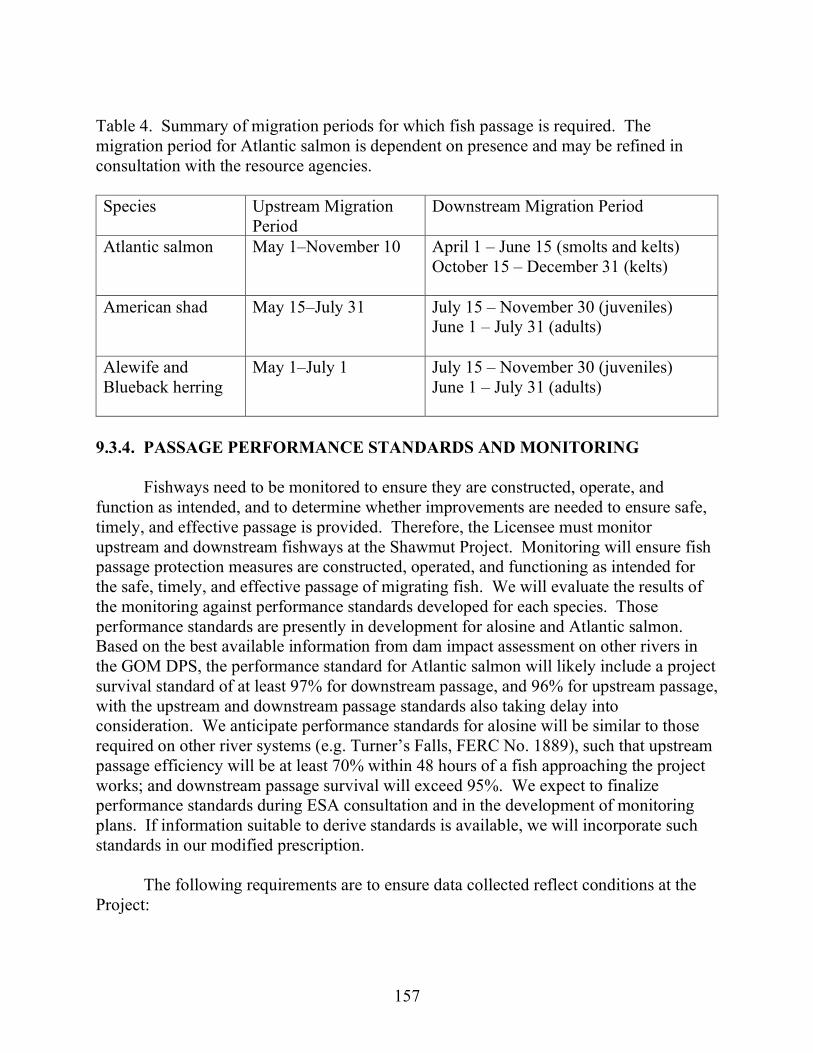
157
Table 4. Summary of migration periods for which fish passage is required. The migration period for Atlantic salmon is dependent on presence and may be refined in consultation with the resource agencies. Species Upstream Migration
Period Downstream Migration Period
Atlantic salmon May 1–November 10 April 1 – June 15 (smolts and kelts) October 15 – December 31 (kelts)
American shad May 15–July 31 July 15 – November 30 (juveniles) June 1 – July 31 (adults)
Alewife and Blueback herring
May 1–July 1 July 15 – November 30 (juveniles) June 1 – July 31 (adults)
9.3.4. PASSAGE PERFORMANCE STANDARDS AND MONITORING
Fishways need to be monitored to ensure they are constructed, operate, and function as intended, and to determine whether improvements are needed to ensure safe, timely, and effective passage is provided. Therefore, the Licensee must monitor upstream and downstream fishways at the Shawmut Project. Monitoring will ensure fish passage protection measures are constructed, operated, and functioning as intended for the safe, timely, and effective passage of migrating fish. We will evaluate the results of the monitoring against performance standards developed for each species. Those performance standards are presently in development for alosine and Atlantic salmon. Based on the best available information from dam impact assessment on other rivers in the GOM DPS, the performance standard for Atlantic salmon will likely include a project survival standard of at least 97% for downstream passage, and 96% for upstream passage, with the upstream and downstream passage standards also taking delay into consideration. We anticipate performance standards for alosine will be similar to those required on other river systems (e.g. Turner’s Falls, FERC No. 1889), such that upstream passage efficiency will be at least 70% within 48 hours of a fish approaching the project works; and downstream passage survival will exceed 95%. We expect to finalize performance standards during ESA consultation and in the development of monitoring plans. If information suitable to derive standards is available, we will incorporate such standards in our modified prescription.
The following requirements are to ensure data collected reflect conditions at the Project:

158
1. Licensee will develop study design plans in consultation with NMFS and state and federal resource agencies. The Licensee must obtain approval from the resource agencies prior to filing these plans with the Commission for final approval.
2. Licensee must conduct all monitoring according to scientifically accepted practices.
3. Licensee shall begin monitoring at the start of the first migratory season after each fishway facility (Atlantic salmon and alosines) is operational and shall continue for up to three years or as otherwise required through further consultation.
4. Licensee shall conduct studies to evaluate the effectiveness of fishways for juvenile and adult life stages of alosines and Atlantic salmon.
5. The Licensee shall prepare reports of the monitoring studies to the resource agencies for a minimum 30-day review and consultation prior to submittal to the Commission for final approval.
6. The Licensee shall include resource agencies’ comments in the monitoring study reports submitted to the Commission for final review.
7. The Licensee shall prepare annual fish passage reports that consist of data from the fish passage season including passage counts for each species, daily river flow conditions, fishway operational settings, and Project operations.
8. The Licensee shall include resource agencies’ comments in the annual reports submitted to the Commission for final review.
9. The Licensee shall allow resource agencies or their designees to access the fishway for inspection throughout the length of the license provided reasonable notice.
FERC’s determination about achieving any up- or downstream performance
standards must be based upon an average of three consecutive years of up- or downstream passage monitoring at the Shawmut Project. That is, the standard will only be considered achieved if the average of three years of studies meets or exceeds that standard. If, after the first or second year of each three-year evaluation, it is determined that it is statistically impossible or improbable that the standard can be met, the study will cease and additional measures will be implemented as soon as possible. The implementation of any new operational or facility modifications or measures will necessitate an additional monitoring period (as defined above) or a desktop evaluation, if such an evaluation is determined an appropriate alternative to an empirical study in consultation with the agencies. The same monitoring protocol will occur for any new upstream or downstream fish passage measure implemented at the Project through our reservation of Section 18 authority. 9.3.5 FISHWAY DESIGN REVIEW
In the event there are significant changes to the designs that have already been reviewed or if there are new configurations that have not been reviewed, the Licensee shall submit design plans to NMFS for review and approval during the conceptual, 30, 60

159
and 90 percent design stages. The Licensee shall incorporate into their schedule a minimum of 30 days of review time by resource agencies for each stage. The Licensee shall adhere to the following design milestone schedule for downstream diadromous passage facilities:
1. Conceptual design within 6 months of license issuance, 2. 30% design within 9 months of license issuance, 3. 60% design within 12 months of license issuance and a basis of design report (if
requested), and 4. 90% design within 18 months of license issuance.
If necessary, the Licensee shall adhere to the following design milestone schedule for
upstream diadromous passage facilities:
1. Conceptual design within 36 months of license issuance, 2. 30% design within 39 months of license issuance, 3. 60% design within 42 months of license issuance and 4. 90% design within 48 months of license issuance.
The Licensee may deviate from the design milestone schedule based on design
complexity or permitting constraints; however the deviation requires approval by the resource agencies before filing extension of time requests with the Commission. The Licensee shall allow reasonable time to construct the fishway such that it is operational as prescribed. Following NMFS approval, the Licensee shall submit final design plans to the Commission for final approval prior to the commencement of fishway construction activities. Once the fishway is constructed, final as-built drawings that accurately reflect the project as constructed shall be filed with NMFS.
160
APPENDIX D. SUMMARY OF COST OF ENVIRONMENTAL MEASURES
Table 14. Costa of environmental measures considered in assessing the environmental effects of operating the Shawmut Project (source: Brookfield and staff). Enhancement/Mitigation Measures
Entity
Capital cost ($2021)
Annual Costb
($2021) Levelized
Annual Costc
($2021) Project Operation 1a. Continue to operate the project in a run-of-river mode where outflow from the project approximates inflow, and limit impoundment drawdowns to no more than 1 foot below the normal reservoir level of 112.0 feet.
Brookfield, NMFS, staff
$0d
$0d
$0d
1b. Operate the project in an instantaneous run-of-river mode where outflow from the project equals inflow, and always maintain the impoundment level at elevation 112.0 feet during normal operation.
Interior Unknown - costs related to any required new or upgraded equipment needed for compliance with measure cannot be accurately estimated
Unknown - costs related to any required new or upgraded equipment needed for compliance with measure cannot be accurately estimated
Unknown
2a. Implement Operations Monitoring Plan
Brookfield $0 $5,000 $5,000

161
Enhancement/Mitigation Measures
Entity
Capital cost ($2021)
Annual Costb
($2021) Levelized
Annual Costc
($2021) 2b. Revise and Implement Operations Monitoring Plan
Staff $1,000d $5,000 $5,069
Upstream Anadromous Fish Passage
3. Construct an upstream anadromous fish lift, and upstream fish passage flume to provide volitional passage from the 1982 Powerhouse tailrace across the existing island and into the 1912 Powerhouse tailrace where fish can access the new fish lift entrance.
Brookfield, NMFS, Maine DMR, staff
$13,000,000
$0
$894,470
4a. Operate the upstream anadromous fish passage facilities 12 hours per day from May 1 to October 31.
Brookfield $0 $126,582e $126,582
4b. Operate the upstream anadromous fish passage facilities 12 hours per day from May 1 to November 10
NMFS, staff $0 $133,432f
$133,432

162
Enhancement/Mitigation Measures
Entity
Capital cost ($2021)
Annual Costb
($2021) Levelized
Annual Costc
($2021) 4c. Operate upstream anadromous fish passage facilities 24 hours per day from April 1 to July 30 and 12 hours per day from September 1 to November 30
Maine DMR $0 $228,046g $228,046
5a. Achieve an adult salmon upstream survival standard of 95% for the Shawmut Project, and a cumulative standard of 81.4% for all lower Kennebec Projects combined
Brookfield $0 $0 $0
5b. Achieve an adult salmon upstream survival standard of 95%
Staff $0 $0 $0
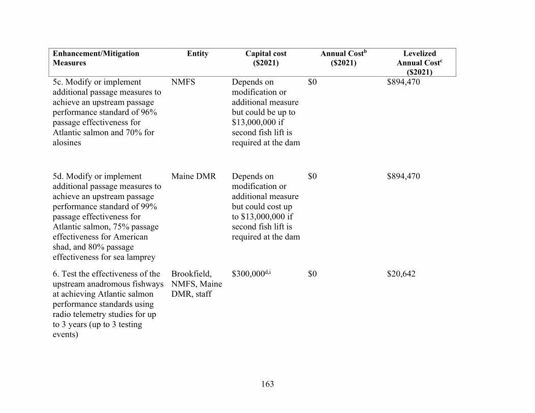
163
Enhancement/Mitigation Measures
Entity
Capital cost ($2021)
Annual Costb
($2021) Levelized
Annual Costc
($2021) 5c. Modify or implement additional passage measures to achieve an upstream passage performance standard of 96% passage effectiveness for Atlantic salmon and 70% for alosines
NMFS Depends on modification or additional measure but could be up to $13,000,000 if second fish lift is required at the dam
$0 $894,470
5d. Modify or implement additional passage measures to achieve an upstream passage performance standard of 99% passage effectiveness for Atlantic salmon, 75% passage effectiveness for American shad, and 80% passage effectiveness for sea lamprey
Maine DMR Depends on modification or additional measure but could cost up to $13,000,000 if second fish lift is required at the dam
$0 $894,470
6. Test the effectiveness of the upstream anadromous fishways at achieving Atlantic salmon performance standards using radio telemetry studies for up to 3 years (up to 3 testing events)
Brookfield, NMFS, Maine DMR, staff
$300,000d,i $0 $20,642

164
Enhancement/Mitigation Measures
Entity
Capital cost ($2021)
Annual Costb
($2021) Levelized
Annual Costc
($2021) 7a. Test the effectiveness of the upstream anadromous fishways at achieving alosine performance standards using radio telemetry studies for up to 3 years (3 testing events)
NMFS $300,000 $0 $20,642
7b. Test the effectiveness of the upstream anadromous fishways at achieving American shad, blueback herring, alewife, and sea lamprey performance standards using radio telemetry studies for 3 consecutive years (12 testing events)
Maine DMR $1,200,000 $0 $82,568
Downstream Anadromous Fish Passage
8. Install a forebay fish guidance boom
Brookfield, NMFS, staff
$500,000 $15,000 $49,403

165
Enhancement/Mitigation Measures
Entity
Capital cost ($2021)
Annual Costb
($2021) Levelized
Annual Costc
($2021) 9. During the interim period between license issuance and the installation of the new fish guidance boom, continue to lower four sections of hinged flashboards to pass 560 cfs via spill from April 1 to June 15 for Atlantic salmon smolt passage.
Brookfield, staff
$0 $0 $0
10. Continue to spill 35 cfs through the existing forebay surface sluice gate from April 1 to December 31 to provide a continuous surface bypass route for downstream fish passage.
Brookfield, NMFS, staff
$0 $0 $0
11. Continue to spill 600 cfs through the forebay Tainter gate from April 1 to June 15 to provide a safe downstream passage route for Atlantic salmon smolts.
Brookfield, NMFS, staff
$0 $0 $0

166
Enhancement/Mitigation Measures
Entity
Capital cost ($2021)
Annual Costb
($2021) Levelized
Annual Costc
($2021) 12. Continue to operate the downstream bypass facilities to provide 6% of Station Unit Flow through the combined discharge of the forebay Tainter and sluice gates from November 1 to December 31 for kelt passage.
Brookfield, staff
$0 $0 $0
13a. Prioritize operation of Units 1 through 6 from May 1 to October 31.
Brookfield $0 $0 $0
13b. Prioritize operation of Units 1 through 6 from April 1 to December 31.
NMFS, staff $0 $0 $0
14a. If NMFS determines that they are feasible, then install new trash racks or trash rack overlays with 1-inch bar spacing on intakes for Units 1 through 6.
NMFS $1,100,000d $0 $75,686

167
Enhancement/Mitigation Measures
Entity
Capital cost ($2021)
Annual Costb
($2021) Levelized
Annual Costc
($2021) 14b. If NMFS determines that they are feasible, then install new trash racks or trash rack overlays with 1-inch bar spacing on intakes for Units 7 and 8.
NMFS $325,000d $0 $22,362
14c. If NMFS determines that 1-inch-spaced trash racks on Units 7 and 8 intakes are infeasible, then install 1.5-inch spaced trash racks or trash rack overlays and extend the guidance boom depth to 20 feet.
NMFS $740,000d $0
$50,916
14d. Install 1.5-inch spaced trash racks or overlays on intakes for Units 7 and 8.
Staff $240,000d $0 $16,513
14e. If NMFS determines that 1-inch-spaced trash racks on intakes for Units 1 through 6 are infeasible, then leave existing 1.5-inch-spaced trash racks and implement additional downstream passage measures specified by NMFS.
NMFS Unknown – measure lacks specificity to develop a cost
Unknown – measure lacks specificity to develop a cost
Unknown – measure lacks specificity to develop a cost

168
Enhancement/Mitigation Measures
Entity
Capital cost ($2021)
Annual Costb
($2021) Levelized
Annual Costc
($2021) 15. Construct and operate a new downstream anadromous fish passage facility designed in accordance with FWS’s Design Criteria Manual to provide “safe, timely, and effective” fish passage; operate facility from April 1 to November 30.
Maine DMR Unknown – measures lacks specificity needed to develop a cost
Unknown – measures lacks specificity needed to develop a cost
Unknown – measures lacks specificity needed to develop a cost
16a. Ensure that anadromous downstream fish passage facilities meet a performance standard of 96% survival for Atlantic salmon smolts at the Shawmut Project, and a cumulative standard of 84.9% for all four lower Kennebec River Projects combined.
Brookfield $0 $0 $0
16b. Ensure that anadromous downstream fish passage facilities meet a performance standard of 96% survival for Atlantic salmon smolts at the Shawmut Project
Staff $0 $0 $0
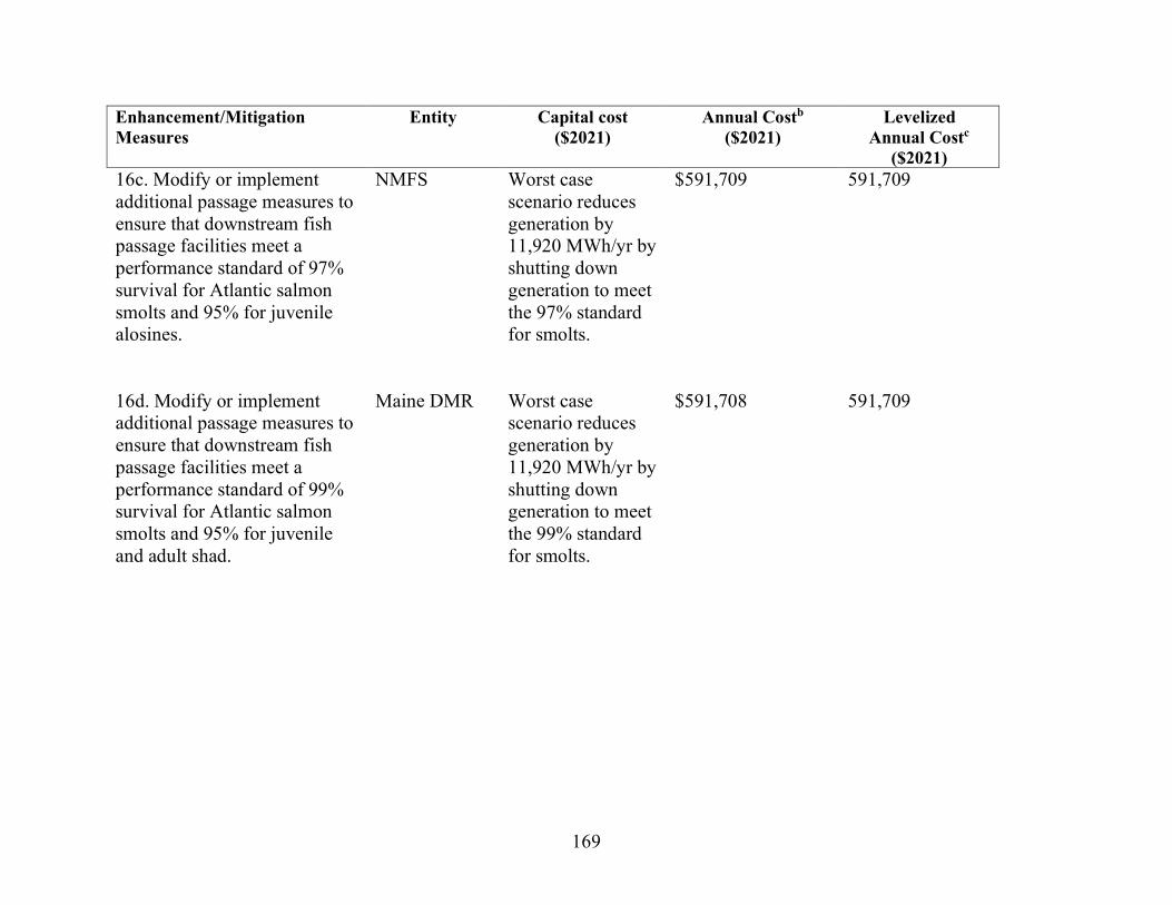
169
Enhancement/Mitigation Measures
Entity
Capital cost ($2021)
Annual Costb
($2021) Levelized
Annual Costc
($2021) 16c. Modify or implement additional passage measures to ensure that downstream fish passage facilities meet a performance standard of 97% survival for Atlantic salmon smolts and 95% for juvenile alosines.
NMFS Worst case scenario reduces generation by 11,920 MWh/yr by shutting down generation to meet the 97% standard for smolts.
$591,709 591,709
16d. Modify or implement additional passage measures to ensure that downstream fish passage facilities meet a performance standard of 99% survival for Atlantic salmon smolts and 95% for juvenile and adult shad.
Maine DMR Worst case scenario reduces generation by 11,920 MWh/yr by shutting down generation to meet the 99% standard for smolts.
$591,708 591,709

170
Enhancement/Mitigation Measures
Entity
Capital cost ($2021)
Annual Costb
($2021) Levelized
Annual Costc
($2021) 17. Conduct up to three years of downstream passage studies to evaluate effectiveness of new downstream passage measures at meeting juvenile salmon performance standards (3 testing events).
Brookfield, NMFS, Maine DMR, staff
$300,000 $0 $20,642
18a. Conduct up to three years of downstream passage studies to evaluate effectiveness of new downstream passage measures at meeting juvenile alosine performance standards (3 testing events).
NMFS $300,000 $0 $20,642
18b. Conduct three consecutive years of downstream passage studies to evaluate effectiveness of new downstream passage measures at meeting performance standards for juvenile and adult alewife, juvenile and adult blueback herring, juvenile and adult shad, salmon kelts, and juvenile sea lamprey (24 testing events)
Maine DMR $2,400,000 $0 $165,136
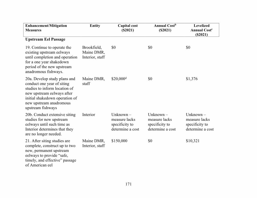
171
Enhancement/Mitigation Measures
Entity
Capital cost ($2021)
Annual Costb
($2021) Levelized
Annual Costc
($2021) Upstream Eel Passage
19. Continue to operate the existing upstream eelways until completion and operation for a one year shakedown period of the new upstream anadromous fishways.
Brookfield, Maine DMR, Interior, staff
$0 $0 $0
20a. Develop study plans and conduct one year of siting studies to inform location of new upstream eelways after initial shakedown operation of new upstream anadromous upstream fishways
Maine DMR, staff
$20,000d $0 $1,376
20b. Conduct extensive siting studies for new upstream eelways until such time as Interior determines that they are no longer needed.
Interior Unknown – measure lacks specificity to determine a cost
Unknown – measure lacks specificity to determine a cost
Unknown – measure lacks specificity to determine a cost
21. After siting studies are complete, construct up to two new, permanent upstream eelways to provide “safe, timely, and effective” passage of American eel
Maine DMR, Interior, staff
$150,000 $0 $10,321

172
Enhancement/Mitigation Measures
Entity
Capital cost ($2021)
Annual Costb
($2021) Levelized
Annual Costc
($2021) 22a. Conduct upstream eelway effectiveness testing for any new facilities for two years.
Interior $40,000d $0 $2,752
22b. Develop study plans and conduct upstream eelway effectiveness testing for any new facilities for one year.
Maine DMR $20,000d $0 $1,376
22c. Conduct one year of monitoring studies to determine the number and size distribution of eels using the fishways.
Maine DMR $20,000d $0 $1,376
23a. Operate any upstream eelways from June 15 to September 15
Brookfield $0 $0 $0
23b. Operate any upstream eelways from June 1 to September 15
Interior, Maine DMR, staff
$0 $0 $0

173
Enhancement/Mitigation Measures
Entity
Capital cost ($2021)
Annual Costb
($2021) Levelized
Annual Costc
($2021) Downstream Eel Passage Measures
24a. Continue to spill 425 cfs through the forebay deep gate and shut down Units 7 and 8 for 8 hours during the night for 6 weeks (42 days) between September 15 and November 15 for downstream adult eel passage.
Brookfield $0 $0 $0
24b. Operate Brookfield’s proposed downstream eel passage measures between August 15 and October 31 (77 days).
Staff $0 $15,786h $15,786

174
Enhancement/Mitigation Measures
Entity
Capital cost ($2021)
Annual Costb
($2021) Levelized
Annual Costc
($2021) 24c. Spill 425 cfs through the forebay deep gate and shut down all generating units for 8 hours at night from August 15 to October 31 (77 days) for downstream eel passage. Implement these measures during an interim period between license issuance and construction and shakedown operation of any new anadromous fish passage facilities (i.e., first three years following license issuance).
Interior $0 $12,360i $12,360
24d. Construct a downstream fish passage facility for American eel that is designed in accordance with FWS’s Design Criteria Manual. Operate the facility at night from August 15 to October 31 (77 days).
Maine DMR Unknown – measure lacks specificity to determine a cost
Unknown – measure lacks specificity to determine a cost
Unknown – measure lacks specificity to determine a cost

175
Enhancement/Mitigation Measures
Entity
Capital cost ($2021)
Annual Costb
($2021) Levelized
Annual Costc
($2021) 25a. At end of interim period described in item 24c, conduct studies for at least one year using balloon tags and radio telemetry methods to test downstream eel survival and passage route selection after completion of all upstream and downstream anadromous fish passage facilities (2 testing events).
Interior $200,000d $0 $13,760
25b. Test the effectiveness of downstream fish passage facilities for three consecutive years at meeting survival standards for adult American eel (3 testing events).
Maine DMR $300,000 $0 $20,642
26. Implement any structural or operational modifications to upstream or downstream fish passage facilities, or construct any additional facilities deemed necessary by the resource agencies to achieve performance standards.
Maine DMR, Interior
Unknown – lacks specificity to determine a cost
Unknown – lacks specificity to determine a cost
Unknown – lacks specificity to determine a cost

176
Enhancement/Mitigation Measures
Entity
Capital cost ($2021)
Annual Costb
($2021) Levelized
Annual Costc
($2021) 27. Conduct 2 additional years of effectiveness testing for downstream eel passage to determine if any modifications or additional measures required by Interior improve survival (2 testing events).
Interior $200,000d $0 $13,760
Additional Fish Passage Measures
28a. Prepare annual fishway monitoring reports
Brookfield, staff
$0 $5,000 $5,000
28b. Prepare annual fish passage reports that include passage counts for each species, daily river flow conditions, fishway operational settings, and information on project operation.
NMFS $0 $35,000j $35,000
29a. Implement Fish Passage Operations and Maintenance Plan
Brookfield $0 $50,000k $50,000
29b. Develop fish passage operation and maintenance plan
Interior $5,000 $50,000k $50,344
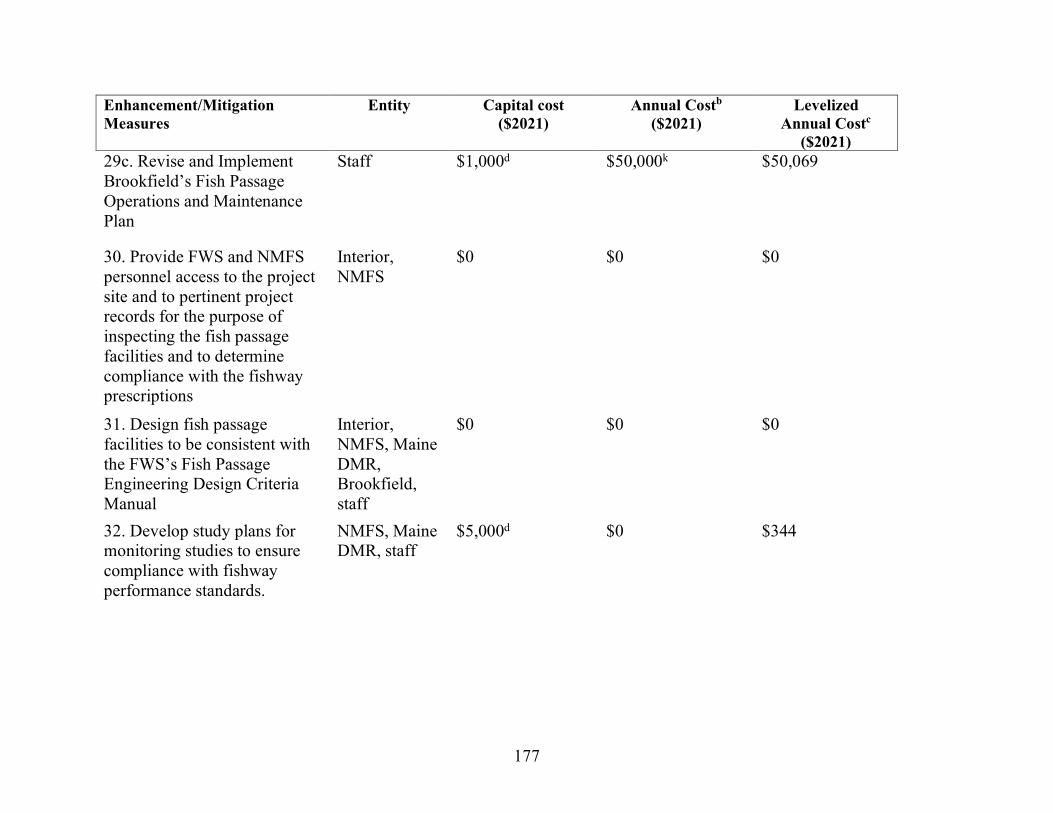
177
Enhancement/Mitigation Measures
Entity
Capital cost ($2021)
Annual Costb
($2021) Levelized
Annual Costc
($2021) 29c. Revise and Implement Brookfield’s Fish Passage Operations and Maintenance Plan
Staff $1,000d $50,000k $50,069
30. Provide FWS and NMFS personnel access to the project site and to pertinent project records for the purpose of inspecting the fish passage facilities and to determine compliance with the fishway prescriptions
Interior, NMFS
$0 $0 $0
31. Design fish passage facilities to be consistent with the FWS’s Fish Passage Engineering Design Criteria Manual
Interior, NMFS, Maine DMR, Brookfield, staff
$0 $0 $0
32. Develop study plans for monitoring studies to ensure compliance with fishway performance standards.
NMFS, Maine DMR, staff
$5,000d $0 $344

178
Enhancement/Mitigation Measures
Entity
Capital cost ($2021)
Annual Costb
($2021) Levelized
Annual Costc
($2021) 33. Require resource agency approval of study plans for fishway effectiveness testing and reserve authority to the agencies to modify the study plans based on the study results.
Maine DMR Unknown – measure lacks specificity to determine a cost
Unknown – measure lacks specificity to determine a cost
Unknown – measure lacks specificity to determine a cost
34. Develop a plan in consultation with the FWS, NMFS, Maine DMR, and the Penobscot Indian Nation, to acquire uniquely marked Atlantic salmon smolts (or other appropriate life stage) for stocking upstream of the Shawmut Project to serve as a source of imprinted adult fish for any required upstream effectiveness testing.
Maine DMR, NMFS, Interior
$5,000 $50,000 each year for 3 years d,l
$9,626
Additional Aquatic Measures

179
Enhancement/Mitigation Measures
Entity
Capital cost ($2021)
Annual Costb
($2021) Levelized
Annual Costc
($2021) 35. Develop a large woody debris management plan with provisions for sluicing wood downstream and stockpiling and transporting wood throughout the basin.
NMFS $5,000 $0 $344
36. Continue to sluice large woody debris that accumulates at the project downstream.
Staff $0 $0 $0
Land Use and Recreation 37. Implement the RFMP. Brookfield,
staff $0 $5,000 $5,000
Cultural Resources 38. Implement an HPMP, including the Phase II surveys.
Brookfield, Maine SHPO, staff
$120,000 $0 $8,257
a Costs were provided by Brookfield in their license application or subsequent additional information request responses unless otherwise noted.
b Annual costs typically include project operation and maintenance costs and any other costs that occur on a yearly basis. c All capital and annual costs are converted to equal annual costs over a 30-year period to give a uniform basis for
comparing all costs. d Cost estimated by staff. e This amount is an estimate of the cost that would result from providing flows to operate the upstream fish passage
facility from May 1 through October 31 (opportunity cost). The measure would reduce generation by 2,550 MWh per

180
year. Using an energy cost of $49.64/MWh from table 4.2 as a proxy for the value of foregone generation, 2,550 MWh of foregone generation would be valued at $126,582/year. The generation losses were estimated by staff based on
information filed by Brookfield on June 1, 2020. f This amount is an estimate of the cost that would result from providing flows to operate the upstream fish passage
facility from May 1 through November 10 (opportunity cost). The measure would reduce generation by 2,688 MWh per year. Using an energy cost of $49.64/MWh from table 4.2 as a proxy for the value of foregone generation, 2,688 MWh of foregone generation would be valued at $133,432/year. The generation losses were estimated by staff based on
information filed by Brookfield on June 1, 2020. g This amount is an estimate of the cost that would result from providing flows to operate the upstream fish passage
facility from April 1 through July 30 for 24 hours a day and September 1 through November 30 for 12 hours a day (opportunity cost). The measure would reduce generation by 4,594 MWh per year. Using an energy cost of $49.64/MWh from table 4.2 as a proxy for the value of foregone generation, 4,594 MWh of foregone generation would be valued at $228,046/year. The generation losses were estimated by staff based on information filed by Brookfield on June 1, 2020.
h This amount is an estimate of the cost that would result from providing flows for downstream eel passage April 15 through October 31 (opportunity cost). The measure would require providing flows an additional 35 days above the baseline measure which would reduce generation by 318 MWh per year. Using an energy cost of $49.64/MWh from table 4.2 as a proxy for the value of foregone generation, 318 MWh of foregone generation would be valued at $15,786/year. The generation losses were estimated by staff based on information filed by Brookfield on June 1, 2020.
i This amount is an estimate of the cost that would result from providing flows for downstream eel passage for an interim period of 3 years (opportunity cost). The measure would reduce generation by 7,467 MWh over three years which averages 249 MWh/year over a 30 year period. Using an energy cost of $49.64/MWh from table 4.2 as a proxy for the value of foregone generation, 249 MWh of foregone generation would be valued at $12,360/yearr. The generation losses were estimated by staff based on information filed by Brookfield on June 1, 2020.
j Estimate includes costs for counting species during upstream migration season and preparing reports. k Annual costs for implementing the plan are for routine operation and maintenance activities (e.g., clearing debris,
inspecting facilities) of all upstream and downstream fish passage facilities at the project. l Estimate assumes stocking level of about 50,000 smolts per year for 3 consecutive years.

181
APPENDIX E
DRAFT LICENSE CONDITIONS RECOMMENDED BY STAFF
On August 27, 2020, and August 28, 2020, the U.S. Department of the Interior (Interior) and U.S. Department of Commerce, National Marine Fisheries Service (NMFS), filed preliminary section 18 prescriptions (Appendices B and C in this EA). Unless modified by Interior or NMFS, these conditions would be included in any license issued for the project. The following draft license articles are based on the inclusion of their mandatory conditions. ADDITIONAL LICENSE ARTICLES RECOMMENDED BY COMMISSION STAFF
In addition to the mandatory section 18 prescriptions submitted by NMFS and Interior, we recommend including the following license articles in any license issued for the project.
Draft Article 001. Commission Notification and Filing of Amendments (a) Requirement to Notify Commission of Modifications to the Approved
Schedule for Fishway Operations.
Interior’s prescription 11.3 in Appendix B and NMFS’s fishway prescription 9.3.3 in Appendix C would allow the licensee to modify the timing of fishway operations based on new information that becomes available. The Commission must be notified as soon as possible in writing, but no later than 10 days after each such modification. Any modification(s) in the seasonal timing of fishway operation must be based on consultation with the National Marine Fisheries Service, U.S. Fish and Wildlife Service, and Maine Department of Marine Resources. The Commission reserves the right to further modify the timing of fishway operations for any reason, including to address any project or public safety concerns.
(b) Requirement to File Amendment Applications.
Certain conditions of National Marine Fisheries Service’s (NMFS) section 18 prescriptions contemplate long-term changes to project operations or facilities (e.g., NMFS’s prescription 9.3.1, 9.3.2). These changes may not be implemented without prior Commission authorization granted after the filing of an application to amend the license. In any amendment request, the licensee must identify related project requirements and request corresponding amendments or extensions of time as needed to maintain consistency among requirements.

182
Draft Article 002. Project Operation. The licensee must operate the project as follows:
(1) operate the project in a run-of-river mode such that, at any point in time, the sum of all outflows from the project approximates the sum of all inflows to the project; and
(2) water levels in the project impoundment must be maintained within the elevations of 111.0 feet U.S. Geological Survey (USGS) Datum and 112.0 feet USGS Datum, except during flood conditions which is defined as Kennebec River flows exceeding 40,000 cubic feet per second at the project.
Reporting of Planned Deviations Run-of-river operation and impoundment level requirements of this article may be
temporarily modified for short periods, of up to 3 weeks, after mutual agreement among the licensee and the National Marine Fisheries Service, U.S. Fish and Wildlife Service, and Maine Department of Marine Resources (collectively, resource agencies). After concurrence from the resource agencies, the licensee must file a report with the Secretary of the Commission as soon as possible, but no later than 14 days after the onset of the planned deviation. Each report must include: (1) the reasons for the deviation and how project operations were modified, (2) the duration and magnitude of the deviation, (3) any observed or reported environmental effects and how potential effects were evaluated, and (4) documentation of consultation with the resource agencies. For planned deviations exceeding 3 weeks, the licensee must file an application for a temporary amendment of the operational requirements and receive Commission approval prior to implementation.
Reporting of Unplanned Deviations
Run-of-river operation and impoundment level requirements may be temporarily modified if required by operating emergencies beyond the control of the licensee (i.e., unplanned deviations). For any unplanned deviation from run-of-river operation or impoundment level requirements that lasts longer than 3 hours or results in visible environmental effects such as a fish kill, the licensee must notify the resource agencies within 24 hours, and the Commission within 14 days, and file a report as soon as possible, but no later than 30 days after each such incident. The report must include: (1) the cause of the deviation, (2) the duration and magnitude of the deviation, (3) any pertinent operational and/or monitoring data, (4) a timeline of the incident and the licensee’s response, (5) any comments or correspondence received from the resource agencies, or confirmation that no comments were received from the resource agencies, (6) documentation of any observed or reported environmental effects and how potential

183
effects were evaluated, and (7) a description of measures implemented to prevent similar deviations in the future.
For unplanned deviations from run-of-river operation or impoundment level requirements lasting 3 hours or less that do not result in visible environmental effects, the licensee must file an annual report, by March 1, describing each incident that occurred during the prior January 1 through December 31 time period. The report must include for each 3 hours or less deviation: (1) the cause of the deviation, (2) the duration and magnitude of the deviation, (3) any pertinent operational and/or monitoring data, (4) a timeline of the incident and the licensee’s response to each deviation, (5) any comments or correspondence received from the resource agencies, or confirmation that no comments were received from the resource agencies, and (6) a description of measures implemented to prevent similar deviations in the future.
Draft Article 003. Operation Compliance Monitoring Plan. Within six months of license issuance, the licensee must file with the Commission for approval, a revised Operations Monitoring Plan, with the following modifications:
(1) update the plan to include the project operation requirements included in Draft
Article 002 (Project Operation) and any additional operation requirements included in the U.S. Department of the Interior’s fishway prescription in Appendix B and the National Marine Fisheries Service’s (NMFS) fishway prescription in Appendix C;
(2) a detailed description of how the licensee will monitor compliance with the operational requirements of Draft Article 002 (Project Operation), including descriptions of the mechanisms and instrumentation or gages used (i.e., type and exact locations of all flow and impoundment elevation monitoring equipment), and procedures for maintaining and calibrating all compliance monitoring equipment;
(3) an implementation schedule; and (4) remove section 5.0 “Reporting”.
The licensee must prepare the plan after consultation with NMFS, U.S. Fish and
Wildlife Service, and Maine Department of Marine Resources (collectively, agencies). The licensee must include with the plan documentation of consultation, copies of comments and recommendations on the completed plan after it has been prepared and provided to the agencies, and specific descriptions of how the agencies’ comments are accommodated by the plan. The licensee must allow a minimum of 30 days for the agencies to comment and to make recommendations before filing the plan with the

184
Commission. If the licensee does not adopt a recommendation, the filing must include the licensee’s reasons, based on project specific information.
The Commission reserves the right to require changes to the plan. The licensee
must not begin implementing the plan until the Commission notifies the licensee that the plan is approved. Upon Commission approval the licensee must implement the plan, including any changes required by the Commission.
Draft Article 004. Spillway Operations for Atlantic Salmon Smolt Passage. During the interim period between license issuance and the installation of the forebay guidance boom required by the National Marine Fisheries Service’s fishway prescription 9.3.2 in Appendix C, the licensee must drop four sections of hinged flashboard to pass 560 cfs from April 1 to June 15 of each year to provide an additional downstream passage route for Atlantic salmon smolts.
Draft Article 005. Forebay Bypass Gate Operations for Atlantic Salmon Kelt Passage. To provide a continuous safe downstream passage route for Atlantic salmon kelts, the licensee must spill a flow equal to 6% of the total powerhouse discharge at any point in time, through the combined discharge of the forebay Tainter and surface sluice gates from November 1 to December 31 each year.
Draft Article 006. Fish Passage Facilities Operation and Maintenance Plan. Within fifteen months of license issuance, the Licensee must file for Commission approval, a final Fish Passage Facilities Operation and Maintenance Plan, as required by the U.S. Department of the Interior’s (Interior) prescription 11.4 in Appendix B. At a minimum, the final plan must include the measures specified in the draft plan filed on December 31, 2019, and the following modifications:
(1) update the plan to include the fish passage operations included in Draft Article
005 (Forebay Bypass Gate Operations for Atlantic Salmon Kelt Passage) and the operation and maintenance procedures for new or modified fish passage facilities included in Interior’s fishway prescription in Appendix B and the National Marine Fisheries Service’s (NMFS) fishway prescription in Appendix C;
(2) revise the end date for the seasonal operating period for the upstream anadromous fishways in section 4.1 to November 10;
(3) include the operating periods specified by Interior’s prescription 11.3 for the
upstream and downstream eel passage facilities; and
(4) describe the procedures for how the fishways would be operated and maintained during project emergencies and outages.

185
The licensee must prepare the plan after consultation with the U.S. Fish and
Wildlife Service, NMFS, and Maine Department of Marine Resources (collectively, agencies). The licensee must include with the plan documentation of consultation, copies of comments and recommendations on the completed plan after it has been prepared and provided to the agencies, and specific descriptions of how the agencies’ comments are accommodated by the plan. The licensee must allow a minimum of 30 days for the agencies to comment and to make recommendations before filing the plan with the Commission. If the licensee does not adopt a recommendation, the filing must include the licensee’s reasons, based on project specific information.
The Commission reserves the right to require changes to the plan. The licensee
must not begin implementing the plan until the Commission notifies the licensee that the plan is approved. Upon Commission approval the licensee must implement the plan, including any changes required by the Commission.
Draft Article 007. Large Woody Debris. To enhance aquatic habitat in the
Kennebec River, the licensee must pass any woody debris that accumulates on project structures downstream of the dam.
Draft Article 008. Reservation of Authority to Prescribe Fishways. Authority is
reserved to the Commission to require the licensee to construct, operate, and maintain fishways as may be prescribed by the Secretaries of the Interior and Commerce pursuant to section 18 of the Federal Power Act.
Draft Article 009. Final Recreation Facilities Management Plan. Within 6 months of licensee issuance, the licensee must file with the Commission for approval, a final Recreation Facilities Management Plan that designates the following as project recreation facilities:
(1) The Hinckley Boat Launch consisting of a single lane, 10-foot-wide, concrete boat launch, an ADA-compliant 44-foot-wide, 44-foot-long concrete dock, a parking area with three spaces for vehicles and trailers and five spaces for vehicles without trailers, and a wooden kiosk and trash receptacle.
(2) The Shawmut Canoe Portage, consisting of a take-out located approximately 430-feet upstream of the dam with a parking area for approximately eight vehicles; a put-in located approximately 600 feet downstream of the dam at the lower end of the powerhouse tailrace with a parking area for approximately five vehicles and a portable toilet, and the entire 0.25-mile-long portage trail connecting the take-out and put-in.

186
The Final Recreation Facilities Management Plan must include, at a minimum, all of the provisions included in the Licensee’s Draft Recreation Facilities Management Plan in Appendix E-5 of the Application, filed on January 31, 2020, and on page 14 of Attachment 2 of the Licensee’s Response to Additional Information filed with the Commission on June 1, 2020. The Final Recreation Facilities Management Plan must also include a description of the methodology that would be used to monitor recreation use every ten years, a description of how monitoring results and any proposed changes to the project recreation facilities will be shared with the Maine Bureau of Parks and Lands (Maine BPL), and an implementation schedule. Any proposed changes to the Recreation Facilities Management Plan must be approved by the Commission prior to implementing the measures.
The licensee must prepare the plan after consultation with the Maine BPL. The licensee must include with the plan documentation of consultation, copies of comments and recommendations on the completed plan after it has been prepared and provided to the agencies, and specific descriptions of how the agencies’ comments are accommodated by the plan. The licensee must allow a minimum of 30 days for the agencies to comment and to make recommendations before filing the plan with the Commission. If the licensee does not adopt a recommendation, the filing must include the licensee’s reasons, based on project specific information.
The Commission reserves the right to require changes to the plan. Implementation of
the plan must not begin until the licensee is notified by the Commission that the plan is approved. Upon Commission approval, the licensee must implement the plan, including any changes required by the Commission.
Draft Article 010. Historic Properties Management Plan. The Historic
Properties Management Plan, filed on January 31, 2020, as Appendix E-9 of the License Application, is approved and made part of this license and may not be amended without prior Commission approval. Upon license issuance, the licensee must implement the plan.

187
APPENDIX F
ALTERNATIVES CONSIDERED BUT ELIMINATED FROM DETAILED ANALYSIS
Issuing a Non-power License A non-power license is a temporary license that the Commission would terminate
when it determines that another governmental agency will assume regulatory authority and supervision over the lands and facilities covered by the non-power license. At this time, no agency has suggested a willingness or ability to take over the project. No party has sought a non-power license, and we have no basis for concluding that the Shawmut Project should no longer be used to produce power.
Federal Government Takeover
Federal takeover and operation of the Shawmut Project would require
congressional approval. While that fact alone would not preclude further consideration of this alternative, there is currently no evidence to indicate that federal takeover should be recommended to Congress. No party has suggested that federal takeover would be appropriate, and no federal agency has expressed interest in operating the project.
Project Retirement Project retirement could be accomplished with or without dam removal.78 Either
alternative would involve denial of the relicense application and surrender or termination of the existing license with appropriate conditions. Decommissioning Without Dam Removal Project retirement without dam removal would involve retaining the dam and disabling or removing equipment used to generate power. Certain project works could remain in place and could be used for historic or other purposes. This approach would require the State of Maine to assume regulatory control and supervision of the remaining
78 In the event that the Commission denies relicensing a project or a licensee
decides to surrender an existing project, the Commission must approve a surrender “upon such conditions with respect to the disposition of such works as may be determined by the Commission.” 18 C.F.R. § 6.2. This can include simply shutting down the power operations, removing all or parts of the project (including the dam), or restoring the site to its pre-project condition.

188
facilities. However, no participant has advocated this alternative, nor do we have any basis for recommending it. Decommissioning With Dam Removal
During the scoping process and in response to the Commission’s notice of ready for environmental analysis, NMFS, Maine DMR, and the Kennebec Coalition recommend removal of Shawmut Dam to assist in the recovery of diadromous fish in the basin. Specifically, NMFS recommends that, should the Commission find decommissioning with dam removal to be the best comprehensive use of the Kennebec River, Brookfield develop and implement a plan to decommission and remove the Shawmut Project and restore the riverine corridor within 10 years of issuance of the licensing decision.
Maine DMR is also considering amending its 1993 Kennebec River Resource
Management Plan to recommend the removal of Shawmut and Lockwood Dams to promote the recovery of diadromous fish in the Kennebec River system. Maine DMR has not yet filed the final plan for Commission approval as a comprehensive plan for the waterway.
In determining whether the EA requires a detailed analysis of project
decommissioning, we consider a variety of factors including the beneficial or adverse effects of licensing the project on a number of resources or interests and whether or not any adverse effects on the environmental resources can be adequately mitigated through licensing. Below we consider the resources or interests for the Shawmut Project and the effects of decommissioning on those resources. However, without a specific decommissioning proposal, any further discussion of the effects of project decommissioning and dam removal would be both premature and speculative.
Aquatic Resources Removing Shawmut Dam and other appurtenant structures would directly affect the flow of water through, and immediately below, the reach of the river currently impounded by the dam. Water velocity in the impoundment area would increase and slower water habitats along the edges of the impoundment would disappear as the water recedes into a more defined channel. Removing the dam would release stored sediment to the Kennebec River. There is no information on sediment accumulation or contaminant levels in the project’s impoundment. However, the dam has been in place for 109 years, and it is likely that significant quantities of sediment have accumulated within the impoundment. Removing the dam would, at a minimum, cause significant increases in sediment transport, elevated turbidity levels, and sedimentation of aquatic habitat beginning with construction and

189
likely continuing periodically for several years thereafter until the stream channel stabilizes. Once dam removal was complete and most of the accumulated sediment was passed downstream, the decrease in hydraulic residence time through removal of the 12-mile-long impoundment would eventually be expected to improve water quality and thermal regimes in the river. Elevated turbidity levels would temporally result in adverse effects on migratory and resident fish, including listed Atlantic salmon, by causing physiological stress (Redding et al., 1987), lowered feeding success (Barrett et al., 1992), and diminished habitat quality (Waters, 1995). Additionally, the suspension of any contaminated sediments, if they exist, could cause long-term adverse physiologic effects on Atlantic salmon and other aquatic organisms through physical contact with contaminants or trophic interactions. The duration and severity of these effects would depend on a number of factors, including but not limited to: the volume, composition, and contaminant level of sediment accumulated behind the dam; the duration of dam breaching and removal activities; and the frequency and duration of high flow events following dam breaching and removal. Over the long-term, accumulated sediment would eventually transport downstream out of the project area, and the project reach would return to a free-flowing riverine stream segment. Transport of gravel, large woody debris, and sediment would move unencumbered downstream. However, such benefits would be limited given the continued presence of other dams upstream and downstream that would continue to trap and disrupt sediment transport from the upper watershed.
Dam removal would also create a free, unobstructed path for fish (including protected Atlantic salmon) to migrate upstream and downstream and utilize riverine habitat within the approximately 12-mile reach of the Kennebec River upstream of Shawmut Dam that is currently impounded. Diadromous fish would no longer be subject to injury or mortality caused by passing the dam, which would improve survival through the affected reach. Access to historical anadromous spawning and rearing habitat in the watershed above Shawmut would still be blocked, however, by Weston, Anson, Abenaki, Williams, and Wyman Dams upstream on the Kennebec River.79 Terrestrial Resources
79 Upstream fish passage is scheduled to be constructed at Weston Dam by
May 31, 2022. Permanent upstream passage is to be operational at both Abenaki and Anson Dams within two years after the licensee receives written certification from the Maine DMR and FWS that 226 adult Atlantic salmon originating from the Kennebec River and obtained from the Lockwood fish lift have been released into the Kennebec River watershed above Weston Dam in any single season.

190
Following dam removal, riparian vegetation along the banks of the impoundment would likely transition to a more upland habitat type such as Pine-Hemlock-Hardwood Forest or Red Oak-Northern Hardwood Forest. Over time, a new river’s edge would become established, and the redevelopment and regrowth of riparian and wetland habitats would occur along its banks. Areas formerly occupied by dam structures or features would provide new aquatic, riparian, and upland habitat for wildlife. Sediments released from the impoundment could eventually settle into downstream wetland habitat, and cover important breeding or foraging habitat for wildlife. Over time, accumulated sediment would be transported downstream during high flows, and dam removal would allow a more natural level of sediment transport to occur within the river channel in the impoundment reach. The diversity and abundance of wildlife species in the area would not be expected to significantly change. The construction work to remove the dam would temporarily disturb and displace some wildlife. Some waterfowl and semi-aquatic wildlife that prefer the more lentic habitat type provided by the impoundment, might move to other impoundments or to nearby lakes. As more natural flows became established in the project area, species that rely on riverine habitat might utilize this stretch more often throughout the year. Recreation and Aesthetics Dam removal would eliminate the impoundment and associated lake-type fishing and boating opportunities currently available above the dam. These activities would be replaced with new opportunities for stream-based fishing and boating opportunities associated with free-flowing water within the area occupied by the impoundment. Boaters would no longer need to portage around the dam and public safety concerns associated with the presence of the dam and project operation would be eliminated. The Hinkley boat launch, parking areas, signage, and formal public access trails would no longer be maintained by the licensee. Spill from the dam, which may be of aesthetic interest to some recreation users, would also be eliminated. While some users may find greater satisfaction in a more riverine setting as they boat and fish in a reach unobstructed by the dam, others who prefer a lake-type recreation environment may be less satisfied with the new riverine experience. Cultural Removal of the dam would result in the permanent loss of a historical resource that is eligible for listing on the National Register. This loss would require mitigation through data recovery in order to document the dam’s historic properties. Removal of the dam could also result in the exposure of currently inundated and as yet unidentified cultural sites, if present. Dam removal could expose these resources to the public, which

191
could result in illicit artifact collection and site vandalism; it could also allow for the discovery and proper collection and documentation of historic resources in previously inundated areas. Other Developmental Interests The Shawmut impoundment is also the only source of water for Sappi North America’s (Sappi) Somerset Mill in Skowhegan. According to Sappi,80 the Somerset Mill uses use an average of 28 million gallons per day (mgd) for processing, cooling, and fire protection. The mill is also permitted to discharge up to 46.5 mgd of wastewater and process water to the impounded Kennebec River upstream of Shawmut Dam. Removing the dam could lower the water levels to a point that the mill’s intake would not be functional and the diffuser for discharging its wastewater would be too close to the water surface to function properly. Project Economics
Based on historical costs of dam removal of similar sized projects, permitting, and remediation costs, Brookfield Renewable Energy Group (2018) estimated at a high conceptual level that dam removal would cost between $7.7 to $11 million. Decommissioning with dam removal would also result in the loss of 50.2 GWh of electricity annually.
Summary As the Commission has previously held, decommissioning is not a reasonable alternative to relicensing a project in most cases, when appropriate protection, mitigation, and enhancement measures are available. Restoring diadromous fish, including the federally listed Atlantic salmon, is a goal of existing management plans for the Kennebec River Basin, and NMFS, Maine DMR, and the Kennebec Coalition all support project decommissioning for this purpose. However, others such Sappi and Brookfield are opposed because of the generation and other developmental uses the project provides. Overall, while dam removal would result in better upstream and downstream passage survival for Atlantic salmon, alosines, American eel, and sea lamprey compared to relicensing the project, the upstream and downstream fish passage measures included in the staff alternative with mandatory conditions would nevertheless enhance fish passage over existing conditions. With the recently (2018) constructed upstream fishway at the Hydro-Kennebec Project, and planned new upstream fishways at the Lockwood
80 See March 29, 2021, filing by Mathew Manahan, Pierce Atwood, on behalf of
Sappi.

192
and Weston Projects, providing upstream fish passage at Shawmut would provide swim-through passage for all species of anadromous fish and allow adult salmon access to an additional 33 miles of mainstem habitat between Lockwood Dam and Abenaki Dam.
Because, as discussed in this EA, protection, mitigation, and enhancement measures can be fashioned to support the recovery of diadromous fish in the basin and still provide for the generation of power, decommissioning is not a reasonable alternative to relicensing.

193
APPENDIX G
LITERATURE CITED
ASMFC (Atlantic States Marine Fisheries Commission). 2007. Stock Assessment Report No. 07-01 (Supplement) of the Atlantic States Marine Fisheries Commission, American Shad Stock Assessment Report for Peer Review, Volume II. August, 2007.
Barrett, J.C., Grossman, G.D., and Rosenfeld, J. 1992. Turbidity Induced Changes in
Reactive Distance of Rainbow Trout. Transactions of the American Fisheries Society, 121, 437-443..
Baum, E. 1997. Maine Atlantic Salmon: A National Treasure. Hermon, Maine: Atlantic Salmon Unlimited.
Bell, M. 1991. Fisheries Handbook of Engineering Requirements and Biological Criteria. U.S. Army Corps of Engineers Fish Passage Development and Evaluation Program, North Pacific Division. Portland, OR. 350 pp.
Boulêtreau, S., Carry, L., Meyer, E. et al. High predation of native sea lamprey during spawning migration. Sci Rep 10, 6122 (2020).
Bourque, B. J. 1995. Diversity and Complex Society in Prehistoric Maritime Societies: A Gulf of Maine Perspective. Plenum Press, New York.
Brookfield Renewable Energy Group. 2013. Downstream passage effectiveness for the
passage of Atlantic salmon smolts at the Weston, Shawmut, and Lockwood Projects, Kennebec River Maine. February 2013. FERC Project Numbers 2325, 2322, and 2574.
_____. 2014. Evaluation of Atlantic salmon passage at the Weston, Shawmut, Hydro Kennebec, and Lockwood Projects, Kennebec River and Brunswick Project, Androscoggin River, Maine, Spring 2013. March 2014. FERC Project Numbers 2325, 2322, 2611, 2574, and 2284. _____. 2015. Evaluation of Atlantic salmon passage at the Weston, Shawmut, Hydro Kennebec, and Lockwood Projects, Kennebec River and Brunswick Project, Androscoggin River, Maine, Spring 2014. March 2015. FERC Project Numbers 2325, 2322, 2611, 2574, and 2284. _____. 2016. Evaluation of Atlantic salmon passage at the Weston, Shawmut, Hydro Kennebec, and Lockwood Projects, Kennebec River and Brunswick Project, Androscoggin River, Maine, Spring 2015. March 2016. FERC Project Numbers
194
2325, 2322, 2611, 2574, and 2284. _____. 2018. Energy Enhancements and Lower Kennebec Fish Passage Improvements
Study. Prepared by Kleinschmidt. Filed with FERC July 1, 2019. Brookfield White Pine Hydro LLC (Brookfield). 2018. Updated Study Report, Shawmut
Hydroelectric Project (FERC NO. 2322), August, 2018. Filed with the Commission on August 1, 2018.
_____. 2020a. Diadromous Fish Passage Report for the Lower Kennebec River
Watershed during the 2019 Migration Season. March 19, 2020. _____. 2020b. Updated Study Report. Pejepscot Hydroelectric Project (FERC No. 4784). Brookfield White Pine Hydro, LLC, Merimil Limited Partnership, and Hydro-Kennebec,
LLC. 2019. Species Protection Plan for Atlantic Salmon, Atlantic Sturgeon, and Shortnose Sturgeon at the Lockwood, Hydro Kennebec, Shawmut, and Weston Projects on the Kennebec River, Maine. Prepared by Kleinschmidt. December 2019.
Calvert, Mary R. 1986. The Kennebec Wilderness Awakens: Lewiston, Maine: Twin
City Printery. Castro-Santos, Theodore; Shi, Xiaotao; and Haro, Alex. Migratory behavior of adult Sea
Lamprey and cumulative passage performance through four fishways. Canadian Journal of Fisheries and Aquatic Sciences. July, 2016.
Clough, S.C., Lee-Elliott, I.E., Turnpenny, A.W.H., Holden, S.D.J., and Hinks, C. 2004.
Swimming Speeds in Fish: phase 2 Literature Review. Environment Agency R&D Technical Report W2-049/TR2.
Colby, George. 1883. Atlas of Somerset County, Maine. George N. Colby & Company, Houlton, Maine.
EIA. 2021. U.S. Energy Information Administration, Annual Energy Outlook Report
2021. EPRI (Electric Power Research Institute). 2000. Technical evaluation of the utility of
intake approach velocity as an indicator of potential adverse environmental impact under Clean Water Act Section 316(b). Prepared by Alden Research Laboratory, Inc., Holden, Massachusetts. EPRI Report No. TR- 1000731. December 2000.

195
Everhart, W.H. 1976. Fishes of Maine. The Maine Department of Inland Fisheries and Wildlife, Augusta.
Federal Energy Regulatory Commission (FERC). 2018. Final Environmental Assessment for Hydropower License. Mattaceunk Hydroelectric Project (P-2520). Issued September 25, 2018.
_____. 2019. Final Environmental Assessment for Hydropower License. Barker’s Mill Hydroelectric Project (P-2808). Issued February 6, 2019.
Florida Power and Light Energy Maine LLC (FPL Energy Maine). 2010. Lockwood Project FishLift Upstream Radio Telemetry Effectiveness Study for American Shad. March 31, 2010.
Gray and Pape. 2019. Phase 0 Post-Contact Period Archaeological Sensitivity Assessment for the Shawmut Hydroelectric Project Relicensing. August, 2019.
_____. 2020. Phase I Post Contact Period Archaeological Reconnaissance Survey for
the Shawmut Hydroelectric Project Relicensing. January, 2020. Greene, K. E., J. L. Zimmerman, R. W. Laney, and J. C. Thomas-Blate. 2009. Atlantic
Coast Diadromous Fish Habitat: A Review of Utilization, Threats, Recommendations for Conservation, and Research Needs. Atlantic States Marine Fisheries Commission Habitat Management Series No. 9, Washington, D.C. 464 pp.
Griffiths, J.S. 1979. Effects of size and temperature on sustained swimming speeds of Great Lakes fishes., pp. 37: Ontario Hydro Research Division Report.
GMCME (Gulf of Maine Council on the Marine Environment). 2007. American Eels:
Restoring a Vanishing Resource in the Gulf of Maine. 12 pp. Available online: http://www.gulfofmaine.org/council/publications/american_eel_high-res.pdf. Accessed March 24, 2021.
Great Lakes Fishery Commission. 2000. Sea Lamprey: A Great Lakes Invader. Online at: http://www.glfc.org/pubs/FACT_3.pdf. Accessed March 23, 2021.
Handeland, S.O., T. Jarvi, A. Ferno, and S.O. Stefansson. 1997. Osmotic stress, antipredator behavior, and mortality of Atlantic salmon (Salmo salar) smolts. Canadian Journal of Fisheries and Aquatic Sciences 53:2673-2680.
Hansen, M.J., Madenjian, C.P., Slade, J.W. et al. Population ecology of the sea lamprey (Petromyzon marinus) as an invasive species in the Laurentian Great Lakes and an

196
imperiled species in Europe. Rev Fish Biol Fisheries 26, 509–535 (2016). https://doi.org/10.1007/s11160-016-9440-3.
Haro, A., T. Castro-Santos, K. Whalen, G. Wippelhauser, L. McLaughlin. 2003. Simulated Effects of Hydroelectric Project Regulation on Mortality of American eels. Pages 357-365 in D. A. Dixon, editor. Biology, Management, and Protection of Catadromous eels. American Fisheries Society, Symposium 33, Bethesda, Maryland.
Hawkes, J.P., R. Saunders., A.D. Vashon, and M.S. Cooperman. 2013. Assessing
efficacy of non-lethal harassment of double-crested cormorants to improve Atlantic salmon smolt survival. Northeastern Naturalist, 20(1), 1-18.
Heisey, P.G., D. Mathur, J.C. Avalos, and C.E. Hoffman. 2017. A Comparison of direct survival/injury of eels passed through Francis and propeller turbines.
Hitt, N.P., S. Eyler, and J.E.B. Wofford. 2012. Dam removal increases American eel
abundance in distant headwater streams. Transactions of the American Fisheries Society 141(5): 1171-1179.
Holbrook, C.M., M. T. Kinnison, and Joseph Zydlewski. 2011. Survival of Migrating
Atlantic Salmon Smolts through the Penobscot River, Maine: a Pre-restoration Assessment. Transactions of the American Fisheries Society 140:1255–1268.
ICES (International Council for Exploration of the Sea). 2011. Report of the Working
Group on North Atlantic Salmon (WGNAS). ICES 2011/ACOM 09. Available at http://www.ices.dk/reports/ACOM/2011/WGNAS/wgnas_2011_final.pdf/.
Izzo L.K., G.A. Maynard, and J. Zydlewski. 2016. Upstream Movements of Atlantic Salmon in the Lower Penobscot River, Maine Following Two Dam Removals and Fish Passage Modifications. Marine and Coastal Fisheries, Dynamics, Management, and Ecosystem Science. January, 2016.
Keefer M.L., M.L. Moser, C.T. Boggs, W.R. Daigle, and C.A Peery. 2009. Effects of
body size and river environment on the upstream migration of adult Pacific lampreys. North American Journal of Fisheries Management 29:1214–1224.
Keefer, M.L., T.C. Clabough, M.A. Jepson, E.L. Johnson, C.T Boggs, and C.C Caudill. 2012. Adult Pacific lamprey passage: data synthesis and fishway improvement prioritization tools. Final Technical Report 2012-8. Prepared for U.S. Army Corps of Engineers, Walla Walla District. 116 pp.

197
Loesch, J.G. 1987. Overview of life history aspects of anadromous alewife and blueback herring in freshwater habitats. American Fisheries Society Symposium 1:89-103.
Loesch, J.G. and W.A. Lund. 1977. A contribution to the life history of the blueback herring, Alosa aestivalis. Transactions of the American Fisheries Society 106:583-589.
Maine DMR (Maine Department of Marine Resources). 2020a. Kennebec River Management Plan Diadromous Resources Amendment. December 2020. 62 pp.
_____. 2020b. Trap Count Statistics. Available online at: https://www.maine.gov/dmr/science-research/searun/programs/trapcounts.html Accessed January 29, 2021.
Melvin, G.D., M.J. Dadswell, and J.D. Martin. 1986. Fidelity of American shad, Alosa
sapidissima (Clupeidae), to its river of previous spawning. Canadian Journal of Fisheries and Aquatic Sciences 43:640-646.
Miller, A.S., T.F. Sheehan, M.D. Renkawitz, A.L. Meister, and T.J. Miller. 2012. Revisiting the marine migration of US Atlantic Salmon using historical Carlin tag data. ICES (International Council for Exploration of the Sea) Journal of Marine Science 69:1609–1615.
Mullen, D.M., C.W. Fay, and J.R. Moring. 1986. Alewife/Blueback Herring. Species
Profiles: Life Histories and Environmental Requirements of Coastal Fishes and Invertebrates (North Atlantic series) USDI Fish and Wildlife Service. Biological Report 82(11.58). 22 pp.
National Marine Fisheries Service (NMFS). 2009. Endangered and Threatened Species. Designation of critical habitat for Atlantic salmon (Salmo salar) Gulf of Maine Distinct Population Segment. Final Rule. Federal Register, Vol. 74, No. 117. June 19, 2009.
_____. 2013. National Marine Fisheries Service Endangered Species Act Biological Opinion. Proposed Amendment of Licenses for Lockwood (2574), Shawmut (2322), Weston (2325), Brunswick (2284), and Lewiston Falls (2302) Projects. NER/2013/9613.
Nieland J.L., T.F. Sheehan, R. Saunders, J.S. Murphy, T.R. Trinko Lake, and J.R.
Stevens. 2013. Dam Impact Analysis Model for Atlantic Salmon in the Penobscot River, Maine. NEFSC Ref Doc. 13-09; 524 p.
Nieland J.L and T.F. Sheehan. 2020. Quantifying the effects of dams on Atlantic Salmon in the Penobscot River Watershed, with a focus on Weldon Dam. NEFSC Ref Doc 19- 16; 90 p.

198
Pacific Lamprey Technical Workgroup. 2017. Practical guidelines for incorporating
adult Pacific lamprey passage at fishways. June 2017. White Paper. 47 pp + Appendix. Available online: https://www.fws.gov/pacificlamprey/mainpage.cfm. Accessed March 24, 2021.
Peake, S.J., R.S. McKinely, and D.A. Scruton. 1997. Swimming performance of various freshwater Newfoundland salmonids relative to habitat selection and fishway design. Journal of Fish Biology 51:710-723.
Price, David L. 2016. Architectural Survey Report, Shawmut Hydroelectric Project (MHPC#15906). Report on file with the Maine Historic Preservation Commission.
Redding, J.M., Schreck, C.B., and Everest, F.H. (1987) Physiological Effects on Coho
Salmon and Steelhead of Exposure to Suspended Solids, Transactions of the American Fisheries Society, 116:5, 737-744.
Richkus, W. and K. Whalen. 1999. American Eel (Anguilla 198ostrate) Scoping Study: A Literature and Data Review of Life History, Stock Status, Population Dynamics, and Impacts. EPRI, Palo Alto, CA. TR-111873.
Roberts, Kenneth. 1953. March to Quebec: Journals of the Members of the Arnold Expedition. Doubleday. Garden City, New York.
Sanger, D. 1979. Discovering Maine’s Archaeological Heritage: Maine Historic Preservation Commission, Augusta.
Saunders, R., M.A. Hachey, and C.W. Fay. 2006. Maine’s diadromous fish community:
past, present, and implications for Atlantic salmon recovery. Fisheries 31:537-547. Smith, C.L. 1985. The Inland Fishes of New York State. The New York State
Department of Environmental Conservation, Albany, New York. Spiess, A.E. 1990. Maine’s Unwritten Past: State Plan for Prehistoric Archaeology (2nd
Draft). Report on file at the Maine Hidoric Preservation Commission, Augusta. Spiess, A., D. Wilson, and J. Bradley. 1998. Paleoindian Occupation in the New
England Maritimes Region: Beyond Cultural Ecology. Archaeology of Eastern North America 26:201-264.
Stevens, J.R., Kocik J.F., and T.F. Sheehan. 2019. Modeling the impacts of dams and
stocking practices on an endangered Atlantic salmon Salmo salar population in the

199
Penobscot River, Maine, USA. Canadian Journal of Fisheries and Aquatic Sciences 76(10):1795–1807.
Towler, B. and J. Pica. 2018. Turbine Blade Strike Analysis Model: A Desktop Tool for
Estimating Mortality of Fish Entrained in Hydroelectric Turbines. Release 200316. USFWS R5. Available Online at: https://www.fws.gov/northeast/fisheries/fishpassageengineering.html. Accessed March 23, 2021.
TRC Environmental Corporation. 2020. Phase I Archaeological Investigation of
Shawmut Hydroelectric Project. January 28, 2020. Turek, J., A. Haro, and B. Towler. 2016. Federal Interagency Naturelike Fishway
Passage Design Guidelines for Atlantic Coast Diadromous Fishes. Interagency Technical Memorandum. 46 pp.
USASAC (U.S. Atlantic Salmon Assessment Committee). 2017. Annual Report of the U.S. Atlantic Salmon Assessment Committee. Report No. 29 – 2016 activities. February 2017.
U.S. Fish and Wildlife Service (FWS). 2014. Northern Long-Eared Bat Interim
Conference and Planning Guidance. Available online at: https://www.fws.gov/northeast/virginiafield/pdf/NLEBinterimGuidance6Jan2014.pdf. Accessed February 19, 2020.
_____. 2015. Endangered and Threatened Wildlife and Plants; Determination that Designation of Critical Habitat is Not Prudent for the Northern Long-Eared Bat. Status for the Northern Long-Eared Bat with 4(d) Rule; Final Rule and Interim Rule. Fed. Reg. 80, 17974-18033 (April 2, 2015).
_____. 2016a. Endangered and Threatened Wildlife and Plants; 4(d) Rule for the Northern Long-Eared Bat. 81 Fed. Reg. 9, 1900-1922 (January 14, 2016).
_____. 2016b. Endangered and Threatened Wildlife and Plants; Determination that Designation of Critical Habitat is Not Prudent for the Northern Long-Eared Bat. 81 Fed. Reg. 81, 24707-24714 (April 27, 2016).
_____. 2019. Fish Passage Engineering Design Criteria. USFWS, Northeast Region R5, Hadley, Massachusetts. Available online at: https://www.fws.gov/northeast/fisheries/pdf/USFWS-R5-2019-Fish-Passage-Engineering-Design-Criteria-190622.pdf. Accessed March 24,2021.
FWS and NMFS. 2018. Recovery plan for the Gulf of Maine Distinct Population Segment of Atlantic salmon (Salmo salar). 74 pp. Available online at:

200
https://media.fisheries.noaa.gov/dam-migration/final_recovery_plan2.pdf. Accessed March 24, 2021.
Varney, George J. 1881. A Gazetteer of the State of Maine. Boston, MA: B. B. Russell Waters, T.F. 1995. Sediment in streams: sources, biological effects and control.
American Fisheries Society, Bethesda, Md. 251 p.
Will, R., E. Moore, and C. Dorion. 2001. The Esker Site (84.12): A 14C Dated Date Paleoindian Campsite. Report on file at the Maine Historic Preservation Commission, Augusta, Maine.
Will, R. T. 2017. Phase IA Review and Assessment of the Shawmut Hydroelectric
Project (FERC No. 2322). Report on file at the Maine Historic Preservation Commission, Augusta, Maine.
Winchell, F., S. Amaral, and D. Dixon. 2000. Hydroelectric turbine entrainment and
survival database: an alternative to field studies. Proceedings of Hydrovision 2000: New Realities, New Responses. HCI Publications, Kansas City, MO.
Wolter, C., and R. Arlinghaus. 2003. Navigation Impacts on Freshwater Fish Assemblages: the Ecological Relevance of Swimming Performance. Reviews in Fish Biology & Fisheries 13: 63-89.

201
APPENDIX H
LIST OF PREPARERS
Federal Energy Regulatory Commission
Matt Cutlip – Project Coordinator, Aquatic Resources (Fish Biologist; B.S. Fisheries Science)
John Matkowski – Aquatic Resources (Fish Biologist; B.S. Marine Science, M.S. Environmental Science and Policy)
Dianne Rodman – Terrestrial Resources, Threatened and Endangered Species (Ecologist; B.A., Biology; M.S., Biology).
Suzanne Novak – Recreation and Land Use, Cultural Resources (Outdoor Recreation Planner; B.S., Conservation and Resource Development; M.A., Recreation Resource Management)
Monte TerHaar – Engineering, Need for Power, and Developmental Analysis (Lead Engineer; M.S., Environmental Engineering)