DRAFT Comonwealth Pier Waterfront Development Plan · Commonwealth Pier Preliminary Waterfront...
77
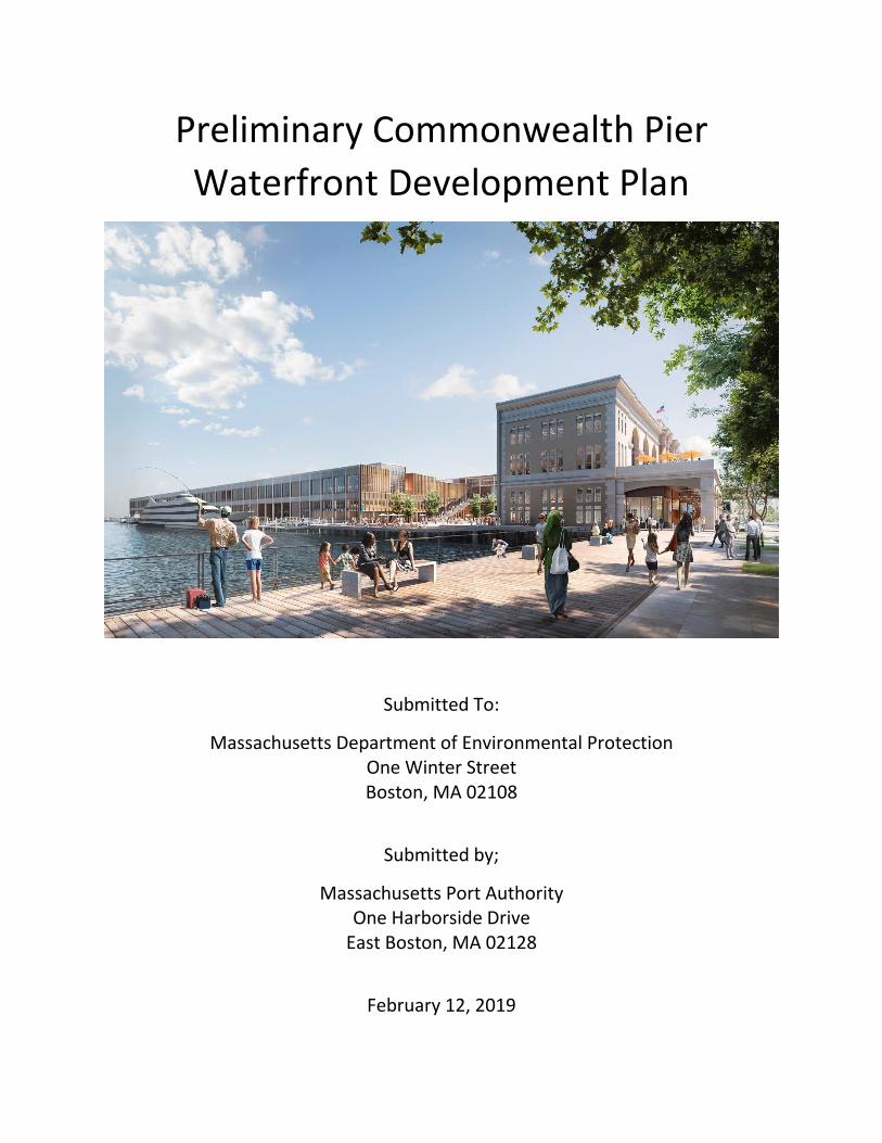
Preliminary Commonwealth Pier Waterfront Development Plan Submitted To: Massachusetts Department of Environmental Protection One Winter Street Boston, MA 02108 Submitted by; Massachusetts Port Authority One Harborside Drive East Boston, MA 02128 February 12, 2019
Transcript of DRAFT Comonwealth Pier Waterfront Development Plan · Commonwealth Pier Preliminary Waterfront...
Preliminary Commonwealth Pier
Waterfront Development Plan
Submitted To:
Massachusetts Department of Environmental Protection One Winter Street Boston, MA 02108
Submitted by;
Massachusetts Port Authority One Harborside Drive
East Boston, MA 02128
February 12, 2019

Commonwealth Pier Preliminary Waterfront Development Plan
TABLE OF CONTENTS
CHAPTER 1: INTRODUCTION ............................................................................................. 1-1
1.1 AREA OF THE PLAN AND CHAPTER 91 JURISDICTION.............................................. 1-1
1.2 MASSPORT’S WATERFRONT PLANNING CONTEXT .................................................. 1-2
1.3 PLANNING VISION FOR THE COMMONWEALTH PIER WATERFRONT DEVELOPMENT PLAN AREA ..................................................................................................................... 1-5
CHAPTER 2: CHAPTER 91 ANALYSIS ................................................................................... 2-1
2.1 PLANNING ANALYSIS ................................................................................................. 2-2
2.2 EXISTING AND PROPOSED USES ................................................................................ 2-2
2.3 DESIGN REQUIREMENTS AND APPROACH ............................................................... 2-6
2.4 CHAPTER 91 BASELINE CONDITIONS ........................................................................ 2-9
2.5 REQUIREMENTS RELATED TO NONWATER-DEPENDENT USES ............................... 2-10
2.6 PUBLIC BENEFITS REQUIREMENTS FOR NONWATER-DEPENDENT USES ............... 2-13
2.7 ADDITIONAL REQUIREMENTS WITHIN THE DPA AREAS ........................................ 2-15
2.8 IMPLEMENTATION .................................................................................................... 2-16
CHAPTER 3: CONSISTENCY WITH CZM PROGRAMS, POLICIES, AND MANAGEMENT
PRINCIPLES ........................................................................................................................ 3-1
3.1 COASTAL HAZARDS ................................................................................................... 3-1
3.2 GROWTH MANAGEMENT .......................................................................................... 3-2
3.3 PORTS AND HARBORS ............................................................................................... 3-2
3.4 PROTECTED AREAS ..................................................................................................... 3-4
3.5 PUBLIC ACCESS ........................................................................................................... 3-4
3.6 CONCLUSION ............................................................................................................. 3-5
Commonwealth Pier Preliminary Waterfront Development Plan
FIGURES
Figure 1-1 MOU/Special Planning Area Figure 1-2 Commonwealth Pier Waterfront Development Plan Area Figure 1-3 Commonwealth Flats Development Area Figure 2-1 Existing Conditions Plan Figure 2-2 Proposed Conditions Plan Figure 2-3 Water Dependent Use Zone -
TABLES
Table 2-1 Existing and Proposed Uses
APPENDICES
Appendix A Massport/DEP South Boston Memorandum of Understanding Appendix B List of Planning Studies Appendix C Massport Maritime Director Letter and DPA Property List
Commonwealth Pier Preliminary Waterfront Development Plan (02.11.19)
Introduction
1-1
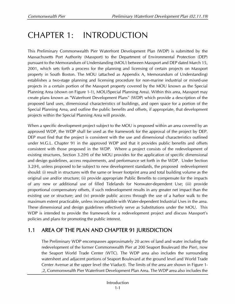
CHAPTER 1: INTRODUCTION
This Preliminary Commonwealth Pier Waterfront Development Plan (WDP) is submitted by the
Massachusetts Port Authority (Massport) to the Department of Environmental Protection (DEP)
pursuant to the Memorandum of Understanding (MOU) between Massport and DEP dated March 15,
2001, which sets forth a process for the planning and licensing of certain projects on Massport
property in South Boston. The MOU (attached as Appendix A, Memorandum of Understanding)
establishes a two-stage planning and licensing procedure for non-marine industrial or mixed-use
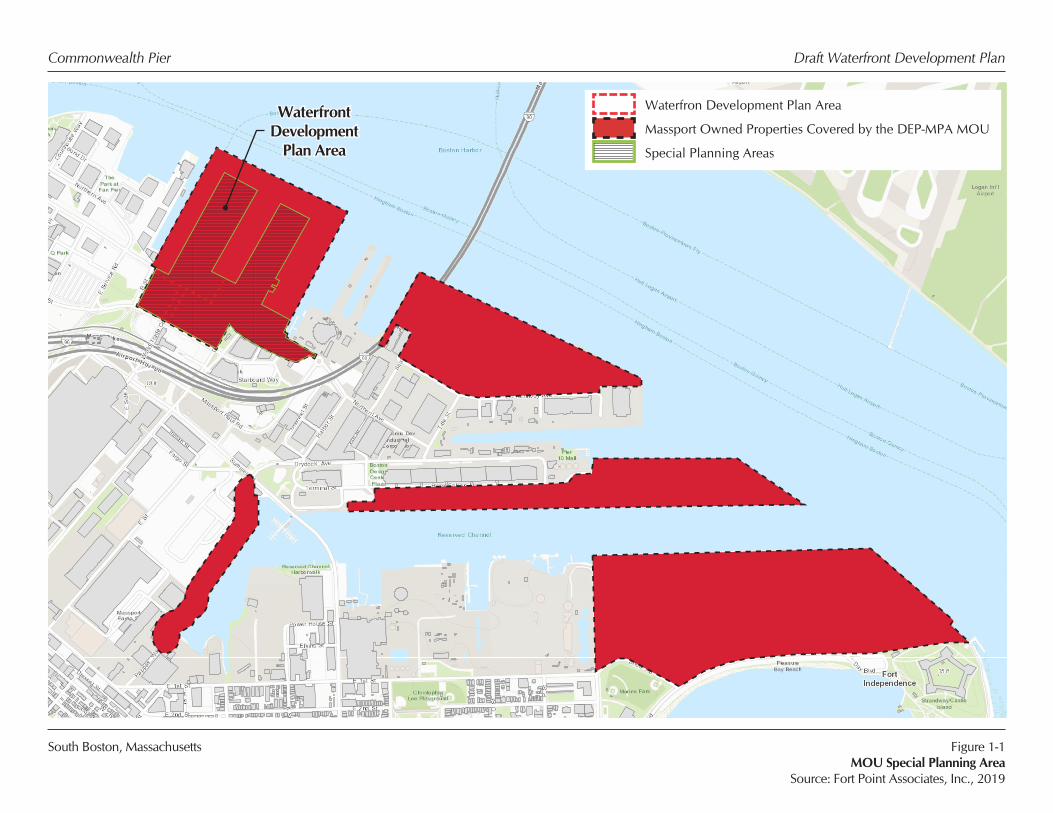
projects in a certain portion of the Massport property covered by the MOU known as the Special
Planning Area (shown on Figure 1-1), MOU/Special Planning Area). Within this area, Massport may
create plans known as "Waterfront Development Plans" (WDP) which provide a description of the
proposed land uses, dimensional characteristics of buildings, and open space for a portion of the
Special Planning Area, and outline the public benefits and offsets, if appropriate, that development
projects within the Special Planning Area will provide.
When a specific development project subject to the MOU is proposed within an area covered by an
approved WDP, the WDP shall be used as the framework for the approval of the project by DEP.
DEP must find that the project is consistent with the use and dimensional characteristics outlined
under M.G.L. Chapter 91 in the approved WDP and that it provides public benefits and offsets
consistent with those proposed in the WDP. Where a project consists of the redevelopment of
existing structures, Section 3.2(H) of the MOU provides for the application of specific dimensional
and design guidelines, access requirements, and performance set forth in the WDP. Under Section
3.2(H), unless proposed to be subject to new development standards, the proposed redevelopment
should: (i) result in structures with the same or lesser footprint area and total building volume as the
original use and/or structure; (ii) provide appropriate Public Benefits to compensate for the impacts
of any new or additional use of filled Tidelands for Nonwater-dependent Use; (iii) provide
proportional compensatory offsets, if such redevelopment results in any greater net impact than the
existing use or structure; and (iv) provide public access through the use of a harbor walk to the
maximum extent practicable, unless incompatible with Water-dependent Industrial Uses in the area.
These dimensional and design guidelines effectively serve as Substitutions under the MOU. This
WDP is intended to provide the framework for a redevelopment project and discuss Massport’s
policies and plans for promoting the public interest.
1.1 AREA OF THE PLAN AND CHAPTER 91 JURISDICTION
The Preliminary WDP encompasses approximately 20 acres of land and water including the
redevelopment of the former Commonwealth Pier at 200 Seaport Boulevard (the Pier), now
the Seaport World Trade Center (WTC). The WDP area also includes the surrounding
watersheet and adjacent portions of Seaport Boulevard at the ground level and World Trade
Center Avenue at the upper level (the Viaduct). The limits of the area are shown in Figure 1-
,2, Commonwealth Pier Waterfront Development Plan Area. The WDP area also includes the
Commonwealth Pier Preliminary Waterfront Development Plan
Introduction
1-2
Pier apron (Harborwalk), the Pier building and the water area around three sides of the Pier.
All of the WDP Area is within filled and flowed Commonwealth tidelands with a portion of
the Plan Area (World Trade Center Avenue, south of the Viaduct) not subject to the
jurisdiction of the DEP Waterways program. The majority of the WDP Area, except for the
watersheet adjacent to the westerly Pier apron, is within the South Boston Designated Port
Area (DPA). The entire WDP is within the boundaries of the MOU.
1.2 MASSPORT’S WATERFRONT PLANNING CONTEXT
Massport has engaged over many decades, and continues to engage, in a thoughtful,
deliberative planning process regarding Massport land and water holdings in South Boston.
This planning process includes Massport’s Northern Avenue Design Guidelines dated 1983,
the Port of Boston Economic Development Plan dated 1996, Massport’s Commonwealth Flats
Strategic Plan dated 2000, and Massport’s Commonwealth Flats Urban Design and Public
Realm Guidelines (See Appendix B, List of Planning Studies). Together, these plans provide
a framework for land uses, public realm improvements, and building design for the
Commonwealth Flats area. The result of this and ongoing work is an overall plan for the
public realm, including streets, sidewalks, and open spaces; new buildings; and new land
uses that will create a dynamic urban waterfront district, of which the Seaport World Trade
Center is a key part.
The planning studies serve as an important guide for the Authority's internal decision-
making, including prioritizing and phasing commercial mixed-use development projects
and core capital improvements to create dependable revenue streams. The
Commonwealth Flats Strategic Plan describes Massport's overall plans for mixed-use
development within the South Boston Waterfront, much of which have now been
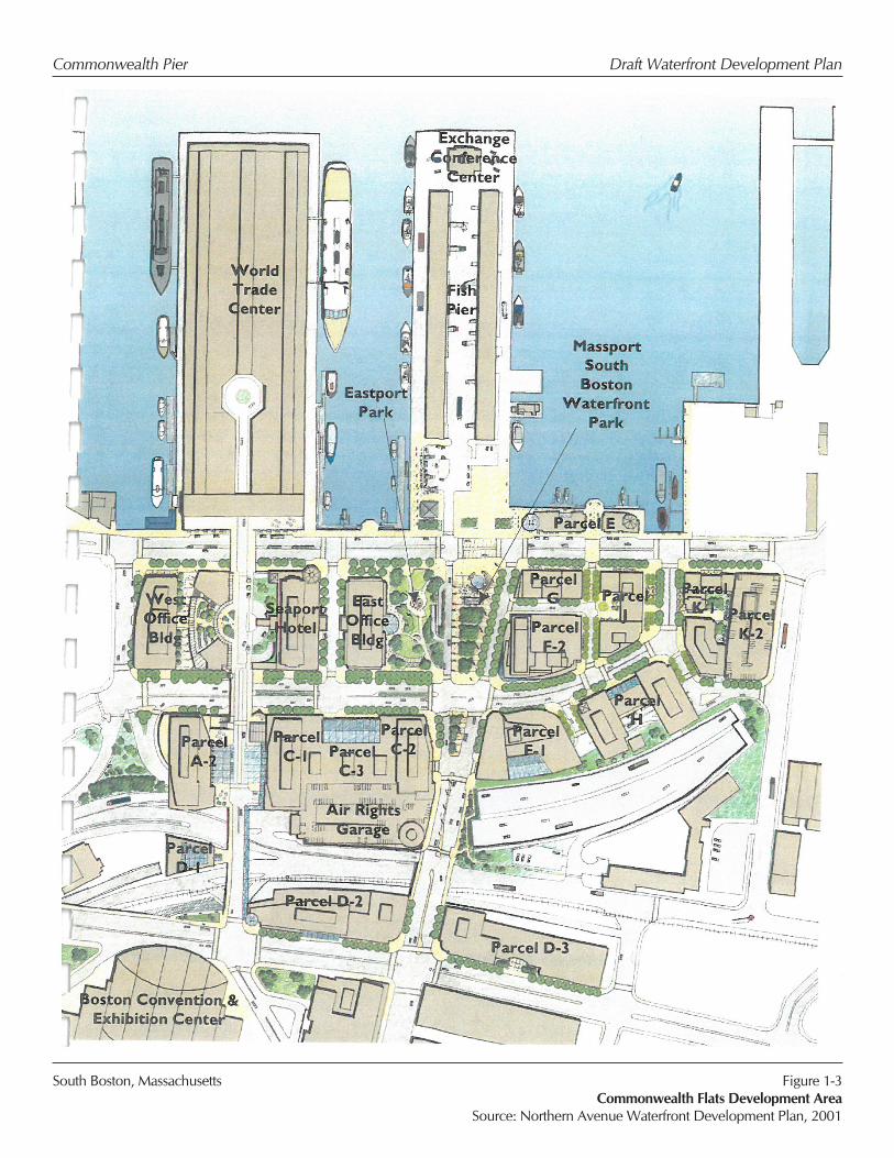
implemented. Figure 1-3, Commonwealth Flats Development Area includes an illustrative
plan of Massport's proposed development in Commonwealth Flats, including the WDP area.
Through the strategic planning process, Massport has developed a set of planning
principles to guide its waterfront development. These principles, which are listed below,
seek to create an appropriate balance of land uses that supports maritime industrial
activities and enhances waterfront public access. As part of the comprehensive planning
approach for Massport's South Boston Waterfront property, these principles establish an
important framework for the WDP:
• Maintain Priority of Port-Related Activities;
• Provide non-maritime revenue to support Massport’s maritime and Port-Related
Activities;
• Improve Transportation Mobility and connect to the surrounding neighborhood;
• Create a Balanced Mixed-Use District;
Commonwealth Pier Preliminary Waterfront Development Plan
Introduction
1-3
• Be a Good Neighbor;
• Advocate Strong, Cohesive Urban Design;
• Undertake Environmentally Responsible Development; and
• Conduct Inter-agency Coordination.
Recent reports by Massport and the City of Boston which particularly focus on the growing
impacts of climate change continue to guide Massport long-range planning and the priorities
of this WDP. These reports include:
SUSTAINABLE MASSPORT – ANNUAL SUSTAINABILITY & RESILIENCY REPORT
Massport has committed to making its facilities more sustainable and improving resiliency.
This report sets sustainability targets and tracks progress toward those goals. It covers all
facilities, including those in South Boston and sets sustainability goals for: energy and
greenhouse gas reductions; water conservation; community, employee and passenger well-
being; materials waste management and recycling; resiliency; noise abatement; air quality;
ground access and connectivity; water quality/stormwater; and natural resources.
MASSPORT FLOODPROOFING DESIGN GUIDELINES
Massport’s facilities are increasingly susceptible to flooding hazards caused by extreme
storms and rising sea levels as a result of climate change. Massport developed these design
guidelines to use in its capital planning and real estate development processes to make its
infrastructure and operations more resilient to flooding threats.
Key objectives include;
• Protect the safety of passengers, occupants, workers, and first responders.
• Minimize flood damage to critical Massport facilities, whose destruction or loss of
service will have a debilitating effect on the security, economy, safety, health and
welfare of the public.
• Enhance business resiliency, and expeditiously recover and restart critical services
with minimum delay and damage to public safety and health, economy and security.
• Provide for operational continuity to the greatest extent possible.
• Minimize losses of electrical power, communications, security and other critical
services facility wide and to individual critical assets.
• Prevent structural and property damage to the maximum extent possible.
• Maintain capacity to support regional emergency response and disaster recovery at
Logan Airport and Conley Terminal during, and immediately after, an extreme storm
event.
Commonwealth Pier Preliminary Waterfront Development Plan
Introduction
1-4
CLIMATE READY BOSTON
South Boston is one of the City’s most exposed neighborhoods to climate change impacts,
including both chronic high-tide flooding and episodic storm-related flooding, greater
intensity rainfall events and more intense heat waves South Boston’s exposure is expected
to increase significantly over the course of the next hundred years as climate change
continues to affect our environment. To protect against this exposure, Climate Ready Boston,
an ongoing initiative by the City of Boston, has identified the following key issues to be
addressed in new development projects:
⎯ Sea Level Rise and Future Storms
Future projects should include resiliency measures to minimize the impact of
potential flooding, including locating all critical mechanical and electrical
equipment on an upper floor or otherwise elevated above predicted future
flood levels. Higher ceiling heights on the ground floor can provide flexibility
for adaptation for future sea level rise. Site designs should incorporate flood
and salt tolerant plant species in open spaces.
⎯ Rainfall Events
Projects should take into account predictions for greater amounts and greater
rates of rainfall during peak events and design systems to accommodate higher
flows and safely direct and/or store rainfall to avoid contributing to major
flooding events.
⎯ Extreme Heat Events
Future development projects should anticipate higher temperature events,
including more extended and higher temperature heat waves. Building
systems should be designed to provide appropriate comfort levels during
these events, and site designs and high-performance building envelopes
should minimize energy required to cool buildings.
IMAGINE BOSTON 2030
In 2017, the City of Boston released the first citywide plan in more than fifty years, “Imagine
Boston 2030.” Imagine Boston 2030 identifies Boston’s goals of “encouraging continued
economic growth, becoming more affordable and equitable, and preparing for climate
change.” Imagine Boston 2030 is a planning tool that Massport will take into consideration
as it plans for the future of its developable properties.
The goals of Imagine Boston 2030 include creating a waterfront for future generations, which
would:
• Support a Welcoming and Active Waterfront

Commonwealth Pier Preliminary Waterfront Development Plan
Introduction
1-5
• Link Neighborhoods to the Water
• Foster Economic Opportunity
• Prepare for Climate Change
• Improve Environmental Quality
• Ensure Sustainable Funding Structure
• Facilitate Collaborative Planning
1.3 PLANNING VISION FOR THE COMMONWEALTH PIER WATERFRONT
DEVELOPMENT PLAN AREA
Adaptive Reuse
The current agreement between Massport and the operators of the Pier involves a
ground lease for the building, with the ground lease tenant responsible for the
management of the Pier apron, including coordination of water transportation
activities. However, the pile-supported apron structure which surrounds the building
and which requires significant infrastructure investment, is currently a responsibility
of Massport. Massport recognizes that shifting the pier structural responsibility to the
ground lessee as part of the redevelopment project will ensure that financial revenue
for capital improvement and ongoing maintenance will be available to maintain the
Pier in its entirety.
The building has tremendous potential to create both an exciting, flexible, and
creative workspace that is attractive to the workforce and a unique waterfront
experience for the public. The adaptive reuse could enhance current uses by
converting a large amount of the existing exhibition/event space into extensive public
realm improvements, convert street side loading areas to expanded ground-floor retail
space, additional and upgraded innovative office space, and first-class event spaces.
A key design goal is to maximize open space while prioritizing public uses, activation,
and access at both the Harbor and Viaduct levels of the building. By incorporating
grand public gestures, such as the creation of a multi-functional open-air public plaza
with city skyline views and enhanced waterfront engagement (e.g. the Harborwalk)
along all three sides of the Pier, the building will be activated with a true sense of
place within its rich urban fabric.
Through reuse and revitalization of the building, the WDP strives to:
• Enhance public access to the waterfront through promotion and activation of
the full length of the Harborwalk and connectivity and permeability of the
Pier;
Commonwealth Pier Preliminary Waterfront Development Plan
Introduction
1-6
• Employ resiliency measures to meet the challenges anticipated from
forecasted rising tides and increased storm intensity;
• Maintain existing truck route and protect pedestrian safety along Seaport
Boulevard.
• Cultivate vibrancy within the public realm and interior spaces;
• Provide a diverse mix of retailers and event facilities;
• Create a unique workplace, including -co-working space that promotes
greater collaboration and innovation for users;
• Create a clearly defined arrival experience from multiple transit options to
encourage public access and promote use of the waterfront;
• Enhance the quality of the passenger access to the existing water-dependent
tenants within the proposed apron design;
• Improve pedestrian safety and traffic flow along Seaport Boulevard by
removing existing loading docks and service access;
• Improve light and water view permeability;
• Maximize future flexibility by providing for potential multi-tenant office
space;
• Incorporate best practices for sustainability and wellness for occupants and
visitors; and
• Provide modernized and highly energy-efficient building systems;
Public Realm Plan
In light of the Public Trust rights inherent in filled and flowed tidelands, one of
Massport’s primary goals for the WDP is to enhance public access to and use of the
waterfront on the Pier. The improved public realm space includes:
• An enhanced and inviting Harborwalk with new lighting, site furnishings,
special paving, wayfinding signage, connectivity to retail/restaurant/café
spaces and/or public art;
• Multiple public ‘niche’ spaces cut out of the perimeter of the building with
access to the Harborwalk;
• Enhancement of the Harborwalk through the introduction of interpretive
signage and amenities;
• A significant, new public Plaza along the waterfront and connecting to the
Harborwalk to draw public users to the Pier;
Commonwealth Pier Preliminary Waterfront Development Plan
Introduction
1-7
• Apron expansions on portions of both sides of the Headhouse that enhances
public access by relieving present conflicts between vehicular and pedestrian
traffic and improving access to water transportation options on the Pier. The
apron expansion will be compatible with future expansion of water
transportation facilities;
• Improvements to water transportation facilities, including replacement of
deteriorated fender piles on sections of the Pier, installation of handicapped
accessible floating docks, provision of a designated water transportation
waiting area which may be within retail or amenity space and a ticketing office
for vessel operators;
• A new street front arcade along Seaport Boulevard and a significantly
upgraded streetscape, including removal of four existing exhibition hall
loading docks on Seaport Boulevard, construction of a recessed ground floor
to create a new arcade for pedestrian access, new site works and landscaping,
and greatly improving the street-level experience with the addition of
designated drop-off areas (taxi, rideshare and buses) and shared bike lanes,
while protecting the truck route serving the Raymond L. Flynn Marine Park
access to I-93;
• Inclusion of additional Facilities of Public Accommodation (FPA) and public
areas on the ground level;
• Enhanced public realm and FPA space on the Viaduct level providing activity
and water views of the Harbor and South Boston Waterfront
• Improved connectivity through and behind the Headhouse to further enliven
the public spaces and provide visual connection from the Headhouse to the
Plaza below and a 24-hour ADA-compliant vertical pedestrian connection
from the Viaduct to Seaport Boulevard;
• Improved pedestrian access system including a covered walkway running
from the Headhouse to Congress Street and the Silver Line MBTA station and
restrictions on traffic on the Viaduct (emergency and special function only) to
promote a pedestrian-focused corridor. Portions from the Headhouse to
Seaport Hotel will occur in connection with the Commonwealth Pier
Redevelopment. Additional portions of this pedestrian access system to be
studied in connection with any major structure or land and hardscaping of the
podium area between the Seaport Hotel and West Office building; and
•
• Design that respects and complements the unique architectural character of
the Headhouse.

Commonwealth Pier Preliminary Waterfront Development Plan
Introduction
1-8
Watersheet Plan
One of Massport’s goals for the redevelopment is to provide physical improvements
that significantly improve public utilization and public benefit by focusing on public
access and commercial passenger vessel activity. Massport intends to (1) preserve
and protect the Water-dependent and Water-dependent Industrial Uses on the WTC
apron, (2) protect the Water-dependent Industrial Uses on adjacent Boston Fish Pier
(including fishing vessels, seafood processing and the transportation activities
associated therewith), and (3) protect trucking activity between the DPA properties
to the east and the interstate highway network west of the WDP planning area. Thus,
redevelopment should:
• Ensure that vessel activity at the Boston Fish Pier is not adversely affected by
new construction or uses;
• Maintain the existing apron principally for commercial passenger vessel
activity, including potential water taxi and commuter boats and expanding
portions of the aprons for improved public access and water transportation
facilities;
• Remove the loading docks along Seaport Boulevard and create drop-off areas
to ease traffic along Seaport Boulevard, including trucking activity from the
DPA properties; and
• Provide opportunities for the general public to get closer to the watersheet
and vessel activities.
Climate Resilience
Within the context of forecasted impacts associated with predicted sea level rise and
increased frequency and intensity of storm events, resiliency provisions should be
included in both the building and site design. Design strategies include:
• Placement of critical mechanical and life safety/standby emergency building
systems at or above at 23.5 BCB, consistent with Massport Floodproofing
Design Guide for critical facilities.;
• A new façade along the Pier apron that raises the glass level above vulnerable
elevations and an integrated wall/apron slab designed to withstand lateral
pressure of wave action up to an elevation of 21.5 BCB, one foot higher than
the Massport Floodproofing Design Guide requires for existing buildings;
• Structural measures to resist buoyancy forces resulting from rising tides and
storm surges;
• New elevated first floor of 19.2 BCB, with floodproofing consistent with
Massport Floodproofing Design Guide for existing buildings;
Commonwealth Pier Preliminary Waterfront Development Plan
Introduction
1-9
• Provisions in the façade openings that allow for deployable flood barriers;
• Use of landscaping walls, walkways, stairways, railings, benches, and bike
racks designed using materials that can withstand saltwater inundation;
• Operational planning/readiness procedures and coordination with city and
state agencies.
South Boston, Massachusetts
Commonwealth Pier Draft Waterfront Development Plan
Sources: Esri, HERE, DeLorme, Intermap, increment P Corp., GEBCO, USGS, FAO, NPS, NRCAN, GeoBase, IGN, Kadaster NL, Ordnance Survey, Esri Japan,METI, Esri China (Hong Kong), swisstopo, MapmyIndia, © OpenStreetMap contributors, and the GIS User Community
Figure 1-1MOU Special Planning Area
Source: Fort Point Associates, Inc., 2019
Waterfront Development
Plan Area
Sources: Esri, HERE, DeLorme, Intermap, increment P Corp., GEBCO, USGS, FAO, NPS, NRCAN, GeoBase, IGN, Kadaster NL, Ordnance Survey, Esri Japan,METI, Esri China (Hong Kong), swisstopo, MapmyIndia, © OpenStreetMap contributors, and the GIS User Community
Waterfron Development Plan Area
Massport Owned Properties Covered by the DEP-MPA MOU
Special Planning Areas

South Boston, Massachusetts
Commonwealth Pier Draft Waterfront Development Plan
Figure 1-2Commonwealth Pier Waterfront Development Plan Area
Source: Fort Point Associates, Inc., 2019
!(éç
!(éç
Legend
Designated Port Area
Chapter 91 Jurisdiction
Buildings
Open Space
Parcel Boundaries0 500
Feet
¯WDP Area
NORTHERN AVENUE
BOSTON HARBOR
B ST
REET
SEAP
ORT
LAN
E
NO
RTHERN
AVENU
E
CONGRESS STREET
WORLD TRADE CENTER
BOSTON FISH PIER
SEAPORT WEST
THE INSTITUTE OF CONTEMPORARY
ARTPIER 4
SEAPORT HOTEL
SEAPORT EAST
South Boston, Massachusetts
Commonwealth Pier Draft Waterfront Development Plan
Figure 1-3Commonwealth Flats Development Area
Source: Northern Avenue Waterfront Development Plan, 2001
Commonwealth Pier Preliminary Waterfront Development Plan
Chapter 91 Analysis
2-1
CHAPTER 2: CHAPTER 91 ANALYSIS
The MOU describes a number of specific elements which must be included in a WDP to create
"criteria, performance standards, and guidelines for development applicable to projects" to be
subsequently licensed under Chapter 91 in the Plan Area. For the WDP these elements include the
following:
Planning Analysis
A description of the planning analysis that synthesized the technical data and other
information that served as the basis for the Preliminary WDP.
Proposed Uses
A summary description of proposed uses for the WDP Area.
Public Benefits for Nonwater-Dependent Uses
If the WDP includes any Nonwater-dependent Uses, identify appropriate potential “Public
Benefits” (as defined in the MOU) and a methodology for allocating the Public Benefits
required for each Nonwater-dependent Project.
Design Requirements
Identify performance criteria for future Nonwater-dependent Projects, including dimensional
guidelines, design guidelines, and requirements regarding public and pedestrian access, and
identify any criteria that are substitutions for performance requirements set forth in the
Chapter 91 Regulations.
Offsets
Where appropriate, identify appropriate potential Offsets to mitigate impacts resulting from
the applications of Substitutions to a Nonwater-dependent Use Project that are greater than
the impacts that would result from the application of the Regulations.
Implementation Program
An Implementation Program commensurate with the scope of the WDP shall outline
elements, which may include provisions in leases and licenses to ensure ongoing compliance
with obligations set forth in the WDP.
Consistency with Coastal Zone Management Policies
The WDP shall describe the Plan's consistency with all applicable policies of the
Massachusetts Coastal Zone Management Program updated in 2011, including the Port and
Harbor Infrastructure Policies, Public Access Policies and Management Principles, and
Growth Management Principles.
Commonwealth Pier Preliminary Waterfront Development Plan
Chapter 91 Analysis
2-2
Accommodation for Redevelopment of Existing Structures
Section 3.2(H) of the MOU specifically provides that the WDP may include provisions
allowing for the redevelopment of existing structures with application of specific dimensional
and design guidelines and/or access requirements set forth in the WDP. The proposed
redevelopment should: (i) result in structures with the same or lesser footprint area and total
building volume as the original use and/or structure; (ii) provide appropriate Public Benefits
to compensate for the impacts of any new or additional use of filled Tidelands for Nonwater-
dependent Use; (iii) provide proportional compensatory offsets, if such redevelopment results
in any greater net impact than the existing use or structure; and (iv) provide public access
through the use of a harbor walk to the maximum extent practicable, unless incompatible
with Water-dependent Industrial Uses in the area. Any such dimensional and design
guidelines may serve as Substitutions under this MOU.
This WDP differs significantly from the previous Waterfront Development Plans for a nearby portion
of the South Boston waterfront because this Plan is specifically prepared to support the licensing of
the redevelopment of the Pier. Accordingly, the WDP has been prepared to ensure that the specific
criteria contained in section 3.2(H) of the MOU are met, while also providing the complete
framework for a WDP as described in Section 3.2 of the MOU.
2.1 PLANNING ANALYSIS
Unlike Massport’s previous WDPs in South Boston, which were prepared prior to the
development of the area, this Preliminary WDP is focused on the area containing and
immediately adjacent to the existing Pier, which is planned to be redeveloped. As noted in
Chapter 1, the Preliminary WDP incorporates planning principles identified in the earlier
plans, particularly those proposing to integrate the building into the larger public realm and
pedestrian and vehicle networks.
2.2 EXISTING AND PROPOSED USES
The Pier was redeveloped into the WTC in 1985, which included office space, exhibition
space, and limited retail space. Over the past three decades there has been little change in
the land uses on the Pier. The Pier currently includes commercial office space, exhibition and
meeting space, limited retail and restaurant use on Seaport Boulevard, and a narrow perimeter
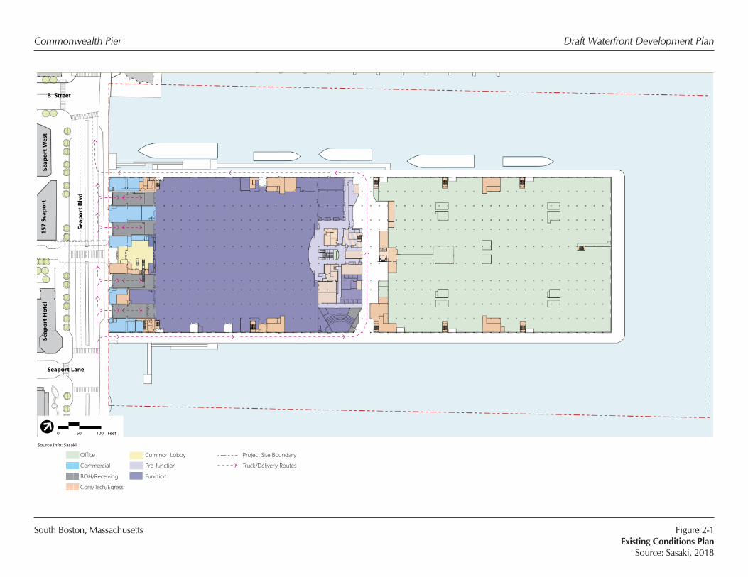
of open space along the Pier apron. See Figure 2-1, Existing Conditions Plan. In its existing
condition, the viaduct level is principally an open plaza with very limited public use and
public programming.
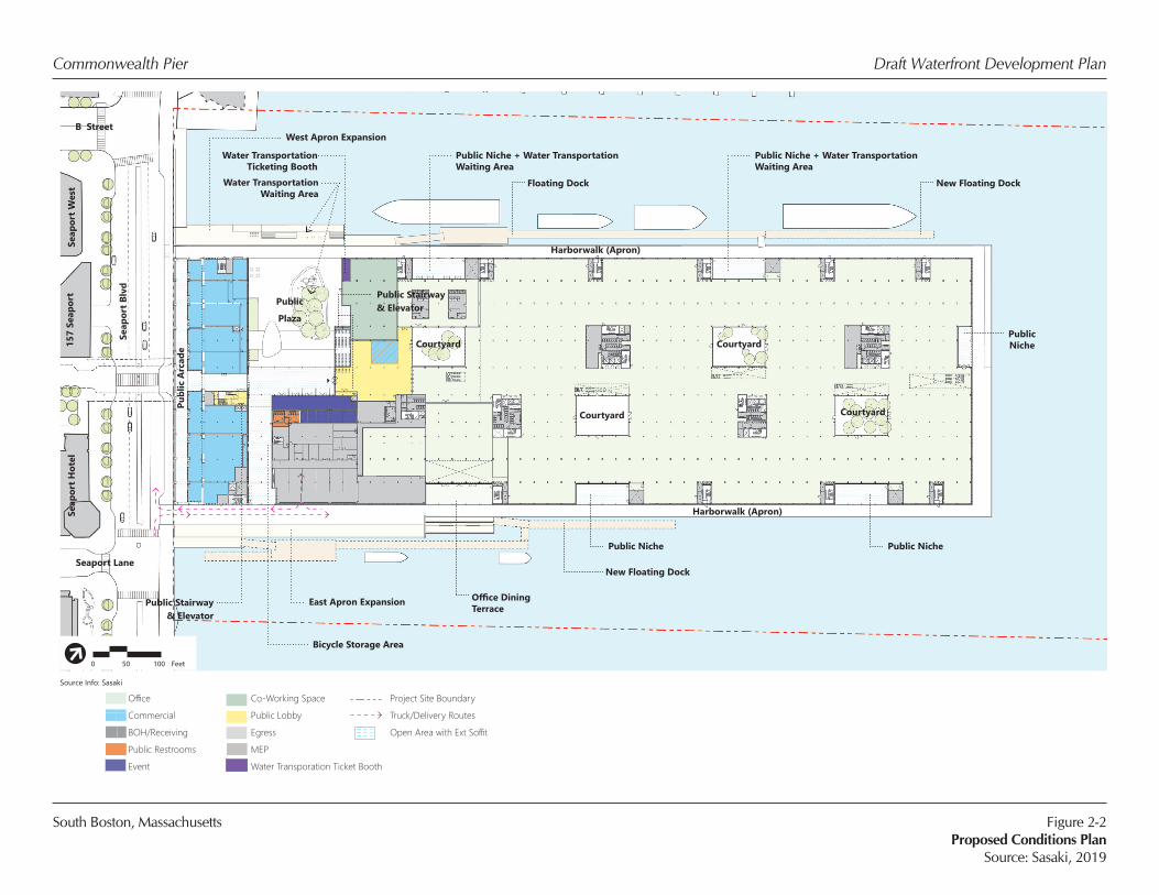
The proposed allowable uses remain similar to the current uses, including commercial office
space, event/meeting space, retail/restaurant use, and open space. However, FPAs and public
space will be significantly reconfigured to promote and enhance public access and use of the
Commonwealth Pier Preliminary Waterfront Development Plan
Chapter 91 Analysis
2-3
Pier. In addition, an innovative co-working space, a Facility of Public Accommodation, is
proposed to reflect the new nature of the South Boston Waterfront. 1
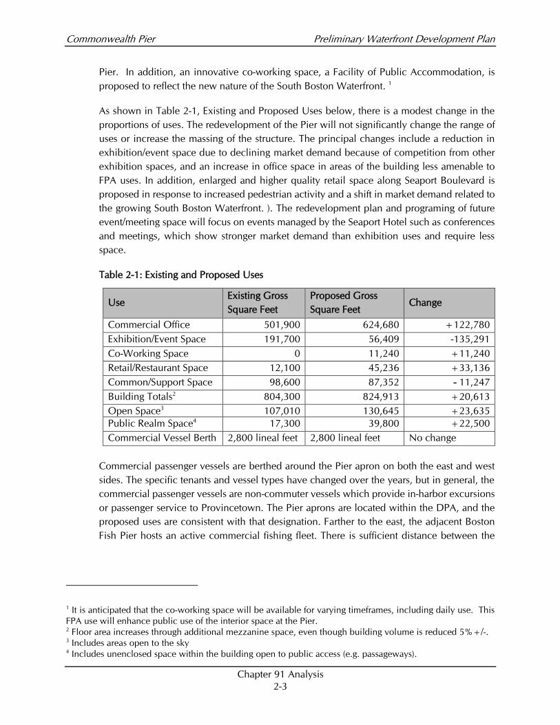
As shown in Table 2-1, Existing and Proposed Uses below, there is a modest change in the
proportions of uses. The redevelopment of the Pier will not significantly change the range of
uses or increase the massing of the structure. The principal changes include a reduction in
exhibition/event space due to declining market demand because of competition from other
exhibition spaces, and an increase in office space in areas of the building less amenable to
FPA uses. In addition, enlarged and higher quality retail space along Seaport Boulevard is
proposed in response to increased pedestrian activity and a shift in market demand related to
the growing South Boston Waterfront. ). The redevelopment plan and programing of future
event/meeting space will focus on events managed by the Seaport Hotel such as conferences
and meetings, which show stronger market demand than exhibition uses and require less
space.
Table 2-1: Existing and Proposed Uses
Use Existing Gross
Square Feet
Proposed Gross
Square Feet Change
Commercial Office 501,900 624,680 +122,780
Exhibition/Event Space 191,700 56,409 -135,291
Co-Working Space 0 11,240 +11,240
Retail/Restaurant Space 12,100 45,236 +33,136
Common/Support Space 98,600 87,352 - 11,247
Building Totals2 804,300 824,913 +20,613
Open Space3 107,010 130,645 +23,635
Public Realm Space4 17,300 39,800 +22,500
Commercial Vessel Berth 2,800 lineal feet 2,800 lineal feet No change
Commercial passenger vessels are berthed around the Pier apron on both the east and west
sides. The specific tenants and vessel types have changed over the years, but in general, the
commercial passenger vessels are non-commuter vessels which provide in-harbor excursions
or passenger service to Provincetown. The Pier aprons are located within the DPA, and the
proposed uses are consistent with that designation. Farther to the east, the adjacent Boston
Fish Pier hosts an active commercial fishing fleet. There is sufficient distance between the
1 It is anticipated that the co-working space will be available for varying timeframes, including daily use. This
FPA use will enhance public use of the interior space at the Pier. 2 Floor area increases through additional mezzanine space, even though building volume is reduced 5%+/-. 3 Includes areas open to the sky 4 Includes unenclosed space within the building open to public access (e.g. passageways).
Commonwealth Pier Preliminary Waterfront Development Plan
Chapter 91 Analysis
2-4
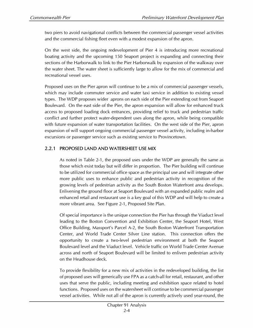
two piers to avoid navigational conflicts between the commercial passenger vessel activities
and the commercial fishing fleet even with a modest expansion of the apron.
On the west side, the ongoing redevelopment of Pier 4 is introducing more recreational
boating activity and the upcoming 150 Seaport project is expanding and connecting their
sections of the Harborwalk to link to the Pier Harborwalk by expansion of the walkway over
the water sheet. The water sheet is sufficiently large to allow for the mix of commercial and
recreational vessel uses.
Proposed uses on the Pier apron will continue to be a mix of commercial passenger vessels,
which may include commuter service and water taxi service in addition to existing vessel
types. The WDP proposes wider aprons on each side of the Pier extending out from Seaport
Boulevard. On the east side of the Pier, the apron expansion will allow for enhanced truck
access to proposed loading dock entrances, providing relief to truck and pedestrian traffic
conflict and further protect water-dependent uses along the apron, while being compatible
with future expansion of water transportation facilities. On the west side of the Pier, apron
expansion of will support ongoing commercial passenger vessel activity, including in-harbor
excursions or passenger service such as existing service to Provincetown.
2.2.1 PROPOSED LAND AND WATERSHEET USE MIX
As noted in Table 2-1, the proposed uses under the WDP are generally the same as
those which exist today but will differ in proportion. The Pier building will continue
to be utilized for commercial office space as the principal use and will integrate other
more public uses to enhance public and pedestrian activity in recognition of the
growing levels of pedestrian activity as the South Boston Waterfront area develops.
Enlivening the ground floor at Seaport Boulevard with an expanded public realm and
enhanced retail and restaurant use is a key goal of this WDP and will help to create a
more vibrant area. See Figure 2-1, Proposed Site Plan.
Of special importance is the unique connection the Pier has through the Viaduct level
leading to the Boston Convention and Exhibition Center, the Seaport Hotel, West
Office Building, Massport’s Parcel A-2, the South Boston Waterfront Transportation
Center, and World Trade Center Silver Line station. This connection offers the
opportunity to create a two-level pedestrian environment at both the Seaport
Boulevard level and the Viaduct level. Vehicle traffic on World Trade Center Avenue
across and north of Seaport Boulevard will be limited to enliven pedestrian activity
on the Headhouse deck.
To provide flexibility for a new mix of activities in the redeveloped building, the list
of proposed uses will generically use FPA as a catch-all for retail, restaurant, and other
uses that serve the public, including meeting and exhibition space related to hotel
functions. Proposed uses on the watersheet will continue to be commercial passenger
vessel activities. While not all of the apron is currently actively used year-round, the
Commonwealth Pier Preliminary Waterfront Development Plan
Chapter 91 Analysis
2-5
most valuable and easily accessible portions of the east and west sides of the pier are
actively used, and the balance is used occasionally for visiting ships during special
events. Expansion of the east and west aprons is planned to provide greater space for
pedestrian queueing, and improved handicap access to floats, and servicing of
vessels. Other enhancements to the perimeter of the building and Harborwalk are
intended to expand year-round public use.
2.2.2 DESIGNATED PORT AREAS
Although the Pier is located within the South Boston DPA, the structure’s principal
use has been as an office, exhibition and event space for more than three decades.
At the time the DPA boundaries were established in 1978, the Pier was primarily
underutilized warehouse space but did host occasional cruise ship port calls.
The WTC redevelopment was authorized in the early 1980s prior to the period in
which Chapter 91 regulations were revised to include filled tidelands and to reflect
new public purposes. At the time that the Pier was being considered for
redevelopment, oceangoing freight business had declined and Massport relocated
cruise ship operations to the Black Falcon terminal and committed to use the Pier
apron for commercial passenger vessels5. The redevelopment of the WTC was
deemed by the DEP6 not to require a Chapter 91 license as the project had completed
MEPA review prior to January 1, 1984. Therefore, there is no existing license for the
current uses.
While the building has been used principally for non-maritime uses for more than
three decades, the Pier apron has been used continuously to support commercial
passenger vessel uses, consistent with the DPA designation, and ground lease
payments for the building have helped to support maritime infrastructure investments
by Massport.
In the context of the current and proposed land uses in the South Boston DPA, the
WDP area lies at the extreme western boundary, and, with the exception of the nearby
Fish Pier (discussed below), the surrounding properties owned by Massport, even
those in the DPA, are primarily used for Nonwater-dependent Uses. Massport’s
principal planning concerns for the WTC redevelopment in the WDP area are focused
on the preservation and protection of the Water-dependent and Water-dependent
Industrial Uses on the WTC apron, the protection of the Water-dependent Industrial
Uses on Fish Pier (including fishing vessels, seafood processing and the transportation
5 Letter from David Davis, Massport to EOEA, January 11, 1985. 6 Written Determination on Waterways application W90-569-N. p. 5.
Commonwealth Pier Preliminary Waterfront Development Plan
Chapter 91 Analysis
2-6
activities associated therewith), and the protection of trucking activity from the DPA
properties to the east to the interstate highway network west of the planning area.
2.3 DESIGN REQUIREMENTS AND APPROACH
2.3.1 MASSPORT DESIGN APPROACH
Massport’s design approach to the redevelopment of the Pier is to provide a more
modern and functional facility to support the next several decades of building use and
to update the physical facilities to better meet the needs of the emerging South Boston
Waterfront and to better accommodate climate change. As detailed in Sections 1.2
and 1.3 above, the key factors in the design objectives are:
• Enlivening the Seaport Boulevard and Viaduct level frontages through active
public uses and replacing existing loading docks with retail use;
• Maintaining the Headhouse structure in recognition of its historical
importance in a way that makes it the focal point of public activity;
• Creating higher quality open space at Seaport Boulevard and along the Pier
aprons to enhance the pedestrian experience;
• Employ resiliency measures to meet the challenges anticipated from
forecasted rising tides and increased storm intensity
• Improving pedestrian access and vehicular traffic flow along and across
Seaport Boulevard to provide a pedestrian activity node for the Seaport WTC;
• Capitalizing on the viaduct level connections to provide greater pedestrian
connectivity to the WTC Silver Line Station, the Boston Convention and
Exhibition Center, and other parts of the South Boston Waterfront;
• Replacing failing façade with new, more durable materials that encourage
daylighting interior spaces and provide greater energy efficiency; and
• Expanding access along the Pier apron and making it compatible with future
expansion of water transportation facilities.
• Creating public spaces at multiple locations along the apron to create better
pedestrian access and amenities to encourage public use.
The implementation of these design goals is detailed in the sections below, and is
reflected in the design requirements proposed in this WDP.
Commonwealth Pier Preliminary Waterfront Development Plan
Chapter 91 Analysis
2-7
2.3.2 BUILDING DESIGN CONCEPT AND DEVELOPMENT
The redevelopment of the Pier takes into account the unique interplay between
historic architecture/function and modern aesthetic/place-making. With a focus on
sustainable practices and resiliency, along with clean lines and materiality, adaptive
re-use will allow the Pier to become a true destination within the South Boston
Waterfront that ultimately stands the test of time.
HEIGHT AND MASSING
The height and massing of the building remain relatively unchanged, although
portions of the shed buildings will have higher roof planes to accommodate higher
floor to floor heights in certain areas. Some rooftop structures may extend above the
current roofline to provide access to potential future roof decks, but no new elements
will create any additional shadow impacts. The roof and parapet of the Headhouse
are and will remain the highest points of the building. It is important to note that
redevelopment will satisfy the dimensional criteria in section 3.2(H) of the MOU by
limiting the redevelopment of the structure to its existing footprint area, and
maintaining the same or less building volume.
2.3.3 PUBLIC REALM IMPROVEMENTS
Important public realm improvements should include a variety of publicly-accessible
spaces along the waterfront, including:
• Expansion of the apron on the sides of the Headhouse increasing the outdoor
public space to better accommodate vessel passengers and other pedestrians;
• An enhanced and inviting Harborwalk with new lighting, site furnishings, special
paving, wayfinding signage, and connectivity to retail/restaurant/cafe spaces;
• Improved connectivity through the building to further enliven the public spaces
and a 24-hour vertical pedestrian access from the Viaduct to Seaport Boulevard;
• New street-front arcade along Seaport Boulevard;
• A large new public plaza adjacent to the waterfront designed for flexibility of use;
• Multiple large niche spaces cut out of the perimeter of the building; and
• Improved connectivity/porosity through and behind the Headhouse to further
enliven the public spaces.
Commonwealth Pier Preliminary Waterfront Development Plan
Chapter 91 Analysis
2-8
NEW PUBLIC PLAZA
The new public waterfront plaza to be located in the southwestern corner of the Pier
defines the main central gathering space (the “Plaza”). The Plaza should provide an
open, flexible outdoor space with tree planting, custom seating elements, and areas
for moveable tables and chairs. The goal of the Plaza is to accommodate large outdoor
events, open markets, and even winter amenities to provide activities throughout the
year. On the east end of the Plaza, public restrooms will be provided.
RENOVATED HARBORWALK
The existing Harborwalk runs the perimeter of the Pier and provides the public with
a continuous walkway along the harbor with views to Downtown Boston, East Boston,
and Boston Harbor. Due to its length and narrow configuration, the Harborwalk is
currently underutilized; increased use is a key Massport WDP goal.
Seating elements with integrated planters, and lighting should be provided to line the
building face edge of the walkway. The renovated Harborwalk will maintain a
generous walking area but expand at points to break up the linearity of the walk and
introduce program spaces both for shelter and rest.
Areas of the Harborwalk will be expanded at the east and west sides to provide
improved pedestrian access to the public spaces proposed along the Harborwalk and
new Plaza. The proposed apron expansions will also provide seating and steps to
allow visitors to approach the waterfront.
HARBORWALK NICHES
Located along the exterior of the Pier building adjacent to the Harborwalk, publicly
accessible niches will provide public amenities, such as seating areas, shelter from
weather, open areas for artwork, and amenity zones for vendors to activate the Pier
and Pier apron. An additional private niche will serve the interior office space,
providing a dining terrace.
2.3.4 THE VIADUCT
The Viaduct, which forms the extension of World Trade Center Avenue across Seaport
Boulevard, connects Summer Street, the MBTA World Trade Center Silver Line transit
station, and the upper level of the Seaport Hotel to the Headhouse. The Viaduct will
be a primary pedestrian connection to Pier and will play a critical role in linking
pedestrian access from the Boston Convention and Exhibition Center and World
Trade Center Avenue to the waterfront and create a consistent design and public
realm among these areas. Conceptually, the Viaduct bridge will support plantings and
include a covered walkway area for pedestrians, creating an opportunity for

Commonwealth Pier Preliminary Waterfront Development Plan
Chapter 91 Analysis
2-9
pedestrians to pause and enjoy the view from Viaduct. The Viaduct links to the
Headhouse terrace, where outdoor event and restaurant seating areas are planned.
2.3.5 SEAPORT BOULEVARD STREETSCAPE IMPROVEMENTS
The streetscape improvements proposed along Seaport Boulevard will include
renovations between the existing eastern curb and the new retail entrances, as well
as curb modifications along the southern edge of Seaport Boulevard. Along Seaport
Boulevard, the curb will be configured to provide a more visible and safer connection
below the Viaduct at the existing crosswalk. The sidewalk at the edge of the street
would be improved with new pavers. . New arcade space will be created to provide
a sheltered pedestrian space with access to retail.
The improvements will also serve to protect the truck route along Seaport Boulevard
and eliminate impediments to the free flow of traffic by changing the curb lines to
provide designated areas for bus, taxi and ride-share standing.
2.3.6 PEDESTRIAN ACCESS AND CIRCULATION
Pedestrian access and circulation to the Pier will be improved with the addition of a
Plaza, an improved Harborwalk, and passageways through the Headhouse from east
to west. Pedestrian access will also be improved by the removal of the loading docks
at the south side of the Headhouse facing Seaport Boulevard. This would eliminate
the need for the existing ramps at the loading bays and provide greater activation of
the southern facade of the building. Direct ADA-compliant pedestrian access between
the Viaduct level and the Seaport Boulevard is a key design goal and must be
incorporated in the final design.
2.3.7 ACCESSIBILITY
Accessibility improvements are required for adaptive reuse of existing buildings to
ensure that access is available to all. The main pedestrian entrances of the building
will be ADA-compliant.. Floating docks for passenger vessel loading along the Pier
aprons also will be ADA-compliant.
2.4 CHAPTER 91 BASELINE CONDITIONS
Given the unique conditions that resulted in the initial redevelopment of the Pier for the
WTC, the baseline Chapter 91 conditions are essentially the existing condition. See Figure 2-
1, Existing Conditions Plan. Although the parcel is within a DPA, the location, layout, and
configuration of the Pier is not well suited for modern maritime activities, particularly in light
of the transportation and traffic conditions in the specific location and the surrounding land
uses. Therefore, the base case against which to measure the Preliminary WDP changes is the
existing condition.
Commonwealth Pier Preliminary Waterfront Development Plan
Chapter 91 Analysis
2-10
Potential changes to the baseline condition considered by Massport for inclusion in the WDP
were limited to vertical expansion of the building consistent with surrounding buildings in
the neighborhood and a potential change of use. Horizontal expansion of the building was
not deemed feasible given the limited apron area today and the proximity of adjacent piers.
2.5 REQUIREMENTS RELATED TO NONWATER-DEPENDENT USES
The Chapter 91 regulations contain certain dimensional standards governing Nonwater-
dependent Uses and structures containing such uses. For new development projects, any
proposed variances from these standards are termed “Substitutions” under the MOU and may
require mitigating Offsets if they result in an environmental impact greater than that which
would result from the application of the regulations. Because this Plan is proposed to apply
only to the redevelopment of an existing structure, Section 3.2(H) of the MOU sets forth the
specific performance standards for such redevelopment, which are more limited than the
standards applicable to new development in the Special Planning Area.
Pursuant to Section 3.2(H) of the MOU, the WDP may include provisions for redevelopment
of existing structures with specific dimensional and design guidelines provided that
redevelopment (i) results in structures with the same or lesser footprint area and total building
volume as the original use and/or structure; (ii) provide appropriate Public Benefits to
compensate for the impacts of any new or additional use of filled Tidelands for Nonwater-
dependent Use; (iii) provides proportional compensatory offsets, if such redevelopment
results in any greater net impact than the existing use or structure; and (iv) provide public
access through the use of a harbor walk to the maximum extent practicable, unless
incompatible with Water-dependent Industrial Uses in the area.
Because there are some provisions of the Waterways Regulations, which would be otherwise
applicable to project elements, the following discussion identifies those provisions and
identifies whether any Substitution may be required.
2.5.1 PILE SUPPORTED STRUCTURES
Chapter 91 regulations at 310 CMR 9.51(3)(a) preclude new pile supported structures
beyond the footprint of existing piers for Nonwater-dependent Use. As part of the
redevelopment of the Pier, apron expansions are contemplated that would be for
Water-dependent Uses and thus would not conflict with this provision. However,
Chapter 91 regulations at 310 CMR 9.32(1)(a)(3) and (b) (8) restrict facilities for public
pedestrian access to filled tidelands or existing pile fields, wherever feasible. In the
case of the redevelopment of the Pier, reducing the building width on both sides to
allow increased Harborwalk dimensions would severely compromise the existing
historic Headhouse features and is not feasible. Thus, the WDP proposes a limited
expansion of the Pier apron to accommodate combined public pedestrian and
commercial passenger vessel activities. No Offset is required.
Commonwealth Pier Preliminary Waterfront Development Plan
Chapter 91 Analysis
2-11
2.5.2 FACILITIES OF PUBLIC ACCOMMODATION/PRIVATE TENANCY
In considering the baseline condition, including the location of the existing Facilities
of Public Accommodation along Seaport Boulevard, and the current Facilities of
Private Tenancy in the outside perimeter of the existing structure, Massport has
determined that the contemplated redevelopment would not create “new or
additional impacts” requiring additional Public Benefits, as would otherwise be
required under Section 3.2(H) of the MOU. However, Massport has considered the
intent of 310 CMR 9.51(3)(b), which would otherwise require Facilities of Public
Accommodation on the ground floor of buildings on flowed tidelands and within 100
feet of the Project shoreline (edge of pier) on filled tidelands, in proposing a
redevelopment requirement for Facilities of Public Accommodation. 310 CMR
9.51(3)(b), if applied to the existing Pier, would result in a narrow ribbon of FPAs
around the 2,800 lineal foot perimeter, most of which would be at a great distance
from the pedestrian activity along Seaport Boulevard. It is unlikely that such space
would be successful, as it does not have the characteristics of visibility and
accessibility that make for viable FPAs. As a redevelopment project, Massport has
determined that the building cannot be feasibly redeveloped in this manner for FPAs
and believes that the proposed mix of public and private uses on multiple levels will
significantly enhance public access and enjoyment.
Accordingly, Massport proposes to require the redevelopment to provide FPAs,
including upper level FPA spaces accessible from the Viaduct level, in an amount
equal to 25% of the building footprint. This standard meets the requirements of
Section 3.2(H) of the MOU and is appropriate in light of the unique location, existing
dimensions, and circumstances of the Pier. The Pier dimensions (1,200 feet long from
Seaport Boulevard to the end of the Pier) and sheer size of the building, the high ratio
of ground floor to upper floor space, and the distance from Seaport Boulevard make
public uses on much of the ground floor infeasible. Building on the active presence
on Seaport Boulevard, the unique nature of the Headhouse, and the unusual bi-level
circulation system created by the Viaduct, opportunities can be created for successful
uses that engage the public in the activity node around Seaport Boulevard. These FPA
uses provide an Offset such that the public benefits exceed those of the base case.
This Substitution of FPAs equal to 25% of the building footprint provides greater
activation and public benefit than a thin, linear strip of ground floor FPAs around the
extensive pier perimeter.
In addition, the proposed locations of FPAs in the WDP places FPAs in the most
publicly beneficial locations (consistent with 310 CMR 9.53 (2)(c)), focusing on areas
closest to Seaport Boulevard and on the Viaduct level of the Project. This will provide
for a higher level of public activity and accessibility within the waterfront area while
providing necessary support to the facilities of private tenancy on upper floor.

Commonwealth Pier Preliminary Waterfront Development Plan
Chapter 91 Analysis
2-12
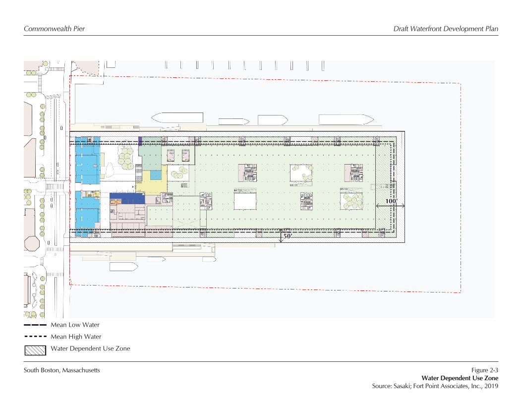
2.5.3 WATER-DEPENDENT USE ZONE
The Chapter 91 regulations at 310 CMR 9.51(3)(c) provide for a Water-dependent Use
zone measured from the Project shoreline that is the lesser of 100 feet or 25% of the
depth of the property for projects located along the ends of piers and wharves and the
lesser of 50 feet or 15% of the width of the pier along the sides of piers and wharves.
See Figure 2-3, Water Dependent Use Zone. While this standard only applies to new
or expanded buildings, which is not contemplated in this WDP, and would not be
required under the provisions of Section 3.2(H) of the MOU, the principal of reserving
the area along the water’s edge for Water-dependent Uses is one which Massport
supports. This WDP does not allow for new or expanded buildings for Nonwater-
dependent Uses closer to the water than the existing building. Massport notes that the
creation of the plaza and the niches along the exterior of the existing Pier building
will open a greater portion of the Pier apron at the water’s edge than is available
today. The existing apron area will be expanded and will continue to be utilized for
public pedestrian access, vessel passenger use, and berthing of commercial passenger
vessels. Co-use of the apron area by vehicles will be allowed in limited areas to
service the loading docks for the redeveloped building and to service the commercial
passenger vessels.
No Substitution for this standard is required.
2.5.4 BUILDING HEIGHT
The Chapter 91 regulations at 310 CMR 9.51(3)(e) call for a 55-foot height limit for
new buildings over the water and within 100 feet of the high water mark on filled
tidelands. Landward of this area, building heights increase one foot for each
additional two feet of horizontal distance, which equates to a peak height of 80 feet
in the center of the Pier. The existing building heights of the Headhouse towers are
approximately 77 feet. The main roof area varies across the Pier from 50 – 65 feet in
height due to the nature of the shed construction but are less than the Headhouse
height. The contemplated redevelopment would reduce the building footprint and
volume by approximately 5% from the existing structure but would require small
changes in building height. Massport anticipates that modest building height increases
on the shed portion of the structure would be appropriate to accommodate higher
floor to ceiling heights in some areas and other building infrastructure improvements.
Building heights would not exceed the height of the existing Headhouse. Such
changes may be permitted under Section 3.2(H) of the MOU without identifying a
required Substitution, unless the redevelopment would result “in any greater net
impact than the existing … Structure”. In this instance, any additions to the shed or
Headhouse roofs would have no discernable changes in wind, shadow or other
ground level effects and the redevelopment provides substantial public benefits, and
Commonwealth Pier Preliminary Waterfront Development Plan
Chapter 91 Analysis
2-13
therefore no Offset is necessary. As the redevelopment meets the requirements of
Section 3.2(H) of the MOU, the Substitution of additional height is appropriate.
2.5.5 OPEN SPACE (LOT COVERAGE)
The Chapter 91 regulations at 310 CMR 9.51 (3)(d) require one square foot of ground
level open space for every square foot of tideland area within the footprint of new
buildings containing Nonwaterdependent Uses. Unlike the other open space
standards, this basic dimensional standard considers any open land to be "open
space" and does not distinguish between parks, green spaces, streets, sidewalks,
parking areas, or other types of potential open space. Further, the regulations provide
an exception for the renovation or reuse of existing buildings and only require open
space to be provided to the maximum reasonable extent.
Currently, the existing Pier building covers most of the Pier area. The existing on-site
open space is comprised of the approximately 20-foot wide Pier apron wrapping the
pier and the Headhouse terrace and drive court at the Viaduct level. The
redevelopment will increase open space through the removal of an approximately
20,000 sf portion of the existing structure to create a new pedestrian plaza area at the
ground level, and adding 20,395 sf to the Pier apron areas.
No Substitutions for open space are necessary in the WDP as no new buildings or
expanded building footprints are being proposed, and in fact the footprint is being
reduced. Open space is being provided to the maximum reasonable extent consistent
with Chapter 91 requirements.
2.6 PUBLIC BENEFIT REQUIREMENTS FOR NONWATER-DEPENDENT
USES
The proposed allowable land uses for this WDP area include Nonwater-dependent Uses
along with Water-dependent Industrial Uses (commercial passenger vessels). The Chapter 91
regulations require that projects containing such uses within Commonwealth Tidelands
provide public benefits to compensate for the dedication of land to Nonwater-dependent Use.
The public benefits requirements, in addition to the public benefits discussed in Section 2.5
above, are described below.
Some of the alternative public benefits requirements proposed by Massport for projects in the
WDP Area exceed those contained in the applicable existing Chapter 91 requirements. In
those instances, the additional requirements are specifically identified. In addition, these
benefits are contemplated to supersede those existing requirements contained in Chapter 91
licenses for the East and West Office building relating to water transportation support
facilities.

Commonwealth Pier Preliminary Waterfront Development Plan
Chapter 91 Analysis
2-14
2.6.1 EXTERIOR OPEN SPACE
Section 310 CMR 9.53(2)(b) of the regulations stipulates that every square foot of
Commonwealth Tidelands area not within the footprint of buildings, and not deemed
necessary to accommodate other Water-dependent Uses, be available as public open
space. Such open space shall be available for public recreation and include “related
pedestrian amenities such as lighting and seating facilities, restrooms, and trash
receptacles," etc. However, the regulations allow up to half of this open space area
to be used for public roadways and public surface parking.
The WDP will meet this standard within the Chapter 91 jurisdictional area, even
though not required under Section 3.2(h) of the MOU. All areas not within the
footprint of buildings will be available for Water-dependent Use, public access, or
both. Expanded public open space will be provided around the entire Pier apron,
although the use of this area will periodically be shared with service vehicles
associated with passenger vessels, service vehicles accessing the Pier building loading
docks, and security patrols. Areas along Seaport Boulevard will include shared use
areas for pedestrians and vehicles.
2.6.2 FACILITIES OF PUBLIC ACCOMMODATION
The public benefits related to FPAs are discussed in Section 2.5.2 above.
2.6.3 ACCESS TO WATER-DEPENDENT USE ZONE
The Chapter 91 regulations call for the Water-dependent Use Zone to have "walkways
and related facilities along the entire length and other public pedestrian facilities
providing access to a Water-dependent Use Zone” except in DPAs where concerns
for public safety may limit public access.
The WDP will meet this standard. Massport will require public realm improvements
that provide generous and high-quality pedestrian access along Seaport Boulevard
and within the Water-dependent Use Zone. While the entire Pier Apron is within a
DPA, public use and access is compatible with the current and proposed use by
commercial passenger vessels. While areas of the apron will need to be used to
service a vessel or may need to be temporarily closed off while vessels are boarding
or disembarking, full perimeter public access of the Pier apron will be provided.
2.6.4 MANAGEMENT PLAN FOR PUBLIC OPEN SPACES AND FACILITIES
To ensure that public open space is appropriately managed and well maintained, the
regulations stipulate that projects should provide management plans addressing these
subjects.
Commonwealth Pier Preliminary Waterfront Development Plan
Chapter 91 Analysis
2-15
Massport will ensure, as it currently does with other open space resources under its
control, that management and maintenance plans for the public open spaces within
the WDP be prepared. These plans will provide for a variety of public activation that
include daily activities as well as small and large events. Further, maintenance plans
for these facilities will also be prepared to direct daily, seasonal and annual
maintenance activities as necessary for all public open space improvements.,
Massport will include such requirements in the terms of the ground lease.
2.7 ADDITIONAL REQUIREMENTS WITHIN THE DPA AREAS
This WDP incorporates portions of the Special Planning Area lying within the South Boston
DPA. In accordance with the MOU, the WDP shall contain:
• An inventory of all currently existing uses within said DPA Special Planning Area.
The existing uses within the DPA Special Planning Area are described in
Appendix C, Massport DPA Land Uses.
• An analysis assessing the feasibility of future Water-dependent Industrial Uses.
The existing Water-Dependent Industrial Uses on the Pier today (commercial
passenger vessels) will continue to operate at a comparable level for the
foreseeable future. This use has been the primary use of the Pier apron since the
first redevelopment of the Pier in the mid-1980s. The existing commercial office,
exhibition and event space and retail uses have been demonstrated to be
compatible with, if not beneficial to, the commercial passenger vessel use over
time. Since this existing use is contemplated to remain, no other alternative Water-
dependent Industrial Uses were considered.
• A representation by Massport that it shall maintain Water-dependent Industrial
Uses, Accessory Uses, Maritime Projects, and/or Temporary Uses on no less than
seventy-five percent (75 %) of the Massport Properties located in a DPA.
As shown in Appendix C, Massport DPA Land Use, Massport has maintained and
will continue to maintain at least 75% of the land uses on Massport Properties in
Water-dependent Industrial, Accessory Uses, Maritime Project and/or Temporary
Uses.
• A description of the arrangements to be provided for Water-dependent Industrial
Uses to be continued at their current locations or at appropriate alternative
locations in the Port of Boston.
As noted above and in accordance with past practice, the existing commercial
passenger vessel use at the Pier apron will be maintained.
Commonwealth Pier Preliminary Waterfront Development Plan
Chapter 91 Analysis
2-16
• A representation by Massport's Maritime Director that: (a) any Nonwater-
dependent Projects proposed within the DPA will not give rise to severe conflict
with Port operations or excessive consumption of Port space, either directly or
indirectly, and (b) the implementation of the Waterfront Development Plan shall
not significantly disrupt any existing Water-dependent Industrial Uses in areas
outside, but proximate to, the Waterfront Development Plan area.
Please see Appendix D, Maritime Director Letter for a copy of a letter from the
Massport Maritime Director for assurances related to the WDP.
• Notwithstanding the foregoing, Maritime, Water-dependent Industrial,
Temporary, and Supporting DPA Uses shall be allowed in DPA areas.
As noted above, Water-dependent Industrial Uses will be maintained in the WDP
through the use of the apron by commercial passenger vessel activities.
2.8 IMPLEMENTATION
Massport, as both the signatory to the MOU and the landlord for the ground lease of the Pier,
will be responsible for ensuring implementation of the commitments contained in the WDP.
These measures will be incorporated into lease terms to ensure that the tenant is fully aware
of and responsible for carrying out commitments made under the WDP. To the extent that
Offsets require improvements outside the WDP boundaries, Massport will fully cooperate to
ensure their implementation.
South Boston, Massachusetts
Commonwealth Pier Draft Waterfront Development Plan
Figure 2-1Existing Conditions Plan
Source: Sasaki, 2018
Seaport World Trade CenterBoston, Massachusetts
Seap
ort
Blvd
Seap
ort
Hot
elSe
apor
t W
est
157
Seap
ort
B Street
Seaport Lane
Source Info: Sasaki
Figure 1.3a
Existing Conditions PlanGround Level
0 50 100 Feet
G:\76359.00\3.0_Working\3.6_Graphics\INDD\20180523_PNF_Figures\20180523_Sasaki_PNF_Figures.indd p1 05/23/18
��������������
������������
����
Offi ce
Commercial
BOH/Receiving
Core/Tech/Egress
Common Lobby
Pre-function
Function
Project Site Boundary
Truck/Delivery Routes
South Boston, Massachusetts
Commonwealth Pier Draft Waterfront Development Plan
Figure 2-2Proposed Conditions Plan
Source: Sasaki, 2019
Commonwealth Pier RevitalizationBoston, Massachusetts
Seap
ort B
lvd
Seap
ort H
otel
Seap
ort W
est
157
Seap
ort
B Street
Seaport Lane
Office
Commercial
BOH/Receiving
Public Restrooms
Event
Co-Working Space
Public Lobby
Egress
MEP
Water Transporation Ticket Booth
Source Info: Sasaki
Figure 1.5a
Proposed Conditions Site PlanGround Floor Level
Public
Plaza
Public NichePublic Niche
Courtyard Courtyard
Courtyard Courtyard
Office Dining Terrace
East Apron Expansion
Bicycle Storage Area
Water Transportation Ticketing Booth
Public Niche + Water Transportation Waiting Area
Public Niche + Water Transportation Waiting Area
West Apron Expansion
Water Transportation Waiting Area
Publ
ic A
rcad
eNew Floating Dock Floating Dock
New Floating Dock
Harborwalk (Apron)
Harborwalk (Apron)
PublicNiche
Project Site Boundary
Truck/Delivery Routes
Open Area with Ext Soffit
Public Stairway& Elevator
Public Stairway& Elevator
0 50 100 Feet
\\wt-fs1\wt_billable\76359.00\3.0_Working\3.6_Graphics\INDD\20190205_PNF_Figures\20190205_Sasaki_PNF_Figures.indd p3 02/08/19
South Boston, Massachusetts
Commonwealth Pier Draft Waterfront Development Plan
Figure 2-3Water Dependent Use Zone
Source: Sasaki; Fort Point Associates, Inc., 2019
Mean Low Water
Mean High Water
Water Dependent Use Zone
100'
50'

Commonwealth Pier Preliminary Waterfront Development Plan
Consistency with CZM Programs, Policies, and Management Principles
3-1
CHAPTER 3: CONSISTENCY WITH CZM
PROGRAMS, POLICIES, AND MANAGEMENT
PRINCIPLES
The federally-approved Massachusetts Coastal Zone Management (CZM) Program Plan established
20 enforceable program policies and nine management principles that embody coastal policy for the
Commonwealth of Massachusetts. The WDP is consistent with all of the applicable enforceable
policies of the approved Massachusetts CZM program, as revised in October 2011. The relevant
policies are listed below.
3.1 COASTAL HAZARDS
CZM has established Coastal Hazard Policies for structures in the hazardous coastal area,
which is defined as areas susceptible to storm surge and waves, flooding, erosion, and relative
sea level rise.
3.1.1 COASTAL HAZARDS POLICY #1
Preserve, protect, restore, and enhance the beneficial functions of storm damage
prevention and flood control provided by natural coastal landforms, such as dunes,
beaches, barrier beaches, coastal banks, land subject to coastal storm flow, salt
marshes, and land under the ocean.
Compliance with Coastal Hazard Policy #1
The entire filled portion of the Pier is considered Land Subject to Coastal Storm
Flowage. No new structures are proposed within this area, which would affect storm
flowage. The existing structures will be redeveloped with improved resiliency to
coastal storm flowage.
3.1.2 COASTAL HAZARD POLICY #2
Ensure that construction in water bodies and contiguous land areas will minimize
interference with water circulation and sediment transport. Flood or erosion control
projects must demonstrate no significant adverse effects on the project site or adjacent
or downcoast areas.
Compliance with Coastal Hazard Policy #2
The Project will not cause any changes that will alter water circulation or sediment
transport. The South Boston waterfront is characterized almost exclusively by a
structural, urban edge shoreline. The Project will not affect accretion nor erosion in
Commonwealth Pier Preliminary Waterfront Development Plan
Consistency with CZM Programs, Policies, and Management Principles
3-2
adjacent or downcoast areas. Work on the Pier will not alter the bottom topography
and will not result in increased storm damage or erosion. All new apron expansions
will be pile supported.
3.2 GROWTH MANAGEMENT
The Commonwealth of Massachusetts and the Executive Office of Energy and Environmental
Affairs have made significant efforts to manage community growth, particularly the effects of
growth on environmental resources.
3.2.1 GROWTH MANAGEMENT POLICY #1
Encourage sustainable development that is consistent with state, regional, and local
plans and supports the quality and character of the community.
Compliance with Growth Management Policy #1
The Project will advance the creation of a pedestrian-friendly district along Seaport
Boulevard by introducing a mix of retail, restaurant, office, , and water-dependent
activities with new public open space.
The proposed plans are consistent with Massport’s urban design standards for the area
and will highlight the scenic and historic qualities of the Pier and Boston Harbor.
Additionally, the Project will maintain the historic Headhouse structure.
3.2.2 GROWTH MANAGEMENT POLICY #3
Encourage the revitalization and enhancement of existing development centers in the
coastal zone through technical assistance and financial support for residential,
commercial, and industrial development.
Compliance with Growth Management Policy #3
The Project will revitalize this portion of the South Boston waterfront with a new
public plaza, landscaping, an improved streetscape and numerous public amenities
including seating, lighting, and way-finding and interpretive signage. The WDP will
enhance the community character by providing for the rehabilitation of an older
structure along the South Boston waterfront.
3.3 PORTS AND HARBORS
It is CZM’s intent to ensure that the Commonwealth waterways and port resources are
maintained and improved by the least environmentally-damaging practicable alternatives.
Commonwealth Pier Preliminary Waterfront Development Plan
Consistency with CZM Programs, Policies, and Management Principles
3-3
3.3.1 PORTS AND HARBORS POLICY #3
Preserve and enhance the capacity of Designated Port Areas to accommodate Water-
dependent Industrial Uses and prevent the exclusion of such uses from tidelands and
any other DPA lands over which an EEA agency exerts control by virtue of ownership
or other legal authority.
Compliance with Ports and Harbors Policy #3
The majority of the WDP area is located within the South Boston DPA, but the Pier
building has not been used for maritime purposes for decades. The Pier apron has
been actively used for commercial passenger vessel activity, a Water-dependent
Industrial Use. The Project will continue this use, preserving this capacity for the
future.
3.3.2 PORTS AND HARBORS POLICY #4
For development on tidelands and other coastal waterways, preserve and enhance
the immediate waterfront for vessel-related activities that require sufficient space and
suitable facilities along the water’s edge for operational purposes.
Compliance with Ports and Harbors Policy #4
The Pier apron supports commercial passenger vessel operations today and will
continue this use in the future. The Pier apron will continue to be used to support the
operational needs of these vessels while also providing for public pedestrian access.
By expanding the apron, these uses will be enhanced.
3.3.3 PORTS AND HARBORS POLICY #5
Encourage, through technical and financial assistance, expansion of Water-dependent
Uses in Designated Port Areas and developed harbors, re-development of urban
waterfronts, and expansion of physical and visual access.
Compliance with Ports and Harbors Policy #5
The Harborwalk edge will be lined with direct Water-dependent Uses, including
water transportation and transient vessels. Extensive landscaped open space,
Harborwalk improvements, and new commercial uses will create a destination along
this portion of the waterfront. The general aesthetic quality of the Project Site will be
improved through the installation of planters, new Harborwalk decking, and updated
lighting fixtures. Viewing areas and other amenities will expand visual access for
pedestrians to enjoy views of Boston Harbor, East Boston, and the downtown Boston
skyline.
Commonwealth Pier Preliminary Waterfront Development Plan
Consistency with CZM Programs, Policies, and Management Principles
3-4
3.4 PROTECTED AREAS
It is CZM’s intent to protect recognized complexes of marine resources by ensuring that
activities in or affecting such areas avoid or minimize adverse effects.
3.4.1 PROTECTED AREAS POLICY #3
Ensure that proposed developments in or near designated or registered historic places
respect the preservation intent of the designation and that potential adverse effects
are minimized.
Compliance with Protected Areas Policy #3
The Pier is listed on the National and State Register of Historic Places. The Pier
consists of the Headhouse and three connected rear sheds, which were connected by
later additions to create a continuous structure. The significance and integrity of this
important historic resource will be maintained through the adaptive reuse of the
Headhouse and rehabilitation of the Pier building.
3.5 PUBLIC ACCESS
CZM seeks to promote, maintain, and improve efforts to help the public get to and enjoy the
coastal zone.
3.5.1 PUBLIC ACCESS POLICY #1
Ensure that development (both water-dependent or nonwater-dependent) of coastal
sites subject to state waterways regulation will promote general public use and
enjoyment of the water’s edge, to an extent commensurate with the Commonwealth’s
interests in flowed and filled tidelands under the Public Trust Doctrine.
Compliance with Public Access Policy #1
An improved Harborwalk along the perimeter of the Pier, new landscaping features,
and other amenities will improve the general public’s enjoyment and ability to use
the waterfront and Boston Harbor at this critical site along the South Boston
waterfront. The niches will provide enhancements to the Harborwalk around the Pier
apron and encourage its use by the public. The public plaza will create a new
destination along the water’s edge. The proposed Harborwalk and landscaped open
space will draw residents and visitors to this waterfront location. Wayfinding and
interpretive signage will facilitate better public access and engagement with the
waterfront and its dynamic history.
Commonwealth Pier Preliminary Waterfront Development Plan
Consistency with CZM Programs, Policies, and Management Principles
3-5
3.5.2 PUBLIC ACCESS POLICY #2
Improve public access to existing coastal recreation facilities and alleviate auto traffic
and parking problems through improvements in public transportation and trail links
(land- or water-based) to other nearby facilities. Increase capacity of existing
recreation areas by facilitating multiple use and by improving management,
maintenance, and public support facilities. Ensure that the adverse impacts of
developments proposed near existing public access and recreation sites are
minimized.
Compliance with Public Access Policy #2
The WDP includes improved connections to the MBTA Silver Line World Trade
Center Station and provides capacity for existing and future water transportation
vessels. The improved Harborwalk along the perimeter of the Pier, along with the
new public open space, serve as vital links to other portions of the South Boston
Harborwalk and open space. Installation of bike racks and the inclusion of water
transportation facilities will help alleviate dependence on vehicular transport to and
from this waterfront site.
3.6 CONCLUSION
As demonstrated above, the WDP will comply with the applicable policies of CZM. Through
the maintenance of commercial passenger vessel activities, provision of an improved
Harborwalk for greater public access and recreation, expanded open space, and the
installation of an abundance of amenities, the interests of the CZM policies will be thoroughly
served by the WDP.

APPENDIX A
Massport/DEP South Boston Memorandum
of Understanding

MEMORANDUM OF UNDERSTANDING
between
Massachusetts Port Authority
and
The Commonw~alth of Massachusetts Department of Environmental Protection
P-3127
SOUTH BOSTON March 15, 2001
This Memorandum of Understanding ("MOU") entered into as of March 15, 2001 by and between the Massachusetts Port Authority ("Massport") and The Commonwealth of Massachusetts Department of Environmental Protection ("DEP") relative to the licensing of certain projects on certain properties owned by Massport in South Boston:
WHEREAS, Massport is a body politic and corporate created by Chapter 465 of the Acts of 1956, as amended (the "Enabling Act"), to engage in, inter alia, the operation, maintenance and improvement of the Port of Boston;
WHEREAS, the DEP is an agency of the Commonwealth of Massachusetts created pursuant to M.G.L. Ch. 21, authorized to administer the provisions of M.G.L. Ch. 91, §1 through 63, commonly known as the Public Waterfront Act ("Ch. 91 ");
WHEREAS, pursuant to the authority contained in§ 18 of said Ch. 91, the DEP has promulgated regulations codified at 310 CMR 9.00 et seq. (the "Regulations");
WHEREAS, pursuant to §4C of the Enabling Act, Massport and inter alia, the DEP are authorized and empowered to enter into agreements furthering the purposes of the Enabling Act, which include, but are not limited to, the operation and development of the Port of Boston and other property owned by Massport;
WHEREAS, §6 of the Enabling Act provides that, although the DEP may "issue licenses and permits for filling, dredging, building of structures or excavating within the Port of Boston, ... no such licenses or permits shall be required to be obtained by [Massport]";
-1-
SOUTH BOSTON March 15, 2001
WHEREAS, §9 .03(3) of the Regulations states that Massport may undertake "without written authorization in the form of a license or permit from the Department ... any project consisting entirely of water-dependent industrial uses or accessory uses thereto on previously filled or flowed tidelands within the Port of Boston;"
WHEREAS, §9.03(3) of the Regulations provides that "Massport shall obtain a license or permit pursuant to M.G.L. c. 91 for any project consisting entirely of uses other than water-dependent industrial uses";
WHEREAS, §9.03(3) of the Regulations further provides that the DEP and Massport may enter into agreements to further clarify the DEP's jurisdiction under Ch. 91 for certain activities undertaken on Massport land that include Water-dependent Industrial or Accessory Uses and Nonwater-dependent uses;
\VHEREAS, Massport has identified Special Planning Areas within the Massport Properties in South Boston where it may undertake future projects that include both Waterdependent Industrial Uses and Nonwater-dependent Uses;
WHEREAS, Massport has invested well over $100,000,000 in the past ten years to provide the necessary infrastructure to facilitate the water-borne transportation of freight and passengers;
WHEREAS, Massport is endeavoring to undertake mixed use development on certain portions of its land holdings in order to generate revenues sufficient to help subsidize substantial capital investments in and operating costs of Port facilities including Conley Container Terminal, the Black Falcon Cruise Terminal, and the Massport Marine Terminal;
WHEREAS, Massport will continue to maintain the functions of the Designated Port Areas and will protect deep water berths, channels and transportation infrastructure necessary to support the operations of the Port of Boston and maintain its competitive position in the future;
WHEREAS, Massport has undertaken extensive planning in concert with the City of Boston, community representatives and others to create a comprehensive strategy for investment and development of its properties in South Boston, as articulated in the joint City of Boston/Massport Port of Boston Economic Development Plan, the Port of Boston Competitiveness Task Force Report and Massport's Commonwealth Flats Strategic Plan;
-2-
SOUTH BOSTON March 15, 2001
WHEREAS, the DEP and Massport recognize the importance of establishing an agreement with respect to the confirmation by the DEP of Massport's compliance with Ch. 91 for activities on certain Massport Properties hereinafter described;
WHEREAS, Massport will obtain licenses from DEP for all activities on the Massport Properties unless exempt by statute, regulation or this MOU;
NOW, THEREFORE, Massport and the DEP agree that, with respect to the Massportowned properties described herein, the terms of this MOU shall govern the licensing by DEP of certain Projects, as defined below.
Article I Definitions
As used in this MOU, the following terms shall have the definitions set forth below:
A. "Accessory Use" means a use customarily associated with and necessary to accommodate principal Water-dependent Industrial Uses. Such Use must be integral in function to the construction or operation of Water-dependent Industrial Uses, or provide related goods or services to persons primarily engaged in such Uses, and be commensurate in scale with the operations of Water-dependent Industrial Uses in the DPA area. Examples of such Accessory Uses include, but are not limited to, access and interior roadways, surface and/or above-and below-grade structured parking facilities, administrative offices and other facilities providing services to Water-dependent Industrial Uses, and office or lodging facilities exclusively serving Water-dependent industrial uses. Uses that may not be determined to be Accessory Uses include, but are not limited to, general office, general hotel and residential facilities, and major retail establishments.
B. "Airport" means Logan International Airport, located in East Boston.
C. "Applicable Regulatory Performance Standards" mean the provisions of the Regulations found at 310 CMR 9.31, 9.32, 9.33, 9.35(1), (2), (3) and (6), 9.37, 9.38, 9.39, 9.40, 9.51, 9.52, and 9.53, for Projects in and outside the DPA, and 9.35(5) for Projects outside the DPA.
-3-
SOUTH BOSTON March 15, 2001
D. "Height" or "Height of Building" shall mean the vertical measurement of a structure from the surface on the land or pier on which the structure will be constructed to the peak of the roof, excluding however, any mechanical structures, equipment, architectural features or other facilities that are not intended for habitation.
E. "Maritime Projects" means Projects related to the use and operation of the Port of Boston, including but not limited to facilities related to intermodal transportation of goods shipped by sea, bulk cargo and petroleum facilities, seafood processing facilities, terminals and facilities for commercial and charter fishing, water transportation and other commercial passenger vessel operations, including cruise ship, charter cruises, water taxis, water shuttles, Boston Harbor Islands shuttles and commuter services.
F. "Massport Properties" means those properties owned or leased by Massport or leased by Massport to tenants of Massport, which constitute Commonwealth Tidelands, Flowed Tidelands or Filled Tidelands other than Landlocked Tidelands, or are located within a Designated Port Area (hereinafter, a "DPA"), as those terms are defined in the Regulations, located in the South Boston area of the City of Boston as such properties are more particularly identified on Exhibit A attached hereto and made a part hereof.
G. "Offsets" means those activities, uses, or structures included in a Project to compensate for the application of Substitutions under this MOU and impacts resulting from such Substitutions which are greater than impacts which would result from application of the requirements of the Regulations. Where offsets are required by this MOU, they are to be provided in addition to any Public Benefits which may be required to compensate for the use of Filled or Flowed Tidelands for Nonwater-dependent Uses. Such Offsets may be:
a) numeric, in-kind offsets;
b) qualitative, out-of-kind offsets, provided there is a reasonable proportionality, geographic proximity and temporal proximity so that the public benefits outweigh the detriments within the same area and time frame;
-4-
SOUTH BOSTON March 15, 2001
c) offsets that are appropriate for the scale and density of existing structures, taking into account the location of the Project Area in an urban community; and
d) offsets that appropriately reflect the relationship between proposed structures and the waterfront.
If Substitutions allowing Nonwater-dependent Uses in the DPA portion of the Special Planning Area are exercised, Offsets involving the construction or operation of Water-dependent Industrial Use Projects or Maritime Projects in the DPA, or the provision of financial support for such projects or uses, shall be proposed, although Offsets outside of the DPA may be proposed in addition. Any provision of Offsets in the DPA shall not create adverse impacts on the operations of the Designated Port Area.
Where offsets outside of the DPA are proposed, offsets may include, but are not limited to, the creation, development or support of public purpose uses and structures, such as cultural facilities, educational facilities, additional on-site or off-site parks, public art, museums, cultural or other special public destination facilities, transportation facilities or services, off-site harbor walks, additional on-site or off-site open space or greater activation of open space in excess of that required in a Waterfront Development Plan; public pedestrian facilities in excess of those required in a Waterfront Development Plan; promotion, support and maintenance of public facilities, water shuttles to the Boston Harbor Islands or elsewhere in Boston Harbor; the management and/or support for or financial support of public events and activities which help activate the waterfront; and other similar uses or structures or programs described in the Waterfront Development Plan to mitigate or otherwise ameliorate the impact of development of Nonwater-dependent Uses on the Massport Properties. Reductions in wind or shadow impacts below those impacts which would be experienced by the application of the Regulations to a theoretical structure on the Project site may also be considered as an Offset. These Offsets may include the open space provided in connection with the creation of the so-called D Street Open Space authorized by the Written Determination for the World Trade Center, issued by DEP on August 16, 1995.
H. "Project" means any structure, activity or use that is proposed by Massport or a private entity proposing to act under a ground lease of the Massport Properties, for new construction or Substantial Structural Alteration
-5-
SOUTH BOSTON March 15, 2001
on the Massport Properties, unless specifically excluded from the scope of this MOU, as set forth below.
I. "Public Benefits" means those features incorporated into a Project to compensate for the use of Filled or Flowed Tidelands for Nonwater-dependent Uses and structures. Where proposed for inclusion within the DPA portion of the Special Planning Area, Public Benefits shall include facilities or financial support for Water-dependent Industrial Uses or non-recreational water-based activities, such as rebuilding or constructing additional pier heads, bulkheads, aprons and fender systems, repairs to the dry dock, implementing elements of the South Boston Transportation Study's recommendations for truck route improvements, dredging to support maritime activities, increasing or improving paved cargo handling surfaces and other lay down areas, providing supporting structures or services for cargo or commercial fishing vessels, ferries, cruise ships and water shuttles, or otherwise improving the freight handling capacity of the Port of Boston. Waterfront walkways, small-scale parks and observation areas may be appropriate in the DPA portion of the Special Planning Area, provided that they will not interfere with any existing or planned Waterdependent Industrial Uses. Any provision of Public Benefits in the DPA shall support Maritime and Water-dependent Industrial activities within the DPA wherever feasible and not create adverse impacts on the operations of such Designated Port Area.
Where proposed for inclusion outside of a DPA, such Public Benefits may include, but are not limited to, facilities that promote active use of the Project shoreline, such as boat landing docks and launching ramps, marinas, fishing piers, waterfront boardwalks, esplanades, walkways, parks, plazas, observation areas, facilities which support water-based activities such as ferries, cruise ships, water shuttles, excursion/charter/rental docks, and community sailing facilities and other facilities which support and/or promote active use of the Project Shoreline and support water-based activities. These Public Benefits may include the open space provided in connection with the creation of the so-called D Street Open Space authorized by the Written Determination for the World Trade Center, issued by DEP on August 16, 1995.
J. "Substitutions" means the substitution of the dimensional and use requirements set forth hereunder for those set forth in the Regulations regarding open space, set backs, water-dependent use zones, ground floor Facilities of
-6-

SOUTH BOSTON March 15, 2001
Public Accommodation, Facilities of Private Tenancy over Flowed Tidelands, and Height limitations.
All capitalized terms used herein and not specifically defined above shall have the definitions set forth in the Regulations.
Article 2 General Provisions
2.1. Applicability of MOU. As the development of the Massport Properties will be undertaken on an integrated basis, including a combination of Water-dependent Industrial uses, Maritime Uses, Water-dependent Uses and Nonwater-dependent Uses, except as specifically excluded in Section 2.2 of this MOU, the terms and provisions of this MOU shall govern and apply to Projects on the Massport Properties which do not consist solely of Water-dependent Industrial Uses, Maritime Projects or Accessory Uses. The terms of this MOU shall not apply to structures, projects, or properties owned, operated, developed or leased by Massport on land not contained within the Massport Properties identified on Exhibit A hereto. Notwithstanding the foregoing, Massport may elect to identify an individual non-exempt Project which shall be subject to licensing pursuant to the provisions of 310 CMR 9.00 et seq. or to the provisions of this MOU by written notice to DEP.
Projects which are not exempt from licensing requirements pursuant to Section 2.2 shall be required to obtain a Ch. 91 license in accordance with the requirements of Articles 4 or 5 hereof.
2.2. Projects Not Requiring a License. Notwithstanding anything to the contrary contained in this MOU, in no event shall the terms and provisions of this MOU, apply to or govern the following:
A. all structures, Projects and activities specifically exempted from Ch. 91 and the Regulations pursuant to Section 9.03(3) of the Regulations including:
(1) any Project consisting entirely of Water-dependent Industrial Uses, including Maritime Projects, or Accessory Uses on previously Filled or Flowed Tidelands within the Port of Boston; or
(2) any Project authorized pursuant to the Enabling Act on previously Filled Tidelands within the geographic boundary of the Airport, so long as it is operated as an airport;
-7-
SOUTH BOSTON March 15, 2001
B. The continuation in use of any Project or structure on the Massport Properties, whether owned or leased by Massport or leased by Massport to tenants of Massport, existing as of October 4, 1990 and for which no unauthorized structural alteration or change of use has occurred since October 4, 1990, provided said Project or structure:
(1) includes Water-dependent Industrial Uses, including Maritime Projects or Accessory Uses;
(2) is any other Project for which a final EIR was certified as adequate and properly complying with M.G.L. Ch. 30, §§61 through 62H, prior to January 1, 1984; or
(3) is any Project or structure in existence as of the date of this MOU for which DEP has issued a determination of exemption from the requirements of Ch. 91.
C. Maintenance, repair and minor modification of existing structures described in (A) through (E) herein, whether owned or leased by Massport or leased by Massport to tenants of Massport;
D. Any other activity on the Massport Properties otherwise exempt from the requirement of the Regulations pursuant to Section 9 .05(3) thereof; and
E. All Projects undertaken by Massport for the use of Massport and in aid of the performance of its governmental functions as provided in the Enabling Act.
No permit, license or approval pursuant to Ch. 91 shall be required for those structures, Projects and activities described in paragraphs (A) through (E) above.
2.3. MOU as Exclusive Regulatory Framework. The terms and provisions of this MOU, including references to the Regulations as modified by a Waterfront Development Plan, shall constitute the exclusive framework under Ch. 91 and M.G.L. c. 21A for regulation of structures and uses on the Massport Properties. The terms and provisions of any Municipal Harbor Plan now or hereinafter approved by the Executive Office of Environmental Affairs shall not govern the development, use or dimensional requirements of Projects on the Massport Properties.
-8-

Article 3 Massport Properties Waterfront Development Plan
SOUTH BOSTON March 15, 2001
3.1. Development of Waterfront Development Plans. Massport may develop and adopt one or more Waterfront Development Plans (the "Waterfront Development Plans") for certain portions of the Massport Properties known as the "Special Planning Area" shown on Exhibit B hereto, the adoption of which shall be subject to the review and approval process set forth in Section 3.3 below. Such Waterfront Development Plans, once approved, shall be used by Massport and DEP in connection with the licensing of future Projects undertaken on Massport Properties under this MOU. The Waterfront Development Plan(s) may be developed and adopted by Massport simultaneously or in sequence.
3.2. Waterfront Development Plan Elements. The Waterfront Development Plan(s) shall set forth criteria, performance standards and guidelines for development applicable to Projects in the Special Planning Area. All of the Massport Properties designated within an area covered by a Waterfront Development Plan shall be treated as a single site or parcel for the purposes of meeting the requirements of this section and licensing pursuant to this MOU. The Waterfront Development Plans shall include:
A. Planning Analysis. A description of the planning analysis which synthesized the technical data, public input and other information which served as the basis for the proposed Waterfront Development Plan.
B. Proposed Uses. A description of the proposed uses for the Planning Area. Uses proposed and described shall conform to the standards set forth in Regulations, as set forth in the Applicable Regulatory Performance Standards, unless otherwise specifically allowed in the approved Waterfront Development Plan.
C. Public Benefits for Nonwater-dependent Uses. If the Waterfront Development Plans include any Nonwater-dependent Uses, the plans shall identify appropriate potential Public Benefits which may be constructed by Massport or its tenants on either the Massport Properties or other properties owned or being leased by Massport, as mitigation for the development of Nonwater-dependent Uses on the Massport Properties. For Projects within a DPA, the Plan shall provide as primary Public Benefits facilities or financial support for Water-dependent Industrial Uses as described in Article 1(1) of this
-9-
SOUTH BOSTON March 15, 2001
MOU, and may also include additional Public Benefits either in or outside the DPA. The Waterfront Development Plans shall also contain a methodology for allocating the Public Benefits required for each Nonwater-dependent Use. The Public Benefits shall be developed, constructed or otherwise provided before, after, or simultaneously with development of Nonwater-dependent Uses on the Massport Properties, provided such Public Benefits are developed, constructed or otherwise provided prior to or within a time frame that is reasonably proximate to the development of the Nonwater-dependent Use to which said Public Benefit is allocated but no later than 12 months from the completion of the Project, and, to the extent not fully allocated to a particular Nonwater-dependent Use, the Public Benefits may be applied retrospectively or prospectively as Public Benefits or Offsets for another Nonwater-dependent Use. The Waterfront Development Plan shall describe a methodology for tracking the allocation of Public Benefits and the Offsets described below.
D. Design Requirements. Waterfront Development Plans that include Nonwater-dependent Uses shall identify performance criteria for Nonwater-dependent Uses, including, but not limited to, dimensional guidelines, design guidelines and requirements regarding public and pedestrian access and also identify those criteria which are Substitutions for performance requirements set forth in the Applicable Regulatory Performance Standards.
E. Offsets. Where appropriate for Nonwater-dependent Uses, the Waterfront Development Plans shall identify potential Offsets to mitigate impacts from Substitutions which result in greater impacts than would result from the application of the Applicable Regulatory Performance Standards. Where required, the Offsets shall be developed, constructed or otherwise provided prior to or within a time frame that is reasonably proximate to the development of the Project built with the exercise of a Substitution, but no later than 12 months from the completion of the Project, and to the extent not fully allocated to a particular Project, the Offset may be applied retrospectively or prospectively as an Offset or Public Benefit for another Project. The applications of Substitutions and use of such Offsets, together with the Public Benefits, shall ensure that the Waterfront Development Plan will promote, with comparable or greater effectiveness than the Regulations, the Commonwealth's tidelands policy objectives.
-10-
SOUTH BOSTON March 15, 2001
F. Implementation Program. Commensurate with the scope of the Waterfront Development Plan, the Plan shall include an implementation program, which may include provisions in leases and licenses, to ensure ongoing compliance with obligations set forth in said Waterfront Development Plan.
G. Consistency with Coastal Zone Management Policies. The Waterfront Development Plans shall describe the Plan's consistency with all applicable policies of the Massachusetts Coastal Zone Management Program, including the Port and Harbor Infrastructure Policies, Public Access Policies and Management Principles and Growth Management Principles.
H. Accommodation for Redevelopment of Existing Structures. Waterfront Development Plans may include provisions allowing for the redevelopment of · existing structures with application of specific dimensional and design guidelines and/ or access requirements set forth in the Waterfront Development Plan, provided such redevelopment (i) results in structures with the same or lesser footprint area, and total building volume as the original use and/or structure; (ii) provides appropriate Public Benefits to compensate for the impacts of any new or additional use of filled Tidelands for Nonwater-dependent Use; (iii) provides proportional compensatory Offsets, if such redevelopment results in any greater net impact than the existing use or structure; and (iv) provides public access through the use of a harbor walk to the maximum extent practicable, unless incompatible with Water-dependent Industrial Uses in the area. Any such dimensional and design guidelines may serve as Substitutions under this MOU.
I. Additional Requirements Within the DPA Area. In addition to the elements described in A through H above, any Waterfront Development Plan(s) that incorporate portions of the Special Planning Area lying within the South Boston DPA shall contain:
(1) an inventory of all currently existing uses within said DPA Special Planning Area. This inventory shall specify the uses by type, in categories, including but not limited to, Maritime and Water-dependent Industrial Uses, Accessory Uses, Supporting DPA Uses, Temporary Uses, and other uses. The inventory shall provide a percentage breakdown by type of use, including an overall calculation of total Water-dependent Industrial Uses, Accessory Uses, Supporting DPA Uses, and Temporary Uses compared to all other Uses;
-11-
SOUTH BOSTON March 15, 2001
(2) an analysis assessing the feasibility of future Water-dependent Industrial Uses, considering the area's existing uses, characteristics and the context of surrounding land uses and activities, and determining whether additional uses are appropriate for the study area.
(3) a representation by Massport that it shall maintain Water-dependent Industrial Uses, Accessory Uses, Maritime Projects, and/or Temporary Uses on no less than seventy-five percent (75 % ) of the entire area consisting of those portions of Massport Properties located in a DPA, and a description of those uses which may comprise the remaining twenty-five percent (25 % ) or less, including Supporting DPA uses and other uses proposed for the Waterfront Development Plan Area. For purposes of this evaluation, Massport shall employ the methodology described in the Boston Marine Industrial Park Master Plan Update submitted to the DEP in July 1998.
( 4) a description of the arrangements to be provided for Water-dependent Industrial Uses to be continued at their current locations or at appropriate alternative locations in the Port of Boston.
(5) a representation by Massport's Maritime Director that (a) any Nonwater-dependent Projects proposed within the DPA will not give rise to severe conflict with Port operations or excessive consumption of Port space, either directly or indirectly and (b) the implementation of the Waterfront Development Plan shall not significantly disrupt any existing Water-dependent Industrial Uses in areas outside, but proximate to, the Waterfront Development Plan area.
(6) with respect to any Waterfront Development Plan for the Fish Pier, as shown on Exhibit C, the Plan shall not propose hotel, residential or other short- or long-term overnight occupancy uses, except those exclusively serving Water-dependent Industrial Uses, or general purpose retail facilities not related to Maritime or Water-dependent Industrial Uses.
(7) notwithstanding the foregoing, Maritime, Water-dependent Industrial, Temporary and Supporting DPA Uses shall be allowed in DPA areas.
SOUTH BOSTON March 15, 2001
3.3. Waterfront Development Plan(s) Preparation. Approval. Amendment.
A. Preliminary Waterfront Development Plan Preparation. To initiate the Waterfront Development Plan process, Massport shall prepare preliminary descriptive materials consistent with the elements set forth in Section 3 .2 above, together with any necessary historical or reference maps and/or plans (the "Preliminary Waterfront Development Plan"). Massport shall submit the Preliminary Waterfront Development Plan to the D EP, with a copy to the Massachusetts Office of Coastal Zone Management. Notice of availability of the Preliminary Plan and of the public meeting, shall be provided to Massport's tenants within the Plan area, and Massport shall advise those tenants to notify their subtenants.
1. Within twenty (20) days of receipt by DEP of the Preliminary Waterfront Development Plan, the DEP shall consult with Massport to discuss objectives and plan elements for the Massport Properties.
2. During the twenty (20) day period described in Section 3.3.A(l) above, the DEP shall publish notice of receipt of the Preliminary Waterfront Development Plan in the next available edition of the Environmental Monitor, and shall consult with the Massachusetts Office of Coastal Zone Management and other state agencies to evaluate consistency with applicable state agency plans and policies, including applicable CZM policies. If the Director of the Office of Coastal Zone Management determines that the Preliminary Waterfront Development Plan is inconsistent with applicable CZM Policies, the Director shall submit a finding to Massport and DEP indicating the basis for such a determination.
3. For a period of thirty (30) days after publication of notice in the Environmental Monitor, DEP and Massport shall accept public comment and shall convene a public meeting to address public comments regarding the elements of the Preliminary Waterfront Development Plan(s).
B. Final Waterfront Development Plan(s) Preparation. After the close of the public comment period referred to in Section 3.3.A above, Massport shall incorporate the reasonable comments received from the DEP and the public into a final Waterfront Development Plan(s) to be presented to the DEP for its
-13-
SOUTH BOSTON March 15, 2001
review and approval. Upon receipt of the final Waterfront Development Plan(s), the DEP shall publish notice of receipt of the Final Waterfront Development Plan(s) in the next available edition of the Environmental Monitor.
C. DEP Approval of Waterfront Development Plan(s). Not later than forty-five ( 45) days after the publication of the notice of receipt of the final Waterfront Development Plan(s) by the DEP in the Environmental Monitor, the DEP shall approve the Waterfront Development Plan(s), conditionally approve the Waterfront Development Plan(s), or disapprove the Waterfront Development Plan(s). A conditional approval of the Waterfront Development Plan(s) shall specify the conditions of such approval, and a disapproval of the Waterfront Development Plan(s) shall specify the reasons for such disapproval. In its approval, conditional approval or disapproval of the Waterfront Development Plan(s), DEP shall determine:
1. whether the Waterfront Development Plan balances the economic and public benefits of the proposed Plan with Massport' s statutory obligation to operate and develop the Port of Boston;
2. whether the Waterfront Development Plan promotes the overall public trust in waterways, taking into account Massport's statutory obligation to operate and develop the Port of Boston, the Commonwealth's public tidelands objectives as embodied in the provisions of 310 CMR 9.00, and the applicable CZM policies;
3. whether the Waterfront Development Plan provides, with equal or greater effectiveness than the Commonwealth's public tidelands objectives embodied in the provisions of 310 CMR 9.00 and applicable CZM policies, Public Benefits and/or Offsets which mitigate, compensate or otherwise offset potential adverse effects on Waterdependent Industrial and Maritime Uses in the Port of Boston; and
4. whether the implementation of the Waterfront Development Plan will serve a proper public purpose, providing greater benefits than detriments to the public rights in the subject tidelands, and that collectively, the private advantages of use are not primary, but merely incidental to the achievement of public purposes, as those purposes are set forth in Ch. 91 and the Enabling Act.
-14-
SOUTH BOSTON March 15, 2001
D. Amendments to Waterfront Development Plan(s). The review and approval requirements for amendment of a Waterfront Development Plan(s) shall be the same as those for the initial approval for such plan.
E. Resolution of Disputes. In the event a dispute arises regarding DEP's determination on the Waterfront Development Plan(s), the parties shall engage in mediation in the same manner as described below in Section 5.5. In the event the parties are unable to reach agreement on the content of the Waterfront Development Plans, Massport may elect to withdraw without prejudice all or a portion of the Waterfront Development Plan, or a Project described in the Waterfront Development Plan upon written notice to the Commissioner of the DEP.
Article 4 Licensing of Special Allowed Uses
4.1 Special Allowed Uses. Notwithstanding any other provisions of this MOU to the contrary, the following structures and uses shall be specifically allowed pursuant to this MOU, subject to the conditions and limitations contained in this Article 4, as established in licenses issued pursuant to Sections 5 .1 through 5 .6 hereof. The DEP shall review applications for licenses for the uses set forth in this Article 4 to determine compliance with 310 CMR 9.32, 9.33, 9.35(1) and (6), 9.37, 9.38(1), 9.39 and 9.40 of the Regulations:
A. The construction of a new commercial restaurant facility on the location of the so-called "Jimmy's Harborside" parcel (parcel E) as shown on Exhibit C, provided that the area of the footprint of the new structure(s) (not including any public pedestrian walkway or harbor walk or transient vessel piers or floats constructed appurtenant thereto) shall not exceed the area of footprint of the present structure, nor shall the Height exceed 55 feet. A new facility on the "Jimmy's Harborside" parcel shall include a harbor walk and a view corridor; and
B. The non-exclusive use of that portion of the water sheet within the Special Planning Area shown on Exhibit C for transient recreational vessel mooring, berths, piers and floats, and supporting structures and facilities thereto, to permit temporary (less than 12 hours) water access
-15-
SOUTH BOSTON March 15, 2001
to the restaurant and commercial uses appurtenant thereto. However, such facilities shall not interfere with the use and operations of any existing or proposed Water-dependent Industrial Uses proximate thereto.
4.2 Designated Port Area. Nothing in this MOU is intended to alter the location of the existing boundaries of the South Boston Designated Port Area.
Article 5 Licensing for Non-Exempt Projects
5.1. General Requirements. After the DEP's approval of a Waterfront Development Plan(s) in accordance with Article 3 above, Massport may, from time to time, propose an individual Project or Projects for the Special Planning Area covered by such Waterfront Development Plan(s). If such Project does not require a license, as set forth in Section 2.2 hereof, Massport shall notify the DEP in writing that it will be commencing development of such Project. If such Project is subject to the terms of this MOU as provided in Section 2.1 hereof, Massport or its tenant shall file an application with the DEP in accordance with Section 5.2 below.
5.2. Application: The application for a license under this MOU shall be submitted to DEP by Massport or its tenant on forms provided by the DEP, and meeting the requirements 310 CMR 9.11 of the Regulations (the "Application").
5.3. Notice.
A. Within thirty (30) days of receipt of the Application and the information required in Section 5.2 above, the DEP shall notify Massport, and, if applicable, its tenant, whether the Application meets the minimum submittal requirements or whether additional information is required.
B. Once the DEP determines that the Application meets the minimum submittal requirements, it shall assign a file number to the Project and, in accordance with the Regulations shall publish notice of receipt of a completed Application in the Environmental Monitor and shall send notice of the Application to:
-16-
SOUTH BOSTON March 15, 2001
1. The City of Boston Conservation Commission, Boston Redevelopment Authority and Harbor Master;
2. The Massachusetts Coastal Zone Management Office; and
3. All abutters to the Project site, identified in accordance with the Regulations.
C. Massport or its tenant shall, upon assignment by the DEP of a file number of the Application and, at its own expense, cause a notice in accordance with the Regulations to be published in one or more newspapers having circulation in the area affected by the Project and shall post such notice at one or more prominent locations on the Project site visible to the public. Massport shall also provide notice of such Application to its tenants located within the relevant Waterfront Development Plan area, and advise such tenants to notify their subtenants.
5.4 Public Hearing. The DEP and Massport shall conduct a public hearing on the application. The hearing shall be noticed in accordance with the Regulations, and shall be conducted no later than forty-five (45) days from the notice in the Environmental Monitor provided above.
5 .5. DEP Review: Within thirty (30) days of the close of the applicable public comment period, DEP shall review the Application to determine: (i) whether the proposed Project incorporates either directly or in conjunction with the Implementation Program, the Public Benefits and Offsets, if applicable, as set forth in the applicable Waterfront Development Plan; (ii) whether the Project conforms to the Applicable Regulatory Performance Standards and the Substitutions in the approved Waterfront Development Plan; (iii) whether, in the context of the approved Waterfront Development Plan, the Project will serve or contribute to a proper public purpose and provide greater benefit than detriment to the public rights in the subject tidelands; and (iv) in the case of proposed Projects in the DPA portion of the Special Planning Area, whether the proposed Project will result in the required seventy-five (75%) standard described in Section 3.2 above being met. The DEP shall meet with Massport and its tenant, if applicable, to collectively determine the application of the performance criteria and calculation of the 75 % requirement. In the event a dispute arises regarding the application of the performance criteria and/or the calculation of the 75% requirement that, after reasonable efforts to negotiate, the parties hereto cannot resolve, said parties hereby agree to pursue mediation, by hiring a mutually acceptable mediator from a agency or firm engaged in the provision of professional mediation services. In the event the parties cannot agree on the same mediator, then upon request of either party, each party shall
-17-
SOUTH BOSTON March 15, 2001
designate a mediator within seven (7) days after such a request to designate has been made and the two mediators so designated shall choose a third mediator to conduct the mediation and such choice shall be binding on the parties. If a party fails to designate a mediator as heretofore provided, then the mediator selected by the other party shall be the designated mediator. Mediation shall be undertaken and completed as soon as possible but in no event later than sixty (60) days after the close of the applicable public comment period. The parties shall share equally any costs of mediation.
5.6. Issuance of License. Within sixty (60) days after the close of the applicable public comment period, the DEP shall take action on the Application. Except for temporary licenses, which shall be no more than 10 years, or unless a shorter term is otherwise requested by Massport, the DEP shall issue a license for the Project with a term of sixty-five (65) years, provided it has determined that the requirements of Section 5. 5 have been met. Licenses with terms up to ninety-nine (99) years may be issued by DEP if requested by Massport, provided such extended term is deemed appropriate by the DEP in accordance with 310 CMR 9.15(l)(b) (2), (4) and (5), and 9.15(l)(c). Massport may propose a license term for any Project in the applicable Waterfront Development Plan. Any license so issued by DEP shall be recorded in accordance with Section 9.18 of the Regulations.
5. 7. Appeals. The appeal of the grant or denial of any license by DEP pursuant to the terms of this MOU shall be governed by and subject to the provisions of Sections 9 .17 of the Regulations. The standard for review of any appeal for a license issued pursuant to a Waterfront Development Plan hereunder shall be whether the proposed Project meets the criteria set forth in Section 5.5. For Projects licensed under Section 5.8 hereof, the standard of review of shall be those set forth in the Regulations.
5.8. Projects Outside Approved Waterfront Development Plan Area. If a Project subject to this MOU pursuant to Article 2 hereof, but is not within an area for which a
Waterfront Development Plan has been approved, Massport or its tenant shall file an application with the DEP in accordance with Section 5.2, 5.3 and 5.4 hereof. Within 30 days of the applicable comment period, DEP shall review the application to determine compliance with Applicable Regulatory Performance Standards and 9 .54 of the Regulations and shall issue a license therefor.
5.9. Emergency Actions. In the event of an emergency situation, as defined in Section 9.20 of the Regulations, Massport and DEP agree to follow the requirements set forth in said Section 9 .20 for Massport Projects subject to this MOU pursuant to Section 2.1 hereof. For Projects exempt from this MOU pursuant to Section 2.2 hereof, Massport may take any
-18-
SOUTH BOSTON March 15, 2001
action it deems necessary and desirable in connection with an emergency situation, provided it so notified the DEP in writing within ten (10) days thereafter of such action taken.
5.10. Maintenance, Repair and Minor Project Modification. The provisions of Section 9.22 of the Regulations shall apply to maintenance, repair and minor projects modifications for Projects subject to this MOU pursuant to Section 2.1 hereof. Maintenance, repair and minor project modifications for Projects exempt from this MOU pursuant to Section 2.2 hereof shall be made by Massport in its sole discretion, without notice to the DEP.
5.11. Removal of Previously Licensed Structures. The provisions of Section 9.27 of the Regulations shall apply to removal of structures licensed pursuant to this MOU. The removal of structures exempt from this MOU pursuant to Section 2.1 hereof shall be made by Massport in its sole discretion, without notice to the DEP.
5. 12. Enforcement. The provisions of Section 9.08 of the Regulations shall apply to all Projects subject to the terms of this MOU pursuant to Section 2.2 hereof.
Article 6 Miscellaneous
6.1. Binding Effect. This MOU is a legally binding document having the full force and effect of the law between the parties and shall be enforceable by the signatories hereto in a court of law by equitable relief.
6.2. Applicable Law. This MOU shall be interpreted in accordance with the laws of the Commonwealth of Massachusetts.
6.3. Entire Agreement. This MOU sets forth the entire agreement of the parties hereto with respect to the subject matter contained herein, and no amendment of this MOU shall be effective unless it is in writing and signed by both parties to this MOU. The draft text of any amendment shall be published in the Environmental Monitor for a 30 day public review and comment period, and the text shall be published therein upon adoption and made available by the DEP upon request.
6.4. Effective Date of MOU. The terms and provisions of this MOU shall become effective immediately upon execution by the Commissioner of DEP and by a Massport Officer duly authorized by the Massport Board of Directors and no further action shall be required by the parties hereof.
-19-
SOUTH BOSTON March 15, 2001
6.5. No Waiver. The parties agree that nothing in this MOU shall be construed to constitute assent to or assertions by either party that Massport, its agents, tenants, successors or assigns is or is not subject to the jurisdiction or regulatory authority of the DEP for licenses and permits for filling, dredging, building of structures or excavating within the Port of Boston or is otherwise subject to the requirements of Ch. 91 or the Regulations.
6.6. Notices. All notices or other communications required or permitted to be given hereunder shall be in writing and shall be deemed delivered hereunder if mailed postage prepaid, or delivered by hand to the following address, or to such other individual or address as may be specified by either of the parties in writing:
If to the DEP:
If to Massport:
with a copy to:
Commonwealth of Massachusetts Department of Environmental Protection One Winter Street Boston, MA 02108 Attention: Commissioner Attention: Director, Waterways Program
Massachusetts Port Authority Logan Office Center One Harborside Drive East Boston, MA 02116 Attention: Executive Director
Massachusetts Port Authority Logan Office Center One Harborside Drive East Boston, MA 02116 Attention: Chief Legal Counsel
6.7. Paragraph Heading. The paragraph headings in this MOU are for convenience and reference only, and shall not be used to interpret, clarify, limit or amend the contents or meaning of any provision.
-20-
SOUTH BOSTON March 15, 2001
IN WITNESS WHEREOF, the Executive Director of the Massachusetts Port Authority, and the Commissioner of the Commonwealth of Massachusetts Department of Environmental Protection have executed this Memorandum of Understanding as of the date first written above.
MASSACHUSETTS PORT A THORITY
DEPARTMENT OF ENVIRONMENTAL PROTECTION
Commissioner
Approved as to Form:
Chief Legal Counsel
Approved as to Form:
Counsel to the Cmnmissin
-21-
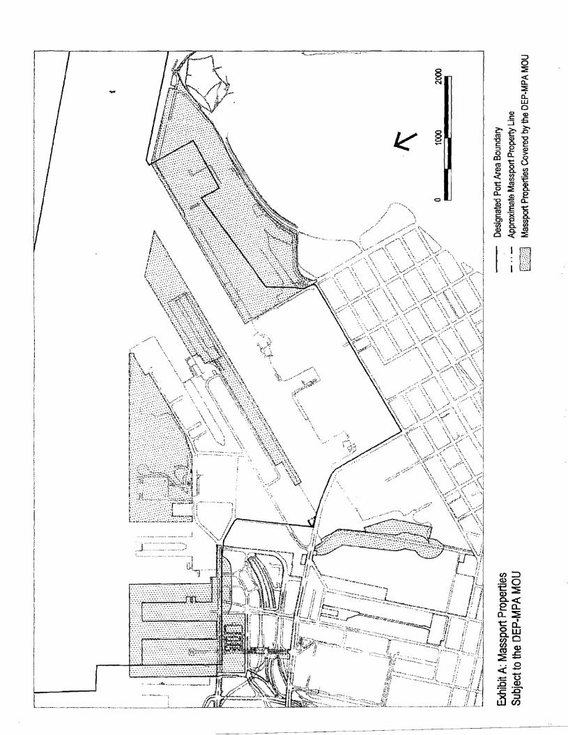
----------·
P.,
[:\,
it'\
]-. .. ·
w
.. L. ---,,
.. ......... _,,,
.. ---- ... Tffll-- ...... ···- ...
8 N
§ .....
0
'~jj - •• _ :~· J ··-.. - .. _ .. __ ,, !!
;
" ., jr·· ·{
. <::.:.:A.: c:::7~~c,,~i.l 1/ i' l'"
___ .c:,!1_ ... iL.L_
Cl) C:
:::i c ~ ro 'O 8. C: :::, e 0 CL £X) ~ ro g_ <l)
~ ~ t: (1J
0 ::::i: a. .$
I ~ C: -~ Cl ·oo a. <1)
~ 0
:::, 0 :::E < a. ::E a.. w 0 Cl)
£ ~
~ Cl) > 8 "' Cl)
'e 8. e a. ~
8. lZ co :::
w
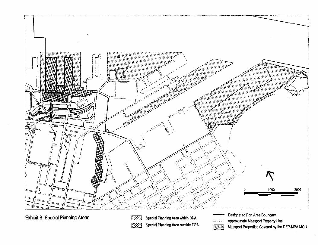
vcY- . -·-- , ' .... ,?' d ~,--s-'". e:'W/ ,. ,·. ' "' ., . ·.'.:°'.f-'' , .. , , .. ,·., ,.,. ",. , '. " ...... ,._,,~ - , L./L::,J I _ _l 'I : / /' \, fe?.-c.: ,,P,·' ,:><" .... ·.,:·-,. : .·,::··.,:·.,:· .:: .:,.·:::",:·.,:·.: ~,;:»
-~-~ , ~ ~. ', I ;?;::ef;rtJllly,Y/ ~<!5"::tf/1:l;:ttt;J::;h :U::~; .... ::,;ft/Jt< of!m~ -\~fh~-:F-~ _;f ~;;r-·/ A: \f'./};:\V:':,3}\:)J\\), ~~ ~!Ir . 1 ,~;;;~. /Jl>P ,;;,· r . ~ . l';F~Jl!Jlll/P' . , i IQ ~ JI !U! /( i ' -- /p . \ \S'i'',t)\i/lrl/ ! f r1-j·~-w.1 \' f 11; ! .. _ / • ) \. ,dff-~} 111 /I I ! ,I , -. · " ' ,,.- I" 7"
I /f ,1 J J I I i ,/". \ ' • . , If 1
: :! 1' I i / \ \ \ •• "'\, i tc:!:...,._..,._ ff !f JI f (/ \ \cc\, . .7 \ I r~~- Vrr= f $' r i "\ ._,, " ,,./·'.: _.y,;, : ,r~
7
.. ~ if .. .J ·, \ ?'t .--·~·--'"' \, I! i I q I \ ,:0, " -;.···· '' /Os \ .
!I
1
1 II fl Ii \ '• ' _,/ '\.,;_;· \.,,;/" '-' J // // II l' I/ ! \ '-l 0f' ,;::' \' . .,_;.:'>t .}..'C\ , ~-:.- ... 1, 1r·- A'' ,, · " > ,... ,, ··· ,.-:c"·' ,,,. ,,.. \, -,...j, -·,fl.,, "ri . ( '\ \\/";:·\\ .,,;;'-"\ \~.> . \'. ::· /'" /,::- \ '•.,
--.;_ ~ tj~"'=- I · , _,_.,/ '•1/ ,, ,, // >·'/ \' , fr--,..:...._ .. __ s ~·
1
-- ,ft" ~ /:/ \ X \V '/ :\ // ' ,, \ .. ,_ IL' -<:.--11 7 ··-"""··· Ii' ;;;7 \ /. •' \ ., ,.,.,,., / ,' '' . ,, \\ /•" . ::::z,.J -ir:C:- •..::,,_ ~ ~/ ;"' ',\ /;/ \\ / ,., •' ' '/ '\
',-:::·--- JI =:::::--..1l. .,._ ' ,::"i \ //~' > '/ '' · '/ '' /, ,'. ,, ''" \ - ----"::"~ ... ~ ·l ~ - : ~- r::r 'i,. ,\ ,r / ,,- ,,,<,('-\ ,' / ,,·,/ \' ,.,,.,_.,...,\ ,-•' --::::::..Jt----··--~r:-· ··J ,1-- 1 ! ..,.~ V·"""" ,V;/ \\ ./::./,'. ,' ·.· ,,C// \', ,,;A
L_..J..L7r_:::::._-_.,..~::--::::·--===--,..:·-d=-==--:~~::i r:---:::,,;,1,,_ ,w·:I ,0/\\ Y".,'"' ;> v,,,.- \ .• /,/ . _,;:·-'- ... t?· . ' -.......,JC-°"'=" j,,.:::-~- ,/ ,,. ,;;~ < , \' ,-;:/ \ ,_,/_,/\, /0. / .f' \::,,/ d,,,,..=·\\,.,-_;,'.·,,., '- // ___ ·::::--·' - ..... ,, . /' ' •' ;-'·'" . - .... "
"' 0 1000
Exh
..... - / ,. ,,.,, .• .• -~/·' ,. ,, .• ...... ' lb.,t B· s r > ,;:/ .,, / • ",, /;/// -' •/ ·.,: ,,;;/ •> /
PeCl
·at Pl ' ...... w· •• :v-:/ ' ' ·· ,.., ,,..,. :. ·'" · ann·,n A · · ' ·· ,. __ · > ,,,,, .. .,,. ,::· ·.\ . J'\. /· o g reas . /',"I--' ,.. .. . ". .. ., . , .• · , ' ~ S •' L'•' _.,_;..,~2 .. ~ .·· pecial Planning Ar . .
Designated Port Area Boundary Approximate Massport Property Line
2000
~ S . ea within DPA ea outside DPA pecial Planning Ar [ill] Massport Properties Covered by the DEP-MPA MOU
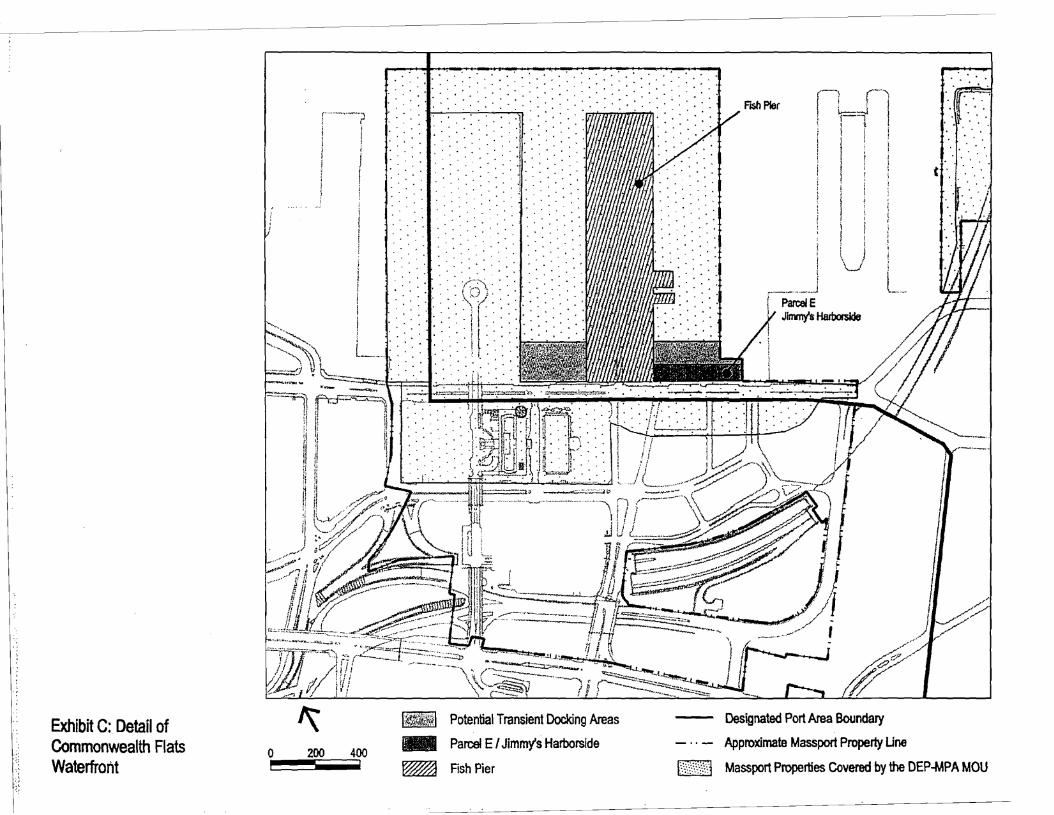
Exhibit C: Detail of Commonwealth Flats Waterfront
0 200 400
. . .
. . . ' .. '.
. . . . . . . .
. . .
.....
.. . . . . .. . . . ' .... . . .
... '
Potential Transient Docking Areas
II.II Parcel E / Jimmy's Harborside
~ RshPier
. .. . . . ' .... . . ..
. . . . .
. . .
.....
...
...
; i i
l J ' _________ __j
ParcelE Jlrrvny's Harborslde
I ;
l __
Designated Port Area Boundary
Approximate Massport Property Une
t ·. ·. ·. · .
[\?,.)',j Massport Properties Covered by the DEP-MPA MOU

APPENDIX B
List of Planning Studies


APPENDIX B
LIST OF PLANNING STUDIES RELEVANT TO THE WATERFRONT DEVELOPMENT PLAN
1. Northern Avenue Design Guidelines, Massport, 1983
2. Port of Boston Economic Development Plan, Massport and the Boston Redevelopment
Authority, 1996
3. Commonwealth Flats Strategic Plan, Massport, 2000
4. Commonwealth Flats Urban Design and Public Realm Guidelines, Massport, 2005
5. Sustainable Massport – Annual Sustainability & Resiliency Report, 2018
6. Massport Floodproofing Design Guide, 2015
7. Climate Ready Boston, City of Boston, 2016
8. Imagine Boston 2030, City of Boston, 2017

APPENDIX C
Massport Maritime Director Letter and
Massport DPA Property List

DPA Massport Inventory and Land Use CalculationsSouth Boston
Planning Area Maritime Supporting Building Footprint Maritime Supporting DPA Use Excluded from Calcs
Fish PierEast Building footprint 41,300 38,330 2,966West Building footprint 41,400 38,540 2,866Exchange Center footprint 7,100 0 7,100Exterior 224,896 49,604 224,896 49,604
Liberty WharfBuilding A 69,500 1,469 1,469Building B 12,330 12,330Building C 9,205 9,205
Surrounding Area 23,367 0 23,367World Trade Center Building footprint 422,345 0 422,345 Apron without Building 77,795 77,795Fish Pier + WTC Watersheet 1,094,475Northern Ave
Land Area 1,566,817 1,566,817 0Existing Structures 141,000 141,000
Watersheet 237,222
Flynn Cruiseport 325,670 0 162,835 162,835 088 Black Falcon 282,000 94,000 94,117 70,588 23,529Parking and circulation 411,209 0Watersheet 702,822
Main Terminal 4,166,851 4,166,851 108,353Coastal Oil 1,190,350 1,190,350 114,994Exelon 238,532 238,532 177,788MBTA 523,532 523,532 214,594Tommy Butler Buffer Park 184,273 184,273Triangle Parcel (Boston Line) 8,013 8,013 0
TOTAL 8,859,288 554,781 2,834,521Percent 94.11% 5.89%
Notes:Northern Avenue is not included in the calculations, though it is included in the DPA boundary.Watersheet Not Counted toward DPA usesOnly Ground Floor Building Uses counted towards DPA uses as per 2017 Raymond L. Flynn Marine Park Master Plan update88 Black Falcon is assumed to by 75%/25% Maritime/Supporting use per Chapter 91Only a portion of Conley is included in the current DPAWorld Trade Center "Apron without Building" square footage includes proposed apron expansion
MMT
Cruise Terminal + 88 Black Falcon
Conley
Methodology: 1999 Boston Marine Industrial Park Master PlanTotal Development Area Applied to Building SF
Comm Flats