Draft 2015-2020 Grants Mining District Five-Year Plan (PDF)
45
1 October 9, 2015 DRAFT Grants Mining District, New Mexico 2015 – 2020 Five-Year Plan to Assess and Address Health and Environmental Impacts Of Uranium Mining and Milling EPA Region 6 RA Curry, NMED Secretary Flynn and EMNRD Secretary Martin touring uranium mines
-
Upload
vuongkhanh -
Category
Documents
-
view
214 -
download
0
Transcript of Draft 2015-2020 Grants Mining District Five-Year Plan (PDF)

1
October 9, 2015
DRAFT
Grants Mining District, New Mexico
2015 – 2020 Five-Year Plan to
Assess and Address Health and Environmental Impacts
Of Uranium Mining and Milling
EPA Region 6 RA Curry, NMED Secretary Flynn and EMNRD Secretary Martin touring uranium mines

2
Table of Contents
Purpose ......................................................................................................................... ..3
Summary of Work Completed 2010-2015 and Planned for 2015-2020 ........................... 5
Objectives ........................................................................................................................ 8
Objective 1: Assess Water Supply Sources for Contamination ....................................... 8
Background ............................................................................................................................ 8
Current Status ........................................................................................................................ 8
Goals for Next Five Years ...................................................................................................... 9
Specific Actions for Next Five Years ...................................................................................... 9
Objective 2: Assess and Cleanup of Legacy Uranium Mine Sites ................................ 10
Background .......................................................................................................................... 10
Current Status ...................................................................................................................... 10
Goals for the Next Five Years .............................................................................................. 13
Specific Actions for Next Five years ..................................................................................... 15
Objective 3: Assess, Cleanup, and Long-Term Management of Former Uranium Milling Sites
................................................................................................................................. 18
Background .......................................................................................................................... 18
Current Status of Work ......................................................................................................... 18
Goals for the Next Five Years .............................................................................................. 19
Specific Actions for Next Five Years .................................................................................... 20
Objective 4: Assess and Cleanup of Contaminated Structures and Properties ............. 20
Background .......................................................................................................................... 20
Current Status of Work ......................................................................................................... 20
Goals for the Next Five Years .............................................................................................. 23
Objective 5: Communicate and Coordinate with Communities ...................................... 23
Background .......................................................................................................................... 23
Current Status ...................................................................................................................... 23
Goal for the Next Five Years ................................................................................................ 23
Specific Actions for Next Five Years .................................................................................... 24

3
Purpose The purpose of this 2015 – 2020 Five-Year Plan is to report to the public the progress made in implementing the 2010 Five-Year Plan and to memorialize priorities and activities for the next five years in the Grants Mining District. The plan is intended to promote and advance the assessment and cleanup, when warranted, of contamination caused by legacy uranium mining and milling operations.
The five (5) objectives for the 2015 Five-Year Plan are designed to guide the endeavor in the Grants Mining District. Each objective identifies goals with specific actions to be taken in the next five years. Although the objectives are presented as standalone subjects in the plan, they are intertwined. The objectives are:
1. Assess water supply sources for contamination 2. Assess and cleanup legacy uranium mines 3. Assess, cleanup, and perform long-term management of former uranium milling
sites 4. Assess and cleanup contaminated structures and properties 5. Communicate and coordinate with communities
Partners
Federal, State, and Tribal governmental agencies are partners to the plan. They are committed
to continue to assess and address legacy contamination and to eliminate, reduce or manage
risks to human health and the environment.
The Governmental partners participating are:
U.S. Environmental Protection Agency – Region 6;
U.S. Department of Energy – Office Legacy Management;
U.S. Department of the Interior – Bureau of Land Management;
U.S. Department of Health and Human Services – Agency for Toxic Substances and Disease Registry;
U.S. Nuclear Regulatory Commission;
U.S. Department of Agriculture – Forest Service;
Pueblo of Acoma Environment Department;
Pueblo of Laguna Environmental and Natural Resources Department;
New Mexico Environment Department;
New Mexico Energy, Minerals, and Natural Resources Department – Mining and Minerals Division; and
New Mexico Department of Health.

4
Background
The Grants Mining District is an area of significant uranium-bearing rock approximately 100 miles long and 25 miles wide encompassing portions of McKinley, Cibola, Sandoval and Bernalillo counties and organized into three (3) sub-districts (Ambrosia Lake, Laguna, and Marquez – Figure1). These mining sub-districts contain 97 legacy uranium mines and five (5) former uranium mill and tailing disposal sites that were active during the Atomic Energy Commission uranium purchase years (1940’s-1970) and beyond until the 1990’s. Over 52 million tons of uranium ore were extracted from these mines, constituting approximately 68% of the total uranium ore mined in the United States. Land ownership within the Grants Mining District consists of public, tribal, and private property. Though surface and underground mining was prolific during the Atomic Energy Commission uranium purchase years (1940’s-1970) and beyond until the 1990’s, the state of New Mexico has specifically identified 97 uranium mines that require assessment and possible cleanup. The mines had reportable ore production and surface expression post mining (i.e., waste rock piles, vents/shafts, physical remnants, etc.).

5
Figure 1

6
Summary of Work Completed 2010-20151 and Planned for 2015-2020
1 For a more complete description of history and work accomplished under the 2010 Five-Year Plan, see Appendix A.
2010 – 2015 Plan 2015 – 2020 Plan Goals Accomplished Goals
Water Supply Sources
Evaluate private well groundwater quality
Evaluate public water supplies
32 private wells sampled (2009 & 2010)
23 wells exceed drinking water standards for at least one or more constituent
43 private wells sampled (2014 & 2015)
26 wells exceed drinking water standards for at least one or more constituent
3 Milan public water supply wells sampled
all wells meet drinking water standards
In 2015, issue EPA and NMED Groundwater Assessment Reports
In 2018, issue conceptual site model; is a tool to understand impacts of legacy uranium mining and milling on surface water and groundwater systems in San Mateo Creek basin
Legacy Uranium Mines
Compile existing information
Assess mine impact areas
Evaluate Jackpile for NPL
97 mines assessed
aerial gamma survey
screening assessments
10 investigations – Dysart #2, John Bully, Johnny M, Marquez, Mary #1,Sandstone, Sections 10,12,15,30
1 cleanup – San Mateo Mine
Jackpile on NPL December 2013
In 2016, engage potential responsible parties
In 2016, BLM complete cleanup at 4 mines (Spencer and Barbara J Complex)
In 2016, USFS complete cleanup at 4 mines (Old La Jara, Taffy, Vallejo, Zia)
In 2016, EPA complete assessment on 2 mines and begin cleanup (Sections 35, 36); initiate assessment on 4 mines (Sections 10, 22, 24, 30W)
In 2017, complete assessment on 4 mines and begin cleanup (Sections 10, 22, 24, 30W); initiate assessment on 4 mines (Sections 17, 19, 30, 33)
In 2019, complete cleanup of 3 mines (Sections 35, 36, Johnny M)
In 2020, begin cleanup of 4 mines (Sections 10, 22, 24, 30W)
Conduct remedial investigation/feasibility study at Jackpile
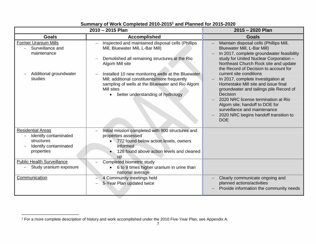
7
Summary of Work Completed 2010-20151 and Planned for 2015-2020
2010 – 2015 Plan 2015 – 2020 Plan
Goals Accomplished Goals
Former Uranium Mills
Surveillance and maintenance
Additional groundwater studies
Inspected and maintained disposal cells (Phillips Mill, Bluewater Mill, L-Bar Mill)
Demolished all remaining structures at the Rio Algom Mill site
Installed 10 new monitoring wells at the Bluewater Mill; additional constituents/more frequently sampling of wells at the Bluewater and Rio Algom Mill sites
better understanding of hydrology
Maintain disposal cells (Phillips Mill, Bluewater Mill, L-Bar Mill)
In 2017, complete groundwater feasibility study for United Nuclear Corporation –Northeast Church Rock site and update the Record of Decision to account for current site conditions
In 2017, complete investigation at Homestake Mill site and issue final groundwater and tailings pile Record of Decision
2020 NRC license termination at Rio Algom site; handoff to DOE for surveillance and maintenance
2020 NRC begins handoff transition to DOE
Residential Areas
Identify contaminated structures
Identify contaminated properties
Initial mission completed with 900 structures and properties assessed
772 found below action levels, owners informed
128 found above action levels and cleaned up
Public Health Surveillance
Study uranium exposure Completed biometric study
6 to 9 times higher uranium in urine than national average
Communication 4 Community meetings held
5-Year Plan updated twice
Clearly communicate ongoing and planned actions/activities
Provide information the community needs
1 For a more complete description of history and work accomplished under the 2010 Five-Year Plan, see Appendix A.

8
Objectives The objectives of the 2015-2020 Five-Year Plan are designed to comprehensively assess and cleanup, when warranted, contamination related to legacy uranium mining and milling activities within the Grants Mining District.
Objective 1: Assess Water Supply Sources for Contamination
Background Residents within the Ambrosia Lake and Laguna mining sub-districts primarily rely on private and community wells for residential-domestic, stock-watering, and agricultural uses. Legacy uranium mining and milling operations generated liquid wastes (effluent). The effluents included groundwater produced from mine dewatering, process waters from unlined on-site ore leach pads, evaporation and tailing ponds, heap- and isotope-leaching, and uranium milling operations. These effluents were discharged to ground surface or surface drainage features (e.g., arroyos, channels) and allowed to infiltrate and recharge the shallow alluvium directly or via impoundment infiltration and overflow. From 30 years of mining operations alone, approximately 80 billion gallons of mine water was extracted from the subsurface and discharged to surface drainages, the majority being discharged into the San Mateo Creek basin. The effluent discharges that occurred prior to the establishment of state and federal groundwater regulations had little or no treatment prior to discharge. The effluents discharged during legacy uranium site operations, as well as subsequent runoff from contaminated soil and sediment which continues to the present, may impact regional bedrock drinking water aquifers and shallow alluvial aquifers. These aquifers are accessed by scattered private residences and nearby municipal or community water supply systems. Additionally, extensive dewatering of underground workings during mine operations created a regionally-extensive cone of depression into which oxygenated groundwater currently is flowing. The oxygenated groundwater may dissolve and mobilize unmined uranium and associated constituents within the aquifers.
Current Status
Groundwater quality investigations have been ongoing in the San Mateo Creek basin by the New Mexico Environment Department (NMED) and the U.S. Environmental Protection Agency (EPA), focusing on private water wells and municipal or community supply wells. Even though these investigations throughout the years have occurred as separate events, all information gathered furthers the understanding of the water systems and the potential impact from uranium mining and milling operations.
New Mexico Environment Department
The New Mexico Environment Department (NMED), under a Cooperative Agreement with the U.S. Environmental Protection Agency (EPA), conducted Phase I and Phase II Site Inspections (SIs) of the San Mateo Creek basin groundwater from 2009 to 2012 to determine groundwater quality in private water wells within the basin. There was concern that legacy uranium mines and mills may have contributed to the widespread degradation of groundwater quality within the basin. Additionally, groundwater in the alluvial aquifer upgradient of the

9
Homestake Mining Company Mill Superfund site was found to contain uranium and other contaminants at concentrations above federal and state drinking water standards. The results of the Phase I and Phase II SIs showed elevated concentrations of constituents in 31 of the 32 wells sampled with respect to health-based or aesthetic (color, odor, or taste) drinking water standards. The one (1) well with water quality that did not exceed drinking water standards is not located in an area that was mined or where milling operations were located. All well owners were notified by letter of the analytical results. In 2014, the NMED collected 26 additional groundwater samples from private and public water supply wells in the Homestake Mining Company Superfund site area at the request of the community. A report summarizing the groundwater quality will be completed in the fall of 2015 documenting the results.
U.S. Environmental Protection Agency
In 2013, the EPA, with assistance from the NMED and the U.S. Geological Survey, initiated a phased groundwater investigation for the San Mateo Creek basin as part of an Expanded Site Inspection (ESI) to assess the nature and extent of contamination in the alluvial aquifer related to legacy uranium mining and milling. The investigation was to build on the investigative work completed by the NMED for Phase I and Phase II of the SIs. Most importantly, the investigation was crafted to determine background water quality in the alluvial aquifer in the basin, i.e., groundwater that has not been impacted by legacy mining and milling activities. Therefore, beginning in the fall of 2014 and continuing into early 2015, a field team conducted seismic surveys, drilled numerous boreholes. Despite an extensive amount of drilling, background alluvial groundwater was not found within the San Mateo Creek basin. However, five (5) boreholes were completed as monitoring wells in an attempt to address data gaps within the basin. A total of 20 groundwater samples were collected from the new monitoring wells as well as municipal supply and private wells for analysis. An interim report summarizing the groundwater quality will be completed and shared in the fall of 2015 documenting the results. Goals for Next Five Years U.S. Environmental Protection Agency
The goal is to build a conceptual site model by 2018 that can be used as a tool to understand impacts of legacy uranium mining and milling on the surface and groundwater systems in the San Mateo Creek basin and to identify the current and potential future risks to human health. Communicate with and provide information to residents regarding groundwater quality especially from private wells with detected uranium and other constituents at concentrations that exceed federal and state drinking standards. Information about the risks and potential mitigation practices will be provided. Specific Actions for Next Five Years
Collect and analyze additional groundwater samples from existing and new monitoring wells, private water wells, and water supply wells throughout the San Mateo Creek basin if needed to address data gaps in assessing groundwater quality.

10
Collect and analyze additional soil impacted from legacy uranium mine water discharges to determine the potential for ongoing releases to surface water and groundwater.
Collaborate with the NMED, the U.S. Department of Energy – Office of Legacy Management (DOE) and the Nuclear Regulatory Commission (NRC) to incorporate information from the Bluewater Mill, the Rio Algom Mill and the Homestake Mill sites and collected groundwater quality information into the conceptual site model for the San Mateo Creek basin.
Issue the conceptual site model in 2018. Project plans will be developed to accomplish the specific actions in coordination with all appropriate agency partners. Potential Challenges Natural Contamination Since the San Mateo Creek basin contains uranium-bearing rock formations from which groundwater is accessed by private water wells, it is challenging to determine if groundwater containing contaminants that exceed Federal and State water quality standards are due to natural conditions and/or has been impacted by legacy mining and milling operations. Additional analyses will be performed on groundwater samples to attempt to forensically distinguish mining and milling impacts from natural conditions.
Objective 2: Assess and Cleanup of Legacy Uranium Mine Sites
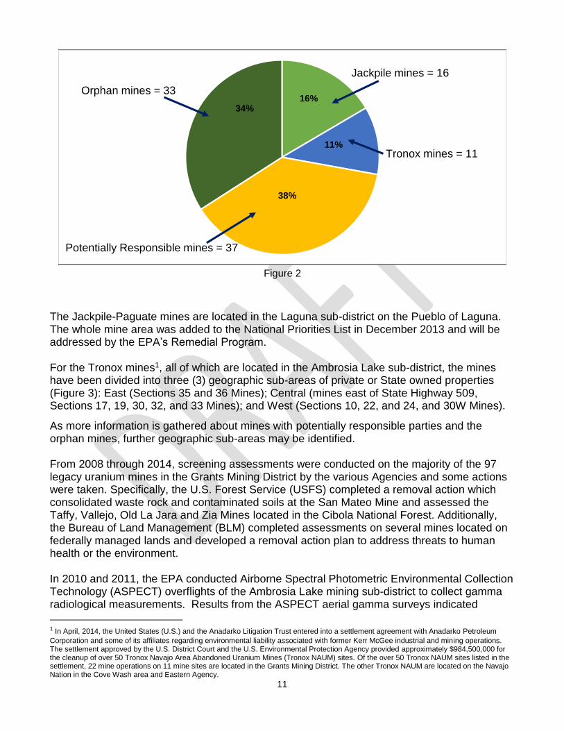
Background Uranium mining was prolific in the Grants Mining District starting in the 1950’s until as late as the mid-1980’s. In the Grants Mining District alone, over 300 mining permits were issued by the state of New Mexico for mine exploration and mining operations in McKinley, Cibola, Sandoval and Bernalillo counties. The extraction of uranium-bearing ore occurred through open pits, from underground workings that were extensively connected and solution mining. Of all of the mining operations, 97 legacy uranium mines with surface expression (i.e., open pits, waste rock piles, vents/shafts, etc.) are the focus for reclamation and cleanup. Current Status For the 97 uranium mines in the Grants Mining District, the EPA has identified four (4) categories with respect to entities that should be responsible for addressing the legacy mines and operational impacts.
Mines associated with Jackpile-Paguate
Mines with Potentially Responsible Parties
Mines covered by the Tronox Settlement
Mines without responsible parties (orphans)
11
Figure 2
The Jackpile-Paguate mines are located in the Laguna sub-district on the Pueblo of Laguna. The whole mine area was added to the National Priorities List in December 2013 and will be addressed by the EPA’s Remedial Program. For the Tronox mines1, all of which are located in the Ambrosia Lake sub-district, the mines have been divided into three (3) geographic sub-areas of private or State owned properties (Figure 3): East (Sections 35 and 36 Mines); Central (mines east of State Highway 509, Sections 17, 19, 30, 32, and 33 Mines); and West (Sections 10, 22, and 24, and 30W Mines).
As more information is gathered about mines with potentially responsible parties and the orphan mines, further geographic sub-areas may be identified. From 2008 through 2014, screening assessments were conducted on the majority of the 97 legacy uranium mines in the Grants Mining District by the various Agencies and some actions were taken. Specifically, the U.S. Forest Service (USFS) completed a removal action which consolidated waste rock and contaminated soils at the San Mateo Mine and assessed the Taffy, Vallejo, Old La Jara and Zia Mines located in the Cibola National Forest. Additionally, the Bureau of Land Management (BLM) completed assessments on several mines located on federally managed lands and developed a removal action plan to address threats to human health or the environment. In 2010 and 2011, the EPA conducted Airborne Spectral Photometric Environmental Collection Technology (ASPECT) overflights of the Ambrosia Lake mining sub-district to collect gamma radiological measurements. Results from the ASPECT aerial gamma surveys indicated
1 In April, 2014, the United States (U.S.) and the Anadarko Litigation Trust entered into a settlement agreement with Anadarko Petroleum
Corporation and some of its affiliates regarding environmental liability associated with former Kerr McGee industrial and mining operations. The settlement approved by the U.S. District Court and the U.S. Environmental Protection Agency provided approximately $984,500,000 for the cleanup of over 50 Tronox Navajo Area Abandoned Uranium Mines (Tronox NAUM) sites. Of the over 50 Tronox NAUM sites listed in the settlement, 22 mine operations on 11 mine sites are located in the Grants Mining District. The other Tronox NAUM are located on the Navajo Nation in the Cove Wash area and Eastern Agency.
Jackpile mines = 16
Tronox mines = 11
Potentially Responsible mines = 37
Orphan mines = 3316%
11%
34%
38%

12
Figure 3
13
elevated gamma radiation activity at many legacy uranium mine sites (Figure 4). The largest gamma radiation anomalies were identified at mine sites in the Ambrosia Lake area and near the village of San Mateo located near Mount Taylor that operated as wet mines with mine water discharges to ground surface. Using information from assessments and the ASPECT aerial gamma surveys, EPA conducted detailed assessments on nine (9) mine sites likely to pose a threat to human health or the environment. In 2011, the EPA conducted a Removal Action to relocate a resident and his livestock from property located immediately adjacent to the Johnny M Mine to address an imminent and substantial endangerment from elevated radiation. The EPA signed an Administrative Order on Consent for Removal Action with the operator of the Johnny M Mine in 2012 for performance of a site investigation and engineering evaluation/cost analysis at the mine and adjacent residential property. The site investigation was completed in early 2014 and confirmed the presence elevated gamma radiation in soil. Based on the site investigation report and engineering evaluation/cost analysis, there is an estimated 500,000 cubic yards of contaminated soil that will need to be addressed.
Goals for the Next Five Years U.S. Environmental Protection Agency
During the next five years, the EPA will conduct a series of assessments and engineering evaluation/cost analyses at uranium mine sites for the purpose of obtaining necessary information to develop an appropriate number of investigations which will be become the basis for any subsequent actions that may be necessary to abate the threats to human health and the environment posed by these mine sites.
Bureau of Land Management
The goal is to restore watersheds impacted by legacy uranium mines and mitigate hazards to protect public health and safety.
U.S. Forest Service
During the next five years, the USFS will continue to evaluate site conditions at abandoned mines with a record of uranium production on lands they manage in the Grants Mining District.

14
Figure 4

15
Specific Actions for Next Five years
U.S. Environmental Protection Agency
Assessments and engineering evaluation/cost analyses and potential non-time critical removal actions will be conducted and completed in the Ambrosia Lake sub-district, East geographic subarea, starting with the Section 35 and 36 mines. The assessment of the East geographic subarea will be completed in the summer of 2016 with actions completed by the end of 2019. Assessments will be completed in the Central and West geographic subareas on all Tronox mines by 2017 with non-time critical removal actions beginning in the West geographic subarea in 2020. Additionally, will oversee response actions at the Johnny M Mine and initiate a Remedial Investigation/Feasibility Study at the Jackpile-Paguate mines. Other mine assessments may be reprioritized, as warranted.
U.S. Bureau of Land Management
During the next five years, the BLM through the New Mexico Energy, Minerals, and Natural Resources Department’s Abandoned Mine Land Program is planning on completing reclamation of the Spencer Mine and the Barbara J Complex Mines (which is comprised of three mine operations). Additionally, the physical hazards will be addressed at the Poison Canyon Mine. At the Rio Puerco Mine, reclamation activities will be conducted by the current mine operator/claimant which will include placement of mine wastes into a lined pit and removal of structures, tanks and other mine-related facilities (Figure 5).
U.S. Forest Service
Removal actions will be performed at the Taffy, Vallejo, Old La Jara and Zia Mines. These sites will be made safe for visitors and wildlife and will be restored to a natural appearance and re-vegetated with native grasses (Figure 6).

16
Figure 5

17
Figure 6

18
Opportunities for Potentially Responsible Parties
The EPA will continue its efforts to engage and work with potentially responsible parties for the assessment and cleanup of mines or to secure funding through enforcement for this work. Selection of final cleanup plans for mines is dependent on identification of cost effective and protective solutions for mine operation related materials.
Objective 3: Assess, Cleanup, and Perform Long-Term Management of Former Uranium Milling Sites
Background
Five legacy uranium milling operations are located in the Grants Mining District. Within the San Mateo Basin of the Ambrosia Lake sub-district, milling activities occurred at the Phillips Mill-Ambrosia Lake site from 1958 to 1982; at L-Bar Mill site from 1977 to 1981; at the Homestake site from 1957 to 1990; at the Anaconda-Bluewater site from 1953 to 1982, and at the Rio Algom-Ambrosia Lake site from 1958 to 2002. The Bokum Mill is located within the Marquez sub-district; however, no uranium ore was processed at the site.
The United Nuclear Corporation Mill – Northeast Church Rock Superfund (UNC–NECR) site is located outside of the Grants Mining District near Gallup, New Mexico, but is included for a more comprehensive understanding of legacy uranium operations in northwestern New Mexico.
The DOE, with NRC oversight, is responsible for long-term surveillance and maintenance duties at the Phillips Mill-Ambrosia Lake (Phillips Mill), Anaconda-Bluewater Mill (Bluewater Mill), and L-Bar Mill sites.
The NRC, in coordination with the EPA and the NMED, currently regulates ongoing remedial activities at the both the Homestake Mining Company Uranium Mill Superfund (Homestake) site and the UNC–NECR site.
The NRC also oversees reclamation in coordination with the NMED at the Rio Algom-Ambrosia Lake Mill (Rio Algom Mill) site.
Current Status of Work The DOE reviews groundwater compliance strategies annually for the Phillips Mill, Bluewater Mill, and L-Bar Mill sites to track progress against compliance standards. The DOE monitors activities at the Homestake and UNC–NECR sites and the Rio Algom Mill in preparation for when the sites transition from the NRC to DOE’s stewardship. Additionally, the DOE and NRC continue to work with NMED under a Cooperative Agreement to provide the resources to review and participate in the DOE’s activities during these long-term actions.

19
For the Rio Algom Mill, reclamation under NRC regulation is largely complete. A radon barrier was constructed over Tailings Impoundment 1 in 1999 and the mill was decommissioned in 2005. Additional reclamation tasks were completed in subsequent years, including the construction of a 1000-year diversion channel for the Arroyo Del Puerto. In 2014 and 2015, RAML demolished all remaining structures at the mill site and consolidated remaining waste material into Tailings Impoundment 2. The DOE conducted additional hydrogeological work at the Rio Algom and Bluewater Mill sites. At the Rio Algom Mill site, groundwater monitoring of existing site wells was increased in frequency, and additional constituents were analyzed as recommended by NMED. A new monitoring well was installed in the alluvium immediately downgradient of the uranium mill tailings disposal cell to sample groundwater at the alluvium/bedrock contact. This well has been dry, so no groundwater samples have been collected. The DOE has conducted a considerable amount of work at the Bluewater site. Ten new monitoring wells were added to the original nine wells to better understand the site hydrogeology of the Rio San Jose alluvium and San Andres bedrock aquifers. Groundwater monitoring of the site well network was increased in frequency, and additional constituents were analyzed as recommended by NMED. Offsite private wells have also been sampled. Additionally, disposal cell performance and the site and regional hydrogeology were evaluated to determine the extent of contamination originating from the Bluewater site. A report describing this evaluation was submitted to the NRC, NMED, and the EPA in November 2014, and is available to the public. Goals for the Next Five Years Legacy sites (Phillips Mill, Bluewater Mill, L-Bar Mill):
The DOE will review and update the Bluewater Mill Site Status Report as appropriate, and evaluate the impacts of new information on the understanding of the Bluewater Mill site.
The DOE, where applicable, continue to update sampling information from on-site monitoring wells and evaluate the impacts of new information on the groundwater activity and composition.
The DOE work with the NMED through the Cooperative Agreement to support NMED’s participation in DOE activities to ensure that former uranium mill sites do not pose risks to human health and the environment.
Ongoing remedial activities sites (Rio-Algom, Homestake):
The DOE monitors activities at the Homestake and Rio Algom Mill sites in preparation for when the sites transition to their stewardship.
Complete EPA Record of Decision for the groundwater and the tailings pile at Homestake.
Update the EPA Groundwater Record of Decision at UNC–NECR site to account for current site conditions.
NRC license termination in 2020 for the Rio Algom Mill. The cost for decommissioning is estimated to be approximately $16 million.

20
Specific Actions for Next Five Years Legacy sites (Phillips Mill, Bluewater Mill, L-Bar Mill): During the next five years, the DOE plans to continue ongoing monitoring of the milling-activities affected groundwater at the Bluewater Mill site, as follows:
Continue to monitor and review the condition of existing monitoring wells at Bluewater. Specifically, they will continue to sample the on-site monitoring wells annually for milling-related metals of concern and major ions and cations, and collect water level data at the wells.
Provide on-site well monitoring data to the EPA for use in developing the conceptual model for the San Mateo Creek basin.
Work with the NMED through the Cooperative Agreement to test private wells off of the Bluewater Mill site that have the potential of being impacted by past milling activities at the Bluewater Mill.
Ongoing remedial activities sites (Rio Algom, Homestake):
The DOE will participate in meetings related to the Homestake and Rio Algom Mill sites and
review the progress of these ongoing remedial activities. The final licensing action will be the
approval of a redesigned channel by the NRC.
Potential Challenges A portion of the tailings impoundment is still open for disposal under the Atomic Energy Act at the Rio Algom – Ambrosia Lake Mill site.
Objective 4: Assess and Cleanup Contaminated Structures and Properties
Background Uranium mining or milling waste was occasionally used as sand for aggregate (in foundations and stucco) and contaminated stones were incorporated into the walls and floors of structures, including homes. Structures may also be contaminated by the presence of mined or naturally-occurring radioactive materials in outside dust and soil brought into homes on shoes and clothing. Flagstones and petrified wood have been used as decorative items in homes and in residential landscaping. Current Status of Work U.S. Environmental Protection Agency’s Accomplishments
From 2010 through 2015, the EPA’s Removal Program assessed over 900 structures and properties for gamma and elemental uranium contamination (Figure 7). All of the villages of the Pueblo of Laguna and communities of the Acoma Pueblo, the villages of Bluewater, San Mateo, and the Cebolleta Land Grant, and the subdivisions south of the Homestake Mill site were assessed. Seven hundred seventy-two (772) were found below action levels and deemed to require no action; however, one hundred and twenty-eight (128) of the assessed

21
properties had soil radiation above action levels and were cleaned up. One structure was demolished and another was replaced with a modular house. One resident living in close proximity to Johnny M legacy uranium mine was relocated.

22
Figure 7

23
Goals for the Next Five Years U.S. Environmental Protection Agency
While the EPA has completed work on all known residential properties with excess gamma radiation contamination, the EPA is prepared to work with any additional property owners to identify any potential excess gamma radiation contamination issues.
Objective 5: Communicate and Coordinate with Communities
Background Historical releases to ground and surface water, soil and air have been documented from legacy uranium sites throughout the Grants Mining District. Releases are likely to continue, posing risk to area residents, the public, and the environment.
Current Status In the 2010 Five-Year Plan, communication with the public, federal and state agencies, and tribes was incorporated into each of the plan objectives. For the 2015 Five-Year Plan, communication and coordination about community issues will be emphasized by separating into its own objective.
For the 2010 Five Year Plan, the EPA in cooperation with Federal, State and local partners
continued to provide ongoing community engagement with residents and communities. The
EPA has provided and or participated in community meetings, site technical meetings with
agencies, and specific meetings with residents regarding the UNC-NECR, Homestake Mill, and
the Jackpile-Paguate Mine Superfund sites. For example, EPA staff has met with the
Bluewater Valley Downstream Alliance (BVDA) and the Multicultural Alliance for a Safe
Environment (MASE) regarding the Homestake Mining Company Mill Superfund site to explain
ongoing site remediation, met with Pueblo of Laguna leaders on the Jackpile-Paguate Mine
site, and participated with the EPA Region 9 in frequent Tribal and village meetings regarding
the UNC-NECR site.
The EPA has also provided several community involvement support initiatives to enhance
communication and outreach at these sites. Technical Assistance Services for Communities,
as well as a Technical Assistance Grant were provided to BVDA and Homestake Mill site
communities. A Technical Assistance Services for Communities was also recently approved
for the UNC-NECR site to assist the community with a better understand of the science,
regulations and policies of environmental issues associated with upcoming site cleanup issues.
Goal for the Next Five Years The goal for the 2015 Five-Year Plan partners is to provide clear and understandable information about ongoing and planned actions and activities in the Grants Mining District. This will be accomplished through enhanced coordination amongst the partners to provide clear and understandable information that the community members request, want, and/or need.

24
Specific Actions for Next Five Years
Conduct strategic outreach to residents using groundwater that exceeds Federal and State drinking water standards.
Implement education plan to increase awareness of studies, processes, regulatory involvement, and the public’s right to know.
Maintain and update the EPA’s Grants Mining District website.
Hold community meetings for Superfund sites in the Grants Mining District.
Maintain the Field Operations and Outreach Center (FO-OC) located in the Ambrosia Lake sub-district and the Grants Mining District Post located in downtown Grants, New Mexico through this period.
Make available Technical Assistance Services for Communities and Technical Assistance Grants.
Annual updates to Community Involvement Plans at each of the Superfund sites in the Grants Mining District.

A-1
October 9, 2015
Appendix A: History and Detailed Activities under 2010 Five-Year Plan Objective 1: Assess Water Supply Sources for Contamination Background Groundwater in the Grants Mining District has been contaminated from legacy uranium mining and milling operations, but the current day impacts to groundwater quality at most of the legacy mine sites as well as downgradient of the mines and former mill sites on a regional scale have not been assessed. The majority of these mine and mill sites are located within the San Mateo Creek basin, a 320-square mile drainage basin north of the village of Milan. Of these mines, many were operated as “wet mines” where the underground workings were dewatered. The mine water was discharged to surface drainages and allowed to infiltrate the ground surface and percolate downward to saturate the alluvium. The discharge of an estimated 80 billion gallons of mine water from these wet mines re-saturated the alluvial sediments in the basin on a massive scale, with water levels being raised over 50 feet in some places of the basin. This massive slug of mine water has been draining out of the basin alluvium and recharging the underlying bedrock aquifers that sub crop against the alluvium for over 50 years.
There is no groundwater quality data for most of the uranium mine sites within the San Mateo Creek basin. However, such data have been collected for several mines in the Ambrosia Lake mining sub-district under the New Mexico Environment Department’s (NMED) groundwater abatement regulations and discharge permitting program. Groundwater quality data have also been collected by the U.S. Department of Energy (DOE) at uranium mill sites that have been turned over to its Legacy Management Program for long-term maintenance and monitoring and by mill operators performing groundwater remediation or monitoring under the U.S. Nuclear Regulatory Commission’s (NRC) Source Materials License program. Additionally, groundwater quality data have been periodically collected by the NMED from private water wells and municipal or community supply wells scattered throughout the basin. These data indicate that groundwater in the shallow alluvium and bedrock formations contain uranium and other contaminants at concentrations exceeding federal drinking water standards and New Mexico groundwater standards. Furthermore, these data indicate that such contamination may be widespread throughout the basin.
Since uranium and other contaminants detected in groundwater are naturally occurring substances and the sediments which comprise the alluvium within the basin are derived in part from uranium ore-bearing formations such as the Westwater Canyon Member of the Jurassic Morrison Formation, these contaminants will be present in the groundwaters of the alluvium and bedrock formations at some natural background concentration or range of concentrations (depending on the location within the basin). This natural background concentration or range of concentrations for a contaminant would represent a baseline in which to compare concentrations from groundwaters believed to be contaminated by legacy uranium sites and, therefore, would need to be determined to define the extent of the impacts to groundwaters from the uranium sites.
Although uranium mining and milling operations occurred throughout many parts of the San Mateo Creek basin, there still may be locations within the basin where groundwater quality has not been impacted by these legacy uranium sites (e.g., upgradient of legacy mine and mill sites). At these locations, such water quality should represent natural background water quality.

A-2
Without background water quality data, the extent of the impacts to groundwater from these legacy uranium sites will be difficult to ascertain. Previous and Ongoing Regulatory Actions
New Mexico Environment Department
The NMED, under a Cooperative Agreement with the U.S. Environmental Protection Agency (EPA), conducted Phase I and Phase II site inspections (SIs) of the San Mateo Creek basin groundwater from 2009 to 2012 to determine if groundwater quality at private water wells within the basin had been contaminated. There was concern that legacy uranium mines and mills may have contributed to the widespread degradation of groundwater quality within the basin. Additionally, groundwater in the alluvial aquifer north of the Homestake Mining Company Mill Superfund site was found to contain uranium and other contaminants at concentrations above federal and state standards. The results of the Phase I and Phase II SIs showed elevated concentrations of constituents in 31 of the 32 wells sampled with respect to health-based or aesthetic (color, odor, or taste) drinking water standards. The one (1) well with water quality that did not exceed drinking water standards is not located in an area that was mined or where milling operations were located. All well owners were notified by letter of the analytical results. In 2014, the NMED collected 26 additional groundwater samples from private and public water supply wells in the Homestake Mining Company Superfund site area at the request of the community. A report summarizing the groundwater quality will be completed in the fall of 2015, documenting the results. U.S. Environmental Protection Agency
In 2013, the EPA, with assistance from the NMED and the U.S. Geological Survey, initiated a phased groundwater investigation for the San Mateo Creek basin as part of an Expanded Site Inspection (ESI) to assess the nature and extent of contamination in the alluvial aquifer related to legacy uranium mining and milling. The investigation was to build on the investigative work completed by the NMED for Phase I and Phase II of the SIs. Most importantly, the investigation was crafted to determine background water quality in the alluvial aquifer in the basin, i.e., groundwater that has not been impacted by legacy mining and milling activities. Therefore, beginning in the fall of 2014 and continuing into early 2015, a field team conducted seismic surveys, drilled numerous boreholes. Despite an extensive amount of drilling, background alluvial groundwater was not found within the San Mateo Creek basin. However, five (5) boreholes were completed as monitoring wells in an attempt to address data gaps within the basin. A total of 20 groundwater samples were collected from the new monitoring wells as well as municipal supply and private wells for analysis. An interim report summarizing the groundwater quality will be completed and shared in the fall of 2015 documenting the results. Department of Energy – Office of Legacy Management The DOE supported the Five-Year Plan by conducting additional hydrogeological work at their Ambrosia Lake-Phillips Mill and Bluewater uranium mill tailings disposal sites. At Ambrosia Lake, groundwater monitoring of existing site wells was increased in frequency, and additional constituents were analyzed as recommended by NMED. Also, a new monitoring well was installed in the alluvium immediately downgradient of the disposal cell to sample groundwater at the alluvium/bedrock contact. This well has been dry, so no groundwater samples have been collected.

A-3
A considerable amount of work has been conducted by DOE at the Bluewater site. Ten new monitoring wells were added to the original nine wells to better understand the site hydrogeology of the Rio San Jose alluvium and San Andres bedrock aquifers. Groundwater monitoring of the site well network was increased in frequency, and additional constituents were analyzed as recommended by NMED. Offsite private wells have also been sampled. Additionally, disposal cell performance and the site and regional hydrogeology were evaluated to determine the extent of contamination Objective 2: Assess and Cleanup of Legacy Uranium Mine Sites Background The Grants Mining District was the primary location of uranium extraction and production activities in New Mexico from the 1950s to the 1990s. Three (3) mining sub-districts located within the District – Ambrosia Lake, Laguna, and Marquez – contain an estimated ninety-seven (97) legacy uranium mines with recorded uranium ore production outside of the boundaries of the Navajo Nation.1 During the mine operational period, many of the larger mines conducted extensive dewatering operations to access ore below the water table. Most effluent produced from mine dewatering operations received little or no treatment before being discharged to the ground or surface drainages during the majority of the mine operational period, causing perennial stream flows in major drainages. The extensive dewatering operations significantly changed areal hydrologic conditions, resulting in continuing influx of oxygenated groundwater to areas that were dewatered during the mine operational periods. Impacts to groundwater from these discharges were noted both in a 1975 EPA document titled “Summary of Ground-Water Impacts of Uranium Mining and Milling in the Grants Mineral Belt, New Mexico” and a 1986 New Mexico Environmental Improvement Division (predecessor agency of NMED) document. Other environmental impacts may have been caused by erosion and leaching of mine waste materials, some of which were deposited in arroyos where it remains to the present-day, and by the reported operation of on-site heap-leach and stope-leaching operations. Few of the legacy uranium mine sites have undergone surface reclamation, and many have physical hazards that remain such as open adits and shafts, as well as uncontrolled waste rock and ore piles on-site. Previous and Ongoing Regulatory Actions
New Mexico Environment Department
Within the Ambrosia Lake mining sub-district, the NMED has completed preliminary assessments of the Poison Canyon Mining District in the late 1980s, a preliminary assessment in 1991, a preliminary assessment addendum in 2008 of the Febco Mine, a preliminary assessment of the Silver Spur Mine in 2008, a hazard ranking package in 1984 for the Haystack Mining District, and a preliminary assessment in 1988 of the San Mateo Mine. Additionally, in 2008 the NMED completed a preliminary assessment of the San Mateo Creek Basin, which is located within the Ambrosia Lake mining sub-district and where the majority of the legacy uranium mine and mill sites are located. In the Laguna Mining District, the NMED completed a preliminary assessment of the St. Anthony mine in 1995. From 2009 through 2012, the NMED completed pre-Comprehensive Environmental Response, Compensation, and Liability Information System (CERCLIS) screening assessments for sixty-six (66) legacy uranium mines on behalf of the EPA. Pre-CERCLIS screening is the process for 1 Legacy uranium mines that are located on lands within the boundaries of the Navajo Nation are being addressed in detail in the
2014 Federal Actions to Address Impacts of Uranium Contamination in the Navajo Nation Five-Year Plan.

A-4
reviewing data on a potential site to determine if it may warrant response actions under CERCLA. Of the 66 sites screened, fifty-one (51) sites were recommended for further CERCLA response actions by the NMED. No further response actions were recommended for the remaining fifteen (15) sites at the time of the screening because remediation and reclamation activities were being conducted by the owner/operator in accordance with New Mexico Water Quality Control Commission regulations under an abatement plan and the New Mexico Mining Act under a closeout plan. The NMED and the New Mexico Energy, Minerals and Natural Resources Department (MMD) oversee the assessment, abatement, and reclamation activities at these sites. The owner/operators are required to investigate and abate radiological and metal contamination in groundwater under the abatement plans. The NMED noted in the pre-CERCLIS screens that, although reclamation and closure under the New Mexico Mining Act had been completed for some of these legacy mine sites, the aerial radiological survey conducted by the EPA of the Ambrosia Lake mining sub-district measured elevated gamma radiation levels at these reclaimed sites. The NMED indicated that it may revisit the recommendations for no further action under CERCLA at these fifteen sites should additional information become available that indicates a threat to human health or the environment. New Mexico Energy, Minerals, and Natural Resources Department
From 2010-2014, the MMD, working with the NMED, developed integrated methods and protocols as guidance for site characterization and cleanup goals at existing and new sites being regulated under New Mexico’s mine permitting and groundwater discharge permitting programs. These protocols were developed to resolve inconsistencies in cleanup goals established by the departments under their regulatory authorities. These protocols are defined in the draft “Joint Guidance for the Cleanup and Reclamation of Existing Uranium Mining Operations in New Mexico”, dated March 2014, and the draft “Guidance for Meeting Radiation Criteria Levels and Reclamation at New Uranium Mining Operations, Title 19, Chapter 10, Part 3 and Part 6, New Mexico Administrative Code”, dated April 2014.
From 1990-2003, the MMD safeguarded hazardous mine openings at 12 legacy uranium mines in the Poison Canyon area. The MMD is currently overseeing surface reclamation at nine (9) mine sites and developing site assessment and engineered reclamation designs for approximately 20 legacy uranium mines that are located primarily on Bureau of Land Management (BLM) administered lands in the Poison Canyon area. Reclamation activities will primarily address remediation of waste rock piles and physical hazards, which will assist in mitigating contaminant pathways.
To help identify and coordinate reclamation activities, the MMD has also developed a uranium mine inventory to compile information and reclamation status on all known uranium mines in New Mexico.
Bureau of Land Management
In 1985-87 approximately forty (40) legacy uranium mines on Bureau of Land Management (BLM) property were inventoried in the checkerboard areas in the Ambrosia Lake mining sub-district. All of these sites predate the BLM’s surface management authority which was promulgated in 1981. The BLM manages about 13 million acres of public land in New Mexico, which includes hundreds of dangerous abandoned hard rock mine features such as open shafts, adits, and pits; waste rock and tailing; and dilapidated buildings and structures. These dangerous mine

A-5
features, especially those in high use areas and near cities and towns, present an elevated risk to the public. The project objective is to improve the quality of public lands placed in the BLM’s care by mitigating hazards present at abandoned mine sites, restoring watersheds for natural resource value when practical, and protecting health and safety. Addressing and remediating abandoned mine land impacts is becoming increasingly important as more and more people choose to live and recreate near public lands. The BLM has been working with the MMD’s Abandoned Mine Land Program for several years in characterizing and remediating abandoned mines throughout the state, and has recognized the MMD as a partner agency in this effort. The BLM will work with MMD through an Assistance Agreement and will pursue several million dollars of funding for the next several years. The results of a successful partnership will be the remediation of the most dangerous abandoned mine land features on the public land administered by the BLM in New Mexico, including, but not limited to, legacy uranium mines. Two major legacy uranium mining areas that are a high priority are the Barbara J Mine complex and the Mesa Top Mine complex, located along Poison Canyon on BLM land near Grants. Radiation surveys were performed by the MMD in 2009. Site evaluations of the Barbara J Mine complex, including soil sampling and analysis, were completed in 2014. Physical hazards and elevated radon levels associated with open boreholes and shafts, as well as elevated radiation levels at the mine waste piles, make these areas the highest priority to protect human health. The BLM completed a removal action design in 2014 to close the shafts and bore holes and cap highest radiation levels. The BLM reviewed a reclamation plan for the Rio Puerco Mine, including a proposed bond to meet financial assurance requirements, which was submitted by the operator in 2014. The BLM also completed an environmental assessment of the Spencer Mine. Erosion has resulted in the mine shaft being head cut by an arroyo and filled with sediment. The head frame has also fallen over. A reclamation plan is being developed by the MMD to control erosion at the Spencer Mine. Current plans are to re-route drainage around the site, backfill erosion features around the head frame, cover mine waste with three feet of soil and seal vent shaft with polyurethane.
The state’s Abandoned Mine Land Program has initiated characterization in the Poison Canyon area and estimates cost of four to five million dollars for engineering, administration and construction. The BLM, facilitated by the above-mentioned Assistance Agreement, will work with MMD in final prioritization of remediation and funding to address the entire Grants Mining District.
U.S. Forest Service
The U.S. Forest Service (USFS) developed and implemented an environmental cleanup plan for the San Mateo Mine under its CERCLA authority. The site is located on the Mount Taylor Ranger District of the Cibola National Forest. Elevated concentrations of uranium and radium 226 were found present in the waste rock and leach pad at the site. The USFS prepared an Engineering Evaluation and Cost Analysis (EE/CA) report to identify and evaluate removal action alternatives and a risk assessment for threats to potential recreational visitors and the environment. Under a Unilateral Administrative Order for Removal Action from the USFS, the operator completed the site cleanup in 2013. The work consisted of regrading waste rock piles, excavation of surface soil over a 100-acre area and consolidation around the waste rock piles to form a 24-acre waste repository, construction of a 3.5-foot thick evapotranspiration soil and

A-6
vegetative cover the top of the repository, and fencing. Quarterly inspections and operation and maintenance (O&M) will be performed by the operator for a period of five years, after which the USFS will assume future O&M responsibilities. Groundwater was not investigated as part of the Removal Action performed at the San Mateo Mine. The USFS completed the draft EE/CA for the Cibola Uranium Mines in 2014. These mines include the Zia, Taffy, old La Jara and Vallejo mine sites located on USFS lands.
U.S. Environmental Protection Agency
In 2010 and 2011 the EPA conducted Airborne Spectral Photometric Environmental Collection Technology (ASPECT) overflights of the Ambrosia Lake mining sub-district to collect gamma radiological measurements. Results from the ASPECT aerial gamma surveys indicated elevated gamma radiation activity at many legacy uranium mine sites, with the largest gamma radiation anomalies located at mine sites in the Ambrosia Lake area and near the village of San Mateo that operated as wet mines with mine water discharges to ground surface.
After reviewing the pre-CERCLIS screens and the results from the ASPECT aerial gamma survey, the EPA concluded that an investigation was needed to determine if hazardous substances had been released to the environment from legacy uranium mine sites in the Grants Mining District. Several legacy mines were targeted for field sampling based on the size of the gamma radiation anomaly detected in the ASPECT aerial gamma survey. In 2012 and 2013, the EPA conducted Documented Release Sampling (DRS) at nine (9) legacy uranium mines:
Mary No. 1 Mine, Ambrosia Lake area;
Dysart No. 2 Mine, Ambrosia Lake area;
John Bully Mine, Ambrosia Lake area;
Sandstone Mine, Ambrosia Lake area;
Section 10 Mine, Ambrosia Lake area;
Section 12 Mine, Ambrosia Lake area;
Section 15 Mine, Ambrosia Lake area;
Section 30 Mine, Ambrosia Lake area;
Marquez Mine.
The DRS included the collection of surface gamma radiation measurements and surface soil samples for performing chemical/radiological analyses. The sampling objectives were to collect data that could be used to document a release of hazardous substances to the environment. The results of the DRS showed soil contamination attributable to the sites included Radium 226, molybdenum, selenium, uranium and other metals as well as gamma radiation. Based on these results, the EPA concluded that a release had occurred to soil at all nine legacy mine sites evaluated, including one site (Section 30 Mine) that had previously been reclaimed under the New Mexico mine permitting program. Johnny M Uranium Mine The Johnny M uranium mine site is a legacy uranium mine located within the Grants Mining District. It is located along New Mexico Route 605/San Mateo Road approximately four miles west of the village of San Mateo. The mine was developed and operated from 1972 through 1982 by Ranchers Exploration and Development Corporation. Hecla Limited acquired mining

A-7
interests in the site through a merger with Ranchers in 1984. The mine consisted of an underground mining operation which utilized surface support facilities, including two sand fill storage areas, two discharge ponds, a ditch with a water discharge pipe routed to a nearby drainage that connected to San Mateo Creek, and a water supply well. As part of mining operations, mill tailings purchased from the Kerr-McGee uranium mill in the Ambrosia Lake mining sub-district was slurried into the underground to stabilize the mine workings beginning in 1977. An estimated 286,000 tons of tailing material was slurried and pumped into the mine at depths of 1100 – 1300 feet. Two surface locations were used for temporary storage of the uranium tailings prior to its placement in the mine stopes. The use of uranium mill tailings at the mine, including backfilling, was approved by the New Mexico Environmental Improvement Division, the predecessor to NMED. Reclamation and closure activities were conducted after cessation of mining in 1982 under the direction and oversight of the New Mexico Environmental Improvement Division. The NRC became the licensing authority for the source material (tailings) and reclamation of the tailings storage and backfill areas in 1986 and issued Source Materials License SUA-1482 in 1988. The license was terminated in 1993 when the NRC determined that reclamation efforts were completed. In 2010, New Mexico Environment Department personnel noticed elevated radiation levels at a residence located adjacent to the mine site when conducting sampling of a private water supply well. The EPA was requested to evaluate the site for possible removal action. The EPA tasked its contractor to conduct both a Phase I outdoor gamma radiation assessment on portions of the site and a Phase II indoor assessment for radon gas at the residence, stables and barns. Surface and subsurface soil samples were collected from areas with elevated gamma readings around the residence and horse stables area. The sampling results indicated possible releases to the sediment/soil in the residential and horse stable areas. The EPA determined that conditions on the residential property posed an unacceptable health risk to the residents and initiated relocation in 2011 as a time-critical removal action. New Mexico Land, LLC purchased the property on February 2, 2012. In 2012, the EPA entered into an Administrative Settlement Agreement and Consent Order with Hecla Limited and New Mexico Land, LLC for the performance of a removal action under CERCLA. The work performed under this consent order included site stabilization to manage runoff and run on, performance of a site assessment, and the preparation of a site investigation report and engineering evaluation/cost analysis (EE/CA). A groundwater investigation was not included as part of the consent order, nor was sampling of sediment in San Mateo Creek at the discharge point from the mine site drainage. Based on the site investigation report and EE/CA, there is an estimated 500,000 cubic yards of contaminated soil that will need to be addressed. U.S. Geologic Survey
The USGS, working in partnership with the USFS, completed a hydrogeologic study to characterize aquifers within the upper San Mateo Creek Basin near Mt. Taylor in 2010-2011. The study focused on aquifer areas on USFS lands that are proposed for exploratory uranium drilling and possible mining. Most of the study area is within the upper San Mateo Creek basin but also includes small areas along the hydrologic divide of the San Mateo and Cañada Las Vacas basins to the north and the San Mateo and Lobo Creeks to the south. Results of this study are published in USGS Scientific Investigation Report 2012-5019: Geologic Framework,

A-8
Regional Aquifer Properties (1940s-2009), and Spring Creek, and Seep Properties (2009-2010) of the Upper San Mateo Creek Basin near Mount Taylor, New Mexico.
The USGS, through its State Map Geologic-Mapping Program, has provided funding to the New Mexico Bureau of Geology and Mineral Resources for mapping six-7.5 minute quadrangles in the Grants Mining District, including the Ambrosia Lake, San Lucas Dam, and Cerro Pelὁn quadrangles for which mapping is in progress and the San Mateo, Lobo Springs, and Mt. Taylor quadrangles for which mapping was recently completed. In 2011, the New Mexico Bureau of Geology and Mineral Resources began geologic mapping of quadrangles on the east side of Mt. Taylor.
Other USGS activities not necessarily taking place in the Grants Mining District but are relevant include:
Preparation of a bibliography of USGS publications on research conducted in the Grants
Mining District inclusive of references and abstracts;
Research to examine isotopic compositions, primarily of uranium and sulfur, in water in relation to a variety of solid phase sources; and
Preparation of “Uranium and the Environment” community education modules for Native American communities in the Grants Mining District to be developed in consultation with the New Mexico Environment Department, the EPA and possibly others.
The New Mexico Bureau of Geology and Mineral Resources and New Mexico Institute of Mining and Technology have had an active program in uranium resources, uranium geochemistry and remediation around New Mexico for many years. The studies have included a uranium resource assessment for the state, understanding the mobility of uranium in the environment and what influences migration of uranium in soil, understanding uranium bioavailability to plants and the potential application of phytoremediation to mitigate contamination in a semi-arid environment, site assessment studies at abandoned mine sites that include soil and plant surveys, and looking at traditional and non-traditional technologies for remediating mine and mill sites.
Objective 3: Assess, Cleanup, and Long-Term Management of Former Uranium Milling
Sites Background In enacting the Uranium Mill Tailings Radiation Control Act of 1978, Congress had two general goals. The first was to provide a remedial action program to stabilize and control radioactive mill tailings at various inactive mill tailing sites. The second was to ensure adequate regulations for uranium production activities and cleanup of mill tailings at mill processing sites that were active and licensed by the NRC (or Agreement States). At the time, the NRC did not have direct regulatory control over uranium mill tailings because the tailings did not fall into any category of the NRC licensable material. Before 1978, the NRC was regulating tailings at active mill sites indirectly through licensing of source materials milling operations under the Atomic Energy Act of 1954, as a result of the enactment of the National Environmental Policy Act of 1969, to address environmental impacts of licensing actions. Under provisions of Title I of the Uranium Mill Tailings Radiation Control Act, Congress addressed the problem of inactive, unregulated mill tailing piles. Title I specifies the inactive mill

A-9
sites for remediation. Under Title I, the EPA establishes standards for cleanup and disposal of contaminated material; the DOE identifies and remediates the sites and vicinity properties to the EPA standards; the NRC evaluates and concurs with the DOE remediation plans and concurs when site remediation has been adequately completed. Upon completion of decommissioning, the DOE becomes the long-term site custodian under the NRC General License and is responsible for performing routine surveillance and maintenance activities. Title II of the Uranium Mill Tailings Radiation Control Act addresses the issue of mill tailings produced at active mill operations sites licensed by the NRC or Agreement States. Title II amended the definition of byproduct material to include mill tailings and added specific authorities for the NRC to regulate this new category of byproduct material at licensed sites. Under Title II, the EPA establishes standards for cleanup and disposal of byproduct material; the NRC or Agreement State reviews license applications, issues licenses, conducts inspections, and oversees the decommissioning activities in meeting EPA standards; the NRC, which incorporated the EPA standards in its regulations, reviews and concurs on the DOE Long-Term Surveillance Plans for conventional mills; the NRC or the Agreement State terminates the specific licenses for the mill operations sites and the NRC concurs with Agreement State license termination. Upon completion of decommissioning, the DOE becomes the long-term site custodian under the NRC General License. Remediation criteria for uranium mills were first promulgated by the EPA in 1983, and amended in 1987. These criteria, which are found in 40 CFR Part 192, Health and Environmental Protection Standards for Uranium and Thorium Mill Tailings, are as follows:
Soil and buildings:
5 picocuries per gram (pCi/g) averaged over the first 15 centimeters (cm) of soil below surface;
15 pCi/g averaged over 15 cm thick layers of soil more than 15 cm below surface;
Radon:
20 pCi/m2sec;
Groundwater:
Background or maximum contaminant level, whichever is higher, or
Alternate concentration limit.
The NRC’s final regulations for mill tailings were promulgated in 1985 and amended in 1987 in 10 CFR Part 40, Appendix A, Criteria Relating to the Operation of Uranium Mills and the Disposition of Tailings or Wastes Produced by the Extraction or Concentration of Source Material from Ores Processed Primarily for their Source Material Content.
Four legacy uranium mill sites are located within the Ambrosia Lake mining sub-district. The Ambrosia Lake-Philips Mill site, a Title I site, and the Anaconda Bluewater Mill site, a Title II site, that was reclaimed and transferred to the DOE in 1997, are in the custody of the DOE for long-term surveillance, maintenance and groundwater monitoring under the NRC general license provisions. The Homestake Mining Company Mill Superfund site and Rio Algom-Ambrosia Lake Mill site are both Title II sites under the jurisdiction of the NRC for reclamation. The Homestake Mining Company Mill Superfund site is also under the jurisdiction of the EPA for CERCLA response actions. Located in the Laguna mining sub-district is the L-Bar Mill site, a Title II site

A-10
that was reclaimed and transferred to the DOE in 2004 for long-term surveillance, maintenance and groundwater monitoring. The Bokum Mill is located within the Marquez mining sub-district; according to the NRC records, the source material license was terminated in 1988 following multiple inspections, which confirmed that no uranium ore was ever produced or processed at the site.
The United Nuclear Corporation Mill – Northeast Church Rock Superfund site is located outside of the Grants Mining District but presents similar environmental issues and concerns related to legacy uranium milling activities in northwestern New Mexico. Previous and Ongoing Regulatory Actions
Anaconda Bluewater Mill Site (U.S. Department of Energy)
The 3,300-acre former Anaconda Bluewater Mill site is located in Cibola County in west central New Mexico. The Anaconda Copper Company constructed the original carbonate-leach mill at the site in 1953 to process uranium ore. The mill had a production capacity of 300 tons of ore per day. Mill effluents were stored in unlined evaporation ponds. Water budget calculations and groundwater monitoring indicated the occurrence of substantial leakage from these ponds. In 1959, the Anaconda Copper Company drilled a deep well for injection disposal of mill effluents. This well was operated between 1960 and 1977. By 1965, an estimated 500 million gallons of effluent had been injected. Water pressure monitoring and hydraulic head/flow calculations indicated that injected effluents may have leaked to overlying formations.
Milling operations at the site ended in 1982. It is estimated that several billion gallons of tailing fluid seeped through the bottom of the main tailings impoundment and into the underlying aquifers prior to the construction of the disposal cell cover in 1995. The tailing seepage contaminated the ancestral Rio San Jose alluvial system and the bedrock San Andres Limestone/Glorieta Sandstone aquifer with molybdenum, selenium, and uranium. Several years of active remediation by pumping contaminated groundwater from the aquifers produced no significant reduction in contaminant concentrations. In accordance with NRC regulations at 10 CFR Part 40, Appendix A, and EPA standards at 40 CFR Part 192, when background and drinking water limits are not practically achievable, alternate concentrations may be considered. Based on the criteria evaluated, the NRC approved site-specific alternate concentration limits for contaminants of concern in 1996, and transferred the site to the DOE for long-term surveillance, maintenance and groundwater monitoring in 1997.
Surface remediation consisted of consolidating and encapsulating all contaminated material on site in an engineered disposal cell, which covers about 320 acres and contains an estimated 23 million tons (16 million cubic yards) of tailing and other contaminated material having a total activity of about 11,200 curies of radium-226.
The DOE manages the tailing disposal cell according to a site-specific Long-Term Surveillance Plan concurred on by the NRC to ensure that the disposal cell systems continue to prevent release of contaminants to the environment. Under provisions of this plan, the DOE conducts annual inspection of the site to evaluate the condition of surface features, perform site maintenance as necessary, and monitor groundwater to verify the integrity of the tailing disposal cells. The NRC performs oversight of these actions under UMTRCA Title II. The DOE compliance strategy includes annual groundwater monitoring. Groundwater samples are analyzed annually for polychlorinated biphenyls and every three years for molybdenum, selenium, and uranium.

A-11
In 2008, the NMED conducted a site investigation of the Bluewater Disposal Site, and sampled 33 San Andres aquifer wells for an expanded list of metals and radionuclides. NMED also reviewed well construction diagrams and sampling protocol for representative sampling and determined that the sampling results for uranium were suspect and not representative of the true ground water quality of the San Andres Aquifer beneath the site. DOE conducted their own analysis of the well construction, sampling protocol, and laboratory results and concluded the integrity of the monitoring wells to yield a representative sample was compromised and that there were also gaps in the monitoring network. During 2011-2012, DOE installed and sampled six new San Andres aquifer wells and four new alluvial wells at the site in order to gain a better understanding of the hydrogeology-geochemistry of ground water, and to respond to questions raised by the NRC in mid-2012. DOE determined that contamination in the alluvial aquifer was exceeding the uranium standard (0.44 mg/L) at the Point of Exposure well (boundary), and that contaminated San Andres ground water extends beyond the site boundaries. NRC directed the DOE to conduct further analysis of the site including an assessment of exposure and human-health risk to off-site San Andres aquifer well users. In 2014, DOE conducted a study to develop a revised ground water conceptual model for the site, and to determine if there is potential exposure to down gradient users of ground water from mill-related contamination. The DOE completed a status report on the flow and contaminant transport from the Anaconda Bluewater Disposal Site in November 2014.
Ambrosia Lake – Phillips Mill Site (U.S. Department of Energy)
The Ambrosia Lake – Phillips Mill is a former uranium ore processing facility in McKinley County, approximately 25 miles north of Grants, New Mexico, near the Rio Algom-Ambrosia Lake Mill site. The site is within the Ambrosia Lake mining sub-district, near the center of the Grants Mining District. Numerous abandoned underground mines are located in close proximity to the site. The mill processed more than three (3) million tons of uranium ore between 1958 and 1963 to provide uranium for the U.S. Government national defense programs. All mill operations ceased in 1982, leaving radioactive mill tailing on approximately 111 acres. Wind and water erosion spread some of the tailing across a 230-acre area. The DOE remediated this site and contaminated near-vicinity properties between 1987 and 1995 under Title I of the Uranium Mill Tailings Radiation Control Act. Surface remediation consisted of consolidating and encapsulating all contaminated material on site in an engineered disposal cell. An engineered disposal cell, which occupies 91 acres of the 290-acre site, encapsulates all site-derived contaminated material. Groundwater remediation of the site was not conducted due to the determination by the DOE that the groundwater in the uppermost aquifer underlying the site is of limited use based on aquifer yield.
The DOE manages the disposal site according to a site-specific Long-Term Surveillance Plan concurred on by the NRC to ensure that the disposal cell systems continue to prevent release of contaminants to the environment. Under provisions of this plan, the DOE conducts annual inspections of the site to evaluate the condition of surface features, performs site maintenance as necessary, and samples two monitoring wells every three years. The NRC performs oversight of these actions under UMTRCA Title II.

A-12
The NMED reviewed information regarding the Ambrosia Lake-Philips Mill site in 2009. The NMED identified possible inadequacies in the site hydrologic assessment and remediation, and also documented that mill tailing had been used to backfill some area mines. The NMED has discussed these concerns with the DOE. Groundwater corrective actions continue under abatement plans and discharge permits issued by the New Mexico Environment Department, and Rio Algom is finalizing the site tailings surface reclamation. Homestake Mining Company Mill Superfund Site (U.S. Nuclear Regulatory Commission and U.S. Environmental Protection Agency)
The Homestake Mining Company Mill Superfund site is located in Cibola County, New Mexico, approximately 5.5 miles north of the village of Milan, at the intersection of Highway 605 and County Road 63. An alkaline leach-caustic precipitation process mill was operated at the site from 1958 until 1990. Tailing entrained in solution from the milling process was placed into lagoons on top of two unlined disposal piles, a large tailing pile and a small tailing pile, which together cover an area of 170 acres. Approximately 1.2 million tons of tailing was disposed of in the small tailing pile and 21 million tons of tailing were disposed of in the large tailing pile. From 1958 through 1974, the site was regulated by the Atomic Energy Commission under License Number SUA-708. In 1974, regulatory authority was granted to the State of New Mexico as an Agreement State.
Contamination of groundwater in the alluvial aquifer was first noted by the EPA in 1975. Based on these findings, United Nuclear-Homestake Partners (the owner of the site at that time) initiated groundwater abatement actions under the direction of the New Mexico Environmental Improvement Division (predecessor to the NMED) in 1977.
Contamination associated with the tailing material and milling operations have resulted in the creation of three operable units (OUs) at the site under CERCLA. The first operable unit (OU1) is the restoration of groundwater that is contaminated by tailing seepage. The second operable unit (OU2) concerns the long-term stabilization of the tailing, surface reclamation, decommissioning and closure of the mill. The third operable unit (OU3) addresses indoor and outdoor radon concentrations in residential areas adjacent to the site.
In 1986, regulatory authority over uranium milling and closure operations was transferred to the NRC and source materials license SUA-1471 was issued, replacing SUA-708. Homestake Mining Company conducted a surface soil cleanup to remove windblown tailing contamination in the vicinity of the large tailing pile beginning in 1988. Soil exceeding 5 pCi/g Radium-226 above background in the top 15 cm of soil was excavated and disposed of at the tailing facility. After a temporary shutdown of this work to complete mill decommissioning, the remainder of the windblown contamination was cleaned up in 1993. The mill was decommissioned and demolished between 1993 and 1995 and debris was buried at the former mill site.
Tailing seepage has contaminated four aquifers at the site: the shallow alluvium and three separate bedrock aquifers of the underlying Chinle Formation which sub crop with the alluvium. Homestake Mining Company currently conducts corrective action under the direction and oversight of the NRC to mitigate groundwater contamination. The corrective action consists of a groundwater extraction and injection system, tailing flushing and dewatering systems, a reverse osmosis water treatment system, a pilot zeolite groundwater system, two lined collection ponds, three lined evaporation ponds and associated equipment and structures. Homestake Mining Company has also disposed of excess contaminated groundwater collected by the extraction

A-13
system at established Land Treatment Areas through irrigation. Decommissioning activities and groundwater corrective action activities are projected to be completed by 2022.
The NMED has regulatory authority at the site through issuance of groundwater discharge permit DP-200, which regulates several aspects of the ongoing groundwater remediation and related reverse osmosis water treatment system. In 2008, the Agency for Toxic Substances and Disease Registry prepared a public health assessment report for the Homestake Mining Company Mill Superfund site. In the report the agency concluded that the lack of consistent water quality monitoring data, the uncertainty in the degree to which residents used groundwater from their private wells, including for irrigation and livestock watering purposes, and the lack of vegetable or soil sample results from gardens made past exposures an indeterminate health hazard. However, due to contaminant levels in groundwater being above drinking water standards and the potential for human exposure through use of this groundwater, the Agency for Toxic Substances and Disease Registry categorized the site as a public health hazard. An updated revised groundwater corrective action program (CAP) was submitted to the NRC by the Homestake Mining Company in 2012. The primary purposes of updating the CAP was to: 1) document the status of the current restoration effort; 2) describe the adaptations necessary for source control and plume remediation; 3) to address the Request for Additional Information from the NRC after the review of the 2006 draft CAP revision; and 4) to address specific comments from the EPA and the NMED to assure that completion of the CAP will satisfy NMED requirements, and EPA criteria in order to be able to delete the site from the National Priorities List. In 2013 Homestake Mining Company submitted an Updated Decommissioning and Reclamation Plan (DRP). This document supplements the Grants Reclamation Project site information as provided in the CAP update. This DRP updates the previous reclamation plan submitted by Homestake Mining Company to the NRC in October 1993, and provides supporting documentation to amend current license conditions for the completion of final groundwater restoration activities and remaining site decommissioning and reclamation activities. The updated DRP is currently under review by NRC. The NRC expects to issue a response to the document with a request for information and a response to the public comments in 2015. The NRC continues to review annual and semi-annual reports and conduct inspections of the site and site activities. In 2015 NRC responded to Homestake Mining Company’s CAP submittal with a request for additional information and responded to the public comments received on the CAP. NRC expects a response from Homestake Mining Company detailing how they responded to each request for additional information, and a revised CAP document based on those responses. If the NRC judges that the document can be approved, or approved with conditions, the next step would be to prepare an environmental assessment per our National Environmental Policy Act regulations in 10 CFR Part 51. As directed by the EPA, the Homestake Mining Company submitted a remedial investigation and feasibility study (RI/FS) equivalency package containing historic records and information on site activities and a draft RI report to the EPA in 2014. The RI/FS equivalency package and RI Report are intended to support a determination by the agency that prior site activities under the NRC Source Materials License SUA-1471 are equivalent to an RI/FS and CERCLA-quality cleanup that would be conducted in accordance with CERCLA and the NCP. Such equivalency,

A-14
including the public participation process in remedy selection and decision-making, would eventually be necessary to support NPL delisting of this site by the EPA.
Ambrosia Lake – Rio Algom (U.S. Nuclear Regulatory Commission)
The Ambrosia Lake – Rio Algom Mill site is located approximately 25 miles north of Grants, New Mexico, near the Ambrosia Lake – Philips Mill site. The tailing impoundment contains 33 million tons of uranium mill tailings and covers an area of approximately 370 acres. The site, which began underground mining operations in 1957, was the largest uranium ore processing facility in North America. It produced over 130 million pounds of uranium concentrate and generated 34 million tons of tailings. The mill was placed on standby in 1985; however, limited production continued through the use of old stope leaching through 1999. Between 1999 and 2002, minor amounts of uranium were produced as part of a groundwater remediation program. Groundwater reclamation was completed in 2001 in accordance with the NRC license. Surface reclamation is nearing completion. The site status changed from standby to reclamation in August 2003 to reflect the licensee’s intent to begin full demolition and reclamation of the site leading to termination of the specific license. The mill was demolished and disposed of in the tailing impoundment in late 2003. The NRC issued a license amendment for alternate concentration limits at the site in February 2006. Groundwater corrective actions continue under an abatement plans and discharge permit DP-169 issued by the NMED, and Rio Algom is finalizing the site tailing reclamation. A portion of the tailing impoundment is still open for disposal under the Atomic Energy Act, Section 11e (2), as byproduct material. Reclamation of the mill site is largely complete. A radon barrier was constructed over Tailings
Impoundment 1 in 1999 and the mill was decommissioned in 2005. Additional reclamation
tasks were completed in subsequent years, including the construction of a 1000-year diversion
channel for the Arroyo Del Puerto. In 2014 and 2015, all remaining structures at the mill were
demolished and consolidated remaining waste material into Tailings Impoundment 2.
Completion of a radon barrier over Tailings Impoundment 2 is scheduled to be completed by
late 2015.
Groundwater monitoring occurs at the site pursuant to the NRC license. The NRC approved
Alternative Concentration Limits (ACLs) for groundwater at the site through issuance of an
Environmental Assessment and Finding of No Significant Impact in January 2006. Investigations
are currently underway to demonstrate equivalency with NMED’s abatement process and a
petition for alternate abatement standards will need to be submitted.
Once all decommissioning and reclamation tasks are complete, the specific license will be
terminated with the NRC and the site ownership will be transferred to the DOE for perpetual
care and maintenance in accordance with the Uranium Mill Tailings Radiation Control Act
(UMTRCA). License termination and handover to DOE is currently estimated to occur in 2020.
L-Bar Mill (U.S. Department of Energy)
The former L-Bar Uranium Mill site is located in Cibola County, approximately 47 miles west of Albuquerque, New Mexico, and 10 miles north of Laguna Pueblo. The site is located on part of the former L-Bar Ranch and is about four miles east-southeast of the village of Seboyeta. The site was previously owned and operated by SOHIO Western Mining Company. Mining and milling at L-Bar began in 1977 and continued until 1981, when the nearby mine closed due to unfavorable uranium industry economic conditions. About 2.1 million tons of uranium ore were

A-15
processed at the mill. SOHIO Western Mining Company completed site surface reclamation in 2000.
The L-Bar Mill site currently comprises an area of 740 acres and includes a 100-acre disposal cell containing approximately 700,000 cubic yards of tailings. Groundwater withdrawal essentially dewatered the first Tres Hermanos aquifer underlying the site, decreasing well yields to the point that recovery of contaminants was no longer effective. The DOE’s compliance strategy at the site is application of the NRC approved alternate concentration limits and the New Mexico Water Quality Control Commission-approved alternate abatement standards for the contaminants of concern. The DOE will conduct groundwater monitoring annually for three years; if monitoring results indicate that seepage from the disposal cell is under control, the sampling frequency will be reduced to once every three years thereafter. Groundwater monitoring will continue as long as any contaminant of concern or total dissolved solids concentrations in any point-of-compliance well exceeds a state groundwater protection standard. United Nuclear Corporation Mill – Northeast Church Rock Superfund Site (U.S. Nuclear Regulatory Commission and U.S. Environmental Protection Agency) The United Nuclear Corporation Mill – Northeast Church Rock Superfund site is located 17 miles northeast of Gallup, New Mexico and on the southern border of the Navajo Indian Reservation. United Nuclear Corporation was granted a radioactive materials license by the State of New Mexico in 1977 and operated the site as a uranium mill facility from 1977 to 1982. The site includes a former ore processing mill and an unlined tailing disposal site which cover about 25 and 100 acres respectively. The tailing disposal site is subdivided by cross-dikes into three cells identified as the South cell, Central cell and North cell. In 1979, the dam on the South cell was breached, releasing approximately 93 million gallons of tailing and pond water into the Rio Puerco. The dam was repaired shortly after its failure and the cleanup of the resultant spill was conducted according to criteria imposed by state and federal agencies at the time. Tailing liquids seeped downward from the leaking disposal cells to contaminate the shallow alluvium (referred to as the Southwest Alluvium) and two aquifer zones (Zone 1 and 3) of the Upper Gallup Sandstone Formation with radionuclides and chemicals. The EPA placed the site on the NPL of Superfund sites in 1983 because of the groundwater contamination from tailing seepage and other releases to surface water and air. In 1986, the NRC assumed responsibility for the licensing and regulating of uranium mills within the State of New Mexico at the request of the Governor. The tailing disposal cells have been capped with an interim radon barrier cover as part of the reclamation activities performed under the direction of the NRC. The EPA issued a Groundwater Operable Unit Record of Decision in 1988. The selected remedy consisted of extraction of groundwater from the Southwest Alluvium and Zone 1 and 3 and treatment by evaporation. United Nuclear Corporation constructed the groundwater remedy in 1989, and continues to operate a portion of the remedy in accordance with the 1988 Record of Decision. For Groundwater Operable Unit 01, the United Nuclear Corporation is currently extracting seepage-impacted groundwater from Zone 3 to an evaporation pond on-site under a CERCLA Unilateral Administrative Order issued by the EPA. The extraction systems for Zone 1 and the Southwest Alluvium are shut off. The Zone 1 extraction system was shut down in 1999 because it had reached its limit of effectiveness in achieving the cleanup levels because of significant

A-16
declines in pumping rates over time due to insufficient natural recharge of the aquifer. The extraction system was shut off for the Southwest Alluvium because there was little progress in achieving some site cleanup levels over time. Due to the dysfunction of the remedial system, the EPA directed United Nuclear Corporation to complete a Site Wide Supplemental Feasibility Study. While conducting this study, United Nuclear Corporation also performed interim measures to improve the existing extraction system with little or no success. After twenty-five (25) years of active site remediation, the cleanup levels are still unattained. In 2013, the EPA issued a Record of Decision for the Surface Soil Operable Unit. The selected remedy includes the transportation of approximately one million cubic yards of contaminated soil and mine waste from the adjacent Northeast Church Rock uranium mine site to the United Nuclear Corporation Mill Superfund site for consolidation and disposal within the tailing disposal site for an estimated cost of $41.5 million. Additionally, the EPA has completed negotiations on a CERCLA Administrative Order on Consent with United Nuclear Corporation for implementing the remedy selected in the 2013 Record of Decision. United Nuclear Corporation has also prepared and submitted required pre-draft design reports and other study reports in 2014 for the agencies to review. Objective 4: Assess and Cleanup of Contaminated Structures and Properties Background
Some structures within the Grants Mining District may be constructed or remodeled with radiological contaminated materials from legacy uranium sites or located on legacy uranium sites and may pose risks to human health. Additionally, some residential or commercial properties within the District may contain radiological contaminated materials from legacy uranium sites that were transported to the properties by former uranium mine workers and may pose risks to human health.
Previous and Ongoing Regulatory Actions
U.S. Environmental Protection Agency
The EPA initiated removal site assessments at potentially-contaminated residential structures in the Ambrosia Lake and Laguna mining sub-districts of the Grants Mining District in 2009. The removal assessment was conducted in two general phases: 1) aerial radiological survey conducted by the EPA owned aircraft equipped with Airborne Spectrophotometric Environmental Collection Technology (ASPECT) Gamma Emergency Mapper, and 2) on-the-ground residential radiological survey using a peer reviewed assessment protocol developed specifically for this assessment. Five general areas of interest were originally targeted for aerial radiological assessment by the ASPECT in the Ambrosia Lake mining sub-district: 1) the greater Grants area (includes Milan, Toltec, Bluewater, and San Rafael), 2) the village of San Mateo, 3) the area surrounding the intersection of State Highway 605 and State Highway 509, 4) the Mormon Farms area (south of the Homestake Mining Company Mill Superfund site), and 5) the Lobo Canyon sub-divisions. Within the Laguna mining sub-district, two areas were targeted for aerial radiological assessment: 1) the six main villages of the Laguna Pueblo (Paguate, Encinal, Seama, Paraje,

A-17
Laguna and Mesita) and 2) the three villages of the Cebolleta Land Grant (Bibo, Moquino, and Seboyeta). The Laguna mining sub-district area was addressed as the Oak Canyon site.
The aerial radiological assessment was completed in October 2009 and the final report completed in January 2010. Copies of the final report were distributed to the other Agencies and a copy was made available for public review at the public library in Grants, New Mexico. Results from the aerial radiological assessment allowed the EPA to prioritize its resources for those areas of greatest probability for excessive radiological contamination within the five original areas of interest. Areas of highest priority were the village of San Mateo in the Ambrosia Lake mining sub-district and all of the Oak Canyon site (Laguna mining sub-district).
In December 2009, the EPA began public outreach and seeking voluntary access to conduct the on-ground removal assessments. In January 2010, the on-ground radiological surveys and residential radon sampling commenced, beginning in the three villages of the Cebolleta Land Grant at the Oak Canyon site. From 2010 through 2014, the EPA’s Removal Program assessed over 900 structures and properties for gamma and elemental uranium contamination. All of the villages of the Pueblos of Laguna and Acoma, the villages of Bluewater, San Mateo, and the Cebolleta Land Grant, and the subdivisions and Mormon Farms area south of the Homestake Mining Company Mill Superfund site were assessed. One hundred and twenty-eight (128) of the assessed properties had soil radiation above action levels and were cleaned up. One structure was demolished and another was replaced with a modular house. One resident living in close proximity to a legacy uranium mine was relocated. The following cleanup activities were performed over this time period:
Bear Canyon Site-Cebolleta Land Grant, Villages of Bibo and Seboyeta
o Soil removals were completed at 12 residential properties with soil transported to
Clive, Utah, for disposal.
o Radon Abatement systems were installed in 5 homes.
Cross Roads Area Site (Near State Highways 605 and 509)
o Soil removals were completed at 8 residential properties and soil will be
transported to Deer Trail, Colorado.
o Radon abatement systems were installed in 2 homes.
Hogan Mine Site
o Paving rocks were removed at one residence and transported to Clive, Utah, for
disposal
Johnny M Mine, near Village of San Mateo
o One resident was relocated
Middle Reservoir Road Site, Village of Paquate
o A structure was replaced with a modular house
Mormon Farms Area South of Homestake Mining Company Mill Superfund Site
o Constructed waste staging area for removal actions planned for 19 properties

A-18
o Soil removals were completed at 19 residential properties with soil transported to
waste staging area. The soil has been transported to Deer Trail, Colorado for
disposal.
Mount Taylor – San Mateo Radiation Site, Village of San Mateo
o Soil removals were completed at 12 residential properties with soil transported to
Clive, Utah for disposal.
o Radon abatement systems were installed in 7 homes.
Oak Canyon Site-Village of Paguate
o Soil removals were completed at nine residential properties with soil transported
to Clive, Utah for disposal
o Radon abatement systems were installed in 23 homes
Pueblo of Acoma Villages-Canyon Largo Site
Soil removals were completed on two properties with soil transported to Deer Trail,
Colorado for disposal.
One radon abatement system was installed.
Rio San Jose Radiation Site, Villages of Mesita, Paraje, Laguna, and Seama
o Soil removals were completed at 14 residential properties located in four villages
on Pueblo of Laguna land with the soil transported to Clive, Utah for disposal.
Radon abatement system was installed in one home.
Subdivisions South of Homestake Mining Company Mill Superfund Site
o Radon abatement systems were installed in 8 homes
Sun Clan Road Site, Village of New Laguna
o One structure was demolished. The owner was compensated for their home.
Bluewater Radiological Site, Village of Bluewater
o Soil removals were completed at 26 residential properties with soil transported to
Deer Trail, Colorado for disposal. Radon abatement systems were installed in 6
homes.
Objective 5: Laguna Pueblo/Jackpile Mine Background The Jackpile-Paguate uranium mine site is located within the Pueblo of Laguna, near the village of Paguate, and approximately 40 miles west of Albuquerque, New Mexico. The mine was started by Anaconda Copper Company in 1953 and operations ceased in 1982 by the Atlantic Richfield Company (ARCO). Open pit and underground mining activities were conducted under lease agreements, with mining leases covering approximately 7,868 acres. Approximately 2,656 acres were disturbed by mining. The mining operation included the excavation of three large open pits: the Jackpile pit and the North and South Paguate pits. The mine also included

A-19
32 waste rock dumps, 23 protore (sub-grade ore) stockpiles, four topsoil stockpiles, and 66 acres of buildings and roads. Mine water was collected in sumps and pumped to ponds in the open pit. Uranium ore was stockpiled waiting for rail shipment to the Anaconda Bluewater Mill. Previous and Ongoing Regulatory Actions As part of the agreement made between Anaconda/ARCO and the Pueblo of Laguna, once operations at the mine ceased, ARCO was to pay for reclamation. In 1986, the BLM and Bureau of Indian Affairs completed an Environmental Impact Statement and issued a Record of Decision. In 1989, the Pueblo of Laguna was paid approximately $44 million by ARCO to conduct the reclamation work themselves. The Laguna Construction Company was created by the Pueblo of Laguna to do the reclamation. Reclamation was completed in 1994 and included backfilling the open pit areas using protore and waste rock dump material; sloping, regrading and covering remaining waste rock dumps; completing arroyo drainage improvements and erosion controls; decontaminating and removing structures; plugging and bulkheading underground ventilation raises and decline portals; and revegetating disturbed areas. Over 100 million tons of backfill, comprised mostly of ore-associated waste with some overburden, was returned to the pits. The Pueblo of Laguna conducted a Record of Decision compliance assessment for the mine site in 2007 to determine if the post-reclamation had met the requirements of the Environmental Impact Statement and Record of Decision. It was determined that reclamation was not complete. Non-compliant issues included elevated gamma radiation and outdoor radon-222. At about this time, the Pueblo of Laguna began sampling surface water at various locations for analysis of uranium. Elevated levels of uranium were detected in the surface waters of the Rio Paguate and near Mesita Dam. The levels of uranium could have an impact on Traditional/Cultural and Ceremonial uses of surface water bodies below the convergence of the Rio Paguate and Rio Moquino. The Rio Moquino and Rio Paguate bisect the site and are in direct contact with the sources of contamination on site. Groundwater in the Jackpile Sandstone Aquifer interchanges with surface water from the Rio Moquino and Rio Paguate through the alluvium and deposits along the perennial river channels. The EPA’s first formal consultation was held with the Pueblo Governor and council members on October 13, 2009. A Memorandum of Understanding was signed by the Pueblo of Laguna and the EPA on June 22, 2010 to facilitate consultation, coordination and cooperation in performing removal and site assessment phases of activities for the site in accordance with CERCLA and the NCP. The EPA conducted a preliminary site assessment in April 2010 and a site investigation in June 2010. Soil, sediment and surface water samples were collected in proximity to open pits, waste dumps and protore stockpiles around the site and analyzed. An expanded site investigation was performed by the EPA in April 2011. In 2013, the EPA placed the site on the NPL of Superfund sites. A Special Notice Letter was sent to ARCO in 2014 inviting ARCO to enter into settlement negotiations with the EPA for performing a remedial investigation/feasibility study at the Jackpile-Paguate Mine site in accordance with CERCLA and the NCP. ARCO decline to negotiate. The EPA is the lead regulatory agency for the site and has the authority to conduct response actions at the Jackpile-Paguate Mine Superfund site under CERCLA.

A-20
The Pueblo of Laguna Environmental and Natural Resources Department has been given the authority by the Pueblo of Laguna Government to monitor and protect the environmental quality of the air, land, and water within the jurisdictional boundaries of the Pueblo of Laguna for the benefit of Pueblo member’s health today and for future generations. The Pueblo of Laguna Environmental and Natural Resources Department programs are implemented in accordance with Pueblo of Laguna laws, codes, regulations and policies. The Pueblo of Laguna Codes contain codes for the Environment (Title XI), including Water Quality Standards (Chapter 2 of Title XI). Consistent with Title XI, Chapter 2, the Pueblo of Laguna will collaborate with federal and state agencies to prevent, reduce, and eliminate water pollution in coordination with programs managing water resources. The EPA is continuing to consult and coordinate with the Pueblo of Laguna on all ongoing site-related activities. A remedial investigation/feasibility study is necessary to support the EPA’s future decision-making on the appropriate CERCLA response actions to protect human health and the environment. Objective 6: Public Health Surveillance
Background
Historical releases to ground and surface water, soil and air have been documented from legacy uranium sites throughout the Grants Mining District, and may be continuing into the present from on-site wastes. Area residents have requested health assessments associated with environmental impacts from historical known and possible legacy uranium activities and wastes in the San Mateo Creek basin and throughout the Laguna sub-district.
Previous and Ongoing Regulatory Actions
The New Mexico Department of Health’s Environmental Health Epidemiology Bureau has a long history of investigating New Mexicans’ exposure to uranium.
From 2004-2008, New Mexico was a member of the six-state Rocky Mountain Biomonitoring Consortium (RMBC), which studied exposure to arsenic and other metals, including uranium. Biomonitoring is the assessment of human exposure to chemicals by measuring the presence of those chemicals (or their break‐down products) in urine, blood, hair, saliva, or other
biological samples. There are many reasons why biomonitoring is useful, but one reason is
that the test result for a given chemical can be compared to average levels of this same chemical found in the general population (i.e. the US population). This can indicate if an individual or group has a higher or lower exposure to the chemical than the general population. The RMBC recruited volunteers so that baseline levels of chemicals could be determined for
the participating New Mexico residents statewide. The New Mexico study focus was initially in
areas with a known or suspected arsenic presence in drinking water. However, the results also indicated that urine uranium concentrations among volunteers were higher than the average uranium concentrations measured among the US population (National Health and Nutrition Examination Survey, 2005‐2006). Specifically, the average volunteer in New Mexico had 0.03 micrograms per liter of uranium in their urine, whereas in the NHANES study, which consisted of a sample representative of the general US population, the average level was 0.005

A-21
micrograms per liter. This suggested that New Mexicans might have more exposure to uranium than the typical American.2
2 Grants Mineral Belt Uranium Biomonitoring Project Summary, March 2011.