DOWNTOWN MONTAUK STABILIZATION PROJECT · DOWNTOWN MONTAUK STABILIZATION PROJECT . Evaluation of a...
61
DOWNTOWN MONTAUK STABILIZATION PROJECT Evaluation of a Stabilization Plan for Coastal Storm Risk Management In Response to Hurricane Sandy & Public Law 113-2 ENVIRONMENTAL ASSESSMENT U.S. Army Corps of Engineers New York District October 2014
Transcript of DOWNTOWN MONTAUK STABILIZATION PROJECT · DOWNTOWN MONTAUK STABILIZATION PROJECT . Evaluation of a...
DOWNTOWN MONTAUK STABILIZATION PROJECT
Evaluation of a Stabilization Plan for Coastal Storm Risk Management In Response to Hurricane Sandy & Public Law 113-2
ENVIRONMENTAL ASSESSMENT
U.S. Army Corps of Engineers New York District
October 2014
Downtown Montauk Stabilization Project October2014 i Environmental Assessment
TABLE OF CONTENTS
LIST OF ACRONYMS ............................................................................................................................ IV
1 INTRODUCTION ........................................................................................................................... 1
1.1 Study Authority ...................................................................................................................... 1 1.2 Downtown Montauk Project Area.......................................................................................... 3 1.3 Purpose and Need ................................................................................................................... 6 1.4 Background/Relationship to Other Projects and Studies ....................................................... 6
2 ALTERNATIVES ........................................................................................................................... 8
2.1 Alternatives Analysis – Downtown Montauk Stabilization ................................................... 8 2.1.1 Identification of Downtown Montauk Dune Reinforcement Alternative ................. 9
2.2 No Action Alternative ............................................................................................................ 9 2.3 Dune Reinforcement Alternative (Tentatively Selected Plan) ............................................. 10
3 AFFECTED ENVIRONMENT ................................................................................................... 15
3.1 Overview of Long Island and East Hampton ....................................................................... 15 3.1.1 Formation History ................................................................................................... 15 3.1.2 Human Settlement History ...................................................................................... 17
3.2 Human Environment ............................................................................................................ 19 3.2.1 Land Use ................................................................................................................. 19 3.2.2 Socioeconomics ...................................................................................................... 19 3.2.3 Environmental Justice ............................................................................................. 20 3.2.4 Transportation ......................................................................................................... 21 3.2.5 Recreation/Parks ..................................................................................................... 22 3.2.6 Cultural Resources .................................................................................................. 22
3.3 Physical Environment .......................................................................................................... 24 3.3.1 Geology ................................................................................................................... 24 3.3.2 Geomorphology ...................................................................................................... 24 3.3.3 Natural Resources/Habitats ..................................................................................... 25 3.3.4 Threatened, Endangered and Protected Species...................................................... 29 3.3.5 Significant Habitats ................................................................................................. 31
3.4 Noise and Air Quality .......................................................................................................... 32 3.4.1 Noise ....................................................................................................................... 32 3.4.2 Air Quality .............................................................................................................. 32
4 ENVIRONMENTAL IMPACTS ................................................................................................. 33
4.1 No Action Alternative .......................................................................................................... 33 4.1.1 Human Environment ............................................................................................... 33 4.1.2 Physical Environment ............................................................................................. 35 4.1.3 Noise and Air Quality ............................................................................................. 35
Downtown Montauk Stabilization Project October2014 ii Environmental Assessment
4.2 Dune Reinforcement Alternative (TSP) ............................................................................... 36 4.2.1 Human Environment ............................................................................................... 36 4.2.2 Physical Environment ............................................................................................. 39 4.2.3 Natural Resources/Habitats ..................................................................................... 41 4.2.4 Noise and Air Quality ............................................................................................. 42
4.3 Other Environmental Considerations ................................................................................... 44 4.3.1 Irreversible and Irretrievable Commitment of Resources ....................................... 44 4.3.2 Cumulative Impacts ................................................................................................ 44
5 CONSULTATION AND COORDINATION ............................................................................. 48
6 PERMIT/REGULATORY REVIEW REQUIREMENTS ....................................................... 51
7 LIST OF PREPARERS ................................................................................................................ 52
8 BIBLIOGRAPHY ......................................................................................................................... 53
LIST OF TABLES
Table 1: Per Capita and Median Family Income (Average: 2008-2012) ................................................... 20 Table 2: Federally-listed Species that are Known or Believed to Occur in Suffolk County ..................... 31 Table 3: Estimated Construction Noise ..................................................................................................... 43 Table 4: Effects of Downtown Montauk TSP on Resources of Principal National Recognition .............. 48 Table 5: Compliance with Environmental Requirements and Protection Statutes .................................... 49 Table 6: List of Permit / Approvals to be Applied Obtained ..................................................................... 50
LIST OF FIGURES
Figure 1: FIMP Study Area .......................................................................................................................... 2 Figure 2: Downtown Montauk Study Area .................................................................................................. 4 Figure 3: Downtown Montauk Project Area- Aerial View .......................................................................... 5 Figure 4: Dune Reinforcement Alternative ................................................................................................ 11 Figure 5: Geobag Example Installations ..................................................................................................... 12 Figure 6: Reinforced Dune Typical Section ............................................................................................... 13 LIST OF ATTACHMENTS Attachment A – Detailed Plan Layouts of the Proposed Action Attachment B – Montauk Beach Rehabilitation - Truck and Equipment Air Emissions Analysis Attachment C – Fish & Wildlife Act Coordination Report (FWACR) Attachment D – Clean Water Act Section 404(B) 1 Evaluation Report Attachment E – Federal and Town of East Hampton LWRP Consistency Assessment Attachment F – Memorandum of Agreement (National Historic Preservation Act) Attachment G – Pertinent Correspondence
Downtown Montauk Stabilization Project October2014 iii Environmental Assessment
Page left intentionally blank
Downtown Montauk Stabilization Project October2014 iv Environmental Assessment
LIST OF ACRONYMS
APE Area of Potential Effect BA Biological Assessment BCP Breach Contingency Plan BMP Best Management Practice CAA Clean Air Act CBRA Coastal Barrier Resources Act CDP Census Designated Place CEQ Council of Environmental Quality CERCLA Comprehensive Environmental Response, Compensation Act CLA Comprehensive Liability Act CMSA Consolidated Metropolitan Statistical Area CO Carbon Monoxide CZM Coastal Zone Management DEA Draft Environmental Assessment DEIS Draft Environmental Impact Statement DoI Department of Interior EA Environmental Assessment EAS Environmental Assessment Statement EFH Essential Fish Habitat EIS Environmental Impact Statement ESA Endangered Species Act FIMI Fire Island Inlet to Moriches Inlet FIMP Fire Island Inlet to Montauk Point FHWA Federal Highway Administration FWACR Fish and Wildlife Act Coordination Report GC General Conformity GDM General Design Memorandum GMP General Management Plan GRR General Re-evaluation Report HSLRR Hurricane Sandy Limited Reevaluation Report HTRW Hazardous, Toxic, Radioactive Waste LIRR Long Island Rail Road LWRP Local Waterfront Revitalization Program
Downtown Montauk Stabilization Project October2014 v Environmental Assessment
MAFMC Mid-Atlantic Fisheries Management Council MHW Mean High Water MLW Mean Low Water MSFCMA (MSA) Magnuson-Stevens Fishery Conservation and Management Act MSL Mean Sea Level NAAQS National Ambient Air Quality Standards NEPA National Environmental Policy Act NHP Natural Heritage Program NHPA National Historic Preservation Act NGVD National Geodetic Vertical Datum NMFS National Marine Fisheries Service NOAA National Oceanic and Atmospheric Administration NOx Nitrogen Oxides NPS National Park Service NRHP National Register of Historic Places NYS New York State NYSDEC New York State Department of Environmental Conservation NYSDoS New York State Department of State NYSDoT New York State Department of Transportation NYSSHPO New York State Office of Parks, Recreation, and Historic Preservation PL Public Law PM Particulate Matter TSP Tentatively Selected Plan TFSP Tentative Federal Selected Plan SCFWH Significant Coastal Fish and Wildlife Habitats SEQR State Environmental Quality Review SLOSH Sea Lake and Overland Surge from Hurricanes USACE U.S. Army Corps of Engineers USACoE U.S. Army Corps of Engineers USEPA U.S. Environmental Protection Agency USFWS U.S. Fish and Wildlife Service USGS U.S. Geological Survey VOCs Volatile Organic Compounds
Downtown Montauk Stabilization Project October2014 vi Environmental Assessment
WQC Water Quality Certificate WRDA Water Resources Development Act WRP Waterfront Revitalization Program
Downtown Montauk Stabilization Project October 2014 1 Environmental Assessment
INTRODUCTION 1.1 Study Authority
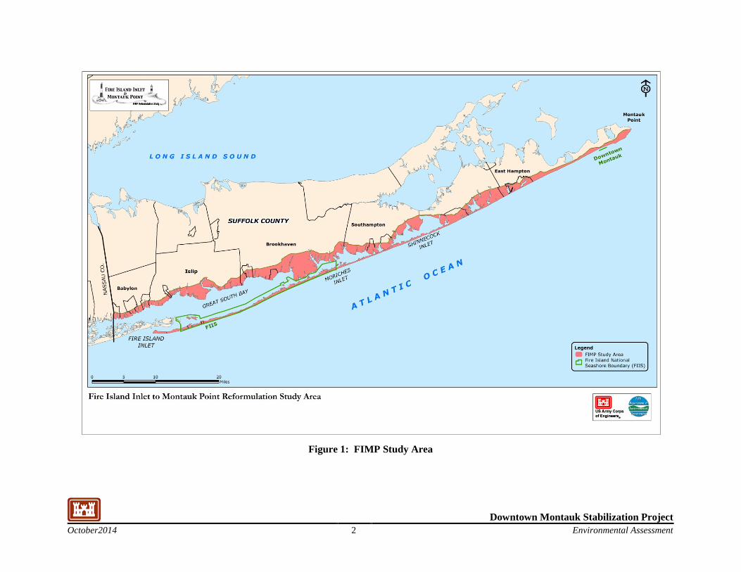
This Environmental Assessment is being conducted to evaluate potential impacts to the human and natural environment for the Downtown Montauk Stabilization Plan. The plan was developed in response to Hurricane Sandy and Public Law 113-2 which appropriated funds for “supplemental appropriations for the fiscal year ending September 30, 2013, to improve and streamline disaster assistance for Hurricane Sandy…” The Downtown Montauk Stabilization Plan will address erosion which occurred during Hurricane Sandy, leaving the area vulnerable to future storms and will provide protection to the project area while the overall Fire Island Inlet to Montauk Point (FIMP) project is being finalized. The overall FIMP study area including the Downtown Montauk project area is shown in Figure 1.
The FIMP, New York, Combined Beach Erosion Control and Hurricane Protection Project was authorized by the Rivers and Harbors Act of 14 July 1960, and subsequently modified in accordance with Section 103 of the Rivers and Harbors Act of 12 October 1962. The project authorization was modified again by Section 31 of the Water Resources Development Act (WRDA) of 1974. The authorization was further modified by section 502 of the WRDA of 1986 (P.L. 99-662). For portions of Fire Island to Montauk Point, other than the portion from Moriches Inlet to Shinnecock Inlet, Section 103 of the WRDA of 1986 (P.L. 99-662) defined the cost sharing of the first cost to be 65% Federal. In addition, Section 156 of the WRDA of 1976, as modified by Section 934 of the WRDA 1986, provides for continued renourishment not to exceed 50 years from initiation of construction of each of these reaches.
The project was also prepared considering the provisions within Public Law (PL) 113-2 of January 29, 2013, Disaster Relief Appropriations. The initial construction cost in accordance with the provisions of P.L. 113-2 is 100% Federal. PL 113-2 states that ‘the completion of ongoing construction projects receiving funds provided by this division shall be at full Federal expense with respect to such funds.”
Consistent with the Disaster Relief Appropriations Act of 2013 (Public Law. 113-2; herein P.L. 113-2), the USACE has proposed an approach to expedite implementation of a one-time stabilization project at downtown Montauk in advance of the completion of the Reformulation study. It is recognized that the timeframe to complete the FIMP Reformulation Study would leave vulnerable portions of the hamlet of Montauk exposed to future damages. This approach is strongly supported by the State of New York, Suffolk County, N.Y., and the Town of East Hampton. This approach is also consistent with USACE policy guidance (Memorandum dated 8 January 2014 approval from Steven L. Stockton, P.E., Director of Civil Works, Appendix G – Pertinent Correspondence).
The recommended plan utilizes information and data from the ongoing FIMP study to develop a one-time stabilization project that does not limit the options being considered or presuppose the outcome of the Reformulation study.
This document is a Draft Environmental Assessment (DEA), prepared to demonstrate project compliance with the National Environmental Policy Act (NEPA) in accordance with the Council of Environmental Quality (CEQ) regulations (November 20, 1978, 40 CFR Parts 1500-1508).
Downtown Montauk Stabilization Project October2014 2 Environmental Assessment
Figure 1: FIMP Study Area

Downtown Montauk Stabilization Project October2014 3 Environmental Assessment
1.2 Downtown Montauk Project Area
The authorized project was developed and implemented along five reaches. These reaches are used in the description of the implementation of the project, and are as follows:
Reach 1 – Fire Island Inlet to Moriches Inlet (FIMI)
Reach 2 – Moriches Inlet to Shinnecock Inlet
Reach 3 – Shinnecock Inlet to Southampton
Reach 4 – Southampton to Beach Hampton
Reach 5 – Beach Hampton to Montauk Point
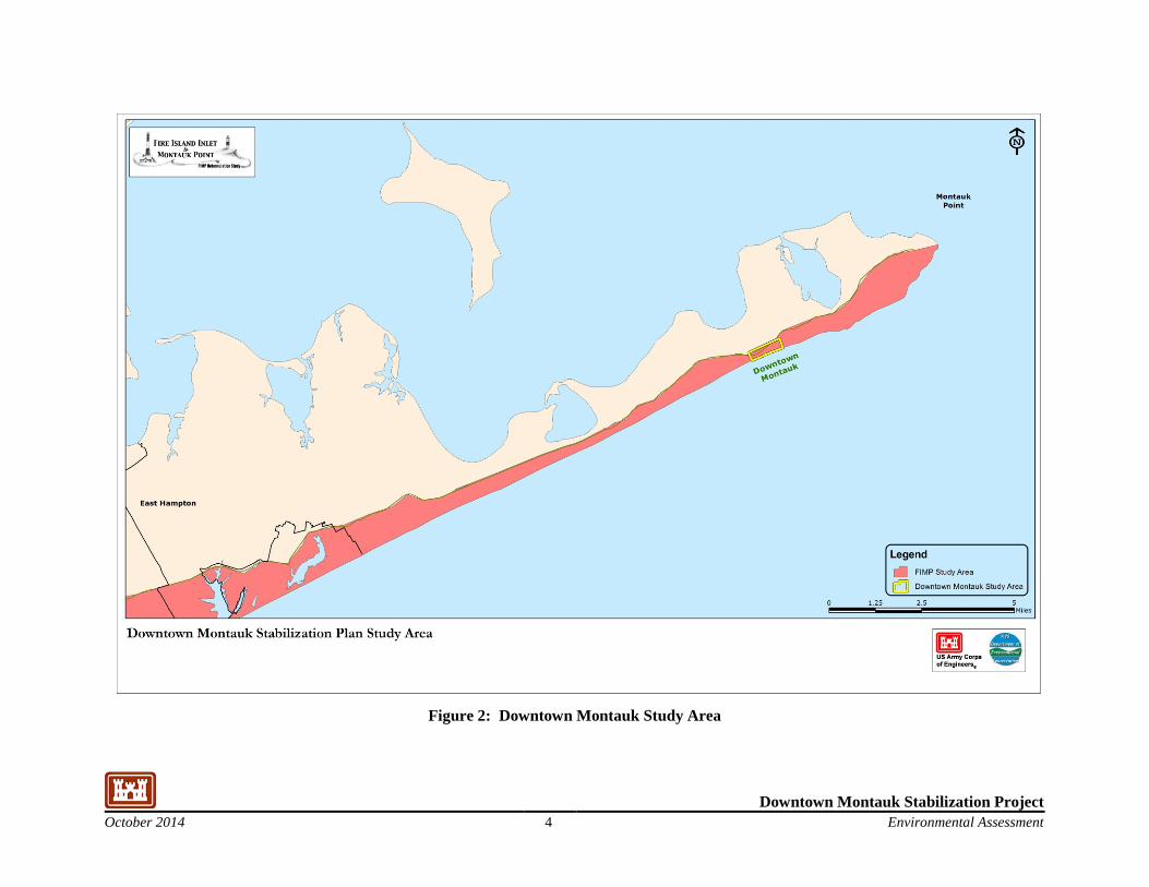
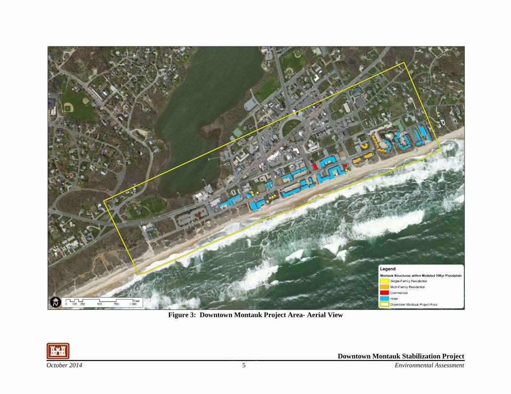
The Montauk Reach is the eastern most of the five designated Reaches within the overall FIMP study area; its location is shown on Figure 2. Montauk is the eastern most hamlet in the Town of East Hampton. It extends from Hook Pond in Easthampton to Montauk Point, a distance of about 20 miles. The Downtown Montauk project area consists of the business area in the hamlet of Montauk and is approximately 1 mile long by 0.25 mile wide. The Downtown Montauk project area is shown on Figure 3.
Downtown Montauk is the largest business area in the hamlet of Montauk. The land use in the Downtown Montauk project area consists of motels, restaurants and shops for transient visitors making Montauk the most seasonal of the hamlets in East Hampton. Residential development is also present in the project area. The layout of downtown Montauk has largely been governed by its unique oceanfront setting and the development pattern. Dense development has resulted from the small size of the lots and the high appeal of a coastal resort community along the Atlantic Ocean.
Within the project area, ocean shoreline sand generally moves east to west alongshore, in response to waves and currents during normal conditions and during storms. This alongshore movement of sand maintains the prevailing shoreline conditions. In addition to alongshore movement, sediment is also exchanged in the cross-shore direction, through erosion and accretion of the beach and dune, exchange of sand through and across tidal inlets, continued erosion of the inner continental shelf, redistribution of reworked sediments, and during large storm events through the episodic transport of sand across the island.
Downtown Montauk Stabilization Project October 2014 4 Environmental Assessment
Figure 2: Downtown Montauk Study Area
Downtown Montauk Stabilization Project October 2014 5 Environmental Assessment
Figure 3: Downtown Montauk Project Area- Aerial View
Downtown Montauk Stabilization Project October 2014 6 Environmental Assessment
1.3 Purpose and Need
Recent storm events, most notably Hurricane Sandy in 2012 have eroded beaches and dunes in the Downtown Montauk project area, creating a potentially imminent hazard that has left many commercial buildings along the shoreline vulnerable to damages from future storms. Beach and dune erosion caused by Hurricane Sandy has partially undermined several shorefront structures in downtown Montauk, leaving the area vulnerable to damage from future storms. This Draft EA documents the impacts associated with implementing the Downtown Montauk Stabilization Project.
A proposed solution to address this particular vulnerability is the implementation of a Stabilization Project at Downtown Montauk. This project is proceeding on a separate, accelerated path separate from those previously executed as "Interim Projects" along the south shore of Long Island because of the urgency to restore the coastline in this particular reach, thereby addressing the immediate need to reduce risk to life and property that resulted from Hurricane Sandy. The assumption for the Stabilization Project is that the project advances as a unique 100% Federally-funded stabilization stand alone project.
The Downtown Montauk Stabilization Project (the Project) has been developed to reinforce the existing dune and berm system along the Downtown Montauk project area. The selected design consists of dune reinforcement along 3,100 ft of the shoreline. Because there are restrictions on placement of hard structures in the coastal zone at East Hampton, dune reinforcement will be accomplished utilizing geotextile bags filled with sand. The sand-filled geotextile bags will be covered with a minimum of 3-ft of sand and plantings to reduce the likelihood of bag exposure.
1.4 Background/Relationship to Other Projects and Studies
The FIMP project was originally authorized in the Rivers and Harbors Act of 1960. For this larger project that extends another 53 miles to the east and includes Fire Island, a General Design Memorandum (GDM) was prepared in 1963. The GDM recommended building groins and placing beach fill along the south shore of Long Island. Construction began in 1965, and 11 groins were built. Later in the 1960's 4 more groins were constructed bringing the number of groins constructed to 15. In the 1970s, the final two groins were built. All of the constructed groins were located east of Fire Island. The FIMP project was halted in 1972 when New York State (NYS) withdrew its support of the project. In 1978, an Environmental Impact Statement (EIS) was prepared by the New York District for the FIMP project. After consultation with the U.S. Department of Interior (DOI), the EIS was referred to the Council on Environmental Quality (CEQ), which found the document to be inadequate because of the lack of consideration of alternatives. In addition, CEQ indicated that the impact analysis needed to treat the complete length of the barrier island as a system. Work began on a Reformulation Study, but was halted in 1984 because of a disagreement about cost sharing. This disagreement was resolved following the adoption of the Water Resources Development Act of 1986.
Study efforts were resumed in 1994 and are ongoing. Additional details on the Reformulation project are presented in the Downtown Montauk Hurricane Sandy Limited Reevaluation Report (HSLRR) that accompanies to this Draft EA. While the Reformulation Study is being completed and prior to implementation of the selected plan, the barrier islands are still subject to storms that could damage
Downtown Montauk Stabilization Project October 2014 7 Environmental Assessment
structures, open breaches, and cause flooding on the bayshore. With support from state and local interests, three Interim Plans have been developed while the Reformulation Study proceeds. The first Interim Plan entailed breach fill, dune construction, and support of the existing groin field in Westhampton Beach. A design by New York State was modified by the USACE and was approved by all involved local and federal agencies. The Westhampton Interim Project was constructed in 1997 and 1998. The second interim project was the development of a Breach Contingency Plan (BCP). The BCP authorized the closing of a barrier island breach within 3 months, and rebuilding the beach and dunes to provide protection consisting of a berm at elevation 9 feet above NGVD. The BCP was developed and is in place. Another Interim Plan prepared provided for the protection of the commercial fishing facilities West of Shinnecock Inlet. The beach west of Shinnecock Inlet is subject to overwash with high breach potential, and the area is subject to severe erosion.
Downtown Montauk Stabilization Project October 2014 8 Environmental Assessment
ALTERNATIVES
This section provides a summary of the alternatives considered for the Downtown Montauk Stabilization effort.
1.5 Alternatives Analysis – Downtown Montauk Stabilization
Prior to Hurricane Sandy, coastal storm risk management measures for the downtown Montauk area were considered as part of the ongoing FIMP Reformulation Study. The FIMP Reformulation Study undertook an initial screening of alternatives that considered non-structural measures, beachfill with structures, and beachfill. Each of these measures was analyzed considering general design requirements, costs, and local acceptability. Beachfill was the only measure considered for further evaluation. Based upon more detailed analysis, the pre-Sandy recommendation was a small scale beach nourishment project, or feeder beach.
In the aftermath of Hurricane Sandy, it was recognized that there was a need to revisit the plan at downtown Montauk and determine if the eroded beach conditions and updated costs and benefits warranted selection of a larger alternative plan. This analysis is presently underway as part of the Reformulation Study to consider a wider array of alternatives, and to aid in identifying a stabilization plan. An evaluation of five alternatives is underway, taking into consideration the severely eroded beach conditions following Sandy.
Based on the prior screening of alternatives, and coordination with State and local officials five conceptual alternatives were considered for evaluation:
• Alternative 1: Beach Restoration,
• Alternative 2: Beach Restoration and Buried Seawall,
• Alternative 3: Feeder Beach,
• Alternative 4: Dune Reinforcement,
• Alternative 5: Dune Reinforcement and Feeder Beach.
Due to the large quantities of sand fill required for construction of Alternatives 1, 2, 3, and 5 dredging of an offshore borrow area would be required. Dune Reinforcement (Alternative 4) requires significantly less sand, approximately 51,000 cy, than other four alternatives. Therefore, it is feasible and expected to be less costly to obtain the necessary sand fill material from upland sediment sources.
A stabilization project for Downtown Montauk must meet the following requirements:
a. The selected plan will not limit the overarching reformulation process; b. Economically justified as a separate, independent project;
.

Downtown Montauk Stabilization Project October 2014 9 Environmental Assessment
In reviewing the alternatives under consideration, Alternative 4 was identified as the only alternative that meets the criteria for a stabilization project. Alternatives 1, 2, 3, and 5 all have very high costs, and can only perform as designed if done in conjunction with a long-term plan for renourishment. Provided that the stabilization project for Downtown Montauk is intended as a 1 time project in advance of the implementation of the overall FIMP reformulation, these 4 alternatives were not be considered further, and Alternative 4 was selected as a viable stabilization alternative.
1.5.1 Identification of Downtown Montauk Dune Reinforcement Alternative
The post-Sandy Fire Island Stabilization Project, which encompasses the Downtown Montauk project area, was developed based upon the Engineering, Economic, Environmental, and Planning efforts that have been undertaken through the ongoing FIMP Reformulation Study that compared alternatives referenced in this report to identify the recommended scale and scope of a dune reinforcement project as an independent stabilization effort. Stabilization efforts were focused on Downtown Montauk as this reach is a popular tourist destination which experienced significant erosion and damages during Hurricane Sandy which have created a potentially imminent hazard and left many commercial buildings along shoreline vulnerable to storm damages. There is a more urgent need to advance the stabilization of this reach due to its vulnerability and potential for major damage and risk to life and property.
This stabilization effort has been developed as a one-time, stand-alone construction project to repair damages caused by Hurricane Sandy and to stabilize the island. The Downtown Montauk Stabilization Project has its own independent utility, and as developed does not limit the options available in the overall FIMP Reformulation Study or pre-suppose the outcome of the Reformulation Study. In the absence of a future decision, the area is expected to continue to be managed consistent with current practices.
Two alternatives are evaluated in this EA, the No Action Alternative and a Dune Reinforcement Alternative. The Dune Reinforcement Alternative is the recommended alternative/Tentatively Selected Plan (TSP) and is also the environmentally preferred plan because it reduces storm damages in a manner that mimics the natural protective features of the barrier island. The Dune Reinforcement Alternative is also the locally preferred plan.
1.6 No Action Alternative
Under the No Action Alternative, the USACE and the Federal government would take no action to reduce storm damages in the study area. It is recognized that in the absence of Federal action Local Governments and non-governmental groups, such as homeowner associations, could take actions to protect themselves by undertaking their own construction projects to build up the beach and dune profiles. Although these actions are likely to occur, the extent and details of the actions that they may be undertaken are not known and therefore they have not been included in the No Action Alternative, for the purposes of this analysis.
Downtown Montauk Stabilization Project October 2014 10 Environmental Assessment
This conclusion is based on a review of recent activities including the extent of private activities. Recent records indicated that in the years 2010 through 2013 dune repairs of this nature costing more than $2,200,000 were locally implemented. It is likely that within their available resources, property owners will continue to maintain a minimum dune condition.
The minimum beach and dune condition that is currently maintained merely helps to provide continued access to the beach; it provides only limited protection against severe storms. A more robust dune and beach is required to provide adequate protection from severe storms and address the vulnerability of the project area.
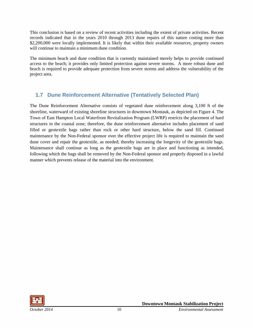
1.7 Dune Reinforcement Alternative (Tentatively Selected Plan)
The Dune Reinforcement Alternative consists of vegetated dune reinforcement along 3,100 ft of the shoreline, waterward of existing shoreline structures in downtown Montauk, as depicted on Figure 4. The Town of East Hampton Local Waterfront Revitalization Program (LWRP) restricts the placement of hard structures in the coastal zone; therefore, the dune reinforcement alternative includes placement of sand filled or geotextile bags rather than rock or other hard structure, below the sand fill. Continued maintenance by the Non-Federal sponsor over the effective project life is required to maintain the sand dune cover and repair the geotextile, as needed; thereby increasing the longevity of the geotextile bags. Maintenance shall continue as long as the geotextile bags are in place and functioning as intended, following which the bags shall be removed by the Non-Federal sponsor and properly disposed in a lawful manner which prevents release of the material into the environment.
Downtown Montauk Stabilization Project October 2014 11 Environmental Assessment
Figure 4: Dune Reinforcement Alternative
Downtown Montauk Stabilization Project October 2014 12 Environmental Assessment
The following plan details are from the HSLRR description of the alternative for the Stabilization project. Plan layout for the Dune Reinforcement Alternative is provided in Attachment A of this report.
Design Section
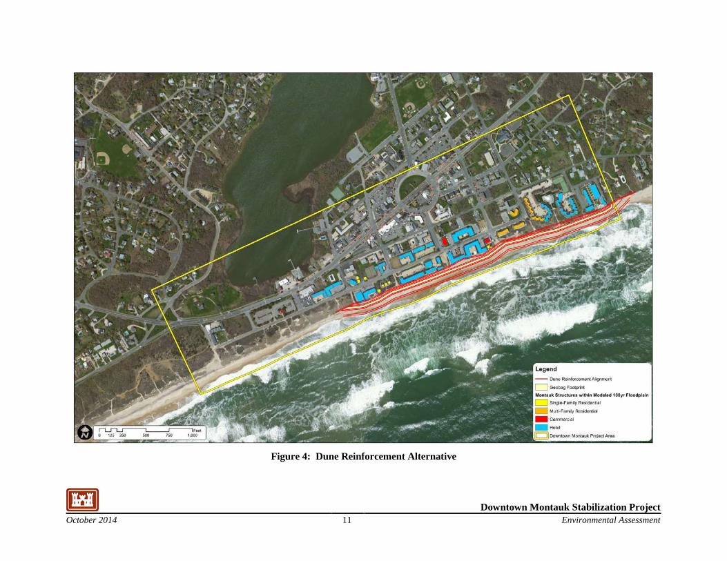
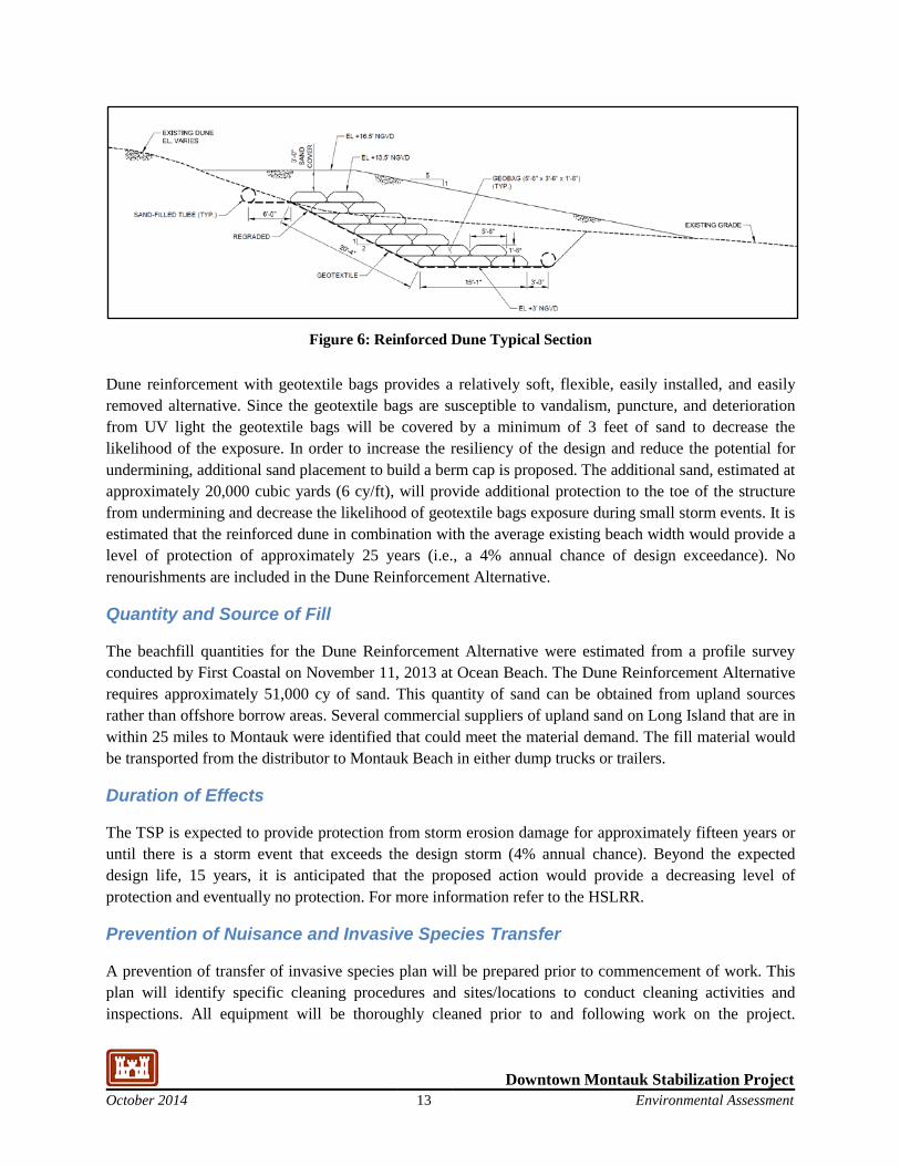
Geotextile bags filled with sand are proposed for dune reinforcement. There are several manufacturers that produce large-sized sandbags. The geotextile bags are made of UV resistant sand-colored geotextile fabric that can be filled either hydraulically or mechanically with sand. The bags are sold in a variety of flat dimensions ranging from 3 x 5 ft to 5 x 15 ft. When the bags are filled, the dimensions typically decrease by 8 to 18 inches. An example of two geobag stabilization projects, depicting the filled bags prior to placement of final sand cover with dune planting, is provided in Figure 5.
Figure 5: Geobag Example Installations
Based on design wave conditions the 7 by 5 foot bags (flat dimensions) were selected for downtown Montauk. When filled, the bag is approximately 5.5 feet long by 3.5 feet wide by 1.5 feet tall. The nominal weight of the filled bags is 1.7 tons based on sand fill with a unit weight of 165 lbs/ft3. A total of 14,171 geotextile bags will be utilized for approximately 3,100 linear feet of reinforced dune.
For greater stability the bags would be aligned with the long side perpendicular to the shoreline and would overlap by 30 to 50% of the filled width. The proposed design calls for stacking the bags along the existing dune at a 1V:2H slope. The Dune Reinforcement extends from a toe elevation of +3 ft to a crest elevation of +13.5 ft NGVD. A typical section for the dune reinforcement is provided in Figure 6. The dune will be planted with dune grass on 18 inch centers on the dune crest and face. Sand fencing will be installed at the seaward toe of the dune to retain wind-blown sand.
Downtown Montauk Stabilization Project October 2014 13 Environmental Assessment
Figure 6: Reinforced Dune Typical Section
Dune reinforcement with geotextile bags provides a relatively soft, flexible, easily installed, and easily removed alternative. Since the geotextile bags are susceptible to vandalism, puncture, and deterioration from UV light the geotextile bags will be covered by a minimum of 3 feet of sand to decrease the likelihood of the exposure. In order to increase the resiliency of the design and reduce the potential for undermining, additional sand placement to build a berm cap is proposed. The additional sand, estimated at approximately 20,000 cubic yards (6 cy/ft), will provide additional protection to the toe of the structure from undermining and decrease the likelihood of geotextile bags exposure during small storm events. It is estimated that the reinforced dune in combination with the average existing beach width would provide a level of protection of approximately 25 years (i.e., a 4% annual chance of design exceedance). No renourishments are included in the Dune Reinforcement Alternative.
Quantity and Source of Fill
The beachfill quantities for the Dune Reinforcement Alternative were estimated from a profile survey conducted by First Coastal on November 11, 2013 at Ocean Beach. The Dune Reinforcement Alternative requires approximately 51,000 cy of sand. This quantity of sand can be obtained from upland sources rather than offshore borrow areas. Several commercial suppliers of upland sand on Long Island that are in within 25 miles to Montauk were identified that could meet the material demand. The fill material would be transported from the distributor to Montauk Beach in either dump trucks or trailers.
Duration of Effects
The TSP is expected to provide protection from storm erosion damage for approximately fifteen years or until there is a storm event that exceeds the design storm (4% annual chance). Beyond the expected design life, 15 years, it is anticipated that the proposed action would provide a decreasing level of protection and eventually no protection. For more information refer to the HSLRR.
Prevention of Nuisance and Invasive Species Transfer
A prevention of transfer of invasive species plan will be prepared prior to commencement of work. This plan will identify specific cleaning procedures and sites/locations to conduct cleaning activities and inspections. All equipment will be thoroughly cleaned prior to and following work on the project.
Downtown Montauk Stabilization Project October 2014 14 Environmental Assessment
Cleaning protocols include cleaning all equipment surfaces, including but not limited to undercarriage, tires, and sheet metal, to ensure that soil, vegetative debris, eggs, mollusks, larvae, seeds, and vegetative propagules are not transported from a previous work location to the project nor transported from this project site to another project site. The equipment includes but is not limited to heavy equipment, vehicles, trailers, ATV's, and chippers and smaller equipment including chain saws, loppers, shovels, and backpack sprayers. Any method of cleaning equipment that is accepted by the Government can be used with a common accepted method including pressure washing or soap and water washing. Cleaning protocols will also address clothing and personal protective equipment.
Downtown Montauk Stabilization Project October 2014 15 Environmental Assessment
AFFECTED ENVIRONMENT 1.8 Overview of Long Island and East Hampton
This section presents background information on the overall FIMP study area, with focus on the Downtown Montauk study area and sets the context necessary for describing the affected environment within the study area. It includes a synopsis of the formation of storm and erosion events in the study area and human settlement. The East Hampton Local Waterfront Revitalization Program (LWRP) served as a key reference for much of the information specific to East Hampton (Town of East Hampton, 1999).
The Town of East Hampton is situated on the eastern end of Long Island, approximately 100 miles from New York City. It encompasses the east half of the South Fork of Long Island and covers approximately 70 square miles of land. It is bordered to the west by the Town of Southampton, to the north by the Peconic Bay, and to the east and south by the Atlantic Ocean. Montauk is the easternmost hamlet within the Town of East Hampton; Downtown Montauk is located approximately 5.0 miles west of Montauk Point, the easternmost tip of the island. The Town of East Hampton has approximately 110 miles of coastline including several sheltered harbors along its northern bay shore. The Atlantic shoreline is protected by beaches, dunes and bluffs but is vulnerable to damaging northeasters and hurricanes. Public policy in the Town had mainly emphasized protecting developed parts of the Town rather than maintaining the coastal areas, protecting them from flooding and erosion, to ensure an important recreational and resort economy.
Coastal development had often failed to recognize potential flooding and erosion from storms and residents later tried to minimize the potential damage by constructing structural erosion control measure such as groins and bulkheads. These measures often had the opposite affect by disrupting natural coastal movement of sand. Beaches adjacent to the erosion control measures often disappeared resulting in the loss of recreational fishing or beach activities upon which the local economy depends.
The East End of Long Island is a complex ecosystem consisting of physical (non-living) and biological (living) components and their interactions. The physical components include the open waters and embayments of Gardiners Bay, Napeague Bay, Block Island Sound and the Atlantic Ocean, and the coastal lowlands, headlands, bluffs, adjacent upland areas and small offshore islands. These features continue to develop and change through the action of tides and offshore currents, weathering from precipitation and surface runoff, and the effects of human development. The biological components include the plants and animals in a wide range of ecological communities in and around the East End (Town of East Hampton, 1999).
1.8.1 Formation History
Generally, Long Island traces its geologic origin to sediment deposits from the advance and retreat of the glaciers. The shoreline basically has two types of land forms, the original glacial depositions and secondary lands built up from eroded sand and sediments. The sediments are carried from east to west by longshore currents. The materials deposited by glacial activities along the shoreline vary, from knob and kettle terrain to the small harbors and coastal ponds formed by meltwater channels and later closed by
Downtown Montauk Stabilization Project October 2014 16 Environmental Assessment
littoral drift. The coastal bluffs are composed of a mix of gravel and sandy material; some locations may have clay-like sediments.
Long Island's geography and East Hampton's particular location increase vulnerability to hurricanes. Because of the Island's east-west projection into the Atlantic, hurricanes following the warm waters of the Gulf Stream north tend to meet the coastline at right angles, in a coast-normal path, rather than the glancing impact common to the north-south coasts of the Carolinas. The following discussion of the historical storm records in East Hampton is primarily excerpted from the Town of East Hampton LWRP that was adopted by the Town in 1999 and approved by NYS in 2007 (Town of East Hampton, 1999).
Over the past 60 years human development has increased on Fire Island and Long Island, and a number of large storms have struck and caused erosion and damage to structures. Little has been recorded about storms and the effects on the barrier islands prior to about 1900. The hurricane of 1938 is the first, well-known, major storm of the 20th century that caused large-scale erosion and property damage. On September 21, 1938, the hurricane came ashore without warning. The winds are estimated to have been about 120 miles per hour. The water level rose about 10 feet above normal on the ocean front, and because of breaches in Fire Island allowing water into the Great South Bay, the water level on the bay shore rose about 13 to 15 feet. At least seven new inlets were formed along the south shore of Long Island, and numerous small overwashes occurred. It is estimated that about 20 square miles of the bayshore were inundated.
The overwashed inlets along Fire Island filled either naturally or with human intervention. A series of hurricanes and northeastern storms caused erosion and property damage during the 1940's and 1950's after the hurricane of 1938. After the storms, accretion of sand restored some of the beach width. According to anecdotal information, the dune heights lowered and beaches narrowed gradually. The next storm that caused heavy erosion and wide spread property damage occurred in March 1962. This storm is often referred to as the Ash Wednesday storm. It was a northeaster that lasted for about three days or five tidal cycles. Two low-pressure systems joined and became stationary to the south of Fire Island. Ocean waves of 20 to 30 feet were reported, and the water level rose to about 7.7 feet above National Geodetic Vertical Datum (NGVD), which approximates Mean Sea Level (MSL). About 50 overtoppings of the barrier islands were reported, and a new inlet at Westhampton, east of Fire Island, formed. About 12 square miles of the bayshore was flooded.
Again, over time, sand accreted, dune elevations rose due to natural processes, and beaches widened to the east, both naturally and with human intervention after the Ash Wednesday storm.
The northeaster that occurred on December 11 and 12, 1992 is taken to be an approximation in terms of flood inundation of the 100-year storm. This storm lasted through four tidal cycles with water levels at or above 8 feet NGVD. Ocean waves of 15 to 25 feet were reported. Several storms have caused erosion and property damage since 1992. Local efforts were taken to mitigate erosion and flooding problems caused by storms.
The most recent major storm events to impact the project area are Hurricane Irene (2011) and Hurricane Sandy (2012). Hurricane Sandy made landfall near Atlantic City, NJ on October 29th with wind speeds
Downtown Montauk Stabilization Project October 2014 17 Environmental Assessment
equivalent to a Category 1 hurricane. The orientation of the Hurricane Sandy wind field prior to landfall caused strong winds to blow across the continental shelf towards New York. Because the peak storm surge was in phase with the peak high tide, storm-induced flood was exacerbated. Hurricane Sandy’s unusually large diameter resulted in long fetch lengths generating extreme wave heights at the study area. These three factors (track, timing, and extraordinary size) resulted in record water levels and wave heights in the New York Bight. The storm tide elevation at the Battery in New York is estimated to have reached elevation 11.3 feet NAVD88.
1.8.2 Human Settlement History
The following is excerpted from the Downtown Montauk Hamlet Study – Draft Inventory that was prepared by the Town of East Hampton Planning Department (2008).
The first human inhabitants of the Montauk peninsula were the Montauk Indians or Montaukets, who occupied the region as early as the Middle Archaic Stage, or ca. 6,000 to 4,000 B.C. These Native Americans lived in small camps and used the entire peninsula as hunting and fishing grounds. They build a fort in the area, for which Fort Pond and Fort Pond Bay were named.
East Hampton was settled by Europeans in 1648 who established agricultural and pastoral communities. By 1660 these proprietors had acquired rights from the Montaukets to all of Montauk for the purpose of establishing common pasturage, a land use pattern that persisted for over 220 years.
Arthur W. Benson, a Brooklyn financier, bought all of Montauk in 1879 and subsequently formed the Montauk Association for the purposes of constructing a small summer colony, which was designed by landscape architect, Fredrick Law Olmstead of Central Park fame and architect Stanford White. The summer colony and seven “cottages” constructed at that time are located in an historic district to the east of the downtown area, the Montauk Association Historic District. This historic district, which is listed on the National Register of Historic Places, is well east of the Downtown Montauk project area (URS, 2006).
Extension of the Long Island Railroad (LIRR) to Fort Pond, just west of downtown Montauk resulted in the weekly fishing excursions for fishermen from New York, making Montauk a first class fishing and hunting destination by the late 1800’s. Around the same period, the Great Plain between Fort Pond and Lake Montauk was used to quarantine Col. Theodore Roosevelt and 30,000 Rough Riders, arriving home from the Spanish American War until they were certified free of yellow fever and typhoid fever. A military base was later also established at Fort Pond Bay as a strategic defense outpost during World War I.
The extension of the LIRR to Montauk created markets in New York City for the fishing industry and a fishing village sprang up north of the railroad tracks, around Fort Pond Bay, representing the first center of development in Montauk. By the 1920’s, the village consisted of hundreds of small wooden fisherman’s houses and businesses related to the fishing industry including fuel, supplies, and a crushed ice industry for packing fresh fish shipped to the Fulton Fish markets. Montauk remained sparsely settled by a small group of fisherman until the 1920’s. The World War I hangar and Second House represented the only documented development in the current downtown area.
Downtown Montauk Stabilization Project October 2014 18 Environmental Assessment
The current development pattern in downtown Montauk was established in the 1920’s by Carl Fisher, who developed the area as a summer resort. Fisher constructed of dozens of commercial and recreational buildings. A six story building that headquartered his offices, known as the Fisher Building, and today referred to as the Tower, and four other two-story buildings housing stores and offices were constructed in the downtown area. Fisher also constructed numerous homes, roads, and recreational amenities, including a yacht club, golf course, indoor tennis courts, polo grounds, and horse stables, intended to transform the area into a sportsman’s paradise and world class resort for the wealthy and socially prominent. To provide docking for boats owned by these affluent guests, Fisher blasted open a channel connecting Lake Montauk to Block Island Sound.
Fisher constructed six commercial buildings as offices, stores, a restaurant/tavern, and a movie theater within the boundaries of the current downtown project area. Fisher chose a Tudor Revival style of architecture for all of the buildings associated with his development. This architectural style set the character of the hamlet and particularly, the downtown area. Pink sidewalks used in his Miami Beach development scheme were also incorporated into the downtown Montauk development scheme. The stock market crash in 1929 ruined Fisher’s finances and brought his dreams of completing this resort to an end. However, the Montauk that tourists see today is in large part the vision of Carl Fisher.
In the September 1938 hurricane, floodwater breached the land spit between the Atlantic Ocean and Fort Pond in an area with no development. At the time, there were approximately 14 buildings in the downtown area, including the Fisher Buildings, three gas stations, and several single family residences. . The fishing village on Fort Pond Bay was severely damaged by both flooding and wind and buildings were washed off their foundations. The Fishing village was restored several months later and remained the commercial center for several years more.
During World War II, Montauk was part of the Eastern Coastal Defense System, and Montauk was transformed from a small sparsely populated resort and fishing community to a military one. The U.S. Navy used Fort Pond Bay as a torpedo testing range and a number of war-related facilities, including docks, hangars, and barracks were constructed in the hamlet. Buildings in the fishing village on Fort Pond Bay were either razed or relocated to other areas in order to allow for the installation of these facilities. The Navy utilized the Tower and other Fisher buildings in the downtown area for officers’ quarters and offices.
The inexpensive fishing excursions run by the LIRR since 1933 were discontinued after 1953 when the channel to Lake Montauk was dredged and the fishing boats relocated there from Fort Pond Bay. The post-World War II trend toward suburban living increased residential development and was followed by motels and summer visitors in the 1960s which brought expansion of commercial facilities to service these visitors.
Downtown Montauk Stabilization Project October 2014 19 Environmental Assessment
1.9 Human Environment
1.9.1 Land Use
Downtown Montauk is the second largest commercial area in East Hampton. The land use in the Downtown Montauk project area consists of commercial development that includes hotels, restaurants and shops for transient visitors making Montauk the most seasonal of the hamlets in East Hampton. Single-family and multi-family residential development is also present in the project area. The layout of downtown Montauk has largely been governed by its unique oceanfront setting and the development pattern. Dense development has resulted from the small size of the lots and the high appeal of a pristine resort community along the Atlantic Ocean (Town of East Hampton, 2008).
The Montauk business area is protected by a dune system which has not been well maintained. The beach throughout this area is wide and sandy due to longshore movement of sand from the east. Development before the current zoning laws were instituted and recent storm events have damaged the existing beach and dunes. Recent storm activity appears to have also affected the bluffs in the area. An unvegetated dune south of Fort Pond bay that is used as a path for beach goers is the location of a potential breach by a serious storm could open a direct path from the Atlantic Ocean to the downtown area. Other access points to the Town owned beach across the dunes are also potential sites of a breach.
Local erosion control structures or drainage installations as well as private and public beach access walkways also have a negative influence on the ability of the beach and dunes to reduce impacts from severe storms. The high density of residential, commercial and resort development in the area would be a major location for storm-driven flood damage in the hamlet.
1.9.2 Socioeconomics
The following details the economic conditions in the hamlet of Montauk.
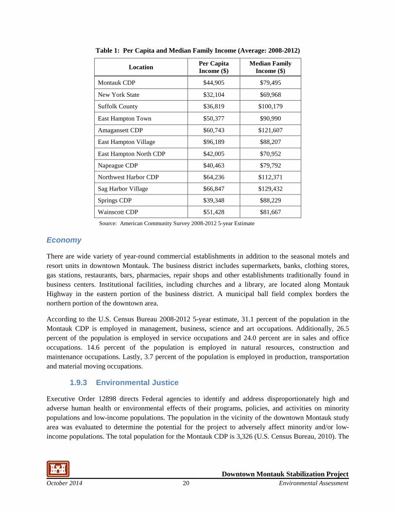
Income
The U.S. Census Bureau per capita income and median family income for the Montauk CDP (Census Designated Place) are shown in Table 1. For comparison New York State, Suffolk County, the Town of East Hampton and other villages/hamlet CDPs in the Town of East Hampton are also included in Table 1. The per capita income for the Montauk CDP is higher than New York State and Suffolk County but lower than the Town of East Hampton. The median family income in the Montauk CDP is lower than the Town of East Hampton and Suffolk County but higher than New York State.
Downtown Montauk Stabilization Project October 2014 20 Environmental Assessment
Table 1: Per Capita and Median Family Income (Average: 2008-2012)
Location Per Capita Income ($)
Median Family Income ($)
Montauk CDP $44,905 $79,495
New York State $32,104 $69,968
Suffolk County $36,819 $100,179
East Hampton Town $50,377 $90,990
Amagansett CDP $60,743 $121,607
East Hampton Village $96,189 $88,207
East Hampton North CDP $42,005 $70,952
Napeague CDP $40,463 $79,792
Northwest Harbor CDP $64,236 $112,371
Sag Harbor Village $66,847 $129,432
Springs CDP $39,348 $88,229
Wainscott CDP $51,428 $81,667
Source: American Community Survey 2008-2012 5-year Estimate
Economy
There are wide variety of year-round commercial establishments in addition to the seasonal motels and resort units in downtown Montauk. The business district includes supermarkets, banks, clothing stores, gas stations, restaurants, bars, pharmacies, repair shops and other establishments traditionally found in business centers. Institutional facilities, including churches and a library, are located along Montauk Highway in the eastern portion of the business district. A municipal ball field complex borders the northern portion of the downtown area.
According to the U.S. Census Bureau 2008-2012 5-year estimate, 31.1 percent of the population in the Montauk CDP is employed in management, business, science and art occupations. Additionally, 26.5 percent of the population is employed in service occupations and 24.0 percent are in sales and office occupations. 14.6 percent of the population is employed in natural resources, construction and maintenance occupations. Lastly, 3.7 percent of the population is employed in production, transportation and material moving occupations.
1.9.3 Environmental Justice
Executive Order 12898 directs Federal agencies to identify and address disproportionately high and adverse human health or environmental effects of their programs, policies, and activities on minority populations and low-income populations. The population in the vicinity of the downtown Montauk study area was evaluated to determine the potential for the project to adversely affect minority and/or low- income populations. The total population for the Montauk CDP is 3,326 (U.S. Census Bureau, 2010). The
Downtown Montauk Stabilization Project October 2014 21 Environmental Assessment
population in the Montauk CDP is largely white (90.3%) with minorities making up less than 10% of the population (U.S. Census Bureau, 2010).
Local and regional businesses, residents, and tourists determine the socioeconomic climate at and near the Downtown Montauk. Based on the census data presented in Table 1, there are no significant concentrations of low-income populations or minority populations in the Downtown Montauk project area. Alternatives evaluated would not disproportionately affect socially or economically disadvantaged populations and no further evaluation of compliance with Executive Order 12898 is warranted.
Protection of Children from Environmental Health Risks and Safety Risks
Both the resident and tourist populations of the downtown Montauk study area include a significant number of children, especially during the summer months. The work may be an attraction and commonly used "Best Management Practices" would be used to keep people out of the areas where dune reinforcement is being constructed. BMP’s will also be used to keep people out of areas where small tracked vehicles may be placing sand immediately adjacent to motels and residential structures.
Executive Order 13045: A growing body of scientific knowledge demonstrates that children may suffer disproportionately from environmental health risks and safety risks. Therefore, to the extent permitted by law and appropriate, and consistent with the agency’s mission, USACE will address EO 13045. BMPs will address EO 13045 during the implementation phase of the project. BMPs will be addressed more fully in a Health and Safety Plan and implemented during construction.
1.9.4 Transportation
Local commuting patterns tend to flow west to east in the morning and east to west in the evening (USDoT, 2009). The year-round, seasonal, and transient populations have been increasing in the project area bringing an increase in traffic to a road system not originally designed for the current level of use. The Town Board commissioned a Town wide Transportation Study in 1995. That study was incorporated into the Town's Comprehensive Plan in June, 1997. The study determined that Montauk Highway (NYS Route 27), the Town's primary thoroughfare, was already at or near capacity for lengthy periods of time in the summer months and was increasing at an annual rate of eight percent. Daily traffic was found to suffer peak hour congestion while summer traffic was also increasing. In an effort to maintain a rural atmosphere on the south fork of Long Island a mass transit program, park and ride with train and bus service for commuters was recommended. This recommendation was reinforced at the conclusion of a 2009 multi-year study conducted to evaluate transportation needs from a regional perspective. The study was conducted on behalf of the five Towns of the East End: East Hampton, Riverhead, Shelter Island, Southampton, and Southold to evaluate the technical feasibility and cost-effectiveness of a proposed “coordinated rail-bus network” to replace most of the East End’s current transit services with an integrated system of local shuttle trains and connecting bus services (USDoT, 2009). Viability of a fixed route public transportation system for the east end of Long Island is expected to be more favorable during the tourist season, when population increases by two and a half to three times as compared to the year round population. Higher seasonal population fluxes are documented for East Hampton, which based on 2003 data, had a year round population of 20,275 and a seasonal population of 93,756 (USDoT, 2009); an
Downtown Montauk Stabilization Project October 2014 22 Environmental Assessment
increase of more than four and a half times the year round population. The annual average daily traffic along Montauk Highway in the vicinity of downtown Montauk is roughly 8,000 vehicles, based on 2011 traffic counts (USDoT, 2014). Consistent with the seasonal population changes, traffic volume is also highly seasonal, which daily traffic volume during the off-season expected to be substantially lower than average and conversely, summer season traffic volume substantially higher.
1.9.5 Recreation/Parks
East Hampton, and particularly downtown Montauk, is known for motels and resorts with beach access for visitors. Kirk Park Beach is located on the westerly side of the hamlet within the study area. A Town-owned municipal parking lot and comfort stations are located across South Emerson Street to the north of the beach. The other areas along the shoreline in the project area are not designated as public beaches. A portion of the shore adjacent to resorts or motels has access for guests only. The local beaches are also used by large numbers of people who enjoy walking, jogging, sunbathing and picnicking, beachcombing and bird watching. There are no boating facilities in the project area; however the beach is popular for fishing. Access to Fort Pond is available through a public boat ramp/parking lot located on South Erie Avenue. Access to Fort Pond is also available through the miniature golf course on Montauk Highway.
There are several other parks and recreation areas within one mile of the Downtown Montauk project area. An unopened portion of Montauk Point State Boulevard located north of South Emery Street/South Erie Avenue provides parkland and opportunities for water access and recreational activities. The Town operates several recreational facilities in this parkland. Facilities at the Henry “Hank” Zebrowski Memorial Park (commonly known as “Lion’s Field”) include two baseball/softball fields, one lighted for evening use, a swing set and playground apparatus, a multipurpose field utilized for soccer, football, and other sports related activities, two tennis courts, a basketball court, an in-line hockey rink, and skateboard area. Hither Woods Preserve is located approximately one mile to the west of the project area. Montauk Downs State Park Golf Course is located approximate one-half mile to the northeast of the project area. Shadmoor State Park is a 99 acre state park located one quarter mile to the east of downtown Montauk. Rheinstein Estate Park is located to the east of Shadmoor State Park. Ditch Plains Beach, east of the project area, is a popular surfing spot.
1.9.6 Cultural Resources
This section provides an overview of known and potential cultural resources and historic properties, including archaeological and architectural resources, within the Area of Potential Effect (APE) as well as within the area surrounding the Downtown Montauk project area. As determined pursuant to Section 106 of the National Historic Preservation Act (16 U.S.C.470f), the APE for this proposed project includes the Downtown Montauk project area shown on Figure 3, which includes approximately one mile of the Atlantic shoreline in the downtown Montauk area, extending seaward from the existing dune line into the marine beach sand placement area and extending landward to include much of downtown Montauk. There are no properties listed on State or National Registers of historic places within the APE. Additional information regarding cultural resources in the Downtown Montauk project area is provided in the description of Human Settlement History (Section 3.1.2).
Downtown Montauk Stabilization Project October 2014 23 Environmental Assessment
The history of development in East Hampton begins with the earliest settlements of Native Americans. The New York State archaeological site location map indicates numerous archaeological sites in East Hampton with many sites located in Montauk (NYSOPRHP, 2014). As is common at many early sites, areas adjacent to ponds, harbors or bays, particularly where fresh water meets salt, were often settled by earliest people. These sites generally contain archaeological material as evidence of the settlement characterized by subsistence hunting, fishing, and gathering. Several sites in East Hampton have undergone archaeological surveys, and these studies, serve as a basis for identification of archaeologically sensitive areas. Recent remains of native culture exist in Montauk, as this was the last area in the Town of East Hampton where the Montauk tribe had a reserve of land. When European settlers arrived in East Hampton in the 17th century a written record of the Native Americans was begun documenting the agreements and conflicts between the two groups (Town of East Hampton, 2008).
Montauk was one of the last outposts of the native tribes who were slowly displaced and disappeared as the European settlement moved eastward. Due to the dynamic nature of the shoreline environment, remnant archaeological resources are not expected within the dune reinforcement footprint. However, the project area is within an area mapped as archeologically sensitive ((NYSOPRHP 2014). Although shipwrecks are common off the coast of Long Island, the APE does not extend offshore where wrecks would be located.
Montauk was used as common pasture from 1658 through the late nineteenth century. A few structures remain from the period in Montauk’s history from the mid- 1600’s through the 1800’s when the land was used as common pasture. Second House, located within the Town's Kirk Park on the banks of Fort Pond, north of Montauk Highway, and Third House, located on County parkland, were both used to house the keepers of livestock and later by Theodore Roosevelt and the Rough Riders (Town of East Hampton LWRP, 1999). Second House, which was built in 1797, is the oldest building in downtown Montauk and currently serves as a museum. Second House is located in the northwest corner of the APE while Third House is located outside the APE.
Present development in Montauk is largely a result of influences and events from the late 1800's onward when wealthy New York residents discovered the potential for a vacation area away from the City. The Town of East Hampton began to change from a predominantly rural and agricultural region to a seaside recreational area (Liquori and Nagel, 2005).
The developer Carl Fisher, known for the creation of resorts in Miami Beach, saw potential for recreation facilities on the eastern end of Long Island. His development company designed a resort community, a residential community, the downtown Montauk area, a protected harbor in Lake Montauk and four major sporting facilities, the Surf Club, the Polo Club, the Tennis Club and the Yacht Clubs. None of these sporting clubs are within the APE. After Fisher’s death in 1934, his projects went into a decline, leaving only Montauk Manor, the tennis auditorium, Montauk railroad station and several buildings in downtown Montauk. Six of these Tudor Revival style structures constructed by Carl Fisher in the 1920’s are located in the downtown area (Town of East Hampton LWRP, 1999). Aside from the Second House and Third House, these are the oldest structures in the community. Four of these buildings retain sufficient integrity to be recognized as historic. Most of the buildings in downtown Montauk were constructed in the 1950’s and later.
Downtown Montauk Stabilization Project October 2014 24 Environmental Assessment
1.10 Physical Environment
1.10.1 Geology
Long Island is part of the Atlantic and Gulf Coastal physiographic province which lies along the eastern border of the United States and at the southern boundary of the late Pleistocene glacial advance in the eastern part of North America (Taney, 1961). The Ronkonkoma and Roanoke Point moraine deposits (i.e., mounds of unstratified glacial drift chiefly consisting of boulders, gravel, sand and clay) characterize the topography along the northern side of Long Island, while a gentler southward dipping gradient on the outwash plains makes up much of the southern side of the island (Schwab et al., 2000).
The Downtown Montauk project area is located approximately 5 miles west of Montauk Point. From Montauk Point west to Southampton (approximately 33 miles) headlands formed by Ronkonkoma moraine and outwash deposits are eroded forming a narrow beach and a series of small bays (i.e., ponds). Eroded sediments along this reach are transported westward by wave action. The headland section is further subdivided into three units. Bluffs that rise to 60 ft or more above sea level and narrow beaches of coarse sand and gravel characterize the shoreline from Montauk Point westward for a distance of approximately 10 miles. The next unit, which includes Napeague Beach, is considered a connecting beach that provides a link between two areas of deposition of the Ronkonkoma moraine. This unit is approximately 4 miles long. A low sandy beach backed by dunes characterizes the shoreline within this unit. The third unit of the headland section is 19 miles long and extends to Southampton. Sandy beaches and long continuous dunes that rise to an elevation of 20 ft above sea level characterize this unit. Lying just north of the shoreline are several small ponds or bays that have been cut off from the ocean by bay mouth bars and narrow barrier beaches, which are periodically breached during and after storms. The larger of these bays include Agawam Lake, Mecox Bay, Sagaponack Lake, Georgica Pond and Hook Pond. To the north of the ponds the Ronkonkoma moraine ridge provides the dominant topographic relief of the area (Town of East Hampton LWRP, 1999).
The geology of the inner continental shelf fronting the south shore of Long Island is complex and is characterized by Holocene sediments of variable thickness. These sediments generally consist of either organic-rich moods (back barrier deposits typically found in the sheltered waters leeward of a barrier island) or modern marine and inlet-filling sands.
1.10.2 Geomorphology
The FIMP study area is comprised of two distinct physiographic regions, specifically a barrier island portion extending from Fire Island Inlet to Southampton and a headland segment from Southampton to Montauk Point where the Downtown Montauk project area is located.
The Town of East Hampton consists geologically of a bedrock base with layers of sediment from the Cretaceous Period and Pleistocene Epoch. Deposits from several glacial advances and retreats formed the South Fork, the last one, the Wisconsin glaciation, ending about 10,000 years ago. The southernmost limit of the Wisconsin glacier terminated in the Ronkonkoma moraine, forming the South Fork. Montauk Point indicates the easternmost end of the Ronkonkoma moraine on Long Island.
Downtown Montauk Stabilization Project October 2014 25 Environmental Assessment
The glacial moraine is composed largely of glacial drift, consisting of both unstratified sediments deposited directly in place by melting ice, meltwater stream or lake deposits. Altitudes range from sea level to approximately 200 feet above sea level at several isolated high points. The varied composition of the glacial material becomes evident as eroding headlands or bluffs along the shore are exposed and the contents sorted by littoral processes (Town of East Hampton LWRP, 1999).
Meltwater streams carried sand and gravel deposits and formed outwash plains. The outwash plains are relatively flat lands consisting of sandier more stratified material. The finest materials, which provide the basis for the best soils, tended to be carried and deposited the farthest from the moraine. This produced the fertile lands found along the southernmost areas.
Advances and recessions in the glacial margin resulted in abnormal forms of relief; boulders were scattered and pockets of glacial till were deposited. Rock formations typical of glacially produced landscapes were formed.
The Montauk peninsula has been altered significantly in relatively recent geologic times by the continuing coastal processes. Beaches, dunes and spits have formed from the erosion of headlands, littoral drift, or wind borne deposition. The net littoral drift along the south shore is generally east to west carrying sand to form beaches westward. Generally, the beach buildup occurs during the summer when prevailing onshore winds cause accretion. Winter storms result in narrower beaches as sand is washed out to sea or to nearshore bars by strong wave action.
1.10.3 Natural Resources/Habitats
The Downtown Montauk project area is surrounded by natural habitats but the project area predominantly consists of commercial development that includes hotels, restaurants and shops for transient visitors. Single-family and multi-family residential development is also present in the project area (see Figure 3). Natural resources/habitats within the study area are found mainly along the shoreline, within the limits of sand placement for the proposed dune reinforcement, but also extend landward to Fort Pond. This section provides a description of the habitats in the project area. An assessment as to the potential for listed species and significant habitats to occur in the project area is also included in this section. The Downtown Montauk project area includes coastal and upland ecosystems and habitats. Habitats in the project area include the marine nearshore, marine intertidal, maritime beach and maritime dunes, as well as the inland waters of Fort Pond. Upland sand sources are proposed to be used for the dune reinforcement rather than offshore borrow areas. Therefore the project area does not include the marine offshore environment. As these upland sand sources are commercial sand quarries, these sand sources are not described as natural habitats.
Habitats within the Atlantic Shores and Inlets and Barrier Island Ecosystems are found in Downtown Montauk project area. A description of each habitat, including a physical description and identification of the commonly associated flora and fauna is provided in the following sections.
Downtown Montauk Stabilization Project October 2014 26 Environmental Assessment
Marine Nearshore Habitat of the Atlantic Shores Ecosystem
Physical Description The marine nearshore habitat consists of the area between mean low water (MLW) to 10 meters in depth. The marine nearshore habitat is divided into pelagic and benthic zones and the substrate is predominantly sand. The marine nearshore habitat is a transitional area between the deeper offshore waters of the marine offshore habitat, which is beyond the Downtown Montauk project area, and the shallow, marine intertidal habitat, it includes biota common to both of these areas.
Marine Invertebrates The benthic community of the marine nearshore environment includes a variety of benthic invertebrates, several of which are commercially and recreationally important. Within the marine nearshore habitat of the project area, there is a high degree of spatial and seasonal uniformity in both species composition and abundance (USACE, 2005). Benthic invertebrate communities in the marine nearshore habitat are generally similar in distribution and composition to the marine offshore habitat and consist of a variety of taxa common to generally clean, well-oxygenated, coarse sandy, subtidal marine habitats. Dominant invertebrates include: segmented worms (phylum Annelida), snails, clams and squids (phylum Mollusca), crabs, lobster and shrimp (phylum Arthropoda, class Crustacea) and sea urchins and sea starts (phylum Echinodermata). Commercially important benthic species such as surf clams, American lobster (Homarus americanus) and long finned squid (Loligo pealeii) also use the marine nearshore habitat (USACE, 2005).
Finfish The marine nearshore habitat supports a variety of pelagic and benthic finfish, some of which are recreationally or commercially important. The pelagic zone contains few truly resident fish populations; rather it is dominated primarily by a variety of migratory and highly mobile species including hake (Urophycis sp.), scup (Stenotomus chrysops), Atlantic butterfish (Peprilus triacanthus), bluefish (Pomatomus saltatrix), and striped bass (Morone saxatilis). Similarly, benthic fish species that occur in the marine offshore habitat are largely mobile and migratory; important benthic species include both summer flounder (Paralichthys dentatus) and winter flounder (Pseudopleuronectes americanus). The pelagic zone contains few truly resident fish populations; rather it is dominated primarily by a variety of migratory and highly mobile species including commercially and recreationally important bluefish and striped bass.
Marine Mammals Harbor seals (Phoca vitulina) are the most common marine mammal in the marine nearshore habitat. Gray seals (Halichoerus grypus) may also be found in this habitat.
Reptiles Several species of sea turtles, including Kemps Ridley (Lepidochelys kempii), and loggerhead (Caretta caretta), may also be found in the marine nearshore habitat from time to time.
Birds Shallower marine nearshore waters provide feeding habitat for a variety of birds, including osprey (Pandion haliaetus; State Special Concern), common tern (Sterna hirundo; State threatened), least tern (Sterna antillarum; State Threatened) and roseate tern (Sterna dougallii; State and Federally Endangered). The availability of prey fish and benthic invertebrates also attracts piscivorous (fish-eating) species such as the cormorant (Family Phalacrocoracidae). Recreationally important sea ducks also utilize the marine nearshore habitat. Waterfowl such as sea ducks and diving ducks use marine nearshore, as well as offshore, habitats in winter. Common waterfowl species observed in the area include white-winged scoter
Downtown Montauk Stabilization Project October 2014 27 Environmental Assessment
(Melanitta deglandi), surf scoter (Melanitta perspicillata), oldsquaw (Clangula hyemalis), and red-breasted merganser (Mergus serrator).
Marine Intertidal Habitat of the Atlantic Shores Ecosystem
Physical Description The marine intertidal habitat extends from the boundary of the marine nearshore at MLW to mean high water (MHW). Within the project area, this habitat is predominantly sandy. The area is typically highly turbid with very high wave energy and exhibits a varying pelagic zone due to the tidal cycle. Biota that use the marine intertidal habitat are adapted for life in physically stressful conditions and as a result, this habitat zone is characterized by fewer organisms.
Vegetation Owing to the dynamic nature of high energy wave action in much of the marine intertidal habitat and the lack of surface for attachment, there is little aquatic vegetation in the Downtown Montauk project area.
Marine Invertebrates Because of the alternate inundation and drying of this zone, the benthic community tends to have lower species richness than the other marine habitats described. A variety of polychaetes, amphipods, isopods, bivalves and crabs are commonly found in sandy intertidal areas that typify the study area. Other common taxa in the marine intertidal habitat include the polychaete (e.g., Scolelepis sp.), the bivalve (e.g., Donax sp.), and the mole crab (Emerita sp.), aquatic worms (Class Oligochaeta), and round worms (phylum Nematoda) are also present.
Finfish The marine intertidal habitat provides limited habitat for fish depending on the tidal cycle; consequently the fish diversity in this habitat is relatively low.
Marine Mammals The marine intertidal habitat also provides habitat to marine mammals such as harbor and gray seals.
Reptiles The sea turtles that may be found in the marine nearshore habitat, as well as in marine offshore habitat outside the project area, do not nest in the project area and therefore, are not likely to be found in the marine intertidal habitat.
Birds The marine intertidal habitat is an important feeding area for shorebirds, colonial waterbirds, gulls and waterfowl. Shorebird species that forage on invertebrates along the beaches and intertidal zones of the project area include, but are not limited to: dunlin (Calidris alpina), sanderling (Calidris alba), red knot (Calidris canutus), semipalmated sandpiper (Calidris pusilla), piping plover (Charadrius melodus; State and Federally Endangered), semipalmated plover (Charadrius semipalmatus), black-bellied plover (Pluvialis squataroia), lesser yellowlegs (Tringa flavipes), greater yellowlegs (Tringa melanoleuca), willet (Catoptrophorus semipalmatus),and American oystercatcher (Haematopus palliates). Seabird species include least tern, common tern, roseate tern, and Forster’s tern (Sterna forsteri; State protected).
Marine Beach Habitat of the Atlantic Shores Ecosystem
Physical Description The marine beach habitat extends from the MHW line, or upper boundary of the marine intertidal habitat, to the line of vegetation or to the seaward toe of the primary dune. This community is characterized by extremely sparse vegetation that occurs on unstable sand, gravel, or cobble
Downtown Montauk Stabilization Project October 2014 28 Environmental Assessment
ocean shores above mean high tide, where the shore is modified by storm waves and wind erosion. The marine beach habitat is generally low in biological diversity in relation to other project area habitats.
Vegetation In most areas, the marine beach habitat is not particularly suitable for the establishment and maintenance of vegetative communities. The poor nutrient content and moisture holding capacity of the sandy substrate restricts colonization by all but the most specialized forms. In undeveloped areas, the backshore of the beach (high tide line to dunes) can be sparsely vegetated by species such as sea rocket (Cakile edentula) and seaside spurge (Euphorbia polygonifolia).
Invertebrates Dominant invertebrate groups collected in the wrack zone of the marine beach habitat include oligochaetes and nematodes (USACE, 2005). The dominant invertebrate taxa collected using pitfall samplers were the crustacean beach fleas (Talorchestia spp). A variety of beetles, ants and flying insects are also present in this habitat. The major taxonomic orders include Coleoptera (beetles), Diptera (true flies) and Amphipoda (scuds). Annelids (segmented worms) are also common. Beach invertebrates were much more abundant in the spring than in the fall.
Terrestrial Mammals Red foxes (Vulpes vulpes) may use the marine beach habitat, particularly within western portion of the project area that is less developed.
Birds A variety of birds use the Long Island beaches for resting, nesting and feeding including several state and/or federally listed threatened and endangered species, such as least and common terns, and piping plover. These birds prefer dry, sandy, open beaches well above the high tide line breeding habitat. Grassless areas in remote beaches are traditionally utilized, although sparsely vegetated areas may also be used (NYNHP, 2014). Piping plover nests have been seen along the southern shore of Long Island in grassy areas at the edges of dunes, and sometimes behind dunes in blowout areas. Most of the beach in the Downtown Montauk project area is adjacent to hotels which would not be conducive as breeding habitat for these species. Herring gulls (Larus argentatus), great black-backed gulls (Larus marinus), and ring-billed gulls (Larus delawarensis) are common year-round in the study area and northern gannet (Morus bassanus) are frequently present in winter. Black-bellied plovers (Pluvialis squatarola) and sanderlings (Calidris alba) are also common shorebirds in the study area.
Dunes and Swales of the Barrier Island Ecosystem
Physical Description The dunes and swales habitat is located landward of the marine beach habitat. This habitat typically has a sand substrate and is not regularly inundated by tides. The dune habitat in the eastern portion of the project area consists of a sparsely vegetated, relatively narrow area adjacent to the motels and residential development. The dune habitat in the western third of the project area is approximately 150 feet wide and is vegetated with grasses and low shrubs.
Vegetation This habitat is dominated by grasses and low shrubs that occur on active and stabilized dunes along the Atlantic coast. This habitat consists of a mosaic of vegetation patches. The mosaic of vegetation reflects past disturbances such as sand deposition, erosion, and dune migration. The composition and structure of the vegetation is variable depending on stability of the dunes, amount of sand deposition and erosion, and distance from the ocean (Edinger, et. al, 2002). American beachgrass (Ammophila breviligulata) is a pioneer plant that dominates the dune vegetation community, especially in areas most
Downtown Montauk Stabilization Project October 2014 29 Environmental Assessment
exposed to wind and salt spray such as the ocean face of the foredune and crests of dunes. Just inland of this zone, at the toe of the dune, beachgrass occurs along with dusty miller (Artemisia stelleriana), beach pea (Lathyrus japonicus), and saltwort (Salsoli kali). On the primary dunes, American beachgrass is dominant along with seaside goldenrod (Solidago sempervirens); on the backside of the dunes, beach heather (Hudsonia tomentosa), bearberry (Arctostaphylos uva-ursi), and bayberry (Myrica pensylvanica) occur.
Terrestrial Mammals Terrestrial mammals that use the dune and swale habitat in the western third of the project area include white-tailed deer (Odocoileus virginianus), red fox and raccoon (Procyon lotor).
Reptiles and Amphibians Several species of reptiles and amphibians potentially could utilize the dune habitats on Long Island. However, as noted above the dune habitat in the project area is either adjacent to hotels along the beach or relatively narrow. Therefore, the likelihood of the dune habitat in the project area supporting reptiles and amphibians is minimal.
Birds Many of the shorebirds and waterbirds that utilize the habitats previously described may also utilize the dunes habitat. However, as noted above the dune and swale habitat in the project area is either located adjacent to hotels along the beach or consists of a relatively narrow area. Therefore, the likelihood of the dune habitat in the project area supporting many species of birds is less optimal compared to the more natural dune and swale habitat to the west of the project area and in other areas of Long Island. Although it is unlikely that listed bird species will occur in the dune and swales habitat in the project area a bird watch plan will be adhered to during construction.
Freshwater Pond
The south end of Fort Pond is within the Downtown Montauk project area; however, no activities are proposed in, or are in the immediate vicinity of, Fort Pond. Fort Pond is one of the largest freshwater ponds on Long Island. The pond is 160 acres and has a maximum depth of 26 feet. The pond supports one of the three major smallmouth bass (Micropterus dolomieu) populations on Long Island. The pond is also an important waterfowl wintering area, especially for Canada geese (USFWS, 1997). Fort Pond is also mapped as NYS DEC Freshwater Wetland MP-18. No activities are proposed within the wetlands associated with Fort Pond or within the immediate vicinity (within 100 feet) of the wetlands.
1.10.4 Threatened, Endangered and Protected Species
Regulatory
Two Federal agencies, the Fish and Wildlife Service (USFWS), in the Department of the Interior (DOI), and the National Oceanic and Atmospheric Administration (NOAA) Fisheries, in the Department of Commerce, share responsibility for administration of the Endangered Species Act (ESA). The USFWS is responsible for terrestrial and avian listed species, as well as freshwater aquatic species. NOAA, through the Protected Resources Division of the National Marine Fisheries Service (NMFS) is responsible for marine aquatic species. In addition to species protected under the Federal ESA, the State of New York maintains a list of species that are Threatened, Endangered, Rare, or of Special Concern in the State.
Downtown Montauk Stabilization Project October 2014 30 Environmental Assessment
Assessment Methodology
The potential for threatened and endangered species or critical habitat for protected species to occur within the project area was assessed through written consultation with the applicable regulatory agencies and through database review. The response letters from the regulatory agencies are included in Attachment C. The potential for listed species to occur in the project area was assessed by: 1) review of the responses from the applicable agencies, 2) review of lists of listed species occurring in the vicinity of the project area and the habitat requirements of the these species as compared to habitats present.
Correspondence with NYS DEC
The wildlife manager in the NYS DEC Stony Brook office was contacted regarding known occurrences of listed species, particularly piping plover, in the immediate vicinity of the project area. The response from the NYS DEC wildlife manager indicated that they do not have any records of piping plovers or least terns nesting in the study area (see correspondence in Attachment C). The nearest nesting area was indicated to be over 1.5 miles to the west of the project area.
Correspondence with New York Natural Heritage Program
The New York Natural Heritage Program (NY NHP) was contacted for information on known records of rare or state-listed animals and plants, and significant natural communities that may occur on, or in the immediate vicinity of the Downtown Montauk project area. The response letter from NY NHP is included in Attachment C. The response letter indicates that there are no known records of rare or state-listed animals or significant natural communities in the project area. However, the vascular plants southern arrowwood (Viburnum dentatum var. venosum, State threatened) and whorled-pennywort (Hydrocotyle verticillata, State threatened) were noted as having been found on the edge of Fort Pond. The south end of Fort Pond is within the Downtown Montauk project area; however, no activities are proposed in, or in the immediate vicinity of, Fort Pond.
Several vascular plants that are State listed threatened or endangered species were noted in the NY NHP response letter to occur in Shadmoor Ditch Plains (Shadmoor State Park) that is located to the east of the Downtown Montauk project area. The State listed vascular plants noted to occur in Shadmoor Ditch Plains include: blunt mountain-mint (Pycnanthemum muticum, threatened), fringed boneset (Eupatorium torreyanum, threatened), little-leaf tick-trefoil (Desmodium ciliare, threatened), northern blazing-star (Liatris scariosa var. novae-angliae, threatened), sandplain gerardia (Agalinis acuta, State and federally listed endangered), sandplain wild flax (Linum intercursum, threatened), southern arrowwood (threatened), spring ladie’s-tresses (Spiranthes vernalis, endangered) and whorled mountain-mint (endangered). Several significant natural communities were also listed as occurring in Shadmoor State Park. The significant natural communities noted in Shadmoor State Park include maritime bluff, maritime grassland and maritime shrubland. No state listed animals were noted in the NY NHP response letter to occur in the vicinity of the project area.
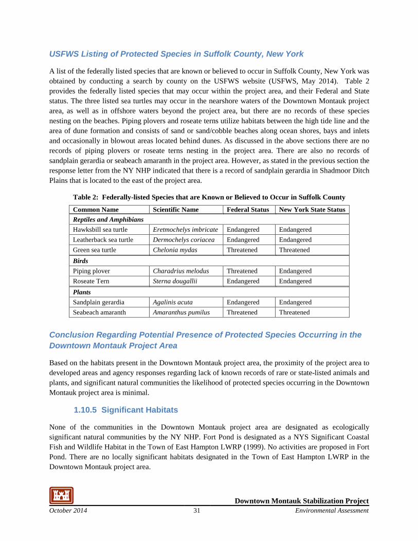
Downtown Montauk Stabilization Project October 2014 31 Environmental Assessment
USFWS Listing of Protected Species in Suffolk County, New York
A list of the federally listed species that are known or believed to occur in Suffolk County, New York was obtained by conducting a search by county on the USFWS website (USFWS, May 2014). Table 2 provides the federally listed species that may occur within the project area, and their Federal and State status. The three listed sea turtles may occur in the nearshore waters of the Downtown Montauk project area, as well as in offshore waters beyond the project area, but there are no records of these species nesting on the beaches. Piping plovers and roseate terns utilize habitats between the high tide line and the area of dune formation and consists of sand or sand/cobble beaches along ocean shores, bays and inlets and occasionally in blowout areas located behind dunes. As discussed in the above sections there are no records of piping plovers or roseate terns nesting in the project area. There are also no records of sandplain gerardia or seabeach amaranth in the project area. However, as stated in the previous section the response letter from the NY NHP indicated that there is a record of sandplain gerardia in Shadmoor Ditch Plains that is located to the east of the project area.
Table 2: Federally-listed Species that are Known or Believed to Occur in Suffolk County
Common Name Scientific Name Federal Status New York State Status Reptiles and Amphibians Hawksbill sea turtle Eretmochelys imbricate Endangered Endangered Leatherback sea turtle Dermochelys coriacea Endangered Endangered Green sea turtle Chelonia mydas Threatened Threatened Birds Piping plover Charadrius melodus Threatened Endangered Roseate Tern Sterna dougallii Endangered Endangered Plants Sandplain gerardia Agalinis acuta Endangered Endangered Seabeach amaranth Amaranthus pumilus Threatened Threatened
Conclusion Regarding Potential Presence of Protected Species Occurring in the Downtown Montauk Project Area
Based on the habitats present in the Downtown Montauk project area, the proximity of the project area to developed areas and agency responses regarding lack of known records of rare or state-listed animals and plants, and significant natural communities the likelihood of protected species occurring in the Downtown Montauk project area is minimal.
1.10.5 Significant Habitats
None of the communities in the Downtown Montauk project area are designated as ecologically significant natural communities by the NY NHP. Fort Pond is designated as a NYS Significant Coastal Fish and Wildlife Habitat in the Town of East Hampton LWRP (1999). No activities are proposed in Fort Pond. There are no locally significant habitats designated in the Town of East Hampton LWRP in the Downtown Montauk project area.
Downtown Montauk Stabilization Project October 2014 32 Environmental Assessment
1.11 Noise and Air Quality
1.11.1 Noise
Land uses in the project area include primarily hotels with some single-family residences, both of which are sensitive to increased noise levels. Due to the short construction duration of the proposed project, no noise monitoring has been collected. The proposed project would be constructed during the fall, winter and spring months prior to the main influx of the tourism season. As a result, existing noise levels are representative of typical off-season, ocean-front communities with daytime noises dominated by the sounds of waves crashing on the beach, along with typical residential noises from vehicle traffic, residents, off-season tourists, and the downtown business district.
1.11.2 Air Quality
Based on the National Ambient Air Quality Standards (NAAQS), Suffolk County is currently classified as “marginal” nonattainment for the 2008 8-hour ozone standard and nonattainment of the 2006 particulate matter less than 2.5 microns (PM2.5) standard. The county is part of the Ozone Transport Region. Ozone is controlled through the regulation of its precursor emissions, which include oxides of nitrogen (NOx) and volatile organic compounds (VOCs). Sulfur dioxide (SO2) is a precursor for PM2.5. The combination of these designations and that the project is a Federal Action taken by the USACE, mean that this project triggers General Conformity Review under 40CFR§93.154 (see Attachment B).
Downtown Montauk Stabilization Project October 2014 33 Environmental Assessment
ENVIRONMENTAL IMPACTS 1.12 No Action Alternative
The No Action alternative does not imply “no action”, but rather represents a continuation of the status quo. No Action as an alternative would entail allowing the processes of erosion, drift, and redeposition to occur with minimal human interference. The only measures undertaken under No Action would be periodic sand replenishment as currently done by the community. Under No Action, only non-Federal emergency measures could provide storm damage protection of the south shore of Long Island until FIMP is implemented. With the No Action Alternative, a catastrophic storm will likely result in major damage to structures and possibly human safety, since the majority of the Downtown Montauk project area lies within the 100-year flood plain. Therefore, even no action has negative environmental consequences, since during catastrophic storm events, no action will probably mean a loss of property and potentially even human life. Since the No Action alternative does not meet the needs of the downtown Montauk community, it is not the preferred alternative.
The following subsections discuss the potential environmental consequences on the topics evaluated that would be expected to occur with the No Action Alternative.
1.12.1 Human Environment
Land Use
Under the No Action Alternative, beach change and erosion would continue in the Downtown Montauk project area. This would result in reduced beach frontage and increased potential for structural damage and loss of business and residences. Business and residential structures located in low-lying areas would experience increased flooding and tidal surges potentially leading to extensive damages to structures and their contents as well as possible utility service interruptions.
Storms analogous to historic trends, consisting of frequent minor to moderate events, are likely to result in moderate adverse impacts to land use and the community, with repeat damage to structures followed by subsequent rebuilding. These impacts would be expected to be short to long term, depending on storm frequency and severity.
A single catastrophic storm event is likely to result in severe adverse impacts to land use and the community, including loss of structures. These impacts would be expected to be long term.
Socioeconomics
As discussed previously, businesses in the Downtown Montauk project area, including restaurants, bars, hotels and other commercial enterprises would all experience decreased activity as a result of minor or catastrophic storm events. The No Action Alternative would not provide protective benefits to businesses or residents in the downtown Montauk area. Physical damage to businesses as well as lost revenues would have negative economic and fiscal impacts on these commercial operations. Individuals would also suffer economic setbacks through loss of property, loss of jobs, or both.
Downtown Montauk Stabilization Project October 2014 34 Environmental Assessment
Storms analogous to historic trends, consisting of frequent minor to moderate events, are likely to result in moderate adverse social and economic impacts, with repeated financial losses especially difficult. These impacts would be expected to be short to long term, depending on storm frequency and severity.
The No Action alternative would have a significant adverse impact on the commercial enterprises in the project area. A single catastrophic storm event is likely to result in severe adverse social and economic impacts. These impacts would be expected to be long term.
Transportation
Under the No Action alternative transportation in the Downtown Montauk project area could be significantly affected if flooding washed out portions of neighborhood streets and local roads. In addition, parking areas could be inundated or damaged, preventing access to parts of the downtown Montauk area. Storms analogous to historic trends, consisting of frequent minor to moderate events are likely to result in moderate adverse impacts to transportation with repeat damage to roadways and transportation facilities and associated inconvenience and/or hardship to residents and visitors. These impacts could be expected to be short to long term depending on storm frequency and severity.
A single catastrophic storm event is likely to result in severe impacts to transportation, including potential loss of roadways, travel routes, and parking areas. These impacts would be expected to be long-term. Loss of essential transportation, including emergency services, could have severe repercussions during an emergency situation and could severely hinder rebuilding efforts.
Recreation/Parks
Given the increased future vulnerability to flooding, portions of public beaches could be temporarily (or permanently) lost and/or difficult to access in portions of the Downtown Montauk project area, resulting in lost recreation opportunities for beach-goers. Furthermore, roadways and parking areas used by beach-goers may be damaged or rendered inaccessible due to flooding of the areas adjacent to the beaches, further limiting accessibility.
Storms analogous to historic trends, consisting of frequent minor to moderate events, are likely to result in moderate adverse impacts to recreation, with repeated loss and disruption of recreational opportunities. These impacts would be expected to be short to long term, depending on storm frequency and severity.
A single catastrophic storm event is likely to result in severe adverse impacts to recreation. These impacts would be expected to be long term.
Cultural Resources
There are no properties listed on State or National Registers of Historic Places within the APE (NYSOPRHP 2014). Most of the buildings in the Downtown Montauk project area were constructed in the 1950’s and later. The few older structures that remain in the downtown Montauk area include Second House which was built in 1797 and several Tudor Revival style structures constructed by Carl Fisher in the 1920’s. Although these properties are not listed on the National Register they may be eligible for
Downtown Montauk Stabilization Project October 2014 35 Environmental Assessment
listing. A single catastrophic storm event may result in severe adverse impacts to these structures. Due to the dynamic nature of the shoreline environment, no remnant archaeological resources are expected within the dune reinforcement footprint; however, the area is mapped as an archeologically sensitive area (NYSOPRHP 2014). The No Action Alternative would not directly impact any archaeological resources that may be present; however, continued erosion may expose buried resources.
1.12.2 Physical Environment
Geology/Geomorphology/Beaches and Dunes
Under the No Action Alternative, continued erosion could result in changes to the shoreline and geomorphologic characteristics of the beach in the Downtown Montauk project area. This would lead to progressive dune and shoreline retreat or degradation that could lead to increased risk beach and dune erosion. With the No Action Alternative, it is expected that the periodic beach replenishment operations currently conducted by the community would continue, offsetting the progressive erosion. The No Action Alternative would have moderate impacts on geomorphology, particularly beach and dune configuration.
Natural Resources/Habitats
Under the No-Action Alternative the habitats and species that utilize them would continue to be consistent with the current conditions. However, the shoreline would be expected to recede resulting in progressive dune and shoreline retreat or degradation, followed by subsequent sand placement by the community. Beach erosion would have moderate to major impacts on natural resources and habitats in the Downtown Montauk project area.
Listed Species and Significant Habitats
The Endangered Species Act (ESA) of 1973 mandates the protection from extinction of uncommon or threatened wildlife and plant species. Section 7(a) of the ESA requires Federal agencies to evaluate their actions with respect to any listed or proposed species or listed/proposed critical habitat. Section 7(a)(2) of the Act requires Federal agencies to insure that activities they authorize, fund, or carry out are not likely to jeopardize the continued existence of a listed species or will result in the destruction or adverse modification of its critical habitat. The responsible Federal agency must enter into formal consultation with the USFWS or NMFS if it determines that its action may affect a listed species or its critical habitat.
As stated in Section 3.3.4 the likelihood of listed species occurring in the Downtown Montauk project area is minimal. There are also no significant habitats in the project area. Therefore, the No Action Alternative would not have an impact on any listed species or significant habitats.
1.12.3 Noise and Air Quality
The No Action Alternative would not result in any defined construction activities. Therefore, the No Action Alternative would have no impacts to noise or air quality.
Downtown Montauk Stabilization Project October 2014 36 Environmental Assessment
1.13 Dune Reinforcement Alternative Selected Plan
The Dune Reinforcement Alternative consists of dune reinforcement along 3,100 linear feet of the shoreline, waterward of existing shoreline structures in downtown Montauk. The Dune Reinforcement Alternative includes placement of approximately 14,171 sand filled geotextile bags placed below the sand fill. This alternative requires approximately 71,000 cubic yards of sand, 51,000 of which will be obtained from upland sources rather than offshore borrow areas.
The following subsections discuss the potential environmental consequences on the impact topics evaluated that would be expected to occur with the Dune Reinforcement Alternative.
1.13.1 Human Environment
Land Use
The construction activities for the Dune Reinforcement Alternative are limited to the shoreline, waterward of existing shoreline structures in downtown Montauk. Therefore, the Dune Reinforcement Alternative would not have a negative impact on the land use in Downtown Montauk project area. The proposed project would help prevent damage to and/or the loss of hotels and restaurants in the Downtown Montauk project area. Therefore the proposed project would have a positive impact on the land use in the project area. Due to the reduced likelihood of breaching and inundation of the bayshore, residential, recreational and commercial structures are much less likely to be damaged or destroyed, access to homes and businesses are less likely to be interrupted, and utility service is less likely to be disrupted.
Storms analogous to historic trends, consisting of frequent minor to moderate events, are likely to result in minor adverse impacts to land use and communities, with repeat damage to structures followed by subsequent rebuilding. These impacts would be expected to be short term, depending on storm frequency and severity.
A single catastrophic storm event is likely to result in moderate adverse impacts to land use and communities. The extent of damage would depend on the severity of the storm. Localized damages would be expected. These impacts would be expected to be short term, depending on storm frequency and severity.
Socioeconomics
Overall, the Downtown Montauk TSP is expected to yield annual storm damage reduction benefits estimated at $1,052,000. Additional details on the analysis of economic benefits of the TSP are presented in the Main Report for this project.
Shorefront structures in downtown Montauk would be negatively impacted if directly subject to waves and tidal surges, as would occur in the absence of a protective dune. With the Downtown Montauk Stabilization Project, a reinforced dune would be constructed along the shoreline, providing protection to vulnerable structures. Implementation of the Downtown Montauk TSP would protect residential, recreational, and commercial structures in the project area. With the Dune Reinforcement Alternative,
Downtown Montauk Stabilization Project October 2014 37 Environmental Assessment
structures are much less likely to be damaged or destroyed, access to the businesses is less likely to be interrupted, and utility service is less likely to be disrupted. Erosion of the reinforced dune could add to the quantity of material requiring removal from inland streets and properties following storms; however, any increase in sand quantity is not expected to be substantially different from the No Action Alternative. In addition, the financial cost and impact to the community in terms of disruption of daily life would be substantially less from any increased sand removal than would occur with damages to homes, businesses and infrastructure and associated need for rebuilding and repairs.
Storms analogous to historic trends, consisting of frequent minor to moderate events, are likely to result in minor adverse social and economic impacts. These impacts would be expected to be short term.
A single catastrophic storm event is likely to result in moderate adverse impacts to land use and communities. The degree of negative impact would depend on the severity of the storm. These impacts would be expected to be short term.
The construction activities would not occur during the summer tourist season. Therefore, the Dune Reinforcement Alternative would not have a negative effect on the socioeconomics in the project area during the summer tourist season.
Transportation
With the Dune Reinforcement Alternative, adverse effects to traffic, transportation, access, and circulation that are expected under the No Action Alternative would be reduced. The existing road network would continue to function. Some level of post-storm clean up of sand and debris would be anticipated, and the volume of sand may be increased as a result of dune erosion or failure. The sand and debris clean-up would be accomplished more readily than rebuilding of transportation infrastructure to the extent that would be needed without the project. The transportation network could be restored quickly with the Dune Reinforcement Alternative as major damages would be reduced.
Storms analogous to historic trends, consisting of frequent minor to moderate events, are likely to result in minor adverse impacts to transportation, consisting primarily of inconvenience to residents and visitors due to minor roadway flooding. These impacts would be expected to be short term, depending on storm frequency and severity.
A single catastrophic storm event is likely to result in minor to moderate adverse impacts to transportation. While some flooding and minor road damage could occur, there would be no loss of transportation systems. These impacts would be expected to be short term and there would be no loss of essential transportation, including for emergency services.
The Dune Reinforcement Alternative would utilize upland sand sources and would result in approximately 2,762 truck round trips from Wainscott, NY, or an alternate sand source nearby, to the Downtown Montauk project area over the three month construction duration. Truck trips would occur from roughly 7:00 a.m. to 5:00 p.m., seven days per week over a three month period. On average approximately 30 truck round trips per day (3/hour) is expected. The construction activities would not occur during the summer tourist season, when traffic is at its peak. Considering that average annual daily
Downtown Montauk Stabilization Project October 2014 38 Environmental Assessment
traffic volume on Montauk Highway in the project vicinity is roughly 8,000 vehicles, an off season increase of approximately 30 trucks per day would not be noticeable along Montauk Highway. During transport through local streets, residents and businesses would likely notice the additional truck traffic; however, the duration would be short term. Therefore, the Dune Reinforcement Alternative would not have a significant adverse effect on existing transportation in the project area during the summer tourist season. However, the increased truck traffic would result in a minor impact to local transportation during the three month construction period.
Recreation/Parks
During construction the Dune Reinforcement Alternative would prevent the use of the beaches in the project area including a small portion of Kirk Park Beach. There would be a temporary impact on recreational use of the area during the construction period. However, the construction activities would not occur during the summer tourist season. The proposed project would prevent the loss of beaches in the project area. Therefore the proposed project will have a positive impact on the recreational use in the project area.
Storms analogous to historic trends, consisting of frequent minor to moderate events, are likely to result in minor adverse impacts to recreation, with loss and disruption of recreational opportunities limited primarily to post storm clean-up of fallen vegetation and debris and minor repair to structures. These impacts would be expected to be short term.
A single catastrophic storm event is likely to result in moderate adverse impacts to recreation. These impacts would be expected to be localized and relatively short term.
Cultural Resources
There are no properties listed on State or National Registers of Historic Places within the APE (NYSOPRHP 2014). Most of the buildings in the Downtown Montauk project area were constructed in the 1950’s and later. The few older structures that remain in the downtown Montauk area include Second House which was built in 1797 and several Tudor Revival style structures constructed by Carl Fisher in the 1920’s. Although they are not listed, these properties are likely eligible for the New York State and the National Registers. The construction activities for the Dune Reinforcement Alternative are limited to the shoreline, waterward of existing shoreline structures and therefore would not have an adverse affect on any of these structures. The added shoreline protection from the Dune Reinforcement Alternative would protect these structures from potential future storm damage. The increased truck traffic necessary to transport sand to the project area could cause vibrations that could damage older structures in the area. To minimize the potential for this impact, truck routes will avoid roads with sensitive structures to the extent practicable.
Due to the dynamic nature of the shoreline environment, no remnant archaeological resources are expected within the dune reinforcement footprint that could potentially be impacted. However, the area is mapped as archeologically sensitive (NYSOPRHP 2014.) Dune Reinforcement Alternative would further bury any subsurface resources that may be present, protecting them from erosion forces and exposure to the elements. The excavation of the project area for the geotextile sand containers may encounter
Downtown Montauk Stabilization Project October 2014 39 Environmental Assessment
archaeological resources, given the archaeological sensitivity of the area. The portion of the construction will be monitored to assess and allow consultation with the NYSHPO and the Advisory Council on Historic Preservation (ACHP) if resources are encountered. Work in the area of the find may be halted, as necessary, to permit documentation of any significant resources identified. A Memorandum of Agreement in accordance with the National Historic Preservation Act is provided in Attachment F.
1.13.2 Physical Environment
Geology/Geomorphology/Beaches and Dunes
The Dune Reinforcement Alternative includes the placement of sand filled geotextile bags below the sand fill along approximately 3,100 feet of shoreline. The dune reinforcement activities will take place waterward of existing shoreline structures to create a design beach and dune profile. There are three major ways that the proposed geotextile bags and sand cover could physically impact the coastal beach environment: 1) the deposited material covers the existing beach sediments, 2) the deposited material modifies the beach (sand/water) interface; and 3) the deposited material could increase the turbidity of the near shore area. Any impacts to water quality associated with the construction activities would be minor, localized and short term, limited to the construction phase of the project. The project would also alter the beach/dune profile substantially, reducing the potential for breaching and overwash during storm events and creating greater stability of this reach along the shoreline in the project area. The project would facilitate coastal processes, such as longshore sediment transport and dune development and evolution.
The existing dune volume in this area is significantly limited by infrastructure immediately adjacent landward. The existing dune volume is less than 10 cy/linear foot, and in some cases even less. It is not expected over the limited design life of this project that the dune in this project area will be a source of significant sand for the fronting berm. The project will have a fronting face of sand over the geotextile sand containers, which will be supplemented by dune plantings with the goal of keeping the sand in place for the effective life of the project.
The Dune Reinforcement extends from a toe elevation of +2 ft NAVD to a crest elevation of +12.5 ft NAVD. In order to increase the resiliency of the design and reduce the potential for undermining, the proposed design includes a 50 foot wide berm cap at +8.5 ft NAVD. The additional sediment will provide additional protection to the toe of the structure from undermining and decrease the likelihood of exposure of the GSCs during small storm events. It is estimated that the reinforced dune provides a level of protection of approximately 25 years (4% annual chance of design exceedance) and that the effective life of this type of structure would be approximately 15 years. Continued maintenance over the effective project life is required to maintain the sand dune cover, to eliminate impacts to adjacent shorelines and properties, and to also increase the longevity of the GSCs.
The proposed dune extends west to east from South Emery Street to Atlantic Terrace motel and tapers into a smooth transition into the high dunes at both ends of the project area, and is set back as far as possible into the existing dune alignment to eliminate flanking issues. The project alignment closely follows the existing dune contour. The elevation of the properties and dunes behind the reinforced dune is higher than the elevation of the reinforced dune. If waves overtop the structure, this is the result of a
Downtown Montauk Stabilization Project October 2014 40 Environmental Assessment
storm that is outside the designed level of protection. This reinforced dune is a permeable structure, if water overtops the dune it will flow back to the sea unrestricted. Water will not pond behind the structure.
Certain avulsive or erosive events can remove significant volumes of sand from the beach berm, resulting in reductions in the elevation and width of the beach berm feature. In the aftermath of such events, sand tends to move from the dunes onto the beach. Sand slips off the dune face onto the steeply sloping cut left by the storm as it reestablishes the natural angle of repose for the material grain size. Wind can also play a role in the movement of material. This phenomenon is expected to continue after the installation of the reinforced dune because the geotextile-bag core of the dune will be covered with a layer of beach compatible sand during initial construction and the maintenance provisions for the structure include formal, binding requirements for the regular observation and repair of the system, including the maintenance of the sand cover for its full service life. However, the movement of dune material onto the beach berm may be somewhat retarded due to the planting of dune grass to stabilize the oceanward face of dune.
The GSC Dune Reinforcement extends from a toe elevation of +2 ft NAVD to a crest elevation of +12.5 ft NAVD. In order to increase the resiliency of the design and reduce the potential for undermining of the dune reinforcement, the proposed design includes a 50 foot wide berm cap at +8.5 ft NAVD. The additional sediment will provide additional protection to the toe of the structure from undermining and decrease the likelihood of exposure of the GSCs during small storm events. Periodic maintenance operations are expected to occur during the life of the project to maintain a sand cover over the geotextile sand containers. These maintenance operations will contribute additional sediment to the system. It is estimated that the reinforced dune provides a level of protection of approximately 25 years (4% annual chance of design exceedance) and that the effective life of this type of structure would be approximately 15 years.
The toe elevation of the reinforced dune was selected to minimize the risk of scour and undermining under storm events with annual exceedance probability of 4% (25 year return period). Continued maintenance over the effective project life is required to maintain the sand dune cover and increase the longevity of the GSCs. If the bags are exposed, the sand filled geotextile containers will act more like a hard structure than an unreinforced sand dune when subject to wave attack. For this reason, the design includes:
1. The “Typical Section” of the geotextile sand bag reinforced dune includes a small sand-filled tube to anchor the bottom of a scour apron, designed to descend to an elevation of approximately 2-ft NAVD. The scour protection will resist undermining of the entire sand bag alignment in significant storm conditions.
2. The GSC’s must remain covered and sand shall be maintained following installation of the revetment structure to ensure that design service life may be achieved. The sand cover shall be placed as per the slopes and grades indicated in the Construction Plans and appropriate dune vegetation shall be planted and maintained to provide stabilization of the sand placed. These details are included in the construction specifications, Section 31 24 00.00 18 Beach Fill.
The reinforced dune system will not starve the surrounding areas of sand with the planned operations and maintenance requirements. The design includes smooth tapers at either end of the project area to prevent
Downtown Montauk Stabilization Project October 2014 41 Environmental Assessment
localized erosion at the ends of the project. The tapers angle landward into the existing high dunes at the east and west ends of the project boundaries. The GSC’s remain at a full design cross section throughout the length of the tapers. The structure is located as far landward on the beach as practicable to reduce the number of storm events in which the geotextiles will be uncovered, while meeting real estate easement requirements.
The proposed reinforced dune design includes tapers at both ends of the project to provide a smooth transition into the high dunes. The reinforced dune is set back as far as possible into the existing dune alignment to minimize flanking issues. The alignment closely follows the existing dune contour.
The tapers at both ends of the project are designed to prevent flanking and decrease the risk of creating a pathway for water captured behind the reinforced dune from flowing out towards the unhardened dunes at either end of the project. It is unlikely that water will pond behind the structure even at strom events larger than the design storm; the elevation of the properties and dunes behind the reinforced dune is higher than the elevation of the reinforced dune and the reinforced dune will be constructed as landward as possible. It is not possible to include shore perpendicular sections of bags behind the GSC structure (similar to bulkhead returns) due to easement issues.
.
1.13.3 Natural Resources/Habitats
Impacts to living natural resources in the Downtown Montauk project area would be associated with direct impacts related to sand placement along the ocean shoreline of downtown Montauk for reinforced dune construction. Impacts to natural resources are discussed in the remainder of this section, with discussion grouped by ecosystem type.
Marine Nearshore Habitat of the Atlantic Shores Ecosystem
The Dune Reinforcement Alternative would not directly impact the nearshore habitat, as all sand placement for dune reinforcement would be located landward of MLW. No impact to macroinvertebrates, finfish, marine mammals, reptiles or birds of the marine nearshore habitat is anticipated.
Marine Intertidal Habitat of the Atlantic Shores Ecosystem
The Dune Reinforcement Alternative would not directly result in deposition of materials within the marine intertidal habitat, as all sand placement for dune reinforcement would be located landward of MHW. Incidental deposition of material in the intertidal zone could occur, however, the deposition would not be expected to be substantially different from normal conditions in this dynamic habitat, except for short durations. The Dune Reinforcement Alternative is expected to have limited temporary impact on marine invertebrates in this habitat, as a result of sand transport beyond the placement area as runoff during rain events or by wave action during storms or spring tides. No impact to finfish, marine mammals, reptiles or birds is anticipated.
Downtown Montauk Stabilization Project October 2014 42 Environmental Assessment
Marine Beach and Dunes and Swales of the Atlantic Shores Ecosystem
The Dune Reinforcement Alternative would result in the direct placement of sand on the existing dunes, altering the dune profile substantially. The dune reinforcement activities would impact the approximately 3,100 feet existing marine beach and dune habitat along the downtown Montauk shoreline waterward of the existing shoreline structures. The construction activities would have a direct impact on the invertebrate species and plants that are found in these habitats, as those present in the project limits would be buried. Due to the extensive human use of the beach and dune habitat within the project area, the presence of most wildlife species is expected to be limited, particularly during the summer tourist season, as compared to less developed stretches of the island. Invertebrate species that are impacted by the construction activities would likely recolonize the area within approximately one year following construction. The proposed reinforced dune alignment is adjacent to downtown structures; although terrestrial mammals, reptiles and amphibians are found in the project area, use of the sand placement area by resident wildlife is expected to be minimal. Similarly, there are no shorebird nesting areas within the dune alignment footprint or construction area. No impact to terrestrial wildlife or birds which utilize the marine beach and dune habitats is anticipated.
Freshwater Pond
The Dune Reinforcement Alternative would not directly impact the freshwater pond habitat as all sand placement is along the Atlantic shoreline. At the western end of the reinforced dune alignment, there’s approximately 700 feet of mixed development and dune and swale habitat separating the Fort Pond from the marine beach. The Dune Reinforcement Alternative may afford additional protection from breaching along this narrow swath of land, thereby benefiting the freshwater pond habitat by protecting it from sand overwash and saltwater intrusion.
Listed Species and Significant Habitats
As stated in Section 3.3.4, the likelihood of listed species occurring in the Downtown Montauk project area is minimal. Therefore, the Dune Reinforcement Alternative would not have an impact on any listed species. Fort Pond is designated as a NYS Significant Coastal Fish and Wildlife Habitat in the Town of East Hampton 2007 LWRP report. No activities are proposed in, or adjacent to, Fort Pond. There are no additional habitats in the project area that are designated as significant habitats. Therefore, the Dune Reinforcement Alternative will not have an impact on any significant habitats.
1.13.4 Noise and Air Quality
Noise Impacts
While the implementation of the No-Action Alternative or the Dune Reinforcement Alternative would not change existing noise levels, the estimated three-month construction process has the potential to increase noise levels during that time period. Construction activities would include both on-road truck traffic for sand hauling to the job site and non-road construction vehicles to construct the dune reinforcement along 3,100 feet of the shoreline. On-road sources of noise include approximately 2,762 truck round trips from Wainscott, NY, or an alternate sand source location, to the Downtown Montauk project area over the
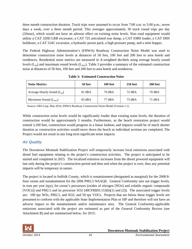
Downtown Montauk Stabilization Project October 2014 43 Environmental Assessment
three month construction duration. Truck trips were assumed to occur from 7:00 a.m. to 5:00 p.m., seven days a week, over a three month period. This averages approximately 30 truck round trips per day (3/hour), which would not have an adverse effect on existing noise levels. Non–road equipment would utilize a CAT 320D LRR excavator, a CAT 725 articulated rear dump, a CAT 938H loader, a CAT D6N bulldozer, a CAT 314C excavator, a hydraulic power pack, a high pressure pump, and a mini hopper.
The Federal Highway Administration’s (FHWA) Roadway Construction Noise Model was used to determine construction noise levels at distances of 50 feet, 100 feet and 200 feet to area hotels and residences. Residential noise metrics are measured in A-weighted decibels using average hourly sound levels (Leq) and maximum sound levels (Lmax). Table 3 provides a summary of the estimated construction noise at distances of 50 feet, 100 feet and 200 feet to area hotels and residences.
Table 3: Estimated Construction Noise
Noise Metrics 50 feet 100 feet 150 feet 200 feet
Average Hourly Sound (Leq) 81 dBA 76 dBA 72 dBA 70 dBA
Maximum Sound (Lmax) 83 dBA 77 dBA 73 dBA 71 dBA
Source: URS Corp. May 2014, FHWA Roadway Construction Noise Model (Version 1.1)
While construction noise levels would be significantly louder than existing noise levels, the duration of construction would be approximately 3 months. Furthermore, as the beach restoration project would extend 3,100 feet, construction would progress in a linear fashion, and impacts would be of much shorter duration as construction activities would move down the beach as individual sections are completed. The Project would not result in any long term significant noise impacts.
Air Quality
The Downtown Montauk Stabilization Project will temporarily increase local emissions associated with diesel fuel equipment relating to the project’s construction activities. The project is anticipated to be started and completed in 2015. The localized emission increases from the diesel powered equipment will last only during the project’s construction period and then end when the project is over, thus any potential impacts will be temporary in nature.
The project is located in Suffolk County, which is nonattainment (designated as marginal) for the 2008 8-hour ozone and nonattainment for the 2006 PM2.5 NAAQS. General Conformity sets out trigger levels, in tons per year (tpy), for ozone’s precursors (oxides of nitrogen [NOx] and volatile organic compounds [VOCs]) and PM2.5 and its precursor SO2 (40CFR§93.153(b)(1) and (2)). The associated trigger levels are: 100 tpy NOx, PM2.5, and SO2; and 50 tpy VOCs. Projects that are below these trigger levels are presumed to conform with the applicable State Implementation Plan or SIP and therefore will not have an adverse impact to the nonattainment and/or maintenance area. The General Conformity-applicable emissions associated with the project are estimated as part of the General Conformity Review (see Attachment B) and are summarized below, for 2015:
Downtown Montauk Stabilization Project October 2014 44 Environmental Assessment
NOx 9.5 tons VOC 0.2 tons PM2.5 0.2 tons SO2 <0.1 tons
The Downtown Montauk Stabilization Project estimated General Conformity-applicable emissions of NOx, VOC, PM2.5, and SO2 are all significantly below their respective trigger levels and therefore, by rule are de minimis and the project will have only a temporary minimal impact around the construction activities with no significant impacts.
1.14 Other Environmental Considerations
1.14.1 Irreversible and Irretrievable Commitment of Resources
The Dune Reinforcement Alternative consists of dune reinforcement along 3,100 ft of the shoreline, waterward of existing shoreline structures in downtown Montauk. The Dune Reinforcement Alternative includes placement of sand filled geotextile bags below the sand fill utilizing approximately 51,000 cy of sand from upland sand sources. Sand will not be irreversibly or irretrievably committed to this project, as it will be subject to natural littoral processes following placement. No irreversible or irretrievable commitment of resources will occur as a result of this project.
1.14.2 Cumulative Impacts
The Council on Environmental Quality (CEQ) definition of cumulative impacts as found in 40 Code of Federal Regulation (CFR) Section 1508.7 is as follows: "Cumulative Impact is the impact on the environment which results from the incremental impact of the action when added to other past, present and reasonably foreseeable future actions regardless of what agency (Federal or nonfederal) or persons undertakes such other acts." Repeated beach renourishment projects, as well as implementation of other emergency projects, may result in cumulative impacts to resources impacted by the overall the Downtown Montauk Stabilization Project area.
With the exception of the authorized but unconstructed Montauk Point Shoreline Stabilization Project, Federal shoreline stabilization projects on the south shore of Long Island are west and down-drift (long-shore current and ocean shoreline sand generally runs east to west of the project site and would not contribute to the cumulative impacts of this project. The Montauk Point project involves the installation of stone revetment which, while it could cause down-drift erosion adjacently west of that project area, is approximately 4.5 mi. east of the Downtown Montauk project area is therefore not expected to significantly contribute to the cumulative impacts of the proposed action.
Other than beach nourishment projects, local/state actions that are reasonably certain to occur in the project area that could potentially affect fish and wildlife resources include beach maintenance (raking and cleaning), the installation of sand fencing, continued recreational activity, and the maintenance of the proposed action to maintain the sand dune cover to increase the longevity of the proposed alternative.
Downtown Montauk Stabilization Project October 2014 45 Environmental Assessment
The cumulative impact assessment of federal nourishment projects on the south shore of Long Island indicate that federal project actions would occur in a dynamic environment whose biotic inhabitants have adapted to these conditions. Studies indicate that borrow area and sand placement areas re-colonize shortly after construction activities are completed. Unlike several of the other projects proposed along the south shore of Long Island the Downtown Montauk project does not propose the use of an offshore borrow area and therefore would not add to the cumulative impacts to the offshore benthic environment. Relative to the categorization provided within Council on Environmental Quality guidance, the cumulative impacts of the Federal projects in the Study Area can be characterized as additive. The impacts are also interactive in that the stabilization of barrier beaches and mainland shoreline may alter/prevent early successional communities such as maritime beach from evolving in overwash areas.
Maintenance of the proposed action by the Town of Easthampton and/or the state of New York is expected after the one-time Corps project is complete. Maintenance activities could include: beach scraping (moving of sand existing on the beach to eroded areas); beach nourishment (upland or off-shore borrow areas); installation of sand fencing and/or beach grass plantings; or replacement of damaged GSCs. Each of these activities could have impacts to fish and wildlife resources addressed in the project area.
The area immediately adjacent to the beach and dunes in the Downtown Montauk project area is fully developed and consists of hotels, commercial and residential structures. Therefore, there is no opportunity for early successional communities to evolve in overwash areas in the project area. The extent of these cumulative impacts will be fully vetted in the EIS prepared for the Reformulation Project.
Cumulative impacts of the Downtown Montauk Stabilization Project alternatives evaluated in this EA are discussed in the following paragraphs.
Cumulative Impacts of the No Action Alternative. With the No Action Alternative there would likely be periodic sand placement as a result of local initiatives; however, there would be no federal contribution to the sand placement area in advance of the FIMP Project implementation. The biotic communities in the sand placement would be expected to recover between stabilization projects and abiotic conditions, such as water quality, would be expected to return to pre-disturbance conditions. Cumulative impacts of the No Action Alternative would be most noticeable in the event of a severe storm and resultant damages to structures and the community.
Cumulative Impact of the Preferred Alternative. The cumulative impacts of the Federal projects in the Study Area are uncertain. The coastal barriers were originally created by natural processes without human intervention. These natural processes redistribute sand in the nearshore environment in response to gradual erosion and storm events. Once coastal barriers are manipulated by human interventions, which Fire Island has undergone through maintenance of the inlets at either end of the island, they are no longer able to maintain their natural equilibrium. In combination with sea level rise, lower shoreface erosion, bayshore inundation and continuing natural sediment transport processes, the long-term effect of sand placement and prevention of breaches on the coastal barriers is uncertain.
Downtown Montauk Stabilization Project October 2014 46 Environmental Assessment
The impacts are also interactive in that the stabilization of barrier beaches and mainland shoreline may alter/prevent early successional communities such as maritime beach from evolving in overwash areas. The natural barrier beach environment exists in a continually changing state of "dynamic equilibrium" that depends on the size of the waves, changes in sea level relative to the land, the shape of the beach, and the beach sand supply. When any one of these factors changes, the others adjust accordingly. Development patterns that have built up over the years took place prior to coastal regulation and research on coastal barrier island behavior and sea level rise. Under the cumulative effect of natural processes acting on an environment altered by human intervention the proposed Downtown Montauk TSP mediates between managing risk to the community and natural processes. The additive damages to homes, businesses, the area’s recreational resources, and its economy would be reduced by the Downtown Montauk proposed plan. The use of natural and nonrenewable resources in the salvage, repair, and reconstruction in the aftermath of storm damage would also be reduced. The Downtown Montauk plan maintains the opportunity for long-term management plans in the project area to incorporate natural processes and sea level rise adaptation within risk reduction and community resilience strategies.
Under extreme storm conditions coupled with deterioration of the geotextile fabric of the sand bags, sections or strands of the polypropylene fabric could be released into the environment, contributing to the cumulative inputs of foreign, non-biodegradable debris released to the environment from anthropogenic sources. Strands of material, such as polypropylene, plastic fishing line, etc., poses direct risk to marine life, including marine mammals, sea turtles, and birds as well as fishes, as they can become entangled and unable to swim or feed normally, resulting in injury or mortality. Ultraviolet radiation is expected to degrade the geotextile material into small pieces; reducing the potential for entanglement. Small pieces of foreign matter, particularly plastics, such as the geotextile, pose a physical threat to marine life and can contribute to both direct and indirect impacts on the environment and aquatic species. Ingestion of such materials can physically harm the intestinal tract, or can contribute to malnutrition. Plastic debris accumulated on shorelines or on estuarine and ocean bottoms can damage plants and habitat and prevent re-establishment of native communities, as well as harbor contagions. (USEPA 2014).
Measures to Minimize Cumulative Impacts
The Corps will implement the following measures that will avoid and/or minimize some of the project’s impacts to fish and wildlife resources:
• The GSCs will be buried with sand to provide suitable dune habitat. • The grain size of the sand used to bury the GSCs is the same or slightly larger than the native sediment. • The project is designed to maximize the stability of the GSCs and reduce the potential for undermining and exposure of the GSC which would diminish habitat suitability for affected species. • 45,000 cy of sand will be obtained from upland sediment sources and will avoid off-shore borrow area ocean bottom disturbances.
The majority of unavoidable impacts associated with the identified federal projects are likely to occur within the borrow areas. The Downtown Montauk TSP will not contribute to these impacts as upland sand sources will be utilized instead of offshore borrow areas. Thus the cumulative effects of this Federal
Downtown Montauk Stabilization Project October 2014 47 Environmental Assessment
Stabilization project are minimized. Implementation of the maintenance plan for the preferred alternative will minimize the environmental impacts associated with potential deterioration of the geotextile bags and subsequent release to the environment. Also the geotextile bags are not made of plastic and therefore would not be ingested by marine life which similarly happens with clear plastic material.
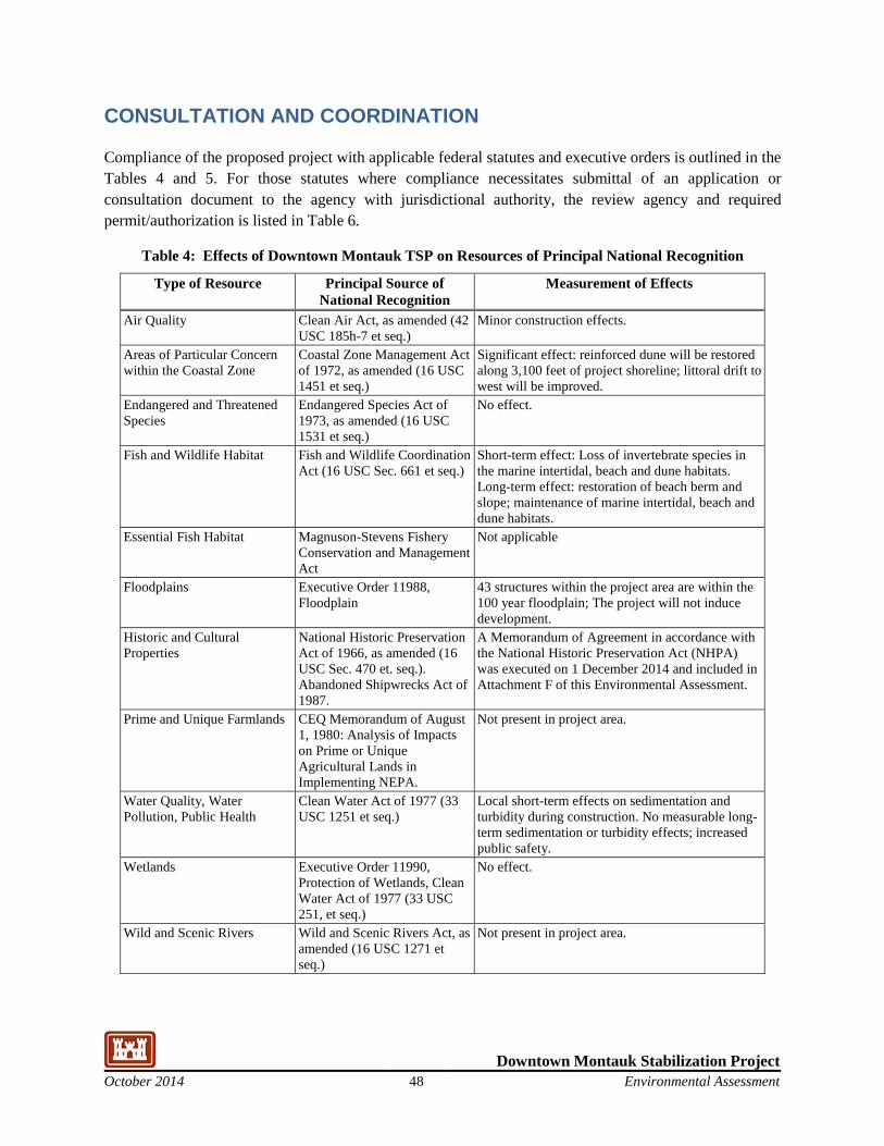
Downtown Montauk Stabilization Project October 2014 48 Environmental Assessment
CONSULTATION AND COORDINATION
Compliance of the proposed project with applicable federal statutes and executive orders is outlined in the Tables 4 and 5. For those statutes where compliance necessitates submittal of an application or consultation document to the agency with jurisdictional authority, the review agency and required permit/authorization is listed in Table 6.
Table 4: Effects of Downtown Montauk TSP on Resources of Principal National Recognition
Type of Resource Principal Source of National Recognition
Measurement of Effects
Air Quality Clean Air Act, as amended (42 USC 185h-7 et seq.)
Minor construction effects.
Areas of Particular Concern within the Coastal Zone
Coastal Zone Management Act of 1972, as amended (16 USC 1451 et seq.)
Significant effect: reinforced dune will be restored along 3,100 feet of project shoreline; littoral drift to west will be improved.
Endangered and Threatened Species
Endangered Species Act of 1973, as amended (16 USC 1531 et seq.)
No effect.
Fish and Wildlife Habitat Fish and Wildlife Coordination Act (16 USC Sec. 661 et seq.)
Short-term effect: Loss of invertebrate species in the marine intertidal, beach and dune habitats. Long-term effect: restoration of beach berm and slope; maintenance of marine intertidal, beach and dune habitats.
Essential Fish Habitat Magnuson-Stevens Fishery Conservation and Management Act
Not applicable
Floodplains Executive Order 11988, Floodplain
43 structures within the project area are within the 100 year floodplain; The project will not induce development.
Historic and Cultural Properties
National Historic Preservation Act of 1966, as amended (16 USC Sec. 470 et. seq.). Abandoned Shipwrecks Act of 1987.
A Memorandum of Agreement in accordance with the National Historic Preservation Act (NHPA) was executed on 1 December 2014 and included in Attachment F of this Environmental Assessment.
Prime and Unique Farmlands CEQ Memorandum of August 1, 1980: Analysis of Impacts on Prime or Unique Agricultural Lands in Implementing NEPA.
Not present in project area.
Water Quality, Water Pollution, Public Health
Clean Water Act of 1977 (33 USC 1251 et seq.)
Local short-term effects on sedimentation and turbidity during construction. No measurable long-term sedimentation or turbidity effects; increased public safety.
Wetlands Executive Order 11990, Protection of Wetlands, Clean Water Act of 1977 (33 USC 251, et seq.)
No effect.
Wild and Scenic Rivers Wild and Scenic Rivers Act, as amended (16 USC 1271 et seq.)
Not present in project area.
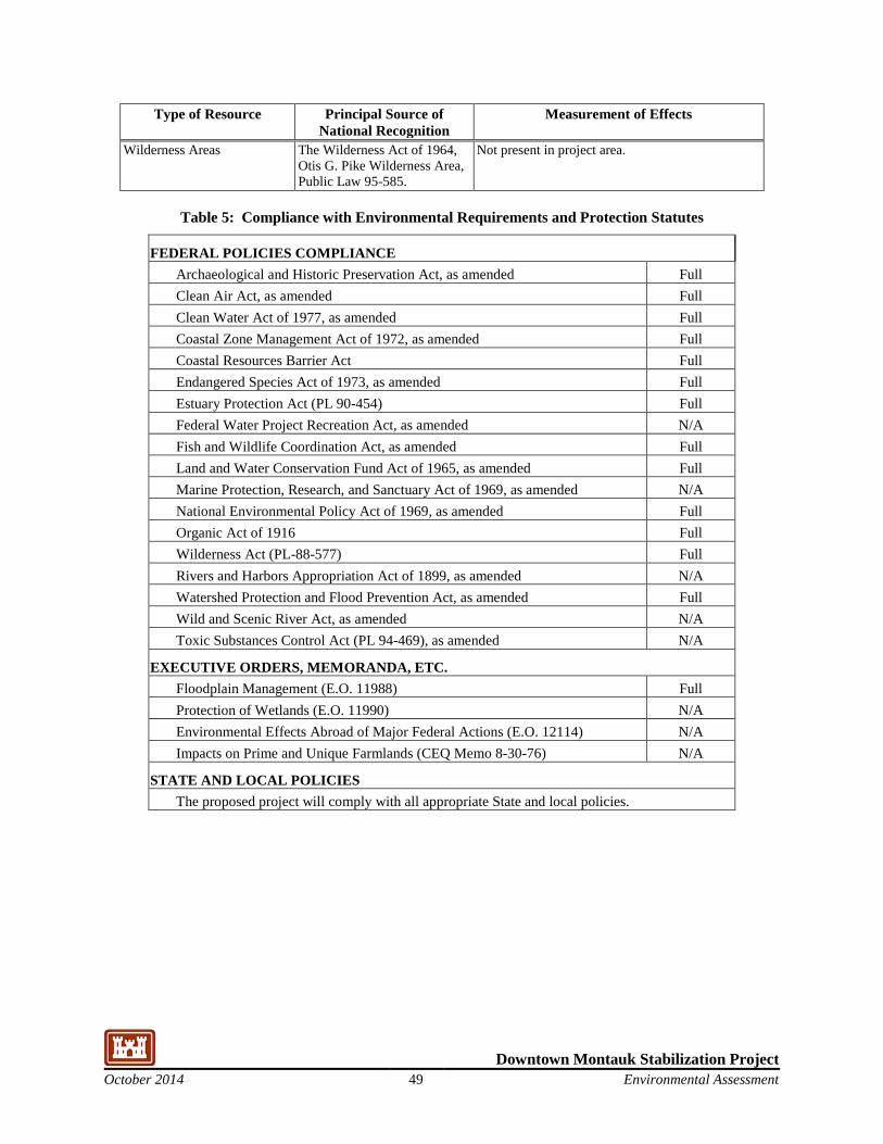
Downtown Montauk Stabilization Project October 2014 49 Environmental Assessment
Type of Resource Principal Source of National Recognition
Measurement of Effects
Wilderness Areas The Wilderness Act of 1964, Otis G. Pike Wilderness Area, Public Law 95-585.
Not present in project area.
Table 5: Compliance with Environmental Requirements and Protection Statutes
FEDERAL POLICIES COMPLIANCE Archaeological and Historic Preservation Act, as amended Full Clean Air Act, as amended Full Clean Water Act of 1977, as amended Full Coastal Zone Management Act of 1972, as amended Full Coastal Resources Barrier Act Full Endangered Species Act of 1973, as amended Full Estuary Protection Act (PL 90-454) Full Federal Water Project Recreation Act, as amended N/A Fish and Wildlife Coordination Act, as amended Full Land and Water Conservation Fund Act of 1965, as amended Full Marine Protection, Research, and Sanctuary Act of 1969, as amended N/A National Environmental Policy Act of 1969, as amended Full Organic Act of 1916 Full Wilderness Act (PL-88-577) Full Rivers and Harbors Appropriation Act of 1899, as amended N/A Watershed Protection and Flood Prevention Act, as amended Full Wild and Scenic River Act, as amended N/A Toxic Substances Control Act (PL 94-469), as amended N/A
EXECUTIVE ORDERS, MEMORANDA, ETC. Floodplain Management (E.O. 11988) Full Protection of Wetlands (E.O. 11990) N/A Environmental Effects Abroad of Major Federal Actions (E.O. 12114) N/A Impacts on Prime and Unique Farmlands (CEQ Memo 8-30-76) N/A
STATE AND LOCAL POLICIES The proposed project will comply with all appropriate State and local policies.
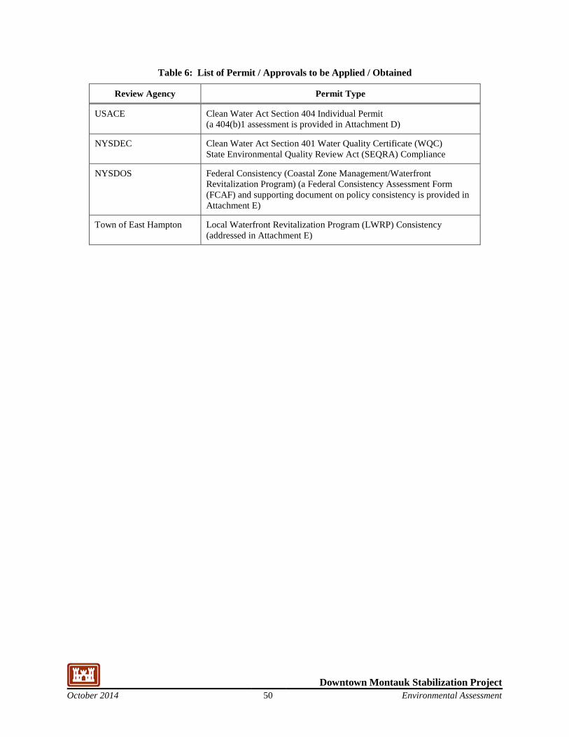
Downtown Montauk Stabilization Project October 2014 50 Environmental Assessment
Table 6: List of Permit / Approvals to be Applied / Obtained
Review Agency Permit Type
USACE Clean Water Act Section 404 Individual Permit (a 404(b)1 assessment is provided in Attachment D)
NYSDEC Clean Water Act Section 401 Water Quality Certificate (WQC) State Environmental Quality Review Act (SEQRA) Compliance
NYSDOS Federal Consistency (Coastal Zone Management/Waterfront Revitalization Program) (a Federal Consistency Assessment Form (FCAF) and supporting document on policy consistency is provided in Attachment E)
Town of East Hampton Local Waterfront Revitalization Program (LWRP) Consistency (addressed in Attachment E)
Downtown Montauk Stabilization Project October 2014 51 Environmental Assessment
PERMIT/REGULATORY REVIEW REQUIREMENTS
The USACE will coordinate with the NYSDEC to obtain a Section 401 Water Quality Certificate, and the New York State Department of State to obtain a consistency determination for the proposed project. All applicable Federal, State, and local policies will be complied with during review and implementation of the proposed Project. Copies of pertinent communications are provided in Attachment D.
Downtown Montauk Stabilization Project October 2014 52 Environmental Assessment
2. List of Preparers
The following persons contributed to the preparation of this EA:
USACE STAFF
Peter Weppler, Chief, Environmental Analysis Branch
U.S. Army Corps of Engineers - Planning 26 Federal Plaza - Room 2151 New York, NY 10278-0090 (917) 790-8634
URS GROUP, INC. STAFF
Sherri Albrecht, PWS Ron Gautreau John Dromsky-Reed, P.E. Laura Lesch
1255 Broad Street, Suite 201 Clifton, NJ 07013-3398 (973) 883-8500
MOFFATT & NICHOL STAFF
Rob Hampson, Coastal Engineer Moffatt & Nichol 104 West 40th Street, 14th Floor New York, NY 10018 (212) 768-7454
Downtown Montauk Stabilization Project October 2014 53 Environmental Assessment
Bibliography
Edinger, et. al. 2002. Draft - Ecological Communities of New York State, Second Edition. New York Natural Heritage Program. New York State Department of Environmental Conservation. Latham, N.Y. January 2002, 136 p.
Liquori, L., Nagle, I., 2005. Town of East Hampton Comprehensive Plan. Prepared for the Town of East Hampton, N.Y., May 6, 2005
New York Natural Heritage Program. 2014. NYNHP Conservation Guide - Piping Plover. accessed online June 2, 2014. http://www.acris.nynhp.org/report.php?id=6850
New York State Office of Parks, Recreation and Historic Preservation (NYSOPRHP). 2014. NY State Historic Preservation Office, GIS-Public Access. Accessed online June 2, 2014. http://nysparks.com/shpo/online-tools/disclaimer.aspx?pgm=gis&stp=1#
Pennypacker, Morton, 1939, Personal Collection of Long Island books and other materials, presented to the Town of East Hampton Free Library, N.Y.
Schwab, W., Thieler, R., Allen, J., Foster, D., Swift, A., and Denny, F., 2000: “Influence of Inner-Continental Shelf Geologic Framework on the Evolution and Behavior of the Barrier-Island System Between Fire Island Inlet and Shinnecock Inlet, Long Island, New York,” Journal of Coastal Research, Vol. 16, No. 2, pp. 408-422.
Schwab, et al. 2000. Seafloor Sediment Distribution off Southern Long Island, New York, Online publication accessed June 2, 2014 (http://pubs.usgs.gov/of/2000/of00-243/ ) derived from U.S. Geological Survey Open-File Report 00-243. U S. Geological Survey, Coastal and Marine Geology, Woods Hole Field Center, Woods Hole, MA.
Taney, N. E. 1961. “Geomorphology of the south shore of Long Island, New York,” Technical Memorandum 128, U.S. Army Corps of Engineers, Beach Erosion Board, Washington, DC., 97 p.
Town of East Hampton, Local Waterfront Revitalization Program, Adopted Dec 3, 1999, Approved by N.Y. State Department of State December 20, 2007.
Town of East Hampton Planning Department. 2008. Downtown Montauk Hamlet Study – Draft Inventory, August 2008.
URS Corporation. 2006. Historic Resource Study, Fire Island to Montauk Point Reformulation Study & Environmental Impact Statement. Prepared for U. S. Army Corps of Engineers, New York District. March 2006.
U.S. Army Corps of Engineers. 1999. Draft Environmental Impact Statement. Atlantic Coast of Long Island, Fire Island to Montauk Point. Reach I-Evaluation of Interim Plan for Storm damage Reduction Reformulation Study, Interim Submission 6, Screening of Protection Alternatives. USACOE, New York District.
U.S. Army Corps of Engineers. 2005. Atlantic Coast of Long Island, Fire Island Inlet to Montauk Point, New York: Reformulation Study Beach and Intertidal Invertebrate Survey. U.S. Army Corps of Engineers, New York District. January 2005.
Downtown Montauk Stabilization Project October 2014 54 Environmental Assessment
U.S. Army Corps of Engineers. 2013. Hurricane Sandy Coastal Projects Performance Evaluation Study, Disaster Relief Appropriations Act, 2013. Submitted by the Assistant Secretary of the Army for Civil Works. November 6, 2013.
U.S. Census Bureau. American Community Survey 2008-2012, 5-Year Estimate for East Hampton, New York.
U.S. Census Bureau. 2010. 2010 Census Redistricting Data (Public Law 94-171) Summary File, Tables P1, P2, P3, P4, H1.
U.S. Department of Transportation, September 2009. East End Transportation Study Final Report. Research and Innovative Technology Administration, John A. Volpe National Transportation Systems Center.
U.S. Department of Transportation, June 1014. Traffic Data Viewer, accessed online June 2, 2014. https://www.dot.ny.gov/divisions/engineering/applications/traffic-data-viewer
USEPA 2014. Marine Debris Impacts. Website accessed 9/30/2014. http://water.epa.gov/type/oceb/marinedebris/md_impacts.cfm#environmental
U.S. Fish and Wildlife Service. May 2014. Listings and Occurrences of Listed Species for Suffolk County, New York. Accessed online May 13, 2014. http://ecos.fws.gov/tess_public/countySearch!speciesByCountyReport.action?fips=36103
U.S. Fish and Wildlife Service. 1997. Significant Habitats and Habitat Complexes of the New York Bight Watershed. Southern New England – New York Bight Coastal Ecosystems Program. Charleston, Rhode Island.