Download a Tennessee Hollow Watershed Self-guided Walking ...
5
PRESIDIO SELF-GUIDED HIKE Tennessee Hollow Watershed Walk Summer 2016 Follow us on:
-
Upload
hoangkhuong -
Category
Documents
-
view
221 -
download
0
Transcript of Download a Tennessee Hollow Watershed Self-guided Walking ...

TUNNEL
TUNNEL
TUNNEL
TUNNEL
50
P A C I F I C
O C E A N
N
0 250 M
0 500 FT 1,000 FT
L OV
E RS ’ L A
NE
B A Y T R A
IL
& P R E S I D I O P R OM
E N
AD
E
P R E S I DIO
P R O M E N A D E
M O U N T A I N L A K E TRA I L
M O U N TA I N L A K E T R A I L
L O B O S C R E E K V
AL
LEY T R A I L
BA
TT
ER
IES
T
O
B L U
F F S
TR
AI L
J U A N BA
UT
I ST
A D
E A
NZ
A N
AT
I ON
AL
HIS
TO
RIC
TR
AI L
PA
RK
TR
AI L
M O U N T A I N L A K E T R A I L
P R E S I DI O
PR
OM
E
N A D E
CA
LI F
ORN
I A
CO
AS
TA
L
T
RA
I L
P AR
K T
RA
I L
ECOLOG
Y T
RA
IL (
U P P E R )
AN
ZA
ES
PL A
NA
DE
E C O L OG
Y
TR
AIL
(LO
W
ER)
B A Y T R A I L
G O L D E N G A T E P R O M E N A D E ( B A Y T R A I L )
BA
Y
A R E A R I D G E T R A I L T
EN
NE
SS
EE
HO
LL
OW
TR
AIL
Length: 0.8 miles (1.3 km)L O B O S C R E E K VA L L E Y T R A I L
Length: 4.3 miles (6.9 km)
G O L D E N G AT E P R O M E N A D E /B AY T R A I L
Length: 0.7 miles (1.0 km)B AT T E R I E S T O B L U F F S T R A I L
Length: 2.5 miles (4.0 km)B AY A R E A R I D G E T R A I L
Length: 2.7 miles (4.3 km)
J U A N B A U T I S TA D E A N Z AN AT I O N A L H I S T O R I C T R A I L
Length: 2.7 miles (4.4 km)C A L I F O R N I A C O A S TA L T R A I L
Length: 1.2 miles (1.9 km)T E N N E S S E E H O L L O W T R A I L
Length: 2.6 miles (4.1 km)M O U N TA I N L A K E T R A I L
Length: 2.1 miles (3.4 km)P R E S I D I O P R O M E N A D E
Length: 1.4 miles (2.2 km)E C O L O G Y T R A I L
Length: 0.6 miles (0.9 km)A N Z A E S P L A N A D E
Length: 0.6 miles (1 km)L O V E R S ’ L A N E
Length: 1.7 miles (2.6 km)PA R K T R A I L
P A C I F I C
O C E A N
N
0 250 M
0 500 FT 1,000 FT
MULTI-USE
PEDESTRIAN ONLY
FUTURE TRAIL
BIKE LANE / ROUTE
STAIRS
PRESIDIO TRAIL NETWORK
LINCOLN BLVD
LIN
CO
LN
BLV
D
MC
DO
WE
LL
A
VE
LIN
CO
LN
BLV
D
MARINA
LOMBARD ST
PR
ES
IDIO
AV
E
LINC
OLN
BLV
D
25
TH
AV
EN
UE
PERSHING DR
PRESIDIOTERRACE
STOREY AVE
BR
OW
N
G
RA
HA
M S
T
FUN
STO
N A
VE
MO
NTG
OM
ERY
ST
WEST PACIFIC AVE
PRESIDIO
MACARTHUR AVE
GORGAS AVE
MORAGA AVE
WASHIN
GT
ON
BLVD
AMATURY LOOP
KOBBE A
VE
UP
TO
N A
VE
WO
OL
CT
UP
TON
AV
E
RUCKMAN
STOREY AVE
WASHINGTON BLVD
WA
SH
IN
GTON BLVD
ME
RC
HA
NT
RD
ARMISTEAD RD
LON
G AVE.
HOFFMAN
BO
WL
EY
ST
GIBSON RD
W
ED EMEYER ST
GIBBON
MORTON ST
WRIGHT LOOP
GR
EE
NO
UG
H
FERNANDEZ
BARNARD
HA
RR
ISO
N B
LVD
AR
GU
ELL
O
BLV
D
MASON ST
BLVD
RO
D R
D
BE
LLE
S
MARINE DR
KOBBE AVE
BA
TT
ER
Y
CA
ULF
IEL
D
RD
COWLES
CENTRAL MAGAZINE
C
RISSY FIELD AVE
QU
AR
RY R
D
DE
EM
S RD
PAR
K
BLV
D.
PAR
K
BLV
D
RICHARDSONFRANCISCO
CH
ER
RY
MA
PL
E
SP
RU
CE
LOC
US
T
LA
UR
EL
LAKE
WA
LN
UT
LYO
N
PACIFIC
JACKSON
WASHINGTON
CLAY
SACRAMENTO
CALIFORNIA
JEFFERSON
NORTH POINT
BAY
BAY
BEACH
GREENWICH
FILBERT
UNION
VALLEJO
BROADWAY
GREEN
STREET
BA
KE
RLY
ON
YA
CH
T
RD
TAY
LOR
RD
PATTEN RD
SIMONDS LOOP
LOMBARD ST RU
GE
R S
T
WY
MA
N A
VE
HITCHCOCK ST
R
AL
ST
ON
AV
E.
PR
ES
IDIO
BLV
D
TORNEY
SA
NC
HE
S
ST
LIGG
ETT AVE
PRESIDIO BLVD
LETTERMAN DR
O'R
EILL
Y A
VE
EDIE RD
THORNBURGH RD
GEN
KEN
NED
Y A
VE
GIR
ARD
RD
HA
LLE
CK
S
T
MA
CA
RT
HU
R
AV
E
PO
RT
OL
A
ST
KEY
ES A
VE
M
ESA
ST
SH
ERID
AN
AV
E
RIL
EY A
VE
OR
D S
T
BLISS RD
FISHER LOOP
NAUMAN RD
ST
OR
EY A
VE
STILWELL
PERSHING DR
RA
LS
TO
N
AV
E
LANGDON
CAMINO DEL MAR
INFA
NT
RY
TE
RR
AC
E
27
TH
AV
E
26
TH
AV
E
24
TH
AV
E
22
ND
AV
E
21
ST
AV
E
20
TH
AV
E
19T
H A
VE
18T
H A
VE
17T
H A
VE
16T
H A
VE
FU
NS
TO
N A
VE
11T
H A
VE
10T
H A
VE
9T
H A
VE
8T
H A
VE
7T
H A
VE
6T
H A
VE
5T
H A
VE
4T
H A
VE
3R
D A
VE
2N
D A
VE
12T
H A
VE
15T
H A
VE
14T
H A
VE
BA
KE
R
BR
OD
ER
ICK
MASON ST
HAYS
KINZEY
COMPTON RD
APPLETON ST
SC
HO
FIE
L
D RD
MA
RT
INE
Z
AR
GU
EL
LO B
LVD
JACKSON
YMCA
BROADWAY GATE(pedestrian only)
LOMBARD GATE
GORGAS GATE
PRESIDIO GATE
ARGUELLO GATE
25th AVE. GATE
15th + 14thAVE. GATES
MARINA GATE
CHESTNUT GATE(pedestrian only)
MAIN
PARADE
GROUND
MAIN
POST
PUBLIC HEALTHSERVICE DISTRICT
PRESIDIOGOLF COURSE
FORTWINFIELD
SCOTT
SAN FRANCIS
CO
NATIONAL
CEMETERY
COA
STA
L
B
LUFF
S
CRISSY F IELD
BAKER BEACH
APARTMENTS
LETTERMAN
DISTRICT
CIVIL
WAR P
ARADE
SPIRESPIRE
WOOD LINE
WAYBURN REDWOOD GROVE
P E TC E M E T E R Y
TREEFALLTREEFALL
EARTHWALLEARTHWALL
L O B O S VA L L E YO V E R L O O K
M A R I N EC E M E T E R Y V I S TA
N AT I O N A L C E M E T E R YO V E R L O O K
C R I S S Y F I E L DO V E R L O O K
PA C I F I CO V E R L O O K
G O L D E N G AT EO V E R L O O K
I M M I G R A N TP O I N T O V E R L O O K
I N S P I R AT I O NP O I N T O V E R L O O K
TOR
PED
O
BATTERYEAST
COAST G
UA
RD
PIER
BATTERYSAFFOLD
BATTERYDYNAMITE
BATTERYCROSBY
BATTERYCRANSTON
BATTERY
LANCASTER
BATTERYMARCUS
MILLER
BATTERYGODFREY
BATTERYBOUTELLE
BATTERYHOWE-WAGNER
WW IIWEST COASTMEMORIAL
CAVALRYSTABLES
OFFIC
ERS’
ROW
BATTERYWEST
BATTERYBLANEY
BATTERYSHERWOOD
BATTERYCHAMBERLIN
BATTERY
McKINNON-STOTSENBERG
WATERTREATMENT
PLANT
WH
AR
F
PILOTS’ ROW
KOREAN WARMEMORIAL
D R A G O N F L Y C R E E K
FORTSCOTTFIELD
JULIUS KAHN PLAYGROUND
PAULGOODEFIELD
MORTONSTREETFIELD
PALACEOF
FINE ARTS
Mountain Lake Park
E LP O L Í N
S P R I N G
(Permit Required)
EAST BEACH
BA
KER
B
EACH
MA
RSH
ALL
’S
BEA
CH
China Beach,Coastal Trail, Land’s End
To:
PAR
K P
RE
SID
IO
L O B O S C R E E K
CommunityGarden
Recycling Center
PresidioInstitute
Golf CourseGeneral Store
HIG
HW
AY
1 -
VE
TE
RA
NS
BLV
D
U.S. Park Police
LogCabin
Rob HillCampground
PresidioNursery
TOLL
PLAZA
PRESIDIO PARKWAY
PRESIDIO PARKWAY
TU
NN
ELOpen 11am - 3pm the
first full weekendeach month
Battery ChamberlinOpen 11am - 3pm thefirst full weekendeach month
Warming Hut983 Marine Drive
Fort Point National Historic Site
TH
OM
PS
ON
RE
AC
H
Golden Gate Bridge
M O U N T A I N L A K E
E A S T A R M
G O L D E N G AT E B R I D G EW E L C O M E C E N T E R
G O L D E N G AT E B R I D G EW E L C O M E C E N T E R
Open Daily, 9am-6pm
101
1
1
POPHICKSFIELD
Scale in Feet
0 500'
101
ATM
LODGING PICNIC AREA
SCENIC VISTA
TRANSIT CENTER
VISITOR INFORMATION
11
C R I S S Y F I E L D M A R S H
9
8
210
5
3
6
7
1
2
10
12
S A N F R A N C I S C O B A Y
215
4
P R E S I D I O S E L F- G U I D E D H I K E
Tennessee HollowWatershed Walk
Summer 2016
Follow us on:

TUNNEL
TUNNEL
TUNNEL
TUNNEL
50
PACIFIC
OCEAN
N
0250 M
0500 FT1,000 FT
LOV
ERS’
LAN
E
BAY TRA
IL
& PRESIDIO PROM
EN
AD
E
PRESIDIO
PROMENADE
MOUNTAIN LAKE TRAIL
MOUNTAIN LAKE TRAIL
LOBOS CREEK VA
LLEY TRAIL
BA
TT
ER
I ES
TO
BLUFFS
TR
AIL
JUAN B
AU
TIS
TA
D
E
AN
ZA
N
AT
ION
AL
HI S
TO
RI C
TR
AIL
PA
RK
TR
AIL
MOUNTAIN LAKE TRAIL
PRESIDIO
PR
OM
E
NADE
CA
LIF
ORNIA
CO
AS
TA
L T
RA
IL
PAR
K T
RA
IL
EC OLOG
Y T
RA
IL (UPPER)
AN
ZA
ES
PLA
NA
DE
ECOLOG
Y T
RA
I L ( L
OW
E R )
BAY TRAIL
GOLDEN GATE PROMENADE (BAY TRAIL)B
AY
AREA RIDGE TRAILT
EN
NE
SS
EE
HO
LL
OW
TR
AI L
Length: 0.8 miles (1.3 km)LOBOS CREEK VALLEY TRAIL
Length: 4.3 miles (6.9 km)
GOLDEN GATE PROMENADE/BAY TRAIL
Length: 0.7 miles (1.0 km)BATTERIES TO BLUFFS TRAIL
Length: 2.5 miles (4.0 km)BAY AREA RIDGE TRAIL
Length: 2.7 miles (4.3 km)
JUAN BAUTISTA DE ANZANATIONAL HISTORIC TRAIL
Length: 2.7 miles (4.4 km)CALIFORNIA COASTAL TRAIL
Length: 1.2 miles (1.9 km)TENNESSEE HOLLOW TRAIL
Length: 2.6 miles (4.1 km)MOUNTAIN LAKE TRAIL
Length: 2.1 miles (3.4 km)PRESIDIO PROMENADE
Length: 1.4 miles (2.2 km)ECOLOGY TRAIL
Length: 0.6 miles (0.9 km)ANZA ESPLANADE
Length: 0.6 miles (1 km)LOVERS’ LANE
Length: 1.7 miles (2.6 km)PARK TRAIL
PACIFIC
OCEAN
N
0250 M
0500 FT1,000 FT
MULTI-USE
PEDESTRIAN ONLY
FUTURE TRAIL
BIKE LANE / ROUTE
STAIRS
PRESIDIO TRAIL NETWORK
LINCOLN BLVD
LINC
OLN
BLV
D
MC
DO
WE
LL
AV
E
LINC
OLN
BLV
D
MARINA
LOMBARD ST
PR
ES
IDIO
AV
E
LINC
OLN
BLVD
25
TH
A
VE
NU
E
PERSHING DR
PRESIDIOTERRACE
STOREY AVE
BR
OW
N
GR
AH
AM
ST
FUN
STON
AV
E
MO
NTG
OM
ERY ST
WEST PACIFIC AVE
PRESIDIO
MACARTHUR AVE
GORGAS AVE
MORAGA AVE
WASHIN
GT
ON
B
LVD
AMATURY LOOP
KOBBE
AV
E
UP
TO
N A
VE
WO
OL C
T
UP
TON
AV
E
RUCKMAN
STOREY AVE
WASHINGTON BLVD
W
AS
HIN
GTON B
LVD
ME
RC
HA
NT R
D
ARMISTEAD RD
LON
G A
VE.
HOFFMAN
BO
WL
EY
ST
GIBSON RD
W
EDEMEYER ST
GIBBON
MORTON ST
WRIG
HT L
OOP
GR
EE
NO
UG
H
FERNANDEZ
BARNARDH
AR
RIS
ON
BLV
D
AR
GU
ELLO
BLV
D
MASON ST
BLVD
RO
D
RD
BE
LLES
MARINE DR
KOBBE AVE
BA
TT
ER
Y C
AU
LFIEL
D R
D
COWLES
CENTRAL MAGAZINE
C
RISSY
FIEL
D
AVE
QU
AR
RY R
D
DE
EM
S R
D
PAR
K B
LVD
.
PAR
K B
LVD
RICHARDSON
FRANCISCO
CH
ER
RY
MA
PL
E
SP
RU
CE
LOC
US
T
LA
UR
EL
LAKE
WA
LN
UT
LYO
N
PACIFIC
JACKSON
WASHINGTON
CLAY
SACRAMENTO
CALIFORNIA
JEFFERSON
NORTH POINT
BAY
BAY
BEACH
GREENWICH
FILBERT
UNION
VALLEJO
BROADWAY
GREEN
STREET
B
AK
ER
LYO
N
YA
CH
T R
D
TAYLO
R R
D
PATTEN RD
SIMONDS LOOP
LOMBARD STRU
GE
R
ST
WY
MA
N A
VE
HITCHCOCK ST
RA
LS
TO
N A
VE.
PR
ES
IDIO
B
LVD
TORNEY
SA
NC
HE
S S
T
LIG
GETT
AVE
PRESIDIO B
LVD
LETTERMAN DR
O'R
EILLY A
VE
EDIE RD
THORNBURGH RD
GEN
KEN
NED
Y A
VE
GIRA
RD RD
HA
LLEC
K S
T
MA
CA
RT
HU
R A
VE
PO
RT
OL
A S
T
KEY
ES A
VE
MESA
ST
SH
ERID
AN
AV
E
RILEY
AV
EO
RD
ST
BLISS RD
FISHER LOOP
NAUMAN RD
ST
OR
EY A
VE
STILWELL
PERSHING DR
RA
LS
TO
N A
VE
LANGDON
CAMINO DEL MAR
INFA
NT
RY
TE
RR
AC
E
27
TH
A
VE
26
TH
A
VE
24
TH
A
VE
22
ND
A
VE
21
ST
A
VE
20
TH
A
VE
19T
H
AV
E
18T
H
AV
E
17T
H
AV
E
16T
H
AV
E
FU
NS
TO
N A
VE
11T
H
AV
E
10T
H
AV
E
9T
H
AV
E
8T
H
AV
E
7T
H
AV
E
6T
H
AV
E
5T
H
AV
E 4
TH
A
VE
3R
D
AV
E
2N
D
AV
E
12T
H
AV
E
15T
H
AV
E
14T
H
AV
E
BA
KE
R
BR
OD
ER
ICK
MASON ST
HAYS
KINZEY
COMPTON RD
APPLETON ST
SC
HO
FIE
L
D RD
MA
RT
INE
Z
AR
GU
EL
LO
BLV
D
JACKSON
YMCA
BROADWAY GATE(pedestrian only)
LOMBARD GATE
GORGAS GATE
PRESIDIO GATE
ARGUELLO GATE
25th AVE. GATE
15th + 14thAVE. GATES
MARINA GATE
CHESTNUT GATE(pedestrian only)
MAIN
PARADE GROUND
MAIN
POST
PUBLIC HEALTHSERVICE DISTRICT
PRESIDIOGOLF COURSE
FORTWINFIELD
SCOTT
SAN FRANCISCO
NATIONAL
CEMETERY
COA
STAL B
LUFFS
CRISSY FIELD
BAKER BEACH
APARTMENTS
LETTERMAN
DISTRICT
CIVIL WAR PARADE
SPIRE SPIRE
WOOD LIN
E
WAYBURN REDWOOD GROVE
PETCEMETERY
TREEFALLTREEFALL
EARTHWALLEARTHWALL
LOBOS VALLEYOVERLOOK
MARINECEMETERY VISTA
NATIONAL CEMETERYOVERLOOK
CRISSY FIELDOVERLOOK
PACIFICOVERLOOK
GOLDEN GATEOVERLOOK
IMMIGRANTPOINT OVERLOOK
INSPIRATIONPOINT OVERLOOK
TOR
PEDO
BATTERY EAST
COAST G
UA
RD
PIER
BATTERYSAFFOLD
BATTERYDYNAMITE
BATTERYCROSBY
BATTERYCRANSTON
BATTERY
LANCASTER
BATTERYMARCUS
MILLER
BATTERYGODFREY
BATTERYBOUTELLE
BATTERY HOWE-WAGNER
WW IIWEST COASTMEMORIAL
CAVALRYSTABLES
OFFICERS’
ROW
BATTERYWEST
BATTERY BLANEY
BATTERY SHERWOOD
BATTERYCHAMBERLIN
BATTERY
McKINNON-STOTSENBERG
WATERTREATMENT
PLANT
WH
AR
F
PILOTS’ R
OW
KOREAN WARMEMORIAL
DRAGONFLY CREEK
FORTSCOTTFIELD
JULIUS KAHN PLAYGROUND
PAULGOODEFIELD
MORTONSTREETFIELD
PALACEOF
FINE ARTS
Mountain Lake Park
ELPOLÍN
SPRING
(Permit Required)
EAST BEACH
BA
KER BEA
CH
MA
RSHA
LL’S B
EAC
H
China Beach,Coastal Trail, Land’s End
To:
PAR
K P
RE
SID
IO
LOBOS CREEK
CommunityGarden
Recycling Center
PresidioInstitute
Golf CourseGeneral Store
HIG
HW
AY
1 - V
ET
ER
AN
S B
LVD
U.S. Park Police
LogCabin
Rob HillCampground
PresidioNursery
TOLL
PLAZA
PRESIDIO PARKWAY
PRESIDIO PARKWAY
TU
NN
EL
Open 11am - 3pm thefirst full weekendeach month
Battery ChamberlinOpen 11am - 3pm thefirst full weekendeach month
Warming Hut983 Marine Drive
Fort Point National Historic Site
TH
OM
PS
ON
RE
AC
H
Golden Gate Bridge
MOUNTAIN LAKE
EAST ARM
GOLDEN GATE BRIDGEWELCOME CENTER
GOLDEN GATE BRIDGEWELCOME CENTER
Open Daily, 9am-6pm
101
1
1
POPHICKSFIELD
Scale in Feet
0500'
101
ATM
LODGINGPICNIC AREA
SCENIC VISTA
TRANSIT CENTER
VISITOR INFORMATION
11
CRISSY FIELD MARSH
9
8
210
5
3
6
7
1
2
10
12
SAN FRANCISCO BAY
215
4
Walking Directions (map inside)
on our planet in the wild, the Franciscan Manzanita. The
Presidio Clarkia, an endangered wildflower, also finds home here.
Green serpentinite, our state rock, has naturally occurring
heavy metals that are toxic to many plants. The native plants
here have evolved to thrive in its harsh soils. These and other grasslands around the Bay Area naturally “brown” for the seasonal six-months of drought (May through October). They quickly green again with regular rains. Contin-ue uphill on the Ecology Trail (passing a sign with a Great Horned Owl). When the fence on the left ends, turn right to ascend the stairs to the overlook.
Inspiration PointFrom this view, scan the contours of the park and imagine how water would travel in a heavy rain storm, recharging the creek and spring you’ll soon discover downhill. In the distance you’ll notice a large construction site. Today an athletic field is being renovated, but during the late 1800s, the U.S. Army built wells and other structures here to collect water for human use. Demand eventually exceeded the supply, and the Army abandoned this water source for the more prolific one at the Presidio’s Lobos Creek. At the downstream edge of the ballfield is the revival of the Tennessee Hollow Watershed’s eastern stream. When you’re ready, return to Stop 2 near the redwood trees and turn right to go downhill. Keep right on the trail and at the next trail crossing, stay straight since the trail narrows after you cross. You will travel under Monterey pine and cypress trees until you descend a staircase to arrive at El Polín Spring.
El Polín SpringPause at the picnic tables to try to notice wildlife (of any size) in the ponds. Just five years ago these creek-fed ponds formed after the removal of a large underground pipe (a process known as “daylighting” a creek). Today, much of the El Polín
Spring area is in the midst of an ecological renaissance. It also has a rich history, told in part on the signs near the adobe
walls. As you walk around the loop, be sure to find the source of the spring near the “Water of Life” sign. When you’re ready to continue your journey, head downstream towards the picnic area and stop at the drinking fountain. (The drinking water is tapped from another Presidio watershed that feeds Lobos Creek on the southwest corner of the park). Find the nearby manhole cover and you’ll hear the creek water flowing below, awaiting its “daylighting.” Take the sidewalk to the end of the street and then cross at the field. Follow the sidewalk to the right to stay MacArthur Ave.
MacArthur MeadowThis area is named for Lieutenant General Arthur MacArthur who commanded U.S. Army forces during the 1898 Philippine-American War. This was once a naturally wet meadow, where all three streams of the watershed came together. It was filled in by the Army so it could build here on dry land. Today, that seasonal wetland is being recreated. The area will be a rich habitat for water-loving plants because the water is so close to the surface of the soil. Next winter, staff and volunteers will plant 23,000 plants representing 60 species native
Start in front of the Presidio Officers’ Club (50 Moraga Avenue). Facing the bay, which is to the north, walk east, or to your right, toward the Inn at the Presidio. At the corner of Funston and Moraga, turn right and seek the trailhead for the Ecology Trail towards the back of the parking lot. About 50 feet from the trailhead sign look to the left and stop when you can see a field of woodchips and planted slope.
The Western Stream (at Pop Hicks Playing Field)Pop Hicks Field was first built in 1955 as a Little League field and was named in honor of Master Sergeant Calus “Pop” Hicks, who served at the Presidio’s Letterman Hospital and was instrumental in establishing youth recreation leagues in the Presidio. The Army built the playing field on top of a landfill of garbage and building debris.
In 2011 this landfill was remediated to protect the nearby creek and make this site safe for a future athletic field. There is a seasonal stream channel (out of view) on the right edge of the site as you cross the wood chipped area. This is the western tributary of the water-shed. Continue to left on the Ecology Trail, amidst towering eucalyptus trees and occasional redwood trees (about a five minute walk uphill). Just past a small footbridge on the Ecology Trail, stop where a trail connects from a grove of redwood trees to the left.
Serpentine Grasslands As you are winding up the path, look to your left. Did you notice the change in habitat from the dense trees to open meadows? The hillsides to your right feature a rare California habitat, serpentine grasslands, that shelters at least one species found nowhere else
A watershed is an area of land that catches rain and drains into a body of water. Tennessee Hollow is the Presidio’s largest watershed, encompassing 20 percent of the park. It begins with a natural spring, which is eventually fed by two joining creeks. The waters then flow north to Crissy Marsh through a variety of habitats where native plants, birds, and other wildlife thrive, and ultimately join the bay and ocean.
For centuries, people have used this creek system as a water source, beginning with the native Ohlone and later Spanish settlers. The U.S. Army substantially altered where and
how it flows, pushing its waters underground in many areas in order to build on the land above.
This self-guided, two-mile walk traces a large section of the creek system where, for the past 15 years, restoration projects have brought habitats back to life. Along the way, you’ll learn about some significant people and moments in Presidio history.
Note: this hike is moderate, with a variety of terrain. The loop takes approximately two hours.
1
3
2
Twelve Tales of Water in a Two Mile Trek 4
5
TUNNEL
TUNNEL
TUNNEL
TUNNEL
50
P A C I F I C
O C E A N
N
0 250 M
0 500 FT 1,000 FT
L OV
E RS ’ L A
NE
B A Y T R A
IL
& P R E S I D I O P R OM
E N
AD
E
P R E S I DIO
P R O M E N A D E
M O U N T A I N L A K E TRA I L
M O U N TA I N L A K E T R A I L
L O B O S C R E E K V
AL
LEY T R A I L
BA
TT
ER
IES
T
O
B L U
F F S
TR
AI L
J U A N BA
UT
I ST
A D
E A
NZ
A N
AT
I ON
AL
HIS
TO
RIC
TR
AI L
PA
RK
TR
AI L
M O U N T A I N L A K E T R A I L
P R E S I DI O
PR
OM
E
N A D E
CA
LI F
ORN
I A
CO
AS
TA
L
T
RA
I L
P AR
K T
RA
I L
ECOLOG
Y T
RA
IL (
U P P E R )
AN
ZA
ES
PL A
NA
DE
E C O L OG
Y
TR
AIL
(LO
W
ER)
B A Y T R A I L
G O L D E N G A T E P R O M E N A D E ( B A Y T R A I L )
BA
Y
A R E A R I D G E T R A I L T
EN
NE
SS
EE
HO
LL
OW
TR
AIL
Length: 0.8 miles (1.3 km)L O B O S C R E E K VA L L E Y T R A I L
Length: 4.3 miles (6.9 km)
G O L D E N G AT E P R O M E N A D E /B AY T R A I L
Length: 0.7 miles (1.0 km)B AT T E R I E S T O B L U F F S T R A I L
Length: 2.5 miles (4.0 km)B AY A R E A R I D G E T R A I L
Length: 2.7 miles (4.3 km)
J U A N B A U T I S TA D E A N Z AN AT I O N A L H I S T O R I C T R A I L
Length: 2.7 miles (4.4 km)C A L I F O R N I A C O A S TA L T R A I L
Length: 1.2 miles (1.9 km)T E N N E S S E E H O L L O W T R A I L
Length: 2.6 miles (4.1 km)M O U N TA I N L A K E T R A I L
Length: 2.1 miles (3.4 km)P R E S I D I O P R O M E N A D E
Length: 1.4 miles (2.2 km)E C O L O G Y T R A I L
Length: 0.6 miles (0.9 km)A N Z A E S P L A N A D E
Length: 0.6 miles (1 km)L O V E R S ’ L A N E
Length: 1.7 miles (2.6 km)PA R K T R A I L
P A C I F I C
O C E A N
N
0 250 M
0 500 FT 1,000 FT
MULTI-USE
PEDESTRIAN ONLY
FUTURE TRAIL
BIKE LANE / ROUTE
STAIRS
PRESIDIO TRAIL NETWORK
LINCOLN BLVD
LIN
CO
LN
BLV
D
MC
DO
WE
LL
A
VE
LIN
CO
LN
BLV
D
MARINA
LOMBARD ST
PR
ES
IDIO
AV
E
LINC
OLN
BLV
D
25
TH
AV
EN
UE
PERSHING DR
PRESIDIOTERRACE
STOREY AVE
BR
OW
N
G
RA
HA
M S
T
FUN
STO
N A
VE
MO
NTG
OM
ERY
ST
WEST PACIFIC AVE
PRESIDIO
MACARTHUR AVE
GORGAS AVE
MORAGA AVE
WASHIN
GT
ON
BLVD
AMATURY LOOP
KOBBE A
VE
UP
TO
N A
VE
WO
OL
CT
UP
TON
AV
E
RUCKMAN
STOREY AVE
WASHINGTON BLVD
WA
SH
IN
GTON BLVD
ME
RC
HA
NT
RD
ARMISTEAD RD
LON
G AVE.
HOFFMAN
BO
WL
EY
ST
GIBSON RD
WED EMEYER ST
GIBBON
MORTON ST
WRIGHT LOOP
GR
EE
NO
UG
H
FERNANDEZ
BARNARD
HA
RR
ISO
N B
LVD
AR
GU
ELL
O
BLV
D
MASON ST
BLVD
RO
D R
D
BE
LLE
S
MARINE DR
KOBBE AVE
BA
TT
ER
Y
CA
ULF
IEL
D
RD
COWLES
CENTRAL MAGAZINE
C
RISSY FIELD AVE
QU
AR
RY R
D
DE
EM
S RD
PAR
K
BLV
D.
PAR
K
BLV
D
RICHARDSONFRANCISCO
CH
ER
RY
MA
PL
E
SP
RU
CE
LOC
US
T
LA
UR
EL
LAKE
WA
LN
UT
LYO
N
PACIFIC
JACKSON
WASHINGTON
CLAY
SACRAMENTO
CALIFORNIA
JEFFERSON
NORTH POINT
BAY
BAY
BEACH
GREENWICH
FILBERT
UNION
VALLEJO
BROADWAY
GREEN
STREET
BA
KE
RLY
ON
YA
CH
T
RD
TAY
LOR
RD
PATTEN RD
SIMONDS LOOP
LOMBARD ST RU
GE
R S
T
WY
MA
N A
VE
HITCHCOCK ST
R
AL
ST
ON
AV
E.
PR
ES
IDIO
BLV
D
TORNEY
SA
NC
HE
S
ST
LIGG
ETT AVE
PRESIDIO BLVD
LETTERMAN DR
O'R
EILL
Y A
VE
EDIE RD
THORNBURGH RD
GEN
KEN
NED
Y A
VE
GIR
ARD
RD
HA
LLE
CK
S
T
MA
CA
RT
HU
R
AV
E
PO
RT
OL
A
ST
KEY
ES A
VE
M
ESA
ST
SH
ERID
AN
AV
E
RIL
EY A
VE
OR
D S
TBLISS RD
FISHER LOOP
NAUMAN RD
ST
OR
EY A
VE
STILWELL
PERSHING DR
RA
LS
TO
N
AV
E
LANGDON
CAMINO DEL MAR
INFA
NT
RY
TE
RR
AC
E
27
TH
AV
E
26
TH
AV
E
24
TH
AV
E
22
ND
AV
E
21
ST
AV
E
20
TH
AV
E
19T
H A
VE
18T
H A
VE
17T
H A
VE
16T
H A
VE
FU
NS
TO
N A
VE
11T
H A
VE
10T
H A
VE
9T
H A
VE
8T
H A
VE
7T
H A
VE
6T
H A
VE
5T
H A
VE
4T
H A
VE
3R
D A
VE
2N
D A
VE
12T
H A
VE
15T
H A
VE
14T
H A
VE
BA
KE
R
BR
OD
ER
ICK
MASON ST
HAYS
KINZEY
COMPTON RD
APPLETON ST
SC
HO
FIE
L
D RD
MA
RT
INE
Z
AR
GU
EL
LO B
LVD
JACKSON
YMCA
BROADWAY GATE(pedestrian only)
LOMBARD GATE
GORGAS GATE
PRESIDIO GATE
ARGUELLO GATE
25th AVE. GATE
15th + 14thAVE. GATES
MARINA GATE
CHESTNUT GATE(pedestrian only)
MAIN
PARADE
GROUND
MAIN
POST
PUBLIC HEALTHSERVICE DISTRICT
PRESIDIOGOLF COURSE
FORTWINFIELD
SCOTT
SAN FRANCIS
CO
NATIONAL
CEMETERY
COA
STA
L
B
LUFF
S
CRISSY F IELD
BAKER BEACH
APARTMENTS
LETTERMAN
DISTRICT
CIVIL
WAR P
ARADE
SPIRESPIRE
WOOD LINE
WAYBURN REDWOOD GROVE
P E TC E M E T E R Y
TREEFALLTREEFALL
EARTHWALLEARTHWALL
L O B O S VA L L E YO V E R L O O K
M A R I N EC E M E T E R Y V I S TA
N AT I O N A L C E M E T E R YO V E R L O O K
C R I S S Y F I E L DO V E R L O O K
PA C I F I CO V E R L O O K
G O L D E N G AT EO V E R L O O K
I M M I G R A N TP O I N T O V E R L O O K
I N S P I R AT I O NP O I N T O V E R L O O K
TOR
PED
O
BATTERYEAST
COAST G
UA
RD
PIER
BATTERYSAFFOLD
BATTERYDYNAMITE
BATTERYCROSBY
BATTERYCRANSTON
BATTERY
LANCASTER
BATTERYMARCUS
MILLER
BATTERYGODFREY
BATTERYBOUTELLE
BATTERYHOWE-WAGNER
WW IIWEST COASTMEMORIAL
CAVALRYSTABLES
OFFIC
ERS’
ROW
BATTERYWEST
BATTERYBLANEY
BATTERYSHERWOOD
BATTERYCHAMBERLIN
BATTERY
McKINNON-STOTSENBERG
WATERTREATMENT
PLANT
WH
AR
F
PILOTS’ ROW
KOREAN WARMEMORIAL
D R A G O N F L Y C R E E K
FORTSCOTTFIELD
JULIUS KAHN PLAYGROUND
PAULGOODEFIELD
MORTONSTREETFIELD
PALACEOF
FINE ARTS
Mountain Lake Park
E LP O L Í N
S P R I N G
(Permit Required)
EAST BEACH
BA
KER
B
EACH
MA
RSH
ALL
’S
BEA
CH
China Beach,Coastal Trail, Land’s End
To:
PAR
K P
RE
SID
IO
L O B O S C R E E K
CommunityGarden
Recycling Center
PresidioInstitute
Golf CourseGeneral Store
HIG
HW
AY
1 -
VE
TE
RA
NS
BLV
D
U.S. Park Police
LogCabin
Rob HillCampground
PresidioNursery
TOLL
PLAZA
PRESIDIO PARKWAY
PRESIDIO PARKWAY
TU
NN
ELOpen 11am - 3pm the
first full weekendeach month
Battery ChamberlinOpen 11am - 3pm thefirst full weekendeach month
Warming Hut983 Marine Drive
Fort Point National Historic Site
TH
OM
PS
ON
RE
AC
H
Golden Gate Bridge
M O U N T A I N L A K E
E A S T A R M
G O L D E N G AT E B R I D G EW E L C O M E C E N T E R
G O L D E N G AT E B R I D G EW E L C O M E C E N T E R
Open Daily, 9am-6pm
101
1
1
POPHICKSFIELD
Scale in Feet
0 500'
101
ATM
LODGING PICNIC AREA
SCENIC VISTA
TRANSIT CENTER
VISITOR INFORMATION
11
C R I S S Y F I E L D M A R S H
9
8
210
5
3
6
7
1
2
10
12
S A N F R A N C I S C O B A Y
215
4
PRESIDIOOFFICERS’
CLUB
PRESIDIOOFFICERS’
CLUB
START / FINISHSTART / FINISH
PRESIDIOTRANSIT CENTER
PRESIDIOTRANSIT CENTER
FUTUREVISITOR CENTER
(opening december 2016)
FUTUREVISITOR CENTER
(opening december 2016)
to San Francisco. Use the sidewalk to walk to the tall cypress tree with a view of a small brick bridge to the left.
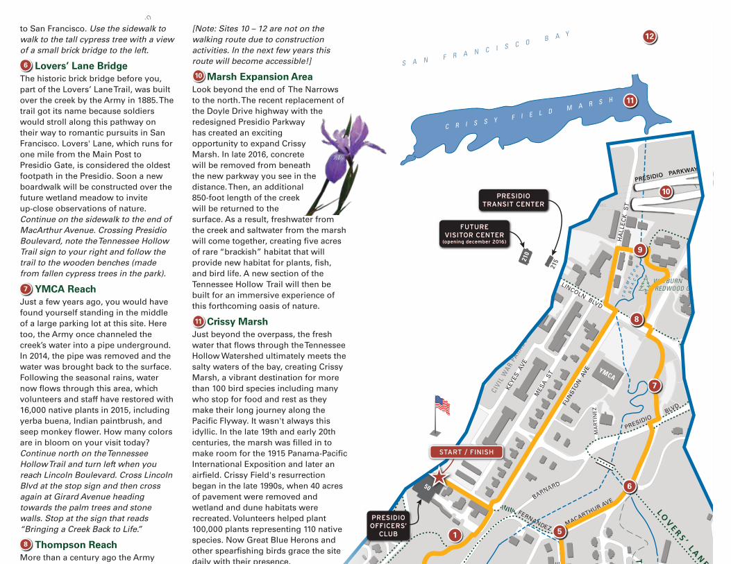
Lovers’ Lane BridgeThe historic brick bridge before you, part of the Lovers’ Lane Trail, was built over the creek by the Army in 1885. The trail got its name because soldiers would stroll along this pathway on their way to romantic pursuits in San Francisco. Lovers' Lane, which runs for one mile from the Main Post to Presidio Gate, is considered the oldest footpath in the Presidio. Soon a new boardwalk will be constructed over the future wetland meadow to invite up-close observations of nature. Continue on the sidewalk to the end of MacArthur Avenue. Crossing Presidio Boulevard, note the Tennessee Hollow Trail sign to your right and follow the trail to the wooden benches (made from fallen cypress trees in the park).
YMCA ReachJust a few years ago, you would have found yourself standing in the middle of a large parking lot at this site. Here too, the Army once channeled the creek’s water into a pipe underground. In 2014, the pipe was removed and the water was brought back to the surface. Following the seasonal rains, water now flows through this area, which volunteers and staff have restored with 16,000 native plants in 2015, including yerba buena, Indian paintbrush, and seep monkey flower. How many colors are in bloom on your visit today? Continue north on the Tennessee Hollow Trail and turn left when you reach Lincoln Boulevard. Cross Lincoln Blvd at the stop sign and then cross again at Girard Avenue heading towards the palm trees and stone walls. Stop at the sign that reads “Bringing a Creek Back to Life.”
Thompson ReachMore than a century ago the Army buried the creek here to use the land, first as a firing range and later for an Army hospital. The site is named after Dora Thompson, chief nurse at the former hospital on this site (note the sign about her). In the 1970s, these buildings were demolished and many
tons of debris left behind (akin to the landfill at Pop Hicks Field). In 2005, the landfill was removed and the creek was
brought back above ground -- the first section of creek in the Tennessee Hollow Watershed to be restored.
In the last decade, native plant diversity increased
from five species to more than 100 species. Backtrack to the Tennessee Hollow Trail marker and turn left on the asphalt path. Continue through the Wayburn Redwood Grove until you encounter a foot bridge.
The Narrows At this site, the creek flows through a very narrow area with buildings on each side. The water in front of you is an accumulation of all three streams, seeping ground water, plus the salt water tide from Crissy Marsh. The water flows here can be very high in a storm event, so a channel was specially designed to manage the volume. The slopes along “the narrows” wererecently planted. To get a sense of what it will look like in just a few years, look back at Thompson Reach south of the bridge.
[Note: Sites 10 – 12 are not on the walking route due to construction activities. In the next few years this route will become accessible!]
Marsh Expansion AreaLook beyond the end of The Narrows to the north. The recent replacement of the Doyle Drive highway with the redesigned Presidio Parkway has created an exciting opportunity to expand Crissy Marsh. In late 2016, concrete will be removed from beneath the new parkway you see in the distance. Then, an additional 850-foot length of the creek will be returned to the surface. As a result, freshwater from the creek and saltwater from the marsh will come together, creating five acres of rare “brackish” habitat that will provide new habitat for plants, fish, and bird life. A new section of the Tennessee Hollow Trail will then be built for an immersive experience of this forthcoming oasis of nature.
Crissy MarshJust beyond the overpass, the fresh water that flows through the Tennessee Hollow Watershed ultimately meets the salty waters of the bay, creating Crissy Marsh, a vibrant destination for more than 100 bird species including many who stop for food and rest as they make their long journey along the Pacific Flyway. It wasn't always this idyllic. In the late 19th and early 20th centuries, the marsh was filled in to make room for the 1915 Panama-Pacific International Exposition and later an airfield. Crissy Field's resurrection began in the late 1990s, when 40 acres of pavement were removed and wetland and dune habitats were recreated. Volunteers helped plant 100,000 plants representing 110 native species. Now Great Blue Herons and other spearfishing birds grace the site daily with their presence.
San Francisco Bay and the Pacific OceanIn addition to the Tennessee Hollow Watershed’s creek, sixteen major California rivers drain into San Francisco Bay. Their comingled waters flow beneath the Golden Gate Bridge into the Pacific Ocean. This area has been an important resource for centuries, and features myriad habitats and species. It is a biodiversity hotspot identified nationally by the Nature Conservancy and internationally by Conservation International because of the diversity of geology, soils, waters, and vegetation habitats.
Thank you!
You’ve just explored a watershed in a dynamic state of change. These kinds of efforts are not unique to this national park site. Many cities around the planet are pursuing similar projects, large and small, to make a place for nature in our increasingly urban world.
To find your way back to the Presidio Officers’ Club, cross the bridge and turn left on Halleck Street. At the corner, cross to Funston Avenue and walk south on the sidewalk and turn right at the Inn at the Presidio.
11
6
10
7
8

TUNNEL
TUNNEL
TUNNEL
TUNNEL
50
P A C I F I C
O C E A N
N
0 250 M
0 500 FT 1,000 FT
L OV
E RS ’ L A
NE
B A Y T R A
IL
& P R E S I D I O P R OM
E N
AD
E
P R E S I DIO
P R O M E N A D E
M O U N T A I N L A K E TRA I L
M O U N TA I N L A K E T R A I L
L O B O S C R E E K V
AL
LEY T R A I L
BA
TT
ER
IES
T
O
B L U
F F S
TR
AI L
J U A N BA
UT
I ST
A D
E A
NZ
A N
AT
I ON
AL
HIS
TO
RIC
TR
AI L
PA
RK
TR
AI L
M O U N T A I N L A K E T R A I L
P R E S I DI O
PR
OM
E
N A D E
CA
LI F
ORN
I A
CO
AS
TA
L
T
RA
I L
P AR
K T
RA
I L
ECOLOG
Y T
RA
IL (
U P P E R )
AN
ZA
ES
PL A
NA
DE
E C O L OG
Y
TR
AIL
(LO
W
ER)
B A Y T R A I L
G O L D E N G A T E P R O M E N A D E ( B A Y T R A I L )
BA
Y
A R E A R I D G E T R A I L T
EN
NE
SS
EE
HO
LL
OW
TR
AIL
Length: 0.8 miles (1.3 km)L O B O S C R E E K VA L L E Y T R A I L
Length: 4.3 miles (6.9 km)
G O L D E N G AT E P R O M E N A D E /B AY T R A I L
Length: 0.7 miles (1.0 km)B AT T E R I E S T O B L U F F S T R A I L
Length: 2.5 miles (4.0 km)B AY A R E A R I D G E T R A I L
Length: 2.7 miles (4.3 km)
J U A N B A U T I S TA D E A N Z AN AT I O N A L H I S T O R I C T R A I L
Length: 2.7 miles (4.4 km)C A L I F O R N I A C O A S TA L T R A I L
Length: 1.2 miles (1.9 km)T E N N E S S E E H O L L O W T R A I L
Length: 2.6 miles (4.1 km)M O U N TA I N L A K E T R A I L
Length: 2.1 miles (3.4 km)P R E S I D I O P R O M E N A D E
Length: 1.4 miles (2.2 km)E C O L O G Y T R A I L
Length: 0.6 miles (0.9 km)A N Z A E S P L A N A D E
Length: 0.6 miles (1 km)L O V E R S ’ L A N E
Length: 1.7 miles (2.6 km)PA R K T R A I L
P A C I F I C
O C E A N
N
0 250 M
0 500 FT 1,000 FT
MULTI-USE
PEDESTRIAN ONLY
FUTURE TRAIL
BIKE LANE / ROUTE
STAIRS
PRESIDIO TRAIL NETWORK
LINCOLN BLVD
LIN
CO
LN
BLV
D
MC
DO
WE
LL
A
VE
LIN
CO
LN
BLV
D
MARINA
LOMBARD ST
PR
ES
IDIO
AV
E
LINC
OLN
BLV
D
25
TH
AV
EN
UE
PERSHING DR
PRESIDIOTERRACE
STOREY AVE
BR
OW
N
G
RA
HA
M S
T
FUN
STO
N A
VE
MO
NTG
OM
ERY
ST
WEST PACIFIC AVE
PRESIDIO
MACARTHUR AVE
GORGAS AVE
MORAGA AVE
WASHIN
GT
ON
BLVD
AMATURY LOOP
KOBBE A
VE
UP
TO
N A
VE
WO
OL
CT
UP
TON
AV
E
RUCKMAN
STOREY AVE
WASHINGTON BLVD
WA
SH
IN
GTON BLVD
ME
RC
HA
NT
RD
ARMISTEAD RD
LON
G AVE.
HOFFMAN
BO
WL
EY
ST
GIBSON RD
W
ED EMEYER ST
GIBBON
MORTON ST
WRIGHT LOOP
GR
EE
NO
UG
H
FERNANDEZ
BARNARD
HA
RR
ISO
N B
LVD
AR
GU
ELL
O
BLV
D
MASON ST
BLVD
RO
D R
D
BE
LLE
S
MARINE DR
KOBBE AVE
BA
TT
ER
Y
CA
ULF
IEL
D
RD
COWLES
CENTRAL MAGAZINE
C
RISSY FIELD AVE
QU
AR
RY R
D
DE
EM
S RD
PAR
K
BLV
D.
PAR
K
BLV
D
RICHARDSONFRANCISCO
CH
ER
RY
MA
PL
E
SP
RU
CE
LOC
US
T
LA
UR
EL
LAKE
WA
LN
UT
LYO
N
PACIFIC
JACKSON
WASHINGTON
CLAY
SACRAMENTO
CALIFORNIA
JEFFERSON
NORTH POINT
BAY
BAY
BEACH
GREENWICH
FILBERT
UNION
VALLEJO
BROADWAY
GREEN
STREET
BA
KE
RLY
ON
YA
CH
T
RD
TAY
LOR
RD
PATTEN RD
SIMONDS LOOP
LOMBARD ST RU
GE
R S
T
WY
MA
N A
VE
HITCHCOCK ST
R
AL
ST
ON
AV
E.
PR
ES
IDIO
BLV
D
TORNEY
SA
NC
HE
S
ST
LIGG
ETT AVE
PRESIDIO BLVD
LETTERMAN DR
O'R
EILL
Y A
VE
EDIE RD
THORNBURGH RD
GEN
KEN
NED
Y A
VE
GIR
ARD
RD
HA
LLE
CK
S
T
MA
CA
RT
HU
R
AV
E
PO
RT
OL
A
ST
KEY
ES A
VE
M
ESA
ST
SH
ERID
AN
AV
E
RIL
EY A
VE
OR
D S
T
BLISS RD
FISHER LOOP
NAUMAN RD
ST
OR
EY A
VE
STILWELL
PERSHING DR
RA
LS
TO
N
AV
E
LANGDON
CAMINO DEL MAR
INFA
NT
RY
TE
RR
AC
E
27
TH
AV
E
26
TH
AV
E
24
TH
AV
E
22
ND
AV
E
21
ST
AV
E
20
TH
AV
E
19T
H A
VE
18T
H A
VE
17T
H A
VE
16T
H A
VE
FU
NS
TO
N A
VE
11T
H A
VE
10T
H A
VE
9T
H A
VE
8T
H A
VE
7T
H A
VE
6T
H A
VE
5T
H A
VE
4T
H A
VE
3R
D A
VE
2N
D A
VE
12T
H A
VE
15T
H A
VE
14T
H A
VE
BA
KE
R
BR
OD
ER
ICK
MASON ST
HAYS
KINZEY
COMPTON RD
APPLETON ST
SC
HO
FIE
L
D RD
MA
RT
INE
Z
AR
GU
EL
LO B
LVD
JACKSON
YMCA
BROADWAY GATE(pedestrian only)
LOMBARD GATE
GORGAS GATE
PRESIDIO GATE
ARGUELLO GATE
25th AVE. GATE
15th + 14thAVE. GATES
MARINA GATE
CHESTNUT GATE(pedestrian only)
MAIN
PARADE
GROUND
MAIN
POST
PUBLIC HEALTHSERVICE DISTRICT
PRESIDIOGOLF COURSE
FORTWINFIELD
SCOTT
SAN FRANCIS
CO
NATIONAL
CEMETERY
COA
STA
L
B
LUFF
S
CRISSY F IELD
BAKER BEACH
APARTMENTS
LETTERMAN
DISTRICT
CIVIL
WAR P
ARADE
SPIRESPIRE
WOOD LINE
WAYBURN REDWOOD GROVE
P E TC E M E T E R Y
TREEFALLTREEFALL
EARTHWALLEARTHWALL
L O B O S VA L L E YO V E R L O O K
M A R I N EC E M E T E R Y V I S TA
N AT I O N A L C E M E T E R YO V E R L O O K
C R I S S Y F I E L DO V E R L O O K
PA C I F I CO V E R L O O K
G O L D E N G AT EO V E R L O O K
I M M I G R A N TP O I N T O V E R L O O K
I N S P I R AT I O NP O I N T O V E R L O O K
TOR
PED
O
BATTERYEAST
COAST G
UA
RD
PIER
BATTERYSAFFOLD
BATTERYDYNAMITE
BATTERYCROSBY
BATTERYCRANSTON
BATTERY
LANCASTER
BATTERYMARCUS
MILLER
BATTERYGODFREY
BATTERYBOUTELLE
BATTERYHOWE-WAGNER
WW IIWEST COASTMEMORIAL
CAVALRYSTABLES
OFFIC
ERS’
ROW
BATTERYWEST
BATTERYBLANEY
BATTERYSHERWOOD
BATTERYCHAMBERLIN
BATTERY
McKINNON-STOTSENBERG
WATERTREATMENT
PLANT
WH
AR
F
PILOTS’ ROW
KOREAN WARMEMORIAL
D R A G O N F L Y C R E E K
FORTSCOTTFIELD
JULIUS KAHN PLAYGROUND
PAULGOODEFIELD
MORTONSTREETFIELD
PALACEOF
FINE ARTS
Mountain Lake Park
E LP O L Í N
S P R I N G
(Permit Required)
EAST BEACH
BA
KER
B
EACH
MA
RSH
ALL
’S
BEA
CH
China Beach,Coastal Trail, Land’s End
To:
PAR
K P
RE
SID
IO
L O B O S C R E E K
CommunityGarden
Recycling Center
PresidioInstitute
Golf CourseGeneral Store
HIG
HW
AY
1 -
VE
TE
RA
NS
BLV
D
U.S. Park Police
LogCabin
Rob HillCampground
PresidioNursery
TOLL
PLAZA
PRESIDIO PARKWAY
PRESIDIO PARKWAY
TU
NN
ELOpen 11am - 3pm the
first full weekendeach month
Battery ChamberlinOpen 11am - 3pm thefirst full weekendeach month
Warming Hut983 Marine Drive
Fort Point National Historic Site
TH
OM
PS
ON
RE
AC
H
Golden Gate Bridge
M O U N T A I N L A K E
E A S T A R M
G O L D E N G AT E B R I D G EW E L C O M E C E N T E R
G O L D E N G AT E B R I D G EW E L C O M E C E N T E R
Open Daily, 9am-6pm
101
1
1
POPHICKSFIELD
Scale in Feet
0 500'
101
ATM
LODGING PICNIC AREA
SCENIC VISTA
TRANSIT CENTER
VISITOR INFORMATION
11
C R I S S Y F I E L D M A R S H
9
8
210
5
3
6
7
1
2
10
12
S A N F R A N C I S C O B A Y
215
4
PRESIDIODETAIL
Area
A
TennesseeHollow
Watershed
Area
B
Scale in Feet
0 500'
Creek Channel
Creek in Storm Drain or Concrete / Stone Channel
LEGEND
Trail (existing)
Trail (Future or to be Improved)
Restroom
Stairs
Foot Bridge
Spring
Hiking Route
Watershed Boundary
to San Francisco. Use the sidewalk to walk to the tall cypress tree with a view of a small brick bridge to the left.
Lovers’ Lane BridgeThe historic brick bridge before you, part of the Lovers’ Lane Trail, was built over the creek by the Army in 1885. The trail got its name because soldiers would stroll along this pathway on their way to romantic pursuits in San Francisco. Lovers' Lane, which runs for one mile from the Main Post to Presidio Gate, is considered the oldest footpath in the Presidio. Soon a new boardwalk will be constructed over the future wetland meadow to invite up-close observations of nature. Continue on the sidewalk to the end of MacArthur Avenue. Crossing Presidio Boulevard, note the Tennessee Hollow Trail sign to your right and follow the trail to the wooden benches (made from fallen cypress trees in the park).
YMCA ReachJust a few years ago, you would have found yourself standing in the middle of a large parking lot at this site. Here too, the Army once channeled the creek’s water into a pipe underground. In 2014, the pipe was removed and the water was brought back to the surface. Following the seasonal rains, water now flows through this area, which volunteers and staff have restored with 16,000 native plants in 2015, including yerba buena, Indian paintbrush, and seep monkey flower. How many colors are in bloom on your visit today? Continue north on the Tennessee Hollow Trail and turn left when you reach Lincoln Boulevard. Cross Lincoln Blvd at the stop sign and then cross again at Girard Avenue heading towards the palm trees and stone walls. Stop at the sign that reads “Bringing a Creek Back to Life.”
Thompson ReachMore than a century ago the Army buried the creek here to use the land, first as a firing range and later for an Army hospital. The site is named after Dora Thompson, chief nurse at the former hospital on this site (note the sign about her). In the 1970s, these buildings were demolished and many
tons of debris left behind (akin to the landfill at Pop Hicks Field). In 2005, the landfill was removed and the creek was
brought back above ground -- the first section of creek in the Tennessee Hollow Watershed to be restored.
In the last decade, native plant diversity increased
from five species to more than 100 species. Backtrack to the Tennessee Hollow Trail marker and turn left on the asphalt path. Continue through the Wayburn Redwood Grove until you encounter a foot bridge.
The Narrows At this site, the creek flows through a very narrow area with buildings on each side. The water in front of you is an accumulation of all three streams, seeping ground water, plus the salt water tide from Crissy Marsh. The water flows here can be very high in a storm event, so a channel was specially designed to manage the volume. The slopes along “the narrows” wererecently planted. To get a sense of what it will look like in just a few years, look back at Thompson Reach south of the bridge.
[Note: Sites 10 – 12 are not on the walking route due to construction activities. In the next few years this route will become accessible!]
Marsh Expansion AreaLook beyond the end of The Narrows to the north. The recent replacement of the Doyle Drive highway with the redesigned Presidio Parkway has created an exciting opportunity to expand Crissy Marsh. In late 2016, concrete will be removed from beneath the new parkway you see in the distance. Then, an additional 850-foot length of the creek will be returned to the surface. As a result, freshwater from the creek and saltwater from the marsh will come together, creating five acres of rare “brackish” habitat that will provide new habitat for plants, fish, and bird life. A new section of the Tennessee Hollow Trail will then be built for an immersive experience of this forthcoming oasis of nature.
Crissy MarshJust beyond the overpass, the fresh water that flows through the Tennessee Hollow Watershed ultimately meets the salty waters of the bay, creating Crissy Marsh, a vibrant destination for more than 100 bird species including many who stop for food and rest as they make their long journey along the Pacific Flyway. It wasn't always this idyllic. In the late 19th and early 20th centuries, the marsh was filled in to make room for the 1915 Panama-Pacific International Exposition and later an airfield. Crissy Field's resurrection began in the late 1990s, when 40 acres of pavement were removed and wetland and dune habitats were recreated. Volunteers helped plant 100,000 plants representing 110 native species. Now Great Blue Herons and other spearfishing birds grace the site daily with their presence.
San Francisco Bay and the Pacific OceanIn addition to the Tennessee Hollow Watershed’s creek, sixteen major California rivers drain into San Francisco Bay. Their comingled waters flow beneath the Golden Gate Bridge into the Pacific Ocean. This area has been an important resource for centuries, and features myriad habitats and species. It is a biodiversity hotspot identified nationally by the Nature Conservancy and internationally by Conservation International because of the diversity of geology, soils, waters, and vegetation habitats.
Thank you!
You’ve just explored a watershed in a dynamic state of change. These kinds of efforts are not unique to this national park site. Many cities around the planet are pursuing similar projects, large and small, to make a place for nature in our increasingly urban world.
To find your way back to the Presidio Officers’ Club, cross the bridge and turn left on Halleck Street. At the corner, cross to Funston Avenue and walk south on the sidewalk and turn right at the Inn at the Presidio.
12
9
TUNNEL
TUNNEL
TUNNEL
TUNNEL
50
P A C I F I C
O C E A N
N
0 250 M
0 500 FT 1,000 FT
L OV
E RS ’ L A
NE
B A Y T R A
IL
& P R E S I D I O P R OM
E N
AD
E
P R E S I DIO
P R O M E N A D E
M O U N T A I N L A K E TRA I L
M O U N TA I N L A K E T R A I L
L O B O S C R E E K V
AL
LEY T R A I L
BA
TT
ER
IES
T
O
B L U
F F S
TR
AI L
J U A N BA
UT
I ST
A D
E A
NZ
A N
AT
I ON
AL
HIS
TO
RIC
TR
AI L
PA
RK
TR
AI L
M O U N T A I N L A K E T R A I L
P R E S I DI O
PR
OM
E
N A D E
CA
LI F
ORN
I A
CO
AS
TA
L
T
RA
I L
P AR
K T
RA
I L
ECOLOG
Y T
RA
IL (
U P P E R )
AN
ZA
ES
PL A
NA
DE
E C O L OG
Y
TR
AIL
(LO
W
ER)
B A Y T R A I L
G O L D E N G A T E P R O M E N A D E ( B A Y T R A I L )
BA
Y
A R E A R I D G E T R A I L T
EN
NE
SS
EE
HO
LL
OW
TR
AIL
Length: 0.8 miles (1.3 km)L O B O S C R E E K VA L L E Y T R A I L
Length: 4.3 miles (6.9 km)
G O L D E N G AT E P R O M E N A D E /B AY T R A I L
Length: 0.7 miles (1.0 km)B AT T E R I E S T O B L U F F S T R A I L
Length: 2.5 miles (4.0 km)B AY A R E A R I D G E T R A I L
Length: 2.7 miles (4.3 km)
J U A N B A U T I S TA D E A N Z AN AT I O N A L H I S T O R I C T R A I L
Length: 2.7 miles (4.4 km)C A L I F O R N I A C O A S TA L T R A I L
Length: 1.2 miles (1.9 km)T E N N E S S E E H O L L O W T R A I L
Length: 2.6 miles (4.1 km)M O U N TA I N L A K E T R A I L
Length: 2.1 miles (3.4 km)P R E S I D I O P R O M E N A D E
Length: 1.4 miles (2.2 km)E C O L O G Y T R A I L
Length: 0.6 miles (0.9 km)A N Z A E S P L A N A D E
Length: 0.6 miles (1 km)L O V E R S ’ L A N E
Length: 1.7 miles (2.6 km)PA R K T R A I L
P A C I F I C
O C E A N
N
0 250 M
0 500 FT 1,000 FT
MULTI-USE
PEDESTRIAN ONLY
FUTURE TRAIL
BIKE LANE / ROUTE
STAIRS
PRESIDIO TRAIL NETWORK
LINCOLN BLVD
LIN
CO
LN
BLV
D
MC
DO
WE
LL
A
VE
LIN
CO
LN
BLV
D
MARINA
LOMBARD ST
PR
ES
IDIO
AV
E
LINC
OLN
BLV
D
25
TH
AV
EN
UE
PERSHING DR
PRESIDIOTERRACE
STOREY AVE
BR
OW
N
G
RA
HA
M S
T
FUN
STO
N A
VE
MO
NTG
OM
ERY
ST
WEST PACIFIC AVE
PRESIDIO
MACARTHUR AVE
GORGAS AVE
MORAGA AVE
WASHIN
GT
ON
BLVD
AMATURY LOOP
KOBBE A
VE
UP
TO
N A
VE
WO
OL
CT
UP
TON
AV
E
RUCKMAN
STOREY AVE
WASHINGTON BLVD
WA
SH
IN
GTON BLVD
ME
RC
HA
NT
RD
ARMISTEAD RD
LON
G AVE.
HOFFMAN
BO
WL
EY
ST
GIBSON RD
W
ED EMEYER ST
GIBBON
MORTON ST
WRIGHT LOOP
GR
EE
NO
UG
H
FERNANDEZ
BARNARD
HA
RR
ISO
N B
LVD
AR
GU
ELL
O
BLV
D
MASON ST
BLVD
RO
D R
D
BE
LLE
S
MARINE DR
KOBBE AVE
BA
TT
ER
Y
CA
ULF
IEL
D
RD
COWLES
CENTRAL MAGAZINE
C
RISSY FIELD AVE
QU
AR
RY R
D
DE
EM
S RD
PAR
K
BLV
D.
PAR
K
BLV
D
RICHARDSONFRANCISCO
CH
ER
RY
MA
PL
E
SP
RU
CE
LOC
US
T
LA
UR
EL
LAKE
WA
LN
UT
LYO
N
PACIFIC
JACKSON
WASHINGTON
CLAY
SACRAMENTO
CALIFORNIA
JEFFERSON
NORTH POINT
BAY
BAY
BEACH
GREENWICH
FILBERT
UNION
VALLEJO
BROADWAY
GREEN
STREET
BA
KE
RLY
ON
YA
CH
T
RD
TAY
LOR
RD
PATTEN RD
SIMONDS LOOP
LOMBARD ST RU
GE
R S
T
WY
MA
N A
VE
HITCHCOCK ST
R
AL
ST
ON
AV
E.
PR
ES
IDIO
BLV
D
TORNEY
SA
NC
HE
S
ST
LIGG
ETT AVE
PRESIDIO BLVD
LETTERMAN DR
O'R
EILL
Y A
VE
EDIE RD
THORNBURGH RD
GEN
KEN
NED
Y A
VE
GIR
ARD
RD
HA
LLE
CK
S
T
MA
CA
RT
HU
R
AV
E
PO
RT
OL
A
ST
KEY
ES A
VE
M
ESA
ST
SH
ERID
AN
AV
E
RIL
EY A
VE
OR
D S
T
BLISS RD
FISHER LOOP
NAUMAN RD
ST
OR
EY A
VE
STILWELL
PERSHING DR
RA
LS
TO
N
AV
E
LANGDON
CAMINO DEL MAR
INFA
NT
RY
TE
RR
AC
E
27
TH
AV
E
26
TH
AV
E
24
TH
AV
E
22
ND
AV
E
21
ST
AV
E
20
TH
AV
E
19T
H A
VE
18T
H A
VE
17T
H A
VE
16T
H A
VE
FU
NS
TO
N A
VE
11T
H A
VE
10T
H A
VE
9T
H A
VE
8T
H A
VE
7T
H A
VE
6T
H A
VE
5T
H A
VE
4T
H A
VE
3R
D A
VE
2N
D A
VE
12T
H A
VE
15T
H A
VE
14T
H A
VE
BA
KE
R
BR
OD
ER
ICK
MASON ST
HAYS
KINZEY
COMPTON RD
APPLETON ST
SC
HO
FIE
L
D RD
MA
RT
INE
Z
AR
GU
EL
LO B
LVD
JACKSON
YMCA
BROADWAY GATE(pedestrian only)
LOMBARD GATE
GORGAS GATE
PRESIDIO GATE
ARGUELLO GATE
25th AVE. GATE
15th + 14thAVE. GATES
MARINA GATE
CHESTNUT GATE(pedestrian only)
MAIN
PARADE
GROUND
MAIN
POST
PUBLIC HEALTHSERVICE DISTRICT
PRESIDIOGOLF COURSE
FORTWINFIELD
SCOTT
SAN FRANCIS
CO
NATIONAL
CEMETERY
COA
STA
L
B
LUFF
S
CRISSY F IELD
BAKER BEACH
APARTMENTS
LETTERMAN
DISTRICT
CIVIL
WAR P
ARADE
SPIRESPIRE
WOOD LINE
WAYBURN REDWOOD GROVE
P E TC E M E T E R Y
TREEFALLTREEFALL
EARTHWALLEARTHWALL
L O B O S VA L L E YO V E R L O O K
M A R I N EC E M E T E R Y V I S TA
N AT I O N A L C E M E T E R YO V E R L O O K
C R I S S Y F I E L DO V E R L O O K
PA C I F I CO V E R L O O K
G O L D E N G AT EO V E R L O O K
I M M I G R A N TP O I N T O V E R L O O K
I N S P I R AT I O NP O I N T O V E R L O O K
TOR
PED
O
BATTERYEAST
COAST G
UA
RD
PIER
BATTERYSAFFOLD
BATTERYDYNAMITE
BATTERYCROSBY
BATTERYCRANSTON
BATTERY
LANCASTER
BATTERYMARCUS
MILLER
BATTERYGODFREY
BATTERYBOUTELLE
BATTERYHOWE-WAGNER
WW IIWEST COASTMEMORIAL
CAVALRYSTABLES
OFFIC
ERS’
ROW
BATTERYWEST
BATTERYBLANEY
BATTERYSHERWOOD
BATTERYCHAMBERLIN
BATTERY
McKINNON-STOTSENBERG
WATERTREATMENT
PLANT
WH
AR
F
PILOTS’ ROW
KOREAN WARMEMORIAL
D R A G O N F L Y C R E E K
FORTSCOTTFIELD
JULIUS KAHN PLAYGROUND
PAULGOODEFIELD
MORTONSTREETFIELD
PALACEOF
FINE ARTS
Mountain Lake Park
E LP O L Í N
S P R I N G
(Permit Required)
EAST BEACH
BA
KER
B
EACH
MA
RSH
ALL
’S
BEA
CH
China Beach,Coastal Trail, Land’s End
To:
PAR
K P
RE
SID
IO
L O B O S C R E E K
CommunityGarden
Recycling Center
PresidioInstitute
Golf CourseGeneral Store
HIG
HW
AY
1 -
VE
TE
RA
NS
BLV
D
U.S. Park Police
LogCabin
Rob HillCampground
PresidioNursery
TOLL
PLAZA
PRESIDIO PARKWAY
PRESIDIO PARKWAY
TU
NN
ELOpen 11am - 3pm the
first full weekendeach month
Battery ChamberlinOpen 11am - 3pm thefirst full weekendeach month
Warming Hut983 Marine Drive
Fort Point National Historic Site
TH
OM
PS
ON
RE
AC
H
Golden Gate Bridge
M O U N T A I N L A K E
E A S T A R M
G O L D E N G AT E B R I D G EW E L C O M E C E N T E R
G O L D E N G AT E B R I D G EW E L C O M E C E N T E R
Open Daily, 9am-6pm
101
1
1
POPHICKSFIELD
Scale in Feet
0 500'
101
ATM
LODGING PICNIC AREA
SCENIC VISTA
TRANSIT CENTER
VISITOR INFORMATION
11
C R I S S Y F I E L D M A R S H
9
8
210
5
3
6
7
1
2
10
12
S A N F R A N C I S C O B A Y
215
4
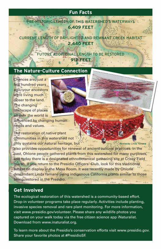
Fun Facts
The Nature-Culture Connection
Get Involved
PRE-HISTORIC LENGTH OF THIS WATERSHED’S WATERWAYS
6,409 FEET
CURRENT LENGTH OF DAYLIGHTED AND REMNANT CREEK HABITAT
2,440 FEET
FUTURE ADDITIONAL LENGTH TO BE RESTORED
912 FEET
Chances are, just a few hundred years ago, your ancestors were living much closer to the land. The changing landscape of places all over the world is influenced by changing human needs and values.
The restoration of native plant communities in this watershed not only sustains our natural heritage, but also provides opportunities for renewal of ancient cultural practices. In the past, Ohlone people gathered plants from this watershed for many purposes, and today there is a designated ethnobotanical gathering site at Crissy Field marsh. If you return to the Presidio Officers’ Club, look for this traditional basket on display in the Mesa Room. It was recently made by Ohlone descendant Linda Yamane using indigenous California plants similar to those being restored in the Presidio.
The ecological restoration of this watershed is a community-based effort. Drop-in volunteer programs take place regularly. Activities include planting, invasive species removal and rare plant monitoring. For more information, visit www.presidio.gov/volunteer. Please share any wildlife photos you captured on your walk today via the free citizen science app iNaturalist. Download from www.inaturalist.org.
To learn more about the Presidio’s conservation efforts visit www.presidio.gov. Share your favorite photos at #PresidioSF.
Photos by Linda Yamane