Download 4.91 MB
205
Technical Assistance Consultant’s Report This consultant’s report does not necessarily reflect the views of ADB or the Government concerned, and ADB and the Government cannot be held liable for its contents. For project preparatory technical assistance: All the views expressed herein may not be incorporated into the proposed project’s design. Project Number: 39536 March 2008 Technical Assistance Socialist Republic of Viet Nam: Capacity Building in the Strategic Environmental Assessment of the Hydropower Project (Financed by the Government of Finland) Prepared by International Centre for Environmental Management Brisbane, Queensland, Australia For Ministry of Environment and Natural Resources (MONRE)
Transcript of Download 4.91 MB

Technical Assistance Consultant’s Report
This consultant’s report does not necessarily reflect the views of ADB or the Government concerned, and ADB and the Government cannot be held liable for its contents. For project preparatory technical assistance: All the views expressed herein may not be incorporated into the proposed project’s design.
Project Number: 39536 March 2008
Technical Assistance Socialist Republic of Viet Nam: Capacity Building in the Strategic Environmental Assessment of the Hydropower Project (Financed by the Government of Finland)
Prepared by International Centre for Environmental Management Brisbane, Queensland, Australia
For Ministry of Environment and Natural Resources (MONRE)

Final SEA Report ADB, MONRE, EVN, MOIT, Quang Nam DONRE
ICEM SEA of the hydropower plan in the Vu Gia-Thu Bon River Basin page 1 of 204
Capacity Building in the Strategic Environmental Assessment of the Hydropower Sector in Viet Nam
(TA 4713-VIE)
SEA of the Quang Nam Province Hydropower Plan for the Vu Gia-Thu Bon
River Basin
Final SEA Report January 2008
(Report structure is based on requirements for contents of SEA Reports laid down in the SEA/SEA Circular 08/2006/TT-BTNMT)
Ministry of Environment and Natural Resource Ministry of Industry, Electricity Viet Nam
Asian Development Bank

Final SEA Report ADB, MONRE, EVN, MOIT, Quang Nam DONRE
ICEM SEA of the hydropower plan in the Vu Gia-Thu Bon River Basin page 1 of 204
Citation: ICEM, 2008, Strategic Environmental Assessment of the Quang Nam Province Hydropower Plan for the Vu Gia-Thu Bon River Basin, Prepared for the ADB, MONRE, MOITT & EVN, Hanoi, Viet Nam.

Final SEA Report ADB, MONRE, EVN, MOIT, Quang Nam DONRE
ICEM SEA of the hydropower plan in the Vu Gia-Thu Bon River Basin page 1 of 204
CONTENTS CONTENTS ..................................................................................................................................................................... 1
ACKNOWLEDGEMENTS ............................................................................................................................................ 5
ACRONYMS ................................................................................................................................................................... 6
SUMMARY ...................................................................................................................................................................... 7
1 BACKGROUND TO THE SEA .......................................................................................................................... 11
1.1 ORIGIN OF THE PILOT SEA .............................................................................................................................. 11 1.2 PURPOSE OF THE PILOT SEA ........................................................................................................................... 11 1.3 LEGISLATIVE BASIS FOR UNDERTAKING THE SEA .......................................................................................... 12 1.4 MANAGEMENT AND INSTITUTIONAL ARRANGEMENTS .................................................................................... 13 1.5 PROJECT APPROACH AND METHODOLOGY ....................................................................................................... 14
1.5.1 Methodology .............................................................................................................................................. 14 1.5.2 Steps in the assessment process ................................................................................................................. 15
2 OVERVIEW OF THE PROPOSED HYDROPOWER PLAN......................................................................... 16
2.1 THE QUANG NAM HYDROPOWER PLAN ........................................................................................................... 16 2.2 ENERGY PLANNING AND THE VU GIA – THU BON RIVER BASIN ..................................................................... 16 2.3 THE VU GIA – THU BON RIVER BASIN ........................................................................................................... 17 2.4 LARGE PROJECT CASCADE PLANNING FOR THE VU GIA - THU BồN RIVER BASIN ............................................ 18 2.5 SMALL AND MEDIUM-SIZED HYDROPOWER PLANNING .................................................................................... 20
3 ENVIRONMENTAL, ECONOMIC AND SOCIAL ISSUES ADDRESSED IN THIS SEA PROCESS ...... 22
3.1 ISSUES OF RELEVANCE TO DEVELOPMENT OF THE VU GIA THU BON RIVER BASIN ......................................... 22 3.2 KEY THEMES OR ISSUES ADDRESSED BY THE SEA .......................................................................................... 24
4 PAST TRENDS AND CURRENT SITUATION IN KEY ISSUES FOR DEVELOPMENT OF THE RIVER BASIN ............................................................................................................................................................... 26
4.1 ISSUE: ‘CLIMATE SITUATION WITH EMPHASIS ON RAINFALL’ .......................................................................... 26 4.2 ISSUE ‘DRY SEASON MINIMAL FLOWS AND EFFECT ON SALINITY INTRUSION’ ................................................. 27 4.3 ISSUE ‘FLOODING AND MAXIMUM FLOWS’ ...................................................................................................... 29 4.4 ISSUE ‘SEDIMENT TRANSPORT AND SAND EXCAVATION’ ................................................................................ 32 4.5 ISSUE ‘AQUATIC BIODIVERSITY AND FISHERIES’ ............................................................................................. 34 4.6 ISSUE ‘FOREST MANAGEMENT AND TERRESTRIAL BIODIVERSITY’ .................................................................. 36
4.6.1 Special Use Forest (Protected Areas) in the central Truong Son. ............................................................. 37 4.6.2 Forest management: Protection and production forests ........................................................................... 41 4.6.3 Forest management: connectivity .............................................................................................................. 42 4.6.4 Terrestrial biodiversity .............................................................................................................................. 43
4.7 ISSUE ‘DEMOGRAPHY AND MIGRATION’ ......................................................................................................... 44 4.7.1 Rural-urban migration and urbanization .................................................................................................. 44 4.7.2 Lowland-upland migration ........................................................................................................................ 47
4.8 ISSUE ‘ETHNIC MINORITIES AND THEIR LIVELIHOODS’ .................................................................................... 49 4.9 ISSUE ‘PUBLIC HEALTH IN AFFECTED COMMUNITIES’ ..................................................................................... 51
4.9.1 Health problems in affected communities .................................................................................................. 51 4.9.2 Health amenities in upland areas .............................................................................................................. 52
4.10 ISSUE ‘TRANSPORT’ ........................................................................................................................................ 53 4.10.1 Road Transport ..................................................................................................................................... 53 4.10.2 Waterway Transport .............................................................................................................................. 53
4.11 ISSUE ‘AGRICULTURE AND IRRIGATION’ ......................................................................................................... 53 4.11.1 System Management Issues ................................................................................................................... 55 4.11.2 Water Demand Issues ............................................................................................................................ 55

Final SEA Report ADB, MONRE, EVN, MOIT, Quang Nam DONRE
ICEM SEA of the hydropower plan in Quang Nam Province – January 2008
2
4.11.3 Water Yield and Quality Issues ............................................................................................................. 56 4.12 ISSUE ‘INDUSTRIAL DEVELOPMENT’ ............................................................................................................... 56 4.13 ISSUE ‘TOURISM DEVELOPMENT IN THE BASIN’ .............................................................................................. 57 4.14 ISSUE ’MINING’ .............................................................................................................................................. 58
4.14.1 Overview ............................................................................................................................................... 58 4.14.2 Past trends and current situation .......................................................................................................... 59 4.14.3 Institutional arrangements .................................................................................................................... 60 4.14.4 Key issues relating to mining identified by local government experts .................................................. 60
4.15 ISSUE ’WASTE MANAGEMENT’ ....................................................................................................................... 63 4.15.1 National context .................................................................................................................................... 63 4.15.2 Legal Requirements ............................................................................................................................... 64 4.15.3 Past Trends and Current Conditions in Solid Waste Generation in the Basin ...................................... 64 4.15.4 Past Trends and Current Conditions in Solid Waste Collection and Treatment in the Basin ............... 65
5 FUTURE TRENDS WITHOUT THE HYDROPOWER PLAN ...................................................................... 67
5.1 ISSUE ‘CLIMATE SITUATION WITH EMPHASIS ON RAINFALL’ ........................................................................... 67 5.2 ISSUE ‘DRY SEASON MINIMAL FLOWS AND EFFECT ON SALINITY INTRUSION’ ................................................. 67 5.3 ISSUE ‘FLOODING AND MAXIMUM FLOWS’ ...................................................................................................... 67 5.4 ISSUE ‘SEDIMENT TRANSPORT AND SAND EXCAVATION’ ................................................................................ 68 5.5 ISSUE ‘AQUATIC BIODIVERSITY AND FISHERIES’ ............................................................................................. 68 5.6 ISSUE ‘FOREST MANAGEMENT AND TERRESTRIAL BIODIVERSITY’ .................................................................. 69
5.6.1 Forest management: Special Use Forest (Protected Areas)...................................................................... 69 5.6.2 Forest management: protection and production forests ............................................................................ 71 5.6.3 Forest management: connectivity .............................................................................................................. 72 5.6.4 Terrestrial biodiversity .............................................................................................................................. 73
5.7 ISSUE ‘DEMOGRAPHY AND MIGRATION’ ......................................................................................................... 75 5.7.1 Rural-urban migration and urbanization .................................................................................................. 75 5.7.2 Lowland-upland migration ........................................................................................................................ 78
5.8 ISSUE ‘ETHNIC MINORITIES AND THEIR LIVELIHOODS’ .................................................................................... 78 5.9 ISSUE ‘PUBLIC HEALTH IN AFFECTED COMMUNITIES’ ..................................................................................... 79
5.9.1 Health problems in affected communities .................................................................................................. 79 5.9.2 Health amenities in upland areas .............................................................................................................. 79
5.10 ISSUE ’TRANSPORT’ ........................................................................................................................................ 79 5.10.1 Quality and Accessibility of Rural Roads .............................................................................................. 79 5.10.2 Development of a Major Road Network ................................................................................................ 80 5.10.3 Waterway Transport .............................................................................................................................. 80
5.11 ISSUE ‘AGRICULTURE AND IRRIGATION’ ......................................................................................................... 80 5.12 ISSUE ‘INDUSTRIAL DEVELOPMENT’ ............................................................................................................... 80 5.13 ISSUE ‘TOURISM DEVELOPMENT IN THE BASIN’ .............................................................................................. 82 5.14 ISSUE ’MINING’ .............................................................................................................................................. 85 5.15 ISSUE ’WASTE MANAGEMENT’ ....................................................................................................................... 86
5.15.1 Solid Waste Generation ......................................................................................................................... 86 5.15.2 Solid Waste Collection and Treatment .................................................................................................. 87
6 FUTURE TRENDS WITH THE HYDROPOWER PLAN .............................................................................. 88
6.1 ISSUE ‘CLIMATIC AND RAINFALL CONDITIONS’ ............................................................................................... 88 6.2 ISSUE ‘DRY SEASON MINIMAL FLOWS AND EFFECT ON SALINITY INTRUSION’ ................................................. 88
6.2.1 Effects of the individual components of the Hydropower Plan .................................................................. 88 6.2.2 Cumulative effects of the HP plan on the trends in the issue ..................................................................... 89
6.3 ISSUE ‘FLOODING AND MAXIMUM FLOWS’ ...................................................................................................... 90 6.3.1 Effects of the individual components of the HP plan ................................................................................. 90
6.4 ISSUE ‘SEDIMENT TRANSPORT AND SAND EXCAVATION’ ................................................................................ 91 6.4.1 Effects of the individual components of the HP plan ................................................................................. 91 6.4.2 Cumulative effects of the HP plan on the trends in the issue ..................................................................... 92
6.5 ISSUE: “AQUATIC BIODIVERSITY AND FISHERIES” ........................................................................................... 92 6.5.1 The main risks ............................................................................................................................................ 92 6.5.2 Effects of individual components of the Hydropower Plan ........................................................................ 94 6.5.3 Cumulative effects of the HP plan on the trends in the issue ..................................................................... 98
6.6 ISSUE ‘FOREST MANAGEMENT AND TERRESTRIAL BIODIVERSITY’ .................................................................. 98 6.6.1 Effects of individual components of the Hydropower Plan ........................................................................ 98

Final SEA Report ADB, MONRE, EVN, MOIT, Quang Nam DONRE
ICEM SEA of the hydropower plan in Quang Nam Province – January 2008
3
6.6.2 Cumulative effects of the HP plan on the trends in the issue ................................................................... 104 6.7 ISSUE ‘DEMOGRAPHY AND MIGRATION’ ....................................................................................................... 104
6.7.1 Impacts of the Plan on rural-urban migration and urbanization ............................................................ 104 6.7.2 Impacts of the Plan on lowland-upland migration .................................................................................. 105
6.8 ISSUE ‘ETHNIC MINORITIES AND THEIR LIVELIHOODS’ .................................................................................. 106 6.8.1 Impacts of the HP plan on socio-cultural conditions of ethnic minorities ............................................... 106 6.8.2 Impacts of the Plan on livelihoods of ethnic minorities ........................................................................... 107 6.8.3 Cumulative effects of the HP plan on the trends for the theme ................................................................ 110
6.9 ISSUE ‘PUBLIC HEALTH IN AFFECTED COMMUNITIES’ ................................................................................... 110 6.9.1 Impacts of the HP plan on health problems in affected communities ...................................................... 110 6.9.2 Health amenities in upland areas ............................................................................................................ 111 6.9.3 Cumulative effects of the HP plan on the trends in the issue ................................................................... 112
6.10 ISSUE ’TRANSPORT’ ...................................................................................................................................... 112 6.10.1 Impacts of the entire HP plan on quality and accessibility of rural roads .......................................... 112 6.10.2 Impacts of the entire HP plan on the development of a major road network ...................................... 113 6.10.3 Impacts of the entire HP plan on waterway transport ........................................................................ 113 6.10.4 Expected future cumulative effects of the HP plan on the trends for the theme .................................. 114
6.11 ISSUE ‘AGRICULTURE AND IRRIGATION’ ....................................................................................................... 115 6.11.1 Impacts of the operation of the dams and releases of water to downstream areas for irrigation and other users ............................................................................................................................................................ 115 6.11.2 Cumulative effects of the HP plan on the trends for the issue ............................................................. 117
6.12 ISSUE ‘INDUSTRIAL DEVELOPMENT’ ............................................................................................................. 118 6.12.1 Effects of the HP plan .......................................................................................................................... 118 6.12.2 Cumulative effects of the HP plan on the trends for the issue ............................................................. 118
6.13 ISSUE ‘TOURISM DEVELOPMENT IN THE BASIN’ ............................................................................................ 118 6.13.1 Effects of the HP plan .......................................................................................................................... 118 6.13.2 Cumulative effects of the HP plan on the trends for the issue ............................................................. 119
6.14 ISSUE ’MINING’ ............................................................................................................................................ 119 6.15 ISSUE ’WASTE MANAGEMENT’ ..................................................................................................................... 120
6.15.1 Solid Waste Generation ....................................................................................................................... 120 6.15.2 Solid Waste Collection and Treatment ................................................................................................ 121 6.15.3 Mitigation and Management Measures Proposed in EIA Reports ...................................................... 121 6.15.4 Summary of Risks ................................................................................................................................ 122 6.15.5 Cumulative impacts of the HP plan on the relevant trend ................................................................... 122
7 OVERALL CONCLUSIONS ON THE FOUR STRATEGIC CONCERNS ................................................ 124
7.1 IDENTIFICATION OF FOUR CRITICAL STRATEGIC CONCERNS .......................................................................... 124 7.2 WATER SUPPLY ............................................................................................................................................. 124
7.2.1 Water Supply as effected by the Hydro-power Plan ................................................................................ 124 7.3 ECONOMIC DEVELOPMENT OF QUANG NAM AND DA NANG ......................................................................... 128
7.3.1 Impacts on sectoral development ............................................................................................................. 129 7.3.2 Impacts on employment ........................................................................................................................... 132 7.3.3 Budgetary impacts ................................................................................................................................... 133
7.4 ECOSYSTEM INTEGRITY ................................................................................................................................ 134 7.4.1 Aquatic systems ....................................................................................................................................... 134 7.4.2 Terrestrial systems ................................................................................................................................... 136 7.4.3 Summary of effects relating to ecosystem integrity .................................................................................. 137
7.5 ETHNIC MINORITIES ...................................................................................................................................... 137 7.5.1 Introduction ............................................................................................................................................. 137 7.5.2 Opportunities and Risks ........................................................................................................................... 138
8 OVERALL MITIGATION AND ENHANCEMENT MEASURES .............................................................. 140
8.1 PRINCIPLES GUIDING MITIGATION AND ENHANCEMENT ................................................................................ 140 8.2 OVERALL MITIGATION MEASURES FOR THE CRITICAL STRATEGIC CONCERNS ............................................... 142
8.2.1 Water supply mitigation ........................................................................................................................... 142 8.2.2 Provincial economic development mitigation .......................................................................................... 144 8.2.3 Ecosystems integrity mitigation (EI)........................................................................................................ 146 8.2.4 Ethnic minorities mitigation .................................................................................................................... 150
8.3 OTHER SPECIFIC MITIGATION MEASURES ...................................................................................................... 152 8.4 RECOMMENDED IMMEDIATE FOLLOW UP TO THE SEA .................................................................................. 152

Final SEA Report ADB, MONRE, EVN, MOIT, Quang Nam DONRE
ICEM SEA of the hydropower plan in Quang Nam Province – January 2008
4
8.4.1 Consultation on the SEA Report .............................................................................................................. 152 8.4.2 Institutional arrangements for river basin planning and management ................................................... 153
REFERENCES ............................................................................................................................................................ 155
ANNEX 1: PROPOSED HYDROPOWER PROJECTS VGTB BASIN AS AT NOVEMBER 2007 .................. 161
ANNEX 2: MAPS ....................................................................................................................................................... 171
MAP 1: EXISTING AND PLANNED HYDROPOWER PROJECTS IN THE VU GIA-THU BON RIVER BASIN .......................... 171 MAP 2: QUANG HUE CHANNEL AND DA NANG WATER INTAKES ................................................................................ 172 MAP 3: RIVER SUB-BASINS IN THE VU GIA-THU BON CATCHMENT ............................................................................ 173 MAP 4: IMPACT OF PLANNED HYDROPOWER ON FLOW REGIMES ................................................................................ 174 MAP 5: FOREST CLASSIFICATION ............................................................................................................................... 175 MAP 6: EXISTING AND PROPOSED PROTECTED AREAS ................................................................................................ 176 MAP 7: WATERSHED CLASSIFICATION ....................................................................................................................... 177 MAP 8: POPULTION DENSITY AND DISTRIBUTION ....................................................................................................... 178 MAP 9: DISRUPTION TO CONNECTIVITY ..................................................................................................................... 179 MAP 10: DISRUPTION OF CONNECTIVITY DUE TO PLANNED HYDROPOWER PROJECTS ................................................ 180 MAP 11: ETHNICITY IN QUANG NAM PROVINCE ........................................................................................................ 181 MAP 12: POVERTY INCIDENCE ................................................................................................................................... 182 MAP 13: ETHNICITY AND POVERTY INCIDENCE .......................................................................................................... 183 MAP 14: IRRIGATED LAND, PUMP STATIONS AND TRANSPORT NETWORKS ................................................................. 184 MAP 15: SALINE INTRUTION AND STORM SURGE – RISK TO INFRASTRUCTURE ........................................................... 185 MAP 16: EXISTING AND PLANNED MINING IN THE VU GIA – THU BON RIVER BASIN ................................................. 186 MAP 17: PROPOSED INTACT RIVERS IN THE VU GIA – THU BON RIVER BASIN ........................................................... 187
ANNEX 3: STEPS IN THE HYDROPOWER PLANNING PROCESS IN QUANG NAM – 2003 TO 2006 ..... 188
ANNEX 4: VG-TB RIVER PLANNING MANAGEMENT BOARD ..................................................................... 191
ANNEX 5: PRESENT AND FUTURE WATER DEMANDS, CITY OF DA NANG ......................................... 192
ANNEX 6: ADDITIONAL MITIGATION MEASURES FOR THE SPECIFIC KEY ISSUES ADDRESSED WITHIN THE SEA ..................................................................................................................................................... 193
Climatic and rainfall conditions ........................................................................................................................... 193 Hydrology ............................................................................................................................................................. 193 Aquatic biodiversity and fisheries ......................................................................................................................... 194 Forest management and terrestrial biodiversity ................................................................................................... 196 Transport in the basin ........................................................................................................................................... 199 Mining ................................................................................................................................................................... 199 Waste management ............................................................................................................................................... 200 Agriculture and irrigation .................................................................................................................................... 201

Final SEA Report ADB, MONRE, EVN, MOIT, Quang Nam DONRE
ICEM SEA of the hydropower plan in Quang Nam Province – January 2008
5
ACKNOWLEDGEMENTS This report was prepared by ICEM - the International Centre for Environmental Management for the Asian Development Bank in partnership with MONRE, MOIT, EVN and the Quang Nam DONRE. The SEA was undertaken as part of a capacity building project in the use of strategic environmental assessment in the hydropower development sector. The ICEM SEA team consisted of Jeremy Carew-Reid (team leader), Andrew Grieser-Johns (terrestrial biodiversity and forestry), Bruce Dunn (team coordinator), Charles Adamson (agriculture and transport), Dang Thi Thu Hoai (ethnic minorities), Jeremy Anderson (spatial analyses), Jiri Dusik (SEA methodology), John Sawdon (economic and social analyses), Marcus Sheaves (aquatic biodiversity and fisheries), Ngo Sy Hoai (forestry), Nguyen Huu Duc (aquatic biodiversity and fisheries), Nguyen Thi Phuong Lam (hydrology and water supply), Nguyen Xuan Dang (terrestrial biodiversity), Peter Ward (hydrology and water supply), Tran Nguyen Anh Thu (transport, mining and urban developments) and Vu Xuan Nguyet Hong (economic development). The team was supported by Nguyen Thi Nga of ICEM Viet Nam. Dr Pham Khang as National Project Director and Pham Anh Dung of the MONRE Department of EIA and Appraisal were intensively involved and supportive throughout the SEA. Equally engaged and committed to the process were the Quang Nam DONRE staff, led by Duong Chi Cong with Pham Hong Son and Tra Tien. Yue-Lang Feng of ADB had a continuous guiding input and facilitated the review and comment on the draft SEA report within the Bank. The SEA process was effectively overseen by a Steering Committee and Pilot SEA Core Group. Members of the Committee and Core Group were Pham Khang – Chair and Vice Director of Department of EIA and Appraisal, MONRE, Pham Anh Dung – Senior Expert of Department of EIA and Appraisal, MONRE, Phan Thi Thuy Tien - Director, Science Technology and Environment Department, Viet Nam Electricity (EVN), Duong Chi Cong – Director, Department of Natural Resources and Environment, Quang Nam Province, Le Thi Ngoc Quynh – Senior Expert, Science Technology and Environment Department, Viet Nam Electricity (EVN), Nguyen Van Thanh - Deputy Director General, Dept. for Science & Technology, MOIT, and Tran Viet Hoa – Senior Expert, Department for Science and Technology, MOIT. Barney Long of WWF in Quang Nam provided information and advice throughout the SEA and Jeremy Bird of the Mekong River Commission, and Jay Roop and Pradeep Perera of ADB also shared information and their extensive experience working in the Vu Gia – Thu Bon River Basin. Two national and three provincial workshops were conducted involving more than 100 specialists from line ministries, EVN Regional Management Boards and Consulting Companies, and Provincial agencies including DONREs, DOIs and DARDs. Especially important to the success of the SEA consultations were the provincial, district and communal officials in Quang Nam who contributed technical information, data, expert comments and guidance to the pilot project which has help shaped this report.
Final SEA Report ADB, MONRE, EVN, MOIT, Quang Nam DONRE
ICEM SEA of the hydropower plan in Quang Nam Province – January 2008
6
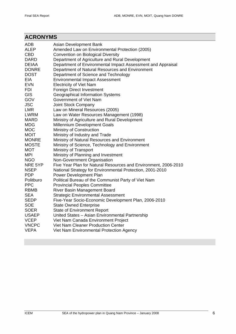
ACRONYMS ADB Asian Development Bank ALEP Amended Law on Environmental Protection (2005) CBD Convention on Biological Diversity DARD Department of Agriculture and Rural Development DEIAA Department of Environmental Impact Assessment and Appraisal DONRE Department of Natural Resources and Environment DOST Department of Science and Technology EIA Environmental Impact Assessment EVN Electricity of Viet Nam FDI Foreign Direct Investment GIS Geographical Information Systems GOV Government of Viet Nam JSC Joint Stock Company LMR Law on Mineral Resources (2005) LWRM Law on Water Resources Management (1998) MARD Ministry of Agriculture and Rural Development MDG Millennium Development Goals MOC Ministry of Construction MOIT Ministry of Industry and Trade MONRE Ministry of Natural Resources and Environment MOSTE Ministry of Science, Technology and Environment MOT Ministry of Transport MPI Ministry of Planning and Investment NGO Non-Government Organisation NRE 5YP Five Year Plan for Natural Resources and Environment, 2006-2010 NSEP National Strategy for Environmental Protection, 2001-2010 PDP Power Development Plan Politburo Political Bureau of the Communist Party of Viet Nam PPC Provincial Peoples Committee RBMB River Basin Management Board SEA Strategic Environmental Assessment SEDP Five-Year Socio-Economic Development Plan, 2006-2010 SOE State Owned Enterprise SOER State of Environment Report USAEP United States – Asian Environmental Partnership VCEP Viet Nam Canada Environment Project VNCPC Viet Nam Cleaner Production Center VEPA Viet Nam Environmental Protection Agency
Final SEA Report ADB, MONRE, EVN, MOIT, Quang Nam DONRE
ICEM SEA of the hydropower plan in Quang Nam Province – January 2008
7
SUMMARY This SEA was conducted on a plan already approved by the Quang Nam PPC and MOIT – the hydropower development plan for the Vu Gia – Thu Bon River Basin 2006-2010, a components of the overall power development plan for the province. When approved in 2006, the plan included close to 40 hydropower project proposals. By the time this SEA was completed the number of proposed projects had mounted to over 60, with proposals continuing to come in to the Quang Nam DOI. Following extensive review and consultation on 15 key economic, social and environmental themes of concern to sustainable development in the basin, the SEA concluded that the pace and scale of proposed hydropower development is at a level which cannot be sustained. As it stands, the plan with all its additional projects will be detrimental to the economies of the two provinces concerned, and will have serious negative consequences for the natural systems in the basin and for the livelihoods and well being of the ethnic minority groups most affected. A number of fundamental principles must underpin and drive implementation of the hydropower plan for the Vu Gia-Thu Bon River Basin. They are principles, which if followed, would enhance the sustainability and equity of the hydro sector in the basin. The seven principles are: 1. Net provincial economic gain: Quang Nam and Da Nang Provincial economies should not
be left worse off by the plan 2. User pays: HP operators should contribute to meeting all direct and indirect environmental
and socio-economic costs of the plan implementation 3. Multiple use: HP projects with reservoirs should be designed and managed for multiple use of
water resources 4. Safe operations: Implement operational regimes and institutional arrangements to reduce
droughts and floods and prepare for disasters 5. Net biodiversity gain: Avoid and minimize harm to biodiversity and introduce conservation
offsets 6. Net gain in minority well being: Reduce poverty and increase food security in affected
minorities 7. The precautionary principle: Take care to avoid permanent loss of provincial assets which
can occur by developing too much too quickly. These seven principles need to be expressed in practical ways at site, provincial, river basin and national levels. In the SEA, the principles are applied to four critical strategic concerns associated hydropower development in the basin – (i) water supply, (ii) economic development in Quang Nam and Da Nang Provinces, (iii) integrity of ecosystems, and (iv) minorities. Thirty four main mitigation and enhancement recommendations are made in this SEA, 14 relating to water supply, 7 to financing and employment measures, 10 for safeguarding the integrity of aquatic and terrestrial ecosystems and three for improving the livelihoods and quality of life of ethnic minorities. In this summary, only a few recommendations for each of the four critical strategic concerns will be emphasized, along with suggestions relating to institutional arrangements for integrated planning in the basin. Water supply Multiple-purpose use: All eight large hydro projects need to be managed as multi-purpose use facilities for water – to avoid future situations of acute water shortages. This will involve a strategic and co-operative long term approach, and a tactical (day by day, week by week) procedure for reservoir water release operations (ie the rule curve governing reservoir operations).
Final SEA Report ADB, MONRE, EVN, MOIT, Quang Nam DONRE
ICEM SEA of the hydropower plan in Quang Nam Province – January 2008
8
Rule Curve Preparation: Reserves of water should be held in the major reservoirs to provide compensatory flows for water supplies during droughts. This will be achieved by the preparation of seasonal guidelines for managing the reservoirs for drought control, which will be the basis of future Rule Curves. These will be agreed upon, and adhered to, by operator/owners of the dams. Water Supply Gate Dak Mi River: The diversion involved in the current design of the Dak Mi 4 project will create unnecessary and far reaching negative environmental, social and economic impacts in the Basin. The favoured mitigation is to redesign the project without the diversion. This will reduce the power capacity but eliminate the most serious negative risks. If the development has proceeded too far to consider this scale of redesign, then, as a second option, a water supply gate should be incorporated into the current project, so that its operation will avoid a major problem for water supply for Da Nang Province. Innovative financing Establish a River Basin Fund: A river basin fund should support the mitigation of detrimental impacts of hydropower on (i) the environment, (ii) minority groups, and (iii) affected sectors to offset natural system, social and economic losses in the basin due to hydropower development. The fund will redistribute some of the financial gains of hydropower operators to affected areas, communities and sectors in the basin. It would be replenished through deposits and other payments, various forms of taxing and fines for non compliance. Environmental management plans to set priorities for funding: Funds would only be allocated according to priorities set in environmental management plans for specific projects, and in the longer term, in an integrated river basin plan. Employment creation Employment creation as part of sectoral structural adjustment programmes: Hydropower will impact negatively on a number of sectors such as fisheries and forestry. Sectoral structural adjustment programmes should be introduced over a defined period to assist in retraining, technology innovation and employment creation. Development of a local hydropower servicing industry: With over 60 proposed hydropower operations in the basin a long term need for engineering services to support their maintenance will develop (recurrent costs are estimated to be a minimum of VND 744 billion (US$ 47 million)). Da Nang and Quang Nam should seek to develop a servicing sector for hydropower in the medium to long term. To this end DIC and DoLISA should develop a sectoral plan, including a technical school or other training facility in one of the basin’s major population centres. Ecosystem integrity Intact Rivers Program: Two complete river sequences, from headwaters to sea, should be kept free from barriers in each of the Vu Gia and Thu Bon Rivers to ensure that a full sequence of habitats and migratory routes is protected in each river. Potential candidate rivers for such an intact rivers scheme are the (i) Song Tien/Thu Bon (ii) Song Giang/Vu Gia. Song Giang: Five small hydro developments are planned for the Song Giang. It is understood that these are run-of-the-river schemes that may provide the opportunity for fish passages, allowing free migration. Yet, construction of at least four of these projects contravenes forest law because they are within the Song Thanh Nature Reserve. These projects should not be permitted to proceed.

Final SEA Report ADB, MONRE, EVN, MOIT, Quang Nam DONRE
ICEM SEA of the hydropower plan in Quang Nam Province – January 2008
9
Song Tien: Small/medium hydro schemes are planned for the Song Tien contributing only a small fraction of the total hydropower capacity for the basin. It is recommended that these project not proceed. The Song Tien has extensive middle and low land habitats so needs to be set aside as a complement to the Song Tien/Thu Bon which provides the high altitude habitat representation. Compensatory forest should take the form of establishing forest corridors to re-connect isolated forests or rehabilitating degraded forests to improve biological values of the landscape as a whole. Compensatory forestry should not be household based farm forestry fragmented through the landscape (as proposed by way of compensation for lost forests at Song Bung 4). That is a livelihoods improvement activity not an ecosystem conservation initiative. Communities should be involved in the allocation and management of these compensatory forest areas. The costs of these forestry interventions must be borne by the hydropower operators. Compensatory forestry as a mitigation measure to restore corridors along the border area, especially in maintaining connections between the Song Thanh NR and Ngoc Linh NR are critical, in addition to the current BCCI targeted area north of the E-W Economic Corridor. Ethnic minorities Integrated government service delivery for ethnic minorities: A range of central and local government departments need to be involved in the delivery of integrated support programs including agriculture, forestry, fishery and labor. The preparation and implementation of an Ethnic Minorities Development Plan associated with each project requires the collaborative delivery of services and resources from central, provincial and district/commune governments. Specific actions needed include establishing a provincial level inter-sectoral group on ethnic minorities with a dedicated budget and mandate to formulate and oversee the resettlement and long-term adjustment programs. Long-term adjustment programs for resettled communities (10-15 yrs): Difficulties suffered by ethnic minorities are created by short-term and piecemeal resettlement programs. Long-term adjustment support programs of 10 to 15 years are required to restore previous productive capacity and living standards. Specific actions include occupational change support and training, preferential credit and start-up investment funds, agricultural and forestry extension services and cultural heritage conservation Long term financial & non-financial commitment by hydropower developers: Regulations on resettlement and compensation do not make the investors fully responsible for all financial costs and socio-economic risks they create for the affected communities, especially in the medium to long-term. Central legislation is required so that developers are obligated in contracts to provide long-term support through (i) one-off payments; (ii) regular installments and (ii) a percentage of revenue. These revenues would be managed through the pilot river basin fund. River basin planning A number of important principles need to be followed in further development of the integrated river basin planning and management arrangements for Vu Gia – Thu Bon: A river basin organization should involve all provinces within the basin. This SEA has shown why the full participation of Quang Nam, Da Nang and Kon Tum Provinces is essential if appropriate development planning decisions effecting the management of water resources in the basin are to be made. Any structure for basin wide management needs to include representation of these three provinces. Maintain prominence of local government in the RBO. It will be important to maintain the prominence of the PPC in any basin wide structure and the chairmanship of any committee.

Final SEA Report ADB, MONRE, EVN, MOIT, Quang Nam DONRE
ICEM SEA of the hydropower plan in Quang Nam Province – January 2008
10
Maintain and extend the existing informal committee arrangement as a pilot: It may be better to continue the existing 'Committee' arrangement as a pilot rather than designating the organisation at this stage as an RBO under the water law. Local arrangements can be developed for representation of the three provinces concerned, with central government agencies taking part as observer members. Be flexible and informal in how the committee functions: Lessons from the Red River, suggest that the organisation should be flexible to deal with issues separately depending on how many groups are affected by any one issue. The three provinces should decide on the operating procedures of the committee. Begin involving the districts and communes affected by hydropower: It is important for integrated management capacity to be developed at Commune and District levels. . Follow priorities identified in this SEA report for committee discussion: The SEA lists the top issues to consider for placing on the Committee's agenda. Prepare an integrated river basin plan: Ultimately an integrated river basin plan will need to be prepared – and the sooner the better – it should be informed to a large extent by the SEA.
Final SEA Report ADB, MONRE, EVN, MOIT, Quang Nam DONRE
ICEM SEA of the hydropower plan in Quang Nam Province – January 2008
11
1 BACKGROUND TO THE SEA
1.1 Origin of the pilot SEA Many strategies and plans have broad reaching environmental implications that cannot be adequately or efficiently captured in the context of project-specific environmental assessment. Strategic Environmental Assessment (SEA), which includes assessments of cumulative impacts, addresses the broader strategic issues usually relating to more than one project and defines approaches for managing them. SEAs follow similar steps to EIA but have much larger boundaries in terms of time, space and subject coverage. SEAs serve as an umbrella level of analysis that feeds more specific EIAs and improves their quality. When addressing a development plan, SEAs can lead to revisions and adjustments to the plan and its implementation including (i) area (eg river basin) wide and cross sectoral mitigation, (ii) innovations to institutional arrangements, and (iii) modifications to planning and management procedures. SEA is a legal requirement in Viet Nam but it is a new tool and awareness, understanding and capacity in its use is in its early stages of development. The ADB Technical Assistance for Capacity Building in the Strategic Environmental Assessment (SEA) of the Hydropower Sector (TA 4713-VIE) was approved in December 2006 and ran from October 2006 to November 2007. The Ministry of Natural Resources and Environment (MONRE) is the Executive Agency for the project, with Electricity of Viet Nam (EVN) and the Ministry of Industry and Trade (MOIT) as partners. The purpose of the TA is to (i) develop the capacity within MONRE, EVN, MOIT and related government agencies in SEA preparation and appraisal and its uses in integrated watershed management; (ii) pilot a comprehensive SEA of planned and committed hydropower in the Vu Gia - Thu Bon River Basin in Central Viet Nam; and (iii) define and share the lesson learned from the pilot within government and with other development partners including donors and non-government organizations.
The pilot SEA was required to demonstrate the process and usefulness of SEA in identifying likely benefits and risks associated with hydropower in the basin. Key outputs were to include recommendations on the mitigation and monitoring of impacts and technical, policy and institutional guidance for SEA and hydropower development in Viet Nam. It should act as a pilot and demonstration for national application and for the benefit of all GMS countries. This report is the result of the pilot SEA.
1.2 Purpose of the pilot SEA The objective of the pilot SEA is to demonstrate SEA methodology and good SEA practice through the assessment of hydropower proposals and other development activities in the Vu-Gia Thu Bon River Basin. The SEA should pilot practical approaches for undertaking SEA in Viet Nam. It should test the relevant requirements laid down in national legal framework with particular regard to the contents of SEA Reports defined in the recent MONRE SEA/SEA Circular 08/2006/TT-BTNMT and in MONRE’s draft general guidelines now in advanced form. The intention is to test and contribute to development of both the general guidance and specific guidance for SEA application in the hydropower sector. This pilot SEA aims to demonstrate a comprehensive SEA process that examines impacts of the proposed hydropower developments on the overall economic developments trends and the associated social and environmental trends. It provides a broad overview of key ‘strategic impacts’ and resulting policy recommendations. The SEA does not replace detailed analyses that need to be performed for each individual project – it identifies gaps in information and when necessary suggests where more detailed studies are required.

Final SEA Report ADB, MONRE, EVN, MOIT, Quang Nam DONRE
ICEM SEA of the hydropower plan in Quang Nam Province – January 2008
12
1.3 Legislative basis for undertaking the SEA A key impediment to environmental-development integration had been the absence of any requirement for environmental assessments of policies, plans and programs under the Law on Environment Protection 1993 (LEP). This law was revised in 2005 and as of July 2006, Article 14 mandates SEA for national, provincial and inter-provincial strategies, planning and plans including:
1. National socio-economic development strategies, planning and plans. 2. Strategies and plans for development of branches or sectors on a national scale. 3. Socio-economic development strategies, planning and plans of provincial level or regions. 4. Plans for land use, forest protection and development; exploitation and utilization of other
natural resources in inter-provincial or inter-regional areas. 5. Plans for development of key economic regions. 6. General planning of inter-provincial river watersheds.
Responsibility for conducting SEAs falls on the state agency responsible for the strategy or plan development. SEA reports are to be evaluated by an “Appraisal Council”, which will be established by the agency with legal authority to approve the target plan. The LEP (2005) is supported by:
1. Decree No. 80/2006/ND-CP (August 2006), which guides implementation, reporting and appraisal arrangements and includes a detailed list of strategies and plans that require SEA. The decree also outlines institutional responsibilities for SEA and SEA reporting requirements.
2. Circular 08/2006/TT-BTNMT (September 2006), which provides detailed guidance and
instructions on the implementation of the LEP provisions relating to SEA. The circular also provides in Annex 1, detailed guidance on the required contents on an SEA report.
3. A draft MONRE General Guidance on Conducting SEA to be issued by MONRE in 2007 as
an evolving guide which will be regularly reviewed on the basis of experience in SEA implementation.
4. SEA Guidance for specific sectors to be prepared for hydropower and other key
development sectors by MONRE and the agencies concerned. The provisions of the LEP and supporting Decree and Circular are generally consistent with current approach to SEA adopted in Europe and those promoted by the OECD. The legal framework prescribes that SEA in Viet Nam should be undertaken as an integral part of strategy and plan development. This means that SEA should normally be undertaken prior to plan approval and as an integral part of the plan preparation process. However, it does not rule out the conduct of SEAs for existing plans or plans which have been substantially revised. In this case, the SEA is of a plan which already has been approved by the Quang Nam PPC and MOIT – ie the hydropower component of the Quang Nam Power Development Plan 2006-2010. A distinctive feature of the Viet Namese system is that SEAs need to cover environment, social and economic aspects of a strategy or plan – ie all three pillars of sustainable development as defined in the Strategic Orientation for Sustainable Development in Viet Nam (Viet Nam Agenda 21 Strategy) (2004). The LEP does not specifically require SEA for government policies or programs – although they are an inherent ingredient of strategies and plans.

Final SEA Report ADB, MONRE, EVN, MOIT, Quang Nam DONRE
ICEM SEA of the hydropower plan in Quang Nam Province – January 2008
13
1.4 Management and institutional arrangements The implementation arrangements for the pilot SEA were structured to achieve optimum involvement of the main government partners and the key officers of local and central government in conducting the pilot assessment and as the main focus of capacity building. Three structures were involved: (i) Steering Committee – MONRE (Chair), EVN and MOIT (ii) Pilot SEA Core Group – MONRE, EVN and MOIT (iii) Working Group on SEA of Hydropower Sector Steering Committee Formal approval for establishing the project steering committee was given by the Minister of MONRE in November 2006. As the National Project Director, Dr Pham Khang, Deputy Director of MONRE’s Department of Environmental Impact Assessment and Appraisal chaired the Committee. Members were: Mr Nguyen Van Thanh – Vice Director, Department of Science and Technology (MOIT) and
head of the MOIT Office of Environment, Ms Phan Thi Thuy Tien – Head, Department of Science, Technology and Environment (EVN),
and Mr Duong Chi Cong – Director (DONRE Quang Nam)
The Steering Committee met three times during the pilot SEA. Pilot SEA Core Group A core group was established by the steering committee as the main technical body overseeing and guiding the SEA project. It involved technical focal points from MONRE, MOIT and EVN and met at least once each month to provide detailed direction on the pilot and to facilitate its activities. The focal points were: Mr Pham Anh Dung – DEIAA/MONRE Mr Tran Viet Hoa – Department of Science and Technology, Ministry of Industry Ms Le Thi Ngoc Quynh, Department of Science, Technology, Environment &
Telecommunication, EVN Mr Pham Hong Son – Quang Nam DONRE
Dr Khang convened the core group when issues required consensus among the main partners or when their close involvement and contributions were required as in the case of the arrangements for the three provincial workshops. For key strategic issues, MONRE convened a meeting of the Steering Committee. The focal points facilitated all contributions to the pilot of their agency, the involvement of agency staff and the provision of agency information and documentation on request. The SEA team met with the focal points on a one-to-one basis or collectively within the core group or at review and planning sessions of the full SEA team. The Quang Nam DONRE took the lead in all arrangements and interactions involving provincial and district agencies in Quang Nam and Da Nang. Working Group on SEA Hydropower and consultation The main approach to engaging a wide range of central and local government experts and departments in the SEA was a program of workshops which were key analytical stages in the SEA

Final SEA Report ADB, MONRE, EVN, MOIT, Quang Nam DONRE
ICEM SEA of the hydropower plan in Quang Nam Province – January 2008
14
process. Two national and three provincial workshops were conducted, each contributing in a major way to the assessment, its findings and recommendations: (i) First national workshop (November 2006) (ii) Provincial Workshop 1 (November 2006)
Definition of key issues for basin development (iii) Provincial Workshop 2 (March 2007)
Past trends and current situation in key issues Future trends in key issues
(iv) Provincial Workshop 3 (August 2007) Identification of opportunities and risks Recommendations for enhancement and mitigation
(v) Final National Workshop (October 2007) Presentation of SEA report Discussion of recommendations Lessons learned from SEA pilot
A round of department by department consultations preceded each workshop with prior distribution of draft assessments for comment. The district, provincial and central government participants at the workshops were referred to as the SEA Working Group. The working group was the main mechanism for government technical participation and contributions to the assessment. Participants were provided with hands-on training at key stages of the pilot SEA, and exposed to key concepts relating to environmental assessment. The Working Group had a flexible membership drawing from a network of central and local government officers. Resources were not available to involve all group members in every event. The location of the pilot SEA in Quang Nam Province was a key determinant of membership – most coming from Quang Nam district and provincial level departments but also drawing from key departments in Da Nang. Figure 1.1 illustrates how the consultation process and the role of the working group led to a staged focusing on the strategic issues of critical concern to the hydropower plan.
1.5 Project approach and methodology
1.5.1 Methodology The methodology adopted for the pilot SEA is intended to closely link the process to the development planning sectors and processes in the Vu Gia – Thu Bon River Basin. It assumes that there are scarce financial and human resources, as well as time, to conduct SEAs in Viet Nam. It also assumes that there is some urgency to apply the tool to assist in guiding and shaping the very rapid and extensive development planned for the Basin in the hydropower sector. Above all, the method assumes that the information on many key issues is either not in place or only partially available. This necessitates a method and process which relies heavily on the judgments and opinions of the government officers and other national experts involved. Trend analysis: Based on the prevailing SEA practices in the European Union and the draft MONRE general SEA guidelines, this SEA used trend analysis as the primary analytical tool. Trend analysis is one of the most important elements of any strategic assessment. In the context

Final SEA Report ADB, MONRE, EVN, MOIT, Quang Nam DONRE
ICEM SEA of the hydropower plan in Quang Nam Province – January 2008
15
of the specific SEA requirements in Viet Nam1, it can be defined as an analysis of changes over time in the key environmental, social and economic issues. The trend analysis in this SEA focused on key issues of concern identified by the government and private sector stakeholders. It helped to trace key trends or patterns in the study area over the past 10 years and with an outlook of up to 20 year ahead. These trends were described mainly through: • Story-lines that qualitatively describe the key trends, their main drivers, territorial dimension
and key concerns for hydropower development; • Maps showing and overlaying spatial dimensions of key environmental, social and economic
issues; and where possible, • Simple graphs that used available data sets to illustrate evolution of key issues over time.
1.5.2 Steps in the assessment process The SEA employed the following analytical steps: (i) Identification of more than 80 environmental, social and economic issues considered by
the local stakeholders as important for development in the basin; (ii) Consolidation of the list of issues into 15 key environmental, social and economic themes (iii) Outline of the past and future trends in 15 key environmental, social and economic themes
in the study area without the hydropower plan (linked to the expected development trends should no hydro-power plan be implemented);
(iv) Outline of the expected future trends in 15 key environmental, social and economic themes in the study area with the hydropower plan;
(v) Based on the trend analysis, identification of four critical strategic concerns associated hydropower development in the basin – (i) integrity of ecosystems, (ii) water supply, (iii) minorities, and (iv) economic development in Quang Nam and Da Nang Provinces.
(vi) Assessment of the synergistic impacts of the hydropower plan on four critical strategic concerns; and
(vii) Formulation of a comprehensive set of recommended measures for preventing, reducing or off-setting negative impacts of the proposed hydropower plan and for enhancing any expected positive impacts.
These analytical steps were carried out through extensive consultations with national and local stakeholders – thus building their capacity for follow up activities after completion of the SEA and for possible replication of the SEA approach for hydropower plans in other basins. Figure 1.1 summarises the overall SEA approach and main steps in the process.
1 The Law on Environmental Protection (2005), Chapter 1, Article 3, Item 19 defines an SEA as an analysis and prediction of potential impacts of strategic projects and development planning and plans prior to approval in order to ensure the achievement of sustainable development

Final SEA Report ADB, MONRE, EVN, MOIT, Quang Nam DONRE
ICEM SEA of the hydropower plan in Quang Nam Province – January 2008
16
Figure 1.1: A schematic outline of the SEA process
2 OVERVIEW OF THE PROPOSED HYDROPOWER PLAN
2.1 The Quang Nam hydropower plan The hydropower development plan 2006 – 2010 of Quang Nam Province is the target of this SEA with the provincial Department of Industry identified as the responsible proponent agency. The plan is a component of the Master Plan for Electricity Development in Quang Nam Province, Period of 2006 – 2010 Towards 2015 approved by the Provincial Peoples Committee in 2006. The hydropower plan includes 8 large hydropower projects (ie of more than 30 MW) and 38 small (less than 10 MW) to medium (between 10 to 30 MW) projects (Map 1). Since 2006, a further 11 small and medium projects have entered the DOI planning pipeline which means that the plan has changed substantially since its approval with significant cumulative implications for the river basin. There are now some 50 small and medium hydropower projects planned or under development in the Basin in addition to the 8 “large” projects (Annex 1).
2.2 Energy planning and the Vu Gia – Thu Bon River Basin During the past decade, energy demand in Viet Nam has grown at a rate of 13-15% annually. Demand is projected to continue growing at a similar high pace over the next ten years. According to government estimates Viet Nam will need up to 100 billion kilowatts of power by 2010 and around double that by 2020. Generating capacity in the country will more than double from just under 11,000 MW in 2004 to over 22,000 MW in 2010. Hydropower is responsible for about 60% of the nation's electricity generation and this proportion is expected to grow to over 70% by the year 2010. Electricity output from hydropower plants will rise to 30 billion kWh a year.
1st round of provincial consultations 80 environmental, social and economic issues identified and priorities defined
2nd round of provincial consultations Trends analysed for 15 key themes without & WITH the HP plan
3rd round of provincial consultations Total impacts of the HP plan on critical strategic concerns: ecosystem integrity, water supply, minorities, and provincial economic development Mitigation measures identified
Final SEA Report ADB, MONRE, EVN, MOIT, Quang Nam DONRE
ICEM SEA of the hydropower plan in Quang Nam Province – January 2008
17
A large part of this expansion is planned to be in hydropower with a medium-term development program of 6,000 MW. EVN has identified nine priority river basins for future hydropower development. Within each of these watersheds multiple hydropower projects are operating, under construction, in planning or are seeking further investment. The Vu Gia - Thu Bon River Basin is ranked fourth in Viet Nam for potential hydropower generation capacity after the Da, Dong Nai and Se San river systems. The total hydropower potential of the Vu Gia - Thu Bon River Basin is estimated to be 1,300 MW with an annual energy potential at about 6 TWh. Quang Nam Province has two river basins - the Vu Gia - Thu Bon River Basin occupying 90% and other river basins occupying about 10% of the province (Map 3). The Government has listed 8 large-medium hydropower projects for the Vu Gia – Thu Bon River Basin in the Sixth National Power Development Plan (2006-2010). From 2003, Quang Nam Province began preparing a provincial hydropower plan as part of its power development plan. The provincial hydropower planning process took about 4 years, from 2003 to 2006, including a process of proposal making and revisions to add additional small and medium projects to the plan. This process of progressively adding projects to maximize the potential for hydropower development in the basin is continuing even though the plan for 2006-2010 has been adopted. Box 1.1: Legal framework for power development planning at provincial level According to Paragraph 2 of Article, the Law on Electricity, provincial/municipal peoples committees are
responsible for formulating local power development planning to be appraised by peoples’ councils of the same level before final approval by MOIT.
Decision No. 42/2005/QĐ-BCN dated 30 December, 2005 by MOIT stipulates the content and procedure for preparation and appraisal of power development planning and indicates that MOIT has the authority to approve provincial power development planning while the provincial people committees have the mandate to approve district power development planning.
Decision No. 30/2006/QĐ-BCN dated 31 August, 2006 by MOIT issues the Regulation on single power project investment and construction. This Regulation gives MOIT the authority to approve hydropower projects attributed to Group A, and DOI is responsible for approving projects under Group B and C.
2.3 The Vu Gia – Thu Bon River Basin The Vu Gia-Thu Bon system originates on the eastern side of the Truong Son mountain range (Map 3). It is short and steep with narrow valleys, steep riverbanks and many waterfalls and rapids. In the middle reaches the riverbed widens and shallows and in the downstream reach, riverbanks become low, allowing overflow into fields and 219 villages during the flood season. The Vu Gia-Thu Bon system has two main rivers - the Vu Gia and Thu Bon rivers. The Vu Gia River has many tributaries, the most significant being the Dak Mi (or Cai River), Bung, A Vuong and Con rivers. The length of the Vu Gia River to its mouth in Da Nang is 204 km. The Thu Bon River is 152 km long and originates at the borders of the three provinces of Quang Nam, Kon Tum and Quang Ngai at an elevation of more than 2,000 m. It runs in a north-south direction then changes its course to flow south-west – north-east and then west-east up to Giao Thuy before entering the sea through the Dai estuary. The total catchment area of the Vu Gia-Thu Bon River basin is 10,350 km2. Towards the downstream area, for some of the year there is an exchange of flow between the two rivers. The Quang Hue River diverts part of flow from the Vu Gia into the Thu Bon. About 16 km from the Quang Hue River, the Vinh Dien River returns part of the flow from the Thu Bon to the Vu Gia. During the SEA field missions, these connections were dry. Apart from the flow exchanges, the river system is also supplied with additional water from other branches, i.e., the Tuy Loan
Final SEA Report ADB, MONRE, EVN, MOIT, Quang Nam DONRE
ICEM SEA of the hydropower plan in Quang Nam Province – January 2008
18
River in Vu Gia with a catchment area of 309 km2 and a length of 30 km and the Ly Ly in Thu Bon with a catchment area of 275 km2 and a length of 38 km.2
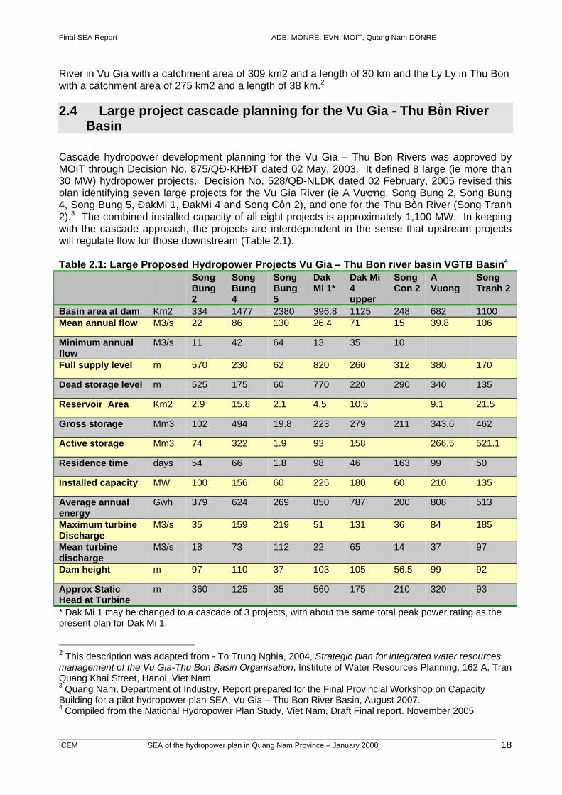
2.4 Large project cascade planning for the Vu Gia - Thu Bồn River Basin
Cascade hydropower development planning for the Vu Gia – Thu Bon Rivers was approved by MOIT through Decision No. 875/QÐ-KHÐT dated 02 May, 2003. It defined 8 large (ie more than 30 MW) hydropower projects. Decision No. 528/QĐ-NLDK dated 02 February, 2005 revised this plan identifying seven large projects for the Vu Gia River (ie A Vương, Song Bung 2, Song Bung 4, Song Bung 5, ÐakMi 1, ÐakMi 4 and Song Côn 2), and one for the Thu Bồn River (Song Tranh 2).3 The combined installed capacity of all eight projects is approximately 1,100 MW. In keeping with the cascade approach, the projects are interdependent in the sense that upstream projects will regulate flow for those downstream (Table 2.1). Table 2.1: Large Proposed Hydropower Projects Vu Gia – Thu Bon river basin VGTB Basin4 Song
Bung 2
Song Bung 4
Song Bung 5
Dak Mi 1*
Dak Mi 4 upper
Song Con 2
A Vuong
Song Tranh 2
Basin area at dam Km2 334 1477 2380 396.8 1125 248 682 1100 Mean annual flow M3/s 22 86 130 26.4 71 15 39.8 106
Minimum annual flow
M3/s 11 42 64 13 35 10
Full supply level m 570 230 62 820 260 312 380 170
Dead storage level m 525 175 60 770 220 290 340 135
Reservoir Area Km2 2.9 15.8 2.1 4.5 10.5 9.1 21.5
Gross storage Mm3 102 494 19.8 223 279 211 343.6 462
Active storage Mm3 74 322 1.9 93 158 266.5 521.1
Residence time days 54 66 1.8 98 46 163 99 50
Installed capacity MW 100 156 60 225 180 60 210 135
Average annual energy
Gwh 379 624 269 850 787 200 808 513
Maximum turbine Discharge
M3/s 35 159 219 51 131 36 84 185
Mean turbine discharge
M3/s 18 73 112 22 65 14 37 97
Dam height m 97 110 37 103 105 56.5 99 92
Approx Static Head at Turbine
m 360 125 35 560 175 210 320 93
* Dak Mi 1 may be changed to a cascade of 3 projects, with about the same total peak power rating as the present plan for Dak Mi 1.
2 This description was adapted from - To Trung Nghia, 2004, Strategic plan for integrated water resources management of the Vu Gia-Thu Bon Basin Organisation, Institute of Water Resources Planning, 162 A, Tran Quang Khai Street, Hanoi, Viet Nam. 3 Quang Nam, Department of Industry, Report prepared for the Final Provincial Workshop on Capacity Building for a pilot hydropower plan SEA, Vu Gia – Thu Bon River Basin, August 2007. 4 Compiled from the National Hydropower Plan Study, Viet Nam, Draft Final report. November 2005

Final SEA Report ADB, MONRE, EVN, MOIT, Quang Nam DONRE
ICEM SEA of the hydropower plan in the Vu Gia-Thu Bon River Basin page 19 of 204
Figure 1.2: Overview of the approach used in this pilot SEA Themes and issues that SEA focuses on
Past and future trends in key issues without the HP plan
Future trends in the key issues with the HP plan
Future trends with HP plan
Conclusions and
recommendations Themes
addressed in the SEA
Specific issues of concern
Past trends and their drivers in key issues
Likely future evolution of these trends due to related plans or planned major projects in the study area that will take place even if the HP plan is not implemented
Direct impacts of various components of the HP plan on the expected future trends (i.e. building on the analysis of trends without HP plan)
Cumulative impacts of all trends with the HP plan and implications for critical strategic concerns
ENV
SOC
ECON
Hydrology, water quality,
aquatic & terrestrial biodiversity, etc.
Clear qualitative explanation of the trends and implications .. when data not available
..graphs and maps when data availableDemography/migration, ethnic
groups and their livelihoods, health, etc.
Agriculture, fisheries, transport, mining, industry, tourism, etc.
- National actions - Actions in the river basin (new planning process, institutional arrangements, monitoring) - Provincial actions - Project-specific actions (suggestions for detailed project design and assessments)
Implications of the predicted future trends with the HP plan on the critical strategic concerns: integrity of ecosystems, water supply, minorities, and economic development of Quang Nam and Dan Nang

Final SEA Report ADB, MONRE, EVN, MOIT, Quang Nam DONRE
ICEM SEA of the hydropower plan in the Vu Gia-Thu Bon River Basin page 20 of 204
Four of the large projects are under construction: A Vương 1: owned by EVN, started in August, 2003, expected to generate power in
December, 2007 and to be completed in 2008. Sông Tranh 2: Owned by EVN, started in March, 2006, will become operational in 2009, to be
completed by 2010. Sông Côn 2: Owned by Sông Côn Joint Stock Company, started in November, 2005, planned
to generate power from October, 2008. Ðăk Mi 4: Owned Urban and Industrial Zone Development Corporation (IDICO), started in April
2007, operational in first quarter of 2011.
2.5 Small and medium-sized hydropower planning The Quang Nam hydropower plan identifies 36 small (ie less than 10 MW) and medium-sized (ie from 10 to 30 MW) HP projects with a total capacity of 346 MW approved. The Provincial People’s Committee has requested DOI to prepare proposals for an additional 11 projects to be licensed for investment. One of the small and medium-sized hydropower projects identified in the plan is completed - the 9 MW Khe Diện project developed by the Song Ban HP Joint-stock Company came into operation in June, 2007. Five other projects are under construction: An Ðiềm 2: Invested by Song Vang Joint-Stock; planned capacity of 15, 9 MW; designed
capacity of 15 MW; construction began in September, 2004; generation projected for Dec 2007, to be completed in 2008.
Song Cung: Hoang Anh QN Joint-Stock; planned capacity of 1.6 MW; designed capacity of 1.3 MW; construction began in July 2004; generation in December 2006, to be completed in 2007
Dại Ðồng: QT Investment & Construction Ltd.; planned capacity of 0.6 MW; designed capacity of 1.0 MW; construction began April 2004; generation in February 2006.
Trà Linh 3: Construction Joint-Stock No.699; planned capacity of 6 MW; designed capacity of 7.2 MW; construction of subsidiary facilities started; generation projected for Dec 2007, completed in March 2008.
Za Hung: Investment registered for Za Hưng Joint-Stock; planned capacity 18 MW; designed capacity 28 MW; main component started in 2007; to be completed in December 2008, the remaining components on the verge of investment.
Five of the planned small and medium sized projects are located in the Song Thanh Nature Reserve:
Song Giang 1: Investment was registered by Song Da Construction Corp., planned capacity 6.5 MW, designed capacity 6.5 MW, annual generation 32.26 million kWh, total investment 111.221 billion VND.
Song Giang 2: Song Da Construction Corp. registered for investment, planned capacity 18 MW, designed capacity 18 MW, annual generation 89.41 million kWh, total investment 242.36 billion VND.
Song Giang 3: Song Da Construction Corp. registered for investment, planned capacity 7 MW, designed capacity 7 MW, annual supply 33.69 million kWh, investment totaling at 126.6 billion VND.
Song Giang 4: Quang Nam Construction & Water Supply Company registered for investment, planned capacity 4.5 MW, designed capacity 4.5 MW, annual supply 22.5 million kWh, investment totaling at 88.92 billion VND.
The Dac Se dam is located in the Nature Reserve and will require a road and transmission line along the river valley causing a further break in the continuity of the natural forest habitat.

ADB, MONRE, MOIT and EVN: TA 4713-VIE - Capacity Building in the SEA of the Hydropower Sector in Viet Nam
ICEM SEA of the hydropower plan in the Vu Gia-Thu Bon River Basin page 21 of 204
According to Quang Nam Department of Forest Protection, the location identified for the construction of Song Chang 2 is in forest districts 677, 678, 682 (Phuoc Xuan Commune, Phuoc Son District) and other forest districts 402, 403, 407, 408 (Dakpin Commune, Nam Giang District) of the strictly protected zone of Song Thanh Nature Reserve. The site defined for the construction of Song Chang 4 is forest districts 304 and 307 of the rehabilitation zone and forest districts 308 and 311 of the strictly protected zone of Nature Reserve (Map 6). 5 In summary, the Quang Nam hydropower plan seeks to maximize hydropower development of all available and suitable river sections within the basin. An analysis of the hydropower planning experience of Quang Nam Province shows that cumulative environmental concerns are not taken into account in preparing the provincial hydropower development plan (Annex 1). No consideration has been given to the environmental relationships between the 8 medium to large projects listed for Quang Nam in the National Hydropower Development Plan and the 36 small-medium projects listed in the Provincial Hydropower Plan. To date, Environmental Impacts Assessments or environmental protection commitments have been required by MONRE and the Quang Nam DONRE for the eight large projects and a number of small-medium projects. Several of the EIAs, especially relating to Song Bung 4, involved extensive assessments of potential project specific impacts. Table 2.2 lists those EIAs and EPCs which MONRE and the Quang Nam DONRE advised the SEA team have been completed. Table 2.2: EIAs and EPC of hydropower projects in the Vu Gia – Thu Bon Basin Project EIA/EPC and responsible
authority 1. A Vuong 2. Song Chanh 2 3. Song Bung 4 4. Song Con 2 5. Dak Mi 4 6. Song Bung 2 7. Cha Val 8. An Diem 9. An Diem 2 10. Dac Pring 11. Khe Dien 12. Za Hung
EIA – MONRE EIA – MONRE EIA – MONRE EIA – DONRE EIA – DONRE EIA – DONRE EIA – DONRE EIA – DONRE EPC – DONRE EPC – DONRE EPC – DONRE EPC – DONRE
Sources: MONRE and Quang Nam DONRE
5 The Strict Protection Zone of protected areas is defined as an area of national importance for maintaining environmental and biodiversity values intact and infrastructure and industrial development projects are specifically prohibited from these areas (Decision 186/2006/QD-TTg).

ADB, MONRE, MOIT and EVN: TA 4713-VIE - Capacity Building in the SEA of the Hydropower Sector in Viet Nam
ICEM SEA of the hydropower plan in the Vu Gia-Thu Bon River Basin page 22 of 204
3 KEY ENVIRONMENTAL, ECONOMIC AND SOCIAL ISSUES ADDRESSED IN THIS SEA PROCESS
3.1 Issues of relevance to development of the Vu Gia Thu Bon river basin
The SEA process began with a consultative workshop with Quang Nam and Da Nang provincial and district authorities (Tam Ky, Quang Nam, November 2006) which identified 80 issues of relevance to overall socio-economic development of the Vu Gia -Thu Bon River Basin (Table 3.1). Workshop participants were also asked to score each identified issue to obtain initial advice on their relative importance and to assist in the process of strategic focusing of the SEA on the key concerns. In Table 3.1, the higher the score the more significant the issue for basin development in the view of stakeholders at the first provincial consultation workshop. Table 3.1: Identification and ranking of issues of relevance to development of the Vu Gia -Thu Bon river basin Themes Issues identified by provincial and district authorities Priority
ranking
Environ-mental
1 Hydrology Water shortage in dry season, low water levels 11 Big floods causing charges in water flow patters 3 Pollution of surface and underground water 6 Water sources downstream of Thu Bon river decreasing 7 2 Water
quality Industrial wastes - heavy metal and chemical pollution increasing 8
High sedimentation loads due to deforestation 7 Salt intrusion in dry season - increasing 6 Toxic chemicals from the American War remaining 1 3 Aquatic
Biodiversity Increasing demand in use and export of natural products 2
Polluted environment affecting fish and plant species 2 Use of destructive fishing equipment 4 Traditional practices and sustainable use braking down 6 4 Terrestrial
Biodiversity Abundant and diversified fauna and flora deteriorating 10
Biodiversity values mainly remaining in upstream areas 1 Strengthened high role of regional biodiversity conservation 1 5 Land/Soil High level and increasing risk of erosion 9 Economic 6 Aquaculture
and fisheries Intensive fishing leading to reduced catch per unit effort 8
Reduction of feed sources for aquaculture – increasing costs - Main economic species in rivers reduced/eliminated by
reservoirs/dams 2
Pollution effecting aquatic habitats 8 7 Agriculture Soil erosion in upland agricultural areas, agricultural land
degradation in downstream areas, acidic soils 11
Rice monoculture 1

ADB, MONRE, MOIT and EVN: TA 4713-VIE - Capacity Building in the SEA of the Hydropower Sector in Viet Nam
ICEM SEA of the hydropower plan in the Vu Gia-Thu Bon River Basin page 23 of 204
Use of fertilizers and pesticides causing pollution of soil and water
9
Reducing area of brackish aquaculture and increasing area of fresh water aquaculture, high environmental impact
-
8 Irrigation Only 55% of irrigation demand met 6 Competition of water use/demand between irrigation and
hydropower – multi-use management required 2
9 Water supply
Lack of water supply for residential areas 6
Water demand for industry and domestic use rapidly increasing - Increasing ecological water demand: pushing back salt intrusion,
combating pollution (ie flushing); mitigating soil erosion along banks (waterways) by reducing extreme flooding
-
Lack of attention to systematic basin wide management and utilization of hydropower projects, lack of coordination among sectors
6
Lack of regular announcements on water quality and supply 1 Industrial park development, increase of water demand causing
imbalance of ecology and population concentrations 4
10 Forestry Large natural forest area, high forest coverage in upland watersheds - high priority for conservation
5
Livelihood of many households depending on forest resource and forest production
8
11 Urban development
Building projects in low lying areas frequently flooded 2
Housing space fragmented, ribbon development, lack of associated infrastructure
7
Lack of safe water for residential areas 1 12 Transport Poor quality of local roads, many roads blocked, lack of roads to
commune centres (29) 10
Limited use of inland waterways for transport (32%) 2
Poor inland waterway infrastructure 1
13 Mining Causing pollution of surface and ground water 4 Excessive exploitation of clay minerals; uncontrolled and poorly
managed mining 7
Illegal exploitation of gold along rivers and in special use forests 6 Mining permitted in rivers where reservoirs are planned - 14 Industry Concentration of development within the basin - remote regions
for raw material extraction and processing plants 10
Conflict between primary industrial development (extractive including hydro) and development of other sectors – in use of land and resources
3
Causing pollution of surface and ground water 2
15 Hydropower Management of water discharge - Shortage of water in dry season when energy requirements draw
down on reservoirs 4
Sedimentation in rivers and reservoirs – life span of reservoirs? 2
Competition of water use/demand among sectors -
16 Tourism Rapid increase of tourists 3

ADB, MONRE, MOIT and EVN: TA 4713-VIE - Capacity Building in the SEA of the Hydropower Sector in Viet Nam
ICEM SEA of the hydropower plan in the Vu Gia-Thu Bon River Basin page 24 of 204
Rapid growth of restaurants and hotels 1 Increase of waste loads 9 Restoration and development of trade villages 1 Social 16 Demography Increasing immigration to urban areas from rural areas 1 Increase of resettlements 4 Poor labour force quality/training 6 Slow labour structural change/High percentage of workers in
state enterprises 1
17 Health Increase in life expectancy - High rate of child malnutrition 4 Waterborne diseases increasing in flood season 3 Malaria still exists 2 Better access to health services 3 HIV – small but potentially growing problem - 18 Ethnic
minorities Dependence on swidden agriculture, forest products and fishing in rivers
6
High poverty rate 6 Low education 5 Conservation of distinctive cultural characteristics 2 Specific and diverse religions - Need to develop education and health services - The priorities defined during the first round of consultations assisted in the consolidation of issues into key themes or issues in the second round.
3.2 Key themes or issues addressed by the SEA The priorities defined and subsequent consultations with local government reduced and consolidated the initial long-list of issues into a more manageable short-list of 15 key themes to be addressed by the SEA. The key theme short-list and their relationship to hydropower development in the Basin became the backbone of the assessment. The list evolved during the early stages of the SEA – of the original 80 issues, some issue were reformulated, some were added and some were skipped during the assessment process as information gathering and consultation progressed (Table 3.2). Table 3.2: Key themes or issues addressed by the SEA Key themes addressed within the SEA (see Chapters 4, 5 and 6)
1. ‘Climate situation with emphasis on rainfall’ 2. ‘Dry season minimal flows and effect on salinity intrusion’
3. ‘Flooding and maximum flows’ 4. ‘Sediment transport and sand excavation’ 5. ‘Aquatic biodiversity and fisheries’
6. ‘Forest management and terrestrial biodiversity’
7. ‘Demography and migration’
8. ‘Minorities’
ADB, MONRE, MOIT and EVN: TA 4713-VIE - Capacity Building in the SEA of the Hydropower Sector in Viet Nam
ICEM SEA of the hydropower plan in the Vu Gia-Thu Bon River Basin page 25 of 204
9. ‘Public health’ 10. ‘Transport’ 11. ‘Agriculture and irrigation’
12. ‘Industrial development’
13. ‘Tourism development’
14. ‘Mining’
15. ‘Waste management’
These 15 key themes were the focus of the SEA trend analysis as described in the methodology section 1.5.1. In the chapters which follow, these 15 themes or key issues provide the framework for the structure of the SEA report. Each theme or key issue is analysed in turn for past, current and future trends without and with the hydropower plan.

ADB, MONRE, MOIT and EVN: TA 4713-VIE - Capacity Building in the SEA of the Hydropower Sector in Viet Nam
ICEM SEA of the hydropower plan in the Vu Gia-Thu Bon River Basin page 26 of 204
4 PAST TRENDS AND CURRENT SITUATION IN KEY ISSUES FOR DEVELOPMENT OF THE RIVER BASIN
4.1 Issue: ‘Climate situation with emphasis on rainfall’ The Vu Gia – Thu Bon Basin experiences extreme fluctuations in annual precipitation. The wettest years bring approximately 4-6 times more rainfall than the driest years. Maximum monthly rainfall occurs during September-November and is sometimes caused by typhoons but can also occur without typhoons. From 1997-2006 fourteen typhoons and depressions made landfall in the area. During the last 15 years, there was no increase in occurrence of “category 4-5” typhoons in the Western Pacific6 compared to the situation that occurred during the 1970’s and 1980’s. The driest months are February and March, and have about 15 times less rainfall than wettest months (Figure 4.1). On average, only 1 – 2% of annual rainfall occurs during the months. Early season rains occur in some years during the May to June period, and are important in providing relief from drought conditions. Figure 4.1: Seasonal distribution of mean monthly rainfall in Vu Gia and Thu Bon River Basin
0200400600800
1000
Jan March May July Sep Nov
Monthly rainfall at three stations - Vu gia - Thu Bon River Basin (mm)
Da NangTra MyThanh My
Sources: Water balance and Downstream benefit analysis for Hydropower projects on Vu Gia Thu Bon basin – Institute of Water Resources Planning (IWARP) Spatial trends The average annual rainfall in upland areas of the basin is approx 3000-4000 mm. This is approx. 50-100% higher than annual rainfall in the coastal areas (approx 2000 mm per year). The wettest area in the basin is in the mountains south and east of Tra My (Figures 4.2 and 4.3).
6 Wu M.C., Yeung K.H. and Chang W.L. 2006. “Trends in Western North Pacific Tropical Cyclone Intensity”. EOS Transactions of American Geophysical Union Vol 87 No 48 page 537

ADB, MONRE, MOIT and EVN: TA 4713-VIE - Capacity Building in the SEA of the Hydropower Sector in Viet Nam
ICEM SEA of the hydropower plan in the Vu Gia-Thu Bon River Basin page 27 of 204
Figure 4.2: Average annual rainfall in Nong Son (Vu Gia) and Giao Thuy (Thu Bon)
01000200030004000
ThanhMy
AiNghia
NongSon
GiaoThuy
NamPhuoc
CamLe
Average annual rainfall (mm) upstream of 6 locations
Source: Water balance and Downstream benefit analysis for Hydropower projects on Vu Gia Thu Bon basin – Institute of Water Resources Planning (IWARP) Figure 4.3: Spatial distribution of average annual rainfall in Vu Gia Thu Bon River Basin
Sources: Quang Nam DARD 2006
4.2 Issue ‘Dry season minimal flows and effect on salinity intrusion’ There is a large difference between dry season minimal flows in different years. Long-term average monthly minimal flows for the Vu Gia at Ai Nghia are 45 m3/s and about 50% of this amount during the driest day on record (4th September 1998). Long-term average monthly minimal flows for the Thu Bon at Nong Son are 28 m3/s and about 50% of this amount during the driest day of record (17th August 1977). During the dry season, the Thu Bon and Vu Gia Rivers flow via separate estuarine channels. The Quang Hue connection is blocked by a sand bar near the Thu Bon channel from early April for several weeks during the dry season. The elevation of the water surface of the flow in the Vu Gia channel is higher than the (parallel) flow in the Thu Bon channel.

ADB, MONRE, MOIT and EVN: TA 4713-VIE - Capacity Building in the SEA of the Hydropower Sector in Viet Nam
ICEM SEA of the hydropower plan in the Vu Gia-Thu Bon River Basin page 28 of 204
Salinity intrusion is a problem in the driest months. Intrusion used to extend to the Da Nang city water intake (Cau Do) at the Highway 1 rail/road bridge every 10 years in the past and every 5 years more recently. Concentrations of about 1000 mg/L of total dissolved solids and greater (about 1/35th of undiluted seawater) are unacceptable for municipal water supplies, because of problems with taste/odour, and because of excessive scaling of household appliances.7,8 Sea level increases compared with land elevation has been happening at the rate of about 3 mm per year over the last 3 decades, based on data from the Hon Dau tidal gauge. A small part of this increase is associated with land subsidence. Sea level increases have probably been driving saline water further inland than in the past. The effect on intrusion is hard to quantify without modeling. Figure 4.3 shows a sand bar prevents flow of water in either direction along the Quang Hue channel during the dry season (photo of 29th March 2007). (Map 2) Figure 4.3. Quang Hue cross channel connection near Song Thu Bon junction.
Figure 4.4 shows that the VGSB Delta is characterised by separate channels to the ocean - a northern route Song Vu Gia, Song Ai Nghia, Song Yen Song Cau Do, and southern route Song Thu Bon to Hoi An. The upper area of the delta is cross connected for part of the year by the Quang Hue channel. The channel shown in yellow in the Figure is controlled by a rock weir (Dai Cuong) on the Song Vu Gia channel, and does not flow during the dry season.
7 World Health Organisation 2006. Guidelines for Drinking Water Quality. First Addendum to Third Edition. Volume 1 Recommendations. Page 218 Total Dissolved Solids. 8 Health Canada 1991. Environmental and Workplace Health: Guidelines for Canadian Drinking Water Quality. Supporting Documents Total Dissolved Solids.
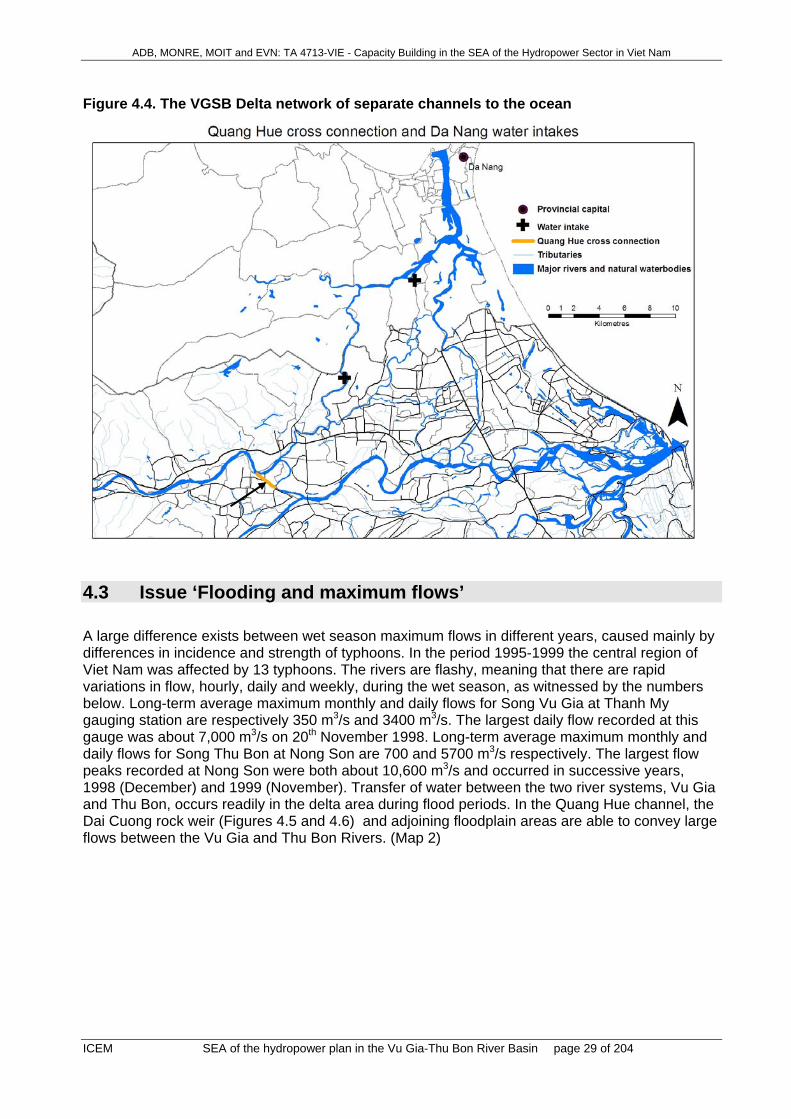
ADB, MONRE, MOIT and EVN: TA 4713-VIE - Capacity Building in the SEA of the Hydropower Sector in Viet Nam
ICEM SEA of the hydropower plan in the Vu Gia-Thu Bon River Basin page 29 of 204
Figure 4.4. The VGSB Delta network of separate channels to the ocean
4.3 Issue ‘Flooding and maximum flows’ A large difference exists between wet season maximum flows in different years, caused mainly by differences in incidence and strength of typhoons. In the period 1995-1999 the central region of Viet Nam was affected by 13 typhoons. The rivers are flashy, meaning that there are rapid variations in flow, hourly, daily and weekly, during the wet season, as witnessed by the numbers below. Long-term average maximum monthly and daily flows for Song Vu Gia at Thanh My gauging station are respectively 350 m3/s and 3400 m3/s. The largest daily flow recorded at this gauge was about 7,000 m3/s on 20th November 1998. Long-term average maximum monthly and daily flows for Song Thu Bon at Nong Son are 700 and 5700 m3/s respectively. The largest flow peaks recorded at Nong Son were both about 10,600 m3/s and occurred in successive years, 1998 (December) and 1999 (November). Transfer of water between the two river systems, Vu Gia and Thu Bon, occurs readily in the delta area during flood periods. In the Quang Hue channel, the Dai Cuong rock weir (Figures 4.5 and 4.6) and adjoining floodplain areas are able to convey large flows between the Vu Gia and Thu Bon Rivers. (Map 2)

ADB, MONRE, MOIT and EVN: TA 4713-VIE - Capacity Building in the SEA of the Hydropower Sector in Viet Nam
ICEM SEA of the hydropower plan in the Vu Gia-Thu Bon River Basin page 30 of 204
Figure 4.5: Quang Hue Channel, and location of breakthrough channel that was opened in about 1999 by extreme flows in Song Vu Gia
Source: Google Earth photo 2007 During the flood season, large flows are passed over the weir at Dai Cuong, and directed to the Song Thu Bon channel via the Quang Hue channel, helping to minimise flood magnitudes in the Song Ai Nghia, Song Yen system. Since the Figure 4.6 photo was taken in March 2007, this structure has collapsed and will need rebuilding. Figure 4.6: Rubble weir at Dai Cuong, built in about year 2000, to contain Song Vu Gia in its present channel and to control loss of flow to Song Thu Bon
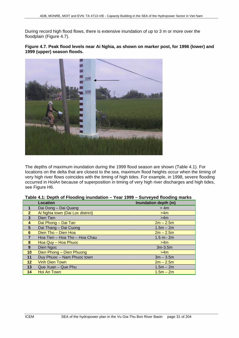
ADB, MONRE, MOIT and EVN: TA 4713-VIE - Capacity Building in the SEA of the Hydropower Sector in Viet Nam
ICEM SEA of the hydropower plan in the Vu Gia-Thu Bon River Basin page 31 of 204
During record high flood flows, there is extensive inundation of up to 3 m or more over the floodplain (Figure 4.7). Figure 4.7. Peak flood levels near Ai Nghia, as shown on marker post, for 1996 (lower) and 1999 (upper) season floods.
The depths of maximum inundation during the 1999 flood season are shown (Table 4.1). For locations on the delta that are closest to the sea, maximum flood heights occur when the timing of very high river flows coincides with the timing of high tides. For example, in 1998, severe flooding occurred in HoiAn because of superposition in timing of very high river discharges and high tides, see Figure H6. Table 4.1: Depth of Flooding inundation – Year 1999 – Surveyed flooding marks Location Inundation depth (m)
1 Dai Dong – Dai Quang > 4m 2 Ai Nghia town (Dai Loc district) >4m 3 Dien Tien >4m 4 Dai Phong – Dai Tan 2m – 2.5m 5 Dai Thang – Dai Cuong 1.5m – 2m 6 Dien Tho – Dien Hoa 2m – 2.5m 7 Hoa Tien – Hoa Tho – Hoa Chau 1.5 m– 2m 8 Hoa Quy – Hoa Phuoc >4m 9 Dien Ngoc 3m-3.5m 10 Dien Phong – Dien Phuong >4m 11 Duy Phuoc – Nam Phuoc town 3m – 3.5m 12 Vinh Dien Town 2m – 2.5m 13 Que Xuan – Que Phu 1.5m – 2m 14 Hoi An Town 1.5m – 2m
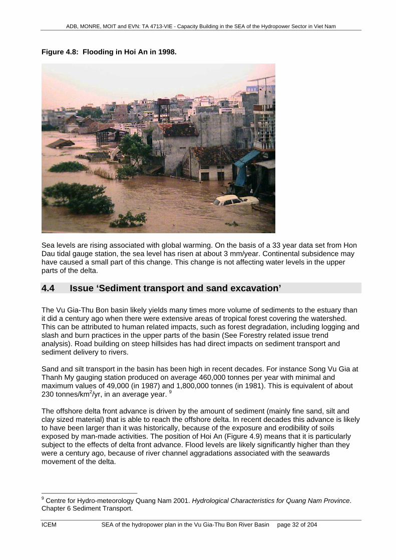
ADB, MONRE, MOIT and EVN: TA 4713-VIE - Capacity Building in the SEA of the Hydropower Sector in Viet Nam
ICEM SEA of the hydropower plan in the Vu Gia-Thu Bon River Basin page 32 of 204
Figure 4.8: Flooding in Hoi An in 1998.
Sea levels are rising associated with global warming. On the basis of a 33 year data set from Hon Dau tidal gauge station, the sea level has risen at about 3 mm/year. Continental subsidence may have caused a small part of this change. This change is not affecting water levels in the upper parts of the delta.
4.4 Issue ‘Sediment transport and sand excavation’ The Vu Gia-Thu Bon basin likely yields many times more volume of sediments to the estuary than it did a century ago when there were extensive areas of tropical forest covering the watershed. This can be attributed to human related impacts, such as forest degradation, including logging and slash and burn practices in the upper parts of the basin (See Forestry related issue trend analysis). Road building on steep hillsides has had direct impacts on sediment transport and sediment delivery to rivers. Sand and silt transport in the basin has been high in recent decades. For instance Song Vu Gia at Thanh My gauging station produced on average 460,000 tonnes per year with minimal and maximum values of 49,000 (in 1987) and 1,800,000 tonnes (in 1981). This is equivalent of about 230 tonnes/km2/yr, in an average year. 9 The offshore delta front advance is driven by the amount of sediment (mainly fine sand, silt and clay sized material) that is able to reach the offshore delta. In recent decades this advance is likely to have been larger than it was historically, because of the exposure and erodibility of soils exposed by man-made activities. The position of Hoi An (Figure 4.9) means that it is particularly subject to the effects of delta front advance. Flood levels are likely significantly higher than they were a century ago, because of river channel aggradations associated with the seawards movement of the delta.
9 Centre for Hydro-meteorology Quang Nam 2001. Hydrological Characteristics for Quang Nam Province. Chapter 6 Sediment Transport.

ADB, MONRE, MOIT and EVN: TA 4713-VIE - Capacity Building in the SEA of the Hydropower Sector in Viet Nam
ICEM SEA of the hydropower plan in the Vu Gia-Thu Bon River Basin page 33 of 204
Figure 4.9 shows the plume of fine silt and clay sized materials entering the sea. Flood levels have increased in recent years, associated with channel aggradation and delta front advance. Lines showing former delta front locations are shown, supporting historical evidence that Hoi An was previously much closer to the sea. Much reduced supply of sand and silt to the delta are forecast to occur after construction of the large dams. Nutrient supply to the Bien Dong (East Sea) will be reduced by a large factor. Figure 4.9: Present Location of Hoi An on the Delta
Sand mining from river channels is extensively practiced, and provides valuable low cost fill for building foundations and construction (Figures 4.10 and 4.11). Sand sized material is brought in by barge, and transferred to trucks for local delivery (Figure 4.10). Other mining operations e.g gold mining, conducted by machine operated dredges within the river channels, destabilises the natural armouring that is present on the bed of rivers, causes high turbidity10, and a man-made increase in bed load movement (Map 16). Figure 4.10: Sediment trans-shipment, Song Yen near Route 1 Bridge
10 Bird J., Jay Roop, B Quynh Nga 2005. Song Bung 4 Hydropower Project, Viet Nam. Report on Water Resources, Environmental and Social Issues. ADB TA 4475-VIE: PPTA Phase 1.

ADB, MONRE, MOIT and EVN: TA 4713-VIE - Capacity Building in the SEA of the Hydropower Sector in Viet Nam
ICEM SEA of the hydropower plan in the Vu Gia-Thu Bon River Basin page 34 of 204
Bank stability is related to suspended sediment and bed load movement. Bank protection with rip rap is expensive. For example, from 1990 to 2006, Quang Nam government has spent 189 billions VND to improve 47 sites of river embankments with a length of 43.55km. About 8000 households were thereby protected. Figure 4.11: Sand Excavation from Song Tien, near Tien Ky
4.5 Issue ‘Aquatic biodiversity and fisheries’ Biodiversity includes the abundance and variety of organisms as well as the ecosystems to which they belong and the ecological processes that support them (Huston 1994, Kottelat & Whitten 1996). Viet Nam has extensive natural resources exemplified by extremely high aquatic
ADB, MONRE, MOIT and EVN: TA 4713-VIE - Capacity Building in the SEA of the Hydropower Sector in Viet Nam
ICEM SEA of the hydropower plan in the Vu Gia-Thu Bon River Basin page 35 of 204
biodiversity, including many of national and international importance (MOSTE 1995). Fish diversity is extremely high, with 2470 species of fish (MOSTE 1995), including at least 268 species of native freshwater fish (Kottelat 2001), including 7 species listed as vulnerable in the national Red Book (Clupanodon punctatus, Onychostoma laticeps, Bangana lemassoni, Spinibarbus hollandi, Tor tambroides, Cranoglanis sinensis and Bagarius bagarius) (Red Book of Viet Nam, 2000). Other aquatic taxa are also likely to extremely diverse, but they have received little study, and as with fish (Hao & Duc 2000), new species are still being identified (Xuan 2003). Although the idea of biodiversity extends to ecosystems, as well as the organisms they contain (MOSTE 1995), the structure and function of aquatic ecosystems is generally poorly understood. Recently, a number of hydropower-related EIAs (eg. Berge et al. 2006) have indicated Viet Nam’s high aquatic biodiversity is reflected in Quang Nam Province, but the restricted scope of the available studies means most of the aquatic biodiversity remains undescribed. Fisheries are of crucial importance in Quang Nam providence, providing a major source of protein for residents and producing substantial export turn-over (26,200,000USD in 2005). The province’s rich biodiversity of aquatic ecosystems and species underpins valuable commercial and subsistence fisheries (MOSTE 1995, Kottelat & Whitten 1996), with potential impacts of hydropower on biodiversity directly affecting fisheries. Consequently, the two issues – aquatic biodiversity and fisheries - are dealt with together here. There is no organized commercial fisheries in upstream areas (SWECO) but species such as fish, mussels, shrimps, frogs and turtles are exploited for local consumption (Berge et al. 2006). In contrast, downstream freshwater, estuarine and near-coastal areas support large and valuable commercial fisheries (MOSTE 1995) as well as important subsistence fisheries (SWECO). Early consultation identified the maintenance of species composition and density of freshwater and marine organisms as the key biodiversity concerns, and maintaining freshwater and marine fisheries outputs as the main fisheries concerns. The importance of these items to Viet Nam is highlighted in the Biodiversity Action Plan for Viet Nam (MOSTE 1995).These general concerns are probably best captured in three specific issues recognized around the world as major potential impacts of hydropower development on aquatic biodiversity and wild fisheries: (i) barriers to migration, (ii) habitat modification and loss, and (iii) alteration of patterns of nutrient supply. Information sources and uncertainties: There is scant information on aquatic biodiversity that is specific to the Vu Gia – Thu Bon River Basin, and little even at the national level (Kottelat & Whitten 1996). Published information refers mainly to fish, and even recent EIAs on components of the Basin’s hydropower developments (eg. Berge et al. 2006) are very data limited. Interviews with government departments indicated that there is no systematic collection of data on the Basin’s aquatic biodiversity. This means species lists are incomplete and for a majority of species there is no comprehensive information on migratory needs or habitat requirements. Similarly, there are few spatially detailed studies of many of the water quality parameters of importance to biota (eg. turbidity, dissolved oxygen), or specific understanding of how present flow variations influence those parameters. Consequently, any evaluation is highly subjective with a high degree of uncertainty about specifics, and heavily reliant on understandings gained from elsewhere. Fisheries information is similarly scant with both Da Nang and Quang Nam Departments of Fisheries indicating they only collect data on total catch and fisheries output, with no disaggregation by species, habitat type or region of the Basin. Thus, again the data needed for quantitative evaluation are not available. Although comprehensive quantitative data on Aquatic Biodiversity and Fisheries are not available authoritative national sources, like the Biodiversity Action Plan for Viet Nam (MOSTE 1995), and international reviews (eg. Kottelat & Whitten 1996), make it plain that aquatic biodiversity and fisheries have been declining due to overexploitation, unsustainable fishing practices, habitat loss and pollution (Thao 2004, Berge et al. 2006, Stobutzki et al. 2006). Field

ADB, MONRE, MOIT and EVN: TA 4713-VIE - Capacity Building in the SEA of the Hydropower Sector in Viet Nam
ICEM SEA of the hydropower plan in the Vu Gia-Thu Bon River Basin page 36 of 204
studies undertaken as part of this SEA indicate river fisheries and fish populations are decreasing rapidly, probably due to destructive fishing practices (ICEM 2007). Migration: A recent, highly detailed EIA report on the Bung River (Berge et al. 2006) suggests that currently the Vu Gia – Thu Bon River System is a continuous water body without barriers to fish migration. However, the presence of a barrage at An Trach (Fig. 2) on the Song Yen (the downstream continuation of the Song Vu Gia) aimed at preventing salinity intrusion into upstream areas, coupled with a lack of cross-flow between the Thu Bon and Vu Gia during dry seasons, means that connectivity may be interrupted when the barrage is in operation, because most Viet Namese river fish are unable to ascend even small barriers (Kottelat & Whitten 1996). Consequently, although relatively in tact, biological connectivity between some parts of the system is already reduced during dry seasons. Habitats: There is little information on the integrity of aquatic habitats, however, a historic lack of barriers to migrations (Berge et al. 2006) and low humans densities (Map 8) suggests that up until recently most habitats in upstream mountainous areas have remained in a fairly unaltered state. This situation has begun to change in recent years as the construction of hydropower dams like A Vong 1 and Song Tranh 2 begin to alter water clarity, sediment loads and river depth profiles. In addition, there are localised but significantly elevated levels of pollutants like mercury (related to mining activities) in river sediments (Berge et al. 2006), indicating a degradation of aquatic habitat quality. Change is more substantial in lower reaches of the river with extensive replacement of bank-side vegetation by agriculture and aquaculture (SWECO, Benthem et al. 1997). Most of the agricultural developments are long-standing but development of aquaculture is increasing (Fleischer 2004). River bottoms habitats are extensively modified by sand dredging activities in downstream areas (Bailey 1985). Large human populations, the impact of defoliants (Thu & Populus 2007), and extensive bank-side development for aquaculture (SWECO, Benthem et al. 1997) and housing have led to extensive habitat degradation in downstream freshwaters and estuaries (Benthem et al. 1997, Jensen 2001, Thu & Populus 2007). Although strong links between river systems and offshore ecosystems like coral reefs are well known from other parts of the world (Devlin & Brodie 2005, McKergow et al. 2005, Wooldridge et al. 2006), no data linking river and offshore areas are available for the Basin. Throughout the system heavy fishing pressure and unsustainable fishing practices (Khan et al. 2000, Trong et al. 2002, Thao 2004, Stobutzki et al. 2006) (eg. electro fishing & drifted monofilament gill nets (Fig. 1)) are likely to have led to substantial reductions in aquatic populations in the various habitat types but no data are currently available to verify this. Nutrients: The upstream freshwater reaches of the Vu Gia – Thu Bon system are oligotrophic (low in nutrients) (Berge et al. 2006), a typical situation for similar systems around the world (eg. Leira & Sabater 2005, Alexander & Smith 2006, Domenech et al. 2006, Roelke et al. 2006) indicating systems in which productivity, and population sizes, are limited by nutrient supply. While there is little indication of organic pollution in upstream areas (SWECO, Berge et al. 2006) there are local high levels of pollution in downstream fresh, estuarine and coastal waters. For instance, levels of oil and grease, mercury, organic materials, nutrients are at levels of ecological concern in downstream reaches of the Vu Gia river system (Da Nang PC & PEMSEA 2004). Many of these substances are organic compounds with the potential to be degraded to bioavailable nutrients, with the attendant potential problems of eutrophication.
4.6 Issue ‘Forest management and terrestrial biodiversity’ Forest management in Viet Nam is currently defined by the Forest Protection and Development Strategy 2006-2010 and National Forest Development Action Plan 2007-2010. The key legal instrument is the Forest Protection and Development Law 2004. There are three types of forest:
ADB, MONRE, MOIT and EVN: TA 4713-VIE - Capacity Building in the SEA of the Hydropower Sector in Viet Nam
ICEM SEA of the hydropower plan in the Vu Gia-Thu Bon River Basin page 37 of 204
• Special Use Forest (SUF) consist of protected areas, including National Parks, Nature Reserves, Species-Habitat Conservation Areas (SHCAs) and other set-asides. These are managed by SUF Management Boards, usually, although not exclusively, under the responsibility of the Forest Protection Department at national level or Provincial Forest Protection Sub-departments (Map 6).
• Protection Forests which are mostly located in watershed areas (Map 7) and are under the jurisdiction of DARD at provincial level (and are managed by the Forestry Sub-department and other statutory bodies such as Forest Management Boards and State Forest Enterprises). The management (although not the ownership) of many protection forest areas is sub-contracted to households, community groups and organizations under 661 Programme contracts for forest protection.
• Production Forests are usually the more accessible areas that are allocated to households, community groups, organizations or enterprises for production purposes, including the establishment of plantations. There is currently a major drive from Government to speed up the process of forest socialization, whereby production forest is allocated to, owned and managed by households to increase the volume of forest products harvested and to assist in rural livelihoods development.
The current distribution of the three types of forest in the River Basin is indicated in Map 5 (situation in 2005). This is in process of change, however, with implications that will be discussed below. The management of biodiversity (defined as the abundance and diversity of organisms and the ecological systems that support them) is poorly supported by legal instruments. It is nominally the responsibility of the line agency who manage the forest or other habitat in which the biodiversity exists. The Biodiversity Action Plan for Vietnam 1995-2005, which was largely unimplemented, focused primarily on protected areas as a means of conserving biodiversity and paid little attention to integrated landscape management. A new Biodiversity Action Plan 2006-2015 with a vision to 2020 has recently been completed by MONRE, but has a similar focus. A biodiversity law is being prepared was takes a broader perspective.
4.6.1 Special Use Forest (Protected Areas) in the central Truong Son. The role of protected areas (Special Use Forest) in Viet Nam is defined by the Forest Protection and Development Law 2004 (Article 49) as ‘to ensure the natural status progresses of forest, bio-diversity conservation and forest landscape’; furthermore, ‘Any activity conducted in a special use forest must be permitted by forest owners and strictly follow regulations on forest management’. The latter clause refers to Decision 186/2006/QD-TTg of the Prime Minister, dated 14/08/2006 on the regulations for the management of the three forest types. The Special Use Forest system in the Basin is currently 134,669 ha (officially gazetted area), representing 88% of the PA coverage for the basin endorsed by MASPAS (Map 6). Of this area, 112,290 is forested (figure from current Management Plans), representing 39.16% of the total forest cover of the River Basin (SWECO 2006, which gave the area of natural forest in the basin as 286,755 ha. The Basin contains two established protected areas (Map 6), both of them currently classified as Nature Reserves. Nature Reserves are essentially the highest level of protection afforded under the law, in that they are required to maintain intact ecosystems of national importance, to be large enough to maintain a viable ecosystem, and are expected to be protected from direct negative influences of people and economic development. Unlike in National Parks, extensive infrastructural development for tourism is not allowed within Nature Reserves.
ADB, MONRE, MOIT and EVN: TA 4713-VIE - Capacity Building in the SEA of the Hydropower Sector in Viet Nam
ICEM SEA of the hydropower plan in the Vu Gia-Thu Bon River Basin page 38 of 204
Box 4.1: Special use forests (protect areas) in the study area (Map 6) Ngoc Linh (Kon Tum) Nature Reserve The area was formally gazetted by Provincial Letter 69/1998/TT-UB dated 12/10/1998 and MARD Decision 559/BNN-KH, dated 09/02/1999, on the establishment of the Ngoc Linh (Kon Tum) Nature Reserve). It is a provincially-managed NR with an area of 41,420 ha, of which about 36,453 ha is forest. The area consists of lower montane evergreen and upper montane evergreen forest, and includes Ngoc Linh Mountain, the highest mountain in the Central highlands at 2,598 m, being the highest mountain in the Central Highlands). The NR is reported to contain at least 878 vascular plant species of which 19 are listed in the IUCN Red List and 34 listed in the Red Data Book of Viet Nam. 52 species of mammals are reported, including two recently discovered Truong Son endemics, the Giant Muntjac Megamuntiacus vuquangensis and Truong Son muntjac Muntiacus truongsonensis. 190 species of birds are recorded, including 10 on the IUCN Red List and two new endemic species known only from the NR: the Golden-winged laughingthrush Garrulax ngoclinhensis and Black-crowned barwing Actinodura sodangorum (Birdlife International & FIPI 2001). The NR covers the watershed area above the Dak Mi hydropower cascade in Quang Nam, as well as the watershed of the Ya Ly hydropower station in Kon Tum (Le Trong Trai et al. 1999) (The proposed Ngoc Linh NR (Quang Nam), listed in MASPAS11 with an area of 18,430 ha, extends this watershed protection to cover the western part of the watershed area of the Song Chanh hydropower cascade.) Song Thanh NR The NR was established by Quang Nam Provincial Decision 3349/2000/QD-UB, dated 31/10/2000, on the establishment of the Song Thanh Nature Reserve, with an area of 93,249 ha of which 88,879 ha is forest. A feasibility study was approved by MARD, Decision 1860/BNN-KH, dated 02/06/2000. Song Thanh NR is included in the MASPAS list of protected areas to 2010. Some parts of its initial area have since been transferred to the jurisdiction of the Border Army (18.12 ha) and to Phuc Son Gold Mining Company (6,014 ha). Recently the forest reclassification (Decision 47/2006/QD-UBND, dated 27 September 2006 of Quang Nam PC converted 4,161 ha to the north of the transport corridor (Highway 14B) to protection and production forest. The forest reclassification is still on-going, however, and will likely include further excision of some areas of settlement and agriculture overlapping its outer boundary, which will further reduce the area to a small degree. The area contains remnant lowland forests as well as significant areas of lowland hill and montane forest. 831 vascular plant species are recorded of which 23 are endemic to Viet Nam and 49 listed either in the IUCN Red List or the Viet Nam Red Data Book. 53 mammals species are recorded of which four are endemic to the region: Red-shanked Douc Langur Pygathrix nemaeus, Grey-shanked Douc Langur Pygathrix cinerea, Giant Muntjac Megamuntiacus vuquangensis and Truong Son muntjac Muntiacus truongsonensis (a detailed description of the conservation values of the PA is given in: Le Nho Nam et al. 2004). The NR is contiguous with Ngoc Linh NR (Kon Tum) Nature Reserve to the south, and forests on the Laotian side of the boarder to the west and is one of the largest areas of contiguous forest cover in Viet Nam. The NR covers a large part of the watershed of the Vu Gia River. Ngoc Linh proposed NR (Quang Nam province) This is generally regarded as the highest priority for additional conservation measures in Quang Nam, both for reasons of habitat and wildlife protection and because of its watershed protection functions for the Song Tranh hydropower cascade, and it is listed by MASPAS. A feasibility study for creation of the NR was completed in 2000 (Tordoff et al. 2000). It is noted that this area falls largely under the jurisdiction of the Border Army, who would need to be involved in its management. In July 2007, Quang
11 Management Strategy for a Protected Area System in Vietnam to 2010, published by the Forest Protection Department, Hanoi, in 2003, and approved by Decision 192/2003/QD-TTg, dated 17 September 2003, of the Prime Minister.

ADB, MONRE, MOIT and EVN: TA 4713-VIE - Capacity Building in the SEA of the Hydropower Sector in Viet Nam
ICEM SEA of the hydropower plan in the Vu Gia-Thu Bon River Basin page 39 of 204
Nam PC has requested MARD to develop Investment plan for Ngoc Linh Quang Nam NR (Letter no. 1949/UBND-KTN dated 05 July 2007). The proposed area occupies about 18,430 ha of mostly upper montane forest, but includes the longest altitudinal gradient of undisturbed natural habitat types remaining in Vietnam (from 150 to 2598 m altitude). It has a high botanical diversity, including several endemic plant species such as Pinus dalatensis and Panax vietnamensis. Its wildlife includes the Truong Son muntjac Muntiacus truongsonensis and the endemic Golden-winged laughingthrush Garrulax ngoclinhensis which is restricted to this proposed NR plus Ngoc Linh mountain on the Kontum side. The feasibility study notes particularly the role of the NR in watershed protection for the Tranh River, in maintaining the integrity of water flow for downstream irrigation and in mitigating the effects of heavy rainfall that has already caused devastating flooding in the province in 1999 (this area of upland Tra My commune has the highest level of precipitation in the province). Establishment of the protected area was agreed by the provincial PC on 01 August 2007. Western Que Son proposed SHCA This area holds the largest and most intact area of lowland forest in Quang Nam, and a small group of the highly endangered Asian Elephant Elephas maximus. There is very strong political will in Que Son district to protect 43,520 ha of forest west of the Thu Bon River in Que Lam, Que Phuoc and Que Ninh Communes. A feasibility study and management plan was submitted to the PPC in late March 2007 (Que Son Forest Protection Department 2007). The establishment of the new Elephant Habitat and Species Conservation Area was approved by the provincial PC on 01 August 2007 but requested that the SHCA be revised to a smaller area and that it should be better integrated with existing development plans for the area Besides the Elephants, the area contains seven other globally threatened mammals (including one of the largest remaining extant population of Grey-shanked Douc Langurs Pygathrix cinereus), and at least five other vertebrate species and nine plant species listed of conservation concern. The 23,200 ha of lowland forest remaining in the area is of critical importance in the hydrology of the River Basin. There is one hydropower station, Khe Dien, currently under construction inside the area with an expected output of 9.0 mW. Tay Giang Saola proposed SHCA This area is adjacent to a further proposed Saola SCHA in TT Hue. Together, these areas are the highest priority for action under the National Saola Action Plan, currently awaiting Government approval (Hardcastle & Nguyen Huu Dung 2005). The provincial PC has in principle agreed to an area of 12-18,000 ha, as defined in recently developed feasibility study (results of a meeting on 01 August 2007); this is now waiting for review by MARD. A landscape level conservation initiative is envisaged, combining wider conservation initiatives with the 12-18,000 ha intensive protection core area in Tay Giang district (Long et al. 2005). Establishment of a SCHA in this area will also protect the Bach Ma - Hai Van mountain ecosystem and the watershed of the A Vuong and Song Con hydropower developments. There has been general recognition of the importance of the central Truong Son (central Annamites) as an eco-region of international significance, considered one of the 200 most importance eco-regions globally (Olsen & Dinnerstein 1998) and rated as globally critically important in a more focused analysis Baltzer et al. 2001). The central Truong Son landscape covers natural forests of conservation importance in Quang Tri, Thua Thien Hue, Da Nang city, Quang Nam, Kon Tum, Binh Dinh and Gai Lai provinces, and Da Nang city.

ADB, MONRE, MOIT and EVN: TA 4713-VIE - Capacity Building in the SEA of the Hydropower Sector in Viet Nam
ICEM SEA of the hydropower plan in the Vu Gia-Thu Bon River Basin page 40 of 204
Promotion of awareness of the ecological significance of the area has resulted in several key Government decisions relating to conservation of the area that lay the foundation of a landscape conservation initiative for the central Truong Son: • Decision No. 192/2003/QD-TTg of the Prime Minister, dated 17/09/2003, to approve the
management strategy for a protected area system in Viet Nam to 2010. (This endorses a protected area system for the central Truong Son.)
• Prime Minister’s letter 81/CP-NN dated 09/01/2004 on the approval of the Central Truong Son Biodiversity Conservation Initiative.
• Decision 06/2004/QD-BNN of the Minister of Agriculture and Rural Development dated 22/03/2004 on issuance of the Central Truong Son Biodiversity Conservation Initiative for the period 2004-2020.
Specific to the Vu Gia – Thu Bon river basin, the conservation strategy of Government is defined by Decision 1332 of QN PPC, dated 04 May 2005, on the promulgation of the Quang Nam Natural Resource and Biodiversity Conservation Strategy 2005-2020, which assigns responsibilities for implementing the strategy developed through inter-agency collaboration and with the support of WWF and others. The Management Boards of the protected areas currently consist of 52 staff (Ngoc Linh) and 16 staff (Song Thanh). These staff numbers are fixed in the documentation approving the NRs. However, the current ban on hiring new Government staff expires in 2007, and the NRs have staff development plans that aim to increase numbers and capacities of staff. The FPD is expected to expand to a total of 400 staff by 2010. The staff have not able to protect the areas effectively for reasons common to most protected areas in Viet Nam, including poor staff capacity and ineffective deployment, poor funding, and especially a lack of socio-political support for maintaining the integrity of the protected areas (for a summary of the issues see IUCN 2006). The threat analysis within the management plan for Ngoc Linh NR (1999) identified four principal and growing threats – forest clearance for agriculture by the 14,000 people living in the 60,000 ha buffer zone of the NR, hunting of wildlife, illegal extraction of timber and NTFPs, and forest fire. Mining is not mentioned. Hydropower development has not been recognized as a potential threat, perhaps due to lack of communication of intent between Quang Nam and Kon Tum in this respect (the Dak Mi 1 hydropower project which is likely to impact most on the Nature Reserve originates with the Quang Nam authorities – currently it has no EIA).12 The threat analysis within the management plan for Song Thanh NR (2001) lists shifting cultivation, fuel wood collection, illegal logging and wildlife trapping as the major threats. This was expanded in the 2005-2010 Management Plan to hunting/trapping/fishing, illegal logging, freshwater siltation (caused by gold mining inside the reserve (Map 16) and construction in areas adjacent to the reserve, over exploitation of forest products such as rattans and other NTFPs, and forest conversion into agricultural land (viewed as a potentially increasing threat due to the relocation of the district capital of Nam Giang to the reserve buffer zone. Hydropower development has not been recognized as a potential direct threat due to an assumption (mistaken) that any developments would be downstream of the NR area.
12 The team notes that representatives from Kon Tum Province were not involved in the SEA consultations and thus opinions of the provincial authorities in regard to Dak Mi 1 and other developments in that province concerning the impact on Ngoc Linh NR have not been obtained. Information requested from the Kon Tum Provincial authorities is awaited, pending an official request from MoNRE.

ADB, MONRE, MOIT and EVN: TA 4713-VIE - Capacity Building in the SEA of the Hydropower Sector in Viet Nam
ICEM SEA of the hydropower plan in the Vu Gia-Thu Bon River Basin page 41 of 204
4.6.2 Forest management: Protection and production forests Forest statistics for Quang Nam Province report that in 2006 the province had 387,997 ha of natural forest and 54,956 ha of plantation. These forest areas are divided between three forest classifications (Table 4.1 and Map 5). Table 4.1: Forest area by category of Quang Nam Province in 2006
Forest category Total Natural forest
Plantations
Production forest 107,925 76,864 31.061 Protection forest 253,038 229,636 23,402 Special-use forest 81,980 81,497 483 Total 442,943 387,997 54,946 Source: Quang Nam Provincial People’s Committee 2006a. The majority of forest area is within the Vu Gia – Thu Bon river system, the major exception being the 23,409 ha Phu Ninh Watershed Protection Forest to the east of the basin, managed by a Forest Management Board under DARD. In addition to the above figures, the river basin extends into an area of Kon Tum province, most of which is forested and a large proportion of which is covered by the Ngoc Linh NR (Kon Tum section). The natural forests of the river basin consist mainly of tropical broadleaf evergreen forest of various formations (97.7%), with small areas of bamboo forest and natural coniferous forest (2.3%) (forest classifications are defined in Tordoff et al. 2003). Long-term extensive human impacts (logging, shifting agricultural practice, etc.) have significantly affected the forest quality and converted broadleaf forest into different stages of succession. Overall, 20.2% of the forest in the basin is lowland forest (<300 m altitude), 71.3% is lowland hill forest and lower montane forest (300-1,200 m) and 8.5% upper montane formations. Based on the criteria published by the Ministry of Forestry in Decision 134-QD/KT on 4th April 1991 and the guidelines for assigning criteria issued by the Ministry of Agriculture and Rural Development (1997), 3,517 ha of the forest is classified as of high watershed protection importance (Map 7), 63,707 ha classified as medium importance and 39,053 ha classified as of low importance (Long et al. 2005) (Map 5). According to the new criteria (Decision 61/2005/QD-BNN and Decision 62/2005/QD-BNN, both dated 12 October 2005, of MARD, the total area of different categories of forest will be slightly changed (revision is on-going). As stated by law (Decision 186/2006/QD-TTg), protection forests with an area of more than 5,000 ha and more are managed by assigned Forest Management Boards which receive funds from the provincial budget for forest protection. Protection forests of less than 5,000 ha have no management board and are managed by social or economic organizations or allocated to households. Production forests have in the past been managed primarily by economic organisations (state forest enterprises), but also by companies, social organizations and community groups, with some areas allocated to households. Trends in the area of SUF have been discussed in the previous section. The area of protection forest has been reduced slightly from 250,888 ha in 1998 to 229,636 ha in 2006; the area of production forest, however, has reduced from 250,525 ha in 1998 to 76,864 ha in 2006 (Table 2). Forest coverage is least in the lowlands (<300 m) where only 19.4% of the land area remains forested, compared to 61-83% of land for forest formations between 300 and 1,500 m, and 92% of land >1,500 m. A large proportion of production forest area was located in the lowlands and lower hill forests, and these are the areas that have now been cleared, mostly for agriculture and other forms of economic development.

ADB, MONRE, MOIT and EVN: TA 4713-VIE - Capacity Building in the SEA of the Hydropower Sector in Viet Nam
ICEM SEA of the hydropower plan in the Vu Gia-Thu Bon River Basin page 42 of 204
Table 4.2. Changes in protection and production forest areas in Quang Nam Province
Forest category 1998 1 2004 1 2006 2 Area (ha)
Area (ha) % of 1998 area
Area (ha)
% of 1998 area
Protection forest 261,220 288,420 110.4 253,035 96.9 - Natural forest 250,888 240.214 95.7 229,636 91.5 - Plantations 10,332 13,030 23,402 Production forest 250,525 173,414 69.2 107,925 43.1 - Natural forest 250,525 71,113 28.4 76,864 30.7 - Plantations 0 30,395 31,061 Sources: 1Long et al. 2005; 2Quang Nam Provincial Peoples Committee 2006b. The quality of both Production and Protection forests has been seriously reduced. 2005 statistical data from Quang Nam Forestry Department indicate that out of 388,225 ha of remaining natural forest, only 37,275 ha (10%) is classified as primary forest (rich in timber species); 137,720 ha (35%) is classified as medium forest and the rest are classified as poor, regenerating and bamboo forests. Most areas of rich forest are within SUF; protection and production forests consist of medium and poor forest. The reasons of the forest loss and degradation in the past have been are commercial logging, illegal logging, non-timber forest product harvest, forest conversion into agricultural land, mining and construction (roads, irrigation dams, etc.) (Map 14). According to data from Quang Nam Forestry Department, the average logging volume was about 16,000 m3/year during 1998-2002; despite a commercial logging ban placed in 2002 this has continued at about 9,000m3/year since then. The harvest of fuel wood is about 500,000 steres/year, rattan about 1,000 tons/year and bamboo about 3.4 million stems/year. There have been no sustainable management plans in place to regulate any of this harvest. Before the 2002 logging ban (Instruction 05/CT-UB, dated 05 February 2002, of Quang Nam Provincial People Committee), Quang Nam had 13 SFEs which focused mainly on forest product exploitation and processing, and to some level on forest protection and planting. After 2002, the number of SFEs was reduced to eight and the main task of the SFEs has become forest protection and plantation establishment. Funds for SFE operations until 2005 were provided from provincial budgets for 327 and 661 Programmes, PASCA, JIBIC, etc. However, funds were limited and SFE activities were ineffective. In December 2005, another SFE reform (Decision 104/QD-UB, 10 January 2005 of Quang Nam Provincial People’s Committee, ratified by Decision 237/2005/QD-TTg, 26 September 2005 of the Prime Minister) stopped operations of these remaining eight SFEs and transformed them into four Watershed Protection Forest Management Boards with the mandate to manage 53,743 of protection forest (Song Tranh, Song Con, A Vuong and Dak Mi Protection Forest Management Boards). The main tasks of these FMBs are to protect and restore forests for watershed protection. However, the FMBs lack capacity and investment and have also been ineffective.
4.6.3 Forest management: connectivity The trends for forest degradation during the last decades have led to increasing fragmentation of the forests in the central Truong Son. Fragmentation has led to a loss of ecological connectivity within the landscape: meaning that there are no forested links between the different parts of the landscape that would allow the dispersion of plant species or movement of animals. Some of the gaps are very large, such as across cultivated river valleys or economic corridors; others are smaller, across simple cross border trade roads. These all represent barriers to animal movement. Whilst the theoretical distribution of many wildlife species may be quite large, fragmentation of suitable habitat areas for each of the different species is causing sub-populations

ADB, MONRE, MOIT and EVN: TA 4713-VIE - Capacity Building in the SEA of the Hydropower Sector in Viet Nam
ICEM SEA of the hydropower plan in the Vu Gia-Thu Bon River Basin page 43 of 204
within Quang Nam to become too small to be viable over the long term (for example, the endemic Annamite muntjac has 1,450 km2 of remaining forest habitat in Quang Nam, but only 14 areas of suitable habitat are larger than 10km2 (Long 2005). An analysis of drivers of forest loss and fragmentation has indicated that the establishment of new roads and creation of access is a primary factor, with these developments leading to settlement and spreading agricultural and plantation forestry development. Socio-economic factors such as poverty and ethnicity are not directly related to forest loss: the people causing the loss are evenly spread across ethnic minority and Kinh peoples (Long et al. 2005) (Maps 11 to 13). ADB has begun to implement a Biodiversity Conservation Corridors Initiative (BCCI) as a part of regional technical assistance. The purpose of the BCCI is to establish sustainable management regimes for restoring ecological and integrity in selected areas of biodiversity importance. In Viet Nam, the pilot site is in Quang Nam Province, bordering areas of Thua Thien Hue and Kon Tum Provinces and Sekong and Attapeu in Laos. The Central Truong Son in Viet Nam is ranked as a critically important landscape (Tordoff et al., 2003). Phase I of BCCI focuses on the links between three nature reserves Ngoc Linh, Song Thanh and Ba Na in Quang Nam Province, and Xe Sap NBCA in Lao PDR (Maps 9 and 10).
4.6.4 Terrestrial biodiversity The Vu Gia – Thu Bon River Basin is part of the central Truong Son landscape, which has been ranked as globally “critically important” for biodiversity conservation (Baltzer et al. 2001). It contains unique assemblages of species of birds, amphibian and butterflies, with a high degree of range restriction and endemism. Two Endemic Bird Areas are recognized, the Annamese lowlands extending into the northern part of Quang Nam (and characterized by the presence of the Annam Partridge Arborophila merlini and Edwards pheasant Lophura edwardsi), and the high Kon Tum plateau centred on Ngoc Linh and its two endemic bird species (Tordoff, 2002). It also supports a number of endemic mammal species of limited distribution through the Annamites, especially the grey-shanked douc Pygathrix cinerea which is wholly restricted to this landscape and the saola Pseudoryx nghetinhensis and Annamite muntjac Muntiacus troungsonensis which extends into the northern Annamites. There are a few figures on trends in the abundance of wildlife species (data from Long 2005): • The distributon of Saola in Quang Nam is reported to have been reduced from 11 communes
in the north of the province during recent historical times to four communes in 2006. • Gibbons and Douc Langurs were eradicated over most of the north of the province during the
1970s, and have recently been extirpated from large areas of Phuoc Son district in the southern part of their range. An important population of Douc langurs has, however, recently been discovered in Que Son district.
• There have been only five known sightings of Tiger in the province during the last five years, located in Nam Giang and west Phuoc Son districts, and these are believed to be part of a transient population shared with Laos. Populations of all tiger prey species were reported to have declined considerably during the last five years, with the exception of wild pigs.
• Two herds of Asian Elephants remain, one of 6-10 individuals in the proposed Western Que Son SCHA, and one of six individuals in Tien Phuoc (this latter population being inviable due to loss of habitat and as a result being in high conflict with the surrounding human population.
• Edward’s pheasant Lophura edwardsi was considered extinct until 1986 when it was rediscovered just north of Quang Nam province. There are some areas of potential habitat for this species in the northern lowland areas of Quang Nam (the species does not occur above 400 m asl) but these areas are now very small and heavily disturbed, so the likelihood of the species remaining extant in the province is very small.

ADB, MONRE, MOIT and EVN: TA 4713-VIE - Capacity Building in the SEA of the Hydropower Sector in Viet Nam
ICEM SEA of the hydropower plan in the Vu Gia-Thu Bon River Basin page 44 of 204
• The Annam Partridge Arborophila merlini is a local endemic species occurring up to 700 m asl. Quite large areas of potential habitat remain in Quang Nam but it appears sensitive to habitat disturbance and has likely been declining in recent years.
• The populations of the Ngoc Linh endemic birds are unknown due to Border Army restrictions on working in the area that prevent the populations being surveyed.
There are no data on other taxa. However, evidence from elsewhere in Viet Nam suggests that turtles, monitor lizards, pythons and cobras, and pangolins have all had their wild populations reduced by more than 95% since the start of the 1990s. One well-studied Viet Namese National Park reported a severe to critical decrease in all IUCN Red List species during 1998 to 2004 (Grieser Johns 2004). Terrestrial biodiversity has been declining dramatically throughout the province for several decades. This is common over all forested areas of Viet Nam. In part the loss is due to habitat destruction through economic development, but the larger part of the loss is caused by the rapidly increasing wildlife trade, which is driven buy the large urban market for wildlife for consumption and for export (World Bank 2005). Hunting and trading was formerly a widespread activity but is now conducted mainly by professionals, usually Kinh people, who supply a network of traders and retailers who are also mostly Kinh people. The role of ethnic minorities in the trade is fairly minor: there is an inverse relationship between the level of hunting/trapping and poverty. It is carried out more by wealthy households than by poor households (Long et al. 2005). A total of 55 wildlife traders were identified in Quang Nam province in 2004, most supplying the very large wildlife market in Da Nang and Tam Ky, but several operating inter-provincially and supplying other major urban centres (Roberton et al. 2004). The past trend in success of the provincial authorities in addressing the wildlife trade is difficult to assess. In 2004 it was estimated that only 2.6% of the wildlife trade in the province was apprehended by the responsible authorities. During the period 2004-2006 Quang Nam PFD reported about 5,000 violations cases, with a number of wildlife trade violations (FPD unpublished statistics, August 2007). Province has introduced a training programme in an attempt to improve capacity of field staff, but even if capacity is increased to understand the issue, rangers and other FPD staff are unable to address the drivers of the trade or deal with trade outlets, which tend to be protected through a network of political connections and corruption.
4.7 Issue ‘Demography and migration’
4.7.1 Rural-urban migration and urbanization National context: Increasing rural-urban migration driven by rapid economic growth and job creation around large urban centres is arguably the most important socio-economic change facing Viet Nam at present. Over the last 20 years the urban population has grown from approximately 20% of the total population in 1976, to 27% of the country’s population in 2006 today (GSO website) (Map 8). Table 4.3: Average annual population growth rates 1990 – 99, 2000 -04 Annual Growth Rates (%) Period Total Urban Rural 1990-99 1.69 3.61 1.44 2000-2006 1.12 3.26 0.68 Source: GSO Statistical Yearbook 2004, GSO website Prior to about 1991, forced relocation of population, strict controls on population movements, the disruption caused by war and slow economic growth resulting in an urbanisation rate that lagged
ADB, MONRE, MOIT and EVN: TA 4713-VIE - Capacity Building in the SEA of the Hydropower Sector in Viet Nam
ICEM SEA of the hydropower plan in the Vu Gia-Thu Bon River Basin page 45 of 204
behind that of countries in the region (World Bank 2006). However, with liberalisation policies and increasing economic growth, rural - urban migration has been increasing. The 1999 Census found that 6.5% of the population (around 5.2 million people) had migrated in the previous five years (GSO and UNDP 2001). The Census data also shows that between 1994 and 1999 net rural-urban migration contributed to around one third of population growth of urban areas. Around 20% of migration within provinces and 36% of migration between provinces over the same period was from rural to urban areas (GSO and UNDP 2001). In the future, rural to urban migration is likely to constitute an increasing proportion of urban population growth as the rate of natural increase continues to decline, especially in urban areas.13 Much of the migration to urban areas is concentrated in the largest cities. For example, between 1994 and 1999 migration contributed to over 50% of the growth of HCMC and Ha Noi (GSO and UNDP 2001). The 1999 Census figures show that for the 1989-99 periods, migration to Ha Noi and HCMC accounted for 40% of the migration between provinces. As a direct consequence of both population growth concentrated in urban areas, infrastructure development and economic development in those areas the physical urban area is also expected to expand. MoC estimates suggest a four-fold increase in urban construction land between 1995 and 2010, and a further doubling between 2010 and 2020 (MoC 1998)14. It is with an appreciation of the wider context of high rural-urban migration and rapid urban expansion that rural-urban migration in the basin, and possible interactions with hydro power development need to be considered. Information sources and uncertainties: Although there are numerous documents on urban development and population growth in Viet Nam, available population figures are unreliable. Official figures are based upon household registration records (Ho Khau) and as a large proportion of rural urban migrants do not register their residence in their new abode, they do not appear in official population measures. For example, recent figures from HCMC estimate that unregistered migrants account for 10-15 percent of the population (World Bank 2006). This in turn leads to problems with estimating current population trends and future growth rates, at best official statistics give the bottom limit for population levels in urban areas. Other difficulties in forecasting population growth stem from the temporary nature of migration, many migrants only living in the urban area for the duration of the income earning opportunity. Many temporary migrants also move between the city and the village on a seasonal basis, returning home during times of higher labour demand, such as during rice planting and harvest. A severe economic downturn could mean a significant change in the rate of in migration to urban areas. However, as this represents a structural change, linked closely to Viet Nam’s overall development, over the time horizon of this assessment the urbanization trend is likely to continue. With these caveats in mind we go on to look at past trends and the current situation in the river basin. Past trends and current conditions Table 4.5 gives officially reported population levels for the two main provinces in the basin (Map 8). From these statistics several trends are clear. First, population growth rates across the two provinces in the official figures are quite low for the period at around 1.12%. Second, rural growth rates are low at about 0.6% between 2000-2004 (the sharp increase in urban population levels between 2004 and 2005 is due to the reclassification of a number of populous rural communes as urban in the creation of Cam Le district in Da Nang). Third, urban growth rates are much higher at around 1.8%. Fourth, rural population growth rates are similar in both provinces but Da Nang 13 This is in contrast to most developing countries where urban population growth is due to natural population growth (excluding China) (UNFPA 2007) 14 Implying greater fixed investment in low-land areas often prone to flooding.

ADB, MONRE, MOIT and EVN: TA 4713-VIE - Capacity Building in the SEA of the Hydropower Sector in Viet Nam
ICEM SEA of the hydropower plan in the Vu Gia-Thu Bon River Basin page 46 of 204
shows a slightly higher urban growth rate of 1.8% compared to that of 1.6% in Quang Nam. Finally, Da Nang also shows a higher overall growth rate as the majority of the population are urban, reflecting differentials between rural and urban growth rates (Map 8). Table 4.5: Recent population trends in Quang Nam and Da Nang Provinces Region 2000 2001 2002 2003 2004 2005Quang Nam 1,403,475 1,412,682 1,421,948 1,431,276 1,446,359 1,459,534
Urban 231,184 235,000 238,816 242,694 246,634 250,770Rural 1,172,291 1,177,682 1,183,133 1,188,582 1,199,725 1,215,153
Da Nang 716,282 728,823 741,214 752,439 763,279 781,023Urban 566,000 586,000 593,600 590,900 609,500 673,026Rural 150,282 142,823 147,614 161,539 153,779 107,997
Total 2,119,757 2,141,505 2,163,162 2,183,715 2,209,638 2,240,557Urban 797,184 821,000 832,416 833,594 856,134 923,796Rural 1,322,573 1,320,505 1,330,747 1,350,121 1,353,504 1,323,150
Source: Da Nang SEDP to 2010, Quang Nam SEDP to 2015, Statistical yearbooks, Consultants own calculations based on these trends Figure 4.12 looks at the results of these trends, urban populations have increased significantly over the period. Some of this change in population structure is undoubtedly due to reclassification of rural areas as urban (such as the formation of Cam Le urban district, Da Nang in 2004-2005, from rural communes in Hoa Vang district). 15 Figure 4.12: Population structure 2000-2005
2000
Urban38%
Rural62%
2005
Urban41%
Rural59%
Source: Calculations based on trends in Da Nang SEDP to 2010, Quang Nam SEDP to 2015, Statistical yearbooks There are two important qualifications to this analysis which need to be considered for the purposes of this assessment. First, not all the urban population centres in these two provinces are within the basin. Second, figures significantly under estimate the level of net rural –urban migration both within the basin, and from rural areas to areas outside the basin outside the basin (such as to HCMC and Ha Noi). Around 88% of Da Nang’s urban population is within the basin. Hoi An, which accounts for approximately 23% of the urban population in Quang Nam is also within the river basin. Other important population centres down within the basin include those in Dai Loc, Dien Ban and Duy Xuyen to the north of Hoi An town. Population densities shown in Map 8 clearly illustrate the high
15 This trend explains the jump in urban population seen in Figure 4.3.

ADB, MONRE, MOIT and EVN: TA 4713-VIE - Capacity Building in the SEA of the Hydropower Sector in Viet Nam
ICEM SEA of the hydropower plan in the Vu Gia-Thu Bon River Basin page 47 of 204
population densities on the costal plain. These urban centres are downstream of the hydro power developments which means they are likely to feel any impacts of hydropower development should they occur. Rural-urban migration is almost certainly underestimated. Officials in Da Nang estimate that the current urban population may be underestimated by about 20% (Dowell 2006), and including unregistered and temporary migrants, Da Nang’s current urban population may be in excess of 800,000. There are two key drivers of rural-urban migration; economic expansion and the consequent expansion of income earning opportunities clustered around urban areas, and rural poverty and underemployment. The river basin displays both these characteristics. Firstly, lowland urban centers have seen rapid economic growth driven primarily by industrial growth. In Da Nang in particular, economic growth running at over 12% and job creation on average over 23,000 a year between 2000-2006 (DPI Da Nang 2006), both act as an important attractor for migrants. Increasing FDI and membership of the WTO is only likely to accelerate this trend. Secondly, rural poverty rates are high, according to Quang Nam DoLISA, running at about 30 percent in 2005, compared to a poverty rate of only 11% in the predominantly urban Da Nang in 2005 (PIIP 2006). Rural underemployment is also high with rural residents using under 80% of their time in both Quang Nam and Da Nang provinces. Given these circumstances it is clear why migration to urban areas can be an attractive proposition for rural inhabitants with saleable skills.
4.7.2 Lowland-upland migration National context: Aside from migration to the large cities the second key population trend of mention in the river basin is migration from lowland to upland areas. During the previous decade a number some upland areas saw considerable in migration (see Map 8b), in particular the central highland provinces bordering on Quang Nam. However, with the single exception of Kon Tum province, highland areas bordering upon the Vu Gia Thu Bon river basin, and Quang Nam itself saw a net out migration over the period (Douglass et al 2002). In more recent years there are indications that this pattern has changed, as the previously untapped natural resource base in the river basin becomes more accessible and attractive to lowland residents in search of income earning opportunities. The upland areas are experiencing a net in migration. Map 8b: Net population movements between provinces 1994-1999 Source: Duplicated from Douglass et al 2002, based upon GSO census data Information sources and uncertainties: Figures on rural-urban migration involved a great deal of uncertainty. Figures on lowland –upland migration in the province are even less sure. Most migration is unofficial and temporary, and difficult to enumerate with any degree of accuracy (as the range of possible values indicated below suggests). Nevertheless, all indications are that net in migration to hydropower

ADB, MONRE, MOIT and EVN: TA 4713-VIE - Capacity Building in the SEA of the Hydropower Sector in Viet Nam
ICEM SEA of the hydropower plan in the Vu Gia-Thu Bon River Basin page 48 of 204
development areas is significant relative to local populations and is likely to have a significant impact on the area. Past trends and current conditions: Upland areas in the river basin are sparsely populated by various ethnic groups (Map 11). According to 2005 population statistics, the 6 mountainous districts of Quang Nam (Dong Giang, Tay Giang, Nam Giang, Phuoc Son, Nam Tra My and Bac Tra My) are home to an indigenous population of less than 140,000. This represents less than 10% of the total province population while accounting for about 45% of the land area. Of the people living in these areas around 71% are from ethnic minority groups (see ethnic minorities and livelihoods section), while the rest are from the majority Kinh population. Over the last five years the area has seen an influx of temporary migrants from lowland areas in search of income opportunities. These are composed of three main groups, workers in mining, construction workers working on hydro power projects and individuals moving into the areas to offer supplies and services to these two groups. It is difficult to place exact figures on the number of immigrants into these areas. The A Vuong dam construction site employed between 1,000-3,000 workers over a 4 year period of construction16. Official numbers of miners in the province are about 6,500 (Quang Nam Statistical yearbook 2005), most of whom are in upland areas. DONRE estimates that a further 1,500 miners are involved in illegal mining activities in upland areas. WWF puts the figure of illegal miners at between 5,000 – 10,000 for gold mining alone (WWF 2006). There are no overall figures on the number of immigrants offering supplies and services to hydro workers and miners, however at this stage their number is likely to be relatively small. A conservative estimate of the number of temporary immigrants into the upland areas suggests a figure between about 12,000 to over 20,000 people (or an increase of between 9% and 14% over permanent population levels). The key drivers behind movement to these areas include the strong “push factor” of poverty and low income levels elsewhere, especially in rural areas (see rural-urban migration trends). Another driver is the limited income earning opportunities faced by some casual laborers in cities (WWF 2006). The attraction for migrants to these areas is of newly accessible income earning opportunities. An extra “pull factor” is the recent “gold rush” to Quang Nam province which has attracted prospectors from all over the country (WWF 2006). All this is facilitated by much better road access to the upland areas through the GMS corridor (highways 14B and 14D) and improved north-south road access, as well as any improved road access as a result of hydro power development. There are several key characteristics of these immigrants which determine the impact on upland areas they are likely to have:
• They are predominantly of Kinh ethnicity • They are overwhelmingly male • Migration is generally short term and only lasts for the duration of the income earning
opportunity (as with other migrants from rural areas it may also be seasonal as they return home when agricultural labour needs are greatest)
• In migrants generally have a low level of education, better educated migrants are more able to find suitable work in urban areas
Indirect effects of this immigration are widespread. These include:
• Increased exploitation of forest resources, fishing, hunting and NTFPs - with a knock on effect on biodiversity (WWF 2006).
• Increased pollution in camp areas from solid waste (see section on solid waste).
16 Interviews with EVN PMU3.

ADB, MONRE, MOIT and EVN: TA 4713-VIE - Capacity Building in the SEA of the Hydropower Sector in Viet Nam
ICEM SEA of the hydropower plan in the Vu Gia-Thu Bon River Basin page 49 of 204
• Increased incidence of disease (in particular HIV/AIDs and other communicable diseases) and accidents (see section on health)
• Strain on local level amenities and infrastructure, roads, local health services etc.(see sections on roads and health)
• Increase in ‘social evils’, prostitution, drug and alcohol abuse (see section on ethnic minorities)
• Conflicts with local people and socio-cultural impacts on ethnic minority groups (see section on ethnic minorities)
4.8 Issue ‘Ethnic minorities and their livelihoods’ National context: There are 54 different ethnic groups in Viet Nam accounting for about 11 million people, or 14 percent of the national population in 2004. Most of the ethic minority population lives in remote and mountainous areas, while Kinh populations are concentrated in coastal delta regions. The 54 ethnic groups have distinct cultures and languages, and vary in the level of integration with the majority Kinh population (UNICEF 2005). In spite of government efforts to address poverty among different ethnic groups, ethnic minorities are still disproportionately represented among the poor and are vulnerable to chronic poverty (Map 13). According to figures from the Viet Nam Household Living Standards Surveys, while poverty rates amongst Kinh dropped sharply between 1993 and 2002, declines in poverty rates amongst ethnic minorities were more modest. In 2002, although ethnic minorities made up only 14 percent of the population, they accounted for about 30 percent of the poor (Figure 4.13). Figure 4.13: Poverty rates by ethnicity 1993-2002
0
20
40
60
80
100
Ethnic Minority Kinh Total
1993 1998 2002
Source: United Nations, Millennium Development Goal: Closing the Millennium Gaps, 2003, Viet Nam The central highlands are predominantly inhabited by ethnic minorities (Map 11). This area stands in contrast to these national trends. Between 1998 and 2002 the area showed the only poverty rate rise in the country. According to the most recent living standards survey in 2004 the poverty rate in this area declined by 20 points (this maybe due to statistical inaccuracies or increases in international coffee prices affecting income levels) (UNICEF 2005). Nevertheless, poverty rates in this area remain some of the highest in the country. The upland areas of Quang Nam are contiguous with this region and have similar ethnic and socio-cultural characteristics, their poverty characteristics are also likely to be similar. There are two main reasons for high poverty rates amongst ethnic minority groups. First, these groups tend to live in remote areas with little in the way of infrastructure or amenities, they have
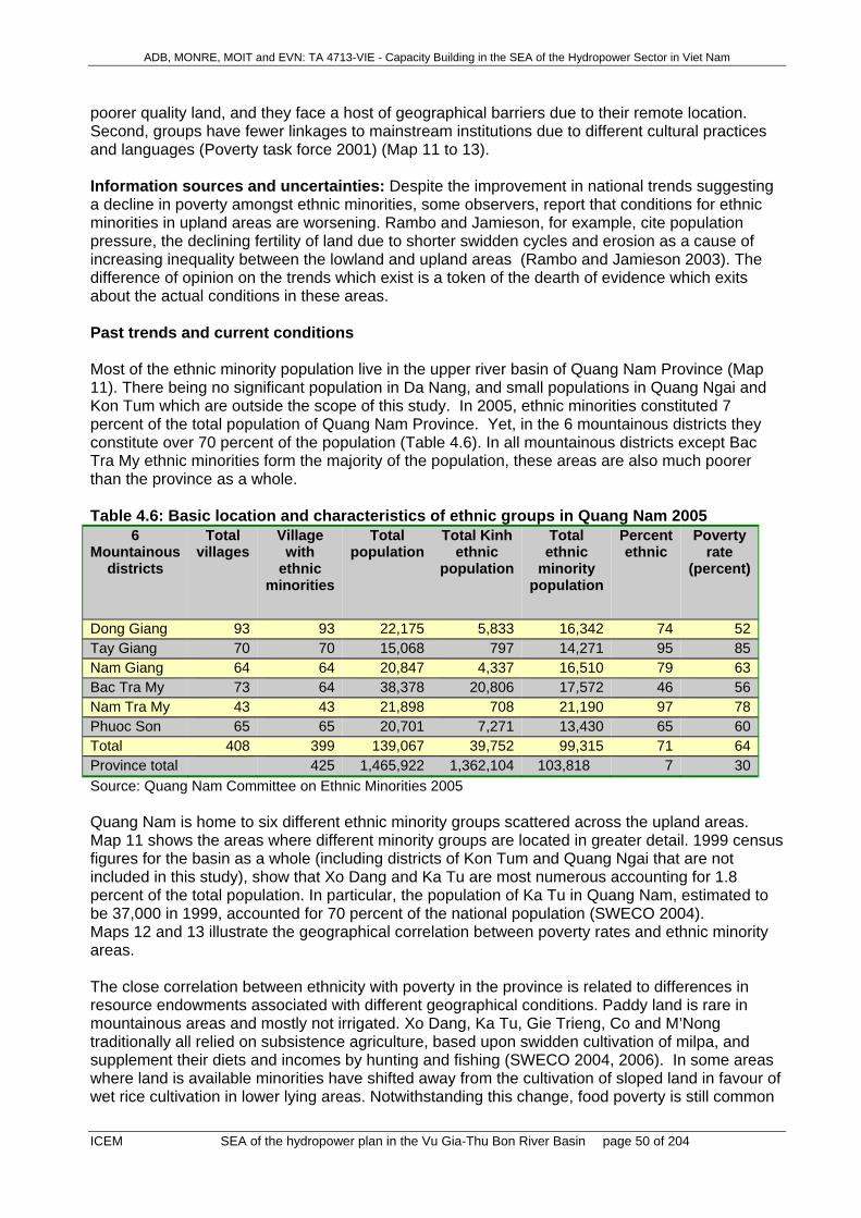
ADB, MONRE, MOIT and EVN: TA 4713-VIE - Capacity Building in the SEA of the Hydropower Sector in Viet Nam
ICEM SEA of the hydropower plan in the Vu Gia-Thu Bon River Basin page 50 of 204
poorer quality land, and they face a host of geographical barriers due to their remote location. Second, groups have fewer linkages to mainstream institutions due to different cultural practices and languages (Poverty task force 2001) (Map 11 to 13). Information sources and uncertainties: Despite the improvement in national trends suggesting a decline in poverty amongst ethnic minorities, some observers, report that conditions for ethnic minorities in upland areas are worsening. Rambo and Jamieson, for example, cite population pressure, the declining fertility of land due to shorter swidden cycles and erosion as a cause of increasing inequality between the lowland and upland areas (Rambo and Jamieson 2003). The difference of opinion on the trends which exist is a token of the dearth of evidence which exits about the actual conditions in these areas. Past trends and current conditions Most of the ethnic minority population live in the upper river basin of Quang Nam Province (Map 11). There being no significant population in Da Nang, and small populations in Quang Ngai and Kon Tum which are outside the scope of this study. In 2005, ethnic minorities constituted 7 percent of the total population of Quang Nam Province. Yet, in the 6 mountainous districts they constitute over 70 percent of the population (Table 4.6). In all mountainous districts except Bac Tra My ethnic minorities form the majority of the population, these areas are also much poorer than the province as a whole. Table 4.6: Basic location and characteristics of ethnic groups in Quang Nam 2005
6 Mountainous
districts
Total villages
Village with
ethnic minorities
Total population
Total Kinh ethnic
population
Total ethnic
minority population
Percent ethnic
Poverty rate
(percent)
Dong Giang 93 93 22,175 5,833 16,342 74 52Tay Giang 70 70 15,068 797 14,271 95 85Nam Giang 64 64 20,847 4,337 16,510 79 63Bac Tra My 73 64 38,378 20,806 17,572 46 56Nam Tra My 43 43 21,898 708 21,190 97 78Phuoc Son 65 65 20,701 7,271 13,430 65 60Total 408 399 139,067 39,752 99,315 71 64Province total 425 1,465,922 1,362,104 103,818 7 30Source: Quang Nam Committee on Ethnic Minorities 2005 Quang Nam is home to six different ethnic minority groups scattered across the upland areas. Map 11 shows the areas where different minority groups are located in greater detail. 1999 census figures for the basin as a whole (including districts of Kon Tum and Quang Ngai that are not included in this study), show that Xo Dang and Ka Tu are most numerous accounting for 1.8 percent of the total population. In particular, the population of Ka Tu in Quang Nam, estimated to be 37,000 in 1999, accounted for 70 percent of the national population (SWECO 2004). Maps 12 and 13 illustrate the geographical correlation between poverty rates and ethnic minority areas. The close correlation between ethnicity with poverty in the province is related to differences in resource endowments associated with different geographical conditions. Paddy land is rare in mountainous areas and mostly not irrigated. Xo Dang, Ka Tu, Gie Trieng, Co and M’Nong traditionally all relied on subsistence agriculture, based upon swidden cultivation of milpa, and supplement their diets and incomes by hunting and fishing (SWECO 2004, 2006). In some areas where land is available minorities have shifted away from the cultivation of sloped land in favour of wet rice cultivation in lower lying areas. Notwithstanding this change, food poverty is still common

ADB, MONRE, MOIT and EVN: TA 4713-VIE - Capacity Building in the SEA of the Hydropower Sector in Viet Nam
ICEM SEA of the hydropower plan in the Vu Gia-Thu Bon River Basin page 51 of 204
and at least 50 percent of ethnic minority people in the province suffer from food insufficiency for part of the year (SWECO 2004). Detailed trend information is not available for the province. National figures suggest that poverty levels are declining amongst ethnic minorities, albeit more slowly than amongst Kinh (see figure 1), this pattern is likely to be repeated in the basin.
4.9 Issue ‘Public health in affected communities’
4.9.1 Health problems in affected communities National context: Health indicators have been showing a gradual improvement over about the last 25 years (Table 4.7). Infant mortality per 1000 live births (%o) reduced from 57%o in 1980 to 26%o in 2002. The mortality rate amongst under-fives decreased from 105%o in 1980 to 35%o in 2002; malnutrition among children under five years old fell from 47% in 1990 to 33% in 2002; and, the prevalence of low birth weight in children reduced from 25% in 1980 to 7% in 2002. These improvements reflect the success of primary health care programs (such as immunization programs), and socio economic improvements leading better nutrition, sanitation and health services. Table 4.7: Trends in main health indicators of Viet Nam
Indicators 1980 1990 2000 2002 2004 Infant mortality rate (per 1,000 live births)
57 40 36.7 26 26
Under five mortality rate (per 1,000 live births)
105 81 42 35 -
Maternal mortality ratio (per 100,000 live-births)
- 200 95 91
Malnutrition among children under five (%)
- 47 35 32 29
Birth weight < 2500g (%) 25 15 7.3 7.1 - Life expectancy (years) 63 67 67.8 71.3 - Source: Viet Nam Ministry of Health, WHO 2005 Despite a great improvement overall, Viet Nam still has one of the highest rates of child malnutrition in East Asia. Incidence is especially high amongst the poor and ethnic minority groups. Child and infant malnutrition is typically caused by a number of factors, including food security, lack of diversity in children’s diets, limited knowledge of nutrition, inadequate health care for mother and child, and limited access to clean water and sanitation facilities. In particular, intestinal parasites are a key factor in the prevalence of malnutrition, recent studies have estimated that as many as 44 percent of children in the country have intestinal parasites (UNICEF 2005) Despite declines in the incidence of aggregate morbidity, the incidence of some diseases associated with urbanisation and environmental pollution have increased. For example, the proportion of people affected by pneumonia and dengue fever have increased. Changes in the physical environment, living conditions and life style are key factors driving the changing morbidity profile in the country (MoH, WHO 2005). Of particular concern is the rise in cases of HIV/AIDs. For a considerable period Viet Nam had the lowest rate of HIV infection amongst 15-49 year olds in the world. However, the infection rate has increased and currently cases are increasing at 7 percent a year. Moreover, once largely confined

ADB, MONRE, MOIT and EVN: TA 4713-VIE - Capacity Building in the SEA of the Hydropower Sector in Viet Nam
ICEM SEA of the hydropower plan in the Vu Gia-Thu Bon River Basin page 52 of 204
to sex workers and intravenous drug users it is now spreading rapidly into the general population. All 64 provinces have reported cases of the disease. Table 4.8 summarizes figures on the prevalence of HIV and AIDs nation wide. Table 4.8: Viet Nam HIV and AIDS estimates (end 2003) Adult (15-49) 0.40%HIV prevalence rate (range: 0.2%-0.8%)Adults (15-49) 200,000living with HIV (range: 100,000-350,000)Adults and children (0-49) 220,000living with HIV (range: 110,000-360,000)Women (15-49) 65,000living with HIV (range: 31,000-110,000)AIDS deaths 9,000(adults and children) in 2003
(range: 4,500-16,000)
Source: 2004 UNAIDS Report on the Global AIDS Epidemic, UNAIDS website Key drivers behind the increasing infection outside high risk groups include poor sex education and widespread use of sex workers. Past trends and current conditions: Although detailed information on specific indicators in the basin has been partial, the area is likely to reflect current national trends. As the basin contains both large urban agglomerations, rural lowlands and sparely populated uplands it is also likely to show health characteristics associated with these differing environments. For example, urban agglomerations are likely to show higher instances of HIV/AIDs and dengue fever than elsewhere. Health problems faced by ethnic minority populations living in the uplands are better documented. Those recorded by SWECO in a recent survey of Zuoih commune in Dong Giang district are likely to be typical of the upland areas as a whole. Zuioh commune is located close to the proposed site of the Song Bung 4 hydro power project. Residents in these areas report respiratory illness in the dry season (flu, pneumonia, bronchitis), and digestive diseases during the winter and rainy seasons. Diarrhea, bronchitis and pneumonia are common amongst children. Tuberculosis is also present amongst the adult population. Malaria occurs occasionally in the wet season (SWECO 2006). A key cause of illness amongst men appears to be stomach problems associated with daily consumption of rice wine. Drug addiction is reportedly common amongst gold miners and loggers. Prostitution is also reported to occur in some locations presenting an increased risk of HIV/AIDs and STDs (SWECO 2006).
4.9.2 Health amenities in upland areas Although data on health care provision in the province is limited some fragmentary evidence is available on current conditions. As elsewhere in the country the provision of health services in the basin has improved dramatically over the last 10 years. In particular, the extension of health services and infrastructure to poor communes in upland areas through targeted poverty alleviation programs such as program 135 has improved access markedly. This has in part, helped in the reduction of infant and maternal mortality rates. In fact in terms of health personnel per capita the 6 upland districts do better than the rest of the province (DoH 2007). This does not, however, reflect access to or the quality of these services. As
ADB, MONRE, MOIT and EVN: TA 4713-VIE - Capacity Building in the SEA of the Hydropower Sector in Viet Nam
ICEM SEA of the hydropower plan in the Vu Gia-Thu Bon River Basin page 53 of 204
upland areas are very sparsely populated even with a relatively high number of medical personnel per capita, health staff likely to be much less physically accessible than in the lowlands. Moreover, upland populations do not have access better trained staff and better medical facilities available in lowland areas.
4.10 Issue ‘Transport’
4.10.1 Road Transport Overall context: The study area has a well developed road network for both national (north-south) and provincial (west – east) roads. As of May 2004, the total road length was 6,355 km. The road network consists of:
National roads 470 km (7.4%) Provincial roads 421 km (6.6%) District roads 1,151 km (18.1%) Commune and village roads 1,695km + 2,535 km (66.7%)
Quality and Accessibility of Rural Roads: Apart from national and provincial roads, road quality is variable although the quality of rural roads and access is constantly being improved. However, within Quang Nam Province out of 29 communes which do not have adequate road access, 23 are upland communes. These will require the development of a further 306 km to connect outlying villages to the commune centres. Development of a major Network: Major road connections are being improved. The Ho Chi Minh national road runs N-S through Quang Nam Province and connects to Kon Tum Province. It also links with 14 D at Cau Giang. The E-W connection for road 7B in the ASEAN/GMS transport network has been completed by upgrading 14B (42 km in Quang Nam) and 14D (77.4 km).
4.10.2 Waterway Transport Transport by waterways accounts for 5-8% of total transport load. Most of the transport takes place through loads of 5-10 ton per boat, operating over short distances of 20 to 50km. Thu Bon and Truong Giang are the main waterways for transport. They offer 941 km of navigable inland waterways but only 307 km (33%) is managed and used, mainly because poor inland waterway infrastructure and low demand for this type of transport. Limited improvement is possible because of poor natural conditions that restrict use of waterways (eg steep unsuitable topography in upper areas, and shallow channels with seasonally dry conditions).
4.11 Issue ‘Agriculture and irrigation’ Of a total land area of 12,831km2 within Quang Nam Province, the Vu Gia Tu Bon basin occupies 11,828 km2 or 92.2% of the province’s area. In 2005, agriculture occupied 266,200 ha (22.5%) of the VG-TB basin. The area available for irrigation within the basin is nearly fully developed and by 2005, a command area of 71,000 ha (26.7% of the agricultural land) had been developed. Of this the actual area that is irrigated is 57,200 ha (80.6% of the irrigated area). The difference between these two figures is due to a variety of reasons including: unavailability of water in the dry season from insufficient reservoir capacity, salinity intrusion into lower areas which limits pumping from these sources, poor water distribution, and poor management and maintenance of irrigation structures and equipment.

ADB, MONRE, MOIT and EVN: TA 4713-VIE - Capacity Building in the SEA of the Hydropower Sector in Viet Nam
ICEM SEA of the hydropower plan in the Vu Gia-Thu Bon River Basin page 54 of 204
Agriculture occupies an important part in the local economy with 50% of the provincial population engaged in agriculture. Rice is the main crop and irrigated and dryland rice crops occupy 30% of the agricultural land area, followed by annual crops 23%. Tree crops occupy 2% of the area while aquaculture occupies 0.1% of the basin area. Intensive livestock raising of cattle, pigs and poultry is also an important part of the agriculture sector. Buffalos continue to be used for traction but are being progressively replaced by small walk-behind farm tractors. Irrigated rice is normally grown in terraced flood irrigation systems in the lower areas of the Vu Gia Thu Bon basin. Rice was grown as 3 crops/yr but this has now been changed to 2 crops/yr so as to improve cropping reliability by moving dependence away from the dry season low water flow period. In 2005 the two crop system planted 40,862 ha to Winter-Spring rice while the Summer-Autumn crop area was 42,805 ha. The overall yield for the 2005 crop was 4.6 t/ha. Rice yields are highest in the Spring–Summer rice crop at about 4.0 t/ha while yields from rice cropped at other times of the year are about 3.5t/ha. The dry season from Jan – September limits flows available for irrigation. To obtain these high yields farmers use high yield irrigated hybrid varieties, together with high inputs of fertilisers and agro-chemicals. Maize is the second main annual crop and in 2005 10,600 ha were grown. Yields have increased from about 1.8t/ha to 3.0t/ha. Maize is often grown as an intermediate crop between rice crops and is supplemented by irrigation water if this is available. Other crops that are grown as rainfed crops but have lower yields than irrigated crops include; maize, cotton and beans. Rain fed upland rice is grown as 2 crops per year. Three types of irrigation systems are used: (i) Reservoir, (ii) weir and (iii) pump irrigation (Map 14: Irrigated Land, Pump Stations and Transportation Network). Reservoirs. There are 63 irrigation reservoirs, located in the upstream tributaries of Vu Gia and
Thu Bon. Weirs. There are 589 irrigation weirs, which are mainly located in the tributaries of the Thu
Bon. Pumps. There are 148 pump irrigation systems which are mainly located in the lower sections
of the Vu Gia and Thu Bon and may be situated on both the tributaries and the main stream. There are about 80 medium and large pumping stations with a design capacity of 6,500 ha and actual irrigation area of 4,300 ha and about 50-60 smaller pumping stations located along the Vu Gia and Thu Bon rivers.
Flow within the Vu Gia and Thu Bon rivers is highly variable and is dependent on the monsoon which lasts for four months, from September to December when 65-80% of the rainfall occurs while the dry season lasts from January to August where only 20-35% of the annual rainfall occurs. October and November are the wettest months when 40-50% of total annual rainfall occurs. Rainfall starts earlier and is higher in the mountainous areas than in the lowland areas. Flooding is a particular problem within the basin and normally commences in mid September and ends by early January, the majority of floods being recorded from October to December. During this time about 65% of the basin’s runoff occurs in contrast to the dry season when about 27% of the runoff occurs. November is the month with highest runoff with up to 28-31% of total annual runoff recorded while by April flows have rapidly diminished to only 1-3% of the total annual runoff. The actual and planned irrigated areas are shown in Table 4.9 which shows that by 2010 the irrigated area will have only slightly increased by 1,130 ha but the cropping system will have changed to two annual crops, using a May – November crop. This allows a more effective use of the available water and avoids drought periods.
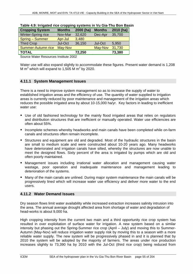
ADB, MONRE, MOIT and EVN: TA 4713-VIE - Capacity Building in the SEA of the Hydropower Sector in Viet Nam
ICEM SEA of the hydropower plan in the Vu Gia-Thu Bon River Basin page 55 of 204
Table 4.9: Irrigated rice cropping systems in Vu Gia-Thu Bon Basin Cropping System Months 2000 (ha) Months 2010 (ha)Winter-Spring rice Nov-Mar 32,620 Dec-Apr 35,700 Spring – Summer Apr-Jul 3,480 Third Crop Jul-Oct 36,150 Jul-Oct 5,950 Summer-Autumn rice May-Nov May-Nov 31,730 TOTAL 72,250 73,380 Source Water Resources Institute 2002 Water use will also expand slightly to accommodate these figures. Present water demand is 1,208 M m3 which will expand to 1,505 M m3 by 2020.
4.11.1 System Management Issues There is a need to improve system management so as to increase the supply of water to established irrigation areas and the efficiency of use. The quantity of water supplied to irrigation areas is currently reduced by poor maintenance and management of the irrigation areas which reduces the possible irrigated area by about 10-15,000 ha/yr. Key factors in leading to inefficient water use: Use of old fashioned technology for the mainly flood irrigated areas that relies on regulators
and distribution structures that are inefficient or manually operated. Water use efficiencies are often about 55%.
Incomplete schemes whereby headworks and main canals have been completed while on-farm canals and structures often remain incomplete.
Structures and equipment are old and degraded. Most of the hydraulic structures in the basin are small to medium scale and were constructed about 10-20 years ago. Many headworks have deteriorated and irrigation canals have silted, whereby the structures are now unable to meet the designed flows. Sixty percent of the area is irrigated by pumps which are old and often poorly maintained.
Management issues including irrational water allocation and management causing water wastage, poor operation and inadequate maintenance and management leading to deterioration of the systems.
Many of the main canals are unlined. During major system maintenance the main canals will be progressively lined which will increase water use efficiency and deliver more water to the end users.
4.11.2 Water Demand Issues Dry season flows limit water availability while increased extraction increases salinity intrusion into the area. The annual average drought affected area from shortage of water and degradation of head-works is about 9,000 ha. High cropping intensity from the current two main and a third opportunity rice crop system has resulted in over exploitation of surface water for irrigation. A new system based on a similar intensity but phasing out the Spring-Summer rice crop (April – July) and moving this to Summer-Autumn (May-Nov) will reduce irrigation water supply risk by moving this to a season with a more reliable water supply. The new system will be progressively phased in and it is planned that by 2010 the system will be adopted by the majority of farmers. The areas under rice production increases slightly to 73,390 ha by 2010 with the Jul-Oct (third rice crop) being reduced from

ADB, MONRE, MOIT and EVN: TA 4713-VIE - Capacity Building in the SEA of the Hydropower Sector in Viet Nam
ICEM SEA of the hydropower plan in the Vu Gia-Thu Bon River Basin page 56 of 204
36,150 ha to 5,950 ha (Table 4.9). This crop is then moved to a Summer – Autumn crop (May-Nov) when 31,730 ha is planned to be planted as a new seasonal rotation.
4.11.3 Water Yield and Quality Issues During the dry season water supplies are sometimes insufficient for structures in the Ly Ly and West Que Son sub-basins. On the plains, water sources usually suffer from saline intrusion. Salinity intrusion into the lower channels of the Vinh Dien and Ba Ren rivers results in reduced opportunities for pump operation. Some pump stations are unable to pump at full capacity due to low water levels (Map 15 - “Risk to Irrigated Land and Transportation Networks due to Saline Intrusion or Storm Surge”). From the limited water quality data that is available, water quality does not appear to be impaired at present but with increasing use of high agro-chemical inputs, point source runoff from agricultural areas will affect downstream water quality especially in Da Nang and Hoi An. This will create issues for domestic water supplies and estuarine fish habitats. Upstream watershed erosion from degraded watersheds is supplying increasingly large amounts of sediments to the Vu-Gia Thu Bon river system. This is building up sediment deposits within the river channels. With continuing watershed degradation and climate change, the severity of flooding is expected to increase in the downstream areas.
4.12 Issue ‘Industrial development’ Past trends and current conditions: The Vu Gia Thu Bon river basin has experienced rapid economic growth over the past decade. Industrial development has played a key role in this growth, industrial output having grown from approximately VND1,900 billion in 1995 to over VND 9,300 billion in 2005, an increase of over 480 percent, or about 17.2 percent per year. This will create increased energy demand, partly met by hydropower development. Despite its smaller size and population, most of the industrial production by value is concentrated in Da Nang, although annual industrial growth in the province over the period was slightly lower, at 16.9 percent compared with 18.2 percent in Quang Nam. As a result the Da Nang’s share of industrial output of the two provinces dropped from 76 percent in 1995 to 74 percent in 2005. Nevertheless, Da Nang is still the centre of industrial production in the basin by a large margin (Figure 4.14). Figure 4.14: Comparing industrial growth in Da Nang and Quang Nam 1995-2005

ADB, MONRE, MOIT and EVN: TA 4713-VIE - Capacity Building in the SEA of the Hydropower Sector in Viet Nam
ICEM SEA of the hydropower plan in the Vu Gia-Thu Bon River Basin page 57 of 204
0
1000
2000
3000
4000
5000
6000
7000
8000
1995 1996 1997 1998 1999 2000 2001 2002 2003 2004 2005
Indu
stra
il ou
tput
at c
onst
ant 1
994
pric
e (V
ND
bi
llion
)
0
0.2
0.4
0.6
0.8
1
1.2
1.4
1.6
Perc
enta
ge o
f nat
iona
l
Da Nang - industrial output Quang Nam - industrial output
Da Nang - proportion of national Qunag Nam - proportion of national
Source: GSO website (Note: Right hand scale gives each province’s proportion of national industrial output). The spatial development of industry in the basin is confined largely to lowland areas in and around large population centers in both Quang Nam and Da Nang. The spatial pattern of this growth is largely reflected by the growth in urban areas indicated by population density (see demographic trends). Issues: There are three issues related to the development of industry in the basin, increased use of water, increased production of waste water, and risk of flooding. The risk of flooding is addressed in the section on urban-rural migration. Water use: Although detailed figures were not available on industrial water demand, indicative figures were available from recent research performed in the basin (SWECO 2004). Derived from these estimates industrial water demand in 2001 was about 2 million cubic meters per year, increasing to about 47 million cubic meters in 2005. This is a much faster rate of growth than the growth in industrial output indicating industries must be making much more intensive water use than previously. Waste water: Figures on the production of industrial waste water were not available, however, as with domestic waste water, production is likely to be of a similar magnitude to that of water demand. Moreover, indications are that facilities for the treatment of waste water are very limited. A recent report on Quang Nam showed that water treatment facilities were not available at any of the industrial zones or clusters. Without water treatment facilities waste water from factories, industrial zones and clusters, and industrial villages is discharged directly into streams and tributaries in the river basin with potentially negative affects on water quality and human health.
4.13 Issue ‘Tourism development in the basin’ Past trends and current conditions: In line with national trends tourism in the basin has grown rapidly since 2001. Tourism numbers have grown by over 23 percent a year on average in Quang Nam, and about 15 percent a year in Da Nang. Total tourism revenues have increased in line with this at about 23 percent per year.

ADB, MONRE, MOIT and EVN: TA 4713-VIE - Capacity Building in the SEA of the Hydropower Sector in Viet Nam
ICEM SEA of the hydropower plan in the Vu Gia-Thu Bon River Basin page 58 of 204
Table 4.10: Visitor numbers and total tourism revenue (USD)
Province 2001 2002 2003 2004 2005 Quang Nam
543,479
659,578
826,000
1,024,412
1,362,126 Da Nang 423,290 557,410 517,530 649,110 758,870
Total revenue 543,479
659,578
826,000
1,024,412
1,362,126
Source: Quang Nam and Da Nang statistical yearbooks Da Nang is not a popular tourist destination itself, but with regular flights to HCMC and Hanoi, acts as a gateway to the central region, many of the arrivals recorded as tourists in Da Nang city are actually en route to Hue or tourism sites in Quang Nam. Only a small minority spend any length of time in the city. Therefore, care must be taken with the above statistics, adding numbers of tourists to the two provinces together will double count many arrivals and over estimate tourism numbers. Quang Nam on the other hand, offers a considerable umber of attractions for tourists being home to the UNESCO heritage sites of Hoi An and the Cham ruins at My Son. The majority of tourists are foreign, although a large and growing number of domestic tourists are traveling to the basin as a consequence of growing domestic income levels. Trips tend to be relatively short, according to Quang Nam department of tourism the average trip length is about two days. This in part reflects the limited opportunities to engage in leisure activities available in the area. According to the Department of Tourism, tourism in the province remains traditional mass tourism based upon beach resorts and visits to places of cultural/historical interest (Hoi An, My Son). Key factors influencing the growth of tourism are income levels in origin countries and areas, accessibility, the level of service/infrastructure available and the attractiveness of a destination. The increasing affordability of air travel is also an important driver of increasing international tourism to the river basin. Issues: Increases in the kind of mass tourism seen in the basin can mean increased water usage environmental damage due to increased water pollution, which can affect seas and water ways surrounding tourist attractions. Sewage runoff can result in considerable damage to coral reefs and changes in salinity can have wide ranging impacts on coastal environments (see aquatic biodiversity and hydrology sections) (UNEP 2007). Trend projections take little account of the potential for eco-tourism in the region.
4.14 Issue ’Mining’
4.14.1 Overview Given the relatively small geographic area, mining activity is intensive throughout the river basin. In terms of employment only around 25% of mine workers are involved in legal activities. Most are recent immigrants following the “gold rush” now estimated at up to 10,000 people, many in less accessible parts of the basin. This influx of workers has put pressure on available local resources – especially fisheries and forest products – and caused social problems. The other environmental concerns are mainly due to the unregulated and widespread nature of much of the mining. Water pollution involving cyanide and mercury is a serious localised problem. The rush to get minerals out of the ground now is stimulated by the prospect of having so many hydropower reservoirs in the basin. Hydro developments would submerge mineral resources and increase restrictions in access upstream and around hydro sites. This pressure to get minerals out before hydropower projects go ahead has been experienced in other parts of Viet Nam.

ADB, MONRE, MOIT and EVN: TA 4713-VIE - Capacity Building in the SEA of the Hydropower Sector in Viet Nam
ICEM SEA of the hydropower plan in the Vu Gia-Thu Bon River Basin page 59 of 204
For the time being, mining is having a significant negative environmental impact on the basin, especially in the quality of aquatic ecosystems. If adequately managed, it could be a very important economic sector in the long term, an important employer, and with a high proportion of revenues remaining within the province (Map 16).
4.14.2 Past trends and current situation The policy of mining sector in Viet Nam is set out in the Mining Law 1996, and revised in 2005 and the Master Plan of Socio-Economic Development to 2015 of Quang Nam Province. The Plan identifies mining industry as one of three main industries to be promoted in the planning period. The Revised Master Plan on Industrial Development – Small and Handicraft Industrial Development in Quang Nam until 2015 (2005) deals with mining and quarrying. It stipulates that the mining industry must develop in a sustainable and planned manner to provide raw materials to other industries, employment opportunities and to protect the environment. There are some180 deposits and ore occurrences in the Vu Gia – Thu Bon River Basin divided into 5 groups: energy, metal, non-metal, construction materials and mineral/thermal water (Table 4.11 and Map 16). In upland areas, mining is the main industry with gold extraction and processing, rock and clay exploitation. Rock, gravel, sand and clay extraction along rivers are the main industrial activities in the midlands. In coastal areas, mining activities take place along rivers and beaches. Artisanal and small scale mining (ASM) dominates the sector in the Vu Gia – Thu Bon River Basin. Although not well documented, anecdotal evidence suggests that most involved are immigrants. Nationally, the number of small scale miners is about 200,000, twice the number of employees working in the medium scale mining industry. In 2005 the production of ASM accounted for at least 20% of the total mining output. Growth in ASM has stemmed from high unemployment and poverty in rural areas and liberalization of the mining sector most recently through amendment to the Mineral Law in 2005. ASM tend to have insufficient financial resources for investment in equipment including for pollution control. The Industrial Development Plan reports that there are 68 mines in the province - 26 with permits for industrial scale operations and 38 for small scale mining. Although the Quang Nam State of Environment Report 2005 finds 47 enterprises working in 57 mines. In 2006, another 13 permits were issued. Half of the operating mines are exploiting rock for construction. Others exploit feldspar, clay for bricks and tiles, gold, coal, white sand, mineral water, and kaolin (potting clay). MONRE has issued only two permits for gold mining in 25 years in Bong Mieu and Phuoc Son. Bong Mieu began operating in 2006. It is the first modern gold processing plant built in Viet Nam since World War II. The Bong Mieu field is the country’s largest gold mining area, located in Tam Lanh Commune, Phu Ninh District. The values of gold and coal mining have been growing rapidly at 6.16% and 23.87% during 1997-2003 respectively. Table 4.11: Industrial and small scale mines in Quang Nam Province - 2005
Minerals Total Number of mines
(industrial scale)
Number of small scale operations in
old mines
Construction rocks 23 13 10 Feldspar 5 2 3 Clays for tiles and bricks
7 3 4
White sand 2 2 0 Coal 4 1 3 Imenit 2 0 2 Gold (Map 16) 8 2 6

ADB, MONRE, MOIT and EVN: TA 4713-VIE - Capacity Building in the SEA of the Hydropower Sector in Viet Nam
ICEM SEA of the hydropower plan in the Vu Gia-Thu Bon River Basin page 60 of 204
Kaolin 1 Mineral water (1.2 million litres in 2003)
3
Sand and gravel 2 Total 57 23 28 Quang Nam DONRE estimates that there are 2,337 legal workers in the mining industry - more than 70% from the non-state sector (Map 16).
4.14.3 Institutional arrangements The Department of Industry cooperates with DONRE to prepare plans on mineral exploration, exploitation and processing. DONRE carries out geological surveys and issue mineral exploitation permits. DONRE also coordinates and cooperates with People’s Committees at all levels and other departments, such as Department of Labour and Social Welfare for safety in mining activities, DARD on matters related to forests, Department of Construction regarding construction materials, Provincial Police regarding the use of explosive in mining activities and public order. The mining section of DONRE has four staff. They also have their network at all district and commune levels to help them in managing mineral activities. However, as an advisory body to PPC, all policies relating to either mineral exploitation or environmental safeguard rest with the PPC. DOI and DONRE report illegal mining is not being controlled, clay extraction is “excessive” while sand, gravel and rock extractions are moderate.
4.14.4 Key issues relating to mining identified by local government experts
1. Illegal gold mining 2. Water pollution from mines and habitat destruction 3. Exhaustion of mineral resources for construction (eg clays and sand)
Illegal gold mining: In the last five years, “a gold rush” has occurred in the province. Illegal gold mining is attracting immigration from other provinces, leading to uncontrolled and unsustainable use of natural resources in the upland areas of the basin. The use of mercury and cyanide contaminates local waterways and fish (Song Bung 4 EIA did not find high mercury concentrations but other studies by DONRE have). Illegal mines are operating throughout the province, but concentrating in mountainous areas such as Bac Tra My, Nam Tra My, Phuoc Son, Thang Binh, Dong Giang, Tay Giang, and Nam Giang. In upland areas, gold production is estimated at 80.5kg/year and in midlands 34.5 kg/year. Lack of livelihood opportunities and rumours of gold mining windfalls have contributed to in-migration of illegal miners to the province. Estimates vary from around 2,000 to 7,500 miners annually operating illegally – possibly many more. Most are transitory staying no more than a few months. Although existing information is anecdotal and more extensive studies are needed, it is evident from the number of dredging facilities that illegal mining is extensive within river channels. It is also spreading in terrestrial areas – some of importance for biodiversity.17 DONRE have identified the following impacts: • Chemical and sediment pollution of water resources (mercury and cyanide of greatest
concern); • Changes to river morphology affecting aquatic fauna availability and altering flood regimes;
17 A recent provincial decision to excise 6,014 ha of Song Thanh NR for a (legal) gold mining operation should also be noted as have a number of adverse impacts on biodiversity which were likely not considered in the decision to excise this area. One of these would be a cumulative effect of concentrating illegal miners into the remainder of the NR.
ADB, MONRE, MOIT and EVN: TA 4713-VIE - Capacity Building in the SEA of the Hydropower Sector in Viet Nam
ICEM SEA of the hydropower plan in the Vu Gia-Thu Bon River Basin page 61 of 204
• Increased resource use, including fishing, hunting and collection of forest products; • direct dumping of tailings and effluents into rivers, • threats from improperly constructed tailings dams, • river sedimentation and damage in alluvial areas, • Conflict between mining migrants and local inhabitants; and • Erosion caused by land clearance, extraction of ore and alteration of river flow leading to loss
of agricultural land and sections of paths and roads. Some local inhabitants have been able to create businesses which cater to the miners, but the majority do not benefit from the mining activity. Overall the illegal activities are creating insecurity and uncertainty in the hydropower project areas. Water pollution and habitat loss: Illegal and legal mining is causing several environmental and natural resource concerns. Environmental performance of recently permitted mining is significantly better than in older ventures. Mining involves clearing of forests, surface water pollution, river bank landslides and encroachment on agriculture lands and sedimentation and habitat loss. Sediment from erosion caused by deforestation and land clearance, and the mining operation is inhibiting survival of aquatic fauna, reducing fish populations and forcing fish migration to less disturbed areas. Wastewater from sand and titan extraction sites along sea shores also pollutes beaches and sea water with suspected impacts on coral reefs and fish stocks. Rain water overflows from rock and clay mines are also causing problems. Waste water from gold mining sites is a special concern. Pollutants include mercury, cyanide and COD. Since 2003, DONRE has found that the mercury concentration has increased and exceeded the allowed threshold. While mercury and cyanide is associated with gold extraction, high COD concentration indicates that there is an increasing load of waste water discharging to rivers caused by an increased number of people living in the area, including miners. Since 2004 COD concentration has been double the allowed limit. Sand extraction and processing (6 units) and titan mining activities (14 units) along the coast is causing mercury in sea water (Figure 4.15). Illegal exploitation occurs in many other places such as of feldspar in Dai Loc district, of sand and gravel in riverbed in Thu Bon River of Dien Ban, Duy Xuyen and Dai Loc, Que Son, and Tien Phuoc districts. The province issued at least two instructions in 1999 to stop illegal extraction of sand and gravel in streams and rivers and again in 2002 to enhance management of these forms of mining. Enforcement has proved difficult. Limited capacity, unclear responsibilities for inspection of mining extraction, low investment and lack of environment consideration by miners, all contribute to the pollution from mines of surface and ground water in the province. Use of water in the mining industry is expected to increase in line with increasing extraction especially of rock, gravel and sand. Exhaustion of minerals for construction: Quang Nam Province is suffering from declining
outputs and exhaustion of some key mineral resources serving construction industries such as clay, sand and gravel. There are increasing pressures along rivers in upland and midland areas as mining expands to new locations. This significant trend is reversible if intensity and volume of mining is reduced and stricter controls enforced. Detailed studies are needed to identify the status of mineral resources, exact location of mines, volume of exploitation and environmental impacts. Clay minerals for making bricks and tiles along rivers in upland and midland areas will be depleted within 20 years due mainly to the rapid expansion of the construction sector. Outputs for 2000-2003 halved from 76 million to 31 million cubic meters a year (Figure 4.16). Already there are
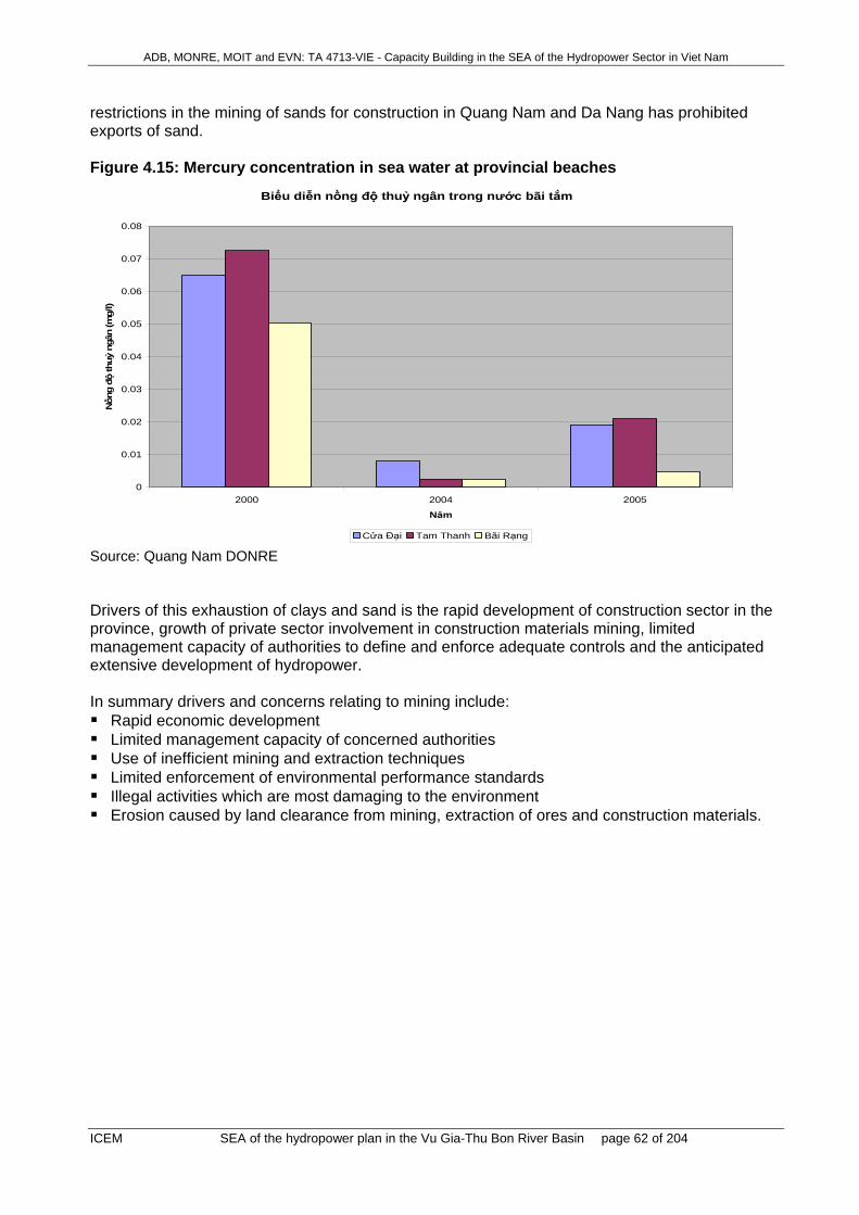
ADB, MONRE, MOIT and EVN: TA 4713-VIE - Capacity Building in the SEA of the Hydropower Sector in Viet Nam
ICEM SEA of the hydropower plan in the Vu Gia-Thu Bon River Basin page 62 of 204
restrictions in the mining of sands for construction in Quang Nam and Da Nang has prohibited exports of sand. Figure 4.15: Mercury concentration in sea water at provincial beaches
Biểu diễn nồng độ thuỷ ngân trong nước bãi tắm
0
0.01
0.02
0.03
0.04
0.05
0.06
0.07
0.08
2000 2004 2005
Năm
Nồn
g độ
thuỷ
ngâ
n (m
g/l)
Cửa Đại Tam Thanh Bãi Rạng Source: Quang Nam DONRE Drivers of this exhaustion of clays and sand is the rapid development of construction sector in the province, growth of private sector involvement in construction materials mining, limited management capacity of authorities to define and enforce adequate controls and the anticipated extensive development of hydropower. In summary drivers and concerns relating to mining include: Rapid economic development Limited management capacity of concerned authorities Use of inefficient mining and extraction techniques Limited enforcement of environmental performance standards Illegal activities which are most damaging to the environment Erosion caused by land clearance from mining, extraction of ores and construction materials.

ADB, MONRE, MOIT and EVN: TA 4713-VIE - Capacity Building in the SEA of the Hydropower Sector in Viet Nam
ICEM SEA of the hydropower plan in the Vu Gia-Thu Bon River Basin page 63 of 204
Figure 4.16: Remaining time for extraction of some main minerals in the province Biểu diễn thời gian cạn kiệt của các khoáng sản với trữ lượng cao
0
10,000,000
20,000,000
30,000,000
40,000,000
50,000,000
60,000,000
70,000,000
80,000,000
1 2 3 4 5 6 7 8 91011121314151617181920212223242526272829303132333435363738394041424344454647484950515253545556575859606162636465666768
Thời gian cạn kiệt (năm)
Trữ
lượn
g (m
3)
ĐÁ XÂY DỰNG CÁT TRẮNG SÉT Felspat THAN ĐÁ X axis: Extraction time in years Key to figure: Minerals covered (i) construction gravel; (ii) white sand; (iii) clay; and (iv) coal Source: Quang Nam DONRE
4.15 Issue ’Waste management’
4.15.1 National context In Viet Nam, wastes from households, industries, commercial enterprises, and hospitals are expected to increase rapidly over the next decade (World Bank 2004). In 2004, solid waste generation amounted to 15 million tones per year, with more than 80 percent (12.8 million tons/yr) from municipal sources. Of greatest concern for solid waste management is an increasing proportion of hazardous waste generation from industries, hospitals and agricultural sources. The handling of waste, including reuse and recycling, collection, treatment and disposal, is also of concern, as the majority of waste in Viet Nam is not safely disposed (World Bank, 2004). Within cities, on average around 71% of waste is collected. Collection is however limited in rural and poor areas where typically less than 20 percent is collected. It is estimated that an average urban dweller in Viet Nam produces approximately 0.7kg of waste each day, about twice the amount produced by people in rural areas, where on average 0.3kg are produced (World Bank, 2004). Recycling and reuse is an active industry in Viet Nam, driven by an informal network of waste pickers at landfills, informal waste collectors, and waste buyers (World Bank, 2004). Waste management in Viet Nam is managed by a legal framework under the Law on Environment Protection (2005) and it’s supporting Decree 80/2006/NĐ-CP and Circular No. 08/2006/TT-BTNMT. In addition to the legal requirements, there have been a number of key strategies and directives issued on the management of solid waste. These include:
1. The Urban and Industrial Solid Waste Management Strategy, 1999 (SWMS); 2. The National Strategy for Environmental Protection until 2010, 2003 (NSEP);

ADB, MONRE, MOIT and EVN: TA 4713-VIE - Capacity Building in the SEA of the Hydropower Sector in Viet Nam
ICEM SEA of the hydropower plan in the Vu Gia-Thu Bon River Basin page 64 of 204
3. the Strategic Orientation for Sustainable Development, 2005 (VNLA21); and 4. Direction No. 23/2005/CT-TTg (21/6/2005) of the Prime Minister on Accelerating Solid
waste Management in Cities and Industrial Areas. While these strategies and directives provide sound direction in terms of solid waste management priorities for urban and industrial areas, limited provision is given to the management of wastes in rural areas.
4.15.2 Legal Requirements Under the LEP (2005), organizations and individuals engaged in activities that generate wastes, shall have the responsibility to reduce, recycle and reuse wastes so as to minimize the volumes of wastes required to be discharged and disposed of. Wastes must also be identified in terms of their sources, volumes and characteristics in order that appropriate treatment methods and procedures shall be applied in accordance with specific categories of waste. In addition, Organizations and individuals engaged in activities that generate hazardous wastes (in this case oils and fuel residues) must organize the segregation and collection of hazardous wastes. These issues must be taken into account in EIA reports and appropriate management regimes development as part of construction and operational environmental management plans. Furthermore, solid waste collection points or treatment stations must be identified and monitoring should be undertaken at a minimum frequency of three times a month. At the provincial level, the Provincial People’s Committee has the responsibility for planning and providing spaces for the storage of domestic solid wastes, and constructing centered domestic wastewater treatment systems and landfills. They are also responsible inspecting and evaluating waste management of projects and this is usually undertaken by DONRE or District Environmental Section staff.
4.15.3 Past Trends and Current Conditions in Solid Waste Generation in the Basin As all hydropower developments considered within this assessment occur within the upland areas of Quang Nam Province and solid waste management will be dealt with locally, this section focuses primarily on Quang Nam and does not consider trends within Da Nang. Solid waste generation in Quang Nam Province between 2002 and 2004 is summarised in Table 4.11 and is discussed further below: Between 2002 and 2004, total solid waste generation in Quang Nam Province was estimated
to have increased from 174,524 tons to 236,998 tons with an average annual increase of approximately 16%.
The greatest contribution to solid waste generation comes from rural and urban domestic waste generation (71%). While provincial statistics do not provide data on the respective contributions of rural versus urban areas, based on national averages (World Bank, 2004) and provincial population data (Quang Nam SEDP to 2015), rural and urban areas are estimated to contribute 68% and 32% of total domestic waste, which is equivalent to 48% and 23 % of total solid waste generation for the province respectively (Table 4.12).
Industrial solid waste accounted for 12% of all solid waste in 2004, of which 5% was considered hazardous. Overall, production of hazardous industrial waste has significantly increased from approximately 4200 tons in 2002 to 14100 tons in 2004 with an average annual increase of approximately 83%.

ADB, MONRE, MOIT and EVN: TA 4713-VIE - Capacity Building in the SEA of the Hydropower Sector in Viet Nam
ICEM SEA of the hydropower plan in the Vu Gia-Thu Bon River Basin page 65 of 204
Hazardous waste generated from medical facilities has also increased from approximately 1700 tonnes in 2002 to approximately 3000 tonnes in 2004 with an increase of 42% in 2003 and 20% in 2004. .
Table 4.11: Solid waste in Quang Nam Province (2002-2004) No Type of solid wastes Unit 2002 2003 2004 1. Total rural and urban domestic wastes tons 158,222 178,000 197,7772. Total domestic solid waste of Tam Ky and Hoi An
Towns tons 33,830 38,059 42,287
3. Total non-hazardous industrial solid waste tons 8,412 11,829 20,1534. Total hazardous industrial solid waste tons 4,206 7,689 14,1075. Total hazardous medical solid waste tons 1,682 2,460 2,957
Total Solid Waste (Sum of Rows 1,3,4&5) 208,354 240,040 279,285Source: DONRE (2005) Annual Environmental Monitoring Report for Quang Nam Province. Table 4.12: Estimated Solid Waste Contributions from Urban and Rural Areas in Quang Nam Province Solid Waste Category Proportion Unit 2002 2003 2004Total rural and urban domestic wastes 100% tons 158,222 178,000 197,777Estimated rural waste 32% tons 50631 56960 63289Estimated urban wastes 68% tons 107591 121040 134488Note: Estimates based on based on national averages of 0.7kg per person per day for urban areas and 0.3kg per person per day for rural areas (World Bank, 2004) and provincial population data (Quang Nam SEDP to 2015). Figure 4.17: Solid Waste Generation by Type in Quang Nam Province (2004)
4.15.4 Past Trends and Current Conditions in Solid Waste Collection and Treatment in the Basin
In general, solid wastes are not classified at their sources, except for hazardous medical wastes. In factories, only wastes that can be easily sorted are set aside. Formal waste collection is only undertaken in urban areas. Between 2002 and 2004, sorting of waste in urban areas increased 15-20% (Table 4.13), however at present the province currently lacks sufficient infrastructure and systems for adequate recycling (DONRE, 2005). In rural areas, wastes are not formally managed and are either informally recycled or dumped openly in home gardens, barren land, along river banks and ponds.

ADB, MONRE, MOIT and EVN: TA 4713-VIE - Capacity Building in the SEA of the Hydropower Sector in Viet Nam
ICEM SEA of the hydropower plan in the Vu Gia-Thu Bon River Basin page 66 of 204
Table 4.13: Proportion of solid waste sorted out No Type of solid wastes 2002 2003 2004 1 Urban Domestic 55% 60% 65% 2 Industrial 60% 70% 75% 3 Construction 80% 85% 90% 4 Medical 50% 55% 65%
Source: DONRE (2005) Annual Environmental Monitoring Report for Quang Nam Province. There are 5 landfills that can together dispose 700 m3 of municipal waste per day equivalent to 255,500 tonnes per year. This is currently sufficient to deal with the current quantity of collected non-hazardous wastes from urban and industrial areas. All dumps are located in the lowland and coastal zones and service primarily urban communities. There are no dumps in upland areas. Land-fills are not secured by sanitary lining and deal with all wastes dealt with by burial. There is no information available on the impacts of these landfills to the surrounding environment or the extent to which ground and surface waster in adjacent areas may be contaminated. The extent to which hazardous wastes are dumped at these sites is also unknown. There is only limited monitoring undertaken at these sites and penalties for illegal dumping are poorly enforced. For the treatment of hazardous wastes, of 19 hospitals and health care centres of the province, only five hospitals have waste treatment systems on site. There is no data available on the treatment of hazardous wastes from industry in Quang Nam. Table 4.14: Status of solid waste treatment in Quang Nam No Landfill Location Treatment method Capacity
(m3/day) Start date
1 Tam Dan Tam Ky Bury 200 1999 2 Hill No. 42 Thang Binh Bury 100 2000 3 Dai Hiep Dai Loc Bury 150 2001 4 Tam Nghia Nui Thanh Bury 150 2001 5 Hoi An Hoi An Bury 100 Total Capacity
per day 700
Total Capacity per year
255,500 per year

ADB, MONRE, MOIT and EVN: TA 4713-VIE - Capacity Building in the SEA of the Hydropower Sector in Viet Nam
ICEM SEA of the hydropower plan in the Vu Gia-Thu Bon River Basin page 67 of 204
5 FUTURE TRENDS WITHOUT THE HYDROPOWER PLAN
5.1 Issue ‘Climate situation with emphasis on rainfall’ The United Nation’s International Panel on Climate Change forecasts heavy precipitation events to increase in frequency by mid-century in Viet Nam (IPCC 2007).18 There is a possibility that intense tropical cyclone activity will increase, rated as “likely” by IPCC 2007. Small increases in mean annual temperatures to year 2050 have been projected, of the order of 0.5 to 1 degree19. More frequent hot days and nights over the next century are rated as “virtually certain” by IPCC 2007. Increases in annual rainfall20 by year 2050 for the region are predicted to be in the range 0% to 10%. Some increases in rainfall may be caused by air pollution (small particles e.g. from distant coal fired power plants, triggering raindrop formation) generated within the province or transported from other regions/countries.
5.2 Issue ‘Dry season minimal flows and effect on salinity intrusion’ Minor changes to existing trends are expected over a 20 year time scale, including salinity intrusion which may occur increasingly frequently. Changes of flow associated with a reduction in forest cover would be expected to cause more severe flooding and worse droughts in small river basins. This effect is less likely in the Vu Gia/Thu Bon basin because of its size, and because re-vegetation, including establishment of tree plantations, is underway. Global increases in temperature will increase evapo-transpiration, leading to decreased flows during the dry season. For Da Nang, an increase in 3.2% in annual evapotranspiration is forecast to arise from an average increase in temperature of 1oC (Viet Nam Climate Change Report, UNFCCC 2006).
5.3 Issue ‘Flooding and maximum flows’ Delayed hydrograph timing, especially of flood peaks, may occur if predictions for a change (delay) in the onset of the typhoon season materialises, in the 20 year period. Increases in size of extreme flood flows, associated with predicted (likely) increases in intense tropical cyclone activity. Substantial increases in annual average river flows in wet tropical locations are forecast to happen by IPCC (2007). Sea level rise worldwide predicted by climate change models (IPCC 2007) during the next ½ century will be in the range 0.1 to 0.25 m. This will affect flooding in the seaward parts of the Delta, for example, in Hoi An.
18 IPCC 2007. “Climate Change 2007: Climate Change Impacts, Adaptation and Vulnerability”. Summary for Policymakers. Working Group II Contribution to the Intergovernmental Panel on Climate Change Fourth Assessment Report. 6th April 2007. 19 Asian Development Bank. “Climate Change in Asia”. Viet Nam Country Report. 20 Climate Change Viet Nam 2001. “Viet Nam: Preparation of the Initial National Communication to the UN Framework Convention on Climate Change (UNFCCC)”. GF/2200-97-54.

ADB, MONRE, MOIT and EVN: TA 4713-VIE - Capacity Building in the SEA of the Hydropower Sector in Viet Nam
ICEM SEA of the hydropower plan in the Vu Gia-Thu Bon River Basin page 68 of 204
Changes of flow associated with a reduction in forest cover would be expected to cause more severe flooding in small river basins. Re-vegetation initiatives by government in the Vu Gia – Thu Bon River Basin, including establishment of tree plantations, may off-set flood severity to some extent.
5.4 Issue ‘Sediment transport and sand excavation’ Trends towards larger extreme flood flows associated with world-wide climate change will cause much larger extreme sediment transport events, because of enhanced erosion and enhanced fluvial transport capability of the river system. Long term average sediment transport events will also increase. Flooding associated with temporary and permanent deposition of fluvial sand will worsen. On going development will result in increased erosion and sediment transport - increased efforts at re-afforestation may reduce this impact.
5.5 Issue ‘Aquatic biodiversity and fisheries’ Without hydropower development pressures of overexploitation, pollution and habitat destruction will continue, so Freshwater, Estuarine and Coastal Marine Aquatic Biodiversity is likely to continue to decline, although this may occur at a decreasing rate. The most sensitive species and habitats are usually the first to be lost (Huston 1994) leaving more resilient species that are likely to decline more slowly. Strong implementation of measures to support the principles enshrined in Biodiversity Action Plan for Viet Nam (MOSTE 1995) may ameliorate the loss of aquatic biodiversity over the medium to long term. Similarly, the pressures of overexploitation, pollution and habitat destruction are likely to continue to degrade Freshwater, Estuarine and Coastal Marine Fisheries. Da Nang and Quang Nam fisheries are both endeavoring (with minimal human and financial resources) to reduce exploitation pressures on downstream freshwater, estuarine and near-coastal fisheries, but overseas experience shows any recovery is likely to be slow. Without hydropower development (or the construction of major dams for other purposes) there will probably be few changes to the freedom of Migration for aquatic organisms in the upper reaches of the basin where hydropower projects are concentrated. This may change in the lower reaches if increased demands on water lead to the construction of barriers for water storage or more barrages for control of salinity intrusion. The current trends of Habitat change are likely to continue in the absence of hydropower development. Any increase in destructive practices, like the use of toxic chemicals in mining and farming or accelerated clearing of bank-side vegetation, will lead to increased habitat degradation. Additionally, the development of any new population centres is likely to increase the pressure on aquatic habitat integrity. Without hydropower development Nutrients will remain limited in upstream areas. Nutrients levels are likely to increase in downstream areas as populations grow, increasing the dangers of ecologically deleterious nutrient eutrophication. If successful, current attempts to reduce pollution from industries and aquaculture ventures may reduce this problem. Summary of the past and future trends without the hydropower plan

ADB, MONRE, MOIT and EVN: TA 4713-VIE - Capacity Building in the SEA of the Hydropower Sector in Viet Nam
ICEM SEA of the hydropower plan in the Vu Gia-Thu Bon River Basin page 69 of 204
Freshwater, Estuarine and Marine Biodiversity and Fisheries have been declining and are likely to continue declining due to overexploitation, habitat loss and modification, and pollution
Migration along the rivers, and between rivers and coastal waters is likely to undergo little change
Habitats integrity is likely to remain good in upstream areas located in SUF or protection forest, but continue to be modified in downstream freshwater, estuaries and coastal areas
Nutrient levels are likely to remain low in upstream areas, limiting the size of populations of aquatic organisms
Nutrient levels are likely to continue to increase in downstream areas due to pollution, leading to increasingly eutrophic conditions.
5.6 Issue ‘Forest management and terrestrial biodiversity’
5.6.1 Forest management: Special Use Forest (Protected Areas) There is a divergence of the national and provincial agendas for protected areas in Quang Nam province. This gives a lack of clarity in assessing the future trends in both SUF area coverage and associated funding and staffing levels. In August 2007, the province PC agreed to the establishment of new SUFs; however, the decision is still awaiting ratification from MARD. While the uncertainty in MARD’s position remains, any new SUF will not receive national recognition or funding and will need to be supported by funds generated within the province. There is an important potential role for the use of Natural Resources Tax levied on the hydropower development here, which will be discussed later. The Conservation Strategy for Quang Nam province, approved by the PPC, targets the establishment of three new protected areas in the Vu Gia – Thu Bon river basin (2010 target 1.2). (The formerly discussed Tien Phuoc proposed SCHA, just downstream of the Song Tranh 2 hydropower development, has been dropped as it does not meet the criteria for SCHAs.) (Map 6). The reclassification of the three forest types in the province is required under MARD Official Letter 843/2006/CT-TTg on re-planning of the three forest types (following up Directive No. 38/2005/CT-TTg on the same subject), which among other things requires specific information on the SUF system of the province (Map 5). The current Government agenda is to restrict the establishment of new SUF and to promote the allocation of protection and production forest to private users such that they generate income and cease being a drain on the central budget (this is a key element of the National Forest Development Strategy 2006-2020). This does not affect the Ngoc Linh NR in Kon Tum, which is the only SUF area in the river basin that is officially recognized at national level. In Quang Nam, however, DARD has responded to the above Government directives by producing a revised forest classification in 2005 (as part of the 2006-2010 planning cycle), has revised this again in September 2006, and is currently revising for a third time. The area of SUF proposed by provincial DARD in the latest draft is104,620 ha, which is in line with the SUF totals in the 2006-2010 plan approved by MARD (Map 6). The SUF provisions in the latest DARD figures are as follows: Song Thanh NR (64,134 ha Nam Giang district, 20,403 ha Phuoc Son district). This reduction
in area from the provincially agreed 93,249 ha reflects the decision to cut off the NR at the trans-boundary road into Laos. Additional excisions may result from the on-going stakeholder redefinition of the boundary.

ADB, MONRE, MOIT and EVN: TA 4713-VIE - Capacity Building in the SEA of the Hydropower Sector in Viet Nam
ICEM SEA of the hydropower plan in the Vu Gia-Thu Bon River Basin page 70 of 204
6,401 ha Dong Giang district is added as an extension of Bach Ma NR in Thua Thien Hue province and Ba Na NR in Da Nang. This is a new initiative not yet approved at provincial or national level.
18,945 ha Nam Tra My district, which indicates an intent to gazette the proposed Ngoc Linh NR (Quang Nam section).
DARD (Sub-department of Forestry), who lead the reclassification process, plan to convene a workshop in the end of 2007 to present the latest proposed forest reclassification. Excision of areas from SUFs The Forest Protection and Development Law 2004 and MARD Official Letter 843/2006/CT-TTg make specific comment in regard to communities living within or utilising areas of SUF. It is expected that such areas will under the current and future forest planning be excluded from SUF and reclassified as production forest (thereby falling under the jurisdiction of district development agencies rather than the SUF Management Board. Experience from elsewhere is that this almost always causes management conflicts (e.g. PARC 2004: sustainable use patterns promoted by a detailed study of a critical village in Yok Don National Park have not made their way into district and provincial planning, roads and power lines have been constructed into the village, and the level of disturbance of the park core zone is increasing rapidly, F. Potess, pers. comm.. 2007). As part of a current stakeholder-defined re-demarcation of the boundary of Song Thanh NR the areas of potential dispute are being excised from the reserve, which are in any case non-critical areas along the edge of the NR. The one exception are some isolated areas of temporary cultivation in Dak Pring commune, which are used seasonally by commune households but which have not expanded for many decades. In this area, a road development by the Border Army (ostensibly for security reasons) is likely to expand the number of households using the area and result in the excision of larger areas in the future, which have important implications for forest (Maps 9 and 10). If the Border Army plans to build a base in this area, which is a likely reason for the road being built, then the implications for this part of the Special Protection Zone of the NR will be increasingly serious. Forest protection capacity Capacity of forest protection staff is being improved and extensive training is envisaged for the future, both with the support of the WWF MOSAIC project and with provincial funding (Primmer & La Quang Trung 2007). However, it remains very difficult to address the drivers of illegal activity in the SUF, particularly in respect to biodiversity protection (see section 5.6.4). Two additional points of concern are as follows. First, FPD has not been able to hire more staff (or very few) to service the new protected areas
and will have to reassign existing staff to cover the new areas – in effect, spread their quite small number of staff even more thinly across the landscape at a time when the level of people-environment conflicts are rising. FPD may be provided funding to hire contract staff, but these do not have the legal power or responsibility to deal with illegal activities, which can be addressed only be uniformed staff. There is no longer a Government ban on hiring new civil service staff, but provincial personnel departments are not willing to increase numbers significantly without additional budget contributions from central level.
Second, as required under the Forest Protection and Development Law 2004, FPD has recently been reorganized from its former department status at provincial level into a sub-department under DARD. This changes the equal status of FPD (forest protection) and DARD (forest development), to put forest protection squarely under the responsibility of an organization primarily concerned with forest development. This is liable to reduce FPDs share of provincial funding and to automatically give forest protection and conservation a lower

ADB, MONRE, MOIT and EVN: TA 4713-VIE - Capacity Building in the SEA of the Hydropower Sector in Viet Nam
ICEM SEA of the hydropower plan in the Vu Gia-Thu Bon River Basin page 71 of 204
priority than development – although it is too early for these predicted trends to become apparent.
5.6.2 Forest management: protection and production forests The Socio-economic Development Plan 2006-2010 of Quang Nam Province has the following relevant targets: Enforcement of a complete logging ban for natural forests to promote forest and environmental
protection (a ‘complete’ ban which includes both commercial and subsistence logging was put into place in 2005).
Increasing forest coverage from 42.5% in 2005 to 50% in 2010. Increasing the area of plantations by about 10,000 ha per year, and the area of assisted
natural regeneration by 12,000 ha per year.
As part of the SEDP, a revised land-use plan for Quang Nam province until 2010 was developed and was approved by Government in November 2006 (Decision 29/2006/NQ-CP, dated 09 November 2006 of the Prime Minister). According to this plan, the land area allocated for protection and production forests will remain approximately the same from 2006-2010 (although the figures given are at odds with previous figures from 2004 (Table 5.1). A recent forest re-classification (Decision 47/2006/QD-UBND, dated 27 September 2006 of the Quang Nam Provincial Peoples Committee) also determines to keep the land area for protection and production forests close to those of the approved 2010 plan.
Table 5.1: Planning for protection and production forests in Quang Nam Province Forest category 2004 1 2006 2 2010 3 Protection forest (ha) 288,420 389,261 386,077 Land with forest 288,420 253,035 280,871 - Natural forest 240,214 229,636 262,097 - Plantations 13,030 23,402 18,774 I. Production forest (ha) 173,414.0 180,041 179,560 Land with forest 173,414 107,925 90,161 - Natural forest 71,113 76,864 59,616 - Plantations 30,395 31,061 30,545 Source: 1Quang Nam Provincial Peoples Committee 2006c, 2From Decision 47/2006/QD-UBND, 3From Decision 29/2006/NQ-CP. However, Decision 47 has not been approved by MARD. As noted for SUF (previous section) there is a national agenda for reclassification of the three forest types (MARD Official Letter 843/2006/CT-TTg on re-planning of the three forest types following up Directive No. 38/2005/CT-TTg on the same subject). The latest National Forest Development Strategy 2006-2010 has noted particularly the slow process of forest socialisation and requires a large increase in the amount of production forest for allocation to households through the nation. This is intended both to give households sustainable income sources and to reduce the crippling budgetary burden of forest protection under 661 Programme. DARD (Sub-department of Forestry) have not yet clarified how they will respond to this directive in their new (third) attempt at a reclassification due at the end of 2007. The improvement of protection and production forest quality in Quang Nam province is supported by several programmes for forest protection and enrichment:
1. Programme 661 in Quang Nam (1999-2010). This programme supports the creation of creating new plantations, and forest protection through natural regeneration or forest enrichment. During the period 1999-2006, this Programme completed 12,000 ha of new

ADB, MONRE, MOIT and EVN: TA 4713-VIE - Capacity Building in the SEA of the Hydropower Sector in Viet Nam
ICEM SEA of the hydropower plan in the Vu Gia-Thu Bon River Basin page 72 of 204
plantations, and protected 7,440 ha of natural and enhanced regeneration forest. The Programme will continue until 2010. Main difficulties faced by the programme have been low investment and low interest of local communities in managing protection forest.
2. WB3 Forestry Sector Development Programe (2005-2010). This Progamme aims at plant
industrial tree crops on 8,800 ha of production forest land owned by households and 1,800 ha of production forest land owned by Forest Management Units. The programme operates in four districts: Phuoc Son, Bac Tra My, Hiep Duc and Que Son.
3. JBIC Programme for replanting of watersheds (2003-2008). This programme operates in 5
districts: Duy Xuyen, Que Son, Thanh Binh, Hiep Duc and Tien Phuoc. It aims to create about 3,000 ha of new plantations on production forest, and protect 2,200 ha of natural forest, 1,500 ha of naturally regenerating and 500 ha of enriched forest (the last three being areas of protection forest). Again it has been hampered by a low interest of local people in working with protection forest.
4. Project KFW6 Forest restoration and sustainable management (2005-2009). This project
conducts tree planting on sloping lands of Que Son, Dai Loc and Hiep Duc districts, using a mix of forest trees and exotics. In 2006, the Project completed 247 ha of new plantations and enrichment planting of 143 ha.
The full logging ban in 2005, and shift of focus of SFEs from timber logging and NTFP exploitation to forest protection, planting and care of natural regeneration are all expected by provincial stakeholders to result in improved forest protection and forest quality, although there has been little evidence of this to date. Counter trends The impact of the expected large scale transfer of lower hill forest and lower montane protection forest land currently classified as of low watershed protection importance to production forest is unknown. It is expected by province that this land will be allocated to households for management under overall sustainable management plans; however, the capacity to establish these plans is limited. The past trend in the province has been for production forest land to be cleared for tree crops or agricultural crops. It may be expected that this re-allocated land will be poorly managed for the foreseeable future and that a) natural forest areas will be reduced in quality through more intensive (and legal) harvesting, and b) that areas of current degraded and regenerating forest cover will be converted to non-forest. The trend for conversion to non-forest may well be emphasised by the current provincial policy to increase the area of industrial crops. The SEDP 2006-2010 calls for establishment of 5,000ha of cashew, 5,000 ha of rubber, 6,000 ha of coffee, 2,000 ha of black pepper, 2,000 ha of tea and 1,000 ha of fruit trees. Most of this is likely to be established in the new production, formerly protection, forest areas.
5.6.3 Forest management: connectivity Trends in forest connectivity have been closely analysed in the lead-up to the BCCI, and a number of key problems have been identified (Maps .. and ..): 1. Connectivity between forest blocks in the proposed Saola SHCA is being lost through
development of the HCM Highway through this region.

ADB, MONRE, MOIT and EVN: TA 4713-VIE - Capacity Building in the SEA of the Hydropower Sector in Viet Nam
ICEM SEA of the hydropower plan in the Vu Gia-Thu Bon River Basin page 73 of 204
2. Route 14D (East-West Economic Corridor) and associated new economic zone close to the border will create a significant break through what is currently the northern tip of the Song Thanh NR. According to Decision No. 47/2006/QD-UBND dated 27 September 2006 of Quang Nam PC (on the results of forest reclassification), 4,161 ha of Song Thanh NR, located North of 14E Road (within Lae and Lade communes of Nam Giang district) will be converted into production forest and protection forest. The current SUF north of the road corridor will thus be excised, exacerbating this break in connectivity (Maps 9 and 10).
3. Construction of a road by the Border Army into the Special Protection Zone of Song Thanh NR
in Dak Pring commune has potentially of of the most serious direct impact of any construction project in the province (including the hydropower projects), creating a significant break through a vital section of the forest. The area of cultivation in Dak Pring has no permanently settled households and has not expanded over many decades. New permanent settlement and expansion of the agricultural area is not allowed under the new Forest Protection and Development Law, although the agricultural area should technically be removed from the jurisdiction of the PA and placed under the authority of the commune. There seems no need for this road, unless it is to support development of a border army base.
4. The crossing of the HCM Highway into northern Ngoc Linh in Phuoc My commune causes a
break in the connection between Ngoc Linh and Song Thanh NRs. This crossing may also be expanded to provide access to the proposed Dak Mi 1 project.
5. There is a critical connection between Song Thanh NR and the proposed Western Que Son
SHCA, which should be effectively protected such that the proposed new SCHA is not immediately isolated from the rest of the forest habitat.
6. The HCM Highway through the northern part of Western Que Son SCHA, and to a lesser
extent the Khe Dien hydropower development, causes a break in forest connectivity within this proposed PA.
The role of the BCCI is to address some of these areas of discontinuity. The project is yet to be fully defined, but is likely to focus efforts on the linkages north of the E-W Economic Corridor where forest fragmentation is separating the forests in Nam Giang and northwards from the Song Thanh NR (the area north of the E-W Corridor formerly included as part of the Song Thanh NR has recently been excised, which will likely exacerbate this problem). The resources of the BCCI are not great, however, and there is some doubt as to its ability to assist in maintaining the increasing disconnection even without the additional impacts of hydropower development.
5.6.4 Terrestrial biodiversity Although the capacity of the Forest Protection Department is being improved, with the support of international NGOs, they are heavily restricted in their ability to enforce wildlife protection laws due to the complex organization of the wildlife trade and a lack of political support. There is currently an inability to address the drivers of the wildlife trade. The decline of wildlife in Quang Nam is likely to continue in the future - as is the case throughout the country – unless specific Government action is taken to address this issue.21 21 The Government in Viet Nam has a strong ability to influence public opinion and to reach all levels of society
through its decentralised structure. As has been seen with the issue of forest fire control, the Government can very effectively raise public awareness and institute rapid change in attitudes as well as put into place the infrastructure and capacity to deal with issues perceived as of importance to environmental protection. Addressing the wildlife trade in a similar way is within the reach of Government, as it is largely an economic rather than a poverty issue, but there is no motivation to act at present due to indifference and varying levels of personal involvement of Government officials in the trade (all studies of the wildlife trade certainly indicate that Government officials are among the main consumers of wildlife).

ADB, MONRE, MOIT and EVN: TA 4713-VIE - Capacity Building in the SEA of the Hydropower Sector in Viet Nam
ICEM SEA of the hydropower plan in the Vu Gia-Thu Bon River Basin page 74 of 204
There is little demographic information to assess the extent to which populations of key species have already reached such low numbers as to be inviable in the longer term. This is certainly the case for turtles which have long been a mainstay of the wildlife trade: they are easily trapped by everyone, including women and children. Turtles have very low reproduction rates. If adults are harvested, the populations may not be able to rebuild. In one study, a 10% annual increase in mortality of a population brought about by hunting resulted in a 50% reduction of the total population in 20 years (Congdon et al. 1994). Already the turtle population in most forest areas of Viet Nam has been reduced by 95% or more, and is restricted to mainly sub-adult and juvenile animals very few of whom will survive to become breeding adults (e.g. at one site a comparison of turtles densities between surveys during 1987-1991, repeated in 2004, reported population decreases between 97% and 100%: CERD 2004). Data on Gibbon populations suggests that densities are now so low in Quang Nam that viable populations remain in only four of the 13 communes where the species still exists Minh Hoang et al. 2005). Summary of the past and future trends without hydropower Relating to Protected areas:
• National and provincial awareness of the ecological importance of the area has grown and a number of strategies have been approved to establish a network of protected areas. Implementation has been rather slow, but one protected area is established and recognized at national level (Ngoc Linh NR Kon Tum section) and one established and recognized at provincial level (Song Thanh NR).
• The total protected (SUF) area is currently around 134,000 ha (not exact as Song Thanh NR is currently involved in a boundary redefinition process). This represents 39.16% of the total natural forest in the River Basin.
• There is a provincial agenda, expressed in the approved Quang Nam Conservation Strategy, to establish three new protected areas (Ngoc Linh NR Quang Nam section, Western Que Son SCHA and Tay Giang Saola SCHA) with an additional area of 55-60,000 ha. This raises the amount of SUF to 63.57% of the total natural forest in the River Basin.
• A national level counter-trend is to require the stabilization of SUF at 2006 levels, in according with the National Forest Development Strategy 2006-2020. It is not yet clear whether Quang Nam province will get their proposed new protected area system recognised at national level according to the provincial Conservation Strategy or not.
• The capacity of the Forest Protection Department to manage the existing SUF area, let alone a future increase in SUF area, is minimal.
Relating to protection and production forests:
• The provincial area of protection forest has been fairly stable, falling from 250,888 ha in 1998 to 229,636 ha in 2006. The provincial area of production forest, by contrast, was reduced from 250,525 ha in 1998 to 76,864 ha in 2006, due mainly to clearance of lowlands.
• The quality of both protection and production forest has been significantly reduced, and this trend continues despite a ban on commercial logging since 2002 and a full logging ban since 2005. Only about 10% of remaining forests are classified as natural (primary) forest.
• Provincial forest protection activities (forest protection and plantation programmes/projects, reforming SFEs into management boards for protection forests) may support some increase in plantation areas but are unlikely to lead to significant improvement of forest quality and watershed protection functions due to low capacity and low efficiency of operations.
• Likely reclassification of large areas of protection forest to production forest, and allocation to households, are likely to accelerate the loss of forest area and quality as provincial agencies do not have the capacity to provide management support for the households. Provincial plans for industrial crop production will also likely impact on the quality of
ADB, MONRE, MOIT and EVN: TA 4713-VIE - Capacity Building in the SEA of the Hydropower Sector in Viet Nam
ICEM SEA of the hydropower plan in the Vu Gia-Thu Bon River Basin page 75 of 204
production forest land as most such crops are loosely regarded as ‘tree crops’ and permissible for planting on production forest land.
Relating to forest connectivity:
• The past trend has been towards increasing forest fragmentation, driven largely by infrastructural developments such as the road network which have opened up new areas for economic development.
• Fragmentation has a direct effect on terrestrial biodiversity in that many areas of remaining (disconnected) forest habitat are too small to support viable population units.
• On-going and planned road development will cause further breaks in connectivity through the River Basin. Of particular concern are roads that are being constructed inside protected areas and will cause disconnection between different sections of these protected areas, reducing their conservation value.
• The ADB-funded BCCI will attempt to address some of the disconnection issues, but its resources are small compared to the scale of the problem (even without the hydropower development) (Maps 9 and 10).
Relating to terrestrial biodiversity:
• The River Basin is rated ‘critically important’ for endangered and endemic biodiversity; it contains unique assemblages of species and two Endemic Bird Areas.
• Exploitation of terrestrial biodiversity is, however, critically high and largely uncontrollable as the enabling environment for biodiversity protection does not exist. Many species have already reached unviable population levels over most of the River Basin, and will disappear from most of the remaining forest within a few years – despite concerted conservation efforts by FPD and NGOs.
5.7 Issue ‘Demography and migration’
5.7.1 Rural-urban migration and urbanization Over the last 10 years population levels in the basin as a whole have increased mainly due to the rapid urban growth in Da Nang. Quang Nam is likely to have seen a decline in its overall population due to out migration to large urban centers, although this is not reflected in official population figures. These trends have resulted in increased water consumption and waste water production in settlements. Rural-urban migration is likely to continue unabated. By 2010, the proportion of urban residents nationally is expected to rise to around 33% and by 2020 to around 45% of the population, or 46 million people (MoC 1998). This is almost double the urban population today. This implies that nationally on average at about 1 million people every year will be added to the urban populations until 2020 (World Bank 2006). 22 This increase is likely to be primarily caused by rural – urban migration, rather than differentials in natural population growth rates, which are generally lower in urban areas. Moreover, this growth is likely to be concentrated in larger urban areas such as HCMC, Ha Noi and Da Nang (World Bank 2007). The current Da Nang SEDP to 2020 projects an urban population over about 1.1 million by 2020 with a growth rate of about 2.9%. International experience (such as that in China, India and Pakistan), however, suggests a higher rate of growth between 3 and 4 % if we include
22 From 1990-1995 the number of rural-urban migrants was 1,037,800, this increased to 2,291,000 in the 1995-2000 period and is expected to be 3,000,000 in the 2000-2005 period (GSO 2005).
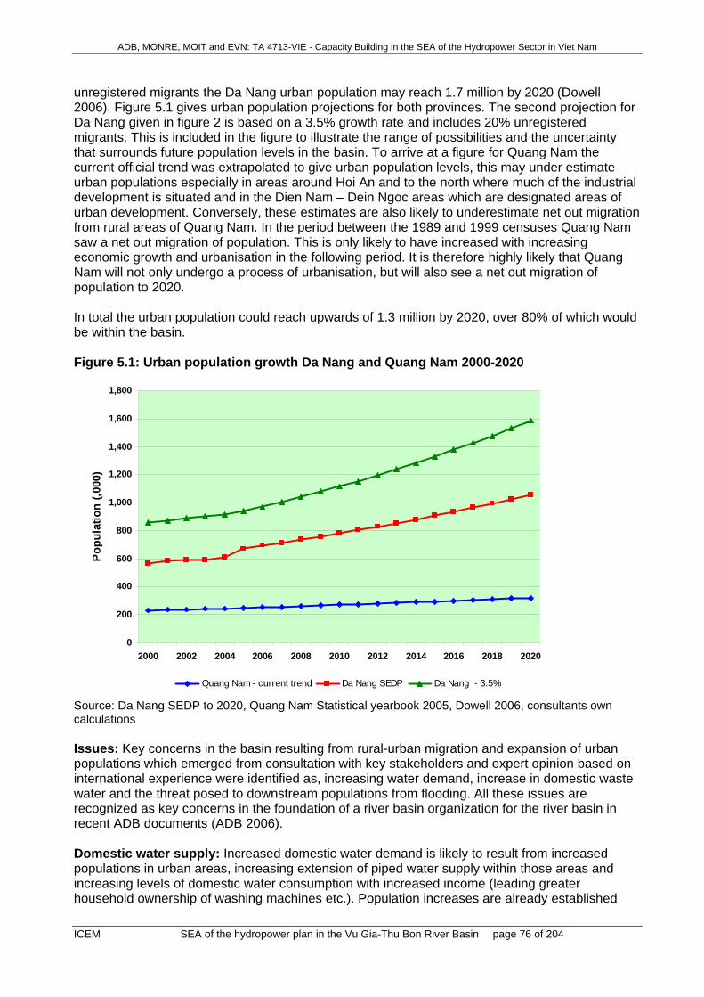
ADB, MONRE, MOIT and EVN: TA 4713-VIE - Capacity Building in the SEA of the Hydropower Sector in Viet Nam
ICEM SEA of the hydropower plan in the Vu Gia-Thu Bon River Basin page 76 of 204
unregistered migrants the Da Nang urban population may reach 1.7 million by 2020 (Dowell 2006). Figure 5.1 gives urban population projections for both provinces. The second projection for Da Nang given in figure 2 is based on a 3.5% growth rate and includes 20% unregistered migrants. This is included in the figure to illustrate the range of possibilities and the uncertainty that surrounds future population levels in the basin. To arrive at a figure for Quang Nam the current official trend was extrapolated to give urban population levels, this may under estimate urban populations especially in areas around Hoi An and to the north where much of the industrial development is situated and in the Dien Nam – Dein Ngoc areas which are designated areas of urban development. Conversely, these estimates are also likely to underestimate net out migration from rural areas of Quang Nam. In the period between the 1989 and 1999 censuses Quang Nam saw a net out migration of population. This is only likely to have increased with increasing economic growth and urbanisation in the following period. It is therefore highly likely that Quang Nam will not only undergo a process of urbanisation, but will also see a net out migration of population to 2020. In total the urban population could reach upwards of 1.3 million by 2020, over 80% of which would be within the basin. Figure 5.1: Urban population growth Da Nang and Quang Nam 2000-2020
0
200
400
600
800
1,000
1,200
1,400
1,600
1,800
2000 2002 2004 2006 2008 2010 2012 2014 2016 2018 2020
Popu
latio
n (,0
00)
Quang Nam - current trend Da Nang SEDP Da Nang - 3.5%
Source: Da Nang SEDP to 2020, Quang Nam Statistical yearbook 2005, Dowell 2006, consultants own calculations Issues: Key concerns in the basin resulting from rural-urban migration and expansion of urban populations which emerged from consultation with key stakeholders and expert opinion based on international experience were identified as, increasing water demand, increase in domestic waste water and the threat posed to downstream populations from flooding. All these issues are recognized as key concerns in the foundation of a river basin organization for the river basin in recent ADB documents (ADB 2006). Domestic water supply: Increased domestic water demand is likely to result from increased populations in urban areas, increasing extension of piped water supply within those areas and increasing levels of domestic water consumption with increased income (leading greater household ownership of washing machines etc.). Population increases are already established

ADB, MONRE, MOIT and EVN: TA 4713-VIE - Capacity Building in the SEA of the Hydropower Sector in Viet Nam
ICEM SEA of the hydropower plan in the Vu Gia-Thu Bon River Basin page 77 of 204
above. Piped water supply in Da Nang reached about 50% of the urban population (World Bank 2006), this is expected to rise to 90% in 2010 and 100% in 2020 (according to MoC forecasts). MoC figures suggest that per capita water supply for urban areas was around 80litres/person /day in 2005, this is expected to more than double by 2020 to 180 litres/person/day. Figure 5.2 gives an estimation of the increasing water demand for the area. Even given relatively modest urban population projections adopted for these estimates, demand is expected to see an increase of about 7 fold. Figure 5.2: Projected household water demand for urban population within the basin
0
10
20
30
40
50
60
70
80
90
100
2005 2010 2015 2020
Mill
ion
cubi
c m
eter
s pe
r yea
r
Demand due to increased household consumption
Demand due to extension of w ater supply
Increase due to population increase
Source: Urban population estimates given above, World Bank 2007, Consultants own calculations Table 5.2: Estimates of urban domestic water demand 2005 – 2020 (m3) 2005 2010 2015 2020 Urban domestic water demand
13,459,708 39,039,377 60,793,541 90,163,786
SWECO estimate - 51,457,962 64,711,927 77,965,891 Source: SWECO report, Urban population estimates given above, World Bank 2007, SEA team calculations Domestic waste water: As production of domestic waste water is directly related to water supply, we can expect to see increases in the production of waste water of a similar magnitude to increases in water supplied. The discharges of water into water ways and into the sea will almost inevitably increase. One factor which may mitigate this increase is greater investment in water treatment facilities which is likely to take place. Although detailed information was not available about waste water treatment facilities in Quang Nam province, according to project documents of the Priority Infrastructure Investment Project (PIIP) in Da Nang city, waste water treatment facilities are due to be substantially upgraded. Key to the provision of different waste water facilities is the provision of 4 new treatment facilities with a total daily capacity of 240,000 m3/day. However, this new treatment capacity will only cover a little over 56% of current waste water production. Flooding risks to downstream populations: As shown in Map 5 and reported in the section of this report on hydrology, all of the large population concentrations in the basin are downstream in relatively low lying flood prone coastal locations. Higher levels of urbanisation in these areas will put more households and concomitant urban infrastructure investments at risk from flooding.

ADB, MONRE, MOIT and EVN: TA 4713-VIE - Capacity Building in the SEA of the Hydropower Sector in Viet Nam
ICEM SEA of the hydropower plan in the Vu Gia-Thu Bon River Basin page 78 of 204
Table 5.3 gives some idea of the expansion of population levels in areas which are particularly prone to seasonal floods. Table 5.3: Areas designated for urban development within the river basin which are prone to seasonal floods District Area
(km2) 2005 Pop.
2020 Pop. Pop. Inc.(2005-2020)
Quang Nam
Hoi An 61.45 83,978 95,059 11,081
Dien Ban 214.28 201,268 227,826 26,558
Duy Xuyen 298.42 132,560 150,032 17,472
Da Nang
Cam Le 33.25 65,506 200,000 134,494
Hoa Vang 1008.75 107,997 244,748 136,751
Total 1,616.15 591,304 917,665 326,361
Source: PIIP 2006, Quang Nam construction master plan to 2020
5.7.2 Lowland-upland migration The upland areas of the basin located in Quang Nam have not seen the kind of lowland –upland migration experienced in the neighboring region of Tay Nguyen. However, improved road networks and an increased number of income earning opportunities in these areas have seen increasing levels of in migration over recent years. As most of this migration is temporary it does not appear in official statistics and is difficult to estimate. The inflow of migrants in search of income earning opportunities is likely to continue as long as those income earning opportunities exist and pose a more attractive proposition than opportunities elsewhere. In particular, the current ‘gold rush’ in Quang Nam is highly unpredictable. Nevertheless, it is likely to persist at least in the medium term (next 5-10 years), and may increase due to better road access. Without any further hydro power development the in migration is likely to remain at current levels, with a decline in the long term as resources are exhausted.
5.8 Issue ‘Ethnic minorities and their livelihoods’ Ethnic minority groups in upland areas have experienced little or no socio cultural change over the last 10 years. Better communications and increasing in migration by ethnic Kinh hunters, loggers and miners is likely to influence cultural change amongst ethnic groups in upland areas. However, the change is likely to be slow, and possibly marginal over the next 10 – 15 years without hydropower development. Trend evidence shows that ethnic minority poverty rates have been declining over the last 10 years, however, declines in poverty rates have been lower than for the Kinh majority. In Quang Nam ethnic minority groups are particularly poor and disadvantaged.

ADB, MONRE, MOIT and EVN: TA 4713-VIE - Capacity Building in the SEA of the Hydropower Sector in Viet Nam
ICEM SEA of the hydropower plan in the Vu Gia-Thu Bon River Basin page 79 of 204
Data from the VHLSS, suggests that in the future ethnic minorities can expect to see an improvement in terms of income, this could be assisted by the extension of the road network (see roads trends), targeted poverty reduction programmes (such as programme 135, CBRIP and P-CLIP programmes). However, writers such as Rambo and Jamieson (2003), see a spiraling depletion of the natural resource base upon which these groups rely due to high population growth and increased exploitation from outside groups made possible by better access. From the available evidence it is difficult to comment upon which scenario is most likely to arise in the Vu Gia Thu Bon river basin.
5.9 Issue ‘Public health in affected communities’
5.9.1 Health problems in affected communities While morbidity related to basic sanitation and the level of available health services has declined, resulting in better overall health indicators, diseases amongst certain groups and in certain areas have increased (HIV/AIDs, dengue fever). Upland areas remain of key concern due to poverty, child malnutrition, low education levels and poor health care provision. With better education, satiation and the extension of clean water supplies, conditions related to poor sanitary conditions and lack of clean water supply could be expected to continue their decline. In particular, child malnutrition should be expected to decline markedly. Other age related aliments can be expected to increase in importance as the population ages and as people live longer. HIV/AIDs is expected to continue increasing its spread into the general population. Incidence is likely to be concentrated around large urban areas which already suffer from a relatively high incidence of the disease. Although there are already many programs to address the spread of the disease it is not clear how effective these will be in the short term (UNICEF 2005). Diseases related to urbanization and urban living can also be expected to increase, as has been seen with recent increases in the incidence of dengue fever.
5.9.2 Health amenities in upland areas Health services have improved in all areas of Viet Nam. Sparsely populated upland areas have a greater per capita quantity of health infrastructure than in lowland areas. However, this does not reflect the accessibility of these facilities to isolated poor or the quality of the care given. This trend of improving health services is likely to continue in the future.
5.10 Issue ’Transport’
5.10.1 Quality and Accessibility of Rural Roads Extension and improvement of rural roads receives high priority within the Provincial Transport Plan 2005-2015, an objective of which is that all communes should be accessible via the rural road network by 2010. The rural road network has a high priority since improving access is viewed as a means of reducing poverty, which is a serious issue in upland communities. The construction of rural roads is supported by the Poverty Alleviation Program and the WB funded RT-3 rural road program. Given these developments, it can be expected that: By 2010 all communes will be connected to the national road network. Road sections will be upgraded according to the 2005-2015 Provincial Road Plan.

ADB, MONRE, MOIT and EVN: TA 4713-VIE - Capacity Building in the SEA of the Hydropower Sector in Viet Nam
ICEM SEA of the hydropower plan in the Vu Gia-Thu Bon River Basin page 80 of 204
5.10.2 Development of a Major Road Network Road 14 B will be considered for improvement to a highway after 2015 which will improve transport. This road will also form part of the GMS network and will connect the GMS countries to the port at Tien Sa in Da Nang City (the lower 42 km section is part the GMS road) (Map 14). The south Quang Nam road (147 km in Quang Nam Province) which will be another E-W connection (provincial road 616) is planned to be upgraded (2005-2015). This will create a further connection to the HCM road and link to Kon Tum Province via Dak To. This road will help the traffic in the region when the provincial road 616 is submerged by Song Tranh 2 hydropower project.
5.10.3 Waterway Transport Waterway growth and use will continue to be constrained by low, dry season flows. This may worsen due to watershed degradation such that low flows may further diminish. If flows decrease then (i) infrastructure will need to be changed to accommodate smaller craft and (ii) river channels will need to be dredged. Both of these will be additional costs to the provincial departments responsible.
5.11 Issue ‘Agriculture and irrigation’ System Management Issues: The Quang Nam Draft Irrigation Development Plan 2006-2010 anticipates significant Improvements in irrigation system management. Canal lining will increase efficiency but may deplete ground water recharge and affect household wells (Map 14). Water Demand Issues: By 2010, an additional 60 reservoirs are planned for the tributary systems, allowing for an increase in the irrigation area by13,500 ha. A further 79 weirs will be constructed which will add 2,100 ha while 5 new pumping stations will provide water for an additional 400 ha. Greater competition for dry season water will occur from other users e.g. domestic, industry, aquaculture and environment. This may result in water being allocated away from agriculture towards higher value uses. Dry season flows may continue to decrease due to increasing watershed degradation. Increased maintenance will be required in irrigation systems due to increasing sediment loads from degrading watersheds. Water Yield and Quality Issues: The sources of water quality pollutants will increase. Nutrient and chemical contamination will increase from the use of agro-chemicals while watershed degradation from unsustainable activities will provide increased levels of sediment from accelerated erosion. Bank channel erosion will increase to compensate for increased flood discharges. Lower dry season flows resulting from deteriorating watershed conditions will cause salinity intrusion to increase.
5.12 Issue ‘Industrial development’ Industry has been growing rapidly in the river basin. This growth has been concentrated in and to the south of Da Nang. Industrial growth has not only been a significant driver of economic growth, migration to urban centers and increasing per capita GDP, but has also resulted in significant increases in water demand and a concomitant increase in the production of waste water. Industry is expected to continue its rapid growth at least over the next 10 years (Figure 5.3). Quang Nam SEDP expects growth in industrial output of between 25 and 36 percent between

ADB, MONRE, MOIT and EVN: TA 4713-VIE - Capacity Building in the SEA of the Hydropower Sector in Viet Nam
ICEM SEA of the hydropower plan in the Vu Gia-Thu Bon River Basin page 81 of 204
2006 and 2010, reducing to between 17 and 19 percent between 2010 and 2015. Similarly, Da Nang expects an industrial output to grow by 17 percent per year over the next 5 years or so. Figure 5.3: Expected growth of industrial output in Quang Nam and Da Nang 1995-2015 (constant 1994 prices)
0
10000
20000
30000
40000
1995 2000 2005 2010 2015
Indu
stria
l out
put (
VND
billi
on)
Quang Nam Da Nang
Source: Statistical yearbooks, SEDPs Increasing water usage: The only projections available suggest that growth in industrial water usage is likely to exceed that of industrial growth (Figure 5.4 and Table 5.4). Significant usage increases will place increasing pressures on water supplies, and may outstrip supply in severe dry seasons constraining industrial development. Figure 5.4: Increasing water demand/use Source: SWECO 2004 Table 5.4: Increasing water demand for industry in the basin 2001-2020
206 million
104 million
2 million0
50
100
150
200
250
2001 2010 2020
Miil
ion
cuni
c m
eter
s/ye
ar

ADB, MONRE, MOIT and EVN: TA 4713-VIE - Capacity Building in the SEA of the Hydropower Sector in Viet Nam
ICEM SEA of the hydropower plan in the Vu Gia-Thu Bon River Basin page 82 of 204
2001 2010 2020 Increase 2001 - 2020
Industrial water demand (million m3/year)
2 104 206 204
Source: SWECO 2004 Increasing waste water production: Waste water production is likely to increase in proportion to water consumption - consequently waste water volumes are likely to increase dramatically. Without the development of proper treatment facilities this will have dire consequences for water pollution, especially in and around areas where industrial production is talking place. The consequences of unchecked water pollution are well known throughout Viet Nam especially in the three economic development focal regions (ICEM 2007, Berg et al 2003).
5.13 Issue ‘Tourism development in the basin’ Tourism is one of the most rapidly growing industries in the basin and is especially important for Quang Nam which is home to two UNESCO world heritage sites. Both international and domestic tourism are important components of this increase. However, trip length is still relatively short and the amount spent per tourist relatively low. Key tourism impacts include high water usage and waste water production. Tourism can be expected to continue growing due to improvement of facilities and infrastructure, growing tourism in the region, and growing domestic tourism demand due to increasing income levels (Figure 5.5). The SEDPs for the basin envisage an increase in visitors of 150 percent over the period, or five million by 2015. The typical tourist profile is also likely to change with domestic tourism becoming increasingly important. Tourism from elsewhere in Asia is also likely to increase rapidly as economies, and incomes in the region continue to grow. Despite over 50 percent of this growth being accounted for by domestic tourists, revenue per visitor is expected to increase from under 250,000VND per person, nearly 500,000VND per person (Figure 5.6). This is due to an expected increase in higher value added tourism and trip length in the future. High value added tourism is expected to increase through better tourism provision being developed in the shape of new hotels and tourism developments in beach and costal areas. Better facilities and greater diversification of tourism activities (while still centered around cultural and resort based amenities) is also expected to lead to a greater trip length. Increasing use of water: The tourism industry generally overuses water resources for hotels, other facilities and personal use of water by tourists. This can result in water shortages and degradation of water supplies, as well as generating a greater volume of waste water (UNEP 2007). Using the estimates arrived at earlier23, water usage due to tourism currently adds around 1 percent to current annual water usage in the basin, or 200,000 cubic meters. By 2015 this is forecast to reach about 3 percent of annual water demand in the basin, or 2.3 million cubic meters. This is a rough estimate for the basin as a whole, if we look at Hoi An, the key tourist area of Quang Nam where water demand due to tourism is likely to be highest. Current water demand in Quang Nam due to tourism is about 490 thousand cubic meters per year, given projected levels of tourism this can be expected to increase by over 380 percent by 2015 to about 1.9 million cubic meters per year.24 This is equivalent to about 40 percent of current and predicted domestic water demand.
23 See demography. Assuming that visitors use on average 180 liters/day, and trip length is about 2 days, increasing to a trip length of 2.5 days in 2015. 24 Assuming, in line with MoC figures that tourists use 180litres or water per person per day. This is also assuming that all tourist to Quang Nam stay in Hoi An for the duration of their visit.

ADB, MONRE, MOIT and EVN: TA 4713-VIE - Capacity Building in the SEA of the Hydropower Sector in Viet Nam
ICEM SEA of the hydropower plan in the Vu Gia-Thu Bon River Basin page 83 of 204
Figure 5.5: Projected number of visitors to Da Nang and Quang Nam 2001-2015
-
2,000
4,000
6,000
2001 2003 2005 2007 2009 2011 2013 2015
Visi
tors
(tho
usan
ds)
Quang Nam Da Nang
Source: Quang Nam, Da Nang statistical yearbooks and SEDPs Figure 5.6: Expected tourism indicators in Quang Nam
-
1
2
3
2001 2003 2005 2007 2009 2011 2013 2015
Visi
tors
(mill
ions
)
-
500
1,000
1,500
2,000
2,500
3,000
Rev
enue
(bill
ion
VND
)
International visitors Domestic visitors Revenue
Source: Quang Nam statistical yearbook and SEDP Increasing waste water production: Waste water production due to tourism will increase in line with the increase in water usage (see demographic trends). The demands of tourism will add to the pressure on waste water treatment facilities, especially in locations such as Hoi An with indigenous populations which are small relative to tourist numbers. Potential for developing eco-tourism: The possibility of developing eco-tourism is a key opportunity for the river basin in general which has not yet been fully realized in current tourism and socio economic development plans. Eco-tourism involves traveling to relatively undisturbed

ADB, MONRE, MOIT and EVN: TA 4713-VIE - Capacity Building in the SEA of the Hydropower Sector in Viet Nam
ICEM SEA of the hydropower plan in the Vu Gia-Thu Bon River Basin page 84 of 204
areas for the purpose of studying or enjoying scenery, flora and fauna as well as local cultures in a way that does not adversely affect the environment or communities which are visited (Phan et al 2002). Eco-tourism can involve a range of activities, including hiking, trekking, cycling, white water rafting and fishing amongst other activities. There are many relatively untouched areas in the province which may offer considerable potential for tourism development. In addition, the recent completion of road infrastructure to the upland areas, through improving access to these areas of interest allow this potential to be better realized. Particular locations of interest for eco-tourism within the study area include special use forests, sites of natural interest and rivers in upland areas of the basin and coastal regions. The kinds of activities which could be promoted in these areas include: Trekking in areas of natural scenic beauty. Already in many upland areas in the region in
general, and more specifically Viet Nam have well established companies which run trekking excursions through areas of natural beauty and environmental interest. Examples of this are in locations around Sa Pa and Da Lat.
Visiting indigenous people, excursions in upland areas often take make stops at ethnic minority villages. These offer the potential for outsiders to learn more about traditions of ethnic cultures while offering indigenous people living in these areas the opportunity to diversify their income streams.
Angling – the aquatic biodiversity trends report suggests that the river basin is home to some rare species of fish. Traveling to remote locations to engage in sport fishing is increasingly popular. In similar upland areas in Papua New Guinea, for example, tourists pay considerable fees to be allowed to catch fish. Fish are returned to the water after being caught so this kind of fishing has no impact on fish stocks. As with rafting improved road access could better facilitate this kind of tourism.
White water rafting – as the topography of the basin is quite steep in some periods of the year, depending on rainfall, rivers maybe suitable for white water rafting (see hydrology trends). This popular leisure activity despite requiring proper training and equipment requires minimal infrastructure and should not place a significant burden on the surrounding areas. The completion of road access to the upper reaches of the basin should allow access to at least some suitable locations. If managed properly offering this kind of leisure activity can be economically valuable. In many areas of Laos, for example, rafting is already a popular tourist activity.
Eco-tourism offers real economic benefits which do not come at the expense of environmental deterioration. Eco-tourism has the advantage over mass tourism of potentially returning greater economic benefits to the poorest groups. Where the profits of mass tourism, especially international tourism, are often remitted back to large cities or other countries where companies which run these concerns are based. Eco-tourism potentially offers employment to ethnic minority groups as guides and other support staff, it also allows the potential for returning funds to environmental protection mechanisms, local communities etc. Detailed data on how much revenue could be expected to be generated from this kind of tourism is not available at present. At a conservative estimate, if only 25 percent of visitors stay an extra half day to pursue these kind of activities that would mean, given current projections, around 66 billion VND25 (4.1 million USD) per annum in extra revenues. This figure is probably larger as this kind of tourism comes at a considerable premium. Moreover, as a larger proportion of this, if 25 Calculated as revenue/visitor in 2015 multiplied by 25 percent of visitor numbers, divided by number of days and multiplied by half a day (0.5)

ADB, MONRE, MOIT and EVN: TA 4713-VIE - Capacity Building in the SEA of the Hydropower Sector in Viet Nam
ICEM SEA of the hydropower plan in the Vu Gia-Thu Bon River Basin page 85 of 204
properly managed, could go to the poorest groups the welfare effect of the marginal income to the province will be many times greater. The Government is fully aware of the significance of eco-tourism and has prioritized ecotourism in its strategy for tourism development to ensure both sustainability and economic benefits (Phan et al 2002).
5.14 Issue ’Mining’ The average annual growth of mining industry during 2010-2015 is projected to be 10 -11%, including increased gold exploitation in Bong Mieu and Phuoc Duc mines reaching one million tonnes per year (Table 5.5). Other growth sub-sectors are lime stone, materials for cement production and coal exploitation in Nong Son mine to supply the Thanh My cement plant. There is also planned investment in ashlar paving and facing stones for export. Mineral exploitation and processing requires 11% (or VND 4.57 B) of the total investment capital for industrial development in the Province until 2015. Table 5.5: GDP growth and structure of provincial mining industry Unit: VND Billions
Indicators
2000
2003
2005 2010
2015
Growth 2001-5 2006-10 2011-15
Total industrial production 1034.1 2026.8 3200.4 9934 22522 125.35 125.42 117.79 Mining and quarrying 62.98 106.35 144 370 620 117.99 120.77 110.88
Percentage 6.09 5.25 4.5 3.72 2.75 Source: Revised Master Plan of Industrial – Small and Handicraft Industrial Development in Quang Nam until 2015. Without hydropower development, it is likely that the mining industry will progressively come under more effective environmental management. It will become one of the most significant economic sectors for the province with a high proportion of revenues remaining in the area and high employment potential. In the short term – over the next five years – environmental problems and illegal activity will intensify, with serious disturbance to terrestrial and aquatic natural systems and, possibly to public health. It will cause serious social disturbance in isolated areas, especially impacting on minorities and small scale farmers and fishers. Larger scale mining ventures will be more readily brought under environmental controls with performance monitored and enforced than the small scale miners (legal and illegal). Small-scale miners tend to do more damage to the environment than those working in modern mining enterprises – with a greater environmental cost per unit of output. They are dispersed in location and harder to manage. Table 5.6 summarises the future trends relating to mining without further hydropower development. Table 5.6: Future trends relating to mining without the proposed hydropower developments Issues Future trend without the
proposed hydropower developments
Key drivers of this trend Key concerns in the study area
1. Illegal exploitation of gold
- In the short term it will increase. Currently, the Government and province have banned exploitation of gold in many areas. - Illegal exploitation will
- Government and provincial policies - Strong demand due to increasing price of gold - Ineffective enforcement - Poor management
- Negative impacts in affected areas will intensify: Social insecurity in affected areas - Clearing of forest and

ADB, MONRE, MOIT and EVN: TA 4713-VIE - Capacity Building in the SEA of the Hydropower Sector in Viet Nam
ICEM SEA of the hydropower plan in the Vu Gia-Thu Bon River Basin page 86 of 204
decrease only if strict and effective measures of monitoring and enforcement are applied. - Potential public health implications from poorly controlled use of chemicals
- Lack of human resources in policy implementation
upstream disturbance my increase sedimentation and erosion Source: WWF report on mining in QN Song Bung 4 EIA
2. Pollution of surface and underground water
- Increasing in areas with low investment in mining mitigation and technologies - Decreasing in areas where high and prioritized investment will be put in together with strict requirement on environmental protection.
- Lack of capital for better, more environment-friendly technologies - Modern technologies + strict requirements for environmental protection + effective management
Increased sedimentation Reduction in aquatic fauna – reduced fisheries productivity Increased risk in use of water for agriculture and industry
3. Exhaustion of clay and other minerals
- The trend continues to increase - Exhaustion of some key minerals is anticipated
- Scarcity of clay and other minerals - Increase of demand for new houses and construction due to the population growth and industrial development
- Increase the cost of construction materials - Potential impediment to economic growth and infrastructure development Source: DONRE for mining;
5.15 Issue ’Waste management’
5.15.1 Solid Waste Generation It is highly likely that Quang Nam Province will undergo a process of urbanisation of the population to 2020, especially in areas around Hoi An and to the north where much of the industrial development is situated and in the Dien Nam – Dein Ngoc areas which are designated areas of urban development. As a result, total solid waste generation from domestic sources is likely to increase as consumption patterns change from rural to urban norms. Based on population estimates for 202026, it is estimated that domestic solid waste will reach approximately 100,000 tons per year in urban areas and 126,000 tons in rural areas. For urban waste, this represents an increase of approximately 50% on 2004 levels and for rural areas a decrease of approximately 6%. This trend is due primarily to predicted demographic trends which will produce an increase in population levels in urban areas and a slight reduction or stagnation in rural populations due to out migration. Urban waste management will become increasing important and the capacity of existing waste dumps for urban and coastal areas should be reviewed. Rural waste production is still likely to be significantly higher than urban wastes and there is no plans or strategies for the development of rural waste management systems. While rural wastes are largely organic in nature and represent a low hazard, improved material wealth over the next 15 years in these areas is likely to bring with it changing consumption patters and increases waste volume and changes in its composition. Of greatest concern will be further increases in hazardous wastes generated from industrial zones and medical facilities, which have increased on average by 80% and 30% per year respectively from 2002-2004. Should these trends continue unabated and without significant improvements in
26 Projected population estimates based on Provincial Socio-Economic Development Plans and Statistical Year Books for Quang Nam (refer to Section on Demographic Trends for further details).

ADB, MONRE, MOIT and EVN: TA 4713-VIE - Capacity Building in the SEA of the Hydropower Sector in Viet Nam
ICEM SEA of the hydropower plan in the Vu Gia-Thu Bon River Basin page 87 of 204
waste treatment and management, levels of hazardous waste will increase significantly. Present treatment facilities are unlikely to cope with such increases and the development of more sophisticated treatment such as high temperature incineration may need to be considered. Planning for the development of treatment facilities should be developed within the context of a provincial waste management strategy as required under Direction No. 23/2005/CT-TTg. This directive requires the completion of urban and industrial solid waste management plans for provincial, inter-provincial or special areas by 2010.
5.15.2 Solid Waste Collection and Treatment While improvements have been made between 2002 and 2004 in the sorting of waste in urban and industrial areas, with a 15-20% increase, national targets for waste collection and sorting by 2010 are unlikely to be met without significant further improvements. For example, under the NSEP (2003), the SWMS (1999) and Direction No. 23/2005/CT-TTg, 90% of domestic, industrial and service solid waste should be collected and treated, with priorities under Directive No. 23 being reduction, reuse and recycling. In addition, 100% of hazardous health solid waste and 60% hazardous industrial solid waste should be treated by proper technologies under Direction No. 23.

ADB, MONRE, MOIT and EVN: TA 4713-VIE - Capacity Building in the SEA of the Hydropower Sector in Viet Nam
ICEM SEA of the hydropower plan in the Vu Gia-Thu Bon River Basin page 88 of 204
6 FUTURE TRENDS WITH THE HYDROPOWER PLAN
6.1 Issue ‘Climatic and rainfall conditions’ No measurable change is expected in climate and rainfall conditions over 20 years due to the hydropower plan. The sizes of the proposed reservoirs are too small to cause local changes in rainfall, although there will likely be reductions in peak daily temperatures in areas close to the reservoirs. However greenhouse gas emissions may be of some concern. In recent years studies in Canada (eg. Duchemin et al. 2002) and Brazil (eg. Fearnside 2001, Fearnside 2005) have shown that emissions of greenhouse gasses from reservoirs make them less environmentally friendly that was once thought. In particular, emissions from tropical reservoirs may contribute many times the amount of greenhouse gasses to the atmosphere during their first 10 years of operation than oil or coal fired power stations (McCully 2002). This occurs because organic matter decomposing in reservoirs consumes O2 and creates CO2, CH4 and other greenhouse gases. These gases are released when water levels fall or when water from deep in reservoirs is released through turbines and over spillways (Fearnside 2005). This understanding is still developing so many aspects are still controversial, but on the basis of recent international research the probability of substantial releases of greenhouse gases from some 60 reservoirs planned in the basin has to be considered as high, particularly if a substantial amount of plant matter remains in reservoirs when inundated. This problem is likely to occur in all reservoirs. Greenhouse gas releases are likely to continue until organic matter trapped in the reservoirs is used up. The key concern is that hydropower projects may add substantially to the release of greenhouse gases. This impact may be reduced by: • clearing trees and other plants from the reservoir prior to filling; • using an adjustable level intake that directs only surface water to power stations; and • minimising water level fluctuations.
6.2 Issue ‘Dry season minimal flows and effect on salinity intrusion’
6.2.1 Effects of the individual components of the Hydropower Plan The reservoirs/HP projects are being planned as single purpose power generation facilities. The capacity of the largest reservoirs is medium, in the range 100 to 500 Mm3. They are too small to be used for inter-annual storage. However they will serve to delay the hydrograph in the downstream river by one to several weeks, and the amount of the delay will depend partly on control of the turbine flows, and partly on when spillage occurs. The increased summer flows associated with the May to June light rains, that are useful for drought relief, may not be present in the future. The runoff during this period may be captured in the reservoirs, and this may prolong the duration of drought in the downstream and estuarine parts of the basin. If a future decision is made to operate the projects as dual purpose (ie hydro-electric and water supply), then there would be significant benefits to low flow, particularly in the Song Vu Gia system. For example, in an average dry season, there would be the possibility of augmenting flows in Song Vu Gia, downstream of Song Bung 5, by up to 30 m3/s, if about ½ of the live storage

ADB, MONRE, MOIT and EVN: TA 4713-VIE - Capacity Building in the SEA of the Hydropower Sector in Viet Nam
ICEM SEA of the hydropower plan in the Vu Gia-Thu Bon River Basin page 89 of 204
volume in the two largest reservoirs (A Vuong and Song Bung 4) were released during the 4 month dry season period. This would constitute a significant and valuable improvement to dry season flows. Three concerns for much reduced flows in the dry season, which may not be mitigated by operational changes in reservoir water release, are:
1. Sections of river between the dam and the location of the powerhouse which will be dewatered
and suffer reduced flows for all times other than when spillage is occurring and 2. Much reduced flows during part of the year, including possibly the dry season, will occur during
the reservoir filling period. For example for Song Bung 4, the volume of water needed to fill the reservoir (490 Mm3) is equivalent to the total volume of river flow for about 20% of a year, during an average runoff year.
3. Inter-basin diversions, see detailed description below, Inter-river diversion is part of the present plan for Dak Mi 4. Water from the proposed reservoir will be diverted through a tunnel and penstock to the powerhouse, located on a tributary of the Song Thu Bon (Ngon Thu Bon). Up to 115 m3/s of flow will be diverted from the Song Vu Gia system to the Song Thu Bon, with smaller amounts of diversion flow when the turbines are operating under partial load. In the lowest flow month, the diversion flow may be about 15 m3/s or larger, and this amount will be lost from low flows in the Song Vu Gia system. Whether or not low flows in the Song Vu Gia system can be maintained during future droughts will depend on the design of the Dak Mi 4 dam (existence of low flow diversion gate at the dam and/or retention of sufficient water that spillway gates may be used for release), and on operation at the dam to retain sufficient water for drought flow supplementation.
6.2.2 Cumulative effects of the HP plan on the trends in the issue Without provisions stated in the preceding paragraph, the presently planned diversion flow for Dak Mi 4 will cause problems in the Song Vu Gia downstream. For example in the dry season, the reduced flow in the Song Vu Gia will cause reduced flows in the Song Ai Nghia and Song Yen rivers downstream, affecting the City of Da Nang water intake. Figure 6.1 shows the locations of existing intake and water treatment plant for municipal water supply for Da Nang, and the location of new (under construction) pump station at An Trach weir. This pump station will be connected by pipeline to the present intake/water treatment plant. Compensatory flow exchange from the Song Thu Bon to the Song Vu Gia via the Quang Hue connection will not be possible. With the 1125 km2 area of Dak Mi 4 removed from the Song Vu Gia river basin, an expected flow reduction of at least 10 m3/s will occur on average during the lowest flow month of the year. Monthly low flows at Ai Nghia will reduce from about 45 m3/s to about 35 m3/s, in an average year. Deterioration of salinity conditions, associated with increased intrusion along the Song Yen channel, will accompany this flow reduction. During years of extreme drought, the effect on salinity intrusion will be particularly severe.

ADB, MONRE, MOIT and EVN: TA 4713-VIE - Capacity Building in the SEA of the Hydropower Sector in Viet Nam
ICEM SEA of the hydropower plan in the Vu Gia-Thu Bon River Basin page 90 of 204
Figure 6.1: Song Ai Nghia and Song Yen system
The new water intake (at An Trach weir pump station, see Figure 6.2) for City of Da Nang will be operated frequently with lower dry season flows. Six pumps of capacity 5,500 m3/hr each are to be installed, and 1 to 4 of these will operate at one time. The pumping head will be at least 4 m, and power consumption will be about 100 kW per pump. The supply will send water free of salinity from the river upstream of the weir to the existing water treatment plant (at Cau Do), to avoid salt contaminated water in the Song Yen channel. The energy requirement for operating 4 pumps, each of 5500 m3/hour capacity (combined capacity 22,000 m3/hour) at the water intake is approximately 8.5 MWh per day, with an operating cost of about 12 million VND per day at present electricity prices. If a reserve of water were kept in Song Bung 4 and A Vuong reservoirs and released for dry season downstream flow augmentation, then there will be sufficient dry season flows to ensure that saline water in the estuary is kept well away from the Cau Do intake.
6.3 Issue ‘Flooding and maximum flows’
6.3.1 Effects of the individual components of the HP plan Limited improvements to the flooding situation are expected in the lower Song Bung basin because three reservoirs with modest storage (A Vuong, Song Bung 4 and Dak Mi 4) are either under construction or proposed. Flood peak flows will be delayed due to the effects of capture of early season runoff by the reservoirs. Main season floods are typically too large to be reduced by the future reservoirs. Improvements in flooding in the lower parts of the Song Thu Bon basin will be minor because only one project with significant storage (Song Tranh 2) is proposed and under construction.

ADB, MONRE, MOIT and EVN: TA 4713-VIE - Capacity Building in the SEA of the Hydropower Sector in Viet Nam
ICEM SEA of the hydropower plan in the Vu Gia-Thu Bon River Basin page 91 of 204
Figure 6.2: New pump station under construction at An Trach weir (March 2007).
No significant reduction of late season (large) floods for 7 out of 8 of the proposed large projects. Song Con 2 reservoir has significant storage in comparison with inflows, so there may be small potential improvements to the main season floods downstream of the dam. The reservoirs/HP projects are being planned as single purpose power generation facilities. Flood control storage and operation is not proposed at present. Possible reduction of small floods. Good co-ordination of spillway release flows by the dam operators, acting under directions from the EVN Central Despatch Office, and under annual Prime Ministerial Directive Orders will be important in achieving flood reduction where possible. Increase in flood events because of mechanical/electrical failures in spillway gate operation. This may be mitigated by a well conceived, well executed and well budgeted maintenance plan. Unexpected, operator induced, flood events during the dry season, e.g. testing of flood gates at future dams during the dry season, should be avoided, in order to prevent damage to life and property. Dak Mi 4 project will increase average and maximum flood flows in the Ngon Thu Bon tributary, because of large diversion flows exiting from the powerhouse. Local inhabitants living along the Ngon Thu Bon tributary may have problems crossing the river during the dry season, because flows will be much larger than they have been historically.
6.4 Issue ‘Sediment transport and sand excavation’
6.4.1 Effects of the individual components of the HP plan A major decrease in sediment transport is expected in the lower reaches of the two main river systems, because of blockage to sediment movement by the proposed dams. About 65% of the basin area will no longer be able to supply the natural transport of sand and silt-sized material downstream, as much of this will be permanently trapped in the reservoirs behind large dams. The fraction of suspended sediment that will be transported through the reservoirs and over the dam

ADB, MONRE, MOIT and EVN: TA 4713-VIE - Capacity Building in the SEA of the Hydropower Sector in Viet Nam
ICEM SEA of the hydropower plan in the Vu Gia-Thu Bon River Basin page 92 of 204
will be small. For river flows and reservoir storage capacity such as A Vuong reservoir for example, only about 3-10% of the total sediment will be passed to the downstream river27, because there will be sufficient transit time for the majority of particles to settle. Hourly water surface fluctuations associated with operating the turbines for peaking power, combined with sand-free and silt-free water, will cause enhanced river bank erosion and down-cutting of downstream channels. Additional expenditures are foreseen on bank stabilization, e.g. maintenance of the Quang-Hue river cross-connection, which is already a problem. During the initial few years of the Dak Mi 4 project there will be increased river channel erosion in the Song Ngon Thu Bon associated with large turbine discharges (up to 130 m3/s additional flow) in the channel. Losses of sites for sand availability for fill and construction will arise, because of impacts such as inundation, and erosion of existing in-channel sand supply sites that are downstream of future proposed large dams
6.4.2 Cumulative effects of the HP plan on the trends in the issue The river delta will change. Based on examples for other major river basins, e.g. Nile River Delta after construction of Aswan High Dam, Dension Dam28 on the Red River (USA) and Yantze River system after construction of Three Gorges project29 there may be: (i) much less suspended sediment and associated nutrients causing agricultural lands that are
presently flooded every few years to become less productive, (ii) less bed material load from upstream causing channel downcutting, re-direction of the
thalwegs of major channels, and problems for river off-takes, such as pumping stations, (iii) in the long term (one to several decades), the offshore delta front may advance much slower,
or possibly retreat, as the supply of sand and silt is reduced and (iv) much less supply of nutrients to the Bien Dong (East China Sea) with a change in ecological
character and productivity.
6.5 Issue: “Aquatic biodiversity and fisheries”
6.5.1 The main risks Barriers to Migration: Dams and river channels with seriously reduced flows can effectively prevent aquatic fauna undertaking normal migrations (eg. Borges Barthem et al. 1991, Cooke & Leach 2004, Katano et al. 2006, Sheer & Steel 2006). This is a serious issue for Viet Nam where a large proportion of river and estuarine fish are migratory and thus may be cut off from breeding areas resulting in population crashes (Jensen 2001, Poulsen et al. 2002) (Box 6.1).
27 Heinemann H.G. 1984. Reservoir Trap Efficiency, Chapter 8 of “Erosion and Sediment Yield: Some Methods of Measurement and Modelling” (ed R.F. Hadley and D.E. Walling). Geo Books, Norwich, U.K. 28 Leopold L.B., Gordon Wolman M, and Miller J.P. Channel Changes with Time, Chapter 11 of Fluvial Processes in Geomorphology. W.H. Freeman & Company. San Francisco 1964. 29 EOS Transactions of American Geophysical Union. Yangtze Sediment Decline Partly from Three Gorges Dam”. Volume 87, No 19, pp 185-190. 9th May 2006.

ADB, MONRE, MOIT and EVN: TA 4713-VIE - Capacity Building in the SEA of the Hydropower Sector in Viet Nam
ICEM SEA of the hydropower plan in the Vu Gia-Thu Bon River Basin page 93 of 204
Habitat modification and loss: Changes in flow volumes and patterns of flow, and the conversion of stream ecosystems to lake-like reservoirs can lead to substantial changes in the structure (Erny et al. 2003, Fujita et al. 2005, Anderson et al. 2006), distribution (Dauble et al. 2003), availability and use of habitats (Brenden et al. 2006), and species composition (Anderson et al. 2006) (Box 6.1). Nutrient Supply & Regulation of Downstream Water Quality: Over the long term nutrients settle out in the still waters of reservoirs, leading to the trapping of nutrients (Rausch & Schreiber 1981). This leads to a reduction in nutrient supplies to areas downstream of reservoirs (Childers et al. 2006). This is likely to lead to severe nutrient limitation directly below dams because upland streams like those in the Vu Gia – Thu Bon basin are usually already low nutrient systems (eg. Leira & Sabater 2005, Alexander & Smith 2006, Domenech et al. 2006, Roelke et al. 2006). Impacts of altered flows can cascade downstream to produce effects throughout the whole river system. Perhaps the most crucial are likely to occur in estuarine areas, because the timing of seasonal low and high flows are crucial to productivity, recruitment of larvae and the location and nature of the Estuarine Turbidity Maximum (ETM) zone, an area vital to environmental processes (Box 6.1). Box 6.1: Consequences of reductions to flows on fauna and biodiversity Direct consequences from reductions to flows on estuarine and freshwater fish faunas are pervasive across many spatial and temporal scales and include: disruptions to life-history migration pathways which are often crucial to successful reproduction (Connor & Pflug 2004, Walsh et al. 2005), growth and survival (Borges Barthem et al. 1991; McCormick et al. 1998, Cooke & Learch 2004), alterations to community structure (Kennish 2001, Gillette et al. 2005 Sheaves et al 2007) and faunal distribution (Lafaille et al. 2001, Daufresne et al. 2005; Sheaves et al 2007). Further, they impair ecological processes such as spawning (Connor & Pflug 2004, Walsh et al. 2005), influence habitat provision (Schofield 2003, Grismer et al. 2004, Khan et al. 2004) and habitat structure (Kennish 2001), disrupt the supply of nutrients that stimulate primary (Cloern et al. 1983, Salen Picard et al. 2002, Mallin et al. 1993) and secondary productivity (Kalke & Montagna 1991, Livingston et al. 1997), decrease juvenile survival (Salen Picard et al. 2002, Kraus & Secor 2005, North et al. 2005), and prevent the dissemination of cues needed for successful recruitment of juveniles (Strydom & Whitfield 2000). In turn, flow-on effects can impact indirectly on higher trophic levels (Omundson et al. 2002), change predator/prey dynamics and modify energy flow (Brietburg et al. 1997), both of which can feed-back to impact community structure. Extended low or no flow periods can lead to complete changes in the way a system functions (Livingston et al. 1997), changes that may be irreversible in extreme cases (Bate & Adams 2000). Estuaries are particularly important to biodiversity and fisheries; they support the greatest abundances and diversity of fish and invertebrates making them the sites of the greatest fisheries production, they provide nursery grounds for many important species (Strydom et al. 2002, Shoji & Tanaka 2006), and they are crucial corridors for the migration of aquatic animals between marine and fresh waters (eg. Sheaves et al. 2006). Important estuarine functions, like primary and secondary production (eg. Bate et al. 2002), and nursery ground provision, are intimately linked to seasonal river flow patterns (North et al. 2002, Strydom et al. 2002, Whitfield 2005). Of particular importance is the estuary turbidity maximum (ETM) zone, which acts as an area of concentration of small juvenile and larval fish (North et al. 2002, 2005, Shoji & Tanaka 2006) and their prey (Chicharo et al. 2001). The location of the ETM varies greatly between seasons (Uncles et al. 2006), with its exact location and chemistry substantially influencing patterns of productivity (ref) and larval recruitment success (Strydom et al. 2002, Islam et al. 2006). As well as affecting the location of the ETM and estuarine water quality in general, freshwater flows into estuaries are crucial drivers of sedimentation (Pontee et al. 2004), erosion, re-suspension of sediments and turbidity (Deloffre et al. 2006), all of which directly influence biodiversity and productivity. Reduced flow into estuaries can induce both higher long-term salinity and increased inland incursion of saline water. This leads to changes in habitat availability and shifts towards more marine faunas in affected areas (Sheaves 1992, Whitfield 2005, Sheaves et al in review). In contrast, increased flow can lead to reductions in salinity and promote mixed marine/freshwater faunas (Sheaves et al in review) however long-term maintenance of those faunas would require input of consistent freshwater base-flow (Bate & Adams 2000). The effects of altered environmental flows on biological processes have been reported at many organisational levels including, individual species (Adams & Bate 1995; Robins et al
ADB, MONRE, MOIT and EVN: TA 4713-VIE - Capacity Building in the SEA of the Hydropower Sector in Viet Nam
ICEM SEA of the hydropower plan in the Vu Gia-Thu Bon River Basin page 94 of 204
2006), assemblage (Albaret et al 2004; Teels et al 2004; Gyedu-Ababio & Baird 2006) and functional (Livingston et al 1997). Although detectable at various levels, effects of altered flows are pervasive and impact on every aspect of estuarine ecology.
6.5.2 Effects of individual components of the Hydropower Plan Construction of dams and clusters of dams that fully block rivers in the Basin will lead to: 1. Impaired Longitudinal Connectivity Leading to Migration Barriers. Imposition of dams will act as impassable barriers to longitudinal migration along the river, a consequence recorded throughout the world (eg. Borges Barthem et al. 1991, Fearnside 2001, Katano et al. 2006, Sheer & Steel 2006). Longitudinal connectivity is crucial because fish and mobile invertebrates use longitudinal migration to access spawning and nursery grounds, to move to deep water refuge areas when river levels fall, and as part of life-history migrations that are integral to the life cycles of many species (Jensen 2001, Poulsen et al. 2002). Impacts on longitudinal migration are expected to be particularly severe because Asian rivers contain large numbers of migrating species (Kottelat & Whitten 1996). Particularly severe on fish with requirements for long distance migration within the river or between the sea and upstream areas, and on fish needing to make specific short distance migrations between areas separated by the dam. This is likely to be a particular problem for species like Clupanodon thrissa an important fisheries species that migrates from the sea to upstream freshwater areas for spawning (Berge et al. 2006) and is recorded as vulnerable in Viet Nam’s Red Book. There is insufficient information to determine exact spawning grounds in the Vu Gia – Thu Bon so the specific level of risk for this (and other species) is unknown. Clusters of dams, such as those in the upper Vu Gia system, and dams on multiple branches of the system are likely to exacerbate this problem because few alternative spawning areas may be available. To exacerbate this problem, altered flows may not occur at times appropriate for migration needs. The probability of this impact is extremely high; few Asian fish can negotiate even low barriers (Kottelat & Whitten 1996) and there appear to be no amelioration plans at present. The Plan is likely to impact species across the whole river basin wherever dams or weirs are high enough to prevent passage – and this applies to all dams reviewed in the Plan. It is likely to impact organisms throughout the system, from those requiring local migration in the areas of dams to those that migrate between the sea and freshwater. The key concern with this issue is the total loss of species or severe reductions in abundance within the Vu Gia – Thu Bon system. This impact will be permanent, but reversible if effective mitigation measures are employed. By-pass channels, fish ladders, fish lifts etc. could be installed. However, there has apparently been no pre-planning for such structures, and retroactive additions would add considerably to costs. There are also doubts as to effectiveness and appropriate designs, because most Asian fish find it difficult to negotiate even moderate barriers (Kottelat & Whitten 1996) and the experience world-wide has not been positive with regard to fish ladder technologies. One major measure to mitigating the effects of this and other impacts is to ensure that selected branches of the Vu Gia – Thu Bon system remains unaltered. This would need to consist of a complete sequence from the estuary to headwaters with no barriers and a high level of protection from other impacts such as mining-related pollution and destructive fishing practices. Having a completely unaltered system would preserve connectivity within one branch of the system and provide species requiring inter-habitat migration one part of the system in which they could perform necessary life functions. It would allow for sustainable uses and collaborative
ADB, MONRE, MOIT and EVN: TA 4713-VIE - Capacity Building in the SEA of the Hydropower Sector in Viet Nam
ICEM SEA of the hydropower plan in the Vu Gia-Thu Bon River Basin page 95 of 204
management regimes involving minority groups. It would be important to ensure that all habitat types were well represented within the protected system. 30 2. Habitat Conversion Upstream of Dam Imposition of dams will back-up water converting fast-flowing mountain streams to upland lakes, an effect seen throughout monsoon Asia (Dudgeon 2005). Natural habitats are lost (Dudgeon 2005, Silva et al. 2006) and the extreme habitat conversion means that conditions will be unfavourable for most reverine species occurring naturally in the area. This is likely to cause a substantial impact as most impoundments envisaged in the Plan are large enough to substantially alter flows. Habitat change will be permanent and irreversible. The hydropower developments will occur in areas where streams are naturally fast flowing meaning the probability of habitat conversion is very high. The key concern is that major dams will be constructed on areas of similar habitats, severely reducing the total area of that habitat type and the viability of populations of organisms that rely on it. Little can be done to reverse the permanent change to habitat types in the effective rivers. The most useful measure would be to ensure that any fish stocked in the reservoirs are native to the system so that possibly undesirable species are not introduced.
3. Increase in Area for Fisheries Production All reservoirs will create additional area with potential for increased fisheries and aquaculture production. Increased area will be available for the life of the reservoirs but regulation-associated productivity limitation will also continue for the life of the reservoirs. Impoundments will increase area but increased fisheries production depends on the availability of suitable fish species in the reservoirs. The productivity of fisheries depends on dam management because frequent water level fluctuations in regulated reservoirs dry up and destroy productivity in the shallow edge zone of the impoundment, which is normally the largest contributor total productivity in lakes (eg. Grimas 1962, Kaster & Jacobi 1978, Blinn et al. 1995, Okland & Okland 1996).. Increases in aquaculture depend primarily on fisheries policy because at the moment policy is not to allow development of aquaculture in reservoirs because of potential for pollution. Increases in fisheries productivity may be low compared with increased demand if populations around reservoirs increase greatly. Fisheries production may be enhanced by stocking of fish. However, to safeguard biodiversity this should be confined to stocking fish native to the system. Additionally, destructive fishing practices, such as electro-fishing and monofilament gill nets, should be discouraged.
4. Nutrient Trapping Water entering dams slows down allowing nutrients to settle out (Rausch & Schreiber 1981). Water released from dams is depleted in nutrients leading to reduction in nutrient supplies to naturally nutrient limited freshwater areas downstream of dams (Domenech et al. 2006, Roelke et al. 2006). Reduced nutrient flows to offshore areas may benefit coral reefs that are damaged by high nutrient and sediment loads (Devlin & Brodie 2005, McKergow et al. 2005, Wooldridge et al. 2006). Nutrient starvation is likely to be particularly severe in upstream areas below dams. May extend to downstream freshwater and estuaries but there is insufficient information on nutrient source to these areas. Advantage to coral reefs depends on the extent of export of nutrients from upstream areas. 30 There is no precedent for such a legally protected river system in Vietnam. The procedure for establishing an ‘Intact River’ is discussed further in chapters 7 and 8.

ADB, MONRE, MOIT and EVN: TA 4713-VIE - Capacity Building in the SEA of the Hydropower Sector in Viet Nam
ICEM SEA of the hydropower plan in the Vu Gia-Thu Bon River Basin page 96 of 204
Nutrient trapping in reservoirs is widely reported overseas so is very probable in upper freshwater areas of Vu Gia – Thu Bon system. There is too little understanding of sources of nutrient supply in downstream freshwater and estuarine areas in Viet Nam to make an evaluation of the likelihood or scale of impact from reduced nutrient flows from upstream. Studies from overseas show that nutrient processes in tropical estuaries are complex (eg. Davies & Eyre 2005). Typically, decaying organic matter in the reservoirs initially leads to enhanced nutrient flow from dams, but in the medium to long term (eg. 2-5 years) trapping increases leading to extremely low nutrient export. The effect is expected to be irreversible during the active life of the reservoir. Composition and biomass of stream fauna are sensitive to nutrient levels (Sabater et al. 2005) so loss of nutrient supply to downstream areas is likely to lead to reduced diversity, abundance and fisheries catches. Discharging water from deep parts of the reservoir (Martin & Arneson 1978) could alleviate this problem, however this could lead to increased discharge of Greenhouse gases. Attempts to add additional nutrients to downstream areas are unlikely to be practical because there is insufficient understanding of the processes operating, or how they would change following hydro development, to be able to determine appropriate addition levels.
Redirection of flows to power stations bypass areas of river below dams is likely to lead to the following effects: 5. Impaired Longitudinal Connectivity Leading to Migration Barriers Channeling off-take water to power stations diverts water that would normally pass through river channels immediately downstream of dams has the potential to severely impair flows downstream of dams during dry seasons when flows are naturally low, potentially creating additional impediments to migration, and increasing the impact noted in 1 above. Substantial effects are likely downstream of A Vuong, Song Bung 4, Dak Mi 1, Dak Mi 4 and Song Tranh 2 dams. High seasonal rainfall variability (Thanh et al. 2004) means low dry season discharge from dams is very likely. The extent of impacts depends on the degree of flow impairment, which will be influenced by discharge management regimes. The impact is likely to occur both during reservoir filling, and then as a permanent dry season event. The key concern with this issue is the total loss of species or severe reductions in abundance within the Vu Gia – Thu Bon system. This impact will be permanent, but reversible if effective mitigation measures are employed. Alleviation could take the form of compensatory flow releases from the dam. Success would depend on the extent to which compensatory flows matched the volumes and timing of natural flows.
6. Loss of Habitats Between Dams and Power Stations The diversion of off-take water to power stations that diverts water away from river channels immediately downstream of dams has the potential to produce seasonal low flows or complete dry-down (Van Pagee et al. 1982, Adamson 2001). This has the potential to reduce the areas of aquatic habitats, reduce the depth of habitats and modify flow characteristics of habitats. Each of these has the potential to severely impact aquatic biodiversity, ecosystem function and fisheries production Substantial effects are likely downstream of A Vuong, Song Bung 4, Dak Mi 1, Dak Mi 4 and Song Tranh 2 dams. High seasonal rainfall variability (Thanh et al. 2004) means low dry season discharge from dams is very likely. The extent of impacts depends on the degree of flow impairment, which will be influenced by discharge management regimes.

ADB, MONRE, MOIT and EVN: TA 4713-VIE - Capacity Building in the SEA of the Hydropower Sector in Viet Nam
ICEM SEA of the hydropower plan in the Vu Gia-Thu Bon River Basin page 97 of 204
The loss of crucial habitats that occur in the areas below the dams (particularly where the same type is repeated in many locations) and species and fisheries production that rely on them (Freeman et al. 2001) is likely to occur both during reservoir filling, and then as a permanent dry season event. This impact could be reversed by appropriate management measures, such as substantial flow compensation, particularly during dry season.
Management of flow from dams and cascades of dams is likely to lead to the following impacts: 7. Impaired lateral migration The key concerns here are the disruption of processes vital to the wellbeing of organisms, leading to degradation of biodiversity and fisheries production. Dams will alter the volume and timing of flows (Van Pagee et al. 1982, Adamson 2001) in downstream areas. Changes in the volume and timing of flows have the potential to severely disrupt lateral migrations. Being able to use a mosaic of habitats often allows organisms to occupy areas or maintain population sizes that would be impossible without access to multiple habitats (Sheaves 2005). Lateral migrations occur for a broad variety of purposes that are often vital to the well being of aquatic organisms. When water levels are high many organisms, particularly fish, migrate into rice fields (Taniguchi et al. 2001) or flooded bank-side (Bretschko & Waidbacher 2001) vegetation to spawn (Chow-Fraser 2005), or feed (Mannheimer et al. 2003, Wojtal et al. 2003). Similarly, small fish and other organisms often use flooded off-stream habitats as nurseries where predation is reduced (Gregory & Levings 1996, Wojtal et al. 2003, de Meutter et al. 2005). Seasonal floods also allow fish to enter and leave off-stream lakes and ponds (Sheaves et al. 2006). It is important to note that as well as requiring sufficient water levels, successful lateral migration relies on flooding at the correct times of year because functions like nursery ground migrations need to occur at the correct time to be beneficial. This problem is likely to manifest itself throughout the Vu Gia – Thu Bon system because lateral migration is important from upstream freshwaters to estuaries. Although the exact management of individual dams and clusters of dams is uncertain, the mere construction of dams means that flows will be regulated. The extent to which changes in flows will impact organisms is unknown because of the poor level of understanding of even the most common and important species. Duration and reversibility largely depend on dam management. This impact can be reduced by managing releases to closely mimic natural flows.
8. Downstream habitat damage Changes in flow patterns are likely to alter patterns of sedimentation, erosion and scouring downstream of dams, altering the nature of habitats and their abilities to support organisms (Fujita et al. 2005). Additionally, there are likely to be changes in water clarity that may affect the ability of aquatic plants to photosynthesize and visual feeders (eg. predatory fish) to find their prey. This effect is likely to occur throughout the systems but with highest severity close to power stations where regulated water is released. Changes of this sort are common throughout the world (Van Pagee et al. 1982, Fujita et al. 2005, Ruetz et al. 2005), but depend on the exact management regime imposed. Their duration and reversibility largely depend on flow management. The Plan will lead to loss or alteration of habitats that change the ability of particular species to exist in areas they currently occupy (Lyons 2005), and consequent loss degradation of biodiversity and fisheries output. This impact can be reduced by managing releases to closely mimic natural flows.
ADB, MONRE, MOIT and EVN: TA 4713-VIE - Capacity Building in the SEA of the Hydropower Sector in Viet Nam
ICEM SEA of the hydropower plan in the Vu Gia-Thu Bon River Basin page 98 of 204
9. Impaired downstream transport Altered flow volumes and particularly timing of flows are likely to influence the downstream transport of biological material (eg. eggs (Sopha et al. 2002)) and cues necessary to trigger biological processes (eg. spawning, migration of juveniles (Strydom & Whitfield 2000)) This will likely impact the whole system from headwaters to the estuary. The impact is very likely to occur if volumes or timings of flows are altered substantially. It will continue for the life of the project with reversibility depending on flow management. The key concern is the impairment of crucial biological processes. This impact can be reduced by managing releases to closely mimic natural flows.
10. Alterations to the location and nature of the ETM Management that alters seasonal flow patterns (eg. increased dry season flows) are likely to alter the location and nature of the ETM. This could adversely affect recruiting larval fish by altering productivity patterns and predation refuge functions (North et al. 2005, North & Houde 2006, Shoji & Tanaka 2006) with direct impacts on the estuary but flow-on effects throughout the entire system through impacts on migrating larvae. Although the lack of data for the Vu Gia – Thu Bon make location specific evaluation impossible, alterations to the ETM are seen as an important impacts of altered flows in many areas of the world (eg. Chicharo et al. 2001, Whitfield 2005, Shoji & Tanaka 2006). These alterations will continue for the life of the projects with reversibility depending on flow management. The key concern is the impairment of crucial biological processes. This impact can be reduced by managing flows to mimic natural conditions.
6.5.3 Cumulative effects of the HP plan on the trends in the issue Worst-case scenario If full HP plan proceeds as planned there is a high probability of substantial damage to aquatic biodiversity and fisheries resulting from substantial impairment of migrations at many different scales, loss and modification of habitats and altered nutrient flows. The plan is likely to greatly exacerbate declining trends in biodiversity and fisheries. Species, habitats and functions are likely to be lost or greatly impaired, a situation made much worse by the current very low levels of understanding of the aquatic habitats and biota of the region. Best-case scenario If extensive mitigation measures are taken there is still likely to be a diminishment of aquatic biodiversity and fisheries production in many areas of the Vu Gia – Thu Bon basin, but most the loss of species should not be greatly accelerated over non-hydro expectations, and it should be possible to preserve examples of most aquatic habitat types, and most ecological functioning.
6.6 Issue ‘Forest management and terrestrial biodiversity’
6.6.1 Effects of individual components of the Hydropower Plan 1. Overall impacts of the whole Plan on planning of new SUFs The hydropower development agenda is conducted independently of the SUF development agenda with a potential risk of conflict. In terms of the existing Hydropower Plan and other pipeline hydropower project, there are no significant impacts on the proposals for new SUFs.

ADB, MONRE, MOIT and EVN: TA 4713-VIE - Capacity Building in the SEA of the Hydropower Sector in Viet Nam
ICEM SEA of the hydropower plan in the Vu Gia-Thu Bon River Basin page 99 of 204
No hydropower projects are planned within the proposed Tay Giang Saola SCHA or the proposed Ngoc Linh NR (Quang Nam) which are both in both in very steep watershed areas not suitable for hydropower projects and which add additional protection to the watersheds and the hydropower cascades below them - in addition to biodiversity conservation functions. The proposed Western Que Son SCHA is mostly lowland, and no further hydropower projects are planned for the area once the on-going Khe Dien project is completed. The provincial decision was made in August 2007 on SUFs, and thereafter the national level response, will determine the future pattern of SUF development. SUF internal zoning and management planning has been independent of the hydropower planning process, with the availability of investment for hydropower over-riding planning priorities for SUFs. The potential impacts of the hydropower programme in the longer term will need to be reviewed once clarity is achieved concerning the re-planning of SUFs in Quang Nam province. 2. Overall impacts of the Plan on loss of watershed protection forest functions Because most of hydropower projects will be in upland areas, their reservoirs, dams, access roads, transmission lines, resettlement areas and other related constructions will cause disproportionate impacts on protection forest area, including areas of high importance. Forest clearance for reservoirs and other construction sites may expand outside their required boundaries if monitoring is ineffective. This effect relates to all hydropower projects but the loss of protection forest is disproportionately severe with large dams as opposed to run-of-river projects. It is estimated that 10,403 ha of forest will be cleared for the eight large projects (A Vuong 1, Song Con 2, Song Bung 2, Song Bung 4, Song Bung 5, Dak Mi 1, Dak Mi 4 and Song Tranh 2) (based on information from Consultation Company no.1 for Electricity Construction, 2003).1 This loss from dam sites is permanent and irreversible, although damage caused during diversion, powerhouse, road and transmission one construction could be mitigated to some extent by replanting and thus partially reversible. Construction in high and critical watershed areas is likely to require careful planning and mitigation to avoid damage to the watershed. It is unlikely that the EIAs applied, and the capacity of construction companies, is sufficient to identify and apply the required environmental mitigation. Strict monitoring of forest clearance in hydropower construction sites is required to prevent over-clearance to increase revenue from log sales (logs from hydropower and road projects are the only legal timber currently cut in the province and have a high value). Bare land and quarries formed during construction should be rehabilitated and replanted with natural forest trees, especially sloping land along roads, to prevent erosion and damage to the watershed. 3. Overall impacts of the Plan on loss of habitat for terrestrial biodiversity Inundation areas and alteration of the hydrology, including particularly altering the flow regimes, will cause serious and irreversible impacts on the aquatic habitats occupied by a variety of species (Map 4). Many species are likely to be lost permanently – as is the case for fish. This is particularly true for frogs requiring fast-flowing clear streams and turtles, which are already under severe pressure from hunters (CERD 2004). For other species-rich groups, some habitat-restricted species of butterflies may be affected, but we have no data on habitat affinities to determine this. Some aquatic birds specializing in fast-flowing shallow-water habitats, such as forktails Enicurus sp., may also be affected.

ADB, MONRE, MOIT and EVN: TA 4713-VIE - Capacity Building in the SEA of the Hydropower Sector in Viet Nam
ICEM SEA of the hydropower plan in the Vu Gia-Thu Bon River Basin page 100 of 204
The further upriver the hydropower project and impact is located, the more serious the effect as the diversity of aquatic habitats and associated species. Projects in the high areas, particularly Dak Mi 1, Song Giang 1 to 4 and Dak Se will have major impacts on aquatic habitats as the access roads and transmission lines will follow the valleys and road construction will have serious effects on both the riverside forest and water quality. All major tributaries in the Basin have hydropower projects planned, many with projects in high areas, which means changes to terrestrial systems will be irreversible. Strict observance of EIA requirements for streamside protection and maintenance of water quality during access road and transmission line construction would reduce impacts at least for run-of-river projects. 4. Overall impacts of construction workers During the construction phase in the province, there will be a huge influx of construction workers into the area. Separate groups of workers will be required for the hydropower dam sites, powerhouses, tunnels and diversions, access roads, and transmission lines. Construction worker camps will be scattered across the landscape. Workers will be difficult to manage. Experience elsewhere in Vietnam shows that many workers tend to use spare time in collecting forest products or hunting. Even more important, the workforce is typically accompanied by a range of camp-followers including professional hunters who will supply the demand for bush-meat at the camps. These camp-followers will not be restricted to the environs of the construction site and will range throughout the landscape in search of productive hunting and trapping areas, which will likely be the remotest parts of the protected areas. A conservative estimate is that up to 100,000 workers will be present in the River Basin over the 15 years under study. The impacts on the protected areas will be critical and some may be irreversible. It is highly probable that the forest areas of the River basin, especially the internationally and nationally important SUF, will be seriously degraded and will never recover. FPD is powerless to control the mass of people scattered through the forest. The sedentary camps (e.g. at the dam sites) could and should be controlled by the Hydropower Project Management Boards: indeed ADB could and should initiate a model as to how to control the environmental impacts of construction workers at Song Bung 4. However, the scattered camps or road and transmission line workers will be impossible to control even if the will was there. 5. Overall impacts of increased road access Roads will need to be developed into all upper watershed hydropower sites and powerhouse sites. The development of roads into hydropower sites facilitates access and allows for hunters and trappers to penetrate deeper into the forest to reach the remaining wildlife populations in the remoter areas. It also allows easier access for other illegal activities, such as gold mining or timber harvesting. In the longer term it opens up land areas for potential settlement that were previously protected by remoteness and a lack of market access (and were therefore unprofitable to settle and cultivate). Most often the effects of road construction are permanent and irreversible. Access along the roads by gold miners and forest exploiters could be controlled if the roads remain private access and supply the hydropower site only (i.e. of there are equipped with barriers) rather than forming part of the provincially maintained road network.

ADB, MONRE, MOIT and EVN: TA 4713-VIE - Capacity Building in the SEA of the Hydropower Sector in Viet Nam
ICEM SEA of the hydropower plan in the Vu Gia-Thu Bon River Basin page 101 of 204
Road access into critical forest areas could be controlled by barriers and the roads maintained as private access by the hydropower site management boards. 6. Overall impacts of increased Natural Resources Tax The 5% Natural Resources Tax charged and retained by the province represents a major opportunity for a positive impact, if appropriately targeted. Re-investing these environmental funds into environmental protection (e.g. through strengthening the management boards of the protected areas) would potentially greatly assist in maintaining the conservation value of the landscape. 7. Overall impacts of ribbon development along the main roads Ribbon development along the main roads, and possibly New Economic Zones that may or may not occupy areas now classified as SUF, will cause disconnections in the habitat along the Annamite chain and also facilitate the marketing of forest products. Typically timber, NTFP and wildlife traders set up along such routes and employ local people to collect products from the newly accessible forests, including protected areas, accelerating the drain of even the commoner and less valuable species. In the longer term, hydropower creates jobs and stimulates economic growth, generating wealth. The growing wealth stimulates a growing market and willingness to pay high prices for wildlife products, which cause a further long-term drain on wildlife populations. This is a problem throughout urban Viet Nam, and can already be seen in the 20 wildlife restaurants that exist in Tam Ky town. 8. Project specific effects Specific impacts of Song Bung 1 This large project was planned inside the Special Protection Zone of Song Thanh NR where it would have maximum and irreversible impacts on the integrity of the protected area. We believe this project has been cancelled: it does not appear in the latest list of projects of the Department of Industry, dated June 2007. Specific impacts of Song Bung 4 A section of Song Bung 4 reservoir extends into Song Thanh NR.
• 78 ha of the NR will be flooded by the reservoir. This area will be clear felled up to the flood line prior to the completion of the dam. This area is being removed from the NR under the current re-demarcation as will fall under the jurisdiction of the Song Bung 4 Management Board not FPD. The loss of forest through direct construction activities is minor.
• Highway 14D will be realigned southwards into the Song Thanh NR although it is likely to follow the edge of the reservoir and will create little additional direct impacts. A bridge will be constructed across the arm of the reservoir in the former NR to reduce intrusion of the road into the NR.
• Transmission lines will also cross the Song Thanh NR to a minor extent. The Song Bung 4 project will result in a significant disconnection in the forested landscape. There is a critical forest landscape connection over Road 14C in Ta Bhing, Cha Val and Zouih communes that connects Song Thanh NR and the forests to the north. This connection will be broken with the filling of the Song Bung 4 reservoir. This break will isolate a previously connected area of around 20,000 ha (Map 9). While this forest area is quite degraded, it still contains

ADB, MONRE, MOIT and EVN: TA 4713-VIE - Capacity Building in the SEA of the Hydropower Sector in Viet Nam
ICEM SEA of the hydropower plan in the Vu Gia-Thu Bon River Basin page 102 of 204
populations of several IUCN listed endangered species. The likelihood of a loss of viability of isolated populations in the affected forest area is high, especially for large mammals (such as Annamite muntjac) with low population densities. The project and developer do not have a forest compensatory policy or requirement for conservation offsets to re-establish or compensate for this disconnection. The project will finance community forestry as part of a mitigation program for affected communities. The targeting of community forestry activity on longer-term forest re-connection around the reservoir might be considered. Alternatively, as part of overall integrated landscape management approaches promoted by ADB, the project might include a pilot conservation offset established through the ABD funded Biodiversity Corridor Conservation Initiative (BCI) which is working to enhance connectivity between Song Thanh NR and forests to the north (such as the link area north of the E-W Economic Corridor) (ADB 2005). The Government may use the Song Bung 4 project as an opportunity to pilot conservation offsets linked to hydropower projects using the proposed revenue / benefit sharing arrangements for hydropower projects to ensure environtment and social sustainability.31 The ADB supported BCI project provides a useful framework for initiating such a pilot. Specific impacts of Song Giang 1-4 and Dac Se All five small projects are located inside the Special Protection Zone of the Song Thanh Nature Reserve. The purpose of an SPZ is to protect intact examples of important ecosystems. The construction of hydropower projects within the SPZ is not in line with the Forest Protection and Development Law 2004, the National Forest Strategy 2006-2020, Decision 186/2006/QĐ-TTg of Government on the role of SPZs, and not in line with the goals of the provincial Conservation Strategy. While the small dam sites are likely to be run-of-the-river projects, with no significant reservoirs, they will necessarily involve access roads and transmission lines that will cut through the centre of the SPZ and directly impact on critically important wildlife habitats as well as having critical impacts on connectivity. The river valleys are affected by illegal gold mining, but this has minor impacts on the habitat compared with construction for hydropower development. The Song Giang cascade will require construction of access roads and transmission lines along the entire length of the Song Giang valley, which is one of the most pristine remaining areas of intact forest in the SPZ. The Dac Se dam is located in a narrow neck of the NR and will also require a road and transmission line along the river valley causing a further break in the continuity of the natural forest habitat. The direct impact will be restricted to the river valleys but will be permanent and irreversible. Likelihood of a direct impact on terrestrial ecology, especially for river valley habitats and species, is high. The Song Thanh NR Management Plan threat analysis contains the following recommendations for mitigation actions for direct impact of these constructions: • Native species planting along roads where forest has been cleared or degraded. • Construct canopy bridges and road tunnels in the future to ensure habitat continuousness. FPD (July 2007) report that these projects are now cancelled, but they still appear in the list of projects of Department of Industry dated June 2007, circulated in August 2007. 31 ADB, December 2007, Benefit sharing for people adversely affected by power generation projects in Vietnam, TA 4689 (VIE), Prepared for the Electricity Regulatory Authority of Vietnam (ERAV) by Lawrence Haas and Dang Vu Tung, and the Institute for Energy Studies.

ADB, MONRE, MOIT and EVN: TA 4713-VIE - Capacity Building in the SEA of the Hydropower Sector in Viet Nam
ICEM SEA of the hydropower plan in the Vu Gia-Thu Bon River Basin page 103 of 204
Specific impacts of Song Con 2 and Song Bung 5 Infrastructure development at these sites impacts directly on the lowland forest habitat inhabited by two endemic bird species. The development area overlaps almost completely with the small remaining range that might be occupied by the endemic and critically endangered Edwards’ pheasant. This area is already severely degraded, but the hydropower project will make this degradation irreversible. The species may already be extinct in this area, but the projects will remove the possibility of the species continuing to occur here. No mitigation possible. Specific impacts of Khe Dien The on-going construction of the hydropower dam in Que Phuoc commune has significantly altered the hydrological system of the northern part of the proposed Western Que Son SCHA. The road built to the dam is being used for significant timber extraction, including illegal timber extraction that is reported to have been countenanced by some of the provincial authorities concerned. The construction work is located in the northern section of the proposed Western Que Son SCHA, overlapping the range of the Asian Elephant population for which the area is to be protected. The impact is permanent and irreversible, but is taken into account into the planning of the new SCHA. The impact on terrestrial ecology is considered moderate as the constriction is localized. Impacts are less than the direct impacts of construction of the HCM highway through the same area, although these effects add to a cumulative degradation of this northern section of the proposed SCHA. The Feasibility Study for the proposed SCHA has considered the potential short- and long-term impacts of this development and if implemented should help to mitigate these impacts. Specific impacts of Dak Mi 1 The construction will require re-routing and upgrading of the existing road through a mountain pass into Kon Tum province cutting through the northern tip of the Ngoc Linh NR (Kon Tum section). The reservoir is expected to flood an area in the buffer zone, rather than the NR itself. Impacts are uncertain, since different maps indicate different locations for the proposed dam site and even a different number of dams. The direct impact on river valley habitat would be permanent and irreversible, the road through to Kon Tum has already caused habitat degradation along the river valley but this would become more severe with the road upgrading and rerouting. There is some potential for habitat regeneration along the river valley which may mitigate some of the direct habitat loss caused by road construction as well as regenerate areas caused by past human disturbance. Specific impacts of proposed small and medium HP projects in Kon Tum There may be two other sites planned on the Kon Tum side in or in close proximity to Ngoc Linh Nature Reserve (Dak Choong and Dac Mi 2). These may be in the upper part of the River Basin or may be part of the next River Basin. Research is needed with the Kon Tum Partners to clarify the situation in this important and ecologically sensitive part of the watershed. Hydropower development in this area could lead to significant biodiversity losses.
ADB, MONRE, MOIT and EVN: TA 4713-VIE - Capacity Building in the SEA of the Hydropower Sector in Viet Nam
ICEM SEA of the hydropower plan in the Vu Gia-Thu Bon River Basin page 104 of 204
6.6.2 Cumulative effects of the HP plan on the trends in the issue Worst-case scenario If full HP plan proceeds as planned a) there is a very high probability of substantial loss of area and quality of forest, and disconnection of forest habitats, reducing the integrity of the landscape and its value for conservation; b) there is a high probability of loss of aquatic habitats important or critical to some species such as frogs, turtles, riverine butterfly species and aquatic birds; c) there is a near certainty of local extinction of much of the remaining terrestrial biodiversity, particularly all types of large mammals, larger birds, larger snakes and lizards, and turtles; and d) these changes will be permanent and irreversible. Best-case scenario If effective EIA is undertaken and mitigation applied, including road under- or over-passes and regeneration and long-term protection of forest corridors where necessary, then forest habitat loss and disconnection may be mitigated (although the continuing cumulative trend for reducing forest quality can not be so easily addressed) If extensive strengthening of the Forest Protection Department is undertaken (including hiring large numbers of contract staff with powers of arrest and seizure), extensive and rigorous control and institution of a strong punishment regime for construction workers on all aspects of the hydropower development put into place, controls on forest access down newly constructed roads strictly observed, and significant progress made in controlling the marketing network for forest products (including rooting out corruption at all levels) then the rate of decrease of terrestrial biodiversity may be reduced.
6.7 Issue ‘Demography and migration’
6.7.1 Impacts of the Plan on rural-urban migration and urbanization The development of hydro power in the region is not expected to have any direct impact on future rural-urban migration trends. Urban population growth is likely to be highly significant whatever hydropower development takes place. The Plan may have some indirect effects on the rural-urban migration trends and urban population growth through: • Reduced dry season flow rates. As explained in the hydrology section, the Dak Mi 4 hydro
power project is likely to have a direct impact on water supply. Da Nang water supply intake is located in the Song Yen River. With loss of flow salinity intrusion will increase in the Song Yen River, and is likely to be severe in drought years. This in turn means that when the Song Yen intake is affected by salinity intrusion water will have to be pumped from a secondary inlet at some cost to the city. Any deterioration the water quality in the river due to higher concentrations of pollution may also compromise city water supplies.
• Possible changes in maximum flow rates. As the urban areas are sited on the coastal plain
and downstream of hydropower developments, depending on their management they could pose increased risk of flooding during the wet season. There will be no reduction in large floods as hydro power projects do not have reservoirs with sufficient capacity. Poor management or coordination of flood gate opening may actually increase the risk of flooding during periods of peak rainfall.

ADB, MONRE, MOIT and EVN: TA 4713-VIE - Capacity Building in the SEA of the Hydropower Sector in Viet Nam
ICEM SEA of the hydropower plan in the Vu Gia-Thu Bon River Basin page 105 of 204
Worst-case scenario Continuing rapid population expansion means that the expansion of water demand and production of waste water continue unabated. Water demand for the urban areas is compromised by salinity intrusion due to decreased dry season flows in Da Nang. Pollution of the sea and water ways in and around the urban areas increases. Flooding increases as do the costs to flooding, poor planning controls mean residential, industrial and commercial development take place in areas prone to flooding. Poor management of hydro power developments increases peak time flows. Best-case scenario Increasing employment opportunities and sensitive urban development draw increasing numbers of in migrants to growing urban centers of Da Nang, Hoi An and Tam Ky. Rural poverty is declines steadily, moreover there is less pressure on upland and rural areas. Well managed hydro power developments reduce the risk to flooding in urban areas.
6.7.2 Impacts of the Plan on lowland-upland migration The development of hydro power in the river basin will mean an increase in the number of in migrants over the construction period. Best estimates suggest that given the 8 large planned projects employing typically 1,000-3,000 workers each over 5 years of construction (e.g. A Vuong) this would mean about 80,000 work/years spent in upland areas between 2005 and 2015. In addition to this the 51 planned small and medium hydro power projects (DoI June 2007), estimated to employ 500 workers each over about 2 years of construction, would mean about 51,000 work/years in upland areas between 2005-2015. This immigration of population to upland areas will have a significant impact on the size and composition of the population (Figure 6.3). Estimates suggest that currently in migrants make up about 7% of the upland population (as defined by the population of the six mountainous districts mentioned previously). If all the proposed national and local hydro power projects go ahead we estimate that in migrants will make up 14% of the population (assuming that construction employment is spread evenly throughout the period). This would mean an increase in the Kinh population which in 2005 constituted around 30% of the population mostly settled in district towns, to a bout 35% of the total upland population over the construction period. In addition many of these in migrants will be living in communes, or near commune centres which are home to none Kinh minority peoples. Figure 6.3: Changes in population composition in across Quang Nam’s six mountainous provinces.

ADB, MONRE, MOIT and EVN: TA 4713-VIE - Capacity Building in the SEA of the Hydropower Sector in Viet Nam
ICEM SEA of the hydropower plan in the Vu Gia-Thu Bon River Basin page 106 of 204
0
100
200
Trend With HP
Popu
latio
n (th
ousa
nd)
Indigenous - Ethnic minorities Indigenous - Kinh
Miners HP (national)
HP (local)
Source: DoNRE, WWF 2006, Quang Nam Statistical yearbook 2005, consultants own calculations The other key characteristic of this population movement is shown in Figure 6.4. Assuming that practically all in migrants working in construction and mining are male, and based on the estimated likely magnitude of the in migration, the gender balance of the population is likely to change dramatically. Figure 6.4: Changes in gender balance due to hydro power construction
Trend
Male52%
Female48%
With HP
Male55%
Female45%
Source: DoNRE, WWF 2006, Quang Nam Statistical yearbook 2005, SEA team calculations
6.8 Issue ‘Ethnic minorities and their livelihoods’
6.8.1 Impacts of the HP plan on socio-cultural conditions of ethnic minorities The development of hydro power in the basin is likely to have two direct impacts on the socio cultural lives of ethnic minority groups within the basin, which are likely to realize a range of socio cultural effects. Resettlement: Resettlement of households, even when managed with care can result in considerable trauma for the effected families. Groups can be relocated away from ancestral lands and graves, and traditional modes of living can be disrupted. Compensation payments, in the

ADB, MONRE, MOIT and EVN: TA 4713-VIE - Capacity Building in the SEA of the Hydropower Sector in Viet Nam
ICEM SEA of the hydropower plan in the Vu Gia-Thu Bon River Basin page 107 of 204
absence of investment opportunities, or appropriate knowledge and skills may lead to the dissipation of funds and the rise of social evils such as alcoholism. These impacts can be accentuated by the more general impacts of the mass in-migration of construction workers required to complete large construction projects and the socio cultural impacts this implies. Kinh in-migration: The magnitude of temporary in migration of male construction workers of largely Kinh ethnicity is likely to have considerable impacts on the socio-cultural lives of indigenous ethnic minority groups. This change in population composition in the affected areas is likely to compound the negative aspects in the development of Kinh-ethnic minority relations as reported elsewhere in the country. In the central highlands of Tay Nguyen, increasing exposure to the majority culture has lead to increasing negative self perceptions amongst minority ethnic groups, which in turn spurs the rejection and loss of cultural identity and traditional practices, and the gradual disenfranchisement of these groups. This sequence of impacts creates increasing social problems such as alcoholism and drug abuse (Jamieson and Rambo 2003). Conflicts between ethnic minority groups and the majority over land and resources in upland areas are common, although experiences vary from area to area and it is difficult to generalize (SWECO 2006, Jamieson and Rambo 2003). Social and cultural marginalisation of ethnic minority groups has been linked to economic developments and immigration in many cases throughout upland Viet Nam. Lack of access (due to poor literacy rates in Viet Namese and differing cultural practices) to formal institutions compounds the risk of exploitation (Poverty task force 2001). Given the likely changes in gender balance young women and young girls are especially at risk of sexual exploitation. Increases in women engaging in prostitution are likely to occur, even amongst ethnic minority women (especially in a scenario where other means of income generation are compromised). These trends in turn are likely to have an impact on the level of STD, and in particular HIV/AIDs in the communities (see health trends) (SWECO 2006, World Commission on Dams 2000). Other communicable diseases are also likely to become more of a problem amongst ethnic minority groups due to population increases. Moreover, if water quality and supply is compromised by large encampments of construction workers and poorly maintained new supply facilities, water borne diseases amongst ethnic minorities may increase.
6.8.2 Impacts of the Plan on livelihoods of ethnic minorities There are three expected direct impacts of hydro power development in the basin, loss of housing and forced relocation, loss of food sources, and loss of water supply/decline in quality. Table 6.1 gives indicators for each of these possible impacts derived from a recent report on hydro power development in the basin (SWECO 2004). It should be noted that these figures do not include locally funded projects, which are all likely to run of river projects and therefore will not result in inundation of agricultural land or much resettlement. The most significant direct impacts on the livelihoods of ethnic minorities are likely to be captured in the consideration of the national projects in the basin, nevertheless other indirect impacts due to local hydropower developments are likely to be significant (see demographic trends). Loss of housing and involuntary resettlement: Although figures vary, the cumulative extent of resettlement of households, at least 90 percent of whom are from ethnic minority groups is likely be significant, relocating between 5 and 6 percent of the total population in the 6 mountainous districts and much higher proportions in particular communes. Table 6.1: Indications of direct impacts on ethnic minority groups of national hydro power projects

ADB, MONRE, MOIT and EVN: TA 4713-VIE - Capacity Building in the SEA of the Hydropower Sector in Viet Nam
ICEM SEA of the hydropower plan in the Vu Gia-Thu Bon River Basin page 108 of 204
Project Commune location
Affected
persons
Agricultural land loss (ha)
Of which paddy (ha)
Resettlement (perso
ns)
Flow loss
Length of river (Km)
Song Bung 2
La E, Zuoih 4,700 0 0 10
Song Bung 4
Ta Bhing 5,500 112 52 953 4
Song Bung 5
Ta Bhinh 3,700 0 195
Dak Mi 1 Dak Chong (Kon Tum)
4,000 70 215 28
Dak Mi 4 Phuoc Hiep 7,300 0 126 27 Song Giang Ca Dy 4,600 300 150 1647 0 Song Con 2 Jo Ngay 3,100 60 74 6 A Vuong* 1500 9 Song Thanh 2
Tra Boc, Tra My 9,500 566 no information
4050 0
Total 42,400 1,108 202 8,760 84 Note: Resettlement figure for A Vuong was obtained from DoI, no other information on
social impacts of this dam were available at the time of writing Source: SWECO 2004 Anecdotal reports gleaned from the Department of Construction (DoC) and the Commission on Ethic Minorities (CEM) in Quang Nam province suggests, in common with other resettlement programmes which have taken place in upland areas, housing is often unsuitable. In one case a household resorted to building a traditional dwelling next to the house which was built to resettle them, this house stood vacant. Reports from project affected people (PAP) in the Song Bung 4 area suggest that households would prefer concrete floored houses with wooden walls and corrugated metal roofs. Co Tu households also expressed a desire to have the site designed as a street rather than in a traditional concentric layout to allow motorbike access (SWECO 2006). These reports do accord with the DoC and CEM reports, resettlement provision at A Vuong was viewed as inappropriate as houses did not have sufficient space around them to allow for garden land (SWECO 2006). Loss of land and compensation: In total, inundation and dam areas are expected to result in the loss of around 1,108 hectares of agricultural land, of which about 18 percent is paddy land (SWECO 2004). Compensation for lost land can be problematic. Firstly, it is not clear what obligation developers have under law for compensating locals for lost productive land (and forestry land), due to the lack of clarity surrounding what are frequently customary rights to land, held without official tenure documents, and used only intermittently in the swidden cycle. However, where land use has been established since 1993 and in constant use, even in the absence of legal tenure documents there should be an obligation to compensate land holders fully for the loss of land (2004 Land Law, Decree 197). Nor is there any obligation under the new land law to compensate households for the loss of protection forest or special use forest land, or cemetery land. Secondly, even if obligations under the law to compensate households for lost land are strictly adhered to, it is not a foregone conclusion that compensation will be adequate. In the case of households resettled to make way for a large hydro electric project in Son La, reports suggest that compensation was sometimes insufficient, households were not given sufficient support in stabilizing their livelihoods, nor were compensation payments managed properly, large lump sum payments were often frittered away. Cash compensation where land for land swaps were not possible, was often inappropriate (Viet Nam Union of Science and Technology Associations 2006).

ADB, MONRE, MOIT and EVN: TA 4713-VIE - Capacity Building in the SEA of the Hydropower Sector in Viet Nam
ICEM SEA of the hydropower plan in the Vu Gia-Thu Bon River Basin page 109 of 204
Disruption to food production: In these locations households can often go hungry for around 3-4 months of the year. Given the vulnerable state these households find themselves in any disruption to their ability to produce food can be expected to be serious (SWECO 2006). The resettlement implied by hydropower development may mean that food production in the long term is compromised in these areas. Where paddy is lost and new land is not available, even where compensation is offered with few investment opportunities households have little other option but to use these funds for other purposes. After the compensation payments have been dissipated, the food availability situation is likely to be worse than ever. To a lesser extent the same comments apply to the loss of non-paddy agricultural land. When households are forced to move new fields must be brought into rotation, implying a great deal more effort. It is unclear whether these fields, usually at a higher elevation than those lost to inundation, are as productive as the land it replaces (Viet Nam Union of Science and Technology Associations 2006). In summary, although outcomes depend upon the actual implementation of hydro power projects, without very careful consideration being given to resettlement and livelihood issues, the food security of predominantly ethnic minority groups losing land to the projects could be seriously compromised. There is evidence that resettlement associated with dam construction has resulted in food shortages elsewhere in Viet Nam, in China, Thailand, Malaysia and India (World Commission on Dams 2000). Loss of hunting and fishing opportunities: Although there is a dearth of available data, counterparts in Quang Nam agreed that loss of fishing and hunting opportunities could pose a direct threat to ethnic minority food security and livelihoods. As reported in the Song Bung 4 project documentation, practically all Ka Tu households practice fishing (SWECO 2006). Although the extent to which communities are dependant on fish stocks both for food and as a source of income varies, by and large communities situated on or near to rivers utilize these resources to some extent (SWECO 2006). In one village downstream of Song Bung 4 the report states that: “Fish is staple food and the major protein source in their daily diet. There are no other protein sources available, in that villagers can seldom afford eating meat and they sell most of the beans they grow. Loss of fishing resources will have a devastating impact on the nutritional status and consequently on the health of the villagers. The negative impact will be especially serious on growing children. (SWECO 2006)” This pattern is likely to be repeated across the basin. In all likelihood, the extensive development of hydropower will seriously deplete fisheries in the river basin (see aquatic biodiversity trends). This will compromise what potentially constitutes an important source of protein for populations who live along these rivers. Hunting opportunities, are also likely to be severely reduced by the extra pressure placed upon them from the large temporary in migration (see demographic trends and terrestrial biodiversity trends), and demand driven hunting at unsustainable level which is likely to follow. Both these trends are likely to seriously affect the ethnic minority population which is, as mentioned above, already in a state of severe food insecurity and relies on hunting and fishing as important sources of nutrition and income (SWECO 2006). There is no legal obligation to compensate individuals or groups who are impacted in this way. Moreover, as this impact is likely to be widespread over the river basin, and compound other negative trends Loss of down stream flow: Significant lengths of river are likely to suffer from flow loss due to the development of the proposed hydro power projects, as shown in table 2 (SWECO 2004, hydrology trends). Aside from the loss of fisheries mentioned above, loss of down stream flow, will compromise the water supply upon which many down stream communities in upland areas depend. This will either force people to go further a field to locate water, or compromise water quality (see water quality trends) and increase disease risks. Indirect effects of the proposed HP plan on livelihoods of ethnic minorities will include

ADB, MONRE, MOIT and EVN: TA 4713-VIE - Capacity Building in the SEA of the Hydropower Sector in Viet Nam
ICEM SEA of the hydropower plan in the Vu Gia-Thu Bon River Basin page 110 of 204
• Lowland upland migration which will increase pressure on the natural resource base. This impact can be reduced by restricting access to upland areas.
• High population growth rate amongst ethnic minorities and depletion of fish and animal stocks will cause greater pressure on resources that will cause greater pressure on resources and greater food insecurity. This impact can be reduced by improving agricultural techniques through extension services and developing other income earning opportunities
• Influx of migrants will increase risk of communicable diseases. This impact can be reduced by improving health education.
• Development of eco-tourism will lead to income earning opportunity and potentially positive distributional impact. This impact can be enhanced by improving education.
6.8.3 Cumulative effects of the HP plan on the trends for the theme Worst-case scenario Case study evidence paints a vicious cycle of resource depletion reaching critical levels amongst ethnic minority communities in Viet Nam (Jamieson and Rambo 2003). Quang Nam has not been subject to such a depletion of natural resources as its hinterlands have remained largely inaccessible. Increased road infrastructure will change this, as will the influx of construction workers engaged in hydropower, resettlement, and longer term changes in hydrological systems due to hydro power development. At worst, ethnic minority populations and entire cultures may be under threat. Disease, malnutrition and the cycle of cultural degradation and self depreciation which is likely to follow could spell the end for many ethnic cultures. Best-case scenario Even with proper mitigation measures put in place it is difficult to see how many of these adverse impacts can be avoided. The best case scenario may simply seek to ameliorate the worst effects by more sensitive planning of resettlement, better compensation packages, better health and sex education and restrictions on construction workers movements. Whatever shape these kind of mitigation measures take, there is a clear case for the administration to take steps to ensure proper funding, services and technical support over the long term.
6.9 Issue ‘Public health in affected communities’
6.9.1 Impacts of the HP plan on health problems in affected communities Hydro power development is unlikely to have any health impacts on populations living outside the immediately affected areas, by and large impacts will be confined to upland areas. The impacts felt in upland areas are due to either long term changes in environment due to dam construction, to impacts felt due to the construction of the dam itself and longer term impacts on ethnic minority groups. Direct impacts due to long term environmental change: Water bore diseases are often associated with reservoir development in tropical regions. Schistosomiasis, which is spread by snails breeding in still and slow moving water has been a significant health problem in a number of hydro power projects (WHO 200732, World Commission on Dams 2000). As Quang Nam is an area where malaria is endemic, reservoir construction can also be expected to lead to increases in the incidence of this disease. Experience shows from other tropical regions, eutrophication and
32 World Health Organization, 2007, Schistosomiasis and soil transmitted helminths, Country Profile, Vietnam.

ADB, MONRE, MOIT and EVN: TA 4713-VIE - Capacity Building in the SEA of the Hydropower Sector in Viet Nam
ICEM SEA of the hydropower plan in the Vu Gia-Thu Bon River Basin page 111 of 204
excessive growth of toxic cyano-bacteria can cause long term health problems, for example in China where it has been linked to increased incidence of stomach cancer (World Commission on Dams 2000). The accumulation of mercury in reservoir fish caused by the activity of bacteria on rotting biomass in the reservoir, which turns naturally existing mercury into methylmercury - a central nervous system toxin. Mercury becomes increasingly concentrated as it moves up the food chain and can pose a significant threat to human health (World Commission on Dams 2000). Impacts due to construction: The three main health risks posed by constriction itself are increases in injuries due to the actual construction work, increases in sanitation related diseases, and increases in communicable diseases and diseases related to ‘social evils’. • The first of these risks results from a large number of workers using heavy equipment in an
uncontrolled environment and an increase in road traffic, on roads which can be expected to be poor, these factors will mean the risk of injury amongst workers and road users in the area will be relatively high.
• Second, the large concentration of workers moving into these upland areas for extended periods of time without proper sanitation or water supply will increase the risk of diseases related to poor sanitation. This may also affect communities living directly downstream of the construction site as without proper waste disposal provision downstream water quality is likely to decline.
• Finally, the large influx of mainly male workers to the area is likely to bring with it a number of social problems including increased use of alcohol, drugs and almost certainly prostitution. Although all are significant the highest risk to public health in general, and in particular health within ethnic minority groups is posed by increased risk of STDs including HIV/AIDs due to prostitution. In other countries this has proved to be a significant problem (World Commission on Dams 2000). In the upland context, where ethnic minority women may be vulnerable to sexual exploitation (see ethnic minorities and livelihoods), and where education and health care levels are low, the risk posed by HIV/AIDs (not present in these communities) difficult to quantify but likely to be significant.
Impacts due to alienation and long term degradation of ethnic minorities: The direct impacts on ethnic minority groups and increased health risks aside, the development of hydropower is also likely to further marginalize and exclude ethnic minority groups. Long term impacts on these groups risks mirroring those in other counties (e.g. Thailand and China) where marginalization of indigenous ethnic groups left behind by economic growth have lead to intractable long term social and health problems, at a significant cost to the government. The HP plan may also indirectly cause: • Resettlement, loss of productive land, increase in food insecurity may increase in malnutrition
and related diseases. This risk may be reduced by better resettlement and compensation policies, provision of long term support for affected groups.
• Low land upland migration of construction workers may increase risk of communicable
diseases. This risk may be reduced by better health and sex education.
6.9.2 Health amenities in upland areas The influx of construction workers into the area will place a massive strain on existing health services. Especially due to the inevitable increased level of accidents and injuries. According to the Department of Health in Quang Nam, no account is taken of the extra strain on district health services, and extra budgetary requirements needed when construction workers are brought into

ADB, MONRE, MOIT and EVN: TA 4713-VIE - Capacity Building in the SEA of the Hydropower Sector in Viet Nam
ICEM SEA of the hydropower plan in the Vu Gia-Thu Bon River Basin page 112 of 204
these areas. This greater strain on health services risks compromising the access of all upland populations to health services with a knock on effect on health indicators.
6.9.3 Cumulative effects of the HP plan on the trends in the issue Worst-case scenario Construction camps and ethnic minority communities in and around construction sites suffer a rapid decline in sanitary conditions; levels of related diseases increase, and related to this, the incidence of child malnutrition. Alcoholism, drug abuse and prostitution become increasing common in upland areas. The incidence of HIV/AIDS increases more rapidly amongst construction workers than the general population. HIV/AIDS also enters ethnic minority populations, where due to poor health care and educational levels it spreads rapidly. Food insecurity and malnutrition amongst the ethnic minority population, and especially children increases dramatically. Life expectancy declines amongst ethnic minority populations, infant mortality rates increase. Health services will be stretched by the influx of construction workers to upland areas seriously affecting the quality of care local people are able to access. Best-case scenario Environmental impacts on health are negligible. Construction camps are well run and proper sanitary and water provision is made, meaning that there is little increase in diseases related to sanitation. Health and sex education programs run at the construction camps result in limited spread of STDs and only a slight increase in incidence of HIV/AIDS. Ethnic minority groups are successfully protected from infection. Better access to health care services due to accelerated road construction. Construction workers provided with adequate health insurance to cover medical costs and/or adequate on site medical provision.
6.10 Issue ’Transport’
6.10.1 Impacts of the entire HP plan on quality and accessibility of rural roads New access roads will be required to service most of the dam sites and powerhouses; this represents the main new road construction as apart from these there will be few changes in road length during the period 2005 - 2015. There does not appear to have been inter-agency discussion concerning the hydropower plan and its possible impact on transport. The Department of Transport noted during the Tam Ky workshop that contractors were not responding to requests from them to undertake repairs to damaged road infrastructure. Furthermore it was stated at the workshop that developers have not included compensation costs for rebuilding damaged roads as part of their proposal. Since hydropower projects will be located in areas of steep topography, villages that are located within these areas may directly benefit from improved access to services and markets. This positive impact is however marginal since all communes should be connected to the national road network by 2010. The SEA team has not received any information on the exact locations of these planned service roads, however the following adverse impacts can be expected: Inundation losses of rural roads and bridges.

ADB, MONRE, MOIT and EVN: TA 4713-VIE - Capacity Building in the SEA of the Hydropower Sector in Viet Nam
ICEM SEA of the hydropower plan in the Vu Gia-Thu Bon River Basin page 113 of 204
Increased damage to roads arising from both increased traffic density and higher vehicle weights of construction and project vehicles. The movement of heavy equipment, especially generators and turbine components, may require rural access roads and bridges to be strengthened and upgraded.
Increased road traffic along narrow, unpaved rural roads during construction and to a less extent during operation will increase traffic safety hazards for communities living alongside roads.
Increased traffic from construction activities will generate additional site pollution (exhaust smoke particulates, dust and noise) which will be a problem for local communities and workers living alongside unsealed roads.
Increased accessibility during construction and operation is likely to spread of HIV/AIDS, other human transmittable diseases and various social evils to isolated rural communities from immigrant construction workers.
Increased access from roads into forested areas will accelerate forest degradation through illegal forest clearance and logging causing a loss of wildlife habitat. There will also be an increase in hunting pressure and the wildlife trade. This will occur during both construction and operation.
Increased access into forested areas will also increase hunting pressure and wildlife trade. Collection of valuable forest products by road construction workers, particularly where building roads through high quality forest areas (e.g. setting of snare lines for wildlife, setting traps for turtles in riverbeds, collection of orchids from trees felled during road construction or adjacent to the new roads) is likely to occur during both construction and operation.
6.10.2 Impacts of the entire HP plan on the development of a major road network The existing network of major national roads will increase accessibility and improve movement of heavy materials from the port at Tien Sa to the hydropower sites. National Road 14 D: Song Bung 4 will require a new bridge (~300m long) to lift the road above the reservoir. National Road 14 D: Song Bung 5 will require about 0.7 km of the road to be re-routed to a new site above the reservoir TWL (Top Water Level) Other losses cannot be established until the site location plans are available. For example route 612 (along the Ngon Thu Bon valley, about a 20 km distance) will be impacted by increased flows from the Dak Mi 4 diversion, and additional bank protection, e.g. rip rapping of embankments, will be needed.
6.10.3 Impacts of the entire HP plan on waterway transport With reservoirs storing sediments, channels may naturally deepen, which may improve navigation. The reservoirs will store wet season water and release water which will augment dry season flows. This may improve navigability in both seasons. During average operation conditions, Sung Bung 5 will release about 110 m3/s constantly. However, if Song Bung 5 is used for peaking during the dry season, there will be considerable flow variation (from zero up to 220 m3/s) in the downstream section of the river, which may affect navigation.

ADB, MONRE, MOIT and EVN: TA 4713-VIE - Capacity Building in the SEA of the Hydropower Sector in Viet Nam
ICEM SEA of the hydropower plan in the Vu Gia-Thu Bon River Basin page 114 of 204
Increased dry season flows may only have a limited effect on use since water transport is being progressively substituted by road transport. Water transport of low value high weight goods (sand and gravel) will be affected if dry season flows decrease or are diverted e.g. Dak Mi 4 HPP may adversely affect waterway transport on the Vu Gia.
6.10.4 Expected future cumulative effects of the HP plan on the trends for the theme
There are no uncertainties with regard to road transport. All developments are covered in the Provincial planning document and it can be assumed that the required funding will be forthcoming since road development is given high priority. Water transport: There is uncertainty with regard to the understanding the operational releases of the hydropower cascade. Song Bung 5 will be the lowest project in the cascade and will have the greatest regulating effect on the Vu Gia River. The reservoirs will store wet season flows and augment dry season flows but the actual magnitude of the modified hydrology is not known. It is suspected that the dry season flows will be considerably lifted but without quantifying the extent of increase it is not known how these will affect channel navigability. Furthermore the Dak Mi 4 project is expected to transfer flow from one basin to another and by doing so will increase the dry season flow in the Thu Bon but further decrease the dry season flow in the Vu Gia River. Parts of the Vu Gia system on the delta (Song Ai Nghia and Song Yen rivers) are blocked by the weir at An Trach so upstream/downstream navigation is already not possible past this point. The lower (Song Yen) river is tidal, and navigation on this part of the river will not be significantly affected by the changes in dry season flows. Worst-case scenario Roads: If the hydropower projects do not proceed, rural roads will still be developed according to the plan. However, with HPPs road density and road quality may increase. Procedures and agreements must be made between DoT and developers for developers to replace any damaged infrastructure. Developers should either construct or use alternative roads where required to avoid disrupting normal traffic. If not properly policed, road construction gangs in the short-term and improved access to remote areas in the long-term will contribute significantly to forest degradation and wildlife loss. (See ecosystem integrity issue.) Waterways: If the Dak Mi 4 diversion goes ahead, and/or if Song Bung 5 does not maintain a steady flow, and/or if dams are used for peaking, waterway transportation will face drastically lowered and/or unpredictable and potentially dangerous fluctuations in water level. Best-case scenario Roads: Since roads are readily identified with development, road networks will continue to increase for both inter and intra provincial transport with or without hydropower development. Waterways: The provision of the HP plan by releasing additional water during the dry season may provide further opportunities for additional development.

ADB, MONRE, MOIT and EVN: TA 4713-VIE - Capacity Building in the SEA of the Hydropower Sector in Viet Nam
ICEM SEA of the hydropower plan in the Vu Gia-Thu Bon River Basin page 115 of 204
6.11 Issue ‘Agriculture and irrigation’
6.11.1 Impacts of the operation of the dams and releases of water to downstream areas for irrigation and other users
Additional Water available for irrigation
Rice is the main irrigated crop and has extensive water needs. This is either supplied from rainfall or supplemented by irrigation. Irrigated rice needs about 10,000 m3/ha of water to produce a crop yielding 4 t/ha. This is the total requirement and includes evapo-transpiration (Facon, 2000). Part of this is provided by supplementary irrigation. With a current annually cropped area of 72,250 ha rising to 73,400 ha by 2010, the annual water requirement assuming that 50% of the crop requirements are met from irrigation is 1.6% of annual flow based on an annual runoff of 23 billion m3 (Nghia and To Trung, undated). As the hydropower dams will incorporate large reservoir storages within their systems, dry season flows will become more reliable and have improved flow duration frequencies. Since Song Bung 5 is the lowest reservoir in the cascade it will probably act with a reasonably pronounced regulating capacity on the Vu Gia. It would appear that the overall effect of the releases from such a cascade system will be beneficial in terms of moderating the flows, i.e. slightly reducing wet season flows by diverting part of the flow to storage and increasing the dry season flow by releasing water from storage. Key concern is that the diversion of Dak Mi 4 will divert flow from the Vu Gia to the Thu Bon. At Dak Mi 4 the average minimum monthly flow of 45.4 m3/s within the Vu Gia will decrease to 35.3 m3/s at Ai Nghia. Conversely the Dak Mi 4 diversion will increase the average minimum monthly flow in the Thu Bon from 28.3 m3/s to 38.4 m3/s at Nong Son. It appears that the additional reservoir storage will have a beneficial effect on the downstream situation. However, it has not been possible to adequately define the impact since neither the hydropower modified releases nor the irrigation requirements were available. Mitigation should include: (i) Minimising the losses from the Vu Gia river from the Dak Mi 4 diversion, especially during
drought periods (ii) Multiple use operation of the reservoirs, using Rule Curves, to help preserve storage for flow
supplementation at the end of the dry season (iii) Improvements to canals, including lining, to prevent losses (iv) Improvements to the Dai Cuong low flow diversion structure at the entrance to the Quang
Hue channel, to control the amount of flow lost by the Vu Gia river-Song Yen system. Trapping of sediment and nutrients within the reservoirs
A cascade of eight reservoirs will almost certainly block most of the sediment that was previously deposited in downstream areas. Also trapped with the sediment will be nutrients that are attached to soil particles. Most tropical rivers acquire their nutrient status from nutrients leached from the soils and attached to soil particles. Since the bulk of the upland soils are derived from sandstone which is inherently low in fertility, the waters have low nutrient status which is manifested by low aquatic productivity. Overbank flooding is considered to be a source of nutrient enrichment of lowland soils but based on the low nutrient status of the flood waters this is unlikely to be a significant nutrient source to low lying areas in the Thu Bon – Vu Gia basin. It is considered that any removal of nutrients from the system by the hydropower reservoirs will be limited since the systems are already nutrient deprived. While overbank flooding is commonly recognized as a source of nutrients, farmers in the Vu Gia-Thu Bon system will only have limited

ADB, MONRE, MOIT and EVN: TA 4713-VIE - Capacity Building in the SEA of the Hydropower Sector in Viet Nam
ICEM SEA of the hydropower plan in the Vu Gia-Thu Bon River Basin page 116 of 204
nutrient enrichment gains from overbank flooding. Nutrients trapped within the reservoirs will be partly off-set by unmodified in-flows that enter the TB-VG downstream of the hydropower reservoirs. In this high yield situation farmers import nutrients either as inorganic (bagged fertilizers) or from organic sources, rather than relying on uncertain and damaging overbank flooding. The change will be permanent and irreversible but it will likely cause a geographically limited impact. What effect there may be will be partly off-set by unmodified downstream inflows. It is considered that the overall impact will be of little consequence for agricultural production.
Reduction in downstream flooding Reservoirs will provide additional flood storage. Routing floods through reservoirs affects the flood hydrograph by reducing the peak discharge while lengthening the duration of the flow. The routing effect will be greatest for the early season (smaller) floods and will only remain effective until the reservoirs are filled. Once the reservoir storage is filled the reservoir routing effect will be limited. This also coincides with the larger late season floods in which case the reservoirs will have limited effect. While ever the dams are operating, the flows will be affected and this impact concerns the Vu Gia and Thu Bon rivers downstream of the hydropower dams. The size of the impact will depend on the quantity of rainfall and the extent of available storage. Without undertaking a routing exercise to model the flood through the various reservoirs it is not possible to evaluate the extent of the effect. The overall impact will be minor and beneficial to agriculture and irrigation systems. No mitigation measures are needed. However the operation of the hydropower storages should be evaluated to determine whether there are any opportunities for improving flood mitigation without jeopardising energy output. This would be established by comparing the various operating procedures with their economic costs and benefits. Reduction in bank channel erosion
Three effects will occur. (i) Trapping of sediment within the reservoir will reduce supply to downstream areas which normally starves the river of sediment and promotes channel erosion and (ii) the modified hydrology downstream of reservoirs will have three further effects. This will mainly be determined during flooding when sediment transport ability is greatest and depends on the magnitude of catchment alteration affecting the flood hydrology; (a) where reservoirs retain their original catchment size the downstream flows and sediment transporting abilities will be little altered; (b) where catchments have had flows diverted out of them both downstream flood discharges and sediment transport will be reduced (channels are over-fit); (c) where catchments receive trans-basin diversions channels will be undersized (under-fit) and bank and channel erosion will occur. Part of the Vu Gia will be diverted to the Thu Bon via Dak Mi 4. The overall effect on the Vu Gia is not expected to be significant since the cascade of reservoirs will significantly modify the flood discharges. However the situation immediately below Dak Mi 4 will be exacerbated and will be an under-fit channel that will erode. New sediment equilibriums will be established in all of the rivers which will manifest in altered channels. The alteration will be dependent on the size of the diversion. The situation below Dak Mi 4 will be quite serious. Otherwise in the Vu Gia the effect is likely to be inconsequential since the cascade of reservoirs while trapping sediments will have a greater impact by lowering the flood frequencies in this river. Currently the Vu Gia river exhibits all of the signs of a sediment oversupplied river (braided channels and large sand banks) and the amount of sediment that is in storage within the river is considerable. This will take a long time to move and there is unlikely to be any perceptible change in the rivers’ channel morphology for

ADB, MONRE, MOIT and EVN: TA 4713-VIE - Capacity Building in the SEA of the Hydropower Sector in Viet Nam
ICEM SEA of the hydropower plan in the Vu Gia-Thu Bon River Basin page 117 of 204
some time. Sediment supply from in-coming tributaries will be unaffected. Lower sediment loads mean lower amounts of sediment being pumped or diverted into irrigation headworks and canals. This will have a beneficial impact by increasing maintenance intervals to desilt structures. Measurements have been made at Thanh My gauging station since about 1980, (see Trend Analysis for Sediment Transport) and indicate that a substantial amount (approx 0.5 million tones per year) is transported at this location, with very large variability from year to year. The transport of the finer component (medium and fine silt), will be quickly affected while the larger component (gravel and sand) more slowly because of the extensive reserves held in sand bars in the downstream river channels. The impact will occur in the areas immediately downstream of the reservoirs on the Vu Gia and Thu Bon but especially the downstream portion of the tributary that Dak Mi 4 discharges to, where bank and channel erosion will be greatest. The effect will last as long as (i) the reservoir’s trapping ability remains and (ii) under-fit channels erode and re-establish the required channel hydraulics. Depending on the size of the increased discharge this may take many years. Eventually reservoirs will lose their ability to effectively hold back and retain sediment within the reservoir. This is determined by the amount of available dead storage and active storage. Normally reservoirs are designed for a 100 year lifetime but in most cases reservoirs accumulate sediment more quickly than this. Overall impact will be minor and beneficial with regard to agriculture below Song Bung 5 but major direct impact on farms immediately below Dak Mi 4 where bank and channel erosion will occur. The impact will be lessened on the Thu Bon itself where the larger catchment has a better hydraulic fit to accommodate Dak Mi 4 inflows. Otherwise few concerns exist for the Vu Gia.
Mitigation should include: (i) Vu Gia below Song Bung 5 - No mitigation needed but situation should be monitored. (ii) On Dak Mi 4 tributary - Bank channel protection will be needed. (iii) On lower Thu Bon (below Dak Mi 4 inflow) - Bank channel erosion should be monitored.
Channel protection may be needed.
6.11.2 Cumulative effects of the HP plan on the trends for the issue Worst-case scenario If the HP plan does not proceed as planned there will be no additional water storage created within the basin. There is then a high probability that water deficits and maintenance costs of irrigation structures will increase. This will limit further irrigation development and agricultural production. The diversion of Dak Mi 4 while having little overall affect on water available for agriculture will increase channel erosion and have a direct effect on reducing property size and increase costs of operating irrigation systems. Best-case scenario The provision of the HP plan by creating additional water storage will secure the already established irrigation systems and provide further opportunities for additional development, with a strong proviso that the water storages in the reservoirs are declared to be for multipurpose use. Dak Mi 4 can only be diverted to the Thu Bon with adequate channel protection.
ADB, MONRE, MOIT and EVN: TA 4713-VIE - Capacity Building in the SEA of the Hydropower Sector in Viet Nam
ICEM SEA of the hydropower plan in the Vu Gia-Thu Bon River Basin page 118 of 204
6.12 Issue ‘Industrial development’
6.12.1 Effects of the HP plan The development of hydropower in the basin could have significant impacts on industry due to a decreased water supply to Da Nang due to the Dak Mi 4 diversion. If the hydropower projects are managed as single use projects they will run the risk of seriously compromising water supplies to industry in Da Nang. The HP plan is also expected to have the following indirect effects: • Lower dry season flows increasing concentration of pollution in rivers may increase health
risks posed by industrial pollution. This risk may be reduced by better pollution controls and better waste water treatment.
• Increased saline intrusion/lower dry season flows in north of the basin due to reduced dry season flows may compromise industrial water supplies, and result in greater costs for industry in Da Nang. This risk may be reduced by providing industry with a bigger say in how water use is managed.
6.12.2 Cumulative effects of the HP plan on the trends for the issue Worst-case scenario Water supply in Da Nang is seriously affected necessitating the pumping of water from elsewhere in the basin and increased costs to industry. Best-case scenario Due to multi use management of hydropower plants water supply for industry is improved throughout the basin.
6.13 Issue ‘Tourism development in the basin’
6.13.1 Effects of the HP plan The development of hydro power in the region is not expected to have any direct impact on future development of mass tourism in the basin. The potential for eco-tourism runs the risk of being undermined in the basin as terrestrial and aquatic biodiversity decline, and as the cultural integrity of ethnic minority groups is compromised by high levels of in migration. There is the possibility that some of the reservoirs created by the large hydro power projects could be used for recreational purposes, but this depends upon their accessibility, reservoir design and facilitation by hydropower plant management boards. More information on the potential of reservoirs for leisure activities is not currently available. These reservoirs could provide a location for sight seeing, fishing and other water sports. However, from current available data the extent of this opportunity is not clear. Indirect effects of the HP plan include: • Decline in upland bio diversity, deforestation may undermine the natural resource base upon
which eco-tourism depends, thus foregoing future revenues earned through this sector. • Creation of reservoirs may create some potential income earning opportunity, if these
reservoirs allow use for recreational purposes.

ADB, MONRE, MOIT and EVN: TA 4713-VIE - Capacity Building in the SEA of the Hydropower Sector in Viet Nam
ICEM SEA of the hydropower plan in the Vu Gia-Thu Bon River Basin page 119 of 204
• Fragmentation of aquatic habitats and loss of aquatic biodiversity may prevent development of those forms of tourism that exploit ‘wild rivers’ and their aquatic biodiversity.
6.13.2 Cumulative effects of the HP plan on the trends for the issue Worst-case scenario Demand for water and production of waste water from mass tourism continue to increase without proper provision being made. Water price increases and water access for local residents is compromised. Water pollution increases and seriously undermines the natural resource base upon which coastal tourism relies. Coral is killed off and fish stocks depleted. Upland eco systems are degraded by poorly planned and managed hydropower development and potential for eco-tourism lost. Best-case scenario Sufficient infrastructure is introduced to cope with increasing tourism demand. Through careful management of upland areas the resource base for eco-tourism is developed. Better access to the area, investment and education programmes further enhance both locals appreciation of the income earning potential of these resources and the ability to exploit this potential.
6.14 Issue ’Mining’ Hydropower development will tend to reduce and restrict the significance of the mining industry in riverine environments, although the resulting improved access to remote areas is likely to facilitate development of the sector in terrestrial mining locations, especially in most isolated biodiversity areas. According to DONRE, wherever mining deposits and occurrences are located in areas of the potential hydropower reservoirs, mining activity intensifies, where possible, prior to starting the schemes – many hydropower projects initiated over a relative short time can lead to a substantial spike in mining activities along river banks and beds. Yet, in Quang Nam, as planning of hydro projects advances, restrictions on mining increase. In the Song Bung 4 reservoir area and its upper stream there are six types of minerals located in 36 mineral locations registered by MONRE as national property and requiring protection. All mining activities have been suspended. The Prime Minister has prohibited the issuing of permits for mining activity within the whole Song Bung 4 catchment area. Yet, illegal mining continues to expand. The high density of hydro project construction in western and southern districts of the province will reduce access to mineral deposits which are progressively covered by reservoirs, infrastructure and resettlement zones. The hydropower development may also attract local labour away from the mining industry making new initiatives in that sector more expensive and require immigrant workers. Similarly, a drain of potential investment away from mining ventures to hydropower may dampen growth in this sector. In summary: Worst case scenario In the short to medium term the interaction between the two sectors will not be positive from an economic or environmental stand point. Where hydropower is developed on mineral reserves it will reduce and restrict growth of the legal mining sector and increase illegal mining due to greater access to a wider range of deposits. Mining activities have potential to reduce water quality in hydropower reservoirs through extensive erosion and sedimentation upstream. Also, mining activities could disrupt local infrastructure linked to hydropower projects.

ADB, MONRE, MOIT and EVN: TA 4713-VIE - Capacity Building in the SEA of the Hydropower Sector in Viet Nam
ICEM SEA of the hydropower plan in the Vu Gia-Thu Bon River Basin page 120 of 204
Best case scenario On the other hand some new mineral deposits in isolated areas will become economical for legal miners by more extensive road and transmission network. Also, increased access to electricity may allow for establishment of mineral processing plants in mid land and upland areas with employment and sector growth implications. Finally, in the medium to long term, greater access and the resultant transformation of the mining sector to larger scale and more readily managed ventures could see a significant increase in environmental performance in the industry.
6.15 Issue ’Waste management’
6.15.1 Solid Waste Generation The total amount of solid waste in Quang Nam will increase slightly during the hydropower construction phase wastes. These wastes will be generated in rural upland and midland areas, where access to provincial landfill sites and sorting stations is limited. Hydropower construction sites will generate wastes from the following sources:
Worker Camps Worker camps will be a source of solid and human wastes during construction. For the all proposed large and small hydropower projects in the river basin, it is estimated that on average 1,275 tons of solid waste will be created per year between 2006 and 2020 (Table 6.2). These wastes are considered to be non-hazardous. This represents 0.5% of the total solid waste generated in the province in 2004 and would therefore be considered insignificant in terms of overall waste management priorities for the province. At a site level the likely impacts of this waste will depend entirely on management (see Solid Waste Collection and Treatment Section below). Table 6.2: Waste generation from workers and hydropower construction sites in Quang Nam. Projects Number
of workers in HP project
Years of construction
Number of projects
Labour years in basin
Average number of workers per year between 2005-2020
Estimated solid waste generated (ton/year)1
Sewerage Waste (ton/year)
Large Hydropower Projects
2,000 5 8 80,000 5,333 778.6 194.6
Small Hydropower Projects
500 2 51 51,000 3,400 496.4 124.1
Total 8,733 1275 318.7 1. Solid waste estimate based on an average of 4kg/person/day provided by DONRE Quang Nam, 2007. 2. Based on average human waste rate of 100g per day (Parket and Galagher, 1986) Construction spoil Estimates on total volumes of construction spoil from excavation of tunnels and site preparation such as rock, soil and concrete, are not available within plans or EIA reports. Construction spoil

ADB, MONRE, MOIT and EVN: TA 4713-VIE - Capacity Building in the SEA of the Hydropower Sector in Viet Nam
ICEM SEA of the hydropower plan in the Vu Gia-Thu Bon River Basin page 121 of 204
is unlikely to pose a major issue as the most can be reused on site as part of earth works and landscaping. In cases where rubble does require dumping or temporary storage, a key concern would be inappropriate dumping and storage adjacent to waterways, where they may cause river sedimentation and turbidity problems, or within protected areas, where inappropriate dumping could cause vegetation disturbance and associated biodiversity impacts. Of greatest concern with respect to protected areas would be the management of construction rubble with respect to Ngoc Linh (Kon Tum) Nature Reserve, which is adjacent to Dak Mi 1, and the Song Thanh NR, which is adjacent to Dak Mi 1, Song Bung 2 and Song Bung 4 projects. Oils and Fuel Wastes Oil and fuel waste wastes will be generated by the use and maintenance of vehicle and machinery on site. These wastes are likely to be insignificant in terms of total volume but are of concern if stored insecurely or adjacent to waterways, where contamination may lead to impacts on water quality and fisheries. Inappropriate disposal is also a concern, particularly if oil and fuel residues are buried in land-fill sites adjacent to waterways or where groundwater tables are high.
6.15.2 Solid Waste Collection and Treatment It is proposed that each project will have its own landfill site for non-hazardous wastes as mentioned in its EIA report. The investor is responsible for collecting the solid waste in the construction site. DONRE and the environment section in each district are responsible for monitoring and enforcing the EIA, including solid waste collection in the construction site. No fees are paid to the government for dumping sites and no bond is provided to government to ensure proper management and rehabilitation following construction. The exact location of solid waste dumps to be provided at each site if often not made clear as part of EIA reports and provisions for hazardous material dumping is often not provided.
6.15.3 Mitigation and Management Measures Proposed in EIA Reports Review of provisions for waste management under completed EIA Reports and Registrations of Satisfaction of Environmental Standards was undertaken to identify the range of impacts considered and their consideration of mitigation and management provisions. The review identified that while nearly all projects made provisions for solid waste dumps during project construction, few projects, with the exception of Song Bung 2 and 4, considered the need for sewerage treatment of worker wastes or the need for separate treatment and management of oil and fuel wastes and storage on site (Table 6.3). While these provisions are less critical for smaller projects such as Za Hung, their management is still required under the LEP (2005). Table 6.3: Summary of waste management measures considered in EIA and RSES Reports. Project Management Measures Considered
Sewerage Treatment
Management of Oil and
Fuel Wastes & Storage
Solid Waste Disposal
Sites
A. EIA Reports 1. Song Bung 4 Hydropower Project X X X 2. Song Bung 2 Hydropower Project X X X 3. Cha Val Hydro Power Plant X 4. Dak Pring Hydropower X 5. An Diem Power Plant of Quang Nam
Province X X

ADB, MONRE, MOIT and EVN: TA 4713-VIE - Capacity Building in the SEA of the Hydropower Sector in Viet Nam
ICEM SEA of the hydropower plan in the Vu Gia-Thu Bon River Basin page 122 of 204
B. Registration of Satisfaction of Environmental Standards
1. Za Hung Hydro Power Plant In A Vuong River - Quang Nam Province
X
2. Khe Dien Hydropower Project
6.15.4 Summary of Risks Site level risks: Site level and downstream impacts may still occur during construction if adequate site level management and rehabilitation is not undertaken. Of greatest concern are: (i) Unsanitary solid waste dumps located in close proximity to waterways or where water tables
are high; or in areas that require forest clearance. (ii) Use of unsanitary solid waste dumps for hazardous fuel and oil residues; (iii) Untreated sewerage wastes discharged into waterways. Poorly planned and managed hydropower operation will also create the following risks: (i) Impacts on downstream water quality from power plant maintenance or run-off from oil and
fuel storage; (ii) Impacts from worker camps on downstream water quality and health due to sewerage and
domestic wastes. These may lead to: (i) Waste seepage and discharge into waterways which would contributes to water pollution with
increasing levels of hydrocarbons, BOD, TSS and coliform . . (ii) Potential soil erosion and forest clearance (iii) Local health risks. Provided that appropriate site level environmental management plans are implemented, the above impacts are likely to be small, particularly when compared to the overall production of solid wastes for the province as a whole. Normally operator camps are properly planned and constructed with water supply and sewage schemes. Provincial level risks: While the overall level of solid waste generation from hydropower construction and operation in the province is relatively small (estimated 0.5% of total volume), each hydropower project will create an unsanitary solid waste dump. For the whole province this will mean the creation of more than 40 new dumps. There is a risk that these sites will become long-term informal dumping areas unless adequate measures are taken to ensure their closure and rehabilitation following the construction phase.
6.15.5 Cumulative impacts of the HP plan on the relevant trend The total volume of solid waste generated at hydropower project is insignificant in terms of overall load for the province. Wastes generated will be primarily non-hazardous, except for fuel and oil residues from construction equipment and vehicles. Provided sound site level environmental management occurs, the overall risks are low. Worst-case scenario More than 40 new solid waste dumps will be created in the province without an adequate integrated provincial waste management strategy. Best-case scenario

ADB, MONRE, MOIT and EVN: TA 4713-VIE - Capacity Building in the SEA of the Hydropower Sector in Viet Nam
ICEM SEA of the hydropower plan in the Vu Gia-Thu Bon River Basin page 123 of 204
Secure landfill sites are located away from waterways, erosion prone areas, rural communities or protected areas. The number of new dump sites is minimised and identified as part of a provincial waste management strategy. At each site solid waste and sewerage waste is well managed and monitored through EMPs, with minimal impacts to water quality and land.

ADB, MONRE, MOIT and EVN: TA 4713-VIE - Capacity Building in the SEA of the Hydropower Sector in Viet Nam
ICEM SEA of the hydropower plan in the Vu Gia-Thu Bon River Basin page 124 of 204
7 OVERALL CONCLUSIONS ON THE FOUR STRATEGIC CONCERNS
7.1 Identification of four critical strategic concerns The process of assessing past and future trends in 15 key environmental, social and economic themes in the river basin with and without the hydropower plan involved all relevant government agencies in Quang Nam and Da Nang provinces. The workshops and one to one meetings guided definition of issues and allowed agencies to provide the documents and information required for the assessment. Once the trend analyses on the 15 themes were drafted, they were circulated in hard copy for review and comment by the participating agencies. Follow up meetings were conducted to receive the detailed oral and written comment and then the trend analyses were finalized. Selection criteria for identifying the critical strategic concerns: The feedback from local agencies enabled the identification of four critical strategic concerns as the highest priority focus of the SEA. The following criteria were applied in the consultation and appraisal process to screen the 15 themes for strategic significance: (i) Influencing a critical national policy priority (eg HIV/AIDs control, poverty reduction and
support to minorities in mountainous areas). (ii) Probability of risk: A high probability that the risk will occur (iii) Population affected: A large number of people affected (iv) Geographical scope - the impact has a relatively large geographical scope beyond project
sites (v) Effect on local livelihoods: Substantial impacts on local livelihoods (eg likelihood of marked
impacts on fisheries production) (vi) Direct and immediate impacts: Extensive, severe direct impacts on key areas of development
concern to the basin (eg biodiversity, ecosystem integrity and ecosystem services) (vii) Duration of impact – the effect is likely to be permanent/irreversible or last for a long period (viii) Cumulative impacts – the effect will have far reaching impacts on other sectors (ix) Cost/benefit – the effects will involve major economic costs not accounted for in decision
making Based on the trend analysis and the screening of issues applying those criteria, four critical strategic concerns associated hydropower development in the basin were identified – (i) water supply, (ii) economic development in Quang Nam and Da Nang Provinces, (iii) integrity of ecosystems, and (iv) minorities. In this chapter the results of the assessment of the synergistic impacts of the hydropower plan on four critical strategic concerns are summarized. Chapter 8 sets out the mitigation measures recommended to minimize and ameliorate risks and to enhance the benefits of the plan.
7.2 Water supply
7.2.1 Water Supply as effected by the Hydro-power Plan In the present context, water supply concerns mainly municipal/domestic water availability from surface sources, with an associated interest in supplies for irrigated agriculture. Supplies of water taken from the Vu Gia-Ai Nghia-Yen Rivers (e.g part of the supply for City of Da Nang) are of

ADB, MONRE, MOIT and EVN: TA 4713-VIE - Capacity Building in the SEA of the Hydropower Sector in Viet Nam
ICEM SEA of the hydropower plan in the Vu Gia-Thu Bon River Basin page 125 of 204
particular concern, because of the proposed inter-basin diversion, and because of the fragile nature of the low flow diversion weir at the head of the delta, at Dai Cuong. The hydro-power projects, during the operation phase, will change the timing of flows, from day to day and week to week. This impact is not reversible and is permanent. Future climate change, associated with global warming, is expected to create further changes to the timing of flows, and to the extremity of drought and floods. This is not presently quantifiable and the change in climate will be permanent. Usually the annual volume of water that is conveyed in the river downstream of the project is unchanged. However, in some cases, e.g. for inter-river diversions, such as the proposed Dak Mi 4 project, the flow in the Dak Mi river will be reduced (for most of the year excluding flood periods) to a small fraction of the natural flow in the river. This effect is only partially reversible, see below. Typically for water supply, we are concerned with both the quantity and quality of water that is available, and the ease or difficulty of abstracting the water from the river, treating it to comply with provincial/national standards, and sending it to the users. Five of the eight proposed “large” hydro-power projects will have reservoirs that are sufficiently large to significantly alter downstream flows in the dry season. These are Song Tranh 2 (Thu Bon system), A Vuong (Vu Gia system), Song Bung 4 (Vu Gia system), Song Con 2 (Vu Gia system), and Dak Mi 4 (inter-river diversion). The other 3 projects will have a secondary role, but are also available to assist in providing drought relief. During extreme drought flow years, it will be important to have sufficient water storage in A Vuong and Song Bung 4 (for example) to supplement flows for downstream water supplies. During these periods, it will be very important to release water from Dak Mi 4 reservoir to the Dak Mi river, curtailing the interbasin diversion for power production. Procedures for operation of the projects for supplementation of flows in the dry season have not yet been prepared, and until now there are no guidelines for what dam owner-operators should release during the dry season, or the timing of these releases. Multiple use was not foreseen or emphasized during the permitting process, but use of this type is part of the intention of a recent prime ministerial order, dated 25/12/2006. A mitigation suggestion is listed, see M1. The mandate of the VG-TB river planning management board (see Appendix 1) covers aspects of multiple use, but this organization needs to be significantly strengthened to be effective. None of the projects will have reservoirs large enough achieve significant amounts of flood control for the main (October-November) flood period. Early season (May and June) floods may be controlled, provided sufficient storage room is available in the reservoirs. Larger flood events, such as those equal to and larger than annual main season floods, causing the most severe economic and social damage, will not be altered by the projects. Because of the large storage capacity of Song Con 2 in relation to the inflow, there is a possibility of somewhat reducing substantial floods in the Song Voi downstream of the dam, such as those occurring in the main flood season, see M6. The owner/developers now have a mandate to proceed with construction, understanding that they have no responsibility for flood control, and with no plans to operate for drought augmentation. For example there is a clear opinion with developer/owners such as EVN, that they will not have responsibility to operate the reservoirs for flood mitigation. A solution to this problem will be part of the work of a strengthened VGTB river planning management board. For municipal water supplies, e.g. for the City of Da Nang, the water flow in the Song Vu Gia-Song Ai Nghia-Song Yen system is crucial. The present and future demands for City of Da Nang are shown, see Appendix 2. The amount of water arriving at, and passing the An Trach weir is particularly important for the supply to the Cau Do water plant, and additionally determines the

ADB, MONRE, MOIT and EVN: TA 4713-VIE - Capacity Building in the SEA of the Hydropower Sector in Viet Nam
ICEM SEA of the hydropower plan in the Vu Gia-Thu Bon River Basin page 126 of 204
extent of sea water intrusion downstream. Mitigation items M1, M2, M3 and M4 apply. These include preparation and adherence to Rule Curves for operating the reservoirs (M2). The amount of water arriving at the weir is determined, in part, by the operation of the Dai Cuong low flow structure, see paragraph below. For purposes of security of water supply in emergencies in the Song Vu Gia-Ai Nghia-Song Yen system, special arrangements are needed at Song Bung 5 power station. Mitigation M5 is suggested. Presently there is a problem with salt water intrusion on Song Yen at the Cau Do intake about 1 year in 5, with a trend towards more frequent and more extreme problems, lasting for longer periods of time. There are also problems with high coliform counts at the intake, see Table 33, PEMSEA 2004 report.33 With the imminent completion of the municipal water supply pump station just upstream of An Trach weir, it will be possible to access water that is free of salinity, but only at the cost of running a pumping station with substantial daily operating costs. This (municipal) pumping station will not benefit supplies of water for irrigated agriculture. Augmentation of the dry season flows by multi-purpose operation of the hydropower projects an obvious solution for improvement of water availability for agriculture. For security of water supplies, attention must be given to the Quang Hue cross connection channel. The low flow control structure at Dai Cuong was designed to ensure that a fraction of the flow in the Song Vu Gia passes to the Ai Nghia/Song Yen system. This fraction was set at 20%-80% flow split in the dry season (20% to the Song Ai Nghia, 80% to Song Thu Bon) based on long term average dry season flow volumes. The magnitude of this flow split needs to be re-assessed based on operating river flow regimes with the power projects in place, and the structure redesigned and rebuilt (which is needed anyway in view of the serious recent deterioration of the structure). If the Dak Mi 4 diversion proceeds as planned and permitted, and if compensatory water is not released during drought periods from some or all of Song Bung 4, Song Con 2 and A Vuong reservoirs, then there will be a serious loss of water from the Song Cai-Song Vu Gia-Song Yen system, causing very much more severe and frequent droughts in Da Nang Province. Because some of the pump stations along this river system also supply areas in Quang Nam province, there will be losses of water supply affecting both provinces. Mitigation for losses from Dak Mi 4 involves returning part of the available flow to the Dak Mi River. This item is urgent, because ground breaking has already started for the project. Sediment (gravel, sand, silt and clay) transport in rivers concerns both the load in suspension and bed load. The majority of the transport of both these components occurs during a period of a few days only during the year, when the rivers are close to or at maximum flood stage. Bed load movement and deposition (formation of permanent and temporary bars and islands, usually of sand and gravel) determines when and where there will be bank erosion during the following months/years. Anticipating and mitigating this effect is important for the reliable operation of bank-side pumping stations. Changes in suspended load and bed load transport from the operation of the hydro-power projects, particularly those associated with enlarged and rapidly changing flood flow regimes, influence water supply to the extent that: (i) Municipal/domestic water supplies are degraded by the presence of suspended sediment in
the water source, however the period of time each year that this is a problem is short. This may be mitigated by more extensive water treatment (filtration) at the purification plants
33 Da Nang PC and PEMSEA 2004. Da Nang Initial Risk Assessment. PEMSEA Technical Report No. 10. 130 p.(see Table 33). Global Environmental Facility/UNDP/PEMSEA, Quezon City, Philippines. ISBN 971-92799-5-8

ADB, MONRE, MOIT and EVN: TA 4713-VIE - Capacity Building in the SEA of the Hydropower Sector in Viet Nam
ICEM SEA of the hydropower plan in the Vu Gia-Thu Bon River Basin page 127 of 204
(ii) Bank-side pumping stations depend on the stability of river banks for structural integrity, and may collapse if serious erosion problems occur. Also bank-side pumping station intakes may be left high and dry if bed load deposition determines a new course for the river channel thalweg. Stabilisation of river banks is suggested.
(iii) Overtopping of pump stations e.g. from enlarged flood events, damages electrical and mechanical equipment in the station. More expensive operating costs will result.
River bank stability is also directly affected, in a negative way, by daily fluctuations in water surface, such as those associated with peak power generation from the proposed power-plants. Steady (base load) operation of the turbines is advocated. Enlarged flood flow regimes resulting for example from dam operations, will lead to additional amounts of suspended sediment in the downstream river, associated with bank erosion. The presence of the reservoirs will allow sediment to settle, and will account for a reduction in the amount of sediment in the downstream river and in the supply water. On balance we believe that there will be a reduction in the supply of sediment downriver. This situation has been reviewed for Ta Trach reservoir (Thua Thien Hue province) by WWF, and similar conclusions reached.34 The sediment load reduction will manifest itself in several ways. For example there will be less fine sediment (silt and clay) deposited on agricultural lands on the delta, associated with periodic flooding. There will also be less fine sediment arriving at the delta mouth, with an associated risk of enhanced coastal erosion. The timescale for this issue of coastline erosion to appear is difficult to estimate, and may be within (less than 20 years) or outside, the time period of concern in this SEA. A recommendation for monitoring is included. Some information on present nutrient levels in the Song Bung are contained in the Song Bung 4 EIA (Berge et al 2006). This document comments that values for nitrogen N are low (a few hundreds of micrograms per litre). Reservoirs and lakes are known to function worldwide as nutrient sinks. Nutrients attached to particulate matter, such as clay and silt, sink to the bottom of the reservoir and form a permanent mud layer. Nutrients that are in solution encourage growth of organic matter in the reservoir, such as algae, phytoplankton and macrophytes. When these growing organisms die at the end of the growing season, much of the biomass falls to the bottom of the reservoir, where it forms part of the permanent layer of mud. The net effect is that for most of the year, the water flowing out of the reservoirs are much less rich in nutrients than are the inflows. During times of large floods this nutrient reduction effect is minimal, because the residence time of water in the reservoir is short, but the period of time that this applies is a few days of the year only. On balance we expect a substantial reduction of nutrients as a result of the presence of the proposed reservoirs on the system. The impact on water supplies will be minimal, but there will be a large negative impact on aquatic productivity, possibly extending to coastal areas and the offshore river delta. Generally we expect soils from a tropical basin of this type to be low in nutrients, and there is a low human population in the watershed areas, so the conditions that create high nutrient levels in runoff water from developed areas elsewhere are absent in the VGSB system at the reservoirs. The reservoir volumes are also small enough relative to the mean annual discharge of the inflow that they flush quickly (residence times in 7 out of 8 of the reservoirs are less than 45-100 days and much less during years of heavy flooding). We therefore believe that even during and following project commissioning/reservoir filling the problems with degraded water quality (e.g very low oxygen, hydrogen sulphide presence etc) will be short-lived.
34 Goichot, Marc. 2004. Experiences from the WWF Ta Trach Reservoir Mitigation and Options Assessment. Review of SAProF/JBIC study 2002.

ADB, MONRE, MOIT and EVN: TA 4713-VIE - Capacity Building in the SEA of the Hydropower Sector in Viet Nam
ICEM SEA of the hydropower plan in the Vu Gia-Thu Bon River Basin page 128 of 204
Water quality problems related to water supply are difficult to anticipate, because present data are so sparse, and because there are so many chemical constituents in the water that can be of potential concern. Much of the contamination appears to arise in settled areas of the delta, well downstream of the proposed dam sites (see PEMSEA 2004 report). The circumstances in the upper part of the VGTB basin (upstream of the reservoirs) are such that we cannot find situations where there would be significant increases of contaminants downstream of the reservoirs, resulting from the operation of the hydropower projects. This is corroborated by information in the Song Bung 4 EIA (Berge et al 2006). However the concern for lowered nutrient concentrations downstream of the reservoirs is most significant for aquatic life. There is a shortage of technical staff with experience in water engineering, with emphasis on hydrology, hydraulic engineering, and hydropower. This is particularly a problem for departments, e.g. DONRE, MONRE, whose job it is to assess and approve EIAs and future SEAs. Without these staff members, EIAs that are deficient are getting approved. One of the EIA’s (Song Bung 4)35 contains suggestions for fisheries/environmental flow maintenance downstream of the dam. The recommendation for future flow releases form Song Bung 4 (in the range 5 to 11 m3/s dependent on month of the year) appears to have been ignored, because the developer (EVN) believes it is not required to support the downstream river channels with environmental flows. Another EIA (Song Bung 2)36 calculates that, based on practice in other countries, an environmental flow of 1.03 m3/s would be specified downstream of Song Bung 2, but that (for reasons that are not clear) an environmental discharge at the dam is unnecessary.
7.3 Economic development of Quang Nam and Da Nang With national power demand growing at about 15% a year (with elasticity to GDP growth of about 2), power production is emerging as a key constraint on national economic growth in Viet Nam. It is not possible to quantify the extent to which limitations in power generation and transmission infrastructure constrain economic growth with the evidence currently available. However, available evidence implies that nationally it is a significant, a recent World Bank report found 19% of manufacturing firms characterised electricity supply as a severe constraint, and that SMEs reported annual sales losses of 2-3% due to power outages (World Bank 2006). Extensive hydropower development envisaged as part of the EVN’s 5th and 6th national power development master plans are central to Viet Nam’s long term growth strategy. It is in this national context that the Quang Nam’s hydropower development has been planned. The Vu Gia -Thu Bon river basin is estimated to have an annual generation potential of 4.29TWhrs – about 5.1 percent of national HP generation potential. Moreover, Quang Nam’s economy is mainly rural and based upon low value added production. For example, its industrial output is smaller than Da Nang even though it has almost twice the population of its smaller neighbor. Lifting output and improving productivity in the province is central to reducing its high poverty rate and providing employment to underemployed rural workers. In this context the development of hydropower is regarded as having potentially wide ranging positive impacts on the basin wide economy. However, the evidence suggests that the net economic effect of hydro power development to the basin in general, and Quang Nam in particular is likely to be marginal at best, and possibly negative in the short to medium term.
35 Berge D., Ho Thanh Hai and K.S. Nguyen 2006. Water Quality, Aquatic Life and Fish: A Part Study of the EIA for the Song Bung 4 Hydropower Development Project in Central Viet Nam, Final Report. For Norwegian Institute for Water Research/Asian Development Bank and SWECO International. ADB TA 4625-VIE. 134 pp. 36 Power Engineering Consulting Company 2006. Report: Environmental Impact Assessment. For Investor: Hydro-power Project Management Board No. 3. 166 p. (see page 101).

ADB, MONRE, MOIT and EVN: TA 4713-VIE - Capacity Building in the SEA of the Hydropower Sector in Viet Nam
ICEM SEA of the hydropower plan in the Vu Gia-Thu Bon River Basin page 129 of 204
7.3.1 Impacts on sectoral development Hydropower development is likely to have both positive and negative economic impacts across a range of different sectors, and in particular those involved in natural resource use and exploitation. Industrial production In a superficial sense the development of hydro power will have a positive impact on industrial development because hydropower development is industrial development. Positive linkages to other industrial sectors in the river basin, however, are far less clear. Electricity produced in the province will go to the national grid and be used where it is in most demand. Power is not an important constraint on industrial development in Quang Nam province, nor will it be in the short to medium term, as other constraints mean that power demand in the basin will not increase rapidly. Key constraints on industrial growth in the basin result from a lack of trained labour and poor infrastructure. Addressing either of these bottlenecks to economic development are long term structural issues. One potential impact of hydropower development in the basin is a better transmission system in the basin leading to better quality power supply. For example, due to the construction of Song Tranh 2 a new distribution station will be built in Bac Tra My district improving the power supply there. However, this too is likely to have only a marginal impact on industrial development in the province due to the other more pressing constraints mentioned above. One final and indirect impact of hydropower on industrial development in the province is the potential for better water supplies for small scale industrial production in the basin, again this is not likely to have a significant impact on the economy of the basin. Mitigation and enhancement measures include: Develop hydropower servicing sector to ensure recurrent costs benefit firms based in the river basin area and reduce leakage of these expenditures to other areas. Agricultural sector There are a number of direct and indirect ways in which the agricultural sector will be subject to both costs and benefits from the development of hydropower. The potential for costs and benefits concern impacts on peak and dry season flows in the basin and nutrient supply to the lower reaches of the basin. If hydropower reservoirs are managed for multiple uses including improving dry season flows and mitigating flooding during the wet season there are a number of potential benefits to agriculture from hydropower. Releases during the dry season should improve flows for irrigation (together with the policy of promoting later planting of the 3rd rice crop so that crop needs coincide better with the natural availability of water, a practice which should be in place for most of the basin by 2010) and agricultural productivity. Similarly, when reservoirs are drawn down during the dry season the hydropower projects could reduce flooding, also having a beneficial effect on agricultural production. Conversely if hydropower reservoirs are not managed as multiple use facilities, dry season flows may be reduced, in drought years flows could be greatly reduced leading to crop failure. Similarly, in the wet season, poor management of hydropower facilities could increase peak flows and lead to greater flooding.

ADB, MONRE, MOIT and EVN: TA 4713-VIE - Capacity Building in the SEA of the Hydropower Sector in Viet Nam
ICEM SEA of the hydropower plan in the Vu Gia-Thu Bon River Basin page 130 of 204
In addition to effects related to water flows, there is the possibility of a reduction of nutrient transfer to down steam areas. Hydropower dams will trap suspended sediment which are the main vehicle for nutrient transport in the basin. As a result the level of nutrients available in rivers downstream of the project may be reduced. This in turn could reduce the productivity of agriculture although farming systems already rely on chemical fertilizers. Similarly, while flooding may damage crops it also brings sediment carrying nutrients to lowland areas. Reduction of flooding may thus have long term implications for agricultural production. Mitigation and enhancement measures include:
• Provide livelihood support to farmers adversely affected in dry years (such as credit support, livelihood diversification opportunities);
• Promote management of hydropower projects for multiple uses (not just power generation); and,
• Integrate cropping regimes better with natural changes in water availability, and multiple use reservoir management (i.e. shift from April to May planting of 3rd rice crop already being instituted).
Fisheries sector While it is not possible to predict the impact of hydropower on costal fisheries as the processes related to nutrient transfer are not well understood, the effects of hydropower development on fresh water fisheries biodiversity will be dramatic. Indications are that fresh water fish stocks have already collapsed from levels seen 25 years ago as a result of unsustainable fishing practices, pollution and the destruction of river side vegetation. The extensive planned hydropower development in the basin aggravate the stock collapse and cause the complete loss of certain aquatic ecosystems. As freshwater stocks have already declined to a point where they are not economically significant the economic impact of this disappearance will be insignificant in the short term. The more important costs implied by hydropower development of the economy are long term opportunity costs. Hydropower projects have a limited lifespan, although large projects such as A Vuong are expected to have a life span of at least 200 years, many of the smaller projects have a much shorter life span. The potential for ecosystem loss represents an opportunity cost for the basin when these plants are decommissioned, as intact ecosystems with which to restock the basin will no longer exist. This in turn means that a valuable tourism resource could be lost for the future. While if this undoubtedly represents an opportunity cost, its significance depends greatly upon how much future economic benefits are discounted (i.e. the discount rate). This cost must be weighed against the potential benefits to the fisheries sector of aquaculture in hydropower reservoirs. The eight large hydropower projects and 40% of the small and medium sized projects planned in the basin will have reservoirs. Although it is currently not policy to pursue aquaculture in hydropower reservoirs, depending on the management regime adopted (i.e. how much water is drawn down from the reservoir in the dry season and whether reservoirs are conceived as single use facilities or not) stocking reservoirs with fish would bring economic gains to the sector. Mitigation and enhancement measures include:
• Measures to maintain fresh water fisheries bio diversity as far as possible. • Adopt a ‘wild river’ policy maintaining at least one protected river in the basin. • Introduce fish ladders where possible. • Require dam operators to institute environmental flows.

ADB, MONRE, MOIT and EVN: TA 4713-VIE - Capacity Building in the SEA of the Hydropower Sector in Viet Nam
ICEM SEA of the hydropower plan in the Vu Gia-Thu Bon River Basin page 131 of 204
• Manage reservoirs to limit draw down and promote limited aquaculture in reservoirs. Forestry sector Around 10,000 ha of forest land will be lost in the inundation of the eight large hydropower facilities planned for the basin. In addition to this, forestry land will also be lost to transmission lines, roads and the 40% of small and medium sized projects with reservoirs. In total at least 4-5% of forest land in Quang Nam province will be lost as a direct result of hydropower development. Much of this land is, or would have been reclassified as, production forest, so while there is a short-term windfall to the province in terms of timber revenue from these areas they are subsequently lost as a long-term source area for sustainable production of timber and NTFPs. Better access to the upland areas due to infrastructure construction as part of hydropower projects will also open up areas to illegal logging resulting in a further influx of timber into the market. Both these benefits are short term and unsustainable. Foregone future benefits from increased short term logging include the opportunity cost from all other forest value streams (NTFPs, water shed protection, carbon storage, eco-tourism potential etc). Assessing whether, on balance, this results in a negative or positive impact for the forestry sector depends upon the magnitude of current benefits relative to future benefits and the discount rate (it should also be born in mind that the discount rate for very poor households who are likely to benefit from logging in the short term is likely to be very high, i.e. that any future potential gain will be heavily discounted). Mitigation and enhancement measures include:
• Develop a compensatory forestry programme Mining sector The mining sector in the province will suffer short-medium term opportunity costs due to hydropower through the loss of mining potential in water shed protection areas around reservoirs and from the inaccessibility of mineral resources in reservoir areas. On the other hand, the short-term promotion of mining in reservoir areas, while the reserves are still accessible such as that being carried out in the Song Tranh upstream of the Song Tranh 2 project represents a short term gain for the sector. Insofar as better road access is a consequence of hydropower development then, to the extent that this makes mineral reserves more accessible, this too could also represent a significant benefit to the sector. Most of this new access would be to illegal miners, and the risk of serious negative externalities from this kind of mining enterprise poses an important caveat which needs to be considered alongside any short term economic gain better access may represent. Finally, the reduction in sediment load down-stream of hydropower projects may result in the loss of opportunities to extract construction materials. The deposition of sand, gravel and other materials in rivers around the basin will decrease significantly. Mitigation and enhancement measures include:
• The policy of promoting mining in areas to be affected by hydropower must proceed on the basis of systematic environmental assessment controls and monitoring of performance.
• All mining permits should include adequate environmental safeguards and adequate financial deposits by operators for rehabilitation and monitoring costs.
Tourism sector Hydropower development is likely to result in both costs and benefits to tourism development in the basin. The risk of opportunity costs due to hydropower relate to the potential for destruction of

ADB, MONRE, MOIT and EVN: TA 4713-VIE - Capacity Building in the SEA of the Hydropower Sector in Viet Nam
ICEM SEA of the hydropower plan in the Vu Gia-Thu Bon River Basin page 132 of 204
natural systems and ethnic minority cultures in upland areas due, at least in part, to hydropower development. If the large reservoirs are managed either for power generation or for multiple uses including power generation, irrigation and flood control this will imply that water levels will be drawn down during the dry season, and the level of the reservoirs will fluctuate by at least a few meters throughout the year. These fluctuations may make the reservoirs less attractive for tourism development. Other potential costs and benefits to tourism relate to the potential for eco-tourism development in the basin and the impacts of better road access for eco-tourism development. Better road access into the upland areas certainly makes these areas more accessible for tourism. By the same token better road access also opens up opportunities for the greater exploitation of upland resources, be it through mining, forestry or hunting, all activities which potentially undermine the natural resource base upon which eco-tourism depends. Mitigation and enhancement measures include:
• Protection of eco systems and biodiversity. • Management of reservoirs as multiple use facilities including tourism. • DoT needs to coordinate closely with EVN/DOI, DPI and upland districts in identifying
sustainable tourism opportunities in upland areas and mobilizing investment for these areas.
7.3.2 Impacts on employment The hydropower sector is very capital intensive and will result in relatively little job creation compared to other modern industries such as manufacturing. Nevertheless, there are three potential sources of employment related to hydropower, direct employment in the construction hydropower, employment in the operation of hydropower and employment in industries developed as a result of better power supplies. Construction of hydropower itself is potentially a significant employer of local labour. For example, at the time of writing A Vuong is at its peak construction period and is reportedly employing around 2,500 construction workers, Song Tranh 2 is currently employing 1,000 and Song Con 2 400-500 and Za Huong 300. Employment figures will vary over the period of the construction which may last from 3-5 years depending on the size and technical difficulty of the project. Nevertheless, two factors mitigate against the wide scale use of local labour in these construction projects. i) Most contractors involved in hydropower construction do not come from the local area. As contractors usually draw their workers from their home areas and as contractors able to construct hydropower projects rarely come from the basin area, workers typically come from all over the country, or even from abroad (as with the Chinese contractors building Song Con 2 and Za Huong). The exception to this trend is with contractors engaged in building resettlement sites which are more frequently from Quang Nam, partly due to the less specialized nature of the work; ii) Local labour often lacks the requisite skills for the technically skilled construction work involved in hydropower. For example, tunnel construction for Song Con 2 was being performed by Chinese workers on a recent site visit. As a result of these two factors local employment in the construction of hydropower so far has been limited. Moreover workers generally live in designated encampments with food and amenities provided; this means there is little gain to the locals from increased consumption expenditure in the basin as a result of this employment. Most workers wages are remitted back to their homes.

ADB, MONRE, MOIT and EVN: TA 4713-VIE - Capacity Building in the SEA of the Hydropower Sector in Viet Nam
ICEM SEA of the hydropower plan in the Vu Gia-Thu Bon River Basin page 133 of 204
One area where significant employment may be generated in the long term is in the operation and servicing of hydropower plants. With over 50 plants planned in the river basin it is likely that a skills base for hydro maintenance will develop in the basin. However welcome such employment opportunities may be, this is unlikely to be of particular significance when considered alongside large scale growth in manufacturing and service sector employment - not dependant on hydropower – which is expected to take place in the basin over next few decades. Given that the development of hydro power is likely to have negligible impacts on the development of other industries in the basin the impact of hydropower on employment in other sectors as a result of improvements in provincial power supply is likely to be marginal. As with power generation the significant effects of hydropower development will be felt outside the basin in the indirect creation of industrial sector jobs through the provision o more reliable energy supply via the national grid. To the extent that out-migrants from the province are able to find these jobs this may be of marginal benefit to the province. Mitigation and enhancement measures include:
• Stronger local labour requirements need to be stipulated for HP developers. • Labour training programmes required in hydro power development projects. • Promotion of local servicing sector for hydro power (e.g. engineering maintenance and
supply).
7.3.3 Budgetary impacts The budgetary implications of hydropower are important to consider because it represents both an extra revenue generating opportunity for the province and a series of direct costs. Table 7.1 contains an estimation of some key financial indicators for planned hydropower projects in the basin. Although it is based on the most recent available documentation (DoI July 2007), it is a rough estimation and has only been used here to indicate the order of magnitude of these indicators. Recurrent costs may vary between large and small-medium projects. Smaller projects can be subject to recurrent costs which represent a much larger proportion of their investment cost, especially run-of-river projects which are likely to face much greater wear and tear on turbines. Conversely, larger projects can be expected to have a longer life span, longer cost recovery period and thus face lower cost recovery payments and larger annual profits. Table 7.1: Hydropower financial indicators
Item Amount (VND) Investment* 37.2 trillion (US$ 2.31 billion) Annual revenue** 5.3 trillion (US$ 329 million) Annual cost recovery*** 253.7 billion (US$ 16 million) Annual recurrent costs† 744 billion (US$ 47 million) Annual pre-tax profit 4.3 trillion (US$ 269 million) [Quang Nam 2006 budget 2.3 trillion]
*Based upon DoI list of proposed projects for which figures were available on June 2007; ** As with * and price per KWhr VND 750; ***based on a cost recovery period of 50 years and interest rate of 8%; †2% of total investment costs. Of these financial flows provincial government revenue will be raised from tax on revenue, corporate profit and income tax. These revenue sources appear in Table 7.2 as Natural Resource tax, Private income tax and Corporate tax respectively. In addition to these three taxes the provincial government will generate some funds from both the allocation of land use rights to the hydropower projects and from the sale of timber felled from the reservoir area prior to inundation.

ADB, MONRE, MOIT and EVN: TA 4713-VIE - Capacity Building in the SEA of the Hydropower Sector in Viet Nam
ICEM SEA of the hydropower plan in the Vu Gia-Thu Bon River Basin page 134 of 204
Table 7.2: Potential sources of provincial revenue
Type Source Natural resource tax (2% of revenue from HP power generation)
Estimated annual tax revenue generated from planned HP in the basin VND 106 billion*.
Private income tax Private income Corporate income tax(28% of profits)
Company profits (up to about VND630 billion*)
Land allocation fees Allocation fee for land used in HP project based upon land price
Revenue from timber cleared from inundation area
Windfall from sale of timber
* Based upon DoI list of proposed projects for which figures were available on June 2007and revenue per KWhr of VND750. Provinces are allowed to keep 50% of these ‘domestic’ revenues. However, as Quang Nam is a deficit province receiving a net transfer from the government its budget is essentially capped by the transfer it is able to negotiate with the central government, this in turn means that they receive no net gain in terms of budgetary expenditures. Hydro power is also likely to imply a range of direct budgetary costs including:
• Degradation and subsequent maintenance cost of transportation infrastructure • Long term support costs for resettled communities • Health costs linked to HP development (on and off site) • Cost of extra policing and compliance of construction sites/workers • Costs of conducting oversight of operator performance • Stone rip-rap bank protection to safeguard high value infrastructure with increased erosion
due to reduced sediment load • Water supply risks associated with lower flows in the Vu-Gia river, damage to pumps and
expenditure on electricity to pump water from further upstream to supply water in Da Nang. Some of these costs are minor, but costs implied by damage caused to infrastructure are likely to be significant. Overall, given current fiscal arrangements, hydropower development in the basin will mean that the province is likely to be worse off, at least in the short to medium term. In the long term, if Quang Nam is able to lift itself from its deficit status, hydropower could become a valuable source of provincial revenue.
7.4 Ecosystem integrity
7.4.1 Aquatic systems Eight major and at least 50 minor hydropower developments are planned for the Vu Gia – Thu Bon River System. The concentration of so many hydropower developments on one river system raises a series of major concerns from the integrity of aquatic ecosystems throughout the system. 1. Migration of aquatic organisms prevented The 8 large developments and some 40% of the smaller hydropower developments involve blockage of streams with dam, weirs etc., most of which will prevent the passage of migratory organisms. Migration is crucial to the lives of many and probably most fishes and other aquatic organisms. Aquatic life, especially fish, need to migrate for reproduction, feeding, to enter nursery habitats, and to access dry season refuges. While even a single blockage is enough to severely

ADB, MONRE, MOIT and EVN: TA 4713-VIE - Capacity Building in the SEA of the Hydropower Sector in Viet Nam
ICEM SEA of the hydropower plan in the Vu Gia-Thu Bon River Basin page 135 of 204
impact life-history functions, the imposition of series of blockages has the potential for serious, irreversible and permanent damage to aquatic ecosystems, with many species unable to maintain viable populations without necessary migrations. Not only will migration be prevented but populations will be fragmented. Even those species able to maintain populations in the fragmented riverscape will be at risk because the potential for recolonisation following local extinctions will be severely curtailed. This impact will directly affect all rivers where dams are constructed, and have cumulative impacts throughout the whole river basin because those aquatic species that rely on access to many sections of the river will be denied continuity of access. The primary mitigation measure for this issue is the establishment of an Intact Rivers Policy and Program, supported by Fish Passages, Comprehensive Environmental Flows Plans, Ecological Capacity Building and Control of Additional Ecological Stressor Activities.
2. Permanent change to riverine ecosystems Within the reservoirs created by the hydropower dams current riverine habitats will be converted to lacusterine environments, representing complete and irreversible ecosystem changes that will be permanent while the reservoirs remain in place. Because hydropower requires sufficient head for power generation, the reservoirs will be situated in high flow areas. Few organisms adapted to those conditions will be suited to the altered conditions, and most will fail to thrive. No mitigation measures can compensate for these complete habitat alterations.
3. Diversion of water will leave large stretches of river between major dam walls and tailraces
with little water for substantial periods, leading to loss of aquatic habitat due to drying, and substantial changes in the nature of the remaining riverine area for most of the year. Without mitigation these changes will be permanent.
The primary mitigation measure for this issue is the release of environmental flows following Comprehensive Environmental Flows Plans.
4. Regulation of releases from reservoirs is likely to change the pattern of flows downstream of power stations, further altering the nature of aquatic habitats and altering the potential for local migration. These changes will be permanent.
The primary mitigation measure for this issue is the development of Comprehensive Environmental Flows Plans.
5. Inter-basin diversions (i.e. Dak Mi 4) will greatly increase flows in receiving streams (eg. Ngon Thu Bon) leading to substantial destruction of aquatic habitats downstream to the point where the receiving system widens sufficiently to accommodate the increased flows. Without mitigation these changes will be permanent.
The mitigation measures for this issue are contained in the Water Supply Mitigation measures.
6. The prevention of migrations will substantially alter the translocation of aquatic biomass around the system. This, together with altered nutrient flows due to changed patterns of lateral flooding and physical nutrient transport, will lead to fundamental modification of aquatic trophic systems. These changes will be permanent wherever there are blockages to migration.
The primary mitigation measure for this issue is the Intact Rivers Program, supported by Fish Passages, and Comprehensive Environmental Flows Plans (Map 17).
7. Reservoirs will trap nutrients (particulate organic matter and nutrients bound to sediment particles). This will reduce the supply of nutrients to aquatic habitats immediately downstream of dams. The extent of impact on lower parts of the system depends on the relative importance of nutrients from upstream (River Continuum Concept (Vannotte et al. 1980)) compared to

ADB, MONRE, MOIT and EVN: TA 4713-VIE - Capacity Building in the SEA of the Hydropower Sector in Viet Nam
ICEM SEA of the hydropower plan in the Vu Gia-Thu Bon River Basin page 136 of 204
lateral nutrient supply from littoral margins and floodplain habitats (Flood Pulse Concept (Junk et al. 1989)).These changes will be permanent from the life of the reservoirs.
The mitigation measures for this issue are contained in the Water Supply Mitigation measures.
8. Any aquaculture ventures in the new reservoirs provide the potential for invasive species to enter the river system, leading to competition for feeding and breeding space with native species, and in many cases predation on and extinction of native species. Abundances, ranges and viabilities of native fish populations are likely to be adversely affected. Such impacts are common throughout the world where exotic fish have been introduced, with many native fish suffering local extinction. Mitigation has usually proved ineffective, meaning impacts are permanent.
The primary mitigation measure for this issue is strict Control of Additional Ecological Stressor Activities.
9. The exact extent of reduction in sediment delivery downstream and coastal areas as a result of hydropower is uncertain (see Water Supply Story-Line), however any substantial reduction has the potential for serious impacts, particularly to estuarine coastal habitats and ecosystem. In particular, a major reduction in the outflow of sand from the Song Thu Bon may lead to a lack of supply of sand to replenish the beaches to the south of the river mouth resulting of substantial coastal erosion. Substantial erosion of the narrow strip of land (which appears to be composed principally of silicate sand) that separates the Song Truong Giang estuary from the sea is likely to result in degradation of the sand barrier and eventually to the loss of much of the estuary. This is likely to occur in the medium to long term (eg. 15-100 yrs).
Little mitigation is possible for this risk.
10. Any short term surge in mining (see economics section) will lead to increased dredging and bank excavation, and the creation of contaminated sites and the release of mercury and cyanide to aquatic systems. These activities are likely to lead to further bank collapse, and aquatic habitat loss and degradation. Increased mining is also likely to lead the increased availability of explosives, which will increase the potential harm to aquatic ecosystems due to destructive fishing practices. These impacts may be reversible, in cases where they do not lead to complete ecosystem change and/or species loss.
The primary mitigation measure for this issue is strict Control of Additional Ecological Stressor Activities.
7.4.2 Terrestrial systems The concentration of so many hydropower developments in an area of national and international importance for terrestrial biodiversity raises a set of further major concerns. 11. Forest area will be lost due to inundation by lakes, destruction by roads, transport corridors
and transmission lines (e.g. Dak Mi 1, Song Giang 1-4, Dac Se, and possibly Dac Chong and Dak Mi 2 in Kon Tum will cause extensive loss or damage to protected forests of high biodiversity value. Forest clearance will also occur as a result of the construction of transmission lines, access roads, workers camps and other infrastructure associated with hydro projects, and as a result of forest land allocation to new settlements arising from relocations from the affected dam areas.
These changes are not easily mitigated as the local effects are irreversible. In the basin as a whole, losses of forest area may be compensated over the long term by rehabilitation or replanting of new forest to attempt to recreate suitable habitat for species.
ADB, MONRE, MOIT and EVN: TA 4713-VIE - Capacity Building in the SEA of the Hydropower Sector in Viet Nam
ICEM SEA of the hydropower plan in the Vu Gia-Thu Bon River Basin page 137 of 204
12. Forest quality will be degraded throughout the river basin as improved infrastructure leads to
increased ease of access for illegal logging activities, etc. Furthermore, resource degradation through increased exploitation can be expected wherever resettlement site are being built (e.g. A Vuong, Song Tranh 2).
These changes can be mitigated and reversed by careful protection and rehabilitation and protection of the resources, but this is a very long-term and expensive process.
13. Increased infrastructure development, particularly reservoir, road and transmission line construction leads to increased habitat fragmentation which may isolate fauna and flora populations and render them unviable in the long term.
The primary mitigation measure for this issue is forest corridor development, but the corridors need to be effectively protected to allow species dispersal along them.
14. It is likely that there will be severe declines in species populations, particularly in economic wildlife and timber species. Increased ease of access will lead to increased illegal logging and wildlife trade, the presence of large numbers of workers will create a local demand for wildlife and other forest and aquatic products, and in the longer term increased economic affluence in the province will increase the urban market for expensive wildlife products.
These changes are irreversible and very difficult to mitigate – to begin with there must be strict compliance requirements on the developers and sub-contractors.
7.4.3 Summary of effects relating to ecosystem integrity Hydropower will have serious, and largely irreversible, impacts on aquatic ecosystems, their component habitats, species and community assemblages, and overall ecosystem functioning. In turn these changes will further alter wild fisheries, are expected to substantially reduce the yield of native fisheries populations, and will probably lead to the collapse of wild fisheries. Wild fisheries stocks that are already heavily impacted [particularly due to current high levels of destructive fishing practices] are likely to be pushed further towards total collapse; due to loss of the small number of large breeding fish that remain, and due to the inability to carry out migrations necessary for feeding, nursery ground use, and successful breeding. Similarly for the terrestrial ecosystem, these impacts will lead to a loss of economically valuable forests and timber resources and a permanent and irreversible loss of biodiversity values of international importance. Ultimately, these changes will lead to depletion of the natural resources base for provincial development, the loss of species and ecosystems that could provide the basis for future ecotourism development, and prevent the province achieving its biodiversity conservation objectives.
7.5 Ethnic minorities
7.5.1 Introduction The hydro-power plan represents minimal benefits and high risks to ethnic minorities in the Vu Gia – Thu Bon River Basin. The hydro-power projects in the River Basin are for the national benefit (i.e., increased power supply to the national grid), but their implementation requires the acquisition of lands that are currently occupied and cultivated mostly by ethnic minorities. The effects of

ADB, MONRE, MOIT and EVN: TA 4713-VIE - Capacity Building in the SEA of the Hydropower Sector in Viet Nam
ICEM SEA of the hydropower plan in the Vu Gia-Thu Bon River Basin page 138 of 204
building and operating hydro-power projects bring other risks and opportunities to ethnic minorities, but by far the most important impact on ethnic minorities is land loss and resettlement. Resettlement also has the potential to improve productive capacity and living standards for ethnic minorities, but this will require long-term adjustment programs supported by cross-sector planning on a provincial level and financial commitment for long-term support by investors.
7.5.2 Opportunities and Risks The main purpose of hydro-power projects in the Vu Gia – Thu Bon River Basin is to supply power to the national grid. However, hydro-power can also bring a number of important local benefits to ethnic minorities in the upland areas. The large hydro-power dams that are located in the remote upland areas sometimes bring improvements in public infrastructure to those areas through the construction of roads and other public amenities, such as schools, police stations and health stations. The small and medium sized reservoirs can help create new sites for local tourism, although often requiring high investment costs and generating marginal returns. Finally, as already mentioned, resettlement can also result in improved living standards for displaced communities, if planned, implemented and financed effectively. These benefits often form key parts in arguments for investment in hydro-power projects and they should continue to be encouraged and reinforced through contractual arrangements with investors. However, these opportunities are outweighed by the risks that hydro-projects bring to the ethnic minorities in the upland areas of the VGTB River Basin. Land loss and resettlement resulting from the inundation of reservoirs and related construction works (e.g., roads, power stations, power lines) is by far the most important risk. Risks of impoverishment and resulting marginalization caused by resettlement projects are well documented (Cernea 2000) and these risks are exacerbated by the fact that many of these communities are already struggling with poverty and food security, as documented in the trend analysis on ethnic minorities (TA Minorities). Other important risks also arise from changes in river flow caused by the operation of the hydro-electric dam, increased pressure on land and natural resources resulting from relocation of communities and influx of labourers, and social evils resulting from negative social interaction with a transitory labour force. Resettlement sites are generally caught between two difficult options. Commonly they are characterized by insufficient production land where resettlement sites are relocated, or they have sufficient productive land but are located in more remote areas with limited access to main roads, markets, public services and/or other communities. This is a fundamental problem to resettlement that has no easy solution but requires long-term support to rehabilitation of livelihood sources and, where appropriate, occupational changes. Another key problem also evident in many resettlement sites across Viet Nam is poor quality construction for infrastructure and houses. Resettled communities are unable to benefit from infrastructure improvements on a long-term basis. Often, for example, families do not own motorized vehicles but resettlement sites require longer travel distances to land and resources. Water supply systems are often unreliable but the resettled families do not have the skills or the funds for maintenance and repair. Or resettlement areas are connected to the national electric grid and equipped with power supply equipment but families do not have money to pay for electricity. In addition, arrangements on resettlement do not enable the long-term and comprehensive support to ethnic minority as follows: (i) The authority responsible for resettlement is set up at district level for individual HP
projects (District’s Council for Compensation and Resettlement). This limits i) the involvement of different departments in supporting the ethnic minority; ii) the negotiating

ADB, MONRE, MOIT and EVN: TA 4713-VIE - Capacity Building in the SEA of the Hydropower Sector in Viet Nam
ICEM SEA of the hydropower plan in the Vu Gia-Thu Bon River Basin page 139 of 204
power with the investors; and, iii) the mobilization of other financial sources for supporting ethnic minorities.
(ii) Current regulations on resettlement and compensation do not make the investors fully responsible for all financial costs and socio-economic risks they create for the community, especially in the long-term. They focus mainly on short-term construction of resettlement sites and on compensation for household land. The investor’s responsibility to the relocated population ends once the resettlement site is complete and people have relocated there. Any further financial or other responsibilities are then shifted either to the local government (e.g., via support payments) or the resettled people themselves. The relocation of affected people to the resettlement site should be seen more as the start of the resettlement project, which is followed by long-term adjustment support to restore previous productive capacity and living standards as required by Asian Development Bank and The World Bank resettlement and compensation safeguards.

ADB, MONRE, MOIT and EVN: TA 4713-VIE - Capacity Building in the SEA of the Hydropower Sector in Viet Nam
ICEM SEA of the hydropower plan in the Vu Gia-Thu Bon River Basin page 140 of 204
8 OVERALL MITIGATION AND ENHANCEMENT MEASURES This chapter is in three sections. First the sustainability principles which need to guide implementation of the hydropower plan and the main mitigation measures associated with them are summarized. The second section focuses on the four strategic concerns assessed in this SEA as being of highest priority for mitigation. Finally, a wide range of mitigation and enhancement measures are discussed for the many other issues of concern to river basin development which are affected by and affect hydropower development.
8.1 Principles guiding mitigation and enhancement A number of fundamental principles must underpin and drive implementation of the hydropower plan. They took shape as intensive consultation with government experts progressed and led to the definition of strategic concerns and mitigation. They are principles, which if followed, would enhance the sustainability and equity of the hydro sector in the basin. The seven principles are: 8. Net provincial economic gain: Quang Nam and Da Nang Provincial economies should not
be left worse off by the plan 9. User pays: HP operators should contribute to meeting all direct and indirect environmental
and socio-economic costs of the plan implementation 10. Multiple use: HP projects with reservoirs should be designed and managed for multiple use of
water resources 11. Safe operations: Implement operational regimes and institutional arrangements to reduce
droughts and floods and prepare for disasters 12. Net biodiversity gain: Avoid and minimize harm to biodiversity and introduce conservation
offsets 13. Net gain in minority well being: Reduce poverty and increase food security in affected
minorities 14. The precautionary principle: Take care to avoid permanent loss of provincial assets These seven principles need to be expressed in practical ways at site, provincial, river basin and national levels. They provide a useful framework for summarizing the recommendations for mitigation and enhancement set out in this chapter. In this section each principle is listed followed by a number of the key mitigation measures discussed in more detail later in the chapter. 1. Net provincial economic gain principle (i) Increasing provincial employment
Stronger local labour requirements for HP developers. (ii) Promotion of local servicing industry
economic incentives and technical support (iii) Structural adjustment programs for economic sectors negatively affected by hydropower development
eg, retraining, credit schemes, subsidies (iv) HP tax revenues remain in the province
Natural resources tax revenues to be directed to mitigation in affected natural systems, social infrastructure and livelihood improvements in affected communities.
2. User pays principle

ADB, MONRE, MOIT and EVN: TA 4713-VIE - Capacity Building in the SEA of the Hydropower Sector in Viet Nam
ICEM SEA of the hydropower plan in the Vu Gia-Thu Bon River Basin page 141 of 204
Operators must pay for the maintenance of natural resources they use and natural and socio-economic systems they affect:
Up-front lump sum payments from HP developers River basin fund under a strong river basin management authority with funds allocated
against site and basin wide plans 3. Multiple use principle The objective of the hydropower projects are not clear – The SEA team was advised by EVN that they are designed solely for power generation – DOI advised that they are multiple use. All hydropower projects in the basin should be designed and operated for multiple uses. (i) HP operators must comply with government policies: PM’s Directive on operation rules for
reservoirs (2006), the Water Law and the Environmental Protection Law all promote multiple-use of water resources
(ii) Multiple use water management plans must be prepared with user involvement and implemented for each project with a reservoir
(iii) A river basin management authority is needed to oversee plan implementation building on existing experience and structures.
4. Safe operations principle (i) Drought and flood control plan - To guard against extreme conditions
eg define rule curves to set reservoir operational limits (ii) Institutional arrangements to manage the plan
establish a VG-TB Flood and Drought Control Board – with expert secretariat and budget and mandate for daily interventions
(iii) Emergency preparedness - prevention and planning for preparedness in case of catastrophic failure situations eg dam breaks, spillway failures incorporation of climate change parameters in design and management
5. Net biodiversity gain principle In practice, every hydropower project will lead to losses in biodiversity. The intent of this principle is that those losses must be kept to a minimum and for substantial investments to be made in better managing, enhancing or rehabilitating biodiversity values elsewhere in the basin. (i) Avoid and minimize harm to biodiversity in each HP project (ii) Conservation offsets – in cases of unavoidable harm to biodiversity, each project should
take conservation actions to compensate (eg compensatory forestry) (iii) Environmental flows policy (on a basin wide basis) (iv) Intact rivers policy – to concentrate HP on the same rivers and preserve others in their
natural state for optimal (rather than maximum economic) development benefits 6. Net gain in minority well being principle The plan should not lead to increased poverty and food insecurity in minority communities. To avoid negative effects, the following programs are required: (i) Long term adjustment program (ii) Integrated government service delivery to affected communities (iii) Investors pay over life of HP projects 7. Precautionary principle

ADB, MONRE, MOIT and EVN: TA 4713-VIE - Capacity Building in the SEA of the Hydropower Sector in Viet Nam
ICEM SEA of the hydropower plan in the Vu Gia-Thu Bon River Basin page 142 of 204
The precautionary principle underpins the application of the other principles. The SEA has concluded that hydropower development in the Vu Gia-Thu Bon River Basin is moving forward at too rapid a pace and too large a scale – ie it is too much too quickly. This haste is unnecessary, it is unmanageable given current capacities, and brings with it many risks of serious irreversible environmental, social and economic harm. Most important, it is proceeding without government leaders having the full information and knowledge of its consequences. Applying the precautionary principle means: (i) A more cautious approach to hydro development in the basin given the many uncertainties
which remain concerning the risks to natural, social and economic systems. (ii) The plan should be phased and projects postponed when there is good reason to believe
that harmful effects may occur, and when the risk cannot be assessed with sufficient confidence to adequately inform decision-making.
8.2 Overall mitigation measures for the critical strategic concerns This section sets out the recommended mitigation measures to address the critical strategic concerns identified through the SEA:
(i) water supply, (ii) provincial economic development, (iii) ecosystem integrity and (iv) minorities.
8.2.1 Water supply mitigation Mitigation measures required for Water Supply (WS) are as follows: No Mitigation
measure Mitigation description
WS1
Multiple-purpose use
All eight major hydro project need to be managed as multi-purpose use facilities for water – to avoid future situations of acute water shortages. This will involve a strategic and co-operative long term approach, and a tactical (day by day, week by week) procedure for reservoir water release operations (ie the rule curve).
WS2
Rule Curve Preparation
Reserves of water should be held in the major reservoirs to provide compensatory flows for water supplies during droughts. This will be achieved by the preparation of seasonal guidelines for drafting the reservoirs for drought control, which will be the basis of future Rule Curves. These will be agreed upon, and adhered to, by operator/owners of the dams. Part of the objectives of this work will be to ensure that during years of forecast drought extreme conditions, all the reservoirs do not run low in water at the same time.
WS3
Water Supply Gate Dak Mi River
The SEA team considers that the diversion involved in the current design of the Dak Mi 4 project will create unnecessary and far reaching negative environmental, social and economic impacts in the Basin. The favoured mitigation is to redesign the project without the diversion. This will reduce the power capacity but eliminate the most serious negative risks. If the development has proceeded too far to consider this scale of redesign, then, as a second option, a water supply gate should be incorporated into the current project, so that its operation will avoid a major problem for water supply for Da Nang Province. The gate should be large enough to provide flows in the Dak Mi river downstream that are close to the natural dry season monthly minimum flow in the river. The gate should be low enough in the dam that it can access water at close to the dead (minimum drawdown) level of the reservoir. Without the gate in

ADB, MONRE, MOIT and EVN: TA 4713-VIE - Capacity Building in the SEA of the Hydropower Sector in Viet Nam
ICEM SEA of the hydropower plan in the Vu Gia-Thu Bon River Basin page 143 of 204
place, the reservoir level will have to be raised ahead of each dry season, and water discharged via the spillway to keep a minimum flow passing down the Dak Mi River. The presence of a low level gate is recommended, as it will provide much more flexibility of operation in the future.
WS4 Dai Cuong low flow structure.
Re-assess the required flow split at the structure which controls flows to the Quang Hue channel, in view of the changes in timing of river flows expected from operation of the hydro-power projects. Following a re-assessment, a new design should be formulated and approved, followed by construction. This needs to be rebuilt as a matter of some urgency (Map 2).
WS5 Emergency Gate
An emergency water supply gate is needed at Song Bung 5, located close to the minimum drawdown level. This will be large enough to convey a flow that would provide a measure of security for downstream supplies during an unforeseen catastrophy at the dam, for example flooding to the powerhouse and cessation of operation of the turbines. A gate that would convey about 20-30 m3/s of flow through the dam wall is recommended.
WS6 Flood Control For projects with reservoirs that are large compared with the mean annual flow in the river, e.g. Song Con 2, there is a clear opportunity to achieve significant flood control, if the reservoir is operated with a well conceived policy, involving the use of an Upper Rule curve. MOIT will have to intervene with the owner-operators, under recent rulings from the Prime Minister (dated 25/12/2006), to ensure that this is achieved.
WS7 Pump Station and River Bank Protection
Rip rap lined bank protection upstream and downstream of pump stations as required. The timing for this cannot be specified in advance because it is too difficult to predict where the most severe problems will arise. Construction for this may or may not be expensive, and can be done in the future on a case by case basis
WS8 Steady Load Operation
Stabilisation of flow from the most downstream power project (Song Bung 5) by operating turbines at steady load. This project should not be used as a peaking power project for electricity supply, to avoid daily/hourly fluctuations in downstream flows in the Song Vu Gia-Song Yen system.
WS9 Environmental flow gates
Environmental-fisheries flow gates are needed at the dams, including those for the numerous small projects. While this may be too late to achieve at A Vuong and Song Con 2, their incorporation in other projects will allow much more flexibility in the future for water for environmental and water supply purposes.
WS10 Monitoring Coastline Erosion
A reduction in sediment deposition due to hydropower development may lead to coastal erosion with potential impacts on infrastructure and settlements. A strategy must be developed concerning procedures for long term monitoring of the coastline, especially near the mouth of the Song Thu Bon river. The recommended monitoring process will use a combination of high resolution satellite photographs, reviewed for example once every 5 to 10 years, use of land surveys with established shoreline markers, and local knowledge based on word of mouth and anecdotal evidence.
WS11 Institutional strengthening
Ensure a) that future recruitment of staff with training and experience in hydrology, hydraulic engineering and hydropower, is achieved within DONRE and MONRE and b). that water engineering staff members are provided with the best tools available (sufficient data and state-of-the-art numerical models), see next items. Capacity is needed to evaluate EIAs and to request modifications when they are deficient, or overlook important impacts.
WS12 Hydrological data collection
Extend the data collection network for river flow, sediment transport, and meteorological data collection. The objective is to achieve a much denser network of measuring points as for timely operation of the reservoirs in the future, especially for flood operations. Emphasis should be given to the upper parts of all the tributary basins, as there is a deficiency of data from these areas at present.
WS13 Numerical modeling
A reliable and well tested numerical model such as MIKE BASIN (Danish Hydraulic Institute model) should be acquired, and staff trained to collect data and operate the model. The focus of the model’s output should be on options for controlling water releases from the reservoirs for multi-purpose use. The model should be purchased and held initially at DARD, and consideration should be given to transferring it later to the VGTB River Planning Management Board. The

ADB, MONRE, MOIT and EVN: TA 4713-VIE - Capacity Building in the SEA of the Hydropower Sector in Viet Nam
ICEM SEA of the hydropower plan in the Vu Gia-Thu Bon River Basin page 144 of 204
use of complementary models for flood flow prediction, and for salinity intrusion is also recommended.
WS14 River Basin Planning and Management Board
The River Basin Planning and Management Board for VGTB Basin should be strengthened with sufficient staff and budget so that it can carry out its responsibilities and exercise its powers in a satisfactory manner. The responsibilities of the River Planning Management Board were established by Decision 2-/2005/QD-BNN, 13 April 2005 and are described fully in the attached Annex 1.
8.2.2 Provincial economic development mitigation Financial arrangements (FA) Mitigation and enhancement measures relating to the economic development of Quang Nam and Da Nang include a number of financial arrangements for increasing revenue flows to the basin The river basin’s economy will be subject to a range of economic costs due to hydropower. Benefits from hydropower such as increased employment are likely to be marginal and, at least in the short to medium term, outweighed by the costs. In addition to these economic costs, hydropower is likely to cause environmental damage and have adverse social impacts (especially on ethnic minority communities in upland areas). These are costs which need to be covered by hydropower developers. Under current arrangements, the governments of Quang Nam and Da Nang will bear these costs. This reflects a net loss to both provinces. In the case of Da Nang, this is because none of the revenue sources generated by hydro power go into the city’s budget as they are generated in Quang Nam. In the case of Quang Nam, because it is a deficit province any extra revenues are likely to simply mean that the province gets a smaller contribution from central government. It is recommended that a pilot river basin fund be established and managed by the river basin management board to allow funds to be returned to the basin and to ensure that they be used for payments or interventions related directly to identified costs incurred by hydro power.37 The rationale behind this suggestion hinges on three important principles: (i) the basin should be better off with hydropower in terms of key social, environmental and
economic indicators; (ii) the user of a resource should pay for both the resource use and any (direct and indirect)
costs this use implies; and, (iii) the Hydropower Plan should be in line with the national policy of developing self sufficiency
and decentralized management in local government through the allocation of financial resources, and responsibility for their management to the local level.
FA1 A River Basin
Fund The river basin fund should support the mitigation of detrimental impacts of hydropower on the environment and different affected sectors in the river basin, and for the enhancement of positive linkages to hydropower to offset economic losses to the basin due to hydropower development. The fund will redistribute some of the financial gains of hydropower operators to affected areas and sectors in the basin.
37 These funds should not go into consolidated provincial expenditures but be “labeled” for specific expenditure needs related to cost incurred by hydropower.

ADB, MONRE, MOIT and EVN: TA 4713-VIE - Capacity Building in the SEA of the Hydropower Sector in Viet Nam
ICEM SEA of the hydropower plan in the Vu Gia-Thu Bon River Basin page 145 of 204
Ingredients of the fund operation include: • Contributions from hydropower projects should be required in the form of up front deposits and
regular payments based on production. Existing deposits from hydropower developers should be increased to cover all environmental costs. The issue of payments from hydropower developers requires a consolidated approach and special management arrangements.
• Natural Resource Tax on hydropower returned to the river basin for conservation programs and long term livelihood and adjustment support to affected communities and sectors.
• Funds should be labeled for mitigation and enhancement measures to address the negative effects and promote the positive impacts of hydropower development.
• Mitigation plans for funding priorities: Funds should only be disbursed where mitigation plans are in place to set priorities for investment.
It is recommended that the river basin fund have a number of component parts, each with dedicated funds and directed at specific areas of intervention including:
(i) Environmental and infrastructure damage (ii) Environmental externalities (iii) Sectoral structural adjustment packages (iv) Hydropower contractors and operators compliance monitoring
The river basin fund would be replenished from various sources and function according to priorities set in environmental management plans and an integrated river basin plan as follows: FA2 Deposits To ensure the correct incentives are in place for the investor and that
environmental and infrastructure damage caused as a result of hydropower construction is addressed, investors would be expected to pay a deposit determined by the size of investment, the expected duration of the construction period and expected clean-up and infrastructure repair costs. The river basin board would oversee the management of these funds.
FA3 Natural resources tax Fines
Environmental externalities and hydropower monitoring - A portion of the Natural Resource tax should be used specifically on environmental mitigation measures. Fines to hydropower operators which have been found not meet their obligations as set out in environmental compliance certification, causing environmental damage would also be paid into this fund.
FA4 Corporation tax levied on hydropower profits
A portion of corporation tax levied on hydropower profits would constitute this fund. Funds would be allocated on the basis of sectoral structural adjustment packages developed by the relevant line agencies to mitigate the costs due to hydropower.
FA5 Environmental management plans to set priorities for funding
Use of these resources would only be sanctioned when there are EIA conditions and environmental management plans for specific projects, and in the longer term, once an integrated river basin plan is in place. A portion of these funds would also be used to support the long term monitoring of hydropower operations.
Employment measures (E) Hydropower is not likely to result in significant employment generation in the river basin. Although local employment requirements are already in place the local labour force is generally unable to take the opportunities made available to it because of low skills levels. Similarly, local contractors often do not have the technical engineering skills required be suitable sub contractors for hydropower construction projects.

ADB, MONRE, MOIT and EVN: TA 4713-VIE - Capacity Building in the SEA of the Hydropower Sector in Viet Nam
ICEM SEA of the hydropower plan in the Vu Gia-Thu Bon River Basin page 146 of 204
Given the skills shortfall it is unlikely, in the short term, that hydropower developers will be able to utilize much more of the local labour force than they already do. Enhancing employment opportunities in the basin through the enhancement of linkages to hydropower is likely to be a medium to long term measure. Areas in which the employment linkages with hydropower could be improved are through, i)the development of sectoral structural adjustment programmes; and, ii) long term development of a hydropower servicing industry. E1 Employment
creation as part of sectoral structural adjustment programmes
Hydropower will impact negatively on a number of sectors such as fisheries and forestry. Sectoral structural adjustment programmes should be introduced over a defined period to assist in retraining, technology innovation and employment creation.
E2 Development of a local hydropower servicing industry
With over 50 proposed hydropower operations in the basin a long term need for engineering services to support their maintenance will develop (recurrent costs are estimated to be a minimum of VND 744 billion (US$ 47 million)). Da Nang and Quang Nam should seek to develop a servicing sector for hydropower in the medium to long term. To this end DIC and DoLISA should develop a sectoral plan, perhaps drawing on resources from the water supply and sectoral support fund (above). Any plan should seek to develop a technical school or other training facility in one of the basin’s major population centres. The hydropower sector should be consulted extensively in drawing up any plans to establish a sector servicing industry.
8.2.3 Ecosystems integrity mitigation (EI) Substantial and innovative mitigation measures will be required to offset the major impacts on ecosystem integrity that will stem from such a concentration of projects in one river basin. However, the hydropower development plan is approved and implementation is well underway. Thus the mitigation measures proposed here are not seen as either-or propositions but as complimentary measures that together can help to alleviate some of the more severe problems. These mitigation measures include: 1. The establishment of an Intact Rivers Program. 2. The construction of Fish Passages on dams, weirs etc. wherever practical. 3. The development of Comprehensive Environmental Flows Plans for Hydropower
Operation to take into account the flow needs of aquatic ecosystems. 4. Ecological Capacity Building directed at collecting the appropriate data to underpin effective
management and to allow careful monitoring of aquatic ecosystems. 5. Strict Control of Additional Ecological Stressor Activities likely to exacerbate the impacts of
hydropower development. 6. Compensatory Forestry, in the form of replacing lost or forests with new forests, should take
the form of establishing forest corridors to re-connect isolated forests or rehabilitating degraded forests to improve biological values of the landscape as a whole (see Maps 9 and 10 for key disconnection areas). Compensatory forestry in the form of household based farm forestry fragmented through the landscape (as proposed by way of compensation for lost forests at Song Bung 4), is a commendable approach as a livelihoods improvement initiative, but has limited value as a conservation offset. Communities could and should be involved in the allocation and management of these compensatory forest areas, but the areas should be
ADB, MONRE, MOIT and EVN: TA 4713-VIE - Capacity Building in the SEA of the Hydropower Sector in Viet Nam
ICEM SEA of the hydropower plan in the Vu Gia-Thu Bon River Basin page 147 of 204
selected to add incremental value to existing forest patches or to recreate connections between forest patches that may be lost by development projects. The Government should consider introducing regulations to enable hydropower developers to finance rehabilitation of forest connectivity to enhance their biodiversity values.
7. Place a Moratorium on Hydro Projects inside SUF of known biodiversity importance (Song Giang 1-4, Dac Se) and conduct detailed EIA and if necessary re-plan projects located adjacent to and directly impacting on SUF (e.g. Dak Mi 1 and possibly Dac Choong and Dak Mi 2 in Kon Tum).
8. Restrict Ribbon Development along Roads 9. Assign Specific Responsibilities for Forest Protection between FPD, hydro project
owner/operators and commune authorities during construction and operation of the hydropower plan.
EI1 Intact Rivers
Program Two complete river sequences, from headwaters to sea, should be kept free from barriers in each of the Vu Gia and Thu Bon Rivers to ensure that a full sequence of habitats and migratory routes is protected in each river. Potential candidate rivers for such an intact rivers scheme are the (iii) Song Tien/Thu Bon (iv) Song Giang/Vu Gia (Map 12).
An Intact Rivers Program would mirror the approach taken in Marine Protected Areas programs that have been so successful around the world. In such as scheme at least one continuous river waterway in both the Vu Gia and Thu Bon Rivers would be kept free of barriers to migration from its headwaters to the ocean, and environmentally destructive practices strictly controlled within and adjacent to the intact rivers to maximize habitat quality. Such a scheme would secure complete river continuums that could maintain aquatic biodiversity and the wild fisheries of the river system, despite severe disruption to migratory pathways and loss and fragmentation of habitats in other parts of the basin. Not only would the intact river provide an area that would preserve critical fauna by providing for their life history requirements, but it would serve as an “aquatic faunal repository” from which other parts of the system could be repopulated in the future. There is no precedent in Vietnam for such a system and no legal basis for protection and management of a river as a whole ecosystem. This would need to be approved as a pilot, perhaps under the classification of ‘Protected Landscape’ defined under Decision 186, with the River Basin Committee forming the Management Board for this Protected Landscape. Song Giang: Five small hydro developments are planned for the Song Giang. It is understood that these are run-of-the-river schemes that may provide the opportunity for fish passages, allowing free migration. Yet, construction of at least four of these projects contravenes forest law because they are within the Song Thanh Nature Reserve (Map 3). These projects should not be permitted to proceed. Also, the 6,014 ha area of the Song Thanh Nature Reserve recently excised and reallocated to the Phuc Son Gold Mining Company covers a major part of the upper reaches of this river (Map 11). This is not a good precedent in development of the Basin – where provincial commitment is made to their establishment, Nature Reserves and watersheds should be retained and managed according to their conservation objectives and other benefits and not subject to mining, hydropower or other degrading development. It is recommended that the mining concession decision be reviewed with a view to returning most of the excised area to the Nature Reserve. If mining proceeds, very careful impact mitigation (especially of outwash) and intensive monitoring would be necessary to retain this river in an intact state.

ADB, MONRE, MOIT and EVN: TA 4713-VIE - Capacity Building in the SEA of the Hydropower Sector in Viet Nam
ICEM SEA of the hydropower plan in the Vu Gia-Thu Bon River Basin page 148 of 204
Song Tien: At present only small/medium hydro schemes are planned for the Song Tien. The Song Tien has extensive middle and low land habitats but lacks high altitude components so needs to be set aside as a complement to the Song Tien/Thu Bon which provides the high altitude habitat representation. Nam Nim River: Another possible intact river portion with high altitude ecosystems is the west fork of the Nam Nim River above the Song Tranh 2 reservoir (Map 12). This section of the river would not provide a complete migration path from high altitude to the sea but would provide an intact area allowing migration over a substantial area of high altitude habitats. Specific Details of the Intact Rivers Program 1. Prohibit the imposition of barriers (hydropower dams and other structures) from the Song
Tien/Thu Bon and Song Giang/Vu Gia headwaters to the ocean. Any human imposed barriers already in place should be removed or bypassed with fish passage devices.
2. Define Zones of Influence adjacent to the Intact Rivers (see shaded areas in Map 12) in which activities that might impact the aquatic environments of the Intact Rivers are strictly controlled.
3. Prohibit mining in the river channel and river banks for the length of the intact river and its side branches and feeder streams within the Zones of Influence.
4. Impose strict controls on terrestrial mining in of the Zones of Influence to prevent pollutants (eg. cyanide & mercury) and sediments entering the intact river.
5. Prohibit the construction of roads and road infrastructure within the Zones of Influence except where it can be demonstrated to be necessary and demonstrated to have no effect on aquatic ecosystems of the Intact Rivers.
6. Prohibit the establishment of new settlements, industrial areas and other new human activities within the Zones of Influence.
7. Strictly control human activities and industries already occurring in the Zones of Influence to reduce any current impacts on the Intact Rivers and prevent any new impacts.
8. Strengthen bans on destructive fishing practices (electrofishing, explosive fishing, gill net fishing) within the Intact Rivers and Zones of Influence, and police the bans vigorously.
Other recommendations to safeguard ecosystem integrity include: EI2 Fish Passages Fish passages, fish ladders, fish elevators or similar devices that are usable by
key local species should be installed where possible) to overcome the cumulative impacts of series of barriers. Although this is probably only possible on smaller projects, where dam walls are low enough to allow this mitigation, it is crucial to reduce the cumulative impacts of clusters and series of barriers. In general, tropical fish do not adapt well to fish passages and related devises. Therefore, careful design would be required to ensure that devices installed were suitable for the use of native fishes.
EI3 Environmental Flows Plan for Hydropower Operation
Multi-purpose and coordinated management of water releases could minimize excessive flooding and improve minimum flows to help maintain critical habitats and help to alleviate adverse impacts of altered flows in areas downstream of dams. Environmental flow releases need to be carefully timed and coordinated if they are to be effective, and need to be developed within an integrated framework to optimize the benefits to all sectors. For instance, environmental flow releases to reduce habitat loss during droughts are likely to coincide with compensatory flows for agricultural and water supply needs, but additional

ADB, MONRE, MOIT and EVN: TA 4713-VIE - Capacity Building in the SEA of the Hydropower Sector in Viet Nam
ICEM SEA of the hydropower plan in the Vu Gia-Thu Bon River Basin page 149 of 204
releases may also be required to support migration needs. A comprehensive environmental flows policy and plan should be developed. The policy should provide requirements for environmental flows and regulatory guidance to the operators of hydropower infrastructure. The plan should be based on a location-specific understanding (ie. understanding of the needs for species inhabiting the actual system under development).
EI4 Ecological Understanding Capacity Building
The definition of a specific policy to protect and manage aquatic biological resources is constrained by an absence of appropriate data. An extensive, carefully targeted data collection scheme should be implemented to collect basic ecological data, in particular detailed information on habitat relationships, spawning sites and migratory patterns, particularly related to life cycle requirements of aquatic fauna. At the same time extensive monitoring of the health of Intact Rivers ecosystems should be conducted to ensure the benefits of that initiative are maximized. This data collection is a high priority because at the moment rational management is hampered by a lack of fundamental understanding of aquatic ecosystems.
EI5 Control of Additional Ecological Stressor Activities
Strict controls on activities likely to exacerbate the impacts of hydropower development are needed to support other mitigation measures: (i) The use of exotic species in any aquaculture developments in the reservoirs
should be prevented, because accidental releases of exotic species can displace and destroy native fish species.
(ii) Current regulations on destructive fishing practices (eg. electro-fishing, explosive fishing) needs to be enforced vigorously throughout the river system, to reduce exploitive pressures on fish stocks.
(iii) Mining activities in all areas of the river basin need to be strictly controlled to
reduce damage from dredging, bank excavation, pollution from toxic chemicals (eg. cyanide and mercury), and the creation of contaminated sites. These activities are likely to lead to further aquatic habitat loss and degradation.
(iv) Specific regulations are needed for the control of contractors and for the
management of workers, ensuring that they do not engage in ecologically harmful practices either during their duties or during their free time. Responsibility for this must rest with the contractors during construction and the hydro project operators during operation.
Access into forests along new roads constructed to the dams and powerhouses, should be strictly controlled by establishing road barriers, the manning of which should be the responsibility of the hydropower project operators. This will help to prevent hunting and illegal logging and settlement in forests that are suddenly made more accessible.
EI6 Compensatory forestry
A policy and program for compensatory forestry should be introduced. It should take the form of establishing forest corridors to re-connect isolated forests or rehabilitating degraded forests to improve biological values of the landscape as a whole. Compensatory forestry should not be household based farm forestry fragmented through the landscape (as proposed by way of compensation for lost forests at Song Bung 4), which is a livelihoods improvement exercise not a conservation exercise. However, communities could and should be involved in the allocation and management of these compensatory forest areas. The costs of these forestry interventions must be borne by the hydropower operators. The priority sites for compensatory forestry schemes are being identified through the BCCI project, which itself has limited resources to implement the

ADB, MONRE, MOIT and EVN: TA 4713-VIE - Capacity Building in the SEA of the Hydropower Sector in Viet Nam
ICEM SEA of the hydropower plan in the Vu Gia-Thu Bon River Basin page 150 of 204
establishment of corridors. Furthermore, excision or road development within some key areas of the Song Thanh NR has set back the efforts of this project. Compensatory forestry as a mitigation measure to restore corridors along the border area, especially in maintaining connections between the Song Thanh NR and Ngoc Linh NR are critical, in addition to the current BCCI targeted area north of the E-W Economic Corridor.
EI7 Coordination of hydropower and forest planning
Forests of high conservation value are classified as Special Use Forests and consolidated into protected areas: there are at least six existing or proposed protected areas in the river basin occupying about 60% of the forest area (Map 3). Much of the protected areas are further zoned as Special Protection Zone, within which any form of development is prohibited according to Decision 186/2006. It is recommended that a moratorium be placed on planned hydro projects located inside the SPZ of protected areas (in particular Song Giang 1-4 and Dac Se - these have a combined output of 30MW which is a very small part of the total hydropower generation capacity in the basin). One hydropower project – Dac Mi 1 – is under construction in Kon Tum Province just across the border and this should be subject to immediate and comprehensive environmental assessment and strict conditions placed on its continued construction and operation. Furthermore, hydro projects adjacent to and/or likely to impact heavily on protected areas should conduct detailed EIA with re-planning if necessary. This applies to Khe Dien hydropower project recently completed within the new Elephant Species and Habitat Conservation Area.
EI8 Restrict ribbon development along roads crossing forested areas
Already existing provincial regulations restricting ribbon development along the transport corridor and HCM Highway, particularly, should be enacted, especially where these roads cross forests of high biodiversity value (Map 10). To enable this, province needs to approve the already proposed provincial FPD staff increase (to 400 people), plus capacity building and equipment for control of the road corridors.
EI9 Clarify responsibilities mitigation
To achieve effective mitigation, responsibilities for paying for the required measures needs to be clearly placed within the contracts awarded to hydro operators (according to the user pays principle). Hydropower project operators also need to be assigned specific responsibilities in regard to limiting environmental damage during construction, controlling workers, and introducing ecologically friendly water release operations, etc. (all points covered in detail above). FPD, commune authorities and river basin authorities will be responsible for compliance monitoring. Capacity building will be needed of many authorities made responsible for overseeing mitigation and monitoring compliance: provincial authorities need to ensure that allocations of funds are made available for this such that the authorities can conduct their assigned tasks effectively.
EI10 Carry environmental management plan conditions into contracts
All environmental management plan conditions associated with a project need to be transferred to the tender documents to form part of the bid proposals. During construction the contractor must implement the plan and report regularly on progress in compliance.
8.2.4 Ethnic minorities mitigation The mitigation measures are designed to address risks to ethnic minorities associated with hydro-power development. There are two key requirements proposed: (i) a basin wide plan of 10 to 15 years to support the adjustment and development of ethnic minorities, and (i) consistent project

ADB, MONRE, MOIT and EVN: TA 4713-VIE - Capacity Building in the SEA of the Hydropower Sector in Viet Nam
ICEM SEA of the hydropower plan in the Vu Gia-Thu Bon River Basin page 151 of 204
specific plans for support to affected ethnic minorities, prepared and adopted as part of the contract conditions for all hydropower projects. The plans should cover the following mitigation measures: EM1 Integrated
government service delivery for ethnic minorities
Hydropower projects create radical changes in the life of affected ethnic people. A range of central and local government departments need to be involved in the delivery of integrated support programs including agriculture, forestry, fishery and labor. The preparation and implementation of an Ethnic Minorities Development Plan associated with each project requires the collaborative delivery of services and resources from central, provincial and district/commune governments. The aims are (i) to lift the provision of services to the provincial level so that financial and technical sources can be mobilized effectively - presently, the authority responsible for these issues is set up at district level for individual hydropower projects (District’s Council for Compensation and Resettlement) and (ii) to require that all government agencies make their contributions according to one agreed plan. Specific actions: Establish a provincial level inter-sector group on ethnic minorities This group should be led by Chairman or Vice Chairman of the PPC Members of this group should include representatives from CEM, other related
departments and affected districts. This group should have a dedicated budget allocation from investors and other
sources (such as from donors, NGOs, and the state budget). The group functions:
• Formulate and oversee the resettlement and long-term adjustment programs
• Coordination of sector departments at provincial level to support district and commune authorities in their implementation
• Baseline data collection and long-term monitoring of restoration of pre-project productive capacity and living standards
EM2 Long-term
adjustment programs for resettled communities (10-15 yrs)
Current difficulties suffered by ethnic minorities are created by short-term and piecemeal resettlement programs. They focus mainly on short-term construction of the resettlement site and the compensation for taking land from households. The investor’s responsibility to the relocated population normally ends once the resettlement site is complete and people have been relocated. Any further financial or other responsibilities are then shifted either to the local government (e.g., via subsidies) or the resettled people themselves. The relocation of affected people to the resettlement site should be seen as the start of the resettlement project, which is followed by long-term adjustment support program of 10 to 15 years to restore previous productive capacity and living standards. Specific actions: The provincial level inter-sector group on ethnic minority should direct
district/project bodies to formulate the long-term adjustment program of 10 to 15 years duration.
The long-term adjustment program should be: (i) Based on a participatory approach (ii) Tailored to local needs, including activities such as:
Occupational change support and training Preferential credit and start-up investment funds Community forestry and agro-forestry Agricultural and forestry extension services Health and education awareness raising such as on HIV/AIDS, other
socio evils Culture/tradition conservation programs

ADB, MONRE, MOIT and EVN: TA 4713-VIE - Capacity Building in the SEA of the Hydropower Sector in Viet Nam
ICEM SEA of the hydropower plan in the Vu Gia-Thu Bon River Basin page 152 of 204
(iii) Contribute to and coordinate with national programs The long-term adjustment program should be carried out in such a way that it maintains and enhances the productive capacity of the community
EM3 Financial & non-financial commitment by investors
Regulations on resettlement and compensation do not make the investors fully responsible for all financial costs and socio-economic risks they create for the community, especially in the long-term. The proposed actions make investors responsible for the costs of mitigation. Specific actions: • Set up the central legislation for contractual arrangements between the
provincial level inter-sector group on ethnic minority and the hydropower investors (eg through a separate decree/provision on the resettlement of ethnic minority)
• Financial provisions should be sufficient for long-term support in various schemes, for example, from each project a combination of:
(i) One-off payments (ii) Regular installments for defined periods (iii) A percentage of revenue
• Financial commitment of the investors should cover potential risks and costs to affected ethnic minority communities and local authorities such as: loss of income sources, costs for law enforcement training and delivery to local police and local forest protection rangers
8.3 Other specific mitigation measures In the screening steps leading to the identification of the four strategic concerns, 15 key issues or themes were assessed. The results of that analysis of trends and the effects of hydropower are presented in chapters 5 and 6. The assessment resulted in the definition of specific mitigation measures for all 15 key themes. These measures are not as significant for the hydropower development plan as those included in section 8.2, but still should be considered in plan review and implementation and in the preparation of environmental management plans and an integrated basin wide development plan. The additional mitigation measures appear as Annex 6.
8.4 Recommended immediate follow up to the SEA
8.4.1 Consultation on the SEA Report There are immediate steps which need to be taken as follow-up to act on the SEA report. The Steering Committee for the SEA Project decided that, as the Quang Nam Hydropower Plan was already approved, a formal appraisal involving the establishment by MOIT of an appraisal board was not appropriate. That would be the usual procedure under the Environment Protection Act once an SEA had been prepared as part of the plan preparation process and prior to plan approval. In this case, the plan has changed significantly since its approval with the addition of many new hydropower projects. So, it could be judged to be so modified in content as to be a new plan for the purposes of the EP Law. However the Steering Committee considered that it would achieve the intent of the Law by distributing the SEA report for comment and then submitted recommended action to Government. Immediate steps to act on the SEA Report:
ADB, MONRE, MOIT and EVN: TA 4713-VIE - Capacity Building in the SEA of the Hydropower Sector in Viet Nam
ICEM SEA of the hydropower plan in the Vu Gia-Thu Bon River Basin page 153 of 204
1. MONRE and the Quang Nam DONRE, in consultation with the SEA project steering committee should settle arrangements for distribution of the SEA report to line ministries and relevant local government agencies for review and comment. .
2. A consultative workshop should be convened by the Quang Nam DONRE in consultation with MONRE to promote open discussion among local government and to record views on the recommendations made
3. The Quang Nam DONRE should (i) provide the report to the Quang Nam DOI so that it can review and elaborate on the SEA outcomes in its current assessment of environmental effects of the hydropower plan directed by the Quang Nam PPC, and (iii) make recommendations to DOI in line with the priorities in the SEA report.
4. MONRE should summarise comments received and then submit the report to Government along with its recommendations on actions which need to be taken.
8.4.2 Institutional arrangements for river basin planning and management An important issue for early collaborative attention is the institutional arrangements for river basin planning and management. Currently, there are two bodies which have been established with basin responsibilities, one with the support of ADB and the other with support from The World Bank: 1. A Committee for the Management and Control of Integrated Water Resources for the Vu Gia
Basin (CMCIWR) established under the chairmanship of the Vice Chair of Quang Nam’s Peoples Committee with the Quang Nam DONRE providing the secretariat. Involves only Quang Nam.
2. The Vu Gia – Thu Bon Planning Management Board set up by MARD Decision 2-/2005/QD-BNN, 13 April 2005 and focusing on water management, not social-economic development in the River Basin. Involves Quang Nam and Da Nang.
It is apparent that a collaborative forum is required which brings together both banks and relevant government agencies to help integrate these two initiatives in a useful way and to establish one collaborative framework for harmonizing developing assistance which aims at similar objectives (and which also brings stakeholders in Kon Tum Province to the table). MONRE has now been given responsibility for river basin planning and management. MONRE’s Department of Water Resources Management is preparing a Decree on River Basin Management which is intended to lay out the procedures and institutional arrangements. Much remains to be resolved in practice. A number of important principles need to be followed in further development of the integrated river basin planning and management arrangements: A river basin organization should involve all provinces within the basin. This SEA has shown why the full participation of Quang Nam, Da Nang and Kon Tum Provinces is essential if appropriate development planning decisions effecting the management of water resources in the basin are to be made. Any structure for basin wide management needs to include representation of these three provinces. Maintain prominence of local government in the RBO: In the continuing practical uncertainties between MARD and MONRE on responsibility for river basin organisations under the Water law / Prime Ministerial decrees, it will be important to maintain the prominence of the PPC in any set-up and the chairmanship of any committee. It is only the PPC that can bring various provincial departments together and will at its highest level have sufficient influence so that EVN and MOI pay regard to their concerns.

ADB, MONRE, MOIT and EVN: TA 4713-VIE - Capacity Building in the SEA of the Hydropower Sector in Viet Nam
ICEM SEA of the hydropower plan in the Vu Gia-Thu Bon River Basin page 154 of 204
Maintain and extend the existing informal committee arrangement as a pilot: It may be better to continue the existing 'Committee' arrangement as a pilot rather than designating the organisation at this stage as an RBO under the water law. Local arrangements can be developed for representation of the three provinces concerned without the need for a central facilitation role. An arrangement could be piloted where the central government agencies take part in the river basin organisation as observer members. Be flexible and informal in how the committee functions: Lessons from the Red River, suggest that the organisation should be flexible to deal with issues separately depending on how many groups are affected by any one issue. For example, Da Nang may need to be involved in initiatives to discuss aspects that affect them - dry season salinity, flooding, water quality. The three provinces should decide on the operating procedures of the committee. Begin involving the districts and communes affected by hydropower: Apart from the big picture cross-agency issues related to hydropower it is important for capacity for more integrated management to be developed at commune and District levels. Over time, this could help build up local capacity for engagement on water resources issues and could be an element of any integrated approach to hydropower mitigation and management - from two ends - top down provincial level and bottom up from commune and District. Follow priorities identified in this SEA report for committee discussion: Then the question is what issues are priority for the Committee's agenda and here the SEA has done the groundwork to be able to list out the top 4-5 issues for discussion, including an intact rivers policy. These are expressly listed in the SEA report as a recommendation for DONRE to consider as placing on the Committee's agenda. Prepare an integrated river basin plan: Ultimately an integrated river basin plan will need to be prepared – and the sooner the better – it should be informed to a large extent by the SEA. It is the next step from the SEA in preparing a roadmap for water resources management in the basin - part of which could be investments for ADB and others to consider in some form or sector project and others would relate to management and institutional strengthening.

ADB, MONRE, MOIT and EVN: TA 4713-VIE - Capacity Building in the SEA of the Hydropower Sector in Viet Nam
ICEM SEA of the hydropower plan in the Vu Gia-Thu Bon River Basin page 155 of 204
REFERENCES 1. Adamson P (2001) Hydrological perspectives of the Lower Mekong. International Water Power
and Dam Construction 53:16-21 2. ADB (2006) Promoting Effective Water Management Policies and Practices (Phase 3). Final
Report Water for the Poor-Partnerships in Action – Viet Nam. Prepared by Jeremy Bird. 3. ADB. 2005. Core Environment Programme and Biodiversity Conservation Corridors Initiative
in the Greater Mekong Sub-region. ADB, Manila. (Updated project implementation information by Barney Long, pers. comm.. 2007)
4. Alexander RB, Smith RA (2006) Trends in the nutrient enrichment of U.S. rivers during the late 20th century and their relation to changes in probable stream trophic conditions. Limnology and Oceanography 51:639-654
5. Anderson EP, Freeman MC, Pringle CM (2006) Ecological consequences of hydropower development in Central America: impacts of small dams and water diversion on neotropical stream fish assemblages. River Research and Applications 22:397-411 ustralia.
6. Bailey RH (1985) Human modification of molluscan habitats in Little Creek Estuary, Virginia. Nautilus 99:1-6
7. Baltzer, M.C., Nguyen Thi Dao & Shore, R. (eds). 2001. Towards a vision for biodiversity conservation in the Forests of the Lower Mekong Ecoregion Complex - technical annex. WWF Indochina, Hanoi, Viet Nam.
8. Bate GC, Whitfield AK, Adams JB, Huizinga P, Wooldridge TH (2002) The importance of the river-estuary interface (REI) zone in estuaries. Water S. A. [Water S. A.]. pp. 271-279.
9. Benthem W, Duy Chuyen N, Van Lavieren LB, Verheught WJM (1997) Rehabitating the mangrove forests of the Mekong Delta. Intercoast Network:p
10. Berge D, Ho Than Hai, Kiem. N (2006) Water Quality, Aquatic Life and Fish A Part Study of the Environmental Impact Assessment for the Song Bung 4 Hydropower Development Project in Central Viet Nam, Norwegian Institute for Water Research, Oslo
11. Birdlife International in Viet Nam & FIPI. 2001. Sourcebook of existing and proposed protected areas in Viet Nam. Birdlife International in Viet Nam and FIPI, Hanoi.
12. Blinn DW, Shannon JP, Stevens LE, Carder JP (1995) Consequences of fluctuating discharge for lotic communities. Journal of the North American Benthological Society 14:233-248
13. Bong, Bui Ba. (2006) Bridging the Rice Yield Gap in Viet Nam. Bridging the Rice Yield Gap in the Asia-Pacific Region. FAO, Oct 2006, Bangkok.
14. Borges Barthem R, Brito Ribeiro M, Petrere M, Jr. (1991) Life strategies of some long-distance migratory catfish in relation to hydroelectric dams in the Amazon Basin. Biological Conservation 55:339-345
15. Brenden TO, Murphy BR, Hallerman EM (2006) Effect of Discharge on Daytime Habitat Use and Selection by Muskellunge in the New River, Virginia. Transactions of the American Fisheries Society 135:1546-1558
16. Bretschko G, Waidbacher H (2001) Riparian ecotones, invertebrates and fish: life cycle timing and trophic base. Ecohydrology & Hydrobiology 1(1-2) 2001:57-64.
17. CERD, 2004, Baseline survey of turtles in the Pu Huong Nature Reserve and recommendations for conservation. DANIDA and CERD, Vinh University, Nghe An province).
18. Chicharo MA, Chicharo LM, Galvao H, Barbosa A, Marques MH, Andrade JP, Esteves E, Miguel C, Gouveia I (2001) Status of the Guadiana Estuary (south Portugal) during 1996-1998: An ecohydrological approach. Aquatic Ecosystem Health & Management 4:73-89
19. Childers DL, Boyer JN, Davis SE, Madden CJ, Rudnick DT, Sklar FH (2006) Relating precipitation and water management to nutrient concentrations in the oligotrophic "upside-down" estuaries of the Florida Everglades. Limnology and Oceanography 51:602-616
20. Chow-Fraser P (2005) Ecosystem response to changes in water level of Lake Ontario marshes: lessons from the restoration of Cootes Paradise Marsh. Hydrobiologia 539:189-204

ADB, MONRE, MOIT and EVN: TA 4713-VIE - Capacity Building in the SEA of the Hydropower Sector in Viet Nam
ICEM SEA of the hydropower plan in the Vu Gia-Thu Bon River Basin page 156 of 204
21. Committee, Da Nang City, Viet Nam and Global Environment Facility/United Nations Development Programme/International Maritime Organization Regional Programme on Building Partnerships in Environmental Management for the Seas of East Asia (PEMSEA), Quezon City, Philippines
22. Congdon, J.D., Dunham, A.E. & Van Loben Sels, R.C. 1994. Demographics of Common Snapping Turtles (Chelydra serpentina): Implications for Conservation and Management of Long-lived Populations. American Zoologist 34: 397-408.
23. Cooke DW, Leach SD (2004) Implications of a Migration Impediment on Shortnose Sturgeon Spawning. North American Journal of Fisheries Management 24:1460-1468
24. Da Nang Province statistical yearbook 2005, Statistical publishing house, 2005 25. Da Nang Province statistical yearbook 2005, Statistical publishing house, 2005 26. Da NangPC, PEMSEA (2004) Da Nang Initial Risk Assessment, Da Nang People’s 27. Dauble DD, Hanrahan TP, Geist DR, Parsley MJ (2003) Impacts of the Columbia River
Hydroelectric System on Main-Stem Habitats of Fall Chinook Salmon. North American Journal of Fisheries Management 23:641-659
28. Davies PL, Eyre BD (2005) Estuarine modification of nutrient and sediment exports to the Great Barrier Reef Marine Park from the Daintree and Annan River catchments. Marine Pollution Bulletin 51:174-185
29. de Meutter FV, Stoks R, De Meester L (2005) Spatial avoidance of littoral and pelagic invertebrate predators by Daphnia. Oecologia (Berlin) 142(3), January 2005: 489-499.
30. Deloffre J, Lafite R, Lesueur P, Verney R, Lesourd S, Cuvilliez A, Taylor J (2006) Controlling factors of rhythmic sedimentation processes on an intertidal estuarine mudflat - Role of the turbidity maximum in the macrotidal Seine estuary, France. Marine Geology 235:151-164
31. Devlin MJ, Brodie J (2005) Terrestrial discharge into the Great Barrier Reef Lagoon: nutrient behavior in coastal waters. Marine Pollution Bulletin 51:9-22
32. Domenech R, Gaudes A, Lopez-Doval JC, Salvado H, Munoz I (2006) Effects of short-term nutrient addition on microfauna density in a Mediterranean stream. Hydrobiologia 568, September 2006: 207-215.
33. Douglass, M. et al. 2002 The Urban transition in Viet Nam University of Hawai'i at Manoa, Honolulu, Hawai'i, USA, and United Nations Centre for Human Settlements, Fukuoka, Japan
34. Dowell, David E., 2006, Da Nang Urban Planning Issues Report, June 2006. Unpublished 35. Duchemin E, Lucotte M, St-Louis V, Canual R (2002) Hydroelectric reservoirs as
anthropogenic source of greenhouse gases. World Resource Review 14:334-353 36. Dudgeon D (2005) River Rehabilitation for Conservation of Fish Biodiversity in Monsoonal
Asia. Ecology and Society 10:[vp] 37. EOS Transactions of American Geophysical Union. Yangtze Sediment Decline Partly from
Three Gorges Dam”. Volume 87, No 19, Pp 185-190. 9th May 2006. 38. Erny J, Copp GH, Kova V, Gozlan R, Vilizzi L (2003) Initial impact of the Gabcikovo
hydroelectric scheme on the species richness and composition of 0+ fish assemblages in the Slovak flood plain, River Danube. River Research and Applications 19:749-766
39. Facon T. (2006) Water Management in Rice in Asia: Some Issues for the Future. Bridging the Rice Yield Gap in the Asia-Pacific Region. FAO, Oct 2006, Bangkok.
40. Fearnside P (2005) Do hydroelectric dams mitigate global warming? The case of Brazil’s Curua-una Dam. Mit. Adapt. Strat. For Global Change 10:675-691
41. Fearnside PM (2001) Environmental impacts of Brazil's Tucurui Dam: Unlearned lessons for hydroelectric development in Amazonia. Environmental Management 27(3), March 2001:377-396.
42. Fleischer IJ (2004) A participatory case study on nutrition and aquatic resources in Quang Tri Province, Central Viet Nam. FAO aquaculture newsletter:28-35
43. Freeman MC, Bowen ZH, Bovee KD, Irwin ER (2001) Flow and habitat effects on juvenile fish abundance in natural and altered flow regimes. Ecological Applications 11:179-190
44. Fujita M, Mizuyama T, Sawada T, Niihara S (2005) Restoration process of pools filled up with sediment in step-pool bed form. Japan Society of Erosion Control Engineerng Journal 58:[np]
ADB, MONRE, MOIT and EVN: TA 4713-VIE - Capacity Building in the SEA of the Hydropower Sector in Viet Nam
ICEM SEA of the hydropower plan in the Vu Gia-Thu Bon River Basin page 157 of 204
45. Gregory RS, Levings CD (1996) The effects of turbidity and vegetation on the risk of juvenile salmonids, Oncorhynchus spp., to predation by adult cutthroat trout, O. clarkii. Environmental Biology of Fishes 47(3), November 1996:279-288.
46. Grieser Johns, A. 2004. Pangolins for TVs: a case study of the commercialisation of Viet Nam’s wildlife and the impact of a development project. SFNC Project, Vinh.
47. Grimas U (1962) The effect of increased water level fluctuation upon the bottom fauna in Lake Blasjon, northern Sweden. Rep. Inst. Freshw. Res. Drottningh. No. 44 1962: 14-41.
48. GSO and UNDP 2001, Population and Housing Census: Census Monograph o Internal Migration and Urbanisation in Viet Nam, Hanoi, Viet Nam
49. Hao NV, Duc N, Huu (2000) Two new species of the fish genus of Opsariithys [Opsariichthys] from Viet Nam. Tap Chi Sinh Hoc 22:12-16
50. Hardcastle, J. & Nguyen Huu Dung. 2005. National Action Plan for conservation of the saola (Pseudoryx nghetinhensis) Viet Nam, 2005 to 2010. WWF Indochina and Forest Protection Department, Hanoi.
51. Heinemann H.G. 1984. Reservoir Trap Efficiency, Chapter 8 of “Erosion and Sediment Yield: Some Methods of Measurement and Modelling” (ed R.F. Hadley and D.E. Walling). Geo Books, Norwich, U.K.
52. Huston MA (1994) Biological Diversity: the Coexistence of Species on Changing Landscapes, Vol. Cambridge University Press, Cambridge
53. ICEM, 2007. Analysis of pollution from manufacturing sectors in Viet Nam., 54. International Centre for Environmental Management, Indooroopilly, Queensland, 55. Islam M, Hibino M, Tanaka M (2006) Distribution and diets of larval and juvenile fishes:
Influence of salinity gradient and turbidity maximum in a temperate estuary in upper Ariake Bay, Japan. Estuarine, Coastal and Shelf Science 68:62-74
56. IUCN, 2006. Protected Areas Policy Study Technical Report. Forest Protection Department and IUCN, Hanoi.
57. Jensen JG (2001) Managing fish, flood plains and food security in the Lower Mekong Basin, Vol. Elsevier Science Ltd., Pergamon, P.O. Box 800 Kidlington Oxford OX5 1DX UK
58. Junk WJ, Bayley PB and Sparks RE (1989) The flood-pulse concept in river-floodplain systems. In Proceedings of the international large river symposium (LARS), Dodge DP (ed.). Canadian Special Publication in Fisheries and Aquatic Sciences, 106.
59. Kaster JL, Jacobi GZ (1978) Benthic macroinvertebrates of a fluctuating reservoir. Freshwater Biol. 8:283-290
60. Katano O, Nakamura T, Abe S, Yamamoto S, Baba Y (2006) Comparison of fish communities between above- and below-dam sections of small streams; barrier effect to diadromous fishes. Journal of Fish Biology 68:767-782
61. Khan PV, Tuan N, Hao NV, Jeney Z, Trong TQ, Thanh NM (2000) Review of biology and breeding of some indigenous fish species in the Mekong Delta of Viet Nam, Vol
62. Kottelat M (2001) Freshwater fishes of northern Viet Nam: a preliminary check-list of the fishes known or expected to occur in northern Viet Nam with comments on systematics and nomenclature
63. Kottelat M, Whitten T (1996) Freshwater biodiversity in Asian, with special reference to fish. Report No. 343, The World Bank, Washington D.C.
64. Le Nho Nam, Tran Van Thu, Le Truong Tho, Le Van Duc, Dinh Van Hong, Ngo Dinh Khoi, Pham Duc Khong, Le Cong Be, Tran Van Hoang, Ngo Hoang Hai Son, Nguyen Dinh Tuan & Nguyen Van Len. 2004. Song Thanh Nature Reserve Management Plan 2005-2010. Song Thanh Nature Reserve, Tabhing, Viet Nam.
65. Le Nho Nam, Tran Van Thu, Le Truong Tho, Le Van Duc, Dinh Van Hong, Ngo Dinh Khoi, Pham Duc Khong, Le Cong Be, Tran Van Hoang, Ngo Hoang Hai Son, Nguyen Dinh Tuan & Nguyen Van Len. 2004. Song Thanh Nature Reserve Management Plan 2005-2010. Song Thanh Nature Reserve, Tabhing, Viet Nam.
66. Le Trong Trai, Richardson W.J., Bui Dac Toyen, Le van Cham, Ngiuyen Hy Dung, Ha Van Hoach, Nguyen Van Sang, Monastyrskii S.L. & Eames J. 1999. An investment plan for the Ngoc Linh Nature Reserve, Kon Tum province: a contribution oto the management plan. Birdlife International Viet Nam Programme & FIPI, Hanoi.
ADB, MONRE, MOIT and EVN: TA 4713-VIE - Capacity Building in the SEA of the Hydropower Sector in Viet Nam
ICEM SEA of the hydropower plan in the Vu Gia-Thu Bon River Basin page 158 of 204
67. Leira M, Sabater S (2005) Diatom assemblages distribution in catalan rivers, NE Spain, in relation to chemical and physiographical factors. Water Research 39:73-82
68. Leopold L.B., Gordon Wolman M, and Miller J.P. Channel Changes with Time, Chapter 11 of Fluvial Processes in Geomorphology. W.H. Freeman & Company. San Francisco 1964.
69. Long, B, Minh Hoang & Thai Truyen, 2005, A conservation assessment of Quang Nam Province, Central Viet Nam. WWF Indochina and Quang Nam Forest Protection Department, Tam Ky.
70. Long, B. 2005. Identification of priority areas for integrated conservation management in Quang Nam province, Viet Nam. PhD thesis, University of Kent, UK.
71. Lyons J (2005) Fish Assemblage Structure, Composition, and Biotic Integrity of the Wisconsin River. American Fisheries Society Symposium 45:345-363
72. Mannheimer S, Bevilacqua G, Caramaschi EP, Scarano FR (2003) Evidence for seed dispersal by the catfish Auchenipterichthys longimanus in an Amazonian lake. Journal of Tropical Ecology 19:215-218
73. Martin DB, Arneson RD (1978) Comparative limnology of a deep-discharge reservoir and a surface-discharge lake on the Madison River, Montana. Freshwater Biol. 8:33-42
74. McCully P (2002) Flooding the land, Warming the earth. Greenhouse gas emissions from dams. Report from Internationa River Network (IRN)
75. McKergow LA, Prosser IP, Hughes AO, Brodie J (2005) Regional scale nutrient modelling: exports to the Great Barrier Reef World Heritage Area. Marine Pollution Bulletin 51:186-199
76. Minh Hoang, Tu Van Khanh, Huynh Van Thuong & Long, B. 2005. Primate conservation in Quang Nam provjnce, central Viet Nam, Forest protection department and WWF Mosaic project, Hanoi.
77. Ministry of Construction. 1999, 2000-2020 Viet Nam Urban Development Orientation, Construction Publishing House, Hanoi
78. MOSTE (1995) Biodiversity Action Plan for Viet Nam 79. Nghia, To Trung, (undated). Strategic Plan for Integrated water Resources Management of the
Vu Gia – Thu Bon Basin Organization. 80. North EW, Hood RR, Chao SY, Sanford LP (2002) Retention of fish early-life stages and
copepod prey in an estuarine nursery area: The influence of environmental variability. Report No. ICES CM 2002/N:04
81. North EW, Hood RR, Chao SY, Sanford LP (2005) The Influence of Episodic Events on Transport of Striped Bass Eggs to the Estuarine Turbidity Maximum Nursery Area. Estuaries 28:108-123
82. North EW, Houde ED (2006) Retention mechanisms of white perch (Morone americana) and striped bass (Morone saxatilis) early-life stages in an estuarine turbidity maximum: an integrative fixed-location and mapping approach. Fisheries Oceanography 15(6), November 2006: 429-450.
83. Okland J, Okland K (1996) Lakes and Rivers 2. Ecology, Vol. Vett & Viten 84. Olson, D.M. & Dinnerstein, E. 1998. The Global 200: A representation approach to
conserving the Earth’s most biologically valuable eco-regions. Conservation Biology 12:502-515.
85. PARC Project. 2004. Assessment of natural resource use and management of Drang Phok Village, Yok Don National Park. Forest Protection Department, Hanoi.
86. Phan Nguyen Hong, Quan Thi Quynh Dao, Le Kim Thoa, Ecotourism in Viet Nam: Potential and Reality, 2002, last accessed at http://kyotoreview.cseas.kyoto-u.ac.jp/issue/issue1/article_167.html, on 17 May 2007
87. Pontee NI, Whitehead PA, Hayes CM (2004) The effect of freshwater flow on siltation in the Humber Estuary, north east UK. Estuarine, Coastal and Shelf Science 60:241-249
88. Poulsen A, Poeu O, Viravong S, Suntornratana U, Tung NT (2002) Deep pools as dry season fish habitats in the Mekong River basin, Vol
89. Primmer, R., & La Quang Trung. 2007. Co-ordination and Capacity Building for Improved Forest and Biodiversity Protection and Management in Hue Province. Report to the WWF Mosaic Project, Tam Ky.
90. Quang Nam province statistical yearbook 2005, Statistical publishing house, 2005

ADB, MONRE, MOIT and EVN: TA 4713-VIE - Capacity Building in the SEA of the Hydropower Sector in Viet Nam
ICEM SEA of the hydropower plan in the Vu Gia-Thu Bon River Basin page 159 of 204
91. Quang Nam province statistical yearbook 2005, Statistical publishing house, 2005 92. Quang Nam Provincial Peoples Committee. 2006a. Overall report on land-use re-planning
until 2010 and land-use plan from 2006 to 2010. 93. Quang Nam Provincial Peoples Committee. 2006b. Classification of three forest categories in
Quang Nam Province; attached to Decision 47/2006/QD-UBND, dated 27 Sept. 2006 of Quang Nam Provincial People Committee. Tam Ky.
94. Quang Nam Provincial Peoples Committee. 2006c. Socio-economic Development Plan 2006-2010. Tam Ky.
95. Que Son Forest Protection Department. 2007. A conservation assessment of the Western Que Son Landscape including a management feasibility study.
96. Rausch DL, Schreiber JD (1981) Sediment and Nutrient Trap Efficiency of a Small Flood-Detention Reservoir. Journal of Environmental Quality 10:288-293
97. Roberton, S., Huynh Van Thuong, Nguyen Ngoc Nguyen, Ho Loi, Le Hoang Son, Nguyen Quyen, Vu Ngoc Anh, Le Van Di, Hoang Xuan Thuy, Vu Ngoc Thanh and Long, B. 2004. The Illegal Wildlife Trade in Quang Nam Province; Covert Investigations by Specially Trained Forest Rangers. Unpublished report. WWF Indochina and Quang Nam Forest Protection Department. Tam Ky, Viet Nam.
98. Roelke DL, Cotner JB, Montoya JV, Castillo CED, Davis SE, Snider JA, Gable GM, Winemiller KO (2006) Optically determined sources of allochthonous organic matter and metabolic characterizations in a tropical oligotrophic river and associated lagoon. Journal of the North American Benthological Society 25:185-197
99. Ruetz CR, III, Trexler JC, Jordan F, Loftus WF, Perry SA (2005) Population dynamics of wetland fishes: spatio-temporal patterns synchronized by hydrological disturbance? Journal of Animal Ecology 74(2), March 2005: 322-332.
100. Sabater S, Acuna V, Giorgi A, Guerra E, Munoz I, Romani AM (2005) Effects of nutrient inputs in a forested Mediterranean stream under moderate light availability. Archiv fuer Hydrobiologie 163(4), August 2005: 479-496.
101. Sheaves M (2005) Nature and consequences of biological connectivity in mangrove systems. Marine Ecology Progress Series 302:293-305
102. Sheaves M, Collins J, Houston W, Dale P, Revill A, Johnston R, Abrantes K (2006) Contribution of Floodplain Wetland Pools to the Ecological Functioning of the Fitzroy River Estuary, Cooperative Research Center for Coastal Zone, Estuarine and Waterway Management
103. Sheer MB, Steel EA (2006) Lost Watersheds: Barriers, Aquatic Habitat Connectivity, and Salmon Persistence in the Willamette and Lower Columbia River Basins. Transactions of the American Fisheries Society 135:1654-1669
104. Shoji J, Tanaka M (2006) Influence of spring river flow on the recruitment of Japanese seaperch Lateolabrax japonicus into the Chikugo estuary, Japan. Scientia Marina (Barcelona) 70, suppl. 2:159-164
105. Silva ARM, Santos GB, Ratton T (2006) Fish community structure of Juramento reservoir, Sao Francisco River basin, Minas Gerais, Brazil. Revista Brasileira de Zoologia 23(3), setembro 2006: 832-840.
106. Socio economic development plan for Da Nang province 2006 -2010, Da Nang People’s Committee
107. Socio economic development plan for Da Nang province 2006 -2010, Da Nang People’s Committee
108. Socio economic development plan for Quang Nam province 2006 – 2015, Quang Nam People’s Committee
109. Socio economic development plan for Quang Nam province 2006 – 2015, Quang Nam People’s Committee
110. Sopha L, Bun NP, Kong H, Joergensen JV (2002) Status of the Mekong Pangasianodon hypophthalmus resources, with special reference to the stock shared between Cambodia and Viet Nam, Vol. MRC, Phnom Penh (Cambodia)
111. Stobutzki IC, Silvestre GT, Garces LR (2006) Key issues in coastal fisheries in South and Southeast Asia, outcomes of a regional initiative. Fisheries Research (Amsterdam) 78:109-118

ADB, MONRE, MOIT and EVN: TA 4713-VIE - Capacity Building in the SEA of the Hydropower Sector in Viet Nam
ICEM SEA of the hydropower plan in the Vu Gia-Thu Bon River Basin page 160 of 204
112. Strydom NA, Whitfield AK (2000) The effects of a single freshwater release into the Kromme Estuary. 4: Larval fish response. Water S. A. 26:319-328
113. Strydom NA, Whitfield AK, Paterson AW (2002) Influence of altered freshwater flow regimes on abundance of larval and juvenile Gilchristella aestuaria (Pisces: Clupeidae) in the upper reaches of two South African estuaries. Marine & Freshwater Research 53:431-438
114. SWECO I Volume II: Annex to Main Report, Chapter 5: Vu Gia - Thu Bon River Basin 115. Taniguchi Y, Inoue M, Kawaguchi Y (2001) Stream fish habitat science and management
in Japan: A review. Aquatic Ecosystem Health & Management 4(4), December 2001:357-365. 116. Thanh TD, Saito Y, Huy D, V, , Nguyen VL, Ta TKO, Tateishi M (2004) Regimes of human
and climate impacts on coastal changes in Viet Nam. Regional Environmental Change 4:49-62 117. Thao NX (2004) Fisheries law, status and perspectives to improve fisheries management.
Conference Paper No. 3, Vol. FAO, Rome (Italy) 118. Thu PM, Populus J (2007) Status and changes of mangrove forest in Mekong Delta: Case
study in Tra Vinh, Viet Nam. Estuarine, Coastal and Shelf Science 71:98-109 119. Tordoff, A.W. (ed.). 2002. Directory of Important Bird Areas in Viet Nam: Key sites for
conservation. BirdLife International in Indochina and the Institute of Ecology and Biological Resources, Hanoi, Viet Nam.
120. Tordoff, A.W., Timmins, R.J., Smith R.J. & Mai Ky Vinh. 2003. Central Annamites Biological Assessment. WWF Indochina, WWF US, Hanoi and Washington D.C.
121. Tordoff, A.W., Tran Hieu Minh and Tran Quang Ngoc. 2000. A Feasibility Study for the Establishment of Ngoc Linh Nature Reserve, Quang Nam Province, Viet Nam. BirdLife International Vitenam Programme, Hanoi, Viet Nam.
122. Trong TQ, Hao NV, Griffiths D (2002) Status of Pangasiid aquaculture in Viet Nam, Vol 123. Uncles RJ, Stephens JA, Harris C (2006) Runoff and tidal influences on the estuarine
turbidity maximum of a highly turbid system: The upper Humber and Ouse Estuary, UK. Marine Geology 235:213-228
124. UNEP website, last accessed 15 May 2007 125. Van Pagee JA, Groot S, Klomp R, Verhagen JHG (1982) Some ecological consequences
of a projected deep reservoir in the Kabalebo River in Suriname. Hydrobiol. Bull 16:241-254 126. Vannote RL, Minshall GW, Cummins KW, Sedell JR and Cushing CE (1980) The river
continuum concept. Canadian Journal of Fisheries and Aquatic Sciences 37: 130–137. 127. Whitfield AK (2005) Fishes and freshwater in southern African estuaries - A review.
Aquatic living resources/Ressources vivantes aquatiques 18:275-289 128. Wojtal A, Frankiewicz P, Izydorczyk K, Zalewski M (2003) Horizontal migration of
zooplankton in a littoral zone of the lowland Sulejow Reservoir (Central Poland). Hydrobiologia 506-509:339-346
129. Wooldridge S, Brodie J, Furnas M (2006) Exposure of inner-shelf reefs to nutrient enriched runoff entering the Great Barrier Reef Lagoon: Post-European changes and the design of water quality targets. Marine Pollution Bulletin 52:1467-1479
130. World Bank 2006, Viet Nam’s Infrastructure Challenge (Workshop Edition), Urban Development Strategy: Meeting the Challenges of Rapid urbanisation and the transition to a market oriented economy, Hanoi
131. World Bank 2007, EAP Sustainable development on the urban fringe: Viet Nam case study, unpublished
132. World Bank. 2005. Going, going, gone: the illegal trade in wildlife in East and South-east Asia. The World Bank, Washington DC, USA.
133. WWF 2006, Small scale mining impacts on environment and society in the lower Mekong basin (Viet Nam, Cambodia, Lao PDR), Earth Systems Lao, August 2006
134. Xuan NV (2003) Two new freshwater prawns of the genus Macrobrachium (Decapoda, Caridea, Palaemonidae) from the highlands of South Viet Nam. Crustaceana (Leiden) 76(4), April 2003:453-467.

Final SEA Report ADB, MONRE, EVN, MOIT, Quang Nam DONRE
ICEM SEA of the hydropower plan in the Vu Gia-Thu Bon River Basin page 161 of 204
ANNEX 1: PROPOSED HYDROPOWER PROJECTS VGTB BASIN AS AT NOVEMBER 2007
No HPPs Investors Location Co-ordinates
Names of
rivers, streams
Capacitiy of reservoirs (millionm3)
Height of
dams (m)
Capacity(MW)
Electricity
(million kWh/ year)
Total investmen
t capital (Billion dong)
Investment Progress
Plan Design
Vu Gia River 1 A
Vương PMU 3 Đông
Giang 15050'00"-107040',
A Vương
266.500 99.00 210.00 210.00 808.00 4165.00 Under construction; Expected generation in 2007 and expected completion in 2008
2 Sông Côn 2
S.Côn 2 Joint Stock Company
Đông Giang
15055'40"-107048'52", 15052'45"-107049'28"
Sông Côn
210.900 56.50 60.00 57.00 249.00 1050.00 Under construction; Expected generation in Oct 2008 and expected completion in 2009
3 Đăk Mi 1 has been divided into 3 steps
Đăk Mi 1- in Kontum province
Đak Mi
Đăk Mi2- in Phuoc Son, Quang Nam
Đak Mi
Đăk Mi2- Phước Sơn Quảng Nam
15010'-15018', 107047'-107055'
Đak Mi
4 Đăk Mi 4
Urban and Industrial Zone Development Investment Corporation (IDICO)
Phước Sơn
15020'-107047', 15030'-107057'
Đak Mi 278.90 105.00 210.00 180.00 787.00 4150.05 Under construction; Expected generation in the 1st quarter of 20011
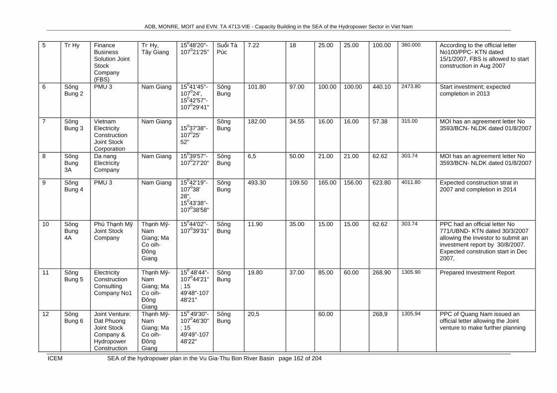
ADB, MONRE, MOIT and EVN: TA 4713-VIE - Capacity Building in the SEA of the Hydropower Sector in Viet Nam
ICEM SEA of the hydropower plan in the Vu Gia-Thu Bon River Basin page 162 of 204
5 Tr, Hy Finance Business Solution Joint Stock Company (FBS)
Tr, Hy, Tây Giang
15048'20"-107021'25"
Suối Tà Púc
7.22 18 25.00 25.00 100.00 360.000 According to the official letter No100/PPC- KTN dated 15/1/2007, FBS is allowed to start construction in Aug 2007
6 Sông Bung 2
PMU 3 Nam Giang 15041'45"-107024', 15042'57"-107029'41"
Sông Bung
101.80 97.00 100.00 100.00 440.10 2473.80 Start investment; expected completion in 2013
7 Sông Bung 3
Vietnam Electricity Construction Joint Stock Corporation
Nam Giang 15037'38"-107025' 52"
Sông Bung
182.00 34.55 16.00 16.00 57.38 315.00 MOI has an agreement letter No 3593/BCN- NLDK dated 01/8/2007
8 Sông Bung 3A
Da nang Electricity Company
Nam Giang 15039'57"-107027'20"
Sông Bung
6,5 50.00 21.00 21.00 62.62 303.74 MOI has an agreement letter No 3593/BCN- NLDK dated 01/8/2007
9 Sông Bung 4
PMU 3 Nam Giang 15042'19"-107038' 28", 15043'38"-107038'58"
Sông Bung
493.30 109.50 165.00 156.00 623.80 4011.80 Expected construction strat in 2007 and completion in 2014
10 Sông Bung 4A
Phú Thạnh Mỹ Joint Stock Company
Thạnh Mỹ- Nam Giang; Ma Co oih- Đông Giang
15044'02"-107039'31"
Sông Bung
11.90 35.00 15.00 15.00 62.62 303.74 PPC had an official letter No 771/UBND- KTN dated 30/3/2007 allowing the investor to submit an investment report by 30/8/2007. Expected constrution start in Dec 2007,
11 Sông Bung 5
Electricity Construction Consulting Company No1
Thạnh Mỹ- Nam Giang; Ma Co oih- Đông Giang
150 48'44"-107044'21"; 15 49'48"-107 48'21"
Sông Bung
19.80 37.00 85.00 60.00 268.90 1305.90 Prepared Investment Report
12 Sông Bung 6
Joint Venture: Dat Phuong Joint Stock Company & Hydropower Construction
Thạnh Mỹ- Nam Giang; Ma Co oih- Đông Giang
150 49'30"-107046'30"; 15 49'49"-107 48'22"
Sông Bung
20,5 60.00 268,9 1305,94 PPC of Quang Nam issued an official letter allowing the Joint venture to make further planning

ADB, MONRE, MOIT and EVN: TA 4713-VIE - Capacity Building in the SEA of the Hydropower Sector in Viet Nam
ICEM SEA of the hydropower plan in the Vu Gia-Thu Bon River Basin page 163 of 204
Investment and Consulting Joint Stocl Company
13 Đăk Pring 1
Electricity Construction Company No1
Chà Vàl, Nam Giang
15037'05"-107033'10"
Suối Đăk Pring
2.56 18.00 7.50 6.30 37.28 128.82 Started designing
14 Đăk Pring 2
Dat Phuong Joint Stock Company Joint Venture
Chà Vàl, Nam Giang
Suối Đăk Pring
5,4 Started designing
15 Chà Vàl Vietnam Electricity Construction Joint Stock Corporation
Chà Vàl, Nam Giang
15037'30"-107028'00"
Suối Tam Pacte
0.34 11.50 4.50 4.50 22.81 79.940 Started designing
16 Nước chè
A Chau Trading construction and Investment Joint Stock Company
Phước Năng, Phước Sơn
15014'30"-107050'06"
Suối nước chè
170.00 45 18.40 14.00 72.00 300.000 According to the official letter No 3121/UBND- KTN of PPC, deadline for submission of an investment report is by 26-01-07
17 Za Hung
Za Hưng Joint Stock Company
Za Hung, Đông Giang
15055'-107039'00"
A Vương
1.10 31.00 18.00 18.00 78.00 358.384 Under construction
18 A Điềm 2
Sông Vàng Hydropower Joint Stock Company
Đại lãnh, Đại Lộc
15056'-107054'15"
Sông Vàng
0.30 15.90 15.60 78.27 268.256 Started construction in 2006
19 Đại Đồng
Quang Tri Industrial Construction and Investment Company Ltd
Đại Đồng, Đậi Lộc
15053'-107056'
Upstream Vu Gia
5.00 0.60 0.60 3,12 13.356 Finished construction in 2006
20 Sông Cùng
Hoang Anh Quang Nam Joint Stock Company
Đại lãnh, Đại lộc
15053'-107057'05"
Upstream Vu Gia
5.00 1.60 1.60 8.10 21.427 Finish construction in 2008

ADB, MONRE, MOIT and EVN: TA 4713-VIE - Capacity Building in the SEA of the Hydropower Sector in Viet Nam
ICEM SEA of the hydropower plan in the Vu Gia-Thu Bon River Basin page 164 of 204
21 Sông Giằng 1
Song Da Construction Corporation (Song Da Company No9)
Đak Pring, Nam Giang
15023'-107041'
Sông Giằng
12.00 6.50 13.50 32.26 111.221 Investor submitted a report on 5/1/07, PPC had an announcement No 08/TB- UBND dated 15/01/07
22 Sông Giằng 2
Song Da Construction Corporation (Song Da Company No9)
Phước Xuân, Phước Sơn
15026'-107043'
Sông Giằng
26.5 18.00 18.00 89.41 242.360 The official letter No 36/ CCKL- QLBVR of the Forest Protection Department
23 Sông Giằng 3
Song Da Construction Corporation (Song Da Company No9)
Đak Pring, Nam Giang
15028'-107045'
Sông Giằng
22 7.00 7.00 33.69 126.602 Investor submitted a report on 5/1/07, PPC had an announcement No 08/TB- UBND dated 15/01/07
24 Sông Giằng 4
Quang Nam Water Supply and Construction Company
Tà Bhing, Nam Giang
15037'30"-107042'
Sông Giằng
4.50 4.50 22.81 79.940 The official letter No 184/ CCKL- QLBVR of the Forest Protection Department dated 02/6/2006
25 Pà Dồn Nhan Luat Steel trading and Investment Company
Zuôih- Nam Giang
15039'20"-107024'33"
Suối PàNâu
3.00 3.00 14.04 52.240 Deadline to submit an investment report by 31-3-07
26 MR Teh Huu Son Trading & Service - Construction Company Ltd
A Tiêng- T. Giang
15032'-107031'
Upstream Vu Gia
1.50 1.50 6.15 27.800 PPC had an official letter requesting MOI to approve a further planning
27 Đak Se Quang Nam Infrastruction Construction and Development Company
Phước Mỹ, Phươc Sơn
15018'30"-107044'10"
Upstream Vu Gia
12 2.50 2.50 12.55 52.568 The official letter No 551/UBND- KTN of PPC dated 12-3-2007 allowing to contract with Vietnam Technology and Production Joint Stock Company as an investment joint venture until 15/6/2007

ADB, MONRE, MOIT and EVN: TA 4713-VIE - Capacity Building in the SEA of the Hydropower Sector in Viet Nam
ICEM SEA of the hydropower plan in the Vu Gia-Thu Bon River Basin page 165 of 204
28 A Vương 2
Tay Giang Hydropower Joint Stock Company
Tây Giang 15054'40"-107032'20"
Sông A Vương
3.50 3.50 17.65 74.209 The official letter No 2259/UBND- KTN of PPC dated 02/8/2005 allowing Tay Giang Hydropower Joint Stock Company to be an investor for this project replacing Dong Duong Hydropower Hydropower Joint Stock Company and being responsible for implementation in accordance with the anouncement No 160/TB-UBND of PPC dated 11/7/2007
29 A Re Tay Giang Hydropower Joint Stock Company
Tây Giang 15048'16"- 107029'10"
Ngọn Sông Boung 2.20 2.20 11.03 45.650 NT
Thu Bon River
1 Sông Tranh 2
PMU 3 Bắc Trà My 15019'50"-10808'30"; 15023'50"-108008'32",
Sông Tranh
462.40 92.00 130.00 190.00 618.10 4150.40 Expected generation in 2009 and completion in 2010
2 Khe Diên
Song Ba Development and Investment Company
Quế Phước, Quế Sơn
15041'37"-107055'
Suối Khe Diên
26.15 32.5 9.00 9.00 42.30 140.399 Started construction in March 2003, expected power generation in Feb 2007 and completion at the end of the 2nd quarter of 2007
3 Trà Linh 3
Construction Joint Stock Company No 699
Trà Cang, Nam Trà My
15002'40"-108005'33"
Suối NướcNô, Upstream of Tranh river
8 6.00 6.00 30.09 124.952 Auxiliary work items have been under construction.
4 Trà Linh 1
Construction Joint Stock Company No 699
Ngọc Linh, Nam Trà My
15001'40"-10800'30"
Suối NướcNô, thượng nguồn Sông Tranh
8 3.20 3.20 15.98 58.093 Catch a point of junction
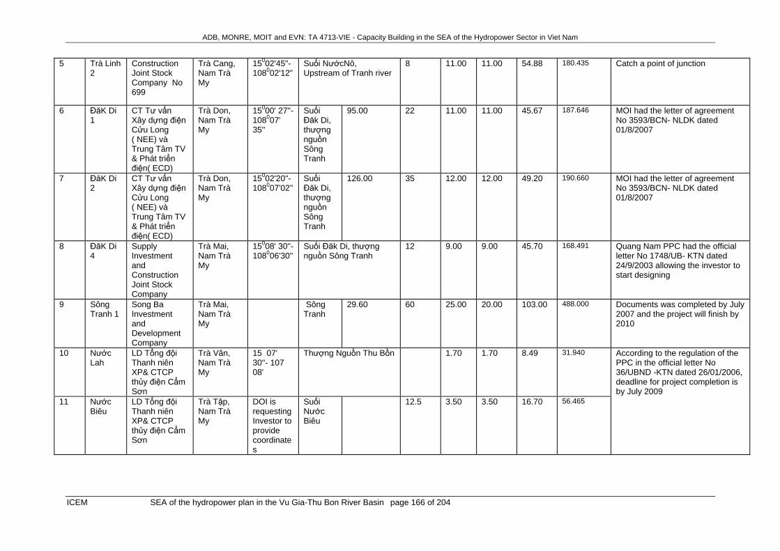
ADB, MONRE, MOIT and EVN: TA 4713-VIE - Capacity Building in the SEA of the Hydropower Sector in Viet Nam
ICEM SEA of the hydropower plan in the Vu Gia-Thu Bon River Basin page 166 of 204
5 Trà Linh 2
Construction Joint Stock Company No 699
Trà Cang, Nam Trà My
15002'45"-108002'12"
Suối NướcNô, Upstream of Tranh river
8 11.00 11.00 54.88 180.435 Catch a point of junction
6 ĐăK Di 1
CT Tư vấn Xây dựng điện Cửu Long ( NEE) và Trung Tâm TV & Phát triển điện( ECD)
Trà Don, Nam Trà My
15000' 27''-108007' 35''
Suối Đăk Di, thượng nguồn Sông Tranh
95.00 22 11.00 11.00 45.67 187.646 MOI had the letter of agreement No 3593/BCN- NLDK dated 01/8/2007
7 ĐăK Di 2
CT Tư vấn Xây dựng điện Cửu Long ( NEE) và Trung Tâm TV & Phát triển điện( ECD)
Trà Don, Nam Trà My
15002'20"-108007'02''
Suối Đăk Di, thượng nguồn Sông Tranh
126.00 35 12.00 12.00 49.20 190.660 MOI had the letter of agreement No 3593/BCN- NLDK dated 01/8/2007
8 ĐăK Di 4
Supply Investment and Construction Joint Stock Company
Trà Mai, Nam Trà My
15008' 30''-108006'30''
Suối Đăk Di, thượng nguồn Sông Tranh
12 9.00 9.00 45.70 168.491 Quang Nam PPC had the official letter No 1748/UB- KTN dated 24/9/2003 allowing the investor to start designing
9 Sông Tranh 1
Song Ba Investment and Development Company
Trà Mai, Nam Trà My
Sông Tranh
29.60 60 25.00 20.00 103.00 488.000 Documents was completed by July 2007 and the project will finish by 2010
10 Nước Lah
LD Tổng đội Thanh niên XP& CTCP thủy điện Cẩm Sơn
Trà Vân, Nam Trà My
15 07' 30''- 107 08'
Thượng Nguồn Thu Bồn 1.70 1.70 8.49 31.940 According to the regulation of the PPC in the official letter No 36/UBND -KTN dated 26/01/2006, deadline for project completion is by July 2009
11 Nước Biêu
LD Tổng đội Thanh niên XP& CTCP thủy điện Cẩm Sơn
Trà Tập, Nam Trà My
DOI is requesting Investor to provide coordinates
Suối Nước Biêu
12.5 3.50 3.50 16.70 56.465
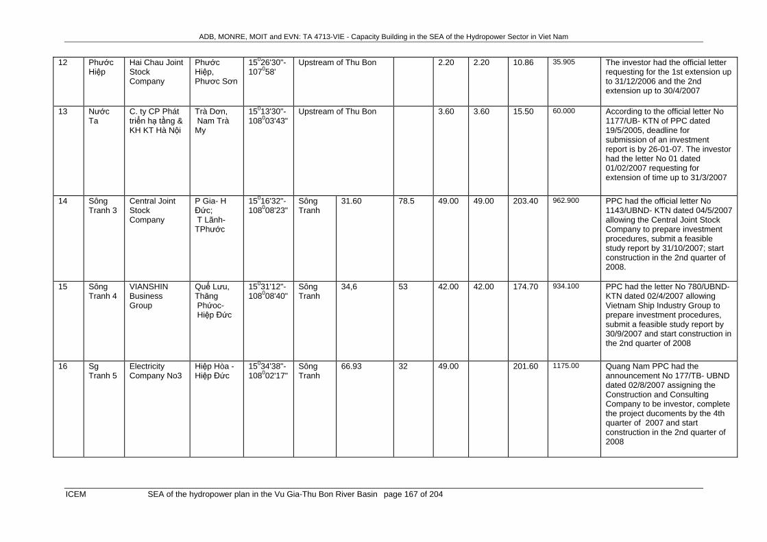
ADB, MONRE, MOIT and EVN: TA 4713-VIE - Capacity Building in the SEA of the Hydropower Sector in Viet Nam
ICEM SEA of the hydropower plan in the Vu Gia-Thu Bon River Basin page 167 of 204
12 Phước Hiệp
Hai Chau Joint Stock Company
Phước Hiệp, Phươc Sơn
15026'30"-107058'
Upstream of Thu Bon 2.20 2.20 10.86 35.905 The investor had the official letter requesting for the 1st extension up to 31/12/2006 and the 2nd extension up to 30/4/2007
13 Nước Ta
C. ty CP Phát triển hạ tầng & KH KT Hà Nội
Trà Dơn, Nam Trà My
15013'30"-108003'43"
Upstream of Thu Bon 3.60 3.60 15.50 60.000 According to the official letter No 1177/UB- KTN of PPC dated 19/5/2005, deadline for submission of an investment report is by 26-01-07. The investor had the letter No 01 dated 01/02/2007 requesting for extension of time up to 31/3/2007
14 Sông Tranh 3
Central Joint Stock Company
P Gia- H Đức; T Lãnh- TPhước
15016'32"-108008'23"
Sông Tranh
31.60 78.5 49.00 49.00 203.40 962.900 PPC had the official letter No 1143/UBND- KTN dated 04/5/2007 allowing the Central Joint Stock Company to prepare investment procedures, submit a feasible study report by 31/10/2007; start construction in the 2nd quarter of 2008.
15 Sông Tranh 4
VIANSHIN Business Group
Quế Lưu, Thăng Phứoc- Hiệp Đức
15031'12"-108008'40"
Sông Tranh
34,6 53 42.00 42.00 174.70 934.100 PPC had the letter No 780/UBND- KTN dated 02/4/2007 allowing Vietnam Ship Industry Group to prepare investment procedures, submit a feasible study report by 30/9/2007 and start construction in the 2nd quarter of 2008
16 Sg Tranh 5
Electricity Company No3
Hiệp Hòa -Hiệp Đức
15034'38"-108002'17"
Sông Tranh
66.93 32 49.00 201.60 1175.00 Quang Nam PPC had the announcement No 177/TB- UBND dated 02/8/2007 assigning the Construction and Consulting Company to be investor, complete the project ducoments by the 4th quarter of 2007 and start construction in the 2nd quarter of 2008
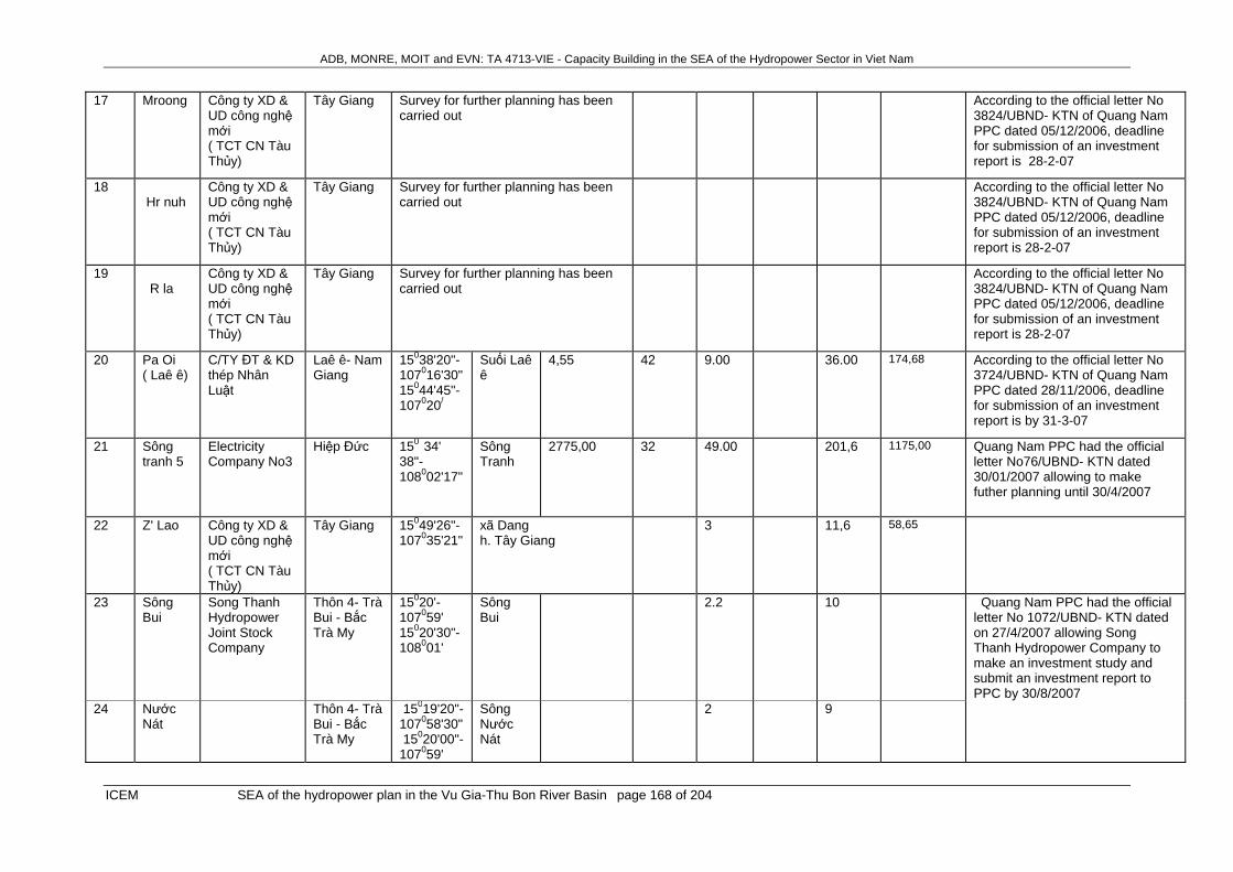
ADB, MONRE, MOIT and EVN: TA 4713-VIE - Capacity Building in the SEA of the Hydropower Sector in Viet Nam
ICEM SEA of the hydropower plan in the Vu Gia-Thu Bon River Basin page 168 of 204
17 Mroong
Công ty XD & UD công nghệ mới ( TCT CN Tàu Thủy)
Tây Giang Survey for further planning has been carried out
According to the official letter No 3824/UBND- KTN of Quang Nam PPC dated 05/12/2006, deadline for submission of an investment report is 28-2-07
18 Hr nuh
Công ty XD & UD công nghệ mới ( TCT CN Tàu Thủy)
Tây Giang Survey for further planning has been carried out
According to the official letter No 3824/UBND- KTN of Quang Nam PPC dated 05/12/2006, deadline for submission of an investment report is 28-2-07
19 R la
Công ty XD & UD công nghệ mới ( TCT CN Tàu Thủy)
Tây Giang Survey for further planning has been carried out
According to the official letter No 3824/UBND- KTN of Quang Nam PPC dated 05/12/2006, deadline for submission of an investment report is 28-2-07
20 Pa Oi ( Laê ê)
C/TY ĐT & KD thép Nhân Luật
Laê ê- Nam Giang
15038'20"-107016'30" 15044'45"-107020/
Suối Laê ê
4,55 42 9.00 36.00 174,68 According to the official letter No 3724/UBND- KTN of Quang Nam PPC dated 28/11/2006, deadline for submission of an investment report is by 31-3-07
21 Sông tranh 5
Electricity Company No3
Hiệp Đức 150 34' 38"-108002'17"
Sông Tranh
2775,00 32 49.00 201,6 1175,00 Quang Nam PPC had the official letter No76/UBND- KTN dated 30/01/2007 allowing to make futher planning until 30/4/2007
22 Z' Lao Công ty XD & UD công nghệ mới ( TCT CN Tàu Thủy)
Tây Giang 15049'26"-107035'21"
xã Dang h. Tây Giang
3 11,6 58,65
23 Sông Bui
Song Thanh Hydropower Joint Stock Company
Thôn 4- Trà Bui - Bắc Trà My
15020'-107059' 15020'30"-108001'
Sông Bui
2.2 10 Quang Nam PPC had the official letter No 1072/UBND- KTN dated on 27/4/2007 allowing Song Thanh Hydropower Company to make an investment study and submit an investment report to PPC by 30/8/2007
24 Nước Nát
Thôn 4- Trà Bui - Bắc Trà My
15019'20"-107058'30" 15020'00"-107059'
Sông Nước Nát
2 9

ADB, MONRE, MOIT and EVN: TA 4713-VIE - Capacity Building in the SEA of the Hydropower Sector in Viet Nam
ICEM SEA of the hydropower plan in the Vu Gia-Thu Bon River Basin page 169 of 204
25 Trà Leng 1
Thôn 3- Trà Leng- Bắc Trà My
15015,-107059'30" 15016'15"-108000' 45"
Sông Leng
3 17
26 Trà Leng 2
Thôn 1- Trà- Leng- Bắc Trà My
15016,-108001'30" 15016'30"-108003'15"
Sông Leng
5 27
27 Nước Oa 3
Thôn 3- TràTân- Bắc Trà My
15017,
15"-108011'15" 15018'00"-108018' 45"
Sông Leng
1.2 5
28 Bồng Miêu
Song Da Joint Stock Company No 505
Tam Lãnh- Phú Ninh
15024, -108025'
Sông Bồng Miêu
3 Quang Nam PPC had the official letter No 2177/UBND-KTN dated 26/7/2007 allowing to make a futher planning study, deadline is by 30/10/2007
29 Tiên An Song Da Joint Stock Company No 10.1
Tiên An- Tiên Phước
15024, -108019'
Tiên An 3 Quang Nam PPC had the official letter No 2172/UBND-KTN dated 26/7/2007 allowing to make a futher planning study, deadline is by 30/10/2007
30 Suối Ô Song Da Joint Stock Company No 10.1
Tiên An- Tiên Phước
15024, 33" -108020'39"
Suối Ô 3 Quang Nam PPC had the official letter No 2172/UBND-KTN dated 26/7/2007 allowing to make a futher planning study, deadline is by 30/10/2007
31 Suối Tươm
F.C.L Joint Stock Company
Trà Tập- Nam Trà My
15011, 48" -108005'37"
Thượng nguồn Sông Tranh
1.2 Quang Nam PPC had the official letter No 2417/UBND-KTN dated 30/11/2007 allowing to make a futher planning study, deadline is 30/10/2007
32 Đăk Mi 4C
Vietnam Urban and Industrial Zone Development Investment Corporation (IDICO)
Phước Hiệp-Phước Sơn
15028, -107057'
Sông Trường
26.00 MOI had the official letter No 603/BCN- NLDK dated 05/02/2007 allowing IDICO to construct the step No3 ( Đăk Mi 4c) of the project Đăk Mi 4

ADB, MONRE, MOIT and EVN: TA 4713-VIE - Capacity Building in the SEA of the Hydropower Sector in Viet Nam
ICEM SEA of the hydropower plan in the Vu Gia-Thu Bon River Basin page 170 of 204
HPPs have been in operation
1 Duy Sơn
Duy Sơn II Co-o
Duy Sơn, Duy Xuyên
15047', 108013'20"
Suối Duy Sơn
1
2 Nước Oa
Bắc Trà My 15019'20", 108010'40"
Suối Nước Oa
2.25
3 Hồ Phú Ninh
Công ty khai thác thuỷ lợi Phú Ninh
Tam Đại, huyện Phú Ninh
15030' 108043'
Tam Kỳ 350.00 33.00 1.60 2.50 Operation in 1980
4 Ca Đắp Quang Nam Infrastruction Construction and Development Company
Prao, Đông Giang
15054', 107038'
Đông Giang
0.20
5 ĐakSa Quang Nam Infrastruction Construction and Development Company
Phước Sơn 15025', 107046'30"
Phước Sơn
0.60
6 A Điềm 1
Phân xưởng phát TĐ An Điềm Quang Nam Electricity
Đại lãnh, Đại Lộc
15058’, 107058'
Sông Vàng
0.16 134.00 5.40 25.00 Operation in 1994
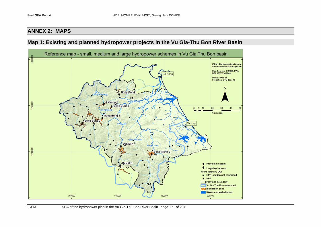
Final SEA Report ADB, MONRE, EVN, MOIT, Quang Nam DONRE
ICEM SEA of the hydropower plan in the Vu Gia-Thu Bon River Basin page 171 of 204
ANNEX 2: MAPS
Map 1: Existing and planned hydropower projects in the Vu Gia-Thu Bon River Basin

Final SEA Report ADB, MONRE, EVN, MOIT, Quang Nam DONRE
ICEM SEA of the hydropower plan in the Vu Gia-Thu Bon River Basin page 172 of 204
Map 2: Quang Hue channel and Da Nang water intakes

Final SEA Report ADB, MONRE, EVN, MOIT, Quang Nam DONRE
ICEM SEA of the hydropower plan in the Vu Gia-Thu Bon River Basin page 173 of 204
Map 3: River sub-basins in the Vu Gia-Thu Bon catchment

Final SEA Report ADB, MONRE, EVN, MOIT, Quang Nam DONRE
ICEM SEA of the hydropower plan in the Vu Gia-Thu Bon River Basin page 174 of 204
Map 4: Impact of planned hydropower on flow regimes
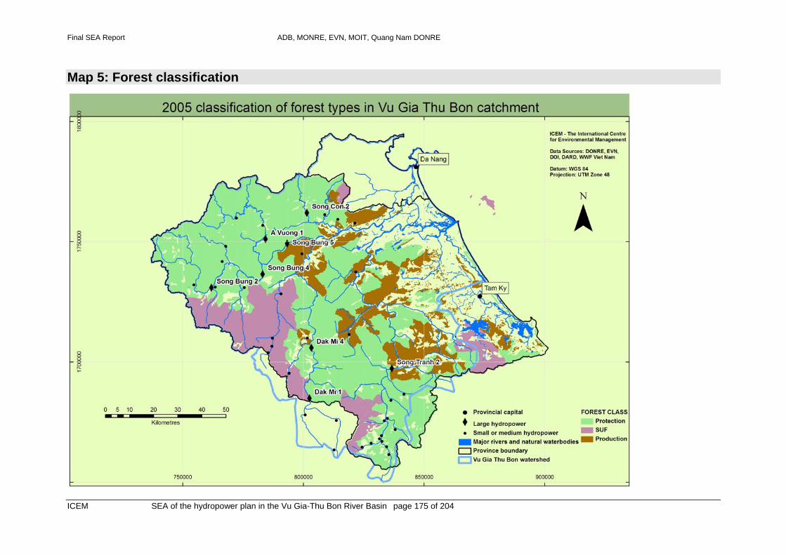
Final SEA Report ADB, MONRE, EVN, MOIT, Quang Nam DONRE
ICEM SEA of the hydropower plan in the Vu Gia-Thu Bon River Basin page 175 of 204
Map 5: Forest classification

Final SEA Report ADB, MONRE, EVN, MOIT, Quang Nam DONRE
ICEM SEA of the hydropower plan in the Vu Gia-Thu Bon River Basin page 176 of 204
Map 6: Existing and proposed protected areas

Final SEA Report ADB, MONRE, EVN, MOIT, Quang Nam DONRE
ICEM SEA of the hydropower plan in the Vu Gia-Thu Bon River Basin page 177 of 204
Map 7: Watershed classification

Final SEA Report ADB, MONRE, EVN, MOIT, Quang Nam DONRE
ICEM SEA of the hydropower plan in the Vu Gia-Thu Bon River Basin page 178 of 204
Map 8: Popultion density and distribution

Final SEA Report ADB, MONRE, EVN, MOIT, Quang Nam DONRE
ICEM SEA of the hydropower plan in the Vu Gia-Thu Bon River Basin page 179 of 204
Map 9: Disruption to connectivity

Final SEA Report ADB, MONRE, EVN, MOIT, Quang Nam DONRE
ICEM SEA of the hydropower plan in the Vu Gia-Thu Bon River Basin page 180 of 204
Map 10: Disruption of connectivity due to planned hydropower projects

Final SEA Report ADB, MONRE, EVN, MOIT, Quang Nam DONRE
ICEM SEA of the hydropower plan in the Vu Gia-Thu Bon River Basin page 181 of 204
Map 11: Ethnicity in Quang Nam Province
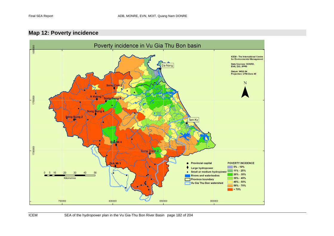
Final SEA Report ADB, MONRE, EVN, MOIT, Quang Nam DONRE
ICEM SEA of the hydropower plan in the Vu Gia-Thu Bon River Basin page 182 of 204
Map 12: Poverty incidence

Final SEA Report ADB, MONRE, EVN, MOIT, Quang Nam DONRE
ICEM SEA of the hydropower plan in the Vu Gia-Thu Bon River Basin page 183 of 204
Map 13: Ethnicity and poverty incidence
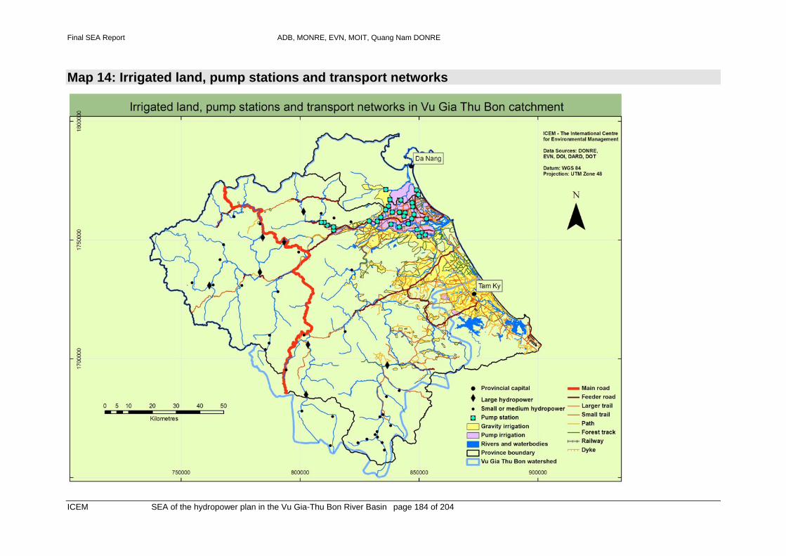
Final SEA Report ADB, MONRE, EVN, MOIT, Quang Nam DONRE
ICEM SEA of the hydropower plan in the Vu Gia-Thu Bon River Basin page 184 of 204
Map 14: Irrigated land, pump stations and transport networks

Final SEA Report ADB, MONRE, EVN, MOIT, Quang Nam DONRE
ICEM SEA of the hydropower plan in the Vu Gia-Thu Bon River Basin page 185 of 204
Map 15: Saline intrution and storm surge – risk to infrastructure

Final SEA Report ADB, MONRE, EVN, MOIT, Quang Nam DONRE
ICEM SEA of the hydropower plan in the Vu Gia-Thu Bon River Basin page 186 of 204
Map 16: Existing and planned mining in the Vu Gia – Thu Bon River Basin

Final SEA Report ADB, MONRE, EVN, MOIT, Quang Nam DONRE
ICEM SEA of the hydropower plan in the Vu Gia-Thu Bon River Basin page 187 of 204
Map 17: Proposed intact rivers in the Vu Gia – Thu Bon River Basin

Final SEA Report ADB, MONRE, EVN, MOIT, Quang Nam DONRE
ICEM SEA of the hydropower plan in the Vu Gia-Thu Bon River Basin page 188 of 204
ANNEX 3: STEPS IN THE HYDROPOWER PLANNING PROCESS IN QUANG NAM – 2003 TO 2006
Table A3.1: Procedure followed for planning of small-medium hydropower projects in Quang Nam
Time Conducted by
Decision Issue Note
6 August 2002
Government 923/CP-CN Prime Minister assigns MOIT to Appraisal and Approval HP Master Plan on small rivers not included in project National Hydropower Planning Study
10 January 2003
DOI in Quang Nam province
24/CN-SCN Proposal to PPC on preparing Master plan on small and medium HP projects in Vu Gia – Thu Bon river in Quang Nam
33 projects are in the list, mostly in Vu Gia-Thu Bon river basin
12 March 2003
PPC Quang Nam
943/QD-UBND
Approval Proposal and Fund for preparing Master plan on small and medium HP projects in Quang Nam
33 projects
29 March 2003
DOI 01/HDKT Economic Contract to PECC1 on preparing Master plan on small and medium HP projects in Quang Nam
33 projects
27 August 2003
PECC1 (Cty tu van XD dien 1)
Study 01-03 PECC1/EVN submit to DOI the Master plan on small and medium HP projects in Quang Nam province
Document has 2 parts: (i) Plan outline and planning process; (ii) Plan content
21 September 2004
DOI 393/TT-KT-GSDN
Project and Proposal on Approving to Master plan on small and medium HP in Quang Nam province
33 projects
7 October 2004
DPI 494/TT-KH Proposal/comment on Approving Master plan on small and medium HP in Quang Nam province
33 projects
8 October 2004
PPC Quang Nam
4318/QD-UBND
Approval Master plan on small and medium HP in Quang Nam province
33 projects
Table A3.2: Process followed for adding three projects to the Quang Nam Hydropower Development Plan
Time Conducted by
Decision Issue Note
2003 Investor Some companies studied and proposed to develop 3 HP projects to DOI
3 Projects: Nuoc Che HP, 18.4MW, 72 million kWh/year, cost VND300 billion; in Phuoc Nang, Phuoc Son district. Nuoc Ta HP, 3.6MW, 15.5 million kWh/year, cost VND60 billions. In Tra Don, Nam Tra My district Song Tranh 1, 25MW, 103 kWh/year,

ADB, MONRE, MOIT and EVN: TA 4713-VIE - Capacity Building in the SEA of the Hydropower Sector in Viet Nam
ICEM SEA of the hydropower plan in the Vu Gia-Thu Bon River Basin page 189 of 204
cost VND488 bilion, in Tra Mai, Nam Tra My district
DOI Proposal to PPC/MOIT/ EVN on adding to Master plan on small and medium HP in Quang Nam province
3 HP
17 February 2004
EVN 520/CN-EVN-TD
Agree on and adding to Master plan on small and medium HP in Quang Nam province
3 projects
4 June 2004
MOIT (Department of Petroleum and Energy)
1345/CN-NLDK
Agree on and adding to Master plan on small and medium HP in Quang Nam province
3 projects
20 August 2004
MOIT (Department of Petroleum and Energy)
4431/CN-NLDK
Agree on and adding to Master plan on small and medium HP in Quang Nam province
3 projects
12 January 2006
PPC Quang Nam
88/UBND Proposal to MOIT on Agree to adding to Master plan on small and medium HP in Quang Nam province
3 HP
24 May 2006
MOIT (Department of Petroleum and Energy)
2815/BCN-NLDK
Agree with PPC to adding HP to Master plan on small and medium HP in Quang Nam province
Agree Quang Nam province to add 3 HPs Have final comment on adding HP to Master plan on small and medium HP in Quang Nam province
4 July 2006
DOI (Energy Management Division)
250/TT-QLNL
Proposal/comment on adding HP to Master plan on small and medium HP in Quang Nam province
Have final comment on adding HP to Master plan on small and medium HP in Quang Nam province
19 July 2006
DOI (Planning division)
33/TT-KH Proposal/comment on adding HP to Master plan on small and medium HP in Quang Nam province
Have final comment on adding HP to Master plan on small and medium HP in Quang Nam province
26 July 2006
PPC Quang Nam
Decision 2192/QD-UBND
Approval adding HP to Master plan on small and medium
- Nuoc Che in Phuoc Nang commune, Phuoc Son district, capacity18.4 MW, generation 72 million KWh/year,

ADB, MONRE, MOIT and EVN: TA 4713-VIE - Capacity Building in the SEA of the Hydropower Sector in Viet Nam
ICEM SEA of the hydropower plan in the Vu Gia-Thu Bon River Basin page 190 of 204
HP in Quang Nam province
investment VND300,000 million
- Nuoc Ta in Tra Don commune, Nam Tra My district, Phuoc Son district, capacity 3.6 MW, generation 15.5 million KWh/year, investment VND60,000 million
- Song Tranh 1 in Tra Mai commune, Nam Tra My district, capacity 25 MW, generation 103 million KWh/year, investment VND484,000 million

ADB, MONRE, MOIT and EVN: TA 4713-VIE - Capacity Building in the SEA of the Hydropower Sector in Viet Nam
ICEM SEA of the hydropower plan in the Vu Gia-Thu Bon River Basin page 191 of 204
ANNEX 4: VG-TB RIVER PLANNING MANAGEMENT BOARD For a number of pilot basins, a river planning management board was established by MARD (Decision 14/2004/QD-BNN-TCCB, 8 April 2004) along with local river basin committees belonging to DARD. For example, Decision 2-/2005/QD-BNN, 13 April 2005 on Setting up the Vu Gia – Thu Bon Planning Management Board focuses its operation on water management, not social-economic development in the River Basin. Box 1 illustrates the functions of the RPMB for the Vu Gia – Thu Bon River Basin. Box 1: Functions of the Vu Gia – Thu Bon RPMB Article 3. Tasks 1. To assess planning alternatives, basic investigation projects, inventory and assessment of water resources in the river basin; submit to MARD and authorised state agencies follow-up recommendations and proposals; 2. To assess the outcomes of planning alternatives and make proposals to complete and/or supplement planning projects on integrated water use, drainage and irrigation, flood control and watercourse protection within river basin; 3. To coordinate with relevant agencies in implementation and supervision of implementation of planning projects that are approved by authorised state agencies; 4. To coordinate with relevant agencies to develop a data and information management mechanism to support the management, exploitation, utilisation and protection of watercourse within river basin; 5. To propose and develop programs on capacity building and awareness raising for organisations and individuals in the river basin in terms of water management, exploitation, utilisation and protection; 6. To submit to the Minister of MARD and related ministries and state agencies review reports on water resources exploitation, utilization and protection status within the river basin; Article 4. Powers 1. To submit to the Minister of MARD proposals on water management, exploitation, utilisation and protection in the river basin and measures to settle water-related disputes; 2. To submit to the Minister of MARD proposals on international cooperation in the areas of water management, exploitation, utilisation and protection in the river basin; 3. To coordinate with authorised state agencies in implementation and coordination of related international projects and affairs in the river basin; 4. To advise the Minister of MARD on planning and development projects, management mechanism, policies and on other issues relating to management, exploitation, utilisation and protection of watercourse in the river basin; 5. To request related ministries, state agencies and People's Committee of centrally governed municipals and provinces within the river basin to supply necessary information on water management, exploitation, utilisation and protection in activities of the ministries, state agencies, and People Committees of centrally governed municipals and provinces in the river
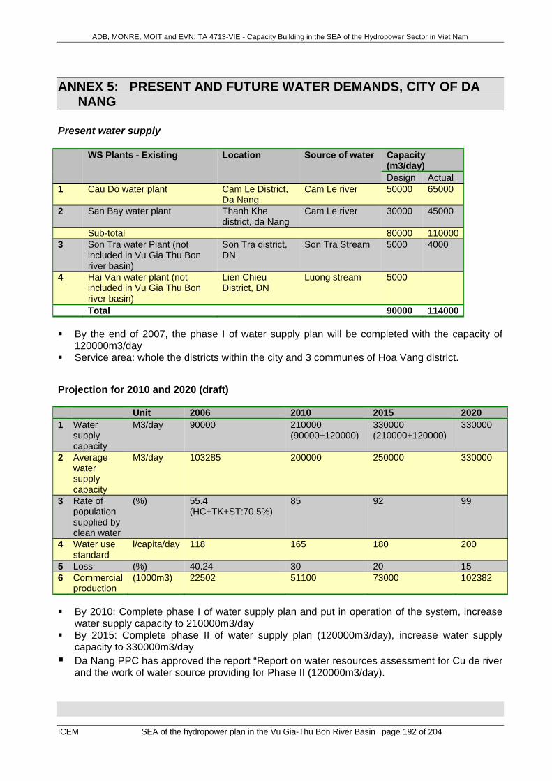
ADB, MONRE, MOIT and EVN: TA 4713-VIE - Capacity Building in the SEA of the Hydropower Sector in Viet Nam
ICEM SEA of the hydropower plan in the Vu Gia-Thu Bon River Basin page 192 of 204
ANNEX 5: PRESENT AND FUTURE WATER DEMANDS, CITY OF DA NANG
Present water supply WS Plants - Existing Location Source of water Capacity
(m3/day) Design Actual
1 Cau Do water plant Cam Le District, Da Nang
Cam Le river 50000 65000
2 San Bay water plant Thanh Khe district, da Nang
Cam Le river 30000 45000
Sub-total 80000 1100003 Son Tra water Plant (not
included in Vu Gia Thu Bon river basin)
Son Tra district, DN
Son Tra Stream 5000 4000
4 Hai Van water plant (not included in Vu Gia Thu Bon river basin)
Lien Chieu District, DN
Luong stream 5000
Total 90000 114000 By the end of 2007, the phase I of water supply plan will be completed with the capacity of
120000m3/day Service area: whole the districts within the city and 3 communes of Hoa Vang district.
Projection for 2010 and 2020 (draft) Unit 2006 2010 2015 2020 1 Water
supply capacity
M3/day 90000 210000 (90000+120000)
330000 (210000+120000)
330000
2 Average water supply capacity
M3/day 103285 200000 250000 330000
3 Rate of population supplied by clean water
(%) 55.4 (HC+TK+ST:70.5%)
85 92 99
4 Water use standard
l/capita/day 118 165 180 200
5 Loss (%) 40.24 30 20 15 6 Commercial
production (1000m3) 22502 51100 73000 102382
By 2010: Complete phase I of water supply plan and put in operation of the system, increase
water supply capacity to 210000m3/day By 2015: Complete phase II of water supply plan (120000m3/day), increase water supply
capacity to 330000m3/day Da Nang PPC has approved the report “Report on water resources assessment for Cu de river
and the work of water source providing for Phase II (120000m3/day).
ADB, MONRE, MOIT and EVN: TA 4713-VIE - Capacity Building in the SEA of the Hydropower Sector in Viet Nam
ICEM SEA of the hydropower plan in the Vu Gia-Thu Bon River Basin page 193 of 204
ANNEX 6: ADDITIONAL MITIGATION MEASURES FOR THE SPECIFIC KEY ISSUES ADDRESSED WITHIN THE SEA
In the screening steps leading to the identification of the four strategic concerns, 15 key issues or themes were assessed. The results of that analysis of trends and the effects of hydropower are presented in chapters 5 and 6. The assessment resulted in specific mitigation measures being defined for all 15 key issues. These measures are not as significant for the entire hydropower development plan as those included in Chapter 8.2, but they should be considered in plan implementation and in the preparation of specific environmental management plans.
Climatic and rainfall conditions Issue: Climate situation with emphasis on rainfall Improvements in data collection ability are needed, particularly in mountains regions of Quang Nam province. Meteorological data collection stations should be established at all the (8) large dams under construction and proposed, at some of the small-medium dams, and at easily accessed sites in the upper catchments of the VGSB basin.
Hydrology Issue: Dry season minimal flows and effect on salinity intrusion 1. Arrangements (Agreement) are needed between EVN, IDECO, MONRE, DARD and Provinces of Quang Nam and Da Nang for operation of dams, particularly Song Bung 4, A Vuong, Song Tranh 2 and Song Con 2 as dual purpose hydro-electric and water supply reservoirs. Following the Agreement, a reserve of water should be kept in the 4 major reservoirs at the end of the wet season, for water supply during the dry season. Rule curves for operators of each reservoir should be prepared, so that discharges through the turbines are sufficient to ensure water levels in the reservoir are between the upper and lower rule curves during all days of the dry season. Note that established regulations for Viet Nam are as follows: For storage greater than 1 bill m3, operation rules to be approved by the Central Board of
Flood Preparedness and Control (all proposed reservoirs are smaller than this, hence not applicable)
The storage less than 1 bill m3, operation rules will be approved by Provincial People’s Committee.
2. Government (Provinces, MONRE, EVN and VGTB River Basin Management Authority) should request a change to design/configuration of Dak Mi 4 project, so that a diversion gate is included in the dam, for supplementation of low flows in the Song Vu Gia system. Sufficient water should be held in storage to supplement downstream flows in the Dak Mi river in the dry season. 3. Data collection and numerical modeling expertise should be funded/encouraged within the responsible authority (e.g. River Basin Management Board and DONRE) to assist with reservoir management at the strategic and operational levels. New river flow measurement stations should be established at key locations, e.g. Song Vu Gia near Khe Lim. Improvement should be made to the gauging station at Ai Nghia, including use of a ADCP (acoustic) flow meter for improved accuracy.
ADB, MONRE, MOIT and EVN: TA 4713-VIE - Capacity Building in the SEA of the Hydropower Sector in Viet Nam
ICEM SEA of the hydropower plan in the Vu Gia-Thu Bon River Basin page 194 of 204
4. Institutional strengthening arrangements for water resources management should be made, as recommended in Chapter concerning Water Supplies Storyline and Mitigation. 5. Improvements in the content of EIA’s is needed, with special emphasis on water management and water supply. EIA’s must include suggestions to improvements of engineering design of dams, where needed. EIA’s should carefully consider the multiple impacts of suggested changes, e.g. recommendation to use smaller drawdown in reservoirs will improve the viability of the future reservoir for fisheries and recreation, but will have serious impact in reducing the reservoirs (positive) effectiveness for drought supplementation of water supplies. Issue: ‘Flooding and maximum flows 1. Coordination between EVN Central Despatch and various dam operators (e.g EVN, IDECO) to
prevent worsening of floods due to poorly scheduled opening of spillway gates. 2. Procedures for specification of ramping rates (rate of change of turbine and spillway flows).
Ramping rates indicating maximum permissible changes in flow in the river downstream of the dam will need to be formulated, and made clear in the SOOs (Station Operating Orders). Training of dam operators will be needed to avoid rapid and unexpected increases in flow in the river downstream of dams.
3. A program of periodic dam safety reviews (e.g. once every 5 years) by experienced engineers working on site will be essential in checking for factors such as spillway gate mechanical/electrical system and leakage flows under the dam. Amongst other factors, the safety review should ensure that spillway gates are working well, and that back-up emergency power generators are in good condition.
4. Preparation of a dam break analysis, including a dam break flood inundation map, is needed. A warning system and evacuation plan should accompany this work with emphasis on downstream inhabitants in the floodplain areas.
5. Additions to the provincial river flow gauging network should be made, with new stations at key locations, e.g. Song Vu Gia near Khe Lim. Improvement should be made to the gauging station at Ai Nghia, including use of an ADCP (acoustic) flow meter for improved accuracy.
Issue ‘Sediment transport and sand excavation’ No mitigation is possible for continuity of sediment transport past large dams. Increased expenditures on bank stabilisation, bridge crossings and pump station intakes will be needed to preserve existing river bank locations and infrastructure.
Aquatic biodiversity and fisheries Issues: Barriers to Migration, Habitat Modification & Loss, Nutrient Supply & Downstream Water Quality National interventions The ability to assess the impacts of the hydropower plan on aquatic biodiversity and fisheries is severely compromised by an almost total lack of data appropriate for that assessment. This problem is exacerbated by a paucity of similar information from other regions of Viet Nam, highlighting a much broader problem. There is a great need for a much greater emphasis, from the national level down, on the collection of data specific to evaluating the impact of hydropower, or any other development. While there is a limited amount of information on freshwater species most is anecdotal, and unlikely to be comprehensive. There is also limited understanding of estuarine species and habitats, even though these are under the greatest human-induced pressure. In particular there great lack of information for freshwaters or estuaries on:

ADB, MONRE, MOIT and EVN: TA 4713-VIE - Capacity Building in the SEA of the Hydropower Sector in Viet Nam
ICEM SEA of the hydropower plan in the Vu Gia-Thu Bon River Basin page 195 of 204
The distribution of habitat types Species-habitat relationships Migratory and life-history requirements of organisms Sources of trophic support for ecosystems Inter-species relationships Fisheries data for individual areas
This severe lack of basic understanding highlights the need for a more explicit application of the precautionary principal to hydropower development proposals, and an urgent need for stronger strategic policy responses at a national level. Strategic Responses at a National Level: 1. A policy-level recognition of the lack of basic understanding necessary to allow rational
decision making in support of sustainable biodiversity and fisheries, including recognition of the consequences of poorly supported decision making on long-term environment sustainability, the sustainability of fisheries production at both subsistence and commercial levels, and the sustainability of potential major tourist resources represented by an intact fauna of unique freshwater and estuarine aquatic species and ecosystems.
2. The inclusion into policies requiring Environmental Impact Assessment of explicit requirements for the type and detail of ecological data that should be collected to allow informed assessment of impacts on biological resources.
3. The development of a comprehensive Environmental Flows Policy explicitly recognising the importance to the environment and fisheries of ensuring the maintenance of environmental flows (including both volume and timing) sufficient for the maintenance of ecological functioning at a sustainable level. This should include specifications for the systematic collection and analysis of information necessary to support this policy.
4. The development of an Intact Rivers Policy that ensures that at least one branch of all major river systems is maintained in an unaltered state with full ecological functioning. This policy should require the protection of a complete sequence of connected habitats from the estuary to headwaters with no barriers to movement and a high level of protection from other impacts such as mining-related pollution and destructive fishing practices. Having a completely unaltered system would preserve connectivity within one branch of the system and provide species requiring inter-habitat migration one part of the system in which to perform necessary life functions. It would be important to ensure that all habitat types within the river basin were well represented within the protected intact system.
5. Inclusion in fisheries policy of the requirement to collect specific data on fisheries catch at a disaggregated, sub-regional level, with species-specific detail. Such data would ensure fisheries managers had basic data that were appropriate for determining the status of individual species stocks at a local level, allowing specific management of fishing effort and other impacts necessary to protect fisheries species viability.
6. The development of a policy, and identification or an appropriate organisation to collect the basic biological and ecological data needed to understand the status and patterns of change of aquatic biodiversity in both freshwater and estuarine areas.
Interventions specific to this hydropower plan Besides the specific implementation of the national policies outlined above at the hydropower plan level, there is:
• A need for integration of development and management measures to ameliorate cumulative impacts of clusters of hydropower developments
ADB, MONRE, MOIT and EVN: TA 4713-VIE - Capacity Building in the SEA of the Hydropower Sector in Viet Nam
ICEM SEA of the hydropower plan in the Vu Gia-Thu Bon River Basin page 196 of 204
• Where possible development should be reconsidered and re-planned to incorporate such provisions as fish passages and compensatory flows
Project-level recommendations As outlined for the National level: Because of the paucity of data on aquatic ecology, future EIAs should include a much more extensive quantitative investigation of aquatic systems. It would be preferable if this involved a standardized approach to allow individual project- and location-specific understanding to contribute to developing a broader understanding of aquatic systems.
Issue: Migration of fish and other aquatic organisms Two full branches of the system should be kept free from barriers in an “Intact Rivers Policy”, to
ensure the full sequence of habitats is protected. This provides the greatest opportunity to maintain the full range of ecosystem services needed to ensure impacts on the highly migratory fish fauna is limited as much as possible. The most appropriate rivers are the Song Tien/Thu Bon and Song Giang/Vu Gia (Map 8) which should receive continuous special management for conservation and sustainable use for their full length.
Although the Song Tien/Thu Bon has the least proposed hydro works, making it the most viable
for protection, it lacks extensive high altitude habitats. Management of the Song Giang/Vu Gia as an intact river will bring in the required representation of high altitude habitats.
In addition, fish passages, fish ladders or similar devises should be installed where possible.
Probably only possible on smaller projects but crucial to overcome the cumulative impacts of series of barriers
Timing environmental flow releases to match with migration needs will help to mitigate effects
of altered flow timing where there are no barriers.
Forest management and terrestrial biodiversity In contrast to the paucity of data for aquatic ecology, there is a considerable volume of information on terrestrial ecology on which to assess the hydropower plan and to suggest interventions (largely due to extensive work by FPD and NGOs in the area). National interventions Conservation planning processes for the area have been undertaken and approved at national
level, although the scale of the hydropower developments has not really been considered within the approved strategies and action plans. National level recognition of the proposed protected area network, approval of Investment Plans and strengthening of the Management Boards is a first step in creating an improved capacity to at least monitor the situation.
National regulations are in place requiring Environmental Impact Assessment and contain
explicit requirements for the type and detail of ecological data that should be collected to allow informed assessment of impacts on biological resources (see also Aquatic Ecology). While Song Bung 4 has an EIA of proper standard, the standard of EIA produced for other hydropower projects to date, especially for mini-EIAs, is inadequate and does not begin to assess the environmental issues. No EIA, including that for Song Bung 4, appears to be

ADB, MONRE, MOIT and EVN: TA 4713-VIE - Capacity Building in the SEA of the Hydropower Sector in Viet Nam
ICEM SEA of the hydropower plan in the Vu Gia-Thu Bon River Basin page 197 of 204
adequately implemented to include an appropriate emphasis on environmental mitigation during construction.
MoNRE as a whole, and especially Quang Nam DoNRE, do not have the capacity to oversee
and monitor EIA implementation – and probably not even the mandate although this is supposed to be accorded to them under national law. This needs to be addressed by assigning a specific mandate and additional staff to DoNRE in respect to the 15 year implementation period for the hydropower development.
National level guidelines are needed on the use of Natural Resources Tax retained by
provinces in respect to the use of these funds for mitigating the projects from which they are generated.
Inter-sectoral interventions in the river-basin The current reclassification of the three forest types underway by DARD (Sub-department of
Forestry) with targets supplied from national level, needs to pay explicit attention to the impacts of the hydropower development plan in allocating SUF and protection forest areas to maximise the potential for landscape integrity and forest connectivity. The reclassification to be submitted to national level at the end of 2007 should have specific recommendations in this respect and due to the special and unique issues faced by this river basin need not be bound by national targets for the reclassification as expressed in the National Forest Development Strategy.
DARD Sub-departments of Forestry and Forest Protection will need a coordinated plan in
respect to implementation of the approved provincial Conservation Strategy to mitigate environmental damage. These Sub-departments will also be responsible for drawing up specific regulations for construction worker camps and roving camps (working on roads and transmission lines) and ensuring that Hydropower Project Management Boards enforce these regulations.
Provincial PC will be required to both approve drastic regulations on the control of workers
(both in respect to environmental impacts and also to social impacts – see section on potential impacts on ethnic minorities). Provincial PC will also be requested to put into place specific and stringent regulations to better control the wildlife trade, which is likely to be exacerbated by the hydropower development.
Interventions specific to this hydropower plan – issue pertaining to all projects Specific guidelines and regulations of the responsibility of Hydropower Project Management
Boards in environmental mitigation during construction and operation of the projects need to be developed.
Provincial PC should appoint an inter-sectoral monitoring commission to oversee the entire
hydropower development plan and assess cumulative impacts (as opposed to monitoring each project individually).
The role of communities in monitoring and feedback of hydropower impacts through the
Grassroots democracy process should be clarified. In particular, the rights of local communities to social audit of developments impacting upon them should be made clear to the communities.
Small hydropower schemes located inside the Special Protection Zone of protected areas
should not be allowed to go ahead, regardless of the stage of planning and contracting of the project. No such projects should be considered in future. These projects disproportionately damaging to the landscape compared to their value in terms of generated power.

ADB, MONRE, MOIT and EVN: TA 4713-VIE - Capacity Building in the SEA of the Hydropower Sector in Viet Nam
ICEM SEA of the hydropower plan in the Vu Gia-Thu Bon River Basin page 198 of 204
Projects should be constructed starting from the lower levels of the respective river systems,
and if possible their capacity/level of technology could be increased to obviate the need for further small projects upstream.
Project-level recommendations Song Bung 1 should remain shelved. Song Giang 1 to 4, Dak Se, small projects inside Ngoc
Linh NR (Kon Tum section), and any other small projects recently added that are located inside SUF, should be cancelled in favour of downstream projects. The river basin hydropower plan should in general respect 186/2006/QĐ-TTg of the Prime Minister concerning banned activities inside SUF and the spirit of the approved Quang Nam Conservation Strategy.
Song Bung 4. There are a series of key mitigation measures that can be developed for this
site, including conservation offsets:
The Government may consider options for the proposed community forestry interventions to be targeted to re-establishing connectivity between Song Thanh NR and the forest block to the north that is broken by the reservoir in collaboration with the ABD-funded BCI project. This would require long-term financing commitment in planting and maintaining the integrity of a new forest corridor around the reservoir and this could be secured through the proposed benefit sharing / revenue sharing arrangements of hydropower projects.
An external expert panel should be appointed to determine the likely feasibility of various options for re-establishing landscape connectivity around the reservoir, or if not feasible, for proposing alternative forest connectivity measures to enhance connectivity in the wider landscape to offset the specific impact of the hydropower project.
A model should be establishing of how to control construction workers, using the example
of Song Bung 4 construction camp in Ta Bhing commune. This is not regarded as an affected commune as no villages are relocated, despite a 60% loss of farmland, two major quarries, and the huge construction workers camp (all of these located in the area of Tong Vinh village). This model would encompass means of controlling social impacts, especially on ethnic minorities, as well as the suite of environmental impacts discussed in previous sections of this report.
A model should be established of a cooperative impacts and mitigation monitoring team,
consisting of representatives from the hydropower project construction and later the operating company, district authorities, FPD, and local communities. The aim would be to ensure compliance to all aspects of the EIA and defined mitigations.
As a conservation offset, the project should finance a proper study of the aquatic
ecosystem and fisheries in that section of the Song Bung (as detailed in previous sections of the report).
As a conservation offset, the project should contribute to the implementation of the Song
Thanh NR Management Plan, including financial contributions to capacity building and provision of necessary equipment to the patrolling of the NR and limitation of illegal access that will be facilitated by the improved infrastructure in the area. This contribution might be extended to facilitation of the revision of the provincial Conservation Strategy, of which the Song Thanh NR is a key feature, to include due consideration of the hydropower plan.
Dak Mi 1 should be critically reviewed in terms of its impact on Ngoc Linh NR (Kon Tum
section) and a comprehensive EIA conducted.

ADB, MONRE, MOIT and EVN: TA 4713-VIE - Capacity Building in the SEA of the Hydropower Sector in Viet Nam
ICEM SEA of the hydropower plan in the Vu Gia-Thu Bon River Basin page 199 of 204
Transport in the basin Quality and accessibility of rural roads Impacts of the plan on rural roads may be mitigated through the following measures:
Costs for compensation for damaged and lost infrastructure should be included as part of the project cost and should not be left until roads are submerged or damaged.
Contractors should be also made responsible for workers observance of forest and wildlife protection laws, for undertaking and apply driver safety training and for implementing noise and dust mitigation procedures
Contractor and Ministry of Health to create community and worker awareness of the dangers of HIV/AIDS and other diseases.
Capacity of forest and wildlife organisations to monitor compliance with the forest and wildlife protection laws should be strengthened.
Access along new roads should be controlled by boom gates. Impact on waterway transport Song Bung 5 should not be used for peak power production and should maintain a steady flow at the turbines. There will be a need to establish the powerhouse release regime and prior to its implementation advise boat owners that the powerhouse release will change from base load to peaking and that the river will experience poor navigation during the off-peak period. In addition, more signs and marking buoys should be provided.
Mining The mining sector in Quang Nam has potential to be a major local employer and economic contributor to provincial GDP. Already, there are signs that the sector is shifting from one dominated by artisanal and small scale mining (ASM) to larger scale and better managed projects. Yet, ASM has an important on-going role in the provincial economy and one which can be promoted if properly managed. The hydropower plan will tend to constrain and dampen growth in the mining sector. This need not be the case. Proactive government policies and programs are required to reach out and engage with artisanal and small scale miners to reduce illegal activities and promote compliance with the with the Mineral and Environment Protection Laws. As part of the structural adjustment program for the mining sector needed because of hydropower development, hydropower developers should be involved in appropriate support for the mining sector in the basin – with a focus on ASM – to offset the dampening impact on mining. The artisanal and small scale miners do not have sufficient knowledge, skills and resources, as well as the collective organizational structures to ensure efficient management and equipment is in place. To overcome these problems and ensure the mining sector plays an important economic and environmentally responsible role in provincial development, the following actions are required at national, provincial and sector level. National interventions A pilot small credit and government subsidy scheme should encourage ASM to invest in
renovation of their equipment and technology to improve safety, health and environmental aspects of their mining operations.

ADB, MONRE, MOIT and EVN: TA 4713-VIE - Capacity Building in the SEA of the Hydropower Sector in Viet Nam
ICEM SEA of the hydropower plan in the Vu Gia-Thu Bon River Basin page 200 of 204
Specific legal and policy instruments are required to address the special needs and challenges of ASM.
Strengthen the education, training, awareness campaigns and inspection work for the mining sector in general and ASM in particular.
Organize regular meetings of artisanal and small scale miners to exchange knowledge, experiences and to promote cooperation in ASM.
Provincial interventions Collective EIA and environmental management plan for ASM in the basin: Support small-scale
miners in producing ‘joint environmental studies’ and a collective EIA. Small-scale mining enterprises in the basin will have similar environmental impacts and therefore could use the same environmental management plans.38
Support the formation of an ASM association in Quang Nam to facilitate financing, training and collective approaches to environmental management
Offer incentives to illegal operators to regularise – These could include tax allowances for new enterprises, exemptions from import duties on equipment or supplies, access to finance, and assistance with exports.
Create necessary extension services – Government should organize services that meet miners’ real needs – legal, organizational, technical, and health and safety. They can also encourage the mining sector in the basin to develop its own services by supporting the formation an association in which larger scale mining operations can mentor and assist ASM. It is in the interest of large mining companies to improve the reputation of the sector in the basin.
Awareness raising campaign targeting small-scale miners. ASM need to be informed about the health and environmental effects of their activities, especially the dangers of mercury amalgamation. They should be helped to adopt appropriate techniques for using mercury more safely in the short term, with its use phased out altogether. Although raising awareness is primarily the responsibility of government, the mining sector can assist in this effort.
Make special control arrangements for mining future reservoir areas: The intense and concentrated environmental problems associated with the mining of future hydropower project areas requires special review and attention.
Waste management Project-level mitigation The review of EIAs and environmental commitment statements for hydropower projects in the river basin show that improvements in site level management and mitigation may be required to avoid significant cumulative waste problems throughout the basin. This should involve the following provisions. 1. Sewerage - All sites must have an appropriate sewage treatment system for workers during
construction and operational phases. Sewerage should not be discharged into adjacent waterways.
2. Solid Waste - Solid wastes from worker camps should be sorted for recyclable materials and collected regularly for disposal in a secure disposal site. Construction rubble should reused in construction as much as possible.
3. Hazardous Wastes and Storage – Soil contamination should be prevented by installing oil and water separators at wash down and refueling areas, and by installing secondary containment at fuel storage sites. All hazardous wastes and hazardous materials will be stored in properly
38 IIED reviewed the mining industry in a global study and has made many valuable recommendation to promote its development and sustainability – see IIED, 2002, Breaking new ground – a study of the mining industry.

ADB, MONRE, MOIT and EVN: TA 4713-VIE - Capacity Building in the SEA of the Hydropower Sector in Viet Nam
ICEM SEA of the hydropower plan in the Vu Gia-Thu Bon River Basin page 201 of 204
designed storage facilities away for waterways and drainage lines. Hazardous waste will be collected and stored on-site in approved facilities according to relevant standards. Hazardous waste will then be removed from site to approved hazardous waste disposal facilities.
4. Waste Dumps - Disposal areas should be located away from waterways and drainage lines and well marked and monitored so that appropriate procedures for disposal of different agents and waste materials are followed to minimize soil and water contamination. Waste dumps should be decommissioned and rehabilitated following construction completion according to an approved plan.
5. Clean up following construction - On completion of construction, the contractor is to remove all materials and equipment from the site, close all quarries and extraction sites, remove contaminated soils and carry out comprehensive site landscaping, re-vegetation and remediation to the satisfaction of DONRE.
Provincial level mitigation To manage these wastes more effectively, it is recommended that waste management for hydropower construction sites be integrated within a provincial solid waste management strategy. Such a plan would need to recognise the relatively higher needs for urban and industrial waste management, while at the same time looking for opportunities to minimise the creation of new dumps from hydropower. One option would be to consider using investor funds from multiple hydropower projects to develop a small number of well located sanitary landfill sites that could service hydropower and rural community needs, rather than creating more than 40 unsanitary dump sites. Specific provincial level actions include: 1. Waste management impacts should be incorporated into all EIA and Environmental
Commitment Statements and managed with site level EMPs. 2. Regular monitoring of land fill sites should be undertaken by DONRE and District Environment
Sections. 3. Environmental bonds should be established for the solid waste management to ensure sites
are well managed and rehabilitated. National interventions Environmental bonds for contactors or investors in hydropower projects should be considered to ensure that waste management is undertaken according to standards and waste dumps are decommissioned and rehabilitated following completion of construction.
Agriculture and irrigation National interventions There does not appear to have been any significant inter-agency discussion concerning the hydropower plan and its possible impact on agriculture and irrigation. This further amplifies the need for a River Basin Plan so that all development is considered in its entirety rather than as individual components. Surface water resource planning was undertaken by DARD, groundwater was the responsibility of the Provincial Industry Department, but was then handed to DARD in 1997. In 2003 these roles were transferred to DONRE with the intention of harmonizing these relationships. DONRE has received help in developing several water resources plans for the Vu-Gia Thu Bon river system which include a Strategic Plan for Integrated Water Resources Management (Nghia and To Trung (undated)) and Integrated Water Resources Management (ADB, 2006). However, most DONRE expertise is held in land management and there is a low capacity for water management.

ADB, MONRE, MOIT and EVN: TA 4713-VIE - Capacity Building in the SEA of the Hydropower Sector in Viet Nam
ICEM SEA of the hydropower plan in the Vu Gia-Thu Bon River Basin page 202 of 204
There is a need for better integration across development sectors in water resources management at both national and provincial level. The need for integrated and coordinated development planning and management could be met through effective river basin planning. While a Vu-Gia -Thu Bon river basin organization has been formed, it lacks capacity to implement any effective organization and management of the basin’s resources. Thus there is a need to urgently provide this organization with the authority and abilities to effectively carry out the role of an integrated river basin planning and management organization. Two VG-TB organizations have been established, one involving both Quang Nam and Da Nang and the other just Quang Nam. This situation of overlap and lack of coordination in international technical assistance needs to be resolved and government and international resources (ADB and The World Bank in this case) focused on the same body and capacity building activities. The issue of institutional arrangements within the basin is dealt with in more detail earlier in this chapter.


![Download [12.78 MB]](https://static.fdocuments.net/doc/165x107/58904f861a28abd74c8b6127/download-1278-mb.jpg)


![Download [1.24 MB]](https://static.fdocuments.net/doc/165x107/588869d21a28abc6518b5b6f/download-124-mb.jpg)