Downeast & Acadia When to Visit Amherst Mountains ...
2
Overview A mherst Mountains Community Forest is a 4,974 acre Public Lands parcel with recreation trails and ecologically important forestland surrounding six ponds in the town of Amherst. Wildlife, including peregrine falcons, brook trout, deer, bear, partridge, and woodcock, thrive here; and thousands of migratory birds arrive each spring to nest on these lands. Secluded remote pond camping, hiking, snowmobiling, and ATVing are available here. Forest management on the property is practiced in partnership with the Town of Amherst. The Bureau’s forest practices are third-party certified by two independent standards: the Forest Stewardship Council® and the Sustainable Forestry Initiative®. Downeast & Acadia Region Directions Amherst Mountains Community Forest is located off of Route 9 (Airline Rd.) east of Bangor and just west of Amherst and Route 181/Mariaville Rd. Look for the Public Lands sign where the Ducktail Pond Rd. (AKA: 22-00- 0 Rd.) meets Route 9. The three trailheads may be accessed from this south entry. Bald Bluff Trailhead may also be accessed from the north off the 22-00-0 Rd. Contacts Maine Bureau of Parks and Lands Eastern Region Public Lands Office 106 Hogan Rd., Suite 5 Bangor, ME 04401 207-941-4412 www.maine.gov/dacf/publiclands www.maine.gov/amherst Travel Information Region: www.downeastacadia.com Maine: www.visitmaine.com Services & Facilities • Two campsites, each with fire ring, picnic table and privy. • Ducktail Pond: Lat 44.858632, Lon -68.399116 • Partridge Pond: Lat 44.859174, Lon -68.400307 • Brook trout fishery - special rules apply. • 4.8 miles of hiking trails include the: • Loop offered by the Bald Bluff Trail, and • Trails to both Partridge and Ducktail Ponds • Shared-use roads open to ATV and bicycle riders. 2019 guide & map Amherst Mountains Community Forest Backcountry fishing, camping, and hiking close to Bangor. www.parksandlands.com Lat 44.826707, Lon -68.392087 www.MaineTrail Finder.com Get Map at www.avenzamaps.com When to Visit Amherst Mountains Community Forest is open year-round. Be prepared for changing conditions and take extra care during the winter months. www.maine.gov/amherst Spring Birdwatchers keep a lookout for the arrival of migratory birds. Summer Anglers fish for brook trout. Special rules apply. Visit www.maine.gov/ifw for fishing license and season information. Hikers enjoy the views to Acadia afforded at several of the overlooks. ATV and bicycle riders make use of the shared-use Ducktail Pond Road/22-00-0 Rd. Autumn Fall foliage can be viewed from the water or trail. Typical view time is mid-September through first week in October. For foliage reports visit: MaineFoliage.com Wear blaze orange during hunting season. Winter Snowmobile riders pass through along Ducktail Road/22-00-0 Rd. when it is not plowed. All photos by Ben Clark. Fires Kindle fires only in authorized campsites with fire rings. Do not cut live vegetation. www.maine.gov/forestpests Pets Pets in campsites must be leashed and attended; outside of campsites, pets must be under control. Trash Carry out all trash. Fishing All those fishing must have a valid license and review the State’s open water fishing regulations. Anglers are asked to use lead-free sinkers and jigs to prevent metal poisoning of loons, eagles and other wildlife. www.maine.gov/ifw/ Hunting Although hunting is allowed in season, do not discharge weapons within 300 feet of any picnic, camping, or parking area, marked hiking trail or other developed area. Hunting license and season information is available at www.maine.gov/ifw/ Limit of Stay Campers may not exceed a 14-day stay in a 45-day period Power Equipment Use no chainsaws, generators or other power equipment around campsites. Abandoned Property BPL staff may take custody of any personal property left unattended for more than 3 days (unless advance written permission is given). Visitor Rules recreational trails program This brochure was made possible in part by funding assistance through the Federal Highway Administration’s Recreational Trails Program (RTP), administered by the Maine Bureau of Parks and Lands. Partners and Supporters The State of Maine’s Bureau of Parks and Lands purchased Amherst Mts. Community Forest in 2009, with help and funding from the: • Forest Legacy Program and, • Land for Maine’s Future (LMF) The property is managed through a unique state-municipal- private partnership. The Bureau of Parks and Lands owns the property but it is managed jointly with the Town of Amherst, which receives assistance from the Forest Society of Maine.
Transcript of Downeast & Acadia When to Visit Amherst Mountains ...
Overview
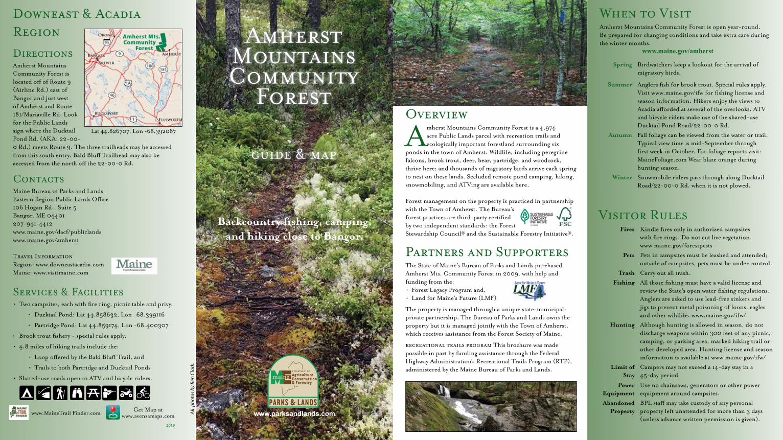
Amherst Mountains Community Forest is a 4,974 acre Public Lands parcel with recreation trails and ecologically important forestland surrounding six
ponds in the town of Amherst. Wildlife, including peregrine falcons, brook trout, deer, bear, partridge, and woodcock, thrive here; and thousands of migratory birds arrive each spring to nest on these lands. Secluded remote pond camping, hiking, snowmobiling, and ATVing are available here. Forest management on the property is practiced in partnership with the Town of Amherst. The Bureau’s forest practices are third-party certified by two independent standards: the Forest Stewardship Council® and the Sustainable Forestry Initiative®.
Downeast & Acadia Region
DirectionsAmherst Mountains Community Forest is located off of Route 9 (Airline Rd.) east of Bangor and just west of Amherst and Route 181/Mariaville Rd. Look for the Public Lands sign where the Ducktail Pond Rd. (AKA: 22-00-0 Rd.) meets Route 9. The three trailheads may be accessed from this south entry. Bald Bluff Trailhead may also be accessed from the north off the 22-00-0 Rd.
ContactsMaine Bureau of Parks and LandsEastern Region Public Lands Office106 Hogan Rd., Suite 5Bangor, ME 04401207-941-4412www.maine.gov/dacf/publiclandswww.maine.gov/amherst
Travel InformationRegion: www.downeastacadia.comMaine: www.visitmaine.com
Services & Facilities• Two campsites, each with fire ring, picnic table and privy.
• Ducktail Pond: Lat 44.858632, Lon -68.399116
• Partridge Pond: Lat 44.859174, Lon -68.400307
• Brook trout fishery - special rules apply.
• 4.8 miles of hiking trails include the:
• Loop offered by the Bald Bluff Trail, and
• Trails to both Partridge and Ducktail Ponds
• Shared-use roads open to ATV and bicycle riders.
2019
guide & map
Amherst Mountains Community
Forest
Backcountry fishing, camping,
and hiking close to Bangor.
www.parksandlands.com
Lat 44.826707, Lon -68.392087
www.MaineTrail Finder.com Get Map at www.avenzamaps.com
When to VisitAmherst Mountains Community Forest is open year-round. Be prepared for changing conditions and take extra care during the winter months. www.maine.gov/amherst
Spring Birdwatchers keep a lookout for the arrival of migratory birds.
Summer Anglers fish for brook trout. Special rules apply.Visit www.maine.gov/ifw for fishing license and season information. Hikers enjoy the views to Acadia afforded at several of the overlooks. ATV and bicycle riders make use of the shared-use Ducktail Pond Road/22-00-0 Rd.
Autumn Fall foliage can be viewed from the water or trail. Typical view time is mid-September through first week in October. For foliage reports visit: MaineFoliage.com Wear blaze orange during hunting season.
Winter Snowmobile riders pass through along Ducktail Road/22-00-0 Rd. when it is not plowed.
All p
hoto
s by
Ben
Clar
k.
Fires Kindle fires only in authorized campsites with fire rings. Do not cut live vegetation. www.maine.gov/forestpests
Pets Pets in campsites must be leashed and attended; outside of campsites, pets must be under control.
Trash Carry out all trash.
Fishing All those fishing must have a valid license and review the State’s open water fishing regulations. Anglers are asked to use lead-free sinkers and jigs to prevent metal poisoning of loons, eagles and other wildlife. www.maine.gov/ifw/
Hunting Although hunting is allowed in season, do not discharge weapons within 300 feet of any picnic, camping, or parking area, marked hiking trail or other developed area. Hunting license and season information is available at www.maine.gov/ifw/
Limit of Stay
Campers may not exceed a 14-day stay in a 45-day period
Power Equipment
Use no chainsaws, generators or other power equipment around campsites.
Abandoned Property
BPL staff may take custody of any personal property left unattended for more than 3 days (unless advance written permission is given).
Visitor Rules
recreational trails program This brochure was made possible in part by funding assistance through the Federal Highway Administration’s Recreational Trails Program (RTP), administered by the Maine Bureau of Parks and Lands.
Partners and SupportersThe State of Maine’s Bureau of Parks and Lands purchased Amherst Mts. Community Forest in 2009, with help and funding from the: • Forest Legacy Program and,• Land for Maine’s Future (LMF)
The property is managed through a unique state-municipal-private partnership. The Bureau of Parks and Lands owns the property but it is managed jointly with the Town of Amherst, which receives assistance from the Forest Society of Maine.
Trou
t Pon
d Rd
Trou
t Pon
d Rd
Airli
ne R
dAi
rline
Rd
River RdRiver Rd
Tanne
ry L
oop
Ducktail Pond Rd22-00-0 Rd
Field Rd
Foste
r Rd
MacdonaldRd
Jellison
Hill
Rd
Jellison
Hill
Rd
9-13
Rd
9-13
Rd
22-00-0 Rd
22-00-0 Rd
East ForkEast Fork
22-00-0 Rd22-00-0 Rd
9-15 Rd
9-15 Rd
Halfmile Pond
Rd
Halfmile Pond
Rd
Sand
She
d L
oop
Sand
She
d L
oop
*9-1
3 Ro
ad is
clo
sed
duri
ng m
ud s
easo
n.*9
-13
Road
is c
lose
ddu
ring
mud
sea
son.
Bald
Blu
�Tr
ail
Bald
Blu
�Tr
ail
Part
rid
ge
Pond
Tra
il
Duc
ktai
l Po
nd
Trai
l
(0.8 mi)(1)
(1)
(0.7
mi)
(0.3
mi)
(0.2 mi)
(1.7
mi)
(0.3
mi)
Am
he
rs
t
T3
2 M
D B
PP
400
400
500
500
500
600
700
500
500
400
600
600
600
600
600
700
70080
0
800
900
900
1000
700
700
600700
700
800
800900
Part
ridg
e
Pond
Indi
anCa
mp
Pond
s
Gra
ssy
Pond
Trou
tPo
nd
Eas
t Gre
atW
orks
Pon
d
Hal
fmile
Pon
dPu
gPo
nd
Duc
ktai
lPo
nd
Snow
shoe
Pond
W e s t Branch Union River
Indian Camp Brook
Indian Camp Brook
Ba
ldM
ou
nta
inBa
ld B
luff
Mo
un
tain
Yo
rkH
ill
Tro
ut
Po
nd
Mo
un
tain
9
9
To M
yra
Bald
Blu
�Tr
ailh
ead
Duc
ktai
l Pon
dTr
ailh
ead
Part
ridg
e Po
ndTr
ailh
ead
Part
riTr
ailh
To T
itco
mb
Pond
Roa
dan
d St
ud M
ill R
oad
To A
mhe
rst
To A
mhe
rst
gate
gate
gate
*
shared-use road
shared-use road
Am
her
st M
ou
nta
ins
Co
mm
un
ity
Fore
st
Hiki
ng tr
ail
Park
ing
Trai
ls an
d In
tere
st P
oint
s
Tran
spor
tatio
n
Seco
ndar
y ro
ad, S
treet
Tent
site
(Num
ber o
f site
s)
Ove
rlook
Picn
ic a
rea
Grav
el ro
ad
ATV
on sh
ared
-use
road
Cam
psit
e La
titu
de /
Long
itud
es
Duc
ktai
l Pon
d44
.858
780,
-68.
3921
31
Part
ridge
Pon
d44
.859
174,
-68.
4003
07Ca
mps
ites
are
prim
itive
. Eac
h au
thor
ized
site
has
a �
re ri
ng, p
icni
c ta
ble,
and
priv
y.
Cont
our i
nter
val: 2
0 ft
00.
51
Mile
s
AT
Vri
ding
is a
llow
ed o
n th
e 22
-00
-0 R
d./D
uckt
ail P
ond
Roa
d.
AT
V r
ider
s sh
ould
be
on th
e lo
okou
t for
hik
ers,
bik
ers,
and
car
s th
at
may
use
the
road
as
wel
l. F
or m
ore
info
rmat
ion
abou
t AT
V tr
ails
con
tact
lo
cal c
lubs
at w
ww.
atvM
aine
.org
. The
Bur
eau
of P
arks
and
Lan
ds O
ff
Roa
d Ve
hicl
e offi
ce m
ay b
e re
ache
d at
(20
7) 2
87-2
751,
and
at
ww
w.m
aine
.gov
/dac
f/at
v an
d w
ww.
mai
ne.g
ov/d
acf/
snow
mob
ile.
Nea
rby
Des
tin
atio
ns
The
Am
hers
t Com
mun
ity
Fore
st is
in M
aine
’s D
owne
ast &
Aca
dia
regi
on.
Oth
er d
esti
nati
ons
wit
hin
this
are
a in
clud
e:
• D
uck
Lak
e P
ubli
c L
and
wes
t of G
rand
Lak
e St
ream
enc
ompa
sses
29
,00
0 a
cres
of w
oods
and
lake
fron
t off
erin
g ba
ckco
untr
y ca
mpi
ng a
nd
fish
ing.
ww
w.m
aine
.gov
/duc
klak
e
• D
onne
ll P
ond
Pub
lic
Lan
d m
ore
than
14,
00
0 a
cres
of r
emot
e fo
r-es
ted
land
wit
h cr
ysta
l cle
ar la
kes,
sec
lude
d po
nds,
and
mou
ntai
ns w
ith
pano
ram
ic v
iew
s. L
ocat
ed b
etw
een
Fran
klin
and
Che
rryfi
eld.
w
ww.
mai
ne.g
ov/d
onne
llpon
d
• L
amoi
ne S
tate
Par
k off
ers
visi
tors
a 6
2-si
te c
ampg
roun
d w
ith
amen
i-ti
es c
lose
to A
cadi
a N
atio
nal P
ark.
ww
w.m
aine
.gov
/lam
oine
Tra
ils
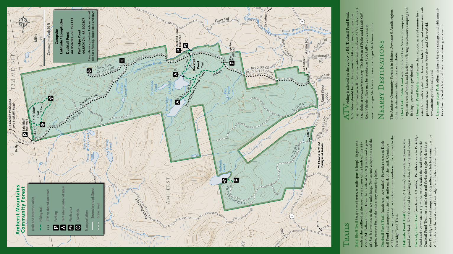
Bal
d B
luff
Tra
il (
easy
to m
oder
ate,
2-m
ile s
pur
& lo
op):
Beg
ins
and
ends
at t
he tr
ailh
ead
at th
e no
rthw
est c
orn
er o
f the
land
s off
the
22-
00
-0 R
d. F
ollo
w th
e sp
ur fr
om th
e tr
ailh
ead
for
0.3
mile
s an
d a
gain
of
180
-ft e
leva
tion
to th
e 1.
7 m
ile lo
op. T
wo
scen
ic v
iew
poin
ts a
nd th
e qu
iet,
rem
ote
feel
mak
e th
is a
ver
y re
war
din
g hi
ke.
Duc
ktai
l Pon
d Tr
ail (
mod
erat
e, 0
.7 m
iles)
: Pro
vide
s ac
cess
to D
uck-
tail
Pond
and
cam
psit
e at
the
half
-mile
mar
k of
the
trai
l. C
onti
nue
0.2
5-m
iles
past
the
pond
, as
the
trai
l tur
ns s
outh
war
d, to
con
nect
to th
e Pa
rtri
dge
Pon
d T
rail.
Hal
fmil
e Po
nd T
rail
(m
oder
ate,
0.1
mile
s): A
sho
rt h
ike
dow
n to
the
pond
ove
rloo
k. N
ote
that
roa
d to
par
kin
g is
clo
sed
duri
ng m
ud s
easo
n.
Part
ridg
e Po
nd T
rail
(m
oder
ate,
1.7
mile
s): P
rovi
des
acce
ss to
Par
trid
ge
Pon
d an
d a
cam
psit
e in
1.3
mile
s. A
t 0.8
mile
s th
e tr
ail i
nte
rsec
ts th
e D
uckt
ail P
ond
Tra
il. A
t 1.1
mile
the
trai
l for
ks: t
he r
ight
fork
end
s at
th
e Pa
rtri
dge
Pond
and
cam
psit
e in
0.2
mile
s; th
e le
ft fo
rk c
onti
nues
for
0.6
mile
s on
the
wes
t sid
e of
Par
trid
ge P
ond
befo
re it
dea
d en
ds.