
DOE/E IS-0020 tU CO?Y - energy.gov · DOE/E IS-0020 - LE t..1 tU CO?Y ·-Final Environmental Impact...
192
DOE/E IS-0020 � - � L E t CO?Y ·- nal Envinmenl Imt tement (Final Supplement to Dept. of the Navy NPOSR FEIS Issued 9/16/77) CRUDE OIL TRANSPORT ALTERNATE FROM NAVAL PETROLEUM RESERVE NO. 1 Elk Hills/SOHIO Pipeline Conneion Conveyance System Teinal Tank Fa Relion Rialto, Califomia U.S. DEPARTMENT OF ENERGY June 1978
-
Upload
truonghanh -
Category
Documents
-
view
214 -
download
0
Transcript of DOE/E IS-0020 tU CO?Y - energy.gov · DOE/E IS-0020 - LE t..1 tU CO?Y ·-Final Environmental Impact...

DOE/E IS-0020 �- � L E t..1 tU
CO?Y ·-
Final Environmental Impact Statement (Final Supplement to Dept. of the Navy NPOSR FEIS Issued 9/16/77)
CRUDE OIL TRANSPORT ALTERNATE FROM NAVAL
PETROLEUM RESERVE NO. 1 Elk Hills/SOHIO Pipeline Connection
Conveyance System
Tenninal Tank Fann Relocation to Rialto, Califomia
U.S. DEPARTMENT OF ENERGY
June 1978


DOE/EI S-0020 DOE/EIS-0020 UC-11, 13, 92
Rnal Environmental Impact Statement (Final Supplement to Dept. of the Navy NPOSR FEIS Issued 9/16n7l
CRUDE OIL TRANSPORT ALTERNATE FROM NAVAL
PETROLEUM RESERVE NO. 1 Elk Hills/SOHIO Pipeline Connection
Conveyance System Tenninal Tank Fann Relocation to Rialto, California
Responsible Official
�;?: . � James L. Liverman :::=secretary for Environment
U.S. DEPARTMENT OF ENERGY Washington, DC 20545
June 1978

Avai l abl e from :
Pri ce :
Nat i onal Techn i cal Infonnati on Servi ce (NTIS) U.S. Department of Corrmerce 5285 Port Roya l Road Spri ngfi el d, V i rgi n i a 22161
Pri nted Copy : $6.25 Microfi che : $6.25

Statement Type :
SUMMARY
( ) Draft E nvironme nta l Impact ( ) Statement
Final E nvironmental Impact Stateme nt
( X ) Supp l eme nt to Final E nvironme ntal Impact Statement
Prepared By:
Comments to :
Tit l e :
Department o f Energy, As sistant Sec retary o f Resource App l ications, Office o f Naval Petro l eum and Oil Sha l e Reserves
Captain John Dic k- Peddie Officer in Charge of Construction , E l k Hil l s P . O . Box 40 San Bruno , Cal ifo rnia 44066
C rude Oil Conveyance System From Naval Petro l eum Reserve No . 1 ( E l k Hil l s ), Kern County, Cal ifo rnia , to the SOH I O Pipe l ine Connection in Ria l to, Cal ifo rnia
Type of Action : ( X ) Administrative ( ) Legis l ative
1. Brief Desc ription o f Proposed Actio n : Purs uant to Pub l ic Law 94- 258 , the Naval Petro l eum Reserves Production Act of 1976, Naval Petro l eum Rese rve No . 1 ( NPR-1) was opened up fo r production for a period o f 6 years . The Act a l so directed the government to acquire pipe l ine capacity from NPR-1 to marketing termina l s for 350 , 000 barre l s per day ( B/D ) o f c rude oil . This suppl ement covers the actio ns nece s s ary to modify the design of a proposed 250,000 B/D c rude oil conveyance system from NPR-1 to connect to the proposed SOH IO West Coast to Midcontinent Pipe l ine at Rial to, Cal ifornia . The Final E nvironmental Impact Stateme nt ( F E I S ) on the original design was pub l is hed on September 16, 1977 .
During the review o f the NPR-1/SOHIO Pipe l ine Connection Conveyance System D E I S, there were a number of strong ly wo rded obj ections to the proposed terminal tan k farm l ocation near Cajon Pas s . The chief action covered by this s upp l eme nt is the rel ocatio n of this controve rsial tan k farm to a n indus tria l l y zoned area i n Rial to , Cal ifo rnia .
Other actions covered in this s upp l ement inc l ude :
o reductio n in pipe l ine size o exten sion of pipe l ine l� mil es o addition of one main l ine pump station o mino r re ro uting and mil epost changes o more detail ed descriptio n o f communicatio ns system
a

2 . Summary of Environmental Impacts and Adverse E ffects : Overal l , the proposed project mod i f i cati ons wou l d res u l t in l es s er adverse effects than those previ ous l y descr i bed in the F E I S . The construct i o n d i ff i cu l ties and potenti a l secur i ty probl ems associated with the Cajon Pas s Tan k Farm wou l d be e l i minated; fire f i ghti ng response at the R i a l to s i te wo u l d be vas t l y improved over that of the remote Caj on s i te ; and the Ria l to site wou l d be mo re compati b l e wi th l oca l l and use. A l so, the smal l e r p i pe l i ne s i ze wou l d reduce the s i ze of potent i a l o i l sp i l l . Total hydrocarbon em i s sions from the tank farm wou l d be reduced but emi s s i ons wo u l d be in an a i r bas i n with poorer a i r qua l i ty than at the Caj on s i te .
The maj o r add i t i ona l adverse i mpacts wo u l d be the potent i a l for the l o s s of a rare p l ant spec i e s ( E ri ogonum gos sypi num ) on the o l d s ho re l i ne of the Buena Vista Lakebed and the i ndirect i mpact ( pr i mari ly vis ua l ) to the Agua Mansa Cemetery, a Cal iforn i a H i stor i c Landmark l ocated adj acent to the proposed R i a l to Term i nal . Because the p roposed modi ficati ons wo u l d requ i re a greate r number of construct i o n emp l oyees than the or i g i nal project, the benef i c i a l econom i c impact wou l d be i ncreas ed .
3 . A l ternati ves Con side red: A l ternatives to the proposed proj ect mod i f i cati ons:
o cons truct tan k farm at Caj on Pas s as or i ginal l y p roposed o con struct tan k farm at a l ternate s i te i n Co l to n, Cal i fo rn i a o construct tan k farm b ut postpone use o decrease s i ze of tan k farm o e l iminate tan k farm from project o postpone construction o cance l project
The postponement and cance l l at i o n a l ternati ves wo u l d requ i re mod i f i cati on of exi st i ng l eg i s l at i o n i n Pub l i c Law 94- 258 .
4 . Comme nts Reque sted: The fo l l owi ng age nc i e s and organ i zati ons have received cop i es of the F i na l E I S .
Co ngre s sio nal
Senato r A l an Cranston Senator S . I . Hayakawa Senato r John C . Stenn i s Se nato r Henry M . Jackson Congres sman B . F . Sis k Congres sman Leon E . Panetta Congres sman John H. Krebs Congressman Wi l l i am M. Ketchum Congres sman Robert J . Lagomars i no Congres sman Barry M . Go l dwate r, J r .
b

Co ngressman Jame s F . L l oyd Co ngressman Geo rge E . B rown , Jr . Co ngressman Sh i r l ey N . Pett i s Co ngressman Me l v i n P r i ce Congre ssman Mo rr i s K . Uda l l
Fede ral
State
Department of Agri c u l ture So i l Conservat i o n Serv i ce (D . C . and Bakers f i e l d )
Department of Commerce As s i stant Sec retary for Sc i ence and Tec hno l ogy Dep uty As s i stant Secretary for E nv i ronme ntal Affa i rs
( 5 cop i e s ) Nati ona l Oceaograp h i c and Atmospheri c Agency
Departme nt of Heal th, Educat i o n and We l fare Departme nt of Hous i ng and Urban Deve l opment
E nv i ronme nta l and Land- Use P l ann i ng D i v i s i on Reg i ona l Adm i n i strat i o n ( Reg i on I X )
Department o f I nter i o r Off i ce of E nv i ro nme ntal Project Rev i ew ( 20 cop i e s )
Departme nt o f Labo r ( Occupat i o na l Hea l th and Safety) Departme nt of Transportat i on
Off i ce of P i pe l i ne Safety Adv i s ory Counc i l o n H i stor i c Prese rvat i o n Counc i l on E nv i ro nme nta l Qua l i ty Env i ronme ntal Protect i o n Agency ( 10 cop i e s ) U . S . Water Resources Counc i l
State of Ca l i fo rn i a Off i ce of P l ann i ng and Res earc h
State C l ear i ng House Metropo l i tan Transportat i on Comm i s s i on U n i vers i ty o f Cal i fo rn i a at R i ve rs i de ( Arc haeo l og i ca l
Res earc h U n i t)
Regi ona l
South Coast A i r Qua l i ty Management D i stri ct Metropo l i tan Zo ne D i str i ct Headquarters
Southern Ca l i fo rn i a Assoc i at i o n of Gove rnments
c

Local
Fresno Cou nty P l ann i ng Department Ki ngs Cou nty P l ann i ng Departme nt Kern County P l ann i ng Department San Lui s Ob i spo County Off i ce of E nv i ronmental Coord i nat i o n Santa Barbara County P l ann i ng Department Ventura Cou nty P l ann i ng Departme nt Los Ange l es Cou nty Departme nt of Reg i ona l P l ann i ng Los Ange l e s Cou nty Board of Superv i sors San Bernard i no Cou nty P l ann i ng Department Los Ange l es Natural H i story County Mus eum Southern Ca l i forn i a As soc i ati on of Governments Fresno Cou nty Counc i l of Governments Kern Cou nty Cou l c i l of Gove rnme nts Ventura Regi o nal Cou nty Sani tat i o n D i str i ct Ventura Cou nty A i r Po l l ut i o n Co ntro l D i str i ct Kern Cou nty A i r Po l l ut i o n Contro l D i stri ct Fresno Cou nty A i r Po l l ut i o n Control D i str i ct San L u i s Ob i spo Cou nty A i r Po l l ut i o n Contro l D i str i ct Ki ngs Cou nty A i r Po l l uti on Control D i str i ct Port o f Long Beach South Coast A i r Qua l i ty Management D i str i ct C i ty of Camar i l l o Departme nt of Env i ronmenta l A ffa i rs C i ty of Coa l i nga C i ty of Taft C i ty of Ve ntura Los Ange l es Department of A i rports C i ty of Oxnard C i ty of Port Hue neme C i ty of Pal mda l e C i ty of San Bernard i no C i ty of S i m i Val l ey Department of Env i ronmental Affa i rs C i ty of Co l ton C i ty of Thousand Oaks Department of Env i ronmental Affa i rs C i ty of Bakers f i e l d C i ty of R i a l to Oxnard Harbor D i stri ct C i ty of V i cto rv i l l e Coal i nga U n i f i ed Schoo l D i stri ct L i b rary Frenso Cou nty Pub l i c L i b rary Ave nal B ranch L i brary K i ngs County L i b rary Taft Branch L i b rary Kern Cou nty L i b rary San Lu i s Ob i spo Cou nty L i b rary San Lu i s Ob i spo Cou nty L i b rary , Av i l a Beach Branch Santa Barbara Pub l i c L i b rary Ventura County L i brary Serv i ces Agency
d

S i mi Va l l ey Branch, Ventura County L i b rary Oxnard Pub l i c L i b rary Port Hueneme L i b rary Pa l mdal e L i brary Lo s Ange l es Cou nty Pub l i c L i b rary Lancaster Pub l i c L i b rary L i tt l e roc k Pub l i c L i b rary Vi ctorv i l l e Pub l i c L i brary Hunti ngton Beach Pub l i c L i b rary Bake rs f i e l d Pub l i c L i brary San Bernard i no County L i brary Co l ton Pub l i c L i b rary R i vers i de Mun i c i pa l Museum San Be rnard i no County Museum
Other G roups
Ante l ope Va l l ey Co l l ege, Departme nt of Archaeo l ogy B l oomi ngton Mun i c i pa l Adv i so ry Counc i l Ca l i forn i a Chamber of Commerce League of Women Voters, San Lu i s O b i spo and R i vers i de League of Cal i forn i a C i t i e s Ca l i forn i a I nst i tute of Man i n Nature Env i ronmental I n fo rmati on Center Env i ronme nta l Po l i cy Commi ttee Ca l i forn i a Mar i ne Affa i rs and Nav i gati on Conference Ca l i forn i a Wi l d l i fe Fede rati o n P l ann i ng and Conse rvat i o n League Nati ona l Resources Defense Counci l , I n c . The W i l derness Soc i ety E n v i ronmental Defense Fund Fr i ends of the Earth ( Ca l i fo rn i a and Nati onal ) Nati ona l Wi l d l i fe Federat i on I zaak Wa l ton League of Amer i ca Audubon Natura l i st Soci ety S i e rra C l ub ( San F ranc i sco, Los Ange l es, Santa Luc i a, and
Gorgon i o Chapters ) Wes te rn O i l and Gas Assoc i ati on P i pe L i ne Techno l og i sts R . M . Parso n s Company, Atte n : Mr . Thomas Hare Pace Corporati on Exxon P i pe l i ne Company, Houston, Texas, Attn : Mr . T . Pari sh SOH I O Transportat i on Company, C l eve l and, Oh i o, Att n : Mr . F red
Gari ba l d i Center f o r Urban Affai rs , Northwestern U n i vers i ty, Evansto n,
I l l i no i s, Attn : H . Pau l F r i esema Tej o n Ranch Company, Attn : Mr . Denn i s McCarthy Wri ghtwood Chamber of Comme rce U n i vers i ty of Ca l i fo rn i a , Santa Barbara, Department of
Anthropo l ogy , Att n : M . G l assow
e

P he l an E l ementary Sc hoo l , P . O . Box 78 , P he l an Phe l an Chamber o f Comme rce E nv i ro nmental Cente r , San Lu i s Ob i spo C l ean A i r Coal i t i on, San Lu i s Ob i spo Tetra Tech, I n c . M i s s i on Coast Lung As soc i at i on Save Our Coast Coal i t i on South Bay Cons ervati on G roup Tri - County Conservat i o n League At l anti c R i chf i e l d Company , Transportat i o n D i v i s i on Beacon O i l Company Chevron U . S . A . I nc . Des ert Wi de Real Estate , I nc . Hunt Rea l ty , I nc . Ben Oman Company Pa l mda l e Board of Rea l tors , I nc .
5 . Comme nts Rece i ve d : Pub l i c meeti ngs we re he l d to rev i ew the proposed project modi f i cat i o n and a draft o f th i s s upp l eme nt at the R i a l to C i ty Counc i l Chambers on Apr i l 3 , 1978 and Apri l 27 , 1978 . Comments and quest i ons were ra i s ed at the pub l i c meeti ngs and s ubsequent to the meeti ngs , addi t i ona l wri tten comments we re rece i ved . A l l q ue sti ons and concerns expres s ed have been addressed i n th i s s upp l ement .
f

Secti o n
I
I I
TAB LE O F CONTENTS
I NTRODUCT ION . .- . . . .
A . Proj ect Descri pti o n . 1 . Purpose . . . . . 2 . Approach . . . . 3 . Bac kground . . . 4 . Project Modi f i cat i ons . 5 . Descr i pti o n o f Proposed Fac i l i ti e s 6 . Land Requ i rements . . . . . . 7 . Cons tructi on and Resto rati o n Procedure s . 8 . Operati ons and Mai ntenance 9. Personne l Requi reme nts
10. Mothba l l i ng Procedures . 11 . Abandonme nt Procedures . 12 . R i s k Asses sment . . . . . 1 3 . Other Fede ra l Acti v i t i e s
E X I ST ING ENVI RONMENT OF P RO POSED S ITE .
A . Geo 1 ogi ca 1 Resources . . . . . 1 . P hys i ography . . . . . . . 2 . Areal Geo l ogy/Strati graphy 3 . So i l s . . . . . . . . . . . 4 . M i neral Resources . . . . . 5 . U n i que Geo l ogi ca l Features 6 . Se i smi c Sett i ng . . . . 7 . Nonse i smi c Constrai nts
B . A i r Resources . 1 . C l i mate . . 2 . A i r Qua l i ty .
C . No i se . . . . . .
D . Water Resource s .
E . B i o l og i ca l Re sources 1 . Vegetati on . . . 2 . Wi l d l i fe . . . . 3 . Aquati c B i o l ogy . 4 . Eco l ogi ca l Re l at i on s h i ps
i ii
Page
1- 1
1- 1 1- 1 1- 1 1- 2 1-4 1-8 1- 17 1- 17 1- 19 1-20 1-21 1-23 1-23 1-28
2- 1
2- 1 2-1 2-1 2-1 2-2 2-2 2-2 2-5
2- 6 2-6 2-7
2-8
2-8
2-8 2-8 2-9 2-9 2-9

Sect i o n
I I I
IV
TAB LE OF CONTENTS ( cont . )
F . Archaeo l og i ca l , H i stori ca l , and Other C u l tura l Resources . . . . . . . . 1 . Arc haeo l og i ca l Re sources . . . 2 . H i stor i ca l /C u l tural Resources .
G . Land Use . . . . . . . . . . . . .
H . Soc i oeconom i cs . . . . . . . . . . 1 . & 2 . Emp l oyment and Popu l at i o n 3 . Pub l i c Serv i ces and Uti l i t i e s . 4 . Rec reat i o n . . . . . 5 . Land Transportat i o n . . . 6 . F i sca l Effects . . . . . . . . 7 . V i s ua l Qua l i ty . . . . . . . .
R ELAT IONSH I P O F TH E P RO POSED ACTION TO LAND-USE P LANS , POLI C I ES , AND CONTRO LS FO R TH E AFFECTED AREA . . . . . . . . . . . . . . . . . . .
P ROBABLE I MPACT OF THE P ROPOSED ACTION ON THE ENV I RONMENT . . . . . . .
A . Geo 1 ogi ca 1 Resources . . 1 . Cons truct i o n . . . . 2 . Operati ona l . . . . . 3 . M i t i gat i o n Measures .
B . A i r Qua l i ty . . . 1 . Con struct i o n 2 . Operat i o n . .
C . No i s e . . . . . . 1 . Con struct i o n 2 . Operat i ona l . 3 . M i t i gat i o n .
D . Water Resources . 1 . Con struct i o n 2 . Operat i o n (Norma l ) 3 . Operat i on (Abnormal ) 4 . M i t i gat i o n . . . . .
i v
2-9 2-10 2-11
2-12
2-13 2-13 2-13 2-14 2-15 2-15 2-15
3-1
4-1
4-1 4-1 4-1 4-1
4-2 4-2 4-2
4-5 4-5 4-5 4-6
4-6 4-6 4-6 4-7 4-7

Sect i o n
v
TAB LE OF CONTENTS ( cont . )
E . B i o l ogi ca l Resources 1 . Vegetat i o n . . . 2 . Wi l d l i fe . . . . 3 . Aquati c B i o l ogy .
F . Archaeo l og i ca l , H i stor i ca l , and Cu l tural Re sources . . . . 1 . Constructi on 2 . Operat i o n . 3 . M i t i gat i on
G . Land Use . . .
H . Soci oeconomi cs 1 . Emp l oyment 2 . Popu l ati o n 3 . P ub l i c Serv i ces and Uti l i t i es . 4 . Recreat i on . . 5 . Transportat i o n . . 6 . F i sca l Effect . . . 7 . V i s ua l Qua l i ty . . 8. G rowth I nducement .
ALTE RNATIVES .
A . Tan k Farm at Caj on Pas s .
B . Tank Farm at Co l to n , Cal i forn i a .
C . Cons truct Tan k Farm But Postpone U s e
0. Decrease Tan k Farm S i ze .
E . E l i m i nate Tank Farm from Proj ect
F . Po stpone Constructi o n .
G . Cancel P roj ect .
v
. Page
4- 7 4- 7 4- 7 4-8
4-8 4-8 4-8 4-9
4-9
4- 10 4- 10 4-11 4-11 4- 12 4- 13 4- 13 4- 14 4- 16
5-1
5-1
5-1
5-4
5-4
5-5
5- 5
5 -6

Secti on
VI
VI I
VI I I
IX
APPENDI CES
A
B
c
D
E
F
G
H
I
J
K
L
TAB LE OF CONTENTS (cont . )
ANY PROBAB LE ADVE RS E ENVI RONMENTAL E F FECTS WH ICH CANNOT BE AVO I DED SHOULD THE PROPOSAL BE I MP LEM ENT ED . . . . . . . . . . . . . . . . . . .
R ELATIONS H I P BETWE EN LOCAL SHORT-TERM USE OF MAN ' S ENVI RONMENT AND MA I NTENANCE AND ENHANCEMENT OF LONG-TERM P RODUCTIVITY . . . . . . . . . . . . . . . . . .
ANY I RREVERS I BLE AND I RRETRI EVABLE COMMI TMENTS OF RESOURCES THAT WOU LD BE I NVOLVED IN THE P ROPOSED ACTION IF IMP LEMENT�D . . . . . . . . . . . . . .
CONS IDERAT IONS THAT OFFSET ADVERSE ENVI RONMENTAL E FFECTS . . . . . . . . . . . . . . . . . . . . .
EXCE RPTS F ROM PUB L I C LAWS 94-258 and 95-91
CHARACTERISTICS OF C RUDE O I L AND P ROJECT DES IGN ELEMENTS . . .
ENVI RONMENTAL ATLAS . . . . . . . .
R I S K ANALYSIS AND SP I LL PREVENTION
SENSI TIVITY ANA LYS I S
S E I SM I C HAZARD S .
C L I MATE . . . . .
A I R QUALITY R EGULATIONS AND STANDARDS .
A I R QUALITY - - PAST , P RES ENT , AND FUTU RE TRENDS .
NO I S E . . . . .
WATE R RESOU RCES .
CHARACTER I ZAT ION OF P LANT COMMUN I T I E S .
v i
6 - 1
7-1
8- 1
9- 1
A- 1
B-1
C-1
D-1
E-1
F -1
G-1
H-1
I - 1
J - 1
K-1
L- 1

Secti on
M
N
0
p
Q
R
TAB LE OF CONTENTS (cont . )
WI LDL IFE . . . . . . . . . . . . . . . . . . . .
CU LTU RA L RESOURCES EVA LUATION OF THE R IALTO TAN K FARM LOCAT ION AND ASSOC IATED P I P EL I N E AND PUMP STAT ION LOCATIONS , SAN BERNARD I NO COUNTY , CALIFORNIA . .
SOC IOECONOMICS . .
A I R QUALITY I MPACTS .
E LK H I LLS CRUDE O I L MARKETS AND MARKET I NG FACTO RS . . . . . . . . . . . . . . . . . .
SUMMARY OF R IALTO PUBLIC MEETI NGS , WR I TTEN COMMENTS , AND RESPONSES.
B I B LIOGRAPHY . . . . . . . . . . .
vii
Page
M- 1
N - 1
0 - 1
P - 1
Q - 1
R-1
1
Number
1- 1
1- 2
1- 3
1-4
1- 5
1-6
1- 7
2- 1
3 - 1
5 - 1
G - 1
N -1
L I ST OF F IGURES
General Map o f E l k H i l l s/SOH IO Project Fac i l i t i es i n Central Cal i forn i a . . .
P i pe l i ne Extens i o n to R i a l to Term i nal .
Ll ano Pump Stat i o n Sett i ng and P i pe l i ne Real i gnment . . . . . . . . . . . . . .
P i pe l i ne Rea l i gnme nt
P i pe l i ne Rea l i gnment
Buena Vi sta Lakebed .
Caj on Bou l evard .
R i a l to Tank Farm P l an S i te
Des i gn Sp i l l for E l k H i l l s to SOH IO P i pe l i ne . . . . . .
Fau l ts and Groundwater Barr i ers i n the V i c i n i ty of the R i a l to Tan k Farm and P i pe l i ne Connecti o n .
Land U s e Zo n i ng i n the V i c i n i ty o f the R i a l to Term i nal S i te . . . • . . . . . . . . . .
Locat i o n Map of A l ternate Tan k Farm S i te . . .
Wi nds at Norton AFB , San Bernard i no , Ca l i forn i a .
Locati on Map o f Arc haeo 1 og i c a 1 Survey . . . . . .
.
v i ii
1- 6
1-7
1- 10
1-12
1- 13
1- 15
1-27
2-3
3 -2
5 -2
G-4
N -5

N umber
1-1
1-2
2-1
4 -1
D -1
G - 1
G -2
I - 1
I - 2
I - 3
I - 4
I - 5
0 - 1
0 - 2
0 - 3
L I ST OF TAB LES
Construct i on Pers onne l . . .
Operat i ng Personne l Req u i red
Large H i s tor i c Earthquakes of the San Jac i nto Fau l t Zone . . . . . . . . . . . . . .
R i a l to Tan k Farm RHC Emi s s i ons Compared to the South Coast Porti on of San Bernard i no County
Compar i son o f F i re R i s ks Between Tan k Farms .
Tempe rature and P.rec i p i tati on Data for San Bernard i no F i re Stati o n No . 5 . . . . . .
Mean M i xi ng Depths i n the San Bernard i no Area .
Number of Days Federal Oxi dant Standard Has H i s tor i cal ly Been Exceeded at Stat i ons Near the Proposed R i a 1 to Tank Farm . . . . . . . . . .
Number of Days Fede ral Oxi dant Standard Was Exceeded and Max i mum Hour ly Ave rage by Month Dur i ng 1975 . . . . . . . . . . . . .
Annua l Geometr i c Mean Concentrati o ns o f Suspended Part i c u l ates . . . . . .
Frequency w i th Wh i ch State 24- hour Secondary Suspended Part i c u l ate Standard was Exceeded Dur i ng 1976 . . . . . . . . . . . . . . . . .
San Bernard i no County Emi s s i on s I nventory for Total Hydrocarbons and Reacti ve Hydrocarbons 1975 and 1980 For South Coast A i r Bas i n Port i o n O n l y . . . . . . . . . . . . . . .
F i re Protecti on Manpowe r and Equ i pme nt
Schoo l E n ro l l ment Trends , C i ty of R i a l to
R i a l to C i ty Was tewate r Treatme nt P l ant .
i x
Page
1- 21
1-22
2-6
4-4
D-4
G-2
G-6
I - 3
I - 4
I - 5
I - 6
I-8
0 - 2
0 - 2
0 - 3

Number
P - 1
P - 2
P-3
Q-1
L I ST OF TAB LES ( cont . )
Compar i s on of Hydrocarbon Emi s s i o ns from the R i a l to and Caj on Tan k Farms . . . . . . .
R i a l to and Caj on Tan k Farm Emi s s i on s i n Compar i son wi th Res pect i ve 1980 County Emi s s i ons
Potent ia l A i r Po l l utant Emi s s i o ns i n Los Ange l es County Due to I nc reased Pump i ng Capac i ty of the E l k H i l l s/SOH I O Connect i o n P i pe l i ne . . . . . . .
Rev i s i on of Tab l e Q-6 i n Fi na l E I S - -Awards o f Contracts for Sal e of E l k H i l l s C rude Qi 1 . . . . . . . . . . . . . . . . . . . . . . .
x
P-3
P-3
P-6
Q-2

A . P roject Descri pt i on
1 . P urpose
I . I NTRODUCTION
The purpose of th i s document i s to p rov i de a s upp l ement to the
f i na l env i ronme nta l i mpact s tatement of the p roposed co nveyance sys tem
needed to transport c rude o i l from the Naval Petro l e um Res e rve No. 1
(NPR-1) i n Kern County , Cal i fo rn i a , to a connecti on wi th the p roposed
SOHIO P i pe l i ne i n R i a l to , Cal i forn i a . Th i s s upp l ement has been deemed
nece s sary due to mod i f i cati o n s i n the p roject des i gn that have occu rred
s i nce the September 1977 pub l i cati on of the F i na l E nv i ronme ntal Impact
Statement , C rude O i l Transport from Naval Petro l e um Reserve No . 1 ,
Tupman , Cal i forn i a , E l k H i l l s/SOH IO P i pe l i ne Con necti on Sys tem .
Th i s s upp l ement i s not meant to be a comp l ete env i ro nme ntal i mpact
stateme nt by i tse l f . I t i s meant to s upp l ement the p rev i o usly pub l i s hed
Draft E I S ( Apr i l 1977 ) and the F i nal E I S . The s upp l ement i s based on
the more deta i l ed p roject descri pti on contai ned i n the F i na l Study
Report , E l k H i l l s Deve l opme nt C rude O i l P i pe l i ne , Phase I I - I nc rement 9 (P i pe L i ne Tec hno l og i s ts , January 1978) .
2 . Approach
The approach of thi s s upp l ement i s to l i m i t the d i scus s i on to the
compo nents of the p roj ect de s i gn that have changed s i nce the pub l i cat i o n
1- 1

of the F i na l E I S . Repet i t i o n o f the d i scus s i on conta i ned i n the F i na l
E I S , there fo re , wi l l be m i n i m i zed . T o fac i l i tate u s e o f th i s supp l e
ment , e s s e nt i a l l y the same fo rmat and tab l e o f contents as the F i na l E I S
have been used .
3 . Background
The government was d i rected by Congre s s i n Pub l i c Law 94- 258 and
the Naval Petro l eum Reserve P roduct i o n Act o f 1976 , to secure p i pe l i ne
capac i ty for not l es s than 350 , 000 barre l s per day ( BID ) of c rude o i l
from Nava l Petro l e um Rese rve No . 1 ( NPR-1) , Ke rn County , Cal i fo rn i a , i n
the E l k H i l l s area to a marketi ng te rm i nal by Ap r i l 1979 . I n add i t i o n ,
petro l eum product i o n at NPR-1 i s to proceed at the max i mum e ff i c i ent
rate co n s i stent wi th sound eng i neer i ng pract i ces for a peri od not to
exceed 6 years , at the end o f wh i ch the P res i dent wi th the approval o f
Congre s s may exte nd the product i o n peri od fo r add i t i ona l peri ods n o t to
exceed 3 years eac h . P i pe l i ne capac i ty avai l ab l e for transport i ng c rude
o i l out of NPR- 1 i s l e s s than 150 , 000 BID and , therefore , a new conveyance
system capab l e o f tran sporti ng up to 250 , 000 BID of c rude from E l k H i l l s
i s be i ng proposed to carry o ut the Congres s i ona l mandate .
As o f October 1 , 1977 , the newly c reated Department of .Energy ( DO E )
has taken over respons i b i l i ty from the Navy f o r the product i o n and
conveyance of c rude petro l eum from NPR- 1 .
The e nv i ronmental rev i ew process on the conveyance of c rude o i l
from NPR-1 was begun i n J une 1976 whe n a pre l i m i nary E n v i ronmental
A s se s sment ( EA ) was p repared for fo ur conveyance a l ternati ves . The fo ur
a l ternati ves co n s i sted of a system o f ra i l road/truck tran sport o f crude
o i l and three new bur i ed p i pe l i nes: (1) no rthward to Coa l i nga , Cal i fo rn i a ,
( 2 ) westward to a Navy mari ne te rm i nal at Port Hueneme , Cal i fo rni a , and
( 3 ) southward to a connect i o n wi th the p roposed SOH I O P i pel i ne i n the
v i c i n i ty of R i a l to , Cal i forn i a .
1-2

The three p i pe l i ne al ternati ves were se l ected for further env i ron
mental study ; the ra i l /truck tran sport a l ternati ve was con s i dered i n feas i
b l e for the quanti ty o f crude o i l to b e conveyed . A Draft E I S o f the
p i pe l i ne al ternati ves was pub l i s hed i n three parts i n Ap r i l 1977 . The
Draft E I S conta i ns a fu l l env i ronmenta l i nventory of the study area as
we l l as an env i ronmental i mpact eva l uat i o n of the o r i g i nal ly proposed
proj ect . P ub l i c heari ngs on each of the se three conveyance a l ternati ves
were hel d i n the commun i t i es o f Coal i nga , Bakers f i e l d , Taft , San Lui s
Ob i spo , Oxnard , San Bernard i no , and Pa l mda l e i n May and J une 1977 .
As a res u l t of the rev i ew of comments rece i ved both i n wri t i ng and
at pub l i c hear i ngs i t became apparent that the env i ro nmenta l prob l ems
assoc i ate d wi th the Coal i nga and Port Hueneme a l ternati ves were s i gn i f i
cant ly more d i ffi cu l t to deal wi th than those o f the SOH I O connecti on ,
parti cu l ar ly wi th regard to a i r qual i ty i mpacts from l oad i ng crude o i l
at mari ne te rmi nal l oadi ng fac i l i t i e s . Taki ng i nto con s i derati o n the
env i ro nme nta l i mpacts as we l l as the expected s urp l us of crude o i l i n
the Cal i forn i a area when A l as ka o i l beg i ns arri v i ng at ful l proj ected
capac i ty , the gove rnment dec i ded the proposed t i e- i n to the SOH I O P i pe
l i ne wou l d be the preferred method of mar keti ng crude o i l from NPR- 1 .
I t i s be l i eved that i mp l ementat i o n of th i s al ternati ve wou l d max i mi ze
d i str i buti on of the government 1 s o i l to the m i dconti nent and East Coast
reg i ons at the l east po s s i b l e transportat i o n cos t , and wi th the l east
env i ronmenta l i mpact. Furthermo re , th i s al ternati ve wo u l d al l ow the
governme nt 1 s s hare of the o i l produced at NPR-1 to be p l aced i n sto rage
fac i l i t i e s of the Strateg i c Petro l eum Reserve to be l ocated on the Gu l f
Coast , sho u l d the Pre s i dent so d i rect , purs uant to Pub l i c Law No . 94- 258 .
T h e F i na l E I S on the P i pe l i ne Conveyance System to the proposed
SOH IO P i pe l i ne was pub l i shed i n two vo l umes i n September 1977 . Vol ume I
conta i ns the proj ect descri pt i on and env i ronme nta l i mpact analys i s ;
Vo l ume I I conta i ns wri tte n and pub l i c hear i ng comments on the Draft E I S
and responses t o these comments . The env i ronme ntal i mpact ana lys i s
1- 3

conta i ned i n the F i nal E I S reflects the project des i gn changes i n s t i
tuted a s a res ult o f the publ i c rev i ew.
After the F i nal E I S was publi s hed , cont i n u i ng work on the des i gn of
the conveyance system made i t apparent that some add i t i onal mod i f i ca
t i o n s i n the project des i gn would have to be made i n order to achi eve
opti mum des i gn and system compat i b i l i ty . As stated i n the open i ng
paragraph , th i s s uppleme nt prov i des the env i ronmental analys i s of these
mod i f i cati ons .
Dur i ng rev i ew of the draft for th i s s uppleme nt , publ i c meeti ngs
were he l d at the R i alto C i ty Co unc il Chambers on Ap r i l 3 and Apr i l 27 ,
1978 and wri tten comments were rece i ved afte r these meet i ngs . Concerns
expressed at those meeti ngs and i n s ub sequent l ette rs have been con
s i dered i n preparati on of th i s s uppleme nt . A s ummary of the meeti ngs
and the wri tte n comme nts (wi th respons e s ) are prese nted i n Appe nd i x R.
4. Project Mod i fi cati ons
The p i peli ne project as proposed i n the Elk H i lls/SOHIO FEIS con
s i sted of a crude o i l p i peli ne from Naval Petroleum Rese rve No . 1 ( Elk
H i l ls ) near Taft , Cal i forn i a , to a t i e- i n po i nt wi th the proposed SOH I O
P i peli ne a t Colton , Californ i a . Under th i s p l an , c rude o i l tan k farms
wo uld have been l ocated at Elk H i lls and i n the Caj on Pass area no rth
west of the C i ty of R i a l to , Cal ifo rn i a . The Cajon Pass locat i on had
been chosen to prov i de a grav i ty feed i nto the propo sed SOH I O li ne , thus
sav i ng the energy requ i red to pump i nto the SOH IO system . A s ubsequent
change i n the project econom i cs was created by a rev i s i o n i n the est i mated
tota l throughp ut of crude o i l over the l i fe of the proj ect , ma ki ng the
h i gher cost of construct i on i n the remote Caj on Pass area unj u s t i f i ab l e .
H i gh-pre s s u re meter i ng prob l ems i n the SOH IO system cou l d a l so best be
so l ved by rel ocati ng the tan k farm . A l so , rel ocat i o n of the tank farm
to the San Bernard i no Val l ey wou l d m i t i gate concerns over secu r i ty of
the i s o l ated Caj on tank farm s i te .
1- 4

The fol l owi ng i s a br i ef outl i ne of the maj or p roject des i gn mod i
f i cati ons that wi l l b e di scu s sed i n th i s s upp l eme nt .
o Tan k Farm Re l ocat i o n
The p roposed tan k farm a t Caj on Pass has been re l ocated
to the C i ty of R i a l to , adjacent to the p ropos ed SOH I O P i pe l i ne
R i a l to Pump Stat i o n ( see Figs . 1- 1 and 1- 2 ) .
o Exte n s i on of P i pe l i ne
To accommodate the R i a l to Tan k Farm and De l i very Termi nal ,
the p i pe l i ne wou l d be extended about l� mi l e s southwestward
from the termi nus proposed i n the F i na l E I S , m i l epost ( M . P. )
166 ( s ee F i g . 1- 2 ) .
o Reducti on i n P i pe l i ne S i ze
The s i ze of the e nti re p i pe l i ne has been reduced , from
28 i nches to 24 i nches for the segme nt from the E l k H i l l s Tan k
Farm to Caj on Pass and from 32 i nches to 18 i nches from Caj o n
P a s s to t h e R i a l to Tan k Farm .
o Addi t i onal Mai n l i ne Pump Stat i o n
A new mai n l i ne pump stat i o n ( L l ano P ump Stat i o n ) has been
added i n the v i c i n i ty of Ante l ope Ce nte r , near M . P. 107 . 8 ( s ee
F i g . 1-1) .
o M i nor Rerouti ng and M i l epost Changes
M i nor rerouti ng of the p i pe l i ne has been made i n the
f i rst 12 m i l es of the a l i gnme nt i n the v i c i n i ty of Buena Vi sta
Lakebed and i n Ante l ope Va l l ey i n the v i c i n i ty of the proposed
L l ano P ump Stati o n . Th i s has res u l ted i n a net i ncrease o f
2 m i l es i n the total l e ngth of the p i p e l i ne and correspondi ng
m i l epost changes from those shown i n the F i nal E I S .
1- 5

........ I
(j)
��:.-<" !' "';;, . . ·.\,.,
� Microwave Repeater Station
•#2 Remote Valve
Base Map: State of California, South Half, 1: 5 00,000, 1970.
........ , ' ........... !
"'" ·'�•�:.
,. !
•4'�"""'.-- '
f "Ji .... .,
\ l/
' \ " J \i!-·. c"'.i'�/ \ 11');::"·' ) !f
-·-/.- -· . .. , .. I . .. , .. .,., .. � A ,,, I
' .,
/
Figure 1-1. General Map of El k Hill s/SOHIO Project Facilities in Central Californi a

' I ,, -!: :IT
I
P roposed Elk H i ll s Pipeline
BM 9 --r�--.:-=.-1-
: , . '·
.;•
�.1r.1r� Proposed Elk Hill s Pipel ine Extension
• - • Proposed SOH IO Pipe l i ne 0c:===========�:E2 �===========1
Base Map: San Bernardino South Quadrangle, 1:24, 000. 1973.
Figure 1-2 . Pipeline Extension to Rialto Terminal
1- 7

o More Deta i l ed Descri pt i on o f Commun i cat i o n System
S i nce the pub l i cat i o n of the F i na l E I S , deta i l s of the
commu n i cati on sys tem a l ong the p i pe l i ne have been made avai l
ab l e . The bas i c components o f th i s system are s i x m i c rowave
re l ay stati ons , one towe r each at the E l k H i l l s , Tej on , and
L l ano pump stati ons , and R i a l to term i na l , and towers at Doub l e
Mounta i n and Ke l l e r Peak ( see F i g . 1- 1 ) .
5 . Descri p t i o n o f Proposed Fac i l i t i e s
The p roposed proj ect wou l d invo l ve construct i o n o f a 1 , 250 , 000- barre l
tan k farm at E l k H i l ls ; b u i l d i ng a p i pe l i ne to R i a l to , Cal i forn i a , a
d i stance o f approx i mate l y 168 m i l es ; and cons truct i o n o f a 1 , 000 , 000-barre l
tan k farm and del i very fac i l i ty a t the p i pe l i ne term i nus i n R i a l to . The
p i pe l i ne wou l d connect w i th the proposed SOH IO m i dconti nent c rude o i l
p i pe l i ne , for the transport o f Alas ka North S l ope C rude from a mari ne
termi na l at Long Beac h , Cal i forn i a , to a d i str i bution center at M i d l and ,
Texas .
The followi ng descri pt i on of the proposed fac i l i t i es fol l ows the
outl i ne of the F i na l E I S , not i ng where changes have been made .
a . E l k H i l l s Tank Farm
No s ubstant i a l changes i n the des i gn of the E l k H i l l s Tank
Farm have been made . Some c hanges i n the booster pumps have bee n made ,
wh i ch are d i scus sed i n Appe nd ix B .
b . E l k H i l l s /Caj o n Pass P i pe l i ne Segme nt
The major des i gn changes i n th i s segment of the p i pe l i ne route
are the abandonment of the Caj o n tan k farm s i te , the add i t i o n o f a
mai n l i ne pump i ng stat i o n ( L l ano Pump Stat i o n ) near M . P . 107 . 8 , i n the
1-8

v i c i n i ty o f Antelope Cente r , and a reduct i o n i n p i peli ne s i ze . Other
m i nor des i gn c hanges i nclude add i ng a block valve at M . P . 87 . l ; i n
creas i ng the number o f p umps , but decreas i ng the power req u i rements at
the Tejon Pump Stat i o n ; and do i ng m i nor reali gnme nts i n the f i rst
12 m i les of the p i peli ne and i n the v i c i n i ty of the new Llano P ump
Stat i o n .
The Llano Pump Stat i o n wo uld b e located on about 1 acre o f
land a t the corner o f Palmdale Boulevard and 115th Street East i n
Antelope Cente r , at about M.P . 107 . 8 (see F i g . 1- 3 ) . Fac i li t i es at the
p ump stat i o n wo uld i nclude a small s i ngle- story b u i ld i ng to house equ i p
me nt , an asphalt or gravel dri veway and parki ng area , and a 200- foot
m i crowave relay towe r . T h e s i te wo uld be s urro unded by a 6- foot h i gh
cha i n li n k fe nce . The pump stat i o n would i nclude the same type o f
equ i pme nt as the Tej o n Pump Stat i o n , b ut o nly four 1 , 500-H� pumps wo uld
be req u i red i nstead o f s i x . Electri cal powe r f o r the pumps wo uld be
s uppl i ed by an exi st i ng Southern Cali forn i a Ed i son (SC E ) 66- kV ove rhead
transm i s s i on li ne along Palmdale Boulevard. It wo uld be nece s sary for
SCE to construct a customer sub stat i on at the pump stat i o n s i te .
The d i ameter o f the p i peli ne from the Elk H i lls Tan k Farm to
Cajo n Pass has been reduced from 28 i nches to 24 i nches . The p i peli ne
s i ze has been reduced to opt i m i ze the cap i tal i nvestment and operat i ng
costs .
The locat i o n o f the Tej on Pump Stat i on wo uld be unchanged ;
however , s i x i ns tead o f four pumps wo uld be used . The total horse�owe r
o f the pumps has bee n reduced from 12 , 000 to 10 , 75 0 . T o s upply the
req u i red electri cal powe r , Pac i f i c Gas and Electr i c (PG&E) wo uld con
s truct 8 . 5 m i les o f 70- kV wood pole transm i s s i o n li ne from an exi st i ng
li ne along H i ghway 5 .
1- 9

... =wiiifliifiiii"iiiilliii���i·;ma;J•lJ•W;meiil l[;mm:;••l!ll�:;::::;:;;;:;;;;;::;;:_;;:_;;:_��M- 268 7 ���-�\� -=�-;_-fr--'AY.P.IU� -�-
o M . P . 107 I I I I I
=-=-=��·_J� ·�-=-
.-� ; ;r---�-----
.... Note: �/bb � -.. -'}.:-··
If)
-�--�l_ __ ;---qi
---- I I
M. P . l08""f"'
I
" �y =��=:-= =- �: 11 II II
// //
vorr PALMDALE .. _ _ -=cn-=·��""""'!f' ��=�=-���-�-·-
at i 6n :: :: ;P II I, II 11 II
" ii II II ii
'
!� = = = �f = = =- �F = = = �F -= -= = �r .I II ·1
II "
• II II
�=--:---;- --=#==-===- _J_ -___ ___lJ__---==.::::-- .J.i ___ _:: _.u__ II .11 II II II 11
.::. = = = = -�� - -: = -=- == ·= = = �I
=Jr=-- = -��= = = .::;r ===�I II II 11
II Ii Ii II
II II
II ii 11 .:dl.= = = :::!.."-:: = --=- �-----':::;:= y�- 35
Water Tank•
Base Map: Littlerock Quadrangle, 1: 24, 000, 1957.
Figure 1-3. Llano Pump Station Setting and Pipeline Realignment
1-1 0
Real i gnme nts a l ong th i s segme nt of the p i pe l i ne route have
been made near the L l ano Pump Stat i o n and i n the f i rst 12 mi l e s of the
p i pe l i ne route ( see F i gs. 1- 3 and 1-4 , respect i v e l y ) .
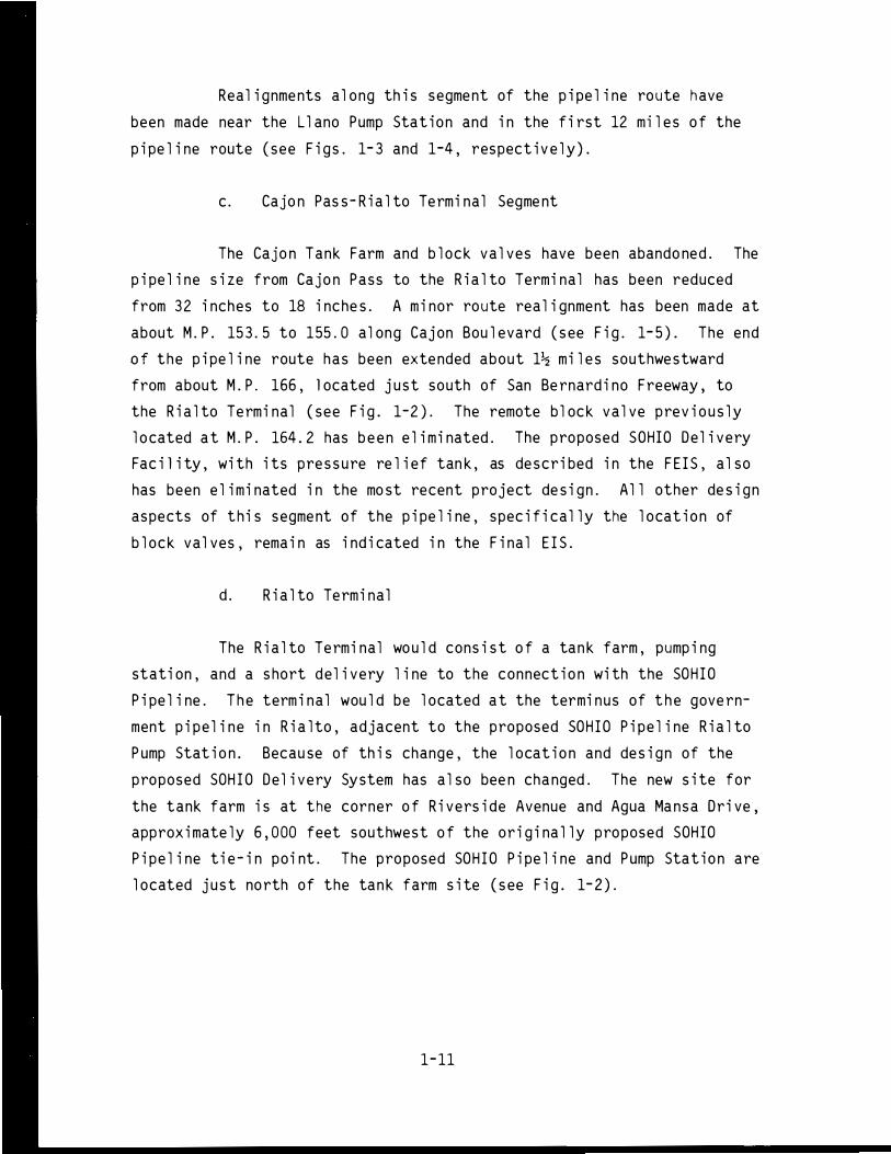
c. Cajo n Pas s-R i a l to Te rmi nal Segme nt
The Cajo n Tank Farm and b l ock va l ves have been abando ned . The
p i pe l i ne s i ze from Cajo n Pass to the R i a l to Termi nal has been reduced
from 32 i nches to 18 i nche s . A m i nor route rea l i gnment has been made at
about M. P . 15 3 . 5 to 155 . 0 al ong Caj on Bou l evard ( s ee F i g. 1- 5) . The end
of the p i pe l i ne route has been exte nded about 1� mi l e s southwe stward
from about M. P . 166 , l ocated j u st south of San Be rnard i no Freeway, to
the R i a l to Te rmi nal ( see F i g . 1-2) . The remote b l ock va l ve prev i o u s l y
l o cated a t M. P . 164 . 2 has b e e n e l i m i nated. The proposed SOHIO De l i very
Fac i l i ty , wi th i ts pre s s u re re l i ef tan k , as de scr i bed i n the F E I S , a l so
has been e l i m i nated i n the mo st recent project de s i gn. A l l other de s i gn
aspects of th i s segme nt of the p i pe l i ne , spec i f i cal l y the l ocat i o n of
b l ock val ves , rema i n as i nd i cated i n the F i na l E I S.
d. R i a l to Te rmi nal
The R i a l to Te rmi nal wo u l d cons i s t of a tan k farm , pump i ng
stati on , and a s hort del i very l i ne to the connect i o n wi th the SOH I O
P i pe l i ne. T h e term i nal wou l d be l ocated a t the termi nus of t h e gove rn
ment p i pe l i ne i n R i a l to , adjacent to the proposed SOH I O P i pe l i ne R i a l to
P ump Stat i o n . Becau se of th i s change , the l ocat i o n and de s i gn of the
proposed SOH I O De l i very System has a l so bee n cha nged. The new s i te for
the tank farm i s at the corner of R i vers i de Avenue and Agua Ma nsa Dr i ve,
approx i mate ly 6 , 000 feet southwest of the or i g i na l l y proposed SOH IO
P i pe l i ne t i e-i n po i nt. The proposed SOH I O P i pe l i ne and Pump Stat i o n are
l ocated j u st no rth of the tan k farm s i te ( s ee F i g . 1- 2) .
1-11

....... I
....... N
Base Map:
Figure 1-4.
Cl)
- --
Old Route
New Route
Realignment - Buena Vista Lakebed
6

Base Map:
------ """"'.- 'l'!-- ---,;:.- ------
0\ // ,,�
--- New Route
Devore Quadrangle, 1966 and San Bernardino North Quadrangle, 1973, 1: 24, 000.
Figure 1-5 . Pipeline Realignment - Cajon Boulevard
1-13

The tank farm fac i l i ty i s dep i cted i n F i gure 1- 6 and wo u l d
conta i n components s i m i l ar to those fo und i n the E l k H i l l s Tan k Farm .
Tota l storage capac i ty wou l d b e 1 , 000 , 000 barre l s wi th two tanks of
250 , 000 barre l capac i ty (40-feet h i gh and 210-feet i n d i ameter) , and one
tan k of 500,000 barre l capac i ty (40-feet h i gh and 300-feet i n d i ameter) .
Suffi c i ent space wou l d be a l l ocated for another 250 , 000-barrel tan k,
a l though i t i s not p resent l y p l anned for constructi o n . As wi th the E l k
H i l l s Tank Farm, c l ean and treated s u rface ru noff wate r wo uld be di s
tri buted to l oca l s urface dra i nage channe l s . F i re water s upp ly wou l d be
provi ded from a l oca l 12- i nch c i ty water mai n wh i c h paral l e l s R i vers i de
Avenue. An aspha l t concrete paved road system wou l d prov i de l ocal
access to a l l b u i l d i ngs , whi l e the fac i l i ty wo u l d be s u rrou nded by a
8-foot- h i gh chai n- l i n k fe nce, except adj acent to the Agua Man sa Cemetery .
A l ong th i s boundary , earth berms and l andscap i ng mater i a l s wou l d be
i n stal l ed to b l oc k the v i ew of the tan k farm from the cemetery . I n
add i t i on , other s hrubbery and l andscap i ng mate ri a l s wou l d b e provi ded to
screen the tan k farm and chai n l i n k fence from p ub l i c v i ew. San i tat i on
fac i l i t i es fo r the bu i l d i ngs wou l d i nc l ude a sept i c tan k and a l each
fi e l d .
P ump i ng equ i pme nt fo r the 2 , 150-foot- l o ng , 36-i nch SOH IO
De l i very L i ne wou l d i nc l ude 2 , 550 i n stal l ed horsepowe r . Th i s wo u l d
prov i de the pump i ng powe r for Phase I operat i ons up to a max i mum capa
c i ty of 597 , 000 B/D . Suffi c i ent space wou l d be a l l ocated fo r the equ i p
ment , i nc l ud i ng 1 , 700 add i ti ona l i nsta l l ed horsepowe r , nece s s ary to
powe r Phase I I operat i ons up to a maxi mum capac i ty of 1 , 100 , 000 B/D . A
p i pe l i ne i ndus try- type crude o i l custody- transfer meter i ng system wo uld
be emp l oyed to record the amo u nt of o i l fl owi ng i nto the SOH IO system .
No i s e barr i ers wou l d be i nc l uded to m i n i m i ze no i s e i mpact.
The R i a l to Termi nal wou l d a l so have provis i o ns fo r m i x i ng
Stevens and Shal l ow Zo ne Crude O i l whe n v i scos i ty ana lys i s i nd i cates a
certa i n l i m i t has been exceeded . The Stevens and Shal l ow Zo ne crude
o i l s co u l d be comb i ned at the te rmi nal boo ster pump stati on or s h i pped
1-14

,.-----
I I
L
GRA.F'HfC SCALE 200' 100 200' iiiiE'lliiiiil"
Source: Pipe Line Technologists, April 1978 .
Figure 1-6. Rial to Tank Fann P l an S i te
1-15
separate l y . The de l i very l i ne wou l d a l so have a chec k va l ve and motor
operated sucti o n gate val ve contro l l ed by the SOH IO contro l l er .
E l ectri ca l powe r for the R i a l to Termi nal wo u l d b e prov i ded by
SCE from an ex i st i ng overhead 66- kV transm i s s i on l i ne near the p roposed
s i te . SCE wo u l d construct a c u stomer substati on and the requ i red wood
po l e transm i s s i o n l i ne to the s ub s tat i o n l ocated on the term i nal s i te .
e . Commun i cati on Sys tem
S i nce the pub l i cati on of the F i na l E I S, more detai l has been
made avai l ab l e for the commu n i cati on sys tem a l ong the p i pe l i ne ro ute .
The fo l l owi ng i s a descr i pti on of the p roposed commun i cati on sys tem.
The p i pe l i ne sys tem wo u l d be provided w i th a h i gh l y re l i ab l e
commun i cati on system cons i st i ng of a government- owned m i c rowave and VHF
rad i o system w ith l eased commerc i a l te l ep hone c i rc u i t s . F i xed s i tes
a l ong the p i pe l i ne route, wh i ch wo u l d have both vo i ce and data commun i
cat i on serv i ce, i nc l ude the two tan k farms and the three p ump stat i ons
( see F i g . 1- 1 ) .
The bac kbone of the commu n i cati on system wo u l d cons i st of a
m i crowave rad i o commu n i cati o n s sys tem that wo u l d conta i n re l ay s tati ons
at the E l k H i l l s Pump Stat i o n , Doub l e Mounta i n, L l ano Pump Stati on,
Ke l l er Pea k , and the R i a l to Termi nal . Commu n i cati on wi th the Tej on P ump
Stat i o n wou l d be a l ateral m i crowave rad i o l i n k from the E l k H i l l s P ump
Stat i o n . S i nce Remote Va l ve No . 1 i s not i n l i ne-of- s i ght from one of
the above-p l anned repeater s i tes, commu n i cati on wo u l d be by a VHF rad i o
l i n k from Doub l e Mo unta i n .
Each repeate r s i te wo u l d have a transm i tt i ng and rece i v i ng
tower . Power for the E l k H i l l s, L l ano , and R i a l to fac i l i t i e s wo u l d be
p rov i ded by ex i st i ng ut i l i ty l i ne s . Because of the i r remote l ocat i ons,
1- 16
power for Doub l e Mo unta i n and Ke l l er Peak wou l d be pro v i ded by ons i te
e l ectri ca l generators . Standby batter i es wo u l d be pro v i ded at a l l
l ocat i on s .
6 . Land Req u i reme nts
There wo u l d be l i tt l e change i n l and requi reme nts as soc i ated wi th
the updated proj ect des i g n . The L l ano Pump Stat i on wo u l d requ i re about
an acre of l and, but th i s wo u l d be offset by the e l i m i nat i o n of the
separate SOH IO De l i ve ry Fac i l i ty . The R i a l to te rm i nal s i te wo u l d be
68 acres, o r about 10 acres l es s than the prev i o u s l y proposed Caj o n Tank
Farm . An addi t i ona l 1- 1/2 mi l es of p i pe l i ne r i ght- of-way wo u l d be
. req u i red for the exten s i o n of the p i pe l i ne from the prev i o us p i pe l i ne
term i nus to the R i a l to Termi na l . However , the proposed access road to
the Cajon Tan k Farm wou l d no l onger be requ i red .
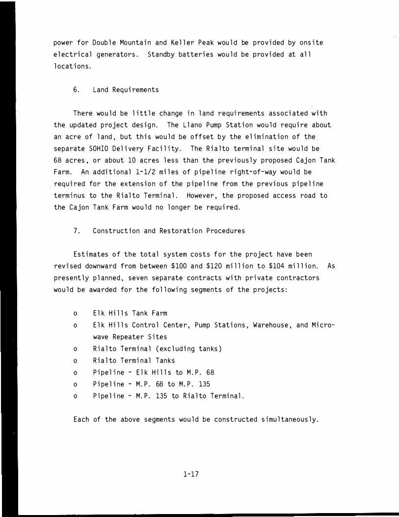
7 . Construct i on and Res to rat i o n Procedures
E st i mates of the total system costs for the project have been
rev i sed downward from between $100 and $120 mi l l i o n to $104 mi l l i o n . As
present l y p l anned, seven separate contracts wi th pr i vate contractors
wo u l d be awarded fo r the fo l l owi ng segments of the p rojects :
o E l k H i l l s Tan k Farm
o E l k H i l l s Co ntro l Cente r , Pump Stat i ons, Warehouse , and M i cro-
wave Repeate r S i tes
o R i a l to Term i na l ( exc l ud i ng tan ks )
o R i a l to Termi na l Tan ks
o P i pe l i ne - E l k H i l l s to M.P . 68
o P i pe l i ne - M . P . 68 to M . P . 135
o P i pe l ine - M . P . 135 to R i a l to Termi nal .
Each of the above segme nts wou l d be constructed simu l taneous ly .
1-17

a . Schedu l e
Pub l i c Law 94-258 states that p i pe l i ne capacity must be
secured by Apr i l 15 , 1979 . I t now appears this dead l i ne cannot be
ach i eved . The l atest est i mate o f the t i me for comp l et i on ( from
eng i neer i ng des i gn to project operati o n ) i s 18 month s .
The construct i on o f th i s project i s dependent on the cons truc
t i on of the proposed SOH IO m i dconti nent p i pe l i ne . Howeve r , the SOHIO
P i pe l i ne has not yet rece i ved a l l the required pe rmits . Anti c i pati ng
the pos s i b i l ity of a del ay i n the NPR-1 project because of its depen
dence on the SOHIO project , the government has requested that Congre s s
con sider amend i ng P . L . 94-258 t o extend t h e deadl ine t o no l ater than
Ap r i l 5 , 1980 , i n order to maxi m i ze f l exib i l i ty in making a dec i s i o n
concern i ng wh i c h p i pe l i ne a l ternat i ve s ho u l d be uti l i zed . I n addit i on ,
an adm i n i strati on-sponsored b i l l that wou l d rev i s e the mandato ry com
p l et i on date to Decembe r 5 , 1980 , has been s ubsequent ly transmi tted to
Congres s . As of th i s wri ti ng ( February 1978 ) , act i o n on th i s b i l l has
not been take n .
b . O rgan i zation and Methods
A l though the DOE has a s sumed overal l re spon sibil ity fo r de
ve l oping and transporting o i l from the N PR-1 , cons truction activ i t i es
wou l d rema i n under the direct control of the O fficer i n Charge of Con
s truction ( O I CC ) , Nava l Facil iti e s E ngineer i ng Command Contracts , E l k
H i l l s , San Bruno , Cal i forn i a .
c . Tan k Farms and P ump Stations
Except for the d i scuss i on of constructio n act i v i t i es at the
Cajo n Tan k Farm , the p revious discuss i o n in the Fina l E IS stil l app l i es .
The proposed acce s s road to the Caj on Tan k Farm wou l d no l onger be
1-18

needed . Cons truct i on at the R i a l to s i te wou l d be con s i derab l y eas i er
than the Cajon Pass s i te becau se of easy acces s . The storage tanks at
the R i a l to Term i nal wou l d be pai nted a l i ght co l or i n orde r to decrease
temperatures i n the tan ks the reby mi n i m i z i ng hydrocarbon emi s s i o n s .
d . P i pe l i ne Construct i on
As me nti oned earl i e r , the E l k H i l l s - to- R i a l to p i pe l i ne would
be cons tructed by three separate p i pe l i ne cr2ws i n three spreads -- E l k
H i ll s to M i l epost (M . P . ) 68; M . P . 68 to M . P . 136. 7 ; and M . P . 136. 7 to
R i a l to . N o other changes have been made i n the actual construct i on
methods as de scr i bed i n the F i nal E I S .
e . Re storati o n
The proposed project des i gn mod i f i cati ons wo u l d not change the
ri ght-of-way c l eanup and restorati o n p l ans de scr i bed i n the fi nal E I S.
f . Abnormal Effects
Usua l cons truct i on safety programs and i nj u ry and damage l i a
b i l i ty i ns urance wou l d be req u i red of a l l contractors . The potenti a l
fo r construct i on-re l ated hazards wo u l d not be affected by the proposed
project des i gn mod i f i cati ons .
8 . Ope rat i o ns and Mai ntenance
a. E l k H i l l s Tan k Farm
The proposed project des i gn mod i f i cati ons wo u l d not change the
ope rat i o n and mai ntenance procedures at the E l k H i l l s Tank Farm as
de scr i bed i n the F i nal E I S .
1-19

b . R i a l to Term i na l
The d i scuss i o n i n the F i nal E IS on the operat i on and mai nte
nance of the Caj on Tan k Farm and SOH I O De l i very System wo u l d now app l y
to the R i a l to Term i nal . The bas i c operat i on of the tan k farm and
de l i very system at the R i a l to Termi na l wou l d be automat i ca l l y contro l l ed
from the Operat i ons Control Center at E l k H i l l s . Two fu l l - t i me em
p l oyees wou l d be as s i gned to the R i a l to Term i nal to perform rout i ne
mai ntenance and to take peri odi c crude o i l samp l es .
c . P i pe l i ne
Operat i o n of the p i pe l i ne , i nc l ud i ng the three pump stat i ons
and remote-contro l b l oc k va l ve s , wo u l d be by the Operat i ons Control
Center at E l k H i l l s . Scraper p i gs fo r c l ean i ng the p i pe l i ne wo u l d be
used i n e s sent i a l l y the same way as descr i bed prev i o u s l y i n the F i na l
E I S ; howeve r , t h e rece i ver and l auncher fac i l i t i es fo rmer l y proposed fo r
the Caj on Tan k Farm s i te have been re l ocated about a m i l e southward to
the f l oor of Caj o n Canyo n , at.M . P . 136 . 7 , at the po i nt whe re the p i pe-
l i ne d i amete r narrows from 24 i nches to 18 i nc hes . Thus , the E l k H i l l s
to- Caj on ( M . P . 136 . 7 ) segment of the p i pe l i ne wou l d be c l eaned by i nsert i ng
a sc raper p i g at E l k H i l l s and retr i e v i ng it at M . P . 136 . 7 . The Cajon-to
R i a l to segment wou l d be c l eaned by i nsert i ng a scraper p i g at M . P . 136 . 7
and retr i ev i ng i t at the R i a l to Term i nal .
9. Pe rsonne l Req u i rements
a . Construct i o n Acti v i t i e s
Construct i o n c rew req u i rements have bee n mod i fi ed s l i ght ly
from those i nd i cated i n the F i na l E I S . The est i mated average c rew s i ze
dur i ng the cons truct i on peri od wo u l d be as fo l l ows :
1-2 0

Tab l e 1-1
CONSTRUCT ION P ERSONN EL
C rew Type Ave rage C rew S i ze
E l k H i l l s Tank Farm 50
Operat i ons Control Cente r 40
Tejon and L l ano Pump Stati ons , 25 each 50
M i c rowave Repeate r Stat i on 20
R i a l to Termi nal 75
P i pe l i ne , 3 c rews 480
Engi nee rs/I nspectors 40
Source : Marmac Eng i neers
A l l construct i on wou l d be performed s i mu l taneous l y .
b . Operati o n
A tota l of 3 8 fu l l - t i me ope rati ng personne l wou l d b e emp l oyed
as s hown i n Tab l e 1-2 . Th i s rep resents an i ncrease of seven over the
est i mate conta i ned i n the F i na l E I S . T h i rty- fi ve peop l e wou l d be
emp l oyed at the Operat i ons Contro l Center at E l k H i l l s . One p ump s ta
t i on ope rato r wou l d se rve both the Tej on and L l ano Pump Stati ons ; and
two termi na l ope rato rs wou l d be emp l oyed at the R i a l to Termi na l on a
norma l 40- hour , wo rk-week bas i s .
10 . Mothbal l i ng P rocedures
No changes have been made i n the mothbal l i ng p rocedures descr i bed
i n the F i na l E I S .
1- 21

Tab l e 1-2
OPE RATING PE RSONNE L REQU I RED
Operat i ons Control Center
P i pe l i ne System Manager Mai ntenance Manager P i pe l i ne Eng i neer Safety Eng i neer Operat i ons Manager
P i pe l i ne Mai ntenance S uperv i sor E l ectri cal Mai ntenance S uperv i sor Commu n i cati ons Mai ntenance Superv i sor Mechan i ca l Mai ntenance Superv i sor Warehouseman
Ch i ef D i spatcher D i spatchers Schedu l er Operat i ons Superv i sor Term i na l Operator (El k H i l l s )
P i pe l i ners We l der E l ectri c i ans Commu n i cati on Techn i c i ans Mechan i c s Secretari e s
F i e l d Operat i ons
Pump Stat i on Operator R i a l to Term i nal Operators
Total
Sourc e : P i pe L i ne Techno l og i s ts, 1978.
1-22
1 1 1 1 1
1 1 1 1 1
1 5 1 1 1
6 1 2 2 2 3
1 2
38

11 . Abandonme nt P rocedu re s
N o changes have been mde i n the abandonment p rocedures de scri bed i n
the F i nal E I S .
12 . R i s k Asses sme nt
The fo l l owi ng d i scus s i o n i s l i mi ted to s i gn i fi cant changes i n the
p rev i o u s l y i dent if i ed ri s ks due to project change s . The major c hanges
affect i ng the r i s k asses sment are : the re l ocat i on of the tan k farm from
the Caj on s i te to R i a l to ; m i nor mod i fi cat i o ns i n the ro ut i ng of the
p i pe l i ne and i ts extens i o n to the R i a l to s i te ; and the overa l l reduct i on
i n p i pe s i ze throughout the enti re l e ngth of the p i pe l i ne .
a . Tan k Farm
The re l ocat i o n of the tan k farm to the R i a l to s i te has , over
a l l , reduced the r i s ks as soc i ated wi th f i re and/o r exp l os i on ; the r i s k
of s p i l l s i s l i tt l e changed . At the R i a l to s i te the tanks wo u l d be
i ndi v i dual l y d i ked with s uff i c i ent capac i ty to conta i n the enti re con
tents of each tank p l us 1 0 percent ove rage , s uff i c i ent to conta i n any
pos s i b l e sp i l l .
The use of fl oat i ng- roof tanks , wh i c h have the best fi re safety
record i n the i ndustry ( see the E l k H i l l s/SOH IO F E I S , Append i x D) , i s
expected to m i n i m i ze the pos s i b i l i ty of fi re occu rre nce. Each tan k wi l l
be equ i pped w i th s h unts from the f l oat i ng-roof to the tan k to a l l e v i ate
poss i b l e l i ghtn i ng - assoc i ated i gn i t i o ns , the most common source of
f i re i n fl oati ng- roof tan ks . If , desp i te th i s p rotecti on , a fi re occu rs
(fo r examp l e , from a d i rect l i ghtn i ng stri ke - a very u n l i ke l y eventu
a l i ty) , the fi re wou l d be l i m i ted to the seal area . ( Seal fi res are
typ i ca l l y very s l ow burn i ng and , once detected , are often ext i ngu i shed
wi th hand he l d dry powder u n i ts) . Each tan k wi l l be protected by f i xed
1-23

foam outl ets around the top of the tan k ; 3 percent foam wi l l be s upp l i ed
from a central foam generat i ng sys tem wh i ch can a l so be s upp l i ed from
truc k mo unted foam gene rato rs . A foam dam wi l l be emp l aced around the
peri p he ry of the fl oati ng- roof to i ns ure foam retenti on on the sea l
area .
The second most common cause of f i re i n and about fl oati ng- roof
tan ks i s from tank overfi l l ing. To m i n i m i ze this pos s i b i l i ty , each tan k
wi l l have a h i gh l eve l a l arm wh i c h, when tr i gge red, wil l s h ut down the
incom i ng product p ump and , s i mu l taneou s l y , sound an audi b l e a l arm at the
Superv i s ory Contro l Center at E l k H i l l s. A second h i gh- l eve l a l arm wi l l
a l so be prov i ded wh i ch , i f tri gge red , wi l l sound an a l arm at E l k H i l l s
and a l so a l e rt the R i a l to F i re Department d i spatcher 1 s office . I n the
most u n l ike l y case that , despi te these redundant systems , the tank
overfl ows , the c rude o i l wou l d be reta i ned wi th i n the d i ked area ( b ut
dra i ned away from the tan k itse l f) where it cou l d be co l l ected. If a
sp i l l were to i g n i te, the fl ame s cou l d be contro l l ed by mob i l e foam
un i ts wh i ch can read i l y reach any of the tan k s i tes . As add i t i onal
precautions , a l l contro l va l ves and i n strume ntat i o n wi l l be p l aced
outs i de of the d i ked areas and a l l p i p i ng l ead i ng to the tank wi l l be
protected , u s ua l l y by buri a l .
Pontoon-type fl oating- roof tanks exposed to sea l f i res have , i n a
few cases due to poor con struct i o n pract i ces and/or imp roper fi refight i ng
tech n i ques , res u l ted i n i nvo l vement of the entire tan k s u rface i n fi re .
To pre c l ude s uc h a pos s i b i l ity eac h fl oati ng- roof tank wil l use a n umber
of a i r- t i ght pontoo ns wh i ch cannot become part i a l l y or fu l l y fi l l ed w ith
oil or wate r , t h u s e l i m i nating the maj or cause for roof s i n kings . As an
add i tiona l p recaut i o nary meas ure , the co ntents of any tan k can be removed
at a rate of up to 20 , 000 barre l s/hr . (Genera l l y u ncontro l l ed fi res i n
l arge tan ks depend on fue l dep l et i o n as the majo r fi re contro l mechan i sm ) .
1- 24

I n an uncontro l l ed fi re the radi ati on from the f l ames can
i gn i te adjacent tan ks , if the d i stances are smal l . At the R i a l to Tan k
Farm the tan ks are schedu l ed to be app rox i mate l y 1- 1/2 tan k d i ameters
( 300 feet) apart wh i ch i s co n s i dered mo re than adequate to m i n i m i ze
radiati o n effect s . However , i f necessary , tank she l l coo l i ng can be
p rov i ded by pumpers from nearby fi re stat i ons u s i ng f i xed nozz l es .
Water and foam add i t i ves are e ssenti a l resources for f i ghti ng
fi res . At R i a l to the m i n i mum quant i t i es s uggested by code ( N F PA 11 , 30)
fo r f i re protecti on of the 500, 000 barrel tank are as fo l l ows :
Tan k
Hydrant
She l l Cool i ng
Total
Water ( ga l l o ns pe r mi nute)
300
150
1,500
1, 950
Foam Concentrate
( ga l l o n s )
180
135
315
The R i a l to Tan k Farm expects to obtai n water from one o r more
ma i ns run n i ng near the prope rty . The water supp l y wi l l exceed mi n i mum
s ugge sted quant i ti es and be adeq uate to meet ant i c i pated peak demands
p l u s a marg i n of safety . Li kewi se , on- hand foam supp l i es wi l l exceed
m i n i mum s ugge s ted quant i t i es app rec i ab l y .
I n the extreme l y u n l i ke l y eventua l i ty that fi re s hou l d spread ,
add i t i onal foam and l i ght water capab i l i t i e s are avai l ab l e from nearby
fi re departments ( i nc l ud i ng the R i a l to F i re Dep artment and the Marc h and
No rto n A i r Force f i re departments ) whose capabi l i t i e s are s hown i n
Append i x 0 . No f i re trucks wou l d be kept at the tan k farm i tse l f .
The recent fi re a t the Southern Pac i f i c P i p e l i ne tan k farm o n
February 21, 1978, near the p roposed R i a l to Tan k Farm p rov i des add i
t i ona l va l uab l e i nformati on o n the fi refi ghti ng capab i l i t i es i n the
1- 25

R i a l to area . I n th i s l arge fi re , wh i c h i s de scr i bed i n Append i x D , the
ava i l ab l e water and foam resources we re more than adequate .
b . P i pe l i ne
The new de s i gn ca l l s fo r a 24- i nch p i pe from E l k H i l l s to
Caj on Pas s and an 1 8- i nch p i pe from there to the R i a l to Te rmi na l ; these
rep re sent substant i a l decreases i n p i pe s i ze over p rev i o us des i gn , but
wi th the same throughput of 250,000 barre l s per day . P r i mar i l y as a
re s u l t of th i s decreased p i pe s i ze , and seco ndar i l y because of add i
t i ona l remote- contro l va l v i ng i n the l i ne and at other contro l po i nts
s uch as p ump s tat i ons , the des i gn sp i l l has been reduced s ub s tanti a l l y . *
I n the 24- i nch l eg of the p i pe l i ne , the des i gn sp i l l has bee n
reduced by app roxi mate l y one-th i rd i n most cases ; and i n the 1 8- i nch
segment , wh i c h pas ses through the most pop u l ated areas , reduc t i o n i s
from 5 0 to 70 percent . The des i gn sp i l l fo r th i s rout i ng i s s hown i n
F i gure 1- 7 .
The sp i l l repo rt i ng and contro l measures , wh i c h we re adequate
i n most cases under the p rev i ous des i gn , are st i l l cons i de red adequate
under the present des i gn cr i teri a . Howeve r , p resent schedu l i ng of
construct i on i nd i cates that the p i pe l i ne and the R i a l to Tan k Farm wi l l
be avai l ab l e fo r operat i on p r i o r to the comp l et i on of the Superv i s ory
Contro l System . Hence , as i nte ri m m i t i gati ng measures unt i l the Super
v i sory Control Sys tem can be comp l eted and tested , the p i pe l i ne route
*De s i gn sp i l l i s based on the wo rst credi b l e case , wh i ch ass umes a comp l ete b reak i n the p i pe w i th comp l ete drai nage of a l l up h i l l s ecti ons of the p i pe p l u s that o i l l ost pr i or to s hutdown . I n th i s case , app l i cab l e val ues used are : a 24- i nch p i pe l i ne conta i ns 2 , 957 barre l s per m i l e and an 18- i nch p i pe l i ne 1 , 663 barre l s per m i l e . Remote l y contro l l ed va l ves are ass umed to be c l osed wi th i n 10 m i n ute s of a maj or break causi ng a tota l l os s p r i o r to shut down of 1 , 700 barre l s . Man ual b l oc k va l ves are ass umed to b e c l osed wi th i n 2 hours , p reventi ng further drai nage from up h i l l port i ons of the l i ne after that t i me .
1-26

I-' I
N -.....!
5000 .µ
� 4000 LL.
.. § 3000 .....
.µ ro � 2000
..--w
1000
Tejon Pump Sta ti on °"'-
R
Cal if. Aqueduct I
B+B
� B+C
KEY:
California Aqu,duct
Llano Pump B+C+B Station
B R
- Block Valve R#4+B� Remote Valve Check Valve Rialto Terminal R
01 I I I I I I I I I I 4 � � I I I I 1 A AA X?< A n FX 2'h 9X nn ffR i nX , " i n i X 140 150 160 V1
.--Cl) � � ro
co 4--0
70
60
� 50 c ro V1
6 40 _c I-
.,... Q_
(/)
c O"l
V1 Cl)
0
30
20
10
Milepost
0 ' lo 2
10 30 4D-
· �lo - 610 io a'o g'o l oo 11 o - ,- • L- - L - ! - - :_ ·
Milepost
Source: Pipe Line Technologists, Inc. and URS Company.
Figure 1-7 . Design Spill for Elk Hills, to SOHIO Pipeline

wi l l be overfl own twi ce a wee k and a man wi l l be on duty at the R i a l to
Tan k Farm at any t i me when fi l l i ng i s p roceedi ng and vo l ume exceeds
80 percent of tan k c apac i ty .
A 36- i nch p i pe l i ne o f app roxi mate l y 2, 000 feet wo u l d carry o i l
from the R i a l to Tan k Farm to the SOH I O connect i o n . The des i gn sp i l l o n
th i s l i ne was not determ i ned s i nce th i s l i ne i s ent i re l y o n pr i vate o r
government-owned prope rty so that contro l over th i rd party acc i dents
( the most p robab l e cause) i s very t i ght . Smal l er l ea ks wou l d be detected
by rout i ne i nspect i on of the tan k farm fac i l i ty .
13 . Other Fede ral Acti v i t i e s
I n add i t i o n to tho se fede ral acti v i t i e s menti oned i n the F i nal E I S,
the p roposed p roject mod if i cati ons wou l d affect the U . S . Forest Serv i ce .
The p roposed m i c rowave tower a t Ke l l e r Peak wou l d b e l ocated wi th i n the
San Be rnard i no Nat i ona l Forest .
1-28

A . Geo l ogical Resources
1 . P hysiograp hy
I I . E X I ST I NG ENVI RONMENT OF P ROPOSED S I TE
No s i gnif i cant change$ from the d i scussion i n the Fina l E I S are re
q u i red . References t o the Caj on Tank Farm n o l onge r app l y . The pro
posed R i a l to Term i na l wou l d be l ocated on the near l y l eve l a l l u v i a l
p l a i n o f the San Be rnard i no Val l ey . The e l evat i on a t the termi nal s i te
i s approxi mate l y 930 feet .
2. Areal Geo l ogy/Strati graphy
The proposed R i a l to termi nal s i te and the p i pe l i ne exten s i o n route
from M . P . 164 to the R i a l to Termi na l are underl a i n by th i c k a l l uv i a l
sed i ments of Ho l ocene and P l e i stocene age . The northern end of the s i te
i s covered wi th a th i n l aye r of l oose w i nd- b l own sand , the rema i nder of
the s i te i s covered by o l der , mo re compact a l l uv i um . The sed iments gen
e ra l l y become more compact wi th depth .
3. Soi l s
The s o i l s at the R i a l to termi nal site and a l ong the pipe l i ne route
from M . P . 164 to the termi nal are genera l l y part of the s o i l assoc i at i on
composed of Hanford coarse sandy l oam and D e l h i f i ne sand ( U . S . S o i l
Conservat i on Survey , 1971 ) .
2- 1

4. M i neral Re sources
Sand and grave l have been and . s t i l l are be i ng m i ned i n the v i c i n i ty
of the R i a l to termi nal s i te . G rave l p i ts occ ur j ust northeast of the
p roposed SOH I O P ump Stat i on and on the we st s i de of R i vers i de Aven ue ,
j ust across from the R i a l to term i nal s i te . I t i s as s umed the a l l uv i a l
s ed iments under ly i ng the termi nal s i te wo u l d a l so b e s u i tab l e a s a
so urce of sand and grave l .
5 . Un i que Geo l og i ca l Features
No known u n i que geo l og i ca l features occ ur at the l ocat i on of the
proposed p roject mod if i cati ons .
6 . Se i s m i c Sett i ng
The p roposed project mod i f i cat i o ns, part i c u l ar ly the re l ocati on of
the Caj on Tan k Farm to the R i a l to s i te, have necess i tated an expanded
d i s c us s i o n of the s e i sm i c sett i ng i n the San Bernard i no- R i vers i de area.
The fo l l owi ng i s a s ummary of the more deta i l ed s e i smi c sett i ng di scus
s i o n conta i ned i n Appendi x F .
a . Local Fau l t Tecto n i cs
The San Bernardi no- R i vers i de area l i es about 10 m i l es south
east of a major b i furcat i o n i n the San Andreas fau l t system . The no rthe rn
branch, named the San Andreas fau l t, tre nds east- southeastward a l ong the
southern fro nt of the San Bernard i no Mountai ns . The southern b ranch of
the San Andreas system, named the San Jac i nto fau l t, i s at l east equal
in tecto n i c i mportance . I t compri ses a band of paral l e l and en eche l on
traces that trends so utheastward from the v i c i n i ty of Caj on Pas s and
crosses the so uthwest corner of the C i ty of San Bernard i no ( F i g. 2- 1).
Recent s u rface b reaks and ev i dence fo r fau l t acti v i ty a l ong the San
2-2

R. IA f. T O
. � .. • . . � · · : . . �·-. -...,:·;:. · ..
·. .. . . . . .
r-A R. 1'¥1 --- "' ..
• '
• '
. . . : · ·
3 3° 00
\ LEGEN D:
----=::- Quaternary Faul t
---- Other Fau l t
· · · · · · · Concea 1 ed Fau l t ? . . . . . ? Possib l e Faul t
( Groundwater Barrier)
Sou rces: Jenni ngs
I 0
... U) - .
0 " ' - · - · I
E"3
e mil es
E3 I 5
9 63 .
• •
• •
• •
Figu re 2- 1 . Faul ts and Ground water Barriers in the Vici nity of the Rial to Tank Farm Site and Pi pel ine Connecti on
2-3
1 0

Jaci nto fau l t zone from Caj on Pass to the Imper i a l Val l ey have been
mapped by Sharp ( 1972) . Geomo rph i c ev i de nce fo r Ho l ocene moveme nt
(yo unger than about 10 , 000 years ) i s abu ndant a l ong both the San Andreas
and San J ac i nto fau l t zones, demo nstrat i ng conti n u i ng defo rmati on .
H i stor i c movement a l ong the San Jac i nto fau l t zone has been
documented by geodeti c measurements across the fau l t zone i n San Bernard i no
( U . S . Departme nt of Comme rce, 1971) , by repeated road repa i rs and ground
settl eme nt i n San Jac i nto Val l ey 25 m i l es southeast of the R i a l to s i te
( Fett et a l . , 1967 ; and Procto r , 1962), and by earthquake occu rrences
and gro u nd ruptu res, espec i a l l y neare r the southe rn end of the fau l t
zone i n the Imper i a l Va l l ey reg i on ( Jenn i ngs, 1975 ) .
b . Fau l t Rupture and Fau l t C reep Hazard
Wi th the except i o n of the proposed powe rl i ne to se rve the
Tej o n Pump Stat i on , none of the p roj ect mod i fi cati ons wou l d be s ubject
to fau l t ruptu re hazard . The weste rnmost th i rd of the powe rl i ne to
serve the Tej on Pump Stat i on co i nc i des wi th the trace of P l i eto fau l t, a
thrust fau l t that has been act i ve i n Quaternary t i me and thus i s con
s i dered potent i a l l y act i ve ( Jenn i ngs , 1975 ) . Because of the i rregu l ar
surface trace of th i s no rthward thrus t i ng fau l t , fau l t rupture hazard
shou l d be co n s i dered po s s i b l e over a cons i derab l e wi dth of the fau l t
zone . Powe r po l es fou nded on s uch a fau l t trace cou l d not be protected
aga i n s t damage s hou l d renewed movement occur .
c . Se i sm i ca l l y I nduced G round Fai l ure
Cond i t i ons i n the v i c i n i ty of the R i a l to term i nal s i te are
con s i dered to be genera l l y favo rab l e to stab i l i ty dur i ng strong s hak i ng
because of the near l y fl at topography and a usua l l y l ow groundwater
tab l e . Neverthe l ess , the res u l ts of geotech n i ca l stud i es wi l l be used
fo r fo u ndat i o n de s i gns . It i s expected that the s ame ge neral conc l u s i ons
fo r gro u nd s tab i l i ty app l y to the L l ano p ump s tat i on s i te u n l e ss detr i
mental cond i t i ons s uch a s s ha l l ow ground water are detected duri ng s i te
2-4

deve l opment geotechn i ca l stud i es , i n wh i ch cas e there may be a potenti a l
fo r l i q uefact i o n fo r wh i c h fo undat i on des i gn s wi l l have t o cons i de r .
d . Strong G round Mot i o n
The expected peak hori zontal acce l erat i ons at the R i a l to
term i na l s i te are e st i mated at 0 . 2g fo r a 25-year pe ri od and 0 . 4g for a
50-year pe r i od . The s i te shou l d be expected to exper i ence gro und acc l era
t i ons of O . lg and greate r on an av erage of more than once per year .
These est i mate s have been made us i ng a p robab i l i st i c analys i s and are
con s i derab l y greate r than the actual h i stor i ca l record ( s i nce 193 3 ) i n
the v i c i n i ty i nd i cate s ( see Append i x F fo r further exp l anat i on ) .
The source of most strong ground mot i on that wo u l d be expe r i
enced i n R i a l to wo u l d be from earthquakes generated a l ong the San Jaci nto
fau l t , the southern b ranch of the San Andreas fau l t system that l i e s
abour 4 m i l e s northeast of the R i a l to term i nal s i te . At l east seven
l arge ( magn i tude 6 o r greater) earthquakes have occurred i n the San
Jac i nto fau l t zone duri ng the past century ( see Tab l e 2- 1 ) . The fi rst
fo ur events l i sted i n Tab l e 2-1 occurred i n the northern sect i o n of the
fau l t zone , wh i l e the rema i n i ng three events occurred i n the southern
sect i on of the fau l t zo ne , farther from the R i a l to term i na l s i te .
7. Nonse i sm i c Constra i nts
The p roposed proj ect mod i fi cat i on s wou l d not res u l t i n any new or
rev i sed nonse i smi c geo l ogi c constrai nts . The d i scuss i o n contai ned i n
the F i na l E I S st i l l app l i e s .
2-5

Tab l e 2- 1
LARGE H I STOR I C EARTHQUAKES O F THE SAN JACI NTO FAULT ZON E
Event
San Jac i nto
San Jac i nto
San Jac i nto
San Bernard i no
Terwi l l i ger Va l l ey
Santa Rosa Mounta i ns
Borrego Mounta i n
B . A i r Res ources
1 . C l i mate
Date
1890 Feb . 9
1899 Dec . 2 5
1918 J u l y 1 4
1923 J u l y 22
1 93 7 Mar. 2 5
1954 Mar. 19
19 68 Apr . 8
Mag n i tude
6. 8
6. 2
6. 0
6. 2
6. 4
Length o f S u r f ace Rupture
(m i l es)
1 0
1 7
The d i scuss i on o f c l i mate i n the Cajon Canyon area i s no l onger of
maj o r i mportance because o f the tan k farm re l ocat i o n . However , the
desc r i pt i o n i s correct and requ i res no changes . The San Joaqu i n Va l l ey
des c r i p t i o n rema i ns pert i nent and correct .
The R i a l to s i te i s l ocated wi th i n the San Bernard i no Val l ey . The
c l i mate o f the San Bernard i no Va l l ey i s c haracteri zed by warm, dry
s ummers and coo l , wet wi nters . Summert ime wi nds average about 4 m i l es
per hour preva i l i ng from the wes t . The gent l e wi nds, i n comb i nat i on
wi th frequent and pers i s tent i nvers i o n condi t i o n s , trap and co ncentrate
2- 6

po l l utants emi tted at ground l eve l . The s u n acts upon the se trapped
po l l utants (ma i n l y reacti ve hydrocarbons and oxi des of n i trogen ) to
photochemi ca l l y produce h i gh co nce ntrati ons of oxi dants .
The maj or d i rect i o n of po l l utant transport appears to be eastward
toward the Bann i ng Pass area , a l though another di rect i o n i s through the
Cajon Pas s . Wi nds are typ i ca l l y stagnant i n the s umme r mo nths from
early mo rn i ng unti l about noon when the sea breeze reac hes the San
Bernard i no- R i vers i de area .
A mo re detai l ed d i scus s i o n of the c l i mate i n the San Bernard i no
Val l ey i s p rese nted i n Append i x G .
2 . A i r Qual i ty
The pass age of the C l ean A i r Act Ame ndme nts of 1977 i ncorpo rated
several c hanges i n a i r qual i ty regu l ati ons . These changes i nc l ude :
statutory req u i reme nts for em i s s i o n offs ets and Prevent i o n of S i gn i fi
cant Deter i orat i o n (PSD ) as part of the req u i red New So urce Rev i ew (NSR )
procedures ; de l ays i n au tomoti ve emi s s i ons standards (except Cal i f
orn i a ) ; new attai nme nt schedu l es fo r State Imp l eme ntat i o n P l ans (S I P s ) ;
and the req u i reme nt for fede ral agenc i e s to comp l y wi th s ubstant i ve and
adm i n i strat i ve req u i reme nts of state and l ocal agenc i es . A mo re de
tai l ed d i scus s i o n of the new ame ndme nts are presented i n Appendi x H .
Re l ocat i o n of the Caj on Tan k Farm to the R i a l to s i te nece s s i tated a
d i scus s i o n of ai r qua l i ty i n the San Bernard i no Val l ey po rti on of the
South Coast A i r Bas i n . The major a i r qua l i ty prob l em i n thi s area i s
oxi dants . Standa rds are exceeded we l l over 1 00 days each year at San
Bernardi no , R i vers i de , Red l ands , Ban n i ng , and Fontana . The oxi dant
l eve l s at each stat i o n are a re s u l t of l ocal so urces and transport from
other parts of the a i r bas i n . The s ummer months (May through September)
are the mo st prone to exces s i ve oxi dant l eve l s.
2 - 7

Future a i r qua l i ty i n the San Bernard i no Va l l ey i s h i gh l y depe ndent
upon the contro l strateg i es i n the enti re South Coast A i r Bas i n . I n
ge neral , automob i l e emi s s i on contro l dev i ce s are expected to reduce
hydrocarbon emi s s i ons unti l 1995 when growth i s expected to overcome the
be nefi t of emi s s i on contro l dev i ces .
A more deta i l ed d i scus s i o n of the San Bernard i no Va l l ey a i r qua l i ty
i s presented i n Append i x I .
C . No i se
No s i gn i fi cant change to the F i nal E I S d i scu s s i o n on the no i se
env i ronment i s req u i red . Some short- te rm no i se i mpacts wou l d ex i st
duri ng cons truct i o n ; howeve r , s i gn i f i cant l ong- term no i se i mpacts wou l d
ge nera l l y be negl i g i b l e because of the i ndustr i a l c haracte r of the area
adjacent to the tank farm . The o n l y poss i b l e excepti o n wou l d be the
homes nearest to the p ump stati o n at the i nte rsect i o n of R i vers i de
Avenue and Agua Mansa Road ( see F i g . 1- 6 ) .
0. Water Resources
S i nce a l l of the propo sed mod i f i cat i o n s occur wi th i n the study area
defi ned by the project ' s F i nal E I S , the water resources sett i ng p re
se nted i n that docume nt i s s uffi c i ent for th i s ana lys i s .
E . B i o l ogi ca l Re sources
1. Vegetat i on
The p i pe l i ne corri dor fo r the proposed modi f i ed route traverses
l and that i s essent i a l l y the same as that descri bed i n the F i na l E I S . A
few of the changes are b i o l og i ca l l y s i gn i fi cant , howeve r .
2- 8

The p roposed rea l i gnment around the southern s ho re of the Buena
V i s ta l akebed pas ses very near and may i mp i nge upon a popu l at i on of
cotton eri ogo num ( E ri ogonum gos sypi num) i n SE� Secti o n 6 R25 E , T32S .
T h i s p l ant i s i nc l uded i n the rare p l ant i nventory of the Ca l i forn i a
Nati ve P l ant Soc i ety ( Powel l , 19 74 ) , but i s not o n any federal l i st .
South of S l over Avenue , between M . P . 1 63 and M . P . 1 64 , the corri dor
c ro s ses a d i sturbed f ie l d that conta i ns el ements of Annual Gras s l and and
Coastal Sage commun i t i es, as def i ned i n the Append i x .
The R i a l to Tan k Farm wou l d occupy a d i s tu rbed f ie l d of Annual
G ras s l and, i n contrast to the sen s i ti ve , undi s turbed ecotona l desert
val l ey of the Caj on Tan k Farm .
2 . W i l d l i fe
There are no s i gn i fi cant d i fferences between the wi l d l i fe envi ro n
ment d i scussed i n the F i na l E I S , and that i n the v i c i n i ty of the pro
posed mod if i cati o n s .
3 . Aquat i c B i o l ogy
A l l of the propo sed mod if i cati ons occur wi th i n the study area are
descr i bed i n the project F i nal E I S . Thus , the basel i ne d i scus s i o n
p resented i n that doc ument i s s u i tab l e for th i s ana l ys i s .
4 . Eco l ogi ca l Re l ati o n s h i p s
The p roposed project mod i f i cati on s wou l d n o t a l ter the eco l ogi ca l
rel at i on s h i p s as p rev i ou s l y d i s c u s sed i n the F i na l E I S .
F . Archaeo l og i ca l , H i s tor i ca l , and Other C u l tural Resources
In add i t i o n to the d i scuss i o n contai ned i n the F i nal E I S, a
descri pt i on of the archaeo l ogi ca l and h i s tor i cal condi t i ons at the
2- 9

R i a l to term i na l s i te and the p i pe l i ne exten s i o n from M . P . 1 64 are b r i e f l y
d i scus sed here . A more comp l ete d i scus s i o n i s conta i ned i n Append i x N .
1 . Archaeo l og i ca l Resources
The proposed p i pe l i ne extens i o n to the R i a l to Te rmi na l and the
R i a l to Termi na l s i te l i e wi th i n the regi on pop u l ated by Shos honean
speaki ng Se rrano and Cah u i l l a I nd i an groups duri ng preh i stor i c t i mes .
These peop l e s we re essent i a l l y hunters and gatherers , and emp has i zed
seed gather i ng and proces s i ng . Archaeo l og i ca l s i tes i n th i s reg i o n
re f l ect these acti v i t i e s and are general l y i n the fo rm of gri nd i ng
stati ons ( seed- p roces s i ng s i tes) .
Several archaeo l og i ca l s i tes have been reco rded i n the Santa Ana
R i ver/J urupa Mounta i n area . I n the i mmed i ate v i c i n i ty of the proj ect
s i te, n i ne archaeo l og i ca l s i tes have been recorded . A c l ose fi e l d
exami nat i o n o f the project s i te, i nc l ud i ng a n a l te rnate s i te fo r the
R i a l to Termi na l j ust north of the s e l ected s i te ( s ee Append i x N, Map 1 ) ,
revea l ed no s urface ev i dence o f the ex i s tence o f any archaeo l og i ca l
res ou rce s wi th i n the bo undar ie s of the proposed project areas . It must
be rea l i ze d , howeve r , that a potenti a l a l ways exi sts for the occurrence
of undetected, s ub s urface rema i ns at any of the project l ocat i o n s .
A pre l i m i nary eva l uat i o n , based on the cr i te r i a prese nted i n the
Fede ral Reg i s ter ( Vo l . 40, No . 24, 1 975 , " P rotect i o n of P ropert i e s i n
the Nati ona 1 Regi ster; P rocedures fo r Comp 1 i ance , 11 and Vo 1 . 42 , No . 1 83 ,
Part 63 , 1 977 , " Determi nat i o n of E l i g i b i l i ty for I nc l u s i o n i n the Nati ona l
Reg i s ter o f H i stor i c P l aces ") , s ugge sts that none of the archaeo l o gi ca l
s i tes l ocated in the v i c i n i ty of the propo sed project wou l d qua l i fy for
nom i nati on to the Nat i ona l Reg i s te r of H i stor i c P l ace s . A l though the
referenced archaeo l og i ca l resources do not appear to be of s uffi c i ent
s i ze and c u l tura l comp l ex i ty to warrant s uch cons i derat i o n , i t must be
noted that a l l these archaeo l og i ca l s i tes potenti a l l y conta i n u n i que
2-10

data wh i ch cou l d contri b ute to the overa l l understand i ng of the pre
h i story of the Santa Ana R i ver area . The refore, i t must be understood
that the preservat i o n of the se nonrenewab l e c u l tural resources i s of
utmost i mportance .
2 . H i stor i ca l /Cu l tural Resources
A rev i ew of the Nat i onal Reg i ster of H i sto r i c P l aces i nd i cates that
no h i stor i ca l l y s i gn i fi cant features or structures are c urre nt ly l i sted
w i t h i n the i mmedi ate v i c i n i ty .of the defi ned R i a l to project areas .
However, a Regi s tered Cal i forn i a H i stor i c Landmark ( N o . 1 2 1 ), known
as Agua Mansa , i s l ocated i mmed i ate l y adj acent to the p roposed R i a l to
Tan k Farm l ocat i o n . Agua Mansa wh i ch cons i s ts of the Agua Mansa Cemete ry
has been recogn i zed as an h i stori cal l y s i gn i fi cant l andmark of the San
Bernard i no County area ; recogn i t i o n of the re l at i ve h i stor i c i mportance
of th i s cemete ry i s p resented i n prev i ou s l y refe re nced docume nts (Sm i th,
1 97 3 ; Jones, 1 97 3 ; Whel an, 1 973 ; and Love l ace, 1 973) , and by the State
H i sto r i c Landmarks des i gnati o n . Based on the cr i teri a presented i n the
above- c i ted Federal Reg i s ter, i t i s conce i vabl e that the Agua Mansa
Cemete ry wou l d qual i fy for nom i nat i on to the Nat i onal Reg i s te r of
H i stor i c P l ace s .
The Santa Ana R i ve r/Agua Mansa area was sett l ed i n the 1 840 1 s by
farme rs from New Mex i co . The sma l l commu n i ty wh i ch deve l oped was a n i m
portant front i e r outpost and served as a stopover for east/we st trav
e l e rs . The Agua Mansa commu n i ty f l our i shed unt i l 1 862 when a f l ood
destroyed the major i ty of the commun i ty . The or i g i nal Agua Mansa ceme
tery l ocati on may we l l have been destroyed at that t i me and the present
cemetery area may refl ect the postfl ood l ocati on estab l i shed by res i
dents of the area ( Patterson, 1 978) . Whether o r not th i s feature was
s i tuated at i ts p resent l ocati on -- above the Santa Ana R i ve r fl ood
p l a i n -- at the t i me of the refe renced f l ood i s an academ i c matte r . I t
2-11

is certa i n that the use of this cemete ry dates bac k to the m i d- 1 800 ' s
and conti nued i nto the ear ly 20th century by both H i span i c and Ang l o
res i dents of the area . Today , th i s feature stands as a d i s t i nct monu
ment to the ear ly h i s to ry of th i s area , and cont i n ued preservati o n of
th i s l ocation i s of utmo st i mportance .
On the southeas t s i de of the Santa Ana R i ve r i s the s i te of an
equa l l y important h i stor i ca l settl ement known as La P l ac i ta de l os
Truj i l l os . T h i s settl ement was a l so estab l i s hed i n the in the 1840 ' s by
peop l e from New Mex i co , who we re of both H i span i c and I nd i an cu l tural
bac kground . U n l i ke the c l ose l y as soc i ated Agua Mansa settl ement acro s s
t h e r i ver, th i s commun i ty surv i ved the 1862 fl ood . T h e h i story o f La
P l ac i ta exte nds from the m i d - 1800 ' s to the ear l y part of th i s century
and i s c l ose l y assoc i ated wi th the found i ng ( 1870 ) and ear ly devel opme nt
of the C i ty of Rivers i de (V i c ke ry, 1977 ; Patterson, 1978 ) .
Wi th the excep t i o n of the Truj i l l o Adobe, and a wooden structure
known as the Garc i a House, few s urface trace s of the or i g i na l settl ement
rema i n . Seve ral structure s of a l ate r h i stor i c per i od are l ocated in
the v i c i n i ty of the Garc i a House, however . They i nc l ude rema i n s from
the Pe l l es i e r Ranch pe r i od from the turn of the century ( Patterson,
1978) , and two water cana l s wh i ch trans ported water to R i v�rside from
the 1870 ' s unti l 1913 .
R i vers i de County has contemp l ated the devel opment of a histor i c
park at the La P l ac i ta l ocat i on ; s uch a proj ected use of th i s area
further emphas i zes i ts i mportance to the c u l tural h i s tory of R i vers i de
and San Bernard i no count i es .
G . Land Use
The R i a l to term i na l s i te and the p i pe l i ne extens i o n to this site
are l ocated wi th i n the corpo rate l i m i t of the C i ty of R i a l to i n a rural
2- 12
area near i ndustry, vacant l and, and agri c u l ture . After cros s i ng under
the San Be rnard i no Freeway , the p i pe l i ne route heads due south a l ong the
edge of a rai l road yard, then turns west a l ong S l over Avenue ( see F i g . 1-2) .
The p i pe l i ne route fo l l ows a ut i l i ty corr i dor south agai n through vacant
l and ; pas s i ng near a sma l l agr i c u l tural area . The route turns west onto
Santa Ana Avenue, cros s i ng south of the agr i c u l tura l area , and heads
past R i a l to ' s sewage treatment p l ant and other l i ght i ndus try . The
route then turns south , and passes a l ong the wes t edge of the i ndustr i a l
propert i e s unt i l i t reaches the termi nal s i te .
The te rmi nal s i te occup i es 6 8 ac re s o f a n abandoned agri c u l tural
fi e l d wi th remnants of an i rr i gat i o n system s t i l l i n p l ace . A trans
m i s s i on corri dor c rosses the fi e l d . Other vacant l and l i es i mmed i ate l y
to the north and wes t of the s i te . There i s a grave l quarry to the
northeast , the Agua Mansa Cemetery and agr i c u l ture to the southeas t , and
agri c u l ture to the south and northwest . There are two res i dences adj a
cent to the s i te on R i vers i de Avenue near Agua Mansa Road . Petro l eum
p roduct tank farms occ ur i n the general v i c i n i ty further to the north .
The s i te of the proposed R i a l to Tan k Farm i s zo ned fo r general manufac
tur i ng by the C i ty of R i a l to .
H . Soci oeconom i cs
1 . & 2 . Emp l oyment and Popu l at i o n
S i nce a l l o f the proposed mod i f i cati ons occur wi th i n the s tudy area
def i ned by the project 1 s F i na l E I S, the emp l oyment and pop u l at i o n setti ngs
presented i n that document are s uff i c i ent for th i s ana lys i s .
3 . Pub l i c Serv i ces and Ut i l i t i es
The re l ocat i o n of the proposed tan k farm to R i a l to demands con
s i derat i on of fi re p rotecti on, schoo l s, and waste treatme nt fac i l i t i es
i n that c i ty .
2-13

a . F i re Protect i on
The C i ty of R i a l to ' s ma i n f i re s tat i on i s l ocated about 2 mi l es
from the tan k farm s i te . The s tat i on has o i l - f i re f i ghti ng equ i pme nt
do nated by the Southern Pac i f i c P i pe l i ne Company, wh i ch has a tan k farm
near the proposed government s i te . The C i ty a l so has agreeme nts wi th
Norto n A i r Force Base, wh i ch has i n the past prov i ded cras h un i ts and
fi refi ghters to a i d the C i ty o r supp l eme nt the C i ty ' s force s . Manpowe r
and equ i pme nt for R i a l to ' s f i re stat i on are s hown i n Tab l e 0 - 1 , Appen
d i x 0 . Add i t i onal i nformati on concern i ng f i re protecti on i s presented
i n Appendi x D .
b . Schoo l s
Enro l l ment data for the R i a l to U n i f i ed Schoo l D i str i ct i s
g i ven i n Tab l e 0-2 , Appendi x 0 . Over the past 6 years e l eme ntary schoo l
e nro l l ment has dropped 1 5 perce nt, wh i l e h i gh sc hoo l e nro l l ment has
i ncreased by 4 perce nt .
c . Waste Treatme nt Fac i l i t i es
The C i ty o f R i a l to ' s was tewate r treatme nt p l ant capac i ty i s
the object of growi ng concern . The p l ann i ng department has rece nt ly
real i zed that they gave p re l i m i nary app rova l to more hous i ng proj ects
than can be accommodated by the treatme nt p l ant ' s rema i n i ng capac i ty .
T h e c i ty i s ho l d i ng pub l i c hear i ngs on a growth manageme nt p l an a n d i s
beg i n n i ng to p l an for p l ant expans i on i n order to deal wi th th i s prob l em.
4 . Recreat i on
There are two rec reat i ona l resources pote nt i a l l y affected by p ro
ject mod i fi cati ons . The p i pe l i ne exte ns i o n to the new termi nal s i te
pas ses one- ha l f m i l e east of the Agua Mansa Rest Area . A l ong the s outh
wes t edge of the proposed R i a l to tank farm i s the Agua Mansa Cemetery
2-14

where a county museum has rece nt ly been cons tructed . The town of Agua
Mansa i s a state h i stor i cal l andmark . The cemete ry i s a l l that rema i ns
of the town . These two recreat i ona l areas are shown i n F i gure 3- 1 . I n
add i t i on , the Truj i l l o Adobe and the s i te of a poss i b l e future R i vers i de
County park are l ocated across the Santa Ana R i ver at the base of the La
Loma H i l l s .
5 . Land Transportati on
The proposed changes i n the p i pe l i ne route wou l d not affect the
d i scu s s i on on l and transportat i on i n the F i na l E I S .
6 . F i sca l Effects
S i nce a l l of the proposed mod i fi cati ons occur wi th i n the study area
defi ned by the project ' s F i na l E I S , the fi sca l effects sett i ng presented
i n that document i s s uff i c i ent for th i s ana lys i s .
7 . V i s ua l Qual i ty
The v i sua l sett i ng for the project from the proposed E l k H i l l s tank
farm s i te to about M . P . 1 64 i s descri bed i n the proj ect ' s F i na l E I S .
The v i s ua l sett i ng fo r the p i pe l i ne extens i o n from M . P . 1 64 to the
p roposed R i a l to tank farm s i te i s genera l l y s i m i l ar to that for porti ons
of the route between M . P . 1 56 and M . P. 1 64 de scr i bed i n the F i na l E I S .
The extens i on wo u l d pass through the San Bernard i no- R i a l to urban fri nge
i n an area character i zed by m i xed and scattered petro l eum- re l ated and
i ndustri a l uses . The route wou l d general l y fo l l ow the Santa Ana Avenue
ri ght-of-way , or cross open , vacant l and . Th i s area i s of l i m i ted
sc en i c qua l i ty and v i ewab i l i ty , and may be cons i de red v i s ua l l y i nsens i
t i ve to p i pe l i ne i nstal l at i o n .
2-15

The R i a l to term i nal s i te , however , i s s l i ght ly mo re sens i t i ve v i s u
a l l y because of the prox i m i ty of the Agua Mansa Rest Area and Cemetery ,
Truj i l l o Adobe , and the s i te of a po s s i b l e future R i ve rs i de Cou nty park .
The h i stor i cal and recreat i ona l character i s t i c s of these re sources are
di s c us sed i n Sect i ons I I . F . and I I . H . of th i s report .
Two proposed m i crowave rel ay tower s i tes not d i s c us sed i n the
F i nal E I S occur at Doub l e Mo u nta i n ( e l ev . 7 , 98 1 ) i n the Tehachapi
Mounta i ns about 6 m i l es so uth of the town of Te hachap i , and at Ke l l er
Peak ( e l ev . 7 , 942) i n the San Bernard i no Mounta i ns ( and San Bernard i no
Nat i onal Forest) about 6 m i l es so uthwest of the commun i ty of B i g Bear
Lake . Both s i te s l i e atop r i dge l i nes i n rugged , remote , and undi sturbed
areas character i zed p r i mar i l y by scrub forest, shrubs , and seasonal
gras ses .
2- 1 6

I I I . R ELAT IONSH I P OF THE P RO POSED ACTION TO LAND-USE P LANS, PO L I C I ES , AND
CONTRO LS FO R THE AFFECTED AREA
Th i s sect i on d i scus ses the re l at i o n s h i p of the proposed proj ect
mod i f i cati ons to the l and-use p l ans , po l i c i es, and contro l s of the City
of R i a l to . R i a l to was not i nc l uded i n a d i scus s i o n of th i s s ubject i n
the p roj ect ' s F i na l E I S .
The p i pe l i ne route extens i on through Co l ton and R i a l to and the tan k
farm s i te i n R i a l to are l ocated i n areas zoned fo r general manufacturing
( s ee F i g . 3- 1) . The R i a l to General P l an ( adopted 1967 ) shows the tan k
farm s i te to be l ocated wi th i n an area des i gnated as park l and . Thus ,
the current zon i ng of the area does not agree wi th the 1967 General
P l a n . Howeve r , i n the op i n i on of the C i ty P l a n n i ng Departme nt, the
p roposed par k , as out l i ned i n the General P l an, is no l o nge r cons i dered
econom i ca l l y feas i b l e and a l l p l ans for a park as de scr i bed in the
General P l an have been abandoned . A newly formed redevel opment age ncy
i s considering the area around the tan k farm site for one of three rede
ve l opme nt study areas . P l ans wi l l be made to encourage pr i vate indus try
to l ocate i n these areas .
I n genera l , then, the l ocati on of a tan k farm and de l i very facil ity
at the proposed s i te i s compat i b l e wi th the C i ty ' s cu rrent p l ans and
po l icies fo r the site . Yet the goal of the redevel opment agency ' s
effo rts i s to attract pri vate i ndustry , wh i c h wo u l d bring econom i c
benefit t o R i a l to . The gove rnment ' s project , o f co urse , wou l d not
d i rect ly c reate th i s be nefit . Acti v i ty on the s i te wou l d be exempt from
3 - 1

\ Hermosa I
LEGEND
Zon i ng
C i ty of R i a l to
..
C-M Corrrnerc i a l - Ma nu factu r i ng M-1 L i ght Manu fac t u r i n g M - 2 Genera l Ma n u fa c tu r i ng
County of San Bernard i no
A - 1 L i m i ted Agr i cu l ture MRT Restr i c ted Man u factu r i ng
Tran s i t i o na l FP - 1 Des i gna ted Fl oodway
C i ty of Col ton
1 M-1 L i g ht Man u factu r i n g
Source : City of Rial to, County of San Bernardino, and C i ty of Col ton Zon i ng Maps .
Base Map : San Bernardino South Quadrangl e, 1 : 24,000. 1973 .
Fi gure 3- 1 . Land Use Zoning in the Vicinity of the Rialto Tenni nal S i te .
3-2

l oca l taxes, and emp l oyment on the s i te wou l d be l i m i ted to two peop l e .
Howeve r , desp i te th i s probl em, the R i a l to P l an n i ng Departme nt fe l t the
project i s i n confo rmance wi th cu rrent l and- use p l ans (Ria l to P l an n i ng
Department Staff, 1978 ) .
The i ncompati b i l i ty of the Caj on tan k farm s i te wi th San Bernardino
County p l ans and po l i c i es, as d i scussed i n the project ' s F i na l E I S, is
no l onge r an i s s ue . Thus, the proposed modi f i cat i o n s br i ng the who l e
project i nto c l oser accord w i th l oca l j u r i s d i ct i ona l p l ans and po l icies .
3-3


A . Geo l og i ca l Resources
1. Cons tructi on
IV . P ROBAB LE I MPACT OF THE P RO POSED ACTION ON THE ENVI RONMENT
The p roposed p roject mod i fi cat i on s wou l d re s u l t i n a reduced potenti a l
fo r con struct i on- re l ated geo l ogi ca l i mpacts . The re l ocat i o n of the
Cajon Tan k Farm to the p roposed s i te i n R i a l to wo u l d reduce the potent i a l
f o r e ros i on and i nduced s l ope fa i l u re because of the near ly f l at terra i n
at R i a l to . S i m i l arly, the tota l cons umpt i o n o f m i neral resources wou l d
be reduced somewhat due to the smal l er p i pe l i ne d i ameters. Construction
of the R i a l to Termi na l wou l d res u l t i n l e s s topograp h i c a l teration than
a tan k farm at the p re v i o u s l y proposed Caj o n Pass area .
2 . Operat i ona l
The proposed proj ect modifi cati ons wou l d not a l te r the pote ntial
operat i ona l geo l og i c i mpacts as d i scus sed i n the F i na l E I S.
3. M i t i gati on Meas ures
S i nce there wou l d be no i nc reased geo l og i c impacts associated with
the p roposed p roj ect mod i f i cat i o n s, no a l terat i o n of the dis cus sion of
m i tigati on meas u res conta i ned in the Fina l E I S i s necessary.
4-1

B . A i r Qua l i ty
1 . Construct i on
Construct i on o f the proposed R i a l to Tan k Farm and p i pe l i ne modi f i
cat i ons wou l d not entai l any add i t i ona l i mpacts, but rather a s h i ft i n
the l ocat i on o f these i mpacts . The maj or new i mpact area wou l d be the
R i a l to tan k farm s i te . There are a few home s a l ong R i vers i de Avenue and
Agua Mansa Road wi th i n a quarte r-m i l e of the s i te and fug i t i ve dust
em i s s i on s may cause an occas i ona l excess of the 24- hour part i c u l ate
standard near the s i te .
2 . Operat i on
a . San Joaqu i n Va l l ey
No add i t i onal s i gn i fi cant a i r qua l i ty i mpacts wou l d occ ur i n
the San Joaqu i n Va l l ey due to the proposed mod i f i cati ons . The i ncreased
pump i ng capac i ty req u i red wou l d gene rate about 2 pounds per day add i
t i ona l hydrocarbon emi s s i ons . Power generat i on neces sary for the i n
c reased pump i ng capac i ty and the potent i a l a i r qua l i ty i mpact i s a s sumed
to occur i n the South Coast A i r Bas i n as d i scus sed be l ow .
b . Southeast Desert
Re l ocat i o n of the tank farm s i te from Caj on Pass to R i a l to
wou l d s h i ft the maj o r a i r qua l i ty i mpacts from the Southeast Desert A i r
Bas i n to the mo re heav i l y po l l uted South Coast A i r Bas i n . Therefore,
the i mpacts on the V i ctorvi l l e and Barstow areas, nearer the or i g i na l
Cajon s i te, wou l d not occur to the degree i nd i cated i n the F i nal E I S . A
sma l l amount of po l l utant tran sport from the new tan k farm s i te co u l d
occur through the Caj on Pas s toward V i ctorvi l l e, and s l i ght ly affect
th i s port i on of the Southeast Desert . The Bann i ng area a l so cou l d be
s l i ght ly affected by hydrocarbon emi s s i on s from the new tan k farm .
4-2

c . South Coast
Hydrocarbon em i s s i o ns from the R i a l to Tan k Farm wo u l d be l es s
than esti mated for t h e Caj on Tan k Farm because o f a l ower wi nd speed at
the R i a l to s i te . A l l other factors affect i ng evapo rat i ve hydrocarbon
emi s s i on s wo u l d rema i n the same .
Tab l e 4-1 s hows that the expected react i ve hydrocarbon emi s s i o ns
wou l d be we l l wi th i n the spec i fi ed regu l atory l i m i ts fo r new sources
wi th i n the South Coast A i r Bas i n and wou l d compr i se o n l y a smal l port i o n
of San Bernard i no County emi s s i o n s .
The R i a l to Tan k Farm , al though contri but i ng a smal l e r quant i ty
of reacti ve hydrocarbons than the Caj on Tan k Farm, wou l d em i t these
po l l utants i nto an a i r bas i n wi th poorer a i r qua l i ty, espec i a l l y i n
te rms of oxi dants . The tan k farm emi s s i ons wou l d p r i mar i l y affect the
l oca l San Bernardi no- R i ve rs i de area and areas to the we st toward Bann i ng
Pas s . These emi s s i on s co u l d contri b ute to addi t i ona l oxi dant standard
v i o l at i ons . However , the emi s s i on s thems e l ves wou l d not cause the
ox i dant standard to be v i o l ated , but the i r effect wo u l d be cumu l at i ve .
A l though the current trend i n hydrocarbon emi s s i o ns i n the
South Coast A i r Bas i n i s downward , a number of new sources , s uch as the
propo sed tan k farm , cou l d s l ow that trend . Such a s i tuat i on co u l d
h i nder the atta i nme nt and mai ntenance comp l i ance schedu l e fo r a i r qua l i ty
standards as spec i fi ed i n the C l ean Ai r Act Amendments of 1977 .
d . Pump Stat i on a n d Powe r P l ant Emi s s i o n s
Modi fi cat i ons t o t h e p i pe l i ne ro ute and tan k farm re l ocat i o n
wo u l d req u i re add i t i ona l p ump i ng capac i ty . Pump sea l s re l ease hydrocar
bon at an approx i mate rate of 0. 45 pounds per day per sea l ( CARB, 1972 ) .
For the ent i re p i pe l i ne, the tota l hydrocarbon l os s wou l d be 9 pounds
per day -- about 3 pounds more than befo re .
4- 3

+=I
-+::-
LB/HOUR
3 . 2
Tabl e 4- 1
RIALTO TAN K FARM RHC EMISSIONS COMPARED TO THE SOUTH COAST PORTION OF SAN B ERNARDINO COUNTY
TAN K FARM EMI SSIONS LB/DAY TONS/YEAR
72. 6 13 . 2
SAN BERNARDI NO COUNTY
TONS/YEAR
1 8 , 98 0
Source : URS Company , 1 97 8 , and Cal i forn i a Ai r Resources Board , 1 977 .
TANK EMISS IONS AS % OF COUNTY TOTAL
PERC ENT
0. 07

The i nc reased pump i ng capac i ty wou l d req u i re an add i t i onal
8 , 450 ho rsepowe r over the prev i ous project . The ene rgy needed to p ro
duce th i s powe r cou l d potent i a l l y come from a number of d i fferent types
of powe r p l ants at a numbe r of l ocati ons . As a wo rst- case ana l ys i s , i t
was ass umed that a l l the add i t i onal ene rgy req u i reme nts wou l d b e pro
v i ded by an o i l - f i red power p l ant i n Los Ange l es County . U s i ng Cal i
fo rn i a A i r Resources Board emi s s i on facto r est i mates, i t was determ i ned
that the re s u l t i ng emi s s i ons wo u l d be sma l l i n compar i son to present
emi s s i ons . Howeve r , the emi s s i ons wou l d contr i b ute contami nants i nto an
ai r bas i n that current ly has poor a i r qua l i ty .
Append i x P pro v i des a more detai l ed des cr i pti on o f the a i r
qual i ty i mpacts assoc i ated wi th the proposed project mod if i cati ons .
C . No i se
1 . Cons truct i on
Except for the change i n l ocat i on of cons truct i on- re l ated i mpacts
due to the re l ocati on of the tank farm from Caj on to R i a l to, no other
i mpact changes are expected . No i se from cons truct i on of the R i a l to
Term i na l cou l d i mpact some of the nearby homes a l ong R i vers i de Avenue
and Agua Man sa Road .
2 . Ope rat i ona 1
Operat i ona l no i se i mpacts cou l d affect the few houses near the p ump
stati on , i n the v i c i n i ty of the i ntersecti o n of R i vers i de Ave nue and
Agua Man sa Road . No i se l eve l s from the p roject at the nearest house
shou l d be be l ow 60 dBA at a l l t i mes (wh i ch meets the normal l y acceptab l e
U . S . Department of Hous i ng and Urban Deve l opme nt no i se cr i teri a ) .
4-5

3 . M i t i gat i on
To m i n i m i ze any poss i b l e adverse effects on nearby houses from p ump
stat i on no i se , a no i se barri er i n between the p ump stat i o n and sens i t i ve
receptors wi l l be i nstal l ed .
D . Wate r Re source s
1 . Construct i on
Wi th one except i on, the proposed mod i fi cat i o n s shou l d not res u l t i n
any changes i n the expected construct i on i mpacts . O n l y the re l ocat i on
of the tan k farm from Cajon to R i a l to s hou l d affect such a change and i t
i s expected that s uch change wou l d b e l i m i ted to a reduct i on i n the
i mpact assoc i ated wi th the acqu i s i t i o n of l oca l ground water fo r hydro
stat i c tes t i ng of the tan ks . Th i s reduct i o n wo u l d re s u l t from the
greate r avai l ab i l i ty of water at the R i a l to s i te and the e l i m i nati o n of
the groundwater effects assoc i ated wi th s uch acqu i s i t i on at the Caj on
s i te .
2 . Operat i on ( Normal )
The o n l y operat i ona l i mpact change res u l t i ng from the proposed
modi fi cati o n s wou l d be as soc i ated wi th the tan k farm re l ocat i o n . Th i s
change wo u l d aga i n cause a reduct i o n i n i mpact stemmi ng from a decreased
need for fi refi ght i ng water . Due to the Caj on s i te 1 s i so l ated l ocati on ,
fi ref i ghti ng water wo u l d most l i ke l y have been prov i ded from l oca l
groundwaters res u l t i ng i n l oca l l y s i gn i f i cant effects . I n contrast , the
R i a l to s i te ' s prox i m i ty to var i ous l oca l fi refi ghti ng agenc i es wi th
acces s to l oca l water s upp l i e s wou l d cause l i tt l e or no i mpact .
4- 6

3 . Operati o n (Abnorma l )
No changes i n i mpact due to abnorma l project operat i ons s ho u l d
res u l t from the proposed mod i fi cat i ons . I n s tead , i t i s expected that
these mod i f i cati ons wou l d mere l y l ead to a transfer of i mpacts from one
l oca l e to another l oca l e of s i mi l ar characte r .
4 . M i t i gati on
No new mi t i gati o n meas ures wou l d be requ i red by the propos ed mod i
fi cat i ons . Moreover, the mi t i gat i on proposed for the protecti on of the
groundwaters underl y i ng the Caj o n s i te from exces s i ve dep l et i o n wou l d no
l onger be neces sary .
E . B i o l og i cal Resources
1 . Vegetat i o n
Some changes i n expected i mpact wo u l d resu l t from the proposed
mod i f i cat i ons . The potent i a l for damage to the popu l at i on of the rare
cotton er i ogonum (Er i ogonum gos sypi num) on the southern edge of Buena
V i s ta Lakebed, between M . P . 7 and M . P . 8 (SE� Sect i o n 6 R 25E T32S )
wo u l d be muc h greater than w i th the or igi na l proj ect . In contrast , the
damage to the i ntact commun i ty at the former Caj on Tan k Farm wo u l d be
greatl y reduced . The l and at the R i a l to Tan k Farm wou l d be l os t , but i t
has a l ready been d i s turbed . F urthermore , the s urroundi ng l and s uppo rts
cons i derab l e i ndustri a l deve l opment . Therefo re, constructi on at the
R i a l to s i te wo u l d const i tute a l es s s i gn i fi cant i mpact than construct i on
of a tank farm at Caj on Pas s .
2 . Wi l d l i fe
Less hab i tat i n the sens i ti ve trans i ti onal zone at Caj on Pass wou l d
be d i s turbed i f the s i te of the tan k farm i s moved to R i a l to . The
4- 7

nat i ve fauna i n th i s trans i t i ona l reg i o n , whi ch may i nc l ude the Moj ave
ground squ i rre l , wou l d consequent ly be l es s adve rse ly i mpacted . The
human-to l erant w i l d l i fe at R i a l to wou l d be d i sp l aced.
3. Aquat i c B i o l ogy
None of the p roposed mod i f i cati on s wou l d res u l t i n a l te ratio n of
e i ther the l ocat i on or magni tude of the i mpacts d i scussed i n the Final
E I S .
F . Archaeo l og i ca l , H i stor i cal , and C u l tural Resources
l . Co nstruc t i o n
A l though n o reco rded arc haeo l og i ca l s i tes ex i st wi th i n the bounda
r i es of the p roposed p roject s i tes nor was there any s urface evide nce of
archaeo l og i ca l res ources revea l ed dur i ng a s urface reconna i s sance , i t i s
pos s i b l e that arc haeo l og i cal mate ri a l s ex i st be l ow the ground s urface
and cou l d be d i s turbed duri ng the cons truct i on of the R i a l to Termi nal
and p i pe l i ne exten s i o n . S i m i l ar ly, based on s urface e v i dence , construc
t i o n acti v i t i e s wou l d not phys i ca l l y d i s tu rb the Agua Mansa Cemetery .
But , because o f the p rox i mi ty o f the R i a l to te rmi na l s i te t o the ceme
tery, there i s a potenti a l for encounter i ng bur i ed rema i ns ons i te .
2. Operat i o n
If the R i a l to tan k farm fac i l i t i e s are deve l oped a t the proposed
l ocati on , adverse i mpacts of an i nd i rect nature wou l d be i mposed on the
Agua Mansa Cemetery . A l though a fence l i ne defi nes the boundary of the
cemete ry, and deve l opme nt of fac i l i t i e s wou l d not phys i ca l l y d i sturb the
cemetery area, the deve l opme nt of the p ropo sed tank farm at th i s l oca
t i o n wou l d s ure l y d i m i n i s h the h i s tori c sett i ng of th i s i mpo rtant cu l
tural feature .
4-8

3. M i t i gati on
S i nce undetected , subsurface archaeo l og i cal rema i n s cou l d be re
vea l ed dur i ng the proce s s of any grad i ng , l eve l i ng , or s ub surface con
struct i on acti v i t i es, construct i on personne l assoc i ated wi th th i s proj ect
wou l d be a l erted to these poss i b i l i t i e s . Shoul d any archaeo l ogi ca l
mate r i a l s ever be uncovered dur i ng any phase of the proposed fac i l i ty
deve l opments , work w i th i n the gene ral v i c i n i ty of the fi nd wou l d be
ha l ted , and a qua l i fi ed archaeo l og i s t wou l d be cons u l ted . If human
rema i ns of a preh i stori c natu re shou l d ever be uncovered , represe nta
t i ves of Nat i ve Amer i can o rgan i zat i on s i n San Bernard i no Cou nty and a
qua l i f i ed archaeo l og i s t wo u l d be contacted i mmedi ate l y .
As d i scussed above , the p l aceme nt o f the R i a l to Termi na l a t the
proposed l ocati on wou l d re s u l t i n adverse i nd i rect i mpacts on the Agua
Mansa cemetery s i te , and pos s i b l y d i rect i mpacts to subsurface archaeo
l og i ca l re sources at that l ocati on ; whereas , no d i scern i b l e i mpacts
wo u l d exi s t by ut i l i z i ng A l ternat i ve l ocat i o n B fo r the p rop osed tan k
farm deve l opme nt ( s ee Append i x N, Map l ) . The R i a l to l ocati on i s
favored and i f i t i s i mp l emented , earth berms and l andscap i ng wil l be
erected a l ong the boundary wi th the Aqua Mansa Cemetery to s creen the
tan k farm fac i l i t i e s from pub l i c v i ew i n the cemete ry are a .
Concern i ng the p i pe l i ne corri dors , i t i s anti c i pated that n o pre
sent ly d i scern i b l e adverse i mpacts wou l d be l ev i ed upon any known cu l
tural resources, a s l ong a s the proposed p i pe l i ne routes are deve l oped
wi th i n the spec i f i ed s u rvey corri dors a l ong the defi ned roadways .
Sho u l d future project p l ann i ng res u l t i n a l teri ng the present facil ity
l ocat i ons , fu rthe r arc haeo l og i cal survey work wo u l d be requ i re d .
G . Land U s e
The project mod i fi cati ons wou l d have a m i n i ma l adverse i mpact on
l and u se . The new p i pe l i ne route general l y fo l l ows existing s treets or
4-9
other r i ghts- of-way . No agr i cu l tural l ands wou l d be d i s tu rbed . The new
l e ngth of p i pe l i ne pas ses no res i dences . The tan k farm s i te i s appro
p r i ate for i ndustri a l deve l opment . The mod i fi cat i o ns wou l d a l so e l i m i
nate the l and- use i ncompati b i l i t i e s foreseen around the s i te of the
Caj on Pas s Tan k Farm .
Impacts from the proj ect on no i se o r v i sua l qua l i ty, traffi c , a i r
qua l i ty , or recreat i on , a l though re l ated to l and use, are d i scussed i n
th i s report under the appropr i ate head i ngs .
H . Soci oeconom i c s
1 . Emp 1 oyment
a. Construct i on
Cons truct i o n i mpacts on emp l oyment wou l d be es senti a l l y the
same as i n the F i nal E I S . The exact numbers of construct i on c rew mem
bers have been rev i sed to ref l ect an acce l erated construct i on schedu l e
of 8 mo nths , as s hown be l ow.
Tas k Group
E l k H i l l s Tan k Farm
P i pe l i ne- E l k H i l l s to R i a l to
E l k H i l l s Contro l Center
Eng i neers/ I nspectors
Pump Stat i o n s
Repeater Stat i on
R i a l to Term i na l
TOTAL
4- 1 0
Ave rage C rew S i ze
50
48 0
40
40
50
2 0
7 5
755

b . Operat i on
The i mpacts o n reg i onal and l oca l emp l oyment from the opera
t i on of th i s project wo u l d be ess enti a l l y the same as those d i scussed i n
the F i nal E I S . However, the est i mate of project emp l oyees has bee n
changed s l i ghtl y . Current est i mates are as fo l l ows :
E l k H i l l s Tank Farm and Contro l Cente r 3 5
Tej on a n d L l ano Pump Stat i ons 1 R i a l to Termi nal 2
TOTAL 38
2. Popu l at i o n
S i nce i t i s anti c i pated that n o l abor s h i fts wou l d res u l t d i rect ly
or i nd i rectly from i mp l eme ntat i on of the E l k H i l l s/SOHIO project, no
pop u l at i o n c hanges are expected i n the depe ndent popu l at i o n .
3 . Pub l i c Serv i ces and Uti l i t i es
a . Construct i o n
F i re protecti o n, i f needed, duri ng cons truct i on of the p i pe-
1 i ne and the tank farm s i te wou l d be l ocated nearby . Because re l ocat i on
of fami l i e s wou l d not be neces sary duri ng the constructi on of the proj
ect , there wou l d be no effect o n schoo l e nro l l ments . The R i a l to c i ty
wastewater treatme nt p l ant cou l d adequate l y hand l e a temporary i nc reased
1 oad .
b . Operati on
Sho u l d a fi re occur at the R i a l to tank farm s i te duri ng norma l
duty hours , operati ng personne l wo u l d i mmedi ate l y beg i n fi ghti ng the
fi re wi th on s i te equ i pme nt . The i r efforts wou l d be s upported by R i a l to ' s
4-11

fi remen and o i l firefi ghting equ i pment, and, if nece s sary , by men and
equ i pment from Marc h and No rton a i r fo rce bases . Adequate equ i pment i s
avai l ab l e from these sources . The R i a l to F i re Department sees no p rob l em
i n worki ng out an agreement wi th the DOE fo r the i r as sistanc e . F o r a
more detail ed d i sc us s i o n of fi refi ght i ng requ i reme nts and l oca l capab i l i
t i es see Sect i o n I - 12 .
P robab l y no more than f i ve schoo l - age c h i l dren wou l d i n-m i grate
i nto the area w i th the pe rsonne l requ i red at the R i a l to Tan k Farm . An
add i t i ona l four schoo l - age c h i l dren ( beyond those mentio ned i n the F i na l
E I S ) may b e assoc i ated wi th pe rs onne l a t E l k Hil l s . The schoo l d i str i cts
wo u l d eas i l y be ab l e to accommodate these stude nts .
Requ i rements for domes t i c waste d i spo sa l wou l d be sma l l during
the ope ratio n of the p roject and can eas i l y be accommodated by l oca l
waste manageme nt systems . To d i spose of any i ndustr i a l wastes , the DO E
must app l y through the c i ty 1 s eng i neer i ng departme nt for app roval and
approval cond i t i ons .
4 . Recreat i o n
a . Construct i on and Operat i on
The Agua Mansa Cemetery, adjacent to the tan k farm s i te , has
recent ly rece i ved much attent i on . I t i s the l ast evidence of a n ear ly
Mex i can settl ement ca l l ed Agua Mansa . The county has j ust comp l eted
construct i ng a museum on the s i te , wh i c h wi l l begin to attract more
v i s i tors . D ur i ng the cons truct i on of the tan k farm, the cemete ry wou l d
be affected pr i ncipa l l y by cons truction no i se . Once the tan k farm i s
comp l eted , the p rinc i pa l i mpact o n the cemete ry and the museum wou l d be
a reduct i on i n v i s ua l qual ity . Th i s point i s d i scus sed u nder 1 1 7 .
V i sua l Qual ity11 i n th i s chapte r .
4- 12

b . M i t i gati on
The i mpact on the cemetery wou l d be mi n i m i zed by the barr i er
of earth berms and l andscap i ng separati ng the cemetery from the tan k
farm s tructures , thus reduc i ng no i se and v i s ua l d i s turbances .
5. Transportat i o n
The proposed p roj ect modi fi cati ons wo u l d not affect the overal l
i mpacts on transportati on as d i scus sed i n the F i nal E I S .
6 . F i scal Effect
W i th the project mod i f i c at i ons , San Be rnardi no County wou l d conti nue
to co l l ect $ 2 00 annual l y i n prope rty taxes from the Caj on tan k farm
s i te . But , removal of the 68 acre Ri a l to tank farm s i te from tax ro l l s
wou l d res u l t i n an annua l l o s s of $2 , 050 i n taxes , of wh i ch $291 wou l d
have been co l l ected by the C i ty of R i a l to . Thus , the i mpact of the
project on pub l i c fi nance wo u l d be greate r wi th the R i a l to tank farm
s i te than wi th a Caj on Pass s i te . * These fi gures are based on the
val uat i o n of u n i mproved l and as i t prese nt ly ex i sts . The l o ng- term
adverse fi sca l i mpact to the C i ty and County co u l d be much greater s i nce
pr i vate i ndustri a l deve l opme nt at the s i te (wi th correspondi ng h i gher
taxes ) wo u l d be e l i m i nated .
*As ses sors Parce l No . 26 0 061 05 i s asses sed at $26 , 7 3 0. The project represents 68 percent of that parce l . The fu l l tax rate i s $ 11 . 2825 per $ 1 00 assessed val ue , and the C i ty of R i a l to ' s s hare of that i s $ 1 . 6 0 per $ 1 00 asses sed val ue .
Source : Bob Meyers , San Bernard i no County Assessors Offi ce , Personal commun i cat i on , March 1 0, 1978 .
4- 13

7 . V i s ua l Qual i ty
a . Construct i on
The v i s ua l i mpacts of construct i on acti v i t i e s assoc i ated wi th
the propo sed project mod i fi cat i on s wo u l d be essent i a l l y the same as
tho se descri bed i n the F i na l EIS for the or i g i nal proj ect, except that
they wo u l d occur at or near the new construct i on s i te s . Genera l l y , the
v i s ua l i mpacts of project cons truct i o n wou l d be l oca l i zed and m i no r .
They wou l d be attr i butab l e most ly t o storages o f mater i a l s , equ i pme nt,
and earth , and to constructi on- and excavat i on-re l ated acti v i t i es i n the
v i c i n i t i es of cons truct i on and p i pe l i ne s i tes .
b . Operat i o n
The v i sua l i mpacts of i np l ace project fac i l i t i es and asso
c i ated ope rat i o ns acti v i t i es at the E l k H i l l s Tan k Farm and a l ong the
p i pe l i ne route from the tan k farm to approx i mate l y M . P . 1 6 6 wou l d be
e s sent i a l l y unchanged from those descr i bed i n the F i na l E I S .
The exten s i o n of the p i pe l i ne from M . P . 1 6 6 to the R i a l to tan k
fa rm s i te wou l d resu l t i n negl i g i b l e operat i ona l i mpacts , s i nce the
p i pe l i ne wou l d be unde rground , and therefore i nv i s i b l e , fo r i ts ent i re
route . However, some s urface traces of the p i pe l i ne extens i o n may
rema i n v i s i b l e i f bac kfi l l i ng i s not accomp l i shed proper ly .
T he p roposed R i a l to tan k farm s i te i s s i tuated i n an area of
genera l ly l ow sce n i c qua l i ty cons i s t i ng p r i mari l y of exi st i ng petro l eum
re l ated fac i l i t i es, sewage treatme nt fac i l i t i es, grave l quarri e s , dry
l and agri c u l ture and a sewer treatment p l ant . However, the v i sua l
i mpact of the tank farm wou l d be s i gn i fi cant because the s i te i s a l so
v i ewab l e from the adj acent port i o n of R i vers i de Avenue , and several
potent i a l l y sens i t i ve v i ewi ng s i tes, i nc l ud i ng the Agua Mansa Cemete ry,
4- 14

the Agua Mansa Re st Area, and the poss i b l e future s i tes of a museum and
a R i ve rs i de County Par k . * Th i s i mpact wo u l d be s i m i l ar i n magn i tude to
the magn i tude of the Caj on Tank Farm , but for d i ffe re nt reasons . The
Caj o n Tan k Farm wou l d be d i s rupti ve of a re l at i ve l y pr i st i ne e nv i ro n
me nt, but o n l y mi n i ma l l y v i ewab l e , whi l e the R i a l to Tan k Farm wou l d
occur i n an area a l ready conta i n i ng sto rage tan ks , but wou l d be v i ewab l e
from several sens i t i ve l ocat i ons and by s i gn i fi cant ly more v i ewe rs .
Add i t i ona l features of the rev i s ed proj ect that have v i s ua l
i mp l i cati ons beyond those d i scus sed i n the F i nal E I S i nc l ude s i x m i c ro
wave sendi ng , rece i v i ng, and re l ay towers .
The proposed commu n i cati on towers at the E l k H i l l s Tank Farm
( 1 00 feet h i gh ) and the Tejo n Pump Stati o n ( 2 0 feet h i gh ) wou l d have
o n l y m i nor v i s ua l effects due to the i r l ow v i ewab i l i ty and the i r occur
rence i n a l ready substant i a l l y d i s turbed v i s ua l e nv i ronme nts . However,
the re l ay stati ons proposed for Doub l e Mounta i n ( 1 50 feet h i gh ) and
Ke l l e r Peak (80 feet h i gh ) wou l d occur i n remote and re l at i ve l y pr i s t i ne
natural env i ronments . A l though they wou l d be seen by re l at i ve ly few
peop l e , they wou l d have a substant i a l d i s rupt i ve i nfl uence on the i r
l oca l v i s ua l sett i ngs and s ky l i nes . The towe rs at the L l ano Pump
Stat i on ( 2 00 feet h i gh ) and the R i a l to Term i nal ( 60 feet h i gh ) wou l d
a l s o be v i s ua l l y d i s rupti ve due to the i r re l at i ve l y great v i ewab i l i ty
and the i r occurrence i n pop u l ated and/or v i s ua l l y sens i t i ve l ocat i ons .
The R i a l to s i te , however, presently has powe r transm i s s i on l i nes wi th
towers h i gher than the proposed towe r for the commu n i cat i on system . The
v i s ua l i mpacts attr i butab l e to these m i crowave towe rs are a l l add i t i ona l
to those d i scussed i n the F i na l E I S .
*The h i stor i ca l and recreati onal i mp l i cat i ons of the R i a l to Tank Farm are d i scus sed i n deta i l i n Secti ons I V . F . and I V . H .
4- 15

c . M i t i gat i o n
Meas ures fo r m i t i gat i ng the adverse v i sua l i mpacts o f the pro
posed proj ect mod i f i cat i ons are i dent i f i ed i n the F i na l E I S .
Add i t i onal meas ures for m i t i gat i ng the v i s ua l effects o f the
R i a l to Tan k Farm i nc l ude the e rect i on of earth be rms and l andscap i ng
mater i a l s a l ong the bo undary o f the Agua Man sa Cemetery and i n stal l at i o n
and mai ntenance o f vegetati on that wou l d screen v i ews of the tanks and
re l ated tank farm fac i l i t i e s from R i vers i de Ave n ue and nearby sens i t i ve
v i ew i ng s i tes , i nc l ud i ng the Agua Man sa Cemetery , the Agua Man sa Rest
Area , and the poss i b l e future museum and park s i te s . Adequate s hrubbery
and other l andscap i ng mate ri a l s wi l l be pro v i ded to m i n i m i ze pub l i c v i ew
of the cha i n l i n k fence surround i ng the s i te .
8. G rowth Inducement
No c hanges i n i mpact due to project cons truct i on or operati ons
shou l d res u l t from the proposed mod i f i cati ons .
4-1 6

V . A LTERNAT IVES
The fo l l owi ng i s a d i scuss i on of the d i fferences i n e nv i ronme ntal
effects for a l ternat i ves to the proposed tan k farm at R i a l to. In general ,
the proposed project mod i fi cati o n s res u l t i n no s i gn i fi cant changes fo r
the d i scuss i o n of a l ternat i ves contai ned i n the F i nal E I S .
A . Tan k Farm at Cajon Pass ( or i g i na l l ocati o n )
Th i s a l ternat i ve s i te p resents a numbe r o f e nv i ronmental , tec hn i ca l ,
and econom i c d i sadvantages when compared wi th the proposed R i a l to l oca
t i o n . E nv i ro nme nta l l y i t has h i gher ero s i o n potent i a l , requ i res more
topograp h i c a l terat i o n of the s i te, wou l d re s u l t i n h i gher quant i t i es of
hydrocarbon emi s s i o ns ( a l though i nto an a i r bas i n wi th better a i r qual i ty) ,
and wou l d have greate r poss i b l e i mpacts on l oca l groundwate rs , vegetat i o n ,
wi l d l i fe , and v i sua l qua l i ty . Techn i ca l p rob l ems are re l ated to secur i ty
of the i so l ated s i te and the h i gh pre s s u re de l i very i nto the SOH I O
system. Econom i ca l l y, t h e Cajon P a s s l ocat i o n wou l d requ i re h i gher
constructi o n costs .
B . Tan k Farm at Co l ton, Ca l i fo rn i a
Th i s a l ternati ve tan k farm s i te i s i n the i mmedi ate v i c i n i ty of the
proposed R i a l to s i te and i s s hown i n F i gure 5-1. Th i s s i te i s l ocated
wi th i n the c i ty l i m i ts of Co l ton. L i ke the R i a l to s i te , i t i s zoned for
i ndustri a l use and i s present ly undeve l oped open l and.
5- 1

r , L _
' .•
--1,,· . "
B M · 1 0 0 1 -�-� / \
g u a M a n s a Area
· . .,.... -
, G ravel • • P i t
/.:. ··\ ��
-ii- , . .. " ·/:' . ;� BM
l" : . . � .. :�: > 9;>5 . ---
1 Well
I N
I ! .
mil e
2
I . ' I
• :'1/
Al ternate Tank Fann Locatio�
Q.. Agua Mansa Cemetary
( SRHL - 121)
Wel l
i \ '-· i ;: o ' I .' ·-
/�) ' · -
.
CJ..,
-= - -
'':\ . ' " \ .
� ' \-;;:; I
1 �:::: ; ·
co ..J
i n Co 1 ton -"'.. ______ __ __ .
;:;·���, ,,_ . .�� --�, . .
· , : ::: :
. .... .
983 � / San0 S�l \' I •• :
\
I · . . . L .
Wel l ' \
._.1 , : \ . . ·.
' . �Sewage· �'i_posa I . �·,\WT
B M
I .
- � - - - - - . 1. � .
. · · . .. ·: . , r - - - -
' . I '
r< 78 ! . r ' . ' "'· l/
J
!/ t' J
I •
' - - - - - - - · . . . ' .
/ .
<i' • • • : .. � ... . .
_ .. ".�
Base Map: San Bernardi no South Quadrangl e , 1 : 24,000, 1973.
Figure 5-1 . Location Map of Al ternate Tank Fann Site
5-2

The Co l ton s i te i s smal l e r than the R i a l to s i te, thu s offer i ng l es s
f l ex i b i l i ty i n the l ayout o f the tan ks and equ i pment . Spec i f i c d i sadvan
tages of the Co l to n s i te re l ati ve to the R i a l to s i te are as fo l l ows :
o I t i s l ocated on cu l t i vated l and area .
o Topograp hy of the s i te i s such that the total usage of the
comp l ete area i s not po s s i b l e .
o Tan k contai nme nt d i kes wo u l d l i ke l y requ i re the purchase of
fi l l mate ri a l s .
o Lo nger de l i very p i pe l i ne to SOH IO R i a l to Pump Stat i o n wou l d be
requ i red .
o Booster pump cost wou l d i ncrease due to the greate r d i s tance
to SOH I0 1 s R i a l to Pump Stat i o n .
o I ncreased cost wou l d be neces s ary because of the extens i o n at
Peppe r Avenue .
o Ex i st i ng b u i l d i ng on north part o f prope rty wo u l d requ i re
removal .
o An exi st i ng p i pe l i ne trave rses the southwest corner of
prope rty , wh i ch wo u l d l i m i t u s age of that area .
o The potenti a l for fau l t rupture i s greate r .
T h e advantage s of t h e C o l ton s i te over t h e R i a l to s i te are that
there wou l d be l e s s v i s ua l i mpact on Agua Mansa Cemete ry , a s tate
h i stor i c l andmark , and there wou l d be l es s potenti a l for d i s turb i ng
bur i ed archaeo l og i c rema i ns .
5- 3

C . Construct Tan k Farm But Postpone Use
Th i s a l ternat i ve wou l d sat i sfy the Congres s i ona l mandate to acqu i re
the nece ss ary fac i l i t i e s for transport i ng petro l e um from NPR- 1, but the
crude o i l transport i ts e l f wo u l d be postponed i nto the future . Under
th i s a l ternati ve , construct i on effects wou l d occ ur exact l y as fo r the
propo sed project, but operat i ng effects wo u l d be postponed i nto the
future .
D ur i ng postponement, the qua l i ty of the a i r affected by the project
wo u l d i mprove unt i l the 1980 ' s . After the m i d- 1980 ' s, concentrat i ons
wo u l d probab l y i ncrease as popu l at i on i nc reases overcome the benef i ts of
em i s s i on contro l s . Postponeme nt wo u l d a l l ow more t i me for dec i s i o ns and
i mp l ementat i on of Phases I and I I of the SOH IO P i pe l i ne system and cou l d
perm i t mo re opti mum u se of th i s system . I n add i t i on, the we st coast
crude o i l s u rp l us s i tuat i on cou l d be re s o l ved dur i ng the postpo neme nt
pe r i od, wh i c h wou l d ma ke use of the SOH I O P i pe l i ne even mo re opt i mum .
D . Decrease Tank Farm S i ze
Th i s a l te rnat i ve wou l d i nvo l ve e i ther a reduct i on i n the s i ze of
the tan k farm s i te i tse l f or a reduct i on i n the tota l amo unt of crude
o i l sto rage at the s i te ( e . g . , 500, 000 barre l s i nstead of 1,000,000
barre l s) .
I n the case o f a sma l l e r s i te s i ze, there wou l d be a h i gher f i re
ri s k s i nce the sto rage tan ks wo u l d be more c l ose l y spaced . A l l other
effects wou l d rema i n the same .
I n the case of l owe r sto rage capac i ty, construct i on i mpacts wou l d
be correspond i ng ly l owe r and operat i ng effects wou l d be great l y changed .
Wi th l es s capac i ty , the s to red c rude o i l wo u l d e i ther have to be trans
fe rred i nto the SOH IO P i pe l i ne mo re frequent ly o r the p i pe l i ne from
5-4

NPR-1 wou l d have to be operated l es s ofte n . The l atter opt i on wou l d be
most l i ke l y to happe n , b ut i n e i ther case operat i ng costs wou l d i ncrease
dramat i cal l y .
E . E l i m i nate Tan k Farm from Project
Under th i s a l ternat i ve , the p i pe l i ne from N PR- 1 wou l d have to
connect d i rect l y i nto the SOHIO P i pe l i ne wi thout a termi nal tank farm at
R i a l to . Th i s wou l d present maj or tech n i ca l d i ff i c u l t i es s i nce the
p i pe l i ne from NPR-1 i s des i gned for f l owi ng 250 , 000 barre l s per day
( B/D ) and the SOHIO P i pe l i ne i s des i gned for 597 , 000 B/D under Phase I .
The o n ly v i ab l e opt i on wou l d be to i ncrease the s i ze of the p i pe l i ne
from NPR-1 to match the SOH IO P i pe l i ne capac i ty . Thi s wou l d add pro
h i b i t i ve l y to the cost of the system and make i n i nfeas i b l e .
F . Postpone Cons truct i on
Postponement wou l d req u i re mod i f i cati on of exi s ti ng l eg i s l at i on
u nder Pub l i c Law 94-258 . I f i mp l emented , th i s a l ternat i ve wo u l d y i e l d
the same construct i on effects , but postponed i nto the future . Operat i ng
effects wou l d a l so be postponed and co u l d be somewhat d i ffere n t , de
pendi ng on how l ong the postpo nement peri od l asted .
D ur i ng postpo nement , the qual i ty of the a i r affected by the project
wou l d i mp rove unt i l the 1980 1 s . Afte r the m i d- 1980 ' s , concentrat i ons
wou l d probab l y i nc rease as pop u l at i on i nc reases ove rcome the benef i ts of
emi s s i on contro l s . Postpo nement wou l d a l l ow more t i me for dec i s i ons and
i mp l ementat i on of Phases I and I I of the SOH IO P i pe l i ne system and cou l d
permi t more opt i mum use of th i s system. I n add i t i o n , the west coast
crude o i l s u rp l us s i tuat i on co u l d be re so l ved duri ng the postponement
peri od , wh i ch wou l d make use of the SOH I O P i pe l i ne even more opt i mum .
5 - 5

G . Cance l Project
Cance l l at i on of the tan k farm on ly and retenti on of the re st of the
p roposed project wou l d be the same as al ternat i ve E . above ( E l i m i nate
Tan k Farm from Proj ect) . Cance l l at i on of the enti re p roposed p roject
wou l d req u i re mod i fi cat i on of the ex i st i ng l eg i s l at i on under Pub l i c Law
94-258 . If i mp l emented, th i s a l te rnat i ve wou l d re s u l t i n e l i m i nati on of
a l l adverse and benefi c i a l i mpacts of the proposed project . A pr i mary
effect wou l d be that the NPR-1 crude o i l wou l d not be del i vered i nto the
nat i ona l s upp ly s i tuat i o n .
5- 6

VI . ANY P ROBAB LE ADVERSE ENVI RONMENTAL EFFECTS WH I CH CANNOT BE AVO I D ED SHOULD TH E P ROPOSAL B E IMP LEMENTED
Unavo i dab l e adverse effects of the p roposed p roject mod i f i cat i o ns
wo u l d i nc l ude v i sua l d i s rupt i on at the Agua Mansa Cemetery adjacent to
the p roposed R i a l to Te rm i nal ; v i s ua l d i s rupt i on c reated by the p roposed
m i c rowave re l ay towe rs at Ke l l e r Peak i n the San Be rnard i no Nat i ona l
Forest, and at the L l ano Pump Stat i on ; a s l i ght i nc rease i n hydrocarbon
em i s s i o n s i n the South Coast A i r Bas i n ; and an annual l o s s i n p roperty
taxes of $2, 050 from the R i a l to s i te . Of th i s fi gure, $291 wou l d be
l os t by the C i ty of R i a l to and the remai nder wou l d be l o st by the County
of San Bernard i no . The potenti a l l os s for R i a l to and the County co u l d
be more s i nce the opportun i ty for other i ndustr i a l u sers of the s i te
wo u l d be e l i m i nated .
Many of these unavo i dab l e effects wou l d be offset by the e l i m i na
t i on of the adve rse effects that wou l d have been c reated by the Caj o n
Tan k Farm . V i sua l and b i o l ogi ca l d i s rupt i on o f t h e Caj o n Canyon area,
l ocated near the San Bernard i no Nat i onal Forest, wou l d be avoi ded by the
proposed mod i fi cati ons . S i m i l ar l y , the r i s k of an o i l s p i l l wou l d
probab l y be reduced ; the total amo unt of hydrocarbon emi s s i ons wou l d be
reduced ( a l though the a i r bas i n i nvo l ved wou l d have poorer a i r qua l i ty) ;
and the R i a l to Tan k Farm wou l d be l ocated i n accordance wi th l ocal p l an
n i ng po l i c i es .
6 -1


VI I . R E LATIONSH I P BETWEEN LOCAL SHORT-TERM USE OF MAN 1 S ENVI RONMENT AND MAI NTENANCE AND ENHANCEMENT OF LONG-TERM P RODUCTIVITY
The o n l y s i gn i f i cant effect the p roposed project mod i f i cati ons wou l d
have on the p rev i ous d i scuss i on i n the F i na l E I S wou l d be a reduct i on i n
the s i ze of the des i gn sp i l l . Due to dec reased p i pel i ne s i ze and changes
i n the remote control va l ve sys tem, the des i gn sp i l l has been reduced by
about one- th i rd. Thus , the potenti a l l os ses c reated by an o i l s p i l l wou l d
be reduced .
7 - 1


VI I I . ANY I RREVERS IBLE AND I RRETRI EVAB LE COMM ITMENTS OF RESOURCES THAT WOU LD BE I NVO LVED I N THE PROPOSED ACT ION IF IMP LEMENTED
The proposed p roject mod i f i cati ons wou l d i nc rease ene rgy cons umpti on
for p ump i ng o i l from E l k H i l l s to the SOH I O P i pe l i ne . The use o f smal l e r
d i ameter p i pe has nece s s i tated these i ncreased pump i ng req u i rements ,
wh i ch i nc l udes the addi t i ona l i n- l i ne p ump s tat i on at L l ano . The u se o f
smal l e r p i pe wou l d re s u l t i n a s l i ght decrease i n t h e consump t i o n o f
m i neral resources fo r p i pe l i ne fab r i cat i o n .
8- 1

I X . CONS IDERATI ONS THAT OF FSET ADVERSE ENVI RONMENTAL EF FECTS
The proposed project mod i f i cat i ons wou l d have l i tt l e effect on the
d i scuss i o n conta i ned i n the F i nal E I S . The re l ocat i on of the tank farm
from the Cajon Pas s area to R i a l to wou l d tend to l e s sen the v i s ua l i mpact .
A l though the R i a l to Tan k Farm wou l d b e v i s i b l e t o more peop l e , i t wou l d be
l ocated i n a much l e s s v i s ua l l y sens i t i ve area than the Cajon Pass s i te
at the per i meter of the San Bernard i no Nat i onal Forest . I n add i t i on , the
decrease i n v i s ua l i mpact res u l t i ng from the tan k farm re l ocat i o n wou l d
be somewhat offset by the l ocat i on of the m i crowave re l ay towe r o n ly at
Ke l l e r Peak i n the San Bernard i no Nat i ona l Forest .
9-1


Appe nd i x A
Excerpts from Pub l i c Laws Nos . 94- 258 and 95-91
No amendme nts to Pub l i c Law 94- 258 have been made at the t i me th i s
s upp l ement was prepared , March 1978 . Howeve r , P ub l i c Law 95-91
transfe rs contro l of the Nava l Petro l eum Reserve s to the Department of
Energy . Excerpts from Pub l i c Law 95-91 are attac hed .
A- 1

Excerpts from Publ i c Law 95-91
PUBLIC LAW 95-91-AUG. 4, 1977 91 STAT. 58 1
" (h ) The S<'cretary shall, bdor<' taking act ion on any final standard Notice. under t his sect ion or any modification of or <'xernption from such �:t�ndanl, notif�· the S
_rcr<'tar�: of En<'rgy arnl prm·ide .�11ch Secretary
with a reasonable iwnod of t une to comment thereon. · .
TR.\ XSl·'E R FRO)I TIIE I XTERSTATE CO)DCERCE CO)DifSSIO:N'
SEc. 30G. Except as provided in title IY. there are hereby t ransferred to the Secr<'tarv such functions set forth i n the Interstate Commerce Act and vestecl ° bv law in the Inter;:tate Commrrce Commission or the Cha irman and 11i<'mbers tllC'r<'of as relate to trnnsportation of oil by p ipel ine.
TR.\ XS FF.HS FRO)C TIIE DF.l'.\RT)CF.XT OF TUE X ,\ \'Y
SEc. 307. There are hereby tra nsferred to and vested in the Secrctarv all fu nctions ve�ted by chapter GH of t it le 10, U11ited States Code, ii1 the Secretary of the Xavy as they relate to the adm inistrat ion of and jurisclictio11 ove1·-
( 1 ) Naval Petroleum Heserve Numbered 1 (Elk Hil ls ) , located in Kern Countv. Cal ifornia, established bv Execu t ive order of the Prt>sident , dak.cl Sepkmber 2, 10 12 : •
(2) Xaval Pet roleum Reserve Xnmbered 2 ( Buena Vista ) , located i n Kem Countv, California, estahli"hed bv Executive ordrr of the President, dakd Decrmber 13, 1!)12 ;
•
( 3 ) Naval Petroleum Re;:erve X11mb!'n·d 3 (Teapot Dome ) , located i n \Vyoming, establ ishrd by Execut ive order of the Preside11t, dated April 30, 1!)15 :
(4) Oi l Shale Reserve Xumbered 1 . located in Colorado, establ ished by E xecntive ordrr of the President. datPd Decrmber 6, mm, as amended by Exec11t irn order dated June 12, mm ;
( ;i ) Oi l Shale Hesrnr �i n ml irrPd 2. loratrd in Utah . estnbl isllC'<l by Execut ive order of the Prrsident, dated December 6, l !ll G ; and
(G) Oil Shale Hespn·e Xnmbered 3, located in Colorado, establ ished by Executive ordrr of the PresidPnt , dated September 27, 1 %!.
In thp administ ra t ion o f an.'· of the fonet ions t ransferrrd to, and vestrd in. the Srcrda !'y by t h is sect ion thr Srereta ry shall take into co11sideration the rrq11 irl'me11ts of national srcnrity.
Tll.\ X t<FEI:S l'llO�C TI I E ll}:l'.\lt'DIEXT OF CO)DC EflrE
Si::c. 308. There. arr herebv t rn nsfcITl'd to. and wsted in, the Secretary all funct ions of the Se'crl' tary of C'ommerer, the Department of ComHH'l 'ce, and officers and rompone11ts o f that Department , as relate to or a l'e ut i l izl•d by thr Ofliee of Enrrgy Programs, but l imited to indust rial enPrgy conservat ion programs.
X .\Y.\L m:.\ ( "1'01: ,\ X I > )l ! LI T. \ l : Y A l 'l'I.IC.\TIO :'\ l'HOnit\ )!S
Transportation of oil by pipeline. 42 USC 7 1 55. 49 USC prec. l note.
certain naval petroleum reserves. 42 USC 7 1 56. 10 USC 742 1 .
Industrial energy conservation programs. 42 USC 7 1 57.
S 1-:c. 30!). ( a ) The Di Yision of Xarnl Henctol's C'stabl ished pu rsuant 42 USC 7 1 58. to sl'ct ion 2:> of thP "\ tomic Ener:...ry Act o f 1!\i L and rPsponsible for 42 USC 2035. research . design, de \·elopment , hea l th , an cl sa fety mattrrs pertaining to narnl nuclra r propnl :-ion pla n t s and assignr<l c i vil ian power reactor programs is t r:rn� fPrrPd t o the ])ppa rt11 1ent 11mlrr the Assistant Sec-rrtar.v to whom thr Secret a ry has assigned t he fm1rtion l isted in sPc-tion �o:3 ( a ) ( 2 ) ( E ) , and such organizat ioual unit shall be dremed to be an oq::ra11 iza t io1 1al unit C'StabJi!.:hpd by t h i s �\ C't.
A-2

Append i x B
C haracter i s t i c s of Crude O i l and Proj ect Des i gn E l ements
1 . C rude O i l C haracter i st i cs
No changes are requ i red i n Tab l e B-1 i n the F i na l E I S .
2 . Pump Motor Horsepower Character i s t i c s
P ump i ng requ i rements have been i ncreased by t h e proposed proj ect
mod i f i cati o n s . Thus Tab l e B-2 i n the F i nal E I S has been rev i sed as
fo 11 ows :
Locati on P ump
Quanti ty*
E l k H i l l s Tan k Farm 2 1
E l k H i l l s P ump Stati on 7
Tejon P ump Stat i on 5 1
Ll ano P ump Stat i on 4
SOHIO De l i very Pump Stat i o n 3
*Q uanti ty s hown i nc l udes one spare u n i t at each l ocat i o n .
So urce : P i pe Li ne Tec hno l og i s ts , I nc . , 1978 .
B-1
Motor Horsepowe r
500 300
1 , 500
1 , 750 2 , 000
1 , 500
850


Appe nd i x C
E nv i ronmental Atl as
Because of the s hort d i stance of the p i pe l i ne extens i o n and the
m i nor route changes i nvo l ved , revi s i ons to the route maps conta i ned i n
Append i x C of the F i na l E I S were not deemed neces sary . Changes i n the
project have been shown on i nd i v i dual maps conta i ned i n Sect i o n I .
S i m i l ar ly , the change i n the sp i l l l i ne , wh i c h i s the major a l terat i o n
to the str i p maps , has been dep i cted i n F i gure 1 - 7 .
C- 1


Append i x 0
R i s k Ana lys i s and Sp i l l Prevent i o n
The r i s k asse ssments for p i pe l i nes and tan k farms presented or i g
i na l l y ( Vo l ume I , SOH I O F E I S ) st i l l perta i n s to the rev i s ed project .
However , the safety con s i derati ons , wh i ch re l ate to spec i f i c project
changes are no l onge r app l i cab l e (pages 0-8 through 0-13 and 0-20
thro ugh 0-23 ) . Important c hanges are , i nstead , d i scus sed i n the ma i n
text of th i s Annex ( Sect i o n I - 12 , R i s k Asses sment) .
As a res u l t o f a recent f i re at the Southern Pac i f i c p i pe l i ne tan k
farm near the p roposed R i a l to Tan k Farm , f i re prevent i on and f i ght i ng
capab i l i t i es at R i a l to have been rev i ewed and the res u l ts , whe re app l i
cab l e , i ncorporated i nto the r i s k asses sment o f Sect i o n I - 12 . A s ummary
of th i s f i re and maj or d i fferences between the Southern Pac i f i c tan k
farm and the p roposed R i a l to Tan k Farm are d i scus sed be l ow .
The f i re occurred at about 8 : 30 a . m . o n February 21 , 1978 , whe n a
50 , 000 barre l u n l eaded gas o l i ne sto rage tan k owned by Texaco overfl owed .
About 90 , 000 gal l o ns ( 2 , 140 barre l s ) of gaso l i ne accumu l ated wi thi n the
d i ked area (wh i ch conta i ned three other sto rage tan ks ) , form i ng a vapor
c l oud wh i ch a l erted the tan k farm c rew to i n i t i ate s hutdown o f p ump i ng
ope rat i o ns . However , i gn i t i o n o f the vapo r c l oud occurred at about th i s
t ime caus i ng gaso l i ne overfl owi ng the tan k and i n the d i ked area to
catc h f i re .
The nearby R i a l to F i re Department , a s we l l a s the Central Va l l ey
and Co l ton f i re departments (wh i ch automat i ca l l y respond to f i res i n the
0-1

area ) , q u i ck ly exti ngu i s hed the f i re i n the d i ked area us i ng foam .
Howeve r , the f i re i n the tan k cont i nued u nabated and was compounded by a
gas ket fai l ure i n the product l i ne . Product wi thdrawa l was u ndertake n
at the rate of 1 , 500 gal l ons/hour to pro v i de s uff i c i ent freeboard fo r
s ub s urface foam i nject i o n to be attempted . Meanwh i l e the gas ket l eak
was contro l l ed . After 7 , 000 gal l o ns o f gaso l i ne had been removed from
the p roduct l i ne , foam was i nj ected i nto the bottom of the tan k , suc
cessfu l l y exti ngu i s h i ng the f i re .
I n the meant i me , 13 pumpers app l i ed water to the adj acent tan ks fo r
cool i ng p urposes at a max i mum rate o f 12 , 000 gal l ons per m i n ute . Water
was recyc l ed from the d i ked area b ut , because of d i ke wa l l weake n i ng by
the recent torrent i a l rai n , a d i ke fai l u re occu rred , re l eas i ng water
( b ut l i ttl e or no product) i nto the tank farm area to wh i c h i t was con
f i ned . Th i s break was f i xed i n about 2 hours . D ur i ng th i s 2 hour
pe r i od , pers onne l we re wi thdrawn from the tan k farm and an adj acent
sewage treatme nt p l ant to avo i d any pos s i b i l i ty o f be i ng engu l fed by
f l ame carr i ed by the escap i ng water ( no s uch f i re i nvol veme nt occurred ,
howeve r) . A parti a l evacuat i o n of a few res i dents i n Agua Mansa Road , a
d i stance of over a m i l e away , was ordered by anothe r l ocal agency . Th i s
evacuat i o n was not sanct i o ned by the R i a l to F i re Departme nt and was
co n s i dered tota l l y u n neces sary .
D ur i ng the f i re , some 3 m i l l i o n gal l o ns o f water were used , drawi ng
from two i ndepende nt water mai ns . The wate r s upp ly was adequate and d i d
not adverse ly affect wate r reserves ( because o f the nature o f the water
d i str i ct ' s sources , the rese rves wou l d have been v i rtua l l y u naffected
even i n the recent drought per i od ) . Drawi ng on the mutual a i d of nearby
f i re departments a tota l of 33 p umpers , not a l l of wh i c h we re used , we re
avai l ab l e at the s i te . A tota l of 21 , 000 gal l o n s of foafi concentrate
was a l so on s i te ; o n l y 12 , 000 gal l o ns of the concentrate we re used ( as
both 3% and 6% so l uti o n ) . I n short , re sources we re adequate .
D-2

Tab l e D-1 compares the s a l i e nt features o f t h e propo sed
and the exi st i ng tank f a rm wh i c h experi enced the r e c e n t f i ·· outstandi ng d i fference i n the two t a n k farms are t he i r ages , '1 1 : n
turn , refl ects t he app l i cab l e des i gn cr i ter i a . F or examp l e , � J e �
tank farm emp l oys a commo n d i ke and c l o ser tank p l ac eme nt - - � . 0
des i gn cr i ter i a o f the per i od o f construct i o n (and st i 1 1 acc2nr -' ,· �::; r
ex i st i ng tank farm s ) - - but not acceptab l e for new i n sta l l at i ; , : : 1 (�
propo sed tank farm , by meet i ng t he l atest s tandards , and i n s � s 2 s
exceedi ng them , i s l i ke l y t o estab l i s h a safety reco rd we l l a ::.c, / : :·1 2
ave rage for the i ndustry as a who l e .
D - 3

o I
+:>
TAB LE D -1 . COMPAR I SON O F F I R E R I S KS BETWEEN TANK FARMS
FEATU RE GOVERNMENT TANK FARM
TANK TYP E F LOATING ROOF
P RODUCT I NVO LVED C RUDE O I L
DES IGN/CONSTRUCTION P ER IOD LATE 1970 1 5
M I N I MUM TANK SEPARAT ION 300 F EET
BERMS SURROUND ING TANKS I ND IV IDUAL BERMS FOR EACH TANK
H I GH LEVEL ALARM ( S ) 2
I N- P LACE F I RE SUPPRESSION SYSTEM YES
TANK FARM WITH R ECENT F I RE
CONE ROOF WITH I NTERNAL F LOATER
GASO LINE
LATE 1950 1 5
20 FEET
ONE COMMON BERM FOR FOUR TANKS
1
NO

Append i x E
Sens i t i v i ty Anal ys i s
N o rev i s i ons to the d i scus s i on o f the sens i t i v i ty anal ys i s conta i ned
i n the F i na l EIS are necessary .
E-1


1 . Setti ng
a . I ntroduct i o n
Appe nd i x F
Sei sm i c Hazards
Th i s d i scus s i on i s an extens i on of wo rk done for Append i x F of the
E l k H i l l s/SOH IO P i pe l i ne Connect i o n Del i very Sys tem F i na l E I S . The
p r i n c i pa l fac i l i t i es cons i dered here i n are the p roposed R i a l to te rm i nal
s i te , a nearby a l te rnate s i te , an assoc i ated l�- mi l e segment of p i pe l i ne
that wou l d extend from M . P . 166 so uthwest of San Be rnard i no , and two
m i c rowave towe r s i tes , one each at Doub l e Mounta i n i n the Tehac h i p i
Mounta i ns and a t Ke l l er Peak i n the San Bernard i no Mounta i ns .
Add i t i ona l s erv i ce fac i l i t i es cons i dered at the L l ano Pump Stat i o n ,
l ocated on the E l k H i l l s p i pe l i ne route 10 m i l e s east of Pal mda l e , and
the Doub l e Mountai n m i c rowave tower , 16 m i l es northeast of the p i pe l i ne
route where i t c rosses the Te hac hapi Mountai n s . A 7 . 5 m i l e- l ong powe r
l i ne , to s erv i c e the Tejon P ump Stati on , wou l d be constructed to connect
wi th exi st i ng l i nes .
b . Local Fau l t Tecton i c s , San Be rnard i no- R i vers i de
The San Be rnard i no- R i vers i de area l i e s about 10 m i l e s so utheast of
a major b i furcati on i n the San Andreas fau l t system. The northern
b ranc h , named the San Andreas fa u l t , trends east- southeastward a l ong the
southern front o f the San Bernard i no Mountai n s . A promi nent l i ne of
F-1

l i near depres s i on s , benche s , and offset stream courses marks the fau l t
trace a l ong the northeast s i de o f the c i ty o f San Bernard i no ( Hope ,
1969 ) .
The southern branch o f the San Andreas system , named the San Jac i nto
fau l t , i s at l east equal i n tecto n i c i mportance . It compr i ses a band of
para l l e l and e n eche l on traces that trends southeastwa rd from the v i c i n i ty
of Caj o n Pas s and c rosses the so uthwe st corner of the c i ty of San Bernard i no
( F i g . 2 -1 ) . Recent brea ks and ev i dence fo r fau l t act i v i ty a l ong the San
Jac i nto fau l t zone from Caj on Pass to the Imper i a l Val l ey have been
mapped by Sharp ( 1972 ) . Geomorph i c ev i dence for Ho l ocene movement
(younger than about 10 , 000 years ) i s abu ndant a l ong both the San Andreas
and San J ac i nto fau l t zones , demo n strati ng conti nu i ng deformat i o n . The
Bun ke r H i l l d i ke , for examp l e , i s a l i near mound that can be traced for
about 5 m i l e s a l ong the southwestern corner of San Bernard i no . Based on
c14 dati ng of fau l ted sedi ments , S i eh et a l . ( 1973 ) conc l uded that th i s
was assoc i ated w i th ruptures that occu rred i n the l ast several thousand
years .
H i stor i c movement a l ong the San Jaci nto fau l t zone has been docu
mented by geodeti c measurements across the fau l t zone i n San Bernard i no
( U . S . Department of Comme rce , 1971) , by repeated road repa i rs and ground
settl ement i n San Jac i nto Val l ey 25 m i l es southeast of the R i a l to s i te
( Fett et a l . , 1967 ; and P rocto r , 1962 ) , and by earthquake occ urrences
and ground ruptures , especi a l l y nearer the southern end of the fau l t
zone i n the I mper i a l Va l l ey reg i o n ( Jenn i ngs , 1975 ) .
c . Fau l t Rupture Hazard
The R i a l to te rm i nal s i te l i e s 4 m i l e s so uthwest of the pr i nc i pa l
known trace of the San Jac i nto fau l t zone ( F i g . 2-1 ) . The a l te rnate
tan k farm s i te and the connecti ng segment of the E l k H i l l s p i pe l i ne
app roach to wi thi n 3 m i l es of the faul t .
F-2

Rupture s character i st i ca l l y occur a l ong the mai n trace o f a fau l t .
However , some rupture hazard may exi st even at a d i stance from the mai n
b reak . The San Andreas faul t zone , for examp l e , i s more than 1/4- m i l e
wi de at many l ocati ons . T he San J ac i nto fau l t zone , w ith i ts comp l i cated
pattern of b reaks and poss i b l e fau l t traces , cou l d be 3 m i l es wi de near
San Bernardi no .
Grou nd-water stud i es i n the San Bernard i no area have d i s c l osed a
number of b u r i ed obstruct i on s to subsurface water f l ow . Dutcher and
Garrett ( 1963) proposed that these barr i ers are caused by reduced per
meab i l i ty a l ong fau l t p l anes . A majo r ground-water barr i e r , the R i a l to
Co l ton barr i er , passes about 2 mi l es northeast of the R i a l to tan k farm
s i te . Becau se of i ts l i near i ty and conti n u i ty over a stretc h of more
than 15 m i l es , th i s feature has bee n c l as s i f i ed by Jenn i ngs ( 1975 ) among
fau l ts showi ng poss i b l e ev i de nce of Quaternary acti v i ty . Other known
fau l ts are l ocated farther than 4 m i l es from the s i te , and none of them
are known to be act i ve ( F i g . 2- 1 ) .
G ree n s fe l der ( 1974) suggested a max i um c redi b l e earthquake of
mag n i tude 7 . 5 for the San Jac i nto fau l t zone . R i ght l ateral d i s
p l acements of about 8 feet wou l d be expected to accompany such an event .
The p roposed Ll ano Pump Stati on i s l ocated on the Ante l ope Val l ey
port i on of the E l k H i l l s p i pe l i ne . Th i s reg i o n was cons i de red for the
de l i very system F i nal E I S . Two s hort fau l ts of probab l e Quaternary age
are l ocated at d i stances of 2 to 3 m i l es from the pump stati on , based on
the faul t map comp i l ed by Jenn i ngs ( 1975 ) . The se fau l ts , as we l l as the
San Andreas fau l t about 4 m i l es to the so uthwest , tre nd para l l e l to the
p i pe l i ne ro ute . They are cons i dered not to present a rupture hazard to
the pump stat i o n or the 1 . 5- m i l e powerl i ne serv i ng i t .
The powe rl i ne p roposed to serve the Tej on Pump Stat i o n wou l d exte nd
we stward from the p i pe l i ne ro ute a l ong the northern fro nt of the Tehachapi
F -3

Mounta i n s . The westernmost th i rd of th i s l i ne co i nc i de s w i th the trace
of the P l i eto fau l t , wh i ch has been i n Quaternary t i me (Jenn i ngs , 1975 ) .
Fau l t rupture hazard i n the event of renewed acti v i ty on the P l i eto
fau l t s ho u l d be cons i dered ov�r a cons i derab l e wi dth because the styl e
of fau l t i ng was thrust i ng toward the north wi th an i rregu l ar s u rface
trac e . Power po l es founded on such a fau l t trace co u l d not be protected
aga i nst damage .
The proposed m i c rowave tower at Doub l e Mounta i n i s l ocated about
3 m i l es no rthwest of an h i stor i ca l l y acti ve segment of the Gar l oc k
fau l t . Based on the maps of C l ark (1973 ) and J e n n i ngs ( 1975 ) , th i s
l ocat i o n i s outs i de of the fau l t zone and i s expected to be unaffected
by s urface fau l t rupture .
d . Fau l t Creep
G radua l fau l t p l ane s l i ppage may occur wi thout accompany i ng se i s
m i c i ty . C reep i ng deformati o n o f about 2 m i l l i meters per year was
detected acro ss the San Jac i nto fau l t 4 m i l es northeast of the R i a l to
s i te ( U . S . Department of Commerce , 1971 ) . Th i s occurre nce was over the
per i od 1964 to 1968 ; at l east one other ep i sode has been reported . No
other i nstances of fau l t creep are known i n the areas s urround i ng the
proposed fac i l i t i e s .
e . S e i smi ca l l y I nduced Ground Fa i l ures
The occurrence of s e i smi ca l l y i nduced ground fai l ure depends upon
grou nd condi t i o n s as we l l as the i nte ns i ty and durat i on of se i sm i c
shak i ng . Condi t i o n s i n the v i c i n i ty of the R i a l to Tank Farm are con
s i dered to be general l y favorab l e to stab i l i ty dur i ng strong shaki ng
because o f near l y f l at topography , a l ow ground-water tab l e , and coarse
gran u l ar fo undat i o n mate ri a l s .
F-4

The R i a l to s i te and the al ternate tank farm s i te l i e on a gent ly
s l op i ng modern al l uv i al fan adjacent to the dry was h of the Santa Ana
R i ver . Accord i ng to D utcher and Garrett ( 1963) the a l l uv i um cons i sts of
trave l , s and , s i l t , and c l ay ; has ge neral l y h i gh permeab i l i ty ; and
range s from about 50 to 100 feet i n th i ckness i n the R i al to area .
f . Lands l i des
The forces i mposed o n so i l and rock by earthquake ground moti o n s
commo n l y cause l ands l i des . Suscept i b i l i ty to such se i sm i ca l l y i nduced
s l ope fai l u res wi l l be i nf l uenced by steepness of topography , the degree
of competence and fractur i ng of the geo l og i c format i ons , degree of water
saturati on due to spri ngs and rai nfal l , and the p resence o f vegetati ve
cover as we l l as i nte ns i ty of shak i ng .
Owi ng to the f l at- l y i ng topography at the R i al to s i te , l ands l i de
s uscepti b i l i ty even i n the event of a maj o r earthquake o n the San Jaci nto
fau l t wi l l be negl i g i b l e except where man has a l tered the l andscape by
constructi ng f i l l s l opes and excavat i o ns . M i nor l ands l i de potenti a l may
ex i st where there are undercut or steep banks a l ong stream washe s .
The p roposed Doub l e Mounta i n m i crowave tower i n the Techachap i
Mounta i n s shou l d be fou nded o n bedroc k o r so i l s uff i c i entl y dense to
precl ude de ns i f i cati o n and l i quefacti o n . Lands l i d i ng wi l l be the
pr i nc i pa l se i smi c ground fai l ure hazard at th i s s i te .
g . V i bratory Dens i f i cati on
When granu l ar s o i l s are strong ly v i b rate d , they may exper i ence a
l os s i n vo l ume wi th consequent subs i dence o f the ground s urface . Sub
s i dence i s rap i d and u neven due to i nhomoge ne i ti es w i th i n the so i l
l ayers . Granu l ar so i l s of ·1 ow dens i ty are parti cu l arl y s ucepti b l e to
dens i f i cati o n . Dens i f i ab l e s o i l s have not been i denti f i ed i n the R i a l to
F-5

area . However , a l l uv i um depos i ted by f l ash f l oods i n a semi ar i d envi ro n
ment may somet i mes conta i n poo r ly conso l i dated hori zons that are s u scep
t i b l e to v i bratory co l l apse . I f s uch s o i l s are encountered , dens i f i ca
ti on can be m i t i gated by proper earthquake engi neeri ng .
h . L i quefacti on and Lurch i ng
L i quefacti on i s the momentary trans fo rmat i o n of so i l from a so l i d
state to a l i qu i d state duri ng v i brato ry ground moti on . The s o i l may
then s u ffer a catas trop h i c l os s o f bear i ng strength . Lurch i ng i s a
spec i a l case o f l i quefact i o n i n wh i c h l eve l ground moves l ateral ly
toward an unco nf i ned s u rface s uch as a cana l or streambank .
In order for l i que fact i o n to occu r , the s o i l s must be satu rated .
I n add i t i on , th i s phenomenon norma l l y occurs when sandy s o i l s wi th l ow
dens i ty and l ow c l ay content are s ubj ected to strong ground s ha k i n g .
Such a comb i nati on o f grou nd-wate r and s o i l cond i t i ons has not been
i denti f i ed i n the v i c i n i ty of the R i a l to tank farm s i te . A n exp l orato ry
tre nch has been dug ac ro ss the San Jac i nto fau l t zone i n San Bernardi no
l e s s than a m i l e from the i ntersect ion of the proposed E l k H i l l s p i pe
l i ne and the fau l t and about 4 m i l e s from the R i a l to s i te . S i eh e t a l .
( 1973 ) d i scove red sand bo i l s preserved i n the wa l l s of the trench ,
i nd i cat i ng that s ubs urface l i quefacti on has occurred i n the past at some
nearby l ocati ons .
The proposed L l ano p ump stat i o n s i te l i es on s i m i l ar a l l uv i a l
terra i n i n the Ante l ope Va l l ey . It i s expected that the same general
conc l u s i ons for ground stab i l i ty wi l l app l y to th i s s i te u n l e ss detr i
me nta l cond i t i ons such as s ha l l ow ground wate r are detected .
i . Expos ure to Strong Ground Moti on
The s e i smi c setti ng o f the fac i l i ti es under cons i derat i o n i s
descr i bed i n Appe nd i x F of the F i na l E I S . Maj or acti ve fau l ts pass
F -6

w i t h i n about 15 mi l es of the s i tes of a l l the fac i l i t i es under cons i der
ati on , name l y the R i a l to Tank Farm , the L l ano Pump Stat i o n , and the
Doub l e Mounta i n mi crowave tower .
I n the E l k H i l l s/SOHIO F i na l E I S , a probabi l i st i c ground-mot i o n
ca l c u l at i o n was conducted for the E l k H i l l s termi nal . Expected peak
hori zontal ground acc e l erati ons for 25-year and 50-year peri ods were
est i mated to be 0 . 15g to 0 . 2g and 0 . 3g , respecti ve l y . It was noted that
there wou l d be s i m i l ar expectanc i es a l ong most of the l ength of the E l k
H i l l s/SOH I O p i pe l i ne route . At some po i nts wi th i n a few m i l e s of the
maj o r act i v e faul ts , the rec urrence expectanc i es m i ght be 50 to 100 percent
greater than at E l k H i l l s . The R i a l to tan k farm s i te and the a l ternate
s i te l i e wi th i n 4 m i l es of the pr i nci pa l known trace of the San Jac i nto
fau l t zone . Expected peak hori zonta l acce l e rati ons for 25-year and
50-year peri ods are est i mated to be 0 . 2g and 0 . 4g , respecti ve ly .
It i s of i nterest to compare these est i mates wi th the record of
strong mot i o n obta i ned at Co l ton ( s i tuated 2 to 3 mi l es to the east of
the proposed tan k farm s i te and i ts a l ternate ) , where strong-mot i o n
acce l erograp h s have been operati ng at a So uthern Cal i forn i a Ed i son
sub stat i o n s i nce January 1933 . The major Kern County earthquake of J u l y
21 , 1952 , produced the l argest acce l erat i o n , about 0 . 07g , that has been
recorded at Co l ton i n the past 45 years . Acce l erati o ns exceed i ng O . Olg
have been reco rded at an average rate of two or three events per decade .
The actual recu rrence rates obta i ned from the strong-mot i o n i ntru
ments at Co l ton are co n s i derab l y l ower than the l ong- term recurrence
rates est i mated i n the probab i l i sti c ana lys i s . For examp l e , the proba
b i l i st i c ana l ys i s i nd i cates a l o ng-term average rate of more than once
per year for ground acce l erati ons of . O l g and greate r . A l so , the
expected peak acce l erat i o n for a 50-year pe ri od i s about 0 . 4g , much
l arge r than the maxi mum of 0 . 07g recorded at Co l ton over the past
45 years .
F-7

The probab i l i st i c ana lys i s i s cons i dered to prov i de more rel i ab l e
l ong- term average est i mates o f ground moti o n recurrence expectancy than
the re l at i v e l y b r i e f acce l erograph record prov i des . At l east seven
l arge ( magn i tude 6 o r more ) earthquakes have occurred i n the San Jac i nto
fau l t zone , wh i l e the rema i n i ng three events ( s i nce 1933 ) occurred i n
the southern secti on o f the fau l t zone . Thus , i t i s l i ke l y that the
i nc i dence of s trong ground mot i o n near the proposed R i a l to tan k farm
s i te was con s i derab l y greater i n the 45 years preced i ng the i ns ta l l at i o n
of the Co l ton acce l erographs than i n the s ub sequent 45 years . Th i s
serves to i l l ustrate the reason for preferr i ng recurrence est i mates
based on the p robab i l i st i c analys i s rather than on the s hort- te rm
acce l erograph record from Co l ton .
Acce l erograms reco rded duri ng the magn i tude 5 . 4 Lytl e Creek earth
quake of September 12 , 1970 , prov i de an examp l e of ground mot i ons that
have a h i gh p robab i l i ty of occurr i ng w i t h i n the l i feti me of the p roposed
tan k farm . Th i s event occurred on the nothern part of the San Jac i nto
fau l t , a few m i l es west of where the E l k H i l l s/SOHIO route c rosses the
San Andreas fau l t . The earthquake d i d not rupture the fau l t at the s u r
face , a l though i t d i d cause l oca l ground c rac ki ng and l ands l i de s . The
event was recorded at e i ght acce l erograph stati ons w i th i n 20 m i l es of
the ep i center . Pea k hori zontal acce l e rat i ons exceed i ng O . lg were recorded
at Wri ghtwood ( 0 . 195g ) , Devi l s Canyon ( 0 . 193g ) , and San Bernard i no
( 0 . 125 ) , at ep i central d i s tances o f 9 , 12 , and 17 m i l es , respect i ve l y .
A t Co l to n , about 20 m i l es s outheast o f the ep i cente r , a peak acce l era
t i o n of 0 . 046g was recorded .
2 . S e i smi c Hazard Impacts
a . I ntroducti on
S e i sm i c i mpacts re l ated to the p roposed R i a l to tan k farm and de l i very
system modi f i cati ons may be separated i nto two categor i e s : i mpacts of
F-8

the fac i l i t i es upo n the exi sti ng se i smo l og i c regi me and i mpacts of the
s e i smo l og i c reg i me upon the fac i l i t i e s . The f i rst case i nc l udes pos s i b l e
changes i n the l eve l o f s e i smi c hazards due to the acti v i t i es o f man .
For examp l e , concentrated surface l oadi ngs cou l d contri bute t o the
sever i ty of se i sm i ca l l y i nduced co l l apse .
I mpacts of the se i smo l og i c regi me upon the fac i l i ti e s are phe nomena
res u l t i ng from earthquake occurrence and fau l t moti ons that cou l d i nter
fere wi th safe and eff i c i ent p i pe l i ne operati ons ; structural i ntegri ty
of o i l sto rage fac i l i t i es , pump stati ons , m i crowave towers , and powe r
l i nes ; and the aestheti c appearance of the fac i l i t i es and s urround i ng
l ands .
Se i sm i c i mpacts can range from severe and wi despread to m i nor and
l oca l i zed . An examp l e of a m i nor i mpact wou l d be a s e i smi ca l l y i nduced
l ands l i de that d i d no damage but a l tered the appearance and future sta
b i l i ty of a f i l l s l ope . A s i gn i f i cant i mpact to a fac i l i ty wou l d be one
that res u l ted i n p i p e l i ne breakage or an o i l sp i l l .
b . Constructi o n I mpacts
The construct i o n of p i p e l i ne and o i l storage fac i l i t i e s at the
R i a l to s i te wo u l d have negl i g i b l e effect upon the se i smo l og i c reg i me .
Large storage tanks are proposed , i nvo l v i ng heavy foundati ons l oad
and/o r excavat i ons that cou l d co ntri bute to the severi ty of se i smi ca l l y
i nduced ground fa i l ures . However , these hazards can b e effect i ve l y
m i t i gated by carefu l fou ndat i o n engi neeri ng and safe constructi on
practi ces . The l oads i mposed by p i pe l i nes , roadways , pumps , commun i
cati ons towe rs , and power l i nes wou l d not affect the so i l b e l ow depths of
a few te ns of feet .
Lands l i des . The addi ti ona l forces i mposed on s l op i ng ground by
strong earthquakes may cause l ands l i des . No natural s l opes suff i c i ent ly
F-9

steep to consti tute a l ands l i de hazard are p resent i n the v i c i n i ty o f
the R i a l to s i te . M i nor l ands l i de hazard may ex i st whe re there are steep
tan ks a l ong the i nterm i ttent Santa Ana R i ve r . Protecti ve measures such
as shor i ng o r tr imm i ng can be used fo r any temporary excavat i on s l ope s .
Constructi o n o f l arge c ut-and- fi l l s l opes i s not ant i c i pated . Therefore ,
the poss i b l e hazard due to l ands l i d i ng can be effecti ve ly m i t i gated .
V i b ratory Dens i f i cat i o n . Granu l ar s o i l s may be dens i f i ed by strong
v i brato ry ground moti ons . The res u l t i ng s ubs i de nce exper i enced at the
ground s urface i s rap i d and uneven due to the i nhomoge neous nature of
gran u l ar so i l s .
No de ns i f i ab l e s o i l s have bee n i dent i f i ed at the R i a l to s i te . How
eve r , because h i gh l eve l s o f v i b ratory ground mot i o n can be expected
wi thi n the p rojected l i feti me of the tan k farm , suscepti b i l i ty to dens i
f i cat i o n wi l l be assessed by so i l s i nves t i gat i o n s . Appropr i ate de s i gn
measures wi l l be taken to ens u re that damage to the p i pe l i ne and o i l
storage tan ks does not occur i n the event of s uch a s o i l fa i l ure .
L i que fact i o n and Lurc h i ng . L i que fact i o n i s the mome ntary trans
fo rmat i on of s o i l from a s o l i d state to a l i qu i d state as a re su l t of
v i brato ry ground moti o n . Lurch i ng i s a spec i a l case of l i que fact i o n i n
wh i ch l eve l ground moves l ate ra l l y toward an unconf i ned s u rface s uch as
a canal embankment o r streambank . These phenome na normal l y occur o n l y
whe n sandy s o i l s are saturated and then subj ected t o strong shaki ng .
These necessary cond i t i ons have not been noted i n the v i c i n i ty of
the tan k farm . However , s uscept i b i l i ty to l i quefact i o n hazard s hou l d be
assessed by s o i l s i nvesti gat i o ns because of h i gh exposure to potent i a l
s e i sm i c s haki ng . Impact due to l i que fact i o n wou l d then be m i t i gated by
fo undati o n des i gn suff i c i e nt to res i st settl ement , f l otati on , o r over
turn i ng .
F -10

c . Ope rati o n I mpacts
General Stateme nt . Operat i o n of the p i pe l i ne and tan k farm fac i l i
t i es i nv o l ves the acti o n of pumps at several l ocati ons and the moveme nt
of o i l through the p i pe . These acti v i t i e s wo u l d have n o effect upon the
su rround i ng s e i sm i c env i ronment .
The s e i sm i c i mpacts upon the p i pe l i ne cons i dered here i nvol ve the
d i rect effects of earthquake occurre nce . These hazards wo u l d be present
at a l l t i mes ; however , the most s i gn i f i cant i mpacts wou l d be upon the
operat i onal phas e .
Se i sm i c Shaki ng . Expos ure to s trong ground mot i o n has been d i s
cus sed i n t h e forego i ng text . T h e potent i al i mpacts due t o s e i sm i c
shaki ng wi l l vary amo ng c l asses of s tructures . I t appears that se i sm i c
ground mot i on hazard can be m i t i gated to a l ow r i s k l eve l wi th adequate
earthquake - res i sti ve des i gn . However , structures that have not been so
des i gned wo u l d probab ly be exposed to pote nt i a l l y damag i ng ground mot i o n
wi thi n the proj ected l i feti me of the fac i l i ti e s .
G round-moti on i mpact wo u l d b e gene ral l y l ow for we l l - constructed
serv i ce fac i l i t i e s and braced p i pe l i nes and pump s . M i nor damage to
these s tructures cou l d be expected i n the event of a major earthquake .
Large s tructures , o n the other hand , wou l d be more vu l nerab l e to
damage from l ong-pe r i od moti on l i ke l y to be generated by a maj or earth
quake . Structures i n th i s c l as s may i nc l ude o i l storage tan ks , m i c ro
wave towers , and power l i nes . The i mpact o f s e i sm i c shaki ng upon the
R i a l to Tan k Farm and p i pe l i ne serv i ce fac i l i t i es wou l d depend upo n the
adeq uacy of earthquake- re s i sti ve des i gn of these cr i ti cal structures .
Structures founded on a l l uv i um coul d exper i ence s i gn i f i cant l y h i gher
amp l i tude ground moti on for peri ods greate r than 1 second . Spec i a l
attenti on wo u l d therefore be g i ven to the stab i l i ty of tan ks and the i r
F-11

fo undat i o n s . P rov i s i o n s wo u l d b e made fo r earthqua ke- res i st i ve de s i gn
and adequate co nta i nment of po s s i b l e s p i l l s .
G ro und Rupture . The occurre nce of a damag i ng earthquake i s often
accompan i ed by ruptures of the ground surface a l ong the causati ve fau l t
zone . Structures l ocated on an acti ve fau l t trace may be subjected to
l arge d i f fe rent i a l moveme nts . There i s no p ract i ca l way to des i gn r i g i d
structure s aga i n st th i s k i nd of de format i o n . However , p i pe l i nes and
some serv i ce fac i l i ti es can be de s i gned so they are protected from
severe damage at the fau l t c ro s s i ng by p rov i d i ng for add i t i ona l f l ex i
b i l i ty . R i g i d s tructures - - s uch a s pump stati ons , o i l s to rage tan ks ,
and fo undat i o n footi ngs - - wou l d not be p l aced o n a fau l t trace that may
rupture i n an earthquake .
No known fau l ts i ntersect the tan k farm s i tes and the connecti ng
p i pe l i ne segme n t , as shown on F i gure 2-1 . Thus , i t appears that hazard
due to fau l t rupture at the R i a l to tan k farm s i te wou l d be negl i g i b l e .
The al ternate tan k farm s i te has pote nti a l l y greater expo sure to
fau l t rupture . I t i s l ocated about 1 m i l e from the R i a l to- Co l ton ground
water barri e r , wh i ch i s not accurate l y l ocated and may be a fau l t trace .
Prox i mi ty to a potent i a l l y act i ve fau l t argues aga i nst s e l ect i on of the
a l ternate tan k farm s i te because d i rect fau l t rupture beneath a tan k
cou l d mean d i sastrous l os s e s .
The p roposed pump s tat i o n near L l ano and the m i c rowave tower at
Doub l e Mounta i n wo u l d have negl i g i b l e fau l t- rupture i mpact .
The power l i ne p roposed to serve the Tej o n Pump Stati on co u l d b e
vu l ne rab l e t o fau l t- rupture damage i f movement occurred on the P l i eto
fau l t . Howeve r , the power l i ne route and support l ocat i ons cou l d eas i l y
be mod i f i ed to avo i d the poss i b l e zones o f fau l ti ng . Rupture hazard
wou l d thereby be m i t i gated to a l ow l eve l .
F-12

Tecto n i c Creep. General fau l t c reep may occur wi thout accompany - lng
damag i ng earthquake s and s udden ruptures . Structure s are more eas i l y
p rotected aga i n st damage due to th i s k i nd o f s l ow deformat i o n . R i g i d
structures shou l d not be p l aced d i rect l y o n the fau l t trace . More
f l exi b l e s tructures such as a p i p e l i ne shou l d be des i gned to fac i l i tate
repeated m i nor repa i rs at the fau l t cros s i ng .
Acti ve creep deformat i o n i s occurr i ng acros s the San Jac i nto fau l t
zone at San Bernard i no , based on geodeti c meas urements ( U . S . Department
of Commerce , 1971) . However , the tan k farm s i tes and p i pe l i ne segment
s hown i n F i gure 2-1 are l ocated 4 mi l es from the zone of tecton i c creep
and w i l l not be affected by th i s deformat i o n . No other i nstances of
fau l t creep are known i n the tan k farm area or near the proposed p i pe-
1 i ne serv i ce fac i l i t i e s .
3. M i ti gati on of Se i sm i c Hazards
It appears that the se i sm i c hazards affect i ng the R i a l to s i te and
proposed p i pe l i ne serv i ce fac i l i t i e s can be m i t i gated to a l ow ri s k
l eve l wi th adequate earthquake- res i st i ve des i gn , as i nd i cated by the
fol l owi ng l i st . Structures for wh i ch earthquake- res i sti ve des i gn i s
e s senti a l i nc l ude o i l s torage tan ks , m i c rowave towers , and any other
l arge or r i g i d s trcutures that may be constructed at the R i a l to s i te .
Hazard
Se i sm i c s hak i ng
Faul t rupture and fau l t creep
Proposed M i t i gati ve Meas ures
M i ti gated by engi neer i ng des i gn and earthquake- re s i st i ve cons truct i o n , e . g . , s tre ngthe n i ng of tanks and towers to p revent overturn i ng and p l ann i ng for adequate contai nme nt of sp i l l s and preventi ng i gn i t i o n .
M i t i gated by j ud i c i ous s i te se l ect i o n , e . g . , tan ks and other r i g i d structures wi l l not be p l aced near potenti a l l y acti ve fau l ts
F- 13

Lands l i des
V i b ratory den s i f i cat i o n
L i que fact i o n
M i t i gated by so i l s eng i neer i ng des i gn of cut-and- f i l l s l opes as needed and by safe construct i on and excavat i o n pract i ces ; carefu l s i te s e l ecti on , s l ope analys i s , and des i g n of proposed powe r and commu n i cat ions fac i l i t i e s l ocated i n mounta i nous te rra i n .
M i t i gated by s o i l s i nvesti gati ons that perm i t app rop r i ate eng i nee ri ng des i gn o f o i l storage tan k foundat ion s and at other s i tes , as neede d .
M i t i gated by s o i l s i nves t i gati ons that perm i t app rop r i ate eng i neer i ng des i gn of o i l storage tan k foundati ons and at other s i tes , a s neede d .
F-14

1 . General C l i mati c Features
Append i x G
C l i mate
No changes to th i s sect i o n are necess ary s i nce o n l y general so uthern
Cal i forn i a c l i mate i s d i scussed .
2 . San Joaqu i n Val l ey
The proposed mod i f i cat ion s to the project wou l d not affect the
bas e l i ne des cr i pti on of c l i mate i n the San Joaqu i n Val l ey .
3 . Caj on Pas s Area
Rel ocat i o n of the Caj on Tank Farm to the s i te ·near R i a l to wou l d
move i t from the So utheast Desert A i r Bas i n to the South Coast Ai r Bas i n
wi th i ts marked l y d i fferent c l i mate . The d i scus s i on of c l i mate i n the
Caj on Pass area i n the F i na l E I S , whi l e not i ncorrect , i s not perti nent
to the rev i sed project and i ts i mpact potent i a l .
4 . San Bernard i no Val l ey
The c l i mate of the San Bernard i no Va l l ey area i s characte ri zed by
warm , dry summe rs and coo l , wet wi nters . Tab l e G-1 s hows a temperature
and prec i p i tat i o n s ummary for San Bernard i no F i re Stati on No . 5 for over
50 years of record .
G - 1

Tabl e G-1 TEMPERATURE AND PREC I P ITATION DATA FOR SAN BERNARD I NO F I RE STAT ION NO . 5
TEMPERATURE SUMMARY (°F )
JAN . FEB . MARCH APR I L MAY JUNE JULY AUG. SEPT. OCT. NOV . DEC . ANNUAL
H i g hest* 92 93 97 1 03 1 09 1 1 6 1 1 6 1 1 6 1 1 4 1 07 99 93 1 1 6
Mean Dai ly Maximum** 66 6B 71 76 80 88 96 96 92 85 76 68 80
Mean Dai ly*** 51 54 56 60 64 70 76 76 72 65 Sb 53 63
Mean Da i l y M i n i mum** 37 40 42 45 49 52 57 57 53 47 41 37 46
G"> Lowest* 1 7 21 26 27 33 37 42 42 36 29 24 1 9 1 7
I N
PRECI P ITAT ION SUMMARY ( i nches } Greatest Monthl y**** 1 5 . 5 1 2 . 2 10 . 1 9 . 4 3 . 3 1 . 0 0 . 4 2 . 2 2 . 4 4 . 6 7 . 5 10 . 9
Mean Preci pi tati on**** 3 . 2 3 . 3 2 . 8 1 . 4 0 . 6 0 . 1 0 . 0 0 . 2 0 . 2 0 . 8 1 . 3 2 . 8 1 6 . 7
Least Monthly**** o . o o . o 0 . 1 0 . 0 0 . 0 o . o 0 . 0 0 . 0 0 . 0 0 . 0 0 . 0 0 . 0
Greatest Dai ly* 5 . 3 3 . 8 4 . 5 3 . 9 1 . 2 1 . 0 0 . 3 1 . 2 1 . 7 1 . 7 2 . 1 3 . 9 5 . 3
' *Based on 54 years of record . **Based on 53 years of record .
***Based on 59 years of record. ****Based on 80 years of reco rd .
Sou rce : Uni ted States Department of Commerce , 1951 .
Wi nds i n the San Bernard i no Val l ey are general l y qu i te weak . The
year ly average i s on ly 4 m i l es per hour as measured at Norton A i r Force
Bas e . Howeve r , i n the fa l l , wi nte r and ear l y spr i ng months , occas i o nal
Santa Ana wi nds b l ow from the north through the San Bernard i no Mounta i ns ,
somet i mes reac h i ng speeds of 35 to 50 m i l es per hour . There i s a h i gh
perce ntage of ca l m wi nds i n the San Bernard i no Val l ey (41%) . I n
the s umme r , the ai r i s typ i ca l l y stagnant from the ear ly morn i ng hours
( about 3 a . m . ) unti l approx i mate l y noo n . These stagnant per i ods , com
b i ned wi th frequent and pers i stent temperature i nvers i o ns , are respon
s i b l e for trapp i ng and conce ntrati ng a i r po l l utants emi tted at ground
l eve l . The sun acts on these trapped po l l utants (ma i n l y reacti ve
hydrocarbons and ox i des of n i trogen ) , and p hotochem i ca l ly produces h i gh
conce ntrati ons of oxi dants .
Wi nd d i recti on , as measured at Norto n A i r Force Base i n San Bernar
d i no , i s p r i mar i ly from the north . Howeve r , duri ng the summe r " ox i dant
season , " the prevai l i ng d i rect i o n i s from the wes t . A t March A i r Force
Base i n R i vers i de , the prevai l i ng wi nd d i rect i o n i s from the no rthwest .
Therefore , the prevai l i ng wi nd d i rect i o n i n the v i c i n i ty of the proposed
R i a l to tank farm s i te i s from the north to no rthwe st s i nce i t l i es
between these two A i r Force Bases . The wi nd rose fo r Norto n AFB i s
s hown i n F i gure G - 1 .
Because o f the l oca l topography a n d di s tance of San Bernardi no
Va l l ey from the coast , the wi nd speed and di recti o n i n the area of the
propo sed ta nk farm c hange di urna l l y as we l l as seasona l l y . A number o f
stud i e s have been comp l eted wh i ch attempt to defi ne the dai l y wi ndf l ow
stream l i nes on an hour ly bas i s ( Ham i ng , 1971 and SCAQMD , 1977 ) . The
pri mary purpose of the se stud i es was to dete rm i ne tra nsport phenomena o f
photoc hem i ca l po l l utants . Dur i ng h i gh oxi dant peri ods , wi nds are normal l y
ca l m from the ear ly mo rn i ng hours unti l noon when the sea breeze reaches
the R i vers i de-San Bernard i no area . From there the wi nds , a nd assoc i ated
po l l utants , di verge i n a number of di recti o n s . O n e major s treaml i ne
G-3

w
January
w
N
s
N
w E
Annual Mean Speed 3. 5 Knots 40. 7% Calm
E w
Mean Speed 3. 5 Knots Apri 1 3 9 . 2% Calm
N
E w
N
@ E
Mean Speed 3 . 7 Knots 37. 8% Calm
N
E
s July Mean Speed 3. 6 Knots
41. 6% Calm October Mean Speed 2. 8 Knots
46 . 1% Calm
Source :
Figure G - 1 . Data Processing Branch , USAFETAC , Ai r Weather Serv i ce .
Winds (H ourl y % ) a t Norton AFB , San Bernardi no , Cal ifornia ( 1943 - 1 972)
G- 4

conti nues eastward to the Ban n i ng Pass area wh i l e another i s defl ected
by the San Bernard i no Mounta i ns and proceeds northward through the Caj on
Pas s . These sea breeze wi nds typ i cal ly or i g i nate i n the Santa Ana area
or the Los Ange l es bas i n .
I n the even i ngs , northe r l y offsho re wi nds can transport unreacted
hydrocarbons from the R i a l to tan k farm s i te toward the R i ve rs i de area
and through the Santa Ana Canyon . These po l l utants wou l d then affect
areas so uth of the proposed tan k farm s i te .
As me nt i oned earl i e r , m i x i ng depth , o r he i ght o f the i nvers i on
l aye r , i s another i mportant factor i n dete rmi n i ng the potent i a l for the
formati on of photochemi cal ox i dants . M i x i ng depths measured i n Santa
Mo n i ca are s hown i n Tab l e G- 2 . Morn i ng m i x i ng depths are genera l ly much
more re stri cti ve than those i n the afte rnoon ; howeve r , the mo rni ng
s u rface i nvers i on i s norma l ly des troyed s ho rt ly afte r sunr i s e . Afte r
noon m i x i ng depths i n the South Coast Ai r Bas i n are most restri cti ve i n
the s ummer mo nths when wi nds are l i ght and the s un i s at i ts greate st
i ntens i ty . S u c h condi t i ons produce the poor a i r qua l i ty de scr i bed i n
Appe nd ix I .
G -5

Tab l e G-2
MEAN MIX ING DEPTHS IN TH E SAN BERNARD I NO AREA* (Meters )
Wi nter
Spri ng
Summer
Fal l
Annua l
Morni ng
422
676
562
5 1 0
542
Afternoon
893
963
603
798
814
*Actual measurements taken i n Santa Moni ca .
Source : Hol zworth , G . C . , 11Mixi ng Hei ghts , Wi nd Speeds , and Potential for Urban Ai r Pol l ution Throughout the Conti guous Uni ted States . 11
G-6

Appendi x H
Ai r Qua l i ty Regu l at i on s And Standards
1 . Federal Regu l at i on s and Standa rds
The C l ean A i r Act Amendments of 1977 i ncorporated several changes
i n a i r qual i ty regu l at i on that we re not i nc l uded i n the F i na l E I S .
These changes i nc l ude : statuto ry requ i rements for emi s s i o n offsets and
Prevent i o n of S i gn i f i cant Deter i o rati on ( PSD ) as part of the requ i red
New Source Rev i ew ( NSR ) p rocedures ; de l ays i n automoti ve emi s s i ons
standards ( except Ca l i forn i a ) ; new atta i nment schedu l es for State I mp l e
mentat i o n P l an s ( S I P ) ; and the requ i rement for federal agenc i e s to
comp l y wi th substant i ve and admi n i strat i ve requ i rements of state and
l oca l agenc i e s .
The federa l NSR p rocedures rema i n i n effect unti l J u l y 1 , 1979 ,
when states are req u i red to deve l op an approved S I P for the EPA detai l
i ng the i r own procedures fo r attai n i ng and mai ntai n i ng amb i ent a i r
qua l i ty standard s . The NSR p rocedures i nc l ude requ i rements fo r emi s
s i ons o ffsets and Best Avai l ab l e Contro l Techno l ogy ( BACT) i n o rder to
b u i l d new or mod i f i ed maj o r sources i n nonattai nment areas ( those areas
whe re standards are exceeded ) . They a l so requ i re a new or mod i f i ed
majo r source �o comp l y wi th PSD regu l at i on s i n an atta i nment area . PSD
regu l at i ons i ncorpo rate i nc remental l i m i ts of a i r qua l i ty deter i o rat i on
dependi ng upo n the degree of deve l opment wh i ch regu l atory author i t i es
spec i fy i n spec i fi c geograp h i ca l areas . There i s a l so a requ i rement fo r
BACT i n the PSD regu l at i on s .
H-1

A maj or so urce i n the co ntext of these regu l ati ons i s defi ned as
any so urce wh i c h wi l l emi t more than 100 to ns per year of any po l l utant
for the purposes of offsets . A new or modi f i ed source i s s ubj ect to PSD
i f i t is one of 28 spec i f i ed source categor i e s emi tti ng more than
100 tons per year or any new or modi f i ed source emi tt i ng more than
250 tons per year of a parti c u l a r po l l utant i f not a spec i f i ed sourc e .
The rev i sed S I Ps , schedu l ed t o take effect by J u l y 1 , 1979 , are
req u i red to deve l op a p l an to meet Nat i ona l Amb i ent Ai r Qua l i ty Stan
dards by 1982 , or to s how cause why the standards cannot be met by that
t i me and thereby deve l op p l ans to meet the standards by 1987 . The Ai r
Qual i ty Mai nte nance P l ans (AQMPs ) requ i red by E PA wi l l pres umab l y serve
as i nput i nto the rev i sed i mp l eme ntati on p l ans .
2 . State and Loca l Regu l at i ons and Standards
No c hanges to state and l ocal regu l ati ons and standards have oc
curred s i nce the pr i nti ng of the F i na l E IS . The State of Ca l i forn i a and
l oca l agenc i e s wi l l be requ i red , howeve r , to adopt and comp l y wi th a l l
of the new regu l ati ons spec i f i ed i n the C l ean A i r Act Amendme nts of
1977 .
H-2

Append i x I
A i r Qual i ty - - Past , Present , and Future Tre nds
1. San J oaqu i n Va l l ey A i r Bas i n
The p roposed changes i n the SOH IO Conveyance System wo u l d not
affect the base l i ne d i scus s i on of a i r qual i ty i n the San Joaqu i n Val l ey
A i r Bas i n .
2 . San Bernard i no-- Southeast Desert A i r Bas i n
Rel ocat i on o f the p roposed Caj on Tan k Farm wou l d s h i ft hydrocarbon
emi s s i ons ( and there fore a i r qual i ty i mpacts ) from the Southeast Desert
Ai r Bas i n port i o n o f San Bernard i no County to the South Coast Ai r Bas i n .
Consequent l y , the base l i ne d i scus s i on o f a i r qual i ty i n the Southeast
Desert A i r Bas i n i s not pert i nent .
3 . San Bernard i no Val l ey-- South Coast A i r Bas i n
The South Coast A i r Qual i ty Manageme nt D i stri ct ( SCAQMD ) operates a
l arge networ k o f amb i ent a i r qual i ty mon i tor i ng stat i ons i n the a i r
bas i n . Th i s sect i o n wi l l present mon i tor i ng data from those stat i o n s
that wou l d b e most affected by hydrocarbon em i s s i o n s from the p roposed
tan k farm . As d i scussed i n Append i x G o f th i s s upp l ement , hydrocarbo ns
emi tted near R i a l to can potenti a l ly be transported i n a number of d i rec
ti ons be fore reacti ng to form p hotochemi ca l oxi dants . For the purposes
o f th i s d i scus s i on , data from f i ve stat i ons wi l l be p rese nted to i l l us
trate the sever i ty o f the a i r qual i ty p rob l em i n th i s part of the a i r
I -1

bas i n . The Bann i ng stat i o n i s actua l l y wi thi n the South East Desert A i r
Bas i n , but cou l d pote nt i a l l y be affected by the tan k farm emi s s i ons .
Tab l e I - 1 shows h i stor i ca l data for the frequency wi th wh i c h the
federal oxi dant standard ( 0 . 08 ppm) has been exceeded for the f i ve
stat i ons chose n . There appears to be a s l i ght downward trend ; however ,
a change i n i nstrument ca l i brat i o n on June 1 , 1975 may be re spon s i b l e
fo r the drop from 1975 to 1976 s hown at four of the f i ve stati ons . The
obv i ous conc l u s i on to be drawn from the se data i s that oxi dants have
been , and conti nue to be a severe a i r po l l uti on prob l em i n the area
where the tan k farm wou l d be l ocated and the areas it wou l d i mpact .
Data from 1977 are not i nc l uded because they were not avai l ab l e at the
t i me of th i s wr i t i ng .
Tab l e I - 2 s hows the typ i cal month l y d i str i but i on of oxi dant stan
dard exces ses and the maxi mum hourly average recorded concentrati on for
each month dur i ng 1975 . The months of May through September conta i n the
b u l k of the days on wh i ch the federal standard i s exceeded . Most s ta
ti ons i n the San Bernard i no Val l ey area exh i b i t two oxi dant peaks duri ng
the day -- one i n the ear l y to m i d-morn i ng and another i n the m i d- to l ate
afternoon . The mo rn i ng peak i s due to l ocal sources of hydrocarbons and
oxi des of n i trogen wh i c h have reacted to form oxi dants . When the sea
breeze p i c ks up about noon , these l ocal l y generated po l l utants are
transported out of the area and rep l aced by oxi dants generated i n other
parts of the a i r bas i n . As de scri bed i n the c l i mati c setti ng , the
afternoon pea ks cou l d be due to oxi dants generated i n the Santa Ana area
or areas to the west such as the Los Ange l es bas i n o r Ontar i o regi on .
Suspended part i c u l ates are a l so a prob l em i n the San Bernard i no
Val l ey . Tab l e I - 3 s hows the h i s tor i cal parti cu l ate trend a t the San
Bernard i no , R i vers i de and Red l ands stati ons . Tab l e I - 4 i l l us trates the
frequency wi th wh i ch the State 24- hour secondary standard ( 100 w g/m3 )
was exceeded i n 1976 at the three stati ons .
I - 2

Stat i on
Fontana
Red l ands
R i ve rs i de
Tab l e I -1
NUMBER OF DAYS FEDERA L OXI DANT STANDARD ( 0 . 08 ppm) HAS H I STORICALLY BEEN EXCEEDED AT STATIONS
NEAR THE P RO POSED RIALTO TANK FARM
Year Frequency (days )
1976 181 1975 200 1974 200 1973 1972 173
1976 159 1975 184 1974 207 1973 1972 155
1976 184 1975 196 1974 200 1973 190 1972
San Bernard i no 1976 168 1975 155 1974 182 1973 168 1972 145
Bann i ng 1976 125 1975 137 1974 155 1973 1972 145
Source : Cal i fo rn i a A i r Resources Board ( 1974 , 197 5 ) a n d South Coast A i r Qua l i ty Management D i str i c t , 197 7 .
I - 3

Tab l e I - 2
NUMBER O F DAYS FEDERAL OXI DANT STANDARD WAS EXCEEDED AND MAXI MUM HOURLY AVERAGE ( PPM)
BY MONTH DUR I NG 1975
Stat i on
Month Fontana �ea1 anas �ivers iae 5an Bernardi no Banni ng
January 4 ( . 12 ) 2 ( . 15 ) 5 ( . 17 ) NA( - ) 2 ( . 10)
February 7 ( . 20 ) 4 ( . 16 ) 5 ( . 19 ) 4 ( . 16 ) 5 ( . 12 )
March 8( . 20 ) 8( . 16 ) 7 ( . 18 ) 9 ( . 17 ) 6 ( . 14 )
Apr i l 7 ( . 18) 8 ( . 17 ) 11( . 22 ) 5 ( . 13 ) 10( . 13 )
May 27 ( . 41) 24( . 20 ) 26 ( . 32 ) 16( . 25 ) 25 ( . 23 )
J une 27( . 29 ) 27 ( . 26 ) 23 ( . 25 ) 23 ( . 32 ) 23 ( . 23 )
Ju ly 28( . 38 ) 30 ( . 32 ) 30 ( . 29 ) 30 ( . 30 ) 19 ( . 27 )
August 31( . 34 ) 30 ( . 28 ) 29 ( . 31) 30 ( . 38 ) 21( . 25 )
September 28( . 31) 25 ( . 30 ) 27 ( . 35) 26 ( . 32 ) 18( . 22 )
October 19 ( . 29 ) 18 ( . 27 ) 19 ( . 29 ) 8 ( . 21) 8 ( . 17 )
Novembe r 13 ( . 20 ) 8 ( . 18 ) 11( . 19 ) 3 ( . 12 ) 0 ( . 08 )
December 1( . 09 ) 0 ( . 07 ) 2 ( . 10 ) 1( . 09 ) 0 ( . 06 )
200 184 196 155 137
Source : C a l i forn i a A i r Resources Board , 1976 .
I -4

Tab l e I - 3
ANNUAL GEOMETR IC MEAN CONCENTRAT I ONS OF SUSP ENDED PARTI CULATES (µg/m3 )
Stat i on Year San Be rnardi no Red l ands Ri versi de
1966 124 124
1967 109 88
1968 no 88
1969 91 94
1970 ll9 102 ll2
1971 131 94
1972 100 96 ll9
1973 100 89 127
1974 ll5 109 136
1975 102 76 149
1976 102 69 131
Sourc e : South Coast A i r Qual i ty Management D i s tri ct , 1977 .
I -5

Tab l e I -4
F REQUENCY WITH WH ICH STATE 24-HOUR SECONDARY SUSPENDED PART I CU LATE STANDARD WAS EXCEEDED DUR ING 1976
Stat i o n San Bernardi no Redl ands
Days Samp l ed 58 56
Days Standard Exceeded 32 10
Percentage 55 18
Sourc e : South Coast Ai r Qual i ty Manageme nt D i str i ct , 1977 .
I -6
Ri vers i de
53
41
77

There we re no exce s ses of the s hort-term standards for carbon
monox i de or s u l fur d i ox i de at the three stat i ons d i scus sed above . The
one-hour state standard ( 0 . 25 ppm) ' for n i trogen d i ox i de was exceeded one
day at the Red l ands stat i o n .
Tab l e I - 5 s hows the hydrocarbon emi s s i ons i nventory for the South
Coast A i r Bas i n port i on of San Bernard i no Cou nty . The years of 1975 and
1980 are i nc l uded to i l l ustrate that emi s s i o ns are proj ected to decrease
between now ( 1978) and the t i me the project wou l d be comp l eted . T h i s
decrease i s expected to conti nue i n San Bernard i no Cou nty .and the ent i re
So uth Coast Ai r Bas i n through 1985 and then r i s e aga i n i n 1990 . Ac h i ev i ng
the state and federal standards for ox i dant i s a l most tota l l y dependent
upon the progres s of the automob i l e i ndustry i n i mp l ementi ng the means
for b u i l d i ng automob i l es that meet Cal i forn i a State Ai r Re sources Board
req u i rements for emi s s i o n contro l s .
hydrocarbo ns and oxi des o f n i troge n
as s i st i ng the South Coast Ai r Bas i n
s tandard.
Control of stati o nary sources of
wi l l a l so be a s i gn i f i cant facto r i n
atta i n and ma i nta i n the oxi dant
Emi s s i o ns of part i c u l ates i n San Bernard i no County are proj ected to
i ncrease stead i l y from the present t i me to 1995 . However , a l arge
port i o n of the part i c u l ate burden i n San Bernard i no County i s the res u l t
of photochemi ca l reacti o ns and th i s phe nome na i s expected to decreas e .
Thus , i t i s u ncerta i n what the l o ng-term tre nd i n part i c u l ate l eve l s
wi 1 1 be .
I - 7

Tab l e I - 5
SAN B ERNARD I NO COUNTY EMISSIONS I NVENTO RY FOR TOTA L HYDROCARBONS (THC ) AND REACTIVE HYDROCARBONS ( RHC ) *
1975 AND 1980 FOR SOUTH COAST A I R BAS I N PORTION ONLY ( tons/day)
Source
Petro l eum
Product i o n Re f i n i ng Marketi ng
1975 TAC
7 . 7
1980 RAC THC
7 . 4 0 . 8
RAC
0 . 8
Other Stat i o nary Sources
Mob i l Sources
TOTA L
19 . 5
63 . 6
90 . 8
8 . 8
58 . 2
74 . 4
21 . 1
45 . 2
67 . 1
9 . 6
41 . 6
5 2 . 0
*React i ve hydrocarbons are C l as s I I and C l as s I I I hydrocarbons as defi ned by the Ca l i forn i a A i r Resources Board .
Source : Cal i forn i a A i r Re sources Board , 1977 .
I -8
1 . I ntroducti on
Append i x J
No i s e
No c hanges are requi red on th i s secti on .
2 . Deri vati on o f I mpact Cr i ter i a
( s ee d i scuss i on i n F i na l E I S )
3 . Der i vati on o f Contructi on No i se I mpact Cri teri a
( s ee d i scus s i on i n F i na l E I S )
4 . Setti ng
The no i s e setti ng i s exp l a i ned s uff i c i ent ly i n the f i na l env i ron
mental i mpact statement up to M . P . 165 . F rom M . P . 165 to the R i a l to
Te rm i nal the exi sti ng no i se env i ronment i s descri bed i n Sect i o n I I of
th i s s upp l ement .
5 . Impacts
a . Construct i on
Except fo r the c hange i n l ocati on of no i s e i mpacts due to the
rel ocati on of the tan k farm from Caj on to R i al to , the i mpacts descri bed
J-1

i n the F i na l E I S are s u ff i c i ent ly exp l a i ned up to M . P . 165 . The construc
t i o n of the R i a l to Term i na l , and the 1- 1/2 m i l e p i pe l i ne extens i on to
the termi na l , s hou l d not s i gn i f i cant ly i mpact the area because of d i s
tance attentuat i o n of no i se and the no i se sources a l ready i n the area ,
name l y : grave l p i ts , s ewage d i sposa l areas , cement p l ants , rai l road
swi tchyard , etc . Pos s i b l e excepti ons are the nearest houses to the
R i a l to te rm i na l s i te .
b . Operat i o n
The no i se i mpacts descr i bed i n the F i na l E I S adequate l y de scri be
the i mpacts o f th i s a l ternati ve , wi th the pos s i b l e excepti on o f the
neare st houses to the p ump stati on on the R i a l to te rm i na l s i te .
J - 2

1 . Setti ng
Append i x K
Water Resources
The proposed tank farm rel ocati on and p i pe l i ne modi f i cat i ons i nvo l ve
a l terati ons i n the E l k H i l l s/SOHIO Conveyance Sys tem i n each of the
three water bas i ns through wh i ch i t pas ses . For examp l e , p i pe l i ne
rea l i gnments are occ urr i ng i n both the Tu l are Lake and South Lahontan
bas i ns , wh i l e the tan k farm at Cajon Pass i n South Lahontan Bas i n i s
be i ng moved to R i al to i n the Santa Ana R i ver Bas i n . Yet , for al l th i s
movement , none of the a l terati ons are occurr i ng outs i de of the study
area ori gi nal l y descr i bed i n the f i nal env i ronmental i mpact statement
for the E l k H i l l s/SOHIO Conveyance System . Thus , the water re sources
setti ng p rovi ded i n that document i s s u ff i c i ent for thi s ana lys i s and
wi l l be used as the bas i s for est i mati ng the i mpacts assoc i ated wi th the
propos ed p roj ect a l terati ons .
2 . Impacts
a. Impact Cr i ter i a
The cr i ter i a u sed i n th i s i mpact eval uat i on are i denti ca l to the
ones prev i ous l y presented i n F i na l EIS for the proposed project .
K- 1

b . Cons truct i o n
S i m i l ar l y , the a l terat i ons d i scussed i n th i s s upp l ement shou l d not
res u l t i n any s i gn i f i cant changes i n the wate r re sources i mpacts assoc i ated
wi th the construct i o n of the proposed conveyance system . For examp l e ,
the proposed p i pe l i ne mod i f i cati ons wou l d s i mp l y s h i ft such construct i o n
i mpacts a s i ncreased eros i o n potent i a l a n d wate r consumpti o n from one
l ocati on to another wi th no rea l change i n the sever i ty , or l ac k thereo f ,
o f i mpact. O n l y i n the i nstance o f the tank farm re l ocat i on from Caj on
to R i a l to wou l d any i mpact c hange . Th i s tran s fer can be expected to
reduce s l i ght l y the wate r resources i mpact associ ated wi th the hydro
stat i c te sti ng of the proposed tan k farm . I n part i cu l ar , the potenti a l
d i ff i c u l t i e s assoc i ated wi th the acqu i s i t i on of these t e s t wate rs and
the subsequent effects of th i s acqu i s i ti on on l oca l groundwate rs wou l d
be l es sened by th i s re l ocat i o n .
c . Ope rati o n ( No rma l )
Re l at i ve l y few i mpacts are assoc i ated w i th norma l p roject operat i o n .
Of these i mpacts , o n l y one , the effects of p rov i d i ng f i re f i ght i ng wate r
to the tan k farm , wou l d be affected by the proposed proj ect mod i f i cati ons .
The d i stance of the Caj on fac i l i ty from ex i st i ng f i ref i ght i ng systems
wou l d have requ i red the creat i on of an ons i te f i re f i ghti ng capab i l i ty .
I f l oca l groundwate rs were used as the wate r source fo r th i s s upp l y as
has bee n tentati ve l y proposed , l oca l l y s i gn i f i cant effects wou l d have
resu l ted . Howeve r , the movement o f th i s tan k farm to R i a l to wou l d
es senti a l l y e l i m i nate these conce rns . Loca l mun i c i pa l i t i es i mmed i ate l y
adj acent t o the R i a l to s i te cou l d b e contracted t o p rov i de th i s nece ssary
serv i ce wi th l i tt l e o r no i mpact to thems e l ves .
K-2

d . Operat i o n (Abnorma l )
Whi l e abnormal p roject operati o n ( e . g . , o i l s p i l l s ) has the g reatest
pote nti a l for i mpact , the p roposed modi f i cat i ons to the E l k H i l l s/SOHIO
Conveyance Sys tem wou l d not res u l t i n any s i gn i f i cant c hanges i n th i s
i mpact . I nstead , i t i s expected that these modi f i cati ons wou l d o n ly
l ead to a transfer of i mpacts from one l ocal e to anothe r . The tan k farm
re l ocati on wou l d , for i ns tance , have no maj or effects s i nce the tan k
farm wou l d b e s urrounded by p rotect i ve berms i n e i ther l ocati o n . S i mi l ar l y ,
the areas i mpacted by the proposed p i p e l i ne real i gnment are c l ose e nough
i n character to the or i g i na l a l i gnment to effecti vel y e l i m i nate any
change i n i mpact .
K- 3


Appe n d i x L
Character i zat i on of P l ant Communi ti es
The proposed project mod i f i cat i ons wo u l d affect two addi t i onal
p l ant commun i ti es . The d i scu s s i on o f the e i ght p l ant commun i t i e s con
tai ned i n the F i nal EIS i s not repeated here .
9 . Annual Gras s l and
Th i s vegetati ona l assoc i ati o n , as de f i ned for the project area ,
occup i es formerl y cu l t i vated p l a i ns i n the southwe stern San Be rnard i no
and we stern R i ve rs i de counti es . The dom i nant spec i es are wi l d oats
(Ave na spp . ) . Other commo n p l ants i nc l ude f i e l d cress ( Bras s i ca
campe str i s ) , red- stemmed f i l aree ( Erodi um c i cutari um) , and Rus s i an
th i st l e , o r tumb l eweed (Sa l so l a ka l i ) . None of the se spec i es are
nat i v e .
10 . Coastal Sage Scrub
Munz and Kec k ( 1974) have de f i ned th i s type for al l o f the South
Coast Range s of Cal i forn i a . Wi th i n the project area , the dom i nant
spec i es are Ca l i forn i a sagebrush (Artemes i a cal i forn i ca ) , b r i ttl ebrush
( Ence l i a fari nosa) , and f l attop buckwheat brush ( E r i ogonum fasc i c u l atum ) .
These form a dense o r scattered s hrub stratum over an herbaceous ground
cover that i nc l udes the domi nant spec i e s of the Annua l G ras s l and associ a-
t i o n .
L- 1


Appendi x M
Wi l dl i fe
There are no addi t i o na l wi l dl i fe speci es assoc i ated wi th the pro
posed changes .
References to extens i ve damage at the Caj on Tan k Farm are no l onger
val i d .
M-1


Append i x N
C u l tural Re sources Eval uati o� of the R i al to Tan k Farm Locat i o n and Associ ated P i � l i ne and Pump Stat i o n
Locati ons , San Bernard i no County , Cal i fo rn i a
1 . P ref ace
The p roposed p roject mod i fc ati ons have nece s s i tated an addi ti onal
archaeo l ogi ca l s u rvey . Th i s append i x i s an ed i ted vers i on of the above
ti t l ed report wh i ch was prepared by Dav i d Chavez , a qual i f i ed con s u l t i ng
arc haeo l og i st . A l l refe re nces to exact l ocati ons of archaeo l og i ca l
s i te s , i nc l ud i ng maps , have been del eted from th i s append i x i n orde r to
protect these archaeo l og i ca l resources from uncontro l l ed excavati on and
de struct i o n . Uncontro l l ed acces s to port i ons of the repo rt that de l i n
eate spec i f i c archaeo l og i c s i te l ocati ons and descr i pti ons co � l d res u l t
i n exte ns i ve damage ( through acts of vanda l i sm and/or i l l ega l excavat i o n s )
of nonre newab l e c u l tural re sources . Howeve r , the comp l ete report ,
i nc l udi ng maps , i s avai l ab l e to qual i f i ed persons and researc he rs .
The scope of the c u l tural resources eva l uat i o n i nc l uded a deta i l ed
rev i ew of records , maps , and re l evant arc haeo l og i cal and h i stori ca l
doc uments at the San Bernard i no County Museum at Red l ands , Ca l i fo rn i a ,
and the Archaeo l ogi ca l Research U n i t at the U n i ve rs i ty of Ca l i fo rn i a ,
R i vers i de . Bac kground i nformati on was a l so obta i ned from conve rsati ons
wi th the San Bernard i no County Museum D i recto r , G . A . Sm i th . A f i e l d
reconnai s sance o f two a l te rnati ves s i tes for the R i al to Te rm i nal , and o f
the route o f the p i pe l i ne exte n s i on from M . P . 164 to the R i a l to te rm i nal
s i te , was made by arc haeo l og i st Dav i d Chavez and Jan Hupman duri ng the
l ast wee k of J anuary 1978 .
N-1

2 . Archaeo l og i ca l Perspect i ve
The Santa Ana R i ver Bas i n i n the S l over Mounta i n and La Loma H i l l s
area was pop u l ated by Shoshonean- spea ki ng Se rrano and Cahui l l a I nd i an
groups duri ng pre h i stor i c t i mes ( Sm i th , 1973 ) . These peop l es were
essenti a l ly hunters and gatherers , and empha s i zed seed gather i ng and
proce s s i ng . Archaeo l og i ca l s i tes i n th i s reg i on ge nera l l y ref l ect that
type of s ubs i stence eco nomy and are found i n the fo rm of gr i ndi ng sta
t i o n s ( proces s i ng s i te s ) . These types o f s i tes con s i st of deep-bas i n
metate su rfaces ( ear ly fo rm) and po l i s hed gri ndi ng surfaces on bedroc k
exposures ( l ater form ) wh i ch are occas i ona l l y accompan i ed by mano s .
As soc i ated hab i tati on areas are c haracter i zed by the occurre nce o f bone
too l s ( s uch as awl s ) , stone and she l l beads and notched c i rc u l ar c harm
stones . Pottery occurs at some s i tes and re f l ects a l ate c u l tural
i n f l uence from the Moj ave and Co l o rado R i ve r areas .
Hunt i ng acti v i t i e s con s i stent l y supp l emented the s ubs i stence economy
of seed gather i ng i n th i s area , and there fore , l i th i c arti facts assoc i
ated wi th the earl i er use o f the atl atl ( spear throwe r) and the l ate r
ut i l i zat i o n of bow and arrow , are to be encountered i n assoc i at i o n wi th
archaeo l og i ca l s i te s . Other l i th i c mate ri a l s wh i ch are assoc i ated wi th
s i tes are core and f l ake too l s , scraperp l ane- l i ke too l s , and a vari ety
of gri d i ng stone s . A l so , the mortar and pest l e doe s occur l ate i n th i s
reg i o n , as we l l . Further d i scu s s i ons of the mater i a l rema i ns o f preh i s
tor i c c u l tural act i v i ty i n th i s area are prese nted i n Smi th ( 1973) and
Wi l ke and Hommone ( 1 973 ) .
Several archaeo l og i ca l s i te s have been recorded i n the general en
v i rons of Santa Ana R i ver/Jurupa Mounta i n area . Many o f these s i tes
have been documented as a re su l t of comprehe n s i ve archaeo l og i ca l stud i es
conducted over the years ; such stud i es i nc l ude works by Smi th ( 1942) ,
K i ng ( 1972 ) , K i rk i s h and McCoy ( 1972 ) , and Wi l ke and Hammo nd ( 1973 ) .
N-2

I n the i mmedi ate v i c i n i ty of the p roj ect a reas wh i ch are the s ub
ject of th i s study , n i ne archaeo l ogi cal s i tes are recorded . These s i tes
are SMCM- 711 , SBCM- 75 , SBCM-40 , SBCM- 113 , SBCM- 3144 , SBCM- 34 , SBCM- 6 5 ,
SBCM- 2224 , and SBCM-868 .
3 . H i s tori cal Perspecti ve
A rev i ew of the Nati onal Reg i ster of H i stor i c P l aces i nd i cates that
no h i s tor i cal l y s i gn i f i cant features o r s tructures are current ly l i s ted
wi thi n the i mmedi ate v i c i n i ty of the de fi ned R i a l to project areas .
However , the Agua Mansa/Santa Ana R i ve r area i s not wi thout i ts own
i nte resti ng earl y h i s tory , and re ference i s g i ven to documents by Jones
( 1973 ) , Whe l an ( 1973 ) , Love l ace ( 1 97 3 ) , and V i c ke ry ( 1977 ) , for more
spec i f i c i n fo rmat i o n .
Of cons i derab l e s i gn i f i cance i s a State Regi s te red H i s to ri c Land-
mark (No . 121 ) , known as the Aqua Mans a Cemetery . Th i s h i stor i c s i te i s
l ocated i mmedi ate l y adj acent to the proposed R i a l to Tank Farm l ocat i on
(A l te rnat i ve A) . Th i s h i stor i c feature i s d i scussed i n the seve ral
arti c l es noted i n the referenced pub l i cat i ons , and the reade r i s d i rected
to those arti c l es for detai l s concern i ng th i s cu l tural re source . Accord i ng
to those arti c l es , the Sana Ana R i ver/Agua Mans a area was settl ed i n the
1840 1 s by farmers from New Mex i co . The smal l commu n i ty wh i ch devel oped
was an i mportant fronti e r o utpost and served as a s topover for east/we st
trave l ers . The Agua Mansa commun i ty fl our i s hed unti l 1862 whe n a f l ood
destroyed the maj o r i ty of that commun i ty . The or i g i nal Agua Mansa
cemetery l ocat i o n may we l l have been destroyed at that t i me and the
present cemete ry area may ref l ect the postfl ood l ocati on estab l i s hed by
res i dents of the area ( Patterson , 1978 ) . Whether or not th i s feature
was s i tuated at i ts p resent l ocati on -- above the Santa Ana R i ve r fl ood
p l a i n -- at the t i me of the re ferenced f l ood i s an academi c matter . I t
i s certa i n that the use o f th i s cemetery dates bac k t o the m i d- 1800 1 s
and conti nued i nto the ear l y 20th century by both H i span i c and Angl o
N- 3

re s i dents of the area . Today , th i s featu re stands as a d i st i nct monu
me nt to the early h i story of th i s area , and conti nued preservat i o n of
th i s l ocat i o n i s of utmost i mpo rtance .
4 . F i e l d I nvesti gat i o n
The R i a l to Tank Farm l ocat i o n s (A l ternat i ves A a n d B ) we re subjected
to comprehens i ve archaeo l og i ca l surveys of a type de scr i bed as a General
Su rface Reco nna i s sance ( K i ng , Mo ratto and Leo nard , 1973 ) .
" I nspect i o n o f a l l l and s urfaces that can re sonab l y be expected to conta i n v i s i b l e arc haeo l og i ca l resource s . Every port i o n o f the study area whose s urface can be seen w i thout majo r mod i f i cat i o n o f the vegetat i o n or the structure cove r , and where i t i s reaso nab l y poss i b l e that human act i v i t i es that l eave traces m i ght be carr i ed out , i s i n spected i n a ge neral s urface reco nna i s s ance . Every foot of ground i s not necessari l y covered . A general s u rface reconna i s sance i s the funct i ona l equ i val ent o f a comp l ete reconna i s sance i n areas where so i l , vegetat i o n or other condi t i ons make i t h i gh l y u n l i ke l y that some k i nd of archaeo l og i cal phenome na wou l d be prese rved , o r where s urface condi t i ons obscufe s uch phenome na to a po i nt at wh i c h they wou l d not be obs erved wi thout unde rtak i ng l arge- sca l e brush c l eari ng , grad i ng , etc . 1 1
The se two l ocati ons we re systemat i ca l l y i n spected by trans ecti ng
the areas at 3- to 5-meter i nterval s . At the t i me of the s u rvey , i t was
noted that the R i a l to l ocat i o n (A l ternati ve A , see F i g . N -1 ) cons i sted
of a grass- covered p l ateau ove r l oo ki ng the Santa Ana R i ver ; some f i l l
and deb r i s we re present on the property , othe rwi se s u rvey cond i t i on s
we re qu i te good . The a l ternate l ocat i o n ( B , s ee F i g . N -1 ) was charac
te ri zed by agr i cu l tural l and i n the southern port i o n of the property and
sandy , ro l l i ng h i l l s wi th some grass and tumb l eweeds present i n the
north . Su rvey condi ti ons we re re l at i ve l y good at th i s l ocat i o n as we l l .
D ur i ng the course of th i s f i e l d recon na i s sance , c l ose atte nti on was
g i ven to the detect i o n of any o f the phys i ca l i nd i cati ons fo r the
N-4

BM i OO l
·l: . .� . ... 35.:-· --·< " '(Al.._......::
I 1·
Vv f:l 1
mi 1 e 1
Base Ma p : San Bernard i no South Quadrangl e , 1: 24 , 000, 1 973.
Fi gure N- 1 . Locat i o n Map of Archaeol ogi cal Survey
N-5
• ) San Sa
/ .· : ', . ·.
B M
' ·
I · 11:
: • I

presence o f archaeo l og i ca l resources i n th i s part i c u l ar geograp h i c
l ocat i o n .
C l ose exam i nat i o n of both o f these cons i dered l ocati ons for the
R i a l to tan k farm s i te , revea l ed no surface ev i dence of the exi stence o f
archaeo l og i ca l resources wi th i n the bo undari es of those areas . It i s
noted , however , that the c l ose proxi m i ty of A l ternate s i te A , to the
l ocat i o n of the h i stor i c cemete ry ra i ses ser i ous cons i derat i ons as to
what e ffects such a p roject wo u l d have on that i mportant h i stor i c re
source . Th i s i s s ue wi l l be addressed i n greater depth i n a l ate r
secti on of th i s report .
The p i pe l i ne routes a l ong Santa Ana Avenue , R i ve rs i de Avenue , and
the secondary road i mmed i ate l y west of R i vers i de Avenue we re su rveyed by
i nspecti ng a 10- to 15-mete r corri dor o n both s i des of the des i gnated
roadways . Dur i ng the course of th i s phase of the f i e l d s urvey , a l l open
space wi th i n the spec i f i ed corri dors was c l o s e l y exam i ned for the
presence of archaeo l og i ca l rema i ns , and no s uch ev i dence of archaeo
l og i ca l resources we re e ncountered .
No ev i dence of the archaeo l og i ca l s i te SBCM- 57 was encounte red
wi thi n the s urvey corr i do r . The proposed p i pe l i ne a l ong the roadway
shou l d not c reate an adve rse i mpact to any archaeo l og i cal re sources i n
th i s i mmedi ate area .
The l ocat i ons of the Pump Stat i o n and P i pe l i ne Connector o n the
northeast end of the R i a l to Tan k Farm l ocat i o n ( A ) we re s urveyed as
we l l . No s urface ev i dence of archaeo l og i ca l resources we re encountered
at these l ocati ons .
N-6

5 . S i gn i f i cance of I de nti f i ed Re sources
It i s apparent that numero us archaeo l og i ca l resources are recorded
i n the v i cn i ty of the R i a l to project areas . A pre l i m i nary eval uat i o n
wou l d s ugge sts that none of these s i te s wou l d qua l i fy for nomi nati on to
the Nat i ona l Regi ste r of H i s to r i c P l ace s . Thi s determi nati on i s based
on the cr i ter i a presented i n the Fede ral Reg i ste r (Vo l . 40 , No . 24 , 1975
11 P rotect i on of Properti e s on the Nati ona l Reg i ster ; Procedures for
Comp l i ance , " and Vo l . 42 , No . 183 , Part 63 , 1977 , " Determ i nati on of
E l i g i b i l i ty for I nc l u s i o n i n the Nati ona l Reg i ster of H i stor i c P l aces . 1 1 )
Al though the referenced archae o l ogi ca l resources do not appear to be o f
suff i c i ent s i ze and c u l tural comp l ex i ty t o warrant s u c h con s i derat i on ,
i t must be noted that a l l these archaeo l og i ca l s i tes pote nti a l l y conta i n
u n i que data wh i c h cou l d contri bute to the overa l l understand i ng o f the
preh i s tory of the Santa Ana R i ve r area . Therefore , it must be under
stood that the pre servati o n of these nonrenewab l e c u l tural re source s i s
of utmost i mportance .
The Agua Mansa Cemetery has been recogn i zed as an h i sto r i ca l l y
s i gn i f i cant l andmark of the San Bernard i no County area ; recogn i t i c n o f
the re l ati ve h i stor i c i mportance o f th i s cemetery i s prese nted i n p re
v i ou s l y referenced docume nts ( Sm i th , 1973 ; Jones , 1973 ; Whe l a n , 1973 ;
and Love l ace , 1973 ) , and by the State H i s to r i c Landmarks des i gnati o n .
Based on the cr i ter i a prese nted i n the above-c i ted Federal Reg i ster , i t
i s conce i vab l e that the Agua Mansa Cemete ry wo u l d qua l i fy f o r nomi nati on
to the Nat i ona l Reg i ster of H i s to r i c P l aces .
6 . D i sc us s i on of Impacts
Based on the rev i ew of current maps and records at the referenced
C u l tural Resources fac i l i ti e s and the f i e l d i nvesti gat i o n s of the var
i ous R i a l to project l ocati o n s , the fo l l owi ng statements are presented.
N-7

I f the R i a l to Tan k Farm fac i l i t i es are deve l oped on A l ternati ve
l ocat i o n A , adverse i mpacts o f an i nd i rect nature may be i mposed upon
the Agua Mansa Cemetery . A l though a fence l i ne defi nes the boundary of
the cemetery and deve l opment o f fac i l i ti es wou l d not phys i ca l l y d i sturb
the cemetery area , the deve l opment of the proposed tan k farm at th i s
l ocat i o n wou l d s u re l y d i m i n i s h the h i stor i c sett i ng o f th i s i mpo rtant
c u l tural feature . Such a l terat i o n o f the phys i ca l setti ng wo u l d cer
ta i n l y consti tute i nd i rect adve rse i mpacts . A l so , i t i s pos s i b l e that
further archaeo l og i ca l mater i a l s ex i s t be l ow the ground s urface at th i s
l ocat i o n , and cou l d be d i sturbed as a res u l t o f the proposed project
deve l opment .
Whereas , the l ocati on of the R i a l to Tan k Farm at A l ternat i ve area B
wo u l d resu l t i n no d i scern i b l e i mpacts to any known c u l tural resources .
The deve l opment o f the proposed p i pe l i ne a l ong Santa Ana Avenue ,
R i vers i de Aven ue , and the secondary road east of R i vers i de Avenue and
the deve l opme nt o f the SOH IO P i pe l i ne P ump Stati on and Connector P i pe
l i ne ( east o f R i a l to Tank Farm l ocat i o n A l ternati ve A ) , wo u l d re s u l t i n
no adverse i mpacts to known c u l tural res ou rces . Th i s conc l u s i o n must be
qual i f i ed , howeve r ; that i s , i f the propo sed p i pe l i nes are p l aced wi th i n
the s u rvey corri dors ( 10 to 15 meters of e i ther s i de o f the de s i gnated
roadways ) , and i f the SOHIO Pope l i ne Pump Stat i o n and Connector P i pe l i ne
are l ocated as des i gnated on F i gure N- 1 , then no s uch i mpacts are ant i c i
pated .
N -8

Appe nd i x 0
Soc i oeconom i cs
I n addi t i o n to Soci oeconomi c data co nta i ned i n Appe nd i x 0 of the
F i na l E I S , the proposed project mod i f i cati ons nece s s i tate add i ng the
fol l owi ng i n fo rmat i o n .
0 - 1

Locati o n
R i a l to & R i vers i de Avenue s , R i a l to
Tab l e 0- 1
F I RE P ROTECTION MANPOWER AND EQU I PMENT
Jur i s d i ct i o n
C i ty of R i a l to
Men
6 o n duty
Equ i pment
3 p umpers , 1 - 1 , 250 gal /m i n 2- 1 , 000 gal /mi n
2 rescue ambu l ances 2 rush tan kers for wi l d l and 1 a i rport- type crash u n i t wi th
1 , 000 l bs dry chem i cal powde r foam trai l er wi th 700 gal l ons l i ghtwater
Source : Purdy , Roge r , and R i chard Br i dge s , C h i ef and As s . Ch i e f , R i a l to C i ty F i re Departme nt . Personal commun i cati on , February 1 , 1 978 .
Tab l e 0 -2
SCHOO L ENROLLMENT TRENDS , C ITY O F R IALTO
1 97 1 - 1 972- 1 973- 1 974- 1 975- 1 976- Percent Schoo l D i str i ct 1 972 1 973 1 974 1 975 1 976 1 977 Change
R i a l to U n i f i ed
E l ementary 9 , 065 8 , 580 8 , 1 43 7 , 8 1 9 7 , 9 1 2 7 , 666 - 1 5 . 4%
Secondary 3 , 782 3 , 780 3 , 72 1 3 , 736 3 , 796 3 , 940 + 4 . 0%
Sourc e : San Be rnard i no County Superi nte ndent of Schoo l s . February 1 7 , 1 978 , personal commun i cati o n .
0 -2

Capac i ty
Tab l e 0 -3
RIALTO C ITY WASTEWATER TREATMENT P LANT
Current fl ow
Rema i n i ng Connect i ons
Leve l of Treatme nt
3 . 2 mgd
2 . 4 mgd
3 , 200
Secondary
Source : Steve Randal l , R i a l to C i ty Engi neer i ng Departme nt , personal commun i cati o n . Feb . l , 1 978 .
0 - 3


Appe nd i x P
A i r Qua l i ty Impac ts
1 . Cons tructi on
The proposed project mod i f i cat i o ns wo u l d res u l t i n a s l i g ht s h i ft
of i mpacts from one l ocal e to another . Dust generated du ri ng con
struct i on of the proposed R i a l to Tan k Farm wou l d have a negl i g i b l e
i mpact s i nce the s i te i s rather remote from any sens i t i ve receptors .
2 . Operati on
a . San Joaqu i n Val l ey
The proposed project changes and mod i f i cat i ons wou l d not s i gn i
f i cantly affect the a i r qual i ty i mpacts i denti f i ed for the San Joaqu i n
Va l l ey . The i ncreased pump i ng requi rements at the E l k H i l l s Tank Farm
and Pump Stat i o n wo u l d gene rate app roxi mate l y 2 po unds per day of add i
ti onal hydrocarbon emi s s i on s . Power generat i on necessary for the i n
creased pump i ng capac i ty and the potent i a l a i r qual i ty i mpact i s a s s umed
to occur i n the South Coast A i r Bas i n and i s d i scussed be l ow .
b . So utheast Desert
Rel ocat i on of the tan k farm s i te wou l d s h i ft a i r qual i ty i mpacts
from the Southeast Desert A i r Bas i n to the more heav i l y po l l uted South
P-1

Coast A i r Bas i n . Therefore , the i mpacts i dent i f i ed i n the F E I S for the
Southeast Desert wou l d not occur to the degree i nd i cate d . Wi nd f l ow
streaml i ne s i nd i cate that there i s some transport from the San Bernard i no
R i vers i de area through the Caj on Pas s . However , g i ven the vo l ume of
expected hydrocarbon emi s s i ons from the R i a l to Tan k Farm , the i mpact i n
the Caj on port i on of the Southeast Desert A i r Bas i n sho u l d be m i n i ma l .
Wi nd f l ow s treaml i ne s a l so i nd i cate that transport frequent l y
occurs through the Ban n i ng P a s s a n d i nto the Bann i ng area of the South
east Desert A i r Bas i n . The potenti a l i mpacts of th i s phe nome no n wi l l be
d i scussed i n the next secti o n deal i ng wi th the South Coast A i r Bas i n .
c . South Coast
Tan k Farm Emi s s i on Ca l c u l ati o n . Hydrocarbon evaporat i ve emi s s i on s
from the R i a l to Tank Farm wou l d b e l es s than est i mated fo r the Caj o n
Tan k Farm . The reduct i o n i s d u e to a l owe r average wi nd speed a t the
R i a l to s i te ( 4. 7 mph ve rsus 8 . 5 mph ) . A l l other factors affecti ng
evaporati ve emi s s i ons wo u l d rema i n the same .
A compari son of the R i a l to and Caj on tan k farm hydrocarbon emi s s i ons
i s s hown i n Tab l e P -1 . The R i a l to Tank Farm emi s s i ons are we l l wi th i n
the SCAQMD spec i f i ed l i m i ts for new sources i n the South Coast A i r
Bas i n .
Impact Upo n Oxi dant Concentrat i o n s . A s noted i n the F i na l E I S , the
i mpact of hydrocarbon emi s s i ons on oxi dant concentrat i ons i s d i ff i c u l t
to quanti fy . Photochem i ca l mode l s are undoubted l y the opt i ma l means by
wh i ch to assess the e ffects of a new hydrocarbon source . Howeve r , s i nce
the vo l ume of hydrocarbon emi s s i on s from the proposed tank farm does not
qual i fy i t as a majo r source , i t wo u l d be i mpracti ca l to run a l arge ,
expe n s i ve photochemi ca l mode l . Therefo re , th i s ana lys i s wi l l re l y upon
P-2

Tabl e P-1
COMPARISON OF HYDROCARBON EMI SSIONS FROM THE R IALTO AND CAJON TANK FARMS
Source Tota l Hydrocarbons* Reacti ve Hydrocarbons* 1 b/hour 1 b/ day 1 b/ hour 1 b/day
Ri al to Tank Fann
Cajon Tank Farm
3 . 2
5 . 8
76 . 4
139 . 2
3 . 0
5 . 5
*Numbers s hown are 25 percent of the ca l cu l ated AP I va l ue .
72 . 6
132 . 0
**Moderate or hi ghly reacti ve hydrocarbons compri se about 95 percent of tota l hydrocarbon emi ss i ons .
Source : URS Company , 1978
Tab l e P-2
R IALTO AND CAJON TANK FARM EMI SS IONS IN COMPARI SON W ITH RESPECTIVE 1980 COUNTY EMISS IONS
(Tons/yr}
Sou rce
R ia l to Tank Farm
Cajon Tank Farm
React i ve Hydrocarbons Tan k Farm County
13 . 2
24 . 1
18 , 980*
6 , 278**
*South Coast Ai r Bas i n po rti on of San Bernard i no County . **Southeast desert porti on of San Bernard i no Cou nty .
Percent of County
0 . 07%
0 . 38%
Sou rce : URS Company , 1978 , and Cal i forn i a Ai r Resou rces Board , 1977 .
P - 3

a semi quanti tati ve proporti ona l techn i que for asses s i ng the effects of
hydrocarbon emi s s i on s from the R i a l to Tan k Farm .
The tan k farm wo u l d be l ocated i n an a i r bas i n of ve ry poor a i r
qual i ty as prev i o u s l y descr i bed i n Append i x I . Appe nd i x G deta i l ed the
vari ous wi nd f l ow patte rns i n the San Bernard i no- R i vers i de area and
where potenti a l i mpact areas cou l d be . From the meteoro l og i cal data
avai l ab l e , i t appears that the tank farm emi s s i on s cou l d affect oxi dants
on a l ocal l eve l , s uch as the San Bernard i no- R i ve rs i de area as we l l as
areas to the north and east . In parti cu l ar , duri ng the peak oxi dant
pe r i ods , the preva i l i ng wi nd i s from the wes t , wh i c h wou l d b l ow both
reacted and unreacted hydrocarbons i n the d i rect i o n of the Ban n i ng Pas s .
The tan k farm emi s s i ons may a l so i ncrease oxi dant l eve l s s l i ght ly i n the
Caj on Pass area .
T he degree to wh i ch oxi dant l eve l s wou l d i ncrease can be rough l y
est i mated us i ng a proporti ona l techn i que . Th i s i nvo l ves compari ng
hydrocarbon emi s s i ons from the tan k farm wi th emi s s i on s from a spec i f i c
geograp h i ca l area . The sma l l e st geograph i ca l breakdown avai l ab l e for
compar i s o n purposes i s the San Bernard i no County emi s s i ons i nventory fo r
the porti o n of the county wi th i n the South Coast A i r Bas i n . Tab l e P-2
prese nts a compar i so n of R i a l to Tank Farm reacti ve hydrocarbon emi s s i ons
to San Bernard i no Cou nty emi s s i o n s . The est i mated 0 . 08 percent contr i
but i o n i s a re l at i ve l y sma l l i ncrease wh i ch wou l d have a sma l l i mpact
upon amb i ent l eve l s of oxi dant . However , the oxi dant standard i s ex
ceeded frequentl y i n the San Bernard i no Va l l ey and any new so urces de l ay
the atta i nment and mai ntenance schedu l e o f comp l i ance wi th a i r qua l i ty
standards .
Th i s order-of-magn i tude est i mate i s cons i s tent wi th a cal cu l at i on
of downwi nd reacti ve hydrocarbon concentrat i o n contr i b uted by the tank
farm . U s i ng the same a s sumpti ons used i n the F i na l EIS for th i s
ana l ys i s , the downwi nd concentrati on of nonmethane hydrocarbons i s l es s
P-4
than 0 . 01 ppm as meth ane . The refore , the addi t i ve e ffect o f the new
source
upon ex i sti ng hydrocarbon and ox i dant co nce ntrati ons wou l d be smal l .
The new tan k farm emi s s i ons wo u l d not , i n and of themse l ves , cause the
oxi dant standard to be v i o l ated . Rather , the effect wou l d be cumul a
ti ve .
d . Pump Stat i o n and Power P l ant Emi s s i ons
The mod i f i cati ons to the p i pe l i ne s i ze and tan k farm re l ocat i o n
wou l d requ i re addi ti ona l pump i ng capac i ty . Th i s wou l d cause a sma l l
i nc remental i nc rease i n hydrocarbon emi s s i o ns over those def i ned i n the
F i na l E I S . The sources of these emi s s i ons are the p ump sea l s wh i ch
re l ease an ave rage of 0 . 45 l b . per day per sea l of hydrocarbon l os s es
( CARB , 1972 ) . For the enti re p i pe l i ne route the total hydrocarbon l os s
wou l d be n i ne pounds per day .
T h e add i t i onal p ump i ng capaci ty requ i red fo r a l l modi f i cati ons and
tan k farm re l ocati on wo u l d be 8 , 450 horsepower . The e l ectr i c i ty needed
to del i ve r th i s hors epowe r wou l d requ i re addi t i ona l energy cons umpt i o n .
Howeve r , the e l ectri c i ty cou l d potent i a l l y b e del i vered from a nuc l ear
powe r p l ant , a fo s s i l fue l powe r p l ant , a geothermal generati ng stat i on ,
or even hydroe l ectri c . Add i ti ona l l y , power netwo r ks are so i nterconnected
that the e l ectr i c i ty may be gene rated at a number of d i fferent stati ons .
As a worst-case scenari o , i t wi l l be as s umed that a l l the power requ i red
to ope rate the addi t i onal pumps wi l l come from an o i l - f i red p l ant i n Lo s
Ange l es County , burn i ng 0 . 5 percent s u l fur content fue l . Wi th th i s
as s umpt i on , the Cal i fo rn i a A i r Resources Board has made esti mates of
po l l utant em i ss i ons per megawatt o f power generat i o n .
Tab l e P - 3 s hows the emi s s i o n factors , po l l utant burden , and a
compar i son to 1980 Los Ange l es County emi s s i o ns . The addi ti ona l po l
l utant burden wo u l d be very smal l compared to Los Ange l es County
em i s s i ons , but wou l d contri bute contam i nants i nto an a i r bas i n that
cu rre nt l y has poor qual i ty .
P -5

Tab l e P -3
POTENTIAL A I R POLLUTANT EMISSIONS I N LOS ANGELES COUNTY DUE TO INCREASED PUM P I NG CAPAC ITY OF
THE ELK H I LLS/SOHIO CONNECTION P I PEL INE
Emi s s i on Facto r 5 . 3 ( l b/mw- hr )
Emi s s i ons 1 44 (T/yr)
Los Ange l e s County 1 39 , 430 Emi s s i o n s (1980-T/yr)
Percent due to Pumps 0. 1 %
Los Ange l es County 50 , 370 Powe r P l ant Emi s s i ons ( 1980- T /yr)
Percent Due to Pumps 0 . 29%
PO LLUTANT NO
x PARTICULATES
3 . 0
8 1
305 ' 1 40
0 . 03%
58 , 035
0 . 1 4%
0 . 5
1 4
73 , 730
0 . 02%
1 9 , 272
0 . 07%
THC
0 . 2
5
352 , 225
. 00 1 %
l , 278
0 . 39%
Source : URS Company , 1978 and Ca l i fo rn i a A i r Resources Board , 197 7 .
P-6

Append i x Q
E l k H i l l s C rude O i l Markets and Market i ng Factors
The fo l l owi ng rev i s i ons to Append i x Q i n the F i na l E I S sho u l d be
made :
Page Q- 3 , u nder the d i scus s i on of Conveyance Systems . The refer
ence to the Port Hue neme a l te rnat i ve sho u l d be de l eted s i nce th i s
al te rnat i ve i s no l o nge r cons i de red v i ab l e fo r env i ronmental reasons
( s ee d i scus s i o n i n Sect i o n V ) . S i m i l ar l y , the re ference to l ateral
faci l i t i es for transport i ng a sma l l port i o n of c rude o i l to Av i l a Beach
and Este ro Bay mari ne fac i l i t i es , as conta i ned i n the ds i cuss i on of the
Coal i nga a l ternat i ve , sho u l d be de l eted . These opt i ons a l so have been
dropped fo r env i ronmental reasons .
Page Q-17 , P resent Markets . New sa l es contacts for E l k H i l l s o i l
have been made wh i ch exp i re i n Feb ruary 1979 . The number o f contracts
has been reduced by seven , and the tota l amount co ntracted has been re
duced by 23 , 505 B/D . The rev i sed co ntract l i st i s shown i n Tab l e Q- 1 .
Page Q-21 , Summary . A s stated above , new sa l es contracts fo r E l k
H i l l s o i l have been made wh i c h exp i re i n February 1979 .
Q -1

Tabl e Q-1
REV I S ION OF TABLE Q-6 I N F INAL E IS AWARDS OF CONTRACTS FOR SAL E OF EL K H I LlS CRUDE O IL
( Feb . 1978 - February 1979 )
BUYER LOCATION AMOUNT ( B/ D )
Poweri ne Oi l Company
Fl etcher Oi l & Refi n i ng Company
Newhal l Ref i ni ng Company , I nc .
U . S . A . Petrochem Corporation
Beacon Oi l Company
Pac if ic Reso urces , I n c .
Chevron U . S . A . , I n c .
Sunl and Refi nery Corporation
Mo hawk Petrol eum Corporation , I n c .
TOTAL
Los Angel es
Los Angel es
Los Angel es
Ventura
Hanford
Hono l u l u
(Al l o f Cal i forn ia )
Los Angel es
Ba kersfiel d
1 9 , 500
3 , 000
3 , 000
1 1 , 500
6 , 500
19 , 500
19 , 520
10 , 000
6 , 275
98 , 7 9 5
1source : De partment of Energy , Offi ce of Pub l i c Affa i rs , Was h i ngton , D . C . 20461 , Weekly Announcements , Vol . 2 , No . 9 , Wee k Endi ng Ma rch 1 5 , 1978 .
Q-2

1 . Bac kground
Appe ndi x R
Summary of R i a l to Pub l i c Meeti ngs , Wri tten
Comments , and Re sponses
Duri ng p reparat i o n of th i s supp l ement , i nputs we re s o l i c i ted from
members of the R i a l to P l ann i ng Departme nt s taff and cop i es of a draft
vers i o n of the s upp l eme nt were supp l i ed to the c i ty . Subsequentl y , two
pub l i c meeti ngs we re he l d i n the R i a l to C i ty Counc i l C hambers , duri ng
wh i ch the proposed project was exp l a i ned and pub l i c comments we re rece i ved .
After the meeti ngs , wr i tten comme nts on the project and the s upp l ement
we re rece i ved .
Conce rns expres sed at these meeti ngs and i n s ub sequent l etters
rece i ved have been c o n s i dered i n preparati on o f th i s s upp l ement . The
fo l l owi ng paragraphs p resent s ummari es for each of the meeti ngs , the
wr i tte n comme nts , and re sponses to the comments .
2 . Meeti ng of Ap ri l 3 , 1978 ( C i ty Counc i l Meeti ng)
A presentat i o n was made to the R i a l to C i ty Counc i l and assemb l ed
p u b l i c by Capta i n John I . D i c k- Pedd i e of the Department of the Navy ,
Off i cer i n Charge of Constructi on for the E l k H i l l s /SOH I O Con nect i o n
P i pe l i ne System. H e pro v i ded bac kground i n format i o n about the p i pe l i ne
project and exp l a i ned how R i a l to had been s e l ected as the s i te for the
p roposed termi nal tan k farm afte r the or i g i nal s i te at Caj on Pass became
i n feas i b l e . He gave deta i l s about the fac i l i t i e s p l anned for the R i a l to
Tan k Farm and then opened the meeti ng up for questi o n s .
R-1

The Counc i l and the aud i e nce expres sed oppo s i t i on to the tank farm
s i nce they fe l t i t was a h i gh r i s k operat i o n and that the c i t i zens o f
R i a l to had been bypas sed . Typ i ca l comments were as fo l l ows :
Mayo r E l v i n Mee k : R i s k i s the maj or co nce rn . I s the Navy p l a n n i ng to b ury these tan ks so that a reoccu rrence of the f i re wh i ch occurred o n February 21 wo u l d be preve nted?
Capt . D i c k- Pedd i e : The tan ks wi l l not be bur i ed , but w i l l present a l e s se r r i s k than the tan k wh i c h burned recent l y .
Counc i l man Jerry Eaves : P l ease exp l a i n the foam sys tem .
Capt . D i c k- Pedd i e : Each storage tan k wi l l b e connected to a foam sys tem to catch any tan k f i re .
Counc i l man Tom Sawye r : What about the homes south o f the tan k farm? Wi l l the Navy buy them and re l ocate the p resent occupants (who wants to l i ve bes i de one m i l l i o n barre l s o f o i l ? ) .
Capt . D i c k- Pedd i e : Acq u i s i t i o n of p rope rty wou l d not b e undertaken unti l p roj ect i s app roved .
Counc i l man Sawyer : Buy up the property , i nc l ud i ng a l l the horse ranches .
Capt . D i c k- Pedd i e : We wi l l have to l oo k more c l o s e l y at the s i tuat i o n .
Counc i l man Ham i l to n : Wou l d the government g i ve s e r i o u s cons i de rat i o n to purchase and re l ocat i on?
Capt . D i c k- Peddi e : N o comm i tment can b e made at th i s t i me .
Counc i l man Curt i s : Accord i ng to the author i z i ng l eg i s l at i o n ( P L 94- 258) the gove rnment has not mai nta i ned the t i me s chedu l e and have not touched base wi th Congressmen or l oca l off i c i a l s as they s hou l d have .
R-2

Capt . D i c k- Peddi e : We are tryi ng to catch-up now and we d i d actua l l y co ntact the l ocal co ngres sman ( B rown ) .
Mrs . Wa l ter Bacz kows ki spoke for a group of 20 opposed c i t i zens and descr i bed her fear duri ng the recent tan k f i re .
Ms . Margaret Kauffman expressed her concern about o i l seep i ng i nto u ndergro u nd water we l l s .
Counc i l man Sawyer quest i o ned the SOH IO P i pe l i ne project i tse l f and C i ty Admi n i s trator Wa l te r Pud i n s k i noted that SOH I O had rece i ved approval from the Counc i l and had taken a l l the necessary step s .
Counc i l man Eaves :
Capt. D i c k- Peddi e :
Wi l l the c i ti ze n s of Rai l to have any choi ce? W i l l there be any p ub l i c meet i ngs?
Yes , the c i t i zens wi l l have a cho i ce . Thi s i s a p ub l i c meeti ng now and we wi l l ho l d another one soo n .
3 . Meet i ng of Apr i l 27 , 1978 ( pub l i c meeti ng)
Capta i n D i c k- Pedd i e began the presentat i on by exp re s s i ng app rec i ati on
to the c i ty for be i ng ab l e to ho l d the meeti ng i n the Counc i l C hambers .
He then i nd i cated the s urpr i ze wi th wh i c h the concerns expres sed i n the
l ast meeti ng had been rece i ved . The Capta i n then prov i ded a detai l ed
bac kground concern i ng the p i pe l i ne project and how the R i a l to s i te came
to be cho s e n . He to l d of the cop i es of the draft s upp l ement to the F E I S
wh i c h had bee n g i ven t o the C i ty . F i na l l y , h e sa i d that quest i ons co u l d
be as ked afte r other members of the prese ntati on team prov i de deta i l s on
the actual fac i l i t i es p l anned , f i re protecti on feature s , earthquake
protecti o n , and ai r qua l i ty aspect s .
M r . Leo G . Be l l arts , J r . , D i rector of P i pe l i ne E ng i neer i ng for
Capta i n D i c k- Pedd i e gave a prese ntati on on deta i l s of the project . He
showed vari o u s maps and p hotos wh i c h i nd i cated the project l ocati on and
v i sua l appearance . He de l i neated the vari o u s faci l i t i es of the tan k
farm and prov i ded deta i l s on the p roposed tan k de s i gn to b e used .
R-3
•

•
M r . James Edwards , F i re Protecti o n Eng i neer of the We stern D i v i s i on ,
Nava l Fac i l i t i es E ng i nee r i ng Command gave a presentati on on f i re p rotec
t i o n aspects . He de scr i bed the spec i f i c f i re protecti on deta i l s to be
i ncorporated i nto the p roposed tan k farm des i gn . F i na l ly , he gave a
compar i son between the p roposed tan k farm and the tank farm wh i ch
expe r i e nced a recent f i re .
Mr . Wi l l i am H . Van Horn , E nv i ro nmental Con su l tant fo r URS Company
(wh i c h ass i sted the Navy i n preparat i o n o f the s upp l ement to the F E I S )
gave a presentat i on on earthquakes and a i r qua l i ty . H e i nd i cated that
earthquake des i gn techn i ques wou l d be used i n deve l op i ng the tan k farm .
He a l so tal ked about hydrocarbon a i r emi s s i ons from the sto rage tan ks
and sa i d that the tota l emi s s i ons wou l d be about the same as two med i um
s i ze gas o l i ne serv i ce stat i ons .
Capta i n D i c k- Pedd i e then sa i d that the presentat i o n was comp l eted
and quest i ons wou l d now be rece i ved . The mater i a l be l ow prov i des the
e s se nce of the quest i ons and comments wh i ch fo l l owe d .
Ann V i nes s a i d that the proposed project rea l l y upsets h e r . the l arge st tan k wou l d b e l ocated j ust above h e r house . map it was dete rm i ned that her home wou l d be 800 to 900 the tan k .
S h e sa i d From the
feet from
Mr . Hugh Graves :
Capt . D i c k- Peddi e :
Mr . Grave s :
Capt . D i c k- Pedd i e :
Mr . Graves :
Capt . D i c k- Pedd i e :
Does the Navy use the o i l from E l k H i l l s ?
No , i t i s so l d to the h i ghest b i dde r .
How does the Navy get i ts o i l for use?
From o i l compan i es , as needed .
I s the project go i ng to be tan ks and a pump stati on?
Ye s , but the pump stat i o n i s on ly j ust e nough to get the o i l i nto the SOHIO P i pe l i ne .
R-4

Mrs . E . L . Dun n :
M r . Van Horn :
Mrs . Dunn :
Mr . Van Horn :
Mr . Haro l d Huts o n :
Cap t . D i c k- Pedd i e :
Mrs . Kennedy :
Mr . Be l l arts :
Mrs . Kennedy :
M r . Be l l arts :
Mrs . Hop ki n s :
Capt. D i c k- Pedd i e :
We get damage i n o u r houses from the b l ast i ng at a nearby cement p l an t , wi l l the b l asti ng hurt the new tanks?
So i l samp l i ng wi l l be done on the s i te to ens ure that foundati o ns wi l l be suff i c i ent to avo i d damage .
Horses are sens i t i ve to sme l l s and v i brati ons , wi l l the p roject affect the horses?
No , i t wi l l be just l i ke a gas stati on .
Wou l d you buy a house i n th i s area afte r the tan k farm goes i n? I say no !
I don ' t th i nk property va l ues wi l l go up .
What wi l l th i s do to water we l l s? We are gett i ng an o i l y taste now!
So i l s wi l l be treated to p revent pe netrat i o n o f any sp i l l ed o i l . Ground wate r wi l l be p rotected .
Whe re wi l l drai nage go?
O i l /water separators w i l l be used for drai n water and the separated o i l wi l l be recyc l ed bac k i nto the tan ks .
I ' ve been i n the hosp i ta l wi th p rob l ems due to the a i r . Why can ' t th i s project be put on a government base?
The engi neer i ng demands and tech n i ca l needs o f the proj ect p ro h i b i t that.
Someone i nd i cated that we have de sert l ands avai l ab l e and a s ked why not use them for the tan k farm?
Capt . D i c k- Peddi e :
M r . H uts o n :
We have t o connect wi th t h e SOH I O P i pe l i ne . U se of a desert tan k farm wou l d requ i re a l o nger p i pe l i ne wi th more d i s rupt i on and cost .
Does the tan k farm have o n ly 3 tan ks? I t l oo ks l i ke you are p l a n n i ng for 4 .
R- 5

Capt . D i c k- Pedd i e : O n l y 3 are p l anned at th i s t i me . The fourth tan k wo u l d be added o n ly i f the SOH IO P i pe l i ne goes to Phase I I . No more tan ks wo u l d be needed beyond th i s s i nce there i s no more o i l at E l k H i l l s to j u sti fy mo re .
Mr . John Longv i l l e ( from Congres sman B rown ' s Off i ce ) : What earthquake des i gn wi l l be used fo r the tan k farm?
Mr . Van Horn :
Mr . Lo ngv i l l e :
Mr . Edwards :
M r . Longv i l l e :
I t i s des i gned for a n event o f 7 . 5 magn i tude o n the R i chter s ca l e o r a 5 0 year earthquake .
The fi re protecti on seems good . Wi l l the po rtab l e equ i pment be avai l ab l e fo r u se on other f i res i n the area?
We hope to wo rk out an arrangement fo r use by the R i a l to F i re Department . The f i xed equ i pment wo u l d i nc rease the sto rage o f f i re f i ghti ng age nts i n the genera l area .
There are nearby homes i mmed i ate ly south o f the tan k farm -- what wi l l be the no i se l eve l s there?
Mr. M i l ton Staac kmann ( another rep re sentat i ve from URS Company) : The no i s e l eve l at the nearest house wo u l d be about 60 dec i be l s o r l es s and wi l l meet HUD cr i ter i a .
M r . Lo ngv i l l e :
Capt . D i c k- Pedd i e :
That can b e p retty l oud i n a n area that i s q u i et . Why not m i t i gate th i s no i se?
The des i gner can i nc l ude no i s e barr i ers . F i na l deta i l s are not yet comp l eted . We wi l l l oo k at the prob l em and f i nd ways to m i t i gate any prob l ems .
Someone as ked i f acc i dents from a i rp l anes had been co ns i dered .
Mr . Van Horn : S uch acc i dents we re not cons i de red i n the r i s k ana lys i s . I n the event o f a c rash i n the area , a p l ane wo u l d be mos t l i ke l y to stri ke the powe r l i nes before h i tti ng the sto rage tan ks . I n add i t i o n , a p i l ot wo u l d genera l l y avo i d s e ns i t i ve areas l i ke tan k farms i n the event o f a potent i a l c ras h .
R-6

Mr . Graves : Some of u s have horses . I f a f i re occurs , how wou l d our horses be evacuated?
R i a l to F i re C h i e f Roger Purd i e : I t shou l d b e made c l ear that the evacuat i on dur i ng the recent tank farm f i re was not ordered by the R i a l to F i re Departme nt . It was o rdered by another o rgan i zati on w ith no authori zat i o n . The evacuat i o n was not neces sary . I n the event of a f i re at the p roposed tan k farm , no evacuat i o n wou l d b e anti c i pated.
Someone as ked about spar ks from the nearby powe r l i nes cau s i ng a f i re at the tank farm .
Mr . Edwards :
Mrs . Dunn :
Mr . Edwards :
Mrs . Dunn :
Mr . Long v i 1 1 e :
Mr . Hopki n s :
M r . Be l l arts :
Mr . Hop ki ns :
M r . Be l l arts :
The l i nes are far enough away not to be a prob l em .
How about l i ghtn i ng stri kes?
Shunts wi l l be p ro v i ded on a l l tanks to avo i d the prob l em of f i re from l i ghtn i ng .
Why has n 1 t Congress been i n touch about th i s?
Congres sman Brown d i d know about the SOHIO P i pe l i ne proj ect . Th i s new tan k farm was l earned about through the newspapers . The concern of the c i t i zens was not known , but the s upp l ement to the F E I S i s now the ve h i c l e for i de nti fyi ng tho se concerns and th i s meet i ng i s part of the p roces s .
I own a horse ranch wo rth three quarters o f a m i l l i o n dol l ars r i ght nearby . How far i s i t to my house?
From the map I see that the neare st tan k wi l l be about 1 , 8 00 feet from your property .
Wi l l I see the tan ks?
You may not see a l l or any of the tanks from your property . I stood on the tan k farm s i te th i s mo rn i ng and I cou l dn ' t see your house , but then I 1 m not 40 feet h i gh (as h i gh as the tan ks wi l l be ) .
R- 7

Mr . Hop ki ns :
Capt . D i c k- Pedd i e :
Mrs . Hop ki ns :
Capt . D i c k- Pedd i e :
What wi l l th i s do t o my prope rty va l ues?
I don ' t real l y know. I don ' t th i n k i t wi l l go up .
I have had many heal th prob l ems here . The a i r qual i ty has gotte n worse and my hea l th has gotten wo rs e . I don ' t th i n k we need the tank farm .
The tank farm emi s s i ons are cons i dered to be i ns i gn i f i cant i n accordance wi th regu l at i o n age nc i es .
Someone s a i d that f i re i ns urance rates i n the area had tri p l ed l ate l y . I f the r i s k goes up , i ns urance wi l l g o up .
Mr . Edwards : The meas urab l e r i s k s ho u l d not go up . I n s urance cost u sua l l y depends p r i mar i l y on the f i re protecti on avai l ab l e .
Someone s a i d that tumb l eweeds can ' t b e b urned here , b ut a tan k farm can come i n . I can 1 t u nderstand i t .
Capt . D i c k- Pedd i e :
M r . Longv i l l e :
Capt . D i c k- Pedd i e :
Mrs . D u nn :
Capt . D i c k- Pedd i e :
Mrs . D u n n :
Capt . D i c k- Pedd i e :
Mrs . D u nn :
T he regu l at i ons have bee n deve l oped fo r the best e ffect i n the who l e area .
Who wou l d pay for i ncreased costs i n s upp l y i ng f i re p rotect i o n wate r requ i rements?
Any equ i pment upgrad i ng wh i ch the C i ty wo u l d requ i re due to the tank farm wou l d be worked out wi th the C i ty .
Why are you here?
We want to have a l l commun i ty concerns expressed befo re mak i ng a dec i s i o n .
I th i n k a dec i s i o n has been made !
No , but we don ' t th i n k the i mpact i s great .
We don ' t want i t! Why can ' t we conti nue to l i ve here as we a l ways have?
R-8

Capt . D i ck-Pedd i e : The l aw requ i res that a p i pe l i ne b e b u i l t and i t must be do ne , but wi th a m i n i mum e ffect . Th i s tan k farm i s be i ng p l anned for an area that i s zoned fo r i ndus try .
Someone as ked i f the berms around the tan ks wou l d be l andscaped .
Mr . Be l l arts :
Mr . Longv i l l e :
Capt . D i c k- Peddi e :
Ann V i nes :
Capt . D i c k- Peddi e :
A n n V i nes :
Capt . D i c k- Peddi e :
Ann V i nes :
Capt . D i ck-Peddi e :
A n n V i nes :
Capt . D i c k- Peddi e :
Mrs . Dunn :
Not o n the berms , th i s wou l d p resent a structural i ntegr i ty prob l em .
Mrs . Dunn has as ked why you are here . I p res ume that any object i o ns wi l l be con s i dered. I f the deci s i o n i s to use R i a l to , wou l d the prob l ems o f no i se and appearance be take n i nto account?
Yes . We wi l l i ns ta l l no i se barri ers to m i n i m i ze pos s i b l e no i se effects .
Th i s area i s so q u i e t at n i ght you can here the l i o ns roar from an an i ma l farm more than a m i l e away .
We wi l l i ns ta l l no i se barr i ers to m i n i m i ze i mp acts .
Why not put the tan k farm at March A i r Force Base?
It i s an engi neer i ng reason , we must be near the SOH I O P i pe l i ne Pump Stati o n . Go i ng to Marc h AFB wou l d requ i re an add i ti ona l 26 m i l es o f p i pe l i ne and there may not be space ava i l ab l e at Marc h .
Th i s tan k farm wi l l b e mo re expens i ve fo r u s and l es s for you . Why not more expens i ve for you and l e s s for us?
It i s a matter of overa l l econom i c s .
Why does i t have to b e by peop l e?
I t has to be by the SOH IO P i pe l i ne and it wo u l d b e noti ced l e s s here than any other p l ac e .
How about the C i ty Counci l 1 s reacti on?
R-9

Capt . D i c k- Pedd i e :
Ann V i nes :
Mr . Edwards :
Mrs . Dun n :
M r . Edwards :
Ann V i n e s :
Capt . D i c k- Pedd i e :
Mr . Longv i l l e :
Capt . D i c k- Pedd i e :
M r . Longv i l l e :
Mrs . Hopki ns :
Capt . D i c k- Pedd i e :
S i l ence
Capt . D i c k- Pedd i e :
4 . Wri tte n Comments
They have provi ded comments on the s up p l ement to the F E I S .
Why not rearrange the tanks on the p roperty to be further away from our homes ?
The p l anned spac i ng i s actua l l y bette r from a f i re hazard v i ew .
I thought you sa i d there were no hazards !
There are some , but the de s i gn has been carefu l l y p l anned to m i n i m i ze hazards .
What happens afte r the o i l runs out?
The tank farm wou l d be torn down and so l d . Or it co u l d be used by others . We don ' t know fo r certai n .
I f the C i ty Counc i l does n ' t want the tan k farm they can ' t stop i t . The Fede ra l Gove rnment can get i n wi th the i r project , but pr i vate i ndustry wo u l d have tro ub l e .
The gove rnment i s bound by the app l i cab l e e nv i ronmental l aws j ust as a l l others are .
But i t ' s harde r to keep the Federa l Gove rnment out .
Th i s a i r bas i n gets wo rse every year . The tan k farm and o i l shou l d b e o uts i de the bas i n .
We are comp l y i ng wi th a l l regu l at i o n s as nece ssary . Are there any more quest i ons or comments?
Th i s conc l ude s the pub l i c meet i ng .
Subsequent to the pub l i c meeti ngs , two l ette rs were rece i ved ( o ne
from the C i ty o f R i a l to and one from Ann A . V i ne s ) wi th comme nts and
quest i ons about the project and the s upp l eme nt . These l etters are s hown
on the fo l l owi ng page s . Responses to the comme nts and quest i ons are
provi ded fo l l owi ng the l etters .
R-10

• C i t y o f R i a l t o
Ap r i l 27 , 1 978
John I . D i ck-Pedd i e Capta i n , CEC , USN Off i cer i n Cha rge of Con s t ruc t i on NAVFACENGCOM Contracts , E l k H i l l s P 0 Box 4o San Bruno , Ca l i forn i a 94066
Dear Capta i n D i c k-Pedd i e :
Californ ia
T he C i ty of R i a l to has rev i ewed t he s upp l ementa l Env i ronmenta l I mpact S ta teme n t ( E I S } on t he p roposed conveyance system to t ransport c rude o i l from E l k H i l l s to a connec t i on w i t h t he p l anned SOH I O p i pe l i ne i n R i a l to . More spec i f i ca l l y , t he Staff has focu sed i t 1 s rev i ew on t he t e rm i na l tank farm fac i l i ty proposed w i th i n t h i s C i ty .
I n genera l , t he E I S adequa te l y asses ses t he maj or potent i a l i mpacts ant i c i pa ted to resu l t from the deve l opment of t he tank farm fac i l i ty . T he f o l l ow i ng responses made by t he C i ty a re c l a r i f i cat i on s and corrrnents on t he suff i c i ency of t he documen t i n addres s i ng certa i n pos s i b l e adverse i mpacts on t he env i ronmen t . A l so i nc l uded a re recorrrnendat i ons for certa i n add i t i ona l m i t i gat i ng meas u res t o b e con s i dered b y t he proj ect sponsor to ensu re that a l l forseeab l e adverse env i ronmenta l i mpact s a re m i t i gated to t he g reates t extent pos s i b l e :
A . Pages I 1 - 1 and 1 1 -4 ( So i l s and Se i sm i ca l l y I nduced G round Fa i l u res ) .
The E I S i nd i cates t ha t t he s o i l s a t the R i a l to s i te a re pa rt of t he Foste r-G rangev i l l e A s soc i at i o n ( U . S . So i l Cons erva t i on Su rvey , 1 968) . Acco rd i ng to P l ann i ng Depa rtmen t data , based on a 1 97 1 U . S . So i l Conserva t i on Su rvey , t he so i l s on t he p roj ect s i te a re genera l l y composed of the Hanford Coa rse (Hae ) and De i h l F i ne Sand ( DaD2) Soi I Assoc i a t i on s , not the Fos t er-G rangev i l l e As soc i a t i on as noted i n t he report . The i mpo rtance of th i s d i screpancy may be s i gn i f i cant . The Wes t San Berna rd i no Mu n i c i pa l Water D i s t r i ct has i nd i cated to the C i ty that t he dep t h to g roundwater i s genera l l y 1 00 feet du r i ng t he ra i ny season , w i th a h i gh l eve l recorded t h i s yea r of 33 feet . W i t h a comb i na t i on of seasona l sha l l ow g round wa ter l eve l s and the ex i s t i ng
R-1 1
1 50 S O U T H PALM AV E N U E . RIALTO. C A L I FO R N I A 9 2. 3 7 6 • P H O N E 1 7 1 4 1 675-3 4 1 0

Page Two
sandy so i l base , the p roj ect s i te wou l d be subject to poten t i a l l i quefact i on du r i ng i n tense ground s ha k i ng i n a s t rong se i sm i c even t . T he C i ty w i l I requ i re a n approved geotechn i ca l i nvest i gat i o n of t h e proj ect s i te . T h e des i gn of t h e fac i l i ty mu s t i ncorpo ra te a l I i dent i f i ed mea s u res to m i t i gate poten t i a l se i sm i c con s t ra i n ts .
B . Pages I V -8 and 9 ( A rchaeo l og i ca l , H i s tor i ca l and Cu l tu ra l Resou rces ) .
The E I S i nd i cates that t he deve l opment of t he proposed ta n k farm at t h i s loca t i o n wou l d d i m i n i s h t he h i s tor i c se t t i ng of t he Agua Mansa Ceme tery ( Reg i s t ered Ca l i forn i a H i s tor i c Landma rk N o . 1 2 1 ) , The proposed
m i t i gat i ng mea s u res recommend that p r i o r i ty be g i ven to con s i d e r i ng the p l acement of the tank farm fac i l i ty at A l terna t i ve B l oca t i on ( w i t h i n the C i ty of Co l ton s hown on F i g u re N - 1 on Page N-5 ) . However , i n t he even t that A l terna t i ve A l ocat i on i s s e l ected ( w i t h i n t he C i ty of R i a l to adj acen t to the Agua Mansa Ceme tery ) , t he C i ty recommends that the tank farm fac i l i t i es be sc reened from pub l i c v i ew in t he cemetery area to the greatest extent pos s i b l e t h rough the p l acement of eart hberms and ex tens i ve l andscap i n g a l on g t he en t i re bounda ry I i ne between the two proper t i es .
C . Page I V- I I ( Pub l i c Serv i ces and U t i l i t i e s ) .
The E I S i nd i cates t ha t f i re p rotect i on wou l d i n i t i a l l y be prov i ded by opera t i ng pe rsonnel on-s i t e , w i t h the p r i mary suppo rt pro v i ded by the C i ty ' s F i re Depar tmen t us i ng o i l f i re-f i ght i ng equ i pmen t . A deta i l ed d i scu s s i on of f i re- f i gh t i ng requ i rements and l ocal capab i I i t i es i s conta i ned i n Sect i on 1 - 1 2 ( Page 1 -2 5 ) . The C i ty ' s F i re Depar tmen t has rev i ewed the E I S and has prov i ded t he fo l l ow i ng requ i remen ts and recommendat i on s to be con s i dered a s add i t i ona l measures to m i t i ga t e poten t i a l f i re hazards :
l . Na t i on a l F i re Codes s ha l I be fo l l owed as m i n i mum s tandards w i t h a F i xed Foam Sys t em requ i red .
2 . An overf l ow and f i re detec t i on a l a rm system s ha l l be au toma ted and t ransm i t ted to Emergency F i re D i spatch- e i t her d i rect ly or t hroug h a Cen t ra l Rece i v i ng Center .
3 . The Deve l opmen t of a r e i mburseab l e ag reemen t to the C i t y of R i a l to to cover a l l d i rec t cos t s for f i re protect i on opera t i on .
D i rect Costs I nc l u de : (a) F i re f i ght i ng foam AFFF (b ) Manpower r:o s t s - over t i me ( c ) Log i s t i c Supp l i e s - food , fue l , etc .
4 . I n o rder to exp l o re a l I feas i b l e and p ract i ca l f i re ext i ngu i s hment
R- 1 2

Page Three
techn i ques ava i l a b l e , p roj ect personne l w i l l , w i t h support and as s i stance of t he foam p roduct i on i ndus t ry and R i a l to F i re Depar tmen t , ma ke an i ndep t h rev i ew of the l a test f i re f i ght i ng opera t i ons , i nc l ud i ng sub-surface i nj ect i on of AFF F .
T h i s rev i ew wi l l a t temp t t o see k a l ternate s o l u t i ons to f i re ext i ngu i s hment by tota l fue l consump t i on or remova l .
5 . P roj ect Adm i n i s t ra t i on are reques ted to u t i l i ze whatever i nf l uence ava i ! a b l e to a s s i s t the R i a l to F i re Departmen t i n modern i z i ng t he i r p resen t f l an111ab l e l i qu i d equ i pment .
P resent equ i pmen t cons i s t s of a da ted 4x4 powde r un i t ( 1 000 l b s ) , and a foam t ra i l er w i t h 700 ga l l on s of AFFF concentra t e , 6%. T he un i t shou l d be tw i nned i n to a s i ng l e veh i c l e . Such an a l tera t i on wou l d g rea t l y i nc rease the f i re-f i gh t i ng potent i a l and p rov i de for qu i c ker response. The t ruck- t ra i l er now i s l i m i ted to a 20-30 mph due to t he we i gh t of t he t ra i l er and response t i mes to t he p roposed tan k fac i l i ty wou l d be exces s i ve . A twi nned un i t wou l d have greater f l ex i b i l i ty and respon se t i mes wou l d be much short er . T he convers i on cou l d be accomp l i s hed w i t h the acqu i s i t i on of a new chass i s , a l l whee l d r i ve wi t h a f i ve ton m i n i mum . P resen t equ i pment and sys tems cou l d be mounted on such a chass i s , and w i th a few mod i f i cat i ons , become an as set for f i re-f i g h t i ng opera t i ons i n t he p roposed Tank Farm P ro j ec t .
D . Page I V - 1 3 ( F i sca l Effect ) .
The E I S i nd i cates that t he remova l of t he 68 acre tank farm s i te from the tax rol l s wou l d resu l t i n an annua l l os s of $29 1 to the C i ty of R i a l to . T h i s f i gure i s based o n the va l u a t i on of un i mproved l and a s i t p resen t l y ex i s t s . However , t he J ong-term adverse f i sca l i mpact t o t he C i ty and Cou nty cou l d be s i g n i f i cant . Deve l opmen t of the t a n k farm fac i l i ty w i l l e l i m i na t e the opportun i ty for the deve l opmen t of pr i vate i ndus t r i a l uses on s i te . The poten t i a l tax l os s as compared w i t h the va l ua t i on of future i ndus t r i a l u ses w i l l be fa r g reater t han $29 1 per yea r .
E . Pages I V - 1 3 t hrough 1 6 ( V i s ua l Qua ! i ty) .
The E I S " i den t i f i es" adverse i mpacts a s soc i ated wi t h a genera l redu c t i on i n the v i sua l qua l i ty of t he area resu l t i ng from the deve l opment of t he tank farm s i te . The proposed m i t i ga t i ng measures i n c l u de t he i n s ta l l a t i on and ma i ntenance of landscap i ng that wou l d sc reen v i ews of t he tan ks and re l a ted fac i l i t i es from R i vers i de Avenue and other sens i t i ve v i ew i n g areas . I t i s ant i c i pat ed that a m i n i mum 8-foot h i gh cha i n l i n k fence w i l l be i n s t a l l ed for secu r i ty pu rposes a l ong t h e per i meter of t h e p ropert y . The C i ty recon111ends that cons i de ra t i on be g i ven to a l so prov i d i n g adequate
R- 1 3

Page Four
s h rubbery and o t he r l a ndscap i ng ma ter i a l s to screen t he cha i n l i n k fence from pub l i c v i ew .
F . Page V I - Any P robab l e Adverse Env i ronmen ta l Effects wh i ch Cannot Be Avo i ded S hou l d the P roposa l be I mp l emen ted .
The E I S i n d i cates t ha t the unavo i dab l e effects a s soc i ated w i t h t he R i a l to Tank F a rm s i te wou l d be offset by t he e l i m i nat i on of t he adverse effec t s t ha t wou l d have been c rea ted by t he Caj on T a n k F a rm A l terna t i ve . The s t a t ement that the r i s k of an o i l sp i I I wou l d be reduced i s an as sumpt i on not necessa r i l y borne out by fac t . Cons i der i ng the g reater potent i a l for l i quefact i on at t he R i a l to s i te , a s sumpt i ons on the l eve l o f r i s k of an o i I s p i l l resu l t i ng from a s e i sm i c even t s hou l d be based on a deta i l ed geotechn i ca l st u dy of the R i a l to s i te . T he i nd i c a t i on t ha t the tota l amount of hyd roca rbon emm i s s i on s wou l d be reduced at the R i a l t o s i te i s an overs i mp l i f i ca t i on of t he d i scu s s i on on probab l e i mpact on A i r Qua l i ty ( Page I V- 3 of Repor t ) . The est i mated sma l ler quant i t i es of react i ve hydrocarbons w i l I be em i t ted i n to an a i r bas i n hav i ng a much poorer a i r qua l i ty t han t he Cajon Pas s . The i mp l i ca t i on that t he R i a l to s i te i s more accep tab l e because of a l ower l eve l of hydroca rbon emm i s s i ons i s ques t i onab l e .
G . Page F-8 - Se i sm i c Haza rds I mpact ,
Subsect i ons a and b of t h i s por t i on of t he E I S a re not p rov i ded i n t he cop i es of t he repor t subm i t ted to the C i ty for rev i ew ( pages F-9 and F - 1 0 not i nc l uded ) .
I n the event that t he R i a l to s i te i s se l ected for the tank farm locat i on , i t i s the i n tent ion of t he C i t y t o i mpose a l l l oca l b u i l d i n g and p l ann i ng requ i rement s norma l l y app l i ed on p r i vate i n dus t r i a l deve l opment . As prev i ous l y ment i oned , the C i ty i s concerned about t h e potent i a l i mpact o f the deve lopment on the commun i t y and i t ' s env i ronmen t . Thank you for the opportun i ty to rev i ew the Env i ronmenta l I mpact Sta tement as i t re l a tes to the C i ty o f R i a l to . I f you have any ques t i ons rega r d i ng t h e s ta tement s conta i ned i n t h i s response , p l ease do no t hes i tate to contact me.
Very t ru l y yours ,
�-r� ROD TAY LOR , P l ann i ng D i rector
RT : v cc : C i ty Depar tmen t s
Mr . D i c k R u s se l l
R- 1 4

May 4, 1 9 7 8
Department of the Navy Officer in C harge of Construction Naval Fac ilities Engineer ing Command C ontract s , Elk Hills P . O . Box 40 San Bruno , C alifornia 94 0 6 6
Gentlemen:
On A p r il 2 7, 1 9 7 8 I attended a h ear ing regard ing the propo sed location of an o il storage farm in Rialto , Califo rnia.
As a member of this community and actually one of the very clo s est res idents to this propo s ed tank farm (to be located approximately 800 feet from o u r prop erty line) I r e s ent the intrus ion of the Navy Department in our neighborho o d .
Agua Mansa Road is a street l ined w ith hor s e ranches . Everyone that lives along this road, lives here becau s e we enjoy the p eac e and quiet and o ur rural atmo sphere. We have all worked hard to be ahle to enjoy this life style . T o place a tank farm here would completely ruin the life style we have cho s en. I want my children to be ra ised away fro m the no i s e and pollution of the c ity . With the tank farm comes the very thing I have moved from the c ity to get away fro m.
Is it to b e that no matter where we choo s e to live we are going to have to put up w ith s uch intrus ions ? Why can't the storage farm be located somewhere in the desert where is wouldn't intr ude with anyone, or at March A ir For c e Base s ince they ar e go ing to run a line there anyway . W ith the money t hey save by not p ur chas ing the prop erty in Rialto they can afford to p ut the lines a little further . There must be land clo s e by owned b y the government o n which the storage tanks could be located at a savings to the taxpayer s .
I hope yo u look into this very thoroughly before disrupting the l ives of all the res idents on A gua Mansa Road. W e as c it izens of the Un ited States d e s erve to live as we cho o s e in p eace and quiet .
S incer ely, atqJ a �:v Ann A . Vines 7 95 A gua Mansa Road Colton, C alifornia 92324
R- 1 5 Cop ies to : Governor J erry Brown
Rialto C ity Council

b l an k page .
R-16

5 . Respo nses to Comments
Letter from C i ty of R i a l to
Comme nt A : The E I S s upp l ement has bee n ame nded to s how the correct
s o i l s at the R i a l to s i te ( see pages 2 -1 and 2-4 ) . The geotech n i ca l
i nvest i gat i ons are now go i ng on and appropr i ate measures wi l l be i ncor
porated i nto the des i gn as requ i red by the exi st i ng so i l condi t i o n s .
Comme nt B : The gove rnme nt wi l l fo l l ow the C i ty 1 s recommendati on
and prov i de l andscap i ng and arc h i tectural mounds to s creen the tan k farm
fac i l i t i e s from pub l i c v i ew i n the cemete ry area ( see page 4-9 ) .
Comme nt C : The gove rnment wi l l comp l y wi th i tems 1 . and 2 . Wi th
regard to i tem 3 . , the gove rnme nt wi l l deve l op a cooperat i ve agreement
wi th the C i ty . I tem 4 . wi l l be comp l i ed wi th a n d an i n- depth rev i ew
wi l l be co nducted . Concern i ng i tem 5 . , the governme nt wi l l attempt to
f i nd ways to p rov i de a s u i tab l e veh i c l e for the C i ty .
Comme nt D : The E I S suppl ement h a s b e e n mod i fi ed t o re f l ect the
pos s i b i l i ty of a l te rnate pr i vate deve l opme nt at the tan k farm s i te and
correspond i ng greate r tax l os ses ( see page 4- 13 ) .
Comment E : The government wi l l fo l l ow the C i ty ' s recommendati on
and p rov i de s hrubbery and other l andscap i ng mate ri a l s to m i n i m i ze p ub l i c
v i ew of the chai n l i n k fence ( see page 4- 16 ) .
Comment F : Geotec hn i cal i nvesti gat i ons are now be i ng conducted as
i nd i cated under Comme nt A . The EIS s upp l ement has been ame nded to
i nc l ude the fact that the l owe r l eve l of emi s s i on s wi l l occur i n an a i r
bas i n hav i ng poorer a i r qual i ty ( see page 6-1 ) .
R-17

-------------------- ---
Comment G : The omi tted pages F -9 and F -10 of the E I S s upp l ement
were prov i ded to the C i ty on the day of the p ub l i c meet i ng (Apr i l 27 ,
1978) .
Conc l ud i ng Comment ( fo l l owi ng Comment G ) : The fac i l i ty i s p l anned
for an area wh i ch i s des i gnated for general man u factur i ng and i s , there
fore , i n comp l i ance wi th the C i ty ' s zon i ng regu l at i on s . A l though the
Federal government i s not req u i red to comp l y wi th l ocal req u i rements ,
the government wi l l attempt to pro v i de a fac i l i ty wh i c h wi l l meet o r
exceed l ocal standards a n d wi l l coope rate w i th l oca l off i c i a l s .
Lette r from Ann A . V i nes
Comments on peace and qu i et and rural atmosphere ( 2nd and 3rd
paragrap hs ) : The p ropo sed tan k farm s i te i s i n an area des i gnated by
the C i ty of R i a l to for i ndustri a l us e . The proposed use i s compat i b l e
wi th other acti v i t i e s a l ready i n the area , i . e . , tan k farms and a sewage
treatment p l ant . A l though there are rural res i dences i n the area ( p r i
mar i l y across Agua Mansa Road , outs i de the R i a l to c i ty l i m i ts ) , none of
the i mpacts re s u l t i ng from the propo sed project are expected to s i gn i f i
cant ly affect conti nued use o f these propert i e s as re s i dences and horse
ranche s . M i t i gati n� meas u res descri bed i n the repo rt ( see pages 4- 3 ,
4-6 , 4-9 , 4-13 , and 4-16 ) wi l l m i n i m i ze i ntrus i o n o n the rural atmosphere
by reduc i ng the a i r qua l i ty , v i sua l , no i se , and other i mpacts to accept
ab l e l eve l s o r better for even the nearest res i de nces ( 400 feet from the
proposed fac i l i t i es ) .
Que st i on s o n l ocat i ng the tan k farm e l sewhe re ( 4th paragraph ) : The
eng i neer i ng requ i reme nts of the proj ect d i ctate that the tan k farm must
be i n the v i c i n i ty of the SOH IO P i pe l i ne and p ump s tat i o n . If the tan k
farm were l ocated at March A i r Fo rce Base , l arge r p ump s wou l d b e req u i red
and add i t i ona l l ength of 36- i nch- d i ameter p i pe wo u l d have to be i nsta l l ed
R- 18

from Marc h A i r Force Base bac k to the SOH IO Pump Stat i o n at R i a l to .
Th i s wou l d b e i mpracti ca l from a n eng i neer i ng and econom i c v i ew.
Comments on not purchas i ng the R i a l to p roperty and mak i ng l onger
l i nes ( 4th paragraph ) : The va l ue of the p roperty i s i ns i gn i f i cant i n
compar i son to the p i pe l i ne cost .
Comments on d i s rupti on and peace and qu i et ( 5th paragraph ) : The
government fu l l y concurs wi th the se comments and does not be l i eve that
the p ropo sed fac i l i t i es wi l l d i s rupt the res i dents of the area.
R-19

BIBL IOGRAPHY
Ca l i forn ia Ai r Resources Board . 1 972 . Ca l i forn ia Emi ss i ons Inventory , 1970 .
U . S . Geo . Survey Mi sc . Geo .
Dutcher, L . C . , and A . A . Garrett . 1963 . Geo l og i c and hydro l oli c features o f the San Berna rdi no area , Cal i fornia . U . S . Geo og ical Survey Water Supply Paper 1419 .
ETAC . 1 1AWS Cl imati c Br ief . 1 1 197 1 . P repa red for March AFB/Ri vers i de , Cal i forn i a .
Fett , J . D . , D . H . Hami l ton , and F . A . Fl emi ng . 196 7 . f_onti nu i ng surface d i spl acements a l o ng the Casa Loma and San Jaci nto fau l ts i n San Jaci nto Va l l ey, Ri vers i de County , Cal i forn i a . Assoc . o f Eng i neeri ng Geel. Bull . , v . 4 , No . 1 , pp . 22-32 .
Greensfel der , R . W . 1974. qua kes i n Ca l i forn i a .
Maxi mum credi bl e rock accel eration from earthCal i f . Di v . Mi nes and Gee l . , Map Sheet 23 .
Harrun i ng , Wa l ter J . 1976 . Ai r Fl ow i n the South Coast Ai r Bas i n . Los Angel es Ai r Po l l uti on Control Di stri ct . Presented in the South Coast Bas i n Coordi nati ng Counci l .
Hol zworth , G . C . 1 972. Mi x i ng Heights Wi nd Speeds , and Potenti a l for Urban Ai r Pol l ution Throughout the Contiguous Uni ted States . U . S . Envi ronmental Protection Agency .
Hope , R . A . 196 9 . Map showi ng recently acti ve breaks al ong the San Andreas and rel ated fau l ts between Caj on Pass and Sa l ton Se- , Cal i forni a . U . S . Geel . Survey Open- Fi l e Report .
Jenn i ngs , C . W . 1975 . Fau l t map of Cal i forni a wi th l ocations of vol canoes , therma l spri ngs , and thermal we l l s . Cal i f . D iv . of Mi nes a nd Gee l . , Ca l i forn i a Geo l og i c Data Map Ser ies , Map No . 1 , sca l e 1 : 7 50 , 000 .
1

Jones , C . H . 1973 . Agua Mansa Settl ed by Those Who Spoke Span i s h , I n Agua Ma nsa and the P i oneer Memori a l Park . San Bernardi no County Museum Association Quarterly . Vol . XX! , No . 1 and 2 (fal l , 1973 ) .
Ki ng , T . F . 1972 . N i bbl ed Rock Ri dge : A Prehi sto ri c M i l l i ng Station i n the Ju rupa Mo untai ns , Ri vers i de County , Cal i forn i a . Robert E . Schenk Archi ves o f Cal i forn i a Archaeo l ogy , Paper No . 35 . Soci ety for Ca l i forn i a Archaeol ogy , Treganza Museum , San Franci sco State Un i vers i ty , San Franc i sco .
Ki ng , T . F . , M . J . Mo ratto , and N . N . Leona rd , I I I . 1973 . Recommended Procedures for Archaeo l ogical Imhact Eval uati on . Publ i shed jo i ntl y by the Soc i ety of Cal i forn i a Arc aeology and the Uni vers i ty of Cal i forn i a . Los Angel es .
Ki rki s h , A . and L . McCoy . 1972 . A Prel imi nary Report of the Archaeol og i cal Survey of the Santa Ana Ri ver Reg ion . Manuscri pt on fi l e , Ri vers i de County Pa rks Department , Ri vers i de .
Lovel ace , W . 1973 . Readi ng the Agua Mansa Cemetery . I n Agua Mansa and the P ioneer Memorial Park . San Bernardi no County Museum As soci ation Quarterly . Vol . XX! , No . 1 and No . 2 ( Fal l , 1973 ) .
Munz , Phi l i p and Dav i d Keck . 1974 . A Cal i forn i a Fl ora and Suppl ement . U n i vers i ty o f Cal i forn i a Pres s , Berkel ey .
Pa tterson , T . W . 1978 . Personnal coIT111uni cati on .
Pi pel i ne Techno l og i s ts . 1 978 . 1 1 Fi nal Study Report , E l k Hi l l s Deve lopment , Crude Oi l Pi pel i ne , Phase I I - I ncrement 9 , 11 prepared for U . S . Navy , Contract No . N62474- 76-C-7632 .
Proctor , R . J . 1962 . 11 Geol ogic fea tures of a secti on across the Casa Loma faul t , exposed i n an aqueduct trench near San Jaci nto , Cal i forn i a . 1 1 Gee l . Soc . America Bu l l . , v . 73 , pp 1293-1296 .
Sharp , R . W . 1972 . Map s howi ng recently acti ve brea ks a l ong the San Jaci nto fau l t zone between the San Bernardi no area and Borrego Val l ey , Cal i forni a . U . S . Geel . Survey Mi sc . Geel . I nv . , Map I -675 , scal e 1 : 24 , 000 .
S i e h , K . , C . Cheatum , L . D i ngus , W . Johnson , and G . McMurtry . 11 Geo l og i cal i nvesti gati ons of porti ons of the San Jaci nto San Berna rd i no , Cal i forni a . 11 Uni v . of Cal i f . , Ri vers i de , Mu seum Contri bu ti ons , No . 3 , pp . 1-49 .
1973 . faul t zone , Campus
Smi th , G . A . 1942 . The Masterkey .
Traces o f Anci ent Man a t B l oomi ngto n , Cal i forn i a . Vol . XV I , No. 4 , pp . 124- 127 .
In
2

__ . 1 973 . Agua Mansa , Home of Prehi stor ic I nd ians . In Agua Mansa and the P ioneer Memori a l Park . San Bernardi no County Museum Assoc i ation Quarterly . Vol . XX I , No . 1 and No . 2 (Fal l , 1973 ) .
1 978 . Personal conmunication .
So uth Coast Ai r Qual i ty Management D i str ict . 1 977 . Ai r Qual i ty and Meteorol ogy 1976 Annual Report . E l Monte , Cal i forn i a .
U . S Department of Conmerce , NOAA , Nati onal Ocea n Survey . 1971 . Resul ts of tri angul ati on for earth movement study at Cal i forn i a agueductfaul t crossi ng si tes -- Section I : Col ton to Cedar Spri ngs . Suppl ement No . 7 .
U . S . Department o f Corrrnerce , Weather B ureau . 1 951 . Cl imato l ogi cal Summary for Sa n Bernardi no Fi re Stati on No . 5 . San Franci sco , Cal i fornia .
U . S . Envi ronmental Protecti on Agency . 197 7 . Compi l ati on of Ai r Pol l utant Emi s s i on Fa ctor , Suppl ement No . 7 . Research Triangle Park , N . C .
U . S . So i l Conservation Serv i ce . 1968 . Report and General Soi l Map Southwest Portion San Bernardi no County , Ca l i forni a .
V i ckery , J . C . 1977 . Defendi ng Eden ; New Mex i can Pi oneers i n Southern Cal i forn i a , 1830-1890. The Department of H i s tory , Un ivers i ty of Cal i forni a , Ri verside, and the Ri vers i de Museum Pres s . Ri vers ide .
Whe l a n , H . A . 1973 . Padre Amabl e of Agua Mansa . In Agua Mansa and the P ioneer Memori a l Park . San Bernardi no County Museum Associ ation Quarterly. Vo l . XX I , No . 1 and No . 2 ( Fa l l , 1973 ) .
Wi l ke , P . J . and S . HalTD'llond . 1 973 . La Loma-Mi ra Loma Transmi ss ion Li ne : Expected Impact on Archaeo l og i cal Val ues . Manuscri pt on fi l e at Archaeo l og i cal Resea rch Un i t , Department of Anthropo l ogy , Uni vers i ty of Cal i forn i a , Ri vers i de .
3 1'\J.S. GOVERNMENT PRINTING OFFICE: 1978 261-325/ 571 1-3


![*0020/27/01*0020/27/01] 4. The following statements are either TRUE or FALSE. Tick (3) the appropriate box for each. STATEMENT TRUE FALSE (a) A cellular office is where many employees](https://static.fdocuments.net/doc/165x107/5acbd4117f8b9a63398c2c4b/00202701-00202701-4-the-following-statements-are-either-true-or-false-tick.jpg)


