DOCUMENT RESUME Gengler, Charles R., Ed. TITLE … PRICE DESCRIPTORS. ... Gengler, Charles R., Ed....
44
--.1117119 ED 091 168 AUTHOR TITLE INSTITUTION PUB DATE NOTE AVAILABLE FROM JOURNAL CIT EDRS PRICE DESCRIPTORS ABSTRACT DOCUMENT RESUME SE 017 375 Gengler, Charles R., Ed. Mapology: The How Much of What Is Where? Oregon Association for Supervision and Curriculum Development, Salem. Jan 74 43p. Oregon ASCD Curriculum Bulletin, P. 0. Box 421, Salem, Oregon 97308 ($2.00) Oregon ASCD Curriculum Bulletin; v28 n321 Jan 1974 MF-$0.75 HC-$1.85 PLUS POSTAGE Discovery Learning; Elementary School Students; *Geographic Concepts; *Maps; Problem Solving; Science Education; Secondary School Students; *Skill Development; Social Studies; *Teaching Guides This issue of the curriculum bulletin deals with the use of maps and globes. Eight topics are discussed in this publication: How Maps and Globes Are Used in Problem Solving, Inquiry, and Discovery Learning; Developing Skills Using Globes; Making Flat Maps; Guiding Concept Development of Map Symbolism; Guiding Development of Distance Conce ?ts Related to Map Reading; Guiding Development of Directional Concepts Related to Map Reading; Guiding Development of Time and Motion Concepts Related to Map Reading; and Development of General Concepts Related to Map Reading. (PEB)
Transcript of DOCUMENT RESUME Gengler, Charles R., Ed. TITLE … PRICE DESCRIPTORS. ... Gengler, Charles R., Ed....

--.1117119
ED 091 168
AUTHORTITLEINSTITUTION
PUB DATENOTEAVAILABLE FROM
JOURNAL CIT
EDRS PRICEDESCRIPTORS
ABSTRACT
DOCUMENT RESUME
SE 017 375
Gengler, Charles R., Ed.Mapology: The How Much of What Is Where?Oregon Association for Supervision and CurriculumDevelopment, Salem.Jan 7443p.Oregon ASCD Curriculum Bulletin, P. 0. Box 421,Salem, Oregon 97308 ($2.00)Oregon ASCD Curriculum Bulletin; v28 n321 Jan 1974
MF-$0.75 HC-$1.85 PLUS POSTAGEDiscovery Learning; Elementary School Students;*Geographic Concepts; *Maps; Problem Solving; ScienceEducation; Secondary School Students; *SkillDevelopment; Social Studies; *Teaching Guides
This issue of the curriculum bulletin deals with theuse of maps and globes. Eight topics are discussed in thispublication: How Maps and Globes Are Used in Problem Solving,Inquiry, and Discovery Learning; Developing Skills Using Globes;Making Flat Maps; Guiding Concept Development of Map Symbolism;Guiding Development of Distance Conce ?ts Related to Map Reading;Guiding Development of Directional Concepts Related to Map Reading;Guiding Development of Time and Motion Concepts Related to MapReading; and Development of General Concepts Related to Map Reading.(PEB)
U S DEPARTMENT OF HEALTH.EDUCATION &WELFARENATIONAL INSTITUTE OF
EDUCATIONTHIS Di:CUP:I:NI HAS BEEN REPRO
T. ILY AS RECEIVED FROMT,TE PERSON ON ORGANIZATION ORIGINA TING 17 POINTS :A vILV: OR OPINIONS',TAT ED DO NOT NECESSARILY REPRESENT OFFICIAL NATIONAL INSTITUTE OFEDUCATION POSITION OR cOLiCY

MAPOLOGY: THE HOW MUCH OF WHAT IS WHERE?Charles R. Gengler, D.Ed.
TABLE OF CONTENTSPage
How Maps and Globes are used in Problem Solving, Inquiryand Discovery Learning I
Need for Maps in Everyday Life 2Map Interpretation as an Integrated Skill 2Timing the Introduction of Map Reading Skills 3Planning Instruction for Developing Map Reading Skiils 4
Developing Skills Using Globes 4Values of Globes 4Principles Pertaining to Globe Usage 5
Making Flat Maps 6Advantages,of Flat Maps 6Flat Map Projections 7Acquiring Geographical Concepts Through Map Making 9
Guiding Concept Development of Map Symbolism 11
Concepts. Understandings and Skills Related to sym-bolic Representation 11
Skills and Understandings Related to Concept 12
Activities Related to Concept 13Glossary of Symbolic Representations 17
Guiding Development of Distance Concepts Related toMap Reading 23Scale 24Concepts. Understandings and Skills Related to
Distance 24Activities Related to Distance Concept 24Glossary of Terms for Map & Globe Concept of Distanc 25
Guiding Development of Directional Concepts Related toMap Reading 26Concepts. Skills and Understandings Related to Direc-
tion 26Activities Related to Direction 26Glossary of Terms Related to Direction 27
Guiding Development of Time and Motion Concepts Relatedto Map Reading 28Concepts. Understandings and Skills Related to Time
and Motion 28Activities Related to Time and Motion Concept 29Glossary of Terms Related to Time and Motion 30
Development of General Concepts Related to Map Reading 34Concepts. Understandings and Skills Related to General
Geographic Concepts 34Activities Related to Global Understandings 34Glossary of General Terms 35
SEE LISTINGS OFCHARTS, FIGURES & ILLUSTRATIONS
ON PAGE 39
High adventureAnd bright dream
Maps are mightierThan they seem:
Ships that followLeaning stars
Red and gold ofStrange bazaars
Ice floes hidBeyond all knowing
Planes that ride whereWinds are blowing!
Train maps. maps ofWind and weather.
Road maps takenAltogether
Maps are reallyMagic wands
For home-stayingVagabonds!
DOROTHY BROWN THOA1PSON
Home-staying vagabonds! Vicarious vacations! Excitingexperiences! Delightful day - dreaming! All this and more canhe a result of mapology (the author's "non-word" for thestudy of maps). Pleasurable trips of fantasy may be derivedfrom the anticipation of travel. Maps are an integral part ofthe anticipation. When you plan to travel don't you hurriedlyget out maps (and perhaps a globe) of several varietiesroad map, physical-political map, relief map. historical map?
Your imagination is limited only by your map readingcapabilities. This creates an imperatiVe need for elementaryschool pupils to learn basic rudiments for understanding andinterpreting maps and globes.
HOW MAPS AND GLOBES ARE USED IN PROBLFMSOLVING, INQUIRY AND DISCOVERY LEARNING
Of what value are maps for solving problems in every-day life?
How are maps interpreted through integration withthe social studies?
When should map reading skills be introduced?
How should instruction for map reading and interpre-tation be planned?
Analyzing and perusing information proffered by maps andglobes supplies the data collector with an abundance of

knowledge. insight, and perceptions frequently not availablefrom any other source. The study of maps and globes cananswer the question. "How much of what is where?" an
extremely salient query in solving problems of everyday life.The type and location of wiring may be an importantquestion to a person experiencing electrical difficulties in hishome. A "map'' of the wiring system will, in all probability.he an economic and time saving aid. An astronaut or anastronomer charts terrestial maps designed to show much ofwhat is where pertaining to outer space. Persons involvedwith transportation of diverse variety boat, airplane.automobile, truck, bus, or train must answer the questionhow much of what is where. Maps are the keys which unlockthe portals of information for these people. No matter what anindividual's occupation professional, semi-professional.skilled. semi-skilled, or non-skilled worker maps may yieldindispensable information needed for obtaining solutions toproblems related to earning a living.
Even morr frequently encountered are uses of maps andglobes in solving life's problems outside the means of liveli-hood. Virtually all social problems may be associated in somefashion with a map or graphic materials. Whether theproblem is related to the family or broadens into thecommunity, state, country or international in scope. the mapis a useful tool in aiding a person to solve his problems.Whether connected with anthropological problems such asevolution of the American Indian culture. political problemsas stopping the spread of communism. sociological problemsas urban renewal and civil rights, historical problems as thedevelopment of the western frontier in the United States.economic problems as the stock-market fluctuations orlabor-management friction, or geographical problems as
water diversion from the northwestern United States tosouthwestern United States; maps can be a handy guide forarriving at possible solutions and making decisions.
Children and adults in future generations will be more reliant
on maps than ever before. Extensive travel is anticipated.travel including uncharted. unknown lands the moon and,perhaps. other planets. World events are no longer farremoved from the individual's immediate environment. Tobring other parts of the world into the local habitat, maps are ofinestimable value.
Limited ability in using maps and globes, limited knowledgeof what information maps provide, and limited knowledge ofwhere maps may he found are obstructions to highly efficientmap Usage. It is therefore the teacher's responsibility to posethe types of problems and situations which will bring childrenfirst-hand experiences with maps and globes.
NEED FOR MAPS IN EVERYDAY LIFEEvents occurring in places the world over involve readers
and listeners whose curiosity and need to be informed leadsthem to further research. Maps and R:olns are a readilyavailable reference. Daily newspapers report stories from liter-ally hundreds, or even thousands of places. To gain a meaning-ful concept of a particular news article. knowledge of placeposition lends considerable insight.
Maps and globes should be central tools for learning in thesocial studies. Elementary students need to become aware ofwas in which maps. globes and graphic materials offerassists in solving life's problems. Chart I is a sample listingasocial situations in which maps are of utilitarian worth.
An infinite number of examples could be cited for reasons toread and interpret maps. Elevations, growing seasons,population, points of interest, national parks and monuments,state and county parks, property divisions, soil conditions.types of vegetation and natural resources are other examples ofthe need for map usage in day-to-day living experiences.
MAP INTERPRETATION AS AN INTEGRATED SKILLResearch in educational psychology rather conclusively
discloses meaningful and purposeful exoPtiences as necessary
t''''Coatiiig buSinagiali;IgelialC%'''';g;;CIiy',,,Locating houses of friends or acquaintances living in a new home.:(perhaps
.the friend has .drawn the map tree-hand.) , ,,.
Charting such items as water lines, sewage lines:electric and telephoneor even oceanic cables , , E- , ,
,-Deciphenng weather information from weather mapsPlanning trips through -,Scanning road maps -:"
, -. ,
' Charting a vacation trip binsing road maps ,,
' Checking an atlas for location of places after, reading a news-yele4e,or -upon, , .;
,
learing,about an acquaintadCein another place ,,.,`, -
p ots,> ,
Locating' camping'" spotS- , , ;`, .,,,,
-', * Following map- guide;`for-hUntini rocks,Location, of trails' for hilungq :,` <, ,
Chart 1. Samples of how maps are uscd in everyday living experiences

concomitants for motivation and interest in learning. Mean-ingful experiences, likewise, help to provide for greater ^.ccur-acy in delayed recall. Map drills, in and by themselves. mayeventually destroy the interest for learning to interpret mapsand globes. Therefore, it is necessary to integrate map readingand interpretation with ongoing activities in the classroomrelated to attacking and solving problems. In order to
effectively integrate maps and globes with the study of aproblem. curiosity of the student must be kind:ed. Studentsmust be stimulated and aroused to inquire that is. to askquestions.
Learning to interpret maps need not be a function solelyconnected with social studies instruction. Maps may provideinformation for solving mathematical or scientific problems aswell as social problems. Whatever the problem being faced.map interpretation is better acquired through a problem inwhich the students feel personal ownership.
TIMING THE INTRODUCTIONOF MAP READING SKILLS
When should various map reading skills be introduced?There are two aspects to be considered in the foregoingquestion: ( I) When. maturationally, are students capable andinterested in learning each skill, and (2) when is there a needfor the student to learn the skills?
Capability of Students. There appears to be little doubt thatchildren are capable of learning to read maps as early as theyare able to understand the terminology for which maprepresentations stand. If a three-year old child has developed afairly adequate concept of a river through first-handexperiences, the map. symbol of a river is ready,maturationally, to be learned. The teacher must not take it forgranted the students know how to identify a river, or other.geographical terms. on a map. A research study by Genglericoncluded that approximately one-third of sixth grade studentscould not identify the blue lines representing rivers on an atlasmap.
As an additional example. when school children obtaininsight about the meaning of a day equalling 24 hours, they areready for learning why there are twenty-four hours in a dayrather than 40 or 28 or 15 hours. Timing instruction, from amaturational viewpoint, is limited basically by the child'sexperiences, vocabulary developmental and, perhaps, complex-ity of the symbolic map representatiori. The latter limitationmay be counteracted if teachers emphasize symbolic map rep-resentations while teaching geographical terminology. If aprimary student knows the definition of a cliff he is ready tolearn the symbolic representation on a map. The time for
liGengler, Charles R. A Study of Selected Problem Solving.Skills Comparing Teacher Instructed Students with Librarian-Teacher Instructed Students," Eugene. Oregon: DoctoralDissertation. University of Oregon, 1965, pp. 129-132.
3
instruction is ripe, maturationally. The need for learning themap representation of a cliff may be lacking.
Need of Students. The need for students to learn mapreading and interpretation is more difficult to determine thanthe maturational readiness. The teacher's role in providing theneed is significant. Consider the following situation:Elementary school children normally have no need or incentivefor resorting to highway maps since they, legally. cannot drivea car. Most children, aged 10-15, when asked to locate a place.perhaps a city, on a highway map will begin to search random-ly. After wildly scanning the highway map, some may realizethere is a map guide available which will aid them in locatingthe city. Others may absolutely quit searching. Upon findingthe city listed in the alphabetized guide the students becomelost because they find after the name of the city a peculiar,strange marking such as a B-7 or E-3. What action must betaken at this point? Mon children will "give up." The attitudeon the part of the student will likely be, "It was a sillyassignment anyway!" But wait a minute! What happens if thestudents have a reason for locating the city? The teacher thenhas an opportunity to teach the students how map guides areused to locate cities. Perhaps a fellow student recently movedfrom another state to the present locality. Classmates may beinterested in locating that state and city, Similar situations inclassroom environs enable a teacher to promote skills whichwill be permanently imbedded as a part of the students mapreading abilities. A teacher, principal. or parent visiting anout-of-state or other distant locality, provides incentive forlocating cities. Actual happenings involving the students orpersons closely associated with the them provide the bestmotivation for developing map reading skills. Current events,weekly news magazines, or other vicarious experiences areother ways to impress upon students the need for map readingskills.
What can the teacher do to provide both the need and themeans for learning to read the map guides? Employingproblem-solving, discovery, or inquiry processes the teachercan provide experiences which will entice, encourage andtalierwise awaken curiosity and furnish a need for learning.Teachers may provide a need for learning many geographicalterms by timing instruction to coincide with involvement of thestudents :n problem-solving activities. What better time isthere to develop the concept of a cliff than during the study ofcliff-dwelling Indians? Pueblo is a term which the studentsshould find a need for learning during the study of the PuebloIndians. The need for learning a term such as sand dune mightbe provided through the study of life along the seashore.
Pose a problem situation such as the following: "Your homeis located in Cicero. Illinois. During February you are making atwo week vacation trip. You wish to travel to a warmer. drierclimate. You have $800 (or other amounts). Where will you goon your two week vacation?" Ask the students to chart theirvacation journey on a map or draw their own maps.
Reading a story about a foreign land or an historical evet,

may act as the motivational force which will encourage othersto locate places on a map or globe and perhaps chart the coursefor traveling to that particular site. Attacking a problem suchas, "Why do many farmers in South America continue to userudimentary equipment when modern machinery is available,"may be the key to unlock student inquiry into all sorts ofreference materials, including maps and globes. Planning animaginary trip to Disneyland, the United Nations' Building orthe Six Flags of Texas may encourage many youngsters to workwith maps. with teacher's help, in determining how one usesMap guides and keys. Each of the aforementioned activitiescreates a meaningful situation which enables children to secureskills in solving problems as well as acquiring knowledge.
PLANNING INSTRUCTION FOR DEVELOPINGMAP READING SKILLS
The process of discovery, inquiry, problem-solving and sci-entific method are often unduly criticized as being looselyconstructed, unorganized and undisciplined methods of study.Not so! Allowing students to investigate a problem entirely bythemselves is not the intent of these processes. Guiding theinvestigation is the intent. Telling, no! Guiding, yes!
Adequate guidance requires careful, systematic. yet flexibleplanning. Planning for solving academic problems of a socialnature in the classroom is quite analogous to a football teampreparing to play a Saturday afternoon game. A football team isfaced with solving a problem each Saturday during autumndays. Their major problem is how to win the game nextweekend. They analyze movies, draw upon scouting reports.talk to persons who know players on the other team, analyzethe background of each of the opposing players' experienceincluding the type of coaching received, consider the record ofthe opposing team, review the teams already played, andreview the background and past performances (successes) ofthe coaches. The coaches plan carefully!
The coaches also plan systematically. Their team runs playslikely to he encountered by next Saturday's opponent. Theypractice various counter-attacks. They plot new strategy. Theyhope to counteract their teams' weaknesses by attacking theopposing team's weaknesses. In short, they systematically planan attack dependent upon what has been anticipated.
But wait a minute! Even though the planning has beencareful, thorough, and systematic the other team has a fewsurprises to unfold on the gridiron. However, the reallyoutstanding football team has some coaches who have alsoincorporated flexibility in their planning. This team is able toalter offense and defense to plug weaknesses while the game isbeing played. The coaches may have "missed the boat" inanticipation of the other team's mode of operation, but theyhave also plotted for alternate attacks.
Comparing the football analogy to an elementary schoolclassroom, carefully thought-out plans incorporate a myriad ofideas, techniques, and activities to spur curiosity (motivation),
state a problem. attack the problem, proceed to gatherinformation, verify information, and arrive at conclusions.
Systematic plans are required to learn and make applicationto innumerable skills during the process of solving problems.However, the learning of the skills are garnered from system-atic employment of teaching strategies.
Flexible planning allows for alternate plans of attack. Veryfew problems are solved by an orderly, step-by-step (lockstep) procedure. If one line of attack doesn't produce results,an alternate tactic should be held in reserve.
SECTION B: DEVELOPING SKILLS USING GLOBESI. Of what value are globes in solving problems?2. What principles apply to globe usage?
Globes are often the forgotten maps of a classroom. Flatmaps are so commonly used that globes, if in existence at all,are likely found in the schoolroom closet or placed on display,but seldom used. However, several concepts and understand-ings may be garnered more effectively through globe usagethan by utilization of flat maps.
Man's activities always have been related to the dis-tribution of physical features over the earth's surfaceand to the effects of the earth's motion. In order tobetter understand his relationship to the earth, mandeveloped methods and devices to study the earth. Ofthese devices none is more important than the globe.j
VALUES OF GLOBESTo indicate the vast importance of the globe in the study of
man, his environment, and his activities the values in Figure 1are of infinite merit:
Distortion-free. A globe is the most distortion-free represen-tation of the planet Earth. In fact, globes are the basis of flatmaps. If a globe and a flat map are not in agreement, the flatmap is normally in the wrong. There has never been a flat mapproduced which approaches the accuracy of a globe. As theearth is a spheroid. the globe is a small replica of it and is avital source of information for elementary students studyingthe social studies. Early in the life of a school child it should berealized the further away from the equator on most flat maps,the greater the distortion.
Because globes are spherical in shape, geographical featuresdenoting size, shape. and distribution of land areas comparedto water areas are quite accurately portrayed. Mercator.Azimuthal, and semi-elliptical projections are examples ofattempts to make flat maps accurate; however, none 'of thesemethods portray the geographical features of the earth asconcisely nor as accurately as a globe.
Hand drawn globes provide maximum accuracy. However,few globes are hand drawn; most are printed. Since a
1"Successful Teaching with Globes," Denoyer-Geppert Com-pany, 1957, p. 14.

.is a distortion- freerepresentation of theearth..develops readiness forreading maps (globalconcepts).
.is free from the confu-sion of details.
.presents accurate pro-portional distancesbetween places.
Figure 1. Values of a Globe
satisfactory spherical printing press has not yet been invented,most globes are made of flat gores of paper which are stretchedand pasted onto the globe.
Readiness for Flat Maps. During the first years of school theglobe should be an essential tool for developing children'sgeographic understandings. The globe should be theforerunner of flat maps. Early experiences in using a globedevelops readiness for map and globe reading in later years.The map readiness value of globes does not terminate withprimary students. Although flat maps are used more frequently
as students advance through educational levels or grades,globes continue to provide a valuable asset for teachinggeographical concepts.
Free from Details. Globes are usually not detailed byrepresenting every conceivable geographic feature of theearth's surface. Flat maps, scaled to depict small surface areas,are considerably more effective is showing detail. The globesstrength lies in its unclutteredness. Relationships of size andshape of hemispheres, continents, countries, and water areas,may be readily learned through globe usage because details donot handicap the user.
Accuracy of Proportional Distances and Directions. A flatmap of.the world cannot proportionately present true distancesor directions. Distandes between two places on a globe can be
projected quite accurately. The tapered effect of the globeallows for near-accurate scaled distances. The globe'sroundness likeivise creates an accurate representation of direc-tion.
Principles Pertaining to Globe UsageSeven generalizations are applicable to globe usage in
elementary classrooms. The generalizations, or principles, arebriefly presented by Figure 2.
GLOBES SHOULD BE USED...
...when accuracy in measuringdistance, direction, land and
water area is desired.
...in conjunction with flat maps....with a cradle to permit rotation and
a variety of positions....for their vivid colors making places
easy to distinguish....in various grouping situations.
...when they are of durable qualityfor long wear.
...when simplification of geograph-ical features is preferable
to detail....for locating places by
longitude and lati-tude.
Figure 2. Principles for using globes.
Globes Should be Used for Accuracy in Measurement.When accuracy in measuring distance, direction, or surfaceareas of land and water is important globes should be usedrather than flat maps.
Globes Should be Used in Conjunction with Hat Maps. Aquestion often heard is, "When should glObes be used ratherthan flat maps?" Although globes and flat maps each haveadvantages they seldom should be used to the exclusion of theother, rather in conjunction with one another. Comparing andcontrasting information gleaned from both globes and flatmaps leads to better concept formation. Through the processesof comparison students discover advantages of each type ofmap. But, it is important to hold the concept that globes andflat maps are not in competition with each other. They are incooperation and should be used in that manner.
A Cradle Should be Provided for the Globe. Whether usinglarge globes in a large group setting or smaller globes in smallgroups or individually, a cradle permits rotating the globe.Rotation of the globe is of considerable value in learning time,

direction, and distance concepts. Additionally. the cradlefurnishes a substantial base and provides an easier method forstoring globes.
Time Concepts. By rotating the globe students may becomeaware of such understandings as why time changes each 15degrees and how night and day occur. Experimentation withlamps to show night and day is made more realistic by facilityin turning the globe.
Directional Concepts. By allowing the globe to rotate in thecradle, direction becomes more accurately defined in thestudent's mind. "Up is not necessarily related to north.'Up.' defined as away from the center of the earth, becomesmeaningful. When asked. "Which direction would you flywhen traveling from New York to Hong Kong. students mayreadily find the shortest route is north and then south. Theroute takes one almost directly over the North Pole. Theconcept of north being toward the North Pole becomes wellimbedded.
Concepts of Distance. Referring to the example of the flightbetween New York and Hong Kong the shortest distance isitc,irty over the North Pole. Using a wooden cradle with 'ahorizon mounting the cities may he lined up along the framewith the North Pole facing directly toward the students."eye -b:ill to eye-ball. Globes framed in a stand and metal ring(stand mounting) arc quite useable in determining distance anddirection. In this type of situation, a string may serve as theyardsiick" for measurement.
Colors Should be Vivid and Easy to Distinguish. The smallerthe globe the smaller the representation of the variouscountries and states. Because the representation is small.colors should be vivid to differentiate the political boundaries ofcountries. Globes of larger dimension. such as the 16 inch ones.need not he as sharply differentiated in color.Colored and raised relief maps. especially, should be
distinctive in the shades of blue. green, yellow. and .:ed.Size of Globes Should be Related to the Size of the Group.
Large globes. 12 to 16 inches, should be used with large groupsor an entire class. A large globe should be made available ineach classroom for individual reference as well as groupreference, experimentation. and discussion.
Smaller globes, six to eight inches, should be available foruse with individual students or pairs of students.
No matter what grouping arrangement individual, pairs,small group (committees), or large group globes should bereadily available for learning various geographical concepts.
Glohes Should be Durable. To withstand long wear andfrequent use. as well as misuse, globes should be durable.Easily punctured plastic globes are not economically feasible ifthey do not stand the wear and tear of classroom use. However,our world, geographically, changes rapidly. If globes are ofsufficient quality to last eight to ten years they are quiteadequate.
Geographical Features Should Display Simplicity. Detailedgeographical features is not an important aspect of globes.
Since the size of globes is relatively small in proportion to theearth it is not realistically feasible for globes to be detailed. Ifthe globe significantly illustrates the hemispheres. continents;countries. bodies of water. and major cities it is sufficientlydetailed.
Longitude and Latitude Should be Clearly Indicated. Flatmaps cannot accurately depict longitude and latitude markings.Globes may serve a quite useful function by clearly established .
markings of longitude and latitude for students to learn how tolocate places by degrees and minutes.
SECTION C: MAKING FLAT MAPS
What are some advantages of flat maps?Wh3, should various projections of flat maps be under-
stood?What is the Mercator projection?What is an Azimuthal projection?What are some other types of projections?
How may geographical concepts he acquired through mapmaking?
What are some techniques for drawing or sketchingmaps?
ADVANTAGES OF FLAT MAPSAlthough globes are. proportionately, more accurate in their
portrayal of the planet earth, flat maps are indispensable formany occasions where globes may not be advantageous.
Flexibility. Perhaps the greatest advantage of flat maps istheir flexibility. Hat maps have a wide variety of purposes.Globes normally show political divisions of the world or relief ofthe earth's surface. Flat maps may also represent politicaldivisionS and relief. In addition, flat maps portray land use,natural resources. highway routes, railroad and airway routes,and dozens of other geographical features not indicated byglobes.
Globes represent the entire'world. Globes never portray onlya continent. one country, one state or a very small section ofland. .Flat maps may he constructed on virtually any scaledesired. Very small areas such as a city block of .a small parkmay be charted' on rather large scales. As an example,Yellowstone National Park in Wyoming may be represented ona flat map by a scale of 4" equal to one mile. A globeconstructed to the same scale would be so large it wouldn't fitinto a school classroom.
Flexibility of flat maps is likewise exhibited by various typesof- projections. .Depending upon what purpose the map isintended a specific type of projection can be drafted to meetspecial needs of the Map reader.
Inexpensive. Flat maps are considerably lower in cost thanglobes. Although the price range of wall maps and other flatmaps vary markedly the expense is not so great as purchase ofglobes. Many maps are free or available for a small cost.
Storage. Flat maps may be folded and stored in drawers.Even wall maps can be quite easily stored in closets or out of
the way places where globes take up greater space and donot lie flat.
Detail. Because flat maps can he constructed on 4 largerscale than globes more geographical features, both naturaland man-made, are shown in detail. Detailed symbolismwould clutter a globe rendering geographic featuresunrecognizable.
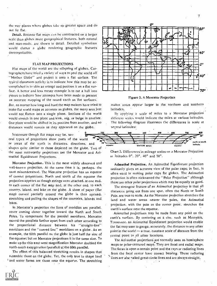
FLAT MAP PROJECTIONSFlat maps of the world are the offspring of globes. Car-
tographers have tried a variety of ways to peel the world offMother Globe" and project it onto a flat surface. The
typical classroom activity is to indicate how this may be ac-complished is to skin an orange and position it on a flat sur-face. A better and less messy example is to cut a ball intopieces to indicate how attempts have been made to presentan accurate mapping of the round earth on flat surfaces.But, no matter how long and hard the map makers have tried tomake flat world maps as accurate as globes, the many arcs justwould not flatten into a single plane. Sections of the worldwould stretch in one place and kink, sag, or bulge in another.One place would be shifted in its position from another, and nodistances would remain as they appeared on the globe.
Inaccurate though flat maps may be, sev-eral types of projections show parts of the world 40 )0
20or areas of the earth in distances, directions, and .o,
0
7
- '00= I0
IiI1 1 -ENOwomirmalmolemma wurvailmmontrammiwzrawm.ist......fammagionmegm...mqihimlINIIIMMIEIMPUNIIIIIKAII MININIP10011M111=2111WAINIMICIIIVIIMMumiwlLIIIMINIMI11110.4i07.11=1.1111WAM
wiNM NIIMMIIMMEIWZalrilll
IMINIMENSIIMIMMUMMINIIIlliarAMMINEMMIIIIIIMIINal
80'
40'
0
40°
70°
Figure 3. A Mercator Projection
makes areas appear larger in the northern and southernlatitudes..
By applying a scale of miles to a Mercator projectiondifferent scales would indicate the miles at various latitudes.The following diagram illustrates Cie diffei.ences in scale atseveral latitudes:
too 200 5C0 400 700 SOO
soINIWAMIANWir:30 40EIMPRW4111111r10 7.olhdo: south
shapes quite similar to those depicted on the globe. Two ofthe most noteworthy projections are the Mercator and Azi-muthal Equidistant Projections,
Mercator Projection. This is the most widely observed andwell-known projection. At the same time it is. perhaps, themost misunderstood. The Mercator projection has an equatorof correct proportions. North and south of the equator theprojection appears as though strings were attached, at one end,to each corner of the flat map and, at the other end, to eachcountry, island. and lake on the globe. A sheet of paper (flatmap) curved partially around the globe is then opened,stretching and pulling the shapes of the countries, islands andlakes.
In Mercator's projection the lines of meridian are parallel,never coming closer together toward the North and SouthPoles. To compensate for the parallel meridians, Mercatormoved the parallels farther apart from each other according tothe proportional distance between his "straight-line"meridians and the "curved line" meridians on a globe. As anexample, the 60th parallel on the globe is just half the size ofthe equator; but on Mercator projections it is the same size. Tomake up for this east-west magnification Mercator doubled thenorth-south exaggeration (parallel) at the 60th parallel.
The effect of this balanced stretching results in shapes thatresemble those on the globe. Yet, the only true to shape landand water forms are those near the equator. The stretching
STATUTE MILES quota'
Chart 2. Differences in mileage scales on a Mercator Projectionat latitudes 00. 20°, 40° and 50°.
Azimuthal Projection. An Azimuthal Equidistant projectionordinarily gives an accurate view of the polar caps; in fact, isoften used in making polar caps for globes. The Azimuthalprojection is often nicknamed the "Polar Projection" althoughthere are other polar projections which may be equally as good.
The strongest feature of an Azimuthal projection is that alldistances going out from one spot, often the North or SouthPole. are true to scale. As the Mercator projection stretches theland and water areas nearer the poles, the Azimuthalprojection, with the pole as the center point, stretches theearth's surface near the equator.
Azimuthal projections may be made from any point on theearth's surface. By centering on a cite, such as Memphis,Tennessee. an Azimuthal Equidistant projection would enablethe flat map user to gauge, accurately, the distance to any otherpoint in the worlda true, constant scale of distance from thecentral point to all other locations.
The Azimuthal projections are normally seen as hemispheremaps or polar-centered maps. They are focal and radial maps.The focus is upon a certain point and the rays or radiating linesfrom the focal center have correct bearing. These radiatinglines are alsc called great-circle lines and are always straight.

4s N
eau ser,anne111111sammom-'61111slasam',otaisses..own.
111111111114.,,,,pi,
WissisilmawsWIff
010111ER
15.11Mk001047Mre'hlt:oe.\,' 40.4 .44e..#1
44110:0101,',.
t
9
o
41///aL'ALI1111101k, BUMF ANIMUPQMOWN 111'411 Mai/ 11ffUM %URI UM %WWI
I
III/4 Ala '7.>'0.1111111101% 4 5, lc°, Tral 1 '118.4.Ilmilliagg, IR,. 4 .--21017,-.......
4wayst-- -,,i-,A.,:...,/iii
fi-*fa ..:..L,. Ai
Ts# 4
SOO'
SO
I
I I
o
o
I
I.
0 o-o
I
O
OS
OS
I 11
5. I
o
0 0
o
.1
. 0 I ^ 5'
0
0
I
. o g
OS I
0 I
o
o
OS .g g
r//li":";AM
'4'WillIANW-,
,.!': ' ' '14/4(111%1'': .41. XIII At: , ' ,,. Tall& Iti, ' 4
, , ... . ' iiiiniank'' ' ' , '..411111111 1,
,., ,...4NV %to .. wmasimamsomm ,..leammet...1 -, .,-,smniairir:.-mmumummesmausai ,- ,711111h....: .
-` illtEMSMffii.ilnliS+5a'''ZilingUNEMinali ,:"/ 71MMEL''..171U1111111111/n, i ' VACIPS1110111MIML , '" "; ,1111111il ,
';` i -1111111 ' -VIIIIIIIIIIIINVIIINM : 411111111111IgMSUMMILara , WILIIIIIIIIMM, , AIIIIIM%%MINORU, NLILN.1111111111111/1 / V iIIIIIIIONIN'MUI11111/// V MW111111ML., VaMi11121
NINNVINIIIIIFACr N71:0111//,,,,.

ACQUIRING GEOGRAPHICAL CONCEPTSTHROUGH MAP-MAKING
Map-making projects provide optimal opportunities forstudents to learn through discovery and inquiry processes.Motivation for making maps is derived most efficiently by pro-viding a challenging problem. If students feel the problem istheirs, a real need for map-making is developed. How is this"feeling." for ownership of a problem and need developed?Samples Of how several teachers have supplied motivation andinvolved their classes in map-making activities follow:
1. Planning: One teacher of eight and nine year old Students(third grade) asked the class to help plan activities forlearningmore about the city in which they lived. Their study problemwas. "What are the most important things we could learnabout our city, Topeka, Kansas?" Before the class was ready toformulate plans. the teacher's responsibility demanded thather students realize a need for a greater data base from whichto draw clearly defined ideas. This realization, by itself.brought about a purpose for reviewing existing maps of thecity, learning to locate various places by using the legend.After spending several weeks learning about their city the classbegan to formulate plans. The teacher. one day, distributedindividual mimeographed maps showing only tile major roadsof the city. The students were asked. individually, to indicateon the map places they would like to know more about. eitherthrough field trips. resource persons visiting the classroom, orobtaining information from printed reference materials. Uponcompletion of this activity the students formed smallcommittees to agree upon which areas they considered mostimportant to study. The day following, the class membersfound a large teacher-made map (4' x 8') of the city. showingonly major streets, pinned to the bulletin board. The smallgroup committees proceeded to report their plans to the entireclass:While the committees reported, other students marked,in pencil, symbols representing the areas in which they desiredknowledge. In this particular situation there were three vitalactivities in map-making procedures (1) interpre;:ng alreadyexisting maps; (2) completing individual maps; and (3)completing the large group map.
2. An upper grade (junior high) teacher obtained aerialphotographs of a locality from a city newspaper. To study thehistory and size of the home town and surrounding countrysidethe students made maps from these aerial photos whichshowed their locality, periodically, from about 1920 through1973. By making map comparisons of the community at variousdates throughout the past 53 years, students not only knew thehistory of their locality better, but also the present city: Themap-making activity branched out into side study excursions.Students studied the historical development and growth ofseveral industries. By comparing maps of different vintages thestudents investigated various locations and growth of suchinstitutions and government buildings as city hall, libraries,schools, hospital, and churches. Growth of the city in terms of
9
population was traced and reported to the class by a specialcommittee. Several persons were obtained as resources to aidin the historical study. The entire problem was motivated bythe map-making activity which developed from the teacher'sopportunism in obtaining aerial photographs of the locale.
3. An intermediate grade classroom constructed a map ofSouth America and traced the route of travel as a top politicalfigure from the United States visited various Latin Americancities. The daily newspapers reported the reactions of the SouthAmerican people to the visits by the United Statesrepresentative. From locating each city on the map and a globethe students. daily. located information concerning the vart..11scities and countries. Discussions developed because the arrivalof the politician in Caracas. Venezuela was greeted by jeers andcat-calls. The reception at Quito, Ecuador r,,,d Lima, Peru wasmet with very positive action. What ,tuused the difference infeeling? How do people in Venel:aela, Ecuador and Peru feelabout people in the United States? Why? These questions wereanalyzed as a result of a well-known political figure making ajourney to South America and a teacher's inventiveness bycapitalizing upon map study which supplied motivation todeeper .,tudy.
SUGGESTIONS FOR NOVICE CARTOGRAPHERS
Maximal map information is not attainable unless thesymbofism is interpreted correctly by persons reading the map.Junior cartographers can be taught some basic skills in
symbolizing various geographical features which can beadequately interpreted by others.
First grade teachers may draw symbols on thc chalkboard. Inlater grades students refer to published maps to gain anawareness of what symbols are used to represent variousfeatures.
Although some symbols are widely used, there are nospecific sythbols which must be used by cartographers. As anexample. towns are normally represented on a map by a dot.However, the cartographer has the prerogative to use someother symbol to represent a tov.ri if he so desires. He maychoose to use an X or a small square. The important aspect ofmap-making is to record the symbolic representations in themap key or legend.
What are some helpful hints for constructing maps? Supposethc novice cartographer wishes to symbolize a river.Merely draw a line.
Illustration I: Symbol for a river.
A river is nearly always crooked. Smaller streams flow intorivers. Large streams' of water are made with heavy lines andsmaller streams (tributaries) are made with a light line. As theriver becomes wider. the line is drawn more heavily.

16
Illustration 2: Symbol for a river and its tributaries.
A lake with rivers flowing into or out of it is easilyrepresented.
Illustration 3: A lake connecting two rivers
How may a beach be symbolized on a map? Have thestudents seen a beach? On a map we call the beach a coast fine.This is a coast line: ,
Illustration 4: A coastline.
A coast line with a river flowing into an ocean may berepresented in this manner:
Illustration 5: A coast line with a river flowing into an ocean.
When the shoreline curves and makes an indentation into theland a bay or gulf is formed. A bay or gulf may be representedin the following manner:
Illustration 6: An island and a bay or gulf.
An island is also depicted in the above illustration.More advanced, yet elementary, cartographic techniques
include the use of shading, lines, hachures and color layers toportray relief.
Shading. Forming. representations of mountains and valleys
by utilizing shading is an easily developed technique.Mountains appear bright and shining on one side by making a
mountain slope with the point of a pencil. The shadow side of a
mountain may be sketched with the side of the pencil lead. This
gives the impression of slope, elevation and a suggestion ofruggedness. The appearance is a three-dimensional effect of
valleys and mountains.
Illustration 7: The use of shading for sketching mountainsand valleys.
Hachures: The hachure is a name for small, short strokes orlines. usually parallel. indicating breadth and depth of surfaceFeatures. The length and angle of the hachures indicate slope.From the nature of the hachures direction and steepness arelikewise indicated. Proper perspective is difficult to achievebut hachures are most appropriate for the novice map-maker.
/ I. ...,.1111/141d(nifill;1
'"" 'mum
/ <
Illustration 8: Using hachures for showing relief on maps.

Contour Lines and Color Layers. Contour lines arc extremelydifficult for most students to comprehend. Drawing contourmaps is a recognized way of enabling a student to gain aconcept of what contour really indicates. Relief (elevation)Showing contour of the land may be drawn in two ways, (a) bylines and (b) by color layers. Color layers are used on mostrelief, physical-political atlas maps.
Illustration 9: Using color layers to show relief.
illustration 10: Using contour lines to show relief.
SECTION D: GUIDING CONCEPT DEVELOPMENTOF MAP SYMBOLISM
What are the skills and understandings related tosymbolic representations?
What activities may be helpful for teaching symbolicconcepts?
What are the generic map terms represented bysymbols?
Although applying to pictures, the adage, "a picture is wortha thousand words," is also appropriate for maps, There is agreat body of geographic terminology that cannot be defined inwords nearly as efficiently as they can be described on a map.However, the terminology must be, linked with the knowledgeand experiential background of the student to convey meaning.Because a map is a pictorial representation of geographical and
I I
scientific terms, proper concept development is necessary foroptimum map reading and interpretation abilities. Learning tointerpret maps should take place through seeking solutions andideas for problems, rather than an activity as an end in itself.Map reading and skill development shoidd take place throughprojects and activities of the classroom. However, maps andglobes may be utilized for many learning situations which mayor may not evolve from the social studies class airectly. Mapsshould be reference tools whenever they lend extra visualperception to the learning task. Map symbols carry atremendous amount of knowledge to the map reader. .It is,therefore, important for teachers to plan for teaching mapsymbolism.
CONCEPTS, UNDERSTANDINGS AND SKILLS RELATEDTO SYMBOLIC REPRESENTATION
Maps and globes use a myriad of symbolic representationsfor places, events, and other items of useful information.Learning to recognize map symbols requires the same depth ofperception required for associating the letter names with theletter symbol in reading the printed word. Many of thesymbols bear little or no resemblance to the object represented.Concrete symbols (pictorials) are often found in product mapsor natural resource maps. Concrete symbols include suchpictures as vegetables, fruits, minerals, houses, churches, andschools. Semi-concrete symbols depict replicas of the actualobject, but are not full pictorials. An example of a
semi-concrete symbol is a tree marking a spot for camping or afish-like symbol marking the location of fish hatcheriesnMostsymbols are completely abstract. Various colors representelevation. Lines represent rivers, boundaries, highways, ferryand boatlines, trails, railroads, and airways.
Concrete
Semi-Concrete
Abstract
Figure 7. Degrees of abstractness in symbolic representations.Each of the three symbols represents a school.
As in mathematics, the concept of many educators has beento proceed from the concrete to the abstract degree. It is notnecessarily accurate to assume this is the most efficientprogression for learning map symbolism. If a child has an
12
adequate concept of a lake, the map symbolism of a lake will bemeaningful. If a child has no concept of a fish hatchery thesymbol will carry tic meaning and likely will be an unlearnedsymbol. However, verbalized learning may take place. It is notuncommon to find intermediate grade children who canverbalize the definition of a peninsula as, "A strip of landsurrounded on three sides by water," yet who are unable topoint out a peninsula on a map. First-hand or vicariousexperiences are necessary. Meaning is conveyed to the mapuser only when some meaningful experience is brought to thesymbol..
A research investigation conducted in Oregon elementaryschools vividly illustrates the necessity of students associatingexperience with printed map symbols and geographical terms,including lines and colors. One-hundred eighty-eight sixthgrade students were asked to identify, by pointing to an atlasmap, ten geographical terms. The ten terms were bay, cape,island, lake, river,,, peninsula, mountains, valley, stateboundary and county boundary. One-hundred sixty-onestudents (85.6%) were unable to identify a cape. In Oregonmany children have, physically, seen capes; yet a greatpercentage couldn't identify a cape on an atlas map of the stateof Washington. However, a cape may be a trifle difficult tocomprehend, but should a valley? Ninety-seven of the sixthgraders tested (51.1%) were unable to identify a valley.Sixty-seven (35.6%) could not identify a peninsula. Astonish-ingly, sixty-three students (33.5%) were unable to select theproper representation of a river (in this situation, blue coloredlines). Many of the sixty-three examinees selected the heavyred line which represented state boundaries or a thin red linewhich represented county boundaries. A few selected lines oflatitude or longitude which were light green in coloration.Additionally, forty-el 4ht (25.5%) and thirty-seven students(19.7%) were unable to identify, correctly, county or stateboundaries. Of the other three geographical terms, bay wasselected incorrectly by thirty-eight pupils (20.2%); mountainsby sixteen pupils (8.5 %); island by ten pupils (5.3%); and lakeby eight pupils (4.3%)
Teachers cannot take it for granted that students are able tointerpret map symbols, There must be a foundation laid uponwhich students may build concepts. Two major concepts arepresented in the following pages; (1) symbols on mapsrepresent natural geographic features and man-madestructures, and (2) colors usually signify elevation onphysical-political and relief maps: political sub-divisions onpolitical maps.
It must be noted the grade level distinctions should be veryloosely regarded. The grade level designations primary,intermediate, and upper are provided as a guide, not a law.Need, interest, and maturity of the students are much betterprognosticators of readiness to . learn map symbols thanclassification in a social studies textbook.
1 op.cit., Gengler, pp. 129-132,
Primary level refers to skills and understandings to bedeveloped during the first three years of school. Intermediaterefers to the years four, five and six. Upper refers to theseventh and eighth ycars of a student's school life.
MAJOR CONCEPT: Symbols on maps represent natural geo-graphic features and man-made struc-tures.
SKILLS AND UNDERSTANDINGS RELATED TO CONCEPT
Primary: Understand symbols for land, water, moun-tains, cities, cliffs, coastlines, directional indica-tors, falls and rivers.
(See glossary beginning on page 17.)
Recognize concrete and semi-concrete mapsymbols representing man-made structuressuch as schools, churches, and airports.
Intermediate: Understand the relationship of photographs tomap symbols. Aerial photographs are used ex-tensively for map reading:
Recognize and understand symbols for county,state, and international boundaries, canals,bluffs, dunes, glaciers, capital cities, towns, vil-lages, deserts, grasslands, .mountain peaks,tributaries, swamplands, marshes, and vol-canoes, lava beds, lava flows, mountain passes,summits, plateaus, and rapids.(Sec glossary beginning on page 17)
Recognize and understand most s-yrnbols forreading highway maps.
A legend is provided for helping to locateplaces.
Recognize and understand symbolism on specialpurpose maps indicating climate (includingweather maps), distribbtion of population,transportation, and products.
Size and darkness of print (bold-faced type) in-dicate size of cities.
Upper: Understand and recognize symbols for escarp-ments, reefs, and shoals.(See glossary beginning on page 17.)
Understand and recognize all symbols on high-way maps.
Symbols may vary for identification of the samefeature or structure, but the legend will de-termine the representation.
Contour lines indicate elevation on topographi--cal maps.
Recognize and understand symbols on a
weather map representing cold fronts, warmfronts. isotherms; isobars, isolines, wind veloc-ity, wind direction, and ocean currents.(See glossary. page 35.)
ACTIVITIES RELATED TO CONCEPT
1. Primary: Construct a map of the school playground.Create symbols which represent various play equipmentslides, ladders. merry-go-round. teeter-totters, swings. (Seefigure 8).
2. Primary: Pupils construct maps of the route from home toschool and surrounding areas.
3. Primary: Supply individual mimeographed maps of thetown, city or community in which the students live. On this mapinclude only streets and roads. identifying the roads by namelabels. Ask the students to draw . symbols which wouldrepresent various landmarks which are important to people inthe community., Landmarks might include schools, churches.airports, historical sites, historical markers, rivers, mountains,or even homes. trees, fences. etc.. which may be important tothe locale. Remember: Symbols for the landmarks may be theCreation of the students. but the symbol must appear in thelegend if others reading the map are to benefit from itscontents.
a. The clas-. may wish to draw boundary lines on the mapfor the town, thy. school district or other divisions of politicalunits.
b. At the third or fourth grade level this activity could beextended by including; a wider area and adding coloration fordenoting elevation.
c. Consider the above activity for the entire class with themap drawn on a large piece of white butcher paper.
4. Primary: Use a flannel board to construct maps. Symbols,made of flannel. are placed on the flannel board to representvarious geographical features. Note the sequence of flannelboiled symbols added to the flannel board by two first gradegirls in Figure 9.
5. Primary: Have students take turns feeling the kinestheticsensations of an uncolored relief globe. How do you determinethe difference between land and water areas by feel? How doyou determine the differences between mountains, coastlines,and lower areas?
6. Intermediate: Compare aerial photographs with actualmaps of the Same area. Aerial photographs may be obtainedfrom persons employed in county and city government offices.
13
Newspapers sometimes have aerial photos which may beobtained.
a. Construct maps from simple aerial photographs.Encourage students to devise their own symbols for variousgeographic features. Emphasize the need for devising a legendfor other people interpreting the map symbols. In tl-s activity itis important for students to delineate aerial photographs takenfrom a vertical viewpoint and those snapped from a slantedposition.
7.. Intermediate: Engaging the use of outline globesand maps draw in the physical features of countries. states,provinces. and regions studies. How are the various physicalfeatures symbolized on maps? Accuracy of placement is vital toconcept formatiOn of place geography. This activity shouldcorrelate meaningfully with problems developed in reference tocountries of the Western Hemisphere.
8. Intermediate: Plan a vacation trip by referring to highwaymaps. What roads shall we travel? Why? Shall we camp out? Ifso, %vlierc? What national and state parks could be visited? Atwhat points or interest shall we stop? Will we need .to knowwhere airports are located? From plotting places where theclass or individuals would visit to the distance traversed.students arc actively engaged in using the map legend andlearning symbolism. During this activity note two ways inwhich the size of cities is symbolized, on highway maps, onother flat maps. and on atlas maps (1) by the size of the dotor other symbol, and (2) by the size and heaviness of pt:nt ofthe city's name.
9. Intermediate: Cut out, or ask students to cut out. flannelsymbols representing various geographical features. Place thesymbols on a flannel board. String is a useful item to outline theshape of a country, province or state on the flannel board.
a. The same flannel board may be used to comparespecial features of a country. province or state. Comparerainfall. products. population. vegetation and . natural re-sources.
10. Intermediate: Special features of countries, provinces.states or local regibas may be sketched on outline .maps andglobes.
I 1 . Intermediate: Utilize a geographic features map to pointout how various features are symbolized on a map.
12: Intermediate: Observe the weather. Not how theweather is symbolically recorded on weather maps by (a)viewing weather reports on television, (b) asking local weatherstation for a copy of their map on a particular day, (c) taking afield trip, to the weather station, or (d) asking a weather stationemployee to visit the class as a resource person.
. a. Construct weather recording instruments. Throughobservation of the weather and measurement by variousinstruments record temperatures. wind directions. and cloudforms.
13. Upper: A study of the water problems in an Asiatic orAfrican country could develop into a map-making project for

co
Figu
re 8
: A s
choo
l pla
ygro
und
is d
epic
ted
ina
free
-han
d dr
awn
map
by
a fi
rst g
rade
stu
dent
.N
umer
ical
ly th
e m
ap s
ymbo
lsre
pres
ent t
he s
choo
l bui
ldin
g (1
), te
ther
balls
(2)
,ri
ngs
(3),
hori
zont
al b
ars
(4),
tire
s (5
),m
erry
-go-
roun
d (6
), ju
ngle
gym
(7)
, slid
e (8
), a
nd h
oriz
onta
lla
dder
(9)
. Alth
ough
the
map
is n
ot d
raw
n to
sca
le th
is f
irst
gra
deyo
ungs
ter
is g
aini
ngru
dim
enta
ry c
once
pts
of s
ymbo
licm
ap r
epre
sent
atio
ns a
nd p
lace
pos
ition
.

1. The Willamette Valley is positioned in the appropriateplace. Green flannel corresponds to the symbolism for alti-tude of this valley.
3. Symbols indicating mountains are added to the east of thevolley. These symbols represent the Cascade Range.
15
2. Symbols indicating mountains are added to the west of thevalley. These symbols represent the Coast Range.
4. Symbolism of two cities most important to the students areadded to the flannel board map. These symbols representthe cities of Salem and Eugene.
Figure 9. A sequence of four pictures illustrating the construction of a flannel board map of Oregon's Willamette Valley.

learning symbolic representations. COmpare water diversionand pollution problems of Asiatic and African countries withthose of the United States.
14.. Upper: As in the intermediate grades, planning a tripthrough Europe. Africa or Asia may bc beneficial in providingmap-making motivation.
IS. Upper: Construct maps from complex- aerial photo-graphs.
. lb. Upper. Map comparisons is a worthy activity for tippergrade students. Comparing topographical maps with physical-'political and relief maps; comparing special feature maps withone another and with physical-political maps; and comparingOutline maps with other commercially available maps are alluseful activities. How do symbols differ on each of these maps?
17. Upper: Discuss the value of weather maps to theindividual as well as to the industry. Apply the value of weathermaps to the weather of areas studied. Regarding the relation ofweather to man's activities, Thralls' comments:
Many- people think that the farmer is the only-one inter-ested in weather. but actually almost every modern in-dustry has to take weather into account. Many industriespay a large sum annually to private weather forecastingcompanies for special forecasts for their specific industry.
a. Construct weather maps symbolically charting thewind directions. wind velocity and air pressure.
SKILLS AND.UNDERSTAND1NGS RELATED TO CONCEPT
Major Sym:olic Concept: Colors usually signify elevation onphysical - political and relief maps;political sub-divisions on politicalmaps.
Primary: Recognize difference between land andwater areas.
Therc is considerably more water thanland area on the earth's surface.
Land and water masses vary in shapeand size.
Continents or countries can be recog-nized by a change in color.
Intermediate: General understanding and ability tointerpret the colors which representvarious elevations:Shades of blue indicating areas belowsea level. Green indicating lowaltitudes (0-1000 feet.) Yellow indicat-
'Thralls, Zoe A. The Teaching of Geography. New York:Appleton-Century-Crofts, Inc., 1958, p. 58.
Upper:
ing intermediate altitudes (1,000-5,000 feet). Brown and red indicatingaltitudes above 5,000 feet.
About 30% of thc earth's surface island; about 70%, water.
Complete understanding of the Inter-national Color Scheme. The Inter-national Color Scheme has shadingsfrom dark blue, medium blue, lightblue, dark green, light green, yellow,golden yellow, orange, brown, andred indicating increase in altitudefrom the lowest elevations below sealevel to the highest elevations abovesea level.
Activities Related to Concept
1. Primary: Draw a map of the school. Color each division ofrooms a different color to distinguish between them. Stress thelikeness of the division of classrooms to the division of politicalunits.
2. Primary: Draw a map of a familiar region in which thereis a body of water, preferably a lake or ocean. Students shouldrecognize the difference in coloration between land and waterareas.
3. Intermediate: Compare Southern Hemisphere with theNorthern Hemisphere. Note the differences in land and Waterareas. Notc thc differences and similarities in elevations. Howdo North and South American continents compare in location ofmountains and lowlands? Which of the continents has the mosthighlands? Lowlands?
4. Upper: The teacher draws a cross-section of a country onthe blackbiard or duplicated paper. Cross-sectional drawingsmay bc found in most encyclopedia. itIc students to color thecross-sectional drawing according to the International ColorScheme. Compare thc cross-sectional drawings with the flatmaps of thc same regions.
Glossary of Symbolic Representations
A working vocabulary of generic terms is a necessity fortranslating maps and globes into words. The followingglossary of terms and symbols provides a guide to socialstudies teachers in aiding children to learn concepts about mapsymbols. (Note: Asterisks indicate the levels whenunderstanding of the terms and symbols should be complete.Students may possess clear concepts of some geographicalterms, yet not have lucid images of the symbols representingthose terms. Such is often the case when terms as glacier, sanddune and cliff are mentioned.)

To the knowledge of the author, a glosSary listing of thistype is not available in other professional literature, nor inschool district teacher's guides. The definitions are pre-sented for purposes of clarification of terms. The intent ofthe deseription.of geographical terms is not in the vernacular ofelementary school students. Students shouldn't be expected toknow definitions of terms as they are presented in this glossarylisting. The same is true with glossary definitions in Sections
17
E. F, (3 and H. However, teachers and students may beable to use these glossaries as students make maps. Theglossary is useable for determining three facets of map andglobe reading and interpretation; (1) distinguishing betweensimilar geographical features, such as cliffs, bluffs andescarpments; (2) identifying well known symbols for geograph-ical features; and (3) levels at which the concepts for geograph-ical terms should be rather well imbedded.
SYMBOLIC MAP REPRESENTATIONS
Term DefinitionExamples of
SymbolicRepresentation
Level
SYMBOLS FOUND ON MOST ATLAS MAPS:
boundaries lines which divide political units of government
county the lines marking the perimeter of a political division sub-div-iding a state
state the lines marking the perimeter of a political division sub-divi-ding a nation
international
canal
city
capital city
town
village
cliffbluffescarpment
coastline
desert
the lines marking the perimeter of a political division betweencountries or nations
an artificial waterway for navigation or irrigation
a huge, incorporated municipality
t1c7: city or town which is the official seat of government in acenrity, country or state
4 um00010.mmor
a thickly populated area, usually smaller than a city and largerthan a village, having fixed boundaries and certain local pow-ers of governmenta small community of group of houses in a rural area, largerthan a hamlet and usually smaller than a town
the high, steep face of a rocky massa hill with a broad, steep facea long, precipitous, clifflike ridge of land or rock formed byfaulting or fracturing of the earth's crust
the contour or outline of a coast; shoreline
a region so arid it supports only sparse or widely spaced vege-tation or no vegetation at all
0 0
*
* *

18
direction the line along wiNich anything lies, faces, or moves; north,south, east and west are the basic directions
dunes a sand hill formed by the wind, usually in desert regions or nearlakes and oceans
falls a body of water dropping suddenly to a lower position
glacier an extended mass of ice formed from snow falling andaccumulating over a period of years; glaciers move very slowly,descending from high mountains through valley glaciers or
centers of accumulation (continental glaciers)grassland an area in which the natural vegetation consists largely of
perennial grasses
lava bed a substance formed when molten rock has solidified
lava flow molten rock from a volcat,o
mountain a natural elevation the earth's surface rising more or lessabruptly to a summit and attaining an altitude greater than thatof a hill
pass a road, trail or natural land opening through mountains
peak the pointed top of a mountain
summit the apex or highest point of elevation of a mountain or amountain pass
plateau a land area having a level surface considerably raised aboveadjoining land on at least one side; often cut by canyons
rapids a section of a river or stream where the current runs veryswiftly
reef a ridge of rocks or coral debris at or near the surface of water
shoal a sand bank or sand bar in the bed of a body of water, especiallyone which is exposed at low tide
river
tributary
swampland
marsh
volcano
a natural stream of water of fairly large size flowing in adefinite course or channel
a stream contributing its flow of water to a larger stream
a tract of wet spongy ground
a tract of low wet land, usually treeless and inundated;characterized by grasses, sedges, eat-tails and rushes
an opening in the earth's crust through which lava, steam, andashes arc expelled, usually at irregular intervals
* Primary grades 1-3
MACAA/ % A /1
^ A A AAA AAAAnAA A AAet A r%
AL ram ps
re Dit
*
**
* **
** Intermediate grades 4-6 *** Upper grades 7-8

HIGHWAY MAPS
Road maps are vital instructional tools in a classroom. Thesemaps express the same features as physical-political maps withan added feature travel routes through the land shown onthe map. Primary children should realize the value of highwaymaps as their parents and other adults use them.
For the motorist, a good road map is standard equipment. Ittells him where to go and what he will find when he gets there;for travelers there is nothing more fascinating than a road map.
Anderzohnj surveyed 750 children below grade nine andfound 43% acquired initial interest in maps through using andhandling highway maps. This experience usually occurredoutside the classroom. Anderzohn further found thatapproximately 65% of nine and ten year old children use mapsand globes as a "pointer device:' for locating places andtracing trips or routes of trips, either real or imaginary. At thejunior high school level about 20% of the students used mapsfor planning trips of their own of following routes of trips takenwith their parents.
Besides being fascinating, road maps will serve a highlyfunctional role to the teacher who is alert and aware of its manyinstructional facets.
I Anderzohn, Mamie L., "The Child Looks Upon a Map,"Journal of Geography 53: 238 (September 1954).
19
Values of Highway Maps. There are several advantages ofroad maps when comparing them to other types of maps.Perhaps the greatest adi/antage is their availability. Severalsources of road maps are (a) major oil companies, (b) statetourist bureaus, and (c) World Almanac listings under thecategories cities and parks. Free or.inexpensive highway mapsare also obtainable from the Superintendent of Documents,Government Printing Office, Washington, D. C., 20402. Twosuch maps are the Standard Metropolitan Statistical Areas map(30" x 42") for 50c. and a United States Map of National Parks,two sheets (23" x 29.'), for 20E each.
For individual use by students large quantities of highwaymaps are readily available from oil companies and servicestations. Storage of highway maps is considerably lesstroublesome than wall maps and are easily replaced whendamaged or worn out.
Another advantage of highway maps is the natural interestchildren have in them. Children find road maps fun to workwith because most of them have taken trips with their parentsand come into contact with them through daily life. Ander-zohni found that over 50% of junior high school youngstersstudied maps just for fun, with highway maps of basic interest.
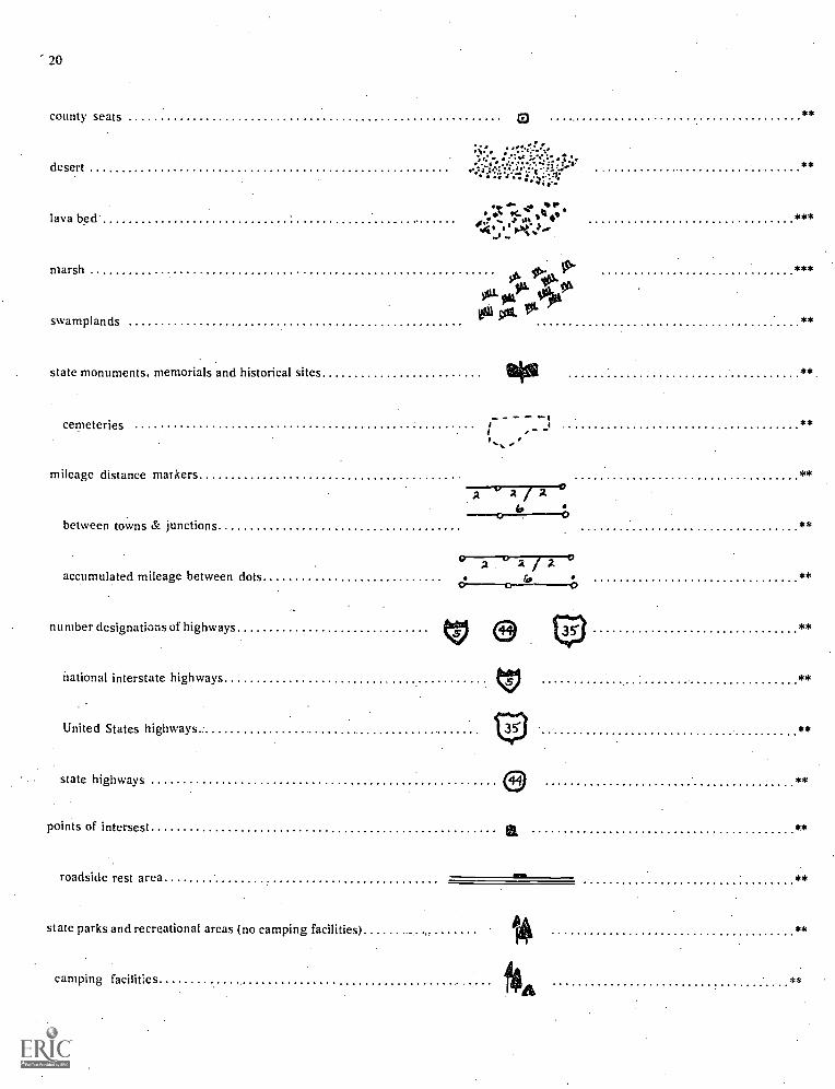
Symbols Found Principally on Highway Maps. Most highwaymaps symbolize THE SAME FEATURES AS AN ATLAS MAPOR A PHYSICAL-POLITICAL WALL MAP. However, somesymbols are represented almost exclusively on highway maps.A glossary of symbols found principally on highway mapsfollows:
Term RepresentedSymbolically
Examples ofSymbolic Representation
Level SymbolsShould BeRecognized
ROADS
divided highway (multilane controlled access)
highway interchanges
improved roads
paved roads
roads 'under construction
u'h improved roads
Imilism=mgaggEMENEINIR
= = -
***
***
**'
***
***
***
20
county seats **
desert;: **
lava bed.
marsh
swamplands
state monuments. memorials and historical sites
cemeteries
mileage distance markers
between towns & junctions
:X I ; *tn. .
*
odt 0014J 151'
I
**
**
**
**
**
**
accumulated mileage between dots
number designations of highways
national interstate highways
United States highways
state highways
points of intersest
Ogt
roadside rest area IMO
state parks and recreational areas (no camping facilities)
camping facilities
1
**

21
state waysides -Yr**
self-explanatory symbols TocCIP lik £schools aig
**
airports **
fish hatcheries ToCSP**
winter sports area **
state memorialsNal
**
state parks **
camping facilities ISA**
no camping facilities **
time zone boundary tw, am. ../. ow **
* Primary grades 1-3 ** Intermediate grades 4-6 ***Upper grades 7-8
SYMBOLS FOUND ON WEATHER MAPS:
Type 'Color
cold solid blue
warm solid red
secluded solid purple
Frontal Systems
Symbol
witehindeff-Astaketausairmesstallava

2'
upper cold
upper warm
dashed blue
dashed red
stationary alternate blue & red
4c0^QinCniOnnOID
Weather Symbols
fog (I) drizzle V light rain shower.
rain V squalls S dustX funnel cloud C;$0 haze < lightning
G thunderstorm .6i sleet snow
4 ice needles
Wind Symbols
Wind Direction
/C) west wind
0\\ east wind
north wind
south wind
(northeast wind
northwest wind
southeast wind
7,0 southwest wind
Wind Velocity
cairn
1-4 mph
5-8 mph
9-14 mph
15-20 mph
21-25 mph
26-31 mph
\\1.... 32-37 mph
38-43 mph

0
23
Sky Symbols
no clouds
less than one-tenth or one-tenth
one quarter coverage
four tenths
one half ( live tenths)
(2.3 tenths)
shower area
Area Symbols
thunderstorm area
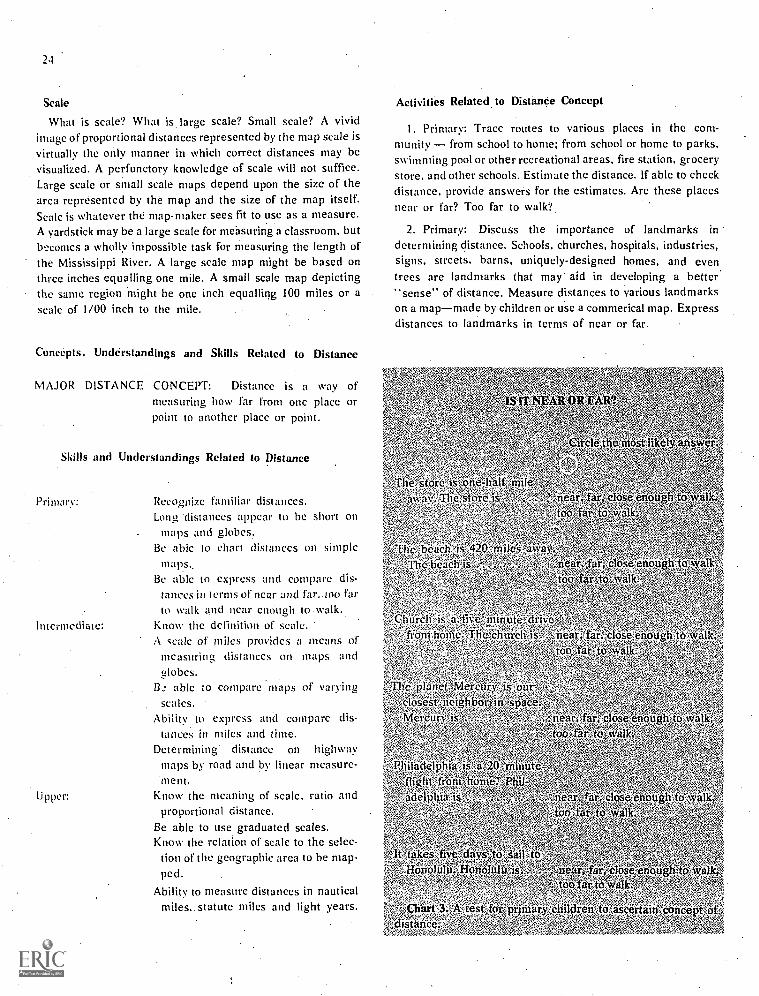
SECTION E: GUIDING DEVELOPMENT OF DISTANCECONCEPTS RELATED TO MAP READING
What is the importance of scale?What are the skills and understandings related to
distance concepts?What activities are helpful for teaching distance
concepts?What map terminology is related to measuring
distance?
A group of adults at a PTA meeting were asked to fill out aquestionnaire. One item called for the distance of the schoolfrom their home. After gathering the questionnaires andcomputing the data. it was found that some of the people knewexactly how far they lived from the school, perhaps havingclocked the distance on the automobile mileage gauge. But,others miscalculated the distance by a considerable margin.One lady who lived .3 miles from the school answered 1.5
miles. Another person who lived 3.8 miles from the schoolthought the distance was about one mile. What perceptions ofdistance did these people have? What perceptions do children
have of distance?
six tenths
three quarters (7-8 tenths)
overcast with openings or completely overcast
sky obscured
Precipitation area(represented by color)
solid green continuousgreen hatching intermittentsolid yellow fog
solid brown dust
Even when a person holds a satisfactory concept, distanceson a map or globe may still be meaningless. Several learningsmust take place before distance is meaningful. First, one mustpossess considerable knowledge about place geography, wherecities or other geographical features are located. Secondly, themap reader must know how to use the scale of miles andunderstand what that scale represents. Thirdly, the map readermust have an adequate conception of how far the measureddistance is. How far is 2,451 statute miles, representing the airdistance between New York City and Los Angeles? Thatquestion may have as little meaning to many people as thequestion, "How much is a million dollars." It may be difficultto conjure up a visual image for either of these questions.However, a comparison of distances presently known to those
oqnown will aid in forming more clearly identified concep\f of
distance.
24
Scale
What is scale? What is large scale? Small scale? A vividimage of proportional distances represented by the map scale isvirtually the only manner in which correct distances may bevisualized. A perfunctory knowledge of scale will not suffice.Large scale or small scale maps depend upon the size of thearca represented by the map and the size of the map itself.Scale is whatever the map-maker sees fit to use as a measure.A yardstick may be a large scale for measuring a classroom, butbecomes a wholly impossible task for measuring the length ofthe Mississippi River. A large scale map might be based onthree inches equalling one mile. A small scale map depictingthe same region might be one inch equalling 100 miles or ascale of 1/00 inch to the mile.
Concepts, Understandings and Skills Related to Distance
MAJOR DISTANCE CONCEPT: Distance is a way ofmeasuring how far from one place orpoint to another place or point.
Skills and Understandings Related to Distance
Primary:
Intermediate:
Upper:
Recognize familiar distances.Long 'distances appear to be short on
maps and globes.Be able to chart distances on simple
m a ps..
Be able to express and compare dis-tances in terms of near and far.. too farto walk and near cm-MO to walk..
Know the definition of scale.A scale of miles provides a means ofmeasuring, distances on maps andglobes.
Bc able to compare maps of varyingscales.
Ability to express and compare dis-tances in miles and time.
Determining distance on highwaymaps by road and by linear measure-ment.
Know the meaning of scale, ratio andproportional distance.
Be able to use graduated scales.Know the relation of scale to the selec-
tion of the geographic area to be map-ped.
Ability to measure distances in nauticalmiles,. statute miles and light years.
Activities Related to Distanee Concept
1, Primary: Tracc routes to various places in the com-munity from school to home; from school or home to parks,swimming pool or other recreational areas, fire station, grocerystore, and other schools. Estimate the distance. If able to checkdistance, provide answers for the estimates. Are these placesnear or far? Too far to walk?
2. Primary: Discuss the importance of landmarks in
determining distance. Schools, churches, hospitals, industries,signs, streets, barns, uniquely-designed homes, and eventrees are landmarks that may aid in developing a better."sense" of distance. Measure distances to various landmarkson a mapmade by children or use a commerical map. Expressdistances to landmarks in terms of near or far.
Walk;
O :beach', is '42P miles ,,i4fraSe.,
.Thehe41r.is :'" '4- Iiir"olaseenouith-to-walk,4,, .'Oa' far-ta
Chi') eh is:a:Jiiv"iointiie-drii.e..,ftom hohie;Tlie,enuich enough to wai
Rio '.-far to' walk^ 'z
the planet Merury"' closest' netghbot,;in space:
"I,;lereunt; .
Philadelphia is, a',20>millute
"adelPhia
t'It4akes five' days'Ao, sail ,toeordolu,Honoluio
4.1.i5! 4
4 7,
; 5 Chart 3:,A test-forpronaryehildrenAwascerfain Oonpept off.,iStaricer,
ye;ear, 1. elose.enou00 far to waik.W,'-'re

3. Primary: On a map of the community draw a one milediameter circle around the school attended by your class.Determine how far each pupil lives from the school. How muchtime does it take to walk from home to school? How much timedoes it take to run?
4. Intermediate: Relate the distance of one mile to miles perhour when traveling in a car. (Ratio of one mile to one minute).
S. Intermediate: Locate geographical areas in relation tomountains, river, railroad, bay, etc. Measure distance by roador highway maps. Measure distance by scale of miles onseveral maps of different scale.
6. Intermediate: Make use of a magnifying glass to build theconcept of scale as a proportional distance. Hold a magnifyingglass over a small scale map, perhaps an atlas map or one in asocial studies textbook. Note that as the map details aremagnified the map scale is enlarged to the same mathematicalextent.
7. IntermediateUpper: Cut a dispensable map intosquares of equal size. Cut an identical number of larger, butmathematically proportional, squares from butcher paper.( Example: If map squares are 3 inches make the butcher papersquares 6, 9, or 12 inches). Give each student a small "map"square and a larger "butcher paper" square. Assign eachstudent the task of enlarging their square from the small scaleto the larger scale. After each student completes his square.put the butcher paper and map squares together again forcomparison. By cutting the map squares on parallels andmeridians a dual concept may be learned; (a) scale is a
proportioaal distance. and (b) the grid pattern of a map may beutilized for expressing distances.
8. Intermediate-Upper: Whether measuring distance in
terms of miles or degrees the globe will indicate why flat mapscales are not entirely accurate. Measuring east-west degreesalong the equator. one degree is equal to 69.172 miles.Measuring east-west degrees along the 80th parallel onedegree is equal to only about 12 miles. As students observethe globe the reason for the change will be readily observable.The circles of latitude become smaller as they appear closer tothe poles; larger as they' approach the equator. Note: thenorth-south degrees have a slight variation because the earthis not perfectly round. For most classroom computation thevariation of the north-south degrees is of relatively little conse-quence.
Glossary of Terms for Map and GlobeConcept of Distance
Term Definition Level
distance the extent or amount of space be-tween two places or points
light year
milestatute mile
nautical mile
the distance light travels in oneyear; about 5,880,000,000,000miles
a unit of measurementa unit of measurement on land **
equal to 5,280 feet or 1,760 yardsa unit of measurement in sea and ***
air navigation equal to 6076.1033feet
)5
**
proportional distance one distance compared with an- ***
other; if unequal length theshort distance is a multiple ofthe longer distance
ratio the relation of one magnitude to ***
another in respect to the numberof times the first contains thesecond
scale a graduated line representing pro-portional size
**
* Primary grades 1-3** Intermediate grades 4-6
*** Upper grades 7-8
statute miles .0 o S /0 20 30 /aLIXISFE=1111ENE=Ellmonl
kilometers 41-117,711.117-545-ZS 35 its"
SCALE 1:1.929.000 1 inch=30.5 statute miles
statute miles/0 20 30
SCALE: 1 inch=21 miles
Figure 10: Samples of graduated scales

26
SECTION F: GUIDING DEVELOPMENT OF DIRECTIONALCONCEPTS RELATED TO MAP READING
What is the importance of the grid?What are the skills and understandings related to
direction?What activities are helpful for teaching directional
concepts?What map terminology is related to direction?
It is impossible to accurately identify a place on a map orglobe without referring, in some manner, to direction. Inter-pretation of map and globe information therefore is reliantupon a student's skill to recognize direction for location ofplaces. But knowledge of direction is important to individuals.in many ways. The person who says, after parking a car along acity street and spending several hours shopping, "Oh! Oh!Where did I park my car?" may have difficulty with thisconcept.
Several aspects of direction may be important to everyindividual. Knowledge of the sun's position will guide manypersons in determining direction. Likewise, surface landmarksare important factors in determining direction. The person wholost his car may recall that it was parked in front of a bank. Thebank was one block from a motion picture theater. By recallingthese landmarks, the car may be found. Maps and globes alsohave landmarks which aid the map reader. These landmarksare the North and South Poles, the equator, Tropic of Cancer,Tropic of Capricorn, International Date Line, and PrimeMeridian.
Exact location of places is dependent upon the landmarkslabeled parallels and meridians or lines of latitude andlongitude. The intersection of the lines of latitude with the linesof longitude form the basic landmarks for locating points onmaps and globes.
The Grid. A system of coordinates to establish direction andprovide accuracy in locating places is termed a grid. Parallels,or lines of latitude, encircling the earth in an east -westdirection intersect with meridians, lines of longitude, encircling
the earth in a north-south direction, thus forming the gridframework. Children will better understand how places arelocated on a map or globe if they understand how the grid isconstructed. The landmarks are then translated into numbk.called degrees and minutes.
CONCEPTS, SKILLS AND UNDERSTANDINGSRELATED TO DIRECTION
Major Directional Concept: Basic directions for interpretingmap and globe information are north, south,east and west.
Skills aid Understandings Related to Direction
Primary: The North Pole is the tip of the earth's axiswhich points toward the North Star, Polaris.
Intermediate:
Upper:
The South Pole is at the opposite tip of theearth's axis
North is the direction toward the North Pole.South is the direction toward the South Pole andopposite North.East is to the right of north.West is to the left of north.Up is dircetien away from the center of theearth.Down is the direction toward the center of theearth.The sun may be a valuable aid in determiningdirection.People need to know direction in order totravel.
Ability to follow highways from one place toanother on highway maps. Ability to follow airand train routes on transportation maps.Directions may be more clearly stated in termsof northeast, southeast, northwest andsouthwest.Understand the relation of the North Poles,South Pole and equator to the basic directions.Understand the use of the compass, North Starand noon day sun to determine direction.Direction and distance are plotted by degreesand minutes south or north of the equator andeast or west of the International Date Line..Learn to measure by degrees and minutes.Understand directions on maps of anyprojection.Nortn is not always toward the top of the pageor map.Great-circle routes make a change in direction.
ACTIVITIVES RELATED. TO DIRECTION
1. Primary: Make use of familiar landmarks to determinedirection. What direction do we travel in walking from the cityhall to the school? What direction do we walk when going fromthe city hall to the fire station? Include other landmarks such ashospitals, libraries, recreational areas, super-markets, schools,churches, industries, police departments, etc.
2. Primary: Form a grid chart. Locate familiar landmarkson the grid. Number the grid lines in the same fashion ashighway maps; north-south lines numbered by Arabicnumberals (1,2,3) and east-west lines numbered by capitalletters (A, B, C). Constantly talk about directions wheninvolved in locating landmarks. (Please, do not refer to north as"up', south as "down".)
3. Primary: Observe, first -hand, the direction of sunrise andsunset: Chart the course of the sun, hourly, during one day.Determine directions each hour. How does the sun help usdetermine direction?

4. Primary: Place a shadow stick outside the classroomwhere it may be easily observed. Chart (graph) the length anddirection of the shadows cast during each season.
5. Primary: Place appropriate labels on the walls of theclassroom, marked north, south, east and west. The teachermay emphasize these directions by asking children to standalong the east wall or to water the plants along the south wall.
6. Primary: Refer to places in the school environs as the westwing of the school or the north, end of the building.
7. Primary:Construct weather charts showing wind direc-tion.
8. Primary: Locate the community in which the children livein relation to. water bodies or the community. (Mountains orrailroad tracks may also be used for purposes of relatingcommunity location and direction from basic geographicfeatures.)
9. Primary: "Directional May I" game. Leader instructsplayers, "Gloria may take three hops east. Bill may take fourleaps north. Jill may take 'one step west." All playersstart from a beginning circle. A player failing to say, "May I,"or heading in the wrong direction must return to the centercircle again. The player who first reaches a larger outer circlebecomes the leader for the next game.
10. Primary-Intermediate: Capitalize upon events which areimportant in the lives of children. Interest in Santa Claus maylead into a discussion about the North Pole and life in the north.When rocket. and satellites are launched from Cape Kennedymany students watch the proceeding on television. WhatAirctint: is this from the children's place of habitation? Globesare handy references for this activity.
11. Intermediate: Locate "home" on a world map by themathematical terms of geographer's degrees and minutes,north-south latitude and east-west longitude.
12: Intermediate: When giving directions the teacher mayuse "directional language.- Please form a circle in thenortheast corner of the gym. Please report to the southeastsoftball diamond.
13. Intermediate: Individually, ask students to show north,south, east, and west directions on the globe from severalspecific locations such as Melbourne, Australia; Toronto,Canada; Sao Paulo, Brazil; and Cairo, Egypt. Choose places invarious hemispheres. Additionally, ask students to showdirections along the parallels and meridians.
14. Intermediate-Upper: A compass is a valuable asset tosurveyors and reconnaissance men. It is valuable instrumentfor hunters and fishermen. There are several constructive usesof compasses in a classroom. Curiosity may be aroused aboutthe magnetic poles. Direction becomes a clear concept throuehexperimentation with a compass. Students should be instructedto face the object whose bearing is being. taken. Holding thecompass in the palm of the hand, the compass box should beslowly rotated with the opposite hand until the north end of the
. 27
needle is at the point indicating north on the compass. Theneedle will not stand completely still, but near accuracy indirection will be obtained.
Laying a pencil across the compass face for obtaining a sightline on the object is helpful to the beginning compass reader.
Reading a compass near metal objects such as automobiles,fences, high tension power lines, bicycles, or steel poles willindicate the magnetic force exerted by materials which areefficient conductors.
Figure 11. Reading a compass.With the compass needledirectly on north; the object is sighted west of the needle.Degree of the object (tree) is measurable.
15. Upper: Orient the globe so north points northward (tothe top). Rotate the globe froin west to east (counterclockwise)so the point marking the location of the student's home town ison the highest meridian. Next, place the center of the compassat the location of your home so the following three points are ina straight line on the oriented globe: (a) center of the compassat "home,- (b) zero degrees on the compass (north), (c) NorthPole on the globe. The angle made by the line of the great circleand the line described in the three points (precedingsentence) is the angle of direction to be used when followingthe great circle from one point to another. To discover thedirection of the student's home from any other point on theglobe, orient the map in the same manner as described above.Always use the compass to identify north.
Glossary of Terms Related to Direction
Term Definition Level
compass
compass tick
an instrument for determining di-rections by means of a freely ro-tating magnetized needle thatindicates magnetic north
the markings indicating degreeson compass
**
***

28
direction
north
south
east
west
up
see definition; p. 17,
the direction toward the NorthPole
the direction toward the SouthPole; opposite the north
the direction to the right of north
the direction to the left of north
the direction away from theearth's center
down the direction toward the earth'scenter
upstream toward or in the higher part ofa stream: against the current
downstream toward or in the lower part of astream: with the current
northeast a point midway between north andeast
northwest
southeast
southwest
great circle
small circle
a point midway between northand west
a point midway between southand cast
a point midway between southand west
an imaginary line encircling theearth so that the plane of the cir-cle passes directly through thecenter of the earth. All meridi-ans are great circles. The Equa-tor is a great circle.
the line (arc) of shortest distancebetween two points on the sur-face of the earth. Except for theEquator. all lines of parallel aresmall circles.
What map terminology is related to understandingtime and motion?
To completely interpret maps and globes, students need athorough understanding of how our earth moves and how timeand season changes affect man and his eyironment, Time andmotion are related to man's behavior and geographic elementsof the earth in many ways. The changes of season bring aboutmany climatic differences in various parts of the world. Aridand hot lands have little vegetation, little water, and sparsepopulation except along rive; s, Wet, hot lands have myriadtypes of vegetation. Population also may be sparse. Elevation,too, causes a difference in the climatic conditions. At any rate,the climatic factors have much to do with the number of peopleliving in a given area and the manner in which they live.
The concept of night and day as the earth spins on itsaxis will aid students in better concepts for translating lives ofpeople into the reading of maps. Children in Point Barrow,Alaska have different bed times and eating times than childrenin New Orleans,Louisiana. Why? A study of night-day causesand relationships will provide some understanding.
** Concepts, Understanding and SkillsRelated to Time and Motion
**
**
***
* Primary grades 1-3 ** Intermediate 4.6 *** Upper 7-8
Section G: Guiding Development of Time and MotionConcepts Related to Map Reading
What are the skills and understandings related totime and motion concepts?
What activities are helpful for teaching time andmotion concepts?
MAJOR TIME AND MOTION CONCEPT: The rotation andrevolution of the earth cause time
Skills and Understandings Related to Time and Motion
Primary: The..sun is apparently, but not really, in motion.There is change in the length of day and night.There is a change in seasons.The total length of a day is twenty-four hours.The sun. is most nearly overhead- at midday;
most nearly opposite at midnight.Understand time relationships of yesterday, to-
morrow, today, history, future.
Intermediate: The earth rotates on its axis in one day.The earth revolves around the sun in one year.Rotation of the earth causes night and day.Revolution of the earth causes seasons.Understand meaning of the terms Equator, Tro-
pic of Capricorn, Tropic of Cancer, AntarcticZone, Arctic Circle, Arctic Zone, North andSouth Temperature Zones, Torrid Zone morn-ing, evening, noon, night, midnight, twilight,dawn, dusk, horizon.
Express time in relation to history. How longwas long ago?

Upper:
The earth spins in a counter-clockwisedirection omits axis.
While one half of the earth is daylight.theother half is in darkness.
The North and South Poles (FrigidZones) have periods of time whenthere is virtually total darkness andtotal daylight. '
Latitude is expressed in degrees and isapproxmiately 70 miles per degree.
As the earth rotates counter-clockwiseon its axis time changes by one houreach 15 degrees of movement:
Apparent paths of the sun at differentlatitudes is due to the ecliptic pathof the earth's movement around thesun.
Using the analemma. to determineseasons in various parts of I he worldand exact times when the sun's raysshine directly upon the earth's surfacein different parts of the world.
Understand terms of analemnia, aphe-lion. civil time. equinox. solar time.local mean time. declination of thesun. ecliptic, horizon ring, meridianring, nadir. perihelion, small circle.great circle, solstice. zenith, CelestialPole, Celestial Sphere, apogee, per-ogee. perigee, circle of illumination.
Activities Related to Time and Motion Concept1. Primary: Construct a shadow chart illustrating various
times of the day--morning. noon, early afternoon and lateafternoon.
2. Primary: Construct a chart showing differences in autumn,winter, spring, and summer.
3. Primary: Construct calendars for each month.4. Primary: Demonstrate with a globe representing the
larger earth and a ball representing why the sun appears to bein motion when actually the earth is in motion (beginningconcept of night art" day).
S. Intermediate: One child holds a flashlight or a lamp in astationary position representing the sun. Anothei child spins,counter-clockwise, the globe, representing the earth with thelamp beam shining directly on the globes equatOr. As the lightbeam begins to light up the globe as it spins, that section of theearth is experiencing sunrise; the opposite side of the earth,sunset.
6. Intermediate: Continue holding up a lamp beam on theequator so the daylight hemisphere falls exactly between theInternational Date Line and the Prime Meridian.. Demonstratethe differential in time of 12 hours in each direction between
29
these lines. Next, place the International Date Line so the lightbeam shines directly toward it. Demonstrate the midday (noon)position of the date line and the midnight position of the PrimeMeridian. Post the question. "Why does time change by. onefull day at the international Date Linc?
7, Intermediate: On another day, continue the lamp andglobe demonstration. This time have the pupil spinning(rotating) the globe also begin moving, simultaneously with thespinning, around the sun (lamp). Indicate the slant and ask,"What effect does the slant of the earth and the slant of sun'srays have upon our weather?"
8. Intermediate: Chart the length of daylight for the fourseasons.
Y. Upper: ShoW exact times and differences (in slant) of theshadows on specific dates and times. Use the globe andanalemma to aid in constructing the chart.
i O. intermediate-Upper: Use a large Smooth ball. Ask thechildren to imagine the ball is a replica of the world. Encouragethe children to locate their home or community on this ball.Finding no lines or points of reference the students will realizethe importance of imaginary lines. labeled parallels andmeridians for locating places. Proceed to label the lines on theball with appropriate degree markings. Continue by locatingthe position of North America. the United States, the state andthe community where the students live. When the classmembers are able to locate their own community by the use ofparallels and meridians ask them to locate the position ofout-of-state friends in the same manner. Do you have friends inother countries? How might you locate where they live? Byutilizing the lines of parallel and meridian proceed to havechildren express place position in the proper mathematicalterminology of degrees and minutes coupled with direqionsuch as 52 degrees 44 minutes W longitude by 47 degrees 35..
minutes N latitude, the location of Saint Johns, Newfoundland.
After students realize the importance of maps and globesbeing constructed on the grid pattern it may prove helpful tolocate states, countries, and specific places, such as cities,mountains, and parks. This procedure can be used throughoutthe intermediate and upper grades. Grid lines are the parallels(east-west lines) and meridians (north-south lines) whichintersect to form a grid pattern.
Review of grid lines is easily maintained by referring to roadmaps. city maps, wall maps, atlas map, and maps in an ency-clopedia which are constructed along the same patterns.
11. Upper: Make use of the analemma. The analemma is afigure or band imprinted upon a globe which has the generalappearance of a figure 8. It extends from the Tropic of Cancerto the Tropic of Capricorn, usually located on the globe in theeastern part of the Pacific Ocean where there are no islands of
significance. The band indicates the sun's declination and theequation of time. By reading the date scale, showing the sun'sposition in accordance with the equator and any meridian, thesun's declination or latitude May be measured during any day

30
of the year. The equation of time line indicates the differencebetween sun time and local clock time for any day. This line isknown as the equatorial minute scale.
Declination of the sun. Ask students to trace the position ofthe sun beginning with January 1 and continuing throughoutthe year. Emphasize that the sun's rays are shining directlyupon the earth at approxmiately 23 degrees S latitude on Jan-uary 1st. Ask the students to find where the sun would be di-rectly overhead on their birthday. Suppose George (one of thestudents) celebrated his birthday on October 20. Where wouldthe sun be shining directly overhead on George's birthday?George would locate October 20 on the figure 8 band and countthe markers south from the equator on the line that passesthrough the middle of the analemma to find the latitude. Thesun is directly overhead at approxmiately 10 degrees southlatitude on October 20. Any place in the world located at 10degrees south latitude receives the direct rays of the sun onGeorge's birthday. Lima, Peru receives the sun's direct rays onthis date, and again on February 18. (This experience may evenenthuse George to take a greater interest in the study of SouthAmerica, particuarly Peru, if there is some personal connectionwith the experience; some feeling of personal possesion.)Proceed by asking each child to locate some city in the worldwhere the sun's rays strike the earth on the anniversary of theirbirthdays.
Equation of Time. Students may learn to compute the time tothe exact minute as well as the day, when the sun is directlyoverhead at midday. The analemma provides a guide fordetermining the exact time. The solar day is used to computethe precise time. The solar day is the time interval between twosuccesive transits by the sun of the meridian exactly oppositethat of the observer. It is the interval of time from one midnightto the following midnight. However. the length of time is notalways exactly 24 hours. In fact, the sun's rays shine directlyupon the earth at 12:00 noon, sharp, only four times per year.These days are April 13, June 15, September 1, and December25. Our clocks, telling local time, will agree, at noon, with solartime only four times per year. The analemma will help studentsdetermine how much faster or slower our clocks may be whencompared with the solar day. Showing the effects of the earth'srevolution about the sun in an elliptical pattern, rather than aperfect circle will aid in explaining the time differentialbetween the solar day and the clock time. Determining theequation of time may be a cliallengz to academically brightstudents in intermediate or to upper grade students. The globewill show the ecliptic; the great, imperfect, circle formed by theintersection of the plane of the earth's orbit with the celestialsphere. The ecliptic is, thus the apparent annual path of thesun in the heavens. The ecliptic intersects with the equator (aspictured on a globe) at the International. Date Line and thePrime Meridian. The sun is directly overhead at the equator at12:07 on March 21 and at 11:53 a.m. on September 23.
Again, ask students to compare. "sun time" with "clocktime ". at 12:00 noon on the students' birthdays. George will
find the clock time in Lima, Peru will read 11:44 a.m. This isfound by locating the date, October 20, then using a ruler tomeasure on a 90 degree angle (perpendicular) to the scale of.minutes. On October 20 the "sun time", because of the,elliptical revolution of the earth about the sun, is sixtee.2minutes faster than "clock time"
Glossary of Terms Related to Time and Motion
Term Definition Level
analemma a scale shaped like a figure 8,showing the declination of thesun and the equation of time forfor the day of the year. Placed ona globe, the analemma will showthe latitude where the sun's raysare vertical at noon on each dayof the year.
circle of illumination the great circle that is located be-tween the lighted half and theunlighted half of the earth's sur-face
climatic zone anyof five divisions of the earth'ssurface, bounded by lines par-allel to the Equator, and namedaccording to the prevailing tem-perature. The five great zonesare the Arctic (North Frigid)Zone, North Temperate Zone,Antarctic (South Frigid) Zone,South Temperate Zone and theTorrid Zone.
***
***
**

Antarctic Zone
Arctic Zone
North TemperateZone
South TemperateZone
Torrid Zone
day
afternoon
darkness
dawn
daylightdusk
evening
forenoonmid-day
morning
noon
solar day
also known as the South FrigidZone. The geographical parallelof 66 degrees 13 minutes Southlatitude; the section of theearth's surface lying betweenthe Antarctic Circle and theSouth Pole
also known as the North FrigidZone. The geographical parallelof 66 degrees 13 minutes Northlatitude; the section of theearth's surface lying betweenthe Arctic Circle and the NorthPole
the part of the earth's surfacelying between the Tropic ofCancer and the Arctic Circle inthe Northern Hemisphere
the part of the earth's surface ly-ing between the Tropic of Capri-corn and the Antarctic Circle inthe Southern Hemisphere
the part of the earth's surfacebetween the Tropic of Cancerand the Tropic of. Capricorn
a measure of time based upon onecomplete rotation of the earth. Asolar day is measured from atransit of the sun across a givenmeridian to its next successivetransit across the same meridian
the time from noon until evening
absence or deficiency of light onthe earth's surface
the first appearance of daylight inthe morning
the light of the daythe period of partial darkness be-
tween day and night in theevening
the latter part of the day and theearly part of the night
the period of daylight before noonthe middle of the day; noon or the
time around noonthe first period of the day extend-
ing from midnight to mid-day
the instant when the sun's raysfall vertically on any given meri-dian
the length of time from noon tonoon
**
**
**
**
**
*
sunrise
sunset
twilight
declination of sun
degree
direction
east
north
south
west
North Pole
South Pole
Celestial Pole
the rise or ascent of the sun abovethe horizon in the morning
the setting or descent of the sunbelow the horizon in the evening
the, periods of partial daylight af-ter sunset and before sunrise,when light from the sun is re-flected from the atmosphereoverhead
the angular distance of a hegven-ly body from the celestialequator, measured on the greatcircle passing through the celes-tial pole and the body
a unit equal to 1/360 of a circle;a degree of latitude on theearth's surface is roughly equiv-alent to 69 statute miles; a de-gree of longitude varies inlength but is always equivalentto about four minutes of time
a position on a line extending froma specific point toward a point ofthe compass or toward the nadiror the zenith
a cardinal point of the compass,90 degrees to the right whenfacing north; corresponds to thepoint where the sun is seen toarise
the direction along any meridiantoward the North Pole
the direction along any meridiantoward the South Pole
a cardinal point of the compass,90 degrees to the left whenfacing north; corresponds to thepoint where tha sun is seen toset
the end of the earth's axis of ro-tation marking the northern-most point on the earth (Note: Acompass needle is attracted to amagnetic pole near the NorthPole. but never directly towardthe geographic North Pole).
the end of the earth's axis of rota-tation marking the southernmostpoint of the earth
the North Star; each of the twopoints in which the extendedaxis of the earth cuts the celesti-al sphere and about which thestars seem to revolve
***
**
**
*
*
*
*
***

32
Celestial Sphere the imaginary spherical shellformed by the sky, usually rep-resented as an infinite sphere,the center of which is a given ob-servr.r's position
ecliptic a great circle sometimes shown ona map or globe and representingthe apparent annual path of thesun across the surface of theearth
equinox the time when the sun crosses theplane of the earth's equator,making .light and day of equallength all over the earth
the time when the overhead suncrosses the Equator on its appar-ent migration from north tosouth, or about September 23,and the length of day and nightis approximately the same in alllatitudes
autumnal equinox
vernal equinox
growing season
hemisphere
eastern'hemisphere
northernhemisphere
southernhemisphere
westernhemisphere
the date when the overhead suncrosses the Equator on its appar-ent migration from south tonorth (about March 21) and thelength of day and night is ap-proximately the same in all lati-tudes
the time between the latest killingfrost during the spring and thefirst killing frost of autumn
half of the terrestial globe or ce-lestial sphere
that half of the earth traversed inpassing westward from 180 de-grees longitude to the PrimeMeridian. The Eastern Hemi-sphere includes Asia, Africa,Australia, and Europe
the half of the earth between theNorth Pole and the Equator
the half of the earth between theSouth Pole and the Equator
that half of the earth traversed inpassing westward from thePrime Meridian to 180° longi-tude. The Western Hemisphereincludes North and South Ameri-ca, their islands and the sur-rounding waters
***
***
***
***
***
**
horizon
horizon ring
inclination of earth
latitude
longitude
meridian a great circle of the earth passingthrough the poles and any givenpoint on the earth's surface
international the imaginary line extending fromDate Line, pole to pole along the 180th
meridian, with local variations.At this line each new calendarday begins at midnight. Trav-elers crossing the line going
,west must advance their cal-endar one day, while those goingeast must retard the calendarone day
Prime Meridian the meridian on the earth's sur-face from which longitude ismeasured, generally the merid-ian of Greenwich, England, onmodern maps .
meridian ring a graduated ring fitted to a globein such manner that its planecontains the poles of the globe.The ring can be adjusted intothe plane of any given meridianof the globe
nadir the point in the heavens dia-metrically opposite the zenith, orthe point directly under the ob-server
the line at which the earth and skyappear to meet
a graduated ring fitted to a globein such manner that its planecontains the center of the globe,and it can be adjusted into theplane of the horizon for a givenpoint
the tilt of the earth's axis in rela-tion to the plane of the earth'sorbit. The angle of inclination is231/2 degrees from a verticalposition.
the distance in degrees of a pointon the earth north or south of theEquator
the distance in degrees of a pointon the earth east or west of thePrime Meridian
orbit of the earth the circular pattern in which theearth follows as it revolvesaround the sun
**
**
**
**
**
**
**
**
***
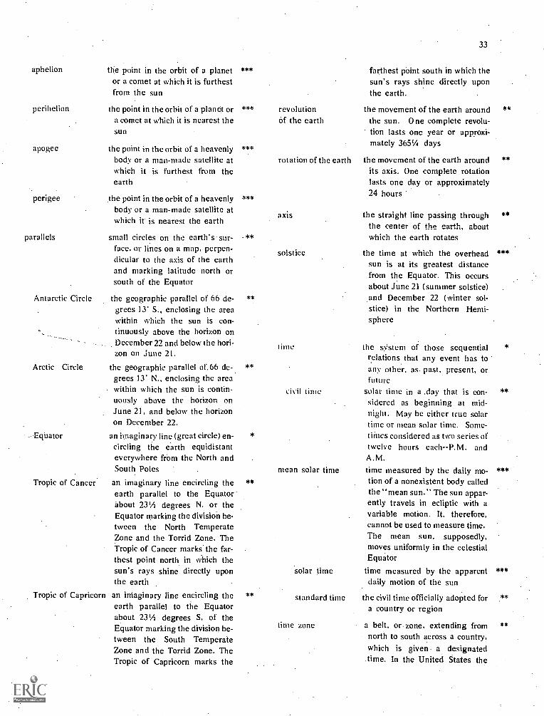
aphelion
perihelion
apogee
perigee
parallels
the point in the orbit of a planetor a comet at which it is furthestfrom the sun
the point in the orbit of a planet ora cornet at which it is nearest thesun
the point in the orbit of a heavenlybody or a man-made satellite atwhich it is furthest from theearth
the point in the orbit of a heavenlybody or a man-made satellite atwhich it is nearest the earth
small circles on the earth's sur-face. or lines on a map, perpen-dicular to the axis of the earthand marking latitude north orsouth of the Equator
Antarctic Circle the geographic parallel of 66 de-grees 13' S., enclosing the areawithin which the sun is con-tinuously above the horizon onDecember 22 and below the hori-zon on June 21.
Arctic Circle the geographic parallel of. 66 de-grees 13' N., enclosing the areawithin which the sun is contin-uously above the horizon onJune 21, and below the horizonon December 22.
an imaginary line (great circle) en-circling the earth equidistanteverywhere frOm the North andSouth Poles
Tropic of Cancer an imaginary line encircling theearth parallel to the Equatorabout 231/4 degrees N. or theEquator marking the division be-tween the North TemperateZone and the Torrid Zone. TheTropic of Cancer marks the far-thest point north in which thesun's rays shine directly uponthe earth
Tropic of Capricorn an imaginary line encircling theearth parallel to the Equatorabout 231/4 degrees S. of theEquator marking the division be-tween the South TemperateZone and the Torrid Zone. TheTropic of Capricorn marks the
Ecuator
***
***
***
***
.**
**
**
*
**
**
revolutionof the earth
rotation of the earth
axis
solstice
33
farthest point south in which thesun's rays shine directly uponthe earth.
the movement of the earth aroundthe sun. One complete revolu-tion lasts one year or approxi-mately 3651/4 days
the movement of the earth aroundits axis. One complete rotationlasts one day or approximately24 hours
the straight line passing throughthe center of the earth, aboutwhich the earth rotates
the time at which the overheadsun is at its greatest distancefrom the Equator. This occursabout June 21 (summer solstice)and December 22 (winter sol-stice) in the Northern Hemi-sphere
time the system of those sequentialrelations that any event has toany other, as past, present, orfuture
civil time solar time in a .day that is con-sidered as beginning at mid-night. May be either true solartime or mean solar time. Some-times considered as two series oftwelve hours each--P.M. andA.M.
mean solar time time measured by the daily mo-tion of a nonexistent body calledthe "mean sun." The sun appar-ently travels in ecliptic with avariable motion. It, therefore,cannot be used to measure time.The mean sun, supposedly,moves uniformly in the celestialEquator
solar time time measured by the apparentdaily motion of the sun
standard time the civil time officially adopted fora country or region
time zone a belt, or zone, extending fromnorth to south across a country,which is given a designated
.time. In the United States the
**
**
**
***
**
***

34
year
zenith
time zones are Bering, Alaska,Yukon, Pacific, Mountain,Central and Eastern time. The165th, 150th, 135th, 120th, 90th,and 75th meridians, respective-ly, mark the boundaries of theseseven time zones. The length oftime between one time zone andthe next is exactly one hour
an interval of time based upon therevolution of the earth in its orbitaround the sun. It is equal to365.2422 solar days or' 365 days,5 hours, 48 minutes, .46 seconds
the point in the celestial spheredirectly over a given point on theearth
*
***
* Primary grades 1-3 ** Intermediate grades 4-6*** Upper grades 7-8
SECTION H: DEVELOPMENT OF GENERAL CONCEPTSRELATED TO MAP READING
What are the skills and understandings related toglobal concepts and uses of maps?
What activities are helpful for teaching global under-standings and uses of maps?
What map terminology is useful for teaching globalunderstandings and uses of maps?
CONCEPTS, UNDERSTANDINGS AND SKILLSRELATED TO GENERAL GEOGRAPHIC CONCEPTS
MAJOR CONCEPT: Global understandings are important toUS.
Skills and Understandings Related to Global Understandings
Primary: The shape of the earth is round.Although round, the earth's surface is
not smooth.The globe is a proportional replica ofthe earth.
Globes are the basis for flat, maps.The earth is divided into sections called
hemispheresThere is more land area in the North-
ern Hemisphere than in the SouthernHemisphere .
Each place on, earth may be identifiedby degrees and minutes.
A grid forms the framework for allowingexact location of places in terms oflatitude and longitude.
Intermediate:
The earth is a sphere divided into hemi-spheres: Western, Eastern, Northern,Southern, daylight, and darkness.
Climate has a direct relationship withthe location of surface features of theearth.
Realizing the proportional relationshipbetween the size of globes and the sizeof the earth.
Activities Related to Global Understandings1. Primary: Compare the earth with photos of the moon, and
the moon as seen by the children at night. The reflection oflight shows a round moon, yet the photos of the moon showrough spots resembling craters and mountains. Point out theresemblance of this uneveness to the earth, yet both the moonand the earth are, over-all, round.
2. Primary: Use small replicas of ships. 'Sail' them over aglobe to show how ships disappear over the ocean. Use blocks
of wood or other small objects if toy boats are not readily
available.3. PriMary: Compare the above activity (2) with moving the
same object across a flat surface such as the floor, a table, abench, or a counter.
4. Intermediate: Ask a committee to present a report to theclass on the relationship of the types of houses, the types ofclothes and the types of climates in various piaceg in the world.Select places in all areas of the world. Be_certain to includefrigid, temperate and torrid zones.
MAJOR CONCEPT: Maps have different uses.
Skills an Understandings Related to Concept
Primary:
Intermediate:
Recognize that flat maps are not as ac-curate as globes for determining direc-tion and distance (location).
Recognize shape of the United States onall types of maps and globes.
Recognize shape of students' homestate on all types of maps and globes.
Maps are useful tools to man.Weather maps are of value to us as indi-
viduals.Locate places familiar to the students'
environment home, schoOl, com-munity, neighboring towns or cities,main streets, churches, hospitals, rec-reational areas, libraries, governmentbuildings.
Knowledge of how various maps andglobes may be used including outline,relief, political, and physical-politicalmaps.

Upper:
Understand the use of globes in con-junction with maps
Special maps may provide needed infor-mation
Be able to use outline maps for the dis-tribution of places and things.
Learn position and names of continents.
Recognize shape of many states.
Recognize shape of countries in theWestern Hemisphere
Various projections are used accordingto the purpose for their use. Mercator,Azimuthal, conical, and semi-ellipticalare several well-known projections
Recognize shape of countries through-out the world.
Associate countries with continents.
Activities Related to Concept
1. Intermediate: Compare two or more world pattern mapsand draw conclusions as to the reasons for certain patterns.Example: Compare (a) world population map, (b) world physi-cal map, and (c) world average yearly rainfall map. Note possi-ble relationships between (a)-density of population in variousareas. (b) type of topography, and (c) amount of rainfall.
2. Intermediate-Upper: Place two outline maps side-by-sidefor comparing various aspects of a country or statc and the lifeof itspcoplc. Compare population with products; products withclimate; population with climate; climate with vegetation;natural resources with manufactured goods, etc. (Remember:the great advantage of outline maps is its unclutteredncss.)
3. Intermediate-Upper: Have a student read a news item tothe class. Ask students to locate the place where the eventoccurred. Make it a practice to display and consult more thanone map each time it is necessary to use a map.
GLOSSARY OF GENERAL TERMS
Term
alp
altitude
Definition
a German term for a high moun-tain
the height above sea level of any
Level
***
**
archipelago
arroyo
bahia
bar
bay
beach
boreal
bourg
brook
canal
canyon
cape
cartography
channel
cold front
community
point on the earth's surface or inthe atmosphere
any large body of water with manyislands
a small steep sided watercourse orgulch with a nearly flat floor;usually dry except after heavyrains
a Portuguese or Spanish expres-sion for bay or gulf
a long ridge of sand, gravel, orether material near or slightlyabove the surface of the water ator near the mouth of a river orharbor entrance
a body of water forming an indent-ation of the shoreline, largerthan a cove but smaller than agulf
an expanse of sand or pebb:esalong a seashore
of or pertaining to the north ornorth wind
a town
a small, natural stream of freshwater
an artificial waterway for naviga-tion or irrigation
a deep valley with steep sides,often with a stream flowingthrough it; also, canon
a piece of land jutting into a sea orsome other large body of water
the production and construction ofmaps
the bed of a stream or waterway;the deepest part of a stream
the zone separating two airmasses, of which the cooler,denser air mass is advancingand replacing the warmer
a social group of any size whosemembers reside in a specificlocality, share government, andhave a common cultural andhistorical heritage
35
**
*
**
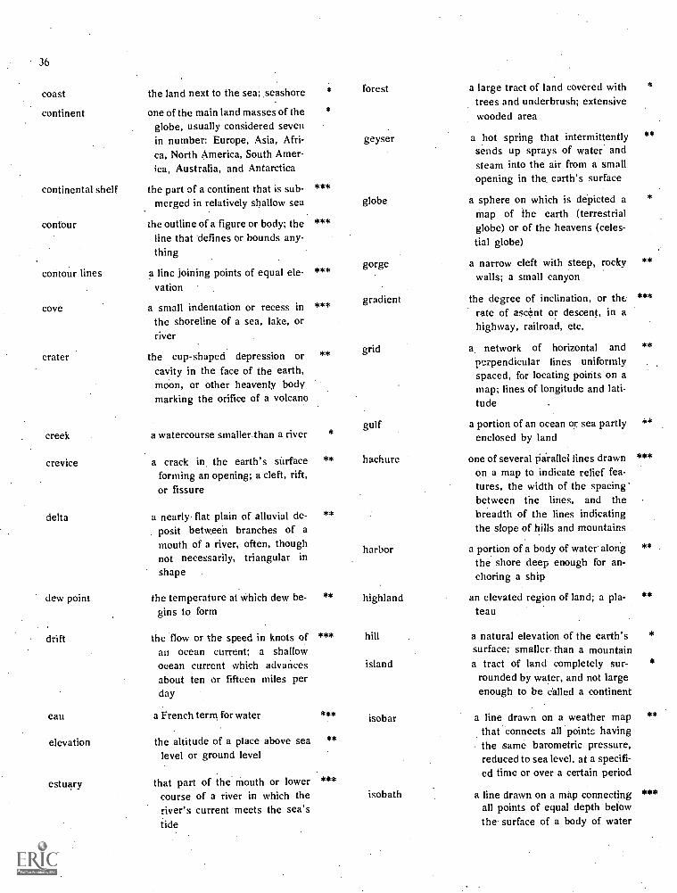
36
coast
continent
continental shelf
contour
contour lines
cove
crater
the land next to the sea; .seashore
one of the main land masses of theglobe, usually considered sevenin number: Europe, Asia, Afri-ca, North America, South Amer-ica, Australia, and Antarctica
the part of a continent that is sub-merged in relatively shallow sea
the outline of a figure or body; theline that defines or bounds any-thing
a line joining points of equal ele-vation
a small indentation or recess inthe shoreline of a sea, lake, orriver
the cup-shaped depression or
*
***
***
***
***
**
forest
geyser
globe
gorge
gradient
grid
cavity in the face of the earth,moon, or other heavenly bodymarking the orifice of a volcano
creek
crevice
delta
dew point
drift
a watercourse smaller than a river
a crack in, the earth's surfaceforming an opening; a cleft, rift,or fissure
a nearly flat plain of alluvial de-posit between branches of amouth of a river, often, thoughnot necessarily, triangular in
shape
the temperature at which dew be-gins to form
the flow or the speed in knots ofan ocean current; a shallowocean current which advancesabout ten or fifteen miles perday
*
**
**
**
***
gulf
hachure
harbor
highland
hill
island
eau
elevation
estuary
a French term for water
the altitude of a place above sealevel or ground level
that part of the mouth or lowercourse of a river in which theriver's current meets the sea'stide
***
**
***
isobar
isobath
a large tract of land covered withtrees and underbrush; extensivewooded area
a hot spring that intermittentlysends up sprays of water andsteam into the air from a smallopening in the earth's surface
a sphere on which is depicted amap of the earth (terrestrialglobe) or of the heavens (celes-tial, globe)
a narrow cleft with steep, rockywalls; a small canyon
the degree of inclination, or therate of ascent or descent, in ahighway, railroad, etc.
a network of horizontal andperpendicular fines uniformlyspaced, for locating points on amap; lines of longitude and lati-tude
a portion of an ocean or sea partlyenclosed by land
one of several Parallel lines drawnon a map to indicate relief fea-tures, the width of the spacingbetween the lines, and thebreadth of the lines indicatingthe slope of hills and mountains
a portion of a body of water alongthe shore deep enough for an-choring a ship
an elevated region of land; a pla-teau
a natural elevation of the earth'ssurface; smaller than a mountaina tract of land completely sur-
rounded by water, and not largeenough to be called a continent
a line drawn on a weather mapthat connects all points havingthe same barometric pressure,reduced to sea level, at a specifi-ed time or over a certain period
a line drawn on a map connectingall points of equal depth belowthe surface of a body of water
*
**
*
**
***
**
***
**
**
***

isobront
isodrosotherm
isogram (isoline)
isohaline
isohel
isohume
isohyet
isoneph
isotach
isotherm
a line on a weather map connect-ing various points where thesame phase of thunderstormactivity occurs simultaneously
a line on a weather map connect-ing points having an equal dewpoint
a line representing equality withrespect to a given variable, usedto relate points on a map
a line drawn on a map of the oceanconnecting all points of equalsalinity
a line on a weather map connect-ing points that receive equalamounts of sunshine
a line on a weather map connect-ing points of equal relative hu-midity
a line drawn on a map connectingpoints having equal rainfall at acertain time or for a stated per-iod
a line on a weather map connect-ing points having the same a-mount of cloudiness
a line on a weather map connect-ing points where winds of equalspeeds have been recorded
a line on a weather map connect-ing points having equal temper-ture
isthmus a narrow strip of land, borderedon both sides by water, connect-ing two larger bodies of land
lake a body of water completely sur-rounded by land
ledge any relatively narrow, shelf-likeprojection of land or rock; cliff orridge
legend a table on a map or chart explain-ing the symbols used
llanos an extensive grassy plain with fewtrees in Spanish South America
lowland land which is level with respect tothe adjacent country
***
***
***
***
***
***
***
***
***
***
***
map
land use map
landscape map
physical map
political map
relief map
mesa
metropolitan area
natural resource
oasis
ocean
pampas
peninsula
pictograph
plain
population
pueblo
a drawing or representation ofpart or all of the surface of theearth or of some other heavenlybody
a map showing the relation of manto the landscape; indicates howthe land is used
37
**
maps showing the appearance of ***
the earth's surface; a photo-graph of the Earth's surfacelandform maps indicating plains,
plateaus, mountains, rivers,lakes, seas, etc.; the geomorph-ology of a region
maps depicting the political de-scription of boundaries betweencountries, provinces, states orcountries
a map showing the relief of anarea, usually by generalized con-tour lines
a land formation having a relative-ly flat top and steep rock walls
the areas adjoining a large city
the natural wealth of a country,consisting of land, water, miner-al deposits, etc.
a small fertile area in a desert re-gion
the vast body of salt water whichcovers almost threefourths ofthe earth's surface
the vast grassy plains of SouthAmerica
a body of land surrounded onthree sides by water
a sign of symbol used in graphsand maps
an area of land not significantlyhigher than adjacent areas andwith ''"'e difference in altitudes
the total number of persons livingin an area
an Indian village; a communal vil-lage of certain agricultural In-dians of the Southwest UnitedStates
**
**
**
**
**
**
**
**
**
**
**
**

ridge
river basin
sea
sea level
sextant
slope
spit
strait
a long, narrow elevation of land; acliain of hills or mountains
the area of land drained by a riverand its tributaries
the salt waters that cover thegreater part of the earth's surcface
that point in altitude in which thesea comes in contact with theland
an instrument used in measuringangular distances, especiallythe altitudes of the sun. moonand stars at sea in determing lat-itude and longitude
the sides of foothills or bluffs
a narrow point of land projectinginto the water
a narrow passage of water con-necting two large bodies ofwater
*** stream
terrain
trail
***
*
a body of water flowing in a chan-nel, such as a 'river, rivulet,brook or creek
a tract of land considered with re-ference to its natural features
a path or track made across a wild
***
*
region or over rough country;made by the passage of men or**animals
tundra a vast nearly level, treeless plainsof the Arctic regions
**
***
upland the higher ground of a region oror district
**
***vegetation all the plants or plant life of a
place
**
*** villa a small town, country residence orestate
***
** warm front a transition zone between a massof warm air: and the colder air it
**
. is replacing
* Primary grades 1-3 ** Intermediate grades 4-6 *** Upper grades 7-8

. FIGURESPage
1. Values of a globe 52. Principles for using globes 53. A Mercator Projection 7
4. An example of Azimuthal Projections 8
5. Cahill's Butterfly World Map 86. Goode's Interrupted Projection 87. Degrees of abstractness in symbolic representations 11
8. Map of a school playground 149. Construction of flannel-board map 15
10. Samples of graduated scales 2511. Reading a compass 2712. Climatic zones of the world 30
39
ILLUSTRATIONSPage
I. Symbol for a river 92. Symbol for a river alai its tributaries 103. A lake connecting two rivers 104. A coastline 105. A coastline with a river flowing into an ocean 106. An island and a bay or gulf 107. Use of shading for sketching mountains and valleys 108. Using hachures for showing relief on maps 109. Using color layers to show relief 11
10. Using contour lines to show relief 11
CHARTS
1. Samples of how maps are usedexperiences
2. Differences in mileage scales onat latitudes 00,, 20°, 4O and 50° 7
3. A test for primary children to ascertain concept ofdistance 24
Pagein everyday living
2
a Mercator Projection

PRICE LISTINCLUDING SPECIAL "PACKAGE" RATES)
Pkg. I Prior 1972, in-print issues (includes I-A, I-B, I-CPkg. 1-A (Disadvantaged and Special Education)
262 Random Excerpts on the Disadvantaged270 Job Corps Innovations280 Education of Educable MR Students: Literature Review282 The Culturally Disadvantaged288 Needs of the Non-College Bound
299 A Program for Neglected Youth303 Measurement & Prosthesis of Retarded Behavior307 Acculturation of Minority Group Children
Pkg. I-B (Improvement of Instruction) .
252 Mankind's Many Calendars259 How Do the People of Canada Work and Live? (unit)276 Creativity and the Classroom279 Guidelines to Learning: Inquiry and Discovery281 Independent Study in Secondary Schools283 Balance in Music Classes in Oregon High Schools284 Constructing Tests in A Curriculum Study Center286 Team Teaching: Definition, Hist., Description287 People of West Indies in World Community (Unit)289 The Chewing Method in Speech Therapy290 Free-Association Word List for Oregon295 Oregon's Contribution to Literature, Music, Art300 The Teaching- Leaining Environment301 Planning for Teaching302 Some Techniques of Teaching305 Evaluating and Reporting Pupil Progress
Pkg. I-C (Administrative Interests)274 The Oregon Six-Year Secondary School277 Admin. Staff Relationships: Effect on Children
293 Evaluation -- Accreditation of Secondary Schools297 Ingredients of Change304 Education and Your Child306 More Sense and Nonsense (Readings in 5.,t;,...-1308 The Clinica: School Program309 Annotated 1 idex of the Cirricuium Bulletins
List Price
$ .751.301.252 001.20.50.75
1.501.10
.751.301.85
.80.85.50.50
2.001.35.50.75.50.75.50.50.75
.75
.75
75.50.50.80
1.001.00
$6.00
8.00.
3.50
PackageRates
$15.00
$15.00
NOTE: If specific issue:. of cur supply of "prior 1972. in-print issues" are exhausted before we receive your order, we reserve the right tosubstitute a limited number of other issues (order immediately to avoid substitutions) . THE PRIOR 1972, IN-PRINT ISSUES WILL NOT BESTOCKED AFTER JUNE 1974.
Pkg. II 0972 issues)310 Remedial Reading: Case Studies311 Teaching Performance: Some Basis for Change
1.501.50
312 An Inventory of Reading Skills 1.50 5.00313 Evaluative Reform in the Arts and Humanities 1.50314. A Curriculum Manifesto (Jack Frymier) 1.50
Pkg. (11 (1972 issues)315 Responding to Student Unrest: Administrative Guide 2.50316 Annotated Bibliography Secondary School Materials,'Remediation of Reading 2.00317 The Change Process: What We Can Learn From Nepal 2.00318 Writing Is the Funnest Thing: Creative Writing 1.50 5.00319 The Open School: Roosevelt Junior High School, Eugene 1.50320 Designing Behavioral Goals 1.25
Pkg. IV (1974 subscription)321 Mapology: The How Much of What Is Where 2.00 5.00322 Using Art Prints in Art Education323 B.F. Skinner and Carl Rogers on Behavior and Education324 Heritage of American Youth325 Moving Toward a More Open Education326 (Title to be Selected)
PAYMENT MUST ACCOMPANY ORDER (WE PAY POSTAGE) PAYMENT MUST ACCOMPANY ORDER
Order from: Oregon ASCD Curriculum Bulletin, PO Box 421, Salem, OR 973:38

Pkg. , Language
PRICE LIST SUPPLEMENTARY PACKAGES
Arts310 Remedial Reading. Case Studies312 An Inventory of Reading Skills . . . .316 Anno. Biblio Sec. Sch. Mtrls, Remediation of Read'.' .318 Writing is the Funnest Thing- Creative Writing289 ......Chewing Method in Speech Therapy . .290 Free Association Word List295 Oregon's Literature, Music, Art
Pkg.' Elementary Education . ,
-252 Mankind's Many,Calendars . : .. .. ....... .. . .. . ...279 Inquiry and Discovery in the Elementary School ... .... . `... .. ... .. .. , .. - .80 . ' '
280 Education of Educable,MR Students. Lit. Review , -- 1.25. .287 How People of the West Indies Participate in the World Com. . . '1 35290 A Free-Association Word List for the Willamette Valley . 75304- Education 'and Your Child - ... . .. . .. .. - 50 _310 Remedial Reading- Case Studies . ' .1 50312- An Inventory of Reading Skills . . .. .... .1.50318 Writing Is the Funnest Thing .... .1.50
Pkg. Secondary Education274 The Oregon Six-YearSecondary School .281 Independent Study in Secondary Schools ...... ...283 Study of Balance in Music Classes in Oregon High Sch293 Evaluation Accreditation of Secondary Schools315 Student Unrest in the HS: Guide for Administrators316 AnnO. Biblio Sec. Sch. Mtrls.,Remediation of Read.319 The Open School. Roosevelt Jr.r1-1.S.. Eugene, OR.
-$5 50
. 75:85
.50 -
. 2.50'
. 1.50
Oregon ASCD Curriculum BulletinPO Box 421, Saleni, Oregon 97308 Date _
Please use the order form below
Please send me the following: I, enclose $
pkg. I, Prior 1972, in-print issues' at $15.00' ... .
Pkg. I-A, Disadvantaged and Special. at $6 00' Pkg 1711, Improvement of hisfruction at $8 00: ',
Pkg 1- C,-Administrative Interests at $3.50,Pkg. 11, 1972 issues, at $5.00 .
- Pkg. '111;1973 issues,''at $5.00, '
Pkg. IV, 1974 subscription, at $5 00 .- ' ' ''''r k7 Grand Package, L 11, 111, IV above at $25.00 : :
Pkg. Language Arts at $5.50 . : ' ,.
Pkg: Elernentary,Edileation at $5.50 .. : ..Pkg. Secondary Education at $5.50 -:Pkg. "Z',*. Your choice, List price, less Onelthird, $5 00 min.
.
, ' . TOTAL ENCLOSED,';.
Institution
Street Address'. -
_City, State, Zip

OREGON ASCD CURRICULUM BULLETINP. 0. BOX 421SALEM. OREGON 97308
Non-Profit Org.Bulk Rate
U.S. PostagePAID
Salem, Ore. 97308Peruilt No. 226
STATEMENTS AND POINTS OF VIEW APPEARING IN THE OREGON. ASCD CURRICULUM BULLETIN DO NOT NECESSARILYREPRESENT THE POSITION OF THE EDITING COMMITTEE CR OREGON ASCD, COLLECTIVELY OR INDIVIDUALLMANUSCRIPTS ARE PRESENTED PRIMARILY FROM THE VIEWPOINT OF POTENTIAL INTEREST AND PROVOCATIVENES
MANUSCRIPTS SOLICITED: SHOULD TREAT A SINGLE TOPIC, AS A MONOGRAPH OR SYMPOSIUM, WITHIN THE BROAD AREOF CURRICULUM, 10,000 to 25,000 WORDS IN LENGTH. SUBMIT TO EDITOR (P.O. BOX 421, SALEM, OREGON 97308)
THE LIBRARY OF CONGRESSCATALOG ,CARD66. 64621',


![Baudelaire Charles - Poesia Completa Ed Bilingue[1]](https://static.fdocuments.net/doc/165x107/577cc5b21a28aba7119cf4aa/baudelaire-charles-poesia-completa-ed-bilingue1.jpg)