DOCUMENT RESUME - ERIC - Education Resources … · DOCUMENT RESUME SE 007 609. Eubach, Harold W.;...
135
ED 033 85 AUTHOR TITLE INSTITUTION Pub Date Note Available from EDES Price Descriptors Identifiers Abstract DOCUMENT RESUME SE 007 609 Eubach, Harold W.; Taber, Bcbert W. Questions About the Cceans. Naval Cceanographic Office, Washington, L.C. 6E 134p. Superintendent cf Documents, Gcvernment Printing Cffice, Washington, E.C. 20402 $0.30 EDBS Price MF$0.75 HC Not Available from EEBS. Earth Science, Elementary Schccl Science, Marine Biology, *Oceanology, Physical Sciences, *Reference Books, Resource Materials, Scientific Methodology, *Secondary School Science, Supplementary Beading aaterials Naticnal Oceancgraphic Data Center This bock was prompted by the success of a display mounted by the National Oceanogr c Eata Center at the 17th International Science Fair 1. _06, which enabled visiting teachers and students to ask and receive answers to questicns via teletype. The bock ccntains one hundred questions typical of those asked, together with answers ranging in length frog a paragraph to ahcut a page. Topics include physical, chemical, and geological aspects of the oceans, marine biology, and the history and methodology oceanclogy. The authors paid particular attenticn tc presenting the material in language understandalle tc secondary school students; elementary school students should also be able to comprehend some of the questicns and answers. Scme answers are illustrated, and each is fcllowed by selected references prcviding additional information. (EB)
Transcript of DOCUMENT RESUME - ERIC - Education Resources … · DOCUMENT RESUME SE 007 609. Eubach, Harold W.;...

ED 033 85
AUTHORTITLEINSTITUTION
Pub DateNoteAvailable from
EDES Price
Descriptors
Identifiers
Abstract
DOCUMENT RESUME
SE 007 609
Eubach, Harold W.; Taber, Bcbert W.Questions About the Cceans.Naval Cceanographic Office, Washington,L.C.6E134p.Superintendent cf Documents, GcvernmentPrinting Cffice, Washington, E.C. 20402$0.30
EDBS Price MF$0.75 HC Not Available fromEEBS.Earth Science, Elementary Schccl Science,Marine Biology, *Oceanology, PhysicalSciences, *Reference Books, ResourceMaterials, Scientific Methodology,*Secondary School Science, SupplementaryBeading aaterialsNaticnal Oceancgraphic Data Center
This bock was prompted by the success of adisplay mounted by the National Oceanogr c Eata Centerat the 17th International Science Fair 1. _06, whichenabled visiting teachers and students to ask and receiveanswers to questicns via teletype. The bock ccntains onehundred questions typical of those asked, together withanswers ranging in length frog a paragraph to ahcut a page.Topics include physical, chemical, and geological aspectsof the oceans, marine biology, and the history andmethodology oceanclogy. The authors paid particularattenticn tc presenting the material in languageunderstandalle tc secondary school students; elementaryschool students should also be able to comprehend some ofthe questicns and answers. Scme answers are illustrated,and each is fcllowed by selected references prcvidingadditional information. (EB)

-
'%rfkMI:A
CO
,...;.;
..;
I I r ;
.....'Ie.,-....-'
= ....,..1.27..0.:::,-..-;21:ZW::,2-....ir
.;f
":--1 4,110, 7--, . N
C:\ . ,:....".....: -*..;..40.!ritAt?". . t,..i.t.a. '
U.S. DEPARTMENT Of HEALTH, EDUCATION & WELIARL:t.44'1!;iii.:,1;40OFFICE OF EDUCATION
. c:\,!!
. `;
./4 ,/j ',f.
"*,we.
DOCUMENT HAS BEEN REPRODUCED EXACTLY AS RECEIVED FROM THE
;VERSON OR ORGANIZATION ORIGINATING IT. POINTS OF VIEW OR OPINIONS,
STATED DO NOT NECESSARILY REPRESENT OFFICIAL OFFICE OF EDUCATION 111"---=''. :.7'414116,10' Pen-. ;117.1,3'POSITION OR POLICY.
ws v447"
0E1
44i 44.4f.If'1.; 7." rd..164,
)*011. I
ft"2.7t="71.4."--'rerrilrimov11. f
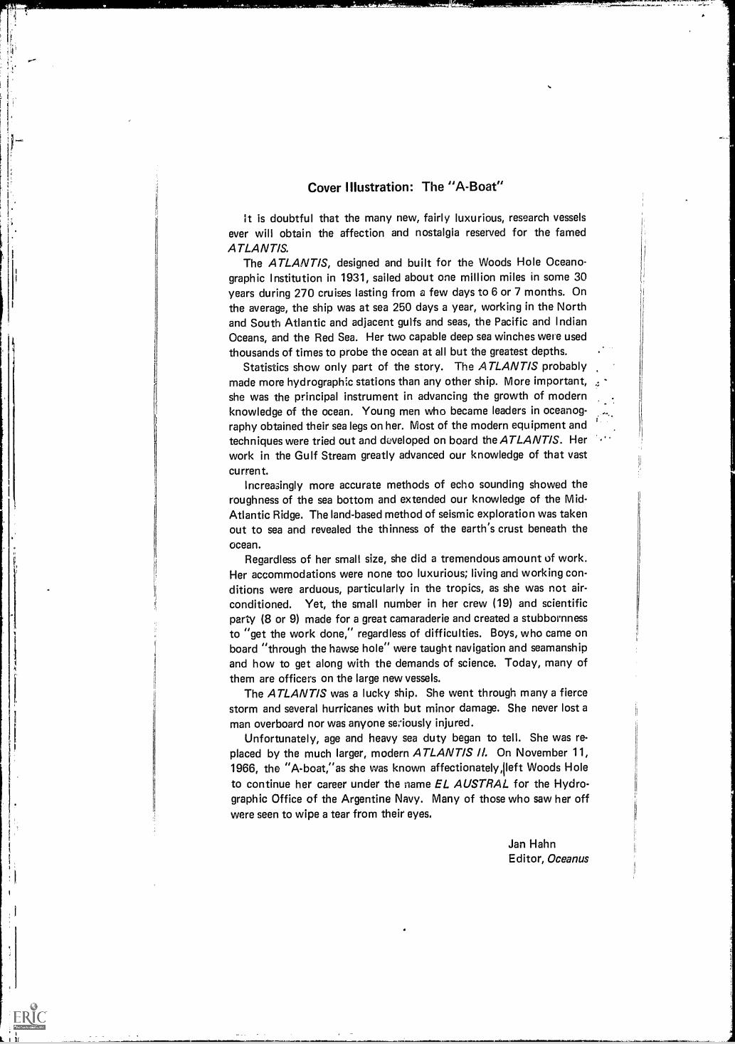
Cover Illustration: The "A-Boat"
It is doubtful that the many new, fairly luxurious, research vesselsever will obtain the affection and nostalgia reserved for the famedATLANTIS.
The ATLANTIS, designed and built for the Woods Hole Oceano-graphic Institution in 1931, sailed about one million miles in some 30years during 270 cruises lasting from a few days to 6 or 7 months. Onthe average, the ship was at sea 250 days a year, working in the Northand South Atlantic and adjacent gulfs and seas, the Pacific and IndianOceans, and the Red Sea. Her two capable deep sea winches were usedthousands of times to probe the ocean at all but the greatest depths.
Statistics show only part of the story. The ATLANTIS probablymade more hydrographc stations than any other ship. More important,she was the principal instrument in advancing the growth of modernknowledge of the ocean. Young men who became leaders in oceanog-raphy obtained their sea legs on her. Most of the modern equipment andtechniques were tried out and developed on board the ATLANTIS. Herwork in the Gulf Stream greatly advanced our knowledge of that vastcurrent.
Increasingly more accurate methods of echo sounding showed theroughness of the sea bottom and extended our knowledge of the Mid-Atlantic Ridge. The land-based method of seismic exploration was takenout to sea and revealed the thinness of the earth's crust beneath theocean.
Regardless of her small size, she did a tremendous amount of work.Her accommodations were none too luxurious; living and working con-ditions were arduous, particularly in the tropics, as she was not air-conditioned. Yet, the small number in her crew (19) and scientificparty (8 or 9) made for a great camaraderie and created a stubbornnessto "get the work done," regardless of difficulties. Boys, who came onboard "through the hawse hole" were taught navigation and seamanshipand how to get along with the demands of science. Today, many ofthem are officers on the large new vessels.
The ATLANTIS was a lucky ship. She went through many a fiercestorm and several hurricanes with but minor damage. She never lost aman overboard nor was anyone se; ously injured.
Unfortunately, age and heavy sea duty began to tell. She was re-
placed by the much larger, modern ATLANTIS II. On November 11,1966, the "A-boat,"as she was known affectionately,Ileft Woods Holeto continue her career under the name EL AUSTRAL for the Hydro-graphic Office of the Argentine Navy. Many of those who saw her offwere seen to wipe a tear from their eyes.
Jan HahnEditor, Oceanus

NATIONAL OCEANOGRAPHIC DATA CENTER
GENERAL SERIES
co QUESTIONS ABOUT THE OCEANS
CoLC%
PUBLICATION G-13
by
HAROLD W. DUBACHUsi and
ROBERT W. TABER
EDWIN J. SEREMETH
Technical Adviser For Graphics
Library of Congress Catalog Card Number: 67-60068
First Printing 7968Second Printing 1968
Published by The U.S. Naval Oceanographic OfficeWashington D.C. 20390
For sale by the Superintendent of Documents, 'U.S. Government Printing OfficeWashington, D.G. 20402 Price 85 cents (paper cover)

The National Oceanographic Data Center is
sponsored by U. S. Government agencies having an
interest in the marine environment; it is governed
by an Advisory Board composed of representatives ofthese activiNes and the National Academy of Sciences.
The U. S. Naval Oceanographic Office is assigned
responsibility for management of the NationalOceanographic Data Center.
The Sponsoring Agencies are:
Atomic Energy Commission
Bureau of Commercial Fisheries
Coast Guard
Coastal Engineering Research Center
Department of the Navy
Environmental Science Services Administration
Federal Water Pollution Control Administration
Geological Survey
Health, Education & Welfare
National Science Foundation
H

ACKNOWLEDGMENTS
The authors acknowledge with thanks the historical brief on thefamous Woods Hole Oceanographic Institution vessel ATLANTIS sup-plied by Mr. Jan Hahn. The authors wish to give special recognition tothe science class of Zundelowitz Jr. High School, Wichita Falls, Texas,which was a principal catalyst responsible for the creation of this book.We gratefully acknowledge the assistance of Mrs. L. Annette Farrall,Mrs. Wilhelmenia Bowe, and Mr. William Lyons.
iii

PUBLICATIONS IN THE NODC GENERAL SERIES:
G-1. Introduction to the National Oceanographic DataCenter
G-2. Oceanographic Vessels of the World, Vol. I, Vol. II,and Vol. III
G-3. EQUALANT IData Report, Vols. I & IIG-4. A Summary of Temperature-Salinity Characteristics
of the Persian GulfG-5. EQUALANT IIData ReportG.6. Atlas of Bath ythermograph DataIndian OceanG-7. EQUALANT IllData ReportG-8. Guinean Trawling SurveyData Report0-9. Water Masses and Density Stratification, Vol. (
Western North Atlantic OceanG-10. Selected HOE Track Charts
G-11. The Variability of Water Masses in the Indian Ocean
G-12. Indian Ocean AtlasInterpolated Values of Depth,Salinity, and Temperature on Selected Sigma-tSurfaces
G-13. Questions About the Oceans
G-14. Summary of NODC Ad Hoc Committee and WorkingGroup Activities
iv

.arstitt
Junior High School Students Ask Questions About the Oceans at the17th International Science Fair in Dallas, Texas.
v

No.
CONTENTS
Question Page
1. What is the greatest depth of the ocean and where is it?. . . 1
2. Why is the ocean blue? 23. Where do waves come from? 34. What is the rate of sediment deposition on the sea floor ? 45. How thick is the ice in the Arctic Ocean? 56. If all the ice in the world should melt, what would
happen? 67. What causes the red tide? 7
8. What makes the ocean salty? 89. Is there gold or other precious elements in the ocean? If
so, how much? 910. What is the difference between a sea and an ocean? 1011. How deep has a skin diver gone? 11
12. Can a "hard hat" diver go deeper than a skin diver? 1213. How deep has man gone in the ocean? 13
14. What is the source of the Gulf Stream? 1415. How long (and big) is the Gulf Stream? 1516. What is a waterspout and what causes it? 16
17. What do oysters and clams eat? 17
18. What commercial products other than fish are obtainedfrom the sea? 18
19. What is the annu,.:1 fish take by the United States? . . . 19 .
20. How does the fish take of the United States compare withother countries? 20
21. What are the primary pollutants found in the sea and whatare their sources? 21
22. What is Atlantis? 2223. What does the sea floor look like? 2324. Are there strong currents at depths b3neath the ocean
surface that might compare to the "jet stream" in theupper levels of the atmosphere? 24
25. Why does the sea foam? 2526. How did seas, such as the Black, Red, and White, get their
names? 2627. Wh,*.. causes hurricanes and how do they differ from
typhoons? 2728. How high is the highest wave? 2929. How many species of fishes are there? 3030. Beside the whale, what other mammals live in the oceans? 31
v% vii

No. Question Page
31. What causes the tides? 3332. Wny do tide ranges in the same geographical areas of the
world differ so greatly? 3433. What are seamounts? How are they created? 3534. How deep in the ocean can one see with natural sunlight? 3635. What is the volume of the world's oceans? 3736. Are whales found in all oceans of the world? 3837. Do any creatures in the sea other than the porpoise talk?. 3938. How do oysters produce pearls? 4039. How far into the ocean can one "see" the effect of a
river? 4140. Is seaweed a weed? What is it and how does it grow? . . . 4341. What is green scum? 4542. What are algae? 4643. Can gold, silver, platinum, or diamonds be mined from
the sea? 4844. Where is the hottest ocean or portion of an ocean? 4945. How salty are the oceans? Which is the saltiest? 5046. Has a sea gull, albatross, or other sea bird ever flown
across the ocean? 5147. Are there volcanoes under the sea like those on land? . . . 5248. Is life found at all depths in the ocean? 5349. What causes "tidal waves"? 5550. Can "tidal" waves be forecast? 5851. What is the "bends" and how do divers become afflicted
with it? 5952. Are all fishes edible? 6053. What other sea life is used for human consumption? 6154. What is fish protein and why is it important? 6355. What is "fish farming" and where is it practiced? 6456. How far has a message in a bottle ever traveled on the
ocean? 6557. What is the difference between hydrography and oceanog
raphy? 6758. How old is the science of oceanography? 6859. What universities and colleges have oceanographic courses? 7060. Who hires oceanographers? 7261. What is the largest oceanographic research ship? 7362. How are oceanographic observations taken beside from a
ship? 74
viii

No. Question Page
63. What is bioluminescence? 77
64. What is the continental shelf? 7865. Has an efficient method of obtaining fresh water from the
sea been invented? 7966. Why is the Cape Hatteras area known as the graveyard
of ships? 81
67. How does an oceanographic ship anchor to take observa-tions in the deep ocean? 83
68. How much power (energy) is in a wave? 8469. Are the rise and fall of tides used to develop power? 8570. Who is the most famous oceanographer? 8671. Does oceanography include the study of lakes and streams? 8772. What is plankton? 8873. Are there really sea monsters? 9074. What is sonar? 91
75. How deep can submarines operate safely? 9276. How do submarines navigate when submerged for weeks at
a time? 9377. How fast can a porpoise swim? Is it the fastest swimming
"fish"? 9478. What is the pressure at the deepest part of the ocean? 9579. What are turbidity currents? 9680. What is the most important discovery made about the
oceans? 9781. What is the MOHO? 9882. How much do scientists really know about the oceans? . . 9983. What are ice islands? 10084. What are the best materials to use for building a pier? 10185. What is the hydrologic cycle? 10386. What is the DSL? 10487. How thick is the sediment at the bottom of the ocean? 10588. What is a storm surge? 10689. What makes a very slight swell (wave) become much higher
when it breaks on the shore as surf? 10790. What is "ship route forecasting"? 10891. How accurately can oceanographers predict ice formation,
size, and movement? 10992. What is the International Ice Patrol? 11093. Who owns the water areas offshore and how far? 11294. Is there any danger of overfishing? 113
ix

No. Question Page
95. Are radioactive wastes disposed in the ocean? If so, whereand how, and are there any latent dangers involved? 114
96. Why isn't there more interest and activity in recovery ofsunken ships and treasure? 115
97. What types of organisms, other than sharks, are poten-tially dangerous to swimmers? 117
98. How much electricity does an electric eel generate? 118
99. How are ships protected from corrosion and fouling? . . . 119
100. What causes the hydrogen sulphide concentration at thebottom of the Black Sea? 120

INTRODUCTION
In May 1966, the National Oceanographic Data Center was invitedto be an exhibitor at the 17th International Science Fair in Dallas, Texas.Among other things, the display included a Teletype that linked theFair exhibit to the NODC data-information base in Washington, D. C.Visiting teachers and students were invited to ask questions aboutoceanography and related subjects on the Teletypeand the Teletypequickly spelled out a response to the query. In some cases, answerswere delayed because information was not in the data base; the questionhad to be referred to an experienced marine scientist. This exhibit be-came the "Fair favorite" as a constant stream of visitors waited theirturn to ask a question and a crowd of curious onlookers waited for theanswer to come in. The interest, curiosity, and enthusiasm shown byhundreds of Science Fair visitors from the southwest United Statessparked the idea for this book. Their questions were limitless and theirthirst for information on the ocean seemed never to be satisfied. At theconclusion of the Fair, the authors decided that a "question andanswer" book on'the oceans might be helpful and useful to many.
The questions presented in this booklet are typical of those asked bythe Science Fair visitors or of the hundreds of student inquiries receivedeach year by the NODC. And, of course, some questions are based onthe authors' own personal contacts with individuals in all walks of lifewho wanted a specific question on the ocean answered.
One purpose of the book is to supply answers to the more com-monly asked questions on oceanography and the marine sciences-butit is our hope that this book will fulfill a more basic twofold purpf3s4:
(1) To present factual material on the marine sciences for use tyoung people at all grade levels, with the expectation that it will stirro.,late their imagination, create interest in the subject, and provoke furtherstudy; and
(2) To supply for teachers a suitable introduction to selected marinesubjects, with specific references for additional information. (Addi-tional assistance and study material are available from the NationalOceanographic Data Center upon request.)
Each question and answer is followed by references containing moreinformation on the topic. Answers may not cover some of the subtledetails and related complexities, because the authors have made a con-certed effort to supply an answer in 350 words or less. Particular atten-tion was given to presenting the material in language understandable tothe secondary school student. Elementary school children should beable to comprehend about 25 percent of the questions and answers.
xi

r.
The remainder probably will require explanatory help from the teacheror parents. Authoritative references containing additional details on eachquestion are given; many of these books may be found in school librariesor can be easily obtained by instructors or students.
To our readers, we hope the information herein will promote furtherexploration into the wealth of material available on the oceans. Wesincerely hope it will serve as a threshold to students seeking interestingchallenges for study. To those who seek careers in virgin frontiers, wesuggest serious consideration of the opportunities for investigation, re-search, and discovery in the marine sciences. If additional assistance orinformation is desired, we invite you to write us at the National Oceano-graphic Data Center.
xii

1. What is the greatest depth of the ocean and where is it?
In 1959, the Soviet vessel VITYAZ reported a depth of 36,200 feetnear the Challenger Deep. The Marianas Trench had been sounded in1927 by the Japanese survey ship MANSHU, which recorded a depthof 32,190 feet.
In recent years, many other deeps have been measured by oceanog-raphers; some of those reported by British and U. S. ships follow:
In 1952, the British survey ship CHALLENGER located a depth of35,640 feet in the Marianas Trench off Guam (the Challenger Deep).This depth was measured by an echo sounder; it took 7-1/4 seconds forthe sound to reach the bottom. To confirm the sounding, a weightedcable was lowered to the bottom; this lowering required 90 minutes.
On January 23, 1960, the bathyscap!, TRIESTE descended into thaMarianas Trench to a depth of 35,800 feet.
Although most publicity has been given to the Marianas and Min-danao Trenches, very deep soundings have also been recorded in theSouthern Hemisphere. In 1952, the U. S. research vessel HORIZON re-corded a depth of 34,884 feet in the Tonga Trench, south of SamoaIslands.
Gaskell, T. F.World Beneath the Oceans, American Museum of Natural History,1964.
Soule, GardnerThe Ocean Adventure, Appleton-Century, 1966.
Stewart, Harris B., Jr.Deep Challenge, Van Nostrand, 1966.
1

2. Why is the ocean blue?
Not all sea water is blue. Water of the Gulf Stream, off the easterncoast of the United States, is a deep blue, but water of a similar currentoff Japan is so dark that it has been named Kuroshio (Black Stream).In other areas water may be various shades of green, brown, or brownish-
red.The sea is blue for the same reason that the sky is blue. The blue of
the sea is caused by scattering of sunlight by tiny particles suspended in
the water. Blue light, being of short wave length, is scattered more ef-
fectively than light of longer wave lengths.Although waters of the open ocean are commonly some shade of
blue, especially in tropical or subtropical regions, green water is com-monly seen near coasts. This is caused by yellow pigments being mixedwith blue water. Microscopic floating plants (phytoplankton) are onesource of the yellow pigment. Other microscopic plants may color the
water brown or brownish-red. Near shore silt or sediment in suspension
can give waters a brownish hue; outflow of large rivers can often be ob-
served many miles offshore by the coloration of suspended soil particles.
The color of the sea changes constantly because of clouds passingacross the face of the sun or because of the angle of the sun's rays pass-
ing through the atmosphere.Oceanographers record the color of the ocean by comparison with
a series of bottles of colored water known as the Forel scale.
Bowditch, NathanielAmerican Practical Navigator, U. S. Naval Oceanographic Office,1958.
Carrington, RichardA Biography of the Sea, Basic Books, 1960.
Miller, Robert C.The Sea, Random House, 1966.
2

3. Where do waves come from?
The commonly seen waves on the surface are caused principally bywind. However, submarine earthquakes, volcanic eruptions, and tidesalso cause waves.
A breeze of less than 2 knots (2 nautical miles per hour) can formripples. As the wind speed increases, larger more visible waves form.The wave height in feet usually will not be more than half the windspeed in miles per hour, although individual waves may be higher.
As lor,g as the wind blows consistently from the same direction, thewaves are referred to as sea. When the wind stops or changes direction,
the waves that continue in a direction different from that of the localwinds are called swell.
Bowditch, NathanielAmerican Practical Navigator, U. S. Naval Oceanographic Office,1958.
Gaskell, T. F.World Beneath the Oceans, American Museum of Natural History,1964.
Miller, Robert C.The Sea, Random House, 1966.
3

4. What is the rate of sediment deposition on the sea floor?
Probably the most accurate method of dating sediments is the radio-carbon method. Red clay accumulates on the bottom of the deep ocean
at a rate of half a centimeter or less every 1,000 years. Calcareous oozes
may accumulate twice as fast.The average deposition rate in the Atlantic is probably twice that in
the Pacific, because much of the Pacific is far from the land which serves
as a sediment source.
Very long cores (about 60 feet) brought up from the ocean floor con-tain sediments deposited ovt,r a time span of nearly 2 million years.
Deposits near land are so variable that no meaningful figures can begiven.
Ericson, David B. and Goesta WollinThe Deep and the Past, Alfred A. Knopf, 1964.
King, Cuchlaine A. M.Oceanography for Geographers, Edward Arnold Ltd. (London), 1962.
Yasso, Warren E.Oceanography, A Study of Inner Space, Holt, Rinehart and Winston,1965.

5. How thick is the ice in the Arctic Ocean?
The average thickness of the Arctic ice pack is about 9 to 10 feet,although in some areas it is as thick as 65 feet, with pressure ridges ex-tending downward into the ocean as much as 125 feet.
The atomic submarine NAUTILUS passing beneath the North Poleon August 3, 1958, measured a pressure ridge extending 25 feet down.The depth of the ocean at the North Pole was recorded as 13,410 feet;depths as great as 13,776 feet have been recorded near the Pole.
Ice floes ranging from 7 to 13 feet in thickness have been reportedin the Arctic. Icebergs, which are pieces of glacial ice floating in thesea, are many times thicker than sea floes.
Engel, Leonard and Editors of LI FEThe Sea, Life Nature Library, Time, Inc., 1961.
Soule, GardnerThe Ocean Adventure, Appleton-Century, 1966.
5313-538 0 - 88 - 2

6. If all the ice 3n the world should melt, what would happen?
The possibility that all the ice in the world would melt is extremelyremote. If it should happen, the time span would be measured in thou-sands of years and the increased weight of the water would probablycause the ocean basins to sink and the land masses to rise.
In the unlikely event that all the world's ice would suddenly melt,the sea level all over the world could rise as much as 500 or 600 feet.The Antarctic ice cap alone covers 6 million square miles and, if melted,
would yield about 6.5 million cubic miles of water, enough to feed theMississippi for more than 50,000 years.
A rise of even 100 feet would flood most of the Atlantic seaboardof the United States, including all the major cities. A rise of 600 feetwould cause the seas to cover 85 or 90 percent of the earth's surface(the oceans now cover about 71 percent of the earth's surface). TheUnited States would be split in two by the "Mississippi Sea" which wouldjoin the Gulf of Mexico with the Great Lakes.
On the basis of evidence gathered from all over the world, Dr. RhodesFairbridge of Columbia University concludes that some 6,000 years ago
the oceans rose about 14 meters within a few centuries, flooding almostall the areas where man had begun to found civilizations. He believesthis to be the same Great Flood described in the Bible, in Bt...idhist rec-ords, and in legends handed down in many lands.
There is also the possibility that the ice age is not yet over and thatthe ice caps may again increase in size. If another glacial advance com-parable to the last one should occur, many of the important manu-facturing and agricultural areas of the world would be covered, forcingwidespread migrations.
Ericson, David B., and Goesta WollinThe Deep and the Past, Alfred A. Knopf, 1964.
Freuchen, PeterPeter Freuchen's Book of the Seven Seas, Julian Messner, 1957.
Gaskell, T. F.World Beneath the Oceans, American Museum of Natural History,1964.

7. What causes the red tide?
The red tide and its effects on fish have been known since Biblicaltimes. Dr. Harris B. Stewart, Jr., Director of the Institute for Oceanog-raphy of the Environmental Science Services Administration, says thatprobably this particular phenomenon had occurred in the lower Nileand is recorded in the Bible in the seventh chapter of Exodus "....andall the waters that were in the river were turned to blood, and the fishthat were in the river died; and the river stank, and the Egyptians couldnot drink the waters of the river."
A red tide, with its mass fish kill, occurs when the following two con-ditions exist: (1) physical factors are favorable to the rapid reproduc-tion of dinoflagellates (Gymnodinium), and (2) the number of predatorsis temporarily reduced. Dinoflagellates are one-celled organisms withcharacteristics of both plants and animals. Although less than a thou-sandth of an inch in size, they reproduce so rapidly that a quart of seawater may contain 100 million.
Millions of fish may be killed during such a plankton "bloom." Morethan 50 million were reported killed off Florida in 1947.
Deacon, G. E. R. (Ed.)Seas, Maps, and Men, Doubleday and Company, 1962.
Stewart, Harris B., Jr.Deep Challenge, Van Nostrand, 1966.
Troebst, Cord-ChristianConquest of the Sea, Harper and Row, 1962.

8. What makes the ocean salty?
For many years it was assumed that the ocean began as fresh water
and that the age of the earth could be determined by comparing theannual increase of salt from rivers with the total salt in the ocean. How-ever, radioactive dating of rocks indicates that the earth is much olderthan the age derived by such me-tod.
It is now generally believed that the primeval seas were initially salty,
having dissolved their salts from the rocks underlying their basins. Break-
ing up of continental rocks by frost and erosion has added to the salts of
the sea, but the dissolved material in rivers contains higher percentagesof carbonates than does sea water, where chlorides predominate.
The saltiness of the oceans is undoubtedly increasing, but it is a slowprocess which has been going on for hundreds of millions of years.
Carrington, RichardA Biography of the Sea, Basic Books, 1960.
Engel, Leonard, and Editors of LIFEThe Sea, Life Nature Library, Time, Inc., 1961.
Miller, Robert C.The Sea, Random House, 1966.
8

9. Is there gold or other precious elements in the ocean? Ifso, how much?
Yes, there are traces of many valuab:e elements in the ocean, includ-ing gold and silver. The trouble is that these are present in very minuteconcentrations. For example, there is not enough gold in a cubic yardof sea water to cover the period at the end of this sentence, and it wouldbe worth less than 0.1 of a cent. Its extraction would cost more than thevalue of the gold.
Although analyses of sea water samples from various parts of theocean differ only slightly when a volume of one cubic yard of sea wateris considered, extrapolations for the amount of gold in a cubic mile mag-nify substantially the analytical differences and geographic variations.Carson calculates 93 million dollars worth of gold in a cubic mile; Pincussets the value at 20 thousand dollars.
After the First World War, Germany seriously considered extractinggold from the ocean to pay the war debt. The idea was endorsed andsupported by the distinguished chemist Fritz Haber. One of the maingoals of an extended series of expeditions by the METEOR, whichcrossed and recrossed the North and South Atlantic repeatedly between1924 and 1928, was to investigate the feasibility of gold recovery fromthe ocean. Although the quantity of gold found was less than expectedand the cost of extraction prohibitively high, the METEOR co!!ectedmuch valuable oceanographic data.
If a "cheap" industrial method of extracting gold from the sea is ever
developed, gold would lose much of its value.
Carson, R. L.The Sea Around Us, Oxford University Press, 1951; Mentor Books(Paperback), 1954.
Clarke, Arthur C.The Challenge of the Sea, Holt, Rinehart and Winston, 1960.
Pincus, Howard J.Secrets of the Sea, Oceanography for Young Scientists, AmericanEducation Publications, Inc., 1966.
9

10. What is the difference between a sea and an ocean?
The terms "sea" and "ocean" are often used interchangeably in re-
ferring to salt water. However, from a geographic point of view, a sea is
a body of water that is substantially smaller than an ocean or is part of
an ocean.The term "seven seas" dates back to ancient times, referring to the
seas known to the Mohammedans before the 15th century. These were
the Mediterranean Sea, the Red Sea, the East African Sea, the West Afri-
can Sea, the China Sea, the Persian Gulf, and the Indian Ocean.
In more recent times, Rudyard Kipling popularized the expression
"seven seas" by using it as the title of a volume of poems. There has been
a tendency to divide the world's ocean into seven oceans to retain this
legendary number. The popular division is Arctic, North Atlantic, SouthAtlantic, North Pacific, South Pacific, Indian, and Antarctic. However,
International Hydrographic Bureau at Monaco does not accept the exist-
ence of an Antarctic Ocean. Actually, of course, all limits of oceans are
arbitrary, as there is only one global sea. The International HydrographicBureau subdivisions are primarily for the purpose of filing Notices to
Mariners and have little to do with natural boundaries.The International Hydrographic Bureau lists 54 seas; some are seas
within seas. The Mediterranean Sea contains seven seas so one could
sail the seven seas (of the Mediterranean) without ever venturing into
an ocean.
Freuchen, PeterPeter Freuchen's Book of the Seven Seas, Julian Messner, 1957.
International Hydrographic BureauLimits of Oceans and Seas, Special Publication No. 23, Monaco, 1953.
Pell, Claiborne (Senator)Challenge of the Seven Seas, William Morrow and Company, 1966.
10

11. How deep has a skin diver gone?
The greatest depth to which a diver has ever descended without a
pressure suit was reached in December 1962 when Hannes Keller, a
Swiss mathematician, and Peter Small, a British journalist, descendedto 1,000 feet in an open diving bell. At that depth, Keller swam outside
'2)0op
for 3 minutes. He breathed a secret mixture of gases which was based
on his own computations of what the human system requires and can
tolerate; he also computed the decompression stages for the diver. Un-fortunately, Small and another diver died during this attempt.
The deepest dive without breathing aids, mask, or fins was made inFebruary 1967 by Robert Croft, a U. S. Navy submarine escape instruc-tor. He carried a 29-pound weight and reached a depth of 212.7 feet.His unusual ability can be attributed to the fact that he had rickets inhis childhood, which resulted in a flexible rib cage and a lung capacityabout twice the normal.
Dugan, James and Richard Vahan (Ed.)Men Under Water, Chilton Books, 1965.
Link Edwin A."Tomorrow on the Deep Frontier," National Geographic, Vol. 125,No. 6, June, 1964.
Miller, Robert C.The Sea, Random House, 1966.
11

12. Can a "hard hat" diver go deeper than a skin diver?
Going to to great depths presents many problems to a hard hat diver.First of all, he is tied to the surface by breathing tubes. Also, the highair pressure causes some of the nitrogen in the diver's air supply to dis-solve in his blood (air is composed of about 80% nitrogen, 20% oxygen).
The emergency limit for Navy divers is about 500 feet, although divershave gone much deeper.
The main advantages of the hard hat gear are that the diver has pro-tective clothing and telephone connections to the surface. A helmetdiver could spend perhaps 3 or 4 hours working at 200 feet, but hewould then have to make a very slow return to the surface.
Scuba divers have more mobility, but in practice they are limited toless than 200 feet, unless they have a special diving apparatus and gas
mixtures. A "closed circuit scuba," which has been tested at depths of600 feet by Westinghouse Underseas Division, is expected to providesafe breathing mixtures at depths exceeding 1,000 feet. This would pro-vide the capability of working at great depths for extended periods.
The underwater structures, tested by Cousteau and Link, from whichscuba divers emarge to work, make it possible for divers to live and workunder water for weeks at a time.
Gaskell, T. F.World Beneath the Oceans, American Museum of Natural History,1964.
Pell, Claiborne (Senator)Challenge of the Seven Seas, William Morrow and Company, 1966.
Rebikoff, DimitriFree Diving, E. P. Dutton and Company, 1956.
12

li
13. How deep has man gone in the ocean?
On January 23, 1960, Jacques Piccard and Lt. Donald Walsh, USN,descended in the bathyscaph TRIESTE to a depth of 35,800 feet at thebottom of the Challenger Deep (Marianas Trench), the deepest spot inthe ocean known at that time (see question 1). At that depth, thetemperature was 2.4°C (36.5° F ).
During the descent they passeda minimum temperature of 1.4°Cat 2,000 fathoms.
The TRIESTE was designed
and constructed by Jacques'father, Auguste Piccard, the fa-mous Swiss explorer of the strato- a,
sphere. It was launched in theMediterranean in 1953 and ac-
ofquired by the U.S. Navy in 1958.
The record descent of theTRIESTE took 4 hours and 48minutes. The return to the surface required 3 hours and 17 minutes.
Gaskell, T. F.World Beneath the Oceans, American Museum of Natural History,1964.
Piccard, Jacques, and Robert S. DietzSeven Miles Down, G. P. Putnam's Sons, 1961.
Soule, GardnerThe Ocean Adventure, Appleton-Century, 1966.
13
r.
II

14. What is the source of the Gulf Stream?
The Gulf Stream received its name because of the misconception that
its source was the Gulf of Mexico. It is now known that water of theGulf contributes very lithe to the flow of the Gulf Stream.
Two currents, the North and the South Equatorial Currents, join
to flow through the passages between the Windward Islands into the
Caribbean Sea. The resultant current, flowing through the YucatanChannel, has only one outlet be-tween Florida and Cuba. Off thesouthern coast of Florida, othercurrents coming from the north-ern coast of Puerto Rico and east-
ward from the Bahamas add tothe flow of the Gulf Stream.
Bowditch, NathanielAmerican Practical Navigator, U. S. Naval Oceanographic Office,1958.
Stommel, HenryThe Gulf Stream, University of California Press, 1958.
U. S. Naval Oceanographic OfficeScience and the Sea, Washington, D. C., 1967.
14

15. How long (and big) is the Gulf Stream?
It is difficult to set exact boundaries for the Gulf Stream. There ismuch meandering, with eddies and offshoots. Also, the Gulf Streamis part of a larger system, known as the Gulf Stream System, which en-compasses the entire northward and eastward flow from the Straits ofFlorida, including the branches crossing the North Atlantic from theregion south of the Newfoundland Banks. The Gulf Stream proper isthe portion between the Straits of Florida and the Grand Banks.
The flow of water through the Straits of Florida is about 26 millioncubic meters per second. By the time the Stream reaches ChesapeakeBay, the transport has increased to 75-90 million cubic meters per sec-ond because of the addition of Sargasso water and deep water. Beyond
the Grand Banks, the flow decreases to less than 40 million cubic metersper second, since part of the water turns southward.
Carson, R. L.The Sea Around Us, Oxford University Press, 1951; Mentor Books(Paperback), 1954.
Stommel, HenryThe Gulf Stream, University of California Press, 1958.
U. S. Naval Oceanographic OfficeScience and the Sea, Washington, D. C., 1967.
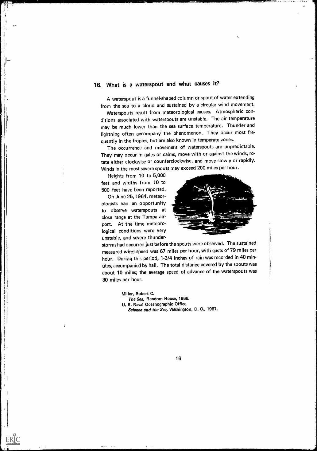
16. What is a waterspout and what causes it?
A waterspout is a funnel-shaped column or spout of water extending
from the sea to a cloud and sustained by a circular wind movement.
Waterspouts result from meteorological causes. Atmospheric con-
ditions associated with waterspouts are unstab!e. The air temperature
may be much lower than the sea surface temperature. Thunder and
lightning often accompany the phenomenon. They occur most fre-
quently in the tropics, but are also known in temperate zones.
The occurrence and movement of waterspouts are unpredictable.
They may occur in gales or calms, move with or against the winds, ro-
tate either clockwise or counterclockwise, and move slowly or rapidly.
Winds in the most severe spouts may exceed 200 miles per hour.
Heights from 10 to 5,000 -feet and widths from 10 to500 feet have been reported.
On June 25, 1964, meteor-ologists had an opportunityto observe waterspouts at
close range at the Tampa air- .
port. At the time meteors- _logical conditions were veryunstable, and severe thunder-storms had occurred just before the spouts were observed. The sustained
measured wind speed was 67 miles per hour, with gusts of 79 miles per
hour. During this period, 1-3/4 inches of rain was recorded in 40 min-
utes, accompanied by hail. The total distanbe covered by the spouts was
about 10 miles; the average speed of advance of the waterspouts was
30 miles per hour.
Miller, Robert C.The Sea, Random House, 1966.
U. S. Naval Oceanographic OfficeScience and the Sea, Washington, D. C., 1967.
16

IIt.1 I
1
17. What do oysters and clams eat?
Oysters and clams eat microscopic plants called phytoplankton, which
live in the water. Oysters and clams spend most of their time attachedto or buried in the bottom and do not move around searching for food.They obtain food by pumping water through their bodies. Clams andoysters, like fish, breathe by means of gills, but their gills also act as asieve, straining the phytoplankton out of the water. The gills are cov-
ered with a sticky substance which holds the phytoplankton. Tinyhairs, called cilia, move the food from the surface of the gills to the
mouth. Pieces of food too large for the animal to eat are discarded andflushed out of the body by the water current. A single blue mussel willpump about 10 gallons of water a day, filtering out the plankton anddebris that make up its diet.
Of the various nutrients that have been experimentally tried as food
supplements for oysters, finely ground corn meal was found to be ac-
ceptable and resulted in fatter oysters.
Barnes, Robert D.Invertebrate Zoology, W. B. Saunders Company, 1964.
Cromie, William J.The Living World of the Sea, Prentice-Hall, 1966.
Galstoff, P. S."The American Oyster (Crassostrea virginica Gmelin)," U. S. De-partment of the Interior, Fisheries Bulletin 64: 1.480, 1964.
17

18. What commercial products other than fish are obtainedfrom the sea?
Products obtained commercially from sea water include commonsalt, bromine, and magnesium. All of the United States' supply of mag-nesium is taken from sea water, because extraction is cheaper than ob-taining it from raines on land. About 75 percent of our supply of bro-mine is extracted from the sea.
In recent years interest has developed in exploiting the seeminglyinexhaustible supply of manganese and phosphate-rich nodules on thesea floor. The American Institute of Mining, Metallurgical, and Petro-leum Engineers (AIME) has estimated that there are 1.5 trillion tons ofmanganese nodules on the bottom of the Pacific Ocean. These nodulescontain as much as 50 percent manganese plus smaller amounts ofnickel, copper, cobalt, and other metals. Nodules on the sea floor appearto be forming faster than the rate at which the United States is nowusing manganese, nickel, and cobalt; thus it seems that our reserve ofthese metals is assured for many years. Phosphorite nodules off theCalifornia coast could satisfy California's phosphate fertilizer needs formany years.
Other materials obtained from the sea floor or beaches include dia-monds, pearls, sand, gravel, shell, and ores of tin, thorium, and titanium.
Oil is being recovered from beneath the ocean floor in increasingamounts. In 1960, about 8 percent of the free world's oil supply wasobtained from this source; by 1965, it had increased to 16 percent.Undersea deposits of sulfur are also being tapped by drilling from plat-forms in the Gulf of Mexico, as the supply on land dwindles.
Carson, R. L.The Sea Around Us, Oxford University Press, 1951; Mentor Books,(Paperback), 1954.
Stewart, Harris B., Jr.Deep Challenge, Van Nostrand, 1966.
U. S. Bureau of MinesMineral Yearbook, 1963, Washington, D. C., 1964.
18

1
it
it
19. What is the annual fish take by the United States?
According to the Bureau of Commercial Fisheries, commercial fish-ermen in the United States caught 4.3 billion pounds of fish in 1966.This was a decrease of nearly 10 percent from the 4.7 billion poundcatch landed in 1965. However, the 1966 catch sold for 454.4 milliondollars, nearly 21 percent over theaverage for the preceding 10 years. The
1963 catch of 4.6 billion pounds soldfor only 390 million dollars.
Mr.
Cromie, William J,7he Living World of the Sea, Prentice-Hall, 1966.
U. S. Department of the InteriorFisheries of the United States, published annually.
19

20. How does the fish take of the United States compare withother countries?
In 1956, the United States ranked second in the world in fish catch;by 1966 the United States had dropped to sixth place. The catch byAmerican vessels is less than one-twentieth of the world's total.
Today Peru leads the world in fish catch and landings, followed byJapan, Red China, the Soviet Union, and Norway.
The world's catch of seafoods of all types (chiefly fish) in 1966 is
estimated at 123 billion pounds, an increase of 6 percent over 1965.Two-thirds of it went directly for human consumption.
Although the United States is not generally considered a fish-consuming country, the per capita consumption of fish in the UnitedStates is nearly double the world's average. Fish consumption in the
United States is about 63 pounds (whole weight) per person per year.The United States is the world's largest importer of fishery prod-
ucts. In 1966, about 65 percent of the U. S. consumption was imported.
Cromie, William J.The Living World of the Sea, Prentice-Hall, 1966.
Miller, Robert C.The Sea, Random House, 1966.
Pell, Claiborne (Senator)Challenge of the Seven Seas, William Morrow and Company, 1966.

21. What are the primary pollutants found in the sea and whatare their sources?
Man is the greatest contributor of pollutants, such as sewage, pulp-mill wastes, fertilizers, soaps, detergents, radioactive wastes, syntheticfibers, plastics, oils, tars, greases, and insecticides. Hot and cold waterdischarged by factories and silt from dredging operations may also beconsidered as pollutant.
Radioactive wastes may be direct fallout, discharges from nuclearpower plants, or nuclear waste disposed at sea.
Improperly treated municipal and industrial wastes, which have longpresented problems in lakes, streams, and rivers, are becoming increas-ingly serious in nearshore oceanic waters.
Agricultural chemicals, both fertilizers and pesticides, are carriedinto the oceans by runoff and through the atmosphere.
Future coastal installations of large nuclear reactors that use seawater cooling could result in contaminants that would significantly af-fect the marine environment and the life it supports.
Gorsky, N.The SeaFriend and Foe, Foreign Languages Publishing House,Moscow (Paperback), 1961.
National Academy of ScienceNational 'Research CouncilOceanography 1966Achievements and Opportunities, 1967.
21
313-538 0 - 68 - 3

22. What is Atlantis?
The story of Atlantis is one of the most persistent of all legends.More than 5,000 scholarly works are in existence about the lost Atlan-tean civilization. The oldest existing account is that of Plato and is thebasis for most subsequent speculations.
Plato described a great civilization far ahead of its time. The Atlan-teans built temples, ships, and canals. They lived by agriculture andcommerce. In their pursuit of trade, they reached all the countriesaround them. By 9600 B. C. they had conquered all the known worldexcept Greece, which was saved when Atlantis was engulfed by the sea,overnight, disappearing without a trace.
Plato said that Atlantis was west of the Pillars of Hercules, whichmany people have assumed to be the Straits of Gibraltar. Recently it
has been suggested that the pillars may have been the Strait of Messinabetween Italy and Sicily.
Before entirely dismissing the legend as a myth, remember that forthousands of years the cities of Troy, Pompeii, and Herculaneum wereconsidered to be mythical. It has been said that mythology is historyseen through the eyes of the intellectually immature.
Clarke, Arthur C.The Challenge of the Sea, Holt, Rinehart and Winston, 1960.
Donnelly, Ignatius J.Atlantis: The Antediluvian World, Harper and Brothers, 1882.
Pell, Claiborne (Sedator)Challenge of the Seven Seas, William Morrow and Company, 1966.
22

23. What does the sea floor look like?
The sea bottom is divided into three distinct areas: the continentalshelf, the continental slope, and the ocean floor.
The continental shelf has numerous hills, ridges, terraces, and evencanyons comparable to the Grand Canyon. The average width of theshelf is about 30 miles, but it may extend several hundred miles fromshore. The continental slope, between the shelf and the deep ocean, hasan average slope of 2 to 3 degrees, although the slope off a volcanicisland may be as much as 50 degrees.
Features of the ocean bottom are comparable to those on land. Manymountains under the sea are higher than Mt. Everest. All oceans exceptthe North Pacific are divided by an almost continuous system of moun-tains, the largest being the Mid-Atlantic Ridge.
Most of the deep-ocean floor is made up of basins surrounded bywalls of lesser depth. Oceanographers have compared the floor of thePacific to the surface of the moon,
Deep trenches rim the Pacific in areas associated with great volcanicactivity and lie near islands and continental slopes. The deepest knowntrenches are in the Western Pacific.
Scientists once believed that the ocean floor was covered by a layerof recently deposited sediments, but it is now known that sedimentsdeposited 100 million years ago lie near the surface of the ocean floorand in some areas are even exposed.
Engel, Leonard and Editors of LIFEThe Sea, Life Nature Library,lime Inc., 1961.
King, Cuchlaine A. M.Oceanography for Geographers, Edward Arnold Ltd. (London),1962.
Yasso, Warren E.Oceanography, A Study of Inner Space, Holt, Rinehart and Winston,1965.
23

it
li
24. Are there strong currents at depths beneath the ocean sur-face that might compare to the "jet stream" in the upperlevels of the atmosphere?
In 1952, Townsend Cromwell of the U. S. Fish and Wildlife Service
began investigation of a previously unknown subsurface current flowing
in a direction opposite to that of the surface currents. This current has
speeds up to 3 knots and could be used by submarines to increase speed
and reduce power requirements, just as the jet stream is used by high
flying aircraft.The Cromwell Current is a shallow current flowing eastward along
the Equator beneath the South Equatorial Current. In certain places, it
comes to within 100 feet of the surface; its bottom limit reaches a depth
of 750 feet. The flow is equal to half the volume of the Gulf Streem andits extent is about 8,000 miles, from New Guinea to the coast of Ecuador.
A similar undercurrent is known to exist below the South Equatorial
Current in the Atlantic. Investigations by British and American shipsduring the International Geophysical Year revealed that this currentflows in a direction opposite to that of the Gulf Stream at speeds of1.5 to 15 miles a day. This countercurrent is much deeper than the
Cromwell Current.It is also suspected that a countercurrent exists in the equatorial
region of the Indian Ocean.Caidin, Martin
Hydrospace, E. P. Dutton and Company, 1964,Engel, Leonard and Editors Of LIFE
The Sea, Life Naturealipibrary, Time, Inc., 1961.Yasso, Warran E.
Oceanography, A Study of Inner Space, Holt, Rinehart and Winston,1965.
24

25. Why does the sea foam?
Foam is made up of air bubbles separated from each other by a filmof liquid. Bubbles coming together in fresh water coalesce, but bubblescoming together in salt water bounce off each other.
Most bubbles in the ocean arc caused by find waves, but they may
also be produced by rain and even snow. The bubbles that form alongthe seashore are very small, mostly less than 1/2 millimeter in diameter.
When bubbles rise to the surface, they burst and release salt sprayinto the air, a fact well known to any wearer of glasses who has been on
shipboard or at the seashore. Each bursting bubble causes a jet of sev-
eral drops to rise to heights up to 1,000 times the bubble diameter. Itis believed that most of the airborne salt nuclei come from burstingbubbles.
Blanchard, Duncan C.From Raindrops to Volcanoes, Doubleday and Company, 1967.
25

26. How did seas, such as the Black, Red, and White, gettheir names?
Because the Black Sea is landlocked, it is deficient in oxygen, except
near the surface. The high concentration of hydrogen sulphide causes
a reducing environment, resulting in a black color.Oddly enough, the recurring bloom of small blue-green algae (Tri-
chodesmium erythraeum) imparts the red color to the Red Sea.
The White Sea received its name from the ice that covers it more than
200 days a year.The color of the Yellow Sea is caused by the yellow mud which is
carried by rivers, especially when floods occur.
Miller, Robert C.The Sea, Random House, 1966.
Stewart, Harris B., Jr.Deep Challenge, Van Nostrand, 1966.
26

27. What causes hurricanes and how do they differ fromtyphoons?
Hurricanes are great heat engines, much like the gasoline engine in acar. The moisture in the humid air over the sea is analogous to the gaso-
line in the gas tank; it contains the potential energy (or fuel) for thehurricane. Once the hurricane is born, it draws moist air up from the seasurface in a counterclockwise spiral to the condensation level. Here
cooling of the air, due to reduced pressure, condenses water vapor inthe air. This can be equated to the combustion cycle in the gasolineengine; it converts potential energy to kinetic energy.
The latent heat of condensation (597 calories per gram of water)heats the air, which then accelerates in its upward spiralling journey. Itliterally goes "up the chimneys' formed by the relatively cooler airaround it. At the top of the chimney of cooler air, the warm air spreadsoutward in a clockwae spiral (when viewed from above). As air spiralsupward, through and out of the chimney, it draws more warm, moistair into it from below. This self-perpetuating process intensifies thecirculation, causing the engine to run faster and causes the hurricane toincrease in size.
The exact mechanism of hurricane formation is still unknown. Sci-entists know that very warm ocean water is required. The warmer thewater, the greater will be the volume of moisture (potential energy)carried aloft. A storm must be some distance away from the Equator inorder to start spinning, because the spin of an object on the earth variesdirectly with the sine of the latitude. There must be an outward (diver-gent) flow of air in the high atmosphere; otherwise the chimney wouldbe closed off.
The origin of a hurricane is associated with an area where air con-verges and showers occur. This may be a remnant of low pressure from a
cold front which moved far south; it may be an area of lower pressuremoving westward in the Trade Wind Belt (easterly wave); or it may bean area where air from the two hemispheres converges (intertropicalconvergence zone). The origin could be due to oscillation of the greathigh pressure system which dominates the ocean.
Hurricanes and typhoons are alike in origin, structure, and features,their only difference being the area of the world in which they occur.Hurricanes occur in the waters adjacent to North America (North Atlan-tic Ocean, Gulf of Mexico, Caribbean Sea, and Southeastern North
27
Pacific Ocean); typhoons occur in the Western North Pacific Ocean.Because of the vast expanse of warm water in the Western Pacific, ty-phoons occur more often than hurricanes and are frequently largerand more intense.
Dunn, G. E., and B. L MillerAtlantic Hurricanes, L.S.U. Press, New Orleans, Louisiana, 1960.
Tannehill, L R.Hurricanes, Their Nature and History, Princeton University Press,Princeton, New Jersey, 1938.
Simpson, R. H."Hurricanes," Scientific American, Vol. 190, pp. 32-37, June 1954.

28. How high is the highest wave?
An American.tanker, the USS RAMAPO, reported the highest wavethat has been measured with any degree of certainty. In 1933, whileproceeding from Manila to San Diego, she reported a wave 112 feethigh; it was produced by winds of 60.68 knots operating over a fetch ofseveral thousand miles.
Most ocean waves are less than 12 feet high. Waves more than 25feet high are rare, and waves in excess of 50 feet develop only duringvery severe storms.
It is very difficult to measure wave height from a ship. Height canoften be estimated with reasonable accuracy by comparison with thefreeboard of the ship, but accuracy decreases as wave height and shipmotion increase.
r.
"-,*14:6'..
& ."'Nt "-;:11,
Ayor40),
USN TANKER RAMAPO" FEB. 7,1933
tfj 1441%1
Carson, R. L.The Sea Around Us, Oxford University Press, 1951; Mentor Books(Paperback), 1954.
Miller, Robert C.The Sea, Random House, 1966.
Stewart, Harris B., Jr.Deep Challenge, Van Nostrand, 1966.
29

1
S.
29. How many species of fishes are theve?
Although fishes are the most numerous of the recent vertebrates,there is little agreement among scientists on the number of species.Estimates range from 15,000 to 40,000 species; however, 25,000 ap-
pears to be the most often quoted figure. This discrepancy exists be-cause fish species are sometimes named more than once due to inade-quate descriptions and variation due to environment or geographicaldistribution. In some fish species, the male has been described as be-
longing to one species and the female to another because of a difference
in body form or color pattern. This phenomenon is called sexual dimor-phism. Other fishes have been named more than once because theyoung look different than the adults. In addition, most scientists agreethat not all fishes have yet been named; the estimate of 25,000 allowsfor this unknown. The species of fishes with bony skeletons are morenumerous than those with skeletons of cartilage (sharks and rays). Bony
fish number around 20,000 while the cartilaginous fish number onlyabout 600.
Herald, Earl S.Living Fishes of the World, Doubleday and Company, 1961.
Lag ler, Karl F., John E. Bardach, and Robert R. MillerIchthyology, John Wiley and Sons, 1962.
Norman, J. R.A History of Fishes, Hill and Wang, 1963.
30

30. Beside the whale, what other mammals live in the oceans?
There are several distinct groups of marine mammals, other thanwhales, that live in the ocean. These groups include porpoises, manateesor sea cows, seals, and sea otters. Porpoises belong to the same order(cetacea) as the whales.
The manatee is the fabled mermaid of old sailors' stories. Its fore-limbs are absent, with the body ending in a broad, flattened tail. Itlives in shallow coastal waters and eats aquatic plants only. Manateesinhabit the warm rivers of Florida and estuaries of the Indian and PacificOceans on both sides of the Equator.
The sea otter is very similar in appearance to the land otter, exceptthat it is larger and better adapted for marine living. It has webbed hindfeet, and its fur is said to be the world's best. At one time sea otterswere very common, but they approached extinction because of the highdemand and value of their skin. In 1911, an agreement known as the"Fur Seal Treaty" between the United States, Russia, Great Britain,and Japan protected fur seals and sea otters from further hunting ortrapping. This treaty is still in effect and violation carries a very severepenalty.
The sea otter feeds on mussels and other shellfish and has a very in-teresting feeding behavior pattern. It floats on its back and pounds shell-fish against a rock balanced on its chest; the pounding fractures the shelland enables the sea otter to feed on the soft parts. Sea otters are distri-buted along the California coast and among the Aleutian Islands.
Seals are divided into two groups: Those with external ears andthose without. Eared seals comprise the sea lion, fur seal, and walrus.
0 10litistilit1SCALE. IN FEET
20 20 40 50 601 1 1
So
31

The northern sea lion is the largest of the eared seals, weighing as mich
as 1,700 pounds. The California sea lion weighs about 600 pounds and
may grow to be 8 feet long. The smaller female has a fine sense of bal-
ance, high intelligence, and is trained for circus work.
The fur seal is small, weighing only a few hundred pounds, and its
fur is very valuable. It is found all over the world. Great herds spend
the summer months in the Bering Sea and Pribilof Islands. The fur seal
has been protected since the 1911 treaty. Only 3-year-old "bachelors"
are taken each year for furs.The walrus inhabits the Arctic and adjacent seas. It has a thick layer
of skin and fat for protection from the cold water; it has two large upper
canine teeth (tusks) about 3 feet long for digging shellfish and crusta-
ceans from the bottom.Ear less seals comprise the harbor seal and the elephant seal. The
harbor seal is smaller than the eared seals; it grows to 5 feet in lengthand weighs about 150 pounds. It feeds on fish and crustaceans. Usually
harbor seals stay close to land, mainly around harbors and river mouths.
They range from U. S. coasts to the Arctic Circle.The elephant seal is the largest of all seals. The male is considerably
larger than the female and may have a body length of 16 feet and aweight up to 5,000 pounds. The elephant seal was so named because of
the large snout of the male. Distribution ranges from California toAlaska and they are numerous in the North Atlantic.
Daugherty, Anita E.Marine Mammals of California, State of California, The ResourcesAgency, Department of Fish and Game, 1965.
Scheffer, Victor B., and Dale W. Rice"A List of the Marine Mammals of the World," United States De-partment of the Interior, Fish and Wildlife Service, Special ScientificReport-Fisheries No. 431.
Scheffer, Victor B.Seals, Sea Lions, and Walruses, Stanford University Press, 1958.
32

31. What causes the tides?
Tides are caused by gravitational forces of the moon, the sun, andvarious other celestial bodies. The moon, being nearest, has the greatesteffect. The sun, despite its greater mass, exerts only a secondary effect,less than half that of the moon.
High tides are generated on the sides of the earth nearest to andfarthest from the moon. At times of new moon and full moon, thesun's attraction reinforces that of the moon, producing higher (spring)tides. Halfway between new and full moon, solar attraction does notcoincide with lunar attraction and therefore the difference betweenhigh and low tides is less; these lesser tides are called neap tides.
When the moon is over the Equator as the earth rotates, a point onthe earth passes through two high and two low areas each day. Whenthe moon is north or south of the Equator, the two highs are unequal inheight or there may be only one high tide.
LOW TIDE
HIGH TIDE
SUN
Engel, Leonard and Editors of LIFEThe Sea, Life Nature Library, Time, Inc., 1961.
Gaskell, T. F.World Beneath the Oceans, American Museum of Natural History,1964.
Stewart, Harris B., Jr.Deep Challenge, Van Nostrand, 1966.
a
33
32. Why do tide ranges in the same geographical areas of the
world differ so greatly?
In addition to effects of the moon and sun, tide ranges are affected
by shape and dimension of the coastlineand sea floor. In some restricted
water areas (bays, channels, etc.), heights may build up to 50 feet and
tidal currents of as much as 10 knots occur.Tides moving upstream in an estuary are slowed down by bottom
friction, and the following water piles up. The water rises more rapidly
than it falls, and the flood stream has higher velocity than the ebb.
Some areas of great tidal ranges are the Bay of Fundy, Bristol Chan-
nel, and the Sea of Okhotsk. The famous Bay of Fundy tidal bore
moves more than 100 billion tons of water a day.
There are also areas in the world that are almost tideless; among
these are the Mediterranean, Baltic, and Adriatic Seas, and the Gulf of
Mexico.
Deacon, G. E. R. (Ed.)Seas, Maps, and Men, Doubleday and Company, 1962.
Gaskell, T. F.World Beneath the Oceans, American Museum of Natural History,
1964.King, Cuchlaine A. M.
Oceanography for Geographers, Edward Arnold Ltd. (London), 1962.
34

fi
33. What are seamounts? How are they created?
Seamounts are relatively isolated features rising from the deep sea
floor. To qualify as aseamount, a rise must be at least 1,000 metersabove the surrounding topography. At least 1,400 seamounts have beendiscovered in the Pacific Ocean; this may be only a small percentage ofthe seamounts that will eventually be discovered.
The origin of seamounts is controversial. Their distribution in linearchairs gives credence to the theory that they are caused by fissure erup-tions, There is also speculation that seamounts were volcanoes thatonce extendrAl above the ocean surface and later sank because of theirweight.
Photographs of seamount surfaces show ripple marks which are ap-parently caused by deep currents; samples dredged from North Atlanticseamounts also indicate that they have never been near the ocean surface.
In the Pacific Ocean many flat-topped seamounts, known, as guyots,have been found. A Princeton University geologist, Dr. Harry H. Hess,discovered guyots in the examination of echo sounder records whilein command of a naval vessel during World War II. He explains the flattops as wave erosion at sea level. If this is correct, there has been a
great change either in the ocean floor or in the sea level, because thetops of the guyots are now 2,000 to 3,000 feet below the surface.Guyots are unknown in the Atlantic.
Ericson, David B., and Goesta WollinThe Deep and the Past, Alfred A. Knopf, 1964.
Gaskell, T. F.World Beneath the Oceans, American Museum of Natural History,1964.
Stewart, Harris B., Jr.Deep Challenge, Van Nostrand, 1966.
35

34. How deep in the ocean can one see with natural sunlight?
Even when perfectly dear, water is et least a thousand times moreopaque than air, because of the density difference. The depth to which
one can see in the ocean is dependent on the amount of suspended mat-
ter and the angle of sunlight. Underwater visibility is best at noon when
the sun is directly overhead; at that time about 98 percent of the lightpenetrates the sea surface. When the sun is at an angle of 10 degrees
above the horizon, only 65 percent of the light penetrates; the rest is
reflected.Tropical waters usually have high transparency; the Mediterranean
Sea, particularly the eastern section, is also noted for its good trans-
parency characteristics.As a diver descends into the ocean, the first change he notices is that
everything appears to be blue-green; when he approaches the 100-footlevel, it becomes impossible to distinguish colors. Light appears to come
from all ditections and there are no shadows. Cousteau reports that at300 meters the pale blue lighting is hardly sufficient to define the shapes
of objects a short distance away.Sometimes horizontal visibility is better at greater depths because of
the higher amounts of suspended materials in surface waters. Italian
divers working on the liner EGYPT southwest of Brest, France, reportedthat visibility diminished as they went to a depth of 66 feet, then im-proved. Light faded as they reached the wreck at 396 feet; at that depth,
visibility was 6 feet.
Caidin, MartinHydrospace, E. P. Dutton and Company, 1964.
Cousteau, Capt. J. Y.The Silent World, Harper and Brothers, 1953.
Rebikoff, DimitriUnderwater Photography, American Photographic Book PublishingCompany, 1965.
36

35. What is the volume of the world's oceans?
Estimatesvary from 317 to 330 million cubic miles; the most reliablesources place the volume at approximately 328 million cubic miles.Ocean waters comprise about 85 percent of the total water on theearth's surface.
The volume of all land above sea level is only one-eighteenth of the
volume of the ocean. If the solid earth were perfectly smooth (level)and round, the ocean would cover it to a depth of 12,000 feet.
Bowditch, NathanielAmerican Practical Navigator, U. S. Naval Oceanographic Office,1958.
Engel, Leonard and Editors of LIFEThe Sea, Life Nature Library, Time, Inc., 1961.
37
313-538 0 - 68 - 4

36. Are whales found in all oceans of the world?
Yes, whales have been observed in all oceans of the world and even
in fresh water. Most of the larger species continually migrate fromocean to ocean with the changing seasons.
There are two distinct species populations: the Southern Hemispheregroup and the Northern Hemisphere group. Both groups breed in trop-ical coastal waters during the winters, Then go to the Arctic or Antarcticregions for summer feeding. The Fin, Sei, and Humpback whales migrate
seasonally in this fashion.Sperm whales appear in tropical waters the year round, seldom going
farther north than 40 degrees latitude.Most people do not realize that Julphins are small whales; dolphins
are also known as porpoises.
Two species, the Amazon dolphin and the Ganges dolphin, actuallygo into fresh waters of the Amazon and Ganges Rivers.
The distribution and migration of whales is studied by means of com-
mercial catch records, tagging, and sightings.Some whale species are in danger of extinction because man has
overhunted. International agreements between whale hunting nationsattempt to limit the kill of certain species of whales. Through this in-ternational effort, it is hoped that the whale stocks will be preserved for
future generations.
Mackintosh, N. A.The Stocks of Whales, Fishing News Books Ltd., 1965.
Slijper, E. J., W. L. Van Utrecht, and C. NaaktgeborenRemarks on the Distribution and Migration of Whales, Based on Ob-servations from Netherlands Ships, Bijdragen Tot de Dierkunde, 1964.
Norris, Kenneth S.Whales, Dolphins, and Porpoises, University of California Press,Berkeley and Los Angeles, 1966.
Moasumer..doriltrara.....J
38

37. Do any creatures in the sea other than the porpoise talk?
Yes, many creatures in the sea make sounds which may be a form ofcommunication; porpoises and other mammals offer the greatest pos-
sibility for understanding by man someday. Dr. John C. Lilly, of theCommunications Research Laboratory in the Virgin Islands, has reported
strong evidence that porpoises (dolphins) can mimic the human voice.Extensive recordings of whale sounds have been made. These sounds
have been compared to the trumpeting of elephants. Killer whales incaptivity have even talked to each other from one city to another overlong distance telephone lines using hydrophones at each end as thereceiver-transmitter.
Some fish, such as drumfish and groupers, produce drumlike thumps
which are suspected to be a defense to frighten other approaching fish.Croakers received their name from the sound they produce, often de-scribed as sounding like rapid blows on a hollow log. Toadfish emit a
"boat whistle" sound which may be related to reproductive behavior.Among other noisy animals are sea lions, seals, puffers, crabs, snap-
ping shrimp, and lobsters.
Herald, Earl S.Living Fishes of the World, Doubleday, 1961.
Lanyon, W. E., and W. N. Tavo Iga (Ed.)Animal Sounds and Communication, Publication No. 7, AmericanInstitute of Biological Sciences, 1960.
Marteka, VincentBionics, J. B. Lipincott Company, 1965.
39

38. How do oysters produce pearls?
Pearls are produced by a type of oyster more closely related tomussels than to the common edible oyster. These gems are formed by
a foreign substance, such as a grain of sand, which accidentally entersthe shell. The oyster attempts to reduce the irritation by depositing suc-cessive layers of nacreous material around the foreign body.
The most valuable pearls are obtained from oysters taken near Ceylon
and in the Persian Gulf. It is believed that the nucleus of these pearls isa tapeworm egg.
Cultivated pearls are produced by inserting particles in pearl oysters.It takes 3 to 5 years for an oyster to produce a pearl; if sea conditionsare not right during the entire period, the oyster may yield only aworthless lump of calcium. Under the best conditions, only 60 percentof cultivated oysters live to yield pearls and only 2 to 3 percent producegem quality pearls.
There are many legends and stories about pearls. The ancient Greeks
believed that pearls were created when lightning struck the sea.
Miller, Robert C.The Sea, Random House, 1966.
U. S. Naval Oceanographic OfficeScience and the Sea, Washington, D. Ce 1967.
40

11
39. How far into the ocean can one "see" the effect of a river?
By using an echo sounder as eyes, one can "see" the effect of riversin the submarine canyons that extend seaward for hundreds of milesfrom the mouths of some rivers.
HUDSON RIVER
A submarine canyon 4 miles wide and 240 feet deep extends fromthe mouth of the Ganges River into the Bay of Bengal for a distance ofmore than 1,000 miles. The Congo Canyon has been traced for 145miles to a depth of 7,500 feet.
Off the Hudson River a canyon extends 200 miles across the con-tinental shelf. This canyon was surveyed by the Woods Hole Oceano-graphic Institution vessel ATLANTIS (cover illustration).
The continental shelf along the Pacific Coast of the United States isnarrow and its submarine canyons are deep and steep-sided. The Mon-terey Canyon, off California, is sometimes compared with the GrandCanyon.
The origin of submarine canyons is still under dispute. There isspeculation that channels may have been cut by rivers while the land
41

mass was above sea level, but. it is probable that turbidity currents con-
tributed substantially in creating these bottom features (see questior) 79).
Cowan, Robert C.Frontiers of the Sea, Doubleday and Company, 1960.
King, Cuchlaine A. M.Oceanography for Geographers, Edward Arnold Ltd. (London), 1962.
Stewart, Harris B., Jr.Deep Challenge, Van Nostrand, 1966.
42

40. Is seaweed a weed? What is it and how does it grow?
Plants as useful as seaweed can hardly be considered weeds becauseweeds are commonly defined as uncultivated (wild) plants that are use-less, unsightly, and have no economic value. Seaweed is used as a foodby millions of people, particularly along the Pacific Coast of Asia; italso serves as food for livestock.
Seaweed has many other uses, for example, as fertilizer, medicines,source of iodine, and ingredients used in prep ration of bread, candy,canned meat, ice cream, jellies, and emulsions.
In the late 18th century seaweed was the primary source of soda untilother sources became more economical and practical. In these years,thousands of tons of soda were derived from sea plants.
Attached seaweeds grow only along the narrow border near shore.Growth is depth limited because natural sunlight is needed for thephotosynthesis processes of the plants.
FUCCIS(Rocx wcro)
CAVIPDA(At, A ry ATLANTIC
f:04141V)
43

it
Floating seaweeds are found in great quantity in the Sargasso Sea,where sailors once thought it to be a hazard to ships.
Deacon, G. E. R. (Ed.)Seas, Maps, and Men, Doubleday and Company, 1962.
Wier, Robert C. .
The Sea, Random House, 1966.Troebst, Cord-Christian
Conquest of the Sea; Harper and Row, 1962.
44

'Jr
41. What is green scum?
The green scum on ponds and slow-flowing rivers is formed by float-ing green and blue-green algae and a tiny flowering plant called duckweed. The duck weed and floating green algae do not live in sea water,but the blue-green algae do. These blue-green algae have a sticky cover-ing and form slimy films on rocks and pilings. Mermaid's Hair, a largeblue-green alga, forms thick feathery coverings on rocks and boatbottoms.
Algae are classified not by color but by structural relationship toother species of algae; it is "blue-green" algae that make the Red Seared. Some "red" algae are either pink or white, and there is one "red"alga in the upper intertidal zone that is olive-green.
Dawson, E. YaleMarine Botany, Holt, Rinehart and Winston, Inc., 1966.
Miller, Robert C.The Sea, Random House, 1966.
Odum, Eugene P.Fundamentals of Ecology, W. B. Saunders Company, 1959.
45

42. What are algae?
Algae are primitive plants ranging in size from a single cell, whichcan only be seen with a microscope, to the giant kelps, which grow to a
length of 100 feet. Algae are dominant in the sea, both in number ofspecies (approximately 6,600) and in number of individual plants. Al-though algal cells contain chlorophyll and other pigments, these plantsdo not have roots, stems, or leaves. However, some larger forms do have
structures which resemble these organs.Algae do not need roots, because they live in a solution of nutrients
and the whole plant can absorb water and nutrients from this solution.Some algae have a holdfast that resembles a root. The holdfast is simplya structure that holds the plant in place; it does not absorb water ornutrients from the "soil"; therefore, it cannot be called a root. Sincemost of the plant can absorb materials needed for sustenance andgrowth, there is no need for an elaborate system to transport water,nutrients, and food; therefore, algae do not have stems. The supportingstructure of kelp that resembles a stem is called a stipe; it does notserve a transport function and it does carry on photosynthesis.
Some algae have blades that resemble leaves, but these are exten-sions of the plant body and are not the primary site of photosynthesisas in terrestrial plants. Because the entire body of the algal plant carrieson photosynthesis, the blades are adapted to increase the surface areato make absorption and photosynthesis more efficient.
Photosynthesis requires light, and, since the amount of light avail-able in the water is limited by suspended particles, the blades with theirlarger surface area enable the algae to receive more of the availablelight. When the water is very turbid, light penetration is poor and plantsgrow only in shoaler areas. Plants with large surface area:, have a better
chance of survival.Large plants do not usually grow in the open ocean, but are re-
stricted to water less than 300 feet deep; one exception is the sargassum
weed which floats in the surface layers of the f.77. g a sso Sea. Algae in the
open ocean are generally one-celled forms and are limited to the lightedzone (surface to approximately 600 feet). These algae are extremelynumerous and are referred to as the "grass of the sea" because they are
the very beginning of the food chain in the sea.
46

Dawson, E. YaleMarine Botany, Holt, Rinehart and Winston, Inc., 1966.
Round, F. E.The Biology of the Algae, St. Martin's Press, 1965.
Smith, Gilbert M.Cryptogamic Botany, McGraw-Hill Book Company, 1955.
Zini, Herbert S., and Lester IngleSeashores, Golden Press, 1955.
47

43. Can gold, silver, platinum, or diamonds be mined fromthe sea?
Diamonds and gold are now being dredged from the ocean floor inseveral areas of the world. Off the southwest coast of Africa more thanone-half million carats of diamonds have been dredged from the sea
floor since 1952. The ship ROCKEATER, owned by a United Statescompany, is dredging about $200,000 worth of diamonds a month fromdepths as great as 200 feet. The diamonds are found in mixtures of sand,
gravel, and boulders. Although the diamonds can be separated easily,the operation is not yet profitable because present dredging techniquescannot handle the large quantities of sand economically.
The coast of Alaska near Nome has attracted many companies in-terested in dredging for gold. Beach sands along the Nome Gold Coastyielded 100 million dollars worth of gold during the gold rush; thesesame sands are known to extend beneath the ocean. About 600 off-shore prospecting permits have been issued, covering about a million anda half acres off the Alaskan coast.
Exploration is now being conducted along the coasts of North Caro-lina and Oregon to determine whether gold can be dredged economicallyin these areas.
Carlisle, Norm 9n V.Riches of the Sea, Sterling Publishing Co., 1967.
Pell, Claiborne (Senator)Challenge of the Seven Seas, William Morrow and Company, 1966.
U. S. Naval Oceanographic OfficeScience and the Sea, Washington, D. C., 1967.
48
iMillaged

tai
44. Where is the hottest ocean or portion of an ocean?
The hottest ocean area is in the Persian Gulf, where water tempera-tures at the surface exceed 90° F in the summer months. Near shorein shallow water, temperatures as high as 96.8° F have been reported.. A unique hot, salty area has recently been discovered in the Red Sea,
where scientists of the Woods Hole Oceanographic Institution recordeda temperature of 132.8° F at a depth of 2,000 meters. In this area, theexpected temperature at that depth is about 68° F. The reason for
these extreme temperatures is unknown, but much scientific research isbeing directed to continue observations in the area and to investigatetheories on the origin of the heat source.
In the open ocean, maximum temperatures occur north of the Equa-tor. The zone of maximum water temperature shifts with the season,but only in a few areas does it extend south of the Equator. Tempera-tures in the Southern Hemisphere are considerably lower than those inthe Northern Hemisphere.
Dubach, Harold W.A Summary of Temperature-Salinity Characteristics in the PersianGulf, Publication G-4, National Oceanographic Data Center, 1964.
King, Cuchlaine A. M.Oceanography for Geographers, Edward Arnold Ltd. (London), 1962.
Woods Hole Oceanographic InstitutionResearch in the Sea, 1967.
49

45, How salty are the oceans? Which is the saltiest?
Salinity in the open ocean normally ranges from 3.3 to 3.7%. Ocean-ographers express salinity in parts per thousand; the symbol for partsper thousand is 0/00. The average is about 35 0/00. The saltiest ocean isthe Atlantic, with 37.5 °Am in the northern subtropical region. ThePacific is less salty than the Atlantic because it is affected less by drywinds and resulting high evaporation rates. In the deeper waters of thePacific, the salinity ranges from 34.6 Oh,,, to 34.7 040. The Arctic andAntarctic waters are the least salty.
Some areas in the world have abnormally high salinities; for example,the Red Sea and Persian Gulf have salinities exceeding 42 06.. The"hot, salty hole" in the Red Sea has salinities exceeding 270 °4, (closeto saturation) at depths below 2,000 meters.
Very low salii.ities occur where large quantities of fresh water aresupplied by rivers or melting ice. Salinity in the Baltic is 2 °40-7 0/00 andin the Black Sea about 18 `700.
Deacon, G. E. R (Ed.)Seas, Maps, and Men, Doubleday and Company, 1962.
King, Cuchlaine A. M.Oceanography for Geographers, Edward Arnold Ltd. (London), 1962.
Dubach, Harold W.A Summary of Temperature-Salinity Characteristics in the PersianGulf, Publication G-4, National Oceanographic Data Center, 1964.
50

I
L
46. Has a sea gull, albatross, or other sea bird ever flown acrossthe ocean?
Some sea birds live along the coast and rarely travel far from shore.Others spend their lives over the ocean returning to land only to nest.Sea gulls are coastal birds, so they would not normally cross the ocean.
However, many oceanic birdsbanded in Europe have beenrecovered in North America.Kittiwakes banded by scien-tists in the Barents Sea areahave been recovered in New-foundland 4 months afterbanding. Puffins, fulmars, andpetrels also are known to havecrossed the Atlantic from Eu-rope to North America, andthe Arctic skua and the At-lantic cormorant fly fromNorthern Europe to the Afri-
- can coasts.
By far the most impressivetravelers are the Arctic ternand the albatross. The Arctictern, which is tha size of asmall sea gull, regularly mi-grates from its breedinggrounds in the Arctic to the
Antarctic. It molts in the Antarctic and returns to the Arctic to nesteach year. The albatross is also an oceanic bird, returning to land onlyto nest. Banding records indicate that albatrosses fly around the world,especially during their first few years of life.
Belopolskii, L. 0.Ecology of Sea Colony Birds of the Barents Sea, 1957. (Translation),Israel Program for Scientific Translations, 1961.
Salomonsen, FinnThe Food Production in the Sea and the Annual Cycle of FaeroeseMarine Birds, Oikos 6 (1): 92.100, 1955.
Solyanik, G. A."Discovery of a Banded Polar Sterna Paradisae Briinn in the Antarc-tic," Soviet Antarctic Expedition 2:28-31 (translation), 1959.
Vaucher, CharlesSea Birds, Dufour Editions, 1963.
.11MINIMMINIMOMI111101116116.=.
51

A 11
47. Are there volcanoes under the sea like those on land?
Volcanoes have built up impressive mounds and ridges under the
oceans. In many places these volcanic ridges extend above the sea sur-
face as islands. Iceland is part of a ridge of volcanoes that also includes
the Azores. The Hawaiian Islands are part of a volcanic chain that ex-
tends across the Pacific for nearly 2,000 miles.On November 14, 1963, a new volcanic island began to rise from the
North Atlantic, just south of Iceland. Fishermen witnessed the birth ofthe island, now known as Surtsey. Before the volcanic activity began,
the ocean at this spot was 425 feet deeps After the initial eruption, anoutpouring of lava built up about an acre a day. One of the first scien-tists to arrive on the scene was Professor Paul Bauer of American Uni-versity, who continuously observed and recorded the growth of Surtsey.
His pictorial and scientific documentation of this evolutionary processas a day-by-day event is the first and onI such record and should be a
most useful record for research study by geologists for years to come.
A 30-minute film is available on Surtsey.
Blanchard, Duncan C.From Raindrops to Volcanoes, Doubleday and Company, 1967.
Gaskell, T. F.World Beneath the Oceans, American Museum of Natural History,1964.
Thorarinsson, Sigurdur"SurtseyIsland of Fire," National Geographic, Vol. 127, No. 5,May, 1965.
52

I
48. Is life found at all depths in the ocean?
This question was settled for all time in 1960 when Piccard andWalsh reported a flatfish, resembling a sole, at a depth of 35,800 feet.From the porthole of the bathyscaph TRIESTE they observed a fishabout 1 foot long and 6 inches wide swimming away.
As recently as 1860, some scientists believed that marine life couldnot exist below 1,800 feet. This view was discredited when a telegraphcable brought up from a depth of 6,000 feet was found to be coveredwith a variety of marine life.
HA.TCHET F1514 ACTUPO.. S
.PER FISHStiE
In 1872 scientists aboard the HMS CHALLENGER found life in thedeepest areas which they were able to trawl, but it was not until steamtrawls and wire rope became available that trawl collections could be ob-tained from the deepest trenches.
313-538 0 - 85 - 5

In 1951, the Danish oceanographic ship GALATHEA dredged variousinvertebrates from a depth of 33,433 feet in the Philippine Trench and a
year later caught fish at a depth of 23,400 feet.
Deacon, G. E. R. (Ed.)Seas, Maps, and Men, Doubleday and Company, 1962.
Piccard, Jacques, and Robert S. DietzSeven Milos Down, G. P. Putnam's Sons, 1961.
Soule, GardnerThe Ocean Adventure, Appleton-Century, 1966.
54

\\ 49. What causes "tidal waves"?
"Tidal waves" are not caused by the tides, but by movement of theocean floor. Their proper name is tsunami, a word of Japanese origin.They are also commonly called seismic sea waves.
Submarine earthquakes, landslides, or volcanic eruptions create tsu-namis; a submarine disturbance may produce three or four waves with a
wave length (crest to crest) greater than 3 miles, although their heightover the open ocean may be only 1 foot. Speed of advance can exceed500 miles an hour. As the waves approach shore, they are slowed andthe water behind piles up to tremendously destructive heights.
Cowan. Robert C.Frontiers of the Sea, Doubleday and Company, 1960.
Gaskell, T. F.World Beneath the Oceans, American Museum of Natural History,1964.
Stewart, Harris B., Jr.Deep Challenge, Van Nostrand, 1966.
55
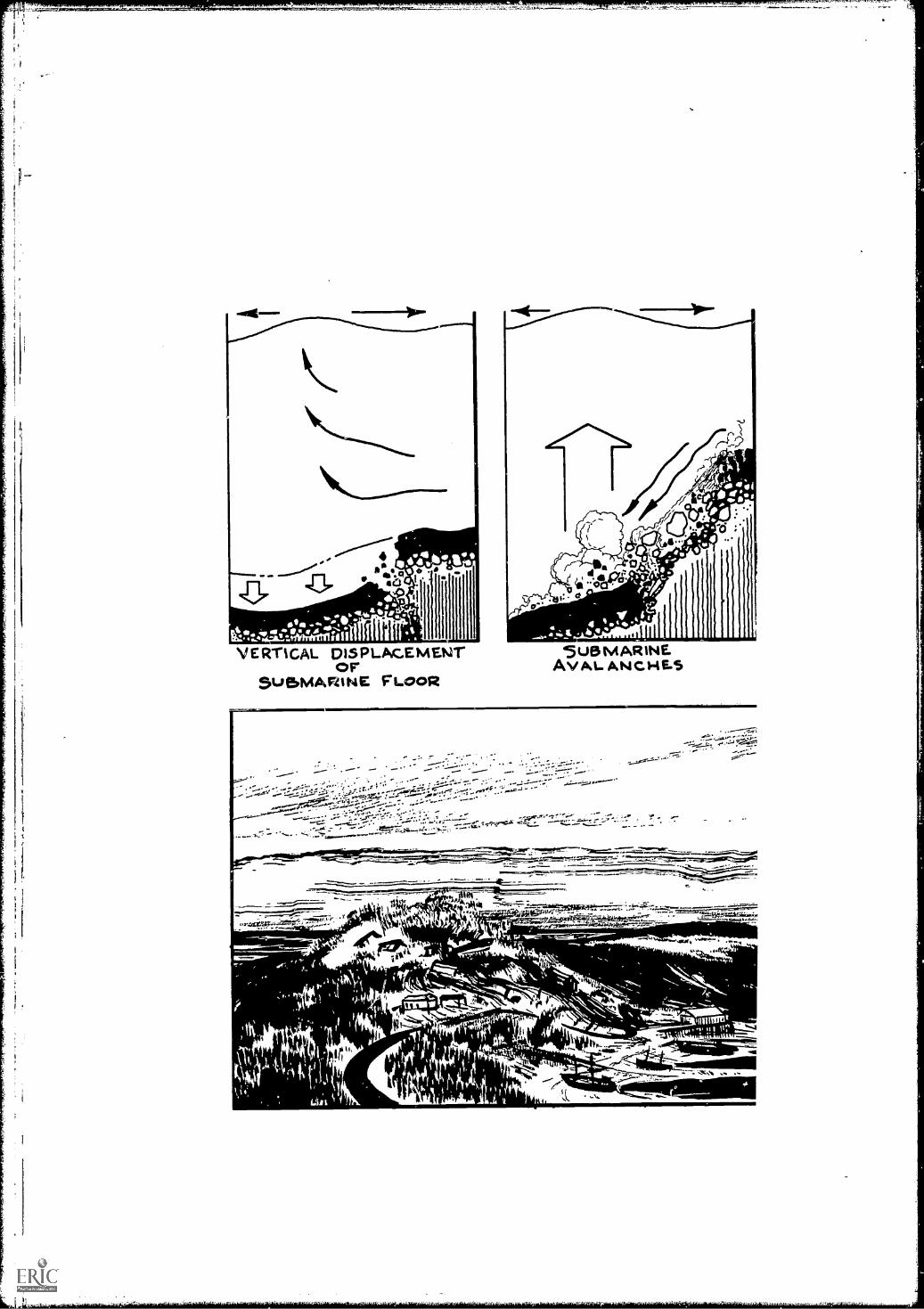
VERTICAL DISPLACEMENTorSUBMARINE FLOOR
SUBMARINEAV AL. ANC-4E.5
,-- - ,. -
-
''.-
1
ntt0011.
,
4111' 31+
,,
05, . r" mg . \
1,.
,_,..161 ........_. _.
111 1.1=Mik._" )141 wirry. I,
444V.:4'

LONG - PERIODE A R TH 0 VAKE WAVES
RESONANCEOF
TRENCH WATER
r";:::.''.....,,,,molear -,-,.",-;4.-..........1::::,....."-i4,,,ik '---41ig,...-"- .......r...-....,,,,..,..7
64.........1,0101401110E.9/111AN6.0,63d e 1111K.Ai.
t.01INIPWIllar,:6
ttitam,1 ,

50. Can "tidal" waves be forecast?
Yes, "tidal" waves (tsunamis) can be forecast, because the earth-quake waves causing them cross the ocean in only a few minutes andcan be picked up by seismograph stations hours before the sea wavearrives.
After the destructive tsunami that struck the Hawaiian Islands in1946, killing 173 people and destroying 25 million dollars worth ofproperty, a warning system was set up in the Pacific. Seismograph sta-tions provide information on the time and location of the quake. If theepicenter of the quake is under the sea, a tsunami may result. When aquake is noted, tide stations are alerted to watch for indications of awave.
A travel time chart centered on the Hawaiian Islands is used to esti-mate time of arrival of the waves. Warnings of estimated time of arrivalare transmitted through an international Pacific-wide communicationsystem. The U. S. Coast and Geodetic Survey operates the warningservice, which has its headquarters in Honolulu, Hawaii.
Bowditch, NathanielAmerican Practical Navigator, U. S. Naval Oceanographic Office,1958.
Gaskell, T. F.World Beneath the Oceans, American Museum of Natural History,1964.
U. S. Coast and Geodetic SurveyTsunami, The Story of the Seismic Sea-Wave Warning System, 1965.
58

51. What is the "bends" and how do divers become afflictedwith it?
High pressure at depth causes some of the nitrogen in a diver's bodytissue to dissolve in his blood. If he ascends too rapidly, bubbles willform in the blood and collect in his joints and bone marrow, causingthe extremely painful condition known as the "bends." It is notordinarily fatal unless bubbles collect in the spinal cord or brain, but thepain will continue for several days unless the diver is put under pres-sure and decompressed gradually; if the condition goes untreated therewill be bone damage.
After a long dive, a diver is returned to normal pressure gradually sothat nitrogen in the blood may be released through the lungs, avoidingthe "bends."
Bond, George F."Medical Factors in Diving Safety," Signal, October, 1965."
Gaskell, T. F.World Beneath the Oceans, American Museum of Natural History,1964.
Rebikoff, DimitriFree Diving, E. P. Dutton and Company, 1956.
59

52. Are all fishes edible?
Not all fishes are edible. Some have organs that are always poisonousto man; others sometimes become toxic because of certain elements intheir diet. In Japan, a national dish called fugu is highly prized. It is pre-pared from the puffer fish, and the gonads of the puffer are highlypoisonous. For this reason, fugu is only served in restaurants licensedby the government.
Consumption of sharks and rays has been known to cause illness ordeath; this was probably because the victim ate a portion of the liver,which contains a very high concentration of vitamin A that the humanbody cannot tolerate.
There are 300 tropical species of fishes that cause fish poisoning; onetype of poisoning is commonly known as ciguatera. A particular speciesmay cause ciguatera when caught on one side of an island, but not ifcaught on the other side. These tropical fish are associated with reefsand do not usually venture far from the home reef; for this reason, thepeople living on one island may eat a certain species of fish, while thoseon a nearby island would not. No one knows what causes the fish to be-come poisonous, but most investigators agree that it issomething in thediet. There is no method to determine before a fish is consumed whetheror not it will cause ciguatera. Some common species of fish known tocause ciguatera are: surgeon fish, jacks, porgies, snappers, goatfish,moray eels, wrasses, and barracudas.
Scombrid fish, commonly known as tuna or mackerel, have beenknown to cause scombrid poisoning, usually because of inadequatepreservation. The flesh of scombrid fish contains bacteria which, if thefish is not preserved soon after capture, begin to produce a histamine-like compound. This compound, if ingested by humans, causes a severeallergylike reaction and may even lead to death.
Fish, C. J. and M. C. Cobb.Noxious Marine Animals of the Central and Western Pacific Ocean,U. S. Dept. Interior, FWS, Res. Rept. 36, pp. 1-45.
Norman, J. R.A History of Fishes, Hill and Wang, 1963.
Randall, John E."A Review of Ciguatera, Tropical Fish Poisoning with a TentativeExplanation of Its Cause," Bull. Mar. Sci. Gulf and Caribbean 8(3),pp. 236-267.
60
53. What other sea life is used for human consumption?
Fish are only one form of marine life used for food. Two other im-portant sources are shellfish and algae. Shellfish are not fish at all; rather,they are members of two large groups of marine animalscrustaceansand mollusks. Lobsters, crabs, and shrimp are the most popular crusta-ceans on American tables. Spiny lobsters, Alaskan king crabs, andprawns are also harvested for food. Clams, oysters, and scallops are themost commonly eaten mollusks in this country. However, many othermollusks are used in some parts of this country and in other parts of theworld. Mussels and cockles are popular in Europe, and squid is popularin Southern Europe and the Orient. Abalone is eaten in the Orient andthe Western United States. One noted delicacy of the West Indies isconch salad; conchs are also used in chowder. Still more exotic delica-cies are sea urchins and sea cucumbers; these animals are relatives ofstarfish.
Although not popular in this country, sea mammals provide food formany peoples. Whales provide a great deal of meat which is marketedcommercially in Japan and the Scandinavian countries. The Eskimo hasdepended on seals and walruses for food, oil, fur, and leather forcenturies.
Food from the sea is not limited to animal life. Seaweeds have alsobeen used as food for centuries. In Iceland, sell, a red alga, is used as avegetable during the long winters. Other algae have been boiled andmade into puddings. Seaweed is also eaten in the British Isles. The useof seaweed for food is most highly developed in Japan. Nori, a red alga,is cultivated as a crop on nets or bushes set in quiet bays. In the past,Hawaiians have made use of a wide variety of seaweeds, and the mostselect varieties were grown in special ponds for the nobility.
Kelp, a brown alga, is the raw material for a gelatin used in many foodproducts. The growing world population, coupled with the shortage ofprotein foods in underdeveloped areas, has stimulated interest in algae asa source of cheap protein. Flour enriched with protein extracts fromalgae has been used in baked goods.
Dawson, E. YaleMarine Botany, New York, Holt, Rinehart and Winston, 1966.
Halisson, S. V."The Uses of Seaweeds in Iceland." Proceedings of the Fourth inter-national Seaweed Symposium, pp. 398.405, 1964.
61
313-533 0 - 68 -

4
-
Hundley, J. M., R. B. Ing, and R. W. Krauss"Algae as Sources of Lysine and Threonine in Supplementing Wheat
and Bread Diets," Science 124 (3221): 536-537, 1956.Storer, Tracy I. and Robert L. Usinger
General Zoology, McGraw-Hill Book Company, 1957.
62

54. What is fish protein and why is it important?
Fish protein is a substance containing all the amino acids essential tohumans in proper proportions to maintain health. In concentrated form,fully dehydrated and defatted, it can be shipped and stored for longperiods without refrigeration.
Protein deficiencies exist in areas of the world where starchy foodsare used as a dietary staple. The critical areas of the world are the FarEnt, Near East, Africa, and Latin America. In these areas, nearly 60percent of the people receive less than one-half ounce of animal proteindaily. It has been stated many times that two-thirds of the world'spopulation IE.:k sufficient animal protein.
Roughly refined fish protein has been used as feed for chickens, pigs,and cattle, but it was not until February 1, 1967, that the U. S. FederalFood and Drug Administration approved the use of whole fish proteinconcentrate for human consumption.
The U. S. Congress has authorized a pilot plant in the Pacific North-west, and plans have been made to set up demonstration plants in coun-tries whose people have protein deficiencies. The purpose of theprogram is not to ship fish protein to other countries, but to help themdevelop their own industry.
Varieties of fish that are not presently used for food can be used forprotein concentrate to supplement the diet of millions of people whoare not receiving enough protein to maintain a healthy existence.
Food and Agriculture Organization (UNESCO)The Director-General's Program of Work and Budget for 1966-67,C. 65/3, April 1965.
U. S. Department of the Interior, Bureau of Commercial FisheriesFish Protein Concentrate, Reports 1-5, 1962.
Van Camp Sea Food Company:.Potential Resources of the Ocean, Long Beach, California, 1965.
63

55. What is "fish farming" and where is it practiced?
For the most part, man's role is still that of a hunter rather than afarmer of the sea. In the future, however, it is probable that foodshortages will require regulation of the life cycles of marine animals andplants in much the same way as on land. This might include altering thebottom environment, hatching of fish eggs, fencing breeding areas,fertilizing plants, and use of drugs to control diseases.
Japan has developed fish farming and aquaculture to a higher degreethan any other country. Fish-farming centers have been established inthe Inland Sea to offset the decrease in catch of high quality fish incoastal waters. Eggs are hatched and fries released into the waters ofthe Inland Sea.
By growing oysters on ropes hanging from rafts, the Japanese haveincreased the yield per acre to 50 times that of conventional methods.Oyster culture is also highly developed in the Mediterranean Sea whereoysters are harvested from sticks thrust into the shoal bottom.
Off the coast of California old streetcars and automobiles have beendumped into the ocean to form artificial reefs to attract fish.
Possible methods of fencing sea areas include the use of nets, elec-trical impulses, and ultrasonics.
Fertilizers have been used experimentally in enclosed areas of the sea,but they have stimulated growth of weeds and unwanted spec:es as wellas of desirable fish.
Clarke, Arthur C.The Challenge of the Sea, Holt, Rinehart and 1Vinston, 1960.
Deacon, G. E. R. (Ed.)Seas, Maps, and Men, Doubleday and Company, 1962.
Hull, SeabrookThe Bountiful Sea, Prentice-Hall, 1964.
64

56. How far has a message in a bottle ever traveled on theocean?
Each year, the Woods Hole Oceanographic Institution releases be-tween 10,000 and 20,000 drift bottles off the East Coast of the UnitedStates to obtain information on currents in the ocean, particularly overthe continental shelf. Clear 8-ounce carbonated-drink bottles are com-monly used. Dry sand is added for ballast and a self-addressed postcardis included, requesting the finder to note the date and location offinding.
Bottles are released from ships, ferry boats, offshore towers, aircraft,and even blimps. The rate of return has been 10 to 11 percent. Recordsof all bottles released and recovered are kept in an IBM punchcard system.
crtrsrf."
Woods Hole has records of a number of bottles that have crossed theAtlantic from the United States to Ireland, England, and Francea dis-tance of 3,000 miles. Other drift bottles have made a nearly completecircuit, passing the Azores and coming ashore in the West Indies afterhaving drifted 5,000 or 6,000 miles.
Probably the longest undisputed drift on record was a bottle releasedJune 20, 1962, at Perth, Australia, and recovered almost 5 years laternear Miami, Florida. Oceanographers at the Tropical Atlantic BiologicalLaboratory estimated that the bottle had traveled some 16,000 statutemiles at a speed of about 0.4 mile per hour. The most probable routewas around the Cape of Good Hope, north along the Coast of Africa,across the Atlantic to northern Brazil, north along the South AmericanCoast into the Gulf of Mexico, and through the Florida Straits to Miami.
65

f
Bumpus, D. F."Bottled Oceanography," Oceanus, Vol. XI, No. 3, April, 1965.
Hubbard, Ralph"A Message in a Bottle," Scholastic Teaching, Vol. 14, No, 8,March 31, 1967.
66

r.
57. What is the difference between hydrography and ocean-ography?
To explain the difference between hydrography and oceanography,the ocean can be compared to a bucket of water; then hydrography isthe study of the bucket and oceanography is the study of the water.
Hydrographers are primarily concerned with the problems of naviga-tion. They chart coast lines and bottom topography. A hydrographicsurvey usually includes measurement of magnetic declination and dip,tides, currents, and meteorological elements.
Oceanography is concerned with the application of all physical andnatural sciences to the sea. It includes the disciplines of physics, chem-istry, geography, geology, biology, and meteorology.
Physical oceanography is primarily concerned with energy transmis-sion through ocean water, specifically with such items as wave forma-tion and propagation, currents, tides, energy exchange between oceanand atmosphere, and penetration of light and sound.
Chemical oceanography is a study of the chemical properties of seawater, of the cause and effect of variation of these properties with timeand from place to place, and of the means of measuring these proper-ties.
Biological oceanography is the study of the interrelationship ofmarine life with its oceanic environment. The study includes the dis-tribution, life cycles, and population fluctuations of marine organisms.
Geological oceanography deals with the floor and shore of the oceansand embraces such subjects as submarine topography, geological struc-ture, erosion, and sedimentation.
The interrelationship of specialties is one of the main characteristicsof oceanography. Oceanographic and hydrographic surveying may becombined on the same ship.
Many times the words "oceanography" and "hydrography" are usedinterchangeably.
Bowditch, NathanielAmerican Practical Navigator, U. S. Naval Oceanographic Office,1958.

58. How old is the science of oceanography?
Mankind has been interested in the oceans since before the time of
Aristotle, who wrote a treatise on marine biology in the fourth century
B. C. The early studies of the ocean were concerned with problems of
commerce; information about tides, currents, and distances between
ports was needed.While he was Postmaster General, Benjamin Franklin prepared
temperature tables by means of which navigators could determine
whether or not they were in the Gulf Stream. This resulted in faster
mail service to Europe.The beginning of modern oceanography is usually considered to be
December 30, 1872, when HMS CHALLENGER made her firstoceanographic station on a 3-year round-the-world cruise. This was the
,,":4-=.BeWti 77A,
MAN I--;r:v ,.AMMEIR111.IMMINASINI 111111114, -SI.
LI ,,,1 n Wain I ....rL.Pt ,1, M.+.
H.M.S. CHALLENGE.R71872-1876
first purely deep-sea oceanographic expedition ever attempted. Analysis
of sea water samples collected on this expedition proved for the first
time that the various constituents of salts in sea water are virtually in the
same proportion everywhere (Dittmar's principle).
68

Even before the CHALLENGER expedition, Lt. Matthew FontaineMaury of the U. S. Navy was analyzing J.:a books of sailing vessels todetermine the most favorable routes. He did much to stimulate inter-national cooperation in oceanography and marine meteorology. Thepresent U. S. Naval Oceanographic Office is an outgrowth of his efforts.
Daugherty, Charles M.Searchers of the Sea, Viking Press, 1961.
Guberlet, M. L.Explorers of the Sea; Famous Oceanographic Expeditions, RonaldPress, 1964.
Hu li, SeabrookThe Bountiful Sea, Prentice-Hall, 1964.
69

S.
59. What universities and colleges have oceanographic courses?
Before World War II, only two universities in the United Statesgranted degrees in oceanography. By 1966, at least 50 colleges and uni-versities were granting degrees in oceanography, marine biology, andocean engineering; at least 20 others offered courses.
Because oceanographic facilities and ships are expensive, must institu-tions offer a broad training program covering the basic sciences, mathe-matical sciences, and some introductory environmental courses. Nor-mally, the oceanographic curriculum is available to those who havecompleted the bachelor's degree. Specialization in marine biology andmarine geology is available to undergraduates at some schools. In June1966, the Sea Grant College Act, first suggested by Dean AthelstanSpilhaus, now President of the Franklin Institute in Philadelphia, andintroduced into Congress by Senator Claiborne Pell (Rhode Island), waspassed. This project to develop and support universities in much thesame fashion as land grant colleges is being administered by the NationalScience Foundation.
%IL
e
4
ScRipps A/srirunoN f OCE4A/OgRAPHYLa Jo /Ia, CaVornia.
A student interested in becoming an oceanographer should first majorin one (or more) of the basic sciencesphysics, biology, geology, chem-istry, or meteorology. His later study of the ocean will relate to his pastmajor. Most institutions offering degrees in oceanography require abachelor's degree as a prerequisite. Oceanographers are expected to havemathematics through calculus.
70

r.
%,
Individuals planning to become oceanographers should begin prepara-tion in high school; counes should include the sciences, mathematics,and a foreign language if possible. The best training for oceanography isto get into the "toughest" undergraduate science curriculum possibleand to work hard.
Single copies of a list of colleges and universities offering degrees inoceanography may be obtained without cost from the National Ocean-ography Association, Suite 301, 1900 L Street, N. W., Washington,D. C. 20036.
Interagency Committee on OceanographyUniversity Curricula in Oceanography, ICO Pamphlet No. 23,Washington, D. C., 1966.
National Oceanography AssociationOceanography Curricula, Washington, D. C., 1967.
Oceanology International Yearbook, 1968, "Academic and ResearchPrograms in Oceanology," Industrial Research Publications, BeverlyShores, Indiana, June 15, 1967.
71

60. Who hires oceanographers?
Between 2,500 and 3,000 scientists and technicians are employed inoceanography and related fields of marine science in the United States,and the number is growing. Most of these scientists are employed bycolleges and universities and by university-operated oceanographiclaboratories, where they are usually engaged primarily in research.
The Federal Government employs a substantial number of ocean-ographers. Many oceanographic positions are in activities of the Navy;the Naval Oceanographic Office in the Washington, D. C., area probablyemploys more than any other single activity. Government agencies withsizable oceanographic staffs are ESSA (Environmental Science ServicesAdministration), with laboratories located in Miami and Seattle; BCF(Bureau of Commercial Fisheries) with laboratories at 14 coastal loca-tions; and Public Health Service, with three shoreside research stations.The Bureau of Mines marine work is at Tiburon Island, California.Marine scientists employed by the U. S. Coast Guard and the CERC(Army Engineers) are usually based in Washington, D. C. A total of 22Government agencies conduct oceanographic work of some kind. Statesbordering the ocean and Gulf of Mexico also employ quite a number ofmarine specialists.
Oceanographers are employed in limited but growing numbers byprivate industry (manufacturers and consulting firms), independent non-profit laboratories, fishery laboratories, and local Governments.
Board of U. S. Civil Service ExaminersYour Future in Oceanography in Establishments of the U. S.Government, Announcement No. 371B, September 28, 1965.
Gaber, Norman H.Your Future in Oceanography, Richards Rosen Press, 1967.
Smithsonian InstitutionOpportunities in Oceanography, Publication No. 4537, 1964.
72

61. What is the largest oceanographic research ship?
The Japanese Arctic Research Ship FUJI is the largest ship built foroceanographic research, although larger ships have been converted fromother uses. FUJI, which was launched in March 1965 has a displace-ment of 8,305 tons (full load). She was designed for breaking ice morethan 20 feet thick, and her bow is heavily armored for driving the shipon top of the ice field and crushing it by sheer weight.
From 1957 until 1965 (when FUJI was launched) the RussianOceanographic Research Ship MIKHAIL LOMONOSOV was the largestship designed for oceanographic work. That ship has 16 scientificlaboratories capable of performing any type of investigation or analysis.The scientific staff of 69 includes women scientists. Displacement is5,960 tons.
The largest U. S. oceanographic ships are DISCOVERER and
OCEANOGRAPHER with a length of 303 feet and displacement of3,805 tons.
Capurro, Luis R. A., Albert M. Bargeski, and William H. MyersOceanographic Vessels of the World, IGY World Data Center A forOceanography and the National Oceanographic Data Center, 1961.
73
,11

62. How are oceanographic observations taken beside from aship?
4
Because oceanographic ships are expensive to operate, difficult toanchor in deep water, and limited in speed, continuous observations inone location and surface observations over wide ocean areas can best beaccomplished by means other than ships.
Buoys have been used for many years to obtain measurements ofsurface and subsurface currents and temperatures, as well as to observemeteorological conditions. These observations were mostly made nearshore because of the difficulties in deep-sea anchoring and long-distanceradio transmission. More recently other measurements have been in-cluded, such as of salinity and waves.
There is increasing interest in setting up networks of moored buoyswhich would transmit oceanographic and meteorological information
by radio or satellite relay. The NOMAD (Navy OceanographicMeteorological Automatic Device) biloys have withstood hurricanes andtherefore supplied timely and useful data which could not have beencollected by ships.
FLIP (Floating Instrument Package) is a hybrid ship-buoy. It istowed in the horizontal position to its location, where ballast tanks atone end are flooded, thus flipping it to the vertical position. FLIP
74

serves as a stable, manned platform or "buoy" with observation portsextending to a depth of about 300 feet.
Offshore towers have also been used for collection of oceanographicdata. Some, such as the Navy Electronics Laboratory tower located amile off the San Diego, California, coast, have been built specifically foroceanographic research; others, such as the Air Force radar towers (Texastowers), were built for other purposes but also used as observation sites
by oceanographers. The Coast Guard is undertaking a significant and ex-tensive oceanographic data collection program on its new offshoretowers. These towers, which replace the lightships as outer channelmarkers to major East Coast and West Coast ports, are being equippedwith an impressive array of oceanographic instruments.
Surface data, primarily temperature, have been collected by ex-tremely sensitive sensors on aircraft and satellites. Frequent flights havemade it possible to map the meanderings of the Gulf Stream.

Subsurface observations have been made by submersibles and bydivers operating either from the surface or from underwater laboratories.
Cromie, William J.Exploring the Secrets of the Sea, Prentice-Hall, 1962.
Yasso, Warren E.Oceanography, A Study of Inner Space, Holt, Rinehart andWinston, 1965.
76
63. What is bioluminescence?
Bioluminescence is light produced by living organisms, both animalsand plants. In contrast to incandescent light, high temperatures are notnecessary; oxygen, however, appears to be essential to the light-producing process.
Thousands of species of marine animals produce bioluminescence;most of them are animals of the lower orders. In addition to single-celled animals, various jellyfish and related animals produce displays.Among vertebrates, luminescence is found only in certain fishes andsharks.
Displays are seen most commonly in warm surface waters. Althoughmost of the organisms are small, there are such immense numberspresent that brilliant displays occur when the waters are disturbed bythe passage of a ship at night.
Luminescent bacteria are present in sea water, but not in fresh water,and can cause decaying fish to glow in the dark.
At ocean depths where light does not penetrate, there are strange-looking luminescent fishes. Beebe estimated that 96 percent of all thecreatures brought up by nets were luminescent. There is controversyamong biologists concerning the purpose of lights on marine animals.Some creatures have well-developed eyes but no light to enable them tosee in the dark; others have brilliant light organs but are too blind tosee. The property of luminescence is perhaps used as a defense againstpredators or as a means of hunting food or finding members of theopposite sex in the dark.
Cromie, William J.Exploring the Secrets of the Sea, Prentice-Hall, 1962.
Klein, H. ArthurBioluminescence, J. B. Lippincott Company, 1965.
Yasso, Warren E.
Oceanography, A Study of Inner Space, Holt, Rinehart andWinston, 1965.
313-538 0 - 68 - 7
77

64. What is the continental shelf?
Officially, United States laws define the continental shelves as theseaward extention of the coast to a depth of 600 feet; this limit is setfor the purpose of granting mineral rights, including oil drilling. Theedge of the continental shelf, where the bottom begins to slope steeply,most commonly is found at depths between 360 and 480 feet.
At the time the shelf received its name, it was thought to be essen-tially flat; now geologists know that the continental shelf has basins,ridges, and deep canyons. Compared to the deeper ocean floor, how-ever, the relief is gentle; hills and basins on the shelf usually do not ex-
ceed 60 feet.The continental shelf width varies from practically nothing to several
hundred miles. The shelf along the east coast of the United States ismany times wider than that along the west coast. If all the continentalshelves of the world are included, the average width is approximately40 miles.
The shelf slopes gently, at an average drop of 12 feet per mile, fromthe shore to the continental slope. In contrast, the grade of continentalslopes is 100 to 500 feet per mile.
Switt,Ow SEA
CCNT.04NY SNELVCONYINC TALS OPC
VO CANiC
SE011Atter AYER
ABY
MirtOCtio4 GUacAmmep
z7.x ,o:gitAu
5
e41.7,ti-Gn
Ro t, NNTL
About 7 percent of the ocean is underlain by continental shelves. Theseare the areas where intensive mineral exploration is now being con-ducted.
Cromie, William J.Exploring the Secrets of the Sea, Prentice-Hall, 1962.
Engel, Leonard, and Editors of LIFEThe Sea, Lifepature Library, Time, Inc., 1961.
Stewart, Harris B., Jr.Deep Challenge, Van Nostrand, 1966.
78

\I\65. Has an efficient method of obtaining fresh water from sea
water been invented?
Compared to the cost of purifying fresh water, desalinization is notyet an efficient method of obtaining water for either drinking or irriga-tion. Only in a few water-poor areas is it now economical to desalinatesea water. As commercially practical plants reduce water costs, the con-sumption of water will increase, making the desalinization operation notonly attractive but also essential.
Use of water in the United States is increasing at the rate of 1.5 mil-lion gallons an hour! In many parts of the country water shortages are
already critical. Recognizing this crisis, the U. S. Congress in 1952 passedthe Saline Water Act; this Act established the Office of Saline Water andassigned to it the primary mission of developing practical low cost com-mercial ways to increase the supply of potable water. Using the best com-mercial methods available in 1952, the cost of producing 1,000 gallons offresh water from sea water was more than 4 dollars. Today the cost isabout 1 dollar; future cost of 20 to 30 cents per 1,000 gallons is con-sidered entirely possible.
A nuclear powered plant is scheduled to begin operation in southernCalifornia in 1972. Capacity will be 150 million gallons per day plus1,800 megawatts of electricity. This one plant will produce more freshwater than all the desalination plants operating throughout the world in1966.
There are a number of desalinization methods. Freezing of sea waterleaves about one-third of the salts in pockets in the ice. Use of semi-permeable membranes, ion exchange, and salt-eating bacteria has beenconsidered experimentally. Scripps Institution of Oceanography is
79

developing a multiple-effect sea water conversion system, whichshows promise of producing fresh water for 20 cents per 1,000 gallonscommercially.
The oldest method, solar distillation, is not economical, because even
in the Sahara the cost of a plant would be four times that of an evapora-
tion plant using artificial heat. Nevertheless, there are areas in the
world where small quantities of water are needed, but energy sources
and technical competence are not available. In these areas the simple
solar still may be a partial answer.
Spiegler, K. S.Salt Water Purification, John Wiley and Sons, 1962.
Stewart, Harris B., Jr.Deep Challenge, Van Nostrand, 1966.
U. S. Department of the InteriorSaline Water Conversion Report for 1965, Office of Saline Water,
Washington, D. C., 1965.
80

66. Why is the Cape Hatteras area known as the graveyard ofships?
Cape Hatteras has earned its reputation as a dangerous area becauseof a combination of factors: sudden storms, shifting sand bars, andstrong currents. The name "Graveyard of Ships" or "Graveyard of theAtlantic" was used by Alexander Hamilton, who as a young man sailedpast the area. Later, he used his influence as Secretary of the Treasuryto have a lighthouse built at Cape Hatteras.
The Cape is exposed to severe storm winds; it is open to the sea fromnorth throuqh east to southwest. Storms strike with sudden intensity.Hurricanes have driven many ships onto the beaches and shoals.
The sands of Hatteras Island extend seaward as gigantic shoals for adistance of 12 miles; at some places they reach almost to the surface.Sand bars on Diamond Shoals are constantly shifting.
A t
2/
It is in this area that the southernmost portion of the Labrador Cur-rent meets the Gulf Stream. At times, the current has great velocity atDiamond Shoals; at other times there is no current or its directionmay be reversed. With northerly and northeasterly winds a dangerouscross sea is usually encountered.
Since the introduction of modern aids to navigation the reputationof Cape Hatteras has improved considerably, but the skeletons of manyships are reminders of its past.
81

Carney, Charles B."Hatteras: Climate Setting for Year-round Recreation," Weather-wise, Vol. 18, No. 3, 1965.
Lansdale, Adrian L., and H. R. KaplanA Guide to Sunken Ships in American Waters, Compass Publica-tions, 1964.
82

67. How does an oceanographic ship anchor to take observa-tions in the deep ocean?
Although most oceanographic observations are made without anchor-ing, oceanographic ships sometimes anchor in deep water for severalhours, days, or weeks to measure subsurface currents or to obtain re-peated observations in one spot.
The weight of the anchor need not be great, because the weight ofcable lying on the bottom may be mere than 2 tons. The Navy oftenuses anchors of 500 or 800 pounds, but Danforth anchors of only 40pounds have been used to anchor in water a mile deep.
In depths of 3,000 fathoms, wire tapering from 5/8 to 1/2 inch isnormally used to lower the anchor. In greater depths, the taper is from3/4 to 3/8 inch.
Free-fall anchors have been used for rapid anchoring in deep water.For example, in a recent mooring the total elapsed time for planting a4,000-pound anchor at 17,250 feet was 16 minutes. No attempt wasmade to recover the cable and anchor. Even if a suitable winch hadbeen available, the cost would have exceeded the value of the anchorand cable.
To prevent a ship from swinging on its mooring, it may be anchoredfore and aft or it may tie to a bridle arrangement of three or fouranchored buoys.
Pell, Claiborne (Senator)Challenge of the Seven Seas, William Morrow and Company, 1966.
Sverdrup, H. U., Martin W. Johnson, and Richard H. FlemingThe Oceans, Their Physics, Chemistry, and General Biology,Prentice-Hall, 1946.
U. S. Naval Oceanographic Office
Instruction Manual for Oceanographic Observations, H. 0. Pub.No. 607, 1955.

68. How much power (energy) is in a wave?
The kinetic energy in waves is tremendous. A 4-foot, 10-secondwave striking a coast expends more than 35,000 horsepower per mileof coast.
The power of waves can best be visualized by viewing the damagethey cause. On the coast of Scotland, a block of cemented stoneweighing 1,350 tons was broken loose and moved by waves. Five yearslater the replacement pier, weighing 2,600 tons, was carried away.Engineers have measured the force of breakers along this coast ofScotland at 6,000 pounds per square foot.
Off the coast of Oregon, the roof of a lighthouse 91 feet above lowwater was damaged by a rock weighing 135 pounds.
An attempt has been made to harness the energy of waves along theAlgerian coast. Waves are funneled through a V-shaped concrete struc-iure into a reservoir. The water flowing out of the reservoir operates aturbine which generates power.
Bowditch, NathanielAmerican Practical Navigator, U. S. Naval Oceanographic Office,1958.
Deacon, G. E. R. (Ed.)Seas, Maps, and Men, Doubleday and Company, 1962.
Williams, JeromeOceanography, An Introduction to the Marine Sciences, Little,Brown and Company, 1962.
84

69. Are the rise and fall of tides used to develop power?
Only in France are the tides used to develop power. There are manyreasons why tidal power is not extensively used and probably won't bein the near future.
There are only a few places in the world where the tidal range is greatenough to justify building dams. Even if all these areas were utilized,they could supply only one-tenth of one percent of the world's powerrequirements by the year 2000.
Labor costs for such huge construction projects are prohibitivelyhigh. Perhaps some of the dams could have been built 30 years ago, butlabor costs today make the projects financially unattractive.
SEA WATER INLETSLUICE GATE
OPENHYDRO T totswEs
SE A WATER.. AT _HIGH TIDE
POWER HOUSE
SLUICEINLET
SLUICE GATE CLOSED
gw-Miiii, Ili Paftil
et el
1,71'WOrAPS firogideAi= 12 lfiliaitM
wm**4111141"5,40090egkertli"----...BAY_
0 eltulaTEL-2uCtage.oSEA WATER OUTLET
SLUICE GATE OPEN
WI-I ELI GrA WATUt AT Low TIDE...,.SLUICE GATES N2 2 6. 3 OPEN FOR SW WATERTO FLOW OUT TO THE SEA. GATES N2 1 t4 CLOSEDWITHOUT STOPPAGE OF HYDRO-ELECTRIC GENERATORSBY MEANS OF TIDAL GATE CONTROLS.
Tidal power cannot compete economically with power produced bynuclear fission and other methods. The main reason that tidal power isnot used is simply that the need for additional power does not exist now.
It is interesting to note that extensive use of tidal energy for powerstations would bring about a noticeable change in tidal conditions.According to the French engineers Allard and Gibrat, if the utilization oftidal energy is brought to 2 billion kilowatts, the earth would slow itsrotation so much that it would lag 24 hours every 2,000 years.
Deacon, G. E. R.(Ed.)Seas, Maps, and Men, Doubleday and Company, 1902.
Gaskell, T, F.World Beneath the Oceans, American Museum of Natural History, 1964.
Pell, Claiborne (Senator)Challenge of the Seven Seas, William Morrow arid Company, 1966.
85

70. Who is the most famous oceanographer?
This is a difficult question. The scientists best known for their ex-
ploits on and in the ocean have been explorers and aquanauts. Many
men who have contributed most to oceanography are virtually unknown
to the public.One man who was both an explorer and oceanographer was Fridtjof
Nansen, a Norwegian who froze his ship, the FRAM, into the Arctic ice
off the coast of Siberia to prove the theory that an ocean current would
drift a ship across the Arctic Basin. During the 3-year drift he came
within 360 miles of the North Pole and then proceeded by sledge to a
point 226 miles from the Pole. He is the inventor of the Nansen bottle,
which has been the basic oceanographic instrument for decades and is
still widely used. A special museum in Oslo houses the FRAM and
many other Nansen mementos, awards, and expedition materials.
Lt. Matthew Fontaine Maury, USN, often called the father of Ameri-
can oceanography, was the first man to undertake systematic study of
the ocean as a full-time occupation and to write an English language
textbook on oceanography. The present U. S. Naval Oceanographic
Office is an outgrowth of the work he started before the Civil War.
Two other Americans who contributed much to oceanography were
William Beebe and Professor Henry Bigelow. Beebe, although best
known for his work with the bathysphere in which he reached a depth
of 3,028 feet in 1934, also directed a number of shipboard ocean-
ographic surveys.During his long association with the Woods Hole Oceanographic
Institution, Bigelow contributed greatly to the coordination of physical,
chemical, and geological studies of the oceans, leading to a more com-
plete understanding of the interrelationships of life in the sea.
Many men who were famous for other reasons have been interested
in study of the oceans. Included in the long list are Alexander the Great,
Prince Albert of Monaco, Captain James Cook, Benjamin Franklin, and
Commander Scott Carpenter.
Deacon, G. E. R. (Ed.)Seas, Maps, and Men, Doubleday and Company, 1962.
Daugherty, Charles M.Searchers of the Sea, Viking Press, 1961.
Lyman, John"History of Oceanography," Ocean Sciences, edited by Captain
E. John Long, United States Naval Institute, 1964.

71. Does oceanography include the study of lakes and streams?
The study of inland waters (lakes and streams) and the processesoccurring in them is known as limnology rather than oceanography, butmany of the methods of oceanography can be used in this study. It isconcerned with the interrelationships of chemistry, physics, andgeology and their effects on organisms.
Processes such as sediment drift along shore are similar in lakes andoceans. Fish are affected by temperature changes in fresh water as wellas in salt water. Pollution is a universal problem.
In North America, oceanographers and limnologists have a jointsociety, the American Society of Limnology and Oceanography, whichpublishes the journal Limnology and Oceanography.
Frey, David G.Limnology in North America, University of Wisconsin Press, 1963.
Pincus, Howard J.Secrets of the Sea, Oceanography for Young Scientists, AmericanEducation Publications, Inc., 1966.
Reid, George K.Ecology of Inland Waters and Estuaries, Reinhold, 1961.
87

72. What is plankton? ai
The word "plankton" is derived from a Greek word meaning wander-
ing. Plankton includes all sea animals and plants too small or weak to do
anything but drift with the currents. The plants are known as phyto-
plankton and the animals as zooplankton. Both are important food
sources for fish and other animals.The single-celled plants known as diatoms make up more than half
the plankton in the ocean. A cubic foot of sea water may contain20,000 plants and only 120 animals or eggs. Phytoplankton uses the
nutrient salts and minerals in sea water as food. It, in turn, is food for
many animals, which are themselves part of the "food chain."Plankton "blooms" in the spring when nutrient-rich bottom water is
brought to the surface by storms. Longer days provide more light to
DtATOMS
RAPIWAINY
g COPEPODACTUAL 51u-2 5mm
stimulate plant growth and increase numbers rapidly. Phytoplankton
may spread over miles of ocean, discoloring the water with shades of
yellow, brown, or green.Many planktonic organisms are sensitive to changes in temperature
and salinity. Sudden changes can cause mass mortality, not only to theplankton, but also to the animals that feed on it.
Beside planktonic plants and animals, there is another group with
some characteristics of each. This group includes the dinoflagellateswhich manufacture their own food, but also eat other organisms and
have means of locomotion.
88

:Atk
Deacon, G. E. R. (Ed.)Seas, Maps, and Men, Doubleday and Company, 1962.
Engel, Leonard and Editors of LIFE.The Sea, Life Nature Library, Time, Inc., 1961.
King, Cuchlaine A. M.Oceanography for Geographers, Edward Arnold Ltd. (London),1962.
89

73. Are there really sea monsters?
Although we discount the fabled sea monsters, such as the krakenwhich could swallow vessels whole, we have not yet explored the oceanthoroughly enough to say with absolute certainty that there areno monsters in the deep.
Scientific observations and records note that giant squids withtentacles 40 feet long live at 1,500 feet and that sizable objects havebeen detected by explosive echo sounding at greater depths.
Oarfish 40 to 50 feet long also have been observed by scientists.Either the oarfish or the giant squid with its long tentacles may havegiven rise to the sea serpent stories told by sailors of old.
In recent years, Danish scientists have studied large eel larvae thatwould grow to 90 feet if their growth rate is the same as eels of otherspecies.
Helm, ThomasMonsters of the Deep, Dodd, Mead and Company, 1962.
Knowlton, WilliamSea Monsters, Alfred A. Knopf, 1959.
Miller, RoVrt C.The Sea, Random House, 1966.
90

74. What is sonar?
The word "sonar" was coined from the term describing the opera-tion and functions of certain undersea equipment, "sound navigationand ranging." Equipment using sound for underwater navigation andranging is called sonar. It operates on the same principle as radar, buttransmits sound waves instead of radio waves. Sonar may be eitheractive or passive. In an active system, a sound is transmitted and theecho received. Distance is computed as one-half of elapsed time multi-plied by speed of sound in sea water. A passive system is a listeningsystem, and only direction can be determined.
The speed of sound is affected by water temperature, salinity, andpressure. An increase in any of these results in an increase in soundvelocity.
Sonar is used for submarine detection, navigation, fish finding, anddepth determination. The depth finding sonar is commonly called afathometer but the correct general name for a depth finding sonar isecho sounder. The word "Fathometer" is a registered trademark of theRaytheon Company and should be used to describe electronic soundersmade by Raytheon only.
Coombs, Charles
Deep-Sea World, William Morrow and Company, 1966.Hull, Seabrook
The Bountiful Sea, Prentice-Hall, 1964.U. S. Naval Oceanographic Office
Oceanography and Underwater Sound for Naval Applications,Special Publication No. 84, October 1965.

75. How deep can submarines operate safely?
The maximum operating depth of submarines is a military secret;however, the engineering facts that determine safe operating depths arewell known.
The bathyscaph TRIESTE, which reached the deepest depth of theoceans, is no more like a true submarine than a stratosphere balloon islike an airplane. A true submersible should be positively buoyant andcarry a considerable payload. A submarine built by today's methods towithstand a depth of 4,000 feet would not have sufficient buoyancy tocarry a useful payload.
Submersibles (not military submarines) have dived and operated underpower at depths greater than 6,000 feet; AL VIN and A LUMINAUT aretwo of these. A LUMINAUT has a depth capability of 15,000 feet.
Newer construction materials, such as filament-wound, glass-rein-forced plastic, produce high hull strength in respect to weight and maybe used in the future for submersibles designed for deeper depths.
According to Geo-Marine Technology magazine (March 1967),World War I submarines had a capability of 100-200 feet; World War I Isubmarines, 200-400 feet; and present day submarines, 750-1,500feet. By 1970 the depth is expected to reach 4,000 feet; small, high-speed interceptor submarines may be capable of diving to 6,000 feet ormore.
Hull, SeabrookThe Bountiful Sea, Prentice-Hall, 1964.
Soule, GardnerThe Ocean Adventure, Appleton-Century, 1966.
92

)176. How do submarines navigate when submerged for weeks at
a time?
When the nuclear submarine NAUTILUS made its famous voyage tothe North Pole under the Arctic ice in 1958, the navigator was makinguse of Newton's second law of motion, F = MA (force equals mass timesacceleration). The navigation system, known as inertial navigation, usesaccelerometers to continu9usly sense changes in velocity with respectto a known starting point.
Three gyroscopes (one for each direction of movement) create aplatform which remains stabilized regardless of maneuvers of the sub-marine. The system is entirely independent of magnetic influences;this is an essential requirement in polar navigation.
In addition to the inertial navigation system, submarines may rely onacoustic positioning sources on the bottom of the ocean to locate knownpoints of reference, and they can make use of doppler sonar to deter-mine accurate ground speed. The whole doppler-inertial navigationsystem on a nuclear submarine is tied together by an electroniccomputer.
Caidin, MartinHydrospace, E. P. Dutton and Company, 1964.
Sherwood, David A."Acoustic Navigation Systems," Undersea Technology, Vol. 5, No. 6,June 1964.
Tilson, Seymour"The New Navigation," International Science and Technology,July 1963.
93313-538 0 - 68 - 8

77. How fast can a porpoise swim? Is it the fastest swimming"fish"?
Most porpoises can swim 17 to 23 miles per hour for short periods,although, to an observer aboard a ship, they may appear to be travelingmuch faster. There are records of porpoises being observed at 40 to 43miles per hour, but they were swimming before a ship, utilizing the bowwave for extra speed.
Much research has been done to discover just how the porpoise isable to accomplish its high swimming speed. Either it is a much morepowerful swimmer than expected, or it modifies its shape and, there-fore, reduces hydrodynamic drag. The question is yet unsolved.
Although the porpoise is a very fast swimmer, it is not the fastest seaanimal. Marlin, bonito, and albacore have been reported to swim atspeeds of 40 to 50 miles per hour. The sailfish and swordfish have at-tained speeds of 60 miles per hour.
Alpers, AntonyDolphins: The Myth and the Mammal, Houghton Mifflin Com-pany, 1961.
Lag ler, Karl F., J. E. Bardach, and R. R. MillerIchthyology, John Wiley and Sons, 1962.
Norris, Kenneth S.Whales, Dolphins, and Porpoises, University of California Press,Berkeley and Los Angeles, 1966.

\11
78. What is the pressure at the deepest part of the ocean?
The pressure at the deepest part of the ocean is close to 7 tons persquare inch, almost a thousand times the e'-nospheric pressure on theearth's surface.
At a depth of 3,000 feet, a pressure 001,350 pounds per square inchis sufficient to squeeze a block of wood to half its volume so that it willsink.
At a depth of 25,000 feet, air will be compressed so much that it wit!be as,dense as the surrounding water.
Bowditch, NathanielAmerican Practical Navigator, U. S. Naval Oceanographic Office,1958.
Carrington, RichardA Biography of the Sea, Basic Books, 1960.
Stewart, Harris B., Jr.Deep Challenge, Van Nostrand, 1966.
95

79. What are turbidity currents?
Turbidity currents occur when sediments on the continental slope
are dislodged by earthquakes and begin sliding down the slope. A cur-
rent is created by the increased density of the sediment-laden water.
This current, in turn, dislodges more sediment which continues down-
slope at greater speed.Turbidity currents have broken off series of submarine cables; the
time between the cable breaks enables one to compute their approxi-
mate speed. If the slope is steep and long, the speed may reach 50
miles per hour.The sediment-laden currents cause scouring of the sea floor; it is
believed that they contribute to the flushing and erosion of submarine
canyons.If the turbulence is sufficient to keep sediments in suspension,
turbidity currents may flow for great distances; the sediments are finally
deposited on the abyssal plains.
Cowan, Robert C.Frontiers of the Sea, Doubleday and Company, 1960.
Deacon, G. E. R.( Ed. )Seas, Maps, and Men, Doubleday and Company, 1962.
Gaskell, T. F.World Beneath the Oceans, American Museum of Natural History,1964.

80. What is the most important discovery made about theoceans?
One of the most important discoveries about the oceans is the truenature of the sea floor. Not so long ago it was generally believed thatmuch of the deep ocean floor was a featureless plain. We now know thatthere are numerous mountains under the sea, some of them higher thanMt. Everest. But perhaps the most striking discovery is that all oceansexcept the North Pacific are divided in the center by an almost con-tinuous system of mountains.
Some of the other important discoveries are:Discovery in 1938 of the coelacanth, a fish thought to have become
extinct 50 to 70 million years ago, but which was found to be thrivingoff South Africa.
Discovery of a layer of living organisms spread over mvih of theoceans at a depth of several hundred fathoms (deep scattering layer).
Discovery of nodules of manganese, cobalt, iron, and nickel whichcan be dredged from the sea floor.
Discovery that the earth's crust is much thinner under the sea thanunder the land and that the bed of the ocean is underlain by basaltrather than by granite which makes up the continents.
Discovery of a deep sound channel that carries sounds for thousandsof miles.
Discovery of life in the deepest parts of the oceans.Perhaps the most important recent discovery is that man can live and
work in the ocean for extended periods of time. Captain George F.Pond, a medical officer in the United States Navy, discovered that, oncea diver's blood has become saturated with breathing gases at a givendepth, decompression time is related only to the depth and not to thelength of time the diver remains there. This led to the concept of under-water habitation by Cousteau and Link.
Carson, R. L.The Sea Around Us, Oxford University Press, 1951: Mentor Books(Paperback), 1954.
Engel, Leonard, and Editors of LIFEThe Sea, Life Nature Library, Time, Inc., 1961.
97

81. What is the MOHO?
MOHO is the name commonly used for the Mohorovicic dis-continuity, the boundary between the earth's crust and mantle. It wasnamed from the Yugoslav seismologist who discovered its existence.
The crust is the surface layer of rock, averaging 125,000 feet inthickness under the continents; under the oceans it is only 15,000 to20,000 feet thick. This is why the planned Moho le was to be drilledthrough the ocean floor.
At the Mohorovicic discontinuity, the speed of earthquake waveschanges abruptly, indicating a difference between rocks of the crust andof the mantle.
The objective of the Mohole Project (now discontinued) was to drillthrough the MOHO and obtain samples of the mantle rock. Some of thequestions which led to the project are: How did the rocks of the oceaniccrust become separated from the rocks of the continental crust? Howwas the crust differentiated? And from where did the layers of oceaniccrust come?
Achievements that arose from the Moho le Project included develop-ment of ways to core the ocean bottom in deep water, a better under-standing of the geophysics of several ocean areas, and improvement ofdrilling instruments and techniques.
Bascom, WillardA Hole in the Bottom of the Sea, Doubleday, 1961.
Ericson, David B. and Goesta WollinThe Deep and the Past, Alfred A. Knopf, 1964.
Yasso, Warren E.Oceanography, A Study of Inner Space, Holt, Rinehart andWinston, 1965.
98

82. How much do scientists really know about the oceans?
Every question answered about the oceans leads to additional ques-tions that demand answers, so it can safely be said that our presentknowledge is very small.
Charting of the ocean floor is one thing that can be expressed in per-centage. Not more than five percent of the world's ocean floor has beencharted with any degree of reliability and most of this was done duringthe International Geophysical Year (1957-58).
Our ability to predict the ocean environment is still small and largelyrestricted to predicting wave height and conditions for sound trans-mission.
Among the unanswered questions are the following:Where can more fish for food be found? The Southern Hemisphere
is largely unexploited.Are there still unknown animals in the sea? The coelecanth (question
80) was unknown except as fossils until 1938.Will "farming" the ocean increase our food supply without disturb-
ing the balance of nature?Were the Eastern and Western Hemispheres split apart millions of
years ago as the contours of their present shorelines suggest?What causes the lateral meanders in the path of the Gulf Stream?How much pollution, radioactive and other, can the sea dissipate
without turning into a "desert"?Can a practical method of using plankton for food be found?And, perhaps most important, can the nations of the world learn to
use the ocean and its resources cooperatively? There have been manydisputes over fishing rights; disputes over mineral rights on the continen-tal shelves will follow unless international agreements are made andadhered to.
Coombs, CharlesDeep-Sea World, William Morrow and Company, 1966.
Pell, Claiborne (Senator)Challenge of the Seven Seas, William Morrow and Company, 1966.
Woods Hole Oceanographic I nstautionResearch in the Sea, 1967.
99

r.
83. What are ice islands?
ri /4Ice islands are thick masses of ice which have broken from the ice
shelves of Greenland, Ellesmere Island, or other northern islands. Theyhave been used as drifting stations for oceanographic and. meteorologicalstudies. Ice floes of frozen sea water have also been used as scientificstations, but they usually last only a year or two.
The Russians have been manning ice stations in the Arctic since themid-1930's; by 1958 they had airlifted 565 temporary scientific sta-tions onto Arctic Ocean pack ice.
The U. S. station Fletcher's Ice Island (T-3) has been used as a re-search station since 1952. It drifts clockwise around the Arctic Ocean.
Another ice island, AR LIS II, was manned from May 1961 toMay 1965.
Cromie, William J.Exploring the Secrets of the Sea, Prentice-Hall, 1962.
Thomas, Lowell, Jr."Scientists Ride Ice Islands on Arctic Odysseys," National Geo-graphic, Vol. 128, No. 5, Nov. 1965.
Weeks, Tim, and Ramona MaherIce Island, The John Day Company, 1965.
100

84. What are the best materials to use for building a pier?
Because piers are constructed and used in all geographic climates andbecause of the variety of marine conditions that piers are exposed to,experts hesitate to recommend a universal "best material" for piers andother marine constructions.
Piers and harbor and shore constructions are subjected to corrosion,abrasion, marine borers, and fouling. Since World War II, extensive per-formance and service life tests of the basic helvy structural materialstimber, concrete, and steelhave been undertaken in hundreds of loca-tions;, on these basic materials an infinite number of paints, adhesivecoatings, impregnations, and protective coverings have been tested.There is no structural material that can be guaranteed to withstand theextreme forces and pressures of waves generated by a hurricane or ofsea ice driven by wind and current.
Results of experiments using steel piles for shore protection showthe greatest deterioration at the beach surface. The corrosion createdby the salt spray, combined with the constant "sanding" movement ofthe beach, causes this location on the pile to erode 10 times faster thanany other.
In many cases, galvanic protection is given to steel piers. Galvaniccorrosion occurs because sea water is a good electrolyte; the system actson the same principle as a battery. Mill scale and other chemical andphysical differences in steel cause it to act as a bimetallic, setting up ananode and a cathode in the electrolyte (sea water). Corrosion protec-tion is afforded by attaching magnesium, aluminum, or zinc oxide barsbelow the level of mean low water; direct current using scrap steel orgraphite anodes can be used to give the same protection.
Certain marine mollusks and crustaceans cause extensive damage totimber structures in sea water each year. The mollusks as larvae enterthe timber through a small hole and grow to full size inside the wood;crustaceans destroy the surface, burrowing very close together andcreating a system of interlacing holes that weaken the wood and permitwaves and currents to break off the damaged wood and carry it away.Cases are recorded where untreated piles 16 inches in diameter havebeen severed in 6 months and creosote-treated piles needed replacementin 2 years! Such destruction has been reported in widely different geo-graphic locationsPuerto Rico, Florida, Newfoundland, California, NewYork, and Alaska. Two common methods of pile protection are creo-sote pressure treatment and use of precast concrete jackets. The valueof the latter covering is questionable, since marine borers are also known
101

to attack low-grade concrete and soft stone. Certain tropical woods,such as Greenheart found in British Guiana, have a natural resistanceto marine borers, but most woods must be protected.
Concrete structures tend to "grow" in sea water. A case on recordcites a 13-foot-diameter concrete cylinder. that increased 6 inches in di-ameter and 4 inches in height. In another case, a steel cylinder of 1/4-inch steel plate filled with concrete "grew", causing the plates torupture. High-silica-cement piles covered or impregnated with asphalthave proven quite satisfactory; an engineering report on piers built withthese specifications indicates that they were in excellent condition after10 years of exposure and use.
Woods Hole Oceanographic InstitutionMarine Fouling and Its Prevention, Annapolis, Maryland, U. S.Naval Institute, 1952.
Morgan, J. H.Cathodic Protection, Its Theory and Practice in the Prevention OfCorrosion, Macmillan Company, 1960.
102

85. What is the hydrologic cycle?
The oceans are the vast reservoir from which moisture is drawn tofurnish precipitation to the land. Even inland areas, such as theMissouri-Mississippi drainage area, receive up to 90 percent of theirprecipitation from water that has evaporated from the sea surface.
It has been estimated that about 9,000 cubic miles of water fall onthe land surface of the earth each year. This water dissolves mineralsfrom the earth and carries them, along with sediments, to the ocean.
Rain water may return to the ocean directly through streams.or riversor more slowly through subsurface percolation. Part of the water maybe withdrawn from the cycle for extended periods by being locked up asice, and some evaporates back to the atmosphere and falls again as rainor snow.
Thus, the essence of the cycle is the progressive transformation andmovement of water through evaporation, precipitation, runoff, andreturn to the sea.
cs d 7
WlrHill
141111111111J1
717.:,,ag
TFUNSPIFCATIliNEVAPORATION (moisTustE FROM
QdritirritaffS)
EVAPORATION
King, Cuchlain A. M.Oceanography for Geographers, Edward Arnold Ltd. (London), 1962.
Pincus, Howard J.Secrets of the Sea, Oceanography for Young Scientists, AmericanEducation Publications, Inc., 1966.
103

86. What is the DSL?
The deep scattering layer (DSL) is a widespread layer of livingorganisms that scatter or reflect sound pulses. During the day, thislayer has been reported at depths of 700 to 2,400 feet, but most oftenbetween depths of 1,000 and 1,500 feet; at night, the layer moves to ornear the surface.
Existence of the DSL has been reported from almost all deep oceanareas, except the Arctic, Antarctic, and some areas of the Central SouthPacific. The types of organisms making up the deep scattering layer arestill not definitely known. They may be fish, shrimplike crustaceans,or squid. Attempts to collect and photograph the organisms have beeninconclusive.
The DSL produces a phantom bottom on echograms, which probablyaccounts for the charting of nonexistent shoals in the early days ofecho sounders.
Dietz, Robert S."The Sea's Deep Scattering Layer," Scientific American, Vol. 207,No. 2, Aug. 1962.
Soule, GardnerThe Ocean Adventure, Appleton-Century, 1966.
U. S. Naval Oceanographic OfficeScience and the Sea, Washington, D. C., 1967.
104
87. How thick is the sediment at the bottom of the ocean?
Seismic refraction and reflection methods have enabled geophysiciststo make reliable estimates of the average thickness of unconsolidatedsediments on the ocean floor.
Sediments in the Atlantic are about 750 meters thick. The rate ofdeposition in the Pacific appears to be much slower (see question 4);the thickness of red clay sediment in deep basins of the Pacific has beenfound to be 100 to 200 meters. The average thickness of sediments inthe Pacific is about 300 meters. Basins of the Indian Ocean have aboutthe same sediment thickness as those of the Pacific.
Calcareous deposits in equatorial regions average 400 meters inthickness.
Most sediments (sand, mud, and clay) come from the land; therefore,the thickest deposits of sediments are near land. Thickness as great as4,000 meters has been measured close to large land masses.
Cowan, Robert C.Frontiers of the Sea, Doubleday and Company, 1960.
Ericson, David B., and Goesta WollinThe Deep and the Past, Alfred A. Knopf, 1964.
Gasket' , T. F.World Beneath the Oceans, American- Museum of Natural History,1964.
105

s.
88. What is a storm surge?
A storm surge is caused by a combination of meteorological andastronomical factors. Gravitational effects of the moon and sun pro-duce tides. Storms, and particularly hurricanes, may raise the normaltide level by several feet. High winds blowing from one direction for aprolonged period (usually 10-12 hours or more) can physically "pile up"water on shore (or move it off shore). The effect is particularly notice-able, and most dramatic and hazardous, along shorelines of estuaries andsemienclosed seas. This amounts to transport of a substantial volume ofwater by the frictional meshing of two fluidsair and water. Whenstorms occur during times of highest tides, the results may be disastrous.
When the water level is raised, higher waves can result from the com-bination of greater depth and strong winds. The storm surge resultingfrom a hurricane can last through one or two tidal cycles.
In 1953, a storm surge occurring at a time of particularly high tidesflooded the coast of Holland, killing more than 1,800 people. The samestorm surge killed more than 300 people in England. Since that time, aflood warning service has been set up in Britain to forecast the probableheight of a surge 12 hours before it strikes.
Deacon, G. E. R. (Ed.)Seas, Maps, and Men, Doubleday and Company,
Dunn, G. E., and B. I. MillerAtlantic Hurricanes, Louisiana State University1960.
Gaskell, T. F.World Beneath the Oceans, American Museum1964.
108
1962.
Press, New Orleans,
of Natural History,

89. What makes a very slight swell (wave) become much higherwhen it breaks on the shore as surf?
Until a wave approaches the shore, its height is usually about one-twentieth its length (distance from crest to crest); thus, if the crests are20 feet apart, the wave height would be 1 foot.
When the water depth equals half the wave length, bottom frictionbegins to slow down the speed of advance. With a wave length of 20feet, this would take place when the water depth is 10 feet.
As the wave slows, the back of the wave crowds the front, piling thewater higher. The lower part of a wave, being nearest the bottom, isslowed more than the top; as a result, the top begins tc curl over. Whenthe wave height reaches three-fourths the water depth, the wave topplesover as a breaker.
Bowditch, NathanielAmerican Practical Navigator, U. S. Naval Oceanographic Office,1958.
Deacon; G. E. R. (Ed.)Seas, Maps, and Men, Doubleday and Company, 1962.
Engel, Leonard and Editors of LIFEThe Sea, Life Nature Library, Time, Inc., 1961.

90. What is "ship route forecasting"?
The shortest route between two points on the globe is a great-circletrack; however, because of sea conditions, it is not always the fastest orsafest. In one year (1954), more than 6 percent of the world's shippingexperienced weather damage. Another 3 percent was involved in col-lisions, some of which were caused at least partly bpi weather condi-tions.
In the early 1950's, the U.S. Navy established a ship routing servicewhich is a modern version of the service provided by Lt. Matthew Maurybefore the Civil War, when he gathered the logs of ships and producedcharts of ocean currents and winds. Maury's work resulted in saving daysor weeks in the journeys of sailing vessels; now time savings are meas-ured in hours. By 1958, it was found that the travel time of MilitarySea Transport Service ships from New York to Bremerhaven had beenreduced from 10 days to 9.
The principles of ship routing are simple. Marine meteorologists pre-dict wind speeds and direction for the area of interest. A chart is pre-pared to show lines of equal wind velocity and these are translated intocharts of expected wave heights. By use of these charts maximum attain-able speed can be computed for any type of ship. A ship using thisservice maintains communication with the individual supplying therouting service and receives a daily course to be steered.
Although ship route forecasting was developed by the military, pri-vate forecasters furnish the same service to commercial ships.
James, Richard W.Application of Wave Forecasts to Marine Navigation, Special Publi-cation No. 1, U. S. Naval Oceanographic Office, July 1957.
Marcus, Sidney 0., Jr."The United States Navy Hydrographic Office Ship Routing Pro-gram," Transactions of the New York Academy of Sciences, Vol.21, No. 4, February 1959.
108

91. How accurately can oceanographers predict ice formation,sizs, and movement?
The accuracy of ice forecasting depends on the locale, details re-quired, time range of the prediction, and accuracy of the input weatherinformation. Ice formation predictions are based on heat content andsalinity of the water mass, currents, and expected heat exchange fromwater to atmosphere (weather prediction and climatology). The requiredheat, salinity, and current information is obtained by oceanographersaboard icebreaker survey ships when the ice coverage of the sea is at itsannual minimum. From ocean data so obtained, the "ice potential" ofthe water can be determined.
With a known ice potential and expected air temperature data appliedto the basic laws of thermodynamics one can derive the ice formation"forecast".
In the far north, long-range predictions of ice formation are accuratewithin 2 to 4 days. Farther south, however, where the environmentalconditions tend to be more variable, the formation predictions are accu-rate within 8 to 12 days.
Size of the ice pack varies relatively little from year to year in thegeneral area. Variations occur mostly on the southernmost fringes whereshipping must travel; here variations are of critical importance. Predic-tions of the size of the pack are therefore generally quite accurate, butthe predictions of ice in the shipping lanes need to be improved.
The movement of ice in and out of shipping lanes, or leads, dependssubstantially on the wind; therefore the accuracy of an ice forecast is de-pendent on a good wind forecast. An accurate 48-hour to 5-day ice fore-cast is possible because meteorologists can produce reasonably good windforecasts. For long-range (seasonal) ice prediction, which must be basedin part on the area climatology, the dates for opening or closing of leadson the Labrador coast may be in error by as much as 6 weeks.
Recently the problem of predicting "heavy ice" and "open" areas inthe polar ice pack for submarine operations has been tackled byoceanographers using aerial and submarine surveys and wind climatology.
Oak, W. W. and H. V. Myers"Ice Reporting on the Great Lakes," Weathowise, Vol. 6, No. 1,Feb. 1953.
Perchal, R. J. and S. 0. Marcus"The U. S. Navy Hydrographic Office Ice Observing and ForecastingProgram," Mariners Weather Log, Vol. 5, No. 6, Nov. 1961.
Wittmann, W. I."Polar Oceanography," Ocean Sciences, edited by Capt. E. JohnLong, U.S. Naval Institute, Annapolis, 1964.
109
313-538 0 -68 - 9

92. What is the International Ice Patrol?
The menace of icebergs to shipping was brought starkly to publicattention on April 14, 1912, when the "unsinkable" ship TITANICsmashed into an iceberg off Newfoundland and sank with the loss of1,500 lives. As a direct result of this tragedy, the International IcePatrol was established; since that time not a single life has been lostthrough collision with icebergs in North Atlantic shipping lanes.
Seventeen nations contribute to the funding tf the Patrol, which isconducted by aircraft and ships of the U.S. Coast Guard. Despite man's
I I
."1 .1l.!7 "c:
-
knowledge of icebergs, his best defense against them is still to track theirmovements and broadcast warnings. Attempts to destroy icebergs byfirebombs, gunfire, and chemicals have all met with failure.
Ice surveillance begins early in March when Coast Guard aircraftbegin flying from Argentia, Newfoundland, and continues through Juneor July. The average number of icebergs drifting past Newfoundlandeach year is 400, although the number varies from less than a dozen tomore than a thousand.
Icebergs that break off from glaciers of the Greenland icecap are firstcarried northward along west Greenland. They then turn westward andare carried so,..thward by the Labrador current. The average timebetween breakoff and entry into the shipping lanes is 3 years.
In order to understand the forces of nature that influence the driftof icebergs, oceanographers of the Coast Guard make studies of theorigin of icebergs, yearly crop err+ drift patterns, currents, waves, andmeteorological factors. The Coast Guard is now using a computer
110

aboard the oceanographic vessel EVERGREEN to aid in predicting thespeed and course of icebergs drifting in the shipping lanes of the NorthAtlantic.
Bowditch, Nathaniel
American Practical Navigator, U. S. Naval Oceanographic Office.1958.
Kaplan, H. R."The International Ice PatrolA Memorial to the Titanic," MarinersWeather Log, Vol. II, No. 3, May 1967.
111

ii
93. Who owns the water areas offshore and how far?
Ownership of offshore waters is one of the major problems to be re-solved before the sea can be exploited peacefully. No country owns thefloor of the open ocean. In the past, the traditional limit was 3nautical miles, the effective distance a cannonball could be fired in thedays of sailing vessels.
Now nations choose a distance between 3 and 12 miles from theirshores. Within these limits they may exercise control of shipping; thereis, however, no clear requirement for other nations to recognize thissovereignty.
Although waters were orig-inally designated territorial fordefense purposes, nations arenow also concerned with pro-tecting their fishing and min-eral rights. The continentalshelves are important for fu-ture harvest of marina lifeand minerals. The GenevaConvention of 18'i8 providesfor a nation the sovereignty over its continental shelf to a depth of 200meters or to the depth of exploitation of natural resources. SeveralLatin American countries have made claims of exclusive fishing rights toa distance of 200 miles from their coasts.
Burke, William T."Legal Aspects of Ocean Exploitation," Transactions of the 2ndAnnual MTS Conference, Marine Technology Society, Washington,D. C., 1966.
Pell, Claiborne (Senator)Challenge of the Seven Seas, William Morrow and Company, 1966.
U. S. Department of StateSovereignty of the Sea, Geographic Bulletin No. 3, April 1965.
112

94. Is there any danger of overfishing?
In some areas of the world, overfishing is already a problem for somespecies. Stocks have been depleted in heavily fished areas such as thecontinental shelves of Europe, particularly the North Sea. Cessation offishing during two World Wars proved that a decrease in fishing couldresult in an increase in the number of large specimens.
The U. S. Bureau of Commercial Fisheries has listed the followingspecies as being seriously depleted: Pacific sardine, Atlantic salmon,Atlantic sturgeon, blue whale, fin whale, Atlantic shad, sperm whale,humpback whale, oyster, and sea otter. Depletion of these species isnot caused entirely by overfishing; disease, predators, and water pollu-tion all take their toll.
When the catch of a species reaches the point where the reproductivecapacity is unable to compensate for the losses sustained, the species isheaded for extinction. However, before this point is reached, operationof fisheries becomes uneconomical, and fishing of many species toextinction is thus prevented.
ti48440." '4Nir
There is little agreement among fisheries experts on how much theworld's fisheries could be increased. Estimates of the percentage of po-tential yield have varied from 1 percent to 75 percent. Undoubtedly thefish catch could be increased through exploitation of areas in theSouthern Hemisphere and through fishing for species not now widelyused for food.
Pell, Claiborne (Senator)Challengo of the Seven Seas, William Morrow and Company, 1966.
U. S. Naval Oceanographic OfficeScience and the Sea, Washington, D, C., 1967.
Van Camp Sea Food CompanyPotential Resources of the Ocean, Long Beach, California, 1965.
113

95. Are radioactive wastes disposed in the ocean? If so, whereand how, and are there any latent dangers involved?
Radioactive wastes in concentrations considered harmful to man arecontained in storage tanks on land; only low-level concentrations aredisposed in the ocean in sealed containers.
Nuclear generators of electricity will produce large quantities of low-level radioactive wastes. The sea has a great capacity for dispersing con-taminants; however, certain marine organisms have the capacity to con-centrate radioactive and other materials, even in an environment withlow levels of concentration. Clams and other sessile (permanentlyattached) organisms eaten by man concentrate strontium-90 in theirbodies; fish also concentrate the material in their bodies. Local gameand fish authorities should be consulted before consumption of organ-isms taken from waters containing even low-level radioactive con-taminants.
Some Russian scientists are of the opinion that disposal of radio-active waste in the sea is potentially harmful, especially if it reaches thesea at times when fish eggs are developing.
While this view is not shared by all scientists, it does nevertheleissuggest a latent danger: any disposal of radioactive materials in the seais potentially hazardous. The study of organism uptake and concentra-tion of elements in sea water to such an extent that they may becomeinedible is a subject that promises to receive increasing attention andstudy by health and Government scientists and authorities.
Cowan, Robert C.Frontiers of the Sea, Doubleday and Company, 1960.
Stewart, Harris B., Jr.Deep Challenge, Van Nostrand, 1966.
Williams, JeromeOceanography, An Introduction to the Marine Sciences, Little,Brown and Company, 1962.
114

4.
96. Why isn't there more interest and activity in recovery ofsunken ships and treasure?
There is a great deal of interest in sunken ships and treasures, notonly among professional salvors, but also among historical researchersand adventurers, including the armchair variety. From the beginning oftime, men have been fascinated by the thought of getting rich quickly;but, for every successful treasure hunter, there are hundreds who don'teven meet expenses.
Unquestionably, gold worth millions of dollars lies on the bottom ofthe ocean. It has been estimated that 150 million dollars worth oftreasure from Spanish ships which sank while crossing from the Caribbeanto Spain has never been salvaged.
.r
The availability of scuba gear has opened the search beneath the seato amateurs. Those who search in shallow water (less than 65 feet) arealmost certain to be disappointed; most treasure ships in these depthswere located and salvaged soon after their loss.
Waters between 65 feet and 200 feet deep (the effective workingdepth of scuba gear) offer most hope of finding treasure without expenditure of large capital. The hazards of salvage operations in deepwater are great, and professional salvors must have a substantive marginof potential profits, because bad weather and equipment breakdown canmake the operation expensive. Old wrecks are nearly always covered bycoral, sand, and mud. Poor visibility adds to the difficulty of salvageoperations. Traditionally, there is an old shark guarding everytreasure.
115
3
Fi
fl
There are fabulous true stories, such as the success of Wagner andAssociates, who have recovered more than a million dollars in treasurefrom Spanish ships off the coast of Florida, Perhaps there would bemore such stories if it were not for the fact that successful treasurehunters are often closemouthed.
Not all the treasures on the ocean bottom are gold and silver. Whenthe ANDREA DORIA sank in 240 feet of water in 1956, she carriedwith her irreplaceable paintings of Rembrandt, which may still be un-damaged by salt water. A lifesize bronze statue of Admiral Doria hasalready been salvaged.
Two ships which sailed the seas many years ago will become nationaltreasures of their respective countries when salvage and renovation arecompleted. The VASA, which sank in Stockholm (Sweden) harbor onher maiden voyage in 1628, was raised in 1961 and is now being re-stored. Eventually, the VASA and the artifacts found aboard will residein their own seaside museum. In the United States, work is activelyproceeding to raise from Mobile Bay (Alabama) the Yankee Civil Warironsided monitor known officially as USS TECUMSEH. Some objectshave already been recovered from the ship, but many more museumpieces are expected to be located when the ship surfaces. When re.stored, the USS TECUMSEH will become a prize historic relic in theSmithsonian collection. Both ship and artifacts are valued beyond anyprice.
Lonsdale, Adrian L., and H. R. KaplanA Guide to Sunken Ships in Americo» Waters, Compass Publications,1964.
Potter, John S., Jr.The Treasure Diver's Guide, Doubleday and Company, 1960.
Wagner, Kip"Drowned Galleons Yield Spanish Gold,"National Geographic, Vol.127, No. 1, January 1965.
116
..-. .. ,
.

1
7. What tips of organisms, other than sharks, are potentiallydangerous to swimmers?
The most dangerous animal other than sharks is probably the barra-cuda; indeed it is feared more than sharks by West Indian divers. Itsusual length is only 4 to 6 feet, but it is aggresr!ve, fast, and armed witha combination of long canines and small teeth capable of cutting ascleanly as a knife.
Although no authentic record of deliberate attacks on man exists,the killer whale is potentially more dangerous than either sharks orbarracudas. This carnivore measures 15 to 20 feet and hunts in packs.It attacks, seals, walruses, porpoises, and even baleen whales.
The moray eel, which is as long as 10 feet, lurks in holes in coral reefsand may inflict severe lacerations on a diver who pokes his hand into itshiding place, or it may grasp the diver in its bulldoglike grip until hedrowns.
The octopus is probably overrated as a villain because of its evilappearance; nevertheless, its bite is poisonous. The giant squid has beenknown to pull man beneath the water to his delth. The Portuguese man-of-war has tentacles up to 50 feet long with stinging cells which aropainful to a swimmer brushing against them.
There is a large group of animals dangerous to swimmers or waderswho step on them. These include the sting ray, stonefish, zebra fish,toadfish, and many others. The giant tropical clam (Tridacna), weighingas much as 500 pounds, has been depicted as trapping divers; however,no authentic records exist.
Cromie, William J.The Living World of the Sea, Prentice-Hall, 1966.
Engel, Leonard and Editors of LIFEThe Sea, Life Nature Library, Time, Inc., 1961.
Herald, Earl S.Living Fishes of the World, Doubleday, 1961.
117

98. How much electricity does an electric eel generate?
Although the electric eel (which isn't a true eel) is the best knowngenerator of electricity, there are at least 500 kinds of fishes that gener-ate appreciable amounts of electricity. The electrical discharge servesto stun prey and repel attackers.
The average discharge is more than 350 volts, but discharges as highas650 volts have been measured. Current is low, usually a fraction of anampere; however, brief discharges of 500 volts at 2 amperes have beenmeasured, producing 1,000 watts. Although direct current is produced,it may be discharged as frequently as 300 times a second.
Severity of the shock depends on the size and state of health of thefish. Voltage increases until the eel reaches a total length of about 3feet; after that, onlyamperage increases. Electr5c eels in South Americanwaters have been known to grow to a length of almost 10 feet.
Other electric fish are found in other parts of the world.
Cromie William J.The Living World of the See, Prentice-Hall, 1966.
Herald, Earl S.Living Fishes of the World, Doubleday and Company, 1961.
118

99. How are ships protected from corrosion and fouling?
In the days of wooden ships, copper sheathing was used for protec-tion against fouling organisms because of its toxic properties. It servedthe additional purpose of protecting the hull against borers. By 1783all English vessels ravers copper sheathed, and by the early 1800's theFrench and Spanish had followed suit. Copper sheathing has now beenreplaced by coatings and paints, many of which contain copper. Be-cause the toxic material must dissolve fast enough to prevent attach-ment, these coatings must be renewed periodically.
Before World War I I, development of antifouling coatings was on atrial-and-error basis. During the war, oceanographers of the Woods HoleOceanographic Institution worked with the U. S. Navy to learn howmarine paint actually works and which compounds are most effective atthe least cost. Their research saved millions of dollars by cutting thecost of paints, lengthening the stay out of dry dock, and saving fuel. TheNavy attributed a 10-percent fuel bill reduction to the improved anti-fouling paints.
Corrosion of ships hulls is prevented by organic coatings or cathodicprotection. Sea water is very corrosive, and the copper and mercurycompounds used in antifouling paints, if not isolated from the hull, mayaccelerate corrosion. The most widely used anticorrosive compoundsare vinyls, epoxies, and combinations of epoxy and coal tar. Fiberglasscoatings are being tested.
When a metal corrodes, metal ions enter the electrolyte (sea water)at the anode, leaving behind electrons which flow to the cathode throughthe metal. In cathodic protection, the corrosion potential of the hullis made more electronegative and the direction of flow is reversed at thesacrifice of the cathodic metal.
Nowacki, Louie J., and Walter K. BoydMetals Protection in the Marine Environment, Battelle TechnicalReview, June 1964.
Turner, Harry J., Jr."A Practical Approach to Marine Fouling," Geo-Marine Technology,Vol. 3, No. 3, March 1967.
119

100. What causes the hydrogen sulphide concentration at thebottom of the Black Sea?
The Black Sea is landlocked with only a narrow, shallow outlet to theMediterranean Sea. As a result of its configuration, the bottom water isstagnant. Although the surface water is well oxygenated and teemingwith life, water below the depth of about 200 meters contains no oxygenand is inhabited only by bacteria that decompose organic matter drift-ing down from above.
Decomposition of organic material on the bottom uses up any avail-able oxygen so that hydrogen sulphide is concentrated in a thick layerof bottom water. This hydrogen sulphide colors the black mud on thesea floor.
Similar conditions occur in those Norwegian fiords that are separatedfrom the open ocean by shallow sills.
Miller, Robert C.The Sea, Random House, 1966.
Sverdrup, H. V., Martin W. Johnson, and Richard H. FlemingThe Ocoans,Their Physics, Chemistry and General Biology, Prentice-Hall, 1946.
120
1.

4
y.
t.
ssa
They that go down to the sea in ships,
That do business in great waters,
These see the works of the LORD,
And His wonders in the deep.
Psalms 107:23-24
0.11.11
121
U. S. GOVERNMENT PRINTING OFFICE : 1988 0 - 313-538