DMEN-X00-RP-EH-90-0010.02U - 2011 Rock Placement · PDF filepipeline on-bottom stability...
37
Deep Panuke 02U 2011-04-11 Issued for Use M. Thillet D. Trask J. Hurley A. Wylde 01R 2011-03-29 Issued for Review M. Thillet D. Trask J. Hurley A. Wylde Rev Date Reason for Issue Prepared Checked Approved Approved Title 2011 Rock Placement Environmental Protection Plan / Environmental Effects Monitoring Plan DM EN X00 RP EH 90 0010 02U Project Originator Location Type Disc System No. Sheet Rev This document is property of Encana Corporation who will safeguard its rights according to the civil and penal provisions of the law
Transcript of DMEN-X00-RP-EH-90-0010.02U - 2011 Rock Placement · PDF filepipeline on-bottom stability...

Deep Panuke
02U 2011-04-11 Issued for Use M. Thillet D. Trask J. Hurley A. Wylde
01R 2011-03-29 Issued for Review M. Thillet D. Trask J. Hurley A. Wylde
Rev Date Reason for Issue Prepared Checked Approved Approved Title
2011 Rock Placement Environmental Protection Plan / Environmental Effects Monitoring Plan
DM EN X00 RP EH 90 0010 02U Project Originator Location Type Disc System No. Sheet Rev
This document is property of Encana Corporation who will safeguard its rights according to the civil and penal provisions of the law

2011 Rock Placement EPP/EEMP Deep Panuke
DMEN-X00-RP-EH-90-0010.02U Page 2 of 37
REVISION LIST
REVISION DESCRIPTION OF CHANGES
01R Issued for Review 02U Issued for Use
HOLDS AND INPUT STATUS
HOLD No. ACTION REMARKS

2011 Rock Placement EPP/EEMP Deep Panuke
DMEN-X00-RP-EH-90-0010.02U Page 3 of 37
TABLE OF CONTENTS
1 BACKGROUND ................................................................................................ 6
1.1 Regulatory and Management System Context...............................................................6
1.2 Program Overview..........................................................................................................7
1.3 Rock Placement over the Export Pipeline ......................................................................9
1.4 Rock Placement over the Flowlines .............................................................................11
1.5 Rock Placement around the PFC Footings ..................................................................12
1.6 Rock Material................................................................................................................14
2 SPECIAL AREAS............................................................................................ 15
3 INTERACTION WITH FISHING ACTIVITY..................................................... 16
4 INTERACTION WITH MILITARY OPERATIONS............................................ 18
5 IMPACT TO BENTHIC HABITAT.................................................................... 19
6 WASTE AND DISCHARGES.......................................................................... 20
7 NOISE FROM MULTIBEAM SOURCE ........................................................... 21
8 STRANDED BIRD PROTOCOL...................................................................... 22
9 SPILL RESPONSE ......................................................................................... 23
9.1 Spill Risk.......................................................................................................................23
9.2 Spill Response Logistics and Equipment .....................................................................23
9.3 Spill Monitoring .............................................................................................................23
9.4 Enhance Natural Dispersion.........................................................................................23
9.5 Spill EPP for Marine Birds ............................................................................................24
9.5.1 Bird Monitoring ............................................................................................................... 24 9.5.2 Bird Dispersal ................................................................................................................. 24 9.5.3 Oiled Birds Handling....................................................................................................... 24
9.6 Spill EPP for Marine Mammals.....................................................................................25
9.7 Spill EPP for Sable Island.............................................................................................25
APPENDIX 1 CODES OF PRACTICE FOR SABLE ISLAND, THE GULLY MPA AND COUNTRY ISLAND............... 28
APPENDIX 2 WILLIAMS AND CHARDINE PROTOCOL.................................................................................. 33

2011 Rock Placement EPP/EEMP Deep Panuke
DMEN-X00-RP-EH-90-0010.02U Page 4 of 37
TABLE OF FIGURES
FIGURE 1.1 DEEP PANUKE EHS MANAGEMENT FRAMEWORK ................................................... 6 FIGURE 1.2 DEEP PANUKE FIELD CENTRE LAYOUT................................................................... 8 FIGURE 1.3 PROPOSED ROCK PLACEMENT LOCATIONS ON THE EXPORT PIPELINE................... 10 FIGURE 1.4 TYPICAL CROSS-SECTION OF ROCK BERM OVER PIPELINE SECTION..................... 11 FIGURE 1.5 TYPICAL CROSS-SECTION OF ROCK BERM FOR FLOWLINE TRANSITION................. 12 FIGURE 1.6 TYPICAL CROSS-SECTION OF ROCK BERM FOR FLOWLINE UPHEAVAL BUCKLING
PROTECTION ................................................................................................................... 12 FIGURE 1.7 TYPICAL CROSS-SECTION OF ROCK BERM FOR PFC FOOTINGS ........................... 12 FIGURE 1.8 LOCATION OF ROCK BERMS FOR FLOWLINE TRANSITIONS NEAR THE PFC AND PFC
FOOTINGS ....................................................................................................................... 13 FIGURE 3.1 DEEP PANUKE SAFETY ZONE............................................................................... 17 FIGURE 9.1 BIRD HANDLING FLOWCHART............................................................................... 26 FIGURE 9.2 SPILL EPP FLOWCHART ...................................................................................... 27

2011 Rock Placement EPP/EEMP Deep Panuke
DMEN-X00-RP-EH-90-0010.02U Page 5 of 37
ABBREVIATIONS
CEAA Canadian Environmental Assessment Act
CNSOPB Canada Nova Scotia Offshore Petroleum Board
COSEWIC Committee on the Status of Endangered Wildlife in Canada
CSR Comprehensive Study Report
CWS Canadian Wildlife Service
DFO Fisheries and Oceans Canada
DND Department of National Defense
EA Environmental Assessment
EEMP Environmental Effects Monitoring Plan
EHSMS Environment, Health and Safety Management System
EPP Environmental Protection Plan
FFROV Free-flying ROV
FPROV Fall-pipe ROV
IMO International Maritime Organization
MARLANT Maritime Forces Atlantic
MPA Marine Protected Area
PFC Production Field Centre
ROV Remotely-Operated Vehicle
TDG Transportation of Dangerous Goods
UXO Unexploded Ordnance
WHMIS Workplace Hazardous Materials Information System

2011 Rock Placement EPP/EEMP Deep Panuke
DMEN-X00-RP-EH-90-0010.02U Page 6 of 37
1 BACKGROUND
1.1 Regulatory and Management System Context
The Deep Panuke Project has been assessed in the Deep Panuke Environmental Assessment (EA) Report (Volume 4, 2006) under a Canadian Environmental Assessment Act (CEAA) Comprehensive Study process. The proposed subsea survey is part of the overall Deep Panuke scope of work.
As part of its environmental management system (see Figure 1.1, Encana’s Environmental Management Framework), regulatory commitments (2006 EA Report), and conditions of approval (specifically Condition 25 and Condition 26 from the CNSOPB Decision Report and Condition 8 and Condition 13 from the National Energy Board (NEB) Certificate GC-111), Encana is obliged to implement environmental protection and monitoring measures to mitigate potential environmental effects from its activities. This Environmental Protection Plan/Environmental Effects Monitoring Plan (EPP/EEMP) focuses on Encana’s proposed 2011 rock placement program.
Figure 1.1 Deep Panuke EHS Management Framework
Corporate Responsibility
Policy
Encana’s EH&S Principles
Encana’s Environment, Health
and Safety Management System
Elements Expectations Requirements
Deep Panuke EHSMS
Deep Panuke practices, plans and procedures, e.g.: Project Safety Plan Emergency Management Plan Spill Response Plan Environmental Protection Plan Environmental Effects Monitoring Plan

2011 Rock Placement EPP/EEMP Deep Panuke
DMEN-X00-RP-EH-90-0010.02U Page 7 of 37
1.2 Program Overview
The proposed rock placement program will be conducted by Tideway Offshore Contractors with the vessel Tideway Rollingstone;
Rock will be placed at the following locations (see Figure 1.2, Location Map):
on sections of the flowlines;
around the perimeter of the PFC footings; and
on sections of the offshore gas export pipeline.
Specific details of rock placement over these structures are provided in Sections 1.3 to 1.6 below.
The installation is anticipated to commence mid June 2011, and will take approximately 40 days to complete.
This rock placement program is very unlikely to have significant effects on the marine environment because of the low risk aspects of the proposed activities and the environmental protection measures described in the following sections.

2011 Rock Placement EPP/EEMP Deep Panuke
DMEN-X00-RP-EH-90-0010.02U Page 8 of 37
Figure 1.2 Deep Panuke Field Centre Layout
Country Island

2011 Rock Placement EPP/EEMP Deep Panuke
DMEN-X00-RP-EH-90-0010.02U Page 9 of 37
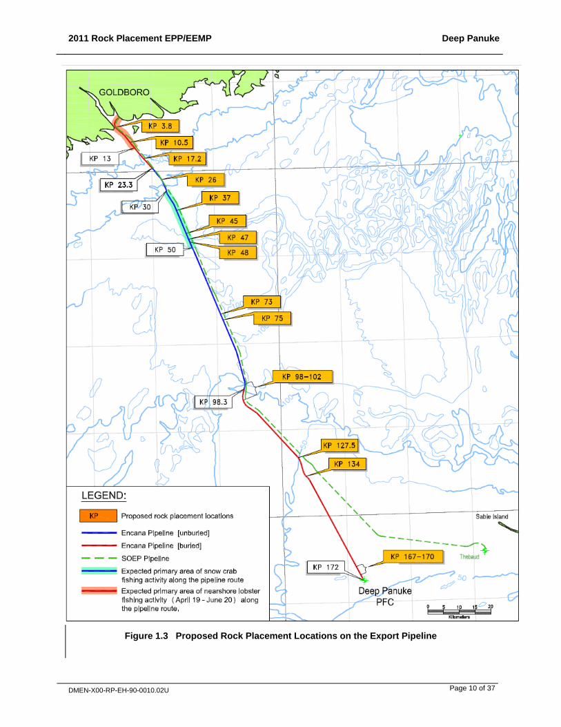
1.3 Rock Placement over the Export Pipeline
Rock placement will take place over the export pipeline for the following three reasons:
pipeline on-bottom stability (where pipeline was not trenched to the required depth for stability);
correction of pipeline free span sections; and
pipeline upheaval buckling protection.
Rock placement locations over the export pipeline are shown on Figure 1.3 and detailed in Table 1.1 below.
Table 1.1 Rock Placement Locations Over the Export Pipeline
Free span / On-bottom stability
Rock start KP Length (m)
On-bottom stability 3.8 30 On-bottom stability 10.6 140 On-bottom stability 17.2 25 Free span 25.6 40 Free span 26.3 67 Free span 26.7 8 Free span 37.6 11 Free span 37.7 32 Free span 45.8 13 Free span 46.0 20 Free span 47.6 17 Free span 48.8 13 Free span 73.2 6 Free span 75.4 36 Upheaval buckling 98.2 66 Upheaval buckling 100.2 33 Upheaval buckling 102.0 37 Upheaval buckling 127.4 43 Upheaval buckling 134.0 36 Upheaval buckling 167.0 30 Upheaval buckling 167.0 44 Upheaval buckling 167.3 25 Upheaval buckling 167.6 43 Upheaval buckling 167.9 40 Upheaval buckling 169.3 27 Upheaval buckling 169.4 42 Upheaval buckling 169.6 22 Upheaval buckling 169.7 25 Upheaval buckling 169.8 40
2011 Rock Placement EPP/EEMP Deep Panuke
DMEN-X00-RP-EH-90-0010.02U Page 10 of 37
Figure 1.3 Proposed Rock Placement Locations on the Export Pipeline

2011 Rock Placement EPP/EEMP Deep Panuke
DMEN-X00-RP-EH-90-0010.02U Page 11 of 37
Figure 1.4 shows a typical cross-section of a rock berm over a pipeline section (the figure shows a pipeline span section; for a stability or upheaval buckling protection berm, the pipeline may be on the seabed or partly buried). The height of the berm will vary between approximately 0.2-1.2 m. Please note that dimensions provided on these cross-sections are indications only and actual dimensions will vary.
Figure 1.4 Typical Cross-Section of Rock Berm Over Pipeline Section
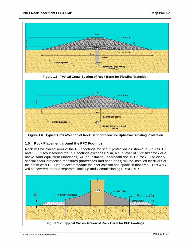
1.4 Rock Placement over the Flowlines
Rock placement will take place over the flowlines for the following two reasons:
Flowline trench transitions; i.e. where the flowlines are coming out of the trench at each end (near the wellhead and near the PFC). Figure 1.8 shows the flowline transition rock placement locations near the PFC. Figure 1.5 shows a typical cross-section of a flowline transition rock berm. These rock berms will be approximately 30 m in length (covering the flowline section located between 20-50 m from each flowline end flange) and 1 m in height.
Flowline upheaval buckling protection (for added weight over sections of the buried flowlines with propensity to buckle). These rock berms will be placed at numerous locations along the flowlines as detailed in Table 1.2. Figure 1.6 shows a typical cross-section of a flowline upheaval buckling protection rock berm. These rock berms will vary in heights from 0.3 m to 2.2 m.
Table 1.2 Rock Placement Locations for Flowline Upheaval Buckling Protection
Flowline Flowline Length (km)
# Rock Berms Total Length of Rock Berm
% of Flowline Rock Covered
H-08 5.9 39 3.9 66% D-41 5.9 45 2.9 49% F-70 2.2 20 1.6 70% M-79A 0.6 0 0 0% E-70 1.6 0 0 0%
2011 Rock Placement EPP/EEMP Deep Panuke
DMEN-X00-RP-EH-90-0010.02U Page 12 of 37
Figure 1.5 Typical Cross-Section of Rock Berm for Flowline Transition
Figure 1.6 Typical Cross-Section of Rock Berm for Flowline Upheaval Buckling Protection
1.5 Rock Placement around the PFC Footings
Rock will be placed around the PFC footings for scour protection as shown in Figures 1.7 and 1.8. If scour around the PFC footings exceeds 0.5 m, a sub-layer of 1”-3” filter rock or a native sand equivalent (sandbags) will be installed underneath the 1”-12” rock. For clarity, special scour protection measures (mattresses and sand bags) will be installed by divers at the south west PFC leg to accommodate the riser caisson and spools in that area. This work will be covered under a separate Hook-Up and Commissioning EPP/EEMP.
Figure 1.7 Typical Cross-Section of Rock Berm for PFC Footings

2011 Rock Placement EPP/EEMP Deep Panuke
DMEN-X00-RP-EH-90-0010.02U Page 13 of 37
Figure 1.8 Location of Rock Berms for Flowline Transitions near the PFC and PFC Footings
2011 Rock Placement EPP/EEMP Deep Panuke
DMEN-X00-RP-EH-90-0010.02U Page 14 of 37
1.6 Rock Material
The following rock grades will be used for this program:
1”-12” rock around the PFC footings (and potentially 1-3” rock or sand bags depending on scour conditions, as per Section 1.5);
3”-9” rock over the pipeline and flowline sections; and
1”-3” rock for the under-layer used in the flowline transition protections.
Rock material will be sourced from Martin Marietta Materials Quarry located in Auld’s Cove (Mulgrave, NS) by Van Zutphen contractors. Supplied rock material will be free of contamination from hydrocarbons or chemicals, and will be free of fines (as much as practical) to minimize sedimentation in the water.
2011 Rock Placement EPP/EEMP Deep Panuke
DMEN-X00-RP-EH-90-0010.02U Page 15 of 37
2 SPECIAL AREAS
The rock placement program will follow Encana’s Codes of Practice for Sable Island, the Gully Marine Protected Area (MPA) and Country Island, which include the following measures (see Appendix 1):
No activities and no vessels and aircraft within 2 km (1 nautical mile) of Sable Island except in emergency situations, under an approved Environmental Monitoring Program or for special trips approved by the Canadian Coast Guard.
No activities inside the Gully MPA, no vessels permitted within the Gully MPA, and aircraft flying at a height of at least 500 m above the Gully MPA; except for the purpose of safety or under an approved environmental monitoring program.
No flying over, disembarking or approaching within 2 km (1 nautical mile) of Country Island (which encompasses the Roseate tern designated critical habitat) except for the purpose of safety or an approved Environmental Monitoring Program.
In the October 2002 Additions and Errata to the approved 2002 Comprehensive Study Report, Encana committed to “limiting activities undertaken within 22 km of Country Island between May 1st and June 20th to onshore pipelaying construction activities (including winch set-up) and nearshore small-diving and environmental-support vessel activities”. However, this commitment is no longer expected to be applicable for this type of construction activities, as outlined in the 2011 Subsea Asset Survey Environmental Protection Plan / Environmental Effects Monitoring Plan, DMEN-X00-RP-EH-90-0006.

2011 Rock Placement EPP/EEMP Deep Panuke
DMEN-X00-RP-EH-90-0010.02U Page 16 of 37
3 INTERACTION WITH FISHING ACTIVITY
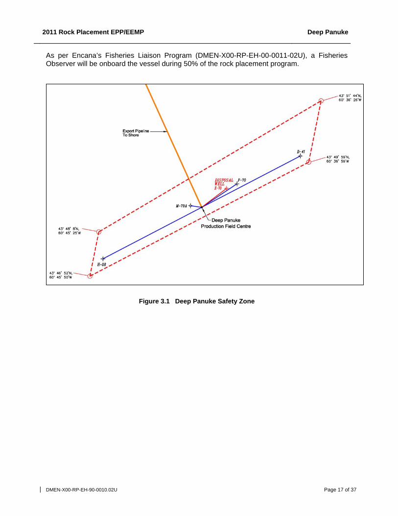
No interactions with fishing vessels are anticipated since the program only involves one vessel transiting through the area; minimal fishing activity is expected along the pipeline route; and no fishing activity is expected within the Deep Panuke Safety Zone (see Figure 3.1).
Extensive consultation with the fishing industry was conducted as part of the Deep Panuke Environmental Assessment process and identified that the Deep Panuke field centre was an area of very low fishing activity, with no catches reported in this area between 2002 and 2005 (refer to the commercial fisheries catch and effort maps provided in Appendix J of the 2006 Deep Panuke EA Report (Volume 4)), even before the Deep Panuke Safety Zone was established.
The Deep Panuke pipeline route was identified as an area of generally low fishing activity (refer to the commercial fisheries catch and effort maps provided in Appendix J of the 2006 EA Report (Volume 4)).
In the offshore area, except for a few scattered groundfish catches reported on the pipeline route, the only fishing activity directly adjacent to the pipeline route is snow crab fishing taking place around KP 30-50 (see Figure 1.3) between mid-June and the end of September (refer to Table 7.11 Licensed Seasons for Key Fisheries in the Project Area from the 2006 EA Report (Volume 4)).
In the nearshore area, the pipeline route crosses lobster, rock crab and sea urchin fishing grounds. As per its commitment, rock placement at the two nearshore locations (KP 3.8 and 10.5, see Figure 1.3) will be conducted after the end of the nearshore lobster fishing season (June 20th).
Encana has contacted the following fisheries associations with regard to its planned Deep Panuke’s 2011 offshore activities, including this rock placement program:
Nearshore Sea Urchin Fisherman; Area 24 Crab Fisherman's Association; Native Council (Mime'j Seafood Inc.); Eastern Shore Fisherman's Protective Association (part of the larger Eastern Fisherman's
Federation); Ocean Pride (Sea Cucumber Fishery); Grover Fisheries Ltd. (Sea Cucumber Fishery); Atlantic Herring Co-op Ltd.; Nova Scotia Sword Fishermen's Association; Clearwater Seafoods Limited; Seafood Producers Association of Nova Scotia; and Guysborough County Inshore Fishermen's Association.
In March 2011, these organizations were provided with an updated information package including a summary of activities, schedule and location information on Deep Panuke’s planned 2011 offshore activities, including this survey. They were then called directly to gather any feedback. No issues or concerns were raised by fishing groups representatives.
A Notice to Shipping will be issued with regard to the program.
In the unlikely event of an incident with a non-project vessel such as a fishing vessel or a spill, Encana will adhere to the CNSOPB Compensation Guidelines Respecting Damages Relating to Offshore Petroleum Activity and compensate and indemnify licensed participants in the fishing industry to the extent that the Deep Panuke Project may cause them damage or loss, including consequential damages during normal fishing operations.
2011 Rock Placement EPP/EEMP Deep Panuke
DMEN-X00-RP-EH-90-0010.02U Page 17 of 37
As per Encana’s Fisheries Liaison Program (DMEN-X00-RP-EH-00-0011-02U), a Fisheries Observer will be onboard the vessel during 50% of the rock placement program.
Figure 3.1 Deep Panuke Safety Zone

2011 Rock Placement EPP/EEMP Deep Panuke
DMEN-X00-RP-EH-90-0010.02U Page 18 of 37
4 INTERACTION WITH MILITARY OPERATIONS
Encana has received confirmation from DND in February 2011 that there are no UXO (Unexploded Ordnance), chemical, biological, or radioactive material or operational issues or conflicts from the MARLANT perspective with the Deep Panuke Project, including this rock placement program. Should any suspected UXOs be encountered during the course of the Deep Panuke operations, they will not be disturbed or manipulated. Encana will mark the location and immediately inform the Coast Guard.
2011 Rock Placement EPP/EEMP Deep Panuke
DMEN-X00-RP-EH-90-0010.02U Page 19 of 37
5 IMPACT TO BENTHIC HABITAT
Rock will be placed on the export pipeline, the flowlines and around the PFC footings, as described in Sections 1.3 to 1.6.
The potential impact from the physical presence of project infrastructure (including platforms, pipelines, protective mattresses and rocks) was assessed in the 2002 Deep Panuke Comprehensive Study Report (CSR). It was determined that while these structures would create a long-term alteration of benthic habitat, the areas would re-colonize with local species within one to three years.
It was noted in particular that concrete mattresses and rocks used to stabilize the pipeline would provide a hard stable substrate creating benthic habitat in what is otherwise a predominantly sandy mobile environment. These hard surfaces will be colonized by a variety of local marine flora and fauna creating a “reef” effect which is anticipated to have a minor positive effect on the benthic community in the project area (see Section 6.3.3.4 from the 2002 CSR for additional information on that reef effect).
It was also noted that concrete coating and the colonization from benthic organisms on the subsea pipeline would increase the roughness of the pipe surface, thereby further facilitating the capability of crustaceans to climb over the pipe. The same can be said of rock placement over the pipeline.
In the 2006 EA Report (see Section 8.3.4.2, Operation, Presence of Structures, Reef and Refuge Effects), it was determined that the proposed new design of the project would create a greater reef effect (and associated minor positive effect on the benthic community) because of the additional structures on the seafloor, including the flowlines and associated protective rocks and mattresses.
As mentioned in Section 1.6, the selected rock material will be free of fines and hydrocarbon/chemical contamination. No additional protection measures are required during rock placement installation.

2011 Rock Placement EPP/EEMP Deep Panuke
DMEN-X00-RP-EH-90-0010.02U Page 20 of 37
6 WASTE AND DISCHARGES
Hazardous wastes will be accumulated in suitable containers and placed in appropriate shipping containers for return to shore for disposal and collected by licensed waste haulers. Applicable codes and regulations for the handling, use, storage, transport and disposal of hazardous wastes will be followed, including Workplace Hazardous Materials Information System (WHMIS), the Nova Scotia Dangerous Goods Management Regulations and the Transportation of Dangerous Goods (TDG) Act and Regulations, as applicable.
In the event of an onboard spill, any used absorbent materials and any other oily wastes will be placed in sealed containers and returned to shore for treatment and disposal at an approved waste management facility.
The CNSOPB Offshore Waste Treatment Guidelines will be followed with respect to routine discharges (e.g., sanitary and food wastes, oily bilge/ballast water) from the MV Tideway Rollingstone. The MV Tideway Rollingstone has a food waste macerator, a sewage treatment plant and a bilge water oil/water separator onboard.
The MV Tideway Rollingstone will comply with the Ballast Water Control Land Management Regulations (2006) under the Canada Shipping Act, including provisions to replace its ballast water before entering Canadian waters.
Any other wastes will be sorted and brought to shore for disposal according to the local regulatory regime of the shore base (Mulgrave, NS), including the Nova Scotia Solid Waste - Resource Management Regulations and municipal requirements at the offloading location under professional guidance of Tideway’s locally appointed Marine Agency, I.H. Mathers.

2011 Rock Placement EPP/EEMP Deep Panuke
DMEN-X00-RP-EH-90-0010.02U Page 21 of 37
7 NOISE FROM MULTIBEAM SOURCE
Both the fall-pipe ROV (FPROV) and the free-flying ROV (FFROV) used during the program will carry multibeam echosounders. The multibeam equipment (which is similar to echo sounder and sonar equipment commonly used by fishing vessels) can be considered as non-intrusive in the marine environment and is not expected to have any significant environmental impact for the following reasons:
the multibeam activity will be transient (along the pipeline, flowline and PFC locations);
the multibeam activity will be of short duration (intermittently over the program duration, i.e. approximately 40 days);
generated noise will be of low pressure (below the CEAA seismic screening trigger level of 275.79 kPa or 229 dB re 1 µPa @1m) and of high frequency (greater than 1000 Hz, as opposed to seismic surveys which use predominantly low frequency (10-300 Hz) noise which propagates farther), and will therefore attenuate over a short time and distance;
the multibeam system will be mounted on an ROV; there will not be any towed hydrophone streamer; and
endangered whales such as the Blue whale, Northern Right whale and the Northern Bottlenose whale are not expected to be in the Project area.
2011 Rock Placement EPP/EEMP Deep Panuke
DMEN-X00-RP-EH-90-0010.02U Page 22 of 37
8 STRANDED BIRD PROTOCOL
The protocol developed by Williams and Chardine (1999) for storm petrels (Appendix 2) will be implemented for any stranded bird species on the program’s vessel.
A Seabird Salvage Permit has been obtained from Canadian Wildlife Service (CWS) to cover all Deep Panuke 2011 offshore activities. A report of birds “salvaged” onboard the program’s vessel (and other offshore vessels/platforms used for Deep Panuke 2011 activities) will be submitted to CWS and to the CNSOPB before the end of January 2012.
Encana will immediately notify CWS if a dead bird or an oiled bird is found during the program. Any oiled bird will immediately be reported to the Canadian Coast Guard Operations Center. In case of a mass stranding (more than five dead birds in a 24-hr episode), or an oiled bird (see section 9.5.3 for oiled birds), the CNSOPB will also be contacted. Dead birds will be identified, recorded and disposed of at sea unless they are oiled (see section 9.5.3 for oiled birds). Please see Figure 9.1 for a detailed flowchart of bird handling procedures for the program.

2011 Rock Placement EPP/EEMP Deep Panuke
DMEN-X00-RP-EH-90-0010.02U Page 23 of 37
9 SPILL RESPONSE
9.1 Spill Risk
The likelihood of an accidental spill into the marine environment during the program is very low because the program’s vessel will comply with IMO standards and will have no specific onboard spill sources other than its own internal fuel tanks.
The survey will include the deployment of two ROV (the FPROV and FFROV). However, the risk of potential impact from ROV hydraulic fuel spills is expected to be minimal due to typically very small volumes of such spills and the fact that the ROV hydraulic fluids used (Mobil DTE 10 Excel 46 and Mobilect 35 for the FPROV and FFPROV, respectively) are not expected to be harmful to aquatic organisms and are expected to be inherently biodegradable.
A spill response plan is in place to minimize the possible consequences of a malfunction or accident (refer to Sections 9.2 to 9.7 below).
9.2 Spill Response Logistics and Equipment
The program’s vessel will be available for spill monitoring and response if required. There are no scheduled helicopter flights during the program (there is no helideck on the MV Tideway Rollingstone).
The program’s vessel will have standard spill response kits capable of containing and cleaning up a small spill onboard the vessel.
9.3 Spill Monitoring
As per Encana’s Spill Response Plan, in the unlikely event of a spill, Encana will conduct the following monitoring until the slick dissipates:
estimate spill volume; estimate oil type; and visually assess the slick until it has disappeared by natural dispersion and evaporation.
9.4 Enhance Natural Dispersion
Spill modeling can be used to investigate the fate of a ‘worst case’ spill event – a diesel spill from a simultaneous rupture of the vessel hull and fuel tank, a very unlikely event for this program. Furthermore, diesel is a light oil which is highly evaporative and dispersive in the marine environment.
Spill dispersion modeling carried out for the 2006 Deep Panuke EA (Volume 4) gave the following results for 1.6 m3 (10-barrel) and 16 m3 (100-barrel) diesel spill scenarios at the Deep Panuke PFC location. A 1.6 m3 (10-barrel) batch spill will persist as a slick for about 13 hours and travel about 12 km prior to the complete loss of the surface oil. The maximum dispersed oil concentration for this spill will be about 2 ppmw and this will drop to 0.1 ppmw within about 16 hours. A 16 m3 (100-barrel) batch spill of diesel will persist as a slick for about 19 hours and travel about 18 km prior to the complete loss of the surface oil. The maximum dispersed oil concentration for this spill will be about 4 ppmw and this will drop to 0.1 ppmw within about 43 hours. The dispersed oil cloud will travel about 54 km and have a maximum width of about 4 km. Prevailing water currents would take the dispersed oil cloud in a southwest direction away from Sable Island (located approximately 48 km from Deep Panuke). Therefore, no diesel is predicted to reach the nearest landfall which is Sable Island (critical habitat for endangered

2011 Rock Placement EPP/EEMP Deep Panuke
DMEN-X00-RP-EH-90-0010.02U Page 24 of 37
Roseate terns). Any diesel spill will also not likely reach the Haddock Box since most spill scenarios result in a dispersed oil cloud traveling significantly less than the 49 km distance from the production field to the Haddock Box (for further details refer to Encana’s Reply Evidence for the Deep Panuke Project dated February 26, 2007).
Based on the limited persistence of diesel on the sea surface, it is unlikely that a containment and/or recovery effort at sea or the use of chemical dispersants would be warranted. The most appropriate response would be to enhance natural dispersion processes by running vessels through the slick.
9.5 Spill EPP for Marine Birds
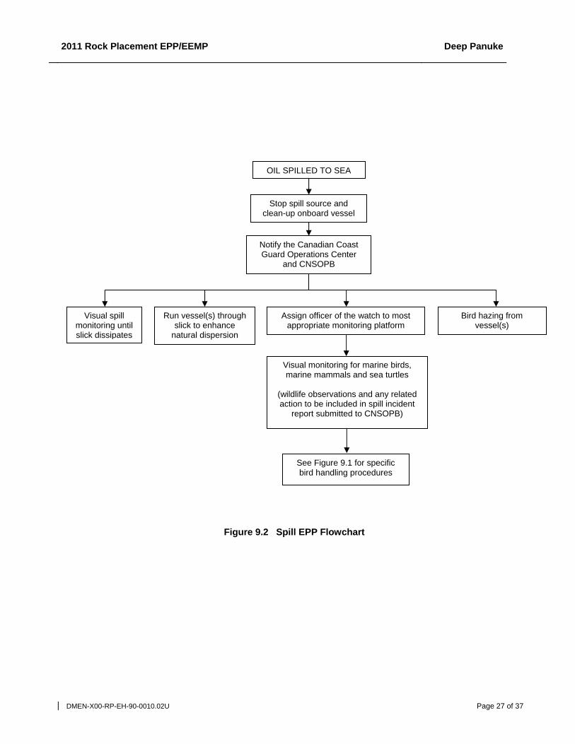
Figure 9.2 provides a summary flowchart of the proposed environmental protection plan (EPP) for the program in the event of a spill.
9.5.1 Bird Monitoring
In the unlikely event of a spill, any observations of spill and marine bird interactions will be reported to Encana immediately.
Marine bird species-at-risk are not expected to occur in the program area. The only marine bird species listed by COSEWIC as endangered or threatened offshore Nova Scotia is the endangered Roseate tern nesting on Sable Island between May and July, approximately 40 km away from the closest location of the project site.
9.5.2 Bird Dispersal
In the unlikely event of a spill, Encana will attempt to keep birds away from the slick area by hazing from the vessels, if logistical conditions permit. This effort will focus on dispersing congregations of birds. Potential hazing means include the vessels themselves, and the use of sound makers (e.g. vessel horns). No specific permit is required from Environment Canada for bird hazing.
9.5.3 Oiled Birds Handling
It is very unlikely that an oiled bird will be found at sea during the program because of the low risk of oil spill during the program (see section 9.1) and the difficulty to identify oiled birds in the water (small dark spot on dark water). In the very unlikely event that an oiled bird were found at sea during the program, Encana would not attempt to recover it because of safety concerns associated with an overboard recovery operation and the unlikelihood to save a live oiled bird if it can be recovered (onshore rehabilitation can cause distress to marine birds with no guarantee of successful re-entry into the breeding population, especially in Canada where waters are generally cold and the species generally affected do not respond well to cleaning).
It is also very unlikely that an oiled bird will be found onboard the vessel during the program because of the absence of specific spill sources on deck and of good housekeeping procedures. If a live oiled bird were found onboard the vessel during the program, the protocol developed by Williams and Chardine (1999) for storm petrels (Appendix 2) would be implemented. If the bird died or if any dead oiled birds were found onboard the vessel, the bird would be frozen and shipped to the CWS office in Dartmouth for confirmation of origin of the oil contamination, if logistics permits (CWS will be contacted beforehand). If shipping to shore were not possible, the bird would be disposed at sea.
Encana will immediately notify the CNSOPB, the Canadian Coast Guard Operations Center and CWS if an oiled bird (dead or live) is identified during the program and will confirm the course of action with them.

2011 Rock Placement EPP/EEMP Deep Panuke
DMEN-X00-RP-EH-90-0010.02U Page 25 of 37
Beached bird surveys on Sable Island would only be implemented in the event of a catastrophic spill in which a large number of birds were expected to be oiled and oiled birds were expected to arrive on the island. As indicated in Section 9.4, such an occurrence is deemed to be highly unlikely based on spill dispersion modeling.
Figure 9.1 provides a detailed flowchart of oiled bird handling procedures for the program.
9.6 Spill EPP for Marine Mammals
Marine mammals have body coverings, unlike those of birds, that are relatively unaffected by oiling. Hair seals for example are often observed with apparently untroublesome patches of heavy oil; light oils such as diesel are likely to evaporate and wash off more readily. Spills of light oil are likely to impair breathing in ways that would tend to repel animals from the area before they are adversely affected.
In the unlikely event of a spill, any observations of spill and marine mammal interactions will be reported immediately to Encana. Wildlife observations and any related action will be included in the spill incident report submitted to CNSOPB (see Figure 9.2).
9.7 Spill EPP for Sable Island
Dispersion modeling carried out for the Deep Panuke EA (Volume 4) shows that 10-barrel and 100-barrel spills of diesel are unlikely to occur during program activities or reach Sable Island due to prevailing currents away from the island – even with winds blowing directly towards the island (see Section 9.4).
While very unlikely, Encana will conduct beached bird surveys on Sable Island should a spill approach or reach Sable Island, to assist in determining the impact of the spill.

2011 Rock Placement EPP/EEMP Deep Panuke
DMEN-X00-RP-EH-90-0010.02U Page 26 of 37
1 If during non business hours or if during business hours and CWS has not responded within 2 hours of being contacted via cell phone and email, AND in case of 10 dead birds or more in a 24-hr episode, then notify Canadian Coast Guard Operations Center 2 Also notify the CNSOPB in case of mass stranding (more than five dead birds in a 24-hr episode) 3 Birds handled during the program will be included in Encana’s yearly Seabirds Salvage Permit report submitted to Environment Canada under the Migratory Bird Act and to the CNSOPB (before January 31 from the following year). 4 Oiled birds will be shipped to Canadian Wildlife Service, Environment Canada, 45 Alderney Drive, 16th Floor, Dartmouth, N.S. B2Y 2N6. CWS will be contacted beforehand.
Figure 9.1 Bird Handling Flowchart
Implement Williams and
Chardine Protocol 3
No action required
NON OILED bird is found
Onboard
Record & dispose at
sea 3
At sea
Dead Live
Notify CWS 1, 2
Live Dead
Identify and record
Bird released 3
No recovery because of
safety concerns and low chance
of success in saving the bird.
Identify and record.
Record, freeze and ship to CWS for oil
source confirmation if possible. If not,
record and dispose at sea. 3, 4
Bird survives
Notify Canadian Coast Guard Operations Center, CWS and the
CNSOPB and confirm course of action.
OILED bird is found
Onboard At sea
Dead Live
Implement Williams and
Chardine Protocol
No Yes
2011 Rock Placement EPP/EEMP Deep Panuke
DMEN-X00-RP-EH-90-0010.02U Page 27 of 37
Figure 9.2 Spill EPP Flowchart
Visual monitoring for marine birds, marine mammals and sea turtles
(wildlife observations and any related action to be included in spill incident
report submitted to CNSOPB)
OIL SPILLED TO SEA
Bird hazing from vessel(s)
Notify the Canadian Coast Guard Operations Center
and CNSOPB
Visual spill monitoring until slick dissipates
Stop spill source and clean-up onboard vessel
Run vessel(s) through slick to enhance
natural dispersion
See Figure 9.1 for specific bird handling procedures
Assign officer of the watch to most appropriate monitoring platform

2011 Rock Placement EPP/EEMP Deep Panuke
DMEN-X00-RP-EH-90-0010.02U Page 28 of 37
APPENDIX 1 CODES OF PRACTICE FOR SABLE ISLAND, THE GULLY MPA AND COUNTRY ISLAND

444000
444000
544000
544000
644000
644000
744000
744000
844000
844000
944000
944000
4749
000
4749
000
4849
000
4849
000
4949
000
4949
000
5049
000
5049
000
5149
000
5149
000
EnCana Codesof Practice
Reference Map
0 50 10025
Kilometers
Map ParametersProjection: UTM-NAD83-Z20
Scale 1:1,750,000Date: JOctober 05, 2006
Project No.: 1015157
Map FeaturesLand
Bathymetry (m)DEPTH
0 - 5051 - 100101 - 200201 - 400401 - 500501 - 10001001 - 20002001 - 30003001 - 35003501 - 40004001 - 45004501 - 50005001 - 5500
Figure 1
Sable Island
N O V A S C O T I A
Halifax
Goldboro
Gully Marine Protected Area
Country Island
Date: November 2010
Encana Codes of Practice
Reference Map
Deep Panuke Area Reference
Map
Deep Panuke Project Area
Date: December 2010

1 | code of practice for Sable Island
code of practice for Sable Island
Encana has developed, as part of its environmental protection planning, a code of practice to protect the uniqueness and integrity of Sable Island (see area reference map). This code is not a regulatory requirement and is indicative of Encana’s environmental stewardship philosophy and corporate policies.
Sable Island is approximately 41 kilometres (km) (25 miles) in length and is located 290 km (157 nautical miles) southeast of Halifax. The island is composed of sand and is the only emergent portion of the Sable Island Bank. It supports a fragile ecosystem consisting of diverse flora and fauna; the best known components being the feral horses, seal populations, the rare Ipswich (Savannah) sparrow (Passerculus sandwichensis princeps) and the endangered Roseate tern (Sterna dougallii).
Sable Island access and activities are currently administered by the Canadian Coast Guard pursuant to the Sable Island Regulations under the Canada Shipping Act. It is also protected by Environment Canada’s Migratory Bird Sanctuary Regulations under the Migratory Birds Convention Act. Nesting tern colonies on the island have also been designated by Environment Canada as critical habitat for Roseate terns under the Species at Risk Act. In May 2010 the governments of Canada and Nova Scotia announced that they will take the necessary steps to designate Sable Island as a national park under the Canada National Parks Act. Encana is represented on the Sable Island Stakeholder Advisory Committee chaired by the federal Department of Fisheries and Oceans (DFO). The Sable Island Green Horse Society website (www.greenhorsesociety.com) contains additional information on Sable Island.
As part of its environmental stewardship with respect to Sable Island:
� Encana will not conduct activities within 2km (one nautical mile) of Sable Island. All Encana activities on Sable Island must receive approval from Encana senior management and the Canadian Coast Guard and will comply with all applicable guidelines including the Canadian Coast Guard Visitors Guide to Sable Island www.ccg-gcc.gc.ca/folios/00039/docs/SableIslandVisitorsGuide-eng.pdf.
� Encana vessels and aircraft are not permitted within 2km (one nautical mile) of the Island. However, this restriction does not apply in the case of an emergency situation, for access required as part of an approved environmental monitoring program or for special trips approved by the Canadian Coast Guard.
� Encana will include discussion of this code of practice in its environmental awareness training program for its personnel. Encana intends this code to be a living document and will review and update it as required. This code of practice is also publicly available on the Encana website www.encana.com/contractor/expectationspractices.
1 | code of practice for the Gully Marine Protected Area
code of practice for the Gully Marine Protected Area
Encana has developed, as part of its environmental protection planning, a code of practice to protect the uniqueness and integrity of the Gully Marine Protected Area (MPA) (see area reference map). This code is not a regulatory requirement and is indicative of Encana’s environmental stewardship philosophy and corporate policies.
The Gully is a large submarine canyon approximately 40 kilometres (km) (21.6 nautical miles) east of Sable Island on the edge of the Scotian Shelf. It is unique among canyons of the Eastern Canadian margin because of its depth, steep slopes and extension back into the continental shelf. The Gully contains a rich diversity of marine habitats and species, including deep-sea corals and the endangered northern bottlenose whale (Hyperoodon ampullatus). The area is nationally and globally acknowledged as an important and exceptional marine habitat.
The Gully has been designated by the Federal Department of Fisheries and Oceans (DFO) as an MPA under the Oceans Act in 2004, and comprises an area of 2,364 square km (913 square miles). The MPA regulations prohibit the disturbance, damage, destruction or removal of any living marine organism or habitat within the Gully. The MPA contains three management zones, each providing varying levels of protection based on conservation objectives and ecological sensitivities. The regulations also control human activities in areas around the Gully that could cause harmful effects within the MPA boundary. Encana is represented on the Gully Advisory Committee chaired by DFO.
As part of its environmental stewardship with respect to the Gully MPA:
� Encana will not conduct activities inside the Gully MPA. In addition, no vessels are permitted within the Gully MPA and aircraft in regular transit to and from any vessels, drilling units, or facilities are restricted to flying at a height of at least 500 metres (1640 feet). These restrictions apply unless it is required for purposes of safety or safe operation of a vessel/aircraft or as part of an approved environmental monitoring program.
� Encana will include discussion of this code of practice in its environmental awareness training program for its personnel. Encana intends this code to be a living document and will review and update it as required. This code of practice is also publicly available on the Encana website www.encana.com/contractor/expectationspractices.

1 | code of practice for Country Island
code of practice for Country Island
Encana has developed, as part of its environmental protection planning, a code of practice to protect the uniqueness and integrity of the Roseate tern colony of Country Island (see area reference map). While the focus is on Country Island, the code will also serve to protect nearby seabird colonies. This code is not a regulatory requirement and is indicative of Encana’s environmental stewardship philosophy and corporate policies.
Country Island is a 19 hectare (ha) island, located approximately eight kilometres (km) (five miles or 4.3 nautical miles) offshore from Goldboro, Nova Scotia (45º06’N, 61º32’W). The island hosts a sizeable breeding colony of Common and Arctic terns and has provided a nesting opportunity for the endangered Roseate tern (Sterna dougallii) for many years. The Roseate is the tern species most at risk in northeastern North America. There are about 4,000 pairs in the northeastern United States and 120 – 150 pairs in Atlantic Canada, mostly in one or two colonies, including approximately 53 pairs on the Country Island complex.
Country Island has been identified as critical habitat for the Roseate tern by Environment Canada in the Recovery Strategy for the Roseate tern in Canada (2006) under the Species at Risk Act. This designation includes the entire terrestrial habitat of the island as well as aquatic habitat extending 200 metres (656 feet) seaward from the mean high tide line.
As part of its environmental stewardship with respect to Country Island:
� Encana will not fly over, disembark or approach within 2km (one nautical mile) of Country Island (which encompasses the Roseate tern designated critical habitat) unless it is required for purposes of safety or safe operation of a vessel or aircraft or as part of an approved environmental monitoring program.
� Encana will include discussion of this code of practice in its environmental awareness training program for its personnel. Encana intends this code to be a living document and will review and update it as required. This code of practice is also publicly available on the Encana website www.encana.com/contractor/expectationspractices.

2011 Rock Placement EPP/EEMP Deep Panuke
DMEN-X00-RP-EH-90-0010.02U Page 33 of 37
APPENDIX 2 WILLIAMS AND CHARDINE PROTOCOL

2011 Rock Placement EPP/EEMP Deep Panuke
DMEN-X00-RP-EH-90-0010.02U Page 34 of 37
The Leach's Storm-Petrel:
General information and handling instructions
Urban Williams (Petro-Canada)
&
John Chardine (Canadian Wildlife Service)
The Grand Banks is an area that is frequented by large numbers of seabirds, representing a variety of species. Large populations are found in this area in both summer and winter, and come from the Arctic, northern Europe, and the south Atlantic, as well as from colonies along the Newfoundland Coast. One of the species found in the area of the Terra Nova Field is the Leach’s Storm-Petrel (Oceanodroma leucorhoa).
The Bird:
Leach’s Storm-Petrels are small seabirds, not much bigger than a Robin. They have relatively long wings and are excellent fliers. Leach’s Storm-Petrels are dark brown in colour and show a conspicuous white patch at the base of the tail. In the hand, you can easily notice a small tube at the top of their bill, and you will also notice that the birds have a peculiar, not unpleasant smell (although some Newfoundlanders call these birds “Stink Birds”). Storm-Petrels are easy prey for gulls and other predators, and so to protect themselves from predation, Leach’s Storm-Petrels are only active at night when on land at the breeding colonies.
Nesting Habitat:
Leach’s Storm-Petrels are distributed widely in the northern hemisphere, however, their major centres of distribution are Alaska and Newfoundland. The bird breeds on offshore islands, often in colonies numbering tens or hundreds of thousands of pairs, even millions at one colony in Newfoundland. The nest is a chamber, sometimes lined with a some grass, located at the end of a narrow tunnel dug in the topsoil. Depending on the colony, burrows may be under conifer or raspberry thickets or open grassland.
Reproduction:
In Newfoundland, Leach’s Storm-Petrels lay their single egg in May and June. The egg is incubated by both parents alternately, sometimes for stretches exceeding 48 hours. The egg is incubated for 41-42 days, which is a long time for such a small egg. The peak hatching period is in the last half of July. The young petrel remains in the tunnel for about 63-70 days. Once breeding is over in late-August or early September, the birds disperse from the colonies and migrate to their wintering

2011 Rock Placement EPP/EEMP Deep Panuke
DMEN-X00-RP-EH-90-0010.02U Page 35 of 37
grounds in the Atlantic. September is the most important period for migration of Storm-Petrels to the offshore areas such as near the Terra Nova field.
Populations:
Canada alone supports more than 5 million pairs of Leach's Storm-Petrels. Most of them are found in Newfoundland. The Leach’s Storm-Petrel colony located on Baccalieu Island is the largest known colony of this species.
Nesting sites for Leach’s Storm-Petrels are found along the southeast coast of Newfoundland. These are - i) Witless Bay Islands (780,00 nesting pairs), ii) Iron Island (10,000 nesting pairs), iii) Corbin Island (100,000 nesting pairs), iv) Middle Lawn Island (26,000 nesting pairs), v) Baccalieu Island (3,336,000 nesting pairs), vi) Green Island (72,000 nesting pairs), and vii) St. Pierre Grand Columbier (100,000 nesting pairs).
Feeding Habits:
Leach’s Storm-Petrels feed at the sea surface, seizing prey in flight. Prey usually consists of myctophid fish and amphipods. The chick is fed planktonic crustaceans, drops of stomach oil from the adult bird, and small fish taken far out at sea. Storm-Petrels feed far out from the colony and it would be reasonable to assume that birds nesting in eastern Newfoundland can be found feeding around the Terra Nova site.
The Problem:
As identified in the C-NOPB Decision 97-02, seabirds such as Leach’s Storm-Petrels are attracted to lights on offshore platforms and vessels. Experience has shown that Storm-Petrels may be confused by lights from ships and oil rigs, particularly on foggy nights, and will crash into lighted areas such as decks and portholes. Fortunately, this type of accident does not often result in mortality, however, once on deck the bird will sometimes seek a dark corner in which to hide, and can become fouled with oil or other contaminants on deck.
Period of Concern:
Leach’s Storm-Petrels are in the Terra Nova area from about May until October and birds could be attracted to lights at any time throughout this period. The period of greatest risk of attraction to lights on vessels appears to be at the end of the breeding season when adults and newly fledged chicks are dispersing from the colonies and migrating to their offshore wintering grounds. September is the most important period for migration of storm-petrels to the offshore areas. Past experience suggests that any foggy night in September could be problematic and may result in hundreds or even thousands of birds colliding with the vessel.
The Mitigation:
On nights when storm-petrels are colliding with the vessel, the following steps should be taken to ensure that as many birds as possible are safely returned to their natural habitat:
All decks of the vessel should be patrolled as often as is needed to ensure that birds are picked up and boxed (see below) as soon as possible after they have collided with the vessel. After collision, birds will often “freeze” below lights on deck or seek dark areas underneath machinery and the like.
Birds should be collected by hand and gently placed in small cardboard boxes. Care should be taken not to overcrowd the birds and a maximum of 10-15 birds should be placed in each box, depending upon its size. The birds are very easy to pick up as they are poor walkers and will not fly up off the deck so long as the area is well-lit. They will make a squealing sound as they are

2011 Rock Placement EPP/EEMP Deep Panuke
DMEN-X00-RP-EH-90-0010.02U Page 36 of 37
picked up- this is of no concern and is a natural reaction to be handled (the birds probably think they have been captured to be eaten!).
When the birds are placed in the box the cover should be put in place and the birds left to recover in a dark, cool, quiet place for about 5-10 minutes. The birds initially will be quite active in the box but will soon settle down.
Following the recovery period, the box containing the birds should be brought to the bow of the boat or to some other area of the vessel that has minimal (if any) lighting. The cover should be opened and each bird individually removed by hand. The release is usually accomplished by letting the bird drop over the side of the vessel. There is no need to throw the bird up in the air at release time. If the birds are released at a well-lit part of the vessel they usually fly back towards the vessel and collide again.
If any of the birds are wet when they are captured (i.e. they drop into water on the deck) then they should be placed in a cardboard box and let dry. Once the bird is dry it can be released as per the previous instruction. Also, temporarily injured birds should be left for longer to recover in the cardboard box before release.
Any birds contaminated with oil should be kept in a separate box and not mixed with clean birds. Contact Canadian Wildlife Service at (709) 772-5585 for instructions on how to deal with contaminated birds.
In the event that some birds are captured near dawn and are not fully recovered before daylight, they should be kept until the next night for release. Storm-Petrels should not be released in daylight as at this time they are very vulnerable to predation by gulls. Birds should be kept in the cardboard box in a cool, quiet place for the day, and do not need to be fed.
Someone should be given the responsibility of maintaining a tally of birds that have been captured and released, and those that were found dead on deck. These notes should be kept with other information about the conditions on the night of the incident (moonlight, fog, weather), date, time, etc). THIS IS A VERY IMPORTANT PART OF THE EXERCISE AS IT IS THE ONLY WAY WE CAN LEARN MORE ABOUT THESE EVENTS.
Handling Instructions:
Leach’s Storm-Petrels are small, gentle birds and should be handled with care at all times.
It is recommended that the person handling the birds should wear thin rubber gloves or clean, cotton work gloves. The purpose of the gloves is to protect both the Storm-Petrel and the worker.
As mentioned Storm-Petrel’s have a strong odour that will stick to the handler’s hands. Washing with soap and water will remove most of the smell.
Handling Leach’s Storm-Petrels does not pose a health hazard to the worker, however some birds may have parasites on their feathers, such as feather lice. These parasites do not present any risk to humans, however, as a precaution we recommend wearing cotton work gloves or thin rubber gloves while handling birds and washing of hands afterwards.

2011 Rock Placement EPP/EEMP Deep Panuke
DMEN-X00-RP-EH-90-0010.02U Page 37 of 37
Wilson’s Storm Petrels:
A relative of the Leach’s Storm-Petrel is the Wilson’s Storm-Petrel. They breed in the south Atlantic and Antarctica and migrate north in our spring to spend the summer in Newfoundland waters. This species is very numerous on the Grand Banks in the summer, and shares the same nocturnal habits as the Leach’s Storm-Petrel. Thus it is possible that Wilson’s Storm-Petrels may also be attracted to the lights of a vessel at night. The two species are very similar and should be handled in the same way as described above for our Leach’s Storm-Petrel.
Permits:
A permit to handle storm-petrels issued by the Canadian Wildlife Service will be held on board the vessel to cover personnel involved in bird collision incidents.