DISTRICT GROUNDWATER BROCHURE DHARMAPURI DISTRICT, TAMIL...
20
DISTRICT GROUNDWATER BROCHURE DHARMAPURI DISTRICT, TAMIL NADU A.BALACHANDRAN, SCIENTIST-D Government of India Ministry of Water Resources Central Ground Water Board South Eastern Coastal Region Chennai OCTOBER 2009 For official use Technical Report Series
Transcript of DISTRICT GROUNDWATER BROCHURE DHARMAPURI DISTRICT, TAMIL...
DISTRICT GROUNDWATER BROCHURE
DHARMAPURI DISTRICT, TAMIL NADU
A.BALACHANDRAN, SCIENTIST-D
Government of India
Ministry of Water Resources
Central Ground Water Board South Eastern Coastal Region
Chennai
OCTOBER 2009
For official use
Technical Report Series
1
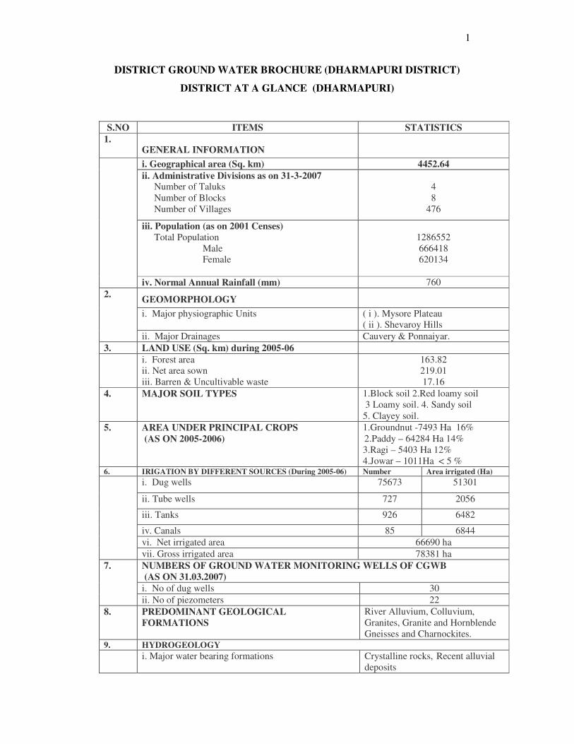
DISTRICT GROUND WATER BROCHURE (DHARMAPURI DISTRICT)
DISTRICT AT A GLANCE (DHARMAPURI)
S.NO ITEMS STATISTICS
1. GENERAL INFORMATION
i. Geographical area (Sq. km) 4452.64
ii. Administrative Divisions as on 31-3-2007 Number of Taluks
Number of Blocks
Number of Villages
4
8
476
iii. Population (as on 2001 Censes)
Total Population
Male
Female
1286552
666418
620134
iv. Normal Annual Rainfall (mm) 760
GEOMORPHOLOGY
i. Major physiographic Units ( i ). Mysore Plateau
( ii ). Shevaroy Hills
2.
ii. Major Drainages Cauvery & Ponnaiyar.
3. LAND USE (Sq. km) during 2005-06
i. Forest area
ii. Net area sown
iii. Barren & Uncultivable waste
163.82
219.01
17.16
4. MAJOR SOIL TYPES 1.Block soil 2.Red loamy soil
3 Loamy soil. 4. Sandy soil
5. Clayey soil.
5. AREA UNDER PRINCIPAL CROPS
(AS ON 2005-2006)
1.Groundnut -7493 Ha 16%
2.Paddy – 64284 Ha 14%
3.Ragi – 5403 Ha 12%
4.Jowar – 1011Ha < 5 % 6. IRIGATION BY DIFFERENT SOURCES (During 2005-06) Number Area irrigated (Ha)
i. Dug wells 75673 51301
ii. Tube wells 727 2056
iii. Tanks 926 6482
iv. Canals 85 6844
vi. Net irrigated area 66690 ha
vii. Gross irrigated area 78381 ha
NUMBERS OF GROUND WATER MONITORING WELLS OF CGWB
(AS ON 31.03.2007)
i. No of dug wells 30
7.
ii. No of piezometers 22
8. PREDOMINANT GEOLOGICAL
FORMATIONS
River Alluvium, Colluvium,
Granites, Granite and Hornblende
Gneisses and Charnockites. 9. HYDROGEOLOGY
i. Major water bearing formations Crystalline rocks, Recent alluvial
deposits
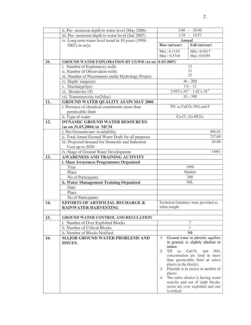
2
ii. Pre- monsoon depth to water level (May 2006) 2.66 – 20.06
iii. Pre- monsoon depth to water level (Jan’2007) 1.19 – 14.57
Annual
Rise (m/year) Fall (m/year) iv. Long term water level trend in 10 years (1998-
2007) in m/yr
Min : 0.1119
Max : 0.5744
Min : 0.0417
Max :0.6789
10. GROUND WATER EXPLORATION BY CGWB (As on 31-03-2007)
i. Number of Exploratory wells
ii. Number of Observation wells
iii. Number of Piezometers under Hydrology Project.
12
11
22
iv. Depth range(m) 36 – 200
v. Discharge(lps) 1.6 – 12
vi. Storativity (S) 5.693 x 10⁻³
– 1.42 x 10⁻²
vii. Transmissivity (m2/day) 10 – 300
11. GROUND WATER QUALITY AS ON MAY 2006
i. Presence of chemical constituents more than
permissible limit
TH as CaCO3, NO3.and F
ii. Type of water Ca-Cl , Ca-HCO3
12. DYNAMIC GROUND WATER RESOURCES
(as on 31.03.2004) in MCM
i. Net Groundwater Availability 496.62
ii. Total Annul Ground Water Draft for all purposes 737.69
iii. Projected demand for Domestic and Industrial
Uses up to 2029
20.00
iv. Stage of Ground Water Development 149%
13. AWARENESS AND TRAINING ACTIVITY
i. Mass Awareness Programmes Organized
Year 1998
Place Madam
No of Participants 200
ii. Water Management Training Organized NIL
Date
Place
No of Participants
14. EFFORTS OF ARTIFICIAL RECHARGE &
RAINWATER HARVESTING
Technical Guidance were provided as
when sought
15. GROUND WATER CONTROL AND REGULATION
i. Number of Over Exploited Blocks 7
ii. Number of Critical Blocks 1
ii. Number of Blocks Notified Nil
16. MAJOR GROUND WATER PROBLEMS AND
ISSUES.
1. Ground water in phreatic aquifers
in general, is slightly alkaline in
nature.
2. TH as CaCO3 and NO3
concentration are fond in more
than permissible limit at select
places in the district.
3. Fluoride is in excess in number of
places
4. The entire district is having water
scarcity and out of eight blocks,
seven are over exploited and one
is critical.
3
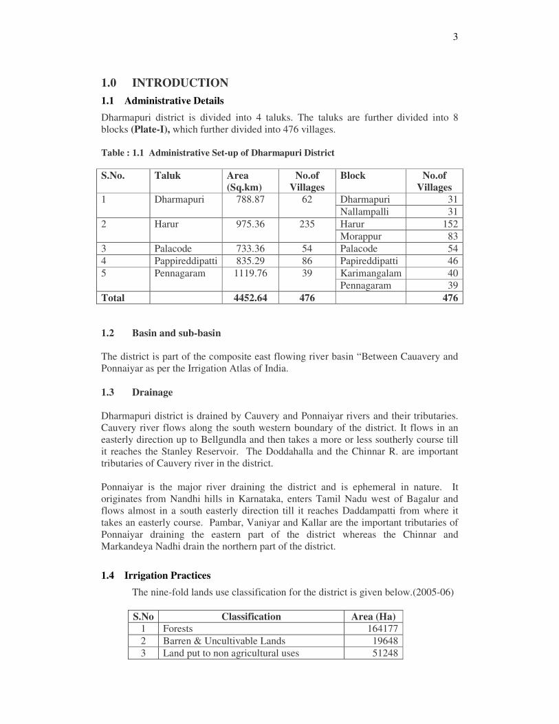
1.0 INTRODUCTION
1.1 Administrative Details
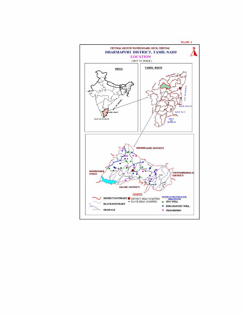
Dharmapuri district is divided into 4 taluks. The taluks are further divided into 8
blocks (Plate-I), which further divided into 476 villages.
Table : 1.1 Administrative Set-up of Dharmapuri District
S.No. Taluk Area
(Sq.km)
No.of
Villages
Block No.of
Villages
Dharmapuri 31 1 Dharmapuri 788.87 62
Nallampalli 31
Harur 152 2 Harur 975.36 235
Morappur 83
3 Palacode 733.36 54 Palacode 54
4 Pappireddipatti 835.29 86 Papireddipatti 46
Karimangalam 40 5 Pennagaram 1119.76 39
Pennagaram 39
Total 4452.64 476 476
1.2 Basin and sub-basin
The district is part of the composite east flowing river basin “Between Cauavery and
Ponnaiyar as per the Irrigation Atlas of India.
1.3 Drainage
Dharmapuri district is drained by Cauvery and Ponnaiyar rivers and their tributaries.
Cauvery river flows along the south western boundary of the district. It flows in an
easterly direction up to Bellgundla and then takes a more or less southerly course till
it reaches the Stanley Reservoir. The Doddahalla and the Chinnar R. are important
tributaries of Cauvery river in the district.
Ponnaiyar is the major river draining the district and is ephemeral in nature. It
originates from Nandhi hills in Karnataka, enters Tamil Nadu west of Bagalur and
flows almost in a south easterly direction till it reaches Daddampatti from where it
takes an easterly course. Pambar, Vaniyar and Kallar are the important tributaries of
Ponnaiyar draining the eastern part of the district whereas the Chinnar and
Markandeya Nadhi drain the northern part of the district.
1.4 Irrigation Practices
The nine-fold lands use classification for the district is given below.(2005-06)
S.No Classification Area (Ha)
1 Forests 164177
2 Barren & Uncultivable Lands 19648
3 Land put to non agricultural uses 51248
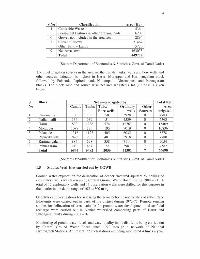
4
S.No Classification Area (Ha)
4 Cultivable Waste 5364
5 Permanent Pastures & other grazing lands 6209
6 Groves not included in the area sown 2894
7 Current Fallows 31464
Other Fallow Lands 5720
9 Net Area sown 163053
Total 449777
(Source: Department of Economics & Statistics, Govt. of Tamil Nadu)
The chief irrigation sources in the area are the Canals, tanks, wells and bore wells and
other sources. Irrigation is highest in Harur, Morappur and Karimangalam block
followed by Palacode, Papireddipatti, Nallampalli, Dharmapuri, and Pennagaram
blocks. The block wise and source wise net area irrigated (Ha) (2005-06 is given
below).
Net area irrigated by S.
No
Block
Canals Tanks Tube/
Bore wells
Ordinary
wells
Other
Sources
Total Net
Area
irrigated
1 Dharmapuri 0 805 50 3928 0 4783
2 Nallampalli 134 639 51 4539 0 5363
3 Harur 830 1238 574 12767 0 15409
4 Morappur 1097 525 195 9019 0 10836
5 Palacode 1316 1122 405 6035 0 8878
6 Papireddipatti 2473 988 401 3918 0 7780
7 Karimangalam 884 698 358 7114 0 9054
8 Pennagaram 110 467 22 3981 7 4587
Total 6844 6482 2056 51301 7 66690
(Source: Department of Economics & Statistics, Govt. of Tamil Nadu)
1.5 Studies /Activities carried out by CGWB
Ground water exploration for delineation of deeper fractured aquifers by drilling of
exploratory wells was taken up by Central Ground Water Board during 1988 – 91. A
total of 12 exploratory wells and 11 observation wells were drilled for this purpose in
the district in the depth range of 105 to 300 m bgl.
Geophysical investigations for assessing the geo-electric characteristics of sub-surface
litho-units were carried out in parts of the district during 1973-75, Remote sensing
studies for delineation of areas suitable for ground water development and artificial
recharge were carried out in Vaniar watershed comprising parts of Harur and
Uthangarai taluks during 2001 – 02.
Monitoring of ground water levels and water quality in the district is being carried out
by Central Ground Water Board since 1972 through a network of National
Hydrograph Stations. At present, 32 such stations are being monitored 4 times a year.
5
The ground water monitoring network has been expanded through the construction of
29 purpose-built observation wells, constructed as part of the World Bank aided
Hydrology Project during 1997-98.
Systematic Hydrogeological studies were carried out in the district by CGWB during
1980-1983. Reappraisal hydrogeological surveys were taken up in different parts of
the district during 84-85, 87-88 and 2000-01.
CGWB constructed Sub Surface Dykes as a part of experimental studies to determine
the efficacy of the structure in water conservation techniques. 2 sub surface dykes
were constructed during 1998-1999 under Central Sector Schemes in the district and
the impact assessment studies have shown that they were found very effective in
water conservation.
2.0 RAINFALL AND CLIMATE
The normal annual rainfall over the district varies from about 760mm to about
910mm. It is lowest around Rayakota (766.5mm) in the northern part of the district. It
gradually increases towards south, west and east and attains a maximum around
Denkanikota (912.0mm) in the northwestern part small area the northwestern part
around Thally. It increases towards the north and reaches a maximum in the northern
part around Rayakota
The district temperature is a gradual decrease of both day and night temperatures from
June onwards till December, when the mean daily maximum is about 30°C and the
mean daily minimum about 19°C in the plains. The day temperatures increase
gradually from January onwards. The lowest temperature is reached in January when
the mean daily minimum is about 19°C. April and May are the hottest months in the
year with the mean daily maximum temperature of about 37°C and the mean daily
minimum temperature of about 25°C in the plains. However, in the higher areas in
Hosur, Thally and Krishnagiri taluks day and night temperatures are lower by about
2°C to 3°C. In these areas weather is comparatively pleasant round the year. In the
lower plains weather is also pleasant except on individual days in May, June and July
when weather becomes occasionally oppressive and sultry due to high temperatures
(about 42°C).
The climate of the district on the whole is slightly humid. The driest months are
February and March with average relative humidity of about 30% in the afternoons.
During the rainy months the average humidity is appreciably below the saturation
level.
Skies are generally clear or lightly clouded during the period January to about the
middle of April. The cloudiness increases from the later half of April and from middle
of June onwards when the skies are generally clouded till about the middle of
November.
Winds are generally light to moderate in strength round the year. In open areas, winds
blow from northeasterly to easterly directions during the period November to March
and from southwesterly to westerly directions during the period May to September.
April and October are the transition months. During March, winds are mainly from
easterly directions, and in October, winds are mainly from southwest direction in the
6
morning and easterly direction in the afternoon. However, winds in the higher and
sheltered places or valleys may differ very much.
3.0 GEOMORPHYLOGY AND SOIL TYPES
3.1 Geomorphology
Dharmapuri district forms part of the upland plateau region of Tamil Nadu with many
hill ranges and undulating plains. The western part of the district between
Pennagaram and Denkanikottai has hill ranges of Mysore Plateau with a chain of
undulating hills. The southern boundary of the district is occupied by the Shevaroy
hill ranges. The plains occupying the central, eastern and southern parts of the district
have an average elevation of 488 m. above Mean Sea Level. The Plateau region
along the western boundary and the northwestern part of the district has an average
elevation of 914 m. above Mean Sea Level.
The prominent geomorphic units identified in the district through interpretation of
Satellite imagery are 1) Structural Hills 2) Inselberg 3) pediments, 4) Buried
pediments 5) Shallow Buried Pediments 6) Plateau, 7) Flood plain, and 8) Bazada
Zone.
3.2 Soils
The soils of Dharmapuri district can be classified into i) Red Soil, ii) Red lateritic soil,
(iii) Brown soil and iv) alluvial soil The soils are mostly in-situ in nature, lateritic,
earthy and pale reddish in colour. They are derived from laterisation of gneisses. The
soils derived from gneisses are mostly brownish. The thickness of soils in the mounts
is almost negligible whereas in the valleys it is around 2 m.
4.0 GROUND WATER SCENARIO
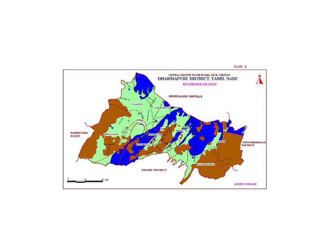
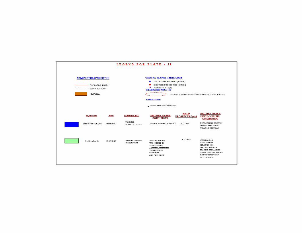
4.1 Hydrogeology
The district is underlain by Archaean Crystalline formations with recent alluvial
deposits of limited areal and vertical extents along major rivers. (Plate-II). The
important aquifer systems in the district are constituted by i) unconsolidated & semi-
consolidated formations and (ii) weathered and fractured crystalline rocks.
In the areas underlain by crystalline rocks, occurrence of ground water is essentially
limited to zone of weathering and fracturing. Generally the hard rock aquifers are
heterogeneous in nature, which is indicated by the variations in lithology, structure
and texture. Ground water occurs under phreatic condition in the weathered mantle
and semi confined to confined condition in the fracture and fissured zones of these
rocks. Thickness of weathered material varied widely from less than 1m bgl to more
than 20m bgl.
The Alluvium with intervening crystalline outcrops are noticed as patches west of
Dharmapuri, and Papireddipatti areas. The ground water occurs under water table to
semi-confined conditions. The discharge ranges from 10 to 20 m3/day.
7
The yield of large diameter wells in the district, tapping the weathered mantle of
crystalline rocks ranges from 150-200 m3/day and are able to sustain pumping for 2 to
4 hours per day. The yield of large diameter wells tested in crystalline rocks ranges
from 150 to 200 m3/day for drawdown of 1 to 3 m. The yield characteristics of wells
vary considerably depending on the topographic set-up, litho logy and nature of
weathering. The transmissivity of weathered formations computed from pumping test
data using empirical methods range from 12 to 22 m2/day. The specific capacity in the
fissured formation ranges from 2.89 to 153.74 lpm/m/dd. In the porous formation the
specific capacity values vary from 6.31 to 28.7 lpm/m/dd.
The yield of bore wells drilled down to a depth of 36 to 200 m bgl, by various state
agencies mainly for domestic purposes. The discharge ranged from 2 to 33 lps. The
yield of successful bore wells drilled down to a depth of 200 m bgl during the ground
water exploration programme of Central Ground Water Board ranged from 1 to 12
lps. The aquifer and well parameters of the wells show wide variation, both in
crystalline and sedimentary formations.
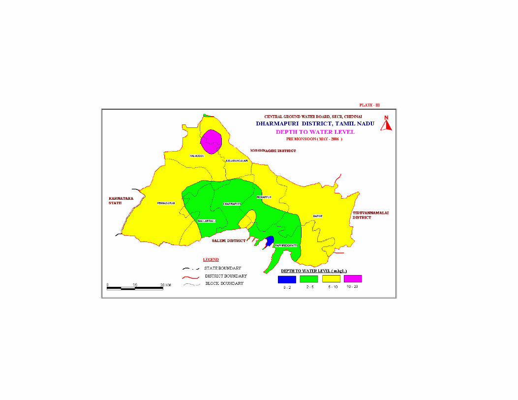
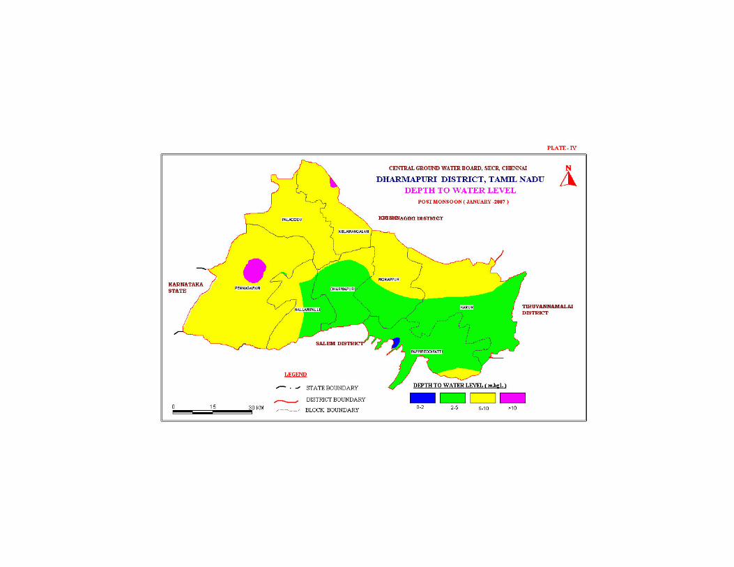
The depth to water level in the district varied between 5.27 and 16.70 m bgl during
pre-monsoon (Plate-III) and varied between 2.47 and 11.32 m bgl during post
monsoon (Plate-IV). The seasonal fluctuation shows a rise in water level, which
ranges from 3.71 to 7.06 m bgl. The piezometric head varied between 2.66 to 20.06
m bgl (May 2006) during pre monsoon and 1.19 to 14.57 m bgl during post monsoon.
4.1.1 Long Term Fluctuation (1998-2007)
The long-term water level fluctuation for the period 1998-2007 indicates rise in water
level in the area 0.0225 to 0.5744 m/year and fall in the range between 0.0600 to
0.6789 m/year.
4.1.2 Aquifer Parameters
The Transmissivity values in weathered, partly weathered and jointed rocks vary from
12 to 300 m2/day and specific yield in this formation is less than 2% and the
Transmissivity values ranged from 4 to 16 m2/day. The specific yield varied
formations is around 2% to 4%.
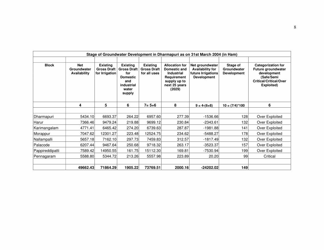
4.2 Ground Water Resources
The ground water resources have been computed jointly by Central Ground Water
Board and State Ground & Surface Water Resources and Data Center (PWD, WRO,
Government of Tamil Nadu) as on 31st March 2004. The salient features of the
computations are furnished below. The computation of ground water resources
available in the district has been done using GEC 1997 methodology.
8
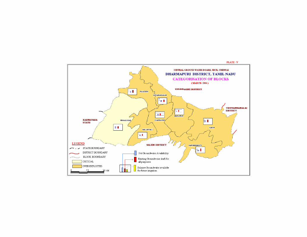
Stage of Groundwater Development in Dharmapuri as on 31st March 2004 (in Ham)
Block Net Groundwater Availability
Existing Gross Draft for Irrigation
Existing Gross Draft
for Domestic
and industrial
water supply
Existing Gross Draft for all uses
Allocation for Domestic and
Industrial Requirement supply up to next 25 years
(2029)
Net groundwater Availability for
future Irrigations Development
Stage of Groundwater Development
Categorization for Future groundwater
development (Safe/Semi
Critical/Critical/Over Exploited)
4 5 6 7= 5+6 8 9 = 4-(6+8) 10 = (7/4)*100 6
Dharmapuri 5434.10 6693.37 264.22 6957.60 277.39 -1536.66 128 Over Exploited
Harur 7366.46 9479.24 219.88 9699.12 230.84 -2343.61 132 Over Exploited
Karimangalam 4771.41 6465.42 274.20 6739.63 287.87 -1981.88 141 Over Exploited
Morappur 7047.62 12301.27 223.48 12524.75 234.62 -5488.27 178 Over Exploited
Nallampalli 5657.18 7162.10 297.73 7459.83 312.57 -1817.49 132 Over Exploited
Palacode 6207.44 9467.64 250.68 9718.32 263.17 -3523.37 157 Over Exploited
Pappireddipatti 7589.42 14950.55 161.75 15112.30 169.81 -7530.94 199 Over Exploited
Pennagaram 5588.80 5344.72 213.26 5557.98 223.89 20.20 99 Critical
49662.43 71864.29 1905.22 73769.51 2000.16 -24202.02 149
4.3 Ground Water Quality
The chemical characteristics of ground water in the phreatic zone in Dharmapuri
district has been studied using the analytical data of ground water samples collected
from Network Hydrograph Stations of Central Ground Water Board. The study of
quality of ground water in deeper aquifers in the district has been attempted using the
data collected from exploratory bore/tube wells constructed in the district.
Ground water in phreatic aquifers in Dharmapuri district in general, is colourless,
odourless and slightly alkaline in nature. The specific electrical conductance of
ground water in phreatic zone (in MicroSeimens at 25oC) during May 2006 was in the
range of 320 to 6010 in the district. It is between 750 and 2250 µS/cm at 25oC in the
major part of the district. Conductance below 750 µS/cm have been observed in
ground water in only one sample is Dharmapuri block Whereas Conductance
exceeding 2250µS/cm have been observed in parts of Papireddipatti, Pennagaram and
Morappur block
It is observed that the ground water is suitable for drinking and domestic uses in
respect of all the constituents except total hardness and Nitrate in more than 90
percent of samples analysed. Total Hardness as CaCO3 is observed in all samples
have with in the excess of permissible limits in about 40 percent of samples analysed
whereas Nitrate is found in excess of 45 mg/l in about 32 percent samples. The
incidence of high total hardness is attributed to the composition of lithounits
constituting the aquifers in the district, whereas the Nitrate pollution is most likely
due to the use of pesticides and fertilizers for agriculture.
With regard to irrigation suitability based on specific electrical conductance and
Sodium Adsorption Ratio (SAR), it is observed that ground water in the phreatic zone
may cause high to very high salinity hazard and medium to high alkali hazard when
used for irrigation. Proper soil management strategies are to be adopted in the major
part of the district while suing ground water for irrigation.
4.4 Status of Ground Water Development
The estimation of groundwater resources for the district has shown that all block is
under “Over Exploited” category. The shallow alluvial aquifers along Cauvery and
Ponnaiyar rivers serve as an important source of drinking water irrigation
development for Dharmapuri district. Dug wells are the most common ground water
abstraction structures used for irrigation in the district. The yield of dug wells range
from 150 to 200 m3/day in weathered crystalline rocks and 20 to 200 m3/day in
Recent alluvial formations along major drainage courses.
5.0 Groundwater Management Strategy
5.1 Groundwater Development
The yields of dug wells in crystalline are improved at favorable locations by
construction of extension bores, which are 20 to 40 m. deep. In recent years, a large
number of bore wells have also been drilled by farmers for irrigation purposes.
The development of ground water for irrigation in the district is mainly through dug
wells tapping the weathered residuum or recent alluvial deposits. Bore wells have
also become popular as the source for irrigation in the district in recent years. Dug
wells with extension bores wherever necessary is ideal for hard rock areas whereas
large diameter dug wells with radials is suitable for alluvial areas.
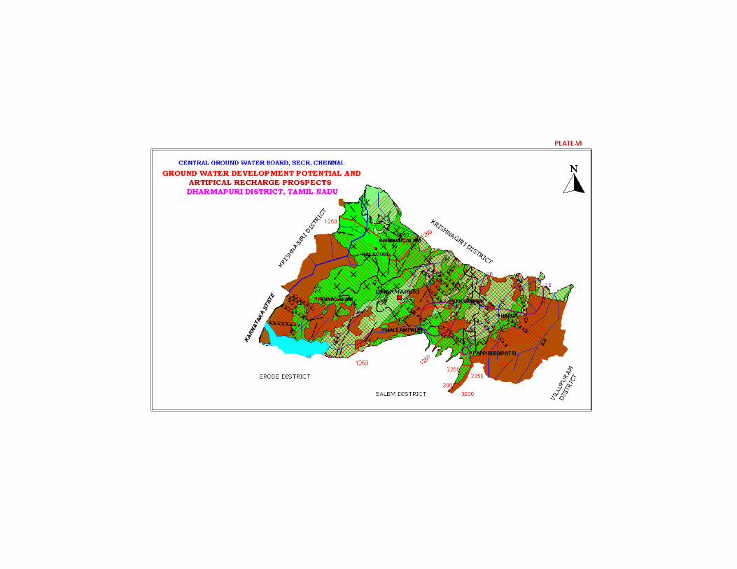
The map showing the development prospects for the district is shown in (Plate VI).
5.2 Water Conservation and Artificial Recharge
The topography of Dharmapuri district, in general, is suited for construction of
various artificial recharge structures such as percolation ponds, check dams and sub-
surface dykes. However, detailed studies are necessary to formulate a comprehensive
scheme for artificial recharge of phreatic ground water in the district in view of the
variations in the geomorphic set-up and the complex hydrological and
hydrogeological conditions.
Free technical guidance for implementation of rooftop rainwater harvesting schemes
is also being provided by Central Ground Water Board, and manual is also published
to give more scientific design tips.
6.0 Groundwater related Issues & Problems
TH as CaCO3 and Nitrate concentration are found more than permissible limit at
select places. Fluoride is in excess in number of places. The entire district is having
water scarcity and out of eight blocks seven are over exploited and one is critical.
Limited Groundwater potential and excess fluoride are the main issues in the district
7.0 Awareness & Training Activity
Mass Awareness Campaign was conducted at Madam, adjacent to the site, where sub
surface dyke was constructed in 1998 and about 200 farmers participated in the
programme.
8.0 Area Notified by CGWA/SGWA
Neither Central Ground Water Authority nor State Government of Tamil Nadu has
notified any block in the district.
9.0 Recommendations
The occurrence and movement of ground water in the hard rock is limited to
weathered, jointed, fractured and sheared zones. Ground water occurs under phreatic
and confined conditions. Thickness and aerial extent of formations is very limited. In
the bore wells tapping deep fracture zones, in certain pockets, water is brackish in
nature and hence need treatment before using for the drinking purposes.
Large scale rainwater harvesting to strengthen the sustainability of groundwater
system is necessary and micro level water balance studies and detailed action plan for
recharge under various central and State schemes need to be prepared and
implemented in a given time frame.
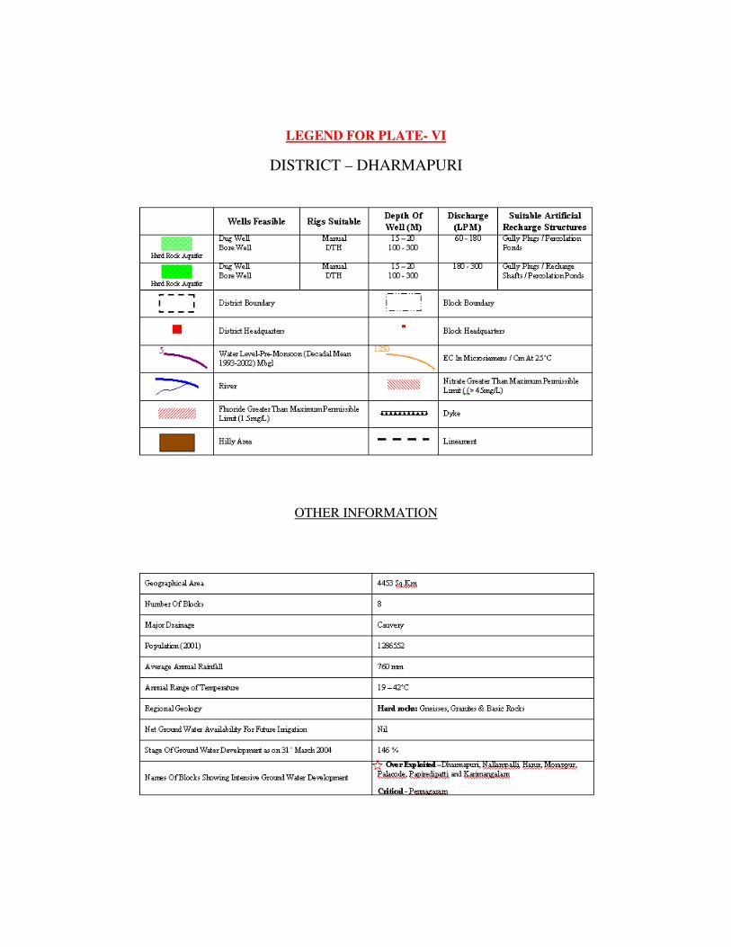
LEGEND FOR PLATE- VI
DISTRICT – DHARMAPURI
OTHER INFORMATION
Published By: Regional Director, CGWB, SECR, E1, Rajaji Bhavan, Besant Nagar, Chennai
600090. ���� +914424914494/24912941 ����/Fax +914424914334 Web: www.cgwb.gov.in, ���� [email protected]