DISTRICT COURT, WATER DIVISION 1, COLORADO ......09CW18 Debra Lee Trujillo Living Trust, 3808 Pikes...
26
1 DISTRICT COURT, WATER DIVISION 1, COLORADO FEBRUARY 2009 WATER RESUME PUBLICATION TO: ALL PERSONS INTERESTED IN WATER APPLICATIONS IN WATER DIV. 1 Pursuant to C.R.S. 37-92-302, you are notified that the following is a resume of all water right applications and certain amendments filed in the Office of the Water Clerk during the month of FEBRUARY 2009 for each County affected. 09CW14 VERIFIED COMPLAINT FOR INJUNCTIVE RELIEF, COSTS AND PENALTIES. Plaintiffs: THE PEOPLE OF COLORADO, ex rel. DICK WOLFE, State Engineer for the State of Colorado, and JAMES (“JIM”) R. HALL, Division Engineer for Water Division No. 1 v. Defendant: LOWER LATHAM RESERVOIR CO. 09CW15 VERIFIED COMPLAINT FOR INJUNCTIVE RELIEF, COSTS AND PENALTIES. Plaintiffs: THE PEOPLE OF COLORADO, ex rel. DICK WOLFE, State Engineer for the State of Colorado, and JAMES (“JIM”) R. HALL, Division Engineer for Water Division No. 1 v. Defendant: HAMILTON HAY FARMS, LLP, MARK HAMILTON. 09CW16 VERIFIED COMPLAINT FOR INJUNCTIVE RELIEF, COSTS AND PENALTIES. Plaintiffs: THE PEOPLE OF COLORADO, ex rel. DICK WOLFE, State Engineer for the State of Colorado, and JAMES (“JIM”) R. HALL, Division Engineer for Water Division No. 1 v. Defendant: HALLAHAN FARM AND DAIRY, JOHN HALLAHAN, MARGARET HALLAHAN. 09CW17 VERIFIED COMPLAINT FOR INJUNCTIVE RELIEF, COSTS AND PENALTIES. Plaintiffs: THE PEOPLE OF COLORADO, ex rel. DICK WOLFE, State Engineer for the State of Colorado, and JAMES (“JIM”) R. HALL, Division Engineer for Water Division No. 1 v. Defendant: LOREN CHAMBERS 09CW18 Debra Lee Trujillo Living Trust, 3808 Pikes Peak Road, Parker, CO 80138, Lisa S. Weinstein, Esq , #35668, c/o Colorado Water Plans, P.O. Box 1955, Elizabeth, CO 80107, Telephone (303) 646-3895 APPLICATION FOR UNDERGROUND WATER RIGHTS FROM THE NONTRIBUTARY DENVER, ARAPAHOE AND LARAMIE-FOX HILLS AND THE NOT NONTRIBUTARY UPPER DAWSON AND LOWER DAWSON IN ELBERT COUNTY . 2. Well Permits: There is one well (214337) on the property. Appropriate well permits will be applied for when Applicant is prepared to drill additional wells. 3. The wells which will withdraw groundwater from the nontributary Denver, Arapahoe and Laramie-Fox Hills aquifers and the not nontributary Upper Dawson and Lower Dawson aquifers are to be located on applicants land on Lot 37, Filing 2 of the Mountain View Ranch subdivision in SW/4 of the SE/4 Section 18, Township 6 South, Range 64 West of the 6 th P.M., Elbert County. The total area of water rights on the applicants land is 5.01 acres. No specific locations for the proposed wells are requested. Specific locations for additional wells will be provided when applications for well permits are submitted. 4. Source of Water Rights: The sources of the nontributary groundwater to be withdrawn are the, Denver, Arapahoe and Laramie-Fox Hills aquifers. The source of the not nontributary groundwater to be withdrawn are the Upper Dawson and Lower Dawson aquifers. 5. Date of Appropriation: 3-12-1979. 6. Estimated Amounts (acre feet per year) and Rates of Withdrawal (gallons per minute): Upper Dawson (0.4 AF, 250 gpm), Lower Dawson (1.0 AF 150 gpm), Denver (2.5 AF 250 gpm), Arapahoe (2.1 AF 400 gpm) and Laramie-Fox Hills (0.7 AF 400 gpm) aquifers. Two (2) acre feet per year of the nontributary Denver aquifer groundwater will be reserved for use through the one well (permit # 214337) that is being used for one house, one barn, 2 horses and 1500 square feet of garden irrigation. 7. Well Field: The wells which will withdraw groundwater from the proposed Well Field are to be located on the Applicant’s property. The Applicant requests that the Court determine that the applicant has the right to withdraw all of the legally available
Transcript of DISTRICT COURT, WATER DIVISION 1, COLORADO ......09CW18 Debra Lee Trujillo Living Trust, 3808 Pikes...

1
DISTRICT COURT, WATER DIVISION 1, COLORADO FEBRUARY 2009 WATER RESUME PUBLICATION TO: ALL PERSONS INTERESTED IN WATER APPLICATIONS IN WATER DIV. 1 Pursuant to C.R.S. 37-92-302, you are notified that the following is a resume of all water right applications and certain amendments filed in the Office of the Water Clerk during the month of FEBRUARY 2009 for each County affected. 09CW14 VERIFIED COMPLAINT FOR INJUNCTIVE RELIEF, COSTS AND PENALTIES. Plaintiffs: THE PEOPLE OF COLORADO, ex rel. DICK WOLFE, State Engineer for the State of Colorado, and JAMES (“JIM”) R. HALL, Division Engineer for Water Division No. 1 v. Defendant: LOWER LATHAM RESERVOIR CO. 09CW15 VERIFIED COMPLAINT FOR INJUNCTIVE RELIEF, COSTS AND PENALTIES. Plaintiffs: THE PEOPLE OF COLORADO, ex rel. DICK WOLFE, State Engineer for the State of Colorado, and JAMES (“JIM”) R. HALL, Division Engineer for Water Division No. 1 v. Defendant: HAMILTON HAY FARMS, LLP, MARK HAMILTON. 09CW16 VERIFIED COMPLAINT FOR INJUNCTIVE RELIEF, COSTS AND PENALTIES. Plaintiffs: THE PEOPLE OF COLORADO, ex rel. DICK WOLFE, State Engineer for the State of Colorado, and JAMES (“JIM”) R. HALL, Division Engineer for Water Division No. 1 v. Defendant: HALLAHAN FARM AND DAIRY, JOHN HALLAHAN, MARGARET HALLAHAN. 09CW17 VERIFIED COMPLAINT FOR INJUNCTIVE RELIEF, COSTS AND PENALTIES. Plaintiffs: THE PEOPLE OF COLORADO, ex rel. DICK WOLFE, State Engineer for the State of Colorado, and JAMES (“JIM”) R. HALL, Division Engineer for Water Division No. 1 v. Defendant: LOREN CHAMBERS 09CW18 Debra Lee Trujillo Living Trust, 3808 Pikes Peak Road, Parker, CO 80138, Lisa S. Weinstein, Esq , #35668, c/o Colorado Water Plans, P.O. Box 1955, Elizabeth, CO 80107, Telephone (303) 646-3895 APPLICATION FOR UNDERGROUND WATER RIGHTS FROM THE NONTRIBUTARY DENVER, ARAPAHOE AND LARAMIE-FOX HILLS AND THE NOT NONTRIBUTARY UPPER DAWSON AND LOWER DAWSON IN ELBERT COUNTY. 2. Well Permits: There is one well (214337) on the property. Appropriate well permits will be applied for when Applicant is prepared to drill additional wells. 3. The wells which will withdraw groundwater from the nontributary Denver, Arapahoe and Laramie-Fox Hills aquifers and the not nontributary Upper Dawson and Lower Dawson aquifers are to be located on applicants land on Lot 37, Filing 2 of the Mountain View Ranch subdivision in SW/4 of the SE/4 Section 18, Township 6 South, Range 64 West of the 6th P.M., Elbert County. The total area of water rights on the applicants land is 5.01 acres. No specific locations for the proposed wells are requested. Specific locations for additional wells will be provided when applications for well permits are submitted. 4. Source of Water Rights: The sources of the nontributary groundwater to be withdrawn are the, Denver, Arapahoe and Laramie-Fox Hills aquifers. The source of the not nontributary groundwater to be withdrawn are the Upper Dawson and Lower Dawson aquifers. 5. Date of Appropriation: 3-12-1979. 6. Estimated Amounts (acre feet per year) and Rates of Withdrawal (gallons per minute): Upper Dawson (0.4 AF, 250 gpm), Lower Dawson (1.0 AF 150 gpm), Denver (2.5 AF 250 gpm), Arapahoe (2.1 AF 400 gpm) and Laramie-Fox Hills (0.7 AF 400 gpm) aquifers. Two (2) acre feet per year of the nontributary Denver aquifer groundwater will be reserved for use through the one well (permit # 214337) that is being used for one house, one barn, 2 horses and 1500 square feet of garden irrigation. 7. Well Field: The wells which will withdraw groundwater from the proposed Well Field are to be located on the Applicant’s property. The Applicant requests that the Court determine that the applicant has the right to withdraw all of the legally available

2
groundwater from wells that may be completed in the future as the Applicant’s Well Field. 8. Proposed use: All water withdrawn will be reused, successively used, leased, sold or otherwise disposed of for the following beneficial uses: unified municipal water systems, municipal, domestic, industrial, commercial, irrigation, augmentation, stock watering, recreational, fire protection, water feature ponds and piscatorial habitat less than 1000 square feet, and wildlife. The water will be produced for immediate application to said uses, for storage and subsequent application to said uses, for exchange purposes, for replacement of depletions from the use of water from other sources and for all other augmentation purposes. 9. Jurisdiction: The Water Court retains jurisdiction over the the material in this application. 10. The use of not nontributary water from future wells shall be subject to judicial approval of an augmentation plan which will be applied for at such time as additional wells may be proposed and permitted. 11. Remarks: Applicant requests the right to withdraw from these wells an average amount of water determined to be available in paragraph 6 plus an amount of groundwater in excess of that annual amount; provided that the sum of the total withdrawals from any particular aquifer does not exceed the product of the number of years since the date of the issuance of well permits or of the entry of a decree, which ever occurs first, times the decreed average annual amount for that aquifer. 12. Number of pages of Application: 4 pages. 09CW19 Jack D. Putnam and Lila D. Putnam, 8835 Tanglewood Road, P.O. Box 285 Franktown, CO 80116, Lisa S. Weinstein, Esq , #35668, c/o Colorado Water Plans, P.O. Box 1955, Elizabeth, CO 80107, Telephone (303) 646-3895 APPLICATION FOR UNDERGROUND WATER RIGHTS FROM THE NONTRIBUTARY LOWER DAWSON, DENVER, ARAPAHOE AND LARAMIE-FOX HILLS AND THE NOT NONTRIBUTARY UPPER DAWSON IN DOUGLAS COUNTY. 2. Well Permits: There is one well (92654) on the property. Appropriate well permits will be applied for when Applicant is prepared to drill additional wells. 3. The wells which will withdraw groundwater from the nontributary Lower Dawson, Denver, Arapahoe and Laramie-Fox Hills aquifers and the not nontributary Upper Dawson aquifers are to be located on applicants land on W/2 of the NW/4 and the W/2 of Section 6, Township 8 South, Range 65 West of the 6th P.M., Douglas County. The total area of water rights on the applicants land is 33.833 acres. No specific locations for the proposed wells are requested. Specific locations for additional wells will be provided when applications for well permits are submitted. 4. Source of Water Rights: The sources of the nontributary groundwater to be withdrawn are the Lower Dawson, Denver, Arapahoe and Laramie-Fox Hills aquifers. The source of the not nontributary groundwater to be withdrawn is the Upper Dawson aquifer. 5. Date of Appropriation: 7-8-1977. 6. Estimated Amounts (acre feet per year) and Rates of Withdrawal (gallons per minute): Upper Dawson (10.7 AF, 250 gpm), Lower Dawson (4.5 AF 150 gpm), Denver (11.0 AF 250 gpm), Arapahoe (15.8 AF 400 gpm) and Laramie-Fox Hills (10.0 AF 400 gpm) aquifers. Two (2) acre feet per year of the not-nontributary Lower Dawson aquifer groundwater will be reserved for use through the one well (permit # 194696) that is being used for one house. 7. Well Field: The wells which will withdraw groundwater from the proposed Well Field are to be located on the Applicant’s property. The Applicant requests that the Court determine that the applicant has the right to withdraw all of the legally available groundwater from wells that may be completed in the future as the Applicant’s Well Field. 8. Proposed use: All water withdrawn will be reused, successively used, leased, sold or otherwise disposed of for the following beneficial uses: unified municipal water systems, municipal, domestic, industrial, commercial, irrigation, augmentation, stock watering, recreational, fire protection, water feature ponds and piscatorial habitat less than 1000 square feet, and wildlife. The water will be produced for immediate application to said uses, for storage and subsequent application to said uses, for exchange purposes, for replacement of depletions from the use of water from other sources and for all other augmentation purposes. 9. Jurisdiction: The Water Court retains jurisdiction over the the material in this application. 10. The use of not nontributary water from future wells shall be subject to judicial approval of an augmentation plan which will be applied for at such time as additional wells may be proposed and permitted. 11. Remarks: Applicant requests the right to withdraw from these wells an average amount of water determined to be available in paragraph 6 plus an amount of groundwater in

3
excess of that annual amount; provided that the sum of the total withdrawals from any particular aquifer does not exceed the product of the number of years since the date of the issuance of well permits or of the entry of a decree, which ever occurs first, times the decreed average annual amount for that aquifer. 12. Number of pages of Application: 4 pages. 09CW20 Cynthia L. Lowe and Kenneth E. Lowe, P.O. Box 565, Franktown, CO 80116, Lisa S. Weinstein, Esq , #35668, c/o Colorado Water Plans, P.O. Box 1955, Elizabeth, CO 80107, Telephone (303) 646-3895 APPLICATION FOR UNDERGROUND WATER RIGHTS FROM THE NONTRIBUTARY LOWER DAWSON, DENVER, ARAPAHOE AND LARAMIE-FOX HILLS AND THE NOT NONTRIBUTARY UPPER DAWSON IN DOUGLAS COUNTY. 2. Well Permits: There is one well (185925) on the property. Appropriate well permits will be applied for when Applicant is prepared to drill additional wells. 3. The wells which will withdraw groundwater from the nontributary Lower Dawson, Denver, Arapahoe and Laramie-Fox Hills aquifers and the not nontributary Upper Dawson aquifers are to be located on applicants land on E/2 of the SE/4 Section 1, Township 8 South, Range 66 West of the 6th P.M., Douglas County. The total area of water rights on the applicants land is 11.10 acres. No specific locations for the proposed wells are requested. Specific locations for additional wells will be provided when applications for well permits are submitted. 4. Source of Water Rights: The sources of the nontributary groundwater to be withdrawn are the Lower Dawson, Denver, Arapahoe and Laramie-Fox Hills aquifers. The source of the not nontributary groundwater to be withdrawn is the Upper Dawson aquifer. 5. Date of Appropriation: 2-28-1995. 6. Estimated Amounts (acre feet per year) and Rates of Withdrawal (gallons per minute): Upper Dawson (3.0 AF, 250 gpm), Lower Dawson (2.2 AF 150 gpm), Denver (4.2 AF 250 gpm), Arapahoe (4.4 AF 400 gpm) and Laramie-Fox Hills (3.5 AF 400 gpm) aquifers. One (1.0) acre feet per year of the not-nontributary Upper Dawson aquifer groundwater will be reserved for use through the one well (permit # 185925) that is being used for one house. 7. Well Field: The wells which will withdraw groundwater from the proposed Well Field are to be located on the Applicant’s property. The Applicant requests that the Court determine that the applicant has the right to withdraw all of the legally available groundwater from wells that may be completed in the future as the Applicant’s Well Field. 8. Proposed use: All water withdrawn will be reused, successively used, leased, sold or otherwise disposed of for the following beneficial uses: unified municipal water systems, municipal, domestic, industrial, commercial, irrigation, augmentation, stock watering, recreational, fire protection, water feature ponds and piscatorial habitat less than 1000 square feet, and wildlife. The water will be produced for immediate application to said uses, for storage and subsequent application to said uses, for exchange purposes, for replacement of depletions from the use of water from other sources and for all other augmentation purposes. 9. Jurisdiction: The Water Court retains jurisdiction over the the material in this application. 10. The use of not nontributary water from future wells shall be subject to judicial approval of an augmentation plan which will be applied for at such time as additional wells may be proposed and permitted. 11. Remarks: Applicant requests the right to withdraw from these wells an average amount of water determined to be available in paragraph 6 plus an amount of groundwater in excess of that annual amount; provided that the sum of the total withdrawals from any particular aquifer does not exceed the product of the number of years since the date of the issuance of well permits or of the entry of a decree, which ever occurs first, times the decreed average annual amount for that aquifer. 12. Number of pages of Application: 3 pages. 09CW21 Donald Nelson and Dorothy Jean Nelson, 8698 East Tanglewood Road, Franktown, CO 80116, Lisa S. Weinstein, Esq , #35668, c/o Colorado Water Plans, P.O. Box 1955, Elizabeth, CO 80107, Telephone (303) 646-3895 APPLICATION FOR UNDERGROUND WATER RIGHTS FROM THE NONTRIBUTARY LOWER DAWSON, DENVER, ARAPAHOE AND LARAMIE-FOX HILLS AND THE NOT NONTRIBUTARY UPPER DAWSON IN DOUGLAS COUNTY. 2. Well Permits: There is one well, permit # 44339 on the property. Appropriate well permits will be applied for when Applicant is prepared to drill additional wells. 3. The wells which will withdraw

4
groundwater from the nontributary Lower Dawson, Denver, Arapahoe and Laramie-Fox Hills aquifers and the not nontributary Upper Dawson aquifers are to be located on applicants land on NE/4 of the SW/4 Section 6, Township 8 South, Range 65 West of the 6th P.M., Douglas County. The total area of water rights on the applicants land is 6.66 acres. No specific locations for the proposed wells are requested. Specific locations for additional wells will be provided when applications for well permits are submitted. 4. Source of Water Rights: The sources of the nontributary groundwater to be withdrawn are the Lower Dawson, Denver, Arapahoe and Laramie-Fox Hills aquifers. The source of the not nontributary groundwater to be withdrawn is the Upper Dawson aquifer. 5. Date of Appropriation: 2-1-1971. 6. Estimated Amounts (acre feet per year) and Rates of Withdrawal (gallons per minute): Upper Dawson (2.30 AF, 250 gpm), Lower Dawson (1.0 AF 150 gpm), Denver (2.3 AF 250 gpm), Arapahoe (3.3 AF 400 gpm) and Laramie-Fox Hills (2.1 AF 400 gpm) aquifers. Two (2) acre feet per year of the not-nontributary Upper Dawson aquifer groundwater will be reserved for use through the one well (permit # 44339) that is being used for one house and 1500 square feet of irrigation. 7. Well Field: The wells which will withdraw groundwater from the proposed Well Field are to be located on the Applicant’s property. The Applicant requests that the Court determine that the applicant has the right to withdraw all of the legally available groundwater from wells that may be completed in the future as the Applicant’s Well Field. 8. Proposed use: All water withdrawn will be reused, successively used, leased, sold or otherwise disposed of for the following beneficial uses: unified municipal water systems, municipal, domestic, industrial, commercial, irrigation, augmentation, stock watering, recreational, fire protection, water feature ponds and piscatorial habitat less than 1000 square feet, and wildlife. The water will be produced for immediate application to said uses, for storage and subsequent application to said uses, for exchange purposes, for replacement of depletions from the use of water from other sources and for all other augmentation purposes. 9. Jurisdiction: The Water Court retains jurisdiction over the material in this application. 10. The use of not nontributary water from future wells shall be subject to judicial approval of an augmentation plan which will be applied for at such time as additional wells may be proposed and permitted. 11. Remarks: Applicant requests the right to withdraw from these wells an average amount of water determined to be available in paragraph 6 plus an amount of groundwater in excess of that annual amount; provided that the sum of the total withdrawals from any particular aquifer does not exceed the product of the number of years since the date of the issuance of well permits or of the entry of a decree, which ever occurs first, times the decreed average annual amount for that aquifer. 12. Number of pages of Application: 3 pages. 09CW22 James W. Larsen and Jung Soon Larsen, 8916 Northeast 127th Street, Kirkland, WA 98034, Lisa S. Weinstein, Esq , #35668, c/o Colorado Water Plans, P.O. Box 1955, Elizabeth, CO 80107, Telephone (303) 646-3895 APPLICATION FOR UNDERGROUND WATER RIGHTS FROM THE NONTRIBUTARY LOWER DAWSON, DENVER, ARAPAHOE AND LARAMIE-FOX HILLS AND THE NOT NONTRIBUTARY UPPER DAWSON IN DOUGLAS COUNTY. 2. Appropriate well permits will be applied for when Applicant is prepared to drill additional wells. 3. There is one non-permitted perched water table well on the property. The wells which will withdraw groundwater from the nontributary Lower Dawson, Denver, Arapahoe and Laramie-Fox Hills aquifers and the not nontributary Upper Dawson aquifers are to be located on applicants land on E/2 of the E/2 Section 1, Township 8 South, Range 66 West and NW/4 of the W/2 of Section 6, Township 8 South, Range 65 West of the 6th P.M. located at 8895 East State Highway 86, Franktown, CO, Douglas County. The total area of water rights on the applicants land is 45.29 acres. No specific locations for the proposed wells are requested. Specific locations for additional wells will be provided when applications for well permits are submitted. 4. Source of Water Rights: The sources of the nontributary groundwater to be withdrawn are the Lower Dawson, Denver, Arapahoe and Laramie-Fox Hills aquifers. The source of the not nontributary groundwater to be withdrawn is the Upper Dawson aquifer. 5. Date of Appropriation: 1953. 6. Estimated Amounts (acre feet per year) and Rates of Withdrawal (gallons per minute): Upper Dawson (13.0 AF, 250 gpm), Lower Dawson (5.6 AF 150 gpm), Denver (16.0 AF 250 gpm), Arapahoe (21.3 AF 400 gpm) and Laramie-Fox Hills (13.0 AF 400 gpm) aquifers. There is one

5
house on the property. 7. Well Field: The wells which will withdraw groundwater from the proposed Well Field are to be located on the Applicant’s property. The Applicant requests that the Court determine that the applicant has the right to withdraw all of the legally available groundwater from wells that may be completed in the future as the Applicant’s Well Field. 8. Proposed use: All water withdrawn will be reused, successively used, leased, sold or otherwise disposed of for the following beneficial uses: unified municipal water systems, municipal, domestic, industrial, commercial, irrigation, augmentation, stock watering, recreational, fire protection, water feature ponds and piscatorial habitat less than 1000 square feet, and wildlife. The water will be produced for immediate application to said uses, for storage and subsequent application to said uses, for exchange purposes, for replacement of depletions from the use of water from other sources and for all other augmentation purposes. 9. Jurisdiction: The Water Court retains jurisdiction over the material in this application. 10. The use of not nontributary water from future wells shall be subject to judicial approval of an augmentation plan which will be applied for at such time as additional wells may be proposed and permitted. 11. Remarks: Applicant requests the right to withdraw from these wells an average amount of water determined to be available in paragraph 6 plus an amount of groundwater in excess of that annual amount; provided that the sum of the total withdrawals from any particular aquifer does not exceed the product of the number of years since the date of the issuance of well permits or of the entry of a decree, which ever occurs first, times the decreed average annual amount for that aquifer. 12. Number of pages of Application: 3 pages. 09CW23 (98CW436) CITY AND COUNTY OF BROOMFIELD, a Colorado county , home rule city, and municipal corporation, c/o Director of Public Works, One Descombes Drive, Broomfield, Colorado 80020-2495, Telephone: 303.469.3301 (c/o Harvey W. Curtis, Esq., 8310 South Valley Highway #230, Englewood, Colorado 80112. Telephone: 303.292.1144. APPLICATION FOR DETERMINATION OF ABSOLUTE WATER RIGHT AND FOR FINDING OF REASONABLE DILIGENCE in BROOMFIELD, ADAMS AND WELD COUNTIES. 2. Names of structures: 2.a. Broomfield Discharge Diversion Point. 2.b. Broomfield Big Dry Creek Diversion Point. 2.c. Broomfield South Platte-Big Dry Creek Exchange. 3. Describe conditional water rights giving the following from the Judgment and Decree: 3.a. Broomfield Discharge Diversion Point 3.a.(1) Date of original decree: February 20, 2003, Case No. 98-CW-436, in the District Court, Water Division No. 1, State of Colorado. 3.a.(2) Location: Located in the City and County of Broomfield, State of Colorado, commencing at the center of Section 32, Township 1 South, Range 68 West of the Sixth Principal Meridian, whence the East one-quarter corner of said Section 32 bears South 89 degrees 46 minutes 32 seconds East a distance of 2,646.68 feet, said line forming the basis of bearings for this description, thence South 69 degrees 09 minutes 23 seconds East, a distance of 1,006.42 feet to the Broomfield Discharge Diversion Point, whence said East one-quarter corner bears North 78 degrees 28 minutes 47 seconds East, a distance of 1,741.17 feet. A plat of said point is attached hereto as Exhibit A. 3.a.(3) Source: Effluent from the City of Broomfield Wastewater Reclamation Facility, tributary to Big Dry Creek, a tributary of the South Platte River. 3.a.(4) Appropriation Date: October 7, 1998. 3.a.(5) Decreed Amount: 5.0 c.f.s. conditional. 3.a.(6) Decreed Use: All municipal purposes, including irrigation, lake level maintenance, domestic, industrial, commercial, fire protection, stockwatering, recreation, piscatorial, storage and all other municipal purposes. The water will also be used for exchange, for replacement, and for augmentation purposes. Applicant asks the Court to decree that it has the right to use, reuse, successively use and dispose of, by sale, exchange or otherwise, to extinction all water lawfully diverted and/or impounded pursuant to any decree entered in this case. 3.a.(7) Depth (if well): Not applicable. 3.a.(8) Name and address of apparent owner of land on which the diversion point is located: The City and County of Broomfield. 3.b. Broomfield Big Dry Creek Diversion Point. 3.b.(1) Date of original decree: February 20, 2003, Case No. 98-CW-436, in the District Court, Water Division No. 1, State of Colorado. 3.b.(2) Location: Located in the County of Adams, State of Colorado, commencing at the Center of Section 32, Township 1 South, Range 68 West of the Sixth Principal Meridian, whence the East one-quarter corner of said Section 32 bears South 89 degrees 46

6
minutes 32 seconds East a distance of 2,646.68 feet, said line forming the basis of bearings for this description, thence South 70 degrees 46 minutes 39 seconds East, a distance of 1,020.11 feet to the Broomfield Big Dry Creek Diversion Point, whence said East one-quarter corner bears North 79 degrees 03 minutes 25 seconds East, a distance of 1,714.60 feet. A plat of said point is attached hereto as Exhibit B. 3.b.(3) Source: Big Dry Creek. 3.b.(4) Appropriation Date: October 7, 1998. 3.b.(5) Decreed Amount: 5.0 c.f.s. conditional. 3.b.(6) Decreed Use: All municipal purposes, including irrigation, lake level maintenance, domestic, industrial, commercial, fire protection, stockwatering, recreation, piscatorial, storage and all other municipal purposes. The water will also be used for exchange, for replacement, and for augmentation purposes. Applicant asks the Court to decree that it has the right to use, reuse, successively use and dispose of, by sale, exchange or otherwise, to extinction all water lawfully diverted and/or impounded pursuant to any decree entered in this case. 3.b.(7) Depth (if well): Not applicable. 3.b.(8) Name and address of apparent owner of land on which the diversion point is located: City of Westminster, 4800 West 92nd Avenue, Westminster, Colorado 80030. 3.c. Broomfield South Platte River-Big Dry Creek Exchange 3.c.(1) Date of original decree: February 20, 2003, Case No. 98-CW-436, in the District Court, Water Division No. 1, State of Colorado. 3.c.(2) Name, location and source of diversion points (“exchange-to points”) at which water will be diverted and/or stored by exchange: Broomfield Discharge Diversion Point and Broomfield Big Dry Creek Diversion Point, described in paragraphs 3.a and 3.b, respectively, above. 3.c.(3) Sources of substitute supply: Effluent and/or other sources of replacement water approved by the Division Engineer. 3.c.(4) Point at which the City and County of Broomfield shall make substitute supplies available to allow diversion by exchange at the points set forth in paragraph 3.c.(2)., above: The confluence of Big Dry Creek and the South Platte River, described as follows: commencing at the Northwest Corner of Section 7, Township 1 North, Range 66 West of the Sixth Principal Meridian, County of Weld, State of Colorado, whence the West one-quarter corner of said Section 7 bears South 00 degrees 00 minutes 00 seconds East a distance of 2,639.16 feet, said line forming the basis of bearings for this description, thence South 72 degrees 54 minutes 39 seconds East, a distance of 660.98 feet to the Confluence of Big Dry Creek and the South Platte River, whence said West one-quarter corner bears South 14 degrees 29 minutes 20 seconds West, a distance of 2,525.23 feet. A plat of said point is attached hereto as Exhibit C. 3.c.(5) Appropriation Date: October 7, 1998. 3.c.(6) Amount: 10.0 c.f.s. conditional. 3.c.(7) Uses: All municipal purposes, including irrigation, lake level maintenance, domestic, industrial, commercial, fire protection, stockwatering, recreation, piscatorial, storage and all other municipal purposes. The water will also be used for exchange, for replacement, and for augmentation purposes. Applicant asks the Court to decree that it has the right to use, reuse, successively use and dispose of, by sale, exchange or otherwise, to extinction all water lawfully diverted and/or impounded pursuant to the decree entered in this case. 3.c.(8) Depth (if well): Not applicable. 4. Provide a detailed outline of what has been done toward completion or for completion of the appropriation and application of water to a beneficial use as conditionally decreed, including expenditures: During the diligence period beginning on March 1, 2003, the City and County of Broomfield has spent in excess of $21.2 million on its water reclamation project in which the subject water right is a part: 4.a. Wastewater Treatment Facility Reuse Plant construction: $5,354,045.00. 4.b. Reuse lines construction: $12,400,712.44. 4.c. Great Western Treatment Facility: $2,330,038.79. 4.d. Engineering and Legal: $1,194,798.78. 4.e. Total: $21,279,595.01. 5. Claim to make absolute: 5.a. Water Right to be made Absolute in Part: Broomfield Discharge Diversion Point, described in paragraph 3.a., above. 5.b. Amount to be made Absolute: 3.09 c.f.s., on February 24, 2006, when the water right was pumped in priority, following confirmation with the water commissioner, and put to beneficial use. 5.c. Decreed Use: See paragraph 3.a.(6), above. 5.d. Portion Remaining Conditional: 1.91 c.f.s., together with any portion of the 3.09 c.f.s. claimed to be absolute which is not herein decreed absolute. 6. Terms and Conditions: All terms and conditions shall continue to apply to the above-described water rights as set forth in the decree in Case No. 98CW436. (6 pages, including 3 pages of exhibits.)

7
09CW24 Golden Land Company, LLC, c/o Reginald V. Golden, Manager, P.O. Box 54, Longmont, CO 80502, 303-702-0708. (Jeffrey J. Kahn, Esq., Matthew Machado, Esq., Bernard Lyons Gaddis & Kahn, PC, P.O. Box 978, Longmont, CO 80502-0978, 303-776-9900). APPLICATION FOR FINDING OF REASONABLE DILIGENCE AND TO MAKE A CONDITIONAL WATER RIGHT ABSOLUTE IN BOULDER COUNTY 2. Name of structure: Fredstrom Drain (Well Permit Number 045031-F). 3. Conditional water right: A) Date of original decree, case no. and court: Case No. 94CW220, Weld County District Court, Water Division No. 1. B) Legal Description: The outlet of the drain is located in the SW1/4, SW1/4 of Section 31, Township 3 North, Range 69 West of the 6th P. M., Boulder County, Colorado, approximately 625 feet north of the south section line and 10 feet east of the west section line. The entire drain is located in the SE1/4 of Section 36, Township 3 North, Range 70 West of the 6th P.M. and in the SW1/4 of Section 31, Township 3 North, Range 69 West of the 6th P.M., Boulder County, Colorado. C) Source: Alluvium of the St. Vrain River D) Appropriation Date: November 30, 1994 E) Amount: 1.86 cfs, of which 0.85 cfs was made absolute for irrigation and livestock uses in Case No. 02CW103. 1.01 cfs for irrigation and livestock and 1.86 cfs for the other uses remain conditional. F) Uses: Livestock, industrial, irrigation, augmentation and exchange. The acreage irrigated is 169 acres in the SW1/4 of Section 31, Township 3 North, Range 69 West of the 6th P.M. and SE1/4 of Section 36, Township 3 North, Range 70 West of the 6th P.M., all of which is north of the St. Vrain River. 4. Detailed outline of what has been done toward completion or for completion of the appropriation and application of water to a beneficial use as conditionally decreed, including expenditures: Applicant continues to divert the water under the subject right when in priority to irrigate the subject lands and for livestock watering. Such diversions are coordinated with the water commissioner. The rate of diversions during this diligence period have not exceeded the 1.01 cfs made absolute previously. The industrial, augmentation and exchange uses are primarily for future gravel mining of the property that will occur as part of larger gravel mining operation the includes neighboring properties pursuant to an existing lease with Aggregate Industries. Water level monitoring on the property for the future gravel mining operations was performed during the diligence period. The current economics of the local gravel mining industry are delaying mining of gravel from the property. 5. If a claim to make absolute, water applied to beneficial use: Not applicable. 6. Names and address of owners or reputed owners of the land upon which any new diversion or storage structure, or modification to any existing diversion or storage structure is or will be constructed or upon which water is or will be stored, including any modification to the existing storage pool: Applicant. WHEREFORE, Applicant requests the Court find Applicant has been diligent in the development of the water right, and continue the conditional water right described in paragraph 3.E for an additional six years. 09CW25 DAWN AND JAMES KEY, 1448 Private Road 130, Elizabeth, CO 80107, through their attorneys: Petrock & Fendel, P.C., James J. Petrock, Atty. Reg. #2881, 700 Seventeenth Street, Suite 1800, Denver, Colorado 80202, Telephone: (303) 534-0702. APPLICATION FOR UNDERGROUND WATER RIGHTS FROM NONTRIBUTARY AND NOT NONTRIBUTARY SOURCES, IN THE NONTRIBUTARY LOWER DAWSON, DENVER, ARAPAHOE AND LARAMIE-FOX HILLS AQUIFERS AND IN THE NOT NONTRIBUTARY UPPER DAWSON AQUIFER, IN ELBERT COUNTY. 2. Well Permits: Well permits will be applied for prior to construction of the wells. 3. Legal Description of Wells and Subject Property: The property which is the subject of this application is approximately 88.1 acres of land located in the W1/2NW1/4, and a part of the NE1/4NW1/4 of Section 26, T8S, R65W of the 6th P.M., as described and shown on Attachment A hereto. The wells which will withdraw the subject groundwater will be located at any location on the Subject Property subject to Section 37-90-137(4), C.R.S. 4. Source of Water Rights: The source of the groundwater to be withdrawn from the Lower Dawson, Denver, Arapahoe and Laramie-Fox Hills aquifers underlying the Subject Property is nontributary groundwater as described in Section 37-90-103(10.5), C.R.S. The groundwater to be withdrawn from the Upper Dawson aquifer is not nontributary as described in Sections 37-90-103(10.7) and 37-90-137(9)(c), C.R.S. 5. Estimated Amounts: The estimated average annual amounts of withdrawal available from the subject aquifers as indicated below, are based upon the
8
Denver Basin Rules, 2 C.C.R. 402-6. For purposes of this application, Applicants estimate that the following annual amounts are representative of the Upper Dawson, Lower Dawson, Denver, Arapahoe and Laramie-Fox Hills aquifers underlying the Subject Property: Saturated Estimated Aquifer Thickness Annual Amount Upper Dawson 183 feet 32 acre-feet (NNT) Lower Dawson 115 feet 20 acre-feet (NT) Denver 188 feet 28 acre-feet (NT) Arapahoe 232 feet 34 acre-feet (NT) Laramie-Fox Hills 232 feet 30 acre-feet (NT) Applicants will reserve part of the Upper Dawson aquifer water which may be available for use through an existing exempt well as permitted in Well Permit No. 113896 and an additional exempt well. 6. Well Fields: Applicants request that this Court determine that Applicants have the right to withdraw all of the legally available groundwater lying below the Subject Property, through the wells requested herein and any additional wells which may be completed in the future as Applicants well fields. As additional wells are constructed, applications will be filed in accordance with 37-90-137(10), C.R.S. 7. Proposed Use: The water will be used, reused, successively used, leased, sold, or otherwise disposed of for the following beneficial purposes: domestic, industrial, commercial, irrigation, livestock watering, recreational, and fish and wildlife. Said water will be produced for immediate application to said uses, both on and off the Subject Property, for storage and subsequent application to said uses, for exchange purposes, for replacement of depletions resulting from the use of water from other sources, and for augmentation purposes. 8. Jurisdiction: The Water Court has jurisdiction over the subject matter of this application pursuant to 37-92-302(2), and 37-90-137(6), C.R.S. 9. Remarks: A. Applicants claim the right to withdraw more than the average annual amounts estimated in paragraph 5 above pursuant to Rule 8A of the Statewide Rules, 2 C.C.R. 402-7. B. Although Applicants have estimated the amounts of water available for withdrawal from the subject aquifers, Applicants request the right to revise the estimates upward or downward, based on better or revised data, without the necessity of amending this application or republishing the same. 09CW26 BSH TIPTON, LLC, 9450 Ellicott Hwy., Calhan, CO 80808, through their attorneys: Petrock & Fendel, P.C., James J. Petrock, Atty. Reg. #2881, 700 Seventeenth Street, Suite 1800, Denver, Colorado 80202, Telephone: (303) 534-0702. APPLICATION FOR PLAN FOR AUGMENTATION, IN EL PASO COUNTY. 2. Description of plan for augmentation: A. Groundwater to be augmented: 0.9 acre-feet per year for 300 years of not nontributary Dawson aquifer groundwater as decreed in Case No. 08CW155, District Court, Water Division 1. Applicant is the owner of the land and groundwater underlying approximately 5.7 acres of land which is generally located in part of the NE1/4NW1/4 of Section 23, T11S, R64W of the 6th P.M., as described and shown on Attachment A hereto ("Subject Property"). B. Water rights to be used for augmentation: Return flows from the use of not nontributary Dawson aquifer water and return flows and direct discharge of nontributary Arapahoe and Laramie-Fox Hills aquifer groundwater underlying the Subject Property as also previously decreed in Case No. 08CW155. Applicant is the owner of 1 acre-foot per year of nontributary Arapahoe aquifer and 1.8 acre-feet per year of nontributary Laramie-Fox Hills aquifer groundwater for use in this plan. C. Statement of plan for augmentation: The subject 0.9 acre-feet per year of Dawson aquifer groundwater may be used on the Subject Property for inhouse use in one residence (0.4 acre-feet), irrigation of 8500 square-feet of home lawn and garden (0.5 acre-feet), and stockwatering of up to 8 large domestic animals (0.1 acre-feet). Applicant reserves the right to amend or revise these uses and values without amending the application or re-publishing the same. Sewage treatment will be provided by non-evaporative septic systems. Consumptive use associated with in-house use will be approximately 10% of water used for that purpose and consumptive use associated with irrigation use will be approximately 90% of water used. Water used for stockwatering is considered to be 100% consumed. D. During pumping Applicant will replace actual depletions to the affected stream systems pursuant to Section 37-
9
90-137(9)(c), C.R.S. Applicant estimates that depletions occur to South Platte River stream systems. Return flows from use of the subject water rights from inhouse use and from irrigation use, will accrue to South Platte River stream systems and those return flows are sufficient to replace actual depletions while the subject groundwater is being pumped. Applicant will reserve the nontributary Arapahoe and Laramie-Fox Hills aquifer groundwater described above to meet post-pumping augmentation requirements. 3. Remarks: Applicant will withdraw the not nontributary Dawson aquifer water under the plan of augmentation requested herein pursuant to Section 37-90-137(9)(c), C.R.S. 09CW27 APPLICATION FOR CHANGE OF WATER RIGHTS, AUGMENTATION PLAN AND EXCHANGE RIGHTS. CONCERNING THE APPLICATION FOR WATER RIGHTS OF WRAY RANCH CO., L.L.C., with co-applicant Yuma County Water Authority Public Improvement District. IN YUMA COUNTY, COLORADO. DISTRICT COURT, WATER DIVISION NO. 1, STATE OF COLORADO, 901 9th Avenue, Room 418, Greeley, CO 80631. 1. Name and Address of Applicants: Wray Ranch Co., L.L.C. (“Wray Ranch”), c/o Rex Buck, Manager, 40369 U.S. Highway 34, Wray, Colorado 80758. YUMA COUNTY WATER AUTHORITY PUBLIC IMPROVEMENT DISTRICT, (“YCWA”), c/o Yuma County Board of County Commissioners, 310 Ash, Suite A, Wray, CO 80758. For Wray Ranch, direct all pleadings to: Steven J. Bushong, Eli A. Feldman, Porzak Browning & Bushong LLP, 929 Pearl Street, Suite 300, Boulder, CO 80302. For YCWA, direct all pleadings to: Steven O. Sims, Andrew l. Meyers, Brownstein Hyatt Farber Schreck, P.C., 410 17th Street, Suite 2200, Denver, CO 80202. 2. Introduction. Wray Ranch owns a ranch located, in part, in Yuma County in the W1/2 SW1/4 and SW1/4 NW1/4 of Section 3; the S1/2 SE1/4 Section 4; the NE1/4, SE1/4 SW1/4, and SE1/4 of Section 9; W1/2 W1/2 of Section 10; W1/2 NW1/4 of Section 15, and all of Section 16, all in T1N, R42W, of the 6th P.M., Yuma County, Colorado (the “Ranch”). YCWA acquired an 81/96th interest in the Laird Ditch Water Right, as that water right is described in paragraph 4, below. As part of a larger water rights settlement and agreement and in consideration for the conveyance of the Wilson No. 1 water right decreed in Case Nos. W-7888-75 and W-7888-79 in Water Division No. 1 from Wray Ranch to YCWA, YCWA conveyed to Wray Ranch the first 0.25 cfs available to YCWA’s 81/96th interest in and to the Laird Ditch Water Right, with adequate historical use credits to allow for the full diversion and consumptive use amounts associated with the change of water rights described below (“Wray Ranch’s Laird Ditch Interest”). This application seeks to change the use of Wray Ranch’s Laird Ditch Interest to allow for certain uses of water at the Ranch and in two impoundments that historically existed on the Ranch, and to augment said uses and operate exchanges, as set forth more specifically below. 3. Decreed name of structure for which change is sought: Laird Ditch, a surface direct flow right. 4. From Previous Decree: A. Date Entered: July 3, 1912, by the District Court in and for the County of Phillips, in Civil Action No. 872, by decree entitled “In the Matter of the Adjudication of Priorities of Right to Use of Water for Irrigation and Other Beneficial Purposes in Water District No. 65 in Water Division No. 1 of the State of Colorado.” B. Decreed Point of Diversion: NW1/4 of the NE1/4 of Section 3, T1N, R43W of the 6th P.M. at a point 425 feet south and 2135 feet west of the northeast corner of said Section 3. C. Source: North Fork of the Republican River. D. Appropriation Date: October 20, 1888 (priority no. 5). Amount: 12 c.f.s. E. Historical Use: A summary of diversion records associated with the water right described in this paragraph 4 (the “Laird Ditch Water Right”) is attached hereto as Exhibit A. Diversions were used for irrigation and livestock watering. Lands historically irrigated by the 81/96th interest acquired by YCWA will be dried up. Wray Ranch’s Laird Ditch Interest, including adequate historical use credit for the uses contemplated herein, is derived from that 81/96th interest. 5. Proposed Change: A. Describe change requested: Change the point of diversion of the Wray Ranch’s Laird Ditch Interest, add additional types of uses and change the location of use, change the direct flow right to allow for a storage right and change the time of use to a year round use, as further described below. B. Location: Change in Wray Ranch’s Laird Ditch Interest to allow it to be diverted by Wray Ranch at the following alternate points of diversion throughout the year (collectively referred to as the “Alternate Diversion Structures”): (i). Wilson Sump Pump. The Wilson Sump Pump is a pump station located in the Wilson Sump Impoundment, which is a small

10
existing pond located on Wray Ranch on an unnamed tributary of the North Fork of the Republican River in the SW1/4 SE1/4 of Section 9, T1N, R42W of the 6th P.M., at a point approximately 1,961 feet from the East line and 1,095 feet from the South line of said Section (with a GPS reading at: N 40º03’50.7” W 102º 03’49.8”). (ii). Wilson River Pump. The Wilson River Pump is a pump station located on the North Fork of the Republican River on Wray Ranch in the SE1/4 NE1/4 of Section 9, T1N, R42W, at a point approximately 593 feet from the East line and 2,064 feet from the North line of said section (with GPS reading at: N 40º04’11.9” W 102º 03’32.3”). C. Location of New Places of Storage. Change in Wray Ranch’s Laird Ditch Interest to allow water diverted at the Alternate Diversion Structures to be stored by Wray Ranch throughout the year in the following structures (collectively referred to as the “Impoundments”) and in up to three livestock tanks: (i). Wilson Sump Impoundment. The location of the Wilson Sump Impoundment is described at paragraph 5.B(i), above. The Wilson Sump Impoundment has a surface area of approximately 0.4 surface acres, with an embankment height of less than 10 feet. (ii). Wilson Lake. Wilson Lake is an existing on-channel impoundment located on an unnamed tributary of the North Fork of the Republican River with a surface area of approximately 4.7 acres when full, and a storage capacity of approximately 24 acre-feet. The embankment is just under 10 feet high and is approximately 300 feet long. The center of the Wilson Lake dam is located in the NE1/4 NW1/4 of Section 16, T1N, R42W at a point approximately 1,958 feet from the West line and 734 feet from the North line of said section (with GPS reading at: N 40º03’32.7” W 102º 04’07.2”). D. Use: Change the original decreed uses to allow Wray Ranch the following uses through-out the year at the Ranch: recreation, livestock watering, piscatorial, wildlife watering, augmentation and exchange purposes, plus freshening flows, replacement of evaporation and incidental aesthetic uses associated with the Impoundments. E. Amount: The first 0.25 c.f.s. available to YCWA’s 81/96th interest in the Laird Ditch, with a cumulative volumetric diversion limitation at the Alternate Diversion Structures of 250 acre-feet in any 5-year period. Diversions may exceed 50 acre-feet in any year so long as no more than 250 acre-feet is diverted in any 5-year period. F. Proposed Plan for Operation of the Changed Water Right: Wray Ranch or its successors and assigns will divert the changed water right throughout the year under the Laird Ditch Water Right priority at the Alternate Diversion Structures described above at paragraph 5.B for storage, freshening flows and replacement of evaporation losses in the Impoundments described above at paragraph 5.C and in up to three livestock tanks on the Ranch that will receive water from the Impoundments, for the use at the Ranch for recreation, livestock watering, piscatorial, wildlife watering, incidental aesthetic, augmentation and exchange uses. Diversions under Wray Ranch’s Laird Ditch Interest at the Wilson Sump Pump may be exercised by exchange from the North Fork of the Republican River as described in paragraph 7, below. Consumptive uses associated with the changed Wray Ranch’s Laird Ditch Interest will be limited to livestock watering at the Ranch and replacement of any evaporation and other losses of water at the Impoundments and at up to three livestock tanks, as may occur throughout the year. The cumulative total surface area of water in the Impoundments shall not exceed 5.1 surface acres (not including the livestock tanks). Applicants propose that evaporation from the Impoundments be calculated based upon the Republican River Compact Administration’s Accounting Procedures for non-federal reservoirs. In addition, the Wray Ranch’s Laird Ditch Interest delivered to the 3 livestock tanks shall be limited to 3 acre-feet of diversions per year. 6. Plan for Augmentation. A.Structures to be Augmented: The Wilson Sump Pump, Wilson River Pump and Impoundments, described above at paragraphs 5.B and 5.C, and livestock watering on the Ranch. B. Determination of out of priority depletions: Applicants propose that evaporation from the Impoundments be based upon the Republican River Compact Administration’s Accounting Procedures for non-federal reservoirs. Livestock watering on the Ranch shall be deemed 100% consumptive. In addition, diversions to the three livestock tanks shall be limited to three acre-feet of diversions per year. C. Augmentation replacement sources: Wray Ranch’s Laird Ditch Interest, as described above. D. Proposed plan of operation: It is anticipated that depletions associated with the augmented structures will largely be associated with the changed Wray Ranch’s Laird Ditch Interest as described in paragraph 5. To the extent any depletions associated with Wray Ranch’s use of the augmented structures occurs to native flows on the tributary where the Impoundments are located and/or

11
to the North Fork of the Republican River, including direct livestock watering therefrom, such out-of-priority depletions shall be covered by this augmentation plan. In any event, the allowable consumptive uses whether under the changed Wray Ranch’s Laird Ditch Interest and/or under this augmentation plan shall remain limited in the manner described in paragraph 5.F, above. Wray Ranch shall replace the out-of-priority depletions to the North Fork of the Republican River with Wray Ranch’s Laird Ditch Interest, including by exchange from the North Fork up to the Impoundments and Wilson Sump Pump, in such a manner as to prevent injury to any vested water right. On the question of injury, there are no vested water rights that divert between the place of depletions and the point of replacement or that divert within Colorado downstream of Wray Ranch. 7. Appropriative Rights of Exchange. A. Description of Exchanges: Diversions at the Wilson Sump Pump exercised under the changed Wray Ranch Laird Ditch Interest as described in paragraph 5, and augmentation of the Impoundments and Wilson Sump Pump with Wray Ranch’s Laird Ditch Interest as described in paragraph 6, may operate by the following rights of exchange: (i). Exchange Reach. From the main stem of the North Fork of the Republican River up the unnamed tributary to the Impoundments described in paragraph 5.C and/or to the Wilson Sump Pump described in paragraph 5.B(i). (ii). Exchange Rate. Cumulative total of 0.25 cfs associated with the Wray Ranch Laird Ditch Interest. (iii). Appropriation Date. November 17, 2008, based upon the final execution of an Agreement between the Republican River Water Conservation District, acting by and through its Water Activity Enterprise (“RRWCD WAE”) and Wray Ranch, which contemplated the sale of Wray Ranch’s Laird Ditch Interest to Wray Ranch and this Water Court application. 8. Name and address of the owner of the land upon which any new diversion or storage structure or modification to any existing diversion or storage structure is or will be constructed: The Alternate Diversion Structures, Impoundments and location of beneficial uses are all located on the Ranch owned by Wray Ranch. 9. Remarks. Legal counsel for RRWCD WAE has approved the form of this Application. WHEREFORE, Applicants request that the Court approve for the future use and benefit of Wray Ranch and its successors and assigns, the change of water rights, augmentation plan and appropriative rights of exchange described above, and grant such other relief as may be appropriate. 09CW28 MARK SCHEUNEMAN AND JAYNE SCHWENGER, 11458 Hilltop Road, Parker, CO 80134, through their attorneys: Petrock & Fendel, P.C., James J. Petrock, Atty. Reg. #2881, 700 Seventeenth Street, Suite 1800, Denver, Colorado 80202, Telephone: (303) 534-0702. APPLICATION FOR UNDERGROUND WATER RIGHTS FROM NONTRIBUTARY AND NOT NONTRIBUTARY SOURCES, IN THE NONTRIBUTARY LOWER DAWSON, DENVER, ARAPAHOE AND LARAMIE-FOX HILLS AQUIFERS AND IN THE NOT NONTRIBUTARY UPPER DAWSON AQUIFER, IN DOUGLAS COUNTY. 2. Well Permits: Well permits will be applied for prior to construction of the wells. 3. Legal Description of Wells and Subject Property: The property which is the subject of this application is approximately 35 acres of land located in part of the S1/2 of Section 16, T7S, R65W of the 6th P.M., as described and shown on Attachment A hereto. The wells which will withdraw the subject groundwater will be located at any location on the Subject Property subject to Section 37-90-137(4), C.R.S. 4. Source of Water Rights: The source of the groundwater to be withdrawn from the Lower Dawson, Denver, Arapahoe and Laramie-Fox Hills aquifers underlying the Subject Property is nontributary groundwater as described in Section 37-90-103(10.5), C.R.S. The groundwater to be withdrawn from the Upper Dawson aquifer is not nontributary as described in Sections 37-90-103(10.7) and 37-90-137(9)(c), C.R.S. 5. Estimated Amounts: The estimated average annual amounts of withdrawal available from the subject aquifers as indicated below, are based upon the Denver Basin Rules, 2 C.C.R. 402-6. For purposes of this application, Applicants estimate that the following annual amounts are representative of the Upper Dawson, Lower Dawson, Denver, Arapahoe and Laramie-Fox Hills aquifers underlying the Subject Property: Saturated Estimated Aquifer Thickness Annual Amount Upper Dawson 179 feet 12 acre-feet (NNT) Lower Dawson 64 feet 4 acre-feet (NT)
12
Denver 236 feet 14 acre-feet (NT) Arapahoe 240 feet 14 acre-feet (NT) Laramie-Fox Hills 187 feet 9 acre-feet (NT) Applicants will reserve part of the Upper Dawson aquifer water which may be available for use through an existing exempt well as permitted in Well Permit No. 171623. 6. Well Fields: Applicants request that this Court determine that Applicants have the right to withdraw all of the legally available groundwater lying below the Subject Property, through the wells requested herein and any additional wells which may be completed in the future as Applicants well fields. As additional wells are constructed, applications will be filed in accordance with 37-90-137(10), C.R.S. 7. Proposed Use: The water will be used, reused, successively used, leased, sold, or otherwise disposed of for the following beneficial purposes: domestic, industrial, commercial, irrigation, livestock watering, recreational, and fish and wildlife. Said water will be produced for immediate application to said uses, both on and off the Subject Property, for storage and subsequent application to said uses, for exchange purposes, for replacement of depletions resulting from the use of water from other sources, and for augmentation purposes. 8. Jurisdiction: The Water Court has jurisdiction over the subject matter of this application pursuant to 37-92-302(2), and 37-90-137(6), C.R.S. 9. Remarks: A. Applicants claim the right to withdraw more than the average annual amounts estimated in paragraph 5 above pursuant to Rule 8A of the Statewide Rules, 2 C.C.R. 402-7. B. Although Applicants have estimated the amounts of water available for withdrawal from the subject aquifers, Applicants request the right to revise the estimates upward or downward, based on better or revised data, without the necessity of amending this application or republishing the same. 09CW29 WELD, MORGAN, AND WASHINGTON COUNTIES Application for Water Rights. Applicants High Plains Energy Associates, LLC (“High Plains”), the Riverside Irrigation District and the Riverside Reservoir and Land Company (together, “Riverside”)(High Plains and Riverside are collectively referred to herein as “Co-Applicants”), by and through their respective counsel, hereby submit this Application to Add Wells to Plan for Augmentation (“Application”). This Application is made pursuant to the terms and conditions of the Corrected Findings of Fact, Conclusions of Law, and Decree of this Court in Case No. 02CW86 entered on August 20, 2008 (“Decree”). In support of the Application, Co-Applicants state as follows. 1. Name, Address and Telephone Number of Applicants High Plains Energy Associates, LLC Two Tower Center, 11th Floor East Brunswick, New Jersey 08816 Telephone: (732) 249-6750 Riverside Irrigation District and Riverside Reservoir and Land Company 221 E. Kiowa Avenue Fort Morgan, Colorado 80701 Telephone: (970) 867-6586 Please direct all pleadings and correspondence to: Christopher L. Thorne, Esq. Holland & Hart, LLP 555 Seventeenth Street, Suite 3200 Post Office Box 8749 Denver, Colorado 80201-8749 Counsel for High Plains Mark Wagner Hill & Robbins, PC 1441 18th Street, Suite 100 Denver, Colorado 80202-5932 Counsel for Riverside 2. Overview of Application High Plains is developing a new electric generation project known as the High Plains Energy Station (the “Project”), to be located in Morgan County near Union, Colorado. The physical water supply for the Project will be provided from a well field (the “HPE Well Field”) to be constructed in the alluvial aquifer of the South Platte River near the Project site in Washington County. An application for conditional water rights for the HPE Well Field has been filed in Case No. 07CW333, Water Division 1. A general location map is attached hereto as Exhibit 1. The HPE Well Field will be constructed in close proximity to the South Platte River, in locations where pumping of the wells will have an instantaneous depletive effect on the river. Accordingly, in Case No. 07CW333 High Plains has claimed the right to operate the HPE Well Field at all times when the wells are in priority. To allow the HPE Well Field to operate at all times when depletions would otherwise be out of priority, Co-Applicants are requesting that the wells be added as covered structures under the plan for augmentation approved in the Decree. 3. Addition of Wells to Decree Paragraph 9.3 of the Decree provides that Riverside may seek to add new wells to the plan for augmentation by filing an application with the Water Court. New wells may be added under such appropriation date and priority as the Court may determine, so long as the wells are operated and used, and out of priority depletions are replaced,

13
on terms and conditions consistent with those contained in the Decree. 4. Structures to Be Augmented: A. The HPE Well Field. The HPE Well Field will be comprised of up to nine alluvial wells (“HPE Well Nos. 1 through 9”) located adjacent to the South Platte River in Washington County, in Section 7, Township 5 North, Range 54 West of the 6th P.M. B. Legal Descriptions: Individual well locations will be within 200 feet of the following locations: (i) HPE Well No. 1: SW1/4 of SW1/4 of Section 7, Township 5 North, Range 54 West of the 6th P.M., at a point 204 feet from the West Section Line and 906 feet from the South Section Line. (ii) HPE Well No. 2: SW1/4 of SW1/4 of Section 7, Township 5 North, Range 54 West of the 6th P.M., at a point 473 feet from the West Section Line and 1,151 feet from the South Section Line. (iii) HPE Well No. 3: NW1/4 of SW1/4 of Section 7, Township 5 North, Range 54 West of the 6th P.M., at a point 789 feet from the West Section Line and 1,333 feet from the South Section Line. (iv) HPE Well No. 4: NE1/4 of SW1/4 of Section 7, Township 5 North, Range 54 West of the 6th P.M., at a point 1,384 feet from the West Section Line and 1,807 feet from the South Section Line. (v) HPE Well No. 5: NE1/4 of SW1/4 of Section 7, Township 5 North, Range 54 West of the 6th P.M., at a point 1,787 feet from the West Section Line and 1,796 feet from the South Section Line. (vi) HPE Well No. 6: NE1/4 of SW1/4 of Section 7, Township 5 North, Range 54 West of the 6th P.M., at a point 2,306 feet from the West Section Line and 1,551 feet from the South Section Line. (vii) HPE Well No. 7: NW1/4 of SE1/4 of Section 7, Township 5 North, Range 54 West of the 6th P.M., at a point 2,217 feet from the East Section Line and 1,710 feet from the South Section Line. (viii) HPE Well No. 8: NW1/4 of SE1/4 of Section 7, Township 5 North, Range 54 West of the 6th P.M., at a point 1,839 feet from the East Section Line and 1,930 feet from the South Section Line. (ix) HPE Well No. 9: NW1/4 of SE1/4 of Section 7, Township 5 North, Range 54 West of the 6th P.M., at a point 1,382 feet from the East Section Line and 1,978 feet from the South Section Line. C. Source: The source of water for HPE Wells Nos. 1 through 9 is ground water tributary to the South Platte River. Depth: Each of the HPE Wells Nos. 1 through 9 will be constructed to a depth of approximately 100 feet. E.Date of appropriation: December 31, 2007. F. Amount: (i) Per well: Each of the HPE Wells Nos. 1 through 9 will have a maximum pumping rate of 3500 gallons per minute (“gpm”). (ii) Combined maximum rate: The combined maximum rate of withdrawal for all wells in the HPE Well Field at any given time will not exceed 15,000 gpm (33.41 cfs). G. Uses: Water produced by the HPE Well Field will be used for the following beneficial purposes: industrial, domestic, irrigation, commercial, augmentation, fire protection, recreation, livestock watering, dust control, and fish and wildlife purpose. Applicant claims the right of direct use, of storage for subsequent use, of reuse and successive use to the extent permitted by law, and use by substitution and exchange. 5. Water Rights to Be Used for Augmentation The water rights to be used for augmentation of the HPE Well Field are described in the Decree (Case No. 02CW86), which is on file with the State and Division Engineer and the Water Clerk for Water Division 1, and which was also recorded in the office of the Morgan County Clerk and Recorder on September 9, 2008 under reception number 851344. A copy of the Decree will be furnished by the Co-Applicants to any person upon request. Augmentation water will be provided to the South Platte River at the point of depletion to replace out of priority depletions associated with the wells comprising the HPE Well Field. The annual volume of deliveries will be limited to the delivery obligation set forth in an agreement between the Co-Applicants. The current delivery obligation is up to 3,265.4 acre feet per year, but this amount may be increased in the future upon mutual agreement of the Co-Applicants. 6. Statement of Plan for Augmentation Out of priority depletions associated with the HPE Well Field will be replaced according to the terms and conditions of the Decree, with such modifications as the Court may determine. Without limiting the foregoing, diversions from the wells comprising the HPE Well Field pursuant to any decree entered in this case will be deemed to be 100 percent consumed for purposes of determining new well head depletion factors for the industrial and other beneficial uses claimed herein. Depletions will be deemed to accrue to the South Platte River at the location of the HPE Well Field. Out of priority depletions resulting from the operation of the HPE Well Field will be replaced in time, location and amount necessary to prevent material injury to senior water rights. 7. Name and Address of Owners of Land Upon Which any New Diversion or Storage Structure is or Will Be Constructed or Upon Which Water is or Will be Stored: The HPE Well Field is located on land owned by: Richard

14
Mari, Jr. P.O. Box 391 Manhattan, Montana 59741 WHEREFORE, Co-Applicants pray for an order of this Court: A. Approving the addition of the wells comprising the HPE Well Field as Covered Wells pursuant to this Application and the terms and conditions of the Decree in Case No. 02CW86; and B. Finding that no vested water rights or decreed conditional water rights will be materially injured by the relief granted herein. 09CW30 Applicant: Lower Poudre Augmentation Company, c/o Don Magnuson, 33040 Railroad Avenue, Lucerne, CO 80646, (970) 352-0222. APPLICATION FOR WATER STORAGE RIGHT AND CHANGE OF WATER RIGHT IN LARIMER AND WELD COUNTIES. Future correspondence and pleadings to: Donald E. Frick, Daniel K. Brown, Fischer, Brown, Bartlett & Gunn, P.C., 1319 E. Prospect Rd., Fort Collins, CO 80525, (970) 407-9000. Application for Water Storage Right. 2. Name of Reservoir: Harmony 25 Reservoir. (all legal descriptions contained herein are West of the 6th P.M., and unless otherwise indicated, in Larimer County. A map depicting all of the structures described herein is included in the engineering report attached to the Application as Exhibit A.) 2.1. Legal description of location of reservoir: SE1/4 of Section 34, T7N, R68W, 6th P.M., in Larimer County. 2.2. If off-channel reservoir, name and capacity of ditch or ditches used to fill reservoir, and legal description of each point of diversion: Box Elder Ditch: Decreed point of diversion on the South bank of the Cache la Poudre River in the SW1/4 of the SE1/4 of the NE1/4 of Section 20, T7N, R68W. 3. Source: Cache la Poudre River. 4. Date of appropriation: September 1, 2005. 4.1. How appropriation was initiated: By formation of intent to appropriate coupled with substantial steps constituting overt acts giving inquiry notice to interested persons, including but not limited to construction of the reservoir, obtaining State Engineer’s approval for the lining of the reservoir, contract for and purchase of the reservoir, and filing of this application. 4.2. Date water applied to beneficial use: N/A. 5. Amount claimed: 682.75 acre-feet, CONDITIONAL, with the right to fill and refill. 5.1. Rate of diversion in c.f.s. for filling the reservoir: 50 c.f.s. CONDITIONAL. 6. Use: Irrigation, storage, recreation, substitution, augmentation, recharge and replacement, either by direct release or following storage for later release, or by exchange, with the right to totally consume the water stored, either by first use, reuse, successive use. Applicant’s proposed uses of water diverted pursuant to the water right are more particularly described in the engineering report attached to the Application as Exhibit A and the proposed decree attached to the Application as Exhibit B, which proposed uses are incorporated herein by reference. 7. Surface area of high water line: 45.67 acres. 7.1. Maximum height of dam in feet: N/A. 7.2. Length of dam in feet: N/A. 8. Total capacity of reservoir in acre-feet: 682.75 active capacity, 0 dead storage. Applicant requests that the court award an absolute water right as to all or any portion of the above claim for water rights which may be duly diverted and/or stored, and placed to beneficial use prior to the date of the decree to be entered herein. 9. Comments: The reservoir is the result of previous sand and gravel mining on the subject property. The pit has been lined, and the liner was approved by the State Engineer on July 21, 2006. By way of agreement dated June 10, 2006 between the Box Elder Ditch Company and Flatiron Companies, LLC, an affiliate of Cottonwood Land and Farms, Ltd., and by assignment of said agreement the Applicant has or will have the right to divert the water right claimed herein at and through the Box Elder Ditch for delivery into the Harmony 25 Reservoir. An analysis completed by Applegate Group, Inc., attached to the Application as Exhibit A, demonstrates the legal and physical availability of the appropriation, demonstrates Applicant’s need for the water right, and that the water can and will be diverted and placed to beneficial use. Proposed terms and conditions regarding the operation and administration of the claimed water right are included in the proposed decree attached to the Application as Exhibit B. Application for Change of Water Rights. 10. Decreed name of structure for which change is sought: Applicant seeks to change its pro rata share of the water rights decreed to the Box Elder Ditch based upon ownership of 4.5 shares of the 64 outstanding shares in the Box Elder Ditch Company. The water associated with 4.5 shares will hereinafter be referred to as the “subject water rights.” 11. From previous decree: 11.1. Decree: Civil Action No. 320, Water District No. 3, Larimer County District Court, April 11, 1882. 11.2. Decreed point of diversion is located on the south bank of the Cache la

15
Poudre River within the SW1/4 of the SE1/4 of the NE1/4 of Section 20, T7N, R68W. 11.3. Source: Cache la Poudre River. 11.4. Appropriation Dates and Amounts:
Date Amount March 1, 1866 32.5 c.f.s. May 25, 1867 8.33 c.f.s. July 1, 1868 11.93 c.f.s.
11.5. Historical Use: The subject water rights have historically been used to irrigate portions of two parcels located in the SE1/4 of Section 34, and Sections 27 and 28, T7N, R68W, 6th P.M., in Larimer County, as described in the engineering report prepared by Applegate Group, Inc. attached to the Application as Exhibit A, and incorporated herein by reference. Said report includes maps depicting the location of historical use and diversion records which Applicant intends to rely on. 12. Proposed change: Applicant seeks a decree changing the use of the subject water rights to irrigation, storage, recharge, augmentation, exchange, replacement and recharge, either by direct release, following storage for later release or by exchange, with the right to totally consume the water diverted, either by first use, reuse or successive use. Applicant’s proposed uses of the subject water right are more particularly described in the engineering report attached to the Application as Exhibit A and the proposed decree attached to the Application as Exhibit B, which proposed uses are incorporated herein by reference. The proposed decree includes proposed terms and conditions to prevent injury to vested water rights as required by C.R.S. §37-92-305(3), including volumetric limitations and return flow obligations which will be maintained when water rights senior to the date of this application are legally entitled to such return flows, which terms and conditions are generally supported by the analyses presented in the engineering report attached to the Application as Exhibit A. The proposed decree is submitted for purposes of complying with C.R.S. §37-92-305(3), however, submittal of the proposed decree shall not preclude the imposition of less restrictive terms and conditions if the Referee finds and/or the parties stipulate and agree that the application may be granted subject to such less restrictive terms and conditions. Applicant will provide the engineering report and proposed decree to interested parties upon request. 13. Ownership (other than Applicant): 13.1. Greeley Canal No. 2 (a/k/a New Cache la Poudre Irrigation Canal): New Cache La Poudre Irrigating Company, c/o Don Magnuson, 33040 Railroad Avenue, Lucerne, CO 80646. 13.2. Box Elder Ditch: the Box Elder Ditch Company, PO Box 100, Timnath CO 80547. 13.3. Box Elder Ditch Lateral to Harmony 25 Reservoir: City of Fort Collins. PO Box 580, Fort Collins, CO 80522.
09CW31 APPLICATION FOR UNDERGROUND WATER RIGHTS FROM NONTRIBUTARY AND NOT NONTRIBUTARY SOURCES AND FOR APPROVAL OF PLAN FOR AUGMENTATION, IN THE NONTRIBUTARY DENVER, ARAPAHOE AND LARAMIE-FOX HILLS AND THE NOT NONTRIBUTARY UPPER DAWSON AQUIFERS PAWNEE HILLS SUBDIVISION LOT OWNERS, Applicants, IN ELBERT COUNTY. 1. Name, address, and telephone number of Applicants: Pawnee Hills Subdivision Lot Owners, c/o 1537 Belgian Trail, Elizabeth, Colorado 80107, (303) 646-0850 through their attorneys Attorneys: Petrock & Fendel, P.C., James J. Petrock, Atty. Reg. #2881, Matthew S. Poznanovic, Atty. Reg. #29990, 700 Seventeenth Street, Suite 1800, Denver, Colorado 80202, Telephone: (303) 534-0702. The names, addresses, and telephone numbers of the Applicants are described on Attachment A hereto. Applicants have filed this application for groundwater rights and to approve a plan for augmentation to allow use of not nontributary groundwater in the Pawnee Hills Subdivision water supply for domestic use, which includes but is not limited to inhouse, irrigation and stockwatering use within the subdivision. 2. Well Permits: Well permits will be applied for prior to construction of the wells. 3. Legal Description of Wells and Subject Property: Applicants are the owners of approximately 151.9 acres of land located in the Pawnee Hills Subdivision, which is generally located in parts of Section 35, T7S, R65W and parts of Section 2, T8S, R65W of the 6th P.M., as described on Attachment A hereto and as shown on Attachment B hereto (Subject Property). The not nontributary Upper Dawson aquifer groundwater requested herein is located

16
underlying the entire Subject Property for use in the subdivision augmentation plan requested herein. The nontributary groundwater requested herein is located only underlying 25 acres of the Subject Property as described on Attachment A and parts of that water will be used in the subdivision augmentation plan requested herein. The wells which will withdraw the subject groundwater will be located at any location on the Subject Property, including existing wells which may be operated under the subdivision augmentation plan. 4. Source of Water Rights: The source of the groundwater to be withdrawn from the Upper Dawson aquifer is not nontributary as described in 37-90-103(10.7) and 37-90-137(9)(c), C.R.S. The groundwater to be withdrawn from the Denver, Arapahoe and Laramie-Fox Hills aquifers is nontributary groundwater as described in 37-90-103(10.5), C.R.S. 5.Estimated Amounts and Rates of Withdrawal: The wells will withdraw the groundwater at rates of flow necessary to efficiently withdraw the entire decreed amounts. Applicants will withdraw the subject groundwater through wells to be located at any location on the Subject Property, including existing wells completed into the Upper Dawson aquifer which are located on the Subject Property as referenced on Attachment A. Applicants waive any 600 foot spacing rule as described in Section 37-90-137(2), C.R.S. for wells located on the Subject Property. The estimated average annual amounts of withdrawal available from the subject aquifers as indicated below, are based upon the Denver Basin Rules, 2 C.C.R. 402-6. Applicants estimate the following annual amounts are representative of the subject aquifers: Saturated Annual Aquifer Thickness Amount Upper Dawson 140 feet 42 acre-feet (NNT/underlying entire Subject Property)* Denver 190 feet 8 acre-feet (NT/underlying 25 acres) Arapahoe 240 feet 10 acre-feet (NT/underlying 25 acres) Laramie-Fox Hills 210 feet 8 acre-feet (NT/underlying 25 acres) *9.9 acre-feet per year of this amount will be reserved for continued use through existing exempt wells on the Subject Property. 6. Well Field: Applicants request that this Court determine that Applicants have the right to withdraw all of the legally available groundwater lying below the Subject Property, through wells which may be located anywhere on the Subject Property, and any additional wells which may be completed in the future as Applicants' well fields. As additional wells are constructed, applications will be filed in accordance with 37-90-137(10), C.R.S. Applicants also request that the nontributary groundwater requested herein be withdrawn in combination with the same type of groundwater available underlying other lots in Pawnee Hills Subdivision which is pending in Case No. 08CW296 in this court. 7. Proposed Use: Applicants will use, reuse, and successively use the water for domestic, commercial, industrial, irrigation, livestock watering, fire protection, and augmentation purposes, both on and off the Subject Property. 8. Jurisdiction: The Water Court has jurisdiction over the subject matter of this application pursuant to 37-92-302(2), and 37-90-137(6), C.R.S. 9. Description of plan for augmentation: A. Groundwater to be augmented: 30 acre-feet per year for 100 years of Upper Dawson aquifer groundwater as requested herein as described in paragraph 5 above. B. Water rights to be used for augmentation: Return flows from the use of not nontributary and nontributary groundwater and direct discharge of nontributary ground water requested herein and which is the subject of pending Case No. 08CW296. C. Statement of plan for augmentation: The wells located on the Subject Property as described on Attachment A are exempt wells permitted for household use only or household and limited stockwatering use. The purpose of this application is to modify the subdivision water supply plan to allow these wells to be used for domestic use, which includes but is not limited to inhouse, irrigation, and stockwatering use. Each well will use 1 acre-foot per year of the amount requested in paragraph 5 above for inhouse use (0.4 acre-feet), irrigation/limited to 9500 square-feet of lawn and garden (0.55 acre-feet), and stockwatering of 4 large domestic animals (0.05 acre-feet). Additionally, one well may require commercial use at the subdivision clubhouse. The water will be withdrawn at rates of flow not to exceed 15 gpm. Applicants reserve the right to amend these values based on final planning of the Subject Property. Sewage treatment for inhouse use will be provided by a non-evaporative septic system. Consumptive use associated with in-house use will be approximately

17
10% of that water, and consumptive use associated with irrigation use will be approximately 90% of that water. Stockwatering is considered to be 100% consumptively used. During pumping Applicants will replace actual depletions to the affected stream system pursuant to 37-90-137(9)(c), C.R.S. Applicants estimate that depletions occur to the Running Creek stream system. Return flows from use of the subject water rights accrue to the South Platte River stream system, and those return flows are sufficient to replace actual depletions while the subject groundwater is being pumped. Applicants will reserve an equal amount of nontributary groundwater underlying the Subject Property as requested herein or as pending in Case No. 08CW296 to meet post pumping augmentation requirements, but reserve the right to substitute the use of other nontributary groundwater, including return flows, either underlying the Subject Property, or from another location which is legally available for such purpose, for replacement of post-pumping depletions at such time that post-pumping depletions may begin. 10. Remarks: A. Applicants claim the right to withdraw more than the average annual amounts estimated in paragraph 5 above pursuant to Rule 8A of the Statewide Rules, 2 C.C.R. 402-7. B. Applicants will withdraw up to 30 acre-feet per year of the not nontributary Upper Dawson aquifer groundwater requested herein under the plan of augmentation requested herein pursuant to 37-90-137(9)(c), C.R.S.
09CW32 STAR TREE TRUST AND RHEA MILLER, Star Tree Trust, c/o Wendy Kane, Trustee, 5251 DTC Blvd, No. 995, Englewood, CO 80104-2738 and Rhea Miller, 4545 S. Monroe Lane, Englewood, CO 80113. Attorney: Bernard F. Gehris, Burns, Figa & Will, P.C., 6400 S. Fiddler’s Green Circle, Suite 1000, Greenwood Village, CO 80111 (303) 796-2626. CONCERNING THE APPLICATION OF STAR TREE TRUST AND RHEA MILLER FOR CONDITIONAL AND ABSOLUTE WATER STORAGE RIGHTS IN ARAPAHOE COUNTY 2. Name of Structure: Star Tree/Miller Pond 3. Location and legal description: Star Tree/Miller Pond spillway is located at a point approximately 660 feet North and 1710 feet West of the E1/4 Corner of Section 12, Township 5 South, Range 68 West, 6th P.M., Arapahoe County, Colorado. 4. Source: Greenwood Gulch, tributary to Little Dry Creek, tributary to the South Platte River, and natural tributary runoff. 5. Appropriation date: May 15, 1963 for 3.2 acre-feet (irrigation use); July 1, 1983 for an additional 6.8 acre-feet (irrigation use), and for recreation, piscatorial and aesthetic use. 6. Amount claimed: 10 acre-feet (including 3.2 acre-feet absolute and 6.8 acre-feet conditional for irrigation; 4.3 acre-feet absolute and 5.7 acre-feet conditional for recreation, piscatorial and aesthetic uses), with right to fill and refill. 7. How Appropriation was Initiated: The irrigation appropriation was initiated by Co-Applicants’ predecessor-in-interest owner of the property prior to 1946, and was implemented by construction of the original pond located at this site, storing at least 3.2 acre-feet from that pond to irrigate property, including land owned by Applicants, no later than May 15, 1963. In 1983 Co-Applicant Star Tree’s predecessor owner-in-interest entered into an agreement with Glenmoor Country Club to have the pond enlarged and filled with water for recreation, piscatorial and aesthetic uses to benefit Co-Applicants’ property. 8. Date Water Applied to Beneficial Use: No later than March 15, 1963 (for irrigation purposes); October 25, 2007 (for recreation, piscatorial and aesthetic purposes). 9. Uses and Proposed Uses (include legal description for irrigation if at all): Irrigation (1.6 acre-feet absolute and 8.4 acre-feet conditional); recreation, piscatorial, and aesthetics (4.3 acre-feet absolute and 5.7 acre-feet conditional). Irrigation use is for approximately 12 acres in the SE1/4 NE1/4 and SW1/4 NE1/4, Section 12, Township 5 South, Range 68 West, 6th P.M., Arapahoe County, Colorado, on property owned by each of the Co-Applicants, as shown on the map attached as Exhibit A. 10. Pond Description and Capacity for Star Tree/Miller Pond: i) Surface Area of High Water Line: 3.4 acres, including 1.7 acres on Co-Applicants’ property. ii) Maximum Height of Dam in Feet: 9.0 feet. iii) Active Capacity: 20 acre-feet, of which Applicants own 10 acre-feet. iv) Dead Storage: None. The pond will bypass out-of-priority inflows or measure and release out-of-priority inflows. The pond will utilize pumps to eliminate any dead storage. 11. Name and Address of Owners of the land upon which any structure is to be located, upon which water is or will be stored, or upon which water is or will be placed to beneficial use: The land upon which the Star Tree/Miller Pond spillway is located is owned by Co-Applicant Rhea Miller, and other portions of the dam are on land

18
owned by Glenmoor Country Club (110 Glenmoor Drive, Cherry Hills Village, CO 80113). Portions of the pond where water is stored behind the spillway are owned by Glenmoor Country Club, and Co-Applicants Star Tree Trust and Rhea Miller. Applicants claim storage rights only to the amount of water stored in the Star Tree/Miller Pond that is located on property owned by Applicants. 12. Relation Back: Applicants seek to relate back the filing date of this application for storage rights to December 30, 2008, based on the storage application then filed by Glenmoor Country Club in Case No. 08CW293, pursuant to C.R.S. § 37-92-306.1. WHEREFORE, Applicants, Star Tree Trust and Rhea Miller, request that the Water Court enter a decree confirming their absolute and conditional water storage rights as described above. Number of Pages of Application 5.
09CW33, Town of Morrison, 321 Highway 8, Morrison, CO 80465, Cynthia F. Covell and Andrea L. Benson, Alperstein & Covell P.C., 1600 Broadway, Suite 2350, Denver, CO 80202, APPLICATION FOR ADDITIONAL ALTERNATE PLACE OF STORAGE in JEFFERSON COUNTY. Background. The Town of Morrison (“Morrison”) owns certain water rights decreed for storage and subsequent municipal and related uses, as well as augmentation. These water rights include certain shares of the Warrior Ditch Company and interests in the Lewis & Strouse Ditch, as well as storage rights originally decreed to the Strain Gulch Reservoir. An alternate place of storage for these water rights at the Morrison Reservoir No. 2 was decreed in Case No. 94CW209 on October 23, 1996. Morrison Reservoir No. 2 is a former extraction pit located at a hard rock quarry site operated by Aggregate Industries W.C.R. Inc. (“Aggregate”). Pursuant to the Annexation Agreement dated October 31, 1994 (and amended December 1, 1998), between Morrison and Aggregate’s predecessors in interest, Aggregate was required to convey two reservoir sites to Morrison. These reservoir sites have been referred to in other documents and water court decrees as “Morrison Quarry Reservoir No. 1 and Morrison Quarry Reservoir No. 2. For consistency, “Morrison Reservoir No. 2” as described in Case No. 94CW209 will hereinafter be known as “Morrison Quarry Reservoir No. 1” and the reservoir that is the subject of this application is known as “Morrison Quarry Reservoir No. 2 (North Quarry.)” Name of Alternate Place of Storage: Morrison Quarry Reservoir No. 2 (North Quarry). Legal Description. Morrison Quarry Reservoir No. 2 (North Quarry) is an excavated reservoir located in the N 1/2 NE1/4 and SE 1/4 NE 1/4 of Section 10, and in the W 1/2 NW 1/4 of Section 11, both in Township 5 South, Range 70 West of the 6th P.M. in Jefferson County, Colorado, as shown on the map attached hereto as Exhibit A. Morrison Quarry Reservoir No. 2 (North Quarry) is an off-channel reservoir that can be filled from the following sources, which are also shown on Exhibit A Morrison Quarry Pipeline No. 2: This pipeline will divert from Strain Gulch at a point lying in the SE1/4 of the NE1/4 of Section 10, Township 5 South, Range 70 West of the 6th P.M. from which the NE Corner of said Section 10 bears N 33°15'07" E a distance of 1835.66' and from which NE Corner the North1/4 Corner of said Section 10 bears S 89°40'25" W a distance of 2580.59 feet and from which North1/4 Corner the point lies S 45°59'33" E a distance of 2188.41 feet, Town of Morrison, County of Jefferson, State of Colorado. Morrison Municipal Intake: The Morrison Municipal Intake is located on the south bank of Bear Creek in the SW1/4 SE1/4, Section 34, Township 4 South, Range 70 West of the Sixth P.M. in Jefferson County, Colorado, at a point whence the southeast corner of said section 34 bears South 79º28’ East 2452.5 feet. Morrison Municipal Intake No. 2: Morrison Intake No. 2, is to be located on the south bank of Bear Creek in the NW1/4 NW1/4 of Section 2, Township 5 South, Range 70 West of the 6th P.M. in Jefferson County, at a point whence the NW corner of said section bears North 32ΕWest 140 feet. Names, locations, appropriation dates, storable quantities and terms and conditions of storage of water rights to be stored in Morrison Quarry Reservoir No. 2 (North Quarry) Warrior Ditch (Changed to storage and augmentation uses in Case Nos. 82CW425 and 87CW301) The Warrior Ditch shares included in this application are three and one-eighth shares of the Warrior Ditch Company owned by Morrison. These shares are referred to herein as the “Warrior Shares.” In Case Nos. 82CW425 (decreed July 19, 1985) and 87CW301 (decreed November 7, 1988), the Warrior Shares were changed to allow diversion from Bear Creek at the Morrison Municipal Intake and storage in accordance with the terms and conditions of the decrees in those cases. In Case No. 94CW207, the Morrison Municipal Intake No. 2 was added as an additional
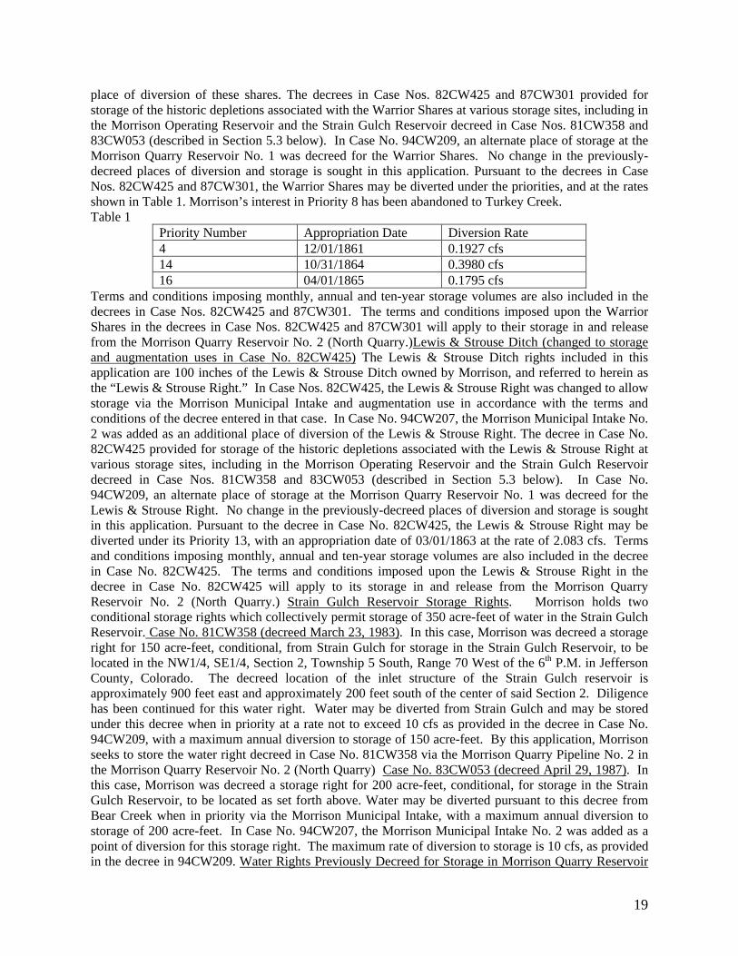
19
place of diversion of these shares. The decrees in Case Nos. 82CW425 and 87CW301 provided for storage of the historic depletions associated with the Warrior Shares at various storage sites, including in the Morrison Operating Reservoir and the Strain Gulch Reservoir decreed in Case Nos. 81CW358 and 83CW053 (described in Section 5.3 below). In Case No. 94CW209, an alternate place of storage at the Morrison Quarry Reservoir No. 1 was decreed for the Warrior Shares. No change in the previously-decreed places of diversion and storage is sought in this application. Pursuant to the decrees in Case Nos. 82CW425 and 87CW301, the Warrior Shares may be diverted under the priorities, and at the rates shown in Table 1. Morrison’s interest in Priority 8 has been abandoned to Turkey Creek. Table 1
Priority Number Appropriation Date Diversion Rate 4 12/01/1861 0.1927 cfs 14 10/31/1864 0.3980 cfs 16 04/01/1865 0.1795 cfs
Terms and conditions imposing monthly, annual and ten-year storage volumes are also included in the decrees in Case Nos. 82CW425 and 87CW301. The terms and conditions imposed upon the Warrior Shares in the decrees in Case Nos. 82CW425 and 87CW301 will apply to their storage in and release from the Morrison Quarry Reservoir No. 2 (North Quarry.)Lewis & Strouse Ditch (changed to storage and augmentation uses in Case No. 82CW425) The Lewis & Strouse Ditch rights included in this application are 100 inches of the Lewis & Strouse Ditch owned by Morrison, and referred to herein as the “Lewis & Strouse Right.” In Case Nos. 82CW425, the Lewis & Strouse Right was changed to allow storage via the Morrison Municipal Intake and augmentation use in accordance with the terms and conditions of the decree entered in that case. In Case No. 94CW207, the Morrison Municipal Intake No. 2 was added as an additional place of diversion of the Lewis & Strouse Right. The decree in Case No. 82CW425 provided for storage of the historic depletions associated with the Lewis & Strouse Right at various storage sites, including in the Morrison Operating Reservoir and the Strain Gulch Reservoir decreed in Case Nos. 81CW358 and 83CW053 (described in Section 5.3 below). In Case No. 94CW209, an alternate place of storage at the Morrison Quarry Reservoir No. 1 was decreed for the Lewis & Strouse Right. No change in the previously-decreed places of diversion and storage is sought in this application. Pursuant to the decree in Case No. 82CW425, the Lewis & Strouse Right may be diverted under its Priority 13, with an appropriation date of 03/01/1863 at the rate of 2.083 cfs. Terms and conditions imposing monthly, annual and ten-year storage volumes are also included in the decree in Case No. 82CW425. The terms and conditions imposed upon the Lewis & Strouse Right in the decree in Case No. 82CW425 will apply to its storage in and release from the Morrison Quarry Reservoir No. 2 (North Quarry.) Strain Gulch Reservoir Storage Rights. Morrison holds two conditional storage rights which collectively permit storage of 350 acre-feet of water in the Strain Gulch Reservoir. Case No. 81CW358 (decreed March 23, 1983). In this case, Morrison was decreed a storage right for 150 acre-feet, conditional, from Strain Gulch for storage in the Strain Gulch Reservoir, to be located in the NW1/4, SE1/4, Section 2, Township 5 South, Range 70 West of the 6th P.M. in Jefferson County, Colorado. The decreed location of the inlet structure of the Strain Gulch reservoir is approximately 900 feet east and approximately 200 feet south of the center of said Section 2. Diligence has been continued for this water right. Water may be diverted from Strain Gulch and may be stored under this decree when in priority at a rate not to exceed 10 cfs as provided in the decree in Case No. 94CW209, with a maximum annual diversion to storage of 150 acre-feet. By this application, Morrison seeks to store the water right decreed in Case No. 81CW358 via the Morrison Quarry Pipeline No. 2 in the Morrison Quarry Reservoir No. 2 (North Quarry) Case No. 83CW053 (decreed April 29, 1987). In this case, Morrison was decreed a storage right for 200 acre-feet, conditional, for storage in the Strain Gulch Reservoir, to be located as set forth above. Water may be diverted pursuant to this decree from Bear Creek when in priority via the Morrison Municipal Intake, with a maximum annual diversion to storage of 200 acre-feet. In Case No. 94CW207, the Morrison Municipal Intake No. 2 was added as a point of diversion for this storage right. The maximum rate of diversion to storage is 10 cfs, as provided in the decree in 94CW209. Water Rights Previously Decreed for Storage in Morrison Quarry Reservoir

20
No. 2 (North Quarry). Additional storage rights from Bear Creek and Strain Gulch were decreed to Morrison Quarry Reservoir No. 2 (North Quarry) in Case Nos. 95CW126 and 99CW225. Nothing in this application is intended to change or affect such storage rights. Capacity, Surface Area, and Releases. The excavated reservoir has a current capacity of 1,642 acre-feet, and, when filled to that volume, will have a surface area of 17.1 acres. Deliveries and/or releases from the reservoir may be made directly to Strain Gulch or to Bear Creek by delivering the water by pipeline to the Morrison Operating Reservoir, and releasing it from the Morrison Operating Reservoir to Bear Creek. The outlet of the Morrison Operating Reservoir is located at a point whence the NW corner of Section 2, Township 5 South, Range 70 West bears North 47º West a distance of 1980 feet. Water can also be piped back to the location of Morrison Municipal Intake No. 2 and released to Bear Creek at that location if required for proper administration. Before any water is stored in the Morrison Quarry Reservoir No. 2 (North Quarry) pursuant to a decree entered herein, appropriate arrangements will be made to account for out-of-priority groundwater inflows, if any, by direct release from the reservoir or pursuant to an approved substitute water supply plan or augmentation plan, or otherwise upon approval and supervision of the water commissioner. Name and address of owner or reputed owner of the land on which any new diversion or storage structure is or will be constructed or upon which water is or will be stored, including any modification to the existing storage pool: All structures are owned by Morrison, with the exception of the Morrison Quarry Reservoir No. 2 (North Quarry) which is owned by Aggregate Industries W.C.R. Inc., 3605 South Teller Street, Lakewood, CO 80235. The application is 6 pages with1 exhibit. 09CW34 Dorothy Sue Peck, 1832 Pawnee Parkway, Elizabeth, CO 80107, Lisa S. Weinstein, Esq. #35668, c/o Colorado Water Plans, P.O. Box 1955, Elizabeth, CO 80107, Telephone (303) 646-3895 APPLICATION FOR UNDERGROUND WATER RIGHTS FROM THE NONTRIBUTARY LOWER DAWSON, DENVER, ARAPAHOE AND LARAMIE-FOX HILLS IN ELBERT COUNTY. 2. Well Permits: There is one well on the property producing from the Upper Dawson. No wells produce from the Nontributary Lower Dawson, Denver, Arapahoe and Laramie-Fox Hills aquifers. Appropriate well permits will be applied for when Applicant is prepared to drill additional wells. 3. The wells which will withdraw groundwater from the nontributary Lower Dawson, Denver, Arapahoe and Laramie-Fox Hills aquifers are to be located on applicants land on Pawnee Hills Filing 2, Block 1, Lot 7, Section 35, Township 7, Range 65 west of 6th PM Elbert County. The total area of water rights on the applicants land is 5.0 acres. No specific locations for the proposed wells are requested. Specific locations for additional wells will be provided when applications for well permits are submitted. 4. Source of Water Rights: The sources of the nontributary groundwater to be withdrawn are the Lower Dawson, Denver, Arapahoe and Laramie-Fox Hills aquifers. 5. Date of Appropriation: 9-15-1992. 6. Estimated Amounts (acre feet per year) and Rates of Withdrawal (gallons per minute): Lower Dawson (0.7 AF 150 gpm), Denver (1.6 AF 250 gpm), Arapahoe (2.0 AF 400 gpm) and Laramie-Fox Hills (1.5 AF 400 gpm) aquifers. 7. Well Field: The wells which will withdraw groundwater from the proposed Well Field are to be located on the Applicant’s property. The Applicant requests that the Court determine that the applicant has the right to withdraw all of the legally available groundwater from wells that may be completed in the future as the Applicant’s Well Field. 8. Proposed use: All water withdrawn will be reused, successively used, leased, sold or otherwise disposed of for the following beneficial uses: unified municipal water systems, municipal, domestic, industrial, commercial, irrigation, augmentation, stock watering, recreational, fire protection, water feature ponds and piscatorial habitat less than 1000 square feet, and wildlife. The water will be produced for immediate application to said uses, for storage and subsequent application to said uses, for exchange purposes, for replacement of depletions from the use of water from other sources and for all other augmentation purposes. 9. Jurisdiction: The Water Court retains jurisdiction over the the material in this application. 10. The use of not nontributary water from future wells shall be subject to judicial approval of an augmentation plan which will be applied for at such time as additional wells may be proposed and permitted. 11. Remarks: Applicant requests the right to withdraw from these wells an average amount of water determined to be available in paragraph 6 plus an amount of groundwater in

21
excess of that annual amount; provided that the sum of the total withdrawals from any particular aquifer does not exceed the product of the number of years since the date of the issuance of well permits or of the entry of a decree, which ever occurs first, times the decreed average annual amount for that aquifer. 12. Number of pages of Application: 3 pages. AMENDMENTS 03CW217: SECOND AMENDED APPLICATION IN THE MATTER OF THE APPLICATION FOR AMENDMENT TO EXISTING AUGMENTATION PLAN FOR AUGMENTATION OF THE BOARD OF COUNTY COMMISSIONERS OF THE COUNTY OF GILPIN IN GILPIN AND JEFFERSON COUNTIES. Applicant, Board of County Commissioners of the County of Gilpin (“Gilpin County”), through its attorneys, Petrock & Fendel, P.C., Frederick A. Fendel, III, Reg. #10476, Bradford R. Benning, Reg. #31946, Denver, Colorado 80202, Telephone: (303) 534-0702, amends its Application in this matter with this Second Amended Application. Gilpin County filed the original Application in this case on May 8, 2003 and an Amended Application on February 24, 2006. Notices of the Application and Amended application were published as required by C.R.S. §37-92-302. The Application and Amended Application are incorporated herein and other than the below described amendments remain as previously filed. AMENDMENTS. 1. Place of Use of Gilpin County’s Tucker Lake Water Rights. Gilpin County’s application includes, among other things, a plan to provide water for the recreational grounds and facilities located adjacent to the Justice Center, commonly referred to as the Community Center, Fairgrounds, and Ball Fields (“Recreation Facilities”). The County’s Tucker Lake water rights supply as well as augment these uses. Other uses of the County’s Tucker Lake water rights may be made at any location within the County of Gilpin for the decreed uses of Gilpin County’s Tucker Lake water rights, which include all municipal uses, including irrigation, domestic, commercial, fire protection, recreational, and piscatorial. Use will be made directly, following storage, or by augmentation of such uses, pursuant to the augmentation plan or a separately decreed augmentation plan. Without admitting this amendment is necessary, Gilpin County is filing this amendment for the purposes of eliminating any doubt or dispute on these issues and to allow use of Gilpin County’s Tucker Lake water rights at any location in the County of Gilpin. 2. Additional Future Sources of Supply to Either North Clear Creek or Ralston Creek – Supplies of Augmentation Water of Limited Duration, Additional, or Alternative Sources. Gilpin County claims the ability to use additional and alternative future water supplies for augmentation under this plan should any such supplies become available to Gilpin County on a permanent or limited basis. Gilpin County is amending its application to include as sources of augmentation water any other sources lawfully available now or in the future to Gilpin County. 3. More Flexible Locations For In-Building Use. The County’s original application in this case indicated that the County was amending its augmentation plan to augment depletions associated with its Recreation Facilities, in lieu of future expansion of the Justice Center. By this amendment, the county seeks to use water under this augmentation plan for any in-building use, which may include, but is not limited to, expansion of the Recreation Facilities, expansion of the Justice Center, and/or any other or new building or buildings, provided the building is served by the Justice Center 1 and 2 wells. Wastewater return flows from any such in-building use will be returned to North Clear Creek and/or Ralston Creek as necessary for operation of the County’s augmentation plan. LEGAL DESCRIPTION OF THE STRUCTURES TO WHICH SECOND AMENDMENT APPLIES: 1. Justice Center Well No. 1 (JC-1), Permit No. 55234-F, WDID 5859: JC-1 is located in the SE1/4SE1/4, Section 30, T2S, R72W of the 6th P.M., at point approximately 500 feet west of the East Section Line and 125 feet north of the South Section Line of said Section 30, Gilpin County, Colorado: 2. Justice Center Well No. 2 (JC-2), Permit No. 55180-F, WDID 5860: JC-2 is located in the SE1/4SE1/4, Section 30, T2S, R72W of the 6th P.M., at a point approximately 625 feet west of the East Section Line and 875 feet north the South Section Line of said Section 30, Gilpin County, Colorado; 3. Dory Lake: Dory Lake is located in the SE1/4NW1/4, Section 29, T2S, R72W of the 6th P.M., Gilpin County, Colorado; 4. Dory Lake inlet ditch: The headgate of the inlet ditch is located in the

22
SE1/4NW1/4, Section 29, T2S, R72W of the 6th P.M., Gilpin County, Colorado, at a point approximately 1,350 feet east of the West Section Line and 2,225 feet south of the North Section Line of said Section 29, Gilpin County, Colorado; 5. Tucker Lake Water Rights: a. Original Point of Diversion: Tucker Lake is filled by the Haines and Piquette Ditch, the headgate of which is located on the north bank of Ralston Creek in the SE1/4SW1/4, Section 33, T2S, R70W of the 6th P.M., Jefferson County, Colorado; b. Original Place of Storage: Tucker Lake, located in the S1/2SW1/4, Section 35, T2S, R70W and the N1/2NW1/4, Section 2, T3S, R70W of the 6th P.M., Jefferson County, Colorado; c. First Alternate Point of Diversion: The headgate of the inlet ditch to Dory Lake. The headgate of the inlet ditch is located in the SE1/4NW1/4, Section 29, T2S, R72W of the 6th P.M., Gilpin County, Colorado, at a point approximately 1,350 feet east of the West Section Line and 2,225 feet south of the North Section Line of said Section 29, Gilpin County, Colorado; d. Alternate Place of Diversion and Storage: Dory Lake located in the SE1/4NW1/4, Section 29, T2S, R72W of the 6th P.M., Gilpin County, Colorado; d. Second Alternate Point of Diversion: Dory Lake located in the SE1/4NW1/4, Section 29, T2S, R72W of the 6th P.M., Gilpin County, Colorado. 03CW385 AMENDED APPLICATION TO MAKE CONDITIONAL WATER RIGHT ABSOLUTE AND FOR FINDING OF REASONABLE DILIGENCE IN THE MATTER OF THE APPLICATION OF THE BOARD OF COUNTY COMMISSIONERS OF THE COUNTY OF GILPIN IN GILPIN COUNTY. Applicant, through its attorneys, Petrock & Fendel, P.C., Frederick A. Fendel, III, Reg. #10476, Bradford R. Benning, Reg. #31946, Denver, Colorado 80202, Telephone: (303) 534-0702, moves to amend its Application in this case. Gilpin County filed the original Application in this case on November 26, 2003. Notices of the Application were published as required by C.R.S. §37-92-302. Other than the addition of the below described amendments, the Application remains as previously filed. The unchanged portions of the original Application that was previously filed are not set forth herein but are incorporated herein by reference. AMENDMENTS TO APPLICATION: Claim to Make Absolute Portion of Gilpin County’s 1994 Dory Lake Water Right. During the diligence period of December 1997 through the present (specifically during the months of May and June 2005), 2.58 acre-feet of the Dory Lake conditional water right were put to the decreed beneficial uses. Therefore, Applicant requests that 2.58 acre-feet of conditional water right decreed in Case No. 94CW277 be made absolute for all municipal uses, including irrigation, domestic, commercial, fire protection, recreational uses. In the alternative and if this amount is not made absolute, Gilpin County requests that a diligence finding be made to continue the full amount of the Dory Lake water right pursuant to the activity described in the original Application. Additional Claims to Make Absolute Prior to Decree in this Case. To the extent, if any, that water is diverted and used in priority while this case remains pending, Gilpin County reserves the right and may claim that additional amounts of each and all of the water rights set forth in the original Application are absolute without further amendment or publication of notice. LEGAL DESCRIPTION OF STRUCTURES TO WHICH AMENDMENT APPLIES: Justice Center Well No. 1 (JC-1), Permit No. 55234-F, WDID 5859: JC-1 is located in the SE1/4SE1/4, Section 30, T2S, R72W of the 6th P.M., at point approximately 500 feet from the East Section Line and 125 feet from the South Section Line of said Section 30, Gilpin County, Colorado; Justice Center Well No. 2 (JC-2), Permit No. 55180-F, WDID 5860: JC-2 is located in the SE1/4SE1/4, Section 30, T2S, R72W of the 6th P.M., at a point approximately 625 feet from the East Section Line and 875 feet from the South Section Line of said Section 30, Gilpin County, Colorado; Dory Lake: Dory Lake is located in the SE1/4NW1/4, Section 29, T2S, R72W of the 6th P.M., Gilpin County, Colorado; Dory Lake inlet ditch: The headgate of the inlet ditch is located in the SE1/4NW1/4, Section 29, T2S, R72W of the 6th P.M., Gilpin County, Colorado, at a point approximately 1,350 feet east of the West Section Line and 2,225 feet south of the North Section Line of said Section 29, Gilpin County, Colorado. 05CW346 Fort Morgan Farms, LLC, c/o Robert L. Graves, 5821 West County Road 54, Bellvue, Colorado 80512, Telephone: 970-482-5789. Please send pleadings to: Timothy R. Buchanan, Esq., John

23
P. Justus, Esq., Buchanan and Sperling, P.C., 7703 Ralston Road, Arvada, Colorado 80002. 2 The Application for Water Right and Change of Water Right IN WELD AND MORGAN COUNTIES filed with the Court on December 30, 2005 ("Application") is amended as described below, and otherwise remains as published in the December 2005 Resume for Water Division No. 1. 3. Paragraph 2.A. of the Application is revised as follows to correct the decreed location of the Weldon Valley Ditch headgate: A. Previous Decrees: The Weldon Valley Ditch was decreed in Case No. 433 in the Weld County District Court, Weld County, State of Colorado, on November 21, 1895, with an appropriation date of October 26, 1881 for 165 c.f.s. from the South Platte River. The decreed use is for irrigation. The decreed headgate location is on the north bank of the South Platte River in the Southwest Quarter (SW1/4) of the Northwest Quarter (NW1/4) of the Southeast Quarter (SE1/4) of Section 13, Township 4 North, Range 61 West of the 6th P.M., Weld County, Colorado. 4. Paragraph 2.C. of the Application is replaced in its entirety with the following: C. Proposed Change: Fort Morgan Farms seeks to change the use of the six (6) Weldon Valley Ditch Company shares to include augmentation, replacement and exchange, with the right to totally consume the consumable portion of the water, either by first use, successive use, or disposition. Fort Morgan Farms may use all or a part of the shares less ditch loss for replacement by direct release to the river or by recharge, including, but not limited to diversion at the headgate of the Upper Platte and Beaver Canal and use of the structures described in Case No. W-2968, and diversion at any and all other structures approved for the use of the recharge water. Fort Morgan Farms will use of all or a portion of the water delivered pursuant to the six shares of Weldon Valley Ditch Company as a replacement source in the augmentation plan decreed in Case No. 00CW261, to replace out-of-priority depletions from the pumping of the wells described therein, and in other plans for augmentation and substitute supply plans. In order to replace depletions associated with the pumping of the wells described in Case No. 00CW261 or in other plans for augmentation and substitute supply plans, Fort Morgan Farms shall divert the water attributable to the six shares through the Weldon Valley Ditch headgate and either: (1) deliver the water attributable to the six Weldon Valley Ditch Company shares to the South Platte River as approved by the Weldon Valley Ditch Company in accordance with the Bylaws of the Weldon Valley Ditch Company or by agreement with the Weldon Valley Ditch Company; or (2) deliver the water attributable to the six Weldon Valley Ditch Company shares through the Weldon Valley Ditch to an irrigation pipeline and delivery ditch owned by Fort Morgan Farms, located in the Northeast Quarter (NE1/4) and the North Half (N1/2) of the Southeast Quarter (SE1/4) of Section 12, Township 4 North, Range 59 West, as approved by the Weldon Valley Ditch Company in accordance with the Bylaws of the Weldon Valley Ditch Company, for delivery to the South Platte River at a point in the Southeast Quarter (SE1/4) of said Section 12; or (3) deliver the water attributable to the six Weldon Valley Ditch Company shares to the South Platte River and subsequently to the headgate of the Upper Platte and Beaver Canal, located at a point whence the Southeast Corner of Section 35, Township 4 North, Range 58 West of the 6th P.M., bears South 13° 57' East, 5020.2 feet, as approved by the Weldon Valley Ditch Company in accordance with the Bylaws of the Weldon Valley Ditch Company; and the water attributable to the six Weldon Valley Ditch Company shares will then be delivered to a groundwater recharge facility located in the North Half (N1/2) of Section 4, Township 3 North, Range 57 West of the 6th P.M., Morgan County, Colorado, as decreed in Case No. 00CW261 or exchanged for other fully consumable water to be delivered to the South Platte River; or (4) exchange the water attributable to the six Weldon Valley Ditch Company shares with other shareholders in the Weldon Valley Ditch Company for fully consumable water to be delivered to the South Platte River, as approved by the Weldon Valley Ditch Company in accordance with the Bylaws of the Weldon Valley Ditch Company. 5. The following sentence will be added to Paragraph 2.D. of the Application: The Upper Platte and Beaver Canal Company, c/o Terry Larsen, P.O. Box 69, Fort Morgan, Colorado 80701, owns the Upper Platte and Beaver Canal described in paragraph 2.C.(3) above. 6. The following sentence will be deleted from Paragraph 2.D. of the Application: The Fort Morgan Reservoir and Irrigation Company, P.O. Box 38, Fort Morgan, Colorado 80701, owns the Fort Morgan Canal described in paragraph 2.C(3) above. 7. Paragraph 4 of the Application is replaced in its entirety with the following: Fort Morgan Farms and the Upper Platte and Beaver Canal Company have not reached an
24
agreement for the use of the Upper Platte and Beaver Canal for the diversion of the water attributable to the six Weldon Valley Ditch Company shares described herein. Fort Morgan Farms currently has no right to use the Upper Platte and Beaver Canal as contemplated in this Amended Application and will not have any such right unless an agreement is reached with the Upper Platte and Beaver Canal Company. 8. A new Exhibit B is attached hereto, showing the location of the structures included in the Amended Application. 9. All statements of opposition previously filed in this case shall apply to the Amended Application without the need for filing additional statements of opposition. (Total of 5 pages). 06CW288 CITY AND COUNTY OF BROOMFIELD, a county and Colorado municipal corporation, c/o Director of Public Works, One Descombes Drive, Broomfield, Colorado 80038-1415, Telephone: 303.469.3301 (c/o Harvey W. Curtis, Esq., 8310 South Valley Highway #230, Englewood, Colorado 80112, Telephone: 303.292.1144. AMENDMENT TO APPLICATION FOR CONDITIONAL WATER STORAGE RIGHT AND CONDITIONAL APPROPRIATIVE RIGHT OF SUBSTITUTION AND EXCHANGE in WELD COUNTY. 1. The legal description for the South Platte Wellfield/Wells in paragraph 2.c.(3) of the application is hereby amended to read as follows: "2.c.(3) The South Platte Wellfield/Wells, to be located on the west bank of the South Platte River in the Southwest quarter of Section 18 and part of the Northeast quarter of the Northwest quarter of Section 19, Township 2 North, Range 66 West of the 6th P.M." 2. The legal description for the Little Dry Creek Diversion and/or Wellfield/Wells in paragraph 2.c.(4) of the application is hereby amended to read as follows: "2.c.(4) Little Dry Creek Diversion and/or Wellfield/Wells to be located in the West half of the Southeast quarter of Section 13, Township 2 North, Range 67 West, of the 6th PM." 3. Paragraph 4.d of the application is hereby amended to read as follows: "4.d South Platte Wellfield/Wells: Darrell L. Bearson and Nelva M. Bearson, 9208 Weld County Road 25, Fort Lupton, Colorado 80621. Groundwater Management Subdistrict of the Central Colorado Water Conservancy District, 3209 West 28th Street, Greeley, Colorado 80631. Robert Stahl, 9378 Weld County Road 25, Fort Lupton, Colorado 80621. Christine J. Smith Rev Trust, c/o Robert M. Stahl, Trustee, 9378 County Rd 25, Fort Lupton, Co 80621". 4. Paragraph 4.e of the application is hereby amended to read as follows: "4.e. Little Dry Creek Diversion and/or Wellfield/Wells: Meadow Island No. 1 Ditch Company, c/o Richie Pyeatte, 9826 Highway 66, Platteville, Colorado 80651. SW Chambers, LLC, a Colorado limited liability company, 7600 East Orchard Road, Suite 370 S. Greenwood Village, Colorado 80111. Groundwater Management Subdistrict of the Central Colorado Water Conservancy District, 3209 West 28th Street, Greeley, Colorado 80631". 5. A revised map showing the amended location of the South Platte Wellfield/Wells and Little Dry Creek Diversion and/or Wellfield/Wells, Exhibit B to the application, is attached to the amendment. 6. In all other respects, the Application shall remain as originally filed on December 28, 2006, and as published in the resume for December, 2006, in Water Division No. 1. (4 pages, including 1 page of exhibits.) 07CW96 Applicant: Hoshiko Farms, Inc. (“Hoshiko” or “Applicant”), c/o Dennis J. Hoshiko, P.O. Box 119, Kersey, CO 80644, (970) 330-8780. AMENDED APPLICATION FOR APPROVAL OF CHANGE OF WATER RIGHTS IN WELD COUNTY. Future correspondence and pleadings to: Donald E. Frick, Fischer, Brown, Bartlett & Gunn, P.C., 1319 E. Prospect Rd., Fort Collins, CO 80525, (970) 407-9000. The original application in this matter was filed on May 9, 2007 and was published in the May 2007 resume (“Original Application”). The Original Application is unchanged by this amended application except to the extent specifically set forth below. 1. Section 3.C of the Original Application sets forth the shares in the Greeley Irrigation Company (“GIC”) which are the subject of the requested change of water rights. Applicant has since acquired 2.5 additional shares in the GIC which were not included in the Original Application, and sold 2.0 shares (Certificate No. 3308) that were included in the Original Application. The Original Application is hereby amended so as to seek approval of a change of the water rights represented by the ownership of the following shares in the GIC to the uses stated in the Original Application (a map showing the historical use of the water rights and diversion records for the Greeley Canal No. 3 were included with the Original Application. The headgate of the Greeley Canal
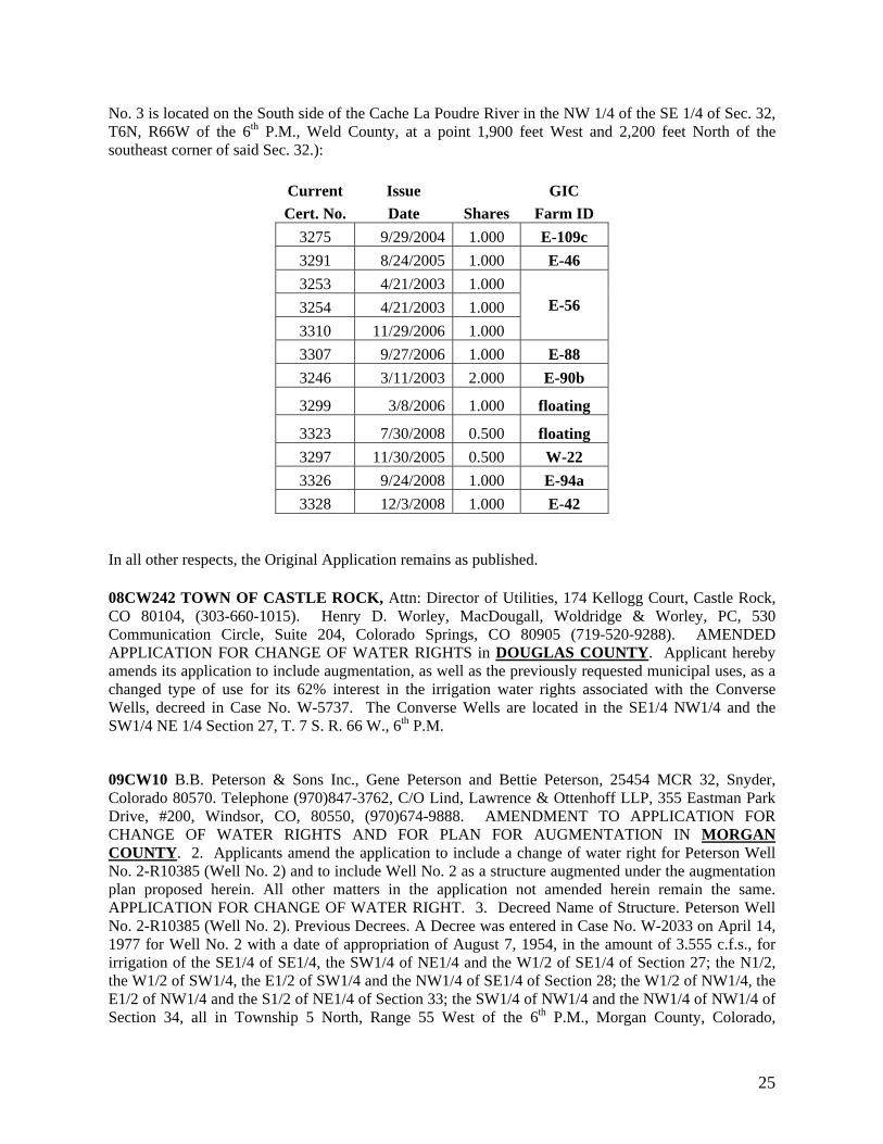
25
No. 3 is located on the South side of the Cache La Poudre River in the NW 1/4 of the SE 1/4 of Sec. 32, T6N, R66W of the 6th P.M., Weld County, at a point 1,900 feet West and 2,200 feet North of the southeast corner of said Sec. 32.):
Current Issue GIC Cert. No. Date Shares Farm ID
3275 9/29/2004 1.000 E-109c 3291 8/24/2005 1.000 E-46 3253 4/21/2003 1.000
E-56 3254 4/21/2003 1.000 3310 11/29/2006 1.000 3307 9/27/2006 1.000 E-88 3246 3/11/2003 2.000 E-90b
3299 3/8/2006 1.000 floating
3323 7/30/2008 0.500 floating 3297 11/30/2005 0.500 W-22 3326 9/24/2008 1.000 E-94a 3328 12/3/2008 1.000 E-42
In all other respects, the Original Application remains as published. 08CW242 TOWN OF CASTLE ROCK, Attn: Director of Utilities, 174 Kellogg Court, Castle Rock, CO 80104, (303-660-1015). Henry D. Worley, MacDougall, Woldridge & Worley, PC, 530 Communication Circle, Suite 204, Colorado Springs, CO 80905 (719-520-9288). AMENDED APPLICATION FOR CHANGE OF WATER RIGHTS in DOUGLAS COUNTY. Applicant hereby amends its application to include augmentation, as well as the previously requested municipal uses, as a changed type of use for its 62% interest in the irrigation water rights associated with the Converse Wells, decreed in Case No. W-5737. The Converse Wells are located in the SE1/4 NW1/4 and the SW1/4 NE 1/4 Section 27, T. 7 S. R. 66 W., 6th P.M.
09CW10 B.B. Peterson & Sons Inc., Gene Peterson and Bettie Peterson, 25454 MCR 32, Snyder, Colorado 80570. Telephone (970)847-3762, C/O Lind, Lawrence & Ottenhoff LLP, 355 Eastman Park Drive, #200, Windsor, CO, 80550, (970)674-9888. AMENDMENT TO APPLICATION FOR CHANGE OF WATER RIGHTS AND FOR PLAN FOR AUGMENTATION IN MORGAN COUNTY. 2. Applicants amend the application to include a change of water right for Peterson Well No. 2-R10385 (Well No. 2) and to include Well No. 2 as a structure augmented under the augmentation plan proposed herein. All other matters in the application not amended herein remain the same. APPLICATION FOR CHANGE OF WATER RIGHT. 3. Decreed Name of Structure. Peterson Well No. 2-R10385 (Well No. 2). Previous Decrees. A Decree was entered in Case No. W-2033 on April 14, 1977 for Well No. 2 with a date of appropriation of August 7, 1954, in the amount of 3.555 c.f.s., for irrigation of the SE1/4 of SE1/4, the SW1/4 of NE1/4 and the W1/2 of SE1/4 of Section 27; the N1/2, the W1/2 of SW1/4, the E1/2 of SW1/4 and the NW1/4 of SE1/4 of Section 28; the W1/2 of NW1/4, the E1/2 of NW1/4 and the S1/2 of NE1/4 of Section 33; the SW1/4 of NW1/4 and the NW1/4 of NW1/4 of Section 34, all in Township 5 North, Range 55 West of the 6th P.M., Morgan County, Colorado,

26
consisting of approximately 676 acres, along with Peterson Wells No. 1, 3-6. Well No. 2 is located in NW1/4 SE1/4 of Section 28, Township 5 North, Range 55 West of the 6th P.M., Morgan County, Colorado at a point 1450 feet North and 2300 feet West of the SE corner of said Section 28. 4. Historical Use. Well No. 2 has been used to irrigate approximately 676 acres on the lands described in ¶3, along with Wells No. 1, 3-6. 5. Proposed Change. Applicant seeks to change Well No. 2 so that it can be used to irrigate approximately 509 acres located in Sections 16, 17, 20 21, 22 and 27 all in Township 5 North, Range 55 West of the 6th P.M., Morgan County, Colorado along with Well No. 6. See Figure 1. PLAN FOR AUGMENTATION. 6. Plan for Augmentation. Well No. 2 is augmented pursuant to the augmentation plan decree in Case No. 81CW407 for the Pioneer Water and Irrigation, Inc. (Pioneer). Well No. 2 is augmented for the irrigation of the 676 acres decreed in Case No. W-2033. The Decree in 81CW407 (Pioneer Decree) at ¶B.7 allows the addition of wells to the plan for augmentation upon application to the water court. Applicant proposes to augment the changed use for Well No. 2 under the terms of the Pioneer Decree using Pioneer shares owned by Applicant. Applicant owns 1,093 Pioneer shares. 7. Amount of Depletion. Applicant’s engineers estimate that the depletion from diversions of Well No. 2 and Well No. 6 for irrigation of 509 acres will be approximately 894 acre feet per year on average. 8. Measurement of Diversions. Diversions from Well No. 2 are measured by a flow meter and Applicant proposes to continue to measure well diversions as required by the Pioneer Decree. 9. Water Rights to be used for Augmentation. Applicant owns 1,093 Pioneer shares and proposes to use those shares, or as many as needed, to provide augmentation of out of priority depletions from Well No. 2 and Well No. 6. 10. Name and Address of Owners of Structures. Applicants own Well No. 2 and 1,093 Pioneer shares. Pioneer Water and Irrigation, Inc. 17586 County Road 20, Fort Morgan, Colorado 80701 owns the Pioneer Decree and owns or has the right to use the structures referenced in the Pioneer Decree.
THE WATER RIGHTS CLAIMED BY THESE APPLICATIONS MAY AFFECT IN PRIORITY ANY WATER RIGHTS CLAIMED OR HERETOFORE ADJUDICATED WITHIN THIS DIVISION AND OWNERS OF AFFECTED RIGHTS MUST APPEAR TO OBJECT WITHIN THE TIME PROVIDED BY STATUTE OR BE FOREVER BARRED. YOU ARE HEREBY NOTIFIED that any party who wishes to oppose an application, or an amended application, may file with the Water Clerk, P. O. Box 2038, Greeley, CO 80632, a verified Statement of Opposition, setting forth facts as to why the application should not be granted, or why it should be granted only in part or on certain conditions. Such Statement of Opposition must be filed by the last day of April 2009 (forms available on www.courts.state.co.us or in the Clerk’s office), and must be filed as an Original and include $158.00 filing fee. A copy of each Statement of Opposition must also be served upon the Applicant or Applicant’s Attorney and an affidavit or certificate of such service of mailing shall be filed with the Water Clerk.