Dismal Swamp State Park General Management Plan
18
1 Dismal Swamp State Park General Management Plan North Carolina Department of Natural and Cultural Resources Division of Parks and Recreation Coastal Region May 2017
Transcript of Dismal Swamp State Park General Management Plan

1
Dismal Swamp State Park General Management Plan
North Carolina Department of Natural and Cultural Resources
Division of Parks and Recreation
Coastal Region
May 2017
2
I. MISSION AND PURPOSE MISSION:
Conservation: To protect natural diversity of North Carolina through careful selection and stewardship of state parks system lands; Recreation: To provide and promote outdoor recreation opportunities in the state parks system and throughout the state; and Education: To encourage appreciation of North Carolina’s natural and cultural heritage through diverse educational opportunities; for all citizens of and visitors to the State of North Carolina.
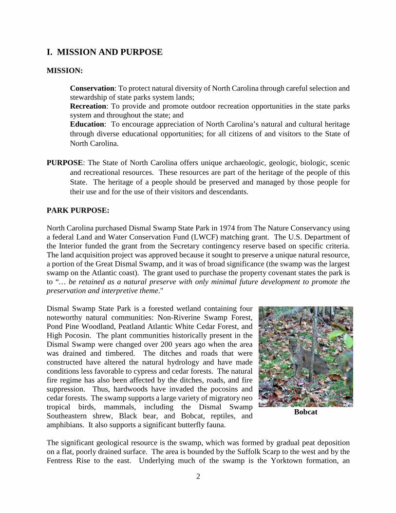
PURPOSE: The State of North Carolina offers unique archaeologic, geologic, biologic, scenic and recreational resources. These resources are part of the heritage of the people of this State. The heritage of a people should be preserved and managed by those people for their use and for the use of their visitors and descendants. PARK PURPOSE: North Carolina purchased Dismal Swamp State Park in 1974 from The Nature Conservancy using a federal Land and Water Conservation Fund (LWCF) matching grant. The U.S. Department of the Interior funded the grant from the Secretary contingency reserve based on specific criteria. The land acquisition project was approved because it sought to preserve a unique natural resource, a portion of the Great Dismal Swamp, and it was of broad significance (the swamp was the largest swamp on the Atlantic coast). The grant used to purchase the property covenant states the park is to “… be retained as a natural preserve with only minimal future development to promote the preservation and interpretive theme." Dismal Swamp State Park is a forested wetland containing four noteworthy natural communities: Non-Riverine Swamp Forest, Pond Pine Woodland, Peatland Atlantic White Cedar Forest, and High Pocosin. The plant communities historically present in the Dismal Swamp were changed over 200 years ago when the area was drained and timbered. The ditches and roads that were constructed have altered the natural hydrology and have made conditions less favorable to cypress and cedar forests. The natural fire regime has also been affected by the ditches, roads, and fire suppression. Thus, hardwoods have invaded the pocosins and cedar forests. The swamp supports a large variety of migratory neo tropical birds, mammals, including the Dismal Swamp Southeastern shrew, Black bear, and Bobcat, reptiles, and amphibians. It also supports a significant butterfly fauna. The significant geological resource is the swamp, which was formed by gradual peat deposition on a flat, poorly drained surface. The area is bounded by the Suffolk Scarp to the west and by the Fentress Rise to the east. Underlying much of the swamp is the Yorktown formation, an
Bobcat
3
impermeable clay layer that acts as an effective barrier against upward or downward water movement. Although Dismal Swamp State Park and the adjacent National Wildlife Refuge protect 120,000 acres of the Great Dismal Swamp, at least half the original acreage has been drained. The Dismal Swamp is thought to have been a prime hunting and fishing area for Native American tribes prior to European settlement. Although hunting lodges were maintained around the perimeter of the swamp, no evidence exists that any permanent villages were established in the swamp. Significant archaeological resources have not been discovered. The park provides an excellent opportunity to experience an extensive East Coast swamp and pocosin complex. Day Use Activities that promote the interpretation and education goals of the park, such as trails and overlooks, should be promoted. The extensive road system supports an opportunity for long-distance hiking and bicycling. A major constraint of the park is the soil types which limit the construction of facilities. Camping is difficult due to yellow flies, ticks and extreme heat in summer months. Significant scenic resources include the Atlantic White Cedar stands and the extensive swamp and forested areas. Trails are primarily located on straight road beds alongside ditches, providing opportunities to view wildlife. Visitors can view the swamp with additional trails constructed away from the historic ditches. Dismal Swamp was acquired so that its valuable biological, geological, archaeological, recreational, and scenic values could be protected. The N.C. Division of Parks and Recreation is charged with preserving these values and providing park experiences that promote and pride in understanding natural heritage of North Carolina.
II. HISTORY Early European settlers encountered a different Great Dismal Swamp than we see today. In the late 1600s, the Dismal was a vast wetland, covering about 1.28 million acres. It stretched from the James River in Virginia to the Albemarle Sound in North Carolina. For centuries, Native Americans used the Swamp as hunting and fishing grounds but found it too wet to build homes. The area has a rich cultural history. William Drummond, first governor of North Carolina, explored the area, and President George Washington helped sponsor the digging of the first ditch. Virginia Gov. Patrick Henry proposed the Dismal Swamp Canal, which has been listed on the National Register of Historic Places. Some early explorers, such as William Byrd II, saw no value in swampland and thought it should be drained and converted to agricultural uses. The system of ditches intersecting Dismal was intended to carry water out, but this work was only partially successful. Although the water table dropped significantly, the Swamp remained unsuitable as farmland, and efforts turned to harvesting timber for construction in the region. Cypress and cedar both could be used to make durable products with exceptional resistance to moisture. Cedar shingles were a common product of the Swamp in the 1800s. By the 1880s, most hardwood trees had been logged out, but

4
commercial logging continued into the 1960s. In 1972, the Nature Conservancy purchased land from timber companies and sold over 14,000 acres of land to the State of North Carolina in 1974. For many years, the area was managed as the Dismal Swamp State Natural Area. Landlocked on three sides and bordered by the Canal on the fourth, access for the public was limited. Following construction of the hydraulic swing bridge over the Canal and the Visitor Center, the Dismal Swamp State Park opened in 2008. The Dismal Swamp Canal represents an important piece of American history. While the idea of a canal originated in the early 1700s, construction did not begin until 1793. Dug almost entirely by slaves, the Canal stretches 22 miles, from Deep Creek in Chesapeake, VA, to the town of South Mills, NC. The slaves forced to dig the channel by hand faced terrible working conditions: waist-deep muck and peat, extreme summer heat, biting insects, and venomous snakes. On average, they could complete about 10 feet of the Canal each day, while their masters collected their wages for the work. In 1805, 12 years later, the Canal opened to boat traffic, but it was so narrow and shallow that only flat-bottomed barges called lighter boats or gondolas could pass thru. These lighter boats, however, were used extensively to move timber products out of the Swamp and off to market. You can see a replica lighter boat exhibit along Canal Road, about 0.70 miles from the Visitor Center. The Dismal Swamp Canal changed private hands several times and fell into disrepair during the Civil War, while the Union and the Confederacy each fought to control this vital means of transporting supplies. Finally, in 1929, the Federal Government purchased the Canal for $500,000 and the Army Corps of Engineers widened and dredged it to its current width of about 50 feet and depth of about 9-12 feet. At different times in its past, the Dismal Swamp has been viewed as a "glorious paradise," a grim and a place of strange smells, sounds, and a refuge. Lawbreakers found it an ideal place to hide illegal moonshine stills during the Prohibition years from 1920-1933. Today, you can see a replica still device along Canal Road about a half mile from the Visitor Center and the remains of real stills along the Supple-Jack Trail. In the time of slavery, many runaway slaves bravely seeking a path to freedom took shelter in the swamp. Some stayed only briefly to rest before finding passage farther north, but some formed maroon colonies or independent settlements on Mezic Islands, areas of higher ground, and lived out the rest of their lives in the swamp. Researchers believe the Dismal may have been home to the largest maroon colony. In December 2003, the National Park Service recognized the Great Dismal Swamp as a site on the National Underground Railroad Network to Freedom. It is the only such site to span two states, Virginia and North Carolina.
Visitor Center
5
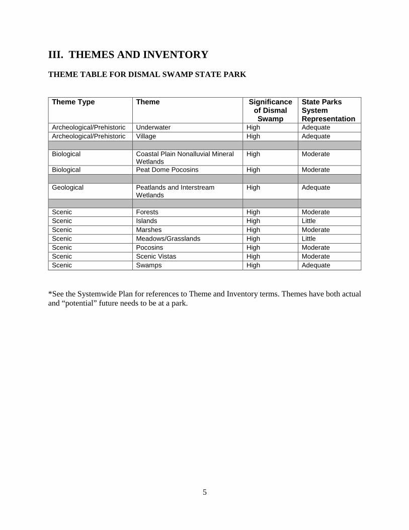
III. THEMES AND INVENTORY THEME TABLE FOR DISMAL SWAMP STATE PARK Theme Type Theme Significance
of Dismal Swamp
State Parks System Representation
Archeological/Prehistoric Underwater High Adequate Archeological/Prehistoric Village High Adequate Biological Coastal Plain Nonalluvial Mineral
Wetlands High Moderate
Biological Peat Dome Pocosins High Moderate Geological Peatlands and Interstream
Wetlands High Adequate
Scenic Forests High Moderate Scenic Islands High Little Scenic Marshes High Moderate Scenic Meadows/Grasslands High Little Scenic Pocosins High Moderate Scenic Scenic Vistas High Moderate Scenic Swamps High Adequate
*See the Systemwide Plan for references to Theme and Inventory terms. Themes have both actual and “potential” future needs to be at a park.

6
FACILITIES INVENTORY- VISITOR CENTER DISMAL SWAMP STATE PARK

7
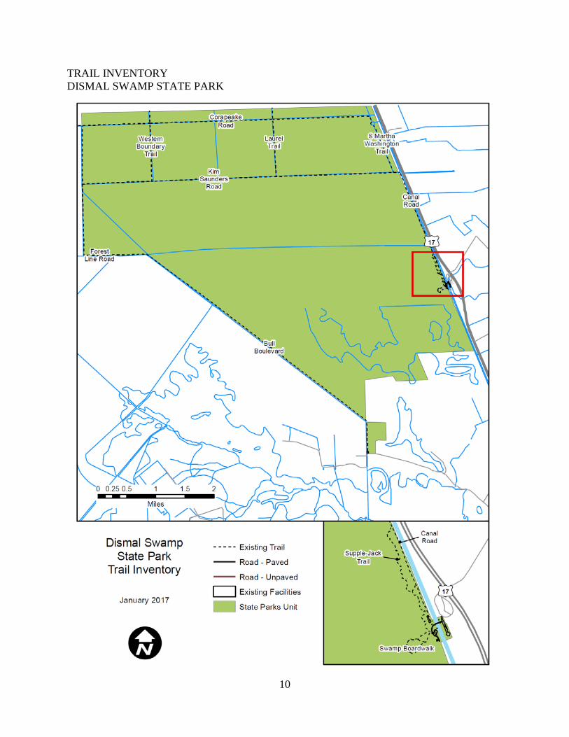
TRAILS INVENTORY DISMAL SWAMP STATE PARK
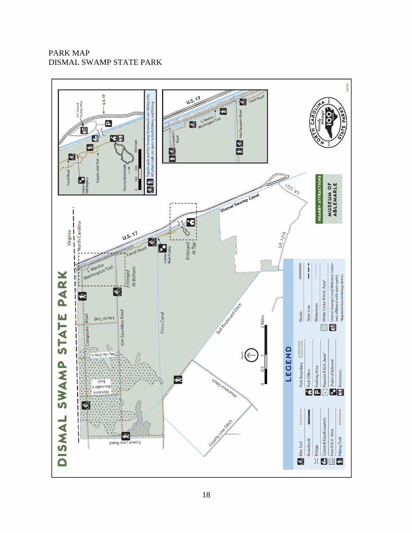
Trails Inventory Hiking Multi Use Trail Bull Boulevard 2.25 Canal Road 2.20 Corapeake Road 5.16 Cross Canal 6.55 Forest Line Road 2.30 Kim Saunders Road 5.40 Laurel Ditch 1.19 Myrtle Ditch 1.25 S. Martha Washington 1.20 Supple -Jack Trail 0.85 Swamp Boardwalk 0.50 Western Boundary Trail 1.22
Dismal Swamp SP Total (miles) 30.07 Dismal Swamp Canal Trail 8.00
Trails: Bull Boulevard: is a 2.25 mile one way, grassy ditch deep located in the swamp, where a few cypress and cedar trees grow. Visitors can find bear signs, wood ducks and otters. Canal Road: is a 2.20 mile one- way trail begins at the Visitor Center. A replica liquor still is located 0.25 miles up the road, near the first Supple-Jack Trail junction. An example of a lighter boat can be found near Cross Canal, about 0.70 miles up the road. Corapeake Road: The 5.16-mile trail runs just south of the NC/VA state line, cutting east across the park. Visitors can see abundant pocosin habitats along Corapeake Road. Common species include bay and gallberry. Forest Line Road: is a 2.30 mile one- way trail which is located along the Western boundary of the park. This mostly gravel trail is deep in the Swamp, with shoulders dotted with Atlantic White-Cedar trees. Black bear and otter are frequently seen here, along with herons, ducks, and the occasional bald eagle.
Canal Road during winter

8
Kim Saunders Road: is a 5.40 -mile trail which turns straight across the park along northern end of Canal Road. Wildlife includes: Black bears, turkey, bobcat and butterflies. Bird watchers will enjoy the trail to see several warblers. Laurel Trail: The road runs north from mile 2 at Kim Saunders to Corapeake. From there you can continue further into the park along Corapeake or turn east and visit the water control structures near the eastern boundary. Myrtle Ditch: is a 1.25-mile trail that intersects with Corapeake Road and Kim Saunders Road. S. Martha Washington Trail: is a 1.20-mile-long trail which connects Kim Saunders and Corapeake Trails. Beginning just a few hundred feet beyond the end of Canal Road, this is the fastest way to reach the water control structures, located near the junction of Corapeake and S. Martha Washington Trails. Supple-Jack Trail: is a 0.85-mile-long trail begins at the Visitor Center across from the bridge. The trail winds through dense vegetation and connects to Canal Road. Remains of illegal moonshine stills can be found near the trail corridor. Swamp Boardwalk: The boardwalk is located behind the Visitor Center and offers diverse wildlife for interpretive nature walks, including frogs, turtles, snakes, birds, and even the occasional bear or bobcat. The Dismal Swamp State Park TRACK Trail also follows the Swamp Boardwalk, an accessible half-mile loop. There is an observation platform and accessible picnic table a few hundred feet along the trail from the left entrance. Western Boundary Trail: is a one mile, one -way trail connects Kim Saunders to Corapeake Trail, further west than S Martha Washington and Laurel Trail. The trailhead is located near mile marker 4 of Kim Saunders Road. A six-mile hike connects to Western Boundary Trail from the Visitor Center.
Swamp Boardwalk
Wildlife on Trial System

9
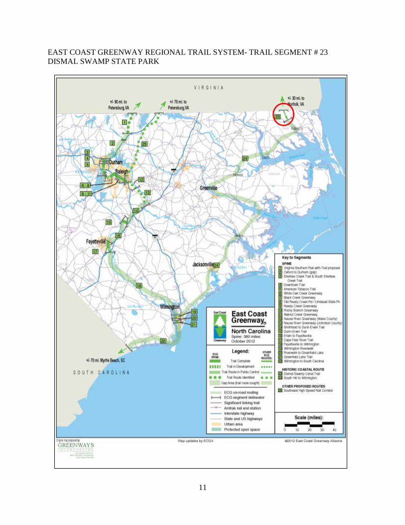
Regional Trails System: Dismal Swamp Canal Trail was named a designated National Recreation Trail in 2008. The northern Trailhead begins on the south end of the Dismal Swamp Canal Welcome Center off Highway 17. The first 3 miles of trail meander through a wooded area between the historic waterway and the historic highway, ending at N.C. Highway 343. The historic trail became part of the N.C. Birding Trail in 2005. Maintenance of the trail is performed by Camden County staff and volunteers. East Coast Greenway: Regional Trail references with Historic Coast Route, Dismal Swamp Canal Trail (reference # 23). This trail was a designated trail along the East Coast Greenway in 2006.
10
TRAIL INVENTORY DISMAL SWAMP STATE PARK
11
EAST COAST GREENWAY REGIONAL TRAIL SYSTEM- TRAIL SEGMENT # 23 DISMAL SWAMP STATE PARK

12
IV. PLANNING

13
LAND PROTECTION PLAN DISMAL SWAMP STATE PARK
FACILITIES FOR MAIN ENTRANCE AND TO CROSS
OVER CANAL
ACCESS PRIMARY RESOURCE PROTECTION AND CONNECT PARCELS
GREAT DISMAL SWAMP NATIONAL WILDLIFE REFUGE

14
LAND PROTECTION PLAN- CRITICAL ACRES DISMAL SWAMP STATE PARK
GREAT DISMAL SWAMP NATIONAL WILDLIFE REFUGE
NEEDED FOR ACCESS ALONG EASEMENT WITH WILDLIFE REFUGE. NATURAL
RESOURCES INCLUDE: WETLANDS AND HIGH QUALITY COMMUNITIES

15
PROJECT EVALUATION PROGRAM LIST DISMAL SWAMP STATE PARK
Project # Project Title Cost 1 Hydrology Restoration $210,941 2 Park Wide Road Improvements $1,140,554 3 Maintenance Area Development $878,000
TOTAL $2,229,495 ** Estimated project cost does not include contingencies, design fee, nor escalation.
1. Hydrology Restoration
The division is interested in returning the park to its natural condition prior to the man-made construction of ditches. Restoration work completed north of Kim Saunders Ditch have shown the effectiveness of restoration for ecological and fire control purposes. This project will continue restoration efforts throughout the park.
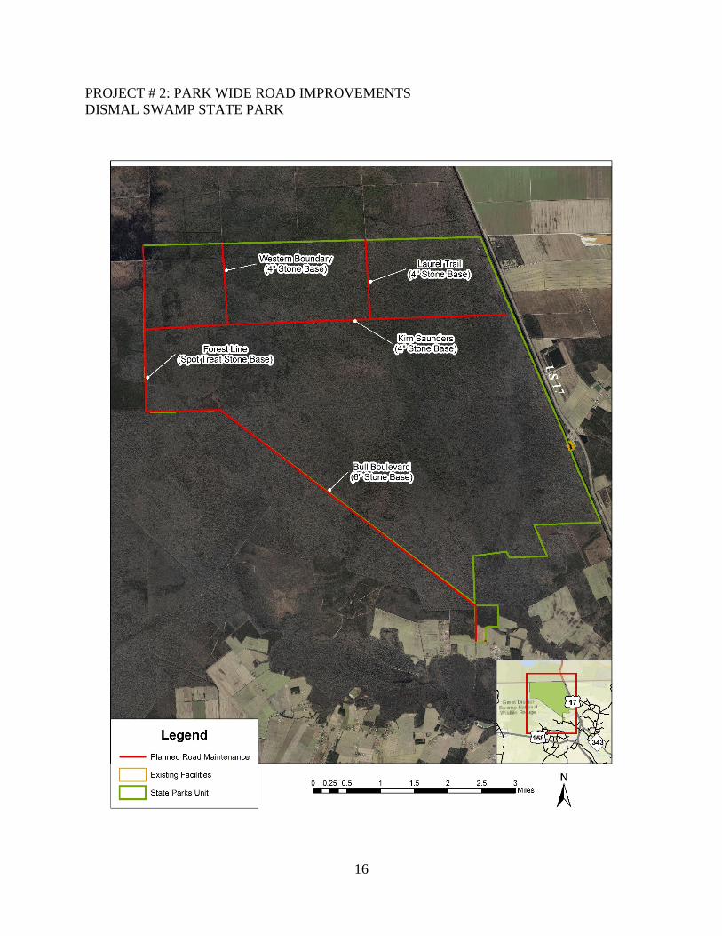
2. Park Wide Road Improvements
Several miles of former logging roads offer opportunities for hikers and mountain bikers to explore a unique ecosystem. This project consists of clearing, grading and stone stabilization of various canal roads throughout the park. Typical roads will be minimum ten feet wide with four foot shoulders with field located pull-off and turn around areas. Storm drainage and erosion control measures will be installed with required erosion control permitting. Most the area is in a floodplain zone. These road improvements will improve park trail users experience in addition to provide better staff access for emergency and operational access.
• Forest Line Ditch –spot stone stabilization (12,144 LF) • Western Boundary/Laurel Trail –Install four inches of stone base (10,560 LF) • Bull Boulevard – Install six inches of stone base (33,264 LF) • Kim Saunders – Install four inches of stone base (28,512 LF)
3. Maintenance Area Development A maintenance area will be developed in the existing maintenance yard near the visitor center. The development will include: chain-link fence, 6-bay pole barn, enclosed storage building, equipment storage, and a shop building. Offices will be in existing visitor center. This is needed to protect equipment.
Water Control Structure
16
PROJECT # 2: PARK WIDE ROAD IMPROVEMENTS DISMAL SWAMP STATE PARK

17
PROJECT # 3: MAINTENANCE AREA DEVELOPMENT DISMAL SWAMP STATE PARK
18
PARK MAP DISMAL SWAMP STATE PARK