DISDI Panels at ESRI FedUC - 10 Jan 07 - Agenda€¦ · • BEA Integration ... (DoD business...
58
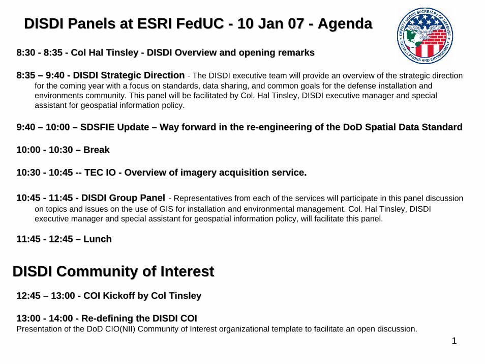
1 8:30 8:30 - - 8:35 8:35 - - Col Hal Tinsley Col Hal Tinsley - - DISDI Overview and opening remarks DISDI Overview and opening remarks 8:35 8:35 – – 9:40 9:40 - - DISDI Strategic Direction DISDI Strategic Direction - The DISDI executive team will provide an overview of the strategic direction for the coming year with a focus on standards, data sharing, and common goals for the defense installation and environments community. This panel will be facilitated by Col. Hal Tinsley, DISDI executive manager and special assistant for geospatial information policy. 9:40 9:40 – – 10:00 10:00 – – SDSFIE Update SDSFIE Update – – Way forward in the re Way forward in the re - - engineering of the engineering of the DoD DoD Spatial Data Standard Spatial Data Standard 10:00 10:00 - - 10:30 10:30 – – Break Break 10:30 10:30 - - 10:45 10:45 -- -- TEC IO TEC IO - - Overview of imagery acquisition service. Overview of imagery acquisition service. 10:45 10:45 - - 11:45 11:45 - - DISDI Group Panel DISDI Group Panel - Representatives from each of the services will participate in this panel discussion on topics and issues on the use of GIS for installation and environmental management. Col. Hal Tinsley, DISDI executive manager and special assistant for geospatial information policy, will facilitate this panel. 11:45 11:45 - - 12:45 12:45 – – Lunch Lunch 12:45 12:45 – – 13:00 13:00 - - COI Kickoff by Col Tinsley COI Kickoff by Col Tinsley 13:00 13:00 - - 14:00 14:00 - - Re Re - - defining the DISDI COI defining the DISDI COI Presentation of the DoD CIO(NII) Community of Interest organizational template to facilitate an open discussion. DISDI Panels at ESRI DISDI Panels at ESRI FedUC FedUC - - 10 Jan 07 10 Jan 07 - - Agenda Agenda DISDI Community of Interest DISDI Community of Interest
Transcript of DISDI Panels at ESRI FedUC - 10 Jan 07 - Agenda€¦ · • BEA Integration ... (DoD business...
1
8:30 8:30 -- 8:35 8:35 -- Col Hal Tinsley Col Hal Tinsley -- DISDI Overview and opening remarksDISDI Overview and opening remarks
8:35 8:35 –– 9:40 9:40 -- DISDI Strategic Direction DISDI Strategic Direction - The DISDI executive team will provide an overview of the strategic direction for the coming year with a focus on standards, data sharing, and common goals for the defense installation and environments community. This panel will be facilitated by Col. Hal Tinsley, DISDI executive manager and special assistant for geospatial information policy.
9:40 9:40 –– 10:00 10:00 –– SDSFIE Update SDSFIE Update –– Way forward in the reWay forward in the re--engineering of the engineering of the DoDDoD Spatial Data StandardSpatial Data Standard
10:00 10:00 -- 10:30 10:30 –– BreakBreak
10:30 10:30 -- 10:45 10:45 ---- TEC IO TEC IO -- Overview of imagery acquisition service.Overview of imagery acquisition service.
10:45 10:45 -- 11:45 11:45 -- DISDI Group PanelDISDI Group Panel - Representatives from each of the services will participate in this panel discussion on topics and issues on the use of GIS for installation and environmental management. Col. Hal Tinsley, DISDI executive manager and special assistant for geospatial information policy, will facilitate this panel.
11:45 11:45 -- 12:45 12:45 –– LunchLunch
12:45 12:45 –– 13:00 13:00 -- COI Kickoff by Col TinsleyCOI Kickoff by Col Tinsley
13:00 13:00 -- 14:00 14:00 -- ReRe--defining the DISDI COIdefining the DISDI COIPresentation of the DoD CIO(NII) Community of Interest organizational template to facilitate an open discussion.
DISDI Panels at ESRI DISDI Panels at ESRI FedUCFedUC -- 10 Jan 07 10 Jan 07 -- AgendaAgenda
DISDI Community of InterestDISDI Community of Interest

The Defense Installation Spatial Data Infrastructure:
2006 and Beyond
Colonel Hal Tinsley, USAFDISDI Executive Manager
ODUSD I&E (Business Enterprise Integration)
January 10, 2007

3
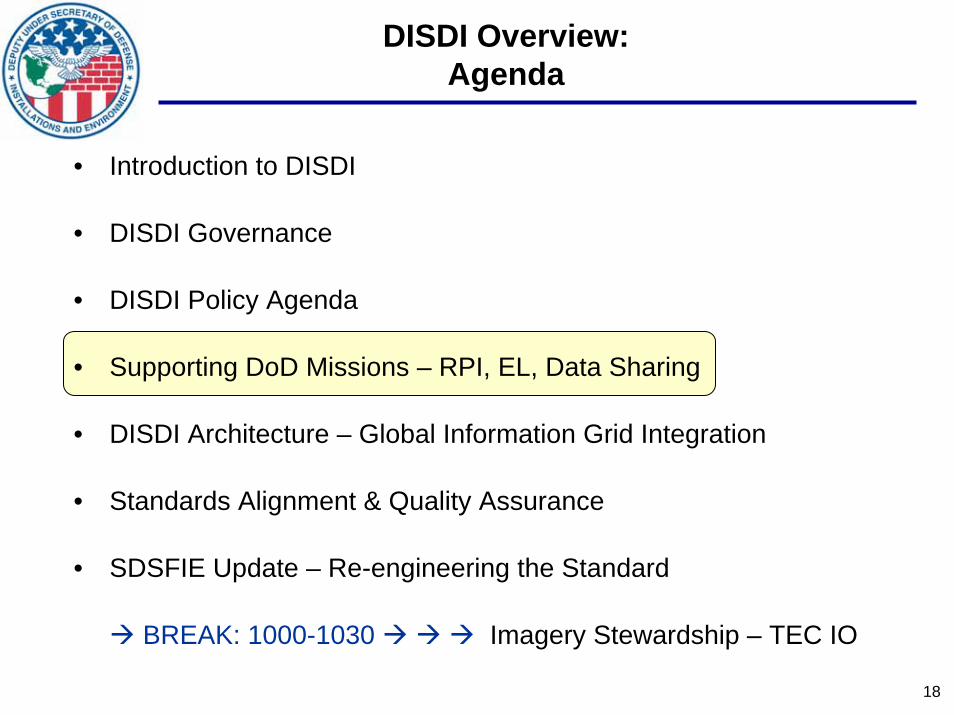
DISDI Overview:Agenda
• Introduction to DISDI
• DISDI Governance
• DISDI Policy Agenda
• Supporting DoD Missions – RPI, EL, Data Sharing
• DISDI Architecture – Global Information Grid Integration
• Standards Alignment & Quality Assurance
• SDSFIE Update – Re-engineering the Standard
BREAK: 1000-1030 Imagery Stewardship – TEC IO
4
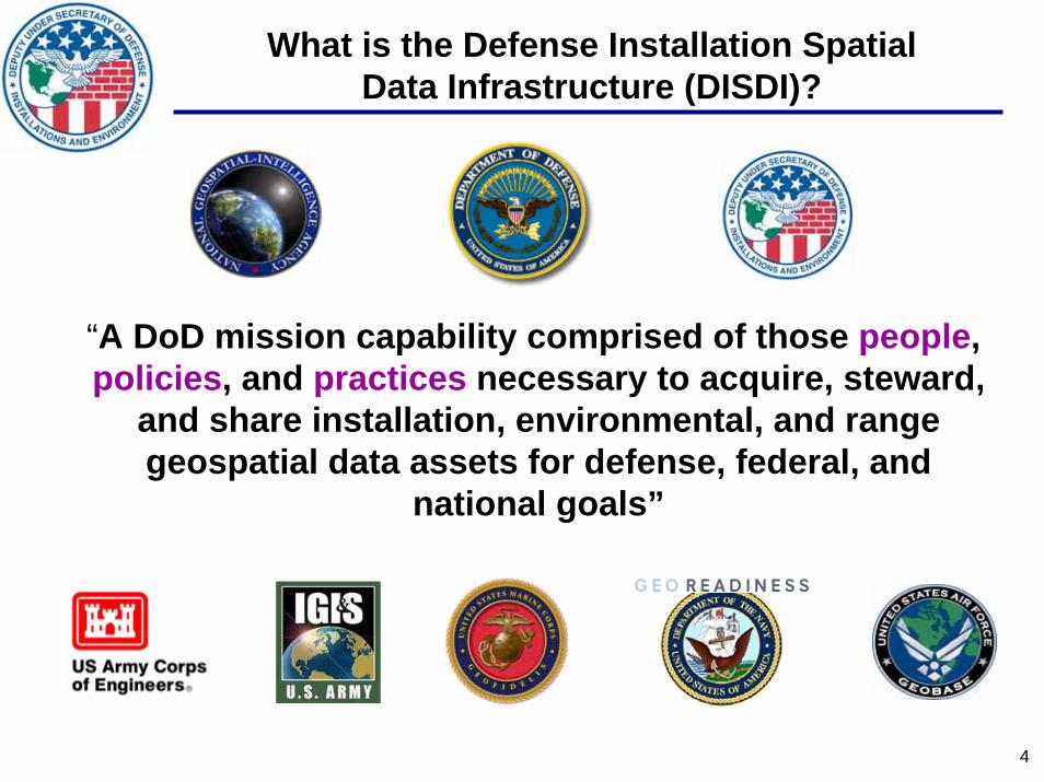
What is the Defense Installation SpatialData Infrastructure (DISDI)?
“A DoD mission capability comprised of those people, policies, and practices necessary to acquire, steward,
and share installation, environmental, and range geospatial data assets for defense, federal, and
national goals”

5
DISDI Key Milestones & Objectives
• Governance, Policy, & Guidance– Align DISDI Program within the National System for Geospatial Intelligence (NSG)– NGA Partnership – Geospatial-Intelligence Working Group (GWG)– Clarify Distinctions between Business GI&S, GEOINT– Quality Assurance for Mapping
• Standards– Support for Enhanced Geospatial Data Catalogs and Content – “Value-add” to NGA Capabilities via Data Alignment– Enhanced Metadata to Synchronize with the DoD Net-Centric Enterprise Strategy Goals
• Service Architecture– Mapping Portal to Leverage Component Source Data
• Inventory– Portfolio Management, Tracking, & Accountability
• Real Property & Installation Lifecycle Management (RP&ILM) Support– Real Property Inventory & Environmental Liability Mapping– Support a Transformational Process for Sustaining and Enhancing the SDSFIE
6
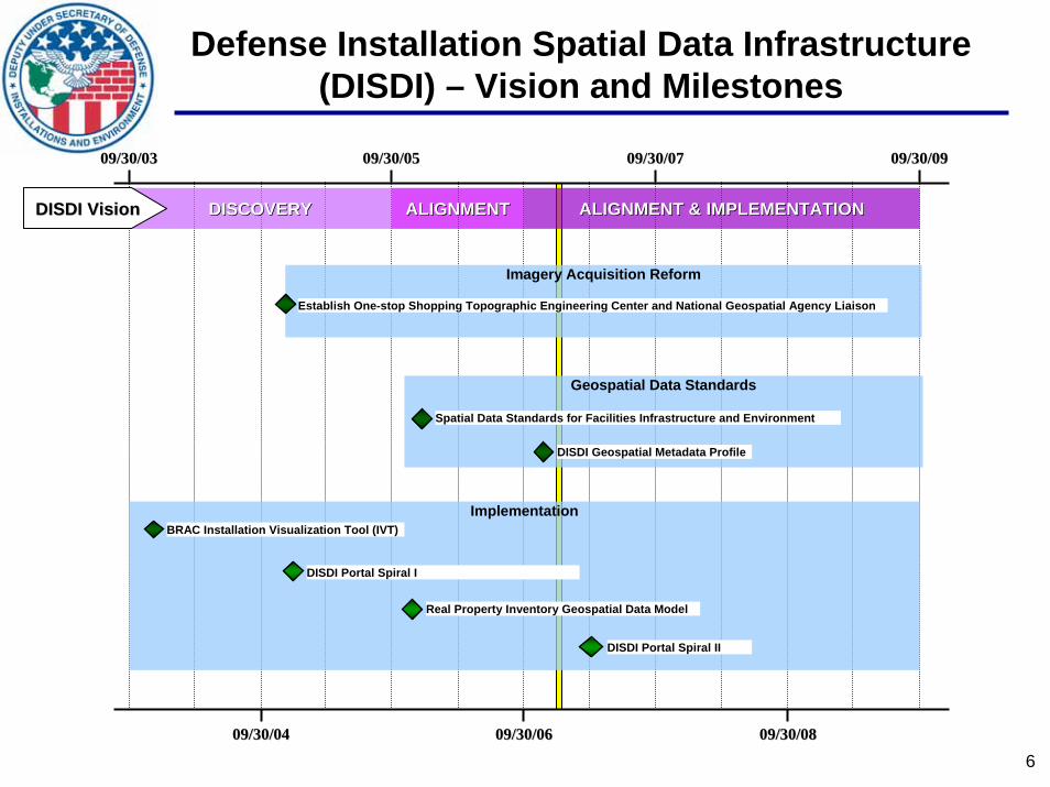
Defense Installation Spatial Data Infrastructure (DISDI) – Vision and Milestones
09/30/0309/30/03
09/30/0409/30/04 09/30/0609/30/06
09/30/0509/30/05 09/30/0709/30/07
09/30/0809/30/08
09/30/0909/30/09
Imagery Acquisition Reform
Establish One-stop Shopping Topographic Engineering Center and National Geospatial Agency Liaison
Geospatial Data Standards
Spatial Data Standards for Facilities Infrastructure and Environment
DISDI Geospatial Metadata Profile
Implementation
DISDI Portal Spiral I
BRAC Installation Visualization Tool (IVT)
Real Property Inventory Geospatial Data Model
DISDI Portal Spiral II
DISCOVERYDISCOVERY ALIGNMENTALIGNMENT ALIGNMENT & IMPLEMENTATIONALIGNMENT & IMPLEMENTATIONDISDI VisionDISDI Vision

7
DISDI Overview:Agenda
• Introduction to DISDI
• DISDI Governance
• DISDI Policy Agenda
• Supporting DoD Missions – RPI, EL, Data Sharing
• DISDI Architecture – Global Information Grid Integration
• Standards Alignment & Quality Assurance
• SDSFIE Update – Re-engineering the Standard
BREAK: 1000-1030 Imagery Stewardship – TEC IO
8
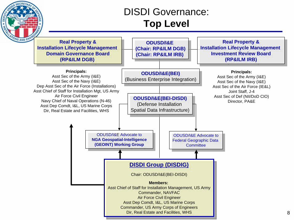
DISDI Governance:Top Level
Real Property &Installation Lifecycle Management
Domain Governance Board(RP&ILM DGB)
Real Property &Installation Lifecycle Management
Domain Governance Board(RP&ILM DGB)
Real Property &Installation Lifecycle Management
Investment Review Board(RP&ILM IRB)
Real Property &Installation Lifecycle Management
Investment Review Board(RP&ILM IRB)
ODUSD/I&E (Chair: RP&ILM DGB)(Chair: RP&ILM IRB)
ODUSD/I&E (Chair: RP&ILM DGB)(Chair: RP&ILM IRB)
ODUSD/I&E(BEI-DISDI)(Defense Installation
Spatial Data Infrastructure)
ODUSD/I&E(BEI-DISDI)(Defense Installation
Spatial Data Infrastructure)
Principals:Asst Sec of the Army (I&E)Asst Sec of the Navy (I&E)
Asst Sec of the Air Force (IE&L)Joint Staff, J-4
Asst Sec of Def (NII/DoD CIO)Director, PA&E
Principals:Asst Sec of the Army (I&E)Asst Sec of the Navy (I&E)
Dep Asst Sec of the Air Force (Installations)Asst Chief of Staff for Installation Mgt, US Army
Air Force Civil EngineerNavy Chief of Naval Operations (N-46)Asst Dep Comdt, I&L, US Marine Corps
Dir, Real Estate and Facilities, WHS
ODUSD/I&E Advocate toNGA Geospatial-Intelligence
(GEOINT) Working Group
ODUSD/I&E Advocate toNGA Geospatial-Intelligence
(GEOINT) Working GroupODUSD/I&E Advocate toFederal Geographic Data
Committee
ODUSD/I&E Advocate toFederal Geographic Data
Committee
ODUSD/I&E(BEI)(Business Enterprise Integration)
ODUSD/I&E(BEI)(Business Enterprise Integration)
DISDI Group (DISDIG)Chair: ODUSD/I&E(BEI-DISDI)
Members:Asst Chief of Staff for Installation Management, US Army
Commander, NAVFACAir Force Civil Engineer
Asst Dep Comdt, I&L, US Marine CorpsCommander, US Army Corps of Engineers
Dir, Real Estate and Facilities, WHS
DISDI Group (DISDIG)Chair: ODUSD/I&E(BEI-DISDI)
Members:Asst Chief of Staff for Installation Management, US Army
Commander, NAVFACAir Force Civil Engineer
Asst Dep Comdt, I&L, US Marine CorpsCommander, US Army Corps of Engineers
Dir, Real Estate and Facilities, WHS
9
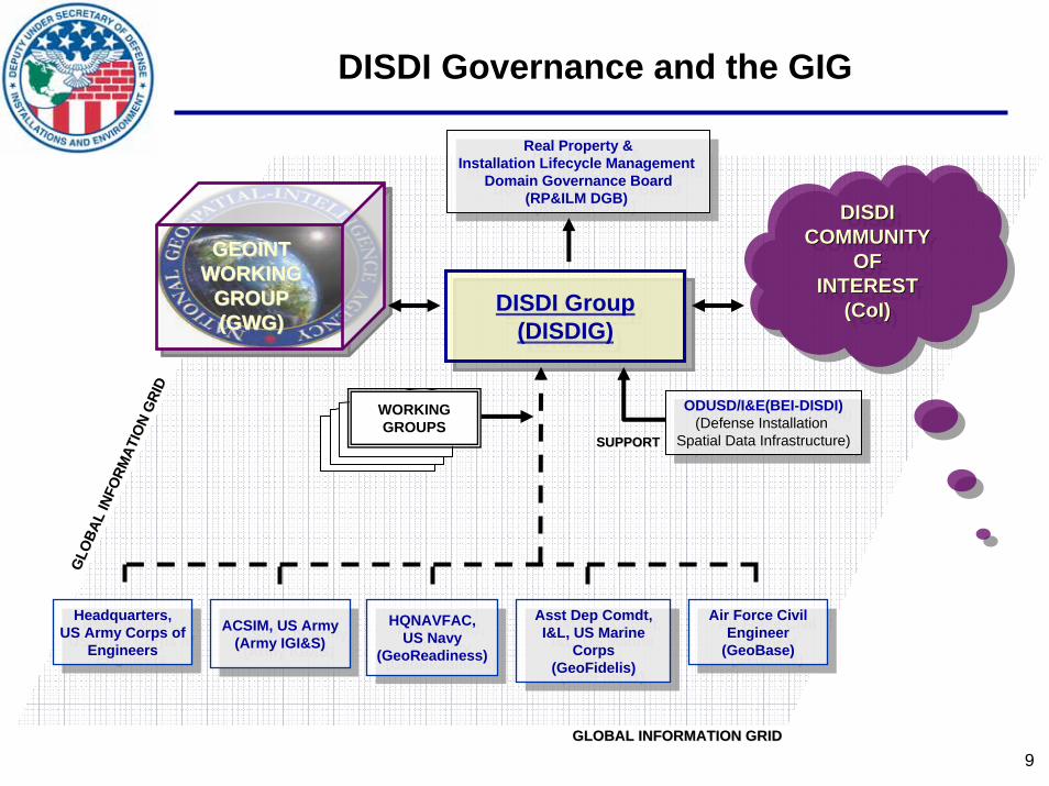
DISDI Governance and the GIGG
LOBA
L IN
FORM
ATIO
N G
RID
GLO
BAL
INFO
RMAT
ION
GRI
D
GLOBAL INFORMATION GRIDGLOBAL INFORMATION GRID
Real Property &Installation Lifecycle Management
Domain Governance Board(RP&ILM DGB)
Real Property &Installation Lifecycle Management
Domain Governance Board(RP&ILM DGB)
ODUSD/I&E(BEI-DISDI)(Defense Installation
Spatial Data Infrastructure)
ODUSD/I&E(BEI-DISDI)(Defense Installation
Spatial Data Infrastructure)
DISDI Group (DISDIG)
DISDI Group (DISDIG)
ACSIM, US Army(Army IGI&S)
ACSIM, US Army(Army IGI&S)
HQNAVFAC, US Navy
(GeoReadiness)
HQNAVFAC, US Navy
(GeoReadiness)
Asst Dep Comdt, I&L, US Marine
Corps(GeoFidelis)
Asst Dep Comdt, I&L, US Marine
Corps(GeoFidelis)
Air Force Civil Engineer
(GeoBase)
Air Force Civil Engineer
(GeoBase)
Headquarters, US Army Corps of
Engineers
Headquarters, US Army Corps of
Engineers
SUPPORT SUPPORT SUPPORT
GEOINTWORKING
GROUP(GWG)
GEOINTGEOINTWORKINGWORKING
GROUPGROUP(GWG)(GWG)
DISDICOMMUNITY
OFINTEREST
(CoI)
DISDIDISDICOMMUNITYCOMMUNITY
OFOFINTERESTINTEREST
((CoICoI))
WORKING GROUPS
10
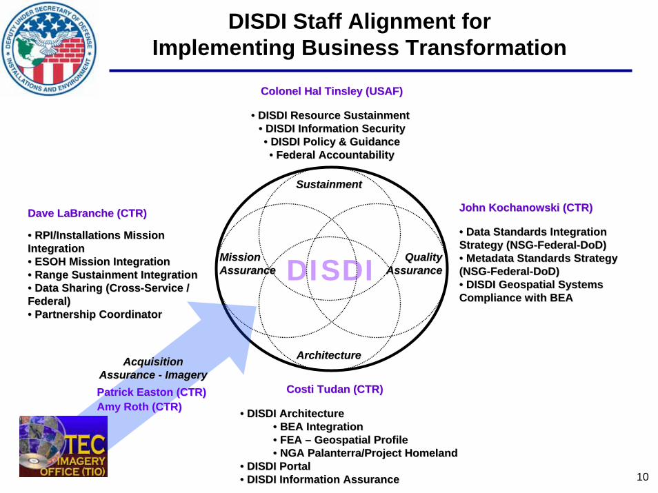
DISDIMission Mission AssuranceAssurance
QualityQualityAssuranceAssurance
CostiCosti TudanTudan (CTR)(CTR)
Dave LaBranche (CTR)Dave LaBranche (CTR)
•• RPI/Installations Mission RPI/Installations Mission IntegrationIntegration•• ESOH Mission IntegrationESOH Mission Integration•• Range Sustainment IntegrationRange Sustainment Integration•• Data Sharing (CrossData Sharing (Cross--Service / Service / Federal)Federal)•• Partnership CoordinatorPartnership Coordinator
•• DISDI ArchitectureDISDI Architecture•• BEA IntegrationBEA Integration•• FEA FEA –– Geospatial ProfileGeospatial Profile•• NGA Palanterra/Project HomelandNGA Palanterra/Project Homeland
•• DISDI PortalDISDI Portal•• DISDI Information AssuranceDISDI Information Assurance
John Kochanowski (CTR)John Kochanowski (CTR)
•• Data Standards Integration Data Standards Integration Strategy (NSGStrategy (NSG--FederalFederal--DoD)DoD)•• Metadata Standards Strategy Metadata Standards Strategy (NSG(NSG--FederalFederal--DoD)DoD)•• DISDI Geospatial Systems DISDI Geospatial Systems Compliance with BEACompliance with BEA
ArchitectureArchitecture
DISDI Staff Alignment for Implementing Business Transformation
Acquisition Acquisition Assurance Assurance -- ImageryImageryPatrick Easton (CTR)Patrick Easton (CTR)Amy Roth (CTR)Amy Roth (CTR)
SustainmentSustainment
Colonel Hal Tinsley (USAF)Colonel Hal Tinsley (USAF)
•• DISDI Resource Sustainment DISDI Resource Sustainment •• DISDI Information SecurityDISDI Information Security•• DISDI Policy & GuidanceDISDI Policy & Guidance•• Federal AccountabilityFederal Accountability

11
DISDI Overview:Agenda
• Introduction to DISDI
• DISDI Governance
• DISDI Policy Agenda
• Supporting DoD Missions – RPI, EL, Data Sharing
• DISDI Architecture – Global Information Grid Integration
• Standards Alignment & Quality Assurance
• SDSFIE Update – Re-engineering the Standard
BREAK: 1000-1030 Imagery Stewardship – TEC IO

12
Objective: Align the DISDI Staff to Plan Business TransformationAlign the DISDI Staff to Plan Business Transformation
Strategy: Optimize the DISDI Staff duties to focus on architecture, quality, acquisition, and mission integration.
Objective: Align the DISDI Program to Coordinate and Implement Business TraAlign the DISDI Program to Coordinate and Implement Business Transformationnsformation
Strategy: Charter a formal DISDI working group under the DGB and IRB to secure strategic consensus across the Services
Objective: Align the DISDI Program Within the Federal Geographic Data CommiAlign the DISDI Program Within the Federal Geographic Data Committeettee
Strategy: Modify the Federal Geographic Data Committee charter to reflect ODUSD/I&E as a core member (DoD business mission), joining NGA and USACE-Civil Works
Objective: Align the DISDI Program to Leverage USACE/ERDC Talent PoolsAlign the DISDI Program to Leverage USACE/ERDC Talent Pools
Strategy: Partner with the Components and the USACE Cold Regions Research Laboratory, the Topographic Engineer Center, and the Information Technology Laboratory to secure quality architecture, acquisition and data standards
Objective: Align the DISDI Program Within the National System for GeospatiaAlign the DISDI Program Within the National System for Geospatiall--IntelligenceIntelligence
Strategy: Partner with NGA/OGMP in formally revising DODD 5105.60 to delegate Business Mission Area GI&S to OUSD/AT&L
1 May 06
1 Jun 06
1 Sep 06
DISDI Policy Alignment and Guidance Objectives
FY06 Goals Met, FY07 Goals Remaining

13
• The NGA shall provide timely, relevant, and accurate geospatial intelligence (GEOINT) in support of the national security objectives of the United States, and shall provide the DoD, Intelligence Community, and other Federal departments and agencies with GEOINT needed to meet national intelligence requirements…provide combat support to the Armed Forces of the United States, provide for safety of navigation, and other activities that may be prescribed by the President, the SECDEF, or the DNI. The NGA shall function within the following broad areas:
• GEOINT Data, Products, Information and Services.
• Education and Training Services.
• National System for Geospatial Intelligence (NSG) Operations.
• Procedures and Standards.
• GEOINT Systems.
• Information Assurance (IA).
• NSG Functional Management.
• New Missions as Assigned.
DoDDDoDD 5105.60 (revised): 5105.60 (revised): NIMA Becomes NGANIMA Becomes NGA

14
GEOINT
Business Business DomainDomain
INSTALLATIONGI&S
InstallationInstallationSituationalSituationalAwarenessAwareness
InstallationInstallationGeospatialGeospatialInformationInformation
UnclassifiedUnclassifiedInstallationInstallation
ImageryImagery
IntelligenceIntelligenceandand
WarfightingWarfightingDomainsDomains
ImageryImageryImageryImagery
IntelligenceIntelligenceGeospatialGeospatialInformationInformation
GeospatialGeospatialIntelligenceIntelligence
ImageryImageryImageryImagery
IntelligenceIntelligenceGeospatialGeospatialInformationInformationImageryImagery
ImageryImageryIntelligenceIntelligence
GeospatialGeospatialInformationInformation
GeospatialGeospatialIntelligenceIntelligence
DoDDoD Directive 5105.60 (revised)Directive 5105.60 (revised)Defining Complementary Roles for GEOINT and Installation Defining Complementary Roles for GEOINT and Installation
Geospatial Information & ServicesGeospatial Information & Services
15
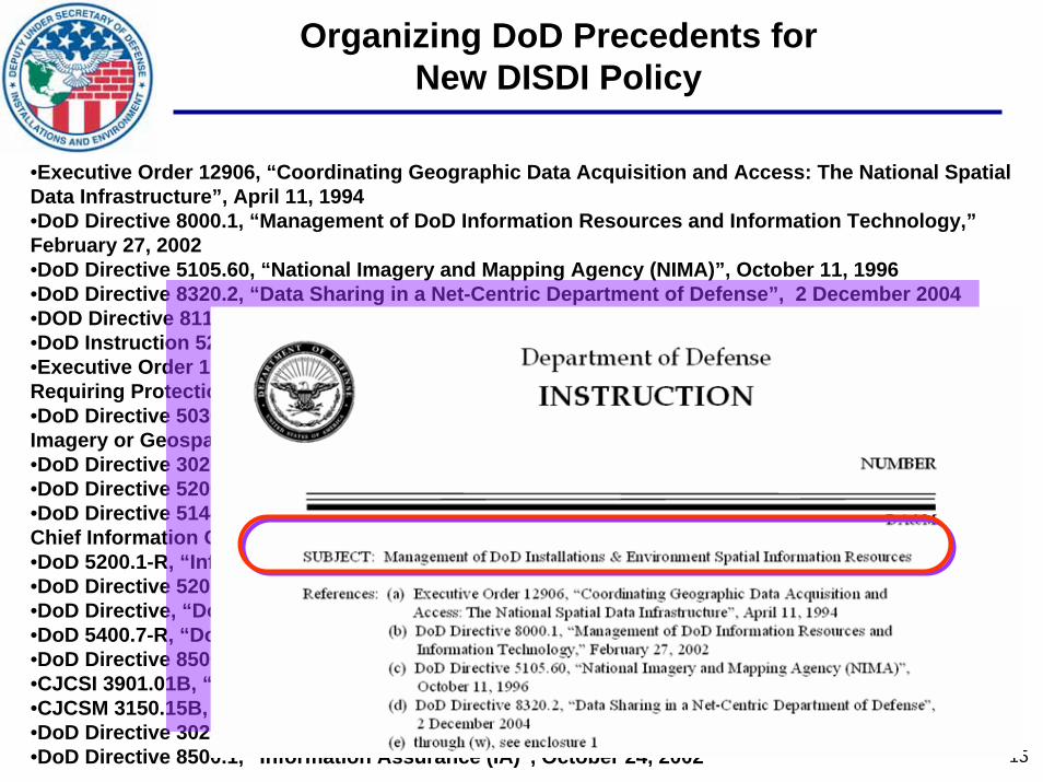
•Executive Order 12906, “Coordinating Geographic Data Acquisition and Access: The National Spatial Data Infrastructure”, April 11, 1994•DoD Directive 8000.1, “Management of DoD Information Resources and Information Technology,”February 27, 2002•DoD Directive 5105.60, “National Imagery and Mapping Agency (NIMA)”, October 11, 1996•DoD Directive 8320.2, “Data Sharing in a Net-Centric Department of Defense”, 2 December 2004•DOD Directive 8115.01, “Information Technology Portfolio Management” 10 October, 2005•DoD Instruction 5210.52, “Security Classification of Airborne Sensor Imagery,” May 18, 1989•Executive Order 10104, “Defining Certain Vital Military and Naval Installations and Equipment as Requiring Protection Against the General Dissemination of Information Relative Thereto, “ Feb 1, 1950•DoD Directive 5030.59, “National Imagery and Mapping Agency (NIMA) LIMITED DISTRIBUTION Imagery or Geospatial Information and Data”, 13 May 2003•DoD Directive 3020.40, “Defense Critical Infrastructure Program (DCIP)”, 19 August, 2005•DoD Directive 5200.1, “DoD Information Security Program”, 13 December 1996•DoD Directive 5144.1, “Assistant Secretary of Defense for Networks and Information Integration/DoDChief Information Officer (ASD(NII)/DoD CIO)”, 2 May 2005•DoD 5200.1-R, “Information Security Program”, January 1997•DoD Directive 5205.2, “DoD Operations Security (OPSEC) Program”, 29 November 1999•DoD Directive, “DoD Freedom of Information Act (FOIA) Program”, 28 October 2005 •DoD 5400.7-R, “DoD Freedom of Information Act Program”, September 1998•DoD Directive 8500.1, “Information Assurance (IA)”, October 24, 2002•CJCSI 3901.01B, “Requirements for Geospatial Information and Services”, July 15,2004•CJCSM 3150.15B, Standard Specified Geographic Location File Request, November 1, 2005•DoD Directive 3025.1, “Military Support to Civil Authorities (MSCA)”, January 15, 1993•DoD Directive 8500.1, “Information Assurance (IA)”, October 24, 2002
Organizing DoD Precedents for New DISDI Policy

16
Potential Topics for DISDI Policy and/or Instruction
• Organizational roles and responsibilities
• Interagency data sharing protocols
• Reporting requirements (DoD, Federal)
• Portfolio management requirements
• Data requirements• “Common installation picture”• Based on enterprise (DoD-wide) requirements
• Technical requirements• Standards alignment• Architectural alignment
• Information Assurance (IA) and Information Security (INFOSEC) requirements
17
Questions?
The Defense Installation SpatialData Infrastructure (DISDI) Group
18
DISDI Overview:Agenda
• Introduction to DISDI
• DISDI Governance
• DISDI Policy Agenda
• Supporting DoD Missions – RPI, EL, Data Sharing
• DISDI Architecture – Global Information Grid Integration
• Standards Alignment & Quality Assurance
• SDSFIE Update – Re-engineering the Standard
BREAK: 1000-1030 Imagery Stewardship – TEC IO
Acquisition, Technology and Logistics
DISDI Mission Assurance
Implementing DISDI Capabilities,Enhancing Mission Execution
Mr. David LaBranche, P.E.ODUSD I&E (BEI)10 January 2007

Acquisition, Technology and Logistics
20
• What is Mission Assurance?
• Aligning DISDI Resources with DoD Business Mission Areas
• Goals & Status of ODUSD(I&E) Geospatial Mapping Pilot
Projects to Support Real Property Inventory (RPI) and
Environmental Liabilities Reconciliation (total value $5.5M)
• DISDI Data Sharing – Status & Trends
Agenda

Acquisition, Technology and Logistics
21
DISDI Mission Assurance
• Objective: Support OSD Staff and Components’ implementation of OMB Circular A-16, DoDD 5105.60, and DISDI goals and objectives; assure business process reengineering tasks to implement visualization and mapping capabilities in I&E are coordinated with the Components and aligned with the DoD Business Enterprise Architecture (BEA).
• Mission Assurance Goals:
Acquisition “Acquire Once… Share ManyShare Many”Architecture “One Enterprise…One Architecture”Information “Maximize Leverage… Minimize Risk”Quality “Standards-Based Stewardship”Sustainment “From Awareness to Adoption”
Dimension Goal

Acquisition, Technology and Logistics
22
The “I and E” of DoD
BusinessEnterpriseIntegration
The FacilitiesThe FacilitiesAssessmentAssessment
Database (FAD)Database (FAD)

Acquisition, Technology and Logistics
23
AuditoryBoundaryBuildings
CadastreClimate
CommonCommunications
CulturalDemographics
EcologyEnvironmental Hazards
FaunaFlora
Future ProjectsGeodeticGeology
HydrographyImprovementLand StatusLandform
Military OperationsOlfactory
SoilTransportation
UtilitiesVisual
AuditoryBoundaryBuildings
CadastreClimate
CommonCommunications
CulturalDemographics
EcologyEnvironmental Hazards
FaunaFlora
Future ProjectsGeodeticGeology
HydrographyImprovementLand StatusLandform
Military OperationsOlfactory
SoilTransportation
UtilitiesVisual
SDSFIE v2.5
Business Transformation Drivers
DoD Business Mission Areas of Interest
:
Real Property Inventory
Environmental Liabilities Recognition, Valuation, and Reporting Requirements
Hazardous Materials Process Controls and Information Management Requirements
Explosives Safety Management Requirements
In progress
Authoritative Sources for Enhancing the SDSFIE
BEA 4.0BEA 4.0

Acquisition, Technology and Logistics
24
DISDI Support for DoD Real Property Inventory (RPI)
• Goal: Formal registry of accurate real property data, including site locations
• Site Registry– Authoritative, non-spatial repository of all
DoD “sites”
• Mapping Site locations (legal boundaries) is a key component of the RPI
– Based on Audited Tract Maps or land descriptions from acquisition deeds, lease agreements, SOFA agreements, etc.
– Entered using Coordinate Geometry (COGO) using legal (parcel) land descriptions
– Prototyping at ~70 installations
• Relevance to DoD Installations– New boundary layer (CIP or MDS)– Changes to the SDSFIE
Sites and Land ParcelsDover AFB, DE
SiteBoundariesLand Parcels (owned)Land Parcels (non-owned)
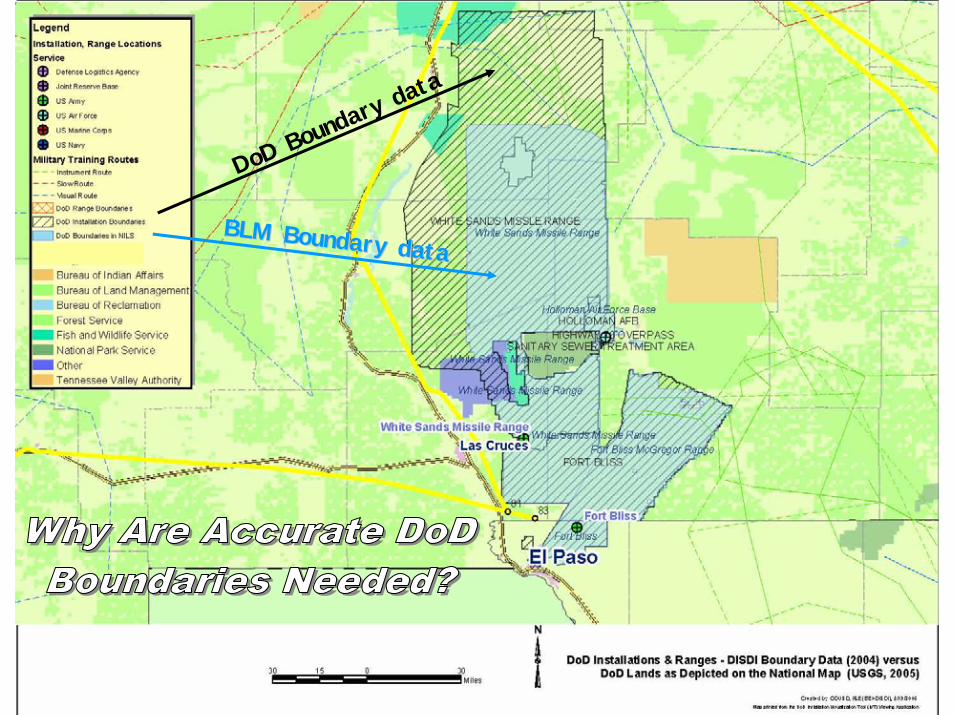
DoD Boundary
data
BLM Boundary dataBLM Boundary data

Acquisition, Technology and Logistics
26
EL Mapping & Reconciliation PilotEL Mapping & Reconciliation Pilot
Objective: Develop a department-wide Environmental Liabilities reconciliation process and standards to enable the Components to demonstrate completeness of the EL site recordsat each installation.
Approach: The pilot will establish and test the technical approach and work flow for the acquisition of EL geospatial data and reconciliation of EL sites to one or more real property assets (RPA), i.e. land parcels
RPI Site & Parcels
DERP Sites
Non-DERP Sites
ENVIRONMENTAL LIABILITIES

Acquisition, Technology and Logistics
27
What is an Environmental Liability?
• Environmental Liabilities (EL)– A Sub-set or Type of “ESOH Interest Area” as Defined in BEA 4.0
“An environmental liability is a probable and measurable future outflow or expenditure of resources that exist as of the financial reporting date for environmental cleanup costs resulting from past transactions or events.”
• EL Site Categories Are Defined in Guidance– Financial Management Regulation (FMR) Volume 4, Chapter 13– DUSD(I&E) Management Guidance for the Defense Environmental
Restoration Program (DERP)– DUSD(I&E) Guidance for Recognizing, Measuring, and Reporting
Environmental Liabilities Not Eligible for DERP Funding

Acquisition, Technology and Logistics
28
The Spatial Component of EL Sites
• EL Occur in Three Broad I&E Areas:
1. Real Property1. Real Property Have unique points, lines, Have unique points, lines, or polygonsor polygons YesYes
2. Facilities and 2. Facilities and EquipmentEquipment
Primarily associated with Primarily associated with building # or addressbuilding # or address
Yes & Yes & NoNo
3. Weapons 3. Weapons SystemsSystems
Primarily associated with a Primarily associated with a maintenance or storage maintenance or storage facilityfacility
NoNo
GeolocGeoloc..EL AreaEL Area Spatial ComponentSpatial Component in BEA?in BEA?

Acquisition, Technology and Logistics
29
Keys to Successfor the RPI and EL Mapping Pilot Project
• Contractors (3) provide weekly progress reports that communicateprogress made, % complete, issues requiring government resolution
• RPI and EL Mapping contractual ‘deliverables’ will be reviewed by Components during draft and final stages
• Strong need for good lines of communication between Real Property, Environmental and GI&S staff elements
• BEI to lead an “RPI Mapping Working Group” and an “EL Mapping Pilot Working Group”– Member from each Component– Forum for resolution of issues & questions, feedback conduit between
headquarters/contractor/staff/installation

Acquisition, Technology and Logistics
30
DISDI Data Sharing – Status & Trends
• DISDI has coordinated 22 data sharing exchanges over three fiscal years; dozens of requests redirected or maps provided instead
• No data has been (or will be) shared without permission of the Components; some data is already in public realm (e.g. IVT)
DISDI Data Request Elements:Purpose of request; requesting Agency’s project or requirement
Specific data types and installations/locations desired
Intended use of data
How requestor will limit further distribution
Technical specifications & POCs
DISDI Data Request Elements:Purpose of request; requesting Agency’s project or requirement
Specific data types and installations/locations desired
Intended use of data
How requestor will limit further distribution
Technical specifications & POCs
Most Requested Data
Installation & Range Boundaries
Installation/Facility Point Locations
Road Centerlines
Building Footprints
Critical Infrastructure Layers

Acquisition, Technology and Logistics
31
People, Technology, or Both?
Geo-Data Input
Geo-Data Storage
Geo-Data Output
Geo-Data Analysis
• What is the “right” data source – what sources are authoritative?– How can you tell? Organizational Hierarchy, METADATA, professional
standards
• How will the data be used – for what purpose?– Scale, accuracy, level of detail, map format, etc.– Is the data or analysis based on scientific rigor?
(“sound science,” documentation, peer review, etc.)
• It’s about both DATA and PEOPLE– Avoid “If we build, it they will come”– Audience? Goals? Information Culture?– Data Information Knowledge

32
DISDI Overview:Agenda
• Introduction to DISDI
• DISDI Governance
• DISDI Policy Agenda
• Supporting DoD Missions – RPI, EL, Data Sharing
• DISDI Architecture – Global Information Grid Integration
• Standards Alignment & Quality Assurance
• SDSFIE Update – Re-engineering the Standard
BREAK: 1000-1030 Imagery Stewardship – TEC IO
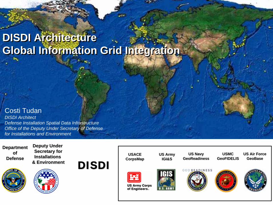
Acquisition, Technology and Logistics
DepartmentDepartmentofof
DefenseDefense
Deputy Under Deputy Under Secretary forSecretary forInstallations Installations
& Environment& Environment
US ArmyUS ArmyIGI&SIGI&S
US NavyUS NavyGeoReadinessGeoReadiness
USMCUSMCGeoFIDELISGeoFIDELIS
US Air ForceUS Air ForceGeoBaseGeoBase
DISDIDISDI
DISDI ArchitectureGlobal Information Grid IntegrationDISDI ArchitectureGlobal Information Grid Integration
Costi TudanDISDI ArchitectDefense Installation Spatial Data InfrastructureOffice of the Deputy Under Secretary of Defense for Installations and Environment
USACEUSACECorpsMapCorpsMap
Acquisition, Technology and Logistics
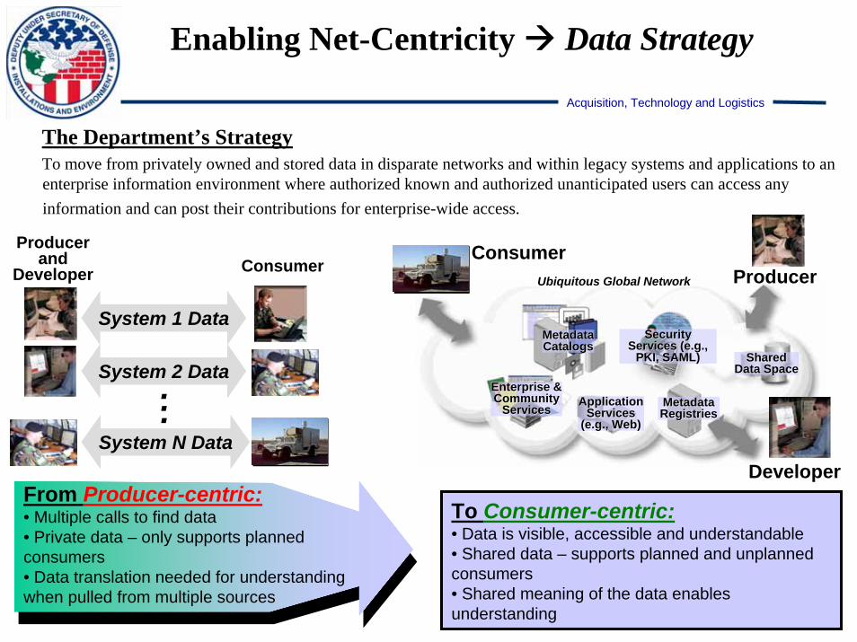
The Department’s StrategyTo move from privately owned and stored data in disparate networks and within legacy systems and applications to an enterprise information environment where authorized known and authorized unanticipated users can access any information and can post their contributions for enterprise-wide access.
To Consumer-centric:• Data is visible, accessible and understandable• Shared data – supports planned and unplanned consumers• Shared meaning of the data enables understanding
Enabling Net-Centricity Data Strategy
Ubiquitous Global Network
Metadata Metadata CatalogsCatalogs
Enterprise & Enterprise & Community Community
ServicesServices Application Application Services Services
(e.g., Web)(e.g., Web)
Shared Shared Data SpaceData Space
Metadata Metadata RegistriesRegistries
Security Security Services Services (e.g., (e.g.,
PKI, SAML)PKI, SAML)
Producer
DeveloperFrom Producer-centric:• Multiple calls to find data • Private data – only supports planned consumers• Data translation needed for understanding when pulled from multiple sources
ConsumerProducer
and Developer
System 1 Data
System 2 Data
System N Data
Consumer
...

Acquisition, Technology and Logistics
• The Net-Centric Data Strategy (signed May 9, 2003) is a key enabler of the Department’s transformation.
• DoDD 8320.2 (signed Dec 2, 2004) directs implementation of the Net-Centric Data Strategy.
• DoD 8320.2 – G (signed April 12, 2006) provides guidance for implementing the DoD Net-Centric Data Strategy.
• The Strategy provides the foundation for managing the Department’s data in a net-centric environment, including:
Ensuring data are visible, accessible, and understandable when needed and where needed to accelerate decision making“Tagging” of all data (intelligence, non-intelligence, raw, and processed) with metadata to enable discovery by known and unanticipated users in the EnterprisePosting of all data to shared spaces for users to access except when limited by security, policy, or regulationsOrganizing around Communities of Interest (COIs)Establish Communities of Interest to understand the nature of the change.
Strategic Guidance

Acquisition, Technology and Logistics
Data Sharing Responsibilities
Key Goal of DoD Directive 8320.2 Scope of Enterprise Role Scope of COI Role
Make data visible
Contextual Data
* Develop, maintain DoD Discovery Metadata Specification (DDMS) to facilitate DoD-wide search
* Direct development of Enterprise search capability
* Tag data holdings with DDMS
* Extend for COI specific search criteria
Make data accessible
Sharing Data
* Maintain repository of acceptable commercial standards for web-based services
* Direct development of federated service registry for web-services
* Implement access services* Register access services in
federated service registry
Make data understandable
Structural & Semantic Data Descriptions
* Direct development of federated metadata registry for semantic and structural metadata
* Develop vocabularies, taxonomies for data exchange
* Register these agreements in federated DoD metadata Registry
DepSecDef sees this as a DoD transformational priority !
DoD 8320.2 Directive, Data Sharing in a Net Centric Department of Defense
DoD 8320.2 Directive codifies DoD Net-Centric Data Strategy (DoD CIO)

Acquisition, Technology and Logistics
Enable Data to be Understandable
Metadata, metadata, metadata
Three types of metadata are relevant to DISDI:• Geospatial Data
– e.g. “This GIS file includes boundaries for Langley AFB”– How? FGDC metadata (CSDGM, ISO 19115)
• Services– e.g., “Use this web service to access boundaries for Langley
AFB”– How? OGC WMS, WFS, DDMS (Dod Discovery Metadata
Specification)
• Vocabulary and taxonomy– e.g., “I can access the boundary file for Langley AFB, but I
Acquisition, Technology and Logistics
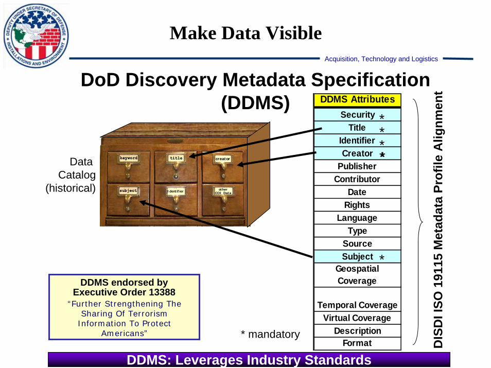
Make Data Visible
DDMS AttributesSecurity
TitleIdentifier Creator
Publisher Contributor
Date Rights
LanguageType
SourceSubject
Geospatial Coverage
Temporal CoverageVirtual Coverage
DescriptionFormat
DoD Discovery Metadata Specification (DDMS)
DDMS endorsed by Executive Order 13388
“Further Strengthening The Sharing Of Terrorism
Information To Protect Americans”
Data Catalog
(historical)
****
*
*
* mandatory
DDMS: Leverages Industry Standards
otherCOI Data
creator
Identifier
DIS
DI I
SO 1
9115
Met
adat
a Pr
ofile
Alig
nmen
t

Acquisition, Technology and Logistics
Make Data Accessible
• Documents– Use common formats– Store in shared spaces
accessible via URL• Systems
– For applications: Expose data via web services
• Web services = “API for the web”
– For end-user: Web-enable via browser or application
• Enablers– DISDI Portal– Expose map services
Acquisition, Technology and Logistics
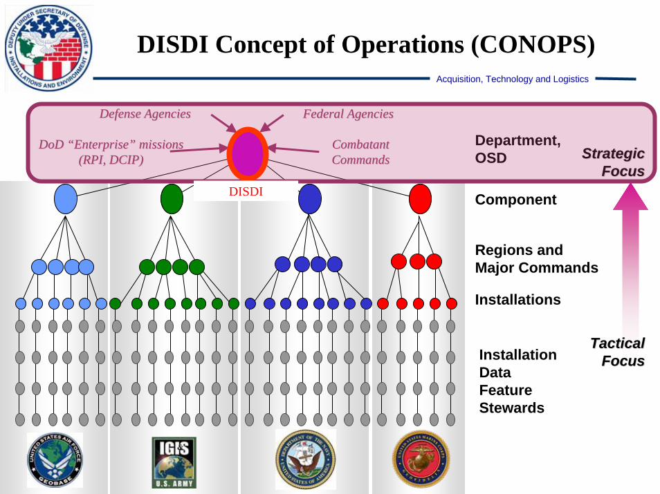
InstallationData FeatureStewards
Department,OSD
TacticalTacticalFocusFocus
StrategicStrategicFocusFocus
Regions andMajor Commands
Component
DISDI Concept of Operations (CONOPS)
DoD DoD ““EnterpriseEnterprise”” missions missions (RPI, DCIP)(RPI, DCIP)
Defense AgenciesDefense Agencies Federal AgenciesFederal Agencies
Combatant Combatant CommandsCommands
Installations
DISDI
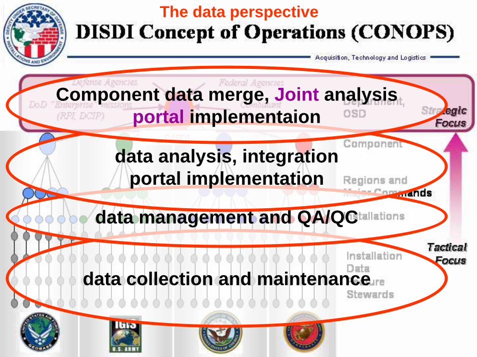
Acquisition, Technology and Logistics
data collection and maintenance
data management and QA/QC
data analysis, integrationportal implementation
Component data merge, Joint analysisportal implementaion
The data perspective

Acquisition, Technology and Logistics
The technology perspective
desktop GIS, GPS, fieldwork
desktop GIS, geospatial repositoryQA/QC, intranet map services
DB of record, development,metadata, portal implementation
DoD discovery, metadata, access,information assurance, portal implementation

Acquisition, Technology and Logistics
User Access Continuum
AF
USMC
Army
Navy
conn
ectiv
ity a
nd s
ecur
ity p
aram
eter
s MDRDoD Portal
…
MetadataRegistry
mer
ged
data
DISDIGeo-enabledApplications
disc
over
y an
d ac
cess
Specific
Joint
Unanticipated
Component assets
Merged pathways
Potential user pathways
Map Service Providers
Metadata and Service RegistriesSearch Engines and SOA Foundation
DoD Portal ApplicationsSOAF users
UNKNOWN USERSKNOWN USERS
Dat
aBas
esof
Rec
ord

Acquisition, Technology and Logistics
User Access Continuum
AF
USMC
Army
Navy
conn
ectiv
ity a
nd s
ecur
ity p
aram
eter
s MDRDoD Portal
…
MetadataRegistry
mer
ged
data
DISDIGeo-enabledApplications
disc
over
y an
d us
e
User Access
Specific
Joint
Unanticipated
Component assets
Merged pathways
Potential user pathways
Map Service Providers
Metadata and Service RegistriesSearch Engines and SOA Foundation
DoD Portal ApplicationsSOAF users
UNKNOWN USERSKNOWN USERS
Acquisition, Technology and Logistics
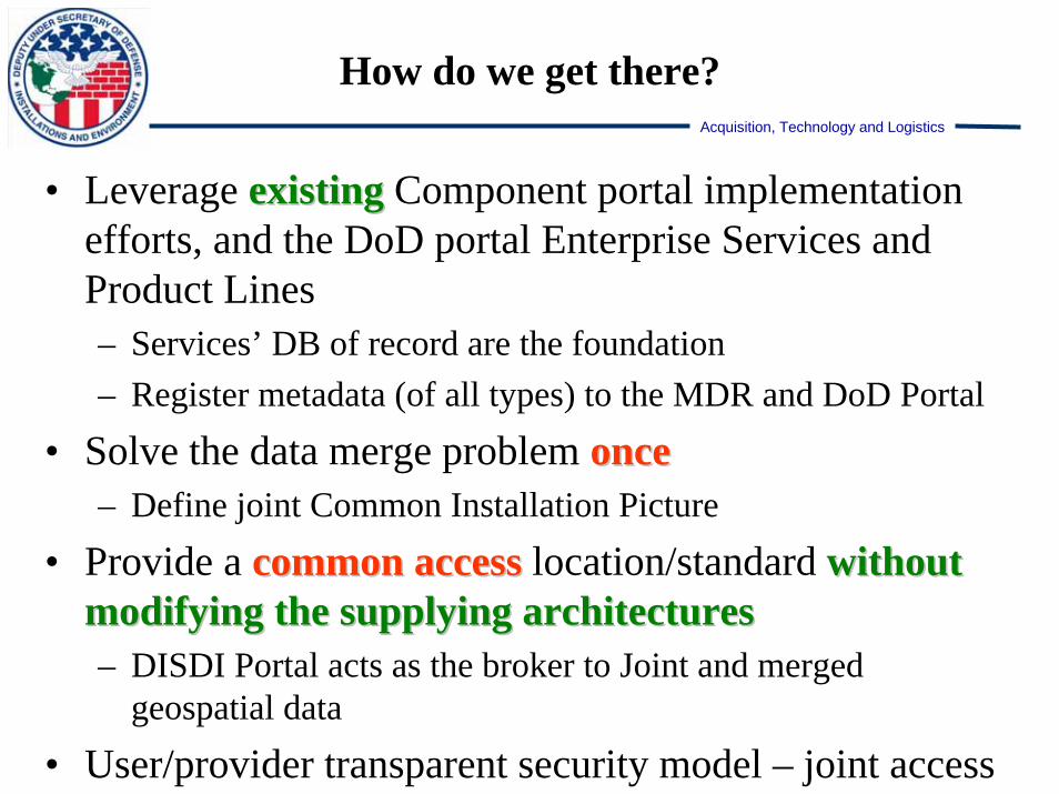
How do we get there?
• Leverage existingexisting Component portal implementation efforts, and the DoD portal Enterprise Services and Product Lines– Services’ DB of record are the foundation– Register metadata (of all types) to the MDR and DoD Portal
• Solve the data merge problem onceonce– Define joint Common Installation Picture
• Provide a common accesscommon access location/standard without without modifying the supplying architecturesmodifying the supplying architectures– DISDI Portal acts as the broker to Joint and merged
geospatial data
• User/provider transparent security model – joint access

Acquisition, Technology and Logistics
DoD Global Enterprise Services Portal Framework
Acquisition, Technology and Logistics
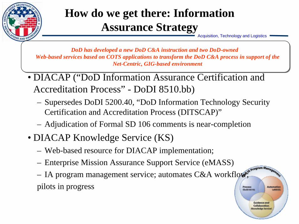
How do we get there: Information Assurance Strategy
DoD has developed a new DoD C&A instruction and two DoD-owned Web-based services based on COTS applications to transform the DoD C&A process in support of the
Net-Centric, GIG-based environment
• DIACAP (“DoD Information Assurance Certification and Accreditation Process” - DoDI 8510.bb)– Supersedes DoDI 5200.40, “DoD Information Technology Security
Certification and Accreditation Process (DITSCAP)”– Adjudication of Formal SD 106 comments is near-completion
• DIACAP Knowledge Service (KS)– Web-based resource for DIACAP implementation; – Enterprise Mission Assurance Support Service (eMASS)– IA program management service; automates C&A workflow; pilots in progress
Acquisition, Technology and Logistics
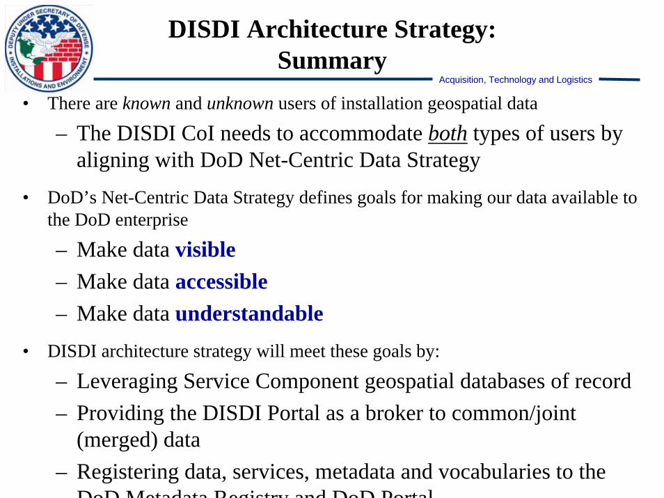
DISDI Architecture Strategy:Summary
• There are known and unknown users of installation geospatial data
– The DISDI CoI needs to accommodate both types of users by aligning with DoD Net-Centric Data Strategy
• DoD’s Net-Centric Data Strategy defines goals for making our data available to the DoD enterprise
– Make data visible– Make data accessible– Make data understandable
• DISDI architecture strategy will meet these goals by:
– Leveraging Service Component geospatial databases of record– Providing the DISDI Portal as a broker to common/joint
(merged) data– Registering data, services, metadata and vocabularies to the
DoD Metadata Registry and DoD Portal

49
DISDI Overview:Agenda
• Introduction to DISDI
• DISDI Governance
• DISDI Policy Agenda
• Supporting DoD Missions – RPI, EL, Data Sharing
• DISDI Architecture – Global Information Grid Integration
• Standards Alignment & Quality Assurance
• SDSFIE Update – Re-engineering the Standard
BREAK: 1000-1030 Imagery Stewardship – TEC IO

Acquisition, Technology and Logistics
50
DepartmentDepartmentofof
DefenseDefense
Deputy Under Deputy Under Secretary forSecretary forInstallations Installations
& Environment& Environment
US Army Installation US Army Installation Geospatial Geospatial
Information & ServicesInformation & Services
US NavyUS NavyGeoReadinessGeoReadiness
USMCUSMCGeoFIDELISGeoFIDELIS
DISDIDISDI
US Air ForceUS Air ForceGeoBaseGeoBase
Defense Installation Spatial Data Infrastructure:Defense Installation Spatial Data Infrastructure:Defense Installation Spatial Data Infrastructure:Geospatial Standards & Quality AssuranceGeospatial Standards & Quality AssuranceGeospatial Standards & Quality Assurance
John KochanowskiDISDI Standards Coordinator

Acquisition, Technology and Logistics
51
AgendaAgenda
• DISDI Standards Coordination - Primary Focus
• DISDI Geospatial Standards - Objectives & Progress– Standards Alignment
– Metadata
– Quality Assurance Planning

Acquisition, Technology and Logistics
52
DISDI Standards CoordinationPrimary Focus
1. Geospatial Data Standards & Content Strategies– Geospatial Data Alignment
• Spatial Data Standard for Facilities, Infrastructure, and Environment (SDSFIE)• National System for Geospatial-Intelligence (NSG)• Federal Geographic Data Committee (FGDC)• DoD Business Enterprise Architecture (BEA)
2. Geospatial Metadata Strategies– Developing a new geospatial metadata profile– Discoverable, Accessible, Understandable– Uniform Quantitative & Qualitative Measurements of Data
3. Quality Assurance Planning & Reporting– Establish CommonCommon Geospatial Data Quality Reporting– Maturing DoD User Community Expectations
Standards:Standards:Precursor to the Establishment of Quality AssurancePrecursor to the Establishment of Quality Assurance

Acquisition, Technology and Logistics
53
• DoD Business Mission Area Liaison for Geospatial Data Standards– Ensure new standard legitimately meets DoD enterprise data strategies
• DoD Net-centric Enterprise Data Strategy (DoD Directive 8320.2)• Business Enterprise Architecture (BEA)
• Geospatial-Intelligence Working Group (GWG) Coordination– Application Schema Feature Encoding (ASFE) Focus Group
•• Finalizing creation of an SDSFIE Technical PanelFinalizing creation of an SDSFIE Technical Panel• Support SDSFIE guidance, harmonization, and alignment with NSG Feature Catalog• Establish procedures for managing SDSFIE updates to the DoD IT Standards
Registry
• FGDC Alignment– Framework data standards – Metadata linkages
SDSFIE & DISDI Involvement

Acquisition, Technology and Logistics
54
Migrate Business Mission Area CSDGM Metadata to ISO 19115 AND support ALL DoD metadata reporting requirements with a new DISDI Metadata Profile
• DDMS• IVT• Army• Navy• Air Force• Marines• NGA• CSDGM
Metadata
DISDI Metadata ProfileDISDI Metadata Profile
IVT
Common Core
DDMS
Acquisition, Technology and Logistics
55
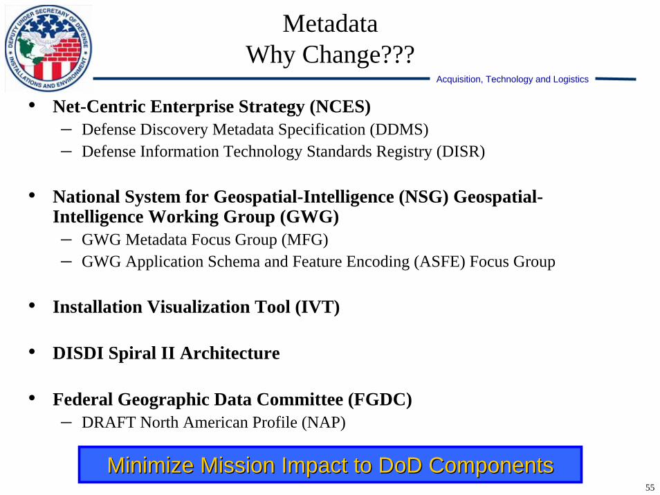
• Net-Centric Enterprise Strategy (NCES)– Defense Discovery Metadata Specification (DDMS)– Defense Information Technology Standards Registry (DISR)
• National System for Geospatial-Intelligence (NSG) Geospatial-Intelligence Working Group (GWG)– GWG Metadata Focus Group (MFG)– GWG Application Schema and Feature Encoding (ASFE) Focus Group
• Installation Visualization Tool (IVT)
• DISDI Spiral II Architecture
• Federal Geographic Data Committee (FGDC) – DRAFT North American Profile (NAP)
MetadataWhy Change???
Minimize Mission Impact to DoD ComponentsMinimize Mission Impact to DoD Components

Acquisition, Technology and Logistics
56
• DISDI Metadata Working Group– Established 27 Oct 06– Army, Navy, Air Force, Marine representation– Identified and drafted a set of standard metadata elements based on ISO
19115.
• DISDI Geospatial Metadata Profile Draft Specification– Scheduled comment review NLT 26 Jan 07– Three week Component review/comment – DISDI Geospatial Metadata Profile 1.0 to be delivered to DISDI Group
for approval NLT mid-March
• Next Steps– XML Schema Development– Translation Tools– Editor/Publishing Tool
MetadataStatus

Acquisition, Technology and Logistics
57
Bringing It All Together Bringing It All Together -- Quality Assurance PlansQuality Assurance PlansQAP… a specification based on a common set of authoritative guidelinesStandards-Based Data Requirements
– Content– Organization – Extent– Metadata
Collection Guidelines– Data Sources– Positional Accuracy– Content Accuracy
Certification, Acceptance, & Ownership– Validation Guidelines– Data Submission Requirements– Security Requirements
Quality Assurance Standards & Planning
Mission Mission AssuranceAssurance
QualityQualityAssurance`Assurance`
ArchitectureArchitecture
SustainmentSustainment
Initial Development To Begin in Initial Development To Begin in conjunction with DISDI Common conjunction with DISDI Common
Installation Picture (CIP)Installation Picture (CIP)
Standards:Standards:Precursor to the Establishment of Quality AssurancePrecursor to the Establishment of Quality Assurance

58
Questions?
The Defense Installation SpatialData Infrastructure (DISDI) Group