Biogeography ofthe vertebrates ofthe Cape Range peninsula ...

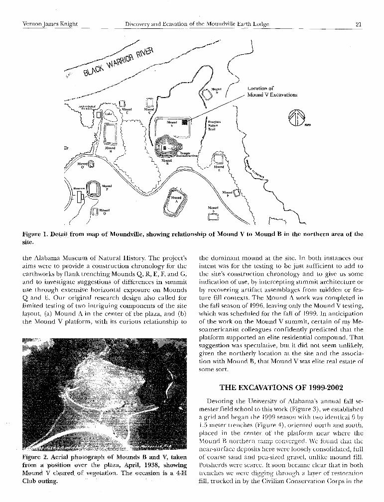
Discovery and Excavation of the Moundville Earth Lodge
Vernon James Knight
Department of Anthropology
University of Alabama
Box 870210
Tuscaloosa, AL 35487
ABSTRACT: Archeological investigations during 1999-2002 of the summit of Mound V at the Moundville site, Alabama,revealed a pair of large building foundations of single-set post construction conjoined by a tunnel entranceway definedby wall trenches. The more elaborate of the two buildings was square in plan and had extraordinarily large roof supports and an external embankment of clay. It is an example of the kind of building called earth lodges elsewhere inthe Southeast, a form previously unknown at Moundville. I discuss the discovery, excavation, architectural details, andevidence for dating these buildings to the Moundville III phase at ca. AD 1400-1500.
INTRODUCTION
Moundville, in west-central Alabama, is the largest ofthe Mississippian ceremonial centers in the Deep South,with more than 30 mounds arranged around a centralplaza (Knight and Steponaitis 1998:2-6). We are concerned here with architectural remains recently foundon the summit of Mound V at Moundville ArchaeologicalPark. Because it is not possible to address every aspectof these remains in this paper, I will concentrate on anaccount of the discovery and an outline of the main architectural elements.
Mound V is a broad, rectangular artificial platformthat adjoins the northern margin of Mound B, the tallestmound at Moundville (Figure 1). It is probably legitimateto think of Mound V as an apron of Mound B, intimatelyassociated with the dominant mound. Mound V measuresabout 140 by 70 meters in basal dimension, and is approximately 2.5 m thick in the main area of our work, nearthe northeast corner of the summit. The importance ofthe space is signaled by the fact that one of Mound B'stwo ramps ascends directly from the Mound V platformon the north, the other from the east. The only previous
Bull. Alabama Mus. Nat. Rist. 27:20-28
November 30, 2009
excavations at Mound V were by Clarence Moore in 1905(1905:141-142), who devoted "eighteen trial holes and 150feet of narrow trench" to the summit surface, finding noburials and few artifacts of interest to him. He did notethe presence of near-surface midden, a detail that wasimportant to us, as it suggested a residential use. A photograph taken from an airplane in April, 1938 of a Four-HClub outing to the Park (Figure 2) shows Mound V recently cleared of vegetation by the Civilian ConservationCorps. Its angular features are relatively well preserved. Aclose inspection of the photo, however, shows signs of erosion and gullying near the center. As with other moundsin the Park, the platform was to some degree "restored"in the late 1930s. Since then, about two dozen trees havebeen allowed to grow up on the summit while the areabetween them has been maintained in grass by mowing,resulting in a pleasantly shaded park-like area.
Our work at Mound V came at the tail end of a te11-"\i'earrun of field work called the Moundville Public Architecture Project, aided by grants from the University of Alabama and National Science Foundation, and abetted by
Vernon James Knight Discovery and Ecavation of the Moundville Earth Lodge
~.J(
)~V10U"d I Location ofo D I ~ Mound V Excavations
l
\~'f"~.''f,
~L.\~ ........
21
Figure 1. Detail from map of Moundville, showing relationship of Mound V to Mound B in the northern area of thesite.
the Alabama Museum of Natural History. The project'saims were to provide a construction chronology for theearthworks by flank trenching Mounds Q, R, E, F, and G,and to investigate suggestions of differences in summituse through extensive horizontal exposure on MoundsQ and E. Our original research design also called forlimited testing of two intriguing components of the sitelayout, (a) Mound A in the center of the plaza, and (b)the Mound V platform, with its curious relationship to
Figure 2. Aerial photograph of Mounds B and V, takenfrom a position over the plaza, April, 1938, showingMound V cleared of The occasion is a 4-HClub outing.
the dominant mound at the site. In both instances ourintent was for the testing to be just sufficient to add tothe site's construction chronology and to give us someindication of use, by intercepting summit architecture orby recovering artifact assemblages from midden or feature fill contexts. The Mound A work was completed inthe fall season of 1996, leaving only the Mound V testing,which was scheduled for the fall of 1999. In anticipationof the work on the Mound V summit, certain of my Mesoamericanist colleagues confidently predicted that theplatform supported an elite residential compound. Thatsuggestion was speculative, but it did not seem unlikely,given the northerly location at the site and the association with Mound B, that Mound V was elite real estate ofsome sort.
THE EXCAVATIONS OF 1999-2002
Devoting the University of Alabama's annual fall semester field school to this work (Figure 3), we establisheda grid and began the 1999 season with two identical 6 by1.5 meter trenches (Figure 4), oriented north and south,placed in the center of the platform near where theMound B northern ramp converged. We found that thenear-surface deposits here were loosely consolidated, fullof coarse sand and pea-sized gravel, unlike mound fill.Potsherds were scarce. It soon became clear that in bothtrenches we were digging through a layer of restorationfill, trucked in by the Civilian Conservation Corps in the

22 BULLETIN 27 November 30,2009
Figure 3. University of Alabama Department ofAnthropology Field school, Mound V, fall semester 1999.
Figure 5. Trench in the northeast sector of the Mound Vsummit at the end of the 1999 season, showing multiplepartially excavated features.
late 1930s to level and restore the eroded center portionofthe mound. Recognizing this, we abandoned these twotrenches and used a I-inch split core auger to prospectfor intact deposits elsewhere on the summit. Finding apromising locality on the northeast section, we set up athird trench measuring 10 by 1.5 meters, and spent therest of the 1999 term excavating it. Here, just below thehumus we encountered numerous intact features of various kinds (Figure 5). It was impossible to excavate and
Figure 4. One of two 1.5 by 6 m trenches dug in thecentral portion of Mound V during fall, 1999. The oneshown here was located near the base of the north rampofMoundB.
Figure 6. Alabama Museum of Natural History Expedition23, Moundville site, June 2001. This was one of fourExpedition 23 crews, consisting primarily of high schoolstudents.
Figure 7. Extent of Mound V excavations at the end of thesummer 2001 season, with Alabama Museum of NaturalHistory Expedition 23 crew.

Vernon James Knight Discovery and Ecavation of the Moundville Earth Lodge 23
~O~~iiiiiOi..E2~~3meters
entrance wall trenches
Structure 1 clay berm
.78R138
Key
exterior berm, Structure 1
main wall posts, roof supports,and entrance trenches
shallow dugouts surroundingwall posts and entrance trenches
fired clay floor remnants
superficial excavations
Figure 8. Plan of excavated area, northeast summit of Mound V, showing features associated with Structure 1 (the earthlodge) and adjacent Structure 2, with connecting tunnel entranceway bounded by wall trenches.
record all of these in the remaining time, so I chose todevote a second fall semester field school to this effortin the year 2000, excavating previously exposed featuresand expanding the 1999 trench in two places to the eastand west. By the end of the second season, however, wewere still left with unsolved puzzles. We had uncoveredparts of what seemed to be a much larger architecturalwhole that could not be interpreted from our narrow excavation window.
Not wishing to abandon this effort with so little understanding of it, I decided that we needed to continue witha larger effort. Fortunately, a large crew was available inthe annual Expedition program of the Alabama Museumof Natural History (Figure 6). I had worked with this organization before, and it suited our needs (and theirs)perfectly. Over a period of four weeks in the summer of2001, with an average crew size of about 30 per day, we expanded horizontally (Figure 7), primarily to the west butalso to the east and south. By the second week it becameclear that we had uncovered portions of two adjoiningbuildings, one of which was heavily earth-embanked andwhich featured a tunnel entranceway bounded by walltrenches.
Even so, at the close of the summer work, the Expedition crew had exposed and mapped numerous featurestains that remained unexcavated. Consequently I devoted the next fall semester's Department of Anthropology
field school to excavating pits and post holes within thearea already opened, completing the record of plan andprofile drawings, and collecting additional samples. Thiswork, which was undertaken in the fall of 2001, was primarily in the floor area of the embanked structure. Thesetasks, however, proved greater than I anticipated, whichmeant devoting yet another field school to the same workin the fall of 2002, after which we could finally bring closure to the excavations with some understanding of thedeposits.
In this manner, after five episodes ofexcavation spreadover four years, we had exposed the architecture shownin plan view in Figure 8. To the west, we have the northeast corner of a building surrounded by a massive earthembankment, featuring heavy roof supports and a tunnelentranceway-characteristics identified in the past withbuildings called "earth lodges" in the Southeast. To theeast, we had intercepted portions of the west and northwalls of a second building, directly connected to the firstby the entranceway. We will refer to the embanked building as Structure 1, and to the building to the east of it asStructure 2. Both were built essentially at ground level onthe Mound V summit as it existed at the time. Althoughthe embanked Structure 1 has a floor that was somewhatdished out toward the center, it was not built within a discrete excavated pit.

24 BULLETIN 27 November 30,2009
Figure 9. The east berm of Structure 1, looking north,summer 2001. This was an exterior embankment ofcompact tan-orange sandy day. The wall trenches of thetunnel entranceway, crosscutting the berm, are seen in theforeground.
STRUCTURE 2Let us first describe Structure 2, to the east, whose
western wall was encountered by our initial trench in1999. This was a rectangular building with rounded corners,of "single set post" construction (that is, with individually-dug post holes) and with daubed walls. The apparent confusion ofwall posts seen in plan view is mainlydue to the fact that Structure 2 was rebuilt in place. Foreach of its incarnations, wall posts were set about 70 emapart center-to-center. The post holes averaged 20 em indiameter and were rather deeply set, about 58 em belowthe floor level. Two exceptional post holes, perhaps corner posts, were set much more deeply at 106 to 107 embelow the floor level. The daub along this wall line hasa gritty exterior finish, and interior impressions showthat it was applied against split cane lath-work (Sherard,this volume). When posts were pulled for renovation, asthey were at least twice, the post holes were deliberatelyplugged with brightly colored clean clay-yellow in oneinstance and orange in another-such that these postholes are virtually color-coded by construction episode.The upper portions of these posts are surrounded on allsides by broad, irregular dugouts, filled with midden. Although these dugouts appear to be trench-like in planview, these are in no sense conventional wall trenches. Iinterpret this as a connected series of crude extractionpits, dug around the bases of standing posts for the purpose of pulling them.
The floor of Structure 2 was initially paved with a thicklayer of clay, laid down when wet. At least in some areasnear the wall, this clay floor was fired in place, probablywhen an early version of the building burned. Subsequently the baked areas became much broken up and distorted, perhaps by foot traffic, such that remnants of theoriginal clay floor were preserved only in spots. Where
Figure 10. Excavated area of Structure 1 (the earth lodge),looking east, fall semester 2002. The large feature visiblein the center is the bisected post pit of the northeast roofsupport, Structure la. The largest circular feature to theright is the northeast roof support of Structure '1 b.
the wall dugouts intersected the baked floor areas, thedugouts cut through and therefore postdate the floor.A second, larger zone of baked clay floor was preservednorth ofStructure 2 in areas marginal to our excavation. Iam unsure of the purpose of this patio-like surface and ofthe circumstances which caused it to be heavily baked.
STRUCTURE 1
Turning our attention to Structure 1, we found that itwas surrounded by a loaf-shaped berm ofwell-compactedtan-orange sandy clay (Figure 9), that sloped both to theinterior and to the exterior. This berm was about 2.7 mwide and rose 60 em above the floor level. It was originally higher, having been truncated at the top by modernactivity. We found that the berm slopes were gullied inplaces, showing that it had been exposed to the elementsbefore the addition of dark brown midden-like depositsthat covered its interior and exterior flanks. The bermwas interrupted by a tunnel entranceway flanked by narrow wall trenches about 57 em apart. Not indicated in ourplan drawing (for risk of confusion) is the fact that thereare actually two superimposed sets of entrance trenchespertaining to two successive buildings of Structure 1 inthe same place.
Our work in the northeast corner of Structure 1 (Figure 10) revealed two superimposed floor levels. The firstversion, which we will call Structure la, did not burn, butwas dismantled after a period of use. Afterward a cleanlayer of fill 15 to 20 em thick was laid down over the floor,and the second version, Structure Ib, was built in place.At some point this second version burned fiercely, result"ing in thick piles of daub rubble and charred bits of roofbeams strewn across the floor area. The fire was suffi-

Vernon James Knight Discovery and Ecavation of the Moundville Earth Lodge 25
Figure 11. North wall line, Structure 1. The main rowof post holes is shown, with shallow dugouts surrounding the posts. A separate line of shallow post holes orindentations for leaner posts appears just to the left ofthe main wall line.
ciently intense to produce silica froth, a gray vesicularglass formed by the melting and fusion ofsilica phytolithsin grass and cane structural elements (Sherard 2001).
The main wall line thus incorporates post holes pertaining to both buildings (Figure 11). When Structure lawas dismantled, a certain amount of digging was donearound the bases of the posts to dislodge them, resultingin midden-filled dugout areas similar to those of Structure 2, but not quite so extensive. The post holes, spacedabout 50 cm apart center to center, averaged 28 cm in diameter and 74 cm deep. They were not vertical, but rather sloped inward from bottom to top toward the center ofthe building at a very slight angle of about 9 degrees fromplumb, reminiscent of the sloping wall posts of the earthlodge found beneath the main mound at Town Creek,North Carolina (Coe 1995:65-72). This was undoubtedlya weight-bearing wall that supported a horizontal plate.Charred bits of pine wood (Tickner, this volume) from
the wall posts of Structure Ib were frequently encountered in the post holes. As Structure Ib burned, the wallfell inward on both the northern and eastern sides, leaving a continuous ridge of daub rubble just interior to thewall line.
In addition to the main wall line, there was a second rowofsmall indentationsjust exterior to it, set into the base ofthe clay berm. These indentations-one can hardly callthem post holes-were so shallow and so ephemeral thatat first we did not believe they could be structural members. In Figure 8, they are shown as small open circles adjacent to the main north and east wall lines. On inspecting these indentations, my colleague Richard Krause,who has first-hand knowledge of earth lodge excavationsin the Plains, recognized these as "leaner posts," homolo-
Figure 12. Bisected post pit for Structure la roof support (Feature 49b), view to the east. The post insertio~
and extraction ramp occupies the foreground. At thebase was a circular indentation 65 cm in diameter,marking the size of the post. Charred remnants of woodfound at the base of this feature show that the post was
pine, as was the adjacent roof support forStructure 1b.

26 BULLETIN 27 November 30,2009
gous with the outermost wall posts of Plains earth lodgesagainst which the sad is embanked.
Daub recovered from the collapsed northern and eastern wall lines revealed a very different patterning thanthat seen in Structure 2 (Sherard, this volume). Thehand-smoothed exterior surfaces here differed from thegritty-textured surfaces of the adjacent structure. More interesting from an architectural standpoint was that wholecane rather than split cane formed the horizontal lathing of this wall. Apparently bundles of two to three wholecanes were tied at close intervals to the main wall posts,and heavily grass-tempered daub was built up around thisframework to form the wall. The daub-plastered interioreast wall was painted in red and white, using pigmentedclay slips. We cannot know what the overall painted pattern was like, except to say that red and white painted areas were relatively large. Fragments of daub showing theconjunction of both colors also occurred.
Daub rubble was also found well to the interior of thecollapsed walls, evidently having fallen from the underside of the roof. This daub, in contrast to the wall daub,tended to show the impressions of split cane lathing, presumably bound to the interior roof to provide a fireproofcoating of hand-smoothed clay plaster.
The roof was held up by interior support posts (Features 36 and 49b in Figure 8), almost certainly four innumber, each situated near a building corner. These werelarge. Shown in Figure 12 is one of the primary roof supports for the initial version of Structure 1. This post hole,Feature 49b, lies at the base of a broad insertion pit whichwas later re-excavated as an extraction pit, a distinctionthat is clear in profile view. The post pit is somewhat morethan two meters deep, and it bears a compact impressionat the base which gives us the diameter of the post itself:65 em. This tree-sized post, I suggest, is a case of over-engineering, meant to impress. The species is identified asyellow pine (Tickner, this volume) from remnant charredfragments present at the base. An intriguing architectural fact is that this post, like the main wall posts, leaned inward toward the center of the building at an angle of fourdegrees from plumb. The fill of the post pit contained
unusual inclusions of tiny, round pellets of copper, whichmust have had a symbolic significance. The roof supportfor the corresponding rebuilt version (Feature 36, Structure Ib) was smaller, 51 em in diameter, with its own insertion pit. It was placed about 1 meter interior to its predecessor. As a result of the burning of the replacementstructure, the butt of the smaller roof support post (alsoyellow pine) was partially preserved in place.
Figure 13. Gradiometer image of the unexcavatedportion of the Structure 1 area, with excavation plansuperimposed. Tick marks are at 5 m intervals. The surrounding clay berm has a negative magnetic signatureand shows as a light-colored square, interrupted by aprobable second entranceway to the west. Piles of fireddaub lying on the interior floor have a positive magneticsignature and show as black. A contrasting black andwhite "dipole" near the center marks the probable location of the hearth. Image courtesy of Jay Johnson andBryan Haley, University of Mississippi.
Table 1. Radiocarbon dates from the Mound V excavations.
Sample No. Sample Description Radiocarbon 13Cj12C Conventional 2 SigmaAge Ratio % Radiocarbon Age Calibration
Beta-161959 Feature 8. Pocket of wood chamal 620 ± 60 BP -26.7 590 ± 60 BP AD 1290 - 1430within fill of east berm. Structure 1.
Beta-161960 Feature 14. Charred wood from 570 ± 60 BP -24.8 570 ± 60 BP AD 1290- 1440corner post of Structure 2.
Beta-161961 Charred wood from roof beam, 250 ± 60 BP -25.7 240 ± 60 BP AD 1500 - 1690Structure Ib, Unit 79R125.
Beta-161962 Feature 33. Charred wood from 550 ± 60 BP -25.7 540 ± 50 BP AD 1300 - 1440roof support post, Structure lb.

Vernon James Knight Discovery and Ecavation of the Moundville Earth Lodge 27
Our excavations were insufficiently broad to determine the size of Structure 1. In consequence, we useda 1" split core auger to locate the crest of the exteriorberm to the west and south. Better still, we were favoredby a visit fromJ~'YJohnson and Bryan Haley of'the Centerfor Archaeology at the University of Mississippi, who applied four different remote sensing technologies along agrid in the unexcavated area: ground-penetrating radar,soil resistivity, magnetometry, and gradiometry. Becauseof the strong magnetic signature produced by daub, theyobtained their best results using a fluxgate gradiometer(a Geoscan FM 36). The gradiometer image (Figure 13),with our excavation plan superimposed, reveals a greatdeal. The piles of fired daub on the floor of the building show as an area of mostly positive magnetic readingswhich appear as dark patches, mixed with some negativereadings which show as lighter patches. As in the excavated area, we can see that concentrations of daub rubbleoccur both along the wall line and also to the interior,where the daub must represent roof fall. The wall daubappears to be heaviest along the northern margin of thebuilding. The central hearth is indicated by a "dipole," aspot near the middle of the structure where stark positiveand stark negative magnetic readings are juxtaposedrendered as white against black. The top of the clay bermshows up clearly as a square outline with a relatively negative magnetic signature, light in tone, confirming thatit is made of homogeneous material with low magneticsusceptibility. One of the nicest features of this image isthat it shows a break in the western berm correspondingto the one excavated in the eastern berm-almost certainly a second tunnel entranceway on the west side. It isnoteworthy that both entranceways are off-center. Withthis image we can verify that the building is square, andthat the floor as marked by the main wall lines is approximately 11.1 m in diameter, giving a floor area of about123 square meters. This is large for an earth-embankedbuilding in the Southeast, the only comparably big example being the earth lodge at the Macon Plateau site incentral Georgia (Fairbanks 1946).
As for interior features we have only a few indicationsin the small excavated area. Two oval pits originating atthe level of the second structure floor resembled burial pits but contained no human bone. One of these didyield unusual artifacts-a triangular arrow point of clearcrystal quartz and a large, white-painted clay bead. Bothpits were open at the time of the burning, and the largerof the two pits contained water-sorted sand and silt below the burned debris that could only have accumulatedfrom a breach in the roof. Based on these circumstancesand the lack of any artifacts on the floor, it is my impression that the burning of Structure Ib was deliberate, andthat skeletal remains may have been exhumed from theirsub-floor burial pits just prior to the burning.
CHRONOLOGY, ARCHITECTURAL STYLE,AND FUNCTION
The stratigraphy of the area shows that following thefire that destroyed Structure Ib, humic, midden-like fillwas added to the Structure 1 area to even out the pilesof fired daub and the surrounding berm. This was followed in succession by the addition of a layer of cleanyellow clay, perhaps over the whole locality, although dueto modern truncation it was apparent only to the east ofthe berm. This activity produced a locally mounded areaon the Mound V summit, a rise noticed by C. B. Mooreand shown on an unpublished topographic map made inthe 1930s. Following that, there was yet another middenproducing episode superimposed on the mounded area,about which we know little except for limited evidence ofa final structure indicated by yellow clay-filled post holeson top of the mounded surface.
All of this activity, start to finish, was late in the Moundville sequence. Three calibrated radiocarbon dates oncharred wood obtained from a post hole in StructureIb, a mass of charcoal in the east berm, and a post holein Structure 2 are in close agreement in suggesting construction early in the 1400s (Table 1). Although the pottery has been analyzed, the data remain unreported todate. The diagnostics indicate use during the MoundvilleIII phase, consistent with the radiocarbon dates. The pottery in the upper fills overlying the burned remains includes sherds of the type Alabama River Applique andcertain other Protohistoric diagnostics, suggesting a finalabandonment of the locality around AD 1500.
The architectural style of these remains is South Appalachian Mississippian and was heretofore unknown atMoundville. No earth lodges have been previously reported for the state of Alabama, although several are knownfrom neighboring Georgia, eastern Tennessee, and western North Carolina. The significance of this fact is notobvious, but the sudden appearance of foreign architecture at a time when Moundville was a vacant ceremonialcenter and a regional necropolis adds a curious detail tothe circumstances of Moundville's decline and eventualcollapse (Knight and Steponaitis 1998:21-24). Regarding the function of the Moundville structures reportedhere, we know that they were ceremonially important,from their location, from details of their construction,and from evidence of commemorative ritual activity following their deliberate dismantling and destruction. Regarding more specific questions, a key one being whetheror not Structure 1 served as a council house, I will haveto reserve judgment pending a full analysis of the associated artifacts and comparison with elite assemblages elsewhere at the site.

28 BULLETIN 27
APPENDIX: THOSE WHO DID THE WORK
November 30, 2009
VA Department of Anthropology Field School, Fall Semester 1999Undergraduates: Jessica Baggett, Melissa Baggett, Charlotte Bohrer, Howard Davidson, Brian Hand, Lori Harris,Kareen Hawsey, Amanda Ingram, ShannonJames,Jennifer Keeling, Shannon Koerner, Melina McConatha, AnnPearson, Brannon Queen, John Simmer, David Wendlek,Kelly Whatley, Katherine Williams.Graduate Assistant: Katherine McGhee-Snow
VA Department of Anthropology Field School, FanSemester 2000Undergraduates: Tracy Allen, Jeffrey Brown, Leigh Elgin, Elizabeth Forward, Sharon Freeman, Becky Pitts,JeffSherard, Stephnie Weinstein,Josh Willingham.Graduate Assistant: Tom Lewis
Alabama Museum of Natural History Expedition 23,June 2001Week 1: Emily Bailey, Davis Burleson, Jennifer Cobb,James Dwyer, Charles Ebert, Wyline Ebert, James Elliott,Patricia Elliott, Chris Hamilton, Amber Harrison, AprilKirk, Michael Picone, Benjamin Picone, Locke Provost,Reba Redd.
Week 2: Barbara Beaman, Andrew Bernard, Erin Camp,Joyce Crenshaw, Jan Delgehausen, L.E. Delgehausen, Avery Driggers, Lona Hawkins, Jamie Hill, Douglas Jones,RalphJones, Susie 1. Lanier, Kristen Lomax, Richard Lomax, Beth Newman, Glen Newman, Locke Provost,JuneRitchey, Krista Truscott, Lauren Woernle, Darrell Woodall.
Week 3: Elliott Alford, Barbara Beaman, Michael Bricknell, Stephen Bricknell, Cabot Brown, Rush Bruson,JulieCole, Michael Finnell, Amanda Harbin, Kamrehn Harvey, Mary Harvey, Whitney Harvey, KathyJoseph, CharlesMunoz, Jesse Munoz, Bryan Poe, Billy Shaw, Marcia Veal.
Week 4: Katie Anderson, Joe Anderson, John Anderson, Maiben Beard, David Blum, Belinda Brown, CallanDeRamus,Matt Durham, Suzanne Flynn, Kathleen Hilt,Angela Mayfield, Will Morrison, Neil Pinkerton, MalindaPowers, Craig Reinhart, Anna Rich, Emily Taff, Lila Taff,Philip Taff, Joe Thompson, John Thornhill, Vera Welsh,Daniel Wise.
Staff: Brian Rushing, Bob Pasquill, Rosa Newman, JohnHall, Collins Davis, Anne Halli, Monica Newman,JordanSandlin, Walter Gowan, Jeff Sherard, Philip Donley, Brian Montabana, Julie Markin
VA Department of Anthropology Field School, Fan Semester 2001Undergraduates: Charles Burns, Dereik Edwards, PatrickMann, Robin Newborn, Michael StevensGraduate Assistant: Jennifer Myer
UA Department of Anthropology Field School, Fall Semester 2002Undergraduates: Jamie Boyd, Emily Brewer, Daniel Bridges, Michael BUjalski, Elizabeth Collier, Michael Dockens,Jennifer Elliott, Alex Medicus, Susan Olin, Natalie Porter,Paula Simmons, Jeffrey Whatley.Graduate Assistants: Steve Barry, Jennifer Myer.
REFERENCES CITED
Coe, Joffre L. 1995. Town Creek Indian Mound: A Native AmericanLegacy. University of North Carolina Press, Chapel Hill.
Fairbanks, Charles H. 1946. The Macon Earth Lodge. AmericanAntiquity 12:94-108.
Knight, Vernon j., Jr., and Vincas P. Steponaitis. 1998. A NewHistory of Moundville. In: Archaeology of the MoundvilleChiefdom, edited by V. j. Knight, Jr., and V. P. Steponaitis, pp.1-25. Smithsonian Institution Press, Washington, D.C.
Sherard, Jeffrey L. 2001. Burning Down the House: TheInterpretation of Slag-Like Material Remains Recoveredfrom an Earth Lodge Structure Located on Mound V atthe Moundville Site. Paper presented at the 58th annualmeeting of the Southeastern Archaeological Conference.Chattanooga, Tennessee