
Disaster Risks in Ayeyarwady Delta, Irrigation and Flood ... · Irrigation and Flood Protection....
31
Disaster Risks in Ayeyarwady Delta, Irrigation and Flood Protection.
Transcript of Disaster Risks in Ayeyarwady Delta, Irrigation and Flood ... · Irrigation and Flood Protection....
Disaster Risks in Ayeyarwady Delta,
Irrigation and Flood Protection.

CLIMATIC CONDITION
6/13/2017
Seasons
o Summer March to mid-May
o Monsoon mid-May to end of October
o Cold November to end of February
Temperature
Changing 34 to 43 °C during summer and
10 to 16 °C during winter in the different localities
Precipitation
o northern part 2000 - 3800 mm
o middle dry zone less than 760 mm
o delta regions 2030 - 3050 mm
o coastal areas more than 5000 mm

Disaster outbreak in Myanmar (2000 to 2012)
several natural hazards
cyclones, earthquakes, floods, fires, tsunamis and landslides,hit periodically .
floods in the Ayeyarwady Region is 16% of the disasters.
MYANMAR
INDIA
BA
NG
LA
DE
SH
CHINA
THAILAND
BAY OF
BANGAL

Recent major disasters
Earthquake in Taungdwingyi ( M: 6.8 RS) , 2003 , loss of live = 7
Indian Ocean Tsunami, 2004, loss of live = 61
Cyclone Mala, 2006, loss of live = 37
Cyclone Nargis, 2008, loss of live and missing = 138373
Earthquake in Bagan, (M: 6.8 RS), 24.8.2016, loss of live = 4, 397 temples
damaged.

Ayeyarwady Delta (Region) Over view
• a shape of a triangle, flared to the sea.
• North to south - 288km
• East to west - 240km
• a stretch of flat plain
• over 35000 sqkm , 3m above MSL
• ≈ 320 sqkm , lower than spring tide
• Land slope - 0.00005
• Max discharge at apex -32600m³/sec
• Sediment transport -180 mil ton/year
• Progress rate of Delta -49m/year
• population - 6.18 mil

6
Fresh and saltwater,- depose sediment with nutrients, transformed into fertile & fragile delta
Salinity- influencing growth and distribution of plants
Mangroves - characteristic forest type, buffer to storm surge, provide ideal nursery groundsfor fish and wildlife species.
supports over 6 million people and produces ≈ 60% of country’s rice production Private prawnfarms and deforestation - destroyed the delta environment.
Estuaries
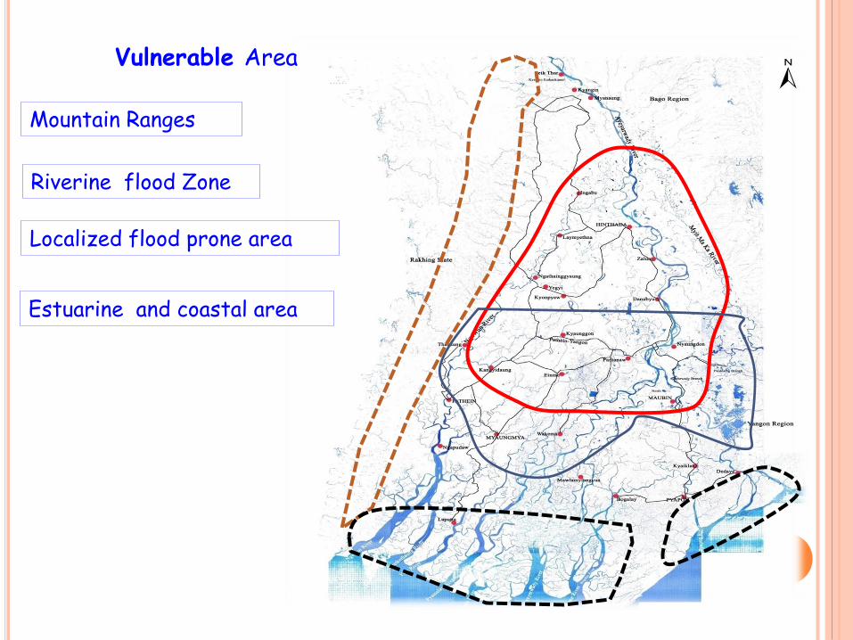
Vulnerable Area
Mountain Ranges
Riverine flood Zone
Localized flood prone area
Estuarine and coastal area

Sedimentation
Rivers are active with bank erosion, emergence of sand bars progressively high
Bridge construction and other development activities obstruct the river flow, that
process instigate the sediment deposition in the lower delta.
Changes of river flow pattern by the climate change impact comes high sedimentation
and make worse the river deterioration .
increase suspended load (Deforestation , Gold/ mineral/ Gem and precious stone
extractions, Dam and storage reservoir construction)
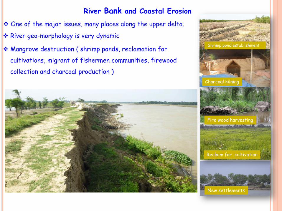
River Bank and Coastal Erosion
One of the major issues, many places along the upper delta.
River geo-morphology is very dynamic
Mangrove destruction ( shrimp ponds, reclamation for
cultivations, migrant of fishermen communities, firewood
collection and charcoal production )
Reclaim for cultivation
Shrimp pond establishment
Charcoal kilning
Fire wood harvesting
New settlements

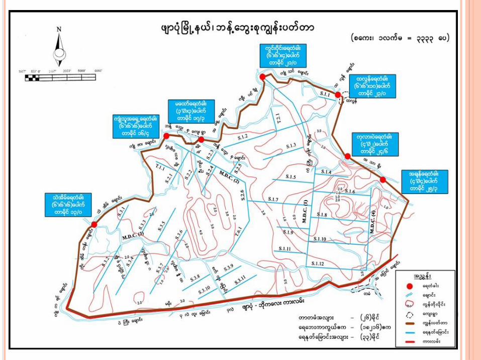
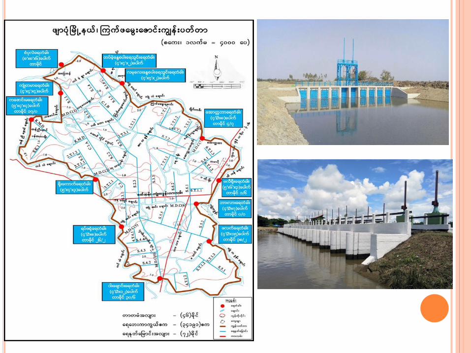
Location of Storage Reservoirs in Ayeyarwady Region
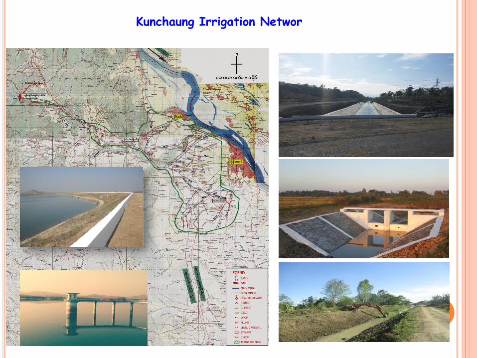
Kunchaung Irrigation Networ

Nankathu Irrigation Network

Floods and inundation
Causes of flooding in the AYD delta
The coincidence of high flows in the upper rivers cause to be big floods in Ayd delta.
Flash floods come from the western ranges.
The effect of tides instigate the river flood high..
The heavy intensive rain cause trouble upon trouble.
Upp
er
flow
Tide from the sea
Local rainfall
HISTORICAL INFORMATION OF DIKES IN MYANMAR
River dikes were constructed along the Ayeyarwady river, Sittaung river and
Ngawun river since 19th century.
The major river dikes, western Ayeyarwady Embankments, eastern Ayeyarwady
Embankments, Ngawun Embankments, Sittaung Embankments and Bago
Embankments, and these were constructed between 1860s and 1880s.
The British engineers designed , constructed the urban dikes along the
Ayeyarwady and Ngawun river, during colonial era.
Urban dikes were also constructed continuously in town area along the
Ayeyarwady and Ngawun river.
Dikes were reconstructed and improved from time to time as the river regime
is changing yearly.

CROSS SECTION OF THE EMBANKMENTS
All the dikes in Myanmar are earthen
dikes without facing any materials.
Nowaday, key trench is provided in dike
construction .

Sr.
no.State/Region
Flood Protection Sea water Protection Total
Remark
no. Length
(mile)
Protected
Area
(acre)
no. Length
(mile)
Protected
Area
(acre)
no. Length
(mile)
Protected
Area
(acre)
1 Kayin 2 1.360 2372 - - - 2 1.360 2372
2 Sagaing 6 49.090 42146 - - - 6 49.090 42146
3 Tanintharyi - - - 14 54.320 10754 14 54.320 10754
4 Bago 39 387.400 515907 - - - 39 387.400 515907
5 Magway 1 1.500 1160 - - - 1 1.500 1160
6 Mandalay 2 10.989 5649 - - - 2 10.989 5649
7 Naypyidaw 5 17.040 16956 - - - 5 17.040 16956
8 Mon - - - 18 50.190 20536 18 50.190 20536
9 Rakhine - - - 32 207.890 79584 32 207.890 79584
10 Yangon 19 101.280 78481 22 234.050 203489 41 335.330 281970
11 Shan 1 41.000 - - - - 1 41.000 -
12 Ayeyarwady 29 733.535 1356101 35 583.400 339177 64 1316.935 1695278
104 1343.194 2018772 121 1129.850 653540 225 2473.044 2672312
Dikes under the care of Irrigation Department
Total length of dikes - 3975 kmTotal Protected area - 1077545 ha
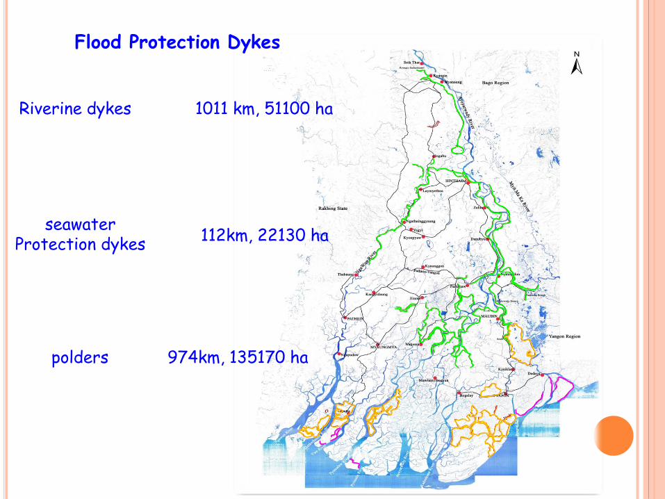
1011 km, 51100 ha
112km, 22130 ha
974km, 135170 ha
Flood Protection Dykes
Riverine dykes
seawaterProtection dykes
polders

1974, HE at 47.5ft (Htd G)
1991, NE at 47.4ft (Htd G)
1997, NE at 47.6ft (Htd G)
2007, NE at 46.05ft (Htd G)
Dyke Breakages
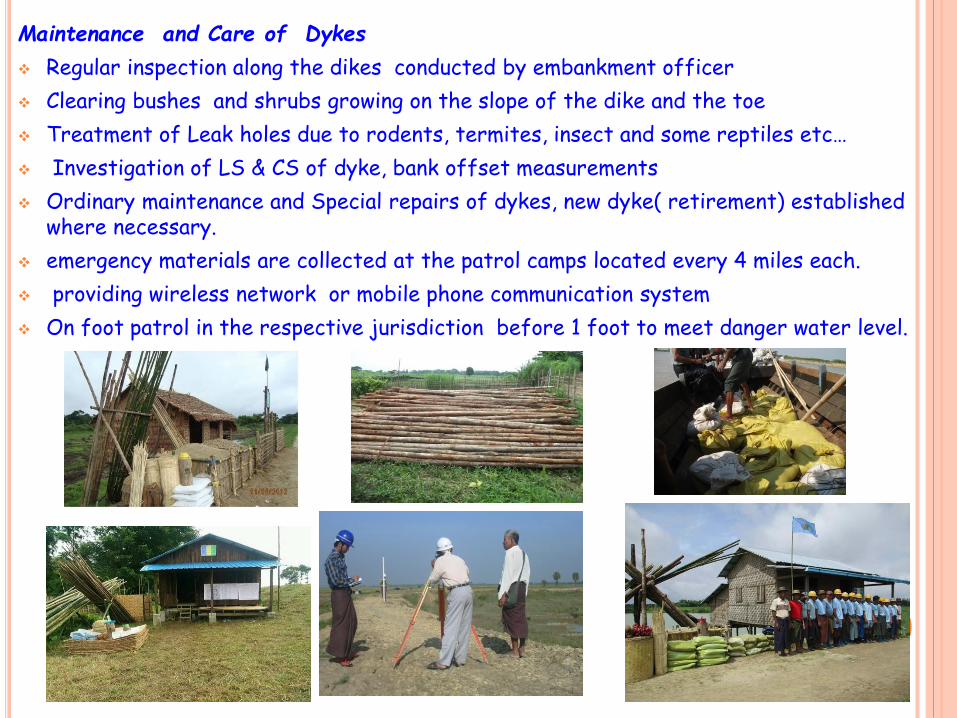
Maintenance and Care of Dykes
Regular inspection along the dikes conducted by embankment officer
Clearing bushes and shrubs growing on the slope of the dike and the toe
Treatment of Leak holes due to rodents, termites, insect and some reptiles etc…
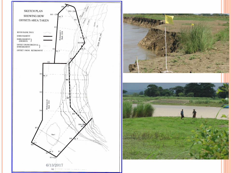
Investigation of LS & CS of dyke, bank offset measurements
Ordinary maintenance and Special repairs of dykes, new dyke( retirement) established where necessary.
emergency materials are collected at the patrol camps located every 4 miles each.
providing wireless network or mobile phone communication system
On foot patrol in the respective jurisdiction before 1 foot to meet danger water level.
6/13/2017

Patrol chart for care of dykes in flood period
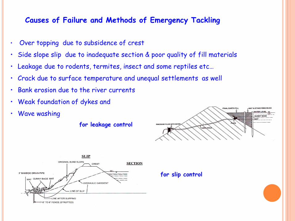
Causes of Failure and Methods of Emergency Tackling
• Over topping due to subsidence of crest
• Side slope slip due to inadequate section & poor quality of fill materials
• Leakage due to rodents, termites, insect and some reptiles etc…
• Crack due to surface temperature and unequal settlements as well
• Bank erosion due to the river currents
• Weak foundation of dykes and
• Wave washing
for leakage control
for slip control
6/13/2017
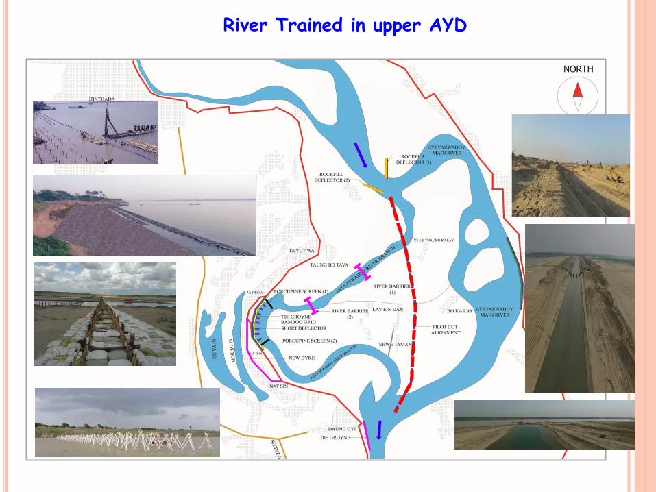
River Trained in upper AYD
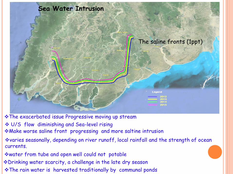
Sea Water Intrusion
The saline fronts (1ppt)
The rain water is harvested traditionally by communal ponds
U/S flow diminishing and Sea-level risingMake worse saline front progressing and more saltine intrusion
water from tube and open well could not potable
Drinking water scarcity, a challenge in the late dry season
varies seasonally, depending on river runoff, local rainfall and the strength of ocean currents.
The exacerbated issue Progressive moving up stream
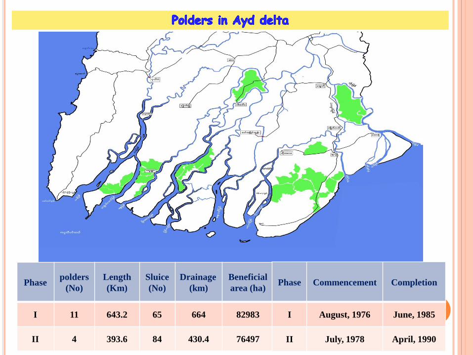
Phase polders
(No)
Length
(Km)
Sluice
(No)
Drainage
(km)
Beneficial
area (ha)
I 11 643.2 65 664 82983
II 4 393.6 84 430.4 76497
Phase Commencement Completion
I August, 1976 June, 1985
II July, 1978 April, 1990

26
supplementary irrigation is not needed during the monsoon season.
no need to store abundant rainwater during the rainy season.
due to the heavy rainfall intensities, the role of the drainage canal is very
important.
The slide gates of the sluice are kept open in rainy season and the drainage is
controlled by the flap gates of the sluice to keep the water level of the drainage
canals as low as possible.
The old river courses are functioning as major drainage channels, small artificial
drainage canals are connected as required in the areas surrounded by polder dikes,
artificial drainage canals are predominant.
Functioning of a polder in the lower delta

Sea level rise
Intensive Rainfall in the polders
Deposition of sediment in out-fall channels in dry season (≈ 1 m )
Widespread inundation in the polder (rainy season)
Restriction of budget allotments
Suitable machine deficiencies
Level of acidity in the soil comes high
Natural channels or creeks need to be dredged up
Polder facilities such as dyke, sluices and drainage canals also need to be rehabilitated.
Present Issues
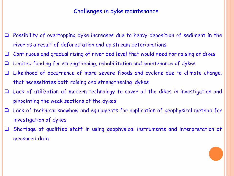
Possibility of overtopping dyke increases due to heavy deposition of sediment in the
river as a result of deforestation and up stream deteriorations.
Continuous and gradual rising of river bed level that would need for raising of dikes
Limited funding for strengthening, rehabilitation and maintenance of dykes
Likelihood of occurrence of more severe floods and cyclone due to climate change,
that necessitates both raising and strengthening dykes
Lack of utilization of modern technology to cover all the dikes in investigation and
pinpointing the weak sections of the dykes
Lack of technical knowhow and equipments for application of geophysical method for
investigation of dykes
Shortage of qualified staff in using geophysical instruments and interpretation of
measured data
Challenges in dyke maintenance

for your attention
Thank you very much


![Irrigation and Flood Protection Rehabilitation Project · BASIC DATA Irrigation and Flood Protection Rehabilitation Project (Loan 1259-VIE[SF]) Project Preparation/Institution Building](https://static.fdocuments.net/doc/165x107/5b5077f37f8b9a1b6e8e53f5/irrigation-and-flood-protection-rehabilitation-basic-data-irrigation-and-flood.jpg)


