DIRECTORATE-GENERAL FOR INTERNAL POLICIES FOR INTERNAL POLICIES . ... VCCS Voice Communications...
40
Transcript of DIRECTORATE-GENERAL FOR INTERNAL POLICIES FOR INTERNAL POLICIES . ... VCCS Voice Communications...

DIRECTORATE-GENERAL FOR INTERNAL POLICIES
POLICY DEPARTMENT B: STRUCTURAL AND COHESION POLICIES
TRANSPORT AND TOURISM
RESEARCH FOR TRAN COMMITTEE - PROSPECTS FOR “REMOTE” EN-ROUTE
AIR TRAFFIC SERVICES
STUDY
This document was requested by the European Parliament's Committee on Transport and Tourism AUTHORS Steer Davies Gleave: Stephen Wainwright, Rosie Offord, Mark Scott RESPONSIBLE ADMINISTRATOR Marc Thomas Policy Department B: Structural and Cohesion Policies European Parliament B-1047 Brussels E-mail: [email protected] EDITORIAL ASSISTANCE Lyna Pärt LINGUISTIC VERSIONS Original: EN ABOUT THE PUBLISHER To contact the Policy Department or to subscribe to its monthly newsletter please write to: [email protected] Manuscript completed in August 2016. © European Union, 2016. This document is available on the Internet at: http://www.europarl.europa.eu/studies DISCLAIMER The opinions expressed in this document are the sole responsibility of the author and do not necessarily represent the official position of the European Parliament. Reproduction and translation for non-commercial purposes are authorized, provided the source is acknowledged and the publisher is given prior notice and sent a copy.
DIRECTORATE-GENERAL FOR INTERNAL POLICIES
POLICY DEPARTMENT B: STRUCTURAL AND COHESION POLICIES
TRANSPORT AND TOURISM
RESEARCH FOR TRAN COMMITTEE - PROSPECTS FOR “REMOTE” EN-ROUTE
AIR TRAFFIC SERVICES
STUDY
Abstract
Remote tower services, where aircraft at an airport are remote-controlled from a separate location, have been introduced to some airports and are being tested at several others. By reviewing the current and emerging technologies, considering some of the risks associated with these technologies and evaluating the contribution of the NextGen and SESAR programmes, this paper aims to assess the feasibility of also providing “remote” en-route Air Traffic Services in Europe.
IP/B/TRAN/IC/2016-027 2016 PE 585.886 EN

Prospects for “remote” en-route air traffic services ____________________________________________________________________________________________
3
CONTENTS
LIST OF ABBREVIATIONS 4
LIST OF FIGURES 6
EXECUTIVE SUMMARY 7
INTRODUCTION 10
1. AIR NAVIGATION SERVICES IN EUROPE 11
1.1. The concept of remote en-route services 11
1.2. The example of remote tower services 11
1.3. En-route technology 12
1.4. Virtual Centres 12
2. REVIEW OF EXISTING AND DEVELOPING TECHNOLOGIES 15
2.1. Radar-based surveillance towards satellite-based surveillance 15
2.2. Radio communication towards datalink communication 18
2.3. Satellite-based landing systems 20
2.4. Costs 22
3. VULNERABILITY TO HACKING 25
4. CONTRIBUTIONS OF THE SESAR AND NEXTGEN PROGRAMMES 27
4.1. SESAR 27
4.2. NextGen 28
5. CONCLUSION: “AIR TRAFFIC ANYWHERE BEING MANAGED FROM ANYWHERE”(?) 31
6. REFERENCES 33
Policy Department B: Structural and Cohesion Policies ____________________________________________________________________________________________
4
LIST OF ABBREVIATIONS
ACARS Aircraft Communications Addressing and Reporting System
ACC Air Traffic Control Centre
ADS-B Automatic Dependent Surveillance – Broadcast
ADS-C Automatic Dependent Surveillance – Contract
ANS Air Navigation Services
ANSP Air Navigation Service Providers
ARE Aircraft Related Equipment
ATCO Air Traffic Controller
ATM Air Traffic Management
ATN Aeronautical Telecommunications Network
ATS Air Traffic Services
CBA Cost Benefit Analysis
CPDLC Controller–Pilot Data Link Communications
CWP Controller Working Position
EASA European Aviation Safety Agency
ESA European Space Agency
FAA Federal Aviation Administration (USA)
FANS Future Air Navigation System
FBI Federal Bureau of Investigation (USA)
FIR Flight Information Region
GBAS Ground-Based Augmentation System
GAO Government Accountability Office (USA)
GPS Global Positioning System
Prospects for “remote” en-route air traffic services ____________________________________________________________________________________________
5
IFPA Instrument Flight Procedures Automation
IGWG International GBAS Working Group
ILS Instrument Based Landing Systems
I4D Initial Trajectory Information Sharing
IP Internet Protocol
LAAS Local Area Augmentation System
LEO Low Earth Orbiting
NextGen Next Generation Air Transportation System (USA)
PCP Pilot Common Project
SATCOM Satellite Communication
SBAS Satellite-Based Augmentation System
SFDPS SWIM Flight Data Publication Service
STDDS SWIM Terminal Data Distribution System
SES Single Euopean Sky
SESAR Single European Sky ATM Research
SSR Secondary Surveillence Radio
SWIM System Wide Information Management
TT&C Tracking Telemetry & Control
TMA Terminal Manoeuvring Area
VCCS Voice Communications Control System
VDL Very High Frequency Datalink
VHF Very High Frequency
WAM Wide-Area Multilateration

Policy Department B: Structural and Cohesion Policies ____________________________________________________________________________________________
6
LIST OF FIGURES
FIGURE 1 ADS-B infrastructure 16 FIGURE 2 World ADS-B coverage 17 FIGURE 3 CPDLC via ATN data link infrastructure 18 FIGURE 4 FANS data link infrastructure 19 FIGURE 5 World data link coverage 20 FIGURE 6 GBAS infrastructure 21
Prospects for “remote” en-route air traffic services ____________________________________________________________________________________________
7
EXECUTIVE SUMMARY This note has been prepared for the Members of the Committee on Transport and Tourism of the European Parliament. It provides an overview and evaluation of the existing and developing technologies that would enable the provision of “remote” en-route Air Traffic Services. Air navigation services in Europe Air Navigation Services (ANS) are generally divided into two areas; en-route services are provided for the majority of the flight in upper and lower airspace and tower services are provided at and around airports including landings and departures. Remote tower services, which allow traffic at airports to be managed off-site, are already in use at some airports and are being tested at several others. The meaning of remote en-route services is not well defined and may be different to participants in the industry. Some define remote en-route services as Virtual Air Traffic Control Centres (ACC), which, in the most extreme example, would enable Air Traffic Controllers (ATCOs) to deliver ANS to aircraft in any ACC to any block of airspace (“any time, any service, anywhere”). Virtual centre technology, in this sense, is in the early stages of development and has only been implemented by a few Air Navigation Service Providers (ANSPs). Delivery of ANS through virtual centres can also refer to a specific function or service, such as flight data processing, being delivered virtually. Virtual centres in this sense are more widespread in en-route ANS; both the NextGen and SESAR are developing information sharing platforms known as System Wide Information Management (SWIM). Remote en-route services can also be defined as providing infrastructure in remote locations and allowing greater use of technology in the air rather than on the ground. The majority of ANS equipment currently relies on decades old radio technology, consequently, many ANSPs are now implementing modernisation programmes which utilises satellite technology. These technologies have the potential to address some of the key issues facing ANSPs providing en-route services; pressures to manage and reduce costs, rationalising the number of ACCs and improving resilience through affordable contingency arrangements. Review of existing and developing technologies Automatic Dependent Surveillance – Broadcast (ADS–B), datalink communication and Ground-based augmentation system (GBAS) are technological developments that can facilitate greater delivery of remote en-route services. These technologies will enable ANSPs to become less reliant on physical assets being placed in a specific location to provide a service to airspace users, often by using airborne technology placed on aircraft. ADS–B is a piece of equipment installed on each aircraft which automatically broadcasts an aircraft’s position, which is determined using Global Positioning System (GPS) satellites. ASD-B has been widely implemented globally; many systems currently use ground stations to receive these broadcasts from aircraft. As the technology develops satellite receiver stations will begin to replace ground stations; the first satellite systems are expected to be operational by 2018. Data link is a text-based messaging service which allows ANSPs to send quick and clear messages to aircraft pilots. There are two types of datalink services currently being implemented; Future Air Navigation System (FANS) and controller–pilot data link communications via aeronautical telecommunications network (CPDLC via ATN). FANS was first developed in the mid-1990s and is the most widely used type datalink technology globally as it can be used in oceanic airspace. CPDLC via ATN can provide a superior service

Policy Department B: Structural and Cohesion Policies ____________________________________________________________________________________________
8
in congested continental airspace but is only being implemented in Europe. Although FANS and CPDLC via ATN are both data link networks, the manner in which they operate and the equipment they require differ significantly. GBAS provides landing assistance at airports using GPS satellites to determine an aircraft’s position which is picked up by a ground station at the airport, the development of the technology is still at a relatively early stage compared to ADS-B surveillance and data link communication. GBAS is currently operational at a small number of airports and is normally capable of supporting landings in the least severe weather and visibility conditions. Vulnerability to hacking In spite of the benefits these new technologies can bring, there are concerns about their vulnerability to cyber-attacks. Older, point-to-point communications systems are generally difficult to access remotely because many are not connected to the internet and it is hard to inflict damage on an entire system as it is often not completely interconnected. The introduction of technologies like SWIM means it is easier for potential hackers to access the system remotely and increased interconnectivity means damage can be inflicted more easily throughout the system once it has been accessed. Avionics systems on board aircraft area also at risk as they are increasingly connected to the internet and therefore there is a greater risk an attacker could access and compromise avionics systems remotely. Although protecting against cyber-attacks represents a serious challenge for the aviation industry, the risk of attack can be reduced by good preparation and a coordinated response. A recent report found that some of the biggest weaknesses in NextGen’s systems were due to lack of preparation and not allocating sufficient resources to guard against cyber security threats, rather than an inherent weakness in the technologies themselves. A separate report also noted that the introduction of more interconnected systems is an opportunity for improved cyber security as it will allow ANSPs address cyber-security systematically through the sharing of vulnerabilities and coordinated incident response. Contributions of the SESAR and NextGen programmes The objective of SESAR and NextGen is to modernise and harmonise the technology and operations of Air Traffic Management (ATM), in their respective jurisdictions, in order to increase capacity, improve safety, reduce costs and reduce the environmental impact of the aviation sector. Both NextGen and SESAR are moving towards the use of virtual centres, although only through System Wide Information Management (SWIM) across different flight sectors; they are not currently pursuing the delivery of ANS independent of the physical location of the personnel and equipment. Although NextGen has begun to roll out SWIM technology, SESAR is still in the relatively early stages of developing the technology and it has not yet been widely implemented. Both programmes have made more progress introducing ADS-B technology; a large amount of ADS-B ground infrastructure has been installed in Europe and the USA which provides coverage to majority of both areas. Both programmes have also mandated that all commercial aircraft must be fitted with ADS-B technology by 2020. Both programmes have also made progress with introducing datalink communication, although they are pursuing different kinds of technology. NextGen is seeking to utilise FANS technology and plans to begin providing en-route datalink communication services to begin in 2019. SESAR is pursuing CPDLC via ATN technology, which is being rolled out across European continental airspace. The current mandated dates by which ANPSs and aircraft in Europe must be fitted with datalink technology are February 2018 and February
Prospects for “remote” en-route air traffic services ____________________________________________________________________________________________
9
2020 respectively. The original date was 2015, but this was delayed due to monetary and technical issues. Although GBAS is operational at a small number of American and European airports, NextGen and SESAR do not have mandates or stipulations regarding its implementation. Conclusion The concept of remote en-route services which follows the principle of “air traffic anywhere being managed from anywhere”, is not well defined. Some stakeholders focus on the location of the Air Traffic Control Centre (ACC) and the concept of Virtual en-route ACCs. Others on the infrastructure where greater use of technology in the air facilitates the introduction of remote en-route services, and others on delivering a specific function or service virtually, e.g. flight data processing. To date there are only a small number of examples of remote en-route services being provided by ANSPs. To provide more widespread implementation of this concept requires the implementation of a range of technologies including satellite-based surveillance, datalink communication, and satellite based landing systems (such as GBAS). The costs of implementing new technologies are significant (and in many cases not yet fully proven), and require coordination of implementation between on the ground and in the air technology. Uptake of the technology has been relatively slow. Coordinating the implementation of the technology and supporting the costs of the changes will be challenging and directly influence the speed of implementation. To move to greater provision of remote services, service providers, Member States and airspace users will need to be willing to adopt innovative approaches to technology and new arrangements for the provision of services. The concepts and technology to support widespread implementation of remote en-route services exists, however to deliver it will require greater co-ordination of organisations, on the ground and in the air, as well as the funding and financing of this new technology. Experience to date is that this may take some time to deliver.
Policy Department B: Structural and Cohesion Policies ____________________________________________________________________________________________
10
INTRODUCTION This note has been prepared for the Members of the Committee on Transport and Tourism of the European Parliament. It provides an overview and evaluation of the existing and developing technologies that would enable the provision of “remote” en-route Air Traffic Services. The note is organised into the following sections:
1. A background explaining the difference between en-route and tower Air Navigation
Services and the concept of remote provision of these services; 2. A review and evaluation of existing and developing technologies (focussed on the
movement towards satellite surveillance, satellite based landing systems and data link communications);
3. An evaluation of the vulnerability of these technologies to hacking; 4. A description of the contributions of the SESAR (Europe) and NextGen (United
States) programmes to these developments; 5. An overall assessment of whether these technologies will support “remote” en-route
services and the concept of “air traffic anywhere being managed from anywhere”.
Prospects for “remote” en-route air traffic services ____________________________________________________________________________________________
11
1. AIR NAVIGATION SERVICES IN EUROPE Air Navigation Services (ANS) are provided by Air Navigation Service Providers (ANSPs) which are responsible for controlling airspace which is divided up depending on local circumstances and the volume of air traffic. These service are provided to airspace users (commercial airlines, military and general aviation and cargo). In general two areas of airspace are used to demark services and operations, as well as charging arrangements: en-route services are provided for the majority of the flight in upper and lower airspace and tower services are provided at and around airports, to support the take-off and landing, descent and ascent phases of the flight.
1.1. The concept of remote en-route services The concept of remote en-route services follows the principle of “air traffic anywhere being managed from anywhere”. NATS, the United Kingdom’s main ANSP refers to the concept of “any time, any service, anywhere”. However, the meaning of remote en-route services is not well defined and may be different to participants in the industry. Some would focus on the location of the Air Traffic Control Centre (ACC) and the concept of Virtual en-route ACCs. An example of this definition would be that a Virtual Centre enables the delivery of an ATC service to move to different locations in real time. The most extreme example of a Virtual Centre would be for an Air Traffic Controller (ATCO) to be able to sit at any Controller Working Position (CWP) in any ACC to provide a service in any block of airspace (“any time, any service, anywhere”). A Virtual Centre is just one example of a remotely provided (en route) ATC. “Remote” can also mean providing infrastructure in remote locations and allowing greater use of technology in the air rather than on the ground. The development of technologies discussed in the document would help facilitate the introduction of remote en-route services. Remote en-route services have the potential to address some of the key issues facing ANSPs providing en-route services, pressures to manage and reduce costs, rationalising the number of ACCs and improving resilience through affordable contingency arrangements.
1.2. The example of remote tower services The recent implementation of remote tower services provides some analogies to the possible development of remote en-route services. Tower control services at commercial airports are usually provided on-site. However, technology has now been developed that allows traffic to be managed remotely; the technology involves a set of high definition cameras and sensors at the airport, which is shown live on a set of screens to an air traffic controller at a different location. The first airport to implement this technology was Örnsköldsvik Airport in Sweden, where since April 2015 air traffic has been controlled from Sundsvall, over 150km away. Since then, the technology (developed primarily by Saab) has been tested at small airports in Australia, Norway and the USA. The Civil Aviation Authority Singapore has also stated that they plan to introduce remote tower technology at Changi airport. Remote tower technology offers considerable cost advantages to small commercial airports which do not handle traffic levels sufficient to cover the cost of on-site air traffic control facilities and the staffing required to support. If traffic were managed remotely, airports would make considerable cost savings. As well as making small commercial airports more economically viable, remote towers could represent a cheap option for replacing ageing infrastructure at larger airports or introducing air traffic management facilities at general aviation airports looking to handle more commercial traffic.
Policy Department B: Structural and Cohesion Policies ____________________________________________________________________________________________
12
Centralising the traffic management of more than one airport in a single location would also lower operating costs, as less equipment and fewer staff would be required to manage a given level of traffic. The aviation industry is currently facing a shortage of air traffic controllers: the US Federal Aviation Administration (FAA) has missed its hiring goals for the last five years1 and there are concerns about the shortage of air traffic controllers and adequate training facilities in Asia, where aircraft traffic is forecast to grow rapidly in the coming decades. Using remote tower technology to centralise traffic management facilities would help to address these problems by lowering demand for air traffic controllers and the costs involved in their training. Although remote tower technology is in the early stages of roll out, it has the potential to provide a step change in how tower control services are provided. Centralising traffic management facilities can significantly reduce air traffic control costs and improve the economic viability of smaller airports. As the technology develops and becomes recognised, there will also be the opportunity to provide remote Tower services in other countries and markets.
1.3. En-route technology The majority of ANS equipment used to provide aircraft surveillance, aircraft communication and aircraft landing assistance currently relies on decades old radio technology. Increasing levels of air traffic means aviation authorities are under pressure to provide a more efficient and cost effective service that will increase capacity and improve safety. Although radio based technology has provided an adequate service in the past, it does have limitations; accuracy can be compromised in poor weather conditions and it relies on a large amount of infrastructure on the ground (radar, beacon, instrument landing equipment) which is expensive to set up, replace and maintain. ANS modernisation programmes are implementing technologies which utilise satellite technology; these technologies are more accurate and are able to provide better coverage as they are less reliant on ground infrastructure. Many of the satellite based ANS technologies currently operational or being implemented in the short term use a combination of satellite and ground infrastructure. However technology is being developed which means in the longer term, all the infrastructure required to provide en-route ANS will be satellite based. Such technological developments will facilitate the concepts of the en-route Virtual Centre described above. Although the technology has been under development for some time, the structure of the industry, where ANSPs provide the ground technology and airspace users are required to invest in airborne technology, and the timing of the benefits (often available only when there is sufficient take up by the airspace user community) have meant that development of satellite based en-route technology has been much slower than anticipated.
1.4. Virtual Centres We discussed above that there are different concepts of the Virtual Centre, Helios – a technology consultancy describe possible definitions: 1. A Virtual Centre is one where the delivery of an Air Traffic Service (ATS) is
independent of the physical location of the personnel and equipment. Usually the personnel and equipment used to provide ATS are geographically co-located in a specified location. In the Virtual Centre concept ATS could be delivered wholly from a
1 “Controller Shortage To Increase Airline Costs, Delays, Fares”, accessed 26th May 2016,
http://www.forbes.com/sites/kathryncreedy/2016/01/28/controller-shortage-to-increase-airline-costs-delays-fares/#558f071610b1
Prospects for “remote” en-route air traffic services ____________________________________________________________________________________________
13
different location, or split dynamically. Maintaining the same quality of service to airspace users would be a minimum requirement. 2. Delivering a specific function or service virtually For example, implementing the flight data processing function as a service (you can think of it like a cloud-based service) would enable this core function to be easily delivered in different physical locations. Helios goes on to describe some key requirements for the development of Virtual Centres: Wide area communication networks: if you want to be able to provide ATS in any airspace from any physical location you need to be able to get the required data between point A and B. This requires a reliable and flexible wide area communication network between existing ATS infrastructure. Harmonised Controller Working Position and operational processes: to provide an identical ATS service from any physical location the functionality available to the controller and the operational procedures used in different locations need to be the same. Technical harmonisation: is necessary to ensure that each physical location can use the same data formats in the same way so that functionality and controller procedures are aligned. The delivery of ATS through virtual centres in line with Helios’ first definition, where the delivery of services is independent of the physical location of the personnel and equipment, is becoming more widespread in tower ANS but is still in the early stages of development in en-route ANS. There is currently only one example of en-route control services being supplied from virtual centres; the Irish Aviation Authority (IAA) and ISAVIA (Iceland) have implemented a system that allows aircraft communication services in their respective control areas to be delivered from either centre. Delivery of ATS through virtual centres in line with Helios’ second definition, where a specific function or service is delivered virtually, is more widespread in en-route ANS. System Wide Information Management (SWIM), a digital data-sharing platform which enables information sharing between ANSPs, is a feature of both the NextGen and SESAR programs.

Policy Department B: Structural and Cohesion Policies ____________________________________________________________________________________________
14
Prospects for “remote” en-route air traffic services ____________________________________________________________________________________________
15
2. REVIEW OF EXISTING AND DEVELOPING TECHNOLOGIES
The following technological developments would facilitate greater delivery of remote en-route services, becoming less reliant on physical assets being placed in a specific location to provide a service to airspace users, often using airborne technology placed on aircraft.
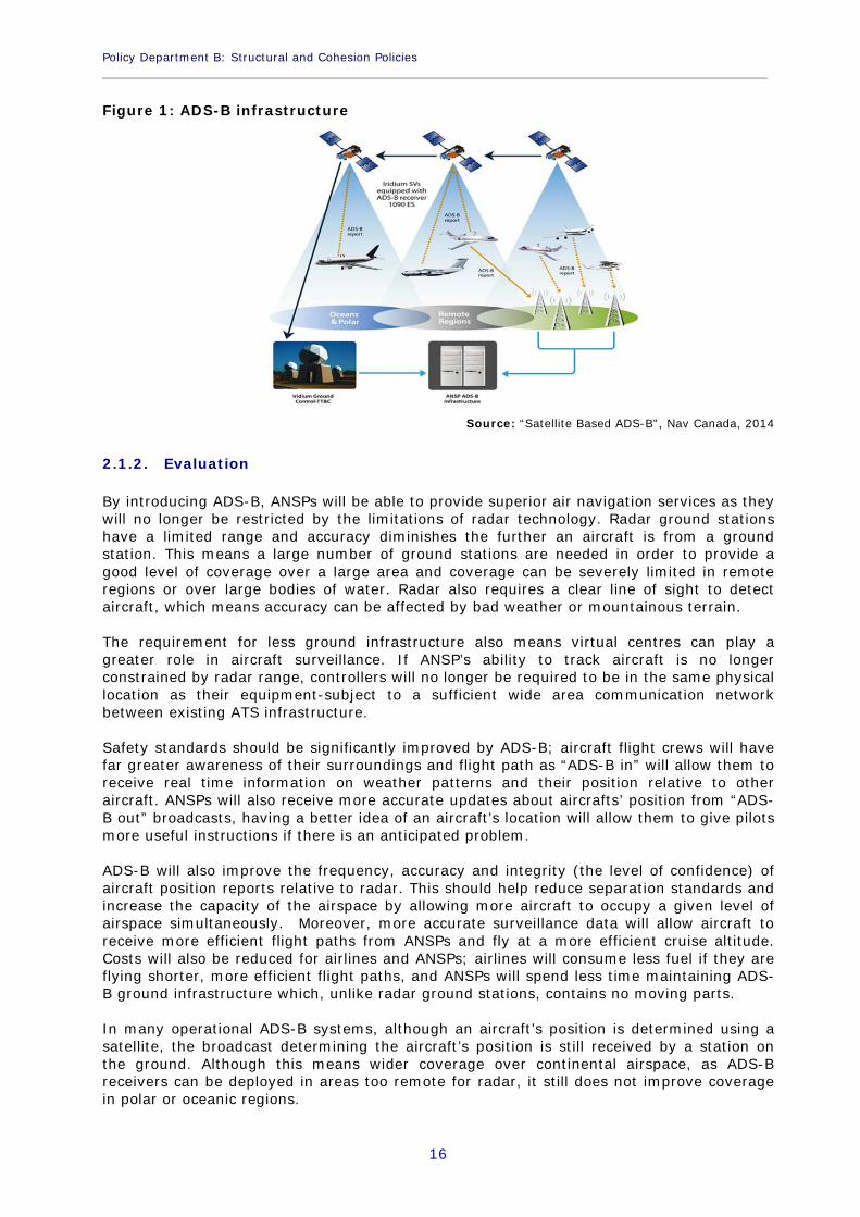
2.1. Radar-based surveillance towards satellite-based surveillance 2.1.1. Features For many decades radar technology has been the primary means used by ANSPs to track an aircraft’s position. The technology comprises of two main components: primary radar, which tracks aircraft using radio waves and does not require any equipment on the aircraft, and secondary surveillance radar (SSR), which interacts with a transponder on each aircraft to receive more detailed information. In modern systems, primary radar is usually used as a complementary or back up service to SSR, as the information it can tell ANSPs about an aircraft is more limited. More recently, Automatic Dependent Surveillance – Broadcast (ADS–B) technology has been introduced by some ANSPs as an alternative means of tracking aircraft. ADS-B technology comprises of two separate services; “ADS-B out” and “ADS-B in”. “ADS-B out” broadcasts real time information about the aircraft to ANSPs which means it can be tracked and “ADS-B in” allows aircraft to receive traffic and weather updates from ANSPs and communications form other aircraft. “ADS-B out” is the technology used for aircraft surveillance. “ADS-B out” is a piece of equipment installed on each aircraft which automatically broadcasts an aircraft’s position, which is determined using Global Positioning System (GPS) satellites. The majority of ASD-B systems currently operational use ground stations to receive these broadcasts, which are then sent to ANSPs. As the technology develops satellite receiver stations will begin to replace ground stations; although satellite receiver stations technology is still being developed and is not currently in use, the first systems are expected to be operational by 2018. The architecture of ADS-B infrastructure is shown in Figure 1. The position of an aircraft flying over land is determined by a satellite and the position broadcast is received by a station on the ground, which is then sent to an ANSP using ground infrastructure. The position of an aircraft on the left of the diagram is determined by a satellite (technology that is currently in development) and the broadcast is received by a satellite, which is then received by an ANSP using a satellite tracking telemetry & control (TT&C) ground station.
Policy Department B: Structural and Cohesion Policies ____________________________________________________________________________________________
16
Figure 1: ADS-B infrastructure
Source: “Satellite Based ADS-B”, Nav Canada, 2014
2.1.2. Evaluation By introducing ADS-B, ANSPs will be able to provide superior air navigation services as they will no longer be restricted by the limitations of radar technology. Radar ground stations have a limited range and accuracy diminishes the further an aircraft is from a ground station. This means a large number of ground stations are needed in order to provide a good level of coverage over a large area and coverage can be severely limited in remote regions or over large bodies of water. Radar also requires a clear line of sight to detect aircraft, which means accuracy can be affected by bad weather or mountainous terrain. The requirement for less ground infrastructure also means virtual centres can play a greater role in aircraft surveillance. If ANSP’s ability to track aircraft is no longer constrained by radar range, controllers will no longer be required to be in the same physical location as their equipment-subject to a sufficient wide area communication network between existing ATS infrastructure. Safety standards should be significantly improved by ADS-B; aircraft flight crews will have far greater awareness of their surroundings and flight path as “ADS-B in” will allow them to receive real time information on weather patterns and their position relative to other aircraft. ANSPs will also receive more accurate updates about aircrafts’ position from “ADS-B out” broadcasts, having a better idea of an aircraft’s location will allow them to give pilots more useful instructions if there is an anticipated problem. ADS-B will also improve the frequency, accuracy and integrity (the level of confidence) of aircraft position reports relative to radar. This should help reduce separation standards and increase the capacity of the airspace by allowing more aircraft to occupy a given level of airspace simultaneously. Moreover, more accurate surveillance data will allow aircraft to receive more efficient flight paths from ANSPs and fly at a more efficient cruise altitude. Costs will also be reduced for airlines and ANSPs; airlines will consume less fuel if they are flying shorter, more efficient flight paths, and ANSPs will spend less time maintaining ADS-B ground infrastructure which, unlike radar ground stations, contains no moving parts. In many operational ADS-B systems, although an aircraft’s position is determined using a satellite, the broadcast determining the aircraft’s position is still received by a station on the ground. Although this means wider coverage over continental airspace, as ADS-B receivers can be deployed in areas too remote for radar, it still does not improve coverage in polar or oceanic regions.
Prospects for “remote” en-route air traffic services ____________________________________________________________________________________________
17
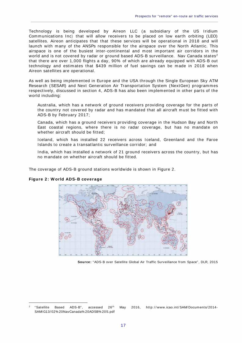
Technology is being developed by Aireon LLC (a subsidiary of the US Iridium Communications Inc) that will allow receivers to be placed on low earth orbiting (LEO) satellites. Aireon anticipates that that these services will be operational in 2018 and will launch with many of the ANSPs responsible for the airspace over the North Atlantic. This airspace is one of the busiest inter-continental and most important air corridors in the world and is not covered by radar or ground based ADS-B surveillance. Nav Canada states2 that there are over 1,000 flights a day, 90% of which are already equipped with ADS-B out technology and estimates that $439 million of fuel savings can be made in 2018 when Aireon satellites are operational. As well as being implemented in Europe and the USA through the Single European Sky ATM Research (SESAR) and Next Generation Air Transportation System (NextGen) programmes respectively, discussed in section 4, ADS-B has also been implemented in other parts of the world including: Australia, which has a network of ground receivers providing coverage for the parts of
the country not covered by radar and has mandated that all aircraft must be fitted with ADS-B by February 2017;
Canada, which has a ground receivers providing coverage in the Hudson Bay and North East coastal regions, where there is no radar coverage, but has no mandate on whether aircraft should be fitted;
Iceland, which has installed 22 receivers across Iceland, Greenland and the Faroe Islands to create a transatlantic surveillance corridor; and
India, which has installed a network of 21 ground receivers across the country, but has no mandate on whether aircraft should be fitted.
The coverage of ADS-B ground stations worldwide is shown in Figure 2. Figure 2: World ADS-B coverage
Source: “ADS-B over Satellite Global Air Traffic Surveillance from Space”, DLR, 2015
2 “Satellite Based ADS-B”, accessed 26th May 2016, http://www.icao.int/SAM/Documents/2014-
SAMIG13/02%20NavCanada%20ADSB%20S.pdf
Policy Department B: Structural and Cohesion Policies ____________________________________________________________________________________________
18
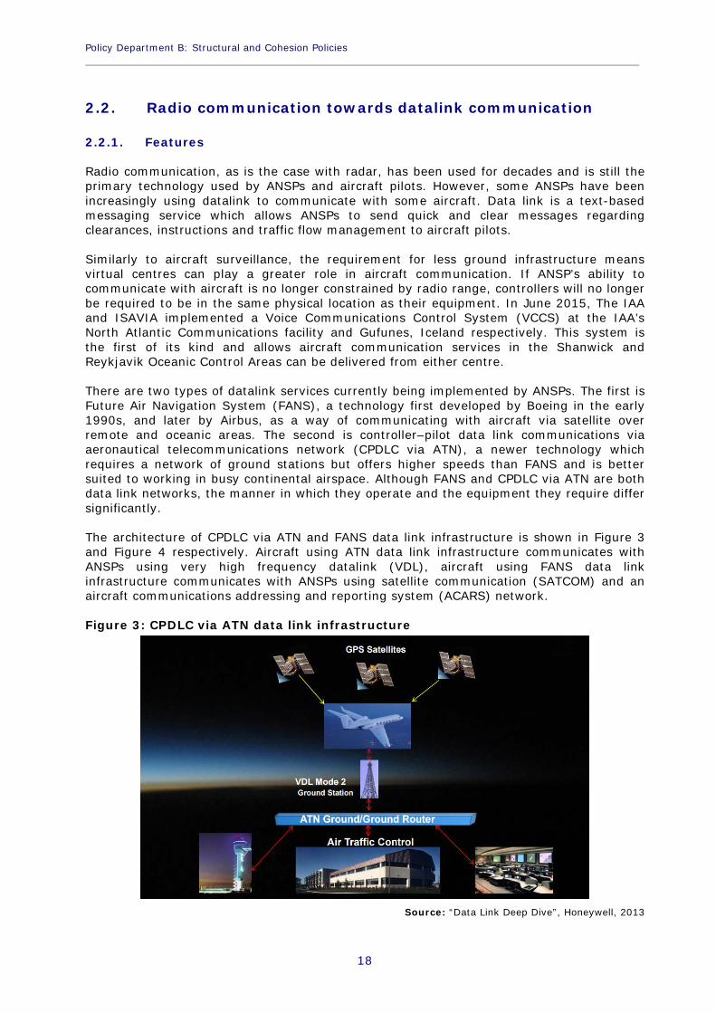
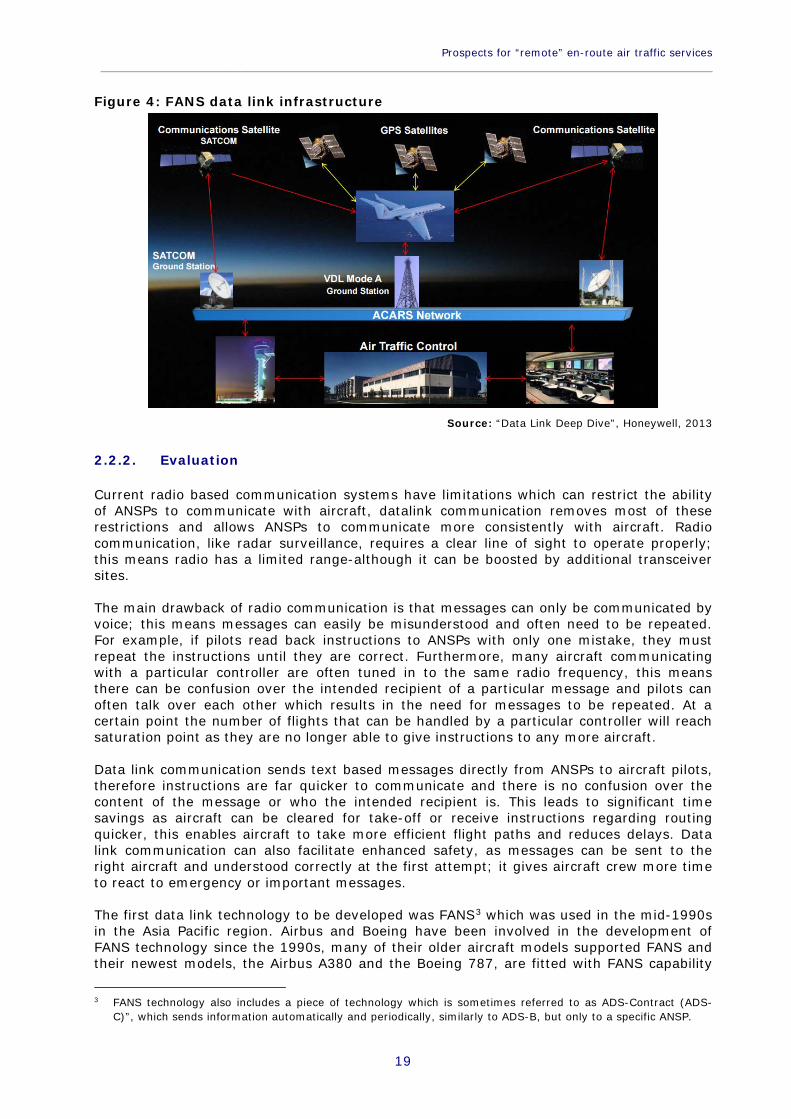
2.2. Radio communication towards datalink communication 2.2.1. Features Radio communication, as is the case with radar, has been used for decades and is still the primary technology used by ANSPs and aircraft pilots. However, some ANSPs have been increasingly using datalink to communicate with some aircraft. Data link is a text-based messaging service which allows ANSPs to send quick and clear messages regarding clearances, instructions and traffic flow management to aircraft pilots. Similarly to aircraft surveillance, the requirement for less ground infrastructure means virtual centres can play a greater role in aircraft communication. If ANSP’s ability to communicate with aircraft is no longer constrained by radio range, controllers will no longer be required to be in the same physical location as their equipment. In June 2015, The IAA and ISAVIA implemented a Voice Communications Control System (VCCS) at the IAA’s North Atlantic Communications facility and Gufunes, Iceland respectively. This system is the first of its kind and allows aircraft communication services in the Shanwick and Reykjavik Oceanic Control Areas can be delivered from either centre. There are two types of datalink services currently being implemented by ANSPs. The first is Future Air Navigation System (FANS), a technology first developed by Boeing in the early 1990s, and later by Airbus, as a way of communicating with aircraft via satellite over remote and oceanic areas. The second is controller–pilot data link communications via aeronautical telecommunications network (CPDLC via ATN), a newer technology which requires a network of ground stations but offers higher speeds than FANS and is better suited to working in busy continental airspace. Although FANS and CPDLC via ATN are both data link networks, the manner in which they operate and the equipment they require differ significantly. The architecture of CPDLC via ATN and FANS data link infrastructure is shown in Figure 3 and Figure 4 respectively. Aircraft using ATN data link infrastructure communicates with ANSPs using very high frequency datalink (VDL), aircraft using FANS data link infrastructure communicates with ANSPs using satellite communication (SATCOM) and an aircraft communications addressing and reporting system (ACARS) network. Figure 3: CPDLC via ATN data link infrastructure
Source: “Data Link Deep Dive”, Honeywell, 2013
Prospects for “remote” en-route air traffic services ____________________________________________________________________________________________
19
Figure 4: FANS data link infrastructure
Source: “Data Link Deep Dive”, Honeywell, 2013
2.2.2. Evaluation Current radio based communication systems have limitations which can restrict the ability of ANSPs to communicate with aircraft, datalink communication removes most of these restrictions and allows ANSPs to communicate more consistently with aircraft. Radio communication, like radar surveillance, requires a clear line of sight to operate properly; this means radio has a limited range-although it can be boosted by additional transceiver sites. The main drawback of radio communication is that messages can only be communicated by voice; this means messages can easily be misunderstood and often need to be repeated. For example, if pilots read back instructions to ANSPs with only one mistake, they must repeat the instructions until they are correct. Furthermore, many aircraft communicating with a particular controller are often tuned in to the same radio frequency, this means there can be confusion over the intended recipient of a particular message and pilots can often talk over each other which results in the need for messages to be repeated. At a certain point the number of flights that can be handled by a particular controller will reach saturation point as they are no longer able to give instructions to any more aircraft. Data link communication sends text based messages directly from ANSPs to aircraft pilots, therefore instructions are far quicker to communicate and there is no confusion over the content of the message or who the intended recipient is. This leads to significant time savings as aircraft can be cleared for take-off or receive instructions regarding routing quicker, this enables aircraft to take more efficient flight paths and reduces delays. Data link communication can also facilitate enhanced safety, as messages can be sent to the right aircraft and understood correctly at the first attempt; it gives aircraft crew more time to react to emergency or important messages. The first data link technology to be developed was FANS3 which was used in the mid-1990s in the Asia Pacific region. Airbus and Boeing have been involved in the development of FANS technology since the 1990s, many of their older aircraft models supported FANS and their newest models, the Airbus A380 and the Boeing 787, are fitted with FANS capability
3 FANS technology also includes a piece of technology which is sometimes referred to as ADS-Contract (ADS-
C)”, which sends information automatically and periodically, similarly to ADS-B, but only to a specific ANSP.
Policy Department B: Structural and Cohesion Policies ____________________________________________________________________________________________
20
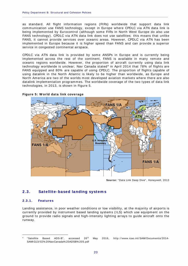
as standard. All flight information regions (FIRs) worldwide that support data link communication use FANS technology, except in Europe where CPDLC via ATN data link is being implemented by Eurocontrol (although some FIRs in North West Europe do also use FANS technology). CPDLC via ATN data link does not use satellites; this means that unlike FANS, it cannot provide services over oceanic areas. However, CPDLC via ATN has been implemented in Europe because it is higher speed than FANS and can provide a superior service in congested continental airspace. CPDLC via ATN data link is provided by some ANSPs in Europe and is currently being implemented across the rest of the continent, FANS is available in many remote and oceanic regions worldwide. However, the proportion of aircraft currently using data link technology worldwide is unclear; Nav Canada stated4 in April 2014 that 78% of flights are FANS equipped and 80% are capable of using CPDLC. The proportion of flights capable of using datalink in the North Atlantic is likely to be higher than worldwide, as Europe and North America are two of the worlds most developed aviation markets where there are also datalink implementation programmes. The worldwide coverage of the two types of data link technologies, in 2013, is shown in Figure 5. Figure 5: World data link coverage
Source: “Data Link Deep Dive”, Honeywell, 2013
2.3. Satellite-based landing systems 2.3.1. Features Landing assistance, in poor weather conditions or low visibility, at the majority of airports is currently provided by instrument based landing systems (ILS) which use equipment on the ground to provide radio signals and high-intensity lighting arrays to guide aircraft onto the runway.
4 “Satellite Based ADS-B”, accessed 26th May 2016, http://www.icao.int/SAM/Documents/2014-
SAMIG13/02%20NavCanada%20ADSB%20S.pdf
Prospects for “remote” en-route air traffic services ____________________________________________________________________________________________
21
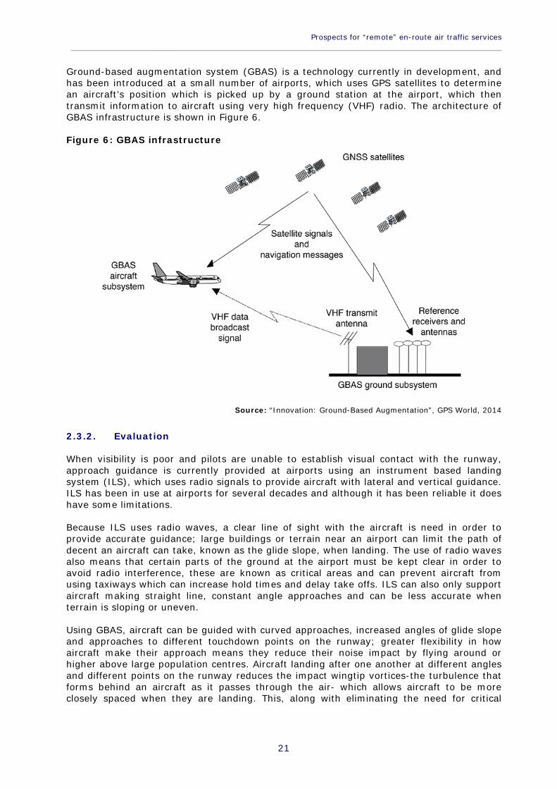
Ground-based augmentation system (GBAS) is a technology currently in development, and has been introduced at a small number of airports, which uses GPS satellites to determine an aircraft’s position which is picked up by a ground station at the airport, which then transmit information to aircraft using very high frequency (VHF) radio. The architecture of GBAS infrastructure is shown in Figure 6. Figure 6: GBAS infrastructure
Source: “Innovation: Ground-Based Augmentation”, GPS World, 2014
2.3.2. Evaluation When visibility is poor and pilots are unable to establish visual contact with the runway, approach guidance is currently provided at airports using an instrument based landing system (ILS), which uses radio signals to provide aircraft with lateral and vertical guidance. ILS has been in use at airports for several decades and although it has been reliable it does have some limitations. Because ILS uses radio waves, a clear line of sight with the aircraft is need in order to provide accurate guidance; large buildings or terrain near an airport can limit the path of decent an aircraft can take, known as the glide slope, when landing. The use of radio waves also means that certain parts of the ground at the airport must be kept clear in order to avoid radio interference, these are known as critical areas and can prevent aircraft from using taxiways which can increase hold times and delay take offs. ILS can also only support aircraft making straight line, constant angle approaches and can be less accurate when terrain is sloping or uneven. Using GBAS, aircraft can be guided with curved approaches, increased angles of glide slope and approaches to different touchdown points on the runway; greater flexibility in how aircraft make their approach means they reduce their noise impact by flying around or higher above large population centres. Aircraft landing after one another at different angles and different points on the runway reduces the impact wingtip vortices-the turbulence that forms behind an aircraft as it passes through the air- which allows aircraft to be more closely spaced when they are landing. This, along with eliminating the need for critical
Policy Department B: Structural and Cohesion Policies ____________________________________________________________________________________________
22
areas at airports, improves the efficiency of airport operations by increasing the rate at which aircraft are able to take off and land. GBAS also simplifies and reduces the amount of equipment required by airports; unlike ILS, it only requires one radio frequency per system and can support up to 48 aircraft approach procedures with one radio frequency. Moreover, one GBAS ground station can support multiple aircraft approaching multiple runways, whereas ILS requires a separate system for each runway approach. Chicago O’Hare airport for example, has twelve runway ends each requiring its own ILS system. There are three accuracy levels of ILS equipment which correspond to landing operations in three categories of weather and visibility conditions. Equipment that can support Category I landings is the least accurate and can operate in the least severe conditions and Category III equipment is the most accurate and can support landings in the worst conditions. The FAA states5 that there are two airports in the USA, four in Europe6, one in Australia and 15 in Russia that have operational GBAS. GBAS at airports in the USA and Europe can currently only support Category I landings, the category of landings supported by GBAS at airports in Russia and Australia is unclear. GBAS equipment is an option on the Boeing 737-Next Generation aircraft and the Airbus A320-A380 models, it also fitted as standard on Boeing 747-8 and 787 aircraft. The airlines using GBAS at the abovementioned airports include Air Berlin, British Airways, Cathay Pacific, Delta Airlines, Emirates, Lufthansa, Qantas, TUIfly, Swiss Air, United Airlines and various Russian airlines. The development of GBAS is at a relatively early stage compared to ADS-B surveillance or data link communication; unlike these technologies, to date there has been no implementation date mandated by the NextGen or SESAR programmes. However, there is research and development in the area; the FAA and Eurocontrol co-chair the International GBAS Working Group (IGWG) which is an international forum for the development of GBAS technology. Satellite-based augmentation systems (SBAS) takes the technology a step further; it works in the same way as GBAS, but uses multiple ground stations to support wide area or regional augmentation and are currently capable of supporting Category I landings. SBAS, which also has many applications outside aviation, is operational in Europe, India, Japan and North America and systems are currently being developed in China and Russia. However, like GBAS, these systems are not currently widely in use at airports to support aircraft landing procedures.
2.4. Costs Although it is difficult to obtain accurate information on the cost of developing and implementing the technologies described above, some estimates and forecasts are provided for in the NextGen and SESAR programmes. In June 2014, regulation was adopted by the European Commission which made the implementation of the first six air traffic management (ATM) functionalities binding, referred to as the “Pilot Common Project” (PCP)7. The PCP cost benefit analysis (CBA)
5 “GNSS Frequently Asked Questions”, accessed 26th May 2016, -
GBAShttp://www.faa.gov/about/office_org/headquarters_offices/ato/service_units/techops/navservices/gnss/faq/laas/.
6 Namely: Bremen, Frankfurt, Malaga and Zurich 7 Commission implementing Regulation (EU) no 716/2014.
Prospects for “remote” en-route air traffic services ____________________________________________________________________________________________
23
model8 provides forecast implementation costs of the six ATM functionalities under SESAR, although the costs are not disaggregated by equipment or technology type. One of the six functionalities in the PCP is Initial Trajectory Information Sharing, also known as i4D, which is the ability to manage an aircrafts’ trajectory at any stage of the flight in real time. The cost of implementing i4D, which includes ADS-B, data link and GBAS amongst other technologies, is forecast to be €280 million between 2014 and 2030. It should be noted that this cost is a high level forecast and final implementation costs may be higher than this. The PCP also only forecasts the implementation costs of the six first ATM functionalities; the implementation of further technologies will lead to additional costs. The PCP CBA model also provides a cost forecast for i4D equipment installation on board aircraft; it estimates the total cost for scheduled airlines will be €554.3 million. The US based Aircraft Owners and Pilots Association states9 that the current cost of installing ADS-B out equipment on a single aircraft is at least $5000 (€4,545). This is not a significant cost for airlines or commercial aircraft manufactures, but is a relatively large compared to the value of many general aviation aircraft. Although the FAA does not provide high level forecast implementation costs for the NextGen programme, the FAA 2017 budget request10 does provide some detailed annual costs for the implementation of specific technologies. In the 2017 budget request, the FAA estimates that implementing new ADS-B technology across the national airspace in 2017 will cost $31.1 million (€28.3 million); the estimated cost enacted in 2016 and actual cost in 2015 was $184.6 million and €254.7 million respectively (€167.8 to €231.5 million). However it should be noted that the 2016 and 2015 figures also include subscription costs which were reallocated in the 2017 budget request. The FAA estimates subscription costs, which are service fees paid to contractors who own and operate current ADS-B infrastructure, will be $123.7 million (€112.5 million) in 2017. Therefore the total cost estimate for operating current ADS-B infrastructure and implementing new ADS-B systems will be $154.8 million (€140.7 million). The budget request estimates that the cost of data communications in support of NextGen will be $232 million (€211 million) in 2017; the estimated cost enacted in 2016 and actual cost in 2015 was $234.9 million (€213.6 million) and €150.3 million (€136.6 million) respectively. These costs include the implementation of tower and en-route data communications technology for both ANSPs and aircraft. The budget request does not provide cost estimates for implementing GBAS technology, although it is included as part of two other areas; Aircraft Related Equipment Program (ARE) and Instrument Flight Procedures Automation (IFPA). The estimated costs of ARE and IFPA in 2017 are $13 million (€11.8 million) and $9.4 million (€8.6 million) respectively, however given only a small part of both these areas is comprised of GBAS technology implementation, disaggregated GBAS costs are not possible to estimate. The analysis shows that implementation of the technologies required to support remote en-route services requires significant and sustained investment.
8 “PCP CBA Model”, accessed 26th May 2016, http://ec.europa.eu/transport/modes/air/consultations/doc/2014-
01-31-sesar/2014_02_13_pcp_final_cba_model_v7.xlsx. 9 “Air Traffic Services Brief-Automatic Dependent Surveillance- Broadcast”, Accessed 26th May 2016,
https://www.aopa.org/advocacy/advocacy-briefs/air-traffic-services-brief-automatic-dependent-surveillance-broadcast-ads-b.
10 “Budget Estimates Fiscal Year 2017”, accessed 26th May 2016, https://cms.dot.gov/sites/dot.gov/files/docs/FAA-FY-2017-CJ.pdf.

Policy Department B: Structural and Cohesion Policies ____________________________________________________________________________________________
24

Prospects for “remote” en-route air traffic services ____________________________________________________________________________________________
25
3. VULNERABILITY TO HACKING In 2015, separate reports were published looking at the vulnerability of both the NextGen and SESAR systems to cyber-attacks and how best to protect against them. Both NextGen and SESAR are introducing a computer system named System Wide Information Management (SWIM), which will handle all ATM information including aeronautical, flight, aerodrome, meteorological, air traffic flow, and surveillance. Both reports note that introduction of SWIM, which represents a more interconnected ATM system that operates through an Internet Protocol (IP) network, means there are increased cyber security risks. Using an IP network means it is easier for potential hackers to access the system remotely and increased interconnectivity means damage can be inflicted more easily throughout the system once it has been accessed. An increased use of common components, services and standards also increase the likelihood of publicly-released common vulnerabilities into the system. The report11 looking at NextGen, produced by the United States Government Accountability Office (GAO), identified three main areas to consider: protecting air-traffic control information systems; protecting aircraft avionics used to operate and guide aircraft; and clarifying cybersecurity roles and responsibilities among multiple FAA offices. The report found that older, point-to-point communications systems are generally harder to access remotely because they are not all connected to the internet and it is harder to inflict damage on an entire system as it is often not completely interconnected. However, the NextGen programme is looking to introduce a network of communication systems that are connected to each other and the FAA’s central computer systems, using an IP network; if one point on the network is compromised, damage can easily spread to other points on the network. The report also noted that because avionics systems on board aircraft are increasingly connected to the internet there is a greater risk an attacker could access and compromise avionics systems remotely. With ADS-B, it is technically possible for hackers to create fake or “ghost” aircraft that would appear on surveillance displays of pilots and ANPSs, raising obvious safety concerns. There are also privacy and security concerns with ADS-B; information is publically accessible that allows real-time tracking of the geographic location of a specific aircraft. Data link communication is also at risk; if it were hacked, instructions could be given to an aircraft that ANSPs would not be able to see and therefore unable to correct. Unlike radio communication, data link messages are text based, which means it would be difficult for pilots to detect false instructions. In 2015 a security researcher was detained by the US Federal Bureau of Investigation (FBI) after he claimed he had hacked into an aircraft’s computer system whilst on board and was able to move the aircraft in flight. Although many have expressed doubt over the validity of the claims, the incident did bring the issue of how vulnerable aircraft computer systems can be to the attention of the authorities. The Government Accountability Office recommended adding a cyber-security component to airworthiness inspections, as a way of ensuring avionics equipment on board aircraft are sufficiently protected. In April 2016 The Cybersecurity Standards for Aircraft to Improve Resilience Act, or Cyber AIR Act, was introduced in the US senate following an investigation in to the security practises of airlines and aircraft manufacturers. The investigation was launched in response to a rise in cyber-attacks in the aviation industry12. In 2015 United Airlines and American
11 ”FAA Needs a More Comprehensive Approach to Address Cybersecurity As Agency Transitions to NextGen”,
accessed 26th May 2016, http://www.gao.gov/assets/670/669627.pdf. 12 “Airlines under siege from hackers”, accessed 26th May 2016, http://thehill.com/policy/cybersecurity/250614-
airlines-under-siege-from-hackers.
Policy Department B: Structural and Cohesion Policies ____________________________________________________________________________________________
26
Airlines were investigating suspected security breaches and the FAA admitted malicious software had been spread throughout its networks. The GAO report states that although the FAA has taken steps to protect its air-traffic control information systems from cyber based threats, significant weaknesses still remain. It also states FAA needs to adopt an agency-wide, holistic approach to cyber security; aviation safety is not represented on the Cyber Security Steering Committee and clarification is still needed on which roles and responsibilities lie with which FAA offices. The SESAR report13 draws similar conclusions to the GAO report; as far as the introduction of SWIM creates new cyber security challenges. It also notes that the varying levels of cyber security maturity across different member state ANSPs presents an additional risk in Europe. In June 2015 several flights were grounded or delayed at Warsaw Chopin airport when hackers attacked LOT airline’s ground computer systems used to issue flight plans. Past security breaches show that protecting against cyber-attacks represents a serious challenge for the aviation industry. ANSPs may continue to use older, radio based technologies as a contingency system to militate against the larger cyber security threat to new technologies. However, like any industry which is highly reliant on computers and uses an IP network, the risk of attack can be reduced by good preparation and a coordinated response. The GAO report found that some of the biggest weaknesses in the FAA’s systems are due to the lack of a cyber security threat model and from not allocating sufficient resources to guard against cyber security threats, rather than an inherent weakness in the technologies themselves. The SESAR report noted that while the introduction of SWIM presents challenges, it is also an opportunity for improved cyber security as it will allow ANSPs to coordinate and address cyber-security systematically through the sharing of vulnerabilities and coordinated incident response.
13 "SESAR Strategy and Management Framework Study for Information Cyber-Security” accessed 26th Mat 2016,
http://www.sesarju.eu/sites/default/files/documents/news/SESAR_Strategy_and_Management_Framework_Study_for_Information_cybesecurity_FINAL.pdf?issuusl=ignore.

Prospects for “remote” en-route air traffic services ____________________________________________________________________________________________
27
4. CONTRIBUTIONS OF THE SESAR AND NEXTGEN PROGRAMMES
4.1. SESAR
4.1.1. Overview
The objective of the Single European Sky Air Traffic Management Research Programme (SESAR) is to modernise and harmonise the technology and operations of the European Air Traffic Management (ATM) System. It forms part of the wider Single European Sky (SES) initiative, which aims to increase capacity and safety while reducing ATM costs and the environmental impact of the aviation sector. After an initial definition phase (2004-2008) and development phase (2008-2013), which developed an ATM masterplan and new generation of technological systems, the programme is now in the deployment phase (2014-2020) which involves the implementation of the new ATM infrastructure.
4.1.2. Virtual Centres
SESAR is moving towards the use of virtual centres, although only through System Wide Information Management (SWIM) across different flight sectors; it is not currently pursuing the delivery of ATS independent of the physical location of the personnel and equipment. SWIM is a technology platform that is designed to facilitate greater sharing of ATM information, including aeronautical, flight, aerodrome, meteorological, air traffic flow, and surveillance, in a commonly understood format between relevant parties. The development of SWIM as part of SESAR is in the relatively early stages and has not yet been widely implemented. In February 2016, Eurocontrol demonstrated how SWIM could facilitate data exchange between different European stakeholders; the exercise involved Eurocontrol (Brétigny), NATS (Southampton), Skyguide in cooperation with SkySoft-ATM (Geneva and Vienna) and Frequentis (Vienna). Using SWIM, the exercise illustrated how ATM data originating from one country was provided as a service to a controller working position in another country, and how data originating from different suppliers, in different formats, can be shared through a common interface.
4.1.3. Satellite-based surveillance
SESAR is moving to Satellite-based surveillance using ADS-B technology. Along with ADS-B, SESAR’s surveillance modernisation programme involves the deployment of Wide-area Multilateration (WAM); a technology that calculates an aircraft’s location using several ground stations listening to signals transmitted from an aircraft. WAM is used to complement ADS-B, as the manner in which it calculates an aircraft’s location differs significantly, therefore using both technologies together can considerably improve the accuracy of surveillance operations. ADS-B using ground stations has been widely implemented in European airspace where no radar or WAM coverage exists, Eurocontrol14 reports there are over 750 stations in 25 European States providing surveillance to thousands of aircraft already installed with the necessary equipment. In airspace that has radar coverage, surveillance infrastructure is being modernised initially by the introduction of WAM, followed by ADS-B. The use of ADS-B in this airspace requires the installation of additional equipment on aircraft. The European Commission has mandated that all new aircraft being built must be equipped with ADS-B out equipment from June 2016 and all existing aircraft must be fitted by June 2020.
14 “Surveillance Modernisation”, accessed 26th May 2016, http://www.eurocontrol.int/articles/cascade.

Policy Department B: Structural and Cohesion Policies ____________________________________________________________________________________________
28
The Iris programme, a partnership between SESAR and the European Space Agency (ESA), is seeking to move ADS-B stations from the ground to satellites. In February 2016, the first trials of satellite based ADS-B and data link communication technologies were successfully undertaken. The Iris programme is expected to start supporting satellite-based navigation services in 2018; the future of the programme beyond this date is currently being addressed by SESAR.
4.1.4. Data link communication
In 2009 a European Commission regulation mandated that aircraft must be fitted with Controller-Pilot Data Link Communications (CPDLC) by 201515. However, due to various monetary, implementation and technical issues, a 2015 amendment to the regulation delayed the fitting requirement date to February 2020. The delay was partly due to an investigation16 by The European Aviation Safety Agency (EASA) in 2014, which concluded that by February 2015 only 40% of operators would be ready to use the technology and about 70% of infrastructure on the ground to support data link was in place. The amended regulation stipulates that aircraft flying above 28,000 feet, which includes almost all commercial passenger aircraft in Europe, should be fitted with CPDLC via ATN or FANS data link. Although FANS technology is still supported- as many older aircraft still use this technology- it is being phased out; CPDLC via ATN is the technology being rolled out across European continental airspace. Aircraft manufactured from 1st January 2014 shall have CPDLC via ATN technology. Eurocontrol17 reported that in 2015, a little over 20% of commercial flights were capable of using CPDLC via ATN technology. The 2015 amendment also mandated that European air traffic control regions, known as Flight Information Regions (FIRs), should have to ability to provide data link services by February 2018. Currently, 17 out of 39 European FIRS have operational CPDLC via ATN equipment and five FIRs in North West Europe are able to accommodate FANS technology. ANSPs are under no obligation to support FANS and, due to a low number of FANS aircraft in their airspace, many see no reason to accommodate it.
4.1.5. Satellite-based landing systems
There are currently no Europe-wide mandates or stipulations regarding GBAS, although there are currently Category I GBAS operations at Bremen, Frankfurt, Malaga and Zurich airports and trials are taking place at other airports, including London Heathrow. The SESAR programme is currently supporting the development of GBAS to support Category II and Category III operations and is expected to be certified for use in 2018.
4.2. NextGen
4.2.1 Overview
The objective of, Next Generation Air Transportation System (NextGen), like SESAR, is to modernise the USA’s national airspace system with the objectives of increasing capacity and improving safety while reducing ATM costs and the environmental impact of the aviation sector. The programme, being implemented by the FAA, started in 2004 and was divided into short term (2004-2012), medium term (2012-2020), and long term (2020-2030 and beyond) targets.
15 Commission Regulation (EC) No 29/2009. 16 “Technical issues in the implementation of Regulation (EC) No 29/2009 (Data Link)”, accessed 12th May 2016,
http://ec.europa.eu/transport/modes/air/single_european_sky/doc/implementing_rules/2014-04-23-easa-datalink-report.pdf.
17 “Current Implementation Status”, accessed 26th May 2016, http://www.eurocontrol.int/WikiLink/index.php/Current_Implementation_Status.
Prospects for “remote” en-route air traffic services ____________________________________________________________________________________________
29
4.2.2. Virtual Centres
Like SESAR, NextGen is only implementing virtual centres through SWIM, which is being implemented in stages across the national airspace system. One component which has already been implemented is the SWIM Terminal Data Distribution System (STDDS), which converts raw data from airport towers into accessible information, currently installed at 38 facilities across the country and makes information available to airlines and airports. NextGen has also implemented SWIM Flight Data Publication Service (SFDPS), which publishes en-route flight data, including airspace sector descriptions, route status, and special activity airspace status. It ensures consistency of data via a common standard and by consolidates flight data previously maintained by multiple systems into a common repository. Looking ahead, NextGen plans to continue improving the SWIM physical infrastructure and current products, and increase the security of data flows. There are also plans to add data query functionality, which will provide flight, weather and aeronautical information.
4.2.3. Satellite-based surveillance
The FAA describes18 ADS-B as ‘the backbone of the NextGen system’ and has stipulated that by 2020 aircraft that want to fly in the majority of controlled airspace will be required to be equipped with ADS-B out technology; the only exceptions are for aircraft in certain areas that fly below 10,000 feet, which means all commercial aircraft will need to be equipped. The FAA states19 that as of February 2016, 16,000 general aviation aircraft and 450 commercial aircraft have been equipped with ADS-B avionics. The FAA completed the nationwide deployment of ADS-B ground stations in 2014 as part of their commitment to complete the majority of NextGen's foundational infrastructure in 2015. The FAA has used ADS-B technology in the Gulf of Mexico since 2009, where radar coverage is severely limited, which has allowed traffic to grow significantly. In 2016 the FAA plans to start using new stations in Mexico to further expand coverage in the Gulf.
4.2.4. Data link communication
The introduction of data link communication, referred to by the FAA as “Data Comm”, seeks to utilise equipment already available in many aircraft by using FANS technology. The FAA is aiming to equip 1,900 aircraft with Data Comm by 2019. As of April 2016, 1,542 aircraft have been fitted with equipment, 722 of which have been fitted under the FAA’s NextGen Avionics Incentive Program. Prototype data link equipment provided tower departure clearances at Memphis and Newark airports in trials that ended in January 2016. The FAA is currently working towards bringing the technology to towers at 56 airports by the end of 2016, and the current goal is for en-route Data Comm services to begin in 2019.
18 “Fact Sheet – NextGen”, accessed 26th May 2016,
http://web.archive.org/web/20150403151639/http://www.faa.gov/news/fact_sheets/news_story.cfm?newsid=8145.
19 “Automatic Dependent Surveillance–Broadcast”, accessed 26th May 2016, http://www.faa.gov/nextgen/update/progress_and_plans/adsb/.
Policy Department B: Structural and Cohesion Policies ____________________________________________________________________________________________
30
4.2.5. Satellite-based landing systems
Although they are conducting some research and development in the area, the FAA does not currently have any nationwide stipulations or implementation plans for Satellite-based landing systems, also known as GBAS and referred to in the past as Local Area Augmentation System (LAAS), as part of the NextGen programme. Some Category I GBAS are in the use at the national level; the FAA has given operational approval to GBAS at Houston and New York Newark airports which are currently being used by United Airlines with some Boeing aircraft20. Private use GBAS systems are also installed at Boeing’s research and development facility at Moses Lake Airport in Washington State and their Charleston assembly plant in South Carolina.
20 “Satellite Navigation - Ground Based Augmentation System (GBAS)”, accessed 26th May 2016,
http://www.faa.gov/about/office_org/headquarters_offices/ato/service_units/techops/navservices/gnss/laas/.
Prospects for “remote” en-route air traffic services ____________________________________________________________________________________________
31
5. CONCLUSION: “AIR TRAFFIC ANYWHERE BEING MANAGED FROM ANYWHERE”(?)
The concept of remote en-route services follows the principle of “air traffic anywhere being managed from anywhere”, NATS the United Kingdom’s main ANSP refers to the concept of “any time, any service, anywhere”. Remote Tower Services, which allows traffic to be controlled remotely using technology providing a set of high definition cameras and sensors at the airport which is shown live on a set of screens to an air traffic controller in a different locations have been implemented in Sweden, and are being tested at small airports in Australia, Norway and the USA. Remote en-route services are less well defined. Some stakeholders focus on the location of the Air Traffic Control Centre (ACC) and the concept of Virtual en-route ACCs. Others on the infrastructure where greater use of technology in the air facilitates the introduction of remote en-route services, and others on delivering a specific function or service virtually, e.g. flight data processing. To date there are only a small number of examples of remote en-route services being provided; for example the IAA (Ireland) and ISAVIA (Iceland) have implemented a system that allows aircraft communication services in their respective control areas to be delivered from either centre. To provide more widespread implementation of this concept requires the implementation of a range of technologies which are being developed under the NextGen and SESAR programmes, including satellite-based surveillance, datalink communication, and satellite based landing systems (such as GBAS). The costs of implementing the new technology are significant (and in many cases not yet fully proven), and require coordination of implementation between on the ground and in the air technology. The SESAR Deployment Manager is tasked with providing financing instruments and support across European airspace, and financial arrangements to support NextGen implementation are also in place. Despite incentive programmes, uptake of the technology has been relatively slow. Coordination of implementation of technology and supporting the costs of these changes will be challenges for the community and directly influence the speed of implementation. Greater provision of remote services has the potential to utilise differences in wage rates across Europe, where ACCs controlling en-route services could be located at relatively lower wage rate locations. However, the provision of services in one country by the staff and company located in another country, although common for cross-border services, has not yet been accepted by most Member States, due to the sovereignty and social impacts of such a change. The SES Performance Scheme, and its cost efficiency targets may incentivise states and ANSPs to introduce these radical changes. However to date this has not happened, and specific legislation or direction may be needed to speed up the timing of implementation. Perhaps more likely will be the implementation of these services in remote geographical locations, such as in the North Atlantic, where there will be mutual benefits, and contingency arrangements. To move to greater provision of remote services, service providers, Member States and airspace users will need to be willing to adopt innovative approaches to technology and new arrangements for the provision of services. This will require coordination across Functional Airspace Blocks, all European airspace and global airspace.

Policy Department B: Structural and Cohesion Policies ____________________________________________________________________________________________
32
Implementation of new technologies which provide more accurate information and are less influenced by geography, or weather conditions has the potential to improve the safety of the provision of ATM services, particularly in remote or oceanic locations. Moving towards the technologies which support remote en-route services also comes with some risks. In particular, it increases the risks of cyber security and vulnerability to hacking. Reports for NextGen and SESAR note that introducing SWIM, which operates through an Internet Protocol network means greater vulnerability to hacking as a negative side effect of increased interconnectivity. The concepts and technology to support widespread implementation of remote en-route services exist, however to deliver it will require greater co-ordination of organisations, on the ground and in the air, as well as the funding and financing of this new technology. Experience to date is that this may take some time to deliver.
Prospects for “remote” en-route air traffic services ____________________________________________________________________________________________
33
6. REFERENCES • Aircraft Owners and Pilots Association. “Air Traffic Services Brief-Automatic
Dependent Surveillance- Broadcast”, Accessed 26th May 2016, https://www.aopa.org/advocacy/advocacy-briefs/air-traffic-services-brief-automatic-dependent-surveillance-broadcast-ads-b
• Eurocontrol. “Current Implementation Status”, accessed 26th May 2016, http://www.eurocontrol.int/WikiLink/index.php/Current_Implementation_Status
• Eurocontrol. “Surveillance Modernisation”, accessed 26th May 2016, http://www.eurocontrol.int/articles/cascade
• European Aviation Safety Agency. “Technical issues in the implementation of Regulation (EC) No 29/2009 (Data Link)”, accessed 12th May 2016, http://ec.europa.eu/transport/modes/air/single_european_sky/doc/implementing_rules/2014-04-23-easa-datalink-report.pdf
• Federal Aviation Administration. “Automatic Dependent Surveillance–Broadcast”, accessed 26th May 2016, http://www.faa.gov/nextgen/update/progress_and_plans/adsb/
• Federal Aviation Administration. “Budget Estimates Fiscal Year 2017”, accessed 26th May 2016, https://cms.dot.gov/sites/dot.gov/files/docs/FAA-FY-2017-CJ.pdf
• Federal Aviation Administration. “Fact Sheet – NextGen”, accessed 26th May 2016, http://web.archive.org/web/20150403151639/http://www.faa.gov/news/fact_sheets/news_story.cfm?newsid=8145
• Federal Aviation Administration. “GNSS Frequently Asked Questions-GBAS”, accessed 26th May 2016, - http://www.faa.gov/about/office_org/headquarters_offices/ato/service_units/techops/navservices/gnss/faq/laas/
• Federal Aviation Administration. “Satellite Navigation - Ground Based Augmentation System (GBAS)”, accessed 26th May 2016, http://www.faa.gov/about/office_org/headquarters_offices/ato/service_units/techops/navservices/gnss/laas/
• Forbes. “Controller Shortage To Increase Airline Costs, Delays, Fares”, accessed 26th May 2016, http://www.forbes.com/sites/kathryncreedy/2016/01/28/controller-shortage-to-increase-airline-costs-delays-fares/#558f071610b1.
• German Aerospace Center. “ADS-B over Satellite Global Air Traffic Surveillance from Space”, accessed 26th May 2016, http://www.worldatmcongress.org/Uploads/2015%20Conference%20Presentations/AoS-DLR-CANSO-2015-02.pdf
• Government Accountability Office. ”FAA Needs a More Comprehensive Approach to Address Cybersecurity As Agency Transitions to NextGen”, accessed 26th May 2016, http://www.gao.gov/assets/670/669627.pdf
• GPS World. “Innovation: Ground-Based Augmentation”, accessed 26th May 2016, http://gpsworld.com/innovation-ground-based-augmentation/
• Honeywell. “Data Link Deep Dive”, accessed 26th May 2016, https://www.mygdc.com/assets/public_files/gdc_services/pilot_services/presentations/Data_Link_Deep_Dive_HON_Ops_Conf_2013.pdf
• Nav Canada. “Satellite Based ADS-B”, accessed 26th May 2016, http://www.icao.int/SAM/Documents/2014-SAMIG13/02%20NavCanada%20ADSB%20S.pdf
Policy Department B: Structural and Cohesion Policies ____________________________________________________________________________________________
34
• Price Waterhouse Coopers. “Study of the terminal charges for Air Traffic Control services”, accessed 26th May 2016, http://ec.europa.eu/transport/modes/air/studies/doc/traffic_management/2001_03_charges_final_report_en.pdf
• SESAR Joint Undertaking. “PCP CBA Model”, accessed 26th May 2016, http://ec.europa.eu/transport/modes/air/consultations/doc/2014-01-31-sesar/2014_02_13_pcp_final_cba_model_v7.xlsx
• SESAR Joint Undertaking. "SESAR Strategy and Management Framework Study for Information Cyber-Security” accessed 26th Mat 2016, http://www.sesarju.eu/sites/default/files/documents/news/SESAR_Strategy_and_Management_Framework_Study_for_Information_cybesecurity_FINAL.pdf?issuusl=ignore
• The Hill. “Airlines under siege from hackers”, accessed 26th May 2016, http://thehill.com/policy/cybersecurity/250614-airlines-under-siege-from-hackers