
Dipl.-Ing. Marcel Ritter, Dr. Werner Benger · Billions of elements/dozens associated values Earth...
43
Dipl.-Ing. Marcel Ritter, Dr. Werner Benger AHM 1. Workshop zum Comet K – Projekt „Alpine Airborne Hydromapping“ 23.2.2015
Transcript of Dipl.-Ing. Marcel Ritter, Dr. Werner Benger · Billions of elements/dozens associated values Earth...

Dipl.-Ing. Marcel Ritter, Dr. Werner Benger
AHM
1. Workshop zum Comet K – Projekt „Alpine Airborne Hydromapping“
23.2.2015

Data ◦ Challenges/Motivation
◦ HDF5
Remote Access
◦ F5
Example

data visualization what you see is what you understand
data conversion convert/processing of items but keeping all data
data storage long lasting data accessibility
data investigation non-limited data investigation and analysis
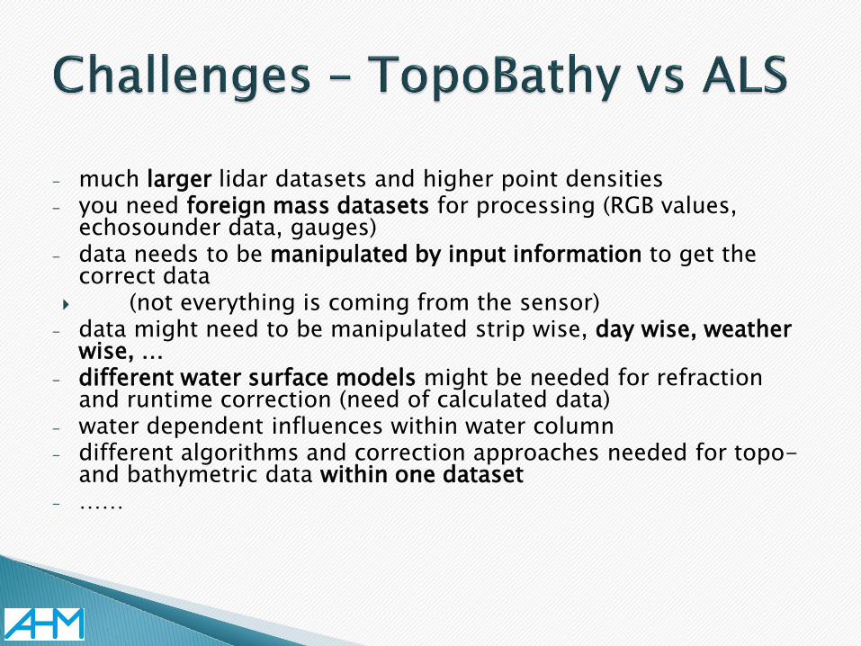
- much larger lidar datasets and higher point densities - you need foreign mass datasets for processing (RGB values,
echosounder data, gauges) - data needs to be manipulated by input information to get the
correct data (not everything is coming from the sensor)
- data might need to be manipulated strip wise, day wise, weather wise, …
- different water surface models might be needed for refraction and runtime correction (need of calculated data)
- water dependent influences within water column - different algorithms and correction approaches needed for topo-
and bathymetric data within one dataset - ……

Higher amount of data processing – Easier to make mistakes during processing
- Visualization for processing and quality control - Keeping all processing steps and data to retrace processing - Data conversion and export possibilities without loosing
information - Merged datasets of different data sources
-> Flexible File Format For the Future (F5)

Before doing data processing and visualization one has to deal with data ◦ Big data sets
◦ Many different kinds
◦ Many formats
Data management and handling is important

Surveying produces big data sets (>100 GB to TBs)
Large Data

http://spinoff.nasa.gov Diverse
Data
LIDAR
Satellite
Images
Arial
Images
Standard
Surveys
•Cross Sections
•Cadastral Maps
•Surfaces, DTM
Sonar
Data

File Format 2
File Format 1
File Format 3
File Format 4
File Format 5
… File Format N
o(N2)

File Format 2
File Format 1
File Format 3
File Format 4
File Format 5
… File Format N

File Format 2
File Format 1
File Format 3
File Format 4
File Format 5
… File Format N
Less Implementation Effort o(N)
Common
Data Format

Workgroup A
Workgroup B Workgroup C
Workgroup D
Software 3
Software Tool 1
Software 4
Software Tool 2
Common Data
Format
Easier collaboration More time for science

Easy access
Fast and
efficient
Huge data
(Terabytes)
Huge variety
of data
Self-
descriptive
Well documented
and user community
Sustainable
(>10 years)

Hierarchical Data Format 5 http://www.hdfgroup.org/HDF5

File system
(in a file) Binary XML file
PDF for
numerical data
Database
(container for
array variables)

lat | lon | temp ----|-----|----- 12 | 23 | 3.1 15 | 24 | 4.2 17 | 21 | 3.6
/
Parameters 10;100;1000
Timestep 36,000
Group
Dataset
Attribute

Billions of elements/dozens associated values
Earth Science (Earth Observing System) Big simulations
Movie Making
Aqua
(6/01)
Aura TES HRDLS
MLS OMI
Terra
CERES MISR
MODIS MOPIT
T
Aqua CERES MODIS
AMSR

HDF5 is a software library to handle the HDF5 file format
Software Application
HDF5 Library
Storage Medium (hard disk)

HDF5 VFD allows to replace the storage device access routines
Software Application
HDF5 Library
Virtual File Driver
Storage Medium (hard disk)

HDF5
HDD Streaming
Server
Client
SSH
Partial Read
Partial Write
HTTP
Anonymous
Read
Local Data Access Remote Data Access

Standard SSH server
◦ No special server required, just place HDF5 file where it can be accessed via scp
Allow partial file acess
◦ Does NOT copy the entire file, e.g.:
HDF5
HDD SSH
Remote
HDD Local (region of interest)

HDF5
HDD Streaming
Server
Client
SSH
Partial Read
Partial Write
HTTP
Anonymous
Read
Local Data Access Remote Data Access
Funded & Supported by:
US National Science Foundation Award #1251137
BIGDATA: Small: DCM: Collaborative Research: An efficient, versatile, scalable, and portable storage system for scientific data containers
Stony Brook University, New York
Brandeis University, New York
Louisiana State University, Baton Rouge

A multi-platform library and tools built on over 10 years experience in large data handling from the high performance computing community (HPC).
A capability that:
◦ Lets them organize large and/or complex collections of data
◦ Gives them efficient and scalable data storage and access
◦ Lets them integrate a wide variety of types of data and data sources
◦ Guarantees long-term data integrity and preservation
◦ Supports remote file access (work in progress)
23


A visualization model based on the mathematics of fiber bundles, David M. Butler and M. H. Pendley, Computers in Physics, Sep/Oct 1989, p 45-51, 3(5)
The proper abstractions for
scientific data are known.
We just have to use them.

The total space E can be written locally as a product space BF of the base space B with some space F.
base space
fiber space at each
point of base space

Designed for Scientific
Data
C Library
•Allows to write complicated data by a
few function calls
Provides High Level
Functions
Originates from
application in
numerical relativity

Separation of Grids (Topology, Geometry, Coordinate Systems)
and Data-Fields
Inspired by concepts of:
Topology Differential Geometry Geometric Algebra
Based on HDF5
Grid
Field

•Manifold describing the base space
•Topology
•Refinement level
•Coordinate representation
•Vertex positions in representation
•Neighborhood
Grid
the base
space

•Dataset holding numerical data
•per k-cell on the grid (vertex, edge, triangle, cell, … )
•Array of arbitrary type, for example:
•Scalar
•Vector, BiVector, …
•Tensor
•Any other user defined type
Field
the fiber
space

Fiber Bundle
Time Slice
Grid
Topology
Coordinates
Field
Visible for an user

• Multi Channel – Multi Resolution Images:
• Full Waveform LIDAR:
t1 t2 t3
t_emission
• Shape Data
• Point Cloud Data

Fiber Bundle
Time Slice
Grid
Topology
Coordinates
Field

HDF5
h5ls
•Good for overview and
data viewing
h5dump
•Good for inspecting
details
•Xml conversion
F5
F5ls
•Fiber bundle
organized based
data viewing


Supported Grid types:
• Uniform Grid
• Curvilinear Grid
• Rectilinear Grid
• Adaptive Mesh Refinement Grid (AMR)
• Point Cloud
• Lines
• Triangular/Quad and Mixed Surfaces
Grids can be fragmented (Blocks) having Ghost Zones
Grids can have refinement levels
Work in progress:
• Hexahedral Grid
• FEM Grid
• Connected Graph Data
• Full Waveform LIDAR Laser Data


A subset c X of a Hausdorff space X is a k-cell if it is homeomorphic to an open k-dimensional ball in ℝn.
0-cells are called vertices, 1-cells are edges, 2-cells are faces
or polygons, 3-cells are polyhedra.

Comes as a
C-library (free academic, free personal)
Provides high-level
functions for data
reading and writing
Comes with several
data converters
• RDBtoF5, LidarToF5,
ShapeToF5, F5toDXF, …
Comes with several
F5-file based
command-line tools
• F5ls, F5Copy, F5shift, …

HDF5 VOL allows to replace high-level API operations More efficient bundling of operations
Software Application
HDF5 VOL – Virtual Object Layer
HDF5 Library
Virtual File Driver
Storage Medium (hard disk)