Dinarides lakes and basins – from 18 Ma to Present
46
Lake - Basin Evolution 2016 - Field Trip Guidebook 1 Fig. 1. Distribution of Miocene lacustrine deposits attributed to the Dinaride Lake System (data from basic geo- logical map M 1:100,000 of former Yugoslavia). Positions of excursion sites are indicated: 1 - Plitvice, 2 - Vrana, 3 - Sutina, 4 - Tušnica, 5 - Mandek, 6 - Ostrožac, 7 - Cebara, 8 - Fatelj, 9 - Gračanica, 10 - Greben, 11 - Janjići, 12 - Lašva. PART 2 / EXCURSION 2 By Oleg Mandic, Karin Sant, Nevena Andrić, Nada Horvatinčić, Nikolina Ilijanić, Slobodan Miko, Nikola Markić, Anđelko Novosel, Liviu Matenco, Hazim Hrvatović With contributions by Ursula B. Göhlich, Thomas A. Neubauer, Arjan de Leeuw, Wout Krijgsman Dinarides lakes and basins – from 18 Ma to Present 1. Introduction: Dinarides lacustrine environments The Dinarides area of Croatia and Bosnia and Herzegovina is an active fold and thrust belt positioned between the Mediterranean and the Pannonian Basin (Fig. 1). In the Neogene the region recorded an extended history of lacus- trine deposition. Its early Neogene history is marked by the rise and fall of the Dinaride Lake System. After its disintegration in the Middle Miocene only three largest lake basins re- mained active – Lake Sarajevo, Livno, and Tomislavgrad. In the Quaternary, all lakes re- treated in consequence of regional tectonic
-
Upload
truongthien -
Category
Documents
-
view
219 -
download
3
Transcript of Dinarides lakes and basins – from 18 Ma to Present

Lake - Basin Evolution 2016 - Field Trip Guidebook
1
Fig. 1. Distribution of Miocene lacustrine deposits attributed to the Dinaride Lake System (data from basic geo-
logical map M 1:100,000 of former Yugoslavia). Positions of excursion sites are indicated: 1 - Plitvice, 2 - Vrana,
3 - Sutina, 4 - Tušnica, 5 - Mandek, 6 - Ostrožac, 7 - Cebara, 8 - Fatelj, 9 - Gračanica, 10 - Greben, 11 - Janjići, 12 -
Lašva.
PART 2 / EXCURSION 2
By Oleg Mandic, Karin Sant, Nevena Andrić, Nada Horvatinčić, Nikolina Ilijanić,
Slobodan Miko, Nikola Markić, Anđelko Novosel, Liviu Matenco, Hazim Hrvatović
With contributions by Ursula B. Göhlich, Thomas A. Neubauer, Arjan de Leeuw, Wout
Krijgsman
Dinarides lakes and basins – from 18 Ma to Present
1. Introduction: Dinarides lacustrine environments
The Dinarides area of Croatia and Bosnia and
Herzegovina is an active fold and thrust belt
positioned between the Mediterranean and the
Pannonian Basin (Fig. 1). In the Neogene the
region recorded an extended history of lacus-
trine deposition. Its early Neogene history is
marked by the rise and fall of the Dinaride Lake
System. After its disintegration in the Middle
Miocene only three largest lake basins re-
mained active – Lake Sarajevo, Livno, and
Tomislavgrad. In the Quaternary, all lakes re-
treated in consequence of regional tectonic
Lake - Basin Evolution 2016 - Field Trip Guidebook
2
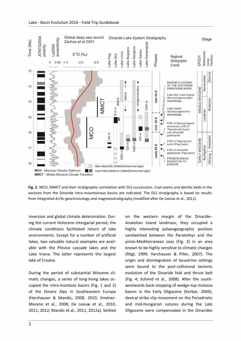
Fig. 2. MCO, MMCT and their stratigraphic correlation with DLS successions. Coal seams and detritic beds in the
sections from the Dinaride intra-mountainous basins are indicated. The DLS stratigraphy is based on results
from integrated Ar/Ar geochronology and magnetostratigraphy (modified after De Leeuw et al., 2011).
inversion and global climate deterioration. Dur-
ing the current Holocene intergacial period, the
climate conditions facilitated return of lake
environments. Except for a number of artificial
lakes, two valuable natural examples are avail-
able with the Plitvice cascade lakes and the
Lake Vrana. The latter represents the largest
lake of Croatia.
During the period of substantial Miocene cli-
matic changes, a series of long-living lakes oc-
cupied the intra-montane basins (Fig. 1 and 2)
of the Dinaric Alps in Southeastern Europe
(Harzhauser & Mandic, 2008, 2010; Jiménez-
Moreno et al., 2008; De Leeuw et al., 2010,
2011, 2012; Mandic et al., 2011, 2012a). Settled
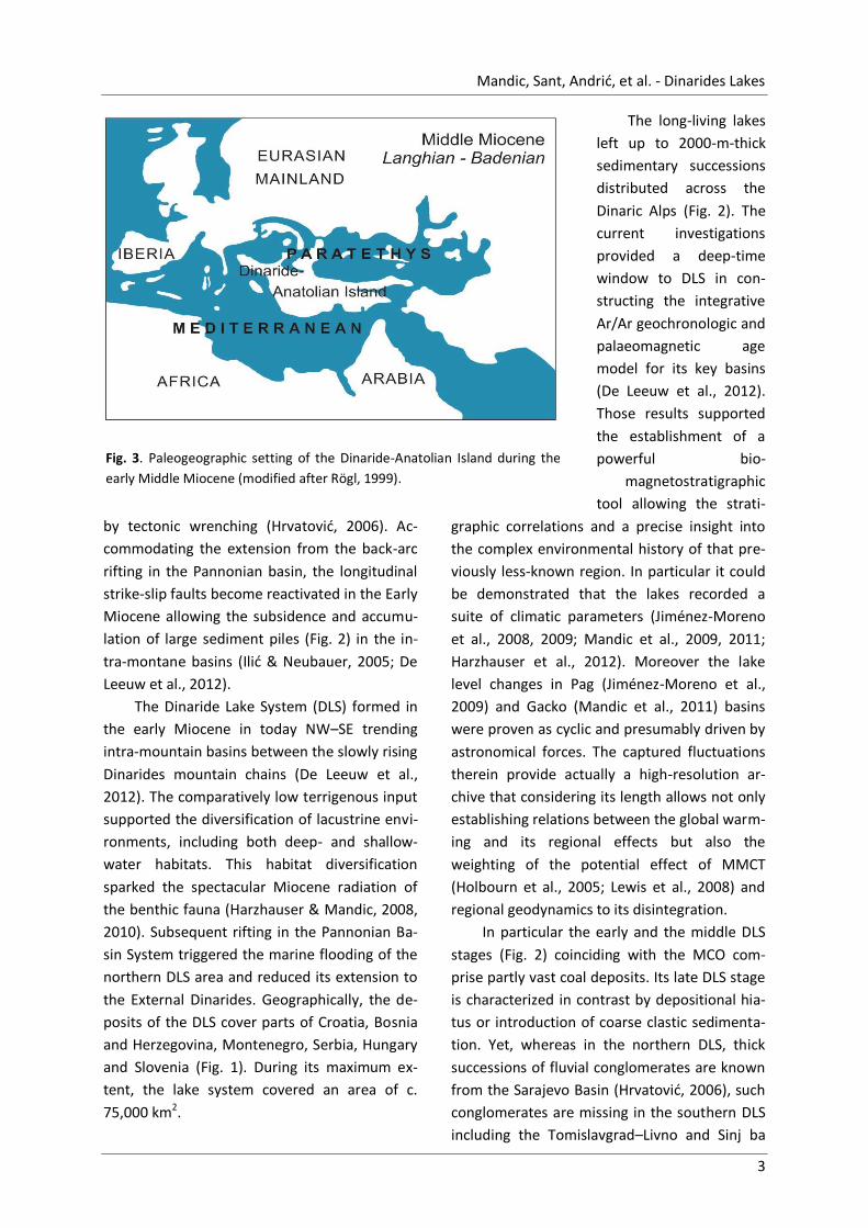
on the western margin of the Dinaride–
Anatolian Island landmass, they occupied a
highly interesting palaeogeographic position
sandwiched between the Paratethys and the
proto-Mediterranean seas (Fig. 3) in an area
known to be highly sensitive to climatic changes
(Rögl, 1999; Harzhauser & Piller, 2007). The
origin and disintegration of lacustrine settings
were bound to the post-collisional tectonic
evolution of the Dinaride fold and thrust belt
(Fig. 4; Schmid et al., 2008). After the south-
westwards back-stepping of wedge-top molasse
basins in the Early Oligocene (Korbar, 2009),
dextral strike-slip movement on the Periadriatic
and mid-Hungarian sutures during the Late
Oligocene were compensated in the Dinarides
Mandic, Sant, Andrić, et al. - Dinarides Lakes
3
Fig. 3. Paleogeographic setting of the Dinaride-Anatolian Island during the
early Middle Miocene (modified after Rögl, 1999).
by tectonic wrenching (Hrvatović, 2006). Ac-
commodating the extension from the back-arc
rifting in the Pannonian basin, the longitudinal
strike-slip faults become reactivated in the Early
Miocene allowing the subsidence and accumu-
lation of large sediment piles (Fig. 2) in the in-
tra-montane basins (Ilić & Neubauer, 2005; De
Leeuw et al., 2012).
The Dinaride Lake System (DLS) formed in
the early Miocene in today NW–SE trending
intra-mountain basins between the slowly rising
Dinarides mountain chains (De Leeuw et al.,
2012). The comparatively low terrigenous input
supported the diversification of lacustrine envi-
ronments, including both deep- and shallow-
water habitats. This habitat diversification
sparked the spectacular Miocene radiation of
the benthic fauna (Harzhauser & Mandic, 2008,
2010). Subsequent rifting in the Pannonian Ba-
sin System triggered the marine flooding of the
northern DLS area and reduced its extension to
the External Dinarides. Geographically, the de-
posits of the DLS cover parts of Croatia, Bosnia
and Herzegovina, Montenegro, Serbia, Hungary
and Slovenia (Fig. 1). During its maximum ex-
tent, the lake system covered an area of c.
75,000 km2.
The long-living lakes
left up to 2000-m-thick
sedimentary successions
distributed across the
Dinaric Alps (Fig. 2). The
current investigations
provided a deep-time
window to DLS in con-
structing the integrative
Ar/Ar geochronologic and
palaeomagnetic age
model for its key basins
(De Leeuw et al., 2012).
Those results supported
the establishment of a
powerful bio-
magnetostratigraphic
tool allowing the strati-
graphic correlations and a precise insight into
the complex environmental history of that pre-
viously less-known region. In particular it could
be demonstrated that the lakes recorded a
suite of climatic parameters (Jiménez-Moreno
et al., 2008, 2009; Mandic et al., 2009, 2011;
Harzhauser et al., 2012). Moreover the lake
level changes in Pag (Jiménez-Moreno et al.,
2009) and Gacko (Mandic et al., 2011) basins
were proven as cyclic and presumably driven by
astronomical forces. The captured fluctuations
therein provide actually a high-resolution ar-
chive that considering its length allows not only
establishing relations between the global warm-
ing and its regional effects but also the
weighting of the potential effect of MMCT
(Holbourn et al., 2005; Lewis et al., 2008) and
regional geodynamics to its disintegration.
In particular the early and the middle DLS
stages (Fig. 2) coinciding with the MCO com-
prise partly vast coal deposits. Its late DLS stage
is characterized in contrast by depositional hia-
tus or introduction of coarse clastic sedimenta-
tion. Yet, whereas in the northern DLS, thick
successions of fluvial conglomerates are known
from the Sarajevo Basin (Hrvatović, 2006), such
conglomerates are missing in the southern DLS
including the Tomislavgrad–Livno and Sinj ba

Lake - Basin Evolution 2016 - Field Trip Guidebook
4
Fig. 4. Plate tectonic and geologic setting of the Dinarides and surrounding area, adapted from Schmid et al.
(2008). The Neogene intra-montane basins filled by lacustrine deposits are marked green (see also Fig. 1), the
sites evaluated by De Leeuw et al (2012) by dark red rectangles (see also Fig. 2). Main faults, major plate
boundaries and the direction of movement of the Adriatic Plate are indicated.
sins (Fig. 2). There local debris flow deposits
(sandstones and breccias) are recorded be-
tween ~15.2 and ~15.0 Ma in the Sinj Basin
(Mandic et al., 2009; De Leeuw et al., 2010) and
between 14.8 and ~13.0 Ma in the
Tomislavgrad–Livno Basin (De Leeuw et al.,
2011). In all three basins the coarse clastic dep-
osition coincide with the terminal phase of the
main DLS depositional sequence indicating
synsedimentary tectonics and relief building as
cause for basinal inversion terminating the la-
custrine deposition in the late Middle Miocene.
The six intra-montane basins of the Dinarides
will be visited to show the late syn- to post-
orogenic sedimentation within the orogenic
belt.

RCMNS IC 2016 Lake - Basin - Evolution • Excursion Guide
5
2. Tectonic setting of the Dinarides
Arjan de Leeuw, Oleg Mandic, Liviu Matenco
The Dinarides are located on the convergent
plate boundary separating the Adriatic and Ti-
sza-Dacia micro-plates in the Central part of the
Mediterranean region (Fig. 4). Early conver-
gence between the Adriatic indenter and the
Tisza-Dacia mega terrane, situated at the
southern margin of Europe, led to the for-
mation of an early middle Jurassic island arc in
the separating Vardar Ocean. This island arc
was obducted onto the Dinarides in the Late
Jurassic (Schmid et al., 2008). Throughout the
Cretaceous, various thrust sheets were em-
placed (Schmid et al., 2008; Hrvatović, 2006).
Ongoing convergence between Adria and the
Tisza-Dacia plate eventually led to their collision
some time between the latest Cretaceous and
Paleogene (Ustaszewski, 2008). A Middle Eo-
cene phase of intense thrusting followed, as
evidenced by the widespread associated flysch
deposits (Tari, 2002; Korbar, 2009). Collision
induced shortening continued in the Late Eo-
cene and Oligocene and was associated with
molasse sedimentation in the external parts of
the Dinarides. Oligocene strike-slip faulting in
response to movement on the Peri-Adriatic
fault initiated transpressional depressions as
precursors of the Neogene freshwater basins
(Hrvatović, 2006). In the Early to Middle Mio-
cene, the north-eastern margin of the Dinarides
was affected by profound extension in response
to the rifting that initialized the Pannonian Ba-
sin (Tari, 2002). It largely subsided below the
base-level of the adjacent Paratethys; a Medi-
terranean sized epi-continental sea that cov-
ered large parts of south-eastern Europe at that
time. In the more central and western parts of
the Dinarides, this extensional phase reactivat-
ed Oligocene transpressive structures and con-
sequently triggered the development of a series
of lacustrine intra-montane basins.
3. Excursion Points
The current excursion will present a brief over-
view on the past and present fresh water lacus-
trine environments represented since the Early
Miocene in the karst valleys and intra-
mountainous basins of the Dinarides (the so-
called Dinaride Lake System and its successors).
Results from current and ongoing research
about their geodynamic, depositional, envi-
ronmental, and biotic histories will be first-hand
presented by investigators in a three day bus
excursion crossing the Dinarides in Croatia and
in Bosnia-Herzegovina (Fig. 1).
The excursion starts with the World herit-
age site, the spectacular calcareous tufa cas-
cades of the Plitvice lakes (P1), situated in the
largest national park of Croatia hosting more
than one million visitors per year. It continues
with Lake Vrana (P2), located in a Dalmatian
karst valley of the Adriatic coastal area, and
represents the largest Croatian fresh water
lake. Recent limnogeological drilling campaigns
therein allowed reconstruction of the regional
sea-level history in the late Quaternary. The
end of the day will be spent in the Sinj Basin
(P3), filled by coal bearing carbonate deposits

Lake - Basin Evolution 2016 - Field Trip Guidebook
6
of a long-living lake that existed there for about
3 myr during the Miocene Climate Optimum.
The second day will demonstrate the rise
and fall of the long-lived lacustrine environ-
ments in the Livno and Tomislavgrad basins in
Bosnia-Herzegovina. Beside different sediment
types such as coal (P4), marl, carbonates, vol-
canic ashes (P5) and debrites (P6), the visit to
the Mio-Pliocene proboscidean site Cebara (P7)
will bring insights to the complex geodynamic
history of these two classical karst valleys of the
External Dinarides. A fossil site with excellently
preserved 15 myr old endemic fresh water mol-
lusks will be visited by the end of the day in the
Kupres basin (P8).
The third day will start with a visit to the
open cast mine Gračanica (P9) in the Bugojno
basin where large-scale outcrops show trans-
gressive open lake marls with slump structures
grading over thick lignite measures, bearing
large mammal remains. The rest of the day will
be spent in the region of Kakanj in the Sarajevo
Basin. This is the largest Dinaride lake basin.
The asymmetric extensional basin formed in the
hanging-wall of a large-scale top-NNE detach-
ment and is associated with the exhumation of
the Mid-Bosnian Schists Mountains in its foot-
wall. The field stops will take you from the deep
lake (P10) to alluvial plains (P11–12), and
thereby illustrate the close connection between
tectonics and sedimentation.
3.1. POINT 1. PLITVICE – Recent tuffa sedimentation
Locality: Plitvice Lakes [Plitvička jezera]
WGS84 coordinates: 44.880323° N, 15.618544° E
Age: Recent
3.1.1. Environment, chronology and tufa sedimentation
Nada Horvatinčić
Introduction
The Plitvice Lakes, situated on the Dinaric karst
in Central Croatia, consist of 16 lakes of differ-
ent size, connected by streams and waterfalls
(Fig. 5). The altitude of the area ranges from
505 m to 636 m asl, the climate is mountain-
continental, the average air temperature is
9.1°C and the average yearly precipitation is
1558 mm for the period 1986–2010.
The lakes receive water from two main springs
(Crna Rijeka and Bijela Rijeka springs) and two
tributaries (Rječica and Plitvica Brooks) (Fig. 5a).
The Plitvice Lakes feed the Korana River which
issues from the lakes. The total distance from
the springs to the Korana River is ~12 km. Lakes
are divided into Upper and Lower Lakes by a
large fault, which strikes northwest to south-
east along the northeast edge of the Kozjak
Lake (Fig. 5b). The lakes developed in the fluvial
karstic river valley (palaeo-Korana River) which
was dammed by tufa barriers. Twelve Upper
Lakes developed in the open part of the river
valley, mainly dolomite, and are surrounded by
thick forests and interlinked by numerous wa-
terfalls. Four Lower Lakes, smaller and shallow-
er, developed in the karst canyon which was
carved by paleo-river flow through limestone,

Mandic, Sant, Andrić, et al. - Dinarides Lakes
7
Fig. 5. a) Plitvice Lakes area from main springs (Crna and Bijela Rijeka) along 16 lakes to the outflow of the Ko-
rana River; b) Schematic geological map of the Plitvice Lakes area (simplified after Polšak et al., 1969); 1 – tufa,
2 – Upper Cretaceous rudist limestone, 3 – Upper Cretaceous limestone, marl and dolomite, 4 – Upper Jurassic
dolomite and platy limestone, 5 Middle Jurassic limestone and dolomite, 6 Lower Jurassic limestone and dolo-
mite, 7 Upper Triassic dolomite, 8 – fault.
presumably during last glacial period (Fig. 5b).
The lakes and Korana River are characterized by
intense calcium carbonate precipitation from
the water forming tufa barriers and fine-grained
lake sediments, mainly composed of authigenic
calcite
The area is protected as a national park
from 1949 and is included in the UNESCO World
Heritage List. Human activities in the lake wa-
tersheds are relatively limited, although nu-
merous tourists visit the area every year.
The Plitvice Lakes represent a unique phe-
nomenon of karst hydrography, particularly
because of tufa formation, a freshwater calcium
carbonate which precipitates in presence of
macrophites and microphites forming spectacu-
lar waterfalls and barriers. Although the area is
protected as a national park, any pollution in
global or local level can disturb very sensitive
process of tufa formation. In order to under-
stand the processes of tufa formation as well as
to protect the area against any contamination,
scientific research in the area of the National
Park has been performed by various teams.
Various projects include the study of tufa and
lake sediment deposition, hydrogeology of the
area, biological and environmental research,
forest vegetation and forest management, in-
ventory of various fauna species, monitoring of
possible organic or inorganic pollutants and
other topics. Regular monitoring of physico-
chemical and bacteriological parameters in
water have been performed by the staff of the
Scientific Investigation Centre "Academician Ivo
Pevalek" located at the Plitvice Lakes since
2006.
Tufa and lake sediment formation
Tufa is a product of calcium carbonate precipi-

Lake - Basin Evolution 2016 - Field Trip Guidebook
8
Fig. 6. Geochemical processes of tufa and lake sediment precipitation presented at the cross-section of the
Plitvice Lakes.
tation at near ambient temperature and typical-
ly it contains the remains of micro and macro-
phytes and bacteria. Tufa is deposited in the
surface water by a combination of physico-
chemical and biological precipitation processes.
Geochemical process of tufa and lake sed-
iment formation is presented at the cross-
section of the Plitvice Lakes (Fig. 6). In the first
step the rain water dissolves CO2 produced by
the decomposition of organic matter and by
root respiration in the topsoil. Percolating wa-
ter rich in CO2 dissolves carbonate rocks and
forms bicarbonate. When water containing
calcium and bicarbonate ions emerges in the
form of a karst spring, precipitation of calcium
carbonate occurs either due to degassing of CO2
from solution or by evaporation. Precipitation
of carbonates in the form of lake sediment or
tufa depends on the physico-chemical condi-
tions of the water. It is enhanced by the photo-
synthetic activity of aquatic primary producers
(algae, bacteria and plants) indicating that the
interaction between atmosphere and biosphere
determines the CO2 – HCO3 – CaCO3 system.
Besides physico-chemical conditions the
plants/biota have important role in the precipi-
tation of the tufa. The biota remove CO2, which
increases the level of saturation of water, act as
a convenient substrate for precipitation (Fig.
7a) and trap and bind calcite seed crystals with-
in a biofilm which is a by-product of the micro-
bial metabolic activity of diatoms, bacteria
and/or cyanobacteria (Fig. 7b) (Chafetz et al.,
1994, Golubić et al., 2008). Tufa formation is
favoured where well-developed plants exist in
streams and waterfalls resulting in different
morphological forms (Fig. 7a). This process is
very sensitive to physico-chemical or biological
changes in the water and also to seasonal fluc-
tuation, e.g., temperature change.
Investigations of physico-chemical condi-
tions of tufa precipitation from the freshwater

Mandic, Sant, Andrić, et al. - Dinarides Lakes
9
Fig. 7. a) Presence of plants and percolation of water on cascades accelerates calcite precipitation in form of
tufa barriers, b) SEM photograph of diatom aggregations on moss at the Plitvice Lakes.
at the Plitvice Lakes area were performed sys-
tematically in different seasons included three
main springs feeding the Plitvice Lakes, lakes,
streams and the Korana River which issued
from the Plitvice Lakes, in total distance of
~12 km (Srdoč et al., 1985, Barešić et al., 2011).
The lake waters are characterized by a high
seasonal temperature variation of ~20°C, and
the pH values of 7.3–7.6 in springs to 8.2–8.6 in
lakes area increasing downstream. CO2 concen-
tration decreases rapidly in spring area, while
concentration of bicarbonates as a main com-
ponent of dissolved inorganic carbon steadily
decreases downstream from 5.2 to 3.5 mmolL-1.
In the area of the lakes where the process of
calcite precipitation is very intensive, the wa-
ters are oversaturated, the saturation index
(Isat) of CaCO3 ranges from 4 to 10.
The whole karstic environment of Plitvice Lakes,
comprising water, soil and air, is very sensitive
to any kind of pollution. Although the Plitvice
Lakes area is protected as the national park and
is scarcely populated, some contamination by
local settlements, tourism activities and traffic
is possible. Comprehensive study of possible
anthropogenic and environmental change influ-
ence on Plivice Lakes area has been performed
on the recent lake sediments (precipitated in
last 100–150 yr). Lake sediments consist mostly
of calcite (70–85% in big lakes, 90–95% in small
lakes) with very small amount of dolomite,
quartz, and low fraction of organic matter (2–
8%). Both, calcite and organic matter are mainly
authigenic (>90%), which is demonstrated by
the δ13C analyses of the sediments.
Anthropogenic influence on 14C activity in
recent lake sediment, interpreted as a delayed
and damped response to bomb-produced 14C in
the atmosphere was observed in Prošće, Kozjak,
Gradinsko and Kaluđerovac lakes (Horvatinčić
et al., 2008). For the small lakes, the increase of
δ13C in the last two decades and at least part of
the increase of δ 14C is probably due to an in-
crease in primary productivity that enhanced
biologically-induced calcite precipitation with
accompanying changes in the carbon isotopic
composition of carbonate sediments. This cor-
responds with the global temperature increase.
Trace element analyses showed no signifi-
cant difference among the trace element con-
centration in the top segment of all cores, cor-
responding to last 50 years when higher an-
thropogenic influence can be expected. Anal-
yses of lake sediment show no significant con-
tamination caused by anthropogenic influence
(Horvatinčić et al., 2006).
Moreover, the lakes are located in mostly
deciduous forest, and huge amount of leaves
are transported into the lakes every year. Addi-
Lake - Basin Evolution 2016 - Field Trip Guidebook
10
Fig. 8. Schematic hydrogeological cross-section of the Plitvice Lakes water resource system (Biondić et al.,
2010).
tionally, some preliminary measurements of
dissolved organic carbon (DOC) in water in this
area showed that increase of DOC can disturb
or even stop the process of tufa precipitation
(Srdoč et al., 1985; Barešić et al., 2011). In last
decades the process of eutrophication in the
Plitvice Lakes has been observed in the form of
intense plant growth in some lakes, tufa barri-
ers and water streams. This process is attribut-
ed to influx of nutrients into lakes and streams
from natural and anthropogenic sources result-
ing in deterioration of water quality.
Geochronology
Results of 14C dating of active tufa deposits
show that they are younger than 8000 years BP
and formed during the Holocene period, i.e.,
after the last deglaciation. Outcrops of old tufa
deposits found at three locations in the Park
area were dated by 230Th/234U dating method
(Srdoč et al., 1994; Horvatinčić et al., 2000).
These results showed that most of old tufa
samples clustered around interglacial marine 18O stage 5, and then interglacial stages 7 and 9. 14C and 230Th/234U ages of tufa in the Plitvice
Lakes area demonstrate that the formation of
tufa barriers was stimulated by changing cli-
mate, e.g., during interglacial periods with
warm and humid conditions (Horvatinčić et al.,
2003).
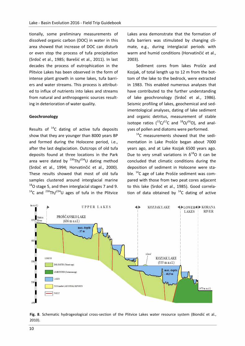
Sediment cores from lakes Prošće and
Kozjak, of total length up to 12 m from the bot-
tom of the lake to the bedrock, were extracted
in 1983. This enabled numerous analyses that
have contributed to the further understanding
of lake geochronology (Srdoč et al., 1986).
Seismic profiling of lakes, geochemical and sed-
imentological analyses, dating of lake sediment
and organic detritus, measurement of stable
isotope ratios (13C/12C and 18O/16O), and anal-
yses of pollen and diatoms were performed. 14C measurements showed that the sedi-
mentation in Lake Prošće began about 7000
years ago, and at Lake Kozjak 6500 years ago.
Due to very small variations in δ18O it can be
concluded that climatic conditions during the
deposition of sediment in Holocene were sta-
ble. 14C age of Lake Prošće sediment was com-
pared with those from two peat cores adjacent
to this lake (Srdoč et al., 1985). Good correla-
tion of data obtained by 14C dating of active

Mandic, Sant, Andrić, et al. - Dinarides Lakes
11
Fig. 9. Schematic hydrogeological map of the Plitvice Lakes catchment area (Biondić et al., 2010).
tufa, lake sediments and peat deposit confirms
that the formation of Plitvice Lakes, i.e., the
beginning of growth of recent tufa barriers,
coincided with global warming during the Holo-
cene.
3.1.2. Geology and hydrogeology of the Plitvice Lakes
Nikola Markić, Anđelko Novosel, Oleg Mandic
The territory of the Plitvice Lakes National park
and surrounding area is part of the External
Dinarides marked by stable carbonate-platform
deposition in the Mesozoic (Fig. 5). Current
geomorphological features of the area resulted
from its complex regional tectonic and climatic
history. The tectonic processes, which formed
the neighboring mountain ranges, such as Vele-
bit, Velika and Mala Kapela, and Lička Plješivica,
defined the current distribution of different
porosity complexes in the area. Today's relief
appearance, marked by an intensive regional
karstification, was highly affected through ex-
treme climate conditions in the Pleistocene.
The present region dominantly consists of
Upper Triassic to Upper Cretaceous carbonate

Lake - Basin Evolution 2016 - Field Trip Guidebook
12
Fig. 10. Panorama photograph of the Lake Vrana (green); note the Adriatic Sea water front (blue) in the back
behind the land barrier.
rocks (Fig. 5b). These limestones and dolomites
show numerous varieties visible in relief differ-
ences. Besides, their composition controls the
water capture on the surface. In the area of the
national park, the karstification particularly
influenced the Jurassic limestone, therefore
strongly contrasting the appearance of re-
sistant, low porous Upper Triassic dolomite. In
addition, the canyon incisions are restricted to
the porous Cretaceous limestone, whereas the
hydrogeological features of the dolomite rocks
gained the lake creation.
Quaternary rocks comprise the tufa barri-
ers of the Plitvice Lakes together with the delu-
vial and alluvial gravel, sand and clay deposits in
depressions and river valleys. The carbonate-
dominated lithology strongly influences the
chemical composition of the subterranean
karst-water, communicating with the surface by
permanent in- and outflow processes. Such
chemistry facilitated the settlement of plants
controlling the origin and growth of calcareous
tufa barriers in the lake water.
The poorly permeable Triassic dolomite,
essential for the emergence and formation of
the so-called Upper Lakes, represents the oldest
carbonate complex in the region (Fig. 5 and 9).
In particular, it enabled the surface water ac-
cumulation from today's Lake Prošćan
[Prošćansko jezero], through Ciginovac, Galovac
and Gradin [Gradinsko jezero] lakes up to the
largest Lake Kozjak (Fig. 5a and 8). The dolo-
mite, that emerged by tectonic forces, acts as a
barrier to the water-discharge from the Mt.
Mala Kapela northeastern slopes, representing
itself a large limestone complex.
The aquatorium of Upper Lakes is fed by
the rivers Bijela Rijeka and Crna Rijeka (Fig. 9),
by the streams from existing subterranean wa-
ter accumulations, by the superficial water of
melted snow, and finally by the numerous small
permanent springs. After the groundwater dis-
charge, the flow takes place up to the longitu-
dinal fault zone on the north-eastern margin of
Lake Kozjak without any losses. After this line, a
gradual water-escape from the system occa-
sionally results in complete desiccation of the
Korana River, about 1-km-downstream from the
Plitvice Lakes.
Almost the entire Plitvice Lakes catchment
area is located within the National Park territo-
ry. Positioned close to the border of the Adriatic
Sea catchment, the Plitvice Lakes still belong to
the Black Sea catchment area.
3.2. POINT 2. VRANA – Holocene climate archive
Nikolina Ilijanić, Slobodan Miko
Locality: Lake Vrana [Vransko jezero]
WGS84 coordinates: 43.849984° N, 15.629439° E
Age: Recent
Mandic, Sant, Andrić, et al. - Dinarides Lakes
13
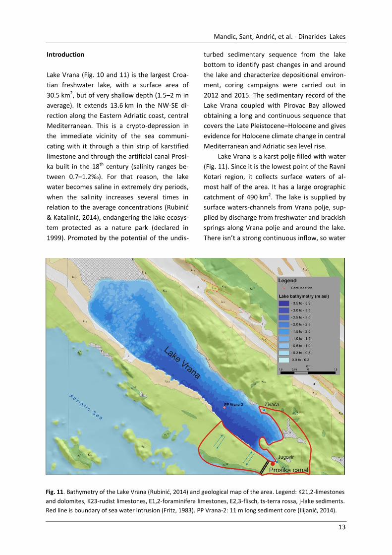
Fig. 11. Bathymetry of the Lake Vrana (Rubinić, 2014) and geological map of the area. Legend: K21,2-limestones
and dolomites, K23-rudist limestones, E1,2-foraminifera limestones, E2,3-flisch, ts-terra rossa, j-lake sediments.
Red line is boundary of sea water intrusion (Fritz, 1983). PP Vrana-2: 11 m long sediment core (Ilijanić, 2014).
Introduction
Lake Vrana (Fig. 10 and 11) is the largest Croa-
tian freshwater lake, with a surface area of
30.5 km2, but of very shallow depth (1.5–2 m in
average). It extends 13.6 km in the NW-SE di-
rection along the Eastern Adriatic coast, central
Mediterranean. This is a crypto-depression in
the immediate vicinity of the sea communi-
cating with it through a thin strip of karstified
limestone and through the artificial canal Prosi-
ka built in the 18th century (salinity ranges be-
tween 0.7–1.2‰). For that reason, the lake
water becomes saline in extremely dry periods,
when the salinity increases several times in
relation to the average concentrations (Rubinić
& Katalinić, 2014), endangering the lake ecosys-
tem protected as a nature park (declared in
1999). Promoted by the potential of the undis-
turbed sedimentary sequence from the lake
bottom to identify past changes in and around
the lake and characterize depositional environ-
ment, coring campaigns were carried out in
2012 and 2015. The sedimentary record of the
Lake Vrana coupled with Pirovac Bay allowed
obtaining a long and continuous sequence that
covers the Late Pleistocene–Holocene and gives
evidence for Holocene climate change in central
Mediterranean and Adriatic sea level rise.
Lake Vrana is a karst polje filled with water
(Fig. 11). Since it is the lowest point of the Ravni
Kotari region, it collects surface waters of al-
most half of the area. It has a large orographic
catchment of 490 km2. The lake is supplied by
surface waters-channels from Vrana polje, sup-
plied by discharge from freshwater and brackish
springs along Vrana polje and around the lake.
There isn’t a strong continuous inflow, so water
Lake - Basin Evolution 2016 - Field Trip Guidebook
14
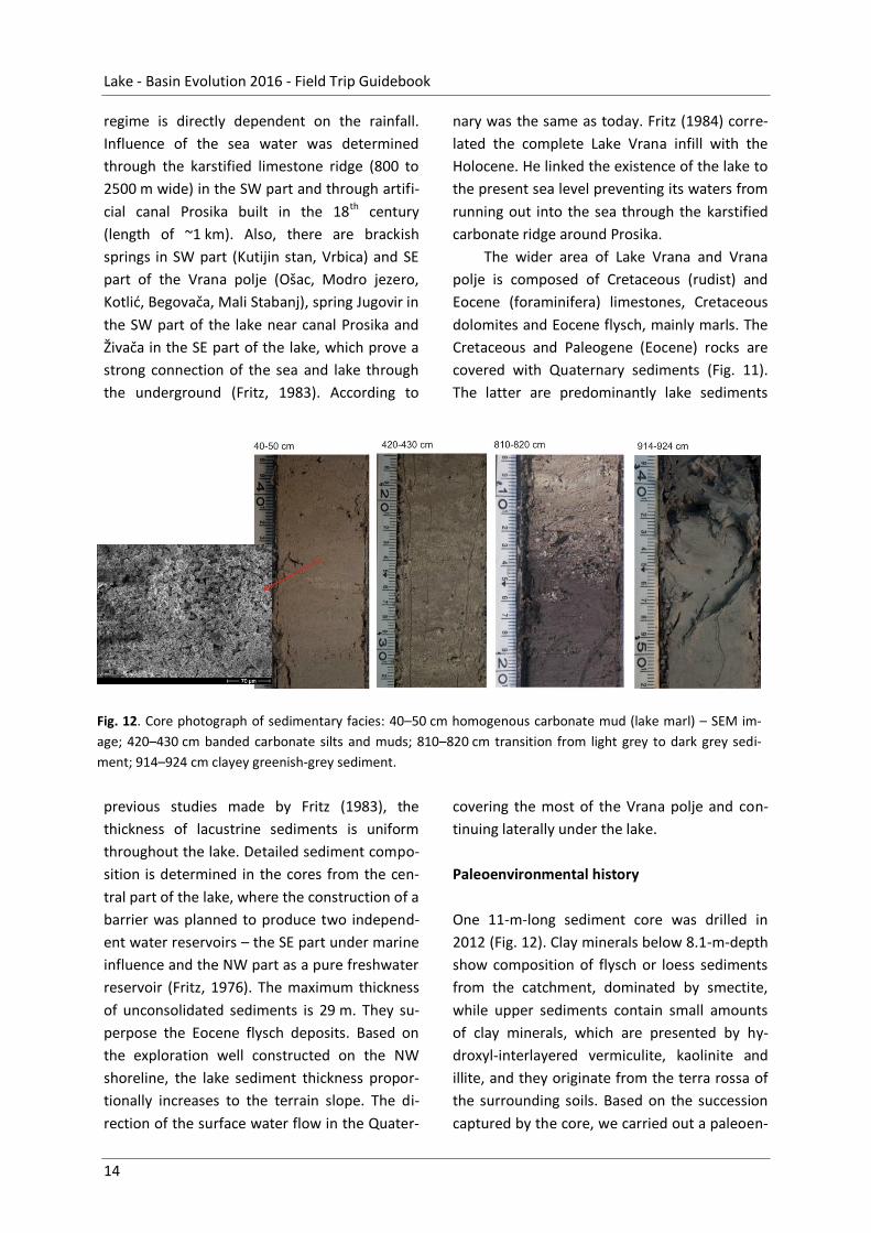
Fig. 12. Core photograph of sedimentary facies: 40–50 cm homogenous carbonate mud (lake marl) – SEM im-
age; 420–430 cm banded carbonate silts and muds; 810–820 cm transition from light grey to dark grey sedi-
ment; 914–924 cm clayey greenish-grey sediment.
regime is directly dependent on the rainfall.
Influence of the sea water was determined
through the karstified limestone ridge (800 to
2500 m wide) in the SW part and through artifi-
cial canal Prosika built in the 18th century
(length of ~1 km). Also, there are brackish
springs in SW part (Kutijin stan, Vrbica) and SE
part of the Vrana polje (Ošac, Modro jezero,
Kotlić, Begovača, Mali Stabanj), spring Jugovir in
the SW part of the lake near canal Prosika and
Živača in the SE part of the lake, which prove a
strong connection of the sea and lake through
the underground (Fritz, 1983). According to
previous studies made by Fritz (1983), the
thickness of lacustrine sediments is uniform
throughout the lake. Detailed sediment compo-
sition is determined in the cores from the cen-
tral part of the lake, where the construction of a
barrier was planned to produce two independ-
ent water reservoirs – the SE part under marine
influence and the NW part as a pure freshwater
reservoir (Fritz, 1976). The maximum thickness
of unconsolidated sediments is 29 m. They su-
perpose the Eocene flysch deposits. Based on
the exploration well constructed on the NW
shoreline, the lake sediment thickness propor-
tionally increases to the terrain slope. The di-
rection of the surface water flow in the Quater-
nary was the same as today. Fritz (1984) corre-
lated the complete Lake Vrana infill with the
Holocene. He linked the existence of the lake to
the present sea level preventing its waters from
running out into the sea through the karstified
carbonate ridge around Prosika.
The wider area of Lake Vrana and Vrana
polje is composed of Cretaceous (rudist) and
Eocene (foraminifera) limestones, Cretaceous
dolomites and Eocene flysch, mainly marls. The
Cretaceous and Paleogene (Eocene) rocks are
covered with Quaternary sediments (Fig. 11).
The latter are predominantly lake sediments
covering the most of the Vrana polje and con-
tinuing laterally under the lake.
Paleoenvironmental history
One 11-m-long sediment core was drilled in
2012 (Fig. 12). Clay minerals below 8.1-m-depth
show composition of flysch or loess sediments
from the catchment, dominated by smectite,
while upper sediments contain small amounts
of clay minerals, which are presented by hy-
droxyl-interlayered vermiculite, kaolinite and
illite, and they originate from the terra rossa of
the surrounding soils. Based on the succession
captured by the core, we carried out a paleoen-

Mandic, Sant, Andrić, et al. - Dinarides Lakes
15
Fig. 13. Paleoenvironmental reconstruction through the Holocene of the sediment core (PP Vrana-2) from Lake
Vrana based on geochemical and sedimentological proxies.
vironmental reconstruction of Lake Vrana at
centennial resolution (Fig. 13):
1.0–8.6 m. – The oldest, still undated part of
the core indicates a period of pond or wetland
deposition characterized by carbonates bearing
an increased amount of siliciclastic material.
Clasts with diameters of 0.5–1 cm suggest the
presence of high-energy inflow linked with ero-
sion processes.
18.6–8.1 m. – Transitional phase to the lake is
characterized by formation of dark organic rich
sediment, which is evident in the interval from
8.6 to 8.1 m.
9.1–6.1 ka BP. – The lake as we know it today
was formed at around 9.1 ka BP (8.1 m depth),
when the sea level rose and the water from the
lake could no longer run through the karstified
underground in an approximately 1-km-long
zone on the SE part of the lake. Lake sediments
are characterized by high amounts of car-
bonates.
6.1–3.8 ka BP. – After 6.1 ka BP siliciclastic de-
tritus gradually increases due to human settle-
ment in the catchment accompanied by defor-
estation, increasing soil erosion and input of the
siliciclastic material. Also, the pollen analysis
showed assemblage of typical Mediterranean
holm-oak vegetation from 6.1 ka BP onwards.
The marine influence on Lake Vrana sediments
is likely visible after 6.1 ka BP, by increased
proportions of magnesium (Mg) and strontium
(Sr) and the presence of aragonite.
3.8–0.0 ka BP. – The present lake water condi-
tions (alternating seasonal changes in the salini-
ty, freshwater-brackish) were established at
3.8 ka BP. Deposition of homogenous carbonate
mud (lake marl) started at 3 ka BP. Parts of the
lake sediments are influenced by sea intrusion
so that lake freshwater partly lies on more sa-
line pore-water in the lake sediments.

Lake - Basin Evolution 2016 - Field Trip Guidebook
16
Fig. 14. Geological map of the Sinj basin with schematic lithological section through its infill (above) accompa-
nied by detail geological map of the Lučane embayment (below) (modified after De Leeuw et al., 2010).
3.3. Lake Sinj – 18–15 Ma continuous freshwater lake succession1
1 The present chapter is based on Mandic et al. (2012b).
The Sinj Basin (Fig. 14), with a surface area of
~140 km2, is located in the hinterland of Split in
SE Croatia. Its sigmoidal plan-view shape sug-
gests an origin as a strike-slip basin, although
Mandic, Sant, Andrić, et al. - Dinarides Lakes
17
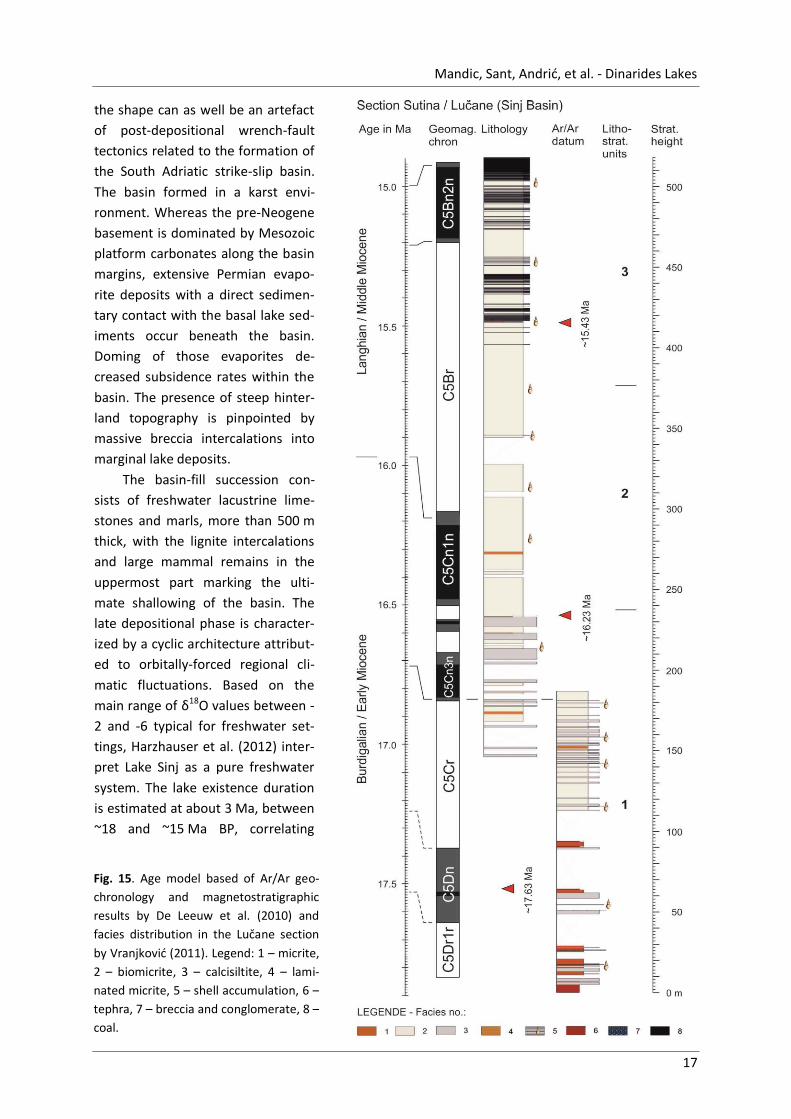
Fig. 15. Age model based of Ar/Ar geo-
chronology and magnetostratigraphic
results by De Leeuw et al. (2010) and
facies distribution in the Lučane section
by Vranjković (2011). Legend: 1 – micrite,
2 – biomicrite, 3 – calcisiltite, 4 – lami-
nated micrite, 5 – shell accumulation, 6 –
tephra, 7 – breccia and conglomerate, 8 –
coal.
the shape can as well be an artefact
of post-depositional wrench-fault
tectonics related to the formation of
the South Adriatic strike-slip basin.
The basin formed in a karst envi-
ronment. Whereas the pre-Neogene
basement is dominated by Mesozoic
platform carbonates along the basin
margins, extensive Permian evapo-
rite deposits with a direct sedimen-
tary contact with the basal lake sed-
iments occur beneath the basin.
Doming of those evaporites de-
creased subsidence rates within the
basin. The presence of steep hinter-
land topography is pinpointed by
massive breccia intercalations into
marginal lake deposits.
The basin-fill succession con-
sists of freshwater lacustrine lime-
stones and marls, more than 500 m
thick, with the lignite intercalations
and large mammal remains in the
uppermost part marking the ulti-
mate shallowing of the basin. The
late depositional phase is character-
ized by a cyclic architecture attribut-
ed to orbitally-forced regional cli-
matic fluctuations. Based on the
main range of δ18O values between -
2 and -6 typical for freshwater set-
tings, Harzhauser et al. (2012) inter-
pret Lake Sinj as a pure freshwater
system. The lake existence duration
is estimated at about 3 Ma, between
~18 and ~15 Ma BP, correlating

Lake - Basin Evolution 2016 - Field Trip Guidebook
18
largely with the Miocene Climatic Optimum (De
Leeuw et al., 2010). This ancient lacustrine ba-
sin is well known since the Darwin time for its
strictly endemic mollusc fauna, serving as a
textbook example of adaptive fauna radiation
(Neubauer et al., 2011).
3.3.1. POINT 3. SUTINA – Paleoenvironments of the lacustrine carbonate ramp
Locality: Sutina Brook / Lučane
WGS84 coordinates: 43.723310° N, 16.594943° E
Age: Burdigalian-Langhian (Early–Middle Miocene)
Lučane section is exposed along the Sutina
Creek W of Sinj. Located at the western margin
of the Sinj basin it allows the study of the com-
plete infill succession (Fig. 14 and 15). Already
described by Kerner (1905) it was currently a
subject of multiproxy investigation campaign
providing new data on stratigraphy, deposition-
al history, palaeobiology, and palaeoclimatolo-
gy (Jiménez-Moreno et al., 2008; Mandic et al.,
2009; De Leeuw et al., 2010; Neubauer et al.,
2011). It comprises two partially overlapping
sections, representing together a continuous,
around 500-m-thick record of lacustrine depos-
its. Magnetostratigraphic pattern together with
facies correspondence prove their precise cor-
relation. The uppermost beds include coal seam
intercalations, whereas the basal and the mid-
dle part of the infill show exclusively carbonate
rocks. The whole succession is intercalated oc-
casionally by volcanic ash layers. Magnetostrat-
igraphic study together with Ar/Ar dating of ash
layer provided precise age model for the sec-
tion proving its continuous sedimentation with-
in a 3 myr period from the latest Early to the
earliest Middle Miocene (Burdigalian to
Langhian) (De Leeuw et al., 2010).
Sedimentological analysis and petrography
made it possible to distinguish nine main facies
types in the Sutina succession (Vranjković,
2011). Five facies are carbonate in origin in
addition to the coal, breccia and tephra facies:
Micrite. – Consists of very fine-grained lime
mudstones. The deposition of the fine-grained
components of lacustrine carbonates is domi-
nantly induced by the photosynthetic activity of
macrophytes and microphytes. It belongs to
deeper and protected lake parts (Fig. 16a). Bi-
omicrite. – Mudstones and wackestones con-
taining degraded, and/or carbonized plant re-
mains, plant encrustations, most commonly
related to the stems of the submerged Charo-
phytes and fruits and stems of Damasonium
plant. Rooted submerged macrophytes indicate
a vegetated littoral environment of the car-
bonate lake (Fig. 16b). Calcisiltite. – Accumula-
tion out of sediment-laden density currents
(hyperpycnal flow; underflow) following ex-
panded floods (Fig. 16c). Laminated micrite. –
Alternation of thin micritic laminae, and micrite
to microsparite laminae containing Charophytes
plant encrustations (Fig. 16e). Coquina. – The
association of gastropods, bivalves, ostracods,
plant encrustations and predominantly oxidized
macrophyte remains suggests a calm, very shal-
low freshwater environment of a carbonate
lake interrupted by higher energy events prob-
ably related to storms and earthquakes. Teph-
ra. – Pyroclastic fall of volcanic ash derived from
distant eruptions (Fig. 16d). Breccia. – Olisto-
liths and debris flow deposits transported
basinwards by gravity processes at the margin
of the lake. Coal. – Deposition of allochthonous
phytoclasts took place in small delta topset at
the mouth of a creek draining a vegetated
marsh while 4-m-thick coal seam was accumu-
lated in a swamp–marsh complex.

Mandic, Sant, Andrić, et al. - Dinarides Lakes
19
Fig. 16. Microfacies types recognized at Ostrožac section by Vranjković (2011): a – micrite, b – laminated mi-
crite with completely preserved, compacted characean remains, c – calcisiltite made of idiomorphic, rhom-
boedral calcite crystals, d – diagenetically alternated vitroclastic tuff, e – biomicrite with characean remains.
The ordinance of those facies types in the
section proves a continuous record of a shal-
lowing upward sequence for the Sinj basin infill.
The sequence starts with basinal micrites and
ends with a 4-m-thick peaty coal. Hence the
dominant limestone deposition marks the lower
and the middle part of the succession. Those
limestones are usually light, thin to medium
bedded, and commonly soft and porous. The
CaCO3 content varies between 82% and 99%,
and it primarily refers to the calcite. Deposi-
tional environment changes in the uppermost
part of the succession due to gradual shallowing
of the lake and generally more humid climate
(Jiménez-Moreno et al., 2008). The changing
conditions resulted into cyclic appearance of
coal seams alternating with limestone. That
alternation was triggered by a short-term, or-
bitally forced cyclic fluctuation of humid and
dry periods. That phase, characterized by stable
hard-water lake conditions, witnessed a strong
diversification of the ecosystem followed by a
significant morphospace increase in melanopsid
and hydrobiid snails (Neubauer et al., 2011).
The paleoenvironmental analysis combining
sedimentology, microfacies analysis, coal pe-
trology and palaeoecology of mollusks and
plant remains by Mandic et al. (2009), inferred
a variety of environments for that part of the

Lake - Basin Evolution 2016 - Field Trip Guidebook
20
Fig. 17. Generalized stratigraphic column and geological map of Livno and Tomislavgrad Basins with indicated
positions of excursion sites (modified after De Leeuw et al., 2011).
section including (1) littoral below the fair
weather wave base, (2) littoral above the fair
weather wave base, (3) infralittoral with vege-
tated areas dominated by aquatic, perennial
plants, (4) low supralittoral to upper infralittoral
with starfruit meadows, (5) areas covered by
cyanobacterial mats, (6) carbonate marshes, (7)
peripheral swamps, (8) stream catchments are-
as and vegetated marches, which were (9) more
or (10) less frequently flooded. The latter envi-
ronment was inhabited by large land mammals
related to elephants and rhinoceroses.
3.4. Lake Livno-Tomislavgrad – the second largest Dinarides basin2
Oleg Mandic, Urulsa B. Göhlich, Arjan de Leeuw, Hazim Hrvatović
2 The present chapter is based on Mandic et al. (2012b and 2013).
The Livno and Tomislavgrad (=Duvno) basins
(Fig. 17) are located in the SW Bosnia and Her-
zegovina. They represent two different, tectoni-
cally-disconnected karst poljes developed at

Mandic, Sant, Andrić, et al. - Dinarides Lakes
21
Fig. 18. Lithostratigraphy and lithology
(see text for explanation) of three
sections (Tušnica, Mandek and Os-
trožac) representing the main (DLS
related) cycle of the basinal infill in
Livno and Tomislavgrad Basins accom-
panied by magnetostratigraphic and
geochronologic results by De Leeuw et
al. (2011). ATNTS. Astronomically
Tuned Neogene Time Scale by Lourens
et al. (2004). A. Mediterranean (stand-
about 1000 m a.s.l. During the DLS
deposition, they formed a single
basin with an area of about
590 km2, the second largest intra-
montane basin in the Dinarides af-
ter the Sarajevo-Zenica Basin.
The basin-fill succession is
more than 2000 m thick, comprising
two depositional sequences bound-
ed by an angular unconformity. The
lower sequence is ~1700 m thick,
composed of Early to Middle Mio-
cene freshwater deposits that
commence with ~10-m-thick coal
bed bearing elephant remains and
pass upwards into a monotonous,
limestone-dominated lacustrine
succession. At a stratigraphic height
of ~850 m the first intercalation of
margin-derived debris-flow deposits
occurs. The successive coarse-clastic
intercalations are thickening and
coarsening upwards, including up to
10-m-thick volcaniclastic beds. The
succession culminates in megabrec-
cia bed, ~26 m thick, near the top,
which suggests strongly that active
tectonics was the main cause for
the cessation of deposition in the
large original basin.
The basin subsequently be-
came split into two parts and the
second cycle of sedimentation fol-
lowed above an angular unconform-
ity overlain by lacustrine claystones

Lake - Basin Evolution 2016 - Field Trip Guidebook
22
Fig. 19. Outcrops in the Tušnica open cast coal mine.
a – coal interval intercalated with the Ar/Ar dated
white ash layer showing remain of an old under-
ground work, b – open lake profundal limestone
series in top of the coal.
passing upwards into lignite-dominated depos-
its. The Holocene witnessed an expansion of
peat deposition. The Livno Basin, with an area
of 410 km2, is the largest karst peatland basin of
the Dinarides.
3.4.1. POINT 4. TUŠNICA – The lake formation – brown coal and open lake
limestone
Locality: Tušnica
WGS84 coordinates: 43.741771° N, 17.086560° E
Age: 17.0 Ma (late Burdigalian, Early Miocene)
The 45-m-thick Tušnica section is located in the Drage opencast coalmine situated at the foot of the
Tušnica Mountain near the eastern boundary of the Livno Basin (Fig. 17, 18 and 19). It was logged
along the SSE–NNW striking wall of the quarry in 2007.
The lower 10.5 m of the section are dominated by coal subdivided in three seams. The lower
two seams are separated by a ~1-m-thick organic material rich sandy limestone interval with lymnae-
id snails and plant remains. A volcanic ash bed separates the middle and the upper coal seam (Fig.
19a). The ash layer is ~20 cm thick, laterally continuous, grayish-whitish in color, and consists of
sandy and silty clay with dark mica flakes. The transition from coal to ash and vice versa is very sharp.
A transitional zone with clayey and coaly inter-
layers starts above the upper coal seam. It is fol-
lowed by dominantly dark brown and grayish well
bedded limestones (Fig. 19b) rich in organic matter
that dominate the remaining 30 m of the section.
These beds belong to interval M2 (Milojević &
Sunarić, 1964) and contain scattered fish and plant
remains.
In the main coal seam, remains of Gom-
photerium angustidens were found and Malez &
Slišković (1976) therefore considered it to be of
Middle Miocene age. The same level was, in con-
trast, thought to pertain to the upper part of the
Early Miocene based on its pollen content (Pantić,
1961). 40Ar/39Ar measurements reveal that the
Tušnica volcanic ash, found in between the coal
seams at the base of the basin infill, is 17.0 ±
0.17 Ma old (De Leeuw et al., 2011). Milojević &
Sunarić (1964) described coal seams and organic
matter rich limestone beds of Tušnica type from
the abandoned Vučipolje coal mine at 1 km lateral
distance from the base of the Ostrožac section.
They apparently belong to the same coal bed dis-
turbed tectonically due to rise of the Tušnica
mountain block.

Mandic, Sant, Andrić, et al. - Dinarides Lakes
23
Fig. 20. Artificial Lake Mandek section: a – (from left to right) above the lake, a thick breccia interval (grayish
brown) forms a step in the landscape, the superposing lacustrine deposits (orange) bear in its lower part thick
ash fall layer (small whitish area), b – thick bentonite succession representing the diagenetically alternated
volcanic ash fall sediments (whitish gray) overlain by a lacustrine marl (orange).
The coals exposed in the Tušnica and Vučipolje testify of swamp conditions during the initial
phase of basin formation. Coal formation is terminated when the basin floods and a long-lived lake
establishes itself. As the lake deepened suboxic bottom conditions developed, as indicated by the
organic matter rich limestones of the Tušnica mine and overlying clivunellid limestones (Unit M2).
Although the clivunellid bearing interval M2 is in general badly exposed in the Livno as well as the
Tomislavgrad basin, fragments crop out at Drage West site located about 300 m W of the main en-
trance to the Tušnica coalmine (N43°44’29.0’’ E17°04’55.6’’).
The little quarry displays there light and dark brownish bedded limestones with endemic deep
water gastropod Clivunella katzeri, small dreissenid bivalves and plant remains such as Taxodium-
related Glyptostrobus europaeus and pertains to the upper part of interval M2. The clivunellid lime-
stone interval is about 300 m thick (Milojević & Sunarić, 1964) and reaches up to the base of the Os-
trožac section (De Leeuw et al., 2011).
3.4.2. POINT 5. MANDEK – Massive Middle Miocene volcanic ash fall
Locality: Mandek
WGS84 coordinates: 43. 730639° N, 17. 022426° E
Age: Middle Langhian (Middle Miocene)
The Mandek section is located 10 km south of
Livno, just E of the Mandek village, on the shore
of artificial lake Mandek (Fig. 17, 18 and 20) and
belongs to stratigraphic unit M4. The section
was logged from North to South along the gul-
ley of the Vojvodinac brook which runs normal
to the bedding. The outcrop was already men-
tioned by Luburić (1963).
The section starts with about 15 m of lacustrine
limestone starting by 30 cm thick bentonitic
tephra layer. A prominent 8-m-thick breccia
horizon follows, topped by about 14 m interval
of presumable lacustrine limestone completely
covered by vegetation. About 6-m-thick coarse
grained volcanic ash, weakly lithified and whit-
ish in colour follows on top. Finally upsection
Lake - Basin Evolution 2016 - Field Trip Guidebook
24
the ash grades into lacustrine carbonates, dom-
inated by fine-bedded limestone.
Ash horizons of the Lake Mandek section
are both indicated on the geological map by
Papeš (1972). A sample of the 6-m-thick main
ash layer was collected in a small pit (Fig. 20b)
about 100 m E of the gulley. The lowermost
tephra analyzed by Luburić (1963) represent
vitroclastic volcanic ash composed mostly by
volcanic glass (~80%) calcite (~18.5%) quartz
(~1%) and biotiote (~0.5%). The glass particles
are elongated, angulated and filled by gas inclu-
sions. It is well sorted fine sand to silt.
Absence of larger grains, together with an-
gular grain shape point to their transport from
larger distance. That coincides with the fact
that no Miocene volcanic rocks have been de-
tected in radius of at least 100 km. The extreme
depth of the main ash horizon however pro-
vides mystery about the transportation of such
a sediment quantity from the long distance.
40Ar/39Ar dating on feldspar crystals found in
the main tephra bed of Mandek delivered an
age of 14.68 ± 0.16 Ma providing its correlation
with the middle Langhian of the standard geo-
logical scale and lower Badenian of the Central
Paratethys scale (Middle Miocene). Considering
its association with the mega-breccia beds this
datum allows the dating of important tectonic
event for the Dinarides. This event marks the
start of the disintegration of the Dinaride Lake
System due to extensive relief building and
exhumation and was recorded throughout the
Dinarides such as Zenica–Sarajevo basin where
massive fluvial conglomerates marks the corre-
sponding event (Hrvatović, 2006). Event coin-
cides with the initial marine flooding of the
southern Pannonian Basin (Ćorić et al., 2009;
Mandic et al., 2012) and could reflect the com-
pensation of the extensional tectonics therein
(De Leeuw et al., 2012). Indeed the new magne-
tostratigraphic and geochronologic data could
prove the complete cessation of lacustrine sed-
imentation synchronous with these movements
for the smaller Dinaride basins such are Gacko
(Mandic et al., 2011) or Sinj Basin (De Leeuw et
al., 2010).
3.4.3. POINT 6. OSTROŽAC – Megabreccia – end of the main lacustrine cycle
Locality: Ostražac
WGS84 coordinates: 43.709919° N, 17.182881° E
Age: Late Langhian (Middle Miocene)
The 1700-m-thick Ostrožac section (Fig. 17, 18
and 21) is situated near the NW margin of the
Tomislavgrad basin. It follows the Ostrožac
brook, running down the eastern slope of the
Tušnica Mountain, for about 2 km. The brook
strikes N–S, subnormal to the bedding that is
~150°/30° in the stratigraphically lower part of
the section and ~170°/55° in the upper part of
the section. The base (N43°43’40.5’’
E17°10’59.6’’) is located about 150 m N of the
place where the path to Eminovo Selo meets
the road to the abandoned Vučipolje coal mine.
The top (N43°43’40.5’’ E17°10’59.6’’) reaches
the village of Josanica where a large megabrec-
cia crops out just north of a large curve in the
main road to Tomislavgrad. The section com-
prises 13 lithostratigraphic units ordered below
from the base to the top.
Unit 1 (8.2 m) is made by light colored
lacustrine limestones intercalated by clay layers
and volcanic ash beds. These already pertain to
stratigraphic interval M3. The well bedded
limestone, light beige, gray, yellowish or brown-
ish in color, is dominantly fine-grained, alt-
hough some coarser-grained intervals are pre-
sent as well. The beds are around 10 cm thick.

Mandic, Sant, Andrić, et al. - Dinarides Lakes
25
The intercalations are at maximum 20 cm thick
and are predominantly found in the lower part
of the unit. Unit 2 (49.6 m) is an interval of
brownish limestone with roots of water plants
(Fig. 21a) follows. The limestone is somewhat
softer than before. Unit 3 (215.9 m) comprise
thick interval of planar bedded limestones (Fig.
21b) with a bed thickness of 5–20 cm. In this
interval, plant remains disappear completely. A
single bentonite layer appears in its middle part
Unit 4 (211.2 m) shows ripple bedded
limestones (Fig. 21c, d) with only few plain bed-
ded intervals. The ripples are commonly about
1 cm thick and there is about 10 cm of distance
between consecutive crests. Some intercala-
tions of plant remains occur in association with
horizons of coarser grained limestone. Unit 5
(111.2 m) starts with an about 5-cm-thick cal-
carenite layer situated within laminated lime-
stones with plant-stems preserved on its bed-
ding plains. Ripple and trough cross beds char-
acterize this unit. Slump and channel structures
occur in combination with more calcarenite
intercalations. These are red or brownish in
colour and consist of badly sorted, angular
lithoclasts. Unit 6 (54.0 m) is dominated by
bedded limestone (Fig. 21e), Unit 7 (24.4 m) by
ripple bedded limestone, whereas Unit 8
(72.2 m) represents a thinning upward succes-
sion of bedded limestone.
Unit 9 (42.0 m) dominantly composed of
alternating cross-bedded and massive lime-
stones starts with the initial breccia layer of the
Ostrožac succession. The breccia is about 2 m
thick and consists of angular, badly sorted car-
bonate lithoclasts from basement rocks. Two,
up to 0.5 thick, volcanic ash layers occur in this
unit as well. Both the tephra and breccia beds
are laterally continuous and can be traced for at
least several 100 m. The breccia thickens in
westward direction. Unit 10 (97.2 m) of thick
bedded limestones is followed by Unit 11 com-
prising the thin bedded limestone with interca-
lated calcarenite layers (Fig. 21f) and inversely
graded breccias (Fig. 21g). Unit 12 (48.3 m) dis-
plays a unique carbonate facies with frequent
micro-breccia intercalations and ooid intervals.
Finally the Unit 13 (394.9 m) representing
the topmost interval is badly exposed due to
valley infill through artificial lake. It consists of
marly limestones with recurrent breccia interca-
lations. The topmost breccia (Fig. 21h) is a 26.3-
m-thick megabed with limestone blocks of up to
2 m in diameter. More marly limestones follow
up to the discordant contact (Milojević & Sunar-
ić, 1964; Papeš, 1975) with the deposits of the
younger lacustrine cycle. The measured thick-
nesses and the succession of lithologic units
correspond very well with data presented by
Milojević & Sunarić (1964).
The strata exposed in the lower part of the Os-
trožac section are indicative of predominantly
shallow water conditions. The rippled structure
of these limestone beds points out that they
accumulated in the shallow littoral zone. The
calcarenites and breccias that characterize in-
terval M4 are badly sorted, which implies short
transport. We interpret them as debris-flows
indicative of local seismic activity in conjunction
with uplift of the basin margins from which the
material originates. The coarsening upwards
sequence, which these calcarenites and brecci-
as built, preludes the end of the first lacustrine
phase.
The angular discordance on top of the Unit
13, representing the boundary between the
first and second lacustrine cycle results from
the tectonic activity at the end of the first lacus-
trine phase. This interpretation is in line with
that of Milojević & Sunarić (1964) and Papeš
(1975), who also suggested that uplift of the
Tušnica Mountain began during deposition of
Unit M4. This event divided the Livno–
Tomislavgrad basin in two portions, providing
independent depositional settings to the sub-
sequent, Late Miocene lakes.

Mandic, Sant, Andrić, et al. - Dinarides Lakes
26
Fig. 21. Photographs with detail view to sedimentary facies of the Ostrožac section: a – subaquatic plant root
remains, b – well bedded limestone, c- Ripple bedded limestone, d – trough cross-bedded limestone, e – bed-
ded limestone of the unit 10, f – calcarenite intercalation, g–h – Breccia of the unit 11 (compare with Fig. 18).
Mandic, Sant, Andrić, et al. - Dinarides Lakes
27
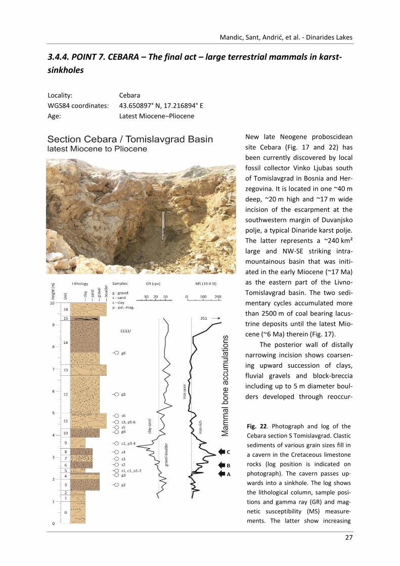
Fig. 22. Photograph and log of the
Cebara section S Tomislavgrad. Clastic
sediments of various grain sizes fill in
a cavern in the Cretaceous limestone
rocks (log position is indicated on
photograph). The cavern passes up-
wards into a sinkhole. The log shows
the lithological column, sample posi-
tions and gamma ray (GR) and mag-
netic susceptibility (MS) measure-
ments. The latter show increasing
values in the mammal bone accumu-
3.4.4. POINT 7. CEBARA – The final act – large terrestrial mammals in karst-
sinkholes
Locality: Cebara
WGS84 coordinates: 43.650897° N, 17.216894° E
Age: Latest Miocene–Pliocene
New late Neogene proboscidean
site Cebara (Fig. 17 and 22) has
been currently discovered by local
fossil collector Vinko Ljubas south
of Tomislavgrad in Bosnia and Her-
zegovina. It is located in one ~40 m
deep, ~20 m high and ~17 m wide
incision of the escarpment at the
southwestern margin of Duvanjsko
polje, a typical Dinaride karst polje.
The latter represents a ~240 km²
large and NW-SE striking intra-
mountainous basin that was initi-
ated in the early Miocene (~17 Ma)
as the eastern part of the Livno-
Tomislavgrad basin. The two sedi-
mentary cycles accumulated more
than 2500 m of coal bearing lacus-
trine deposits until the latest Mio-
cene (~6 Ma) therein (Fig. 17).
The posterior wall of distally
narrowing incision shows coarsen-
ing upward succession of clays,
fluvial gravels and block-breccia
including up to 5 m diameter boul-
ders developed through reoccur-

Lake - Basin Evolution 2016 - Field Trip Guidebook
28
Fig. 23. Selection of mammalian fossils and taxa from the Late Miocene/(Early Pliocene) of Cebara, Bosnia-
Hercegovina: A–C – molars of Anancus arvernensis, A – left M3 sup., B – left M1 sup., C – left m1 inf. D–E –
cheek teeth of Rhinocerotidae indet., D – P2 sup. sin., E – p/m inf., F – m3 inf. of a Bovidae indet. All material is
stored in the Croatian Academy of Sciences and Arts, Zagreb.
ring cave roof collapses (Fig. 22). Upward the
incision is unroofed passing into a ~35-m-wide
and ~10-m-deep funnel-shaped doline. The
logged succession (Fig. 22) is 10 m thick with
the base covered by debris and top not reacha-
ble at present outcrop conditions. It comprises
two units of equal thickness. The lower one is
characterized by deposition of brownish clay
that can include sand lenses and/or laterally
grade to block-breccia. Beyond that up to 1 m
thick sand, gravel and boulder intercalations are
present. The upper unit is composed of two
conglomerate packages both topped by cave-in
breccia. The lower gravel shows through- and
cross-bedding and at its base operculi accumu-
lations of freshwater snail Bythinia occur sup-
porting the inference of riverine and/or lacus-
trine origin of the sediment.
The bone bed interval is about 1.5 m thick
(Fig. 22) and marks the middle part of the lower
unit. The bones, tusks and teeth oriented hori-
zontally to the bedding plane, are disarticulated
and concentrated in three 10 to 30 cm thick
horizons. The lower one appears on top of one
30-cm-thick gravel bed, the other two mark
lower and upper part of one 90-cm-thick sandy
layer. Strongly increased magnetic susceptibility
values (>100 x 10-6 SI) detects the black color of
the bones and matrix sediments as containing
iron-bearing minerals. The inspection of up to
now available fossil remains allows their tenta-
tive classification with Anancus arvernensis,
representing a gomphothere proboscidean
characterized by two oversized straightened
tusks in the upper jaw and a body-size of to-
day's elephant (Fig. 23).
This European gomphothere was a brows-
er with the peak distribution in the late Plio-

Mandic, Sant, Andrić, et al. - Dinarides Lakes
29
Fig. 24. Overview on the early Langhian (Middle
Miocene) Fatelj section: a – map shows the regional
setting of the Kupres Basin with indicated positions
of the Fatelj section and other localities described in
the present guide book (see also Fig. 1), b – log
shows the mollusk distribution in the lacustrine marl
and limestone at Fatelj.
cene, and the stratigraphic range from the lat-
est Miocene MN 11 to the early Pleistocene
MN 17. Its extinction correlates with the deci-
mation of the wood cover in Europe during the
early Ice Age period. Although widely distribut-
ed in the Pliocene of SE Europe from Slovenia
through Croatia, Serbia, Romania, Bulgaria, to
Greece this is the first finding from the south-
ern Bosnia and Herzegovina and the High Karst
Dinarides up to now.
Although the stratigraphic data does not
allow a precise inference of the age yet, the
lithostratigraphic evidence supports the corre-
lation with the Pliocene in a phase post-dating
the Miocene long-lived lake conditions.
The studied site with 920 m a.s.l. repre-
sents probably the topographic highest known
proboscidean locality. In particular, their mass
occurrence in several fossiliferous layers indi-
cates the presence of a well settled gompho-
there population in the study area over many
generations. This is the most striking feature of
the new locality because the gomphotheres,
considering their huge size preferred rather
low-land settings rich in wood vegetation than
the mountainous regions. Yet, the presence of
former habitats in the Dinaride High Karst dur-
ing the deposition of investigated succession is
well supported by tectonic reconstructions
placing the main mountain elevation phase into
the Pliocene–Pleistocene transition interval.
3.5. Lake Kupres – the highest Dinarides intra-mountain basin3
Oleg Mandic, Thomas A. Neubauer, Hazim Hrvatović
3 The present chapter is based on Neubauer et al. (2013).
The Kupres basin is an about 95 km² large, NW-
SE striking karst plane (polje) in southern Bosnia
and Herzegovina (Fig. 24). It is the highest plane
in that part of the Dinarides comprising the
Lake - Basin Evolution 2016 - Field Trip Guidebook
30
water shed between the Adriatic and Black seas
fluvial systems. The basement represents the
northern margin of the External Dinarides and
consists predominantly of Mesozoic marine
platform carbonates (Hrvatović, 2006). The
basin was presumably initiated during the Early
Miocene, reflecting the extensional tectonic
regime originating from back arc rifting of the
Pannonian basin (Ilić & Neubauer, 2005). The
sedimentary thickness of the lacustrine, pre-
dominantly carbonate deposits is unknown
because the lack of intercalated coal deposits
did not favor explorational drillings (Ðerković,
1964). They are exposed on an area of only
about 23 km², yet with possible extension be-
low the Pleistocene–Holocene cover of up to
80 km² (Papeš, 1972, 1975; Vujnović, 1981;
Vujnović et al., 1975).
3.5.1. POINT 8. FATELJ – Miocene endemic mollusks from a carbonate over-
saturated lake
Locality: Fatelj
WGS84 coordinates: 43.971637° N, 17.235321° E
Age: Early Langhian (Middle Miocene)
The investigated locality (1140 m a.s.l.) is placed
at the NW slope of a small hill termed Fatelj
(Fig. 24). It was artificially outcropped at a dis-
tance of about 5 m on the west side of a small
path leading to the main road (Bugojno-Livno).
The path leaves the road about 3.8 km S of
Kupres and heads to the WNW along the north-
ern side of the Fatelj hill. The site is distanced
about 1 km from the road close to the bank of
the rivulet Mrtvica.
The section is about 3 m long and compris-
es three lithological units delimited by transi-
tional boundaries (Fig. 24). The beds are dipping
with 15° to the NNE (015°). Unit 1 is about 1 m
thick and made up by greenish clayey marl with
small to medium sized dreissenid bivalves and
gastropods floating in the sediment. Additional-
ly, fish bone remains are frequent. Aragonite
shells are largely leached. The about 1-m-thick
Unit 2 is lithologically similar to the previous
unit but barren of macrofossils. Unit 3 is about
0.5 m thick and comprises beige to whitish-grey
marls with large dreissenid shells in its lower
part grading into the gastropod dominated up-
per part of the unit. It is a moderately dense
shell accumulation with horizontally oriented
bivalve shells and non-oriented gastropod shells
in the upper part. The aragonite preservation is
moderate to excellent. At about 2.5 m, Unit 3
grades into an about 30-cm-thick soil horizon
rich in gastropods that are reworked from the
underlying horizon.
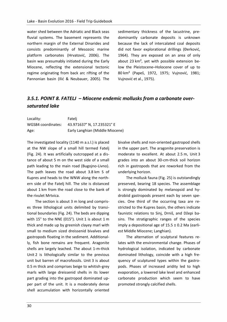
The mollusk fauna (Fig. 25) is outstandingly
preserved, bearing 18 species. The assemblage
is strongly dominated by melanopsid and hy-
drobiid gastropods present each by seven spe-
cies. One third of the occurring taxa are re-
stricted to the Kupres basin, the others indicate
faunistic relations to Sinj, Drniš, and Džepi ba-
sins. The stratigraphic ranges of the species
imply a depositional age of 15.5 ± 0.2 Ma (earli-
est Middle Miocene; Langhian).
The alternation of sculptural features re-
lates with the environmental change. Phases of
hydrological isolation, indicated by carbonate
dominated lithology, coincide with a high fre-
quency of sculptured types within the gastro-
pods. Phases of increased aridity led to high
evaporation, a lowered lake level and enhanced
carbonate production which seem to have
promoted strongly calcified shells.
Mandic, Sant, Andrić, et al. - Dinarides Lakes
31
Fig. 25. Gastropods dominate the mollusk assemblage at Fatelj, comprising diverse melanopsids (A – Mel-
anopsis cvijici, B – M. lyrata, C – M. medinae, D – M. fateljensis, G – M. geniculata) and hydrobiids (E – Pseudo-
dianella haueri, F – Marticia hidalgoi, H – Cyclothyrella tryoniopsis, I – Prososthenia diaphoros, K – P. undo-
costata, J – Bania obliquaecostata), accompanied by few planorbids (M – Orygoceras dentaliforme) and neritids
(N–O – Theodoxus imbricatus) species. Bivalves are species-poor but abundant in certain levels, represented by
only one dreissenid species (L – Illyricocongeria aletici). The latter is an early Langhian marker fossil. Scale bars:
10 mm (L), 5 mm (A–G, N–O), and 1 mm (E-F, H–K, M).
3.6. Lake Bugojno – three lacustrine cycles
Oleg Mandic, Ursula B. Göhlich, Wout Krijgsman, Arjan de Leeuw, Hazim Hrvatović
Bugojno Basin is situated in Western Bosnia and
Herzegovina, between Donji Vakuf and Gornji
Vakuf (Fig. 26). With a total surface of 125 km2,
it belongs to larger intra-mountain basins of the
Dinarides. In its central part, it accommodates
the Vrbas River. The latter is flowing in the
NNW direction and belongs to the Black Sea
catchment area. Mean elevation of the Vrbas
alluvial plane is about 620 m asl, the mountain
peaks are about 2 km high in the SW and 1.5 km
in the NE. The elongated basin shows a Dinaride
strike and a total length of 28 km; the lacustrine
deposits extend for about 22 km. It is 9 to
1.4 km wide, drop-shaped in outline pointed to
the SSE (Čičić, 1976).
The basin stretches along the Ruduša
Nappe dominated by Upper Triassic platform
carbonates (dolomites and limestone) repre-
senting the NE margin of the External Dinarides.
By its NE part, the basin extends into the Bosni-
an Schists Mountains, which is a Miocene ex-
humed core complex dominated by Paleozoic
schists and sandstones. Accompanied are in the
present area Permian limestones with gastro-
Lake - Basin Evolution 2016 - Field Trip Guidebook
32
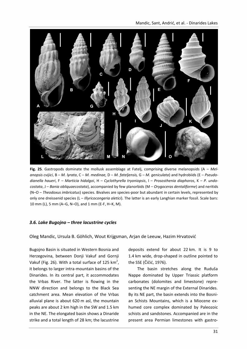
Fig. 26. Geological map showing the Neogene to Quaternary
infill of the Bugojno intra-mountain basin (after Čičić, 1976).
White ring indicates the position of the Gračanica mine.
pod Belerophon sp., Early Triassic shale and
sandstones, and Middle Triassic volcanogenic
sedimentary series. The Vrbas fault, largely
covered by lacustrine deposits, disjoins the
Ruduša Nappe from the core complex and
stretches for several hundred kilometers to the
NW up to Banja Luka region (Hrvatović, 2006).
Infill of the Bugojno Basin (Fig. 26) is about
900-m-thick and comprises three lacustrine
depositional cycles (from base to top: ~250 m /
~300 m / ~300 m) covered by up to 100 m allu-
vial sands (Čičić, 1976). The basal zone of the
first cycle (50 m) comprises conglom-
erates, sandy and gravel bearing clay,
intercalated by lenses with marl and
limestones. Main coal seam (35 m)
follows intercalated by clay and marl,
bearing large mammal remains. Final-
ly, 150-m-thick succession of marl
and sandy to marly limestone with
sphaeriid and dreissenid bivalve re-
mains closes the interval. The second
cycle starts with a 5-m-thick coal
seam intercalated by clay and marl. It
is overlain by a series of clay and
sandstones. The upper cycle starts
finally with a 40-m-thick interval with
large scale lignite lenses in clay, grad-
ing upward into a 250-m-thick inter-
val made by gray clay.
The general structure of the ba-
sin is a syncline with the limbs dip-
ping by 5°-30° toward the basin axis.
It is apparently asymmetric with old-
est deposits concentrated at the
southern and southwestern margin of
the basin. To the north and north-
east, ever younger cycles become
transgressive to the basement, point-
ing to a gradual shift of the deposi-
tional center in that direction (Čičić,
1976).
In general the lower and middle
cycle are considered as Miocene, the
upper one as Pliocene in age. This stratigraphic
correlation is ambiguous, because the only rel-
evant fossil remains in the basin are restricted
to the lower lacustrine cycle. There, the large
mammals identified as Prodeinotherium bavari-
cum and Deinotherium giganteum point to the
latest Early or Middle Miocene age (Malez and
Slišković, 1976). Their presence in the basal
layers of the Bugojno Basin defines ~17.5 Ma
(=European Proboscidean Datum) as maximum
possible age of the Bugojno Basin formation
(Pálfy et al., 2007).

Mandic, Sant, Andrić, et al. - Dinarides Lakes
33
Fig. 27. Selection of mammalian
fossils and taxa from the Mio-
cene of Gračanica, Bugojno, Bos-
nia-Hercegovina: A – Prodeino-
therium sp., maxillary toothrow
P3–M3 (SNSM–BSPG, Munich), B
– Carnivora mandible with denti-
tion (c, p2–m1), C – suoid
Bunolistriodon sp. maxillary ca-
nine, D – suoid Bunolistriodon sp.
maxillary toothrow P4–M3, E –
Palaeomerycidae indet. Upper
molar (M2/3), F – three-toed
horse Anchitherium sp., premo-
lars (p2–p4), G – rhino Brachy-
potherium sp., upper molar (M2),
H – Rhinocerotidae indet., upper
molars (M2–M3), I – Chalico-
theriidae indet., upper molar
(M2/3). All material (except A) is
stored in Natural History Muse-
um Vienna, Austria.
3.6.1. P9. GRAČANICA – Swamp lignite and profundal open-lake marl
Locality: Gračanica open-cast coal-mine / Gornji Vakuf
WGS84 coordinates: 43.997662° N, 17.518516° E
Age: Burdigalian–Langhian (Early–Middle Miocene)
The coal mine is located near the Village
Gračanica about 10 km SSE from the center of
Bugojno, northeast of the main road to Gornji
Vakuf-Uskopje (Fig. 26). The exploitation start-
ed 1939 in an underground work. Today it is a
large opencast mine area providing good out-
crop conditions for investigation of vertical and
lateral facies changes in transgressive lacustrine
successions. Besides, the pit is
well known for its mammal
remains occasionally found in
the lower part of the coal in-
terval (Fig. 27). Muftić & Behli-
lović (1966) carried out a de-
tailed exploration study in the
mine. The coal mine exposes
the lower lacustrine deposi-
tion cycle of Čičić (1976). It
superposes the Upper Triassic dolomite base-
ment rocks with the transgressive contact ex-
posed in the northern part of the mine area.
The very top of the lacustrine succession in the
Gračanica area is marked by the first occur-
rence of Illyricocongeria frici astronomically
dated in Gacko Basin to 15.5 Ma (Mandic et al.,
2011).

Lake - Basin Evolution 2016 - Field Trip Guidebook
34
►Fig. 28. Section Gračanica from the open-cast coal-mine S Bugojno. The facies succession reflects a gradual
deepening of depositional environments, culminating at 35-m-height with installation of open lake profundal
setting.
The succession originally logged in 2008 is 40 m
thick (Fig. 28). The lower half is represented by
coal deposits exploited by the mine company.
The upper part of the succession is dominated
by marly sediment, representing the open lake
environment. The beds are dipping by 10° to
15° to the south (~180°).
The initial 5 m of the coal interval shows
terrestrial influence, bearing common three
trunks and intercalations of colored clay. Also,

Mandic, Sant, Andrić, et al. - Dinarides Lakes
35
the lymnaeid snails are very frequent pointing
there to very shallow, swamp-related sub-
aquatic environment. The lymnaeids are pre-
sent for the next 4 m, after the last trunk occur-
rence.
The following 9-m-thick interval is barren
of fossils. Its lower part is made by whitish silty
marl intercalated by up to 1-m-thick coal
seams. The upper 4 m are dominated by coal.
The overlaying 1-m-thick whitish marl, alternat-
ing with coal, shows the first occurrence of
melanopsids and hydrobiids and marks the first
shift of depositional settings into the open-lake
littoral conditions. Indeed, after a short retreat
marked by the last coal seam (2 m), the cross-
bedded sand (2 m) rich in melanopsids intro-
duces transition into the open lake conditions
persisting later on up to the section's top.
The lower part of the lacustrine interval
(13 m) represents a single transgression-
regression cycle. The fossil-rich littoral sand and
marl (3.5 m) grade upward into laminated and
banded dark marl (3 m) marking the initiation
of profundal depositional settings. The deepen-
ing trend stops with one contorted bed proving
the start of the synsedimentary seismic activity
in the area. Immediate shallowing trend is
marked by the re-appearance of gastropods
and dreissenid bivalves in banded limestone
(1.5 m) and marl (3 m). The final 2 m of the
cycle shows mollusks accumulated in shell-beds
and in cross-bedded sands indicating the re-
establishment of shallow littoral settings.
The top interval of the section (5 m) shows
renewed transgression-regression trend. It is a
coarsening upward succession from clay to silt
barren od macro-fossils and intensively lami-
nated for the initial 2 m. The latter indicates a
short-term reoccurrence of profundal settings.
The increasing importance of silt component
towards the top points clearly to the shallowing
upwards trend.
3.7. Lake Sarajevo – Sarajevo-Zenica Basin
Nevena Andrić, Karin Sant, Oleg Mandic, Liviu Matenco, Hazim Hrvatović
Introduction
The Sarajevo-Zenica Basin (Fig. 29) is the largest
intra-mountainous basin of the Dinaride Lake
System (DLS, Krstić et al., 2001, 2003;
Harzhauser et al., 2008). The basin was formed
nearby the inherited nappe contact between
the pre-Karst and East Bosnian – Durmitor
units, the so-called Busovača Fault, on the
northern flank of the Mid-Bosnian Schist Moun-
tains. Its present-day Neogene basin infill co-
vers an area over 1500 km2. The basin margins
are the Mid-Bosnian Schist Mountains to the
south-west, and Cretaceous limestones of the
Bosnian Flysch to the north-east. Because of
infrastructure and mining activities, the basin
bears plenty of interesting outcrops, which
have been studied in many local and regional
studies (e.g., Hrvatović, 2006 and references
therein). Recently, an intensive field study was
performed to unravel the interplay between
tectonics, sedimentation and climate in this
basin (Andrić et al., 2015; Sant et al., 2015).
Stratigraphy and sedimentology
The deposition in the Sarajevo-Zenica basin
during Oligocene–Miocene times was predomi-
nantly controlled by the tectonically induced
changes affecting the accommodation space
geometry and source area. The basin infill can
be divided into three main depositional cycles,
which are most likely related to three distinct
tectonic phases (Fig. 30, Andrić et al., in prep).
The ages were estimated by pollen analysis
(Pantić et al., 1966). The lacustrine fossil as-

Lake - Basin Evolution 2016 - Field Trip Guidebook
36
Fig. 29. Overview of the basin with main geological units in map view, a zoom in on the area with indicated
excursion stops, and a schematic cross-section of an asymmetric basin. Map after Milojević (1964).
semblage is very poor in diversity and number
of individuals and includes some endemic mol-
lusk species, ostracods, characea, plant frag-
ments and pollen
The first, Oligocene–Early Miocene deposi-
tional cycle started with red alluvial clastics
deposited over Bosnian Flysch. This was fol-
lowed by carbonate deposits with coal se-
quence (i.e., Košćan coal seam) interbedded
with alluvial sediments (Milojević, 1964). The
general regression resulted in deposition of red
alluvial clastics which are locally overlain by
porous bituminous limestones (Muftić, 1965).
Fauna includes the mollusks Lymnaea sp. and
Helix? sp. (Milojević, 1964).
The new transgressional cycle (i.e., second,
Early–Middle Miocene depositional cycle) starts
with a relatively quiet environment with depo-
sition of lacustrine carbonates, coals (i.e., nine
coal seams) intercalated with shaly sandstones
and mudstones (Milojević, 1964; Muftić, 1965).
Gradually, they are replaced by siltstones, sand-
stones and conglomerates. The first appearance
of Mid-Bosnian Schist Mts. clasts marks the
shift from ‘transitional’ unit 2M2 to the Lašva
unit M2,3. The cycle is completed by (coarse)
clastic deltaic facies followed by alluvial and
fluvial conglomerates. The most common fossils
are mollusks Lymnaea sp., Fossarulus sp. and
Unio sp. (Milojević, 1964), and the mammal
Prodeinotherium bavaricum (found in the Ka-
kanj coal mine; Milojković, 1929).
The third, post-Middle Miocene, deposi-
tional cycle is very poorly exposed, and is com-
posed of shales, coals and limestones that indi-
cate a gradual drowning of a swamp environ-
ment and the creation of perennial lake (Mi-
lojević, 1964). These deposits are locally over-
lain by the Orlac conglomerates, and by the
‘Pliocene’ alluvial sediments that were deposit-
ed over a larger area transgressing over the
Mid-Bosnian Schist Mountains (Milojević,
1964).
Tectonic evolution and dating
The Oligocene–Early Miocene depositional cycle
was associated with NE-SW oriented thrusts
showing a dominantly SW transport direction.
The basin formed as a wedge top basin in the
footwall of the coeval thrusts which were active

Mandic, Sant, Andrić, et al. - Dinarides Lakes
37
Fig. 30. Generalized basin infill of the Sarajevo-Zenica Basin, and interpreted tectonic phases. Modified after
Milojević (1964) and Andrić et al. (in prep).
during the final collisional stage in the Dinarides
(Andrić et al., in prep).
The subsequent Early–Middle Miocene ex-
tension resulted in the deposition of new tec-
tono-sedimentary cycle. The deposition is driv-
en by a system of NE-dipping normal faults
which gradually exhumed Mid-Bosnian Schist
Mountains along the south-western margin
creating the asymmetric basin geometry. This is
evidenced by the NE-ward pinching alluvial
clastic wedges aligned along the south-western
basin margin. The main source area for the
alluvial-deltaic clastics were the Mid-Bosnian
Schist Mountains. The overall fill is organized in
one coarsening-upward low-order depositional
cycle. The temporal and spatial migration of the
normal faults in the footwall direction (i.e., SW-
wards) progressively enlarges the basin and
lead to a retrogradational depositional trend.
The proximal facies are being buried by distal
facies during subsidence created by the follow-
ing normal faulting event. There are three sub-
sequent normal faulting events, where each
was associated with deposition of transgres-
sive-regressive higher-order cycles with a SW-
ward younging trend. The cycles are bounded
by sub-areal unconformities and maximal re-
gressive surfaces in the proximal and distal part
of the basin, respectively. Internally, the cycles
reflect the evolution of each major fault event.
After the Middle Miocene, the basin was in-
verted (Andrić et al., in prep).
A detailed magnetostratigraphic study was
performed on a composite section of the fine-
grained basin infill of M1,2 – M2,3. The prelimi-
nary results suggest that deposition took place
between ~18 and 15 Ma, which is similar to the
Sinj and Livno basin (De Leeuw et al., 2010). The
‘deepest’, most quiet lake phase existed around
17 Ma. The major extensional rifting phase
started between 16 and 15 Ma, which might be
similar to the erosive phase in the Livno Basin.
No clear sign of climatic forcing was found in
the sections (Sant et al., 2015).

Mandic, Sant, Andrić, et al. - Dinarides Lakes
38
Fig. 31. Overview of the Greben section with lithology and magnetostratigraphy. Ostracod-rich layers are
marked in partial section 2.
3.7.1. POINT 10. GREBEN – Deep lake organic rich limestone
Locality: Greben / Kakanj
WGS84 coordinates: 44.140301°N, 18.120600° E
Age: Burdigalian (Early Miocene)
The fine-grained carbonate rocks of the Greben
section (Fig. 31) are representative for the low
energy, lacustrine environment that existed
during the beginning of the ‘second cycle’, after
deposition of the main coal seam. The section is
dominated by mudstones and marlstones. It
bears rare remains of gymnosperm plants (Fig.
32), fishes and mollusks (spaeriid bivalves) The
lowermost 8 m of partial section 1 are most
bioturbated. Upwards in the section more silts
and clays appear.
Characteristic lithological features are a
high amount of organic matter and the internal-
ly banded limestones with regular and irregular

Mandic, Sant, Andrić, et al. - Dinarides Lakes
39
Fig. 32. Taxodium-related gymnosperm plant Glyp-
tostrobus europaeus found in the Greben section.
alternations of dark and lighter grey bands (1–
5 cm thickness). Micro-analyses revealed that
bioturbations are concentrated in the lighter
colored bands. Moreover, hematite/pyrite
spots are concentrated around the bioturbated
parts. This suggests that the lighter colored
parts were well-oxygenized, whereas the darker
parts were (almost) anoxic. In the lowermost
part of the section almost no quartz particles
are visible in thin sections, while in the upper
part (>20 m) some more quartz particles are
visible. They are too small to determine the
source area. In general, the facies of the Greben
section indicate calm lacustrine conditions with
almost no external sediment input.
Magnetostratigraphy and biostratigraphy
The magnetostratigraphic study yielded
straightforward magnetic directions with two
reversals. A correlation of this pattern to the
Global Polarity Time Scale (Hilgen et al., 2012)
was not yet possible due to a lack of tie points.
When we follow the preliminary age correlation
of the whole basin infill, the age of the Greben
section is between 17.5 and 16.5 Ma. This part-
ly overlaps with the Middle Miocene Climatic
Optimum and might correlate with the similar
open lake profundal facies from the Livno-
Tomislavgrad basin Ar/Ar dated to ~17 Ma (De
Leeuw et al., 2011).
From the corresponding interval near Zen-
ica (referred there as 90-m-thick marl overlay-
ing the topmost coal seam), Kochansky-Devidé
& Slišković (1972) reported the presence of
Clivunella sp. The latter deep-water gastropod
is a marker fossil for the uppermost Lower Mio-
cene in the Dinaride Lake System (~16.7 and
16.0 Ma; De Leeuw et al., 2011). Its presence in
present interval stays in accordance with the
previous inference.
3.7.2. POINT 11. JANJIĆI – Lacustrine delta deposits of the "transitional unit"
Locality: Janjića Vrh / Janjići
WGS84 coordinates: 44.148444° N, 17.951676° E
Age: Middle Miocene
Formation: "Transitional unit" (2M2)
The road-cut on the left bank of the Bosna river
exposes an over 100-m-thick Early to Middle
Miocene fill of the Sarajevo-Zenica basin (i.e.,
Transitional unit 2M2 sensu Milojević, 1964).
The section represents an excellent example of
a prograding river dominated delta into a lacus-
trine environment (Figs. 29, 30, 33a and 34).

Lake - Basin Evolution 2016 - Field Trip Guidebook
40
Fig. 33. Sedimentary logs of Janjića Vrh section (a) and Lašva section (b). The thick black line represents dia-
chronous progradation of river dominated delta into lake environment.
Description and interpretation
The succession starts with laminated calcareous
mudstones intercalated with laminas to thin
layers/lenses of siltstones and sandstones (Fig.
33a). The mudstones contain dispersed organic
matter and traces of ostracods; the latter is
suggestive for deposition by fallout from the
“background” suspension in a lacustrine envi-
ronment. The thin intercalations originated
from dilute turbidity currents feeding the ter-
minal lobe in the prodelta environment. Further
on in the section, the number of turbidites lay-
ers increases. The sheet-like to lenticular high-
and low-density turbidites often intercalated
with slumps and massflow deposits (cohesion-
less and cohesive debris flows, Fig. 33a, 34). The
turbidites usually contain a bipartite geometry
with lower part made of granula to medium
sandstones (Ta, Tb) capped by fine-grained
sandstones, siltstones and mudstones (Tc, Td,
Te). The debris flow conglomerates mainly
comprise of granula to cobble size sub-angular
to sub-rounded clasts. Most clasts are metario-
lites, quarzites, various schists and carbonates
sourced from the Mid-Bosnian Schist Moun-
tains.
The increased in high frequency of gravity de-
posits, especially slumps in the lower part of the
section imply steeper gradients and slope in-
stability which might be triggered by the activity
of normal faults. The numerous plant remains,

Mandic, Sant, Andrić, et al. - Dinarides Lakes
41
Fig. 34. The migration of the channels in the turbidite sequence of the Janjića Vrh section.
coal fragments, immature clasts (angular, de-
rived from Mid-Bosnian Schist Mountains) and
coarsening upwards suggest an increase of land
derived material prograding into the deeper
water environment
This section is a good example of gradually
forced regression in a river-dominated deltaic
succession. It is characterized by a conformable
shift of facies from lacustrine and prodelta de-
posits to the overlaying delta front sediments.
The forced regression occurred during a stage
of base level fall induced by a decrease in ac-
commodation space creation rate as a response
to cessation of the normal fault activity. The
sediment supply exceeded accommodation
space which caused bypass of terrigenous ma-
terial in a shallow water setting and deposition
in more distal setting as seen in the final depo-
sitional packages of Janjića Vrh log (Fig. 1; An-
drić et al., 2015).
3.7.2. POINT 12. LAŠVA – Lacustrine delta deposits of the Lašva Formation
Locality: Lašva
WGS84 coordinates: 44.133401° N, 17.937542° E
Age: Middle Miocene
Formation: Lašva Formation (M2,3)
The impressive Lašva section is located nearby
the confluence of the Lašva and Bosna rivers
(Fig. 29, 33b and 35). It shows 25 m of coarse-
grained alluvial-deltaic sediments of the Lower
to Middle Miocene (i.e., Lašva unit sensu Mi-
lojević, 1964). This is an example of the rapid
transition from floodplain deposits into braided
channels of the braid-delta plain and delta front
(Fig. 33b). Most likely, it represents a more
proximal equivalent to the Janjića vrh section.
Description and interpretation
The succession starts with floodplain deposits
represented by the alternation of (dark) grey
parallel laminated siltstone and organic rich
claystone pairs intercalated with thin beds of
red fine-grained sandstones or isolated granula
to coarse sand channels. These deposits en-
gulfed beige to yellow mudstone with traces of
ostracods. Deposition is associated with ostra-
cods indicating suspension settling in shallow
lacustrine/lagoon environment. Further on, the
amalgamation of the channels and chan-
nel/floodplain sediments ratio increases up in
the section creating an overall coarsening-
upwards trend (Fig. 33b). The amalgamated
packages are partly eroded and overlain by
more proximal alluvial deposits supplying the
prograding delta front. The upper part of the
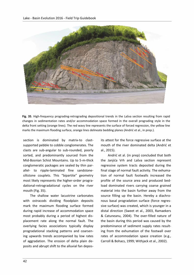
Lake - Basin Evolution 2016 - Field Trip Guidebook
42
Fig. 35. High-frequency prograding-retrograding depositional trends in the Lašva section resulting from rapid
changes in sedimentation rates and/or accommodation space formed in the overall prograding style in the
delta front setting (orange lines). The red wavy line represents the surface of forced regression, the yellow line
marks the maximum flooding surface, orange lines delineate bedding planes (Andrić et al., in prep.).
section is dominated by matrix-to clast-
supported pebble to cobble conglomerates. The
clasts are sub-angular to sub-rounded, poorly
sorted, and predominantly sourced from the
Mid-Bosnian Schist Mountains. Up to 5-m-thick
conglomeratic packages are sealed by thin par-
allel- to ripple-laminated fine sandstone-
siltstone couplets. This “bipartite” geometry
most likely represents the higher-order progra-
dational-retrogradational cycles on the river
mouth (Fig. 35).
The shallow water lacustrine carbonates
with ostracods dividing floodplain deposits
mark the maximum flooding surface formed
during rapid increase of accommodation space
most probably during a period of highest dis-
placement rate along the normal fault. The
overlying facies associations typically display
progradational stacking patterns and coarsen-
ing upwards trends accompanied by low rates
of aggradation. The erosion of delta plain de-
posits and abrupt shift to the alluvial fan depos-
its attest for the force regressive surface at the
mouth of the river dominated delta (Andrić et
al., 2015).
Andrić et al. (in prep) concluded that both
the Janjića Vrh and Lašva section represent
regressive system tracts deposited during the
final stage of normal fault activity. The exhuma-
tion of normal fault footwalls increased the
profile of the source area and produced bed-
load dominated rivers carrying coarse grained
material into the basin further away from the
source filling up the basin. Hereby a diachro-
nous basal progradation surface (force regres-
sive surface) was created, which is younger in a
distal direction (Sweet et al., 2003, Ramaekers
& Catuneanu, 2004). The over-filled nature of
the basin during this period was caused by the
predominance of sediment supply rates result-
ing from the exhumation of the footwall over
rates of accommodation space creation (e.g.,
Carroll & Bohacs, 1999; Withjack et al., 2002).

Mandic, Sant, Andrić, et al. - Dinarides Lakes
43
References
Andrić, N., Sant, K., Matenco, L., Tomljenović, B.,
Pavelić, D., Mandic, O., Hrvatović, H., Demir, V.
2015. The link between tectonic and sedimen-
tation in an asymmetric extensional basin: the
late Miocene evolution of the Sarajevo-Zenica
basin, Bosnia and Hercegovina. Geophysical
Research Abstracts 17, EGU2015-6644-3.
Andrić, N., Sant, K., Matenco, L., Mandic, O., Tom-
ljenović, B. Pavelić, D., Hrvatović, H., Demir, V.
(in prep.). The link between tectonics and sed-
imentation in asymmetric extensional basins:
inferences from the study of the Sarajevo-
Zenica Basin.
Barešić, J., Horvatinčić, N., Roller-Lutz, Z. 2011. Spa-
tial and seasonal variations in the stable C iso-
tope composition of dissolved inorganic carbon
and in physico-chemical water parameters in
the Plitvice Lakes system. Isotopes in environ-
mental and health studies 47, 316–329.
Biondić, B., Biondić, R., Meaški, H. 2010. The concep-
tual hydrogeological model of the Plitvice
Lakes. Geologia Croatica 63, 195–206.
Carroll, A. R., Bohacs, K. M. 1999. Stratigraphic clas-
sification of ancient lakes: balancing tectonic
and climatic controls. Geology 27 (2), 99–102.
Chafetz, H., Srdoč, D., Horvatinčić, N. 1994. Early
diagenesis of Plitvice Lakes waterfall and barri-
er travertine deposits. Geographie physique et
Quaternaire 48, 245–255.
Čičić, S. 1976. Bugojanski basen. In: Milojević, R.
(ed.). Mineralne sirovina Bosne i Hercegovine.
Knjiga I. Ležišta uglja. Geoinžinjering, Sarajevo,
pp. 151–158.
Ćorić, S., Pavelić, D., Rögl, F., Mandic, O., Vrabac, S.,
Avanić, R., Jerković, L. & Vranjković, A. 2009.
Revised Middle Miocene datum for initial ma-
rine flooding of North Croatian Basins (Panno-
nian Basin System, Central Paratethys). Geolo-
gia Croatica 62, 31–43.
De Leeuw, A., Mandic, O., Krijgsman, W., Kuiper, K.,
Hrvatović, H. 2011. A chronostratigraphy for
the Dinaride Lake System deposits of the Livno-
Tomislavgrad Basin: the rise and fall of a long-
lived lacustrine environment in an intra-
montane setting. Stratigraphy 8 (1), 29–43.
De Leeuw, A., Mandic, O., Krijgsman, W., Kuiper, K.,
Hrvatović, H. 2012. Paleomagnetic and geo-
chronologic constraints on the geodynamic
evolution of the Central Dinarides. Tectono-
physics 530–531, 286–298.
De Leeuw, A. de, Mandic, O., Vranjković, A., Pavelić,
D., Harzhauser, M., Krijgsman, W., Kuiper, K.F.
2010. Chronology and integrated stratigraphy
of the Miocene Sinj Basin (Dinaride Lake Sys-
tem, Croatia). Palaeogeography, Palaeoclima-
tology, Palaeoecology 292, 155–167.
Ðerković, B. 1964. Geološke karakteristike
Kupreškog polja i mogućnost gradnje mikroa-
kumulacija. Geološki Glasnik 10, 121–137.
Fritz, F. 1976. Ravni Kotari – Bukovica, Hidrogeološka
studija [Ravni Kotari – Bukovica, Hydrogeologi-
cal study]. Archive of technical documentation
[Fond stručne dokumentacije], Croatian Geo-
logical Survey [Institut za geološka istraživanja],
Zagreb, no. 6193, 134 pp.
Fritz, F. 1983. Pregrada na Vranskom jezeru – idejno
rješenje, geološko istražni radovi, Archive of
technical documentation [Fond stručne doku-
mentacije], Croatian Geological Survey [Institut
za geološka istraživanja], Zagreb, no. 270/83,
24 pp.
Fritz, F. 1984. Postanak i starost Vranskog jezera kod
Biograda na moru. Geološki vjesnik 37, 231–
243.
Golubić, S., Violante, C., Plenković-Moraj, A.,
Grgasović, T. 2008. Travertines and calcareous
tufa deposits: an insight into diagenesis. Geolo-
gia Croatica 61 (2–3), 363–378.
Harzhauser, M., Mandic, O. 2008. Neogene lake
systems of Central and South-Eastern Europe:
Faunal diversity, gradients and interrelations.
Palaeogeography, Palaeoclimatology, Palaeoe-
cology 260, 417–434.
Harzhauser, M., Mandic, O. 2010. Neogene dreis-
senids in Central Europe: evolutionary shifts
and diversity changes. In: van der Velde, G.,
Rajagopal, S., bij de Vaate, A. (eds). The Zebra
Mussel in Europe. Backhuys Publishers, Leiden,
pp. 11–28, 426–478.
Harzhauser, M., Piller, W.E. 2007. Benchmark data of
a changing sea. – Palaeogeography, Palaeobio-
geography and Events in the Central Paratethys
during the Miocene. Palaeogeography, Palaeo-
climatology, Palaeoecology 253, 8–31.
Hilgen, F.J., Lourens, L.J., Van Dam, J.A. 2012. The
Neogene Period. In: Gradstein, F.M., Ogg, J.G.,

Lake - Basin Evolution 2016 - Field Trip Guidebook
44
Schmitz, M., Ogg, G. (eds). A Geologic Time
Scale 2012. Elsevier, Amsterdam, pp. 923–978.
Holbourn, A., Kuhnt, W., Schulz, M., Erlenkeuser, H.
2005. Impacts of orbital forcing and atmos-
pheric carbon dioxide on Miocene ice-sheet
expansion. Nature 438, 483–487.
Horvatinčić, N., Čalić, R., Geyh, M. 2000. Interglacial
growth of tufa in Croatia. Quaternary Research
53, 185–195.
Horvatinčić, N., Barešić, J., Babinka, S., Obelić, B.,
Krajcar Bronić, I., Vreča, P., Suckow, A. 2008.
Towards a deeper understanding how car-
bonate isotopes (14C, 13C, 18O) reflect envi-
ronmental changes: A study with recent 210Pb-
dated sediments of the Plitvice Lakes, Croatia.
Radiocarbon 50, 233–253.
Horvatinčić, N., Briansó, J.L., Obelić, B., Barešić, J.,
Krajcar Bronić, I. 2006. Study of pollution of the
Plitvice Lakes by water and sediment analyses.
Water Air and Soil Pollution, Focus 6, 475–485.
Horvatinčić, N., Krajcar Bronić, I., Obelić, B. 2003.
Differences in the 14C age, 13C and 18O of
Holocene tufa and speleothem in the Dinaric
Karst. Palaeogeography, Palaeoclimatology,
Palaeoecology 193: 139–157.
Hrvatović, H. 2006. Geological Guidebook through
Bosnia and Herzegovina. Geological Survey of
Federation BiH, Sarajevo, 172 pp.
Ilić, A. & Neubauer, F. 2005. Tertiary to recent
oblique convergence and wrenching of the
Central Dinarides: Constraints from a pal-
aeostress study. Tectonophysics 410, 465–484.
Ilijanić, N. 2014. Minerali glina u jezerskim sedimen-
tima istočno jadranske obale kao pokazatelji
promjena okoliša tijekom kasnog pleistocena i
holocena [Clay minareal in lake sediments of
eastern Adriatic coast as environmental proxies
during Pleistocene and Holocene]. Unpublished
PhD study, University of Zagreb, 382 pp.
Jiménez-Moreno, G., De Leeuw, A., Mandic, O.,
Harzhauser, M., Pavelić, D., Krijgsman, W.,
Vranjković, A. 2009. Integrated stratigraphy of
the early Miocene lacustrine deposits of Pag Is-
land (SW Croatia): Palaeovegetation and envi-
ronmental changes in the Dinaride Lake Sys-
tem, Palaeogeography, Palaeoclimatology, Pal-
aeoecology 280, 193–206.
Jiménez-Moreno, G., Mandic, O., Harzhauser, M.,
Pavelić, D., Vranjković, A. 2008. Vegetation and
climate dynamics during the early Middle Mio-
cene from Lake Sinj (Dinaride Lake System, SE
Croatia). Review of Palaeobotany and Pa-
lynology 152, 270–278.
Kerner, F.v. 1905. Gliederung der Sinjaner Neogen-
formation. Verhandlungen der Geologischen
Reichanstalt in Wien 1905 (6), 127–165.
Kochansky-Devidé and Slišković 1972. Revizija roda
Clivunella Katzer, 1918 i Delminella n.gen.
(Gastropoda). Geološki glasnik 16, 47–70.
Korbar, T. 2009. Orogenic evolution of the External
Dinarides in the NE Adriatic region: a model
constrained by tectonostratigraphy of Upper
Cretaceous to Paleogene carbonates. Earth-
Science Reviews 96, 296–312.
Krstić, N., Dumurdžanov, N., Olujić, J., Vujnović, L.,
Janković-Golubović, J. 2001. Interbedded tuff
and bentonite in the Neogene lacustrine sedi-
ments of the Balkan Peninsula. A review. Acta
Vulcanologica 13, 91–100.
Krstić, N., Savić, L., Jovanović, G., Bodor, E. 2003.
Lower Miocene lakes of the Balkan Land. Acta
Geologica Hungarica 46, 291–299.
Lewis A.R., Marchant D.R., Ashworth AC, Hedenäs L.,
Hemming S.R., Johnson J.V., Leng M.J., Machlus
M.L., Newton A.E., Raine J.I., Willenbring J.K.,
Williams M., Wolfe A.P. 2008. Mid-Miocene
cooling and the extinction of tundra in conti-
nental Antarctica. Proceedings of the National
Academy of Sciences of the United States of
America 105(31), 10676–10680.
Lourens, L.J., Hilgen, F.J., Laskar, J., Shackleton, N.J.,
Wilson, D. 2004. The Neogene Period. In: Grad-
stein, F.M., Ogg, J.G., Smith, A. (eds). A Geolog-
ic Time Scale 2004. Cambridge University Press,
Cambridge, pp. 409–440.
Luburić, P. 1963. Pojave tufova i bentonita u
naslagama slatkovodnig neogena u Livanjsko-
Duvanjskom ugljonosnom basenu u jugozapad-
noj Bosni. Geološki glasnik Sarajevo 8, 203–
211.
Malez, M., Slišković, T. 1976. Starost nekih naslaga
ugljena u tercijaru Bosne i Hercegovine na os-
novi nalaza vertebrata. Geološki glasnik Saraje-
vo 21, 39–56.
Mandic, O. Pavelić, D., Harzhauser, M., Zupanič, J.,
Reischenbacher, D., Sachsenhofer, R.F., Tadej,
N., Vranjković, A. 2009. Depositional history of
the Miocene Lake Sinj (Dinaride Lake System,
Croatia): a long-lived hard-water lake in a pull-
apart tectonic setting. Journal of Paleolimnolo-

Mandic, Sant, Andrić, et al. - Dinarides Lakes
45
gy 41, 431–452.
Mandic, O., De Leeuw, A., Vuković, B., Krijgsman, W.,
Harzhauser, M., Kuiper, K.F. 2011. Palaeoenvi-
ronmental evolution of Lake Gacko (NE Bosnia
and Herzegovina): impact of the Middlle Mio-
cene Climatic Optimum on the Dinaride Lake
System. Palaeogeography, Palaeoclimatology,
Palaeoecology 299, 475–492.
Mandic, O., De Leeuw, A., Bulić, J., Kuiper, K.,
Krijgsman, W., Jurišić-Polšak, Z. 2012a. Paleo-
geographic evolution of the Southern Panno-
nian Basin: 40Ar/39Ar age constraints on the Mi-
ocene continental series of northern Croatia.
International Journal of Earth Sciences 101,
1033–1046.
Mandic, O., Vranjković, A., Pavelić, D., Hrvatović, H.,
De Leeuw, A. 2012b. Miocene intra-montane
lacustrine basins of Outer Dinarides (Croatia
and Bosnia and Herzegovina). In: Vlahović, I.,
Mandic, O., Mrinjek, E., Bergant, S., Ćosović, V.,
De Leeuw, A., Enos, P., Hrvatović, H., Matičec,
D., Mikša, G., Nemec, W., Pavelić, D., Pencin-
ger, V., Velić, I., Vranjković, A. (eds). Marine to
continental depositional systems of Outer Di-
narides foreland and intra-montane basins (Eo-
cene-Miocene, Croatia and Bosnia and Herze-
govina). Field Trip Guide, 29th IAS Meeting of
Sedimentology, Schladming/Austria. Journal of
Alpine Geology 54, 456–470.
Mandic, O., Göhlich, U.B., Hrvatović, H., Lenardić,
J.M., Čvorović, B., Glamuzina, G., Radoš, D.
2013. New proboscidean site from the high
karst Dinarides in southern Bosnia and Herze-
govina. 14th RCMNS Congress, Istanbul, Book of
Abstracts, 189 pp.
Milojević, R. 1964. Geološki sastav i tektonski sklop
Srednjobosanskog basena sa naročitim osvrtom
na razvoj i ekonomsku vrednost ugljenonosnih
facija [Geologic composition and tectonic pat-
tern of Middle-Bosnia coal basin with special
review of development and economic value of
coal-bearing facies]. Posebna izdanja Ge-
ološkog glasnika Sarajevo 7, 1–120.
Milojević, R., Sunarić, O. 1964. Pokušaj stratigrafskog
raščlanjavanja slatkovodnih sedimenata
Duvanjskog basena i neki ekonomsko geološki
momenti u razvoju ugljenih facija. Geološki
glasnik Sarajevo 9, 59–75.
Milojković, M., 1929. Stratigrafski pregled geoloških
formacija u Bosni i Hercegovini [Stratigraphic
overview of geological formations in Bosnia-
Herzegovina]. Povremena izdanja Geološkog
zavoda Sarajevo 2, 3–160 (Res. 161–186).
Muftić, M., 1965. Geološki odnosi ugljonosnih terena
Srednjobosanskih ugljenokopa: Bile, Zenice,
Kaknja i Breze [Geological relationships of coal
bearing terrains of Mid-Bosnian coalmines].
Posebna izdanja Geološkog glasnika Sarajevo 5,
1–108.
Muftić, M. & Behlilović, S. 1966. Prikaz geološkog
poznavanja ugljenonosnih naslaga Gračanice
kod Bugojna. Geološki glasnik Sarajevo 11,
303–312.
Neubauer, T.A., Mandic, O., Harzhauser, M. 2011.
Middle Miocene Freshwater Mollusks from
Lake Sinj (Dinaride Lake System, SE Croatia;
Langhian). Archiv für Molluskenkunde 140 (2),
201–237.
Neubauer, T.A., Mandic, O., Harzhauser, M., Hrvato-
vić, H. 2013. A new Miocene lacustrine mollusc
fauna of the Dinaride Lake System and its pal-
aeobiogeographic, palaeoecologic, and taxo-
nomic implications. Palaeontology 56 (1), 129–
156.
Palfy, J., Mundil, R., Renne, P.R., Bernor, R.L., Kor-
dos, L., Gasparik, M. 2007. U–Pb and 40Ar/39Ar
dating of the Miocene fossil track site at Ipo-
lytarnóc (Hungary) and its implications. Earth
and Planetary Science Letters 258, 160–174.
Pantić, N. 1961. O starosti slatkovodnog tercijara sa
ugljem u Bosni na osnovu paleofloristickih
istraživanja. Geološki anali Balkanskog polu-
ostrva 28, 1–22.
Pantić, N., Ercegovac, M., Pantić, V., 1966. Pal-
inološka ispitivanja i stratigrafija terestrično-
limničkih tercijarnih naslaga u Zeničko-
Sarajevskom basenu. Geološki anali Balkanskog
poluostrva 32, 183–210.
Papeš, J. 1972. Basic Geological Map 1:100 000.
Sheet Livno, Institut za geološka istraživanja,
Sarajevo. Zagreb: Institut za geološka istraivan-
ja. Beograd: Savezni geološki zavod.
Papeš, J. 1972. List Livno. SFR Jugoslavija. Osnovna
Geološka Karta 1:100.000. Savezni geološki za-
vod, Beograd.
Papeš, J. 1975. Basic Geological Map 1:100 000.
Explanatory notes for sheet Livno. Institut za
geološka istraživanja, Sarajevo. Zagreb: Institut
za geološka istraivanja. Beograd: Savezni ge-
ološki zavod.

Lake - Basin Evolution 2016 - Field Trip Guidebook
46
Polšak, A. 1969. Geološka karta Plitvičkih jezera, M 1
: 50 000 [Geological map of Plitvice Lakes, M 1 :
50,000]. Mapping laboratory of the Geodetic
faculty [Kartografski laboratorij Geodetskog
fakulteta], University of Zagreb.
Ramaekers, P., Catuneanu, O., 2004. Development
and sequences of the Athabasca basin, early
Proterozoic, Saskatchewan and Alberta, Cana-
da. The Precambrian Earth: Tempos and
Events. Developments in Precambrian Geology
12, 705–723.
Rögl, F. 1999. Mediterranean and Paratethys. Facts
and Hypotheses of an Oligocene to Miocene
Paleogeography (Short overview). Geologica
Carpathica 50 (4), 339–349.
Rubinić, J. 2014. Vodni režim Vranskog jezera u Dal-
maciji i klimatski utjecaji [Water regime of the
Lake Vrana and climate influences]. Un-
published PhD study, University of Zagreb, 212
pp.
Rubinić, J. & Katalinić, A. 2014. Water regime of
Vrana Lake in Dalmatia (Croatia): changes, risks
and problems. Hydrological Sciences Journal 59
(10), 1908–1924.
Sant, K., Andrić, N., Mandic, O., Pavelić, D., Matenco,
L., Demir, V., Hrvatović, H., Krijgsman, W. 2015.
Magnetostratigraphic dating of the lower to
middle Miocene succession in the Sarajevo-
Zenica basin (Bosnia & Herzegovina). Abstract
Volume 1st Geological Congress of Bosnia and
Herzegovina with international participation
(Tuzla, Oct 21–23).
Schmid, S. M., Bernoulli, D., Fügenschuh, B., Maten-
co, L., Schefer, S., Schuster, R., Tischler, M. &
Ustaszewski, K. 2008. The Alpine-Carpathian-
Dinaridic orogenic system: correlation and evo-
lution of tectonic units. Swiss Journal of Geo-
sciences 101 (1), 139–183.
Srdoč, D., Obelić, B., Horvatinčić, N., Culiberg, M.,
Šercelj, A., Sliepčević, A. 1985. Radiocarbon da-
ting and pollen analyses of two peatbogs in the
Plitvice National Park area. Acta Botanica
Croatica 44, 41–46.
Srdoč, D., Obelić, B., Horvatinčić, N., Krajcar Bronić,
I., Marčenko, E., Merkt, S., Wong, H., Sliepčević,
A., 1986. Radiocarbon dating of lake sediments
from two Karstic lakes in Yugoslavia. Radiocar-
bon 28, 495–502.
Srdoč, D., Osmond, J., Horvatinčić, N., Dabous, A.,
Obelić, B., 1994. Radiocarbon and uranium-
series dating of the Plitvice Lakes travertines.
Radiocarbon 36, 203–219.
Sweet, A. R., Long, D. G. F., Catuneanu, O., 2003.
Sequence boundaries in finegrained terrestrial
facies: biostratigraphic time control is key to
their recognition. Abstracts Geological Associa-
tion of Canada-Mineralogical Association of
Canada joint annual meeting (Vancouver, May
25–28) 28, 165.
Tari, V. 2002. Evolution of the northern and western
Dinarides: a tectonostratigraphic approach.
EGU Stephan Mueller Special Publication Series
1, 223–236.
Ustaszewski, K., M. Schmid, S.M. Fügenschuh, B.,
Tischler, M., Kissling, E. & Spakman, W. 2008. A
map-view restoration of the Alpine-Carpathian-
Dinaridic system for the Early Miocene. Swiss
Journal of Geosciences 101 (Suppl. 1), S273–
S294.
Vranjković, A. 2011. Klimatski zapisi u miocenskim
slatkovodnim naslagama Sinjskog bazena. un-
publ. PhD Thesis, University of Zagreb.
Vujnović, L. 1981. Tumač za list Bugojno. SFR Jugo-
slavija. Osnovna Geološka Karta 1:100.000. Sa-
vezni geološki zavod, Beograd, 54 pp.
Vujnović, L., Vrhovčić, J., Jovanović, R., Živanović, M.,
Sofilj, J., Ahac, A., Andijasević, M., Govedarica,
M., Jović, R., Veljović, R., Mitrović, P. 1975. List
Bugojno. SFR Jugoslavija. Osnovna Geološka
Karta 1:100.000. Savezni geološki zavod, Beo-
grad.
Withjack, M.O., Schlische, R.W., Olsen, P.E. 2002.
Rift basin structure and its influence on sedi-
mentary systems. In: Renaut, R.W., Ashley,
G.M. (eds). Sedimentation in Continental Rifts.
SEPM Special Publication 73, 57–81.