DIGITAL GEOMETRIC DOCUMENTATION OF THE RAIL … · DIGITAL GEOMETRIC DOCUMENTATION OF THE RAIL...
5
DIGITAL GEOMETRIC DOCUMENTATION OF THE RAIL JOURNEY OF THE HISTORIC TRAIN OF PELION A. Stamnas a, *, O. Georgoula a a AUTH, Faculty of Rural and Surveying Engineering, Department of Cadastre, Photogrammetry and Cartography, Thessaloniki, Greece *[email protected] KEY WORDS: Industrial Heritage, documentation, multimedia application ABSTRACT: The object of this research project is the documentation of the rail journey of the historic train of Pelion. From the beginning, the approach of the issue pointed out the immediate need of its digital geometric documentation. In this context, a complete cartographic background of the rail journey of the little train of Pelion and the wider region was created. The Digital Terrain Model (DTM) of the entire region was first created and then followed the ortho resampling of aerial photos that covered the area of interest. In addition to the photographic documentation of all viaducts, high masonry overpasses and stations of the railway and finding related information of historical and technical interest, there has been the survey, the photogrammetrical documentation and 3D visual representation of two worthy examples of engineering work. The development of a multimedia project took place in order to manage and publicise a great amount of data related to the documentation of the rail journey of the little train of Pelion. 1. INTRODUCTION The focus of this paper concerns the documentation of the rail journey of the historic train of Pelion. The historic rail journey of Pelion represents a worthy example of Greek industrial heritage. The Volos – Milies narrow gauge heritage railway, widely known as Pelion Little Train, constitutes a fine example of a typical Decauville public railway of 600mm gauge. Since 1903 and for 68 years, it has been used to connect the city of Volos with seven villages in the central and south-western region of Mount Pelion. In 1985, in recognition of its faithful service to the local population, its historical and cultural value and its engineering features, the Ministry of Culture officially declared the line with all its installations a preserved historical monument. Part of its coastal section was recently put back in action with vintage open summer coaches, while the mountainous section had entered traffic since 1996. First of all, there has been an attempt of pointed out all published stuff concerning the little train of Pelion, its history and its prospects for the future. A research of the State Railways’s (OSE) records, Volos department, followed. This first approach of the issue pointed out the immediate need of digital geometric documentation of the rail journey of the historic train. 2. DIGITAL GEOMETRIC DOCUMENTATION OF THE RAIL JOURNEY A complete cartographic background of the rail journey of the little train of Pelion and the wider region was created. This cartographic background constituted the basis of the procedure of recording, surveying and documentation that followed, and was also used for the identification of the most important examples of engineering work, masonry and iron viaducts, retaining walls, tunnels and stations of the railway. In addition, the use of this cartographic background would have been essential for the development of a Geographical Information System (GIS) or a multimedia project. Geographical reference is moreover indispensable for the production of this kind of application. The identification of the overall rail journey of the historic train of Pelion has been possible by using maps with scales 1:50000 and 1:5000. Afterwards, the production of digital orthophotos of the area of interest followed. Geographical reference using orthophotos was chosen, as an orthophoto provides the quality and metric features of both an image and a map. Historic black and white aerial photos dated back in 1953 were used, among others, during the photogrammetric processing for the documentation of the rail journey of the historic train of Pelion, as the network was at that time in full progress and the identification of the rail journey and of all engineering works would have been possible. Most recent black and white and colour aerial photos were used as well to create a complete mosaic of orthophotos for the entire rail journey of the historic train of Pelion. Figure 1: Location of the rail journey of the historic train of Pelion according to maps with scale 1:5000. Maps with scale 1:5000 were used for the production of the Digital Terrain Model (DTM) of the region, essential for the XXI International CIPA Symposium, 01-06 October 2007, Athens, Greece
Transcript of DIGITAL GEOMETRIC DOCUMENTATION OF THE RAIL … · DIGITAL GEOMETRIC DOCUMENTATION OF THE RAIL...

DIGITAL GEOMETRIC DOCUMENTATION OF THE RAIL JOURNEY OF THE HISTORIC TRAIN OF PELION
A. Stamnas a,*, O. Georgoula a
a AUTH, Faculty of Rural and Surveying Engineering, Department of Cadastre, Photogrammetry and Cartography,
Thessaloniki, Greece *[email protected]
KEY WORDS: Industrial Heritage, documentation, multimedia application ABSTRACT: The object of this research project is the documentation of the rail journey of the historic train of Pelion. From the beginning, the approach of the issue pointed out the immediate need of its digital geometric documentation. In this context, a complete cartographic background of the rail journey of the little train of Pelion and the wider region was created. The Digital Terrain Model (DTM) of the entire region was first created and then followed the ortho resampling of aerial photos that covered the area of interest. In addition to the photographic documentation of all viaducts, high masonry overpasses and stations of the railway and finding related information of historical and technical interest, there has been the survey, the photogrammetrical documentation and 3D visual representation of two worthy examples of engineering work. The development of a multimedia project took place in order to manage and publicise a great amount of data related to the documentation of the rail journey of the little train of Pelion.
1. INTRODUCTION
The focus of this paper concerns the documentation of the rail journey of the historic train of Pelion. The historic rail journey of Pelion represents a worthy example of Greek industrial heritage. The Volos – Milies narrow gauge heritage railway, widely known as Pelion Little Train, constitutes a fine example of a typical Decauville public railway of 600mm gauge. Since 1903 and for 68 years, it has been used to connect the city of Volos with seven villages in the central and south-western region of Mount Pelion. In 1985, in recognition of its faithful service to the local population, its historical and cultural value and its engineering features, the Ministry of Culture officially declared the line with all its installations a preserved historical monument. Part of its coastal section was recently put back in action with vintage open summer coaches, while the mountainous section had entered traffic since 1996. First of all, there has been an attempt of pointed out all published stuff concerning the little train of Pelion, its history and its prospects for the future. A research of the State Railways’s (OSE) records, Volos department, followed. This first approach of the issue pointed out the immediate need of digital geometric documentation of the rail journey of the historic train.
2. DIGITAL GEOMETRIC DOCUMENTATION OF THE RAIL JOURNEY
A complete cartographic background of the rail journey of the little train of Pelion and the wider region was created. This cartographic background constituted the basis of the procedure of recording, surveying and documentation that followed, and was also used for the identification of the most important examples of engineering work, masonry and iron viaducts, retaining walls, tunnels and stations of the railway. In addition, the use of this cartographic background would have been
essential for the development of a Geographical Information System (GIS) or a multimedia project. Geographical reference is moreover indispensable for the production of this kind of application. The identification of the overall rail journey of the historic train of Pelion has been possible by using maps with scales 1:50000 and 1:5000. Afterwards, the production of digital orthophotos of the area of interest followed. Geographical reference using orthophotos was chosen, as an orthophoto provides the quality and metric features of both an image and a map. Historic black and white aerial photos dated back in 1953 were used, among others, during the photogrammetric processing for the documentation of the rail journey of the historic train of Pelion, as the network was at that time in full progress and the identification of the rail journey and of all engineering works would have been possible. Most recent black and white and colour aerial photos were used as well to create a complete mosaic of orthophotos for the entire rail journey of the historic train of Pelion.
Figure 1: Location of the rail journey of the historic train of Pelion according to maps with scale 1:5000.
Maps with scale 1:5000 were used for the production of the Digital Terrain Model (DTM) of the region, essential for the
XXI International CIPA Symposium, 01-06 October 2007, Athens, Greece

ortho resampling of aerial photos. The Digital Terrain Model (DTM) that was created, using Erdas Imagine 8.7, gives the 3D comprehension of the terrain of the wider region. For this purpose, digitalization of all contour lines of these maps and determination of elevation for each contour line took place also in Erdas Imagine 8.7. Before starting digitalization of contour lines, all maps were rectified according to the Transverse Mercator projection, the GRS 1980 spheroid and EGSA87 datum. For the rectification of these eleven maps that covered the whole area of interest, all points of grid were used in each map.
Figure 2: Representation of contour lines.
Figure 3: The Digital Terrain Model (DTM) of the area of interest.
Figure 4: Part of the rail way (coastal itinerary Volos-Agria)
identified in the mosaic of orthophotos.
During the process of the ortho resampling in Erdas Imagine 8.7 for all aerial photos, the Digital Terrain Model (DTM) of the region was used and also the rectified maps with scale 1:5000 for the determination and measurement of Ground
Control Points (GCP’s). For the documentation of the entire network, 62 black and white and one colour aerial photos were used overall. The mosaic of orthophotos for the entire rail journey of the historic train of Pelion contains the geographical reference and apparently the projection info (Transverse Mercator projection, GRS 1980 spheroid, EGSA87 datum) of the (DTM) and the rectified maps with scale 1:5000.
Figure 5: Part of the rail way mountainous itinerary Agria-
Gatzea-
(Gatzea) identified in the mosaic of orthophotos.
Figure 6: Part of the rail way (mountainous itinerary
Milies) identified in the mosaic of orthophotos.
Figure 7: Part of the offshore rail way, near Volos outskirts. The digital geometric documentation of the rail journey of the historic train of Pelion proved to be essential, as a cartographic background, for the development of a multimedia project. The same cartographic background could also be used for the development of a Geographical Information System (GIS) concerning mainly the management of industrial heritage.
XXI International CIPA Symposium, 01-06 October 2007, Athens, Greece

3. DOCUMENTATION OF VIADUCTS AND STATIONS OF THE RAILWAY
The photographic do ucts, high masonry overpasses and stations of the railway took place. In this
cumentation of all viad
context, the survey, the photogrammetrical documentation and 3D visual representation of two worthy examples of engineering work, Taxiarchis metallic viaduct, near Milies, and high masonry overpass of Kouklaki, near Ano Gatzea, followed.
Figure 8: Kouklaki high masonry overpass, near Ano Gatzea.
overpass, near Ano Gatzea.
3D visual representation of Kouklaki high masonryoverpass, near Ano Gatzea.
The Reflectorless sed for the measurement of control points. The professional
Figure 9: 3D visual representation of Kouklaki high masonry
Figure 10:
total station TCR 305 of LEICA was ucamera Rolleiflex 6008 Metric was used for the acquisition of images. During the photogrammetric process, the commercial software IRASC was used for the rectification of images. The
3D visual representation of these monuments was finally completed using AutoCAD 2006 and 3D Studio VIZ R3.
Figure 11: Taxiarchis metallic viaduct, near Milies.
viaduct.
viaduct.
Figure 12: 3D visual representation of Taxiarchis metallic
Figure 13: 3D visual representation of Taxiarchis metallic
XXI International CIPA Symposium, 01-06 October 2007, Athens, Greece
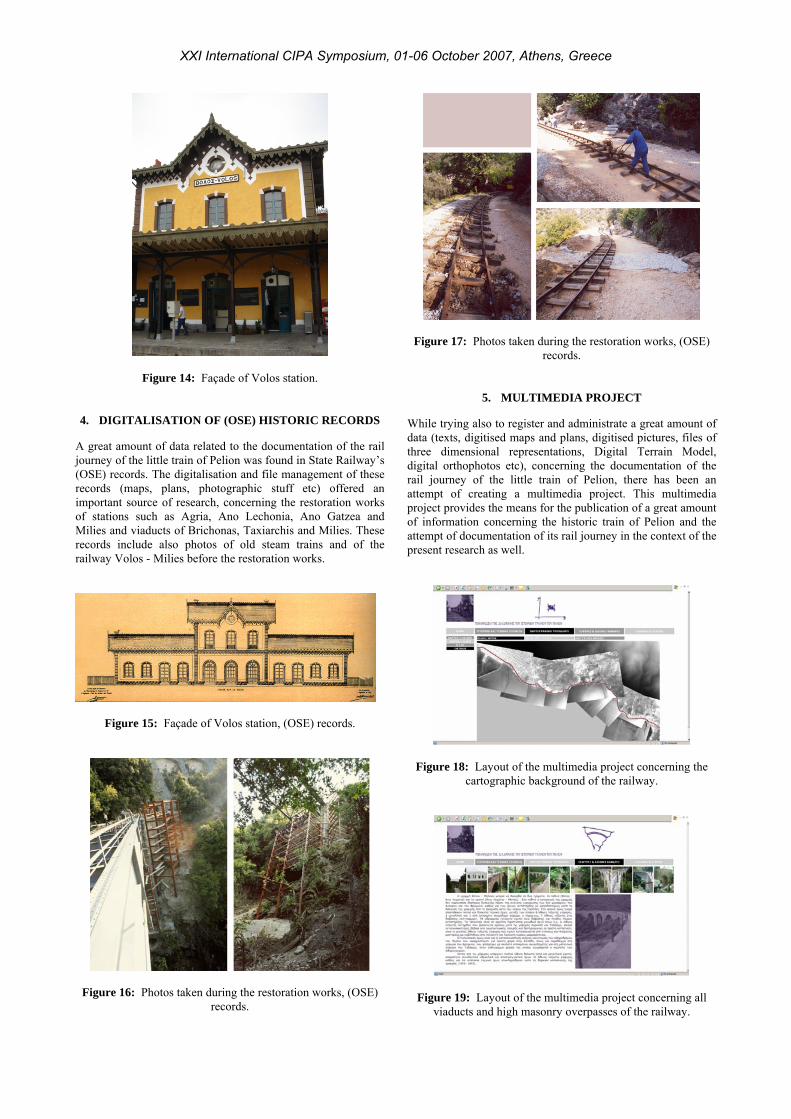
Figure 14: Façade of Volos station.
4. DIGITALISATION OF (OSE) HISTORIC RECORDS
A journey of the little train of Pelion was found in State Railway’s
great amount of data related to the documentation of the rail
(OSE) records. The digitalisation and file management of these records (maps, plans, photographic stuff etc) offered an important source of research, concerning the restoration works of stations such as Agria, Ano Lechonia, Ano Gatzea and Milies and viaducts of Brichonas, Taxiarchis and Milies. These records include also photos of old steam trains and of the railway Volos - Milies before the restoration works.
Figure 15: Façade of Volos station, (OSE) records.
Figure 17: Photos taken during the restoration works, (OSE) records.
5. MULTIMEDIA PROJECT
While trying a eat amount of data (texts, digitised maps and plans, digitised pictures, files of
lso to register and administrate a gr
three dimensional representations, Digital Terrain Model, digital orthophotos etc), concerning the documentation of the rail journey of the little train of Pelion, there has been an attempt of creating a multimedia project. This multimedia project provides the means for the publication of a great amount of information concerning the historic train of Pelion and the attempt of documentation of its rail journey in the context of the present research as well.
Figure 18: Layout of the multimedia project concerning the cartographic background of the railway.
Figure 16: Photos taken during the restoration works, (OSE)
records.
Figure 19: Layout of the multimedia project concerning all
viaducts and high masonry verpasses of the railway. o
XXI International CIPA Symposium, 01-06 October 2007, Athens, Greece

T proje are
he software used for the development of this multimediact was Dreamweaver MX of Macromedia. This softw
offered the choice of working in an intuitive visual layout interface or a streamlined coding environment. The design, development and maintenance of websites and web applications proved to become rather quick and easy using this particular software.
Figure 20: Layout of the multimedia project concerning all stations of the railway.
6. CONCLUSIONS
The whole number of infrastructures of train of Pelion constitutes a worthy example of Greek industrial heritage, from
ation of fast developing digital technologies to the urvey and documentation of cultural monuments was actually
ce of a multimedia project concerning the ocumentation of the rail journey of the little train of Pelion,
7. REFERENCES
Androulidakis K., Ka ail ways of Thessaly (1881 -1955), Museum of Photography ‘Ch. Κalemkeris’,
k rail ways, Athens.
l ways, ΟSΕ, Athens.
G., Κarathanou Μ., 1997, Little train of Pelion, Μilitos, Athens.
1982, Greek locomotives 1882-1910, Cultural Institute of National Bank, Athens.
ΒΑ, Athens.
thens.
Charatsis Ν., 1995, Guide of Pelion for walkers, Graphi, Volos.
Charatsis Ν., 1996, Stone arcaded bridge of Pelion, ksourafa,
constructive, technological and architectural point of view. In other words, it’s a monument with tight bonds with history, culture and social life of the region. The rail journey Volos – Milies is an industrial landmark, a significant component of our tradition. The applicsthe main field of study of this project. The research for the rail journey of the historic train of Pelion was the ignition to put into practice a whole number of methods, techniques and principles related to the protection and conservation of our industrial heritage. Finally, the existendcould become a useful object of study not only for specialists but also for anyone who wants to look through our industrial heritage.
lemkeris Ch., 2002, R
Municipality of Kalamaria.
Kteniadi Ν., 1936, First Gree
Matzaridis P., 1984, Brief history of Greek rai
Nathenas
Papagiannaki L.,
Pinard J., 1991, Industrial archeology, Cultural Technological Institute ΕΤΒΑ, Athens.
Slotta R., 1992, Introduction to industrial archeology, Cultural Technological Institute ΕΤ
Union of friends of locomotives, 1997, Greek locomotives: an itinerary from 1869 to present, Μilitos, A
Τsokopoulos V., 1999, Great technical works in Greece (19–20c.), Kastaniotis, Athens.
Chandrinos G., 2003, Greece of trains, Greek Letters, Athens.
Volos.
XXI International CIPA Symposium, 01-06 October 2007, Athens, Greece