DIAMOND DRILLING RPT DORE TWP - Ontario · The Dore project is characterized by flat to gently...
25
August 8, 2005 Charlie Mortimer Dore Project Assessment Report on Diamond Drilling NTS4101NE Todd Keast
Transcript of DIAMOND DRILLING RPT DORE TWP - Ontario · The Dore project is characterized by flat to gently...

August 8, 2005
Charlie Mortimer
Dore Project
Assessment Report on Diamond Drilling
NTS4101NE
Todd Keast

TABLE OF CONTENTS
Page Introduction ................................................................... 1
Location and Access ......................................................... l
Property ........................................................................ 1
Topography .................................................................... 2
Regional Geology ............................................................. 2
Property Geology ............................................................ 2
Exploration Program .......................................................... 3
Recommendations ............................................................ 3
References ..................................................................... 4
Certificate of Qualification .................................................... 5
Appendices
Diamond Drill Logs
2

INTRODUCTION
During 2003 and 2004, Charlie Mortimer completed a diamond drill program on a group
of claims in Dore Township, situated approximately 100 kilometres southwest of Timmins
Ontario, within the Porcupine Mining Division.
The project is located in the Swayze greenstone belt of the Abitibi Subprovince. The
greenstone belt 1.<; an east-west trending sequence 45km by 25km. Rock types include
massive and fragmental rhyolite volcanic rocks, massive basaltic flows, and scattered
feldspar porphyry intrusions. Sedimentary rocks are a minor component and include
greywacke, argillite, and conglomerate. East-west trending fold axis are prevalent
throughout the stratigraphic package.
Diamond drilling interested wide intervals of intense pervasive carbonate alteration with
very weak sulphide mineralization. Due to the occurrence of surface gold showings
additional work is recommended for the Dore project.
LOCATION AND ACCESS
The property is situated 100 kilometres southwest of Timmins, Ontario. The project is
located in Dore Township ofthe Porcupine Mining Division. The latitude and longitude
of the project is NTS 41 0 I NE, 47° 45 'N 82° 40' E.
Access to the property is excellent. The Folyet Timber road crosscuts the property. The
logging road is accessed from Hwy 101 approximately 100 km southwest of Timmins.
The property is approximately 55km south of the Hwy.
PROPERTY
The Dore Project consists of 17 unpatented mining claims. The claims are situated in
Dore township (GI10S) of the Porcupine Mining Division.
The claim holders include Charles Mortimer (59%), Strik Minerals Inc. (11 %), and
Arnkjell Lovold (30%).

TOPOGRAPHY
The Dore project is characterized by flat to gently rolling topography. The vegetation
consists predominantly of balsam and spruce in the low areas, and a mixture of poplar and
balsam in the high areas. Outcrop exposure is approximately five to ten percent.
REGIONAL GEOLOGY
The project is situated in the Swayze greenstone belt of the Abitibi Subprovince. The
greenstone belt is an east-west trending sequence 45 km by 25 km. Rock types include
massive and fragmental rhyolite volcanics, massive basalt flows, and scattered feldspar
porphyry intrusions. Sedimentary rocks are a minor component and include greywacke
and conglomerate. East-west trending fold axis are prevalent throughout the stratigraphic
package.
The Ontario Geological Survey completed a mapping project of Dore township O.D.M.
Report 33.
PROPERTY GEOLOGY
The claims are situated over a major east west trending rhyolite I basalt contact.
Lithological contacts are preferential sites of structural development, thus important
exploration targets.
The geology of the project consists ofa thick sequence of volcanic rocks which include
mafic volcanic flows, mafic lapilli, conglomerates, and narrow north-south trending
diabase dykes, and an east-west oriented 50m wide shear zone. Alteration within the
shear zone consists of chlorite - sericite carbonated schist. Quartz veins were identified
at a number of locations along the structure.
2
EXPLORATION PROGRAM
Charlie Mortimer has completed four diamond drill holes, three of which have reached
bedrock. Total drilling of all four holes 2,640 feet. Details of the drill results are included
on the drill logs and sections. Location of the drill holes are included on the plan map.
CONCLUSIONS AND RECOMMENDATIONS
Further work is recommended for the Dore Project. Charlie Mortimer is planning to do
mechanical stripping of several areas to identifY the trend of the carbonate alteration
zones.
3

REFERENCES
References:
Donovan,1. F. 1965
Geology of Swayze and Dore Townships. Ontario Department of Mines
Geological Report No. 33. Accompanied by Map 2070, coloured.
O.G.S. 1982
Airborne Electromagnetic an Total Intensity Magnetic Survey, Swayze Area, Cree
Lake Sheet, District of Sudbury, 80541.
4

CERTIFICATE OF QUALIFICATIONS
1, Todd Keast, of 1204 Grace Ave., Porcupine, Ontario, do hereby certifY that:
1. I am the author of this report.
2. 1 am a graduate of the University of Manitoba, Winnipeg, Manitoba, having
received an Honors Bachelor of Science (Geology), in 1986.
3. I have practiced in the field of mineral exploration since 1987, for a number of
exploration companies throughout Manitoba, Ontario, and Quebec.
Dated at Porcupine, Ontario this 10th day of August, 2005.
Todd Keast, FGAC
5

Charlie Mortimer DoreTwp. DDH#: 2002·1 GRID: MDU: , !5 "1'104
From To 0.00 25.00
25.00 65.00
65.00 204.00
204.00 233.00
233.00 275.00
275.00 307.00 307.00 361.00
361.00 642.00
Azimuth and Dip: 701-51 Acid test, "no test" : E.O.H: 642ft
Rock Type CasiI"IQ
Code CAS
Carbonate/sericite/chlorite alteration Zone
Mafic Volcanic Flows
Intermediate Dyke
Massive Mantic FION
Weak alteration Zone Massive Mafic Fla.v
Carbonate/sericite/chlorite alteration Zone
2002-1
GRID LOCATION: UTM, type: E N, none
Start: June 30, 2002 End: Aug 30, 2003
Description
Light buff colour, strong sericite carbonate alteration. Core weathered reddish brONn due to pervassive carbonate. Pervassive intense alteration but not sheared. Possible altered mafic fiChl/S,
rare flON texture. Fine fuccsite, 1-2% fine pyrite. Local narraCMI blocky sections. Dark green medium grained. Gradational upper contact coming out of alteration. PiltON selvedges dCMlOunit. at 100ft unit becomes massive mafic flCMI. Light green grey dike with 7-10% pink fledspar phenocrysts LIP to Smm, euhedral. Sharp upper and 100000r contacts.
Massive mafIC floN, green. Sharp upper contact fine magnetite. Reddish brCMlO alteration averprint of preexisting unit. 1-2% quartz veins. ~sivemafICUnit.
r, strong sericite carbonate aneration. Relatively shafp upper contact 40 deg to CA. Core weathered reddish brCMIn due to pervassive carbonate. Pervassive intense alteration but not sheared. Fine fuccsite, tr fine pyrite, rare grain. Local narraow blocky sections. Rare blue moly on fracture planes. Alteration increases dONn unit.
"",
EOH ::;642ft Casing left in hole. Hole making water. Core stored at Mortimer camp Dore Twp,
Hole spotted 40m north and 100m west of the #2 post of claim 1154404
--
1 of 1
I
I
Drill Company: Charlie Mortimer Logged by; T.Keast
Hardness MS Recovery
.
"----
8/' il/05

C k$, ~ ".:J Co.rb/S('r/chl:>(' sLi;;t,
LOa c.-\
r('\il*rfW!,j'~(e M.~ Q t'c. \l 0 lett f'\: c..s
I.J("~~ A..JI("r~f f(J'"
M.",~,~
o
c ({ \~D(\« {( I ':;C" {" I c AI 0 r
",(i,"(t\~I~,\ 'Zone
DOH 2 0 0<..- \
A 2. 70 0 /-5 f \.J ,'p w /'Jo ("of A t..J,. $ i
S::.ca1e I ,t1,'i =- /00 ttt

(~
J----.
2. 00 3'-1
2002-Y / ~ 2000

Charlie Mortimer DoreTwp. DDH#: 2003-1 GRID: MDU:
From To 0.00 3.00
3.00 58.00 58.00 315.00 315.00 355.00
355.00 625.00
625.00 674.00
Azimuth and Dip: 2701·51 Acid test, "no test" EO H' 674ft ...
Rock Type Casing
Code
Carbonate/sericite/chlorite alteration Zone Mafic Flaw Weak alteration Zone
Conglomerates
Carbonate/sericite/chlorite alteration Zone
2003-1
GRID LOCATION: UTM, type: E N, none
, • Start· Sept 2 2003 End' Oct 30 2003
Description
Light red colour, strong sericite carbonate alteration. Core weathered reddish brown due to pervassiw carbonate. PervassiW intense alteration but nd: sheared. Remnant flC1N texture. Fine fuccsite, tr pyrite. Local narraow blocky sections. Rare qtz veins. Light green mafIC flows, rare pillC1N Ugh brown alteratin OIIeIJ)Iint. Ligh grey to green matrix with scattered rounded cobbles of granitic material. Matrix supported, not bedded. Light buff colour, strong sencile carbonate alteration. Relativeiy sharp upper contact 40 deg to CA Core weathered reddish brown due to pervassive carbonate. Pervassive intense alteration but not sheared. Fine fuccsite, tr fine pyrite, rare grain. Local narraow blocky sections. Rare blue moly on fracture planes. Alteration increases downunit.
EOH=674ft Casing pulled. Core stored at Mortimer camp Dore Twp.
Hole spotted 180m north and 50m west of the #2. post of claim 1154404
1 of 1
Drtll Company: Charlie Mortimer Logged by: T Keast
Hardness MS
7 6 7
6-7
Recovery I
98 90 95
97
8110/05

200~-'
---~C~~~S,0~~. ~~_;~------------------_ ...... _-------
o t. ,4 /oD
Wt'tJ<.K.. A.f{f'(IA -IIC>~ "2(} rll!
Ct. (" b / 5,('(" ! c:. A (ar
<1t(-f('rtllt{/~A 2t>ne
2 00 '1-l
A2 28o/-!;()"
ItJt;r-lh.. UI Pt.,) /'
;11 __ 100 I
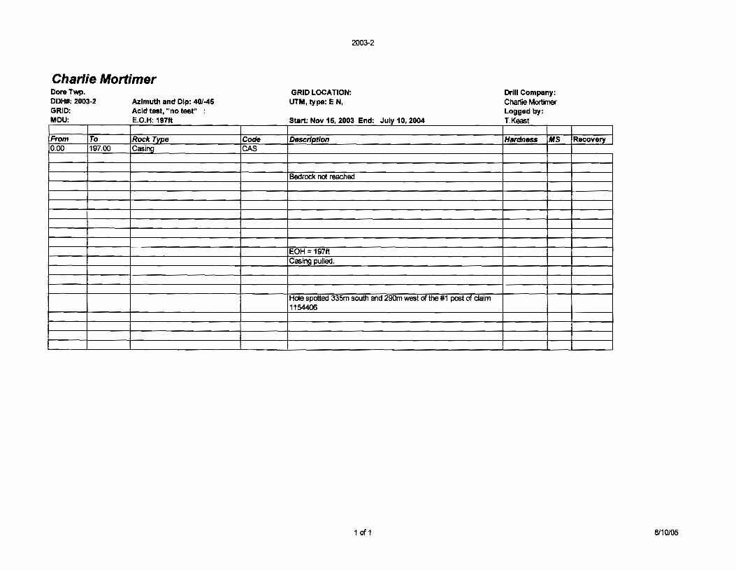
Charlie Mortimer DoreTwp. DDH#: 2003-2 GRID: MDU :
From To 0.00 197.00
Azimuth and Dip: 40/-45 Acid test, "no test" EO H 197ft . . :
,Rock Type Casing
Code CAS
2003-2
GRID LOCATION: UTM, type: EN,
S N 15 2003 E d J t 10 2004 tart: ov . n: UIY . Description
Bedrock not reached
EOH = 197ft Casing pulled.
Hole spotted 335m south and 290m west of the #1 post of claim 1154406
1 of 1
Drill Company: Charlie Mortimer Logged by: TK t . eas
Hardness MS Recovery
8110105

,
(j t L (00 DO/-( 200'3. ~ ~
A2 lfoo /- 41.$ ,
U'fI'fr.J fl.JM -:;( tJ< lei /t"u,\ :: / w(;l

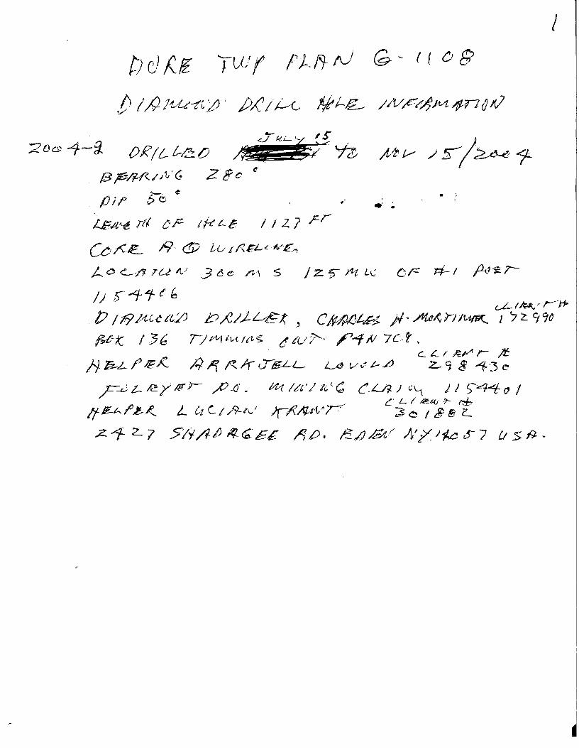
Charlie Mortimer DoreTwp. DDH#: 2004-2 Azimuth and Dip: 280/-50 GRID: Acid test, "no tear' 1IIM:f!-(1 .... ''''I IfS44ct EO H' 1127ft L . , .
From To Rock Type Code 0.00 48.00 Casing CAS
48.00 158.00 Conglomerate 158.00 172.00 Graphitic Af'gillite 172.00 280.00 Conglomerate
280.00 490.00 Weakly altered conglomerate 490.00 750.00 Conalomerate 750.00 1127.00 Maficflo.vs
2004-2
GRID LOCATION: UTM. type: E N,
, , Start: July 15 2004 End' Nov 1S 2004
Description
Light grey green, mixed rounded clasts up to 1 em diamter. Matrix supported. No apparent bedding. Massive pyrtite clasts throughout. Graphitic argillite, sheared, well bedded eo deg to CA. As abo\<e AboYe conglomerate but with a weak pervassive carbonate lowrprint, !igh braNn weathering. As abo\<e non altered. Dart< green massive mafic flaNS.
EOH = 1127ft Casing pUlled. Core stored at Mortimer camp Dore Twp.
Hole spotted 300m south and 125m west of the #1 post of claim 1154406
1 of 1
Drill Company: Charlie Mortimer Logged by: T Keast
Hardness MS I
Recovery
8110105

r;("pt.(4,~ A(~-II'h
(O~O""f(~~t
-" ... ".,
Wt'O{'{ Y 'CAl \ (c ... ~
(ontj6f>1o (,rCA {e
---------------------_.'-'
200'( - 2..
A"L 2 80 I-~O
N I;'
o r..ll\
tI ,
1=-/00

t: 2000

CLAIMaps III
Township
Administrative Boundaries is now the Active Layer
Pan
http://www.c1aimaps.mndm.gov.on.ca/website/c1aimapsiiilviewer.htm
Page 1 of 1
Layers
Building Points
Alienations
Federal Lands
Parks
Pending Claims -Including Filed Only Claims Disposition Symbols
Dispositions Pending Disposition Symbols Pending Dispositions
Lots & Concessions
Buildings
Cliff, Pit & Pile
Utilities
Trails
Roads
Railways
Mine Sites
Mine Headframes
Towers
Contours
Beaver Dams
8/10105

Charlie Mortimer Dore Twp. DDH#: 2004·2 GRID: MDU :
From To 0.00 48.00
48.00 158.00 158.00 172.00 172.00 280.00
280.00 490.00 490.00 750.00 750.00 1127.00
Azimuth and Dip: 280/-50 Acid test, "no test" EO H 1127ft .. :
Rock Type Casing
Conglomerate Graphitic Argillite Conglomerate
Weakly altered conglomerate Conglomerate Mafic flows
Code CAS
2004-2
GRID LOCATION: UTM, type: E N,
Sta J I 15 2004 E d N 15 2004 rt: UIY , n : ov ,
Description
Light grey green, mixed rounded clasts up to 1 cm diamter. Matrix supported. No apparent bedding. Massive pyrtite clasts throughout. Graphitic argillite, sheared, well bedded 60 deg to CA. As above Above conglomerate but with a weak pervassive carbonate overprint, ligh brown weathering. As above non altered. Dark green massive mafic flows,
EOH = 1127ft Casing pulled. Core stored at Mortimer camp Dore Twp
Hole spotted 300m south and 125m west of the #1 post of claim 1154406
1 of 1
Drill Company: Charlie Mortimer Logged by: TK t . eas
Hardness MS I
Recovery
6/21/2005 -

I
:1 !3~/JV(; Z et; '" 6--0 e :. fJi,P ,f."
'. Ls:.4~ rtl ~ r 1ft t...13 / i 2. 1 p,r
, U /C£. 19· (!j) u,.. t ~GL<A.."€':1
., A <!J <::.-/1- TU-/I,/ .3 6-e M ' S j Z. ~ J1,t u..: c,c #-1 f4!-s:. r-
c.L III;~/ ,....--j . P /1f1~~~{,ZJ J::>;eI..1-~~" CtMlJt.s. )I~A4~V-)I14/St. 1 '7 ~ 990 . ~-K. 136 ;-/~tu/",~ dCu'1- ~~# 7C.t.
t::...c..r~r- )'.t ,;;. ~L- fP /€.,I( ;:) '1 ~ Ir ul£L-L Le 1/ d ~ ./J z.. q 8 -1- 3 ea
" ? t- I!:y IE P- ~.(j. 141 /1'&"/-'1(',"-(; CL-h l'~ ) 1 )'-4"'1;" I , c. L. r /i!!J.(;'!J'- tt:b tt /£-h I' J:-.~, L tt C- / /tf-/lj )(A~/1/' r ~ ~ I $ E z....
.. .z.. "1- 2. 7 $/)1. /II) 1ft ~ c£ ,.If,t). £.iJ /,;;,/' /}/ 7. l-k .r 7 II S J9. •
2002-1
Charlie Mortimer DoreTwp. DDH#: 2002-1 GRID: MDU :
From To 0.00 25.00
25.00 65.00
65.00 204.00
204.00 233.00
233.00 275.00
275.00 307.00 307.00 361.00
361.00 642.00
~ .. ... -• ~ -".,J'
• ,
,
Azimuth and Dip: 70/·51 Acid test, "no test" .. : EO H 642ft
Rock Type Casing
Code CAS
GRID LOCATION: UTM, type: E N, none
s tart: J une I n : 30 2002 E d A 30 2003 ug "
Description
Light buff colour, strong sericite carbonate alteration. Core weathered reddish brown due to pervassive carbonate. Pervassive intense alteration but not sheared. Possible altered mafic flows, rare flow texture. Fine fuccsite, 1-2% fine pyrite.
Carbonate/sericite/chlorite alteration Zone Local narraow blocky sections. Dark green medium grained. Gradational upper contact coming out of alteration. Pillow selvedges downunit. at 100ft unit
Mafic Volcanic Flows becomes massive mafic flow. Ught green grey dike with 7-10% pink fledspar phenocrysts up
Intermediate Dyke to 5mm, euhedral. Sharp upper and lower contacts.
Massive Manfic Flow Massive mafic flow, green. Sharp upper contact fine magnetite. Reddish brown alteration overprint of preexisting unit. 1-2%
Weak alteration Zone I quartz veins. Massive Mafic Flow Dark green massive mafic unit.
Ught buff colour, strong sericite carbonate alteration. Relatively sharp upper contact 40 deg to CA. Core weathered reddish brown due to pervassive carbonate. Pervassive intense alteration but not sheared.Fine fuccsite, tr fine pyrite, rare grain. Local narraow blocky sections. Rare blue moly on fracture
Carbonate/sericite/chlorite alteration Zone Iplanes. Alteration increases downunit.
EOH = 642ft Casing left in hole. Hole making water. Core stored at Mortimer camp Dore Twp.
Hole spotted 40m north and 100m west of the #2 post of claim 1154404
r-!'-=,_ - ~.
Ht:Gt:IVED JUN 28 2005
G;~OSCIENCE ASSESSMENTI of 1 _Q,EFICE
Drill Company: Charlie Mortimer Logged by: T K t . eas
Hardness MS Recovery
6/2112005

be (Zf=- 'reu f' P Lit /I) G- ~ L I () E
.. }J I' Ii .j)/:J L L fIe;t.1'i- / /v l 7- C/{' It t/f-i=-t /-11. 1
pptf,. 26-l! Z - I T/{/5
~ .z.. '-/ fl e G~5E d)/'t IL. L
IX! j..L SI jE JIV /Z.Jc..1 L/ Z c~ 2-
/>I!L..L/IL'~ {A-/r95 AI['~
,l9-l t '0 u(J l~'1 /LfjJJ'£/1 Ci/[/ I9tl ~ !3;;:_~~Jt{;'(; z:. 7(1
~
._ I!
,!; /
C (!J hE ;:;, tS I W //ZL t,.f,//: -'
:c i t$[ g; t "C-L,/!-I.lV,
v; ~lvL-t (1/ .t' j) /Z. /i-L-tZ,e (..,c...r~"''''- ;rt:
ct{/J./i';...pp: 1/· pr! ~r / f"'rl.·tY. 17 2. 1 q C
f;f!flf{~ .::
}.ffrLf~/~ ,
86 K ) ;)0 1/ rl1 /V{ /f 1/,5 C! tVt>- /"'f -1/ 7 t..=.. 'I J'j -P.r 11:T{!-L-L ~ t'" i/' l-~ ;:::c-~/~ r r t:3 "
1/ '/
,/
\,

Charlie Mortimer DoreTwp. DDH#: 2004-2 GRID: M U 0:
From To 0.00 48.00
48.00 158.00 158.00 172.00 17200 280.00
280.00 490.00 490.00 75000 750.00 1127.00
Azimuth and Dip: 2801-50 Acid test, "no test" : E.O.H: 1127ft
Rock Type Casing
Conglomerate Graphitic Argillite Conglomerate
Weakly altered conglomerate Conglomerate Mafic flows
Code CAS
(j) ~~ 0 en n (....
m C 2 Z ·:::;In
,'TIm 1'0 :!!::e> 'nen ')0
men t'-J m = en -:-;) en U1
~ m :2: -1
2004-2
GRID LOCATION: UTM, type: E N,
Start: July 15, 2004 End: Nov 15, 2004
Description
Light grey green, mixed rounded clasts up to 1 cm diamter. Matrix supported. No apparent bedding. Massive pyrtite clasts throughout. Graphitic argillite, sheared, well bedded 60 deg to CA. As above Above conglomerate but with a weak pervassive carbonate overprint, Jigh brown weathering. As above non altered. Dark green massive mafic flows.
EOH::= 1127ft Casing pulled. Core stored at Mortimer camp Dore Twp.
Hole spotted 300m south and 125m west of the #1 post of claim 1154406
:Ill m' 0\ ml -I <I
Drill Company: Charlie Mortimer Logged by: T.Keast
Hardness MS
\; 1-, : .... ml ""\..,
0\ ""-, .
1 of 1 'J ',JIII
Recovery
6/21/2005
I
;ZOe ~-iJ OR/'! ... t-cO
f3 p;Rft.. / /(,' 6 .2 8 c C"
'-- ~
/Ji,P bo ~
LG:4"~ rtf OF- 1ft t-E / /27 F-r
W~£.. /9- (!i) to/A€L~~":€'"l
)... 0 <:'-/'1 T 1-2' ~/ ,3 6 e ft1 S / z. f) fit 1-1":; () F #- I j1J-s.:. r-
J--!~rrH
p 11I9Puc/t£) b~/.J..v~t -' C~,()t-~ )+/-. fltdJ{rJIU/FIC. J '7 ~ 990
1U~t( /:3 b 1/ p1,J itA, It~ g. t1 tu l'- ~..:r- tV 7 L- t , . ~ ~ I' ~;/f r )f:
f) ~LI' /€A. ;:; /1 ~ II uE-LL LcJ t,/ .. ~ £-fi z.. 9 8 ~'3 ~
P L- ~ Y Ie r- /'J -0' • at /?t'J 11. {(; C-L/i-) G'-1 j i )~-4 () I C L ( ~(, J-- f1:b
Ifl£-hr>1:-~ L tA C/ /Y-/\~/ JrA"ht'vY :3 C I $ B L
.z. '1- 2. 7 51)1 AiJ If!- Q; E£ /) £>. ~ /J,/2;t/ A' /. J~a S- 7 u:> fi. •
I
!
I
I
.~

, ~
-:! ' " ~
'" 'i. , ~
,- < -. > . . "
~
"' ~ -, -
-.- ~ -- >
~ - , ~
. ' "
. . -• ' , --
-~ • , , -" ,
~ , -, "
\ ' ' r " . - , < ------'. , - ---,.~- ,
-~ ~ ~-
~ &
-,- "-
4;T.0~fj I
~-,... .... - • •
r
"'"" ,- , <' , - < .
'" .- r
~ L -, ~
<-
, ,
2tOON
.,
07-00 ,
" ,