DEVELOPMENT CONTROL AND REGULATION COMMITTEE …councilportal.cumbria.gov.uk/Data/Development...
34
1 DEVELOPMENT CONTROL AND REGULATION COMMITTEE 17 March 2009 A Report by the Head of Transport and Spatial Planning _____________________________________________________________________________ District Allerdale Application No 2/08/0879 Applicant Eatonfield Developments Ltd _____________________________________________________________________________ PROPOSAL Outline application for mixed–use redevelopment comprising residential, commercial, small scale retail, community and leisure uses Corus Rail Steel Works, Lakes Road, Workington _____________________________________________________________________________
Transcript of DEVELOPMENT CONTROL AND REGULATION COMMITTEE …councilportal.cumbria.gov.uk/Data/Development...

1
DEVELOPMENT CONTROL AND REGULATION COMMITTEE 17 March 2009
A Report by the Head of Transport and Spatial Planning _____________________________________________________________________________ District Allerdale Application No 2/08/0879 Applicant Eatonfield Developments Ltd _____________________________________________________________________________ PROPOSAL Outline application for mixed–use redevelopment comprising
residential, commercial, small scale retail, community and leisure uses Corus Rail Steel Works, Lakes Road, Workington
_____________________________________________________________________________
2
1 RECOMMENDATION
1.1 That no objection is raised to the proposal, subject to Allerdale Borough
Council having regard to the matters as set out in Section 3 of this report, and Annexes 1, 2 and 3 below, and ensuring that the developer:-
• amends the housing mix to better reflect local needs, as per the
Housing Market Assessment; • agrees to a phasing condition being attached to the planning
permission, in order to avoid an over-supply of housing in any five year period;
• agrees to a condition being attached to the planning permission, which ties maximum sizes of retail units to specific uses to avoid one single large (Use Class A1) retail unit being erected on this site;
• ensures that the design of the buildings (and site) is made accessible to the disabled and appropriate for their designated use, and the number of units proposed for adult social care satisfactorily meets local needs;
• submits details of the proposed Public Right of Way footpath through the site for Local Planning Authority agreement, and ensures that the footpath is provided on site prior to occupation of the buildings;
• addresses highway and transport concerns by way of conditions set out in Annex 1 and enters into a Section 106 Agreement as set out in Annex 3;
• protects archaeological interests by way of conditions set out in Annex 1, and commits to preserving some of the above-ground archaeological remains by way of a S106 agreement;
• protects biodiversity interests by way of meeting the conditions set out in Annex 1 that require a butterfly habitat and population survey to be undertaken in May - June for both the Small Blue and Dingy Skipper and the preparation of an impact assessment, mitigation strategy, and establishment management plan. These measures should ensure on-site survival of the Small Blue and Dingy Skipper butterfly colonies preferably through in-situ habitat preservation, or by suitable habitat creation and translocation;
• enters into a Section 106 Agreement as set out in Annex 2 to achieve long-term habitat management;
• addresses the potential impacts of contamination within the site to the satisfaction of Allerdale Borough Council;
• addresses the potential issues of flood risk in the application to the satisfaction of Allerdale Borough Council, having taken advice from the Environment Agency; and
• addresses the potential issues of coastal erosion to the satisfaction of Allerdale Borough Council.
3
2 THE PROPOSAL
2.1 Cumbria County Council has been consulted by Allerdale Borough Council
on an outline application for a mixed-use development comprising residential, commercial, small-scale retail, community and leisure uses on the former Corus Steel works site in Workington. The site covers 31ha, and the development would provide a total of 39,563 sqm of new commercial floorspace, plus 651 residential units (480 dwellings and 171 apartments). The only aspect being considered at this stage is access. All other aspects of the development are being left for reserved matters approval.
2.2 The application site had been used for steel production and processing
since the 1870s and was continuously developed until the 1930s. Extensive modernisation continued after World War II. In late 2006, as a result of rail track production being switched to Scunthorpe, works ceased, causing a loss of approximately 250 jobs in the Workington and wider area. The site consisted predominantly of engineering works, ancillary buildings and storage areas.
2.3 As part of a metals recycling operation set out in the conditions of sale
agreed between Corus Rail Products and Eatonfield Developments Ltd, Corus Rail has been required to clear the site of all structures by the end of October 2008.
2.4 The site lies on the south-west periphery of the Town Centre of Workington.
Access to the site is currently off Lakes Road to the north of the site, which is directly accessed off the main spine road to the Derwent Howe Industrial Estate. The site is framed by the slag bank on the southwest edge of the site (rising up to 20m above site level), and by the rising ground of the Derwent Howe area, and the Derwent Howe Industrial estate to the north.
2.5 It is bound to the east by the Barrow to Carlisle Railway line, beyond which
lies the main A597 Solway Road arterial route. To the west of the site lies the coastline of the Solway Firth. The site is approximately 900m in length and takes a sprawling, elongated, irregular shaped form, tapering and dropping in level at its most southerly point. In terms of width, the site extends from the railway line on the east side of the site to the sea wall on the west side, which is a distance of between 550m and 750m.
2.6 The indicative proposal includes the following range of mixed-uses:
Table 1: Proposed uses for the Corus site - planning application 02/08/0879
Land Use Land Requirements/No. of Units
Development Phase
Offices (B1) 13,734sqm A

4
Public House 1,600sqm A Retail (A1, A2, A3,
A4, A5) 2,330sqm A
Play Barn 694sqm A Community Centre 1,080sqm C
Spa 1,160sqm C Hotel 4,275sqm A
Starter Units (B2/B8)
4,250sqm A
Light Commercial (B2/B8)
5,995sqm A/B
Facilities (gym, clinic and health
care)
1,160sqm C
40x bed Care Home
2,400sqm C
1x bed Apartments 66 A/B/C 2x bed Apartments 105 A/B/C Detached Houses 64 A/B/C
Semi-detached Houses
42 A/B/C
Town Houses 342 A/B/C Bungalows 32 C
2.7 The indicative layout shows three development parcels or zones for
development (A, B, and C). A draft phasing programme has been prepared, which shows how the site could be developed over a six to seven year build programme. Subject to planning permission, it is intended that site infrastructure works would begin in 2010 with the laying down of the main thoroughfare road through the site, its spine roads and drainage systems. This would allow vehicular access across the site, ensuring development is not restricted to one area of the site, should there be a demand for particular land uses or parcels to implement their approved works. The development of the residential, commercial and retail elements are then expected to begin in 2012 over a five year programme up until 2017.
2.8 The applicant states that the commercial elements would assist in the
delivery of approximately 1,500 new FTE jobs. Construction jobs would account for between 20% - 40% of the total employment opportunities. Construction jobs would be sourced locally as far as possible. The remaining 60 - 80% would be created during subsequent use of the site. Employment opportunities would be created in retail, food outlets, and accommodation services, health and social work, business and recreation. The applicant states that the mixed-use proposal would offer a diverse range of employment uses, and would enable a dynamic labour force to live, work and flourish in an attractive setting, alongside wider regeneration
5
benefits making the most efficient use of the land. 2.9 The inclusion of 4,250sqm of starter units in the scheme would attract small
businesses to the site, attracting future inward investment, whilst retaining and diversifying employment opportunities. These would be located adjacent to the new access road from Lakes Road. The 5,995sqm light commercial use industrial development (Use Classes B2/B8) is intended to provide a range of jobs for future and existing residents of Workington and the site, and to attract further future investment in the area.
2.10 The indicative layout also includes provision of open/green space, a sea-
front promenade (with public art features and tourist attractions), improved access to the Howe area, and the re-aligning of the Coastal Path to run alongside the sea front. The promenade would create new and improved pedestrian and cycle routes through and adjacent to the site, which will create an active and highly attractive pedestrian zone fronting the sea, easily accessed by foot and cycle. The applicant anticipates that this would enhance sea views for residents and visitors, thereby improving access to the coast and those environmental features previously inaccessible to the public. The applicant considers that the proposed hotel, together with a new bus service linking with the town centre would assist the growth and perception of Workington and the wider area, encouraging visitors, as well as future investment.
2.11 The proposal would provide a health centre, clinic, doctor’s and dentist’s
surgery(s) and a care and retirement village. The care and retirement village also allows for a range of community uses, such as tennis courts, golf practice nets and a community centre. A creche/play barn will also be provided elsewhere in the scheme.
2.12 The applicant states that the range of housing types and sizes would
diversify the existing stock in and around Workington, encouraging in-migration and creating a mixed and inclusive community. The development would minimise energy consumption thorough high density development, energy efficient construction and locating development so as to encourage walking and cycling.
2.13 Redevelopment also seeks to protect the long-term interests of important
landscape features, such as the slag banks and sea wall, through appropriate sea spray and flooding mitigation techniques and shoreline stabilisation methods.
2.14 The proposal seeks to improve access through the provision of two
enhanced pedestrian access points over the existing rail line to the east of the site, and beneath the rail line via an underpass on Shore Lane to the south of the site. Vehicular access will be enhanced with a new road
6
accessing Bessemer Way to the south of the existing Lakes Road / Bessemer Way junction which would serve as a secondary access. The inclusion of local shops and services that are accessible on foot should minimise the use of private cars travelling to and from Workington Town Centre.
2.15 The proposal would include amongst other aspects the provision of the
following on- and o ff-site road network improvements:
• A new signalised junction at Bessemer Way/new access road to serve as the main point of access to the site and improvements to the existing Bessemer Way/Lakes Road junction;
• Enhanced bus services between the site, the proposed transport interchange, the proposed Tesco Store and Workington Town Centre;
• Improvements to Annie Pit Lane/Harrington Road junction with developer contributing to a new controller and provision of MOVA which improves the junction’s operational efficiency;
• Provision of walking routes/information contained within information packs and site based notice board;
• Provision of one 8 week West Cumbria Megarider ticket to every dwelling;
• Improved pedestrian and cycle linkage to the underpass linking the development site to Shore Road;
• Improved linkage to the railway footbridge; • Improved coastal route to the western edge of the development; • Footway provision to both sides of the carriageway on the proposed
access road; • Provision of a toucan crossing as part of the proposed Bessemer
Way/Lakes Road junction improvement; • Provision of adequate infrastructure including dropped crossings
and street lighting within the development site; • Provision of secure and sheltered cycle parking facilities within the
site • Use of lockers and shower/changing facilities within the site; • Provision of cycle routes/information contained within information
packs and site based notice boards; • The potential to provide free bicycles by employers for those who
wish to cycle to and from the site; • Provision of secure sheltered on site PTW parking; and • Provision of new bus stops within the development site with level
access, shelters, adequate lighting and timetables. 2.16 The County Council has been consulted in this case, as the proposal
involves a major mixed-use development within this Key Service Centre.

7
2.17 A number of supporting documents have been submitted with the application. These include: a Planning Statement; Environmental Statement; Transport Assessment and Green Travel Plan; Drainage Feasibility Report; Flood Risk Assessment; Utilities Infrastructures report; General Design Statement – Landscape; Seafront Design Statement; and an Historic Environment Record.
3 PLANNING AND TRANSPORT ISSUES
3.1 The application will be assessed as to whether it would conflict with or
prejudice the implementation of those policies that are contained within the Cumbria and Lake District Joint Structure Plan (JSP) 2001 – 2016 (adopted April 2006) that have been extended and not replaced by the Regional Spatial Strategy (issued 30 September 2008). The application will also be assessed against the policies contained in the Cumbria Local Transport Plan (LTP) 2006-2011, and the Cumbria Strategic Partnership’s Sub-Regional Spatial Strategy (SRSpS).
3.2 It is considered that the main strategic issues raised by the application are:
• To determine whether or not the scale, mix and type of development is appropriate to the location, and whether or not there is any significant adverse effect on strategic housing, regeneration/employment and retail policies;
• To determine whether it is sustainable in terms of transport and accessibility; and
• To determine whether there are any significant adverse effects on landscape, historic environment and ecology, and impact of land contamination and flooding .
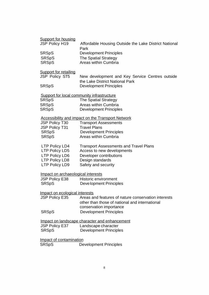
3.3 The following Policies are considered relevant. 3.4 Development strategy & location
JSP Policy ST5 New development and Key Service Centres outside the Lake District National Park SRSpS Development Principles
SRSpS The Spatial Strategy SRSpS Areas within Cumbria Support for the economy JSP Policy EM 13 Employment Land Provision
JSP Policy EM14 Development of employment land for other purposes SRSpS The Spatial Strategy SRSpS Areas within Cumbria
8
Support for housing JSP Policy H19 Affordable Housing Outside the Lake District National
Park SRSpS Development Principles
SRSpS The Spatial Strategy SRSpS Areas within Cumbria
Support for retailing JSP Policy ST5 New development and Key Service Centres outside
the Lake District National Park SRSpS Development Principles
Support for local community infrastructure SRSpS The Spatial Strategy SRSpS Areas within Cumbria SRSpS Development Principles Accessibility and impact on the Transport Network
JSP Policy T30 Transport Assessments JSP Policy T31 Travel Plans
SRSpS Development Principles SRSpS Areas within Cumbria
LTP Policy LD4 Transport Assessments and Travel Plans LTP Policy LD5 Access to new developments LTP Policy LD6 Developer contributions LTP Policy LD8 Design standards LTP Policy LD9 Safety and security
Impact on archaeological interests JSP Policy E38 Historic environment SRSpS Deve lopment Principles
Impact on ecological interests JSP Policy E35 Areas and features of nature conservation interests other than those of national and international conservation importance
SRSpS Development Principles Impact on landscape character and enhancement JSP Policy E37 Landscape character SRSpS Development Principles
Impact of contamination SRSpS Development Principles

9
Impact of flooding SRSpS Development Principles
Development strategy & location
3.5 The Cumbria Community Strategy 2008-2028 aims to create: safe, strong
and inclusive communities; health and well-being throughout life; a sustainable and prosperous economy; effective connections between people and places; and a world class environmental quality. The Community Strategy seeks to energise the county’s communities, health, economy, connections and environment over the next 10-20 years. It brings together aspirations and ambitions from a range of thematic and geographic strategies.
3.6 The Sub-Regional Spatial Strategy (SRSpS) sets out the spatial framework.
This enables actions that affect specific areas and locations to serve the delivery of the Community Strategy, and provide the sub-regional spatial framework for Local Development Frameworks in Cumbria. This enables them to align to the Community Strategy.
3.7 The Community Strategy and the SRSpS recognise that the challenge is to
secure a sustainable level and pattern of development that creates balanced communities and meets need – including the need for jobs. The SRSpS states that this will require private and public investment, in appropriate locations, to bring about transformational change to the Cumbrian economy. In the interests of sustainable development, housing is also necessary at a level to complement economic growth and ensure that local housing needs are met through the achievement of balanced housing markets.
3.8 The SRSpS Development Principles require most development to be
located in designated Key Service Centres and Local Service Centres to assist in reducing the need to travel, and to give , in the following order of priority, a preference for a) the reuse of buildings worthy of protection, b) the reuse of previously-developed land, and only then c) the use of previously undeveloped land. It will be the exception for development to be located in the open countryside. Development is required to seek sites that are or will be made accessible by public transport, walking and cycling. Development proposals are also required to reduce the risk of flooding (on site and by applying a sequential approach to location), to protect and where possible enhance important or distinctive conservation features, protect landscape quality, ensure high standards of design, and avoid reductions in air quality and the quality and quantity of ground and surface waters.
3.9 JSP Policy ST5 identifies the following Key Service Centres in the administrative area of Allerdale Borough Council: Workington, Maryport,
10
Aspatria, Wigton and Cockermouth. Workington and Maryport are identified for sustained development of large towns. Aspatria, Wigton and Cockermouth are identified for moderate development appropriate to their scale.
3.10 Workington is identified in the SRSpS as a location where major development is to take place in the County, alongside Barrow, Carlisle and Whitehaven. Major development is required in Workington (and Whitehaven) to counterbalance the current and future loss of jobs and to improve the quality of life. Spatial planning will be required that develops the roles of the existing centres of Workington (and Whitehaven) alongside those of Cleator Moor and Maryport should be complementary so that they support each other as a single urban area, and generate the means to improve quality and availability of facilities. Together Workington and Whitehaven have a regionally significant role as a service centre, and development of the two towns should complement each other.
3.11 The SRSpS recognises that West Cumbria has suffered long-term social and economic problems brought about by an over-dependence on the declining manufacturing sector and its relative remoteness from regional and national markets.
3.12 The West Cumbria Energy Coast Masterplan seeks to bring about
transformational change by diversifying the economy, whilst building on the areas key assets. The Masterplan identifies a number of major interventions to support UK energy security and environmental responsibility in terms of climate change, through the creation of an energy, environment and technology cluster along the coastal corridor from Sellafield to Workington. Interventions to support improvements to and diversification of the skills base and local economy along with further development of tourism, cultural and recreational sectors will also be encouraged. Significant transport and infrastructure interventions will be crucial to delivering transformational change. Balanced housing markets will be created through refurbishment, clearance and renewal and by enabling new houses to be built within the wider area. There is a need for choice, quality and flexibility in the land allocations being made for employment and housing. This is essential to enable the rapid economic and social transition that will occur with the delivery of the transformational interventions of the Masterplan.
3.13 A Derwent Howe Development Strategy (April 2008) prepared by
consultants on behalf of Allerdale Borough Council, Cumbria County Council and other partners seeks to deliver a comprehensive approach to the redevelopment of a 202ha site covering the Derwent Howe area, which includes the Corus application site. The Strategy seeks to build upon and complement the wider aspirations and objectives for the regeneration of Workington and West Cumbria, contributing towards the transformational of the sub-regional local economy. This Strategy provides a blueprint for the
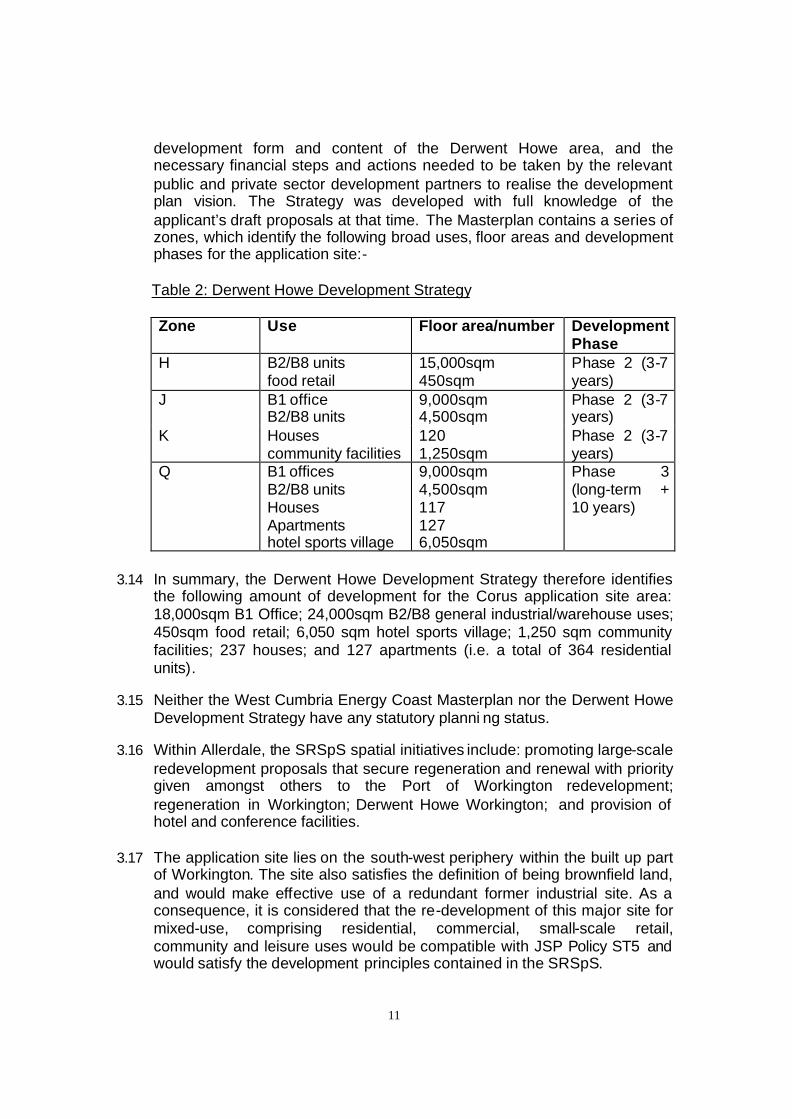
11
development form and content of the Derwent Howe area, and the necessary financial steps and actions needed to be taken by the relevant public and private sector development partners to realise the development plan vision. The Strategy was developed with full knowledge of the applicant’s draft proposals at that time. The Masterplan contains a series of zones, which identify the following broad uses, floor areas and development phases for the application site:- Table 2: Derwent Howe Development Strategy Zone Use Floor area/number Development
Phase H B2/B8 units
food retail 15,000sqm 450sqm
Phase 2 (3-7 years)
J B1 office B2/B8 units
9,000sqm 4,500sqm
Phase 2 (3-7 years)
K Houses community facilities
120 1,250sqm
Phase 2 (3-7 years)
Q B1 offices B2/B8 units Houses Apartments hotel sports village
9,000sqm 4,500sqm 117 127 6,050sqm
Phase 3 (long-term + 10 years)
3.14 In summary, the Derwent Howe Development Strategy therefore identifies
the following amount of development for the Corus application site area: 18,000sqm B1 Office; 24,000sqm B2/B8 general industrial/warehouse uses; 450sqm food retail; 6,050 sqm hotel sports village; 1,250 sqm community facilities; 237 houses; and 127 apartments (i.e. a total of 364 residential units).
3.15 Neither the West Cumbria Energy Coast Masterplan nor the Derwent Howe
Development Strategy have any statutory planni ng status. 3.16 Within Allerdale, the SRSpS spatial initiatives include: promoting large-scale
redevelopment proposals that secure regeneration and renewal with priority given amongst others to the Port of Workington redevelopment; regeneration in Workington; Derwent Howe Workington; and provision of hotel and conference facilities.
3.17 The application site lies on the south-west periphery within the built up part of Workington. The site also satisfies the definition of being brownfield land, and would make effective use of a redundant former industrial site. As a consequence, it is considered that the re-development of this major site for mixed-use, comprising residential, commercial, small-scale retail, community and leisure uses would be compatible with JSP Policy ST5 and would satisfy the development principles contained in the SRSpS.

12
3.18 The proposed development would support the high priority given in the
SRSpS and the West Cumbria Energy Coast Masterplan to bring about transformational social and economic change in West Cumbria to regenerate a significant part of Workington. It would create new housing and employment development to diversify the skills base and the local economy, and would also create enhanced tourism, community and recreation facilities linking to the remainder of Derwent Howe.
3.19 The current application would provide for a smaller amount of office and
light industrial use, and a proportionately greater provision for new housing development, compared to the Derwent Howe Development Strategy. The current application would also create a more intensive form and layout of development, with less provision for open space and recreation areas, and less physical separation between the residential and commercial elements of the scheme. The Derwent Howe Development Strategy provides for a large avenue of open green space, thereby delineating the residential element and the business scheme. This difference in the development proportions probably reflects the current state of the UK economy and the property development market to maximise development values.
3.20 Notwithstanding this point, it is considered that the broad range of proposed
uses is considered acceptable as they would broadly reflect the development principles set out in the Derwent Howe Development Strategy. However, specific detailed concerns about the type of housing mix are referred to under the following sections. Support for the economy
3.21 In recognition of the need to ensure an adequate supply of land for a variety of business uses in the most appropriate locations, saved JSP Policy EM 13 sets out a supply of employment land required by each District over the period 2001 to 2016. The Policy requires that there should be a supply of readily available employment land for the following employment sectors in Allerdale Borough: 20ha of Strategic Employment land; 10ha of Local Employment land; and 5ha of Business Science Park land. For the period 2001-2006, 7ha of Port Related development should also have been made available. The JSP states that land remaining available at the end of a five-year period will count towards the following period.
3.22 Saved JSP Policy EM14 states that the development of existing
employment sites, premises and land allocations for non-employment or mixed-uses will be considered where it can be demonstrated that over the Structure Plan period, either the site or premises is likely to remain unsuitable for employment purposes; or the retention of the site or premises in employment use is not needed to meet the requirements of Policy EM13. This inc ludes the requirement tha t each Key Service Centre to retain an

13
appropriate supply of land within the Local Employment site market sector.
3.23 The SRSpS recognises that Cumbria’s economy is underperforming, with under representation in growth sectors. This is coupled with a high dependence on declining sectors and household earnings significantly below the UK average. The SRSpS points out that West Cumbria has suffered long-term social and economic problems brought about by overdependence on the manufacturing sector and its relative remoteness from regional and national markets . The most recent challenge to the economy is the restructuring of the nuclear industry and a shift to decommissioning. There is also a recognised oversupply of low quality unserviced employment sites. The SRSpS also supports utilising the potential of the Cumbria Coast.
3.24 The Cumbria County Council Employment Land and Floorspace
Assessment (December 2008) prepared by the Spatial Planning Team identifies that within Allerdale Borough, there is currently 0.70ha of Business Park land available; 50.65ha of Local Employment land; 0.10ha of Own Use land; 6ha of Port Related land; and 34.86ha of Strategic Employment land available. This would give a total of 92.31ha of available employment land within Allerdale Borough.
3.25 In comparison with the requirements of Policy EM13, it would seem that
although there is a need for Allerdale to provide further Business Park space, there is more than sufficient Local Employment land and Stra tegic Employment land (mostly at the Lillyhall Industrial Estate) available given current take up rates. The take up rates show that between April 2003-March 2008, some 7.88ha of all employment land was completed in Allerdale (i.e. equivalent to 1.6ha per annum). Consequently, there is a total of 58 years supply of employment land in the Borough.
3.26 The current proposal would not utilise the whole of the former Corus site for
employment purposes. Instead it is proposing to provide a total of 39,563sqm of commercial space, of which 13,734sqm would be for B1 office use; 10,245sqm for B2/B8 general industrial/warehouse uses; and 2,330sqm would be for retail uses. Other quasi-employment uses are also proposed, which include the public house, restaurant, community centre, and hotel as outlined in Table 1 above.
3.27 The applicants claim that the commercial elements would assist in the
delivery of approximately 1,500 new FTE jobs. 60 - 80% of this number would be created during subsequent commercial use of the site. Employment opportunities would be created in retail, food outlets, and accommodation services, health and social work, business and recreation. This contrasts with the fact that the previous Corus Steel Works site was employing 250 jobs in the Workington and wider area before its closure in late 2006. Hence there would be a net gain in employment in Workington as
14
a result of the proposed new development. 3.28 On the basis of the above, it is considered that the proposed mixed-use
development would make a positive contribution towards the employment needs of the Borough as required by the SRSpS, the Energy Coast Masterplan, and the Derwent Howe Strategy, and would not undermine saved JSP employment policies EM13 and EM14.
Support for housing
3.29 The SRSpS gives a high priority to delivering balanced housing markets throughout Cumbria and housing market renewal in Furness and West Cumbria. Within West Cumbria, the SRSpS seeks to create balanced housing markets through refurbishment, clearance and renewal and by enabling new houses to be built within the wider area. The SRSpS identifies a need for choice, quality and flexibility in the land allocations being made for employment and housing. This is essential to enable rapid economic and social transition that will occur with the delivery of the transformational interventions of the Masterplan. Saved JSP Policy H19 also requires the provision of affordable housing in the County to meet proven local need as part of residential or mixed-use development of sites of more than 0.4ha or 10 or more dwellings.
3.30 The proposal includes 651 new dwellings, with a mix of 1x (no. 66) and 2x
bed apartments (no. 105). There would also be detached (no.64) and semi-detached dwellings (no. 42), town houses (no. 342) and bungalows (no. 32), and a 40x bed care home. The total number of residential units proposed in this application would be greater than that envisaged by the Derwent Howe Development Strategy, which identifies a total of 364 residential units (237 houses and 127 apartments).
3.31 The Workington and Maryport Housing Market Assessment (2006) identifies
a need for 515 new affordable homes between 2006-2011 (i.e. 103 units per annum), and the Housing Needs Survey 2006 identified that there is a significant need for 2x bed houses for those trying to access the housing market. There are some unpopular property types in this housing market area, such as 1x bed flats and bungalows, and as a result some 1x bed properties have had to be demolished and then re-developed. Bungalows only come empty due to death or the elderly household moving into residential care, and there is considerable need for 2x bed bungalows. Both Workington and Maryport have parts that have been declared renewal areas. Properties in the renewal areas undergo major externa l works, which improve the life of the property as well as enhancing the area. The affordability ratios of property prices to household income are between 5:1 – 6:1 for terraced and semi-detached dwellings.
3.32 Over the past five years, the number of dwelling completions within
15
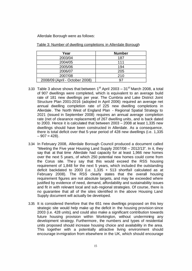
Allerdale Borough were as follows: Table 3: Number of dwelling completions in Allerdale Borough
Year Number 2003/04 187 2004/05 111 2005/06 194 2006/07 205 2007/08 210
2008/09 (April - October 2008) 97 3.33 Table 3 above shows that between 1st April 2003 – 31st March 2008, a total
of 907 dwellings were completed, which is equivalent to an average build rate of 181 new dwellings per year. The Cumbria and Lake District Joint Structure Plan 2001-2016 (adopted in April 2006) required an average net annual dwelling completion rate of 225 new dwelling completions in Allerdale . The North West of England Plan - Regional Spatial Strategy to 2021 (issued in September 2008) requires an annual average completion rate (net of clearance replacement) of 267 dwelling units, and is back dated to 2003. Hence it is calculated that between 2003 – 2008 at least 1,335 new dwellings should have been constructed in Allerdale. As a consequence, there is total deficit over that 5-year period of 428 new dwellings (i.e. 1,335 – 907 = 428).
3.34 In February 2008, Allerdale Borough Council produced a document called
“Meeting the Five year Housing Land Supply 2007/08 – 2012/13”. In it, they say that at that time Allerdale had capacity for at least 1,966 new homes over the next 5 years, of which 250 potential new homes could come from the Corus site. The y say that this would exceed the RSS housing requirement of 1,848 for the next 5 years, which included the outstanding deficit backdated to 2003 (i.e. 1,335 + 513 shortfall calculated as at February 2008). The RSS clearly states that the overall housing requirement figures are not absolute targets, and may be exceeded where justified by evidence of need, demand, affordability and sustainability issues and fit in with relevant local and sub-regional strategies. Of course, there is no guarantee that all of the sites identified in the above Housing Land Supply document will actually be developed.
3.35 It is considered therefore that the 651 new dwellings proposed on this key
strategic site would help make up the deficit in the housing provision since 2003 (i.e. 428 units), and could also make a significant contribution towards future housing provision within Workington, without undermining any development strategy. Furthermore , the numbers and types of residential units proposed should increase housing choice and availability in the area. This together with a potentially attractive living environment should encourage in-migration from elsewhere in the UK, which should encourage

16
further investment and create opportunities for diversification of the skills base and local economy. Overall, the development would support the strategic aims of the SRSpS.
3.36 Notwithstanding this point, on the basis of the Housing Market Assessment
(2006) referred to above, it is recommended that the mix of housing types should be amended so as not to provide for as many as 66 no. 1x bed apartments. The HMA clearly showed that this type of housing type is not required in this housing market area, and that it is larger dwellings and bungalows (i.e. 2x beds and above), which are needed in the Workington and Maryport HMA.
3.37 It is recommended that Allerdale Borough Council must also seek to ensure
that the proposal significantly contributes towards meeting the outstanding affordable housing requirement, as identified in the Housing Needs Assessment 2006 in order to satisfy saved JSP Policy H19.
3.38 It is also recommended that a phasing condition should be attached to the
planning permission, in order to avoid an over-supply of housing in any five year period, which might otherwise therefore adversely affect investment elsewhere in the housing market renewal areas of Allerdale Borough. Support for retailing
3.39 The SRSpS identifies a key challenge in Cumbria is to secure a sustainable level and pattern of development that creates balanced communities and meets local needs. Development will be encouraged so that there is a full range of appropriate and accessible services. The Derwent Howe Development Strategy identifies provision for 450sqm of food retail use within the Corus application site area as part of the wider Masterplan (see Table 2 above).
3.40 The current application proposal includes a maximum of 2,330sqm of mixed
retail floorspace (Use Classes A1 – shops; A2 – financial and professional services; A3 – restaurants and cafes; A4 – drinking establishments; and A5 – hot food takeway) for the Corus site. In accordance with national Planning Policy Statement PPS6 – Planning for Town Centres, as the proposal would be less than 2,500sqm (gross floor space) a detailed retail assessment is not required in this case. Detailed retails assessments may occasionally be necessary for smaller developments, such as those likely to have a significant impact on smaller centres, depending on the relative size and nature of the development in relation to the centre. However, PPS6 advises that the sequential approach to site selection should be applied to all development proposals for sites that are not in an existing centre nor allocated in an up-to-date development plan document. The purpose of this sequential exercise is to explore the possibility of enabling the development to fit onto more central sites by reducing the footprint of the proposal.

17
3.41 In February 2006, DC&R considered a consultation from Allerdale Borough
Council for a Class A1 retail unit of 2,322sqm (25,000sqft), with ancillary garden centre of 929sqm (10,000sqft) with 128 car spaces on land o ff Annie Pit Lane, Clay Flatts Trading Estate, Workington. This site is not far from the Corus application site. At that time, the County Council raised no objection to this proposal, subject to Allerdale Borough Council taking into account the need to consider the whole of the retail development (i.e. 3,251sqm) upon the catchment area of Workington Town Centre. In terms of its location and accessibility, it was considered that the proposal for non-food retail use on the site at Clay Flatts was broadly acceptable. Despite being an out-of-town location, it utilised a previously-developed site, surrounded by other non-food retail and light industrial uses, and was situated within the urban core. This development has now been completed, and is trading as a Focus DIY store.
3.42 It is considered that similar considerations apply to the Corus site, in so far
as the proposed retail development would utilise a brownfield site, and lies within the urban core (albeit peripheral) within this Key Service Centre as required by Saved JSP Policy ST5 . Most importantly, it is considered that the range of retail uses proposed here (Use Classes A1; A2; A3; A4; and A5) would be appropriate to the new community in this location, which would offer improved choice and variety, and would be consistent with the aims of the SRSpS. The role and function of these retail uses would be part of a much wider mixed–use development, which would be accessible and aimed to serve the needs of the new residential and business community in this location. For the same reason, it is considered that application of the sequential test is not relevant in this case, as it is not necessary to establish a more central location relative to Workington Town Centre .
3.43 Given this specific role and function, it is recommended that a condition be
attached, which ties maximum sizes of retail units to specific uses to avoid one single large (Use Class A1) retail unit being erected on this site. Support for local community infrastructure
3.44 The SRSpS states that development will be encouraged so that there is a
full range of appropriate and accessible services, quality built environments and safe and healthy places to live. Within West Cumbria, the SRSpS confirms that interventions to support improvements to and diversification of the skills base will be encouraged. Public service infrastructure improvements will be required. It is important that the quality of towns is enhanced and that the quality of service provision is improved including education and health. If an overall improvement were achieved this would encourage indigenous economic growth.
3.45 In terms of local education facilities, Cumbria County Council has a duty to

18
provide school places. But it would not oppose any planning application on the grounds that there are insufficient places in the local schools. However, in terms of current provision of places in local primary schools and the Mossbay area of Workington, the nearest/catchment primary schools are Victoria Infant and Junior Schools and Westfield Primary. All of these schools have spare places. There are also some more unfilled primary places elsewhere in Workington.
3.46 There are likely to be enough secondary school places in Workington
at Stainburn and Southfield Secondary Schools to accommodate any 'new' pupils to the area arising from the extra housing proposed in the planning application. However, the Authority is looking to reduce the number of surplus secondary places in the town at the same time as the additional housing is likely to be built. Experience of new housing estates throughout Cumbria has shown that children tend to move around within an area, and very few new families move in. It is considered unlikely that any additional student numbers arising from the proposed development will do anything other than reduce the projected decline in the numbers expected from the downward trend in births in the area in recent years. In any case, the Authority will allow for additional students in any plans submitted for future development.
3.47 It is considered that there should be enough education nursery places
in Workington to cope with demand arising from the detailed plans. There are a number of other private and voluntary nursery providers in the town.
3.48 The long-term effect of the detailed housing developments could be a
reduction in the projected unfilled (so called surplus places) in the town. While it is difficult to gauge the number of new families arriving from any housing development, the outline proposal would be unlikely to place unreasonable pressure on the existing schools, although the scope to develop additional school facilities, if required, exists.
3.49 In terms of adult social care, as the plans are in outline only at this stage,
and will therefore be subject to change and refinement as the proposals develop, support is given 'in principle' for the 'care village' type model that is proposed here. However, given that the plans are still subject to change, the degree of support offered for the proposal as the plans are further refined will need to be reviewed. The design of the buildings (and site) will need to be made accessible to the disabled and appropriate for their designated use, and the number of units proposed (care home, extra care housing, other properties) will have to reflect local needs and demand for such services. There is a particular need to ensure that the development does not 'draw people in' from outside the area, which may incur increased demand on already limited local health and social care resources.
19
3.50 The range of other health community uses is generally supported.
Accessibility and impact on the transport network 3.51 The CSRSpS identifies the need to create effective connections between
people and places. One of the three key spatial objectives identified in the SRSpS is to develop and maintain high quality modern and integrated transport networks. Access between and to the Key Service Centres is critical to a sustainable Cumbria, as is reducing the overall need to travel. The need to reduce remoteness from markets, whilst at the same time increasing the efficiency of local businesses and to encourage investment is crucial. Development will therefore be encouraged, so that there are good transport services and communications linking people to jobs, schools, health and other services.
3.52 The SRSpS seeks to improve access to economic opportunities through the
improvement of links and transport interchange facilities to Workington. A key spatial initiative for the area is to maintain and improve the sustainable transport network through: maintaining passenger transport networks and developing demand responsive transport; and developing integrated transport opportunities linked to an enhanced cycling network. The Development Principles requires new development sites that are or will be made accessible by public transport, walking and cycling, providing a realistic choice of access by means other than the private car.
3.53 The applicants have submitted a Transport Assessment (TA) and a Travel
Plan in support of the planning application in accordance with JSP Policies T30, T31 and LTP Policy LD4. Subsequent addendums to the TA dated 13 January 2009 and 3 March 2009 have been submitted in order to address highway and transport concerns raised by the County Council.
3.54 A review of the Travel Plan, Transport Assessment and subsequent
addendums has been carried out. 3.55 Due to the significant size of the development, the traffic impact resulting
from the development has been assessed utilising the County Council’s SATURN traffic model for Workington. This identified where measures would be required in order to accommodate the traffic likely to be generated by the proposal. The following highway improvements and contributions are proposed:-
§ Construction of a new double signal controlled junction located at
the Bessemer Way / Lakes Road Junction and to the north improvements to the existing Morrison’s mini roundabout on Derwent Drive and provision of a commuted sum of £30,000 for Traffic Signals Maintenance.
20
§ Construction of a Toucan Crossing on Lakes Road in conjunction with the above and provision of commuted sum of £4,126.63
§ Construction of a mini roundabout on Lakes Road to form an
access to the site. § A £20,000 contribution to provide MOVA (and new controller) at
the Harrington Road/Annie Pit Lane junction. § A financial contribution of £218,429.92 in respect of highway and
transport improvements to Workington Town Centre in order to help alleviate capacity issues on Washington Street.
§ A financial contribution of £20,000 in respect of improvements to
the Falcon Street Gyratory. § Improvements to both of the approaches to the Shore Lane
underpass including a commuted sum of £7,657.46 in respect of future maintenance costs. CCTV is proposed to be installed and managed by an on-site management company.
3.56 The proposal seeks to improve access through the provision of two
enhanced pedestrian access points over the existing rail line to the east of the site, and beneath the rail line via an underpass on Shore Lane to the south of the site. While the proposed improvements to the Shore Lane underpass are considered acceptable, there remains uncertainty over the proposed improvements to the existing pedestrian bridge over the rail line. It is considered that the bridge should be improved to make it accessible to all pedestrians and comply with Disability Discrimination Act requirements. While this principle has been agreed with the developer, it is understood that the developer is considering achieving this by providing a lift despite being given clear guidance that ramps are the Highway Authority’s preference at this location. However, it is considered that this issue can be addressed at a later stage by use of an appropriate such as condition 5 in Annex 2.
3.57 An off carriageway cycle/footway is proposed along the western side of the
new access road which links to the proposed toucan crossing at Lakes Road/Bessemer Way junction. The developer has also agreed to dedicate land along Derwent Drive as highway in order to enable further improvements and facilities to be provided in the future. Cyclists can also utilise the Shore Lane underpass to access the site although this will necessitate them to dismount due to the restricted height.
3.58 With regards public transport, the information provided has demonstrated
that there is limited accessibility to existing services from the site. In order to address this issue the developer proposes to contribute £500,000, which
21
should be secured via a Section 106 Agreement, in order to provide a new bus service which would link the site to the proposed Transport Interchange and Workington Town Centre.
3.59 It is therefore considered that the development will, or will be made
accessible by walking, cycling and public transport and so satisfies SRSpS Development Principles and LTP Policy LD5.
3.60 The Travel Plan is considered acceptable and includes clear targets to be
achieved. A bond of £64,449 is proposed in order to supply a West Cumbria Megarider ticket for 8 weeks for each dwelling proposed as part of the Travel Plan measures. This bond will need to be secured via a Section 106 Agreement.
3.61 In order to ensure Travel Plan targets are endeavoured to be met, a security
bond of £181,058 is proposed which will also need to be secured via a Section 106 Agreement. Monies to be refunded to the developer pro -rata based on the achievement of modal shift targets.
3.62 The developer has agreed to contribute towards County Council staff costs
likely to be incurred as a result of the Travel Plan and provide a contribution which will enable surveys to be undertaken in order to check the information submitted in respect of the Travel Plan. This financial contribution is shown in the table below and will also need to be secured via a Section 106 Agreement.
Period of Construction until 90% occupation (Years)
Checking Fees Survey Fees Total
5 £6,000 £5,000 £11,000 6 £7,200 £6,000 £13,200 7 £8,400 £7,000 £15,400
7.5 £9,000 £7,500 £16,500 3.63 With regard to Rights of Way within the site , the proposals mention that
there will be a new footpath for the Cumbria Coastal Way. It is important that this route is dedicated as a Public Right of Way to ensure it is added to the definitive map, and therefore maintained as part of the rights of way network. Details of this footpath should be submitted to the satisfaction of the Local Planning Authority, and be provided on site prior to occupation of the buildings.
Impact on archaeological interests
3.64 The SRSpS seeks to encourage development which supports quality
historic environments. The Development Principles requires new development to avoid the loss of or damage to, and wherever possible enhance important or distinctive conservation features including

22
landscapes, buildings, archaeological sites, historic parks and gardens and visually important public and private open spaces.
3.65 Saved Policy E38 of the JSP is relevant to the proposal. Policy E38 requires
measures to be taken to identify record, protect, conserve or enhance areas, sites buildings and settings of archaeological, historic and architectural importance. Where harm occurs, an exception is made where the harm is outweighed by the need for the development.
3.66 In this regard, it is regrettable that the main historic interest on the site – the
iron and steel works that were established in the late 19th century, has been largely demolished. According to the Environmental Statement, The Derwent Howe Site Appraisal Report undertaken in 2006 highlighted that industrial buildings of historic and architectural merit survived on the site at that time. Unfortunately, the historic interest of the buildings has been ignored, and the structures have subsequently been removed apparently without any record.
3.67 The Environmental Statement identifies that the site has the potential to
contain industrial remains surviving below ground. These remains would relate to the Mossbay Iron and Steel Works, Derwent Iron and Steel Works, New Yard Iron Works and the Marsh Pottery, and are likely to include building foundations and structures relating to the industrial processes undertaken on the site , including the foundations of the blast furnaces. Unfortunately, the Environmental Statement does not include historic mapping in it’s Archaeology and Cultural Heritage section, and so the location of any of these features is unknown. Furthermore, the Environmental Statement does not consider the impact of the on-going remediation works, nor the impact of the proposed development on any below ground archaeological remains. In light of this lack of information on the archaeological remains and the impact of the proposed development on those remains, it is considered that the recommended archaeological mitigation scheme – a watching brief is an inadequate response.
3.68 In order to provide further information on what may survive below ground of
the industrial remains, it is considered that an archaeological desk-based assessment should be undertaken of all the available historic maps of the site, including any archive plans of the iron works that may be in existence. It is recommended that this assessment is followed by a targeted archaeological evaluation of those features of potential interest that have been identified in the desk-based assessment. This will identify the nature and extent of any archaeological remains that survive below ground. At this point an informed decision can be made as to the scope of archaeological recording, if required. It is considered that this programme of archaeological work can be secured through the inclusion of two conditions in any planning consent based on the model given in PPG16 (paragraph

23
30), as set out in Annex 1 below. 3.69 It is also strongly suggested that some elements of the site’s very limited
surviving industrial fabric are retained. The Environmental Statement quotes a report undertaken by Alan Dawson Associates that identifies 17 elements of the above-ground industrial fabric of the site that was in existence in February 2008, which should be considered for retention and displayed. The Environmental Statement indicates that the applicant is considering incorporating up to 6 of these identified features into the development. It is recommended that a commitment from the applicant is obtained by a legal agreement to preserve some of these above-ground remains. Impact on ecological interests
3.70 The Community Strategy aims to create world class environmental quality. The SRSpS states that there is a need to enhance environmental assets and for the impacts of climate change to be addressed. The SRSpS recognises that Cumbria is unique in the North West as a high proportion of the county is covered by international, national and local designations. The SRSpS seeks to protect and enhance landscape, biodiversity, heritage and other environmental assets. The Development Principles require proposals to avoid the loss of or damage to, and where possible enhance, restore or re-establish important nature conservation features.
3.71 Saved JSP Policy E35 sets out protection for areas and features of nature
conservation importance other than those of national and international conservation importance e.g. County Wildlife Sites (CWS), UK Biodiversity Action Plan Priority Habitats that occur in Cumbria and Species of Conservation Importance in the North West Region that occur in Cumbria. Development that is detrimental to these interests is not permitted, unless the harm caused to the value of these interests is outweighed by the need for the development. Loss of interests should be minimised in any development and, where practicable , mitigation should be provided.
3.72 The site is home to a population of Small Blue Butte rflies. The Small Blue
is a UK protected species and a UK priority species as well as a ‘Species of Principal Importance in England’. Its habitat is also a UK priority habitat – ‘open mosaic habitats on previously developed land’. It is one of the rarest butterflies in Cumbria, and is limited to three coastal locations in the County, from Workington to Maryport, of which the Mossbay (Corus) site is one.
3.73 The Small Blue requires kidney vetch as a food source for its caterpillars. It
requires sparse species-rich grassland habitats, or eroding vegetation where kidney vetch can flourish. Most good sites are a mosaic of short and tall grassland with some light scrub. In Cumbria, these conditions are found on brownfield sites. The small size of Small Blue colonies, their low
24
dispersal ability, and the fragmentation of kidney vetch habitat can easily lead to localised extinctions if the colony is pressurised.
3.74 Any development proposal affecting a Small Blue colony should trigger a
Small Blue Assessment. This would include a survey of the butterfly itself, an assessment of its habitat on site and connections with colonies off-site. This has not been carried out for this development. Small Blues main flight period is May-June so an assessment of the population should take place at this time. Kidney vetch distribution can be surveyed at any time of the year to map the potential Small Blue habitat. Information provided in the Habitat Management Plan, is not sufficient to adequately assess the impacts of the development on the butterfly population and the mitigation required to sustain a viable population.
3.75 The development access road will pass though the middle of the currently
known Small Blue colony. A Scheme of Mitigation is required to achieve a sustainable population, where the distribution and size of the Small Blue population post-development will be broadly the same as or greater than the population distribution and size pre-development. There will also be a need to co-ordinate ecological interests and highways transportation interests at the point that detailed reserved matters are considered to achieve a satisfactory result.
3.76 The mechanisms to achieve this include the retention and maintenance of
the areas that support Small Blues within the proposed development area, the creation of replacement habitat by translocation from those areas supporting butterfly habitat at present, where these areas will be destroyed, and the creation of additional new habitat to compensate for habitat fragmentation impacts. In addition measures are required to protect the habitat during the construction phases. This should be done with advice from Butterfly Conservation, and take account of and allow for the weak colonizing ability and low mobility of the Small Blue. Failing this off-site mitigation for partial habitat loss could be considered, but a very good case would need to be made for why this is necessary. Breeding conditions for the Small Blue are relatively easy to create either by allowing sites to colonise naturally with kidney vetch, or by planting kidney vetch of local provenance. The best results are achieved on uneven ground with thin calcareous soils. Recommended planning conditions dealing with these aspects are set out in Annex 1 of this report.
3.77 It is recommended that if planning permission is granted for this
development, it should also include a Section 106 agreement for establishment and future habitat management, to be prepared and approved by the Local Planning Authority before commencement of development. The terms of a draft Section 106 agreement is set out in Annex 2. The aim of the Section 106 agreement will be to achieve the sustainability of the existing Small Blue population on-site.

25
3.78 Additionally, it is understood that Butterfly Conservation note the high
likelihood of the Small Blue habitat also supporting a Dingy Skipper butterfly population. This is also a UK priority species and can only be surveyed in May-June.
3.79 In summary, prior to development the following actions are required:
a) Entry into a section 106 agreement to ensure establishment and long-term habitat management ; b) Butterfly population and habitat survey undertaken in May-June for both the Small Blue and Dingy Skipper; c) Preparation of an impact assessment, scheme of mitigation and establishment management plan that ensures the on-site survival of the colony primarily through in-situ habitat conservation but if not by habitat creation and translocation. Impact on landscape character and enhancement
3.80 The Cumbria Community Strategy aims to create world class environmental quality. The Development Principles in the SRSpS requires development to avoid the loss of, or damage to, and wherever possible enhance landscapes. It also requires high standards of design and construction which include siting, scale, use of materials and landscaping which respect and, where possible, enhance the distinctive character of the townscape and landscape. JSP Policy E37 is relevant to this proposal.
3.81 The proposal is located within the Workington Urban area, and adjoins
Landscape Type 5a – Lowland Ridge and valley, Type 5d – Lowland urban fringe and Type 9a – Lowland Ridges. In terms of landscape impacts, the Environmental Assessment states that there will be no significant adverse impacts on the landscape. There will be a significant benefit for the local landscape character as a result of the removal of the worn out industrial structures and their replacement by a scheme that exploits the sea front setting and provides a distinctive pattern of streets and buildings for the new community.
3.82 In terms of visual effects, the EA states that there would not be any
significant adverse impacts arising from the completion of the development. There would however be significant visual benefits arising from the change from the large-scale industrial structures to the smaller scale pattern of streets and spaces, with buildings no more than three storeys high, which will be softened by planting where appropriate as the scheme matures. The reduced height of the new development means that the scheme will be visible over a smaller area than the old steel works.
26
3.83 It is considered that the findings of the EA appear to be sound in this
regard, and therefore the proposal is compatible with the SRSpS and JSP Policy E37. Impact of contamination
3.84 The Development Principles in the SRSpS requires new development to avoid reductions in air quality and the quality and quantity of ground water and surface waters. Development located on land known to be contaminated must be subject to appropriate remediation.
3.85 The EA submitted with the application concludes that baseline surveys have
demonstrated that groundwater contamination is not as significant as would have been expected from a heavy industrial steelworks site. Negative effects on groundwater during construction can be controlled through removal of hydrocarbon ‘hotspots’ and the application of good construction methodology, and as a result residual effects are localised and short term. The long-term net effects of the proposals on controlled waters are positive , as contamination sources from the former Corus steelworks would be removed and the site remediated.
3.86 The EA states that baseline surveys indicated potential risks to future site
users are from localised hydrocarbons used for lubrication and cooling and from toxic metals and Polyaromatic Hydrocarbons (PAHs). Although there has been extensive infilling on the site, this has been with inert slag and there are no indications of widespread ground gas risks. The EA states that short-term acute risks to construction workers can be managed through appropriate construction controls. Potential dust nuisance to neighbouring residents during construction can similarly be controlled and to be outlined in the Environmental Management Plan (EMP), which must be formulated to ensure mitigation measures are adopted throughout the development programme. Mitigation include remediation of hydrocarbon ‘hotspots’ and capping of the Public Open Space (POS) and garden areas to prevent contact with future site users. The EA requires further site investigation to be undertaken after demolition and site clearance to clarify the conceptual site model.
3.87 The County Council has not been able to make an assessment of the
impacts of contamination of the proposal and the documents provided with the application. It is recommended therefore that Allerdale Borough Council ensure that it makes an assessment on the potential impacts of contamination within the site on the proposed development. Impact of flooding
3.88 The Development Principles in the SRSpS require that development should
27
minimise or mitigate any flood risk and where practicable include sustainable drainage systems.
3.89 The EA submitted with the application states that the potential for impact on
the local surface hydrological environment and from flooding at and around the proposed development is mostly significant during the construction phase. However, this can be controlled through the application of good construction methodology and practice and all residual impacts are localised and short-term.
3.90 Longer-term impacts are primarily associated with potential spills and
activities typical to a mixed-use development, which have the potential for polluting receiving water bodies. In this case, the Irish Sea is the only receiving body. However, implementation of this project is likely to result in improvements when compared with the existing quality of effluent discharge, since the industrial effluent has long been discharged to the Sea from the site.
3.91 Flood risk at and around the site is minimal, and possible development of a
sustainable drainage strategy and the addition off green space throughout the site should suppress flood risks further and provide possible improvements to surface water runoff quality.
3.92 In terms of cumulative impacts, whilst minor, the localised and short-term
impacts of construction activity could potentially become more significant if other construction activities are occurring nearby simultaneous to development of the former Corus site. This could potentially place a greater environmental pressure on the Irish Sea and the surrounding drainage system.
3.93 There is an associated flooding issue, arising from waves washing onto the
site and causing coastal erosion, especially to the south-western corner of the development site. Cumbria County Council owns the slag banks adjacent to this area, whilst Allerdale Borough Council is responsible for coastal protection in this case. In order to protect the coastline at this point and avoid potential future long-term flooding damage to the new properties within the proposed retirement village, the developer must demonstrate that a solution and mechanism would be put in place to overcome the effects of coastal erosion. It is recommended that a condition should therefore be attached, which would require new coastal defences to be put in place, prior to any development taking place on this part of the site, to the satisfaction of Allerdale Borough Council.
3.94 The County Council has not been able to make an assessment of the
impacts of flooding of the proposal and the documents provided with the application. It is recommended therefore that Allerdale Borough Council ensure that the potential issues of flood risk are satisfactorily addressed by
28
this application, having taken advice from the Environment Agency. 4 CONCLUSION
4.1 In principle, the proposed development broadly supports the aims of the
Cumbria Community Strategy, the development strategy of the SRSpS, and the Saved Policies of the Joint Structure Plan. This significant development of a brownfield site in an area requiring regeneration would help to support the vision to achieve transformational change in this part of West Cumbria.
4.2 There would be significant benefits to be derived from the range of mixed-use development comprising residential, commercial, small-scale retail, community and leisure uses on this former disused steel works site, and it has a major potential to help stimulate further growth in the local economy in Workington.
4.3 However, the development of the site can only realise the full social and economic benefits sought, if the Local Planning Authority ensures that:
• the housing mix is amended to better reflect local needs, as per the
Housing Market Assessment; • a phasing condition be attached to the planning permission, in order to
avoid an over-supply of housing in any one year; • a condition be attached to the planning permission, which ties
maximum sizes of retail units to specific uses to avoid one single large (Use Class A1) retail unit being erected on this site;
• the design of the buildings (and site) is made accessible for the disabled and appropriate for their designated use, and the number of units proposed for adult social care satisfactorily meets local needs;
• with regards highway and transport concerns, conditions are attached to the planning approval as set out in Annex 1 and commitments set out in Annex 3 are secured via a Section 106 Agreement;
• details of the proposed Public Right of Way footpath through the site are submitted for Local Planning Authority agreement, and the applicant ensures that the footpath is provided on site prior to occupation of the buildings;
• conditions are attached to the planning approval, which seek to protect archaeological interests as set out in Annex 1, and a commitment from the applicant is obtained by a S106 agreement to preserve some of the above-ground archaeological remains;
• the applicant enters into a Section 106 Agreement as set out in Annex 2 and planning conditions as set out in Annex 1, that require a butterfly survey to be undertaken in May - June for both the Small Blue and Dingy Skipper; and the preparation of an impact assessment, mitigation strategy and management plan. These measures should ensure on-site survival of the Small Blue and Dingy Skipper butterfly colonies preferably through in-situ habitat preservation, or by suitable

29
habitat creation and translocation. Either option must include a plan for long-term habitat maintenance;
• the potential impacts of contamination within the site are satisfactory addressed;
• the potential issues of flood risk are satisfactorily addressed in the application, having taken advice from the Environment Agency; and
• the potential issues of coastal erosion are satisfactorily addressed; • the footpath works are carried out as per the ‘Clarification Statement
for footpath route to be used as the Cumbria Coastal Way across the site’ document 21-1-09.
as set out above in Section 3 of this report, and Annexes 1, 2 and 3 below.
Rob Terwey Head of Transport and Spatial Planning Contact Graham Hale, Carlisle Tel. 01228 226716
Background Papers None
Electoral Division Identification St Michaels: Cllr Alan Lawrence Barry Moss Bay: Cllr Barbara Ann Cannon St John’s: Cllr Joseph Simon Holliday Moorclose: Cllr Gerald Humes
30
Annex 1 Recommended detailed conditions: Archaeological interests Condition 1: No construction shall commence within the site until the applicant has secured the implementation of a programme of archaeological work in accordance with a written scheme of investigation which has been submitted by the applicant and approved by the Planning Authority. This written scheme will include the following components:
i) An archaeological desk-based assessment and evaluation to be undertaken in accordance with the agreed written scheme of investigation;
ii) An archaeological recording programme the scope of which will be dependant upon the results of the evaluation and will be in accordance with the agreed written scheme of investigation.
Reason: To afford reasonable opportunity for an examination to be made to determine the existence of any remains of archaeological interest within the site and for the examination and recording of such remains Condition 2: Where appropriate, an archaeological post-excavation assessment and analysis, preparation of a site archive ready for deposition at a store, completion of an archive report, and publication of the results in a suitable journal as approved beforehand by the Local Planning Authority (LPA) shall be carried out within two years of the date of commencement of the hereby permitted development or otherwise agreed in writing by the LPA. Reason: To ensure that a permanent and accessible record by the public is made of the archaeological remains that has been disturbed by the development. Ecological interests Condition 3: A Small Blue and Dingy Skipper butterfly habitat and population assessment will be carried out, using appropriately qualified and experienced individuals, in May-June, using an appropriate method and in suitable weather conditions. The assessment will be submitted to, and approved by, the Local Planning Authority prior to commencement of development.
31
Reason: To inform the positioning and design of the access road, with minimum impact on existing butterfly habitat and populations, the extent of habitat replacement required, the landscape design and the future management plan. Condition 4: An impact assessment, mitigation strategy and establishment management plan will be prepared, informed by the results of the surveys, submitted to, and approved by, the Local Planning Authority prior to commencement of development. Reason: To ensure that the butterfly populations are sustainable in the long term, where the distribution and size of the Small Blue population post-development will be broadly the same as or greater than the population distribution and size pre-development Highway and transport interests Condition 5: Step free access that is suitable for use by the mobility impaired and available for use by the public at all times shall be provided to the pedestrian footbridge in accordance with detailed plans to be submitted to and approved in writing by the local authority, prior to first occupation, unless otherwise agreed in writing with the Local Planning Authority. Reason: To ensure that the footbridge is accessible to all pedestrians. Condition 6: The development, or part thereof, shall not be occupied until:
• A new double signal controlled junction located at the Bessemer Way / Lakes Road Junction and improvements to the existing Morrison’s mini roundabout on Derwent Drive (shown on drawing number 15070473/1114B)
• A toucan crossing on Lakes Road (shown on drawing number
15070473/1114B)
• a mini roundabout on Lakes Road forming an access to the site (shown on drawing number 15070473/1114B)

32
• Harrington Road/Annie Pit Lane junction improvements consisting of a new controller and implementation of MOVA
• Improvements to the Shore Lane underpass and its approaches as
shown on drawing number 1507/0423/1103 have been completed in accordance with such details that form part of an agreement with the Highway Authority under Section 278 of the Highway Act 1980, unless otherwise agreed in writing with the Local Planning Authority. Reason: To ensure that the highway network can accommodate the traffic
associated with the development. Condition 7: Within 6 months of the development being occupied (or any part thereof), the developer shall prepare and submit to the Local Planning Authority for their approval a Travel Plan which shall identify the measures that will be undertaken by the developer to encourage the achievement of a modal shift away from the use of private cars to visit the development to sustainable transport modes. The measures identified in the Travel Plan shall be implemented by the developer within 12 months of the development (or any part thereof) opening for business. Reason: To aid in the delivery of sustainable transport objectives. Condition 8: An annual report reviewing the effectiveness of the Travel Plan and including any necessary amendments or measures shall be prepared by the developer/occupier and submitted to the Local Planning Authority for approval. Reason: To aid in the delivery of sustainable transport objectives. Condition 9: The carriageway, footways, footpaths, cycleways etc shall be designed, constructed, drained and lit to a standard suitable for adoption and in this respect further details, including longitudinal/cross sections, shall be submitted to the Local Planning Authority for approval before work commences on site. No work shall be commenced until a full specification has been approved. These details shall be in accordance with the standards laid down in the current Cumbria Design Guide. Any works so approved shall be constructed before the development is complete. Reason: To ensure a minimum standard of construction in the interests of
highway safety.
33
Annex 2 Proposed terms for a S106 Agreement covering ecological interests The aim of the Section 106 Agreement will be to achieve the sustainability of the existing Small Blue butterfly population on-site , where the distribution and size of the Small Blue population post-development will be broadly the same as or greater than the population distribution and size pre-development. The Section 106 will ensure that the Long-term Management Plan is prepared within an agreed timescale. The Section 106 agreement will ensure implementation of the Establishment and Long-term Management Plans. It will provide for the setting up of an implementation and review process. It would provide for annual meetings called by the developer and attended by the Local Planning Authority and other interested parties, such as Butterfly Conservation, Cumbria Wildlife Trust and Natural England. These meetings would consider annual reports of work and monitoring achieved in the previous year prepared by the developer, and proposals for future work and monitoring. The S106 would provide for a mechanism for feedback from the interested parties at these meetings. The S106 would also ensure that there is a formal means of amendment of the plans, such as ‘with the agreement of the Local Planning Authority’. The S106 would outline the measures to be taken by the developer should the mitigation strategy not achieve the stated aim.
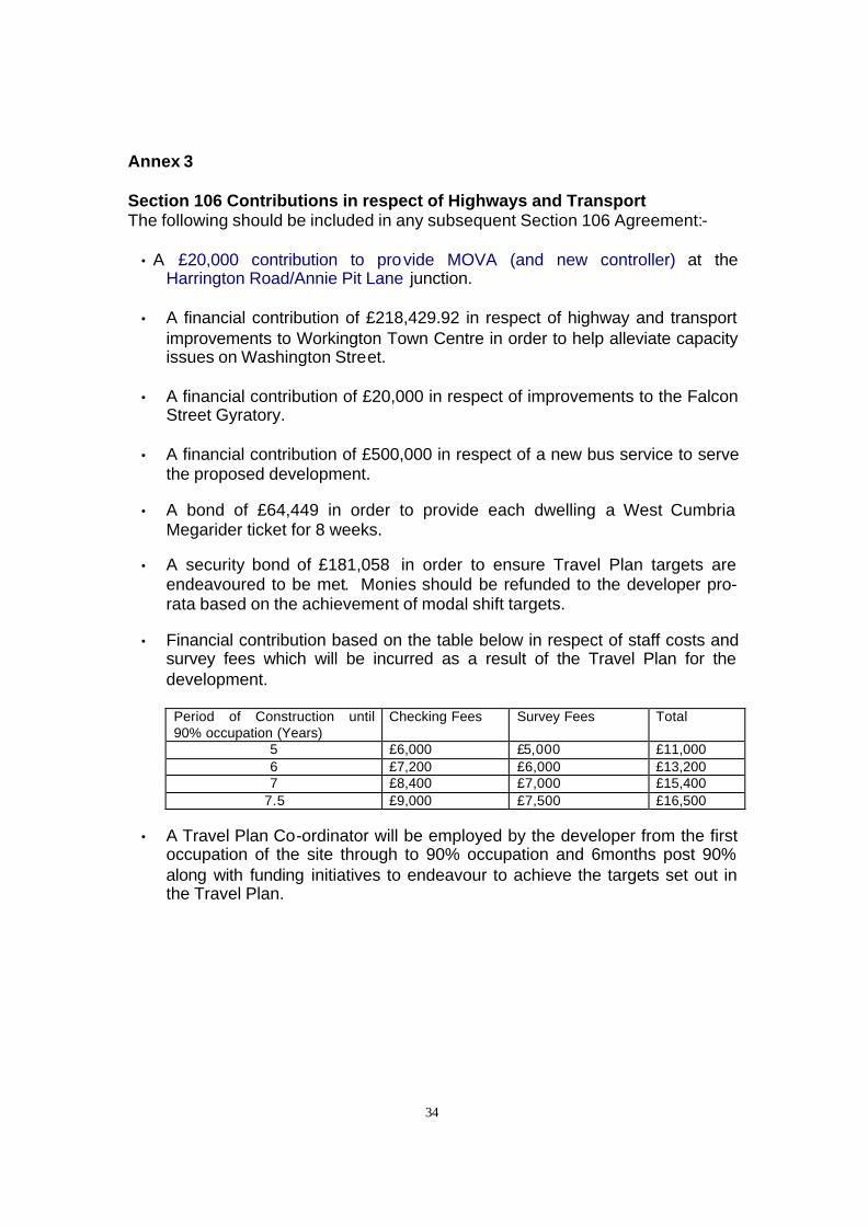
34
Annex 3 Section 106 Contributions in respect of Highways and Transport The following should be included in any subsequent Section 106 Agreement:-
• A £20,000 contribution to provide MOVA (and new controller) at the Harrington Road/Annie Pit Lane junction.
• A financial contribution of £218,429.92 in respect of highway and transport
improvements to Workington Town Centre in order to help alleviate capacity issues on Washington Street.
• A financial contribution of £20,000 in respect of improvements to the Falcon
Street Gyratory. • A financial contribution of £500,000 in respect of a new bus service to serve
the proposed development. • A bond of £64,449 in order to provide each dwelling a West Cumbria
Megarider ticket for 8 weeks. • A security bond of £181,058 in order to ensure Travel Plan targets are
endeavoured to be met. Monies should be refunded to the developer pro-rata based on the achievement of modal shift targets.
• Financial contribution based on the table below in respect of staff costs and
survey fees which will be incurred as a result of the Travel Plan for the development.
Period of Construction until 90% occupation (Years)
Checking Fees Survey Fees Total
5 £6,000 £5,000 £11,000 6 £7,200 £6,000 £13,200 7 £8,400 £7,000 £15,400
7.5 £9,000 £7,500 £16,500
• A Travel Plan Co-ordinator will be employed by the developer from the first occupation of the site through to 90% occupation and 6months post 90% along with funding initiatives to endeavour to achieve the targets set out in the Travel Plan.