DEVELOPMENT ASSESSMENT UNIT Planning... · Minutes of the Development Assessment Unit ... On 22...
12
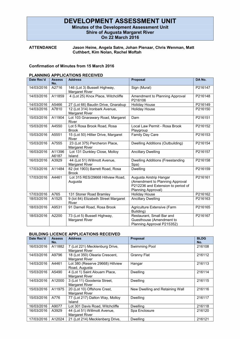
DEVELOPMENT ASSESSMENT UNIT Minutes of the Development Assessment Unit Shire of Augusta Margaret River On 22 March 2016 ATTENDANCE Jason Heine, Angela Satre, Johan Pienaar, Chris Wenman, Matt Cuthbert, Kim Nolan, Rachel Moftah Confirmation of Minutes from 15 March 2016 PLANNING APPLICATIONS RECEIVED Date Rec’d Assess No. Address Proposal DA No. 14/03/2016 A2716 146 (Lot 3) Bussell Highway, Margaret River Sign (Mural) P216147 14/03/2016 A11859 4 (Lot 25) Knox Place, Witchcliffe Amendment to Planning Approval P216106 P216148 14/03/2016 A5466 27 (Lot 66) Baudin Drive, Gnarabup Holiday House P216149 14/03/2016 A7810 12 (Lot 314) Ironbark Avenue, Margaret River Holiday House P216150 15/03/2016 A11904 Lot 103 Gnarawary Road, Margaret River Dam P216151 15/03/2016 A4550 Lot 5 Rosa Brook Road, Rosa Brook Local Law Permit - Rosa Brook Playgroup P216152 15/03/2016 A5551 15 (Lot 50) Hillier Drive, Margaret River Family Day Care P216153 15/03/2016 A7555 23 (Lot 375) Percheron Place, Margaret River Dwelling Additions (Outbuilding) P216154 16/03/2016 A11396 A6187 Lot 131 Dunkley Close, Molloy Island Ancillary Dwelling P216157 16/03/2016 A3929 44 (Lot 51) Willmott Avenue, Margaret River Dwelling Additions (Freestanding Spa) P216158 17/03/2016 A11484 82 (lot 1903) Barrett Road, Rosa Brook Dwelling P216159 17/03/2016 A4461 Lot 315 RES/29668 Hillview Road, Augusta Augusta Airstrip Hangar (Amendment to Planning Approval P212236 and Extension to period of Planning Approval) P216161 17/03/2016 A765 131 Stoner Road Bramley Holiday House P216162 18/03/2016 A1525 9 (lot 84) Elizabeth Street Margaret River Ancillary Dwelling P216163 18/03/2016 A9531 91 Darnell Road, Rosa Brook Agriculture Extensive (Farm Building) P216165 18/03/2016 A2200 73 (Lot 5) Bussell Highway, Margaret River Restaurant, Small Bar and Guesthouse (Amendment to Planning Approval P215352) P216167 BUILDING LICENCE APPLICATIONS RECEIVED Date Rec’d Assess No. Address Proposal BLDG No. 16/03/2016 A11882 7 (Lot 221) Mecklenburg Drive, Margaret River Swimming Pool 216108 14/03/2016 A9796 18 (Lot 350) Olearia Crescent, Margaret River Granny Flat 216112 14/03/2016 A4461 Lot 380 (Reserve 29668) Hillview Road, Augusta Hangar 216113 15/03/2016 A5490 4 (Lot 1) Saint Alouarn Place, Margaret River Dwelling 216114 14/03/2016 A12000 3 (Lot 11) Goodenia Street, Margaret River Dwelling 216115 15/03/2016 A11975 20 (Lot 10) Offshore Crest, Margaret River New Dwelling and Retaining Wall 216116 15/03/2016 A776 77 (Lot 217) Dalton Way, Molloy Island Dwelling 216117 16/03/2016 A9077 Lot 301 Davis Road, Witchcliffe Dwelling 216118 16/03/2016 A3929 44 (Lot 51) Willmott Avenue, Margaret River Spa Enclosure 216120 17/03/2016 A12024 21 (Lot 214) Mecklenberg Drive, Dwelling 216121
Transcript of DEVELOPMENT ASSESSMENT UNIT Planning... · Minutes of the Development Assessment Unit ... On 22...
DEVELOPMENT ASSESSMENT UNIT Minutes of the Development Assessment Unit
Shire of Augusta Margaret River On 22 March 2016
ATTENDANCE Jason Heine, Angela Satre, Johan Pienaar, Chris Wenman, Matt
Cuthbert, Kim Nolan, Rachel Moftah Confirmation of Minutes from 15 March 2016 PLANNING APPLICATIONS RECEIVED Date Rec’d Assess
No. Address Proposal DA No.
14/03/2016 A2716 146 (Lot 3) Bussell Highway, Margaret River
Sign (Mural) P216147
14/03/2016 A11859 4 (Lot 25) Knox Place, Witchcliffe Amendment to Planning Approval P216106
P216148
14/03/2016 A5466 27 (Lot 66) Baudin Drive, Gnarabup Holiday House P216149 14/03/2016 A7810 12 (Lot 314) Ironbark Avenue,
Margaret River Holiday House P216150
15/03/2016 A11904 Lot 103 Gnarawary Road, Margaret River
Dam P216151
15/03/2016 A4550 Lot 5 Rosa Brook Road, Rosa Brook
Local Law Permit - Rosa Brook Playgroup
P216152
15/03/2016 A5551 15 (Lot 50) Hillier Drive, Margaret River
Family Day Care P216153
15/03/2016 A7555 23 (Lot 375) Percheron Place, Margaret River
Dwelling Additions (Outbuilding) P216154
16/03/2016 A11396 A6187
Lot 131 Dunkley Close, Molloy Island
Ancillary Dwelling P216157
16/03/2016 A3929 44 (Lot 51) Willmott Avenue, Margaret River
Dwelling Additions (Freestanding Spa)
P216158
17/03/2016 A11484 82 (lot 1903) Barrett Road, Rosa Brook
Dwelling P216159
17/03/2016 A4461 Lot 315 RES/29668 Hillview Road, Augusta
Augusta Airstrip Hangar (Amendment to Planning Approval P212236 and Extension to period of Planning Approval)
P216161
17/03/2016 A765 131 Stoner Road Bramley Holiday House P216162 18/03/2016 A1525 9 (lot 84) Elizabeth Street Margaret
River Ancillary Dwelling P216163
18/03/2016 A9531 91 Darnell Road, Rosa Brook Agriculture Extensive (Farm Building)
P216165
18/03/2016 A2200 73 (Lot 5) Bussell Highway, Margaret River
Restaurant, Small Bar and Guesthouse (Amendment to Planning Approval P215352)
P216167
BUILDING LICENCE APPLICATIONS RECEIVED Date Rec’d Assess
No. Address Proposal BLDG
No. 16/03/2016 A11882 7 (Lot 221) Mecklenburg Drive,
Margaret River Swimming Pool 216108
14/03/2016 A9796 18 (Lot 350) Olearia Crescent, Margaret River
Granny Flat 216112
14/03/2016 A4461 Lot 380 (Reserve 29668) Hillview Road, Augusta
Hangar 216113
15/03/2016 A5490 4 (Lot 1) Saint Alouarn Place, Margaret River
Dwelling 216114
14/03/2016 A12000 3 (Lot 11) Goodenia Street, Margaret River
Dwelling 216115
15/03/2016 A11975 20 (Lot 10) Offshore Crest, Margaret River
New Dwelling and Retaining Wall 216116
15/03/2016 A776 77 (Lot 217) Dalton Way, Molloy Island
Dwelling 216117
16/03/2016 A9077 Lot 301 Davis Road, Witchcliffe Dwelling 216118 16/03/2016 A3929 44 (Lot 51) Willmott Avenue,
Margaret River Spa Enclosure 216120
17/03/2016 A12024 21 (Lot 214) Mecklenberg Drive, Dwelling 216121

Margaret River 14/03/2016 A4230 Ellis & Victoria Street, Augusta Toilet Retaining Wall 216122 18/03/2016 A8459 3 (Lot 608) The Nook, Margaret
River Dwelling 216124
SUBDIVISIONS DETERMINED Date Rec’d
Officer DA No. Address Description of Matter Recommendation
LEVEL 1 APPLICATIONS for Determination by Director Date Rec’d Officer Address Proposal Outcome DA No. 15/01/2016 Lucy
Gouws 18 (Lot 40) Coronation Street Margaret River
Grouped Dwellings x 2 Approved P216027
28/01/2016 Lucy Gouws
92 (Lot 183) Dalton Way Molloy Island
Holiday House (Large) Approved P216055
04/02/2016 Lara Hoole 112 (Lot 73) Terry Drive Margaret River
Dwelling Additions
Approved P216065
05/02/2016 Lucy Gouws
39 (Lot 10) Saint Alouarn Place Margaret River
Holiday House
Approved P216068
15/02/2016 Johan Pienaar
98 (Lot 10) Connelly Road Margaret River
Dwelling Additions (Rainwater Tank)
Approved P216081
17/03/2016 Rachel Moftah
82 (lot 1903) Barrett Road, Rosa Brook
Dwelling
Approved P216159
LEVEL 2 APPLICATIONS for Determination by Director Date Rec’d Officer Address Proposal Outcome of
DAU Meeting DA No.
05/01/2016 LG 63 (Lot 28) Baudin Drive, Gnarabup
Request for retrospective approval for fill
Approve P216002
06/01/2016 AS Lot 2 Lovejoy Road, Cowaramup
Dam Approve P216003
LOCAL LAW PERMITS Date Rec’d Officer Address Proposal Outcome DA No.
OTHER APPLICATIONS determined under delegation Date Rec’d Officer Address Proposal Outcome DA No.
COMPLIANCE Date Rec’d Officer Address Proposal Outcome DA No. ELECTED MEMBERS ATTENTION Date Rec’d Officer Address Proposal Outcome of
DAU Meeting DA No.
05/01/2016 LG 63 (Lot 28) Baudin Drive, Gnarabup Request for retrospective approval for fill
Approve P216002
CLOSURE OF MEETING
DEVELOPMENT APPLICATION ASSESSMENT (DAU) Report to Manager Planning Services Proposed Retrospective Approval for Fill at 63 (Lot 28) Baudin Drive, Gnarabup Major (Level 2) P216002; PTY/5407
REPORTING OFFICER : Lucy Gouws DISCLOSURE OF INTEREST : Nil General Information Lot Area 2080m² Zone Residential R5 (SCA3 – Gnarabup) Proposed Development Retrospective approval is sought for fill (works) that was placed on Lot 28
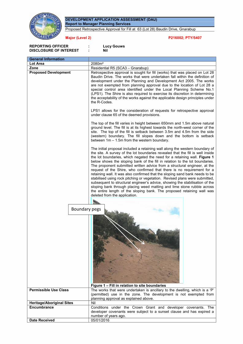
Baudin Drive. The works that were undertaken fall within the definition of development under the Planning and Development Act 2005. The works are not exempted from planning approval due to the location of Lot 28 a special control area identified under the Local Planning Scheme No.1 (LPS1). The Shire is also required to exercise its discretion in determining the acceptability of the works against the applicable design principles under the R-Codes. LPS1 allows for the consideration of requests for retrospective approval under clause 65 of the deemed provisions. The top of the fill varies in height between 650mm and 1.5m above natural ground level. The fill is at its highest towards the north-west corner of the site. The top of the fill is setback between 3.5m and 4.5m from the side (western) boundary. The fill slopes down and the bottom is setback between 1m – 1.5m from the western boundary. The initial proposal included a retaining wall along the western boundary of the site. A survey of the lot boundaries revealed that the fill is well inside the lot boundaries, which negated the need for a retaining wall. Figure 1 below shows the sloping bank of the fill in relation to the lot boundaries. The proponent submitted written advice from a structural engineer, at the request of the Shire, who confirmed that there is no requirement for a retaining wall. It was also confirmed that the sloping sand bank needs to be stabilised using rock pitching or vegetation. Revised plans were submitted, subsequent to structural engineer’s advice, showing the stabilisation of the sloping bank through placing weed matting and lime stone rubble across the entire length of the sloping bank. The proposed retaining wall was deleted from the application.
Figure 1 – Fill in relation to site boundaries
Permissible Use Class The works that were undertaken is ancillary to the dwelling, which is a ‘P’ (permitted) use in the zone. The development is not exempted from planning approval as explained above.
Heritage/Aboriginal Sites Nil Encumbrance Conditions under the Crown Grant and developer covenants. The
developer covenants were subject to a sunset clause and has expired a number of years ago.
Date Received 05/01/2016
Boundary pegs
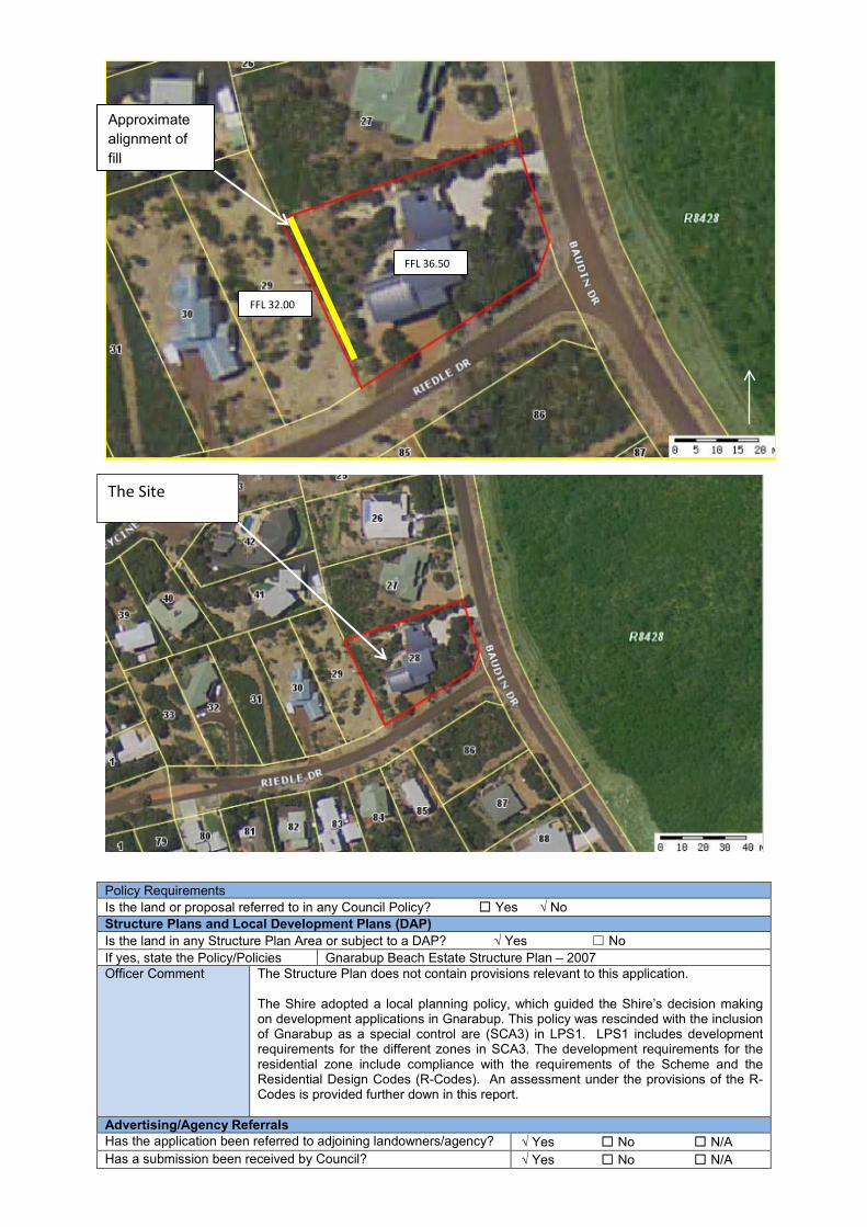
Policy Requirements Is the land or proposal referred to in any Council Policy? ☐ Yes √ No Structure Plans and Local Development Plans (DAP) Is the land in any Structure Plan Area or subject to a DAP? √ Yes ☐ No If yes, state the Policy/Policies Gnarabup Beach Estate Structure Plan – 2007 Officer Comment
The Structure Plan does not contain provisions relevant to this application. The Shire adopted a local planning policy, which guided the Shire’s decision making on development applications in Gnarabup. This policy was rescinded with the inclusion of Gnarabup as a special control are (SCA3) in LPS1. LPS1 includes development requirements for the different zones in SCA3. The development requirements for the residential zone include compliance with the requirements of the Scheme and the Residential Design Codes (R-Codes). An assessment under the provisions of the R-Codes is provided further down in this report.
Advertising/Agency Referrals Has the application been referred to adjoining landowners/agency? √ Yes ☐ No ☐ N/A Has a submission been received by Council? √ Yes ☐ No ☐ N/A
Approximate alignment of fill
FFL 36.50
FFL 32.00
The Site
No. received: 1 Have agency or authority comments been received? √ Yes ☐ No ☐ N/A Submission
The neighbour’s objection is expressed in a written submission prepared by RFF Australia (planning consultants) Dated 5 February 2016. It was indicated in the submission that the application lacks information, which from the neighbour’s point of view, is critical for an informed decision. The Shire has requested additional information during the course of the assessment process and is now satisfied that sufficient information has been provided to complete the planning assessment. A number of concerns were raised in the submission. The concerns comprise:
• Loss of privacy from overlooking. • Loss of amenity through the removal of natural vegetation and significant modification to the natural
contours of the land. • Loss of access to northern light. • Potential stormwater runoff from the development into Lot 29. • Insufficient structural, geotechnical or engineering details supplied with the application.
Overlooking Overlooking/privacy is, from an officer’s point of view, the main consideration in relation to impacts on the neighboring property. Clause 5.4.1 of the R-Codes sets the “deemed to comply” requirements in relation to visual privacy, which comprise the provision of a privacy setback (distance varies between different habitable rooms/spaces) or the provision of permanent screening. Any potential overlooking is assessed from habitable rooms with “major openings” and “unenclosed” outdoor “active habitable spaces”, which have a floor level of more than 0.5m above natural ground level (NGL) and overlooks any part of an adjoining residential property behind the street setback line. Whether clause 5.4.1 even applies is a matter of interpretation, as the privacy setbacks apply to “unenclosed outdoor active habitable spaces”. Unenclosed is defined in the R/Codes as “…an area bounded on no more than two sides by a permanent wall and covered in a water impermeable material”. It can therefore be argued that the 7.5m privacy setback does not apply, as the filled area is not covered in a water impermeable material i.e. is not a roofed area. Furthermore, the definition of “active habitable space” makes reference to “outdoor living areas”, which is defined as “…the area external to a single dwelling….to be used in conjunction with that dwelling such that it is capable of active or passive use and is readily accessible from the dwelling”. The dwelling has been designed with its main living areas such as the kitchen, dining and lounge to be centrally located within the site with direct access to an existing decked area as shown in blue in Figure 2 below. The area of the fill might be capable for passive use, but it is not readily accessible from the dwelling, considering it is over 12m from the already established outdoor living area of the dwelling. The neighbour recently submitted a development application to the Shire for a dwelling on Lot 29. This allows for a more informed assessment of the potential impacts on Lot 29 from an overlooking point of view. As a first stage it is proposed to build, on adjoining Lot 29, a 12m long building, with a finished floor level (FFL) of more than 1m above NGL and setback 1m from the eastern boundary (the boundary that is shared with Lot 28) . The building is proposed to be setback approximately 31m in from the street boundary. This building is designed to maximise ocean views, which is to the west and north-west and in the opposite direction than Lot 28. The proposed raised deck is on the western side of the proposed building and will be totally screened from view from the filled area on Lot 28. Any overlooking from the filled area on Lot 28, within the cone of vision and a 7.5m privacy setback area will be onto a proposed driveway, open car parking area and the almost blank eastern elevation of the proposed building on adjoining Lot 29. Furthermore, the development application proposes the installation of a timber fence along the entire perimeter (except the street boundary) of Lot 29. In light of the above, it is concluded that the proposed fill will not result in any adverse overlooking/privacy impacts on Lot 29. Notwithstanding, the proponent is proposing to introduce vegetation along the top of the fill to create a visual screen. This is considered acceptable to address the neighbour’s concern and is consistent with Design Principle P1.2 of the R-Codes, which supports visual screening in the form of landscape screening. It is recommended to apply a condition that will require landscape screening to be established in accordance with an approved landscaping plan.

Figure 2: Location of existing outdoor living areas on Lot 28 in relation to filled area and western
boundary Loss of amenity The area in the immediate vicinity to Lot 28 is characterised by sloping lots containing split level designs or cut and fill to create level areas for development. Retaining walls on the boundary or fill that slopes down to the boundary is common in this location. The fill is considered to be generally consistent with the development outcomes on other lots in this location and does not raise any concern in regards to impacts on the overall amenity of the location. The natural topography of this area remains evident from the street. It is evident that an area of the coastal scrub, that is prevalent in the area, was removed. There is however a number of remaining standalone native plants in the western parts of Lot 28. The planning application process presents the opportunity to address the issue by requiring, as a condition, the planting of native plants in the cleared areas. This is required in accordance with an approved Landscaping Plan. The plant density and plant species would however require careful considered in light of fire managements requirements. Loss of access to northern light The impact on northern sunlight is determined based on the shadow cast at midday on the 21st of June. The fill will not cast a shadow onto Lot 29 as Lot 28 is situated to the east of Lot 29. Furthermore, the timber fence that is included in the development proposal for Lot 29 will result in a far greater impact in relation to any overshadowing than the fill on Lot 28. Stormwater runoff It is a standard requirement that stormwater runoff must not exceed pre-development flows. Also, any stormwater from newly created impervious services must be managed onsite or be captured and directed to the Shire’s drainage infrastructure. As there is no drainage infrastructure in Gnarabup the requirements is for stormwater to be managed onsite. The proponent has recently installed soak wells to assist with stormwater management. There are no concerns that the proposed fill will result in an increase in pre-development flows as no additional impervious services were created. It is expected that any stormwater flow from Lot 28 will be less considering the recent installation of soak wells. Insufficient structural, geotechnical or engineering details supplied with the application Revised plans were submitted, subsequent to structural engineer’s advice, showing the stabilisation of the sloping bank using weed matting and lime stone rubble across the entire length of the sloping bank. Any retaining and boundary fencing was deleted from the application as the retaining wall is not a structural requirement. Has the application been referred to internal departments? √ Yes ☐ No ☐ N/A
Assessment of Application Is the land referred in the Heritage Inventory? ☐ Yes √ No Are there any Contributions applicable? ☐ Yes √ No Are there any compliance issues in relation to existing development? ☐ Yes √ No R Codes Are R Codes applicable? √ Yes √ No Design Element Policy / R Codes
Req Provided Officer comment
Front Setback N/A
12m
Area of Fill
Outdoor living area
Sides Setback N/A Upgrade Landscaping √ Required ☐ Not Required Street surveillance N/A Street Walls and Fences N/A Overshadowing N/A Energy efficiency/solar access N/A Site Work Complies Other Variations √ Yes √ No Officer’s Comments against performance criteria
Fill The fill that has been added to the site is assessed against the site works standards under clause 5.3.7 of the R-Codes. The R-Codes support, as a deemed to comply requirement, fill behind the street setback line and up to the boundary provided the fill does not exceed a height of 0.5m. The fill that was done is located behind the street setback line of the building and is setback between 1m to 1.5m from the boundary to a maximum height of approximately 1.5m. It was concluded earlier in this report that the overall natural topography of this area remains evident from the street.
Development Standards (Schedule 13) Are the development Standards applicable? ☐ Yes √ No A. In the opinion of the officer, would approval of the planning consent be appropriate under Clause 67 of the
Deemed Provisions of the Scheme? Officer Comment
Local Planning Scheme No.1 The site is located within special control area 3 (SCA 3). The provisions with the Scheme focus upon development within the area being compatible with the natural qualities of the area, in terms of building colours, materials and fencing. There is a requirement for all lots to dispose of stormwater onsite to the satisfaction of the local government. It was concluded earlier I this report that the fill is considered to be generally consistent with the development outcomes on other lots in this location and does not raise any concern in regards to impacts on the overall amenity of the location. it is therefore concluded that the development is generally consistent with the objective for SCA3 which includes that development should be compatible with:
− Adjoining and surrounding land uses. − Environmental and natural landscape attributes. − Lifestyle attributes of the established residences.
B. In the opinion of the officer: i. Are utility services available and
adequate for the development? N/A
ii. Has adequate provision been made for the landscaping and protection for any trees or other vegetation on the land?
A condition will require implementation of a landscaping plan, which will be required to be maintained to the satisfaction of the Shire.
iii. Has adequate provision been made for access for the development or facilities by disabled persons?
N/A
iv. Is development likely to cause detriment to the existing and likely future amenity of the neighbourhood?
Privacy/overlooking is, from an officer’s point of view, the main consideration in relation to this application. It is concluded that the development will not result in any adverse impacts.
v. Is the development likely to comply with AS3959 at the building permit stage?
N/A
Other Comments Any further comments in relation to the application?
The request for retrospective planning approval is supported subject to conditions requiring the establishment of a landscaping screen on top of the filled area and the stabilising of the sloping bank in accordance with the structural engineer’s requirements. It is recommended that the required landscaping and stabilisation works be completed within a set time frame to the satisfaction of the Shire.
OFFICER RECOMMENDATION That the Manager of Planning and Development Services GRANT Planning Consent under Delegated Authority Instrument No. 15 pursuant to Clause 68(2) of the Deemed Provisions of Local Planning Scheme No. 1 for Retrospective Approval for Fill at 63 (Lot 28) Baudin Drive, Gnarabup subject to compliance with the following conditions: CONDITIONS 1. The development is to be carried out in compliance with the plans and documentation listed below and
endorsed with Council’s stamp, except where amended by other conditions of this consent.

Plans and Specifications
P1 received by the Shire on the 21 March 2016 P2 received by the Shire on the 14 January 2016
2. If the development, the subject of this approval, is not substantially commenced within two (2) years from
the date of this letter, the approval shall lapse and be of no further effect. Where an approval has lapsed, development is prohibited without further approval being obtained. (P)
2. All stormwater and drainage run-off from the development shall be contained within the lot boundaries in
accordance with the Shire of Augusta-Margaret River Standards & Specifications. (I)
3. The stabilising of the sloping bank of the fill shall be undertaken in accordance with the specifications and requirements of a suitably qualified engineer within 60 days of the date of this approval. (Refer to advice note b).
4. A Landscaping Plan shall be prepared to the satisfaction of the Shire by a suitably qualified and/or experienced landscape consultant and be submitted to the Shire prior to the commencement of development. The Landscape Plan shall be drawn to scale and show the following:
a) The location, name and mature heights of existing and proposed trees and shrubs and ground
covers as recommended in the Cape to Cape Landcare Companion; b) Any natural landscaped areas to be retained; and c) Those areas that are to be reticulated or irrigated are demonstrated to be designed using water
sensitive principles.
5. Landscaping shall be implemented within 60 days of the date of the approval and shall be maintained at all times to the satisfaction of the Shire.
ADVICE NOTES a) You are advised of the need to comply with the requirements of the following other legislation:
(i) This is not a Building Permit. A Building Permit must be issued by the relevant Permit Authority before any work commences on site as per the Building Act 2011;
(ii) Health Act 1911 and Department requirements in respect to the development and use of the premises; and
(iii) The Bush Fires Act 1954 as amended, Section 33(3), Annual Bush Fires Notice applies to this property.
b) Stabilising of the sloping bank shall be undertaken in accordance with the specifications of Margaret
River Structural Engineering dated 16/3/16.
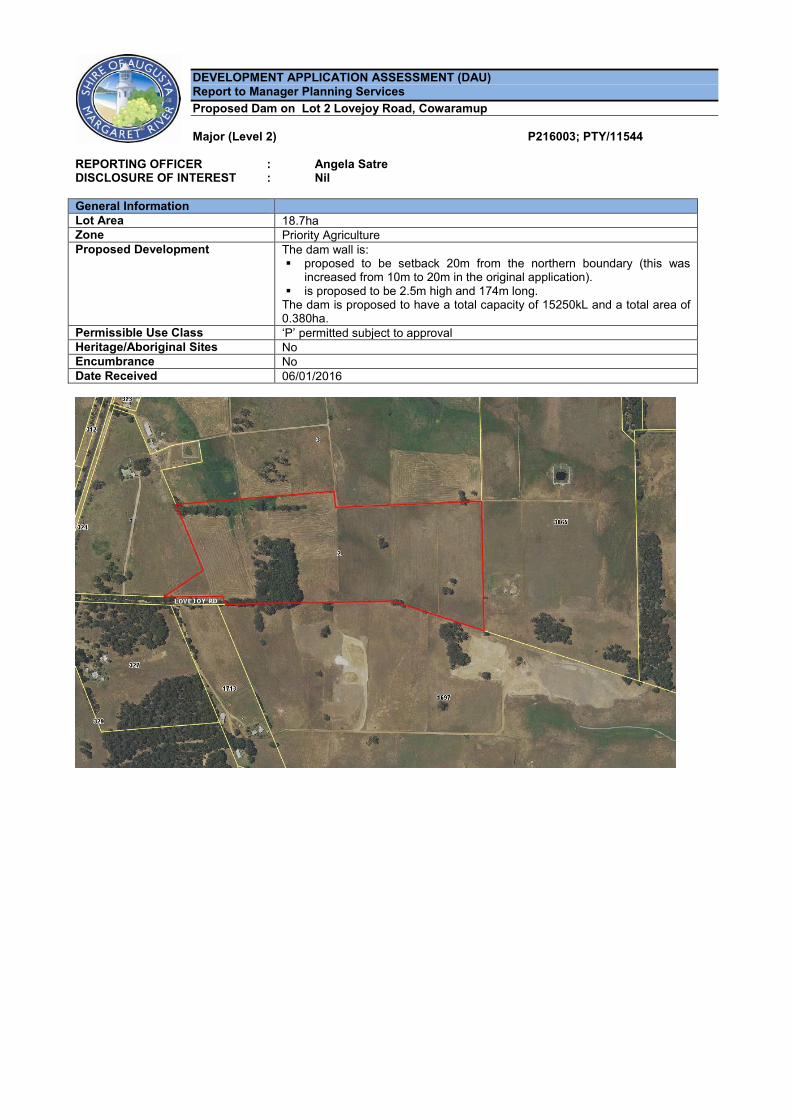
DEVELOPMENT APPLICATION ASSESSMENT (DAU) Report to Manager Planning Services Proposed Dam on Lot 2 Lovejoy Road, Cowaramup Major (Level 2) P216003; PTY/11544
REPORTING OFFICER : Angela Satre DISCLOSURE OF INTEREST : Nil General Information Lot Area 18.7ha Zone Priority Agriculture Proposed Development The dam wall is:
proposed to be setback 20m from the northern boundary (this was increased from 10m to 20m in the original application).
is proposed to be 2.5m high and 174m long. The dam is proposed to have a total capacity of 15250kL and a total area of 0.380ha.
Permissible Use Class ‘P’ permitted subject to approval Heritage/Aboriginal Sites No Encumbrance No Date Received 06/01/2016
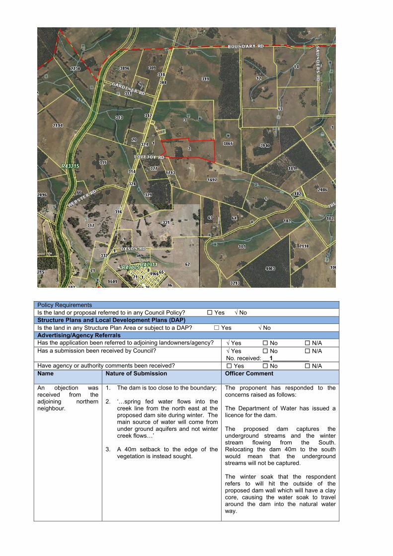
Policy Requirements Is the land or proposal referred to in any Council Policy? ☐ Yes √ No Structure Plans and Local Development Plans (DAP) Is the land in any Structure Plan Area or subject to a DAP? ☐ Yes √ No Advertising/Agency Referrals Has the application been referred to adjoining landowners/agency? √ Yes ☐ No ☐ N/A Has a submission been received by Council? √ Yes ☐ No ☐ N/A
No. received: __1___________ Have agency or authority comments been received? ☐ Yes ☐ No ☐ N/A Name Nature of Submission Officer Comment
An objection was received from the adjoining northern neighbour.
1. The dam is too close to the boundary; 2. ‘…spring fed water flows into the
creek line from the north east at the proposed dam site during winter. The main source of water will come from under ground aquifers and not winter creek flows…’
3. A 40m setback to the edge of the
vegetation is instead sought.
The proponent has responded to the concerns raised as follows: The Department of Water has issued a licence for the dam. The proposed dam captures the underground streams and the winter stream flowing from the South. Relocating the dam 40m to the south would mean that the underground streams will not be captured. The winter soak that the respondent refers to will hit the outside of the proposed dam wall which will have a clay core, causing the water soak to travel around the dam into the natural water way.
The dam is expected to overflow every winter and all run over will return to the natural water way. It is also noted in the planning assessment that the dam wall has been amended in the application to increase the setback from 10m to 20m. This is to be reiterated as a condition of any approval granted. The proponent has also offered to install a landscape buffer along the boundary. Installation of the buffer is not considered a necessary requirement in this case however should a buffer be installed native species are required to be used Accordingly the concerns raised have been addressed and the development setback complies with the 20m guideline under Local Planning Scheme No. 1.
Has the application been referred to internal departments? √ Yes ☐ No ☐ N/A
Environment: No concerns.
Noted – the proposal involves clearing of what the proponent states are existing blue gums. Given these are not native species a clearing permit is not required.
Assessment of Application Is the land referred in the Heritage Inventory? ☐ Yes √ No Are there any Contributions applicable? ☐ Yes √ No Are there any compliance issues in relation to existing development? ☐ Yes √ No R Codes Are R Codes applicable? ☐ Yes √ No Development Standards (Schedule 13) Are the development Standards applicable? √ Yes ☐ No Officer Comment The setback of the dam wall has been increased to comply with the 20m setback
guideline under Local Planning Scheme No. 1. Height Scheme / Policy Requirement Wall - 7 m Roof - 8m State the proposed building height Wall – 2.5m
Roof – n/a √ Complies ☐ Doesn’t Comply
Clause 67 C. In the opinion of the officer, would approval of the planning consent be appropriate under Clause 67 of the
Deemed Provisions of the Scheme? Officer Comment
Yes – it is noted that a licence from the Department of Water for the taking of water for the dam has been the granted.
D. In the opinion of the officer: vi. Are utility services available and adequate for the development? n/a vii. Has adequate provision been made for the landscaping and protection for any
trees or other vegetation on the land? Yes – a landscape buffer on the northern boundary has been proposed by the applicant. Any buffers are required to be installed using native species and this is recommended as a condition of any approval granted.
viii. Has adequate provision been made for access for the development or facilities by disabled persons?
n/a
ix. Is development likely to cause detriment to the existing and likely future amenity of the neighbourhood?
No
x. Is the development likely to comply with AS3959 at the building permit stage? n/a Other Comments Any further comments in relation to the application? Officer Comment
The proposal generated a requirement for advertising to the affected northern neighbour due to the setback variation and the potential to impact the downstream property. In response to the objection submitted the application was amended to increase the setback to 20m from the boundary. While the neighbour sought a 40m
setback the amended setback complies with the guidelines under Local Planning Scheme No. 1. The objection is considered to have been addressed in the application such that conditional approval is recommended.
OFFICER RECOMMENDATION That the Acting Manager of Planning and Development Services GRANTS Planning Consent under Delegated Authority Instrument No. 15 pursuant to Clause 68(2) of the Deemed Provisions of Local Planning Scheme No. 1 for a Dam at Lot 2 Lovejoy Road Cowaramup subject to compliance with the following conditions: CONDITIONS 1. The development is to be carried out in compliance with the plans and documentation listed below and endorsed
with Council’s stamp, except where amended by other conditions of this consent.
Plans and Specifications P1 – P6 received at the Shire offices on 6 January 2016.
2. If the development, the subject of this approval, is not substantially commenced within two (2) years from the date
of this letter, the approval shall lapse and be of no further effect. Where an approval has lapsed, development is prohibited without further approval being obtained. (P)
3. Earthworks or modifications are only permitted in the area approved for development as shown on the approved
plans. (P) 4. Prior to commencement of works, certification from a structural engineer shall be submitted to the Shire for the
Dam the subject of this approval to verify its structural integrity. (P) 5. Prior to installation of any landscape buffers, a Landscape Plan shall be prepared to the satisfaction of the Shire
and shall be submitted to the Shire for approval. The Landscape Plan shall be drawn to scale and show the following: a) The location, name and mature heights of existing and proposed trees and shrubs and ground covers as
recommended in the Cape to Cape Landcare Companion; b) Any natural landscaped areas to be retained; and c) Those areas that are to be reticulated or irrigated are demonstrated to be designed using water sensitive
principles.
6. Any landscape buffers shall be implemented in accordance with the approved Landscape Plan. 7. The top of the Dam wall, the subject of this development approval, shall be setback a minimum of 20m from the
northern property boundary.
ADVICE NOTES a) You are advised of the need to comply with the requirements of the following other legislation:
(i) This is not a Building Permit. A Building Permit must be issued by the relevant Permit Authority before any work commences on site as per the Building Act 2011;
(ii) Health Act 1911 and Department requirements in respect to the development and use of the premises; and (iii) The Bush Fires Act 1954 as amended, Section 33(3), Annual Bush Fires Notice applies to this property.