Development Application Proposed Event Venue Media releases/2014_2015 … · Development...
179
rpsgroup.com.au Development Application Proposed Event Venue Lot 22 Caves Road, Hamelin Bay Prepared by: RPS AUSTRALIA EAST PTY LTD PO Box 749 Busselton WA 6280 T: +61 08 9754 2898 F: +61 08 9754 2085 E: [email protected] Client Manager: Peter Gleed Report Number: PR116700 Version / Date: October 2013 Prepared for: COSY CORNER VISTA PTY LTD PO Box 111 Fremantle WA 6959
Transcript of Development Application Proposed Event Venue Media releases/2014_2015 … · Development...
rpsgroup.com.au
Development Application Proposed Event Venue
Lot 22 Caves Road, Hamelin Bay
Prepared by:
RPS AUSTRALIA EAST PTY LTD
PO Box 749 Busselton WA 6280
T: +61 08 9754 2898 F: +61 08 9754 2085 E: [email protected] Client Manager: Peter Gleed Report Number: PR116700 Version / Date: October 2013
Prepared for:
COSY CORNER VISTA PTY LTD
PO Box 111 Fremantle WA 6959

Development Application Proposed Event Venue Lot 22 Caves Road, Hamelin Bay
PR116700 – October 2013 Page i
IMPORTANT NOTE
Apart from fair dealing for the purposes of private study, research, criticism, or review as permitted under the Copyright Act, no part of this report, its attachments or appendices may be reproduced by any process without the written consent of RPS Australia East Pty Ltd. All enquiries should be directed to RPS Australia East Pty Ltd.
We have prepared this report for the sole purposes of Cosy Corner Vista Pty Ltd (“Client”) for the specific purpose of only for which it is supplied (“Purpose”). This report is strictly limited to the purpose and the facts and matters stated in it and do not apply directly or indirectly and will not be used for any other application, purpose, use or matter.
In preparing this report we have made certain assumptions. We have assumed that all information and documents provided to us by the Client or as a result of a specific request or enquiry were complete, accurate and up-to-date. Where we have obtained information from a government register or database, we have assumed that the information is accurate. Where an assumption has been made, we have not made any independent investigations with respect to the matters the subject of that assumption. We are not aware of any reason why any of the assumptions are incorrect.
This report is presented without the assumption of a duty of care to any other person (other than the Client) (“Third Party”). The report may not contain sufficient information for the purposes of a Third Party or for other uses. Without the prior written consent of RPS Australia East Pty Ltd:
(a) this report may not be relied on by a Third Party; and
(b) RPS Australia East Pty Ltd will not be liable to a Third Party for any loss, damage, liability or claim arising out of or incidental to a Third Party publishing, using or relying on the facts, content, opinions or subject matter contained in this report.
If a Third Party uses or relies on the facts, content, opinions or subject matter contained in this report with or without the consent of RPS Australia East Pty Ltd, RPS Australia East Pty Ltd disclaims all risk and the Third Party assumes all risk and releases and indemnifies and agrees to keep indemnified RPS Australia East Pty Ltd from any loss, damage, claim or liability arising directly or indirectly from the use of or reliance on this report.
In this note, a reference to loss and damage includes past and prospective economic loss, loss of profits, damage to property, injury to any person (including death) costs and expenses incurred in taking measures to prevent, mitigate or rectify any harm, loss of opportunity, legal costs, compensation, interest and any other direct, indirect, consequential or financial or other loss.
Document Status
Version Purpose of Document Orig Review Review Date
1. Draft Development Application M. Hunt P. Gleed 29.8.13
2. Draft Development Application for Client Review M. Hunt J. Legge 2.9.13
3 Final Development Application for lodgement with Shire of Augusta-Margaret River M. Hunt P. Gleed 5.9.13
4 Revision of Development Application as instructed by AMRSC M. Hunt P. Gleed 4.10.13
5 Final revised Development Application lodged with Shire of Augusta-Margaret River M. Hunt P. Gleed 7.10.13
Approval for Issue
Name Signature Date
P. Gleed
7.10.13

Development Application Proposed Event Venue Lot 22 Caves Road, Hamelin Bay
PR116700 – October 2013 Page ii
Contents 1.0 INTRODUCTION ...................................................................................................................................... 1 2.0 SUBJECT SITE ........................................................................................................................................ 2
2.1 Land Particulars ........................................................................................................................... 2 2.2 Location ........................................................................................................................................ 2 2.3 Site Description and Surrounding Land Use ............................................................................ 2 2.4 Vegetation ..................................................................................................................................... 2
3.0 PROPOSED DEVELOPMENT ................................................................................................................. 3 3.1 Event Venue .................................................................................................................................. 3 3.2 Approval Timeframe .................................................................................................................... 3 3.3 Previous Experience .................................................................................................................... 3 3.4 Estimated No. of Attendees / Patrons ........................................................................................ 4 3.5 Timing and No. of Events ............................................................................................................ 5 3.6 Hours of Operation ...................................................................................................................... 5 3.7 Proposed Bus System ................................................................................................................. 5 3.8 Local Community and Stakeholder Consultation ..................................................................... 6 3.9 Social and Economic Benefits .................................................................................................... 6
4.0 SITE LAYOUT .......................................................................................................................................... 8 4.1 Site Entry / Exits ........................................................................................................................... 8 4.2 Parking Control and Camping .................................................................................................... 8 4.3 Stages, Lighting and Temporary Structures ............................................................................. 9 4.4 Pyrotechnic Displays ................................................................................................................. 10 4.5 Food Outlets and Licensed Areas ............................................................................................ 10 4.6 Amenities .................................................................................................................................... 10 4.7 Disability Services ..................................................................................................................... 11 4.8 Signage ....................................................................................................................................... 11 4.9 Vegetation Retention and Landscaping .................................................................................. 11 4.10 Existing and Proposed Water Supply ...................................................................................... 12 4.11 Power Supply.............................................................................................................................. 12 4.12 Relationship to Adjoining National Park ................................................................................. 12 4.13 Noise Regulations – Non Complying Event ............................................................................ 13 4.14 Waste Collection ........................................................................................................................ 13
5.0 EMERGENCY MANAGEMENT COMMITMENTS ................................................................................. 14 5.1 Local Emergency Committee Consultation ............................................................................. 14 5.2 On-Site Management, Safety, Crowd Control and Security ................................................... 15 5.3 Fire Management and Evacuation Planning ............................................................................ 16 5.4 First Aid and Medical Response ............................................................................................... 17 5.5 Communications Plan ............................................................................................................... 18 5.6 Traffic Management ................................................................................................................... 19
6.0 PLANNING FRAMEWORK ................................................................................................................... 21 6.1 Shire of Augusta-Margaret River Local Planning Scheme No. 1 .......................................... 21 6.2 Shire of Augusta-Margaret River Local Planning Strategy .................................................... 21 6.3 Local Planning Policy No. 9 – Events Assessment ................................................................ 21
7.0 CONCLUSION ....................................................................................................................................... 23

Development Application Proposed Event Venue Lot 22 Caves Road, Hamelin Bay
PR116700 – October 2013 Page iii
Figures 1. Location Plan 2. Aerial Photograph 3. Existing Zoning
Appendices
A. Certificate of Title * B. Local Emergency Management Committee Meeting Minutes C. Overall Site Plan, Concert Venue and Lighting Plan, prepared by Sunset Events D. Current Water Licence * E. Fire Management Plan, prepared by Strategen Environmental Consultants F. Event Noise Management Plan, prepared by Lloyd George Acoustics G. Risk Management Plan and Risk Register, prepared by Sunset Events * H. Event Health Requirements Report, prepared by Event Health Management (Hugh Singe) I. Traffic Management Report, prepared by the Traffic Management Company
* Commercially confidential documents withdrawn from this version – the information is being considered/ assessed by Shire staff.

Development Application Proposed Event Venue Lot 22 Caves Road, Hamelin Bay
PR116700 – October 2013 Page 1
1.0 Introduction
RPS has been commissioned by Cosy Corner Vista Pty Ltd and Sunset Events to coordinate and prepare a development application for consideration by the Shire of Augusta-Margaret River. The application seeks approval for a proposed ‘event venue’ on Lot 22 Caves Road, Hamelin Bay (the “subject site”) for the holding of 2 major music festivals, a “one-off concert” (day/ overnight) and low key small community activities such as local artists and charity events.
An ‘Event Venue’ has been determined as a ‘Use Not Listed’ within the Zoning Table of the Scheme. Accordingly, an application for Planning Approval (including formal advertising) is required under the terms of the Shire of Augusta-Margaret River Local Planning Scheme No. 1.
Sunset Events is Western Australia’s leading music events company specialising in holding a number of iconic music events throughout the State, including “Southbound”, which is currently held in Busselton. Southbound is WA’s premier multi-day music, camping and arts festival. However, in recent years the event has been facing considerable market competition from other festivals, and with rising costs of production, the event has now become unsustainable in its current location. Therefore, the Southbound festival has the opportunity to re-establish its unique point of difference by relocating to the subject land.
The proposed development will assist in adding to the existing tourism and recreational opportunities the ‘Cape to Cape’ region has to offer as well as additional social and economic benefits to the region in the form of employment and financial assistance to local businesses and community organisations.
The following report sets out the details of the proposed development and the manner in which it complies with the relevant provisions of Shire of Augusta-Margaret River Local Planning Scheme No. 1 and associated Local Planning Policy. It is emphasised that this Development is to establish an approval for the site to be an “Events Venue”. The full detail for any events held on the site will be submitted well in advance of the actual event in order to comply with conditions imposed on the Development Approval. This report outlines the general management approach that is applied to events to be held on the site.

Lot 22 Caves Road, Hamelin BayFigure 1 - Locality Plan
RPS Australia East Pty LtdACN 140 292 762ABN 44 140 292 762
PO Box 465 Subiaco WA 690438 Station StreetSubiaco WA 6008
T +61 8 9211 1111F +61 8 9211 1122W rpsgroup.com.au
© COPYRIGHT PROTECTS THIS PLANUnauthorised reproduction or amendmentnot permitted. Please contact the author.
0 1500 3000Scale 1:60000@A4 l Date August 2013 l Project No 116700-b-001
Augusta
Indian Ocean
Karridale
Hamelin Bay
DisclaimerThe contents of this plan are conceptual only, for discussion purposes. All areas and dimensions are approximate only subject to relevant studies, Survey, Engineering and Council approval.
LegendSite Boundary

Lot 22 Caves Road, Hamelin BayFigure 2 - Aerial Plan
RPS Australia East Pty LtdACN 140 292 762ABN 44 140 292 762
PO Box 465 Subiaco WA 690438 Station StreetSubiaco WA 6008
T +61 8 9211 1111F +61 8 9211 1122W rpsgroup.com.au
© COPYRIGHT PROTECTS THIS PLANUnauthorised reproduction or amendmentnot permitted. Please contact the author.
0 500 1000Scale 1:20000@A4 l Date August 2013 l Project No 116700-b-002
Cav
es R
oad
Cosy Cor
ner
Road
Grosse Road
Hame lin Bay Road
DisclaimerThe contents of this plan are conceptual only, for discussion purposes. All areas and dimensions are approximate only subject to relevant studies, Survey, Engineering and Council approval.
LegendSite Boundary
Development Application Proposed Event Venue Lot 22 Caves Road, Hamelin Bay
PR116700 – October 2013 Page 2
2.0 Subject Site
2.1 Land Particulars
The land is formally described as Lot 22 on P22155 and is currently under the ownership of Cosy Corner Vista Pty Ltd (refer Appendix A – Certificate of Title).
2.2 Location
The subject site is approximately 119ha in area and is located at Lot 22 Caves Road, Hamelin Bay. The land is located approximately 35 kilometres south of the Margaret River townsite centrally located in the southern Cape region. The land is approximately 6 kilometres (as the crow flies) from Karridale, 12 kilometres from Augusta and 3 kilometres from Hamelin Bay (refer Figure 1 – Location Plan).
2.3 Site Description and Surrounding Land Use
Lot 22 is predominantly cleared and bound by Caves Road and Cosy Corner Road to the east and south east respectively, National Park to the south and west, and Lot 21 to the north (refer Figure 2 – Aerial Photograph). Land to the east comprises an existing extractive industry operation and a low–key tourist facility. Land to the north is privately owned bushland and grazing land (refer Figure 2 – Aerial Photograph). The site is gently undulating with minor rises and depressions at around 30–40m AHD (Australian Height Datum). A ridge is located in the southwest corner sloping upwards to 60m AHD into the adjoining National Park, and a hill is located in the southeast corner at 60m AHD.
The land contains no existing structures and is currently leased for agricultural purposes, which comprises livestock grazing for sheep production undertaken intermittently throughout the year.
2.4 Vegetation
On-site vegetation has been significantly modified over time due to broad scale clearing and ongoing agricultural use of the site for livestock grazing, which has resulted in a predominantly cleared, pastured landscape with some scattered individual trees and shrubs. Small, dense stands of native vegetation do cross the western, southern and northern boundaries of Lot 22. However, these are more an extension of the vegetation extent contained within the adjoining National Park and the northern conservation lot. The owners have also established a number of tree planting strips in the western margins of the site.

Development Application Proposed Event Venue Lot 22 Caves Road, Hamelin Bay
PR116700 – October 2013 Page 3
3.0 Proposed Development
3.1 Event Venue
The application proposes to establish the subject land as an “Event Venue” to hold major music festivals, with the first “Southbound” event planned to commence in January 2015. Additional events (up to a maximum of 3 events per year) are proposed to be held once the success of the initial Southbound event has been established. Additional events may include another event of a similar size to Southbound and a “one-off” (day/ overnight) concert performance consistent with other concerts held in the Margaret River region. Other smaller scale, ‘community benefit’ events are also proposed at the request of local community organisations on an as needs basis. The size and location of the property enables camping to be accommodated consistent with future events in keeping with current activity at the Southbound event, Busselton.
3.2 Approval Timeframe
The proponents will act on any planning approval issued by the Shire through the delivery of the first Southbound event in January 2015. Given the need for long term certainly for future event planning, the proponents request a minimum 5 year development approval period. This provides sufficient certainty for the event pre-establishment components and security of investment. It also enables Sunset Events to demonstrate their ability to run successful events at the site, which is anticipated to lead to the Shire’s support for the site as a more permanent event venue facility after the initial 5 year approval period.
It is envisaged that the Development Approval will contain normal reference to the approval lapsing if substantial commencement is not undertaken with the approval timeframe. It is also expected that the approval will include a review clause in the event that the proponents fail to undertake implementation actions and comply with the conditions of the approval.
3.3 Previous Experience
Sunset Events was conceived in 1997 out of an obsession of music, arts and the environment. The company mission is to develop and introduce a brand of events to Western Australia that puts equal emphasis on both the cultural and educational experience in addition to the music experience.
The company has been successfully coordinating, managing and delivering Western Australia’s leading music event festivals for over 10 years. This includes experience in managing emergency management issues, including traffic management, communications, medical and fire management requirements.
Current events that are delivered annually include:
• “Southbound” at Busselton;
• “Groovin the Moo” in Bunbury;
• “Laneway” in the Perth Cultural Centre;
• “Stereosonic” at the Claremont Showgrounds, Perth;
• “West Coast Blues n Roots” in Fremantle; and
• “North West Festival” in Port Hedland.

Development Application Proposed Event Venue Lot 22 Caves Road, Hamelin Bay
PR116700 – October 2013 Page 4
3.4 Estimated No. of Attendees / Patrons
Initially, audience attendance at events on the subject land is expected to be in the order of 10,000 – 15,000 people consistent with recent experience at Southbound. However, the site has the potential to accommodate up to 20,000 people provided the success of the event is economical and sustainable.
Event Capacity
The event capacity for Southbound will be a maximum of 20,000 people for an event ranging between 2 – 4 days in length. A second, similar sized music festival and one-off concert event on site is proposed to have the same maximum capacity of 20,000 people. Patron numbers for any smaller low-key community events are expected to be low but will vary accordingly to the size and nature of each event.
Southbound is the only event confirmed at this stage, which will be held between 2 – 5 January, 2015. Of the 10,000 Southbound festival patrons estimated for Year 1, approximately 7,000 are expected to camp onsite and 3,000 will be day patrons. Of the 3,000 day patrons, we expect that 25% will have one day tickets with the remainder holding 2 day tickets. So approximately 2,600 day patrons will arrive and leave each day (via car or buses).
The timing and duration of additional events on site have not been determined. However, all stakeholders will be advised sufficiently in advance of future events.
Camping Numbers
Of the 7000 campers expected for the event in Year 1, we expect that half the campers will arrive on the Friday afternoon, with the remainder arriving on Saturday morning.
Camping patrons will camp and park in camping areas south (8.9ha) and north (4.9ha). Note that an additional camping areas will be available on site should sales necessitate.
Shuttle Bus Service Numbers
For those patrons leaving site during festival breaks, we expect the breakdown of bus numbers to be as follows:
• Hamelin Bay – 500 patrons over a 4 hour period with a maximum of 200 patrons at any one time; and Augusta Townsite – 1600 patrons over a 4 hour period with a maximum of 600 patrons at any one time.
Management of Patron Numbers
There is a number of ways patron numbers can be mitigated and enforced in any planning approval that may be granted by the Shire. These include:
• Overall capacity for the event will be managed by implementation of a third party ticketing system from a recognised provider. This will allow for verification by external stakeholders that capacity has not been breached by updated sales reports;
• Specific capacities (VIP areas) can be managed by the implementation of access controls systems such as wrist banding; and
• Capacity limits for areas can be managed with the use of security and the simple "clicker" with in and out being counted. This will applicable for licensed areas.

Development Application Proposed Event Venue Lot 22 Caves Road, Hamelin Bay
PR116700 – October 2013 Page 5
3.5 Timing and No. of Events
The first “Southbound” event will occur between 2nd and 5th January, 2015, and thereafter on the first weekend in January. The proponents intend to hold up to a maximum of three (3) events throughout the year once the initial investment in the success of the site is established.
Event No. 2 is expected to be of a similar size to ‘Southbound’ and will coincide with a National or State Public Holiday long weekend. Event No. 3 may comprise a ‘one-off’ concert in isolation or in association with another local event similar to concerts held at Leeuwin Estate. Other smaller scale, ‘community benefit’ events are also proposed at the request of local community organisations on an as needs basis. The date and timing of event numbers 2 and 3 have not been confirmed. However, detailed information will be provided to the Shire, community and all other stakeholders prior to each event.
Two (2) major events per year would translate to 21 days on site per event, which would include installation and dismantling of facilities before and after each event. A one day event would require 13 days on site.
3.6 Hours of Operation
The expected hours of operation for the initial “Southbound” event are as follows:
• Fri Jan 2: 2pm – 12pm (light entertainment in the evening)
• Sat Jan 3: 11am – 12 midnight (Big Top marquee continuing until 3am)
• Sun Jan 4: 11am – 12 midnight (Big Top marquee continuing until 3am)
• Mon Jan 5: Camping patrons leaving the site (6am – 10am)
The expected hours of operation for event no. 2 would be similar to the Southbound event times outlined above. For a single one-off concert the doors may open at approximately 5.00pm for a concert start time of 7.00pm with the performance ending at approximately 11.00pm – 12.00am. This event will also offer the opportunity for camping overnight. Other smaller scale community type events would typically be held during daylight hours.
3.7 Proposed Bus System
A shuttle bus system will be provided for the duration of the event to convey patrons to nearby Hamelin Bay beach and Augusta during the event breaks.
With the recent construction of a separate road bypassing the need to enter the Hamelin Bay Caravan Park, the loop road it is set up for buses to drop off and pick up without impeding on all the car bays now available for non-caravan park visitors. Sunset Events (in consultation with Shire and DPaW officers) propose to nominate a swimming area that utilises the several beach access paths away from the caravan park guests and adjoining the new infrastructure in place. The nominated swimming area would be marked and lifeguarded. Extra bins would be provided. The Hamelin Bay Caravan Park operators have indicated that they would set up a basic refreshment stall. There are also toilets and cold showers (separate to the Caravan Park), which event patrons might utilise.
There will be no bus service to surrounding beaches as Sunset Events feel Hamelin Bay has the infrastructure, safe beach and close proximity to satisfy Sunset Event and community requirements. Sunset Events will not be managing the safety of other nearby beaches where patrons may go on their own accord.

Development Application Proposed Event Venue Lot 22 Caves Road, Hamelin Bay
PR116700 – October 2013 Page 6
Sunset Events estimate that around 500 patrons would go to the beach at Hamelin Bay over a 4 hour period, with only 200 patrons at any one time. A lot more however, would take the shuttle bus into Augusta to the shops.
Event organisers will also promote other nearby tourism experiences such as the natural cave systems, the Blackwood River and local adventure activities etc. that will be able to be undertaken through local tour operators.
3.8 Local Community and Stakeholder Consultation
Prior to the lodgement of the development application, the proponents have undertaken a comprehensive programme of discussions with the local community and other stakeholders to discuss the proposal and respond to any initial concerns raised. Consultation has involved:
• Meetings with Shire planning staff and elected members;
• Attendance at a site meeting with representatives from Department of Parks and Wildlife, Main Roads WA, Shire of Augusta-Margaret River (Planning, Health and Emergency Management Departments), Augusta and Margaret River Police, Bunbury Police and Department of Fire and Emergency Services (DFES);
• Attendance at the Local Emergency Management Committee Meeting on 13th August 2013 to detail the proposed development and the types of measures to be implemented to address emergency management concerns - refer LMEC minutes attached as Appendix B; and
• Individual meetings with surrounding landholders, business owners, community groups and local tourism operators.
Sunset Events have also met with the Hamelin Bay Caravan Park operators, Augusta Chamber of Commerce, Margaret River Chamber of Commerce, Augusta-Margaret River tourism association.
In terms of feedback, surrounding neighbours appreciated the direct approach (before reading about it in local media) and were thankful for the face to face meeting. Sunset Events advised that if they are able to hold events on the property, further detail relating to fire/ traffic/ emergency management would be provided to the landowners prior to each event. Sunset Events also mentioned to landowners that they would provide a simple neighbour summary sheet and supply direct event/ emergency contacts should the event proceed. The owners were pleased that they would receive specific information briefings relating to each event approval process. The Augusta Chamber of Commerce and the regional tourism body fully supports the proposal and the tourism body is open to financial support as well.
Consultation with key stakeholders will continue through the formal advertising of the proposal.
3.9 Social and Economic Benefits
Development of the subject land to allow for the hosting of future music events will provide a number of benefits to the region beyond simply the operation of the event itself. Specifically:
• Sunset Events will develop community networks through:
Providing financial assistance to local organisations. It is estimated that the current Southbound currently contributes between $2M - $4M to the local Busselton economy annually and this same amount could be expected throughout the Shire of Augusta-Margaret River;

Development Application Proposed Event Venue Lot 22 Caves Road, Hamelin Bay
PR116700 – October 2013 Page 7
Providing training experience (e.g. medical, fire, planning);
Youth development opportunities;
Promoting the Augusta/Hamelin Bay region as a tourist destination via extensive national and international PR;
Local fundraising opportunities for community and volunteer groups;
Providing visitor expenditure; and
Generating employment.
• The development of the site as an event venue will allow the local community to provide a number of additional services to the region including:
Other community based concerts or fairs;
Camping/eco-based education facilities for schools;
Accommodation overflow for peak times of year and additional capacity during the year; and
Other music or lifestyle events.
• Other benefits include:
The ongoing development of skills within the community through service providers as well as the financial contribution to local operators in the region;
Improvements in local tourism services;
Improved environmental sustainability. The subject land has been included in the Environmental Stewardship Program run by the Augusta Margaret River Shire. Under this program, eligible landowners receive professional advice and the preparation of an Environmental Action Plan from a suitably qualified environmental organisation. The Environmental Action Plan will provide Sunset Events with opportunities and actions to improve the environmental values on their property. This will improve the sustainability of the activity being conducted on the land which is a key focus of the event;
The development of ancillary opportunities to use the property for other purposes throughout the year provides expanded opportunities to the local community.

Development Application Proposed Event Venue Lot 22 Caves Road, Hamelin Bay
PR116700 – October 2013 Page 8
4.0 Site Layout
4.1 Site Entry / Exits
Access and egress to the future event venue will be via three (3) separate entries from Caves Road, which will link to an internal road network with a bus stop, three parking areas, two camping areas and the main crowd and concert venue area (refer Overall Site Plan and Concert Venue Plan – Appendix C).
Gate 1 (north) will be for patrons and also production/staff and emergency vehicles. Gate 2 (central) will provide an entry/exit point for patrons only. Gate 3 will provide an entry and exit point for performing artists and emergency vehicles only.
The size of the property allows patrons, staff, emergency vehicles and entertainers to safely turn off Caves Road onto the land (without being stopped) to avoid queuing or congestion on Caves Road. Once vehicles are on site they will be directed to areas where tickets will be checked before proceeding to the designated parking and camping areas, with systems designed to keep cars moving.
Traffic Management for the first Southbound event will be in place from Friday 2nd January 2015 through to Monday 5th January 2015 when campers will be leaving the event.
4.2 Parking Control and Camping
Future events will offer patrons the opportunity to attend the festival for the day or camp for the entire event in the site’s unique setting to maximise the festival experience.
The parking area and camping ground areas generally open at 8.00am and close late in the evening. Vehicles arriving outside of these times are generally turned away.
Parking in the northern and central parts of the site will be limited to day trippers. Parking in the southern portions of the site will be restricted to those camping. In the designated camping areas vehicles will be parked ‘nose-to-nose’. Patrons will then erect their tents at the rear of vehicles so vehicles cannot be moved during the course of the event for safety purposes. Below is an illustration of this proposed parking/ camping arrangement.

Development Application Proposed Event Venue Lot 22 Caves Road, Hamelin Bay
PR116700 – October 2013 Page 9
The proposed arrangement is important to the success of the event and the benefits of the shared camping/ parking arrangement are as follows:
Patron experience
It is convenient for patrons to be able to park their car and unload their heavy camping gear at the location where their tent will be pitched. Having to carry all their gear from a separate parking location is physically demanding and off-putting for those who are less experienced campers. The event market is competitive market and Sunset Events need to make this solution as straightforward and uncomplicated as possible for patrons.
Security and Safety
Patrons must be able to secure their valuables and also keep them clean and dry. Patrons often secure their medications/ sprays in their car – it is critical that any medication required is close at hand during the night.
As patrons arrive and set up their campsites, they open their cars and remove equipment. This is an ideal time for security patrols to observe and search for prohibited items. If cars and tents are separated patrons would be able to keep prohibited items away in the car park where there is less security presence.
Weather
The southern cape region can experience very high winds at times. Patron vehicles are an important part of the safety plan for wind protection to ensure tents are not blown away. Furthermore, if there is rainfall it is important for patrons to have their car next to them so they can take shelter, or retrieve more dry/undamaged gear.
Fire Management
By creating a grid pattern in the campgrounds the "roads" are clearly marked and kept accessible at all times for emergency vehicles as required. Having vehicles close at hand provides an additional level of management in the case of a fire and avoids patrons potentially leaving in a panic.
4.3 Stages, Lighting and Temporary Structures
The main festival component of the site will comprise an area of approximately 3.3ha and will contain the following festival assets and infrastructure:
• Minimum of three (3) stages or platforms to accommodate a range of music acts over the 3 day event;
• Tents, marquee, stalls or portable buildings for staff, artists, production, VIP, display, medical support, security, ticketing and catering purposes;
• Portable lighting towers to deliver reliable and effective lighting throughout the main concert venue, parking and camping areas (refer Lighting Layout – Appendix C);
• Rigging and production lighting will also be provided to help choreograph the performance of individual artists;
• Disabled Viewing Platform. There is a dedicated disabled viewing platform for the main stage, which is situated about 35m back from the stage;

Development Application Proposed Event Venue Lot 22 Caves Road, Hamelin Bay
PR116700 – October 2013 Page 10
• Audio and visual equipment (including screens) to facilitate interaction with patrons/ visitors to the event. Equipment and sound checks will be undertaken by audio-visual technicians prior to and during the course of each event to ensure performances by artists are of a high standard. There will be no rehearsals by performing artists in the days prior to the event;
• Portable toilets; and
• Showers (for camping patrons).
These assets will be temporary demountable structures until such time that the success of the event at the proposed location is guaranteed. At this time a further investment will be made towards permanent structures i.e. hardstand areas, ablution blocks etc. to reduce festival costs moving forward.
The only fixed infrastructure proposed as part of the initial five year period is 1.8m - 2.0 m high link mesh fence installed along the boundary of the festival area to create a 20m exclusion zone to the adjoining National Park for the protection of conservation values within the National Park.
The installation of structures generally occurs 2 weeks before the beginning of a major music festival event and will be dismantled immediately after the completion of the event. Dismantling generally takes up to 7 days to remove structures and equipment off-site.
At the completion of each event, the site will be restored to the manner in which it was found. This will include a comprehensive waste collection programme over the site and surrounding area. While the land is not being used for event purposes, it will continue to be used for grazing purposes in accordance with current lease arrangements.
4.4 Pyrotechnic Displays
No fireworks displays are proposed for any event due to the potential fire risk.
4.5 Food Outlets and Licensed Areas
Future festivals at the subject site will adopt a strictly non-BYO alcohol policy. This also applies to the dedicated camping ground areas. Patrons are generally permitted to bring sealed plastic water or soft drink bottles to the festival. Bars are provided within the main concert precinct to supply alcoholic beverages with the entire festival precinct to be licensed. Stringent responsible service of alcohol policies will be employed.
Southbound will be an 18+ Event, however under 18 patrons may attend if parents register their child and accompany them at all times. Licensing for other events will be on a case by case basis.
Free potable water will be available inside the festival from water stations. This is in addition to bottled water sold throughout the venue.
Patrons will be permitted to bring their own food to the venue however, a range of food options will be provided on site available for purchase.
4.6 Amenities
Portable toilet facilities and showers (for campers) will be provided equitably around the site for ease of access by patrons. Dedicated toilet facilities will be provided for staff, VIP guests and artists.

Development Application Proposed Event Venue Lot 22 Caves Road, Hamelin Bay
PR116700 – October 2013 Page 11
4.7 Disability Services
All future events will be designed and catered to accommodate disabled patrons. Disabled patrons will have access to the same range of services and facilities as those able bodied patrons. Facilities will include (but are not limited to):
• Trafficable surfaces of an appropriate standard for ease of movement around the site;
• Dedicated disabled parking areas;
• Disabled viewing platform. There is a dedicated disabled viewing platform for the main stage, which is situated about 35m back from the stage;
• Disabled toilets in the concert venue and camping areas. These toilets will not be available to the general public and will be kept locked;
• Medical support; and
• Free entry to the festival for carers.
4.8 Signage
Event signage both internal and external to the site will be introduced for event advertising and public directional purposes for artists, staff, medical support, patrons and associated vehicles. This may include signage within the Bussell Highway/ Caves Road reserve, at the site entrance, within the main concert event venue and on private land adjoining the National Park reserve.
Future signage may include banners, freestanding flags, main entry feature walls, portable and illuminated signs (on site and for traffic management purposes).
The proponent will obtain approval for the size, style and location all advertising devices prior to each event in consultation with the Shire of Augusta-Margaret River, MRWA and other State Government authorities, where necessary.
4.9 Vegetation Retention and Landscaping
Areas of consolidated existing vegetation and freestanding vegetated locations will be retained (unless otherwise determined under the fire management plan) for the principle purpose of vegetation protection. Where appropriate it will also be incorporated into the design of the main concert venue for passive recreation purposes and shade for patrons during the heat of the day and wind protection. Further, vegetation will be enhanced by further planting of understorey species in association with the characteristics of the adjoining National Park.
The overarching design approach is to facilitate rehabilitation opportunities as part of the ongoing development of the site in keeping with the Environmental Stewardship Program run by the Augusta Margaret River Shire.

Development Application Proposed Event Venue Lot 22 Caves Road, Hamelin Bay
PR116700 – October 2013 Page 12
4.10 Existing and Proposed Water Supply
The subject land currently contains two groundwater bores and has been granted a “Licence to Take Water” by the Minister, subject to a range of terms, conditions and restrictions. The licence has an annual water entitlement of 55560KL/ year and is due to expire on 30 June 2021. A copy of the Water Licence is enclosed as Appendix D for your information.
A reservoir is proposed to be constructed on the eastern edge of the main concert venue. The reservoir will be fed via the existing bores on site to accommodate water for the irrigation of the lawn, and dust and fire suppression purposes during the event. The reservoir will dimensions will be approximately 20m x 30m and will have an approximate capacity of 3 GL. This water source will not be exhausted before the commencement of the Southbound event given it can serve as an emergency water supply for fire suppression if required. For safety reasons, the dam will be secured by 1.8m – 2.0m high fencing around the perimeter and will be patrolled by qualified security personnel to prevent patrons entering the water.
The water supplied by the bores on site will be supplemented by an Emergency water supply on event operating days in the form of two light tanker units and one 3.4 tanker unit.
4.11 Power Supply
Portable power generators will be brought into the site to power the proposed events. Once the success of future events on site is guaranteed, the existing mains power may be upgraded to reduce the requirement for portable generators.
4.12 Relationship to Adjoining National Park
The proponents acknowledge the environmental qualities of the adjoining National Park and the considerations that to be given to the siting and management of the future events on site.
The proposed design, operational and management responses that are to be implemented to mitigate any perceived impacts that may occur as a result of future events will include the following:
• A 20 m low fuel hazard separation buffer is proposed to be implemented along the western boundary of the site to provide defendable space between proposed critical assets of the two day Southbound event and extreme bush fire hazards within National Park and northern conservation lot. Fuel loads within the buffer are to be maintained within 2 t/ha. A copy of the detailed Fire Management Plan is enclosed as Appendix E;
• Fire fighting equipment will be available on site and an emergency evacuation plan will be prepared prior to each event;
• The major event stages on site will be setback a minimum of 50m off the boundary;
• A high quality perimeter security fence approximately 1.8m – 2.0m high to prevent campers, patrons, litter, impromptu toilet sites and un-ticketed entry via the National Park;
• Security patrols will occur along the perimeter of the site to prohibit any access to or from the adjoining National Park;
• No camping or cooking fires will be permitted on site; and
• Lighting will be directed away from the National Park and lights will be provided with canopies to restrict ambient night light spill outside of the site.

Development Application Proposed Event Venue Lot 22 Caves Road, Hamelin Bay
PR116700 – October 2013 Page 13
Following approval of the site as an event venue, the proponents will continue to work closely with Local and State Government officers to finalise the range of management measures to be implemented on site.
4.13 Noise Regulations – Non Complying Event
The potential impact of noise from future events on surrounding residents, landowners and low-key tourism operators is acknowledged. Accordingly, an Event Noise Management Plan has been prepared by Lloyd George Acoustics to consider the noise management requirements for such events (refer Appendix F). A summary of the findings is as follows:
• In comparison to other outdoor event venues, the site and the proposed stage orientation is acoustically well positioned;
• At many other venue locations, noise levels at residences would be as high as 75 dB(A). Noise to the worst-case effected residence in this case, under worst-case weather conditions, is predicted to be 49 dB(A). Every 3 dB is a halving of sound energy (although to the human ear a halving is 5-10 dB) so that the proposed venue has significantly less noise impact than other venues; and
• For such intermittent events, it is common practice for a regulation 18 Approval under the Environmental Protection (Noise) Regulations 1997 to be sought. Such an approval is provided by the local government and will set management conditions that need to be followed, including such things as start and finish times, sound check times, allowable noise levels and the like.
Accordingly, in accordance with the EPA Environmental Protection (Noise) Regulations, the proponent will seek approval for a “Non-Complying Event” as the noise generated by future events is likely to exceed levels prescribed under the Regulations. That said, the location and direction of the stages will minimise any impact and the proponents will continue to implement any reasonable measures to further minimise the impact where an inconvenience may be caused.
4.14 Waste Collection
The proponent commits to returning the event grounds and the surrounding environment to the way they were found. This includes:
• Employing a cleaning contractor team staying onsite for the during of the event;
• Cleaning team will do a regular sweep of the surrounding roads and adjacent National Park during the event. This will include a regular review of the Hamelin Bay foreshore area;
• At the conclusion of the event a full clean of the site and surrounding areas is completed and reviewed by the event company. This will include the Hamelin Bay foreshore area;
• Sunset Events also operates a waste minimizing and recycling program onsite. There will be several Recycling Stations strategically positioned around the festival site to capture the various waste streams, allowing patrons to contribute to a greener music festival. Biodegradable waste from the festival will also be composted off-site and will end up in local farmer gardens ensuring it is put to good use. These and other environmental initiatives has meant that Sunset Events is at the forefront of sustainable event management, which has resulted in their events (including Southbound) being awarded multiple A Greener Festival Awards.

Development Application Proposed Event Venue Lot 22 Caves Road, Hamelin Bay
PR116700 – October 2013 Page 14
5.0 Emergency Management Commitments
The proponents have been working in this industry for over 10 years and are specialists when it comes to organising and delivering large scale music events safely. The safety of the music event and its patrons is critical to the success of the business.
It is acknowledged that the event needs to be self-sufficient in terms of emergency response capabilities without placing any strain on local emergency resources. Accordingly, the following sections of the report outline the proponent’s approach to emergency management and details the types of measures that will be in place to deal with an emergency should a situation arise during the course of an event.
It should be noted however, that this submission does not include the detailed management plans to the address matters below. These reports are event specific and will be prepared prior to the commencement of each individual music festival as a practical action plan for all identified hazards. The management plans will be sufficiently comprehensive to cover the full range of activities at the event facility and will realistic and sufficiently clear to be understood by all users of the plan. This documentation will be prepared in consultation with the Shire of Augusta-Margaret River, Local Emergency Management Committee members, MRWA and other stakeholders as necessary.
Enclosed as Appendix G is a copy of the Risk Management Plan and Risk Register prepared for Southbound 2015 to demonstrate the importance the proponent’s place on identifying, analysing and prioritising the risks associated with staging an event of this nature.
5.1 Local Emergency Committee Consultation
RPS and the proponents were invited to attend the Shire’s Local Emergency Management Committee on 13 August 2013 to discuss the proposed development and receive feedback on any specific issues raised by the committee members. The following preliminary comments were received and subsequent responses provided:
Issue 1 - The 20m buffer and the temptation for festival goers to enter into the bush and light a fire.
Response:
There will be a security fence that will be lit and patrolled along the southern and western buffer zones. This is a 1.8m – 2.0m high fence that can’t easily be climbed. This is in line with other affiliated events i.e. the Falls Festival (at Lorne, Victoria) which has been running for 20 years in a similar bushland setting without incident.
Issue 2 - The impact of rubbish on the beach at Hamelin Bay with patrons being placed on buses to the beach over the 2 day festival.
Response:
The proponent commits to returning the event grounds and the surrounding environment to the way they were found. This includes:
• Employing a cleaning contractor team staying onsite for the during of the event;
• The cleaning team will do a regular sweep of the surrounding roads and adjacent National Park during the event. This will also include a regular review of the Hamelin Bay foreshore area;

Development Application Proposed Event Venue Lot 22 Caves Road, Hamelin Bay
PR116700 – October 2013 Page 15
• At the conclusion of the event a full clean of the site and surrounding areas is completed and reviewed by the event company. This will include the Hamelin Bay foreshore area.
Issue 3 - Concerns over the number of tourists and locals that will be around the coastal area at the same time.
Response:
Not all festival patrons will go to the Hamelin Bay beach at the same time. Buses are spread intermittently throughout the 3-day event. There is also 16km of beach so there will be enough room for all. The current model in Busselton is similar - these figures have been analysed and show that not everyone goes down to the beach at the same time.
Issue 4 – Concern was raised at the plan to divert Southbound traffic along Bushby Road on route to the site.
Response:
It was suggested by the proponents that locals and non-Southbound traffic use Chapman Road to access Hamelin Bay as vehicle speeds were easier to control at the Bushby Road intersection (where signed speeds were reduced to 60km/hr) for festival patrons heading south along Bussell Highway. Signed speeds at the Chapman Road intersection are 90km/hr, which makes traffic management a more difficult task.
Furthermore, there is the additional option of directing traffic down Bussell Hwy and back up Caves Rd should traffic conditions necessitate.
Issue 5 - Concerns from DPaW that there would be added pressure from the proponents to deal with long-term fire reduction plans on the adjoining National Park land.
Response:
There will be no push from the proponents to undertake fire hazard reduction in the adjoining National Park land. The DPaW will need to deal with this area as part of their long term fuel reduction plans regardless of the event. The approach to fire management will focus solely on the land being self-protecting.
At the closure of the meeting RPS invited LEMC members to provide any further concerns prior to the lodgement of the development application. However, no further comments were forthcoming.
The proponents will continue to liaise with LEMC in the lead up to the first event in January 2015 to ensure all emergency management matters are adequately addressed.
5.2 On-Site Management, Safety, Crowd Control and Security
Key event staff will typically manage operational and programming aspects of each event. Appointed crowd control and security contractors will be employed to manage the safety and security of patrons, artists and assets 24 hours a day for the entire event.
The role of on-site security/ crowd control for any future events will include:
• Ensuring the security of equipment and property;
• Screen people on entry for prohibited items;

Development Application Proposed Event Venue Lot 22 Caves Road, Hamelin Bay
PR116700 – October 2013 Page 16
• To prevent as far as practicable personal injury due to crushing, overcrowding and unruly behaviour;
• To enable injured or distressed patrons to be identified and moved to safety;
• To prevent overloading of structures whether or not for spectator use. They include seating stands, advertising hoardings, stages, lighting and sound mixing towers;
• Prevent patrons from entering surrounding properties (especially the National Park) by patrolling the perimeter of the event site; and
• To prevent overcrowding.
All security and crowd controllers will be briefed before each event to ensure they operate to the pre-arranged security plan that will be prepared in advance of the event.
Security of 1.8m high Perimeter Fence Line
The use of static security points along the perimeter fence line is proposed to allow for monitoring of the area. This will be supported by mobile response engaged in patrols of the fence line either by All-Terrain Vehicles (ATV) or 4WD.
The use of mobile patrols (ATV or 4WD) together with the potential for strategic CCTV positions (cost dependant) allows for the identification of those potential trespassers prior to reaching the vicinity of the site.
Sunset Events, in consultation with relevant stakeholders, will formulate a security roster that will include the use of licensed Security Guards as well as event staff. The overall security strategy for future events will focus on the following:
• Asset Protection: The needs and requirements to secure the assets that are present on site;
• Venue Protection: The requirements to maintain the integrity of the site predominantly along the perimeter fence lines;
• Crowd Management: The movement of patrons around the site/ event;
• Emergency Management: The needs of the site and the measures to be implemented; and
• Liquor License: The requirements for management of the alcohol license
In conjunction with the physical manpower of security and event staff, the use of strategies such as accreditation, electronic (CCTV potentially) and various ticketing measures will allow for the site and future events to be fully secured.
5.3 Fire Management and Evacuation Planning
Strategen has been commissioned to prepare a comprehensive Fire Management Plan for the subject land. The purpose of the FMP is to provide guidance on how to plan for and manage the potential bush fire risk associated with Lot 22 through the implementation of a range of bush fire management measures recommended on the basis of the inherent bush fire risk to the site and associated bush fire hazard levels.

Development Application Proposed Event Venue Lot 22 Caves Road, Hamelin Bay
PR116700 – October 2013 Page 17
The FMP outlines how on-site assets present during future festival events can be protected during summer months when the threat from wildfire is at its peak. This is particularly relevant when existing fire appliances in the area may be unable to offer a fast emergency suppression response. Therefore, site assets should be self-protecting from wildfire.
Implementation of the FMP applies to the proponent (as the event organiser) to ensure bush fire management measures are adopted and implemented on an ongoing basis to achieve bush fire management objectives. This FMP will address the initial Southbound event in the short term, and will require updating and revision if any purpose built facilities are proposed on site during future development phases.
A summary of the proposed fire management measures to be implemented on site include:
• Event assets are to be located in low bushfire hazard areas of the site;
• A 20 m low fuel hazard separation buffer is proposed to be implemented along the western boundary of the site to provide defendable space between proposed critical assets of the three day event and extreme bush fire hazards within the National Park and northern conservation lot;
• Sunset Events will need to manage the potential grassland fuel hazard via annual fuel hazard reduction (e.g. mechanical slashing) to maintain available fuels within 2 t/ha annually prior to the onset of the designated bush fire season;
• A total of three public access points are proposed as part of the proposed development, which connect Caves Road with the proposed internal road network and associated concert venue, camping and parking areas. These access points will also be the nominated emergency access points to the site;
• Safe fire refuge areas will be provided in the form of two, designated muster points with adequate signage, located to the east of the site on cleared (low bush fire hazard) land, adjacent to access points and away from extreme bush fire hazard areas;
• An Emergency Management Plan will be prepared and implemented as necessary.
A copy of the detailed Fire Management Plan is enclosed as Appendix E.
5.4 First Aid and Medical Response
Event Health Management has been commissioned to investigate and provide advice on the event health requirement for any future music festival on the subject land. In summary, to provide an adequate event health service able to achieve the above objectives at all times the following resources are required and therefore recommended based on the event at full capacity of 20,000 patrons:
24 hour first aid service
A twenty four hour a day first aid service will operate on site throughout the duration of the event. This is essential to provide early intervention with appropriate resources to time critical patients. Early intervention with these resources is critical due to the remote nature of the site from emergency health facilities. First aid personnel will be professional first aid officers sourced from Perth with advanced skills and equipment including:

Development Application Proposed Event Venue Lot 22 Caves Road, Hamelin Bay
PR116700 – October 2013 Page 18
• Defibrillation
• Airway Management
• Oxygen Resuscitation (including suction capacity)
Ambulance Resources
One ambulance will be based on site 24 hours a day. An additional ambulance will be on site during the afternoon and evening until 0000hrs. It is during this time period when site activities are most active, vibrant and most presentations occur. The time the second ambulance will be on site has been determined to cover the window during which most presentations occur and emergencies are most likely. Emergency transportation of a time critical patient has not been required at a time outside this window during the event history. During the low risk times, there will be one ambulance on site as well as the doctor available.
Medical Resources
A doctor will be available 24 hours a day. They will be on duty between the hours of 0900hrs and 2200hrs. During the period of 2200hrs – 0900hrs overnight, the doctor will remain on call. The doctor fulfils the following roles
• Providing a morning clinic at 0900hrs and evening clinic at 2100hrs each day. This provides opportunity for camping patrons to attain treatment, prescriptions etc. to prevent them from requiring the use of local health facilities.
• Providing emergency care in conjunction with ambulance and first aid personnel in the event of a time critical patient requiring high acuity care
• Be available on call to support first aid and ambulance personnel if required between the hours of 2200hrs and 0900hrs
Helipad
A helipad of 50m x 50m dimensions will be located as close as possible (but not closer than 75m) to the main first aid post on site (in use 24 hours a day). The designated helipad will be clear of wires, be on flat ground and have an easily accessible path to the main first aid post/health facility on site.
A copy of the detailed Event Health Management report is enclosed as Appendix H.
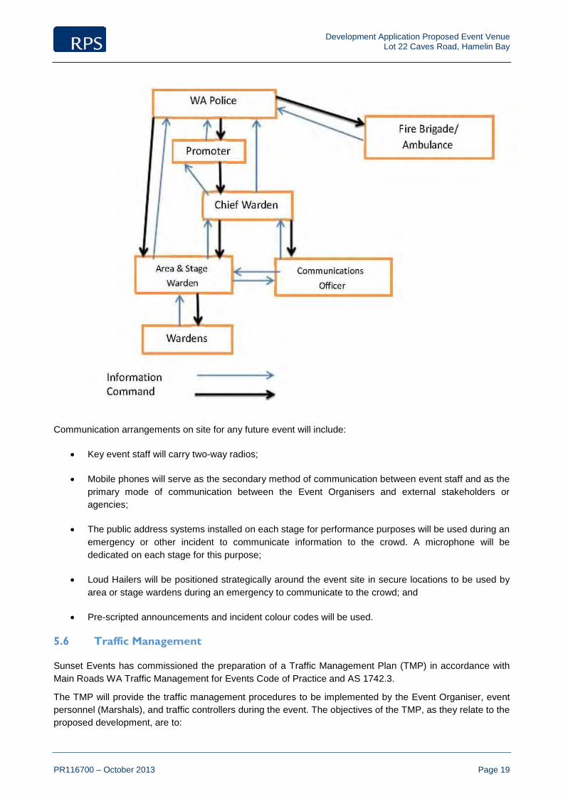
5.5 Communications Plan
Prior to the first event commencing, a communications plan will be prepared to detail the process to escalate incidents and the hierarchy of communication during an emergency. The example chart illustrated below highlights the information command that may occur for a particular incident. It may be entirely possible for incidents to be handled without vertical escalation however, it is expected that roles that are senior in the chart monitor all communications to identify incidents that may require intervention.
Development Application Proposed Event Venue Lot 22 Caves Road, Hamelin Bay
PR116700 – October 2013 Page 19
Communication arrangements on site for any future event will include:
• Key event staff will carry two-way radios;
• Mobile phones will serve as the secondary method of communication between event staff and as the primary mode of communication between the Event Organisers and external stakeholders or agencies;
• The public address systems installed on each stage for performance purposes will be used during an emergency or other incident to communicate information to the crowd. A microphone will be dedicated on each stage for this purpose;
• Loud Hailers will be positioned strategically around the event site in secure locations to be used by area or stage wardens during an emergency to communicate to the crowd; and
• Pre-scripted announcements and incident colour codes will be used.
5.6 Traffic Management
Sunset Events has commissioned the preparation of a Traffic Management Plan (TMP) in accordance with Main Roads WA Traffic Management for Events Code of Practice and AS 1742.3.
The TMP will provide the traffic management procedures to be implemented by the Event Organiser, event personnel (Marshals), and traffic controllers during the event. The objectives of the TMP, as they relate to the proposed development, are to:

Development Application Proposed Event Venue Lot 22 Caves Road, Hamelin Bay
PR116700 – October 2013 Page 20
• Provide for a safe environment for all road users and pedestrians;
• Provide protection to event participants, organisers and the general public from traffic hazards that may arise as a result of the event activity;
• Minimise the disruption, congestion and delays to all users of Bussell Highway and Caves Road;
• To ensure network performance of surrounding roads is maintained at an acceptable level throughout the duration of the event;
• Ensure access to surrounding land uses adjacent to the site is maintained at all times.
In establishing adequate traffic management controls for the site, the following measures are expected to be implemented:
• The preparation of traffic control diagrams for use by event management and marshals prior to each event;
• The implementation of traffic control devices. Signs and devices at the approaches to the event site shall be erected. The event will not commence or continue until all signs, devices and barricades are in place and operational in accordance with the requirements of the TMP;
• The introduction of modified pavement marking where necessary;
• Variable message signs to provide additional advance warning to event attendees;
• Temporary speed zones and traffic cones; and
• Emergency vehicles entering and/or travelling through the event area will be given priority right of way. In situations involving vehicle crashes and breakdowns, the event organiser will render assistance where possible to ensure the impact of crashes and breakdown on the network is minimised.
The detailed findings and recommendations of the traffic management approach to be implemented at a future Southbound event on site are detailed within the Traffic Management Plan enclosed as Appendix I.

Lot 22 Caves Road, Hamelin BayFigure 3 - Existing Zoning Plan
RPS Australia East Pty LtdACN 140 292 762ABN 44 140 292 762
PO Box 465 Subiaco WA 690438 Station StreetSubiaco WA 6008
T +61 8 9211 1111F +61 8 9211 1122W rpsgroup.com.au
© COPYRIGHT PROTECTS THIS PLANUnauthorised reproduction or amendmentnot permitted. Please contact the author.
0 500 1000Scale 1:20000@A4 l Date August 2013 l Project No 116700-b-003
DisclaimerThe contents of this plan are conceptual only, for discussion purposes. All areas and dimensions are approximate only subject to relevant studies, Survey, Engineering and Council approval.
LegendSite Boundary
Development Application Proposed Event Venue Lot 22 Caves Road, Hamelin Bay
PR116700 – October 2013 Page 21
6.0 Planning Framework
6.1 Shire of Augusta-Margaret River Local Planning Scheme No. 1
The subject land is currently zoned ‘General Agriculture’ under the provisions of the Shire of Augusta-Margaret River Local Planning Scheme No. 1 (refer Figure 3 – Existing Zoning). This is consistent with the current agricultural land use of the site, which comprises livestock grazing for sheep production.
The purpose of the zone is outlined in the Scheme as a more general classification of rural land. The intention to develop the land intermittently for event venue purposes is consistent with the zone to allow for ancillary uses which do not detract from the primary use of the land for agricultural purposes. Future events that are delivered on site will be temporary in nature returning the land back to its original appearance, maintaining its existing character and enabling the ongoing use of the land for agricultural purposes.
There is always demand for new and unique tourism and recreational related opportunities in the Margaret River that add to the diverse range of existing attractions and events that currently occur in the Shire i.e. Margaret River Pro, Anaconda Adventure Race etc. The proposal will bring significant community benefit through financial assistance to local business, promotion of the region, improved tourism offerings and employment opportunities. It will also enable the use the property for other purposes throughout the year.
6.2 Shire of Augusta-Margaret River Local Planning Strategy
The subject land is identified within the ‘General Agriculture’ land use category within the Shire’s Local Planning Strategy (LPS). The designation generally provides for broad acre framing and agricultural land uses, rural pursuits and associated rural industries for the short term, and identifies future urban/rural living opportunities. However, small scale and low impact tourism opportunities and other limited but compatible non-agricultural land uses may also be considered in certain circumstances, subject to these uses being incidental and complementary to the predominant agricultural use of the land.
The unconstrained characteristics of the site and its unique setting demonstrate the property's suitability to accommodate this proposed use. The intermittent use of the site for short durations will not have any impact on the ongoing use of the land for agricultural purposes, and will ensure the protection of vegetation on site and the landscape values in the locality.
6.3 Local Planning Policy No. 9 – Events Assessment
The purpose of this Policy is to provide guidance for the assessment of events on both public and private land. In particular, it sets out provisions to ensure that events are properly managed to provide a safe environment for patrons whilst minimising impacts on adjoining properties and the surrounding land.
This planning application to Council for approval to designate the subject land for holding a large music event on ‘General Agriculture’ zoned land satisfies the requirements of this Policy as follows:
• The information provided includes a fire management plan and details a range of emergency management commitments concerning traffic, medical/ first aid, communications, crowd control and security. Detailed emergency management reports addressing the above matters are to be tailored to each specific event and will be prepared for Shire and LMEC consideration prior to each event;
• Consultation has been undertaken with adjoining and surrounding land owners, local business operator/ groups and local emergency services via face-to-face meetings, on site meetings and attendance at the Local Emergency Management Committee on 13th August 2013;
• The report contains all the information required to be submitted with the application.
Development Application Proposed Event Venue Lot 22 Caves Road, Hamelin Bay
PR116700 – October 2013 Page 22
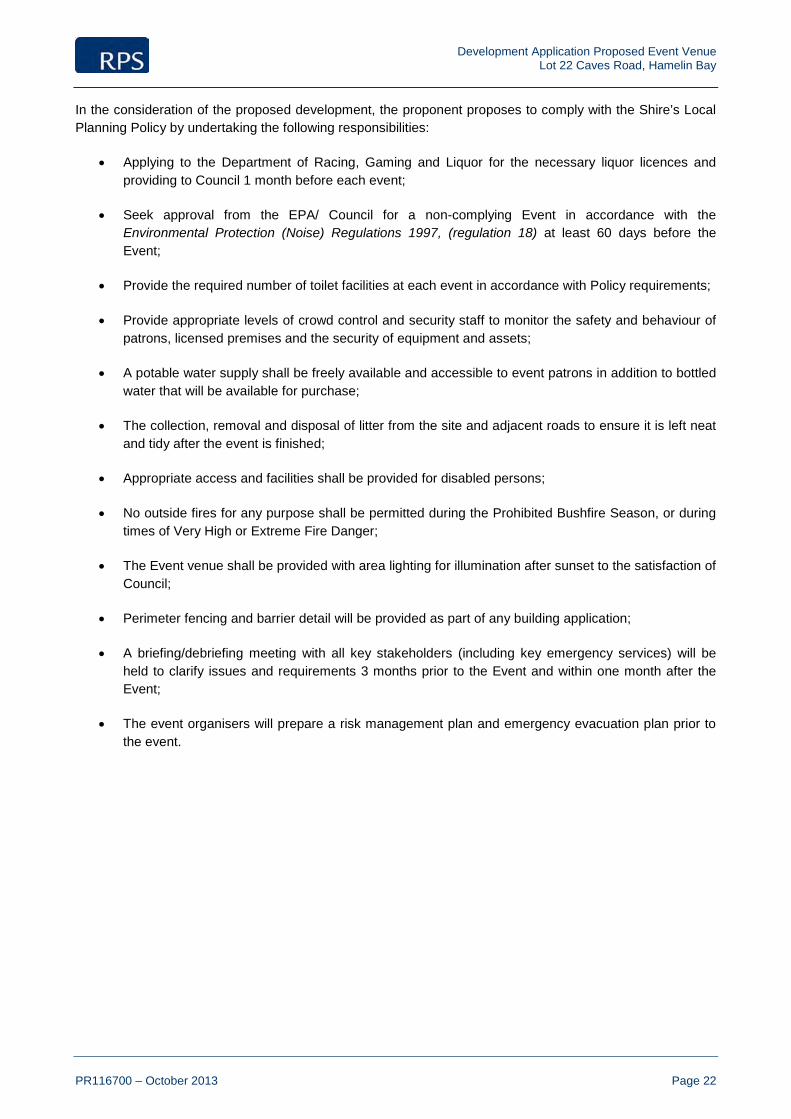
In the consideration of the proposed development, the proponent proposes to comply with the Shire’s Local Planning Policy by undertaking the following responsibilities:
• Applying to the Department of Racing, Gaming and Liquor for the necessary liquor licences and providing to Council 1 month before each event;
• Seek approval from the EPA/ Council for a non-complying Event in accordance with the Environmental Protection (Noise) Regulations 1997, (regulation 18) at least 60 days before the Event;
• Provide the required number of toilet facilities at each event in accordance with Policy requirements;
• Provide appropriate levels of crowd control and security staff to monitor the safety and behaviour of patrons, licensed premises and the security of equipment and assets;
• A potable water supply shall be freely available and accessible to event patrons in addition to bottled water that will be available for purchase;
• The collection, removal and disposal of litter from the site and adjacent roads to ensure it is left neat and tidy after the event is finished;
• Appropriate access and facilities shall be provided for disabled persons;
• No outside fires for any purpose shall be permitted during the Prohibited Bushfire Season, or during times of Very High or Extreme Fire Danger;
• The Event venue shall be provided with area lighting for illumination after sunset to the satisfaction of Council;
• Perimeter fencing and barrier detail will be provided as part of any building application;
• A briefing/debriefing meeting with all key stakeholders (including key emergency services) will be held to clarify issues and requirements 3 months prior to the Event and within one month after the Event;
• The event organisers will prepare a risk management plan and emergency evacuation plan prior to the event.

Development Application Proposed Event Venue Lot 22 Caves Road, Hamelin Bay
PR116700 – October 2013 Page 23
7.0 Conclusion
This application seeks approval for the development of the site as an “Event Venue” to accommodate future large scale music festivals, one-off concerts and other smaller scale event activities undertaken by local community groups.
The application has demonstrated the manner in which the proposed development is generally consistent with the intent of the Shire Local Planning Scheme No. 1, relevant Local Planning Policies and the broader strategic direction as advocated by the Shire’s Local Planning Strategy. The Intermittent use of the site delivers a compatible, non-agricultural land uses that is incidental and complementary to the predominant agricultural use of the land. The current use of the land for grazing purposes will continue on site for the major part of the year (in accordance with the current leasing arrangements) while events are not being held on site.
The introduction of future major festival events on the site represents an exciting opportunity for the Shire that will have widespread benefits both locally and regionally through financial assistance to local business, promotion of the region, improved tourism offerings and employment opportunities. It will also enable the use the property for other ‘community benefit’ purposes throughout the year.
The proposed site plan has been designed in response to the site’s setting and provides for the most orderly and efficient use of the land for event of this nature, whilst protecting the existing vegetation and maintaining the qualities of the adjoining National Park.
The emergency management principles outlined within Section 5.0 of this report have reinforced through the preparation of supporting traffic, fire, acoustic, risk management and event health reports. These reports will be further refined through a series of comprehensive management plans to be prepared prior to the commencement of each individual event as a practical action plan for all identified hazards. This documentation will be prepared in consultation with the Shire of Augusta-Margaret River, Local Emergency Management Committee members, MRWA and other stakeholders, where relevant.
Accordingly, we respectfully request the Shire’s favourable consideration of the proposed development.

Development Application Proposed Event Venue Lot 22 Caves Road, Hamelin Bay
PR116700 – October 2013
“Commercially confidential document withdrawn from this version –
the information is being considered/ assessed by Shire staff.”
Certificate of Title
APPENDIX A

Development Application Proposed Event Venue Lot 22 Caves Road, Hamelin Bay
PR116700 – October 2013
APPENDIX
Local Emergency Management Committee Meeting Minutes
B

Local Emergency Management Committee Meeting
MINUTES
FOR THE MEETING HELD
13 AUGUST 2013
COUNCIL CHAMBERS, 41 WALLCLIFFE ROAD, MARGARET RIVER
COMMENCING AT 6:30PM

Notice of Meeting
Please be advised that a meeting of the Local Emergency Management Committee will be held on 13 August, 2013 in the Margaret River Council Chambers, commencing at 6.30pm. This meeting is open to members of the public. If you are unable to attend the meeting, please contact Katie Taylor, Community Development Administration Officer. Contact Number: 9780 5233
Email Address: [email protected]
Disclaimer
The Council of the Shire of Augusta-Margaret River hereby advises that before taking any action on an application or a decision of the Council, any applicant or members of the public should wait for written advice from the Council.
Gary Evershed Chief Executive Officer

(LEMC) LOCAL EMERGENCY MANAGEMENT COMMITTEE
A G E N D A
Please be advised that a Local Emergency Management Committee meeting will be held on Tuesday, 13 August 2013 in the Margaret River Council Chambers, commencing at 6.30pm.
ORDER OF BUSINESS
1.0 DECLARATION OF OPENING 2.0 ATTENDANCE / APOLOGIES
2.1 Attendance 2.2 Apologies 2.3 Non-attendance
3.0 PUBLIC QUESTION TIME
4.0 DISCLOSURE OF INTEREST
5.0 CONFIRMATION OF MINUTES OF PREVIOUS MEETING
5.1 Confirmation of Minutes : 14 May 2013
6.0 MATTERS ARISING FROM PREVIOUS MINUTES 7.0 SHIRE OFFICERS AND DELEGATE REPORTS 8.0 GENERAL BUSINESS
8.1 Presentation from RPS and Strategen consultants: Proposal to establish Lot 22 Caves Rd as an event venue for the holding of major music festivals (Attach 1).
9.0 MATTERS FOR WHICH THE MEETING MAY BE CLOSED (CONFIDENTIAL ITEMS) 10.0 CLOSE

(LEMC) LOCAL EMERGENCY MANAGEMENT COMMITTEE
MINUTES Minutes of the Local Emergency Management Committee Meeting held on Tuesday, 13 August 2013 in the Margaret River Council Chambers, commencing at 6.30pm.
ORDER OF BUSINESS
1.0 DECLARATION OF OPENING Ray Colyer, LEMC chairperson opened the meeting at 6.37pm.
2.0 ATTENDANCE / APOLOGIES / NON-ATTENDANCE 2.1 ATTENDANCE
Committee Members Rik Lok : WA Police – Augusta/Local Emergency Coordinator Dane Hendry : St John Ambulance - MR Mark Ivers : Volunteer Marine Rescue – MR Gary Yates : Water Corporation Pamela Adams : DCPFS - Busselton Lewis Hawkins : SES Paul Daly : WA Police – Margaret River/Local Emergency Coordinator Jeff Bushby : Volunteer Fire & Rescue Service – MR Jeremy Friend : Department of Parks & Wildlife Lewis Hawkins : SES Council Staff Members Ray Colyer : Shire President, AMRSC Vicky Small : A/Manager Community Development & Safety Katie Taylor : Minute Secretary
Observers Roger Banks : Fire Management Consultant, Strategen James Legge : Sunset Events Dave Chitty : Sunset Events Rob Watt : Sunset Events Mark Hunt : RPS Planning Consultants Hugh Singe : Royal Life Saving
2.2 APOLOGIES Gary Evershed : Chief Executive Officer, AMRSC Brendan Jordan : Community Emergency Services Manager Mary Allen : Department of Health Michael Mudge : Volunteer Marine Rescue – MR Anna Huxtable : Department for Child Protection & Family Support
2.3 NON-ATTENDANCE
Rob Bootsma : Chief Bush Fire Control Officer
Maurie Inwood : St John Ambulance – Augusta David Dickie : Volunteer Fire & Rescue Service - Augusta
3.0 PUBLIC QUESTION TIME Nil.
4.0 DISCLOSURE OF INTEREST
Nil.
5.0 CONFIRMATION OF MINUTES OF PREVIOUS MEETING Confirmation of Minutes: 14 May 2013 RECOMMENDATION: That the minutes of the meeting held on 14 May 2013 be confirmed as a true and accurate representation of the meeting. MOVED: Gary Yates SECONDED: Dane Hendry
CARRIED: (ALL)
6.0 MATTERS ARISING FROM PREVIOUS MINUTES 6.1 Please refer to the attached Action List.
Shire President agreed to move Item 8.0 General Business ahead of Item 7.0 Shire Officers and Delegate Reports.
7.0 GENERAL BUSINESS
7.1 Presentation from RPS, Sunset Events & Strategen consultants: Proposal to establish Lot 22 Caves Rd as an event venue for the holding of major music festivals (see Attach 1 & 2). Mark Hunt, RPS Planning outlined Sunset Events’ proposal to establish Lot 22
Caves Rd as an event venue for the holding of major music festivals. RPS has been appointed by Sunset Events to coordinate their development application.
So far there has been in principle support to their proposal. A number of discussions have been initiated with surrounding land owners to resolve any issues. Mark explained that the point of the briefing today was to focus on the approach Sunset Events take to emergency management, including traffic management, fire management and communication. They are also hoping for feedback on issues the committee thinks are important to consider from an emergency management perspective.
David Chitty, Managing Director Sunset Events explained their emergency management approach, emphasising that the safety of the event and their patrons was critical to the success of their business. David discussed their commitments as outlined on the powerpoint (Slide 4, Attach 2).
Sunset Events would be using similar systems that are currently effectively used at their events. Detailed emergency plans and evacuation plans will be submitted prior to events being held.
Traffic Management - The proposed site is much more isolated than the current Bussell Hwy Southbound site. It is also close to the beach, with a good road system. There are 3 entrance points to the site and with the 293 acre size cars can be brought onto the property for processing before going into the event, this will assist with traffic hold ups. Chapman Road will be used solely for local traffic. The speed limit on Bussell Hwy should remain unimpeded.
Communications – Sunset Events have been working closely with all stakeholders. The Sunset Events representative talked through the Communications chart (Slide 12, Attach 2).

First Aid – This will be self-resourced; with resources brought down from Perth, therefore there will be no impact on local services. This includes 24hr first aid, access to defibrillator, oxygen, ambulance and doctors onsite. This is in line with their current model which is to deal with as much as they can onsite then if need be escalate to a local facility. e.g. Bunbury Hospital.
Fire management planning – The water licence has been approved. They will be putting in a bore, irrigation and turf. This will also help with the issue of dust.
Roger Banks, Strategen Environmental Management Consultant discussed the context of fire management and proposed actions (see Slides 18 – 22, Attach 2). Some of the Fire management actions include a 20m buffer adjacent to the National Park, adequate water and fire fighting resources and 3 access points provided onsite. They have drafted a fire management plan. The aim is to keep the site self-protecting.
Committee representative for DCP voiced concerns over the 20m buffer and the temptation for festival goers to enter into the bush and light a fire. It was explained that there will be a security fence that is manned along the western boundary. This is a solid fence that can’t easily be scaled over. The other side of the fence will be all lit and security patrols on quad or motor bike. This is in line with other Sunset Events such as the Falls Festival at Lorne which has been running for 20 years (also within a bush setting).
Concerns were also raised over the impact of rubbish on the beach at Hamelin Bay with patrons being bussed to the beach over the 2 day festival. David explained that their teams stay onsite 7 days after the event to clean up.
Committee representative for the Water Corporation raised concerns over the number of tourists and locals that will be around the coastal area at the same time. David explained that not all festival goers go to the beach at the same time; buses are spread intermittently all day. There is also 16km of beach so there should be enough room for all. The current model in Busselton is similar, these figures have been analysed and show that not everyone goes down to the beach at the same time.
It was suggested that locals and non-Southbound traffic use Chapman Road to access Hamelin Bay.
DEC raised the query that as their site is surrounded by National Park on 3 sides is there going to be a push from Sunset Events for DEC to do something about the 45 tonne of fuel loading i.e. will there be any added pressures on DEC as a result of this proposal? Sunset Events’ fire management plan will focus solely on their self-contained site. There will be no push from them, however it was discussed that DEC will have to deal with this area in their long term fuel reduction plans regardless of the event.
The committees concerns were acknowledged, and it was mentioned that RPS/Sunset Events feel all these concerns are legitimate however they too have thought about them and will address them in detail in the paperwork.
It was asked what the next steps are for this proposal. The development application will be lodged; there will then be an advertising and submission period where key stakeholders are invited to make a submission towards the proposal. Feedback will go to Planning Officers. RPS will then provide additional information towards their application addressing any concerns.
ACTION: If any committee members have any queries or comments please email Katie who can forward onto Mark, RPS Planning.
It was reiterated that today was really a preliminary update and that the formal application will provide more detail and the opportunity to look at detailed plans. Tonight’s purpose was to get as much local feedback as possible and try to address them before the application is submitted. They will be compiling the submission in the next few weeks.
8.0 SHIRE OFFICERS AND DELEGATE REPORTS
8.1 Shire of Augusta Margaret River – Vicky Small We have recently reached the formal end of recovery, with WANDRRA funding for
the recovery positions ceasing and the $40,000 Premier’s donation having been spent/ allocated. The recovery team has held an official end event with a 14km hike from Ellensbrook to Gnarabup finishing with a sundowner at the Gnarabar. The Recovery Working Group has also wrapped up with only a couple of art projects carrying over.
Moving on, the Red Cross has received funding through the Natural Disaster Resilience Program for a Community Engagement Officer to work on community preparedness for the next 9 months. Katie Taylor from the Shire has been appointed into this position to follow on from recent work around bushfire recovery.
8.2 Department for Child Protection & Family Support – Pamela Adams Nothing much to report, still providing some counseling within bushfire recovery.
8.3 Water Corporation – Gary Yates Nothing to report. On another matter, Gary mentioned that he has some bridge beams at home that
could be useful for the bridge work that needs to be undertaken due to recent storms. Katie will let Dave Nicholson know (completed).
8.4 Department of Parks & Wildlife – Jeremy Friend DEC has recently had a name change to Dept of Parks and Wildlife. Operationally
there is no difference. In the coming months DoPW will be undertaking some community consultation around the area in regards to burn offs. There will be no bushfire burning this year, aiming to start back up in autumn of 2014.
8.5 WA Police Augusta – Rik Lok Nothing to report. 8.6 Margaret River Volunteer Fire & Rescue Service – Jeff Bushby Margaret River VFRS had some officer changes/ shuffles at their AGM. Capt Jeff
Bushby, Lieutenant Leith Jones, Apparatus Officer Shaun Toye, Secretary Alison Scott, Treasurer Lester George, Fuel Hazard Reduction Coordinator Garth Baxter.
Total of 18 emergency calls since last LEMC meeting 14 May 2013. 5 MVA’s, 6 DBA’s, 1 rubbish fire, 1 structure fire, 1 car fire, 2 ambo assist’s, 2 special service calls.
Had issues with Woolworth’s customers parking in front of the Fire Station appliance bays. This issue has now become less frequent.
New 3.4 Urban Tanker fire appliance is currently being built which will allow the brigade to assist with more bushfire operations. Problem will be housing the appliance; this issue is currently being investigated. Our new fire station is scheduled for approximately 2015.
We will be participating in the 2013 Leavers “Crash Rescue” demo at MRSHS this Friday being the 16th August 2013.
8.7 Margaret River Ambulance – Dave Hendry
Nothing significant to report. Margaret River has received some grant funding for a 2nd road ambulance. Within
the region more funding has been received for an emergency backup radio system, to enable more self-sufficiency. This system should be up and running before leavers.
8.8 WA Police – Margaret River/Local Emergency Coordinator – Paul Daly
In the recent storms the Shire, SES and Police got together and conducted a quick table top discussion to ensure they had all measures in place including correct

phone numbers in the case of an emergency. Preparedness is what it’s all about. The storms resulted in 3 wash away roads and numerous road closures. To be able to speak directly with the Shire during this time was really good. Paul suggests that if at any time people want to call together a small sub-committee, and have a chat about the situation then they should. The assumed lead agency could also put forward a planned incident management team and bring them together early to ensure every agency has teams in place to be able to assist if it comes to that.
MR Police now have a full complement of staff in place.
8.9 State Emergency Service – Lewis Hawkins At the last AGM Rob Lewis stood down, his ongoing contribution over the years
was acknowledged. Lewis Hawkins has taken over this position. There have been a few call outs for storm damage so far. There will be some regional emergency services training later in the year.
8.10 Margaret River Volunteer Marine Rescue – Mark Ivers
MRVMR has been pretty quiet, with few incidents. There has been one recent search involving Marine Rescue and St Johns with
someone falling off the rocks near Merchant Rock. Mark said that they can be communicated via 253 on a WAERN radio. WAERN access early would be good for St Johns.
A list of VMR contacts has been provided to key agencies. The Assistant Commissioner DFES is coming down this weekend for a visit. The Anaconda is coming up. It’ll be the same operation as last year. There will be
stakeholder meetings before then.
8.11 Shire President, AMRSC - Ray Colyer An update was provided on the Augusta small boat harbour. Stage 1 is on track
with 80% of the build to be completed (i.e. operational) by September 2014. Funds have now been secured for Stage 2 which involves a larger carpark and landscaping. The new jetty will be useful as a launching point for major sea rescues.
Haven’t heard yet from WANDRRA whether the Shire will receive flood relief to assist with rebuilding the roads/bridges affected by recent storms. Works can’t start until after the peak rain season finishes.
9.0 MATTERS FOR WHICH THE MEETING MAY BE CLOSED (CONFIDENTIAL ITEMS)
Nil.
10.0 CLOSE
Meeting declared closed at 7.59pm.

ACTION LIST
ACTION DATED
ACTION ITEM ACTION UPDATE STATUS ACTIONING OFFICER
12.02.13 Arrange a meeting to discuss organising a table top exercise for after the busy season.
14/5/13 In progress Brendan is currently on leave and
hasn’t provided an update. We will send out an update when he returns.
Brendan Jordan/ Danny Mosconi/Matt Leishman
14.05.13 Draft a press release informing people about the street numbering system, the benefits of the system, and who is responsible for the upkeep and purchase of new ones.
As above. Brendan Jordan / Infrastructure Services
14.05.13 Contact DFES to see who is organising Winter Burning training sessions and provide the information to LEMC members.
As above. Brendan Jordan
13.08.13 If any committee members have any queries or comments regarding the RPS/Sunset Events proposal please email Katie who can forward onto Mark, RPS Planning.
ALL/Katie Taylor

Development Application Proposed Event Venue Lot 22 Caves Road, Hamelin Bay
PR116700 – October 2013
APPENDIX
Overall Site Plan, Concert Venue and Lighting Plan
C
Prepared by Sunset Events

MainStage
GATE 1STAFF, PRODUCTION& PATRON ENTRANCENORTH
ThirdStage
CAV
ES
R
OAD
COSY
CORNER
R
OAD
NA
TION
AL P
AR
K FirstAid/SecurityBase
HelipadEvav.
BUSSTOP
Stalls
parkingnorth(overflow)
Salls / staffparking
parkingsouth
camping / parking north
MainGate
MainBar
20mexclusionzone
parkingmiddle
GATE 2ENTRANCE/EXIT(PATRON)
GATE 3ENTRANCE/EXIT(ARTIST/EMERGENCY)
5
1
2
3
4 6
ArtistBackstage
Toilets
Toilets
reservoir
bore
bore
VIP
BigtopStage
20mexclusionzone
20mexclusionzone
20mexclusionzone
securitypatrols
securitypatrols
securitypatrols
securitypatrols
1.8mmeshpanelfencing
1.8mmeshpanelfencing
1.8mmeshpanelfencing
1.8mmeshpanelfencing
NATIONAL PARK
camping / parking south
Note:All Lot Numbers, Dimensions and Areas areapproximate only, and are subject to survey andWAPC approval.
Dimensions have been rounded to the nearest0.1 metres.
Areas have been rounded down to the nearest5m².
The boundaries shown on this plan should notbe used for final detailed engineers design.
Source Information:CAD Base information: Sunset Events(Autodesk Educational License)Site boundaries: LandgateAdjoining information: LandgateContours: LandgateAerial photography:Landgate
Scale
PROJECT
CLIENT
not permitted. Please contact the author.Unauthorised reproduction or amendment
COPYRIGHT PROTECTS THIS PLANC
+61 8 9211 1111 +61 8 9211 1122
rpsgroup.com.au
Subiaco WA 6008
Subiaco Office38 Station Street
ACN 140 292 762RPS Australia East Pty Ltd
ABN 44 140 292 762
TF
W
Plan Ref Rev
Sheet
Cosy Corner Vista Pty Ltd
LOT 22 CAVES RDHAMELIN BAY
OVERALLSITE PLAN
116700-5-001 A
Lot 22 BoundaryCrowd / Concert Venue
Legend
Car Parking for PatronsCamping AreaProposed tree PlantingPrimary Road AccessEmergency ExitFencing
1
Area 7.1ha (approx)
Area 6.0ha (approx)
Area 6.2ha (approx)
Area 4.9ha (approx)
Area 8.9ha (approx) B
07 OCTOBER 2013
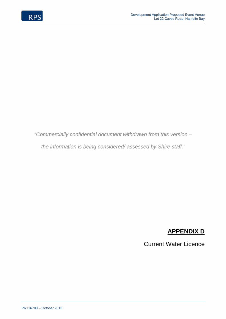
Development Application Proposed Event Venue Lot 22 Caves Road, Hamelin Bay
PR116700 – October 2013
“Commercially confidential document withdrawn from this version –
the information is being considered/ assessed by Shire staff.”
Current Water Licence
APPENDIX D

Development Application Proposed Event Venue Lot 22 Caves Road, Hamelin Bay
PR116700 – October 2013
APPENDIX
Fire Management Plan
E
Prepared by Strategen Environmental Consultants

Fire Management Plan
Lot 22 Caves Road, Kudardup
Prepared for Sunset Events by Strategen October 2013

Fire Management Plan
Lot 22 Caves Road, Kudardup
Strategen is a trading name of Strategen Environmental Consultants Pty Ltd Level 2, 322 Hay Street Subiaco WA ACN: 056 190 419
October 2013

Disclaimer and Limitation
This report has been prepared for the exclusive use of the Client, in accordance with the agreement between the Client and Strategen (“Agreement”).
Strategen accepts no liability or responsibility whatsoever for it in respect of any use of or reliance upon this report by any person who is not a party to the Agreement.
In particular, it should be noted that this report is a qualitative assessment only, based on the scope of services defined by the Client, budgetary and time constraints imposed by the Client, the information supplied by the Client (and its agents), and the method consistent with the preceding.
Strategen has not attempted to verify the accuracy or completeness of the information supplied by the Client.
Copyright and any other Intellectual Property arising from the report and the provision of the services in accordance with the Agreement belongs exclusively to Strategen unless otherwise agreed. This document may not be reproduced or disclosed to any person other than the Client without the express written authority of Strategen unless the document has been released for referral and assessment of proposals.
Client: Sunset Events
Report Version Revision No. Purpose Strategen
author/reviewer Submitted to Client
Form Date
Draft Report Rev A For review by client Z Cockerill / R Banks
Electronic 12/08/2013
Final Draft Report Rev B For review by client Z Cockerill Electronic 2/09/2013
Final Report Rev 0 Issued for use: for submission to
AMRSC and DFES
Z Cockerill / R Banks
Electronic 3/09/2013
Final report Rev 1 AMRSC for public comment
Zac Cockerill / R Banks
Electronic
Filename: RPS13101_01 R001 Rev 1 - 3 October 2013

Fire Management Plan
RPS13101_01 R001 Rev 1
3-Oct-13
Table of contents
1. Introduction 1 1.1 Background 1 1.2 Purpose and application of the document 1 1.3 Stakeholder consultation 1 1.4 Document review 2
2. Aim and objectives 3 2.1 Aim 3 2.2 Objectives 3
3. Description of the area 4 3.1 General overview 4 3.2 Local climate 4
3.2.1 Predominant fire weather 4 3.3 Landform and topography 7 3.4 Geology and soils 7 3.5 Vegetation 7 3.6 Land use 11
3.6.1 Current land use 11 3.6.2 Proposed land use 11
3.7 Site assets 11 3.7.1 Current site assets 11 3.7.2 Proposed site assets 11
3.8 Water supply 12 3.9 Power supply 12 3.10 Site access 12
4. Fire problem 13 4.1 Bush fire history 13 4.2 Bush fire hazards 13
4.2.1 Classifying the bush fire hazard 13 4.2.2 Bush fire hazard performance criteria 20 4.2.3 Classifying the Bushfire Attack Level 20
4.3 Inherent bush fire risk 20 4.4 Summary of bush fire issues 21
5. Bush fire management measures 22 5.1 Event location and timing 22 5.2 Hazard separation buffer 22 5.3 On-site management of grassland fuels 22 5.4 Public and emergency access 23 5.5 Emergency water supply and provision of fire appliances 23 5.6 Safe fire refuge areas 23 5.7 Emergency fire management and evacuation 23 5.8 Summary of bush fire management measures and works program 24
6. Implementation of the Fire Management Plan 26 6.1 Implementation of bush fire management measures 26 6.2 Residual bush fire risk 26 6.3 Contingency measures 26
6.3.1 Shire-issued harvest and vehicle movement bans 27 6.4 Assessment of bush fire management measures 29 6.5 Legislative requirements, specifications and standards 29
7. References 30

Fire Management Plan
RPS13101_01 R001 Rev 1
3-Oct-13
List of tables
Table 1 Key objectives of the FMP 3 Table 2 Cape Leeuwin mean monthly climate statistics 4 Table 3 Key characteristics of Gracetown Ridge soil landscape system 7 Table 4 Vegetation complex characteristics 9 Table 5 Predominant vegetation class and type 17 Table 6 Bush fire hazard levels and performance criteria 20 Table 7 Inherent bush fire risk assessment for Lot 22 21 Table 8 Summary of bush fire management measures and works program 25 Table 9 Residual bush fire risk assessment for Lot 987 26 Table 10 Contingency measures 26
List of figures
Figure 1 Regional location 5 Figure 2 Site overview 6 Figure 3 Site topography 8 Figure 4 Vegetation complexes 10 Figure 5 Vegetation class map 18 Figure 6 Bush fire hazard assessment map 19 Figure 7 Fire Management Plan: Lot 22 Caves Road, Kudardup 28
List of appendices
Appendix 1 Fire Management Plan compliance checklist Appendix 2 January wind profiles for Cape Leeuwin Appendix 3 Shire of Augusta-Margaret River Fuel Hazard Reduction and Firebreak Notice (2012/13) Appendix 4 AFAC bush fire glossary

Fire Management Plan
RPS13101_01 R001 Rev 1
3-Oct-13 1
1. Introduction
1.1 Background
Sunset Events is proposing to develop a festival and events venue at Lot 22 Caves Road, Kudardup (Lot 22), located in the Shire of Augusta-Margaret River. The Southbound Festival is to be the first event held at the site in January 2015, which is expected to attract around 10 000–15 000 people over the course of three days, with overnight camping facilities provided on site. There will be no purpose built festival facilities on the site for an initial two year period until the success of the event can be proven. A Development Application (DA) to Shire of Augusta Margaret River (AMRSC) will facilitate formal approval of the proposed development.
Since Lot 22 is situated adjacent to Leeuwin Naturaliste National Park (LNNP) and a northern conservation lot, bush fire management will need to be a key consideration of ongoing event planning and future development of the site. This is particularly important for summer events such as Southbound, since event timing conflicts with the middle of the designated bush fire season when the potential for wildfire occurrence is at its peak.
RPS, on behalf of Sunset Events, has commissioned Strategen to prepare a Fire Management Plan (FMP) for the proposed development of Lot 22, in accordance with Planning for Bush Fire Protection Guidelines Edition 2 (PFBFP Guidelines). A completed FMP compliance checklist is contained in Appendix 1.
1.2 Purpose and application of the document
The purpose of the FMP is to provide guidance on how to plan for and manage the potential bush fire risk associated with Lot 22 through implementation of a range of bush fire management measures recommended on the basis of the inherent bush fire risk to the site and associated bush fire hazard levels.
The FMP outlines how on-site assets present during future festival events can be protected during summer months when the threat from wildfire is at its peak. This is particularly relevant when existing fire appliances in the area may be unable to offer a fast emergency suppression response. Therefore, site assets should be self-protecting from wildfire.
Implementation of the FMP applies to the developer (Sunset Events) to ensure bush fire management measures are adopted and implemented on an ongoing basis to achieve bush fire management objectives.
1.3 Stakeholder consultation
Strategen has attended stakeholder consultation meetings with the developer, RPS, Shire of Augusta-Margaret River (AMRSC), Main Roads WA, WA Police (Bunbury and Margaret River), Department of Fire and Emergency Services (DFES) and Department of Parks and Wildlife (DPaW) to ensure aims and objectives of the FMP are in accordance with stakeholder expectations and related emergency management plans, and the FMP maintains compliance with PFBFP Guidelines.

Fire Management Plan
RPS13101_01 R001 Rev 1
3-Oct-13 2
1.4 Document review
The FMP will be updated on an annual basis by Sunset Events, as required, following the date of approval. The FMP will be revised every five years by Sunset Events following the date of approval to ensure: 1. Implementation of the FMP is assessed and corrective actions are applied in cases of non-
compliance. 2. The effectiveness and impact of fire prevention work is evaluated and any significant changes in
management are captured and assessed in a revised FMP.
This FMP will address the initial Southbound event in the short term, so will require updating and revision if any purpose built facilities are proposed on site during future development phases.

Fire Management Plan
RPS13101_01 R001 Rev 1
3-Oct-13 3
2. Aim and objectives
2.1 Aim
The FMP aims to achieve a reduction in the occurrence of uncontrolled bush fires and minimise potential impacts on life and property of the proposed development. This will be achieved by preparing an FMP that:
• quantifies the bush fire hazard and assesses the bush fire risk associated with Lot 22
• documents bush fire prevention requirements of Lot 22 to provide ongoing protection to future life and property assets of the subject land
• identifies bush fire protection issues, appropriate strategies and those persons and/or organisations who have a responsibility to implement the FMP
• is in accordance with PFBFP Guidelines and is compatible with bush fire management on neighbouring properties
• provides guidance for the developer to protect the subject land in the event that fire appliances may not be available to offer a fast suppression response.
The above aim and methodology is consistent with bush fire management and planning for similar Australian music festival events that occur during summer in bush fire prone areas, such as The Falls Music and Arts Festival, which is hosted on private property in Lorne (approximately 140 km southwest of Melbourne) on steep topography surrounded by heavily forested areas. This event is guided by an approved Fire Risk Management Plan (Barnard 2013), prepared in accordance with the following methodology: 1. Identify risks associated particularly with bush fires and develop and document treatments. 2. Integrate planning and risk treatments for bush fires into existing management plans. 3. Undertake the risk management process using AS/NZS 4360:2004 (superseded by ISO
AS/NZS 31000:2009). 4. Utilise the AS/NZS 4360:2004 risk management framework for the document.
2.2 Objectives
Key objectives of the FMP and the relevant section/s of this document in which they are addressed are outlined in Table 1.
Table 1 Key objectives of the FMP
Objective Section
Define areas where values are located Section 3.7
Define and rank fire hazard areas Section 4.2.1
Nominate individuals and organisations responsible for fire management and associated works within Lot 22
Section 5.8
Propose fire management measures for Lot 22, with due regard for life, property and the environment
Section 5
Define an assessment procedure that will evaluate the effectiveness and impact of proposed, as well as existing fire prevention work and strategies
Section 6.4
Provide performance criteria and acceptable solutions for all fire management works in accordance with PFBFP Guidelines
Section 4.2.2
Fire Management Plan
RPS13101_01 R001 Rev 1
3-Oct-13 4
3. Description of the area
3.1 General overview
The subject site is approximately 119 ha, located at Lot 22 Caves Road, Kudardup in the Shire of Augusta-Margaret River (Figure 1). Lot 22 is predominantly cleared and bound by Caves Road and Cosy Corner Road to the east, LNNP to the south and west, and Lot 21 to the north, part of which is vested for conservation (Figure 2).
The proposed site layout consists of three access routes off Caves Road, which link an internal road network to three parking areas, two camping areas and the crowd/concert venue (Figure 2). Surrounding land to the south, west and north is heavily vegetated, the majority of which is contained within LNNP and northern conservation lot. Consequently, there is an inherent bush fire risk to proposed life and property assets of the site, given the close proximity to bush fire hazard areas.
3.2 Local climate
Kudardup experiences a Mediterranean type climate characterised by mild, wet winters and warm to hot, dry summers. The nearest Bureau of Meteorology (BoM) weather station at Cape Leeuwin provides long term climate statistics for the local area (Table 2). Long term mean annual rainfall is 967.7 mm (BoM 2013), the majority of which occurs between May and September associated with cold fronts originating from the southwest. Hottest conditions occur from November to April, with average monthly maximum temperatures ranging from 20.1–23.3°C. This is compared with the coldest period from June to September, where average monthly maximum temperatures range from 16.4–17.3°C (BoM 2013).
Table 2 Cape Leeuwin mean monthly climate statistics
Jan Feb Mar Apr May Jun Jul Aug Sep Oct Nov Dec Annual
Mean max temperature (°C)
23.0 23.3 22.7 21.3 19.2 17.3 16.4 16.4 17.1 18.2 20.1 21.8 19.7
Mean min temperature (°C)
16.9 17.3 16.7 15.4 13.7 12.2 11.3 11.2 11.8 12.6 14.2 15.8 14.1
Mean rainfall (mm) 16.2 15.8 27.9 59.9 139.1 176.5 181.6 135.9 90.9 65.2 37.3 20.9 967.7
Source: BoM 2013
3.2.1 Predominant fire weather
Southwest Western Australia generally experiences a cool to mild growing season in the months of August through to November of each year, followed by four months of summer drought conditions, which is when the potential for wildfire occurrence is at its peak. The worst fire weather conditions occur during this dry period when a low pressure trough forms off the west coast and strong winds develop from the north or northeast. These conditions are sometimes associated with ‘Extreme’ or ‘Catastrophic’ fire danger indices, which are consistent with very high temperatures, low relative humidity and strong winds. These high fire risk conditions are considered to occur less than 5% of the time during the designated bush fire season (i.e. around five days from November to March). Therefore, the likelihood of an ‘Extreme’ or ‘Catastrophic’ fire danger day conflicting with an event day at Lot 22 is considered to be very low.
Average 9:00 am and 3:00 pm January wind profiles for Cape Leeuwin are contained in Appendix 2, which illustrate that the predominant winds during this high risk period are from the east and southeast in the morning averaging around 22.7 km/h; and from the southeast in the afternoon averaging around 24.5 km/h (BoM 2013). These dominant wind patterns are considered to occur 95% of the time during the designated bush fire season. It should also be noted that the mean 9:00 am and 3:00 pm relative humidity for Cape Leeuwin is 76% and 72% respectively. The abovementioned predominant fire weather conditions correlate with an average summer fire danger index of ‘Moderate’ to ‘High’.

Figure 1 Regional locationLegend! Town
!( Place name
Major road
Minor road
Major river
Lot 22 boundary
Shi re boundar ies
!(
!(
!(
!(
!(
!(
!(
!(
!(
!(
!(
!(
!(
!(
!(
!(
!(
!(
!(
!(
!(
!(
!(
!(
!(
!(
!(
!(
!(
!(
!(
!
!
Mowen
Wirring
Harmans
Bramley
Kudardup
Arumvale
Prevelly
Metricup
Dianella
Gracetown
Lake Cave
Karridale
Cowaramup
Rosa Glen
Osmington
Jewel Cave
Milyeannup
Giants Cave
Witchcliffe
Chapman Hill
Mammoth CaveForest Grove
Whicher Range
Calgardup Cave
Margaret R iv er
Bla ckwood River
Cav es Road
Sues
Roa
d
Bussel lHi ghw ay
Brockman Highway
AUGUSTA
MARGARET RIVER
310000
310000
320000
320000
330000
330000
340000
340000
350000
350000
6200
000
6200
000
6210
000
6210
000
6220
000
6220
000
6230
000
6230
000
6240
000
6240
000
6250
000
6250
000
6260
000
6260
000
Path: Q:\GIS \Consult\2013\RPS \RP S13101\Arc M ap_doc um ents\R001\Rev0\RP S13101_01_R001_Rev0_F001.mx d
info@stratege n.co m.auww w.strate gen .c om .au
!
!
!
!
!
!
!
!!
Es per anc eAlbany
Kununur ra
Port Hedland
Geraldton
Car nar von
Perth
Newm an
Kalgoorl ie
WE ST ERNAUSTRAL IA
Sc ale at A4
Sourc e: Topogr aphy : G eosc ience Aus tra lia 2011.
Note that pos itional error s m ay occ ur in s om e areas
0 1.5 3 4.5 6 7.5km
1:300,000
Coor dinate S y stem : G DA 1994 MG A Zone 50
Date: 8 /08/2013
Author: JCr ute
¹
Subject site
Shire of Augusta-Margaret River
Shire of Nannup
City of Busselton

!(
!(!(
!(!(
!(!(!(!(!(!(!(!(!(
!(
!(!(!(!(!(!(!(!(
!(!(!(!(
!(!(!(!(
!(!( !( !(
!(!(!( !(!( !(!(
!( !( !( !(!(
!( !( !( !(!(
!(!(
!(
!(
!(
!( !(!(
!(
!(!(
!(!(
!(
!(!(!( !(
!(!(!(!( !(
!(
!( !( !( !(!(
!(
!(!(!( !(!(!(!(!( !(
!(
!( !( !( !(!(
!( !( !( !(!(
!(!( !(
!( !( !(!(
!(
!(!(
!(
!(
!(!(!( !(!( !( !( !( !(!( !( !( !( !(!( !( !( !( !(!( !( !(!( !(!( !(
!(
!( !(!( !(!(!(!(
!( !(!(
!( !( !( !(!(
!( !( !( !(!(
!( !(!(
!(!(!(
!(!(
!(!(
!(!(
!(
!(!(
!(
!(
!(!(
!(
!(!(!(
!(!(
!(
!(
!(!(
!(
!(
!(
!(
!(
!(!(
!(!(
!(
!(
!(
!(
!(!(
!(!(
!(!(
!(
!(!(
!(
!(!(
!(
!(
!(!(
!(
!(
!(
!(!(!(
!(
Cosy Corn
er Roa
d
Cave
s Roa
d
320000
320000
320500
320500
321000
321000
321500
321500
322000
322000
6208
500
6208
500
6209
000
6209
000
6209
500
6209
500
Figure 2 Site overviewLegend
!( Trees
Cadastral boundar ies
Prim ary road access
Lot 22 boundary
National Park
Parking areas
Camping areas
Crowd / Concert venuePath: Q:\GIS \Consult\2013\RPS \RP S13101\Ar cM ap_doc um ents\R001\Rev0\RP S13101_01_R001_Rev0_F002.mx d
info@stratege n.co m.au w ww .strate ge n.c om.auSourc e: A eria l im age: Landgate 07/2013, flown 03/2012. A ll o ther data: Cl ient 2013.
¹Author: JCr ute
at A4
0 50 100 150 200 250m
1:9,000Sc ale
Note that pos itional error s m ay occ ur in s om e ar eas
Coor dinate S y stem : G DA 1994 MG A Zone 50
Date: 3 /10/2013
Stalls
Main Bar
MainGate
MainStage
Lookout
Leeuwin-NaturalisteNational Park
Helipad
Camping South
Camping North
Parking South
Parking Middle
Parking North
BusStop
Entrance/Exit(Artist/Emergency)
Entrance/Exit(Patron)
Entrance/Exit(Production)

Fire Management Plan
RPS13101_01 R001 Rev 1
3-Oct-13 7
3.3 Landform and topography
Lot 22 is situated within the Warren bioregion of Western Australia, which consists of dissected undulating country forming part of landforms known as the Leeuwin Complex, the Blackwood Plateau, the Yilgarn Craton and western parts of the Albany Orogen (McKenzie et al. 2003).
The site is gently undulating with minor rises and depressions at around 30–40 mAHD (Australian Height Datum) (Figure 3). A ridge is located in the southwest corner sloping upwards to 60 mAHD into LNNP, and a hill is located in the southeast corner at 60 mAHD (Figure 3). Predominant vegetation surrounding Lot 22 is located up-slope from the site.
3.4 Geology and soils
Lot 22 is located within the Leeuwin Complex of the Leeuwin-Naturaliste Ridge physiographic unit, which is an isolated and elongated ridge extending north-south between Cape Naturaliste and Cape Leeuwin (DEC & CCWA 2010). The basement rocks are metamorphosed igneous rocks, which outcrop discontinuously as coastal headlands and scatter through the uplands and along river systems (DEC & CCWA 2010).
According to Department of Agriculture’s AGMAPS Land Profiler (AgWA 2003), Lot 22 is contained within the Gracetown Ridge soil landscape system (216Gr), which is prominent throughout the Leeuwin-Naturaliste Ridge. Key characteristics of this soil system are outlined in Table 3.
Table 3 Key characteristics of Gracetown Ridge soil landscape system
Soil landscape system Factor Description
Gracetown Ridge System (216Gr)
Landform Dunes and rocky coast
Geology Aeolian sand and limestone over granitic rocks
Soils Yellow and red deep sands, calcareous deep sands and calcareous stony soils
Vegetation Mixed coastal scrub, Peppermint woodland and Jarrah-Marri-Karri forest
Source: AgWA 2003
3.5 Vegetation
Lot 22 and adjacent properties are situated within the Kilcarnup Kr, Kf and KE vegetation complexes, as mapped by Mattiske and Havel (1998) for the South West Regional Forest Agreement. Key characteristics of these complexes, including key flora species, are outlined in Table 4, with locations illustrated in Figure 4.
On-site vegetation has been significantly modified from the above complexes due to broad scale clearing and ongoing agricultural use of the site for livestock grazing, which has resulted in a predominantly cleared, grassland pasture landscape with some scattered individual trees and shrubs. Small, dense stands of native vegetation do cross the western, southern and northern boundaries of Lot 22; however, these are more an extension of the vegetation extent contained within LNNP and the northern conservation lot.
Predominant vegetation in the local area is situated adjacent west, south and north of Lot 22, within LNNP and the northern conservation lot. This high quality vegetation is consistent with the vegetation complex descriptions provided by Mattiske and Havel (1998).

Cosy Corn
er Roa
d
Cave
s Roa
d
30
35 4045
50
55 60
30
35
4045
505560
65
7075
320000
320000
320500
320500
321000
321000
321500
321500
322000
322000
6208
500
6208
500
6209
000
6209
000
6209
500
6209
500
Figure 3 Site topographyLegend
Lot 22 boundary Cadastral boundar ies Sur face elevation (mAHD)
Path: Q:\GIS \Consult\2013\RPS \RP S13101\Ar cM ap_doc um ents\R001\Rev0\RP S13101_01_R001_Rev0_F003.mx d
info@stratege n.co m.au w ww .strate ge n.c om.auSourc e: A eria l im age: Landgate 07/2013, flown 03/2012. A ll o ther data: Cl ient 2013.
¹Author: JCr ute
at A4
0 50 100 150 200 250m
1:9,000Sc ale
Note that pos itional error s m ay occ ur in s om e ar eas
Coor dinate S y stem : G DA 1994 MG A Zone 50
Date: 8 /08/2013

Fire Management Plan
RPS13101_01 R001 Rev 1
3-Oct-13 9
Table 4 Vegetation complex characteristics
Vegetation complex
Geographic region
Landform description Soils Soil
hydrology Overstorey Second storey Shrubs and herbs
Kilcarnup (Kr)
Perhumid southwest, south of Gracetown
Leeward edge of calcareous sand dune
Dark stony calcareous sand with high organic content and limestone fragments
Water shedding with good infiltration, but only moderate storage capacity (very porous)
Tall Shrubland (4-5 m) of Agonis flexuosa, Acacia saligna and Hakea oleifolia
No second storey
Hibbertia hypericoides, Xanthorrhoea preissii, Hardenbergia comptoniana, Phyllanthus calycinus, Rhagodia baccata, Opercularia hispidula var. pauciflora, Leucopogon parviflorus and Hibbertia cuneiformis
Kilcarnup (Kf)
Hyperhumid south west, near old Karridale on Caves Road
Leeward side of Kilcarnup dunes, with steep parabolic slopes
Pale grey to white calcareous sand with organic topsoil, alkaline
Strongly water shedding laterally via subsoil, good infiltration, moderate to good storage capacity
Shrubland to woodland of Agonis flexuosa
Tall Xanthorrhoea preissii
Spyridium globulosum, Hardenbergia comptoniana and Acacia littorea
Kilcarnup (KE)
Hyperhumid south, near Cosy Corner
Blowout in exposed calcareous dunes
Pale grey calcareous sand with minimal organic matter
Water shedding, good infiltration but poor storage
Nil Nil Heath of Acacia littorea, Olearia axillaris, Conostylis aculeata, Ficinia nodosa, Spyridium globulosum, Leucopogon parviflorus and Senecio lautus
Source: Mattiske and Havel 1998

Cosy Corn
er Roa
d
Cave
s Roa
d
Kr
Kf
KE
KEKr
Kf
C1Cw1
320000
320000
320500
320500
321000
321000
321500
321500
322000
322000
6208
500
6208
500
6209
000
6209
000
6209
500
6209
500
Figure 4 Vegetation complexesLegend
Cadastral boundar ies
Lot 22 boundary
Vegetation class and name
C1, Cowaramup
Cw1, Cowaramup
KE, Ki lcarnup
Kf, K ilcarnup
Kr, K ilcarnupPath: Q:\GIS \Consult\2013\RPS \RP S13101\Ar cM ap_doc um ents\R001\Rev0\RP S13101_01_R001_Rev0_F004.mx d
info@stratege n.co m.au w ww .strate ge n.c om.auSourc e: A eria l im age: Landgate 07/2013, flown 03/2012. Vegetation: M attis ke & Havel 1998. A l l o ther data: Cl ient 2013.
¹Author: JCr ute
at A4
0 50 100 150 200 250m
1:9,000Sc ale
Note that pos itional error s m ay occ ur in s om e ar eas
Coor dinate S y stem : G DA 1994 MG A Zone 50
Date: 8 /08/2013
Fire Management Plan
RPS13101_01 R001 Rev 1
3-Oct-13 11
3.6 Land use
3.6.1 Current land use
Lot 22 is currently zoned ‘General Agriculture’ under the provisions of the Shire of Augusta-Margaret River Local Planning Scheme No. 1 (DoP 2013). This is consistent with the current agricultural land use of the site, which comprises livestock grazing for sheep production and is undertaken intermittently throughout the year.
3.6.2 Proposed land use
Lot 22 is proposed to be developed as a festival and events venue in the South West region of WA. This proposal is the subject of a DA for approval by AMRSC.
Sunset Events will manage the grasses on the property to create a quality green coverage over the camping and main festival areas. This will involve irrigation of the greased areas in the lead up to the event utilising the on-site bores and reservoir.
The site will continue to stock livestock throughout the year, which will assist in reducing fuel loads. Livestock will be moved to the adjoining Lot 21 for the duration of an event prior to an event occurring. Additional grass mowing/slashing will occur in these areas during establishment of these grasses.
The Southbound Festival is to be the first event held at the site in January 2015, which is expected to attract around 10 000–15 000 people over the course of three days, with overnight camping facilities provided on site. There will be no festival purpose built facilities on the site for an initial two year period until the success of the event can be proven.
3.7 Site assets
3.7.1 Current site assets
There are currently no life or infrastructure assets within Lot 22, apart from two windmills to the north of the site, an old shed to the east and internal and perimeter fencing. Environmental assets are also limited to small patches of native vegetation which cross lot boundaries to the west, south and north.
More significant environmental assets are contained within dense stands of native vegetation to the north, south and west of Lot 22 within LNNP and the northern conservation lot, which provide habitat for conservation significant flora and fauna. Coastal areas to the west of Lot 22 are also expected to contain conservation significant karst and cave habitats, which feature prominently throughout the Leeuwin Naturaliste Ridge.
3.7.2 Proposed site assets
No purpose built facilities are proposed for Lot 22 until the success of the Southbound event can be proven. Removable facilities will be utilised throughout this interim period as required, which may consist of perimeter fencing around the immediate concert venue, staging infrastructure, stalls, gates, bar areas, tents and ablution facilities.
It should be noted that throughout the initial two year period of the development, life and property assets will only be located on site temporarily for the duration of individual events. For example, the opening Southbound Festival will operate for three days and provide overnight visitor camping facilities. On completion of the event, all staff and visitors will vacate the site and infrastructure will be removed.
The only fixed infrastructure proposed as part of the initial period is 1.8/2.0 m high link mesh fence installed along the boundary of the festival arena for the protection of conservation values within LNNP.

Fire Management Plan
RPS13101_01 R001 Rev 1
3-Oct-13 12
3.8 Water supply
Lot 22 currently contains two groundwater bores/mills. Additional water supply will be confirmed through the DA process and may include additional groundwater bores.
A reservoir is proposed to be constructed on the eastern edge of the main concert venue. The reservoir will be fed via the existing bores on site to accommodate water for the irrigation of the lawn, as well as for dust and fire suppression purposes during the event. Reservoir dimensions will be approximately 20 m by 30 m and will have an approximate capacity of 3 GL.
Emergency water supply will be provided on event operating days in the form of two light tanker units and one 3.4 tanker unit, which can be refilled from the on-site reservoir.
Pastures located throughout the main crowd/venue area and camping areas will be irrigated as required via an existing Department of Water license.
3.9 Power supply
Mains power supply is currently provided to Lot 22. However, the majority of power supply for the initial events will be via Gensets. The current mains supply may be upgraded in future years to reduce the requirement on Gensets.
3.10 Site access
Site access is currently limited to an entrance off Caves Road located along the northern site boundary. Site access will be confirmed through the DA process, and is proposed to be via three access points off Caves Road, which will link an internal road network with a bus stop, three parking areas, two camping areas and the main crowd and concert venue area.

Fire Management Plan
RPS13101_01 R001 Rev 1
3-Oct-13 13
4. Fire problem
4.1 Bush fire history
Uncontrolled bush fires in and around Lot 22 are uncommon. This is consistent with the lack of fire evidence and high available fuel loads throughout the surrounding vegetation extent, particularly within LNNP and the northern conservation lot.
On assessment of the available fuel loads and lack of fire scarring, the adjacent west LNNP is estimated to experience an average of one uncontrolled bush fire every one to two decades. Conversely, the nearby town of Karridale, experiences more regular occurrences of uncontrolled bush fires, averaging around 8–10 per year (Jordan B [AMRSC Community Emergency Services Manager] 2013, pers. comm. 3 September). The most likely sources of ignition include:
• lightning strike
• poll-top fires
• accidental causes.
The area of LNNP located immediately adjacent west of Lot 22 has not been subject to prescribed burning for many years. This observation is consistent with the lack of fire scarring and high available fuel loads identified throughout the National Park and adjacent bushland.
In the event that wildfire threatens assets of Lot 22, emergency response times are expected to be within 30 minutes from local volunteer bush fire brigades at Karridale and Kudardup, as well as numerous others located throughout the Shire.
4.2 Bush fire hazards
A bush fire hazard assessment aims to classify the bush fire hazard at both the strategic and local level, which enables the assessor to classify the bush fire attack level. A bush fire hazard assessment has been undertaken across Lot 22 and adjacent land in accordance with procedures outlined in PFBFP Guidelines.
4.2.1 Classifying the bush fire hazard
Fuel hazard assessment
A comprehensive fuel hazard assessment of Lot 22 and adjacent land was undertaken by Strategen during a site inspection on 4 July 2013. Results and observations of the fuel hazard assessment are outlined in the following subsections. Fuel hazards were assessed on the basis of a visual inspection of the following factors:
• vegetation type and structure
• vegetation condition and density
• fuel age
• scrub extent • litter and trash accumulation.

Fire Management Plan
RPS13101_01 R001 Rev 1
3-Oct-13 14
On-site fuel hazards
On-site fuel hazards are restricted to small stands of native vegetation which cross the western, southern and northern boundaries of Lot 22 and comprise the following:
• 4 m high, dense, closed scrub of Agonis flexuosa (WA Peppermint) and Acacia saligna (Orange wattle) over Xanthorrhoea preissii (Grass tree) and Hibbertia sp. at up to 45 t/ha available fuels (Plate 1)
• low shrubland dominated by coastal acacias at up to 18 t/ha available fuels (Plate 2).
The abovementioned fuels are an extension onto the site from vegetation contained within LNNP and the northern conservation lot.
The remainder of Lot 22, as well as adjacent areas to the east and north of the site, are cleared and contain grassland pastures and some scattered individual WA Peppermint trees and acacia shrubs (Plate 3). These areas are maintained annually within 2 t/ha through intermittent grazing by sheep, so are not considered significant fuel hazards, provided they are managed on an ongoing basis.
Plate 1 On-site closed scrub at up to 45 t/ha available fuels (extending across the western, southern and northern boundaries from LNNP and the northern conservation lot)

Fire Management Plan
RPS13101_01 R001 Rev 1
3-Oct-13 15
Plate 2 On-site low shrubland at up to 18 t/ha available fuels (extending across the southern boundary from LNNP)
Plate 3 Cleared land and grazed pasture throughout the majority of Lot 22 (less than 2 t/ha)

Fire Management Plan
RPS13101_01 R001 Rev 1
3-Oct-13 16
Surrounding fuel hazards
Fuel hazards surrounding Lot 22 are predominantly contained within LNNP and the northern conservation lot. They consist of:
• 4 m high, dense, closed scrub of Agonis flexuosa (WA Peppermint) and Acacia saligna (Orange wattle) over an understorey of Xanthorrhoea preissii (Grass tree) and Hibbertia sp. at up to 45 t/ha available fuels (Plate 4)
• low shrubland dominated by acacias at up to 18 t/ha available fuels (Plate 5).
Plate 4 Closed scrub within LNNP and northern conservation lot at up to 45 t/ha
Plate 5 Low shrubland within LNNP and northern conservation lot at up to 18 t/ha
The abovementioned fuel hazards located throughout LNNP and the northern conservation lot have the potential to contribute to a wildfire with fire intensity in the range of 10 000–35 000 kW/m2 under worst case scenario conditions.

Fire Management Plan
RPS13101_01 R001 Rev 1
3-Oct-13 17
Vegetation class and type
An assessment of vegetation class and type within and adjacent to Lot 22 has been undertaken in accordance with procedures outlined in PFBFP Guidelines (Table 5).
Table 5 Predominant vegetation class and type
Location of vegetation and fuel load
Vegetation class
Vegetation type
Figure (taken from the Guidelines) Description
On-site closed scrub (up to 45 t/ha)
(D) Scrub Closed scrub
Found in areas wet enough to support eucalypt trees; affected by poor soil fertility or shallow soils; >30% foliage cover; dry heaths occur in rocky areas; shrubs 1–2 m high; often coastal wetlands.
On-site low shrubland (up to 18 t/ha)
(C) Shrubland Low shrubland
Shrubs less than 2 m high; greater than 30% foliage cover; understoreys can contain grasses; acacia and casuarina often dominant in the arid and semi-arid zones.
On-site cleared pasture (managed annually within 2 t/ha)
Managed grassland (unclassified vegetation type)
Surrounding closed scrub (up to 45 t/ha)
(D) Scrub Closed scrub
Found in areas wet enough to support eucalypt trees; affected by poor soil fertility or shallow soils; >30% foliage cover; dry heaths occur in rocky areas; shrubs 1–2 m high; often coastal wetlands.
Surrounding low shrubland (up to 18 t/ha)
(C) Shrubland Low shrubland
Shrubs less than 2 m high; greater than 30% foliage cover; understoreys can contain grasses; acacia and casuarina often dominant in the arid and semi-arid zones.
Location of bush fire hazards
Location of bush fire hazard areas is outlined in the vegetation class map (Figure 5). This map has been created using the abovementioned vegetation class and type descriptions and assessed fuel loads.
Bush fire hazard levels
Bush fire hazard levels within Lot 22 and adjacent vegetated properties are displayed in the bush fire hazard assessment map (Figure 6). Classifying the bush fire hazard by assessing the predominant vegetation is a key to the initial determination of site suitability for development. This also leads to determination of the potential level of construction standard by the application of AS 3959–2009 Construction of buildings in bushfire prone areas (SA 2009) for any proposed development.
The pre-development, on-site bush fire hazard level is low to extreme due to the site being predominantly cleared, but containing small areas of high fuel-carrying closed scrub and low shrubland vegetation, which extend across the western, southern and northern lot boundaries.
The bush fire hazard level of the adjacent LNNP and northern conservation lot is extreme due to the presence of high fuel-carrying closed scrub and low shrubland vegetation types.
According to PFBFP Guidelines, land which has an assessed moderate to extreme bush fire hazard level is classified as bush fire prone land.

Cosy Corn
er Roa
d
Cave
s Roa
d
320000
320000
320500
320500
321000
321000
321500
321500
322000
322000
6208
500
6208
500
6209
000
6209
000
6209
500
6209
500
Figure 5 Vegetation class mapLegend
Cadastral boundar ies
Lot 22 boundary
Vegetation class
Predom inantly cleared land: <2 t/ha
Low shrubland: up to 18 t/ha
Closed scrub: up to 45 t/ha
Path: Q:\GIS \Consult\2013\RPS \RP S13101\Ar cM ap_doc um ents\R001\Rev0\RP S13101_01_R001_Rev0_F005.mx d
info@stratege n.co m.au w ww .strate ge n.c om.auSourc e: A eria l im age: Landgate 07/2013, flown 03/2012. A ll o ther data: Cl ient 2013.
¹Author: JCr ute
at A4
0 50 100 150 200 250m
1:9,000Sc ale
Note that pos itional error s m ay occ ur in s om e ar eas
Coor dinate S y stem : G DA 1994 MG A Zone 50
Date: 8 /08/2013
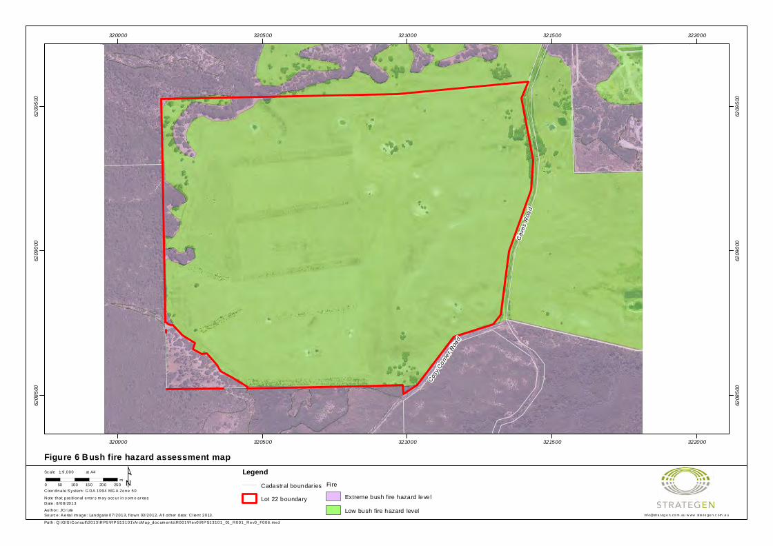
Cosy Corn
er Roa
d
Cave
s Roa
d
320000
320000
320500
320500
321000
321000
321500
321500
322000
322000
6208
500
6208
500
6209
000
6209
000
6209
500
6209
500
Figure 6 Bush fire hazard assessment mapLegend
Cadastral boundar ies
Lot 22 boundary
Fi re
Extreme bush fire hazard leve l
Low bush fire hazard level
Path: Q:\GIS \Consult\2013\RPS \RP S13101\Ar cM ap_doc um ents\R001\Rev0\RP S13101_01_R001_Rev0_F006.mx d
info@stratege n.co m.au w ww .strate ge n.c om.auSourc e: A eria l im age: Landgate 07/2013, flown 03/2012. A ll o ther data: Cl ient 2013.
¹Author: JCr ute
at A4
0 50 100 150 200 250m
1:9,000Sc ale
Note that pos itional error s m ay occ ur in s om e ar eas
Coor dinate S y stem : G DA 1994 MG A Zone 50
Date: 8 /08/2013

Fire Management Plan
RPS13101_01 R001 Rev 1
3-Oct-13 20
4.2.2 Bush fire hazard performance criteria
The relationship between various bush fire hazard levels and development performance criteria is set out in Table 6. Portions of Lot 22, as well as much of the surrounding land to the west, south and north, have been assigned an extreme bush fire hazard level. In general, new developments are not permitted in areas with an extreme bush fire hazard. Therefore, a comprehensive suite of bush fire management measures will need to be implemented to reduce and maintain the bush fire hazard to a moderate level or lower.
Compliance with performance criteria for a moderate bush fire hazard level will be achieved, focussing on the key areas of development location, vehicular access, water supply, siting of development and design of development. Performance criteria will be achieved through adoption of recommended acceptable solutions outlined in PFBFP Guidelines.
Table 6 Bush fire hazard levels and performance criteria
Bush fire hazard level Bush fire protection performance criteria required
Low hazard Development does not require special bush fire planning controls. Despite this, DFES strongly recommends that ember protection features be incorporated in design where practicable.
Moderate hazard
Performance criteria for: • location (Element 1) • vehicular access (Element 2) • water (Element 3) • siting of development (Element 4) • design of development (Element 5).
Extreme hazard
Development is to be avoided in areas with these hazard levels.
Source: WAPC et al. 2010
Compliance of the proposed development with bush fire protection performance criteria and associated acceptable solutions is documented in the compliance checklist (Appendix 1).
4.2.3 Classifying the Bushfire Attack Level
No purpose built structures are proposed as part of the initial phase of the development. Consequently, classifying the Bushfire Attack Level (BAL) and subsequent application of AS 3959–2009 is not applicable in this instance.
If the success of the Southbound Festival can be proven over the initial two year period, purpose built structures may be proposed for the site. This action will need to be supported by a detailed BAL assessment and possible application of AS 3959–2009. The BAL assessment will need to be documented in a revised version of this FMP.
4.3 Inherent bush fire risk
An inherent bush fire risk assessment has been undertaken across Lot 22, which quantifies the level of risk of loss or damage to current site assets from uncontrolled bush fire, prior to the implementation of the proposed development and associated bush fire management measures. The risk assessment is derived from the FESA Rural Urban Bush Fire Threat Analysis (Smith 2003) and Australian Standard/New Zealand Standard AS/NZS ISO 31000:2009 Risk management – Principles and guidelines (SA & SNZ 2009).
Results of the risk assessment are outlined in Table 7. The assessment indicates the inherent risk of loss or damage to current site assets from uncontrolled bush fire is low, given the lack of on-site assets and predominantly low on-site bush fire hazard rating.

Fire Management Plan
RPS13101_01 R001 Rev 1
3-Oct-13 21
Table 7 Inherent bush fire risk assessment for Lot 22
Parameter Risk to site assets
On-site fuel hazard rating (low, moderate, extreme) Predominantly low
Asset located up-slope from vegetation No
Asset located in the flame zone No
Resident/visitor presence (low, moderate, high) Low
Values or assets (low, moderate, high) Low
Fire unit access risk (low, moderate, high) Moderate
Fire suppression response time (minutes) <30
Probability of wildfire occurrence (low, moderate, high) Low
Level of bush fire management (low, moderate, high) Low
Overall inherent risk Low
4.4 Summary of bush fire issues
The following is a summary of potential bush fire issues for Lot 22:
• the likelihood of wildfire in the local area is low, on the basis of the lack of bush fire history, public access restrictions and predominant fire weather conditions during the designated bush fire season, which are not frequently associated with ‘Extreme’ or ‘Catastrophic’ fire danger indices
• further to the above, the likelihood of a wildfire occurring on the day of a festival event is very low, given the event is to be held over the duration of only three days in January
• Lot 22 is predominantly cleared, so does not contribute a significant bush fire hazard (grassland pastures of the site managed annually within 2 t/ha through livestock grazing)
• the festival arena and camping areas will be covered by slashed green grasses
• fuel loads throughout the local bushland extent are very high, particularly in the adjacent LNNP and northern conservation lot
• small stands of native vegetation cross the western, southern and northern boundaries of Lot 22 and these were assessed as closed scrub (up to 45 t/ha) and low shrubland (up to 18 t/ha), both of which are extreme bush fire hazards
• native vegetation within LNNP and the northern conservation lot were also assessed as closed scrub (up to 45 t/ha) and low shrubland (up to 18 t/ha), both of which are extreme bush fire hazards
• no purpose built structures are proposed as part of the initial two year period until the success of the event is proven; therefore, assessment of BALs and subsequent application of AS 3959–2009 is not applicable in this instance
• should Sunset Events propose to construct any purpose built structures on the site, this FMP should be revised to include the relevant BAL assessment and recommendations for heightened levels of construction standard (if required) to support any future DA process
• the inherent bush fire risk to Lot 22 and current site assets is low.

Fire Management Plan
RPS13101_01 R001 Rev 1
3-Oct-13 22
5. Bush fire management measures
The following bush fire management measures will be considered in order to manage the inherent bush fire risk and guide future protection of Lot 22 and proposed site assets: • event location and timing
• hazard separation buffer
• on-site management of grassland fuels
• public and emergency access
• emergency water supply and provision of fire appliances
• safe fire refuge areas • emergency management and evacuation.
Where applicable, the above measures are illustrated in Figure 7 to assist with implementation of the FMP. In addition, contingency measures have been provided in Section 6.3 to further mitigate the bush fire risk to the site in the event of wildfire, ‘Extreme’ or Catastrophic’ fire danger or a vehicle movement ban conflicting with event operation.
5.1 Event location and timing
Strategic location, layout and management of future development at the planning stage can reduce fire threat and risk to proposed critical life and property assets. As such, PFBFP Guidelines recommends that proposed assets be located in low bush fire hazard areas of the site if possible. This will be achieved as part of the proposed development, where event infrastructure, transport networks, crowd areas and visitor camping will be situated throughout the low bush fire hazard areas of the site.
In addition, these assets will only be located on site temporarily, where on completion of the three day event, all staff and visitors will vacate the site and infrastructure will be removed. These management measures will meet performance criteria for development location (Element 1).
5.2 Hazard separation buffer
When considering the overall bush fire management of Lot 22, protection should be provided to critical life and property assets (visitors and built assets) as a minimum requirement. Low fuel buffers between fire hazard areas and critical assets can be implemented to achieve this.
A 20 m low fuel hazard separation buffer is proposed to be implemented along the western boundary of the site to provide defendable space between proposed critical assets of the three day Southbound event and extreme bush fire hazards within LNNP and northern conservation lot. Fuel loads within the buffer are to be maintained within 2 t/ha, which can be achieved through slashed grass or lawn/turf areas. This management measure is expected to meet the performance criteria for siting of development (Element 4).
5.3 On-site management of grassland fuels
Current livestock grazing will be continued to provide ongoing annual management of grassland fuel hazards across the site. In addition, Sunset Events proposes to manage grassland areas within the festival arena and camping area via annual fuel hazard reduction (e.g. mechanical slashing), to maintain available fuels within 2 t/ha annually prior to the onset of the designated bush fire season.
Fuel hazard reduction will need to be undertaken in accordance with the annual Shire of Augusta-Margaret River Fuel Hazard Reduction and Firebreak Notice (Appendix 3). Annual fuel inspections may be undertaken by AMRSC staff and failure to comply with this FMP and the specified requirements of the notice will result in the issuing of fines of up to $5000.

Fire Management Plan
RPS13101_01 R001 Rev 1
3-Oct-13 23
5.4 Public and emergency access
A total of three public access points are proposed as part of the DA, which connect Caves Road with the Lot 22 internal road network and associated venue/crowd areas, camping areas, parking areas and bus stop. These access points will also be the nominated emergency access points to the site in line with the Southbound Emergency Management Plan (Secure Events and Assets 2013).
This management measure is expected to meet the performance criteria for vehicular access (Element 2).
Construction of an internal lot boundary firebreak for Lot 22 is not supported given the associated erosion risk and current low fire risk to cleared areas of the site. A 1.8/2.0 m high link mesh fence is proposed to be installed along the property boundary to LNNP to prohibit public access into LNNP for the protection of conservation values.
5.5 Emergency water supply and provision of fire appliances
There are currently two groundwater bores/mills located to the north of the site, with scope for an additional groundwater bore to be constructed as part of the DA. A 3 GL volume capacity reservoir is also proposed to be constructed on the site to be fed by the existing bores.
Emergency water supply will be provided over the two day event by two light tanker units and one 3.4 heavy duty tanker unit, which can be refilled from the on-site reservoir if necessary. These fire appliances will be sourced from outside the local brigade system and will be located and staffed on site during the event. These appliances will be available for immediate dispatch should the need arise. These water sources and appliance provisions are considered sufficient and demonstrate on-site self sufficiency for the purposes of emergency water supply and provision of fire appliances for the Southbound Festival.
This management measure is expected to meet the performance criteria for water (Element 3).
5.6 Safe fire refuge areas
Safe fire refuge will be provided in the form of two, designated muster points with adequate signage, located to the east of the site on cleared (low bush fire hazard) land, adjacent to access points and away from extreme bush fire hazard areas. The two muster points are located on grassed areas a minimum of 200 m away from extreme fuel hazard areas and will comprise roped off enclosures with marquees containing emergency food and water supplies to cater for patrons. This level of separation distance and the provision of marquees and fire appliances to contain spot fires will provide adequate short term refuge from radiant heat and ember attack should a wildfire occur in the immediate area. Muster point locations are consistent with the Southbound Emergency Management Plan (Secure Events and Assets 2013).
5.7 Emergency fire management and evacuation
In the event that a wildfire threatens life and property assets of the site, the approved Southbound Emergency Management Plan (Secure Events and Assets 2013) will be implemented, which is consistent with this FMP. Specific actions in a fire emergency include (as documented in the Southbound Emergency Management Plan): 1. Life safety: ensuring the immediate safety of anyone within the vicinity of the fire. 2. Call the fire brigade: the fire brigade should be notified in all incidents of fire or suspicion of fire (e.g.
smell of smoke). In most instances, this call will be initiated by the Emergency Control Centre operator.
3. Evacuation: an evacuation, either partial or full, should be initiated in case of fire, depending on the location and intensity of the fire. The preference is for the patrons to assemble on site in predetermined designated refuge areas, rather than flee the event in either a northerly or southerly direction on Caves Road.

Fire Management Plan
RPS13101_01 R001 Rev 1
3-Oct-13 24
4. Fight the fire: where trained and safe to do so, on-site, trained personnel may attempt to fight the fire with supplied fire fighting appliances.
5.8 Summary of bush fire management measures and works program
A summary of the bush fire management measures described in Section 5 and a works program is provided in Table 8. These measures will be implemented to ensure the ongoing protection of on-site assets is achieved. Responsibilities are also defined to assist with implementation of each management measure.

Fire Management Plan
RPS13101_01 R001 Rev 1
3-Oct-13 25
Table 8 Summary of bush fire management measures and works program
Bush fire management measure Recommended works Timing Responsibility
Event location and timing Locate assets throughout low bush fire hazard areas of the site. Refer to FMP Section 5.1. Prior to and during the Southbound event Sunset Events
Remove site assets on completion of the three day Southbound event. Refer to FMP Section 5.1. Immediately following completion of the Southbound event
Sunset Events
Hazard separation buffer Provide a 20 m low fuel hazard separation buffer along the western boundary of the site maintained within 2 t/ha. Refer to FMP Section 5.2.
Prior to an during the Southbound event Sunset Events
On-site management of grassland fuels
Maintain all cleared/grassland areas of Lot 22 within 2 t/ha via ongoing livestock grazing and fuel hazard reduction. Refer to FMP Section 5.3.
Prior to the onset of the designated bush fire season Sunset Events
Annual fire prevention notice Comply with the current Shire of Augusta-Margaret River Fuel Hazard Reduction Notice. Refer to Appendix 3.
Annually prior to 22 November Sunset Events
Annual fuel hazard inspection
Undertake an inspection of fuel hazards across Lot 22 to assess compliance with the FMP and annual fire prevention notice. Refer to FMP Section 5.3.
Annually within the designated bush fire season AMRSC
Issue of work orders or fines Issue work orders or fines where compliance with the Bush Fires Act 1954 or the FMP has been compromised. Refer to FMP Section 5.3.
Annually within the designated bush fire season AMRSC
Public and emergency access
Provide three public access points to Caves Road and an internal access network consistent with the approved DA. Refer to FMP Section 5.4.
Following DA approval Sunset Events
Emergency water supply and provision of fire appliances
Utilise existing/proposed groundwater bores for water supply, plus the proposed 3 GL capacity reservoir. Refer to FMP Section 5.5.
During the Southbound event Sunset Events
Provide two light tanker units and one 3.4 heavy duty tanker unit. Refer to FMP Section 5.5 During the Southbound event Sunset Events
Safe fire refuge areas Provide two muster points with adequate signage, consistent with the Southbound Emergency Management Plan. Refer to FMP Section 5.6.
During the Southbound event Sunset Events
Emergency fire management and evacuation
Implement the approved Southbound Emergency Management Plan. Refer to FMP Section 5.7. In the event of fire occurrence on or adjacent to Lot 22
Sunset Events
Contingency measures Implement the contingency measures specified in Table 10. Refer to FMP Section 6.3. In the event of wildfire, ‘Extreme’ or Catastrophic’ fire danger or a vehicle movement ban conflicting with event operation
Sunset Events
FMP update Update FMP with new information (e.g. recent bush fire occurrences) and any changes to existing bush fire management measures (e.g. BAL assessment and implementation of AS 3959–2009 if any purpose built structures are proposed on site).
Annually Sunset Events
FMP review Review the social, financial and environmental benefits of the FMP and level of compliance, and update FMP accordingly.
Five yearly Sunset Events

Fire Management Plan
RPS13101_01 R001 Rev 1
3-Oct-13 26
6. Implementation of the Fire Management Plan
6.1 Implementation of bush fire management measures
The full range of bush fire management measures and location of implementation as specified in this FMP, overlain on an aerial image of Lot 22, is provided in Figure 7.
6.2 Residual bush fire risk
The residual bush fire risk is the level of risk remaining after the FMP and bush fire management measures have been implemented. A residual bush fire risk assessment for Lot 22 is provided in Table 9.
The residual bush fire risk to life and property assets was assessed as very low, due to the increased level of bush fire management proposed across the site.
Table 9 Residual bush fire risk assessment for Lot 987
Parameter Risk to site assets
On-site fuel hazard rating (low, moderate, extreme) Predominantly low
Asset located up-slope from vegetation No
Asset located in the flame zone No
Resident/visitor presence (low, moderate, high) High (for the two day event only, otherwise low)
Values or assets (low, moderate, high) High (for the two day event only, otherwise low)
Fire unit access risk (low, moderate, high) Low
Fire suppression response time (minutes) <30
Probability of wildfire occurrence (low, moderate, high) Low
Level of bush fire management (low, moderate, high) High
Overall inherent risk Very low
6.3 Contingency measures
Contingency measures will be implemented in the event of wildfire, ‘Extreme’ or Catastrophic’ fire danger or a vehicle movement ban conflicting with event operation (Table 10).
Table 10 Contingency measures
Contingency item Proposed action
Should the event occur on a day of ‘Extreme’ or ‘Catastrophic’ fire danger
Sunset Events will ensure that fire refuge areas are prepared and fire suppression equipment is manned and on standby for immediate dispatch.
If a fire is detected and develops within 10 km of the event Sunset Events will ensure that the patrons are informed, emergency evacuation plans and refuge areas are prepared, suppression equipment is on standby and fire fighting units are positioned accordingly for immediate dispatch.
Should AMRSC or DFES declare a vehicle movement ban on rural land throughout the Shire on a day of ‘Extreme’ or ‘Catastrophic’ fire danger (as described in the Bush Fires Regulations 1954)
Sunset Events will seek to apply for an exemption for emergency service, security and traffic management vehicles to continue to operate on the property as a duty of care to the patrons located on the site

Fire Management Plan
RPS13101_01 R001 Rev 1
3-Oct-13 27
6.3.1 Shire-issued harvest and vehicle movement bans
Harvest and vehicle movement bans are issued by local governments under the Bush Fires Regulations 1954 Section 38A, and/or Section 24C. Sunset Events will need to be aware of any bans in place before operating vehicles on site to avoid being fined for breaching a ban.
Local governments impose the ban when their Bushfire Control Officer is of the opinion that the use of engines, vehicles, plant or machinery during prohibited burning times, restricted burning times, or both, is likely to cause a fire or contribute to the spread of a bush fire.
A harvest and vehicle movement ban may be imposed for any length of time but is generally imposed for the ‘heat of the day’ periods and may be extended or revoked by the local government should weather conditions change. The bans may also be enforced for particular areas of a Shire considered to be at greater risk, usually contained within designated brigade areas.
The responsibility remains with Sunset Events to ensure that any activity undertaken on site is not likely to start a fire and that a harvest and vehicle movement ban is currently not in place in the Shire of Augusta-Margaret River.

!(
!(
!(
!(!(
!(!(
!(!(!(!(!(!(!(!(!(
!(
!(!(!(!(!(!(!(!(
!(!(!(!(
!(!(!(!(
!(!( !( !(
!(!(!( !(!( !(!(
!( !( !( !(!(
!( !( !( !(!(
!(!(
!(
!(
!(
!( !(!(
!(
!(!(
!(!(
!(
!(!(!( !(
!(!(!(!( !(
!(
!( !( !( !(!(
!(
!(!(!( !(!(!(!(!( !(
!(
!( !( !( !(!(
!( !( !( !(!(
!(!( !(
!( !( !(!(
!(
!(!(
!(
!(
!(!(!( !(!( !( !( !( !(!( !( !( !( !(!( !( !( !( !(!( !( !(!( !(!( !(
!(
!( !(!( !(!(!(!(
!( !(!(
!( !( !( !(!(
!( !( !( !(!(
!( !(!(
!(!(!(
!(!(
!(!(
!(!(
!(
!(!(
!(
!(
!(!(
!(
!(!(!(
!(!(
!(
!(
!(!(
!(
!(
!(
!(
!(
!(!(
!(!(
!(
!(
!(
!(
!(!(
!(!(
!(!(
!(
!(!(
!(
!(!(
!(
!(
!(!(
!(
!(
!(
!(!(!(
!(
Cosy Corn
er Roa
d
Cave
s Roa
d
2
1
W
W
320000
320000
320500
320500
321000
321000
321500
321500
322000
322000
6208
500
6208
500
6209
000
6209
000
6209
500
6209
500
Figure 7 Fire Management Plan: Lot 22 Caves Road, KudardupLegend
!( Trees
!( Groundwater bore
Cadastral boundar ies
Prim ary road access
Proposed muster poin ts
Lot 22 boundary
20m hazard separation buffer
National Park
Parking areas
Camping areas
Crowd / Concert venue
Path: Q:\GIS \Consult\2013\RPS \RP S13101\Ar cM ap_doc um ents\R001\Rev0\RP S13101_01_R001_Rev0_F007.mx d
info@stratege n.co m.au w ww .strate ge n.c om.auSourc e: A eria l im age: Landgate 07/2013, flown 03/2012. A ll o ther data: Cl ient 2013.
¹Author: JCr ute
at A4
0 50 100 150 200 250m
1:9,000Sc ale
Note that pos itional error s m ay occ ur in s om e ar eas
Coor dinate S y stem : G DA 1994 MG A Zone 50
Date: 3 /10/2013
Stalls
Main Bar
MainGate
MainStage
Lookout
Leeuwin-NaturalisteNational Park
Helipad
Camping South
Camping North
Parking South
Parking Middle
Parking North
BusStop
Entrance/Exit(Artist/Emergency)
Entrance/Exit(Patron)
Entrance/Exit(Production)
Fire Management Plan
RPS13101_01 R001 Rev 1
3-Oct-13 29
6.4 Assessment of bush fire management measures
Implementation of the bush fire management measures outlined in this FMP will ensure that should a wildfire occur within or adjacent to Lot 22, fire intensity on-site will be minimised and life and property are expected to be protected. In addition, a fire occurring on the site is highly likely to be readily contained within 30 minutes, which is the normal emergency response time provided by local volunteer bush fire brigades.
The cost of undertaking the various tasks and initiatives outlined in the FMP will provide significant cost benefit to the developer when compared with the possible loss of life or infrastructure. Implementation of the management measures will ensure that there will be no net long term environmental detriment to the site.
Five yearly review of the FMP will assess the social, financial and environmental effectiveness of the management measures described in Section 5.
6.5 Legislative requirements, specifications and standards
The legislative requirements, specifications and standards applicable to implementation of this FMP are referenced in Section 7 and Appendix 4 and pertain to the following:
• Bush Fires Act 1954
• Planning and Development Act 2005
• Environment Protection and Biodiversity Conservation Act 1999
• Environmental Protection Act 1986
• Wildlife Conservation Act 1950
• Building Code of Australia
• Planning for Bush Fire Protection Guidelines (Edition 2)
• Australian Standard AS 3959–2009 Construction of Buildings in Bushfire Prone Areas
• annual Shire of Augusta-Margaret River Fuel Hazard Reduction and Firebreak Notice.
Fire Management Plan
RPS13101_01 R001 Rev 1
3-Oct-13 30
7. References
Barnard P 2013, The Falls Music & Arts Festival Fire Risk Management Plan, report prepared for Ash Sounds Pty Ltd, August 2013.
Bureau of Meteorology (BoM) 2013, Climate statistics for Australian locations: Monthly climate statistics for Cape Leeuwin, [Online], Commonwealth of Australia, available from: http://www.bom.gov.au/climate/averages/tables/cw_009518.shtml, [8/08/2013].
Department of Agriculture (AgWA) 2003, AGMAPS Land Profiler: Shire of Augusta-Margaret River, [CD-ROM], Version 1.0/2003, Government of Western Australia, Perth.
Department of Environment and Conservation & Conservation Commission of Western Australia (DEC & CCWA) 2010, Leeuwin-Naturaliste Capes Area Parks and Reserves – Draft Management Plan, Department of Environment and Conservation, Perth.
Department of Planning (DoP) 2013, Shire of Augusta-Margaret River Local Planning Scheme No. 1, originally gazetted 24/09/2010, Department of Planning, Perth.
Mattiske EM and Havel JJ 1998, Vegetation Complexes –1:250 000 Sheet, Vegetation Mapping on the South West of Western Australia for Environment Australia and Department of Environment and Conservation, Perth.
McKenzie NL, May JE and McKenna S 2003, Bioregional Summary of the 2002 Biodiversity Audit of Western Australia, Department of Conservation and Land Management, Perth.
Secure Events and Assets 2013, Southbound WA Draft Emergency Management Plan, report prepared for Sunset Events, May 2013.
Smith R 2003, Rural Urban Bush Fire Threat Analysis (RUBTA), Fire and Emergency Services Authority of Western Australia, Perth.
Standards Australia (SA) 2009, Australian Standard AS 3959–2009 Construction of Buildings in Bushfire-Prone Areas, Standards Australia, Sydney.
Standards Australia & Standards New Zealand (SA & SNZ) 2009, Australian Standard/New Zealand Standard AS/NZS ISO 31000:2009 Risk management – Principles and guidelines, Standards Australia/Standards New Zealand, Sydney/Wellington.
Western Australian Planning Commission, Department of Planning and Fire and Emergency Services Authority (WAPC et al.) 2010, Planning for Bush Fire Protection Guidelines (Edition 2), Western Australian Planning Commission and Fire and Emergency Services Authority, Perth.

Appendix 1
Fire Management Plan compliance
checklist

Compliance checklist for performance criteria and acceptable solutions
Element Acceptable solution Compliance Yes/No Explanation (if
no)
1. Location A1.1 Development location
Does the proposal comply with performance criteria P1 by applying acceptable solution A1.1?
Yes
2. Vehicular access
A2.1 Two access routes
Does the proposal comply with performance criteria P2 by applying acceptable solution A2.1?
Yes
A2.2 Public roads
Does the proposal comply with performance criteria P2 by applying acceptable solution A2.2?
Yes
A2.3 Cul-de-sacs
Does the proposal comply with performance criteria P2 by applying acceptable solution A2.3?
N/A
A2.4 Battle axes Does the proposal comply with performance criteria P2 by applying acceptable solution A2.4?
N/A
A2.5 Private driveways
Does the proposal comply with performance criteria P2 by applying acceptable solution A2.5?
N/A
A2.6 Emergency access ways
Does the proposal comply with performance criteria P2 by applying acceptable solution A2.6?
N/A
A2.7 Fire service access routes
Does the proposal comply with performance criteria P2 by applying acceptable solution A2.7?
N/A
A2.8 Gates Does the proposal comply with performance criteria P2 by applying acceptable solution A2.8?
N/A
A2.9 Firebreak widths
Does the proposal comply with performance criteria P2 by applying acceptable solution A2.9?
N/A
A2.10 Signs Does the proposal comply with performance criteria P2 by applying acceptable solution A2.10?
N/A
3. Water A3.1 Reticulated areas
Does the proposal comply with performance criteria P3 by applying acceptable solution A3.1?
Yes
A3.2 Non-reticulated areas (a)
Does the proposal comply with performance criteria P3 by applying acceptable solution A3.2?
N/A
A3.3 Non-reticulated areas (b)
Does the proposal comply with performance criteria P3 by applying acceptable solution A3.3?
N/A
4. Siting of development
A4.1 Hazard separation – moderate to extreme bush fire hazard level
Does the proposal comply with performance criteria P4 by applying acceptable solution A4.1?
N/A No purpose built facilities are proposed
A4.2 Hazard separation – low bush fire hazard level
Does the proposal comply with performance criteria P4 by applying acceptable solution A4.2?
N/A No purpose built facilities are proposed
A4.3 Building protection zone
Does the proposal comply with performance criteria P4 by applying acceptable solution A4.3?
N/A No purpose built facilities are proposed
A4.4 Hazard separation zone
Does the proposal comply with performance criteria P4 by applying acceptable solution A4.4?
N/A No purpose built facilities are proposed
A4.5 Reduction in bush fire attack level due to shielding
Does the proposal comply with performance criteria P4 by applying acceptable solution A4.5?
N/A
5. Design of development
A5.1 Compliant development
Does the proposal comply with performance criteria P5 by applying acceptable solution A5.1?
Yes
A5.2 Non-compliant development
Does the proposal comply with performance criteria P5 by applying acceptable solution A5.2?
N/A

Note: Performance criteria and acceptable solutions are in accordance with Planning for Bush Fire Protection Guidelines (Edition 2) (WAPC et al. 2010).
Applicant Declaration
I declare that the information provided is true and correct to the best of my knowledge.
Full name: Roger Banks
Applicant signature:
Date: 3/09/2013

Appendix 2
January wind profiles for Cape
Leeuwin

Rose of Wind direction versus Wind speed in km/h (01 Jan 1907 to 30 Sep 2010)Custom times selected, refer to attached note for details
CAPE LEEUWINSite No: 009518 • Opened Jan 1897 • Still Open • Latitude: -34.3728° • Longitude: 115.1358° • Elevation 13m
An asterisk (*) indicates that calm is less than 0.5%.Other important info about this analysis is available in the accompanying notes.
NNE
E
SES
SW
W
NWN
CALM>= 0 and < 10
km/hCALM
>= 10 and < 20>= 20 and < 30
>= 30 and < 40>= 40
3 pm Jan3113 Total Observations
10%
20%
30%
40%
50%Calm *
CopyrightCopyright © Commonwealth of Australia 2012 . Prepared on 30 Mar 2012Prepared by National Climate Centre of the Bureau of Meteorology.Contact us by phone on (03) 9669 4082, by fax on (03) 9669 4515, or by email on [email protected] have taken all due care but cannot provide any warranty nor accept any liability for this information.
TCZMONTH Page 1

Rose of Wind direction versus Wind speed in km/h (01 Jan 1907 to 30 Sep 2010)Custom times selected, refer to attached note for details
CAPE LEEUWINSite No: 009518 • Opened Jan 1897 • Still Open • Latitude: -34.3728° • Longitude: 115.1358° • Elevation 13m
An asterisk (*) indicates that calm is less than 0.5%.Other important info about this analysis is available in the accompanying notes.
NNE
E
SES
SW
W
NWN
CALM>= 0 and < 10
km/hCALM
>= 10 and < 20>= 20 and < 30
>= 30 and < 40>= 40
9 am Jan3124 Total Observations
10%
20%
30%Calm 1%
CopyrightCopyright © Commonwealth of Australia 2012 . Prepared on 30 Mar 2012Prepared by National Climate Centre of the Bureau of Meteorology.Contact us by phone on (03) 9669 4082, by fax on (03) 9669 4515, or by email on [email protected] have taken all due care but cannot provide any warranty nor accept any liability for this information.
TCZMONTH Page 1

Appendix 3
Shire of Augusta-Margaret River Fuel
Hazard Reduction and Firebreak
Notice (2012/13)

FIRST AND FINAL NOTICE IS HEREBY SERVED TO ALL RESIDENTS AND RATEPAYERS.
If you own land in this Shire the contents of this Notice apply to you.
Failure to comply with this Notice may result in a $5000 fine.
Fuel Hazard Reduction & Firebreak Notice
2012-2013
SHIRE of AUGUSTAMARGARET RIVER
This notice and information takes effect from 9 November 2012.All previous firebreak notices are hereby cancelled.By order of G Evershed CEO

CONTENTS PG
1 2
IMPORTANT DATES 2
YOUR LEGAL REQUIREMENTS 3
FIREBREAK INSTALLATION GUIDE 4
FUEL AND HAZARD REDUCTION GUIDE 6
DEFINITIONS 7
YOUR PROPERTY 9
AUGUSTA, MARGARET RIVER, WITCHCLIFFE, ROSABROOK AND COWARAMUP 9
GNARABUP, PREVELLY AND LIGHT INDUSTRIAL 10
GRACETOWN, PARKWATER AND IRONSTONE 11
MOLLOY ISLAND 12
ALL RESIDENTIAL LOTS 4000 SQM AND OVER, RURAL RESIDENTIAL AND EAST AUGUSTA 13
RURAL 14
VINEYARDS AND PLANTATIONS 15
WHAT AND WHEN CAN I BURN? 16
BURNING INFORMATION/PERMITS 17
HAZARD REDUCTION PROGRAM 18
VARIATION GUIDELINES 19
ADDITIONAL INFORMATION 20
VARIATION APPLICATION FORM 21

1 2
9 November 2012 Restricted burning period commences. A Permit is required to burn.
14 November 2012 Application for variations to this Notice close.
22 November 2012 Residential firebreak installation and fuel hazard reduction must be completed.
22 December 2012 Prohibited burning period commences.
22 December 2012 Rural, rural residential, lots over 4000sqm, vineyards and plantations — firebreak installation and fuel hazard reduction must be completed.
1 March 2013 Restricted burning period commences. A Permit is required to burn.
12 May 2013 Restricted burning period finishes.
13 May 2013 No burning restrictions. Permits not required.
MA
INT
ENA
NC
E PE
RIO
D**
IMPORTANT DATES*
**Maintenance period: During this time all properties must be maintained and be compliant as per this notice.
It is the landowners responsiblity to ensure the property is compliant throughout the maintenance period. Failure to do so may result in a on-the-spot fine of $250.
IMPORTANT DATES 2
YOUR LEGAL REQUIREMENTS 3
FIREBREAK INSTALLATION GUIDE 4
FUEL AND HAZARD REDUCTION GUIDE 6
DEFINITIONS 7
YOUR PROPERTY 9
AUGUSTA, MARGARET RIVER, WITCHCLIFFE, ROSABROOK AND COWARAMUP 9
GNARABUP, PREVELLY AND LIGHT INDUSTRIAL 10
GRACETOWN, PARKWATER AND IRONSTONE 11
MOLLOY ISLAND 12
ALL RESIDENTIAL LOTS 4000 SQM AND OVER, RURAL RESIDENTIAL AND EAST AUGUSTA 13
RURAL 14
VINEYARDS AND PLANTATIONS 15
WHAT AND WHEN CAN I BURN? 16
BURNING INFORMATION/PERMITS 17
HAZARD REDUCTION PROGRAM 18
VARIATION GUIDELINES 19
ADDITIONAL INFORMATION 20
VARIATION APPLICATION FORM 21
*Dates are subject to seasonal change. To confirm restriction dates prior to burning contact the Shire of Augusta-Margaret River. Contacts details are listed at the back of this Notice.

Please Read CarefullyThese are your legal requirements
BUSHFIRES ACT 1954 (as amended)SHIRE OF AUGUSTA-MARGARET RIVER
You are hereby required, and are therefore ordered by the local government as a property owner to comply with this Notice and/or an approved Fire Management Plan (FMP) by 22 November (Residential) or 22 December (Rural/Rural Residential/Lots Over 4000sqm/Vineyards/Plantations) each year and maintain compliance until midnight 12 May the following year. These requirements are defined further in this Notice within your relevant area (Pages 9 -15).
Pursuant to the powers contained in section 33 of the Bush Fires Act 1954 (as amended) you are hereby required on or before 22 November (Residential) or 22 December (Rural/Rural Residential/Lots Over 4000sqm/Vineyards/Plantations) to remove from your land, whether owned or occupied by you, all flammable material, to install unobstructed mineral earth firebreaks, if required, that can be trafficable (see Page 5 and 7). Thereafter, maintain the land up to and including 12 May, in such positions/dimensions as specified within this Notice, or approved in writing by Council or its authorised officers.
Landowners should note that restrictions exist on clearing native vegetation under other legislation. Clearing in accordance with this Firebreak Notice should be limited to the extent necessary to comply with this Notice.
FAILURE TO COMPLY MAY RESULT IN A $5000 FINE.
COMPLIANTFIREBREAK
3 4

FIREBREAK INSTALLATION GUIDEThe purpose of this guide is to give an understanding of the principal locations of firebreaks on properties. Council acknowledges that not all properties are the same and has introduced a variation to firebreak system. This allows property owners to apply for a variation to manage their properties reasonably within the environment they live in, in accordance with the Council Firebreak Notice (see Page 19).As a guide the picture below gives an indication of where firebreaks should be installed to meet the requirements of the Council Firebreak Notice.
3 4
The
pic
ture
bel
ow g
ives
an
indi
catio
n of
whe
re fi
rebr
eaks
sho
uld
be in
stal
led
to m
eet
the
requ
irem
ents
of
the
Cou
ncil
Fire
brea
k N
otic
e.
Plea
se n
ote
dist
ance
s m
ay v
ary
acco
rdin
g
to y
our
lega
l req
uire
men
ts.
Fire
brea
k Li
neC
reek
Build
ings
and
Bou
ndar
ies

The installation of a firebreak is only one element of the fire prevention picture. Firebreaks are required to be installed and maintained as per the important dates on Page 2 each and every year. In some cases firebreaks may have to be reinstalled several times in one year.
It is the property owner not the contractor that is responsible for the standard and quality of the firebreaks installed and maintained.
The installation of firebreaks need to be in harmony with total fire prevention activities of which some are highlighted below.
Maintenance of firebreak, access and vegetation: Once your firebreaks, accesses and vegetation have been managed to meet your legal requirements of this Notice please ensure that these conditions are maintained all the way through until 12 May the following year. It is normal for regrowth to occur between November and May, so keep mineral earth firebreaks and access free from obstructions such as fallen tree limbs and ensure vegetation is maintained to appropriate levels.
Effective firebreaks: Firebreaks are there to provide safe access on your property for firefighters.Firefighters need to be able to use the firebreak as a place of safety for themselves and their vehicles where the fire will not travel under their vehicles or underfoot.On days of strong winds or extreme conditions it is fully accepted that a 2 metre firebreak will be unlikely to stop a wildfire. The more fire prevention work you undertake, the greater the chance of your family and property surviving the impacts of fire.
5 6

FUEL AND HAZARD REDUCTIONReduction of fuels does not have to be as drastic as removing all vegetation. Environmentally this would be disastrous and often trees and plants can provide you with some bushfire protection from strong winds, intense heat and flying embers. The Shire, in recognising our responsibility to the biodiversity of our region, can provide information on fuel reduction without degrading the environment.
Methods of hazard reduction:Hand clearing;•Mechanical clearing;•Chemical spraying (should be undertaken June – September);•Hazard reduction burning.•
COMPLIANTLEAF LITTERLess than 5cm in depth
NON-COMPLIANTLEAF LITTER5cm or greater in depth
Raking or manual removal of fine fuels: remove fuels such as fallen leaves, twigs and bark on a regular basis.
Mowing grass: keep grass short, green and well watered.
Slashing and mulching: this is an economical method of fuel reduction. To be effective, the cut material must either be removed, be no greater than 5cm in depth or allowed to rot before summer starts. Slashing and mowing may leave grass in rows, increasing fuel loading in some places. Mulching or turbo mowing, also mulches the vegetation leaving the fuel where it is cut, potentially creating a further hazard if greater than 5cm.
Ploughing and grading: these methods can produce effective firebreaks, however they need constant maintenance. Loose soil may erode in steep areas, particularly where there is high rainfall and strong winds.
5 6

DEFINITIONSFirebreak: Means a strip of land that has been cleared of all trees, bushes, grasses and any other object or thing or flammable material leaving clear bare mineral earth 2 metres wide and 4 metres vertical clearance. This includes the trimming back of all overhanging trees, bushes, shrubs and any other object or thing over the firebreak area.
Trafficable: Means to be able to travel from one point to another in a 4x4 fire vehicle on a firm and stable surface, unhindered and without any obstruction that may endanger resources. No firebreak is to terminate without provision for egress to a safe place or a cleared turn around area of not less than a 19 metre radius.
Hazardous/Flammable: Means any bush, plant, tree, grasses, vegetable matter, substance, object, thing or material that may or is likely to catch fire and burn.
Hazard separation zone: A hazard separation zone must be provided between extreme bush fire hazards and buildings to create a minimum separation distance of up to 100 metres if land is available between the buildings and the hazard in order to protect them from burning debris (spotting, airborne embers), radiant heat and direct flame contact.
Ground fuels: This means anything on the ground that is not living such as logs, fallen trees, branches, sticks, twigs and leaves.
Leaf litter: This is an accumulation of leaves on the ground. See Page 6 for details.
COMPLIANTFIREBREAK
NON-COMPLIANTFIREBREAK
7 8
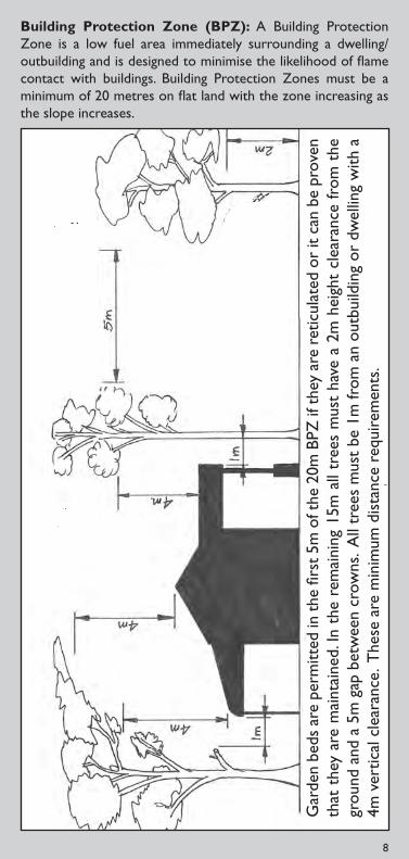
7 8
Building Protection Zone (BPZ): A Building Protection Zone is a low fuel area immediately surrounding a dwelling/outbuilding and is designed to minimise the likelihood of flame contact with buildings. Building Protection Zones must be a minimum of 20 metres on flat land with the zone increasing as the slope increases.
Gar
den
beds
are
per
mitt
ed in
the
firs
t 5m
of t
he 2
0m B
PZ if
the
y ar
e re
ticul
ated
or
it ca
n be
pro
ven
that
the
y ar
e m
aint
aine
d. In
the
rem
aini
ng 1
5m a
ll tr
ees
mus
t ha
ve a
2m
hei
ght
clea
ranc
e fr
om t
he
grou
nd a
nd a
5m
gap
bet
wee
n cr
owns
. All
tree
s m
ust
be 1
m fr
om a
n ou
tbui
ldin
g or
dw
ellin
g w
ith a
4m
ver
tical
cle
aran
ce. T
hese
are
min
imum
dis
tanc
e re
quir
emen
ts.

Compliance Compliance requirements
Fuel Reduction Where your land is under 4000 square metres: All hazardous material is to be removed from the land excluding living plants and trees.
Clearance around Dwellings and Outbuildings
No clearance required.
Vacant land – Cleared blocks
Where you have a vacant block that has been cleared: Grasses are to be slashed, mowed or by other means, maintained below 10cm throughout the period of 22 November until 12 May inclusive.
Vacant land – Timbered or Bush Block
Where you have a vacant block that is timbered or bush: Hazardous material is to be removed from the land excluding living plants and trees. This includes dead branches, trees, leaf litter, twigs and bark to an acceptable standard.
Garden refuse and or wood stacks/piles
1 metre clearance is required around all piles of garden refuse and or wood.
Please note: If your block is 4000 sqm or greater, please refer to Page 13.
The townsites of: Augusta, Margaret River, Witchcliffe, Rosabrook and Cowaramup.
Compliance Date: 22 November through to 12 May inclusive each and every year.
YOUR LEGAL REQUIREMENTS ARE:
9 10

Compliance Compliance requirements
Clearance around Dwellings and Outbuildings
(Example Page 8)
1 metre horizontal and 4 metre vertical clearance around all dwellings and outbuildings. These include, sheds, garages, water tanks, storage containers etc. Garden beds are allowed within this area if they are reticulated and maintained.
Building Protection Zone – 5 metres around all dwellings
Area to be free from garden beds, shrubs, plants and grasses, unless it can be demonstrated to be reticulated and/or regularly maintained. Remainder of your property to be kept to low fuel standards.
Building Protection Zone – 5-20 metres around all dwellings
Hazardous material is to be removed excluding living plants and trees. This includes dead branches, trees, leaf litter, twigs and bark to an acceptable standard of no more than 5cm in depth.
Vacant land – Cleared blocks
Where you have a vacant block that has been cleared: Grasses are to be slashed, mowed or by other means, maintained below 10cm throughout the period of 22 November until 12 May inclusive.
Vacant land – Timbered or Bush Block
Where you have a vacant block that is timbered or bush: Hazardous material is to be removed from the land excluding living plants and trees. This includes dead branches, trees, leaf litter, twigs and bark to an acceptable standard.
Garden refuse and or wood stacks/piles
2 metre clearance is required around all piles of garden refuse and or wood.
Mineral Earth Firebreaks
Where undeveloped land abutts developed land a 2 metre wide firebreak is required on the undeveloped land.
YOUR LEGAL REQUIREMENTS ARE:Compliance Date: 22 November through to 12 May inclusive each
and every year.
The townsites of: Gnarabup, Prevelly and Light Industrial.
9 10

Compliance Compliance requirements
All subdivisions with Fire Management Plans/ and or Variations to Firebreak
Properties to comply with Fire Management Plans, approved Variation to Firebreak and this Firebreak Notice.If in doubt consult this Notice.
Clearance around Dwellings and Outbuildings
(Example Page 8)
1 metre horizontal and 4 metre vertical clearance around all dwellings and outbuildings. These include sheds, garages, water tanks, storage containers etc. Garden beds are allowed within this area if they are reticulated and maintained.
Building Protection Zone – 5 metres around all dwellings
Area to be free from garden beds, shrubs, plants and grasses, unless it can be demonstrated to be reticulated and/or regularly maintained. Remainder of your property to be kept to low fuel standards.
Building Protection Zone – 5-20 metres around all dwellings
Hazardous material is to be removed excluding living plants and trees. This includes dead branches, trees, leaf litter, twigs and bark to an acceptable standard of no more than 5cm in depth.
Vacant land – Cleared blocks
Where you have a vacant block that has been cleared: Grasses are to be slashed, mowed or by other means, maintained below 10cm throughout the period of 22 November until 12 May inclusive.
Vacant land – Timbered or Bush Block
Where you have a vacant block that is timbered or bush: Hazardous material is to be removed from the land excluding living plants and trees. This includes dead branches, trees, leaf litter, twigs and bark to an acceptable standard.
Garden refuse and or wood stacks/piles
A 2 metre clearance is required around all piles of garden refuse and or wood.
YOUR LEGAL REQUIREMENTS ARE:Compliance Date: 22 November through to 12 May inclusive each
and every year.
The townsites of: Gracetown, Parkwater, and Ironstone.
11 12

Compliance Compliance requirements
Clearance around Dwellings and Outbuildings
(Example Page 8)
1 metre horizontal and 4 metre vertical clearance around all dwellings and outbuildings. These include sheds, garages, water tanks, storage containers etc.Please note this includes overhanging branches and or trees. Garden beds are allowed within this area if they are reticulated and maintained.
Building Protection Zone – 5 metres around all dwellings
Area to be free from garden beds, shrubs, plants and grasses, unless it can be demonstrated to be reticulated and/or regularly maintained. Remainder of your property to be kept to low fuel standards.
Vacant land – Timbered or Bush Block
Where you have a vacant block that is timbered or bush: Hazardous material is to be removed from the land excluding living plants and trees. This includes dead branches, trees, leaf litter, twigs and bark to an acceptable standard. Grasses are to be slashed, mowed or by other means, maintained below 10cm throughout the period of 22 November until 12 May inclusive.
Garden refuse and or wood stacks/piles
A 2 metre clearance is required around all piles of garden refuse and or wood.
YOUR LEGAL REQUIREMENTS ARE:Compliance Date: 22 November through to 12 May inclusive each
and every year.
The townsite of: Molloy Island
11 12

Compliance Compliance requirements
All subdivisions with Fire Management Plans and/or Variations to Firebreak
Properties to comply with Approved Fire Management Plans, approved Variation to Firebreaks, and this Notice.
Mineral Earth Firebreaks
Minimum 2 metre firebreak immediately inside all boundaries (can be extended to within 6 metres of a boundary) or as stated in your approved Fire Management Plan.
Clearance around Dwellings and Outbuildings
(Example Page 8)
1 metre horizontal and 4 metres vertical clearance around all dwellings and outbuildings. These include sheds, garages, water tanks, storage containers etc. Garden beds are allowed within this area if they are reticulated and maintained.
Building Protection Zone – 5 metres around all dwellings
Area to be free from garden beds, shrubs, plants and grasses, unless it can be demonstrated to be reticulated and/or regularly maintained.
Building Protection Zone – 5-20 metres around all dwellings
Hazardous material is to be removed excluding living plants and trees. This includes dead branches, trees, leaf litter, twigs and bark to an acceptable standard of no more than 5cm in depth.
Hazard Separation Zone
Low fuel area (up to 5cm in depth) up to a distance of 100 metres between the buildings and the hazard if land is available.
Ungrazed Pastureland
To be slashed or mowed and maintained to 10cm or less throughout the period of 22 December until 12 May inclusive.
Garden refuse and or wood stacks/piles
A 2 metre clearance is required around all piles of garden refuse and or wood.
Fuel storage & haystack protection zone
Construct a 2 metre firebreak not closer than 6 metres around haystacks, and immediately around fuel storage tanks or gas cylinders.
Compliance Date: 22 December through to 12 May inclusive each and every year.
YOUR LEGAL REQUIREMENTS ARE:
East Augusta, Rural Residential and all Residential lots 4000sqm or greater.
13 14

Compliance Compliance requirements
All subdivisions with Fire Management Plans and/or Variations to Firebreaks
All properties to comply with Approved Fire Management Plans, Approved Variation to Firebreaks and this Notice.
Clearance around Dwellings and Outbuildings
(Example Page 8)
1 metre horizontal and 4 metre vertical clearance around all dwellings and outbuildings. These include sheds, garages, water tanks, storage containers etc. Garden beds are allowed within this area if they are reticulated and maintained.
Building Protection Zone – 5 metres around all dwellings
Area to be free from garden beds, shrubs, plants and grasses, unless it can be demonstrated to be reticulated and/or regularly maintained.
Building Protection Zone – 5-20 metres around all dwellings
Hazardous material is to be removed excluding living plants and trees. This includes dead branches, trees, leaf litter, twigs and bark to an acceptable standard of no more than 5cm in depth.
Hazard Separation Zone
Low fuel area (up to 5cm in depth) up to a distance of 100 metres between the buildings and the hazard if land is available.
Garden refuse and or wood stacks/piles
2 metre clearance is required around all piles of garden refuse and or wood.
Mineral Earth Firebreaks
Minimum 2 metre firebreak within 100 metres of a boundary abutting a road reserve.
Fuel storage & haystack protection zone
Construct a 2 metre firebreak not closer than 6 metres around haystacks, and immediately around fuel storage tanks or gas cylinders.
Compliance Date: 22 December through to 12 May inclusive each and every year.
YOUR LEGAL REQUIREMENTS ARE:
Rural
13 14

Compliance Compliance requirements
All subdivisions with Fire Management Plans and/or Variations to Firebreaks
All properties to comply with Approved Fire Management Plans, Approved Variation to Firebreaks and this Notice.
Clearance around Dwellings and Outbuildings
(Example Page 8)
1 metre horizontal and 4 metre vertical clearance around all dwellings and outbuildings. These include, sheds, garages, water tanks, storage containers etc. Garden beds are allowed within this area if they are reticulated and maintained.
Building Protection Zone – 5 metres around all dwellings
Area to be free from garden beds, shrubs, plants and grasses, unless it can be demonstrated to be reticulated and/or regularly maintained.
Building Protection Zone – 5-20 metres around all dwellings
Hazardous material is to be removed excluding living plants and trees. This includes dead branches, trees, leaf litter, twigs and bark to an acceptable standard of no more than 5cm in depth.
Hazard Separation Zone
Low fuel area (up to 5cm in depth) up to a distance of 100 metres between the buildings and the hazard if land is available.
Mineral earth firebreak (plantings)
5 metre wide firebreak around vineyards and 10 metre wide firebreak around plantations. Each cell or block is required to have its own firebreak.
Mineral earth firebreak
2 metre firebreak within 100 metres of a boundary abutting a road reserve.
Garden refuse and or wood stack’s/piles
2 metre firebreak is required around all piles of garden refuse and or wood.
Compliance Date: 22 December through to 12 May inclusive each and every year.
YOUR LEGAL REQUIREMENTS ARE:
Vineyards and Plantations (including Vineyard Tourist Chalets)
15 16
Bur
n p
erio
dD
ates
Gra
ss p
addo
ck,
bonfi
re, b
ush
Woo
d an
d so
lid
fuel
BB
Q1c
ubic
met
re G
arde
n R
efus
e 6p
m t
o 11
pm
Star
tFi
nish
RE
ST
RIC
TE
D9
Nov
embe
r21
Dec
embe
r (m
idni
ght)
Yes
Cond
ition
s ap
ply.
See
Page
s 2
and
17.
Yes
Cond
ition
s ap
ply.
Page
s 2
and
17.
Yes
Cond
ition
s ap
ply.
Page
s 2
and
17.
PR
OH
IBIT
ED
22 D
ecem
ber
28 F
ebru
ary
(mid
nigh
t) N
O
NO
N
O
RE
ST
RIC
TE
D1
Mar
ch12
May
(mid
nigh
t)
Yes
Cond
ition
s ap
ply.
Page
s 2
and
17.
Yes
Cond
ition
s ap
ply.
Page
s 2
and
17.
Yes
Cond
ition
s ap
ply.
Page
s 2
and
17.
15 16
*Dat
es s
ubje
ct to
cha
nges
, ple
ase
refe
r to
Pag
e 17
or
ww
w.a
mrs
hire
.wa.
gov.a
u
WHAT AND WHEN CAN I BURN?

BURNING INFORMATIONPlease note: On any day during the restricted burning period where the fire danger rating is Catastrophic, Severe, Extreme and Very High, garden refuse, wood, solid fuel barbecues or webbers are NOT permitted to be used under any circumstances. Permits are automatically cancelled on these days. Due to unseasonable weather conditions these dates may be extended or shortened.You must check the local newspaper, call the Shire on 9780 5255 or visit www.amrshire.wa.gov.au for further information. The fire danger rating can be found by calling the weather information line 1196.
WHAT CAN I BE FINED IF I DON’T COMPLY?
Failure to comply with this Notice $5000
Offences relating to lighting fires in open air $3000
Setting fire to the bush during prohibited burning times
$250 000And 14 years imprisonment
Failure of occupier to extinguish bush fire $10 000
Refusal to state name and abode or stating false name or abode
$1000
Failure to produce a Permit To Burn $1000 FIRE PERMITS
Before you call a Fire Control Officer ensure you have the following information
Who will be the three able bodied persons in attendance •at all times whilst the fire is alight including contact phone number?What is the address of the property for which the permit •applies?What fire-fighting equipment and resources will you have •at the fire and is it in good working order?What is the size of the burn to take place?•Are there firebreaks installed and can a fire unit get access •to the area?What material are you burning? Is it dry? Is there any •plastic, tyres, treated posts or woods in the piles or area to be burnt? Is so, remove them to a safe place.Ensure you give 72 hours notice to the Fire Control •Officer first and then;Ensure you notify neighbours 72 hours prior to •commencing your burn.
NB: for further information contact the Shire on 9780 5255.
17 18

HAZARD REDUCTION PROGRAMAutumn to Winter (May – August)
Tree pruning – remove lower branches, check that power •lines are clear. Use a professional contractor;Reduce fuel levels around the house, clear long grass, leaves, •twigs and flammable shrubs;Ensure petrol and other flammables are safely stored away •from the main dwelling;Make sure your fire-fighting equipment is in good working •order and serviced when required;Accommodation providers must make sure all guests are •aware of emergency plan, including evacuation routes.
Spring (September – November)Move wood piles and stack timber away from the main dwelling;•Keep grass short;•Install firebreaks in accordance with this Firebreak and Fuel •Hazard Reduction Notice, your approved variation to this Notice or your approved Fire Management Plan.
Summer (November – May)Water lawns, trees and shrubs near buildings to keep •green;Recheck fire-fighting equipment, screens, water supplies •and that gutters remain clear.
Long term precautionsEnsure firebreaks are prepared in accordance with the •latest Firebreak and Fuel Hazard Reduction Notice or any submitted and approved variation to this Notice or Fire Management Plan endorsed by Council;Ensure that the planting of windbreaks or trees is in •accordance with this Notice and will not be detrimental to fire suppression requirements in years to come;Make sure that buildings are safe – fit wire fly screens and •shutters, fill gaps into roof/wall spaces, fit fire screens to evaporative air conditioners and have them operable to provide a water supply;Give consideration to installing external building sprinkler •systems and back up power for emergencies;Ensure that access to emergency water supplies has the •correct fittings, is unobstructed and trafficable;Get basic training in fire-fighting from your local bushfire •brigade or even join your local brigade;Join or start a Bushfire Ready Group (BRG).•
17 18

VARIATION GUIDELINES
The following guidelines are acceptable categories for which a variation to firebreak may be applied for:
The topography makes the normal placement of a firebreak 1. impracticable or dangerous and alternative firebreak emergency access and fire prevention methods that meet the intention of this Notice is provided and demonstrated
The topography/composition makes the normal methods 2. of construction impracticable (cap stone, rocky or water logged) and alternative firebreak emergency access and fire prevention methods that meet the intention of this Notice is provided and demonstrated
An approved Fire Management Plan for the property is in 3. place and being conformed to and meets the intention of this Notice
The firebreak variation only applies to a portion of the 4. property that is reticulated lawn that is kept green and it can be demonstrated that it is maintained regularly to less than 10cm as per important dates on Page 2
The variation only applies to the portion of the property that 5. has reticulated garden beds, lawns, orchards or other accepted sustained cultivation. Unless it is deemed by Council or its authorised officer that the fuel type/loadings are a hazard
Cleared access provided to enable emergency vehicular 6. access to buildings and outbuildings and all parts of the property in accordance with this Notice
Firebreaks are provided in agreed alternative locations to 7. negate natural obstructions
Constructed driveways may where authorised substitute for 8. firebreaks as long as it remains trafficable for the firebreak as a whole and is maintained clear of all flammable materials at all times in accordance with this Notice
Where clearing for fire management is likely to impact 9. vegetation within creekline riparian areas. These areas are recognised as Landscape Protection Areas in the Local Planning Scheme No.1 and include a 20 metre protection zone around watercourses
Where clearing is likely to impact upon areas of Declared 10. Rare Flora, Threatened Ecological Communities or Environmentally Sensitive Areas as defined under the Environmental Protection (Clearing of Native Vegetation) Regulations 2004
19 20

All requests must be made by the property owner or person authorised to act upon the owners behalf. Individual requests are required for each property and must be submitted on the approved document/application form by November 14. Please note variation approvals do not carry over into the following year’s fire season.
The authorising officer has the right to grant, refuse, alter or add any conditions to an application, where alterations or additions are applicable. Failure to comply within the time frames provided by the authorised officer will result in the refusal of the application and prosecution as if a firebreak/hazard reduction works had not been installed/conducted in accordance with this Notice.
Where refusal of an application takes place the owner has fourteen (14) days in which to conform to the normal requirements of this Notice.
Please note: You must have your variation in place and operational as per important dates on Page 2. It is your responsibility to demonstrate that the variation will be maintained for the entire restricted and prohibited burning times. Failure to demonstrate compliance and the ability to maintain the alternative solutions approved with in the variation will automatically require total compliance with this Notice in its entirety.
19 20
ADDITIONAL INFORMATIONEmergency access ways: These are for Emergency Services vehicles only and are not to be considered as a firebreak or escape route.
Trees - live/standing trees: Council does not expect you to remove large trees from or adjacent to boundaries so as to install the firebreak. The firebreak can simply detour around the tree/trees so as to afford safe access. This procedure does not require a Variation to Firebreak Order as long as the normal dimensions of the firebreak exist.
Roads, verges, bridle paths, footpaths, dual use access ways and reserves: None of the above can be classified as a firebreak for your property. Firebreaks must be on your own property to conform to this Notice. However, any additional fire prevention activities on verges etc, can be completed on application to Council in writing and approval received. Removal of indigenous and substantive trees/vegetation requires Council approval.

21 22
Bush Fires Act 1954 (as amended)
Land Owner Details
Surname
Other Names
Postal Address
Property Address
Phone Number
Hereby make application to vary the requirements of the Shire of Augusta-Margaret River Firebreak & Fuel Hazard Reduction Notice 2012-2013, as follows:
Signed (applicant): Date:
Signed (Area Fire Control Officer):
Date:
Signed (Shire Fire Control Officer):
Date:
APPLICATION FOR VARIATION TO THE FUEL HAZARD REDUCTION & FIREBREAK NOTICE
This form can be downloaded from www.amrshire.wa.gov.au

21 22
SO TAKE ACTION NOWHave a bush fire action plan•
Follow the hazard reduction program •diary
Have an evacuation plan•
Stay safe•
To access further information regarding FESA’s “Prepare. Act. Survive” strategy, please visit
www.fesa.wa.gov.au or call 9323 9300

TO REPORT ANY FIRE
DIAL 000
Margaret River Civic Centre41 Wallcliffe Rd, Margaret River
PO Box 61, Margaret River 6285P: 9780 5255, F: 9757 2512
www.amrshire.wa.gov.au
KEY CONTACTS
RangersRangers Coordinator 0439 951 907Peter Fagan 0419 902 540Belinda Biddle 0419 951 907Alison Scott 0448 029 632
Chief Bush Fire Control Officer Rob Bootsma 0419 525 843
Deputy Chief Bush Fire Control Officer David Holland 0419 628 465
FESA Emergency Info Line 1300 657 209

Appendix 4
AFAC bush fire glossary

BUSHFIRE GLOSSARY
Prepared by Rural and Land Management Group for
AFAC Agencies
January 2012

Disclaimer
While all possible care has been taken to ensure a comprehensive and accurate
publication, the Australasian Fire Authorities Council and its servants or agents
shall not be liable for technical or editorial errors contained herein or omissions
there from; nor for incidental or consequential liability in any way resulting from
the information or advice that is contained in this publication or use of that
material.
Copyright 2010 Australasian Fire Authorities Council
All rights reserved. Except under the conditions described in the Copyright Act
1968 of Australia and subsequent amendments, no part of this publication may
be reproduced, stored in a retrieval system or transmitted in any form or by any
means, electronic, mechanical, photocopying, recording or otherwise, without
the prior permission of the copyright owner.
January 2012
AFAC Limited (ABN 52 060 049 327)
Level 5, 340 Albert Street
East Melbourne Victoria 3002
Telephone: 03 9419 2388
Facsimile: 03 9419 2389
Email: [email protected]
Internet: http://www.afac.com.au http://knowledgeweb.afac.com.au/

Preface
The AFAC Bushfire Glossary has been developed to promote an exchange of information between
member agencies on terminology used specifically in bushfires.
The Glossary has been developed based on a set of agreed business rules. It includes the bushfire
technical terms, their definition or description as adopted and applied by the AFAC member agencies. It
does include some fire terms that are of a general industry wide nature for completeness. It excludes
terms for which an agreed definition could not be reached by the member agencies.
This document is not designed to be a text book or to provide a discussion of a term beyond the
definition/description of that term. Nor is it an attempt to modify or redefine terms defined in codes,
standards or legislation. Terms that have been adopted for use by the fire management industry from
another discipline will maintain the meaning ascribed to them in their originating discipline.
It is proposed that this Glossary will be reviewed regularly to ensure that it continues to be relevant and
meets the needs of AFAC member agencies. This is the fifth review. It is the current 2012 version.
AFAC acknowledges the significant contribution of the Rural and Land Management Glossary Working
Group lead by Greg Esnouf and Country Fire Authority staff, Matthew Fraser and Jo Richards, who
contributed generously of their time and expertise in the establishment of this document and the work
of the Genesis Institute to provide a framework for refining the glossary.
Previous versions of the Glossary were titled Wildfire Glossary. The term wildfire has been replaced
with the term bushfire in line with a trend towards using language more accepted by the general
public.
The terms appear in alphabetical order excluding spaces. In this way it is possible to find a compound
word without knowing if it is one or two words.
Aim The purpose of this Glossary is to seek to facilitate a greater understanding by using common language
between bushfire and land management agencies and support organisations during the prevention of,
preparedness for, response to and recovery from bushfires.

Index
Accelerant ................................................................... 1
Adaptor ....................................................................... 1
Adsorption ................................................................... 1
Advance burn .............................................................. 1
Advancing fire ............................................................. 1
Aerial detection ........................................................... 1
Aerial fuel .................................................................... 1
Aerial ignition .............................................................. 1
Aerial ignition device (AID) .......................................... 1
Aerial Observer ........................................................... 1
Aerial reconnaissance ................................................. 1
Aerosol ........................................................................ 1
After action review (AAR) ............................................ 1
AIIMS structure ........................................................... 1
Air attack ..................................................................... 1
Air attack Supervisor ................................................... 1
Air base Manager ........................................................ 1
Air mass ....................................................................... 1
Air Observer ................................................................ 1
Air operations .............................................................. 1
Air operations Manager .............................................. 2
Aircraft Officer............................................................. 2
Airside ......................................................................... 2
Allocated resources ..................................................... 2
Anchor point................................................................ 2
Aqueous film forming-foam (AFFF) ............................. 2
Area ignition ................................................................ 2
Area of origin ............................................................... 2
Arson ........................................................................... 2
Aspect .......................................................................... 2
Asphyxiants ................................................................. 2
Assembly area ............................................................. 2
Assessment ................................................................. 2
Assets .......................................................................... 2
Assisting agency .......................................................... 2
Atmospheric stability .................................................. 2
Attack time .................................................................. 2
Australasian Inter-service Incident Management
System (AIIMS) ............................................................ 2
Automatic dispatch ..................................................... 2
Automatic weather station (AWS) .............................. 2
Available fuel ............................................................... 2
Available resources ..................................................... 2
Backburn ..................................................................... 3
Back fire ....................................................................... 3
Backing fire .................................................................. 3
Bark fuel ...................................................................... 3
Bark heaps ................................................................... 3
Basal accumulation ..................................................... 3
Base camp ................................................................... 3
Bay(s) ........................................................................... 3
Beaufort wind scale ..................................................... 3
Blacking out ................................................................. 3
Blackspot ..................................................................... 3
Blank cap ..................................................................... 3
Blow down................................................................... 3
Blow up ....................................................................... 3
Bole ............................................................................. 3
Bole damage ............................................................... 3
Bracken ....................................................................... 3
Branch ......................................................................... 3
Breakaway .................................................................. 3
Breeching .................................................................... 4
Briefing ........................................................................ 4
Broad area hazard reduction ...................................... 4
Broadcast burning ....................................................... 4
Buffer .......................................................................... 4
Bulk water carrier ....................................................... 4
Burn back .................................................................... 4
Burning brands............................................................ 4
Burning conditions ...................................................... 4
Burning off .................................................................. 4
Burning out ................................................................. 4
Burning program ......................................................... 4
Burning rotation ......................................................... 4
Burning unit ................................................................ 4
Burn out ...................................................................... 4
Burn over .................................................................... 4
Burn plan..................................................................... 4
Bushfire ....................................................................... 4
Bushfire danger period ............................................... 4
Bushfire management ................................................ 4
Byram-Keetch Drought index (BKDI) ........................... 4
Cache .......................................................................... 4
Campaign fire .............................................................. 4
Candle (Candling) ........................................................ 5
Candlebark .................................................................. 5
Canopy ........................................................................ 5
Canopy cover .............................................................. 5
Canopy density ........................................................... 5
Catastrophic fire danger ............................................. 5
Central ignition ........................................................... 5
Chaining ...................................................................... 5
Charged line ................................................................ 5
CIMS ............................................................................ 5
Class A foam ................................................................ 5
Class labels .................................................................. 5
Climate ........................................................................ 5
Clinometer .................................................................. 5
Cloud cover ................................................................. 5
Coarse fuels ................................................................ 5
Code of Practice .......................................................... 5
Cold front .................................................................... 5
Cold trailing ................................................................. 5
Collecting head ........................................................... 5
Combat agency/authority ........................................... 5
Combustion ................................................................. 5
Command ................................................................... 6
Communications plan ................................................. 6
Compartment ............................................................. 6
Competency ................................................................ 6
Conduction.................................................................. 6
Contained.................................................................... 6
Contour lines ............................................................... 6
Control ........................................................................ 6
Control authority ........................................................ 6

Controlled.................................................................... 6
Controlled burning ...................................................... 6
Control line .................................................................. 6
Convection .................................................................. 6
Convection burn .......................................................... 6
Convection column ..................................................... 6
Convective activity ...................................................... 6
Convergence zone ....................................................... 6
Convoy ......................................................................... 6
Coordination ............................................................... 7
Cordon ......................................................................... 7
Coupe .......................................................................... 7
Crew ............................................................................ 7
Crew leader ................................................................. 7
Critical burnout time ................................................... 7
Critical incident stress ................................................. 7
Critical incident stress debriefing ................................ 7
Cross bearings ............................................................. 7
Crown fire .................................................................... 7
Crown scorch ............................................................... 7
Crowning ..................................................................... 7
Crowning potential ...................................................... 7
Curing .......................................................................... 7
Dead fuel ..................................................................... 7
Debrief......................................................................... 7
Deep-seated fire .......................................................... 7
Defensive strategy ....................................................... 7
Dehydration ................................................................ 7
Delayed aerial ignition devices (DAID) ........................ 7
Deliberate fire ............................................................. 8
Delivery hose ............................................................... 8
Delivery valve .............................................................. 8
Demobilisation ............................................................ 8
Depth of burn .............................................................. 8
Desiccant ..................................................................... 8
Desorption ................................................................... 8
Detection ..................................................................... 8
Dew ............................................................................. 8
Dew point temperature .............................................. 8
Dieback ........................................................................ 8
Diffused pattern .......................................................... 8
Direct attack ................................................................ 8
Dispatch....................................................................... 8
Division ........................................................................ 8
Dominant height ......................................................... 8
Downwind ................................................................... 8
Dozer ........................................................................... 8
Dozer line .................................................................... 8
Drain time.................................................................... 8
Drift ............................................................................. 8
Drip torch .................................................................... 8
Drop pass..................................................................... 9
Drop pattern................................................................ 9
Drop zone (DZ) ............................................................ 9
Drought ....................................................................... 9
Drought index .............................................................. 9
Dry bulb temperature ................................................. 9
Dry firefighting ............................................................ 9
Duff .............................................................................. 9
Ecological burning ....................................................... 9
Edge burning ............................................................... 9
Elevated fuel ............................................................... 9
Embers ........................................................................ 9
Emergency centre ....................................................... 9
En route resources ...................................................... 9
Entrapment ................................................................. 9
Equilibrium moisture content (EMC) .......................... 9
Equipment .................................................................. 9
Escape route ............................................................... 9
Evacuation .................................................................. 9
Exposures .................................................................. 10
Extinguishing agent ................................................... 10
Extreme fire behaviour ............................................. 10
Extreme fire danger .................................................. 10
Facilities .................................................................... 10
Fall back fire control line ........................................... 10
Fine fuel .................................................................... 10
Fingers ...................................................................... 10
Fire ............................................................................ 10
Fire access track ........................................................ 10
Fire behaviour ........................................................... 10
Fire Behaviour Analyst .............................................. 10
Fire behaviour model ................................................ 10
Fire behaviour prediction ......................................... 10
Fire behaviour prediction system ............................. 10
Fire bombing ............................................................. 11
Fire brand .................................................................. 11
Fire climate ............................................................... 11
Fire control................................................................ 11
Fire control agent ..................................................... 11
Fire control line ......................................................... 11
Fire crew ................................................................... 11
Fire danger ................................................................ 11
Fire danger class ....................................................... 11
Fire danger index (FDI) .............................................. 11
Fire danger rating ..................................................... 11
Fire ecology ............................................................... 11
Fire edge ................................................................... 11
Fire effects ................................................................ 11
Fire environment ...................................................... 11
Firefighter ................................................................. 11
Firefighting operations ............................................. 11
Fire frequency ........................................................... 11
Fire front ................................................................... 11
Fireground ................................................................ 11
Fire hazard ................................................................ 12
Fire intensity ............................................................. 12
Fireline ...................................................................... 12
Fireline intensity ....................................................... 12
Fire lookout ............................................................... 12
Fire management ...................................................... 12
Fire potential ............................................................ 12
Fire preparedness ..................................................... 12
Fire prevention ......................................................... 12
Fire regime ................................................................ 12
Fire report ................................................................. 12
Fire retardant ............................................................ 12
Fire risk ..................................................................... 12
Fire run ...................................................................... 12
Fire scar ..................................................................... 12

Fire season ................................................................ 12
Fire simulator ............................................................ 12
Fire spread ................................................................. 12
Fire storm .................................................................. 13
Fire suppressant ........................................................ 13
Fire suppression ........................................................ 13
Fire suppression organisation ................................... 13
Fire suppression plan ................................................ 13
Fire tetrahedron ........................................................ 13
Fire threat.................................................................. 13
Fire tower .................................................................. 13
Fire training simulator ............................................... 13
Fire triangle ............................................................... 13
Fire weather .............................................................. 13
Fire weather forecast ................................................ 13
Fire whirl ................................................................... 13
Fire wind .................................................................... 13
First attack ................................................................. 13
Fixed wing aircraft ..................................................... 13
Flame angle ............................................................... 13
Flame depth .............................................................. 13
Flame height .............................................................. 14
Flame length .............................................................. 14
Flame Zone ................................................................ 14
Flame zone ................................................................ 14
Flaming zone ............................................................. 14
Flammability .............................................................. 14
Flammable ................................................................. 14
Flank attack ............................................................... 14
Flanks of a fire ........................................................... 14
Flare up ..................................................................... 14
Flash fire .................................................................... 14
Foam.......................................................................... 14
Foam blanket ............................................................. 14
Foam Class A ............................................................. 14
Foam Class B .............................................................. 14
Foam concentrate ..................................................... 14
Foam inductor ........................................................... 14
Foam solution ............................................................ 14
Forest ........................................................................ 14
Forest fire .................................................................. 14
Forest type ................................................................ 14
Forward looking infrared (FLIR) ................................. 15
Forward rate of spread (FROS) .................................. 15
Frontal fire intensity .................................................. 15
Front end loader........................................................ 15
Fuel ............................................................................ 15
Fuel age ..................................................................... 15
Fuel arrangement ...................................................... 15
Fuel array .................................................................. 15
Fuel assessment ........................................................ 15
Fuel bed depth .......................................................... 15
Fuelbreak ................................................................... 15
Fuelbreak system ...................................................... 15
Fuel continuity........................................................... 15
Fuel depth ................................................................. 15
Fuel load .................................................................... 15
Fuel management ..................................................... 15
Fuel map .................................................................... 15
Fuel model ................................................................. 15
Fuel modification ...................................................... 15
Fuel moisture content .............................................. 15
Fuel moisture differential ......................................... 16
Fuel profile ................................................................ 16
Fuel quantity ............................................................. 16
Fuel reduction ........................................................... 16
Fuel reduction burning ............................................. 16
Fuel separation ......................................................... 16
Fuel type ................................................................... 16
Fuel weight ............................................................... 16
General origin area ................................................... 16
Going fire .................................................................. 16
Grass fire ................................................................... 16
Grassland curing ....................................................... 16
Grid ignition .............................................................. 16
Ground crew ............................................................. 16
Ground fire ............................................................... 16
Ground fuel ............................................................... 16
Habitat ...................................................................... 16
Hand crew ................................................................. 16
Hand line ................................................................... 16
Hand trail .................................................................. 16
Hang up ..................................................................... 16
Hazard ....................................................................... 16
Hazard reduction ...................................................... 16
Head .......................................................................... 16
Head attack ............................................................... 16
Head fire ................................................................... 16
Heat exhaustion ........................................................ 17
Heat stress ................................................................ 17
Heat stroke ............................................................... 17
Heat transfer ............................................................. 17
Heavy fuels................................................................ 17
Heel ........................................................................... 17
Heel fire .................................................................... 17
Helibase (HB) ............................................................ 17
Helicopter ................................................................. 17
Helipad (HP) .............................................................. 17
Helitack crew ............................................................ 17
Heli-torch .................................................................. 17
High fire danger ........................................................ 17
High intensity fire...................................................... 17
Hold over fire ............................................................ 17
Hop over ................................................................... 17
Hose bandage ........................................................... 17
Hose strangler ........................................................... 17
Hot Refueller ............................................................. 17
Hot spot .................................................................... 17
Humus ....................................................................... 17
Hygrometer ............................................................... 17
Ignition ...................................................................... 17
Ignition pattern ......................................................... 18
Ignition source .......................................................... 18
Incendiary ................................................................. 18
Incendiary device ...................................................... 18
Incident ..................................................................... 18
Incident Action Plan (IAP) ......................................... 18
Incident control ........................................................ 18
Incident Control Centre (ICC) .................................... 18
Incident Controller .................................................... 18
Incident Control Point (ICP) ....................................... 18
Incident control system (ICS) .................................... 18
Incident management ............................................... 18
Incident Management Team (IMT) ........................... 18
Incident objective ...................................................... 18
Incident strategies ..................................................... 18
Indirect attack ........................................................... 18
Induced wind ............................................................. 18
Infrared scanning ...................................................... 18
Initial attack ............................................................... 18
Instability ................................................................... 19
Interface .................................................................... 19
Inversion .................................................................... 19
Island ......................................................................... 19
Isobar......................................................................... 19
I zone ......................................................................... 19
Jump fire.................................................................... 19
Jump over .................................................................. 19
Junction zone ............................................................ 19
Keetch-Byram Drought Index (KBDI) ......................... 19
Knock down ............................................................... 19
Ladder fuels ............................................................... 19
Lag time ..................................................................... 19
Lead agency ............................................................... 19
Lee (leeward)............................................................. 19
Legislation ................................................................. 19
Light fuel .................................................................... 19
Lighting pattern ......................................................... 19
Lightning .................................................................... 19
Lightning fire ............................................................. 19
Lightning formation ................................................... 19
Light patrol unit ......................................................... 19
Line ignition ............................................................... 19
Litter .......................................................................... 20
Litter bed fuel ............................................................ 20
Litter fall .................................................................... 20
Living fuels ................................................................. 20
Living shrub fuel ........................................................ 20
Local winds ................................................................ 20
Log ............................................................................. 20
Logistics ..................................................................... 20
Lookout ..................................................................... 20
Lookout tower ........................................................... 20
Low intensity fire ....................................................... 20
Low-moderate fire danger ........................................ 20
Medium fuels ............................................................ 20
Mineral earth ............................................................ 20
Mobilisation .............................................................. 20
Moisture content ...................................................... 20
Mopping up ............................................................... 20
Mosaic ....................................................................... 20
Move up method ....................................................... 20
Multi-agency response .............................................. 20
Natural barrier........................................................... 20
Near surface fuel ....................................................... 21
Needle bed ................................................................ 21
Nozzle ........................................................................ 21
One lick method ........................................................ 21
Operations ................................................................. 21
Operations point ....................................................... 21
Parallel attack ........................................................... 21
Parallel fire suppression............................................ 21
Parallel method......................................................... 21
Parts of a Fire ............................................................ 21
Patch burning ............................................................ 21
Patrol ........................................................................ 21
Peat ........................................................................... 21
Perimeter .................................................................. 21
Peri urban interface .................................................. 21
Permit burn ............................................................... 21
Personal protection equipment (PPE) ...................... 21
Personal protective clothing (PPC) ........................... 21
Plan of attack ............................................................ 21
Planned burning ........................................................ 21
Pocket ....................................................................... 21
Point of attack ........................................................... 22
Point of origin ........................................................... 22
Portable dam ............................................................ 22
Predicted rate of spread ........................................... 22
Pre-incident plan....................................................... 22
Pre-suppression plan ................................................ 22
Prepared community ................................................ 22
Preparedness ............................................................ 22
Pre-planned dispatch ................................................ 22
Prescribed burn ........................................................ 22
Prescribed burn plan ................................................. 22
Prescribed burning .................................................... 22
Prescribed fire ........................................................... 22
Prescription ............................................................... 22
Prevention ................................................................ 22
Profile litter moisture content .................................. 22
Profile moisture content ........................................... 22
Psychrometer ............................................................ 22
Pulaski tool ................................................................ 22
Pumper ..................................................................... 22
Quick-fill pump ......................................................... 23
Rain gauge ................................................................ 23
Rakehoe (McLeod tool) ............................................. 23
Rate of spread (ROS) ................................................. 23
Reaction time ............................................................ 23
Rear ........................................................................... 23
Reburn ...................................................................... 23
Reconnaissance ........................................................ 23
Recovery ................................................................... 23
Red Flag Warning ...................................................... 23
Regeneration burn .................................................... 23
Re-ignition ................................................................. 23
Relative humidity (RH) .............................................. 23
Relay pumping .......................................................... 23
Relief ......................................................................... 23
Report of fire ............................................................ 23
Residence time ......................................................... 23
Resources .................................................................. 23
Response ................................................................... 23
Response time .......................................................... 23
Responsible authority ............................................... 23
Retardant .................................................................. 23
Risk ............................................................................ 24
Risk analysis .............................................................. 24
Road Management Point .......................................... 24

Rural .......................................................................... 24
Rural urban interface (RUI) ....................................... 24
Safe ............................................................................ 24
Safety zone ................................................................ 24
Scorch height ............................................................. 24
Scout.......................................................................... 24
Scrub ......................................................................... 24
Scrub fire ................................................................... 24
Secondary fire control line ........................................ 24
Sector ........................................................................ 24
Seen area ................................................................... 24
Severe fire danger ..................................................... 24
Shift ........................................................................... 24
Shift change ............................................................... 24
Situation report ......................................................... 24
(Sitrep) ....................................................................... 24
Size up ....................................................................... 24
Slash .......................................................................... 24
Slash burn .................................................................. 25
Sleeper ...................................................................... 25
Slip-on unit ................................................................ 25
Slop over ................................................................... 25
Smoke management ................................................. 25
Smoke Plume ............................................................. 25
Smoker ...................................................................... 25
Softwood ................................................................... 25
Soil Dryness Index (SDI) ............................................. 25
Southern Oscillation Index (SOI) ............................... 25
Spark arrestor ............................................................ 25
Spot fire ..................................................................... 25
Spot ignition .............................................................. 25
Spot over ................................................................... 25
Spotting ..................................................................... 25
Staging area ............................................................... 25
Stand by..................................................................... 25
Static water supply .................................................... 25
Step-up method ........................................................ 25
Strike teams .............................................................. 25
Strip burning .............................................................. 26
Strip ignition .............................................................. 26
Stripping .................................................................... 26
Structure ................................................................... 26
Sub surface fire ......................................................... 26
Sub surface fuel ......................................................... 26
Suction hose .............................................................. 26
Supply hose ............................................................... 26
Support agency ......................................................... 26
Surface fire ................................................................ 26
Surface fuel ............................................................... 26
Surface moisture content ......................................... 26
Tactics ....................................................................... 26
Tail fire ...................................................................... 26
Tanker ....................................................................... 26
Task force .................................................................. 26
Task group ................................................................ 26
Technical advisors ..................................................... 26
Temperature (dry bulb) ............................................ 26
Temperature (wet bulb) ........................................... 26
Test fire ..................................................................... 26
Thermal imagery ....................................................... 26
Thermal radiation ..................................................... 26
Thermohygrograph ................................................... 27
Time lag..................................................................... 27
Tongues..................................................................... 27
Topography ............................................................... 27
Torch ......................................................................... 27
Torching .................................................................... 27
Traffic Management Point ........................................ 27
Travel time ................................................................ 27
Under storey ............................................................. 27
Upwind...................................................................... 27
Urban ........................................................................ 27
Urban interface ......................................................... 27
Urban rural interface (URI) ....................................... 27
Values at risk ............................................................. 27
Vehicle Control Point ................................................ 27
Very high fire danger ................................................ 27
Warning device ......................................................... 27
Water bombing ......................................................... 27
Water point ............................................................... 27
Water tank ................................................................ 27
Wetting agent ........................................................... 27
Widow maker............................................................ 27
Wilderness Area ........................................................ 27
Wildfire ..................................................................... 27
Wildfire control plan ................................................. 27
Wildland urban interface (WUI)................................ 28
Wind direction .......................................................... 28
Windfall ..................................................................... 28
Wind throw ............................................................... 28
Wind speed ............................................................... 28
Wind strength ........................................................... 28
Windrow ................................................................... 28
Windrow burning ...................................................... 28
Windward ................................................................. 28
Woodland ................................................................. 28

Bushfire Glossary
�
Term Definition
Accelerant Any substance (such as oil, gasoline, etc) that is applied to a fuel-bed to expedite
the burning process.
Adaptor A fitting used to couple different sized hoses, hoses of the same size with
different threads, or different types of couplings, or to connect the male to male,
or female to female parts of the same type of coupling.
Adsorption The taking in of water vapour from the air by dead plant material.
Advance burn A prescribed fire that reduces fuel through a forest area before felling
operations. It is intended to improve the safety of timber harvesting operations
and as a silvicultural tool to protect lignotubers and standing trees.
Advancing fire That portion of the fire with rapid fire spread and higher intensity which is
normally burning with the wind and/or up slope.
Aerial detection The discovering, locating and reporting of fires from aircraft.
Aerial fuel See: Elevated fuel
Aerial ignition Ignition of fuels by dropping incendiary devices or materials from aircraft.
Aerial ignition device (AID) Inclusive term applied to equipment designed to ignite wildland fuels from an
aircraft.
Aerial Observer See: Air Observer
Aerial reconnaissance Use of aircraft for detection of fires and observing fire behaviour, values-at-risk,
suppression activity, and other critical factors to facilitate command decisions on
strategy and tactics needed for fire suppression.
Aerosol Airborne solid or liquid particles dispersed or suspended in a gas stream.
After action review (AAR) A discussion, focused on performance standards, of an event that enables those
involved to discover what happened, why it happened, and how to sustain
strengths and improve on weaknesses. An After action review is a tool incident
command personnel and units can use to get maximum benefit from every
incident. It provides a review of the incident upon its completion to identify and
discuss effective and non-effective performance and lessons learned and how to
apply them in the future. (adapted from NWCG)
AIIMS structure The combination of facilities, equipment, personnel, procedures, and
communications operating within a common organisational structure with
responsibility for the management of allocated resources to effectively
accomplish stated objectives relating to an incident (AIIMS).
Air attack The direct use of aircraft in the suppression of bushfires.
Air attack Supervisor Primarily responsible for the safety and efficient tactical coordination of aircraft
operations when fixed and/or rotary firebombing aircraft are operating at a fire
(Air Attack Supervisor Training Manual).
Air base Manager An experienced, trained person who is appointed to manage all the functions and
personnel on an air base or helicopter base.
Air mass A meteorological term referring to an extensive body of air within which the
conditions of temperature and moisture in a horizontal plane are essentially
uniform.
Air Observer The primary role of the air observer is to aerially obtain intelligence to assist the
planning of fire suppression operations (NSWRFS).
Air operations The use of aircraft in support of an incident for the purposes of suppression,
transportation of personnel, equipment or supplies, or for aerial reconnaissance.

Bushfire Glossary
�
Term Definition
Air operations Manager The air operations manager position is responsible for overall coordination of air
operations and air support activities in support of an incident.
Aircraft Officer The aircraft officer is responsible for ground operations and overall provision of
support, enabling a safe and efficient air operation to be conducted.
Airside The parts of an airport not normally open to unauthorised people. It comprises
the apron, taxiways, runways and the areas containing them.
Allocated resources Resources working at an incident (AIIMS).
Anchor point An advantageous location, usually a barrier to fire spread, from which to start
constructing a fireline. The anchor point is used to minimize the chance of being
flanked by the fire while the line is being constructed (NWCG).
Aqueous film forming-foam
(AFFF)
A synthetic amber coloured liquid concentrate mixed with water to form an
agent that is capable of forming water-solution films on the surface of flammable
liquids that prevent the escape of fuel vapours, excludes oxygen and maintain
the surface when disturbed (self healing).
Area ignition Ignition of several individual fires throughout an area, either simultaneously or in
rapid succession, and so spaced that they add to and influence the main body of
the fire to produce a hot, fast-spreading fire condition. Also called simultaneous
ignition.
Area of origin General location where the fire started.
Arson The deliberate setting of a fire where the intent of the person responsible was to
cause harm or destruction to life or property.
Aspect The direction towards which a slope faces.
Asphyxiants Substances which interfere with the respiratory process.
Assembly area See Staging area.
Assessment The process of determining if an individual has the prescribed skills, knowledge
and experience needed to acquire a specific capability.
Assets Anything valued by people which includes houses, crops, forests and, in many
cases, the environment.
Assisting agency An agency directly contributing suppression, support or service resources to
another agency.
Atmospheric stability The degree to which the atmosphere resists turbulence and vertical motion.
Attack time See Elapsed time
Australasian Inter-service
Incident Management System
(AIIMS)
A nationally adopted structure to formalise a coordinated approach to
emergency incident management.
Automatic dispatch See Pre-planned dispatch.
Automatic weather station
(AWS)
The Bureau's standard AWSs use sensors to monitor temperature, humidity,
wind speed and direction, pressure and rainfall. Various advanced sensors are
available for specialised applications. These sensors can monitor cloud height
(ceilometer), visibility, present weather, thunderstorms, soil temperature (at a
range of depths) and terrestrial temperature. (Developed from the BOM)
Available fuel The portion of the total fuel that would actually burn under various
environmental conditions.
Available resources The resources at an incident and available for allocation at short notice. (AIIMS)

Bushfire Glossary
�
Term Definition
Backburn 1. A fire started intentionally along the inner edge of a fireline during indirect
attack operations to consume fuel in the path of a bushfire (Australia).
2. A counterfire commenced from within continuous fuel for the purpose of
fighting a fire (New Zealand).
Back fire See: Backburn (Preferred term).
Backing fire The part of a fire which is burning back against the wind or down slope, where
the flame height and rate of spread are reduced.
Bark fuel The flammable bark on tree trunks and upper branches.
Bark heaps Accumulations of bark and branch material resulting from timber harvesting
operations. Soil may be mixed with bark heaps, but generally the heap is formed
by a machine dropping fresh bark on the top of the heap.
Basal accumulation Bark fallen from a tree and forming a relatively high and localized accumulation
of fine fuel.
Base camp A location where personnel are accommodated and fed for a period of time. A
base camp usually contains catering, ablution and accommodation facilities, a
water supply and a lighting system, and may include other facilities such as car
parking maintenance and servicing. (AIIMS)
Bay(s) A marked indentation (s) in the fire perimeter usually located between two
fingers.
Beaufort wind scale A system for estimating wind speeds based on observation of visible wind
effects. A series of descriptions of visible wind effects upon land objects or sea
surfaces is matched with a corresponding series of wind speed ranges, each
being allocated a Beaufort number.
Blacking out The process of extinguishing or removing burning material along or near the fire
control line, felling stags, trenching logs to prevent rolling and the like, in order
to make the fire safe.
Blackspot An area where two-way radio coverage does not exist.
Blank cap The metal cap used on delivery outlets and on the suction inlet of the pump to
prevent discharge of water.
Blow down See: Wind throw.
Blow up Sudden increase in fireline intensity or rate of spread of a fire sufficient to
preclude direct control or to upset existing suppression plans. Often
accompanied by violent convection and may have other characteristics of a fire
storm. (NWCG)
Bole The trunk of a tree.
Bole damage The damage to the trunk of a living tree by fire, mechanical equipment or
disease.
Bracken Bracken fern varies significantly in height and density. If Bracken is generally
upright (either alive or dead) with the majority of its biomass in the top half of
the plant and only the stems in touch with the ground, then it is considered to be
part of the elevated fuel. If however, it has collapsed and most of its biomass is in
touch with the ground, then it is considered to be Near-surface fuel.
Branch A tapered pipe, fitted to the end of a hose line, which increases the velocity
(converting pressure energy to kinetic energy) of the water or foam solution
travelling through the hose, and forms an effective firefighting jet or spray.
Breakaway The points at which a fire, after it has been contained, escapes into unburnt
areas across a fireline or fire edge.

Bushfire Glossary
�
Term Definition
Breeching A device to divide one hose line into two or collect two hose lines into one.
Briefing A general overview of an operation.
Broad area hazard reduction Large scale removal of selected fuel before the onset of a bushfire danger period.
Broadcast burning See: Prescribed burning (Preferred term)
Buffer A strip or block of land on which the fuels are reduced to provide protection to
surrounding lands.
Bulk water carrier A large tanker used for replenishing water to firefighting tankers.
Burn back See: Reburn (Preferred term).
Burning brands Lofted burning material such as bark, usually flaming.
Burning conditions The state of the combined components of the fire environment that influence
fire behaviour and fire impact in a given fuel type. Usually specified in terms of
such factors as fire weather elements, fire danger indices, fuel load and slope.
Burning off Generally setting fire - with more or less regard to areas carrying unwanted
vegetation such as rough grass, slash and other fuels.
Burning out To intentionally light fires to consume islands of unburned fuel inside the fire
perimeter.
Burning program A program of prescribed burns scheduled these for a designated area over a
nominated time, normally looking ahead over one fire season (for the coming
spring to the following autumn), but can also look ahead five years or more.
Burning rotation The period between burning of a prescribed area for management purposes.
Burning unit A specified land area for which prescribed burning is planned.
Burn out 1. A fire set to consume islands of unburnt fuel inside the fire perimeter and
between the fire edge and fireline (Australia).
2. A counterfire commenced from a natural or previously constructed firebreak
for the purpose of fighting a fire (New Zealand).
Burn over A section of fire that overruns personnel and/or equipment.
Burn plan The plan which is approved for the conduct of prescribed burning. It contains a
map identifying the area to be burnt and incorporates the specifications and
conditions under which the operation is to be conducted.
Bushfire Un planned vegetation fire. A generic term which includes grass fires, forest fires
and scrub fires both with and without a suppression objective.
Bushfire danger period A period of the year either established by legislation or declared by the relevant
agency, when restrictions are placed on the use of fire due to dry vegetation and
the existence of conditions conducive to the spread of fire.
Bushfire management All those activities directed to prevention, detection, damage mitigation, and
suppression of bushfires. Includes bushfire legislation, policy, administration, law
enforcement, community education, training of fire fighters, planning,
communications systems, equipment, research, and the multitude of field
operations undertaken by land managers and emergency services personnel
relating to bushfire control.
Byram-Keetch Drought index
(BKDI)
See: Keetch-Byram Drought Index
Cache A predetermined complement of supplies stored in a designated location. (CIMS).
Campaign fire A fire normally of a size and/or complexity that requires substantial firefighting
resources, and possibly several days or weeks to suppress.

Bushfire Glossary
�
Term Definition
Candle (Candling) A tree (or small clump of trees) is said to candle when its foliage ignites and flares
up, usually from the bottom to top.
Candlebark Long streamers of bark that have peeled from some eucalypt species that form
fire brands conducive to very long distance spotting.
Canopy The crowns of the tallest plants in a forest – the overstorey cover.
Canopy cover Canopy cover refers to 2 dimensions (ie plan view, area coverage)
Canopy density Canopy density refers to 3 dimensions (ie mass/volume)
Catastrophic fire danger The highest fire danger rating as determined by fire agencies and generally with a
Forest fire danger index greater than 100 or a Grassland fire danger index greater
than 150.
Central ignition A method of prescribed burning in which fires are set in the centre of an area to
create a strong convective column. Additional fires are then set progressively
closer to the outer control lines causing indraft winds to build up. This has the
effect of drawing the fires towards the centre.
Chaining The process of flattening vegetation (usually mallee or scrub) by dragging a heavy
chain or cable between two large tractors or bulldozers.
Charged line A line of fire hose filled with water under pressure and ready to use.
CIMS Coordinated Incident Management System used in New Zealand.
Class A foam See: Foam
Class labels Class labels identify the type of hazardous material being stored or transported.
These are grouped under broad classifications according to the predominant
type of risk involved.
Climate The atmospheric conditions of a place over an extended period of time.
Clinometer An instrument used to measure the angle of a slope.
Cloud cover The amount of sky covered or obscured by cloud, expressed in eighths. Eight
eighths is complete cloud cover.
Coarse fuels Dead woody material, greater than 25mm in diameter, in contact with the soil
surface (fallen trees and branches). Some researchers categorise forest fuels as:
fine <6 mm diameter; twigs 6-25 mm diameter; coarse >25 mm diameter.
Code of Practice Document giving methods developed to assist compliance with acts and
regulations in the performance of work.
Cold front A cold front is the delineation between cold polar air moving towards the
equator and undercutting warm tropical air moving poleward. The temperature
differences across a cold front can be extreme and associated with strong winds.
The warm tropical air is forced to rise and become unstable with the
development of large cumuliform clouds. Severe weather such as thunderstorms,
squall lines and severe turbulence may accompany these cold fronts. (BOM)
Cold trailing A method of determining whether or not a fire is still burning, involving careful
inspection and feeling with the hand, or by use of a hand-held infrared scanner,
to detect any heat source.
Collecting head A collecting head is used to collect (usually from two to four) lines into the
suction inlet of a pump.
Combat agency/authority See: Control authority
Combustion Rapid oxidation of fuels producing heat, and often light.

Bushfire Glossary
�
Term Definition
Command The direction of members and resources of an agency in the performance of the
agency’s role and tasks. Authority to command is established in legislation or by
agreement within an agency. Command relates to agencies and operates
vertically within an agency.
Communications plan Details the methods and systems for people to communicate with each other,
the incident management structure, including the actual radio channels/mobile
phone numbers. (AIIMS)
Compartment (1) Forestry Definition – A basic administrative unit of a managed forest.
(2) Building Definition - An enclosed space with floor, walls and ceiling.
Competency Skills and knowledge and their application within an occupation to the standard
of performance required in the workplace. (Vic report)
Conduction The transfer of thermal energy between regions of matter due to temperature
gradient.
Contained The status of a wildfire suppression action signifying that a control line has been
completed around the fire, and any associated spot fires, which can reasonably
be expected to stop the fire’s spread. (NWCG)
Contour lines Contour lines connect points of equal elevation on a topographical map.
Control The overall direction of response activities in an emergency situation. Authority
for control is established in legislation or in an emergency response plan, and
carries with it the responsibility for tasking and coordinating other agencies in
accordance with the needs of the situation. Control relates to situations and
operates horizontally across agencies.
Control authority The agency, service, organization or authority with legislative responsibility for
control of the incident. (Also referred to as the responsible authority or agency.)
(AFAC)
Controlled The stage during fire suppression activities at which the complete perimeter of a
fire is secured and no breakaway is expected.
Controlled burning See: Prescribed burning.
Control line See: Fireline
Convection 1. As applied in meteorology, atmospheric motions that are predominantly
vertical, resulting in vertical transport and mixing of atmospheric properties;
distinguished from advection.
2. As applied in thermodynamics is a mechanism of heat transfer occurring
because of the bulk movement of fluids.
Convection burn See: Central ignition
Convection column The rising column of smoke, ash, burning embers and other particle matter
generated by a fire.
Convective activity General term for manifestations of convection in the atmosphere, alluding
particularly to the development of convective clouds and resulting weather
phenomena, such as showers, thunderstorms, squalls, hail, and tornadoes.
(NWCG)
Convergence zone 1. See: Junction zone.
2. In fire weather, that area where two winds come together from opposite
directions and are forced upwards often creating clouds and precipitation.
(NWCG)
Convoy Two or more vehicles driving together under the control of a single Convoy
Leader.

Bushfire Glossary
�
Term Definition
Coordination The bringing together of agencies and elements to ensure effective response to
an incident or emergency. It is primarily concerned with the systematic
acquisition and application of resources in accordance with the requirements
imposed by the emergency or emergencies. Coordination relates primarily to
resources and operates:
• vertically, within an agency, as a function of the authority to command;
• horizontally, across agencies, as a function of the authority to control.
Cordon A cordon is the means to maintain an area and is used to restrict movement into
and out of an area.
Coupe A defined forest area in which timber harvesting takes place.
Crew See: Fire crew.
Crew leader Person responsible for the supervision and management of crews
Critical burnout time Total time a fuel can burn and continue to feed energy to the base of a forward-
travelling convection column.
Critical incident stress Unusually strong emotional reactions which have the potential to interfere with
the ability of personnel to function, either at the incident scene or later, arising
from any situation faced during operations.
Critical incident stress
debriefing
The process in which teams of professional and peer counsellors provide
emotional and psychological support to incident personnel who are or have been
involved in a critical (highly stressful) incident.
Cross bearings Intersecting lines of sight from two or more points on the same object; used to
determine the location of bushfire from lookouts.
Crown fire A fire that advances from top to top of trees or shrubs.
Crown scorch Browning of the needles or leaves in the crown of a tree or shrub caused by heat
from a fire.
Crowning A fire ascending into the crowns of trees and spreading from crown to crown.
Crowning potential A probability that a crown fire may start, calculated from inputs of foliage
moisture content and height of the lowest part of the tree crowns above the
surface. (NWCG)
Curing Drying and browning of herbaceous vegetation due to mortality or senescence.
Dead fuel Fuels with no living tissue in which moisture content is governed almost entirely
by absorption or evaporation of atmospheric moisture (relative humidity and
precipitation). (NWCG)
Debrief To gather information from the participants in an action so as to gauge the
success or otherwise of the action at the end of the task, shift, tour or incident.
Deep-seated fire A fire burning far below the surface in duff, mulch, peat, or other combustibles as
contrasted with a surface fire.
Defensive strategy A firefighting strategy used where the protection of life and assets is a priority
when a fire is:
(i) located in inaccessible or remote location OR
(ii) too intense to be safely or effectively attacked directly.
Dehydration Excessive loss of water from the body’s tissues. Dehydration may follow any
condition in which there is a rapid depletion of body fluids.
Delayed aerial ignition devices
(DAID)
An incendiary device that will ignite after a predetermined time.

Bushfire Glossary
Term Definition
Deliberate fire A fire resulting from a person placing burning material to cause ignition. The
intent of the person may have been to cause harm or destruction to life or
property (arson-criminal offence) or to modify fuels and/or vegetation for land
management purposes (summary offence). See also Arson.
Delivery hose Hose used to transport water under pressure.
Delivery valve On a pump, the valved outlet through which water is discharged.
Demobilisation The orderly release of resources no longer required at an incident.
Depth of burn The reduction in forest floor litter thickness (cm) due to consumption by fire.
Most commonly used in connection with prescribed burning.
Desiccant A chemical that, when applied to a living plant causes or accelerates the drying
out of its aerial parts.
Desorption The loss of moisture to the atmosphere from dead plant material.
Detection The discovery of a fire. Individuals, fire towers, reconnaissance aircraft and
automatic devices may be used, either alone or in combination.
Dew The moisture which collects in small droplets on the surface of substances and
vegetation by atmospheric condensation, chiefly at night.
Dew point temperature This is a measure of the moisture content of the air and is the temperature to
which air must be cooled in order for dew to form. The dew-point is generally
derived theoretically from dry and wet-bulb temperatures, with a correction for
the site's elevation. (BOM)
Dieback The progressive dying, from the top downward, of twigs, branches or tree
crowns.
Diffused pattern A spray pattern (as opposed to straight stream) of water or foam.
Direct attack A method of fire attack where wet or dry firefighting techniques are used. It
involves suppression action right on the fire edge which then becomes the
fireline.
Dispatch The act of ordering attack crews and/or support units to respond to a fire, or
from one place to another.
Division A portion of the incident comprising of two or more sectors. The number of
sectors grouped in a Division should be such as to ensure effective direction and
control of operations. Divisions are generally identified by a local geographic
name.
Dominant height Mean height of the largest trees in a stand. A specified number per unit area are
generally selected.
Downwind Away from the wind direction. In the direction opposite to the direction from
which the wind is blowing. The direction that smoke will travel.
Dozer A crawler tractor fitted with a blade which can be transported to a fire on a tray
truck or trailer. Dozer is a shortened form of "Bulldozer"
Dozer line Fireline constructed by the front blade of a dozer.
Drain time The time (minutes) it takes for foam solution to drop out from the foam mass; for
a specified percent of the total solution contained in the foam to revert to liquid
and drain out of the bubble structure.
Drift The effect of wind on smoke or on a water drop.
Drip torch A canister of flammable fuel fitted with a wand, a burner head and a fuel flow
control device. It is used for lighting fires for prescribed burning, backburning and
burning out.

Bushfire Glossary
Term Definition
Drop pass Indicates that the firefighting aircraft has the target in sight and will make a drop
of fire control agent on this run over the target.
Drop pattern The distribution of an aerially delivered fire control agent drop on the target area
in terms of its length, width, and momentum (velocity x mass) as it approaches
the ground. The latter determines the relative coverage level of the fire control
agent on fuels within the pattern.
Drop zone (DZ) Target area for firefighting aircraft, or cargo dropping.
Drought Prolonged absence or marked deficiency of precipitation (rain). (BOM)
Drought index A numerical value reflecting the dryness of soils, deep forest litter, logs and living
vegetation.
Dry bulb temperature Technically, the temperature registered by the dry-bulb thermometer of a
psychrometer. However, it is identical to the temperature of the air. (Degrees
Celsius). (NZ)
Dry firefighting The suppression of a fire without the use of water. This is normally achieved by
removing the fuel by the use of hand tools, burning or machinery.
Duff The layer of decomposing vegetative matter on the forest floor below the litter
layer, the original structure still being recognisable.
Ecological burning A form of prescribed burning. Treatment with fire of vegetation in nominated
areas to achieve specified ecological objectives.
Edge burning A term used to describe perimeter burning of an area in mild conditions prior to
large scale prescribed burning. This practice is used to strengthen buffers and to
reduce mop-up operations.
Elevated fuel The standing and supported combustibles not in direct contact with the ground
and consisting mainly of foliage, twigs, branches, stems, bark and creepers.
Embers Glowing particles cast from the fire (as ‘showers’ or ‘storms’). (Vic report)
Emergency centre A facility where the coordination of the response and support to the incident is
provided.
En route resources Resources despatched to an incident that have not yet checked in. (AIIMS)
Entrapment A situation in which individuals are exposed to life threatening or potentially life
threatening conditions from which they cannot safely remove themselves.
Equilibrium moisture content
(EMC)
The moisture content that a fuel element would attain if exposed for an infinite
period in an environment of specified constant dry-bulb temperature and
relative humidity. When a fuel element has reached its EMC, it neither gains nor
loses moisture as long as conditions remain constant.
Equipment All material supplied to an incident excluding personnel and vehicles.
Escape route A planned route away from danger areas at a fire.
Evacuation The temporary relocation of persons from dangerous or potentially dangerous
areas to safe areas.
Bushfire Glossary
��
Term Definition
Exposures Parts of the same structure or other structures or property not directly involved
in the fire but at risk of being burnt or damaged if the fire is not controlled. In the
bushfire context:
1. Property that may be endangered by a fire burning in another structure or by a
bushfire. In general, property within 12 metres of a fire may be considered to
involve an exposure hazard, although in very large fires the danger may exist at
much greater distances.
2. Direction in which a slope faces, usually with respect to cardinal directions (N,
S, E, W).
3. The general surroundings of a site, with special reference to its openness to
winds and sunshine.
Extinguishing agent A substance used to put out a fire by cooling the burning material or blocking the
supply of oxygen, or chemically inhibiting combustion or combinations of these
mechanisms.
Extreme fire behaviour A level of bushfire behaviour characteristics that ordinarily precludes methods of
direct suppression action. One or more of the following is usually involved:
• high rates of spread
• prolific crowning and/or spotting
• presence of fire whirls
• a strong convective column.
Predictability is difficult because such fires often exercise some degree of
influence on their environment and behave erratically, sometimes dangerously.
Extreme fire danger The second highest fire danger rating as determined by fire agencies and
generally with a Forest fire danger index between 75 and 99 or a Grassland fire
danger index greater between 100 and 149.
Facilities Permanent and temporary facilities where personnel sleep, cook, maintain and
repair equipment. (AIIMS)
Fall back fire control line Any fire control line which is at a distance from the fire perimeter, and is the
second control line at which the fire perimeter may be stopped should it cross
the first fire control line. Also known as 'fallback line'.
Fine fuel Fuel such as grass, leaves, bark and twigs less than 6mm in diameter that ignite
readily and are burnt rapidly when dry.
Fingers Long and narrow slivers of fire which extend beyond the head or flanks. (AFAC)
Fire The chemical reaction between fuel, oxygen and heat. Heat is necessary to start
the reaction and once ignited, fire produces its own heat and becomes self-
supporting.
Fire access track A track constructed and/or maintained expressly for fire management purposes.
Fire behaviour The manner in which a fire reacts to the variables of fuel, weather and
topography.
Fire Behaviour Analyst Person responsible for developing fire behaviour predictions based on fire
history, fuel, weather, and topography. (NWCG)amended
Fire behaviour model A set of mathematical equations that can be used to predict certain aspects of
fire behaviour.
Fire behaviour prediction Prediction of probable fire behaviour usually prepared by a fire behaviour analyst
in support of fire suppression or prescribed burning operations. (NWCG)
Fire behaviour prediction
system
A system that uses a set of mathematical equations to predict certain aspects of
fire behaviour in wildland fuels when provided with data on fuel and
environmental conditions.

Bushfire Glossary
��
Term Definition
Fire bombing A technique of suppressing a bushfire by dropping water, foam or retardants on
it from an aircraft.
Fire brand A piece of flaming or smouldering material capable of acting as an ignition
source. eg eucalypt bark.
Fire climate The composite pattern or integration over time of the fire weather elements that
affect fire occurrence and fire behaviour in a given area.
Fire control See Fire suppression.
Fire control agent A substance that acts as an Extinguishing agent, and or a Fire retardant and or a
Fire suppressant.
Fire control line See: Fireline.
Fire crew A general term for two or more firefighters organised to work as a unit. (NWCG)
Fire danger Sum of constant danger and variable danger factors affecting the inception,
spread, and resistance to control, and subsequent fire damage; often expressed
as an index. (NWCG)
Fire danger class A segment of a fire danger index scale identified by a descriptive term and or a
colour code. The classification system may be based on more than one fire
danger index and an assessment of risk exposure.
Fire danger index (FDI) A relative number denoting the potential rates of spread, or suppression
difficulty for specific combinations of temperature, relative humidity, drought
effects and wind speed.
Fire danger rating A relative class denoting the potential rates of spread, or suppression difficulty
for specific combinations of temperature, relative humidity, drought effects and
wind speed, indicating the relative evaluation of fire danger.
Fire ecology The study of the relationships between fire, the physical environment and living
organisms.
Fire edge Any part of the boundary of a going fire at a given time. NOTE: The entire
boundary is termed the ‘fire perimeter’.
Fire effects The physical, biological and ecological impact of fire on the environment.
(NWCG)
Fire environment The surrounding conditions, influences, and modifying forces of topography, fuel,
and weather that determine fire behaviour. (NWCG)
Firefighter Any employee, volunteer or agent of any fire agency who occupies, or is
designated, to undertake a role for the purpose of fire suppression.
Firefighting operations Any work or activity directly associated with control of fire.
Fire frequency A general term referring to the recurrence of fire in a given area over time
(NWCG). Also see: Fire regime
Fire front The part of a fire within which continuous flaming combustion is taking place.
Unless otherwise specified, the fire front is assumed to be the leading edge of
the fire perimeter. In ground fires, the fire front may be mainly smouldering
combustion. (NWCG)
Fireground The area in the vicinity of a fire suppression operations, and the area
immediately threatened by the fire. It includes burning and burnt areas;
constructed and proposed fire lines; the area where firefighters, vehicles,
machinery and equipment are located when deployed; roads and access points
under traffic management control; tracks and facilities in the area surrounding
the actual fire; and may extend to adjoining area directly threatened by the fire.

Bushfire Glossary
��
Term Definition
Fire hazard A fuel complex, defined by volume, type condition, arrangement, and location,
that determines the degree of ease of ignition and of resistance to control.
Fire intensity See: Fireline intensity.
Fireline A natural or constructed barrier, or treated fire edge, used in fire suppression
and prescribed burning to limit the spread of fire.
Fireline intensity The rate of energy release per unit length of fire front usually expressed in
kilowatts per metre (Kw/m). The rate of energy release per unit length of fire
front, defined by the equation I=Hwr, where
I = fireline intensity (kW/m)
H = heat yield of fuel (kJ/kg)-16,000 kJ/kg w = dry weight of fuel consumed
(kg/m2) (mean total less mean unburnt)
r = forward rate of spread (m/s)
The equation can be simplified to I = w r/2
where I = fireline intensity (kW/m)
w = dry weight of fuel consumed (tonnes/ha)
r = forward rate of spread (m/hr)
Fire lookout A structure strategically located and manned to detect the occurrence and the
location of fires. It may be a tower or a structure on a high point
Fire management All activities associated with the management of fire prone land, including the
use of fire to meet land management goals and objectives.
Fire potential The chance of a fire or number of fires occurring of such size, complexity or
impact that requires resources (both a pre-emptive management and
suppression capability) from beyond the area of the fire origin. (BCRC)
Fire preparedness All activities undertaken in advance of bushfire occurrence to decrease its extent
and severity and to ensure more effective fire suppression.
Fire prevention All activities concerned with minimising the incidence of bushfire particularly
those of human origin.
Fire regime The history of fire in a particular vegetation type or area including the frequency,
intensity and season of burning. It may also include proposals for the use of fire
in a given area. (AFAC)
Fire report An official record of a fire, generally including information on cause, location,
action taken, damage, costs, etc., from start of the fire until completion of
suppression action. These reports vary in form and detail from agency to agency
(NWCG). Also see Report of Fire
Fire retardant A chemical generally mixed with water, designed to retard combustion by a
chemical reaction. It is applied as slurry from the ground or air to fuels ahead of
the fire.
Fire risk Processes, occurrences or actions that increase the likelihood of fires occurring.
Fire run A rapid advance of a fire front. It is characterised by a marked transition in
intensity and rate of spread.
Fire scar 1) A healing or healed-over injury caused or aggravated by fire on a woody plant.
2) A mark left on a landscape by fire.
Fire season The period during which bushfires are likely to occur, spread and do sufficient
damage to warrant organised fire control.
Fire simulator A device that imposes simulated fire and smoke on a projected landscape scene,
for the purpose of informing fire suppression personnel of potential fire
situations either for an actual fire or hypothetical fire(s).
Fire spread Development and travel of fire across surfaces.

Bushfire Glossary
��
Term Definition
Fire storm Violent convection caused by a large continuous area of intense bushfire often
characterised by destructively violent surface indrafts, a towering convection
column, long distance spotting, and sometimes by tornado-like whirlwinds.
(AFAC)
Fire suppressant An additive designed to reduce the surface tension of water and/or to hold water
in suspension thus increasing water's efficiency as a fire extinguishing agent.
Suppressants are applied directly to the burning fuels.
Fire suppression The activities connected with restricting the spread of a fire following its
detection and before making it safe.
Fire suppression organisation 1. The personnel and equipment collectively assigned to the suppression of a
specific fire or group of fires.
2. The personnel responsible for fire suppression within a specified area.
3. The management structure, usually shown in the form of an organization chart
of the persons and groups having specific responsibilities in fire suppression.
(NWCG)
Fire suppression plan See Incident action plan (IAP).
Fire tetrahedron An instructional aid in which the sides of the tetrahedron (comprising 4 triangular
shaped figures) are used to represent the 4 components of combustion and
flame production process-fuel, heat, oxygen and the chemical chain reaction.
Fire threat The impact a fire will have on a community.
Fire tower Tower strategically located and manned to detect and report the occurrence and
location of fires. A type of Fire lookout
Fire training simulator A training device that imposes simulated fire and smoke on a projected
landscape scene, for the purpose of instructing fire suppression personnel in fire
situations and fire suppression techniques.
Fire triangle Diagrammatic expression of the three elements that are necessary for a fire to
occur. FUEL – HEAT – OXYGEN. The removal of any one of these will extinguish a
fire.
Fire weather Weather conditions which influence fire ignition, behaviour, and suppression.
(NWCG)
Fire weather forecast A weather prediction specially prepared for use in wildland fire operations and
prescribed fire. (NWCG)
Fire whirl Spinning vortex column of ascending hot air and gases rising from a fire and
carrying aloft smoke, debris, and flame. Fire whirls range in size from less than
one foot to over 500 feet in diameter. Large fire whirls have the intensity of a
small tornado. (NWCG)
Fire wind The inflow of air close to a fire caused by the action of convection. It is not to be
confused with a prevailing wind.
First attack See: Initial attack
Fixed wing aircraft A heavier than air aircraft which obtains lift for flight by forward motion of wings
through the air.
Flame angle The angle of the flame in relation to the ground, caused by wind direction or the
effect of a slope.
Flame depth The depth of the zone within which continuous flaming occurs behind the fire
edge.

Bushfire Glossary
��
Term Definition
Flame height The average maximum vertical extension of flames at the leading edge of the fire
front. Occasional flashes that rise above the general level of flames are not
considered. This distance is less than the flame length if flames are tilted due to
wind or slope. (NWCG)
Flame length The distance between the flame tip and the midpoint of the flame depth at the
base of the flame (generally the ground surface), an indicator of fire intensity.
(NWCG)
Flame Zone The highest level of bushfire attack as a consequence of direct exposure to
flames from the fire front in addition to heat flux and ember attack. (AS 3959 -
2009)
Flame zone The area around fuels where the combustion of gases occurs to form flames.
Flaming zone See: Flame zone.
Flammability The ease with which a substance is set on fire.
Flammable Capable of being ignited and of burning with a flame.
Flank attack Obtaining control of a fire by attacking its side/s (flank).
Flanks of a fire Those parts of a fire’s perimeter that are roughly parallel to the main direction of
spread. (NWCG)
Flare up Any sudden acceleration of fire spread, or intensification of fire, or a part of the
fire. A flare up is of relatively short duration and does not radically change
existing control plans. (NWCG)
Flash fire A fast moving fire consuming most of the fine fuels available.
Foam Foam is a mass of bubbles formed by mixing air with water and a foam
concentrate in specific proportions. It is used as a firefighting agent to form a
smothering, cooling and/or ignition preventing layer of the surface over a fuel.
Foam blanket A layer of foam which forms an insulating and reflective barrier to heat and is
used for fuel protection, suppression, and mop-up. (NWCG)
Foam Class A A mixture of foam concentrate & water specifically formulated for extinguishing
bushfires. The foam is biodegradable, non toxic and is used at very low
concentrates. It may be delivered aspirated or non-aspirated. (See also Foam
solution).
Foam Class B A foam formulated for application on Class B fires
Foam concentrate The concentrated foaming agent as received from the manufacturer which, when
added to water, creates a foam solution.
Foam inductor Equipment consisting of an inlet connection, ejector pump and a discharge
assembly, for the induction of foam concentrate.
Foam solution The mixture of water and foam concentrate.
Forest An area, incorporating all living and non-living components, that is dominated by
trees having usually a single stem and a mature or potentially mature stand
height exceeding 2 metres and with existing or potential crown cover of
overstorey strata about equal to or greater than 20 per cent. This definition
includes Australia's diverse native forests, woodlands and plantations, regardless
of age.
Forest fire A fire burning mainly in forest and/or woodland.
Forest type A category for describing a forest commonly based on the predominant tree
species, tree form and structure.

Bushfire Glossary
��
Term Definition
Forward looking infrared (FLIR) Hand held or aircraft mounted device designed to detect heat differentials and
display them. FLIRs have thermal resolution similar to IR line scanners, but their
spatial resolution is substantially less; commonly used to detect hot spots and
flare ups obscured by smoke, evaluate the effectiveness of firing operations, or
detect areas needing mop-up. (NWCG)
Forward rate of spread (FROS) The speed with which a head fire moves in a horizontal direction across the
landscape.
Frontal fire intensity See: Fireline Intensity
Front end loader Earthmoving equipment designed to move loose earth and/or loads into vehicles.
A multi-purpose bucket is fitted to articulated arms at the front of the vehicle.
May be either wheeled or tracked.
Fuel Any material such as grass, leaf litter and live vegetation which can be ignited
and sustains a fire. Fuel is usually measured in tonnes per hectare.
Related Terms: Available fuel, Coarse fuel, Dead fuel, Elevated dead fuel, Fine
fuel Ladder fuels, Surface fuels, and Total fine fuel.
Fuel age The period of time lapsed since the fuel was last burnt.
Fuel arrangement A general term referring to the spatial distribution and orientation of fuel
particles or pieces. (NWCG)
Fuel array The totality of fuels displayed in a location: fine and coarse, live and dead. (Vic
report)
Fuel assessment The estimation or calculation of total and available fuel present in a given area.
Fuel bed depth Average height of surface fuels contained in the combustion zone of a spreading
fire front. (NWCG)
Fuelbreak A natural or manmade change in fuel characteristics which affects fire behaviour
so that fires burning into them can be more readily controlled.
Fuelbreak system A series of modified strips or blocks tied together to form continuous
strategically located fuel breaks around land units.
Fuel continuity The degree or extent of continuous or uninterrupted distribution of fuel particles
in a fuel bed thus affecting a fire's ability to sustain combustion and spread. This
applies to aerial fuels as well as surface fuels.
Fuel depth The average distance from the bottom of the litter layer to the top of the layer of
fuel, usually the surface fuel.
Fuel load The oven dry weight of fuel per unit area. Commonly expressed as tonnes per
hectare. (AFAC). (Also known as fuel loading)
Fuel management Modification of fuels by prescribed burning, or other means. (AFAC)
Fuel map A map showing areas of varying fuel quantities and types and usually indicates
past fire history.
Fuel model Simulated fuel complex for which all fuel descriptors required for the solution of
a mathematical rate of spread model have been specified. (NWCG)
Fuel modification Manipulation or removal of fuels to reduce the likelihood of ignition and/or to
lessen potential damage and resistance to control (e.g., lopping, chipping,
crushing, piling and burning).(NWCG)
Fuel moisture content The water content of a fuel expressed as a percent of the oven dry weight of the
fuel particle. (%ODW)

Bushfire Glossary
��
Term Definition
Fuel moisture differential A term used to describe the situation where the difference in the moisture
content between fuels on adjacent areas results in noticeably different fire
behaviour on each area.
Fuel profile The vertical cross section of a fuel bed down to mineral earth.
Fuel quantity See: Fuel load.
Fuel reduction Manipulation, including combustion, or removal of fuels to reduce the likelihood
of ignition and/or to lessen potential damage and resistance to control.
Fuel reduction burning The planned application of fire to reduce hazardous fuel quantities; undertaken
in prescribed environmental conditions within defined boundaries.
Fuel separation The action of separating fuel for the purpose of providing a mineral earth
firebreak. Also means the actual gap between fuel layers or particles eg gap
between individual hummock grasses or gap between surface and canopy fuels
Fuel type An identifiable association of fuel elements of distinctive species, form, size,
arrangement, or other characteristics that will cause predictable rate of spread
or difficulty of control under specified weather conditions. (AFAC)
Fuel weight See Fuel load.
General origin area The larger area where the fire started that is readily identifiable based on macro
scale indicators and witness statements. (NWCG)
Going fire Any bushfire which is expanding and suppression actions have not yet contained
the fire.
Grass fire Any fire in which the predominant fuel is grass or grass like. (NWCG)
Grassland curing The proportion of dead material in grasslands – usually increases over summer as
tillers die off and dry out, increasing the risk of grassland fire.
Grid ignition A method of lighting prescribed fires where ignition points are set individually at
a predetermined spacing through an area.
Ground crew See: Hand crew.
Ground fire Fire that consumes the organic material beneath the surface litter ground, such
as a peat fire. (NWCG)
Ground fuel All combustible materials below the surface litter, including duff, roots, peat and
saw dust dumps that normally support a glowing or smouldering combustion
without flame.
Habitat The local environment of conditions in which an animal or plant lives.
Hand crew A fire suppression crew trained and equipped to fight fire with hand tools.
Hand line A fireline constructed with hand tools. (NWCG) (Wildfire context)
Hand trail See Hand line.
Hang up A situation in which a tree is lodged in another and prevents it from falling to the
ground.
Hazard A source of potential harm or a situation with potential to cause loss.
Hazard reduction See: Fuel Management
Head See: Head Fire
Head attack Directly knocking down the head of a fire. Recommended only for low intensity
fires where firefighters can be sure that the fire will not flare up unexpectedly.
Head fire The part of a fire where the rate of spread, flame height and intensity are
greatest, usually when burning downwind or upslope.

Bushfire Glossary
��
Term Definition
Heat exhaustion A form of shock, due to depletion of body fluids resulting from overexposure to a
hot environment.
Heat stress Illness caused by the body overheating.
Heat stroke A life-threatening condition that develops when the body’s temperature-
regulating and cooling mechanisms are overwhelmed and body systems begin to
fail.
Heat transfer The transfer of thermal energy from one physical system to another by
conduction, convection or thermal radiation.
Heavy fuels See: Coarse fuels.
Heel See: Rear (Preferred term).
Heel fire See: Backing Fire.
Helibase (HB) A location for parking, refuelling and maintenance of helicopters operating in
support of an incident.
Helicopter A form of heavier-than-air, rotor-wing aircraft whose lift is produced by engine-
driven rotors which behave as if they were both propellers and wings.
Helipad (HP) A designated location which meets specific requirements for a helicopter to take
off and land.
Helitack crew An initial attack crew specially trained in the tactical and logistical use of
helicopters for fire suppression.
Heli-torch An aerial ignition device hung from or mounted on a helicopter to disperse
ignited lumps of gelled gasoline. Used for backburns, burnouts, or prescribed
burns. (NWCG)
High fire danger The second lowest fire danger rating as determined by fire agencies and
generally with a Forest fire danger index between 25 and 49 or a Grassland fire
danger index between 25 and 49.
High intensity fire Fires with an average intensity greater than 3000 kW.m-1
and flame heights
greater than 3 m, causing complete crown scorch or possibly crown fires in
forests. Uncontrollable by direct attack. The term is also applied to stationary
fires burning in very high fuel loads (such as logging slash).
Hold over fire See: Sleeper
Hop over See: Breakaway.
Hose bandage A means of affecting a temporary repair to a canvas or synthetic hose.
Hose strangler A crimping device for stopping the flow of water in a hose.
Hot Refueller A trained person responsible for the operation of the equipment for the ‘hot’
refuelling of helicopters.
Hot spot 1. A particularly active part of a fire.
2. An area of smouldering fuels requiring to be extinguished during patrol
operations.
Humus Layer of decomposed organic matter on the forest floor beneath the
fermentation layer and directly above the soil. It is that part of the duff in which
decomposition has rendered vegetation unrecognizable and mixing of soil and
organic matter is underway. See Also: Duff & Litter
Hygrometer An Instrument which measures the humidity in the air.
Ignition The beginning of flame production or smouldering combustion; the starting of a
fire.

Bushfire Glossary
�
Term Definition
Ignition pattern The manner in which a prescribed burn, backburn, or burnout is set, determined
by weather, fuel, ignition system, topographic and other factors having an
influence on fire behaviour and the objective of the burn.
Ignition source A source of energy sufficient to initiate combustion.
Incendiary A burning compound or metal used to produce intense heat or flame, like a
bomb.
Incendiary device Device designed and used to start a fire.
Incident Any unplanned event requiring emergency intervention. (AIIMS)
Incident Action Plan (IAP) The plan used to describe the incident objectives, strategies, resources and other
information relevant to the control of an incident. (AIIMS)
Incident control See: Incident management
Incident Control Centre (ICC) The location where the Incident Controller and various members of the Incident
Management Team provide overall direction of response activities. (See also
Incident Control Point)
Incident Controller The individual responsible for the management of all incident control activities
across a whole incident (AIIMS)
Incident Control Point (ICP) The location where the Incident Controller and, where established, members of
the Incident Management Team provide overall direction of response activities in
an emergency situation. (See also Incident Control Centre)
Incident control system (ICS) A command structure to systematically and logically manage suppression of
emergency incidents including bushfires, from small, simple incidents to large,
difficult or multiple situations. It is designed to develop in modular fashion from
the top (Incident Controller) downwards. Refer NIMS, AIIMS, CIMS
Incident management The process of controlling the incident and coordinating resources. (EMA)
Incident Management Team
(IMT)
The group of incident management personnel comprising the Incident Controller,
and the personnel he or she appoints to be responsible for the functions of
Operations, Planning and Logistics. (AIIMS)
Incident objective An incident objective is a goal statement indicating the desired outcome of the
incident. Incident objectives guide the development of the Incident Action Plan
and must reflect the policies and needs of the control authority and supporting
agencies. All factors affecting the incident and its potential impact must be
considered before determining the objective. (AIIMS)
Incident strategies The incident strategies will be developed from the incident objectives and will
describe how the Incident Management Team plans to resolve the incident.
There is a requirement for strategies to be developed throughout the incident
and they should be reviewed for each operational period. (AIIMS)
Indirect attack A method of suppression in which the control line is located some considerable
distance away from the fire's active edge. Generally done in the case of a fast-
spreading or high-intensity fire and to utilize natural or constructed firebreaks or
fuelbreaks and favourable breaks in the topography. The intervening fuel is
usually backburnt; but occasionally the main fire is allowed to burn to the line,
depending on conditions.(NWCG)
Induced wind See: Fire wind.
Infrared scanning Use of an optical-electronic system for identifying or obtaining imagery of
thermal infrared radiation to detect non-smoking fires or fire perimeters through
smoke.
Initial attack The first suppression work on a fire.

Bushfire Glossary
�
Term Definition
Instability The tendency for air parcels to accelerate when they are displaced from their
original position; especially, the tendency to accelerate upward after being lifted.
Instability is a prerequisite for severe weather - the greater the instability, the
greater the potential for severe thunderstorms. (Weather Zone)
Interface See: Urban Rural interface.
Inversion A layer of the atmosphere in which temperature increases with increasing
elevation. A condition of strong atmospheric stability.
Island An unburnt area within a fire perimeter.
Isobar Lines on weather maps joining places which have the same air pressure.(BOM)
I zone See: Urban Rural interface.
Jump fire See: Spot fire
Jump over See: Breakaway
Junction zone An area of greatly increased fire intensity caused by two fire fronts (or flanks)
burning towards one another.
Keetch-Byram Drought Index
(KBDI)
A numerical value reflecting the dryness of soils, deep forest litter, logs and living
vegetation, and expressed as a scale from 0 - 200 where the number represents
the amounts of rainfall (mm) to return the soil to saturation.
Knock down To reduce the flame or heat on the more vigorously burning parts of a fire edge.
(NWCG)
Ladder fuels Fuels that provide vertical continuity between strata. Fire is able to carry surface
fuels into the crowns of trees with relative ease.
Lag time The time delay in fuel moisture content responding to changing environmental
conditions (for example, relative humidity). Technically, it is the time necessary
for a fuel particle to lose approximately 63% of the difference between its initial
moisture content and its equilibrium moisture content.
Lead agency The organisation with the legislative or agreed authority for control of an
incident.
Lee (leeward) Away from the wind, on the sheltered side of something that the wind is blowing
on.
Legislation A set of rules made by a State, Territory or Federal Government; includes acts
and regulation.
Light fuel An assessment of fuel quantity indicating a low weight.
Lighting pattern See: Ignition pattern.
Lightning The flash of light accompanying a sudden electrical discharge which takes place
from or inside a cloud, or less often from high structures or the ground or from
mountains. A large electrical spark. Caused when the negative charge in the
lower part of the cloud and the positive charge in the upper part of the cloud
become so great that they can overcome the natural resistance of the air and
discharge between negative and positive takes place. (BOM)
Lightning fire A fire caused by lightning.
Lightning formation See: Lightning.
Light patrol unit See: Tanker.
Line ignition See: Strip burning.

Bushfire Glossary
��
Term Definition
Litter The top layer of the forest floor composed of loose debris of dead sticks,
branches, twigs, and recently fallen leaves and needles, little altered in structure
by decomposition. (The litter layer of the forest floor). (NWCG)
Litter bed fuel Dead fine fuel, including surface fuel and fuel lower in the fuel profile.
Litter fall The addition of litter that falls from vegetation to the forest floor.
Living fuels Fuels made up of living vegetation.
Living shrub fuel Living understorey fine fuel less than 2 metres above ground level.
Local winds Winds which are generated over a comparatively small area by local terrain and
weather. They differ from those which would be appropriate to the general
pressure pattern. (NWCG)
Log Documentation of information and actions arising during an incident
Logistics The provision of facilities, services and materials in support of an incident.
Lookout 1. A person designated to detect and report fires from a fixed vantage point.
2. A member of a fire crew designated to observe the fire and warn the crew
when there is danger.
3. For structure see: Fire lookout
Lookout tower See: Fire tower.
Low intensity fire A fire which travels slowly and only burns lower storey vegetation, like grass and
lower tree branches, with an average intensity of less than 500 kW.m-1
and flame
height less than 1.5m. Usually causes little or no crown scorch and is easily
controlled.
Low-moderate fire danger The lowest fire danger rating as determined by fire agencies and generally with a
Forest fire danger index less than 12 or a Grassland fire danger index less than
12.
Medium fuels See Course fuels.
Mineral earth When used in the context of fire control refers to a non-flammable surface
(either natural or prepared) which provides a break in understorey, litter and
humus fuels and hence a barrier (of varied effectiveness depending, amongst
other things, on its width and the intensity of the approaching fire) to fire
travelling on or near the ground surface.
Mobilisation The processes and procedures for organisations to activate, assemble, and
transport the requested resources to an incident.
Moisture content See Fuel moisture content.
Mopping up See Blacking out
Mosaic Used in reference to the spatial arrangement of burnt and unburnt fuels at either
a local or a landscape scale.
Move up method See: Step-up method
Multi-agency response The response to an incident where one or more agencies assist the jurisdictional
control agency or agencies.
Multiple fire situation A circumstance of high fire incidence over short periods of time in any
administrative unit, usually overtaxing the normal initial attack capability of the
unit.
Natural barrier Any area where lack of flammable material obstructs the spread of vegetation
fires.

Bushfire Glossary
��
Term Definition
Near surface fuel Live and dead fuel, including suspended leaves, bark or twigs, effectively in touch
with the ground but not lying on it, with a mixture of vertical and horizontal
orientation.
Needle bed A fuel bed consisting mainly of pine needles.
Nozzle A fitting that is used with a branch to control the size, pattern and/or velocity of
water or extinguishing medium being discharged.
One lick method A progressive system of building a fireline on a wildfire without changing relative
positions in the line. Each worker does one to several "licks", or strokes removing
a set proportion of the fuel on the line, with a given tool and then moves forward
a specified distance to make room for the worker behind. (NWCG)
Operations The direction, supervision and implementation of tactics in accordance with the
Incident Action Plan.
Operations point The location from which the overall field operations are commanded by the
Operations Officer. (AIIMS)
Parallel attack Method of fire suppression in which fireline is constructed approximately parallel
to, and just far enough from the fire edge to enable workers and equipment to
work effectively, though the fireline may be shortened by cutting across
unburned bays. The intervening strip of unburned fuel is normally burned out as
the control line proceeds but may be allowed to burn out unassisted where this
occurs without undue delay or threat to the fireline. (NWCG)
Parallel fire suppression See: Parallel attack.
Parallel method See: Parallel attack.
Parts of a Fire See: Bay(s), Fingers, Flanks of a fire, Head.
Patch burning Burning in patches to prepare sites for group planting or sowing or to form a
barrier to subsequent fires. (NWCG)
Patrol 1. To travel over a given route to prevent, detect, and suppress fires. Includes
interaction with the public for wildland fire prevention and educational purposes.
2. To go back and forth vigilantly over a length of control line during and/or after
construction to prevent breakaways, suppress spot fires, and extinguish
overlooked hot spots.
3. A person or group of persons who carry out patrol actions. (NWCG)
Peat An amorphous organic material formed by anaerobic decomposition which
usually means that the area is seasonally or permanently inundated with water.
Peat fires burn by smouldering combustion and generate very high amounts of
energy per unit area.
Perimeter See: Fire perimeter.
Peri urban interface See: Urban rural interface.
Permit burn A burn carried out under permit from a Fire Authority.
Personal protection equipment
(PPE)
The equipment and clothing designed to mitigate the risk of injury from the
chemical, physical and thermal hazards that may be encountered at an incident.
Personal protective clothing
(PPC)
The clothing designed to mitigate the risk of injury from the chemical, physical
and thermal hazards that may be encountered at an incident.
Plan of attack See: Incident Action Plan (Preferred term)
Planned burning See: Prescribed burning.
Pocket See: Island.

Bushfire Glossary
��
Term Definition
Point of attack The part of the fire on which work is started when suppression forces arrive.
Point of origin The specific location where the fire started.
Portable dam A temporary water storage used in conjunction with power pumps and hose
lines.
Predicted rate of spread The rate of spread predicted by the application of fire spread models utilising
appropriate inputs of fuel conditions, topography and weather. Also see Rate of
Spread.
Pre-incident plan Advanced planning and preparation for an emergency situation.
Pre-suppression plan See Pre-Incident Plan
Prepared community A community that has developed effective emergency management
arrangements at the local level, resulting in:
• An alert, informed and active community that supports its voluntary
organizations
• An active and involved local government
• Agreed and coordinated arrangements from prevention, preparedness,
response and recovery.
Preparedness All activities undertaken in advance of the occurrence of an incident to decrease
the impact, extent and severity of the incident and to ensure more effective
response activities.
Pre-planned dispatch The pre-planned dispatch of designated suppression forces to fires in
predetermined zones. It is usually dependent on the location of the fire, and the
forecast fire danger.
Prescribed burn A fire utilised for Prescribed burning.
Prescribed burn plan See: Burn plan.
Prescribed burning The controlled application of fire under specified environmental conditions to a
predetermined area and at the time, intensity, and rate of spread required to
attain planned resource management objectives.
Prescribed fire Any fire ignited by management actions to meet specific objectives. A written,
approved burn plan must exist, and approving agency requirements (where
applicable) must be met, prior to ignition.
Prescription A written statement defining the objectives to be attained during prescribed
burning.
Prevention All activities concerned with minimising the occurrence of incidents, particularly
those of human origin.
Profile litter moisture content The moisture content, expressed as a percentage of oven-dry weight, of the
entire leaf litter bed above the mineral soil surface.
Profile moisture content See Fuel moisture content.
Psychrometer The general name for instruments designed for determining the relative humidity
of the air. A psychrometer consists of wet and dry bulb thermometers, generally
with the aid of psychrometric tables or a psychrometric slide rule. (BOM)
Pulaski tool A combination chopping and trenching tool widely used in fireline construction,
which combines a single-bitted axe blade with a narrow adze-like trenching blade
fitted to a straight handle. (NWCG)
Pumper A firefighting vehicle equipped with a large capacity pump, water tank and hose.
Generally intended to be operated when stationary, from reticulated or static
water supplies.

Bushfire Glossary
��
Term Definition
Quick-fill pump A high volume water pump used for filling tankers.
Rain gauge The general name for instruments designed to measure the amount of rain that
has fallen.
Rakehoe (McLeod tool) A hand tool used for bushfire fighting, consisting of a combination of a heavy
rake and hoe.
Rate of spread (ROS) The speed with which a fire moves in a horizontal direction across the landscape
at a specified part of the fire perimeter. See also Forward rate of spread.
Reaction time The time taken between the report of a fire or incident, and the departure of the
crew. See also Response time.
Rear 1. That portion of a fire spreading directly into the wind or down slope.
2. That portion of a fire edge opposite the head.
3. Slowest spreading portion of a fire edge. Also called heel of a fire. (NWCG)
Reburn Repeat burning of an area over which a fire has previously passed, but left fuel
that later ignites when burning conditions are more favourable. (NWCG)
Reconnaissance To examine a fire area to obtain information about current and probable fire
behaviour and other related fire suppression information. (NWCG)
Recovery The coordinated process of supporting emergency affected communities in
reconstruction of the physical infrastructure and restoration of emotional, social,
economic and physical wellbeing.
Red Flag Warning A process for passing critical safety information to incident suppression resources
and support resources on which they can base decisions regarding strategy,
tactics and deployment.
Regeneration burn A burn lit under prescribed conditions for the purpose of achieving regeneration
of a particular vegetation type.
Re-ignition The action of a material that ignites again after it has been extinguished.
Relative humidity (RH) The amount of water vapour in a given volume of air, expressed as a percentage
of the maximum amount of water vapour the air can hold at that temperature.
Relay pumping Using a series of pumps positioned at intervals along a line or lines of hose to
share the workload of pumping water over a long distance.
Relief The replacement of personnel whose period of time at the incident has
concluded.
Report of fire The notification of the detection of a fire to the fire service. (AFAC)
Residence time The time required for the flaming zone of a fire to pass a stationary point; the
width of the flaming zone divided by the rate of spread of the fire.
Resources All personnel and equipment available, or potentially available, for incident tasks.
Response Actions taken in anticipation of, during, and immediately after an incident to
ensure that its effects are minimised, and that people affected are given
immediate relief and support.
Response time The time taken between the report of a fire or incident, and arrival at the scene.
It includes both reaction time and travel time.
Responsible authority See: Control authority.
Retardant See: Fire retardant.
Bushfire Glossary
��
Term Definition
Risk The exposure to the possibility of such things as economic or financial loss or
gain, physical damage, injury or delay, as a consequence of pursuing a particular
course of action. The concept of risk has two elements, i.e. the likelihood of
something happening and the consequences if it happens. (AS4360)
Risk analysis A systematic use of available information to determine how often specific events
may occur and the magnitude of their likely consequences.
Road Management Point A strategic position from which traffic can be observed and controlled. (See also
Traffic Management Point and Vehicle Control Point)
Rural Any area wherein residences and other developments are scattered and
intermingled with forest, range, or farm land and native vegetation or cultivated
crops.
Rural urban interface (RUI) See Urban rural interface
Safe The stage of bushfire suppression or prescribed burning when it is considered
that no further suppression action or patrols are necessary.
Safety zone An area cleared of flammable materials used for escape if the line is outflanked
or in case a spot fire outside the control line renders the line unsafe. In fire
operations, crews progress so as to maintain a safety zone close at hand,
allowing the fuels inside the control line to be consumed before going ahead.
Safety zones may also be constructed as integral parts of fuelbreaks. They are
greatly enlarged areas which can be used with relative safety by fire fighters and
their equipment in the event of a blow up in the vicinity. (Vic report)
Scorch height 1. The height above ground level up to which foliage has been browned by a fire.
2. A measurement for determining the acceptable height of flame during
prescribed burning.
Scout A person who checks and reports on conditions in the fire area.
Scrub Refers to vegetation such as heath, wiregrass and shrubs, which grows either as
an understorey or by itself in the absence of a tree canopy.
Scrub fire Fires burning in scrub.
Secondary fire control line See: Fall back fire control line.
Sector A specific area of an incident which is under the control of a Sector Commander
who is supervising a number of crews.
Seen area The ground, or vegetation, that is directly visible from an established or proposed
lookout point, or aerial detection flight route.
Severe fire danger The third highest fire danger rating as determined by fire agencies and generally
with a Forest fire danger index between 50 and 74 or a Grassland fire danger
index between 50 and 74.
Shift The period resources are allocated during an operation at the incident or on the
fireground.
Shift change Replacement of allocated crews and or equipment during operations.
Situation report
(Sitrep)
A report on the progress of the fire and the efforts to control it. It confirms the
location of the fire, its status and potential and the number, nature and
effectiveness of resources deployed. Situation reports are normally provided at
regular times until the fire is declared safe.
Size up The evaluation of a fire to determine a course of action for suppression.
Slash Accumulated fuel resulting from such natural events as wind, fire, snow
breakage, or from such human activities as logging, cutting or road construction.

Bushfire Glossary
��
Term Definition
Slash burn A prescribed burn conducted to consume slash for fire hazard reduction or
silvicultural purposes.
Sleeper 1. A fire that starts up again after appearing to have been extinguished.
2. A fire that is detected some time after an ignition opportunity (usually from
lightning or hop over events).
Slip-on unit A tank, a live hose reel or tray, a small capacity pump, and an engine combined
into a single one-piece assembly that can be slipped onto a truck bed or trailer
and used for spraying water and/or foam on bushfires.
Slop over See: Breakaway
Smoke management Used by land managers and meteorologists planning a prescribed burn, to ensure
that smoke does not cause problems downwind of the burn.
Smoke Plume The column of smoke that rises from a fire. (See also Convection Column)
Smoker An isolated small burning item such as a log, stump or tree, in an area of fire
otherwise mopped up.
Softwood A conventional term used to describe a tree, and the timber of trees, belonging
to the group of plants with cones, such as pine and cypress.
Soil Dryness Index (SDI) A form of Drought Index, usually with slightly more detailed inputs than the
Keetch-Byram Drought Index. May be on a scale of 0-200 like the KBDI, but some
versions have different scales (for example, Western Australia: 0-2000).
Southern Oscillation Index (SOI) The comparison of surface air pressure differences between Tahiti and Darwin
that shows a strong correlation with rainfall.
Spark arrestor A device fitted to the exhaust system of machinery for trapping carbon sparks.
Spot fire 1. Isolated fire started ahead of the main fire by sparks, embers or other ignited
material, sometimes to a distance of several kilometres.
2. A very small fire that requires little time or effort to extinguish.
Spot ignition An ignition pattern using a series of spaced points of ignition.
Spot over See: Breakaway
Spotting Behaviour of a fire producing sparks or embers that are carried by the wind and
start new fires beyond the zone of direct ignition by the main fire. (NWCG)
Staging area An area where resources are mustered and prepared for allocation to an
incident. It may include the provision of welfare and equipment maintenance
facilities. (AIIMS)
Stand by The period during which personnel are to be immediately available at home or
other location for fire suppression purposes.
Static water supply A supply of water in a reservoir or pond, of limited capacity.
Step-up method A method used by a team of firefighters to construct a firebreak in which each
firefighter completely constructs a section of the firebreak after which the entire
team ‘steps up’ to the next section.
Strike teams A set number of resources of the same type that have an established minimum
number of personnel. Strike Teams always have a leader (usually in a separate
vehicle), and have a common communications system. Strike Teams are usually
made up of five resources of the same type such as: vehicles, crews, earth
moving machinery, etc (AIIMS).

Bushfire Glossary
��
Term Definition
Strip burning 1. An ignition pattern using lines of continuous fire.
2. In hazard reduction, burning narrow strips of fuel and leaving the rest of the
area untreated by fire. (NWCG)
Strip ignition See: Strip burning.
Stripping See: Strip burning.
Structure A constructed object, usually a free-standing building above ground.
Sub surface fire See: Ground fire
Sub surface fuel See: Ground fuel
Suction hose Hose used to draught from static/open water. It has a hard, usually reinforced,
exterior to prevent it collapsing when a partial vacuum exists within the hose.
Supply hose Hose feeding from a water supply to a pump.
Support agency An organisation contributing services or resources directly to a lead agency.
Surface fire Fire that burns loose debris on the surface, which includes dead branches, leaves,
and low vegetation. (NWCG)
Surface fuel Litter fuels made up of leaves, twigs, bark and other fine fuel lying on the ground,
predominately horizontal in orientation.
Surface moisture content The moisture content expressed as a percentage of oven dry weight of the top 5-
10 mm of leaf litter.
Tactics These are the tasking of personnel and resources to implement the incident
strategies. Incident control tactics are accomplished in accordance with
appropriate agency procedures and safety directives. (AIIMS)
Tail fire See: Backing fire.
Tanker A mobile firefighting vehicle equipped with a water tank, pump, and the
necessary equipment for spraying water and/or foam on bushfires.
Task force A combination of resources assembled for a specific purpose. Task Force always
have a leader (usually in a separate vehicle), and have a common
communications system. Task Forces are established to meet tactical needs and
may incorporate a mixture of different resources types. (AIIMS)
Task group A large or complex combination of resources assembled for a specific purpose
including intrastate, interstate and international deployments made up of
multiple strike teams or task forces and or other response or support resources
in any combination.
Technical advisors Are advisors with special skills needed to support incident
activities/functions.(AIIMS)
Temperature (dry bulb) The ambient air temperature recorded by an exposed thermometer.
Temperature (wet bulb) Wet bulb temperature is measured by placing a moist, single-layer, muslin sleeve
over the bulb of a dry bulb thermometer. The difference between dry and wet
bulb readings is used to determine relative humidity and dewpoint values.
Test fire A controlled fire ignited to evaluate fire behaviour.
Thermal imagery A display or print out from an infra-red scanning device.
Thermal radiation The process by which the surface of an object radiates its thermal energy in the
form of electromagnetic radiation.

Bushfire Glossary
��
Term Definition
Thermohygrograph An instrument that simultaneously and continuously measures and records
temperature and relative humidity, normally by tracing each onto a revolving
chart. Charts can be either for one day or one week of continuous recording.
Time lag See: Lag time
Tongues See: Fingers
Topography The surface features of a particular area or region. It may include mountains,
rivers, populated areas, roads and railways and fuel types.
Torch See: Candle
Torching See: Candle
Traffic Management Point Point along movement routes that are staffed by emergency personnel to direct
and control traffic flow. (See also Road Management Point and Vehicle Control
Point)
Travel time The time taken between the departure of a crew, and arrival at the incident. See
also Response time.
Under storey The lowest stratum of a multi-storeyed forest.
Upwind Towards the wind direction. In the same direction as the direction from which
the wind is blowing. The opposite direction to that smoke will travel.
Urban Area in which residences and other human developments form an essentially
contiguous covering of the landscape, includes most area within cities & towns,
subdivisions, commercial and industrial parks, and similar development whether
inside city limits or not.
Urban interface See Urban rural interface
Urban rural interface (URI) The line, area, or zone where structures and other human development adjoin or
overlap with undeveloped bushland.
Values at risk The natural resources or improvements that may be jeopardised if a fire occurs.
Vehicle Control Point A point on a vehicle access route controlled by a barrier, or similar means, at
which a vehicle is required to stop. (See also Road Management Point and Traffic
Management Point)
Very high fire danger The forth highest fire danger rating as determined by fire agencies and generally
with a Forest fire danger index between 25 and 49 or a Grassland fire danger
index between 25 and 49.
Warning device Audible devise fitted to fire bombing aircraft to alert ground crews of pending
drop.
Water bombing See: Fire bombing.
Water point Any natural or constructed supply of water that is readily available for fire
control operations.
Water tank A container capable of storing a large volume of water.
Wetting agent A chemical added in low concentration to water. It is used in firefighting to break
down the surface tension of the water and to improve its penetration into fuels.
Widow maker See: Hang up
Wilderness Area Places where wilderness quality defined using thresholds of remoteness,
naturalness and total area is recognised and valued by society.
Wildfire See: Bushfire.
Wildfire control plan See: Incident Action Plan

Bushfire Glossary
�
Term Definition
Wildland urban interface (WUI) See: Urban rural interface
Wind direction The direction from which the wind blows.
Windfall See: Wind throw
Wind throw An area of previously standing timber which has been blown over by strong
winds or storms.
Wind speed The rate of horizontal motion of the air past a given point expressed in terms of
distance per unit of time. In the NZ Fire Danger Rating System, wind speed is
measured at the standard height of 10 metres in the open, averaged over a 10-
minute interval and in kilometres per hour.
Wind strength Generally measured as wind speed. May be measured by the Beaufort wind
scale.
Windrow A long line of piled slash or debris resulting from forest or scrub clearing.
Windrow burning The burning of windrows.
Windward Towards the wind. You are windward if the wind is blowing on your face.
Woodland A subset of forest plant communities in which the trees form only an open
canopy (between 20% and 50% crown cover), the intervening area being
occupied by lower vegetation, usually grass or scrub.

Development Application Proposed Event Venue Lot 22 Caves Road, Hamelin Bay
PR116700 – October 2013
APPENDIX
Event Noise Management Plan
F
Prepared by Lloyd George Acoustics

Lloyd George Acoustics PO Box 717
Hillarys WA 6923 T: 9401 7770 F:9300 4199
E: [email protected] W: www.lgacoustics.com.au
[Street Address]
, [State][Postal Code]
Web: [Web Address]
Event Noise Management
Proposed Concert Venue – Lot 22 Caves Road, Hamelin Bay
Reference: 13092550-01.docx
Prepared for: Sunset Events
Member Firm of Association of Australian Acoustical Consultants

Report: 13092550-‐01.docx
Lloyd George Acoustics Pty Ltd ABN: 79 125 812 544
PO Box 717 Hillarys WA 6923
T: 9300 4188 / 9401 7770 F: 9300 4199
Contacts Daniel Lloyd Terry George Mike Cake Matt Moyle
E:
M:
0439 032 844
0400 414 197
0438 201 071
0412 611 330
Prepared By: Terry George
Position: Project Director
Date: 1 October 2013
This report has been prepared in accordance with the scope of services described in the contract or
agreement between Lloyd George Acoustics Pty Ltd and the Client. The report relies upon data, surveys,
measurements and results taken at or under the particular times and conditions specified herein. Any
findings, conclusions or recommendations only apply to the aforementioned circumstances and no greater
reliance should be assumed or drawn by the Client. Furthermore, the report has been prepared solely for
use by the Client, and Lloyd George Acoustics Pty Ltd accepts no responsibility for its use by other parties.

Lloyd George Acoustics
Table of Contents 1 INTRODUCTION _________________________________________________________________ 1
2 VENUE LAYOUT _________________________________________________________________ 2
3 PREDICTED NOISE LEVELS _________________________________________________________ 3
3.1 Sound Power Levels __________________________________________________________ 3
3.2 Meteorological Conditions _____________________________________________________ 3
3.3 Barrier Effects _______________________________________________________________ 3
3.4 Results _____________________________________________________________________ 3
4 MANAGEMENT OF NOISE EMISSIONS ________________________________________________ 6
5 MONITORING OF NOISE LEVELS WITHIN THE VENUE ____________________________________ 7
6 MONITORING OF NOISE LEVELS AT NOISE SENSITIVE PREMISES ___________________________ 7
7 COMPLAINTS RESPONSE STRATEGY _________________________________________________ 7
8 REPORTING ____________________________________________________________________ 7
List of Tables Table 3-‐1 Summary of Predicted Noise Levels ___________________________________________ 3
List of Figures Figure 1-‐1 Site Locality ______________________________________________________________ 1
Figure 2-‐1 Venue Layout ____________________________________________________________ 2
Figure 3-‐1 A Weighted Noise Level Contours ____________________________________________ 4
Figure 3-‐2 C Weighted Noise Level Contours ____________________________________________ 5
Appendices A Terminology

Lloyd George Acoustics
Reference: 13092550-‐01.docx Page 1
1 INTRODUCTION
This document has been prepared to consider the noise impacts if Lot 22 Caves Road, Hamelin Bay were to be used as an outdoor concert venue and assuming approval is granted, outlines the noise management requirements for such events. It is envisaged the first Event would be Southbound 2015, which would be relocated from its current venue of Sir Stewart Bovell Park in Busselton.
The location of the lot in question is shown in Figure 1-‐1. Also shown are the locations of buildings assumed to be noise sensitive premises described as follows:
• R1 – Group of residences to the north on Colyer Drive;
• R2 – Single residence to the northeast on Caves Road;
• R3 – Single Residence to the east on Caves Road;
• R4 – Single residence to the southeast on Caves Road.
Figure 1-1 Site Locality
R1
R2
R3
R4
Site

Lloyd George Acoustics
Reference: 13092550-‐01.docx Page 2
The assessment and noise management plan has been divided into the following sections:
• Venue layout;
• Predicted noise levels at noise sensitive premises;
• Management of noise emissions;
• Monitoring of noise levels within the venue;
• Monitoring of noise at residential premises;
• Complaint response strategies; and
• Reporting
Appendix A contains a description of some of the terminology used throughout this report.
2 VENUE LAYOUT
The typical venue layout is provided in Figure 2-‐1. This shows a main stage with the public address (PA) system facing northwest and a tent also facing in a similar manner, which would be typically of a larger event such as Southbound.
Figure 2-1 Venue Layout

Lloyd George Acoustics
Reference: 13092550-‐01.docx Page 3
3 PREDICTED NOISE LEVELS
The noise level resulting from such an event has been predicted using the computer program SoundPLAN 7.2. The predictions take into consideration wind direction, expected music volumes, design of the public address system, and barrier effects from buildings and land contours. Details of the variables used in the noise model are provided below.
3.1 Sound Power Levels
The sound power levels have been calculated using measurement data from similar events held in the Perth region on the basis that both stages will be operating at 102 dB LAeq,1min and 117 dB LCeq,1min. For the main stage and the tent, the assumption is these levels occur at 35 metres from the stages. Directivity from speakers has also been taken into account.
3.2 Meteorological Conditions
The noise modelling has been undertaken assuming the wind will be blowing from all directions. This technique enables the evaluation of the worst-‐case noise levels at all locations. The meteorological conditions used in the predictions are detailed below and are consistent with the conditions recommended by the Department of Environment and Conservation in their draft EPA Guidance for the Assessment of Environmental Factors No.8 Environmental Noise.
• Temperature 15OC
• Relative Humidity 50%
• Wind Strength 3 m/s
• Temp Gradient Category F
3.3 Barrier Effects
The barrier effects from landforms were incorporated in the calculations by constructing a 3-‐dimentional model based on topographical data from GoogleEarth.
3.4 Results
The results of the noise modelling are presented as noise contours in Figures 3-‐1 and 3-‐2, being for both stages operating and the A and C weighted noise levels respectively. The results are also summarised below in Table 3-‐1.
Table 3-1 Summary of Predicted Noise Levels
Location Both Stages Operating Main Stage Only
R1 49 dB(A) / 74 dB(C) 48 dB(A) / 73 dB(C)
R2 49 dB(A) / 75 dB(C) 49 dB(A) / 74 dB(C)
R3 46 dB(A) / 71 dB(C) 43 dB(A) / 69 dB(C)
R4 43 dB(A) / 67 dB(C) 41 dB(A) / 65 dB(C)


Lloyd George Acoustics
Reference: 13092550-‐01.docx Page 6
4 MANAGEMENT OF NOISE EMISSIONS
Environmental noise is assessed against the Environmental Protection (Noise) Regulations 1997, which at their most sensitive prescribe an allowable level of 35 dB(A) after 10pm. Where a venue is used for sporting, entertainment purposes or the like and would ‘lose its character or usefulness if it were required to comply with’ the prescribed standards, an event can be approved by way of a regulation 18 approval. Note that future changes in the Regulations will allow a venue to be approved rather than individual events.
As noise levels from an outdoor concert will exceed the prescribed standards, a regulation 18 approval (or future venue approval) will be required. An important point to note for this venue is that predicted noise levels are calculated to be a worst-‐case of 49 dB(A). Many concerts, including the existing Southbound, result in noise levels in the order of 75 dB(A). Given that every 3 dB is a halving of noise level (although to the human ear it is more like 5-‐10 dB), the proposed venue has significantly less noise impact than other venues.
Assuming such events are approved, a regulation 18 approval will be issued by the Shire of Augusta-‐Margaret River and this document will detail the management measures. Such measures are likely to consist of:
• Stage layout and orientation to be set-‐up as per Figure 2-‐1.
• Sound checks and line checks will only occur during a prescribed time-‐period.
• Background music prior to the start of the Event will not be played to minimise impact to residential areas.
• The Event will finish at a prescribed time to minimise impact to residential premises. All production crew and artists will be made aware of the curfew time.
• Noise levels will be monitored throughout the event. It is suggested that a level of 102 dB LAeq,1min and 117 dB LCeq,1min (as modelled) be set at the mixing desks, assumed to be 35 metres from the stage. To allow for the rapid variation in noise levels that can occur during concerts, it is recommended that a noise level of up to 5 dB above the prescribed noise levels be allowed for 15% of the Event time
• Given the distance to residences and the predicted noise levels, limits at residences are considered unnecessary. Some roving measurements may be undertaken at residences, particularly during the first few events to confirm the modelling results.
• At least two weeks prior to the Event, advertising in the local newspaper should be undertaken. The advertisement is to outline the start and finish times for the Event; the noise monitoring program being undertaken; and details of the noise complaints and information line.

Lloyd George Acoustics
Reference: 13092550-‐01.docx Page 7
5 MONITORING OF NOISE LEVELS WITHIN THE VENUE Sound level meters will be located at each stage so that the production crew are aware of the noise levels and the limits. The sound levels will be set to continuously log the noise levels. To maintain effective control of the noise levels, a person will be responsible for roving between stages and will direct the audio technicians to reduce noise levels were necessary.
6 MONITORING OF NOISE LEVELS AT NOISE SENSITIVE PREMISES
While it is not proposed that noise would be monitored at noise sensitive premises, some roving measurements may be undertaken during the first few events to assess the accuracy of the noise modelling results and also if complaints were received. This could be undertaken by the persons doing the stage noise monitoring or possibly by the local government.
7 COMPLAINTS RESPONSE STRATEGY
The Event promoters will supply a dedicated telephone line for handling complaints. If a complaint is received regarding noise, the relevant details will be recorded on to a complaints form.
8 REPORTING
A report of the results of the monitoring shall be delivered to the Shire of Augusta-‐Margaret River within two weeks of the day of the Event.

Lloyd George Acoustics
Appendix A
Terminology

Lloyd George Acoustics
Reference: 13092550-‐01.docx Page A 1
The following is an explanation of the terminology used throughout this report.
Decibel (dB) The decibel is the unit that describes the sound pressure and sound power levels of a noise source. It is a logarithmic scale referenced to the threshold of hearing.
A-‐Weighting An A-‐weighted noise level has been filtered in such a way as to represent the way in which the human ear perceives sound. This weighting reflects the fact that the human ear is not as sensitive to lower frequencies as it is to higher frequencies. An A-‐weighted sound level is described as LA dB.
Sound Power Level (Lw) Under normal conditions, a given sound source will radiate the same amount of energy, irrespective of its surroundings, being the sound power level. This is similar to a 1kW electric heater always radiating 1kW of heat. The sound power level of a noise source cannot be directly measured using a sound level meter but is calculated based on measured sound pressure levels at known distances. Noise modelling incorporates source sound power levels as part of the input data.
Sound Pressure Level (Lp) The sound pressure level of a noise source is dependent upon its surroundings, being influenced by distance, ground absorption, topography, meteorological conditions etc and is what the human ear actually hears. Using the electric heater analogy above, the heat will vary depending upon where the heater is located, just as the sound pressure level will vary depending on the surroundings. Noise modelling predicts the sound pressure level from the sound power levels taking into account ground absorption, barrier effects, distance etc.
LAeq The equivalent steady state A-‐weighted sound level (“equal energy”) in decibels which, in a specified time period, contains the same acoustic energy as the time-‐varying level during the same period. It is considered to represent the “average” noise level.

Lloyd George Acoustics
Reference: 13092550-‐01.docx Page A 2
Chart of Noise Level Descriptors
Typical Noise Levels

Development Application Proposed Event Venue Lot 22 Caves Road, Hamelin Bay
PR116700 – October 2013
“Commercially confidential document withdrawn from this version –
the information is being considered/ assessed by Shire staff.”
Risk Management Plan and Risk Register
APPENDIX G
Prepared by Sunset Events

Development Application Proposed Event Venue Lot 22 Caves Road, Hamelin Bay
PR116700 – October 2013
APPENDIX H
Event Health Requirements Report
Prepared by Event Health Management (Hugh Singe)

Event Health Management _______________________________________________________________________________________________________
Southbound Festival – Event Health Requirements at Proposed Location
Southbound Festival
Event Health Requirements
Proposed Location Lot 22, Caves Road, Hamelin Bay

Event Health Management _______________________________________________________________________________________________________
Southbound Festival – Event Health Requirements at Proposed Location
Foreword Southbound is a multi-day music festival held in the south west of Western Australia in January annually. It was first held in 2005 and has been held each year since at Sir Stewart Bovell Park in Busselton. The festival will be staged for the tenth time in 2014. Scope of Document The objectives of this document are:
• To identify the health resources required if Southbound Festival was to be held at Lot 22, Caves Road, Hamelin Bay
The scope of this document is limited to:
• Identifying a recommended scope of resources required to provide adequate health services to stakeholders during Southbound Festival if it is held at Lot 22, Caves Road, Hamelin Bay
Project Objectives & Limitations The objectives of this project are as follows:
• To provide a scope of resources required to provide adequate health service to stakeholders during Southbound Festival if it is held at Lot 22, Caves Road, Hamelin Bay with minimal impact on local health resources
The Limitations of this project are as follows:
• Aspects of the event and its organisation other than those relating specifically to the impact on health of stakeholders not related to past presentations to on site health resources, local health resources or the geography of Lot 22, Caves Road, Hamelin Bay have not being considered as part of this project

Event Health Management _______________________________________________________________________________________________________
Southbound Festival – Event Health Requirements at Proposed Location
Establish Context The Southbound festival is a ticketed licensed event restricted to patrons of 18 years of age and older. The event is a multi day outdoor event based in the south west of Western Australia. The capacity of the proposed location at Lot 22, Caves Road, Hamelin Bay is 20,000 patrons. Patrons of this event will comprise a mix of residents from the local area and surrounding regions in addition to a large influx of visitors from Perth. As such camping is a large drawcard to the nature of this event and requires 24 hour a day on site operations for patron safety. With the event taking place in a regional setting a number of persons will not have access to their usual resources for maintaining normal levels of personal health and hygiene. Commercial outlets are available on site for patrons to purchase personal items they may require during the festival. It is anticipated that the environment throughout the event will be a significant influence in the quantity of presentations as well as the nature of presentations to on site health resources. The event will be held during January where the local daily average maximum temperature is 23.1°C in January with the highest recorded maximum temperature since 1907 registering 41.0°C. Although on average less than 1.0 days in the month of January each year exceed 30°C, it is expected that warm days will contribute to a number of patient presentations related to dehydration throughout the event. An average daily minimum of 17.0°C in the month of January including the lowest recorded minimum of 9.4°C is indicative of the cooler evenings. This will result in some patients presenting with hypothermia during the evenings. The contrast between warm days and cool evenings is expected to contribute significantly to the lack of preparation by patrons for the cooler temperatures in the evening following the warm conditions during the day. Most will dress for warm conditions and be subjected to cooler conditions in such clothing. Local health resources have very limited capacity to assist event stakeholders and can not do so without reducing service capacity to the local community. As such one of the key objectives of this report is to ensure the event has sufficient health resources on site without drawing on local resources.

Event Health Management _______________________________________________________________________________________________________
Southbound Festival – Event Health Requirements at Proposed Location
Objectives of Event Health Service The event health service will be structured and operate with the following objectives:
1. Provide an adequate 24hr service to event stakeholders on site 2. Provide necessary resources in a timely manner to time critical patients 3. Provide the fastest possible response to all persons requiring assistance 4. Have minimal or no impact on external (local) health resources keeping
them available for the community Challenges due to site location Hospital – Emergency There is significant distance from the site to appropriate emergency hospital facilities for time critical patients requiring high acuity care. As such the strategies of utilising a highly skilled event health service capable of providing early intervention in the form of defibrillation, airway management, oxygen resuscitation etc is essential due to the distance such patients will then need to travel to reach appropriate facilities. Bunbury Hospital located at South West Health Campus is the largest regional facility. It is located approximately one hour from the site. Smaller facilities are located closer than Bunbury at Busselton, Margaret River and Augusta, however these are very small facilities and are required to be available to the wider community and as such are not ideal to be accessed by event requirements where possible. The time an ambulance takes to return to site following transportation of a patient is significant. As such resources have been recommended with this in mind. Local health services Whilst there are numerous local GP’s located in Augusta, Margaret River and surrounding areas, they are required to service a large regional community. There is reliance from the community for these resources to be available. As such the event will provide adequate resources to ensure the local facilities and resources remain available for the local community. It is anticipated a number of people will stay in the local areas during the event. The use of physicians on site at Southbound in recent years to provide assistance when required has significantly reduced the number of patients leaving site for necessary treatment. As such non urgent medical issues can be dealt with on site easily through the availability of a doctor.

Event Health Management _______________________________________________________________________________________________________
Southbound Festival – Event Health Requirements at Proposed Location
Resources
The resources to provide an adequate health service to the event will be sourced from Perth. This is to ensure all local health resources are available for the local community. To achieve the above objectives at all times the following resources have been determined and therefore recommended, based on the event at full capacity of 20,000 patrons:
24 hour first aid service A twenty four hour a day first aid service will operate on site throughout the duration of the event. This is essential to provide early intervention with appropriate resources to time critical patients. Early intervention with these resources is critical due to the remote nature of the site from emergency health facilities. First aid personnel will be professional first aid officers sourced from Perth with advanced skills and equipment including: • Defibrillation • Airway Management • Oxygen Resuscitation (including suction capacity) Ambulance resources One ambulance will be based on site 24 hours a day. An additional ambulance will be on site during the afternoon and evening until 0000hrs. It is during this time period when site activities are most active, vibrant and most presentations occur. The time the second ambulance will be on site has been determined to cover the window during which most presentations occur and emergencies are most likely. Emergency transportation of a time critical patient has not been required at a time outside this window during the event history. During the low risk times, there will be one ambulance on site as well as the doctor available. Medical resources A doctor will be available 24 hours a day. They will be on duty between the hours of 0900hrs and 2200hrs. During the period of 2200hrs – 0900hrs overnight, the doctor will remain on call. The doctor fulfils the following roles
• Providing a morning clinic at 0900hrs and evening clinic at 2100hrs each day. This
provides opportunity for camping patrons to attain treatment, prescriptions etc.. to prevent them from requiring the use of local health facilities.
• Providing emergency care in conjunction with ambulance and first aid personnel in the event of a time critical patient requiring high acuity care
• Be available on call to support first aid and ambulance personnel if required between the hours of 2200hrs and 0900hrs

Event Health Management _______________________________________________________________________________________________________
Southbound Festival – Event Health Requirements at Proposed Location
Helipad A helipad of 50m x 50m dimensions will be located as close as possible (but not closer than 75m) to the main first aid post on site (in use 24 hours a day). The designated helipad will be clear of wires, be on flat ground and have an easily accessible path to the main first aid post/health facility on site.
Local Beach
The local beach only a few minutes from site offers a natural resource that will assist in maintaining personal hygiene and health standards of patrons. A system in place to allow for access to the beach, will reduce the rate and severity of infections etc.
Event Health Plan Prior to the event each year, an Event Health Plan will be submitted during the event application process. It will address the risks identified during the planning and assessment process and will also detail specific information about the event health resources, structure and operations. The Event Health Plan will be based on event operational details such as attendance, timings etc. It will also take in to account policies, guidelines and consultation with key stakeholders including:
• Shire of Augusta Margaret River: Planning Policy 9 – Events Assessment • WA Department of Health – Guidelines for concerts, events and organised gatherings

Event Health Management _______________________________________________________________________________________________________
Southbound Festival – Event Health Requirements at Proposed Location
Contact Please direct any queries regarding this report and its recommendations to the below contact details. Hugh Singe Event Health Management PO Box 5038 Dalkeith WA 6009 M: + 61 439 920 296 [email protected]

Development Application Proposed Event Venue Lot 22 Caves Road, Hamelin Bay
PR116700 – October 2013
APPENDIX I
Traffic Management Plan
Prepared by Traffic Management Company
Page | 1
Southbound Festival
Lot 22 Caves Rd, Hamelin Bay
Traffic Management Plan
Prepared by
Steven Macknak
Operations Manager
0448 884 820

Page | 2
Index
Cover page .................................................................................... 1
Index ............................................................................................. 2
Event Details ................................................................................. 3
Parking Gates ................................................................................ 3
Road Use Over the Event ……………………......................................... 4
Emergency Vehicle Access ............................................................ 4
Pedestrians.................................................................................... 4
Bus Information ............................................................................ 4
Parking ……………............................................................................ 4
Local Parking ……………................................................................... 5
Impact Statement …………………………………………………………………….. 5
TTMC Staff & Materials …………………………………….......................... 5
Maps ……………………………………………………………………………………….. 6
*** Note that a full Traffic Management Plan will be provided closer to the event as part of the event plans. Attached is a summary of the anticipated impact on the area from the proposed event.

Page | 3
Proposed Event Details
Date: January 2nd – 5th 2015
Times: Traffic management personnel will be in place during the following times:
Friday 2nd 12 pm - 12 am
Saturday 3rd 6 am -1 am
Sunday 4th 7 am - 1 am
Monday 5th 6am-10 am
Attendance: 10,000 approx.
Vehicles : approx 2800 camper vehicles and 1000 day patron vehicles
Parking Gates
There will be three general parking and camping areas on the farm. The farm will be accessed by the following gates off Caves rd:
Gate 1 – South Gate (Production and AAA Gate) - All production and AAA pass holders will enter via the south most entry point on the maps and will be used for event staff, emergency vehicles, artists and buses.
Gate 2 - Central Gate (Patron Traffic Gate) - 1 lane either way for traffic to enter and exit the event grounds. This gate will also be used during event setup.
Gate 3 – North Gate (Patron Traffic Gate) - 1 lane either way for traffic to enter and exit the event grounds.
Roads Use Over the Event
Chapman Rd will be closed to event traffic and only used by local traffic but will be opened up for egress of the event to help the flow of traffic away from event site.
Cosy Corner Rd will used for local traffic only, no event traffic will be allowed down this rd, or parking in that area.
Caves Rd - The speed will be slowed to 40 Km/h through the event site and managed by traffic control on entry gates for maximum flow. All festival traffic coming from the South will be directed through Gate 2 and all festival traffic coming from the North will enter through Gate 3. This will considerably reduce any “cross over” of traffic and therefore delays.

Page | 4
Bushby Rd will be the “feeder road” off Bussell Hwy for patron traffic. Almost all traffic is expected to take this route as they will be travelling south from Perth/Mandurah/Bunbury/Busselton/Dunsborough/Margaret River etc. Due to the distance to the festival gates its expected that traffic along this road will be free flowing. Furthermore, no traffic management controls are required other than signage.
Bussell Hwy- Due to the event being on Caves rd, Bussell Hwy will have minimal impact on its road users. There will be no requirement to slow the speed, and undertake stop/slow to move traffic.
Emergency Vehicle Access
The designated emergency access route will the down Bussell Hwy and right into Caves Road, then left into Gate 1 (which wont be used as a patron access gate). As nearly all traffic is expect to use the Bussell Hwy / Bushby Road route this access route is expected to remain clear.
Pedestrians
There will be no pedestrian danger on the roads coming into the event as this is a country area with no amenities and bus routes. There will be signage to slow the traffic approaching the event and warn motorists of the event in advance.
Parking
After entering the site, vehicles will be split between day parking and camping. Vehicles will be parked according to the established car parking method - 2 cars front to end, with a 10m access lane on either side.
Parking staff will be sourced from experienced parking managers and supplemented with local volunteers.
Bus Information
Buses will be running from the event to the beach in Hamelin bay and Augusta for campers. Expected bus patrons and bus numbers for each route over a 5 hour period (7am to 12pm) on Saturday and Sunday are:
- Hamelin Bay, 500 pax, 9 bus shuttle runs

Page | 5
- Augusta, 1600 pax, 29 bus shuttle runs
A bus depot will be set up onsite at the eastern end of the camping areas. Buses will depart via Gate 1 and head down/up Caves Rd to their destinations.
The above bus numbers over a 5 hours period are not expected to have a significant impact on locals/holiday makers at their respective destinations.
Local Parking
Appropriate signage and/or barriers will be set up along local roads and into local driveways to prevent festival vehicles parking there. Local residences will be provided with an info sheet and help number to call in the case of disturbance.
Impact Statement
It is in my professional opinion that the event will have minimal impact to the local area traffic, due primarily due to:
- its remove location - low traffic volumes - no pedestrian volumes - multiple entry points off Caves Rd - multiple roads off Bussell Hwy
This site is a far better option for the event then the current site in Busselton and will ensure a much safer and enjoyable experience by the patrons, residents and local businesses.
TTMC Staffing & Materials
Traffic Controllers
There will be 6 Traffic Controllers required to implement and manage the Traffic Management Plan. The Traffic controllers will cover key intersections and layout the required signage and cones. They will be under supervision of the onsite Event Supervisor.
Materials
TTMC will supply radios, night wands and staff uniforms for the event. All signage will be supplied by TTMC. The carpark’s will have a designed layout, with cones and signs laid out to maximise the traffic flow through the carpark. TTMC will also erect advanced warning signs on Caves rd, Bussell Hwy, Bushby rd.

Page | 6
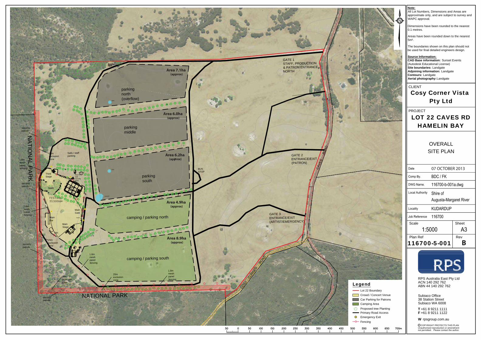
MainStage
GATE 1STAFF, PRODUCTION& PATRON ENTRANCENORTH
ThirdStage
CAV
ES
R
OAD
COSY
CORNER
R
OAD
NA
TION
AL P
AR
K FirstAid/SecurityBase
HelipadEvav.
BUSSTOP
Stalls
parkingnorth(overflow)
Salls / staffparking
parkingsouth
camping / parking north
MainGate
MainBar
20mexclusionzone
parkingmiddle
GATE 2ENTRANCE/EXIT(PATRON)
GATE 3ENTRANCE/EXIT(ARTIST/EMERGENCY)
5
1
2
3
4 6
ArtistBackstage
Toilets
Toilets
reservoir
bore
bore
VIP
BigtopStage
20mexclusionzone
20mexclusionzone
20mexclusionzone
securitypatrols
securitypatrols
securitypatrols
securitypatrols
1.8mmeshpanelfencing
1.8mmeshpanelfencing
1.8mmeshpanelfencing
1.8mmeshpanelfencing
NATIONAL PARK
camping / parking south
Note:All Lot Numbers, Dimensions and Areas areapproximate only, and are subject to survey andWAPC approval.
Dimensions have been rounded to the nearest0.1 metres.
Areas have been rounded down to the nearest5m².
The boundaries shown on this plan should notbe used for final detailed engineers design.
Source Information:CAD Base information: Sunset Events(Autodesk Educational License)Site boundaries: LandgateAdjoining information: LandgateContours: LandgateAerial photography:Landgate
Scale
PROJECT
CLIENT
not permitted. Please contact the author.Unauthorised reproduction or amendment
COPYRIGHT PROTECTS THIS PLANC
+61 8 9211 1111 +61 8 9211 1122
rpsgroup.com.au
Subiaco WA 6008
Subiaco Office38 Station Street
ACN 140 292 762RPS Australia East Pty Ltd
ABN 44 140 292 762
TF
W
Plan Ref Rev
Sheet
Cosy Corner Vista Pty Ltd
LOT 22 CAVES RDHAMELIN BAY
OVERALLSITE PLAN
116700-5-001 A
Lot 22 BoundaryCrowd / Concert Venue
Legend
Car Parking for PatronsCamping AreaProposed tree PlantingPrimary Road AccessEmergency ExitFencing
1
Area 7.1ha (approx)
Area 6.0ha (approx)
Area 6.2ha (approx)
Area 4.9ha (approx)
Area 8.9ha (approx) B
07 OCTOBER 2013