DEVELOPMENT AND PLANNING ERVICES EPARTMENT TO: PLAN ...
36
DEVELOPMENT AND PLANNING SERVICES DEPARTMENT Page 1 MEMORANDUM VILLAGE OF NORTHBROOK TO: PLAN COMMISSION FROM: DAVID SCHOON, ASSISTANT DIRECTOR DATE: SEPTEMBER 3, 2013 SUBJECT: PCD-13-01: 770 SKOKIE BOULEVARD NORTHSHORE 770 MIXED USED DEVELOPMENT INTRODUCTION On September 3, 2013, the Plan Commission is scheduled to hold a public hearing on an application submitted by Morningside Crossroads Partners, LLC (the “Applicant”), as the contract purchaser of the property located at 770 Skokie Boulevard, owned by CXA-10 Corporation, and the property located at 550 Dundee Road, owned by the Ralph J. Zengeler Family Trust, Trust #98250, and the Robert J. Lechner Family Trust, Trust #97450, (the two properties combined referred to herein as the “Subject Property”) to develop the Subject Property with a luxury apartment building and grocery-anchored shopping center. The Applicant has filed an application seeking the following approvals: A. A series of text amendments to the Northbrook Zoning Code to create a new high density multi- use zoning district to accommodate the development proposed on the Subject Property. The text amendment would establish district standards that would include, but not be limited to the following: the types of permitted, conditionally permitted and special permit uses authorized in the district; the building height, density, floor area ratio, setback and yard standards; accessory and temporary structure and use standards; off-street parking and loading requirements; sign regulations; buffer and landscaping requirements; and any other necessary amendments to the Zoning Code to establish and properly cross-reference the proposed zoning district. B. Rezoning of the Subject Property from the O-4 Boulevard Office District to the proposed high density multi-use district. C. Special permit for a planned development on the Subject Property, and concept plan approval for said planned development. The proposed uses within the planned development include, but are not limited to a Mariano’s grocery store, a ten-story multi-family building with up to 416 dwelling units, and a series of other commercial uses, including Zengeler Cleaners as a tenant. D. Special permits for three (3) accessory drive through facilities to accommodate a dry-cleaners, a financial institution, and a restaurant within the planned development on the Subject Property. E. Tentative subdivision plat approval. F. Waiver to allow the slope of the parking structure ramps in the multi-family structure to exceed eight percent (8%). G. Waiver to eliminate or reduce the foundation landscaping requirements for structures within the planned development. H. Variation to reduce the required number of off-street loading spaces for each of the outlot buildings in the planned development from one (1) to zero (0).
Transcript of DEVELOPMENT AND PLANNING ERVICES EPARTMENT TO: PLAN ...

DEVELOPMENT AND PLANNING SERVICES DEPARTMENT
Page 1
MEMORANDUMVILLAGE OF NORTHBROOK
TO: PLAN COMMISSION
FROM: DAVID SCHOON, ASSISTANT DIRECTOR
DATE: SEPTEMBER 3, 2013
SUBJECT: PCD-13-01: 770 SKOKIE BOULEVARDNORTHSHORE 770 MIXED USED DEVELOPMENT
INTRODUCTION
On September 3, 2013, the Plan Commission is scheduled to hold a public hearing on an applicationsubmitted by Morningside Crossroads Partners, LLC (the “Applicant”), as the contract purchaser of theproperty located at 770 Skokie Boulevard, owned by CXA-10 Corporation, and the property located at550 Dundee Road, owned by the Ralph J. Zengeler Family Trust, Trust #98250, and the Robert J. LechnerFamily Trust, Trust #97450, (the two properties combined referred to herein as the “Subject Property”)to develop the Subject Property with a luxury apartment building and grocery-anchored shoppingcenter. The Applicant has filed an application seeking the following approvals:
A. A series of text amendments to the Northbrook Zoning Code to create a new high density multi-use zoning district to accommodate the development proposed on the Subject Property. Thetext amendment would establish district standards that would include, but not be limited to thefollowing: the types of permitted, conditionally permitted and special permit uses authorized inthe district; the building height, density, floor area ratio, setback and yard standards; accessoryand temporary structure and use standards; off-street parking and loading requirements; signregulations; buffer and landscaping requirements; and any other necessary amendments to theZoning Code to establish and properly cross-reference the proposed zoning district.
B. Rezoning of the Subject Property from the O-4 Boulevard Office District to the proposed highdensity multi-use district.
C. Special permit for a planned development on the Subject Property, and concept plan approvalfor said planned development. The proposed uses within the planned development include, butare not limited to a Mariano’s grocery store, a ten-story multi-family building with up to 416dwelling units, and a series of other commercial uses, including Zengeler Cleaners as a tenant.
D. Special permits for three (3) accessory drive through facilities to accommodate a dry-cleaners, afinancial institution, and a restaurant within the planned development on the Subject Property.
E. Tentative subdivision plat approval.F. Waiver to allow the slope of the parking structure ramps in the multi-family structure to exceed
eight percent (8%).G. Waiver to eliminate or reduce the foundation landscaping requirements for structures within
the planned development.H. Variation to reduce the required number of off-street loading spaces for each of the outlot
buildings in the planned development from one (1) to zero (0).

Page 2
I. Approval of any other such variations, waivers, subdivision, and zoning relief as may benecessary to accomplish development and use of the Subject Property as requested by theApplicant
In compliance with Zoning Code public notice requirements, three signs have been posted on theSubject Property indicating the time and date of the Plan Commission public hearing. The Applicant hassubmitted evidence that the mailed notice requirements of the Zoning Code have been satisfied. ThePlan Commission hearing was properly noticed in the August 15, 2013 edition of the Northbrook Star.
Staff has received approximately a dozen e-mails and letters from the public regarding this application;copies of which are attached.
PROPERTY DESCRIPTION
The Subject Property is approximately 15.8 acres in size and is located on the northwest corner of SkokieBoulevard and Dundee Road. Approximately 14.40 acres is vacant while the remaining approximately1.40 acres is currently occupied by Zengeler Cleaners. The Subject Property is currently zoned O-4 OfficeBoulevard and is surrounded by O-4 Boulevard Office to the north, O-4, O-3 General Office, and C-5Commercial Boulevard to the east, O-2 Limited Office and C-2 Neighborhood Commercial to the south,and ComEd right-of-way and unused railroad tracks to the west with O-2 and O-3 districts to the west ofthe railroad tracks. The Subject Property does not include any of the adjacent ComEd right-of-way.
The Northbrook Comprehensive Plan Future Land Use Map designates this area as appropriate for majorcorridor multi-use development. No portion of the Subject Property lies within the 100-yearfloodplain. The Village’s Master Stormwater Plan does not identify any specific stormwaterimprovements for this area.
BACKGROUND INFORMATION
Recent Development ProposalThe Subject Property is vacant and several development projects have been proposed for the site overthe years. The most recent proposal for the site was the Center of the Northshore (CNS) development.The Board’s review of that project began in 2005, and the Board approved the final version of theproject in 2008. The CNS project was a 517,551 square foot mixed use project consisting of the 14.40acre vacant portion of the Subject Property and an additional 3.87 acres of adjacent CommonwealthEdison property. Below is a perspective drawing of that project as well as a site plan

Page 3
The CNS project consisted of the following uses:
SUMMARY OF CNS PROJECT
Retail, Service & Restaurant 130,369 sf
Residential Condominium Units 161,495 sf (74 units)
Hotel 97,214 sf (153 rooms)
Office Space & Bank 40,210 sf
Banquet Facility 20,755 sf (670 seats)
Health Club 44,985 sf
Parking Spaces 1,383 structured & 353 surface
The proposed uses were located in several buildings located on the Subject Property, including an 8-story structure housing the condominium units, some of the retail space, office space, health club andbanquet facility. In addition an 8-story hotel structure as well as five one-story out buildings forrestaurant, retail, and bank uses were part of the development. Attached to this report is a tablecomparing the Applicant’s current proposed project with the CNS project, the Applicant’s preliminaryapplication, and the requirements of the O-4 District.
Due to the economy and the financial situation of the CNS project developer, site work for the projectcommenced, but was never completed and the site was returned to its current state.
Current Request Preliminary ReviewOn November 13, 2012, the Board of Trustees conducted a preliminary application review of theApplicant’s request (a copy of the minutes are attached). Six out of seven Board members werepresent. In general, the trustees were receptive to the proposed mixed use development concept;however, trustees expressed some concerns regarding a few items:
Of those that expressed an opinion, they preferred the creation of a new zoning district ratherthan amendments to the existing zoning district in order to accommodate the proposeddevelopment.
Traffic impacts from the development on roadways in the area are a concern, in particular onthe intersection of Dundee Road and Skokie Boulevard.
Questioned the appropriateness of reducing the length of parking stalls.
Providing only 1 ½ parking stalls for each residential unit may not be adequate.

Page 4
Concern regarding the overall density of the development, in particular the number ofresidential units.
Need to consider the impacts of the residential development on the school districts and takeinto consideration the impacts of commercial development on existing business, in particularexisting grocery stores.
It would be preferred, but not necessary, if the developer could incorporate the Zengeler parcelinto the development (The preliminary application did not include the Zengeler parcel, but thecurrent proposal before the Commission now does include it).
Questioned whether or not it would be appropriate to include affordable units as part of thedevelopment.
The Architectural Control Commission should review the project.
CURRENT PROJECT SUMMARY
Following the preliminary Board review of the proposal, the Applicant worked to make a number ofrefinements to the plan. Most notably, the Subject Property was expanded to include the 1.4 acreZengeler Cleaner site.
Proposed UsesThe Applicant is proposing a mixed use project consisting of the following two components:
101,435 square feet of one-story commercial space, which would include:o A 71,320 square foot Mariano’s grocery store, with anticipated hours between 6 a.m.
and 10 p.m.,o A 6,975 square foot retail space (unnamed tenant),o Four outbuildings with a total of 23,140 square feet, consisting of:
A 4,100 square foot free standing Panera’s restaurant with a drive throughfacility,
A 4,000 square foot bank with a drive through facility (unnamed tenant), A 8,400 square foot multi-tenant building with Zengeler’s as an end cap tenant
with a drive through facility (other tenant’s not specified), and A 6,640 square foot free standing building at the corner of Dundee Road and
Skokie Boulevard (unnamed tenant).
10-story luxury apartment complex consisting of:o 416 rental units on floors 3-10, consisting of:
224 1-bedroom units, average size 779 square feet 192 2-bedroom units, average size 1,075 square feet
o Structured parking in the basement, first and second floors.o The complex would consist of a number of amenities such as an outdoor swimming
pool, fitness center, theater with stadium seating, E-business center, and many otherfeatures including on-site management and leasing.
Site LayoutThe ten-story apartment building would be located in the northwest corner of the property with theremainder of the property being occupied by one story-commercial structures.

Page 5
Parking would be provided on the site as follows:
PROVIDED PARKING
Commercial - All surface 571
Residential- 13 surface & 690 structured 703
Total 1,274
The site would be accessed by four driveways as follows:
ACCESS POINTS
Skokie Boulevard
Northerly Right-in, Right-out, Left-In
Central Full Access – Signalized
Southerly Right-in; Right-out
Dundee Road
Westerly Right-in, Right-out, Left-In
Stormwater detention will be provided on-site in two vaults located underground below the commercialparking lots.
CONSISTENCY WITH THE COMPREHENSIVE PLAN
As previously stated, the Comprehensive Plan, which was adopted in December 2010, designates theproperty as appropriate for major corridor multi-uses. This land use classification is intended to provideareas to accommodate a mixture of higher density multi‐family housing, retail, restaurant, business and professional offices, personal and business services, as well as entertainment, fitness, and religious andother membership organizations that are predominately integrated horizontally on a development site.

Page 6
COMPREHENSIVE PLAN FUTURE LAND USE MAP
The Comprehensive Plan also lists the following zoning districts as applicable for areas designated formajor corridor multi-uses: MRFC Multiple Family Residential and Commercial District, RLC Residentialand Limited Commercial, and O-4 Boulevard Office District. None of these districts allow the residentialdensity or allow the bulk, setback, and yards that the Applicant is requesting for the proposed project.A new zoning district or major amendments to an existing district will be needed to allow the project tomove forward.
The Comprehensive Plan also includes a number of specific policies for the Skokie Boulevard Corridor.A few of them the Commission may wish to consider regarding the current request are the following:
Promote a land use pattern that is consistent with a high quality office corridor, while stillproviding opportunities for appropriate retail and other complementary land uses.
Promote the development of integrated commercial and mixed use developments that form amajor “gateway” to the community.
New development or redevelopment activities should be of an appropriate scale and site design.
Encourage development and redevelopment that has a positive impact on the Village and localtaxing bodies.
Encourage the long term economic viability of buildings in the area by requiring that they bedesigned in a manner as to allow for the adaptive reuse of tenant space.
Encourage excellent architectural design and quality building materials through the use of variedsetbacks, roof lines, windows and other architectural features to help minimize the visual impactof larger buildings.
Discourage proliferation of curb cuts on Skokie Boulevard, while still providing efficient ingressand egress to both customers and delivery vehicles.
The Commission will want to consider whether or not the current request is consistent with the policiesidentified in the Comprehensive Plan for the Skokie Boulevard Corridor.

Page 7
ZONING RELIEF: TEXT AMENDMENT TO CREATE NEW ZONING DISTRICT & REZONING OF SUBJECTPROPERTY
Clearly, this is a complex development proposal involving a key property in the Village. The current O-4Boulevard Office zoning on the property will not accommodate all of the requested project components.To accommodate the project, the Village could take two approaches: (1) create a new multi-use zoningdistrict or (2) amend the existing O-4 District to accommodate the project. With the recent CNS project,the Village amended the O-4 District to accommodate by special permit approval retail uses and alimited amount of residential uses on the site. Based upon feedback provided by the Board of Trustees’during its review of the preliminary application, the Applicant is requesting the creation of a new zoningdistrict.
Creating a new multi-use district allows the Village to create a zoning district to specificallyaccommodate the mixed use development on the site and elsewhere along the Skokie Boulevardcorridor. The Comprehensive Plan does envision other mixed-used developments along the corridor,both on vacant land and with redevelopment.
While considering the appropriate regulations for this new zoning district, the following analysis reviewswhat the Applicant is requesting in terms of standards and requirements for the proposed new districtin relationship with the proposed project. Given that the proposed district would be the highest densitymixed use district in the community, for the purposes of this report we refer to it as the High DensityResidential and Commercial District (HDRC).
Allowed Uses.Each of the Village’s zoning districts provides a list of permitted, conditionally permitted, and specialpermit uses that are allowed in each district. The Applicant requests that “all commercial and retailuses consistent with the C-5 Boulevard District and multiple family residential uses shall be permitted.”This list of allowed uses would generally be consistent with those currently allowed in the O-4 District;however, certain items such as drive-through facilities are a special permit use in all districts. Theattached chart compares the uses allowed in the C-5, O-4, MFRC, & RLC districts.
The Commission will want to determine which uses should be allowed in the new district and how eachuse should be allowed either as a permitted use, conditionally permitted use, or special permit use.There are many ways to approach this issue, but staff will briefly describe a few options below.
Planned Development Requirement. One approach would be to require planned development approvalfor any development located within the proposed district and to allow the uses in the C-5 District as theyare currently allowed, either as permitted, conditionally permitted, or special permit uses. Under thisapproach, once the original planned development is approved, certain uses would be allowed by rightand would not require any zoning relief (permitted & conditionally permitted uses) and others wouldrequire zoning relief to locate on the property (special permit uses).
Special Permit Requirement. Under this approach, virtually all uses in the new zoning district wouldrequire special permit approval. This is basically the approach that was taken with the MFRC & RLCdistricts. If this approach is taken with this application, every currently proposed used (e.g. drycleaners,grocery store, restaurant) and every future use would require special permit approval. This approachwould provide the Village the greatest control over the uses going in the district, but also has the

Page 8
greatest chance of discouraging tenants from going on the site, because they do not want to go throughthe 2-3 month process for special permit approval.
A variation on this theme would have a development approved with a certain list of approved specialpermit uses with conditions. A development may be approved with a specific list of uses that are “pre-approved”. If a use not listed would want to locate on the site, the use would require special permitapproval.
The Commission will want to provide staff with the general direction it would like to take regarding howto handle uses allowed in the new district.
Building Height, Density, FAR, Setback & Yard StandardsEach zoning district also sets the standards for the height, bulk, and placement of the buildings andparking areas on a property. The table on the next page compares the proposed district with theSubject Property’s current zoning , the O-4 District, as well as the much lower density mixed use districtsin the community, the MFRC and RLC districts.
It should be noted that all of the Applicant’s bulk calculations and setback and yard measurements alongDundee Road include the 14-foot wide area along Dundee Road designated as future right-of-waydedication. The Village has been working extensively with our traffic consultants to determine whatroadway improvements are needed to ensure there is adequate traffic flow through the Skokie/Dundeeintersection. Those improvements identified to date can all be constructed within the Dundee Roadfrontage of the Subject Property (although right-of-way is needed for improvements east of theintersection).
Dundee Road is a state highway, and in the past IDOT has indicated a general interest in wideningDundee Road and securing additional right-of-way for that widening; however, there are no specificplans or timeframe for those improvements. IDOT may not require a dedication of right-of-way as acondition of obtaining a permit; thus, only the note regarding the reservation for future dedication isprovided at this time. The Applicant indicated that it has only recently begun to work with IDOTregarding the proposed road improvements.

Page 9
BULK, SPACE AND YARD REQUIREMENTS MFRC RLC O-4 HDRC(1)
A. Maximum Height (whichever is less)
1. Feet
a. Multiple Family Residential 55 65 110 110
b. All Other Uses 50 65 110 110
2. Stories
a. Multiple Family Residential 4 4 10 10
b. All Other Uses 3 4 10 10
B. Minimum Lot Area and Dimensions
1. Total Lot Area (square feet)
a. Planned Development 700,000 100,000 250,000 650,000
b. Multiple Family Residential 460,000 45,000 N/A
c. All Other Uses 40,000 45,000 120,000
2. Lot Area Per Dwelling Unit (sq. ft.) (2)
All Uses (over entire planned development) 6,000 4,150 N/A 1,600
3. Lot Depth (feet) 300 N/A N/A
4. Lot Width (feet) N/A N/A 300
C. Minimum Yard & Setback Requirements (ft)
1. Front
a. Yard 20 100 50 15
b. Setback 40 100 80 60
2. Corner Side
c. Yard 20 100 50 20
d. Setback 40 100 80 60
3. Interior Side
a. Yard 30 6 15 0
b. Setback 75 6 50 0
4. Rear
a. Yard 30 25 5 0
b. Setback 40 25 30 0
D. Maximum Floor Area Ratio (FAR)
1. Planned Development 50% 65% 50%(2)
82%
2. Multiple Family Residential 55% 65% 50%(2)
N/A
3. All Other Uses 45% 65% 50%(2)
N/A
E. Maximum Lot Coverage (% of Lot) 50 70 N/A N/A(1) Applicant’s request(2) 50% by right, < 65% by special permit

Page 10
Building Height & FAR. While the retail structures in the proposed development are all single storystructures, the proposed residential building will be 110 feet in height with a total of 10 stories. Below isa table of some of the surrounding building heights and FAR in comparison to the proposeddevelopment.
BUILDING HEIGHTS IN SKOKIE CORRIDOR
Height FAR
400 Skokie Blvd. 8 stories, 107’ >0.46
500 Skokie Blvd. 6 stories, 82’3” 0.35
555 Skokie Blvd. 6 stories 0.80
707 Skokie Blvd. 7 stories, 84’6” 0.50
933 Skokie Blvd. 10 stories <0.65
1101 Skokie Blvd. 8 stories, 108’ 0.49
550 Dundee Road 2 stories, 27’6” 0.80
Proposed Development 10 stories, 110’ 0.82
Heights of Selected Buildings Along Skokie Boulevard
For comparison purposes, the CNS project had an FAR of 0.83 when only taking into account the SubjectProperty when calculating the FAR. (Note: The CNS project also included 3.87 acres of adjacentCommonwealth Edison property, which made its FAR 0.65). Though the proposed project has an FAR ofapproximately the same amount as the CNS project, it is important to remember that the floor area for

Page 11
structured parking is not included in the Village’s FAR calculations. The CNS project contained twice theamount of structured parking than the current project, thus resulting in a larger, significantly moremassive structure than what is proposed by the Applicant.
Dwelling Units Per Acre. The Applicant is proposing 416 residential rental units as part of thedevelopment. This proposed residential component will have 26.4 dwelling units per acre as measuredover the entire Subject Property. Below is a table comparing the proposed number of dwelling units peracre for the residential component of the development with existing more dense residentialdevelopments located in the Village.
MULTI-FAMILY RESIDENTIAL DEVELOPMENT DENSITIES
Development Name
Zoning
District
Number
of Units
Number
of Acres
Density
(units/acre)
Manus Northshore Estates Cambridge
Court Condos (Dundee/Pfingsten)
R-8 59 1.54 38.3
The Citadel (Shermer) R-8 78 2.65 29.43
Proposed 770 Skokie Boulevard HDRC 416 15.78 26.36
Laurel condos (1410 Shermer) R-8 41 2 20.5
Cherry Ln. condominiums R-8 14 0.7 20
Townhomes behind White Hen on Shermer R-8 6 0.34 17.65
Homart (1220 Lake Cook) R-8 200 11.9 16.81
Pheasant Creek R-8 424 27.4 15.47
Cherry Ln. Condo's & Apts R-8 24 1.7 14.11
Villas Salceda Condo's R-8 61 4.4 13.86
The Applicant has submitted a market study to support its proposed density and the demand in themarket for the number of proposed residential units.
Setback & Yards. The following table compares the proposed yards and setbacks for the SubjectProperty to the proposed new HDRC District and the former CNS project.
BULK, SPACE AND YARDREQUIREMENTS
ProposedHDRC
(1)
Requirements
Northshore770
O-4District
Requirements
CNSProject
Minimum Yard & Setbacks(ft)
Front
Yard 15 16.86/2.86 50 50
Setback 60 76.69/62.69 80 50*
Corner Side
Yard 20 21.69 50 25.00 & 15*
Setback 60 94.90 80 70*
Interior Side
Yard 0 0.00 15 0.00*
Setback 0 20.79 50 25 & 40*
Rear
Yard 0 0.00 5 0.00*
Setback 0 42.50 30 30+
*Required variations.

Page 12
The rear and interior side yards for the proposed project are 0.00 feet to accommodate the existingparking located on the Subject Property that is actually that for the office building to the north. Nottaking into consideration that parking area, the proposed minimum side yard is 3.5 feet and theproposed rear yard is 28 feet, which has a driveway located within it, which is an allowed encroachment.
As previously noted, the Applicant’s setback and yard measurements along Dundee Road are basedupon the inclusion of the 14-foot wide area along Dundee Road designated as future right of waydesignation.
Off-Street Parking & Loading RequirementsThe applicant is proposing to meet all of the parking requirements of the Zoning Code, except that it isrequesting lower parking space requirement for the residential units, shorter parking stall lengths forparking spaces for the residential units, and not to require loading spaces in the new district for anybuilding or use under 10,000 square feet.
Residential Parking Space Requirements. The Applicant proposes establishing a parking requirement forresidential units in new district at 1.65 spaces per unit. The applicant would actually be providingparking at a rate of 1.69 spaces per unit. For the 416 apartments, the Applicant proposes to provide703 parking spaces. For a residential development of this nature, the Zoning Code currently requires 3.0parking spaces per unit, which would mean the Applicant would be required to provide 1,248 parkingspaces for the residential portion of the development.
In certain zoning districts, and under other circumstances, the Village requires fewer parking spaces permultiple family residential dwelling unit, which requirements are listed on the following page.

Page 13
PARKING REQUIREMENTS FOR MULTI-FAMILY RESIDENTIAL DWELLINGS
# of Parking Spaces Per
Dwelling Unit
Multiple Family Dwellings, but not including townhouse
dwellings, in the Multiple Family Residential and Commercial
District (MFRC)
2.5 per dwelling unit
Multiple Family Dwellings, but not including townhouse
dwellings, in the Residential and Limited Commercial (RLC)
District and any Dwelling Units located over a Commercial Use
2.0 per dwelling unit
All other Multiple Family Dwellings, but not including
townhouse dwellings
3.0 per dwelling unit
Applicant’s Proposal 1.65 per dwelling unit
The condominium units in the Center of the Northshore project were only required to provide 2.0parking spaces per unit, because the dwelling units were located over commercial uses. Given that theproposed apartment units would be located in a free-standing building, the Applicant is required toprovide 3.0 spaces under the current requirements. Given that the Shermer Place condominiums witha parking requirement of 2.5 spaces per unit and the Northbrook Pointe condominium project with arequirement of 2.0 spaces per unit have not experienced parking issues, the Commission may want toconsider the Applicant’s lower parking standard of 1.65 spaces per unit for its project.
This is the first new development in many decades to propose one bedroom units, except for seniorliving facilities. As part of the Village consideration of the issue, the Commission may want to look atestablishing parking requirements for multi-family units based upon the number of bedrooms in a unit,which is a standard many communities use. The Applicant has indicated that it is providing parking thatwould provide 1 space for each 1-bedroom, 2 spaces for each 2-bedroom, plus 95 spaces for guests.
The following tables summarizes the number of parking spaces that would be required based uponcurrent code requirements as well as the number the applicant proposes providing for both thecommercial and residential uses.
PARKING SPACES NORTHSHORE 770
Required Spaces by Current Code 1,726
Commercial 478
Residential 1,248
Total Spaces Provided 1,274
Commercial 571
Residential 703
Total Spaces Provided 1,274
Surface 584
Structured 690
The Applicant has stated that the standard they are proposing is consistent with recently approvedprojects on the north shore; however, the Applicant has not provided details regarding those specificprojects. The Applicant does cite the Institute of Traffic Engineer’s manual which states that the for

low/mid-rise apartments, the average parking supply ratio was 1.4 spaces per unit and the average peakparking demand ratio is 1.23 spaces per dwelling unit.
Parking Space Dimensions. The standard parking space dimension requirements in the Zoning Code is 9’x 20’. The Applicant is proposing parking spaces for only the residential units of 9’ x 18’. Though thestandard space dimension is 9’ x 20’, there are exceptions in the Code. The following table comparesthe Applicant’s request with the various parking space dimension requirements in the Zoning Code:
PARKING SPACE WIDTH LENGTH NOTES
Applicant’s Request 9’ 18’ Requires code amendment
Standard 9’
9’
20’
18.5’
No overhang
w/ 1.5’ overhang
I1, I2, & O1 8.5’ 18’ by right
VGO - Metra Lot 8.5’ 18.5’ Metra parking lot
VGO - Design Review 8.5’ 18.5’ Reduction allow through design
review permit process
Landbanking 8.5’ 18.5’ Institutional, office, manufacturing
long term parking
One particular exception to note are the parking spaces for the I-1, I-2, and O1 districts which allownarrower and shorter parking stalls. The rationale behind this is that those uses are low turnover usesas well as the users of those spaces tend to be repeat users who are very familiar with the parking lotand parking stall dimensions. A multi-family residential structure would be similar in nature.
Also, the proposed parking stalls within the parking garage are 9’ wide; however, some of the stalls havestructure supports between the spaces which reduces their width at points to 8’ feet, which is stilladequate space for a typical car. The poles are located in a position, where the motorist and passengerscan open the car doors without hitting the support poles. The parking spaces are accessed by a 24’ widedrive aisle, which meets code; however, the aisle narrows to 22’ wide where support posts are located.
The short stall lengths, narrowernarrower drive aisles in locations
Page 14
openings for some of the spaces due to support posts, and thedue to support posts, will make it tight for cars to maneuver. That may

Page 15
be appropriate in a parking garage that has relatively low turnover by regular users.
Loading Spaces. The Zoning Code currently requires each commercial building to provide a loadingspace, specifically one space for the first 150,000 square feet of gross floor area or fraction thereof plusone for each additional 200,000 square feet of gross floor area or fraction thereof. The Code alsorequires every multi-family building in excess of 20,000 square feet of floor area to provide one loadingspace. Also, the first loading space provided must be 12’ wide, 50’ long, and 15’ high. The Applicantmeets the requirements for the Mariano’s building as well as the apartment building; however, the fouroutbuildings either do not provide a loading space or provide loading spaces that do not meet theminimum dimension requirements.
Rather than request a variation to reduce the required loading spaces from 1 to 0 for each building, theApplicant is proposing that in the new zoning district buildings or uses under 10,000 square feet shallnot be required to provide any loading spaces. The Applicant has stated that it is not anticipated thatthese smaller buildings will have large truck deliveries, and it anticipated that the deliveries would occuroutside of business hours. This would allow the trucks to use the existing drive aisles for loading andunloading.
Sign RegulationsThe Applicant is proposing to comply with all of the sign regulations of the office districts, but is seekingexceptions regarding wall sign heights and sign area as well as for ground sign heights and sign area. Asthe following table indicates, the wall sign amendments requested by the Applicant basically take wallsigns that are allowed by special permit in the O-4 District and allow them by right in the new district.
WALL SIGNS CURRENT O-4 DISTRICT PROPOSED DISTRICT
Sign Area Not to exceed 100 square feet per signface or covering more than five percent(5%) of the wall to which it is affixed,whichever is less. Wall signs in excess of100 square feet per sign face and inexcess of five percent (5%) of the wall towhich it is affixed shall be allowed byspecial permit; however, that in no eventshall any wall sign exceed 200 squarefeet.
Not to exceed 100 square feet per signface or covering more than five percent(5%) of the wall to which it is affixed,whichever is less; however, for buildingsin excess of 50,000 feet up to 200 squarefeet per sign face. (allow by right)
Height Twenty (20) feet; provided, however,that a great height may be authorized inthe O-4 Districts by special permit. (alsoapplies to awning canopy & marqueesigns)
Thirty (30) feet.(allow by right, and would also apply toawning, canopy and marquee signs)
The following proposed wall signs would need the above standards in order to be installed.

Page 16
Panera Wall Sign(Approximately 23 feet from grade)
Mariano’s Wall Sign(Nearly 25 feet from grade & 190 sf of sign area)
As indicated in the table below, the proposed ground sign amendments would allow, by right, signs thatare taller and larger than currently allowed in the O-4 District.
GROUND SIGNS CURRENT O-4 DISTRICT PROPOSED DISTRICT
Sign Area Not to exceed 100 square feet per signface; nor more than 200 square feet intotal.
Not to exceed 200 square feet per signface; nor more than 400 square feet intotal. (allow by right)
Height Eight (8) feet Twenty (20) feet(allow by right)
Commercial Multi-Tenant Ground Signs(17 feet tall & 132 sf of sign area)

Page 17
Mariano’s Ground Sign(8 feet tall & 40 sf of sign area)
Apartment Ground Sign(10 feet tall & 24 sf of sign area)
ZONING RELIEF – SPECIAL PERMIT APPROVALS
As previously stated the Applicant is requesting special permit approval of the planned developmentconcept plan as well as special permit approvals for three drive through facilities. To approve the specialpermit requests, the Village Plan Commission and Board of Trustees must consider the generalstandards for such special permits established in Paragraph 11-602 E1 of the Zoning Code. Thesestandards include the following:
1) Is the proposal in compliance with the Zoning Code and Official Comprehensive Plan?2) Will there be any adverse impact upon adjacent properties?3) Will the proposed use interfere with the orderly development of adjacent properties?4) Are there adequate public facilities to serve the development?5) Will the use cause undue traffic congestion?6) Will the development cause loss of significant environmental or historical features?7) Will the use comply with other applicable Village standards?
All of the above criteria are relevant in considering whether or not the requested special permits shouldbe granted for the proposed use. The Applicant’s response to all of the standards is included in yourpass out.
Planned Development – Concept Plan Special PermitThe planned development process consists of a two-step process: 1) development concept planapproval and 2) final plan approval. This two-step process is similar to the subdivision process whichincludes tentative and final plat approvals. The development concept plan approval stage is intended toprovide the applicant an opportunity to submit a plan showing the basic scope, character and nature ofthe entire proposed planned development. The final plan approval stage is intended to refine and

Page 18
implement the development concept plan and to serve as a complete, thorough and permanent publicrecord of the planned development.
As the Plan Commission considers the special permit request for planned development approval, theCommission should pay particular attention to the following issues: (a) site access & traffic impacts, (b)on-site circulation, parking and deliveries, and (b) building design and landscaping.
Site Access & Traffic ImpactsOne of the issues of most concern expressed by the Board and residents is the traffic that will begenerated by the proposed development and its impact on area roadways, including Skokie Boulevard,Sunset Ridge, and Midway and in particular on the intersections of Skokie Boulevard/Sunset Ridge andDundee Road & Sunset Ridge. The Applicant has submitted a traffic study and the Village’s trafficconsultant has also conducted a separate traffic study that not only looks at the impacts of thisproposed development, but also the proposed Walmart development at 1000 Skokie Boulevard.
Access Points. The location of site access points determines how a development projects will impactarea roadways. As previously stated, the Applicant is proposing three access points along Skokie andone along Dundee Road as follows:
Overall Traffic Impacts. As the Commission considers the impacts of rezoning the Subject Property fromits office zoning to a new mixed use district, the following table is provided to compare the volume oftraffic that would be generated from an office development with the amount of traffic generated by thecurrent mixed use development proposal and the prior CNS mixed use development project. The column“SUM” includes all of the inbound and outbound trips at the driveways. The column “NEW” adjusts forpass-by trips (cars that are already going by the site and stop) or linked trips (e.g. cars that would begoing to Mariano’s and then travel internally on the site to another use, thus not going out onto SkokieBoulevard). As the table indicates, the current proposed mixed use development would generate fewertrips in the morning peak than an office development but more traffic during the evening and Saturdaypeak periods.
Full Access,Signalized
Right-In,Right-Out,Left In
Right-In,Right-Out
Right-In,Right-Out,Left-In

Page 19
Impacts on Area Roadways & Intersections. The proposed development on the Subject Property isestimated to generate 9,130 driveway trips to and from the site on a daily basis, of which 6,850 trips aday would be “new” after adjusting for passby and linked trips.
When the Subject Property is fully developed, the development is estimated to impact theSkokie/Dundee and Skokie/Sunset Ridge intersections as listed on the next page, which informationcomes from the traffic study conducted by the Village’s traffic consultant. It should be noted that Levelof Service (LOS) measures the level of delay in seconds that each vehicle experiences (see followingchart). Generally LOS D is the minimum desirable level of service.
In comparing the impacts of the NorthShore 770 traffic on these intersections, you should compare theBaseline Traffic LOS with the Baseline + 770 Development LOS. (Note: Baseline includes traffic levels inthe Fall of 2012, plus fully occupied office space in the corridor, and a potential restaurant on thenortheast corner of Dundee & Skokie.) Details regarding these LOS ratings can be found in AttachmentA of this memo, which provides information for each turning movement regarding the delay in secondsas well as the length of car queues at the intersection.
Page 20
Above excerpt from traffic study conducted by the Village’s traffic consultant.
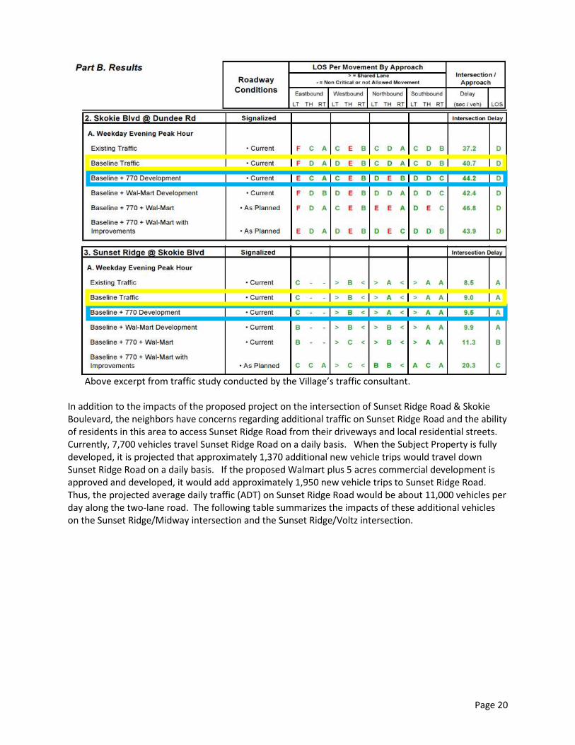
In addition to the impacts of the proposed project on the intersection of Sunset Ridge Road & SkokieBoulevard, the neighbors have concerns regarding additional traffic on Sunset Ridge Road and the abilityof residents in this area to access Sunset Ridge Road from their driveways and local residential streets.Currently, 7,700 vehicles travel Sunset Ridge Road on a daily basis. When the Subject Property is fullydeveloped, it is projected that approximately 1,370 additional new vehicle trips would travel downSunset Ridge Road on a daily basis. If the proposed Walmart plus 5 acres commercial development isapproved and developed, it would add approximately 1,950 new vehicle trips to Sunset Ridge Road.Thus, the projected average daily traffic (ADT) on Sunset Ridge Road would be about 11,000 vehicles perday along the two-lane road. The following table summarizes the impacts of these additional vehicleson the Sunset Ridge/Midway intersection and the Sunset Ridge/Voltz intersection.
Page 21
Above excerpt from traffic study conducted by the Village’s traffic consultant.
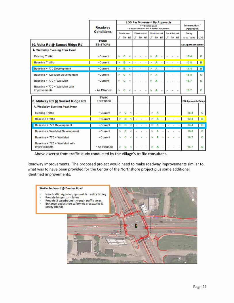
Roadway Improvements. The proposed project would need to make roadway improvements similar towhat was to have been provided for the Center of the Northshore project plus some additionalidentified improvements.

Page 22
Those improvements would include following:
Skokie Boulevard, North of Dundee Road:o Installation of a traffic signal at the main development entrance that is interconnected
with the Dundee Road/Skokie Boulevard signal and the Henrici Drive/Skokie Boulevardsignal.
o Removal of the Skokie Boulevard striped median and re-striping of the roadwaybetween the Dundee Road/Skokie Boulevard intersection to the Henrici Drive/SkokieBoulevard intersection;
o Extension of the single southbound left turn lane at Dundee Road the maximum lengthpossible;
o Installation of a northbound left turn lane at the main development drive;o Extension of the southbound right turn lane at Dundee Road to the most southerly
right-in/right-out development entrance;o Installation of a two-way left turn lane north of main entrance drive to the Henrici
Drive/Skokie Boulevard intersection;o Installation of a southbound right turn lane at main development drive;o Installation of a median at the north development drive to prohibit outbound left turns;
ando Installation of a median at the south development drive to prohibit inbound and
outbound left turns.
Skokie Boulevard, South of Dundee Road:o Extension of the northbound right turn lane the maximum length possible; ando Extension of the northbound left turn lane the maximum length possible.
Skokie Boulevard-Dundee Road Signal & Pedestrian Improvements:o Installation of new traffic signal equipment that accommodates right turn overlap signal
phasing; ando Improvements to existing crosswalks, sidewalks and safety islands to enhance
pedestrian safety at the intersection
Dundee Road, West of Skokie Boulevard:o Extension and provision of a painted single left turn lane from Skokie Boulevard to the
westerly site driveway along Dundee Road.

Page 23
o Installation of a painted single left turn lane accessing the westerly site driveway alongDundee Road.
o Installation of a third westbound through lane to at least the western boundary of theunused Union Pacific Right of Way, if not all the way to Midway Road.
Dundee Road, East of Skokie Boulevardo Installation of a new westbound right turn lane, so as to be able to convert the existing
right turn lane to a third through lane.
Some of these improvements have only been recently identified and not all are included on theApplicant’s striping and road improvement geometric plan. Staff continues to work with the Applicanton identifying the most effective roadway improvements. As will be noted later, the Applicant isrequesting tax increment financing from the Village to assist with roadway improvements associatedwith the project. One of the key elements to be established before any final approval is granted will bea clear delineation of what improvements must be constructed by the developer and whatimprovements will be programmed for construction at a later date, possibly by the Village or IDOT.
On-Site Circulation, Parking & DeliveriesOn-Site Circulation. As previously stated the project would be served by three access points alongSkokie and one along Dundee. Though anyone could use any of the access points to the site, thenortherly driveway along Skokie is designed for the residential development, while the other two alongSkokie are designed for the commercial development. The entrance driveways all connect to a maindrive aisle that runs north and south down the middle of the site, which allows motorist on the site to gobetween buildings without having to go back out on to Skokie Boulevard.
Parking Design. The site layout provides ample parking easily accessible for each of the proposed uses.There are a couple of issues regarding the parking lot layout that should be noted.

Page 24
Both the northerly driveway and the southerly driveway along Skokie Boulevard have parking spacesthat directly back out into the driveways. Generally, it is not desirable to have such situations. Giventhat the northerly driveway is predominately for the residential development, we would anticipate itbeing a less used driveway, and the situation may be acceptable. The southerly driveway serving thecommercial develop may be more heavily used. The applicant has indicated that it will designate thesespaces for employee parking, so that the spaces will experience less frequent turnover.
The other issue to note is that the parking has a fairly significant slope from Mariano’s building outtowards two of the out buildings along Skokie Boulevard. The grade changes four feet between the twobuildings. The Applicant has been asked to explain to the Plan Commission why the need for such achange in grade.
Because of this change in grade, the driveways off of Skokie Boulevard will have a 6% slope. Since awaiver is needed to approve a parking lot with this type of slope, we suggest the question of drainageand icing be considered in reviewing this design.

Page 25
Main Driveway Off of Skokie Boulevard
One last issue for discussion regarding the parking lot is that the Applicant is requesting no curbs alongthe entire front of the Mariano’s building and Retail Building “D”. The Commission will want todetermine if it is appropriate to have no curb this entire length, or if just a portion should not have acurb to allow customers to easily take carts from the grocery store to the front parking area. Since nocurbs are proposed, there are few bollards proposed along the area where the main drive off of SkokieBoulevard ties into the north/south drive. Should additional bollards or other barriers be installed toprotect pedestrians or the building from vehicles?
Pedestrians, Bicyclists, and Mass Transit Riders. Pedestrians could access the site by sidewalks runningalong Skokie Boulevard and Dundee Road. A series of walkways, illustrated below, would connect thedevelopment to these adjacent sidewalks and connect the various uses within the development:
No Curb

As the illustration above would indicate, the Applicant shows a potential future connection to theproposed Skokie Valley Trail that would run along the west of the property either within the adjacentCommonwealth Edison property, adjacent to the high powered power lines, or within the unused UnionPacific Railroad right of way. The following image shows the location of these strips of land inrelationship to 770 Skokie Boulevard
The proposed Skokie Valley Trail is currently in the Village’s Capital Improfunding source for the project has yet to be identified.
The Applicant is also proposing bicycle parking scattered throughout theplans show bike racks along the fronts of the commercial buildings as weThe residential building will also be providing bike storage within the struof the first floor.
The site is currently served by PACE Route 626. The Applicant has indicaregarding the installation of a bus shelter near the northerly drive along Sthis is a much needed amenity for the corridor. No special design has beshelter.
Deliveries. It is anticipated that semi-tractor trailers making would use mthe entrance along Dundee for deliveries. Panel trucks would be able toApplicant has indicated that Mariano’s will have four semi-trailer truck d
Location of Future Skokie Valley Trail
Page 26
vements Program, but a
development. The landscapell as the residential building.cture in the southwest corner
ted that it is working with PACEkokie Boulevard. Staff believesen proposed for the bus
ain entrance along Skokie anduse all driveways. The
eliveries and 15 DSD trucks (one
770 Skokie Blvd

Page 27
third semi-trailer trucks, each day to the site. Deliveries would be made from 8 a.m. to midnight. Giventhat residential units will be located on the site, it may be more appropriate to have delivery hours thatdo not occur during the Village’s quiet hours, which are “from 10:00 p.m. until 7:00 a.m. the followingday, unless the following day is a Saturday, Sunday or nationally recognized holiday, in which case quiethours shall be from 11:00 p.m. until 9:00 a.m. the following day.”
Building Design, Signage, Landscaping, & Architectural Control Commission ReviewCommercial Building Design. The façade of the commercial buildings will be constructed out of amixture of bricks and stack stone, and accented by glass and anodized aluminum trim and dependingupon the building accented by either hardie horizontal plank boards or silver metallic corrugated metalarchitectural panels. The following perspective drawing represents the designs for the proposedcommercial buildings.
Mariano’s (Building C & D) Front Façade – Facing East Towards
Buildings A & B Front Façade – Facing East Towards Skokie Boulevard

Page 28
Buildings F (Panera’s Front Façade – Facing East Towards Skokie Boulevard
The Applicant intends to have a bank occupy Building E. At this point in time, a specific tenant has notbeen identified, so Applicant has yet to submit building elevations for the building. At time of finalplanned development approval, the Applicant will need to identify the building design for this building.
The Applicant has stated that the roof top mechanical equipment will be screened to comply with theVillage’s screening requirements. That will all need to be addressed at final plan approval.
Residential Building Design. As previously stated the proposed residential structure is 10 stories tall.The building is modified “S” design, which creates areas for shared common open space, which includesa green rooftop system, pool and sun deck area, bocce courts, a dog run, and areas for sitting.
The base of residential building façade will be constructed primarily out cast stone base, utility size face

Page 29
brick, and clear anodized aluminum metal.
The upper portions of the building façade will be treated with a combination of a synthetic stuccodrainage barrier, a darker color metal panel with corrugations, and a lighter metal panel.
The Applicant has indicated parapet walls would screen any rooftop equipment from adjacentproperties.
Given the high profile nature of the corner at which the proposed development is located, the designsfor the buildings are critical. The Commission will want to determine if the proposed building designsand materials being used are compatible with each other on the site as well as with the other buildingsalong the corridor.
Signage. The report previously provided information regarding the proposed ground signs along SkokieBoulevard and Dundee Road as well as the wall signs for Mariano’s and Panera’s. Regarding signage forthe other individual tenants, the Applicant has not identified a specific signage program to which alltenants must adhere. Staff would suggest either that all future signage in the development be subjectto review by the ACC or that the Applicant develops, with the Village’s approval, some sign design

Page 30
guidelines for the development. If the latter approach is taken, the design guidelines will need to bedeveloped during the final plan approval process.
Landscaping & Screening. Given that this is only concept plan approval, the Applicant has submittedonly a conceptual landscape plan. Other than not meeting the foundation landscaping requirements,as will be discussed later, it appears that the proposed landscape plan may comply with the Villagelandscaping and screening requirements. During the final plan approval process, the Applicant will haveto provide further details in order to demonstrate that the project meets the parking lot screening andinterior tree requirements, the rooftop mechanical equipment and outdoor refuse container screeningrequirements, the sight triangle requirements, and provide further details regarding the design of theretaining walls along the west and north property lines.
One issue that staff would note at this point is that the Applicant is proposing a drainage area alongSkokie Boulevard that is nearly four feet deep. The Applicant has stated that they plan a continuouslandscape along Skokie and Dundee. The design incorporates either a single or double row of hedgeplants with accent perennials on the road side of the hedge, along with shade an ornamental trees. TheApplicant has stated that it will provide a cross section at time of final plan review.
As the Commission reviews the concept landscape plan, the Commission will want to consider if thelandscaping around the perimeter of the site provides a nice visual buffer as well as an attractiveentrance wall to the community. Also, given the amount of surface parking on the site, does thelandscaping adequately soften the large expanse of pavement throughout the site?
Village Entryway Feature. The Village Board has identified as important an entryway feature to thecommunity at the northwest corner of Skokie Boulevard and Dundee Road. The Applicant has provideda perspective drawing of what they have in mind for that corner. The Applicant’s architect will describein more detail this feature at the public hearing.
Architectural Control Commission Review. The Architectural Control Commission (ACC) is scheduled toconsider the proposed building design, landscaping, and signage for the NorthShore 770 project onThursday, September 12, 2013. A report of the ACC’s discussion will be presented to the Commission atits next meeting regarding the subject project.
Drive Through Facilities Special PermitsThe Applicant is requesting special permit approval for three drive through facilities: one for a bank(occupant unknown), one for a drycleaners (Zengeler), and one for restaurant (Panera’s).In addition to the previously mentioned general permit standards, the Commission and Board mustconsider the following specific special permit standards for drive through facilities:

Page 31
1) Traffic Management and Queuing. Every accessory drive-through facility shall be designed andconstructed so as to have adequate queuing area on the zoning lot for motor vehicles. Nospecial permit for an accessory drive-through facility shall be granted except on evidencesatisfactory to the Board of Trustees that the queue will not obstruct parking areas or majortravel aisles. Stacking areas may not back-up onto public streets or impede emergency access tobuildings.
2) Pedestrian Movement. No special permit for an accessory drive-through facility shall be grantedexcept on evidence satisfactory to the Board of Trustees that the accessory drive-through facilitywill not be hazardous to pedestrians and cyclists. A safe and convenient pedestrian circulationsystem shall be maintained both on the zoning lot and on adjoining public right-of-ways.
3) Enhanced Architectural and Landscape Features. No special permit for an accessory drive-through facility shall be granted except on evidence satisfactory to the Board of Trustees thatthe proposed facility incorporates appropriate architectural and landscape features. Allaccessory drive-through facilities shall provide screening from any nearby residential activities.
4) Hours of Operation & Noise Restrictions. As a condition of approving a special permit for anyaccessory drive-through facility, the Board of Trustees may restrict the hours of operation of thefacility or establish other use limitations to ensure compatibility with surrounding land uses
As the Commission reviews each of the proposed drive through facilities, the Commission will need todetermine if each complies with the above standards. The Applicant has provided a written responseregarding how it believes each drive through complies with these standards. Based upon staff’s reviewof the proposed drive through facilities, the key issue of the Commission to consider is the design of theon-site circulation and ensuring adequate queuing exists for vehicles at each of the facilities. Thefollowing images show the queuing for the Panera’s, bank, and the Zengeler Cleaners.
Since the proposed drive through facilities have such a significant impact on the traffic circulationsystem for the development , staff suggest that Plan Commission pay particular attention to these

Page 32
elements.
SUBDIVISION RELIEF – TENTATIVE PLAT OF SUBDIVISION
The Subject Property currently consists of seven parcels. The Applicant proposes resubdividing theproperty into six lots, one for the residential development and five for the commercial development(see image below). The Applicant is creating the separate lots to help in its efforts in securing financingand tenants for each of the individual buildings.
As previously stated, the applicant is providing a 14-foot wide area along Dundee Road as reserved forfuture right of way dedication. They will also be providing the Village with easements to provide accessto the underground detention vaults in the event the Village would need access to ensure they arefunctioning properly. At the time of final plat approval the Applicant will also be providing cross accesseasements between the lots.
ZONING RELIEF – WAIVERS OF ZONING CODE STANDARDS
The Applicant requests waivers of the Village’s foundation landscaping requirements as well asmaximum parking ramp slope limitation.
Foundation Landscaping. The Zoning Code requires foundation landscaping around each building asfollow:
1) For a building taller than three stories or 35 feet, the landscape area must be 10 feet wide, andfor a building shorter, the foundation landscape area must be 5 feet wide.
2) The landscaped area abutting each building must not be less than 50% of the exterior perimeterof each building.
Though the Applicant does provide some landscaping generally around each of its buildings, theproposed landscaping does not meet the above requirements. Given the Applicant’s desire to create apedestrian-oriented development with outdoor patios and walkways connecting the buildings on thesite, the Applicant has placed landscaping away from the buildings. Though not immediately adjacent tothe building foundation, the Commission will need to determine if the proposed landscaping of thedevelopment is adequate.

Page 33
Parking Ramp Slope. The Zoning Code states that no ramp shall have a slope of 8 percent; however, anapplicant may request a waiver of this requirement. This section of the Zoning Code was amended forthe Center of the Northshore (CNS) development to allow the granting of a waiver. The CNSdevelopment had a ramp with a slope of 13.2%, but no parking along it. Ramps with parking had aslope of 5.6%.
The Applicant is requesting a slope of 9% for the interior ramps of the residential structure. Given thatthe ramp is within the building, the Applicant believes the slope is appropriate as it will not be exposedto the elements and weather related issues, such as icing. The Architectural Control Commissionstudied the parking ramp issue for the CNS development, and staff will ask them to make arecommendation on this proposal too.
TAX INCREMENT FINANCING
Though not the purview of the Plan Commission, we felt it was important to note that the Applicant iscurrently requesting $4.9 million in tax increment financing (TIF financing) support from the Village.
In February 2006 in association with the CNS project, the Village established the Dundee Road-SkokieBoulevard Redevelopment Plan and Tax Increment Financing (TIF) District that includes the SubjectProperty as well as the adjacent Dundee Road and Skokie Boulevard rights-of-way, including theintersection of these two roads. The TIF District was established to make available the use of TIFfinancing to assist with the redevelopment of these sites.
The Board of Trustees will make the final decision regarding the TIF request. The Board’sAdministration and Finance Committee has met once to discuss the Applicant’s request. TheCommittee expressed an interest to further studying the request and directed staff and the Village’s TIFconsultant to work with the Applicant to analyze the Applicant’s TIF request. Of course, the Applicant’sTIF request is dependent upon a specific development proposal. Changes to the make-up of theproposed development during zoning relief process will more than likely impact the Applicant’s TIFrequest.
AFFORDABLE HOUSING
During In March 2005 in response to a new state law that encourages communities to strive to attain atleast 10% of their housing stock as affordable housing units, the Village adopted an Affordable Housing

Page 34
Plan with the goal of providing additional affordable housing opportunities in the community (attachedis a copy of this Plan). The Plan identified several areas in the community that are “most appropriate foraffordable housing developments,” but the Skokie Boulevard corridor was not one of them. Since thattime the Village has adopted a new Comprehensive Plan in 2010 that identifies the Skokie Boulevard asappropriate for mixed use developments including residential uses. Given that the Village now envisionsresidential developments as part of the Skokie Boulevard Corridor, the Village may wish to considerrequiring the inclusion of affordable housing as part of such residential projects.
Currently, the Zoning Code only requires independent senior living facilities in the RS District to provideaffordable units. Such facilities are required to provide no less than ten percent of all units as affordableunits. The Code does not define “affordable;” however, the Village’s approach with the one projectthat provided affordable units, The Lodge, was that the units must be affordable based upon incomelevels for area residents, not the metropolitan area. The Commission will want to consider if affordableunits should be a component of the Applicant’s project and if this general definition of affordablehousing is appropriate.
The Applicant has indicated that it does not plan to include affordable units in the development, andduring the Board’s preliminary review, the Trustees had a mixed reaction to requiring the developer toprovide affordable units. Included in the comments from the public, is a letter from OpenCommunities, a regional organization that among other things advocates for the provision of affordablehousing. They recommend that the Applicant be required to provide 15% of the 416 units as affordableunits, which would be a total of 62 units.
SUMMARY
As stated near the beginning of the staff report, this is a complex development proposal involving a keyproperty in the Village. We suggest that the primary issues the Plan Commission consider are:1) Is a mixed-use development consisting of commercial uses and a major residential component and
of the density proposed by the Applicant appropriate for the Subject Property? If so, is itappropriate to create a new mixed use zoning district and rezone the property to the new district inorder for the development to proceed?
2) In creating a new mixed use zoning district, how should the following unique issues be addressed:a) What uses should be allowed and how (e.g. permitted, special permit)b) What are the appropriate building heights, residential densities, maximum floor area ratio, and
setback and yards?c) Is a parking ratio of 1.65 spaces per residential unit sufficient?d) Is a parking stall dimension of 9’x18’ appropriate for a multi-family use?e) Is it appropriate not to require a loading space for buildings and uses under 10,000 square feet?f) Is it appropriate to allow by right ground signs as tall as 20 feet and with as much as 200 square
feet of sign area? Also, is it appropriate to allow walls signs for buildings in excess of 50,000square feet of up to 200 square feet?
3) Is it appropriate to grant concept plan approval for a nearly 557,000 square foot mixed use planneddevelopment consisting of over slight 100,000 square feet of one-story commercial space and a 10-story, 416-unit luxury apartment building.a) In particular, can Dundee Road and Skokie Boulevard properly handle the increased traffic
associated with this development?

Page 35
b) Are the proposed access points on Skokie Boulevard and Dundee Road generally acceptable?c) Are the proposed building designs, signage, and landscaping compatible throughout the
development as well as with development in the area?
4) Is it appropriate to grant special permit approval to allow three accessory drive-through facilities toaccommodate a dry cleaners, a restaurant, and a financial institution? Do they work with thevehicular and pedestrian circulation system? If so, are there any particular limitations that shouldbe placed on the drive through facilities?
5) Is it appropriate to grant tentative plat approval to resubdivide the Subject property into six lots?
6) Is it appropriate to grant a waiver to allow the parking ramp slope in the residential structure to beno greater than 9%?
7) Should a waiver be granted to allow a section of the commercial parking lot/drive to have a slope of6%?
8) Is there an appropriate amount of landscaping within the site, in the parking lot, and along SkokieBoulevard and Dundee Road? In particular,a) Is it appropriate to reduce the foundation landscaping foundation requirements for structures
with the planned development?b) Is the landscape feature area at the corner of Dundee Road and Skokie Boulevard an
appropriate entryway feature?
9) Would it be appropriate to require the Applicant to provide a some percentage of the residentialunits as “affordable” units?
Representatives for the Applicant will attend the September 3, 2013 Commission meeting to make apresentation and answer any questions.

Page 36
Memo Attachment A