
DEVELOPING NOVA SCOTIAN COMMUNITY CLUSTERS FOR …
15
1 FINAL REPORT DEVELOPING NOVA SCOTIAN COMMUNITY CLUSTERS FOR HEALTH SERVICE PLANNING AND RESEARCH AN INTER-SECTORAL, COLLABORATIVE APPROACH TO THE DEVELOPMENT OF COMMUNITY CLUSTER BOUNDARIES MARITIME SPOR SUPPORT UNIT UNITÉ DE SOUTIEN SRAP DES MARITIMES
Transcript of DEVELOPING NOVA SCOTIAN COMMUNITY CLUSTERS FOR …

1
FINAL REPORT
DEVELOPING NOVA SCOTIAN COMMUNITY CLUSTERS FOR HEALTH SERVICE
PLANNING AND RESEARCH
AN INTER-SECTORAL, COLLABORATIVE APPROACH TO THE DEVELOPMENT OF COMMUNITY CLUSTER BOUNDARIES
MARITIME SPOR SUPPORT UNITUNITÉ DE SOUTIEN SRAP DES MARITIMES

2
PROJECT INFOPRINCIPAL INVESTIGATORMikiko Terashima, School of Planning, Dalhousie University
RESEARCH TEAMCO-INVESTIGATORSAdrian Levy, Professor and Department Head, Department of Community Health and Epidemiology, Dalhousie University; Nominated Principal Investigator, Maritime SPOR SUPPORT UnitGeorge Kephart, Professor, Community Health and Epidemiology, Dalhousie University COLLABORATORSPamela Jones, Manager, Investment and Decision Support, Nova Scotia Department of Health and WellnessJill Casey, Acting Executive Director, Investment and Decision Support, Nova Scotia Department of Health and WellnessLynn Edwards, Senior Director of Primary Health Care and Chronic Disease Management, Nova Scotia Health AuthorityErin Christian, Manager, Planning and Development, Primary Health Care, Nova Scotia Health Authority CONTRIBUTORSChristine Tompkins, Project Lead – Quality, Primary Health Care, Nova Scotia Health Authority Pam Talbot, Jr Epidemiologist / Project Consultant, Diabetes Care Program of Nova ScotiaNatalie Oake, Epidemiologist, Primary Health Care & Public Health, Nova Scotia Health Authority Joseph Fraser, Research Database Specialist, Research Methods Unit, Nova Scotia Health AuthorityBeau Ahrens, GIS mapping / Spatial Analyst, School of Planning, Dalhousie UniversityLaura Dowling, Research Project Manager, Maritime SPOR SUPPORT UnitRobyn Traynor, Senior Knowledge Translation Coordinator, Maritime SPOR SUPPORT UnitDonna Curtis Maillet, Interprovincial Privacy and Ethics Officer, Maritime SPOR SUPPORT UnitJonathan Dyer, Patient Engagement Coordinator, Maritime SPOR SUPPORT Unit Wendy Walters, Communications Advisor, Maritime SPOR SUPPORT Unit
PARTNERSMaritime SPOR SUPPORT Unit (MSSU) is funded by the Canadian Institutes of Health Research (CIHR), the governments of New Brunswick, Nova Scotia and Prince Edward Island, and the New Brunswick and Nova Scotia Health Research Foundations. MSSU acknowledges Dalhousie University, the Nova Scotia Health Authority, the Nova Scotia Department of Health and Wellness, the Diabetes Care Program of Nova Scotia, and the Research Methods Unit (RMU) for their important role in this research. MSSU also recognizes the Primary Health Care co-leadership team, including Primary Health Care Zone Directors, Family Practice Department Heads, and Primary Health Care Managers, for their critical contribution to this work.
HOW TO CITE THIS REPORTTerashima M, Jones P, Levy A, Christian E, Ahrens B, Dowling L, Traynor R (2016). Developing Nova Scotian community clusters for health service planning and research: An inter-sectoral, collaborative approach to the development of community cluster boundaries. Halifax, Nova Scotia: Maritime SPOR SUPPORT Unit.

3
DR. MIKIKO TERASHIMA, PHD Mikiko Terashima, PhD, is an Assistant Professor in the School of Planning, Faculty of Architecture and Planning, and cross-
appointed to the Department of Community Health and Epidemiology, Dalhousie University. Mikiko lives in North End
Halifax with her three loves —two greyhounds, Corona and Modelo (Della), who are enjoying retired life after their racing
career, and Jason (human), her husband of 20 years.
To say that all members of the health research and policy decision making community in Nova Scotia have felt a need for a good set of geographic area boundaries will hardly be an exaggeration. Here, ‘good’ may mean that it matches well with their understanding of community boundaries while linking well with many types of health-related data used to analyze community health status. It can therefore tell clearer stories of what is needed to improve health. There are a number of geographic area boundaries available (e.g. census geographies), but researchers and policy decision makers have often struggled using them because they do not meet the criteria of a ‘good’ set of geographic area boundaries.
The termination of Nova Scotia Community Counts in 2015 posed additional challenges. However, it also presented the opportunity to develop a ‘good’ set of geographic area units to meet our specific needs. It has been extremely exciting to work with the Nova Scotia Health Authority and the Nova Scotia Department of Health and Wellness to come up with the community clusters, which can be universally applied to work in different organizations. This project would not have been possible without the expertise of officials in the health authority working closely with communities, the insights of the provincial department in policy, and the technical capability of the university. The common use of the community cluster units will enhance consistency across research and strengthen the evidence we produce. A truly collaborative effort like this allows us to take another step toward our ultimate goal—to improve the health of Nova Scotians.
Principal InvestigatorMESSAGE FROM THE
Mikiko

4
1. A community cluster geography, in which boundaries appropriately align with the communities they serve, is essential for efficient and effective health service planning and research.
2. The development of the community clusters was a collaborative effort between researchers and government stakeholders, incorporating census data with local knowledge of care delivery.
3. Researchers, health planners and health program providers, as well as the general public, can access the community clusters through the Nova Scotia Health Atlas (www.healthatlas.ca).
HIGHLIGHTSCOMMUNITY CLUSTERS REPORT
MEANINGFUL GEOGRAPHIC AREAS ARE NEEDED FOR CONSISTENT USE IN BOTH RESEARCH AND EVIDENCE-INFORMED HEALTH PLANNING AND DECISION MAKING.

5
IMPROVED EFFICIENCY AND EFFECTIVENESS OF HEALTH SERVICES LEAD TO BETTER HEALTH OUTCOMES
Planning efficient and effective community health services requires accurate information on the geographic distribution of the population. To understand health statuses, patterns of health services use, and social and environmental influences on health, we need a geography that distinguishes our unique communities for which data can be collected, organized, and analyzed. The boundaries of local communities are not well represented by existing administrative (e.g. census) area boundaries. Without having geographic area boundaries that align with the communities they serve, health service planners need to approximate various measures of health and disease outcomes using administrative, area-based data including rates of illness and service delivery.
In this report, we describe the process of developing a set of geographic area units for health service planning, particularly planning for primary healthcare services. This is a component of a larger Nova Scotia Health Atlas project involving collaboration among the Nova Scotia Department of Health and Wellness (DHW), the Nova Scotia Health Authority (NSHA), and the Maritime SPOR SUPPORT Unit (MSSU).
The project team—comprised of researchers and officials from the three partner institutions—conducted a series of consultation processes to construct a geography called “community clusters”. Unlike previous efforts which relied on postal code data, Census Dissemination Areas (DAs) were used as the building blocks for the community clusters. A Geographic Information System (ArcGIS 10.3, ESRI) was used extensively in the process of determining how to best delineate the community cluster boundaries, while minimizing the need for complex recalibration when DA-level data are aggregated to the clusters.
The resulting 54 community clusters are nested in two (larger) levels of geographies—14 community health networks, and four management zones. The range of
population size in the community clusters were set to be approximately 2,700 to 51,000 to:
1. keep the volume of demand for services and programs at the cluster-level viable; and
2. allow stable calculation of the most uncommon disease incidence rates.
Residents’ drive time to comprehensive primary health care programs and services and service utilization patterns observed by the local officials were also taken into consideration in determining cluster boundaries.
The community cluster, community health network, and management zone boundary files are available to the public through the Nova Scotia Health Atlas portal (www.healthatlas.ca). This information enables Nova Scotia’s health care stakeholders to better understand and respond to the health care challenges facing the province.
EXECUTIVESUMMARY

66
BACKGROUNDDEVELOPING NOVA SCOTIAN COMMUNITY CLUSTERS FOR HEALTH SERVICE PLANNING AND RESEARCH
Governments, health authorities, and health researchers need a clear understanding of the geographic distribution of disease occurrence, clinical outcomes, healthcare utilization, and social determinants to better inform targeted interventions. There have been major barriers to discerning these geographic distributions in Nova Scotia. Until now, one significant barrier was the lack of geographic area units that were meaningful for policy and health services planning and readily linkable to routinely collected survey data. Another barrier was the difficulty of accurately linking health data to geography. The small population size of many communities also posed a challenge in calculating rates of uncommon diseases and understanding their associated service needs due to confidentiality.
Between 2004 and 2014, the government of Nova Scotia maintained various population databases, with Nova Scotia Community Counts, including social and demographic (e.g. census, National Household Survey), tax-related, and other data (e.g. crime, electoral). These data were organized at various geographic levels and made available to the public. Their ‘community’ geography, developed by the government, was unique to Nova Scotia and catered largely to the planning needs of health and other community services. With the termination of Community Counts in 2015, however, it became urgent for organizations such as the Department of Health and Wellness (DHW) and Nova Scotia Health Authority (NSHA) to develop alternative geography.
The concept of community clusters came out of earlier work by DHW and the province’s former District Health Authorities, which combined Community Counts’ communities to larger units covered by local primary care services. After the resolution of Community Counts, DHW and now NSHA worked independently to redevelop a geography suitable for their respective responsibilities to support day-to-day and long-term service planning. At the same time, researchers at Dalhousie University were exploring ways to develop a geography that catered to the needs of understanding patterns of health and health service utilization at a small-area level. All three institutions were using different versions of geographic areas, which made it difficult to interpret and compare results. With support from the MSSU, the three parties teamed up to develop this new community cluster geography.
This community cluster geography serves three diverse purposes: health service planning for DHW and NSHA; health service implementation for NSHA; and health status and service research for Dalhousie University. The cluster development is part of the Nova Scotia Health Atlas Project, a larger scale effort to develop a data infrastructure for health and health determinants within the province.
COMMUNITY CLUSTERS CAN BE USED FOR HEALTH SERVICE PLANNING, IMPLEMENTATION AND RESEARCH

7
GENERAL CRITERIAThe geographic units need to meet the following three criteria: 1. Align with what are generally perceived as clusters
of areas sharing a community identity, known as natural communities;
2. Allow for ready data linkage with common population data, such as the census; and
3. Represent a geography that makes sense from a health service delivery perspective.
Patterns of health service use—particularly community-based programs and services, including primary health care—are often associated with geographic areas that residents consider to be their community or nearby community. Their day-to-day activities are also often organized around their community. ‘Communities’ are a helpful geographic base to design areas of service delivery and many primary health care services and programs as they tend to be responsive to groups of communities. Community clusters are therefore the appropriate smallest geographic area unit considered from service planning and delivery perspective.
Census data are an important source of information for understanding the social, economic, and demographic characteristics of the population. The incompatibility between the geographic areas that a health service may cover and areas in which census data are organized makes it difficult to discern the relationships between the social determinants of, and evidence in, health and disease statuses. It is vital that the geographic area boundaries allow ready linkage with population data and show a clear picture
of health of communities for surveillance, policy evaluation, and service planning.
THE PROCESSThe research team comprised of representatives from Dalhousie, DHW, and NSHA who were knowledgeable about local geography and willing to participate in the area review process. A GIS analyst from MSSU created a preliminary set of community clusters as a starting point geography using DAs (from 2011 census) as a building block and aggregating them to create areas as similar to the clusters developed by NSHA and DHW as possible. Four officials from NSHA, one from DHW, and staff and affiliates from MSSU participated in the first, two-day area review process.
The clusters are a grouping of neighbouring communities, primarily determined by the local leaders’ knowledge about both where their users are currently coming from to receive their services and projections of how future care delivery could be best coordinated. The review team inspected the GIS map showing each of the initial community clusters and discussed if they were consistent with these general criteria, as well as three more technical criteria:
1. Avoid splitting DAs as much as possible;2. Maintain sufficient population size for each cluster
so that, a) local health services are sustainable, and b) it allows stable calculation for incidence and prevalence of relatively uncommon diseases; and
3. Ensure the protection of privacy of individuals included in various health data.
7
DEVELOPING CLUSTERS

8
The weights were determined based on approximate population using the number of buildings derived from the Nova Scotia Civic Address File (NSCAF). NSCAF is a set of spatial data maintained by the Nova Scotia government. It contains data for point (latitude and longitude) locations of all buildings in the province. It is not possible to differentiate types of buildings (such as apartments vs. detached homes, residential buildings vs. commercial buildings) but this is unlikely to dramatically affect population weight estimates.
Participating team members brought the GIS maps to their local leadership teams for further consultation with their colleagues, when needed. The GIS analyst redrew boundaries based on all of the team member and local office responses. The revision process was repeated until all the cluster boundaries were accepted by the review team and consulted members in the respective jurisdictions.
Many of the team members have been serving their communities for many years and, as a result, are knowledgeable about what is happening in their respective locale. Their knowledge enabled the cluster boundaries to take into account some important social relationships associated with schools, languages, and shared gathering places, access patterns for health programs and services, and alignment with other existing boundaries (community health boards, counties) and former Community Counts communities, wherever possible. Consequently, some of the DAs that might have been split by looking at the geographically ‘natural’ divisions were kept intact, and vice versa.
Occasionally, it was necessary to divide DAs into two different clusters as some DAs encompass two or more clearly distinctive community entities. It was determined that these split areas would be assigned population weights based on approximate number of population falling into the respective areas.
9
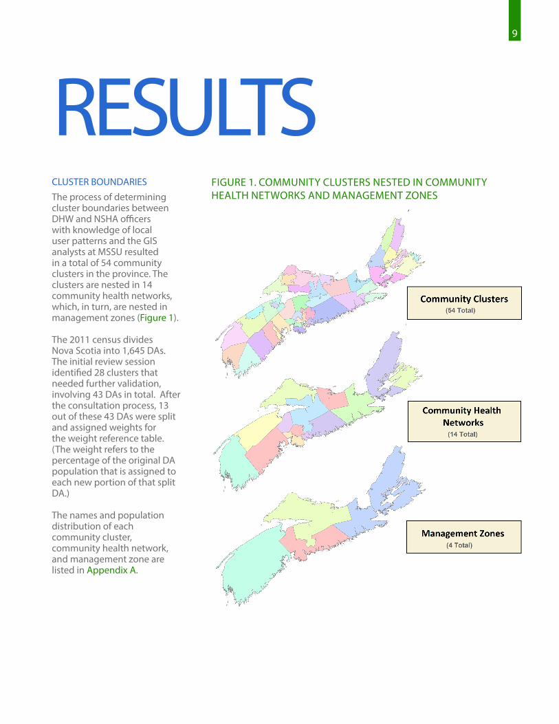
FIGURE 1. COMMUNITY CLUSTERS NESTED IN COMMUNITY HEALTH NETWORKS AND MANAGEMENT ZONES
RESULTSCLUSTER BOUNDARIESThe process of determining cluster boundaries between DHW and NSHA officers with knowledge of local user patterns and the GIS analysts at MSSU resulted in a total of 54 community clusters in the province. The clusters are nested in 14 community health networks, which, in turn, are nested in management zones (Figure 1).
The 2011 census divides Nova Scotia into 1,645 DAs. The initial review session identified 28 clusters that needed further validation, involving 43 DAs in total. After the consultation process, 13 out of these 43 DAs were split and assigned weights for the weight reference table. (The weight refers to the percentage of the original DA population that is assigned to each new portion of that split DA.)
The names and population distribution of each community cluster, community health network, and management zone are listed in Appendix A.

10 10
FIGURE 2. AN EXAMPLE OF CENSUS DISSEMINATION AREAS (OUTLINED IN BLUE) THAT EXTEND INTO THE COASTLINES OF NEIGHBOURING CLUSTERS
FIGURE 3. AN EXAMPLE OF NEW DEVELOPMENT CROSSING BOUNDARIES BASED ON THE OLD CONCEPT
EXAMPLES OF RESOLVING PROBLEM DAsFigures 2-4 show examples of challenges encountered with the aggregation of DAs to clusters. In these figures, clusters are delineated by a unique colour, black lines represent DA boundaries, pink lines represent county boundaries, and purple dots represent building locations.
For example, Figure 2 shows where DA 12090677 of the Lunenburg cluster (yellow) extends to the coastal areas of a neighbouring cluster. This DA crosses over the county boundary well past the community of Hubbards. Assigning this DA to the Lunenburg cluster best represents the community boundaries.
In Figure 3, the boundary of DA 12090901 follows Starboard Drive between Bedford and Clayton Park in Halifax. New development along this road branches off to both sides of the DA boundary, resulting in this community being split between the Bedford (green) and Clayton Park (orange) clusters.

11
In some cases, a group of islands have the same DA code, while the populations in the respective islands are socially more closely connected with different clusters. Figure 4 shows two DAs (12180027 and 12180026) in Boularderie Island area. The research team noted distinct access patterns for health care services, with primary health care being one example. In this case, it does not make sense to keep the DA as one unit. The team agreed that the DA should be separated into different clusters.
In some cases, the DA split is not desirable even though it appears to make sense geographically (e.g. looking at natural borders, such as rivers and mountains, and road connections). Those cases occur when the local services extend to both areas for reasons despite a physical boundary – for example, two areas closely connected historically. Another may be when population on one side of the physical boundary uses the services of the other side because of proximity to other amenities such as shopping malls.
The boundaries of rural clusters are more challenging to configure because the DAs tend to be large and cover sparsely populated areas encompassing multiple communities. Newly developed suburbs
are also challenging due to their rapidly changing landscape and population distribution into neighbouring areas, as seen in Figure 3. Determining which community clusters these newly emerging residential areas should belong to relies heavily on the participating team members’ knowledge about the neighbourhoods and communities surrounding them. Without this local knowledge of how many services reach these sparsely populated areas, it would not be possible to determine the boundaries easily.
The resulting 54 clusters have a population size ranging from 2,725 (Sherbrooke) to 51,169 (Sydney). Appendix B shows the list of community clusters, community health networks, and management zones and the population size.
While the boundaries have been finalized for the time being, no geographic boundaries remain static. Periodical maintenance and fine-tuning of cluster boundaries will be needed. For example, it is anticipated that these boundaries will be subjected to further change with revisions of DA boundaries in the future census.
FIGURE 4. AN EXAMPLE AREA WHERE SPLITTING CENSUS DISSEMINATION AREAS IS NECESSARY (BOULARDERIE ISLAND)

12
The community cluster, community health network, and management zone boundaries are available through the Nova Scotia Health Atlas website for researchers, health planners, and health program providers interested in understanding the status of health, health service utilization, and disease occurrences. The Atlas is also a helpful resource for the general public to better understand the health and well-being of their communities. Visit www.healthatlas.ca to access the cluster area geographic boundary file. The Atlas website also provides a guide on how to use the boundary file, with look-up and population weight tables.
Scotia will join other Canadian provinces and health authorities at the forefront of evidence-informed health care planning.
MSSU and DHW are currently developing a method of geocoding MSI registry data. This geocoding method will enable more reliable and accurate location of people’s place of residence, and therefore calculation of population-level health and service utilization using data linkable to MSI registry data.
The project will continue to receive oversight and guidance from a diverse advisory panel, including provincial government representatives, NSHA / IWK Health Centre administrators, and patient advisors, as well as input on its content and priorities, as identified by decision makers and the public.
ACCESSING THE CLUSTER AREA FILE
MORE ABOUT THE NOVA SCOTIA
HEALTH ATLASThe ongoing Nova Scotia Health Atlas Project represents an orchestrated effort by DHW, NSHA, and MSSU to pool knowledge and data sources from key interest groups for research, policy, and planning. This report describes one phase of this project: developing community cluster units for health service planning.
The Nova Scotia Health Atlas (www.healthatlas.ca) is an interactive, web-based mapping tool that provides timely information pertaining to the distribution of health-related indicators—health and disease measures, health service use, social determinants of health—across different geographic areas of Nova Scotia. The availability of this information in a single location in a user-friendly format, through the Atlas, will better enable Nova Scotia’s health care stakeholders to understand and respond to the health care challenges facing the province. In doing so, Nova
THE NOVA SCOTIA HEALTH ATLAS IS AVAILABLE AT WWW.HEALTHATLAS.CA.

13
APPENDICESAREA LEVEL DEFINITION
NUMBER OF PEOPLE PER UNIT
(approximate)
Census Dissemination Area (DA)
As defined by Statistics Canada1, a DA is a small, relatively stable geographic unit composed of one or more adjacent dissemination blocks (an area bounded on all sides by roads and/or boundaries of standard geographic areas, with a population of 400 to 700 persons). The dissemination block is the smallest geographic area for which population and dwelling counts are disseminated. Dissemination blocks cover all the territory of Canada and all of Canada is divided into DAs.
300 - 1,000
Community Clusters
Community clusters are newly developed area units based on aggregated census DAs intended to align as closely as possible with community activity.
2,700 (Sherbrooke) to 51,000 (Sydney and Area)
Community Health Networks
Community health networks are geographic units based on aggregated community clusters and serve as a mechanism to facilitate linkages across all health system and community partners, linking primary, secondary, tertiary, and diagnostic care across settings (hospital, community, long term care).
18,000 (Eastern Shore / Musquodoboit) to 165,000 (Halifax Peninsula / Chebucto Community)
Management Zones
Nova Scotia Health Authority management zones support local health services leadership, management, and delivery, and are developed in accordance with typical service access, practitioner referral patterns, and other service planning and delivery boundaries.
157,000 (Zone 2: Northern) to 408,000 (Zone 4: Central)
APPENDIX A. AREA LEVELS AND APPROXIMATE SIZE
1 Statistics Canada (2011). https://www12.statcan.gc.ca/census-recensement/2011/ref/dict/geo021-eng.cfm

14
Colchester, East Hants Community Health Network
East Hants Corridor 12,212
Economy / Glenholme 5,400
Hants North 7,054
South Colchester 11,060
Truro and Area 34,970
Cumberland Community Health Network
Amherst 13,535
Cumberland North / North Shore 8,734
South Cumberland 4,216
Springhill 7,915
Pictou Community Health Network
New Glasgow / Westville / Stellarton 34,979
Pictou West 10,664
ZONE 2 Northern
APPENDIX B. LIST OF COMMUNITY HEALTH NETWORKS, COMMUNITY CLUSTERS AND POPULATION
Dartmouth & Southeastern Community Health Network
Dartmouth North 19,149
Dartmouth South 25,623
Dartmouth East 23,694
Cole Harbour / Eastern Passage 36,264
Preston / Lawrencetown / Lake Echo 11,116
Bedford Sackville Community Health NetworkBedford / Hammonds Plains 32,040
Sackville South 21,730
Sackville North and Area 20,892
Fall River and Area 14,163
Halifax Peninsula & Chebucto Community Health Network
Tantallon / Timberlea / St. Margarets Bay 20,990
Sambro Rural Loop 12,836
Armdale / Spryfield / Herring Cove 24,007
Halifax Needham 19,641
Halifax Chebucto 19,127
Fairview 15,797
Clayton Park 32,953
Halifax Citadel 19,683
Eastern Shore Musquodoboit Community Health Network
Eastern Shore / Musquodoboit 17,992
West Hants Community Health Network
West Hants 20,269
Cape Breton Community Health Network
New Waterford 9,803
Sydney and Area 51,169
Dominion / Glace Bay 21,886
Florence / Sydney Mines / North Sydney 20,031
Antigonish & Guysborough Community Health Network
Antigonish 19,589
Guysborough / Canso 5,418
Sherbrooke 2,725
Inverness, Victoria & Richmond Community Health Network
Port Hawkesbury / L’Ardoise / Isle Madame 16,016
Baddeck / Whycocomagh 3,527
Cheticamp 4,119
Dingwall 2,769
Inverness 7,105
Lunenburg & Queens Community Health Network
Bridgewater 26,453
Chester and Area 12,092
Liverpool 10,960
Lunenburg / Mahone Bay 9,258
Yarmouth, Shelburne & Digby Community Health Network
Digby / Clare / Weymouth 19,317
Shelburne / Lockeport 14,496
Yarmouth 25,275
Annapolis & Kings Community Health Network
Annapolis Royal 5,833
Berwick 13,746
Kentville 23,937
Middleton 21,187
Wolfville 15,001
ZONE 1 Western
ZONE 4 Central
ZONE 3 Eastern
*Population data are from 2011 Statistics Canada Census of Population.
COMMUNITY HEALTH NETWORKS & COMMUNITY CLUSTERS POPULATION*
COMMUNITY HEALTH NETWORKS & COMMUNITY CLUSTERS POPULATION*
COMMUNITY HEALTH NETWORKS & COMMUNITY CLUSTERS POPULATION*
COMMUNITY HEALTH NETWORKS & COMMUNITY CLUSTERS POPULATION*

15
The Maritime SPOR SUPPORT Unit (MSSU) is one of several SUPPORT Units across Canada, bringing health research findings to life by helping to integrate them into patient care.
We engage with patients from across New Brunswick, Nova Scotia, and Prince Edward Island, and collaborate with the research community on governance, priority setting, and the planning and conducting of research. Through this meaningful and active collaboration, we contribute to an enhanced health system, engaged health research, and improved health outcomes. We are dedicated to supporting patient-oriented research and decision-making that will reflect the needs and values of Maritime patients.
The MSSU and other Support for People and Patient-Oriented Research and Trials (SUPPORT) Units across Canada are administered by SPOR, the Strategy for Patient-Oriented Research. SPOR, a Canadian Institutes of Health Research (CIHR) initiative, is focused on integrating health research more effectively into care.
WWW.MSSU.CA WWW.HEALTHATLAS.CA
@MARITIMESPOR #ATLAS


![k/ /g/ / / /ɾ/ - Omniglotexisted in Scotian and is usually replaced with pharyngealization in borrowings, eg Attic Αίγυπτος [ájgyptos] "Egypt" > Scotian [ɛʼʒ t]. The](https://static.fdocuments.net/doc/165x107/609f45eea9a131243175a928/k-g-omniglot-existed-in-scotian-and-is-usually-replaced-with-pharyngealization.jpg)


