DETECTING THE COASTAL CLIMATE SIGNAL
14
DETECTING THE COASTAL CLIMATE SIGNAL : THE IOOS CONTRIBUTION JULY 2021
Transcript of DETECTING THE COASTAL CLIMATE SIGNAL

DETECTING THE COASTAL CLIMATE SIGNAL:THE IOOS CONTRIBUTION
JULY 2021
TABLE OF CONTENTSEXECUTIVE SUMMARY 1INTRODUCTION 2THE IOOS ROLE IN DETECTING THE COASTAL CLIMATE SIGNAL 3IOOS STANDS WITH OTHERS 4IOOS CLIMATE SERVICES IN ACTION 5
Observing Warmer Waters in the Gulf of Maine 5Detecting Marine Heat Waves on the West Coast 6Improving Predictions of Hurricane Intensity 7Tracking Nuisance Flooding in the Southeast 7
ENVIRONMENTAL JUSTICE AND CLIMATE 8Providing Low Cost Water Level Sensors in Rural Alaska 8Forecasting Flooding in the Marshall Islands 9Detecting HABs in the Great Lakes 9
RECOMMENDATIONS AND THE PATH FORWARD 10ACKNOWLEDGEMENTS 11

DETECT ING THE COASTAL CL IMATE S IGNAL : THE IOOS CONTR IBUT ION PAGE 1
EXECUTIVE SUMMARYCoastal communities face a growing number of complex climate-related impacts, and the unpredictable
and intensifying nature of these events threaten ecosystems and the economies that rely on them. As a result, the need for reliable and timely information about how climate change impacts our coastal communities has never been greater. Over the last 20 years, the U.S. Integrated Ocean Observing System (IOOS) has built a national network of regional observing systems linked to 17 federal agencies and fostered relationships with stakeholders and partners throughout the coastal United States. This federal-regional partnership provides a unique framework for leveraging data from multiple federal, academic, state, Tribal, local, and private partners to address national issues as they manifest at the regional and local level. To successfully navigate current and future climate-related challenges, we recommend key investments in regional scale modeling, the expansion and modernization of existing observing infrastructure, technological innovation, enhanced program integration, and a deeper commitment to serving underrepresented communities.
While climate change is certain, its effects in coastal regions vary considerably nationwide. Coastal observations and forecasts are vital to providing communities with the information and predictions needed to prepare, plan, adapt, and respond to the impacts of climate in the coastal zone. A one-size-fits-all approach to coastal observing is not sufficient to meet the complexity of communities’ needs nor to meet the variable manifestations of climate change impacts region to region. The sustained IOOS presence along all of our nation’s coasts is tracking these changes, and working with a range of users to provide timely and meaningful information to those who need it. Regional IOOS data and information products are being co-designed and used for a host of decisions impacting society. There is a substantial and growing need for sustained observations and information products, for both coastal communities and all parts of society dependent on coastal regions and resources.
Because a robust coastal observing system is essential to provide timely, high-resolution forecasts and information for decision making to protect coastal ecosystems and economic health, we recommend the following steps to provide the nation with the observing capacity needed to detect and respond to the coastal climate signal:
1. Expand coastal observations and support regional-scale models that collectively can be used to monitor trends, detect changes, provide forecasts, and deliver tailored information products to users for decision making to improve coastal resilience. A first step is to fully fund the recently approved regional cooperative proposals for the next five years, which were developed with significant regional stakeholder input.
2. Recapitalize and modernize existing infrastructure for continued success, including the national network of moorings, profiling gliders, high frequency radar and shore stations, updating sensors, and expanding to comprehensive physical, chemical and biological change detection.
3. Invest in technological innovation for new types of observing tools and sensors and to improve regional-scale models, reducing costs and improving the understanding and delivery of information. In particular, focus on the transition of new technologies such as environmental DNA (eDNA) to operational status, and accelerate development of coupled physical-chemical-biological models that can detect and forecast ecological impacts and changes.
4. Expand regional data integration services to better integrate IOOS with other coastal and global climate programs and to better provide products and services for communities. This can be achieved by supporting smart platforms that can more rapidly communicate information, alerts and warnings to users, thereby building synergies, filling critical gaps, and developing cost-effective solutions.
5. Increase engagement with historically underrepresented communities that are often disproportionately affected by climate impacts by co-designing observation systems and tailored products to ensure all have access to the information and tools needed to fully prepare for and respond to coastal change.

PAGE 2 DETECT ING THE COASTAL CL IMATE S IGNAL : THE IOOS CONTR IBUT ION
The coastal ocean is vitally important for the U.S. economy, and almost 40% of the nation’s population lives in coastal counties.1 “Coastal and ocean activities, such as marine transportation of goods, offshore energy drilling, resource extraction, fish cultivation, recreation, and tourism are integral to the nation’s economy, generating 58% of the national gross domestic product (GDP).”2 Coastal species and habitats also provide countless other benefits to society and natural ecosystems. However, the rapidly changing climate and resulting warming of coastal waters and changes in water chemistry are threatening ecosystems, economies, and communities.
The way society experiences climate variability and change is by what happens where people live - and the changes they see in their daily lives. The climate signal is the link between the broader changing climate, and the climate events that it causes. It manifests differently in coastal areas than in the open ocean and varies greatly from region to region due to a variety of coastal processes such as upwelling, river input, coastal dynamics, geomorphology, weather patterns, and more. The U.S. territorial waters encompass 11 Large Marine Ecosystems that range from the cold waters of the Arctic to the tropical waters of the Pacific Islands, and include the Great Lakes that are the world’s largest system of freshwater lakes. Climate impacts can cascade through these ecosystems resulting in marine heat waves, shifting habitats, increasing harmful algal blooms, hypoxia, loss of coral reefs, extreme storms, sea level rise, and fluctuating lake levels in the Great Lakes. These changes affect not only marine and freshwater organisms, but coastal economies such as fisheries, tourism and maritime transportation. The regionally distributed and federally linked U.S. Integrated Ocean Observing System (IOOS) is uniquely situated to monitor, and help communities respond to, coastal climate issues as they manifest at the local and regional level.
Sustained operational coastal and ocean observing systems provide the data and information required to detect change, forecast future conditions, and provide information products and tools that support decision making. Observations, measurements, and forecasts contribute to a wide range of societal and economic “benefits related to safety, operational efficiency, regulation, and management of activities around, on, in, and under the ocean.”3 Observations are a “key source of information on natural hazards (e.g., harmful algae and bacteria blooms, tsunamis, storm surges, marine heatwaves, and storms and other extreme weather events), ecosystem health and biodiversity (including shifting distributions of organisms and the increased risk of extinctions), ocean pollution (including acidification, de-oxygenation, and plastics), and sea level change. Observations support fisheries management, marine and weather forecasting, climate predictions and projection, marine safety and navigation, decision support for climate adaptation, deep-ocean exploration, and seafloor mapping, among many other areas.”4
1 https://coast.noaa.gov/digitalcoast/data/acs.htm2 USGCRP (2014). Moser, S. C., M. A. Davidson, P. Kirshen, P. Mulvaney, J. F. Murley, J. E. Neumann, L. Petes, and D. Reed, 2014: Ch. 25:
Coastal Zone Development and Ecosystems. Climate Change Impacts in the United States: The Third National Climate As sessment, J. M. Melillo, Terese (T.C.) Richmond, and G. W. Yohe, Eds., U.S. Global Change Research Program, , 579-618.
3 https://cdn.ioos.noaa.gov/media/2020/10/BOOC-Invitation-v6.pdf4 https://www.frontiersin.org/articles/10.3389/fmars.2019.00570/full
INTRODUCTION
The climate signal is the link between the broader changing climate, and the climate events that it causes. It manifests differently in coastal areas than in the open ocean and varies greatly from region to region due to a variety of coastal processes such as upwelling, river input, coastal dynamics, geomorphology, weather patterns, and more.

DETECT ING THE COASTAL CL IMATE S IGNAL : THE IOOS CONTR IBUT ION PAGE 3
IOOS provides a framework for addressing national issues as they manifest at the regional level by linking the observing activities of federal agencies with regional coastal observing systems. The sustained IOOS presence along all of our nation’s coasts over recent decades, both in terms of ocean observation capacity, as well as in its connections to the communities that live on those coasts, provides the foundation for detection and response to the coastal climate signal. This community connection is especially critical when it comes to the manifestations of the coastal climate signal. Coastal communities are vulnerable to a growing number of complex climate-related disturbances that can threaten lives, property, livelihoods, and the coastal ecosystem.
IOOS provides services to the entire coastline of the United States through sustained observations, modeling, data integration, and the design and delivery of information tools for users. In addition, IOOS works with a variety of stakeholders to understand needs and improve safety, enhance the economy, and protect our environment. Using technologies such as gliders, moorings, shore stations, satellites, and more, IOOS collects a broad suite of coastal and marine data including water temperature, water level, currents, winds, waves, chemistry, and biology. IOOS infrastructure allows for real-time data, near-real-time information warnings and forecasts, and other decision-support tools. IOOS constantly innovates with new and affordable technologies. A hallmark of IOOS is its commitment to working with a variety of stakeholders to understand their needs and tailor information for improved safety, enhanced economies, and a protected environment locally, while maintaining an integrated system that makes data easy to access and use nationally.
In addition to collecting their own data, IOOS regions integrate data from local, state, and federal sources to create specialized products and tools at the regional scale. All 11 IOOS Regional Associations (RAs) have also been certified by NOAA. This rigorous process confirms that they meet federal standards for data gathering and management, and operate inclusively, transparently, and with significant stakeholder input into system priorities. Certification means that data and information from these non-federal entities can be used with the same confidence and assurance as federal data. As a result, IOOS data are extended the same liability coverage as federal data, and can be successfully integrated with NOAA data to provide the public with greater access to useful information for decision making. Certification enhances efficient interagency coordination at the regional and national levels, and provides national consistency while addressing unique and diverse regional needs.
IOOS RAs recently completed cooperative agreements that identify local, state, Tribal, and regional needs for the next five years. These include sustaining existing observing efforts as well filling critical gaps. IOOS is “shovel-ready” to address national climate issues where they impact people most - in their local and regional communities.
THE IOOS ROLE IN DETECTING THE COASTAL CLIMATE SIGNAL
The Cha’ba mooring off La Push, WA, was developed with support from the Murdock Charitable Trust and is operated by NANOOS and the University of Washington Applied Physics Laboratory. The Quileute Tribe named the mooring Cha’ba, meaning whale tail. The mooring monitors weather and physical and biogeochemical ocean conditions. Photo credit: J Newton

PAGE 4 DETECT ING THE COASTAL CL IMATE S IGNAL : THE IOOS CONTR IBUT ION
IOOS STANDS WITH OTHERSIOOS is part of a broader organizational ecosystem that is working to detect, understand, adapt and
respond to changing climate along our ocean and coasts. At the national level, the Intergovernmental Panel on Climate Change Assessment Reports (IPCC ARs) and the United States National Climate Assessments (US NCAs) summarize the considerable work that is being undertaken to observe, understand, and respond to climate change at the international, national, and regional levels. The U.S. Climate Variability and Predictability Program (CLIVAR) coordinates and advances research within the United States to improve the documentation, understanding, modeling, and prediction of variations in global and regional climate. Multiple federal agencies, including NOAA, NASA, ONR, DOE, NSF, and more all support climate programs focusing on the ocean and coasts.
Within NOAA, several programs support critical research, observations and modeling efforts related to climate change. The Global Ocean Monitoring and Observing (GOMO) Program, located in NOAA’s Office of Oceanic and Atmospheric Research, facilitates more than one million measurements of the ocean each day, which cover a geographic scale distinct and complementary to that of IOOS. These data are critical for providing boundary conditions necessary to drive coastal models and meet critical societal needs. Other programs IOOS coordinates with, and will continue and expand work with, include, but are not limited to, the Regional Integrated Sciences and Assessments (RISA), National Marine Fisheries Service, National Weather Service, the National Center for Environmental Information, National Marine Sanctuaries, the Office for Coastal Management, National Estuarine Research Reserve System, and the Ocean Acidification Program. Several of the IOOS regions work with Indigenous groups and Tribal governments across the continental U.S. and Pacific Islands. These partnerships incorporate Indigenous knowledge into ocean observing, co-develop and operate the systems, and co-design needed information products. In the coming years, IOOS aims to expand these and other efforts to identify needs, increase the use of co-design, and coordinate efforts to build synergies and fill gaps with the overall goal of enhancing understanding and response to coastal climate impacts.
Out on the water in Tomales Bay, with partners from Hog Island Oyster Company. Shellfish larvae are vulnerable to increasing ocean acidification and monitoring in partnership with shellfish growers has benefitted both the industry and science. Photo credit: T Hill

DETECT ING THE COASTAL CL IMATE S IGNAL : THE IOOS CONTR IBUT ION PAGE 5
IOOS CLIMATE SERVICES IN ACTIONThe following four case studies illustrate how IOOS is using its technologies and data products to reach
different audiences and support communities in the face of climate-related hazards. Many more examples exist in all 11 IOOS regions.
Observing Warmer Waters in the Gulf of MaineThe oceanographic mooring system operated by Northeastern Regional Association of Coastal Ocean Observing
Systems (NERACOOS) records a variety of ocean measurements including temperature, salinity, dissolved oxygen, pH, and nutrients throughout the water column. In fact, the network provides over 50 percent of the sustained subsurface observations and over 90 percent of the deep-water observations in the Gulf of Maine. This 20-year record, along with satellites and other sources, has been used to document that the Gulf of Maine warmed faster than most other regions of the world from 2008-2012, and has remained in a warmer regime since. These temperature trends and other environmental changes in the Gulf of Maine have shifted the region’s lobster catch eastward to cooler areas while increasing the economic and ecological risks posed by harmful algal blooms.
Subsurface temperatures in the Gulf of Maine warmed quickly and significantly from 2008- 2012, as shown here at 200m (red) and 250m (grey) depths. Credit: Dr. Dave Townsend, University of Maine, based on NERACOOS data

PAGE 6 DETECT ING THE COASTAL CL IMATE S IGNAL : THE IOOS CONTR IBUT ION
Network of glider tracks along the U.S. West Coast and Alaska from IOOS investments and our partners, including the National Science Foundation and others. Some gliders are optimized to run both offshore and in nearshore waters to monitor conditions that may lead to climate impacts.
SOUTHERN CALIFORNIACOASTALOBSERVING SYSTEM
OCEAN
Detecting Marine Heat Waves on the West CoastThe IOOS regions along the West Coast - Southern California Coastal Ocean Observing System, (SCCOOS)
Central and Northern California Ocean Observing System (CeNCOOS), Northwest Association of Networked Ocean Observing Systems (NANOOS), and Alaska Ocean Observing System (AOOS) - work with academic, Tribal
and other partners to support glider runs that operate 365 days a year collecting oceanographic data. Combined with satellite and buoy data, this glider network helps to detect marine heat waves. The gliders cover a large range spatially, and provide subsurface data for both inshore and offshore waters.
In 2015 an unprecedentedly large mass of warmer than normal ocean water, known as “The Blob,” stretched from Alaska to Mexico, disrupting the marine ecosystem. Warmer waters stimulated the largest harmful algal bloom ever recorded in these waters, which shut down the Dungeness crab fishery at a cost exceeding $100M. Every part of the food web was impacted, including wild salmon and marine mammals such as California sea lions and fin whales. The marine mammal illness and loss of life led to what experts call an Unusual Mortality Event. Data from this glider system are routinely used by the IOOS regions to inform their stakeholders and also the “NOAA West Watch” to monitor for marine heat waves and other climate-related impacts.

DETECT ING THE COASTAL CL IMATE S IGNAL : THE IOOS CONTR IBUT ION PAGE 7
Tracking Nuisance Flooding in the SoutheastA growing concern for communities in the Southeast is high-tide flooding (also known as nuisance flooding)
that can close roads and create cascading economic, health, safety, and environmental problems. At this time, the region lacks the density of observations necessary to make informed decisions about flood risk and response. SECOORA, in partnership with academic, nonprofit, and private sector experts, is working with communities throughout the southeast to deploy a network of over 200 low-cost water level sensors over the next three years that will aid municipalities and others with planning and adapting to local flood risks. The low-cost sensors leverage NOAA’s National Water Level Observing Network (NWLON) and are aimed at addressing communities’ needs for higher-density real-time information about flood risks. These sensors provide affordable access to the data needed to make decisions and take action.
Improving Predictions of Hurricane IntensityWarming ocean waters contribute to increasing hurricane
frequency and intensity. Improving hurricane intensity forecasts is vital for coastal communities, who regularly face evacuation decisions based on the predicted strength of an approaching hurricane. Since 2017, IOOS has partnered with a number of federal and non-federal partners, including NOAA’s Atlantic Oceanographic and Meteorological Laboratory (AOML) and the U.S. Navy, on a project using profiling gliders to improve hurricane intensity forecasting. Gliders can collect data in the middle of a hurricane without putting people in hazardous conditions, and data collected by the hurricane gliders are automatically integrated into oceanographic forecast models that NOAA uses for predicting hurricane intensity, and also contribute to research on improving the accuracy of relevant models. In 2021, AOML and four IOOS regions - Caribbean Coastal Ocean Observing System (CariCOOS), Gulf of Mexico Coastal Ocean Observing System (GCOOS), Southeast Coastal Ocean Observing Regional Association (SECOORA), and Mid-Atlantic Regional Association Coastal Ocean Observing System (MARACOOS) - will fly over 40 glider missions during the hurricane season.
NOAA and partners from the Cooperative Institute for Marine and Atmospheric Studies (CIMAS) at the University of Miami and CARICOOS launch ocean gliders that will collect data during the hurricane season. Photo credit: NOAA/CIMAS/CARICOOS
Water in the streets during a high tide event on a storm-free day in Charleston, SC. Photo credit: NOAA Tides and Currents
PAGE 8 DETECT ING THE COASTAL CL IMATE S IGNAL : THE IOOS CONTR IBUT ION
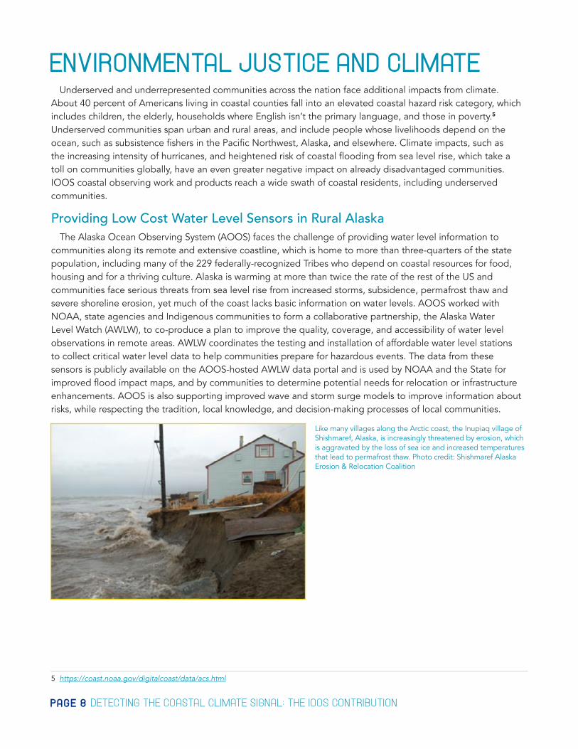
ENVIRONMENTAL JUSTICE AND CLIMATEUnderserved and underrepresented communities across the nation face additional impacts from climate.
About 40 percent of Americans living in coastal counties fall into an elevated coastal hazard risk category, which includes children, the elderly, households where English isn’t the primary language, and those in poverty.5 Underserved communities span urban and rural areas, and include people whose livelihoods depend on the ocean, such as subsistence fishers in the Pacific Northwest, Alaska, and elsewhere. Climate impacts, such as the increasing intensity of hurricanes, and heightened risk of coastal flooding from sea level rise, which take a toll on communities globally, have an even greater negative impact on already disadvantaged communities. IOOS coastal observing work and products reach a wide swath of coastal residents, including underserved communities.
Providing Low Cost Water Level Sensors in Rural AlaskaThe Alaska Ocean Observing System (AOOS) faces the challenge of providing water level information to
communities along its remote and extensive coastline, which is home to more than three-quarters of the state population, including many of the 229 federally-recognized Tribes who depend on coastal resources for food, housing and for a thriving culture. Alaska is warming at more than twice the rate of the rest of the US and communities face serious threats from sea level rise from increased storms, subsidence, permafrost thaw and severe shoreline erosion, yet much of the coast lacks basic information on water levels. AOOS worked with NOAA, state agencies and Indigenous communities to form a collaborative partnership, the Alaska Water Level Watch (AWLW), to co-produce a plan to improve the quality, coverage, and accessibility of water level observations in remote areas. AWLW coordinates the testing and installation of affordable water level stations to collect critical water level data to help communities prepare for hazardous events. The data from these sensors is publicly available on the AOOS-hosted AWLW data portal and is used by NOAA and the State for improved flood impact maps, and by communities to determine potential needs for relocation or infrastructure enhancements. AOOS is also supporting improved wave and storm surge models to improve information about risks, while respecting the tradition, local knowledge, and decision-making processes of local communities.
5 https://coast.noaa.gov/digitalcoast/data/acs.html
Like many villages along the Arctic coast, the Inupiaq village of Shishmaref, Alaska, is increasingly threatened by erosion, which is aggravated by the loss of sea ice and increased temperatures that lead to permafrost thaw. Photo credit: Shishmaref Alaska Erosion & Relocation Coalition

DETECT ING THE COASTAL CL IMATE S IGNAL : THE IOOS CONTR IBUT ION PAGE 9
Forecasting Flooding in the Marshall IslandsIn the Pacific Islands, severe flooding from sea swells, which used to happen once every 10 years now happens
several times a year. In March 2014, a severe inundation event from sea swells required the evacuation of over 1,000 residents of Majuro, the densely populated capital of the Republic of the Marshall Islands with a maximum elevation of only 3 meters. Following the event, the Pacific Islands Ocean Observing System (PacIOOS) team worked with local partners and stakeholders to assess the community’s needs and improve its high sea level forecast. This work resulted in a 6-day high sea level forecast that included wave run-up, to predict when there is likely to be wave overtopping along the atoll’s coasts. This improved forecast tool updates hourly and provides the Majuro community with information about the upcoming six days, allowing local officials to assess risks to lives and property on the island. These forecasts are also regularly used by the local Weather Service Office, as well as residents and local governments to prepare for swells by proactively installing temporary barriers to block wave inundation.6
Detecting HABs in the Great LakesAs the largest source of surface freshwater in the United States, the Great Lakes provide drinking water for over
35 million people. Saginaw Bay in Lake Huron is the new emergency water source for Flint, MI, long troubled by poor drinking water quality. However, the bay is at risk of harmful algal blooms, similar to those that have impacted Lake Erie. These blooms could make the water unsafe to drink without additional treatment. NOAA and other partners are working to determine the necessary observations and forecasts for managers to receive early warning regarding algal blooms so they can remove algal toxins and ensure safe drinking water. The Great Lakes Observing System (GLOS) will provide these forecasts and real-time observations via their Seagull platform, an information technology platform to enhance user access to real-time data.
6 https://www.ingentaconnect.com/content/mts/mtsj/2016/00000050/00000003/art00007
Waves and high water levels engulf the shoreline at Uliga, Majuro Atoll, in November 2019. Photo credit: Hilary Hosia/MIJ
Cyanobacterial bloom in Lake Erie. Photo credit: NOAA GLERL
PAGE 10 DETECT ING THE COASTAL CL IMATE S IGNAL : THE IOOS CONTR IBUT ION
RECOMMENDATIONS AND THE PATH FORWARDThe health of our coastal communities, economies, and ecosystems depends not only on understanding
the complexities of changing coastal conditions, but also on the ability to provide timely, high-resolution forecasts for decision making. With increasing rates of environmental change, the need for more comprehensive information on our coasts has never been greater. Climate-driven impacts, such as sea level rise, warming waters, harmful algal blooms, ocean acidification, hypoxia, shifting habitats, and extreme storms, increasingly threaten coastal communities. These changes happen at time scales that can range from hours to seasonal to decadal. The unpredictable nature of the impacts confound communities’ ability to plan for, prepare for, respond to, and adapt to multiple changes. An end-to-end observing system must match the temporal and spatial scales of these impacts and work with communities and stakeholders to design systems that make the adequate observations needed to support regional scale models which can detect current conditions and forecast future seasonal patterns.
IOOS plays a unique role in providing sustained observations that can detect the coastal climate signal and its cascading effects, as well as communicate about those manifestations in ways that are timely and useful to the people who live in the region. Though much is already being done, more is needed to adequately understand, predict, and respond to these changes. There are critical gaps in the nation’s coastal observing network, particularly for biology. High-resolution coastal models are needed to support understanding and decision support tools. And, we need to further integrate our work with other programs, and work together to expand our reach to, and engagement with, all citizens, including those in underrepresented groups.
We recommend the following steps to provide the nation with the observing capacity necessary to fully detect and respond to the coastal climate signal:
1. Expand coastal observations and support regional-scale models that collectively can be used to monitor trends, detect changes, provide forecasts, and deliver tailored information products to users for decision making to improve coastal resilience. A first step is to fully fund the recently approved regional cooperative proposals for the next five years, which were developed with significant regional stakeholder input.
2. Recapitalize and modernize existing infrastructure for continued success, including the national network of moorings, profiling gliders, high frequency radar and shore stations, updating sensors, and expanding to comprehensive physical, chemical and biological change detection.
3. Invest in technological innovation for new types of observing tools and sensors and to improve regional-scale models, reducing costs and improving the understanding and delivery of information. In particular, focus on the transition of new technologies such as environmental DNA (eDNA) to operational status, and accelerate development of coupled physical-chemical-biological models that can detect and forecast ecological impacts and changes.
4. Expand regional data integration services to better integrate IOOS with other coastal and global climate programs and to better provide products and services for communities. This can be achieved by supporting smart platforms that can more rapidly communicate information, alerts and warnings to users, thereby building synergies, filling critical gaps, and developing cost-effective solutions.
5. Increase engagement with historically underrepresented communities that are often disproportionately affected by climate impacts by co-designing observation systems and tailored products to ensure all have access to the information and tools needed to fully prepare for and respond to coastal change.

DETECT ING THE COASTAL CL IMATE S IGNAL : THE IOOS CONTR IBUT ION PAGE 11
To begin this process, IOOS is taking steps to engage in discussions with other organizations and entities working in the coastal area, as well as users of observing data in the regions, to identify gaps and synergies in our respective efforts related to the coastal climate signal. IOOS is planning to host a series of virtual dialogues with these partner programs to document existing efforts, identify needs, and develop near- and long-term recommendations focusing on the unique challenges related to the impacts of climate on the coastal ocean and the Great Lakes. These will culminate in a community workshop and report that outlines near- and long-term priorities.
Outside of this climate dialogue series, IOOS is planning to hold community sessions at the Coastal and Estuarine Research Federation (CERF) conference and the biennial AGU-ASLO Ocean Sciences conferences in the next year, as well as create channels for further collaboration with U.S. CLIVAR. The problems posed by coastal climate changes are numerous and multifaceted, and will benefit from increased collaboration between all of the entities working on the issues. In addition to increased funding for IOOS-specific activities, ongoing discussions and partnerships with other organizations will be necessary components of the near- and long-term future of IOOS.
ACKNOWLEDGEMENTSJosie Quintrell of the IOOS Association and Margaret Chory of the Consortium for Ocean Leadership wish
to acknowledge and thank the following people for their expertise and contributions provided during the development of this document:
Dr Clarissa Anderson (Scripps Institution of Oceanography/Southern California Coastal Ocean Observing System)
Dr Krisa Arzayus (U.S. IOOS Office, NOAA)
Dr Jake Kritzer (Northeastern Regional Association of Coastal Ocean Observing Systems)
Molly McCammon (Alaska Ocean Observing System)
Dr Jan Newton (University of Washington/Northwest Association of Networked Ocean Observing Systems)
Nicholas Rome (Consortium for Ocean Leadership)
Dr Dan Rudnick (Scripps Institution of Oceanography)
Jessica Snowden (Global Ocean Monitoring and Observing Program, NOAA)
Citation: IOOS Association. 2021. Detecting the Coastal Climate Signal: The IOOS Contribution. IOOSassociation.org. 11 pages.