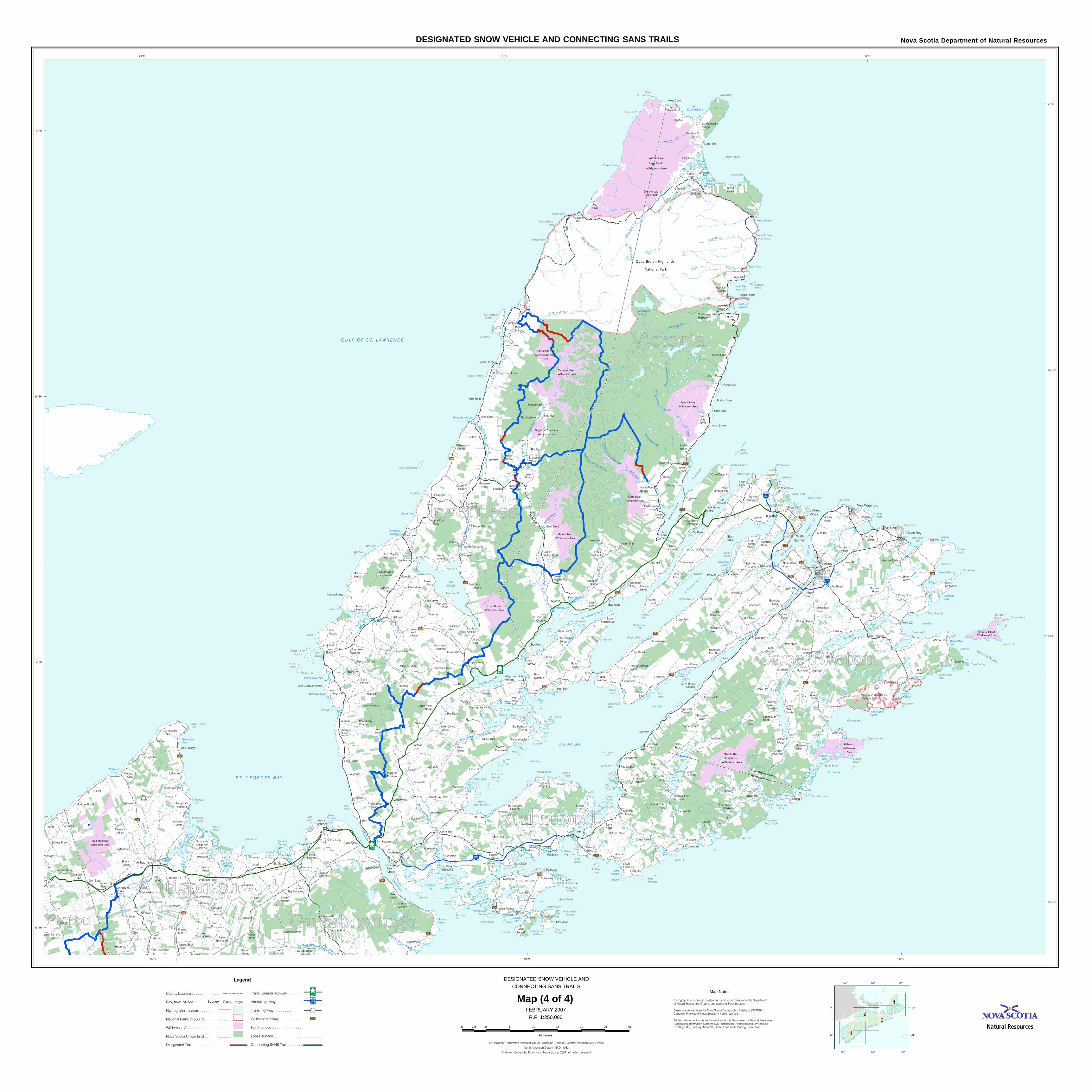
Detailed Map of Cape Breton on Government Web Site - novascotia.ca/natr/ohv/maps/map4.pdf · Cape...
1
Troy Oban Iona Enon Eden Ohio Mabou Ponds Morar Marsh Croft Tarbot Robins Nyanza Lingan Hawker Dundee Brophy Beauly Bucklaw Wilburn Sunrise Seaview Roberta Rivulet Portree Melford Marshes Judique Jubilee Hyannas Glenora Glencoe Gabarus Fourchu Estmere Emerald Arichat Pomquet ore Linwood Ireland Glenroy Dunmore Ashdale Arisaig Ardness Balmoral West Bay Woodbine Stirling St. Anns Rock Elm Port Ban New Glen Mira Gut Lochside Kingross Ingonish Hillside Glendyer Fordview Florence Evanston Eskasoni East Bay Dunvegan Dingwall Coxheath Capstick Boisdale Big Hill Big Glen Big Bank Aspy Bay Askilton Ashfield Tracadie Maryvale Marydale Lakevale Avondale West Alba South Bar Seal Cove Sandfield Riverside Red River Red Point Port Hood Pondville Oceanview Mira Road Meat Cove Martinque Lime Hill L'Ardoise Lake Uist Johnstown Ironville Inverness Hillsdale Hillsboro Hawthorne Grandique Glenville Framboise Creignish Craigmore Cleveland Cheticamp Broughton Bras d'Or Big Ridge Big Marsh Big Brook Big Brook Benacadie Beechmont Purlbrook Monastery Hillcrest Glen Road Glen Bard Glassburn Big Marsh Wreck Cove Terra Nova Tarbotvale Sugar Loaf St. Esprit South Cove Shunacadie Scotsville Salem Road Ross Ferry Rear Forks Orangedale Mull River Marysville Long Point Kingsville Kiltarlity Kempt Head Iron Mines Irish Vale Irish Cove Hays River Goose Cove Gold Brook Frenchvale Egypt Road D'Escousse Coady Road Castle Bay Cape North Blackstone Black Rock Belle Cote Barra Head Barra Glen Barrachois New France Frankville Clydesdale Beech Hill Aulds Cove Hadleyville North Shore Gillis Lake Smelt Brook Whycocomagh Trout Brook Terre Noire Strathlorne Stewartdale Steep Creek Silver Mine Sight Point Scotch Hill River Denys Red Islands Queensville Princeville Point Cross Mason Point Marsh Brook Malagawatch Mabou Mines Loch Lomond Little Anse Lingan Road Island View Hureauville Hornes Road Harbourview Grand River Grand Etang Grande Anse Gracieville French Road French Cove Forest Glen Englishtown Dutch Brook Cross Point Cape Auguet Breton Cove Breac Brook Boularderie Black Point Black Brook Birch Plain Barren Hill Baddeck Bay Alder Point Alder River St. Andrews Marshy Hope James River Glen Alpine Georgeville Cape George Little Mabou Big Lorraine Mount Auburn West Arichat Valley Mills Thibeauville Sydney River Sydney Forks Salmon River Saint Ninian River Bennet Rear Estmere Poirierville Point Tupper Pleasant Bay McAdams Lake Little River L'Archeveque Keltic Lodge Jersey Cove Indian Brook Groves Point Grande Greve Gabarus Lake French River Cap La Ronde Cape Dauphin Belle Marche Ainslie Glen West Linwood Taylors Road Salt Springs Roman Valley Lincolnville Big Tracadie West Bay Road Victoria Line South Harbour Soldiers Cove Rear Boisdale Port Hastings Petit-de-Grat North Ainslie Morrison Road Marion Bridge Mabou Harbour Judique South Inlet Baddeck Grand Narrows Glenora Falls Glen Morrison Glencoe Mills Georges River Forks Baddeck Caribou Marsh Brook Village Big Intervale Albert Bridge West Lakevale South Merland Pomquet Forks Polsons McArras Brook Havre Boucher Frasers Mills Frasers Grant Brierly Brook Baileys Brook Afton Mount Pleasant North West Arm Victoria Mines Upper Margaree Soapstone Mine Plaister Mines Middle Melford Margaree Forks Little Narrows Leitches Creek Ingonish Ferry Ingonish Beach Gardiner Mines East Skye Glen Chimney Corner Blacketts Lake Baddeck Bridge West Intervale North Lochaber Malignant Cove Harbour Centre Victoria Bridge Southwest Mabou River Bourgeois New Campbellton Margaree Valley Marble Mountain Lower Washabuck Lower L'Ardoise Lower Hillsdale Ingonish Centre Glencoe Station Creignish Rear Big Pond Centre Bay Road Valley Pleasant Valley North Intervale Addington Forks Washabuck Bridge Upper Grand Mira New Harris Forks MacKinnons Brook Lower St. Esprit Long Island Main Loch Lomond West Juniper Mountain Grand Mira South Grand Mira North Glengarry Valley Campbellton Road Livingstone Cove Cross Roads Ohio West Lake Ainslie Upper River Denys Salmon River Road Rear Little River Grand River Falls East Lake Ainslie Upper Springfield Upper South River Mattie Settlement Lower Springfield North River Bridge Upper Middle River South Lake Ainslie River Denys Centre Rear Judique South Northside East Bay McIntyres Mountain Lower Middle River Campbells Mountain Big Harbour Centre Upper Big Tracadie Antigonish Harbour Whycocomagh Portage The Points West Bay St. Joseph du Moine St. Georges Channel St. Andrews Channel South West Margaree Rear Judique Chapel North East Margaree Head of Loch Lomond Framboise Intervale pper Barneys River St. Patricks Channel South Cape Highlands North Cape Highlands Little Judique Ponds St. Margarets Village Rear Christmas Island New Harris Settlement Millville Boularderie Guysborough Intervale Barneys River Station South Ingonish Harbour Lower River Inhabitants Big Intervale Cape North Southside Antigonish Harbour Baddeck St. Peters Mulgrave Louisbourg Antigonish North Sydney Sydney Mines New Waterford Sydney Port Hawkesbury Dominion Glace Bay Marconi Towers South Port Morien Kytes Hill Beinn Scalpie Sou t h R i ve r W e st River O hio Riv e r Rig h ts Ri v er Mira River St. F ra n cis Ha r b o ur River Milford H a ve n River Riv er Inhab it a nts River De n ys So u t h w e s t Ma b o u R i v er S kye Ri v er M u ll R iv e r M a b o u R i v e r So ut h w e st M argare e Riv er M a rg a ree R iv e r No rthe ast M a r gare e R i v e r M a c K e n z ie s R i v er No r th A spy River B i g S o u th we st B k . B a d d e c k R iv e r M i d d l e R i v e r Mid dle River N o r th R ive r W e st B r an c h N o r t h Ri ver Ba rac hoi s R i v e r M i d dl e B r a n ch N orth Riv er In d i a n B r o o k W e s t B r anch I n d ia n B rook E a st B r a nc h In d i a n B k . In g o n ish R iv er Chetic a mp R iver Cl ybu r n Bk Bla ck B r o ok So u th Asp y River Sa l m o n R i v e r Lake Uist Loch Lomond Belfry Lake LAKE AINSLIE Bras d'Or Lake Great Bras d'Or Cheticamp Flowage Havre Boucher Pipers Cove ASPY BAY West Bay Mira Bay PORT HOOD So uth Ar m Broad Cove Nyanza Bay Wreck Cove Broad Cove North Cove Morien Bay Forchu Bay Pigeon Cove Denys Basin Browns Cove Spanish Bay Gabarus Bay St. Anns Bay Bay of Rocks Bordens Cove North Harbour South Harbour Neils Harbour Polletts Cove Big Glace Bay Black Bk. Cove St. Peters Bay Little Harbour Big Rorys Cove North West Arm Inhabitants Bay Arichat Hbr ST. GEORGES BAY Why coc omag h Bay Main-à-Dieu Bay Kennington Cove Pomquet Harbour St. Anns Harbour St. Peters Inlet Margaree Harbour East Bay Inverness Harbour North Bay Ingonish South Bay Ingonish Barrachois Harbour Antigonish Harbour BAY ST. LAWRENCE St. Andrews Channel S t. Patric ks Chan nel GULF OF ST. LAWRENCE Head of West Bay Cove Little Judique Hbr Tracadie Harbour Malignant Cove Ballantynes Cove Framboise Cove Lenno x Passage Sydney Harbou r Strait of Canso Louisburg Harbour Main-à-Dieu Passage West Arichat Harbour Petit-de-Grat Harbour Cape St. Lawrence Cat Pt Red Pt Bar Point Black Pt West Hd La Pointe Marsh Pt Black Pt Low Point Low Point Northern Head Dhu Point Cape North Bluff Head Table Head Island Pt Murphy Pt Kempt Hd Cap Rouge Green Pt McKays Pt. Bonar Head North Head Table Head Howe Point Monks Head Red Islands Doirons Pt ISLE MADAME Marache Pt Lowland Pt Ainslie Pt Fishery Pt Militia Pt Alder Point Point Aconi Long Island Lobster Pt McAdam Pt Cape Breton White Point Cape Dauphin Murdocks Pt Fourchu Head MacIsaac Pt Henry Island Cape Gabarus Belfry Beach Pointe Brulee Point Michaud Peninsula Pt Panteleau Pt Cap Le Moine Blackrock Pt Janvrin Island MacMillans Pt Ingonish Island CHÉTICAMP ISLAND Crammond Islands Benecadaie Point Fishing Cove Head BOULARDERIE ISLAND Fox Cove South Cape Cape Jack Cape George Point Eastern Beach Pomquet Pt McIssacs Point Mahoneys Beach Bear Hd Gillis Pt Chapel Island Arichat Head Eastern Head Morrison Head Blackie Point False Bay Hd SCATARIE ISLAND Petite Nez Beach PORT HOOD ISLAND St. Peters Island Big Harbour Island Petit-de-Grat Island Little Lorraine Head Bird Islands Catalone Pt South Head Cape Breton Highlands National Park Polletts Cove Aspy Fault Wilderness Area French River Wilderness Area Gabarus Wilderness Area Middle River Framboise Wilderness Area Margaree River Wilderness Area Middle River Wilderness Area North River Wilderness Area Trout Brook Wilderness Area Jim Campbells Barren Wilderness Area Scatarie Island Wilderness Area Sugarloaf Mountain Wilderness Area Fortress of Louisbourg National Historic Site Eigg Mountain Wilderness Area CT Tracadie Road Balls Creek Donkin Birch Grove Main-à-Dieu Baleine (Sea Wolf Island) MacLeods Pt. Big Bras d'Or Westmount Waddens Cove Cape Breton County Richmond County 104 162 125 105 104 19 CT 4 28 7 22 4 4 4 4 4 337 216 395 255 327 223 252 245 219 344 320 316 239 206 247 205 305 312 312 344 305 223 305 62°0' 62°0' 61°0' 61°0' 60°0' 60°0' 45°30' 45°30' 46°0' 46°0' 46°30' 46°30' 47°0' 47°0' 4 2 1 3 66° 66° 63° 63° 60° 60° 44° 44° 46° 46° 6º Universal Transverse Mercator (UTM) Projection, Zone 20, Central Meridian 63º00' West North American Datum (NAD) 1983 © Crown Copyright, Province of Nova Scotia, 2007, All rights reserved Cartographic compilation, design and production by Nova Scotia Department of Natural Resources, Graphic and Mapping Services, 2007. Base data derived from the Nova Scotia Topographic Database (NSTDB). Copyright Province of Nova Scotia. All rights reserved. Additional information derived from Nova Scotia Department of Natural Resources, Geographic Information Systems (GIS) databases (Restricted and Limited Use Lands (RLUL), Forestry, Minerals, Crown Land and Planning Secretariat). Map Notes Nova Scotia Department of Natural Resources DESIGNATED SNOW VEHICLE AND CONNECTING SANS TRAILS 5 0 5 10 15 20 25 30 2.5 kilometres Legend County boundary . . . . . . . . . . . . . City, town, village . . . . . . . Hydrographic feature . . . . . . . . . . National Parks (>500 ha) . . . . . . . . . . . . . Wilderness Areas . . . . . . . . . . . . . . . . . . . Nova Scotia Crown land . . . . . . . . . . . . . . Designated Trail . . . . . . . . . . . . . . . . . . . Sydney Tangier Trans Canada highway . . . . . . . . Arterial highway . . . . . . . . . . . . . . Trunk highway . . . . . . . . . . . . . . Collector highway . . . . . . . . . . . . Hard surface . . . . . . . . . . . . . . . Loose surface . . . . . . . . . . . . . . . Connecting SANS Trail . . . . . . . . 7 Digby 104 101 224 Map (4 of 4) DESIGNATED SNOW VEHICLE AND CONNECTING SANS TRAILS FEBRUARY 2007 R.F. 1:250,000
Transcript of Detailed Map of Cape Breton on Government Web Site - novascotia.ca/natr/ohv/maps/map4.pdf · Cape...
Troy
Oban
Iona
Enon
Eden
Ohio
Mabou
Ponds
Morar
Marsh Croft
Tarbot
Robins
Nyanza
Lingan
Hawker
Dundee
Brophy
Beauly
Bucklaw
Wilburn
Sunrise
Seaview
Roberta
Rivulet
Portree
Melford
Marshes
Judique
Jubilee
Hyannas
Glenora
Glencoe
Gabarus
Fourchu
Estmere
Emerald
Arichat
Pomquet
ore
Linwood
Ireland
GlenroyDunmore
Ashdale
Arisaig
Ardness
Balmoral
West Bay
Woodbine
Stirling
St. Anns
Rock Elm
Port Ban
New Glen
Mira Gut
Lochside
Kingross
Ingonish
Hillside
Glendyer
Fordview
Florence
Evanston
Eskasoni
East Bay
Dunvegan
Dingwall
Coxheath
Capstick
Boisdale
Big Hill
Big Glen
Big Bank
Aspy Bay
Askilton
Ashfield
Tracadie
Maryvale
Marydale
Lakevale
Avondale
West Alba
South Bar
Seal Cove
Sandfield
Riverside
Red River
Red Point
Port Hood
Pondville
Oceanview
Mira Road
Meat Cove
Martinque
Lime Hill
L'Ardoise
Lake Uist
Johnstown
Ironville
Inverness
Hillsdale
Hillsboro
Hawthorne
Grandique
Glenville
FramboiseCreignish
Craigmore
Cleveland
Cheticamp
Broughton
Bras d'Or
Big Ridge
Big Marsh
Big Brook
Big Brook
Benacadie
Beechmont
Purlbrook
Monastery
Hillcrest
Glen Road
Glen Bard
Glassburn
Big Marsh
Wreck Cove
Terra Nova
Tarbotvale
Sugar Loaf
St. Esprit
South Cove
Shunacadie
Scotsville
Salem Road
Ross Ferry
Rear Forks
Orangedale
Mull River
Marysville
Long Point
Kingsville
Kiltarlity
Kempt Head
Iron Mines
Irish Vale
Irish Cove
Hays River
Goose Cove
Gold Brook
Frenchvale
Egypt Road
D'Escousse
Coady Road
CastleBay
Cape North
Blackstone
Black Rock
Belle Cote
Barra Head
Barra Glen
Barrachois
New France
Frankville
Clydesdale
Beech Hill
Aulds Cove
Hadleyville
North Shore
Gillis Lake
Smelt Brook
Whycocomagh
Trout Brook
Terre Noire
Strathlorne
Stewartdale
Steep Creek
Silver Mine
Sight Point
Scotch Hill
River Denys
Red Islands
Queensville
Princeville
Point Cross
Mason Point
Marsh Brook
Malagawatch
Mabou Mines
Loch Lomond
Little Anse
Lingan Road
Island View
Hureauville
Hornes Road
Harbourview
Grand River
Grand Etang
Grande Anse
Gracieville
French Road
French Cove
Forest Glen
Englishtown
Dutch Brook
Cross Point
Cape Auguet
Breton Cove
Breac Brook
Boularderie
Black Point
Black Brook
Birch Plain
Barren Hill
Baddeck Bay
Alder Point
AlderRiver
St. Andrews
Marshy Hope
James River
Glen Alpine
Georgeville
Cape George
Little Mabou
Big Lorraine
MountAuburn
West Arichat
Valley Mills
Thibeauville
Sydney River
Sydney Forks
Salmon River
Saint Ninian
River Bennet
Rear Estmere
Poirierville
Point Tupper
Pleasant Bay
McAdams Lake
Little River
L'Archeveque
Keltic Lodge
Jersey Cove
Indian Brook
Groves Point
Grande Greve
Gabarus Lake
French River
Cap La Ronde
Cape Dauphin
BelleMarche
Ainslie Glen
West Linwood
Taylors Road
Salt Springs
Roman Valley
Lincolnville
Big Tracadie
West Bay Road
Victoria Line
South Harbour
Soldiers Cove
RearBoisdale
Port Hastings
Petit-de-Grat
North Ainslie
Morrison Road
Marion Bridge
Mabou Harbour
Judique South
Inlet Baddeck
Grand Narrows
Glenora Falls
Glen Morrison
Glencoe Mills
Georges River
Forks Baddeck
Caribou Marsh
Brook Village
Big Intervale
Albert Bridge
West Lakevale
South Merland
Pomquet Forks
Polsons
McArras Brook
Havre Boucher
Frasers Mills
Frasers Grant
Brierly Brook
Baileys Brook
Afton
Mount Pleasant
North West Arm
Victoria Mines
Upper Margaree
Soapstone Mine
Plaister Mines
Middle Melford
Margaree Forks
Little Narrows
Leitches Creek
Ingonish Ferry
Ingonish Beach
Gardiner Mines
East Skye Glen
Chimney Corner
Blacketts Lake
Baddeck Bridge
West Intervale
North Lochaber
Malignant Cove
Harbour Centre
Victoria Bridge
Southwest Mabou
River Bourgeois
New Campbellton
Margaree Valley
Marble Mountain
Lower Washabuck
Lower L'Ardoise
Lower Hillsdale
Ingonish Centre
Glencoe Station
Creignish Rear
Big Pond Centre
Bay Road Valley
Pleasant Valley
North Intervale
Addington Forks
Washabuck Bridge
Upper Grand Mira
New Harris Forks
MacKinnons Brook
Lower St. Esprit
Long Island Main
Loch Lomond West
Juniper Mountain
Grand Mira South
Grand Mira North
Glengarry Valley
CampbelltonRoad
Livingstone Cove
Cross Roads Ohio
West Lake Ainslie
Upper River Denys
Salmon River Road
Rear Little River
Grand River Falls
East Lake Ainslie
Upper Springfield
Upper South River
Mattie Settlement
Lower Springfield
North River Bridge
Upper Middle River
South Lake Ainslie
River DenysCentreRear Judique
South
Northside East Bay
McIntyres Mountain
Lower Middle River
Campbells Mountain
Big Harbour Centre
Upper Big Tracadie
Antigonish Harbour
Whycocomagh Portage
The Points West Bay
St. Joseph du Moine
St. Georges Channel
St. Andrews Channel
South West Margaree
Rear Judique Chapel
North East Margaree
Head of Loch Lomond
FramboiseIntervale
pper Barneys River
St. PatricksChannel
South Cape Highlands
North Cape Highlands
Little Judique Ponds
St. Margarets Village
Rear Christmas Island
New Harris Settlement
Millville Boularderie
Guysborough Intervale
Barneys River Station
South IngonishHarbour
Lower River Inhabitants
Big Intervale Cape North
Southside Antigonish
Harbour
Baddeck
St. Peters
Mulgrave
Louisbourg
Antigonish
North Sydney
Sydney Mines
New Waterford
Sydney
PortHawkesbury
Dominion
Glace Bay
Marconi Towers
South Port Morien
Kytes Hill
Beinn Scalpie
Sout
h R
iver
Wes
t Rive
r
Ohi
o R
iver
Rights River
Mira River
St. Francis Harbour RiverMilford Haven River
River Inhabitants
River Denys
Southwest M
abou River
Skye River
M u ll Ri
ver
Mabou Ri v e r
Sout
hwes
t Mar
gare
e R
iver
Margaree River
North
east
Mar
gare
e R
iver
Ma
cKenz ies R iver
North
Asp
y Rive
r
Big Southwest B
k.
Badde
ck R
iver
Mid
dle
Riv
erM
iddle
River
North River
West Br anch Nor th River
Barachois R iver
Middle B
ranch North River
Indian Bro
ok
We
st Branch India n Brook
East
Bra
nch
Indi
an B
k.
Ingonish River
Cheticamp River
Clyburn Bk
Black Brook
Sout
h As
py R
iver
Sal m on Rive r
Lake Uist
LochLomond
Belfry Lake
LAKE AINSLIE
Bras d'Or Lake
Great Bras d'Or
CheticampFlowage
HavreBoucher
PipersCove
A S P Y B A Y
West Bay
Mira Bay
PORT HOOD
Sout
h Ar
m
Broad Cove
Nyanza Bay
Wreck Cove
Broad Cove
North Cove
Morien Bay
Forchu Bay
Pigeon Cove
Denys Basin
Browns Cove
Spanish Bay
Gabarus Bay
St. A
nns
Bay
Bay of Rocks
Bordens Cove
North Harbour
South Harbour
Neils Harbour
Polletts Cove
Big GlaceBay
Black Bk. Cove
St. Peters Bay
Little Harbour
Big Rorys Cove
North W
est Arm
InhabitantsBay
Arichat Hbr
S T. G E O R G E S B A Y
Whycocomagh Bay
Main-à-Dieu Bay
Kennington Cove
Pomquet Harbour
St. A
nns
Har
bour
St. Peters
Inlet
Margaree Harbour
East Bay
Inverness Harbour
North BayIngonish
South Bay Ingonish
Barrachois Harbour
Antig
onish
Harb
our
BAY ST. LAWRENCE
St. And
rews C
hann
el
St. Patricks Channel
G U L F O F S T. L A W R E N C E
Head of West Bay Cove
Little Judique Hbr
TracadieHarbour
MalignantCove
BallantynesCove
Framboise Cove
Lennox Passage
Sydn
ey H
arbo
ur
Strait of CansoLouisburg
Harbour
Main-à-Dieu Passage
West Arichat Harbour
Petit-de-Grat Harbour
CapeSt. Lawrence
Cat Pt
Red Pt
Bar Point
Black Pt
West Hd
La Pointe
Marsh Pt
Black Pt
Low Point
Low Point
NorthernHead
Dhu Point
Cape North
Bluff Head
Table Head
Island Pt
Murphy Pt
Kempt Hd
CapRouge
Green Pt
McKays Pt.
Bonar Head
NorthHead
Table Head
Howe Point
Monks Head
Red Islands
Doirons Pt
ISLE MADAME
Marache Pt
Lowland Pt
Ainslie Pt
Fishery Pt
Militia Pt
Alder Point
Point Aconi
Long Island
Lobster Pt
McAdamPt
Cape Breton
White Point
Cape Dauphin
Murdocks Pt
Fourchu Head
MacIsaac Pt
Henry Island
Cape Gabarus
Belfry Beach
Pointe Brulee
Point Michaud
Peninsula Pt
Panteleau Pt
Cap Le Moine
Blackrock Pt
JanvrinIsland
MacMillans Pt
Ingonish Island
CHÉTICAMP ISLAND
Crammond Islands
Benecadaie Point
Fishing Cove Head
BOULARDERIE ISLAND
Fox Cove South Cape
Cape Jack
Cape GeorgePoint
Eastern Beach
Pomquet Pt
McIssacsPoint
MahoneysBeach
Bear Hd
Gillis Pt
Chapel Island
Arichat Head
Eastern Head
Morrison Head
Blackie Point
False Bay HdSCATARIE ISLAND
Petite Nez Beach
PORT HOODISLAND
St. Peters Island
Big Harbour Island
Petit-de-Grat Island
Little Lorraine Head
Bird Islands
Catalone Pt
South Head
Cape Breton Highlands
National Park
Polletts Cove
Aspy Fault
Wilderness Area
French River Wilderness Area
Gabarus Wilderness
AreaMiddle RiverFramboise
Wilderness Area
Margaree River Wilderness Area
Middle River Wilderness Area
North River Wilderness Area
Trout Brook Wilderness Area
Jim Campbells Barren Wilderness
Area
Scatarie IslandWilderness Area
Sugarloaf Mountain Wilderness Area
Fortress of LouisbourgNational Historic Site
Eigg MountainWilderness Area
CT
Tracadie Road
Balls Creek
Donkin
Birch Grove
Main-à-Dieu
Baleine
(Sea Wolf Island)
MacLeods Pt.
Big Bras d'Or
Westmount
WaddensCove
Cape Breton CountyRichmond County
104
162
125
105
104
19
CT
4
28
7
22
4
4
4
4
4
337
216
395
255
327
223
252
245
219
344
320
316
239
206
247
205
305
312
312
344
305
223
305
62°0'
62°0'
61°0'
61°0'
60°0'
60°0'
45°30'
45°30'
46°0'
46°0'
46°30'
46°30'
47°0'
47°0'
4
2
1
3
66°
66°
63°
63° 60°
60°
44° 44°
46° 46°
6º Universal Transverse Mercator (UTM) Projection, Zone 20, Central Meridian 63º00' West
North American Datum (NAD) 1983
© Crown Copyright, Province of Nova Scotia, 2007, All rights reserved
Cartographic compilation, design and production by Nova Scotia Departmentof Natural Resources, Graphic and Mapping Services, 2007.
Base data derived from the Nova Scotia Topographic Database (NSTDB). Copyright Province of Nova Scotia. All rights reserved.
Additional information derived from Nova Scotia Department of Natural Resources, Geographic Information Systems (GIS) databases (Restricted and Limited Use Lands (RLUL), Forestry, Minerals, Crown Land and Planning Secretariat).
Map Notes
Nova Scotia Department of Natural ResourcesDESIGNATED SNOW VEHICLE AND CONNECTING SANS TRAILS
5 0 5 10 15 20 25 302.5
kilometres
Legend
County boundary . . . . . . . . . . . . .
City, town, village . . . . . . .
Hydrographic feature . . . . . . . . . .
National Parks (>500 ha) . . . . . . . . . . . . .
Wilderness Areas . . . . . . . . . . . . . . . . . . .
Nova Scotia Crown land . . . . . . . . . . . . . .
Designated Trail . . . . . . . . . . . . . . . . . . .
Sydney Tangier
Trans Canada highway . . . . . . . .
Arterial highway . . . . . . . . . . . . . .
Trunk highway . . . . . . . . . . . . . .
Collector highway . . . . . . . . . . . .
Hard surface . . . . . . . . . . . . . . .
Loose surface . . . . . . . . . . . . . . .
Connecting SANS Trail . . . . . . . .
7
Digby
104
101
224
Map (4 of 4)
DESIGNATED SNOW VEHICLE ANDCONNECTING SANS TRAILS
FEBRUARY 2007R.F. 1:250,000