Designated Wilderness Spatial Data Standard State Data Dictionary Bureau of Land Management...
25
OR/WA State Data Dictionary Bureau of Land Management Designated Wilderness Spatial Data Standard Designated Wilderness November 23, 2013 Page 1
-
Upload
nguyencong -
Category
Documents
-
view
218 -
download
1
Transcript of Designated Wilderness Spatial Data Standard State Data Dictionary Bureau of Land Management...

OR/WA State Data Dictionary Bureau of Land Management
Designated Wilderness Spatial Data Standard
Designated Wilderness November 23, 2013 Page 1

Table of Contents
1. GENERAL INFORMATION 4
1.1 ROLES AND RESPONSIBILITIES 4
1.2 FOIA CATEGORY 4
1.3 RECORDS RETENTION SCHEDULE(S) 5
1.4 SECURITY/ACCESS/SENSITIVITY 5
2. DATASET OVERVIEW 5
2.1 DESCRIPTION 5
2.2 USAGE 5
2.3 SPONSOR/AFFECTED PARTIES 5
2.4 RELATIONSHIP TO OTHER DATASETS 6
2.5 DATA CATEGORY/ARCHITECTURE LINK 6
2.6 RELATIONSHIP TO THE DEPARTMENT OF THE INTERIOR ENTERPRISE ARCHITECTURE - DATA RESOURCE MODEL 7
2.7 WILDERNESS DATA ORGANIZATION STRUCTURE 8
3. DATA MANAGEMENT PROTOCOLS 9
3.1 ACCURACY REQUIREMENTS 9
3.2 COLLECTION, INPUT AND MAINTENANCE PROTOCOLS 9
3.3 UPDATE FREQUENCY AND ARCHIVAL PROTOCOLS 9
3.4 STATEWIDE MONITORING 9
4. WILDERNESS SCHEMA (Simplified) 10
4.1 WILDERNESS FEATURE DATASET 10
4.1.1 WLD_POLY (Wilderness Polygons) 10
4.1.2 WLD_ARC (Wilderness Lines) 10
4.2 WILDERNESS PROPOSED FEATURE DATASET 10
4.2.1 WLD_P_POLY (Wilderness Proposed Polygons) 10
4.2.2 WLD_P_ARC (Wilderness Proposed Lines) 10
5. PROJECTION AND SPATIAL EXTENT 11
5.1 SPATIAL ENTITY CHARACTERISTCS 11
6. ATTRIBUTE CHARACTERISTICS AND DEFINITIONS 12
Designated Wilderness November 23, 2013 Page 2
OR/WA State Data Dictionary Bureau of Land Management

6.1 ACCURACY_FT 12
6.2 ADMIN_ST 12
6.3 AUTH_DATE 13
6.4 AUTH_NAME 13
6.5 CASEFILE 14
6.6 COORD_SRC 15
6.7 DEF_FEATURE 15
6.8 JURIS_CD 16
6.9 VERSION_NAME 17
6.10 WLD_NAME 18
6.11 WLD_P_NAME 18
7. ASSOCIATED FILES OR DATABASES 19
8. LAYER FILES (PUBLICATION VIEWS) 19
9. EDITING PROCEDURES 20
10. OREGON DATA FRAMEWORK OVERVIEW 21
11. ABBREVIATIONS AND ACRONYMS USED IN THIS STANDARD 22
APPENDIX A. DOMAINS (VALID VALUES) 23
A.1 ADMIN_ST 23
A.2 COORD_SRC 23
A.3 DEF_FEATURE 23
A.4 JURIS_CODE 24
OR/WA State Data Dictionary Bureau of Land Management
Designated Wilderness November 23, 2013 Page 3

OR/WA State Data Dictionary Bureau of Land Management
1. GENERAL INFORMATION Dataset (Theme) Name: Wilderness (WLD) Dataset (Feature Classes): WLD_POLY, WLD_ARC, WLD_P_POLY, WLD_P_ARC
1.1 ROLES AND RESPONSIBILITIES
State Data Steward
Roles Responsibilities
The State Data Steward, Jerry Magee, at 503-808-6086, is responsible for approving data standards and business rules, for developing Quality Assurance/Quality Control procedures, and ensuring that data is managed as a corporate resource. The State Data Steward coordinates with field office data stewards, the state data administrator, Geographic Information System (GIS) coordinators, and with national data stewards. The State Data Steward reviews geospatial metadata for completeness and quality.
Lead GIS Specialist The Lead GIS Specialist, Erin Frostad, at 503-808-6524, works with data stewards to interpret business needs into GIS applications and derive data requirements and participates in the development of data standards. The Lead GIS specialist coordinates with system administrators and GIS coordinators to manage the GIS databases. The lead GIS specialist works with data editors to make sure data is being input into the enterprise Spatial Database Engine (SDE) database consistently and in accordance with the established data standard. The Lead GIS Specialist provides technical assistance and advice on GIS analysis, query and display of the dataset.
State Data Administrator The acting State Data Administrator, Pamela Keller, at 503-808-6009, provides information management leadership, data modeling expertise, and custodianship of the state data models. The State Data Administrator ensures that defined processes for development of data standards and metadata are followed and that they are consistent and complete. The State Data Administrator is responsible for making data standards and metadata accessible to all users. The State Data Administrator coordinates with data stewards and GIS coordinators to respond to national spatial data requests.
Administrator State Records
responsible for identifying any Privacy issues related to spatial data. The State Records Administrator also provides direction and guidance on data release and fees. The State Records Administrator assures that data has been classified under the proper records retention schedule and determine appropriate Freedom of Information Act (FOIA) category.
The acting State Records Administrator, Janice Johnson, at 503-808-6430, is
Table 1 Roles and Responsibilities
1.2 FOIA CATEGORY
Public
Designated Wilderness November 23, 2013 Page 4

OR/WA State Data Dictionary Bureau of Land Management
1.3 RECORDS RETENTION SCHEDULE(S)
20/52c (Geographic Information Systems) PERMANENT
Cutoff end of fiscal year (EOFY) in which the layer is created or significantly altered by the Bureau of Land Management (BLM). Transfer copy of data to National Archives and Records Administration (NARA) at the EOFY.
1.4 SECURITY/ACCESS/SENSITIVITY
The Wilderness set of themes does not require any additional security other than that provided by the General Support System (the hardware/software infrastructure of the Oregon/Washington (OR/WA BLM).
This data is not sensitive and there are no restrictions on access to this data either from within the BLM or external to the BLM.
There are no privacy issues or concerns associated with these data themes.
2. DATASET OVERVIEW
2.1 DESCRIPTION
This Wilderness data standard contains requirements for Wilderness polygons and Wilderness lines. Wilderness Areas are designated by Congressional act and are administered in accordance with the Wilderness Act of 1964 and any special provisions of the enabling legislation.
2.2 USAGE
The Wilderness dataset is used in Environmental Assessment and Impact Statements as part of the National Environmental Policy Act (NEPA) analysis of alternatives. Activities with a large impact on Wilderness values such as energy and mineral development have more Wilderness analysis, but most activity plans must address Wilderness.
2.3 SPONSOR/AFFECTED PARTIES
The sponsor for this data set is the Deputy State Director, Resource Planning, Use and Protection. WLD is defined by the Wilderness Act of 1964 and is not specific to BLM. Matching interagency data across the landscape is necessary as some BLM wilderness areas are extensions of a wilderness area of another agency. Our nongovernmental partners and the general public are affected to the extent that WLD is part of the Resource Management Plans (RMP) that determines management on BLM lands. Implementation of an RMP may preclude certain activities in certain areas either because the Wilderness Act prohibits them or because of potential impact to the wilderness resource.
Designated Wilderness November 23, 2013 Page 5

OR/WA State Data Dictionary Bureau of Land Management
2.4 RELATIONSHIP TO OTHER DATASETS
None
2.5 DATA CATEGORY/ARCHITECTURE LINK
These data themes are a portion of the Oregon Data Framework (ODF). The ODF utilizes the concept of inheritance to define specific instances of data. The ODF divides all OR/WA resource-related data into three general categories: Activities, Resources, and Boundaries. These general categories are broken into subcategories that inherit spatial characteristics and attributes from their parent category. These sub-categories may be further broken into more specific groups until you get to a basic dataset that cannot be further sub-divided. Those basic datasets inherit all characteristics of all groups/categories above them. The basic datasets are where physical data gets populated (those groups/categories above them do not contain actual data but set parameters that all data of that type must follow).
See the ODF, Figure 2, for a simplified schematic of the entire Oregon Data Framework showing the overall organization and entity inheritance. For additional information about the ODF, contact:
Pamela Keller OR/WA State Data Administrator Bureau of Land Management P.O. Box 2965 Portland, OR 97208 503-808-6009
For Wilderness, the categories/groups that the dataset is part of are: BLM Wilderness Polygon: Oregon Data Framework
Boundaries Political & Administrative
Political & Administrative Existing WLD _POLY
BLM Wilderness Line: Oregon Data Framework
Boundaries Political/Administrative Special Management Area (SMA) Line
WLD _ARC
Similarly, for proposed wilderness there are two paths, one for the polygon features and one for the line (arc) features. BLM Wilderness Proposed Polygon: Oregon Data Framework
Boundaries Political and Administrative
Political and Administrative Proposed WLD_P_POLY
BLM Wilderness Proposed Line: Oregon Data Framework
Boundaries Designated Wilderness November 23, 2013 Page 6

OR/WA State Data Dictionary Bureau of Land Management
Political/Administrative/Special Management Area (SMA) Line WLD_P_ARC
2.6 RELATIONSHIP TO THE DEPARTMENT OF THE INTERIOR ENTERPRISE ARCHITECTURE − DATA RESOURCE MODEL
The Department of the Interior's (DOI) Enterprise Architecture contains a component called the Data Resource Model. This model addresses the concepts of Data Sharing, Data Description, and Data Context. This data standard provides information needed to address each of those areas. Data sharing is addressed through complete documentation and simple data structures which make sharing easier. Data description is addressed through the section on Attribute Descriptions. Data context is addressed through the data organization and structure portions of this document. In addition, the DOI Data Resource Model categorizes data by use of standardized Data Subject Areas and Information Classes. For this data set, these are as follows:
Data Subject Area: Geospatial Information Class: Location
For a complete list of all DOI Data Subject Areas and Information Classes, contact:
Pamela Keller OR/WA State Data Administrator Bureau of Land Management P.O. Box 2965 Portland, OR 97208 503-808-6009
Designated Wilderness November 23, 2013 Page 7

OR/WA State Data Dictionary Bureau of Land Management
2.7 WILDERNESS DATA ORGANIZATION STRUCTURE
Figure 1 Data Organization Structure
Designated Wilderness November 23, 2013 Page 8

OR/WA State Data Dictionary Bureau of Land Management
3. DATA MANAGEMENT PROTOCOLS
3.1 ACCURACY REQUIREMENTS
Political and Administrative boundary themes (WLD is a boundary theme) often require a higher level of accuracy than other themes. This is because those boundaries often divide very different management and regulation. Some boundaries can, by their nature or definition, be accurately located and others cannot. Boundary perimeter lines must be defined and segmented accordingly. Individual boundary segment attributes (Feature Level Metadata) provide the information needed to answer questions about why a boundary line is where it is and how accurately it is located. These theme groups therefore require feature class pairs (feature datasets), polygons for the area and lines for the perimeter. A high level of positional and attribute accuracy is required for the WLD theme and features are input and maintained with the highest level of accuracy possible.
3.2 COLLECTION, INPUT AND MAINTENANCE PROTOCOLS
Congress determines the boundary of Wilderness Areas and the designating act describes the boundary with legal description or by reference to an official map which is then used to create the legal boundary description. Wilderness boundaries are delineated using guidance in BLM Manual Handbook H-8560-1 (Management of Designated Wilderness). Boundaries are captured in GIS using these legal references and the most accurate GIS themes available including Geographic Coordinates Data Base for parcel segments; 24k Digital Line Graphic (DLG) for roads; Digital Elevation Models (DEM) backdrop for heads-up digitizing of contours, fences and power lines and Digital Orthophoto Quads (DOQ) imagery backdrop for disturbances like mine areas. Proposed Wilderness Areas might be delineated by a District in response to proposals by Congressional offices. If a proposed area becomes designated the features are moved from WLD_P to WLD. Proposals are archived along with other data relevant to a particular plan and/or at critical change dates. The line feature class pair for WLD polygons is required, but existing WLD data for OR/WA Districts will be loaded into SDE without populating the attributes. Future WLD capture will require populating the line attributes. Once the WLD theme has been created, it is the responsibility of the State Data Steward to ensure that it remains current. It is the responsibility of the District Data Stewards and GIS Coordinators to keep the State Data Steward apprised of improvements to the GIS source data and to assist with updates. Proposed changes will be provided to the State Data Steward and Lead GIS Specialist for inclusion in the theme.
3.3 UPDATE FREQUENCY AND ARCHIVAL PROTOCOLS
The unit of processing for updating the WLD theme is the State. Except for minor corrections, WLD changes only through new or amended legislation or with the acquisition of inholdings.
It is also the responsibility of the Data Steward to ensure that any database external to the GIS remains current. The district GIS Coordinator will approve update processes and provide assistance and oversight. At this time there are no digital databases associated with WLD, but this responsibility extends to paper records. Reports or tables containing WLD acreages must be checked against the GIS acres and, ideally, should come directly from the GIS which supplied the official WLD acres for the relevant legislation.
3.4 STATEWIDE MONITORING
Regular review of the WLD theme is not needed since there will be close review at the time of any change.
Designated Wilderness November 23, 2013 Page 9

OR/WA State Data Dictionary Bureau of Land Management
4. WILDERNESS SCHEMA (Simplified)
General Information: Attributes are listed in the order they appear in the geodatabase feature class. The order is an indication of the importance of the attribute for theme definition and use. There are no aliases unless specifically noted. The domains used in this data standard can be found in Appendix A. These are the domains at the time the data standard was approved. Domains can be changed without a re-issue of the data standard. For a complete list of domains, contact:
Pamela Keller OR/WA State Data Administrator Bureau of Land Management P.O. Box 2965 Portland, OR 97208 503-808-6009
4.1 WILDERNESS FEATURE DATASET 4.1.1 WLD_POLY (Wilderness Polygons) Attribute Name Data Type Length Default Value Required? Domain WLD_NAME String 50 Yes CASEFILE String 15 No AUTH_NAME String 100 No AUTH_DATE String 8 No ADMIN_ST String 2 Yes dom_ADMIN_ST JURIS_CODE String 5 No dom_JURIS_CODE VERSION_NAME String 50 InitialLoad Yes*
4.1.2 WLD_ARC (Wilderness Lines) Attribute Name Data Type Length Default Value Required? Domain DEF_FEATURE String 25 Yes dom_DEF_FEATURE COORD_SRC String 7 Yes dom_COORD_SRC ACCURACY_FT Short Integer No VERSION_NAME String 50 InitialLoad Yes*
4.2 WILDERNESS_PROPOSED FEATURE DATASET
4.2.1 WLD_P_POLY (Wilderness Proposed Polygons)
Attribute Name Data Type Length Default Value Required? Domain WLD_P_NAME String 50 Yes ADMIN_ST String 2 Yes dom_ADMIN_ST VERSION_NAME String 50 InitialLoad Yes*
4.2.2 WLD_P_ARC (Wilderness Proposed Lines) Attribute Name Data Type Length Default Value Required? Domain DEF_FEATURE String 25 Yes dom_DEF_FEATURE COORD_SRC String 7 Yes dom_COORD_SRC ACCURACY_FT Short Integer No VERSION_NAME String 50 InitialLoad Yes*
Designated Wilderness November 23, 2013 Page 10

OR/WA State Data Dictionary Bureau of Land Management
* Values automatically generated
5. PROJECTION AND SPATIAL EXTENT
All feature classes and feature datasets are in Geographic, NAD83. Units are decimal degrees. Spatial extent (area of coverage) includes all lands managed by the Bureau of Land Management in the states of Oregon and Washington. In order to maintain consistent acres reporting, WLD_POLY should be projected into Universal Transverse Mercator in the appropriate zone for acres calculation. See the metadata for this data set for more precise description of the extent.
5.1 SPATIAL ENTITY CHARACTERISTCS
WILDERNESS POLYGON (WLD_POLY) Description: Instance of Political and Administrative Existing group. Geometry: Polygons do not cover the landscape nor do they cover all BLM lands continuously. In addition, there may be islands (“donut holes”) of Non-Wilderness surrounded by Wilderness. Polygons do not overlap. Topology: Yes. WLD_POLY lines are coincident with WLD_ARC lines and together make the feature dataset, Wilderness. Integration Requirements: WLD is created from merging together features from many different input themes. Attributes on the WLD_ARC provide the information needed to update lines using the correct sources (either by replacement or snapping) and maintain integration across feature classes.
WILDERNESS LINE (WLD_ARC) Description: Instance of Political Admin/Special Management Area (SMA) Line group. Lines making up the area perimeters of WLD and segmented as needed to indicate a change in either what defines the section of boundary and/or the source of the actual GIS coordinates. Geometry: Simple, non-overlapping lines that are split between endpoints as needed. Topology: Yes. WLD_POLY lines are coincident with WLD_ARC lines and together make the feature dataset, Wilderness. Integration Requirements: Line segments must be coincident with the source data indicated by attributes DEF_FEATURE and COORD_SRC either through duplication or snapping.
WILDERNESS PROPOSED POLYGON (WLD_P_POLY) Description: Instance of Political and Administrative Proposed group. Geometry: Polygons do not cover the landscape nor do they cover all BLM lands continuously. In addition, there may be islands (“donut holes”) of Non-Wilderness surrounded by proposed Wilderness. Polygons do not overlap. Topology: Yes. WLD_P_POLY lines are coincident with WLD_P_ARC lines and together make the feature dataset, Wilderness_Proposed. Integration Requirements: WLD_P is created from merging together features from many different input themes. Attributes on the WLD_P_ARC provide the information needed to update lines using the correct sources (either by replacement or snapping) and maintain integration across feature classes.
WILDERNESS PROPOSED LINE (WLD_P_ARC) Description: Instance of Political Admin/Special Management Area (SMA) Proposed Line group. Lines making up the area perimeters of WLD_P and segmented as needed to indicate a change in either what defines the section of boundary and/or the source of the actual GIS coordinates. Geometry: Simple, non-overlapping lines that are split between endpoints as needed. Topology: Yes. WLD_P_POLY lines are coincident with WLD_P_ARC lines and together make the feature dataset, Wilderness Proposed. Integration Requirements: Line segments must be coincident with the source data indicated by attributes DEF_FEATURE and COORD_SRC either through duplication or snapping.
Designated Wilderness November 23, 2013 Page 11

OR/WA State Data Dictionary Bureau of Land Management
6. ATTRIBUTE CHARACTERISTICS AND DEFINITIONS
In alphabetical order.
6.1 ACCURACY_FT
Geodatabase Name BLM Structured Name
Description
Required/Optional
Domain (Valid Values)
Data Type
ACCURACY_FT ACCURACY_FEET_MEASURE
Inherited from Entity POLITICAL ADMIN SMA LINE
Used in Feature Classes: WLD_ARC WLD_P_ARC
Definition How close, in feet, the spatial GIS depiction is in relation to the actual location on the ground. There are several factors to consider in GIS error: scale and accuracy of map-based sources, accuracy of Global Positioning System (GPS) equipment, and the skill level of the data manipulators. A value of “0” indicates no entry was made. This is the correct value when the COORD_SRC is another GIS theme (Digital Line Graphs (DLG), Geographic Coordinate Database (GCD), Digital Elevation Model (DEM)) because the accuracy is determined by that theme. However, if COORD_SRC is MAP (digitized from a paper map) or GPS, a value of “0” indicates a missing value that should be filled in either with a non-zero number or “-1.” A value of “-1” indicates that the accuracy is unknown and no reliable estimate can be made. Examples: 40, -1, 0
Optional
No Domain
Short Integer
6.2 ADMIN_ST
Geodatabase Name BLM Structured Name
ADMIN_ST ADMINSTRATIVE_STATE_CODE
Description Inherited from POLITICAL ADMINISTRATIVE
Used in Feature Classes: WLD_POLY WLD_P_POLY
Definition The two-character abbreviation for the State with administrative
Designated Wilderness November 23, 2013 Page 12

OR/WA State Data Dictionary Bureau of Land Management
responsibilities. Some BLM State Offices have administrative responsibilities for more than one State. For instance, the administrative state of Oregon is responsible for both Oregon and Washington.
Required/Optional Required
Domain (Valid Values) dom_ADMIN_ST
Data Type Character (CHAR) 2
6.3 AUTH_DATE
Geodatabase Name BLM Structured Name
Description
Required/Optional
Domain (Valid Values)
Data Type
AUTH_DATE Authority_Date
Inherited from POLITICAL ADMINISTRATIVE EXISTING
Used in Feature Classes: WLD_POLY
Definition Date the area was legally established (YYYYMMDD). It is allowable to enter only YEAR or YEAR and MONTH.
Optional
No Domain
Character (CHAR) 8
6.4 AUTH_NAME
Geodatabase Name BLM Structured Name
AUTH_NAME Authority_Name
Description Inherited from POLITICAL ADMINISTRATIVE EXISTING
Used in Feature Classes: WLD_POLY
Definition Public Law or Order that established the designation.
Required/Optional Optional
Domain (Valid Values) No Domain
Designated Wilderness November 23, 2013 Page 13

OR/WA State Data Dictionary Bureau of Land Management
Data Type
Example: Steens Mountain Cooperative Management and Protection Act of 2000, Public Law 106-399
Variable Character (VCHAR) 100
6.5 CASEFILE
Geodatabase Name BLM Structured Name
Description
Required/Optional
Domain (Valid Values)
Data Type
CASEFILE Casefile_Number
Not Inherited
Used in Feature Classes: WLD_POLY
Definition The serialized case file number for each wilderness area. This field should be in uppercase. Inholding polygons should not be given a casefile number.
Optional
No Domain Example: OR-19189
Variable Character (VCHAR) 15
Designated Wilderness November 23, 2013 Page 14

OR/WA State Data Dictionary Bureau of Land Management
6.6 COORD_SRC Geodatabase Name BLM Structured Name
Description
Required/Optional
Domain (Valid Values)
Data Type
COORD_SRC COORDINATE_SOURCE_CODE
Inherited from Entity POLITICAL ADMIN SMA LINE
Used in Feature Classes: WLD_ARC WLD_P_ARC
Definition The actual source of the GIS coordinates for the line segments. If the line is copied from another theme and already has COORD_SRC, it should be reviewed and may need to be changed for use in this dataset.
Required
dom_COORD_SRC
CHAR7
6.7 DEF_FEATURE Geodatabase Name BLM Structured Name
Description
Required/Optional
Domain (Valid Values) Data Type
DEF_FEATURE DEFINING_FEATURE_CODE
Inherited from Entity POLITICAL ADMIN SMA LINE
Used in Feature Classes: WLD_ARC WLD_P_ARC
Definition The physical or legal feature that defines the boundary according to the legal boundary description. In general the lowest level defining feature, but it depends on how the boundary segment is actually defined. For example, SUBDIVISION rather than COUNTY unless the boundary segment is specifically defined as following the COUNTY boundary. If the line is copied from another theme, and already has DEF_FEATURE, it should be reviewed and may need to be changed for use in this dataset.
Required
dom_DEF_FEATURE Variable Character (VCHAR) 25
Designated Wilderness November 23, 2013 Page 15

OR/WA State Data Dictionary Bureau of Land Management
6.8 JURIS_CODE
Geodatabase Name JURIS_CODE BLM Structured Name JURISDICTION_ORGANIZATION_CODE
Description
Required/Optional
Inherited from Entity POLITICAL ADMIN EXISTING
Used in Feature Classes: WLD_POLY
Definition Broad governmental organization with administrative responsibility for the Wilderness area. In general this will be BLM, but there may be adjoining wilderness of a different jurisdiction.
Optional
Domain (Valid Values) dom_JURIS_CODE Data Type Character (CHAR) 5
Designated Wilderness November 23, 2013 Page 16
OR/WA State Data Dictionary Bureau of Land Management
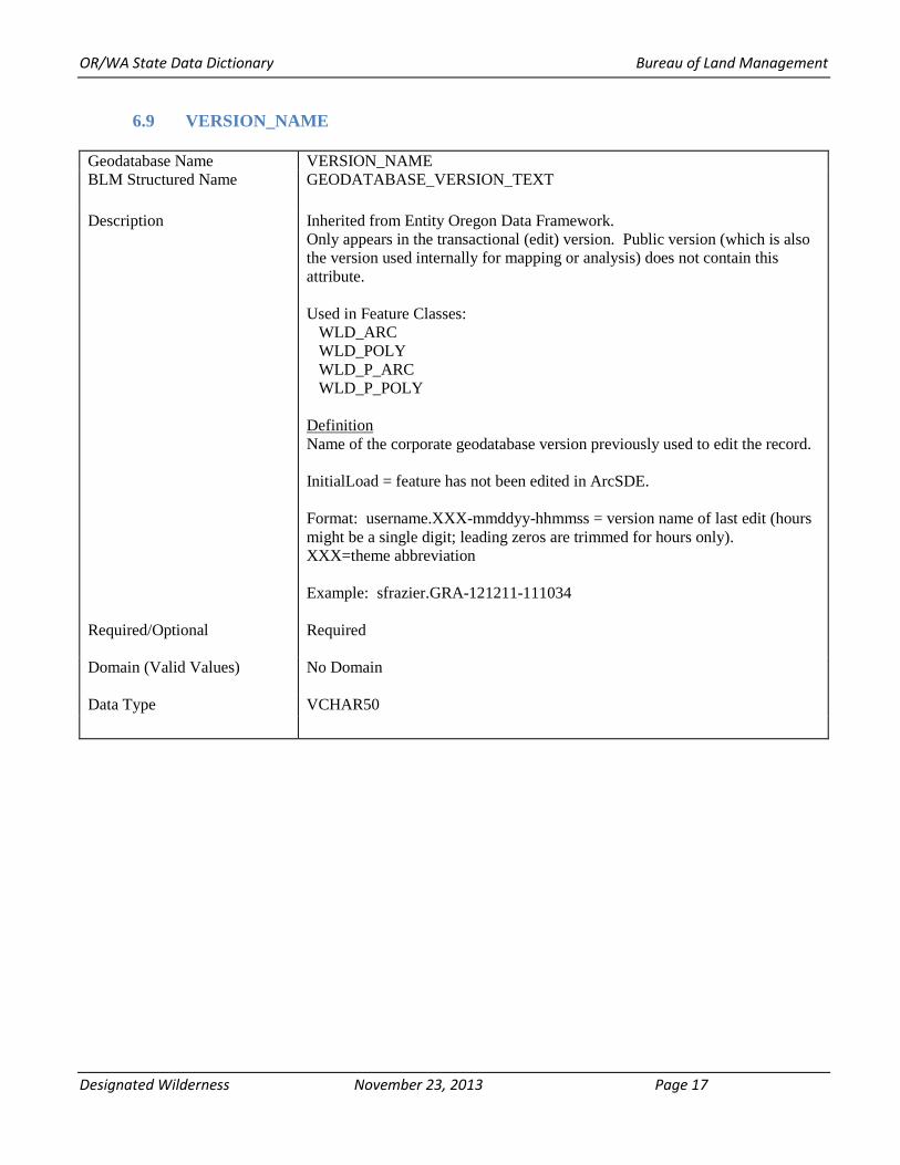
6.9 VERSION_NAME
Geodatabase Name VERSION_NAME BLM Structured Name GEODATABASE_VERSION_TEXT
Description Inherited from Entity Oregon Data Framework. Only appears in the transactional (edit) version. Public version (which is also the version used internally for mapping or analysis) does not contain this attribute.
Used in Feature Classes: WLD_ARC WLD_POLY WLD_P_ARC WLD_P_POLY
Definition Name of the corporate geodatabase version previously used to edit the record.
InitialLoad = feature has not been edited in ArcSDE.
Format: username.XXX-mmddyy-hhmmss = version name of last edit (hours might be a single digit; leading zeros are trimmed for hours only). XXX=theme abbreviation
Example: sfrazier.GRA-121211-111034
Required/Optional Required
Domain (Valid Values) No Domain
Data Type VCHAR50
Designated Wilderness November 23, 2013 Page 17

OR/WA State Data Dictionary Bureau of Land Management
6.10 WLD_NAME
Geodatabase Name BLM Structured Name
Description
Required/Optional
Domain
Data Type
WLD_NAME Wilderness_Name
Not Inherited
Used in Feature Class: WLD_POLY
Definition The official name of the wilderness. It may contain spaces, plus a combination of upper and lowercase alpha characters.
Required
None Examples: For example, Steens Mountain Wilderness Area. Inholding (non-BLM jurisdiction) polygons should be labeled "inholding".
Variable Characters (VCHAR) 50
6.11 WLD_P_NAME
Geodatabase Name BLM Structured Name
WLD_P_NAME Wilderness_Proposed_Name
Description Not Inherited
Used in Feature Class: WLD_P_POLY
Definition The proposed name being considered for wilderness designation.
Required/Optional Required
Domain None
Data Type Variable Characters (VCHAR) 50
Designated Wilderness November 23, 2013 Page 18

OR/WA State Data Dictionary Bureau of Land Management
7. ASSOCIATED FILES OR DATABASES There are no external files or databases currently associated with the WLD data sets.
8. LAYER FILES (PUBLICATION VIEWS)
General Background: Master corporate feature classes/datasets maintained in the edit database (currently orsoedit) are “published” to the user database (currently orsovctr) in several ways:
a. Copied completely with no changes (replicated).
b. Copied with no changes except to omit one or more feature classes from a feature dataset.
c. Minor changes made (e.g., clip, dissolve, union with ownership) in order to make the data easier to use. These “Publication feature classes” are indicated by “PUB” in their name. They are created through scripts that can be automatically executed and are easily rebuilt from the master (orsoedit) data whenever necessary.
Layer files are not new data requiring storage and maintenance but point to existing data. They have appropriate selection and symbolization for correct use and display of the data. They provide the guidance for data published on the web. Layer files are created by simple, documented process, and can be deleted and recreated at any time.
All datasets are published, both internally and externally, with the attribute VERSION_NAME removed (also for privacy reasons).
Specific to this Dataset: ARC feature classes (used primarily for editing and maintenance) are not published. Layer files for existing and proposed wilderness will exclude “inholding” polygons.
Designated Wilderness November 23, 2013 Page 19

OR/WA State Data Dictionary Bureau of Land Management
9. EDITING PROCEDURES There is much in the data standard that addresses editing and provided guidance. Please review the entire data standard carefully.
Cluster Tolerance For these themes, the topology cluster tolerance is 0.00000002 Degrees. (0.000007 degrees is approximately 1 meter)
Topology Rules Apply to the two feature datasets WILDERNESS and WILDERNESS_PROPOSED. § Adjacent polygons must not overlap. § Polygon boundaries in the WLD_POLY (or WLD_P_POLY) feature class must be covered by lines in the WLD_ARC (or WLD_P_ARC) feature class § Line features must not have dangles § Line features must not intersect, self-overlap, or overlap adjacent lines
Feature classes listed in order of reliability: WLD_ARC (or WLD_P_ARC) WLD_POLY (or WLD_P_POLY)
Allowed Exceptions There are no allowed exceptions for the WLD Edit group
Reference Themes and Tables None
Editing Workflow Boundary arcs (WLD_ARC, WLD_P_ARC) are updated then polygons reconstructed or snapped to them.
Snapping Guidelines Standard good editing practices. WLD_ARC and WLD_P_ARC segments are snapped to or replaced by line segments identified by COORD_SRC and DEF_FEATURE. Adjoining segments are snapped to the segment with the highest priority and/or greatest accuracy.
Designated Wilderness November 23, 2013 Page 20

OR/WA State Data Dictionary Bureau of Land Management
10. OREGON DATA FRAMEWORK OVERVIEW
Figure 2 Oregon Data Framework Overview
Designated Wilderness November 23, 2013 Page 21

OR/WA State Data Dictionary Bureau of Land Management
11. ABBREVIATIONS AND ACRONYMS USED IN THIS STANDARD
Does not include abbreviations/acronyms used as codes for particular data attributes.
Abbreviations Descriptions 24K 1:24,000 scale BLM Bureau of Land Management DEM Digital Elevation Model DLG Digital Line Graphs DOQ Digital Orthophoto Quad DRG Digital Raster Graphic FOIA Freedom of Information Act GCD Geographic Coordinate Database GIS Geographic Information System GNIS Geographic Names Information System IDP Interdisciplinary NAD North American Datum NARA National Archives and Records Administration ODF Oregon Data Framework OR/WA Oregon/Washington RMP Resource Management Plan RMPA Resource Management Plan Amendment ROD Record of Decision SDE Spatial Data Engine SMA Special Management Area WLD Wilderness
Table 2 Abbreviations/Acronyms Used
Designated Wilderness November 23, 2013 Page 22

OR/WA State Data Dictionary Bureau of Land Management
APPENDIX A. DOMAINS (VALID VALUES)
The domains listed below are those that were in effect at the time the data standard was approved and may not be current. Contact the State Data Administrator for currents lists:
Pamela Keller OR/WA State Data Administrator Bureau of Land Management P.O. Box 2965 Portland, OR 97208 503-808-6009
A.1 ADMIN_ST [BACK]
OR OR-Oregon and Washington ID ID-Idaho CA CA-California NV NV-Nevada
A.2 COORD_SRC [BACK]
Choices relevant to Wilderness are shaded. CADNSDI CADNSDI - Coordinates from or snapped to the CADNSDI dataset. CFF CFF - Lines duplicated or buffered from Cartographic Feature Files (USFS) DEM DEM - Digital Elevation Model (30m or better accuracy) used for creation of contours DIS DIS - Lines generated to connect discontinuous features DLG DLG - Lines duplicated or buffered from (24K scale accuracy) USGS Digital Line Graphs DOQ DOQ - Screen digitized linework over Digital Orthoquad backdrop DRG DRG - Screen digitized linework over Digital Raster Graphic backdrop GCD GCD - Lines snapped to Geographic Coordinate Database Points GPS GPS - Lines obtained from a Global Positioning System device IMG IMG - Linework derived from interpretation of satellite or other non-photographic imagery MAP MAP - Digitized linework from hardcopy map MTP MTP - Lines duplicated from Digital Master Title Plat SOURCEL SOURCEL - Source Layer from BLM GIS SRV SRV - Survey methods were used to create the linework (e.g. COGO) TIGER TIGER - Tiger Data TRS TRS - Coordinates only given as a legal description (township, range, section) UNK UNK - Unknown coordinate source
A.3 DEF_FEATURE [BACK]
BLM_ADMIN CLOSURE COAST_3MILE COUNTY ELEVATION FENCE
BLM_ADMIN−Bureau of Land Management administrative boundary CLOSURE−Closure extension. Used to close small gaps COAST_3MILE−Separating coastal water from territorial sea at 3-mile COUNTY−County boundary ELEVATION−Line of common elevation FENCE−Boundary defined by a Fence line regardless of whether it forms
Designated Wilderness November 23, 2013 Page 23

OR/WA State Data Dictionary Bureau of Land Management
part of a grazing unit FOREST_SERVICE_ADMIN FOREST_SERVICE_ADMIN−Forest Service administrative boundaries GRAZING_BOUNDARY GRAZING_BOUNDARY−Boundary defined as a pasture or other
administrative grazing boundary (regardless of whether it is fenced or follows a subdivision or other legal boundary)
HU HU−Hydrologic unit divide JETTY JETTY−Jetty JURISDICTION JURISDICTION−Surface jurisdiction boundary (e.g. boundary defined as
BLM ownership regardless of subdivision) LAVA LAVA−Edge of lava flow LEVEE LEVEE−Dike or levee MARSH MARSH−Edge of Marsh, wetland, swamp, or bog boundary MINERAL_DISTURBANCE MINERAL_DISTURBANCE−Edge of quarry, mine, gravel stockpile or
other mineral surface disturbance area NLCS_BOUNDARY NLCS_BOUNDARY−Wilderness, Wild and Scenic River, Historic
District or other NLCS designation boundary PARKING_AREA PARKING_AREA−Motorized vehicle parking area POINT-TO-POINT POINT-TO-POINT−Boundary defined by a straight line segment between
two points POWERLINE POWERLINE−Power transmission line or buffer offset RIDGE RIDGE−Ridge RIGHT-OF-WAY RIGHT-OF-WAY−A legal right of way forms boundary RIM RIM−Line generally follows a natural topographic barrier ROAD ROAD−Routes managed for use by low or high−clearance (4WD)
vehicles, but not ATV ROAD_OFFSET ROAD_OFFSET−Boundary is offset from a road (not a consistent buffer) SHORELINE SHORELINE−Lake, pond, reservoir, bay or ocean shoreline or meander
line STREAM_LBANK STREAM_LBANK−Downstream left stream bank STREAM_RBANK STREAM_RBANK−Downstream right stream bank SUBDIVISION SUBDIVISION−Public Land Survey System derived aliquot (1/2s, 1/4s)
parts and lots define the legal boundary TRAIL TRAIL−Routes managed for human-powered, stock or off-highway
vehicle forms of travel UNKNOWN UNKNOWN−Defining feature is unknown VEGETATION VEGETATION−Boundary is defined as a seeding boundary or other
relatively permanent vegetation change WATERCOURSE WATERCOURSE−Stream, river, ditch, canal or drainage centerline
A.4 JURIS_CODE [BACK]
BL BP BR CE CG DA DD FA FC
BL-BUREAU OF LAND MANAGEMENT BP-BONNEVILLE POWER ADMINISTRATION BR-BUREAU OF RECLAMATION CE-CORPS OF ENGINEERS CG-U.S. COAST GUARD DA-U.S. DEPT. OF AGRICULTURE (EXCEPT THE FOREST SERVICE) DD-U.S. DEPT. OF DEFENSE (EXCEPT THE CORPS OF ENGINEERS) FA-FEDERAL AVIATION ADMINISTRATION FC-FEDERAL ENERGY REGULATORY COMMISSION
Designated Wilderness November 23, 2013 Page 24

OR/WA State Data Dictionary Bureau of Land Management
FS FS-U.S. FOREST SERVICE FW FW-U.S. FISH AND WILDLIFE SERVICE GS GS-U.S. GEOLOGICAL SURVEY GSA GSA-GENERAL SERVICES ADMINISTRATION IA IA-BUREAU OF INDIAN AFFAIRS AND TRIBAL UNITS LG LG-LOCAL GOVERNMENT NP NP-NATIONAL PARK SERVICE PV PV-PRIVATE LANDS PVI PVI-PRIVATE, INDUSTRIAL PVN PVN-PRIVATE, NONINDUSTRIAL PVU PVU-PRIVATE, URBAN SDT SDT-STATE TRANSPORTATION DEPARTMENT ST ST-STATE MANAGED LANDS STF STF-STATE FORESTS STL STL-STATE DIVISION OF LANDS STP STP-STATE PARKS STW STW-STATE WILDLIFE REFUGES UN UN-UNDETERMINED
Designated Wilderness November 23, 2013 Page 25