DESIGN. FOR,' - NCJRS · development of the Environmental Security design process and have involved...
87
" I ' I L!) (V) '" co q- , I :;' DESIGN. FOR,' -G>, SAFENEIGHBORHOOOS·· . -" - . (J .... ... " ", ,.,' ....• , ••. '. < . NA 'l'iON1\L]r-ikITtiTEOFiAW.'-I' . , •.. '. . 'ENFORCEMENTAND CRIMINAL JUSTICE . • '.' ,. LAW ENFORCEMENT. ASSISTANCEADMINISTRATIONI .. '.' , 'UNiTEDSTATESDEPAiiTMENTOFJUSTICE' " . U.S.DEPARTMEW " '. " OFFICEOF POtICY DEYELOPMENT AND RESEARCfI ' 7' - " I ,;;;t If you have issues viewing or accessing this file contact us at NCJRS.gov.
Transcript of DESIGN. FOR,' - NCJRS · development of the Environmental Security design process and have involved...

"
~ I '
I
L!) (V)
'" co q-~
,
I
:;'
DESIGN. FOR,' -G>, .~,
SAFENEIGHBORHOOOS·· . ~ -" - .
(J
~;
.... "-~:. ...
~~>.-.-:--
" ", ,.,' ....• , ••. '. < .NA'l'iON1\L]r-ikITtiTEOFiAW.'-I' . , •.. '. . 'ENFORCEMENTAND CRIMINAL JUSTICE . • '.'
,. LAW ENFORCEMENT. ASSISTANCEADMINISTRATIONI .. '.' , 'UNiTEDSTATESDEPAiiTMENTOFJUSTICE'
" . U.S.DEPARTMEW OFHOUSINGANIJURB::~~i::~~'" " '. " OFFICEOF POtICY DEYELOPMENT AND RESEARCfI ' 7'
- " I ,;;;t
If you have issues viewing or accessing this file contact us at NCJRS.gov.

DESIGN FOR SAFE NEIGHBORHOODS
Itfg73b
THE ENVIRONMENTAL SECURITY PLANNING AND DESIGN PROCESS
RICHARD A. GARDINER
September 1978
U.S. Department of Justice National Institute of Justice
148735
This document has been reproduced exactly as received from the person or organization Originating it. Points of view or opinions stated in this document are those of the authors and do not necessarily represent the official position or pOlicies of the National Institute of Justice.
Permission to reproduce this copyrighted material has been granted by Public Domain/LEAA/NILECJ U.S. Department of Justice
to the National Criminal Justice Reference Service (NCJRS).
Further reproduction outside of the NCJRS system requires permission of the copyright owner.
NATIONAL INSTITUTE OF LAW ENFORCEMENT AND CRIMINAL JUSTICE LAW ENFORCEMENT ASSISTANCE ADMINISTRATION UNITED STATES DEPARTMENT OF JUSTICE
For sule. by the Superintendent of Documents, U.S. Go,oernment Printing Office. 'Yashing-toIl, D.C. 20402, Stock No. 027-000-00751-1

NATIONAL INSTITUTE OF LAW ENFORCEMENT AND CRIMINAL JUSTICE
Blair G. Ewing, Acting Director
LAW ENFORCEMENT ASSISTANCE ADMINISTRATION
James M. H. Gregg, Acting Administrator
This project was supported by funding from the National Institute of Law Enforcement and Criminal Justice of the United States Department of Justice and from the United States Department of Housing and Urban Development. The findings, opinions and recommendations are those of the author and do not necessarily reflect the opinions of funding agencies.
Copyright © 1978 by Richard A. Gardiner. All rights reserved.
No part of this publication may be reproduced, stored in any retrieval system, or transmitted in any form by any means, electronic, mechanical, photocopy, recording or otherwise, without the prior written consent of the author. The LEAA reserves the right to reproduce, publish, translate or otherwise use, or authorize others to use, any or all of the copyrighted material contained in this publication.
"'-: -.... ~"
........ ~"I--l,~.~ .:, ..
-",,:,.,~/

Financial support necessary to the preparation of this document was provided jointly by the National Institute of Law Enforcement and Criminal Justice and the Department of Housing and Urban Development. Special acknowledgement is given to particular individuals for their personal guidance and support. At HUD, Charles Gueli, past Director of the Office of Community Design, originally suggested writing this manual; Dr. Morton Leeds, Director of Housing, provided longtime encouragement; Richard Burke and Don Geis, project monitors at HUD in the Office of Community Design and Research Division, reviewed the manuscript and offered valuable suggestions. At LEAA, Dr. Fred Heinzelmann, Director of the Community Crime Prevention Division; Lois Mock; and Bernard Auc11ter, project monitor; all provided detailed criticism and review of the manual during its preparation.
Research and demonstration projects for
Acknow ledgements the past six years have led to the development of the Environmental Security design process and have involved numerous individuals and organizations. LEAA, through Dr. Fred Heinzelmann's office, has provided the major impetus and funding for work in· the field of reducing crime through environmental design. The first project dealing with area-wide environmental crime prevention planning, the Hartford Neighborhood Crime Prevention Program, was sponsored by LEAA through the Hartford Institute of Criminal and Social Justice. Special recognition must be given to the Hartford Institute staff and its director, Brian Hollander; to Dean Thomas Reppetto, Vice-President of the John Jay College of Criminal Justice in New York; and to Dr. Jack Fowler, Director, and the staff of The Center for Survey Research in Boston for their creative work and endurance on that project which led to the evolution of the Environmental Security Planning Process.

The Chicago South Loop New Town Environmental Security project provided a unique opportunity for further refining the process. Financial assistance was provided by the Illinois Law Enforcement Commission. Organizational and individual support were given by Norm Elkin, Matthew Horan, John Powell, and Glenn Steinberg of Urban Investment and Development Company; Carl Bufalini of Chicago 21 Corporation; Superintendent James Rochford, District One Commander Paul V. McLaughlin, and Lieutenant Robert Casey of the Chicago Police Department; Commissioner Hill and Al Baugher of the Department of Development and Planning.
Gratitude for assistance and cooperation is also expressed to Charles Kindleberger, Acting Director of Planning and Programming of the Community Development Agency in St. Louis, Missouri; and to William B. Merrill, Chief Planner, and Officer Pat McKune of the Police Department of the Village of Oak Park in Illinois.
A number of professionals working with Gardiner Associates have contributed to the development of the Environmental Security Planning and Design Process: Allen Moore, architect; Gail Promboin, city planner; Sanford Low, cultural anthropologist; Bruce Tsuchida, landscape architect; Tom Kirvan, landscape architect; Michael Dana, landscape architect; Louis Robinson, architect; and Jerry Brown, landscape architect. Particular recognition should be given to the following individuals who participated most in the preparation of this manual: Tom Cunningham, urban designer, who collaborated in the initial research and writing; Elsa Martz, editor, who provided valuable advice and cnticIsm; Bill Burbank, landscape architect, who prepared the renderings for the final graphics; Linda Upright and Sharon McLaughlin, who provided administrative assistance; and Jan Noack, who has given longtime support and encouragement.
Richard A. Gardiner Newburyport, Massachusetts June 23, 1978

Table of Contents 1. INTRODUCTION ............................................... 1 2. NEIGHBORHOOD CRIME ESCALATION............... 5 3. HISTORICAL MODELS ...................................... 11
Urban Village ..................................................... 12 Urban Fortress. . . . . . . . . . . . . . . . . . . . . . . . . . . . . . . . . . . . . . . . . . . . . . . . . . . .. 14 Defensible Space . . . . . . . . . . . . . . . . . . . . . . . . . . . . . . . . . . . . . . . . . . . . . . . . . .. 14
4. CRIME AND THE PHYSICAL ENVIRONMENT ...... 19 5. THE CRIME-ENVIRONMENT PHENOMENON ......... 29 6. THE E/S CONCEPTUAL MODEL ......................... 31
7. E/S THEORIES ................................................. 33 Environmental Scale and Opportunity Crime. . . . . . . . . . . . . . . . . . . . . . . . . .. 34
8. THE E/S TECHNICAL PLANNING PROCESS ........ 41 Target Area Selection ............................................... 43 Data Collection and Mapping. . . . . . . . . . . . . . . . . . . . . . . . . . . . . . . . . . . . . . .. 44 Data Analysis and Correlation ........................................ 45 Identification and Synthesis of Crime/Environment Problems. . . . . . . . . . . .. 45 Alternative E/S Solutions and Strategies. . . . . . . . . . . . . . . . . . . . . . . . . . . . . .. 46 The E/S Plan and Program. . . . . . . . . . . . . . . . . . . . . . . . . . . . . . . . . . . . . . . . .. 47 Phase I: Detailed Design and Implementation ........................... 50 Monitoring, Evaluation, and Feedback ................................ 51
9. THE E/S APPLICATION STRATEGy .................... 5S The Funding Strategy ............................................... 57 Cost Effectiveness . . . . . . . . . . . . . . . . . . . . . . . . . . . . . . . . . . . . . . . . . . . . . . . . .. 58 The Organization Strategy. . . . . . . . . . . . . . . . . . . . . . . . . . . . . . . . . . . . . . . . . .. 61
10. CASE STUDIES ................................................ 63 The Hartford Neighborhood Crime Prevention Program. . . . . . . . . . . . . . . . .. 65 The South Loop New Town E/S Plan and Program .... . . . . . . . . . . . . . . . .. 73 Oak Park, IlIinois . . . . . . . . . . . . . . . . . . . . . . . . . . . . . . . . . . . . . . . . . . . . . . . . .. 77 St. Louis, Missouri ................................................. 78
11. IMPLICATIONS ................................................. 79 12. REFERENCES ................................................... 83
--------------------------------------------------------------------------------------------------------------------------------------------------,
List of Illustrations Neighborhood span of recognition. . . . . . . . . . . . . . . . . . . . . . . . . . . . . . . . . . . . . . . . . . . . 5 Neighborhood growth patterns 1: balanced use and support. . . . . . . . . . . . . . . . . . . . . .. 6 Neighborhood growth patterns 2: development and use competition. . . . . . . . . . . . . . . . '7 Neighborhood growth patterns 3: out-of-scale support systems. . . . . . . . . . . . . . . . . . . . . 8 Balanced use and support services. . . . . . . . . . . . . . . . . . . . . . . . . . . . . . . . . . . . . . . . . . .. 9 Land use growth . . . . . . . . . . . . . . . . . . . . . . . . . . . . . . . . . . . . . . . . . . . . . . . . . . . . . . . . . .. 9 Use competition. . . . . . . . . . . . . . . . . . . . . . . . . . . . . . . . . . . . . . . . . . . . . . . . . . . . . . . . . . . 9 Crime opportunities. . . . . . . . . . . . . . . . . . . . . . . . . . . . . . . . . . . . . . . . . . . . . . . . . . . . . . .. 9 Guard dog advertisement. . . . . . . . . . . . . . . . . . . . . . . . . . . . . . . . . . . . . . . . . . . . . . . . . . .. 11 The fortress city. . . . . . . . . . . . . . . . . . . . . . . . . . . . . . . . . . . . . . . . . . . . . . . . . . . . . . . . . .. 12 Photo examples of an urban village. . . . . . . . . . . . . . . . . . . . . . . . . . . . . . . . . . . . . . . . . . .. 13 Territorial abandonment of neighborhood streets. . . . . . . . . . . . . . . . . . . . . . . . . . . . . . .. 15 Types of territoriality .................................................... " .. 16 Range of past conceptual models ............................................ " 17 The need for a comprehensive and flexible planning process. . . . . . . . . . . . . . . . . . . . . .. 17 Geographic classification of opportunity crimes. . . . . . . . . . . . . . . . . . . . . . . . . . . . . . . .. 19 Neighborhood crime phenomena study area .................................. " 20 Neighborhood crime patterns. . . . . . . . . .. .................................... 21 The neighborhood decay process 1: residential neighborhood identity. . . . . . . . . . . . . .. 22 The neighborhood decay process 2: residential neighborhood land use competition. . .. 22 The neighborhood decay process 3: erosion of neighborhood semi-privacy ........... 23

The neighborhood decay process 4: crime and fear of crime. . . . . . . . . . . . . . . . . . . . . . .. 23 The neighborhood decay process 5: physical and social breakdown. . . . . . . . . . . . . . . .. 23 Out-of-scale movement generators . . . . . . . . . . . . . . . . . . . . . . . . . . . . . . . . . . . . . . . . . . .. 24 Competing land uses and their zones of environmental use. . . . . . . . . . . . . . . . . . . . . . .. 25 Breakdown of neighborhood semi-privacy. . . . . . . . . . . . . . . . . . . . . . . . . . . . . . . . . . . . .. 26 Existing territorial use analysis. . . . . . . . . . . . . . . . . . . . . . . . . . . . . . . . . . . . . . . . . . . . . .. 27 The crime-environment phenomenon ........................................ " 29 The neighborhood deterioration phenomenon. . . . . . . . . . . . . . . . . . . . . . . . . . . . . . . . . .. 3'0 Reinforcing urban support systems and predominant land use results in territoriality.. 33 TIle function of urban scale. . . . . . . . . . . . . . . . . . . . . . . . . . . . . . . . . . . . . . . . . . . . . . . . .. 34 Location of crime versus residencies of victim and offender. . . . . . . . . . . . . . . . . . . . . . .. 34 Urban scale ............................................................... 34 Support systems and generators. . . . . . . . . . . . . . . . . . . . . . . . . . . . . . . . . . . . . . . . . . . . .. 34 Districts within a city. . . . . . . . . . . . . . . . . . . . . . . . . . . . . . . . . . . . . . . . . . . . . . . . . . . . . .. 35 Community areas within a district. . . . . . . . . . . . . . . . . . . . . . . . . . . . . . . . . . . . . . . . . . .. 35 Neighborhoods within a community area ....................................... 36 Streets or clusters within a neighborhood. . . . . . . . . . . . . . . . . . . . . . . . . . . . . . . . . . . . . .. 36 Buildings and elements scale. . . . . . . . . . . . . . . . . . . . . . . . . . . . . . . . . . . . . . . . . . . . . . . .. 37 Scale and location of offense, and residencies of offender and victim. . . . . . . . . . . . . . . .. 38 Out-of-scale urban support system. . . . . . . . . . . . . . . . . . . . . . . . . . . . . . . . . . . . . . . . . . .. 3'8 Competing land uses . . . . . . . . . . . . . . . . . . . . . . . . . . . . . . . . . . . . . . . . . . . . . . . . . . . . . .. 38 The Environmental Security concept diagram. . . . . . . . . . . . . . . . . . . . . . . . . . . . . . . . .. 39 The conceptual technical process diagram. . . . . . . . . . . . . . . . . . . . . . . . . . . . . . . . . . . . .. 42 Target area selection. . . . . . . . . . . . . . . . . . . . . . . . . . . . . . . . . . . . . . . . . . . . . . . . . . . . . .. 43 Data collection and mapping. . . . . . . . . . . . . . . . . . . . . . . . . . . . . . . . . . . . . . . . . . . . . . . .. 44 Data analysis and correlation . . . . . . . . . . . . . . . . . . . . . . . . . . . . . . . . . . . . . . . . . . . . . . .. 45 Identification and synthesis of the crime-environment problems. . . . . . . . . . . . . . . . . . .. 45

Alternative strategies and solutions ........................................... 46 The Environmental Security Plan and Program ................................. 47 Phase I-detailed design and implementation ................................... 50 Monitoring, evaluation, and feedback ......................................... 51 The Environmental Security technical process diagram. . . . . . . . . . . . . . . . . . . . . . .. 52 ·53 Case study: Hartford street robbery. . . . . . . . . . . . . . . . . . . . . . . . . . . . . . . . . . . . . . . . . .. 69 Case study: Hartford street robbery. . . . . . . . . . . . . . . . . . . . . . . . . . . . . . . . . . . . . . . . . .. 70 Case study: Asylum Hill existing territoriality plan. . . . . . . . . . . . . . . . . . . . . . . . . . . . .. 71 Case study: Asylum Hill proposed territoriality plan. . . . . . . . . . . . . . . . . . . . . . . . . . . .. 72 Case study: South Loop existing environmental conditions ........................ 74 Case study: South Loop recommended Environmental Security Master Plan ........ 76

Environmental Security (E/S) is an urban planning and design process which integrates crime prevention with neighborhood design and urban development. Essentially, it is a comprehensive environmental design approach that combines traditional techniques of crime prevention with newly developed theories and techniques. Furthermore, E/S is concerned not only with reduction of crime but also the fear of crime, since it has become recognized that the fear of crime is equally serious and is a major contributor to the urban decay process.
The basic premise of E/S is that our urban environments can be designed or redesigned to reduce the opportunities for crime to occur-and at the same time the fear of crime-without resorting to the building of fortresses and the resulting deterioration in the quality of urban life. This manual presents a comprehensive planning process for analyzing and understanding neighborhood crime problems and generating environmental
solutions. As such, the E/S process of reducing crime at the scale of a neighborhood and its environs constitutes a first in the fields of urban design, and crime prevention. The purpose of this manual is to provide an additional planning and decision-making tool for those in a position to affect the future of our neighborhoods and cities. While this document may be of interest to citizen groups, law enforcement officials, and political representatives, it is written primarily for those in the urba~ planning and design professions.
Types of crimes being discussed have been called· street crimes, crimes of fear, or predatory crimes. Essentially, they are those offenses which are referred to by the F.B.I. in its Uniform Crime Reports as "Index Crimes" and are categorized as violent crimes, or crimes against persons, such as murder, forcible rape, aggravated assault, and robbery; and property crimes, or crimes against property, such as burglary, larceny and auto theft. For our purposes as environmental security
--_ ... _-- -- ---- ------
1 Introduction

2
planners, we are referring to those crimes which can undermine the social, economic, physical, and therefore environmental structure of neighborhoods and generally can be described as "opportunistic crimes". As used in this document, however, the violent crime of murder is not included as an opportunity crime.
It is not necessary to recount the seriousness of crime in our cities, nor to cite the alarming rise in nuch crimes over the last decade. Every day, newspapers and television remind us of the problems of uncontrolled street crimes where no individual is safe, and where it has now become a custom for individuals as well as businesses to escape the city. Periodic public opinion surveys consistently identify crime as one of the major problems confronting our cities and their urban neighborhoods. Crime and fear of crime are among the main reasons for reduced urban investment and flight to the suburbs. The loss to businesses from burglary alone has been estimated at $350 million annually, and rising. According to the Department of Justice Sourcebook of Criminal Justice Statistics-1976, the accumulated losses to businesses from ordinary crimes has been conservatively estimated at $21 billion. An additional $3.5 billion is spent annually on law
enforcement and crime prevention measures. These figures do not take into account the indirect losses of tax revenues and jobs; inner-city business failures; the loss of additional residential, commercial, and industrial development; nor do they consider the loss to residents of vital services and availability of goods-key factors in the degeneration of urban neighborhoods.
The recent threat of urban bankruptcy, problems of energy, taxes, and environmental conservation have brought about renewed interest in preserving our urban neighborhoods and downtown areas. Numerous government programs and private projects are being formulated to restore the city. It is shocking to note, however, that few of these programs include measures to deal with the prevention of crime. There seems to be an underlying assumption that by investing more and more money, the problems of crime and fear will somehow be eradicated. However, as shown by the experience of Pruett Igoe in St. Louis, it is possible to create instant slums. Crime is a devastating problem, which if left unattended, will undermine private and governmental urban development efforts.
Traditional approaches to combatting crime have included police investigatory and arrest procedures, adjudication

procedures; criminal justice punishment and threat of punishment, social programs for rehabilitating offenders; and individual defensive measures such as target hardening and fortressing. In recent years there has been a shift in attitude from dependence on a reactionary response to an action orientation. Citizen participation in block watch programs, leadership by police in crime prevention programs, community participation in the decision-making process, and closer relationships between citizens and police reflect a growing sense of the need to do something about preventing crime instead of waiting for it to occur.
The E/S planning approach is an important part of this new preventive orientation to crime. The main thesis of E/S planning is that the design and organization of the physical environment play a key role in providing the opportunities for criminal acts. The objective of E/S is not to build more fortresses but rather to take positive planned action to reduce opportunities for crime and to help citizens regain control of, and take responsibility for, their environment.
If solutions are to be found, it is necessary to first understand the basic environmental organization of neighborhoods and the complex series of
causes and effects that allow the occurrence of opportunity crimes. To respond to these complex problems requires a range of reinforcing solutions, both physical and social-in other words, a comprehensive environmental approach. This concept of multiple reinforcement is contrary to the unfortunate tendency to look for single, simple answers to complex problems. The neighborhood environment is dynamic and ever-changing. Overdependence on anyone tool, whether law enforcement, social or physical structure, will not only fail but will ultimately diminish the effectiveness of the tool being used. A specific objective of E/S is to provide a physical. structure where the individual will be given opportunity, encouragement, and the means to extend his use and sphere of responsibility for his neighborhood beyond his front door. In order to achieve this, individuals will have to make discernible efforts to regain control of their neighborhoods. First, however, will be the need for those who make decisions affecting the neighborhood to develop an understanding of how their decisions and areas of responsibility can affect the potential for crime. The decision-makers must take the necessary actions to create the physical framework which will reinforce and support the citizenry.
3

One of the major E/S theories is that there are logical reasons why certain patterns of opportunity crimes occur in particular areas. The cause and effect relationships involve the organization of the physical environment and extend over entire neighborhoods and districts. It is our contention that when plans for land uses and public facilities are made independently of one another, they can unwittingly create environmental competition, conflict, and crime opportunity. Decisions on transportation, residential and commercial development, parks and recreation, planning and zoning are being made without realization that they can directly result in the opportunity for crime and fear of crime. While it is the avowed purpose of city planning to coordinate such impact decisions, all too often this is not done. There is need for those in the planning and design professions to act as a major interface through coordination and evaluation of planning and design decisions that affect security and therefore the quality of urban life. Clearly, it is the domain and responsibility of the planning professions to address these concerns. In order that crime prevention becomes an integral part of urban planning and design, police need to be brought into the process. Traditionally, project design has relegated public safety to a position of an after-the-
4
fact concern. When planning assistance has been sought from the police department in the past, it was often a token involvement after the major decisions had been made. However, through their day-to-day presence, the police, more than anyone else, have a true understanding of how environments are used or mis-used, and by whom. This valuable knowledge must not be overlooked.
The strategies outlined in this manual are predominately the result of work done over a number of years. In 1973, initial research into the relationship between the physical environment and opportunity crimes at ,the neighborhood level was begun. As this research produced hypotheses and techniques, there was an opportunity to demonstrate this thinking on actual neighborhood projects. E/S design was tested in one. neighborhood of 8,000 people in Hartford, Connecticut, where street crime was reduced by 28% and neighborhood residential burglary by 42% between 1976-1977.
It is not our intention that this manual be looked upon as a state-of-the-art document on crime prevention an!1 physical design, nor do we profess the theories and technical proceduFes are the. final word. Rather they are one approach to the problem. This document is not a
iresearch report; nor is it a project case study report. It is an introduction to a comprehensive approach to environmental security which relates the design of neighborhoods to the prevention of crime.
We also do not suggest that redesign of the physical environment by itself is the key to crime prevention, but it is an important and overlooked tool. When coupled with other efforts, whether they be police, social management, urban reinvestment, or citizen participation programs, the likelihood for success now and in the future can be significantly greater. Future work in this field will refine this process of Environmental Security Planning and Design.
In reality the crime-environment relationship is part of a lax:ger phenomenon of urban growth and decay and provides a perspective of why certain areas continue to thrive while others become ghettos. Positive or negatiye environmental evolution is not an accident, nor is decay of an environment necessarily a natural condition to be expected or accepted. By understanding the growth and de~ay process and what causes and aggravates it, environmental strategies can be developed which will help interdict the patterns of deterioration.

2 Neighborhood Crime Escalation
In dealing with the relationship between opportunity crimes and the physical environment, the neighborhood is the natural geographic and social unit to work with. First and foremost, it is the neighborhood that acts as the interface between home and city and provides opportunity for human interaction and cooperation. The neighborhood is the scale at which· communal standards of behavior are first formed. Historically, it is the natural extension of individual and family territoriality that begins at home. As we shall see, the neighborhood is also the scale at which the opportunity for crimes can be dealt with. If crime cannot be controlled at the neighborhood, it will eventually undermine the entire city.
A basic problem in dealing with the neighborhood unit is the fact that there is no universally accepted dimension, shape, or form to a neighborhood. A neighborhood can be any size depending on the person defining it. For a child of six, the neighborhood may consist of his house and several others along a street.
district
block
building
~~1jJj/l~~ ,y W$;1JJJn~ ,
Neighborhood Span of Recognition
5

6
neighborhood elementary school
neighborhood shopping
/ ~--/
NEIGHBORHOOD GROWTH PATTERNS 1: Balanced Use and Support
For an adult working in the city, his neighborhood can be an .entire city district. However, there are certain common physical and social characteristics of a successful neighborhood:
• It is a place where an individual has certain inherent personal and property rights, which include control over his home or business and their immediate surroundings.
• There are certain unstated standards of behavior based upon community interests, concerns, and group values.
• There are certain essential public and private support services such as roads, utilities, schools, parks, shops.
• The successful neighborhood has particular physical boundaries and focal points which, while perhaps not clearly readable to the non-resident, provide a sense of place or personal identity for the resident.
• There is a pride of home and neighborhood which may be expressed by support of the' high school football team, for example, or by maintenance of private property.
• A successful neighborhood is also a place where the individual will invest in a home or start a new business.

• Finally, there is a sense of security which is intrinsically a part of the notion of home as a safe place.
Unfortunately, too few neighborhoods now exhibit these positive characteristics. With the development of suburbia and the mass movement of individuals and families, the urban neighborhood has become a place one had come from. In suburban areas the traditional neighborhood was replaced by the subdivision or bedroom community. The causes of neighborhood decay are complex. Looked at individually, many of the causes seem to be innocent or logical steps of urban evolution. A number of internal and external forces began to change the image of a neighborhood from a place where residents knew each other to a completely impersonal environment. The increased number of automobiles transformed the neighborhood semiprivate streets into public cross-town connectors. Neighborhood shops became commercial strips and then regional shopping centers. Neighborhood schools became regional schools, and neighborhood parks became district recreational areas. As multi-family housing consumed the remaining open space and the population increased, there was increasing competition for neighborhood spaces and public services.
community medical facility
multi·family housing
community shopping
NEIGHBORHOOD GROWTH PATTERNS 2:_Development and Use Competition
7
_re!!ion.l shopping center
regional hospital
/1 { \ ",:;::Mfu" .. ",.,f:tii;t,. \. .....
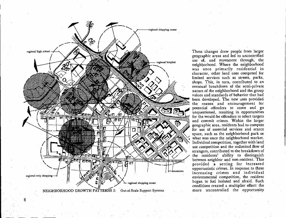
'-..
regional shopping center --NEIGHBORHOOD GROWTH PATTERNS 3: Out-of-Scale Support Systems
8
These changes drew people from larger geographic areas and .led to uncontrolled use of, and movement through, the neighborhood. Where the neighborhood was once primarily residential in character! other land uses competed for limited services such as streets, parks, shops. This, in turn, contributed to an eventual breakdown of the semi-private nature of the neighborhood and the group values and standards of behavior that had been developed. The new uses provided the reason and encouragement for potential ·offenders to come and go unquestioned, resulting in opportunities for the would-be offenders to select targets and commit crimes. Within the larger geographic area, residents had to compete for use of essential services and scarce space, such as the neighborhood park or what was once the neighborhood market. Individual competition, together with land use competition and the unlimited flow of strangers, contributed to the breakdown of the residents' ability to distinguish between neighbor and non-resident. This provided a setting for increased opportunistic crimes. In response to these increasing crimes and individual environmental competition, the resident began to feel isolated and afraid. Such conditions created a multiplier effect: the more uncontrolled the opportunity

------~----------------------------------------~~~~~--------------------------------------------------~
offenses-the more the victim or would-be victim became isolated from his neighbors, giving up use and control of the neighborhood streets~resulting in personal fear and a retreat behind locked doors. Such a situation resulted in abandonment of the neighborhood street to the would-be offender, thereby increasing the opportunities for more crimes, with one of the results being an increase in crimes against the home. The final result was a general deterioration of the neighborhood environment. Lack of responsibility expressed itself in lack of property maintenance, investment, pride of ownership and eventual movement from the neighborhood, thereby providing the breeding ground for more crimes.
This escalation of competition-conflictcrime opportunity-reactionary fear leads to the eventual disintegration of the neighborhoods and loss of the qualities of life which originally made urban neighborhoods a desirable place to live. While the sequence of events and the combination of forces and pressures can vary from neighborhood to neighborhood, the result is a continuing escalation of crime which eventually leads to the permanent presence of offenders and the acceptance of crime as inevitable.
Balanced Use & Support Services
Land Use Growth
Use Competition
Crime Opportunities
9

THE FINEST DOGS
FOR SALE FULLY TRAINED AKC
GERMANSHEPIIERDS & DOBERMAN PINSCHERS
SHlI'i>EDWoru.O'MnE .2.tI1OURDEU'lE'RY
3 Historical Models
As crime in neighborhoods continued to escalate during the 50's and 60's, various solutions were attempted, some of which were planned remedial programs, while others were more reactionary. In many cases families chose to abandon the urban neighborhoods for the assumed safety and security of suburbs. There were other extreme reactions by citizens: increased purchase of weapons, the use of guard dogs, and greater expectations of protection from a police force which was already overtaxed. Remedial efforts included rehabilitation programs for offenders and encouragement by the police for installation of alarm systems and deadbolt locks.
Initial efforts at crime prevention through physical design led to an analysis of the targets. Why was one site more susceptible to crime than another? Because of the defensive mentality that had developed, the stress was on target-hardening one's property from an offender. The emphasis had changed from sole reliance on apprehension and punishment to one of defense.
11

The Fortress City
12
Urban Village
Designing for the defense of one's home and community is not a new idea. Historically, the design of houses such as the Mediterranean atrium house served the purpose not only of climate control, but safety as well. The design of medieval cities such as Malines, Belgium, and the French island abbey of Mont-SaintMichel were essentially fortified towns that provided a safe retreat for citizens. Contemporary examples of security design have stressed the same defensive nature present in the historical examples. The difference, however, has been that instead of defending against a recognized external enemy, the enemy turned out to be within the community itself. There have been three major conceptual models in recent times which have dealt with the design of a safe environment: the urban village; the urban fortress; and defensible space.
While the term "urban village" was drawn from Herbert Gans', The Urban V£llagers (1962), it actually was founded in the theories developed by Robert Park and the University of Chicago School of Sociology, which were presented in Park's 1925 essay, "The City". Park emphasized the human interaction dimension in the organization of cities, observing that the city is not merely a physical mechanism, but a product of human nature. The urban village model postulates that the social interaction essential to the achievement of urban safety, harmony, and functionality is partly a result of spatial organization, proximity, and accessibility. It identifies social disorganization as a primary cause of crime, defining it as the breakdown in the mechanisms that foster personal relationships, cooperation, recognition, arid morale. Although social in its approach to crime prevention, the urban village model makes a strong case for relating physical design to the social mechanisms of recognition, neighboring, and mutual protection. This bridging of the gap between the physical environment and crime-related behavior provides the basis for E/S planning. Jane Jacobs in Death and Life of the Great American Cities, and Elizabeth Wood in Housing Design-A Social 'Theory, go further in

relatil'!g crime to the physical environment by advocating diversity of land uses to provide a kind of constant surveillance capacity, planned loitering areas, and the promotion of social responsibility.
Although of considerable value as a stateof-the-art advancement, sole reliance on the urban village model is limiting, because it depends primarily on social homogeneity. While social interaction and collective responsibility are seen as essential for effective neighborhood crime prevention, the urban v'illage model relies on pre-existing cultural bonds, i.e. resident homogeneity, to achieve these essential behaviors. Therefore, it does not adequately address or recognize the socially heterogeneous neighborhood so common in our cities today. Additionally, the urban village model does not recognize or consider the need for having a physical environment structured to allow and encourage social interaction in either a heterogeneous or homogeneous neighborhood. Finally, as the oft cited Kitty Genovese incident demonstrated, the capability for natural surveillance by individuals does not in itself deter crime. What is additionally required is the reduction of the crime opportunity in the first place, as well as the presence of felt responsibility by the area residents which would encourage and support their collective intervention.
13

Urban Fortress
The urban fortress model represents a view of crime prevention which, as the name implies, places sole reliance on securing buildings and areas so outsiders cannot gain access without approval. This view has gained widespread acceptance because of its practicability and seemingly immediate results. In actuality, the urban fortress is much less a product of a developed design philosophy than a marketing strategy of manufacturers and real estate developers. Examples of this marketing technique can be found in the real estate section of any metropolitan paper in advertisements promoting the security features in luxury apartment complexes.
The urban fortress is, in its own way, an even more simplistic approach than the urban village to the problem of predatory crimes. Indeed, it is perhaps this fundamental simplicity that accounts for its appeal. Instead of promoting corrective design concepts, the approach of the urban fortress is to isolate the resident from an environment which is perceived to be hostile to him. Designed to be the most effective against burglary and other crimes against residences, the model makes no real attempt to deal with street crimes. Implicit in the fortress approach is the notion that the streets are indefensible and
14
are largely the province of criminals. The urban fortress is, at best, a short-term solution. Aside from ignoring the causes of opportunity crime, this technique eventually raises as many problems as it solves. Studies indicate that the presence of security guards and extensive protection: equipment, rather than enhancing the residents' feeling of security, actually generates more anxiety by presenting a fearful image of potential danger, and by encouraging the belief that the residents are powerless to prevent victimization. Eventually this perception can lead to a breakdown of the community's social structure by resident withdrawal from neighborhood life and indifference to problems and thus a relegation to the police of total responsibility for neighborhood controL Besides the social costs of the fortress model, the dollar costs of maintaining equipment and security personnel are such that few neighborhoods could afford them even if desired.
Defensible Space
The defensible space concept is based on studies of public housing projects conducted by Oscar Newman and represents one of the first attempts to develop an architectural perspective on crime prevention through physical design. This model promotes the concept that the design of the physical environment has the capacity to either deter or facilitate crime by enhancing the resident's ability to monitor and control his own environment. Newman builds on the work of urban sociologists and behavioral psychologists but presents his theories in physical design terms. Some of the basic objectives and contentions involved in the defensible space model are summarized below:
Territoriality is defined as the capacity of the physical environment to create for each individual perceived zones of territorial influence that result in a proprietary interest and felt responsibility. Design elements such as building placement and juxtaposition, building height and size limitations, and a range of real and symbolic or perceptual barriers define a hierarchy of increasingly private zones from private apartment to communal space. The model advocates the incorporation of amenities and community facilities within these zones.

------------... ------------............ -----------------------------------------------------------------------------------------------------------
Natural surveillance is defined as the capacity of physical design to provide surveillance opportunities for residents. The idea here is to illuminate and locate public and semi-public pathways, entrances, and areas to facilitate surveillance by residents and to reduce ambiguity of use. Additionally, the defensible space concept proposes that if territoriality is achieved, it will help to eliminate or reduce the apparent vulnerability to crime and therefore aid in deterring possible offenders. Finally, it is proposed that the development and inclusion of commercial "safe zones" within public housing projects will lessen the possibility for victimization.
The defensible space concept is of particular value in that it presents a design-oriented approach for allowing the social interaction of the urban village. The concept presents a strong argument for establishing the relationship between behavior and the structure of the public housing project environment. While the concept of defensible space is noteworthy, its application has been limited to the public housing project which may exhibit an intensity of crime problems but does not represent the complexity of other environments such as neighborhoods.
By considering only the public housing project environment, the defensible space analysis and solution techniques are limited to the site boundaries of the project. The theory does not consider the impact from-or on-the surrounding neighborhood, nor does it deal with the types and frequencies of crimes that might be occurring in the immediate environs which can impact on the public housing project. Conversely, there is also the danger that the public housing project may have a detrimental effect on the surrounding area. The important point is that the limitation imposed by considering only site boundaries of public housing projects does not consider the possibility and presence of street crimes and the safety and security of the neighborhood at large. Essentially, the defensible space concept as applied to date, isolates the resident of the public housing project from his surrounding neighborhood and forfeits the neighborhood streets to possible offenders. Looked at in this way, the defensible space concept risks the danger of becoming a fortress within a neighborhood, further stigmatizing the public housing project rather than making it a part of the neighborhood.
crime occurrences ~
Territorial Abandonment of the Neighborhood Streets and Isolation of Residents Result in Fear and Increased Crime Opportunities Throughout the Neighborhood
15

FORCED TERRITORIALITY
16
CULTURAL TERRITORIALITY
EYES ON THE STREET
I.IIIIIIIA TERRITORIALITY
~ARCHITECTURALLY DESIGNED TERRITORIALITY
Each of the conceptual models offers important theories and examples of the necessity for relating the design of the physical environment to acceptable human behavior. All of the approaches, however, are to varying degrees defensive in nature in that they concentrate on the location or immediate vicinity of the offense. Essentially, these conceptual models do not examine how or why the opportunities for crime occur in the first place, nor do they take into consideration all of the different types of opportunity crimes. Each model is useful in specific situations, but none provides an approach that would be applicable to the vast majority of neighborhoods where there is a heterogeneous society, mixed land uses and ownership, and finally, limited financial capability.
At first glance, these conceptual models seem quite different. However, there is a common theme present in each approach: the need for individual and group territoriality or sense of place. At one extreme, the urban fortress represents a forced method for providing territoriality where sole dependence is on physical
security design. At the other extreme is the urban village model which relies solely on cultural or social behavior to establish territoriality. The defensible space concept of territoriality represents the first attempt at combining both of these extremes. However, it suffers from its separation of the public housing project from an assumed alien surrounding neighborhood. The important point to be made is that each model has validity in certain circumstances. However, those circumstances are limited in that they do not represent the vast majority of situations, since most neighborhoods are neither homogeneous nor isolated from their surroundings. There is a need for a comprehensive environmental security planning process that is applicable to the vast majority of situations and one that can respond to the physical and, socioeco~omic characteristics of a given neighborhood, rather than trying to forcefit or replicate a predetermined model. Since every neighborhood is different, it is necessary to develop techniques which combine both physical and social solutions to meet specific neighborhood crime problems.

With the exception of the urban fortress, each of these approaches, as well as more recent ones such as "turf reclamation" by Seymour Rosenthal, and William Brill's "comprehensive security planning", provides substantive value. Clearly there is a need for developing a flexible, comprehensive approach that integrates particular techniques and makes full use of the physical, social, economic, and law enforcement tOols available. The contribution of the Neighborhood Environmental Security Design Process is an attempt to provide a broader geographic framework in which to grapple with these crime problems. one that is not limited by individual land uses or limited site boundaries. E/S also attempts to build upon these past models and begin to develop a comprehensive and flexible planning process.
., '" u !:: ... 0
\:to c:: '" .0
~ u ..c:
f-o
to u
]-Il.. to
~
zone in which the majority of neighborhoods will exist
u bO
'" :> c:: '" .0 ...
;:l u
..c: t-<
to '0 o
rn to
~
PHYSICAL
I \ I I citizen participation SOCIAL
ECONOMIC
LAW ENFORCEMENT
A Comprehensive and Flexible
Planning Process
17

4 Crime and the Physical Environment
:
The most widely recognized theory relating crime and the physical environment is the concept of territoriality, and in the previous review of the major contemporary models, it was shown to be a common theme. In its simplest form, territoriality involves three conditions: • The resident feels a proprietary interest
and responsibility over areas beyond his front door, a responsibility shared by his neighbors.
• The residen t perceives when this territory is potentially threatened by the intrusion of strangers and is willing to act on that perception.
• A potential offender perceives that he is intruding on, the domain of others, will be noticed if he intrudes and, therefore, is more likely to be deterred from criminal behavior.
In all of its various forms, territoriality is a desired condition or goal in achieving environmental security. However, this recognition of the importance of territoriality does not reveal how such a condition can be achieved. In order to develop a methodology for allowing the condition of territoriality to form, the
following questions must be answered. What types of opportunistic crimes are being committed? Why do these crimes occur? How do they occur? What aspects of the physical environment may· be fostering and encouraging these crimes?·
Opportunistic crimes are classified in various ways; for example, by the actual type of offense such as robbery or burglary; by the basic classification of property or violent crimes as used by the FBI in its Uniform Crime Reports; or as crimes involving strangers or nonstrangers. For the purpose of E/S planning such classifications are not sufficiently useful, since they do not reflect the geographic description and patterns of the offenses. A classification system which relates types of opportunity offenses to the physical environment includes the following:
• out-of-area offenders
• out-of-are~ victims
• both out-of-area offenders and victims
• within area (neighborhood) offenders and victims
• neighbor-to-neighbor crimes
o offender
V victim
JiiIir offense
Geographic Classification of Opportunity Crimes ..
19

Neighborhood Crime Phenomena Study Area
20
Attempts at altering the physical environment to lcduce crime have traditionally concentrated on the structural make-up of the crime location or target-for example, the number of doors, windows and shrubbery around a burglarized building or the amount of lighting along a street or at a bus stop where muggings have occurred. This approach is limited in that it works on the premise that to stop crime you have to rety solely on defending the probable targets: it does not attempt to identify and understand why the crime opportunities exist in the first place.
Opportunities for predatory crimes are the result of a complex series of causes and effects that include the characteristics of the physical environment and how people make use of that environment. These complex interactions and patterns of use can extend far beyond the doorstep of the burglarized home or location of an offense. An analysis of how an environment is structured, and how and by whom it is used, provides a framework for understanding the cause/effect relationships of opportunity crimes. The following case studies illustrate several examples of this phenomenon and show why certain opportunity crimes occur.

In the target neighborhood, residential burglaries and street crimes were occurring with increasing frequency. The area was composed of approximately 8,000 people and was a neighborhood of single family and converted duplex homes and walk-up apartments. It was an older neighborhood where many of its structures dated from the 1920's, although newer apartment buildings, large insurance offices and a regional hospital were situated along its borders. Geographically, the neighborhood was located adjacent to the downtown business district to the east. The north side was designated by a depressed railroad line over which there were three bridges and streets. To the south lay a major thoroughfare, commercial stores, elementary schools, and a regional high school. The neighborhood was in both economic and racial transition. To the north was another residential district; to the south an industrial area and interstate expressway; and to the west a portion of the city's park system. Most of the homes in the neighborhood were located on older tree-lined residential streets within one to three blocks from the main thoroughfares.
Crime-Environment Example #1: Residential Burglary
residential neighborhoods
crime occurrences
Neighborhood Crime Patterns
. .. :.
21

Residential burglaries were generally perpetrated during the daylight hours. A plotting of the offenses over several previous years indicated a random distribution, and it was difficult to discern any logical pattern of occurrences. The traditional approach to dealing with this problem would have been either to move out of the neighborhood or to targetharden the individual homes. Such measures would have had little impact on the crimes.
An E/S analysis of the neighborhood and its surrounding areas uncovered the following causes and effects. Through a review of offense records and identification of the general location of residency of past and suspected offenders, it was found that many of the offenders were young adult males living out of the area in neighborhoods to the north. Through an origin-destination analysis of suspected
22,
THE NEIGHBORHOOD DECAY PROCESS I: Residential Neighborhood Strong Physical Identity
offenders in rdation to the time of day of the crime, it was possible to postulate that burglaries were being perpetrated by students on their way to and from the regional high school. Because the neighborhood streets offered shortcuts to the school, the majority of students living to the north walked directly through the target neighborhood on their way to and from school. It could be theorized that the unrestricted circulation, in combination with the high school as a generator of traffic, provided the opportunity for would-be offenders to become familiar with the neighborhood and to break and enter homes undetected.
Specifically, the results of the unconstrained movement were:
• uncontrolled public use of a semiprivate neighborhood street;
• opportunity for potential offenders to
THE NEIGHBORHOOD DECAY PROCESS 2: Residential Neighborhood
Land Use Competition
come and go unchallenged, to familiarize themselves with neighborhoods and select targets, to break and enter, and to escape unchallenged;
• fear of crime resulting in non-use of neighborhood streets by the residents and thus the loss of ability to distinguish between neighbor and stranger.
While the offenses were occurring at the scale of the individual buildings and the victims were residents within the neighborhood, the suspected offenders were coming from out of the area. Given this recognition, it became evident that a series of causal factors extended from the neighborhood street scale to the district scale. The analysis clarified the need for alternative solutions at all relevant scales, which included a variety of changes in circulation patterns and development of neighborhood improvement programs.

expanded school '2 21,
. -e r~ .~"\.\.
THE NEIGHBORHOOD DECAY PROCESS 3: Erosion of Neighborhood Semi-Privacy
District Scale Alternative Solutions: • Redistrict regional school lines in such a
way as to discourage student flow through other neighborhoods.
• Improve school busing.
• Redesign public bus routes.
• Redesign area street system to go around target neighborhood from north.
• Improve cross-connector streets for ease and convenience of pedestrian traffic.
rQD regionalization of high school
• increase in crime
~=====.~~ ~~.. lIt ~ g. 1t):J taf
=~.. . ttlt all :
new ~egional .ielll hospItal
i ~ tlull.i=:ll THE NEIGHBORHOOD DECAY PROCESS 4: Crime & the Fear of Crime
Neighborhood Scale Alternative Solutions:, • Redesign internal street syste.m,
including use of the cul-de-sac on certain streets, to prevent easy flow through the neighborhood.
• Organize neighborhood residents in a block watch program to report on suspicious activity.
• Develop financial programs to encourage residents to improve private property and to reduce shortcutting through private property.
• Encourage resident use and control of streets through resident-only parking and small neighborhood play areas at the rear of street closings.
~~~fC!;IGJ ~~=,p;(i • ~
"" ~ ~
.,.. ,... "'" '""
• • fortressing
abandoned house
Physical & Sodal Breakdown
... ""
Building Scale Alternative Solutions:
,., "'" • parking
increased crime
• Install dead-bolt locks, alarm systems.
23

Crime-Environment Example #2: Auto Thefts, Street Robbery, Muggings
While the previous case study gave an example of ou t-of-area offender crimes, the following problem describes within-area offenders and both out-of-area and withinarea victims.
Adjacent to an urban residential neighborhood was a regional hospital where street robbery, muggings, and car theft had become a serious problem. The victims had been nurses, out-patients, hospital visitors, and nearby residents. In recent years the hospital had made many additions to its physical plant-to such an extent that only a limited amount of offstreet parking remained. A major route to the central business district bordered two sides of the hospital, and a heavily used bus transfer stop was located next to the hospital. The hospital itself was easily accessible via adjacent neighborhood streets. While the area was heavily patrolled by police, the hospital parking lot was not manned.
An E/S analysis of the hospital site, its surrounding area, and crime and victimization data uncovered a number of perceived reasons for the crimes. Through an analysis of crime and arrest records, it was discovered that the majority of victims did not live in the immediate area.
24
(~,
\ I ....... /
F
·v .. _s.~. Mst :"~.=J~ __ ...----... ",---- ,-_ ........ Regional Strip Commercial
residential neighborhood
out-ai-scale generators
bus route
movement patterns
• •
Out-of-Scale Movement Generators

However, many of the suspected offenders seemed to be coming from the immediate community. Through a plotting of victim and perceived offender residences, it was found that the offenders tended to reside in the immediate neighborhood, while the victims were predominantly regional in residency. It was hypothesized that several physical conditions were providing the opportunity for the auto thefts, street robberies, and muggings:
• insufficient off-street parking at the hospital;
• lack of management in the hospital parking lot;
• a large number of residential streets allowing uncontrolled access and egress;
• parking along neighborhood streets by visitors to the hospital;
• continuous cross-circulation by a variety of people caused by the location of the hospital along major routes to the central business district, by the bus transfer stop adjacent to the hospital, and -by people on foot and in automobiles shortcutting through the neighborhood.
! ~\
~~
\ / Competing Land Uses & Their Zones of Environmental Use
25
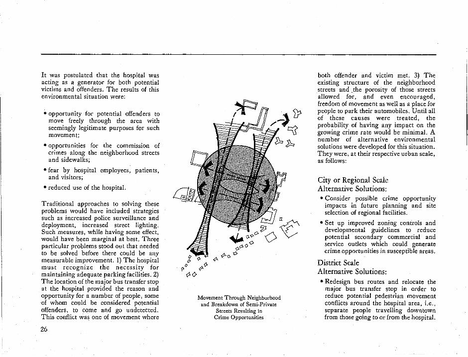
It was postulated that the hospital was acting as a generator for both potential victims and offenders. The results of this environmental situation were:
• opportunity for potential offenders to move freely through the area with seemingly legitimate purposes for such movement;
• opportunities for the commission of crimes along the neighborhood streets and sidewalks;
• fear by hospital employees, patients, and visitors;
• reduced use of the hospital.
Traditional approaches to solving these problems would have included strategies such as increased police surveillance and deployment, increased street lighting. Such measures, while having some effect, would have been marginal at best. Three particular problems stood out that needed to be solved before there could be any measurable improvement. 1) The hospital must recognize the necessity for maintaining adequate parking facilities. 2) The location of the major bus transfer stop at the hospital provided the reason and opportunity for a number of people, some of whom could be considered potential offenders, to come and go undetected. This conflict was one of movement where
26
n
~:;o~o~ ~ -0c '0
Movement Through Neighborhood and Breakdown of Semi-Private
Streets Resulting in Crime Opportunities
both offender and victim met. 3) The existing structure of the neighborhood streets and .the porosity of those streets allowed for, and even encouraged, freedom of movement as well as a place for people to park their automobiles. Until all of these causes were treated, the probability of having any impact on the growing crime rate would be minimal. A number of alternative environmental solutions were developed for this situation. They were, at their respective urban scale, as follows:
City or Regional Scale Alternative Solutions: • Consider possible crime opportunity
impacts in future planning and site selection of regional facilities.
• Set up improved zoning controls and developmental guidelines to reduce potential secondary commercial and service outlets which could generate crime opportunities in susceptible areas.
District Scale Alternative Solutions: • Redesign bus routes and relocate the
major bus transfer stop in order to reduce potential pedestrian movement conflicts around the hospital area, i.e., separate people travelling downtown from those going to or from the hospital.
Community Area Scale Alternative Solutions: • Redesign street system to reduce
unconstrained access and shortcutting through hospital area.
• Develop transitional or buffer uses between hospital and residential neighborhood, such as off-street parking through the closing of selected streets.
• Place a no-parking ban on streets adjacent to the hospital which predominantly serve the hospital.
Neighborhood Scale Alternative Solutions:
• Redesign immediate street and sidewalk system to prohibit direct movement from hospital through residential neighborhood.
• Allow resident-only parking on neighborhood streets.
Site Scale Alternative Solutions:
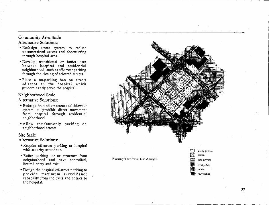
• Require off-street parking at hospital with security attendant.
S Buffer parking lot or structure from neighborhood and have controlled, limited entry and exit.
• Design the hospital off-street parking to provide maximum surveillance capability from the exits and entries to the hospital.
0 totally private
B private
Existing Territorial Use Analysis -m semi.private
g semi-public
W· public
II fully public
27

5 .j
The Crime-Enviroiunent Phenomenon
The Crime-Environment Phenomenon
29

The previous case study examples depicted a sequence of events where no one physical element or system was causing the crime opportunities. Instead, a range of physical situations had inadvertently set up a causal condition. Seemingly independent elements and separate human activities had resulted in the formation of a cause/effect phenomenon where the opportunity for predatory crime was being encouraged. Said in another way, the structure of the physical environment influenced how and by whom the environment was being used, and therefore, the resulting use and possible conflict within the environment. This complex phenomenon reflects the dynamic interchange between man and his environment and is the critical relationship which can allow either positive or negative human behavior and use. There is a direct link between the organization of the environment and the opportunity, and even probability, for crime. When certain elements or uses are no longer appropriate to the scale of the environment, conflicting uses result and provide the setting for opportunities for crime.
In the examples, it was shown that the structure of the environment was allowing competition of use between residents and non-residents for the semi-private neighborhood streets. In addition, the organization of the environment was-
30
encouraging that competitIOn by the location and districting of a regional high school which acted as a traffic generator drawing pedestrian traffic through the neighborhood streets. While this was a simple example, it portrays the beginning of a cause/effect phenomenon where accessibility, use of the neighborhood streets by non-residents, and time of day when residents were away from their homes, resulted in opportunities for offenders to select targets and commit crimes. As this crime condition accelerated, residents retreated behind locked doors and gave up control of their immediate environment, which resulted in loss of the semi-private territoriality of the neighborhood and the eventual loss of the residents' capability to perceive between neighbor and stranger. The loss of territory also contributed to a social brea.kdown within the neighborhood. Such a crime-environment condition can generate additional types of crime opportunities leading to further deterioration of the neighborhood. A multiplier effect sets in, causing loss of real estate values, a lowered quality of life for the residents, and the eventual abandonment of the neighborhood by those who can afford to escape. By looking at the crime-environment phenomenon as part of the urban decay process, environmental strategies can be developed to help interdict the patterns of deterioration.
The Neighborhood Deterioration Phenomenon

6 The E/S Conceptual Model
EIS is a comprehensive planning process which attempts to redirect that part of the neighborhood decay process that is caused by crime and fear of crime. The goals of EIS which initiate the positive process of preserving neighborhoods are straightforward:
• to reorganize and structure the larger environments (city districts and communities) to reduce competition, conflict, and opportunities for crime and fear of crime, which undermine the fabric of a neighborhood;
• to design the neighborhood environment to allow residents to use, control and develop a sense of responsibility for it-resulting in territoriality.
Territoriality is recognized as a major ingredient in achieving a safe and viable neighborhood environment. However, for individuals to be expected to develop a sense of pride and territoriality, it is necessary that the organization of the
environment permits and even encourages them to do so. In this sense, one goal cannot be achieved without the other. As urban designers we cannot create territoriality, since that is a human characteristic. However, as urban designers, we can provide the environmental stage for positive human behavior to manifest itself; we can also provide an environmental stage that discourages negative human behavior patterns.
A sense of place is not achieved overnight but develops as the individual uses and extends his sphere of control and responsibility. In essence, the individual expresses his awareness that it is his home and neighborhood and he will take care of it.
Because predatory crime is opportunistic in nature, the larger physical environment is restructured so that the would-be offender has to go out of his way and make an exception to his normal daily activities to find a target and commit an offense.
31
When this is achieved, a reinforcing framework is created at each scale of the environment which reduces the opportunity for competition and conflict. Within the neighborhood itself, the streets, spaces, elements and systems are designed to serve the residents rather than the public at large. As the scale of application gets smaller, there is a greater need for designing to the special requirements of the particular residents living in the neighborhood. While a neighborhood may exhibit a variety of social characteristics, there will be a predominant user, such as families with children, elderly, ethnic, or transitory groups. Such identification is necessary in view of the types of opportunistic crimes that might be present: out-of-area offenders, out-of-area victims, within-area offenders and victims, neighbor-toneighbor crimes. It is at this point that the full role of territoriality begins to play a dominant position. Territoriality develops first in the individual and then extends naturally to include the immediate neighborhood, resulting in the development of a communal set of behavior standards determining what is accepted and what is not.
There are critical threads of continuity that extend through this entire scenario. First, it is a process that includes a series of steps and actions that may require an
32
extended period of time to accomplish, depending upon the size, complexity, and degree of problems in a given neighborhood. Secondly, this process is comprehensive in that it includes all aspects of the environment-whether they be physical or social-and extends over an area large enough to respond to the crime causes. Thirdly, the environment is being structured to reinforce and encourage positive behavior and discourage or prohibit the opportunity for negative behavior. Fourthly is the element of scale: not only are we considering the environment from the district down to the doorstep, but we are responding to the geographic classification of the opportunity crimes. Finally, we are responding to the particular problems and needs of the given neighborhood rather than looking for a panacea to be replicated everywhere.
Such a fixed model, even if possible to develop, would be totally undesirable since it would not allow the variety of human expression which makes each neighborhood different and unique. Superimposing a predetermined solution on a neighborhood would deny the critical element of territoriality-that is, the sense of place or home.
E/S planning then, is a comprehensive process which allows positive human
behavior to occur at different scales of the environment in such a manner that each element strengthens the other. Such a reinforcing framework has a synergistic effect: the total E/S effectiveness is greater than the sum of the elements. Once E/S is achieved and maintained, there is a further effect which builds upon and reinforces the total environmental security of the neighborhood: positive human values and behavioral standards develop from the growth of individual and group territoriality. E/S is, therefore, both an offensive and defensive tool against crime. It is offensive in the sense that the environment is being structured to allow for, and encourage, the development of positive human behavior through the elimination of competition and conflict for use of the environment. E/S is defensive in that it makes it more difficult for the would-be offender to operate, and the offender is further hindered by the strength of individual and group territoriality.
Obviously such a planning process is complicated and requires careful consideration. This is appropriate in light of the natural complexity of the environmental crime phenomena involved. In order to translate this E/S process into a conceptual perspective, it is necessary to isolate the basic components that determine E/S success or failure.

7 E / S Theories
The components of the E/S planning process are equally important. There must be a set of reinforcing urban support systems and elements. This environmental organization reinforces a predominant land use in a given neighborhood. This primary land use determines the design criteria for redesigning the physical environment, in order to allow and encourage the development of individual and group territoriality. The agent that influences these components and determines how they will either reinforce or work against one another is the environmental scale at which they operate.
8. 1~8 ~ 8
33

Environmental Scale and Opportunity Crime There are different aspects of environmental scale to keep in mind as the term is used in E/S and which have been referred to in this manual:
• the spatial scale of the area being studied-divided into district, community, neighborhood, street or cluster, and building or element.
• cause and effect scale-shows the relationship between the location of the offense to the known location of the victim's residency, and the known or perceived location of the offender's residency.
• the scale of the urban support elements or system which may be inadvertently encouraging the crime opportunity-opportunity crime generators.
It has been postulated that the scale of the environment plays an important function in the occurrence of opportunity crime. Several aspects have been discussed: how the geographic origin of the participants in an offense directly affect the cause/effect phenomenon; and how the scale of the urban support elements and systems can act as opportunity crime generators. The importance of these relationships in reducing crime and fear of crime is the realization that unless we can identify and understand the urban scale at which people are using the environment, we will not be able to understand the cause/effect phenomenon of opportunity crime.
34
community area
neighborhood area
district area
o OFFENDER
V VICTIM
LOCATION OF CRIME
SUPPORT SYSTEMS

Spadal Scale For purposes of analysis and solution we employ a spatial hierarchy:
• district or town scale-which is comprised of several square miles with generally clear boundaries. They may be either physical, such as an interstate highway or a river, or perceptual, such as the "east side".
• community scale-smaller in size than the district, the boundaries and edges may consist of cross-town avenues, river tributaries, etc. The area may include a
Districts Within a City
large shopping center, schools, and a number of neighborhoods.
• neighborhood scale-may consist of several square blocks of residential buildings, small commercial and service facilities, a neighborhood park. It may also have discern able physical boundaries and a socio-economic identity. The characteristics and limits of the neighborhood are well recognized and understood by its residents through their perceptual span of recognition.
• street or site scale-includes a cluster of buildings or a site sufficiently large for multiple users, for example a park or a shopping center.
• building or element scale-individual sites such as a bus stop, telephone booth, street corner, alley.
Determination of an existing spatial hierarchy can vary from one environment to another and is based upon the physical makeup of the natural and man-made elements as well as their use.
Community Areas Within a District
35

Cause and Effect Scale The classification of opportunity crimes employed in E/S planning (out-of-area offender, out-of-area victim, both out-ofarea offender and victim, within-area offender and victim, and neighbor-toneighbor) can include any or all of the common predatory crimes. Offenses such as burglary, robbery, auto theft, rape, and mugging are usually reported and documented by the police by the general
. location of the crime occurrence, i.e., "within the 1500 block of Main Street," or "at 278 Oak Street." Criminologists and
urban planners have also concentrated on the location of the offense and on the pattern that is formed by a number of offenses. As a result there follows an attempt to analyze and understand why a given location is physically prone to crime. Such analysis is limiting in that it assumes that in order to reduce crime, one must defend or harden the target area. While this defensive tool is useful, total reliance on it ignores the question of why an offense has occurred in one particular spot rather than at any number of other susceptible target areas.
Neighborhoods Within a Community Area
36
The term opportunity crime by its very use suggests that the offender has committed the crime because the opportunities presented themselves. This is not to imply that such crimes cannot be planned or premeditated. Instead it suggests that in the normal daily activities of potential victims and offenders, the opportunity for committing a crime, or planning to commit a crime, can be present. Such a view of opportunity crime suggests a dynamic interrelationship between the offender, victim or target, and the numerous ways in which they come in
Streets or Clusters Within a Neighborhood

contact. In order to understand and begin to deal with this phenomena. we must know not only the location of the crime but also must ask why the victim and offender were at that location. By pinpointing the residency of the victim. the residency or suspected source of the offender. and the location of the offense. we are able to identify both the geographic area of the environment in which the crime has been staged and also the reason why the participants came in contact. Then we can begin to postulate how the opportunity for crime was present.
Yit~~ Buildings & Elements Scale
Urban Support System or Element Scale: Opportunity Crime Generators
Elements of the environment can inadvertently become generators of crime. Specifically. the type, location, and relationship of certain people-generators can encourage the interaction of people, some of whom will ·b.e victims and some offenders. Environmental crime generators not only play a role in the environmental crime phenomena at the actual generator but can be a causal factor of opportunistic crimes occurring near or along the way to the generator. Identification of individual opportunity crime generators plays a major role in analyzing the cause and effect phenomena and in developing appropriate strategies and solutions. By relating the location of generators with the structure of the environment, and how and by whom the
environment is being used, it is possible to postulate probable cause and effect relationships between certain patterns of crime.
While it is recognized that opportunity crime generators were not intended to be such by those who made the decision for their existence, it is clear that they do exist. Decisions to locate or relocate a high school, a regional hospital. a commercial development, and even a park or playground are constantly being made by planners without their realization of the potential harm and crime impact.
Opportunity crime generators can be categorized as follows:
• known crime generators-hot spots, or areas at which crime is known to occur frequently; for example, known offender hangouts such as particular bars, drug dealing points, and in some cases parks or other public facilities.
• service generators-public or private facilities and elements which regularly attract potential victims as well as potential offenders; for example, open spaces and parks, public institutions and facilities such as regional hospitals, regional high schools, post offices, commercial locations.
• movemen t generators-circulation systems and elements which attract or channel potential conflicting user traffic; for example, subway systems. bus stops, pedestrian walks or paths, parking lots.
37

• fear generators-systems and elements which provoke fear of crime, for example, certain streets and sidewalks, alleys, large unmanned parking lots and garages.
If the components of E/S are not in balance, competition for use and conflict can result and foreshorten the possibility of territoriality being developed. Several examples will help to illustrate types of imbalance.
• out-of-scale support system: a neighborhood street has been redesigned to carry cross-town traffic, resulting in the breakdown of semiprivate character of the neighborhood and use of the area by non-reside"ts.
• out-of-scale support element: a neighborhood park provides a large open space, baseball field, basketball courts. Because of lack of local recrea tio n al facili ties in 0 ther neighborhoods, the park draws (generates) young adults from out of the area.
• land use conflict: a neighborhood shopping area has been expanded and enlarged to attract suburban commuters, resulting in the need for increased parking in residential neighborhood, competition for use of sidewalks, public services, etc.
The implication in all of these examples is that one or more elements can be out of scale whether by intent (design) or by
38
change of use. It should be kept in mind that seldom is there just one condition of scale conflict in a given neighborhood, nor does such a conflict have to occur within the actual neighborhood. Any neighborhood can have many environmental conflicts which provide opportunities for would-be offenders. Each environmental conflict can then precipitate a pattern of crime, and this is why crime patterns are often so confusing. The ideal relationship between the primary components of E/S is scaled balance and reinforcement.
To achieve such an environmentally reinforcing condition, whether in a new or existing neighborhood, requires the combination of appropriate scale, reinforcing support systems, predominant land use, and territoriality. These are the components of E/S.
E/S strategies are applicable for all classifications of opportunity crime (outof-area and within-area offenders and victims, . and neighbor-to-neighbor crimes). Prevention of neighborhood crime can only be accomplished when all of the opportunities for crime are recognized and dealt with. The process of planning and organizing the environment must start at the large scale then work down through the neighborhood level to the individual street or block. If one were to begin trying to meke an area environmentally secure by starting at the street or building scale, the only possible outcome would be a form of urban fortress.

( THE ENVlRONMENTALSE-CURiTYCONCEPT--DIAGRAM-) F ,
Component Theory
Reinforcing Urban Support Systems
-Suss ..... / ,( \ I I ) \ ...... -j\,_/
( predomin.:=» Land Use
/--" I )
~) ( Territoriality n
/-, I \ \ I
(~\~ ,_/JV)
Environmental Security
~ ~
Determinant
e Environmental Scale
• Predominant Land Use
• Type and Location of Opportunity Generators
• Identification of Intended User
• Secondary and Support Land Uses and Elements
• User Needs and Preferences
• Resident Use and Control of
• Environment _ Stranger Recognition
Capability
• Group Territoriality • Group Standards of
Behavior • Continued Natural
Evolution of Positive Human Behavior and Environmental Change
Applicable Scale
City Wide, District, Community Area
Environmental Security Result
-Type, Location and Scale Criteria for Urban Support Systems and Elements
.Elimination of Land Use Conflicts
- Reduction of Offender Mobility
( Neighborhood H eReduction of Competition For Use
Street or Block, Building or Element
eFurther Limitation of Offender Mobility
.Intended User Design and Planning Criteria
-Crime Opportunity Reduction
.Individual Territoriality
.Individual Environmental Responsibility
.Natural Surveillance Capability
& OPPORTUNITY REDUCTION AND CRIME CONTROL AT EACH
SCALE RESULTING IN SYNERGISTIC IMPACTS
• PLANNED USE OF ENVIRONMENT • FRAMEWORK FOR COMPREHENSIVE
CRIME PREVENTION STRATEGIES AND PROGRAMS
• INCREASED PROPERTY VALUES AND ECONOMIC DEVELOPMENT
OPPORTUNITIES

8 The EI S Technical Planning Process In presenting an outline of the technical planning procedure, it should be recognized that the format of the manual does not allow an exhaustive detailing of the subject matter. To do this would require extensive documentation, and even that could not replace actual field experience. Therefore, it is our intent to provide the interested practitioner with an overview of the basic technical steps and their method of application.
E/S planning bridges a number of disciplines-urban planning and design, criminology and law enforcement, government, sociology and cultural ecology. In its truest sense, E/S is an interdisciplinary approach designed to cope with the pervasive problems of opportunity crime. In order for professionals to become well versed in E/S, it will require not only actual project experience but also some understanding in each discipline.
For E/S planning to be continually effective, it must be integrated into existing city planning and decisionmaking processes. Furthermore, given the recognition and understanding of the relationship between human behavior and the design of the physical environment and its resultant impact on opportunity crime, E/S should be applied as a long-term or continual process. It has been shown that once a condition of environmental security is achieved, there is a natural reinforcement which acts as a catalyst and further influences design and use of the physical environment. The catalyst is positive human behavior seen in the form of territoriality and organization. Obviously the condition of territoriality cannot be developed overnight. It is logical, therefore, that environmental security planning and design not only be an on-going part of the decision-making process, but that the technical steps and procedures reflect this continuing process
and be adaptable to existing decisionmaking procedures.
There are eight basic technical steps in the E/S planning process. The steps are presented in diagram form to illustrate how the concerns of crime prevention, urban planning and design, and sociology are integrated to provide a continuous planning procedure that builds upon evaluation, feedback and further refinement.
41

COMPREHENSIVE PLANNING
COMPONENTS
Crime Prevention
Community Programs
Urban Planning and Design
Investment and Development
1
Target Area
Selection
2 3 4
The Conceptual Technical Process Diagram
42
5 6 7
Phase II Detailed Design
and Implementation
Phase III Defailed Design
and Implementation
~
8
Monitoring Evaluation Feedback

TARGET AREA SELECTION
• crime severity
• area development &/or preservation
Area Boundaries natural
manmade: physical features
social economic
characteristics
public service boundaries
Edges •
Accessibility Use Zones
Proximity,
Image&.
Q Given the nature of opportunity crimes and their geographic cause/effect relationships, it becomes evident that there is a need to carefully select the area to be treated. The target area selection cannot be arbitrary, since it must respond to the specific types of opportunity crime in a particular area. The initial incentive for applying E/S can be the result of a city's recognition of crime severity in a given neighborhood or the fear of potential crime. The initiative may also be based upon CitIZen impetus within the neighborhood. On the other hand, the decision to apply environmental security may be based upon the fact that the area is going to be redeveloped. In the case of a planned new development, there could be concern that it would be undermined by existing crime in the surrounding area or that it would create a new target for offenders. The area selection may also be part of a city's continuing program of neighborhood improvement and environmental security. in which case it may not necessarily exhibit a currently high crime rate.
Whatever the initial incentive for selecting an area for E/S planning, such identification does not sufficiently articulate the actual area to be analyzed
and treated. A more intensive series of questions l:'nd target area analysis must be accomplished. Area selection has to reflect the specific geographic definition of an area and its urban scale in order that subsequent data collection and analysis can be made. Additionally, the determination of geographic boundaries and scale will have a direct influence on the range and type of E/S strategies and solutions that can be evolved.
There are three major types of information that determine a target area's boundaries and urban scale: natural and manmade physical features that constitute the structure of the environment, such as a gateway, river, highway; socio/ economic characteristics, such as recognizable neighborhoods, concentrations of racial or ethnic groups, or abrupt changes in real estate values; public service boundaries, such as education, police, fire, and hospital districting. In combination, these environmental characteristics influence how an environment is being used, existing movement patterns, and existing or potential environmental conflicts. Because physical characteristics are least subject to abrupt modifications and change, they are more representative of how an environment is actually being used.
43

There are two primary steps in determining the physical definition of the area to be treated. The first is the identification of the urban scale, and the second step is the identification and interpretation of the physical components of the larger environment in order to assess:
• relative accessibility to the target area,
• degree of area visibility,
• identification of the primary and secondary user groups and their overlapping zones of use,
" the distance or proximity of one area to another,
• and the types of adjacent land uses and their image and character.
By analyzing the surrounding area in this manner, an understanding of the structure of the existing environment will be accomplished, and then a determination of the urban scale hierarchy-district, community, neighborhood can be made.
44
DATA COLLECTION AND MAPPING
Urban Design Data land use
circul;uion
flruclunlcondilions
spalialindicalors
Crime & Fear Data
FBI.UCRJdm
cily police crime dall
lear &. viclimiulion surveys
Demographic Data •• g<
-clhnie
• home ownership _renlal
i. j:llI:domlnant u~cs
• ~cliYilY
corinicu • p;r.tltrn~ 01
movement ·"oLds, ~
r>
Following the identification of the neighborhood target area within its surrounding environs, more selective data and information can be collected and mapped. Three categories of data are required: urban planning and design, crime statistics, and demographic information.
Urban planning and design data should include, at a minimum, the following: land use plans that can be used to identify predominant land uses and areas of possible activity conflict; circulation plans that reflect patterns and intensity of movement; structural and maintenance conditions which can indicate neighborhood stability or decline and resident environmental concern and territorial expression; and mapping of spatial indicators, such as voids, buffers, gateways, transition zones, and spatial or visual porosity. Crime data should include summaries of city crime rates over several years, as categorized by the FBrs Uniform Crime Reports Index as well as vic'timization data where available. City police data on area crime and locations should include victim residency and known or suspect~d offender residency, in order to determine offender movement patterns and mobility in the subject area. The following demographic data should be collected: statistics to determine age, racial and ethnic characteristics of the neighborhood, as well as percentage of home ownership, rental and unoccupied units. Collected data should be mapped at the relevant urban scales including the district, community, and neighborhood.

DATA ANALYSIS AND CORRELATION
Existing Envil'onmc:ntal Conditions
• scale:
Existing Area Crime Patterns
Existing Te:rrilorilll Use
privatI: Rmi.pri,..ale semi-public
public
Q Analysis of the collected data should result in the following types of correlation:
• determination of Existing Environmental Conditions to illustrate how existing physical systems and elements affect area use and the scale at which these elements and systems are found;
• determination of Existing Area Crime Patterns which allows postulation of opportunity crime generators, their origins in the environment and their perceived consequences;
• determination of Existing Territorial Use to postulate how, by whom, and to what extent, areas are actually being used or misused.
The overall objective of the data analysis step is to postulate how the existing environment is being used in relationship to existing crime patterns, and to identify which elements of the environment are contributing to those crime occurrences. The data analysis should result in identification of the types of opportunity crimes present; offender and victim cha"racteristics including their patterns of movement and environment use; and areas of positive and negative territoriality.
Opportunity Crime.
Generators
Environmental Structure
and Organization
Territorial Use and Behavior
Q
The individual crime-environment problem is the end-of-the-line result of a situation made possible by conflicting environmental conditions and uses.
45

Operating on a variety of scales, certain environmental systems and elements may facilitate uncontrolled encounter between offender and victim, unrestricted offender access and egress, competition for use of an area, and may also result in increased fear of crime. Therefore, the components of the crimeenvironment problems are the presence of opportunity crime generators,' an environmental structure which promotes unconstrained use and movement, and the territorial use or behavior at the environmental scale at which these conditions exist. If the ways in which the use of the environment contributes to crime opportunity can be identified in their entirety, comprehensive strategies can be developed to interdict the problems at their sources. Once mapped, these conditions are then linked according to a hypothesized cause/effect relationship. It should be recognized that quite often individual causal agents such as opportunity crime generators can function in direct or indirect support of one another. The ability to understand cause/ effect relationships and to take apart and put together the component parts allows maximum flexibility in identifying crime-environment problems at various scales of the environment.
46
ALTERNATIVE STRATEGIES II J:::: I r\ AND SOLUTIONS i J II
Preliminary Crime-Environment Environmental Security
Causal Factors Plans and Programs Analysis
Alternative Solutions for each
Crime-Environment Problem
Development of a Preliminary Comprehensh'c
Environmental Security Strategy Based upon an understanding of the
cause/ effect relationships of the crimeenvironment problem, a range of possible solutions can be developed according to the urban scale of the components which are contributing to the problem. Rather than depending upon a defensive set of possible solutions at the site of the offense, it is possible within the larger urban scale to prevent the opportunity for the offense to occur. For example, interdiction may include alteration of the district-wide circulation system, land uses, or the relocation of opportunity crime generators. A number of alternative solutions can be defined for each crimeenvironment problem. The selection of a set of solu tions drawn from the alternatives can result in both off-site interdiction and on-site defensive ability.

One aspect of E/S strategy is clear: development and selection of an appropriate solution to a crime problem depends upon the urban scale at which the cause is found, i.e., a district scale crimeenvironment problem should be countered by district scale solutions. However, E/S solutions do not rely on anyone solution but combine efforts at all relevant scales reducing dependency on anyone element, and thereby creating a reinforcing condition. Although within a given area there can be any number of crimeenvironment problems, each problem must be analyzed separately as well as collectively. It may become evident that certain elements are contributing to many of the crime-environment problems. Thus, the correction of one causal factor, such as the rerouting of a bus line, may impact positively on a number of crimeenvironment problems. Following the development of alternative solutions for each crime-environment problem at the various appropriate scales at which they occur, the next step is to relate all of the alternative solu tions according to their common urban scale. By careful selection of complementary solutions, a comprehensive environmental security strategy can evolve. It is important to develop as many practical alternative strategies as possible.
THE ENVIRONMEl\TTAL SECURITY PLAN AND PROGRAM
Environmental
Sec.urity
Strategy
phasing plan and s~hedulc::
Environmental Security Planning Criteria and
Design Guidelines
Q The development of a recommended Environmental Security Plan and Program for a neighborhood or new project involves several distinct aspects: the feasibility testing of alternative solutions; the formulation of a comprehensive E/S strategy; and the development of a phased implementation program and set of design solutions.
Because of the wide variety and distribution of possible solutions, it becomes evident that feasibility analysis and testing are required before specific strategies are adopted. The vehicle for testing is development of a number of schematic plans and programs showing the alternatives. These preliminary E/S plans and programs should document the ramifications and implications of each measure being considered.
The major elements of feasibility testing are: • the severity of the crime problems, • the anticipated cost of construction, • potential for city government
acceptance, • potential for citizen acceptaGce, • ease of integration within city
departmental plans and programs, • ease of integration within private
development plans and projects.
47

Feasibility testing should also accomplish two ancillary objectives: reaction and recommendations from interested organizations and thus refinement of the solutions being considered; assessment of solutions best suited for immediate or short-term implementation as compared to these more logical as long-term projects. The Environmental Security Plan selects a predominant land use for the target neighborhood, such as residential, which is expressed in terms of a recommended Territorial Use Plan that illustrates a hierarchy of public to private territory. While not excluding other types of land uses, the articulation of a predominant land use is a critical step in evaluating how the physical environment is either working for or against that use. At the larger geographic scale, such as at the community, there may be a number of different neighborhoods where a predominant land use will need to be allocated for each. The second element of the Environmental Security Plan and Program is the resolution of an overall environmental strategy which is composed of the best alternative solutions that have undergone feasibility testing. These will include those strategies that affect the environmental support systems of the surrounding area and district, those support systems and
48
elements that extend through or into the target neighborhood, and the redesign of the actual target neighborhood or original project design of a new development. The design objective is that the support systems complement one another and reinforce the predominant land use for a given area. The range of support systems and elements that can be treated is unlimited and depends on the severity and causes of the opportunity crime and the scale at which those causes exist. Solu tions can include cir~ulation system redesign, changes in mass transit systems, specific area redevelopment, land use changes, and redistricting, relocation, or redesign of opportunity crime generators, such as parks or public facilities.
The third component of the Environmental Security Plan and Program is the actual design of those solutions that have been selected. Since the wide range of solutions and physical elements involved may require phased implementation, a set of planning criteria and design guidelines must be developed to assist the designers at the time when the solu tions are being prepared for implementation. Used in this context, guidelines are based upon a set of theories or'postulates. As such, they are general in nature, rather than site-specific, and suggest a basic set of do's and don'ts. They
are intended to set a framework for design professionals to solve certain environmental security design problems, while they are designing simultaneously for other needs and purposes. The guidelines should also prevent other design objectives from inadvertently overriding environmental security objectives. The distinction should be made that guidelines are an attempt to transfer understanding and intent, not to solve in cookbook fashion specific design problems. Criteria, on the other hand, are suggested means to solve a particular problem. In practice, they respond to particular situations and, therefore, are specific in nature, although not necessarily site-specific. For example, criteria might be established for certain types of streetscape configurations in a neighborhood.
The prevailing tool, however, is the articulation of directives based on the selected solutions and the comprehensive strategy. Directives indicate a desired course of action based on specific solution criteria and are intended to assist policy level decision-makers in the assignment of specific tasks and priorities based upon the Environmental Security Plan. While directives and guidelines are primarily for use in the planning of the urban support systems, design criteria are more often
employed within the target neighborhood or new development. The difference is that within the target neighborhood or new project, there is the need to develop a plan for the specific types of individuals living or working there. Design for the intended user enables the translation of strategies and diagrammatic solutions into reality. For example, a neighborhood park should be designed or redesigned to serve those residents living there.
The final Plan and Program consist of a series of components:
• a district scale plan which identifies specific elements of the environment to be changed and diagrammatically illustrates these changes;
• an overlay of the district plan illustrating the staging of projects over a given period of time;
• a set of solution directives and design guidelines to be used in the design of each .element;
• a master plan for the target neighborhood or new development which diagrammatically illustrates the environmental security changes to be incorporated;
• a detailed site plan that illustrates the planning and design resolutions of those changes;
• a set of planning and design criteria that will be used in the detailed resolution at the various scales of each individual element;
• and finally, a staging diagram.
The Environmental Security Plan and Program, therefore, are composed of a wide range of solutions, plans, and design tools that can extend from the district down to the doorstep. When successfully implemented, each element or system will reinforce the other. In this manner the environment can be structured to reduce the opportunity for crime while at the same time allow and encourage resident territoriality to develop.
49

PHASE I: DETAILED DESIGN AND IMPLEMENTATION
50
!~ II~
iii
Lr;galTools and
Policies
Social and Community
Programs
Implementation
" funding
.. legal apptov~ls
oICOlniruclion
I'implcmcnlalion
Q
Under the general category of implementation, there are solutions such as the integration of the Environmental Security Plan into a city's comprehensive plan; the development and adoption of E/S zoning codes and subdivision regulations to support E/S, or the redistricting of certain public facilities. Essentially, implementation in this sense is accomplished through legal tools and policy changes. Implementation through design and construction may involve any elements of the physical environment which are contributing to the cause of opportunity crime, whether they be circulation redesign, parks and open spaces, public facilities, or streetscapes.
The detail design and implementation of physical changes and legal tools andpolicies will generally take place concurrently rather than sequentially, but they should begin at the larger scale of the district or community and work down to the .leighborhood and individual buildings or elements. It is not necessary to detail the specific techniques of design construction or policy implementation since there are standard procedures in the planning, architectural, and engineering fields. Briefly, they include schematic design, construction or implementation documents, final design. bidding or submission, and actual implementation or supervision of construction.
Given the far-reaching ramifications of the planning and design solutions 'that may occur, it becomes clear that they must fit into a city's master plan and development plans. At the outset, E/S planning may entail a major reconsideration-the acceptance of the concept that crime can be prevented. However, once the possibilities of E/S are understood through educational and promotional efforts, E/S design can become part of the ongoing planning and design process. If sufficient legal tools are implemented, the future tasks of providing environmental security will be significantly reduced.

MONITORING. EVALUATION AND FEEDBACK
Data Collection target:llnd
surrounding:m::.n hefor.eJaher
Iypes 01 data
• ~rimc&rcu • demographiC' .. physical • qUoIlilyoflifc
Evaluation Objecti'les
crimcreduclion
learreduclion
qualilY of life
refinement
Feedback
evaluation
fUlurcproblcms
refinement
There are a number of problems associated with the development of a monitoring and evaluation program. Because the E/S process involves a variety of strategies at different geographic scales of an environment which is constantly changing, the evaluation cannot be a rigidly controlled process. While there is an obvious need to determine whether or not crime has been reduced once an E/S project has been implemented, crime reduction itself should not be the sole criteria of success or failure. Additionally, since many crime attempts and actual occurrences are not reported to the police, city crime data cannot be depended upon as the sole source of evaluation. To institute an evaluation program over a reasonably large area of a community may involve considerable time and expense and, therefore, should endeavor to accomplish a number of objectives in addition to answering the question of whether there has been a reduction in crime. Because of the nature of the evaluation process and the problems of a constantly changing environment, additional indicators are necessary to determine project success or failure. A second objective of the evaluation program should be its use as a barometer to indicate how the environment is changing and whether it is a positive or negative change.
A third objective of the evaluation program should be its use as a planning tool for refinement of the Environmental Security Plan, as well as the identification of new crime-environment problems.
The monitoring and evaluation program should be conducted by professionals trained and experienced in conducting surveys and evaluation projects. Ideally, the evaluation team should also include a professional with experience in E/S planning and design. In order for evaluation feedback to be realized, it is desirable to have representatives from the city take part in the evaluation process so that, once it is incorporated into the operational process, they can take over the responsibility for its use as a planning tool.
The evaluation program should provide answers to the following questions: • Were the planned environmental
changes actually implemented as designed? If so, can any correlation be made between specific changes and specific reductions in crime?
• Has there been a reduction in crime? If so, what types of opportunity crimes were reduced and in which areas?
• Is the environment being used differently? If so, by whom, and in what manner?
Sl

THE
S2
• nimcsevc:rily
• arc:adcvc!opmcnt&!or prcscrvatiol'\
~rUBOUl\daries
• 1\:llur:lI---
manmade. I~,,;"'r'''"''. social
economic ChU:tClcriuic5
public; service boundaries
ENVIRONMENT Ai
Edges. Accessibility UscZoncs
Prol(imity.
Im~gc:&.
Q DATA COLLECTION AND MAPPING
bne! ~ ...
rirru.btiufl
'U~(I~tal,ond'hOI\'
,pIU.IUldic.t"n
Crimc:&.FcarD:u:iI
FBI-UCRleI ...
(lt~rnrl(ccrl=d'l.
fur & ~onim,ul"'" '~I"";
I D,mog,;Ph;o Dm .... I · .. h" ! • home _""nhip
•• ~nl.1
r> DATA ANALYSIS AND CORRELATION
Existing Environmental Condhions
• «ok
ExiningArca Crimc:Palfcrns
Existing TerriiorialUsc:
"nntc Km!.p,jnlc J«1Il;.pllbtk
publ~
SECURITY
r> Opportunity
Crime GeneratorS
Environmental Structure:
andOrganizaliclIl
TcrrilorialUsc: and Bcha\<ior

TECI-INICAL
AltemalivcSolulions (aruch
Crime.Environment Problem
THE ENVIRONMENTAL SECURITY PLAN AND PROGRAM
FcasibilityTesting
PROCESS
Q Physical
Legal Tools "d
Polieid
Social and Community Prognmf
Implcmentlllion
• fun~int
• kr1la,PfO"IIs
• implementalion
DIAGRAM
[)
'Uro' Inc! .".roundin, .....
hd ... t!.rtn IJl'C1-ot-4It1 . • ,ri"",ltle., ·dtm~nphOc: ·ph,U<:11 -qullilyDfLf.
Evalu~tion Objccrives
c,imt'NU«iun
t.",Nuc,ion
q".ht.r(Jllil.
rdi ........ 1I1
Feedback
... lull","
fUlu'Ol'wbk",.
53

• Have police/community relations improved or changed? If so, how?
• What, if any, aspects of the neighborhood have been influenced or improved by the E/S project?
• What quality of life changes have occurred? Has there been an increase in the value of real estate, or indication of enhanced pride of ownership?
• Has there been any crime displacement? Has there - been an increase or decrease in crime in surrounding areas?
In order to answer these questions, the following types of information and statistics should be gathered:
• city crime statistics, including attempts as well as actual occurrences;
• victimization and fear surveys;
• urban design data including district land use patterns, circulation patterns and volumes, urban quality analysis, structural and maintenance condition, public support system changes, and private development activity;
• citizen survey information on sense of neighborhood identity, use of environment, neighbor awareness, stranger recognition, demographic
54
patterns, ownership and frequency of relocation.
There are three distinct periods of data collection: first, at the initiation of the E/S planning study; next, prior to the implementation or construction of any environmental changes; and thirdly, after the environmental security changes have been implemented and had a chance to impact. After the first E/S project has been completed, data collection should occur annually to provide continuous updated information for the E/S planners.
Information should be obtained from both the target area neighborhood and the surrounding district. It will also be necessary to select and monitor a control area separate from the target area and its immediate environs in order to obtain a reasonable comparison of crime rates and changes. Such a control area should be similar in composition and have similar opportunity crime problems, but it should be sufficiently distant from the study area to insure a valid comparison.
Use of evaluation as feedback in refining or correcting the process is basic to the success of an E/S program. Ongoing data collection should be used to refine and funher determine cause/effect relationships, as well as provide the
rationale for changing the Environmental Security Plan and its short and long-term projects. Continued feedback refinement and modification insure that environmental security planning is responding to the crime problems and the ever-changing urban environment.

9 The E/S Application Strategy
The intent of this section of the manual is to suggest a number of ideas on how an Environmental Security Project might be organized, funded, and applied. Because Environmental Security Planning is applicable to a wide range of land uses and types of projects, both existing and new, and because the degree of technical sophistication and detail may vary according to the problems that will be confronted, it is necessary to develop an application strategy for each particular situation. Such a strategy needs to take into consideration the size of study area, sources of funding, type and severity of crime problems, other development or revitalization efforts going on within the area, administrative and organizational responsibility, and human resources that are available-citizen participation and technical assistance. Identification and analysis of these application components will indicate the level of technical commitment that is justified.
55

----------... --------------------------------------------------------------------------------------------------------------
In determining an application strategy, the size of the project in geographic terms should be considered first. Should the area be a small neighborhood of several city blocks or a large city district of several square miles? The size of the project may determine the degree of complexity and number of physical changes to be implemented; for example, from a limited street or park project, to a comprehensive neighborhood restoration or urban renewal project involving public as well as private property and interests. E/S can be applied to the following:
• neighborhood preservation projects, II major redevelopment or new
development projects,
• comprehensive city and community master plans,
• new residential and mixed land use developments,
• public housing projects,
• housing for the elderly, • educational and institutional campuses,
• commercial and industrial developments.
Additionally, E/S can be applied to urban support systems and can be categorized as follows:
., circulation systems, including mass transit, roads, service and delivery
S6
routes, and emergency access routing,
• parks and recreational areas,
• community facilities such as schools, libraries, and municipal buildings,
e public services such as educational, police, fire,
• city planning and zoning, subdivision regulations, and other regulatory tools.
Whatever the desired type or size of project, it should be understood that the actual study area should include the surrounding environs. It has been shown that the causel effect relationships of opportunity crime can be the result of an environmental framework that includes district or even city-wide systems and generators which provide opportunities for crimes at the neighborhood setting.
There are five distinct levels of commitment available to a city interested in applying E/S planning:
• The first level is the E/S Overview Study which consists of data collection and analysis sufficient for identification of primary and secondary neighborhood targets for application and the design of a program for action. This study should be conducted within a reasonably short period of time.
o The next level of planning intensity, once a neighborhood has been selected
for treatment, is the development of a Neighborhood E/S Action Plan, whose purpose is a first phase E/S strategy and set of solutions which respond to immediate problems and are capable of immediate action and implementation.
• The third level of commitment is the development of a long range E/S Master Plan and Action Program for the selected neighborhood or project.
• The fourth level is the development of an E/S District Interface Program. Within a district, individual neighborhood projects are monitored and coordinated to meet district-wide E/S interests. Both public and private planned development projects are analyzed for possible impact on the environmental security of the entire community, as well as on any particular E/S project.
• The fifth level of E/S planning intensity is the development of a City-wide E/S Plan and Program which becomes part of the over-all city master plan, its zoning by-laws, sub-division regulations and other special overlay districts.
These five levels of application provide flexibility in the degree of technical sophistication that is required, as well as flexibility in project phasing and cost controls.

l1he Funding Strategy
Ultimately, the major sources of funding for the application of Environmental Security planning will be the federal government, states, cities, and the private investment and development sector. Besides the fact that E/S and other techniques are a new area, and therefore not fully operational, there is an additional problem since the subject matter bridges a number of different areas of responsibility. In order to achieve success in E/S application, sharing responsibilities will not only be most effective, but may be necessary. Law enforcement, housing and urban development, commerce, and other federal, state, and local departments all play a role in the revitalization of our urbanized areas, and specifically, in the reduction of crime.
Recent research into the relationship between crime and the urban growth and decay process suggests that reduction of property values and the loss of municipal property taxes due to crime may be even greater than the direct costs of crime. The implication is that by reducing crime over large areas of a city, real estate values, and therefore city tax revenues, will increasethereby providing the economic foundation for development. However, more investigation and research are needed relating economic revitalization of
our neighborhoods and cities to crime prevention through design and reorganization of the environment. There is evidence to support the contention that crime in the streets will be controlled only when there is sufficient economic commitment and rationale for changing the conditions that encourage crime.
Until more programs and initiatives are provided through a variety of funding mechanisms, it is left to the cities and the private sector to develop local E/S projects. A possible interim funding strategy is to integrate E/S into existing or planned public or private development projects that can make use of established state or federal funding programs. Such programs include:
• current or planned public housing projects, housing for the elderly, or neighborhood restoration projects;
• city redevelopment and restoration projects that combine both public and private investment;
• new private ranging from subdivisions developmen ts;
development projects, new towns in-town to
and planned unit
• ongoing planning for a city;
and zoning projects
• ongoing or new city developmental projects for parks and playgrounds, street improvements, mass transit, schools and public facilities.
The logic for this initial strategy is straightforward. These projects and programs will have been funded, and they will be built or implemented whether E/S techniques are involved or not. Because the construction and development costs will have been covered, the direct cost of E/S will be limited mainly to analysis, planning, design, and evaluation. Also, by integrating E/S int() existing development projects a wider range of design impacts can be realized, since all of the elements of a given environment will be under consideration for new design or redesign. This is in contrast to a separately funded E/S project where limited funding capability may result in changes of only one or two environmental systems-for example, alteration of a street system. The possibility for achieving the desired reinforcing or synergistic effect that is so important to making environments safe without resorting to urban foitresses is also improved by integration into projects which make use of existing federal, state, and local funding programs.
57

Cost Effectiveness
58
Through integration of an E/S project into established programs, the cost effectiveness is readily apparent. By using existing agencies and their decisionmakers, the competition for funds is virtually eliminated. The cost of crime is so great that funds spent on projects which reduce crime and fear of crime are recognized as money well spent. However, as a practical matter, the costs of planning an E/S project are shared by the same agencies responsible for implementing, monitoring and evaluating it. This in turn leads to strengthened cooperation and coordination in making those decisions which impact on the environment.
Just as planning costs are shared, the implementation costs can often be found in existing program budgets. In a new development, the E/S design elements are built into the plan at the outset. At this stage, the preferred E/S design may cost the same or less than the unplanned design element which might lead to environmental crime opportunities.
For an E/S project in an existing neighborhood, the implementation costs are also shared. The recommendations involving circulation patterns, street systems, or maintenance for example, norm ally fall wi thin the area of responsibility of the department of public works. Recommendations involving land uses should fall within planning or zoning departments. As the project is monitored and evaluated, the costs of collecting crime data may be assumed by the police department, and demographic data by the planning department. Through its design as a cooperative venture, the cost advantages of an E/S program are evident.
We are now just beginning to understand the actual ramifications of the cost of crime. Direct costs due to the loss from crimes and the cost of crime prevention and enforcement are well-known and have been documented. However, there are other costs which may be even more damaging to the continued growth and health of a community, since they affect the very economic and social foundattons of communities. In a report published by the Crime Control Planning Board of the community crime prevention project in Minneapolis, Dr. Douglas Frisbie conducted a study that investigated the
----------------------------------------~----------------------------------------------------------------------.. ~

I--~
relationships of crime and its impact on housing values. In the chapter entitled "Crime and Housing Values" which was co-authored by Charles M. Gray, it was pointed out that "there is another less obvious but very real cost to society-the decline of neighborhoods due to fear of crime. If crime and the fear of crime result in less demand for housing in those areas, then homeowners will suffer a relative, and perhaps absolute, loss of wealth." The authors go on to say that, "if fear of victimization causes people to move out of high crime areas, and demand for housing in those areas consequently decreases, public tax revenues from those areas will also decrease. Since municipal governments are financed largely by property tax revenues, a decline in property values due to crime requires increasing assessments or rates for the entire city to maintain given service levels. At the same time, declining neighborhoods contribute to the need for increased services and increased spending." The authors estimated that the vandalism rate within one of the most highly victimized areas of Minneapolis statistically explained a considerable decrease in the average value of owneroccupied homes. Specifically, "homes in areas of the city within the highest burglary and vandalism rates suffer an
estimated depression in ·value of $3,300 and $2,100 respectively, per home when compared with those at the citywide average." It was estimated that the total loss of property tax revenue from owneroccupied housing units associated with incidences of vandalism was approximately $7 million and for burglary $10 million for the year under study, or a total estimated tax revenue loss of about $17 million. A 10% red.uction in these two offenses would therefore correspond to an increase in city property tax revenues of about $1.7 million.
The implications of these costs due to crime to the private sector homeowner, to the cost of buying a home, to the cost of city services, and to the private investment and development industry are staggering. Such analysis also provides the realization that crime plays a key role in the growth and decay process of our cities. If crime can be reduced and ultimately controlled, economic benefits can accrue to the private as well as public sector. Said in another way, crime plays a role in spiraling inflation and the economic welfare of the country and may be one of the major deterrents to urban revitalization.
In any major public or private development or preservation projects, E/S
59

planning can playa key role, because it is possible to influence all of the physical elements and their design. When a large project is being funded in an existing urbanized area, a unique situation develops. First and foremost, the new development is set in an existing environment with particular problems, of which crime can be one. In such a situation, E/S planning can have a major influence on the comprehensive city planning of the surrounding area, as well as the detailed master plan and design of the new development itself. If E/S can be designed into this situation, a number of social and economic benefits can accrue to all involved.
From the city's standpoint there are three potential rewards. Crime prevention and public safety are designed into the new development. The city managers can then take advantage of the opportunity to begin changing and improving the immediate surrounding area for future growth. Finally, there is a long-range benefit by integrating E/S strategies into the city planning process and applying it to other areas of the city. An important aspect of this unique situation is that the cost to the city for implementing E/S crime prevention measures is considerably less, since construction is funded' by the developers.
60
From the developer's standpoint, designing crime prevention into his development provides several discernible benefits. Usually large urban renewal or new town project sites are in areas of a city which tend to be run down and prone to crime. If the crime problems around the project site are substantial, the developer faces the problem of obtaining construction financing. With the inclusion of crime prevention in the planning and design, it can have a positive influence on his potential financial lender. Secondly, a developer can anticipate greater ease in marketing his homes and commercial areas in a planned safe environment.
The residential advantages of living in a crime-resistant neighborhood are obvious. Those urban neighborhoods which actively and successfully deal with the causes of crime will attract financial investment and will thus become an important factor in the revitalization of our cities. The "costs" to residents for an E/S program are mainly the time and effort it takes to learn about E/S. Past experience has shown that voluntary citizen participation in developing and using E/S strategies is not considered a "cost" but rather a positive opportunity to take part in neighborhood affairs.

The Organization Strategy
On the local level, the major participants should include representatives from the mayor's office or the city council, city planning and zoning, city police, resident or citizen groups, other city departments as necessary, and appropriate private business owners or developers. The city representatives should provide information and participate in the technical process, coordinate the results of
the work with other development efforts that may impact on the target area and translate those results into public policy, implement those environmental changes in the public support systems surrounding the target neighborhood, and integrate the results of the E/S work into the long-range planning and design of the community. The key leaders of community activities should be included. These community representatives should actively participate in problem identification and evaluation of alternative solutions, provide day-to-day communication and feedback to residents in the area, and, if appropriate, coordinate the development of social components, such as block watch programs.
Sponsorship and administrative responsibility can be shouldered by any of the following: the city government, a nonprofit organization or institution, a community or neighborhood organization, a private business or development organization, or a special organization made up of representatives from any or all of the above. Usually, the city is the sponsoring agency with a special staff set up to provide administrative responsibility under the direct authority of the mayor or city council. Key working participants should include a representative from the city police or crime prevention unit as well as from the city planning department.
Other participants who are not employed by the city should include representatives from the citizen or resident organization and, if appropriate, from the business community. It is recommended that the E/S administrative group be kept small to facilitate communication and action.
Because environmental security planning is a new field of endeavor, and the theories and techniques have not been widely disseminated, there is an inherent problem in putting together a technical team. The application of E/S should accomplish two needs: the treatment of a specific project or neighborhood area, and at the same time, the initiation of on-site technical training in E/S strategies for local participants. At the beginning, a professional E/S analyst and planner, if available, should be brought in to organize and execute the project. This individual should have experience in carrying out E/S projects and be capable of coordinating the program. As the project evolves and the program is organized, it would be desirable to form a technical staff from city agencies. This technical E/S team should include an urban designer (architect or landscape architect), a city planner, and a professional criminologist or a crime prevention officer on loan from the city police department. Back-up and clerical staff should be added as necessary.
61

The following section provides a summary presentation of four case studies where the theories of E/S have been applied. The purpose of presenting these project summaries is to:
e show how E/S has evolved through actual applied research and field experience;
• show the flexibility of the theories for application to a variety of urban situations, land uses, environmental conditions, as well as a variety of type and intensity of opportunity crime;
• show that E/S is capable of being successfully integrated into other planning and development programs, complementing those efforts;
o provide the reader with graphic illustrations of actual projects and show how the theories and techniques have been applied;
• show that crime prevention through design of the environment is not limited
10 Case Studies
to single buildings or housing projects, but can be applied to neighborhoods and entire city districts;
• provide a tested and evaluated case study showing that crime has been reduced and that E/S design works.
The case studies being presented are in summary form; however, the salient aspects and conditions are discussed.
The four case studies are cO'nsiderably different in terms of primary project purposes, physical make-up, urban location, and sponsorship. The Hartford Neighborhood Crime Prevention Program is the most unique case study in that it represented the first conscIous attempt and planned program of action for identifying the relationships between the structure of the neighborhood environment and crime opportunity. Hartford was the first such project where the results have been fully tested and evaluated: they show a marked reduction
63

in predatory crimes-that is, a 42% reduction in. the project neighborhood, even though there was a steady increase in the city during the same period. Much of the original research, conceptual thinking, and initial strategies that have evolved into Environmental Security Planning and Design originated in this project.
The South Loop New Town in-town E/S project in Chicago stands out as a valuable example for several reasons. It is the first time that E/S has been attempted over an entire complex urban district and a large multi-use new urban development-an actual new town. The South Loop project shows that E/S can be integrated into existing city planning and into the costconscious world of real estate investment and development. Finally, it was through the South Loop experience that a streamlined technical E/S process evolved which has the potential for wide application when there are budget and time constraints. Although South Loop is still in construction and, therefore, has not been tested and evaluated, it is worthy of presentation as a refinement of the E/S process.
The St. Louis, Missouri, and Oak Park, Illinois, case studies are presented because they further reinforce the logic of E/S as a
64
planning tool. Both of these case studies have certain similarities as well as differences. It has been reported that crime was reduced in both situations even though neither of these efforts was originaIIy designed as an urban design crime reduction project. In each case, some of the techniques of E/S were applied as the primary planning vehicles, although for entirely different purposes and without recognition of their possible impact on crime. Neither St. Louis nor Oak Park was a distinct redevelopment project, but rather each grew out of a series of !:"esident concerns and actions about their neighborhoods. Regardless of initial objectives, however, planners in each city report some degree of success in apparent crime reduction. They also noted heightened resident interaction and neighborhood concern, increased resident use of neighborhood spaces, and stabilized and consistently higher property values where certain techniques have been employed. This increased territorial concern and its potential effect on reduction of crime and fear of crime in St. Louis were documented by Newman and Wayne in 'The Privatization of Streets in St. Louis. Similar experiences in Oak Park have been cited in professional journals such as Planning (August, 1974).
The St. Louis case study is actually a series of separate examples of neighborhood preservation and rejuvenation that occurred due to a local enabling law allowing residents on the same street to create and maintain their neighborhood territoriality. The Oak Park case study had similar neighborhood preservation origins, but city planners expanded their efforts to include the business section of Oak Park and therefore dealt with commercial and institutional land uses as well as residential. Both of these projects began prior to either the Hartford or South Loop E/S projects. However, rather than following a chronological order, the case studies are presented here in the order of their importance to the evolution of E/S.

The Hartford Neighborhood Crime Prevention Program
In 1973, the Law Enforcement Assistance Administration and National Institute of Law Enforcement and Criminal Justice announced their intention to begin a neighborhood rejuvenation project and program which would concentrate on crimes of opportunity. The Hartford Neighborhood Crime Prevention Program was the first project designed to integrate police resources and techniques, citizen mobilization and physical design concept in a combined strategy of crime prevention. The Hartford project, although starting with several already developed concepts for crime prevention, differed from previous approaches in several important ways:
• It utilized and integrated not only differing concep ts, bu t differing perspectives on the problem by assembling a team composed of criminologists, social scientists and urban designers in a systems approach.
• The Hartford project planners recognized that citizen fear of crime was at least as significant to the quality-oflife as the actu.al crime rate and that the two are not always correlated.
• The selection of residential burglary, street robbery and purse snatch was based on crime problem analysis. They were identified by citizens as the most serious problems in rate and fear and were also amenable to environmental strategies.
• The planners recognized the potential for increasing police effectiveness and incorporated innovative police techniques in solution strategies.
• They recognized the potential for citizen participation and the necessity for encouraging neighborhood pride and sense of belonging.
• Environmental design concepts were applied to two urban neighborhoods at the scale and complexity that characterize most American cities, rather than at the smaller scales of individual buildings or housing projects ..
• An integrated solution strategy was attempted in which various components of the crime control program (police, citizens, and environmental strategies) reinforced one another leading to an even greater impact on crime.
65

Two inner-city districts with mixed land use and high crime rates were selected for study. These areas were chosen as basic examples of the types of environments where the rates of stranger-to-stranger crime are high. One area chosen was composed primarily of a white, largely transient population; while the other was primarily a non-white, low-income area containing a large amount of public housing. Part of the challenge of the Hartford Study was finding the method to blend three types of resources-physical design, citizen participation and police techniques-to achieve the primary goal of reducing urban residential crime and fear. Each of the three disciplines (crime/police, urban design, and social/community) had primary responsibility for collecting and interpreting data in its own area of expertise. The methods of data collection were varied, including:
• an analysis of police reports of both offenders and offenses to determine general crime patterns;
• interviews with offenders having a history of working in the target areas to determine how they viewed the environment and its opportunities for victimiza tion;
66
• resident surveys to assess victimization rates, citizen attitudes on police, degree of cooperation, knowledge and sense of physical environment, and levels of fear;
Q urban design surveys to determine physical characteristics and condition of the area's pedestrian movement and vehicular patterns and volumes, quality and condition of structures and spaces, land uses, actual area use and users, perceived unsafe areas during the day and night, distance limits for stranger/neighbor recognition and perceived neighborhood boundaries.

~l
Different combinations of strategies were applied to two neighborhoods: one received a combined treatment of physical, police, and citizen participation techniques; while the other received police and citizen participation techniques. Evaluation was based on comparison, within each area, of data collected before and after these strategies were implemented and on comparison between areas with different combinations of strategies. The victimization evaluation in the first neighborhood (the only one where physical measures were implemented) showed a 42% reduction in the residential burglary rate in the first year after implementation of the complete program. This may be an underestimate since burglary had been rising rapidly in the target neighborhood during the four years preceding program implementation. If the projected burglary level for 1977 were used, the observed reduction was 50% of the predicted rate. In the remaining neighborhood, the burglary rate remained at its previous level, while elsewhere throughout the city of Hartford, the burglary rate continued to rise between 1975 -1977. However, there was no indication of crime displacement from the target neighborhood to surrounding areas, since they did not experience sharp
increases greater than their past yearly trend.
Evaluation also showed a 27.5% reduction in street crime-robbery and purse snatch. Although the number of actual cases was small and does not comprise ample statistical evidence, two important results are clear. The rising trend of street crime was halted. In addition, there was a major shift of robbery from side streets to main streets, thereby achieving one of the project objectives which was to reduce opportunity crime in the residential neighborhood.
Thus the Hartford project evaluation showed a clear and significant reduction in burglary and a probable reduction (at least a reversal in the increasing trend) in street crime. Measurements also showed corresponding reductions in fear of these crimes.
The benefits of the Hartford Neighborhood Crime Prevention Program were:
• realization that stranger-to-stranger crime is not necessarily ~ site-specific or crime-specific occurrence, but rather a pattern which can take place over a span of time and distance;
67

• develoIJment of a method for determining the behavior profiles of potential offenders and victims and the environmental systems and elements which facilitate encounter;
• realization that utilization of environmental security design concepts in the planning of a comprehensive crime prevention program can be effective in reducing the opportunity for crimes;
• preliminary identification of physical environmental configurations which can directly or indirectly inhibit or facilitate offenses;
• development of a method of determining the environmental correlates of citizen fear of crime;
• a beginning language to describe form, concept, and the cause/effect relationships found to be inherent in crime-related problems and their physical context;
• finally, the Hartford experiment provided a successful test of a multifaceted planning and design process that reduces crime and fear of crime, and holds the potential of being applicable to a wide variety of crime problems in many different urban and suburban situations.
68
Although a comprehensive and long-term physical plan and program was developed, only one facet of the plan, circulation control, w.as eventually implemented in one neighborhood. Originally the plan was to redesign the public circulation system, mass transit routing, and the neighborhood park. Because of construction budget limitations the final plan included only vehicular and pedestrian circulation reorganization. Essentially, the final result was a "soft" or psychological deterrent which made it difficult for non-residents to travel freely throughout the target neighborhood, thus restoring the residential private character to the area. Residents could then more easily recognize strangers, could feel more in control of their neighborhood and could feel freer to use their streets and parks. Their presence and sense of ownership of the neighborhood created a positive atmosphere which deterred potential outside offenders. The following plans illustrate the basic planning process and eventual impact in terms of reduction of crimes.

Fa(!t'ing\Ol'Ave.
lHlMlrlFOOIT;)) MmJc(~IRi_ ~~ IHEullfI!l'dl f~"JIOC)~!.~
UofTEDSTlJ'ESOEPAATI.'DIrCF..usn:;e: I.AWDFCR::.&OrrASSIStANCEAlMMSffiAlCfI
N1:0T<II n.~ ... Gt.- Ho.13-M-IJ9-()Oo(oK)
CO'-ITRACTOR: ~ HattIoo1 h;;tituteot Q~ am Soc2I Justt;e. SUBCONTRACTORS: Richard A.Gan:filer-&Associnles· P\rurit1gand Des9t Surv!.y Rcse3n:;t1 Ptogam lJ-Mass Boston& lhe.hn:Ceot{!(lorlJrban Shdes 01 MrrBnd Harvarrl Ud;lan Systems Research 8. ~ Inc.
ASYLUM HILL DISTRICT
STREET ROBBERIES JULY 197G - JUNE 1918
• MAIN STREET ROBBERY ~ 72 • SECONDA1l.Y STREET ROBBERY,· 121
~ UJ iii

ra~l',e.
ASYLUM HILL DISTRICT
STREET ROBBERIES JULY 1976 - JUNE 1977
• MAIN STREET ROBBERY 0 61 • SECONDARY STREET ROBBERY (I 59
~ LIJiii
Asylum" ....
[H]~mmRi[)) MlJ1lam_ ~ !li'l:lI1t7":c:-il (.,-~~1J'li'ik,)~~:::~~
lNTEO SWES OEPP.mUENT CI' .l.GTCE LAWEN'CR:O.'ENT ASSI$tA/'UA[lI.WSTlIAT(Ii
~hltl!\llU()nNo.r.:N~-9!KlO44-0
CCMflACTOR· 11113 tbtfO"d hstlMOof Crmilal aro SoCiaI.Jusfi::e SU8CClNTRACTOR$< RchardA.Gan:fnef&Assroatcs PlarringP1ld Des91 Survey Research Pnx.1am U-Mass SOstoo& 111!!JainJ: CcJJIer lor Urban StuOOs of MIT.&nd HntvarU UIInl Systems Research.5. Erginoot11g ~

-, .............................................................. -------------------------------------------------------------------------------------,
NORTH ASYLUM HILL COMMUNITY AREA
EXISTING TERRITORIALITY PLAN
• public
fill f7'71 ~
D D o private

NORTH ASYLUM HILL COMMUNITY AREA
PROPOSED TERRITORALITY PLAN
• l1li ~ EJ D D o

The South Loop New Town E/S Plan and Program
During the summer of 1976, work was begun on the Environmental Security Plan and Program for the first phase of the South Loop New Town. The 3,OOO-unit residential new town in-town was planned for a 50-acre parcel of former railroad land south of the Chicago Loop. Several constraints and conditions had to be considered in the development of the Environmental Security Plan which rendered it a unique and challenging project.
• It was to be a program for a totally new, mixed land use development within an existing industrial district which was deteriorating and had a long history of crime. As such, assumptions and hypotheses had to be formed about the demography and lifestyles of the future residents, their attitudes, value systems, movement patterns and social characteristics. In essence, it was a complex problem of anticipating and predicting possible tu ture crimeenvironment problems once the new town was built.
e The E/S planners were faced with the task of obtaining a breadth of information and addressing a complexity of issues in a very short period of time.
73
r:/


The time and economic constraints of the project provided a vehicle for the development of a modified or streamlined E/S planning process which could have considerable application potential for other cities and towns. Key to the modified E/S approach was the development of a practical logic process which recognized the dynamic nature of opportunity crimes, i.e., involving movement, actual use of areas, and the interaction of potential offender with potential victim or target. These components were correlated with the structure and organization of the environment in order to identify cause/effect relationships and the geographic extent of the crimeenvironment problems. The practical results to the South Loop New Town and its environs were:
• The crime-environment analysis, problem identification and development of a number of alternative solutions and strategies were applied at a district scale in Chicago which involved a complexity of non-residential land uses and systems. The information has the potential of providing considerable assistance to the city in planning future uses for this district.
• E/S considerations and specific design strategies were incorporated into the first phase master plan for the South Loop New Town. They included a reorganization of the street system, location of buildings and elements, the design of the open space skeleton, and the design of internal spaces and circulation.
• A set of E/S planning criteria and design guidelines were developed for use by the project architects and city and private developers in the final design of the new town.
Through the South Loop study, E/S planning and design evolved into a further refined process. A coherent set of fundamental theories were developed for application to large complex urban districts for new developments whether private or public, and for existing neighborhoods lying within complex urban environments. Highlights representing major advances in the stateof-the-art include relevant data gathering techniques. Practical, time-efficient methods were developed to identify, isolate, and collect the specific kinds of information which yield the most relevant and efficient data on which to base crimeenvironment analysis.
Some of the fundamental concepts behind E/S analysis were further refined. They include:
• indices of territorial responsibility and the nature and components of positive or negative environmental use;
• classification of urban scale and its relationship to the nature of crime opportunity;
• the concepts of economic territoriality and offensive (contrasted to defensive) environmental design and use as crime deterrents;
• expanded use of the environmental synergism effect to treat large, complex urban areas where mutual reinforcement can be used as a planning approach and solution strategy;
• an expanded E/S vocabulary to describe the phenomena of crimeenvironment relationships.
75

~ ..-...-..-., ~ --.---. ---IJ ---u
LEGEND
WATER ELEMENT
ACCESS
USAGE
BUILDING FACADE
VERrlCAL TRANSITION
GATEWAY
PRIVATE ENTRANCEWAY
~ I
.!:lCAL!: m FEET
MID-RISE RENTALS
ELDERLY ffiGH-RlBE/MID-RIBE
TOWNHOUSE CLUSTER cl ~ ., :S r:l I'l ~
[:l " ~ g !i: ~ 2 ~ ~
~
I ~ § :il [;J o ii!
i ~
/ \ RAISED IBLAND \ .LINEAR PARK/ PEDESTRIAN CORRIDOR
MID-RISE CONDOMINIUMS
SOUTH LOOP NEW TOWN CHICAGO, ILLINOIS ENVIRONMENTAL SECURITY PHASE ONE RECOMMENDED SCHEMATIC MASTER PLAN

Oak Park, Illinois The program of circulation redesign in Oak Park was begun in the early 1970's, primarily as a traffic control device to discourage commuters and outsiders from driving through residential areas to get to Chicago or bordering suburbs. The initial success of the program in discouraging through traffic was accompanied by the unexpected side benefit of encouraging residen tial in terac tion on closed neighborhood streets. Presently street closings in Oak Park are an integral part of planning policy with the primary objectives of 1) diverting traffic to "preferential" collector streets, 2) establishing and encouraging enclaves as centers of neighborhood identity, and 3) creating authorized parking areas to alleviate the lack of off-street parking facilities. Oak Park prohibits overnight street parking. Crime reduction is not a primary focus of the program.
Most street closings are made at the request of block residents: they require a petition by two-thirds of the residents fronting on the block. A hearing is held to assess neighborhood reaction and to determine cost and effects of traffic flow. If approved, between 50% and 70% of the street closing costs are borne by the residents through a tax assessment, payable over ten years. In special cases, the town can defray all costs.
Determination of the design alterations and detailed plans are done by the town engineer, and a temporary closing for six months is instituted, during which traffic counts are taken and effects assessed. If after this trial period the closure is found to be acceptable to residents and the town, a permanent street closing is constructed. Street changes include the use of the culde-sac and traffic diverters. In addition, similar techniques have been used to create a downtown pedestrian shopping mall which serves as Oak Park's business center. Town planners report increased residential interaction on treated streets. Both police and planners were enthusiastic concerning the effect of the business center alterations in reducing shoplifting and vandalism. Determining factors included the creation of limited and predictable access and egress routes, the difficulty of transporting shoplifted items to vehicles unobserved, easier patrolling, and increased visibility. The mall has also provided the impetus for the creation of a merchants' organization which is credited with providing a sense of stability and a united effort against commercial' crime.
77

Sto Louis, Missouri
Since the turn of the century the city of St. Louis has had a history of street privatization. Originally conceived as status symbols, in the past twenty years interest has grown in the use of street privatization and closure to enhance block and neighborhood stability and the quality of urban life. The St. Louis Community Development Agency believes strongly in privatization and closure as primary tools to achieve these end~ The planners cite apparent differences I:A!tween private and public streets in real estate values, structural and maintenance conditions, residents' use of outdoor spaces, and neighborhood organization and interaction as proof of their contention. Streets in St. Louis which are owned and maintained by their residents are termed private str~ets. These streets are distinguishable by the use of various physical devices such as columns and gates, decorative fencing, b.ollards, and street narrowing which restrict through vehicular (and sometimes pedestrian) traffic. Streets in which this physical closure exists without resident ownership are termed semi~private. In some cases, two or more blocks are joined by these devices to form effective community enclaves.
Both privatization and semi-privatization require approval of three-quarters of block
78
residents fronting on the street to be closed, as well as fire department and street ciepartment approval. Individual streets are selected as a result of a block resident petition or as recommendations that are part of community development block grants. In the case of privatization, overriding deed restrictions-i.e., extensions of zoning ordinances involving building height, materials, occupancy, permitted uses, etc.-which are called indentures, accompany the petition. The indentures require the owners of all abutting property to assume shared responsibility. Although responsibility for the street is primarily that of residen~s, services such as police, fire, and utilities are still provided by the city.
During the spring of 1977, the following observations were noted. Structural and environmental conditions, such as building and yard maintenance, street repair, absence of litter, and occupancy rates indicated marked differences in the ways private and public street residents use their respective environments. Closed streets consistently exhibited better physical maintenance and manifested a caring attitude. Home improvements were in progress on many closed streets, while only a singie instance was observed on any adjacent open street, and this was a rehabilitation project by the city of St.
Louis. Interviews with several residents of priv'ate streets indicated a high degree of neighborhood awareness, interaction, and commitment. Planners reported that property values were significantly higher on private and closed streets than on their open counterparts.
The closed streets in St. Louis have been highly successful in providing a vehicle for community stabilization. In addition, it is not unreasonable to postulate that these closed streets hav:! also significantly enhanced the residents' perception of their own security and created a perceptible deterrent to opportunistic crime. This is reflected in reported lower crime rates, higher real estate values, and the evidence of proprietory feelings by residents on closed streets.

Over the last decade there have been substantive research and development relating the design of the environment to crime prevention. Hypotheses that were developed by Park, Jacobs, and others have been translated into workable approaches by Newman, Brill, Rosenthal, this author, and others. While much has been achieved and results have begun to be realized, such as in Hartford, it would be false and even presumptuous to assume that a foulproof system for eliminating crime in the streets has been developed. For one thing, there has not been sufficient field application to demonstrate, test, and refine these environmental approaches. It is clear that there is a common foundation of theory and hypothesis that bridges the interests of crime prevention, citizen participation, sociology, urban planning and design, and urban reinvestment and development. Like many new ideas, this emerging field has not been given the support that it needs to become operational. There is an opportunity at this time to integrate crime prevention
with the federal urban strategy for the cities, as well as in those states which have already developed an urban strategyCalifornia and Massachusetts. Additionally, environmental crime prevention strategies can be integrated in a comprehensive manner through existing programs, such as the Community Development Block Grant Program, and others.
In concluding this document we would like to offer some ideas and insights concerning what has been learned from the research and development that have resulted in the Environmental Security Planning and Design Process.
11 Implications
79

80
We now know that crime-envir.onment phenomena exist which can collectively set up the opportunities for crimes to occur. These can exist over large geographic areas of the city, such as neighborhoods and entire districts. As we have seen, all the environmental elements, urban support systems, and land uses can play an interrelated role in contributing to crime opportunities. This interrelationship is the same phenomenon which either encourages or discourages business retention and expansion. If we select the incorrect causal factor or react at the wrong scale, the symptoms may be treated but not the causes. Additionally, if we oversimplify the problems by addressing only one contributing factor and apply only one solution to a complex and dynamic situation, we will fail. A range of causes and effects can result in the continual breeding of crime, to the point where an environment is out of control. To counteract this, a range of solutions, both physical, social, and economic will be required at various scales of the environment in order to respond to the multiple causes and effects. The E/S planning process attempts to create a crime-resistant neighborhood where the opportunities for crime are reduced, and where the environment is structured to support positive use and human behavior.
The theory of E/S has a number of significant implications. First and foremost, the pervasive defensive attitude that nothing can be done about crime and neighborhood decay needs to be changed. Instead of a reactionary attitude of retreating behind locked doors, a positive attitude needs to be developed that recognizes the constitutional right of the individual to live in a safe environment. To achieve this environmental responsibility, however, will require that the structure of the neighborhood allows, supports, and reinforces positive territoriality. In order to create such a neighborhood environment, we need to do the following:
• reconsider our urban policies and the way that environmental decisions are made, since currently many decisions are made which unwittingly contribute to the opportunities for crime to occur;
• re-evaluate our urban support systems and elements in terms of where they are located, their scale, interrelationships, and how they are either reinforcing or inadvertently competing with neighborhoods-and change those elements accordingly;

• recognize that in any given neighborhood there must be a predominant land use which all other elements reinforce;
• recognize that the neighborhood is the critical building block of the city, and that cities must be designed to preserve the integrity of neighborhoods.
The reactionary attitude of defending one's home and self represents a negative approach that results in failure, isolation, and fear. Equally important, it denies'the development of individual territoriality, group standards of behavior, and the social climate for community growththose conditions which spawn private business ihvestment, ownership, and employment.
It has been shown that massive funding and investment, whether public or private, will not eradicate crime. Unfortunately, there is an unstated assumption that if enough money can be applied to an area, crime will be solved. Pruett Igoe in St. Louis, as well as other projects, has proven that instant slums can be created. Unless crime is dealr with in the planning of a project, it can undermine the social and economic foundation of the project and can ultimately destroy :1:.
If there is anyone fact that has become increasingly clear, it is that crime prevention cannot be limited to defense, apprehension, and punishment. Interestingly enough, while crime has consistently been recognized as one of the top two or three major problems in urban America, it is still relegated to an afterthe-fact consideration. Part of the reason has been that, until now, there have been few indications that we could do anythmg substantial about crime.
Those crime prevention projects which have dealt with single or isolated elements for environmental solutions generally have not been successful. Where there have been successes, the projects usually have been part of a hirger multi-level effort that embodied other objectives, such as redevelopment or preservation. This is logical, given the recognition that no one element within the environment is causing crime opportunities. but rather the opportunities result from a wide range and number of interrelationships.
Existing crime-environment problems are directly related to, and are part of, the urban growth and decay process. In order to be effective, any effort directed at influencing and controlling the decay process logically must also include crime prevention. In other words, any revitalization program must be a
comprehensive one which recognizes and deals with the cause/effect interrelationships of the growth and dec:oy process. The band-aid approach will not work.
It is our contention that crime will not be controlled until it is profitable to do so. What is needed is a major change of attitude and approach: we need to create a climate and set of conditions where the opportunity and potential for ownership, investment, and return on investment ar.e greater than the fear of crime, sufficiently to change the environmental conditions which spawn crime. If the contention that crime will not be controlled until it is profitable to do so is correct; and if it is true that crime undermines social growth, and economic retention and investment; then, clearly, one cannot be achieved without the other.
It is hoped that this manual will be of assistance to urban planners and designers in developing a perspective on how their plans and decisions may contribute to the fight against crime. We hope that Environmental Security Planning and Design be considered as not only another crime prevention mechanism, but also as an additional planning tool for the social and economic revitalization and growth of our neighborhoods and cities.
81
j

12 References
Angel, Shlomo: "Community Planning for Crime Prevention", 1968 Brill, William: "Security in Public Housing: A Synergistic Approach", Criminal Justice Monograph, 1973 Festinger, Leon: "Social Pressures in Informal Groups: A Study of Human Factors in Housing", 1967 Frisbie, Douglas W., et al: "Crime in Minneapolis: Proposals for Prevention", 1977 Gans, Herbert: "The Urban Villagers", 1962 Goffman, Erving: "Presentation of Self in Everyday Life", 1959 Gu tman, Robert: "People and Buildings", 1972 Hall, Edward T.: "The Hidden Dimension", 1966 Hartford Neighborhood Crime Prevention Program evaluation report, 1978 Jacobs, Jane: "Death and Life of Great American Cities", 1961 Jeffery, C. R.: "Crime Prevention Through Environmental Design", 1971 Michelson, William: "Man and His Urban Environment", 1970 Newman, Oscar: "Defensible Space: Crime Prevention Through Urban Design". 1972 Newman and 'Wayne: "The Privatization of Streets in St. Louis" Park, Robert: "The City" essay, 1925; and "Community Organization and Juvenile Delinquency", 1952 Rosenthal, Seymour: "An Approach to Neighborhood Security", article, 1974 Simmel, George: "The Metropolis and Mental Life", 1950 Sommer, Robert: "Personal Space: The Behavioral Basis of Design", 1969 "Sourcebook of Crimina! Justice Statistics-1976", U.S. Department of Justice, Law Enforcement Assistance Administration Weber, Max: "The City", 1958 Wood, Elizabeth: "Housing and Design-A Social Theory", 1961
83
* us. GOVERNMENT pRINTING omCE : '979 0-284-70.\