Design Development Plan Phase 2: Pearce Estate Park
21
Design Development Plan Phase 2: Pearce Estate Park What We Heard #3: Preferred Concept Option September 2016 _ Report prepared: September 2016
Transcript of Design Development Plan Phase 2: Pearce Estate Park

Design Development Plan Phase 2: Pearce Estate Park
What We Heard #3: Preferred Concept Option September 2016
_
Report prepared: September 2016

Contents Project Overview 1
Engagement Overview 2
What We Asked 4
What We Heard 5
Next Steps 8

1
Project Overview
The City of Calgary has begun a long-term project to
connect the Inglewood Bird Sanctuary (IBS) to Pearce Estate
Park. This project is called Bend in the Bow.
Phase 1 of this project, which includes the IBS and the
Inglewood Wildlands, is complete.
Phase 2 is wrapping up and focused on Pearce Estate Park and the adjoining green spaces along the Bow River towards the Inglewood Bird Sanctuary.
This document continues to build on previous engagement
for Phase 2 Bend in the Bow. For a summary of the overall
process, and what we heard previously, please visit
calgary.ca/bendinthebow.
InglewoodWildlands
InglewoodBird Sanctuary
PHASE 2
PHASE 1
PearceEstate Park

Concept Options
Preferred Concept
StakeholderWorkshop #1
StakeholderWorkshop #2
Collaborate with parallel
projects
Collaborate with partners
StakeholderWorkshop #3
Vision + Programming
Online Engagement
#1
Online Engagement
#2
Sounding Boards #1
Stakeholder Discussion Kit
Open House #1
What We Heard #1
What We Heard #2
What We Heard #3
MAR–APR 2016 SEP–OCT 2016MAY–JUL 2016
2
Engagement Overview
Figure 1: Bend in the Bow Engagement Process & Opportunities
The engagement for Pearce Estate Park and the adjoining
green spaces (Phase 2 of Bend in the Bow) was made up of
three stages: Vision and Programming, Concept Options,
and Preferred Concept. This What We Heard Report
describes the activities and the results of the engagement
from the final 'Preferred Concept' stage.
On September 13, 2016, stakeholders were given
opportunity to provide comments and feedback on the
preferred concept for Phase 2. Stakeholders were asked
to confirm the proposed park features and identify missed
opportunities, before heading into the Grand Vision on
October 13.

3
Figure 2: Preferred concept for Phase 2 presented during engagement for feedback

4
What We Asked
Two stakeholder workshops (one for internal/City staff and partners, and another for key external stakeholders) were held on September 13, 2016. Through group discussion, participants were asked to:
Discuss and share the strengths of the plan.
Confirm the balance of core values.
Identify any missed opportunities.

5
What We Heard
StrengthsSeparation of Natural & Active Use
Wildlife CorridorNatural Wildlife Habitat
Active Use AreaInterpretive Opportunities
OpportunitiesInterpretive: History & impact of water
Berm: Habitat creationStudy: Impact from increased use
BalanceRiver Edge: Nature & recreation usage
Culture: Ensure balanced presence
Overall, the preferred concept that was presented was well supported by the various stakeholders groups in attendance.
StrengthsThe enhanced wildlife corridor and the provisions to conserve natural habitat
areas was identified as one of the strengths in the preferred concept. Although
specific programming will be determined in the detailed design, the opportunity
to repurpose the green space south of Blackfoot Trail into an active open space
was also met with a positive response. The addition of the flood protection
landform (as required by The City of Calgary Water Resources) was supported for
the reason that it will provide a more distinct separation between the natural and
active zones of use within Pearce Estate Park.
BalanceThe priority for this project is to balance three core values: nature, culture and
education. Pearce Estate Park is a well-loved and extremely active park. It is used
by many different groups, for many diverse reasons. The use of the river’s edge
and elements to support this use, for example, is one feature of the park where
balance is key. Multiple projects in and along the river, as well as competing
priorities, usage and opinions on how park visitors want to access and enjoy the
river’s edge need to be balanced, so the natural beauty, ecological benefits, and
heritage of the park remains.
OpportunitiesThe flood protection landform introduced to stakeholders was not just seen as
an opportunity to separate the zones of use in the park, but as an opportunity
to create new habitat for various species of wildlife and vegetation found in
the park. Within this opportunity, stakeholders asked us to further consider the
impacts on the park’s wildlife and vegetation with respect to parallel projects
(i.e. Harvie Passage) and what the construction and increase in users will have on
them. More in-depth study and collaboration with the other projects happening
in parallel with Bend in the Bow will need to take place. Stakeholders also saw
an opportunity to further develop interpretive elements for the park with more
stories related to the history and impact the river has had on it.
The following pages show a detailed summary of the comments received.

6
What We Heard
Detailed Summary of Input
What We Heard
Active Use Support to redevelop green space south of Blackfoot Trail and opportunity for new active use features
Consider: Winter use (skating, ski paths)
Pearce Estate Park is not an appropriate site for a disc golf course
Consider: Use cultural features as buffer between active & natural zones
Paths Support simplified paths & wayfinding
Strengthen east-west pedestrian connections north of SoBow
Path not required on top of berm or in picnic area
Consider: Critical review of existing trail locations
Pearce Memorial
Reconsider location & message in overall Pearce story
Consider: Traditional style, rather than modern interpretation
Interpretive Water: Include the history & impact of water throughout the site (irrigation, flooding, drainage, recreation)
Transportation heritage: First Nations routes & train lines
Interpretation should be integrated and dynamic (more than signage)
Support for interpretive signage in wildlife corridor
What We Heard
Berm Creates good delineation of space, barrier between natural & active use
Support for natural plantings on one side
Consider: Moving farther back where possible to preserve more natural space
Provide background/rationale
Consider: Safety, views, accessibility
Consider: Opportunity to create specific habitat & strengthen corridor; Tunnels for wildlife to cross berm to wetland; Tobaganning on multi-use side
Wildlife Corridor & Habitat
Support for enhanced wildlife corridor, protecting natural areas, and passive restoration
Consider: Island as wildlife refuge corridor; Or for recreational access
Underpass: Screening at underpass to stop wildlife access to road
Consider: Vegetated or art opportunity for screen; Knock out embankment to widen corridor
Preserve biodiversity
Consider: City-wide biodiversity study; Identify species using the corridor
Consider bank swallow habitat
Support for no light along corridor/regional trail
7
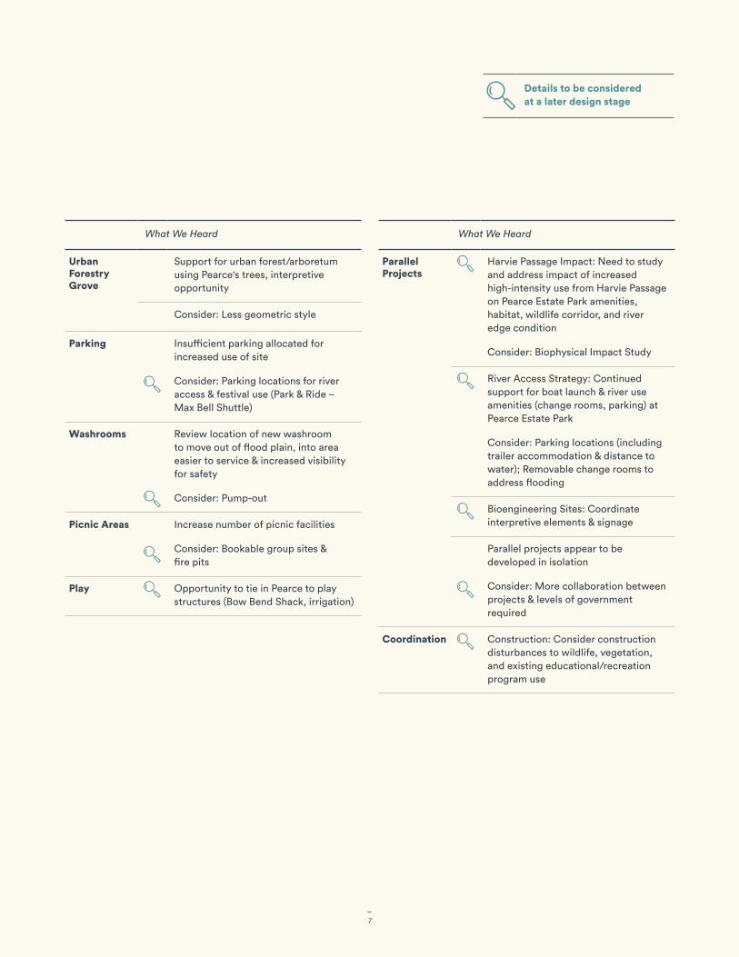
What We Heard
Urban Forestry Grove
Support for urban forest/arboretum using Pearce's trees, interpretive opportunity
Consider: Less geometric style
Parking Insufficient parking allocated for increased use of site
Consider: Parking locations for river access & festival use (Park & Ride – Max Bell Shuttle)
Washrooms Review location of new washroom to move out of flood plain, into area easier to service & increased visibility for safety
Consider: Pump-out
Picnic Areas Increase number of picnic facilities
Consider: Bookable group sites & fire pits
Play Opportunity to tie in Pearce to play structures (Bow Bend Shack, irrigation)
What We Heard
Parallel Projects
Harvie Passage Impact: Need to study and address impact of increased high-intensity use from Harvie Passage on Pearce Estate Park amenities, habitat, wildlife corridor, and river edge condition
Consider: Biophysical Impact Study
River Access Strategy: Continued support for boat launch & river use amenities (change rooms, parking) at Pearce Estate Park
Consider: Parking locations (including trailer accommodation & distance to water); Removable change rooms to address flooding
Bioengineering Sites: Coordinate interpretive elements & signage
Parallel projects appear to be developed in isolation
Consider: More collaboration between projects & levels of government required
Coordination Construction: Consider construction disturbances to wildlife, vegetation, and existing educational/recreation program use
Details to be considered at a later design stage

8
The feedback received from stakeholders during this
stage of engagement will be used to help refine the
Grand Vision, where appropriate. The Grand Vision will
address the overall plan for both Phase 1 and Phase 2 of
the Bend in the Bow sites, combining the Inglewood Bird
Sanctuary (IBS), Inglewood Wildlands, Pearce Estate
Park and the adjoining green spaces into one scheme.
At this stage in the process, it will address the design at
a concept level. Comments related to specific design or
programming details, or recommendations for additional
studies, will be kept on record and used to inform
the subsequent stages of the project, or new related
projects that derive from the Bend in the Bow Design
Development Plan in the future.
These future projects and decisions will require that
the City of Calgary address the opposing viewpoints
on design details arising from stakeholders’ differing
values. Additional parameters, such as internal policies,
technical constraints, and strategic plans, will also need
to be taken into consideration.
Thank you for your continued participation! We have endeavoured to work collaboratively with you
throughout this process and greatly value your ideas,
feedback, and knowledge. Although this stage of the
process is at a close, we would be happy to continue to
receive your input moving forward, as we work towards a
balance of Nature, Culture, and Education together.
We look forward to seeing you at the Grand Vision
on October 13!
Project information is available at
calgary.ca/bendinthebow.
Next Steps
Grand VisionThursday October 13
4–8pm Presentations at 5:15 pm, 6:15 pm and 7:15 pm
Alexandra Centre 922 9 Ave SE

Appendix: Recorded Comments

Stakeholder Workshops
Verbal Comments (Recorded by note-takers) 1. Fluverium St John's
2. Discuss water (signage)
3. Not enough discussion about water throughout the site
(irrigation, flooding, drainage)
4. Connecting planting in park to urban planting
5. Not modern – historical monuments
6. Trails not necessary around picnic
7. Very confusing – could use better orientation –
programs can't find their way
8. Wheelchair accessibility around berm
9. More active park + natural – still exciting
10. "Big art" for Bow Habitat – interpretive Matrix
11. Critical review of existing paths – Re-evaluation
12. Could strengthen wildlife corridor – Could create habitat
with berm – Larch
13. Planted berm vs. having a path
14. Livingston, Pearce connection?
15. Widely used by people with limited ability
16. Larch micro habitat – Sandstone outcropping bring in
animals
17. A good stagging area for groups using river access
points
18. Really likes urban forest + still has lots of demands on
site
19. Support expanded wildlife corridor – Dark at night
20. Simplify wayfinding + trail network – Don't be
constrained by existing
21. Club use – Book group sites
22. Kerrywood Nature Centre – Really like outdoor play (Red
Deer)
23. Picnic areas – Trails may not be necessary
24. Bookable fire pits
25. Busy! More picnic space/group spaces
26. Bring in idea of Pioneering/Experimentation
27. Naturalized vs. urban park
28. Original willow grove – cuttings
29. Why accentuate the berm with a path? Blend in
30. Berm contains/delineates zone change (Rec. vs. wildlife)
31. Opportunities for views
32. Change in height = habitat creation
33. Club/group staging area – Washroom? (Riverwatch)
34. Background on berm would be useful
35. Safety – View to the top of berm: avoid bad behaviour
36. Pearce: Monument(s) only? Balance against Livingston?
37. Maybe play up the park itself?
38. Larch on higher elevations = attract porcupines (micro-
habitats)
39. Represent the history of Pearce – Like the urban forest
40. Riverwatch: Workshops on re-vegetation, etc.
41. More urban forest – Repeat throughout pockets along
berm
42. Berm: Prefer to high wall tight at entrance
43. Invasive species too – Not so nice stories – Hybrids,
etc. – Not native
44. 3 water interpretive loops – Sponsors wanted them
branded
45. 200 kids a day via boat launch – Owned by fire
department – Daily education tours by raft
46. Limit/restrict use of boat launch
47. Boat launch congestion management (Parking? Traffic?
Emergency?)
48. Design charrette: Art for BHS (Key messages to Barb or
Heather)
49. Roundabout: Fire department key to road to river
50. Road [along Active Use zone] would be required if a
supporting launch was established
51. Green table
52. [Active Use Parking] Drive through is good!
53. [Active Use Parking] 3 School Bus: Equipment bus, Raft
trailer, General parking with trailer pull-through
54. In use May/Sept/Oct – Riverwatch coordinate
construction
55. [Connecting green spaces] Dark space
56. [Underpass] No light for wildlife – Constrain this site
57. Where do [boat launch users] park?
58. [Washroom] Year-round
59. Rainbow trout – Plan view
60. Programming links [at berm/path intersections]
61. History needs to be alive! Not just a bunch of
storyboards
62. Calgary Public Library's website: History of Flooding
63. PEP is a better site to tell the story of the evolution of
the Bow – How things have changed
64. Public boat ramp!
65. Multiple stories layered on the "rail trail"
66. Encounter bits of the story – Seeing the story alive
67. They surveyed the first nations trails as future
transportation routes
68. [Active Use] Sounded great – This area in particular
69. [Active Use Parking] Too far to walk a boat from here
70. First Nations oriented + Grand Trunk layers
71. [Active Use Parking] Trail access – Expand parking
72. [GTR Trail] A rut – Trail marker

73. Locked gate needs access to boat ramp
74. Ensure access is preserved
75. Historically important for people to use the river to swim
76. High waters in June, so things should be movable
77. Don't clean up the beach
78. Waterworks: History of floods
79. Most wildlife moves at night – Protected is rhetorical
80. Move [south washroom] outside the flood plain?
81. Encounters better throughout the site (Pearce history)
82. Homestead history – A section of the irrigation
demonstration
83. Memorial as an entrance feature
84. Change rooms [near parking lot]
85. Small scale version of Bow Bend Shack (Play)
86. [Memorial] Older look rather than modern art
87. Washroom closer to Harvie Passage – Sustainable
washroom
88. Gravel beach should be fixed up
89. Ties to Pearce, weir, & irrigation
90. Link Harvie Passage signs – Structure history
91. Harvie Passage Interpretation: Weir history, Irrigation,
Different boat crafts
92. Playing in water part of our history
93. Think about safety – What does that mean for design
94. A ditch/canal – Irrigation marker
95. Landform – Not mowed lawn – No pesticides
96. Examples of irrigation – Pearce tie-in – Play options
97. Open to the idea of moving the plaque
98. Plaque move: Talk to Donna, need permission from
Ottawa
99. Federal marker – Look for it (purple background)
100. Benches
101. Check where federal plaque is
102. No need for channel for safety
103. Temporary barrier
104. "Wild look"
105. Protect riparian habitat, existing vegetation
106. [North shore] Protect and don't touch trees here
107. Fewer dogs in there the better – Keep natural/wild –
Protect the trees & riparian habitat
108. Temporary flood barrier + access road [along north
berm]
109. Pearce recognition requires an integrated approach to
tell the scale of the story
110. Walking & emergency bridge [to island]
111. Owls here [north shore]
112. Old growth trees have become great attraction for
flickers and woodpeckers
113. Bow Habitat responsible for stream (not O2)
114. Currently lots of bird habitat here (don't lose it)
115. Concerned about construction disturbance to wildlife
(ie. of berm)
116. Not good location for [new] washroom? – Move to
middle
117. Harvie Passage needs to become part of the
conversation before PEP is firmed up
118. Refuge on island (limit access)
119. Still concerned that the importance of water is not part
of the core values
120. Look more at berm location – Move here? [south]
121. Corridor of shrubs and trees good for birds
122. Keeping corridor is good!
123. Signage at river where the washrooms are (on river)
124. Make [underpass] more inviting
125. [Blackfoot Trail] Difficult location for pathway
126. Is the City planning bike path from the east side of the
river over the existing Blackfoot bridge?
127. Potential conflict between disc golf and wildlife corridor
128. [Connecting green spaces] Habitat here? Corridor
seems to end
129. [Urban Forestry Grove] Less geometric
130. [Urban Forestry Grove] Use Pearce's Trees
131. [Urban Forestry Grove] Use Diverse Species
132. Optimization of parking lot
133. Blackfoot Trail: Tight location for pathway
134. Continuity of habitat
135. Wildlife corridor to wildlands [west side of BHS]
136. Options for trailer parking
137. Change facility for paddlers
138. Humble but "flood proof"
139. Change rooms removable for flood – Lightweight –
Flood corners on parking lot
140. If you expect "thousands of people every weekend" is
there bus service to the area? Insufficient parking!
141. Awareness of boat launch to north of river
142. Nose Creek wildlife corridor is important
143. Berm boundary good to preserve natural areas – The
further back the better!
144. Commitment to wildlife preservation on island –
Province to commit as well (Corridor)
145. Understory, therefore locate the berm as far from river
as possible – Would give further definition to the river
over time
146. River valleys are what's left – Need to actively preserve
147. Need to address the fact that it is on the edge of Harvie
Passage

148. River use is for passive use (according to City
documents)
149. Divert wildlife corridor to island?
150. Acknowledge use of Harvie Passage and impacts on
area during competitions
151. Part of the role of BITB is to point out inconsistencies
between various plans
152. Questioning criteria for who is allowed to come to
stakeholder meetings (eg. weighting of community
members vs. boating associations)
153. Why haven't we looked at the other side of the river?
154. Island as potential isolation area
155. Island for wildlife corridor OR active use from river
156. Biophysical study needs to be done to acknowledge full
impact of increased use
157. Divide/fence island to prevent interior island
disturbance (no bridge) – Potential naturalization area
158. Paddling (high-intensity use) mixed with wildlife corridor
159. World class paddling = increased water user access –
How to protect river edge?
160. Should people be on the gravel beach?
161. Type of active use if important for wildlife connection
162. Need to figure out what species are going to use the
wildlife corridor
163. Fencing to stop wildlife using underpass from getting
onto road instead
164. River corridor is the City's primary contribution to
biodiversity – Give priority
165. No disc golf
166. Migratory birds down to IBS
167. City-wide biodiversity monitoring – Need to preserve
what we have, don't lose it
168. Impact to biophysical of bringing thousands of people
every weekend
169. No bridge to island
170. Manicured grass on channel in order to accommodate
high intensity in summer
171. Preserve biodiversity
172. Berm good division of natural and active use
173. Likes that the plan has a general understanding that
nature to be left as is
174. Don't let cultural negatively impact the corridor
175. Likes that disc golf is moved away from natural area
176. Likes the ball diamonds gone
177. Wildlife & culture beside each other, active further away
178. Protect the river edge if you do the active use
179. Riparian impacts
180. More migratory birds downriver
181. [Connecting green spaces] Could we fence off public
use?
182. [Connecting green spaces] Leave entirely natural
183. [Connecting green spaces] Passive restoration &
celebrate the regeneration
184. [Active Use Parking] Larger lot for truck trailers
185. Parking needs to be evaluated
186. Use cultural as less-intense buffer between natural and
active use areas
187. [Active Use] This could be a good use
188. Move washroom closer to proposed boat launch?
189. Someone must provide infrastructure
190. Projects are completed in isolation?
191. Are we ignoring Harvie Passage?
192. Criticism of boat access on river (city-wide)
193. Mandate to protect river edge, increase biodiversity
194. [Images: Harvie Passage Interface] Missing the prior to
Harvie Passage "habitat factors" for fish dependant birds
(more friendly terrain + less human disruption)
195. [Images: Harvie Passage Interface] Will it be wildlife
friendly? (Nocturnal? Winter?)
196. [Images: Harvie Passage Interface] Across "Low Water
Channel" the island should be a wildlife sanctuary
(management, protected, and with enforcement)
197. [Images: Underpass] On opportunity basis, make it
larger – In the meantime, make it more wildlife friendly
198. [Images: Parking Enhancements] None of these are
attractive to me. Ensure parking lots have defined
walking access to pathways so people don't take short
cuts that damage the park
199. [Images: Underpass] Clean it up, make it more inviting
200. [Images: Urban Forestry Grove] Biodiversity should be
priority
201. [Images: Urban Forestry Grove] More natural, less
geometric
202. [Images: Urban Forestry Grove] Diverse species –
Replace Col. P's willows for porcupine habitat along H.P.
channel
203. [Images: Urban Forestry Grove] Species that show the
types of trees that Pearce brought into study
204. [Images: Railway Trail] Add a mini tressel bridge??
205. [Images: Railway Trail] I like keeping the feel of a rail trail
on this
206. [Images: Gravel Beach] Is this on the "island" side or
the PE Park side? Island – restrict access! Refuge for
indigenous wildlife
207. [Images: Active Uses] Keep the disc golf to a minimum
208. [Images: Active Uses] Should be subject of specific

consultation – All of these are potentially fine
209. [Images: Interpretive Elements] Signs attached to trees?
Really?
210. [Images: Wildlife Corridor] No built environment
211. [Images: Blackfoot Trail] Slope too steep for pathway
and road negotiate with So Bow
212. [Images: Blackfoot Trail] Some of these option have too
much slope to be compared to the existing trail to the
bridge
213. [Images: Parking Enhancements] Where is the water
coming from?
214. [Images: Wayfinding + Markers] Where is the layout
map?
215. [Images: Play] The more options that can be applied the
better
216. [Images: Wayfinding + Markers] Site is very un-navigable
217. [Images: Pearce Memorial] None of these – Not too
modern, more traditional
218. [Images: Pearce Memorial] Outlook: Way too
interpretive – Hard. upset.
219. [Images: Flood Protection Landform] No pesticides, no
mowed lawn
220. [Images: Pearce Memorial] Interpret Bow Bend Shack as
a playhouse
221. [Images: Pearce Memorial] Older look/historic
222. [Images: Pearce Memorial] Terrible place for the location
223. Impact of construction
224. With storyboard – multi-use of the trail
225. Rationale behind landform
226. Washrooms
» New Washroom could be a pump out.
» Concerns about washroom in the flooding area.
» Located in a hard to service area and may be difficult
to enforce.
» Washroom is notorious for naughty behaviour
227. Safety
» Bird blind – don’t create any hiding spots to avoid
people using the bird blind illegitimately.
» Screening along Deerfoot Trail could be vegetated or
an art opportunity
» SoBow interface – SoBow is currently re-designating
land use on their vacant site (potential town homes),
so that would help with activating the currently
concealed edge.
» Bylaw supports formalized parking and trails (tackle
issues of homelessness at the south end of the park
where there are informal trails and lack of “eyes on
the street”
228. Park Access
» Emergency Access – Bylaw has a whole emergency
response plan for Harvie Passage.
» Requires a 4m wide boat launch
» Better improvements for transit users at bus stops
229. Pathways
» Long lights at the 19th and Blackfoot intersection.
Potential pedestrian overpass as a future item. Lots
of condos, pedestrians, and people will be in the
area
» Strengthen the east-west pedestrian connections
north of SoBow
230. Parking
» Parking for people during festivals (Nationals 2018 at
Harvie Passage)
» Consider trailer parking
» Parking will become an issue as the park becomes
more as a destination
» Transportation supports more parking in the ball
diamonds
» Park and Ride (Max Bell Shuttle) during events
231. Festivals and Events
» Support for second washroom placement and the
adjacent open space
» Consider the ability to bring in temporary
infrastructure
» Consider bringing in power and potable water
» Support for terraced stone seating
» Park would need irrigation to rehabilitate the turf
after a major event
» Suggestion of using the Max Bell parking lot to
shuttle people in during events
232. Underpass
» Could knock out the embankment at the underpass
to increase width of the wildlife corridor
» Underpass improvements supported by
Transportation
233. Berm
» Berm bridge – may be challenging to construct
» Should give more room for wildlife to go through
(small tunnels so wildlife can reach the wetland?)
» Support for berm having one side natural plantings.
» Do you want wildlife to go into the manicured areas?
» Fun to have tobogganing hill on the multi-use side.
234. Tree Grove
» Is more like arboretum rather than nursery. Can be
seen as a place for tree trials, where trees can get
bigger

235. Municipal Reserve
» Raised for flood protection. Site still in discussion.
236. Public Art
» Reconsider the memorial site locations. We
are telling the story of Pearce in different
representations on various sites to tell the story of
urban forestry, Bow Bend Shack, and Irrigation.
237. Wildlife Corridor
» Support for no lighting on regional trail.
» Support for educational and interpretive signs within
the wildlife corridor
» Bank swallow habitat – keep an eye on this!
238. Winter Activities
» Support for skating or ski path in the former ball
diamonds
239. Bio-engineering
» Tying in interpretive elements and signage to the
bio-engineering demonstration sites.
240. Fire department
» What do the improvements with the bridge look like?
» Consider vehicle safety perspective / sightlines
» SoBow has a design for the corridor that was brought
through to widen..? That’s an access point for
fighting fire.
» A turnaround above the bike path and hammerhead
» Needs access to the whole of Harvie Passage for
emergency, exponentially increased with use
241. Strengths
» A place where people go and spend a day
» Excited about enhanced natural wildlife corridor to
Inglewood Bird Sanctuary

| 3 | 4 | 4 | 2
| 1 | 1 | 1 | 2
| 2 | 1 | 1 | 1
| 1 | 1 | 1
Stakeholder Workshop
Design Inspiration ImagesValues beside each image denote the number of times it was selected by participants.
Only images that received at least one dot are shown.
Gateways + Entrances Wayfinding + Markers Flood Protection Landform Parking Enhancements

| 5 | 5 | 1| 2
| 2 | 3 | 4| 3
| 3 | 1 | 2| 2
| 1 | 1 | 1
| 4 | 2 | 2| 1
| 1 | 1
Wildlife Corridor Interpretive Elements PlayPicnic

17
| 8 | 3 | 4| 1
| 1 | 3 | 1
| 2 | 2 | 1| 2
| 2
| 3 | 1 | 2
Harvie Passage Interface Cold Water Stream Pearce MemorialGravel Beach

18
| 2 | 2 | 1| 3
| 1 | 2 | 1| 2
| 1
| 1 | 4 | 1| 1
| 1 | 1 | 2| 1
Blackfoot Trail Underpass Railway TrailActive Uses

19
| 1
| 1
| 1
| 1
| 3
Urban Forestry Grove