DERMA Management
55
Desert Experimental Range Management Area Resource Management Plan Authors: Jesse Morris, Stan Gurley, and Wesley (Skip) Skidmore
-
Upload
jesse-morris -
Category
Documents
-
view
478 -
download
1
Transcript of DERMA Management
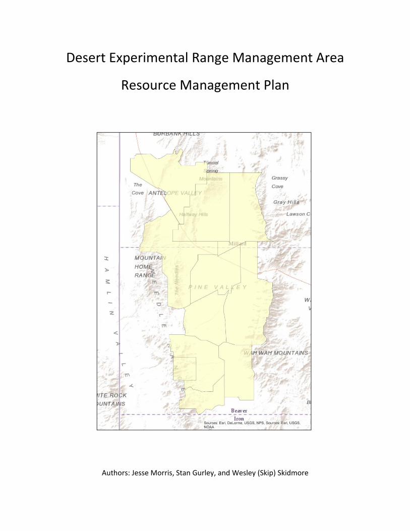
Desert Experimental Range Management Area
Resource Management Plan
Authors: Jesse Morris, Stan Gurley, and Wesley (Skip) Skidmore
Desert Experimental Range Area Management Plan
2
Table of Contents
Introduction……………………………………………………………………………………………………………………3
Watershed……………………………………………………………………………………………………………………..6
o Maps………………………………………………………………………………………………………………….7
o Photographs……………………………………………………………………………………………………….8
Recreation and Possible Conflicts………………………………………………………………………..………10
o Maps………………………………………………………………………………………………………………..11
Energy and Mineral Extraction…………………………………………………….………………………………13
Forestry Interest…………………………………………………………………………………………………………..15
Special Uses and Needs………………………………………………………………………………………………..17
Wildlife Management…………………………………………………………………………………………………..19
o Maps………………………………………………………………………………………………………………..25
Livestock Use……………………………………………………………………………………………………………….42
o Charts………………………………………………………………………………………………………………46
o Maps………………………………………………………………………………………………………………..47
Private Land Ownership……………………………………………………………………………………………….53
Bibliography………………………………………………………………………………………………………….…….55
Desert Experimental Range Area Management Plan
3
Introduction
The Desert Experimental Range (DER) is a research reserve located in northwest Pine Valley,
Millard County, Utah (USA) and 64 km west of the railroad town of Milford. It was established
in 1933 as an agricultural range experiment station by President Herbert Hoover. It is
approximately 225 square kilometers of Cold Desert salt-desert shrub and shrub-grass
ecosystems. Today, nearly 100 years later, it remains a viable and important center for dry
basin studies in the Great Basin Ecoregion of western North America. With an emphasis on
“dry”, this hydrology management plan includes the entire Pine Valley with its surrounding
mountains and includes 10 Bureau of Land Management (BLM) grazing allotments. The Desert
Experimental Range Management area is made up of BLM allotments that are connected to the
DER boundaries.
Watershed
Water resources are one of or the most limiting factor in desert ecosystems. Land managers
are aware that even if forage production is high enough stocking rates and animal units months
may have to be adjusted for the lack of water in an area, and the cost of providing water.
Watersheds are also extremely important for the overall health of an ecosystem. The DERMA is
no exception to the water woes of the west, and careful management and development of
water resources will be weighed and recommended in this management plan.
Recreation Potential and Conflicts
OHV registrations in Utah have increased more than 3-fold from 1998 to 2006 (from 51,686 to
172,231) and that trend continues to increase (Smith 2008). This has led to more people
looking for places that they have rode in before and to avoid crowds. With the increase of
OHV, trails must be established, facilities need to provided and safety must be reinforced.
Energy and Mineral Exploration
Utah has a rich history of energy and mineral exploration. Mining has taken place historically
on DERMA, though the DERMA has relatively untouched. Energy exploration will continue to
expand and most be properly mitigated for proper use and protection of all resources.
Forestry Interest
Though lacking desired forest resources, the potential for logging for profit an issue that will be
managed, and carefully mitigated to protect the overall health of the system. Junipers are
harvested on a minimal level for fence post. The higher elevation on the Wah Wah Mountains
Desert Experimental Range Area Management Plan
4
do have a population of Bristle Cone Pines, that will have to protected from over use and
carefully managed to promote a sustainable population.
Wildlife
Wildlife is in rich abundance with the DERMA. Offering premier elk and pronghorn hunts, the
DERMA which lies with the boundaries of the Southwest Desert Wildlife Management Unit has
produce top quality elk and pronghorn for years. Game species are not the only wildlife that is
of special concern on the DERMA, many protected or threaten species call it home or make
stop during migration within the DERMA boundaries. Greater Sage Grouse are also found on
the south end of the DERMA with two active leks. The greater sage grouse has been petition
for listing as endanger species, and currently is under review.
Livestock and Invasive Weeds
Livestock grazing on the DERMA dates back to settlement of the west. Many of the
improvements to the range have come with the support of livestock owners and associations.
With careful management and continued range improvements, the DERMA allotments will
continue to provide a model of grazing practices in the Great Basin region.
Land Ownership
Land ownership in the DERMA is made up of BLM, State Lands (UDWR, Trust Lands), private lands and
the DER. Land owners need to be considered in all management pratices to ensure that strong
relationsheip are built and maintaned, that a multi-purpose plan can be established and successful.

Desert Experimental Range Area Management Plan
5
This page was left blank intentionally
Desert Experimental Range Area Management Plan
6
Watershed Protection and Hydrology
The climate is characterized as having hot, dry, summers and cold, wet, winters. Mean
January temperatures are -3.5 degrees C and July temperatures average 23.3 degrees C.
Average annual precipitation is less than 165 mm which comes sporadically throughout the
year. The mountains reach 2,565 m elevation where precipitation can be 50% higher than the
valley floor. Water is a limiting factor for wildlife, vegetation, and livestock (Grinnell 1927).
Using data programs found in the State Geographic Information Database (SGID) contained
within the Utah Automated Geographic Reference Center (ARGC) website and displayed using
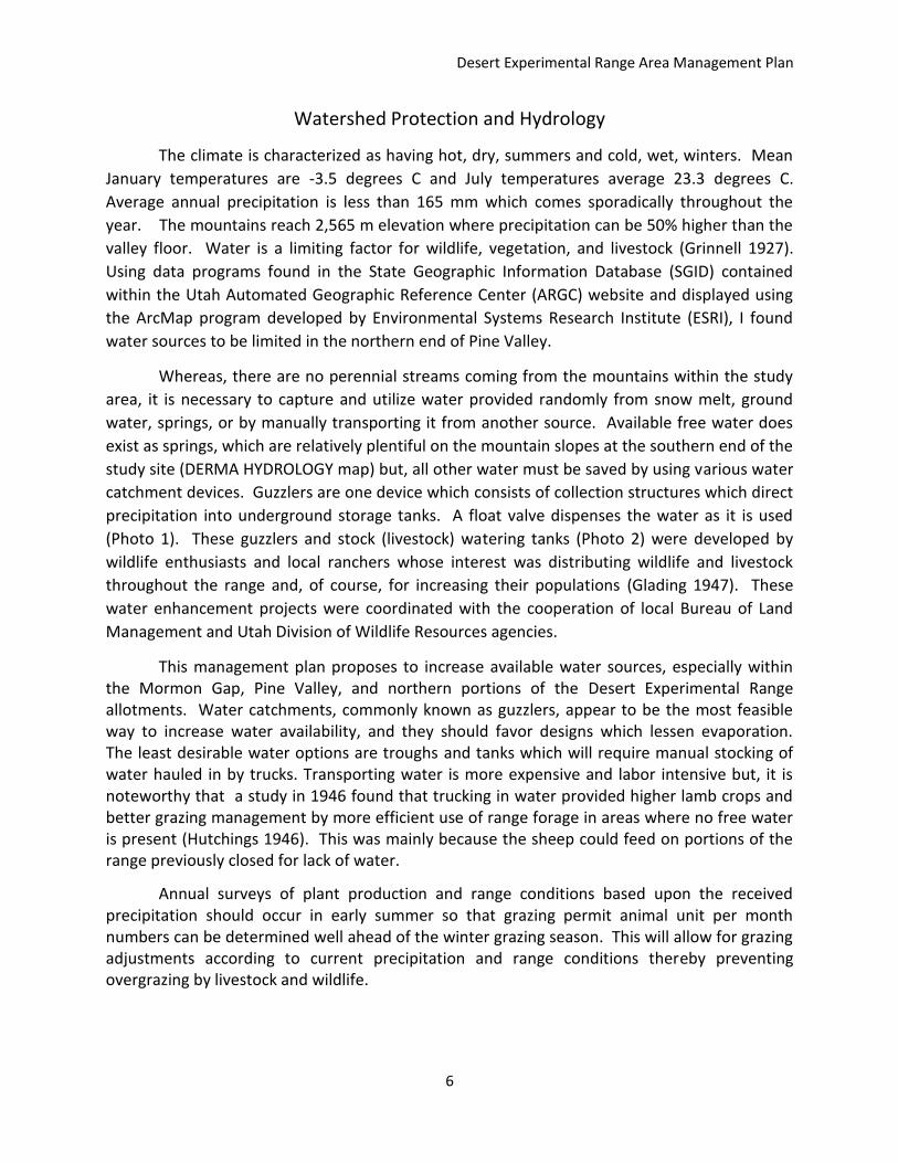
the ArcMap program developed by Environmental Systems Research Institute (ESRI), I found
water sources to be limited in the northern end of Pine Valley.
Whereas, there are no perennial streams coming from the mountains within the study
area, it is necessary to capture and utilize water provided randomly from snow melt, ground
water, springs, or by manually transporting it from another source. Available free water does
exist as springs, which are relatively plentiful on the mountain slopes at the southern end of the
study site (DERMA HYDROLOGY map) but, all other water must be saved by using various water
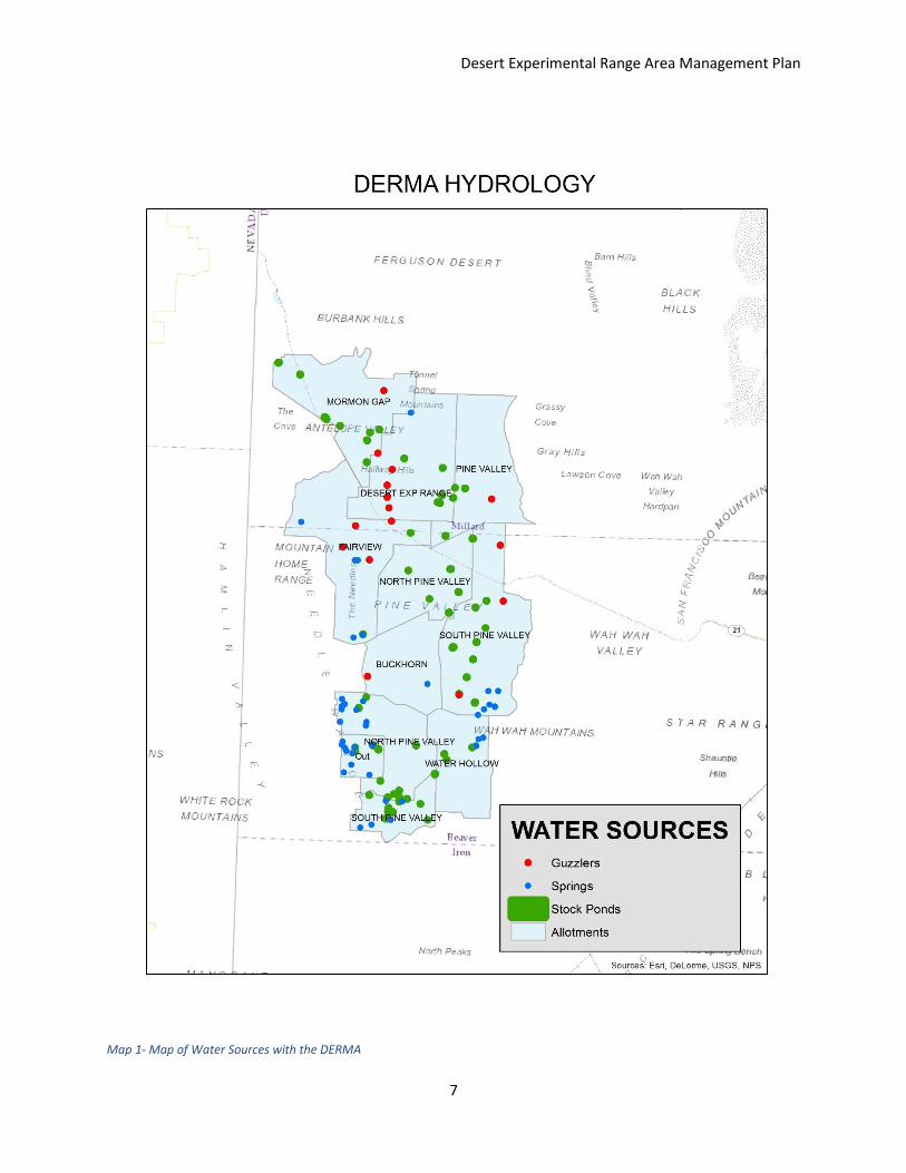
catchment devices. Guzzlers are one device which consists of collection structures which direct
precipitation into underground storage tanks. A float valve dispenses the water as it is used
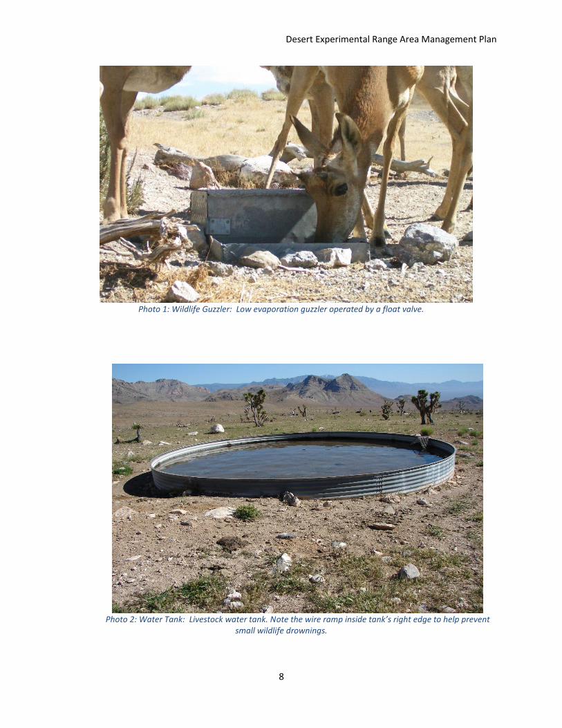
(Photo 1). These guzzlers and stock (livestock) watering tanks (Photo 2) were developed by
wildlife enthusiasts and local ranchers whose interest was distributing wildlife and livestock
throughout the range and, of course, for increasing their populations (Glading 1947). These
water enhancement projects were coordinated with the cooperation of local Bureau of Land
Management and Utah Division of Wildlife Resources agencies.
This management plan proposes to increase available water sources, especially within the Mormon Gap, Pine Valley, and northern portions of the Desert Experimental Range allotments. Water catchments, commonly known as guzzlers, appear to be the most feasible way to increase water availability, and they should favor designs which lessen evaporation. The least desirable water options are troughs and tanks which will require manual stocking of water hauled in by trucks. Transporting water is more expensive and labor intensive but, it is noteworthy that a study in 1946 found that trucking in water provided higher lamb crops and better grazing management by more efficient use of range forage in areas where no free water is present (Hutchings 1946). This was mainly because the sheep could feed on portions of the range previously closed for lack of water.
Annual surveys of plant production and range conditions based upon the received precipitation should occur in early summer so that grazing permit animal unit per month numbers can be determined well ahead of the winter grazing season. This will allow for grazing adjustments according to current precipitation and range conditions thereby preventing overgrazing by livestock and wildlife.
Desert Experimental Range Area Management Plan
7
Map 1- Map of Water Sources with the DERMA
Desert Experimental Range Area Management Plan
8
Photo 1: Wildlife Guzzler: Low evaporation guzzler operated by a float valve.
Photo 2: Water Tank: Livestock water tank. Note the wire ramp inside tank’s right edge to help prevent small wildlife drownings.

Desert Experimental Range Area Management Plan
9
This page was left blank intenetionally
Desert Experimental Range Area Management Plan
10
Recreational Considerations
The human population continues to grow in Utah and interest in outdoor recreation grows with it. Pine Valley, which includes the Desert Experimental Range (DER), west of Cedar City, Utah, offers clean air, solitude and wildlife viewing opportunities, especially enhanced by the resident wild horses (Equus ferus) which range there. Established for the primary purpose of rangeland research and rangeland education, there needs to be continuing guidelines to protect the DER and surrounding land.
The primary outdoor activities in Pine Valley are recreational day use, camping and hunting. Camping brings all-terrain-vehicles (ATV), motor bike, and horseback riders. In September and October, hunters can pursue Pronghorn (Antilocapra americana), Mule deer (Odocoileus hemionus), and Wapiti (Cervus canadensis). We have found no rock-hounding sites within the Pine Valley management area, although topaz, geodes, trilobites, and garnets are found within 160 km to the north and northwest. Some campers enjoy gathering pinyon nuts in the fall. The lack of free water, water which is readily available, contributes to this being a “pass-through” area for migrating birds. There are, however, resident birds, mammals and reptiles which enliven the camping experience and provide many youngsters with lizard catching opportunities.
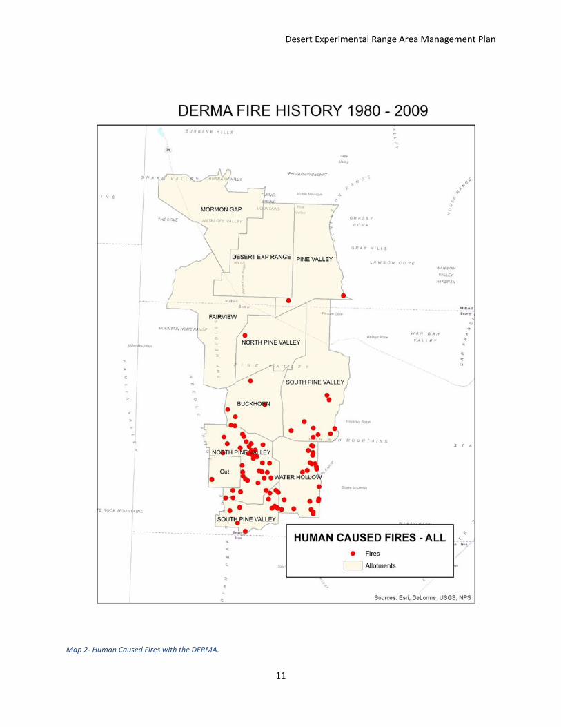
Our management plan proposes recreational activities continue with travel restricted to established roads. Upon further evaluation, some trails and ATV or jeep roads may need to be closed to protect the land from occasional erosion which may occur from intense runoff during thunderstorms. Campfires would be allowed in areas with no vegetation (combustible materials) within 5 m except when environmental factors dictate otherwise. These factors are mainly unusual dryness or wind. We researched the fire history for the management area and there were 99 fires, all human caused, from 1980 through 2009, in Pine Valley. 83 of those fires were less than 1 acre and 16 larger fires ranged from 2 to 280 acres. 95 of the 99 fires were in the southern half of the Pine Valley Management area. (See Pine Valley Management Area Fire map).
We also suggest creating a recreational map providing best access routes to the Desert Experimental Range station and Pine Valley from Interstate 15 and State road 6, with included distances. This map should show available services, if any, such as restroom facilities, gas stations, restaurants and hotels. The map should suggest camping areas and road conditions suitable for cars, trucks and ATV’s. Also of interest to visitors are places for best wild horse, pronghorn, deer, elk, sage grouse and wildlife viewing.
Desert Experimental Range Area Management Plan
11
Map 2- Human Caused Fires with the DERMA.

Desert Experimental Range Area Management Plan
12
This page was left blank intentionally
Desert Experimental Range Area Management Plan
13
Energy and Mineral Exploration
The State of Utah has very rich coal, natural gas, oil, tar sands and uranium deposits. The largest open pit copper mine in North America is found on the west side of Salt Lake Valley in the Oquirrh Mountains. The Great Salt Lake provides salt and other minerals, but, despite this mineral and energy richness, Pine Valley lacks these. A search of the AGRC – SGID data bases showed that the entire valley is considered a solar zone and there is a conceptual right-away for a future power line. It is also noted that this area is considered a “no wind” zone so it will not be considered for wind turbines. This information favors the DER because it can continue, as it was intended, to be an agricultural research facility without these pending threats. If, and we hope it is a big “if”, there should arise a need to open up this area for energy or mineral exploration, consideration should be given to minimize wildlife disturbance caused by increased vehicle and machinery activity especially in winter (Bradshaw 1997).

Desert Experimental Range Area Management Plan
14
This page was left blank intentionally
Desert Experimental Range Area Management Plan
15
Forestry Interests
The predominant trees in the Desert Experimental Range Management Area are the Utah juniper (Juniperus osteosperma) and single-needle pinyon (Pinus monophylla). Also known as “PJ” forests, these trees provided “cedar” posts for building fences, pinyon seeds (pine nuts) for food, and firewood for early pioneers. Local indigenous people also utilized pine nuts for sustenance through the winter months. Today, fences are made using metal posts, although the juniper posts continue to be used in small fencing projects and food comes from other means.
Higher above the PJ trees are patches of Quaking aspen (Populus tremuloides), Douglas fir (Pseudotsuga menziesii), Ponderosa pine, Bristle cone pine (Pinus longaeva) and Big-tooth maples (Acer grandidentatum). These trees add important vegetative diversity and provide important cover for wildlife. There are no timbered areas with enough lumber to provide an economic benefit so forestry interests on the DERMA are minimal and of no consequence.

Desert Experimental Range Area Management Plan
16
This page was left blank intentionally
Desert Experimental Range Area Management Plan
17
Special Uses and Needs
The Desert Experimental Range continues its existing long-term studies today which fulfills its
original purpose, to study cold desert rangelands. Its relative isolation from urban sprawl and
popular recreation activities such as boating and snow skiing, insures its continuing forward
into the foreseeable future. There is great historical value, which remains to be discovered by
future range scientists, recording the evolution of our world’s biomes and documenting how
they change or what may stay the same. We need a foundation of knowledge to benefit from
in order to take us into proper managing the tomorrows. Climate changes coming from
warming temperature trends, are monitored today with instruments and satellites more
sophisticated and intricate that yesteryears. This is undeniable. Whether from carbon fuel
emissions or the earths own evolutionary course through time, the DERMA needs to continue
gathering data from studies. It needs to continue doing was it was established to do.

Desert Experimental Range Area Management Plan
18
This page was left blank intentionally
Desert Experimental Range Area Management Plan
19
Wildlife
The DERMA is rich with wildlife; from rocky mountain elk and mule deer to bald eagles and
borrowing owl. The habitat found in the DERMA contains: montane forest system, the species
diverse sage system, and the salt brush system. Current wildlife management belongs to the
Utah Division of Wildlife Resources (UDWR) and United States Fish and Wildlife Service
(USFWS) and most game species belong to Southwest Desert Management Unit (SDMU) and
the Greater Sage Grouse are included in the Hamlin Valley Sage Grouse Management Area
(HVSGMA).
Game Species
Big Game
Elk (Cervus canadensis)
History
Elk populations in Utah at the turn of the century were nearly gone because of over use and
unregulated hunting. In 1912-1915, elk from Yellowstone, transplanted in the state to help
establish herds again (Utah 2010). Through not originally taken to the (SWDMU), an elk herd
has been established here.
Current Status
Elk herds in Utah are managed by two factors, which include: population objective and age class
objective of harvested bull elk. The current population objective is 975 elk with an age class
objective of 6.75. Currently the population is 1,300 elk and the average age of bulls killed is 7.5.
Both population and average age of bulls killed are increasing (Shannon 2015).
Management Recommendations
Habitat is the limiting factor on the SWDMU, because of intense drought and the threat of
degrading the range; population objectives have been cut to maintain long term sustainability
for wildlife and livestock allotment owners. The UDWR has been working with the BLM and
private landowners to chain and mow areas to create better habitat for all wildlife, while
providing more forage for livestock. These projects take time pay off, and will begin to shortly.
We recommend keeping the SWDMU population and age class object the as they are currently
for two years, with an increase to the age class objective to 7.25 years of age. As of right now
the area is already producing some of the highest quality mature bulls in the state and this
would allow for another excellent trophy class unit.
Desert Experimental Range Area Management Plan
20
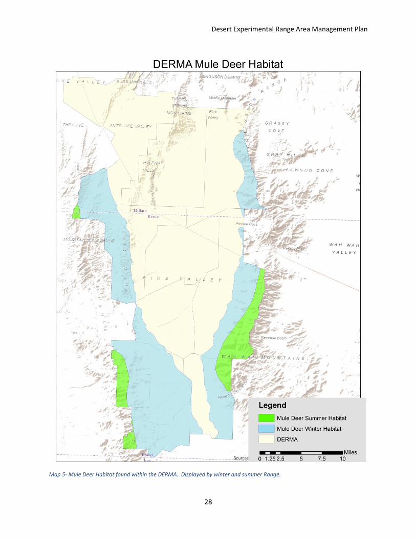
Mule Deer (Odocoileus hemionus)
History
Mule Deer populations on DERMA also fall into management unit #20 or the SWDMU. Mule
deer populations throughout the west have struggled and are currently in decline in the
western United States. Multiple factors have led to this decline, but drought on the SWDMU
has taken its toll. In 2011 the Utah Wildlife Board accepted the proposal for the UDWR to start
hunting deer on 30 smaller units rather than 5 larger regional units. This was to help them
better manage how many hunters would be hunting act management unit deer. The SWDMU
is a general season unit, meaning that the mule deer are managed to provide opportunity for
sportsmen.
Current Status
Mule Deer are also managed to a population objective like elk, but rather than age of bucks
killed the UDWR used a buck: 100 doe ratio, to determine the numbers of tags that can be
given on this unit. This unit population objective is currently 3,200 mule deer which has been
lower from 4,000 mule deer and the buck: 100 doe ratio of 18-20 bucks: 100 does. The current
estimated population is 3,000 mule deer with a buck: 100 doe ratio of24.5 bucks: 100 does
(Shannon 2015).
Management Recommendations
The population of mule is continuing to grow in Utah, thanks to thousands of acres being
treated to provide better habitat and water sources being established in these desert
environments. We recommend that the population objective be raised to 3,800 mule deer and
that the buck: 100 doe ratio be raised to 20-25 bucks: 100 does to provide a higher quality unit.
We also recommend that age data from harvested bucks become part of the objectives
considered for management with an objective of 30% or more bucks being 4 years of age.
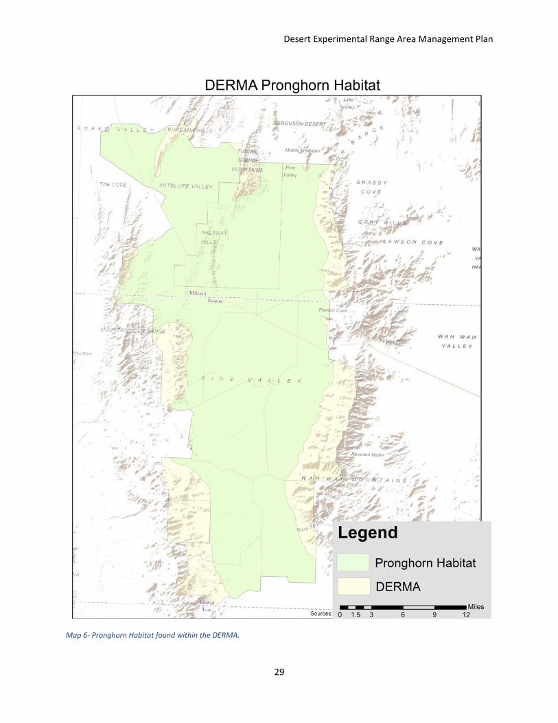
Pronghorn (Antilocapra americana)
History
The SWDU has is the second largest herd of pronghorn and has been one of the most
stable herds in Utah. During the reestablishment of pronghorn throughout Utah the SWDU was
one of the first areas to receive pronghorn that were transplanted from Dagget County, Utah in
1948 (UDWR 2009).
Current Status
Desert Experimental Range Area Management Plan
21
Currently the UDWR manages pronghorn populations on a buck: 100 does ratio of 25-40 bucks:
100 does and that hunter success be maintained at no less than 80% (UDWR 2009). Population
data is lacking if any, and invites problematic issues concerning the true health and herd.
Management Recommendations
We recommend that the DERMA be managed and encourage the UDWR to likewise make
changes in the pronghorn management plan, including: population objectives set for each unit,
and manage to a much smaller window of buck: 100 doe ratio, while keeping the 80% harvest.
A population of objective of 5,000 pronghorn on this unit, and a buck: doe ratio of 35-40 bucks:
100 does. This unit holds the ability to be one of the best pronghorn management units in the
western United States.
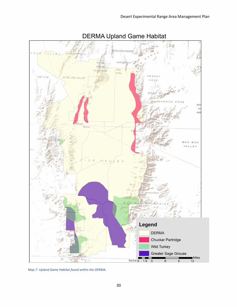
Upland Game
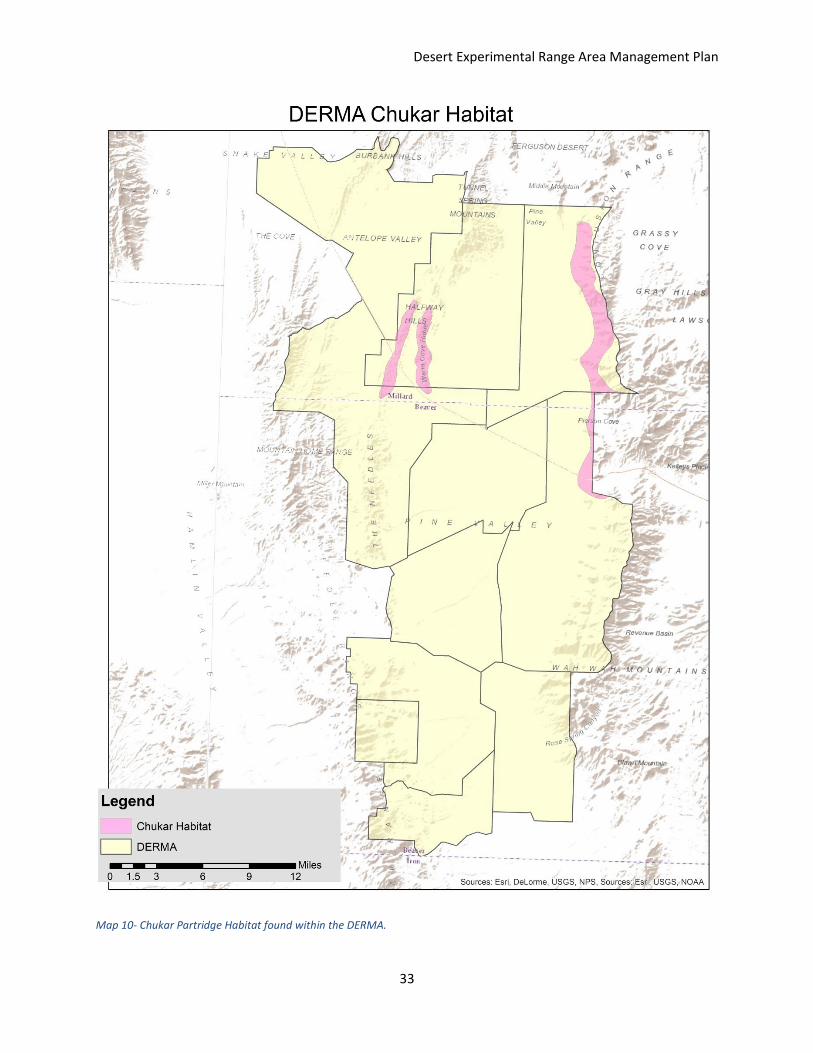
Chukar Partrigde (Alectoris chukar)
History
Chukars are native to Asia, the Middle East, and southern Europe (Utah 2003). Chuckars were
first introduced in Utah in 1935 (Utah 2003). Population and popularity from sportsman have
increased drastically of the past decade.
Current Status
Chukars are found in the northeastern area of the DERMA and the population is stable in this
area. Each year UDWR biologist fly randomly picked areas and birds per square mile are
counted. Current bag limits are 5 birds per day, and a liberal season (September to February.
Management Recommendations
We recommend that flights be continued, but we also recommend that ground survey be
conducted and that chuckar populations throughout the DERMA to 50 birds square miles.
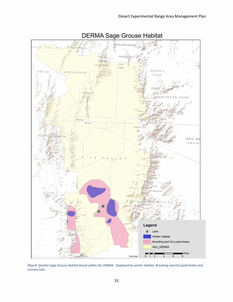
Greater Sage Grouse (Centrocercus urophasianus)
History
Greater Sage Grouse are a native ground dwelling bird that is closely linked to sage brush
habitats. In the past decade a decrease of this bird’s habitat has correlated into a decrease in
population to the point that in 2010 the (USFWS) was asked to consider the Greater Sage
Grouse for listing. After considering each states management efforts the USFWS return with
Desert Experimental Range Area Management Plan
22
the decision of warranted but precluded. This decision was challenged by a law suit, and the
USFWS was told to reconsider and over the course of 5 years decide what the status would be.
Current Status
The HVSGMU does take in the south end of the DERMA. Though not hunted in on this unit,
sage grouse are still considered a game species in Utah. With two leks present and winter and
brood habitat found in the DERMA, careful consideration must be taken all activities on the
DERMA. The HVSGMU has a 10 year average of 89 active leks, two of which are found in the
DERMA.
Management Recommendations
We recommend that not only we do all feasible to keep the leks and habitat intact. We
recommend continue chaining, burning and other pinion and juniper area that have
encroached into sage brush areas. We recommend that we have a total of 5 leks and
population of 250 birds in this part of the HVSGMU. We will as recommend transplanting
grouse from the Parker Mountain Management Area, to help keep genetic variation and
promote population expansion.
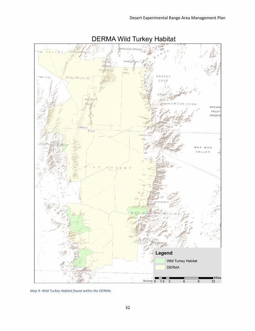
Wild Turkey (Meleagris gallopavo intermedia)
History
Wild turkeys have been found throughout the state of Utah. Caches found of native
peoples have found turkey remnant’s that had been made into tools or ornaments. Turkeys
were removed from the Utah, because of overuse. Turkeys have been reestablished
throughout the state and the population is growing at a record pace.
Current Status
Currently wild turkeys are found on the south end of the DERMA, main around water sources,
particularly around Cottonwood Creek, Rose Canyon and Sawmill Canyon, but can be found in
montane habitat type. A current population objective is not established, and every little data
population data is available for turkeys.
Management Recommendations
As managers we recommend a winter population of 550 turkeys on DERMA. Counts should
happen each winter and a spring and falling hunting season should be established that closely
resembles that of UDWRs.
Predators
Desert Experimental Range Area Management Plan
23
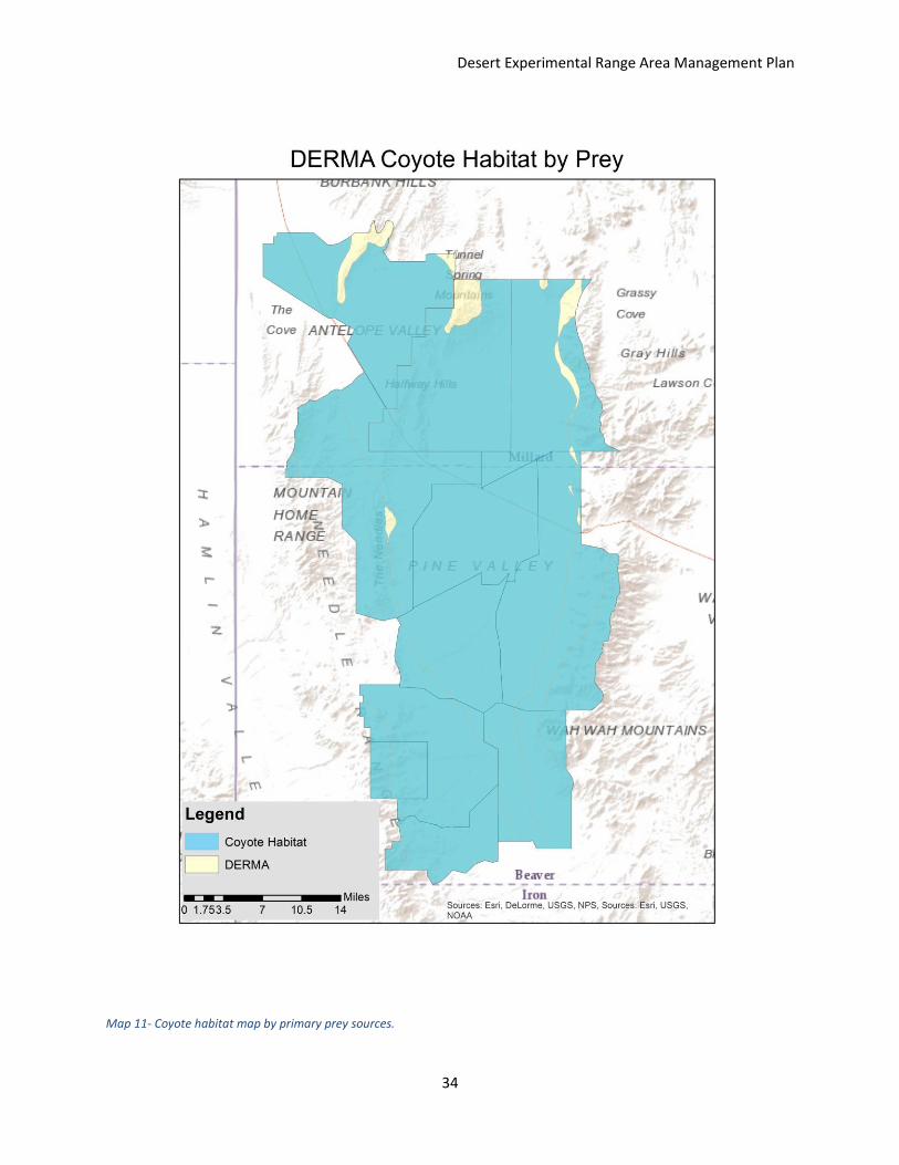
Coyote (Canis latrans)
History
Coyote have are found throughout the US. For a time seen as a terror to livestock and
hunted with extreme persistence; today though still seen as a threat to livestock and wildlife
production, coyotes may have more of a following.
Current Status
Currently the state of Utah has a $50 bounty program for coyotes, and with a harvest of 524
reported coyotes from the SWDU. Coyotes are not protected wildlife so, and the bounty
system came to be through the Mule Deer Protection Act.
Management Recommendations
Because coyotes are one of the biggest predators of greater sage grouse, we recommend to still
supporting the control with the use of United State Department of Agriculture, Wildlife Services
and the supporting the UDWR coyote bounty plan.
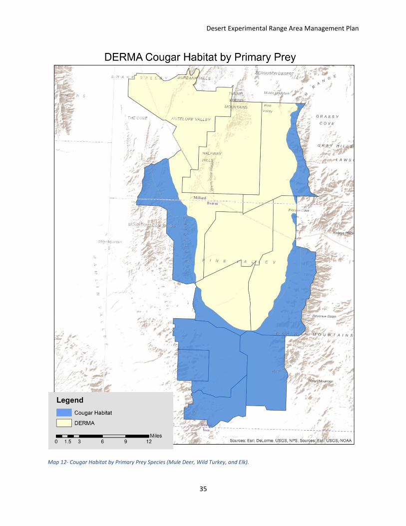
Cougar (Puma concolor)
History
Cougars, like other predators found in the western United States, they were hunted
persistently, but once becoming protected wildlife, they’re populations have been managed to
levels to allow harvest and keep a natural system intact.
Current Status
The UDWR manages the SWDU on a limited entry basis, with an average of 6 tags. Tag
numbers is set according the number of females and age of cougar killed. The ratio of males
killed: females killed lets managers see if too many females or young are being harvested.
Management Recommendations
We recommend that current manage strategy is used.
Non-game Species
Wild Horses (Equus ferus)
History
Desert Experimental Range Area Management Plan
24
Wild horses or feral horses were horses that the Spanish lost. Now there is no use and they are
over protected, which forces miss management have caused horses to become overpopulated.
Current Status
Horses are managed by the BLM and round ups happen usually once a year. Horses became a
hot topic in 2014 in Iron, Beaver, and Millard Counties. These counties suing the federal
government because of the overpopulation horses and that the BLM wasn’t meeting the
management objectives that were set.
Management Recommendations
Though protected, we as managers recommending removal of all but 20 horses for the
protection of wildlife habitat. We also recommend a sterilization program begin and that only
20% of foals left intact. This will promote stronger and more robust wildlife populations, while
allow ranges to recover and treatment plots to establish. Also we recommend that all water
structures be fenced minimum of 100 square feet around springs and guzzlers. On most
commonly use water sources we recommend piping excess water to a trough just outside the
fence.
Species of Concern
Bald Eagle (Haliaeetus leucocephalus)
Big-Tailed Bat (Nyctinomops macrotis)
Burrowing Owl (Athene cunicularia)
Dark Kangaroo Mouse (Microdipodops megacephalus)
Ferruginous Hawk (Buteo regalis)
Greater Sage Grouse (Centrocercus urophasianus)
Kit Fox (Vulpes macrotis)
Northern Gosh Hawk (Accipiter gentilis)
Pygmy Rabbit (Brachylagus idahoensis)
Short-eared Owl (Asio flammeus)
Utah Prairie Dog (Cynomys parvidens)

Desert Experimental Range Area Management Plan
25
Each of these species are of concern or have been listed as threaten or endangered. We
as managers will work with the USFWS to ensure that all habitat improvements and grazing
operations will improve habitat for these species. All of these species do play an important role
in the ecosystem and management of the habitat will be key to ensure that their populations’
health is not threaten or neglected.
Desert Experimental Range Area Management Plan
26
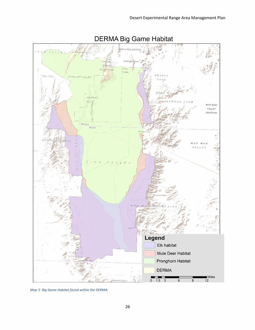
Map 3- Big Game Habitat found within the DERMA.
Desert Experimental Range Area Management Plan
27
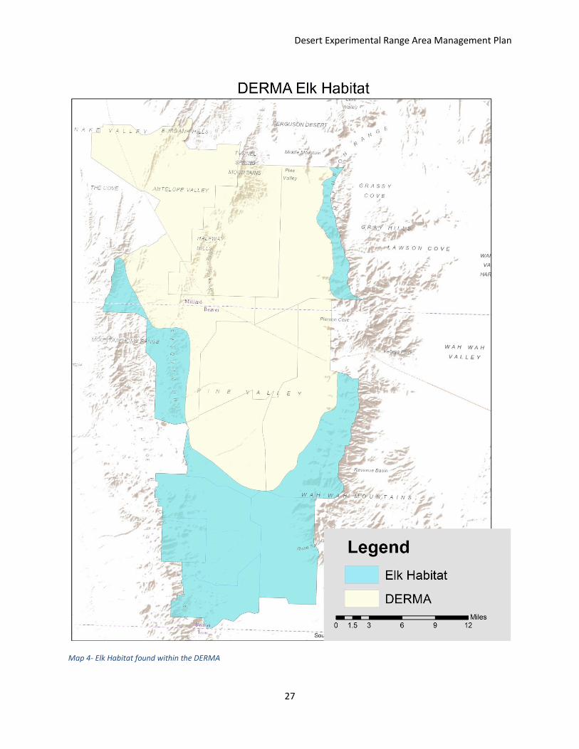
Map 4- Elk Habitat found within the DERMA
Desert Experimental Range Area Management Plan
28
Map 5- Mule Deer Habitat found within the DERMA. Displayed by winter and summer Range.
Desert Experimental Range Area Management Plan
29
Map 6- Pronghorn Habitat found within the DERMA.
Desert Experimental Range Area Management Plan
30
Map 7- Upland Game Habitat found within the DERMA.
Desert Experimental Range Area Management Plan
31
Map 8- Greater Sage Grouse Habitat found within the DERMA. Displayed by winter habitat, Brooding and Occupied Areas and Current Leks.
Desert Experimental Range Area Management Plan
32
Map 9- Wild Turkey Habitat found within the DERMA.
Desert Experimental Range Area Management Plan
33
Map 10- Chukar Partridge Habitat found within the DERMA.
Desert Experimental Range Area Management Plan
34
Map 11- Coyote habitat map by primary prey sources.
Desert Experimental Range Area Management Plan
35
Map 12- Cougar Habitat by Primary Prey Species (Mule Deer, Wild Turkey, and Elk).
Desert Experimental Range Area Management Plan
36
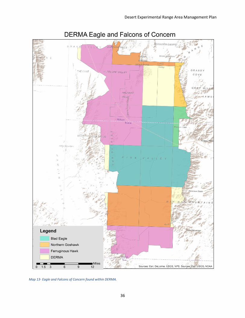
Map 13- Eagle and Falcons of Concern found within DERMA.
Desert Experimental Range Area Management Plan
37
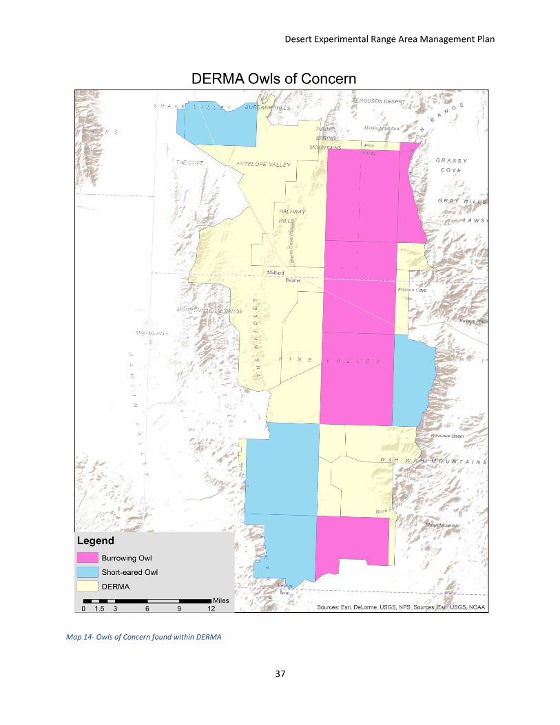
Map 14- Owls of Concern found within DERMA
Desert Experimental Range Area Management Plan
38
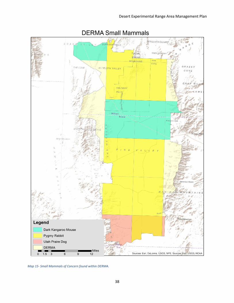
Map 15- Small Mammals of Concern found within DERMA.
Desert Experimental Range Area Management Plan
39
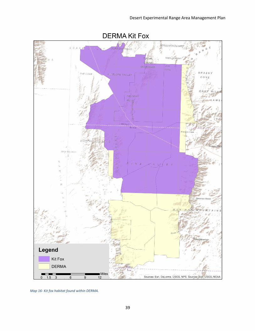
Map 16- Kit fox habitat found within DERMA.
Desert Experimental Range Area Management Plan
40
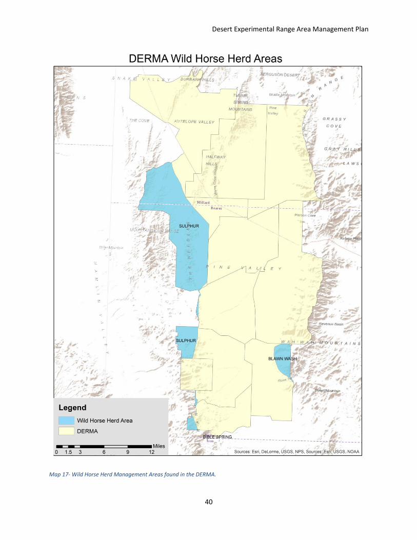
Map 17- Wild Horse Herd Management Areas found in the DERMA.

Desert Experimental Range Area Management Plan
41
This page was left blank intentionally
Desert Experimental Range Area Management Plan
42
Livestock Grazing
Livestock grazing has been an important historical use of the Desert Experimental Range (DER).
When the DER was established in 1934 studies were implemented in grazing and management
effects on plant community compositions, biomass production, and soils. The area is considered
to be salt-desert shrubland. Studies on the effects of grazing and management continue today
in the DER. There are currently 9 grazing allotments in the Desert Experimental Range
Management Area (DERMA). Two of these allotments, South Pine Valley and North Pine Valley
are split into two separate sections, separated by the Buckhorn and Water Hollow allotments.
Forage Values
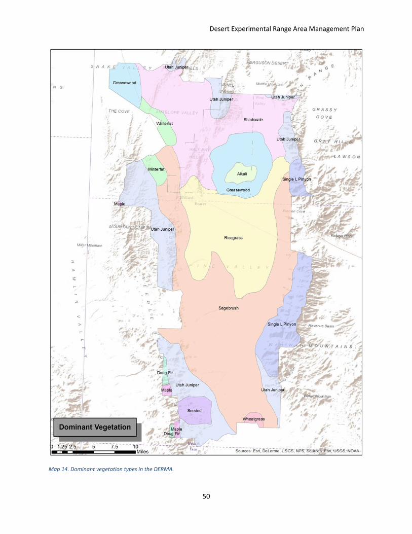
There are 12 dominant vegetation types in the DERMA (see Table 1 and Map 4). Alkali soils,
precipitation, temperature, elevation, and aspect are major factors in determining both the
dominant vegetation types and biomass production in the area. High forage value plant
communities in the DERMA include indian ricegrass, winterfat, and wheatgrass species. Fair to
good forage value communities include sagebrush, greasewood, shadscale, and seeded areas.
Poor to fair forage value plant communities include maple, Douglas fir, Utah juniper, and single
leaf pinyon. The area with high alkali soils has poor forage value (see Map 1). Areas with higher
percentages of good forage values will be better for livestock grazing. When considering
stocking rates for the various allotments, the forage values should be taken into consideration.
A higher stocking rate can be used for the more central allotments such as the DER, North Pine
Valley, and Buckhorn because they have fair to good and high forage values widely distributed.
Mormon Gap, South Pine Valley, Fairview, Pine Valley, and Water Hollow also have significant
amount of good forage value areas and can have a fairly high stocking rate as well. The
peripheral areas in the mountains are more woodland dominated areas and won’t have as high
of forage values, thus reducing the stocking rates in the associated allotments. The alkali soil
area will also reduce the stocking rate for the DER and Pine Valley.
Stocking Rates
In order to determine livestock stocking rates there are a number of factors to take into
consideration. These factors include forage production, proper use amounts, and wildlife forage
use. Proper use is generally considered 50 percent. Depending on the area and management
goals, proper use can be dropped as low as 30 percent. For the DERMA we will use 50 percent
as the proper use of forage. The three big game species which will contribute significantly to
forage production are deer, elk, and pronghorn. The big game species in this area are part of
the Southwest Desert Hunt Boundary and are managed with those populations. The DERMA is
about 13.6 percent of the total Southwest Desert area (see Map 2). In order to determine how
much forage should be allocated to these species, we calculated the number of animals on the
Desert Experimental Range Area Management Plan
43
DERMA year round as 13.6 percent of the population management goals of the Department of
Natural Resources (DNR) for the Southwest Desert area. These goals were 3000 for deer, 1300
for elk, and 269 for Pronghorn (Bernales et al. 2013) and (Shannon 2015).
13.6 percent of these numbers came out to approximately 408 deer, 176.8 elk, and 36.584
pronghorn. Using these numbers, proper use adjustments, and animal unit equivalents (AUE),
we determined the number of AUMs which the wildlife equaled, and then multiplied it by 750
pounds per AUM to find the total forage demand of the big game species on the DERMA. This
number came out to 3889382.4 pounds of air dried forage (see Table 2 for calculations and
numbers). Using 451904 acres as the approximate total area of the DERMA, we found that in
order to support these wildlife numbers you would need to have a production of 8.61 pounds
per acre of forage. This is a very low production, even for areas with extremely low
precipitation, so there should be plenty of forage left after wildlife use for both wild horses,
which are on the range year round, and livestock grazing, which occurs during 4 months in the
winter with the current grazing permits.
Livestock Management Considerations
In order to properly manage livestock it is important to consider livestock distribution,
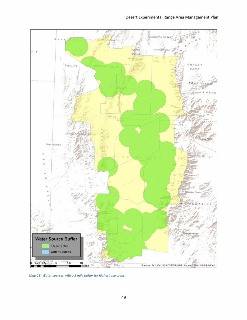
the health of the range, and water use and locations in addition to the stocking rate. Livestock
tend to spend most of their time near water and shade sources, and rarely travel farther than 2
miles away from water sources (Oberlie and Bishop 2009). This creates two problems. The first
problem is that the areas near water and shade tend to get utilized much more heavily, and can
be degraded very easily. The other problem is that areas which produce good forage may be
under-utilized due to the distance from water. One way to ameliorate these effects is by
distributing salt away from water sources in order to more evenly spread livestock distribution.
Another method to prevent degradation of riparian areas would be fencing off especially
sensitive areas. A third method is to develop guzzlers where both wildlife and livestock can
access water. This not only increases the area where livestock are willing to occupy, but also
alleviates the stress on natural riparian areas (see Map 3). In order to better utilize the DERMA,
we will maintain guzzlers and develop new guzzlers as needed to improve both distribution and
utilization by livestock (for more information on guzzlers, see Hydrology section of
Management Plan).
It is important with good grazing management to have flexible stocking rates. On poor
years it can be detrimental to the range to continue with the stocking rates used during good
years. In order to maintain proper stocking rates we will need to assess the range health and
trend for the DERMA on a yearly basis as well as during the grazing season. Not overstocking
the rangeland can also be good for the health of the livestock. With proper use there will be
plenty of good forage for livestock and gains per animal will be maximized. Areas to pay close
Desert Experimental Range Area Management Plan
44
attention to, in order to maintain animal health, are the areas with greasewood (Sarcobatus
vermiculatus) as the dominant vegetation (see Map 4). Livestock do not normally graze
greasewood very heavily, but if the palatable grasses are eaten out of the area the livestock
may start to eat the greasewood. Greasewood when eaten in large amounts can be toxic to
livestock. We must monitor the greasewood areas very closely during the grazing period and
reduce stocking rates if the grasses are being completely utilized; however, a proper stocking
rate should minimize this risk (USDA 2006).
Invasive and Noxious Weed Control
Control of invasive and noxious weeds is an important aspect of forage production
potential, and rangeland and animal health. Noxious and invasive weeds can create
monocultures, decrease desirable plant production, alter disturbance regimes, and cause
livestock losses through death, illness, or loss of gains. Important invasive plants which require
planning and management in the DERMA are halogeton (Halogeton glomeratus), Russian thistle
(Salsola iberica), red brome (Bromus rubens), cheatgrass (Bromus tectorum), Utah juniper
(Juniperus osteosperma), and pinyon pine (Pinus edulis).
Halogeton is toxic to sheep and readily invades disturbed areas of the salt desert.
Russian thistle has a very poor forage value and also readily invades the salt desert. Red brome
and cheatgrass are invasive annual grasses. They can be fair livestock forage, but also create
monocultures, causing frequent fires and outcompeting more palatable forage species. Utah
juniper and pinyon pine can be good thermal cover for wildlife as well as important sources of
forage for rodents, lagomorphs (rabbits and hares), and birds due to the high nutritional value
of the juniper berries and pine nuts. In higher elevations, pinyon and juniper stands can be
functioning healthy range cover, as they are native to the Great Basin area. These trees do
invade lower elevation areas and create woodlands and take up water and nutrients, reducing
the available understory and crowding out the palatable grasses, forbs, and shrubs. An active
integrated pest management program is the best way to control all of these invasive species.
We will treat areas with these weeds quickly with both chemical and mechanical means to try
and prevent their spread.
Sensitive Wildlife Species and Grazing
A sensitive species which occurs in the DERMA is the greater sage grouse (Centrocercus
urophasianus). Grazing management can greatly affect sage grouse habitat. In the DERMA, sage
grouse habitat occurs in the southern sections of South and North Pine Valley allotments, the
Out allotment, the Buckhorn allotment, and the Water Hollow allotment (see Map 5). Grazing
management for sage grouse could include two different options. The first option is to not
Desert Experimental Range Area Management Plan
45
stock the specified grazing allotments during lekking, and the second option is to completely
remove grazing from the allotments where sage grouse habitat occurs.
There has been significant debate as to the effects of livestock grazing on sage grouse
leks and habitat. There will be significant repercussions with either management action chosen.
We will reduce proper use to 30 percent on the allotments with sage grouse habitat. We will
also restrict grazing permits to only allow grazing when it is not within a month of lekking or
nesting and brooding season. This should minimize the impacts of grazing to sage grouse while
not completely restricting livestock production on these areas.
Desert Experimental Range Area Management Plan
46
Table 1- Dominant vegetation types in alphabetical order.
Table 2 -. Calculations and actual numbers for wildlife populations, AUMs, and forage requirements.
Deer AUMs Deer Numbers Months AUE Total AUMs Grass Forb Shrub Total Deer AUMs
SSF 408 8 0.23 750.72 0.15 0.35 0.5 Grass 131.376
Forb 281.52
Shrub 713.184
W 408 4 0.23 375.36 0.05 0.05 0.9 Total 1126.08
Total Elk AUMs
Elk AUMs Elk Numbers 0.7 0.1 0.2 Grass 827.424
SSF 176.8 8 0.65 919.36 0.7 0.1 0.2 Forb 101.13
Shrub 450.486
0.4 0.02 0.58 Total 1379.04
W 176.8 4 0.65 459.68 0.4 0.02 0.58
Pronghorn AUMs Pronghorn Numbers Months AUE Total AUMs Total Pronghorn AUMs
36.584 12 0.2 87.8016 Total 87.8016
Wildlife Total AUMs 2592.9216 x 750 lbs/AUM =
Forage Needed to Support Wildlife 1944691.2 lbs air dry forage
Forage Needed to Support Wildlife Accounting For Proper Use 3889382.4 lbs air dry forage
Dominant Vegetation Types
1 Alkali Soil
2 Douglas Fir
3 Indian Ricegrass
4 Greasewood
5 Maple
6 Sagebrush
7 Seeded
8 Shadscale
9 Single Leaf Pinyon
10 Utah Juniper
11 Winterfat
12 Wheatgrass spp.
Desert Experimental Range Area Management Plan
47
Map 11- Relative Forage Value within the DERMA
Desert Experimental Range Area Management Plan
48
Map 12- Southwest Desert wildlife Management Unit of UDWR, which wildlife found in the DERMA are managed.
Desert Experimental Range Area Management Plan
49
Map 13- Water sources with a 2 mile buffer for highest use areas.
Desert Experimental Range Area Management Plan
50
Map 14. Dominant vegetation types in the DERMA.
Desert Experimental Range Area Management Plan
51
Map 15. Greater sage grouse habitat within the DERMA.

Desert Experimental Range Area Management Plan
52
This page was left blank intentionally
Desert Experimental Range Area Management Plan
53
Private Land Ownership
This is a summary of how each of us would manage the DERMA if we were to manage it.
Jesse: If I privately owned the DERMA, I would maintain livestock grazing on the top half of the
DERMA. The bottom half, beginning at the Buckhorn allotment, I would fence off and remove
all grazing. I would focus on improving the sage grouse habitat and potential habitats in this
area and maintain it as a wildlife area. I would also sell permits or tickets to harvest your own
pine nuts from the areas with pinyon pine.
Skip: Private land ownership infers freedom to do what the landowner wants to do with one’s
own land. Yes, there are taxes to be paid and laws to obey, but, if I privately owned the Pine
Valley area’s 10 allotments, I would a devise a management plan, different from the one
written here. I would make a nature preserve.
After an initial study of the area’s topography, geology, biodiversity, physical structures, and
past records of the climate and history, I would develop a management plan. In other words,
what is the Pine Valley, what is here today, and what resources (money) do I have? I imagine I
would follow a similar model as The Lytle Ranch Nature Preserve, which sought support from
the Nature Conservancy ($$$). My plan would be to restore and maintain the land in as natural
of a state as possible.
To define the boundary and restrict livestock access, I would maintain a perimeter fence,
probably barbed wire, with strands spaced to allow large game animal free movement. I would
reduce the number of roads and restore the old beds. I would construct manmade wildlife
guzzlers in the north and northeast parts of the valley, thereby negating a 100% natural
environment because I like pronghorns, deer, and elk. I’d put out a mineral lick or two to help
keep the big game on my property. There would be no livestock or wild horses, although I
would have a few of those for my own use. I realize my hunting seasons would be patrolling
the range for human trespassers. I believe another challenge would be keeping the invasive
plant species at bay.
Stan: If I were to manage to the DERMA under private management, the first and main thing I
would do it habitat work. I would have a goal to treat at least 1,000 acres a year. I would also
do everything in my power to remove the wild horses. If unsuccessful I would start to fence off
water sources, but still allow water to be available to them. I would do intensive wildlife
population counts and become a part of the UDWR Cooperative Wildlife Management Unit
(CWMU) to allow for hunting opportunities for the public and higher quality harvest. I would
also run a cattle grazing operation and work with partners to become the example of multi-use
area with a highest standard for sage protection, and population growth.

Desert Experimental Range Area Management Plan
54
This page was left blank intentionally
Desert Experimental Range Area Management Plan
55
Bibliography
Bernales, H., K. Hersey and J. Shannon. 2013. Utah big game annual report. Annual Performance Report for Federal Aid Project W-65-M. Publication 14-22. Segments 61-62. Available at: http://wildlife.utah.gov/hunting/biggame/pdf/annual_reports/13_bg_report.pdf
Bradshaw, A. 1997. Restoration of mined lands using natural processes. Ecological Engineering:255-269.
Glading, B. 1947. Game watering devices for the arid southwest. Trans North American Wildlife
Conference:286-292. Hutchings, S. S. 1946. Drive the Woolgrower 36:10-11, 48.water to sheep. National Grinnell, J. 1927. A critical factor in the existence of southwestern game birds. Science:528-529. Lee, R, Mitchell, D. Perkins, E. and Staley, J. 2003. Strategic Management Plan for Chukar
Partridge. Online Resource. Available at: http://wildlife.utah.gov/uplandgame/pdf/03_chukar_plan.pdf
Oberlie, D. and J. Bishop. 2009. Determining rangeland suitability for cattle grazing based on
distance-to-water, terrain, and barriers-to-movement attributes. Available at: https://gis.e-education.psu.edu/sites/default/files/capstone/Oberlie_paper_20090412.pdf
Shannon, J. 2015. Overview of 2015 big game permit recommendations. Department of
Natural Resources RAC Agenda. Available at: http://wildlife.utah.gov/public_meetings/rac/2015-04_rac_packet.pdf
Smith, J. W. 2008. Utah off-highway vehicle owners’ specialization and its relationship to
environmental attitudes and motivations. Thesis, Utah State University, Logan, Utah USA.
USDA. 2006. Greasewood (Sarcobatus vermiculatus). Online Resource. Available at:
http://www.ars.usda.gov/Research/docs.htm?docid=9898 Utah. 2009. Utah Pronghorn Statewide Management Plan. Online Resource. Available at:
http://wildlife.utah.gov/hunting/biggame/pdf/Statewide_prong_mgmt_2009.pdf