
Dept. of Hydrology, IITR, Sept, 17, 2014 Groundwater...
67
Dr. S.N. Rai Department of Earth Sciences Indian Institute of Technology Roorkee Roorkee - 247667 Ex-Chief Scientist CSIR-National Geophysical Research Institute Hyderabad-500 007 E-mail: [email protected] Dept. of Hydrology, IITR, Sept, 17, 2014 Groundwater management in hard rock area using geophysical methods
Transcript of Dept. of Hydrology, IITR, Sept, 17, 2014 Groundwater...

Dr. S.N. Rai
Department of Earth SciencesIndian Institute of Technology Roorkee
Roorkee- 247667
Ex-Chief ScientistCSIR-National Geophysical Research Institute
Hyderabad-500 007
E-mail: [email protected]
Dept. of Hydrology, IITR, Sept, 17, 2014
Groundwater management in hard rock area
using geophysical methods

Sustainable
Development
Delineation &
Development
GovernanceManagement
Sustainable development rejects all policies and practices that
leads to depleting the resource base by fulfilling present needs
and leaving future generation unable to meet their demands.


General four electrode array of resistivity survey
C1 P1 P2 C2
A M N B
BNANBMAM
K
I
VKa
1111
12

Electrode configurations (or arrays)
A
Vaa
2

I
V
l
lLa
2
22

Dipole-Dipole configuration
naa aC2 P2P1C1

Pole- Dipole configuration
aP2C1∞ P1na

Pole-Pole configuration
a P2C1∞ ∞

Four 160-m
multiconductor
cables with 16 takeouts
at 10-m spacing
4×64 channel relay
switching unit
High-resolution
Voltmeter with current
amplifier and active
booster interface
Terrameter Imaging System

Lay out of 4 multi-electrode cables with Terrameter, Electronic
switching unit, and laptop computer


2-D Inverse modeling and interpretation
• RES2DINV program automatically creates a 2D model by
dividing the subsurface into rectangular blocks
• Calculates the apparent resistivity values of the model blocks
using either a finite difference or finite element method
• Compares these to measured data. The resistivity of the model
blocks is adjusted iteratively until the calculated apparent
resistivity values of the model agree with the actual
measurements.
• The final output displays the 2-D variation of true formation
resistivity which is interpreted in terms of hydro-geological
form.

Case studies
Chandrabhaga river basin, Nagpur district,
Vidarbha region, DVP
Tawarja river basin, Latur district, Marathwada
region, DVP
Hot springs of Chiplun Taluk, Ratnagiri district,
DVP
In and around Hyderabad, Granitic terrains
Tadkeshwar lignite mines, Surat district, DVP

Chandrabhaga river basin (Deccan Traps),
Nagpur district, Vidarbha region- case study
25 km in North-West of Nagpur city
Between 78o42’ to 79o East Longitudes and
21o11’ to 21o20’ North Latitudes
Geophysical Investigation details :
Vertical Electrical Soundings :45 sites
Electrical Resistivity Tomography : 56 sites
Investigated area :
~500 sq. km encompassing 50 villages spread over
in parts of Katol, Kalmeshwar and Rural Nagpur taluks


Regional stratigraphy of the region (Mehta, 1989)
Recent to Quaternary
-----------------------------------------
Alluvial, Black cotton soil
and weathered formation
--------------------------------------
Deccan basalt lava flow
(Cretaceous to Eocene)
Vesicular and
Massive basalt layers with
intervening intertrappeans
------------------------------------------------------------------------------------
Lameta beds(Infratrappeans) Thin sedimentary sequences
-------------------------------------------------------------------------------
Gondwana Sandstone of upper Kamthi
Group


1 10 100 1000
1
10
100
1000
Current Electrode Spacing (AB/2) in m
Computed
Observed
S 41
n h
37.5 0.8 91.1 2.9 25.2 22.4 94.2 15.0 26.1 3.5184.0 36.0 60.1
Resis
tivity(
) in
Oh
m -
m
S42
S41
S 42
nh
6.2 0.5 14.5 9.0140.7 27.6 52.2 4.9127.5 10.4 34.5
S43
S44S45
S 43
n h
3.3 3.5 25.4 9.8 46.6 32.6124.5 10.2 20.3
S 44 n h
4.3 5.4 23.5 9.3 42.5 31.6112.6 12.2 21.0
S 45 n h
5.0 2.3 33.8 4.6109.2 25.4126.1 23.0242.0 12.4 20.6
S40
S 40
n h
7.8 6.5 14.8 7.2113.6 24.8217.1 16.9 15.8

Alluvial, Black cotton soil and Bole bed : 5-10 Ohm m
Weathered/fractured/ vesicular basalt saturated
with water : 20-45 Ohm m
Moderately weathered/fractured/vesicular basalt : 40-70 Ohm m
saturated with water Massive basalt : >70 Ohm m
Water saturated Lameta bed : < 10 Ohm m
Water saturated Gondwana sand stone : < 30 Ohm m
Resistivity ranges for different lithos unit (CGWB web site)

Ubali S 41

Rock samples of S2 Site at 3.33 m intervals (10 ft)

Kotwlbardi S10

Raulgaon; S 38

Societal Benefit:


Distribution of true resistivity with depth and Lithologs of borewell
P1 – Ghogali, (E 78o52’9.6” N 21o 14’ 19.2” )

(a) Distribution of true resistivity with depth and borewell location at Khairi, Kalmeshwar
Taluk, Nagpur district
(b) Lithologs obtained from borewell drilling
P21 – Khairi (E 780 50’ 39.7” N 210 12’ 46.9”)

W E
P-13 Samundari
E W
P14-Wathoda
N 21017’09.8”, E78049’36.0”
N 21016’56.8”, E78050’38.9”

P17-Waroda
P8-Waroda
N 21016’25.6”, E78054’20.1”
N 21015’45.4”, E78053’40.8”


Tawarja Basin (Deccan Traps), Latur District, Marathwada


NNN
Geothermal exploration
ofilesERTandhotspringsofLocations Pr


NW SEF
F
NW SENW SEF
F
2D Resistivity model near Unhavare hot spring along L1 profile
2D Resistivity model near Unhavare hot spring along L2 profile
E W
F
FE W
F
F
F
FF
F

S NF
F
F
F
S NS NF
F
F
F
S N
F
F F
FF
F
2D Resistivity model near Tural hot spring along L3 profile
2D Resistivity model near Tural hot spring along L4 profile

Granitic formation


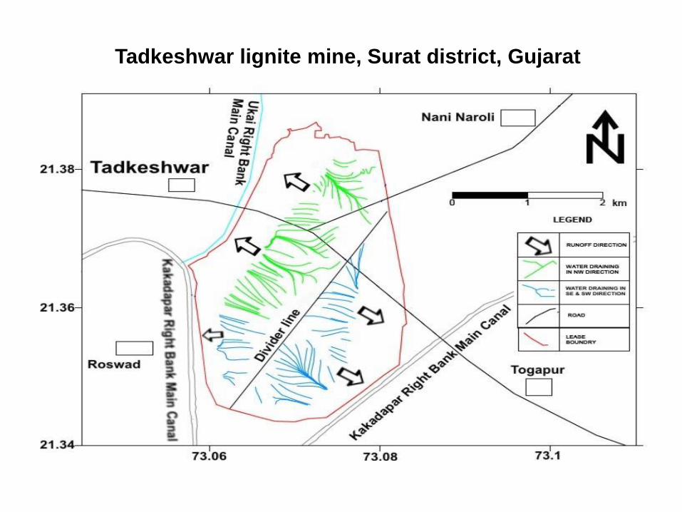
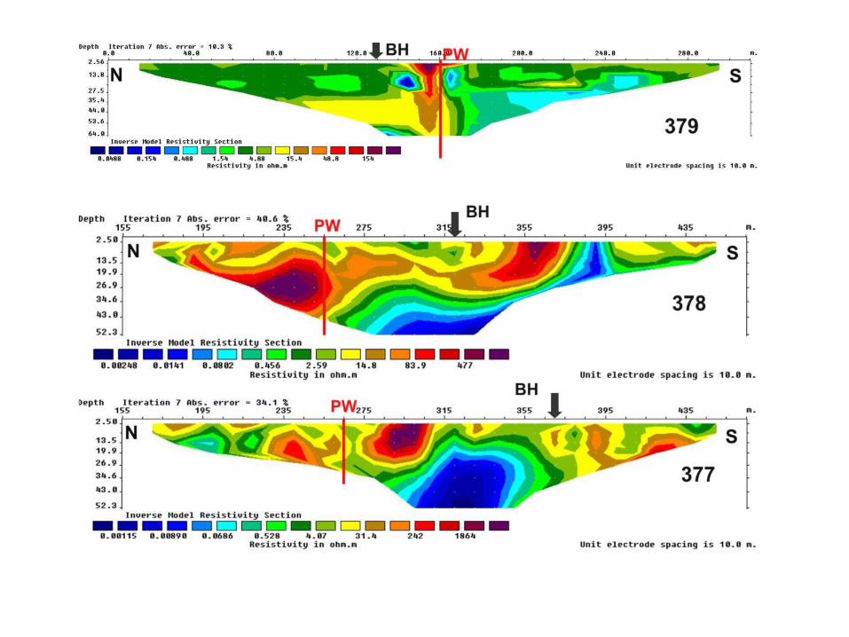
Tadkeshwar lignite mine, Surat district, Gujarat


Development & Management


WEES, Jan. 12-16, 2009
Well hydrographs for
Piezometer upstream,
T(u) and downstream,
T(d) of Tandlam
subsurface dam (after
Raju et al 2006)
Subsurface check
dam, Swarnamukhi
river (after Raju et al.
2006)

Perforated casing of bore well

The Hindu, April 19, 2013
Drilling holes in the Thirst Economy, P. SAINATH
WATER PLUNDER:The owner of this brand new bore well rig says that all told it cost him Rs.14 million. But he can
recover that in six months by drilling just two wells a day

Roof top rainwater harvesting


Conclusions:
Scarcity of water supply is not because of non-availabilty of
groundwater but due to scarcity of proper scientific investigations.
Scientific investigations should be followed by development of
infrastructures like bore wells, and structures like ponds, check
dams for managing aquifer recharge.
Sharing of scientific findings with stakeholders to facilitate
implementation of development schemes to achieve the preset
objectives of development and management.
A substantial amount of scientific projects should be allocated for
development of groundwater resources in a form useful for society.

Acknowledgements
• Dr. S. Thiagarajan
• Dr. Dewashish Kumar
• Mrs Y. Ratnakumari
• Dr. V. Anand Rao
• M. Bulliabai
• Shri G.B.K. Shankar
• Mr. M. Sateesh Kumar

Related literature
•Dewashish Kumar, Rai, S.N., Thiagarajan, S. and Ratnakumari, Y., 2014. Current Science,
vol 107.
•Rai, S.N., Thiagarajan, S., Dewashish Kumar, Dubey, K.M., Rai, P.K., Ramchandran, A. and
Nithya, B., 2013. Current Science, vol. 105 (10), 1410-1418.
•Rai, S.N., Thiagarajan, S., Ratnakumari, Y., Anand Rao, V. and Manglik , A. 2013.
Journal of Earth System Sciences. 122(1), 29-41.
•Rai, S.N., Thiagarajan, S., Ratnakumari, Y and Kumar, D. 2012. J. of Applied Hydrolgy, XXV
(3&4), 85-94.
•Ratnakumari, Y., Rai, S.N., Thiagarajan, S. and Dewashish Kumar, 2012. Current Science,
102(1), 61-69
•Rai, S.N., Thiagarajan, S. and Ratnakumari, Y., 2011. Current Science, 101(9), 1198-1204.
•Kumar, D, Thiagarajan, S. and Rai, S.N., 2011. Journal of Geol. Soc. India, 78, 541-548
•Thiagarajan, S., Rai, S.N., Dewashis Kumar and Ratna Kumari, Y. (2013). J. of Earth System
Science (communicated).
•Rai, S.N., Thiagarajan, S., Kumar. D. and M. Bulliabai, 2011. Hydrogeological investigations
in Tadkeshwar Lignite mine of Gujarat Mineral Development Corporation (GMDC) Ltd.,
Technical Report No. NGRI-2011-GW-766, p. 29.

The Earth has provided adequate natural
resources to meet our needs but not greed

Thank you


![[Hydrology] groundwater hydrology david k. todd (2005)](https://static.fdocuments.net/doc/165x107/55a8e6001a28ab6c2f8b4687/hydrology-groundwater-hydrology-david-k-todd-2005-55b0d9a792c06.jpg)


