Department of the Environment Supplementary Planning Guidance · Department of the Environment...
15
Department of the Environment Supplementary Planning Guidance Practice note: ‘11b’ Information required for a planning application: 3D models June 2012
Transcript of Department of the Environment Supplementary Planning Guidance · Department of the Environment...

Department of the Environment Supplementary Planning Guidance
Practice note: ‘11b’
Information required for a
planning application: 3D
models
June 2012

States of Jersey Department of the Environment
1
About Supplementary Planning Guidance The Minister for Planning and Environment may publish guidelines and policies (supplementary planning guidance) in respect of; development generally; any class of development; the development of any area of land; or the development of a specified site1. Supplementary planning guidance may cover a range of issues, both thematic and site specific, and provides further detail about either, policies and proposals in the Island Plan, or other issues relevant to the planning process. It can also be used to provide information about how the planning system operates. Where relevant, supplementary planning guidance will be taken into account, as a material consideration, in making decisions. Supplementary planning guidance is issued in a number of different forms including: Advice notes, which offer more detailed information and guidance about the
ways in which Island Plan policies are likely to be operated, interpreted and applied in decision making;
Policy notes, which can be issued by the Minister, following consultation with key stakeholders, in-between reviews of the Island Plan, to supplement and complement the existing planning policy framework;
Masterplans, development frameworks and planning briefs provide more detailed information and guidance about the development of specific sites and areas of the Island; and
Practice notes, which aim to provide information about how the planning system's protocols and procedures operate.
The current supplementary planning guidance is listed and can be viewed on the States of Jersey website at www.gov.je/planningguidance. Hard copies of all supplementary planning guidance can be obtained from Planning and Building Services, Department of the Environment, South Hill, St Helier, JE2 4US, telephone: 01534 445 508 email: [email protected]
1 Under Article 6 of the Planning and Building (Jersey) Law

States of Jersey Department of the Environment
2
1. PURPOSE OF DOCUMENT 1.1 This practice note is designed to help applicants determine whether a 3D
digital model of their proposed development is required and if so, to what standard, when submitting a planning application to the Department of the Environment.
1.2 This practice note replaces section 11 (Models) of Practice Note 11
(Information Required for a Planning Application), which outlined the requirements for submitting a physical model with relevant planning applications.
2. INTRODUCTION 2.1 The States of Jersey now has a computer generated three dimensional (3D)
model of St Helier. The model currently provides an accurate representation of St Helier by using 3D imagery to depict the built form of buildings relative to topography (contours of the land).
2.2 An accurate as-built 3D representation of St. Helier enables the Minister, Planning Applications Panel members, planners, developers and architects to make better design development decisions and for the public to make more informed commentary on the future development and regeneration of the town. In summary it will:
Improve the handling of planning applications Enhance the understanding of the built environment Improve design quality and standards Integrate with the department‟s „Planning Online‟ initiative
2.3 The States of Jersey 3D model will, over time, extend to all parts of the Island
as planning applications are submitted and approved through the planning applications process.
2.4 3D models for development schemes that are approved and subsequently
built will be used to update the States of Jersey 3D model data for future reference by the States of Jersey and external consultants/users.
3. WHEN IS A 3D MODEL REQUIRED? 3.1 Effective as of August 1st 2012, a 3D digital model will be required to be
submitted for applications involving any scheme for;
a new building over 1,000 sq.ft ;
any scheme that proposes more than one building in any location; or,
significant major alterations or additions to the exterior of existing buildings within the St Helier 3D model area (see Appendix 1).
3.2 For the purposes of the 3D model, the definition of a significant change to the
front elevation or roof profile/height is regarded as adding one storey in height or having a potential material impact upon the immediate area (by either the
States of Jersey Department of the Environment
3
loss of light or a significant visual impact), as defined in Island Plan policy GD5 skyline, views and vistas.
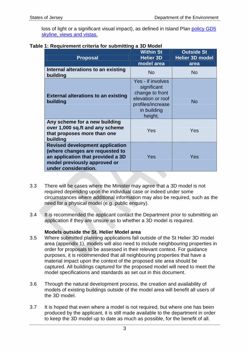
Table 1: Requirement criteria for submitting a 3D Model
Proposal Within St Helier 3D
model area
Outside St Helier 3D model
area
Internal alterations to an existing building
No No
External alterations to an existing building
Yes - if involves significant
change to front elevation or roof profiles/increase
in building height.
No
Any scheme for a new building over 1,000 sq.ft and any scheme that proposes more than one building
Yes Yes
Revised development application (where changes are requested to an application that provided a 3D model previously approved or under consideration.
Yes Yes
3.3 There will be cases where the Minister may agree that a 3D model is not
required depending upon the individual case or indeed under some circumstances where additional information may also be required, such as the need for a physical model (e.g. public enquiry).
3.4 It is recommended the applicant contact the Department prior to submitting an
application if they are unsure as to whether a 3D model is required. Models outside the St. Helier Model area 3.5 Where submitted planning applications fall outside of the St Helier 3D model
area (appendix 1), models will also need to include neighbouring properties in order for proposals to be assessed in their relevant context. For guidance purposes, it is recommended that all neighbouring properties that have a material impact upon the context of the proposed site area should be captured. All buildings captured for the proposed model will need to meet the model specifications and standards as set out in this document.
3.6 Through the natural development process, the creation and availability of
models of existing buildings outside of the model area will benefit all users of the 3D model.
3.7 It is hoped that even where a model is not required, but where one has been
produced by the applicant, it is still made available to the department in order to keep the 3D model up to date as much as possible, for the benefit of all.

States of Jersey Department of the Environment
4
4. ACCESS TO THE 3D MODEL 4.1 The 3D Model is designed for use by the public as well as providing applicants
with assistance in the preparation of each applicant's model and applicant's drawings.
4.2 The 3D Model will:
be freely available for the public to view only via the States of Jersey web2 site;
be licensed to architects and developers in order to allow full editing access to the 3D model to assist them with their own developments;
Integrate each applicant's model into the States of Jersey 3D model; and
be an assessment tool for staff and elected members of the States of Jersey in decision making.
5. MODELLING SPECIFICATION 5.1 The basic requirements for application models are detailed below. MODEL SCALE / UNITS 5.2 The 3D digital model should be created at a scale of 1:1 that is an accurate
representation of the exterior detail of the proposed development. Model units must be in metres.
POSITION AND HEIGHT VALUES 5.3 All submitted models must be accurately located within the current States of
Jersey 3d model and/or mapping data sets. 5.4 If there are significant changes to the existing site levels (ground level
contour), the model should include the amended site levels as part of the model itself.
ACCURACY 5.5 Models are required to meet the current minimum terrain and building heights
accuracy standard which is;
within 20cm vertical and horizontal accuracy within the 3D model area
within 40cm vertical accuracy for terrain outside of the 3D model area. DETAIL LEVEL 5.6 The Department requires only the external elements for its development
application process. Internal fit outs are not required. Some of the details listed below.
The model should include:
Ground level detail deemed to be of major design significance such as doors, access and awnings;
2 https://www.mygov.je/Planning/Pages/planning.aspx

States of Jersey Department of the Environment
5
General detail of shop front design (i.e. areas of glazing and doors) if applicable;
Elevation detail for all elevations including sizes and rear:
Solid to void and opening relationships, glazing, mullion and transoms deemed of significance to the building design;
Balcony elements such as balustrades, detail of any protrusions or indents to facade and any expression of structure;
Roof detail including pitch, plant enclosures, service and fire stair protrusions, terraces, shade and signage structures;
If there are significant changes to the existing site levels (ground level contour), the model should include the amended site levels as part of the model itself;
Floor levels (as a flat plane) be positioned in the location of each floor. All other internal detail is not required and must be stripped out of the model prior to submission.
External ancillary features of significance such as large landscaping planter boxes, canopies;
Indications of vegetation should be kept to an absolute minimum - a separate model of prominent trees is preferred;
Objects such as seating can be shown as simple block forms;
Objects to have correct colours applied as a minimum standard. The model does not need to include:
Lighting
Loose furniture such as umbrellas.
Moving objects such as cars and people. 5.7 Please keep polygon counts as low as possible. If complex models with
high polygon counts are to be submitted, please contact the mapping Service team.
LAYERS 5.8 It is advisable that items be grouped logically. For instance, windows and
doors should be separate components from walls; walls should be grouped separately from roofs etc. This is important when exporting to other programs for the simple fact that if you need to move or delete an object and it is connected to another object in the model, the later object will also be moved or deleted as well. The grouping of items makes it easier to manipulate the model especially if multiple people will work on the file.
TEXTURES AND MATERIALS 5.9 Ensure base material colours are used to represent the object‟s real world
colour. 5.10 NOTE: If special treatments are to be applied to building facades, it is
recommended to include these in the model submission to assist with the planning process.

States of Jersey Department of the Environment
6
Photo Facades 5.11 Photo facades have been applied within the States 3D model within area level
2 (see appendix 1) and this provides greater context when assessing applications. All Models submitted outside of this area will need to include photo facades for all neighbouring buildings. A user guide on how to capture façade photos in your model is outlined in additional technical guidance on the States of Jersey Mapping Service 3web site.
Texture Format 5.12 This is an important element of the model and textures should adhere to the
following rules;
use only .JPEG images for texture materials
textures should be have one or more combinations of the following pixel size; o 128, 256, 512,1024.
5.13 You can do this in PhotoShop or some other image editor to resize your
chosen texture image to the closest fit dimension. 5.14 Texture names should be 8 characters or less and not contain any special
characters
Faces. 5.15 All faces need to be oriented towards the viewer. Reversed they will result in a
blank rendering of façade textures when used in other rendering programs. You can check the orientation of the face by switching to monochrome mode; tan faces are oriented correctly and blue/grey faces need to be reversed. In order to reverse a face, right click on it and select “Reverse Face”.
FILE FORMAT 5.16 Models submitted are to be optimised for efficiency in real-time visualisation.
NOTE interior detail is not required and should not form part of any submitted model.
.KML or .KMZ is the preferred format.
Google SketchUp SKP or Collada (.DAE) format is also supported. 5.17 The States of Jersey 3D model has been compiled in Google Sketchup, as it is
a platform which most architects are familiar with. It is also relatively easy to use and a standard license for the software can be downloaded for free from
http://sketchup.google.com/ 5.18 All 3D models should therefore be submitted with a Sketchup model of the
proposal. There are a number of simple guidelines which should be followed to ensure that submitted models conform to a set standards thus ensuring consistency in model quality and format. The guidelines assume you have a working knowledge of Sketchup or that you can call upon the services of
3 http://govje/PlanningBuilding/JerseyMappingService/Pages/index.aspx

States of Jersey Department of the Environment
7
somebody who does. The Department of the Environment can provide a list of recommended suppliers.
File Size 5.19 File size is important. Care should be given to the number of polygons and
the size of model textures. There is no need to use very detailed high polygon (1000+) models of window frames or door handles. This will severely reduce the performance handling of the model. A suitably detailed representation of the structural elements of a building should be possible for no more than a few hundred polygons. Particular attention should be given to curved surfaces where a lot of polygon detail can be unnecessarily added.
File Name 5.20 Named according to street address or site name and model type/level.
6. CONFORMANCE
6.1 It is the applicant‟s responsibility that the model is complete and represents
the proposed development accurately. Best practice modelling techniques and layering standards should also be applied.
6.2 The Department reserves the right to reject the model if it does not conform to
the above standards, which may lead delay the determination of the application. The Mapping Service will make all efforts to incorporate the submitted model into the States of Jersey 3D Model.
6.3 If the model cannot be supplied in the above mentioned standard the applicant
must seek the services of an organization that can ensure that their model conforms to the States of Jersey model.
7 MODEL SUBMISSION
7.1 When lodging a development application which includes a building model on
CD / DVD, you will need to complete the Terms of Submission sign-off (appendix 2) and include that with your data disk.
7.2 All disks are to be clearly labelled stating the following: 3D MODEL, project
title (postal address or site name) – date of model submission, planning reference (if available).
Example: “3D MODEL, 22 King Street, 31 August 2012”. 7.3 Models will be submitted at the same time as the full planning application
being received by the Department. Failure to submit a model within this timeframe will delay the application being determined.

States of Jersey Department of the Environment
8
8 WHAT IS THE FEE? 8.1 The States of Jersey 3D and associated terrain models are provided freely to
all existing States of Jersey mapping licence holders. 8.2 For those applicants that do not hold a current mapping license with the States
of Jersey, the Department requires the payment of a mapping license fee to access the States of Jersey data required to input the proposed development into the 3D model.
8.3 If a modification is made to the application which alters the external
appearance of the building or significantly alters the external appearance of the building once it is submitted with the Department, a new model will be required but no additional fee applied.
8.5 The current (2012) prices for the relevant .dwg/.dxf and 3d related mapping
data sets are;
One- off license for a 1 x 0.5 km tile of DXF/DWG data (including 3d terrain data) is £368.90 (increases by RPI each year). Note: some model sites may require more than 1 tile.
Annual licence for Island wide DXF/DWG and 3d terrain data mapping is £860.90 per annum for 1-3 users, or £1,937.04 per annum for 4+ users (increases by RPI each year)
8.4 The fees for mapping data are listed in the current mapping fee schedule
on the States of Jersey web site4.
4 http://govje/PlanningBuilding/JerseyMappingService/Pages/PriceList.aspx
States of Jersey Department of the Environment
9
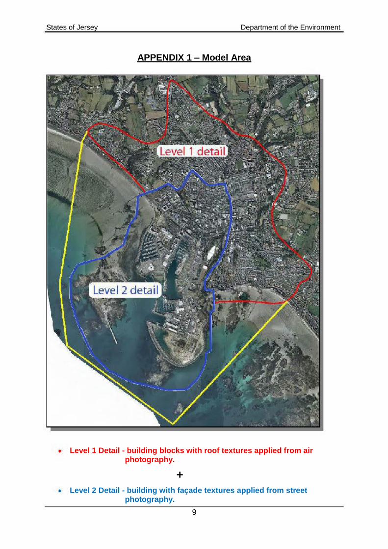
APPENDIX 1 – Model Area
Level 1 Detail - building blocks with roof textures applied from air photography.
+
Level 2 Detail - building with façade textures applied from street photography.
•
•

States of Jersey Department of the Environment
10
APPENDIX 2 – Terms of submission sign off
Licence Where plans are provided in support of an application for planning permission and building bye-law consent, the applicant is taken to have authority to allow the States of Jersey Department of the Environment to copy and take extracts of those plans for the purpose of considering the application. Digital management The States of Jersey Department of the Environment hosts a 3D model of Jersey and asks an applicant seeking planning permission to provide a 3D model in electronic format, where the development proposal meets the thresholds set out in this guidance. The Applicant should then ensure that an electronic edition matches the application plans, and take reasonable steps to ensure the electronic edition is free of viruses or other harmful elements. If the plans later change, updated electronic editions of the model will be required. The States of Jersey Department of the Environment will incorporate the plans in the 3D model, which will be able to be accessed by the States of Jersey Department of the Environment and also (via the Internet) by members of the public for viewing. Ownership All intellectual property rights, including the copyright, in the 3D Model remains the property of the States of Jersey at all times. An architect or other drafter of building plans may hold copyright / moral rights in those plans. The Applicant is taken to have requisite consents for the use of those plans as contemplated above, and to agree to indemnify the States of Jersey Department of the Environment against all losses, expenses, damages and costs resulting from any lack of such consents. In the future, the States of Jersey Department of the Environment may also licence the use the 3D model or information it contains to third parties.
Licence The States of Jersey Department of the Environment provides a licence to use the 3D Model for non-commercial use or for the purpose of preparing and submitting an application to submit to the States of Jersey Department of the Environment. The Copyright Owner grants the States of Jersey Department of the Environment a perpetual, irrevocable, royalty-free licence which allows the States of Jersey Department of the Environment to:

States of Jersey Department of the Environment
11
Use the Applicant's Model and Applicant's Drawings (or extracts of these) without charge as the States of Jersey deems necessary, including without limitation for the purpose of considering the application;
Incorporate the applicant's model into the States of Jersey 3D Model. This includes permitting the States of Jersey to use and license the applicant's model as part of the States of Jersey 3D Model.
Liability The 3d Model is provided for public information purposes only. Each applicant should not rely upon any information in the 3d Model without obtaining the specific advice of a qualified architect, planner or other professional as applicable. The 3d Model is provided 'as is'. No claim is made as to the accuracy or completeness of the 3d Model. The Minister for Planning and Environment and the Department endeavour to ensure that content provided in the 3d Model is complete, accurate and up-to-date and does not contain errors and omissions, but provide no warranty that this will be the case or that access to the 3d Model will always be uninterrupted, timely or secure. The Minister for Planning and Environment excludes to the extent lawfully permitted all liability for any loss or damage of whatever kind (including consequential or incidental damage) and however arising (including due to negligence) that may be suffered, directly or indirectly, in connection with use of the 3d Model. In this section, "Minister for Planning and Environment " includes any Departmental staff, representatives, agents, contractors and employees.

States of Jersey Department of the Environment
12
Before submitting the digital model, please take the time to complete the checklist to ensure that all requested information has been provided;
MODEL DETAILS
Models Scaled at 1:1
Basic Building Model (Exterior Surface Model)
A mass outline of the main building envelope, including roof shape and basic exterior design
Detailed Building Model
Ground level detail deemed to be of major design significance such as doors, access and awnings
General detail of shop front design (ie. Areas of glazing and doors) if applicable
Elevation detail for all elevations including sides and rear:
Solid to void and opening relationships, glazing, mullion and transoms
Balcony elements such as balustrades, detail of any protrusions or indents to façade and any expression of structure.
Floor surface perimeter positioned at calculated floor level for each floor
Roof detail including pitch, plant enclosures, service and fire stair protrusions, terraces, shade and signage structures
External features of significance, e.g. landscaping planter boxes, canopies
If there are significant changes to the existing site levels (ground level contour), the model should include the amended site levels as part of the model itself
NOTE: NO INTERIOR DETAIL IS REQUIRED
MODEL SPECIFICATIONS
Preferred format: .KML, .KMZ (Collada (.DAE) formats are also supported)
textures should have combinations of the following pixel sizes; 128, 256,512,1024
Recommended file type: .JPG
Named according to street address or site name and model type/level Submission of Files
• 3D model files are to be submitted ONLY to Planning and Building Services
South Hill, St Helier, JE2 4US, on a separate CD DVD.
• The files are not to be in a zipped format.
• All disks are to be clearly labelled stating the following: 3D MODEL, project title (postal address or site name) – date of model submission.
Example: “3D MODEL, 22 King Street, 31 August 2012”
• All disks are to be scanned for viruses prior to lodgement.
Model Details
Applicant's Name:
Signature:
Date:
For Office Use Only
Application Ref:

States of Jersey Department of the Environment
13
Useful links
http://www.realsim.ie/home
http://www.fugro-bks.com/
http://sketchup.google.com/3D warehouse/
http://www.google.com/earth/index.html
States of Jersey Department of the Environment
14
Further information If you have any further queries: Visit http://govje/PlanningBuilding/JerseyMappingService/Pages/StHelier3D .aspx Tel: 01534 445508 Email: [email protected] Or visit us at: Planning and Building Services South Hill St Helier JE2 4US Weekdays 0830 - 1700 Please note the department is not fully accessible for those with mobility difficulties. If you require assistance please call us in advance so that we can make suitable arrangements to meet you and discuss your issues.