department of GeoGraphy - University Of IllinoisDepartment of geography school of earth, society and...
12
The four people included the local district conservationist for the National Resources Conservation Service (NRCS), a reporter and photographer from the Indianapolis Star news- paper, and the local landowner whose farm field now lay on the other side of the cutoff channel. As the photographer left to fly over the cutoff chan- nel in a small airplane, the landowner and NRCS conserva- tionist provided a wealth of information about the cutoff. They reported that the new cutoff channel had developed when water was out of bank for eight days in early June 2008. The carving of the new chan- nel by floodwaters flushed large amounts of sediment downstream, resulting in deposition at the confluence of the Wabash and Ohio Rivers. Barge traffic at the confluence had to be shut down for five days until the sediment could be removed. The cutoff has formed what is now the largest island along the entire length of the Wabash River. Bruce, Jim, and Frank also found gullies to the east of the cutoff channel that are threatening to produce another cutoff across the neck of Mackey Bend. After returning from the site, Bruce and Jim developed an SGER proposal to NSF. In the meantime, an article about the cutoff appeared in Indianapolis Star on September 11, 2008, that included an explanation of mean- You may recall from an introductory course in physical geography that meandering rivers actively change over time because of erosion along the outer banks of meander bends and deposition along the inner banks. Develop- ment of bends can lead to the formation of meander loops, where the channels on each side of the loop curve back on themselves to form a narrow neck. Flow across the neck during floods eventu- ally leads to the development of a new channel at this location—a process known as a “meander cutoff.” Once a cutoff has formed, the meander loop is abandoned by the flowing river as sediment plugs the entrance and exit of the loop to produce an oxbow lake—a feature common in nearly all meandering rivers. Such cutoffs are an important part of the process of river mean- dering and floodplain development. These abandoned meander loops can also form vital ecological niches—for instance for fish that may occupy oxbow lakes during times of drought. Although it is possible to provide a general description of how cutoffs occur, few, if any, studies have documented in detail the processes of erosion and deposition involved in the development of a cutoff, especially the processes that take place in the initial stages of channel abandonment and infill. This is principally because cutoffs are hard to study as they typically occur suddenly and unex- pectedly. In January 2009, Bruce Rhoads and Jim Best received funding, through a Special Grant for Exploratory Research (SGER) from the National Science Foundation (NSF), to study a new meander cutoff on the Wabash River that began to develop in the summer of 2008. In June 2008, major flooding occurred on the Wabash River along the Indiana- Illinois border. At Mt. Carmel, Ill., the flood stage on June 14, 2008, came within 0.32 meters of its historical peak stage. During this flood, a cutoff was initiated on Mackey Bend, a major meander loop located just up- stream of the confluence of the Wabash and Ohio Rivers by floodwaters pouring across the neck of the loop. Bruce and Jim found out about the cutoff in late July 2008 and set off, with graduate student Frank Engel, to take a look at it in mid-August. When they arrived at the site by boat, they saw four peo- ple standing on the bank of the new cutoff channel, which by this time was about 200 meters wide. Bruce, Jim, and Frank scram- bled up the bank to introduce themselves. COLLEGE OF LIBERAL ARTS & SCIENCES UNIVERSITY OF ILLINOIS AT URBANA-CHAMPAIGN Illinois Geographers Study a River Changing Before Their Eyes GeoGraphy department of FALL 2009 “Illinois Geographers” continued on page 5 Cutoff channel (top) and gullies (bottom) across the neck of Mackey Bend. (Photo courtesy of Sam Riche, Indianapolis Star)
Transcript of department of GeoGraphy - University Of IllinoisDepartment of geography school of earth, society and...

The four people included the local district conservationist for the National Resources Conservation Service (NRCS), a reporter and photographer from the Indianapolis Star news-paper, and the local landowner whose farm field now lay on the other side of the cutoff channel. As the photographer left to fly over
the cutoff chan-nel in a small airplane, the landowner and NRCS conserva-tionist provided a wealth of information about the cutoff. They reported that the new cutoff channel had developed when water was out of bank for eight days in early June 2008. The carving of the new chan-
nel by floodwaters flushed large amounts of sediment downstream, resulting in deposition at the confluence of the Wabash and Ohio Rivers. Barge traffic at the confluence had to be shut down for five days until the sediment could be removed. The cutoff has formed what is now the largest island along the entire length of the Wabash River. Bruce, Jim, and Frank also found gullies to the east of the cutoff channel that are threatening to produce another cutoff across the neck of Mackey Bend.
After returning from the site, Bruce and Jim developed an SGER proposal to NSF. In the meantime, an article about the cutoff appeared in Indianapolis Star on September 11, 2008, that included an explanation of mean-
You may recall from an introductory course in physical geography that meandering rivers actively change over time because of erosion along the outer banks of meander bends and deposition along the inner banks. Develop-ment of bends can lead to the formation of meander loops, where the channels on each side of the loop curve back on themselves to form a narrow neck. Flow across the neck during floods eventu-ally leads to the development of a new channel at this location—a process known as a “meander cutoff.” Once a cutoff has formed, the meander loop is abandoned by the flowing river as sediment plugs the entrance and exit of the loop to produce an oxbow lake—a feature common in nearly all meandering rivers. Such cutoffs are an important part of the process of river mean-dering and floodplain development. These abandoned meander loops can also form vital ecological niches—for instance for fish that may occupy oxbow lakes during times of drought.
Although it is possible to provide a general description of how cutoffs occur, few, if any, studies have documented in detail the processes of erosion and deposition involved in the development of a cutoff, especially the processes that take place in the initial stages of channel abandonment and infill. This is principally because cutoffs are hard to study as they typically occur suddenly and unex-
pectedly. In January 2009, Bruce Rhoads and Jim Best received funding, through a Special Grant for Exploratory Research (SGER) from the National Science Foundation (NSF), to study a new meander cutoff on the Wabash River that began to develop in the summer of 2008.
In June 2008, major flooding occurred on the Wabash River along the Indiana-Illinois border. At Mt. Carmel, Ill., the flood stage on June 14, 2008, came within 0.32 meters of its historical peak stage. During this flood, a cutoff was initiated on Mackey Bend, a major meander loop located just up-stream of the confluence of the Wabash and Ohio Rivers by floodwaters pouring across the neck of the loop. Bruce and Jim found out about the cutoff in late July 2008 and set off, with graduate student Frank Engel, to take a look at it in mid-August. When they arrived at the site by boat, they saw four peo-ple standing on the bank of the new cutoff channel, which by this time was about 200 meters wide. Bruce, Jim, and Frank scram-bled up the bank to introduce themselves.
C o l l e g e o f l i b e r a l a r t s & s C i e n C e s
U n i v e r s i t y o f i l l i n o i s a t U r b a n a - C h a m p a i g n
Illinois Geographers Study a River Changing Before Their Eyes
GeoGraphydepartment of
f a l l 2 0 0 9
“Illinois Geographers” continued on page 5
Cutoff channel (top) and gullies (bottom) across the neck of Mackey Bend. (Photo courtesy of Sam Riche, Indianapolis Star)

Well, we did it. We kept our promise to get out another newsletter after the
one we sent you last year—our first in 10 years. Our hope is that we can
continue to produce newsletters on an annual basis. We heard from a few
of you last year and the reaction to the newsletter was very positive. We
look forward to hearing from more of you this year and encourage you to
contact the department with news about yourself by email, phone, fax, or
regular mail. We have included an information form on the last page of this
newsletter and we have also put a link to an electronic form on our website (www.geog.illinois.edu).
Although the University of Illinois has not been immune from the economic crisis affecting
the entire country, overall it was a good year for the Department of Geography. Jesse Ribot arrived
in October as an associate professor to spearhead a new campus initiative on Social Dimensions
of Environmental Policy. Professor Ribot was formerly at the World Resources Institute where he
helped to promote local democratic solutions to environmental problems in Africa. His real-world
expertise and experience will contribute to the development of strong programs in policy-oriented
environmental research and teaching on campus.
You may remember that last year our lead story was about geography becoming part of a new
school—the School of Earth, Society and Environment (SESE). The new interdisciplinary major in
SESE continues to grow at a rapid rate. In only its second year of existence, the number of students
in the major is well over 100. The majority of students in the Earth, Society and Environment major
are following the social-science option, which emphasizes courses in geography. In addition, all
majors are required to take our introductory course in “Geographic Information Systems.” The result
has been increasing demand for and enrollment in our courses.
Our graduate program also is growing with the addition of several new faculty members over
the past few years. The number and quality of graduate-student applicants is increasing. This past
year we joined with the Departments of Geology and Atmospheric Sciences (the other departments
in SESE), to host prospective graduate students at our annual Graduate Student Research Review in
late February. This event was a great success and led to a high rate of acceptance by our best appli-
cants. Because of your continued generosity we have been fortunate to have the financial capacity
to fund many new and continuing graduate students through our fellowship endowments. Your
contributions to funds we have established for student support and for other important depart-
ment needs are a vital part of our success. With your help, we have been able to maintain programs
of excellence in the Department of Geography.
Bruce Rhoads Head
M e s s a g e F r o M t h e h e a d
Fall 2009Department of geographyschool of earth, society and environmentCollege of liberal arts and sciencesUniversity of illinois at Urbana-Champaign
this newsletter is produced by the College of liberal arts and sciences office of Communications and marketing (10.002). Correspondence to the Department of geography may be sent to:
220 Davenport hall607 s. mathews ave.Urbana, il 61801(217) 333-1880fax: (217) 244-1785www.geog.illinois.edu
2 D e p a r t m e n t o f G e o G r a p h y
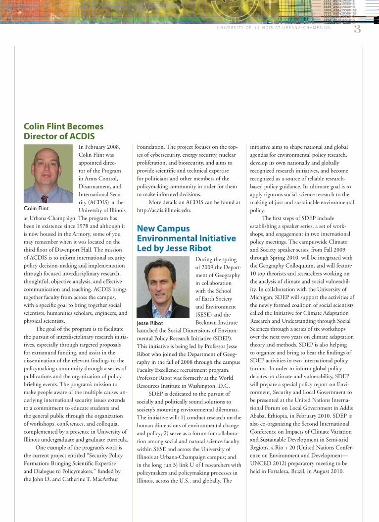
In February 2008, Colin Flint was appointed direc-tor of the Program in Arms Control, Disarmament, and International Secu-rity (ACDIS) at the University of Illinois
at Urbana-Champaign. The program has been in existence since 1978 and although it is now housed in the Armory, some of you may remember when it was located on the third floor of Davenport Hall. The mission of ACDIS is to inform international security policy decision-making and implementation through focused interdisciplinary research, thoughtful, objective analysis, and effective communication and teaching. ACDIS brings together faculty from across the campus, with a specific goal to bring together social scientists, humanities scholars, engineers, and physical scientists.
The goal of the program is to facilitate the pursuit of interdisciplinary research initia-tives, especially through targeted proposals for extramural funding, and assist in the dissemination of the relevant findings to the policymaking community through a series of publications and the organization of policy briefing events. The program’s mission to make people aware of the multiple causes un-derlying international security issues extends to a commitment to educate students and the general public through the organization of workshops, conferences, and colloquia, complemented by a presence in University of Illinois undergraduate and graduate curricula.
One example of the program’s work is the current project entitled “Security Policy Formation: Bringing Scientific Expertise and Dialogue to Policymakers,” funded by the John D. and Catherine T. MacArthur
Foundation. The project focuses on the top-ics of cybersecurity, energy security, nuclear proliferation, and biosecurity, and aims to provide scientific and technical expertise for politicians and other members of the policymaking community in order for them to make informed decisions.
More details on ACDIS can be found at http://acdis.illinois.edu.
New Campus Environmental Initiative Led by Jesse Ribot
During the spring of 2009 the Depart-ment of Geography in collaboration with the School of Earth Society and Environment (SESE) and theBeckman Institute
launched the Social Dimensions of Environ-mental Policy Research Initiative (SDEP). This initiative is being led by Professor Jesse Ribot who joined the Department of Geog-raphy in the fall of 2008 through the campus Faculty Excellence recruitment program. Professor Ribot was formerly at the World Resources Institute in Washington, D.C.
SDEP is dedicated to the pursuit of socially and politically sound solutions to society’s mounting environmental dilemmas. The initiative will: 1) conduct research on the human dimensions of environmental change and policy; 2) serve as a forum for collabora-tion among social and natural science faculty within SESE and across the University of Illinois at Urbana-Champaign campus; and in the long run 3) link U of I researchers with policymakers and policymaking processes in Illinois, across the U.S., and globally. The
U n i v e r s i t y o f i l l i n o i s a t U r b a n a - C h a m p a i g n 3
initiative aims to shape national and global agendas for environmental policy research, develop its own nationally and globally recognized research initiatives, and become recognized as a source of reliable research-based policy guidance. Its ultimate goal is to apply rigorous social-science research to the making of just and sustainable environmental policy.
The first steps of SDEP include establishing a speaker series, a set of work-shops, and engagement in two international policy meetings. The campuswide Climate and Society speaker series, from Fall 2009 through Spring 2010, will be integrated with the Geography Colloquium, and will feature 10 top theorists and researchers working on the analysis of climate and social vulnerabil-ity. In collaboration with the University of Michigan, SDEP will support the activities of the newly formed coalition of social scientists called the Initiative for Climate Adaptation Research and Understanding through Social Sciences through a series of six workshops over the next two years on climate adaptation theory and methods. SDEP is also helping to organize and bring to bear the findings of SDEP activities in two international policy forums. In order to inform global policy debates on climate and vulnerability, SDEP will prepare a special policy report on Envi-ronment, Security and Local Government to be presented at the United Nations Interna-tional Forum on Local Government in Addis Ababa, Ethiopia, in February 2010. SDEP is also co-organizing the Second International Conference on Impacts of Climate Variation and Sustainable Development in Semi-arid Regions, a Rio + 20 (United Nations Confer-ence on Environment and Development—UNCED 2012) preparatory meeting to be held in Fortaleza, Brazil, in August 2010.
Colin Flint Becomes Director of ACDIS
Colin Flint
Jesse Ribot

4 D e p a r t m e n t o f G e o G r a p h y
Congratulations to Professor Ezekiel KalipeniCongratulations are in order for Professor Ezekiel Kalipeni for two reasons. First, Dr. Kalipeni earned a well-de-served promotion to full professor this year. Second, he has accepted an offer to serve as a program officer for the Geography and Spatial Sciences Program at the National Science Foundation. He has agreed to serve for two years, during which time he will retain his appointment in the Department of Geography. The position at NSF will provide Professor Kalipeni with a remarkable opportunity to learn the inner-workings of proposal processing and the awarding of grants at the primary U.S. funding agency for scientific research. He also will play an important role in supporting the best research in geography, helping to shape the research agenda for the discipline.
Ezekiel Kalipeni
Welcome to Susan Etter, Our New Office Support SpecialistI started in the De-partment of Geogra-phy during holiday
break in December 2008. This was a quiet time to look through and absorb the large amount of information produced by the department. When the students returned, though, the pace really picked up. It’s great to be working with the students; many are the same age as my three boys. Our family has moved from New Hampshire to Florida, and eventually to Illinois with SuperValu, a company my husband, Wayne, works with. I am originally from New England and really miss the mountains; even the weather! I take every opportunity to go back and visit our family cottage on Seabrook Beach in New Hampshire.
I started with the University as Extra Help five years ago. After a few years of learn-ing a new job every six weeks to six months, it was time for me to become a permanent employee. I joined Conferences & Institutes as assistant to the head and thoroughly enjoyed the planning of conferences and travel associated with that position. I became a travel buff after working at Busey Travel for a few years and enjoy hearing about the interesting places that faculty and students visit to do their research.
Two Geography Undergraduates Earn Places on Bronze TabletIt’s not every year that a geography major makes the Univer-sity’s Bronze Tablet, so the fact that two geography graduates were named to the University’s highest undergraduate aca-demic award in 2009 is noteworthy. As a part of the May 2009 commencement activities, both Alexander Joseph Beata and Frances Sears Levy were announced as qualifying for the Bronze Tablet.
Mr. Beata from Palatine, Ill., and a graduate of William Fremd High School, entered the University of Illinois in the Fall 2006. He graduated in May 2009 with ma-jors in both economics and geography. In addition to the Bronze Tablet honor, Mr. Beata graduated a Chancellor’s Scholar, a James Scholar, Phi Beta Kappa, Summa Cum Laude and with Highest Distinction in the Department of Geography. Mr. Beata also is the 2009 recipient of the Jerome D. Fellmann Prize for an outstanding senior thesis in geography. He will attend graduate school at UCLA beginning in the Fall.
Ms. Levy from Highland Park, Ill., and a graduate of High-land Park High School, entered the University of Illinois in the Fall 2005. She graduated in May 2009 with a major in geogra-phy and a minor from the Environmental Fellows Program. Ms. Levy also graduates as a James Scholar, Phi Beta Kappa, Summa Cum Laude and with Highest Distinction in the Department of Geography. Ms. Levy was awarded the 2009 John Thompson Prize for outstanding achievement in Geography. She will attend graduate school at Harvard University beginning in the fall.
To be eligible for the Bronze Tablet, students must graduate in the top three percent of their class by college on the Urbana-Champaign campus. While the Bronze Tablet requirements specify a minimum GPA of at least 3.5 out of 4.0, typi-cally students in the College of Liberal Arts and Sciences must have GPAs exceeding 3.97 to qualify for the Bronze Tablet. Congratulations and best of luck to both Alex and Fran!
Alexander Beata
Frances Levy
Susan Etter

Ashwini Chhatre Publishes Work on Forest Conservation in ‘Science’ and ‘PNAS’
More than half a billion people in developing countries depend on forests for some part of their livelihoods. Recently, Professor Ashwini Chhatre co-authored an article in the prestigious journal Science to highlight the trends of changing governance in the world’s forests. He worked with a team of researchers to analyze the con-tributions of forest commons to rural livelihoods, carbon seques-tration, and biodiversity conservation. The main findings of this
research are that an exclusive focus on any one benefit (such as carbon storage) from forest commons is likely to be misleading, since the benefits are produced jointly and trade-offs may take place on more than two dimensions. The team also found that high levels of local enforcement are associated with improvements in the quality of forests, especially where local communities are empowered to enforce rules. This finding from analysis of 152 forests in 11 countries across Asia, Africa, and Latin America was published last year in the Proceed-ings of the National Academy of Sciences (PNAS).
Ongoing analysis has also revealed another important service provided by forest com-mons in human-dominated landscapes. So far, scientists and policymakers have only seen forest commons as providers of livelihoods, as spaces where human pressure from more “pristine” areas can be deflected. However, forest commons provide more than livelihoods; they are also repositories of biodiversity, and serve to keep larger and more valuable forest patches in the landscape connected to each other. Now, with climate change imminent, spe-cies and ecosystems are likely to migrate. Without the connectivity between forest patches in the landscape provided by forest commons, such migration will be very difficult for many forest-dwelling species.
The results of this research program, besides being published in respected journals like Science and PNAS, are also being presented at high-profile conferences. In February 2009, Professor Chhatre organized a symposium on the governance of human-dominated landscapes under a changing climate at the annual conference of the American Associa-tion for the Advancement of Science in Chicago as part of a day-long seminar on assess-ing and responding to climate change. The symposium, titled “Equity, Sustainability, and Governance of Mixed-Use Landscapes,” brought together leaders in the emerging field of sustainability science to report on the frontiers of thinking about governance regimes for complex adaptive social-ecological systems. Moving beyond the role of institutions in deal-ing with trade-offs among income generation, biodiversity conservation, ecosystem services provision, greenhouse gas emissions, and carbon sequestration—the participants in the symposium discussed the challenge of devising complex multi-level governance systems for human-dominated landscapes with multiple users, diverse uses, and an array of benefits to humanity ranging from the local to the global. Professor Chhatre also organized a sympo-sium on forest commons, biodiversity conservation, and climate change at the July 2009 conference of the Society for Conservation Biology, where he emphasized to biologists the need to integrate the study of social and natural processes to conserve forest resources.
F a c u l t y P r o F i l e
U n i v e r s i t y o f i l l i n o i s a t U r b a n a - C h a m p a i g n 5
Confluence of Wabash and Ohio rivers showing Mackey Bend and the cutoff channel.
der cutoffs by Bruce. In November 2008, Bruce and Jim received word from NSF that their proposal had been successful and would be funded for two years. They aim to document changes in the cutoff channel as it captures more and more flow from the Wabash River, and examine in detail how the channel around the me-ander loop becomes abandoned through infilling by sediment at the upstream and downstream ends of the cutoff. The proj-ect is a collaborative effort with the U.S. Geological Survey Water Science Center, located on the campus of the University of Illinois, and involves the participa-tion of Kevin Johnson, who is a USGS employee and also a master’s student in geography working with Bruce. During the winter and spring of 2009, measure-ments of flow and channel dimensions were obtained during three sampling campaigns. First results show that the cutoff channel is changing dramatically as flow within it is easily eroding the banks. The team is documenting how the cutoff evolves and the fluid dynamics of how this is happening. Bruce, Jim, Kevin, and Frank are really excited to collect ad-ditional field data in the summer of 2009, and then over the following 18 months as they get an up-close view of a cutoff in progress. They hope this study will produce the most detailed analysis ever of how meander cut-offs take place and will lead to a better understanding of one of the most recognizable features of the river landscape.
“Illinois Geographers” continued from page 1
Ashwini Chhatre

Since arriving at Illinois in the fall of 2007, I’ve attended both the Writing Across the Curriculum workshop and the Reflective Teaching Seminar sponsored by the College’s Teaching Academy. I decided to implement some of the techniques I’ve learned in a course that was new to me but not new to the depart-ment: Geography 204: “Cities of the World.” Some of these techniques were small, like playing music from around the world in the few minutes before class starts when students are coming in and getting settled, while others were much bigger, including an experimen-tal assignment that will now become part of the course.
In addition to other assignments and exams, the 33 students in the course, mostly sophomores and juniors from a wide range of majors, were instructed to choose a city of
their choice from a country other than their own. They then wrote a profile of that city, including its physical, social, and economic geography. But the twist on the assignment was to require students to produce some kind
of visual representation of their city, in keep-ing with one or more of the themes they had identified in their profile. This could be an image of a famous site that symbolizes something important about the city (like a
Students Take Virtual Trips to Cities of the World By Julie Cidell, Assistant Professor
6 D e p a r t m e n t o f G e o G r a p h y
s t u d e N t l i F e
three-dimensional model of the Colosseum in Rome), representative images that tell a story about the place (such as photographs of hous-ing from different time periods in Moscow’s
history), or a more abstract representation of what that city is known for (like scrapbook pages showing the importance of religious festivals to Seville).
The assignment was kept wide open, with submissions allowed in digital as well as physical form. Suggestions included collage, drawings or paintings, textiles, computer animations, digital slideshows, or a series of maps. One of the purposes of this assign-ment was to allow students to do something a little more fun and creative than the standard term paper, but it was also meant to get them to identify the most important features of their city and distill that information into a concise, unconventional form with only a short written explanation.
On the next-to-last day of the semester, the class held a City Showcase where each student displayed their work. The photos show some of the results. For example, the representation of Stockholm was a collage of a ship and printed pages, representing the city’s
history as a center of shipbuilding and print-making. The materials for the collage were all recycled, furthering the theme of Stockholm as a sustainable city. Another example was the display of London architecture as baked goods: Georgian and Tudor styles were rep-resented by different cakes. (This was one of the most popular projects, since it was shared with the entire class!) Other works included photo essays of Cairo and San Juan; a sculp-ture of Brussels’ famous Mannequin Pis; a map and photos showing multiple places of worship across Istanbul; and a model of an Argentinean asado grill with scenes of Buenos Aires on the sides.
The experiment was definitely a suc-cess. End-of-semester evaluations indicated that this assignment was very popular with the class. When asked, “What was the one thing you would not change about this class?” the most common response was the visual representation assignment. Students put a lot of thought and creativity into their work but also did a good job of relating their work to the themes of the class. This will definitely be an important component of “Cities of the World” in the future!
London’s architecture is depicted in Georgian- and Tudor-style cakes.
Students check out each other’s presentations in the City Showcase.
Recycled materials were used in this collage to reflect Stockholm as a sustainable city.
g r a d u a t e s t u d e N t P r o F i l e
U n i v e r s i t y o f i l l i n o i s a t U r b a n a - C h a m p a i g n 7
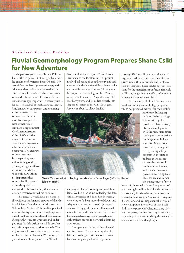
For the past five years, I have been a PhD stu-dent in the Department of Geography, under the guidance of Professor Bruce Rhoads. My area of focus is fluvial geomorphology, with a doctoral dissertation that has studied the effects of small run-of-river dams on channel form and sedimentation. This topic has be-come increasingly important in recent years as the pace of removal of small dams accelerates. Simultaneously, our present understanding of the response of rivers to these dams is rather poor. For example, do these structures ac-cumulate a large amount of sediment upstream of them? What is the potential for upstream erosion and downstream sedimentation if a dam is removed? The answers to these questions lie in expanding our understanding of the geomorphological effects of run-of-river dams. Philosophically, I think it is important that sound scientific research is directly applied to real-world problems, and my doctoral dis-sertation research allowed me to do so.
This research would have been impos-sible without the financial support of the Na-tional Science Foundation and the American Philosophical Society. This funding provided resources for equipment and travel expenses, and allowed me to enlist the aid of a number of geography students (graduate and under-graduate) for field assistance, while broaden-ing their perspectives on river research. The project was field-based, with four dam sites in Illinois—two in Danville (Vermilion River system), one in Effingham (Little Wabash
River), and one in Freeport (Yellow Creek, a tributary to the Pecatonica). The project involved collecting river bathymetry and sedi-ment data in the vicinity of these dams, utiliz-ing state-of-the-art equipment. Throughout the project, we used a high-tech GPS total station; a fathometer/GPS combo which fed river bathymetry and GPS data directly into a laptop (courtesy of the U.S. Geological Survey) in a boat to allow detailed
mapping of channel form upstream of these dams. We had a lot of fun collecting the data, with many stories of field follies, including one episode of a boat motor breakdown, and a day when our truck got stuck (an experi-ence one of my grad student colleagues will remember forever). I also assisted two fellow doctoral students with their research, and both projects proved to be valuable learning experiences.
I am presently in the writing phase of my dissertation. The overall story that the data are revealing is that these run-of-river dams do not greatly affect river geomor-
phology. We found little to no evidence of large-scale sedimentation upstream of these structures, with minimal bed and bank ero-sion downstream. These results have implica-tions for the management of future removals in Illinois, suggesting that effects of removals in many cases may be nominal.
The University of Illinois is home to an excellent fluvial geomorphology program, which has prepared me well for my new life
adventure. In keeping with my desire to bridge science with applied problems, I have recently obtained employment with the New Hampshire Geological Survey as their fluvial geomorphology specialist. My position involves expanding the river geomorphology program in the state to address an increasing pace of dam removals, fluvial erosion hazards, and stream restoration projects now facing New Hampshire, and to root the management of these
issues within sound science. Every aspect of my training from Illinois is already proving to be extremely beneficial in my new position. Presently, I am living in Concord, writing my dissertation, and learning about the rivers of New Hampshire. Despite all of this, I still find time to pursue hobbies, including visit-ing state parks, reading from my continually expanding library, and studying the history of our nation’s roads and highways.
Fluvial Geomorphology Program Prepares Shane Csiki for New Adventure
Shane Csiki (middle) collecting dam data with Frank Engel (left) and Kevin Johnson (right).

8 D e p a r t m e n t o f G e o G r a p h y
Shaowen Wang, an assistant professor of ge-ography and affiliated senior research scientist of the National Center for Supercomputing Applications has been awarded a National Science Foundation CAREER Award. He will study spatially oriented theories and methods for enabling computationally intensive spatial analysis and modeling to establish next-generation Geographic Information Systems (GIS). The award, totaling $470,000, funds the project: “CAREER: Formalizing and Resolving Computational Intensity of Spatial Analysis to Establish a Cyber-GIS Framework.” Shaowen’s CAREER project is motivated by enormous needs to resolve computa-tional challenges in cutting-edge geographic discovery. The project is designed to drastically transform GIS technologies and applica-tions based on cyberinfrastructure (arguably the most sophisticated modern infrastructure that human beings have ever planned or cre-ated) to support transparent access to massive geographically distributed computational resources and services.
“GIS has been around for several decades, gaining tremendous popularity and usage driven by diverse needs related to geography and enabled by personal comput-ers and Internet technologies,” said Shaowen. “However, existing GIS solutions are ill-suited to massive geographic data handling and collaborative geospatial problem-solving and decision making that become increasingly indispensible in modern geographic discovery. Meanwhile, emerging cyberinfrastructure is being developed to revolutionize science and engineering practices by meeting computa-tional needs in an infrastructure fashion and facilitating collaborative scientific problem solving. Therefore, given the mounting computational challenges from geographic
SESE Research Review Honors Graduate Students
On February 27, 2009, the Department of Geography, along with the Departments of Geology and Atmospheric Sciences, partici-pated in the School of Earth, Society and Environments (SESE) 2nd Annual Research Review. The review provides a forum for graduate students to present posters on their research, for faculty to learn what graduate students in the geography and SESE are up to, and for faculty and graduate students across SESE to interact socially. This year the event was held in the beautiful Alice Camp-bell Alumni Center. Several awards were presented for best posters with cash prizes going to three geography graduate students, Steve Radil, Frank Engel, and Poonam Jusrut. In addition, this year marked the first one in which applicants to graduate programs in all three departments were invited to attend the research review. The review proved to be a valuable recruiting event as all three departments were successful in attracting top applicants to their programs for Fall 2009.
applications and the active evolution of cyber-infrastructure, I believe that the benefits, for geography and related disciplines as well as our entire society, are tremendous to develop cyberinfrastructure-based GIS technolo-gies and applications, collectively termed as Cyber-GIS in my project. Cyber-GIS aims to synthesize GIS, spatial analysis and modeling, and cyberinfrastructure and, thus, promises to lead to innovative spatial data infrastructure
for wide scientific break-throughs and broad societal impacts. “
Shaowen joined the De-partment of Geography in the fall of 2007. His teaching and research interests are in the general areas of computational geography, cyberinfrastruc-ture, geographic informa-tion science, and geographic problem-solving. He is trained
as both a geographer and computer scientist, and has established comprehensive track re-cords ranging from cyberinfrastructure, GIS, spatial analysis and modeling, to computa-tionally intensive geographic problem-solving, which allows him to tackle the breadth and depth of the CAREER project. Shaowen received his BS in computer engineering from Tianjin University, China, in 1995; MS in geography from Peking University, China, in 1998; MS in computer science and PhD in geography from the University of Iowa in 2002 and 2004 respectively.
The Faculty Early Career Develop-ment (CAREER) Program offers the Na-tional Science Foundation’s most prestigious awards in support of the early career-development activities of teacher-scholars who most effectively integrate research and education within the context of the mis-sions of their organizations. The award de-scription states the activities should build a firm foundation for a lifetime of integrated contributions to research and education.
Shaowen Wang Receives Prestigious NSF Award
Shaowen Wang
Poonam Jusrut with her winning poster.
Geography students are recognized at the annual SESE Research Review.

a l u M N i P r o F i l e
U n i v e r s i t y o f i l l i n o i s a t U r b a n a - C h a m p a i g n 9
Celebratory Event for Professor Geoffrey Hewings in November 2009Professor Geoffrey Hewings has been a faculty member at the Department of Geography at the University of Illinois since 1974. His undergraduate and graduate courses in “Busi-ness Location Theory” and “Regional Science Methods” have always been popular choices with students. Professor Hewings has been actively involved in the Regional Science Association International throughout his career and many students have been introduced to this field of inquiry through Profes-sor Hewings’ classes, lectures, and research activities.
Professor Hewings established the Regional Economics Applica-tions Laboratory (REAL) in 1989, with his close associate and friend Philip Israilevich from the Federal Reserve Bank of Chicago. REAL has served as a center for training and research for students at the University and has gained an international reputation for rigorous, timely, and insightful research on issues related to the functioning and performance of regional economies in the U.S. and in many countries in Asia, Europe, and Latin America.
To celebrate the contribution of Professor Hewings to graduate education and research at the University of Illinois, and to the wider regional science community, a celebratory two-day event is being organized in Urbana on November 16 and 17, 2009. All U of I ge-ography alumni and friends are very welcome to attend and participate. The celebrations will be organized around a two-day research symposium, where past and current students, visiting academics, and friends of Profes-
sor Hewings will come together to discuss and debate practical and technical issues related to regional economies. A special session examin-ing the performance and prospects for the Illinois economy will be scheduled during the symposium.
If you are interested in attend-ing and participating, more details
may be found at the REAL Celebration pages on Google Groups (http://groups.google.com/group/real-celebration). Please contact Aisling Reynolds-Feighan by email ([email protected]) for more information.
Geoffrey Hewings
Geospatial Information Scientist Sam Batzli Since Sam Batzli (PhD, 1997) graduated from the University of Illinois, he has embarked on a career path that fits the Monty Python introduction: “and now for something completely different.” Sam’s PhD was a study in historical and cultural geography, focusing on how early 20th century stereographs, or 3D photographs of places, communicated an idealized national identity through the depiction of the geography of the United States. Some of us still remem-ber donning 3D glasses when Sam presented his PhD proposal to see examples of stereographs he projected onto a screen using dual slide projectors!
After graduating from Illinois, Sam’s interests shifted more toward the world of GIS, and he worked as a project manager at Michigan State University and a software developer for Geoanalytics, Inc. Today, Sam is a geospatial information scientist in Environmental Remote Sensing at the Space Science & Engineering Center, University of Wisconsin–Madison, where he develops access to GIS and remote sens-ing information through Internet mapping. He is also the director of WisconsinView, a federally funded program that offers a free Web service for easy access to a variety of statewide images and data, including satellite imagery and aerial photography. Led by UW–Madi-son, WisconsinView is part of a nationwide effort called AmericaView. In addition to his role as the director of WisconsinView, Batzli also serves on the AmericaView Board of Directors. When asked about his experience at the University of Illinois, Sam had this to say:
“My experience in the geography doctoral program provided me with a solid academic foundation and an analytical skill-set that I call upon nearly every day in my work. My career focus has shifted from the humanistic side of geography that I pursued in my disserta-tion to the more technical world of GIS and remote sensing that I discovered near the end of my studies at Illinois. However, the intel-lectual rigor of the curriculum, the high quality of my fellow graduate students, and the high standard of excellence demanded by the faculty gave me universal skills in framing an academic argument and communicating research results. When I attend national confer-ences and tell my colleagues where I did my doctoral work, the usual response is, ‘Illinois? Good school!’”
Sam Batzli
Visiting Assistant Professor Helps with Instruction in GIScienceJie Tian is a visiting assistant profes-sor who is helping to teach courses in GIS and remote sensing this year. Jie was born and grew up in Inner Mongolia, China. He received his undergraduate training in Earth Science at Pe-king University, China (1997-2001). His gradu-ate degrees were acquired at the University of Western Ontario (M.Sc., 2004), London, Ontario and Queen’s University (PhD, 2009), Kings-ton, Ontario. His general research interests include methodological and applied aspects of geospatial science. On the methodological front, his research primarily focuses on remote sensing, spatial analysis, and geocomputa-tion. On the applied front, he is interested in application of geospatial approaches in environmental modeling, landscape ecology, climate change, and public health. His teach-ing interests cover GIS, Remote Sensing and Spatial Analysis. In his spare time, Jie plays soc-cer and tennis. He also loves swimming, read-ing, and Chinese painting. Now that he has experienced a late summer in Illinois, cooking sweetcorn in a number of different ways may become another one of his hobbies!
Jie Tian

10 D e p a r t m e n t o f G e o G r a p h y
Kory KonsoerKory was born in Grand Rapids, Mich., and attended Grand Valley State University where he received a BS in geology. While there, he became
interested in geomorphology, specifically fluvial geomorphology. Kory headed to West Virginia University and studied slope movements and their interrelationships with streams. He was attracted to Illinois by the integrated rivers and watersheds group here on campus. Being able to have access to a wide variety of resources, people and departments, and research was an important factor in his decision to pursue a PhD in the Department of Geography. While here, he plans to study hyporheic zone exchange and how varying flow paths affect sediment transport and bedforms.
Heejun KimHeejun is a new master’s degree student in the department. He is interested in GIS-based Information Integration Systems. In December 2007,
a tanker leaked an estimated 10,500 tons of crude oil on the western shores of South Korea. Heejun participated as a volunteer in the cleanup of the blackened coasts and through that experience developed an inter-est in the use of GIS systems and satellite imagery for disaster management and data integration. Heejun wants to explore the power of geographically integrated database systems for rapidly managing large data-bases—the reason why he decided to study at the University of Illinois for his master’s degree.
MEET OUR NEW GRADUATE STUDENTS
The Roepke Scholarships continue to provide a wonderful opportunity for under-graduates to collaborate on research projects with faculty members. Michael Adduci received a Roepke Scholarship to team up with Professor Colin Flint on a project that led to the publication of an article entitled “Mapping the Dynamism of the United States’ Geopolitical Code: The Geography of the State of the Union Speeches, 1988-2008” in the journal Geopolitics. Michael was recruited by Professor Flint after taking his course, “Geography of International Conflicts.” Michael helped to analyze the content of annual State of the Union speeches to identify which parts of the world were given the most attention across different administrations. He examined each speech and counted the number of times a particular country was mentioned, as well as the proportions of the speeches dedicated to discussing allies or enemies. He then used the GIS skills he had acquired as part of his geography degree program to map the results. An example of the results is a map of the geographic focus of President George W. Bush’s speeches from 2001-2008. Unsurprisingly, the research shows an increasing focus on the Middle East. A dramatic increase in attention was also placed on South and East Asia, but Africa was consistently ignored.
u N d e r g r a d u a t e s t u d e N t P r o F i l e
Michael Adduci Helps with Project Analyzing State of the Union Addresses

U n i v e r s i t y o f i l l i n o i s a t U r b a n a - C h a m p a i g n 11
Jessica ZingerJessica is a first-year master’s student who came to the U of I to study river dynamics and mor-phology. She de-veloped an interest in fluvial processes
while participating in an undergraduate field camp. As she learned more about the subject, she found it was the perfect blend of what she was studying at UM: physics and geology. She’s looking forward to her time in the geography department because it will give her a chance to learn more about human interactions with the environment as well. Outside of academics, her main interests are playing soccer and volleyball, cooking, and being outside.
Bart RossmannBart is a new master’s student interested in model-ing the shaping of geographical features by climate, the evolution of species within the
resulting biomes and the dynamic interplay between species, geography, and climate in biomes over time. Bart’s ultimate goal is to understand the role of human impact on the response time of species in these biomes. He plans to examine these issues within a geographical modeling context.
Katie Coulter Katie is a new master’s student in-terested in political ecology and vulner-ability to the effects of climate change in West Africa. She became interested
in environmental change and sustainability during her undergraduate studies when she spent four months in a study abroad pro-gram in Mali. She intends to return there to conduct research on how climate events are impacting rural livelihoods.
Reshmi Mandal KonarReshmi is a first-year PhD student who completed her undergraduate study in geogra-phy at Presidency College, India and
her master’s degree at the University at Buffalo, SUNY. Her research interest is in geographic information systems, spatial analysis and health geography. She is working under the supervision of Professor Sara McLafferty. She was attracted to the department based on its reputation as a center of excellence in graduate education and research, vibrant student community, and her keen interest to work with Profes-sor McLafferty.
Robert CochranRobert is a first-year PhD student who received an MA in geography from Georgia State University. His research interests
include critical race theory, the racialization and criminalization of public discourse, and the dynamics of power in negotiating place identity. Robert hopes to combine his interests in race and criminality with studies of masculinity and the body in or-der to explore the construction of identity in society.
Greg BurtonGreg, a first-year master’s student, comes to Cham-paign-Urbana by way of Chicago, San Francisco, and San Jose, which is
where he was born and raised. Like oth-ers in his family, he has a background in computer and electrical engineering, with a BS in computer engineering and six years working in technology companies. He has traveled widely throughout the U.S., Japan, Hong Kong, and Europe to present his work in conferences of field engineers. After focusing very narrowly on cutting-edge engineering projects for many years, he came to geography to apply his skills to GIS, to gain a broader perspective on the world, and to connect his technical inter-ests to human lives and environments.
Yanli Zhao Yanli is a first-year PhD student who received her ME degree from the University of Electronic Science and Technology of China in 2009. Her
general interest of study is in geographic information science.
MEET OUR NEW GRADUATE STUDENTS
Nonprofit Org.U.S. PostagePAIDPermit #75Champaign, IL
Department of GeographyUniversity of illinois at Urbana-Champaign220 Davenport hall607 s. mathews ave.Urbana, il 61801
Show your support for the Department of Geography at the University of Illinos by contributing to the Department of Geography Annual Fund. www.las.illinois.edu/giving
In December 2008, Diane Lane, a mainstay in the department office since 2000, decided to retire. Just one month before her retire-ment, Diane was honored for 25 years of ser-vice to the University. During her time with geography, Diane assisted many students, faculty, and visitors with appointments, visas, payroll issues, and a host of other concerns. Her contributions to the department are greatly appreciated and we all wish her well in her retirement. Diane plans to stay young at heart by spending lots of quality time with her grandchildren.
D I A N E L A N E R E t I R E s
Diane Lane
Let Us Know What You Are DoingEmail your information to [email protected] or mail this form to the Department of Geography.
name
address
City state Zip
please indicate all U of i degrees:
ba year major
ma year major
phD year major
Current position and employer (if retired, list position prior to retirement):
personal and professional news: