Department of Fisheries and Oceans Canada: An Update … · Department of Fisheries and Oceans...
18
Department of Fisheries and Oceans Canada: An Update on Research and Monitoring Activities Moors-Murphy, H.B. 1 1 Fisheries and Oceans Canada, Bedford Institute of Oceanography, 1 Challenger Drive, Dartmouth, N.S., B2Y 4A2 [email protected] Fisheries and Oceans Canada leads and collaborates on many research and monitoring projects relevant to cetaceans in the Northwest Atlantic, including activities focused on increasing our understanding of North Atlantic right whale distribution, movement patterns and habitat use in eastern Canadian waters. This presentation will provide an overview of recent science activities that have been or are being conducted that will contribute to our knowledge of right whale occurrence in Canadian waters. These activities include visual survey and surveillance efforts, passive acoustic monitoring projects, habitat suitability modelling, prey studies and other work.
Transcript of Department of Fisheries and Oceans Canada: An Update … · Department of Fisheries and Oceans...

Department of Fisheries and Oceans Canada: An Update on Research and Monitoring Activities Moors-Murphy, H.B.1
1 Fisheries and Oceans Canada, Bedford Institute of Oceanography, 1 Challenger Drive, Dartmouth, N.S., B2Y
4A2 [email protected] Fisheries and Oceans Canada leads and collaborates on many research and monitoring projects relevant to cetaceans in the Northwest Atlantic, including activities focused on increasing our understanding of North Atlantic right whale distribution, movement patterns and habitat use in eastern Canadian waters. This presentation will provide an overview of recent science activities that have been or are being conducted that will contribute to our knowledge of right whale occurrence in Canadian waters. These activities include visual survey and surveillance efforts, passive acoustic monitoring projects, habitat suitability modelling, prey studies and other work.

Department of Fisheries and Oceans Canada:
An Update on Research and Monitoring Activities
Annual NARWC Meeting October 22nd 2017
Dr. Hilary Moors-Murphy Research Scientist
Fisheries and Oceans Maritimes Region
Photo: H. Moors-Murphy, Canadian Whale Institute and New England Aquarium

Acknowledgements • Thank you to the following
groups/organizations who contributed to the work described in these slides: – NOAA’s Northeast Fisheries Science
Center
– Canadian Whale Institute
– New England Aquarium
– Mingan Island Cetacean Study
– JASCO Applied Sciences
– Taggart Lab, Dalhousie University
– Transport Canada
– DFO Maritimes, Gulf, Quebec and Newfoundland Regions
(and any others involved with this work!)

Coordination of Fieldwork H. Moors-Murphy (DFO) and various collaborators
• Informal North Atlantic right whale research working group (established by DFO) helps coordinate Canadian field efforts – Includes researchers, regulators, response networks, others
– Meet in spring and fall
– Summary of planned field efforts compiled and distributed in spring
– Email distribution list for sending daily summaries (if there are new reports) of right whale sightings and real-time acoustic detections throughout the summer and early fall to those interested
– Live, free-swimming right whale sightings reported to: [email protected] or 1-844-800-8568
• Allowed weekly updates to sightings maps throughout 2017
• Will continue this effort in 2018

Summary of Visual Monitoring Efforts 2017 DFO, NOAA, Transport Canada, Canadian Whale Institute, New
England Aquarium, Mingan Island Cetacean Study, and others
Figure courtesy of Phil Greyson, DFO

Aerial Surveillance Efforts 2017 DFO, NOAA, Transport Canada
• NOAA Twin Otter: extensive dedicated effort June-July
• TC-EC MART Dash 8: effort in July (not shown here), extensive dedicated effort Aug-present
• DFO Twin Otter: dedicated effort Sept-present
• DFO C&P PAL plane: dedicated effort throughout June-present (not shown in this map)
Figure courtesy of Angelia Vanderlaan, DFO
Aerial Survey efforts June-Sept

Visual Monitoring Plans 2018 DFO, Transport Canada, and others
• Will continue to advertise sightings email and phone number, and collect opportunistic free-swimming right whale sightings data from various sources
• Currently developing visual monitoring plans, including monitoring from aerial platforms, for 2018
Photos: NOAA, CCG, DFO

Real-Time Passive Acoustic Monitoring 2017-2018 Taggart Lab (Dalhousie University) with various partners
• Conducted through Whales
Habitat and Listening
Experiment led by the Taggart
Lab, presented earlier:
“Current Efforts to Mitigate
Ship Strikes Using Real‐Time
Acoustic Monitoring of Right
Whales from Autonomous
Platforms” - Kim Davies and
Mark Baumgartner
• DFO will continue to collaborate
on this project in 2018
Figure courtesy of Phil Greyson, DFO

Bottom-Moored Passive Acoustic Monitoring 2015-2017 – AMARs
H. Moors-Murphy (DFO), JASCO, Taggart Lab (Dalhousie University)
DFO AMAR
JASCO AMAR
Dalhousie AMAR
• Two years of near-continuous recordings (summer/fall 2015-summer/fall 2017)
• Duty cycle: 11 min 20 s @ 8 kHz every 20 min
• Analysis is underway using Davis’s et al. 2017 methods
Figure curtesy of Pam Emery, DFO

Bottom-Moored Passive Acoustic Monitoring 2018 – AMARs
H. Moors-Murphy (DFO)
• New DFO deployment locations
include Grand Manan Basin,
Roseway Basin, and the Gulf of St.
Lawrence (locations shown are
tentative, not finalized)
• Two-year datasets; similar sampling
rates and schedules to previous
deployments
• All data collected will be examined
for right whale call presence
• Part of larger Oceans Protection
Program Figure curtesy of Pam Emery, DFO
Beaked whale and MPA monitoring
Right whale monitoring

• AURAL recorders
• 14 sites with varying temporal coverage between 2009-present
• Sampling rate of 32,768 Hz
• Duty cycle of 32 min/hour
• Only two confirmed recordings with right whale calls (on the NL south coast) on 2009-2014 datasets
• Analysis of 2015-2017 datasets is ongoing
Figure from Jack Lawson
Bottom-Moored PAM –
Newfoundland & Labrador AURALs Jack Lawson (DFO)

Bottom-Moored PAM- SLE/GoSL AURALs Yvan Simard (DFO)
• AURAL recorders
• Six sites
• Varying temporal
coverage between
2011-present
• Sampling rates
between 8,192-
32,768 Hz
• Duty cycle of 15
or 30 min/hour
Figures from Yvan Simard
E LE
Ca OH
CE
BI
S

• Analysis for right whale calls is underway and ongoing
• Detectors (recall rate ~75%) have been run through the data and all detections are manually validated
• Right whale calls only detected on the Gaspe (CE), Shediac (S) and Old Harry (OH) stations
• No right whale calls detected on the Cabot Strait station
• Calls occur in late summer up to late fall (end of Dec)
• Number of confirmed detections in 2015 and 2016 has increased substantially
• Deployments will continue in 2018
Bottom-Moored PAM- SLE/GoSL AURALs Yvan Simard (DFO)

Habitat Suitability Modelling Angelia Vanderlaan , H. Moors-Murphy (DFO)
• Habitat suitability modelling underway to identify areas of predicted suitable habitat where future monitoring and research efforts could be focused
• MaxEnt approach
– Uses non-effort based data
– Initial focus on blue whales and northern bottlenose whales (Gomez et al. 2017)
– Effort expanded to 15 species of cetaceans including North Atlantic right whales
Reference: Gomez, C. Lawson, J., Kouwenberg, A.-L., Moors-Murphy, H.B., Buren, A., Fuentes-Yaco, C., Marotte, E., Wiersma, Y.F. & Wimmer, T. 2017. Predicted distribution of whales at risk: identifying priority areas to enhance cetacean monitoring in the Northwest Atlantic Ocean. Endangered Species Research.
Funding from SPERA DFO Maritimes

Habitat Suitability Modelling Angelia Vanderlaan ,H. Moors-Murphy (DFO)
• Priority areas for right whale research/monitoring
Fall
(Sept-Nov)
Summer
(June-Aug) DRAFT
DRAFT
Habitat
suitability Index
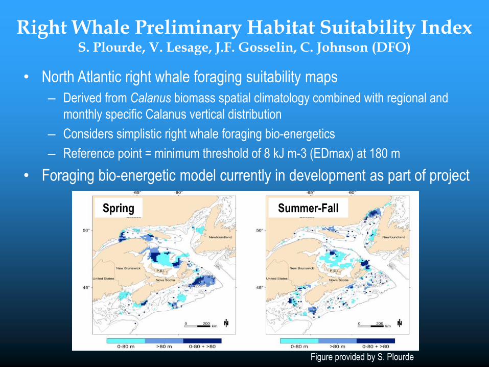
Right Whale Preliminary Habitat Suitability Index S. Plourde, V. Lesage, J.F. Gosselin, C. Johnson (DFO)
• North Atlantic right whale foraging suitability maps
– Derived from Calanus biomass spatial climatology combined with regional and
monthly specific Calanus vertical distribution
– Considers simplistic right whale foraging bio-energetics
– Reference point = minimum threshold of 8 kJ m-3 (EDmax) at 180 m
• Foraging bio-energetic model currently in development as part of project
Spring Summer-Fall
Figure provided by S. Plourde

Calanus Modelling Project C. Johnson, S. Plourde, D. Lavoie, F. Maps, W. Gentleman (DFO)
• Particle tracking model (nested in an ocean model) to predict persistent Calanus hotspots
– Incorporates transportation of particles via advection, dispersion via horizontal diffusivity, and a
random walk in the vertical towards a target depth
• Builds on ongoing work by incorporating state-of-the-art statistical predictions of Calanus
as initial conditions (e.g. Albouy-Boyer et al. 2016)
• Figures show preliminary results of late stage C. finmarchicus abundance in June 2008
– Highlight s role of ocean circulation in transporting Calanus onto the Magdalene shallows
• This is the first step towards developing a full 3-D population model for Calanus
Transformed
Abundance
ln(#/m2 + 1)
Diapause Active
Figure provided by S. Plourde

Summary
Photo: H. Moors-Murphy, Canadian Whale Institute and New England Aquarium
Planning for 2018 is underway in collaboration with many
organizations and we can expect enhanced right whale
focused research and monitoring activities in the future