Denali National Park and Preserve Final South Denali Implementation Plan And Environmental
348
Denali National Park and Preserve Final South Denali Implementation Plan And Environmental Impact Statement April 2006 Produced by Denali National Park and Preserve National Park Service U.S. Department of the Interior Denali Park, Alaska Denali National Park and Preserve Final South Denali Implementation Plan Environmental Impact Statement Lead Agency: National Park Service Abstract: This Final South Denali Implementation Plan and Environmental Impact Statement provides specific direction for expanded visitor facilities and recreational opportunities in the South Denali region until 2021. Proposed actions are guided by established laws and policies that affect the National Park Service, State of Alaska, and Matanuska-Susitna Borough. Alternatives focus on variations in location and extent of new visitor opportunities and facilities. Actions described by this plan should provide a quality visitor experience while protecting resource values in Denali State Park; enhance recreational and access opportunities throughout the South Denali region for the benefit of a wide variety of visitors including Alaskans, independent travelers, and package tour travelers; and preserve the quality of life for residents in nearby communities. Additional information may be obtained from the following addresses: www.southdenaliplanning.com South Denali Planning P.O. Box 588 Talkeetna, Alaska 99676
Transcript of Denali National Park and Preserve Final South Denali Implementation Plan And Environmental

Denali National Park and Preserve Final South Denali Implementation Plan And Environmental Impact Statement April 2006
Produced by Denali National Park and Preserve National Park Service
U.S. Department of the Interior Denali Park, Alaska
Denali National Park and Preserve Final South Denali Implementation Plan
Environmental Impact Statement
Lead Agency: National Park Service
Abstract: This Final South Denali Implementation Plan and Environmental Impact Statement provides specific direction for expanded visitor facilities and recreational opportunities in the South Denali region until 2021. Proposed actions are guided by established laws and policies that affect the National Park Service, State of Alaska, and Matanuska-Susitna Borough. Alternatives focus on variations in location and extent of new visitor opportunities and facilities. Actions described by this plan should provide a quality visitor experience while protecting resource values in Denali State Park; enhance recreational and access opportunities throughout the South Denali region for the benefit of a wide variety of visitors including Alaskans, independent travelers, and package tour travelers; and preserve the quality of life for residents in nearby communities.
Additional information may be obtained from the following addresses:
www.southdenaliplanning.com
South Denali Planning P.O. Box 588 Talkeetna, Alaska 99676

Final South Denali Implementation Plan and EIS
Summary of Changes between the Draft and Final Environmental Impact Statement
The agencies received 72 comments on the Draft South Denali Implementation Plan and EIS. Chapter 6 contains a characterization of comments received and the agency responses to those comments. This Final plan and EIS was revised from the Draft plan and EIS based on response to public comments and on internal discussions within the interagency planning team. Per the National Environmental Policy Act section 1503.4, regarding responses to comments, agencies preparing final EISs can respond to comments in a number of ways. These ways are listed below along with some of the major areas where comments resulted in changes to the Final EIS.
Modify alternatives including the preferred alternative
In response to public comment, the preferred alternative (Alternative C, Parks Highway) was modified to include additional land use controls along the Parks Highway and Petersville Road corridors, mitigation measures for alleviating conflicts between motorized and non-motorized use, and the addition of wildlife monitoring in Denali State Park. To reduce potential human-bear conflicts, the proposed trail near Hill 1007 was removed from the alternative and the proposed new access to the Chulitna River was moved downstream from the mouth of Troublesome Creek.
Supplement, improve, or modify EIS analyses
Each impact topic was reviewed and revised as necessary to ensure that each action being considered was evaluated adequately. Many sections were edited to improve clarity. The impacts analysis for soils, water quality, aquatic resources and fish, wetlands, vegetation, wildlife, socioeconomics, and visitor opportunity were revised to improve logic and clarity. Analyses were edited to better reflect impacts from cross-country ORV use, cumulative impacts from the Boy Scout camp south of Denali State Park, and indirect impacts from increasing the size or constructing new parking lots along the Parks Highway and Petersville Road.
Make factual corrections
Some public comments noted factual errors in the Draft plan and EIS. These were evaluated and, where necessary, the text was revised for accuracy.
Other changes between Draft and Final
Chapter Five: Consultation and Coordination was updated to include descriptions of the public meetings that occurred after the Draft plan was published and to include additional descriptions of the consultation process.
Chapter Six was added. It contains a record of public comment with accompanying agency response to substantive comments.

Executive Summary
EXECUTIVE SUMMARY
PURPOSE AND NEED
Why are the National Park Service, State of Alaska, and Matanuska-Susitna Borough developing this plan?
The purpose of the plan is to enhance recreation and access throughout the South Denali region. Actions described by this plan should
Provide a quality visitor experience while protecting resource values in the South Denali region.
Enhance recreational and access opportunities throughout the South Denali region for the benefit of a wide variety of visitors including Alaskans, independent travelers, and package tour travelers.
Preserve the quality of life for residents in nearby communities.
A South Denali Implementation Plan is needed because visitation in the South Denali region continues to increase, requiring additional visitor opportunities and new methods of management to protect natural and cultural resources and quality of life in local communities.
ALTERNATIVES
What Does This Plan Do?
The Draft plan and EIS includes a no-action alternative and two action alternatives. Under Alternative A, no new actions would be implemented to support the 1997 Record of Decision for the South Side Denali Development Concept Plan except for those projects already approved and initiated. This alternative represents no change from current management direction and therefore represents the existing condition in the South Denali region. However, it does not ensure a similar future condition which could be affected by factors unrelated to this planning effort.
Under Alternative B (Peters Hills Alternative) a new nature center would be constructed on approximately 2.5 acres in the Peters Hills inside the southern boundary of Denali State Park. The total building requirement would be approximately 7,500 square feet. A paved parking area would be constructed near the junction of Petersville Road and the proposed access road (MP 28 of Petersville Road) to accommodate private vehicles. An access road approximately 7 miles in length would be constructed from MP 28 of Petersville Road to the nature center. Upgrading and widening Petersville Road between MP 9.3 and 28 is a connected action that would be necessary to implement this

Final South Denali Implementation Plan and EIS
alternative. Approximately 31 miles of trails would be constructed in the vicinity of the new nature center.
Under Alternative C (Parks Highway, Preferred Alternative) a new visitor complex would be constructed on approximately 4.1 acres near Curry Ridge in Denali State Park. The total building requirement would be approximately 16,000 square feet. A paved parking area would be constructed on the natural bench across from the Denali View South Wayside near Parks Highway MP 134.6. An access road approximately 3.5 miles in length would be constructed from the parking area to the visitor center. Approximately 13 miles of trails would be constructed in the vicinity of the new visitor center.
ENVIRONMENTAL CONSEQUENCES
What are the consequences of each alternative to the resources in the South Denali region?
Alternative A (No Action) This alternative would generally not affect resources in the planning area.
Alternative B (Peters Hills) This alternative would have minor adverse impacts on water quality, aquatic resources, fish, and wildlife; and moderate adverse impacts on soils and cultural resources. This alternative would result in the clearing of 14 acres of wetlands and 117 acres of terrestrial vegetation.
Construction effects would be considered a major beneficial impact on industry, employment, and income. The construction impacts on planning area population and demographics would be minor. Housing impacts would likely be minor if on-site housing were provided. If on-site housing were limited, the impacts would be moderate to major. The operations impacts on housing and real estate would be minor. The construction impacts on borough and municipal revenues and expenditures would be minor because the construction would be of a short duration and largely untaxed. Alternative B would have a major impact on the planning area’s quality of life indicators, particularly in the Petersville area. A majority of the quality of life indicators could be affected by developments proposed in Alternative B; in fact, all indicators except self-sufficient lifestyle could be affected. Impacts on land ownership and use would be moderate because the land uses would shift, but the proposed changes would be consistent with existing plans or controlled by land use restrictions.
The actions proposed in this alternative would have a major positive impact on visitor opportunities for individuals who require assistance with access, facilities, and services, especially in the Peters Hills, along Petersville Road, and on the Chulitna River by increasing access, interpretation, visitor services, and trails. Actions in this alternative would improve access for some recreational activities, would enhance the experience for snowmachine users, and would retain current opportunities for primitive recreation near Curry Ridge. It would simultaneously create a major negative impact by degrading the

Executive Summary
quality of the experience for non-motorized winter recreation throughout the planning area and introducing adverse impacts to primitive, self-reliant recreational opportunities in the Peters Hills, along Petersville Road, and on the Chulitna River by providing opportunities for increases in types and levels of use which could create user conflicts. Visitor safety would be improved by education associated with interpretive panels, information kiosks, and agency staffing. Visitor safety would be adversely affected by conflicts between motorized and non-motorized users.
Alternative C (Parks Highway, Preferred Alternative) This alternative would have minor adverse impacts on water quality, aquatic resources, fish, and wildlife; and moderate adverse impacts on soils and cultural resources. This alternative would result in the clearing of 6 acres of wetlands and 143 acres of terrestrial vegetation.
Construction effects would be considered a major beneficial impact on industry, employment, and income. The construction impacts on planning area population and demographics would be minor. Housing impacts would likely be minor to moderate if on-site housing were provided. If on-site housing were limited, the impacts would be moderate to major. The operations impacts on housing and real estate would be minor. The construction impacts on borough and municipal revenues and expenditures would be minor because the construction would be of a short duration and largely untaxed. Alternative C would have major impacts on the planning area’s quality of life indicators. Five quality of life indicators could be affected by developments proposed in Alternative C, including rural character, community cohesiveness, economic characteristics, government interaction, and recreation opportunities. Impacts on land ownership and use would be moderate because the land uses would shift, but the proposed changes would be consistent with existing plans or controlled by land use restrictions.
The actions proposed in this alternative would have a major positive impact on visitor opportunities for individuals who require assistance with access, facilities, and services throughout the South Denali region and especially at Curry Ridge, along Petersville Road, and on the Chulitna River by increasing access, interpretation, visitor services, and trails. Actions in this alternative would improve access for some recreational activities, would enhance the experience for snowmachine users, and would retain current opportunities for primitive recreation in the Peters Hills. It would simultaneously create a major negative impact by degrading the quality of the experience for non-motorized winter recreation throughout the planning area and introducing adverse impacts to primitive, self-reliant recreational opportunities on Curry Ridge and on the Chulitna River by providing opportunities for increases in types and levels of use which could create user conflicts. Visitor safety would be improved by education associated with interpretive panels, information kiosks, and agency staffing. Visitor safety would be adversely affected by conflicts between motorized and non-motorized users.

Final South Denali Implementation Plan and EIS

Table of Contents
TABLE OF CONTENTS
Executive Summary
Chapter 1: Purpose and Need ................................................................................ 1 Introduction ......................................................................................................................... 1 Purpose of Plan ................................................................................................................... 3 Need for Plan ...................................................................................................................... 3 Planning History for the South Denali Region ................................................................... 4 Denali State Park Purposes ................................................................................................. 9 Signifi cance of the South Denali Region ............................................................................ 9 Applicable Laws, Regulations, and Plans ......................................................................... 10 Issues and Impact Topics .................................................................................................. 13 Permits and Approvals Necessary to Implement the Plan ................................................ 16
Chapter 2: Alternatives ........................................................................................ 17 Alternative A – No Action Alternative .............................................................................. 17 Actions Common to All Action Alternatives .................................................................... 18 Alternative B – Peters Hills .............................................................................................. 22 Alternative C – Parks Highway, Preferred Alternative ..................................................... 26 Alternatives Considered but Dismissed from Further Consideration ............................... 31 Environmentally Preferred Alternative ............................................................................. 33 Plan Implementation ......................................................................................................... 34 Mitigation .......................................................................................................................... 34 Summary Table of Alternatives ......................................................................................... 40 Summary Table of Environmental Consequences ............................................................ 45
Color SectionFigure 2-1 Overview Map Figure 2-2 Mile 121.5 - 122 Parking Area/WaysideFigure 2-3 Rabideux Parking AreaFigure 2-4 Forks CampgroundFigure 2-5 Mile 12.8 PulloutFigure 2-6 Mile 16.3 PulloutFigure 2-7 Peters Hills OverviewFigure 2-8 Peters Hills Nature CenterFigure 2-9 Peters Hills ParkingFigure 2-10 Parks Highway OverviewFigure 2-11 Parks Highway Visitor CenterFigure 2-12 Parks Highway ParkingFigure 2-14 South Denali Land Status
Figure 3-1 South Denali Geographic Area – Wildlife
Figure 4-1 Wetlands – Peters Hills Access Road

Final South Denali Implementation Plan and EIS
Figure 4-2 Wetlands – Peters Hills Nature CenterFigure 4-3 Wetlands – Parks Highway Parking AreasFigure 4-4 Wetlands – Petersville RoadFigure 4-5 Wetlands – Peters Hills Transportation CenterFigure 4-6 Wetlands – Parks Highway AlternativeFigure 4-7 Vegetation – Peters Hills Access RoadFigure 4-8 Vegetation – Peters Hills Nature CenterFigure 4-9 Vegetation – Peters Hills Transportation CenterFigure 4-10 Vegetation – Parks Highway Access RoadFigure 4-11 Vegetation – Parks highway Visitor CenterFigure 4-12 Vegetation – Parks Highway Transportation Center
Color Photographs of Peters Hills and Parks Highway sites
Chapter 3: Affected Environment ....................................................................... 51 Soils................................................................................................................................... 51 Water Quality, Aquatic Resources, and Fish ..................................................................... 56 Wetlands ............................................................................................................................ 64 Vegetation ........................................................................................................................ 71 Wildlife ............................................................................................................................. 78 Cultural Resources ........................................................................................................... 89 Socioeconomics ................................................................................................................ 99 Visitor Opportunity ......................................................................................................... 121
Chapter 4: Environmental Consequences ........................................................ 127 Methodology ................................................................................................................... 127 Assumptions .................................................................................................................... 128 Background for Analysis of Cumulative Impacts ........................................................... 129 Soils................................................................................................................................. 131 Water Quality .................................................................................................................. 139 Aquatic Resources and Fish ............................................................................................ 147 Wetlands .......................................................................................................................... 155 Vegetation ...................................................................................................................... 166 Wildlife ........................................................................................................................... 182 Cultural Resources ......................................................................................................... 191 Socioeconomics .............................................................................................................. 196 Visitor Opportunity ........................................................................................................ 220 Sustainability................................................................................................................... 235
Chapter 5: Consultation and Coordination ...................................................... 237 Public Involvement ......................................................................................................... 237 Consultation with Federal Agencies ............................................................................... 237 Consultation with State and Local Governments ............................................................ 238 Consultation with Native Tribal Governments ............................................................... 238 Additional Consultation .................................................................................................. 239 Summary of Major Issues Raised during Scoping .......................................................... 239

Table of Contents
Existing Cooperative Agency Mechanisms .................................................................... 241 List of Agencies/Organizations/Businesses .................................................................... 242 Preparers ......................................................................................................................... 243 Response to Comments from Agencies .......................................................................... 246 Response to Comments from Individuals and Organizations ......................................... 247
Chapter 6: Public Comments and Response .................................................... 245
Appendices ........................................................................................................... 279 Appendix A: Summary of Actions and Plans that Apply to Lands along Petersville Road .............................................................................................................. 279 Appendix B: ANILCA Section 810(a) Summary of Evaluations and Findings ............. 283 Appendix C: Plan Implementation .................................................................................. 289 Appendix D: Cost Analysis ............................................................................................. 299 Appendix E: Visitor Projection ....................................................................................... 309
Bibliography ........................................................................................................ 319
Index ..................................................................................................................... 339
List of Tables Table 3-1 Soil Characteristics Table 3-2 Catalogued Anadromous Streams Table 3-3 Baseline Wetlands Table 3-4 Plant Species of Concern Table 3-5 Baseline Terrestrial Species Table 3-6 Mammal Species Table 3-7 Bird Species Table 3-8 Cultural Resources Reported along Petersville Road Table 3-9 Cultural Resources Reported along Parks Highway Table 3-10 Selected Economic Characteristics Table 3-11 Residential Sales Table 3-12 Unimproved Lot Sales Table 3-13 Vacancy Rates Table 3-14 Land Ownership, Petersville Road Table 4-1 Impacts to Wetlands under Alternative B Table 4-2 Summary of Alternative B Cumulative Impacts to Wetlands Table 4-3 Impacts to Wetlands under Alternative C Table 4-4 Summary of Alternative C Cumulative Impacts to Wetlands Table 4-5 Impacts to Vegetation under Alternative B Table 4-6 Summary of Alternative B Cumulative Impacts to Vegetation Table 4-7 Impacts of Alternative C to Vegetation Table 4-8 Summary of Alternative C Cumulative Impacts to Vegetation Table 4-9 Criteria for Determining Magnitude of Effects on Socioeconomics

Final South Denali Implementation Plan and EIS
Table A-1 Visitation for Select Alaskan National Park Units, 1997 - 2004 Table A-2 Visitation Scenarios for South Denali Visitor Center for 2010 and 2015 Table A-3 Total Arrivals and Departures on Alaska Railroad into Denali Station 2000-2004 Table A-4 Traffi c Projections for Petersville Road Table A-5 Recreational Visitation for Denali National Park and Preserve, 1985-2004 Table A-6 Monthly Visitation for Denali National Park and Preserve, 2003-2004
List of Figures (that are not included in the Color Section at the end of Chapter Two)
Figure 2-13 Alternatives Considered but Dismissed Figure 3-1 Reconnaissance Map of Yentna District Figure 3-2 Cabins and Trails in the Yentna Region Figure 3-3 MLS Map

Chapter One: Purpose and Need
1
Chapter One: Purpose and Need
Overview This South Denali Implementation Plan and Environmental Impact Statement (EIS) provides specific direction for expanded visitor facilities and recreational opportunities in the South Denali region until 2021. Proposed actions are guided by established laws and policies that affect the National Park Service, State of Alaska, and Matanuska-Susitna Borough. The plan also responds to public concerns identified during project scoping, comments made by the public during the National Environmental Policy Act (NEPA) review process, and the social and environmental impacts identified as part of the NEPA review.
INTRODUCTION
This implementation plan represents a cooperative effort between the State of Alaska, the Matanuska-Susitna Borough, and the National Park Service. The visitor center proposed in this plan would be cooperatively managed by the State of the Alaska and the National Park Service.
This implementation plan is based on existing federal, state, and borough plans including the 1986 Denali National Park and Preserve General Management Plan, 1997 NationalPark Service South Side Denali Development Concept Plan, 1989 Denali State Park Master Plan, 1998 Matanuska-Susitna Borough Petersville Road Corridor Management Plan, and consideration of the Governor-chartered South Denali Citizens Consultation Committee Report (1999). These plans and reports recognize the need for expanded facilities to serve a growing population of visitors to the South Denali region.
The 1986 Denali National Park and Preserve General Management Plan calls for development of visitor services and access to the South Denali region to take advantage of the area’s dramatically sculptured landscapes and mountain-oriented recreational opportunities. This plan recommends the project be planned and developed cooperatively with the state of Alaska and with involvement from the private sector.
The 1997 South Side Denali Development Concept Plan is a regional cooperative plan formulated by a team representing the National Park Service, State of Alaska, Matanuska-Susitna Borough, Denali Borough, Ahtna, Inc., and Cook Inlet Region, Inc. In the Record of Decision (ROD) the NPS and State of Alaska decided to construct visitor facilities in the Tokositna area at the western edge of Denali State Park near the end of an upgraded and extended Petersville Road. Developments would include a visitor center, parking, up to 50 campsites, a picnic area, hiking trails, information and safety signage, and associated facilities. The NPS and State of Alaska also decided to construct new visitor facilities along the George Parks Highway within Denali State Park. Additionally, the ROD called for facility development at Chelatna Lake and in the

Final South Denali Implementation Plan and EIS
2
Dunkle Hills. This current implementation plan further develops some of the concepts presented in the 1997 plan. Other concepts presented in the 1997 plan could be implemented through the planning and environmental compliance processes outlined in that document.
The 1999 South Denali Citizens Consultation Committee Final Report recommended modifying the development concepts in the 1997 South Side Denali Development Concept Plan while remaining consistent with its goals and objectives: to provide resident and visitor facilities throughout the south side of the Alaska Range to meet a wide range of needs and interests of the region’s diverse user groups. The committee recommended that a visitor center be constructed along the Parks Highway and a nature center be constructed within the Denali State Park boundary in the Peters Hills to avoid an extensive upgrade of the Petersville Road through the canyon, thereby minimizing impacts to mining and backcountry uses. This current implementation plan further develops the concepts presented in the 1999 report.
The 1989 Denali State Park Master Plan recommends facility construction in the South Denali region: “Tremendous views of the Mt. McKinley massif and the diversity of surrounding areas make the park an appropriate location for a ‘South Denali Visitor Complex’. The visitor complex will provide a focal point and staging area for the Denali State Park interpretive program.” This current implementation plan is compatible with the vision for development in the state park. Specific language in the master plan has been amended through a concurrent process so that the specifics of development are in concurrence.
One of the objectives of the 1998 Matanuska-Susitna Borough Petersville Road Corridor Management Plan is to enhance the visitor experience of Petersville Road in conjunction with facility development in the South Denali region. Recommendations include interpretive panels, informational kiosks, vegetative buffers, and retention of scenic qualities along the road corridor. The planning team for this current implementation plan considered the recommendations in the Petersville Road plan.
For this planning effort, South Denali is defined to include the local communities, the Petersville Road corridor, the western section of Denali State Park, the northern part of the Peters Hills, lands east of the Peters Hills to the eastern boundary of Denali State Park, and the Parks Highway corridor from Rabideux Creek north through the state park. All proposed developments would occur on state or borough lands. Figure 2-1 (located in the map section at the end of Chapter Two) provides an overview of the planning area.
This plan provides direction for developments to the South Denali region until 2021. The cooperating agencies have prepared this environmental impact statement to evaluate the potential environmental impacts of actions proposed in the South Denali Implementation Plan. The draft environmental impact statement findings and public comment formed the basis for the decision by the South Denali Steering Committee on the Final South Denali Implementation Plan. Implementing the plan may require promulgation of special regulations and public advisories in consultation with other federal and state agencies and

Chapter One: Purpose and Need
3
the public. This environmental impact statement has been prepared according to the National Environmental Policy Act of 1969 and regulations of the Council of Environmental Quality (40 CFR Part 1500).
PURPOSE OF THE PLAN
The purpose of the plan is to enhance recreation and access throughout the South Denali region. Actions described by this plan
Provide a quality visitor experience while protecting resource values in Denali State Park;
Enhance recreational and access opportunities throughout the South Denali region for the benefit of a wide variety of visitors including Alaskans, independent travelers, and package tour travelers;
Preserve the quality of life for residents in nearby communities.
NEED FOR THE PLAN
A South Denali Implementation Plan is needed because visitation in the South Denali region continues to increase, requiring additional visitor opportunities and new methods of management to protect natural and cultural resources and quality of life values in local communities.
The resident population of Alaska has grown more than 50 percent since 1980, and the resident population of the Matanuska-Susitna Borough increased 50 percent from 1990-2000. Increasing population in the South Denali region has created an increasing year-round demand for recreational opportunities on public lands in the South Denali region.
In the last twenty years general growth in the tourism industry statewide has brought more pressure for access to Alaska’s wild lands. Twenty years ago the relatively few recreational users of the public lands were sparsely spread over a vast area, but today – particularly in areas that are accessible from the state road system – the use is much denser. Traffic on Petersville Road is increasing and use of the Petersville Road for recreation has increased. New hotels near Talkeetna and along the Parks Highway near the Chulitna River have developed. Since it opened in 1997, the McKinley Princess lodge has doubled the number of rooms from 162 to 326, and its third expansion is adding another 126 rooms. The latest expansion will make the hotel second in size only to the company's flagship operation near Denali National Park.

Final South Denali Implementation Plan and EIS
4
Local residents report unacceptable impacts to their lifestyle from vandalism, trespass, litter, damage to natural resources, and public safety issues that they attribute to increased use of the area. Land management agencies are responsible for managing recreational and other uses to protect resources and prevent conflicts among users.
PLANNING HISTORY
In general, there has been a shared vision among public land managers in the South Denali region that the south side of Denali should provide opportunities for greater visitor use. However, the issues related to development to support increased visitor use have historically generated extensive public controversy.
1960s and 1970s: Parks Highway Proposals In 1968 the U.S. and Alaska Departments of Commerce proposed a facility at Chulitna Pass. That was followed by a 1969 proposal by the National Park Service and the Alaska Division of Tourism for a facility on South Curry Ridge (NPS 1969). The location at Chulitna, which is only 70 miles from the main entrance of Denali National Park, and lack of existing infrastructure at both sites made these projects unappealing to many people. Neither proposal materialized, though the designation of Denali State Park in 1970 was intended to provide the land base and protections needed for a major public tourism facility (Cresap, McCormick, and Paget 1968).
In 1974 Alaska State Parks proposed a lodge, visitor center, park headquarters, and a downhill ski area at Byers Lake (ADNR 1974 and 1975). This project was let out for competitive proposals and a contract was awarded; however, the successful bidder never seriously pursued the project.
1970s: Peters Hills Proposals The concept of locating recreation facilities in the Peters Hills emerged from a study undertaken by the state in 1970 to explore ways to increase the role of tourism in the Alaskan economy. One of the study recommendations was the construction of a hotel in the South Denali area. Bradford Washburn, the director of the Boston Museum of Science and world renowned Mount McKinley cartographer, photographer, and mountaineer recommended that visitor facilities be constructed at a site south of the Tokositna River (ADNR 1980).
In 1972, U.S. Senator Mike Gravel urged the state and the federal government to jointly study the feasibility of locating visitor facilities in the South Denali area. In 1973, the Mount McKinley National Park Master Plan recommended an expansion of the park boundary to the south and a shift of visitor attention and facilities to the south side. The 1975 Denali State Park Master Plan recommended the addition of the Tokositna study area to the state park for the development of visitor and recreation

Chapter One: Purpose and Need
5
facilities. In 1976, the state legislature added to the state park the land that comprised the study area (ADNR 1980).
Following these two events, State Senator Patrick Rodey and Representative Clark Gruening, with the strong support of Senator Gravel, sponsored the passage of two appropriation bills in the 1978 legislature. One bill appropriated $310,000 to the Alaska Department of Natural Resources to investigate the feasibility of constructing a lodge and visitor center complex at Tokositna, and the second bill appropriated $85,000 to the Alaska Department of Transportation and Public Facilities to study access to the area. These developments led to a memorandum of understanding, signed in October 1978 by the secretary of the U.S. Department of Interior, the governor of Alaska, and the mayor of the Matanuska-Susitna Borough, to jointly plan visitor facilities and programs in Denali State Park (ADNR 1980).
In May 1979, the state legislature set up the Tokositna Special Committee, with Senator Gravel, State Senator Rodey, and Commissioner of Natural Resources Robert LeResche as members. The purpose of this committee was to provide direction for the Tokositna project. The vision for this project was a major, year-round tourism and recreation destination that included commercial lodging and a variety of other facilities and services; various outdoor recreation activities including alpine skiing; campgrounds; trailheads; an airstrip; and a Teflon dome enclosure to house many of these facilities. Four reports were produced that deal with the feasibility of developing major recreation facilities at Tokositna: 1) Environmental Investigation and Site Analysis; 2) Market Analysis and Economic Study; 3) Downhill/cross-country Ski and Outdoor Recreation Study; and 4) Transportation Study.
The Environmental Investigation and Site Analysis (1980) analyzed key environmental information about the physical aspects of the Tokositna area. The Market Analysis/ Economic Feasibility Study (1979) analyzed the potential in-state and out-of-state visitor use demand. The Skiing Feasibility Analysis (1979) passed a positive judgement on the feasibility of skiing in the South Denali area: “Based upon the scope and quality of terrain the tentatively selected site compares favorably with other successful ski resorts in the U.S., Canada and Europe” (Sno Engineering 1979). Disadvantages included high development and operating costs, sensitive environmental and wilderness values, conflicts with existing mining claims, and untested technologies with regard to the Teflon dome enclosure.
1980s: Site Proposals These studies were followed by a series of site proposals. In 1980 the Alaska Division of Parks and the NPS proposed facilities at the Tokositna site. In 1986 the DenaliNational Park and Preserve General Management Plan proposed cooperative state, federal, and private development of a visitor center/hotel complex on South Curry Ridge (ADNR and NPS 1986). The plan calls for the development of visitor services and access to the South Denali region to take advantage of the area’s dramatically sculptured landscapes and mountain-oriented recreational opportunities, and

Final South Denali Implementation Plan and EIS
6
recommends the project be planned and developed cooperatively with the state of Alaska and with involvement from the private sector.
Three years later the 1989 Denali State Park Master Plan proposed a facility for High Lake in the north end of Denali State Park (ADNR 1989; ADNR 1990). The Master Plan recommends facility construction in the South Denali region because, “Tremendous views of the Mt. McKinley massif and the diversity of surrounding areas make the park an appropriate location for a ‘South Denali Visitor Complex’. The visitor complex will provide a focal point and staging area for the Denali State Park interpretive program.”
The 1986 South Denali Concept Proposal for Developing a Major Visitor Destination in Denali State Park on the South Side of the Alaska Range was a product of the Alaska Division of Parks and Outdoor Recreation and the National Park Service. The concept proposed was a major, year-round, destination on South Curry Ridge at the south end of Denali State Park. Facilities included a visitor center, private lodging, restaurants, and other public/private tourist facilities and services.
In 1985 the Alaska Department of Natural Resources (ADNR), in cooperation with the Alaska Department of Fish and Game (ADFG) and the Matanuska-Susitna Borough, completed the Susitna Area Plan for general state lands and borough lands within the borough boundaries (15.8 million acres). The plan presents goals, management guidelines, land allocations, and implementation procedures that affect major resources and types of land use.
1990sMost south side visitor development proposals in the 1990s were rejected because they weren’t accessible by road and railroad. Only two points on the main highway system in the south side area offer both railroad access and a good view of Mount McKinley – High Lake and Talkeetna. High Lake was rejected after considerable public opposition and after it was determined to be only marginally feasible for hotel development. In 1990 CIRI proposed a facility about a mile south of the Talkeetna townsite.
In October 1990 the Senate Appropriations Committee directed the National Park Service to address visitor facility development in Talkeetna, Denali State Park, and on the south side of Denali National Park. The 1991 report in response to the directive from the Senate Committee on Appropriations concluded that the CIRI site for a Talkeetna Visitor Center was desirable but there wasn’t enough information at the time to evaluate whether it was “practicable” (DOI 1991).
In 1993, the National Park Service published a Draft Development Concept Plan/Environmental Impact Statement. In this draft document, several south side developments were proposed, including an orientation center in the state park along the George Parks Highway, scenic and interpretive waysides along the highway, and

Chapter One: Purpose and Need
7
public use cabins and backcountry trails. A visitor center/hotel complex in Talkeetna also was evaluated as required by a 1990 Senate Appropriations Committee Directive. This document was withdrawn and no final document was published.
In 1994 at the request of Secretary of the Interior Bruce Babbitt, a Denali Task Force was established to make recommendations on, among other matters, the cooperative management and recreation development of Denali’s south side. The task force submitted its final report to the National Park System Advisory Board in December 1994, and the report’s recommendations for the south side were adopted by the advisory board without modification (Denali Task Force 1994).
In 1995 the Alaska Visitors Association (AVA) proposed a tram to Alder Point to access South Denali. The AVA recommended further study of a 2-stage aerial tramway at Alder Point extending from the south end of Denali State Park several miles toward, and into, Denali National Park.
In May 1995, south side planning was reinitiated cooperatively by an intergovernmental planning team. Governor Tony Knowles directed the state to take a lead role in this cooperative effort to increase recreation and tourism opportunities on the south side of Denali. The cooperative planning team was comprised of representatives from the National Park Service, State of Alaska, Denali Borough, Matanuska-Susitna Borough, and two Native regional corporations (Ahtna, Inc., and Cook Inlet Region, Inc.). One component of this cooperative endeavor was the preparation of a 1997 South Side Development Concept Plan/Environmental Impact Statement (DCP/EIS).
The Revised Draft DCP/EIS was filed with the Environmental Protection Agency (EPA) in March 1996 and the final plan was filed with the EPA in January 1997. The selected alternative in the final DCP/EIS provides for enhanced access and recreational opportunities throughout the South Denali region for a variety of visitors, including Alaskans, independent travelers, and package tour travelers, while at the same time protecting the important resource and community values in the area, including the rural lifestyle of local residents. The DCP/EIS plans visitor facilities for the Tokositna area at the western edge of Denali State Park near the end of an upgraded and extended Petersville Road; in the central development zone of Denali State Park along the George Parks Highway; at Chelatna Lake; and in the Dunkle Hills.
The 1997 Record of Decision for the DCP/EIS commits the NPS to take all practicable measures to avoid or minimize adverse environmental effects that could result from implementation of the selected action. These measures include conducting cooperative research on the natural and cultural resources and human uses on the south side; protecting sensitive wildlife habitat and activities; protecting, to the extent practicable, wetlands and vegetation; implementing best management practices to protect water quality and surface water resources; implementing measures to reduce soil loss; implementing measures to reduce the potential for human/wildlife conflicts;

Final South Denali Implementation Plan and EIS
8
protecting archeological and historic resources, as necessary; and incorporating sustainable design principles and aesthetics into facility design and siting.
At the same time, the Matanuska-Susitna Borough finalized the 1998 Matanuska-Susitna Borough Petersville Road Corridor Management Plan. One of the objectives of this plan is to enhance the visitor experience of Petersville Road in conjunction with facility development in the South Denali region. Recommendations include interpretive panels, informational kiosks, vegetative buffers, and retention of scenic qualities along the road corridor.
These planning processes relied heavily on public input; however, portions of the 1997 plan remained controversial even after substantial modifications were made to address public concerns. To address implementation of the south side plan, in 1997the Governor of Alaska chartered the South Denali Citizens Consultation Committee, which included representatives from south side communities and interested user groups.
The 1999 South Denali Citizens Consultation Committee Final Report recommended modifying the development concepts in the 1997 South Side Denali Development Concept Plan while remaining consistent with its goals and objectives: to provide resident and visitor facilities throughout the south side of the Alaska Range to meet a wide range of needs and interests of the region’s diverse user groups. The committee recommended that a visitor center be constructed along the Park Highway and a nature center be constructed within the Denali State Park boundary in the Peters Hills to avoid an extensive upgrade of the Petersville Road through the canyon, thereby minimizing impacts to mining and backcountry uses.
2000 and beyond The 2000-2001 Denali National Park Business Plan offers South Denali development as the long-term solution for an alternative tourist destination to Denali National Park and Preserve: “The area offers beautiful views of Mount McKinley and the Alaska Range, glaciers, streams, and much of the impressive array of wildlife for which the Denali Park Road is famous. This alternative visitor destination would be created through partnerships with the state, local communities, and native corporations.”
In 2000, the National Park Service received a Congressional appropriation of $162,000 for community planning to mitigate impacts caused by Denali National Park related tourism. The money was used between 2000-2003 for community planning in Talkeetna, Trapper Creek, and the Y area.
In fiscal year 2004, Denali National Park and Preserve received $741,000 to begin the South Denali Implementation Plan. A cooperative agreement was finalized between the State of Alaska, Matanuska-Susitna Borough, and the National Park Service to cooperatively plan for development at specific locations to provide new access and increased recreational opportunities in the South Denali region.

Chapter One: Purpose and Need
9
DENALI STATE PARK PURPOSES
The park’s enabling legislation does not include a formal statement of purpose for Denali State Park. The Division of Parks and Outdoor Recreation, as part of the planning process and in conjunction with the Susitna Valley State Park Citizen’s Advisory Board, developed the following Mission Statement:
Denali State Park shall be managed and developed in a manner compatible with the following goals:
1. Protect the natural and cultural resources of the park and ensure that the park’s resources are maintained to allow for the public’s experience and understanding of the unique natural features that are found in this part of Alaska.
2. In a manner consistent with Goal I, provide for a variety of opportunities for visitors to the park to experience and understand the park’s natural and cultural resources, including viewing Mount McKinley. Park facilities shall be designed and developed to support the public use and understanding of the park and its resources and not serve as attractions in and of themselves.
3. In a manner that is compatible with Goals I and II, recognize and accommodate, in so far as reasonable, the diverse needs of different types of visitors to the park. Avoid conflicts between different groups of visitors, and between visitors and park resources.
SIGNIFICANCE OF THE SOUTH DENALI REGION
Wildlife and HabitatVisitors to the South Denali region often observe caribou, wolf, grizzly bear, moose, and fox. The region has thousands of lakes and diverse avian habitat that attract birds from all over the world. Rich and varied vegetation includes alpine tundra, shrub-scrub tundra, mixed spruce-birch woodlands, taiga, wetlands, and extensive riparian areas. The subarctic plant communities have adapted to long, bitterly cold winters. Even with these extreme conditions, a diversity of flowering plants inhabit the slopes and valleys of the region.
Mountains and Glaciers The region contains a major portion of the Alaska Range, one of the great mountain uplifts in North America. The Alaska Range is dominated by North America’s highest peak, Mount McKinley, with its summit at 20,320 feet above sea level. A number of large glaciers originate in the high mountains, including some of the largest in North America, up to 45 miles long and 4 miles wide.

Final South Denali Implementation Plan and EIS
10
Large Protected Area Denali National Park and Preserve encompasses a vast area of over six million acres. Most of the two million acres of the original park has been in protected status since 1917. Adjacent to the national park, Denali State Park encompasses 324,240 acres. This large protected area enables a spectacular array of flora and fauna to live together in a healthy natural ecosystem and provides excellent opportunities to study large subarctic ecosystems in settings primarily undisturbed by humans. Because of these values, the United Nations Man and the Biosphere Program designated the national park and preserve an International Biosphere Reserve.
Scenic Resources and Air Quality Outstanding views of natural features, including mountains, glaciers, faults, and rivers dominate the landscape. On a clear day, Mount McKinley can be seen from Anchorage, more than 130 air miles to the south. The exceptional air quality in Alaska and the lack of city lights near the parks provide the conditions for outstanding daytime views and excellent night sky visibility in fall, winter, and spring.
Cultural Resources Known resources in the South Denali region include archeological and historic sites associated with Athabascan Indian groups, early explorers, and mining history.
RecreationThe South Denali region offers superlative opportunities for snowmachining, snowshoeing, dog mushing, skiing, hiking, backcountry camping, boating, biking, ORV use, hunting, and fishing.
APPLICABLE LAWS, REGULATIONS, AND PLANS
Management of the South Denali region must be consistent with the laws, regulations, policies, and plans of the federal, state, and local governments. The legal and policy framework that governs management of the area is extensive; the following information summarizes the most important directives.
FederalNational Environmental Policy Act of 1969 (NEPA) NEPA mandates that any federal project or any project that requires federal involvement be scrutinized for its impact on the natural and human environment, and that reasonable alternatives for accomplishing the project purpose be considered. The purpose of NEPA

Chapter One: Purpose and Need
11
is to help public officials make decisions that are based on an objective understanding of environmental consequences and to take actions that protect, restore, or enhance the environment. To ensure compliance with NEPA, a specified process for proposed projects must be followed. The steps in this process are:
1. Scoping2. Draft Environmental Impact Statement 3. Public Review of the Draft Environmental Impact Statement 4. Final Environmental Impact Statement and Record of Decision
Endangered Species ActThis act requires federal agencies to ensure that any action they authorize, fund, or carry out does not jeopardize the continued existence of any endangered or threatened species or result in the destruction or adverse modifications of critical habitat.
National Historic Preservation Act, Section 106Any federal project or federally assisted project must consider the effect of the project on any district, site, building, structure, or object that is included in or eligible for inclusion on the National Register of Historic Places. This provision includes construction of trails or other visitor facilities.
Executive Order 11990 Protection of Wetlands This executive order requires the NPS to evaluate project impacts to wetlands. Objectives of the order are to avoid, to the extent possible, the short- and long-term adverse impacts associated with occupancy, modification or destruction of wetlands, to preserve and enhance the natural and beneficial values of wetlands, and to avoid indirect support of development and new construction in such areas wherever there is a practicable alternative.
Executive Order 12898 Federal Actions to Address Environmental Justice in Minority Populations and Low Income Populations Executive Order 12898 requires federal agencies to incorporate environmental justice into their missions by identifying and addressing disproportionately high and adverse human health or environmental effects of their programs and policies on minorities and low-income populations and communities.
StateDenali State Park LegislationDenali State Park was created by the Alaska Legislature in 1970 and enlarged in 1976. The park is managed by the Alaska Department of Natural Resources Division of Parks and Outdoor Recreation. The current Denali State Park Master Plan was adopted in 1989.

Final South Denali Implementation Plan and EIS
12
Land Management Statutes and PlansThe Alaska Department of Natural Resources (ADNR) manages state-owned lands and resources under Titles 38 and 41 of the Alaska Statutes. Alaska Statute 38.04.058 addresses restrictions on easement or right-of-way use. ADNR, in cooperation with the Alaska Department of Fish and Game (ADFG) and the Matanuska-Susitna Borough, completed the Susitna Area Plan in 1985. The Susitna Area Plan provides management guidelines for state-owned public domain lands adjacent to Denali State Park and the south side of Denali National Park. In 1991, ADNR, with the assistance of ADFG, cooperation of the Matanuska-Susitna Borough, and assistance from the National Park Service, adopted the Susitna Basin Recreation Rivers Management Plan to guide management of six legislatively designated recreation rivers and adjacent river corridors, including the Deshka (Kroto Creek/ Moose Creek) and Lake Creek.
Fish and Wildlife Management Statutes and ResponsibilitiesUnder Title 16 of the Alaska Statutes, the ADFG is responsible for the management, protection, and maintenance of fish and wildlife resources. Also under Title 16, the Alaska Board of Fisheries and the Alaska Board of Game develop the regulation governing fishing, hunting, and trapping.
Highway Management Statutes and ResponsibilitiesUnder Title 19 of the Alaska Statutes, the Alaska Department of Transportation and Public Facilities is responsible for the planning, construction, maintenance, protection, and control of state-owned roads and associated rights-of-way, including the George Parks Highway and the Petersville Road.
LocalMSB 1.10.115 Planning and Zoning, MSB 15, MSB 16, and MSB 17MSB 1.10 sets out the responsibility of the borough for planning, platting, and zoning on an area wide basis. MSB 15 Planning, MSB 16 Platting, and MSB 17 Zoning, provide detailed standards and procedures for implementing those powers.
Comprehensive Land Use PlanningComprehensive land use planning is conducted by a public process. Final decisions are made by the borough assembly. The comprehensive plan is composed of a variety of component plans including but not limited to transportation, recreation, schools, public facilities, coastal management, and land use. The land use plan is composed of an older (1970) comprehensive plan, which is being updated on a community by community basis. The land use plan also incorporates some state plans such as the Susitna Area Plan and Willow Sub Basic Plan for state-owned land in the borough. Planning goals and objectives are pursued through capital projects, operational funding and regulations. Land use regulations are a primary tool to implement the requirements of approved plans. Borough Land Use Regulations must be consistent with the stated goals and objectives of an adopted Land Use Plan.

Chapter One: Purpose and Need
13
Corridor Management PlanningCorridor Management Plans allow affected communities to consider the various ways of using and benefiting from the scenic highway corridor while developing management guidelines to maintain the integrity and values of the highway. Corridor management plans are developed by a process similar to the manner used by the borough in updating its comprehensive plan. Management guidelines may include a variety of measures including vegetative buffers, road design criteria, pullout identification, zoning, and conveyance language. The planning effort includes public participation in the form of public meetings where the plan is discussed and comments received and through formal public hearing by both the Borough Planning Commission and Assembly. Both the plan and the methods in which it is implemented must be adopted by ordinance.
MSB 17.17 Denali Special Land Use DistrictThe area of the Denali State Park including privately owned inholdings are subject to the Land Use Standards of MSB 17.17 Denali Special Land Use District. This district is designed to encourage land use that will be compatible with the character of the Denali State Park and to provide for appropriate economic development.
For more information, see Appendix A: Summary of Actions and Plans that Apply to Lands along Petersville Road.
ISSUES AND IMPACT TOPICS
Scoping is designed to be an early, open public process to determine the scope and significance of issues to be addressed in an environmental document for a proposed action. The scoping process for this South Denali Implementation Plan was initiated on February 13th, 2004, with the publication of the Notice of Intent to prepare an environmental impact statement in the Federal Register. In February, 2004, a scoping newsletter was distributed to introduce the goals of the project and solicit input on the development of alternatives. During February 2004, public meetings were held in Anchorage, Wasilla, Susitna Valley, McKinley Village, and Fairbanks.
The issues and impact topics identified during the scoping process, together with federal, state, and local legal requirements, formed the basis for the environmental analysis in this document. A brief rationale is presented for each issue and topic. Issues and topics considered but not addressed in this document are also identified and discussed.
Impact Topics Considered in this Document Potential Effects on SoilsNew developments, especially parking areas, visitor centers, and trails, could impact soils in the planning area. An increase in recreational use that is spurred by these new developments could also impact soils.

Final South Denali Implementation Plan and EIS
14
Potential Effects on Aquatic ResourcesConstruction runoff, stormwater runoff and sanitary wastes could impact water quality in the planning area. Construction runoff could introduce high sediment loads and pollutants such as fuel and lubricants from construction equipment. Stormwater runoff could introduce vehicle-related pollutants into the streams and lakes from the use of the roads and parking lots. Recreational activities utilizing powered equipment such as boats, ORVs, and snowmachines could introduce pollutants similar to those anticipated for passenger vehicles. Concerns were also raised about impacts to aquatic ecosystems including macroinvertebrate and fish communities. New development and increases in use could reduce fish habitat.
Potential Effects on WetlandsNew construction could affect wetlands by degrading the quality of the wetlands or by reducing the amount of wetlands in the region. Increases in use (particularly ORV use) could damage wetland communities.
Potential Effects on Vegetation New construction could affect fragile tundra ecosystems. Increases in use (particularly ORV use and snowmachine use) could damage sensitive plants and increase the spread of invasive plant species.
Potential Effects on Wildlife New development and increases in use could reduce wildlife habitat and displace wildlife from areas it currently uses. Increases in use could also lead to more incidences of poaching, increased human-bear interactions, and more incidences of bears obtaining human food.
Potential Effects on Cultural Resources Physical developments and increased backcountry use could disturb archeological and/or historic resources.
Potential Effects on SocioeconomicsNew development could create local employment opportunities and affect regional and local economies of Southcentral and Interior Alaska, particularly the recreational and tourism sectors. It could also lead to a need for more emergency and routine medical services and more public safety officers.
Increased use could lead to crowding, congestion, traffic problems, litter, and vandalism. It could change the character of local communities to one that resembles a large town with lots of development, tourists, and amenities. Creating a new tourist destination could lead to strip development along the Parks Highway. New buildings and roads could affect the appearance of natural landscapes.

Chapter One: Purpose and Need
15
Potential Effects on Visitor OpportunityPlan components could affect visitor numbers, how visitors access public lands, what kind of activities visitors participate in, the type of experience available, and visitor health and safety.
Issues and Impact Topics Considered but not Addressed The following planning issues and impact topics are not addressed in this document. An explanation is provided for each issue or topic.
Effects on Air QualityExhaust emissions from internal combustion engines associated with automobiles, motorboats, snowmachines, and airplanes could have adverse impacts on air quality. Denali National Park and Preserve is designated a Class I airshed under the Clean Air Act amendments and has exceptionally clean air. Resource experts believe that actions proposed in this plan would create negligible impacts to air quality in the South Denali region.
Effects on SubsistenceAn ANILCA section 810 statement has been prepared in conjunction with this environmental impact statement and is included as Appendix B. Subsistence was dismissed as an impact topic because no federal subsistence use is known to occur on Denali National Park lands within the planning area since the planning area is not within Denali National Park and Preserve. Very low levels of subsistence use are believed to occur within the planning area. The south side planning area lies within Alaska Game Management Units 13E and 16A. Unit 16A is part of the Anchorage/Matanuska-Susitna/Kenai nonsubsistence area, which means that dependence on subsistence is not a principal part of the economy, culture, and way of life of the area. Consequently, State subsistence priority does not apply to unit 16A (see Title 5, Alaska Administrative Code 99.016).
Effects on Threatened and Endangered SpeciesNo federally listed threatened and endangered species are known to occur within the planning area.
Effects on Minority and Low-Income PopulationsExecutive Order 12898 requires federal agencies to incorporate environmental justice into their missions by identifying and addressing high and adverse human health or environmental effects of their programs and policies on minorities and low-income populations and communities. The proposed actions would not result in disproportionately high direct or indirect adverse effects on any minority or low-income population or community.

Final South Denali Implementation Plan and EIS
16
PERMITS AND APPROVALSNECESSARY TO IMPLEMENT THE PLAN
A Corps of Engineers Clean Water Act Section 404 Permit is needed for any part of the project that traverses the waters of the United States, including wetlands. A National Pollutant Discharge Elimination System permit is required for construction projects that disturb more than one acre. The Alaska Department of Environmental Conservation (DEC) would need to issue a Certificate of Reasonable Assurance pursuant to the Clean Water Act Section 401. Where development would impact anadromous streams, the Division of Natural Resources Office of Habitat, Management, and Permitting (OHMP) requires a Fish Habitat Permit. The State Historic Preservation Office (SHPO) must approve any construction of access that could adversely affect historic or archeological resources. Any developments proposed within the Scenic Buffer along Petersville Road and the Parks Highway will require evaluation by the State of Alaska Department of Natural Resources Southcentral Regional Office. Constructing and providing nonmotorized boat access downstream of the mouth of Troublesome Creek may require a coastal zone determination. The Matanuska-Susitna Borough's Planning Department's Development Checklist will also need to be completed and submitted. A detailed Implementation Plan is outlined in Appendix C.

17
Chapter Two: Description of Alternatives
Chapter Two: Description of Alternatives
Overview This section describes two action alternatives and a no-action alternative for expanding recreational opportunities in the South Denali region. Matrices at the end of this section summarize these actions by topic and alternative. Maps at the end of this chapter provide general guidance for the location of proposed facilities. Photos at the end of this chapter show the views from both proposed development sites. Sizes and locations of proposed facilities are approximate. If an action alternative is selected, the exact size of the facility and specific design standards would be developed during the design phase.
Throughout this document, the term “agencies” refers to those entities that have entered into a formal partnership to write this South Denali Implementation Plan and EIS: State of Alaska, Matanuska-Susitna Borough, and National Park Service. The term “agency land” refers to land managed by the aforementioned agencies.
ALTERNATIVE A - NO ACTION
Under Alternative A, no new actions would be implemented to support the 1997 Record of Decision for the South Side Denali Development Concept Plan except for those projects already approved and initiated. This alternative represents no change from current management direction and therefore represents the existing condition in the South Denali region. However, it does not ensure a similar future condition which could be affected by factors unrelated to this planning effort.
General Actions In this alternative there would be no approved plan for local, state, and federal agencies to cooperatively improve and increase recreational opportunities and access to the South Denali region. Instead, new facilities and opportunities would be developed at the discretion of the land managing agency with less coordination with other affected agencies. There would be fewer resources available for comprehensive planning to address resource protection in the South Denali planning area. Furthermore, there would be no plan that would commit agencies to preserving quality of life values in the rural South Denali communities. Issues of concern (trespass, vandalism, access, development, etc.) would be addressed separately by land management agencies within the constraints of jurisdictional boundaries and financial resources. Cooperative efforts between agencies would still continue on a case-by-case-basis as issues arose, but in the absence of a comprehensive planning process and with fewer resources.

18
Final South Denali Implementation Plan and EIS
Visitor Facilities New visitor facilities such as campgrounds, picnic shelters, or pullouts with interpretive signage would be constructed at the discretion of the Matanauska-Susitna Borough or the State of Alaska as funds become available.
Trail Systems Under this alternative, there would be fewer resources to construct or improve trail systems in the planning area or initiate trail planning efforts to improve trail or waterway access to Denali State Park or Denali National Park and Preserve.
Implementation of the 2000 Matanuska-Susitna Trails Master Plan would occur at the discretion of the Matanuska-Susitna Borough in cooperation with the State of Alaska where the plan applies to State lands, and with fewer resources to design and construct the trails.
Petersville Road Enhancements Under this alternative, there would be fewer resources to implement the Matanuska-Susitna Borough’s Petersville Road Corridor Management Plan, in total or in segments, at its discretion but still in cooperation with the State of Alaska.
ACTIONS COMMON TO ALL ACTION ALTERNATIVES
Figure 2-1 provides an overview of the planning area. The following actions would occur under either of the action alternatives.
All proposed facilities, excluding parking areas (and associated trash and human waste facilities), turnouts and trails, would be located outside the Alaska Department of Transportation and Public Facilities (DOTPF) right-of-way. All facilities within the right-of-way would require DOTPF authorization. Additionally, all proposed facilities would comply with current agency agreements, regulations, and ordinances.
The descriptions of many of these proposals are conceptual. The actual location of a facility could change after a thorough site investigation is conducted. Some items could require additional environmental compliance before construction.
Enhance Trail System The agencies would cooperatively implement those sections (approved as of December 2004) in the 2000 Matanuska-Susitna Trails Master Plan that pertain to the project planning area. Specific actions include:

19
Chapter Two: Description of Alternatives
1) Seek dedicated trail easements and construct a primitive trail for the regionally significant Chulitna Bluff/Rabideux/106 Seismic Winter Trail System. This would allow for the continuation of a north/south corridor on the east side of the Parks Highway, and a route to access recreational areas to the west that does not include use of the Petersville Road. Please refer to the 2000 Matanuska-Susitna Trails Master Plan, specifically Maps 4, 5, and 7, which show the locations of these trails.
2) Improve parking area and wayside at MP 121.5 on the east side of the Parks Highway to accommodate up to 50 vehicles with trailers. Install toilet facilities and interpretive and educational signage. Most improvements could be made within the existing footprint.
The current parking area has fourteen 12 by 53 foot spaces. The new parking area would have up to thirty-six 12 by 53 foot pull-through spaces and vehicle circulation (1.5 ac), and up to twenty-four 12 by 35 foot head-in parking spaces (0.4 ac and use existing circulation). Trails, pedestrian amenities, interpretive facilities, toilets, and picnic pads would require 0.5 acres. The parking area would be expanded in phases depending on the availability of funds and demand for parking as determined by the agencies. If unacceptable resource damage or conflicts occur as a direct result of expanding this lot, the size of the lot would not be increased until resource damage and conflicts are mitigated. See Figure 2-2: MP 121.5 and MP 122 Parking Areas for detailed information.
3) Construct a parking area near MP 122 on the west side of the Parks Highway to accommodate up to 50 vehicles with trailers and install toilet facilities. This parking area would have up to thirty-six 12 by 53 foot pull-through spaces and vehicle circulation (1.5 ac) and up to twenty-four 12 by 35 foot head-in parking spaces (0.4 ac). A short connector trail (approximately 0.1 miles) would be constructed from the parking lot to the East-West Express Trail. The parking area would be expanded in phases depending on the availability of funds and demand for parking as determined by the agencies. If unacceptable resource damage or conflicts occur as a direct result of expanding this lot, the size of the lot would not be increased until resource damage and conflicts are mitigated. See Figure 2-2: MP 121.5 and MP 122 Parking Areas for detailed information.
4) Construct a parking area on the west side of the Parks Highway at Rabideux Creek that is screened from the highway and would accommodate up to 50 vehicles, and provide toilet facilities, trash receptacles, and interpretive/educational signage for year round recreational opportunities. The parking area would require 6 acres to accommodate fifty 12 by 53 foot spaces and vehicle circulation. The parking area would be expanded in phases depending on availability of funds and demand for parking as determined by the agencies. If unacceptable resource damage or conflicts occur as a direct

20
Final South Denali Implementation Plan and EIS
result of expanding this lot, the size of the lot would not be increased until resource damage and conflicts are mitigated. See Figure 2-3: Rabideux Creek Parking Area for detailed information.
5) Provide safer access to trail systems and parking areas by installing crossing signs near MP 122 of the Parks Highway.
6) Construct an informational kiosk near the Parks Highway/Petersville Road intersection to safely route trail users across the roadway and to provide information to the South Denali region visitor.
7) Add signs along the legally dedicated portions of the trail system in the planning area for user safety (signs would include orientation and mileage information). Seasonal signage would be provided for winter-only trails, and permanent signage would be installed along trails that are used year-round.
The agencies would provide local groups with technical assistance in securing funds for marking and grooming winter trails in the South Denali region and grooming Petersville Road from Kroto Creek to the Forks Roadhouse.
Provide Other Recreational Opportunities Agencies would create access from the Parks Highway to the Chulitna River downstream of the mouth of Troublesome Creek for rafts, kayaks, and other small non-motorized watercraft.
Agencies would determine the feasibility of a docking facility on the west side of the Chulitna River near MP 121.5 of the Parks Highway.
Agencies would create a map showing recreational opportunities on public lands west of Petersville Canyon.
Protect Scenic Qualities If local communities request assistance in securing the state and federal Scenic Highway designation for the Parks Highway between MP 105-132, the agencies would provide technical support and facilitation for the process.
The agencies would work cooperatively to create a contiguous scenic buffer on agency held lands adjacent to the Parks Highway from MP 105 - MP 132 for the purpose of protecting the scenic and natural aspects of the highway corridor. The scenic buffer would provide reasonable access to public and private lands, and allow for appropriate uses consistent with the intent of the buffer. Additionally, the agencies would cooperate in developing context-sensitive design standards that would apply to appropriate agency held lands adjacent to the scenic buffer.

21
Chapter Two: Description of Alternatives
The Matanuska-Susitna Borough would work with the local communities to establish land use controls for private lands along the Parks Highway as necessary.
The Alaska Department of Natural Resources would work with the Matanuska-Susitna Borough, which is the local government with local authority to zone, to update the current Special Land Use District for Denali State Park to include controls such as specific setback and design standards, building height restrictions, vegetative buffer requirements and requirements for the use of wildlife-proof garbage storage containers.
In partnership with the local communities, the agencies would seek appropriate methods to retain the scenic and natural qualities of the Petersville Road.
Petersville Road Enhancements A campground would be developed near MP 18.6 (Forks Roadhouse) that would accommodate tent and RV camping with a vegetative buffer separating the two types of camping. The campground would include restrooms, a camp host site, up to 20 tent sites and up to 20 RV sites, for a total site requirement of approximately 16 acres. The campground could be privately operated. This area could also be used for parking in winter if the Petersville Road is plowed to the Forks. The campground could be built in phases depending on availability of funds and demand, as determined by the agencies. If unacceptable resource damage or conflicts occur as a direct result of this campground, the campground would not be expanded until resource damage and conflicts are mitigated. Note that the drawing shown in Figure 2-4: Forks Campground is conceptual. The actual location of the campground could change after a thorough site investigation is conducted. This project could require additional environmental compliance before construction.
As adopted by the Matanuska-Susitna Borough in 1998, the following road improvements in the Petersville Road Corridor Management Plan were identified as community and land owner priorities in the 2003 Petersville Road Corridor Management Plan Survey.
1) A pedestrian/bike path would be constructed from MP 0 to MP 7 on the north side of Petersville Road. The path would be paved, 10 feet wide, and would be closer to the Petersville Road where it crosses driveways.
2) The DOT&PF would evaluate the need for a 45 mile-per-hour speed zone on the Parks Highway approximately 2,000 feet north and south of the intersection with the Petersville Road.
3) Agencies would determine the feasibility of left-hand and right-hand turning lanes at the Petersville Road/Parks Highway intersection.

22
Final South Denali Implementation Plan and EIS
4) Turnouts would be developed at MP 12.8 and MP 16.3 on the north side of Petersville Road with interpretive panels that highlight the intrinsic qualities of the area. MP 12.8 turnout parking area would accommodate up to 30 vehicles with trailers and up to 10 vehicles without trailers. It would require about 4 acres. MP 16.3 turnout parking area would accommodate 10 vehicles and would require 0.4 acres. See Figure 2-5: MP 12.8 Turnout and Figure 2-6: MP 16.3 Turnout for detailed information.
5) The Kroto Creek parking lot would be redesigned on its existing footprint to safely accommodate more vehicles for year-round use. Interpretive signage would be installed to provide information on safety, trails, private property, and responsible use of the area. A ramp would be installed to facilitate loading and unloading snowmobiles. All developments would occur on the existing footprint.
ALTERNATIVE B - PETERS HILLS
Figure 2-7: Peters Hills Overview Map shows all developments and facilities proposed under this alternative. The descriptions of many of these proposals are conceptual. The actual location of a facility could change after a thorough site investigation is conducted. Some items could require additional environmental compliance before construction.
General Concept This destination facility would capture package tourism, the independent traveler, local school groups, and Alaskan travelers. The vision is for a high quality facility that offers a range of opportunities for learning and recreating. It would provide visitors of various abilities a chance to experience a subarctic tundra environment and opportunities to view Mount McKinley and the Alaska Range.
The facility could engage visitors for an hour, half-day, or most of a day. Diverse activities (such as interpretation of natural and cultural resources, viewing Mount McKinley, short walks, long hikes, educational programs, hands-on exhibits) and information about regional recreational opportunities, safety, and emergency assistance would be provided to accommodate diverse visitor interests and backgrounds. The facility would be closed in winter.
In this alternative Petersville Road would become an integral part of the visitor experience. Conceptually, visitor attractions could be offered every 20 minutes along the road corridor. Visitor amenities could include scenic pullouts with interpretive signage and toilets, opportunities for recreational gold panning and historical walking tours, opportunities for mountain bike rentals with easy access to trails, and easy access to boating and fishing opportunities on Moose Creek.

23
Chapter Two: Description of Alternatives
Upgrading and widening Petersville Road between MP 9.3 and 28 is a connected action that would be necessary to implement this alternative. Impacts from this action are not evaluated in this plan. Due to wetlands and land ownership issues, additional compliance would be needed to upgrade and widen Petersville Road from MP 9.3 (where the pavement currently ends) to the junction with the access road (MP 28).
Nature CenterA new nature center would be constructed on approximately 2.5 acres in the Peters Hills inside the southern boundary of Denali State Park. The total building requirement would be approximately 7,500 square feet. A facility this size could accommodate about 200 people at a time. The facility would be designed to minimize the visual impact of development on the ridge. See Figure 2-8: Peters Hills Nature Center for detailed information.
Service functions such as housing, maintenance, and storage would be located at the parking area (see description below). The feasibility of water wells would be investigated; however, water may be hauled to the site. It is also likely that the site would not support a traditional septic system so vaulted toilets or porta-johns would be designed into the facility. Generators, fuel tanks, and maintenance buildings would be designed into the visitor facility. Alternative energy sources (solar, wind) would be used to the extent feasible.
Busses would unload, load, and depart. Five parking spaces would be provided for ranger vehicles or to accommodate private vehicles in the off-season.
Visitor Contact 3500 sf* Exhibits 1600 sf Bus Shelter 800 sf Restrooms 800 sf Generator building 800 sf
----------Total building requirement (approximate) 7500 sf * square feet
Site required (for buildings, pedestrian circulation, decks) 1.5 ac** Bus Turnaround, 200 feet by 150 feet 0.7 ac Ranger Parking/circulation 0.1 ac Water storage 0.2 ac
--------Total site requirement (approximate) 2.5 ac ** acres

24
Final South Denali Implementation Plan and EIS
Parking Area A paved parking area would be constructed on general state land near the junction of Petersville Road and the proposed access road (MP 28 of Petersville Road) to accommodate private vehicles (tour bus, RV, automobile). Lot size would not exceed the space necessary to accommodate 160 automobiles and 64 busses or RVs. A well would be drilled for water and a septic system would be installed. See Figure 2-9: Peters Hills Parking Area for detailed information.
The following facilities would be constructed at the parking area.
Bus Shelter 1000 sf Office/visitor contact station 1500 sf Restrooms 1000 sf Maintenance and storage 2000 sf Power generation building 800 sf Ranger quarters 1000 sf
---------- Total building requirements (approximate) 7300 sf Site required, maintenance and operations 2.7 ac Parking/circulation for autos 1.9 ac Parking/circulation for 20 busses (12 feet by 45 feet) and 44 RVs (12 feet by 35 to 53 feet) 4.1 ac Septic drainfield, water, treatment systems 0.5 ac
---------Total site required (approximate) 9.2 ac
The office would serve as a contact station and would have static displays and information that visitors could read while waiting for the shuttle. Information would be provided on natural resources, trails and other recreational opportunities in the South Denali region, safety, and Leave No Trace principles. During the busiest part of the season a park volunteer could assist visitors with questions.
Access RoadAn access road approximately seven miles in length would be constructed from MP 28 of Petersville Road to the nature center (the road would primarily be on general state land). Private vehicles would park in the parking area and passengers would take a shuttle bus up to the nature center. The access road would be designed for low volume, low speed traffic (20-25mph), with narrow lanes and tight corners as required to fit the mountainous terrain with minimal cut and fill. Wide spots could be provided for brief viewing stops. The road would be paved but low profile, with gravel shoulders.
The access road would have 9 foot lanes and 1 foot shoulders for a 20 foot top. It could be expanded to a 24 foot top for more safety but 20 feet is the minimum. Grades would

25
Chapter Two: Description of Alternatives
generally be below 8% but could go as high as 16% if needed. Two bridges would be constructed along the access road (200-foot and 100-foot spans).
Overall length new construction 7 miles Average daily traffic (10 busses/hour x 12 hrs) 120 Design speed 20 mph Maximum gradient 16% (preferred: 8%) Minimum radius 125 feet Width of traveled way 18 feet Width of shoulder 2 feet
Trail SystemsThe hub and spoke concept would provide the general vision for trail systems in the South Denali region: the main parking area and information center at Byers Lake would serve as the transportation and information hub, with access to trails and rivers occurring at strategic locations. All trails are conceptual and would require additional site investigations to determine exact locations, tread widths, brushing distances, and trail lengths. Estimated tread widths, brushing distances, and trail lengths are listed below to strengthen the impacts analysis in Chapter Four. Actual widths and lengths would depend on vegetation, topography, projected volume of use, and purpose. Tread widths would likely be wider closer to facilities and narrower further from the nature center. Tread widths would likely be less than those listed below, except for the trail listed as ADA accessible.
Approximately 31 miles of pedestrian trails would be constructed in the vicinity of the new nature center. Most of the trails would be constructed in Denali State Park, though some trails would be constructed on general state land. Trails would be unpaved.
A 15-mile hiking trail would be constructed from Petersville Road (at the gravel pit at MP 30.5) to the Tokositna River and Home Lake. It would also connect to the Long Point loop trail. (Tread width would be 2 feet, with brush cleared 3 feet both sides of trail.) See Trail A on Peters Hills Overview Map (Figure 2-7). A 10-mile hiking trail loop would be constructed from the nature center to Long Point and back. (Tread width would be 4 feet, with no brush cleared). See Trail B on Peters Hills Overview Map (Figure 2-7). A 5-mile interpretive hiking trail loop would be constructed from the access road to Four Lakes and back. (Tread width would be 6 feet, with no brush cleared). See Trail C on Peters Hills Overview Map (Figure 2-7). One half-mile developed (ADA accessible) interpretive loop trail would be constructed within the vicinity of the nature center. (Tread width would be 8 feet, with no brush cleared). These trails would provide a relatively short interpretive outdoor facility for visitors. See Trail E on Peters Hills Overview Map (Figure 2-7).

26
Final South Denali Implementation Plan and EIS
Backcountry Facilities The following backcountry facilities would be constructed.
One 120–square-foot three-sided picnic shelter would be constructed at Long Point.
A 16 by 20 foot public use cabin with a 6 foot covered porch would be constructed in the Peters Hills near Home Lake.
Petersville Road Enhancements In addition to the enhancements that are described in Actions Common to All Action Alternatives, Petersville Road would be upgraded to a 24-foot wide gravel driving surface from MP 9.3 to MP 18.6 to support the developments proposed in this alternative. (NOTE: An additional upgrade to Petersville Road from MP 9.3 to MP 28 would be necessary to implement this alternative. This would be a more extensive upgrade and would require an additional EIS to evaluate impacts.)
ALTERNATIVE C – PARKS HIGHWAY (Preferred Alternative)
Figure 2-10: Parks Highway Overview Map shows all developments and facilities proposed under this alternative. The descriptions of many of these proposals are conceptual. The actual location of a facility could change after a thorough site investigation is conducted. Some items could require additional environmental compliance before construction.
General Concept This destination facility would capture package tourism, the independent traveler, local school groups, and Alaskan travelers. The vision is for a high quality facility that offers a range of opportunities for learning and recreating. It would provide visitors of various abilities a chance to experience alpine and subarctic tundra environments and opportunities to view Mount McKinley and the Alaska Range.
The visitor center and trail system could engage visitors for an hour, half-day, or all day long. Diverse opportunities (such as interpretation of natural and cultural resources, viewing Mount McKinley, short walks, long hikes, educational programs, hands-on exhibits, viewing films) and information about regional recreational opportunities, safety, and emergency assistance would be provided to accommodate diverse visitor interests and backgrounds. Opportunities for winter activities would be provided, though not necessarily at the same scale as in summer.

27
Chapter Two: Description of Alternatives
Visitor CenterA new visitor complex would be constructed on approximately 4.1 acres at the highway site in Denali State Park. The total building requirement would be approximately 16,000 square feet. A facility this size could accommodate up to 300-400 people at a time. See Figure 2-11: Parks Highway Visitor Center for detailed information.
The visitor center would be designed to facilitate park visitors’ connection with and understanding of the landscape and natural resources. To the extent practicable, development would be hidden and blended into the landscape. Portions of the visitor center could remain open during winter. Agencies would limit development to facilities that would be necessary to provide a quality setting for visitors.
Service functions such as housing, maintenance, and storage would be located at the parking area (see description below). A well would be drilled and wastewater system installed at the site. Generators, fuel tanks, and maintenance buildings would be located at the parking area. Alternative energy sources (solar, wind) would be used to the extent feasible.
Traffic patterns at the visitor center would allow busses to unload, load, and depart. Six parking spaces would be provided for ranger vehicles or to accommodate private vehicles in the off-season.
Visitor contact 5000 sf Theater 2400 sf Exhibits 2400 sf Food service 2400 sf Bus shelter 1500 sf Restrooms 1500 sf Building for generator 800 sf
----------Total building requirement (approximate) 16000 sf
Site required (for buildings, pedestrian circulation) 2.8 ac Bus turnaround, 200 feet by 150 feet 0.7 ac Ranger parking/circulation 0.1 ac Septic drainfield 0.5 ac
--------Total site requirement (approximate) 4.1 ac
Parking Area A paved parking area would be constructed in Denali State Park on the natural bench across from the Denali View South Wayside near Parks Highway MP 134.6. Lot size would not exceed the space necessary to accommodate 300 automobiles and 150 busses or RVs. A water well would be drilled and a wastewater system would be installed. See Figure 2-12: Parks Highway Parking Area and Campground for detailed information.

28
Final South Denali Implementation Plan and EIS
The office located in the parking area would also serve as a contact station and would have static displays and information that visitors could read while waiting for the busses. Information would be provided on natural resources, trails, recreational opportunities in the South Denali region, safety, and Leave No Trace principles. The contact station would serve as a shuttle transfer site in summer and would accommodate winter visitation. Staffing would depend upon visitation levels.
Potential would exist to include other shuttle bus stop locations in the state park in order to better serve visitors and to reduce the size of the parking lot. The shuttle busses could pick up passengers from nearby sites including Byers Lake campground, Denali View South wayside, Mary’s McKinley View Lodge, and the Mt. McKinley Princess.
The following facilities would be constructed at the parking area.
Bus shelter, for 150 people 1500 sf Office/visitor contact station 2200 sf Restrooms 1500 sf Maintenance and storage 2000 sf Power generation building 800 sf Ranger quarters 1000 sf
---------- Total building requirements (approximate) 9000 sf
Site required, maintenance, operations 3.6 ac Parking/circulation for autos 5.0 ac Parking/circulation for 30 busses (12 feet by 45 feet) and 120 RVs (12 feet by 35 to 53 feet) 8.0 ac Septic drainfield 0.5 ac
---------Total site required (approximate) 17.1 ac
Access RoadAn approximately 3.5 mile long access road would be constructed from the parking area to the visitor center. During busy times of the day, private vehicles would park in the parking area and passengers would take a shuttle bus up to the visitor center. The access road would be designed for low volume, low speed traffic (20-25mph), with narrow lanes and tight corners as required to fit the mountainous terrain with minimal cut and fill. Wide spots could be provided for brief viewing stops. The road would be paved but low profile, with gravel shoulders.
The access road would have 9 foot lanes and 1 foot shoulders for a 20 foot top. It could be expanded to a 24 foot top for more safety but 20 feet is the minimum. Grades would generally be below 8% but could go as high as 16% if needed.

29
Chapter Two: Description of Alternatives
Overall length of new construction 3.5 miles Average daily traffic (10 busses/hour x 12 hrs) 120 Design speed 20 mph Maximum gradient 16% (preferred: 8%) Minimum radius 125 feet Width of traveled way 18 feet Width of shoulder 2 feet
CampgroundA campground would be constructed in Denali State Park adjacent to the proposed parking lot at MP 134.6 of the Parks Highway. The campground would include restrooms, a camp host site, up to 50 tent sites and up to 50 RV sites, for a total site requirement of approximately 19 acres. The campground could be built in phases depending on availability of funds and demand, as determined by the agencies. If unacceptable resource damage or conflicts occur as a direct result of this campground, the campground would not be expanded until resource damage and conflicts are mitigated. See Figure 2-12: Parks Highway Parking Area and Campground for detailed information. The campground could be privately operated.
Trail Systems The hub and spoke concept would provide the general vision for trail systems in the South Denali region: the main parking area at the highway site at MP 134.6 would serve as the transportation and information hub, with access to trails and rivers occurring at strategic locations. All trails are conceptual and would require additional site investigations to determine exact locations, tread widths, brushing distances, and trail lengths. Estimated tread widths, brushing distances, and trail lengths are listed below to strengthen the impacts analysis in Chapter Four. Actual widths and lengths would depend on vegetation, topography, projected volume of use, and purpose. Tread widths would likely be wider closer to facilities and narrower further from the visitor center. Tread widths would likely be less than those listed below, except for the trail listed as ADA accessible.
Approximately 13 miles of pedestrian trails would be constructed in Denali State Park in the vicinity of the new visitor center. Trails would be unpaved.
A 4-mile interpretive hiking trail (tread width would be 4 feet; brushed 8 feet on both sides) would be constructed from the parking area at MP 134.6 of the Parks Highway to the visitor center. This trail would be removed from the access road corridor. There would be 2-3 pullouts/bus stops/trailheads along the access road, and loop trails would be constructed from one pullout and return to a second one. See Trail A on Figure 2-10 for more information. One half-mile developed (ADA accessible) interpretive trail loop would be constructed from the visitor center to the alpine area (tread width would be 8 feet;

30
Final South Denali Implementation Plan and EIS
brushed 4 feet on both sides). This trail would provide a relatively short interpretive trail for visitors. See Trail B on Figure 2-10 for more information. A 3-mile hiking trail would connect the visitor center with the Curry and Kesugi Ridge Trail systems (tread width would be 2 feet; brushed 4 feet on each side). See Trail C on Figure 2-10 for more information. A 5-mile easy interpretive loop trail would be constructed from the visitor center to Lake 1787 and around the lake (tread width would be 4 feet; brushed 6 feet on both sides). This trail would also connect to the access road. See Trail D on Figure 2-10 for more information. A trail from the visitor center to private property in the area could be constructed to protect natural resources and enhance recreational opportunities on Curry Ridge. The summer hiking trails near the visitor center could be maintained in winter for Nordic skiing.In Denali State Park, winter trails would be developed and select trails would be improved for winter use. Winter uses of the park in some areas could be separated or restricted to minimize conflicts between user groups and protect park resources.
Petersville Road Enhancements Enhancements that would be made to Petersville Road are described in Actions Common to All Action Alternatives.
Other Facilities A Department of Transportation and Public Facilities limited maintenance area for equipment and materials storage would be constructed near Byers Creek to create efficiencies for maintenance of the Parks Highway, existing State Park facilities, and the new visitor center.

31
Chapter Two: Description of Alternatives
ALTERNATIVES CONSIDERED BUT DISMISSED FROM FURTHER CONSIDERATION
Figure 2-13: Alternatives Considered but Dismissed from Further Consideration
Facility Development at Tokositna(See Figure 2-13: Alternatives Considered but Dismissed from Further Consideration) The time and expense that would be involved in implementing this alternative is beyond the scope of what the agencies hope to accomplish through this planning effort; that is, a project that can be implemented immediately. For example, Alaska Department of Transportation and Public Facilities estimates the cost for improving access to Tokositna at $30 million, which would be in addition to the $68 million necessary for road improvements from MP 9 to 28. Development at Tokositna would require a new DOT&PF maintenance facility along Petersville Road. Development, operation, and
32
Final South Denali Implementation Plan and EIS
maintenance costs associated with a road upgrade through Petersville Canyon and access to a remote facility at Tokositna would be higher than for a facility located closer to existing infrastructure. Mitigating impacts to wetlands, and resolving issues with mining claims in the area, would take additional time and expense.
Facility Development at Kroto Creek(See Figure 2-13: Alternatives Considered but Dismissed) Investigation and field work by the agencies during 2003-2004 revealed that this site would not provide a quality visitor experience, nor would it enhance recreational opportunities for a wide variety of visitors including Alaskans, independent travelers, and package tour travelers due to mediocre views of the Alaska Range, and marshy, lowland areas with plentiful mosquitoes. This site would not offer new access opportunities to both the state and national parks, and could not be considered a wilderness destination. The view from the site consists of thick spruce forests, wetlands, and distant views of the Alaska Range. The site is located 13 aerial miles south of the state park and 20 aerial miles south of the national park boundary.
Facility Development at Hill 1007(See Figure 2-13: Alternatives Considered but Dismissed) Investigation and field work by the agencies during 2003-2004 revealed that approximately 80% of the area considered for developments is too steep or too wet. Much of the remainder of the area considered for development is private property. It would be difficult to provide a quality visitor experience and trail system in the vicinity of the facility because of a shortage of high, dry ground. Spin-off development would be difficult to control because the site is located at the southern boundary of the state park and very close to private property. There are currently no restrictions on development south of the state park, and there is not enough vegetation to protect the viewshed.
Facility Development at Chulitna Bluffs(See Figure 2-13: Alternatives Considered but Dismissed) Investigation and field work by the agencies during 2003-2004 revealed that this site does not have the characteristics necessary to provide a quality visitor experience. Less than ¾ of a mile from the highway, it cannot be considered a destination, and noise from the highway precludes the site from providing a setting for a quality visitor experience. The site cannot provide anything different than what is currently provided at the Veteran’s Memorial. There is also very little room on the bluffs for trail development, and views of Mount McKinley are mediocre.
Private, Year-round Vehicular Access to the Visitor FacilityPrivate, year-round vehicular access to the visitor facility was considered and dismissed in favor of a shuttle system in order to minimize construction in the fragile alpine and tundra ecosystems. Constructing a parking lot at the visitor facility to accommodate

33
Chapter Two: Description of Alternatives
private vehicles during all hours would create major adverse impacts to the alpine and tundra environments near the proposed visitor facilities and would degrade the viewshed and the quality of the visitor experience. The access road could still be available to private vehicles during off-hours. A limited number of parking spaces would be available at the visitor facility for this purpose.
Provide Access to a Visitor Facility via TramThis alternative was dismissed due to geographic and financial constraints of construction and operation of a tram (for example, the Portland Aerial Tram, currently under construction in an area with existing infrastructure, will be less than ¾ of a mile long and will cost $40 million). There were also concerns about the noise and visual impacts associated with an aerial tram.
Site Facilities on Native LandsANILCA Section 1306 calls for locating National Park Service administrative and visitor facilities on Native land in the vicinity of the NPS unit where practicable and desirable. Native lands were considered for this project but none were available within the planning area that could meet the goals of this project.
ENVIRONMENTALLY PREFERRED ALTERNATIVE
The environmentally preferred alternative is defined as “the alternative that will promote the national environmental policy as expressed in Section 101 of the National Environmental Policy Act” (CEQ “Forty Most Asked Questions on CEQ NEPA Regulations”). Section 101 states “…it is the continuing responsibility of the federal government to...
1) fulfill the responsibilities of each generation as trustee of the environment for succeeding generations.
2) ensure for all Americans safe, healthful, productive, and esthetically and culturally pleasing surroundings.
3) attain the widest range of beneficial uses of the environment without degradation, risk of health or safety, or other undesirable and unintended consequences.
4) preserve important historic, cultural, and natural aspects of our national heritage and maintain, wherever possible, an environment that supports diversity and variety of individual choice.
5) achieve a balance between population and resource use that will permit high standards of living and a wide sharing of life’s amenities.

34
Final South Denali Implementation Plan and EIS
6) enhance the quality of renewable resources and approach the maximum attainable recycling of depletable resources.”
Based on these criteria, the National Park Service has determined that Alternative A is the Environmentally Preferred Alternative because it causes the least adverse impact to natural and cultural resources.
PLAN IMPLEMENTATION
This section is included to emphasize the importance of coordinated implementation and to illustrate the commitments being made by the agencies, both individually and collectively. Implementation would be closely coordinated to meet state, NPS, borough, and local community needs. The partnership team would serve as an implementation and monitoring group, with substantial community involvement, to evaluate the progress of implementation activities and associated mitigation actions and to keep these functions linked. The partnership would be strongly committed to continued citizen/public meetings and other means of public involvement throughout plan implementation.
Implementation would occur under a cost-effective phasing scheme. The partners are committed to developing a feasible funding strategy, which is key to the implementation of this South Denali plan.
Appendix C describes the coordinating agency for each action item, the phasing strategy, and additional compliance requirements. Appendix D describes staffing needs for plan implementation and includes an estimated cost analysis for each alternative.
MITIGATION
This section describes measures that would be used to minimize the adverse effects of facility construction and later activities associated with use of the facilities. These measures would apply only in the case of actions taken as part of this plan; other actions taken outside of this plan or as part of other unrelated plans do not require implementation of these mitigating measures. No proposals would be implemented unless, and until, necessary mitigating measures could be taken. Unless otherwise noted, mitigating measures would apply under all development alternatives, regardless of whether the proposed actions take place on state or borough lands. These mitigation measures are general in nature; more detailed, site-specific mitigation measures would be developed during the design phase of this project.

35
Chapter Two: Description of Alternatives
General Considerations During the main summer season, Alaska Department of Natural Resources would restrict vehicular access on the new access road proposed in Alternatives B and C. Vehicular access would be restricted to busses and administrative vehicles in order to minimize the effects of traffic on viewshed, wildlife, air quality, and quality of the visitor experience. During off-hours when busses aren’t running and traffic is expected to be minimal, the road may be open to private vehicles. This option would provide opportunities to off-hour visitors without incurring the expense of running shuttle busses additional hours when demand is low. Current State Parks regulations would prohibit off-road vehicles on the proposed access road in Alternative C. When there is adequate snow depth to protect vegetation adjacent to and beyond the end of the road, snowmachines may be allowed on the road during the winter.
Construction would be restricted to the minimum area required. During all phases of construction a project supervisor would review the work to ensure that work methods minimize impacts on lands near the construction site and that mitigating measures written into the contract were followed.
The visitor center and other facilities would be rustic in appearance, reflecting the wild setting. While detailed design solutions would emerge through subsequent planning, solutions would consider the effects of scale, natural/rustic appearance, materials, color, texture, continuity, furniture, and other issues related to the built environment that would contribute to the visitor experience and minimize visual and natural resource impacts.
Appropriate water and energy conservation technologies, sustainable practices, and materials recycling would be incorporated into the design and construction of the proposed facilities.
The visitor facility would be designed to absorb energy from its natural surroundings to the benefit of visitors. For example, daylight could be used extensively to reduce the need for energy–consuming lighting systems. Solar panels could receive energy from the sun and convert it to electricity to assist in powering the visitor programs and non-passive building systems.
To the extent practical, the visitor facility would be constructed with sustainable building materials. For example, the roofing could be constructed of materials comprised of recycled industrial waste products, the structural members could be composed of “engineered” wood products, and finish materials (wall finishes, flooring, etc.) could be specified with rapidly renewable or recycled content materials.
Parking areas at Rabideux Creek, Parks Highway MP 121.5, Parks Highway MP 122, and campgrounds near the Forks Roadhouse and Parks Highway MP 134.6 would be expanded in phases depending on availability of funds and demand, as determined by the agencies. If unacceptable resource damage or conflicts occur as a direct result of expanding parking lots or developing campgrounds, the size of the lot or campground would not be increased further until resource damage or conflicts are mitigated.
36
Final South Denali Implementation Plan and EIS
To reduce impacts from ORV use on natural resources in the South Denali region, measures would be taken at new and expanded trailheads and parking areas (including, but not limited to, Parks Highway MP 122) to control access and use during summer. For example, these areas could be gated in the summer to discourage ORV use in areas that attract winter recreation but may not be suitable for motorized summer recreation. Minimum-impact information targeted to ORV users would be provided at all new and existing trailheads, parking areas, and pullouts in the planning area along the Parks Highway and Petersville Road (including the Forks Campground and Kroto Creek parking lot) where agency staff believe signage would be beneficial in protecting natural resources.
Physical Resources and Aquatic Resources Best management practices (BMPs) would be used during construction to minimize potential erosion and sedimentation. Silt fences and settling ponds would be in place during construction to protect water quality. Proper siting and treatment of human waste would occur to ensure levels of nutrients entering the water are minimal. BMPs to minimize spills and leaks during pumping of sanitary facilities (checking hoses and equipment prior to pumping, ensuring connections are tight, using drip pans or absorbents at connection locations) and checking of holding tanks on a regular basis to ensure integrity would also serve to minimize spills of sanitary waste to nearby water bodies. Construction BMPs such as use of hay bales to block turbid runoff and timing to avoid construction during high flow periods and the presence of anadromous fish would lessen the magnitude of construction impacts.
Impacts to soils could be mitigated by bank and ground stabilization using geotextiles or revegetation. Additional soil testing prior to construction would be required to determine specific construction methods and BMPs.
A program to reduce dust and soil loss would be instituted, as appropriate, for excavation, grading, construction, and other dust-generating and soil-disturbing activities. This program could include (1) sprinkling unpaved construction areas with water to reduce fugitive dust emissions; (2) imposing speed limits for construction vehicles in unpaved areas; (3) covering trucks hauling dirt and debris; and (4) salvage and reuse of native soils.
Where feasible, local fill material, preferably from the original site, would be used for trail construction activities. Material excavated during trail construction would generally be used as fill in other trail segments or construction areas.
Vegetation and Wetlands Vegetation removed during construction would be salvaged to the extent possible for use in restoring areas disturbed by construction.

37
Chapter Two: Description of Alternatives
A disturbed area revegetation plan would be formulated that would require the use of native species. Specifications for soil preparation, native plant/seed mixes, fertilizer, and mulching would be provided for all areas disturbed by construction activities. A monitoring plan would be developed and implemented to ensure revegetation is successful, plantings are maintained, and unsuccessful plant materials are replaced.
All facilities would be sited to avoid wetlands, or if that is not practical, to otherwise comply with Executive Order 11990 (“Protection of Wetlands”) and regulations of the Clean Water Act. In areas with sensitive natural resources, such as wetlands, muskeg, or streambanks, increased caution would be exercised to protect these resources from damage caused by construction equipment, erosion, siltation, and other activities with the potential to affect these resources. Measures would be taken to keep fill material from escaping work areas especially near streams or natural drainages.
Trails would be designed and constructed concurrently with the other facilities so that social trails will be less likely to form. Fragile wetland and alpine environments must be protected; agencies could use such things as decks, boardwalks, and railings to protect these environments.
WildlifeAgencies will adhere to the statewide timing guidelines for migratory bird nesting which are prepared by U.S. Fish and Wildlife Service. These guidelines represent time periods when vegetation clearing and other site preparation activities should be avoided. These site preparation guidelines will assist the agencies in complying with the Migratory Bird Treaty Act.
In an effort to reduce wildlife conflicts and displacement, agencies will conduct vegetation surveys and a bear habitat assessment prior to facility construction. This information would be used in the design and construction phase of this project to properly site facilities away from high conflict zones. The agencies would work together to establish a baseline monitoring program for the park to study the effects of development on park resources. The Alaska Department of Fish and Game, the agency responsible for wildlife management in the park, would be an integral part of the design and construction phase of this project to assure that the facilities are sited in such a fashion to minimize the long-term impacts of development on park resources.
Measures would be taken to reduce the potential for bear/human encounters. Visitors would be educated on the proper behavior when recreating in bear country. Wildlife education and interpretation would be provided at the visitor center, campgrounds, and all new trailheads to reduce negative wildlife-human encounters. Use of bear-proof garbage containers would continue to be required around visitor centers, picnic areas, trails, interpretive waysides, and camping facilities in Denali State Park, and use of these containers could be required on private lands within or adjacent to Denali State Park. Backcountry users would be encouraged to carry bear-resistant food containers on state park lands. Trails or trail sections may be closed temporarily or during certain seasons to

38
Final South Denali Implementation Plan and EIS
protect wildlife. As visitation increases, existing trails may be rerouted to further reduce the potential for bear/human conflicts.
To further reduce the chance of bear/human encounters, trail segments in high-density bear habitat would maximize sight distances, and brushy vegetation would be cleared from trail edges and in areas around other visitor facilities. Where linear trail sections are not appropriate (e.g., due to an area being too wet to allow for a straight route), less densely vegetated sites would be selected. Areas of highly concentrated bear use such as salmon spawning streams would be avoided.
Cultural Resources If any previously unknown archeological remains were discovered during construction, all work would be halted in the discovery area until the significance of the finding could be determined by cultural resource staff. For state actions, project planning must comply with state statutes that prohibit the excavation, damage, and removal of archeological and historic resources located on state land without proper permits. All projects should be coordinated through the Alaska Office of History and Archeology. For borough actions,as a certified local government, the Matanuska-Susitna Borough would comply with local preservation ordinances and state statutes. If any proposed development would involve direct modification, preservation, or use of a structure or district on or eligible for the National Register of Historic Places, such development would be carried out according to the 1992 Secretary of the Interior's Standards and Guidelines for Historic Preservation Projects.
Curry Lookout would be evaluated and repaired to ensure that the building is in stable and good condition. Preparation of a building condition assessment following the Secretary of the Interior’s Standards for Rehabilitation would be conducted to provide appropriate guidance for making repairs while maintaining the historic integrity. Education/interpretation efforts would focus on the structure’s preservation and significance.
The Curry Ridge Trail and associated features would be evaluated for potential eligibility for listing on the National Register of Historic Places.
MonitoringThe agencies are committed to improving the long-term protection of natural and cultural resources in the South Denali region. Monitoring is an essential component of resource management because it provides information on the relative success of management strategies. Monitoring may be accomplished through formal research projects.
Monitoring could be coordinated through the Central Alaska Network Monitoring Program and follow the National Inventory and Monitoring guidelines to enhance the efficiency and usefulness of the results. The Alaska Department of Fish and Game, the agency responsible for wildlife management on state lands, would be an integral part of

39
Chapter Two: Description of Alternatives
the monitoring program for fish and wildlife resources on state lands. Land and wildlife management agencies would follow these general principles in implementing a monitoring program:
Monitoring would integrate information about natural and cultural resources, including weather, air, land, water, soundscape, geoindicators, exotic plants, and other flora and fauna. These broad areas include monitoring for species listed under the Endangered Species Act; and activities subject to the Clean Water Act, Clean Air Act, and National Historic Preservation Act; and other laws, regulations, and policies.
Monitoring would measure the impacts of actions on resources as identified in this environmental impact statement.
Monitoring results would provide managers with the information to determine whether a goal has been met and whether to continue or to modify the management direction.
Monitoring would be periodically evaluated to ascertain whether the monitoring questions and standards are still relevant and would be adjusted appropriately.
Some monitoring activities and projects may be discontinued and others added as knowledge and issues change with implementation.
Monitoring would be conducted at multiple levels and scales.
Existing and previous monitoring activities would be considered for inclusion in this program if they provide appropriate information and employ appropriate protocols.
The monitoring program would involve a long-term commitment to gathering and evaluating data.
Monitoring information would be made available using tools such as Synthesis, Geographic Information Systems Theme Manager, Natural Resources Database template, and interconnected web and distributed databases.

40
Final South Denali Implementation Plan and EIS
Sum
mar
y T
able
of A
ltern
ativ
es
Faci
lity
Alte
rnat
ive
A:
No
Act
ion
Alte
rnat
ive
B: D
evel
op a
Nat
ure
Cen
ter
at
Pete
rs H
ills
Alte
rnat
ive
C: D
evel
op a
Vis
itor
Cen
ter
off t
he
Park
s Hig
hway
(Pre
ferr
ed A
ltern
ativ
e)
Vis
itor
Faci
lity
New
vis
itor f
acili
ties
wou
ld b
e co
nstru
cted
at
the
disc
retio
n of
th
e in
divi
dual
ag
enci
es.
A n
ew n
atur
e ce
nter
wou
ld b
e co
nstru
cted
on
appr
oxim
atel
y 2.
5 ac
res i
n th
e Pe
ters
Hill
s ins
ide
the
sout
hern
bou
ndar
y of
Den
ali S
tate
Par
k.
App
roxi
mat
ely
31 m
iles o
f tra
ils w
ould
be
cons
truct
ed
in th
e vi
cini
ty o
f the
new
nat
ure
cent
er.
A n
ew v
isito
r com
plex
wou
ld b
e co
nstru
cted
on
appr
oxim
atel
y 4.
1 ac
res n
ear t
he so
uthe
rn p
art o
f Cur
ry
Rid
ge.
App
roxi
mat
ely
13 m
iles o
f tra
ils w
ould
be
cons
truct
ed
in th
e vi
cini
ty o
f the
new
vis
itor c
ente
r. Pa
rkin
gPa
rkin
g ar
eas w
ould
be
con
stru
cted
at t
he
disc
retio
n of
the
indi
vidu
al a
genc
ies.
A p
aved
par
king
are
a w
ould
be
cons
truct
ed n
ear t
he
junc
tion
of P
eter
svill
e R
oad
and
the
prop
osed
acc
ess
road
(MP
28 o
f Pet
ersv
ille
Roa
d) to
acc
omm
odat
e pr
ivat
e ve
hicl
es. T
he lo
t wou
ld a
ccom
mod
ate
up to
16
0 au
tom
obile
s and
64
buss
es o
r RV
s. A
wel
l wou
ld
be d
rille
d fo
r wat
er a
nd a
was
tew
ater
syst
em w
ould
be
inst
alle
d.
A p
aved
par
king
are
a w
ould
be
cons
truct
ed o
n th
e na
tura
l ben
ch a
cros
s fro
m th
e D
enal
i Vie
w S
outh
W
aysi
de n
ear P
arks
Hig
hway
MP
134.
6. T
he lo
t wou
ld
acco
mm
odat
e up
to 3
00 a
utom
obile
s and
150
bus
ses o
r R
Vs.
A w
ell w
ould
be
drill
ed a
nd a
was
tew
ater
syst
em
wou
ld b
e in
stal
led.
Acc
ess t
o V
isito
r Fa
cilit
y A
cces
s to
new
vis
itor
faci
litie
s wou
ld b
e co
nstru
cted
at t
he
disc
retio
n of
the
indi
vidu
al a
genc
ies.
An
acce
ss ro
ad a
ppro
xim
atel
y 7
mile
s in
leng
th w
ould
be
con
stru
cted
from
MP
28 o
f Pet
ersv
ille
Roa
d to
the
natu
re c
ente
r. Pr
ivat
e ve
hicl
es w
ould
par
k in
the
park
ing
area
and
pas
seng
ers w
ould
take
a sh
uttle
bus
up
to th
e na
ture
cen
ter.
An
acce
ss ro
ad a
ppro
xim
atel
y 3.
5 m
iles i
n le
ngth
wou
ld
be c
onst
ruct
ed fr
om th
e pa
rkin
g ar
ea to
the
visi
tor
cent
er. P
rivat
e ve
hicl
es w
ould
par
k in
the
park
ing
area
an
d pa
ssen
gers
wou
ld ta
ke a
shut
tle b
us u
p to
the
visi
tor
cent
er.
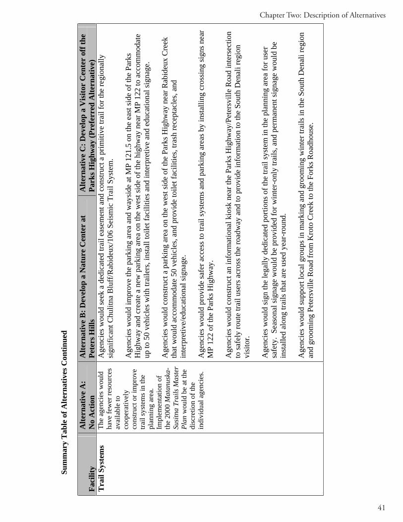
41
Chapter Two: Description of Alternatives
Sum
mar
y T
able
of A
ltern
ativ
es C
ontin
ued
Faci
lity
Alte
rnat
ive
A:
No
Act
ion
Alte
rnat
ive
B: D
evel
op a
Nat
ure
Cen
ter
at
Pete
rs H
ills
Alte
rnat
ive
C: D
evel
op a
Vis
itor
Cen
ter
off t
he
Park
s Hig
hway
(Pre
ferr
ed A
ltern
ativ
e)
Tra
il Sy
stem
s Th
e ag
enci
es w
ould
ha
ve fe
wer
reso
urce
s av
aila
ble
to
coop
erat
ivel
yco
nstru
ct o
r im
prov
e tra
il sy
stem
s in
the
plan
ning
are
a.
Impl
emen
tatio
n of
th
e 20
00 M
atan
uska
-Su
sitn
a Tr
ails
Mas
ter
Plan
wou
ld b
e at
the
disc
retio
n of
the
indi
vidu
al a
genc
ies.
Age
ncie
s wou
ld se
ek a
ded
icat
ed tr
ail e
asem
ent a
nd c
onst
ruct
a p
rimiti
ve tr
ail f
or th
e re
gion
ally
si
gnifi
cant
Chu
litna
Blu
ff/R
abid
eux/
106
Seis
mic
Tra
il Sy
stem
.
Age
ncie
s wou
ld im
prov
e th
e pa
rkin
g ar
ea a
nd w
aysi
de a
t MP
121.
5 on
the
east
side
of t
he P
arks
H
ighw
ay a
nd c
reat
e a
new
par
king
are
a on
the
wes
t sid
e of
the
high
way
nea
r MP
122
to a
ccom
mod
ate
up to
50
vehi
cles
with
trai
lers
, ins
tall
toile
t fac
ilitie
s and
inte
rpre
tive
and
educ
atio
nal s
igna
ge.
Age
ncie
s wou
ld c
onst
ruct
a p
arki
ng a
rea
on th
e w
est s
ide
of th
e Pa
rks H
ighw
ay n
ear R
abid
eux
Cre
ek
that
wou
ld a
ccom
mod
ate
50 v
ehic
les,
and
prov
ide
toile
t fac
ilitie
s, tra
sh re
cept
acle
s, an
d in
terp
retiv
e/ed
ucat
iona
l sig
nage
.
Age
ncie
s wou
ld p
rovi
de sa
fer a
cces
s to
trail
syst
ems a
nd p
arki
ng a
reas
by
inst
allin
g cr
ossi
ng si
gns n
ear
MP
122
of th
e Pa
rks H
ighw
ay.
Age
ncie
s wou
ld c
onst
ruct
an
info
rmat
iona
l kio
sk n
ear t
he P
arks
Hig
hway
/Pet
ersv
ille
Roa
d in
ters
ectio
n to
safe
ly ro
ute
trail
user
s acr
oss t
he ro
adw
ay a
nd to
pro
vide
info
rmat
ion
to th
e So
uth
Den
ali r
egio
n vi
sito
r.
Age
ncie
s wou
ld si
gn th
e le
gally
ded
icat
ed p
ortio
ns o
f the
trai
l sys
tem
in th
e pl
anni
ng a
rea
for u
ser
safe
ty.
Seas
onal
sign
age
wou
ld b
e pr
ovid
ed fo
r win
ter-
only
trai
ls, a
nd p
erm
anen
t sig
nage
wou
ld b
e in
stal
led
alon
g tra
ils th
at a
re u
sed
year
-rou
nd.
Age
ncie
s wou
ld su
ppor
t loc
al g
roup
s in
mar
king
and
gro
omin
g w
inte
r tra
ils in
the
Sout
h D
enal
i reg
ion
and
groo
min
g Pe
ters
ville
Roa
d fr
om K
roto
Cre
ek to
the
Fork
s Roa
dhou
se.

42
Final South Denali Implementation Plan and EIS
Sum
mar
y T
able
of A
ltern
ativ
es C
ontin
ued
Faci
lity
Alte
rnat
ive
A:
No
Act
ion
Alte
rnat
ive
B: D
evel
op a
Nat
ure
Cen
ter
at
Pete
rs H
ills
Alte
rnat
ive
C: D
evel
op a
Vis
itor
Cen
ter
off t
he
Park
s Hig
hway
(Pre
ferr
ed A
ltern
ativ
e)
Prov
ide
Oth
er
Faci
litie
s and
R
ecre
atio
nal
Opp
ortu
nitie
s
Oth
er fa
cilit
ies t
o su
ppor
t vis
itor u
se
and
econ
omic
de
velo
pmen
t wou
ld
be c
onst
ruct
ed a
t the
di
scre
tion
of th
e in
divi
dual
age
ncie
s.
One
120
sf th
ree-
side
d pi
cnic
shel
ter w
ould
be
cons
truct
ed a
t Lon
g Po
int.
A 1
6 x
20 fo
ot p
ublic
use
cab
in w
ith a
6 fo
ot c
over
ed
porc
h w
ould
be
cons
truct
ed n
ear H
ome
Lake
.
Age
ncie
s wou
ld d
eter
min
e th
e fe
asib
ility
of a
do
ckin
g fa
cilit
y on
the
wes
t sid
e of
the
Chu
litna
R
iver
nea
r MP
121.
5 of
the
Park
s Hig
hway
.
Age
ncie
s wou
ld c
reat
e ac
cess
from
the
Park
s H
ighw
ay to
the
Chu
litna
Riv
er d
owns
tream
of t
he
mou
th o
f Tro
uble
som
e C
reek
.
Age
ncie
s wou
ld c
reat
e a
map
show
ing
recr
eatio
nal o
ppor
tuni
ties o
n pu
blic
land
s wes
t of
Pete
rsvi
lle C
anyo
n.
A c
ampg
roun
d w
ould
be
cons
truct
ed a
djac
ent t
o th
e pr
opos
ed p
arki
ng lo
t at M
P 13
4.6
of th
e Pa
rks H
ighw
ay.
The
cam
pgro
und
wou
ld in
clud
e re
stro
oms,
a ca
mp
host
si
te, u
p to
50
tent
site
s and
up
to 5
0 R
V si
tes.
Age
ncie
s wou
ld d
eter
min
e th
e fe
asib
ility
of a
do
ckin
g fa
cilit
y on
the
wes
t sid
e of
the
Chu
litna
R
iver
nea
r MP
121.
5 of
the
Park
s Hig
hway
.
Age
ncie
s wou
ld c
reat
e ac
cess
from
the
Park
s H
ighw
ay to
the
Chu
litna
Riv
er d
owns
tream
of t
he
mou
th o
f Tro
uble
som
e C
reek
.
Age
ncie
s wou
ld c
reat
e a
map
show
ing
recr
eatio
nal
oppo
rtuni
ties o
n pu
blic
land
s wes
t of P
eter
svill
e C
anyo
n.
A D
OTP
F lim
ited
mai
nten
ance
are
a fa
cilit
y w
ould
be
con
stru
cted
nea
r Bye
rs C
reek
.

43
Chapter Two: Description of Alternatives
Sum
mar
y T
able
of A
ltern
ativ
es C
ontin
ued
Faci
lity
Alte
rnat
ive
A:
No
Act
ion
Alte
rnat
ive
B: D
evel
op a
Nat
ure
Cen
ter
at
Pete
rs H
ills
Alte
rnat
ive
C: D
evel
op a
Vis
itor
Cen
ter
off t
he
Park
s Hig
hway
(Pre
ferr
ed A
ltern
ativ
e)
Prot
ect S
ceni
c Q
ualit
ies
The
agen
cies
wou
ld
have
few
er re
sour
ces
avai
labl
e to
co
oper
ativ
ely
wor
k to
pr
otec
t sce
nic
qual
ities
of t
he P
arks
H
ighw
ay a
nd
Pete
rsvi
lle R
oad
corr
idor
.
If lo
cal c
omm
uniti
es re
ques
t ass
ista
nce
in se
curin
g th
e st
ate
and
fede
ral S
ceni
c H
ighw
ay d
esig
natio
n fo
r th
e Pa
rks H
ighw
ay b
etw
een
MP
105-
132,
the
agen
cies
wou
ld p
rovi
de te
chni
cal s
uppo
rt an
d fa
cilit
atio
n.
The
agen
cies
wou
ld w
ork
coop
erat
ivel
y to
cre
ate
a co
ntig
uous
scen
ic b
uffe
r on
agen
cy h
eld
land
s ad
jace
nt to
the
Park
s Hig
hway
from
MP
105
- MP
132
for t
he p
urpo
se o
f pro
tect
ing
the
scen
ic a
nd
natu
ral a
spec
ts o
f the
hig
hway
cor
ridor
. The
scen
ic b
uffe
r wou
ld p
rovi
de re
ason
able
acc
ess t
o pu
blic
an
d pr
ivat
e la
nds,
and
allo
w fo
r app
ropr
iate
use
s con
sist
ent w
ith th
e in
tent
of t
he b
uffe
r. A
dditi
onal
ly,
the
agen
cies
wou
ld c
oope
rate
in d
evel
opin
g co
ntex
t-sen
sitiv
e de
sign
stan
dard
s tha
t wou
ld a
pply
to
appr
opria
te a
genc
y he
ld la
nds a
djac
ent t
o th
e sc
enic
buf
fer.
The
Mat
anus
ka-S
usitn
a B
orou
gh w
ould
wor
k w
ith lo
cal c
omm
uniti
es to
est
ablis
h la
nd u
se c
ontro
ls fo
r pr
ivat
e la
nds a
long
the
Park
s Hig
hway
.
The
Ala
ska
Dep
artm
ent o
f Nat
ural
Res
ourc
es w
ould
wor
k w
ith th
e M
atan
uska
-Sus
itna
Bor
ough
, whi
ch
is th
e lo
cal g
over
nmen
t with
loca
l aut
horit
y to
zon
e, to
upd
ate
the
curr
ent S
peci
al U
se D
istri
ct in
Den
ali
Stat
e Pa
rk to
incl
ude
cont
rols
such
as s
peci
fic se
tbac
k an
d de
sign
stan
dard
s, bu
ildin
g he
ight
rest
rictio
ns,
vege
tativ
e bu
ffer
requ
irem
ents
and
requ
irem
ents
for t
he u
se o
f wild
life-
proo
f gar
bage
stor
age
cont
aine
rs.
In p
artn
ersh
ip w
ith lo
cal c
omm
uniti
es, t
he a
genc
ies w
ould
seek
app
ropr
iate
met
hods
to re
tain
the
scen
ic
and
natu
ral q
ualit
ies o
f the
Pet
ersv
ille
Roa
d co
rrid
or.
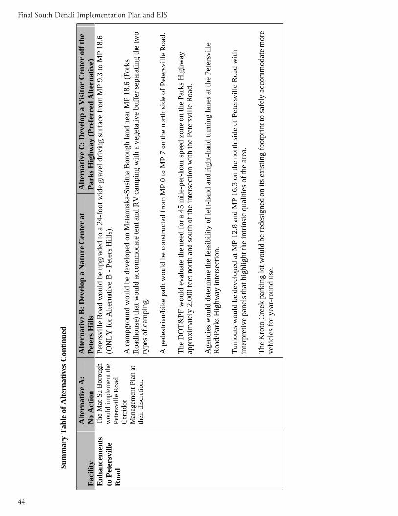
44
Final South Denali Implementation Plan and EIS
Sum
mar
y T
able
of A
ltern
ativ
es C
ontin
ued
Faci
lity
Alte
rnat
ive
A:
No
Act
ion
Alte
rnat
ive
B: D
evel
op a
Nat
ure
Cen
ter
at
Pete
rs H
ills
Alte
rnat
ive
C: D
evel
op a
Vis
itor
Cen
ter
off t
he
Park
s Hig
hway
(Pre
ferr
ed A
ltern
ativ
e)
Enh
ance
men
tsto
Pet
ersv
ille
Roa
d
The
Mat
-Su
Bor
ough
w
ould
impl
emen
t the
Pe
ters
ville
Roa
d C
orrid
orM
anag
emen
t Pla
n at
th
eir d
iscr
etio
n.
Pete
rsvi
lle R
oad
wou
ld b
e up
grad
ed to
a 2
4-fo
ot w
ide
grav
el d
rivin
g su
rfac
e fr
om M
P 9.
3 to
MP
18.6
(O
NLY
for A
ltern
ativ
e B
- Pe
ters
Hill
s).
A c
ampg
roun
d w
ould
be
deve
lope
d on
Mat
anus
ka-S
usitn
a B
orou
gh la
nd n
ear M
P 18
.6 (F
orks
R
oadh
ouse
) tha
t wou
ld a
ccom
mod
ate
tent
and
RV
cam
ping
with
a v
eget
ativ
e bu
ffer
sepa
ratin
g th
e tw
o ty
pes o
f cam
ping
.
A p
edes
trian
/bik
e pa
th w
ould
be
cons
truct
ed fr
om M
P 0
to M
P 7
on th
e no
rth si
de o
f Pet
ersv
ille
Roa
d.
The
DO
T&PF
wou
ld e
valu
ate
the
need
for a
45
mile
-per
-hou
r spe
ed z
one
on th
e Pa
rks H
ighw
ay
appr
oxim
atel
y 2,
000
feet
nor
th a
nd so
uth
of th
e in
ters
ectio
n w
ith th
e Pe
ters
ville
Roa
d.
Age
ncie
s wou
ld d
eter
min
e th
e fe
asib
ility
of l
eft-h
and
and
right
-han
d tu
rnin
g la
nes a
t the
Pet
ersv
ille
Roa
d/Pa
rks H
ighw
ay in
ters
ectio
n.
Turn
outs
wou
ld b
e de
velo
ped
at M
P 12
.8 a
nd M
P 16
.3 o
n th
e no
rth si
de o
f Pet
ersv
ille
Roa
d w
ith
inte
rpre
tive
pane
ls th
at h
ighl
ight
the
intri
nsic
qua
litie
s of t
he a
rea.
The
Kro
to C
reek
par
king
lot w
ould
be
rede
sign
ed o
n its
exi
stin
g fo
otpr
int t
o sa
fely
acc
omm
odat
e m
ore
vehi
cles
for y
ear-
roun
d us
e.

45
Chapter Two: Description of Alternatives
Sum
mar
y T
able
of E
nvir
onm
enta
l Con
sequ
ence
s
Alte
rnat
ive/
Top
ic
Alte
rnat
ive
A (N
o A
ctio
n)
Alte
rnat
ive
B (P
eter
s Hill
s)
Alte
rnat
ive
C (P
arks
Hig
hway
, Pre
ferr
ed
Alte
rnat
ive)
Soils
No
effe
ct o
n so
ils in
the
plan
ning
are
aTh
e di
rect
and
indi
rect
impa
ct o
n so
ils w
ould
resu
lt fr
om d
evel
opin
g fa
cilit
ies,
and
incr
easi
ng o
ppor
tuni
ties f
or c
ross
-cou
ntry
OR
V u
se th
roug
hout
the
plan
ning
are
a. D
irect
im
pact
s wou
ld b
e co
nfin
ed to
soils
in th
e im
med
iate
vic
inity
of t
he d
evel
opm
ents
and
co
uld
be e
asily
miti
gate
d w
ith ty
pica
l con
stru
ctio
n B
MPs
; how
ever
, ind
irect
impa
cts
from
incr
ease
d us
e w
ould
be
mor
e di
ffic
ult t
o m
itiga
te. F
or th
ese
reas
ons,
impa
cts t
o so
ils w
ould
be
cons
ider
ed m
oder
ate.
W
ater
Qua
lity
No
impa
cts t
o w
ater
qua
lity
The
impa
ct o
n w
ater
qua
lity
asso
ciat
ed w
ith d
evel
opm
ents
wou
ld b
e m
inor
in m
agni
tude
be
caus
e it
is u
nlik
ely
that
Ala
ska
Wat
er Q
ualit
y St
anda
rds o
r oth
er re
gula
tory
lim
its
wou
ld b
e ex
ceed
ed.
Dire
ct im
pact
s wou
ld b
e lo
caliz
ed to
wat
er b
odie
s adj
acen
t to
the
prop
osed
faci
litie
s. D
irect
and
indi
rect
impa
cts w
ould
be
long
-term
, las
ting
thro
ugh
the
life
of th
e pl
an.
Aqu
atic
Res
ourc
es
and
Fish
N
o im
pact
s on
aqua
tic
reso
urce
s and
fish
Dire
ct im
pact
s wou
ld b
e co
nfin
ed to
wat
er b
odie
s in
the
imm
edia
te v
icin
ity o
f the
de
velo
pmen
ts. D
irect
and
indi
rect
impa
cts w
ould
not
be
expe
cted
to c
ause
pop
ulat
ion
leve
l eff
ects
and
wou
ld o
nly
affe
ct c
omm
on h
abita
t, re
sulti
ng in
a m
inor
impa
ct.
Impa
cts
to fi
sh h
abita
t cou
ld b
e m
itiga
ted
with
typi
cal c
onst
ruct
ion
BM
Ps to
pro
tect
wat
er
qual
ity.
Wet
land
sN
o ef
fect
on
wet
land
sTh
e de
velo
pmen
ts p
ropo
sed
for
Alte
rnat
ive
B w
ould
impa
ct a
bout
14
acr
es o
f wet
land
s in
the
Pete
rs
Hill
s and
alo
ng th
e Pe
ters
ville
Roa
d an
d Pa
rks H
ighw
ay.
The
impa
ct o
n w
etla
nds i
n th
e pl
anni
ng a
rea
from
th
ese
deve
lopm
ents
and
from
as
soci
ated
recr
eatio
nal a
ctiv
ities
as
soci
ated
wou
ld b
e m
oder
ate
beca
use
habi
tat w
ould
be
lost
th
roug
hout
the
plan
ning
are
a.
The
deve
lopm
ents
pro
pose
d fo
r Alte
rnat
ive
C
wou
ld im
pact
abo
ut 6
acr
es o
f wet
land
s in
the
Cur
ry R
idge
are
a an
d al
ong
the
Pete
rsvi
lle R
oad
and
Park
s Hig
hway
. Th
e im
pact
on
wet
land
s in
the
plan
ning
are
a fr
om th
ese
deve
lopm
ents
and
fr
om a
ssoc
iate
d re
crea
tiona
l act
iviti
es w
ould
be
mod
erat
e be
caus
e ha
bita
t wou
ld b
e lo
st
thro
ugho
ut th
e pl
anni
ng a
rea.

46
Final South Denali Implementation Plan and EIS
Sum
mar
y T
able
of E
nvir
onm
enta
l Con
sequ
ence
s Con
tinue
d
Alte
rnat
ive/
Top
ic
Alte
rnat
ive
A (N
o A
ctio
n)
Alte
rnat
ive
B (P
eter
s Hill
s)
Alte
rnat
ive
C (P
arks
Hig
hway
, Pre
ferr
ed
Alte
rnat
ive)
Veg
etat
ion
No
effe
ct o
n te
rres
trial
ve
geta
tion
The
deve
lopm
ents
pro
pose
d fo
r A
ltern
ativ
e B
wou
ld im
pact
abo
ut
117
acre
s of t
erre
stria
l veg
etat
ion
in
the
Pete
rs H
ills a
nd a
long
the
Pete
rsvi
lle R
oad
and
Park
s H
ighw
ay.
Acr
eage
aff
ecte
d fr
om
indi
rect
impa
cts f
rom
incr
ease
d us
e is
mor
e di
ffic
ult t
o qu
antif
y; li
near
im
pact
s (fr
om O
RV
use
) wou
ld
likel
y oc
cur t
hrou
ghou
t the
pla
nnin
g ar
ea. T
he im
pact
on
terr
estri
al
vege
tatio
n in
the
plan
ning
are
a fr
om
thes
e de
velo
pmen
ts a
nd fr
om
recr
eatio
nal a
ctiv
ities
ass
ocia
ted
with
thes
e de
velo
pmen
ts w
ould
be
mod
erat
e be
caus
e w
ides
prea
d lo
ss to
no
n-se
nsiti
ve v
eget
atio
n w
ould
oc
cur.
The
deve
lopm
ents
pro
pose
d fo
r Alte
rnat
ive
C
wou
ld im
pact
abo
ut 1
43 a
cres
of t
erre
stria
l ve
geta
tion
in th
e C
urry
Rid
ge a
rea
and
alon
g th
e Pe
ters
ville
Roa
d an
d Pa
rks H
ighw
ay.
Acr
eage
af
fect
ed fr
om in
dire
ct im
pact
s fro
m in
crea
sed
use
is m
ore
diff
icul
t to
quan
tify;
line
ar im
pact
s (fr
om
OR
V u
se) w
ould
like
ly o
ccur
thro
ugho
ut th
e pl
anni
ng a
rea.
The
impa
ct o
n te
rres
trial
ve
geta
tion
in th
e pl
anni
ng a
rea
from
thes
e de
velo
pmen
ts a
nd fr
om re
crea
tiona
l act
iviti
es
asso
ciat
ed w
ith th
ese
deve
lopm
ents
wou
ld b
e m
oder
ate
beca
use
wid
espr
ead
loss
to n
on-
sens
itive
veg
etat
ion
wou
ld o
ccur
.
Wild
life
No
effe
ct o
n w
ildlif
e D
evel
opm
ent o
f new
vis
itor f
acili
ties i
s lik
ely
to h
ave
min
or d
irect
and
indi
rect
impa
cts
on lo
cal w
ildlif
e. A
lthou
gh c
onst
ruct
ion
activ
ities
may
cau
se te
mpo
rary
dis
plac
emen
t of
wild
life
due
to d
istu
rban
ce, t
he p
ropo
sed
mod
e of
ope
ratio
n w
ith sh
uttle
bus
ses a
nd
pede
stria
n tra
ils is
like
ly to
cau
se m
inim
al d
istu
rban
ce so
that
resi
dent
bird
s and
m
amm
als a
re li
kely
to re
mai
n in
the
vici
nity
of t
he v
isito
r fac
ilitie
s and
acc
ess r
oad.
Incr
ease
d O
RV
and
snow
mac
hine
use
wou
ld d
ispl
ace
indi
vidu
als b
ut is
not
exp
ecte
d to
ca
use
popu
latio
n-le
vel c
hang
es th
roug
hout
the
plan
ning
are
a.

47
Chapter Two: Description of Alternatives
Sum
mar
y T
able
of E
nvir
onm
enta
l Con
sequ
ence
s Con
tinue
d
Alte
rnat
ive/
Top
ic
Alte
rnat
ive
A (N
o A
ctio
n)
Alte
rnat
ive
B (P
eter
s Hill
s)
Alte
rnat
ive
C (P
arks
Hig
hway
, Pre
ferr
ed
Alte
rnat
ive)
Cul
tura
l Res
ourc
es
No
effe
ct o
n cu
ltura
l re
sour
ces
Alte
rnat
ive
B w
ould
hav
e m
oder
ate
adve
rse
impa
cts t
o cu
ltura
l res
ourc
es
beca
use
of in
crea
ses i
n th
e nu
mbe
r of
visi
tors
in a
reas
whe
re c
ultu
ral
reso
urce
s exi
st.
Alte
rnat
ive
C w
ould
hav
e m
oder
ate
adve
rse
impa
cts o
n cu
ltura
l res
ourc
es b
ecau
se o
f in
crea
ses i
n th
e nu
mbe
r of v
isito
rs in
are
as
whe
re c
ultu
ral r
esou
rces
exi
st. S
ome
of th
ese
affe
cted
reso
urce
s are
elig
ible
or c
ould
be
elig
ible
for t
he N
RH
P.
Soci
oeco
nom
ics
No
effe
ct o
n th
e so
cioe
cono
mic
env
ironm
ent
Con
stru
ctio
n ef
fect
s wou
ld b
e co
nsid
ered
a m
ajor
ben
efic
ial i
mpa
ct
on in
dust
ry, e
mpl
oym
ent,
and
inco
me.
The
cons
truct
ion
impa
cts o
n pl
anni
ng
area
pop
ulat
ion
and
dem
ogra
phic
s w
ould
be
min
or.
Hou
sing
impa
cts w
ould
like
ly b
e m
inor
if
on-s
ite h
ousi
ng w
ere
prov
ided
. If o
n-si
te h
ousi
ng w
ere
limite
d, th
e im
pact
s w
ould
be
mod
erat
e to
maj
or. T
he
oper
atio
ns im
pact
s on
hous
ing
and
real
es
tate
wou
ld b
e m
inor
.
The
cons
truct
ion
impa
cts o
n bo
roug
h an
d m
unic
ipal
reve
nues
and
ex
pend
iture
s wou
ld b
e m
inor
bec
ause
th
e co
nstru
ctio
n w
ould
be
of a
shor
t du
ratio
n an
d la
rgel
y un
taxe
d.
Con
stru
ctio
n ef
fect
s wou
ld b
e co
nsid
ered
a
maj
or b
enef
icia
l im
pact
on
indu
stry
, em
ploy
men
t, an
d in
com
e.
The
cons
truct
ion
impa
cts o
n pl
anni
ng a
rea
popu
latio
n an
d de
mog
raph
ics w
ould
be
min
or.
Hou
sing
impa
cts w
ould
like
ly b
e m
inor
to
mod
erat
e if
on-s
ite h
ousi
ng w
ere
prov
ided
. If
on-s
ite h
ousi
ng w
ere
limite
d, th
e im
pact
s w
ould
be
mod
erat
e to
maj
or. T
he o
pera
tions
im
pact
s on
hous
ing
and
real
est
ate
wou
ld b
e m
inor
.
The
cons
truct
ion
impa
cts o
n bo
roug
h an
d m
unic
ipal
reve
nues
and
exp
endi
ture
s wou
ld b
e m
inor
bec
ause
the
cons
truct
ion
wou
ld b
e of
a
shor
t dur
atio
n an
d la
rgel
y un
taxe
d.
Alte
rnat
ive
C w
ould
hav
e m
ajor
impa
cts o
n th
e pl
anni
ng a
rea’
s qua
lity
of li
fe in
dica
tors
. Fiv
e

48
Final South Denali Implementation Plan and EIS
Soci
oeco
nom
ics,
cont
.A
ltern
ativ
e B
wou
ld h
ave
a m
ajor
im
pact
on
the
plan
ning
are
a’s q
ualit
y of
lif
e in
dica
tors
, par
ticul
arly
in th
e Pe
ters
ville
are
a. A
maj
ority
of t
he
qual
ity o
f life
indi
cato
rs c
ould
be
affe
cted
by
deve
lopm
ents
pro
pose
d in
A
ltern
ativ
e B
; in
fact
, all
indi
cato
rs
exce
pt se
lf-su
ffic
ient
life
styl
e co
uld
be
affe
cted
.
Impa
cts o
n la
nd o
wne
rshi
p an
d us
e w
ould
be
mod
erat
e be
caus
e th
e la
nd
uses
wou
ld sh
ift, b
ut th
e pr
opos
ed
chan
ges w
ould
be
cons
iste
nt w
ith
exis
ting
plan
s or c
ontro
lled
by la
nd u
se
rest
rictio
ns.
qual
ity o
f life
indi
cato
rs c
ould
be
affe
cted
by
deve
lopm
ents
pro
pose
d in
Alte
rnat
ive
C,
incl
udin
g ru
ral c
hara
cter
, com
mun
ity
cohe
sive
ness
, eco
nom
ic c
hara
cter
istic
s, go
vern
men
t int
erac
tion,
and
recr
eatio
n op
portu
nitie
s.
Impa
cts o
n la
nd o
wne
rshi
p an
d us
e w
ould
be
mod
erat
e be
caus
e th
e la
nd u
ses w
ould
shift
, bu
t the
pro
pose
d ch
ange
s wou
ld b
e co
nsis
tent
w
ith e
xist
ing
plan
s or c
ontro
lled
by la
nd u
se
rest
rictio
ns.
Sum
mar
y T
able
of E
nvir
onm
enta
l Con
sequ
ence
s Con
tinue
d
Alte
rnat
ive/
Top
ic
Alte
rnat
ive
A (N
o A
ctio
n)
Alte
rnat
ive
B (P
eter
s Hill
s)
Alte
rnat
ive
C (P
arks
Hig
hway
, Pre
ferr
ed
Alte
rnat
ive)
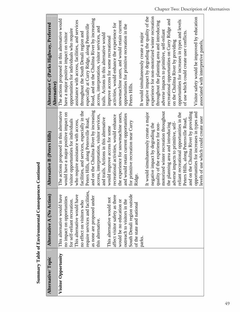
49
Chapter Two: Description of Alternatives
Sum
mar
y T
able
of E
nvir
onm
enta
l Con
sequ
ence
s Con
tinue
d
Alte
rnat
ive/
Top
ic
Alte
rnat
ive
A (N
o A
ctio
n)
Alte
rnat
ive
B (P
eter
s Hill
s)
Alte
rnat
ive
C (P
arks
Hig
hway
, Pre
ferr
ed
Alte
rnat
ive)
Vis
itor
Opp
ortu
nity
Th
is a
ltern
ativ
e w
ould
hav
e no
impa
ct o
n op
portu
nitie
s fo
r sel
f-re
liant
recr
eatio
n.
This
alte
rnat
ive
wou
ld h
ave
no e
ffec
t on
visi
tors
who
re
quire
serv
ices
and
faci
litie
s, as
non
e ar
e pr
opos
ed u
nder
th
is a
ltern
ativ
e.
This
alte
rnat
ive
wou
ld n
ot
affe
ct v
isito
r saf
ety
as th
ere
wou
ld b
e no
edu
catio
n or
ou
treac
h to
vis
itors
in th
e So
uth
Den
ali r
egio
n ou
tsid
e of
the
stat
e an
d na
tiona
l pa
rks.
The
actio
ns p
ropo
sed
in th
is a
ltern
ativ
e w
ould
hav
e a
maj
or p
ositi
ve im
pact
on
visi
tor o
ppor
tuni
ties f
or in
divi
dual
s w
ho re
quire
ass
ista
nce
with
acc
ess,
faci
litie
s, an
d se
rvic
es, e
spec
ially
in th
e Pe
ters
Hill
s, al
ong
Pete
rsvi
lle R
oad,
an
d on
the
Chu
litna
Riv
er b
y in
crea
sing
ac
cess
, int
erpr
etat
ion,
vis
itor s
ervi
ces,
and
trails
. Act
ions
in th
is a
ltern
ativ
e w
ould
impr
ove
acce
ss fo
r som
e re
crea
tiona
l act
iviti
es, w
ould
enh
ance
th
e ex
perie
nce
for s
now
mac
hine
use
rs,
and
wou
ld re
tain
cur
rent
opp
ortu
nitie
s fo
r prim
itive
recr
eatio
n ne
ar C
urry
R
idge
.
It w
ould
sim
ulta
neou
sly
crea
te a
maj
or
nega
tive
impa
ct b
y de
grad
ing
the
qual
ity o
f the
exp
erie
nce
for n
on-
mot
oriz
ed w
inte
r rec
reat
ion
thro
ugho
ut
the
plan
ning
are
a an
d in
trodu
cing
ad
vers
e im
pact
s to
prim
itive
, sel
f-re
liant
recr
eatio
nal o
ppor
tuni
ties i
n th
e Pe
ters
Hill
s, al
ong
Pete
rsvi
lle R
oad,
an
d on
the
Chu
litna
Riv
er b
y pr
ovid
ing
oppo
rtuni
ties f
or in
crea
ses i
n ty
pes a
nd
leve
ls o
f use
whi
ch c
ould
cre
ate
user
The
actio
ns p
ropo
sed
in th
is a
ltern
ativ
e w
ould
ha
ve a
maj
or p
ositi
ve im
pact
on
visi
tor
oppo
rtuni
ties f
or in
divi
dual
s who
requ
ire
assi
stan
ce w
ith a
cces
s, fa
cilit
ies,
and
serv
ices
th
roug
hout
the
Sout
h D
enal
i reg
ion
and
espe
cial
ly a
t Cur
ry R
idge
, alo
ng P
eter
svill
e R
oad,
and
on
the
Chu
litna
Riv
er b
y in
crea
sing
ac
cess
, int
erpr
etat
ion,
vis
itor s
ervi
ces,
and
trails
. Act
ions
in th
is a
ltern
ativ
e w
ould
im
prov
e ac
cess
for s
ome
recr
eatio
nal
activ
ities
, wou
ld e
nhan
ce th
e ex
perie
nce
for
snow
mac
hine
use
rs, a
nd w
ould
reta
in c
urre
nt
oppo
rtuni
ties f
or p
rimiti
ve re
crea
tion
in th
e Pe
ters
Hill
s.
It w
ould
sim
ulta
neou
sly
crea
te a
maj
or
nega
tive
impa
ct b
y de
grad
ing
the
qual
ity o
f the
ex
perie
nce
for n
on-m
otor
ized
win
ter r
ecre
atio
n th
roug
hout
the
plan
ning
are
a an
d in
trodu
cing
ad
vers
e im
pact
s to
prim
itive
, sel
f-re
liant
re
crea
tiona
l opp
ortu
nitie
s on
Cur
ry R
idge
and
on
the
Chu
litna
Riv
er b
y pr
ovid
ing
oppo
rtuni
ties f
or in
crea
ses i
n ty
pes a
nd le
vels
of
use
whi
ch c
ould
cre
ate
user
con
flict
s.
Vis
itor s
afet
y w
ould
be
impr
oved
by
educ
atio
n as
soci
ated
with
inte
rpre
tive
pane
ls,
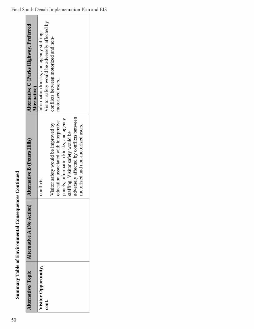
50
Final South Denali Implementation Plan and EIS
Vis
itor
Opp
ortu
nity
, co
nt.
conf
licts
.
Vis
itor s
afet
y w
ould
be
impr
oved
by
educ
atio
n as
soci
ated
with
inte
rpre
tive
pane
ls, i
nfor
mat
ion
kios
ks, a
nd a
genc
y st
affin
g. V
isito
r saf
ety
wou
ld b
e ad
vers
ely
affe
cted
by
conf
licts
bet
wee
n m
otor
ized
and
non
-mot
oriz
ed u
sers
.
info
rmat
ion
kios
ks, a
nd a
genc
y st
affin
g.
Vis
itor s
afet
y w
ould
be
adve
rsel
y af
fect
ed b
y co
nflic
ts b
etw
een
mot
oriz
ed a
nd n
on-
mot
oriz
ed u
sers
.
Sum
mar
y T
able
of E
nvir
onm
enta
l Con
sequ
ence
s Con
tinue
d
Alte
rnat
ive/
Top
ic
Alte
rnat
ive
A (N
o A
ctio
n)
Alte
rnat
ive
B (P
eter
s Hill
s)
Alte
rnat
ive
C (P
arks
Hig
hway
, Pre
ferr
ed
Alte
rnat
ive)

51
Chapter Three: Affected Environment
Chapter Three: Affected Environment
OverviewThis section describes the existing environment and the current conditions of important resources and values of the South Denali planning area that would be affected by any of the alternatives in this implementation plan. Topics examined include soils, aquatic resources and fish, wetlands, vegetation, wildlife, cultural resources, socioeconomics, and visitor opportunity.
SOILS
Existing soils information for the South Denali planning area (see Figure 2-1) was obtained from existing soils maps for the upper Susitna Valley (State Soil Geographic (STATSGO) Database 1995; Clark and Kautz 1998; Olszewski 1998) and regional soils information from the Soil Survey Geographic Database (SURGO) (2003). This information was supplemented by recent aerial photography (Aeromap 1996) and satellite imagery (IKONOS 1996). Soil map units were field verified within the planning area in 2004. For more information on the 2004 field investigation procedures, please refer to the Soils Report (URS 2004b).
The three main areas examined during the 2004 soils survey, and for the purpose of this analysis are located near Peters Hills, Parks Highway (previously referred to as Cari Creek) and the soils surrounding Petersville Road. Distribution of the soil types within the planning areas are presented in the Soils Report (URS 2004b).
Planning Area Primary Landforms All the soils in the geographic area are categorized within two primary landforms or geomorphic units: glacial till plains and mountainous uplands (State Soil Geographic (STATSGO) Database 1995; Clark and Kautz 1998; Olszewski 1998).
Glacial Till Plains
Glacial till plains occur between alluvial terraces along the rivers and the adjacent mountains. The hilly terrain within these plain areas is well-drained and supports mixed forests of white spruce and birch, with an understory of alder and ferns (Clark and Kautz 1998; Olszewski 1998). On the sloping terrain of this landform, the following soils are present:

52
Final South Denali Implementation Plan and EIS
Kroto and Strandline silt loam soils (Andic Haplocryods)Spenard silt loam soils (Andic Cryaquods)Slikok muck soils: 0 to 5% slopes (Histic Cryaquepts)Chichanta peat soils:0 to 8% slopes (Euic Fluvaquentic Borosaprists)
Mountainous UplandThe second of the two major geomorphic units in the planning area, mountainous uplands, have soils on higher slopes. These soils are well-drained, except when adjacent to stream drainages and depressions. In this case, the tight glacial till prevents downward flow of water (Clark and Kautz 1998; Olszewski 1998). Subalpine areas, which support grasslands and thick alder shrub communities, are composed of the following soils:
Puntilla silt loam:7 to 20% slopes (Andic Humicryods)Kliskon silt loam: 12 to 20% slopes (Andic Cryaquods)
Typically, Puntilla soils occur on the steeper mountain sideslopes and support communities of Sitka alder, bluejoint reedgrass, ferns, and forbs. Kliskon soils generally occur in poorly drained areas, which are more gently sloping, and support herbaceous meadows of grass and ferns (Clark and Kautz 1998; Olszewski 1998). Soils in alpine areas at the higher elevations are generally uneven as a result of continual frost heaving and generally consist of the two soil series:
Chuit silt loam: 3 to 30% slopes (Andic Humicryods)Nakochna silt loam: 3 to 30% slopes (Lithic Humicryods)
These soil series are typically classified as “rubble lands” on the available soils maps (State Soil Geographic (STATSGO) Database 1995; Soil Survey Geographic Database (SURGO) 2003). These “rubble land” map units consist of barren areas of loose rock, but also includes sizable patches of Chuit and Nakochna soils, and range in slope from 7 to 45% (Clark and Kautz 1998; Olszewski 1998).
Characteristic of planning area soils that are pertinent to development of project facilities are presented in Table 3-1.

53
Chapter Three: Affected Environment
Tab
le 3
-1 S
oil C
hara
cter
istic
s of i
n th
e So
uth
Den
ali I
mpl
emen
tatio
n Pl
an P
lann
ing
Are
a
Bed
rock
Su
bsid
ence
Fr
ost
actio
nE
rosi
on1.
1.1
Cor
rosi
on P
oten
tial
Soil
Seri
es
Dep
th (i
n)
Har
dnes
s In
itial
(in)
T
otal
(in
) D
egre
e 1.
2W
ater
W
ind
Unc
oate
dSt
eel
Con
cret
e
Chi
chan
tna
peat
>6
0 -
5-10
15
-20
Hig
h sl
ight
sl
ight
H
igh
Hig
h Sa
lam
atof
pea
t >6
0 -
15-3
0 30
-60
Hig
h sl
ight
sl
ight
H
igh
Hig
h K
lisko
n si
lt lo
am
>60
- -
- H
igh
seve
re
seve
re
Hig
h H
igh
Punt
illa
silt
loam
>6
0 -
- -
Hig
h se
vere
se
vere
H
igh
Hig
h Sl
ikok
muc
k >6
0 -
4-6
10-2
4 H
igh
Slig
ht to
m
oder
ate
slig
ht
Hig
h 1.
3H
igh
Spen
ard
silt
loam
>6
0 -
- -
Hig
h se
vere
se
vere
H
igh
Hig
h Sp
enar
d si
lt lo
am
>60
- -
- H
igh
seve
re
seve
re
Hig
h H
igh
Punt
illa
silt
loam
>6
0 -
- -
Hig
h se
vere
se
vere
H
igh
Hig
h N
ancy
silt
loam
>6
0 -
- -
Hig
h se
vere
se
vere
H
igh
Hig
h St
rand
line-
Spen
ard-
Kro
to c
ompl
ex
>60
- -
- -
seve
re
seve
re
Hig
h H
igh
Stra
ndlin
e-K
roto
com
plex
>6
0 -
- -
- se
vere
se
vere
H
igh
Hig
h
Chu
it-N
akoc
hna-
Rub
ble
Land
com
plex
>60
14-2
0>4
0
- Har
dH
ard
- - -
- - -
Hig
hH
igh
-
seve
rese
vere
H
igh
Hig
h-
Hig
hH
igh
-C
huit
silt
loam
>6
0 -
- -
Hig
h se
vere
se
vere
H
igh
Hig
h N
akoc
hna
silt
loam
s 14
-20
Har
d -
- H
igh
seve
re
seve
re
Hig
h H
igh
54
Final South Denali Implementation Plan and EIS
Planning Area Soils
Peters Hills
The Alternative B Peters Hills access road alignment has been divided into two main portions for descriptive purposes -- an upper and a lower. The lower portion follows a series of low rolling hills and ridges and has a variety of common soil types and complexes. The poorly drained depressions, or gently sloping hills, contain Chichantna peat soils (State Soil Geographic (STATSGO) Database 1995; Soil Survey Geographic Database (SURGO) 2003), which support muskeg communities of both ericaceous shrubs and emergent wetlands (Clark and Kautz 1998; Olszewski 1998). Poorly drained ridge tops and hillsides contain Slikok muck soils and Kliskon silt loam (State Soil Geographic (STATSGO) Database 1995; Soil Survey Geographic Database (SURGO) 2003). These soil complexes support mostly tall scrub communities of Sitka alder and willow (Clark and Kautz 1998; Olszewski 1998). Some of the lower ridges and the lower slopes at the foot of Peters Hills are mainly Puntilla silt loams (State Soil Geographic (STATSGO) Database 1995; Soil Survey Geographic Database (SURGO) 2003) and support low scrub, tall scrub and herbaceous plant communities (Clark and Kautz 1998; Olszewski 1998). The ridge tops along the lower portion of the alignment are well-drained and are mostly Chuit-Nakochna soil complex (State Soil Geographic (STATSGO) Database 1995; Soil Survey Geographic Database (SURGO) 2003), which supports both open low scrub and tall scrub thickets (Clark and Kautz 1998; Olszewski 1998).
The upper portions of the proposed access road alignment follow some lower ridges before ascending a steep hillside to the alpine habitats of the proposed visitor facility site. The soils of these upper slopes are mainly mapped as Chuit-Nakochna-rubble land complex (State Soil Geographic (STATSGO) Database 1995; Soil Survey Geographic Database (SURGO) 2003), which are generally shallow and well-drained with areas of exposed bedrock or rubble. These shallow soils support alpine communities of low shrub and dwarf shrub/lichen (Clark and Kautz 1998; Olszewski 1998). Some of the swales contain Chichantna peat soils (State Soil Geographic (STATSGO) Database 1995; Soil Survey Geographic Database (SURGO) 2003).
The trail system would likely cross all of the common soil types in the regions. The Nature Center at the top of the access road would be within areas classified as Chuit-Nakachna–rubble land complex (State Soil Geographic (STATSGO) Database 1995; Soil Survey Geographic Database (SURGO) 2003).
Petersville Road
The Petersville Road Campground is a proposed facility to be placed at a large partially-cleared area uphill and to the northeast of the Forks Roadhouse that is mostly flat and has already been cleared of most of the native vegetation and surface soils. This location falls within the soil map unit of Strandline-Spenard-Kroto complex (State Soil Geographic (STATSGO) Database 1995; Soil Survey Geographic Database (SURGO) 2003).

55
Chapter Three: Affected Environment
A 4-acre parking area is proposed at the base of the proposed Peters Hills access road near MP 28 of the Petersville Road. This facility is completely within a large muskeg just east of the Petersville Road. Soils in this muskeg are mapped as Chichantna peat soil.
Parks Highway Corridor
The lower portion of the proposed Parks Highway facilities is located on a glacial till plain and ascends to the mountainous uplands at the proposed visitor center on Curry Ridge (State Soil Geographic (STATSGO) Database 1995).Soils at the proposed MP 121.5 parking area are mapped as Strandline-Spenard-Kroto complex (State Soil Geographic (STATSGO) Database 1995; Soil Survey Geographic Database (SURGO) 2003). The soils at this site have been previously disturbed. A soil test pit confirmed the soils are both well-drained and within the expected map section. (State Soil Geographic (STATSGO) Database 1995; Soil Survey Geographic Database (SURGO) 2003). The Rabideux Creek Parking Area is in an area of Nancy silt loam soils.
Dominant soil at the proposed parking area and campground near MP 134.6 of the Parks Highway is Strandline Kroto silt loam complex. The large open meadow at this location is primarily Spenard silt loam (State Soil Geographic (STATSGO) Database 1995; Soil Survey Geographic Database (SURGO) 2003).
Parks Highway/Curry Ridge
The access road alignment crosses a narrow glacial till plain between the Susitna River and the adjacent mountains to the east. Soils along this alignment are mostly Kroto and Strandline silt loam complexes in the lower elevations, As the alignment gains elevation, soils are generally Puntilla silt loam (State Soil Geographic (STATSGO) Database 1995; Soil Survey Geographic Database (SURGO) 2003).
The proposed visitor center near Curry Ridge contains mostly Chuit and Nakochna soils, which are relatively shallow soils that support open low shrub, closed tall shrub communities, and herbaceous meadows at higher elevations (Clark and Kautz 1998; Olszewski 1998). There were also isolated patches of Strandline, Kroto, and Chichantna soils in the general area.
The proposed trail system near the visitor center likely crosses most of the common soil types in the area, including Strandline-Kroto silt loam complexes, Spenard silt loam, and Chuit-Nakochna silt loam complexes (State Soil Geographic (STATSGO) Database 1995; Soil Survey Geographic Database (SURGO) 2003). No soil maps are available for most of the area crossed by the trail system.

56
Final South Denali Implementation Plan and EIS
WATER QUALITY, AQUATIC RESOURCES AND FISH
Freshwater Streams and Fish The aquatic resources present in the planning area (see Figure 2-1) include the freshwater streams that support both anadromous and resident fish species. Anadromous fish are species that begin their lives in freshwater habitats, migrate to marine habitats where they mature, and then return to freshwater to spawn. Resident fish remain in streams to spawn and breed, spending their entire life cycle in fresh water. Anadromous waters are protected by the State of Alaska, Department of Natural Resources (ADNR). The ADNR Office of Habitat Management and Permitting (OHMP) requires that permits be obtained for activities (use or construction) potentially affecting anadromous waters. The OHMP is also concerned with protecting fish passage in both anadromous and resident fish streams. The Alaska Department of Fish and Game (ADF&G) continues to receive and process anadromous water body nominations and maintains the fish distribution database (ADF&G 2004b). The Catalog of Waters Important for the Spawning, Rearing or Migration of Anadromous Fishes (ADF&G 1991) and its associated atlas are the media used to accomplish this specification and are adopted as regulation under 11 Alaska Administrative Code (AAC) 195.010. Stream numbers, locations, extent of cataloged habitat, and species utilization of a given stream may change from year to year.
The planning area is located south of Denali National Park and Preserve and includes an extensive portion of the Susitna River drainage that ultimately drains into Cook Inlet. The major rivers flowing through and the planning area originate from glaciers in the Alaska Range and include the Susitna, Chulitna, and Tokositna rivers.
Numerous small to moderately sized lakes and streams originate from non-glacial headwaters of the Alaska Range, many of which are anadromous, and are found within the proposed project corridors along the George Parks Highway and Petersville Road (see Figure 2-1).
George Parks Highway
Two major streams drain the western slopes of Curry Ridge: Troublesome Creek and an unnamed stream and tributaries south of Troublesome Creek. Both of these streams flow into Chulitna River. Troublesome Creek is classified as anadromous. The proposed access road to the Parks Highway visitor center would cross the unnamed stream and a small tributary south of Troublesome Creek.
Petersville Road and Peters HillsNon-glacial anadromous streams that are crossed by Petersville Road include: a tributary to Rabideux, Ninemile, a tributary to Ninemile, Moose, Gate, Seventeenmile, a tributary to Seventeenmile, Kroto, Twentymile, Kenny, Deep, Peters, and Long creeks. Peters Creek and its major tributaries (including Deep Creek) located in the southwest portion of

57
Chapter Three: Affected Environment
the planning area are rated the seventh most important waterway system in the Susitna Basin by the ADF&G (NPS 1997a). In the Peters Hills area, two non-glacial anadromous streams drain the eastern slopes of Peters Hills and flow into the Tokositna River to the north: Bunco Creek and an unnamed tributary to Bunco Creek. Both of these streams are crossed by the proposed Peters Hills access road. The Tokositna flows into the Chulitna River, which flows into the Susitna River. The Susitna River and its tributaries support the largest stocks of Chinook and coho salmon in the Cook Inlet drainage (NPS 1997a).
In their project scoping comments, OHMP specifically stated that the Petersville Road crosses 12 streams that have been cataloged as anadromous for five species of Pacific salmon. The road also crosses at least five tributaries to Peters Creek that support anadromous fish, as well as resident fish species including rainbow trout and Dolly Varden (ADNR 2004; ADF&G 2004b).
An anadromous fish stream survey was performed along the Petersville Road from the Parks Highway (MP 0) to Forks Roadhouse (MP 18) in August 2004. The survey verified the existence of ten cataloged anadromous streams within 150 feet of the existing road centerline (i.e., Rabideux, Ninemile, a tributary to Ninemile, Moose, Gate, Seventeenmile, a tributary to Seventeenmile, Kroto, Twentymile, and Kenny creeks). Other streams within the project corridors were surveyed, and in the Peters Hills area, five juvenile salmonids were observed in the unnamed tributary to Bunco Creek. This stream is cataloged as anadromous for salmon (see Table 3-2). Results of the 2004 study are discussed in detail in the Water Resources Report (URS 2004a).
Table 3-2. Cataloged Anadromous Streams of the Planning Area Stream Fish Species (cataloged for)
Anadromous Stream # Stream Name Scientific Name Common Name
247-41-10200 Susitna River Oncorhynchustshawytscha, O. kisutch,O. nerka, O. gorbuscha, O. keta
Chinook, coho, sockeye, pink, and chum salmon
247-41-10200-2381 Chulitna O. tshawytscha, O. kisutch,O. nerka, O. gorbuscha, O. keta
Chinook, coho, sockeye, pink, and chum salmon
247-41-10200-2381-3161 Tokositna O. tshawytscha, O. kisutch, O. nerka
Chinook, coho, and sockeye salmon
247-41-10200-2341 Trapper Creek O. kisutch Coho salmon
247-41-10200-2291-3049 (tributary to) Rabideaux Creek
O. kisutch Coho salmon
247-41-10200-2081-3100-4136
Unnamed (tributary to Moose Creek)
O. tshawytscha, O. kisutch
Chinook and coho salmon
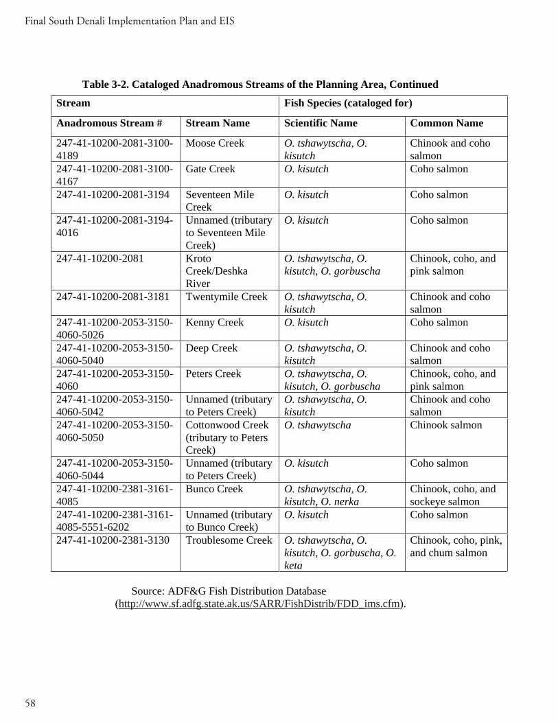
58
Final South Denali Implementation Plan and EIS
Table 3-2. Cataloged Anadromous Streams of the Planning Area, Continued
Stream Fish Species (cataloged for)
Anadromous Stream # Stream Name Scientific Name Common Name
247-41-10200-2081-3100-4189
Moose Creek O. tshawytscha, O. kisutch
Chinook and coho salmon
247-41-10200-2081-3100-4167
Gate Creek O. kisutch Coho salmon
247-41-10200-2081-3194 Seventeen Mile Creek
O. kisutch Coho salmon
247-41-10200-2081-3194-4016
Unnamed (tributary to Seventeen Mile Creek)
O. kisutch Coho salmon
247-41-10200-2081 Kroto Creek/Deshka River
O. tshawytscha, O. kisutch, O. gorbuscha
Chinook, coho, and pink salmon
247-41-10200-2081-3181 Twentymile Creek O. tshawytscha, O. kisutch
Chinook and coho salmon
247-41-10200-2053-3150-4060-5026
Kenny Creek O. kisutch Coho salmon
247-41-10200-2053-3150-4060-5040
Deep Creek O. tshawytscha, O. kisutch
Chinook and coho salmon
247-41-10200-2053-3150-4060
Peters Creek O. tshawytscha, O. kisutch, O. gorbuscha
Chinook, coho, and pink salmon
247-41-10200-2053-3150-4060-5042
Unnamed (tributary to Peters Creek)
O. tshawytscha, O. kisutch
Chinook and coho salmon
247-41-10200-2053-3150-4060-5050
Cottonwood Creek (tributary to Peters Creek)
O. tshawytscha Chinook salmon
247-41-10200-2053-3150-4060-5044
Unnamed (tributary to Peters Creek)
O. kisutch Coho salmon
247-41-10200-2381-3161-4085
Bunco Creek O. tshawytscha, O. kisutch, O. nerka
Chinook, coho, and sockeye salmon
247-41-10200-2381-3161-4085-5551-6202
Unnamed (tributary to Bunco Creek)
O. kisutch Coho salmon
247-41-10200-2381-3130 Troublesome Creek O. tshawytscha, O. kisutch, O. gorbuscha, O. keta
Chinook, coho, pink, and chum salmon
Source: ADF&G Fish Distribution Database (http://www.sf.adfg.state.ak.us/SARR/FishDistrib/FDD_ims.cfm).

59
Chapter Three: Affected Environment
Most species of anadromous fish depend on freshwater environments for both the spawning and rearing phases of their lives. Adequate spawning habitat is always required, and depending upon the species, adequate rearing habitat is necessary for successful reproduction. Resident fish remain in the streams, lakes, and side slough channels year-round and also require adequate spawning and rearing habitat.
Spawning Habitat
For anadromous fish and resident fish such as rainbow trout, adequate spawning habitat consists of a location in a stream where the female fish is able to dig a nest, or “redd,” in the substrate and lay her eggs, after which the male fertilizes them. Components of useable spawning habitat include clean, appropriately sized substrate (gravel), well-oxygenated water, and adequate inter-gravel flow to provide the incubating eggs with oxygen and a means to remove metabolic wastes. If sediment or other material clogs the inter-substrate spaces and the water fails to circulate freely, the incubating eggs can die from hypoxia or be poisoned by toxic concentrations of their own metabolic wastes. Available spawning habitat is usually the key indicator of production potential, especially for those anadromous species that do not rear in freshwater, like pink and chum salmon.
Rearing Habitat
Adequate rearing habitat for both anadromous and resident fish consists of a location in the stream where the young fish can safely feed and grow before migrating to saltwater in the case of anadromous fish, or moving within the stream itself for resident fish.
There are several important characteristics of rearing habitat: a source of food, escape cover from predators, a velocity shelter during high flow events, and a living space for fry as they emerge from the gravel that is protected from larger fingerlings. Good rearing habitat can be found in areas with undercut banks, ponds, pools, lakes, and small side tributary streams. The finite amount of food and living space available in any stream, paired with the fact that rearing species usually establish territories and aggressively defend them, means that rearing habitat is often the key indicator of production potential for resident species, and for those anadromous species that do not immediately migrate to saltwater.
Fish Species Life Histories
Pacific Salmon
Five species of Pacific salmon (Chinook [Onocorhynchus tshawytscha], coho [O.kisutch], sockeye [O. nerka], chum [O. keta], and pink [O. gorbuschas]) are found in the planning area. With some important variations, all species have a similar appearance and anadromous life history. Salmon belong to the family Salmonidae and spawn in fresh water and, during the fall, their eggs incubate, hatch, and go through several

60
Final South Denali Implementation Plan and EIS
developmental stages lasting from several months to several years, depending on species. Chinook, coho, and sockeye salmon spend from one to several years rearing in freshwater before migrating to the ocean, whereas chum and pink salmon leave immediately upon emerging from the spawning gravels. The young salmon feed and grow to maturity in saltwater. They return to fresh water, often migrating tremendous distances to reach their natal streams, where they spawn. Adult salmon do not compete directly with juveniles for the food resources found in freshwater environments. Carcasses left in the streams after spawning fertilize the freshwater environment, ultimately providing food for the developing young. No stocks of Pacific salmon originating from freshwater habitat in Alaska are listed under the Endangered Species Act.
The composition of salmon prey species depends on life stage, availability, and relative abundance of prey, which vary with season and location. Chinook salmon feed on small fish (particularly herring), pelagic amphipods, and crab megalopa, with fish being the largest single contributor to their diet (Healey 1991). Chum salmon diets are composed of amphipod, euphausiid, pteropod, copepod, fish, and squid larvae (Salo 1991). Pink salmon are opportunistic and generalized feeders and are known to feed on epibenthic harpacticoid copepods, pelagic copepods, barnacle nauplii, mysids, eggs of invertebrates and fishes, and fish larvae (Heard 1991). Coho salmon are also opportunistic feeders, with diets consisting of marine invertebrates, chum and pink salmon fry, smelts, sandlance, sticklebacks, squid, and crab larvae (Sandercock 1991). Sockeye are known to feed on euphausiids, amphipods, and small fish (sandlance, herring, pollock, and capelin in the Gulf of Alaska) (Burgner 1991).
A wide variety of predators including birds, marine mammals, and other species of fish feed on migrant salmon smolts. Predators of large salmon include all toothed whales, seals, sea lions, and shark (Sandercock 1991).
Rainbow Trout
Rainbow trout are one of Alaska’s most sought-after sport fish. Rainbow trout occur as both freshwater resident and anadromous forms, the anadromous form referred to steelhead trout. Rainbow trout, like salmon, belong to the family Salmonidae. Spawning for resident rainbow trout usually occurs between late April and early July in shallow gravel riffles or small clearwater streams (ADF&G 2004a). The fry rear along the stream margins or protected lakeshore for two or three years, feeding on plant material, crustaceans, and aquatic insects and their larvae. The juveniles then move into the deep pools of lakes and larger streams where their diet changes to other fish, salmon carcasses, eggs, and sometimes small mammals. Resident rainbows that either live in or migrate to large lakes with sockeye salmon runs generally grow faster and larger than fish that remain year-round in streams (ADF&G 2004a). Rainbow trout occur throughout clear-water tributaries of the Susitana River drainage and stocked lakes. The glacially fed mainstem rivers in the planning area provide wintering habitat for these fish (ADF&G 1978).

61
Chapter Three: Affected Environment
Dolly Varden
Like rainbow trout, Dolly Varden are one of Alaska’s most important and sought-after sport fish. Dolly Varden are also known as char, a fish belonging to the family Salmonidae. Anadromous and freshwater resident forms of Dolly Varden exist with lakes and rivers. Little is known of the habits of Alaskan resident Dolly Varden. Spawning usually occurs during late September or October. Many of the spawning fish die soon after, but those that survive either return to the sea, remain in streams, or migrate to lakes. In lakes, Dolly Varden feed heavily on freshwater snails, aquatic insects, and also consume drifting salmon eggs (ADF&G 2004c). Dolly Varden are widely distributed in the Susitna River and its tributaries and likely occur in all but the smallest streams in the planning area (ADF&G 1978, ADF&G 2004c).
Other Resident Fish Species
Other resident fish in the planning area include game fish such as northern pike (Esoxlucius linnaeus), Arctic grayling (Thymallus arcticus), lake trout (Salvelinus namaycush), and round whitefish (Prosopium cylindraceum), and nongame fish including lampreys (Petromyzontidae sp.), longnose sucker (Catostomus catostomus), and slimy sculpin (Cottus cognatus) (NPS 1997a).
Pike overwinter in relatively deep lakes and rivers. During spring they move to areas in the lake where flooded marshes occur or to upstream or downstream locations in rivers to spawn in marsh areas, generally returning to the same area annually. The young fish move out of the marshes and into the mainstream or lake soon after hatching. Pike are carnivorous; their diet consists mainly of other fishes such as whitefish, small pikes, salmon, trout, and suckers. They also prey on invertebrates. Pike are indigenous to areas north and west of the Alaska Range, and a small native population occurs in Southeast Alaska near Yakutat. However, in many lakes and streams of Alaska pike have been illegally introduced, subsequently upsetting the species balance, due to the pike’s carnivorous nature. Pike were introduced illegally into the Susitna River drainage in the 1950s (Morrow 1980).
Arctic grayling overwinter in lakes or lower reaches of medium-sized rivers such as the Sustina. In the spring they migrate annually upstream to more shallow spawning areas. They have no apparent preferences for spawning substrate, but seem to use sandy gravel in stream tributaries most often (Morrow 1980). Grayling have an unusual tolerance for low dissolved oxygen levels, which allows them to survive long winters in areas where many other salmonids would die (ADF&G 2004a). Their diet consists mainly of insects, especially aquatic forms. Arctic grayling is the most common resident species in Denali National Park waters, which is also likely true for the planning area (NPS 1997a).
Whitefish are the most abundant group of fish north of the Alaska Range, with the round whitefish inhabiting almost every type of river and freshwater habitat in the planning area. These fish are a major food item for many predatory fish (ADF&G 2004a). Round whitefish move annually to shallow gravel areas of streams in the late fall to spawn,

62
Final South Denali Implementation Plan and EIS
and/or overwinter. The diet of round whitefish consists mainly of the immature stages of insects, such as Diptera and Trichoptera (Morrow 1980).
Lake trout spawn annually during the fall in shallow, rocky areas of lakes, tending to return to their natal spawning grounds. After spawning, the fish disperse throughout the waterway, and during summer can be found in deeper water of lakes to keep cool. The young fish move to deeper waters within a month of hatching. The lake trout diet includes zooplankton, insects, snails, amphibians, and mice (Morrow 1980).
Like salmon, Pacific lampreys are anadromous, spending the main portion of their lives at sea and returning to freshwater to spawn in the spring. Preferred spawning habitat consists of fine gravel substrate in the upper reaches of streams. The newly hatched larvae mature in the sand bottom of the stream for several years, until they reach adulthood and migrate to sea. The adult lampreys are parasitic in the marine environment, attaching themselves to salmon and trout with their oral disk, and feeding on the other fish’s body fluids for nutrition (Morrow 1980). Little information is known about the life history of arctic lampreys; however, there are freshwater and anadromous forms (Morrow 1980). Spawning and rearing times coincide with those of the Pacific lamprey, with the adults either migrating to sea or to lakes or larger rivers (Morrow 1980).
Longnose suckers spawn in the spring, moving from their overwintering areas in lakes into streams or from their overwintering areas in deep pools into shallow gravely substrate streams. Some fry move downstream soon after hatching, while others remain in the streams all summer. Longnose suckers are bottom feeders, sucking up insect larvae, other invertebrates, algae, and occasionally fish eggs (Morrow 1980).
Slimy sculpins are common at depth in lakes and along the bottom in swift-current streams with rocky bottoms. Spawning occurs in the spring, and the nest site is usually under a rock or other object, in shallow water. Slimy sculpins do not migrate much throughout a watershed, and are more or less sedentary. Diets of the sculpin consist mainly of insects, especially Diptera and Trichoptera, but can include larval trout (Morrow 1980).

63
Chapter Three: Affected Environment
Surface WaterThe South Denali Implementation Plan planning area is influenced by the rugged Alaska Range, including Denali, North America’s highest peak. Several large glaciers Eldridge, Ruth, Tokositna, Kahiltna, and Yentna, reside in the central portion of the Alaska Range. These glaciers feed many rivers including the Susitna, Chulitna and the Tokositna rivers, all of which are within the Cook Inlet watershed. These braided rivers are composed of glacial runoff, carrying heavy loads of silt (ADNR 1980).
Major rivers transport a heavy silt load during the early spring months (Olszewski 1998). Alluvial fans and terraces are found adjacent to streams and rivers in the planning area. The alluvial fans are formed from sediments deposited by the streams. Sediments are derived from the glacial outwash from the mountain ranges, originating from the volcanic-ash influenced loess deposited in the major river bottoms (Olszewski 1998). Typical of glacial runoff streams, they have distinct day-to-day differences and occasional floods.
The majority of rivers and streams within the planning area, with the exception of the Tokositna River, flow from north to south. Many smaller headwater streams in the area are clear and originate from small watersheds in moraines and lowlands that are not glaciated. Peak discharge as a result of snowmelt typically occurs during spring and early summer. The magnitude, duration and frequency of flooding in the planning area is not well documented. Flooding from snowmelt usually occurs during spring while summer and early fall flooding results from rainstorms or glacial melt.
There are three lakes near the proposed nature center in the Peters Hills, two lakes close to the campground near the Forks Roadhouse along the Petersville Road, four lakes near the aptly named Four Lakes Trail, three lakes near or along the Long Point Loop Trail, and one large lake (Home Lake) near the proposed public use cabin, all in the Peters Hills area. In addition, the proposed access road would cross two streams, the campground is adjacent to Peters Creek, and the turnout near Kroto Creek would be improved. The proposed hiking trails also abut or cross small streams and drainages in several locations. Many of these drainages are likely to be intermittent and seasonal (URS 2004a).
Surface water bodies in the vicinity of the Parks Highway developments include a small lake near the proposed parking area/ campground at MP 134.6, several small lakes and one large lake (Lake 1787) near the 5-Mile Easy Loop Trail, one lake adjacent to the 4-Mile Hiking Trail, two lakes near the 3- Mile Curry Ridge Trail, and four lakes in the vicinity of Curry Lookout. However, there are no streams or lakes in the immediate vicinity of the proposed visitor center. The proposed access road would cross two streams, and additional development is proposed near Troublesome Creek. Many of the additional drainages are near the proposed hiking trails and are likely to be intermittent and seasonal (URS 2004a). The parking areas proposed at MP 105 and MP 121.5 of the Parks Highway are adjacent to Rabideux Creek and the Chulitna River, respectively.

64
Final South Denali Implementation Plan and EIS
GroundwaterLittle information exists on groundwater presence at the alternative locations. During a 1980 site investigation, a surficial geology examination declared that the Tokositna River valley probably contains large quantities of groundwater. The Tokositna River valley has better ground water potential than the saddle and benches on ridges of hills and between mountain peaks, because the recharge area is larger. Groundwater storage is recharged in the spring and summer by rainfall and snowmelt.
Water Quality Water quality in the planning area is primarily impacted by three factors: source, geology and mining impacts. Recreation use and human waste can affect water quality as well. Nearly all surface water in the South Denali region is potable after it has been treated for Giardi lamdlia cysts (treatments include boiling or filters) (NPS 2004b). In 2002, a U.S. Geological Survey (USGS) report entitled Water Quality of Camp Creek, Costello Creek, and Other Selected Streams on the South Side of Denali National Park and Preserve, Alaska, (USGS 2002) documents water resources data for streams and water bodies similar to those in the South Denali region. In general, the results of the USGS investigation show good water quality in the planning area representative of natural conditions, with the exception of some impacts to streambed sediments from mining activities. An NPS study in 1995 analyzed the Chulitna and Yentna rivers, obtaining data from five EPA national databases, and declared them to be of good quality, with some impacts from human activities. Potential sources of contaminants include several mining claims and glacial streams carrying high sediment loads (NPS 1996). The NPS surveyed 19 streams including Long Creek, Bear Creek, Wildhorse Creek, and Alder Creek which are near the planning area; water quality reflected natural conditions (Edwards and Tranel 1998).
The stream samples taken in 2004 indicate low conductivity and total dissolved solids (Duluth Streams.org 2005). The field investigations conducted in 2004 for this South Denali Implementation Plan EIS indicate that water quality at both Peters Hills and Parks Highway is good and is representative of background or ‘natural’ conditions found in undisturbed locations in the area (URS 2004a).
WETLANDS
Placement of fill in waters of the U.S. is regulated by the Clean Water Act, which is aimed at maintaining and restoring the health of the nation’s waters. Section 404 of this act authorizes the U.S. Army Corps of Engineers (USACE) to grant permits for the discharge of dredged or fill material into waters of the U.S., which includes lakes, ponds, mudflats, streams, and wetlands (USACE Waterways Experiment Station 1987). Under the CWA:

65
Chapter Three: Affected Environment
“Wetlands means those areas that are inundated or saturated by surface or groundwater at a frequency and duration sufficient to support, and that under normal circumstances do support, a prevalence of vegetation typically adapted for life in saturated soil conditions. Wetlands generally include swamps, marshes, bogs, and similar areas” (33 U.S.C. 323.2(c)).
The U.S. Fish and Wildlife Service (USFWS) National Wetland Inventory (NWI) maps of the planning area were used to make an initial determination of the presence of wetlands in the alternative sites. An on-site field investigation was conducted to ground-verify the NWI wetland maps. Delineation of wetlands that were not recorded in the field was primarily based on NWI maps and aerial photograph interpretation.
In-field wetland determinations were made according to the U.S. Army Corps of Engineers (USACE) 1987 Wetlands Delineation Manual (USACE Waterways Experiment Station 1987). Refer to the Wetlands Report (URS 2004d) for further details on the 2004 field investigation.
The three main areas in the planning area (see Figure 2-1) examined during the 2004 wetlands survey and for the purpose of this analysis are located near Peters Hills, the Parks Highway (previously referred to as Cari Creek in the (URS 2004d)), and the wetlands surrounding the Petersville Road.
All the wetlands and other waters of the U.S. described in the planning area are described according to the Cowardin Classification system (Cowardin, Carter et al. 1979). Palustrine wetlands are nontidal wetlands with vegetation dominated by trees, shrubs, persistent emergents, or emergent mosses or lichens, or waters that lack such vegetation and are less than 20 acres, have less than 0.5 percent salinity and have less than 6.6 feet of water at low water (Cowardin, Carter et al. 1979). Lacustrine and riverine systems are technically not wetlands, but are under the jurisdiction of the USACE as waters of the U.S.
Palustrine Emergent (PEM) WetlandsThere are approximately 19,200 acres of palustrine emergent wetlands within the planning area, mostly associated with groundwater seeps or muskeg and bog communities, some of which are extensive (NWI 1979; NWI 1980a; NWI 1980b; NWI 1980c). Emergent wetlands that are components of wetlands complexes of unconsolidated bottom/open water, aquatic bed, scrub-shrub wetlands and these complexes make up an additional several thousands of acres. Emergent wetlands vegetation is dominated by a variety of species, including several sedges (Carex spp.),cottongrass (Eriophorum spp.), horsetail (Equisetum spp.), buckbean (Menyanthestrifoliata), showy yellow pond-lily (Nuphar polysepalum), marsh cinquefoil (Comarumpalustre) and in bog environments, sphagnum moss (Sphagnum spp.). Swamp gentian (Gentiana douglasiana), marsh feltwort (Lomatogonium rotatum), and violet species

66
Final South Denali Implementation Plan and EIS
(Viola spp.) are commonly found forbs. These communities typically have a low shrub component of bog birch (Betula nana), cloudberry (Rubus chamaemorus), bog blueberry (Vaccinium uliginosum), and Labrador tea (Ledum palustre spp. decumbens). Several extensive emergent wetlands and wetland complexes occur in the planning area.
Functions and Values
One of the more important wetland functions of palustrine emergent wetlands is providing wildlife habitat and regional ecological diversity. Wildlife habitat value in these wetlands varies, depending upon the type of vegetation and habitat structure available. Larger areas provide some habitat for waterfowl and shorebirds during the summer. Breeding and staging trumpeter swans (Cygnus buccinator) may be found in these wetlands, along with large flocks of migrating sandhill cranes (Grus canadensis), Canada geese (Branta candensis), greater white-fronted geese (Anser albifrons), and tundra swans (Cygnus columbianus) (NPS 2003a). All species would be expected to utilize these wetlands to some degree for feeding and resting during migration. Moose likely utilize some of these wetlands as foraging habitat (especially those dominated by willow species) (NPS 2003a).
Regional ecological diversity of palustrine emergent wetlands within the planning area is generally moderate to high and is often based on the presence of deciduous scrub-shrub communities, which tend to increase vegetative diversity and provide important nesting sites to songbirds (Kessel 1998). Two Alaska Natural Heritage Program (ANHP) sensitive plant species were identified in several wetlands along the Petersville Road area during the 2004 wetlands survey: silvery sedge (Carex lapponica (canescens)) and rannoch-rush (Scheuzeria palustris) (ANHP 2004; Roland 2004). The presence of these species are indicative of high regional ecological diversity (Adamus Resources Assessment Inc. 1987).
Social value of these wetlands is generally low but varies by location. The areas along the Petersville Road and the lower elevations of Peters Hills are used extensively by recreational off-road vehicles (ORV) including three-/four-wheelers and snowmachines due to the open nature of the terrain. Other human uses include recreational hunting, hiking and general nature appreciation.
Palustrine Scrub-Shrub Wetlands (PSS) Scrub-shrub wetlands consist of approximately 14,800 acres within the planning area, with an additional several thousands of acres of scrub-shrub wetland complexes (NWI 1979; NWI 1980a; NWI 1980b; NWI 1980c). Scrub-shrub wetlands are dominated by shrubs and/or trees that are less than 20 feet tall. Sub-classes describe the type of scrub-shrub (e.g., needle-leaved, broad-leaf, dead) (Cowardin, Carter et al. 1979). In the planning area, scrub-shrub wetlands are dominated by either broadleaf deciduous shrubs or needle-leaved evergreens dwarf trees. Common species include black spruce (Picea mariana), Labrador tea, leatherleaf (Chaemadaphne calyculata), diamond-leaf willow

67
Chapter Three: Affected Environment
(Salix planifolia), Barratt willow (Salix barrattiana), sweet gale (Myrica gale), and bog birch. Bog laurel (Kalmia polifolia), bog cranberry (Vaccinium oxycoccus), and crowberry (Empetrum nigrum) are also common in many scrub-shrub communities. The herbaceous layer is generally dominated by horsetail, sedges, and bluejoint reedgrass (Calamagrostis canadensis). Several acres of scrub-shrub wetlands and wetland complexes occur in the planning area.
Functions and Value
Some of the key wetland functions of scrub-shrub wetlands include riparian support, regional ecological diversity, and wildlife habitat for disturbance-sensitive species. Scrub-shrub wetlands can provide riparian support when in proximity to streams by stabilizing banks and reducing sediments and toxicants in the water (Adamus Resources Assessment Inc. 1987). The regional ecological diversity for scrub-shrub areas is moderate to high, based mostly on vegetative diversity. However, these wetlands are most valuable due to their wildlife habitat support functions Deciduous scrub-shrub wetlands, especially those dominated by willow species, provide important foraging habitat for moose.
Moose, Kroto, and Peters Creeks are identified as critical moose habitat for winter survival. Other important riparian scrub-shrub wetlands and areas with extensive scrub-shrub bogs include the lower elevations of Peters and Dutch Hills and the southern end of Curry Ridge, and upper Troublesome and Twentymile creeks.
Songbirds also may use scrub-shrub bogs for nesting and rearing young during the summer months and support some resident birds during the winter (Kessel 1998). Olive-sided flycatchers, a species of concern, prefer nesting in black spruce bogs (NPS 2003a). Therefore, scrub-shrub wetlands within these regions would be rated very high for disturbance-sensitive wildlife habitat functions.
Social values include use of these areas for recreational hunting and general nature appreciation.
Palustrine Forested (PFO) WetlandsThe planning area includes approximately 4,600 acres of forested wetland, with an additional few thousand acres of forested wetland complexes (NWI 1979; NWI 1980a; NWI 1980b; NWI 1980c). Forested wetlands are dominated by trees taller than 20 feet (Cowardin, Carter et al. 1979). Forested wetlands consist mostly of black spruce. The shrub layer is typically dominated by leatherleaf, crowberry, Labrador tea, bog birch, bog laurel, and bog cranberry. The herbaceous layer is dominated by sedges, horsetail, starflower (Trientalis eruopaea), and Labrador lousewort (Pedicularis labradorica). There are only a few small areas of forested wetlands within the planning area, all of which occur along Petersville Road.

68
Final South Denali Implementation Plan and EIS
Functions and Values
Regional ecological diversity of forested wetlands is generally low, largely based on the lack of diversity in structural habitat (Adamus Resources Assessment Inc. 1987). Forested wetlands that consist of willow shrub layer may be important for moose foraging habitat and may provide some relief to moose during the winter months due to the thermal cover and shallower snow depths (NPS 2003a). Black spruce forested wetlands are very widespread in southcentral Alaska.
Palustrine Aquatic Beds (PAB)/Open Water (POW)/Unconsolidated Bottom (PUB) Wetlands There are approximately 215 acres of palustrine aquatic beds and ponds in the planning area, and several hundred additional acres of aquatic bed complexes (e.g., PEM/PAB, PSS/PAB, etc.) (NWI 1979; NWI 1980a; NWI 1980b; NWI 1980c). Palustrine aquatic bed wetlands are dominated by plants that grow on or below the surface of the water. Plants are either attached to the substrate or float freely in the water above the bottom or on the surface. This community develops in relatively permanent waters or areas of frequent flooding (Cowardin, Carter et al. 1979). Dominant vegetation commonly consists of floating-leaf pondweed (Potamogeton natans), burreed (Sparganium spp.), showy yellow pond lily and buck-bean. Palustrine unconsolidated bottom habitats may or may not contain vegetation that grows on or below the surface of the water for most of the growing season (Cowardin, Carter et al. 1979). Open water habitats are permanently flooded wetlands.
Functions and Value
Many of the functions of these sites are dependent on location. Open water wetlands may serve as important fish habitat depending on the depth and duration of inundation and access to the area (Adamus Resources Assessment Inc. 1987). Fish species are supported by ponds with suitable habitat. Breeding and staging trumpeter swans have been located in the Tokositna drainage, and recent studies have observed large flocks of staging swans in the Chulitna River area, especially between the Tokositna drainage and the West Fork of the Chulitna River (NPS 2003a). Trumpeter swans preferred habitat is undisturbed emergent wetlands or aquatic beds for feeding (Rosenberg and Rothe 1994) and riparian forests, lakes, and ponds for nesting (NPS 1997a).
Tule greater white-fronted geese (Anser anser albifrons), an “at risk” species according to the International Waterfowl Research Bureau, have been observed nesting in low densities within the Yetna and Tokositna drainages (NPS 2003a). Aquatic beds also provide important foraging habitat for migrating waterfowl, including sandhill cranes, Canada geese, greater white-fronted geese, and tundra swans (NPS 2003a).

69
Chapter Three: Affected Environment
Palustrine Unconsolidated Shore (PUS) Approximately 300 acres of unconsolidated shore/scrub-shrub complexes have been delineated (NWI 1979; NWI 1980a; NWI 1980b; NWI 1980c). Palustrine unconsolidated shores are characterized by substrates that have less than 30 percent coverage of plant species other than pioneer species. These wetlands are also periodically flooded and would include examples such as gravel bars and flats (Cowardin, Carter et al. 1979). Only one acre of palustrine unconsolidated shore has been identified.
Functions and Values
Functions served by these wetland complexes would be the same as those served by scrub-shrub wetlands. In addition, these wetlands could provide nesting habitat for some bird species that tend to nest near water and are found in the planning area (NPS 2003a).
Lacustrine System Approximately 3,500 acres of lakes are found in the planning area (NWI 1979; NWI 1980a; NWI 1980b; NWI 1980c). The lacustrine system (lakes) includes open water habitats greater than 6.6 feet deep and 20 acres in size (Cowardin, Carter et al. 1979). In the planning area, the lacustrine system includes Scotty Lake, Swan Lake, Jake Lake, Twentyfive Mile Lake, and Kroto Lake.
Functions and Values
Important functions of these habitats include support of resident fish species and potentially one or more species of salmon, assuming the habitat is connected to adjacent river systems. Several migrating waterfowl species likely utilize this habitat type for nesting, feeding or staging for migration. Swan Lake has been identified as prime trumpeter swan nesting habitat (NPS 1997a). Lakes also provide important feeding habitat for the arctic tern and long-tailed jaegers (NPS 2003a).
Riverine System Over 21,000 acres of riverine waters have been identified in the planning area (NWI 1979; NWI 1980a; NWI 1980b; NWI 1980c). The riverine system includes all habitat contained within a channel, except where ocean-derived salts exceed 0.5 percent, or wetlands dominated by trees, shrubs, persistent emergents, or emergent mosses or lichens (Cowardin, Carter et al. 1979). An extensive system of tributaries run throughout the planning area, bordered by the Susitna and Chulitna River drainages in the east, the Kahiltna River drainage to the west and Tokositna River drainage to the north.

70
Final South Denali Implementation Plan and EIS
Functions and Values
Many of these streams and rivers provide fish habitat function and support the both resident and anadromous fish species. The riverine system also provides several wildlife species foraging and/or nesting habitat along riverbanks. Harlequin ducks (Histrionicushistrionica), a species of concern, are likely found within the planning area, although population studies have not been conducted. These waterfowl prefer fast-moving, clear streams and rivers (NPS 2003a). Osprey and bald eagles feed near in riverine water in the planning area (NPS 2003a).
Table 3-3 summarizes the baseline wetlands acreage, which is defined as the wetlands that remain in the planning area as of March 2005. These baseline acreage numbers will serve as a comparison for the direct and indirect impacts of the proposed project.

71
Chapter Three: Affected Environment
Table 3-3: Baseline Wetlands within the Planning Area (Acres)
Cowardin Class1 Baseline2
Lacustrine System (Lakes) Lacustrine 3,384 Palustrine System Palustrine Aquatic Beds and Complexes 209 Palustrine Emergent Wetlands and Complexes 102,233 Palustrine Forested Wetlands and Complexes 8,297 Palustrine Moss-Lichen Wetlands and Complexes 3
Palustrine Scrub-Shrub Wetlands and Complexes 34,384
Palustrine Unconsolidated Bottom Wetlands and Complexes 2,048
Palustrine Unconsolidated Shore Wetlands and Complexes 294
Riverine System Lower Perennial Riverine 1,113 Upper Perennial Riverine 19,947 Total Lacustrine 3,394 Total Palustrine 147,469 Total Riverine 21,062 Total Wetlands and Other Waters of the U.S. 171,925
Notes: 1 Classified by NWI maps (NWI 1979; NWI 1980a; NWI 1980b; NWI 1980c) and described according to the Classification of wetlands and deepwater habitats of the United States (Cowardin, Carter et al. 1979). 2 The baseline waters of the U.S. refers to the wetlands environment as it is known as of March 2005.
VEGETATION
Existing vegetation mapping was reviewed for background information on the planning area (see Figure 2-1). Data reviewed included available vegetation survey (geographic information system [GIS]) data, aerial photography, and prior technical studies conducted in Denali National Park. The review of background information was conducted prior to a 2004 field investigation, the results of which were intended to assist NPS in selecting

72
Final South Denali Implementation Plan and EIS
locations for the visitor facilities in the South Denali planning area. Refer to the Vegetation Report (URS 2004b) for further details on the 2004 field investigation.
The three main areas examined during the 2004 field investigation and for the purpose of this analysis are located near Peters Hills, the Parks Highway (previously referred to as Cari Creek in the Vegetation Report (URS 2004b)), and the wetlands surrounding the Petersville Road.
The vegetation of the planning area is a mosaic of taiga (boreal forest) and tundra ecosystems influenced by the interaction of climate, topography, substrate, and site history. These determining factors vary considerably across the landscape creating a diversity of plant communities and vegetation types that vary across all spatial scales (NPS 2003a). Eight vegetation communities have been described and mapped within the planning area (Shasby and Carneggie 1986; USGS 1987; Fitzpatrick-Lins, Doughty et al. 1989). Viereck et al. (1992) delineates the various vegetation communities in the planning area. These include forest, scrub (shrub) and herbaceous units.
Forest Units
Broadleaf Forest
Broadleaf forest communities have over 75 percent coverage of broadleaf tree species (Viereck, Dyrness et al. 1992). These communities are found on well-drained soils and are generally dominated by paper birch (Betula papyrifera), or balsam poplar (Populusbalsamifera) along riparian corridors. Over 200,000 acres of broadleaf forests have been identified in the planning area (USGS 1987). Trembling aspen (Populus tremuloides) can also form extensive stands. Commonly occurring shrubs include Sitka alder (Alnus viridisssp. sinuata), devilsclub (Oplopanax horridus), Canadian bunchberry (Cornus canadensis), currants (Ribes spp.), blueberry (Vaccinium spp.), and highbush cranberry (Viburnum edule). Monkshood (Acontinum delphiniifolium), claspleaf twistedstalk (Streptopus amplexifolius), false toadflax (Geocaulon lividum), fireweed (Epilobiumangustifolium), cow-parsnip (Heracleum lanatum), bluejoint reedgrass (Calamagrostiscanadensis), horsetail (Equisetum sp.), ladyfern (Athyrium filix-femina), and western oak fern (Gymnocarpium dryopteris) are common species in the herbaceous layer.
Needleleaf Forest
Needleleaf forest communities have over 75 percent coverage of needleleaf tree species (Viereck, Dyrness et al. 1992). Needleleaf forests in the planning area dominated by white spruce (Picea glauca) are generally found on well-drained soils, while needleleaf forests formed on poorly drained soils are often dominated by black spruce (Picea mariana). Over 32,000 acres of needleleaf forest have been identified in the planning area (USGS 1987). The shrub and herbaceous layers of white spruce forests are dominated by species similar to those described for broadleaf forests.

73
Chapter Three: Affected Environment
The shrub layer of black spruce communities includes black spruce, bog birch (Betula nana), leatherleaf (Chamaedaphne calyculata), bog laurel (Kalmia polifolia), black crowberry (Empetrum nigrum), marsh Labrador tea (Ledum palustre ssp. decumbens),cloudberry (Rubus chamaemorus), bog cranberry (Vaccinium oxycoccus), bog blueberry (V. uliginosum), and lingonberry (V. vitis-idaea). Various wetland grasses (Deschampsiaspp., Calamagrostis ssp.) and sedges (Carex spp. and Eriophorum spp.) are found in the herbaceous layer, with occasional patches of sundews (Drosera rotundifolia and D.anglica) and other forbs.
Mixed Forest
Mixed forests in the planning area are found on well-drained soils and are dominated by paper birch (Betula papyrifera) and white spruce in the tree stratum. Broadleaf or needleleaf species contribute 25 to 75 percent of the tree cover in these communities (Viereck, Dyrness et al. 1992). Over 47,000 acres of mixed forest have been identified in the planning area (USGS 1987). The shrub and herbaceous layers are dominated by species similar to those described for broadleaf forests.
Scrub Units
Tall scrub
The tall scrub communities within the planning area are generally dominated by Sitka and/or mountain alder (Alnus viridis ssp. sinuata and A. crispa). To be considered a tall scrub community, the dominant shrubs must be greater than or equal to 1.5 m (5 ft) in height (Viereck, Dyrness et al. 1992). These communities tend to be located on moderately to well-drained soils; however, communities dominated by feltleaf willow (Salix alaxensis), Barclay willow (S. barclayi), Barratt’s willow (S. barrattiana), or diamondleaf willow (S. planifolia) can be more poorly drained and are often located within riparian areas. Common herbs include tall Jacob’s-ladder (Polemonium acutiflorum), larkspur monkshood, American false-hellebore (Veratrum viride var. eschscholtzii), arctic starflower (Trientalis europaea), western oak fern, horsetail, and bluejoint reedgrass.
Black spruce can also form tall scrub communities in low-lying, poorly drained soils. The shrub and herbaceous layers of these communities are dominated by the same species as the black spruce needleleaf forest communities.
Low scrub
The low scrub communities within the planning area tend to be dominated by diamondleaf willow and Barratt willow. These communities are common along drainages and often form dense thickets. Commonly found herbaceous species within these communities include Canada burnet (Sanguisorba canadensis), roseroot stonecrop

74
Final South Denali Implementation Plan and EIS
(Sedum rosea ssp. intergrifolium), northern geranium (Geranium erianthum), arctic sweet coltsfoot (Petasites frigidus), fireleaf leptarrhena (Leptarrhena pyrolifolia), bluejoint reedgrass, horsetail, ladyfern and western oak fern.
Black spruce can also form low scrub communities in low-lying, poorly drained soils. The shrub and herbaceous layers of these communities are dominated by the same species as the black spruce needleleaf forest communities (see above). Shrubs in the low scrub communities must be between between 20 centimeters (cm) (8 inches [in]) and 1.5 m (5 ft) in height (Viereck, Dyrness et al. 1992).
Tall and low scrub units were combined when delineated by USGS (1987); thus these communities together comprise over 160,000 acres in the planning area.
Dwarf Scrub
The dwarf scrub communities occur in the higher elevations of the planning area. Many of the communities are dominated by ericaceous species, including alpine bearberry (Arctostaphylos alpina), diapensia (Diapensia lapponica), Lapland cassiope (Cassiope tetragona) and blueberry (Vaccinium sp.). Dwarf willow communities are formed of arctic willow (Salix arctica), least willow (S. rotundifolia), skeleton leaf willow (S.phlebophylla), and netted willow (S. reticulata). Dryas tundra is also commonly found within the planning area and is dominated by mountain avens (D. octopetala) and entire-leaf avens (D. integrifolia). Sedges (Carex sp.) commonly form the herbaceous layer of the Dryas tundra community. These plant species are less than 20 cm (8 in.) in height, forming a mat covering over shallow bedrock (Viereck, Dyrness et al. 1992). Reindeer lichen (Cladina sp.) is also common in these communities. Dwarf scrub and related communities (which includes communities dominated by lichen), comprise over 10,000 acres in the planning area (USGS 1987).
Herbaceous Units
Mesic (dry) herbaceous Mesic herbaceous vegetation communities form meadows dominated by either forbs or grasses, located on moderately to well-drained soils. The dominant graminoid herb is generally bluejoint reedgrass; however, hairgrass (Deschampsia sp.), fescue (Festuca sp.) and sedges (Carex sp.) are also prevalent. Forbs including American false-hellebore, fireweed, oak fern and horsetail are also interspersed within the meadow. The mesic graminoid herbaceous communities generally form a complex with open tall scrub communities dominated by Sitka and mountain alder.
Dry forb communities found on riverbanks and floodplains in the planning area are often dominated by river beauty (Epilobium latifolium), yellow avens (Dryas drummondii), and yarrow (Achillea borealis). Alpine herbaceous communities on talus slopes are generally

75
Chapter Three: Affected Environment
sparsely vegetated with saxifrages (Saxifraga sp.), pincushion plant (Diapensialapponica), boreal sagebrush (Artemisia arctica), and roseroot stonecrop.
Moist and wet herbaceousWet herbaceous vegetation communities are also called emergent wetlands, and are generally dominated by sedges (Carex sp.) and cottongrasses (Eriophorum sp.). These sedge meadows are poorly drained, often with areas of shallow standing water. Several different sedge species can dominant a meadow; common species in the planning area include, fewflower sedge (Carex pauciflora), water sedge (C. aquatilis), boreal bog sedge (C. magellanica), round sedge (C. rotundata), and manyflower sedge (C. pluriflora). Tall cottongrass (Eriophorum angustifolium), slender cottongrass (E. gracile), and northland cottonsedge (E. brachyantherum) were the common cottongrass species. The dominant forb species within the planning area include marsh horsetail (Equisetum palustre),swamp horsetail (E. fluvatile), smooth violet (Viola glabella), purple marshlocks (Comarum palustre) Kamchatka fritillary (Fritillaria camschatcensis), swamp gentian (Gentiana douglasiana), and marsh feltwort (Lomatogonium rotatum).Mesic (dry) and moist/wet herbaceous units were combined when delineated by USGS (1987); thus these communities together comprise over 29,000 acres in the planning area.
Vegetation Species of Concern
Pear-fruited smelowskia (Smelowski pyriformis) is an Alaskan alpine endemic and a species of concern under the Endangered Species Act (ESA), and is suspected in the planning area (NPS 1997a). Its preferred habitat is steep, sparsely vegetated, unstable alpine screes between 2,000 and 5,500 feet elevation. It is commonly found with McConnell’s poppy (Papaver mcconnellii), purple saxifrage (Saxifraga oppositifolia),river beauty, Griscom’s arnica (Arnica griscomii spp. frigida), monkshood, and arctic stitchwort (Minuartia arctica) (Lipkin and Murray 1997).
Pink dandelion (Taraxacum carneocoloratum) is also a species of concern under the ESA and has been found in the general region of the Alaska Range. This species is typically found on alpine slopes and coarse, well-drained substrates (NPS 1997a).
Table 3-4 shows the plants that have been identified as species of concern by The Nature Conservancy and National Heritage Network and are given a state (subnational) status ranking. These species are known or suspected to occur within the planning area.

76
Final South Denali Implementation Plan and EIS
Table 3-4 Plant Species of Concern in the Planning Area
Species 1.3.1 Common Name 1.3.2 State RankAgrostis thurberiana Thurber bentgrass S2 Carex lapponica (canescens) Silvery sedge S2 Cicuta bulbifera Bulblet water-hemlock S1 Cryptogramma stelleri Slender cliff brake S2S3 Eriophorum viridi-carinatum Green-keeled cottongrass S2 Glyceria striata Fowl mannagrass S2S3 Malaxis paludosa Bog adder’s-mouth S2S3 Potamogeton obtusifolius Blunt-leaved pondweed S1 Scheuzeria palustris Rannoch-rush S3 Thlaspi articum Arctic pennycress S3
Notes: S1: Critically imperiled S2: Imperiled S3: Rare or uncommon
Sources: (NPS 1997a; ANHP 2004; Roland 2004)
Silvery sedge (Carex lapponica (canescens)) and rannoch-rush (Scheuzeria palustris)were both located along the Petersville Road during the 2004 wetlands survey. Silvery sedge is given an “S2” rating, meaning that there is an imminent threat to the population persistence within the state, but it is globally secure, though quite rare in parts of its range. Rannoch-rush is rated as an “S3”, similar to arctic penny (Roland 2004).
Table 3-5 summarizes the baseline vegetation acreage, which is defined as the terrestrial vegetation that remains in the planning area as of March 2005. These baseline acreage numbers will serve as a comparison for the direct and indirect impacts of the proposed project.

77
Chapter Three: Affected Environment
Table 3-5: Baseline Terrestrial Vegetation within the Planning Area (Acres)
Alaska Vegetation Classification1 Baseline2
Terrestrial Vegetation Closed Broadleaf Forest 193,357 Closed Needleleaf Forest 30,655 Closed Mixed Forest 44,156 Tall and Low Scrub 154,571 Dwarf Scrub and Related Communities3
9,994
Dry or Moist Herbaceous 27,989 Sparsely Vegetated 3,281 Total Vegetation 464,003 OtherNon-Vegetated 14,203 Clear and/or Deep Water 2,977 Turbid and/or Shallow Water 4,127 Ice, Snow, and Clouds4 103 Shadow5 NA
Notes: 1 As described by Fitzpatrick-Lins and others (1989), adapted from Viereck and others (1992). 2 The baseline vegetation environment refers to the vegetation environment as it is known as of March 2005. 3 This class may also consist of communities dominated by lichens (Fitzpatrick-Lins, Doughty et al. 1989). 4 This class may consist of bright reflective surfaces and various amounts and types of cloud cover (Fitzpatrick-Lins, Doughty et al. 1989). 5 This class represents those areas obscured from remote sensors by mountainous terrain; vegetation may or may not occur in these areas (Fitzpatrick-Lins, Doughty et al. 1989).

78
Final South Denali Implementation Plan and EIS
WILDLIFE
The following section summarizes the relevant natural history and population status information for selected species in the planning area and is intended to provide a baseline of information relevant to the analysis of impacts in Chapter 4. Figure 2-1 (located in the color map section at the end of Chapter Two) shows wildlife habitat in the planning area for certain species.
MammalsThe area surrounding the South Denali planning area provides habitat for a variety of mammals. Large game species include moose, caribou, brown bear, and black bear (Table 3-6). Species hunted and trapped primarily for their fur include wolf, red fox, lynx, and beaver. There are also a large number of small mammals that have important ecological roles in the local environment, including snowshoe hare, arctic ground squirrel, red squirrel, porcupine, voles, shrews, and lemmings. (ADF&G 2004a).
Brown and Black Bears
Both brown and black bears inhabit the South Denali area. Black bears usually prefer forested habitat while brown bears prefer the more open terrain of high-elevation shrub and tundra communities (Herrero 1972). However, in interior mountain populations, brown bears often utilize all major plant communities at some time during the year (Martinka and Kendall 1985). Both bear species are opportunistic feeders and the availability of various food sources at different times of the year determines much of their seasonal movement patterns. Upon emerging from their dens in mid-spring, bears typically seek foods high in protein and fat. Moose calves and winter-killed moose are likely the most important food sources during this period although they also forage heavily on roots, sedges, early herbaceous plants, and over-wintered berries (Stelmock 1981). From late June through early August, spawning concentrations of anadromous fish attract bears to the smaller streams in the lowlands. During late summer and fall, blueberries and other berries ripen and provide another important food source.
Brown bear denning in the planning area is generally initiated in late October or November and lasts until about April. Brown bears usually den at the higher elevations of the foothills but are also known to den in lower elevation timber (Faerber 1995; NPS 1995c). Although denning may occur on slopes facing any direction, moderately steep slopes that have well-drained soil with a southern aspect appear to be preferred (Miller 1987).

79
Chapter Three: Affected Environment
Table 3-6. Mammal species that regularly occur within the planning area of the South Denali Implementation Plan and their management status under the Alaska Department of Fish and Game
Mammal Species Large Game Furbearer OtherMoose (Alces alces) X Caribou (Rangifer tarandus) X Dall sheep (Ovis dalli) X Brown bear (Ursus arctos) X Black bear (Ursus americanus) X Wolf (Canis lupus) X Red fox (Vulpes vulpes) X Lynx (Lynx canadensis) X Beaver (Castor canadensis) X Wolverine (Gulo gulo) X River otter (Lontra canadensis) X Mink (Mustela vison) X Marten (Martes americana) X Short-tailed weasel (Mustela erminea) X Least weasel (Mustela nivalis) X Snowshoe hare (Lepus americanus) X Arctic ground squirrel (Spermophilus parryii) X Voles, shrews, and lemmings X Red squirrel (Tamiasciurus hudsonicus) X Northern flying squirrel (Glaucomys sabrinus) X Porcupine (Erethizon dorsatum) X Muskrat (Ondatra zibethicus) X Marmot (Marmota caligata) X Collared pika (Ochotona collaris) X Coyote (Canis latrans) X Little brown bat (Myotis lucifugus) X
Estimates of brown bear densities in different parts of GMSU 13E (east side of planning area) ranged from approximately 7 to 23 bears per 1000 km2 in the 1980s (not including dependent cubs) (Tobey 2003b). Preliminary results from a 2000-2003 survey of brown bears in GMSU 13E indicate an estimated density of 16 to 26 bears per 1000 km2
(ADF&G 2005). Within the 1,162 square miles of GMSU 16A in the planning area (excluding lakes, glaciers, large rivers, and areas above 5,000 feet), brown bear densities have been estimated to range from 11 to 23 bears per 1000 km2 (ADF&G 1993a; ADF&G 1996). Preliminary results from the 2000-2003 survey indicated similar estimates of density in the northern sections of GMSU 16A, 16B, and 14B. Population trend data is not available in either GMSU 13E or GMSU 16A but ADF&G wildlife managers feel that the brown bear population was growing during the 1990s in spite of increased hunting pressure (Tobey 2003b; Del Frate 2003).

80
Final South Denali Implementation Plan and EIS
Brown bear hunting regulations for GMU 13 and GMU 16 were liberalized in the 1990s, and again in 2005, to reduce the brown bear population in response to an Alaska State Legislature mandate for intensive management of ungulate populations for human use. As of July 1, 2005, the brown bear bag limit is one per year instead of one per 4 years. A total of 62 brown bears were taken from GMSU 13E in the 2001-2002 season, the highest harvest on record, indicative of the substantial rise in hunting mortality since 1995 (Tobey 2003b). An average of 4 bears per year is also reported to be killed in defense of life and property (DLP) in GMU 13. This figure is considered an underestimate of DLP mortality since some shootings are likely unreported. In GMSU 16A, hunting mortality averaged 12 bears per year from 1999-2001 with an estimated DLP mortality of 2 bears per year (Del Frate 2003). Hunting mortality is known to be concentrated in areas that are easy and inexpensive to access (Miller 1990; ADF&G 1993b). Many brown bears are taken opportunistically during hunts for moose and caribou (Tobey 2003b).
Black bears are present in relatively large numbers in the lowland forests of the Chulitna, Ruth, and Tokositna Rivers. During spring 2000 bear surveys, ADFG staff noted high spring concentrations of black bears on south facing slopes of the Tokositna River (NPS 2004b). Preliminary results from 2000-2001 surveys in GMSU 16A estimate a density of 112 black bears per 1000 km2 (McDonough 2002a).
Black bears are hunted throughout the South Denali area and there is no closed season for hunting. Black bear limits were increased to three per year effective July 1, 2005. In GMSU 13E, 37 black bears were taken in the 2000-2001 season (Tobey 2002b). In GMSU 16A, an average of 54 black bears were taken per year from 1999-2001 (McDonough 2002a). This is the highest harvest rate on record.
Caribou
Caribou from the Denali and Nelchina herds occasionally move through the planning area during their seasonal migrations between alpine and forested habitats (ADNR 1980; ADF&G 1996). During the summer, caribou tend to be concentrated in alpine tundra areas (Boertje 1985). In late summer, when temperatures cool and insect harassment decreases, caribou disperse to lower elevation habitats such as those in the planning area.
The Nelchina herd has fluctuated dramatically since the late 1940s. The herd increased from the mid-1970s until 1995 when it peaked at 50,000 animals. The herd has since decreased and is now estimated to number about 34,000 caribou (Tobey 2003a). Caribou are a popular game animal and are generally hunted on the south side in the late summer and early fall under a variety of permit and open hunt regulations.
Moose
Moose inhabit all the major habitat types in the South Denali area except alpine tundra. Calves are born in late May through June, generally in lower elevation habitats. Moose
81
Chapter Three: Affected Environment
then tend to move into higher elevation forests and shrub habitats. Fall rutting and post-rutting concentrations occur in subalpine habitats, including the Peters and Dutch Hills (ADFG 1985a), with moose moving down from these areas in winter as snow depths increase (ADF&G 1992). Riparian willow stands provide a large part of winter forage, and upland coniferous forests provide thermal cover and shallower snow depths (ADNR 1991).
The upper Tokositna River valley was identified by the state as important winter range in the Denali State Park Master Plan (ADNR 1989). An area on the south side of the Tokosha Range has a particularly high concentration of moose and is known as “Moose Meadows” to pilots who lead scenic flights out of Talkeetna (NPS 1995d). High numbers of moose also wintered in the Little Peters Hills and Petersville area where the riparian zones of Moose, Kroto, and Peters Creeks provide critical winter habitat (ADNR 1991).
The moose population in the South Denali area has fluctuated substantially since the early 1900s with population declines during periods of high mortality from severe winters, natural predation, and heavy human harvest. Mild winters with moderate snow depth help the population to increase (Tobey 2002a). Moose hunting is very popular and hunting regulations have changed substantially over the years to account for changes in the moose population as well as increasing numbers of hunters and improved access (Tobey 2002a). Moose hunting is currently only allowed in August and September and is focused along the roads and larger stream areas. In GMSU 16A, the moose population fluctuated between an estimated 2400 to 3600 moose from 1990-2002 (McDonough 2002b). In the last 3-year period, an average of 154 bulls have been taken by hunters each year, an estimated 36 more are taken illegally every year, and 17 moose are killed by vehicle collisions (McDonough 2002b). Population and mortality estimates for GMSU 13E are not available but the most recent density estimate (2001) was 0.9 moose per square mile (Tobey 2002a).
Wolves
Wolves occur throughout the planning area in a variety of habitats that support their prey, which include primarily moose, with lesser numbers of caribou and sheep, plus small mammals such as hares and beaver. Wolf populations are primarily dependent on the abundance and vulnerability of moose and caribou. During periods of low winter snowfall, prey species tend to be in good physical condition and are difficult for wolves to capture. Under these conditions, wolf numbers tend to be low because of poor reproduction and high dispersal and mortality of older wolves (Adams and Mech 1995; Mech, Adams et al. 1998). When winters are severe, prey become more vulnerable and wolf populations can quickly increase by higher pup production, high survival rates, and reduced dispersal of young adults. Winter observations made since 1992 indicate that there are a minimum of four wolf packs, and possibly five, that have some portion of their range within the planning area (ADF&G 1996).

82
Final South Denali Implementation Plan and EIS
Small mammals
The South Denali area also supports a large suite of smaller mammals, including carnivores (coyote, red fox, lynx, river otter, wolverine, marten, ermine, least weasel, and mink), rodents (hoary marmot, arctic ground squirrel, red squirrel, northern flying squirrel, beaver, voles, brown lemming, and porcupine), two lagomorphs (snowshoe hare and collared pika), insectivores (shrews), and at least one species of bat (little brown bat). These species inhabit a variety of habitats and form integral links in the food web. Many of the rodents are prey sources for larger omnivores and carnivores.
Red fox are common in the Denali area but coyotes are uncommon. Lynx occur at relatively low densities and depend heavily on snowshoe hare as a prey source. River otter and wolverine also occur at relatively low densities. Marten, ermine, least weasel, and mink occur in suitable habitat but little is documented about their abundance. Hoary marmots are usually found in loosely formed colonies in subalpine and alpine areas, often in close proximity to talus slopes and boulder fields. Flying squirrels and red squirrels are common in spruce dominated forests. Arctic ground squirrels are common and conspicuous in open-country habitats. Populations of voles, shrews, and lemmings occur in a diversity of habitats and exhibit tremendous fluctuations but are rarely seen because of their small size and secretive habits.
BirdsThere are many species of birds that are listed on various conservation lists that occur within the South Denali area (Table 3-7). Most of these species are migrants and spend only the summer breeding season in the area. Many of these species, especially those associated with river and lake habitats, are not likely to occur on a regular basis within the construction limits of the alternatives, which are primarily in upland habitats, but could be affected by increased human activity in the surrounding area. Only the ptarmigan are hunted in the area. With the exception of trumpeter swans, there is little information on actual density and distribution of these species. The following accounts briefly describe the relative abundance and habitat preferences of the listed species (Terres J.K 1980; Armstrong 1995; USGS Patuxent Wildlife Research Center 2005; NPS 2005a). Current information on the population status and conservation concerns for these species can be found in the conservation list references and on the Internet (NatureServe 2005).
Waterfowl and Waterbirds
Red-throated loons nest near small, marshy lakes and are uncommon in the area. Trumpeter swans are common nesters in the wetlands of the major river valleys, as documented in aerial surveys conducted by the USFWS every 5 years (USFWS 2000). The Tule goose is a subspecies of greater the white-fronted goose that nests primarily in the lower Susitna Valley, but also in small numbers along the western shore of Upper Cook Inlet from the Susitna River south to Redoubt Bay. The primary nesting grounds extend between the Yenta River drainage and the Susitna River, north to include the

83
Chapter Three: Affected Environment
Kahiltna Valley and lower Tokositna River drainage adjacent to Denali National Park. This area is used by the entire population during migrations in May and August. The Upper Kahiltna Valley has been a primary molting site for more than 1000 Tule geese in midsummer. American widgeons, mallards, northern shoveler, northern pintail, and green-winged teal are common breeding dabbler ducks. Harlequin ducks are common nesters along forested, swift-flowing streams. Long-tailed ducks, ring-necked ducks and surf scoters are both uncommon nesters near streams and lakes in both tundra and taiga habitats.
ShorebirdsAmerican golden-plovers and surfbirds nest on alpine tundra and are considered uncommon. Wandering tattlers are uncommon nesters on streamside gravel banks. Whimbrels are uncommon and nest in lower elevation tundra habitats. Other local shorebirds include greater and lesser yellowlegs, solitary sandpipers and spotted sandpipers.
RaptorsGyrfalcons are uncommon cliff nesters and birds of open habitat. American peregrine falcons are also cliff nesters and are considered rare in the area.
OwlsShort-eared owls are uncommon nesters in open tundra habitats. Great gray owls nest in forested areas but are considered rare. Boreal owls are uncommon in the area and are forest nesters. Northern hawk owls are also uncommon forest residents of this region.
Ptarmigan and GrouseRock ptarmigan and white-tailed ptarmigan are resident birds of rocky mountain ridges and shrub habitats, with rock ptarmigan being more common. Sharp-tailed grouse are uncommon to rare in forests with many open areas. Spruce grouse occur in lower elevation coniferous forest habitats.
SongbirdsBlack-backed woodpeckers are rare forest nesters. Olive-sided flycatchers are uncommon nesters in spruce forest habitat. Hammond’s flycatchers are locally common birds of deciduous forests, both in riparian and upland habitats. Northern shrikes are uncommon residents that are found in a variety of forested habitats with adjacent open areas. American dippers are uncommon residents that are closely associated with fast flowing streams.

84
Final South Denali Implementation Plan and EIS
Gray-cheeked thrush and varied thrush are common in forest and shrub habitats, sometimes feeding in open areas. Arctic warblers are common nesters in willow shrub habitats. Bohemian waxwings are common residents that nest in spruce forests with muskegs. Townsend’s warblers are uncommon in spruce and mixed forests. Blackpoll warblers are uncommon in wet spruce forest habitats. Golden-crowned sparrows are uncommon in sub-alpine shrub thickets. Smith’s longspurs are rare and nest in lowland tundra. Rusty blackbirds rarely nest near marshy lakes and ponds in the area. White-winged crossbills are an irruptive species that may be common in spruce forests some years and absent in other years.

85
Chapter Three: Affected Environment
Tab
le 3
-7.
Bir
d sp
ecie
s tha
t reg
ular
ly o
ccur
with
in th
e pl
anni
ng a
rea
of th
e So
uth
Den
ali I
mpl
emen
tatio
n Pl
an a
nd a
re li
sted
on
stat
ewid
e co
nser
vatio
n lis
ts.
Bir
d Sp
ecie
s
Spec
ies l
ikel
y to
oc
cur
in th
e co
nstr
uctio
nlim
its o
f the
al
tern
ativ
es
Bir
ds o
f C
onse
rvat
ion
Con
cern
1
(USF
WS)
Prio
rity
Spe
cies
fo
rC
onse
rvat
ion2
(Bor
eal P
artn
ers
in F
light
)
Spec
ies o
f Sp
ecia
lC
once
rn3
(AD
F&G
)
BL
M S
ensi
tive
Spec
ies4
Ala
ska
Wat
chlis
t5
(Aud
ubon
)
Red
-thro
ated
loon
(Gav
iast
ella
ta)
X
X
Trum
pete
r sw
an (C
ygnu
sbu
ccin
ator
)
X
Tule
whi
te-f
ront
ed g
oose
(A
nser
alb
ifron
s elg
asi)
X
X
Har
lequ
in d
uck
(His
trio
nicu
shi
stri
onic
us)
X
X
Long
-taile
d du
ck (C
lang
ula
hyem
alis
)
X
X
Surf
scot
er (M
elan
itta
pers
pici
llata
)
X
Gyr
falc
on (F
alco
rust
icol
us)
X
A
mer
ican
per
egrin
e fa
lcon
(F
alco
per
egri
nus a
natu
m)
X
X
Roc
k pt
arm
igan
(Lag
opus
mut
us)
X
X
Whi
te-ta
iled
ptar
mig
an
(Lag
opus
leuc
urus
)X
X

86
Final South Denali Implementation Plan and EIS
Tab
le 3
-7.
Bir
d sp
ecie
s tha
t reg
ular
ly o
ccur
with
in th
e pl
anni
ng a
rea
of th
e So
uth
Den
ali I
mpl
emen
tatio
n Pl
an a
nd a
re li
sted
on
stat
ewid
e co
nser
vatio
n lis
ts, c
ontin
ued.
Bir
d Sp
ecie
s
Spec
ies l
ikel
y to
oc
cur
in th
e co
nstr
uctio
nlim
its o
f the
al
tern
ativ
es
Bir
ds o
f C
onse
rvat
ion
Con
cern
1
(USF
WS)
Prio
rity
Spe
cies
fo
rC
onse
rvat
ion2
(Bor
eal P
artn
ers
in F
light
)
Spec
ies o
f Sp
ecia
lC
once
rn3
(AD
F&G
)
BL
M S
ensi
tive
Spec
ies4
Ala
ska
Wat
chlis
t5
(Aud
ubon
)
Shar
p-ta
iled
grou
se
(Tym
panu
chus
pha
sian
ellu
s)
X
Am
eric
an g
olde
n-pl
over
(P
luvi
alis
dom
inic
a)
X
Wan
derin
g ta
ttler
(H
eter
osce
lus i
ncan
us)
X
Whi
mbr
el (N
umen
ius
phae
opus
)X
X
Surf
bird
(Aph
riza
vir
gata
)
X
X
Sh
ort-e
ared
Ow
l (As
iofla
mm
eus)
X
Gre
at g
ray
owl (
Stri
xne
bulo
sa)
X
X
Bor
eal O
wl (
Aego
lius
fune
reus
)X
X
Bla
ck-b
acke
d w
oodp
ecke
r (P
icoi
des a
rctic
us)
X
Oliv
e-si
ded
Flyc
atch
er
(Con
topu
s coo
peri
)X
X
X
X
X

87
Chapter Three: Affected Environment
Tab
le 3
-7.
Bir
d sp
ecie
s tha
t reg
ular
ly o
ccur
with
in th
e pl
anni
ng a
rea
of th
e So
uth
Den
ali I
mpl
emen
tatio
n Pl
an a
nd a
re li
sted
on
stat
ewid
e co
nser
vatio
n lis
ts, c
ontin
ued.
Bir
d Sp
ecie
s
Spec
ies l
ikel
y to
oc
cur
in th
e co
nstr
uctio
nlim
its o
f the
al
tern
ativ
es
Bir
ds o
f C
onse
rvat
ion
Con
cern
1
(USF
WS)
Prio
rity
Spe
cies
fo
rC
onse
rvat
ion2
(Bor
eal P
artn
ers
in F
light
)
Spec
ies o
f Sp
ecia
lC
once
rn3
(AD
F&G
)
BL
M S
ensi
tive
Spec
ies4
Ala
ska
Wat
chlis
t5
(Aud
ubon
)
Ham
mon
d’s F
lyca
tche
r (E
mpi
dona
x ha
mm
ondi
i)X
X
Nor
ther
n Sh
rike
(Lan
ius
excu
bito
r)X
X
Am
eric
an d
ippe
r (C
incl
usm
exic
anus
)
X
Gra
y-ch
eeke
d Th
rush
(C
atha
rus m
inim
us)
X
X
X
X
X
Var
ied
Thru
sh (I
xore
us
naev
ius)
X
X
Arc
tic w
arbl
er (P
hyllo
scop
usbo
real
is)X
X
Boh
emia
n w
axw
ing
(Bom
byci
lla g
arru
lus)
X
Tow
nsen
d’s W
arbl
er
(Den
droi
ca to
wns
endi
)X
X
X
X
X
Bla
ckpo
ll W
arbl
er
(Den
droi
ca st
riat
a)X
X
X
X
X
Gol
den-
crow
ned
Spar
row
(Z
onot
rich
ia a
tric
apill
a)X
X

88
Final South Denali Implementation Plan and EIS
Tab
le 3
-7.
Bir
d sp
ecie
s tha
t reg
ular
ly o
ccur
with
in th
e pl
anni
ng a
rea
of th
e So
uth
Den
ali I
mpl
emen
tatio
n Pl
an a
nd a
re li
sted
on
stat
ewid
e co
nser
vatio
n lis
ts, c
ontin
ued.
Bir
d Sp
ecie
s
Spec
ies l
ikel
y to
oc
cur
in th
e co
nstr
uctio
nlim
its o
f the
al
tern
ativ
es
Bir
ds o
f C
onse
rvat
ion
Con
cern
1
(USF
WS)
Prio
rity
Spe
cies
fo
rC
onse
rvat
ion2
(Bor
eal P
artn
ers
in F
light
)
Spec
ies o
f Sp
ecia
lC
once
rn3
(AD
F&G
)
BL
M S
ensi
tive
Spec
ies4
Ala
ska
Wat
chlis
t5
(Aud
ubon
)
Smith
’s lo
ngsp
ur (C
alca
rius
pi
ctus
)
X
X
Rus
ty b
lack
bird
(Eup
hagu
sca
rolin
us)
X
Whi
te-w
inge
d cr
ossb
ill
(Lox
ia le
ucop
tera
)X
X

89
Chapter Three: Affected Environment
CULTURAL RESOURCES
EthnohistoryThe Susitna River basin and hills along the southern flank of the Alaska Range were traditionally occupied by the Dena'ina Athabaskan. Three major cultural subdivisions, or 'societies', were discernable within the Cook Inlet region. Differences between the Interior, Susitna, and Kenai societies were reflected in distinctive subsistence practices and cultural expressions (Townsend 1981). People of the Susitna society spoke a dialect of the Dena'ina language known as the Upper Inlet (Kari 2003). This dialectical subdivision was spoken throughout much of Upper Cook Inlet from the Yentna River to Nickolai Creek near Tyonek (Townsend 1981).
The Dena'ina seasonal round correlated to periods of fish, animal, and plant productivity. Fishing occurred in the summer and early fall during anadromous fish migrations. During the winter and spring other particular fish species were caught under the ice. Although subsistence activities involved a basic opportunistic strategy, the fall-winter seasons were particularly important for caribou, mountain sheep, and bird hunting. Other activities along the seasonal round included fall berry picking, winter snaring of ground squirrels, hares, and squirrels, and moose hunting (Townsend 1981). The Dashq'e Ht'ana band of Kroto Creek traveled up the Tokositna and Chulitna Rivers in the fall for moose, caribou, and ground squirrel hunting. After the hunt the parties would load their caribou or moose hide boats and float down the river to their winter villages (Kari 2003). In 1913 geologist Stephen Capps (1913) reported that native peoples along the Susitna River regularly entered the Yentna country during the fall and winter for hunting and trapping.
Elder Shem Pete of Susitna Station recalled stories of hunters using Chelatna Lake (Ht'u Bena) for caribou hunting. Caribou were driven into the lake and speared (Kari and Fall 2003). Shem Pete's brother-in-law Susitna Pete mined gold during the early years of the twentieth century along Cache Creek and maintained a camp in the region (Kari and Fall 2003). A trail along the Kahiltna River to Cache Creek was used to traverse the country. This trail was later used by miners during the first decades of the twentieth century to access their Cache Creek claims (Kari and Fall 2003). The Peters Hills area (K'enuqak'itnetan) and namesake creek (K'enuqak'itnetan Betnu) were thought to resemble a mythological animal. Shem Pete wrote, "as you walk around it [Peters Hills], it looks like a big animal lying there" (Kari and Fall 2003).
The typical Dena'ina seasonal round included a primary winter village of one or more semi-subterranean houses. Typically each multi-family house contained several kin groups of the same clan (Kari and Fall 2003). Skin or birchbark tent-like structures were used at other locations throughout the remainder of the year. During the historic period Dena'ina houses were replaced with log house designs. Large Dena'ina winter villages in the Susitna Valley were located at Susitna Station (Tsat'ukegh), Hewitt Lake (Tiq'atl'ena), and the mouth of Kroto Creek (Dashq'e) (Kari and Fall 2003).

90
Final South Denali Implementation Plan and EIS
HistoryThe first recorded Euroamerican to enter the Susitna River basin was Petr Malakhov of the Russian American Company. In 1844 Malakhov ascended the Susitna to a point near Devils Canyon (Kari and Fall 2003; Brooks 1911). Few if any non-natives entered the Susitna and Chulitna basins until gold miners prospected the region during the latter part of the nineteenth century. In 1887 prospectors explored the Yentna River and by 1895 other groups traversed the Chulitna. One of these early parties led by William A. Dickey ascended the Susitna in 1896 and made note of other non-native groups returning from the Talkeetna and Chulitna Rivers (Sherwood 1992). Dickey designated the name 'McKinley' to the mountain known as 'Delaykah' or 'Dghelay Ka'a' to local Dena'ina people (Kari and Fall 2003). The mountain's namesake was Republican presidential nominee William McKinley (Sherwood 1992). During the Turnagain Arm Gold Rush of 1895-1896 miners began to prospect Upper Cook Inlet and the Susitna valley in earnest. The 1897 gold strike in the Willow Creek drainage of the Talkeetna Mountains brought hundreds more prospectors to the Susitna River basin (Barry 1997; Buzzell 2004).
Early geologic reconnaissance of the Susitna Valley was undertaken in 1898 by geologists Josiah E. Spur and George H. Eldridge. Spur ascended the Susitna and Yentna Rivers to the mouth of the Skwentna (Capps 1911). Eldridge followed the Susitna River to the Tanana Valley (Capps 1913). The following year four parties under the direction of U.S. Army Captain Edwin F. Glenn converged on the Susitna River valley to reconnoiter potential routes from Cook Inlet to the Tanana (Sherwood 1992). One detachment under Joseph Herron ascended the Kichatna River and mapped a route to the Kuskokwim, Tanana, and Yukon Rivers. Although the other three parties of the Glenn expedition failed to reach their destinations, they did make important notes of the region (Sherwood 1992).
In 1902 USGS geologists Alfred Brooks and L.M. Prindle explored the Alaska Range along the Kichatna River, a tributary of the Yentna River (Capps 1911). By 1904 engineers of the Alaska Central Railway Company began surveys of the Chulitna and Susitna valleys in their search for a potential railroad route to Fairbanks (Brooks 1911). Detailed historical descriptions of the uplands near Tokositna and Ruth Glaciers were recorded during the mountaineering expeditions of F.A. Cook in 1906 and Belmore Brown and Herschel Parker in 1911 (Tuck 1934).
Gold was first reported in the hills and tributaries of the Kahiltna River in 1905. Initial discoveries on Nugget Creek and along Peters Creek were made by Doc Herning and group of prospectors based out of Home Lake on the Tokositna River (Capps 1913;Marsh 2000). The Peters Hills were named for early claim owner Henry Peters (Hanson 1999:12). Gold on Cache Creek was discovered in 1906 and the region was designated the Yentna Mining District (Capps 1913). The district included placers in the Peters Hills, Dutch Hills, and the Twin and Mills Creek basin near Chelatna Lake (Paige and Knopf 1906). By the 1920s the Mills, Twin, and Clearwater Creek placers were incorporated within the Fairview Mining District (Wimmler 1925; Paige and Knopf 1906).

91
Chapter Three: Affected Environment
Initial production was reported from small gulches above the tree line where placer ground was shallow (Paige and Knopf 1906). Some of the creeks in the Peters and Cache Creek drainages were exceptionally rich with coarse gold. It was reported that "an ounce to the shovel was generally obtained" from these early claims (Paige and Knopf 1906). Miners quickly expanded their operations from the streambeds to newly discovered high bench placers adjacent to the creeks. Nearly 100 men were employed in several dozen large placer operations during the year 1911 (Capps 1913).
Early mining operations employed shovel-in and hydraulic sluicing technology (Capps 1913). These processes involved groundsluicing or hydraulicking off low-paying overburden and shoveling-in lower gravels at or near bedrock into strings of sluice boxes (Capps 1913:54). Water control systems were required and miles of ditches were constructed along Cache and Peters Creek by 1911 (Capps 1913). Some miners diverted creeks and small rivers using wing dams and shoveled-in the exposed creek gravels (Capps 1913).
Miners in the Yentna District faced short summer seasons, high transportation costs, unpredictable water resources, and timber shortages. Most profitable claims were located above the treeline and required a large quantity of wood for sluice boxes, cabins, fuel, and other mining applications (Capps 1913). Given the high costs of overland freighting to the district, a local sawmill was constructed near Thunder Creek to provide milled lumber (Capps 1913). Even with the sawmill in operation miners were still required to haul lumber distances in excess of seven miles to their claims (Capps 1913). Lignite coal found at some locations was used to supplement limited fuel supplies (Capps 1911, 1913).
Prior to World War I most transportation to the district followed a route from either Tyonek or Knik to the settlement of Susitna Station at the mouth of the Yentna River. Susitna Station, or 'Tsat'ukeght', was a primary Dena'ina village in Upper Cook Inlet and quickly grew as a major supply station on the trail to the gold fields (Kari and Fall 2003). From this point most freight and passengers continued up the Yentna on gasoline-powered launches to the small settlement of McDougall at the confluence of Lake Creek (Paige and Knopf 1906; Capps 1913). From McDougall travelers followed a trail that paralleled Lake Creek, crossed the Kahiltna River, and continued to Cache Creek and Peters Creek (Capps 1913). The trail terminated at Home Lake on the Tokositna River. At this location some miners would build boats late in the season and raft down the Tokositna to their winter homes (Hanson 1999).
By 1909 portions of the trail north of McDougall were upgraded to a wagon road by the Cache Creek Mining Company (Marsh 1999b). Most supplies were carried to the mining camps during the winter due to the marshy ground, tortuous river crossings, and hoards of insects found along the trail in summer (Capps 1913:21). Overland access to the western part of the mining district followed a trail from Youngstown on the upper Yentna River (Paige and Knopf 1906:118).

92
Final South Denali Implementation Plan and EIS
Figure 3-1. Reconnaissance Map of the Yentna District, 1911 (Capps 1911).

93
Chapter Three: Affected Environment
Construction of an alternate supply route to the Yentna District began in 1918 after the Alaska Railroad was completed to Talkeetna (Marsh 1999b). By 1922 fifteen miles of wagon road and thirty miles of rough trail were constructed by the Alaska Road Commission (ARC) along Route 51, the Talkeetna-Cache Creek Road (ARC 1922; Wimmler 1923). With the new route completed, Talkeetna became the primary supply and entry point for miners of the Yentna and Fairview Districts (Tuck 1934). Many miners of the region wintered in Talkeetna, which by 1930 boasted a population of 89 (Tuck 1934). The former supply settlement of McDougall and the McDougall-Cache Creek Trail were largely abandoned by 1926 (Bacon and Cole 1983).
In 1929 the Talkeetna-Cache Creek wagon road was extended to Peters Creek at MP 23 (Wimmler 1929). Near this location, referred to as 'the Forks', freight was transferred from wagons to horses and the trail diverged. The Forks Roadhouse was built at this locality in the late 1920s (ADOT&PF 2001). Route 51B followed the course of Peters Creek and was known as the Peters Creek Trail. Route 51A, the Cache Creek Trail, extended 16 miles to the mining operations on Cache Creek (ARC 1929; Wimmler 1929). Route 51A followed the valley of Black Creek and is also known as the 'Black Creek Summit Trail' (Bacon and Cole 1982). A bridge spanning Peters Creek on the Cache Creek Trail was constructed in 1938. Several ARC construction camps and shelter cabins were established along the route, including one substantial site at Susitna River crossing at the 'Landing' (Marsh 1999a).
Figure 3-2. Map of cabins and trails in the Yentna Region (ARC 1931).

94
Final South Denali Implementation Plan and EIS
The largest gold producer in the Yentna Mining District during this period was the dredge of the Cache Creek Dredging Company. The dredge began operations in 1917 after being freighted over the McDougall Trail by horse team and reassembled on Cache Creek. The complex dredging outfit required miles of ditches, penstock and flume, and was for a time driven by hydroelectric power (Wimmler 1923; Marsh 1999a). The dredge closed in 1926. Other placer operations during the period employed hydraulicking, groundsluicing, and shoveling-in (Wimmler 1923,1925).
Settlements at Curry, Sherman, Gold Creek, and Canyon were established along the railroad route in the 1920s for the maintenance of the line (Tuck 1934). At the town of Curry a hotel was built to accommodate the burgeoning tourism industry surrounding Mt. McKinley Park. Amenities at the hotel included a golf course, swimming pool, and hiking trail to Curry Lookout (Antonson and Hanable 1985). In 1930 Curry had a population of almost 100 people, including miners, maintenance personnel, and trappers (Tuck 1934).
By the late 1930s most miners of the Yentna District employed draglines, washing plants, bulldozers, and hydraulic technology (Roehm 1937; Capps 1940). These large-scale operations required large crews, consolidated claims, and increased investment capital. In contrast were a few individuals or partnerships that continued to mine using small-scalemethods, including sniping and groundsluicing (Roehm 1937). In 1937 J.C. Roehm reported that the Talkeetna-Cache Creek Road was passable by truck to within six miles of the Petersville mining camp (Roehm 1937). Rehabilitation of the route was completed two years later and trucks could for the first time drive to Petersville in dry weather (Roehm 1939).
During World War II all major placer mines in the Yentna District were shut down by the Federal Government under War Production Board Limitation Order L-208. The order closed non-essential mines throughout Alaska to save capital and labor resources for the war effort. The government rescinded the order in 1945 but many mines in Alaska failed to reopen due to stagnant gold prices and increased labor costs (L'Ecuyer 1997; Buzzell 2004). In 1951 only six operations and seven men were mining in the Dutch and Peters Hills. Just prior to the war one-hundred miners were employed in the district (Roehm 1937; Saunders 1951).
Homesteaders began to settle along the Cache Creek Road during the 1950s. The earliest recorded settler on the Petersville road was Clarence "Shorty" Bradley and his wife Florence. Their 160-acre homestead was initially purchased in about 1939 and was located across the river from Talkeetna at Trapper Creek. Trapper Creek was named for the cabin of Oliver and Noah Rabideux who trapped in the vicinity during the 1920s (Marsh 1999a). Significant growth in Trapper Creek occurred in 1959 when a large group of pioneers from the Michigan area homesteaded the area. These new arrivals were known as the "Michigan Fifty-Niners" (Marsh 1999c). In 1971 the George Parks Highway between Anchorage and Fairbanks was completed and invigorated settlement in Talkeetna and Trapper Creek (Marsh 1999a). Recent State of Alaska land disposal

95
Chapter Three: Affected Environment
programs have opened the area to further development. A few small-scale placer mines operate today within the creeks and benches of the former Yentna Mining District.
Previous Investigations The principle ethnohistoric work for the Dena'ina of Upper Cook Inlet and the Susitna River basin is Shem Pete's Alaska (Kari and Fall 1987, 2003). Indicated by Shem Pete and other Dena'ina elders are traditional place names and site locations, many of which are not reported to the Alaska Heritage Resources Survey (AHRS). Common resource types described in the work include campsites, villages, transportation routes, and mythological locations tied to Dena'ina oral history.
Specific cultural locations reported in the Peters and Dutch Hills included a trail (K'enuqak 'itnetant) from Home Lake to the Yentna River, and the camp of Susitna Pete along Cache Creek (Delggematnu) (Kari and Fall 2003). Areas for bear hunting were found within the Chulitna River corridor at Curry Ridge (K'esugi Ken) and Troublesome Creek (Nelnikda Ey'unt). Shem Pete reported the remains of a steambath and possible campsite along the east bank of Troublesome Creek (Kari and Fall 2003). K'esugi Ridge, which translates to "The Ancient One", was also frequented by the Dena'ina of the Kroto Creek area for caribou hunting (Kari and Fall 2003).
The first recorded cultural resource reconnaissance of the Susitna River Valley was conducted by William Irving in 1953. Identified within the proposed site of the Devil's Canyon Dam were eleven archaeological sites representing historic and prehistoric occupations (Irving 1957). In 1971 Frederick Hadleigh West conducted a reconnaissance of the George Parks Highway between the Chulitna River crossing and Hurricane Gulch (West 1971). Historic cabins and a collapsed log cache site (TAL-119) were identified at Byers Lake within a private homestead (West 1971:4). No prehistoric sites were identified along the Chulitna River survey area.
During the 1970s historic building remains at Curry Lookout (TAL-001) were reported to the AHRS. TAL-001 is situated on the top of a conspicuous 2,500-foot hill overlooking Troublesome Creek. A frame building was built at the site in 1923 and became a destination for patrons of the Curry Hotel on the Susitna River. Tourists from the hotel would hike or ride horses to the overlook for views of the Alaska Range and Mount McKinley (AHRS card).
The first large-scale archaeological survey of the region was undertaken in conjunction with the proposed Susitna Hydroelectric Project (Dixon et. al. 1985b). Over 250 archaeological sites were inventoried near the Susitna Canyon. Sites ranged from early Holocene Paleoarctic assemblages to historic Euroamerican tradition components (Dixon 1985a). Investigators also discovered a series of volcanic ash (tephra) horizons useful for dating archaeological and stratigraphic units in the region. The survey area included the Susitna River Canyon and a 0.5-mile wide transmission line corridor along the Susitna and Chulitna Valleys between the towns of Willow and Healy.

96
Final South Denali Implementation Plan and EIS
An archaeological reconnaissance of the Susitna River basin was conducted for the U.S. Department of Agriculture in 1981 (Bacon and Cole 1982). Using ethnographic, historical, and field investigations, researchers located a number of sites along the middle and lower Susitna River valley. A helicopter survey of the Dutch and Peters Hills identified the Petersville Road (TAL-117), the abandoned Cache Creek Trail between the Forks and Cache Creek (TAL-118), the Forks Roadhouse (TAL-116), and several possible Alaska Road Commission (ARC) shelter cabins (Bacon and Cole 1982). The survey also visited the historic settlements of McDougall and Youngtown south of the Yenlo Hills. Portions of the abandoned McDougall-Cache Creek Trail were reported by a local bush pilot. A map illustrating the exact location of these sites was not prepared. Prehistoric sites were not encountered during a pedestrian survey of a 40-mile long track along the east bank of the Susitna River (Bacon and Cole 1983).
Cultural resources were inventoried on lands along the Tokositna, and Coffee Rivers by the National Park Service in 1988 and 1989 (Lynch 1996). Identified was a cluster of modern (late 20th century) cabins near Pirate Lake. No historic or prehistoric properties were located within the survey area near the Dutch and Peters Hills (Lynch 1996).
Between 1989 and 1992 archaeological investigations were conducted at Tiq'atl'ena Bena (Hewitt Lake) near the confluence of the Yentna and Skwentna Rivers. Excavations at (TYO-049) identified artifacts, house depressions and cultural components spanning at least 3,600 years of occupation (Dixon 2003). Ground slate artifacts and associated radiocarbon dates from the site indicate association with the Ocean Bay II or Kachemak cultures of the Alaska Peninsula and the Kenai Peninsula (Dixon 2003).
Archaeologist Fran Seager-Boss conducted a survey of Matanuska-Susitna Borough (MSB) lands near Talkeetna during 1995. Identified were two cache pit clusters near Birch Creek, and an historic site, lodge, and cabins along the east side of the Susitna River between Sunshine and Talkeetna (Seager-Boss 1996).
The mining town of Petersville (TAL-071) and an associated landing strip (TAL-070) were reported to the AHRS by archaeologist Donna Redding. In 2001 the Peters Creek Bridge (TAL-080) was determined eligible for inclusion in the National Register of Historic Places. The historic steel truss bridge over Peters Creek was built in 1938 and used to access placer mines in the area (ADOT&PF 2001).
During the late 1990s the Office of History and Archaeology and National Park Service surveyed several locations in the Peters Hills region of Denali State Park (Hanson 1999). Proposed development within Denali State Park included a visitor center, cabins, hiking trails, and campground. The survey documented three historic mining sites; (TAL-072, TAL-073, TAL-074). A complex of ditches, tailings, and artifacts was found at the head of Poorman Creek (TAL-072). Two sites located along Ramsdyke Creek (TAL-073, TAL-074) included ditch features, possible hydraulic pipe, a tent or cabin site, and various historic artifacts. The survey also identified isolated prospect pits, shovels, tinware, and mining equipment scattered throughout the planning area.

97
Chapter Three: Affected Environment
In 1998 archaeologist Joan Dale of the Office of History and Archaeology reported a number of lithic flakes from the surface of a ridge locality in the uplands near Byers Lake (Dale 2005). The site (TAL-114) is located within an area previously investigated by Frederick Hadleigh West (1971).
Matanuska-Susitna Borough (MSB) lands near Trapper Creek and Talkeetna were investigated again in 2004 by Fran Seager-Boss. Sites identified near the Petersville Road corridor included historic sites (TAL-094,TAL-108); prehistoric archaeological sites (TAL-092,TAL-095); and cache pits and possible house depressions (TAL-089-092; TAL-102). Recovered from the Trapper Creek Overlook Site (TAL-092) and Screaming Hawk Site (TAL-095) are chipped stone and obsidian artifacts that may be several thousand years old (Seager-Boss 2004). In 2004 staff of the Alaska Division of Parks and Outdoor Recreation reported a mining ditch feature (TAL-115) within the uplands overlooking Peters Creek.
Historic documents and other sources indicate additional cultural resources along the Petersville Road. Three shelter cabins are plotted on a 1931 map of the Talkeetna-Cache Creek Road (Route 51) prepared by the Alaska Road Commission (Figure 3-2). The location of only one of these, the Forks Roadhouse (TAL-116), is known to resource managers. Several other cabins are indicated along the Petersville Road on the 1954 (B-2) and the 1958 (B-8) Talkeetna USGS quadrangles. Resources associated with the early settlement of Trapper Creek are reportedly located along the first few miles of the Petersville Road (Marsh 1999a).

98
Final South Denali Implementation Plan and EIS
Table 3-8. Cultural Resources reported to the Alaska Heritage Survey (AHRS) in the proximity of the Petersville Road corridor.
AHRSNumber
Resources Name(s) Resource Type
TAL-070 Petersville Airstrip airstrip TAL-071 Petersville Mining camp TAL-072 Poorman Creek Mining Site Mining complex TAL-073 Ramsdyke Creek Mining Site Mining habitation site TAL-074 Ramsdyke Creek Habitation Site Mining ditch and
habitation site TAL-076 Rabideux cabin Trapping cabin TAL-080 Peters Creek Bridge bridge TAL-089 Post Hole Site site TAL-090 Spirit Tree Site Cache pits and
depression site TAL-091 Confluence Point Cache pit site TAL-092 Trapper Creek Overlook Prehistoric site TAL-094 ARC Construction Camp ARC historic site TAL-102 Powerline Cache Pits Cache pits TAL-108 Robson Cow Camp Site Historic cattle yard TAL-115 Mining ditch Mining ditch TAL-116 Forks Roadhouse Roadhouse TAL-117 Petersville Road; (ARC Route 51-Talkeetna-
Cache Creek Wagon Road) Road
TAL-118 Cache Creek Trail; (ARC Route 51A- Black Creek Summit Trail)
Trail
Table 3-9. Cultural Resources reported to the Alaska Heritage Survey (AHRS) in the proximity of the Parks Highway development site.
AHRS Number Resource Name(s) Resource Type TAL-001 Curry Lookout Historic building TAL-114 TAL-114-Flakes Prehistoric locality TAL-119 Byers Lake Cabins Homesteading cabins
99
Chapter Three: Affected Environment
SOCIOECONOMICS
Matanuska-Susitna Borough The land within the planning area is in the Matanuska-Susitna Borough. There are 26 communities in the borough, although only three are incorporated: the cities of Wasilla, Palmer, and Houston, which are all south of the planning area. Trapper Creek, Petersville (defined in the U.S. Census and this document to include Peters Creek), Talkeetna and the “Y” are all unincorporated and are the communities principally affected in regard to the alternatives considered in the environmental impact statement. They are officially represented by advisory community councils established by the Matanuska-Susitna Borough.
The South Denali region supports a remarkable diversity of economic activity. Tourism, retail, mining, labor export, and services make up a large portion of the economic mix. In many of the communities, non-market activities such as gardening and subsistence hunting, fishing, and gathering make up a significant portion of the economic activity, along with activities that do not fit well within standard economic reporting systems, such as trapping and the manufacture and sale of arts and crafts. This is particularly true for communities such as Talkeetna, Trapper Creek, Y area, and Petersville.
Economy and Employment
Historically, mining and agriculture were the economic activities that brought people to the Matanuska-Susitna Borough. In fact, the borough is still the state’s biggest agriculture producer. However, in the context of a rapidly growing population, agriculture has become relatively unimportant, amounting to only $9 million in production in 1998 (Fried 2000). Now, the rapid population increase in the Matanuska-Susitna Borough is directly linked to the export of labor, particularly to Anchorage. In 1990, the census estimated that 28% of borough residents could be working in Anchorage; in 1998, a new report estimated that the number had climbed to 38% even as the overall population increased. In addition, an estimated 10% of borough residents commute long distances to work in the oil industry on the North Slope, in the fishing industry in Bristol Bay, or in construction around the state. The comparative affordability of housing is one of the primary factors attracting residents to the Matanuska-Susitna Valley (Fried 2000).
Because labor is the borough’s major export, it is not surprising that services and retail dominate employment within the boundaries of the borough itself. Expansion in these sectors over the last decade means that more income is retained in the borough instead of leaking out to Anchorage and elsewhere. Construction and the finance-insurance-real estate sectors have also prospered from residential and commercial construction.

100
Final South Denali Implementation Plan and EIS
The tourism industry is also strong in the Matanuska-Susitna Borough, although its character is different from the rest of the state. The visitor industry in Matanuska-Susitna Borough caters in large part to Alaskans and others who have recreational property in the borough. According to the 2000 census, 19.2% of the housing in the borough is recreational or seasonal, and hundreds of new cabins are added each year. The owners of these recreational properties buy services and pay property taxes.
While Denali-bound visitors spend some money for food and gas on the way through the borough, only the northern communities of Trapper Creek and Talkeetna are tied directly to the park economically. For several decades, Talkeetna has been the gateway to Denali National Park and Preserve for mountaineers who fly from the town airstrip into the Alaska Range to climb Mount McKinley or adventure on other peaks or glaciers. Although this type of visitor traffic has had considerable effect on Talkeetna’s character, the number of people entering the park this way has always been relatively minor. However, other visitors come to the town to enjoy the mountain views, take flightseeing trips over the park, listen to stories of mountaineers and bush pilots, and experience life in a small Alaska town. In 1992, the Talkeetna Visitor Impact Assessment estimated that 40,000 visitors came to Talkeetna over the course of a year. For 2001, Christopher Beck & Associates estimated 110,000 visitors came to Talkeetna (Talkeetna Community Tourism Plan – Issues and Needs Workbook, March 2002).
The opening of two large new lodges serving the package tour industry has driven much of the tourism growth in Talkeetna and nearby South Denali communities. The Mount McKinley Princess Lodge opened 20 miles north of Trapper Creek in 1997. Cook Inlet Region, Inc. opened its Talkeetna Alaskan Lodge in 1998 and within a year began working on plans to double its size. Proximity to and views of Mount McKinley, accessibility from road and rail, a diversity of attractions, and available land have made this area a magnet for the rapidly expanding package tourism industry (Talkeetna Community Tourism Plan – Issues and Needs Workbook, March 2002). These two lodges became two of the largest private sector tourism-related employers in the borough upon opening. Alaska Economic Trends January 2003 shows the McKinley Princess as #21 and Talkeetna Lodge as #27, in the top 50 employers for 2001 in the Mat-Su Borough.
It is important to note that not all tourism in the northern Matanuska-Susitna Borough is Denali-related. Sportfishing, hunting, snowmobiling, and other non-park tourism have been important, at least as long as park-related visitation has been, and still make up a substantial part of tourism activity.
Economic Characteristics
The Matanuska-Susitna Borough has a very similar median household income and per capita income to the state; but in the northern communities that are more strongly tied to the national park, the income is substantially lower than the rest of the borough and state. The percentage of the workforce that is unemployed is significantly higher across most of

101
Chapter Three: Affected Environment
the Denali-area communities than the state as a whole, perhaps because of the seasonality of work. The poverty rate of families is slightly higher than the state average through most of the communities; although Trapper Creek has a high poverty rate of 27.6% (see Table 3-10: Selected Economic Characteristics).
Table 3-10: Selected Economic Characteristics, 2000
Geographical Area
MedianHouseholdIncome
Per Capita Income
Unemployment(%)
Familiesbelow poverty level (%)
State of Alaska $51,571 $22,600 9.0 6.7 Matanuska-SusitnaBorough
51,221 21,105 10.3 7.8
Petersville CDP 43,750 43,000 50.0 0.0 Talkeetna CDP 38,289 23,695 14.4 7.2 Trapper Creek CDP 27,031 18,247 8.1 27.6 Municipality of Anchorage
55,546 25,287 6.8 5.1
Fairbanks-North Star Borough
49,076 21,553 9.1 5.5
Source: U.S. Census of Population and Housing, U.S. Bureau of the Census 2000
Population
The Matanuska-Susitna Borough and the communities of Talkeetna and Trapper Creek show vigorous growth, particularly when compared to the more moderate growth of the large cities of Anchorage and Fairbanks. The Matanuska-Susitna Borough is known as the fastest growing area in the state (Fried 2000) and its population more than doubled during the 1980s. The population continued to grow rapidly during the 1990s, increasing from 39,683 in 1990 to 59,322 in 2000 according to the U.S. Census, a 50% increase. In contrast, the state of Alaska population increased by 14% during the same time period. Population density for Matanuska-Susitna Borough is low at 1.6 persons per square mile.
EconomyThe Matanuska-Susitna Borough is historically an agriculture and mining region; however, neither dominate the economy today. Today the Mat-Su economy derives its vitality from a number of different quarters. Probably its most prominent source of economic stimulus is its role as residence of choice for many people who work somewhere else. U.S. Census 2000 commuter data show that 35 percent of the Valley’s labor force works outside the borough. The Valley’s visitor industry also continues to broaden and expand. A growing number of businesses in the Mat-Su provide services to the rest of the state, such as Job Corps, the GCI call center, Matanuska Valley Regional

102
Final South Denali Implementation Plan and EIS
Hospital, Sunshine Health Clinic, and others. As the Mat-Su Borough’s population rises to higher levels, more of the services needed by the local populace are generated locally. Combined, these several forces have elevated the Mat-Su Borough to the most dynamic economy in the state.
Total employment has been growing steadily during recent years. Employment growth between 1990-2001 was 80% (Fried 2003). Much employment is concentrated in trade, services, and government. Also notable are construction, transportation, and public utilities industries. Growth in the visitor industry has contributed to recent job gains in these sectors.
Unemployment rates in the Matanuska-Susitna Borough have typically greatly exceeded statewide levels; however, they have recently come down. In October 2002, unemployment rates in the Mat-Su Borough fell to 7.3%, compared to 12.1% in 1993 (Fried 2003).
Housing and Real Estate
This section describes the housing market data from the Alaska Multiple Listing Service and the Matanuska-Susitna Valley Board of Realtors in portions of four Alaska Multiple Listing Service (MLS) regions within the Matanuska-Susitna Borough (MSB). These regions include the area around Chase (Area 203), the area containing Petersville, Moose Creek, and Peters Creek, (Area 218), the area containing Talkeetna (Area 224), and the area containing the former townsite of Curry (a portion of Area 229). The areas contain the communities most likely to be affected by the South Denali Implementation Plan Alternatives. Figure 3-3 shows the MLS map of the region. The areas on this map are based on MSB tax parcel maps.

103
Chapter Three: Affected Environment
Figure 3-3 Matanuska-Susitna Borough MLS Regions
Source: (Alaska Multiple Listing Service 2005)

104
Final South Denali Implementation Plan and EIS
Areas in Aggregate
Data were only available in aggregate blocks for the selected region. The listing services were able to provide data for Petersville, Peters Creek, Moose Creek, and Curry (Areas 218 and a portion of 229) as one block and Talkeetna, Montana Creek (part of Y Census Designated Place), and Chase as another block.
The market for both homes and unimproved lots is much larger in the second block than in the first block. With the exception of Chase, which is located off the highway system and is only served by air and flag stop on the Alaska Railroad, Talkeetna and Montana Creek represent the largest communities in the planning area. Between 1996 and 2001, more than three times as many homes sold in the Talkeetna/Montana Creek/Chase area as compared to the Petersville/Peters Creek/Moose Creek/Curry area. In addition, homes tended to sell for nearly one-third more in the first set of communities than in the second (see Table 3-11).
Table 3-11 Residential Sales by Aggregate Communities, 1996-2001
Talkeetna/Montana Creek/ Chase Petersville/ Peters Creek/Moose Creek/Curry
YearNumber of Units
TotalValue
AveragePrice
Number of Units Total Value
AveragePrice
2001 20 $2,089,304 $104,465 5 $303,000 $60,600 2000 20 $1,615,500 $80,775 8 $536,200 $67,025 1999 17 $1,829,500 $107,618 3 $213,000 $71,000 1998 8 $719,500 $89,938 5 $333,000 $66,600 1997 10 $560,600 $56,060 2 $177,500 $88,750 1996 9 $643,400 $71,489 2 $113,500 $56,750 Total 84 $7,457,804 $88,783 25 $1,676,200 $67,048
Source: (Alaska Multiple Listing Service 2005)
Table 3-12 shows the sales of unimproved lots in the aggregated communities from 1996 through 2001. As with the sale of residential properties, sales in the first group are triple the number of sales in the second group. Lots near the communities of Talkeetna and Montana Creek have carried an average value nearly double that of the more remote communities. In both aggregate groups the number of lots sold between 1996 and 2001 is greater than the number of homes sold by a nearly 2-to-1 margin.

105
Chapter Three: Affected Environment
Table 3-12. Unimproved Lot Sales by Aggregate Communities, 1996-2001
Talkeetna/Montana Creek/ Chase Petersville/ Peter’s Creek/Moose Creek/Curry
YearNumber of Lots
TotalValue
AveragePrice
Number of Lots Total Value
AveragePrice
2001 42 $1,027,645 $24,468 16 $239,100 $14,944 2000 34 $772,050 $22,707 23 $332,000 $15,091 1999 35 $811,911 $23,197 9 $110,000 $12,222 1998 30 $907,033 $30,234 8 $68,500 $8,563 1997 42 $844,599 $20,110 3 $20,950 $6,983 1996 20 $320,000 $16,000 6 $71,700 $11,950 Total 203 $4,683,238 $23,070 65 $842,250 $12,957
Source: (Alaska Multiple Listing Service 2005)
U.S. Census data show high levels of vacant housing stock in the Petersville and Trapper Creek Census Designated Places (CDPs). The Chase and Y CDPs also have high levels of vacant housing stock (see Table 3-13). The Y CDP includes both Montana Creek and Sunshine.
Table 3-13. Vacancy Rates by Census Data Place
Community Units Total Vacant Percent Vacant Talkeetna CDP 528 170 32.2% Chase CDP 90 69 76.7% Y CDP 818 496 60.6% Petersville CDP 189 172 91.0% Trapper Creek CDP 361 179 49.6%
Source: (U.S. Census Bureau 2000)
However, this result is primarily due to the fact that the U.S. Census is conducted in April and many of the properties in the planning area are summer cabins that are not readily accessible or occupied until June. Thus, while much of stock is vacant for the majority of the year, it is used by the owners as vacation properties during the summer. Individuals looking for housing in the planning area would have to purchase property, construct a residence, or commute from a large community with available stock. Because other communities in the planning area lack a sufficient amount of available housing stock, the larger communities of Talkeetna and Montana Creek house employees working in the tourist industry associated with the southern portion of the Denali National Park area who cannot find housing closer to their seasonal employment opportunities. Vacancy rates in the summer in these communities are very low (Stinson 2005).

106
Final South Denali Implementation Plan and EIS
Land UseFigure 2-14 (in the color map section at the end of Chapter Two) shows ownership of lands in the planning area.
Denali State Park
Denali State Park (325,460 acres) is about 140 miles north of Anchorage along the George Parks Highway, adjacent to Denali National Park and Preserve. A variety of visitor facilities are available, including four campgrounds with a total of 114 campsites, picnic areas, a boat launch on Byers Lake, and several scenic pullouts along the highway. About 48 trail miles (some maintained) provide hiking routes.
There are about 1,000 acres of private land within the Denali State Park boundaries. These include private inholdings and native allotments. There are no active mining claims in the state park. Most of the private land is near the southern park boundary and concentrated along the Parks Highway.
The 1989 Denali State Park Master Plan designates the western portion of Denali State Park as Natural and Natural With Special Management Considerations. Natural zones are established to provide for moderate-to-low impact and dispersed forms of recreation and to act as buffers between recreational development and wilderness. Activities in this zone include, but are not limited to, hang gliding, bicycling, backpacking, fishing, hunting, cross country skiing, camping, sledding, tobogganing, berry picking, and rock climbing. Private motorized off-road vehicle use is generally prohibited within this zone. A small section in the Tokositna area is designated for Recreational Development. The recreational development zone is established to meet the more intensive recreational needs of the public with convenient and well-defined access. Snowmobiles may be allowed throughout all areas during periods of adequate snowcover.
The area between the Parks Highway and the proposed development at the Parks Highway site is also classified for Recreation Development, with areas to the east classified as Natural and Natural With Special Management Considerations. Most of Curry Ridge is classified as Wilderness.
For a complete description of general zoning classifications in Denali State Park, refer to pages 57-61 of the 1989 Denali State Park Master Plan and to the 2005 Draft Denali State Park Master Plan Amendment.
In addition, the Matanuska-Susitna Borough has special land use regulations within the boundaries of the Denali State Park. Regulations consist of specific permitted, conditional and prohibited uses, as well as building height limits of no more that 35 feet, minimum lot area of five acres, sign regulations, and increased setback and vegetative buffer requirements from the Parks Highway.

107
Chapter Three: Affected Environment
Petersville Road Corridor
The 1970 MSB Comprehensive Plan and the Matanuska-Susitna Borough’s 1998 Petersville Road Corridor Management Plan are incorporated by reference into this plan. Information about land use along Petersville Road is located on pages 3-5 of the Petersville Road plan. Traffic projections for Petersville Road are located in Appendix E of this document
A sizable portion of land area at Petersville (section 28) is owned by the Matanuska-Susitna Borough. Most of the land in the adjacent corridor between Petersville and Peters Creek to the south is owned by the State of Alaska. There are mining claims in the area immediately south and a small claim to the west of Petersville. A number of parcels west of Petersville are privately owned. Along the road at Peters Creek there are a few privately-owned parcels and a tract owned by the Matanuska-Susitna Borough, but most of the land area is owned by the State of Alaska. Heading east between Peters Creek and Kroto Creek there are several subdivisions on opposite sides of the Petersville Road, some extending 2–3 miles into remote areas. There is also a small privately-owned parcel at Kroto Creek. Most of the adjacent area, however, is owned by the State of Alaska. Between Kroto Creek and Gate Creek there are numerous privately-owned parcels and one large subdivision on the north side of the Petersville Road, as well as extensive state-owned lands in the corridor. Just beyond Gate Creek there are several large privately-owned land parcels on the north side of the Petersville Road and several tracts of land owned by the University of Alaska located on both sides of the road.
Proceeding farther east beyond Gate Creek, there are major land holdings on both sides of the road owned by the Matanuska-Susitna Borough, as well as several privately-owned parcels and subdivisions located near Scotty Lake, and surrounding areas owned by the State of Alaska. The built-up area at Trapper Creek adjacent to the Petersville Road is largely in private ownership. Large areas on the periphery of the Trapper Creek community are owned by the Matanuska-Susitna Borough.
The Matanuska-Susitna Borough estimated acreages for each ownership category in the Petersville Road corridor (See Table 3-14: Land Ownership along Petersville Road). The acreages have been calculated to include landholdings within 100 feet on either side of the right-of-way, and thus reflect only landholdings immediately adjacent to the road.
Table 3-14: Land Ownership along Petersville Road according to the 1998 Petersville Road Corridor Management Plan
Land Owner Acres State of Alaska 33,665.5Matanuska-Susitna Borough 4,270.7Matanuska-Susitna Borough selected 1,058.1Private 3,487Other (lake) 512.8

108
Final South Denali Implementation Plan and EIS
State law designated an area of public land near the Petersville Road (approximately a two-mile long corridor along Peters Creek) for recreational mining and other general public recreation. The area is open for recreational gold panning, mineral prospecting, or mining using light portable field equipment. The area is closed to the staking of new mining claims.
There is currently relatively little mining activity in the Petersville area. Perhaps a half dozen miners are working three to four small mining operations in a given year. Most of these operations are active between mid-May and mid-October. The miners stay in the area most of the time; supplies are routinely brought in by airplane. Most of the miners have built cabins or located trailers at the claim sites. The mining operations are dispersed with distances of 2-3 miles separating them.
The Matanuska-Susitna Borough has implemented a form of performance zoning that mostly refers to lot line and right-of-way setbacks for structures and conditional use permits for certain intensive uses throughout the Borough. The Borough also has a subdivision ordinance that regulates the subdividing of land. Additional land use zoning is undertaken by special land use districts, such as the special land use district regulations within Denali State Park. The special land use districts consist of more detailed zoning regulations that address specific communities and areas. In addition, there is a memorandum of understanding between the borough and the state concerning increased setbacks and vegetative buffering on public parcels along the Petersville Road and the Parks Highway.
The borough instituted a junk car removal program that could be used to maintain scenic values on the road corridor. However, due to limited enforcement staff, enforcement of junk and trash complaints is conducted on a complaint basis only, and “neighborhood character” is a factor in determining whether a junk and trash violation exists. Existing zoning ordinances require a conditional use permit to operate a commercial junkyard.
George Parks Highway
Land ownership along the George Parks Highway is divided among federal, state of Alaska, University of Alaska, Matanuska-Susitna Borough, Native corporations, and private interests. The following information on the status of ownership is based on maps and other information assembled by the Alaska Department of Natural Resources, Division of Parks and Outdoor Recreation, Matanuska-Susitna Borough, and Cook Inlet Region, Inc. Beginning from the south, land ownership between Caswell and the Talkeetna spur road junction is mixed, though most of the land is private. Several large parcels within a mile of the highway are under Matanuska-Susitna Borough, State of Alaska, University of Alaska, or Native corporation ownership. Between the junction and the highway bridge crossing the Susitna River, land ownership remains mixed; however, major portions are owned by Matanuska-Susitna Borough and the State of Alaska. Between the bridge and the Trapper Creek area, land ownership is held exclusively by Matanuska-Susitna Borough and the State of Alaska. The area surrounding the Trapper
109
Chapter Three: Affected Environment
Creek intersection with George Parks Highway consists of Matanuska-Susitna Borough and private ownership. The area north of Trapper Creek to the southern boundary of Denali State Park is in Matanuska-Susitna Borough, State of Alaska, and federal ownership. Most of the state park is owned by the state; however, there are a variety of large and small privately held properties within the state park boundary. The area north of Denali State Park to Broad Pass is in federal and State of Alaska ownership.
General State Land
Much of the south side planning area is undeveloped land used for dispersed recreational and subsistence activities, with mining occurring towards the end of the Petersville Road. A few areas and scattered sites are used for residential activities, and there are small commercial areas and sites.
The State of Alaska Division of Natural Resources publication, “Generally Allowed Uses on State Land” Fact Sheet (which can be viewed at http://www.dnr.state.ak.us/mlw/factsht/gen_allow_use.pdf) applies to general state lands in the planning area, but not to lands included in Denali State Park.
Public ServicesThe Matanuska-Susitna Borough is a second-class borough, incorporated in 1964. It has a seven-member assembly and a directly-elected mayor. The school board, platting board and planning commission also have seven members each. The Matanuska-Susitna Borough exercises areawide, non-areawide, and service area powers to provide for the various public facilities and services. Areawide and non-areawide functions are financed from taxes levied on taxable properties in the borough. Areawide functions that the borough must perform include education, assessment and taxation, and planning. The borough has also elected to provide parks and recreation, ambulance service, ports and harbors, and historic preservation functions on an areawide basis. Special service areas have been established to provide ambulance, fire, road, flood, water and sewer, and erosion control services.
The borough imposes a property tax, a special 5% hotel/motel tax, and a tobacco products tax, but does not impose the optional general sales tax.
Petersville Area This 200-square-mile area is located along the Petersville Road, beginning at about 14 miles from the intersection with the George Parks Highway. Kroto Creek forms its eastern boundary and it includes Petersville and Peters Creek. There is no community center per se, but residents are dispersed throughout the area. Gold discoveries were made in the upper tributaries of Peters Creek in the early 1900s leading to the development of a freighting trail that extended westerly to Peters Creek and led to the establishment of Petersville. Numerous mining operations were active in the area until

110
Final South Denali Implementation Plan and EIS
being forced to shut down during W.W. II. Though resurgence occurred in the late 1940s, nearly all mining activity ceased by the mid-1960s due to increased operating costs and the fixed gold price. With the price rising in the 1970s, many of the previously idle properties again were brought into production. Today mining is not a significant employer in the Petersville area.
Population
The population for the Petersville area was listed as 84 in the 1990 census, living in 37 households. The 2000 census counted 27 people (Mat-Su Borough 2003).
Economy
Tourism is becoming an increasingly important component of economic activity in the Petersville area. Recreational activities, such as hunting, dog mushing, snowmachining, and cross-country skiing, are stimulating development of small retailing and service businesses. According to the 2000 U.S. census, the Petersville area had employment of 6 workers. There were 6 unemployed workers indicated. Median household income amounted to $43,750.
Housing
The 2000 census reported 189 housing units, of which 17 were occupied year-round. It is likely that most vacant units are for seasonal, recreational, or occasional use. The geographic boundaries for this area are quite large, including considerable sparsely-populated lands. Also, the census planning area for housing exceeded that for the Matanuska-Susitna Borough's community area boundaries, increasing the housing counts.
Public Services
The Petersville area is represented by an advisory community council. The Petersville Road is maintained by the state. Except for ambulance and rescue service, there are no other public services provided locally.

111
Chapter Three: Affected Environment
Trapper Creek Community Trapper Creek lies about 115 miles north of Anchorage near the intersection of the George Parks Highway and the Petersville Road. There is no clearly recognizable townsite; however, most businesses and residences are near the intersection or close to the Parks Highway off the Petersville Road. Kroto Creek serves as a western community boundary and is also a common boundary with the Petersville/Peters Creek community to the northwest. Recreational activities, including hunting, snowmachining, and dog mushing, are the mainstay of the Trapper Creek visitor industry.
The Trapper Creek community began to take shape in the late 1950s with the arrival of early homesteaders anxious to take advantage of agricultural land available. Though the majority of these homesteaders left soon after they arrived, a few remained to farm and raise families. In the late 1960s the George Parks Highway was built and stimulated migration to the area. With more people came expanded services and a sense of community.
Population
The 2000 census population for the Trapper Creek community was estimated at 423 persons in 182 households.
A large number of property owners have permanent addresses elsewhere. In the summer of 2003 the Matanuska-Susitna Borough generated a list of property owners and registered voters in the Trapper Creek Community Council area, which totaled 1383 addresses. Of those, only 369 contained mailing addresses in Talkeetna, Trapper Creek or Willow. There were 463 with Anchorage or Eagle River address, 141 with addresses in Palmer or Wasilla, and the balance were elsewhere around the state and out of state.
Economy
Today Trapper Creek has a limited economic base, with the majority of business categorized as retail and service. Many jobs are related to tourism (restaurants, gasoline stations, lodges, markets, etc.) or local and state government functions associated with schools, highways, and the post office. Seasonal work is available in construction, commercial fishing, and mining.
According to Matanuska-Susitna Borough Community Profiles, prepared by Matanuska-Susitna Resource Conservation and Development, Inc. in January 1995, Trapper Creek had a 1990 civilian labor force of 109 workers of which 76 were employed and 33 unemployed for an unemployment rate of 30.3%, roughly triple the rate for the Matanuska-Susitna Borough. The 2000 U.S. Census reports a labor force of 136, of which 125 were employed. In 2000, median household income for Trapper Creek residents, another measure of economic health, was $27,031, compared to $51,221 for the borough.

112
Final South Denali Implementation Plan and EIS
Housing
The 2000 census reported 334 housing units, of which 183 were occupied. Many vacant units are second homes or vacation cabins.
Public Services
The Trapper Creek Community Council is a five-member elected advisory council recognized by the Matanuska-Susitna Borough as the representative body for the community in deliberations with the borough. The area represented by the council includes the built-up area near the highway exchange and the area served by the Petersville Road extending to Kroto Creek. Only limited public services are provided in Trapper Creek.
Trapper Creek does not have an established fire service area. The closest fire station is about 15 miles to the south at the Sunshine Community Health Center Building on the George Parks Highway, which is one of two stations operated by the Talkeetna Fire Service Area. The other station is located at Talkeetna. A fire station also exists in Willow. A volunteer fire department did exist at Trapper Creek, but was disbanded several years ago. Information suggests that there have been several cabin/home fires at Trapper Creek during recent years.
Emergency medical and rescue services are provided by the Matanuska-Susitna Borough on an areawide basis with volunteer staffing. A single ambulance is located at Trapper Creek. Ambulances are also stationed at Willow, Talkeetna, and Valdez Creek.
Accident data provided by Department of Transportation and Public Facilities for the Petersville Road covering a 20-month period (January 1994 through August 1995) indicate a total of 21 accidents of which 12 occurred on the paved portion of the road between MP 0 –and MP 2.7, three occurred between MP 2.7 –and MP 5.0, and five occurred between MP 5.0 and MP 18.6 (up to the Forks Roadhouse). None of the accidents were fatal, but 10 involved injuries. Two-thirds of the accidents took place during winter (October - April). Accident data for Petersville Road covering January 2000 through December 2002 indicate a total of seven accidents occurring between MP 1.5 and MP 14.0. Six of the seven accidents occurred during winter and none were fatal.
There were five collisions at the intersection of the Parks Highway and Petersville Road in the 1998-2002 time period. In the estimation of the DOT&PF’s regional traffic staff, only one would have benefited from a left turn lane.
Accident data covering a 20-month period (January 1994 through August 1995) for George Parks Highway from MP 63.3 near Willow to 167.7 near the northern boundary of Denali State Park were also reviewed. Total accidents for the period amounted to 442, of which 146 involved injuries (including 17 fatalities). Sixty percent of the accidents occurred during winter. For the approximately 68-mile distance between the Talkeetna turnoff and the northern boundary of Denali State Park (which logically would be served

113
Chapter Three: Affected Environment
by Trapper Creek EMS facilities) total accidents amounted to 272, of which slightly more than half occurred during winter months. Seventy-two of the accidents involved injuries, including 7 fatalities. As indicated by the data, more than half of accidents occurred on the roughly 36-mile stretch south of Talkeetna Junction. From January 2000 through December 2002 there were 344 accidents along the George Parks Highway from MP 63.3 near Willow to 167.7 near the northern boundary of Denali State Park. These accidents resulted in a total of 14 fatalities.
Police services are provided by the Alaska State Troopers. A state trooper station, staffed by 7 individuals (4 of whom are troopers), is located at MP 0.3 of the Talkeetna Spur Road. It is anticipated that the Alaska State Troopers would be able to keep pace with local needs within the context of statewide priorities.
The Trapper Creek Elementary School (K-6), which is operated by the Matanuska-Susitna Borough School District, is located just off the Petersville Road, 2 miles west of the highway interchange. Primary and secondary education services are provided on a borough-wide basis. The Matanuska-Susitna School District provides teachers and other operational resources to schools within the borough. The FY 1995-96 budget for the Trapper Creek Elementary School amounted to $495,194. The school had 14 certified and 6.75 classified full-time equivalent (FTE) employees. District-level operational funding amounted to $90.3 million, of which $64.0 million or about 70% represented state distributions. Another $4.8 million or 8% came from federal sources.
School construction is normally financed through the issuance of general obligation bonded debt. Total school construction bonds outstanding as of June 30, 1996, amounted to $15.9 million. Debt reimbursement is available from the state on pre-approved school projects subject to the limitations of the State Legislature. After 1994 the maximum debt service reimbursement provided (on a current year basis) by the State is 70% of the total. For FY 1996 the borough was eligible for about $13 million in school debt reimbursement.
Trapper Creek Elementary School experienced rapid enrollment growth in the early 1990s, rising from 30 students in 1990 to 59 students in 1995. Secondary school services (grades 7-12) are provided for students from the Trapper Creek area as well as from the Talkeetna area, and areas north of Willow to the Susitna River by the Susitna Valley Junior-Senior High School. The school is located on the George Parks Highway at MP 98.4, just south of the Talkeetna Spur road. The school also experienced rapid enrollment growth during the early 1990s, increasing from 119 students in 1990 to 178 students in 1995. Continued enrollment expansion at both schools could result in the need for additional facilities and operational resources. As noted, revenue allocations are made at the district level. There is no local area tax levy to support public education.
Trapper Creek has an established road service area with responsibility for 39.5 miles of roadway. The FY1996 levy amounted to 2.88 mils generating $39,380 in estimated revenues. State revenue-sharing funds added $31,465 for a total of $70,845 estimated revenues. Estimated expenditures for the road service area amounted to $54,711 for

114
Final South Denali Implementation Plan and EIS
contractual costs and $16,134 for administration, representing a cost of $1,795 per mile. The Petersville Road is a state road and maintained accordingly.
There is also a solid waste transfer site located in Trapper Creek that also serves Denali State Park.
Y Community Y is the developed area between Willow and Talkeetna, on the George Parks Highway. Y includes Montana Creek and Sunshine and encompasses 333.4 sq. miles of land and 3.1 sq. miles of water.
Ahtna-speaking Athabascans lived in the Talkeetna Mountains and had a village opposite the mouth of Sunshine Creek called "Tsuk Qayeh," meaning "Old Village." Dena'ina-speaking Athabascans lived along the Deshka River and the middle Susitna River in the winter, below present-day Talkeetna. A Dena'ina village was located on the North Fork of the Kashwitna River, with a trail to Chickaloon. Montana Creek became a small Dena'ina village in about 1915 during railroad construction. Through 1927, the railroad brought employment and settlement to the area. Montana, at railroad MP 209.3, was one of the first construction camps. In 1918, a spur was constructed to a coal mine in the area. Sunshine Depot at railroad MP 215.3 was established in 1918, but was moved to higher ground in 1936. Construction of the George Parks Highway and State land disposals led to settlement of the area.
Population
The population for the Y area was listed as 956 in the 2000 census, living in 412 households.
Economy
Many residents are self-employed in a variety of small businesses, including lodging, guiding and charter services. Some residents are employed in the Palmer/Wasilla area. Tourism is becoming an increasingly important component of economic activity in the Y area. Recreational activities, such as hunting, dog mushing, snowmachining, and cross-country skiing, are stimulating development of small retailing and service businesses. According to the 2000 U.S. census, the Y area had employment of 253 workers. There were 81 unemployed workers indicated. Median household income amounted to $31,848.
Housing
The 2000 census reported 810 housing units. Only half of the homes in this area are occupied. One hundred thirty-six units lacked plumbing and kitchen facilities.

115
Chapter Three: Affected Environment
Public Services
The Y Community Council advocates for area residents' concerns. Public services include ambulance service, a solid waste transfer site, fire station, senior center, and high school.
Talkeetna Community
The small unincorporated town of Talkeetna is located about 15 miles off the George Parks Highway and about 114 miles north of Anchorage. The town lies at the end of the Talkeetna Sspur road near the confluence of the Talkeetna, Chulitna, and Susitna Rivers. Talkeetna is a station stop on the Alaska Railroad at about MP 227. There is a general aviation airport. Talkeetna is the traditional departure point for Mount McKinley mountaineering expeditions.
The town originated as a supply station for miners and mining camps in the area. Later construction of the Alaska Railroad established the town as a transportation center for the upper Susitna River valley, a function that was augmented in 1941 when the Talkeetna airport was built by the Civil Aeronautics Authority, the predecessor of the Federal Aviation Administration. In 1965 the Talkeetna spur road was constructed, which linked the town to the George Parks Highway and allowed motor vehicle traffic into town.
Like the rest of the borough, the Talkeetna area is mostly undeveloped land with limited uses. There are residential and commercial activities concentrated in the townsite, with scattered residential sites along the roads elsewhere in the Talkeetna planning area.
The Talkeetna Community Council adopted their Comprehensive Land Use Plan in January, 1998. The plan provides detailed information on a broad range of topics, including background information on social and economic environment, natural and physical environment, and existing land ownership and management; and provides discussions of issues and recommendations for a land use plan; a transportation plan; a public facilities and services plan; and implementation. The Talkeetna comprehensive plan, when adopted by the Matanuska-Susitna Borough Assembly, updated and superseded the existing Talkeetna plan component of the Matanuska-Susitna Borough comprehensive plan that was adopted in 1970. At the direction of the borough assembly, community comprehensive plans are incorporated by reference upon adoption, and become a chapter of the 1970 plan.
In September 2002, the Talkeetna Community Council and Chamber of Commerce facilitated the production of a Talkeetna Community/Tourism Plan. As a result of the planning effort and community’s desire to mitigate side effects of rapid tourism growth, a chapter of the document was dedicated to implementing special land use district regulations in the downtown area and along the Spur Road. In 2003, the Talkeetna Special Land Use District was adopted by the Matanuska-Susitna Borough Assembly at a public hearing held in the Talkeetna Elementary School gym. Over 200 community

116
Final South Denali Implementation Plan and EIS
members participated, supported the process, and contributed to the development of the regulations, which helped implement some of the main goals of the 1998 Talkeetna Comprehensive Plan.
Population
The Talkeetna population has fluctuated over the years, based on availability of work locally. However, from 1980 to 1990 the population in the townsite core area actually declined by 14 residents (dropping from 264 persons to 250 persons). During the same period, population growth in the outlying area was quite rapid, rising from 376 persons to 557 persons for an annual average rate of growth of 4.0%.
The 1990 census population of the Talkeetna planning area, estimated at 557 persons in 224 households (including one-person households), includes surrounding community residents of about a 24-square-mile area. The corresponding figure for the townsite area, as noted, was 250 residents. Residents in the area, outside the townsite, use Talkeetna as a source for supplies, for a mail stop, for schools, and as a social gathering place. In 1994, according to the Talkeetna Comprehensive Plan, January, 1998, the Talkeetna area population had grown to 651 persons, with the townsite area population growing to 287 persons, reversing the downward trend from the previous decade. The 2000 census counted 772 persons living in Talkeetna.
A 1991 community survey indicated that 57% of those interviewed had lived in the Talkeetna area for more than 10 years and another 21% had lived there for 6–10 years. This suggests a stable social environment.
Housing
In 1990 there were 168 housing units in the Talkeetna townsite and 344 units in the entire planning area. Sixty-seven percent of the units in the townsite were occupied and 32.1% vacant. Of the 1990 total in the townsite, 25 units, or about half of all vacant units, were for seasonal, recreational, or occasional use. The percentages of occupied and vacant units were about the same for the planning area. The 1990 median value of owner-occupied housing in the townsite was $66,300, which is lower than the borough average of $71,500. The 1990 vacancy rate for renter-occupied housing in the townsite was 18.8%. Median contract rent in 1990 was $283 per month, which is also lower than the borough average of $430 per month.
Although there are few vacant parcels of land within the Talkeetna townsite, according to the Talkeetna Visitor Center Impact Assessment (Transport/Pacific Associates et. al. 1992), there is a large surplus of available building sites in the immediate area. These vacant sites could accommodate significant population growth.

117
Chapter Three: Affected Environment
Economy
Talkeetna's major industries include the transportation industry, the trade and service industries, the communication industry, and government. According to a 1989 Matanuska-Susitna Borough employment survey and the 1990 U.S. Census, there were about 220 employed persons in the Talkeetna community, of which 144 (65%) worked within the area and 76 (35%) commuted out-of-area to work. Of workers living and employed in the area, 44% work in trade and services, about 23% work in transportation, about 26% work in professional and related services (including government), and about 7% work in communications and other public utilities. According to the borough survey, nearly two-thirds of resident workers (employed in retail trade, services, and transportation) are employed in tourism-related industries. The 2000 U.S. Census reports 541 people in the labor force, 463 of whom are employed.
Many Talkeetna residents work in numerous and diverse trades. In addition, many local businesses are multi-faceted, which makes them difficult to classify. Further, many of Talkeetna's residents depend on a wide range of economic activities, some non-monetary, to enable them to live independently. Some residents rely on locally caught fish and game, locally grown garden produce, arts and crafts sales, or seasonal employment to supplement their incomes. According to the 2000 census, median household income for Talkeetna residents was $38,289, compared to $51,221 for the borough.
Tourism is Talkeetna's main industry. The air transportation industry out of Talkeetna serves three main user groups: flightseers; mountain climbers; and hunters/recreation hikers. Sportfishing, boating, hunting, hiking, and winter sports, such as cross-country skiing, dog mushing, and snowmachining, are all popular in the area.
A survey completed in April 1992 identified the following major established businesses: 4 flight services, 5 riverboat/rafting/guiding services, 8 hotel/motel/bed and breakfast establishments, 5 restaurants, and 11 retailers. Virtually all of these businesses had some relationship to tourism and many depended exclusively on it. Since 1992 the number of flight services has increased to 6. According to information provided by the local chamber of commerce, the number of beds, particularly from bed and breakfast establishments, has increased by a third since the survey was conducted.
About 40,000 persons visited Talkeetna in 1990, based on Talkeetna Visitor Center Impact Assessment (Transport/Pacific Associates et al. 1992). The report provides projections of visitation (to the then-proposed Talkeetna NPS visitor center) between 1994 and 2003. The 1994 projection was for 49,000 visitors. Interviews with local residents and community representatives in Talkeetna suggested that tourism-related visitation has been growing fairly rapidly during recent years by as much as 10% per annum, although one business source indicated that visitation was down slightly in 1995. Accordingly, flight operations (most related to Denali National Park and Preserve flightseeing) have been growing at about 10% per year.

118
Final South Denali Implementation Plan and EIS
Public Services
Talkeetna has an active community council with five elected members. The council is involved in overseeing municipal activities and represents the community's interests before the Matanuska-Susitna Borough Assembly and other governmental agencies. Four service areas in the Talkeetna planning area perform water and sewer, fire protection, road maintenance, and water erosion and flood control functions. The service area functions are funded by special property taxes levied within the respective service areas. Education is an areawide function provided by Matanuska-Susitna Borough. The Alaska State Troopers provide police protection. The Alaska Department of Transportation and Public Facilities manages the Talkeetna airport.
Road maintenance is provided from a service area property tax levy. Talkeetna's road network is extensive and poorly constructed, which creates high maintenance and upgrade costs. The Greater Talkeetna Road Service Area maintains 73.9 miles of roads. The Alaska Department of Transportation and Public Facilities maintains the Talkeetna Spur Road, Comsat Road, and Christiansen Lake Road, for a total of about 20 miles.
Fire protection and emergency medical services are provided by the borough through the Talkeetna Fire Service Area. The fire service area encompasses about 40 square miles, extending from the west townsite to the Parks Highway. Emergency medical services are provided by the borough on an areawide basis. The fire department is volunteer. Including emergency medical services and rescue services, there are 18–20 volunteers. There are two fire stations — one is on the Talkeetna Spur Road, north of the Talkeetna Elementary School; the other is on the George Parks Highway near MP 99. Fire-fighting and emergency medical service equipment includes three engines, two tankers, one jeep, one trailer, and two ambulances. The Talkeetna Fire Service Area is supported by a volunteer response team.
Talkeetna's public library is located on Talkeetna Spur road, ½ mile from the village center. The library function is an areawide service provided by the borough. The library is staffed by a librarian, on-call personnel, and volunteers. The library is open 40 hours per week.
The Talkeetna Historical Society Museum is owned and operated by the Talkeetna Historical Society, a nonprofit organization. The museum receives numerous visitors from packaged tours offered by Anchorage-based companies.
Parks and recreation are provided as an areawide responsibility of the borough, although Talkeetna residents contribute volunteer time and effort to improve facilities. Local resident participation in recreation-related activities is high. Established park facilities located in the planning area include Village Park, River Park, Talkeetna River boat launch and campground, X-Y Lakes Park, and Christiansen Lake Park.
There are about 20 miles of cross-country ski and hiking trails constructed by Talkeetna Chamber of Commerce and maintained by local skiing groups.

119
Chapter Three: Affected Environment
Health and cemetery services are provided by a private physician and Talkeetna Cemetery Association, a volunteer organization. Sunshine Community Health Center provides service to all the communities in the area. It has one doctor and four PAs, plus mental health services.
The Talkeetna Elementary School is located on a 5-acre site on the Talkeetna Spur Road, about ¼ mile south of the village center. The school was renovated in 1999. Enrollment in the early 1990s shows an increase from 89 students in 1990 to 119 students in 1995. Current enrollment is 113 students.
Quality of Life People frequently justify the location of their home due to the perceived quality of life the area provides. However, the quality of life variable is often difficult to define, as it is inherently intangible and subjective. The factors that define the quality of life may vary for different locations, age groups, or other demographic variables. Quality of life can be described as the personal satisfaction (or dissatisfaction) with the non-economic attributes of the area in which one lives (including environmental, cultural, or intellectual conditions) (Howe, McMahon et al. 1997; Webnox Corp. 2005).
To define the existing condition of the quality of life in the planning area, several sources of information were analyzed. Public scoping comments were reviewed, as well as other planning documents related to the planning area, and documents from recent community meetings in Talkeetna, Trapper Creek, Petersville, and the Y Community (Reed Hansen and Associates 1995; Matanuska-Susitna Borough Planning Department 1999; Trapper Creek Steering Committee 2003; Y Community Council Board 2003). Eight quality of life indicators were identified for the planning area: rural character, pace of life, community image, self-sufficient lifestyle, community cohesiveness, economic characteristics, government interaction, and recreation opportunities. Each of these indicators is described below, defining the affected environment for each of the indicators.
Rural Character
Residents of Talkeetna, Trapper Creek, Petersville, and Y Community have chosen to live in these communities because of the remoteness and peaceful character of the area. There are low human population levels in the area. Large tracts of undeveloped land surround these communities; the natural environment dominates the landscape. Forests, streams, wildlife, and viewsheds are highly valued by locals. The wild character of the area, or the feeling of Alaska as the “last frontier,” is something that residents identify with and strive to maintain. The legacy value of the area, or the ability for future generations to enjoy the area essentially unchanged from its present condition, is important to local residents.

120
Final South Denali Implementation Plan and EIS
Pace of Life
During most of the year, the pace of life within the planning area is slow and tranquil. Residents typically value the low numbers of cars in the planning area and freedom from traffic congestion for the majority of the year. The summer months bring vast increases in the numbers of cars and people to the area, which in turn greatly affects the pace of life for local residents. For residents living along the Petersville Road, there is a marked increase in traffic and congestion on weekends during the winter months from snowmachiners.
Community Image
An identifiable community image is another important quality of life indicator. Several of the communities in the area have a rich history; maintaining the historic identity of the area is important to residents. An identifiable community center (or business district) contributes to the community image. Maintaining their existing community images is important to local residents, including the perception of clean and safe communities.
Self-Sufficient Lifestyle
Residents of the communities in the planning area do not have all of the modern conveniences of living in a large city. The independence and resourcefulness that is associated with this type of lifestyle is something the residents value, and keeps them living in these communities. Residents pride themselves on being creative and being able to survive with the resources at hand. The ability to provide for oneself or one’s family by subsisting on the land is vital to most local residents’ quality of life.
Community Cohesiveness
Even though the communities in the planning area have relatively small populations, and the houses are fairly spread out from one another, there is still a strong sense of community. Neighbors know one another and are willing to lend a helping hand to one another in times of need. This familiarity and cooperation with neighbors is important to local residents and distinguishes the small rural communities from larger urban communities.
Economic Characteristics
As in most parts of Alaska, the summer months are extremely busy in the South Denali area due to the influx of tourists. This creates a potentially unstable economic base for the communities – if tourism is strong, then the employment opportunities and business profits are also strong. However, during a slow tourism year, or during the winter months, jobs and profits are not as plentiful. Because tourism has such mixed impacts on these communities, having more stable and diverse industrial and service sectors is becoming increasingly important.

121
Chapter Three: Affected Environment
The cost of living in the planning area is also a defining element of quality of life. While undeveloped land may be more available and less costly than in urban areas, goods and services are typically less available and more costly. Currently, most of the communities in the area have an inadequate tax base to support the level of services needed such as Emergency Medical Services (EMS), fire, and medical to cover current and anticipated future populations. Community facilities (such as libraries, recreation centers, theaters, or medical centers) are also limited in the area.
Government Interaction Government control has historically been an issue for people living outside of major cities in Alaska; this is also true for the communities in the planning area. While local control is highly valued, most communities in the planning area are not incorporated and do not have a form of local government. Regulations or requirements imposed from a statewide or national level are typically not viewed favorably. There is a high desire in local communities to prevent spin-off developments or unwanted growth, but there are not local government entities in place to plan or regulate these initiatives. Finding the right level of government regulation for communities like these is important, yet difficult, to achieve.
Recreation Opportunities The rural communities in the planning area are surrounded by an expansive natural landscape, which supplies many different types of recreational opportunities for local residents. The area also provides habitat to a diversity of wildlife species that are valued for their aesthetic qualities as well as hunting and subsistence uses. Developing and identifying adequate trailheads, as well as designated trail systems and wilderness access, are extremely important to these communities.
VISITOR OPPORTUNITIES
Visitors and local residents participate in many of the same recreational activities in the South Denali area. There is currently a broad range of recreational opportunities available, though concerns about the quality of the experience were expressed during scoping. Comments received during scoping describe the current situation as unmanaged and note problems with safety, trespass, vandalism, noise, and litter along the Petersville Road corridor and in the Tokosha area. Scoping comments suggest that freedom of movement, natural sounds, visual quality, and solitude are valued components of the recreational experience.
122
Final South Denali Implementation Plan and EIS
Airplane and Helicopter Use
Alaska Division of Parks and Outdoor Recreation aircraft regulations for Denali State Park prohibit fixed-wing landings east of the George Parks Highway, except on Blaire and Ermine Lakes. Practice landings are prohibited throughout the park, and helicopter landings are allowed only by commercial use permit at the discretion of the Director of State Parks.
As a means of experiencing Denali National Park and Preserve, scenic air tours (flightseeing) are second in popularity only to the shuttle bus tours along the park road. Approximately 36 aviation companies based along the Parks Highway corridor from Anchorage to Fairbanks advertise air tours in portions of the park and preserve. Air tours can be either by helicopter or airplane, although helicopters are not permitted to land. They occur throughout the park, but the majority of flights are concentrated on the south side of the Alaska Range, centered on Mount McKinley. The majority of the tours follow a flight path along the Kahiltna, Tokositna, and Ruth Glaciers, possibly circling Mount McKinley or Mount Foraker, depending on flight duration (Jones and Stokes 2000).
Era Aviation has a commercial use permit from Alaska State Parks to operate helicopter flightseeing from a park inholding near the Mount McKinley Princess hotel over Denali State Park and into the national park. They reported that in the summer of 2003 they conducted 371 flights carrying 1,924 revenued passengers. They had to cancel 543 reservations due to poor flightseeing weather. The reservations for this activity were down 25% from 2002.
It should also be noted that the Air Force’s Susitna Military Operating Area lies partly over the planning area. When flying over the national park, the “floor” is set at 10,000 feet MSL or 5,000 feet AGL, whichever is higher. Overflights can occur between 7am and 10pm (Rolf 2000). The military conducts an average of 3 flights per day (primarily by F-15s) in the Susitna MOA and an average of 8-12 flights per day by the following types of aircraft: OA-10A, F-16C, F-15E in the MTR 1900 (U.S. Department of Defense 1995). While these flights are generally not sightseeing flights, the presence of military aircraft could affect the visitor experience on the ground.
Birding
Opportunities for birding exist along the Petersville Road corridor and on public lands adjacent to and throughout Denali State Park.
Boating – Motorized
Motorboats are used on the Tokositna River for access to private property and surrounding lands. Commercial operators offer river boating within Denali State Park and on the Chulitna and Susitna River systems.

123
Chapter Three: Affected Environment
Boating – Nonmotorized
Private rafting trips are somewhat common on the Tokositna River during the summer. A couple of commercial rafting guides have permits to use the state park, though their activity level is very low. River rafting and boating, including guided trips, occur on many of the south side rivers and streams, including the Chulitna River, Tokositna River, Lake Creek, Kroto Creek, and Moose Creek. Data on river use for the Deshka River system suggests a total of about 12,600 person visits per year (NPS 1997).
Cycling
Bicycle use occurs primarily on mining routes throughout the Peters and Dutch Hills and on the Petersville Road. Mountain biking in this area has increased in popularity over the last decade. There are no designated bike trails within Denali State Park.
Hiking and Camping
Registration for overnight use on the south side of Denali National Park was voluntary in 1999 and 2000 and was heavily recommended in 2001. Three hundred twenty-eight backcountry users registered in 1999; 426 registered in 2000; and 684 registered in 2001. Hiking into the national park from the Peters Hills, although possible, is extremely limited and difficult because of the thick vegetation and rugged terrain.
Hiking and camping are common in the Peters Hills and along Curry Ridge, as hiking along the ridges is relatively easy. Hiking on Kesugi Ridge is very popular and use has been increasing steadily (Heikes 2005). Increased use is attributed to exposure in outdoor/travel magazines and the construction of the trail and trailhead at Ermine Hill. Backcountry camping is allowed in the state park, but open fires are permitted only on gravel bars or in fireplaces the state provides. Inside the planning area there are no locations where open fires are legal.
Horses and Other Pack Animals
Horses and pack animals are not allowed in Denali State Park, with the exception of llamas, which are considered “pets.”
Hunting and Fishing
The Alaska Board of Game regulates hunting and establishes harvest levels and season lengths. Hunting regulations are published annually. The Board of Game meets regularly and changes state hunting regulations as necessary, based on comments and proposals from the public and local fish and game advisory committees.
The following animals are subject to hunting on lands in the planning area. Most of these species are harvested for subsistence and personal use.

124
Final South Denali Implementation Plan and EIS
moose (Alces alces) Dall sheep (Ovis dalli) black bear (Ursus americanus) grizzly bear (Ursus arctos)wolfwolverinespruce grouse (Dendragapus canadensis)ruffed grouse (Bonasa umbellus)willow ptarmigan (Lagopus lagopus) rock ptarmigan (Lagopus mutus) white-tailed ptarmigan (Lagopus leucurus) snowshoe hare (Lepus americanus) fur animals, including coyote, red fox, lynx, and squirrel
Hunting is allowed within Denali State Park, though the discharge of firearms is prohibited within ¼-mile of the Parks Highway and ½-mile of developed facilities such as campgrounds, trailheads and Public Use Cabins.
The state of Alaska is divided into 26 game management units (GMUs). Hunting and trapping regulations, harvest reporting requirements, and game management practices are designed specifically to each GMU. Game management units are further divided into subunits and uniform coding units (UCUs) that represent major drainages. The boundaries of UCUs rarely conform to political land designations. Locations of harvests according to UCU are entered into a database that is maintained by the state. Because UCUs do not follow political land designations, it is difficult to determine whether harvests occurred within the boundaries of the preserve. Denali State Park is located in both GMU 13E and 16A. The planning area is almost entirely within GMU 13E and 16A.
There are three Commercial Use Permits issued by Alaska State Parks for hunting guides within Denali State Park. All three guides primarily hunt bears in the spring.
Off-road vehicle (ORV) Use
ORV use occurs along the Petersville Road corridor and throughout the Peters Hills. ORVs are prohibited in the state park, except by special permit. In the Tokositna area, the Division of Parks and Recreation provides permits to the people who have the (four) mining claims at the headwaters of Long Creek.
Alaska Travel Adventures conducts commercial jeep tours along the Petersville Road to Peters Creek. Typically, ten jeeps travel the road twice a day. In 2003, about 2000 passengers participated in the tours (Windred 2003).

125
Chapter Three: Affected Environment
Sport Fishing
Fishing is popular in the South Denali region. The numerous surface waters provide habitat for the migration, spawning, and rearing of a variety of fish species, such as salmon, rainbow trout, Arctic grayling, northern pike, burbot, and whitefish.
Skiing and Snowshoeing
Skiing and snowshoeing occur at relatively low levels throughout the planning area. Conflicts between skiers and snowmachine users occur and are increasing. Many skiers and snowshoers have been displaced due to these conflicts.
Skijoring and Mushing
Skijoring and mushing occurs primarily in Denali State Park and on other public lands north and south of the Peterville Road, with little mushing in the national park. In the Tokositna area, mushers often use snowmachine trails. Public comment suggests that conflicts between mushers and other trail users have occurred and are increasing, and that some mushers have been displaced due to these conflicts.
Snowmachine Use
There is extensive access to the South Denali region in winter by snowmachine, primarily by Alaska residents from Anchorage and to a lesser degree from Fairbanks and by other year-round residents along the George Parks Highway. Riders often park on the shoulder of Petersville Road during the snowmachine season. Many users begin riding near the plowed end of the Petersville Road (at Kroto Creek). Users often park on the shoulder of the Petersville Road during the snowmobile season, causing unsafe conditions and hampering snow removal. Most use occurs on state lands north of the trailhead and in the Dutch Hills and Peters Hills, although some use extends into the national park north of the Dutch Hills. Snowmachines are allowed throughout Denali State Park once snow depths are sufficient to protect underlying vegetation.
The number of “jumping-off” points along the plowed roads to the south and east of Denali National Park, and the speed at which snowmobile users can travel, make accurate estimates of users difficult. During March and April of 1999, the NPS estimated that there were between 1,500 and 2,000 snowmobile users along the Parks Highway, primarily in the region from Cantwell to the West Fork of the Chulitna River and the Tokositna River area (NPS 2000).
On one weekend day in December, an estimated 350 vehicles pulling snowmobile trailers (each trailer capable of carrying two snowmobiles) were counted on the Petersville Road (NPS 1997). Snowmobile tracks have been spotted on aerial surveys throughout the south side, including Cache and Peters Creeks, up the Tokositna River drainage to the base of

126
Final South Denali Implementation Plan and EIS
the Tokositna and Kanikula Glaciers, up to 4,000 feet elevation in the Dutch Hills, along Dutch and Bear Creeks, and all along and out from the Petersville Road.
Most riders drive out the Petersville Road but find poor conditions so they leave the road to find alternative routes. Alaska State Parks began contracting for the grooming of the unplowed portion of Petersville Road in March 2004, from the Kroto Creek Trailhead to the historic mining camp of Petersville. Comments received during scoping indicate that there are problems with trespass and riders getting lost because trails and routes are not marked. This is changing as the Matanuska-Susitna Borough implements Matanuska-Susitna Borough Trails Plan, and as local snowmachine organizations receive funding to groom and maintain trails.

127
Chapter Four: Environmental Consequences
Chapter Four: Environmental Consequences
OverviewThis chapter analyzes the probable impacts, by resource topic, for each alternative described in Chapter Two. Impacts resulting from actions common to all alternatives are also discussed. The Summary Table of Environmental Consequences (at the end of Chapter Two) summarizes the impacts of each alternative.
The impact assessment evaluates the magnitude of impacts and how these impacts compare to current conditions and to the no-action alternative. The cumulative impact assessment outlines overall impacts resulting from past, current, proposed, and reasonably foreseeable management actions. The impact assessment is intended to guide the decision-maker in choosing a management action that protects the environment based on an objective understanding of environmental consequences.
METHODOLOGY
Varieties of methods were used for the impact analyses in this chapter. The principal method involved a review of published and unpublished literature regarding the effects of human activities on the resources discussed in the individual sections in this chapter. Literature sources presenting data collected from Alaska and other northern environments were given priority, and unpublished data were reviewed and assessed for applicability. It is assumed that the results of impact studies in similar tundra and taiga environments in Alaska and Canada can be extrapolated reasonably to the South Denali region when specific data are lacking for the South Denali region. In addition to literature review, the impact analyses were based on observations by agency staff; discussions with residents, interest groups, and businesses at scoping meetings and in telephone conversations; site reconnaissance; and best professional judgment based on previous experience with similar projects and activities. Mitigation measures were assumed to be in place when analyzing the impacts of visitor activities and plan elements under the action alternatives.
The general methods used in the cumulative impacts analysis are based on impact assessment principles outlined in the handbook produced by the Council on Environmental Quality (CEQ 1997: vii).
The geographic scope of this assessment is the South Denali planning area (Figure 3-1). The temporal scope extends to 2020, the duration of the plan.

128
Final South Denali Implementation Plan and EIS
ASSUMPTIONS
Assessing the consequences of actions proposed in the various alternatives requires making some assumptions about changes in human use patterns over time. Listed below are some of the assumptions that are referenced in the impact analysis for individual resources. Additional assumptions that are only useful for the particular impact topic may appear in the Methodology section of the impact topic. For the impact analysis, the following seasonal references refer to the indicated time periods:
Summer ..........Beginning of May to end of September Late Winter ....Mid-February to the end of April Early Winter...October and November Mid Winter.....December through mid-February
1) Summer visitation at Denali National Park and Preserve would resume its growth, although not at the 5% annual growth rate of the 1990’s. The rate may be closer to the 2% growth seen in visitor arrivals to Alaska over the past several years (ADCED 2001). Much if not all of the growth would be among package tour travelers associated with cruise ships or other tour companies. Cruise ship arrivals in Alaska climbed 27% from 1999-2003 although this period showed a lull in visitation growth at Denali. The tourism industry clearly expects growth to return to Denali, since the number of rooms available for overnight accommodation in the Denali Borough grew 19% from 1999-2004, demonstrating continued industry interest in investment (statistic courtesy of Denali Borough).
2) Access to and use of public lands near or adjacent to Denali would continue to improve and grow. Limited numbers of new or improved transportation facilities would be responsible for some of the growth – such as planned improvements to the Petersville Road and the gradual expansion of the road system to serve newly developed settlement areas near the Parks Highway. Much of the increased access would occur because of continued technological improvements and increases in ownership of snowmachines and wheeled or tracked all-terrain vehicles. New trail systems serving both motorized and non-motorized users may be constructed or improved on lands within or near the planning area.
3) Increased use of off-road vehicles on general state land and Matanuska-Susitna Borough land will continue to damage resources throughout the South Denali region.
4) Winter visitation to the South Denali region would increase. In part, growth would occur as larger number of out-of-state winter visitors seek winter recreational opportunities in Alaska – the number of off-season (October-April) visitors in state for reasons other than business grew from 114,000 to 142,400 between the winters of 1996/97 and 2002/03, an increase of 25% (ADCED 2003). Additionally, the 73% projected increase by 2018 of the Mat-Su Borough’s resident population would cause a demand for easily accessible recreational areas (Matanuska-Susitna Borough Economic Development Plan 2002).

129
Chapter Four: Environmental Consequences
5) The power, speed, and range of the average snowmachine in Alaska and in the South Denali region would continue to increase. The number of people using these snowmachines recreationally in Alaska would continue to increase. Most of the use in the South Denali region would occur from late February through the end of April.
6) Adoption of low impact technology for motorized forms of access – airplane, snowmachine, motorboat – would generally not occur without incentives or regulations.
BACKGROUND FOR ANALYSIS OF CUMULATIVE IMPACTS
Cumulative impacts are defined as the incremental impacts on the environment resulting from adding the proposed action to other past, present, and reasonably foreseeable future actions (also referred to as regional actions), including those taken by both federal and nonfederal agencies, as well as actions undertaken by individuals. This section outlines the actions considered in this analysis for the South Denali Implementation Plan. Cumulative impacts may result from singularly minor but collectively significant actions taking place over a period of time (CEQ Sec 1508.7).
This analysis evaluates the incremental contribution of impacts from the proposed action, the other action alternative, and the no-action alternative to the impacts of unrelated past and reasonably foreseeable future developments and activities in the South Denali region.
The time period considered under cumulative impacts stretches from 1980 to 2020, the end of the life of the plan.
Resident population growth and visitor use are expected to continue to increase in the south side planning area regardless of the outcome of this development concept plan. Much of the growth would be related to tourism, including new or expanded hotels (such as the Princess Tours hotel near MP 133 on the George Parks Highway), bed and breakfasts, restaurants, service stations, and private full service campgrounds. Along with these new businesses would come more local employment and demands for more housing, especially in summer. Along the George Parks Highway, the development trend has been established.
Technological improvements in snowmachines enabled a large but unquantified expansion of winter motorized access to the South Denali region during the 1990’s. The growth in popularity of snowmachines is demonstrated by an increase in the number of registrations. Since registration in Alaska became required in 2000, the number of registered machines has increased from 33,576 to 41,710, an increase of 7.5% per year. Seventy percent of machines statewide are registered in the area between Anchorage and Fairbanks (DMV 2004).
River rafting and boating, snowmobile use, ORV use, hiking, hunting, and fishing would continue to be popular recreational activities in the South Denali region and their popularity would increase over time due to the easy accessibility offered by the road system.

130
Final South Denali Implementation Plan and EIS
Helicopter landings in Denali State Park could increase under the new policy of allowing helicopter landings in all areas of the park at the discretion of the Director of Alaska State Parks.
In March 2005 the Board of Game liberalized bag limits for both brown and black bear for GMSU 16A. The black bear bag limit was increased to 3 per year and the brown bear limit is now 1 per year instead of 1 every 4 years. The brown bear bag limit within Denali State Park did not change and remains 1 bear every 4 years. These regulation changes became effective July 1, 2005 (Delfrate 2005).
Since 1980, new housing and commercial development has occurred along the Petersville Road and throughout the South Denali region. This development has resulted in minor expansion of local road networks or improvements of existing roads. This gradual development spreading out from the Parks Highway corridor is likely to continue, creating increased access to the state and federal park lands. Resort lodges, motels, RV parks, cabins, and campgrounds would likely be developed in the region independent of developments considered under the proposed action.
Active and inactive placer gold mining claim areas occur in the Peters and Dutch Hills drainages of Cache, Dutch, and Peters creeks. Existing mining activity in the Petersville area, which emphasizes surface mining, is not likely to result in the discovery of new ore bearing deposits. However, the potential for substantial production of gold bearing ores is quite high from deeper channels lying in bedrock buried beneath glacial material. As a rule of thumb applied by mineralogists, the prior existence of minerals suggests that more are likely to be found. Usually a geologist will reason that it is highly likely to find placer gold where such mines have previously existed. This suggests that mining would continue in the Peter and Dutch Hills area for the foreseeable future (NPS 1997).
Numerous mining claims already filed on state selections along the Petersville Road would become valid upon land conveyance from the federal government. State land management plans and policies would support the maintenance of mining activities and would provide direction on measures to avoid conflicts with other land uses.
The Matanuska-Susitna Borough aims to solicit comments on its proposed land classification plan to be used for land disposals along the Petersville Road, and Parks Highway from MP 117 to MP 131.
The Alaska Department of Natural Resources, Division of Mining, Land, and Water would sell 6 parcels of state land comprising 25 acres. These parcels are located in the Denali View subdivision and Swan Lake Alaska subdivision, one mile west of the Parks Highway and 15 miles north of the intersection of the Parks Highway and Petersville Road (DNR 2005).
The Matanuska-Susitna Borough has one timber contract containing just over 300 acres for MP 108 of the Parks Highway that has just completed harvesting. One contract for the area west of the Parks Highway between MP 115 and 118 that currently contains 640 acres began harvesting in February 2006. This contract may add an additional 1280 acres. It is probable

131
Chapter Four: Environmental Consequences
that the MSB would execute contracts for between 3,000 and 5,000 acres in the next 5 years. Timber operations could also occur on state-owned or private lands.
The Western Alaska Council of the Boy Scouts of America (Boy Scouts) owns approximately 2,000 acres of Matanuska-Susitna Borough land located between the Susitna and Chulitna Rivers, south of Blair Lake, about 17 miles from Talkeetna. The Boy Scouts anticipate developing a camp that would have a capacity of up to 600 people per day for the summer season. Three hundred of those would stay on the property, and the other 300 would be "adventuring" and may be on a trek in the south side of the national park, hiking in the state park, or rafting on the adjacent river systems (Haines 2004).
The Western Alaska Council of the Boy Scouts of America hope to acquire an adjacent parcel located in the triangle south of Blair Lake that is not within any council boundaries.
The McKinley Princess Lodge plans to add 126 rooms. This expansion would make the hotel second in size only to the company's flagship operation in Denali National Park.
Princess would charter Alaska Railroad (ARR) engines to run their Denali Express from their new docking location in Whittier. This new service would allow visitors to go from Whittier to Denali National Park in one day. The ARR is also interested in developing Curry as an historic interpretive site.
SOILS
Methodology Information on soils was determined by incorporating a combination of data sources including: aerial photos (Aeromap 1996), previous technical soil studies (Reiger, Schoephorster et al. 1979; Clark and Kautz 1998; Olszewski 1998), small-scale soil maps (State Soil Geographic (STATSGO) Database 1995; Soil Survey Geographic Database (SURGO) 2003), and satellite imagery (IKONOS 1996). Data from these sources were reviewed for background information pertinent to the general planning area, as well as the proposed alignment or facility footprints. After preliminary data collection was completed, field studies were executed and incorporated into the overall soils analysis. For more information on the investigation methods of the 2004 field surveys, please see the URS South Denali Access Soil Report (URS 2004a).
General Impacts The impacts on soil resources were determined by comparing the development footprints for each alternative with the SURGO and field data GIS maps developed in 2004 (URS 2004a). Soil types at the development sites would primarily be impacted by the development and operation of project facilities that would cause soil erosion, subsidence, or compaction either at the site or in areas adjacent to the site. Soils at the development location were also considered for constructability and/or design criteria of proposed project components. For example, organic soils such as peat, which have a low bearing strength, would require either excavation or

132
Final South Denali Implementation Plan and EIS
additional engineering to construct certain facilities. Soil features pertinent to planning and engineering considerations are discussed in Chapter Three of this document.
Impact Level Definitions Criteria for rating the impacts to soil resources are based on magnitude.
Minor: Impacts are localized and could be easily mitigated with one or two readily available measures if necessary.
Moderate: Impacts occur in a wide region and would require extensive mitigation or specialized construction methods.
Major: Impacts would be severe and construction at the location may not be possible.
Alternative A – No Action Alternative A would result in no direct or indirect effects to soils. No new visitor centers and associated access roads or parking areas would be built under this alternative.
Cumulative impacts
Cumulative impacts include the effects of past, present and reasonably foreseeable future events, which could have or would be expected to impact soils along the Parks Highway, Petersville Road, and in the Peters Hills region within the planning area. In the past, these impacts have mainly been due to increased housing and businesses along the two highways potentially occurring in areas with soils susceptible to erosion, frost heaving, and/or subsidence. Mining activities in the Peters and Dutch Hills area have likely impacted soils causing erosion and subsidence. Cross-country ORV use has continued to grow. ORV use primarily causes loss of productivity (loss of vegetation cover), erosion, compaction, rutting, and displacement. Ruts from ORV use can be seen from the air throughout general state land in the planning area. Despite these impacts, the area is still relatively undeveloped, particularly in the Peters Hills region and along the Petersville Road north of MP 18.6.
The following activities have been identified as reasonable future activities that could occur within the geographic and temporal scope of this proposed project. These activities are generally described at the beginning of this chapter and are described below as they pertain to soils.
Recreational activities – There is an extensive trail system in the planning area branching from the Petersville Road and Parks Highway. Non-motorized and motorized use (particularly cross-country ORV use), picnic areas, and campgrounds primarily cause loss of productivity (loss of vegetation cover), erosion, compaction, rutting, and displacement. Sandy soils, soils located on moderately steep or steeper slopes, and soils on south to west aspects, are more susceptible to erosive forces. In addition, soils above shallow water tables are especially susceptible to rutting, erosion, displacement, and compaction when crossed by mountain bikes, horses, and motorized vehicles (Douglass, Hamann et al. 1999). Non-

133
Chapter Four: Environmental Consequences
motorized trail width is approximately 10 feet, while motorized trails can expand up to an average of 35 feet, depending on soil conditions (Connery 1984). There are approximately 196 miles of multiple-use trails in the West Petersville area, approximately 61 miles in the Petersville-Trapper Creek area, and approximately 95 miles of multiple-use trails in the Denali State Park area. Summer and winter visitation is expected to increase, along with snowmachine and other ORV use, and other recreational activities. Implementation of the 2000 Matanuska-Susitna Trails Master Plan would also expand non-motorized and motorized trails within the planning area.
Development of roads (including Petersville Road and the Parks Highway) – Construction of the George Parks Highway between Trapper Creek and Healy occurred in the mid-1960s. Petersville Road was constructed in the 1930s and was upgraded in the mid-1980s. Subsequent increase in residential and commercial development along these main roads led to additional road development in the planning area. There is an estimated 134 miles of roads in the planning area (MSB 2001b), directly affecting approximately 848 acres of surface area. Roads affect soils primarily by accelerating erosion, but can also alter channel morphology and flowpaths at road-stream crossings (i.e., cause areas that were previously unchannelized to become channelized) (USDA Forest Service 2000). A need for additional access roads would be expected with an increase in the residential population. Soils in the planning area would likely be impacted as a result.
Residential and commercial development – Impacts from residential and commercial developments have been estimated from private land ownership. There are approximately 18,547 acres of private land within the planning area (MSB 2001c). An increase in tourism is expected to lead to an increase in commercial and residential developments in the planning area. These developments would impact an unknown area of soils.
Mining activities – Active and inactive placer gold mining claim areas occur in the drainages of Cache, Dutch, and Peters Creeks. There are approximately 5,535 acres of mining claims within the planning area. Soils are affected by their direct removal, and potential contamination, in addition to increased exposure to erosion, compaction, and displacement. Mining activity is expected to continue in the Peters Hills area; soils and viewshed from the Peters Hills could be affected by these activities.
Boy Scouts of America – Increased use of lands by the Boy Scouts in the South Denali region, particularly in the state park, would impact soils.
Past, present and reasonably foreseeable future events have impacted or would impact soils in the planning area, largely through reduced productivity (loss of vegetative coverage), acceleration of erosion, compaction, rutting, and displacement. Exposed soils, especially fine-grained silt loams, can be eroded by the forces of wind and waters, resulting in increased sedimentation in rivers and streams. However, exposed soils can generally be stabilized through natural revegetation or by use of BMPs and restoration techniques. The cumulative impacts on soil resources resulting from past, present, and reasonably foreseeable future actions would be moderate.
134
Final South Denali Implementation Plan and EIS
ConclusionAlternative A would have no effect on soils in the planning area.
Alternative B - Peters Hills Under Alternative B, recreational and visitor facilities would be constructed at sites in the Peters Hills area, adjacent to the Parks Highway, and along the Petersville Road.
Peters Hills Alternative B would construct a new, approximately 7-mile access road starting at MP 28 of Petersville Road to a nature center, trail system, and backcountry facilities in the Peters Hills. A total of about 82 acres would be disturbed during land clearing and excavation during construction of the Peters Hills facilities.
The access road covers about 38 acres in a range of soil types including Kliskon silt loam, Chichantna peat, and Slikok muck. Of these three, both Slikok muck and Chichanta peat have potential subsidence issues. However, potential subsidence could be more of a problem with the muck soils than the peat soils. Peat and muck soils are slightly to moderately susceptible to erosion by water; however, silt loam soils are severely susceptible to erosion by way of wind and water. Construction of an access road could also accelerate the erosion of soils (USDA Forest Service 2000). In addition the road could require two bridges ranging from 100 to 200 feet long. Impacts on soil would be mitigated by the design and constructability of the bridges.
These effects could last throughout the design life of the road, and would require some redesign of the access road and specific BMPs that are unknown at this time. Specific construction techniques and BMPs would be determined based on geotechnical investigation.
The proposed nature center would be located in the upper elevations of the Peters Hills, at the north end of the proposed Peters Hills access road. The proposed location for the nature center is located on 2.5 acres entirely within Chuit-Nakochna-rubble land complex. This land complex has minimal risk of subsidence, but there is potential for frost action and severe wind and water erosion to occur within this soil complex. Soil erosion would be short-term with the use of BMPs during construction. Additional soil testing prior to construction would be required to determine specific construction methods and BMPs.
Soil characteristics would not be as critical for the construction of the trails and backcountry facilities. However, use of non-motorized and motorized trails, picnic areas, and campgrounds can lead to loss of productivity (i.e., loss of vegetative cover), erosion, rutting, compaction, and displacement of soils (Douglass, Hamann et al. 1999). The trails and backcountry facilities proposed as part of this alternative cover approximately 42 acres of surface area. Overall impacts on soils due to the trail system are expected to occur during construction of the trails. Potential impacts from use of the trails would be mitigated by signage warning users to stay on the trails and refrain from damaging or compacting off trail areas.

135
Chapter Four: Environmental Consequences
Visitation to the proposed facilities could affect soils by increasing use of areas located on undisturbed ground off of planned developments. New or expanded parking areas and/or trailheads at Kroto Creek, MP 12.8 and 16.3 of the Petersville Road, MP 28 transportation center on Petersville Road, Forks Roadhouse area, Rabideux Creek, and Parks Highway MP 121.5 and 122 would increase winter and summer motorized use throughout the planning area. Motorized vehicle use would occur off of trails and paved areas. Impacts could include subsidence, erosion and compaction as vegetation is disturbed or removed and could be long-term. Mitigation measures would decrease, but not eliminate, impacts. These measures could include signage, fencing, revegetation and use of geotextiles. No department in the State of Alaska has citation authority to enforce existing regulations related to motorized use on general state land, so impacts from motorized use are expected to increase with the expected increase in use resulting from increased parking areas and trailheads proposed in this alternative.
Parks HighwaySoils in the Rabideux Creek parking area are Nancy silt loam soil and effects (subsidence and erosion) of construction of the parking area on 3.7 acres of these well-drained soils would not be expected to occur at a level requiring mitigation.
No detailed soils information is available for several of the proposed facilities along the Parks Highway, including the parking areas at MP 121.5 (10.7 acres) or the river access at Chulitna Bluffs (2.4 acres). However, it is likely that the proposed locations of these developments are on a variety of soils common to the surrounding uplands of the planning area, none of which are likely to be highly susceptible to erosion. During construction there would be some risk of subsidence depending on the degree of peat or muck at individual sites. Impacts to soil resources would be localized, would occur only during construction, and could be mitigated through the use of BMPs such as bank and ground stabilization using geotextiles or revegetation.
Petersville Road The Petersville Road campground near the Forks Roadhouse at MP 18.6 covers about 15 acres (of which only about 3 acres would actually be cleared) that are mostly within the Strandline-Spenard-Kroto soil complex and thus, potential frost action and subsidence issues are likely to be minimal. However, this soil type is severely susceptible to erosion by wind and water. A portion of the campground (the northern oval loop) is within the Salamatof peat soils and would therefore be susceptible to subsidence. Construction impacts to soil resources would be localized to the immediate area of the facilities, would be short-term (occurring only during construction), and could be easily mitigated through the use of BMPs to reduce subsidence such as excavating and filling with gravel before constructing.
The viewpoint and turnout proposed at MP 12.8 of Petersville Road covers 1 acre that falls mostly within Spenard silt loam soil complex. However, the northern section, as well as the areas to the east and west of the proposed turnout, are within Salamatof peat soils. These two soil types both have the potential for high corrosion frost action and Salamatof peats are prone to subsidence. Overall, erosion at these sites would be localized to the disturbed area, short-term,

136
Final South Denali Implementation Plan and EIS
and could be minimized with BMPs as described above for the campground (Clark and Kautz 1998; Olszewski 1998).
The viewpoint and turnout at MP 16.3 of the Petersville Road is less than 1 acre within the Salamatof peat soil and Strandline-Spenard-Kroto soil complex. Therefore, shifting or settling would need to be considered for any structure placed upon these soils. Potential frost action and subsidence occurrence is minimal for Strandline-Spenard-Kroto soils; however these soils are susceptible to wind and water erosion (Clark and Kautz 1998; Olszewski 1998). Impacts to soils are expected to be short-term and mitigated with the use of BMPs such as the use of geotextiles during construction and subsequent and revegetation.
The Kroto Creek turnout improvements would occur within the existing developed footprint so there would be no further impact on soils at this site.
The parking/transportation facility situated at MP 28 of the Petersville Road incorporates three separate areas for parking and a shuttle turn-around area and would cover 5.5 acres. The bus turn-around area, vehicle parking area, and bus parking area are completely or almost entirely located in either peat or muck soils. Approximately half of the RV parking area is Kliskon silt loam, with the other half located in Slikok muck. While the Kliskon silt loam has minimal subsidence issues, there is a potential for frost action and wind and water erosion to occur. The other three soil types located in this area of the proposed transportation facility have similar engineering considerations. Soil erosion would be short-term and could be mitigated with the use of BMPs during construction as described above for the campground and turnouts.
Upgrading Petersville Road to a 24-foot gravel surface to MP 18.6 and constructing a bike path from MP 0-7 would require additional environmental compliance before construction.
Cumulative impactsPast, present and future developments that would impact soil resources would be the same as those discussed for Alternative A. Cumulative impacts on soil resources resulting from past, present, and reasonably foreseeable future actions and the actions proposed under Alternative B would be moderate. The overall contribution of this alternative to the cumulative impacts on soils in the planning area would be noticeable due to indirect impacts from new or upgraded parking areas and trailheads, which would lead to increased cross-country ORV use throughout the South Denali region.
ConclusionThe direct and indirect impact on soils from development of Alternative B would result from developing facilities on approximately 140 acres of land and increasing opportunities for cross-country ORV use throughout the planning area. Direct impacts would be confined to soils in the immediate vicinity of the developments and could be easily mitigated with typical construction BMPs; however, indirect impacts from increased use would be more difficult to mitigate. For these reasons, impacts to soils would be considered moderate.

137
Chapter Four: Environmental Consequences
Alternative C - Parks Highway Under Alternative C, recreational and visitor facilities would be constructed at sites in the Curry Ridge area, adjacent to the Parks Highway, and along the Petersville Road.
Curry RidgeDevelopments proposed for the Curry Ridge area include a Visitor Center, access road to the Visitor Center, and a trail system in the vicinity of the center and on Curry Ridge.
The access road associated with Alternative C would be about 3.5 miles long and impact about 20 acres of land. Soils along the proposed road alignment are mostly Kroto and Strandline silt loam complexes in the lower elevations, with Puntilla silt loam as the road gains elevation. The Strandline-Kroto Complex presents minimal potential frost action and subsidence issues, while the Puntilla silt loam poses possible frost action difficulties. Both types of soils have a high potential for water and wind erosion. Construction of an access road would create potential for erosion and subsidence along the access road corridor. These effects could last throughout the design life of the road, and may require some redesign of the access road. Specific BMPs would be determined as part of the engineering design process. Specific construction techniques and BMPs would be determined based on geotechnical investigation.
The proposed visitor center at the northern end of the access road is almost entirely within the Strandline-Kroto silt loam soil complex and would cover about 4 acres. The southeastern portion of the facility, which is proposed for bus turnaround and ranger parking, falls within Chuit and Nakochna silt loams. Similar to the Strandline Kroto complex, these silt loams have minimal subsidence issues; however frost action is a possibility. The trail system would impact about 70 acres in the vicinity of the visitor center. While no detailed information on soils potentially impacted by the trails system exists, due to the elevation and soils typically found in the area as characterized by the visitor center, it is likely that similar impacts would be associated with these trails.
Overall impacts on soils due to the visitor center and trail system would be localized to the immediate vicinity of the developments and could be mitigated with BMPs and construction techniques as described for Alternative B.
Visitation to the proposed facilities could affect soils by increasing use of areas located on undisturbed ground off of planned developments. New or expanded parking areas and/or trailheads at Kroto Creek, MP 12.8 and 16.3 of the Petersville Road, Forks Roadhouse area, Rabideux Creek, and Parks Highway MP 121.5 and 122 would increase winter and summer motorized use throughout the planning area. Motorized vehicle use would occur off of trails and paved areas. Impacts could include subsidence, erosion and compaction as vegetation is disturbed or removed and could be long-term. Mitigation measures would decrease, but not eliminate, impacts. These measures could include signage, fencing, revegetation and use of geotextiles. No department in the State of Alaska has citation authority to enforce existing regulations related to motorized use on general state land, so impacts from motorized use are expected to increase with the expected increase in use resulting from increased parking areas and trailheads proposed in this alternative.
138
Final South Denali Implementation Plan and EIS
Parks HighwayEffects on soils along the Parks Highway within the planning area would be the same as those described for Alternative B with the addition of a parking area and campground at MP 134.6 of the highway. The proposed transportation/parking area and campground facility at the MP 134.6 of the Parks Highway lies on 28.6 acres (of which about 20.3 acres would be disturbed) within two soil types: Strandline-Kroto Complex and Spenard Silt Loam. The vast majority of the facility is within the Strandline-Kroto complex, but the southern portion of the campground is in Spenard silt loam soils. The Strandline-Kroto Complex presents minimal potential frost action and subsidence issues, while the relatively small swale of Spenard Silt Loam poses possible frost action difficulties. As described for Alternative B, overall impacts on soil due to the Parks Highway developments would be localized to the immediate area of the developments and could be easily mitigated by BMPs and specific construction techniques. These would be determined after detailed soil testing as part of the engineering design phase.
Petersville Road Effects on soils along the Petersville Road would also be the same as those described for Alternative B; however, there would be no parking/transportation center at MP 28, and Petersville Road would not be upgraded to MP 18.6. Therefore total area of soil impacted along the Petersville Road under Alternative C would be less than 17 acres. All other impacts would be the same and would be minor in magnitude and localized. They could be mitigated by specific BMPs and construction techniques as described for Alternative B.
Cumulative impactsPast, present and future developments that would impact soil resources would be the same as those discussed for Alternative B. Cumulative impacts on soil resources resulting from past, present, and reasonably foreseeable future actions and the actions proposed under Alternative C would be moderate. The overall contribution of this alternative to the cumulative impacts on soils in the planning area would be noticeable due to indirect impacts from new or upgraded parking areas and trailheads, which would lead to increased cross-country ORV use throughout the South Denali region.
ConclusionThe direct and indirect impact on soils from development of Alternative C would result from developing facilities on approximately 150 acres of land and increasing opportunities for cross-country ORV use throughout the planning area. Direct impacts would be confined to soils in the immediate vicinity of the developments and could be easily mitigated with typical construction BMPs; however, indirect impacts from increased use would be more difficult to mitigate. For these reasons, impacts to soils would be considered moderate.

139
Chapter Four: Environmental Consequences
WATER QUALITY
Methodology In order to determine impacts on water quality, impacts to nearby water bodies from construction activities, stormwater runoff, and sanitary wastes were considered.
To evaluate the potential for impacts to water quality during construction and operations, the results from the stormwater study for Anchorage (Municipality of Anchorage 2000a and 2000b) were used and extrapolated to the rural, low-traffic scenario anticipated for the South Denali Implementation Plan alternatives. These reports provided the typical components in stormwater for an urban area, but can be used as the worst-case scenario for a more rural area. The Alaska Department of Environmental Conservation (ADEC) Water Quality Standards (18 Alaska Administrative Code [AAC] 70) and the ADEC Alaska Water Quality Criteria Manual for Toxic and Other Deleterious Organic and Inorganic Substances were used to evaluate the magnitude of potential water quality impacts. These criteria for growth and propagation of fish, shellfish, and other aquatic life and wildlife are summarized in 18 AAC 70 and include total aqueous hydrocarbons less than 15 u/L, and turbidity not exceeding 25 NTU above natural conditions.
General Impacts Construction runoff could introduce high sediment loads and pollutants such as fuel and lubricants from construction equipment. Trail construction could introduce sediments to small streams that may be crossed by the trails. During operations, stormwater runoff from access roads and facility parking areas could introduce vehicle-related pollutants into the streams and lakes from the use of the roads and parking lots. Sanitary wastes would be generated at the nature center, visitor center, turnouts and/or campgrounds under any of the action alternatives. Dispersed recreational activities utilizing powered equipment such as boats, ORVs, and snowmachines could introduce pollutants similar to those anticipated for passenger vehicles. Other recreational activities such as hiking or canoeing could also introduce litter and sanitary wastes.
Impact Level Definitions Comparison of predicted water quality effects to regulatory limits was used to determine the magnitude of impact.
Minor: Impacts are below water quality standards and/or regulatory limits.
Moderate: Impacts are equal to water quality standards and/or regulatory limits.
Major: Impacts exceed water quality standards and/or regulatory limits.

140
Final South Denali Implementation Plan and EIS
Alternative A - No Action Alternative A would result in no direct or indirect effects to water resources. No new visitor centers and associated access roads or parking areas would be built under this alternative.
Cumulative impactsCumulative impacts include the effects of past, present and reasonably foreseeable future events, which could have or would be expected to impact water quality along the Parks Highway, Petersville Road, and in the Peters Hills region within the planning area. In the past, these impacts have mainly been due to road runoff and increased housing and businesses along the two highways producing sanitary and other household wastes, and increased sedimentation and pollutants such as hydrocarbons and metals from mining activities in the Peters and Dutch Hills area. Because water quality in the area is still very good and the magnitude of the past impacts has been below AWQS, past effects can be considered minor in magnitude.
Reasonably foreseeable future actions are described in detail at the beginning of this chapter. Actions that could impacts water quality include:
Planned improvements to the Petersville Road, which would improve access to State, borough and private lands.
Improved public recreation and tourism facilities such as continued improvements in the power and range in off-road vehicle transportation (snowmachines and ORVs) and boats, and new backcountry trails.
The Boy Scouts of America plan to construct a new camp that would hold up to approximately 600 people per day in the summer, 300 on the property and 300 trekking and camping throughout the South Denali region. This activity, in addition to other backcountry users, could affect water quality by increasing turbidity at stream crossings and by human waste contamination from camping.
Mining activities, already present in the Peters and Dutch Hills areas, would continue. Such activity could negatively impact water quality.
Timber harvesting generally impacts water quality by increasing turbidity and sedimentation in streams. The Matanuska-Susitna Borough has several contracts for land in or near the planning area that have been harvested or are available for harvest ranging between 300 and 1280 acres.
The number of residences and recreational cabins along the Petersville Road has been steadily increasing since the 1980s and as a result new roads and driveways have been developed. Land disposals along Parks Highway and Petersville Road planned for 2006 by the Matanuska-Susitna Borough and ADNR parcel sales could result in increased development.

141
Chapter Four: Environmental Consequences
Future improvements to backcountry areas, visitor/tourist access, and increased use of the region by large numbers of recreational users could impact water quality by increasing sedimentation and turbidity, especially if new trails or facilities are located near a stream, river or lake, or if user routes cross a water body. Introduction of pollutants from motorized vehicles and boats could occur in water bodies adjacent to ORV trails and new visitor access points. Increased backcountry use often results in human waste disposal issues. If human waste is left in the backcountry, it may result in added nutrients to streams near trails, which can result in an increased demand for dissolved oxygen by the plants and animals in the area. Giardi lambliacysts have been found in watersheds on the south side of Denali, these cysts can be a result of improper human waste disposal (NPS 1997a). Additional impacts of litter, refuse, petroleum byproducts, and accelerated bank erosion from wave generation or trail use can be the result of increased recreational use. Increased runoff from semi-permeable (trails) or impermeable surfaces (roads and parking lots) could increase sedimentation, turbidity, conductivity, salts, and dissolved solids in local streams or water bodies.
Water quality in drainages such as Cache Creek, Dutch Creek, and Peters Creek would be impacted by increased sedimentation, turbidity, bank erosion, and the introduction of some metals as a byproduct of mining and timber activities.
Reasonably foreseeable future impacts to water quality from developments such as homes, recreational cabins, and hotels would be localized and intermittent. However, developments such as homes and hotels would require drilling for wells and septic tanks, if the area can support them. Although groundwater data are insufficient to determine the quality or quantity, spills or leaks from septic tanks, as well as earth-moving activities and equipment spills or leaks can impact both groundwater and surface water quality during construction.
Because all cumulative impacts have not exceeded water quality standards, or would not exceed standards, it is expected that existing water uses and, in general, water quality would be maintained and protected. Thus, the cumulative impacts on water quality resulting from past, present, and reasonably foreseeable future actions would be minor.
ConclusionAlternative A would not have any direct or indirect impacts on water quality in the planning area because no new facilities or activities would be proposed under this alternative.

142
Final South Denali Implementation Plan and EIS
Alternative B - Peters Hills Under Alternative B, recreational and visitor facilities would be constructed at sites in the Peters Hills area, adjacent to the Parks Highway, and along the Petersville Road. Construction activities (such as removing vegetation, blasting and earth-moving activities, and trampling of stream banks and upland soils in the vicinity of the new trails) would temporarily impact water quality adjacent to all of these areas by increasing sedimentation and turbidity in runoff to the nearby water bodies. Impacts to water quality could also result from spills and leaks of fuel and lubricating oil from heavy equipment and other motor vehicles.
Operations and maintenance of the proposed facilities could affect water quality by adding pollutants (from motor vehicles and sanitary waste removal), increasing the sediment load in adjacent water bodies, and altering water flow patterns.
Peters Hills The Peters Hills facilities include a nature center and access road, trail system, backcountry facilities, and a cabin. The nature center would include a 9,100 square foot building situated on a 2.5 acres site. Because it is not known if sufficient groundwater would be available for facility use, water may need to be hauled to the nature center site in Peters Hills. Vaulted toilets or Porta-Johns would be designed for the facility; sanitary waste would be pumped from the facility into trucks and removed from the site. There is a lake just east of the nature center where human waste spills/leaks from vaulted toilets or Porta-Johns could introduce of fecal coliform bacteria and/or Giardi lamblia cysts to the water body. However, these spills would be minor in magnitude, localized and short-term. BMPs to minimize spills and leaks during pumping of sanitary facilities (checking hoses and equipment prior to pumping, ensuring connections are tight, using drip pans or absorbents at connection locations) and checking of holding tanks on a regular basis to ensure integrity would also serve to minimize spills of sanitary waste to nearby water bodies.
The Peters Hills access road would be about 7 miles long, would cross two anadromous streams, and would require two bridges. Culverts would be added for any small or intermittent stream crossings and would be designed such that flow is maintained and would not create a flood risk. The alignment for the access road runs perpendicular to the natural drainages. Therefore, it is not possible to avoid transverse encroachments of the two anadromous streams. In-water work (if necessary to facilitate bridge construction) would be limited to periods when anadromous fish are not present. However, construction of the access road would likely increase stream turbidity even if in water work is limited or deemed not necessary. Minor increases in sedimentation and turbidity in streams can be tolerated for short periods of time (NPS 1997a), and construction BMPs such as use of hay bales to block turbid runoff and timing to avoid construction during high flow periods and the presence of anadromous fish would lessen the magnitude of construction impacts. These measures would be important in minimizing impacts to the two anadromous stream crossings along the access road. Spills and leaks from construction machinery would also be mitigated by BMPs such as use of drip pans, maintenance and upkeep of equipment, and refueling at locations away from water bodies.
143
Chapter Four: Environmental Consequences
Accidental spills of asphalt during access road and parking area construction could potentially adversely affect water quality as it has many organic compounds that have varying toxicological properties that have caused health problems including petroleum, polycyclic aromatic hydrocarbons and oil (NPS 1997a). Asphalt can have persistent long-term environmental effects.
Because of the low levels of traffic anticipated for the access road and parking lot at the nature center, and the fact that access to the road and nature center would be controlled, it is unlikely that adverse impacts to water quality would occur in water bodies adjacent to the access road and nature center footprints. Results from stormwater research by the FHWA indicate that stormwater runoff from low to medium traffic volumes (under 30,000 vehicles per day) on rural highways exerts minimal to no impact on the aquatic components of most receiving waters (Municipality of Anchorage 2000). Studies conducted in Anchorage, Alaska, under the Municipality of Anchorage Watershed Management Program similarly concluded that street runoff has minimal impacts to the water quality of receiving waters from most potential pollutants (Municipality of Anchorage 2000). These studies showed dissolved concentrations of calcium, chromium, magnesium, and zinc to be below the Alaska Water Quality Standards (AWQS). Only dissolved concentrations of copper and lead were noted to be above their AWQSs; however, modest dilution would likely reduce these concentrations below their AWQS. Identified concentrations would not adversely impact streams with flow rates greater than 0.5 cubic foot per second (MOA, 2000e). Polynuclear aromatic hydrocarbons were at concentrations below the EPA water quality criteria.
Due to the rural setting of the planning area and the predicted low annual average daily traffic (120 vehicles per day), fewer impacts to water quality in the planning area would occur than were found in the Anchorage studies. Because the access road would not be maintained in the winter there would be no snow removal or use of de-icing chemicals or sanding. Potential runoff pollutants would not be concentrated in one area and runoff from the proposed access road would not exceed AWQS or adversely impact the water quality of receiving waters for the long term. Potential contamination from oil or hazardous substance spills would be low due to the rural setting of the road and the low predicted traffic volume. Contaminant concentrations in runoff from the access road would not exceed AWQS or adversely impact the water quality of receiving waters over the long term.
Thirty-one miles of trails would be constructed near the new nature center. Trail construction impacts would include trampling of vegetation in the vicinity of the trail and short-term increased sedimentation in streams that the trails may cross. Human waste from backcountry use may result in added nutrients to streams near trails, which can result in an increased demand for dissolved oxygen. Giardi lamblia cysts have been found in watersheds on the south side of Denali which can be a result of improper human waste disposal (NPS 1997a). Additional impacts of litter, refuse, and petroleum byproducts can be due to increased access and recreation.
Overall impacts to water quality in the vicinity of the Peters Hills developments due to construction, operations, and maintenance of the facilities would be localized to water bodies in the immediate area of the activities. However the duration of impact would be long-term, continuing through the planning period (2020). Visitation to the proposed facilities could affect water quality by increasing use of areas located near water. New or expanded parking areas

144
Final South Denali Implementation Plan and EIS
and/or trailheads at Kroto Creek, MP 12.8 and 16.3 of the Petersville Road, MP 28 transportation center on Petersville Road, Forks Roadhouse area, Rabideux Creek, and Parks Highway MP 121.5 and 122 would increase winter and summer motorized use throughout the planning area. Motorized vehicle use would occur off of trails and paved areas. Introduction of pollutants from motorized vehicles could occur in water bodies adjacent to ORV trails or routes. Impacts could be long-term. No department in the State of Alaska has citation authority to enforce existing regulations related to motorized use on general state land, so impacts from motorized use are expected to increase with the expected increase in use resulting from increased parking areas and trailheads proposed in this alternative.
Parks HighwayThe Parks Highway facilities associated with Alternative B consist of parking areas at MP121.5-122 and Rabideux Creek, new access to the Chulitna River near MP 121.5, and new river access near the mouth of Troublesome Creek. The parking areas and river access would contribute to pollutant loads (such as gasoline and oils from motor vehicles and boats) in stormwater runoff to adjacent water bodies. The parking areas and river access would be designed to minimize stormwater flow and other pollutants directly into nearby creeks and ponds.
The parking areas at MP121.5 and Rabideux Creek would also have vaulted toilets. They would be adjacent to the Chulitna River and Rabideux Creek, respectively; human waste spills/leaks from vaulted toilets or Porta-Johns could introduce of fecal coliform bacteria and/or Giardilamblia cysts to these water bodies. However, these spills would be minor in magnitude, localized, and short-term. BMPs to minimize spills and leaks during pumping of sanitary facilities (checking hoses and equipment prior to pumping, ensuring connections are tight, using drip pans or absorbents at connection locations) and checking of holding tanks on a regular basis to ensure integrity would also serve to minimize spills of sanitary waste to nearby waters. Human waste from backcountry use may result in added nutrients to streams near primitive trails, which can result in an increased demand for dissolved oxygen. Giardi lamblia cysts have been found in watersheds on the south side of Denali which can be a result of improper human waste disposal (NPS 1997a). Additional impacts of litter, refuse, and petroleum byproducts can be anticipated due to increased access and recreational use of the area.
Overall impacts to water quality in the vicinity of the Parks Highway developments would be localized to water bodies in the immediate area of the activities. However the duration of impact would be long-term, continuing through the planning period (2020).
Petersville RoadPetersville Road facilities under this alternative include a campground, turnouts at MP 12.8, MP 16.3, a parking area/transportation center at the base of the access road near MP 28 of the Petersville Road, an upgrade to MP 18.6, and a bike path from MP 0-7. As described above for parking areas on the Parks Highway, stormwater contaminated with oils and gasoline from motor vehicles using the turnouts and parking area/transportation center could contaminate nearby water bodies (see Chapter Three for a description of the streams that are crossed by the Petersville Road or are adjacent to the turnouts and parking/transportation area). In addition, the

145
Chapter Four: Environmental Consequences
parking/transportation area would have a septic drainfield for sanitary wastes. The drainfield would be designed such that impacts to adjacent waterbodies would not be expected.
The Petersville Road Campground would include restrooms, a camp host site, and tent and RV sites. It is unknown at this time whether the campground would have vaulted toilets, which are pumped out and the wastes disposed of at a publicly operated waste treatment facility (POTW), or an on-site septic system. There are two lakes in the vicinity and Peters Creek is adjacent to the campground; human waste spills/leaks from vaulted toilets or Porta-Johns could introduce of fecal coliform bacteria and/or Giardi lamblia cysts to these water bodies. However, these spills would be localized and short-term. BMPs to minimize spills and leaks (as described above for vaulted toilets at the Parks Highway parking areas) would also serve to minimize spills of sanitary waste to nearby water. If used instead of vaulted toilets, an on-site septic system would be designed specifically to avoid impacts to the nearby waters.
Overall impacts to water quality in the vicinity of the Petersville Road developments would be localized to water bodies in the immediate area of the activities. However the duration of impact would be long-term, continuing through the planning period (2020).
Cumulative impactsPast, present and reasonably foreseeable effects would be the same as those discussed for Alternative A. It is expected that existing water uses and, in general, water quality would be maintained and protected. Thus, the cumulative impacts on water quality resulting from past, present, and reasonably foreseeable future actions and the actions proposed under Alternative B would be minor. The overall contribution of this alternative to the cumulative impacts on water quality in the planning area would be minimal.
ConclusionsThe impact on water quality associated with developments along the Parks Highway and Petersville Road and in the Peters Hills under Alternative B would be minor in magnitude because it is unlikely that AWQs or other regulatory limits would be exceeded. Direct impacts would be localized to water bodies adjacent to the proposed facilities. Both direct and indirect impacts would be long-term, likely lasting through 2020, the life of the plan.

146
Final South Denali Implementation Plan and EIS
Alternative C - Parks Highway Under Alternative C, recreational and visitor facilities would be constructed at sites in the Curry Ridge area, adjacent to the Parks Highway, and along the Petersville Road. Construction activities (such as removing vegetation, blasting and earth-moving activities, and trampling of stream banks and upland soils) would temporarily impact water quality by increasing sedimentation and turbidity in runoff to the nearby water bodies identified in Chapter Three. Impacts could also result from spills and leaks of fuel and lubricating oil from heavy equipment.
Curry RidgeDevelopments proposed for the Curry Ridge area include a visitor center, access road to the visitor center, and a trail system in the vicinity of the center and on to Curry Lookout.
The new visitor center would be constructed on 4.1 acres. A septic system and well would be installed, and generators, fuel tanks and maintenance buildings would be included at the site. There are no streams or lakes in the immediate vicinity of the proposed center and therefore there would be no direct effects of operations and maintenance on water quality from this facility.
The access road has two stream crossings that would likely be crossed with culverts. In addition to increasing sedimentation from construction, vehicular traffic in areas previously inaccessible by road could impact water quality. As discussed for Alternative B, these activities could introduce metals, fuel, oil, and other potential contaminants to watercourses, principally through runoff. However, as discussed for Alternative B, runoff from the proposed access road would not exceed AWQS. Potential contamination from oil or hazardous substance spills would be low due to the rural setting of the road and the low predicted traffic volume.
Thirteen miles of trails would be constructed near the new visitor center. Trail construction impacts are the same as those discussed under Alternative B. As described in Chapter Three, there are numerous lakes and streams in the vicinity of the proposed trails. Human waste treatment and disposal would be a concern related to backcountry use, as discussed for Alternative B. Overall impacts to water quality in the vicinity of the Curry Ridge developments due to operations and maintenance of the facilities would be localized to water bodies in the immediate area of the activities. However the duration of impact would be long-term, continuing through the planning period (2020).
Parks HighwayEffects on water quality along the Parks Highway within the planning area would be the same as those described for Alternative B with the addition of a parking area and campground on 28.6 acres at MP 134.6 of the highway. Effects of the parking area and campground would be the same as those described for Alternative B for similar facilities (i.e., the campground at the Forks Roadhouse and the parking/transportation center at MP 28 of the Petersville Road). As described above for Alternative B, impacts of developments proposed along the Parks Highway would be minor in magnitude and extent, but long-term in duration (lasting throughout the planning period).

147
Chapter Four: Environmental Consequences
Petersville Road Effects on water quality along the Petersville Road would also be the same as those described for Alternative B; however, there would be no parking/ transportation center at MP28, and no upgrade to MP 18.6. All other impacts would be the same and would be minor in magnitude and extent and long-term in duration.
Cumulative impactsPast, present and reasonably foreseeable effects would be the same as those discussed for Alternative A. It is expected that existing water uses and, in general, water quality would be maintained and protected. Thus, the cumulative impacts on water quality resulting from past, present, and reasonably foreseeable future actions and the actions proposed under Alternative C would be minor. The overall contribution of this alternative to the cumulative impacts on water quality in the planning area would be minimal.
ConclusionThe impact on water quality associated with developments in the Curry Ridge area and along the Parks Highway and Petersville Road under Alternative C would be minor in magnitude because it is unlikely that AWQs or other regulatory limits would be exceeded. Direct impacts would be localized to water bodies adjacent to the proposed facilities. Both direct and indirect impacts would be long-term, likely lasting through 2020, the end of the life of the plan.
AQUATIC RESOURCES AND FISH
Methodology A four-step process was used to determine the potential impacts on aquatic resources and fish.
1. Review existing information to determine the locations of anadromous streams relative to the locations of the various proposed project actions. Material reviewed included: ADF&G’s interactive Fish Distribution Database (FDD) (ADF&G 2004) the Catalog of the waters important for the spawning, rearing, or migration of anadromous fishes (ADF&G 1991), and project scoping comments received from the Office of Habitat Management and Permitting (OHMP) (ADNR 2004). Information from a field study conducted in 2004 to confirm the presence of anadromous streams along Petersville Road was also considered (URS 2004c).
2. Consider the potential project effects on aquatic resources:
The survival and propagation of aquatic species depends on habitat, free migration, climate (flooding, severely early freezes), water quality, and quantity. Water quality can be affected by sediment and hydrocarbon runoff from roads and parking areas during both construction and use. The high use of dirt roads can produce a large amount of

148
Final South Denali Implementation Plan and EIS
airborne sediment that may deposit in adjacent waters. The improper design or lack of an adequate number of restroom facilities along the transportation route could lead to nutrient and bacterial contamination of adjacent waters. Clearing of vegetation adjacent to streams for campground or other facilities can result in the direct loss of riparian vegetation that provides fish habitat and indirect losses due to trail development along streams for fishing or boating launch points. All project features must be designed to provide access points to state resources that would not lead to direct or indirect impacts to water quality and fish habitat. Road construction that blocks or modifies the surface or subsurface movement of water can alter the quantity of water in small streams at certain times of the year, and fish passage. Small wetland streams provide important habitat for many fish species, but particularly rearing coho salmon. Improperly designed road crossing structures can modify water velocities and stream sediment transport rates, thereby affecting juvenile and adult fish migration and fish habitat.
3. Determine the environmental consequences of the proposed project alternatives on aquatic resources and fish.
4. Evaluate the impacts on fish and fish habitat. Consider magnitude of impact, the proximity to waters supporting anadromous fish, and potential for mitigation of effects.
General Impacts General impacts include the mortality of anadromous and resident fish, disruption or disturbance of spawning and rearing behavior, and destruction of spawning and/or rearing habitat for both anadromous and resident fish. The mechanisms by which the proposed actions could affect these resources include: the placement of fill or trenching for the construction of roads and parking areas, sediment runoff into streams from improperly designed trails, sediment precipitation into waters from heavy dirt road use by vehicles, and disturbance to or mortality of fish.
Impact Level Definitions Minor: Few individuals have reduced survival or reproductive success, but there is no measurable change in the population; and/or there is a loss of a moderate amount of a common habitat.
Moderate: There is a population change in most of the planning area, and/or there is some loss of rearing habitat.
Major: An entire population within a stream or river is impacted, and/or there is a loss of habitat that is important to reproduction or survival.

149
Chapter Four: Environmental Consequences
Alternative A – No Action Under the No Action alternative, there would be no change from the current management direction that represents the existing condition in the South Denali region. There would be no approved plan for local, state, and federal agencies to cooperatively improve and increase recreational opportunities and access to the South Denali region; therefore there would be no new construction and no new impacts on fish and aquatic resources.
Cumulative impactsCumulative impacts include the effects of past, present and reasonably foreseeable future events, which could have or would be expected to impact fish and aquatic resources along the Parks Highway, Petersville Road, and in the Peters Hills region within the planning area.
The following activities are identified as reasonably foreseeable within the temporal and geographical scope of this proposed project. Discussion of reasonable foreseeable activities is limited to those considered to have a potential impact to aquatic resources and fish within the proposed planning area.
Mining activity and development would occur on previously undeveloped land in and surrounding the planning area. Mining activity includes increased placer gold mining activity in the drainages of Dutch, Cache (anadromous), and Peters creeks (anadromous); and activation of the existing mining claims along Petersville Road when land is conveyed from the federal government. Placer gold mining can affect fish behavior, fish mortality, and habitat by damaging the substrate or smothering the fish eggs with sediment. However, OHMP restricts the use of certain equipment in anadromous streams (i.e., suction dredges) as well as the time of year the stream may be mined (allowed only during summer months) to prevent disturbance of spawning or rearing fish and/or destruction of habitat. The Alaska Administrative Code (11 AAC 12 and 11 AAC 20) specifies regulations regarding recreational gold panning, focusing on the protection of anadromous fish and eggs, stream substrate, stream banks, and vegetated areas. Based on the existence of these regulations, the impacts to fish behavior, fish mortality, and habitat should be minimal.
Boy Scouts of America plans include development of up to a 600 person per day camping facility that would involve day users who may hike and camp throughout the South Denali region and raft the Chulitna and/or Susitna rivers. Whiskers Creek (anadromous) runs through this area. Provided that the campground design accounts for vegetative buffers between the cleared site and these three anadromous streams (which would help filter runoff), there should be no impact to the Chulitna or Susitna Rivers or Whiskers Creek. Increased access to public lands within or near the planning area would necessitate improvements to the existing trail systems or the construction of new trails, which may cross anadromous streams, and if so, the design and construction of the trail systems considerations discussed above must be followed. River rafting would likely increase over time due to the increased accessibility mentioned above, and there is interest in transporting McKinley Princess Resort guests across the Chulitna River via jetboat. Rafting would likely not have an affect on fish behavior, fish mortality, and habitat aside from minimal stream bank damage from putting in and taking out of rafts. The ferryboat could impact

150
Final South Denali Implementation Plan and EIS
fish and habitat through an accidental fuel spill; however, the likelihood of a spill of consequence is low because the ferry would be inspected and maintained.
Improved public recreation and tourism facilities such as continued improvements in the power and range in snowmachines, ORVs, and boats would lead to the introduction of pollutants from motorized vehicles and boats. Pollutants that could affect individual organisms would be introduced in water bodies adjacent to ORV trails and routes and new visitor access points.
The actions discussed above would serve to increase access to and development of previously undisturbed areas near anadromous fish streams. However, with proper construction techniques to ensure proper fish passage and minimal impacts to stream habitat, the integrity of the anadromous streams within the planning area can be maintained. Therefore, cumulative impacts to fish and aquatic resources would be localized and minor because measurable changes to populations are not expected and only common habitat would be lost.
ConclusionAlternative A would have no effects on aquatic resources and fish within the planning area.
Alternative B – Peters Hills Under Alternative B, recreational and visitor facilities would be constructed at sites in the Peters Hills area and adjacent to the Parks Highway and Petersville Road.
Peters Hills The Peters Hills facilities include a nature center and access road, trail system, backcountry facilities, and a cabin. The proposed nature center would be located on lands within the boundary of Denali State Park at around 3,000 feet in elevation. Any runoff from construction or operation of the building would flow down gradient. Provided that BMPs such as the use of silt curtains, hay bales and erosion control measures are followed during construction, there would be no effect on the anadromous Bunco or Cottonwood creeks, located on either side of the proposed location. Revegetation after construction would minimize additional silty runoff.
The proposed 7-mile access road to the Peters Hills nature center would cross two anadromous streams (Bunco Creek and an unnamed tributary to Bunco Creek). Runoff during construction and during use of the paved road could potentially contain sediment, petroleum hydrocarbons, and nutrients. Road access would be limited during the main summer season to buses and administrative vehicles. The estimated average daily traffic (ADT) would be low (120 vehicles) and there would be a buffer between the shoulders of the road and the original ground, which would filter out any pollutants. Therefore, none of these components would be expected to cause mortality or disturbance of anadromous and resident fish or destruction of their habitat.
Bridges would be required where the access road would cross two anadromous streams: Bunco Creek and the unnamed tributary to Bunco Creek. These crossings would be over gullies, not directly over the streams. Construction would be limited to building abutments on either side of

151
Chapter Four: Environmental Consequences
the gully and adding a span in between. There would be no in-stream work required, so there would be no impacts to fish or fish habitat.
The approximately 31 miles of trails that would be constructed in the vicinity of the nature center would collectively approach or cross anadromous Bunco Creek, Cottonwood Creek, Long Creek, Tokositna River, and/or the unnamed tributary to Bunco Creek. Brush would be cleared on either side of a 15-mile hiking trail. The design and construction of the trail systems would preserve the riparian areas along the riverbanks that provide habitat for anadromous and resident fish species. Erosion of the stream banks from a poorly designed trail can affect water quality through increased sedimentation, which can smother fish eggs deposited in the stream bottom.
Parks HighwayThe Parks Highway facilities associated with Alternative B consist of parking areas at MP121.5-122 and Rabideux Creek, new access to the Chulitna River near MP 121.5, and new river access near the mouth of Troublesome Creek. The parking areas and river access would contribute pollutants and increase sediment loads (such as gasoline and oils from motor vehicles and boats) in stormwater runoff to adjacent water bodies that could subsequently impact fish and fish habitat. The parking areas and river access would be designed to minimize stormwater flow and other pollutants directly into nearby creeks and ponds (see Impacts to Water Quality section of this chapter).
Improvements at the existing paved parking area on the east side near MP 121.5 Parks Highway would occur within most of the existing footprint. Currently, there is a vegetated buffer between the parking area and the anadromous Chulitna River, as well as a bluff. Asphalt paving and use of 36 additional parking spaces should not increase the potential for sediment and accidental hydrocarbon runoff into the Chulitna River because design standards and BMPs would be followed. Providing that the planned restroom facilities are properly designed and adequate in number, no contamination of the Chulitna River should occur. Therefore, there should be no effects to fish behavior, fish mortality, and habitat from this action.
The Rabideux Creek parking area would be constructed near the confluence of Rabideux Creek and the Susitna River (both anadromous), near MP 105 of the Parks Highway. Depending on the topography of the location, the water quality of Rabideux Creek could be affected from sediment and hydrocarbon runoff from the 50-vehicle capacity parking area during both construction and operation and maintenance. However, through proper design and construction (including following an erosion control plan and BMPs to address sediment laden runoff), and the preservation of a vegetated buffer, contamination would be unlikely, and there should be no effect to fish behavior, mortality, or destruction of fish habitat. Provided that the planned restroom facilities are properly designed and adequate in number, no nutrient and bacterial contamination of Rabideux Creek should occur.
A proposed primitive trail system for the Chulitna Bluff/Rabideaux/106 Seismic Trail System, and a route to access recreational areas to the west excluding the use of Petersville Road would be developed. This trail system would run nearly parallel to the Parks Highway, between the highway and the Chulitna River, from approximately MP 131 south to where it would cross the

152
Final South Denali Implementation Plan and EIS
Parks Highway at MP 106, and then continue, heading west for another 12 miles. Based on the maps provided in the 2000 Matanuska-Susitna Borough Recreational Trails Plan (Matanuska-Susitna Borough 2000) this trail system would not cross the Chulitna River, but would cross Trapper Creek, Rabideux Creek, Ninemile Creek, Queer Creek, Moose Creek and its tributaries, and tributaries to the Deshka River (all of which are anadromous). Use of the trails and rivers in winter would have no effect on fish and habitat.
Petersville Road Petersville Road facilities under this alternative include a campground; turnouts at MP 12.8, MP 16.3, and Kroto Creek, a parking area/transportation center impacting 5.5 acres at the base of the access road near MP 28 of the Petersville Road, an upgrade to MP 18.6, and a bike path from MP 0-7.
The proposed campground near MP 18.6 (Forks Roadhouse) of Petersville Road would be located to the east of the road near a small lake that doesn’t connect with a cataloged anadromous stream. It has not been determined whether or not the road around the campground would be paved. As long as the planned restroom facilities are properly designed and adequate in number, no contamination of the nearby lake should occur. A vegetative buffer placed or retained between the campsites and lake would help to filter out sediment and accidental hydrocarbon runoff into the nearby lake during both construction and use. This would protect resident fish species and habitat that may be present.
All turnouts are distant from the nearby anadromous streams (Kroto, Seventeenmile, Twentymile, and Kenny creeks) by about 0.5 miles in either direction, and because of this spatial separation, there should be no effects on fish behavior, fish mortality, and destruction of habitat from construction or operations and maintenance of these turnouts.
The proposed parking area/transportation center near the junction of Petersville Road and the proposed access road (MP 28 of Petersville Road) would not likely affect fish or fish habitat due to the spatial separation between the proposed lot and the closest anadromous streams (Peters Creek and Deep Creek). For this reason, there should be no potential for sediment and accidental hydrocarbon runoff into these streams during either construction or operations and maintenance.
The proposed road upgrade and bike path would require additional environmental compliance.
Visitation to the proposed facilities could affect aquatic resources by increasing use of areas located near water. New or expanded parking areas and/or trailheads at Kroto Creek, MP 12.8 and 16.3 of the Petersville Road, MP 28 transportation center on Petersville Road, Forks Roadhouse area, Rabideux Creek, and Parks Highway MP 121.5 and 122 would increase winter and summer motorized use throughout the planning area. ORV use would occur off of trails and paved areas. Introduction of pollutants from ORVs could occur in water bodies adjacent to ORV trails or routes. Impacts could be long-term. No department in the State of Alaska has citation authority to enforce existing regulations related to motorized use on general state land, so impacts from motorized use are expected to increase with the expected increase in use resulting from increased parking areas and trailheads proposed in this alternative.

153
Chapter Four: Environmental Consequences
In summary, developments associated with Alternative B would occur in the vicinity of streams that support anadromous and/or resident fish populations. Overall impacts to fish populations and fish habitat would be minor because only a few individuals would likely be impacted and habitat is not limited in the areas so only a loss of a modest amount of common fish habitat would likely occur, resulting in a minor impact. However the duration of impact would be long-term, continuing through the planning period (2020). As long as BMPs are followed during construction and operations of the facilities, additional impacts to anadromous streams and other waters are not expected.
Cumulative impactsPast, present and reasonably foreseeable effects would be the same as those discussed for Alternative A. Those actions, in conjunction with Alternative B, would serve to increase access to and development of previously undisturbed areas near anadromous fish streams. However, with proper construction techniques to ensure proper fish passage and minimal impacts to stream habitat, the integrity of the anadromous streams within the planning area can be maintained. Therefore, cumulative impacts to fish and aquatic resources would be localized and minor because measurable changes to populations are not expected and only common habitat would be lost. The overall contribution of this alternative to the cumulative impacts on fish and aquatic resources in the planning area would be minimal.
ConclusionDirect and indirect impacts on fish and aquatic habitat would occur from development of Alternative B. Direct impacts would be confined to water bodies in the immediate vicinity of the developments. Both direct and indirect impacts would not be expected to cause fish population level effects and would only affect common habitat, resulting in a minor impact. In addition impacts to fish habitat could be easily mitigated with typical construction BMPs to protect water quality as described in the Impacts to Water Quality section of this chapter.
Alternative C – Parks Highway Under Alternative C, recreational and visitor facilities would be constructed in the Curry Ridge area and at sites adjacent to the Parks Highway and Petersville Road.
Curry RidgeDevelopments proposed for the Curry Ridge area include a visitor center, access road to the visitor center, and a trail system in the vicinity of the center and on Curry Ridge. The new visitor center would be constructed to the east of the Parks Highway, about 2 miles south of anadromous Troublesome Creek. There are no streams or lakes in the immediate vicinity of the proposed center and therefore there would be no direct effects of operations and maintenance on fish and aquatic resources from this facility.

154
Final South Denali Implementation Plan and EIS
The proposed 3.5 mile long access road, which would connect the visitor center with MP 134.6 of the Parks Highway, would not cross any anadromous fish streams. Road access would be limited during the main summer season mainly to buses and administrative vehicles. Runoff during construction and use of the paved road could potentially contain sediment, heavy metals, salts, organic molecules, ozone, and nutrients. However, none of these components are expected to cause mortality or disturbance of anadromous and resident fish or destruction of their habitat, due to the spatial separation between the proposed facility and anadromous streams, the low estimated average daily traffic (ADT) of 120 vehicles, and the buffer proposed between the shoulders of the road and the original ground, which would filter out any pollutants.
Parks HighwayEffects on fish and aquatic resources along the Parks Highway within the planning area would be the same as those described for Alternative B with the addition of a parking area and campground. The proposed campground would be constructed adjacent to the proposed parking area at MP 134.6 of the Parks Highway. The proposed toilet facilities would involve a septic system instead of vaulted toilets, which, if designed correctly, would eliminate the possibility of bacterial or nutrient contamination in nearby waters. Due to the distance between the Chulitna River and the Parks Highway, and the fact that a vegetative buffer would surround the parking area and campground, there would be no impact to fish or fish habitat in the Chulitna River from runoff of any kind. As described above for Alternative B, impacts of developments proposed along the Parks Highway would be minor in magnitude and extent, but long-term in duration (lasting throughout the planning period).
Petersville Road Effects on fish and aquatic habitat along the Petersville Road would also be the same as those described for Alternative B; however, there would be no parking/ transportation center at MP28. All other impacts would be the same and would be minor in magnitude and extent and long-term in duration.
In summary, developments associated with Alternative C would occur in the vicinity of streams that support anadromous and/or resident fish populations. Overall impacts to fish populations and fish habitat would be minor because only a few individuals would likely be impacted and habitat is not limited in the area, so only a loss of a very modest amount of common fish habitat would likely occur, resulting in a minor impact. However the duration of impacts, both direct and indirect, would be long-term, continuing through the planning period (2020). As long as BMPs are followed during construction and operations of the facilities, additional impacts to anadromous streams and other waters are not expected.
Cumulative impactsPast, present and reasonably foreseeable effects would be the same as those discussed for Alternative A, and would serve to increase access to and development of previously undisturbed areas near anadromous fish streams. However, with proper construction techniques to ensure proper fish passage and minimal impacts to stream habitat, and in combination with the

155
Chapter Four: Environmental Consequences
possibility of restricted access to some trails and roads, the integrity of the anadromous streams within the planning area can be maintained. Therefore, cumulative impacts to fish and aquatic resources would be localized and minor because measurable changes to populations are not expected and only common habitat would be lost. The overall contribution of this alternative to the cumulative impacts on fish and aquatic resources in the planning area would be minimal.
ConclusionDirect and indirect impacts on fish and aquatic habitat would occur from development of Alternative C. Direct impacts would be confined to water bodies in the immediate vicinity of the developments. Direct and indirect impacts would not be expected to cause fish population level effects and would only affect common habitat resulting in a minor impact. In addition, impacts to fish habitat could be easily mitigated with typical construction BMPs to protect water quality as described in the Impacts to Water Quality section of this chapter.
WETLANDS
Methodology To determine the potential impacts on wetlands, a review of existing information was performed to determine the locations and size of wetlands relative to the various proposed project actions. Material reviewed included the U.S. Fish and Wildlife Service (USFWS) National Wetland Inventory (NWI) maps (NWI 1979; NWI 1980a; NWI 1980b; NWI 1980c), satellite imagery (IKONOS 1996), and aerial photographs (Aeromap 1996) of the planning area, and existing GIS data (MSB 2001a; MSB 2001b; MSB 2001c). A field study was conducted in 2004 to confirm the presence and identification of wetlands along the Petersville Road, and along Alternative B and C proposed access roads and visitor/nature centers (URS 2004d).
The effects of the proposed project on wetlands are determined through the following steps: Determine the existing area of development that has impacted wetlands. This total acreage is called the “baseline” environment, or the environment as it is known in March 2005 (refer to Table 3-3). Discuss the potential loss of wetlands from recreational activities (i.e., trampling, introduction of exotic species). It is assumed that activities within the footprints of the developments would not impact additional wetlands. However, activities off-trail or outside of designated use sites could impact additional wetland areas. The discussion is qualitative because the actual extent of impact cannot be predicted or mapped. Calculate the acreage of wetlands affected by the alternatives. Determine the effects on the functions and values of the affected wetlands. Determine the magnitude of wetland impacts.

156
Final South Denali Implementation Plan and EIS
General Impacts It was determined through review of the project information that the environmental consequences of the proposed project alternatives on wetlands would include: direct loss of wetlands due to placement of facilities and access roads, and loss of wetlands associated with increased recreational activities.
Impact Level Definitions
Minor: Localized, but measurable, loss of wetlands that are not unique. Or, localized loss of common habitat moderately to highly rated for functions and values but commonly in the area.
Moderate: Loss of unique or sensitive habitat in specific locations. Or, loss of non-sensitive habitat throughout the planning area.
Major: Substantial fragmentation or isolation of unique or sensitive habitat. Or, substantial reduction in functions and values of unique or sensitive habitats.
Alternative A – No Action Alternative A would result in no direct or indirect effects on wetlands. No new visitor centers and associated access roads or parking areas would be built under this alternative.
Cumulative ImpactsPast and on-going external events that have or continue to impact wetlands within the planning area include:
MSB recreational trails – Motorized use of trails in the planning area occurs for recreational purposes and to access off-road properties. Snowmachine traffic can cause structural damage to plant tissues (compression, abrasion, stem breakage) (Neumann and Merriam 1974; Roland 2000), and in severely impacted areas, the creation of trails where vegetation has been eliminated. Indirect impacts from snowmobile use include changes in the distribution of snow cover and in the thermal properties of the snow from compaction (Pesant, Fernet et al. 1985). Studies have found that in low-lying areas of high ORV use (mainly summer use of 3- and 4-wheeled vehicles), braiding can occur which expands the average width of the trail up to an average of 35 feet (Connery 1984). There are approximately 68 miles of ORV trails in the planning area, directly impacting approximately 120 acres of wetlands (MSB 2001a). Cross-country travel by ORVs has occurred throughout the South Denali region. Repeated use causes compaction of soils, eliminates vegetation, and can increase erosion (Neumann and Merriam 1974; Roland 2000). Development of roads – Construction of the George Parks Highway between Trapper Creek and Healy occurred in the mid-1960s. Petersville Road was constructed in the 1930s and was upgraded in the mid-1980s. Subsequent increase in residential and commercial development along these main roads led to additional road development in the planning area. There is an
157
Chapter Four: Environmental Consequences
estimated 134 miles of roads in the planning area, directly affecting approximately 130 acres of wetlands (MSB 2001b). Residential, recreation cabins and commercial developments – Impacts from these developments have been estimated from private land ownership. There are approximately 18,547 acres of private land within the planning area (MSB 2001c), directly impacting approximately 2,873 acres of wetlands Mining activities – Active and inactive placer gold mining claim areas occur in the drainages of Cache, Dutch, and Peters creeks. There are approximately 5,535 acres of mining claims within the planning area, directly impacting approximately 864 acres of wetlands.
The acreage of wetlands impacts from these past and on-going activities has been extrapolated from available GIS layers (MSB 2001a; MSB 2001b; MSB 2001c), and aerial photographic and satellite imagery interpretation. These estimates are general and do not imply that the entire wetland or its functions and values were lost. The imagery indicates that past and present development since the late 1970s has altered about 4,000 acres of wetlands in the planning area of the project (see Table 4-2).
The following activities could occur within the planning and temporal scope of this proposed project. These activities are generally described at the beginning of this chapter and are described below as they pertain to wetlands: Recreational activities – Summer and winter visitation is expected to increase, along with snowmachine and ORV use, and other recreational activities. Implementation of the 2000Matanuska-Susitna Borough Recreational Trails Plan would also expand non-motorized and motorized trails within the planning area. Repeated use causes compaction of soils, eliminates vegetation, and can increase erosion (Neumann and Merriam 1974; Roland 2000). Cross-country travel by ORVs will continue throughout the South Denali region. Repeated use causes compaction of soils, eliminates vegetation, and can increase erosion (Neumann and Merriam 1974; Roland 2000). Residential, recreational cabin and commercial development – An increase in tourism and visitation is expected to lead to an increase in these developments in the planning area. Development on wetlands would be expected to be minimal because these lands are generally not suitable for development; however, some development on these habitats could occur.New access roads – A need for additional access roads would be expected with an increase in the residential population. Wetlands in the planning area would likely be directly and indirectly impacted as a result. Mining activities – Mining activity is expected to continue in the Peters Hills area; wetlands would be directly and indirectly affected by these activities. Boy Scouts of America – There are several hundreds of acres of wetlands that lie within the boundaries of the properties that the Boy Scouts own and hope to purchase for development of a Boy Scout camp. However, development on wetlands is likely to be minimal because these habitats are not generally suitable for such activities. Indirect impacts from this camp include compaction of soils from increased use of the South Denali region by as many as 300 Boy Scouts per week.

158
Final South Denali Implementation Plan and EIS
Approximately 176,000 acres of wetland exist in the planning area. Past and on-going activities have impacted about 4,000 acres of wetlands in the planning area. Reasonably foreseeable future external actions would be expected to directly impact an additional unknown acreage. The cumulative impacts on wetlands resulting from past, present, and reasonably foreseeable future actions would be moderate.
ConclusionThe No Action Alternative would have no effect on wetlands.
Alternative B – Peters Hills Under Alternative B, recreational and visitor facilities would be constructed at sites in the Peters Hills area, and adjacent to the Parks Highway and Petersville Road. Construction and operation of these facilities would directly impact any wetlands present at the development sites. Table 4-1 shows the acres of wetland type directly affected by Alternative B.
Peters HillsDirect effects to wetlands under this alternative would largely result from construction of the access road. Wetlands impacted by the access road were identified during the 2004 wetland survey (URS 2004d). Of the 8.8 acres of wetlands impacted by the access road, 4.2 acres are palustrine emergent wetlands and complexes, and 4.6 acres are palustrine scrub-shrub wetlands and complexes (Figure 4-1). These wetlands have been rated high for wildlife habitat, regional ecological diversity and the palustrine emergent wetlands are rated high for sediment and toxicant retention functions (URS 2004d).
No wetlands would be impacted at the location of the Nature Center (see Figure 4-2).
The proposed trail system under Alternative B would cross approximately 2.7 acres of wetlands, including palustrine emergent, scrub-shrub, and unconsolidated bottom wetland types. However, unless these trails require the placement of fill for construction, these impacts would not be direct loss.
As currently designed, no impacts to wetlands have been identified for the backcountry facilities.
New visitor facilities, parking, and trailheads proposed in this alternative would be expected to attract higher levels of use to the South Denali region. Indirect impacts would occur primarily from cross-country travel by hikers and ORVs. Repeated use of ORVs causes compaction of soils, eliminates vegetation, and can increase erosion (Neumann and Merriam 1974; Roland 2000).
Parks Highway No wetlands would be impacted by constructing the turnout at MP 121.5 and MP 122 (see Figure 4-3). Construction of a parking area at Rabideux Creek would impact 0.5 acres of upper perennial river habitat at the end of the existing one-lane river access road (see Figure 4-3). These wetlands could be avoided by constructing a footbridge over the wetlands near the stream.
159
Chapter Four: Environmental Consequences
Petersville Road A campground located near the Forks Roadhouse on Petersville Road would be developed on a 16-acre site, 2.6 acres of which would be cleared. The campground would impact 0.2 acres of wetlands (see Figure 4-4). In general, the palustrine emergent wetlands in the planning area are highly valued for their wildlife habitat function and regional ecological diversity.
The proposed turnouts at MP 12.8 and MP 16.3 of the Petersville Road would each impact 0.1 acre of palustrine emergent wetlands (see Figure 4-4). The Kroto Creek parking area improvements would occur within the existing footprint, so no additional wetlands would be directly impacted.
The proposed parking area/transportation center to be located near the junction of Petersville Road and the proposed access road would require the filling of approximately 1.4 acres of wetlands (Figure 4-4). Of the 1.4 acres of wetlands impacted by the parking area, 0.4 acres are palustrine scrub-shrub wetlands and complexes and 1.0 acre is a palustrine emergent wetland complex. Generally, these wetlands are rated high for wildlife habitat functions and regional ecological diversity.
Upgrading Petersville Road to a 24-foot gravel surface to MP 18.6 and constructing a bike path from MP 0-7 would require additional environmental compliance before construction.

160
Final South Denali Implementation Plan and EIS
Table 4-1 Impacts to Wetlands under Alternative B (acres)
Cowardin Class
Alternative Component Lacustrine
System
PalustrineEmergentWetlands
PalustrineScrub-ShrubWetlands
PalustrineUnconsolidatedBottomWetlands
RiverineUpperPerennial
TotalAcres
Parks Highway MP 121.5-122 Parking Area 0.0 0.0 0.0 0.0 0.0 0.0
Rabideaux Creek Parking Area 0.0 0.0 0.0 0.0 0.5 0.5
Petersville Road Campground and Maintenance Facility 0.0 0.2 0.0 0.0 0.0 0.2
MP 12.8 Turnout 0.0 0.1 0.0 0.0 0.0 0.1MP 16.3 Turnout 0.0 0.1 0.0 0.0 0.0 0.1Parking /Trans. Center 0.0 1.0 0.4 0.0 0.0 1.4Peters Hills Access Road 0.0 4.2 4.6 0.0 0.0 8.8Nature Center 0.0 0.0 0.0 0.0 0.0 0.0Trail System 0.0 0.6 1.8 0.3 0.0 2.7Backcountry Facilities 0.0 0.0 0.0 0.0 0.0 0.0Total Acres for Alternative B 0.0 6.2 6.8 0.3 0.5 13.8
In summary, the direct impacts resulting from the activities proposed under Alternative B would impact a total of 13.8 acres of wetlands, the majority of which consists of palustrine emergent wetlands and palustrine shrub-scrub wetlands. The loss would involve wetlands that are rated high for wildlife habitat, regional ecological diversity and for sediment and toxicant retention functions, and the impacts would be unavoidable and permanent at the paved and developed sites; however, the habitats affected are localized and relatively common in the area (see Table 4-1).
Potential indirect effects associated with the construction and operations of the access road, parking lots, turnouts, maintenance facility and campground could include introduction of sediments and pollutants from road runoff, and sanitary wastes to nearby wetlands and water bodies; these pollutants in the water could indirectly affect nearby wetlands. In addition, recreational visitor use and increased vehicular traffic could introduce invasive species, subsequently reducing ecological diversity. It is difficult to quantify the acreage that would be affected by cross-country use of ORVs. BMPs and design standards that can minimize contaminant introduction from road runoff, and monitoring and removal of invasive species would mitigate these effects. Indirect effects on wetlands associated with trampling due to off site or off trail use could be mitigated somewhat by education programs, signage, revegetation,

161
Chapter Four: Environmental Consequences
and use control (fences). Large areas of unique wetlands or sensitive habitats would not be affected, and mitigation efforts could reduce impacts.
Cumulative impactsPast, present, and reasonable foreseeable actions and effects on wetlands are the same as those described for Alternative A.
Approximately 172,000 acres of wetland exist in the planning area. Alternative B would impact a total of about 14 acres of wetlands. Past and on-going activities have impacted about 4,000 acres of wetlands in the planning area (Table 4-2). Reasonably foreseeable future external actions would be expected to directly impact an additional unknown acreage. The cumulative impacts on wetlands resulting from past, present, and reasonably foreseeable future actions and the actions proposed under Alternative B would be moderate. The overall contribution of this alternative to the cumulative impacts on wetlands in the planning area would be noticeable.
ConclusionThe developments proposed for Alternative B would impact about 14 acres of wetlands in the Peters Hills and along the Petersville Road and Parks Highway. The impact on wetlands in the planning area from these developments and from associated recreational activities associated would be moderate because habitat would be lost throughout the planning area.

162
Final South Denali Implementation Plan and EIS
Tab
le 4
-2 S
umm
ary
of A
ltern
ativ
e B
Cum
ulat
ive
Impa
cts t
o W
etla
nds.
Cow
ardi
n C
lass
1Pl
anni
ng A
rea2 (a
cres
) Pa
st/P
rese
nt
Impa
cts3
(acr
es)
Futu
reE
xter
nal
Impa
cts4
Dir
ect
Impa
cts o
f A
ltern
ativ
e B
(acr
es)
Cum
ulat
ive
Impa
cts
(Per
cent
)
Lac
ustr
ine
Syst
em
3,46
5 71
U
NK
0
2%Pa
lust
rine
Sys
tem
Aqu
atic
Bed
s and
Com
plex
es
214
5 U
NK
0
2%Em
erge
nt W
etla
nds a
nd C
ompl
exes
10
4,59
7 2,
364
UN
K
6 2%
Fore
sted
Wet
land
s and
Com
plex
es
8,68
3 38
6 U
NK
0
4%M
oss-
Lich
en W
etla
nds a
nd C
ompl
exes
3
0 U
NK
0
0%Sh
rub-
Scru
b W
etla
nds a
nd C
ompl
exes
35
,469
1,
085
UN
K
7 3%
Unc
onso
lidat
ed B
otto
m W
etla
nds a
nd
Com
plex
es
2,14
0 92
U
NK
<1
4%
Unc
onso
lidat
ed S
hore
Wet
land
s and
C
ompl
exes
29
4 0
UN
K0
0%
Riv
erin
e Sy
stem
Lo
wer
Per
enni
al
1,11
4 <1
U
NK
0
<1%
Upp
er P
eren
nial
19
,990
42
U
NK
<1
<1
%T
otal
Wet
land
s Im
pact
ed
175,
969
4,04
5 U
NK
14
N
/A
Not
es:
1C
lass
ified
by
NW
I map
s (N
WI 1
979;
NW
I 198
0a; N
WI 1
980b
; NW
I 198
0c) a
nd d
escr
ibed
acc
ordi
ng to
the
Cla
ssifi
catio
n of
wet
land
s and
dee
pwat
er
habi
tats
of t
he U
nite
d St
ates
(Cow
ardi
n, C
arte
r et a
l. 19
79).
2 A
crea
ge o
f uni
mpa
cted
wet
land
s prio
r to
the
late
197
0s (N
WI 1
979;
NW
I 198
0a; N
WI 1
980b
; NW
I 198
0c).
3 Pa
st/P
rese
nt Im
pact
s to
wet
land
s wer
e de
term
ined
from
the
GIS
laye
rs: M
SB m
otor
ized
and
non
-mot
oriz
ed tr
ails
(MSB
200
1a);
NPS
mot
oriz
ed a
nd n
on-
mot
oriz
ed tr
ails
(pro
vide
d by
NPS
); Pa
rks H
ighw
ay (M
SB 2
001b
); M
SB ro
ads (
MSB
200
1b);
MSB
priv
ate
land
s (M
SB 2
001c
); an
d m
inin
g cl
aim
s (pr
ovid
ed b
y N
PS).
4 Fu
ture
Ext
erna
l Im
pact
s to
wet
land
s cou
ld o
ccur
from
incr
ease
d re
crea
tiona
l act
ivity
(esp
ecia
lly in
crea
se in
OR
V u
se),
incr
ease
in h
ousi
ng d
evel
opm
ents
, co
ntin
uatio
n an
d ex
pans
ion
of m
inin
g ac
tiviti
es, d
evel
opm
ent o
f MSB
land
dis
posa
ls, P
eter
svill
e R
oad
upgr
ade
(DO
T&PF
), an
d pr
opos
ed d
evel
opm
ents
by
the
Boy
Sco
uts o
f Am
eric
a, A
lask
a R
ailro
ad a
nd P
rince
ss. H
owev
er, t
hese
pla
ns a
re c
urre
ntly
onl
y co
ncep
tual
ther
efor
e, a
reas
of w
etla
nds i
mpa
cts a
re n
ot a
vaila
ble
at th
e pr
esen
t tim
e. A
qua
litat
ive
disc
ussi
on o
f the
pot
entia
l wet
land
impa
cts a
s a re
sult
of th
ese
futu
re e
xter
nal e
vent
s is a
vaila
ble
in th
e cu
mul
ativ
e im
pact
s tex
t. U
NK
– U
nkno
wn
acre
age
of im
pact

163
Chapter Four: Environmental Consequences
Alternative C – Parks Highway Under Alternative C, recreational and visitor facilities would be constructed at sites in the Curry Ridge area and adjacent to the Parks Highway and Petersville Road. Table 4-3 summarizes the acres of wetland type potentially impacted at each facility.
Curry RidgeThe proposed access road would fill 0.3 acres of wetlands, 0.2 acres of which are palustrine emergent wetland complexes, and 0.1 acres are palustrine scrub-shrub wetland complexes (see Figure 4-6 and Table 4-3). These wetlands have been rated high for wildlife habitat functions, and regional ecological diversity (URS 2004d). The proposed trail system under Alternative C would cross approximately 4.5 acres of wetlands, including palustrine emergent, scrub-shrub, and unconsolidated bottom wetland types, and lacustrine and riverine habitats. As currently designed, no impacts to wetlands have been identified from the proposed visitor center.
New visitor facilities, parking, and trailheads proposed in this alternative would be expected to attract higher levels of use to the South Denali region. Indirect impacts would occur primarily from cross-country travel by hikers and ORVs. Repeated use of ORVs causes compaction of soils, eliminates vegetation, and can increase erosion (Neumann and Merriam 1974; Roland 2000).
Parks HighwayEffects on wetlands along the Parks Highway within the planning area would be the same as those described for Alternative B with the addition of a parking area and campground at MP 134.6 of the highway. The proposed parking area and campground facility lies on 28.6 acres of land. However, the facility would require the filling of less than 0.1 acres of a palustrine emergent wetland complex (see Table 4-3 and Figure 4-6). Generally, these wetlands are rated high for wildlife habitat functions and regional ecological diversity (URS 2004d).
Petersville Road Effects on wetlands along the Petersville Road would also be the same as those described for Alternative B; however, there would be no parking/transportation center at MP 28 and no upgrade to MP 18.6. Therefore total area of wetlands cleared for facilities along the Petersville Road under Alternative C would be about 0.4 acres of palustrine emergent wetlands.

164
Final South Denali Implementation Plan and EIS
Table 4-3. Impacts to Wetlands under Alternative C (Acres)
Cowardin Class1
Alternative Component Lacustrine
System
PalustrineEmergentWetlands
PalustrineScrub-ShrubWetlands
PalustrineUnconsolidatedBottomWetlands
RiverineUpperPerennial
TotalAcres
Parks Highway MP 121.5-122 Parking Area 0.0 0.0 0.0 0.0 0.0 0.0
Rabideaux Creek Parking Area 0.0 0.0 0.0 0.0 0.5 0.5
MP 134.6 Parking Area and Campground 0.0 <0.1 0.0 0.0 0.0 0.1
Petersville Road Campground 0.0 0.2 0.0 0.0 0.0 0.2MP 12.8 Turnout 0.0 0.1 0.0 0.0 0.0 0.1MP 16.3 Turnout 0.0 0.1 0.0 0.0 0.0 0.1Curry Ridge Access Road 0.0 0.2 <0.1 0.0 0.0 0.3Visitor Center 0.0 0.0 0.0 0.0 0.0 0.0Trail System 0.1 2.6 1.4 0.2 0.2 4.5Total Acres for Alternative C 0.1 3.3 1.5 0.2 0.7 5.8
Notes: 1 Classified by NWI maps (NWI 1979; NWI 1980a; NWI 1980b; NWI 1980c) and described according to the Classification of wetlands and deepwater habitats of the United States (Cowardin, Carter et al. 1979).
In summary, the direct impacts resulting from activities proposed under Alternative C would impact a total of 5.8 acres of wetlands (Table 4-3). The loss would involve wetlands that are rated high for wildlife habitat, regional ecological diversity and for sediment and toxicant retention functions, and the impacts would be unavoidable and permanent at the paved and developed sites.
Potential indirect effects associated with the construction and operations of the access road, parking lots, turnouts, and campgrounds could include introduction of sediments and pollutants from road runoff, and sanitary wastes to nearby wetlands and water bodies; these pollutants could indirectly affect nearby wetlands. In addition, recreational visitor use and increased vehicular traffic could introduce invasive species, subsequently reducing ecological diversity. It is difficult to quantify the acreage that would be affected by cross-country use of ORVs. BMPs and design standards that can minimize contaminant introduction from road runoff, and monitoring and removal of invasive species could mitigate these effects. Indirect effects on wetlands associated with trampling due to off site or off trail use could be somewhat mitigated by education programs, signage, revegetation, and use control (fences).

165
Chapter Four: Environmental Consequences
Cumulative impactsPast, present, and reasonable foreseeable actions and effects on wetlands are the same as those described for Alternative A.
Approximately 172,000 acres of wetland exist in the planning area. The direct impacts resulting from activities proposed under Alternative C would impact a total of about 6 acres of wetlands. Past and on-going activities have impacted about 4,000 acres of wetlands in the planning area. Reasonably foreseeable future external actions would be expected to directly impact an additional unknown acreage of wetlands. Cumulative impacts to the lacustrine, palustrine and riverine systems are all under five percent, and are mainly a result of past and on-going activities (Table 4-4). The cumulative impacts on wetlands resulting from past, present, and reasonably foreseeable future actions and the actions proposed under Alternative C would be moderate. The overall contribution of this alternative to the cumulative impacts on terrestrial vegetation in the planning area would be noticeable.
ConclusionThe developments proposed for Alternative C would impact about 6 acres of wetlands in the Curry Ridge area and along the Petersville Road and Parks Highway. The impact on wetlands from these developments and from associated recreational activities throughout the entire planning area would be moderate because habitat would be lost throughout the planning area.
Table 4-4. Summary of Alternative C Cumulative Impacts to Wetlands
Cowardin Class1PlanningArea2 (acres)
Past/Present Impacts3
(acres)
FutureExternalImpacts4
DirectImpacts(acres)
Cumulative Impacts(Percent)
Lacustrine System 3,465 71 UNK <1 2%Palustrine System
Aquatic Beds 214 5 UNK 0 2%Emergent 104,597 2,364 UNK 3 2%Forested 8,683 386 UNK 0 4%Moss-Lichen 3 0 UNK 0 0%Shrub-Scrub 35,469 1,085 UNK 1 3%UnconsolidatedBottom 2,140 92 UNK <1 4%
UnconsolidatedShore 294 0 UNK 0 0%
Riverine System Lower Perennial 1,114 <1 UNK 0 <1%Upper Perennial 19,990 42 UNK <1 <1%
Total Wetlands Impacted 175,969 4,045 UNK 6 N/A

166
Final South Denali Implementation Plan and EIS
Notes: 1 Classified by NWI maps (NWI 1979; NWI 1980a; NWI 1980b; NWI 1980c) and described according to the Classification of wetlands and deepwater habitats of the United States (Cowardin, Carter et al. 1979). 2 Acreage of unimpacted wetlands prior to the late 1970s (NWI 1979; NWI 1980a; NWI 1980b; NWI 1980c). 3 Past/Present Impacts to wetlands were determined from the GIS layers: MSB motorized and non-motorized trails (MSB 2001a); NPS motorized and non-motorized trails (provided by NPS); Parks Highway (MSB 2001b); MSB roads (MSB 2001b); MSB private lands (MSB 2001c); and mining claims (provided by NPS). 4 Future External Impacts to wetlands could occur from increased recreational activity (especially increase in ORV use), increase in housing developments, continuation and expansion of mining activities, development of MSB land disposals, Petersville Road upgrade (DOT&PF), and proposed developments by the Boy Scouts of America, Alaska Railroad and Princess. However, these plans are currently only conceptual therefore, areas of wetlands impacts are not available at the present time. A qualitative discussion of the potential wetland impacts as a result of these future external events is available in the cumulative impacts text. UNK – Unknown acreage of impact
VEGETATION
Methodology To determine the potential impacts on terrestrial vegetation, a review of existing information was performed to determine the locations and size of vegetation communities relative to the various proposed project actions. Material reviewed included existing GIS vegetation layers (Shasby and Carneggie 1986; USGS 1987; Fitzpatrick-Lins, Doughty et al. 1989; BLM 2002), satellite imagery (IKONOS 1996), and aerial photographs (Aeromap 1996) of the planning area, and existing GIS data (MSB 2001a; MSB 2001b; MSB 2001c). A field study was conducted in 2004 to confirm the presence and identification of vegetation communities along Alternatives B and C proposed access roads and visitor/nature centers (URS 2004c).
The direct effects of the proposed project on terrestrial vegetation were determined through the following steps:
Determine the acreage of terrestrial vegetation affected by proposed alternatives by overlaying the alternative footprints over the existing vegetation maps completed last summer and provided in the Vegetation Report (URS 2004c). Discuss the potential loss of vegetation from recreational activities (i.e., trampling, introduction of exotic species). It is assumed that recreational activities within the footprints of the developments would not impact additional vegetation. However, activities off-trail or outside of designated use sites could impact additional vegetation. The discussion is qualitative because the actual extent of impact cannot be predicted or mapped. Determine the percentage of terrestrial vegetation impacted in the planning area. Determine the magnitude of the loss of the vegetation type.

167
Chapter Four: Environmental Consequences
General Impacts The environmental consequences of the proposed project alternatives on terrestrial vegetation could include the direct loss of vegetation from land clearing of vegetation or placement of fill for project facilities, loss of vegetation from recreational activities (i.e., trampling), and invasive species introduction resulting from increased human use of the area.
Impact Level Definitions Minor: Localized but measurable loss of vegetation that is not unique or part of a change in unique or sensitive habitat.
Moderate: Loss of unique vegetation contributing to sensitive habitats in specific locations. Or, widespread loss of vegetation that it not unique.
Major: Substantial fragmentation or isolation of unique vegetation or sensitive habitats.
Alternative A – No Action Alternative A would result in no direct or indirect effects to terrestrial vegetation. No new visitor centers and associated access roads or parking areas would be built under this alternative.
Cumulative ImpactsPast and on-going activities that have impacted or would continue to impact vegetation within the planning area include:
MSB recreational trails – Motorized use on trails in the planning area occurs for recreational purposes and to access off-road properties. Snowmachine traffic can cause structural damage to plant tissues (compression, abrasion, stem breakage) (Neumann and Merriam 1974; Roland 2000), and in severely impacted areas, the creation of trails where vegetation has been eliminated. Indirect impacts from snowmobile use include changes in the distribution of snow cover and in the thermal properties of the snow from compaction (Pesant, Fernet et al. 1985). Studies have found that in low-lying areas of high ORV use (mainly summer use of 3- and 4-wheeled vehicles), braiding can occur which expands the average width of the trail up to an average of 35 feet (Connery 1984). There are approximately 68 miles of ORV trails in the planning area, directly impacting approximately 502 acres of terrestrial vegetation (MSB 2001a).Cross-country travel by ORVs occurs throughout the South Denali region. Repeated use causes compaction of soils, eliminates vegetation, and can increase erosion (Neumann and Merriam 1974; Roland 2000). Development of roads – Construction of the George Parks Highway between Petersville and Healy occurred in the mid-1960s. Petersville Road was constructed in the 1930s and was upgraded in the mid-1980s. Subsequent increase in residential and commercial development along these main roads led to additional road development in the planning area. There is an estimated 134 miles of roads in the planning area, directly affecting approximately 848 acres of terrestrial vegetation. (MSB 2001b).

168
Final South Denali Implementation Plan and EIS
Residential and commercial developments – Impacts from residential and commercial developments have been estimated from private land ownership. There are approximately 18,547 acres of private land within the planning area (MSB 2001c), directly impacting approximately 18,387 acres of terrestrial vegetation. Mining activities – Active and inactive placer gold mining claim areas occur in the drainages of Cache, Dutch, and Peters creeks. There are approximately 5,535 acres of mining claims within the planning area, directly impacting approximately 5,505 acres of terrestrial vegetation.Forest management activities – The MSB has one timber contract containing just over 300 acres for MP 108 of the Parks Highway that has just completed harvesting.
The acreage of vegetation impacts from these past and on-going activities has been extrapolated from existing GIS vegetation coverage (USGS 1987; Fitzpatrick-Lins, Doughty et al. 1989), existing GIS layers (ADNR, ADF&G et al. 1985; MSB 2001a; MSB 2001b; MSB 2001c), and aerial photographic and satellite imagery interpretation of the planning area. These numbers are estimates and indicate the area of vegetation that has been manipulated by humans within the planning area by past and/or on-going external activities. The imagery indicates that past and present development since the late 1980s has altered about 26,000 acres of terrestrial vegetation in the planning area of the project (see Table 4-6).
The following activities could occur within the geographic and temporal scope of this proposed project. These activities are described at the beginning of this chapter and are described below as they pertain to vegetation impacts: Recreational activities –Summer and winter visitation is expected to increase, along with snowmachine and other ORV use, and other recreational activities. Implementation of the 2000 Matanuska-Susitna Trails Master Plan would also expand non-motorized and motorized trails within the planning area. Although trails are not under the jurisdiction of the USACE because fill is not necessarily utilized to create these trails, repeated use causes compaction of soils, eliminates vegetation, and can increase erosion. Snowmachine traffic can cause structural damage to plant tissues (compression, abrasion, stem breakage) (Neumann and Merriam 1974; Roland 2000), and in severely impacted areas, the creation of trails where vegetation has been eliminated. Indirect impacts from snowmobile use include changes in the distribution of snow cover and in the thermal properties of the snow from compaction (Pesant, Fernet et al. 1985). Studies have found that in low-lying areas of high ORV use (mainly summer use of 3- and 4-wheeled vehicles), braiding can occur which expands the average width of the trail up to an average of 35 feet (Connery 1984). Cross-country ORV use would continue to grow. ORV use primarily causes loss of productivity (loss of vegetation cover), erosion, compaction, rutting, and displacement. Ruts from ORV use can be seen from the air throughout general state land in the planning area. This trend would be expected to continue. Residential and commercial development – An increase in tourism is expected to lead to an increase in commercial and residential developments in the planning area. These developments would impact an unknown amount of terrestrial vegetation. New access roads – A need for additional access roads would be expected with an increase in the residential population. Terrestrial vegetation in the planning area would likely be impacted as a result.

169
Chapter Four: Environmental Consequences
Mining activities – Mining activity is expected to continue in the Peters Hills area; terrestrial vegetation would be directly and indirectly affected by these activities. Boy Scouts of America – Development of, and activities associated with, a Boy Scout camp would impact terrestrial vegetation. Timber Management – The MSB currently has a 640-acre timber contract between MP 115 and 118 of the Parks Highway, which could add an additional 1,280 acres. It is probable the MSB would execute contracts for between 3,000 and 5,000 acres within the next five years. It is assumed that these impacts would be focused on closed mixed forest habitats.
The baseline vegetation acreage within the planning area is about 460,000 acres (see Table 3-5 in Chapter Three). Reasonably foreseeable future external actions would be expected to directly impact between 1,920 and 6,920 acres of closed mixed forest from forest management activities, and an additional unknown acreage of terrestrial vegetation from other reasonable activities listed above. Past and on-going activities have impacted about 26,000 acres of terrestrial vegetation in the planning area since the late 1980s. Cumulative impacts to the closed broadleaf and needleleaf forest, tall/low shrubland, dwarf scrub and related communities, dry or moist herbaceous communities, sparsely vegetated and non-vegetated habitats are all under ten percent, and are mainly a result of past and on-going activities (Table 4-6). Cumulative impacts to closed mixed forests could be between 11 and 22 percent, depending on the amount of timber harvests that are to occur in the next five years. Forest management activities are considered long-term, but reversible if selective harvest practices are employed, and forest regeneration is implemented. Thus, cumulative impacts on terrestrial vegetation resulting from past, present, and reasonably foreseeable future actions would be moderate because widespread loss to non-sensitive vegetation would occur.
ConclusionThe No Action Alternative would have no effect on terrestrial vegetation.
Alternative B – Peters Hills Under Alternative B, recreational and visitor facilities would be constructed at sites in the Peters Hills area and adjacent to the Parks Highway and Petersville Road. Construction and operation of these facilities would directly impact vegetation at the development sites. Table 4-5 shows the acres of terrestrial vegetation type directly affected by clearing under Alternative B.
Peters Hills A total 37.9 acres of terrestrial vegetation would be affected by construction of the proposed access road (Figure 4-7). The majority of the vegetation within the road alignment consists of tall/low scrubland with small areas of dwarf scrub and related communities and dry or moist herbaceous communities.
Only 0.5 acres of terrestrial vegetation would be directly impacted by the proposed Peters Hills nature center (Figure 4-8). The impacted vegetation consists entirely of ericaceous dwarf scrub and wet graminoid herbaceous communities.

170
Final South Denali Implementation Plan and EIS
The proposed trail system under Alternative B would in total require the clearing of 38.8 acres of terrestrial vegetation consisting of all vegetation types shown on Table 4-5. However, within the forest types the trails are likely to require only the clearing of the understory vegetation. Therefore, impacts to the closed broadleaf forest, closed mixed forest, and closed needleleaf forest types (which comprise a total of 15 acres of the impacted area) would be less than effects to the tall/low scrubland (17.8 acres) and dwarf shrub, dry or moist herbaceous, or sparsely vegetated areas (6 acres total).
Based on preliminary location and design, the construction of a public use cabin and picnic shelter would require the clearing of 1.4 acres of terrestrial vegetation consisting of closed broadleaf forest and closed mixed forest with a small area of closed needleleaf forest.
Visitation to the proposed facilities could affect vegetation by increasing use of areas located on undisturbed ground off of planned developments. New or expanded parking areas and/or trailheads at Kroto Creek, MP 12.8 and 16.3 of the Petersville Road, Forks Roadhouse area, Rabideux Creek, and Parks Highway MP 121.5 and 122 would increase winter and summer motorized use throughout the planning area. Motorized vehicle use would occur off of trails and paved areas. Impacts could include trampling and loss of vegetation. Mitigation measures would decrease, but not eliminate, impacts. These measures could include signage, fencing, revegetation and use of geotextiles. No department in the State of Alaska has citation authority to enforce existing regulations related to motorized use on general state land, so impacts from motorized use are expected to increase with the expected increase in use resulting from increased parking areas and trailheads proposed in this alternative.
In summary, the direct impacts resulting from the activities proposed under Alternative B would impact a total of 117 acres of terrestrial vegetation, the majority of which consists of closed broadleaf forest and tall/low scrubland. The loss of vegetation would be unavoidable and permanent at the paved and developed sites. Compared to the baseline vegetation acreage within the planning area (about 460,000 acres), Alternative B directly affects less than 0.1 percent of the baseline March 2005 vegetation and no unique vegetation or sensitive habitats would be impacted. Acreage affected from indirect impacts from increased use is more difficult to quantify; linear impacts (from ORV use) would likely occur throughout the planning area.
Parks Highway Direct effects to terrestrial vegetation from the improvement and construction of the parking areas near MP 121.5 and 122 of the Parks Highway would affect about 20.7 acres of closed broadleaf forest. Construction of a parking area at Rabideaux Creek would require the clearing of 3.7 acres of vegetation consisting of closed broadleaf forest, closed mixed forest and tall/low scrubland.
Based on preliminary location and design of an access road from the Parks Highway to the Chulitna River near Troublesome Creek, 2.4 acres of closed broadleaf forest and closed mixed forest would be impacted.

171
Chapter Four: Environmental Consequences
Petersville Road A campground located near the Forks Roadhouse on Petersville Road would be situated on a 16-acre site, 2.6 acres of which would be cleared. Terrestrial vegetation types impacted by these developments would include mostly closed broadleaf forest with small areas of closed needle leaf forest and tall/low scrubland.
The proposed turnouts at MP 12.8 and MP 16.3 of the Petersville Road would impact 1.0 acre (closed broadleaf forest, tall/low scrubland, and dry or moist herbaceous communities) and 0.7 acres (tall/low scrubland), respectively. The Kroto Creek parking area improvements would occur within the existing footprint, so no additional vegetation would be directly impacted.
The proposed parking area/transportation center to be located near the junction of Petersville Road and the proposed access road would require clearing 6.8 acres of vegetation (Figure 4-9). Vegetation types directly impacted would include mostly tall/low scrubland with a small area of dry or moist herbaceous communities.
Upgrading Petersville Road to a 24-foot gravel surface to MP 18.6 and constructing a bike path from MP 0-7 would require additional environmental compliance before construction.
Potential indirect effects associated with the construction and operations of the access road, parking lots, turnouts, maintenance facility and campground include introduction of sediments and pollutants from road runoff, and sanitary wastes to local water bodies; these pollutants in the water could indirectly affect nearby vegetation by degrading their water supply and causing either direct mortality or reduced growth to maturity. In addition, recreational visitor use and increased vehicular traffic could introduce invasive species, subsequently reducing ecological diversity. BMPs and design standards that can minimize contaminant introduction from road runoff, and monitoring and removal of invasive species would mitigate these effects.
Cumulative impactsThe direct impacts resulting from all activities proposed under Alternative B would impact a total of about 117 acres of terrestrial vegetation. Reasonably foreseeable future external actions (as described under Alternative A) would be expected to directly impact between 1,920 and 6,920 acres of closed mixed forest from forest management activities, and an additional unknown acreage of terrestrial vegetation from other reasonable activities listed above. Past and on-going activities have impacted about 26,000 acres of terrestrial vegetation in the planning area since the late 1980s. Cumulative impacts to the closed broadleaf and needleleaf forest, tall/low shrubland, dwarf scrub and related communities, dry or moist herbaceous communities, sparsely vegetated and non-vegetated habitats are all under ten percent, and are mainly a result of past and on-going activities (Table 4-6). Cumulative impacts to closed mixed forests could be between 11 and 22 percent, depending on the amount of timber harvests that are to occur in the next five years. Forest management activities are considered long-term, but reversible if selective harvest practices are employed, and forest regeneration is implemented. Thus, cumulative impacts on terrestrial vegetation resulting from past, present, and reasonably foreseeable future actions would be moderate. The overall contribution of this alternative to the cumulative impacts on terrestrial vegetation in the planning area would be noticeable due to indirect impacts from

172
Final South Denali Implementation Plan and EIS
new or upgraded parking areas and trailheads, which would lead to increased cross-country ORV use throughout the South Denali region.
ConclusionThe developments proposed for Alternative B would impact about 117 acres of terrestrial vegetation in the Peters Hills and along the Petersville Road and Parks Highway. Acreage affected from indirect impacts from increased use is more difficult to quantify; linear impacts (from ORV use) would likely occur throughout the planning area. The impact on terrestrial vegetation in the planning area from these developments and from recreational activities associated with these developments would be moderate because widespread loss to non-sensitive vegetation would occur.
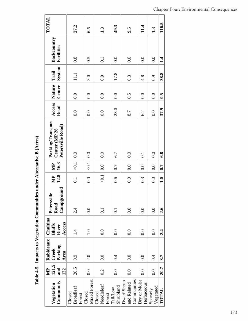
173
Chapter Four: Environmental Consequences
Tab
le 4
-5.
Impa
cts t
o V
eget
atio
n C
omm
uniti
es u
nder
Alte
rnat
ive
B (A
cres
)
Veg
etat
ion
Com
mun
ity
MP
121.
5an
d12
2
Rab
idea
uxC
reek
Park
ing
Are
a
Chu
ltina
Blu
ffs
Riv
erA
cces
s
Pete
rsvi
lle
Roa
dC
ampg
roun
d
MP
12.8
MP
16.3
Park
ing/
Tra
nspo
rtC
ente
r (M
P 28
Pe
ters
ville
Roa
d)
Acc
ess
Roa
dN
atur
eC
ente
rT
rail
Syst
emB
ackc
ount
ry
Faci
litie
s
TOTA
L
Clo
sed
Bro
adle
afFo
rest
20.5
0.
9 1.
4 2.
4 0.
1 <0
.10.
0 0.
0 0.
0 11
.1
0.8
27.2
Clo
sed
Mix
ed F
ores
t 0.
0 2.
0 1.
0 0.
0 0.
0 <0
.10.
0 0.
0 0.
0 3.
0 0.
5 6.
5
Clo
sed
Nee
dlel
eaf
Fore
st0.
2 0.
0 0.
0 0.
1 <0
.10.
0 0.
0 0.
0 0.
0 0.
9 0.
1 1.
3
Tall/
Low
Shru
blan
d0.
0 0.
4 0.
0 0.
1 0.
6 0.
7 6.
7 23
.0
0.0
17.8
0.
0 49
.3
Dw
arf S
hrub
an
d R
elat
ed
Com
mun
ities
0.
0 0.
0 0.
0 0.
0 0.
0 0.
0 0.
0 8.
7 0.
5 0.
3 0.
0 9.
5
Dry
or M
oist
H
erba
ceou
s0.
0 0.
0 0.
0 0.
0 0.
3 0.
0 0.
1 6.
2 0.
0 4.
8 0.
0 11
.4
Spar
sely
Veg
etat
ed0.
0 0.
4 0.
0 0.
0 0.
0 0.
0 0.
0 0.
0 0.
0 0.
9 0.
0 1.
3
TO
TA
L
20.7
3.
7 2.
4 2.
6 1.
0 0.
7 6.
8 37
.9
0.5
38.8
1.
4 11
6.5

174
Final South Denali Implementation Plan and EIS
Tab
le 4
-6 S
umm
ary
of A
ltern
ativ
e B
Cum
ulat
ive
Impa
cts t
o T
erre
stri
al V
eget
atio
n w
ithin
the
Plan
ning
Are
a
Ala
ska
Veg
etat
ion
Cla
ssifi
catio
n1Pl
anni
ngA
rea2 (a
cres
)
Past
/Pre
sent
Im
pact
s3
(acr
es)
Futu
re E
xter
nal
Impa
cts4
(acr
es)
Dir
ect
Impa
cts
(Alte
rnat
ive
B) (
acre
s)
Cum
ulat
ive
Impa
cts
(Per
cent
)
Clo
sed
Bro
adle
af F
ores
t 20
6,33
0 12
,973
U
NK
36
6%
C
lose
d N
eedl
elea
f For
est
32,1
76
1,52
1 U
NK
4
5%
Clo
sed
Mix
ed F
ores
t 47
,599
3,
443
1,92
0 to
6,9
208
7 11
TO
22%
Ta
ll/Lo
w S
hrub
land
16
1,40
6 6,
835
UN
K
50
4%
Dw
arf S
crub
and
Rel
ated
Com
mun
ities
510
,092
98
U
NK
10
1%
D
ry o
r Moi
st H
erba
ceou
s 29
,132
1,
143
UN
K
11
4%
Spar
sely
Veg
etat
ed
3,38
9 10
7 U
NK
1
3%
TO
TA
L V
EG
ET
AT
ED
AR
EA
49
0,12
4 26
,120
un
k 11
9 n/
a N
on-V
eget
ated
14,2
86
82
UN
K
2 <1
%
Cle
ar a
nd/o
r Dee
p W
ater
3,
062
85
UN
K
0 3%
Tu
rbid
and
/or S
hallo
w W
ater
4,
186
59
UN
K
<1
1%
Ice,
Sno
w, a
nd C
loud
s610
4 1
UN
K
0 1%
Sh
adow
74,
910
NA
N
A
2 N
A
Not
es:
1A
s des
crib
ed b
y Fi
tzpa
trick
-Lin
s and
oth
ers (
1989
), ad
apte
d fr
om V
iere
ck a
nd o
ther
s (19
92).
2A
cres
of u
nim
pact
ed v
eget
atio
n pr
ior t
o la
te 1
980s
3
Past
/Pre
sent
Im
pact
s to
veg
etat
ion
com
mun
ities
wer
e de
term
ined
fro
m th
e G
IS la
yers
: MSB
mot
oriz
ed a
nd n
on-m
otor
ized
tra
ils (
MSB
200
1a);
NPS
mot
oriz
ed a
nd n
on-m
otor
ized
trai
ls (
prov
ided
by
NPS
); Pa
rks
Hig
hway
(M
SB 2
001b
); M
SB r
oads
(M
SB 2
001b
); M
SB p
rivat
e la
nds
(MSB
200
1c);
min
ing
clai
ms
(pro
vide
d by
NPS
) and
rece
nt fo
rest
ry a
ctiv
ities
alo
ng P
arks
H
ighw
ay.
4Fu
ture
Ext
erna
l Im
pact
s to
wet
land
s co
uld
occu
r fr
om i
ncre
ased
rec
reat
iona
l ac
tivity
(es
peci
ally
inc
reas
e in
OR
V u
se),
incr
ease
in
hous
ing
deve
lopm
ents
, co
ntin
uatio
n an
d ex
pans
ion
of m
inin
g ac
tiviti
es,
deve
lopm
ent
of M
SB l
and
disp
osal
s, Pe
ters
ville
Roa
d up
grad
e an
d en
hanc
emen
ts (
DO
T&PF
), an
d pr
opos
ed d
evel
opm
ents
by
the
Boy
Sco
uts
of A
mer
ica,
Ala
ska
Rai
lroad
and
Prin
cess
. H
owev
er,
thes
e pl
ans
are
curr
ently
onl
y co
ncep
tual
the
refo
re,
area
s of
wet
land
s im
pact
s ar
e no
t av
aila
ble
at th
e pr
esen
t tim
e. A
qua
litat
ive
disc
ussi
on o
f the
pot
entia
l wet
land
impa
cts a
s a re
sult
of th
ese
futu
re e
xter
nal e
vent
sis
ava
ilabl
e in
the
cum
ulat
ive
impa
cts t
ext.

175
Chapter Four: Environmental Consequences
5Th
is c
lass
may
als
o co
nsis
t of c
omm
uniti
es d
omin
ated
by
liche
ns (F
itzpa
trick
-Lin
s, D
ough
ty e
t al.
1989
). 6
This
cla
ss m
ay c
onsi
sts o
f brig
ht re
flect
ive
surf
aces
and
var
ious
am
ount
s and
type
s of c
loud
cov
er (F
itzpa
trick
-Lin
s, D
ough
ty
et a
l. 19
89).
7Th
is c
lass
repr
esen
ts th
ose
area
s ob
scur
ed fr
om re
mot
e se
nsor
s by
mou
ntai
nous
terr
ain;
veg
etat
ion
may
or m
ay n
ot o
ccur
in
thes
e ar
eas (
Fitz
patri
ck-L
ins,
Dou
ghty
et a
l. 19
89).
8Th
e M
SB c
urre
ntly
hol
d a
timbe
r con
tract
for 6
40 a
cres
bet
wee
n M
P 11
5-11
8 of
the
Park
s Hig
hway
to b
e ha
rves
ted
in M
arch
20
05, w
ith p
oten
tial f
or 1
,280
add
ition
al a
cres
; bet
wee
n 3,
000
and
5,00
0 ac
res
of ti
mbe
r co
ntra
cts
coul
d be
exe
cute
d in
the
next
five
yea
rs.
UN
K –
Unk
now
n ac
reag
e of
impa
ct

176
Final South Denali Implementation Plan and EIS
Alternative C – Parks Highway Under Alternative C, recreational and visitor facilities would be constructed at sites in the Curry Ridge area and adjacent to the Parks Highway and Petersville Road. Table 4-7 summarizes the acres of vegetation type potentially impacted at each facility.
Curry RidgeThe proposed access road under this alternative would require the clearing of 20.4 acres of mostly low/tall scrubland with closed mixed forest and a small area of dry or moist herbaceous communities (Figure 4-10).
Approximately 0.7 acres of closed needleleaf forest and tall/low scrubland would need to be cleared to construct the proposed visitor center under Alternative C (Figure 4-11).
The proposed trail system under Alternative C would require the clearing of 69.9 acres of terrestrial vegetation consisting of mostly closed broadleaf forest and tall/low scrubland with areas of closed mixed forest, closed needleleaf forest, dwarf scrub related communities and dry or moist herbaceous communities. However, within forest habitat, the pathway might only require clearing of the understory vegetation, so impacts to the closed broadleaf forest, closed mixed forest, and closed needleleaf forest types (about 36 acres total) would be less than impacts to the tall/low scrubland (about 27 acres) and the other vegetation types (totaling about 6 acres).
Visitation to the proposed facilities could affect vegetation by increasing use of areas located on undisturbed ground off of planned developments. New or expanded parking areas and/or trailheads at Kroto Creek, MP 12.8 and 16.3 of the Petersville Road, Forks Roadhouse area, Rabideux Creek, and Parks Highway MP 121.5 and 122 would increase winter and summer motorized use throughout the planning area. Motorized vehicle use would occur off of trails and paved areas. Impacts could include trampling and loss of vegetation. Mitigation measures would decrease, but not eliminate, impacts. These measures could include signage, fencing, revegetation and use of geotextiles. No department in the State of Alaska has citation authority to enforce existing regulations related to motorized use on general state land, so impacts from motorized use are expected to increase with the expected increase in use resulting from increased parking areas and trailheads proposed in this alternative.
Parks HighwayEffects on vegetation along the Parks Highway within the planning area would be the same as those described for Alternative B with the addition of a parking area and campground at MP 134.6 of the highway. The proposed transportation/parking area and campground facility at the MP 134.6 of the Parks Highway lies on 28.6 acres of land, of which about 20.3 acres would be cleared or disturbed (see Figure 4-12). Terrestrial vegetation types directly impacted would include mostly closed broadleaf forest and tall/low scrubland with smaller areas of closed mixed forest and closed needleleaf forest.

177
Chapter Four: Environmental Consequences
Petersville Road Effects on vegetation along the Petersville Road would also be the same as those described for Alternative B; however, there would be no parking/transportation center at MP 28 and no upgrade to MP 18.6. Therefore total area of vegetation cleared for facilities along the Petersville Road under Alternative C would be about 4.3 acres consisting mostly of closed broadleaf forest and closed needleleaf forest.
In summary, the direct impacts resulting from the activities proposed under Alternative C would impact a total of about 143 acres of terrestrial vegetation, the majority of which consists of closed broadleaf forest and tall/low scrubland (see Table 4-7). The loss of vegetation would be unavoidable and permanent at the paved and developed sites. Compared to the baseline vegetation acreage within the planning area (about 460,000 acres), Alternative C would directly affect less than 0.1 percent of the baseline March 2005 vegetation and no unique vegetation or sensitive habitats would be impacted.
Potential indirect effects associated with the construction and operations of the access road, parking lots, turnouts and campground include introduction of sediments and pollutants from road runoff, and sanitary wastes two local water bodies; these pollutants could indirectly affect nearby vegetation by degrading water quality. In addition, visitor use and increased vehicular traffic could introduce invasive species, subsequently reducing ecological diversity. BMPs and design standards that can minimize contaminant introduction from road runoff, and monitoring and removal of invasive species would mitigate these effects.
Cumulative impactsPast, present, and reasonable foreseeable actions and effects are the same as those described for Alternative A.
The direct impacts resulting from all activities proposed under Alternative C would impact a total of about 143 acres of terrestrial vegetation. Reasonably foreseeable future external actions would be expected to directly impact between 1,920 and 6,920 acres of closed mixed forest from forest management activities, and an additional unknown acreage of terrestrial vegetation from other reasonable activities listed above. Past and on-going activities have impacted about 26,000 acres of terrestrial vegetation in the planning area since the late 1980s. Cumulative impacts to the closed broadleaf and needleleaf forest, tall/low shrubland, dwarf scrub and related communities, dry or moist herbaceous communities, sparsely vegetated and non-vegetated habitats are all under ten percent, and are mainly a result of past and on-going activities (Table 4-8). Cumulative impacts to closed mixed forests could be between 11 and 22 percent, depending on the amount of timber harvests that are to occur in the next five years. Forest management activities are considered long-term, but reversible if selective harvest practices are employed, and forest regeneration is implemented. Thus, cumulative impacts on terrestrial vegetation resulting from past, present, and reasonably foreseeable future actions, and the actions proposed under Alternative C, would be moderate. The overall contribution of this alternative to the cumulative impacts on terrestrial vegetation in the planning area would be noticeable due to indirect impacts from new or upgraded parking areas and trailheads, which would lead to increased cross-country ORV use throughout the South Denali region.

178
Final South Denali Implementation Plan and EIS
ConclusionThe developments proposed for Alternative C would impact about 143 acres of terrestrial vegetation in the Curry Ridge area and along the Petersville Road and Parks Highway. Acreage affected from indirect impacts from increased use is more difficult to quantify; linear impacts (from ORV use) would likely occur throughout the planning area. The impact on terrestrial vegetation from these developments and from recreational activities associated with these developments throughout the entire planning area would be moderate because widespread loss to non-sensitive vegetation would occur.

179
Chapter Four: Environmental Consequences
Tab
le 4
-7. I
mpa
cts t
o V
eget
atio
n C
omm
uniti
es u
nder
Alte
rnat
ive
C (A
cres
)
Veg
etat
ion
Com
mun
ity
MP
121.
5an
d 12
2
Rab
idea
uxC
reek
Park
ing
Are
a
Chu
ltina
Blu
ffs
Park
ing
Are
a an
d C
ampg
roun
dat
MP
134.
6
Pete
rsvi
lle
Roa
dC
ampg
roun
d
MP
12.8
MP
16.3
Acc
ess
Roa
dV
isito
rC
ente
rT
rail
Syst
em
TOTA
L
Clo
sed
Bro
adle
afFo
rest
20.5
0.
9 1.
4 9.
5 2.
4 0.
1 <0
.10.
0 0.
0 26
.2
51.0
Clo
sed
Mix
ed F
ores
t 0.
0 2.
0 1.
0 2.
5 0.
0 0.
0 <0
.14.
4 0.
0 2.
3 12
.2
Clo
sed
Nee
dlel
eaf
Fore
st0.
2 0.
0 0.
0 0.
3 0.
1 <0
.10.
0 0.
0 0.
2 7.
8 8.
6
Tall/
Low
Shru
blan
d0.
0 0.
4 0.
0 7.
9 0.
1 0.
6 0.
7 15
.6
0.5
27.3
53
.1
Dw
arf S
hrub
an
d R
elat
ed
Com
mun
ities
0.
0 0.
0 0.
0 0.
0 0.
0 0.
0 0.
0 0.
0 0.
0 0.
6 0.
7
Dry
or M
oist
H
erba
ceou
s0.
0 0.
0 0.
0 0.
1 0.
0 0.
3 0.
0 0.
4 0.
0 5.
5 6.
3
Spar
sely
Veg
etat
ed0.
0 0.
4 0.
0 0.
0 0.
0 0.
0 0.
0 0.
0 0.
0 0.
2 0.
6
TO
TA
L
20.7
3.
7 2.
4 20
.3
2.6
1.0
0.7
20.4
0.
7 69
.9
142.
5

180
Final South Denali Implementation Plan and EIS
Tab
le 4
-8.
Sum
mar
y of
Alte
rnat
ive
C C
umul
ativ
e Im
pact
s to
Ter
rest
rial
Veg
etat
ion
with
in th
e Pl
anni
ng A
rea
Ala
ska
Veg
etat
ion
Cla
ssifi
catio
n1Pl
anni
ngA
rea2 (a
cres
)
Past
/Pre
sent
Im
pact
s3
(acr
es)
Futu
reE
xter
nal
Impa
cts4
(acr
es)
Dir
ect
Impa
cts
(acr
es)
Cum
ulat
ive
Impa
cts
(Per
cent
)
Clo
sed
Bro
adle
af F
ores
t 20
6,33
0 12
,973
U
NK
60
6%
C
lose
d N
eedl
elea
f For
est
32,1
76
1,52
1 U
NK
11
5%
Clo
sed
Mix
ed F
ores
t 47
,599
3,
443
1,92
0 to
6,
9208
13
11 T
O 2
2%
Tall
and
Low
Scr
ub
161,
406
6,83
5 U
NK
54
4%
D
war
f Scr
ub a
nd R
elat
ed C
omm
uniti
es5
10,0
92
98
UN
K
<1
1%
Dry
or M
oist
Her
bace
ous
29,1
32
1,14
3 U
NK
6
4%
Spar
sely
Veg
etat
ed
3,38
9 10
7 U
NK
<1
3%
T
OT
AL
VE
GE
TA
TE
D A
RE
A49
0,12
4 26
,120
un
k 14
5 n/
a N
on-V
eget
ated
14,2
86
82
UN
K
2 <1
%
Cle
ar a
nd/o
r Dee
p W
ater
3,
062
85
UN
K
<1
3%
Turb
id a
nd/o
r Sha
llow
Wat
er
4,18
6 59
U
NK
<1
1%
Ic
e, S
now
, and
Clo
uds6
104
1 U
NK
0
1%
Shad
ow7
4,91
0 N
A
UN
K
1 N
A
Not
es:
1A
s des
crib
ed b
y Fi
tzpa
trick
-Lin
s and
oth
ers (
1989
), ad
apte
d fr
om V
iere
ck a
nd o
ther
s (19
92).
2A
cres
of u
nim
pact
ed v
eget
atio
n pr
ior t
o la
te 1
980s
. 3
Past
/Pre
sent
Im
pact
s to
veg
etat
ion
com
mun
ities
wer
e de
term
ined
fro
m t
he G
IS l
ayer
s: M
SB m
otor
ized
and
non
-mot
oriz
ed t
rails
(M
SB 2
001a
); N
PS m
otor
ized
and
non
-mot
oriz
ed tr
ails
(pro
vide
d by
NPS
); Pa
rks
Hig
hway
(MSB
200
1b);
MSB
road
s (M
SB 2
001b
); M
SB p
rivat
e la
nds (
MSB
200
1c);
min
ing
clai
ms (
prov
ided
by
NPS
) and
rece
nt fo
rest
ry a
ctiv
ities
alo
ng P
arks
Hig
hway
. 4
Futu
re E
xter
nal I
mpa
cts
to w
etla
nds
coul
d oc
cur
from
incr
ease
d re
crea
tiona
l act
ivity
(es
peci
ally
incr
ease
in O
RV
use
), in
crea
se in
ho
usin
g de
velo
pmen
ts,
cont
inua
tion
and
expa
nsio
n of
min
ing
activ
ities
, de
velo
pmen
t of
MSB
lan
d di
spos
als,
Pete
rsvi
lle R
oad
upgr
ade
and
enha
ncem
ents
(D
OT&
PF),
and
prop
osed
dev
elop
men
ts b
y th
e B
oy S
cout
s of
Am
eric
a, A
lask
a R
ailro
ad a
nd P
rince
ss.
How
ever
, th
ese
plan
s ar
e cu
rren
tly o
nly
conc
eptu
al t
here
fore
, ar
eas
of w
etla
nds
impa
cts
are
not
avai
labl
e at
the
pre
sent
tim
e. A
qual
itativ
e di
scus
sion
of t
he p
oten
tial w
etla
nd im
pact
s as
a re
sult
of th
ese
futu
re e
xter
nal e
vent
s is
ava
ilabl
e in
the
cum
ulat
ive
impa
cts
text

181
Chapter Four: Environmental Consequences
5Th
is c
lass
may
als
o co
nsis
t of c
omm
uniti
es d
omin
ated
by
liche
ns (F
itzpa
trick
-Lin
s, D
ough
ty e
t al.
1989
). 6
This
cla
ss m
ay c
onsi
sts
of b
right
refle
ctiv
e su
rfac
es a
nd v
ario
us a
mou
nts
and
type
s of
clo
ud c
over
(Fitz
patri
ck-L
ins,
Dou
ghty
et a
l. 19
89).
7Th
is c
lass
rep
rese
nts
thos
e ar
eas
obsc
ured
fro
m r
emot
e se
nsor
s by
mou
ntai
nous
terr
ain;
veg
etat
ion
may
or
may
not
occ
ur in
thes
ear
eas (
Fitz
patri
ck-L
ins,
Dou
ghty
et a
l. 19
89).
8Th
e M
SB c
urre
ntly
hol
d a
timbe
r con
tract
for 6
40 a
cres
bet
wee
n M
P 11
5-11
8 of
the
Park
s H
ighw
ay to
be
harv
este
d in
Mar
ch 2
005,
w
ith p
oten
tial f
or 1
,280
add
ition
al a
cres
; bet
wee
n 3,
000
and
5,00
0 ac
res o
f tim
ber c
ontra
cts c
ould
be
exec
uted
in th
e ne
xt fi
ve y
ears
. U
NK
– U
nkno
wn
acre
age
of im
pact
.
182
Final South Denali Implementation Plan and EIS
WILDLIFE
Methodology Hundreds of bird and mammal species have been documented in the South Denali planning area that could be affected to some degree by construction and operation of the proposed facilities. A subset of these species has been selected for analysis. The selected species occur regularly in the planning area and are either listed on federal or state agency conservation plans or are regularly hunted/trapped and are thus of high public interest.
Baseline conditions for selected wildlife species are described in Chapter Three. The selected species described in that chapter represent many other species that would have similar types of impacts from the proposed alternatives, although the intensity of the effects could vary substantially between species. The intensity of impacts on the various biological resources are estimated based on their baseline abundance and the calculated loss of their preferred habitat types within the planning area as well as the sensitivity of each species to disturbance. The assessments attempt to distinguish between changes in resources that naturally fluctuate over time and changes that would be related to development of the different alternatives. Although specific mitigation factors have not been determined, the potential for commonly used mitigation practices to decrease impacts on wildlife is discussed.
General Impacts Direct effects of the alternatives arise from their construction, operation, and maintenance as well as their replacement of various habitat types with a road/trail surface and/or visitor facilities. For the biological resources considered, potential direct effects include:
Loss of habitat from the cut and fill for the roadbed, visitor facilities, and associated construction sites (i.e. material pits, storage yards, etc.).Habitat fragmentation and edge effectsDisturbance from construction activities Disturbance from road maintenance activitiesDisturbance from road traffic associated with normal operation of the facilityMortality from land-clearing activities and burial with construction materialMortality from collisions with vehicle traffic Displacement from visitor use of the area.
Indirect effects may occur as a result of the project but happen at a different time or place than direct effects. These could include project-induced changes in habitat that eventually lead to changes in prey availability for a given species, or secondary development facilitated by the proposed action. The effects of secondary development could include loss of habitat, increased access for hunters, disturbance from additional recreational activity, and other impacts on wildlife.

183
Chapter Four: Environmental Consequences
Each activity or event may affect wildlife through several mechanisms that can be considered as indicators of potential impact.
Impact Level Definitions Minor: Causes population change in a specific location, and/or causes some loss of common habitat, and/or causes noticeable change in wildlife distribution at a specific location.
Moderate: Causes population change in most of the planning area, and/or causes some loss of important habitat, and/or causes noticeable change in the distribution of wildlife throughout planning area.
Major: Impacts regional population, and/or causes substantial loss of habitat important to reproduction or survival, and/or causes a shift in regional distribution of wildlife.
Alternative A – No Action Under the No Action alternative, there would be no change from the current management direction that represents the existing condition in the South Denali region. There would be no approved plan for local, state, and federal agencies to cooperatively improve and increase recreational opportunities and access to the South Denali region; therefore there would be no new construction and no new impacts on wildlife.
Cumulative impactsIncreasing human settlement in the South Denali area has resulted in two major types of effects on wildlife: changes in habitat brought about by resource extraction, land development, wildfire suppression, and road construction; and greatly improved access to wild lands for hunting, fishing, and a host of other recreational activities.
The general effect of habitat loss and fragmentation has been to reduce the carrying capacity for most wildlife species, although there has been no effort to quantify this effect. Table 4-6, found in the Vegetation section of this chapter, lists the cumulative impacts to different vegetation communities within the planning area. This table indicates that most habitat changes have taken place or are likely to take place in closed canopy broadleaf forests (approximately 13,000 acres), tall and low scrub (about 6,900 acres), closed mixed forests (3,450 acres), closed needleleaf forests (1,500 acres), and herbaceous habitats (1,150 acres). Except for the case of closed mixed forests, these changes in habitat represent much less than ten percent of what existed under pristine conditions before substantial human settlement. Similar changes in wildlife habitat are likely to continue in the foreseeable future as more people settle in the area and seasonal usecontinues to grow. This degree of habitat change has affected the local distribution of various wildlife species, especially around the most developed areas near the Parks Highway, but there is no evidence that the regional populations of any bird or mammal species have declined as a direct result of habitat loss in the area.

184
Final South Denali Implementation Plan and EIS
Impacts from increased cross-country ORV use are more difficult to quantify. ORV use primarily causes loss of productivity (loss of vegetation cover), erosion, compaction, rutting, and displacement. Ruts from ORV use can be seen from the air throughout general state land in the planning area. Noise from ORV use could displace individuals and stress wildlife. This trend would be expected to continue, and impacts would occur throughout the planning area.
For large mammals, the great increase in access and numbers of hunters over the last twenty years has strongly affected the survival rates, sex ratios, and local densities of popular game species, especially moose and caribou. The Alaska Board of Fish and Game and ADF&G have had to change hunting regulations a number of times in order to reduce hunter success and maintain sustainable populations of these species. Recent management actions have been taken to reduce the populations of wolves and brown bears in the area in order to promote increased populations of moose for human consumption (Tobey 2003). Active game management policies that promote the increase of some species and decreased populations of other species are likely to continue in the foreseeable future.
For birds, development in forest and shrub habitats would decrease the options for foraging and nesting, especially for species that are less tolerant of disturbance. However, given the generally low densities of nesting birds in central Alaska and the abundance of alternative, undisturbed habitats in the area, it is unlikely that the regional populations of any species have declined as a result of decreased carrying capacity on their breeding grounds. Most of the species of conservation concern are migrants that are facing much more serious challenges to their winter habitats in the south. However, some of the wetland nesting species such as the Tule goose and trumpeter swans are fairly sensitive to human disturbance on their nesting grounds. Increased human encroachment in these areas, especially by loud riverboats that service the tourist industry, could cause enough disturbance to reduce reproductive success or abandonment of nesting grounds. Growth of these types of tourist services could be facilitated by the proposed project and other access improvements that are in the planning stages. There are a number of potential mitigation measures such as limiting public access to known nesting areas, limiting the use of loaded river boats, and monitoring populations to assess impacts could be pursued to help alleviate this cumulative adverse impact on riverine habitat birds.
Thus, the cumulative impacts on wildlife resulting from past, present, and reasonably foreseeable future actions would be moderate.
ConclusionThe No Action alternative would not affect wildlife in the planning area.

185
Chapter Four: Environmental Consequences
Alternative B – Peters Hills Under Alternative B, recreational and visitor facilities would be constructed at sites in the Peters Hills area and adjacent to the Parks Highway and Petersville Road. Construction and operation of these facilities would directly impact wildlife habitat at the development sites. Table 4-5 (found in the Vegetation section of this chapter) shows the acres of habitat type that would be directly affected by implementing Alternative B. The impacts on wildlife related to the loss of habitat and the indirect effects of increased disturbance from human activity in areas presently with little human activity are discussed as applicable for each site.
Peter HillsLoss of wildlife habitat from construction and operation of facilities in the Peters Hills alternative involve both the direct loss of habitat from clearing vegetation during construction and operation of the facilities, and the indirect effects of increased disturbance from human activity in areas presently with little human activity. Development proposed for this area includes an approximately 7-mile access road from MP 28 of the Petersville Road to a new nature center, trail system, and backcountry facilities including a cabin.
The Peters Hills access road, the nature center at the top of Peters Hills, and the trail network and backcountry facility would result in the direct loss of approximately 79 acres of wildlife habitat. Approximately half of this total, about 40 acres, would be tall and low shrub communities. Broadleaf, needleleaf, and mixed forest habitats make up about 16 acres with the remaining habitat consisting of meadow (dry or moist herbaceous; 11acres) and dwarf shrub communities (9.5 acres). The actual value of this habitat to different wildlife species would depend to some degree on its location.
All of these vegetation communities are common within the planning area and most of the losses due to clearing would be in linear features such as roads and trails, which would minimize the impacts to wildlife in any specific area. However, because the area is not developed at present, direct and indirect impacts with respect to specific mammals and birds in the Peters Hills area are discussed in general in the following paragraphs.
The permanent loss of mammal habitat within the cut and fill limits of the parking facility, road corridor, visitor facility, and associated trails would be relatively small compared to the amount of similar habitat in the planning area. Human noise and activity in the planning area, both during construction and under normal operations, is likely to cause some animals to avoid the road and nature center and would effectively cause additional habitat loss. The size of this “avoidance zone” would depend on the type and intensity of the disturbance as well as many animal behavior variables. The effective loss of habitat for each species would therefore fluctuate over time but could be substantially larger than the footprint of the project.
Roadways can sometimes function as a barrier to animal movements due to a combination of avoidance behavior and physical features such as steep cutbanks, guardrails, or retaining walls. This may deter animals from accessing particular areas and resources and thus decrease the value of the habitat (USDA Forest Service 2000). Another major concern with wildlife having to cross a road is the danger of collisions with vehicles, although the traffic volume and speed of buses on the proposed road is such that road kill mortality should be minimal.

186
Final South Denali Implementation Plan and EIS
Noise from cross-country ORV use and increased snowmachine use, due to improvements in parking areas and trailheads proposed in this alternative, is likely to cause some animals to avoid areas where these vehicles are used. The size of these “avoidance zones” would depend on the type and intensity of the disturbance as well as many animal behavior variables.
Brown bears tend to avoid using habitats near roads, sometimes regardless of traffic volume (McLellan and Shackleton 1988; Kasworm and Manley 1990; Mace, Waller et al. 1996). Black bears appear to be more tolerant of roads and vehicles. However, the proposed facilities are not near any critical bear habitat such as anadromous fish streams so any behavioral loss of habitat is likely to have minor effects on the ability of bears to obtain important resources. Bears typically avoid humans but are attracted to human garbage and food supplies, which sometimes brings them into conflict with humans and results in bears being shot in defense of life or property (Suring, Barber et al. 1998). BMPs, such as controlling waste disposal and food storage, can be incorporated into construction procedures and visitor facility operations to minimize this potential problem.
Under this alternative, private vehicle use would be restricted on the new road during the main visitor season, and ORVs would not be allowed on the new trails. Although parking areas along the Petersville Road would be improved, hunter access to the Peters Hills area would remain similar to the present conditions so the project would not be expected to result in increased hunting mortality of bears.
Caribou occasionally pass through the Peters Hills area during their seasonal movements but they have not been observed to calve or spend appreciable time in the area. The loss of habitat due to the footprint of the project and disturbance is therefore unlikely to affect their reproduction or survival. As noted above, access of hunters to caribou in the area is not expected to change from present conditions and mortality from vehicle collisions is unlikely. Disturbance from human activity could disrupt normal behavior during the short time that caribou are in the area but the effects are likely to be temporary.
Moose could be present in the planning area during construction and during normal operations in the visitor season. Noise from construction activities is likely to disturb moose and temporarily displace them from the immediate vicinity but is unlikely to keep them from acquiring critical resources for survival or reproduction. Because of their keen sense of hearing, moose are typically able to detect the presence of people from a distance and are able to avoid being seen or having adverse interactions. In many urban areas in Alaska, moose habituate to the presence of humans and are able to successfully forage and even have calves nearby. This is often considered a positive experience from a visitor’s perspective and is generally safe unless visitors behave inappropriately and try to approach the moose. Visitor education about appropriate behavior around wildlife is proposed to be an important emphasis at all visitor facilities. The potential for increased mortality on moose through vehicle collisions and increased hunter access are considered to be minor.
There are a variety of small mammals that are likely to be affected by loss of habitat and disturbance from the proposed project. Some species, such as voles and ground squirrels, could

187
Chapter Four: Environmental Consequences
also experience some direct mortality from construction activities. However, given the relatively small amount of habitat involved, the affected numbers of individuals of each species is likely to be small and any reduction in survival or reproduction is likely to be temporary. After construction, small mammals are likely to adjust their territories to accommodate the new facilities and trails. Some predators, such as lynx, red fox, and wolves, could benefit from the project by utilizing the new recreational trails for easy access to their own territories. No species of mammal is likely to experience a substantial increase in mortality due to vehicle collisions or improved hunter/trapper access. The magnitude of potential effects on other mammals is considered to be minor.
For many terrestrial bird species in Alaska, conservation concerns are the result of landscape-scale loss of habitat due to fire or commercial logging (Boreal Partners in Flight 1999). Habitat loss due to the proposed project would be relatively small (approximately 119 acres) in comparison and would primarily affect species that are likely to nest in the area. Most of the bird species of conservation concern described in Chapter three are either uncommon to rare in the South Denali area or nest in other habitat types than the uplands directly affected by the project. Species that potentially nest in the area affected by the alternative include rock ptarmigan, olive-sided flycatcher, northern shrike, varied thrush, arctic warbler, blackpoll warbler, golden-crowned sparrow, and white-winged crossbill.
Loud noises and sudden movements from construction activities, vehicle traffic, or pedestrian traffic are likely to disturb birds in nearby areas. If the birds are feeding or resting, they would likely fly away from the disturbance and resume their normal behavior in another location. Outside of the nesting season, such short-term displacements would cost birds a minor amount of energy and time but would be unlikely to affect their survival. Disturbance of nesting birds would decrease their chances of reproductive success for the season or could cause them to abandon their nests. For this reason, the Migratory Bird Treaty Act prohibits disruption of nesting activities. The most effective way to assure compliance with this law is to schedule land-clearing and excavation activities outside the nesting season. After construction, most birds would likely nest some distance away from the road and trails in order to avoid chronic disturbance from vehicles and pedestrians. However, some species, such as gray jays, are attracted to campgrounds and other human habitations and receive some benefits in the form of food gleaned from picnic tables.
Traffic on the road to the visitor facility and pedestrian traffic on hiking trails would be infrequent so the zone of avoidance around these developments is likely to be small and temporary. Because the type of habitat lost to the proposed project is very common in the South Denali area, the amount of foraging and nesting habitat lost due to construction and disturbance would be unlikely to affect the long-term survival or reproductive success of any of the species considered.

188
Final South Denali Implementation Plan and EIS
Parks HighwayProject components that would be built along the Parks Highway would result in the direct loss of some wildlife habitat. These components include: MP121.5 and 122 parking areas, Rabideux Creek parking area, and Chulitna River access. About 17 acres would be lost from clearing and development of these facilities. Some of the major vegetation types affected by these developments include about 15 acres of closed broadleaf and closed mixed forest, about 1 acre of shrub habitat and less than an acre of dry or moist herbaceous habitats. These habitats are common in the planning area and wildlife populations are not likely to be impacted by the loss. Since the Parks Highway corridor is already developed, indirect effects due to increased disturbance from human activity would not be a factor at most of these sites.
Petersville Road Components along the Petersville Road that would contribute to the loss of wildlife habitat include a campground near the Forks Roadhouse, turnout at MP 12.8, turnout at MP 16.3, upgrade of Kroto Creek parking area, and parking area/transportation center at MP 28. These developments would result in the loss of about 11 acres of habitat. The majority of habitats impacted include broadleaf forest and shrublands; these habitats are common in the planning area and wildlife populations are not likely to be impacted by the loss. Impacts would be permanent and last throughout the life of the plan.
Cumulative impactsPast, present and future developments that would impact wildlife would be the same as those discussed for Alternative A. Increasing human alteration of the South Denali environment is a reasonably foreseeable cumulative effect, especially in the summer tourist season, and the wild character of the surrounding area would be degraded as this occurs. Although these cumulative impacts have changed the population status of some wildlife species (i.e. big game and their major predators) and affected the distribution of most birds and mammals in the area, no species appear to be exhibiting long-term declines in their regional populations as a result of human changes in the local environment. The presence of Denali National Park and Preserve as well as Denali State Park assures that there would continue to be an abundance of diverse and excellent wildlife habitats in the region in the foreseeable future, even with expanded developments on private, state, and borough lands.
Alternative B would increase development and visitor usage of the South Denali region, particularly the Petersville Road area, by thousands of people per day in the summer and would thus contribute substantially to the cumulative impacts of increasing human influence on wildlife in the area. The contribution of this alternative to habitat loss would be minimal relative to both external developments and the pristine condition. Cumulative impacts on wildlife would be considered moderate in magnitude, and the overall contribution of this alternative to the cumulative impacts on wildlife in the planning area would be minimal.

189
Chapter Four: Environmental Consequences
ConclusionDevelopment of new visitor facilities under Alternative B is likely to have minor direct and indirect impacts on local wildlife. Although construction activities may cause temporary displacement of wildlife due to disturbance, the proposed mode of operation with buses and pedestrian trails is likely to cause minimal disturbance so that resident birds and mammals are likely to remain in the vicinity of the visitor facilities and access road. Increased ORV and snowmachine use would displace individuals but is not expected to cause population-level changes throughout the planning area.
Alternative C – Parks Highway Under Alternative C, recreational and visitor facilities would be constructed in the Curry Ridge area and at sites adjacent to the Parks Highway and Petersville Road. Table 4-7 (found in the Vegetation section of this chapter) shows the acres of habitat type directly affected by clearing under Alternative C. The impacts on wildlife related to the loss of habitat and the indirect effects of increased disturbance from human activity in areas presently with little human activity are discussed as applicable for each site.
Curry Ridge The access road from the Parks Highway, the visitor center at the top of access road, and the trail network would result in the direct loss of approximately 91 acres of wildlife habitat. Approximately half of this total, 41 acres, would be forest (broadleaf, needleleaf and mixed). Tall and low shrub communities would make up another 43 acres. The remaining area would consist of 6 acres of meadow habitat (dry or moist herbaceous), and less than 1 acre of dwarf shrub. The actual value of this habitat to different wildlife species would depend to some degree on its location.
All of these vegetation communities are common within the planning area and most of the losses due to clearing would be in linear features such as roads and trails, which would minimize the impacts to wildlife at any specific location. Construction of the trail system, while covering about 70 acres total, would only likely result in the removal of understory species (about 33 acres). The remaining forest species would not be affected by the trails.
Under Alternative C, the permanent loss of wildlife habitat within the clearing limits of the different developments is relatively small (about 143 acres) compared to the amount of similar habitat in the planning area. Although this alternative would impact wildlife in a different location, the types and magnitude of effects would be essentially the same as described for Alternative B. These potential effects primarily involve a minor amount of permanent habitat loss and several sources of disturbance that would be mostly temporary in nature. The Curry Ridge area is generally known to support a high number of bears. Development at this site would likely displace some individuals, but these and other effects are unlikely to impact more than a small number of individual animals or adversely affect regional populations of any species. Mitigation measures (that are listed in the Mitigation section in Chapter Two) would mitigate impacts to bear populations.

190
Final South Denali Implementation Plan and EIS
Parks HighwayEffects on wildlife habitat along the Parks Highway within the planning area would be the same as those described for Alternative B with the addition of a parking area and campground at MP 134.6 of the highway. The proposed transportation/parking area and campground facility at the MP 134.6 of the Parks Highway lies on 28.6 acres of land, of which about 20 acres would be cleared or disturbed. Terrestrial vegetation types directly impacted would include mostly closed broadleaf forest and tall/low scrubland. Since the Parks Highway corridor is already developed, indirect effects due to increased disturbance from human activity would not be a factor at most of these sites.
Petersville Road Effects on wildlife along the Petersville Road would also be the same as those described for Alternative B; however, there would be no parking/transportation center at MP 28. Therefore, total area of vegetation cleared for facilities along the Petersville Road under Alternative C would be about 4 acres consisting mostly of closed broadleaf and needleleaf forest.
Noise from cross-country ORV use and increased snowmachine use, due to improvements in parking areas and trailheads proposed in this alternative, is likely to cause some animals to avoid areas where these vehicles are used. The size of these “avoidance zones” would depend on the type and intensity of the disturbance as well as many animal behavior variables.
Cumulative ImpactsThe cumulative impacts on wildlife would be dominated by factors external to the proposed project and would be the same as those described for the Alternative B. Alternative C would likely promote ancillary visitor service development along the main highway corridor rather than along a secondary road, which might concentrate future development in a smaller area, but the overall contribution of this alternative to the cumulative increase in human influence on the area’s wildlife would be similar to that of the Peters Hills alternative. The two major cumulative impacts on wildlife of increasing human settlement in the South Denali region are changes in habitat and greatly improved access to wild areas. The degree of habitat change and human disturbance/consumption has likely affected the local abundance and distribution of various wildlife species and is considered to have had moderate impacts on the regional populations of the species considered.
Thus the cumulative impacts on wildlife resulting from past, present, and reasonably foreseeable future actions and the actions proposed under Alternative C would be moderate. The overall contribution of this alternative to the cumulative impacts on wildlife in the planning area would be minimal.
ConclusionDevelopment of new visitor facilities at the Parks Highway site would likely have minor direct and indirect impacts on local wildlife. Construction activities may cause temporary displacement

191
Chapter Four: Environmental Consequences
of wildlife due to disturbance but the operation of the facilities and pedestrian trails is likely to cause minimal disturbance of birds and mammals. Increased ORV and snowmachine use would displace individuals but is not expected to cause population-level changes throughout the planning area.
CULTURAL RESOURCES
Methodology To determine potential impacts of the proposed alternatives on cultural resources within the planning area, cultural resources inventories that occurred within the planning area were reviewed. The records of the Alaska Heritage Resources Survey (AHRS) were examined to locate information on known sites in the vicinity of the proposed project area and previous investigations conducted in the area. A literature review was also conducted to assist in generating a historic context for evaluating cultural resources identified in the project area. This included the mining history for the area, as it was felt that the remains of mining activities would likely be found in the Peters Hill location.
The access road routes proposed for Alternative B and C were walked by two to four people from the Alaska Office of History and Archeology, spaced 10m to 15m apart. High probability areas adjacent to the access road route were also inspected. Surface exposure was very good at the Peters Hills area, as there was little soil development and little vegetation. Two personnel accessed the project area of potential effect from the northwest side and surveyed the pad and route leading south. Two other personnel accessed the area of potential effect from approximately the middle of the route and surveyed the route southward. The Parks Highway location was densely vegetated, and surface visibility was very low. Several shovel tests were excavated along the route in areas judged to have high archaeological potential.
No new cultural resources were identified in the Peters Hills area, other than the mining ditch feature (TAL-115) located west of the access route. Fairly complete survey was possible due to the area of potential effect being primarily above treeline, and soil development was minimal resulting in high surface visibility. Much of the area immediately adjacent to the area of potential effect was investigated in hopes that the high surface visibility would allow identification of surface scatters of artifacts. None were identified. The area of potential effect for this alternative does not appear to affect any cultural resources.
The Parks Highway site consists of heavily vegetated kettle and kame topography cut by steep and deep ephemeral stream channels. Although the proposed area of potential effect was surveyed and no cultural resources identified, the adjacent areas were not as thoroughly investigated. As stated, no cultural resources were identified along the proposed area of potential effect. We would recommend that if the route is developed, additional survey of the adjacent area should be conducted to assure that no cultural resources outside the identified area of potential effect exist that might be subjected to secondary affects resulting from increased use of the area.

192
Final South Denali Implementation Plan and EIS
General Impacts In general, the potential for increased pressure on cultural sites increases as the number of visitors increases. Impacts from visitor use can include modification, defacement, displacement, or removal of objects from cultural sites. Management actions to manage visitor use could also result in adverse impacts (for example, disturbing sites during trail construction). When specific actions are taken within any alternative further analysis could be required to comply with the requirements of Section 106 of the National Historic Preservation Act (NHPA) in accordance with the Advisory Council on Historic Preservation’s regulations implementing Section 106 (36 CFR Part 800, “Protection of Historic Properties”).
Impact Level Definitions While each conclusion reflects a judgment call about the relative importance of the various factors involved, the following descriptors provide a general guide for how those conclusions are reached.
Minor: Impacts affect cultural resources that are not eligible for the National Register of Historic Places (NRHP).
Moderate: Impacts affect cultural resources that are eligible for or are already listed in the NRHP if no mitigation measures are implemented.
Major: Impacts affect cultural resources that are listed in the NRHP, regardless of mitigation measures.
Alternative A- No Action The actions proposed under this alternative would have no impact on cultural resources within the planning area because no new developments are proposed under this alternative.
Cumulative ImpactsResident population growth and visitor use are expected to continue to increase in the south side planning area regardless of the outcome of this development concept plan. New housing and commercial development has occurred along the Petersville Road and throughout the South Denali region. This development has resulted in minor expansion of local road networks or improvements of existing roads. This gradual development spreading out from the Parks Highway corridor is likely to continue, creating increased access to the state and federal park lands. Resort lodges, motels, RV parks, cabins, and campgrounds would likely be developed in the region independent of developments considered under the proposed action. These developments would correspond with increased use in the region. Increases in use and improved access to the region increase exposure to cultural resources and increase the potential for disturbance or damage to cultural resources.
The combination of impacts from other activities that directly affect cultural resources and the provisions under Alternative A would result in major impacts overall, since some of the

193
Chapter Four: Environmental Consequences
resources that could be impacted could include resources of national importance. The actions proposed under Alternative A would not contribute to the overall cumulative impacts to cultural resources.
ConclusionThere would be no adverse impacts to cultural resources under this alternative because no new developments would be planned.
Alternative B - Peters Hills Eighteen historic and prehistoric cultural resources are reported in the vicinity of the Peters Hills development site (Table 3-8). Only one site (TAL-080), the Peters Creek Bridge, has been formally evaluated for listing in the National Register of Historic Places. Several types of resources are represented in the immediate area; including prehistoric and Dena'ina archaeological sites (buried archaeological materials, cache pits, house depressions); gold mining habitation and work sites; transportation features (trails, wagon roads, bridges, landing fields, construction camps, shelter cabins); and cabin sites associated with trapping, homesteading, and other historic activities. These resource types are situated in reasonably predictable locations within the landscape.
Early prehistoric archaeological sites along the middle Susitna Valley are generally located on well-drained conspicuous promontories near fresh water (Seager-Boss 2004:61). Cache and house pits are common throughout the Susitna River basin and are most often located near the confluence of streams or rivers, and along lake margins. Historic gold mining habitation and work sites are located within gold-producing stream and river valleys in the Peters and Dutch Hills. Associated ditch and penstock features were often constructed in the uplands between placer creeks. Although most major trails and roads in the region are documented in historic literature, the location of smaller opportunistic trails are largely unknown. Shelter cabins, mining cabins, construction camps, and homesteads are typically clustered along trail, roads, and river corridors.
The historic integrity of the Petersville Road (TAL-117) could be damaged by proposed upgrades and widening of the road. Enhancements may alter the setting, location, workmanship, and feeling of the road. These aspects of integrity are significant elements in National Register eligibility. Cabins or archaeological sites located along its route may be directly impacted by road improvements.
Improving Petersville Road would facilitate and increase access to the Peters and Dutch Hills. Improved access would increase visitation and the potential for artifact collecting and vandalism of cultural resources.
Construction of an access road to the proposed Peters Hills nature center would directly bisect a mining ditch feature (TAL-115). Ground disturbance would be short-term and unlikely to denigrate the overall National Register eligibility of the feature. The ditch is a conspicuous landscape feature that may attract visitation and hiking of its route. Mining-related artifacts, such as shovels, picks, and other antiques are often found along the path of mining ditch features and

194
Final South Denali Implementation Plan and EIS
would be vulnerable to artifact collecting. The new access road would improve access to this ditch, increasing visitation and the potential for artifact collecting and vandalism of cultural resources.
Hiking trail development at the Peters Hill site would have the highest potential to affect historic resources. Reported mining-era sites (TAL-072,TAL-073,TAL-074) in the region consist of surface features and artifacts representing habitations and work sites. Shovels, tinware, and other historic mining-era artifacts are scattered throughout the Dutch and Peters Hills. A proposed 15-mile hiking trail from mile 30.5 to Home Lake could directly affect cultural resources along the mining and native trail (K'enuqak 'itnetant) that extended from Cache Creek to Home Lake. Prior to the construction of the Petersville Road, Home Lake was the site of early prospecting and logistical camps for miners of the Yentna District. Construction of a public use cabin at Home Lake could disturb unreported buried or surface cultural resources at the site. Hiking trails would increase pedestrian access and the illicit collecting of portable artifacts important to the history of the region.
Campground development near the Forks Roadhouse has a high potential to directly affect historic properties. Built in the late 1920s, the Forks Roadhouse (TAL-116) was important to regional history and is likely eligible for listing in the National Register of Historic Places. Campground construction would directly disturb surface artifacts, archaeological deposits, and historic building ruins in the vicinity. Construction of a campground could directly impact artifacts or historic building remains related to road and mining development after the 1920s. Lands at the Forks have not been archaeologically surveyed and probably contain cabins, cabin ruins, mining equipment, tinware, bottles, horseshoes, sleds, and transportation-related artifacts. Effects of construction would be short-term but could destroy the integrity of surface and subsurface resources. Changes in the spatial relationship of artifacts and features would compromise the research potential and National Register eligibility of these properties.
The campground would increase visitation along the adjacent Cache Creek Trail (TAL-118) between the Forks and Cache Creek. The trail has not been surveyed and may possess significant historic artifacts along its route. Mining-era artifacts are highly valued by collectors and would likely disappear with increased access and use (Carley 1981; Sweeney 2000).
Construction of a bike path and turnouts on the Petersville Road has the potential to affect significant cultural resources. Potential historic properties along the route include Alaska Road Commission construction camps, shelter cabins, homestead cabins or cabin sites, the Petersville Road (TAL-117), and scattered artifacts associated with the mining history of the region. The route also holds potential for prehistoric and Dena’ina archaeological sites near streams, ponds, and along well-drained prominent landforms. Impacts from bike path construction would be acute and short-term. Effects from sustained pedestrian use of the route would be long-term and may include artifact collecting from nearby archaeological sites or historic structures. These impacts have a high potential to damage the integrity and National Register eligibility of sites along the route.
Cumulative ImpactsExternal impacts affecting cultural resources would be the same as described in Alternative A.

195
Chapter Four: Environmental Consequences
The combination of impacts from other activities that directly affect cultural resources and the provisions under Alternative B would result in major impacts overall, since some of the resources that could be impacted could include resources of national importance. The actions proposed under Alternative B would appreciably add to the overall cumulative impacts to cultural resources.
ConclusionAlternative B would have moderate adverse impacts to cultural resources because of increases in the number of visitors in areas where cultural resources exist. Many of these resources are eligible or could be eligible for the NRHP; however if the mitigation measures listed in Chapter Two are implemented, then impacts to these cultural resources would be avoided.
Alternative C - Parks Highway In addition to the impacts described under alternative B from campground construction near the Forks, and pullouts and a bike path along Petersville Road, the following impacts would also occur.
Three historic and prehistoric cultural resources are reported in the vicinity of the Parks Highway development site (Table 3-9). Reported at TAL-114 is a scatter of lithic flakes on a hill overlooking Byers Lake. Historic sites include cabins and cabin remains at Byers Lake (TAL-119), and an historic building at Curry Lookout (TAL-001). The Curry Lookout cabin is listed in the National Register of Historic Places. Curry Ridge (K'esugi Ken) and Troublesome Creek (Nelnikda Ey'unt) were locations frequented by Dena'ina bear and caribou hunters. A native steambath and possible campsite were reported by Shem Pete along the east bank of Troublesome Creek (Kari and Fall 2003).
Proposed trail enhancements near the Parks Highway site could affect these prehistoric sites. Prehistoric sites in the region tend to cluster around lakes, the confluence of rivers and streams, and promontories with water access. Hiking trails and a 3.5-mile visitor access road would bring direct visitation to Lake 1787 and other smaller ponds. Ground-disturbance from trail construction, erosion, and artifact collecting could negatively affect the historic significance and potential eligibility of these sites to the National Register of Places. Lithic artifacts vulnerable to collecting may include projectile points, bifaces, and waste flakes.
The proposed trail to Lake 1787 has the potential to directly and indirectly effect cultural resources. A high probability exists for unreported cultural resources at Lake 1787 and small ponds along the trail route. Archaeological resources at these discrete sites may include pit features and surface lithic [stone] artifacts. Trail construction, artifact collecting, and erosion from increased visitor-use would adversely affect these resources. Collection of artifacts and ground-disturbing activities would diminish the research potential and eligibility of these archaeological properties to the National Register of Historic Places.
A proposed hiking trail connecting the visitor center to Curry Lookout would increase visitation to the National Register listed Curry Lookout building (TAL-001). Increased visitation could

196
Final South Denali Implementation Plan and EIS
negatively impact this resource. However, measures listed in the Mitigation section of Chapter Two would mitigate impacts to this resource by ensuring that the building is in stable and good condition. Historic resources in the vicinity of the lookout may be present and could be adversely impacted by trail development, erosion from pedestrian traffic, or artifact collecting. The Curry Ridge Trail and associated features would be evaluated for potential eligibility for listing on the National Register of Historic Places.
Cumulative ImpactsIn addition to the external impacts affecting cultural resources that are described in Alternative A, developments at Curry could include a pedestrian bridge across the Susitna River and a trail from Curry to the Curry Lookout. This action would generate additional potential for disturbance to the historic Curry Lookout.
The combination of impacts from other activities that directly affect cultural resources and the provisions under Alternative C would result in major impacts overall, since some of the resources that could be impacted include resources of national importance. The actions proposed under Alternative C would appreciably add to the overall cumulative impacts to cultural resources.
ConclusionAlternative C would have moderate adverse impacts on cultural resources because of increases in the number of visitors in areas where cultural resources exist. Some of these affected resources are eligible or could be eligible for the NRHP; however if the mitigation measures listed in Chapter Two are implemented, then impacts to these cultural resources would be avoided. For example, repairing the Curry Lookout and providing education and interpretation for that resource would mitigate potential adverse impacts to it.
SOCIOECONOMICS
Methodology The social environment of the planning area includes the areas identified on the planning area map (Figure 2-1) as well as the local communities of Talkeetna, Trapper Creek, Petersville and the Y community. Six socioeconomic elements were analyzed including: population and demographics; industry, employment, and income; housing and real estate; borough and municipal revenues and expenditures; quality of life; and land use.
Methodologies for each socioeconomic element are described below. Whenever possible, effects are identified in quantitative or numerical terms (such as number of jobs, additional income, or housing units). Some impacts are more difficult to evaluate numerically, either because of a lack of quantifiable properties or a lack of background information, and so are described in a qualitative or narrative manner.

197
Chapter Four: Environmental Consequences
A visitor projection was also developed to provide additional context for evaluation of impacts to the socioeconomic environment. This information is provided in Appendix E.
Population and Demographics Impacts to population and demographics are observed throughout the planning area, although they are concentrated primarily in populated areas where data is readily available. The communities in the planning area for which population and demographic information is available are Petersville, Talkeetna, Trapper Creek, and the Y community.
Population data are available for 1990 and 2000 and come from the 1990 Census and 2000 Census (U.S. Census Bureau 1990; U.S. Census Bureau 2000). The geographic extent of the Talkeetna Census Designated Place (CDP) changed in 2000. The 1999 population for the Talkeetna CDP from the Alaska Department of Labor & Workforce Development was used to estimate the growth rate and 2000 population for the area comparable to the 1990 CDP.
Population changes are based on job impacts estimated using IMPLAN (Minnesota Implan Group) and the average household size of the planning area communities. IMPLAN is discussed in more detail in the following section.
Population changes are based on the type of activity that creates a demand for workers. Construction workers are assumed to come to the planning area alone, so population changes are equal to the potential number of jobs filled by nonlocal workers. Workers involved in operations and maintenance are more likely to bring families to the planning area, so population changes are based on the potential number of jobs created and the average household size.
Impact level criteria were developed for each socioeconomic element (Table 4-9). The magnitude criterion for population and demographics is based on growth rates experienced in the planning area communities from 1990 to 2000. The average historic growth rate was 6.0%; the upper limit was 7.7% in the Y community and the lower limit was 3.6% in Trapper Creek. The growth rates are influenced by boundary changes that occurred between 1990 and 2000, and may be slightly different than what is indicated. The two changes that influence the growth rates are the designation of the Petersville CDP, which was new in 2000, and the expansion of the Talkeetna CDP in 2000 from 1990.
Industry, Employment, and Income An input-output model of the regional economy of the Matanuska-Susitna Borough was created using the IMPLAN model and software. The Borough was used because that is the most detailed level of analysis available in IMPLAN. IMPLAN is an input-output modeling system that measures the multiplier effects of changes in the level of economic activity in a particular sector. It is based on the theory that when new money enters a community through investment, revenues, or income, some of it is re-spent one or more times in the local economy, creating multiplier effects of additional economic impacts. IMPLAN estimates those impacts using specific data on the inputs needed to produce the products or services (outputs) for over 500

198
Final South Denali Implementation Plan and EIS
industries or economic sectors, and community-specific data on industries that are present to purchase those inputs. The Matanuska-Susitna Borough has 141 economic sectors. The data are based on secondary sources analyzed by Minnesota Implan Group, Inc.
The IMPLAN data used for this study are for 2001. Employment and unemployment data is discussed in Section 3.3.3 and comes from the 2000 Census (U.S. Census Bureau 2000).
The magnitude criterion for industry, employment, and income (Table 4-9) was based on a comparison of the planning area’s unemployment rate to the Matanuska-Susitna Borough’s rate. Impacts were evaluated based on how the planning area’s unemployment level would approach or recede from the Borough’s level. The Borough’s unemployment rate in 2000 was 6.8%. The average unemployment rate for the planning area communities was 18.7%, with a lower limit of 8.1% in Trapper Creek and an upper limit of 50% in Petersville.
Housing and Real Estate This study uses the number of vacant housing units to measure the impacts of the alternatives on the planning area’s housing and real estate. As with population, impacts to housing and real estate are primarily observed in existing communities where data is readily available. However, housing developments are possible virtually anywhere in the planning area, wherever the developer owns land.
Housing data are available from the 2000 Census (U.S. Census Bureau 2000). Additional data for this study were gathered from area realtors (Alaska Multiple Listing Service 2005; Stinson 2005) and are discussed in the Socioeconomics section in Chapter Three.
Housing and real estate impacts are based on job impacts estimated using IMPLAN. Construction workers are assumed to require temporary housing that could potentially be located proximate to the construction site. Workers that bring their families to the construction area are assumed to need to rent or purchase housing where it is available.
The magnitude criterion for housing and real estate is based on available housing in the planning area and the magnitude criterion for population impacts. Since area realtors indicated that available housing is limited, the magnitude of changes was based on foreseeable population growth rates that drive the demand for housing.
Borough and Municipal Revenues and Expenditures This study uses information about population changes to determine what changes might take place in borough and municipal revenues and expenditures. Since limited data are available about the local and regional fiscal situations, the analysis is qualitative.
Borough and municipal fiscal effects are evaluated based on the potential need for infrastructure improvements (such as roads, schools, and government offices), provision of public services, and collections of additional revenues.

199
Chapter Four: Environmental Consequences
The magnitude criterion for borough and municipal revenues and expenditures (Table 4-9) is based on three levels of expenditures that could be required to accommodate population growth in the planning area: additional operations and maintenance spending (minor), construction of new roads and other limited infrastructure (moderate), or construction of schools and other major infrastructure (major).
Quality of Life Quality of life information was gathered from existing data sources, including recent plans for projects in the vicinity of the South Denali planning area, public scoping comments, as well as documents from recent community meetings in Talkeetna, Trapper Creek, Petersville, and the Y community (Reed Hansen and Associates 1995; Matanuska-Susitna Borough Planning Department 1998; Matanuska-Susitna Borough Planning Department 1999; Trapper Creek Steering Committee 2003; Y Community Council Board 2003; NPS 2003a). These data sources were reviewed, using open coding techniques (Strauss and Corbin 1998). The qualitative data were analyzed by an open coding process, where concepts in the data were sought and sorted into categories. The categories were identified by grouping related concepts; these categories became the quality of life indicators for the planning area. The characteristics of the categories were further defined by their properties and dimensions.
Eight quality of life indicators were identified for the planning area: rural character, pace of life, community image, self-sufficient lifestyle, community cohesiveness, economic characteristics, government interaction, and recreation opportunities. These indicators were described in more detail in Chapter Three. The magnitude criterion was based on a qualitative analysis of change to the quality of life indicators. An action that impacts one or two of the eight indicators would have a minor impact, affecting three or four of the indicators would be a moderate impact, and if more than half of the indicators were affected there would be a major impact to the quality of life.
Land Ownership and Use To determine potential impacts on land ownership, proposed locations for actions planned under the alternatives were compared with land ownership data provided by the Matanuska-Susitna Borough and other land ownership information provided in Chapter Three.
To determine potential impacts on land use, the proposed alternatives were then compared with land use plans described in applicable documents such as the Susitna Area Plan (ADNR, ADF&G et al. 1985), Petersville Road Corridor Plan (Matanuska-Susitna Borough Planning Department 1998), Denali State Park Master Plan (ADNR 1989) and Amendment (2006), 2000 Matanuska-Susitna Borough Recreational Trails Plan (Matanuska-Susitna Borough 2000), andwith the ADNR publication Generally Allowed Uses on State Land Fact Sheet.
200
Final South Denali Implementation Plan and EIS
Land ownership and use impacts were analyzed within the planning area, shown on Figure 2-1. In order to assess impacts four indicators were considered:
Change in land ownership Change in land useCoordination among government entities. Consistency of proposed plans with existing applicable land use plans
The indicators were used to determine potential impact levels on land ownership and use according to the criteria provided in Table 4-9.

201
Chapter Four: Environmental Consequences
Tab
le 4
-9 C
rite
ria
for
Det
erm
inin
g M
agni
tude
of E
ffect
s on
Soci
oeco
nom
ics
ASS
ESSM
ENT
CA
TEG
OR
Y
Effe
ct
Popu
latio
n an
d D
emog
raph
ics
Indu
stry
, Em
ploy
men
t , a
nd In
com
e
Effe
cts o
n H
ousi
ng a
nd R
eal E
stat
eIm
pact
Lev
el
Min
or
Mod
erat
e
Maj
or
Min
or
Mod
erat
e
Maj
or
Min
or
Mod
erat
e
Maj
or
Mag
nitu
de<3
%ch
ange
in
plan
ning
area
popu
latio
n
3% -
6%
chan
ge in
pl
anni
ngar
eapo
pula
tion
>6%
chan
ge in
pl
anni
ngar
eapo
pula
tion
<3%
cha
nge
in p
lann
ing
area
empl
oym
ent
3% -
6%
chan
ge in
pl
anni
ngar
eaem
ploy
men
t
>6%
cha
nge
in p
lann
ing
area
empl
oym
ent
<3%
cha
nge
in p
lann
ing
area
hou
sing
un
its re
quire
d to
mee
t de
man
d
3% -
6%
chan
ge in
pl
anni
ng a
rea
hous
ing
units
re
quire
d to
m
eet d
eman
d
>6%
cha
nge
in p
lann
ing
area
hou
sing
un
its re
quire
d to
mee
t de
man
d

202
Final South Denali Implementation Plan and EIS
ASS
ESSM
ENT
CA
TEG
OR
Y
Eff
ect
Eff
ects
on
Bor
ough
and
Mun
icip
al
Rev
enue
s and
Exp
endi
ture
s Q
ualit
y of
Life
L
and
Ow
ners
hip
and
Use
Impa
ct L
evel
M
inor
M
oder
ate
M
ajor
M
inor
M
oder
ate
M
ajor
M
inor
M
oder
ate
M
ajor
M
agni
tude
W
ould
ge
nera
tead
ditio
nal
reve
nues
and
requ
iread
ditio
nal
mai
nten
ance sp
endi
ngto
supp
ort
oper
atio
nal i
mpa
cts
of th
e pr
ojec
t
Wou
ldre
quire
new
cons
truct
ion (s
epar
ate
from
the
proj
ect)
to
supp
ort
mod
erat
eto
maj
or
chan
ges i
n th
epo
pula
tion
due
to
oper
atio
nal i
mpa
cts
of th
e pr
ojec
t
Wou
ldre
quire
a
new
scho
ol a
nd
othe
rm
ajor
pu
blic
infr
astru
ctur
e to
su
ppor
top
erat
iona
l im
pact
s of
the
proj
ect
One
or t
wo
qual
ity o
f lif
e in
dica
tors
are
affe
cted
Up
to h
alf
of th
e qu
ality
of
life
indi
cato
rsar
e af
fect
ed
Mor
e th
an
half
of th
e qu
ality
of
life
indi
cato
rsar
e af
fect
ed
Littl
e or
no
chan
ge in
land
ow
ners
hip,
land
use
, or
leve
ls o
f go
vern
men
t co
ordi
natio
n;ac
tions
are
co
nsis
tent
with
exi
stin
g la
nd u
se p
lans
Littl
e or
no
chan
ge in
land
ow
ners
hip
or
leve
ls o
f go
vern
men
t co
ordi
natio
n;la
nd u
ses
chan
ge, b
ut
chan
ges a
re
cons
iste
ntw
ith e
xist
ing
land
use
pla
ns
Cha
nge
in
land
owne
rshi
pth
at a
llow
s ch
ange
s in
land
use
; ch
ange
s in
land
use
co
ntro
ls o
r le
vels
of
gove
rnm
ent
coor
dina
tion;
and/
orin
cons
iste
nt
with
exi
stin
g la
nd u
se p
lans
Tabl
e 4-
9 C
rite
ria
for
Det
erm
inin
g M
agni
tude
of
Eff
ects
on
Soci
oeco
nom
ics,
con
tinu
ed
203
Chapter Four: Environmental Consequences
Alternative A - No Action
Population and DemographicsUnder Alternative A, there would be no direct or indirect effects to population and demographics because no actions are proposed under this alternative. The area would continue to be popular for seasonal and recreational use, but the permanent population would continue to grow at rates similar to those experienced during the last several years.
Cumulative Impacts The planning area population could change as a result of other developments in the planning area, though these would occur without agency coordination. These developments are assumed to be of small scale and spread over time so that there would be no impacts to the planning area population outside of historic limits and trends.
Other activities planned in the planning area could have some population impacts, particularly the disposal of state land. These properties would likely be acquired by individuals residing outside the planning area for purposes of building recreational properties for seasonal use. Newly developed recreational properties may increase the planning area’s winter population, although the remoteness of the parcels would limit access. Over time, these recreational developments would have only a minor effect on the permanent population. The overall effect on population of all other activities would be minor.
ConclusionAlternative A would not have an impact on the planning area’s population or demographics
Industry, Employment, and Income Under Alternative A, there would be no direct or indirect effects to industry, employment, and income because no actions are proposed under this alternative. There would be no new employment or business opportunities. The area would continue to provide goods and services to local residents, highway travelers, and visitors to the area. Seasonal and recreational use would also continue. These activities would continue to grow over time.
Cumulative Impacts The planning area population could change as a result of other developments in the planning area, though these would occur without agency coordination. These developments are assumed to be of small scale and spread over time so that there would be minimal impacts to the planning area. Overall, the level of impact would depend on the extent to which local labor and materials would be used.
Other activities planned in the planning area could have some employment and income impacts, particularly the plans to develop a river float trip from Curry to the McKinley Princess Lodge. Riverboat services would see an increase in sales from this activity and could potentially hire new employees. The McKinley Princess Lodge could see an increase in hotel occupancy from visitors that stay at the lodge following the float trip. However, the additional hotel stays would have little to no effect on the planning area’s employment and income since existing hotel staff

204
Final South Denali Implementation Plan and EIS
would be sufficient to handle higher occupancy rates, and the overall impact on industry, employment, and income would be minor.
ConclusionAlternative A would not have an impact on the planning area’s industry, employment, and income.
Housing and Real EstateUnder Alternative A, there would be no direct or indirect effects to housing and real estate because no actions are proposed under this alternative. The area would continue to be popular for seasonal and recreational use, which is reflected in housing information from the U.S. Census Bureau.
Cumulative Impacts The planning area’s housing and real estate would likely not change as a result of other developments in the planning area since these are assumed to be of small scale and spread over time so that there would be no impacts to planning area housing and real estate, outside of historic limits and trends.
Other activities planned in the planning area could have some housing and real estate impacts, particularly the land disposal sales. These properties would likely be acquired by individuals residing outside the planning area for purposes of building recreational properties for seasonal use. Over time, the number of housing units could increase, but the seasonal and recreational use would be similar to existing housing stock. The overall impact on housing and real estate would be minor.
ConclusionAlternative A would not have an impact on the planning area’s housing and real estate
Borough and Municipal Revenues and ExpendituresUnder Alternative A, there would be no direct or indirect effects to borough and municipal revenues and expenditures because no actions are proposed under this alternative. There would be no new property tax revenues associated with new tourism-related development. No change would take place in local or regional governments’ fiscal situation under Alternative A.
Cumulative Impacts Land disposal sales would increase private ownership in the planning area, which could increase property tax collections. However, due to the anticipated use of these properties, their remoteness, and the limited access, it is unlikely that the local or regional governments would build any infrastructure in the foreseeable future to support them. The overall impact on borough and municipal revenues and expenditures would be minimal.

205
Chapter Four: Environmental Consequences
ConclusionAlternative A would not have an impact on the planning area’s borough and municipal revenues and expenditures.
Quality of LifeUnder Alternative A, there would be no direct or indirect effects to quality of life because no actions are proposed under this alternative.
Cumulative Impacts Existing and potential projects in the vicinity of the South Denali planning area are described at the beginning of this chapter. The quality of life indicators, as described in the Socioeconomics section in Chapter Three would not abruptly change from the existing condition. However, quality of life indicators could change over time if uncoordinated development and road improvements continue in the planning area. There would be no plan that would commit agencies to preserving the quality of life in the rural communities in the South Denali area. Issues of concern (trespass, vandalism, access, development, damage by cross-country ORV use, etc.) would be addressed separately by land management agencies within the constraints of jurisdictional boundaries and financial resources. Implementation of the Susitna Area Plan (ADNR, ADF&G et al. 1985), Petersville Road Corridor Plan (Matanuska-Susitna Borough Planning Department 1998), Denali State Park Master Plan (ADNR 1989), 2000 Matanuska-Susitna Borough Recreational Trails Plan (Matanuska-Susitna Borough 2000), and/or other applicable plans would proceed at the discretion of the individual land management agencies.
Indicators that could be affected by uncoordinated development and road improvements throughout the planning area could include: pace of life, community image, community cohesiveness, recreation opportunity, and economic characteristics. Uncoordinated development could redirect typical traffic patterns in the area and road improvements could increase traffic levels; these changes could affect the pace of life indicator. Uncoordinated developments could also change the historic identity of the area; the community image indicator could be affected. Population changes associated with unplanned development could affect community cohesiveness. Increases in recreational use of the area could exacerbate existing conflicts between motorized and non-motorized users, and noise from motors could continue to degrade the quality of the experience for non-motorized recreational users and for remote recreational cabin owners who value natural sounds. Economic characteristics of the area could also be affected by an influx of unplanned development, with economic stimuli as well as economic demand on existing community services and infrastructure.
Developments would likely be clustered around existing transportation infrastructure. With developments potentially occurring throughout the planning area, the extent of the impacts would be considered moderate. The duration of impacts could be long-term, but would likely be intermittent (due to the seasonal nature of businesses in the area).
Up to five quality of life indicators could be affected (including pace of life, community image, community cohesiveness, recreation opportunity, and economic characteristics), which would be

206
Final South Denali Implementation Plan and EIS
a major-level magnitude. Based on prior development in the region, the extent of potential uncoordinated development could be throughout the planning area.
ConclusionAlternative A would not have an impact on the planning area’s quality of life.
Land Ownership and UseLand ownership and use in the planning area could change under Alternative A but would likely be in a manner similar to historic patterns. Implementation of the Susitna Area Plan (ADNR, ADF&G et al. 1985), Petersville Road Corridor Plan (Matanuska-Susitna Borough Planning Department 1998), Denali State Park Master Plan (ADNR 1989) and Amendment (2006), 2000 Matanuska-Susitna Borough Recreational Trails Plan (Matanuska-Susitna Borough 2000),and/or other applicable plans would proceed at the discretion of the individual land management agencies, and it is likely that development would be consistent with these plans. Issues of concern regarding land use would be addressed separately by land management agencies within the constraints of jurisdictional boundaries and financial resources. However, there would be no official agreements for coordination among agencies to guide development and potentially lessen impacts.
Cumulative Impacts Direct and indirect effects on land ownership and use would likely mimic historic patterns. Other existing and potential projects in the vicinity of the South Denali planning area are described at the beginning of this chapter. These projects could also contribute to changes in land ownership and use in the planning area, but as long as land use controls remain in place, and existing land use plans are followed, cumulative impacts are likely to be within historic patterns.
However, land use impacts would be greater in the absence of continued effort by local and state agencies to protect the natural features along road corridors in the area. Without land use controls, haphazard strip development along the Petersville Road and Parks Highway would be likely to occur (NPS 1997a). In that case, the cumulative impacts on land use could be considered major.
ConclusionAlternative A would not have an impact on the planning area’s land ownership and use.
Alternative B - Peters Hills Under Alternative B, several actions are likely to produce both construction and ongoing impacts on the planning area. Actions affecting socioeconomic indicators include construction of a nature center, access road, parking area, trail system and related improvements. The operations and maintenance activities associated with these improvements would also have an impact.
Other actions affecting socioeconomic indicators include the construction of trails, roadway improvements along Petersville Road and the Parks Highway, and a campground. These actions could produce temporary effects in the planning area due to construction, separate from normal

207
Chapter Four: Environmental Consequences
trends. Once construction is complete, spending on operations and maintenance could have a minor impact on the planning area.
Several of the elements described at the beginning of this section have been combined for analysis of Alternative B. These include the sections for population and demographics; industry, employment, and income; housing and real estate; and borough and municipal revenues and expenditures. The social and economic impacts on these indicators are related.
Population and Demographics; Industry, Employment, and Income; Housing and Real Estate; and Borough and Municipal Revenues and Expenditures
Parks Highway and Petersville Road Improvements Based on economic models for the planning area (Minnesota Implan Group), the enhancements to the Parks Highway and Petersville Road (waysides, parking areas, campground, for example) would create roughly 16 to 26 jobs and additional economic activity of $250,000 to $480,000 in the planning area per $1 million of construction activity, including both direct and indirect effects. Ongoing maintenance of these enhancements would create between 17 and 22 jobs and additional economic activity of $425,000 to $440,000 in the planning area per $1 million of maintenance spending. The actual construction and operating impacts would depend on the amounts spent on the various improvements and the degree to which local labor was used.
Construction workers would need housing for the duration of the construction. The analysis assumes that the contractor would seek to maximize the number of local workers hired and provide an area at the construction site for temporary housing. Construction workers moving from outside the planning area would come alone. Under these assumptions, the impact on population and housing and real estate in the planning area would be minor during the construction phase.
The effect on borough and municipal revenues and expenditures would be minor unless local governments were expected to cover a substantial portion of the costs for these improvements. Construction of these improvements would boost economic activity in the region, but there would be only minor effects overall from these activities due to the lack of a sales tax. There would, however, be potential for hotel/motel tax increases.
Peters Hills Economic models for the planning area (Minnesota Implan Group) predict that the combined impact from constructing a nature center at Peters Hills, an access road, and a parking area is 403 part-time and full-time jobs, including both direct and indirect jobs, and additional economic activity of $8.9 million. Construction on a Peters Hills facility is expected to last 2 years (ADNR 2005c).
The projected population increase in the planning area and additional demand for housing would depend on the number of local workers that are used. Because of the short duration of the construction and the potential for work delays if housing is unavailable, the contractor would

208
Final South Denali Implementation Plan and EIS
likely maximize use of local labor and set up a temporary camp area where workers could stay on site. If nonlocal construction workers were used, they would likely come alone and live on-site.
The construction schedule would affect the magnitude of population and housing impacts. For example, a three-year construction schedule would have a smaller magnitude of impact than a two-year schedule, with the total number of workers held constant, because the number of jobs would be spread over time. This differs from other resources for which the duration of impacts would be independent of the magnitude.
Construction of the nature center and other improvements would have a minor impact on borough and municipal revenues and expenditures. The construction would boost economic activity in the region, but the affected governments do not have a sales tax that could generate revenues from that activity. Bed tax collections are unlikely to be affected, unless some construction workers seek lodging instead of living on site.
Operation of the nature center would create about 28 seasonal jobs and $689,000 of additional economic activity per $1 million spent on operations, based on economic models for the planning area (Minnesota Implan Group). It is likely that many of the workers would come from outside the planning area for seasonal work opportunities. Maintenance of the nature center, shuttle bus, access roads, and parking area would create indirect economic activity of $190,000 and 8 seasonal jobs. Maintenance of other Alternative B improvements, including the campground and turnouts along Petersville Road, would create 17 to 22 seasonal jobs and $425,000 to $440,000 of additional economic activity per $1 million spent.
The local population would most likely increase by 25 to 70 persons, due to projected job creation by operations and maintenance of the nature center and associated facilities (Minnesota Implan Group). The population increase would depend on the household size for the incoming population. Demand for housing in the planning area would most likely increase by 13 to 18 housing units, since most of the workers would come from outside of the planning area for seasonal work and the average household size could be substantially higher than the average of 2.5 persons (Minnesota Implan Group). This analysis assumes that the seasonal workers would seek roommates, resulting in an average household size of 4 persons.
Operations of the nature center and other improvements may have minor impacts on borough and municipal revenues and expenditures. If any new housing developments take place, the Matanuska-Susitna Borough (MSB) would receive additional property tax revenues. Bed tax collections could increase from more visitors staying in the area at hotels, lodges, and bed and breakfasts. It is unlikely that any additional public infrastructure would be required to support the population increase estimated for the project.
Cumulative Impacts External actions could impact the planning area’s socioeconomic resources, as discussed under Alternative A.

209
Chapter Four: Environmental Consequences
Land disposal sales could increase the planning area’s seasonal population but would have little effect on the permanent population. This could have a moderate to major impact to housing and real estate over the long term, although the development primarily would be limited to remote areas. Over time, the number of housing units could increase, but most would be for seasonal and recreational use only. Sales would increase private ownership in the planning area, boosting property tax collections by the MSB. The effect on property tax collections would be positive but minor for the foreseeable future.
The Boy Scouts of America purchase of land north of Talkeetna could have additional impacts on borough revenues depending on the land’s tax status. Additional visitors to the area could also increase the number of nights spent at local hotels and bed and breakfasts, increasing the amount collected from the MSB’s bed tax. Additional sales to a riverboat service would be minor and seasonal, and would have few impacts.
Thus the cumulative impacts on socioeconomic resources resulting from the past, present and reasonably foreseeable future actions and the actions proposed under Alternative B would be minor to moderate. The overall contribution of this alternative to the cumulative impacts on socioeconomics in the planning area would be significant.
ConclusionThe total economic impact of Alternative B construction would be $30 to $32 million, creating approximately 400 to 430 jobs (Minnesota Implan Group). The total economic impact of Alternative B operations would be $4 to $5 million, creating approximately 50 to 70 seasonal jobs.
The construction impacts on planning area population and demographics would be minor, because it is likely that most of the workforce would be local and the construction would be of a short duration and limited to one location. The operations impacts on planning area population and demographics would be minor to moderate, but the impacts would be focused in specific locations in the planning area and would occur only during the summer.
Housing impacts would likely be minor if on-site housing were provided. If on-site housing were limited, the impacts would be moderate to major. The operations impacts on housing and real estate would be minor.
The construction impacts on borough and municipal revenues and expenditures would be minor because the construction would be of a short duration and largely untaxed. The operations impacts would be minor because most activities that would take place would not be taxed, nor would they require additional infrastructure from local or regional governments.
Construction effects would be considered a major beneficial impact on industry, employment, and income in the planning area. However, the impacts on all of these resources would be temporary, lasting only during periods of construction. Therefore, the overall effects of Alternative B’s construction phase would be considered a minor impact on population and

210
Final South Denali Implementation Plan and EIS
demographics, housing and real estate, and borough and municipal revenues and expenditures in the planning area.
Alternative B’s operations would have a minor to moderate impact on population and demographics. Operations effects would be considered a major impact on industry, employment, and income; a minor impact on housing and real estate; and a minor impact on borough and municipal revenues and expenditures. Operating impacts would be seasonal, with peak impacts occurring between May and September.
Quality of LifeThere could be a variety of direct and indirect impacts to quality of life indicators due to Alternative B. These effects could be most directly associated with the Petersville area, followed by Trapper Creek, the Y community, and Talkeetna.
Rural Character Feelings of remoteness could be altered with increased development and visitation in the area. The legacy value of the area, or the ability for future generations to enjoy the area essentially unchanged from its present condition, would be diminished. Visual resources would be negatively affected with a new access road and visitor facilities constructed in a currently undeveloped part of the Peters Hills. New or improved parking areas and trailheads proposed in this alternative would lead to higher levels of snowmachine and ORV use, and consequently a higher occurrence of noise from motors. Frequent occurrence of noise from motors would impact rural character as such noise is more readily associated with urban areas. Cabin owners who value natural sounds would be negatively affected by the increase in motorized use on general state land in the planning area.
Pace of Life Traffic levels on the Petersville Road would be expected to increase, changing the perceived pace of life in the area.
Community Image There could be perceptions of decreased levels of community safety with a projected increase in visitors to the area.
Self-Sufficient Lifestyle This indicator would not likely be directly affected by proposed developments.
Community Cohesiveness An increase in visitors or seasonal residents to the area could change the perceptions of familiarity with others in the community.
Economic Characteristics There could be an increase in the availability of seasonal jobs. With increased visitors to the area, there could be an increase in services provided in the area. These factors are also discussed above under, Industry, Employment and Income.

211
Chapter Four: Environmental Consequences
Government Interaction While there would not be a direct change to local control or levels of regulation, there would be a collaborative approach between local, state, and federal agencies to manage the physical, biological, and human environments in the planning area.
Recreation Opportunities There would be an increase in developed recreation opportunities in the area, additional trails, and improved access. Opportunities for undeveloped, dispersed recreation would decrease in the Peters Hills area. Constructing or improving parking areas and trailheads would lead to increases in recreational use in the planning area. Increased use on general state land would exacerbate existing conflicts between motorized and non-motorized users, and noise from motors would continue to degrade the quality of the experience for non-motorized recreational users and for remote recreational cabin owners who value natural sounds.
Cumulative Impacts Other existing and potential projects in the vicinity of the South Denali planning area are described at the beginning of this chapter. These projects could also contribute to changes in quality of life indicators in the planning area, but effects are generally expected to be within historic trends and limits. The cumulative impacts on quality of life resulting from past, present and reasonable foreseeable future actions, along with the proposed actions under Alternative B would be major. Overall, the contribution of this alternative to the cumulative impacts on quality of life, particularly in the Petersville Road area would be substantial.
ConclusionAlternative B would have a major impact on the planning area’s quality of life indicators, particularly in the Petersville area. A majority of the quality of life indicators could be affected by developments proposed in Alternative B; in fact, all indicators except self-sufficient lifestyle could be affected.
Land Ownership and Use
Parks Highway Improvements Land ownership along the Parks Highway is divided among federal, state, University of Alaska, borough, Native corporations, and private interests. See Chapter Three for details regarding general land ownership and use along the highway.
In the vicinity of the proposed parking areas at MP 121.5, MP 122, and Rabideaux Creek, land is owned by the Matanuska-Susitna Borough. The planned minimal development at these sites is consistent with land uses described in the Susitna Area Plan. The informational kiosk to be located at the junction of the Parks Highway and the Petersville Road, would likely be located within the state-owned right-of-way for the highway. Development of informational kiosks is recommended in the Petersville Road Corridor Plan as a way to enhance the visitor experience. The trail easement and construction of primitive trails for the Chulitna Bluff/Rabideaux /106

212
Final South Denali Implementation Plan and EIS
Seismic Trail System would occur on a combination of state and borough lands. The plans for this trail system are consistent with the 2000 Matanuska-Susitna Borough Recreational Trails Plan.
Other actions along the Parks Highway include grooming winter trails in the South Denali region and enhancing access to the Chulitna River near the mouth of Troublesome Creek. These actions would occur on either general state lands or on Denali State Park lands designated Recreation Development or Natural area (see the Denali State Park Master Plan Amendment). Development of improved campsites, visitor information facilities and foot trails is compatible with these land use designations as long as they are developed and maintained with the concurrence of the Alaska Department of Natural Resources (ADNR), Department of Parks and Outdoor Recreation. The planned uses for these areas are also consistent with the ADNR publication Generally Allowed Uses on State Land Fact Sheet. This publication applies to general state lands but not to lands included in Denali State Park.
Development along the Parks Highway corridor would increase pressure to develop land in this area, particularly for tourism-related businesses.
Petersville Road Enhancements Land ownership along the Petersville Road is in private, borough, state, and University of Alaska ownership. West of approximately MP 3.5, the majority of the land is state- and borough-owned and a small amount is owned by the University of Alaska. Present land uses occurring along the Petersville Road corridor are residential, agricultural, recreational, small-scale scattered commercial, and small-scale mineral/material extraction.
The campground planned for MP 18.6 of the Petersville Road would be located on borough and state land near the privately owned Forks Roadhouse. Development of the campground would be consistent with the Petersville Road Corridor Plan for enhancing the visitor experience. Other actions along Petersville Road that are part of the proposed action and could impact land ownership and use include development of turnouts at MPs 12.8 and 16.3. These sites are located on state-owned lands outside of Denali State Park, and are recommended in the 1998Petersville Road Management Plan. The redesign of the Kroto Creek parking lot would occur on the existing footprint and would not affect land use or ownership. This redesign is also specifically recommended in the Petersville Road Corridor Plan.
Peters Hills The Peters Hills nature center would be located on state lands within the boundary of Denali State Park. The center would occur on state park land designated Recreation Development under Alternative B in the Denali State Park Master Plan Amendment.
The seven-mile access road would cross state-owned lands in Denali State Park and general state lands south of the park boundary. Present land uses in the area include mining and backcounty recreation.

213
Chapter Four: Environmental Consequences
There are several private mining claims in the area, which the access road would avoid; the road would be located primarily on general state lands, with a small portion crossing into Denali State Park lands. There would be no direct impact on private land ownership or general land use due to the access road. The access road would not be open to private vehicles or ORVs during the main season. The effect on land use is therefore consistent with acceptable uses.
The parking area for the nature center (MP 28 of the Petersville Road) would be located on state-owned land.
Alternative B also proposes that approximately 31 miles of hiking trails be constructed in the vicinity of the new nature enter. Some of these trails would be contained entirely on Denali State Park lands. Their construction and use would be compatible with land use designations prescribed in Alternative B of the Denali State Park Master Plan Amendment. The proposed Four Lakes Loop Trail would be constructed on general state lands and is consistent with the ADNR Susitna Area Plan.
Two backcountry facilities are also included in Alternative B. A picnic shelter would be situated at Long Point and a public use cabin would be constructed near Home Lake. Both facilities are situated on Denali State Park land and designated Natural Area under Alternative B in the DenaliState Park Master Plan Amendment.
Cumulative Impacts The background and assumptions for the cumulative impacts analysis is provided at the beginning of this chapter. Past and present changes in land ownership and use, such as the development of the Princess Hotel near Blair Lake south of Denali State Park, has likely increased visitor related development on private lands in the planning area. Settlement and home building has progressed steadily on easily accessible private lands along the Petersville Road and near the Parks Highway. Several subdivisions have developed along the shores of lakes and streams within the highway corridor. These activities have increased service-related developments in the planning area in the past, and have contributed to the present-day land use status described in Chapter Three.
Reasonably foreseeable future actions in the planning area are identified and described in detail at the beginning of this chapter. The following actions could contribute to cumulative impacts on land ownership and use in the planning area:
Land disposals along the Petersville Road and Parks Highway from MP 117-131 would change land ownership from public to private. Any disposals and subsequent development along the Petersville Road would comply with the Petersville Road Corridor Plan and State-Borough MOU and would be set back from the Petersville Road to protect scenic qualities.
Land sales by ADNR would also change land ownership from public to private. There is a proposal to sell 6 parcels comprising 25 acres, located 15 miles north of the intersection of the Parks Highway and Petersville Road, about 1 mile south of the Denali State Park Boundary. The land is located within the Denali View and Swan Lake ADNR subdivisions.

214
Final South Denali Implementation Plan and EIS
Land ownership would change, but the development of subdivisions in this area is consistent with the Susitna Area Plan.
Timber harvesting could occur on state and borough lands in the planning area. There would be no change in ownership; harvesting timber in this area is a land use consistent with the Susitna Area Plan and the Susitna Forest Guidelines, as long as all conditions of these plans are met.
Mining would continue in the planning area on general state lands. Land ownership would not change and prospecting or mining using light portable field equipment is allowed on general state lands.
The additional purchase of 2,000 acres of MSB land between the Susitna and Chulitna Rivers by the Boy Scouts of America would change land ownership and use of the parcel. Planned scouting activities would be consistent with uses identified in the Susitna Area Plan and with the Denali State Park Master Plan Amendment when their activities include “adventuring” on adjacent lands. In January 2005 the MSB began a land management plan for this area. Any private development or use of and access to these lands would need to comply with the MSB’s management plan.
The reasonably foreseeable actions described above, in combination with the proposed actions for Alternative B, could all lead to continued growth and change in land use patterns in the planning area. As long as land use controls remain in place and proposed changes to land use remain consistent with applicable plans, the magnitude and extent of the cumulative impacts on land use would be moderate and long-term (lasting through the design life of 2020). The contribution of Alternative B to the cumulative impacts on land use would also be modest.
However, land use impacts would be greater in the absence of continued effort by local and state agencies to protect the natural features along road corridors in the area. Without land use controls and enforcement, haphazard strip development along the Petersville Road and Parks Highway would be likely to occur (NPS 1997a). In that case, the cumulative impacts on land use could be considered major.
ConclusionThe magnitude and extent of the direct and impacts of Alternative B on land ownership and use would be moderate. The duration of change would be permanent.
The effects of the proposed developments for Alternative B (including those actions along the Petersville Road and George Parks Highway) would not cause a change in land ownership. However, land use would shift in some areas from undeveloped land to recreational and visitor use. Land use on private land in the planning area would change to respond to additional visitor use in the area including additional lodging, food service, and retail sales outlets, as well as associated employee housing and support development (NPS 1997a). The land use shift would be permanent and would occur throughout the planning area. However, the Petersville Road Corridor Plan identifies land use guidelines and recommends implementation measures along Petersville Road, thereby providing land use controls. A Scenic Highway designation is also

215
Chapter Four: Environmental Consequences
consistent with the Petersville Road Corridor Plan. The State-Borough MOU would also mitigate impacts on the scenic resources along the Petersville Road and Parks Highway.
Alternative C - Parks Highway Under Alternative C, several actions are likely to produce both construction and ongoing impacts to socioeconomic indicators in the planning area. These actions include construction of a visitor center, access road, parking area, trail system, and a campground, as well as the operations and maintenance activities required for these improvements.
Several of the socioeconomic elements have been combined for analysis of Alternative C. The sections for population and demographics; industry, employment, and income; housing and real estate; and borough and municipal revenues and expenditures have been combined. The social and economic impacts on these indicators are related.
Population and Demographics; Industry, Employment, and Income; Housing and Real Estate; and Borough and Municipal Revenues and Expenditures
Parks Highway and Petersville Road Enhancements Refer to Alternative B for a discussion of effects from Parks Highway and Petersville Road Improvements.
Curry Ridge The combined impact from construction of the visitor center on the Parks Highway, an access road, and a parking area would be 624 part-time and full-time jobs, including both direct and indirect jobs, and additional economic activity of $13.9 million (Minnesota Implan Group). Other developments planned for the Petersville Road such as the campground and turnouts would create 26 jobs and $480,000 of additional economic activity per $1 million of construction spending. Construction on a Parks Highway facility is expected to last 3.25 to 3.5 years (ADNR 2005c).
The projected population increase in the planning area and additional demand for housing would depend on the number of local workers that are used. Because of the short duration of the construction and the potential for work delays if housing is unavailable, the contractor would likely maximize use of local labor and set up a temporary camp area where workers could stay on site. If non-local construction workers were used, they would likely come alone and live on-site.
The construction schedule would affect the magnitude of population and housing impacts. For example, a four-year construction schedule would have a smaller magnitude of impact than a three-year schedule, with the total number of workers held constant, because the number of jobs would be spread over time. This differs from other resources for which the duration of impacts would be independent of the magnitude.

216
Final South Denali Implementation Plan and EIS
Construction of the visitor center, campground, transportation facility, and turnouts would have a minor impact on borough and municipal revenues and expenditures. The construction would boost economic activity in the region, but the affected governments do not have a sales tax that could generate revenues from that activity. Bed tax collections are unlikely to be affected, unless some construction workers seek lodging instead of living on site.
Economic models for the planning area (Minnesota Implan Group) predict that operation of the visitor center would create about 28 seasonal jobs and $689,000 of additional economic activity per $1 million spent on operations. It is likely that many of the workers would come from outside the planning area for seasonal work opportunities. Maintenance of the visitor center, shuttle buses, access roads, and parking area would create indirect economic activity of $290,000 and 12 seasonal jobs. Maintenance of other Alternative C improvements such as the turnouts along the Petersville Road and Parks Highway would create 17 to 22 seasonal jobs and $425,000 to $440,000 of additional economic activity per $1 million spent.
The local population would most likely increase by 40 to 100, due to projected job creation by operations and maintenance of the visitor center and associated facilities (Minnesota Implan Group). The population increase would depend on the household size for the incoming population. Demand for housing in the planning area would most likely increase by 20 to 25 housing units, since most of the workers would come from outside of the planning area for seasonal work and the average household size could be substantially higher than the average of 2.5 persons. This analysis assumes that the seasonal workers would seek roommates, resulting in an average household size of 4 persons.
Operations of the visitor center and campground may have minor impacts on borough and municipal revenues and expenditures. If any new housing developments take place, the MSB would receive additional property tax revenues. Bed tax collections could increase from more visitors staying in the area at hotels, lodges, and bed and breakfasts. It is unlikely that any additional public infrastructure would be required to support the population increase estimated for the project.
Cumulative Impacts External actions could impact the planning area’s socioeconomic resources, as discussed under Alternative A.
Land disposal sales could increase the planning area’s seasonal population but would have little effect on the permanent population. This could have a moderate to major impact to housing and real estate over the long term, although the development primarily would be limited to remote areas. Over time, the number of housing units could increase, but most would be for seasonal and recreational use only. Sales would increase private ownership in the planning area, boosting property tax collections by the MSB. The effect on property tax collections would be positive but minor for the foreseeable future.
The Boy Scouts of America purchase of land north of Talkeetna could have additional impacts on borough revenues depending on the land’s tax status. Additional visitors to the area could also increase the number of nights spent at local hotels and bed and breakfasts, increasing the amount

217
Chapter Four: Environmental Consequences
collected from the MSB’s bed tax. Additional sales to a riverboat service would be minor and seasonal, and would have few impacts.
Cumulative impacts on socioeconomic resources resulting from the past, present and reasonably foreseeable future actions and the actions proposed under Alternative C would be minor to moderate. The overall contribution of this alternative to the cumulative impacts on socioeconomics in the planning area would be significant.
ConclusionThe total economic impact of Alternative C construction would be $47 to $49 million, creating approximately 620 to 650 jobs. The total economic impact of Alternative C operations would be $5 to $6 million, creating approximately 80 to 100 seasonal jobs (Minnesota Implan Group).
The construction impacts on planning area population and demographics would be minor because it is likely that most of the workforce would be local and the construction would be of a short duration and limited to one location. The operations impacts on planning area population and demographics would be minor to moderate, but the impacts would be focused in specific locations in the planning area and would occur only during the summer.
Housing impacts would likely be minor to moderate if on-site housing were provided. If on-site housing were limited, the impacts would be moderate to major. The operations impacts on housing and real estate would be minor.
The construction impacts on borough and municipal revenues and expenditures would be minor because the construction would be of a short duration and largely untaxed. The operations impacts would be minor because most activities that would take place would not be taxed, nor would they require additional infrastructure from local or regional governments.
The effects of Alternative C’s construction phase would be considered a minor impact on population and demographics in the planning area. Construction effects would be considered a major impact on industry, employment, and income; a minor to moderate impact on housing and real estate; and a minor impact on borough and municipal revenues and expenditures. The impacts on all of these resources would be temporary, lasting only during periods of construction.
The effects of Alternative C’s operations, would be considered a minor to moderate impact on population and demographics. Operations effects would be considered a major impact on industry, employment, and income; a minor to moderate impact on housing and real estate; and a minor impact on borough and municipal revenues and expenditures. Operating impacts would be seasonal, with peak impacts occurring between May and September.
Quality of LifeAlternative C would focus development in the vicinity of the Parks Highway, near Curry Ridge. Destination developments would not be located in the immediate vicinity of local communities. In addition, development would also occur along the Parks Highway and the Petersville Road.

218
Final South Denali Implementation Plan and EIS
There could be a variety of direct and indirect impacts to quality of life indicators due to Alternative C, as summarized below. These effects could be most directly associated with Trapper Creek and the Y community, followed by Talkeetna and the Petersville area.
Rural Character Most properties of this indicator would not be directly affected by proposed developments. However, new or improved parking areas and trailheads proposed in this alternative would lead to higher levels of snowmachine and ORV use, and consequently a higher occurrence of noise from motors. Frequent occurrence of noise from motors would impact rural character as such noise is more readily associated with urban areas. Cabin owners who value natural sounds would be negatively affected by the increase in motorized use on general state land in the planning area.
Pace of Life While projects would occur on the Petersville Road up to MP 18.6 (Forks Roadhouse), the remainder of the road would not be altered. The perceived pace of life in the area would not likely change dramatically.
Community Image Properties such as community centers, historic identity, and safety would not likely be directly affected by proposed developments.
Self-Sufficient Lifestyle This indicator would not likely be directly affected by proposed developments.
Community Cohesiveness An increase in visitors or seasonal residents to the area could change the perceptions of familiarity with others in the community.
Economic Characteristics There could be an increase in the availability of seasonal jobs. With increased visitors to the area, there could be an increase in services provided in the area.
Government Interaction While there would not be a direct change to local control or levels of regulation, there would be a collaborative approach between local, state, and federal agencies to manage the physical, biological, and human environments in the planning area.
Recreation Opportunities There would be an increase in developed recreation opportunities in the area, additional trails, and improved access. Opportunities for undeveloped, dispersed recreation would decrease in the Curry Ridge area. Constructing or improving parking areas and trailheads along the Parks Highway and Petersville Road would lead to increases in recreational use in the planning area. Increased use on general state land would exacerbate existing conflicts between motorized and non-motorized users, and noise from motors would continue to degrade the quality of the experience for non-motorized recreational users and for remote recreational cabin owners who value natural sounds.

219
Chapter Four: Environmental Consequences
Cumulative Impacts Other existing and potential projects in the vicinity of the South Denali planning area are described at the beginning of this chapter. These projects could also contribute to changes in quality of life indicators in the planning area, but effects are generally expected to be within historic trends and limits. The cumulative impacts on quality of life resulting from past, present and reasonable foreseeable future actions, along with the proposed actions under Alternative C would be major. Overall, the contribution of this alternative to the cumulative impacts on quality of life, particularly in the Parks Highway Corridor would be noticeable.
ConclusionAlternative C would have major impacts on the planning area’s quality of life indicators. Five quality of life indicators could be affected, although all not negatively, by developments proposed in Alternative C, including rural character, community cohesiveness, economic characteristics, government interaction, and recreation opportunities. The effects would be long-term.
Land Ownership and Use
George Parks Highway and Petersville Road Improvements The Land Ownership section under Alternative B provides a discussion of the actions along the Parks Highway and Petersville Road. All proposed actions would be consistent with applicable land use plans.
Parks Highway (Curry Ridge) The visitor complex would be located about 2 miles directly east of the Parks Highway on land in Denali State Park. A 3.5-mile access road would connect the Parks Highway (near MP 134.6) to the visitor center. A parking lot and campground would be situated near the highway. Alternative C also includes plans for approximately 13 miles of trails. All proposed developments would occur on Denali State Park lands designated Recreation Development or Natural Area (see the Denali State Park Master Plan Amendment). The proposed developments are near areas Designated Wilderness that include portions of Curry Ridge and Kesugi Ridge. The Matanuska-Susitna Borough has adopted land use regulations within the boundaries of the Denali State Park, which are consistent with the recommendations in the Denali State Park Master Plan Amendment. Development of improved campsites, visitor information facilities and foot trails is compatible with these land use designations as long as they are developed and maintained with the concurrence of the Alaska Department of Natural Resources, Division of Parks and Outdoor Recreation.
As described for Alternative B, the effects of the proposed developments for Alternative C (including those actions along the Petersville Road and George Parks Highway that are common to both alternatives) would not cause a change in land ownership. However, land use would shift in some areas from undeveloped land to recreational and visitor use. Land use on private land in the planning area could change to respond to additional visitor use in the area including additional lodging, food service, and retail sales outlets, as well as associated employee housing

220
Final South Denali Implementation Plan and EIS
and support development (NPS 1997a). Development along the Parks Highway corridor would increase pressure to develop land in this area, particularly for tourism-related businesses. The land use shift would likely be permanent and would occur throughout the planning area. The Denali State Park Master Plan Amendment identifies land use guidelines on the state park lands impacted by this project and provides for methods to implement these guidelines in the planning area. That plan, along with the Petersville Road Corridor Plan, provides for land use controls in the planning area.
Cumulative Impacts The past, present, and reasonable foreseeable future actions described for Alternative B also apply for Alternative C. While it is likely that changes in land use patters have occurred or would occur in the future as a result of the actions described above, the anticipated uses would be consistent with applicable land use plans for the area. The reasonably foreseeable actions described above, in combination with the proposed actions for Alternative C, could all lead to continued growth and change in land use patterns in the planning area. As long as land use controls remain in place and proposed changes to land use remain consistent with applicable plans, then the magnitude and extent of the cumulative impacts on land use would be moderate. The overall contribution of Alternative C to the cumulative impacts on land use in the planning area would be modest.
Land use impacts would be greater in the absence of continued effort by local and state agencies to protect the natural features along road corridors in the area. Without land use controls, haphazard strip development along the Petersville Road and George Parks Highway would be likely to occur (NPS 1997a). In that case, the cumulative impacts on land use could be considered major.
ConclusionThe magnitude of the impacts of Alternative C on land ownership and use would be moderate because the land uses would shift, but the proposed changes would be consistent with existing plans or controlled by land use restrictions.
VISITOR OPPORTUNITY
The first part of this section provides an overview of the methodology used to evaluate impacts to visitor opportunity, including a literature review of the types of impacts that could result from actions proposed in the plan. The second part is an analysis of the impacts likely to occur under each alternative. These impacts are also summarized in the Summary Table of Environmental Consequences (at the end of Chapter Two).
For the purpose of this plan, visitor is defined as the Alaskan resident, independent traveler, and package tour traveler who use public land in the South Denali region for an activity other than subsistence.

221
Chapter Four: Environmental Consequences
Visitor opportunity includes the following: The type of experience provided for in the South Denali region; The type of access that is possible; The quality of the experience; The extent of facilities and services provided; Visitor safety.
Methodology Analysis of impacts of proposed actions on visitor opportunities in the South Denali region has relied primarily on a literature review of the types of impacts that can occur and on consultation with land managers.
General ImpactsWhile there are inherent risks in backcountry use, several decades of park management experience in Denali National Park and Preserve demonstrates the value of education to the safety of park visitors. The park has seen considerable benefits from educating backcountry visitors about hazards and proper behavior prior to trips. A good example is the instruction given on how to avoid bear encounters and prevent the habituation of bears to human food. The educational message is delivered at the backcountry desk at the main park visitor center, and it is required as a condition of obtaining a backcountry permit in the park. Along with bear-resistant food and garbage storage, education is one of the most significant parts of Denali’s bear-human conflict management program. This program was successful in reducing the number of backcountry incidents between bears and people at Denali from 26 in 1982 – when Denali had more such backcountry incidents than any national park in the country – to 3 in 1987, which was the first year that bears obtained no human food in the park (Dalle-Molle and Van Horn 1989).1Altogether, visitor education greatly enhanced visitor safety in the backcountry.
Excellent success has also been reported from the increased level of information provided to climbers on Mount McKinley and Mount Foraker. Information provided during the advanced reservation process and at the Talkeetna Ranger Station prior to climbers traveling to the mountain has had a significant impact in reducing climber injuries and fatalities (NPS 2000f). Mountaineering rangers believe the present educational and rescue services could accommodate up to 1,500 climbers on Mount McKinley (Miller 2004).
Denali State Park has reduced the number of negative bear-human encounters in the park by increasing public education about bear safety, installing bearproof garbage containers and food storage lockers in Byers Lake Campground, and encouraging the use of free bearproof food canisters in the backcountry of the state park (Heikes 2005).
Unsafe situations or conditions caused by other trail users can keep visitors from achieving their desired trail experiences. This goal interference due to safety concerns is a common source of
1 Methodology for collecting information on bear-human encounters and incidents changed in the 1990s, so recent reported figures are now higher than in the 1980s but the numbers are not comparable.

222
Final South Denali Implementation Plan and EIS
conflicts on trails. There are a number of threats to user safety that can occur on trails. Some of these include:
Collisions and near misses among users and/or their vehicles Reckless and irresponsible behaviorPoor user preparation or judgment Unsafe conditions related to trail use (e.g., deep ruts, tracks on snow trail, etc.) Unsafe conditions not related to trail use (e.g., obstacles, terrain, weather, river crossings, etc.) Poor trail design, construction, maintenance or management. Other hazards (e.g., bears, lightning, cliffs, crime, etc.) (McKown 2004).
A recent National Park Service study of backcountry recreation management provided information related to conflicts on backcountry trails in 93 national parks (Marion, Roggenbuck and Manning 1993). Nine percent of the parks reported that conflicts between horses and hikers were a problem in many or most backcountry areas. Three percent of the parks reported that conflicts between hikers and mountain bikers were a problem in many or most areas. Day users (apparently due to their large numbers), overnight users, horse users, and mountain bikers were all felt to cause visitor conflicts. Day users, overnight users, ORV users, horse users, and mountain bikers were also reported to create problems through inconsiderate behavior.
Information gathered by Wildlands CPR through a 1988 Freedom of Information Act request showed that 66% of the responding national forests identified user conflicts as a result of ORV use. Types of conflicts included noise, safety, and resource disturbances (Wildlands CPR 2004). “Participants in activities that use different levels of technology often experience conflict with one another. Examples include cross-country skiers and snowmobilers, hikers and motorcyclists, canoe paddlers and motor boaters, and non-motorized raft users and motorized raft users” (McKown 2004).
Impact Level Definitions Minor: There would be a detectable change in recreational opportunities or visitor safety; however, it would affect relatively few visitors.
Moderate: There would be substantial changes in recreational opportunities or visitor safety; however, these changes would not affect the majority of one or more user groups.
Major: There would be substantial changes in recreational activities or visitor safety that would affect opportunities for the majority of one or more user groups.

223
Chapter Four: Environmental Consequences
Alternative A - No Action This alternative represents no change from current management direction and therefore represents the existing condition in the South Denali region. However, it does not ensure a similar future condition, which could be affected by factors unrelated to this planning effort.
Recreational Opportunities Existing opportunities would continue for ORV use, birding, motorized boating, non-motorized boating, cycling, general sightseeing, hiking and camping, hunting and fishing, skiing and snowshoeing, skijoring and dog mushing, and snowmachine use.
Visitor SafetyVisitor safety would be addressed at the discretion of the lead agency.
Cumulative ImpactsResident population growth and visitor use are expected to continue to increase in the south side planning area. River rafting and boating, snowmobile use, ORV use, hiking, hunting, and fishing would continue to be popular recreational activities in the South Denali region and their popularity would increase over time due to the easy accessibility offered by the road system. Increases in population and use in the planning area would have adverse impacts on visitor opportunities in much of the planning area due to increased encounters, noise, and user conflicts associated with increased use of the area.
The Boy Scouts of America plan to purchase 2,000 acres of Mat-Su Borough land located between the Susitna and Chulitna Rivers and run an adventure camp would contribute large numbers of visitors to the South Denali region. At full capacity, 300 campers at a time would be "adventuring" and may be on a trek in the south side of the national park, hiking in the state park, or rafting on the adjacent river systems. Curry Ridge in particular could see a tremendous increase in use since the Boy Scout camp would be adjacent to Curry Ridge. This increase would cause adverse impacts to primitive recreation on Curry Ridge as visitors would be very likely to encounter groups of people on Curry Ridge.
Princess would charter their Denali Express trains from their new docking location in Whittier. This new service would allow visitors to go from Whittier to Denali National Park in one day. The ARR is interested in reactivating Curry. There is also interest in a boat service that could bring Princess guests across the river to the McKinley Princess via the Boy Scout property. These changes would bring additional visitors to the South Denali region.
Primitive recreation opportunities throughout the planning area would be preserved in the short term; however, current trends indicate that population and recreational use of the South Denali region will continue to increase (see Background and Assumptions sections at the beginning of this chapter). If this is the case, increased use of the region could create user conflicts in the long-term as increased use and different types of use in the same areas could create conflicts between users, as has been widely demonstrated throughout the United States. For example, increasing cross-country travel by ORVs throughout the South Denali region would continue to increase,

224
Final South Denali Implementation Plan and EIS
creating damage to natural resources and scenery, and diminishing the quality of recreational opportunities. Existing motorized versus non-motorized use conflicts would be exacerbated in both summer and winter by increasing use on public lands.
New housing and commercial developments, timber sales, and land disposals along Petersville Road could create undesirable views, which would diminish the quality of recreational and sightseeing opportunities along the Petersville Road corridor.
Continued mining activity in the Peters and Dutch Hills could create undesirable views, which would diminish the quality of recreational and sightseeing opportunities in areas where active mining is visible. Mining would, however, have beneficial impacts on the opportunity to experience part of the local culture and history.
Improvements to Petersville Road would improve access to the Petersville Road corridor and Peters Hills area. Improved access would attract more use to this area. This would have a positive effect on opportunities to access the Peters Hills for a variety of recreational purposes, but it would have a negative impact on the quality of the experience due to increased encounters, noise, and user conflicts associated with increased use of the area.
Helicopter landings in Denali State Park could increase under the new policy of allowing helicopter landings in all areas of the park at the discretion of the Director of Alaska State Parks.
These actions would create moderate adverse impacts on the quality of visitor opportunities in the South Denali region and on visitor safety.
ConclusionThis alternative would have no impact on opportunities for self-reliant recreation throughout the planning area. This alternative would have no effect on visitors who require services and facilities, as none are proposed under this alternative.
This alternative would not affect visitor safety as there would be no education or outreach to visitors in the South Denali region outside of the state and national parks.

225
Chapter Four: Environmental Consequences
Alternative B - Peters Hills This alternative would provide additional opportunities for individuals who require assistance with access, facilities, and services, but it would diminish opportunities for primitive, self-reliant activities in much of the planning area.
BirdingWhile access to birding opportunities in the Peters Hills would increase with the addition of 31 miles of trails, increased noise and increases in types and levels of use would diminish opportunities for birding as birds may be displaced from areas with loud noise and high use levels.
Additional birding opportunities would also be provided by improving access to the Chulitna River.
Boating – MotorizedDetermining the feasibility of a docking facility on the Chulitna River could eventually lead to additional opportunities for motorized boating.
Boating – Non-motorizedConstructing access for non-motorized watercraft on the Chulitna would increase opportunities for non-motorized boaters; however, increases in motorized boating on the Chulitna River would adversely affect the primitive recreational opportunities on the Chulitna.
CyclingProviding a map of recreational routes in the Peters Hills area would enhance the mountain biking experience in the Peters and Dutch Hills because cyclists would know where to ride. The opportunity to bike on Petersville Road would be maintained, and constructing a bike path along Petersville Road would enhance the cycling experience by separating cyclists from vehicular traffic. The quality of the experience on Petersville Road beyond MP 7 (where the bike path would end) would be diminished because bikers would have to contend with significant increases in traffic associated with the new visitor facilities in the Peters Hills.
General SightseeingConstructing a new nature center and access road to the Peters Hills would afford visitors additional opportunities for general sightseeing. Developments would provide access to backcountry areas, and programs and facilities at and around the nature center would provide opportunities for visitors to get a feel for the place. Opportunities for interpreting the Alaska Range, glaciers, alpine ecosystem, and alpine lakes would be enhanced. Interpretive information at waysides along Petersville Road, at the parking area, on the shuttle buses, and at the nature center would help visitors interpret their surroundings. These actions would have positive
226
Final South Denali Implementation Plan and EIS
impacts on opportunities to view and learn about the Peters Hills and the western portion of Denali State Park.
The land south of the park is general state land, designated in the Susitna Area Plan as primarily for mineral development, public recreation and wildlife habitat. Adjacent to the visitor facility, visitors could encounter four-wheelers, hunters, and mining activities outside the park, which are all legal activities on general state lands (Note: hunting is allowed within the state park, though summer off-road vehicle use is prohibited. Firearms use on parkland is prohibited within a half mile of developed areas such as what is proposed at this site). The lack of a visual or sound screen at this elevation would prevent nature center visitors from being assured a more wild and primitive experience, void of other development. Long-term scars on alpine vegetation from ORVs would be visible from the road and nature center. This would create adverse impacts to opportunities for a quality sightseeing experience.
Hiking and CampingThis alternative would provide additional opportunities for hiking, backpacking, and camping because approximately 31 miles of trails and a picnic shelter would be constructed in the Peters Hills. These trails would provide opportunities for short walks and longer hikes on established and marked trails. Longer hikes would necessitate descending 3,400 feet off the Peters Hills ridge and ascending the same amount of elevation in order to complete a loop hike. Because the Peters Hills are typically snow-covered through June, trails would provide additional hiking opportunities only for a small part of the year. Constructing a new public use cabin on Home Lake would provide an opportunity for an overnight experience. The quality of the hiking experience in the Peters Hills would be improved for the visitor who prefers hiking on trails rather than cross-country because 31 miles of new trails would be constructed in the planning area. Trails would be marked and maintained, which would require less self-reliance and backcountry skills than cross-country travel.
While new trails in the Peters Hills would provide additional opportunities for visitors to hike on trails, it would diminish opportunities for primitive, cross-country hiking and backpacking because trails and additional developments like a nature center and access road would bisect most cross-country routes. New trails would detract from a sense of discovery and enjoyment of a primitive scene. The quality of the hiking experience in the Peters Hills would be diminished for the visitor who prefers an unimproved, primitive experience.
Constructing a campground along Petersville Road near the Forks would provide an opportunity for drive-up camping. Currently drive-up camping exists only along pullouts on Petersville Road. The quality of the experience would be improved as visitors could expect to camp at a clean, safe, and well-maintained facility instead of in a pullout along Petersville Road.
In general, constructing facilities in the Peters Hills would provide many additional visitor opportunities. However, new facilities would attract more users. More people and more vehicular traffic would create more noise and more visual intrusions (a road, visitor center, buses, trails in a tundra environment where facilities would be in open view and very difficult to conceal). Increased noise and visual intrusions would detract from the remote feel and quality of the hiking

227
Chapter Four: Environmental Consequences
experience. Users in the Four Lakes region and in the vicinity of the new nature center would contend with bus loads of visitors, compared to the current summer experience where visitors are unlikely to encounter many other people. Increases in types and levels of use throughout the planning area would create or exacerbate user conflicts, especially on general state land in the Peters Hills region where there are few restrictions on use. Focusing development in the Peters Hills, however, would preserve primitive recreation opportunities (primarily for hikers) in the Curry Ridge area.
Hunting and FishingWhile access for hunting would remain the same, the experience would be diminished by increases in types and levels of recreational use associated with new facilities in the Peters Hills. Hunters would compete for space with other user groups like hikers, backpackers, bikers, and birders. Increases in use, facilities, and vehicular traffic would displace wildlife and reduce hunting success rates in the planning area, which would diminish the quality of the experience. Hunting opportunities in the eastern part of the planning area would likely remain unchanged.
Fishing in the South Denali region would continue to be popular. Increased recreational use of the area would result in increased competition among anglers.
Off-road Vehicle (ORV) useWhile opportunities for ORV use would continue throughout the planning area where use is allowed, users could expect to encounter additional users and developments associated with the new nature center and access road. In general, increases in types and levels of use throughout the planning area would create or exacerbate user conflicts, especially on general state land in the Peters Hills region where all generally allowed uses on general state land are permitted. It is likely that ORV users would experience increased encounters with ORV users, cyclists, hikers, and birders, as more visitors would be attracted to new facilities in this region. Higher encounter rates, increased noise from road traffic on Petersville Road and the new access road, and new facility developments would diminish the quality of the experience. ORV use would be prohibited on the new access road during the main summer season, thus limiting ORV access and use along the 7-mile access road.
Skiing and SnowshoeingConstructing an access road in the Peters Hills would provide an additional access route to the Peters Hills and would facilitate skiers and snowshoers getting into the high country as the road would alleviate the need to contend with thick brush in the lowland areas.
While 31 miles of new trails in the Peters Hills could provide additional opportunities for skiers and snowshoers, most of the trails are on tundra so would be unrecognizable in the winter.
The quality of the experience would be diminished by the visual intrusion of an access road and nature center located on the Peters Hills ridgeline. The quality of the experience would also be degraded throughout general state land by an increase in motorized use resulting from the

228
Final South Denali Implementation Plan and EIS
addition or improvement of winter parking areas and trailhead on the Petersville Road and Parks Highway. Existing motorized versus non-motorized use conflicts would be exacerbated by increasing opportunities for access to public lands.
Opportunities for skiing and snowshoeing in the eastern part of the planning area (in Denali State Park east of the highway) would likely remain unchanged.
Skijoring and Dog Mushing Additional opportunities for dog mushing and skijoring would be provided by marking and grooming winter trails in the South Denali region and grooming Petersville Road from Kroto Creek to the Forks Roadhouse.
Marking and grooming winter trails in the South Denali region and grooming Petersville Road from Kroto Creek to the Forks Roadhouse would improve the quality of the experience by providing groomed surfaces that are more desirable than the washboard conditions that typically develop on Petersville Road.
The quality of the experience would be degraded throughout general state land by an increase in motorized use resulting from the addition or improvement of winter parking areas and trailhead on the Petersville Road and Parks Highway. Existing motorized versus non-motorized use conflicts would be exacerbated by increasing opportunities for access to public lands.
Opportunities for skijoring and mushing in the eastern part of the planning area (in Denali State Park east of the highway) would likely remain unchanged.
Snowmachine UseOpportunities for snowmachine use would continue throughout the planning area. Additional opportunities would be provided through marking and grooming winter trails in the South Denali region and grooming Petersville Road from Kroto Creek to the Forks Roadhouse. Marking and grooming winter trails in the South Denali region and grooming Petersville Road from Kroto Creek to the Forks Roadhouse would improve the quality of the snowmachine experience because riders would be able to follow marked routes and ride on groomed surfaces that are more desirable than the washboard conditions that typically develop on Petersville Road.
Seeking a dedicated trail easement and constructing a primitive trail for the regionally significant Chulitna Bluff/Rabideux/106 Seismic Trail System would allow for the continuation of a north/south corridor on the east side of the Parks Highway, and a route to access recreational areas to the west. This would increase opportunities for snowmachine use in the planning area.
Enhancements to Petersville Road proposed under this alternative would enhance the experience for snowmachine users. Turnouts at MP 12.8 and 16.3 would provide additional parking for snowmachine users. Redesigning the Kroto Creek parking lot and providing a ramp for snowmachine users to load and unload their machines would enhance the snowmachine experience by facilitating parking and loading of machines. In addition, improving the parking

229
Chapter Four: Environmental Consequences
area at MP 121.5 of the Parks Highway to accommodate 50 vehicles with trailers, constructing a parking area on the west side of the highway near MP 122, and constructing a parking area on the west side of the Parks Highway at Rabideux Creek to accommodate 50 vehicles would create additional parking for snowmachine users which would improve the quality of the experience because users would not have to worry about trying to find a place to park. These parking areas would also alleviate the need to drive down Petersville Road to a parking area.
Improving the highway crossing at MP 122 of the Parks Highway would provide safer access to trail systems and parking areas.
Constructing an access road in the Peters Hills would provide an additional access route to the Peters Hills and would improve the quality of the experience by facilitating riders getting into the high country as the road would alleviate having to contend with thick brush in the lowland areas.
Opportunities for snowmachine use in the eastern part of the planning area (in Denali State Park east of the highway) would likely remain unchanged.
Visitor SafetyVisitor safety would be enhanced under this alternative because increased agency presence and expanded visitor facilities in the South Denali region would increase opportunities for visitor education. Constructing an informational kiosk on the east side of the Parks Highway/Petersville Road intersection to safely route trail users across the roadway would improve the safety of the snowmachine experience. Improving the highway crossing at MP 122 of the Parks Highway would provide safer access to trail systems and parking areas. Signing the entire winter trail system would also enhance user safety. Construction of a bike path along Petersville Road would significantly enhance the safety of the biking and pedestrian experience along Petersville Road between MP 0 and 7.
Conversely, visitor safety would be compromised because constructing a new visitor destination and associated facilities would lead to increases in types and levels of use throughout the South Denali region. Increases in use would lead to user conflicts which could include collisions between motorized and non-motorized watercraft on the Chulitna River; ORV or dirt bike users and hikers in the Peters Hills; and snowmachines and non-motorized winter recreationists on Petersville Road and on trail systems throughout the planning area. Visitor safety could also be compromised by hunters and recreational users occupying the same area. Additionally, more visitors along Petersville Road and in the Peters Hills could jeopardize visitor safety as more people would be more likely to wander into mining areas.
Cumulative ImpactsCumulative impacts for this alternative would be the same as those discussed under Alternative A. These actions would create moderate adverse impacts on the quality of visitor opportunities along Petersville Road and in the Peters Hills and on visitor safety. Implementing this alternative alone would have major adverse impacts to opportunities for primitive, self-reliant activities and major positive impacts on visitor opportunities for individuals who require assistance with

230
Final South Denali Implementation Plan and EIS
access, facilities, and services. The incremental contribution of this alternative to impacts from past, present, and reasonably foreseeable actions would be considerable.
ConclusionThe actions proposed in this alternative would have a major positive impact on visitor opportunities for individuals who require assistance with access, facilities, and services, especially in the Peters Hills, along Petersville Road, and on the Chulitna River by increasing access, interpretation, visitor services, and trails. Actions in this alternative would improve access for some recreational activities, would enhance the experience for snowmachine users, and would retain current opportunities for primitive recreation near Curry Ridge.
It would simultaneously create a major negative impact by degrading the quality of the experience for non-motorized winter recreation throughout the planning area and introducing adverse impacts to primitive, self-reliant recreational opportunities in the Peters Hills, along Petersville Road, and on the Chulitna River by providing opportunities for increases in types and levels of use which could create user conflicts.
Visitor safety would be improved by education associated with interpretive panels, information kiosks, and agency staffing. Visitor safety would be adversely affected by conflicts between motorized and non-motorized users.
Alternative C - Parks Highway The actions proposed in this alternative would provide additional opportunities for individuals who require assistance with access, facilities, and services, and it would preserve opportunities for primitive, self-reliant activities in the Peters Hills. It would simultaneously create a moderate negative impact to opportunities for a self-reliant wilderness experience at Curry Ridge.
BirdingAccess to birding opportunities in the eastern portion of Denali State Park would increase with the construction of a new access road, visitor center, and 13 miles of new trails. Birds are not as likely to be displaced from this development site as they would at the Peters Hills site because ORVs are not allowed in the state park, and diversity of topography and vegetation shield birds from visitors and noise.
Additional birding opportunities would also be provided by improving access to the Chulitna River.
Boating – MotorizedDetermining the feasibility of a docking facility on the Chulitna River could eventually lead to additional opportunities for motorized boating.

231
Chapter Four: Environmental Consequences
Boating – Non-motorizedConstructing access for non-motorized watercraft on the Chulitna would increase opportunities for non-motorized boaters; however, increases in motorized boating on the Chulitna River would adversely affect the primitive recreational opportunities on the Chulitna.
CyclingThe opportunity to bike on Petersville Road and on mining routes in the Peters and Dutch Hills would be improved by constructing a bike path along Petersville Road and by creating a map of recreational routes in the Peters and Dutch Hills.
General SightseeingConstructing a new nature center and access road to the Curry Ridge area in Denali State Park would afford visitors additional opportunities for general sightseeing. Developments would provide access to backcountry areas, and programs and facilities at and around the visitor center would provide opportunities for visitors to get a feel for the place. Opportunities for interpreting the Alaska Range, glaciers, alpine ecosystem, alpine lakes, forest, forest lakes, and rivers would be enhanced. Interpretive information at waysides along Petersville Road, at the parking area at the base of the new access road, on the shuttle bus, and at the new visitor center would help visitors interpret their surroundings. These actions would have positive impacts on opportunities to view the Alaska Range and learn about the South Denali region.
Hiking and CampingThis alternative would provide additional opportunities for hiking, backpacking, and camping because approximately 13 miles of trails would be constructed in the Curry Ridge area. These trails would provide opportunities for short walks and longer hikes on established and marked trails and would connect with the existing Curry and Kesugi Ridge trail systems. The quality of the hiking experience in the Peters Hills would be preserved for the visitor who prefers a more primitive hiking experience. The quality of the hiking experience in the Curry Ridge area would be improved for the visitor who prefers hiking on trails rather than cross-country because 13 miles of new trails would be constructed in the planning area. Trails would be marked and maintained, which would require less self-reliance and backcountry skills than cross-country travel. Very few people hike in the vegetated area around Curry Ridge because the vegetation is so dense. Public comment suggests that improving access to Curry Ridge would improve the experience, while others suggest that the primitive hiking experience on Curry Ridge would be adversely impacted with construction of new trails and a visitor center.
Because four other trailheads exist north of the Parks Highway development site, new trails originating from the visitor center would provide opportunities to connect to the Kesugi Ridge trail system, offering hikers more than 33 miles of trail along the ridge. New trails would also provide opportunities to go to the historic Curry Lookout, alpine lakes, alpine and forest ecosystems.

232
Final South Denali Implementation Plan and EIS
Constructing a campground along Petersville Road near the Forks would provide an opportunity for drive-up camping. Currently drive-up camping exists only along pullouts on Petersville Road. The quality of the experience would be improved as visitors could expect to camp at a clean, safe, and well-maintained facility instead of in a pullout along Petersville Road.
In general, constructing facilities in the Curry Ridge area would provide many additional visitor opportunities. However, new facilities would attract more users. More people and more vehicular traffic would create more noise and more visual intrusions. Increased noise and visual intrusions would detract from the remote feel and quality of the hiking experience on Curry Ridge. Increases in levels of use near Curry Ridge could create user conflicts, but because the access road, visitor center, and most trails would be located in vegetated areas (as opposed to open tundra that comprises much of the Peters Hills location), this site could accommodate more use with fewer conflicts as vegetation would absorb noise and would shield visitors from one another.
Increases in types and levels of use throughout the planning area would create user conflicts especially on general state land where there are few restrictions on use and conflicts already exist. Focusing development near Curry Ridge, however, would preserve primitive recreation opportunities (primarily for hikers) in the Peters Hills.
Hunting and FishingAccess to hunting and fishing in the planning area would generally remain the same. Fishing in the South Denali region would continue to be popular. Increased recreational use of the area would result in increased competition among anglers.
Off-road Vehicle (ORV) UseOpportunities for ORV use would continue throughout the planning area where use is allowed. Users would expect to encounter some additional users on general state land as improved parking and camping opportunities along Petersville Road may make it a more attractive place to recreate.
Skiing and SnowshoeingConstructing an access road through vegetation below Curry Ridge would provide an access route to Curry Ridge. It would facilitate skiers and snowshoers getting into the high country as the road would facilitate passage through thick brush in the lowland areas. If the 3.5-mile access road to the visitor facility is not plowed in winter, parking could be cleared at the transportation center and the unplowed road could become a multi-use winter trail to Curry Ridge.
Thirteen miles of new trails in the Curry Ridge area would provide additional opportunities for skiers and snowshoers. The quality of the experience, however, may be poor as snowmachine use would likely be popular on Curry Ridge.

233
Chapter Four: Environmental Consequences
The quality of the experience would be degraded throughout the planning area, particularly on general state land, by an increase in motorized use resulting from the addition or improvement of winter parking areas and trailhead on the Petersville Road and Parks Highway. Existing motorized versus non-motorized use conflicts would be exacerbated by increasing opportunities for access to public lands.
Skijoring and Dog Mushing Additional opportunities for dog mushing and skijoring would be provided by marking and grooming winter trails in the South Denali region and grooming Petersville Road from Kroto Creek to the Forks Roadhouse.
Marking and grooming winter trails in the South Denali region and grooming Petersville Road from Kroto Creek to the Forks Roadhouse would improve the quality of the experience by providing groomed surfaces that are more desirable than the washboard conditions that typically develop on Petersville Road.
Constructing an access road through vegetation below Curry Ridge would provide an access route to Curry Ridge. It would facilitate access to the high country as the road would facilitate passage through thick brush in the lowland areas. If the 3.5-mile access road to the visitor facility is not plowed in winter, parking could be cleared at the transportation center and the unplowed road could become a multi-use winter trail to Curry Ridge.
The quality of the experience would be degraded throughout the planning area, particularly on general state land, by an increase in motorized use resulting from the addition or improvement of winter parking areas and trailhead on the Petersville Road and Parks Highway. Existing motorized versus non-motorized use conflicts would be exacerbated by increasing opportunities for access to public lands.
Snowmachine UseOpportunities for snowmachine use would continue throughout the planning area. Additional opportunities would be provided through marking and grooming winter trails in the South Denali region and grooming Petersville Road from Kroto Creek to the Forks Roadhouse. Marking and grooming winter trails in the South Denali region and grooming Petersville Road from Kroto Creek to the Forks Roadhouse would improve the quality of the snowmachine experience because riders would be able to follow marked routes and ride on groomed surfaces that are more desirable than the washboard conditions that typically develop on Petersville Road.
Seeking a dedicated trail easement and constructing a primitive trail for the regionally significant Chulitna Bluff/Rabideux/106 Seismic Trail System would allow for the continuation of a north/south corridor on the east side of the Parks Highway, and a route to access recreational areas to the west. This would increase opportunities for snowmachine use in the planning area.
Enhancements to Petersville Road proposed under this alternative would enhance the experience for snowmachine users. Turnouts at MP 12.8 and 16.3 would provide additional parking for

234
Final South Denali Implementation Plan and EIS
snowmachine users. Redesigning the Kroto Creek parking lot and providing a ramp for snowmachine users to load and unload their machines would enhance the snowmachine experience by facilitating parking and loading of machines. In addition, improving the parking area at MP 121.5 on the east side of the Parks Highway to accommodate 50 vehicles with trailers, constructing a park area on the west side near MP 122, and constructing a parking area on the west side of the Parks Highway at Rabideux Creek to accommodate 50 vehicles would create additional parking for snowmachine users which would improve the quality of the experience because users would not have to worry about trying to find a place to park. These parking areas would also alleviate the need to drive down Petersville Road to a parking area.
Improving the highway crossing at MP 122 of the Parks Highway would provide safer access to trail systems and parking areas.
Constructing an access road in the Curry Ridge area would provide an access route to Curry Ridge and would improve the quality of the experience by facilitating passage through thick lowland vegetation.
If the 3.5-mile access road to the visitor facility is not plowed in winter, parking could be cleared at the transportation center and the unplowed road could become a multi-use winter trail to Curry Ridge.
Visitor SafetyVisitor safety would be enhanced under this alternative because increased agency presence and expanded visitor facilities in the South Denali region would increase opportunities for visitor education. For example, constructing an informational kiosk on the east side of the Parks Highway/Petersville Road intersection to safely route trail users across the roadway would improve the safety of the snowmachine experience. Signing the entire winter trail system would also enhance user safety. Improving the highway crossing at MP 122 of the Parks Highway would provide safer access to trail systems and parking areas.
Conversely, visitor safety would be compromised because constructing a new visitor destination and associated facilities would lead to increases in types and levels of use throughout the South Denali region. Increases in use would lead to user conflicts which could include collisions between motorized and non-motorized watercraft on the Chulitna River; ORV or dirt bike users and hikers in the Peters Hills; and snowmachines and non-motorized winter recreationists on Petersville Road and on trail systems throughout the planning area. Visitor safety could also be compromised by hunters and recreational users occupying the same area.
Cumulative ImpactsCumulative impacts for this alternative would be the same as those discussed under Alternative A. Overall, these actions would have moderate adverse impacts to the quality of visitor opportunities in the South Denali region and on visitor safety. Implementing this alternative alone would not impact opportunities for primitive, self-reliant activities in the Peters Hills and

235
Chapter Four: Environmental Consequences
would have major positive impacts on visitor opportunities in the South Denali region for individuals who require assistance with access, facilities, and services. This alternative would negatively impact primitive recreational opportunities on Curry Ridge. The incremental contribution of this alternative to impacts from past, present, and reasonably foreseeable actions would be considerable.
ConclusionThe actions proposed in this alternative would have a major positive impact on visitor opportunities for individuals who require assistance with access, facilities, and services throughout the South Denali region and especially at Curry Ridge, along Petersville Road, and on the Chulitna River by increasing access, interpretation, visitor services, and trails. Actions in this alternative would improve access for some recreational activities, would enhance the experience for snowmachine users, and would retain current opportunities for primitive recreation in the Peters Hills.
It would simultaneously create a major negative impact by degrading the quality of the experience for non-motorized winter recreation throughout the planning area and introducing adverse impacts to primitive, self-reliant recreational opportunities on Curry Ridge and on the Chulitna River by providing opportunities for increases in types and levels of use which could create user conflicts.
Visitor safety would be improved by education associated with interpretive panels, information kiosks, and agency staffing. Visitor safety would be adversely affected by conflicts between motorized and non-motorized users.
SUSTAINABILITY
Alternative A - No Action
Relationship between Short-Term Uses and Long-Term ProductivityThe short-term uses allowed under this alternative would not significantly compromise any part of the long-term productivity of resources in the planning area.
Irretrievable or Irreversible Commitments of ResourcesThere would be no irreversible or irretrievable commitments of resources made under this alternative.
Unavoidable Adverse Environmental ImpactsThere would be no unavoidable adverse impacts to resources in the planning area.

236
Final South Denali Implementation Plan and EIS
Alternative B - Peters Hills
Relationship between Short-Term Uses and Long-Term ProductivityNo aspects of this action would jeopardize the long-term productivity of the environment. Impacts associated with construction, particularly noise, viewshed impairment, and air and water pollution may displace some wildlife from the immediate area. These impacts would be short-term for most wildlife and fish species.
Irretrievable or Irreversible Commitments of ResourcesFinancial resources committed to the proposed action would be, in a practical sense, irreversible. Irretrievable commitments are those involving specific commitments of particular renewable resources. Actions under this alternative would result in disturbance or loss of 117 acres of terrestrial vegetation and 14 acres of wetlands. This irretrievable commitment would preclude its use as habitat for some wildlife species.
Unavoidable Adverse Environmental ImpactsThere would be unavoidable adverse impacts to soils, wetlands, vegetation, cultural resources, quality of life in local communities, and opportunities for primitive recreation in the Peters Hills.
Alternative C - Parks Highway (Preferred Alternative)
Relationship between Short-Term Uses and Long-Term ProductivityNo aspects of the proposed action would jeopardize the long-term productivity of the environment. Impacts associated with construction, particularly noise, viewshed impairment, and air and water pollution may displace some wildlife from the immediate area. These impacts would be short-term for most wildlife and fish species.
Irretrievable or Irreversible Commitments of ResourcesFinancial resources committed to the proposed action would be, in a practical sense, irreversible. Irretrievable commitments are those involving specific commitments of particular renewable resources. The proposed action would result in disturbance or loss of 143 acres of terrestrial vegetation and six acres of wetlands. This irretrievable commitment would preclude its use as habitat for some wildlife species.
Concurrent with most of the comments received by local Alaskans, locating facilities along the already developed highway system would retain the rural character of local communities and the wild character of the Peters Hills.
Unavoidable Adverse Environmental ImpactsThere would be unavoidable adverse impacts to soils, wetlands, vegetation, cultural resources, quality of life in local communities, and opportunities for primitive recreation on Curry Ridge.

237
Chapter Five: Coordination and Consultation
Chapter Five: Coordination and Consultation
Overview Public comment has been sought both formally and informally throughout the South Denali Implementation planning process, and the plan has been modified as a result of public comments received. Public input was solicited through distribution of newsletters, telephone communications, media announcements, and through a series of public meetings. The following is a brief overview of the extent of public and agency involvement.
CONSULTATION
Consultation with the Public Scoping is designed to be an early, open public process to determine the scope and significance of issues to be addressed in an environmental document for a proposed action. The scoping process for this South Denali Implementation Plan was initiated on February 13th, 2004, with the publication of the Notice of Intent to prepare an environmental impact statement in the Federal Register. In February, 2004, a scoping newsletter was distributed to introduce the goals of the project and solicit input on the development of alternatives. During February 2004, public meetings were held in Anchorage, Wasilla, Susitna Valley, McKinley Village, and Fairbanks. In June, 2004, a newsletter summarizing scoping comments was distributed to approximately 450 addresses and posted on the project website www.southdenaliplanning.com.
The agencies met regularly in Palmer, and these meetings were open to and attended by the public. In addition to these meetings, the partners engaged in a number of informal meetings and frequently communicated by telephone and electronic mail to further exchange ideas and information about the project. In November, 2004, the planning team held an informational workshop in Susitna Valley to update the pubic of our progress and exchange ideas on the project. All constituents, including low-income and minority communities that could be affected by the proposal and alternatives, were involved in the agencies’ outreach efforts.
A Notice of Availability for the Draft Plan was published in the Federal Register on September 9, 2005, and public comment was accepted through November 15, 2005. The planning team received 72 comments. See Chapter 6 for a summary and analysis of these comments and the agency responses.
Consultation with Federal Agencies U.S. Fish and Wildlife Service Section 7 of the Endangered Species Act, as amended, prohibits federal agencies such as the National Park Service from implementing any

238
Final South Denali Implementation Plan and EIS
action that is likely to jeopardize the continued existence of a federally protected (i.e., endangered, threatened) species. Further, the act requires that the National Park Service consult with the U.S. Fish and Wildlife Service on any action it authorizes, funds, or executes that could potentially affect a protected species or its designated critical habitat.
To help meet its responsibilities under the act, the National Park Service has consulted with the U.S. Fish and Wildlife Service to identify those listed plant and animal species that may inhabit the park backcountry. On June 2, 2004, Park Planner Adrienne Hall sent a letter to the Endangered Species Biologist, requesting information on federally endangered or threatened plant and animal species in the planning area. The Endangered Species Biologist indicated that the U. S. Fish and Wildlife Service had no endangered or threatened plant and animal species occurring within the planning area (USFWS Reference Number for this letter is 2004 205). Copies of the correspondence are on file at the NPS Alaska Region office.
In February and March 2004, the planning team held discussions with staff from US Army Corps of Engineers, Federal Highways Administration, US Environmental Protection Agency, National Oceanic and Atmospheric Administration, and U.S. Fish and Wildlife Service to discuss the South Denali project.
Consultation with State and Local Governments Employees of the State of Alaska Division of Parks and Outdoor Recreation and Division of Mining, Land, and Water were members of the core planning team for this project. The planning team also held discussions with staff from the following divisions of the State of Alaska to discuss the South Denali project and review planning materials such as natural and cultural resource information: State Historic Preservation Office, Department of Environmental Conservation, Department of Habitat and Permitting, and Department of Fish and Game.
Consultation with Native Tribal Governments Agency staff met with the President of Cook Inlet Regional Corporation (CIRI) and members of her tourism staff to discuss the project during the scoping phase. Meetings were held March 10 and June 1, 2004. These same staff members were invited, and participated in, site visits to each of the proposed locations for visitor facility development on June 22 and July 11, 2005. In addition to direct communications with agency staff working on the project, CIRI staff members participated in meetings with other tourism related businesses to discuss the project at the scoping and draft plan stage.
During the scoping phase, CIRI expressed concern over the ability of the agencies to truly create a destination experience in the South Denali region. They also preferred the Peters Hills location until they had an opportunity to visit each of the sites. After these site visits, CIRI endorsed the agency Preferred Alternative as its preferred location for visitor facility development.

239
Chapter Five: Coordination and Consultation
Additional Consultation In addition to the publicized public involvement opportunities and consultation with public agencies, the agencies sought comments and responded to requests for meetings, discussion, or informational presentations with a wide variety of organizations throughout the process of preparing the plan. Planning staff met with snowmachine groups, environmental groups, local landowners, and members of the travel and tourism industry to provide updates and solicit ideas and information.
SUMMARY OF MAJOR ISSUES RAISED DURING SCOPING
A range of comments were received on the location for a visitor facility. Comments spanned from requesting no new construction, to supporting the alternative in the Peters Hills, to suggesting several different site locations along the George Parks Highway, many in Denali State Park. The agencies responded by evaluating all site locations suggested by the public.
In general, the public encouraged facility construction that would have minimal impact on vegetation, wildlife, and the wild and rural character of the area. The alternatives were developed with the objective of protecting natural and cultural resources and quality of life in the South Denali region. Mitigation measures were also included in the plan to minimize impacts on these resources.
Funding to operate and maintain new facilities was a concern for many members of the public. The agencies responded by including a cost analysis and implementation schedule in the plan.
Those who commented on the access to a visitor facility favored some form of a shuttle system to bring people from a parking area to the facility, possibly in the form of an aerial tram, rail transport, or energy efficient vehicles. The preferred alternative and the other action alternative that was evaluated in the plan propose a shuttle system to bring visitors from a parking area to the visitor center.
It became clear in the scoping process that trails were an important part of the South Denali recreational experience, particularly winter trails. It was also evident that this is a complex issue involving backcountry trails, community trails, regional trail connections, and trails that are used to access private remote parcels. The agencies included in the plan provisions for trail systems for both summer and winter use and trails that would provide opportunities for visitors with a wide range of abilities.
During the public meetings many people asked the agencies to follow the recommendations in the 2000 Matanuska Susitna Borough Recreational Trails Plan for the South Denali region. As a result, many of the recommendations in the 2000 plan were carried forward to this implementation plan.

240
Final South Denali Implementation Plan and EIS
Some landowners in the region commented that trails used to access remote private property frequently become recreational trails used by the general public. Even though many of these trails begin on public land, their destination at private property leads to trespass, noise, and other negative impacts. The agencies included in this plan such measures as signing and education in an effort to enhance the experience of the trail user and route visitors away from private property.
The agencies received some comments regarding trails originating from a new visitor facility. Suggestions included the construction of developed short trails and more primitive longer trail loops. We also heard many suggestions on separating motorized and non-motorized activities to provide for a safer, more enjoyable experience. The agencies included in the plan provisions for trail systems originating from the new visitor center that would provide opportunities for visitors with a wide range of abilities and interests.
Many members of the Trapper Creek community asked that a bike path be built as suggested in the Petersville Road Corridor Management Plan. A bike path adjacent to Petersville Road from MP 0 to MP 7 was proposed in both action alternatives and was retained in the Final plan.
In general comments were received that supported enhancements along the Petersville Road from the Parks Highway to the Kroto Creek area. Specific enhancements requested included bear proof trash containers, toilets, wayside exhibits, improved pull-outs and a bike path. Enhancements to Petersville Road and the Parks Highway were included in both action alternatives and these items were retained in the Final plan. Enhancements include bear-proof trash containers, toilets, wayside exhibits, improved pull-outs and parking areas, trail and safety information, and a bike path.
We received a wide range of comments that discussed the pros and cons of the economic benefits that would be sparked by a new visitor destination in the South Denali region. The socioeconomic environment was evaluated as an impact topic in Chapter Four of both the Draft and Final plans.
Many people voiced concern over the possibility of uncontrolled strip development occurring along either the Petersville Road or Parks Highway north of Trapper Creek. Consequently, impacts to quality of life values were evaluated in Chapter Four of both Draft and Final plans, and mitigation measures to control strip development were included in the plan.
Many Alaskans currently enjoy the road accessible wilderness of the South Denali region. The lack of restrictions, prime recreational environment, and accessibility were common definitions of an enjoyable outdoor experience expressed by the public. The agencies received comments that indicated some Alaskans are concerned that their recreational experience may be compromised to accommodate commercial tourism.

241
Chapter Five: Coordination and Consultation
These aspects of the recreational experience in the South Denali region were evaluated in Chapter Four.
Many comments were received that suggested the South Denali area is experiencing resource damage from existing use and that future development without regulations would only compound the problem. Impacts to natural resources including soils, aquatic resources, vegetation, and wildlife were evaluated in Chapter Four.
EXISTING COOPERATIVE AGENCY MECHANISMS
In 2004 a cooperative agreement was finalized between the State of Alaska, Matanuska-Susitna Borough, and the National Park Service to cooperatively plan for development at specific locations to provide new access and increased recreational opportunities in the South Denali region.

242
Final South Denali Implementation Plan and EIS
List of Agencies, Organizations, and Businesses to Whom Copies of the Draft South Denali Implementation Plan/Environmental Impact Statement Were Sent
ALASKA CONGRESSIONAL DELEGATION Congressman Don Young Senator Lisa Murkowski Senator Ted Stevens
FEDERAL DEPARTMENTS, AGENCIES, AND OFFICES
Advisory Council on Historic Preservation Alaska Public Lands Information Center,
Anchorage Alaska Public Lands Information Center, Fairbanks Department of the Interior All Alaska National Parks Assistant to the Secretary for Alaska Bureau of Land Management National Park Service, Alaska Region National Park Service, Washington office U.S. Fish and Wildlife Service Environmental Protection Agency Federal Highway Administration
NATIVE ORGANIZATIONS AND CORPORATIONS
Ahtna Development Corporation Alaska Federation of Natives Alaska Village Initiatives Cook Inlet Region, Inc. Doyon, Limited
STATE OF ALASKA Governor Frank Murkowski Alaska Department of Fish and Game Alaska Department of Natural Resources Alaska Department of Transportation and Public
FacilitiesAlaska Railroad Corporation Alaska State Historic Preservation Office Alaska State Parks Division of Governmental Coordination State Senator Charlie Huggins State Representative Mark Neuman State Senator Lyda Green State Representative Carl Gatto State Representative Vic Kohring State Representative Bill Stoltze
LOCAL GOVERNMENT AGENCIES Anchorage Convention and Visitors Bureau Matanuska-Susitna Convention and Visitors
Bureau Talkeetna Community Council Denali Borough Greater Palmer Chamber of Commerce Greater Fairbanks Chamber of Commerce Matanuska-Susitna Borough Municipality of Anchorage Talkeetna Chamber of Commerce Trapper Creek Community Council
ORGANIZATIONS Alaska Center for the Environment Alaska Conservation Alliance Alaska Conservation Foundation Alaska Environmental Lobby Alaska Lands Act Coordinating Committee Alaska Miners Association Alaska Natural Heritage Program Alaska Natural History Association Alaska Outdoor Council Alaska Professional Hunters Association Alaska Public Interest Research Group Alaska Quiet Rights Coalition Alaska State Snowmobile Association
ORGANIZATIONS Alaska Tourism Industry Association Alaska Wilderness Recreation & Tourism
Association Alaska Wildlife Alliance Anchorage Snowmobile Club Blue Ribbon Coalition Commonwealth North Curry Ridge Riders Denali Citizens Council Denali Foundation Denali Visitors Association Mat-Su State Park Citizens’ Advisory Board Mountaineers Club of Alaska National Parks and Conservation Association National Wildlife Federation Resource Development Council for Alaska, Inc. Sierra Club, Alaska Chapter Sierra Club, Alaska Field Office Sierra Club, Denali Group

243
Chapter Five: Coordination and Consultation
ORGANIZATIONS, Cont.Susitna Valley Association Talkeetna Environmental Center Talkeetna Historical Society The Conservation Fund The Wilderness Society Trustees for Alaska Wildlife Federation of Alaska
BUSINESSES The Draft Plan was sent to businesses that fall into
one of the following categories:
Accommodations Climbing services Dog sled tour and freighters Engineering and consulting firms Fishing services Flying services Hiking services Hunting services Leisure services Mining companies Mountaineering services Raft and kayak services Restaurants, local Ski tour services Transportation services
EDUCATIONAL INSTITUTIONS Alaska Pacific University Denali Institute Fairbanks Noel Wein Library Loussac Public Library Talkeetna Public Library Trapper Creek Public Library Tri-Valley Community Library University of Alaska-Anchorage
MEDIA Alaska Snowrider Airmen’s Magazine All Public Radio and Television Stations Alaska Geographic Alaska Magazine Anchorage Daily News Denali Summer Times Fairbanks Daily News Miner The Frontiersman Talkeetna Good Times
List of Preparers
Steering CommitteeJerry Lewanski. Director, Alaska State Parks Gary Morrison, Former Director, Alaska State
ParksJohn Duffy, Borough Manager, Matanuska-Susitna
Borough Paul R. Anderson, Superintendent, Denali National
Park and Preserve Steve Horn, Director of Construction and
Operations, Alaska Department of Transportation and Public Facilities
Project TeamChris Degernes, Chief of Operations, Alaska State
ParksDennis Heikes, Superintendent, Mat-Su Area State
ParksMike Seidl, Chief of Design and Construction,
Division of Natural Resources Bill Kiger, Project manager, Interpretation and
Education, Division of Natural Resources Bruce Talbot, Planner, Division of Mining, Lands,
and Water, State of Alaska Monica Alvarez, Planner, Division of Mining,
Lands, and Water, State of Alaska Murph O’Brien, Chief of Planning, Matanuska-
Susitna Borough Eileen Probasco, Planner, Matanuska-Susitna
Borough Bruce Paulson, Land Management Specialist,
Matanuska-Susitna Borough Miriam Valentine, Planner, Denali National Park
and Preserve Adrienne Lindholm, Planner, Denali National Park
and Preserve Brad Sworts, Mat-Su Area Planner, Alaska
Department of Transportation and Public Facilities
Contributors/ ConsultantsPete Panarese, Former Chief of Operations, Alaska
State Parks Bill Evans, Landscape Architect, Division of
Natural Resources Rys Miranda, Engineer Assistant, Division of
Natural Resources Gino Delfrate and Dave Rutz, Department of Fish
and Game, State of Alaska Jeff Davis, Department of Habitat and Permitting,
State of Alaska Ken Morton, Former Landscape Specialist,
Division of Natural Resources Alan DePew and Dan Thompson, Office of History
and Archeology, State of Alaska

244
Final South Denali Implementation Plan and EIS
Contributors/ Consultants, Cont.Ron Swanson, Director of Community
Development, Matanuska-Susitna Borough Lindsey Finney, GIS Technician, Matanuska-
Susitna Borough Mike Tranel, Chief of Planning, Denali National
Park and Preserve Joan Darnell, Team Leader, Environmental
Quality, National Park Service Glen Yankus, Environmental Protection Specialist,
National Park Service John Quinley, Associate Regional Director for
Communications, National Park Service Brad Ritchie, Architect, National Park Service Carol McIntyre, Guy Adema, Pam Sousannes,
Andrea Blakesely, Carl Roland, Tom Meier, Resource Management, Denali National Park and Preserve
Ellen Simpson, Alaska Department of Fish and Game
Contractor AssistanceThe following employees of URS Corporation, Inc., Anchorage, Alaska, contributed: Jon Isaacs, Principal Sue Ban, Senior Biologist Kim Busse, Biologist Dave Erikson, Senior Biologist Eric Klein, Environmental Scientist Joan Kluwe, Environmental Scientist Amy Lewis, Environmental Scientist Colleen Lavery, Environmental Planner Anne Lee, Environmental Scientist Kristin Marsh, Environmental Scientist Mark Vania, Project Scientist Luke Boggess, Senior GIS Speicalist
In addition, Michael Fisher, economist at Northern Economics, Anchorage, Alaska, contributed to this project.

245
Chapter Six: Public Comments and Response
Chapter Six: Public Comments and Response
Characterization of Comments Received
Agency staff received comments from 72 people on the Draft South Denali Implementation Plan. This total includes both written comments and verbal comments made during five public hearings held in 2005 in Anchorage (October 19), Wasilla (November 3), upper Susitna Valley (November 2), Denali Park (October 26), and Fairbanks (October 27). Comments were received from agencies, organizations, and individuals. Comments from individuals included verbal testimony, personally written letters or e-mail messages. The number of comments received from each source is as follows:
Agencies 3 Organizations 14 Individuals 55
TOTAL Comments 72
Some individuals and organizations provided testimony at the public hearings, and they also submitted written comments. Some individuals also submitted more than one written comment. In these instances, park staff consolidated multiple comments from one source to preserve the entire substance of the comments, but counted each individual only once for tallying purposes.
Many comments expressed a preference for one of the alternatives although there were a substantial number that commented only on specific issues or requested a modification even in the alternative they preferred. General preferences are indicated in the table below.
No Alt Selected
A: No Action
B: Peters Hills
C: Parks Hwy
ConditionalSupport of C
Agencies 3 0 0 0 0 Organizations 4 2 2 5 2 Individuals 24 10 1 6 13 TotalNumber of Comments
31 12 3 11 15
Most of the individuals who did not indicate a preference for a particular alternative, and most of the individuals who expressed conditional support for Alternative C asked the agencies to do one or more of the following: adopt land use controls to protect the scenic qualities of the Parks Highway, complete wildlife inventories in the state park, mitigate conflicts between motorized and non-motorized use in the South Denali region, and develop a funding plan for the new facilities.

246
Final South Denali Implementation Plan and EIS
In addition, 28 surveys from miners and interested parties in the Yentna Mining District, and a petition with 2000 signatures, were submitted. Twenty-five out of 28 responses to the survey, and all 2000 names on the petition, indicated an objection to development in the Peters Hills.
Extracts of substantive comments appear below accompanied by the agency response.
Response to Comments from Agencies
Environmental Protection Agency
1. Please note that a National Pollutant Discharge Elimination System (NPDES) permit is required for construction projects that disturb more than one acre (40 CFR 122.26 (b)). We recommend that the Final EIS include information about this permit. Although acreage of wetlands that would be disturbed under Alternative C actions is relatively small, impacts to wetlands should be avoided whenever possible, and unavoidable impacts should be mitigated.
Response: The requirement for the National Pollutant Discharge Elimination System permit is included in the Final plan in Chapter One in the section called Permits and Approvals Necessary to Implement the Plan. Mitigation measures for wetlands are included in the Mitigation section in Chapter Two of the Draft and Final plans.
2. The Draft EIS states that the planning team held discussions with tribes. However, there was no information about the substance or outcome of these discussions. We recommend that the Final EIS include information on the process used to consult with local tribes and outcomes of such consultations.
Response: Chapter Five: Consultation and Coordination was amended to include additional information about the substance and outcome of the planning team’s discussions with tribes.
3. The Draft EIS clearly indicates that public comments on the proposed action were solicited and considered. We recommend that the Final EIS include a discussion of how the major issues were addressed.
Response: The Draft and Final plans include a discussion of issues addressed during scoping. Chapter Five of the Final plan was expanded to include a discussion of the agency response to major issues that arose during scoping. Additionally, Chapter Six: Response to Comments in the Final plan contains the agency response to all substantive comments received on the Draft plan.

247
Chapter Six: Public Comments and Response
Alaska Department of Fish and Game
4. Chapter 3, page 51. Stream names need to be added to the table on page 51.
Response: The stream names that were inadvertently left out of the Draft plan were added for the Final.
5. Chapter 3, page 73. For accuracy and to be more current, the following passage in the second paragraph - "The tule goose is a subspecies of greater white-fronted goose that nests primarily in wetlands on the west side of Cook Inlet, including very low nesting densities from the Yenta River drainage to the Tokositna River drainage within and adjacent to Denali's boundaries (Ely and Dzubin 1994)." should be replaced with the following text: "The Tule goose is a subspecies of greater the white-fronted goose that nests primarily in the lower Susitna Valley, but also in small numbers along the western shore of Upper Cook Inlet from the Susitna River south to Redoubt Bay. The primary nesting grounds extend between the Yenta River drainage and the Susitna River, north to include the Kahiltna Valley and lower Tokositna River drainage adjacent to Denali National Park. This area is used by the entire population during migrations in May and August. The Upper Kahiltna Valley has been a primary molting site for more than 1,000 Tule geese in midsummer."
Response: This change was made in Chapter Three of the Final plan.
6. Chapter 3, page 108 and 109. The reference to "sport hunting" should be corrected on page 108 by deleting the word "sport" and only referring to "hunting." The state regulates general hunting and subsistence hunting and does not use the term "sport." The second paragraph on page 109 should be reworded as follows: "Most of these species are harvested for subsistence and personal use.” The reference to ANILCA should be deleted because this section discusses hunting on state land and ANILCA does not apply. State subsistence law currently includes all residents as subsistence users in areas where subsistence uses are authorized in State regulation.
Response: This change was made in Chapter Three of the Final plan.
Response to Comments from Individuals and Organizations
Land Use Controls
7. All of the following regulatory activities should occur prior to ground breaking activities. Monitoring and enforcement activities should be specific and feasible before infrastructure is developed. Chaotic, haphazard strip development will happen if land use controls are not created, adopted, and enforced.
a. Scenic Highway designation for the Parks Highway corridor between MP 105- 132 b. Regulation of land uses adjacent to the Parks Highway corridor

248
Final South Denali Implementation Plan and EIS
c. Matanuska-Susitna Borough should keep land along the Parks Highway corridor in public domain d. State of Alaska Department of Natural Resources should zone private lands within Denali State Park e. Revise the Denali State Park Special Land Use District to provide maximum protection of the scenery along the Parks Highway corridor
(Denali Citizens Council, Alaska Center for the Environment, National Parks Conservation Association, Mat-Su State Parks Citizens Advisory Board, Friends of Mat-Su, Alaska Quiet Rights Coalition, Talkeetna Community Council, and 22 individuals)
Agency Response: The agencies are committed to protecting the Parks Highway corridor from MP 105 through Denali State Park from unwanted strip development. The agencies agree that haphazard development is likely if controls are not in place. The agencies intend to adopt land use controls before the visitor center is constructed. The following is a point-by-point response to the bulleted list above:
a) Scenic Highway Designation. The Parks Highway corridor between MP 105-132 can be designated as a state scenic highway if the Matanuska-Susitna Borough and the local community both send resolutions to the State Department of Transportation and Public Facilities. The preferred alternative of the Final South Denali Implementation Plan includes a commitment by the agencies to support such designation. The initial action must come from the local community. The agencies would provide facilitation and technical support as necessary if the local community requests it. Once that section of highway acquires state designation, the local community can apply for a federal scenic byway designation. Again, the agencies would provide facilitation and technical support as necessary if the local community requests it. The preferred alternative of the Final plan makes this commitment more explicit.
b) Regulate land uses adjacent to the Parks Highway corridor. The preferred alternative of the Final plan includes the following actions. The agencies would work cooperatively to create a contiguous scenic buffer on agency held lands adjacent to the Parks Highway from MP 105 - MP 132 for the purpose of protecting the scenic and natural aspects of the highway corridor. The scenic buffer would provide reasonable access to public and private lands, and allow for appropriate uses consistent with the intent of the buffer. Additionally, the agencies would cooperate in developing context-sensitive design standards that would apply to appropriate agency held lands adjacent to the scenic buffer. The Matanuska-Susitna Borough would also work with local communities to establish land use controls for private lands along the Parks Highway.
c) Keep land along the Parks Highway corridor in public domain. In the Final plan the agencies have proposed a scenic buffer along the highway corridor that would allow for access to other public lands, as well as accommodate appropriate uses within the buffer. In the near future, the Matanuska-Susitna Borough intends to classify their lands in the corridor area through a public

249
Chapter Six: Public Comments and Response
process, which would be the appropriate forum for the public to voice their interest in retaining these lands in public domain.
d) Zone private lands within Denali State Park. Private lands within Denali State Park are already zoned by the Denali State Park Special Land Use District (SPUD). The preferred alternative of the Final plan acknowledges the Alaska Department of Natural Resources commitment to work with the Matanuska-Susitna Borough, which is the local government with local authority to zone, to update the current SPUD to include controls such as specific setback and design standards, building height restrictions, vegetative buffer requirements and requirements for the use of wildlife-proof garbage storage containers.
e) Revise the Denali State Park Special Land Use District. The following mitigation measure was added to the preferred alternative of the Final plan to address this concern: The Alaska Department of Natural Resources would work with the Matanuska-Susitna Borough to update the current SPUD to include controls such as specific setback and design standards, building height restrictions, vegetative buffer requirements and requirements for the use of wildlife-proof garbage storage containers.
Funding
8. The cost of this project is quite large, and the availability of public funds for yearly maintenance costs is highly questionable. The funding approach to be used in allocating both public and private money for support services is important and hardly covered in this document. Concession and other business contracting are not discussed. Although fees will be an important part of the overall funding structure, these are public facilities and fees should not be burdensome. We are concerned that budget cuts to operations have already reduced staffing at both Denali State Park and Denali National Park. How will this plan buck the tide of reduced public funding over the next few decades? This project should not move forward without practical consideration of how ongoing annual costs are going to be funded. Prove that adequate enforcement and staffing, from backcountry rangers to staffing at the visitor center is possible before entertaining a project of this potential size. (Denali Citizens Council, Alaska Center for the Environment, National Parks Conservation Association, Mat-Su Area State Parks Advisory Board, Friends of Mat-Su, 15 individuals)
Agency Response: The agencies are committed to securing funding to staff and operate new facilities. They intend to generate revenue through concession fees, user fees, and permit fees. The agencies would utilize volunteers for some staffing needs such as campground hosts and information aides. The facilities would be operated through a partnership between the State of Alaska and the National Park Service, and would rely on both state and federal legislatures for additional funding. The planning team will develop an operating plan after a Record of Decision is signed for the Final South Denali Implementation Plan and EIS.

250
Final South Denali Implementation Plan and EIS
Operations
9. The preferred alternative talks about building facilities and installing generators but ignores completely the suggestion of acquiring power by connecting to the grid.(ASSA, 2 individuals)
Agency Response: The planning team is also interested in acquiring power for the new visitor center. At this point in the planning process we cannot guarantee that power from the existing railbelt power grid would be brought to the site; however, if it appears feasible during the design phase, we would incorporate it into the design. There would still be a need for generators for emergency power, albeit smaller and run only when there was an outage. These operational details would be developed during the subsequent design phase for this project.
10. The visitor center can promote sales of local books, art, crafts, and souvenirs rather than mass-produced foreign knock-offs. The NPS sponsors a work area at the Totem Park in Sitka (Sitka National Historical Park), which, among other things, educates tourists on what to expect in an Alaskan handicraft. Similar efforts here, perhaps involving Yupik as well as local artists, would mitigate and offset negative impacts and should be written into this plan.
There is also concern about the necessity and scale of services like food service, bookstore, and theater at the visitor center. What is the function of the food service building on the map? One person commented that services should be scaled back, and one person expressed concern about those operations competing with nearby businesses. One person commented that the decision to have food service at the visitor site is an excellent one, but only if the opportunity to provide concessions services is given to small local businesses, as in a food court setting. (4 individuals)
Agency Response: The vision is for a high quality facility that offers a range of opportunities for learning and recreating. The exact type and scale of services provided at the visitor center would be determined through the subsequent design phase for this project, and public input would be solicited. The Final plan notes that all descriptions and drawings are conceptual. The concept for food service is that food would be available for purchase at the visitor center. Details of what type of food and who would provide it would be developed during the subsequent design phase.
11. During shoulder hours and shoulder seasons, when it is not economically viable for a shuttle system to operate, private vehicles should be allowed and a parking area sufficient to accommodate them should be constructed at the Curry Ridge site.

251
Chapter Six: Public Comments and Response
Agency Response: The agencies share this vision and language was added to the Final plan to make that vision more explicit. Six parking spaces would be provided in the preferred alternative to accommodate private vehicles during non-peak times.
12. We recommend that not all of the buildings be constructed at that location but be placed closer to the Parks Hwy so that the public can access the facility year round. (2 individuals)
Agency Response: One of the criteria used to evaluate locations for a new visitor facility is that it offers a destination experience where visitors feel as though they’re in a wilderness setting and cannot see or hear the highway. The project team evaluated sites closer to the Parks Highway but found that these sites did not meet selection criteria. Depending on demand and funding, part or all of the visitor center could be open year-round. The parking area could be open and plowed in winter to serve winter recreation users. The road could also be open in winter, although it probably wouldn’t be plowed because of maintenance costs.
13. Please make Alternative C a summer-only facility. Do not allow snowmachines access from the new facilities because they will come on private property.
Agency Response: Demand for the visitor would be far greater in summer than in winter. However, if demand is sufficient, parts of the facility could be open in winter. This is consistent with the project goals of enhancing visitor and recreation opportunities for a wide range of visitors. When there is adequate snowcover, snowmachine use is currently authorized in Denali State Park; this plan does not propose changes to existing regulations. The agencies believe that snowmachine users who access Curry Ridge would do so via the proposed access road. This would help keep snowmachine users on park land and away from private property.
14. The role and influence of the package tour industry is unclear. How will this industry influence the final design and use of the facilities at the visitor center? (1 individual)
Agency Response: The design phase would include opportunities for stakeholder involvement in the facility design and proposed operations. All comments would be considered.
15. Make this facility a model NPS can be proud of for its use of renewable energy sources. (1 individual)
Agency Response: The preferred alternative of the Final plan makes a commitment to use renewable energy sources when practical (see Mitigation section, Chapter Two). Specific designs would be determined during the design phase for this project.

252
Final South Denali Implementation Plan and EIS
16. Maintaining a balance between general public access and access by the package tour industry to the visitor center will be important. The plan should provide guidelines for maintaining this balance. Without a prior determination of carrying capacity, state park managers have no way to counteract the ever-increasing demands of industrial tourism. That being the case, we recommend that the Final plan and EIS contain a scheme for regulating future usage of the Park, such as a permit system for accessing various trails or annual quotas limiting the number of visitors each tour company can bring in any one year. (Denali Citizens Council, Alaska Quiet Rights Coalition, 2 individuals)
Agency Response: The operating plan will evaluate the need for allocation between commercial and non-commercial use of new visitor facilities. Carrying capacity and quota systems could be evaluated in an operating plan.
17. The plan needs a rail system from the highway to the visitor center. (1 individual)
Agency Response: The agencies evaluated various alternative transportation methods to bring visitors from the parking area to the visitor center. A bus system was determined to be the most appropriate, feasible, and cost-effective option.
Trails
18. Denali State Park needs a trails plan. If there was a trails plan in place that specified the way trails are to be constructed and maintained it would be better for the visitor experience as well as the environment. Right now trails are nothing more than narrow footpaths. These trails do not meet the needs of the public as a whole. We need trails that families with young children, seniors, and disabled people as well as the elitists can use. (2 individuals)
Agency Response: The new trail system adjacent to the visitor center would provide opportunities for visitors with a wide range of abilities. Federal funding and State of Alaska standards require facilities (including trails) be constructed in accordance with the guidelines for accessibility to places of public accommodation.The Americans with Disabilities Act of 1990 standards and the Accessibility Guidelines for Outdoor Developed Areas would be incorporated into the project’s design recommendations. A park-wide trails plan may be developed by State Parks at some time in the future.
19. The mention that 19 miles of new trails will be constructed is fine for the summer but to imply that they would be available in winter is misleading, except for the comment about maintaining trails for Nordic skiing. What about maintaining trails for snowmobiling?
Agency Response: The goal of the plan is to enhance recreational opportunities in the South Denali region for a wide range of users. Both Draft and Final plans propose enhancing the experience for snowmachine users in the South Denali region by seeking dedicated trail easements and constructing a primitive trail for

253
Chapter Six: Public Comments and Response
the regionally significant Chulitna Bluff/Rabideux/106 Seismic Winter Trail System; by improving parking areas for snowmachine users along Petersville Road and the Parks Highway; by adding signs along the legally dedicated portions of the trail system in the planning area for user safety; and by providing local groups with technical assistance in securing funds for marking and grooming winter trails in the South Denali region and grooming Petersville Road from Kroto Creek to the Forks Roadhouse. In addition, the new access road to the visitor center in the preferred alternative would greatly improve access for snowmachine users to Curry Ridge. The agencies believe that constructing 13 miles of summer trails is equitable and that the Final plan enhances recreation opportunities equally for summer and winter users.
20. I would like to see a winter route that connects two of the trails that are in the Matanuska-Susitna Borough’s trails plan. The first trail is the Safari Lake Trail that ends at the state park line near Bunco Creek. The second trail is the Chulitna Bluff trail that ends at the state park line at Moose Mire Lake. If these two trails were connected and maintained it would make a loop for people who want to stay on maintained trails. I also feel that parking areas within Denali State Park should be maintained in the winter for those folks (all user groups) who want to visit the park. (1 individual)
Agency Response: There are currently two routes that connect the northern end of Kroto-Bunco Lake Trail with the northern end of Chulitna Bluff Trail. These are informal trails with no trail signage, grooming or maintenance being performed at this time. One route goes off the end of Kroto-Bunco Trail, crosses the Tokositna River, turns eastward over the swamps and crosses the Tokositna River a second time, wraps around the northern side of the two hills in Sections 34 and 35, T29N, R06W, S.M., Alaska, turns southeast across the swamps and ties into the northern end of the Chulitna Bluff Trail. The second route goes off the northern end of the Kroto-Bunco Trail, follows the Tokositna River then veers southeast across the large swamp northwest of Swan Lake, heads onto the uplands at the northern tip of Swan Lake and generally heads east, passes to the south of the two hills in Sections 34 and 35, T29N, R06W, S.M., Alaska, crosses the swamps passing south of Moose Mire Lake and reconnects with the northern end of the Chulitna Bluff Trail. Both the Kroto-Bunco Trail and the Chulitna Bluff Trail have legal public use easements and are groomed, signed and maintained by the Curry Ridge Riders under a Trail Care Program agreement with the Matanuska-Susitna Borough (MSB). The northern portion connecting these trails is within Denali State Park. No easements are required for trails within the state park and snow machines can use the area provided there is adequate snow cover. State Parks does not mark and groom trails that follow frozen rivers. Identifying a formal connecting route outside of the state park and issuing an easement to allow grooming, signage and maintenance for a loop trail could also be considered in the future. If this winter route is feasible, it would need to be placed on the Matanuska-Susitna Borough’s priority list of identified trails that need dedication. The MSB would submit an easement application to DNR Division of Mining, Land and Water, Southcentral Regional

254
Final South Denali Implementation Plan and EIS
Office (SCRO). SCRO would then pursue a formal public process in order to adjudicate this potential route.
In an effort to provide for winter recreational use and emergency pull-out areas, the Denali State Park Master Plan Amendment does recommend that State Parks continue to coordinate with the Alaska Department of Transportation and Public Facilities to plow parking areas along the Parks Highway and particularly the Veterans Memorial.
21. The 1997 South Side plan included several hiking trails near the end of the Petersville road including at least one route that provided access into the national park. In an effort to improve opportunities specifically in the national park we request you consider reinstating this hiking route into the final alternative. (National Parks Conservation Association)
Agency Response: During scoping and throughout this planning process residents commented that the agencies should maintain in the Peters Hills opportunities for primitive recreation, and that facilities should be focused along the Parks Highway corridor. Opportunities to access the south side of the national park are provided by river systems, air taxis, and on foot for those who desire a high level of challenge and adventure. A constructed trail from the Peters Hills to the national park boundary was proposed in Alternative B. It was not included in the preferred alternative because the proposed trails closer to the Parks Highway and eastern end of the Petersville Road would receive more use and would be easier to maintain. The trails proposed in the preferred alternative would not require upgrading the northern half of the Petersville Road to access a new trailhead. Parts of the 1997 plan that propose trails near the end of Petersville Road could be implemented in the future with additional planning and environmental compliance.
22. I think Curry Ridge could be managed for low speed snowmachine touring on a marked trail with no riding allowed off the trail. I think a snowmobile trail system should be created that is scenic, routes motorized use around sensitive wintering wildlife habitat, and is safe for multi-use. (2 individuals)
Agency Response: Operational details will be worked out in the subsequent phases of this project. The planning team will consider these suggestions.
23. Ascertain if the new East-West Express Trail has alleviated some of the unrestricted snowmachine use or only added to the conflicts. (2 individuals)
Agency Response: A benefit for having the east-west trail emerge from Mile 121.5 of the Parks Highway is the relief of traffic congestion along the Petersville Road corridor and specifically the Kroto Creek parking area. In the future the agencies could conduct a broad study of impacts of motorized use in the South Denali region.

255
Chapter Six: Public Comments and Response
24. I would like to see the agencies cooperatively implement and secure financial resources towards some non-motorized trails. (2 individuals)
Agency Response: Though the state has the authority to manage non-motorized trails on state lands outside of Denali State Park, this authority is restricted by AS 38.04.200. This statute mandates that the state cannot manage general state land so that traditional means of access for traditional activities is restricted or prohibited. The state can however, establish new non-motorized trails where there is no previous history of motorized use establishing traditional access. The state is willing to work with the agencies or groups, if it is feasible, to establish these types of trails. This would require a separate public process to adjudicate. Within Denali State Park, new non-motorized trails can be established.
Motorized and Non-motorized Use Conflicts
25. The preferred alternative of the Final plan should reduce the capacity of the MP 121.5 and MP 122 parking lots. Adopt a phased approach for each parking area, and commit to building only after potential hazards and conflicts can be mitigated and regulations enforced.(Denali Citizens Council, 2 individuals)
Agency Response: The preferred alternative of the Final plan calls for a phased approach for these parking lots (see Chapter Two of the Final plan and Appendix C: Plan Implementation in the Draft and Final plans). The preferred alternative of the Final plan clarifies that these parking lots would be expanded in phases depending on availability of funds and demand, as determined by the agencies. If unacceptable resource damage or conflicts occur as a direct result of expanding these parking lots, the size of the lot would not be increased further until resource damage or conflicts are mitigated.
26. Expanded and new parking areas south of the park and intended for winter use should not be built until snowmachine issues are further resolved. (2 individuals)
Agency Response: The goal of the plan is to enhance recreational and access opportunities for a wide range of users. One of the ways agencies can enhance opportunities for snowmachine users is by providing new and expanded parking areas. The Matanuska-Susitna Borough Parks, Recreation, and Trails Advisory Board exists to resolve conflicts between motorized and non-motorized users outside of Denali State Park. The Board is required to have broad representation by district and user group. The Matanuska-Susitna Area Citizen Advisory Board fills this purpose within Denali State Park.
256
Final South Denali Implementation Plan and EIS
27. The plan must mandate the formation of a Citizen-Agency Committee to mediate conflicts between motorized and non-motorized use, establish guidelines and develop enforcement plans.(Denali Citizens Council, 1 individual)
Agency Response: The Matanuska-Susitna Borough Parks, Recreation, and Trails Advisory Board already fills this purpose outside of Denali State Park. The Board is required to have broad representation by district and user group. The Matanuska-Susitna Area Citizen Advisory Board fills this purpose within Denali State Park.
28. The plan has statements that indicate agencies cooperatively implementing sections of the Matanuska-Susitna Borough Trail Plan Master Plan but doesn’t appear to address the desired motorized trail along the Petersville Road, nor does it address funding for the described improvements. The document has vague statements about supporting efforts by others to get funding to mark and groom winter trails but avoids taking responsibility for developing and maintaining them, as they do for summer facilities. They will build and maintain summer trails all over the place but appear to want no part of winter trails. (Alaska State Snowmobile Association, 1 individual)
Agency Response: Separate from this South Denali planning process, DNR’s Southcentral Regional Office (SCRO) is working to reserve year-round public access easements that are identified in the Matanuska-Susitna Borough Recreational Trails Plan. Once the easements are reserved, SCRO works cooperatively with the MSB and local trail groups to mark, groom and maintain winter trails. This includes working cooperatively to locate funding sources.
At this time, the Matanuska-Susitna Borough does not have the funding or personnel to take on the responsibility for developing and maintaining winter or summer trails outside borough-managed parks. The MSB Recreational Trails Plan contains specific language that promotes an adopt-a-trail program with the objective of encouraging volunteers and non-profits to develop and maintain trails in order to minimize costs to the borough. MSB currently supports these volunteer efforts by funding; through the bed tax grants program; and the signing, grooming and maintenance of winter trails by trail user groups and organizations who have entered into a Trail Care agreement with MSB.
The Alaska Division of Parks and Outdoor Recreation administers two grant programs, the National Recreational Trails Grant Program and the SnowTRAC Program, that promote trail development, easement acquisition, and trail grooming and maintenance. The National Recreational Trails Grant Program requires that 30% of monies allocated go to motorized trails, 30% go to non-motorized trails, and 40% go to multi-use trails. The SnowTRAC Program is funded through snowmachine registration monies and requires funds to be used solely for snowmachine trail development and grooming.

257
Chapter Six: Public Comments and Response
The Alaska Department of Transportation and Public Facilities cannot use federal highway funds to construct motorized trails along State-owned roads. State law allows use of the right-of-way by off-road vehicles with certain restrictions.
29. A huge concern when ski trails are mentioned is the inevitable push by some to prohibit snowmobile access as soon as they start skiing. (Alaska State Snowmobile Association, 1 individual)
Agency Response: Snowmobile access within Denali State Park is regulated by 11 AAC 20.425 and 11 AAC 20.935, to be open only when it has been determined that there is adequate snow cover. Though there may be some new trails designated within the park for skiers, other areas would remain open pursuant to regulation.The use of snowmobiles on general state lands outside of the state park, just like skiing, is considered “generally allowed” and subject to certain conditions as described in 11 AAC 96.025. The state can create restricted non-motorized trails on general state land as long as there has been no previous history of motorized use that would establish a traditional use. This type of trail establishment would require a separate public process.
30. New or expanded parking areas will encourage even more snowmachine use on general state land and exacerbate already serious problems; they will not facilitate non-motorized winter use because few such users can have an enjoyable time while competing with motorized recreation. Safety, noise, noxious fumes, lumpy paddle tracks, moguls, icy and bumpy surfaces, degraded snowscapes, loss of wildness, and lack of solitude are all substantial issues for most non-motorized users and residents.
Is it fair to manage winter recreation on the vast majority of our public lands for the benefit of motorized recreation (again, the form of recreation which creates the most harmful impacts and the most conflicts) at the expense of non-motorized recreation? The solution is simple. On the millions of acres of public lands in this region and throughout the state, set aside a reasonable number of areas, both near the road and remote from the road, on both beginner and more challenging terrain, screened from motorized recreation either spatially (an example is Chugach State Park) or temporally (an example is Resurrection Pass), for non-motorized recreation. Where, incidentally, are the 324 miles of non-motorized winter trails in the area (p. 117)? (National Parks Conservation Association, 6 individuals)
Agency Response: Many existing parking areas already experience overflow issues and would continue to do so as the area becomes more popular, particularly on weekends and holidays. Additional parking areas along the Parks Highway would divert some of the use off the Petersville Road, alleviating some of the traffic congestion and overcrowded parking areas on Petersville Road.
The access easements reserved for trails over public lands are usually for specific widths but usually not for specific purposes (such as motorized versus non-motorized). The management of these easements is not intended to favor one user
258
Final South Denali Implementation Plan and EIS
group over another, although it may be fair to say that the majority of trail users, especially in the backcountry and areas away from the road system, are motorized trail users. Non-motorized trail users are not required to remain within these easements except where they cross private lands.
Though the state has the authority to manage non-motorized trails on state lands outside of Denali State Park, this authority is restricted by AS 38.04.200. This statute mandates that the state cannot manage general state land so that traditional means of access for traditional activities is restricted or prohibited for the purpose of protecting aesthetic values of the land or water. The state can establish new non-motorized trails where there is no previous history of motorized use establishing traditional access. The state is willing to work with the MSB and other groups, if it is feasible, to establish these types of trails. This would require a separate public process to adjudicate.
Regarding the 324 miles of non-motorized winter trails, this figure was interpreted incorrectly, and language in Chapter Four of the Final plan was amended to more accurately characterize miles of trails in the planning area that are available to non-motorized users. The majority of trails in the planning area are designated multiple-use, and non-motorized trail users are welcome to use them. There are approximately 196 miles of multiple-use trails in the West Petersville area, and approximately 61 miles in the Petersville-Trapper Creek area. The approximately 95 miles of trails in Denali State Park are for non-motorized use only in the summer and there are no designated multi-use winter trails at this time.
31. I recommend prohibiting snowmachining on Curry and Kesugi ridges, where the riding opportunities are far less than optimal, and where the generally windblown terrain is inappropriate for this activity in any case (recognizing also how difficult it is for State Parks to monitor those conditions). I recommend the road to the visitor center as well as the surrounding area and trails be closed to snowmachining. Designating some areas as non-motorized would provide opportunities for a wider diversity of park users. And most of this area is classified as Wilderness (p. 92). How wild is an area if the most powerful, noisiest, fastest modern technology is allowed there (in unlimited numbers to boot)? (National Parks Conservation Association, Alaska Quiet Rights Coalition, 4 individuals)
Agency Response: Snowmobile use within Denali State Park is already restricted by regulation, 11 AAC 20.425 and 11 AAC 20.935, to be open only when it has been determined that there is adequate snow cover. The ‘wilderness’ designation used in the Denali State Park Master Plan Amendment is an administrative term and has no relationship to federal lands designated “Wilderness” under the Wilderness Act or the Alaska National Interest Lands Conservation Act. Under the Amendment’s wilderness designation, snowmobile use is compatible subject to existing regulations.
The goal of the plan is to provide opportunities for both summer and winter recreation. The road to the visitor center could provide additional winter recreation

259
Chapter Six: Public Comments and Response
opportunities. In Denali State Park, winter trails could be developed and select trails could be improved for winter use. Winter uses of the park in some areas could be separated or restricted to minimize conflicts between user groups and protect park resources.
Off-road Vehicles (ORVs)
32. Increasingly, non-snow season ORVs are used not just for hunting, which was usually the case formerly, but for non-hunting recreation as well. The damage caused to soils, vegetation and scenic beauty by unmanaged ORV use, both for hunting and now other purposes, is truly atrocious. Every year old trails are being widened, and new “social” trails are being created, deeper and deeper into once wild backcountry. With very few exceptions (some beaches, for example) ORVs should not be allowed to travel on Alaska’s public lands except on trails, and only those trails that have been designated open after a careful analysis of the effects of that use.
Nodes of camping and parking near Kroto Creek, the Forks Roadhouse, and along the Parks Highway would encourage relatively unregulated motorized backcountry use. There are already a number of ORV ruts in the vicinity of Petersville Road, visible from the air. Trails must be marked and their use enforced. Before this access is facilitated, the plan must mandate an affordable enforcement and monitoring strategy.
A few actions that will help, but not adequately solve, the problem of ORV use in the summer and snowmachine use in the winter are mandating that trails be physically in place, maintained, signed, and a trail etiquette kiosk installed, before parking is built. Physical barriers should be installed to prevent inappropriate use, such as ORV use off of hardened trails. Existing rules should be considered, strengthened, and enforced. If DNR doesn’t have enforcement authority on lands outside Denali State Park, who does? How will you provide for enforcement? (Denali Citizens Council, 9 individuals)
Agency Response: The use of ORVs on general state land outside of Denali State Park is considered ‘generally allowed’ under 11 AAC 96.020. This regulation already provides restrictions on off-road vehicle use for resource protection. While the Division of Mining, Land and Water administers general state land, it has no enforcement authority. Alaska Statute, AS 38.04.200, further restricts the state from managing general state land so that traditional means of access for traditional activities is not restricted or prohibited for the purpose of protecting aesthetic values of the land or water. State of Alaska Department of Natural Resources and the Matanuska-Susitna Borough are also willing to work with user groups to design trails and keep motorized use on designated trails in areas such as wetlands that are susceptible to damage.
Additionally, the Final plan includes the following mitigation measures to reduce impacts from ORV use on natural resources in the South Denali region: 1)

260
Final South Denali Implementation Plan and EIS
measures would be taken at new and expanded trailheads and parking areas (including, but not limited to, Parks Highway MP 122) to control access and use during summer. For example, these areas could be gated in the summer to discourage ORV use in areas that attract winter recreation but may not be suitable for motorized summer recreation; 2) provide minimum-impact information targeted to ORV users at all new and existing trailheads and pullouts along the Parks Highway and Petersville Road (including the Forks Campground and Kroto Creek parking lot) where agency staff believe signage would be beneficial in protecting natural resources.
Hill 1007/Chulitna River Trail
33. The proposal to build a trail from the Chulitna Parks Highway Bridge (MP 132), parallel the west bank of the Chulitna to the mouth of the Tokositna River, and include a foot bridge or tram across the Tokositna is a poor choice for access to the national park, will significantly degrade the major game transit path along the west bank of the Chulitna and will increase bear-human encounters. The south bank of the Tokositna in the area of the proposed trail is essentially a broad riparian plain defined by the Tokositna River and a slough of the same river. It is a major bear area. In the summer moose use is sporadic, but they congregate there in the fall (October and November). It is a favorite spot for moose in the winter. It is also a high density area for bald eagles. Once on the beach (south bank of the Tokositna at the mouth) you can walk a defined distance to the point where the slough and creek re-enter the river, then you are blocked by an alder bluff (essentially not penetrable unless one had a very specific reason). Going westerly, you can travel about 1/2 mile fairly easily, then you also come to a dead end of alder, right at the foot of a private cabin. A trail to that beach would bring people right to the doorstep of that cabin. A bridge across the Tokositna still leaves travelers with only a few hundred yards of easy walking, then a long slog to the ridgeline that includes Alder Mountain. The terrain between the Tokositna and the Coffee River is now seldom traveled and not easy going on foot. There are a lot of bears in there. The view is not any different than from the Parks Highway directly opposite two miles to the east. Even with the best planning, this trail will habituate bears to humans, something that has not happened yet in this area.(5 individuals)
Agency Response: The interagency planning team removed this proposal from the preferred alternative (Alternative C) in the Final plan.
34. Instead, how about a loop trail from the Chulitna Bridge area to the high point on the west bank of the Chulitna? That would be a good day hike. It would be about the right distance, wouldn't impact the mouth of the Tokositna area much, would eliminate issues with bears, would provide a nice view, and might even have a breeze to keep away the mosquitoes. Bet it would be cheaper too.(1 individual)

261
Chapter Six: Public Comments and Response
Agency Response: The interagency planning team appreciates this suggestion. The goal of the project is to provide expanded visitor and recreation opportunities in the South Denali region to a wide range of visitors. The Final plan provides an adequate range for the near term; however, this idea for a Chulitna River loop trail could add to the range of opportunities in the future.
Wildlife
35. It is important that the preferred alternative of the Final plan mandates adequate wildlife and biological inventories to garner baseline data in relation to critical habitat such as bear denning and feeding areas, moose wintering areas, and swan nesting areas. The plan must provide protection of important habitat areas and the establishment of other impact mitigation measures. A comprehensive inventory of wildlife in the park should be completed. Once completed, the plan must mitigate conflicts between construction, increased access, and the displacement of wildlife and critical habitat areas. Use patterns should be monitored in regards to vegetation and impacts on wintering wildlife and habitat. Facilities and trails should be kept away from these critical areas. Steps must also be taken to reduce negative wildlife-human encounters. A Final plan needs to thoroughly address these issues. (Alaska Center for the Environment, Denali Citizens Council, Mat-Su Area State Parks Advisory Board, Talkeetna Community Council, Friends of Mat-Su, 15 individuals)
Agency Response: Protecting natural resources, including wildlife, in Denali State Park is a goal of this plan. Mitigation measures to reduce impacts on wildlife are listed in the Mitigation section in Chapter Two. In an effort to reduce wildlife conflicts and displacement, the preferred alternative in the Final plan commits the agencies to conducting in-depth vegetation surveys and a bear habitat assessment prior to facility construction. This information would be used in the design and construction phase of this project to properly site facilities away from high conflict zones. The agencies would work together to establish a baseline monitoring program for the park to study the effects of development on park resources. The Alaska Department of Fish and Game, the agency responsible for wildlife management in the park, would be an integral part of the design and construction phase of this project to assure that the facilities are sited in such a fashion to minimize the long-term impacts of development on park resources. The Alaska Department of Fish and Game would also be an integral part of ecological monitoring after facilities are constructed. Wildlife education and interpretation would be provided at the visitor center, campgrounds, and trailheads to reduce negative wildlife-human encounters.
36. Talkeetna Community Council has serious concerns with the thoroughness of the research and information regarding bear populations on Curry Ridge. Although twice mentioning that Shem Pete listed Curry Ridge as a place where the Denaina Indians went to hunt bears, the draft failed to address the high bear concentration there and the importance of that habitat. No specific research on Curry Ridge bear populations or habitats is mentioned. In fact, the plan equates the Curry Ridge wildlife situation

262
Final South Denali Implementation Plan and EIS
with that at the Peters Hills site. For both, it speaks of temporary displacement of wildlife during construction and minimal disturbance afterward. (Talkeetna Community Council)
Agency Response: Impacts to wildlife, including bears, are evaluated in Chapter Four in the Wildlife section. The conclusion for the Parks Highway alternative indicates that while individuals could be affected in the Curry Ridge area, no significant population-level changes would occur. The Final plan recognizes that more information on bear populations and habitat is needed. Therefore, mitigation measures to reduce impacts on wildlife are listed in the Mitigation section in Chapter Two. In an effort to reduce wildlife conflicts and displacement, the preferred alternative in the Final plan commits the agencies to conducting in-depth vegetation surveys and a bear habitat assessment prior to facility construction. This information would be used in the design and construction phase of this project to properly site facilities away from high conflict zones. The agencies would work together to establish a baseline monitoring program for the park to study the effects of development on park resources. The Alaska Department of Fish and Game, the agency responsible for wildlife management in the park, would be an integral part of the design and construction phase of this project to assure that the facilities are sited in such a fashion to minimize the long-term impacts of development on park resources. The Alaska Department of Fish and Game would also be an integral part of ecological monitoring after facilities are constructed.
37. Offer a bear viewing opportunity and watchable wildlife program at Byers Creek or Troublesome Creek. A well-managed program of boardwalks, and a controlled access viewing deck is a tangible, doable goal and would be a visionary approach to enhancing the future visitor experience of the area. (4 individuals)
Agency Response: Interpretive materials on bears would be provided at trailheads in the state park; however, the agencies believe that there is not a reliable high concentration of bears at Byers or Troublesome Creek to warrant a designated viewing area with developed facilities.
38. The plan’s purpose is to provide a quality visitor experience while protecting resource values in the South Denali region. This proposed access road will provide access to snowmachiners and hunters resulting in harassment and the elimination of much of the wildlife on Curry and Kesugi ridges.
Agency Response: Chapter Four evaluates impacts to wildlife. This section concludes that population-level impacts would not occur from actions proposed in this plan. Providing access to snowmachine users and hunters would enhance their experience, which, as the comment states, is a goal of this plan.

263
Chapter Six: Public Comments and Response
39. Designate Denali State Park as its own Game Management Unit. Broaden no-hunting areas and enforce hunting regulations that exist now. (Denali Citizens Council, 3 individuals)
Agency Response: All fish and game resources within Denali State Park are managed by the Alaska Department of Fish and Game. The Alaska Board of Game determines the delineation of game management units and sets hunting regulations. Any request for changes to hunting regulations or game management units must be made to the Board. The Denali State Park Master Plan Amendment continues to recommend that the state park be in its own game management subunit. Alaska Department of Natural Resources has no authority to make this change.
Current state park regulations prohibit the discharge of firearms within a quarter mile of the Parks Highway between Mile 132 and Mile 170, and within one-mile of a developed facility or the trail around the shoreline of Byers Lake.
40. If the Lower Troublesome Creek Trail is upgraded for hand-carried boats, the launch should be located downstream of the mouth to prevent the disruption of critical habitat and users at the mouth. Trails along stream beds should be avoided. Efforts need to be made to reduce bear/human conflicts on trails and rivers. (4 individuals)
Agency Response: The Denali State Park Master Plan Amendment commits to reducing the disruption to habitat and reducing wildlife conflicts with humans by recommending that Lower Troublesome Creek Trail be relocated out of the floodplain and that Upper Troublesome Creek Trail be relocated away from the stream bed. The preferred alternative of the Final plan specifies that the launch would be located downstream of the mouth of Troublesome Creek. Educational material about reducing conflicts with bears would be available at trailheads.
41. The "easy loop trail" around the lake is a source of concern. My experience as a pilot has been that bears enjoy the hillside east of the creek that runs through the valley east of Lake 1787. If this is born out by ground observations, then maybe the trail should not go all the way around the lake, but should stay on the west side. Also, it should not go down by the creek as currently planned. The reason for both changes is because the human encroachment would drive the bears away from their feeding grounds. If it seems bear-safe to do so, perhaps the trail could continue southeast of the lake for another mile and a half to end at the waterfall at the boundary between section 26 and section 35. Education and the absolute prohibition of foodstuff on the trail would help. Electronic monitoring of bear movement would help. (1 individual)
Agency Response: The Draft and Final plans and the Denali State Park Master Plan Amendment propose general locations for facilities. During the subsequent design and construction phase of this project, facility locations would be refined

264
Final South Denali Implementation Plan and EIS
and take wildlife considerations into account. The Alaska Department of Fish and Game, the agency responsible for wildlife management in the state park, would be an integral part of the design and construction phase to assure that the facilities are sited in such a fashion to minimize the long-term impacts of development on park resources. The Mitigation section in Chapter Two of the Final plan includes specific mitigation measures for bears. The list of mitigation measures includes food storage and education as suggested by the commenter.
42. I highly recommend off-setting the displacement of bears that visitor facilities will have by more aggressively managing garbage and food storage in the park at all levels, from the hotels to backpackers, and to identify and protect prime bear feeding areas. All garbage needs to be stored in bear proof containers on public and private lands alike and hikers, including the backpackers, need to use bear proof food canisters or possibly electric fences. Private land along bear feeding streams such as Byers Creek should be bought back.(2 individuals)
Agency Response: All garbage containers within Denali State Park are already bear-proof. Bear-proof food lockers are provided at Byers Lake campground and information on safe camping and food/garbage storage is provided at all park campgrounds. The Draft and Final plans and the Denali State Park Master Plan Amendment contain mitigation measures addressing bear-safe food storage and garbage management. These measures would be implemented as described and when appropriate throughout the region. The Amendment recommends relocation of the Troublesome Creek Trail in an effort to reduce human/bear conflicts and also recommends that inholdings along Byers Creek be acquired as they become available. The Amendment also recommends acquiring inholdings in a number of areas within the park. These recommendations will be implemented as staff and funding allow.
National Environmental Policy Act Requirements
43. It is not clear to me exactly who the “agencies” are or what “agency lands” refers to. (1 individual)
Agency Response: Chapter Two of the Final plan clarifies that the term “agencies” refers to those entities that have entered into a formal partnership to write this South Denali Implementation Plan: State of Alaska, Matanuska-Susitna Borough, and National Park Service. It also clarifies that the term “agency land” refers to land managed by the aforementioned agencies.
44. The plan doesn't offer a full range of alternatives. The Tokositna alternative was approved by a Record of Decision in 1997 after a multi-agency review of available sites and proposals to "provide opportunities for high quality, resource-based, destination experiences and provide information, orientation, and recreation services and facilities convenient to park visitors...develop facilities and access in a location and manner that

265
Chapter Six: Public Comments and Response
minimizes impacts on resources, local lifestyles, and communities..establish working partnerships for funding and phasing development as outlined in the concept plan."Nothing about the Tokositna alternative has changed since 1997 to make it less worthy for implementation, including costs or impacts to mining. Since no route was established to get to the Tokositna site, it not known whether there would be impacts to "significant wetlands," as the dismissal asserts. It is the only alternative that would actually bring the visitor to a site deep within the type of landscape protected within Denali National Park, and it would do it on land that the ANILCA Senate Report says was removed from National Park consideration and allowed to be conveyed to the State for the purpose of cooperative development at the site. (1 individual)
Agency Response: The planning team disagrees with the assertion that the Draft plan does not offer a reasonable range of alternatives. Reasons for dismissing the Tokositna alternative from further consideration under this planning process are provided in Chapter Two. The existing alternatives provide a reasonable range of locations and level of development, meet project goals, meet site selection criteria, and were developed with extensive public involvement.
While the 1997 South Side Development Concept Plan recommended development at Tokositna, the level of controversy was such that the governor-chartered 1999 South Denali Citizens Consultation Committee Final Reportrecommended modifying the development concepts while remaining consistent with its goals and objectives: to provide resident and visitor facilities throughout the south side of the Alaska Range to meet a wide range of needs and interests of the region’s diverse user groups. The committee recommended that a visitor center be constructed along the Parks Highway and a nature center be constructed within the Denali State Park boundary in the Peters Hills to avoid an extensive upgrade of the Petersville Road through the canyon, thereby minimizing impacts to mining and backcountry uses. Based on the 1997 Record of Decision and with subsequent planning and environmental compliance, the Tokositna site could be developed in the future to offer visitors a quality visitor experience.
45. The largest flaw I find with the plan is that it does not serve its primary goals: drawing pressure off the northern access to the national park, and providing access to the southern part of the national park. No data has been presented that demonstrates the public actually wants the type of facilities that have been proposed. I feel there is not enough “wow” factor to entice anyone to stop and stay longer than it takes to use the restroom. Neither Alternate B nor C offers wildlife viewing, one of the most hoped-for goals of visitors to Alaska. What is being offered that can’t already be experienced in equal or grander fashion elsewhere along the Parks Highway? One of the original goals of the South Denali plan was to open access to the south side of the National Park. Neither alternative adequately addresses this, in my opinion. The visitor center should be sited in the central development zone rather than in the south end of the state park. (3 individuals)

266
Final South Denali Implementation Plan and EIS
Agency Response: The goal of this plan is not to “draw pressure off the northern access to the national park,” nor is it “to open access to the south side of the National Park.” As described in Chapter One of the Draft and Final plans, the goals of this plan are to provide a quality visitor experience while protecting resource values in Denali State Park; enhance recreational and access opportunities throughout the South Denali region for the benefit of a wide variety of visitors including Alaskans, independent travelers, and package tour travelers; and preserve the quality of life for residents in nearby communities. Opportunities to access the south side of the national park are provided by river systems, air taxis, and on foot for those who desire a high level of challenge and adventure. A constructed trail from the Peters Hills to the national park boundary was proposed in Alternative B. It was not included in the preferred alternative because the proposed trails closer to the Parks Highway and eastern end of the Petersville Road would receive more use and would be easier to maintain.
Site selection criteria required the site provide a destination experience and that it provide opportunities to view wildlife. Both action alternatives proposed in the Draft plan meet these criteria, and both action alternatives meet the project goals. Agencies believe that sites in the central development zone would not meet the goals of this project. Correspondence with individuals, businesses, organizations, and agencies throughout this planning process indicate support for developing new facilities in the South Denali region.
46. The visitor center needs significant scaling back. Something more in keeping with the old Eielson visitor center or even the 5,900 square foot single visitor center. There is no justification for separate buildings. (1 individual)
Agency Response: The agencies believe that the proposed size of the visitor center in the preferred alternative would meet the goals of the project. One of the objectives of the visitor center is to provide a destination facility that can occupy visitors for up to a full day. A smaller facility would be unlikely to accomplish this, nor would it be able to meet the demand for increased growth and tourism in the South Denali region. The drawing of the visitor center is conceptual. The actual facility would consist of a single structure or multiple buildings. These details would be determined during the subsequent design phase of this project.
47. There is not one member from the State Division of Mining on the planning team, and only one from the Division of Lands. (Yentna Mining District)
Agency Response: The agencies disagree with the implication that the team does not have appropriate representation. The planning team consists of two Matanuska-Susitna Borough planners, 1 Matanuska-Susitna Borough trails planner, 2 National Park Service planners, 4 representatives from State Parks including 2 from State Park’s Design and Construction section, 1 Department of

267
Chapter Six: Public Comments and Response
Transportation and Public Facilities planner, and 2 representatives from the State of Alaska Department of Natural Resources Division of Mining, Land, and Water. The Division of Mining, Land, and Water, which represents mining interests, is an active contributor to the core planning team and will continue to have equal opportunity to participate.
48. For the most part, the effects of the footprints of the various proposals are not the problem; the problem is the effects that flow from the development of the facilities. Impacts are incompletely considered in the EIS and need to be more thoroughly examined. For example, a Boy Scout camp, with the possibility of hundreds of scouts using the park, will surely have impacts on the visitor experience. There is no mention of the indirect impacts, which cabin owners in the area will experience in winter from the increased parking included in the Petersville Road improvements. The EIS says nothing about the indirect impact, increased snowmachine traffic, which the improvements will bring to residents outside the community centers. The impacts of snowmachine noise and traffic on cabin owners at current levels is already substantial and seriously degrades their experience. The Final plan should consider the cumulative impacts of introduction of this much motorized winter (and summer) recreation into an area where there are a number of rural residents who value their quiet and who use trails for their own traditional activities. The plan does not address cumulative impacts of a growing number of visitors and residents. When the Draft plan and EIS notes cumulative impacts, the discussion is incomplete, non-specific, and narrow in range. The discussions of the existing situation regarding the effects of and conflicts created by motorized recreation, and of the possible or likely direct, indirect and cumulative effects of the proposed borough, state and federal facilities outlined in these documents are terribly understated and grossly inadequate. The Draft plan states nothing about the indirect impact which will result from more visitors to the Curry and Kesugi Ridges, to the soils, vegetation and wildlife, much less the recreational experiences of the hiker or backpacker.(Denali Citizens Council, Alaska Center for the Environment, Alaska Quiet Rights Coalition, Friends of Mat-Su, 7 individuals)
Agency Response: The Final plan incorporates this information into the impacts analysis by expanding the analysis of indirect impacts and cumulative impacts for soils, vegetation, wildlife, quality of life, and visitor opportunity. It takes into account impacts from increases in use of the area due to a new visitor center and related facilities. Impacts to cabin owners are addressed in the Socioeconomics section of Chapter Four under Quality of Life. Natural sounds, which seems to be of primary concern to cabin owners, is addressed as a component of the Quality of Life section and Visitor Opportunity section in Chapter Four. The agencies believe that the existing situation with respect to relationships between motorized and non-motorized users is described appropriately.
49. The facility will, directly and indirectly, displace wildlife and impact their habitat. If the roughly 250,000 people expected to visit the facility each summer (which translates to approximately 2,700 people per day assuming a 90 day season) is reasonably accurate, the impact would be significant. (1 individual)

268
Final South Denali Implementation Plan and EIS
Agency Response: The impacts analysis in Chapter Four concludes that while individuals may be displaced, impacts to populations are unlikely. Protecting natural resources, including wildlife, in Denali State Park is a goal of this plan. Mitigation measures to reduce impacts on wildlife are listed in the Mitigation section in Chapter Two. In an effort to reduce wildlife conflicts and displacement, the preferred alternative in the Final plan commits the agencies to conducting in-depth vegetation surveys and a bear habitat assessment prior to facility construction. This information would be used in the design and construction phase of this project to properly site facilities away from high conflict zones.
50. High speed snowmachine travel has not only created safety problems, it has also made a mess of the local trails, many put in by local property owners, to the point where both skiing and snowmachining on them can be a very unpleasant experience. And of course much of the snowmachine travel in the area is off-trail, and there’s hardly a lake, meadow or hillside that isn’t extensively tracked up, turning beautiful, traditional snowscapes into ugly war-like zones. Snowmachiners travel through cabin owners’ backyards. Snowmachine noise can be heard long after dark; finding peace and quiet in the area can be nearly impossible, since the noise can be heard for at least a mile or more away. The plan significantly underestimates the impacts and conflicts created by use from other parking areas and “jumping-off” points. (2 individuals)
Agency Response: The Final plan incorporates this information into the impacts analysis by expanding the analysis of impacts to visitor opportunity.
51. The Final plan should recognize that there will be conflicts between motorized and non-motorized users on most of the trails that will be constructed outside Denali State Park, and on Curry and Kesugi ridges. This conflict will occur both in summer and winter. (Denali Citizens Council, Alaska Center for the Environment, 3 individuals)
Agency Response: The Final plan incorporates this information into the analysis of impacts to visitor opportunity.
52. Page 4 of the Draft plan and EIS states “local residents report unacceptable impacts to their lifestyle that range from vandalism, trespass, litter, damage to natural resources, and public safety issues……Actions proposed in this plan…..would manage use to protect natural and cultural resources and protect quality of life in local communities.” Unfortunately, the Draft plan and EIS does not, in fact, provide for managed use, and it does not protect natural and cultural resources and the quality of life in local communities. (1 individual)
Agency Response: The purposes of this plan are to provide a quality visitor experience while protecting resource values in Denali State Park; enhance recreational and access opportunities throughout the South Denali region for the benefit of a wide variety of visitors including Alaskans, independent travelers, and

269
Chapter Six: Public Comments and Response
package tour travelers; and preserve the quality of life for residents in nearby communities. The agencies believe that this plan meets these goals. The agencies disagree that provisions in the Final plan do not protect natural and cultural resources and quality of life values in local communities. Impacts to these resources and values are evaluated in Chapter Four.
53. The definitions of Minor, Moderate, and Major Impacts to Water Quality, Wetlands, Vegetation, and Wildlife are subjective and do not appear to be based on any scientific criteria.(1 individual)
Agency Response: The agencies believe that the impact definitions are adequate to distinguish between varying levels of impacts. Impact definitions are generally developed through consultation with resource specialists, pertinent literature and professional judgment, to provide a range of impact classes that are understandable to the lay public. The definitions (Minor to Major) describe the range of impacts and may be quantitative or qualitative in nature. The environmental analysis for any resource is then compared against the impact definitions and placed in the category that best describes the impact.
54. The plan concludes that the preferred Alternative C would have a major impact on industry, employment, and income, and then a moderate impact on quality of life. But, it concludes that Alternative B would have a major impact on quality of life. Common sense alone tells you that both Alternative B and Alternative C will have a major impact on quality of life, and any model and/or qualitative analysis that predicts otherwise is flawed.(Talkeetna Community Council, 1 individual)
Agency Response: The agencies disagree that the analysis is flawed. The conclusion of major for industry, employment, and income in Alternative C is a result of significant employment opportunities from new developments. Quality of life indicators include things like pace of life and recreation opportunities. No correlation has been made between increased employment and decreased quality of life.
The impacts analysis in the Final plan determines major impacts to quality of life in Alternatives B and C. Alternative B would have a major impact on quality of life indicators, particularly in Petersville and Trapper Creek; in fact, all indicators except self-sufficient lifestyle could be affected. Five quality of life indicators could be affected, though not all negatively, by developments proposed in Alternative C. These include rural character, community cohesiveness, economic characteristics, government interaction, and recreation opportunities.
Fewer quality of life indicators would be affected under Alternative C because development and high use nodes would be focused along the Parks Highway, away from the local communities. Alternative B would affect almost all of the

270
Final South Denali Implementation Plan and EIS
quality of life indicators because most of the traffic associated with new facilities in the Peters Hills would be routed through the community of Trapper Creek.
55. There is no discussion as to how the recreational backpacking experience on Curry and Kesugi Ridges would be affected. (Alaska Quiet Rights Coalition)
Agency Response: Impacts to recreational opportunities, including backpacking, are addressed in the impacts analysis in Chapter Four in the Visitor Opportunity section.
56. The Assumptions section for Chapter 4 says that "Mining Activity in the Peters Hills would increase," even though all of the placer mining takes place beyond the land proposed for development actions in the alternatives and would not be affected by it. Miners stake placer claims where there is water and where there are lode outcrops; neither opportunity would increase in Alternative B by constructing a new 7 mile road to the top of a hill without gold-bearing creeks or ore-bearing outcrops. (1 individual)
Agency Response: Relevant text in the Assumptions section in Chapter Four of the Final plan was amended as suggested.
57. Alternative A assumptions does not address the increasing cross-country use of ORVs and the resultant damage to wetlands, scenery and quality of life. (1 individual)
Agency Response: Language was added to the cumulative impacts sections of the analysis to address this concern.
58. The council is also concerned that the plan does not adequately address the ecological impact of the business development that will occur as a result of Options B and C of the plan. Large numbers of travelers unavoidably generate needs that will be met by the infrastructure that precedes them and the businesses that follow them. All these factors can't help but cause impacts, both on the land and on the local residents.(Talkeetna Community Council)
Agency Response: The agencies disagree with the implication that the analysis is inadequate. Impacts to soils, water resources, wetlands, vegetation, and wildlife are addressed in Chapter Four and include analysis of indirect impacts from increased use of the area. Impacts to quality of life values are evaluated in the Socioeconomics section. This section addresses impacts to rural character, pace of life, and economic characteristics that could be affected by a new visitor center and associated developments. The agencies also intend to work with communities to implement land use controls to control strip development (See Comment #7).

271
Chapter Six: Public Comments and Response
59. On fragile Curry Ridge, address the impacts of increased trail use and the conflicts between motorized and non-motorized recreation as a priority before making this area more accessible to visitation. This proactive approach should precede all infrastructure development. (1 individual)
Agency Response: Impacts to motorized and non-motorized recreational opportunities are addressed in Chapter Four in the Visitor Opportunity section, and impacts to natural resources are also addressed in Chapter Four. Resolving conflicts between user groups and protecting resources on Curry Ridge will continue to be a priority for land and wildlife management agencies.
60. The discussion about Peters Hills mining and impacts appears disconnected: Mining impacts to soils are minor in magnitude but "active and inactive placer gold mining areas are extensive in the Peters and Dutch Hills drainages..." (p. 118). Impacts to soils from a new 7 mile road for Alternative B would be moderate due to the potential for erosion and subsidence..." even while using BMPs. It is not clear why the impacts to soils from "extensive" placer mining and related access development are less than those for building a narrow road on a southfacing slope.(1 individual)
Agency Response: Language was amended in Chapter Four to address these concerns.
61. "Water quality...could be impacted...as a byproduct of mining...activities (p.126), yet the conclusion here is that Alternative A "would not have any direct or indirect impacts on water quality..." Not only would increased mining impact water quality, but so would the anticipated increases in ORV use. (1 individual)
Agency Response: The conclusion for each alternative does not include cumulative impacts. A cumulative impact determination is made for each alternative in the section that precedes the conclusion. In this case, the conclusion of minor is accurate because pollution levels that would result from this alternative would be below water quality standards.
62. The discussion on p. 135 regarding the effects of mining activity on Aquatic Resources and Fish only deals with the impacts from suction dredging and not from the use of heavy equipment on the "extensive" placer claims. (1 individual)
Agency Response: The following sentence that occurs on Page 135 of the Draft plan addresses impacts on aquatic resources and fish from placer mining activities: Placer gold mining can affect fish behavior, fish mortality, and habitat by damaging the substrate or smothering the fish eggs with sediment.

272
Final South Denali Implementation Plan and EIS
63. The statement on Page 187 that there would be no direct or indirect impacts to quality of life from 20 more years of increased placer mining and unrestricted cross-country ORV use indicates that protection of scenery, natural soundscape, and other natural resources does not contribute to "quality of life." (1 individual)
Agency Response: The direct and indirect impacts from placer mining are addressed in the Draft and Final plans in the cumulative impact sections of the impacts analysis for soils, aquatic resources, wetlands, vegetation, quality of life, and visitor opportunity. The direct and indirect impacts from cross-country ORV use are addressed in the Draft and Final plans in the cumulative impacts and indirect impacts sections for soils, aquatic resources, wetlands, vegetation, quality of life, and visitor opportunity. Scenery and natural soundscape are components of visitor opportunity. Two quality of life indicators, rural character and recreation opportunity, also account for changes to these resources.
64. "Visual resources would be negatively affected with a new access road and visitor facilities constructed in the currently undeveloped Peters Hills” (Page 193). This is not true: placer mining is development, the extensive road network to placer claims are also development. The next 20 years of additional placer mining and unrestricted ORV use will also negatively affect visual resources.(1 individual)
Agency Response: A change was made to the text in Chapter Four of the Final plan to address this concern.
65. "Opportunities for undeveloped, dispersed recreation would decrease in the Peters Hills area” (Page 193). The same decrease in opportunity would occur over the next twenty years from increased placer mining development. (1 individual)
Agency Response: The agencies disagree with the assertion that the impact to opportunities for undeveloped recreation from mining operations would be comparable to impacts from constructing a new nature center and formal trail system that, in the medium growth scenario, is projected to attract more than a quarter of a million people to the Peters Hills every year.
66. Analysis on Page 212 and 217 exaggerates impacts from development in the Peters Hills and downplays those from Alternative C. Alternative B states that "Increases in use would lead to user conflicts which could include collisions between...snowmachines and non-motorized winter recreationists on Petersville Road and on trail systems through the planning area." Alternative C states that "Visitor safety would be enhanced...because expanded visitor facilities in the south Denali region would increase opportunities for visitor education...Signing the entire winter trail system would also enhance user safety." Construction of a summer-only nature center and road in Alternative B would have no measurable impact on the growing activity of winter snowmachining in the area. (1 individual)

273
Chapter Six: Public Comments and Response
Agency Response: The agencies agree that constructing a summer-only nature center in the Peters Hills would not measurably impact snowmachine use in the Peters Hills. Other actions proposed in Alternative B, such as upgrading and creating new parking areas and trailheads, would likely increase both motorized and non-motorized use of the area. Conflicts between user groups are likely to occur under both action alternatives, and the analysis was expanded in the Final plan to clarify this. The agencies disagree that any bias exists in the analysis. Both Draft and Final plans mention positive and negative impacts to visitor safety from Alternative B and Alternative C. Both Draft and Final plans conclude that there would be both positive and negative impacts to recreation opportunities in Alternative B and Alternative C.
67. The Yentna miners feel any major improvement to the Petersville Road would be a detriment for the mining community. All of the studies done to date lightly brush over the mining claims in the Cottonwood and Peters Creek area and say very little about the Dutch Hills and other mines in the planning area. We are concerned about vandalism to expensive equipment and to living quarters due to the influx of more people and better access to the area if the road is vastly improved. (Yentna Mining District)
Agency Response: Impacts to quality of life values are addressed in Chapter Four of this plan in the Socioeconomics section. All facilities proposed in this plan would be located away from all the mining areas that are mentioned in the comment. The preferred alternative proposes a minor upgrade to Petersville Road to the Forks. The alternative that included a major upgrade to Petersville Road to MP 28 was not selected as the preferred alternative.
68. It should be noted that the closest fire departments are in Talkeetna and Willow, over an hour’s response time away. (1 individual)
Agency Response: This information was added to Chapter Three of the Final plan.
69. On Page 109 the description of the existing situation regarding skiing and snowshoeing says that these activities “occur at relatively low levels throughout the planning area.” There’s a very good reason for this. Skiing and snowshoeing are not compatible with extensive snowmachining. The plan notes on Page 207 that “increased use and different types of uses in the same areas could create conflicts between users, as has been widelydemonstrated throughout the United States” (my emphasis). Where there’s lots of snowmachine use, there’s little or no skiing and snowshoeing. Traditional non-motorized use has been displaced on the great majority of our public lands in Alaska by, ironically, the noisier, more powerful—and more harmful—motorized technologies. (1 individual)

274
Final South Denali Implementation Plan and EIS
Agency Response: Language was added to Chapter Three of the Final plan to more accurately characterize the existing condition.
70. I feel that assigning the costs of upgrading Petersville Road to Alternate B is incorrect and misleading. Improvements to that corridor should be treated separately from either alternative. (1 individual)
Agency Response: Because implementation of Alternative B would be contingent upon an upgrade to Petersville Road (and because such an upgrade would not need to occur to support Alternative C), the cost of the upgrade was included in the cost analysis for Alternative B. The agencies believe that it would be misleading to exclude such significant costs from the analysis.
71. In view of the still vague architectural structure of the visitor center, the Final EIS should stipulate that its construction be submitted to further compliance through an EA. (Denali Citizens Council)
Agency Response: Both the Draft and Final plans state that further compliance may be needed before development. Appendix C: Implementation Plan states that an EA would be needed before the visitor center would be constructed.
72. Page 234 of the Draft plan reads, "The plan does not identify access for miners and business access to natural resource development." You want to use all of the roads, trails and ditchlines we have established, you went to all of this work to find these items, why did you not identify them as mining access? Also on Page 234 you have a list of trails. Why have you not identified them all, except one, as being mining access, as that is what they are?(Yentna Mining District)
Agency Response: The item identified on Page 234 of the Draft plan in AppendixA: Summary of Actions and Existing Plans that Apply to Public Lands Along the Petersville Road, is a summary of the Matanuska-Susitna Borough Trails Plan. It is provided here as a reference. Neither the Draft plan nor the Final plan proposes to restrict access for mining.
73. Could you please provide in the bibliography the full citation to McKown 2004? (1 individual)
Agency Response: The citation was added to the bibliography in the Final plan. The full article referenced as McKown 2004 is available at http://www.mountainbike.co.nz/politics/usa/conflicts/conflict3.html

275
Chapter Six: Public Comments and Response
74. Today, quiet places are the exception, not the norm. We need not only to protect and maintain our few remaining quiet places, but restore the natural soundscape to large portions of our public lands from which it’s been lost. Not only NPS, but State Parks as well, should treat the natural soundscape like any other resource deserving of protection, such as fish and wildlife, clean air and water, scenic beauty, etc. They should then in fact protect it, and monitor the effects of the proposed facilities and activities on it as well. Similarly, the effects of increased noise on quiet recreationists, private property owners, and others should also be monitored. (Alaska Quiet Rights Coalition, 1 individual)
Agency Response: The agencies agree that natural soundscape is an important resource and that impacts to natural soundscape would increase with the development of additional visitor facilities. In this EIS, impacts to soundscape are addressed as components of the Quality of Life section and Visitor Opportunity section in Chapter Four. Mitigation measures that could be included in the design phase or operational plan include defining trail corridors, designing facilities with visual and natural screening, and controlling campground/visitor center activity times. Monitoring soundscape in the South Denali region, including Denali State Park, could be done in the future.
Denali State Park offers many areas to enjoy natural quiet especially in areas with a "wilderness" land use designation. Facility development is planned for areas of the park designated "recreational development" where more intensive recreational use is expected. Park management prescriptions in the Amendment accommodate a variety of uses and offer a range of experiences for visitors.
Parks Highway
75. The Parks Highway handles most of the north-south traffic in this state. It is vital that the highway infrastructure be safe and adequate to deal with the increases specified in this plan. Avoiding a proliferation of driveways, and providing adequate turning and passing lanes are important from a safety standpoint. In addition, enforcement of traffic laws summer and winter will require increased staffing.(Denali Citizens Council)
Agency Response: Highway upgrades may be warranted at the entrance to the visitor center off the Parks Highway. Other portions of the Parks Highway corridor within the EIS planning area are listed on the ADOT&PF Transportation Needs & Priorities List. These road sections will be systematically funded through the Statewide Transportation and Improvements Program. Engineering criteria is used to determine the needs for passing lanes, turn pockets, and safety pullouts, and they would be evaluated during the design phase of the project. State Troopers and Park Rangers would determine needs for enforcement officials in the region.
Soundscape

276
Final South Denali Implementation Plan and EIS
76. We recommend the turnout at MP 156.5 be moved as it is being used for tractor trailer parking, going to the bathroom, and littering. (2 individuals)
Agency Response: Bathroom facilities are located at MP 163 (Denali View North) and bathroom/semi truck facilities are open year-round at MP 147 (Veterans Memorial). MP 156.5 is a trailhead for Ermine Hill connecting into the Kesugi Ridge Trail. It is plowed in the winter because it’s a convenient wide spot for passing the plow equipment. Truckers use it in the winter because it’s easy to stop. State Parks has plans to improve the turnout at MP 156.5 that will help alleviate these types of use concerns. The turnout has regular trash pick up and is slated to receive (summer accessible only) toilet facilities. State Parks will also work with design staff to improve the appearance and layout of the turnout to make it less attractive as a stop for long-haul truckers.
Timber Harvest
77. DNR and the MSB must regulate timber harvesting in the area. Large scale logging will have detrimental impacts on the tourist industry. (1 individual)
Agency Response: State of Alaska Department of Natural Resources already regulates timber harvest in the area and screens any potential sale areas from the road in an effort to protect the viewshed. The agencies believe that timber harvesting would not impact tourism in the South Denali region unless visitors actually saw the logged areas. Current timber harvest operations are not adjacent to any of the facilities proposed in alternatives in this plan.
Factual Corrections
78. The document refers to land “to be purchased” (or similar language) by the Western Alaska Council of the Boy Scouts of America. At present the Western Alaska Council of the Boy Scouts of America owns approximately 2000 acres between the Chulitna and Susitna Rivers – corrections required on pages 115, 118, 125, 135, 144, 154, 197, 200, 217. (Western Alaska Council of the Boy Scouts of America)
Agency Response: This factual correction was made throughout the document.
79. Page 125 – The third “bullet” item regarding Western Alaska Council of the Boy Scouts of America land needs to be separated from the comments regarding mining in the Peters and Dutch Hills. (Western Alaska Council of the Boy Scouts of America)
Agency Response: This factual correction was made throughout the document.

277
Chapter Six: Public Comments and Response
80. The trail that crosses the proposed MP 28 access road to the nature center is not a 4x4 and bike trail as explained on your map. It was established years ago for access to the Bunco claims to bring in equipment and supplies and is still being used as such.(Yentna Mining District)
Agency Response: The label on Figure 2-7 referring to the 4X4 and bike trail was deleted.
81. The Petersville Road was constructed in the 1930s, not the 1980's as is mentioned in several places in the Draft Plan.(Yentna Mining District)
Agency Response: This factual correction was made throughout the document.
82. The statement on Page 211 about trails in the Peters Hills is not accurate. Snowmachine users ride on the Peters Hills and use it as a gateway to the Dutch Hills. (1 individual)
Agency Response: The agencies agree that snowmachines are used in the Peters Hills. At certain times of the year, and in certain exposed areas, snow is blown free, making the area less desirable for snowmachine use. The statement on Page 211 of the Draft plan evaluates opportunities for snowmachine use in this area. In this context, no new opportunities for snowmachine use would be provided in the Peters Hills as a result of this plan; however, current opportunities would continue to exist. The quality of that experience depends largely on weather, wind, and snowpack. The text was changed to clarify this.
83. The description of existing snowmachine use in the area should have appeared on Page 110 of the Draft plan.(1 individual)
Agency Response: The text that was inadvertently removed from Page 110 of the Draft plan was recovered for the Final.

278
Final South Denali Implementation Plan and EIS

Appendix
279
APPENDIX A: SUMMARY OF ACTIONS AND EXISTING PLANS THAT APPLY TO PUBLIC LANDS ALONG THE PETERSVILLE ROAD
Following is a summary of state plans, land management actions, management agreements, and legislative designations along the Petersville Road. This document also summarizes some of the key recommendations in the Matanuska-Susitna Borough’s recently adopted Petersville Road Corridor Management Plan and Trails Plan. This document is not intended to be a comprehensive list; it includes only those types of activities that have had or are likely to have the greatest effect on the long term management of public land along the Petersville Road.
Susitna Area Plan (SAP) Adopted in 1985 and applies to all state-owned and -selected lands along the Petersville Road Area (with the exception of state lands that have been legislatively designated that are or will be managed under their own management plans). The plan designates parcels of state lands along the Petersville Road starting at the Parks Highway Junction as follows:1. Most of the lands between the Parks Highway and the Oilwell Road are in private
and borough ownership. The few small state-owned parcels are designated Settlement.
2. Most of the land between Gate Creek and the Forks Roadhouse is in state ownership. These lands are codesignated with various combinations of the following: Public Recreation, Wildlife Habitat, Water Resources, and Forestry. Two small areas along this stretch of road (Peters Creek Subdivision and Gate Creek Subdivision) are designated Settlement with no land sales proposed within view of the roadway.
3. Almost all the lands between the Forks Road House and Petersville are state owned or selected. They are designated Forestry, Public Recreation, Water Resources, Wildlife Habitat. These lands are recommended in the SAP for legislative designation as a Public Recreation Area.
4. Almost all the lands north of Petersville between Cache Creek to the west and the Tokositna River to the east are state owned or selected and designated Mining, Public Recreation, and Wildlife Habitat.
Since a state leasing law (AS 38.05.073) adopted in 1991 requires that an area plan specifically allow for a type of commercial recreation leasing for it to be authorized, and since the Susitna Area Plan was adopted prior to the enactment of this law and did not specifically allow for commercial recreation leasing, leases under AS 38.05.073 cannot be authorized in this area without a revision to the Susitna Area Plan.The South Side Denali Final Development Concept Plan Environmental Impact Statement (DCP) calls for SAP and other state policies to be reviewed and modified as necessary to designate the immediate road corridor lands for retention in public ownership. Through the SAP revision process the department can address issues related to development and anticipated increased public use of state land along the

Final South Denali Implementation Plan and EIS
280
Petersville Road with the intent of protecting scenic, wildlife, mineral, recreation, and other resource values.
Susitna Forest Guidelines State lands along the Petersville Road are co-designated Forestry and therefore this 1991 plan applies to them.
Memorandum of Understanding (MOU) The borough and the state entered into an MOU that addressed lands along the Parks Highway and the Petersville Road in 1979 and amended the MOU in 1993. The lands affected are discontinuous and located along the Parks Highway and south of the Petersville Road junction and along the Petersville Road as far west as the Forks Roadhouse. The purpose of the MOU was to create a scenic buffer along these roadways. Under the MOU the borough relinquished lands back to the state that were located within 150 feet of the outside boundary of the existing road rights-of-way. Driveways across the scenic buffer are to be located no closer than 500’ apart. Utility lines may be located only within the outer 25 feet of the 150 buffer on either side of the road ROW. Clearing of vegetation will be kept to a minimum. Complimentary uses such as bike paths, footpaths, and trails are allowed in the scenic buffer.
Mineral Leasehold Location Order In 1997 the Department of Natural Resources adopted Leasehold Location Order #19. The area it applies to is within ¼ mile of the centerline of the Petersville Road above the Forks Roadhouse north to the Peters Creek Bridge and land in the vicinity of Cottonwood Creek to the boundary of Denali State Park. The purpose of the order is to prevent potential use conflicts with preconstruction and construction activities Under the order, locatable minerals may only be acquired under the leasehold location system and may not be acquired by locating a mining claim. After the final location of the road alignment, the order will be vacated for any lands not inside the road right-of-way.Valid existing mineral locations and existing mineral closing orders are not affected.
Susitna Basin Recreation Rivers Rivers (Kroto and Moose creeks) These two rivers were legislatively designated in 1988 and a management plan for them was adopted in 1991. The corridors are approximately one-mile wide. Adjacent to the Petersville Road Kroto Creek is primarily in state ownership, Moose Creek is primarily in private and borough ownership. State lands within the corridors cannot be sold or leased for lodges. All lands within these two corridors are closed to new mineral entry and have no existing mining claims.

Appendix
281
The management plan includes protection measures for habitat, recreation, and water quality.
Petersville Recreational Mining Area Two areas along the road were established by legislature in 1997.The north area is in state ownership and signs and boundaries have been posted; the south area is state selected and is still in BLM ownership. Both blocks are closed to new mineral entry and no mining claims exist within these areas. The public can now recreationally mine in the north area without fear of inadvertently jumping existing claim. The north area has been designated “Special Use Lands” in order to limit suction dredges to 4 inches or less. This designation will take effect in the south area when it is conveyed to the state. A management plan for these areas will be developed when the Susitna Area Plan is updated for the Petersville Road Area.
Denali State Park Master Plan The park was legislatively designated in 1970 and expanded in 1976. A management plan for the area was completed in 1989. It represents a major update and rewrite of the park’s first plan, completed in 1985. The plan reviews legislation establishing the park, provides a park mission statement, inventories the park’s natural resources, discusses recreation and tourism trends and patterns, and makes recommendations for the park’s management, protection, use, and development. The plan makes recommendations for recreational and interpretive facilities. The proposals are designed to rectify management problems, correct for deficiencies in the present number and types of facilities, and to provide opportunities for a variety of park users and visitors, including Alaskans and non-residents. Most of the recommendations call for traditional recreational facilities such as campgrounds, trails, backcountry campsites, and river access points. Others, particularly the South Denali Visitor Center Complex, are oriented toward natural history interpretation. Recommendations are consistent with the mission statement and other goals and objectives of the park.
Proposed Petersville Multiple Use Area In 1985 the Susitna Area Plan proposed a legislative designation along the Petersville Road. The proposed designation includes Petersville Road subunit 1a (lands along the road between the Forks Roadhouse and Petersville) and Sunflower Basin subunit 7b (south-facing slopes of the Peters Hills west of Petersville). The legislature has not acted on this proposal. The management intent for the proposed legislative designation focuses on recreation, fish and wildlife habitat, and harvest.

Final South Denali Implementation Plan and EIS
282
Petersville Road Management Plan The purpose of this plan was to provide the local community with the opportunity to address issues along the road corridor. This Plan was adopted by the Matanuska-Susitna Borough Assembly in August 1998. The plan identifies three corridors where important intrinsic values are identified and development is recommended for more intensive management. The widths of the corridors are as follows:
A) From the Parks Highway to Moose Creek the corridor includes the road right-of-way and a 300-foot scenic buffer.
B) From Moose Creek to Petersville the corridor includes the road right-of-way and those lands within ¼ mile on either side.
C) From Petersville to Tokositna (or Cache Creek, the plan text and maps differ) the corridor includes the right-of-way and those lands within one mile.
The plan makes the following recommendations: Traffic control measures along the first eight miles of road such as speed limits, flashing lights, and turning lanes on the Parks Highway. Construction of a separated motorized trail along the entire length of the road and a separated non-motorized trail along the first five miles of roadway. Construction of numerous waysides, pullouts, interpretive panels, kiosks, and parking lots. Consideration of the Petersville Road as a National Scenic Byway. Management of state and borough lands along the corridor to protect scenic qualities.
Road Right-of-way (ROW) The road right-of-way along the Petersville Road from the Parks Highway to Cache Creek was conveyed to the state (100 feet on either side of centerline) by quitclaim deed under the 1959 Omnibus Act. Because of federal patents issued to homesteaders and others prior to statehood, the ROW may be narrower in some areas. DOTPF and DNR have a Memorandum Of Understanding that states all authorizations in major road rights-of-way will be issued by DOTPF (rather than DNR) statewide.
Matanuska-Susitna Borough Trails Plan This plan was adopted in 1997 and is the basic planning and policy document guiding the borough’s involvement in trails and development activities. The plan identifies the needs and desires of borough residents for primitive recreational trail development actions and guidelines.The plan does not focus on mechanisms for property owners to develop access nor identify access for miners and business access to natural resource development.The plan identifies and maps the principal trail corridors in the borough.Trails along the Petersville Road identified include: Collinsville Trail, Dutch Creek\Petersville Creek Trail, Tokositna River Route, Cache Creek Trail, Long Creek Route, Safari\Bunco Lakes Trail, Peters Hills Trail, Kroto Creek Trail, and Shulin Lake Trail.

Appendix
283
APPENDIX B: ANILCA SECTION 810(A) SUMMARY OF EVALUATIONS AND FINDINGS
I. Introduction
This evaluation and finding was prepared to comply with Title VIII, Section 810 of the Alaska National Interest Lands Conservation Act (ANILCA). It evaluates the potential restrictions to subsistence activities that could result from implementation of the South Denali Implementation Plan. The Draft South Denali Implementation Plan andEnvironmental Impact Statement describes a range of alternatives for consideration.
II. The Evaluation Process
Section 810(a) of ANILCA states: "In determining whether to withdraw, reserve, lease, or otherwise permit the use, occupancy, or disposition of public lands . . . the head of the Federal agency . . . over such lands . . . shall evaluate the effect of such use, occupancy, or disposition on subsistence uses and needs, the availability of other lands for the purposes sought to be achieved, and other alternatives which would reduce or eliminate the use, occupancy, or disposition of public lands needed for subsistence purposes. No such withdrawal, reservation, lease, permit, or other use, occupancy or disposition of such lands which would significantly restrict subsistence uses shall be affected until the head of such Federal agency:
1. gives notice to the appropriate State agency and the appropriate local committees and regional councils established pursuant to Section 805;
2. gives notice of, and holds, a hearing in the vicinity of the area involved; and
3. determines that (A) such a significant restriction of subsistence uses is necessary, consistent with sound management principles for the utilization of the public lands, (B) the proposed activity would involve the minimal amount of public lands necessary to accomplish the purposes of such use, occupancy, or other disposition, and (C) reasonable steps would be taken to minimize adverse impacts upon subsistence uses and resources resulting from such actions."
ANILCA created new units and additions to existing units of the national park system in Alaska. Denali National Park and Preserve additions were created by ANILCA Section 202(3)(a) for the purposes of:
"The park additions and preserve shall be managed for the following purposes, among others: To protect and interpret the entire mountain massif, and additional scenic mountain peaks and formations; and to protect habitat for, and populations of fish and wildlife, including but not limited to, brown/grizzly bears, moose, caribou, Dall sheep, wolves, swans and other waterfowl; and to provide continued opportunities including

Final South Denali Implementation Plan and EIS
284
reasonable access, for mountain climbing, mountaineering, and other wilderness recreational activities."
Subsistence is an allowed use in the ANILCA additions to Denali National Park and Preserve (Sec. 202(3)(a)). The potential for significant restriction must be evaluated for the proposed action's effect upon " . . . subsistence uses and needs, the availability of other lands for the purposes sought to be achieved and other alternatives which would reduce or eliminate the use" (Sec. 810(a)).
III. Proposed Action on Federal Lands
The “Description of Alternatives” section of the Draft South Denali Implementation Planand Environmental Impact Statement describes in detail the alternatives for consideration. Following is a brief summary of each. The primary focus of activity and actions under the proposed alternatives would take place on state and borough lands outside Denali National Park and Preserve. For all alternatives, no development would occur on Denali National Park lands.
Alternative A: No Action No new actions would be implemented to support the 1997 Record of Decision for the South Side Denali Development Concept Plan except for those projects already approved and initiated. This alternative represents no change from current management direction and therefore represents the existing condition in the South Denali region. However, it does not ensure a similar future condition which could be affected by factors unrelated to this planning effort.
In this alternative there would be no approved plan for local, state and federal agencies to cooperatively improve and increase recreational opportunities and access to the South Denali region. Instead, new facilities and opportunities would be developed at the discretion of the lead agency and without interagency coordination. There would be no plan for a collaborative approach to address resource protection in Denali State Park and Denali National Park and Preserve. Furthermore, there would be no plan that would commit agencies to preserving quality of life in the rural South Denali communities. Issues of concern (trespass, vandalism, access, development, etc.) would be addressed separately by land management agencies within the constraints of jurisdictional boundaries and financial resources.
Alternative BThis alternative would provide a nature center in the Peters Hills, where opportunities to experience a subarctic tundra environment and view Mount McKinley and the Alaska Range would be provided to visitors of various abilities. The facility could accommodate up to 200 visitors at a time. The facility would be closed in winter. In this alternative Petersville Road would become an integral part of the visitor experience.

Appendix
285
A 7-mile access road to the new facility would be constructed off Petersville Road near MP 28. A campground would be constructed at the Forks and a transportation facility would be constructed at the base of the access road. A trail system would be developed around the nature center.
Alternative CThis alternative would provide a visitor center off the Parks Highway in the southern Curry Ridge area, where opportunities to experience a forest and subarctic tundra environment and view Mount McKinley and the Alaska Range would be provided to visitors of various abilities. The facility could accommodate up to 400 visitors at a time. Portions of the facility could be open in winter.
A 3.5-mile access road to the new facility would be constructed off the Parks Highway. A transportation facility and campground would be constructed at the base of the access road. A trail system would be developed around the nature center. A campground would be constructed off Petersville Road near the Forks.
IV. Affected Environment
For this planning effort, South Denali is defined to include the local communities of Talkeetna, Trapper Creek, Y Area, and Petersville; the Petersville Road corridor; the western section of Denali State Park; the northern part of the Peters Hills and Dutch Hills; lands east of the Peters Hills to the Parks Highway; and the Parks Highway corridor from Rabideux Creek north through the state park.
Vegetative cover is typical of interior Alaska taiga. Lowland floodplains are dominated by dense, deciduous or coniferous forest, or by a mixed forest of balsam poplar and white spruce. Upland forests tend to be more open with mixed or continuous stands of black spruce, white spruce, or aspen. Upland forests give way to shrub communities at elevations above approximately 2,400 feet. Glacial rivers flowing from the Alaska Range create broad floodplains that are sparsely vegetated. Tall shrub communities of willow and alder grow on moist slopes and along drainages, and low shrub communities of dwarf birch and willow grow at higher elevations or on dry slopes. Alpine tundra, composed of dryas and dwarf willow shrub, mat and cushion species, or grass and sedge mixes, grows on slopes and ridges to about 6,000 feet.
The original Mount McKinley National Park was established in 1917 primarily as a refuge for large mammals. In 1980, ANILCA enlarged the Old Park to more than 6 million acres and re-designated the area as Denali National Park and Preserve. The protected subarctic ecosystem of Denali provides habitat for 30 species of mammals, at least 152 species of breeding birds, 16 species of fish (twelve resident species and four anadromous Pacific salmon species), and 1 amphibian. The American peregine falcon (Falco peregrinus anatum), the subspecies that nests in the Denali region, was formerly listed as an endangered species under the Endangered Species Act but was delisted as of August 25, 1999 (64 FR 46542). No federally designated threatened or endangered

Final South Denali Implementation Plan and EIS
286
species are known to occur within Denali National Park and Preserve (see appendix E, consultation letter from the U.S. Fish and Wildlife Service).
Federal subsistence use in Denali National Park and within the planning area for this project does not occur because Denali National Park is not included in the planning area.
The South Denali planning area lies within Alaska Game Management Units 13E and 16A. General subsistence and commercial uses of fish and wildlife resources on State and private lands within these Units are authorized by State of Alaska hunting and fishing regulations. Under current state regulations, all Alaska residents qualify as subsistence users of fish and wildlife resources in areas where subsistence uses are authorized. Unit 16A is part of the Anchorage/Matanuska-Susitna/Kenai nonsubsistence area, which means that dependence on subsistence is not a principal part of the economy, culture, and way of life of the area. Consequently, State subsistence priority does not apply to unit 16A (see Title 5, Alaska Administrative Code 99.016).
The Alaska Department of Fish and Game, Division of Subsistence, documented subsistence use patterns of south side communities in studies conducted in the 1980s. These studies included mapping of areas used for seasonal resource harvesting. The community of Cantwell and residents living along the Denali Highway make extensive use of areas south of Cantwell to the Chulitna Pass/Hurricane Gulch/Byers Lake areas; and to the east along the Nenana River to the Susitna River where it branches into the west and east forks; and to the Maclaren River.
Another group of users consists of dispersed households in that portion of Unit 13E along the Alaska Railroad north of Talkeetna to the Hurricane-Broad Pass area on the George Parks Highway. Their resource harvesting occurs mostly in Unit 13E in the Chulitna and Susitna River drainages, along the George Parks Highway and Alaska Railroad corridors between Cantwell and Talkeetna, and along the western side of the Denali Highway.
Based on the Alaska Departments of Fish and Game studies in the 1980’s, the rural Alaska annual wild food harvest is about 375 pounds per person per year. This exceeds the South Denali areas per capita annual harvest range of less than 100 pounds to slightly over 200 pounds. In contrast, harvest in areas off the road system can range as high as 500–800 pounds per person per year; while in urban areas a figure of 22 pounds per person per year is common. For households in the planning area that are closer to Anchorage, the majority of harvest tends to be fish.
V. Subsistence Uses and Needs Evaluation
Background InformationIn 1980, Congress established a framework for protecting subsistence uses by both Native Alaskans and non-Native Alaskans in Title VIII of the Alaska National Interest Lands Conservation Act (ANILCA). Title VIII authorizes the State of Alaska to regulate subsistence uses on federal public lands if several requirements are met.

Appendix
287
The State of Alaska managed statewide subsistence harvests until late 1989 when the Alaska Supreme Court ruled that the rural residency preference required by federal law violated the Alaska Constitution. The State was unable to come into compliance and on July 1, 1990, the Federal Government assumed responsibility for the management of subsistence taking of wildlife on Federal public lands in Alaska. Further litigation and court decisions resulted in the October 1, 1999 assumption of Federal subsistence fisheries management in Alaskan rivers and lakes within and adjacent to Federal public lands.
The Federal Government, through the Federal Subsistence Board, manages subsistence use of fish and wildlife resources on federal lands, and the State of Alaska, through the Boards of Fisheries and Game, manages general subsistence and commercial use of fish and wildlife resources on nonfederal lands and National Preserve lands open to multiple use. The Federal and State management systems operate under individual legislation and enforces separate regulations.
Both state and federal laws define subsistence as the “customary and traditional” uses of wild resources for food, clothing, fuel, transportation, construction, art, crafts, sharing, and customary trade. Customary and traditional uses of fish and game are important to Alaskans from diverse cultural backgrounds.
State and federal laws differ in who qualifies for subsistence uses. Currently, all state residents qualify for subsistence fishing and hunting under state law. Under federal law, only local rural residents and communities with customary and traditional use of park lands qualify for subsistence fishing and hunting in National Parks.
No federal subsistence use is known to occur on Denali National Park lands within the Dutch and Peters Hills region, or the upper Tokositna drainage.
Potential Impacts to Subsistence Users
Increases in types and levels of recreation have the potential to interfere with subsistence activities. As popular places become crowded, it is expected that recreational use will disperse into more remote or infrequently-used places. Potential restrictions to subsistence may occur if visitors frequent areas used for subsistence. Visitors, especially those who travel via motorized means, may disturb wildlife and interfere with subsistence users who are hunting or scouting for subsistence resources.
Evaluation Criteria
To determine the potential impacts of the alternatives on existing subsistence activities, three evaluation criteria were analyzed relative to existing subsistence resources:
1. The potential to reduce important subsistence fish and wildlife populations by (a) reductions in number, (b) redistribution of subsistence resources, or (c) habitat losses;

Final South Denali Implementation Plan and EIS
288
2. What effect the action might have on subsistence fisher or hunter access; 3. The potential for the action to increase fisher or hunter competition for
subsistence resources.
1. The potential to reduce populations
(a) Reduction in Numbers:
Alternatives A, B, C Actions in these alternatives are not expected to reduce numbers of wildlife.
(b) Redistribution of Resources:
Alternatives A, B, C Actions proposed in these alternatives would not redistribute subsistence resources.
(c) Habitat Loss:
Alternatives A, B, C Actions in these alternatives would not result in habitat loss.
2. Restriction of Access
None of the alternatives would restrict access for subsistence.
3. Increase in Competition
None of the proposals in any of the alternatives are expected to result in increased competition for subsistence resources.
VI. Availability of Other Lands and Alternatives to the Proposed Action
No other lands can be substituted in the proposed action.
VII. Alternatives Considered
The Draft South Denali Implementation Plan includes a range of alternatives. The evaluation describes and analyzes the alternatives in this plan.
VIII. Findings
This analysis concludes that all proposed actions in all the alternatives would not result in a significant restriction of subsistence users, resources, or opportunities.

Appendix
289
APP
EN
DIX
C: P
LA
N IM
PLE
ME
NT
AT
ION
Act
ions
Com
mon
to B
oth
Act
ion
Alte
rnat
ives
Yea
rs to
Com
plet
ion
(afte
r Rec
ord
of D
ecis
ion)
: 0-3
Item
C
oord
inat
ing
Age
ncy
Add
ition
al C
ompl
ianc
e N
PSD
NR
MSB
DO
TN
one
CX
EAEI
SSu
ppor
t loc
al
com
mun
ities
in
Scen
ic H
ighw
ay
desi
gnat
ion
for
Park
s Hig
hway
MP
105-
132
XX
XX
X
Prot
ect t
he n
atur
al
and
scen
ic v
alue
s of
the
Park
s Hig
hway
co
rrid
or fr
om M
P 10
5 to
MP
132
by
desi
gnat
ing
a co
ntig
uous
scen
ic
buff
er o
n al
l age
ncy
held
land
s adj
acen
t to
the
high
way
.
XX
X
X

Final South Denali Implementation Plan and EIS
290
Yea
rs to
Com
plet
ion
(afte
r Rec
ord
of D
ecis
ion)
: 0-3
, con
tinue
d
Item
C
oord
inat
ing
Age
ncy
Add
ition
al C
ompl
ianc
e N
PSD
NR
MSB
DO
TN
one
CX
EAEI
SU
pdat
e th
e cu
rren
t Sp
ecia
l Use
Dis
trict
(S
PUD
) in
Den
ali
Stat
e Pa
rk
XX
X
In p
artn
ersh
ip w
ith
loca
l com
mun
ities
, re
tain
the
scen
ic
and
natu
ral
qual
ities
of t
he
Pete
rsvi
lle R
oad
corr
idor
XX
X
Seek
ded
icat
ed tr
ail
ease
men
ts a
nd
cons
truct
a
prim
itive
trai
l for
th
e C
hulit
na
Blu
ff/R
abid
eux/
106
Seis
mic
Tra
il Sy
stem
XX
X
Dev
elop
a tu
rnou
t at
MP
12.8
of
Pete
rsvi
lle R
oad
XX
X

Appendix
291
Yea
rs to
Com
plet
ion
(afte
r Rec
ord
of D
ecis
ion)
: 0-3
, con
tinue
d
Item
C
oord
inat
ing
Age
ncy
Add
ition
al C
ompl
ianc
e N
PSD
NR
MSB
DO
TN
one
CX
EAEI
SIm
prov
e pa
rkin
g ar
eas a
t MP
121.
5-12
2 (e
ast a
nd w
est
side
s of P
arks
H
ighw
ay)
XX
X
X
Prov
ide
sign
age
to
impr
ove
high
way
cr
ossi
ng a
t MP
122
XX
X
Sign
trai
l sys
tem
X
X
X
Su
ppor
t mar
king
an
d gr
oom
ing
win
ter t
rails
XX
X
Con
stru
ct a
bik
e pa
th a
long
the
Pete
rsvi
lle R
oad
MP
0-7
XX
X
X

Final South Denali Implementation Plan and EIS
292
Yea
rs to
Com
plet
ion
(afte
r Rec
ord
of D
ecis
ion)
: 0-3
, con
tinue
d
Item
C
oord
inat
ing
Age
ncy
Add
ition
al C
ompl
ianc
e N
PSD
NR
MSB
DO
TN
one
CX
EAEI
SEv
alua
te th
e ne
ed
for a
45
mile
-per
-ho
ur sp
eed
zone
on
the
Park
s Hig
hway
ne
ar P
eter
svill
e R
oad
X
X
Eval
uate
feas
ibili
ty
of ri
ght a
nd le
ft ha
nd tu
rn la
nes a
t th
e Pe
ters
ville
R
oad/
Park
s Hw
y in
ters
ectio
n
X
X
Red
esig
n K
roto
C
reek
par
king
lot
XX
X

Appendix
293
Yea
rs to
Com
plet
ion
(fro
m R
ecor
d of
Dec
isio
n): 4
-7
Item
C
oord
inat
ing
Age
ncy
Add
ition
al C
ompl
ianc
e N
PSD
NR
MSB
DO
TN
one
CX
EAEI
SC
onst
ruct
non
-m
otor
ized
boa
t ac
cess
nea
r Tr
oubl
esom
e C
reek
X
X**
Det
erm
ine
the
feas
ibili
ty o
f a
dock
ing
faci
lity
on
the
Chu
litna
Riv
er
X
X
Con
stru
ct a
ca
mpg
roun
d ne
ar
Pete
rsvi
lle R
oad
ne
ar th
e Fo
rks
XX
X
Con
stru
ct p
arki
ng
area
nea
r Rab
ideu
x C
reek
(wes
t sid
e of
Pa
rks H
ighw
ay)
XX
X**

Final South Denali Implementation Plan and EIS
294
Yea
rs to
Com
plet
ion
(fro
m R
ecor
d of
Dec
isio
n): 4
-7, c
ontin
ued
Item
C
oord
inat
ing
Age
ncy
Add
ition
al C
ompl
ianc
e N
PSD
NR
MSB
DO
TN
one
CX
EAEI
SD
evel
op a
turn
out
at M
P 16
.3 o
f Pe
ters
ville
Roa
d
XX
X
Prod
uce
a m
ap
show
ing
recr
eatio
nal
oppo
rtuni
ties o
n pu
blic
land
s wes
t of
the
Pete
rsvi
lle
Can
yon
XX
X
Con
stru
ct a
n in
form
atio
nal k
iosk
ne
ar t
he P
arks
H
ighw
ay/P
eter
svile
R
oad
inte
rsec
tion
X
X
**A
coa
stal
zon
e de
term
inat
ion
may
be
need
ed.

Appendix
295
Alte
rnat
ive
B: P
eter
s Hill
s
Yea
rs T
o C
ompl
etio
n (a
fter R
ecor
d of
Dec
isio
n): 4
-7
Item
C
oord
inat
ing
Age
ncy
Add
ition
al C
ompl
ianc
e N
PSD
NR
MSB
DO
TN
one
CX
EAEI
SU
pgra
de P
eter
svill
e R
oad
to a
24-
foot
wid
e gr
avel
surf
ace
from
MP
9.3
to M
P 18
.6
X
X
Yea
rs T
o C
ompl
etio
n (a
fter R
ecor
d of
Dec
isio
n): 8
-12
Item
C
oord
inat
ing
Age
ncy
Add
ition
al C
ompl
ianc
e N
PSD
NR
MSB
DO
TN
one
CX
EAEI
SC
onst
ruct
nat
ure
cent
er
at P
eter
s Hill
s
Vis
itor C
onta
ct
Exhi
bits
Bus
shel
ter
Res
troom
s Po
wer
Gen
erat
ion,
W
ater
Sto
rage
XX
X

Final South Denali Implementation Plan and EIS
296
Con
stru
cttra
nspo
rtatio
n fa
cilit
y ne
ar ju
nctio
n of
Pe
ters
ville
Roa
d an
d th
e pr
opos
ed a
cces
s ro
ad
Park
ing/
Circ
ulat
ion
Bus
She
lter
Vis
itor C
onta
ct
Res
troom
s/Se
ptic
St
orag
e an
d M
aint
enan
cePo
wer
Gen
erat
ion
Ran
ger Q
uarte
rs
XX
X
EI
S fo
rro
adup
grad
e
Con
stru
ct 7
-mile
acc
ess
road
Acc
ess r
oad
Circ
ulat
ion,
park
ing,
pat
hway
s
XX
X
EI
S fo
rro
adup
grad
e
Con
stru
ct 3
1 m
iles o
f tra
ils
XX
X
Con
stru
ct p
icni
c sh
elte
r at
Lon
g Po
int
XX
X
Con
stru
ct p
ublic
use
ca
bin
at H
ome
Lake
X
X
Yea
rs T
o C
ompl
etio
n (a
fter R
ecor
d of
Dec
isio
n): 8
-12
Item
C
oord
inat
ing
Age
ncy
Add
ition
al C
ompl
ianc
e N
PSD
NR
MSB
DO
TN
one
CX
EAEI
S
, con
tinue
d

Appendix
297
Alte
rnat
ive
C: P
arks
Hig
hway
Yea
rs T
o C
ompl
etio
n (a
fter R
ecor
d of
Dec
isio
n): 4
-7
Item
C
oord
inat
ing
Age
ncy
Add
ition
al C
ompl
ianc
e N
PSD
NR
MSB
DO
TN
one
CX
EAEI
SC
onst
ruct
vis
itor c
ente
r at
Park
s Hig
hway
site
Vis
itor C
onta
ct
Thea
ter
Exhi
bits
Food
Ser
vice
B
us sh
elte
r R
estro
oms/
Sept
ic
XX
X
Con
stru
ct tr
ansp
orta
tion
cent
er o
ff P
arks
Hig
hway
Park
ing/
Circ
ulat
ion
Bus
shel
ter
Vis
itor c
onta
ct
Res
troom
s St
orag
e/M
aint
enan
cePo
wer
Gen
erat
ion
Ran
ger Q
uarte
rs
DO
T Fa
cilit
y at
Bye
rs
Cre
ek
XX
X

Final South Denali Implementation Plan and EIS
298
Con
stru
ct c
ampg
roun
d of
f Pa
rks H
ighw
ay
XX
X
Con
stru
ct 3
.5-m
ile a
cces
s ro
ad
Acc
ess r
oad
Circ
ulat
ion,
par
king
, pa
thw
ays
XX
X
Con
stru
ct 1
3 m
iles o
f tra
ils
XX
X
Yea
rs T
o C
ompl
etio
n (a
fter R
ecor
d of
Dec
isio
n): 4
-7
Item
C
oord
inat
ing
Age
ncy
Add
ition
al C
ompl
ianc
e N
PSD
NR
MSB
DO
TN
one
CX
EAEI
S
, con
tinue
d

Appendix
299
APPENDIX D: COST ANALYSIS
Assumptions and Comments
Cost analyses are required for all construction projects under National Park Service Alaska regional policy. Following are construction and staffing cost estimates for the proposed action and the alternative for the South Denali Implementation Plan. Most cost estimates are rough NPS "class C" estimates based on the average cost of similar facilities constructed in Alaska through federal government contracts. Actual costs may be higher or lower depending on the final design, site conditions, and the contracting agency. Facilities may be constructed by the National Park Service, the State of Alaska, the Matanuska-Susitna Borough, or some other entity such as a private or nonprofit corporation.
Facilities construction cost estimates generated by the State of Alaska, Department of Natural Resources (ADNR) were developed using 2003 RSMeans Square Foot Costs, 24th Annual Edition; historical data from previous Alaska State Parks construction projects for similar facilities; and cost estimating worksheets provided by the State of Alaska, Department of Transportation and Public Facilities (ADOT&PF). Markup for design/site planning costs (15%), construction administration costs (18%), contingent costs (varying percentages) have been applied due to assumptions & unknowns. These costs represent facility development without some amenities that are usually associated with visitor operations. For example, electricity is currently 14 miles south of the site so power generation, water recovery, and wastewater facility dispersal would be designed accordingly.
Initial one-time costs include net government contract costs, construction supervision, and contingencies. Recurring annual costs include operations and maintenance, including equipment, supplies, utilities, and services necessary to operate the facility. Life cycle costs are for equipment that would need to be replaced during the first 20 years of the facility’s life. Design costs including surveys, more detailed site planning, facility design, construction documents, and additional project compliance activities are listed in a line item at 15%.
The road upgrading and construction cost estimates were provided by the Alaska Department of Transportation and Public Facilities.
These estimates are intended primarily to assist in comparing the relative cost of alternatives. Some figures may not add up due to rounding. These estimates are in 2006 dollars and do not include inflation.
Staffing figures are rough estimates based on a number of assumptions. They are subject to change as plans are finalized and a better understanding of facility operation requirements is gained. The staffing titles listed below are state position descriptions except where position titles are preceded with “NPS” (National Park Service). This does
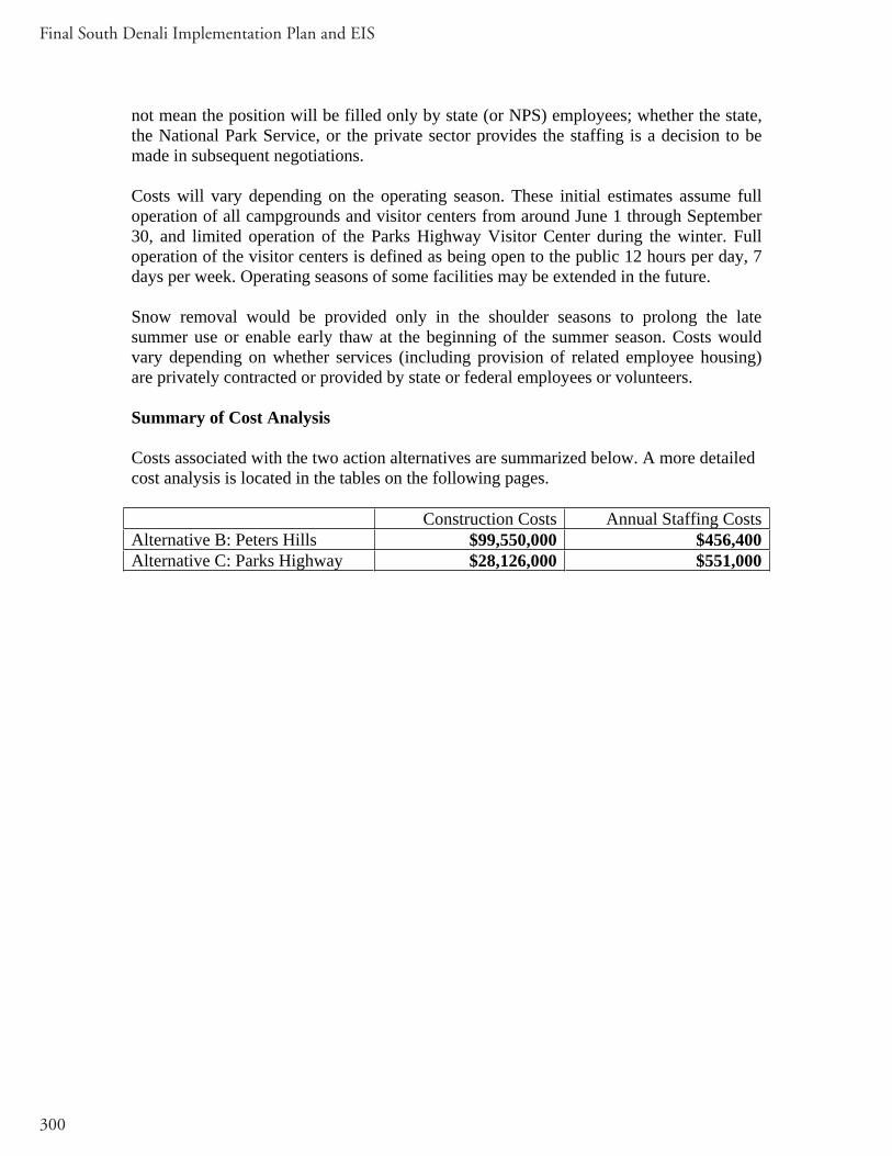
Final South Denali Implementation Plan and EIS
300
not mean the position will be filled only by state (or NPS) employees; whether the state, the National Park Service, or the private sector provides the staffing is a decision to be made in subsequent negotiations.
Costs will vary depending on the operating season. These initial estimates assume full operation of all campgrounds and visitor centers from around June 1 through September 30, and limited operation of the Parks Highway Visitor Center during the winter. Full operation of the visitor centers is defined as being open to the public 12 hours per day, 7 days per week. Operating seasons of some facilities may be extended in the future.
Snow removal would be provided only in the shoulder seasons to prolong the late summer use or enable early thaw at the beginning of the summer season. Costs would vary depending on whether services (including provision of related employee housing) are privately contracted or provided by state or federal employees or volunteers.
Summary of Cost Analysis
Costs associated with the two action alternatives are summarized below. A more detailed cost analysis is located in the tables on the following pages.
Construction Costs Annual Staffing CostsAlternative B: Peters Hills $99,550,000 $456,400Alternative C: Parks Highway $28,126,000 $551,000

Appendix
301
Alternative A: No Action
There are no new construction or staffing costs associated with Alternative A
Alternative B: Peters Hills
Item Estimated Cost (millions) Initial one-time costs (Construction)
Recurringannual costs (Maintenance andOperations)
Life-cyclecosts(20 year life)
Construct nature center at Peters Hills
Visitor Contact (3,500 sf) Exhibits (1,600 sf) Bus shelter (800 sf) Restrooms (vaulted toilets or porta-johns) (800 sf) Power Generation (800 sf), Water Storage
1.5220.5220.1300.139
0.139
0.030.0050.0050.01
0.02
0.030.030.010.02
0.03
Construct transportation facility near junction of Petersville Road and the proposed access road
Parking/CirculationBus Shelter (1000 sf) Visitor Contact (1500 sf) Restrooms/Septic (1000 sf) Maintenance and Storage
(2000 sf) Power Generation (800 sf) Ranger Quarters (1000 sf)
1.7390.1300.4350.1300.435
0.1390.217
0.010.0050.020.010.005
0.010.01
0.020.010.040.020.01
0.020.02
Construct 7-mile access road 12.174 0.01 0.03
Construct 31 miles of trails 0.270 0.01 0.02 Construct picnic shelter at Long Point 0.022 0 0.005

Final South Denali Implementation Plan and EIS
302
Alternative B: Peters Hills, continued
Item Estimated Cost (millions) Initial one-time costs (Construction)
Recurringannual costs (Maintenance andOperations)
Life-cyclecosts(20 year life)
Construct public use cabin at Home Lake
0.052 0.005 0.005
Seek dedicated trail easement and construct a primitive trail for the Chulitna Bluff/Rabideux/106 Seismic Trail System
0 0.01 0
Improve parking area/wayside at MP 121.5 and create new parking area at MP 122 Parks Highway
1.043 0.01 0.03
Construct parking area near Rabideux Creek (west side of Parks Highway)
0.609 0.01 0.03
Provide signage to improve highway crossing near MP 122 of Parks HighwayConstruct informational kiosk near Parks Highway/Petersville Road intersection
0.017 0.005 0.01
Sign trail system 0 0.05 0 Support marking and grooming winter trails
0 0 0
Support local communities in Scenic Hwy designation for Parks Highway MP 105-132
0.004 0 0
Protect natural and scenic values of the Parks Highway corridor from MP 105 to MP 132
0.1 0 0
Retain scenic and natural qualities of Petersville Road corridor
0 0 0
Produce a map showing recreational opportunities on public lands west of the Petersville Canyon
0 0 0
Construct non-motorized boat access near Troublesome Creek
0.261 0 0
Determine feasibility of a docking facility on Chulitna River
0.017 0 0

Appendix
303
Alternative B: Peters Hills, continued
Item Estimated Cost (millions) Initial one-time costs (Construction)
Recurringannual costs (Maintenance andOperations)
Life-cyclecosts(20 year life)
Construct a campground near Petersville Road near the Forks
0.609 0.02 0.03
Upgrade Petersville Road to a 24-foot wide gravel surface from MP 9.3 to MP 18.6
20.865 0.05 0.2
Construct a bike path along Petersville Road MP 0-7
3.1650.005 0.03
Evaluate the need for a 45 mile-per-hour speed zone on the Parks Highway near Petersville Road
0.0020
0
Determine the feasibility of left-hand and right-hand turning lanes at the Petersville Road/Parks Highway intersection
0 0 0
Develop turnouts at MP 12.8 and MP 16.3 of Petersville Road
0.783 0.01 0.03
Redesign Kroto Creek parking lot 0.026 0.01 0 Total Construction Costs 45.696 Design Costs (15%) 6.854 TOTAL 52.550* 0.336 0.68
* This estimate does not include an upgrade to Petersville Road to MP 28 that would be necessary to implement this alternative. Upgrading Petersville Road to MP 28 would add an additional $47 million to the total for Alternative B.

Final South Denali Implementation Plan and EIS
304
Alternative B - Staffing Needs
Position Number Appointment Total Estimated Salary Per Year
Park Ranger II 1 position year-round 74,000 Park Ranger I 1 position year-round 59,000 Park Specialist 1 position seasonal (6 months) 26,400 Park Technician 3 positions seasonal (5 months) 64,300 MaintenanceWorker 1
1 position year-round 62,400
Park volunteer 1 position year-round 4,500 Park volunteer 5 positions Seasonal (5 months) 8,800 Mat-Su Upper Valley Planner
1 position Year-round 74,000
NPS Biological Technician
2 positions seasonal (6 months) 43,000
NPS Interpretation Ranger
1 position seasonal (6 months) 22,000
NPS Visitor Use Assistant
1 position seasonal (6 months) 18,000
TOTAL 18 456,400

Appendix
305
Alternative C: Parks Highway
Item Estimated Cost (millions) Initial one-time costs(Construction)
Recurring annual costs(Maintenance and Operations)
Life-cyclecosts
Construct visitor center at Parks Highway site
Visitor Contact (5,000 sf) Theater (2,400 sf) Exhibits (2,400 sf) Food Service (2,400 sf) Bus Shelter (1,500 sf) Restrooms/Septic (1,500 sf) Power Generation (800 sf)
2.1740.8700.6960.6090.1740.1740.139
0.040.010.0050.010.0050.010.01
0.600.020.040.040.010.020.02
Construct transportation center off Parks Highway
Parking/CirculationBus shelter (1,500 sf) Visitor contact (2,200 sf) Restrooms (1,500 sf) Storage/Maintenance(2,000 sf) Power Generation (800 sf) Ranger Quarters (1,000 sf) DOT Maintenance Facility
3.4780.1740.6520.1300.435
0.1390.2170.950
0.010.0050.020.010.01
0.020.020.02
0.040.020.050.010.05
0.050.030.03
Construct campground off Parks Highway
0.609 0.02 0.04
Construct 3.5-mile access road 6.087 0.01 0.03 Construct 13 miles of trails 0.113 0.01 0.01 Seek dedicated trail easements and construct a primitive trail for the Chulitna Bluff/Rabideux/106 Seismic Trail System
0 0.01 0

Final South Denali Implementation Plan and EIS
306
Alternative C: Parks Highway, continued
Item Estimated Cost (millions) Initial one-time costs(Construction)
Recurring annual costs(Maintenance and Operations)
Life-cyclecosts
Improve parking area/wayside at MP 121.5 and create new parking area at MP 122 Parks Highway
1.043 0.01 0.03
Construct parking area near Rabideux Creek (west side of Parks Highway)
0.609 0.01 0.03
Provide signage to improve highway crossing near MP 122
0 0 0
Construct informational kiosk near Parks Highway/Petersville Road intersection
0.017 0.005 0.01
Sign trail system 0 0.05 0 Support marking and grooming winter trails
0 0 0
Support local communities in Scenic Hwy designation for Parks Highway MP 105-132
0.004 0 0
Protect natural and scenic values of the Parks Highway corridor from MP 105 to MP 132
0.1 0 0
Retain scenic and natural qualities of Petersville Road corridor
0 0 0
Produce a map showing recreational opportunities on public land west of the Petersville Canyon
0 0 0
Construct non-motorized boat access near Troublesome Creek
0.261 0 0
Determine the feasibility of a docking facility on the Chulitna River
0.017 0 0
Construct a campground near Petersville Road near the Forks
0.609 0.02 0.03

Appendix
307
Alternative C: Parks Highway, continued
Item Estimated Cost (millions) Initial one-time costs(Construction)
Recurring annual costs(Maintenance and Operations)
Life-cyclecosts
Construct a bike path along Petersville Road MP 0-7
3.1650.005 0.03
Evaluate the need for a 45 mile-per-hour speed zone on the Parks Highway near Petersville Road
0.002 0 0
Determine the feasibility of left-hand and right-hand turning lanes at the Petersville Road/Parks Highway intersection
0 0 0
Develop turnouts at MP 12.8 and MP 16.3 of Petersville Road
0.784 0.01 0.03
Redesign Kroto Creek parking lot
0.026 0.01 0
Total Construction Costs 24.457 Design Costs (15%) 3.669 TOTAL 28.126 0.355 1.24

Final South Denali Implementation Plan and EIS
308
Alternative C - Staffing Needs
Position Number Appointment Total Estimated Salary Per Year
Park Ranger II 1 position year-round 74,000 Park Ranger I 1 position year-round 59,000 Park Ranger I 1 position seasonal (9 months) 44,000 Park Specialist 1 position seasonal (7 months) 31,000 Park Technician 3 positions seasonal (6 months) 77,000 MaintenanceWorker I
1 position year-round 62,500
Laborer 1 position seasonal (6 months) 28,000 Park volunteer 1 position year-round 4,500 Park volunteer 8 positions seasonal (5 months 14,000 Mat-Su Upper Valley Planner
1 position Year-round 74,000
NPS Biological Technician
2 positions seasonal (6 months) 43,000
NPS Interpretation Ranger
1 position seasonal (6 months) 22,000
NPS Visitor Use Assistant
1 position seasonal (6 months) 18,000
TOTAL 23 551,000

Appendix
309
APPENDIX E: VISITOR PROJECTION
To determine potential impacts of the proposed alternatives on visitor use within the planning area, past and present use levels were examined and future scenarios were estimated. The analysis for the two action alternatives, Peters Hills and the Parks Highway, employs the same methodology and assumptions for estimating future use projections. It is important to note that the developments would vary in size and access, but the facilities are generally comparable at this scale of analysis. General variations in visitor projections are noted for each facility.
Past visitor use levels and trends were obtained from recent area plans, Alaska Visitor Statistics Program (AVSP) data, and interviews with local land managers and tourism representatives. Existing use levels for visitation and recreation activities were established for Denali National Park and Preserve (Denali NPP) and Denali State Park from agency data.
To begin to assess potential visitation levels for new visitor facilities without a previous history of use, qualitative comparisons with similar facilities can be used to forecast visitation (Gramann 2003). When employing qualitative comparisons with similar facilities to forecast visitation, it is important to choose variables of comparison that are consistent across all sites (Gramann 2003). To estimate a baseline of visitor use for a South Denali visitor center, at either the Peters Hills or Parks Highway locations, 2004 visitation numbers were compared from Denali NPP, Wrangell-St. Elias NPP, Kenai Fjords NP (Table A-1), and the Alaska SeaLife Center. Parks or visitor facilities were chosen for direct comparison that were accessible by the road system, were more than a one-hour drive from Anchorage, or served as recreation destinations. (Rationale and background information for each of these sites are presented below.) The use statistics from these four facilities likely encompass the upper and lower visitor use scenarios of a South Denali facility. Since there are no previous visitor statistics specific to a South Denali facility to use for projection purposes, an average of the four facilities listed above was taken for a relative estimate, as discussed below.
Denali NPP visitor numbers include mountain climbers and air tour passengers who typically would not use the visitor center, as these activities are typically based out of Talkeetna. Using the visitation calculation methodology of the park (NPS 2005), it can be assumed that 80% of the reported visitation actually passed through the visitor center for Denali NPP, resulting in 323,389 visitors to the visitor center in 2004.
The adjusted visitation number from Denali NPP (323,389) was averaged with the visitation for Wrangell-St. Elias NPP (57,221), Kenai Fjords NP (244,232), and the Alaska SeaLife Center (150,000) creating an estimated baseline of 193,710 visitors to a South Denali facility.
As previously mentioned, there would be differences in facility size and access. The Peters Hills facility would be smaller and less conveniently located for large tour groups;

Final South Denali Implementation Plan and EIS
310
the Parks Highway facility would be larger and would have easier access from the Parks Highway, facilitating use by large tour groups. Thus, the visitation levels at the Parks Highway facility could be higher than visitation levels at the Peters Hills facility. Due to greater distance from the highway, the Peters Hills facility could have a lower number of visitors, tending more toward the visitation levels seen at the Wrangell-St. Elias Visitor Center.
As a comparison for visitor use estimates in the area, the analysis for the Summary Report for the Socioeconomic Impact Analysis of Denali South Side Development Concept Plan Alternatives (1995) projected 225,421 visitors to the proposed Tokositna visitor center site in 2005. These two analyses yielded comparable visitor use estimates.
Table A-1: Visitation for Select Alaskan National Park Units, 1997 - 2004
Year Denali NPP Glacier Bay NPP
Kenai Fjords NP
Klondike Gold Rush NHP
Wrangell-St. Elias NPP
Sitka NHP
1997 354,278 347,046 306,164 655,858 31,833 269,606 1998 372,519 403,512 263,948 679,980 27,859 159,965 1999 386,867 442,607 290,673 693,883 29,252 197,809 2000 363,983 384,684 254,790 697,051 28,331 194,053 2001 360,192 380,114 262,353 713,436 28,643 211,984 2002 311,335 408,143 251,799 754,436 40,352 295,094 2003 360,189 366,319 243,719 844,576 43,311 251,036 2004 404,236 353,686 244,232 843,623 57,221 297,139 Note: NPP = National Park and Preserve; NHP = National Historic Park (NPS 2005)
Three visitation scenarios were created (low, medium, high) (Table A-2) based on visitor growth estimations performed as part of a community transportation study for the park frontcountry (HDR Inc, 2005). The term “scenario” is used, rather than “projection,” to stress the speculative nature regarding unsettled future events. The growth rates were derived from the total visitation growth expected to the Denali frontcountry over the next 10 years, which in turn are based on analysis of changes in various visitor segments (such as independent traveler or cruise-tour traveler). The rough growth rates and visitor projections for a South Denali facility are as follows.
Table A-2: Visitation Scenarios for South Denali Visitor Center for 2010 and 2015
South Denali Visitor Facility 2010 2015 Low Growth Scenario (2%) 218,149 240,854 Medium Growth Scenario (4%) 245,105 298,208 High Growth Scenario (6%) 274,781 367,719
Levels of growth could also be closely tied to cruise industry numbers, given the amount of package tour use the area currently receives. It is impossible to predict at this point whether a new South Denali visitor center would serve as a substitute (visitors only stop at this facility for their Denali experience) or a compliment (as use increases in the north side, use would increase in the South Denali region) to the current visitor center.

Appendix
311
Background Information for Assessment Methodology
Examination of the methodology used to collect the visitation numbers in Table A-2 shows that the different park units counted both recreational and non-recreational visitors, including visitors entering the park’s visitor center (NPS 2005). Park visitor use figures also do not distinguish between Alaska resident and non-resident visitors. For Denali NPP, visitation numbers are primarily determined by front-country use surrounding the park road.
Wrangell-St. Elias NPP recently remodeled their visitor center and headquarters building in Copper Center; the new facility opened in 2002. That year, Princess Lodges also opened their Copper River Princess Wilderness Lodge – the first major tourism project for the region. The lodge is located four miles from the visitor center. In Table A-1 the dramatic increase seen in visitation starting in 2002 could be attributed to the combination of a new, accessible visitor center and a new destination for package tour visitors to Alaska. The similarities of the alternatives for the South Denali facilities and the existing facility at Wrangell-St. Elias include the following: they are on the road system; they are not in close proximity to large population centers; they are in close proximity to package tourism lodges; and they are regional recreation destination facilities.
Visitation levels at Kenai Fjords NP are also a useful comparison for this analysis. The park’s visitor center, located in Seward, is a similar distance to travel by highway from Anchorage as a South Denali facility would be. Visitors to Exit Glacier are counted in the overall counts as well as visitors to the Seward visitor center. A facility in the South Denali area would also have related outdoor recreation opportunities. Because Seward is a major loading and unloading point for cruise passengers, package tours influence the park’s visitor numbers, similar to the expected situation in the South Denali area.
Another popular Alaskan tourist destination is the Alaska SeaLife Center, located in Seward. As mentioned earlier, Seward is a several-hour drive from Anchorage, making its accessibility comparable to a South Denali visitor center location. The SeaLife Center is more of a recreation destination facility than the Kenai Fjords visitor center. The Center received approximately 150,000 visitors in 2004 (Stephens 2005). The recreation destination status of the facility and proximity of this facility to Anchorage allow for comparisons to be made with the proposed action alternatives.
In addition, information on current visitation and use trends in the South Denali region, as well as current modes of access to the region, were considered.
General Visitation and Access to the South Denali Region There are multiple points and modes of access that visitors to the South Denali planning area may choose from, which make it difficult to estimate visitor use levels. People are willing to invest large amounts of time and money to visit Alaska. In recent years, the proportion of visitors coming to Alaska on package commercial tours has been increasing. Visitors reached Alaska during the 2004 summer tourism season by domestic

Final South Denali Implementation Plan and EIS
312
commercial air (53 percent), commercial cruise ships (37 percent), personal vehicle (6 percent), international commercial air (2 percent), motorcoach (1 percent), or by ferry on the Alaska Marine Highway (1 percent) (Northern Economics Inc. 2004).
The Alaska Visitor Statistics Program (AVSP) is an on-going research project by the State of Alaska that provides information on the number of visitors, demographics and characteristics of the visitor population, and other visitor activities and opinions. The most recent survey was done in 2000-2001. In non-survey years, secondary arrival reports are prepared that are based on visitor counts from the survey years. Secondary arrival reports for visitors to Alaska (non-residents traveling to Alaska) in Summer 2004 totaled 1,447,400 visitors, or an increase of 10 percent over arrivals in 2003 (1,310,100). This substantial increase in visitors to Alaska can also be seen in a 15 percent increase (620,900 to 712,400) in cruise ship arrivals over the same time period, a seven percent increase in domestic air arrivals (569,700 to 607,800), and a 20 percent increase in international air arrivals (23,200 to 27,800). Since 1993, cruise ship arrivals have almost tripled, increasing from 247,000 visitor arrivals in 1993 to 712,400 in 2004 (Northern Economics Inc. 2004).
The use of the Alaska Railroad (AKRR) as a means of transport to the South Denali region has been increasing over the past several years, coinciding with the increase of packaged tours available (NPS 2003a). One train daily comes into the Denali station from Anchorage and another from Fairbanks. Currently, there are stations at Wasilla and Talkeetna, between Anchorage and North Side Denali. The number of total arrivals, including Anchorage and Fairbanks arrivals to the Denali station, showed strong growth between 2003 and 2004, increasing from 137,888 to 161,790 respectively (Kiger 2005). Plans for 2005 include the introduction of first class train cars to the Anchorage/Denali NPP/Fairbanks route, and to include Denali NPP as part of a new Arctic Circle to Glacier Bay Tour. Princess Tours, Royal Celebrity, and Holland-America Westours each own rail passenger cars on the AKRR that bring visitors into the region. Passenger trains during the summer months are usually no longer than 20 cars, including those leased by the cruise companies. Princess is planning on using their own “Denali Express” car package pulled by AKRR from their new docking location in Whittier, allowing passengers to reach Denali NPP in one day. The AKRR is also exploring the reactivation of the Curry Station, and working with Mahay’s Riverboat Service to bring Princess guests across the river to the McKinley Princess Lodge. The 10% increase in ridership between the 2003 and 2004 seasons can also be attributed to increases within the package tour passengers (Kiger 2005). Total arrivals into the Denali Station have been steadily increasing since 2000, with arrival numbers always exceeding departure numbers (Table A-3).

Appendix
313
Table A-3: Total Arrivals and Departures on Alaska Railroad into Denali Station 2000-2004
Year Total Arrivals at Denali Station
Total Departures at Denali Station
2000 153,428 144,718 2001 147,341 141,158 2002 152,253 141,809 2003 137,888 129,391 2004 161,790 152,124 Total 752,700 709,200
The Mt. McKinley Princess Lodge opened in1997. It is situated on the Chulitna River, within Denali State Park, at MP 133 of the Parks Highway (south of Denali NPP entrance). The lodge originally had 238 rooms available, however in 2004 it underwent a remodel, and added 96 more room, for a total of 334 (McKim 2005). Package tour passengers staying at the McKinley Princess get off the cruise ship in Whittier, and then take the Alaska Railroad to Talkeetna where they transfer to coaches for transportation to the lodge. The hotel has established many different options for visitor activities within the south side area, including river rafting, nature walks, and helicopter tours. The Matanuska-Susitna Borough bed tax revenues for the past nine years (FY 1995 to FY 2004) show a steady increase for the period from July to December each year. The period from January to June has held fairly steady during the same time period. During the later half of the year, revenues have increased from $86,397 in FY 1995 to $634,100 in FY 2004. This increase can be attributed to the growing numbers of hotel and lodge facilities in the Mat-Su Borough, as well as the increases in numbers of people visiting and staying overnight there (McKim 2005).
Traffic on the George Parks Highway fluctuates greatly throughout the year and also varies in different places along the road. Recent Alaska Department of Transportation and Public Facilities data on average daily traffic (ADT) in both directions was obtained for George Parks Highway at crossings and intersections near the Petersville Road and Talkeetna. In 1995 the ADT on the George Parks Highway at Trapper Creek at or near the junction with the Petersville Road was 1,285 vehicles per day, increasing from 1,000 vehicles in 1993 and from 1,020 in 1990. For Talkeetna Junction the 1995 ADT figure was 1,500, increasing from 1,300 in 1993, but decreasing from 1,800 in 1990. For Talkeetna Road near the town of Talkeetna, the figure was 1,252, compared to 1,000 in 1993 and 840 in 1990. At Byers Lake, ADT on the George Parks Highway was at 1,200 in 1995, 980 in 1993, and 821 in 1990. Note, however, that these figures refer to year-round traffic flows. If traffic flows were considered during the summer months only, the ADT during these months could be about two times as high.
Petersville Road is classified as a minor collector with an overall length of 36.4 miles consisting of a paved section leading to gravel. State maintenance ends at the Kroto Creek parking area in the winter months with maintenance during the summer months past Kroto Creek dependant on road conditions, staff availability, equipment, time and budgetary constraints. The State Department of Transportation and Public Facilities tries to run a grader the full length of road at least once during the summer months.

Final South Denali Implementation Plan and EIS
314
The paved portion of Petersville Road exists from the intersection of the Parks Highway and Petersville Road to about MP 9.6. The pavement is in fairly good condition with a gravel shoulder along most of it. From the end of the pavement to the Kroto Creek Bridge (a 4.3 mile section) the road consists of a wide gravel driving surface with few potholes and fair ditching. Due to the lack of parking facilities for the summer and winter recreational users, the Kroto Creek pullout has been increased in size to accommodate approximately 300 vehicles. This does not meet the current demand for parking, however. From Kroto Creek Bridge to Forks Roadhouse (a 5.1 mile section) the road is noticeably narrower with more potholes that cause motorists to weave from lane to lane to try to avoid the more severe potholes. The roadbed is lower than the surrounding land causing drainage to parallel and cross the roadway at various locations. From the Forks Roadhouse to just prior to the canyon entrance the road is in very poor condition and is basically graded mineral soil. Portions of the road could be described as “pond like.” The poor drainage is due to several factors: low roadbed, poor to non-existent ditching, culverts either non existent or crushed, brush encroaching the roadbed, corduroy protruding through the roadbed, and general overall disrepair of the roadbed facility. This section is about 13 miles (Boneta 2003).
Alaska DOT&PF traffic projections for Petersville Road are shown in Table A-4. The growth rate of 4% is a common growth rate for this area.
Table A-4: Traffic Projections for Petersville Road Location Start
Milepoint EndMilepoint
2004 Average Daily Traffic
10 Year Projection
20 Year Projection
Parks to Elementary School
0.000 2.670 320 473.7 701.2
Elementary School to Trailridge Rd
2.670 7.860 230 340.5 504.0
Trailridge Road to Kroto Creek
7.860 13.900 78 115.5 170.9
Kroto Creek to Peters Creek Airstrip Rd
13.900 18.320 51 75.5 111.7
Peters Creek Airstrip Rd to Cache Creek Rd
18.320 36.410 36 53.3 78.9
Denali State Park
The primary visitor contact station for Denali State Park is at Byers Lake where there is a visitor and interpretive center for the Alaska Veterans Memorial. Buses from package tour companies usually stop once in Denali State Park, either at one of the viewpoints or at the Veterans Memorial. In 2004, the Veterans Memorial received 54,110 visitors, up from 33,619 visitors in 2003. The number of buses stopping at the visitor center increased as well, going from 853 in 2003, to 1096 in 2004. These dramatic increases

Appendix
315
could be attributed to the fact that the Denali Viewpoint South was closed until late August 2004 for construction. However, the numbers of tour buses do not include Princess Tours buses (Heikes 2005). As in Denali NPP, most park visitation occurs during the months of June, July, and August. During the winter months, only the two public use cabins at Byers Lake remain open. State park staff attempt to collect visitor count data whenever possible; however, the numbers can vary widely due to factors such as construction closing a site, or employee/volunteer turnover (formula used to calculate visitor counts at a site changes). Visitor calculations take into consideration the number of vehicles parked at a site, average stay, and average number of people per vehicle. General trends and ranger reports indicate that visitor numbers are steadily increasing at popular state park sites such as the Veterans Memorial and the Kesugi Ridge Trail system, and visitor numbers are predicted to continue to rise as the cruise industry continues to increase their bus traffic into the area (Heikes 2005).
Based on raw data visitor counts provided by the Alaska Division of Parks and Outdoor Recreation, visitation to Denali State Park increased from 399,607 in fiscal year 1990 to 474,699 in fiscal year 1995 for an average annual growth rate of 3.5%. From fiscal year 1996 through fiscal year 2003 visitation dropped from 357,472 to 280,262. A variety of factors are at play in accounting for this decline:
There has been a drop in the numbers of independent travelers that drive to Alaska due to the rising cost of gasoline. Popular destinations in Denali State Park have had construction projects, resulting in their closing for all or part of the visitor season: Denali View North Campground, the Alaska Veterans Memorial, Byers Lake Campground, and Denali View South Budget cuts reduced the ranger staff in the park from three to one, resulting in a greater dependence upon inconsistent visitor counting by volunteer staff.
While it should be noted that the Division of Parks and Outdoor Recreation considers the reliability of state park visitation data to be questionable except for purposes of providing rough orders of magnitude in regard to visitation levels as well as past trends, general information on Denali State Park visitation includes the following:
Non-resident visitors to Denali State Park are at least 33% of the total visitation, based upon vehicle license plates. This figure does not capture non-residents that fly to Alaska and rent vehicles. This has remained remarkably constant over the last 10 years.Peak visitation typically occurs in July.Summer visitors (May-August) comprise about 80% of the annual visitation to Denali State Park.The two developed scenic viewpoints (Denali View South and Denali View North and the Alaska Veterans Memorial) account for about 42% of the park’s visitation.The three campgrounds in the park account for about 42% of the park’s visitation.
Final South Denali Implementation Plan and EIS
316
Backcountry use accounts for at least 3% of the visitation, but lack of consistent backcountry visitor counts keep park managers from having accurate data. Backcountry users do not have to register to use Denali State Park. Most visitors stop along the Parks Highway within Denali State Park at various pullouts and undeveloped scenic views.
Denali National Park and Preserve
Denali NPP has the largest visitation of any national park in Alaska. This popularity has been attributed to its strategic location between Anchorage and Fairbanks, ease of access by both rail and road, the fame of its resources, and its relatively long history in the national park system.
The annual visitation for Denali NPP for the years 1985 through 2001 is listed in Table A-5. Counting and reporting procedures for the park were modified in 1992 and 1995; therefore data before and after these years are not directly comparable. The number of recreational visits is the main visitation figure used by managers. Recreational visits are defined as entries of people onto lands or waters administered by the National Park Service (NPS) for recreational purposes, excluding government personnel, through traffic (commuters), trades people, and park residents (NPS 2003a). Trends from 1996 to 2000 show an annual average rate of growth for recreational visits at around 1.1% (Table A-5).
Overnight use of Denali NPP is also documented in Table A-5. An overnight stay is defined as one visitor spending one night in the park for recreational purposes, and is counted separately from a recreational visit (NPS 2003a). Overnight stays in the park have been essentially unchanged over the past 15 years. The anomalous drop in 2002 was likely the result of a recordkeeping issue for campground stays, and should not be considered as a distinct change in visitation patterns. Other variations are the result in changes in park facilities, for example the concession-operated hotel was closed after the 2001 season, Morino Campground was closed and Riley Creek Campground expanded with portions closed for reconstruction over a period of two years. Backcountry overnight stays have increased since 1985, going from 26,029 to 34,016 in 2004.
A 2003 survey of visitors to the Matanuska-Susitna Borough who were not part of a cruise ship package tour showed that over three-quarters (77%) of respondents spent at least one night in Denali NPP (McDowell Group 2003). A vast majority of visitors to the park come from out-of-state. According to a 1995 survey, 90% of the visitors that year were from out-of-state. Included in that figure were a notable number of international visitors (12%). During the off-season (October through April), the majority of visitor use is by Alaska residents (NPS 1997b).
Most park visitation occurs during the months of June, July and August, even though Denali NPP is open year-round (Table A-6). Almost all of the visitor use is concentratedon the north side of the park along the 88.5-mile park road corridor between the George Parks Highway and Wonder Lake (NPS 1997a). The park road corridor typically opens sometime after mid-May and closes in mid-September. Weather is the determining factor

Appendix
317
for the actual opening and closing dates of the park road. In the winter, the interior areas of the park are only accessible by dog sled, snowshoes, cross-country skis, or snowmachine (where permitted) (NPS 2003a).
Table A-5: Recreational Visitation for Denali National Park and Preserve, 1985-2004
Overnight Stays2
YearRecreationalVisits1
PercentChange3
ConcessionerLodging
NPSCampgrounds
NPS Group Campgrounds
NPSBackcountry
Total Overnight Stays
1985 436,545 - 28,020 67,963 3,001 26,029 125,013 1986 529,749 21.4 29,752 67,071 2,693 27,999 127,515 1987 575,013 8.5 23,780 65,649 2,086 28,962 120,477 1988 592,431 3.0 22,101 77,500 1,191 29,460 130,252 1989 543,640 8.2 23,429 63,789 1,637 34,113 122,968 1990 546,693 0.6 24,459 56,329 1,534 35,918 118,240 1991 558,870 2.2 24,311 62,539 2,683 29,798 119,331 1992 503,674 9.9 27,452 73,066 2,831 38,262 141,611 1993 505,565 0.4 25,683 63,957 2,034 33,010 124,684 1994 490,311 3.0 23,942 63,082 2,592 41,455 131,071 1995 544,209 11.0 24,459 65,105 1,807 39,500 130,871 1996 341,385 - 23,586 59,871 2,240 37,188 122,885 1997 354,278 4.1 22,223 65,999 2,019 39,224 129,465 1998 372,519 5.1 18,330 64,438 962 37,504 121,234 1999 386,867 4.7 19,912 66,722 1,349 35,826 123,809 2000 363,983 -5.9 19,095 67,431 1,883 32,579 120,988 2001 360,192 -1.0 19,106 42,830 1,457 35,306 98,699 2002 353,560 -1.8 na 26,309 455 36,212 62,976 2003 359,841 1.8 na 62,570 801 34,127 97,498 2004 404,236 12.3 na 85,752 3,309 34,016 123,077 Annual Average Rate of Growth (compounded) 1985-1995
2.2% na 1.3% 0.4% 4.9% 4.3% 0.4%
1990-1995
0.1% na 0% 2.9% 3.3% 1.9% 2.1%
1996-2000
1.1% na -4.1% 2.4% -3.4% -2.6% 0.2%
Note: na = not applicable 1 – Number of people entering the park and preserve during any part of the day 2 – Person-nights 3 – The concessioner lodging was the Denali Park Hotel, which closed after the 2001 season. Source: (NPS 2005c)

Final South Denali Implementation Plan and EIS
318
Table A-6: Monthly Visitation for Denali National Park and Preserve, 2003-2004
Month 2003 2004
# Visitors % of Total # Visitors % of Total January 979 0.3 313 0.1 February 524 0.1 392 0.1 March 751 0.2 1,441 0.4 April 2,985 0.8 3,087 0.8 May 27,260 7.6 30,132 7.5 June 88,471 24.6 100,127 24.8 July 104,686 29.1 116,601 28.8 August 97,821 27.2 108,097 26.7 September 34,639 9.6 39,969 9.9 October 889 0.3 2,525 0.6 November 374 0.1 1,059 0.3 December 462 0.1 493 0.1 Total for Year
359,841 100.0 404,236 100.0
Note: All measurements are given as the number of people entering the park and preserve during any part of the day . Source: (NPS 2005c)
There are multiple points and modes of access that visitors to the South Denali planning area may choose from, which make it difficult to estimate visitor use levels. Talkeetna has traditionally served as the starting point for mountaineering expeditions into Denali NPP, and as a hub of commercial air taxi, flightseeing, and other activities for the planning area. However, there are approximately 36 aviation companies between Anchorage and Fairbanks along the Parks Highway that advertise tours in portions of Denali NPP. The volume of traffic into the park from these tours, and the number of landings is growing rapidly (NPS 2003a). Scenic tour flights concentrate their landings in three main locations, with the Ruth Glacier as the most popular of these areas. Relatively few private aircraft land in the park because of weather, topography, and glacial/snow conditions.

Bibliography
319
BIBLIOGRAPHY
Adams, L. G. and L. D. Mech (1995). "Population Trends of Wolves and Caribou in Denali Naitonal Park, Alaska." Canadian Circumpolar Institute Occasional Paper 35: pp. 347-348.
Adamus, P. R. and L. T. Stockwell (1983). A Method for Wetland Functional Assessment, Volume I: Critical Review and Evaluation Concepts. Washington, D.C., Offices of Research, Development and Technology, Federal Highway Administration, U.S. Department of Transportation.
Adamus Resources Assessment Inc. (1987). Juneau Wetlands Functions and Values, Prepared for the City and Borough of Juneau, Alaska.
Alaska Department of Community and Economic Development, Research and Analysis Section. 2000, 2001, 2003. Alaska Community Database. Download from Internet site www.comregaf.state.ak.us/CF_BLOCK.cfm. Juneau, Alaska.
ADF&G (Alaska Department of Fish and Game) (1984). Alaska Habitat Management Guide, Southcentral Region Map Atlas.
ADF&G (1991). Catalog of the waters important for spawning, rearing, or migration of anadromous fishes. ADF&G Habitat Division. Juneau.
ADF&G (1992). Moose Annual Report of Survey-Inventory Activities.
ADF&G (1993a). Management Report of Survey-Inventory Activites of Brown Bear, July 1, 1990 to June 30, 1992.
ADF&G (1993b). Brown Bears in Alaska: A Statewide Management Overview. B. S. Miller.
ADF&G (1996). Personal Communication with Herman Griese, Area Wildlife Biologist, Palmer AK.
ADF&G (2002). Draft 2002 Anadromous Fish Stream - Southcentral Region. Anchorage, AK, ADF&G Habitat & Restoration Division.
ADF&G (2004a). Wildlife Notebook Series (On-line). 2004.
ADF&G (2004b). Fish Distribution Database: Sport Fish Division. 2004.
ADF&G (2004c). Southcentral Alaska Wild Dolly Varden. Division of Sportfish. 2004.

Final South Denali Implementation Plan and EIS
320
ADF&G (2005). Preliminary Estimates of Brown Bear Densities in GMU 13E and Northernt GMUs 16A, 16B, and 14B. Anchorage, Division of Wildlife Conservation.
ADNR (Alaska Department of Natural Resources) (1974). Alaska State Parks. “Development Prospectus, Denali State Park.”
ADNR (1980). Environmental Investigation and Site Analysis for Tokositna, Denali State Park.
ADNR (1982). Denali to Wrangell-St. Elias — Assessment and management of scenic resources along the highways between Denali and Wrangell-St. Elias national parks.
ADNR (1985) Susitna Area Plan. Prepared with the Alaska Department of Fish and Game, the Matanuska-Susitna Borough, and the U.S. Department of Agriculture.
ADNR (1986) Alaska Department of Natural Resources, Division of State Parks and National Park Service. “South Denali: A concept proposal for developing a major visitor destination in Denali State Park on the south side of the Alaska range.”
ADNR (1987) Fish and Game Harvest and Use in the Middle Susitna Basin: The Results of a Survey of Residents in the Road-Connected Areas of Game Management Units 14B and 16A, 1986, by James A. Fall and Dan J. Foster. Division of Subsistence Technical Paper No. 143. Anchorage.
ADNR (1988) The Harvest and Use of Fish and Game and Plant Resources by the Residents of Chase, Gold Creek - Chulitna, and Hurricane - Broad Pass, Southcentral Alaska, by Ronald T. Stanek, James A. Fall, and Dan J. Foster. Division of Subsistence Technical Paper No. 161. Anchorage.
ADNR (1989). Denali State Park Master Plan. Anchorage, Division of Parks and Outdoor Recreation: 170.
ADNR (1990) “Commissioner’s preliminary decision to proceed towards award of a concession contract for the design, construction, and maintenance of a lodge in Denali State Park.”
ADNR (1991). Susitna Basin Recreation Rivers Management Plan- Resources Assessments. L. a. R. S. Division of Land, ADF&G, Mat-Su Borough, and USDOI.
ADNR (2004). South Denali Implementation Plan Scoping Comments Fish Habitat Case FH-04-IV-0051. NPS. Tlakeetna, AK: Request for comments on the South Denali Implementation plan to DNR, Office of Habitat Management and Permitting.

Bibliography
321
ADNR (2005a). Rough costs of gravel roads in the Fairbanks area: Telephone conversation.
ADNR (2005b). Denali State Park website, Division of Parks and Outdoor Recreation. 2005.
ADNR (2005c). Construction Duration of Each Alternative. M. Seidl.
Aeromap (1996). True color air photos of Curry Ridge and Peters Hills region, Aeromap: Scale 1"=1,000'.
Alaska Department of Labor & Workforce Development (1999). Community Population Data.
Alaska Department of Transportation and Public Facilities. 2001. Section 106 Evaluation Non-NHS FY 01 Bridge Repair, Project Number 55317. Prepared by the Alaska Department of Transportation and Public Facilities Preliminary Design and Engineering.
Alaska Division of Motor Vehicles, Department of Administration. 2004. “Research and Statistics” Web site. http://www.state.ak.us/dmv/research/research.htm.
Alaska Multiple Listing Service (2005). Map of Real Estate in Matanuska-Susitna Borough and Alaska MLS Real Estate Data.
Alaska Road Commission. 1922. Report upon the Construction and Maintenance of Military and Post Roads, Bridges and Trails; and other Roads, Tramways, Bridges, Ferries, Trails, and Related Works in the Territory of Alaska. Board of Road Commissioners for Alaska. Annual Report Fiscal Year 1922, Part II, Juneau, Alaska.
Alaska Road Commission. 1929 Report upon the Construction and Maintenance of Military and Post Roads, Bridges and Trails; and other Roads, Tramways, Bridges, Ferries, Trails, and Related Works in the Territory of Alaska. Board of Road Commissioners for Alaska. Twenty-Fifth Annual Report 1929, Part II, Juneau, Alaska.
Alaska Road Commission. 1931 Report upon the Construction and Maintenance of Military and Post Roads, Bridges and Trails; and other Roads, Tramways, Bridges, Ferries, Trails, and Related Works in the Territory of Alaska. Board of Road Commissioners for Alaska. Twenty-Seventh Annual Report 1931, Part II, Juneau, Alaska.
Alaska Travel Industry Association (2004). FY05 Marketing Implementation Plan.

Final South Denali Implementation Plan and EIS
322
Alaska Visitors Association (1995). Denali National Park Field Trip.
ANHP (2004). Vascular Plant Tracking List for Alaska, April 6, 2004. Anchorage, AK, The Alaska Natural Heritage Program, University of Alaska Anchorage.
Antonson, Joan M. and William S. Hanable. 1985. Alaska's Heritage. Alaska Historical Commission Studies in History No. 133, The Alaska Historical Commission, Department of Education.
Armstrong, R. H. (1995). Guide to the Birds of Alaska 4th ed. Anchorage, AK, Alaska Northwest Publishing Co.
ASTM International (1999). Standard Guide for Assessment of Wetland Functions. West Conshohocken, ASTM International.
Bailey, E. (2003). Park Tourism Is a Breath of Fresh Air for California. Los Angeles Times. Los Angeles, CA.
BLM (2002). Susitna MOA Earth Cover Classification, BLM, USDAF, and Ducks Unlimited, Inc.
Boertje, R. (1985). Seasonal Activity of the Denali Caribou Herd, Alaska. Alaska Cooperative Wildlife Research Unit. F. University of AK.
Boneta, A. P. (2003). South Denali Access Socioeconomics Field Report.
Boreal Partners in Flight (1999). Landbird Conservation Plan for Alaska Biogeographic Regions Version 1.0. USFWS. Anchorage: 116 pp.
Brooks, D. J. and R. W. Haynes (2001). Recreation and Tourism in South-Central Alaska: Synthesis of Recent Trends and Prospects. Portland: 19 pp.
Burdge, R. J. (2004). A Community Guide To Social Impact Assessment: 3rd Edition. S. E. Press.
Burgner, R. L. (1991). Life History of Sockeye Salmon (Oncorhynchus nerka). Pacific Salmon Life Histories. C. Groot and L. Margolis. Vancouver, University British Columbia Press: 3-116 pp.
Caissie, A. (1999). Effects of snowmobile traffic on the vegetation of a coastal plain Sphagnum bog in Gros Morne National Park, western Newfoundland, The University of New Brunswick.
Capps, Stephen R. 1911 Gold Placers of the Yentna District. In Mineral Resources of Alaska Report on Progress of Investigations in 1911. USGS Bulletin 520, pp. 174-200, Government Printing Office, Washington.

Bibliography
323
Capps, Stephen R. 1913. The Yentna District, Alaska. USGS Bulletin 534, Government Printing Office, Washington.
Capps, Stephen R. 1940. Geology of the Alaska Railroad Region. USGS Bulletin 907, U.S. Government Printing Office, Washington.
Carbyn, L. N., S. H. Fritts, et al. (1995). "Ecology and Conservation of Wolves in A Changing World: Proceedings on the Second North American Symposium on Wolves." Candian Circumpolar Institute Occasional Paper 35.
Carley, Caroline D. 1981. Inventory of Cultural Resources in the Chilkoot and White Pass Units of Klondike Gold Rush National Historical Park. Office of Public Archaeology, Institute for Environmental Studies Reconnaissance Report 40, University of Washington.
Clark, D. (2003). Summary Report. Y Community Gathering.
Clark, M. H. and D. R. Kautz (1998). Soil Survey of Matanuska-Susitna Valley Area, Alaska. Anchorage, AK, USDA, NRCS, University of Alaska Fairbanks, Agricultural and Forestry Experiment Station, ADNR, and the MSB.
Cody, W. (2000). Flora of the Yukon Territory, Second Edition. Ottawa, Ontario, Canada, NRC Research Press.
Collet, D. M. (2002). Willows of Southcentral Alaska. Kenai, AK, Kenai Watershed Forum.
Connery, B. (1984). Mechanized trail survey, Wrangell-St. Elias National Park and Preserve. Copper Creek, AK, U.S. Department of the Interior, National Park Service, Wrangell-St. Elias National Park and Preserve.
Cowardin, L. M., V. Carter, et al. (1979). Classification of wetlands and deepwater habitats of the United States. Washington, D.C., U.S. Fish and Wildlife Service.
Cresap McCormick & Paget (1968). A Program for Increasing the Contribution of Tourism to the Alaskan Economy.
Daum, D. W. (2003). Eagles. Wildlife Notebook Series. Anchorage, AK, Alaska Department of Fish and Game. 2005.
Dale, Rachael Joan. 2005. Personal communication with Joan Dale, January 12, 2005.
Del Frate, G. (2003). Unit 16 Brown Bear Management Report. Brown Bear Management Report and Inventory Activities. M. C. Healey. Juneau, ADF&G: 161-173 pp.
Final South Denali Implementation Plan and EIS
324
DelFrate, Gino. Personal Communication with Gino DelFrate, Wildlife Biologist, DNR. 3/18/05.
Denali Task Force. 1994. “Denali Task Force Report: Findings and recommendations for the National Park System Advisory Board, October 1994.”
Department of the Interior (DOI), NPS. 1954. Mount McKinley National Park, Alaska: A history of its establishment and revision of its boundaries. By John M. Kauffmann.
Department of the Interior (DOI), NPS. 1969. “Lodging for Mount McKinley National Park – present and projected requirements and its relationship to park visitation, possible park enlargement, and Alaska tourism.”
Department of the Interior (DOI), NPS. 1973 Master Plan: Mount McKinley National Park, Alaska, with proposed additions.
Department of the Interior (DOI), NPS Alaska Region DNPP. May 1991. Denali South Side: A proposal for the development of visitor facilities for the south side of Denali National Park and Preserve, Alaska. A report in response to a 1991 Appropriations Committee Directive.
Department of the Interior (DOI), NPS. 1993. Draft Development Concept Plan and EIS, South Slope, Denali National Park and Preserve.
Dixon, R. Greg. 2003. Archaeological Investigations at Tiq'atl'ena Bena (Hewitt Lake). In Shem Pete's Alaska: The Territory of the Upper Cook Inlet Dena'ina. University of Alaska Press, Fairbanks, pp. 151-153.
Dixon, James E. 1985. Cultural Chronology of Central Interior Alaska. Arctic Anthropology 22 (1): 47-66.
Dixon, James E. 1985. Susitna Hydroelectric Project, Cultural Resources Investigations 1979-1985, Volume I. Contributions by George Smith, William Andrefsky, Becky Saleeby, and
Douglass, K. S., J. Hamann, et al. (1999). Chapter 9: Vegetation, Soils, & Water. Effects of Recreation on Rocky Mountain Wildlife: A Review for Montana. G. Joslin and H. Youmans, Committee on Effects of Recreation on Wildlife, Montana Chatper of the Wildlife Society: 307.
Duluth Streams.org (2005). Electrical Conductivity (EC25) and TDS. 2005.
Eagles, P. F. J. (2003). "International Trends in Park Tourism: The Emerging Role of Finance." The George Wright Forum Volume 20, Number 1: 25-57 pp.

Bibliography
325
Economic Research Associates (1979). Market Analysis/Economic Feasibility Study. San Francisco, CA.
Edwards, P. J. and M. J. Tranel (1998). Physical and Chemical Characterization of Streams and Rivers within Denali National Park and Preserve. N. E. S. U.S. Forest Service, Timber and Watershed Laboratory: 102 pp.
Eide, S. and S. Miller (1994). Alaska Department of Fish and Game Wildlife Notebook Series: Brown Bear. 2003.
Ely, C. R. and A. X. Dzubin (1994). "Greater White-gronted Goose (Anser albifrons)." The Birds of North America No. 131.
Faerber, G. (1995). Hunting Quide, Talkeetna, Alaska. G. Faerber.
Fitzpatrick-Lins, K., E. F. Doughty, et al. (1989). Alaska Interim Land Cover Mapping Program - Final Report. Reston, VA, U.S. Geological Survey.
Fried, Neal. 1994. "Matanuska-Susitna Borough," State of Alaska, Department of Labor, Alaska Economic Trends, September 1994.
Gamble, Pat. President and CEO of the Alaska Railroad. Meeting with residents of Talkeetna, 12/14/04.
Gramann, J. H. (2003). Visitation Forecasting and Predicting Use of NPS Parks and Visitor Centers: Focus Group Report. NPS Social Science Program: 24 pp.
Haines, Bill. Letter from Bill Haines, Scout Executive to Ron Swanson, Matanuska-Susitna Borough, 12/28/04.
Healey, M. C. (1991). Life History of Chinook Salmon (Oncorhynchus tshawytscha). Pacific Salmon Life Histories. C. Groot and L. Margolis. Vancover, University British Columbia Press: 311-393 pp.
Heard, W. R. (1991). Life History of Pink Salmon (Oncorhynchus gorbuscha). Pacific Salmon Life Histories. C. Groot and L. Margolis. Vancouver, University British Columbia: 121-230 pp.
Heikes, Dennis. Superintendent of Mat-Su Area State Parks. Personal communication 2/9/05 and 3/7/05)
Herrero, S. M. (1972). Aspects of Evolution and Adaptation in American Black Bears and Brown Bears and Grizzly Bears in North America. I. C. o. B. R. a. Management.
Final South Denali Implementation Plan and EIS
326
Hitchcock, C. L. and A. Cronquist (1974). Flora of the Pacific Northwest, An Illustrated Manual. Seattle, WA, University of Washington Press.
HKS Associates. 1981. “Tokositna Development Study, prepared for the state of Alaska, February 1981.”
Holling, C. S. (2000). "Theories for Sustainable Futures." Conservation Ecology Volume 4(2): 7 pp.
Howe, J., E. McMahon, et al. (1997). Balancing Nature and Commerce in Gateway Communities. Washington, DC, Island Press.
Hulten, E. (1968). Flora of Alaska and Neighboring Territories, Standford University Press.
ICONOS (1996). ICONOS Satellite photography of the upper Susitna Valley, AK.
International Economic Development Council (2002). Economic Development Plan, Matanuska-Susitna Borough, Alaska, June 2002. Washington, D.C., Matanuska-Susitna Borough.
Ireland, Roy. Hydrologist, Division of Mining and Water Management, Alaska. Personal communication (11/28/95).
Irving, William N. 1957. An Archaeological Survey of the Susitna Valley. Anthropological Papers of the University of Alaska 6(1): 37-52.
Johnson, D., L. Kershaw, et al. (1995). Plants of the Western Boreal Forest & Aspen Parkland. Edmonton, Canada, Lone Pine Publishing.
Kari, James and James A. Fall. 2003. Shem Pete's Alaska: The Territory of the Upper Cook Inlet Dena'ina. University of Alaska Press, Fairbanks.
Kasworm, W. and T. Manley (1990). Road and trail influences on grizzly bears and black bears in northwest Montana. Int. Conf. Bear Res. and Manage: 8:79-84.
Kessel, B. (1998). Habitat characteristics of some passerine birds in western North American taiga. Fairbanks, AK, University of Alaska Press.
Kiger, S. (2005). Alaska Railroad, Manager of Sales and Marketing. Amy Lewis - URS Corporation. Anchorage: Personal communication.
Land Design North. “Petersville Road Scenic Resource Study, inventory and management recommendations.” Prepared for Matanuska-Susitna Borough.

Bibliography
327
L'Ecuyer, Rosalie E. 1997. Prospecting and Mining Activity in the Rampart, Manley Hot Springs, and Fort Gibbon Mining Districts of Alaska, 1894 to the Present Era. BLM-Alaska Open File Report 61. U.S. Department of the Interior, Bureau of Land Management, Anchorage.
Lenz, J., T. Gotthardt, et al. (2001). Vascular Plant and Vertebrate Species Lists from NPS Species as of September 30, 2001 for Denali National Park and Preserve. Anchorage, AK, Alaska Natural Heritage Program, Environment and Natural Resources Institute.
Lipkin, R. and D. F. Murray (1997). Alaska rare plant field guide, U.S. Fish and Wildlife Service, National Park Service, Bureau of Land Management, Alaska Natural Heritage Program, and U.S. Forest Service.
Lynch, Alice J. 1995 “Archeological Investigations of Five Remote Tracts of Land Within Denali National Park and Preserve, 1988, 1989.” Unpublished data. On file at the Alaska Systems Support Office of the National Park Service, Anchorage, Alaska.
Lynch, Alice J. 1995. “Archeological Investigations of Five Remote Tracts of Land within Denali National Park and Preserve, 1988, 1989.”
Lynch, Alice J. 1996. Archaeological Investigations of Five Remote Tracts of Land within Denali National Park and Preserve, Alaska, 1988, 1989. Resource Report NPS/ARRCR/CRR-95/24. National Park Service, Anchorage.
MacDonald, S. O. (2003). The Amphibians and Reptiles of Alaska: A Field Handbook, Version 1.0. Juneau, AK, Alaska Natural Heritage Program, U.S. Fish and Wildlife Service.
Mace, R., J. Waller, et al. (1996). "Relationships among grizzly bears, roads and habitat in Swan Mountains, Montana." Journal of Applied Ecology 33:: 1395-1405.
Marsh, Ken. 1999.Trapper Creek: More than just a road to the Mines. Talkeetna Good Times Volume 1 (2), July 1999.
Marsh, Ken.1999. A Good Wagon Road. Talkeetna Good Times, Volume 1 (4), September 1999.
Marsh, Ken.1999. Shorty Bradley: Pioneer Homesteader of Trapper Creek. Talkeetna Good Times Volume 1 (5), October 1999.
Marsh, Ken.2000. Correspondence to Rolfe Buzzell, July 7, 2000. Copy located in RSA project files, Office of History and Archaeology, Anchorage.

Final South Denali Implementation Plan and EIS
328
Martinka, C. J. and K. C. Kendall (1985). Grizzly Bear Habitat Research in Glacier National Park, Montana. Grizzly Bear Habitat Symposuim, Intermountain Research Station. U. F. Service.
Matanuska-Susitna Convention and Visitors Bureau (1991). 1990 Visitor and Business Survey. Palmer, AK, DataBank Matanuska-Susitna and ASK Marketing & Research Group.
McDonough, T. (2002a). Unit 16 Black Bear Management Report. Black Bear Management Report and Inventory Activities 1 July 1998- June 2001. M. C. Healey. Juneau.
McDonough, T. (2002b). Unit 16A Moose Management Report. Moose Management Report of Survey and Inventory Activities 1 July 1999- 30 June 2001. M. C. Healey. Juneau.
McDowell Group (1990). Alaska Visitor Statistics Program, Alaska Visitor Arrivals, Fall/Winter/Spring 1989-90, Alaska State Division of Tourism.
McDowell Group (1992). Alaska Visitor Statistics Program, Alaska Visitor Arrivals, Fall/Winter/Spring 1991-92, Alaska State Division of Tourism.
McDowell Group (1993a). Alaska Visitor Statistics Program, Alaska Visitor Arrivals, Summer 1993, Alaska State Division of Tourism.
McDowell Group (1993b). Alaska Visitor Statistics Program, Alaska Visitor Patterns, Opinions, and Planning, Summer 1993, Alaska State Division of Tourism.
McDowell Group (1994). Alaska Visitor Statistics Program, Alaska Visitor Arrivals, Summer 1994, Alaska State Division of Tourism.
McDowell Group (2003). Mat-Su Visitor Profiles Summer 2003. Alaska Travelers Survey. Matanuska-Susitna Convention and Visitors Bureau. Juneau and Anchorage.
McKim, L. (2005). Princess Tours, McKinley Princess Wilderness Lodge Sales and Marketing. Amy Lewis - URS Corporation. Anchorage: Personal communication.
McKown. 2004. http://www.mountainbike.co.nz/politics/usa/conflicts/conflict3.html
McLellan, B. N. and D. M. Shackleton (1988). "Grizzly bears and resource extraction industries: effects of roads on behavior, habitat use, and demography." Journal of Applied Ecology 25: 451-460 pp.

Bibliography
329
Mech, L. D., L. G. Adams, et al. (1998). "Conservation Biology." Conservation Biology: pp. 225.
Miller, Daryl. South District Ranger, Denali National Park and Preserve. Personal Communication.
Miller, S. D. (1987). "Susitna Hydroelectric Project Final Report, Big Game Studies." Black Bear and Brown Bear Alaska Power Authority Vol. 6.
Miller, S. D. (1990). Detection of Differences in Brown Bear Density and Population Composition Caused By Hunting. I. C. o. B. R. a. Management.
Minnesota Implan Group, I. IMPLAN System (model and data).
Morrow, J. E. (1980). The Freshwater Fishes of Alaska. Anchorage, Alaska Northwest Publishing Company.
MSB (Matanuska-Susitna Borough) Planning Department (1998). Petersville Road Corridor Management Plan, Matanuska-Susitna Borough.
MSB, Planning Department (1999). Talkeetna Comprehensive Plan.
MSB (2000). Matanuska-Susitna Borough Recreational Trails Plan.
MSB (2001a). MSB trails all, MSB: all MSB trails; GIS shapefile.
MSB (2001b). MSB roads, MSB: MSB roads; GIS shapefile.
MSB (2001c). MSB general landowners, MSB: MSB genowner; GIS shapefile.
MSB (2002). Matanuska-Susitna Borough Economic Development Plan.
MSB (2003). 2003 Fact Book. Palmer, AK, MSB Planning and Land Use Department.
MSB (2004). Matanuska-Susitna Borough Bed Tax Revenues FY 1995-FY2004. Municipality of Anchorage (2000a). Watershed Management Program: Receiving Water
Chemistry at Selected Streams in Anchorage, Alaska. C. M. Hill. Anchorage, Alaska.
Municipality of Anchorage (2000b). Watershed Management Program: Anchorage Street Deicer and Snow Disposal: 2000 Best Management Practices Guidance. Mongomery Watson, FHWA and DOT&PF.
Munsell (2000). Munsell Soil Color Charts. New Windsor, NY, GretagMacBeth.
Murray, L. (2005). Glacier Ranger District USFS.

Final South Denali Implementation Plan and EIS
330
National Technical Committee for Hydric Soils (1994). Hydric Soils Technical Note 1: Proper Use of Hydric Soil Terminology.
NatureServe (2005). NatureServe Explorer: An online encyclopedia of life. Arlington, Virginia. 2005.
Neumann, P. W. and H. G. Merriam (1974). "Ecological effects of snowmobiles." Canadian Field Naturalist 86: 207-212.
Northern Economics Inc. (2004). Alaska Visitor Arrivals: Summer 2004.
NPS (1995a). Physical and Chemical Characterization of Streams and Rivers in Denali National Park and Preserve, Denali National Park and Preserve.
NPS (1995b). Baseline Water Quality Data Inventory and Analysis, Denali National Park and Preserve. Water Resources Division Servicewide Inventory and Monitoring Program. Fort Collins, CO, Water Resources Division.
NPS (1995c). Personal Communication with J.D. Swed and Roger Robinson, South District Mountaineering Rangers, Talkeetna, Alaska.
NPS (1995d). Reclamation Plan Denali National Park and Preserve.
NPS (1996). Revised Draft Development Concept Plan Environmental Impact Statement, South Side Denali, AK.
NPS (1997a). Final Development Concept Plan Environmental Impact Statement: South Side Denali, Alaska. Denali, AK, NPS, State of Alaska, Denali Borough, MSB, Ahtna Inc., and Cook Inlet Region Inc.
NPS (1997b). Draft Backcountry Management Plan. Denali, AK, U.S. Department of the Interior, NPS.
NPS (2003a). Draft Denali National Park Backcountry Management Plan and General Management Plan Amendment and Environmental Impact Statement. Denali Park, AK, Denali National Park and Preserve, National Park Service, U.S. Department of the Interior.
NPS (2003b). Denali National Park and Preserve North Access Feasibility Study, Appendix: Environmental Study Needs; Physical Resources; Water Quality. 2005.
NPS (2004a). South Denali Implementation Plan Scoping Newsletter.
NPS (2004c). Denali 2004 Update Large Mammals: How Many are There? Denali Park, AK.

Bibliography
331
NPS (2005a). Birds of Denali, Checklist of Avian Species.
NPS (2005b). Public Use Statistics Office, NPS Visitation Database Reports. 2005.
NPS (2005c). Denali National Park and Preserve Revised Draft Backcountry Management Plan. Denali Park, AK, Denali National Park and Preserve, National Park Service, U.S. Department of the Interior.
NPS and ADNR (2004). Draft North Access Visitor Facility Study.
NPS: Prepared by Reed Hansen and Associates (1995). Summary Report Socioeconomic Impact Analysis of Denali South Side Development Concept Plan Alternatives.
NRCS (1995). Hydric Soils of Alaska. Anchorage, Alaska, U.S. Department of Agriculture: 10.
NRCS (2004). Field Indicators of Hydric Soils in Alaska, Draft. Palmer, AK, U.S. Department of Agriculture, National Resources Conservation Service, Major Land Resource Region 17.
NWI (1979). Talkeetna B-1. Anchorage, AK, U.S. Fish and Wildlife Service National Wetlands Inventory.
NWI (1980a). Talkeetna B-2. Anchorage, AK, U.S. Fish and Wildlife Service National Wetlands Inventory.
NWI (1980b). Talkeetna B-3. Anchorage, AK, U.S. Fish and Wildlife Service National Wetlands Inventory.
NWI (1980c). Talkeetna C-1. Anchorage, AK, U.S. Fish and Wildlife Service National Wetlands Inventory.
Olszewski, K. M. (1998). Soil Survey of Yentna Area, Alaska. Anchorage, AK, NRCS, USDA, University of Alaska Agricultural and Forestry Experiment Station, ADNR.
Pesant, A. R., C. Fernet, et al. (1985). "Effects of snowmobile traffic on yield and botanical composition of forage stands in Quebec." Canadian Journal of Plant Science 65: 543-552.
Pojar, J. and A. MacKinnon, Eds. (1994). Plants of the Pacific Northwest Coast: Washington, Oregon, British Columbia, and Alaska. Redmond, WA, Lone Pine Publishing.

Final South Denali Implementation Plan and EIS
332
Pratt, V. E. and F. G. Pratt (1993). Wildflowers of Denali National Park. Japan, Dai Nippon Printing Co., Ltd. through DNP (AMERICA), Inc.
Reed Hansen and Associates (1995). Summary report, socioeconomic impact analysis of Denali South Side Development Concept Plan alternatives.
Reed, P. B. (1988). National List of Vascular Plant Species that Occur in Wetlands: Alaska (Region A), U.S. Fish and Wildlife Service.
Reiger, S., D. B. Schoephorster, et al. (1979). Exploratory Soil Survey of Alaska, U.S. Department of Agriculture, Soil Conservation Service: 213.
Roehm, J.C. 1937. Summary Report of Mining Investigations in the Innoko, Mt. McKinley, Knik, and Talkeetna Precincts to B.D. Stewart, Commissioner of Mines and Itinerary of J.C. Roehm. Alaska Territorial Department of Mines Itinerary Report 195-17.
Roehm, J.C. 1938 Summary Report of Mining Investigations in the Cache Creek, Innoko, Aniak- Tuluksak, and Goodnews Bay Districts. Alaska Territorial Department of Mines Itinerary Report 195-22.
Roehm, J.C. 1939 Summary Report of Mining Investigations in the Fairbanks, Fortymile, Knik and Kenai Precincts to the Commissioner of Mines, and Itinerary of J.C. Roehm. Alaska Territorial Department of Mines Itinerary Report 195-27.
Roland, C. (2000). Brief summary of impacts of snowmachine traffic on vegetation in Denali National Park. Denali Park, AK, Research and Resource Preservation Division, Denali National Park and Preserve, National Park Service, U.S. Department of the Interior: 13.
Roland, C. A. (2004). The Vascular Plant Floristics of Denali National Park and Preserve: A Summary, Including the Results of Plant Inventory Fieldwork 1998-2001. Denali Park, AK, Denali National Park and Preserve.
Rosenberg, D. and T. Rothe (1994). Swans. Wildlife Notebook Series. Anchorage, AK, Alaska Department of Fish and Game. 2005.
Rothe, T. (1994). Geese. Wildlife Notebook Series. Anchorage, AK, Alaska Department of Fish and Game. 2005.
Salo, E. O. (1991). Life History of Chum Salmon (Oncorhynchus keta). Pacific Salmon Life Histories. C. Groot and L. Margolis. Vancouver, University British Columbia Press: 231-309 pp.

Bibliography
333
Sandercock, F. K. (1991). Life History of Coho Salmon (Oncorhynchus kisutch). Pacific Salmon Life Histories. C. Groot and L. Margolis. Vancouver, University British Columbia Press: 396-445 pp.
Saunders, Robert H. 1951.Itinerary Report of Robert H. Saunders for the Period August 28, 1951 to September 2, 1951. Itinerary Report 075-01. Territory of Alaska Department of Mines College, Fairbanks.
Seager-Boss, Fran. 1996 Talkeetna Middle-Susitna Region Archaeological Survey and Inventory. Matanuska-Susitna Borough Part 1, June 1996, Palmer, Alaska.
Seager-Boss, Fran. 2004. Middle Susitna Archaeological Survey and Inventory. Matanuska-Susitna Borough Planning and Land Use Department, Cultural Resources Division, Palmer, Alaska.
Shasby, M. and D. Carneggie (1986). "Vegetation and terrain mapping in Alaska using Landsat MSS and digital terrain data." Photogrammetric Engineering and Remote Sensing 52: 779-786.
Sherwood, Morgan B. 1992. Exploration of Alaska 1865-1900. University of Alaska Press, Fairbanks.
Sno-Engineering. 1979. Denali State Park, Tokositna Site, Skiing Feasibility Analysis, Phase I Report and Second Quarterly Report. Aspen, Colorado.
Soil Survey Geographic Database (SURGO) (2003). Small scale GIS soil maps (not including Denali State Park). Anchorage, AK, USDA NRCS.
State Soil Geographic (STATSGO) Database (1995). Large scale GIS soil maps of the Upper Susitna Valley. Washington, D.C., USDA NRCS, National Cartography and Geospacial Center.
Stelmock, J. J. (1981). Seasonal Activities and Habitat Use Patterns of Brown Bear in Denali National Park. F. University of AK.
Stephens, C. (2005). Alaska SeaLife Center, Guest Relations.
Stinson, H. (2005). Real Estate Data for the Matanuska-Susitna Valley and Information about real estate trends: Real Estate Broker at McKinley View Real Estate in Talkeetna, AK.
State of Alaska, Department of Highways. 1976. “Petersville Road, Alaska Project TOS-0584(3). Administrative Action Environmental Assessment, non-Major Action Determination.”
Final South Denali Implementation Plan and EIS
334
Strauss, A. and J. Corbin (1998). Basics of Qualitative Research: Techniques and Procedures for Developing Grounded Theory. Thousand Oaks, CA, Sage Publications, Inc.
Summary Report of Y Community Gathering, 2003. Facilitated by Delia Clark from the Antioch New England Institute. April 25-26, 2003.
Suring, L. H., K. R. Barber, et al. (1998). "Analysis of cumulative effects on brown bears on the Kenai Peninsula, Southcentral Alaska." Ursus 10: 107-117 pp.
Sweeney, Mary Ann. 2000. The Machine Shop at Kennecott: A Collection Plan. US Department of the Interior, National Park Service, Wrangell-St. Elias National Park and Preserve.
Talkeetna Community Council (1992). Talkeetna Comprehensive Plan.
Tande, G. and R. Lipkin (2003). Wetland Sedges of Alaska. Anchorage, AK, Alaska Natural Heritage Program, Environment and Natural Resources Institute, University of Alaska Anchorage.
Terres J.K (1980). The Audubon Society Encyclopedia of North American Birds. A. A. Knoph. New York.
Tobey, B. (2002a). Unit 13 Moose Management Report. Moose Management Report of Survey and Inventory Activities 1 July 1999- 30 June 2001. M. C. Healey. Juneau, ADF&G: 140-153 pp.
Tobey, B. (2002b). Unit 13 Black Bear Management Report. Black Bear Management Report and Inventory Activities 1 July 1998- 30 June 2001. M. C. Healey. Juneau.
Tobey, B. (2003a). Unit 13 and 14B Caribou Management Report. Caribou Management Report and Inventory Activities 1 July 2000- 30 June 2002. M. C. Healey. Juneau.
Tobey, R. W. (2003b). Unit 13 Brown Bear Management Report. Brown Bear Management Report and Inventory Activities 1 July 2000- 30 June 2002. M. C. Healey. Juneau: 141-151 pp.
Townsend, Joan B. 1981. Tanaina. In Handbook of North American Indians, Subarctic. Edited by William Sturtevant and June Helm. Volume 6, Smithsonian Institution, Washington.
Transport/Pacific Associates, Kevin Waring Associates, et al. (1992). Talkeetna Visitor Center Impact Assessment, Matanuska-Susitna Borough and the National Park Service.
Trapper Creek Steering Committee (2003). Trapper Creek Tomorrow Looking Forward.

Bibliography
335
Tuck, Ralph. 1934. Mineral Resources in Alaska, 1932, The Curry District, Alaska. USGS Bulletin 857-C, U.S. Government Printing Office, Washington.
U.S. Census Bureau (1990). 1990 Census.
U.S. Census Bureau (2000). Census.
US Department of Agriculture, Soil Conservation Service. Soil Survey of the Tokositna area, Alaska. By Clarence Furbush, Anchorage, AK, 1979.
US Federal Report scanned by Scott McKown of the Marinfo BBS. “Conflicts on Multiple-Use Trails: Synthesis of the Literature and State of the Practice. Retrieved on 12/13/04 from www.mountainbike.co.nz/politics/usa/conflicts/conflict3.html
U.S. Senate. Alaska National Interest Lands, Report of the Committee on Energy and Natural Resources. 14 November 1979. P. 166.
URS (2004a). South Denali Access Soils Report. Resource Inventory for South Denali Implementation Plan. Anchorage, AK, National Park Service, Denali National Park and Preserve.
URS (2004b). South Denali Access Vegetation Report. Resource Inventory for South Denali Implementation Plan. Anchorage, AK, National Park Service, Denali National Park and Preserve.
URS (2004c). South Denali Access Water Resources Report. Resource Inventory for South Denali Implementation Plan. Anchorage, AK, National Park Service, Denali National Park and Preserve.
URS (2004d). South Denali Access Wetlands Report. Resource Inventory for South Denali Implementation Plan. Anchorage, AK, National Park Service, Denali National Park and Preserve.
USACE Waterways Experiment Station (1987). Corps of Engineers Wetlands Delineation Manual. Vicksburg, MS, U.S. Army Corps of Engineers Waterways Experiment Station, Environmental Laboratory: 143.
USDA Forest Service (2000). Forest Roads: A Synthesis of Scientific Information. H. Gucinski, M. J. Furniss, R. R. Ziemer and M. H. Brookes, USDA Forest Service: 117.
USFWS (1997). National List of Vascular Plant Species that Occur in Wetlands: 1996 National Summary, Ecology Section, National Wetlands Inventory: 209.
USFWS (2000). Trumpeter Swan Survey Data.

Final South Denali Implementation Plan and EIS
336
USGS (1984). Discharge Measurements at Gauging Stations, Chapter 8A. Techniques of Water Resources Investigations of the United States Geological Survey.
USGS (1987). Interim Land Cover Mapping Program - Talkeetna QM Quad. Anchorage, AK, USGS/EROS Alaska Field Office: Raster digital data.
USGS (2002). Water Quality of Camp Creek, Costello Creek, and Other Selected Streams on the South Side of Denali National Park and Preserve, Alaska. Anchorage.
USGS (2003). Estimating the Magnitude and Frequency of Peak Streamflows for Ungauged Sites on Streams in Alaska and Conterminous Basins in Canada.
USGS Patuxent Wildlife Research Center (2005). North American Breeding Bird Survey; Breeding Bird Survey Species List. Petersville, Alaska Interned Data Set.
Utermohle, Charles. Prepared for Alaska Power Authority by the University of Alaska Museum, May 1985.
VanDaele, L. (1994). Osprey. Wildlife Notebook Series. Anchorage, AK, Alaska Department of Fish and Game. 2005.
Viereck, L. A., C. T. Dyrness, et al. (1992). The Alaska Vegetation Classification. Portland, OR, USDA Forest Service, Pacific Northwest Research Station: 278.
Viereck, L. A. and E. L. Little (1972). Alaska Trees and Shrubs, USDA Forest Service Handbook No. 410.
Water on the Web (2004). Electrical Conductivity. 2005.
Webnox Corp. (2005). Hyperdictionary. 2005: http://www.hyperdictionary.com/dictionary/quality+of+life.
Welsh, S. L., Ed. (1974). Anderson's Flora of Alaska and adjacent parts of Canada. Provo, UT, Brigham Young University Press.
West, Frederick Hadleigh. 1971.Archaeological Reconnaissance of Denali State Park, Alaska, Report to the Division of Parks, State of Alaska. State of Alaska and Alaska Methodist University Contract Number P-71-4, September 21.
Western Regional Climate Center (2004). Alaska Climate Summaries Webpage. 2004.
Wildlands CPR. “Roaring from the Past: Off-Road Vehicles on America’s National Forests” 12/13/04. http://www.wildrockies.org/WildCPR/reports

Bibliography
337
Wimmler, Norman L. 1923 Placer Mining in Alaska in 1923. In Annual Report of the Mine Inspector to the Governor of Alaska 1923. B.D. Stewart, Mine Inspector.
Wimmler, Norman L. 1925. Placer Mining in Alaska in 1924 and 1925. Territory of Alaska Department of Mines, Division of Geological and Geophysical Survey Miscellaneous Report (MR)-195-10.
Windred, Mike. Alaska Travel Adventures. Personal Communication 10/30/03.
Y Community Council Board (2003). Y Community Gathering. Y Community Council Board and the Steering Committee.

Final South Denali Implementation Plan and EIS
338