
Democratisation and Polarisation in Ireland: the Covenant ...
DEMOCRATISATION OF KEY PUBLIC SECTOR INFORMATION IN ZIMBABWE: THE ROAD TOWARDS
OPEN INFORMATION ACCESS?
Edward Kurwakumire1, Sydney Togarepi2, Tarirai P. Masarira2
1Tshwane University of Technology, Geomatics Department, [email protected]
2University of Zimbabwe, Department of Geoinformatics and Surveying
Abstract
The world today has evolved into an information society. Information is key to the operation of government and all sectors of the economy. Good information is needed to formulate informed decisions. The information needs to be accurate and timely. Online access of basic information and services by citizens through the creation of one stops is the concept that most governments are advocating to achieve. This is known as e-government which is one of the themes under discussion in this study. This study concentrates on Public Sector Information (PSI) which includes fundamental spatial data sets that are created and maintained by the national mapping agency. Enhanced access to spatial data and other public sector information has a bearing on good governance, sustainable development and eventually the adoption of open government by nations. A comprehensive study is done in government departments, academia and private sector firms to determine what public sector information access mechanisms, interagency exchange methods currently exist and infromation sharing policies in use. The availability and extend of electronic services is assessed in municipalities. Spatial data access between different stakeholders including public sector, non-governmental organisations and private sector agencies is reviewed. Factors motivating and impeding organisations to share spatial data and PSI are also analysed. The benefits of sharing key information across government are discussed. This study evaluates spatial data access and key public sector information. E-government is assessed to analyse access of key government services by the public. A move towards improving access to PSI is one stride towards open government in Zimbabwe. This study borrows concepts from the fields of Public Administration, E-government and Spatial Data Infrastructures. The world is building towards knowledge economies in which openness is terms in
information and knowledge while good and informed governance is crucial. Public participation should be encouraged in planning and governance issues and in the creation of community based spatial data sets.
Keywords: Democratization, Open Data, PSI, E-government
1. INTRODUCTION
The world today revolves around information due to globalisation and the emergence of the information society. Information today practically drives the world and economies. There is definite need for good and timely information to support various decision making. Information has turned into a basic need without which mankind cannot live without. In this study, public sector information (PSI) is put into consideration. The PSI comprises of information from public sector organisations and fundamental spatial data sets such as topography, aerial photographs and cadastral information that are produced and maintained by the national mapping agency in Zimbabwe.
One of the ways to share and access timely government information is through e-government implementation. E-government can be defined as the use of information and communication technologies (ICT), for the production and delivery of information and services by government (Fountain, 2001). One of the ultimate aims of e-government is to provide one stop shops for government services to the public. Governments are increasingly employing the web to deliver services and information to the public and other stakeholders (Layne and Lee, 2001).
The world now portrays an information society as society becomes more empowered by information (Homburg, 2008). Governments are trying to democratize information through making public information widely accessible. This is being done through e-government initiatives which also have an aim of bringing government closer to the citizens through e-services.
1.1. The Nature of Public Sector Information
Public sector information is essentially a public good or basic necessity especially in the information society where information is an enabler to empowering societies. Public goods and services are characterized by properties such as non-excludability and non-rivalry (ANZLIC, 2010; Samuelson and Nordhaus, 2005). Non-excludability means that the goods and services must be available to all citizens. Non-rivalry means that there is no competition in the use of the goods and services. At the same time use by one person or organisation does not reduce the amount of spatial data available for other organisations (ANZLIC, 2010). Public goods and services often provided by the state or governments or largely public sector organizations. The public sector provides goods for ‘general interest’, that
is, for the good of the public or citizens. Public services, due to their nature of public interest often enjoy government subsidies to promote wider access and thus do not always follow the laws of demand and supply which are basically the market forces.
1.2. The Nature of Spatial Data
The complexity of spatial data lies in the fact that it can be viewed both as a public and economic good. It is however the notion of spatial data as a public good that is of interest to this study with emphasis on only fundamental data sets. Spatial data is a public good in the sense of for example, a public road where no individual should be excluded from using it. In this regard, access should be available to all but not necessarily for free. In the view of spatial data as a public good, the data is used for public or national interest such as in formulating and effecting public policy.
Of interest is the social role that spatial data plays with intend to effect public good in form of societal benefits (Pickles, 1995; Sheppard, 1995). It is from this role that partly the concept of spatial data being a public good stems from. A spatial information infrastructure should ideally improve access to spatial data by the public and all sectors which leads to the concept of democratization of information and equity benefits discussed by (Sawicki and Craig, 1996) and (Tulloch and Epstein, 2002).
2. RESEARCH PROBLEM
Governments worldwide are under pressure to deliver better services and information in a timely fashion. The world today faces an explosion of information which has become part of mankind’s livelihood. This concept is refered to as the information society. On the other hand, the world is trajecting towards a knowledge economy in which good information is key to success. Information is important to support good decisions by government, business and the public. This makes access to information very important. This information includes both spatial and non-spatial information that all forms part of Public Sector Information (PSI). It is increasingly important for citizens to have good and easy access to government services which is normally facilitated through e-government. Some developing countries including Zimbabwe, still lag behind in terms of implementation and difussion of e-government within local government and the public sector in general.There is also growing need for good and informed governance. Citizens want to interact more with government, while the governance structure should be open and transparent. This study investigates the existing information access mechanisms and how to improve upon them in the context of Zimbabwe. The status of e-government in the public sector and local government is investigated leading to development of strategies to improve the implementation

of digital government. A framework for sharing data across different organisations is also proposed as part of this study.
3. RELATED WORK
3.1. Spatial Data Sharing
Different organizations have different pricing models and licencing conditions (Welle-Donker and van Loenen, 2006). This impedes a common ground for access and sharing of spatial information. Welle-Donker and van Loenen (2006) suggests the use of the “creative commons” concept in the development and promotion of uniformity and transparency in licences for Spatial Information. There is need for consistent data access policies and pricing strategies within government and the private sector (Welle-Donker and van Loenen, 2006). Some data sharing techniques include: Open (‘Free’) Access, Paid Access and Cost Recovery.
3.1.1. Open (‘Free’) Access
In this model, the user accesses spatial data at the cost of dissemination. The logic behind this model is that spatial data sets are created using public funding and as such the taxpayer should only pay once to use or reuse the data. However, this leaves a void on the proper functioning and maintenance of the system. On the other hand, should the funding be reduced or stopped, this impacts on the frequency of data updates and maintenance. However there are minimal restrictions regarding data use in this model (Welle Donker, 2010).
3.1.2. Paid Access
This is where by users, including the public, have to pay a designated fee in order to access spatial information. The fee can include cost of collection, processing, customization and packaging. The cost of the information product or service, also referred to as a price, is normally based on a pricing or business model.
3.1.3. Cost Recovery
The cost recovery model is a user-pay system aimed at recovering all costs incurred in the production and dissemination of spatial data. In this regard, the user incurs all these costs. The data in this case is made available for reuse but often under restrictive licensing conditions regulating its use and further dissemination (Welle Donker, 2010).
3.2. E-government
Electronic government, also referred to as digital government is employed to improve efficiency and effectiveness regarding service delivery by government and
access to services and information by the general public and other organisations from different economic sectors within a nation. As a result, the use of information and communication technology has become paramount in service provision. In this case, ICT is an enabler for government to achieve the operational efficiency the public demands while achieving performance gains as public sector organisations (Brown, 2007). However, having a fully functional and mature e-government initiative remains a complex task particularly in the developing world. The e-government implementation should traverse through a number of stages which represents its maturity. As the implementation becomes more mature, so does the performance and productivity gains. This concept of e-government development springs from maturational models in which progress follows a linear, sequential and stepwise manner (Brown, 2007). An example of such a model is presented in (Layne and Lee, 2001). Within each step of development, organisations need time to adjust to technological innovations before they move to the next stage.
Layne and Lee (2001) define four stages of growth of a fully operational electronic (digital) government system. These stages of development are cataloguing, transaction, vertical integration and horizontal integration.
In cataloguing, governments seek to be available on the internet through the creation of websites. Emphasis is on having various forms online for application for different services by business, other government departments and the general public. Governments at this stage avail some key information, notices and documents on their websites for access by the citizens. The cataloguing stage is characterised by digitizing of hardcopy documents towards full automation (Layne and Lee, 2001).
The second stage of transaction enables citizens to transact with government. Citizens can make service requests and make necessary payments online. Citizens are able to pay utility bills and fees for a wide range of service requests. Websites are in this case connected to some government databases to facilitate e-transactions. There is integration with ecommerce to facilitate such transactions (Layne and Lee, 2001).
The last two stages are vertical and horizontal integration. Vertical integration connects local, state and federal governments so that functions or services appear or can be accessed seamlessly. Focus is on expanding and interlinking government services. Horizontal integration aims at creating one stop shops for different services through connecting various government departments. The public only needs to interact with one point of government to access different services (Layne and Lee, 2001).
E-government projects have been initiated to provide digital information and services to business and the general public (Lofstedt, 2012). Their intent is to offer
easy access to government services and information to different stakeholders. E-government has the potential of increasing the quality of services in terms of efficiency and effectiveness and providing a platform for public participation in different democratic processes. E-government is about reinventing the manner in which government interacts with the public, business and other agencies while at the same time, improving democratic processes (Lofstedt, 2012).
As the e-government initiative matures, the public and other organisations develop more trust in it. Trust can determine successful adoption and use of technology and as such the e-government system should be citizen centred, reliable and secure while providing timely information. The acceptance of technology within and outside the society can also be highly context dependent meaning that factors influencing success in one country or organisation might not have the same impact in another organisation or setting.
4. METHODOLOGY
The e-government evaluation is done based on the frame work provided in (Layne and Lee, 2001) using indicators adopted from (Brown, 2007). In this regard, websites for municipalities and were evaluated to determine access of information though notices, downloadable documents and forms and the presence of online transactions.
A questionnaire survey was conducted to gather information regarding the following major themes: Spatial Data Sharing Policies, non-spatial Public Sector Information sharing policies, e-government status and open government. The questionnaire was circulated to academia were there were 7 respondents, 4 from the public sector organisations as well as 4 from the private sector organisations dealing with public sector information. Municipalities where chosen on the basis of their size in terms of acreage and population, economic activity and tourism facilities with only 2 municipalities responding. In total 17 questionnaires were completed of the 35 send out which constituted a response rate of 48%. The questionnaires were analysed using SPSS software.
5. FINDINGS AND ANALYSIS
5.1. E-Government Evaluation in Local Government
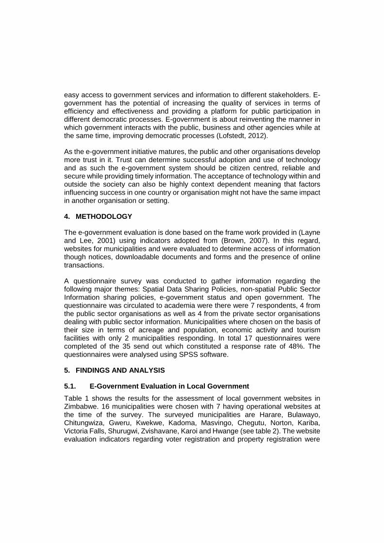
Table 1 shows the results for the assessment of local government websites in Zimbabwe. 16 municipalities were chosen with 7 having operational websites at the time of the survey. The surveyed municipalities are Harare, Bulawayo, Chitungwiza, Gweru, Kwekwe, Kadoma, Masvingo, Chegutu, Norton, Kariba, Victoria Falls, Shurugwi, Zvishavane, Karoi and Hwange (see table 2). The website evaluation indicators regarding voter registration and property registration were
removed as they are only done at national level through the Electoral Commission and the Deeds Registry respectively. However, the processes of property and voter registration would be in principle more efficient if decentralised to local level at which municipalities would handle such tasks within their jurisdictions.
Table 1: Online Services at Local Government Level
Municipalities
Online services CoH CoB CoC CoM KM
VFM HWM
Council Agenda Minutes X X - - - - -
Online Communications X X X X X X X
Communications less than 60 days old
- - - - - X -
Ordinances/Bylaws X X X - X X X
Employment information (Vacancies)
X X - X - X X
Downloadable Forms X X - - X X X
Submit-able online forms - - - - - - -
Requests for Services (Tenders)
- - - X - X X
Electronic Newsletters X X - - X - -
Government Records Request - X X X X X X
Spatial data downloads - - - - - - -
Downloadable Government Information
X X - X X X X
Permit Application - - - - - - -
Tax payment - - - - - - -
Utility bill payment - - - - - - -
Streaming video X - - - - - -
Fines/Fees payment - - - - - - -
Business licence application - - - - - - -
Tourism Information X X - X X X X
Basic Contact information X X X X X X X
Email - X X X X X X
Service faults reporting system/ Helpline
X X X X X X X
X: represents services availability. -: represents service unavailability.
The results show that, e-government is still in its infancy in Zimbabwe as the majority of municipalities have not even established an online presence. Of the few municipalities who are available online, the functionality they have from the websites reflect that they are in the cataloguing stage described in the e-government development model by (Layne and Lee, 2001). The municipalities have a few information documents that can be downloaded online including forms
for service applications. However, there are no online application forms that can be submitted through the websites and it is not possible to pay for services online. However, there are partnerships between municipalities and a private companies and banks to facilitate payment of different services mostly through mobile banking. It is not possible to access spatial data from the websites. Spatial data is only accessible though visiting the offices of the respective organisation.
Table 2: List of Municipalities
CoH City of Harare
CoB City of Bulawayo
CoC City of Chitungwiza
CoM City of Masvingo
CoK Kariba Municipality
CoVF Victoria Falls Municiplality
CoHW Hwange Municipality
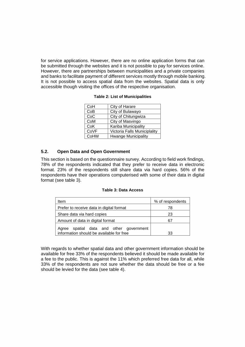
5.2. Open Data and Open Government
This section is based on the questionnaire survey. According to field work findings, 78% of the respondents indicated that they prefer to receive data in electronic format. 23% of the respondents still share data via hard copies. 56% of the respondents have their operations computerised with some of their data in digital format (see table 3).
Table 3: Data Access
Item % of respondents
Prefer to receive data in digital format 78
Share data via hard copies 23
Amount of data in digital format 67
Agree spatial data and other government information should be available for free 33
With regards to whether spatial data and other government information should be available for free 33% of the respondents believed it should be made available for a fee to the public. This is against the 11% which preferred free data for all, while 33% of the respondents are not sure whether the data should be free or a fee should be levied for the data (see table 4).
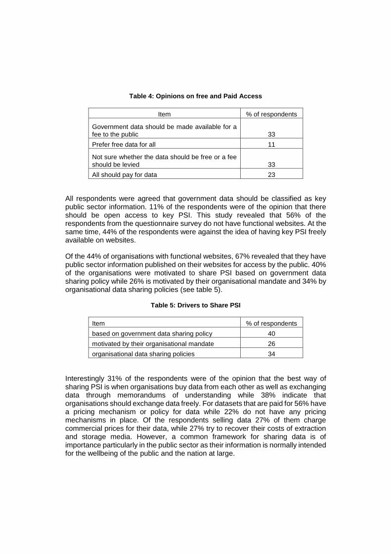
Table 4: Opinions on free and Paid Access
Item % of respondents
Government data should be made available for a fee to the public 33
Prefer free data for all 11
Not sure whether the data should be free or a fee should be levied 33
All should pay for data 23
All respondents were agreed that government data should be classified as key public sector information. 11% of the respondents were of the opinion that there should be open access to key PSI. This study revealed that 56% of the respondents from the questionnaire survey do not have functional websites. At the same time, 44% of the respondents were against the idea of having key PSI freely available on websites.
Of the 44% of organisations with functional websites, 67% revealed that they have public sector information published on their websites for access by the public. 40% of the organisations were motivated to share PSI based on government data sharing policy while 26% is motivated by their organisational mandate and 34% by organisational data sharing policies (see table 5).
Table 5: Drivers to Share PSI
Item % of respondents
based on government data sharing policy 40
motivated by their organisational mandate 26
organisational data sharing policies 34
Interestingly 31% of the respondents were of the opinion that the best way of sharing PSI is when organisations buy data from each other as well as exchanging data through memorandums of understanding while 38% indicate that organisations should exchange data freely. For datasets that are paid for 56% have a pricing mechanism or policy for data while 22% do not have any pricing mechanisms in place. Of the respondents selling data 27% of them charge commercial prices for their data, while 27% try to recover their costs of extraction and storage media. However, a common framework for sharing data is of importance particularly in the public sector as their information is normally intended for the wellbeing of the public and the nation at large.

The term e-government is fairly known by the respondents as 56% of the respondents showed awareness, however 44% of the respondents do not have e-government systems in their organisations. Of those organisations with e-government systems only 22% have services available online and these services being offered online are mainly payment of rates and fees.
Only 33% of the respondents believed the public should participate in government activities such as policy formulation through ironically 100% of the respondents agreed that e-government promote good and informed governance. Findings reflected that all the respondents agree that people with access to information are more empowered and improved access to information improves decision making and policy formulation in government organisations and that exchanging information would save data collection costs in the public sector.
78% of the respondents acknowledged that policies at government level would improve sharing and access of public sector information and that e -government would increase access to public sector information and services. 78% of the respondents concurred that government policy should detect which data sets are free and those that are accessed through payment.
6. DISCUSSION
6.1. Towards Open Data and Open Government
This study revealed that there exists misconception regarding what PSI constitutes. The general view is that PSI is information with direct impact to national security and should remain behind closed doors and not be availed for public use.
Fieldwork findings revealed that organisations prefer accessing digital information to suit today’s digital work environment needs. However, there is lack of complete trust in digital systems as some respondents preferred analogue data. Public sector organisations are trying to computerize operations and convert data into digital format but dissemination through digital means such as on websites is inadequate. Websites are also not frequently updated and thus, the general public cannot access timely information.
Fieldwork results reflected that most respondents are of the opinion that spatial data should not be accessed free of charge and neither should the non-spatial PSI be openly accessible. This is interesting to note since all this data is collected and compiled using public funds. On the other hand, public sector organisations are not implementing a cost recovery approach as funding for their sustenance comes from national government.

The response that PSI should not be openly accessible can translate to unwillingness to share information, authority and autonomy issues. The organisations essentially view the information they create as their own and not for public consumption. This results in organisations creating barriers to access of information due to their autonomy over the information. The barriers mean either no access or lengthy bureaucratic protocols to access information. Other than having standard way of accessing data, this results in informal information sharing arrangements that rely on the relationship between the information requester and the provider. The situation is worsened by lack of policies at national level that promote the sharing and access of public sector information.
Some organisations preferred selling data as the best way of sharing which could be typical for data vendors which were not part of this study. Organisations have even developed pricing mechanisms for their data. Public sector organisations prefer exchanging data free of charge amongst themselves with pricing levied on other users.
The major drivers for sharing data are government and organisational policies and organisational mandates. These drivers need to be coupled with the willingness to share between the organisations.
Even though some information is available via the websites of the organisations it is insufficient as only a small component is published. This means the information regarding operations of government in different sectors such as housing, education and agriculture is not widely available. The possibility for public participation in policy formulation is limited while at the same time, citizens cannot effectively participate in national issues when furnished with inadequate information.
Public sector organisations have awareness of the e-government concept even though: (i) diffusion of e-government is minimal, (ii) e-government is still at grass root level and only exhibiting online presence and (iii) there is no evidence of use by the public. Fieldwork findings reflect that e-government can definitely promote good and informed governance. On the contrary, only a third of the surveyed population supported public participation in national issues. The question that arises then is whether officials are serving the needs of the public or only for the technocrats. The view of the e-government system is that it should be used by government and public sector organisations while excluding other parties.
Regarding the spatial public sector information, Zimbabwe is operating in isolation of worldwide trends. The greatest barrier to access of fundamental data sets is the lack of a spatial information infrastructure and the availability of documents in analogue format. This means that users of spatial data have to travel to the two Surveyor General’s departments in the country to access spatial data. Spatial data is key to aid in public policy implementation and decision which can greatly improve
the quality of life of the citizens. Citizens can greatly influence development that happens in the spaces they live through interaction with local government.
Open data and open government in Zimbabwe requires organisations to change their mindsets regarding (i) what constitutes effective data sharing, (ii) what constitutes democratization, (iii) what constitutes classified information, (iv) what constitutes good governance and (v) the positive role of the public in government operations. The national government has a larger role to play in achieving open data in Zimbabwe. This is due to the fact that, the majority of respondents acknowledge that only policies implemented at national government level can improve access to PSI though the e-government highway. On the other hand, government policy should also detect which data sets are free and those to be paid for.
From the discussion above, the public cannot participate effectively in national issues due to barriers regarding access to public information. This means, the gap between the public and government is not reducing and there is no positive progression towards open government. The more government is open regarding its operations through improved access to information, the better the chances to realize open government. There is need to develop mechanisms to make both the spatial and non-spatial PSI available which is discussed in the following subsections.
6.2. Towards a PSI Sharing Framework
Spatial data has a characteristic that it is costly to collect while the costs of reproduction and distribution are quite minimal. This makes sharing spatial data crucial between agencies. To effectively share the data, there is need to eliminate duplication in the collection of spatial data. The first call is to identify core or fundamental data sets and the respective data custodians. The data custodians will be responsible for the collection, maintenance and distribution of a particular data set. The significance of data custodians is through their responsibility towards maintenance and ensuring consistent quality of data. It is also important to note that, non-spatial PSI is equally important.
E-government calls for different kinds of interactions regarding service delivery to include: (1) G2G – Government to Government, (2) G2B – Government to Business and (3) G2C – Government to Citizen. Data sharing strategies can be developed to cater for these different kinds of interactions. The data sharing policy should stipulate different sharing methods between government, business and the citizens.

One of the major barriers to sharing spatial and non-spatial data are their presence in analogue format. So, there is need to digitize and scan analogue data sets so that they can be accessible through a wide range of media.
Figure 1: Public Sector Information Sharing Framework
Identification of Key Data Sets
Spatial and non-spatial
Identification of Custodians for Key Data
Sets
Development of Data Standards
Creation of Digital Data
Digitizing, Scanning, Other analogue to digital
conversions
Infrastructure Development
Basic: Websites, DatabasesNational level: Spatial Data
Infrastructure, E-government infrastructure
Issues: Interoperability, extensibility
Development of Policy Framework for Data
Custodians
Content: Rights and Duties of Custodians
Development of National Data Sharing Policy
Content: sharing arrangements, free data sets, value added data
sets, licensing, copyright
Dissemination of PSI to different users
Remote access (online), Information kiosks,
helplines
There is definite need to develop a data sharing policy framework (see figure 1 for proposed framework). In this framework, it can be stipulated which framework data sets and key PSI are available openly. If this data is openly available, that may motivate its use in decision making by government departments. Geographic
information systems have not been widely adopted across local government and public sector and as such key personnel need to be sensitized on the importance of spatial analysis for decision making and trained as well.
Some data sets result from value addition and as such can be priced based on the ‘value added’. Data sharing arrangements in form of agreements and memorandums of understanding can be developed on an organisation to organisation basis to ease sharing of data, but they should be recognized by the data sharing policy framework.
6.3. Towards an E-government Implementation Framework
This study proposes e-government implementation according to the model presented in (Layne and Lee, 2001). The development of a fully functional e-government systems requires time and commitment of resources. It is therefore logical to develop it sequentially and logically (see figure 2 for proposed framework) as stipulated in the maturational model proposed in (Layne and Lee, 2001). At each stage there is need for both organisation and community learning, as well as community engagement. The services provided need to have impact on the communities otherwise the public will not use them. Organisations have to go through some reforms including restructuring and change to incorporate the use of information and communication technology in their operations. There is need for staff development so that employees can use the new technology to ensure successful e-government implementation. The employees will also need to adapt to new workflows that will emerge as a result of the migration from an analogue to a digital environment. There is need to understand how society adapts to technology, otherwise governments can implement expensive infrastructures which do not impact society.
Within the implementation framework, it should be realised that benefits do not accrue overnight but over time as well. Some benefits accrue faster while some take time. Some are tangible and easier to measure while some are intangible and more complex to measure. There is need for a monitoring and evaluation system to determine the success of the e-government system and its value or impact to the society that uses the technology.
Successful e-government implementation may require restructuring in the governance structure and some governance procedures. The ultimate aim other than the creation of one stop shops is to improve governance, the quality of life of the public and eventually promote transparency, accountability and openness in government. At this stage, democratisation will have been achieved not only regarding access to PSI but in the governance as well.
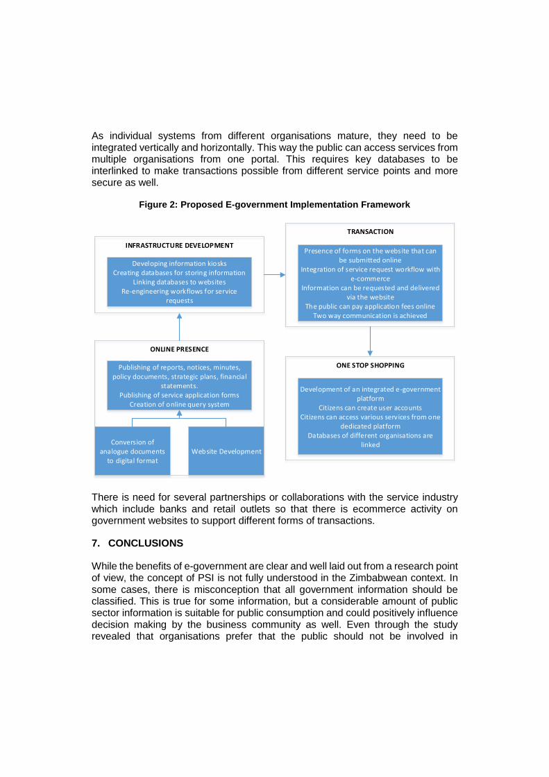
As individual systems from different organisations mature, they need to be integrated vertically and horizontally. This way the public can access services from multiple organisations from one portal. This requires key databases to be interlinked to make transactions possible from different service points and more secure as well.
Figure 2: Proposed E-government Implementation Framework
Conversion of analogue documents
to digital formatWebsite Development
Up-to-date information on websitesPublishing of reports, notices, minutes,
policy documents, strategic plans, financial statements.
Publishing of service application formsCreation of online query system
ONLINE PRESENCE
Developing information kiosksCreating databases for storing information
Linking databases to websitesRe-engineering workflows for service
requests
INFRASTRUCTURE DEVELOPMENT
TRANSACTION
Presence of forms on the website that can be submitted online
Integration of service request workflow with e-commerce
Information can be requested and delivered via the website
The public can pay application fees onlineTwo way communication is achieved
ONE STOP SHOPPING
Development of an integrated e-government platform
Citizens can create user accounts Citizens can access various services from one
dedicated platformDatabases of different organisations are
linked
There is need for several partnerships or collaborations with the service industry which include banks and retail outlets so that there is ecommerce activity on government websites to support different forms of transactions.
7. CONCLUSIONS
While the benefits of e-government are clear and well laid out from a research point of view, the concept of PSI is not fully understood in the Zimbabwean context. In some cases, there is misconception that all government information should be classified. This is true for some information, but a considerable amount of public sector information is suitable for public consumption and could positively influence decision making by the business community as well. Even through the study revealed that organisations prefer that the public should not be involved in
government, public participation will in essence improve interaction and communication between government and citizens. Nations should be governed for the wellbeing of the citizens, and their involvement in the governance structure assists in voicing their needs. There is agreement that data sharing will be cost cutting and that data sharing policies at national level will facilitate this exchange of information. Use of information from different agencies should be encouraged for decision making as it gives a more complete perspective of the problem at hand and possible solutions. Different agencies should also work jointly in projects. This in turn enables organisations to learn from each other regarding their operations and their overlaps and in turn identify ways to assist each other in e-government implementation. There is definite need to at least ensure, online presence for all municipalities and public sector organisations. The departments that are already online should take a leading role towards traversing to the transaction phase of e-government development. They should integrate operations with ecommerce to enable citizens to transact with government online. Partnerships between government, the private sector and specific service industries like the banking sector should be enforced to facilitate an improvement in the current e-government implementations. E-democracy and open government are benefits that can in principle be realised with maturity of e-government systems. The starting point is to make services and information closer to citizens while improving the interaction of government and the public. Zimbabwe currently does not have a spatial information infrastructure which is one of the barriers impeding access to geographic information, despite the absence of a policy framework.
8. REFERENCES
ANZLIC (2010). Economic Assessment of Spatial Data Pricing and Access, Stage 1 report: Principles, Issues and Alternative Models. The Spatial Information Council.
Brown M.M. (2007). Understanding e-government benefits. An examination of leading-edge local governments, The American Review of Public Administration, 37, 178-197.
Fountain, J.E. (2001). Building the virtual state. Information technology and institutional change, Washington DC: Brookings Institution Press.
Homburg, V. (2008). Understanding e-government: Information systems in public administration, New York: Routledge.
Layne K. and J. Lee (2001). Developing fully functional E-government: A four stage model, Government information quarterly, 18, 122-136.
Lofstedt U. (2012). E-government-assesment of current research and some proposals for future directions, International journal of public information systems, 2005, 39-52.
Pickles, J. (1995). Ground truth: The social implications of geographic information systems, Guilford Press.
Samuelson, P.A. and W.D, Nordhaus (2005). Economics, New Delhi: Tata McGraw-Hill Publishing Company Limited.
Sawicki D.S. and W.J. Craig (1996). The democratization of data: Bridging the gap for community groups, Journal of the American Planning Association, 62, 512-523.
Sheppard E, (1995). GIS and society: towards a research agenda, Cartography and Geographic Information Systems, 22, 5-16.
Tulloch D.L. and E. Epstein (2002). Benefits of community MPLIS: efficiency, effectiveness, and equity, Transactions in GIS, 6, 195-211.
Welle Donker, F. and B. van Loenen (2006). "Transparency of accessibility to government-owned geo-information", Proceedings of 12th ECGI & GIS Workshop, Innsbruck, Austria.
Welle Donker, F. (2010). "Public Sector Information Access Policies in Europe", in Fitzgerald, B. (Ed.) Access to Public Sector Information, Law Technology and Policy, Sydney: Sydney University Press.