Delineation of groundwater potential zones in the ... · 2011; Talabi and Tijani 2011)....
20
ORIGINAL ARTICLE Delineation of groundwater potential zones in the crystalline basement terrain of SW-Nigeria: an integrated GIS and remote sensing approach Olutoyin A. Fashae • Moshood N. Tijani • Abel O. Talabi • Oluwatola I. Adedeji Received: 15 March 2013 / Accepted: 2 September 2013 / Published online: 5 October 2013 Ó The Author(s) 2013. This article is published with open access at Springerlink.com Abstract Due to complex and erratic nature of ground- water occurrences in crystalline basement terrains, groundwater development in form of boreholes/wells without the necessary pre-drilling hydrogeological inves- tigations usually results in failure. Therefore, there is the need for adequate characterization of aquifers and delin- eation of groundwater potential zones in such crystalline basement setting. This study employed the integration of multi-criteria decision analysis (MCDA), remote sensing (RS) and geographical information system (GIS) tech- niques to delineate groundwater potential zones in crys- talline basement terrain of SW-Nigeria and validation of the result with existing borehole/well yield data. The study approach involved integration of nine different thematic layers (geology, rainfall geomorphology, soil, drainage density, lineament density, landuse, slope and drainage proximity) based on weights assignment and normalization with respect to the relative contribution of the different themes to groundwater occurrence using Saaty’s analytic hierarchy approach. Following weigh normalization and ranking, the thematic maps were integrated using ArcGIS 10.0 software to generate the overall groundwater potential map for the study area. The result revealed that the study area can be categorized into three different groundwater potential zones: high, medium and low. Greater portion of the study area (84,121.8 km 2 ) representing about 78 % of the total area, fall within the medium groundwater potential zone which are generally underlain by medium-porphyritic granite, biotite-hornblende granite and granite gneiss bed- rock settings. About 18,239.7 km 2 (17 %) fall under high groundwater potential zone which are characterized by weathered/fractured quartzite, quartz-schist, amphibolite schist and phyllite bedrock settings. However, areas of low groundwater potentials constitute only 3 % (3,416.54 km 2 ) of the total study area and are mostly underlain by mi- gmatite, banded and augen gneiss bedrock settings. Sub- sequent validation with boreholes/well yield data revealed a good correlation with respect to the observed ground- water potential zonation. Wells/boreholes with yields greater than [ 150 m 3 /day are generally characteristic of areas with high groundwater potential while those with yields of 75–150 and \ 75 m 3 /day are typical of areas with medium and low groundwater potentials, respectively. The validation clearly highlights the efficacy of the integrated MCDA, RS and GIS methods employed in this study as useful modern approach for proper groundwater resources evaluation; providing quick prospective guides for groundwater exploration and exploitation in such crystal- line basement settings. Keywords Groundwater potential zones Crystalline basement terrains Geographical information systems Remote sensing Multi-criteria decision analysis Introduction The ever increasing population in the developing world, especially in the sub-Sahara Africa, coupled with O. A. Fashae (&) M. N. Tijani Department of Geography, University of Ibadan, Ibadan, Nigeria e-mail: [email protected] A. O. Talabi Department of Geology, University of Ado-Ekiti, Ado Ekiti, Nigeria O. I. Adedeji Institute of Ecology and Environment Studies, Obafemi Awolowo University, Ile-Ife, Nigeria 123 Appl Water Sci (2014) 4:19–38 DOI 10.1007/s13201-013-0127-9
Transcript of Delineation of groundwater potential zones in the ... · 2011; Talabi and Tijani 2011)....

ORIGINAL ARTICLE
Delineation of groundwater potential zones in the crystallinebasement terrain of SW-Nigeria: an integrated GIS and remotesensing approach
Olutoyin A. Fashae • Moshood N. Tijani •
Abel O. Talabi • Oluwatola I. Adedeji
Received: 15 March 2013 / Accepted: 2 September 2013 / Published online: 5 October 2013
� The Author(s) 2013. This article is published with open access at Springerlink.com
Abstract Due to complex and erratic nature of ground-
water occurrences in crystalline basement terrains,
groundwater development in form of boreholes/wells
without the necessary pre-drilling hydrogeological inves-
tigations usually results in failure. Therefore, there is the
need for adequate characterization of aquifers and delin-
eation of groundwater potential zones in such crystalline
basement setting. This study employed the integration of
multi-criteria decision analysis (MCDA), remote sensing
(RS) and geographical information system (GIS) tech-
niques to delineate groundwater potential zones in crys-
talline basement terrain of SW-Nigeria and validation of
the result with existing borehole/well yield data. The study
approach involved integration of nine different thematic
layers (geology, rainfall geomorphology, soil, drainage
density, lineament density, landuse, slope and drainage
proximity) based on weights assignment and normalization
with respect to the relative contribution of the different
themes to groundwater occurrence using Saaty’s analytic
hierarchy approach. Following weigh normalization and
ranking, the thematic maps were integrated using ArcGIS
10.0 software to generate the overall groundwater potential
map for the study area. The result revealed that the study
area can be categorized into three different groundwater
potential zones: high, medium and low. Greater portion of
the study area (84,121.8 km2) representing about 78 % of
the total area, fall within the medium groundwater potential
zone which are generally underlain by medium-porphyritic
granite, biotite-hornblende granite and granite gneiss bed-
rock settings. About 18,239.7 km2 (17 %) fall under high
groundwater potential zone which are characterized by
weathered/fractured quartzite, quartz-schist, amphibolite
schist and phyllite bedrock settings. However, areas of low
groundwater potentials constitute only 3 % (3,416.54 km2)
of the total study area and are mostly underlain by mi-
gmatite, banded and augen gneiss bedrock settings. Sub-
sequent validation with boreholes/well yield data revealed
a good correlation with respect to the observed ground-
water potential zonation. Wells/boreholes with yields
greater than [150 m3/day are generally characteristic of
areas with high groundwater potential while those with
yields of 75–150 and\75 m3/day are typical of areas with
medium and low groundwater potentials, respectively. The
validation clearly highlights the efficacy of the integrated
MCDA, RS and GIS methods employed in this study as
useful modern approach for proper groundwater resources
evaluation; providing quick prospective guides for
groundwater exploration and exploitation in such crystal-
line basement settings.
Keywords Groundwater potential zones � Crystalline
basement terrains � Geographical information systems �Remote sensing � Multi-criteria decision analysis
Introduction
The ever increasing population in the developing world,
especially in the sub-Sahara Africa, coupled with
O. A. Fashae (&) � M. N. Tijani
Department of Geography, University of Ibadan, Ibadan, Nigeria
e-mail: [email protected]
A. O. Talabi
Department of Geology, University of Ado-Ekiti, Ado Ekiti,
Nigeria
O. I. Adedeji
Institute of Ecology and Environment Studies, Obafemi
Awolowo University, Ile-Ife, Nigeria
123
Appl Water Sci (2014) 4:19–38
DOI 10.1007/s13201-013-0127-9

increasing agricultural and industrial development warrants
greater demand for essential public utilities, most espe-
cially water supply for domestic and agricultural purposes.
However, the reality of poor economic situation and
challenges of expansion of many basic infrastructural
facilities to meet the increasing demand on the parts of the
government warrants the need for individuals and local
communities to look for alternative to the conventional
public water supply (Aggarwal et al. 2009; Rodell et al.
2009; Chawla et al. 2010).
Consequently, the readily available alternative option to
the epileptic pipe-borne water supply from reservoirs and
dams is the development of groundwater system in the
form of dug wells and boreholes, especially in the crys-
talline basement terrains, where shallow groundwater sys-
tems can be tapped with minimal cost compared to with the
costlier surface water development. Groundwater is said to
be a more dynamic renewable natural resource and plays
important role in drinking, agricultural and industrial needs
as a timely assured source compared with surface water;
however, availability with good quality and quantity in
appropriate time and space is also important (Rao 2006;
Chowdhury et al. 2009).
Nonetheless, a major constraint is the complex and
erratic nature of groundwater occurrences in crystalline
basement terrains with attendant high rate of well/borehole
failure in the absence of proper and adequate pre-drilling
hydrogeological investigations. The occurrence and
movement of groundwater in a crystalline terrain depends
on the degree of weathering and extent of fracturing of the
bedrock rocks, while identification of potential ground-
water zones could aid in proper development and utiliza-
tion of groundwater resources for eliminating water
scarcity (Rao 2006). However, indiscriminate exploitation
can lead to decrease in groundwater potential in terms of
lowering of water level (hence increase in cost of
groundwater withdrawal) and sometimes deterioration in
groundwater quality. Therefore, there is the need for ade-
quate characterization of basement aquifers and delineation
of groundwater potential zones.
Till now, several conventional methods such as geo-
logical, hydrogeological, geophysical and photogeological
techniques were employed to delineate groundwater
potential zones (McNeill 1991; Lillesand and Kiefer 1994;
Teeuw 1995; Meijerink 1996; Edet and Okereke 1997;
Sander et al. 1996; Taylor and Howard 2000; Shahid et al.
2000; Srivastava and Bhattacharya 2006). However, in the
recent years, with the advent of powerful and high-speed
computers, digital technique is used to integrate various
conventional methods with satellite image/remote sensing
(RS) techniques and geographical information systems
(GIS) technology (Chenini et al. 2010; Machiwal et al.
2011; Talabi and Tijani 2011). Geographical information
system (GIS) provides an excellent framework for effi-
ciently handling large and complex spatial data for natural
resources management (Jenson and Trautwein 1987; Bur-
rough 1986). This integrated approach helps to increase the
accuracy of results in delineation of groundwater potential
zone and also to reduce the bias on any single theme (Rao
and Jugran 2003). Therefore, a systematic approach to
groundwater exploration using modern techniques is
essential for the proper evaluation, exploitation and man-
agement to ensure sustainable development of this seem-
ingly valuable resource, especially in the crystalline
bedrock terrain.
Consequently, integration of remote sensing (RS) and
geographic information system (GIS) has proven to be
efficient, rapid and cost effective technique producing
valuable data on geology, geomorphology, lineaments and
slope as well as a systematic integration of these data for
exploration and delineation of groundwater potentials
zones (Prasad et al. 2008). Furthermore, such integrated
RS-GIS approach enables manipulation of large data base
for large areal extent covering, even in inaccessible areas
(Singh et al. 2013), thus providing a synoptic view of large
areas (with associated hydrological information) for rapid
and cost effective assessment of groundwater occurrences.
In the recent years, there have been wide applications of
RS and GIS in hydrogeological researches. A number of
workers such as Edet et al. (1997), Murthy (2000), Obi
Reddy et al. (2000), Pratap et al. (2000), Singh and Prakash
2002 and Jaiswal et al. (2003) have used GIS to delineate
groundwater potential zone, while Sreedevi et al. (2001)
also applied remote sensing techniques in the delineation of
groundwater potential zones. Furthermore, many authors
such as Krishnamurthy et al. (1996), Murthy (2000), Sri-
vastava and Bhattacharya (2006), Shahid et al. (2000) and
Khan and Maharana (2002) have applied both remote
sensing techniques and GIS applications in groundwater
exploration, delineation of groundwater potential zones as
well as identification of artificial recharge sites. In addition,
El-kadi et al. (1994), Novaline et al. (1999), Shahid et al.
(2000), Boutt et al. (2001), Saraf et al. (2004) Rokade et al.
(2007) and Gumma and Pavelic (2013) have carried out
groundwater modelling through the use of GIS. In addition,
GIS has also been considered for multi-criteria analysis in
resource evaluation, for example Saraf et al. (2004) and
Rao and Jugran 2003 have used GIS technology for pro-
cessing and interpretation of groundwater quality data.
In the crystalline basement terrain of SW-Nigeria which
constitutes almost one-fifth of Nigeria, groundwater
occurrences are largely limited to shallow weathered
overburden units and degree of fracturing of the bedrocks.
These serve as the main sources of freshwater supply for
domestic and industrial purposes, especially in the rural
and sub-urban areas with no public/municipal water
20 Appl Water Sci (2014) 4:19–38
123

supply. In addition, it should be noted that since early
1990s, most of the major cities and urban centres are
increasingly relying on groundwater system too, due to the
failing public/municipal pipe borne-water supply systems.
This situation had resulted in a significant increase of
indiscriminate exploitation of groundwater resources and
random sitting of dug-wells and boreholes leading to
attendant high failure rate. Consequently, to forestall pos-
sible negative impacts of indiscriminate exploitation in
terms of lowering of water level and groundwater quality
deterioration, it is, therefore, necessary to have a proper
understanding of the hydrogeological condition and
groundwater potentiality in such basement terrain.
However, few studies have been conducted in demar-
cating potential groundwater resources within the basement
complex region of Nigeria (Edet et al. 1997), the limita-
tions of which include usage of only two variables
(drainage densities and lineament densities) and covered a
very limited area. Therefore, the present study attempted to
cover larger areas in the SW-Nigeria using more variables
with the inclusion of the multi-criteria decision analysis
(MCDA) technique. This gives a broader view of the
potential groundwater distribution in the study area. Fur-
thermore, the Analytic Hierarchy Process (AHP) (Saaty
1980, 1986, 1992), an international acceptable quantitative
tool, adopted in this study appears to be a flexible decision
making tool for multiple-criterion problems such as the
assessment of the potential zones of groundwater resources
in rapidly urbanized area of SW-Nigeria. It enables
decomposition of a problem into hierarchy and assures that
both qualitative and quantitative aspects of a problem are
incorporated in evaluation process. AHP has been suc-
cessfully applied in several studies of water resources
management by integrating MCDA (Saaty 1980, 1986,
1992) with RS and GIS techniques (Srivastava and Bhat-
tacharya 2006; Jha et al. 2010; Machiwal et al. 2011;
Mukherjee et al. 2012; Singh et al. 2013).
Therefore, the present study employed AHP-coupled
MCDA, GIS and RS techniques to integrate hydrogeolog-
ical, geomorphologic as well as climatic data in respect of
groundwater resources evaluation of the Basement Com-
plex terrain of SW-Nigeria. The intent is to delineate the
groundwater potential zones of the study area and to
develop a prospective guide map for groundwater explo-
ration/exploitation so as to ensure optimum and sustainable
management of this vital resource.
The study area
The study area, the Basement Complex terrain of south-
western part of Nigeria, lies between longitude 2�420E to
Fig. 1 Map of Nigeria showing the study area
Appl Water Sci (2014) 4:19–38 21
123

6�20E and latitude 6�50N to 9�110N encompassing Oyo,
Ogun, Osun Ekiti and Ondo State regions of Nigeria
(Fig. 1).
It covers approximately 137,268 km2 representing about
one-fifth of the total land area of Nigeria. The terrain is
characterized by Precambrian crystalline rock units and
bordered to the south by the western Dahomey Basin. The
area is bounded in the north by massive granitic hills where
most of the drainage originates. The entire area is drained
by medium- to small-sized rivers and streams, which flow
southwards to the Atlantic Ocean.
The topography of Nigeria and indeed the study area is a
reflection of its geology, as the Basement Complex rocks of
the SW-Nigeria are responsible for the rugged topography
that dominates substantial portion of the study area. In
general, the elevation ranges from 600 m asl in the north
and north eastern parts to less than 300 m asl in the
southern part, while the Idanre Hills represent the highest
plateau with an elevation of about 1,000 m above sea level
(Iloeje 1981). The topography of the area exhibits three
distinct features: hilly terrains covering mainly northern
and north-western part of the basin, mid-slope region with
moderate undulating terrain and relatively flat region with
gentle slope covering larger part of the basin.
The study area enjoys a warm tropical climate with
relatively high temperatures throughout the year and two
seasons. Generally, temperatures are high throughout the
year because of the tropical climatic conditions with mean
monthly value of about 27 �C, while daily maximum
temperatures range between 25 and 30 �C depending on
the location and season (Iloeje 1981). The seasonal pattern
is characterized by long wet season between mid-March
and July which is characterized by heavy rainfall and high
humidity followed by a short dry season between July and
August and a short wet season (September–October) before
the commencement of the dry season in November (Oye-
nuga 1967; Iloeje 1981). The total annual rainfall decreases
from the south to the northern parts of the study area with
annual rainfall in the range of 1,000–1,400 mm. However,
about 80 % of the rains fall within the wet months of
April–September (Iloeje 1981). Soil types are influenced
by and follow very broadly the climatic and vegetational
zones of the study area, as the degree of available moisture
in the soil is an important factor in soil reactions, fertility
and productivity (Oyenuga 1967). The soils range from that
of humid tropical forests zone in the south to that of
derived savannah in the north of the study.
Geological and hydrogeological settings of the study
area
The Basement Complex terrains of South-western Nigeria
are underlain by Precambrian basement rocks, which
comprise of crystalline igneous and metamorphic rocks
mostly granite/porphyritic granite, granite-gneiss, quartz-
schist, migmatite as well as augen-gniess, pegmatite
intrusions and variably migmatized biotite-hornblende
gneiss. Descriptions on the field and petrographic/miner-
alogical characteristics of the different rock types are
subject of various works such as Oyawoye (1972), Elueze
(1982), Obaje (2009), among many others). Textural and
compositional attributes are wide ranging. Directional
fabrics such as foliation, lineation and lamination are often
developed in the gneisses, schists, quartzites and tectonized
rocks (Aigbedion 2006).
From hydrogeologic point of view, unweathered base-
ment rock contains negligible groundwater; however, sig-
nificant aquiferous unit can develop within the weathered
overburden and fractured bedrock. It is this weathered and
fractured zone, which forms potential groundwater zones.
However, a number of factors that usually contribute to the
weathering and development of fracture systems in the
basement rocks can be summarized as follows (Jones 1985;
Acworth 1987; Wright and Burgess 1992):
• presence and stress components of fractures; as conduit
zones
• hydro-geomorphological conditions that dictate the
influence of weathering agents
• hydro-climatic/temperature regimes that dictate chem-
ical weathering pace
• mineral contents of the rock which affect the degree of
weathering/overburden thickness.
Hence it can be summarized that the availability of
groundwater in a typical basement setting like that of SW-
Nigeria depends not only on the geology but also on the
complex interactions of the various hydroclimatic and
geomorphologic factors. Consequently, various techniques
have been developed to locate favourable sites for the
exploitation of groundwater resources within basement
rocks. These include remote sensing geophysical methods
and geomorphological studies (Wright and Burgess 1992;
Lillesand and Kiefer 1994; Taylor and Howard 2000;
MacDonald et al. 2005).
Groundwater condition in the study area
Assessment of previous studies revealed that the hydro-
geological setting of the study area is characterized by
weathered saprolite units with varied thickness over the
different bedrock units such as porphyritic granites, gran-
ite-gneiss, migmatite, pegmatite and quartz-schist settings.
Such setting suggests influence of rock types and miner-
alogy on the extent of fracturing and weathering. Conse-
quently, groundwater occurrences in the study area are in
localized, disconnected phreatic regolith aquifers,
22 Appl Water Sci (2014) 4:19–38
123

essentially under unconfined to semi-confined conditions
(Tijani 1994). Nonetheless, groundwater occurrence in the
study area can be categorized under two main units: area
with highly weathered and/or fractured bedrock units and
area with poorly weathered/sparsely fractured bedrock
units.
In area with deep weathered regolith and highly frac-
tured zones, groundwater occurrences usually depend on
the thickness of the water-bearing rock; this rock can be
gravely and fractured with possible quartz veins within the
deep weathered zone of between 10 m to 30 m. In the study
area, these are characteristic of areas underlain by weath-
ered crystalline and metamorphic rocks such as schist/
quartz-schist, fractured granite-gneiss and porphyritic
granites as well as augen gneiss with vertical fracture
zones. These are generally characterized by moderate to
high yield of about 75 m3/day and up to[150 m3/day. The
borehole depth usually varies from 20 to 60 m while the
saturated thickness varies from 20 to 35 m below the
ground surface.
In areas where the weathered zone is thin or absent,
groundwater is usually difficult to find due to widely
spaced fractures and localized zone/pockets of weathered
zone. In the study area, these are characteristic of areas
underlain by crystalline and metamorphic rocks, especially
migmatite and variably migmatized gneiss characterised by
thin/shallow overburden unit of usually less than 10 m in
thickness and low yield of generally less than 75 m3/day.
In such setting also the borehole depth varies from 20 to
30 m while saturated thickness varies from 8 to 20 m
below ground surface
Nonetheless, towards the base of the weathered zone at
the interface with the fresh bedrock, the permeability is
usually high, allowing water to move freely due to low
proportion of clayey materials. However, in such situa-
tions, deep-seated fractures are important source of
groundwater and can sometimes provide appreciable water
supplies, especially when tectonically controlled (Mac-
Donald et al. 2005). Wells or boreholes that penetrate this
horizon can usually provide sufficient water to sustain even
hand pumps (Chilton and Foster 1995; MacDonald et al.
2005). It should be pointed out that due to the complex
interactions of the various factors affecting weathering in a
typical basement complex setting like the study area, the
distribution of groundwater potential zone can be erratic
and may not be present at all in some locations.
The study of Allichi (2007) which involved character-
ization of weathered overburden revealed estimated over-
burden thickness using geoelectrical VES surveys to be
from 3.8 to 50 m with mean value of about 20 m as dic-
tated by bedrock types. These values are within the range
of values obtained for similar Basement Complex terrains
of Africa. Furthermore, it was observed that areas with
thin/shallow overburden coincided mostly with areas
underlain by variably migmatized gneiss complex, while
area with thicker overburden unit coincided with area
mainly underlain by schist. However, quartzite/quartz-
schist setting coincided with areas of moderate to shallow
overburden thickness.
In summary, the varied thickness and the isolated
pockets of the weathered overburden units also confirm the
localized nature of weathered basement aquifers under
crystalline basement setting. The implication of this lies in
the fact that there is the need for careful characterization
and delineation of areas of possible fracturing and deep
weathering as aquiferous zone in respect of groundwater
developments in Basement Complex settings of the study
area. Therefore, the present study addresses the aspect of
characterization of the groundwater potential using inte-
grated GIS, RS and MCDA techniques in conjunction with
conventional hydrological and hydrogeological data.
Materials and methods
For the study, existing hydrogeological and relevant data
on soils, geological/lithological units, structural features,
geomorphologic and climatic conditions of the study area
were collated. The overall study concept involved inte-
gration of nine thematic layers of conventional geology,
soil, drainage and lineament maps, rainfall data as well as
remotely sensed data of land-use, slope and geomorphol-
ogy using both ArcGIS 10.0 and Idrisi Selva 17.0 GIS
software. All of the map themes were presented in UTM
Projection Zone 31, Datum WGS84 with 30 metre
resolution.
Preparation of thematic layers
The analogue geological and lineament maps of the study
area obtained from Nigeria Geological Survey Agency
(NGSA) with scale 1:100,000 were georeferenced and
digitized in ArcGIS 10.0 software platform. Lineaments
are manifestation of linear features that can be identified
directly on the rock units or from remote sensing data while
lineaments and their intersections play a significant role in
the occurrence and movement of groundwater resources in
crystalline rocks (Rao 2006; Prasad et al. 2008). The pre-
sence of lineaments may act as a conduit for groundwater
movement which results in increased secondary porosity
and, therefore, can serve as groundwater potential zone
(Obi Reddy et al. 2000). Lineament density map was
computed in and expressed in terms of length of the line-
ament per unit area (km/km2) in the GIS software.
In addition, land use/land cover (LULC) plays important
role in the occurrence and development of groundwater.
Appl Water Sci (2014) 4:19–38 23
123

LULC map for the study was extracted from a mosaicked
Landsat ETM imagery of February 16, 2010 series through
supervised classification of the false colour composite of
the band 4, 3 and 2 to obtain the land use category in Idrisi
Selva software platform. Also soil zone generally has sig-
nificant role on the amount of infiltrating water and hence
influences groundwater recharge. The rate of infiltration
largely depends on the grain size and related hydraulic
characteristics of the soils. For this study, soil map of the
study area was clipped from Soil Unit FAO/UNESCO/IS-
RIC map of Nigeria.
Geomorphology reflects various landform and topo-
graphical features. Surface water is one of the important
geomorphological agents in the development and shaping
of landscapes and landforms; thus hydrogeomorphological
studies are of importance in the planning and execution of
groundwater exploration. Slope, on the other hand, is an
aspect of geomorphologic features which controls the
infiltration and recharge of groundwater system: thus the
nature of slope alongside other geomorphic features can
give indication of groundwater prospect of an area.
Therefore, Digital Elevation Model (DEM) of the
Advanced Spaceborne Thermal Emission and Reflection
Radiometer (ASTER) of 2002 at 30 m resolution were used
to generate the geomorphology and slope thematic maps
using assigned threshold values (Saraf and Choudhary
1998; Rao and Jugran, 2003; Prasad et al. 2008).
Generally, rainfall represents direct recharge source of
groundwater in the study area while the development and
exploitation of groundwater is through open dug-wells and
shallow boreholes. As mentioned earlier, groundwater
occurs in the weathered zone under unconfined conditions
as well as in the fractured zone semi-confined conditions in
some cases. Mean annual rainfall data for 30 years were
obtained from seven stations of the Nigerian Meteorolog-
ical Agency (NIMET) stations located in the study area
(Fig. 2). The data were processed using the Thiessen
polygon technique in the ArcGIS 10.0 software platform to
obtain the spatial rainfall pattern of the study area. Thies-
sen polygons define the individual ‘regions of influence’
around each of a set of points such that any location within
particular polygon is nearer to that polygon’s point than to
any other point, and, therefore, has the same value (Hey-
wood et al. 1998). This method is commonly used in the
analysis of climatic data when the local observations are
not available and so the data from the nearest weather
stations are used.
Drainage pattern reflects the characteristic of surface as
well as subsurface formation. Drainage map was obtained
from DIVAGIS (http://www.diva-gis.org) and subse-
quently processed to obtain the drainage density map.
Drainage density map delineation was followed by the
division of study area into micro-watersheds (Singh et al.
2013). Intersection of micro-watersheds and drainage layer
was used for the calculation of drainage density for each of
the micro-watershed expressed in terms of the length of
channels per unit area (km/km2) in the ArcGIS 10.0 soft-
ware platform. The drainage density values thus obtained
were reclassified to prepare a drainage density map of the
study area. Furthermore, water bodies are fewer in areal
extent and are distributed sporadically over the study area;
thus the buffered areas are considered more suitable zone
for groundwater occurrence than areas beyond. Conse-
quently, the drainage map was used to obtain the proximity
to water bodies map using the buffering option of ArcGIS
10.0 software.
Subsequent to the preparation of all the different the-
matic maps (including rainfall, slope, drainage density,
soil, land use, slope, geology and lineament thematic maps)
with varied attributes, the maps were converted into raster
format and then assigned suitable weights in order of their
hierarchy in groundwater potentiality using the analytic
hierarchy process (AHP) (Saaty 1980, 1992). All the nor-
malized weighted thematic layers were integrated and
processed in ArcGIS 10.0 platform to demarcate the
potential groundwater zone in the study area. The details of
the procedures adopted for this study is summarzed
graphically as flow-chart in Fig. 3 while further details on
the AHP and weight assignments are highlighted in the
following section.
Analytical hierarchy process, weights assignments
and integration of thematic maps
The analytic hierarchy approach (AHP) developed by Sa-
aty (1980, 1986, 1992) was used in this study as a decision-
aiding method to finalize the weights assigned to different
themes and their respective features used in deciphering
Fig. 2 Trend of mean annual rainfall within the study area for
30 years
24 Appl Water Sci (2014) 4:19–38
123
groundwater potentiality. AHP is a simple mathematical
matrix-based technique that allows users to assess the rel-
ative weight of multiple criteria in an intuitive manner. It
allows efficient group decision-making, where group
members can use their experience, values and knowledge
to breakdown a problem into a hierarchy and solve it by
AHP steps (Chowdhury et al. 2009). It also incorporates
systematic checks on the consistency of judgments, which
is one of the strongest points over the other multi-attribute
value processes.
The attributes of each of the thematic maps employed in
this study were assigned weightage of 1–4, depending on
the relative contribution to the occurrence and movement
of groundwater. In terms of groundwater potentiality the
weightage factor 1 denotes low/poor, 2 implies moderate, 3
represents good and 4 denotes high groundwater potenti-
ality. The weightage employed is in accordance with the
respective importance of the map theme to groundwater
occurrence following the approach of Saraf and Choudhary
(1998), Rao and Jugran (2003), Prasad et al. (2008), Jha
et al. (2010), Machiwal et al. (2011), Mukherjee et al.
(2012) and Singh et al. (2013). The weights of the indi-
vidual themes and their associated features were then
normalized by the Saaty’s AHP and the eigenvector tech-
nique was used to reduce the subjectivity associated with
the assigned weights (Table 1). Further, the pair-wise
comparison matrices of the assigned weights of the dif-
ferent thematic maps were constructed and computed
(Table 2) using the Idrisi Selva software.
The Consistency Index (CI) of the assigned weights was
calculated following the procedure suggested by Saaty
(1980, 1992) while the Consistency Ratio, which indicates
the probability that the matrix ratings were randomly
generated, was also computed using the values of Random
Consistency Index (RI) which is the average value of CI for
random matrices using the Saaty scale obtained by Forman
(1983, 1990) based on the following relations:
Consistency Index ¼ kmax � nð Þ= n � 1ð Þ;Consistency Ratio ¼ CI=RI
where n is the number of criteria or factors
It should be noted that the CR value should be less than
0.10 for consistent weights; otherwise, corresponding
weights should be re-evaluated to avoid inconsistency
(Saaty 1980, 1986, 1992). For this study, the CR was
estimated to be 0.02 which is far below the threshold
consistency value of 0.10. Furthermore, each of the the-
matic maps was then assigned weight in the range of 1–9
according to Saaty’s scale of assignment (Table 1), which
depicts the relative importance of the respective themes to
groundwater availability. The weights assigned to the
respective thematic maps as presented in Table 3 indicate
Fig. 3 Flowchart for delineating potential groundwater zones in SW-Nigeria using, MCDA, GIS and RS techniques
Appl Water Sci (2014) 4:19–38 25
123

that geology was ranked the dominant factor with a nor-
malized weight value of 0.1745 while proximity to water
bodies is the least accounted factor with a normalized
weight of 0.0224 for groundwater occurrence in the study
area. The summary of the assigned and normalized weights
of the features of the different thematic layers alongside
with ranking and coverage areas is presented in Table 4
On the final analysis, nine different thematic maps were
integrated using ArcGIS 10.0 software to generate the
groundwater potential index (GWPI) for the study area.
The index was computed by the integration of the total
normalized weights of different polygons using equation
stated below. This technique is associated with the study of
locations of geographic phenomena together with their
spatial dimension and associated attributes (Prasad et al.,
2008).
GWPI ¼ðGMwGMwi þ GGwGGwi þ LULCwLULCwi
þ DDwDDwi þ SLwSLwi þ LDwLDwi
þ STwSTwi þ RFwRFwi þ DPwDPwi
where GG is the geology, GM is geomorphology, LULC is
landuse/land cover, DD is drainage density, SL is slope,
LD is lineament density, ST is soil type, RF is rainfall, DP
is drainage proximity, w is normalized weight of a theme
and wi is the normalized weight of individual classes.
Thus, using raster calculator tools in ArcGIS platform, a
composite groundwater potential index (GWPI) for the
study area was generated on the basis of which the overall
groundwater potential map was produced. Finally, well/
borehole data (e.g. yield, depths and saturated thickness)
were collated from existing wells in the study area. These
data were used for the purpose of validation of the pro-
posed groundwater potential map, as a useful guide for a
quick assessment of groundwater occurrence on regional
scale in the study area.
Results and discussion
Geology/lithology
The study area is underlain by the Basement Complex rocks
of southwestern Nigeria which are integral part of the Pre-
cambrian unit of the West African Craton. Precambrian
Basement Complex terrain of SW-Nigeria comprises igne-
ous and metamorphic rock units (migmatite gneisses,
Table 1 Saaty’s scale for assignment of weights and its interpretation showing the pair-wise comparison process (Saaty 1980, 1986, 1992)
Less important Equally important More important
Extremely Very strongly Strongly Moderately Equally Moderately Strongly Very strongly Extremely
1/9 1/7 1/5 1/3 1 3 5 7 9
2, 4, 6 and 8 are intermediate values that denotes comprise
Table 2 The pair-wise comparison matrices table of the different themes
Themes GG RF ST GM LU SL LD DD DP
Geology (GG)
1
Rainfall (RF) 1 1
Soil Type (ST) 1 1 1
Geomorphology (GM) 1 1 1 1
Landuse (LU) 1 1 1 1 1
Slope (SL) 1/2 1/2 1 1 1 1
Lineament density (LD) 1/3 1/3 1/2 1 1 1 1
Drainage density (DD) 1/4 1/5 1/4 1/2 1/3 1/2 1 1
Drainage proximity (DP) 1/9 1/8 1/7 1/6 1/5 1/4 1/3 1/2 1
Table 3 Weights of the thematic maps of the potential groundwater
Themes Assigned weights Normalized weights
Geology 9 0.1745
Rainfall 8 0.1717
Soil 7 0.1471
Geomorphology 6 0.1284
Landuse 5 0.1256
Slope 4 0.1020
Lineament density 3 0.0802
Drainage density 2 0.0481
Drainage proximity 1 0.0224
26 Appl Water Sci (2014) 4:19–38
123

granites, quartzites, schist and metasediments). The quartzite
and granite gneiss settings often form elevated topographic
ridges and inselbergs (Elueze 1995), while the schist and
meta-sediment settings form low-lying areas (Fig. 4).
In line with the complexity of the tectonic history of the
Basement Complex rocks, a number of authors have
described the geology and classification of the Basement
rocks of southwestern Nigeria. The earliest systematic
geological work is that of Jones and Hockey (1964) in their
report on the geology of southwestern Nigeria, where five
groups of rocks were recognized. Oyawoye (1970) classi-
fied the Basement rocks into four groups while Rahaman
(1976) recognized five major groups of rocks. Odeyemi
(1976), however, classified the main rocks of the Basement
Complex into four groups:
(a) The migmatite-gneiss complex
(b) The meta-sediments (composed of schist, calc-gneiss,
quartzite and meta-conglomerate.
(c) The porphyritic older granite
(d) Miscellaneous rock types, mostly post orogenic such
as aplites, pegmatite and dolerite dykes.
As highlighted earlier, the geology of the study area is
dominated by the Precambrian basement rock units consist-
ing of igneous and metamorphic rock units, i.e. migmatite
gneisses, granites, schist/metasediments and quartzites. The
Table 4 Assigned and normalized weights of the features of themes for the delineation of the groundwater potentials in the study area
Categories Criterion Weight Normalized weight Rank Area (km2) Percentage area
Geology Migmatite gneiss 1 0.1307 0.175 71,603.5 67.69
Granitic rocks 2 0.1678 12,797.6 12.10
Schist and metasediments 3 0.2200 16,321.3 15.43
Quartzite 4 0.4814 5,055.6 4.78
Rainfall 1,164–1,296 mm 1 0.1307 0.172 35,926.9 33.96
1,296–1,452 mm 2 0.1678 29,292.9 27.69
1,453–1,512 mm 3 0.2200 29,782.9 28.16
1,512–1,776 mm 4 0.4814 10,775.3 10.19
Soil Clayey loam 1 0.2098 0.147 57,005.0 53.89
Loam 2 0.3021 38,398.6 36.30
Sand loam 3 0.4991 10,374.4 9.81
Geomorphology Inselbergs 0 0 0.128 9,688.8 9.16
Ridges 1 0.1700 39,466.4 37.31
Plains 3 0.2805 32,623.6 30.84
Lowlands 4 0.6495 23,999.2 22.69
Land-use Water bodies 0 0 0.126 222.9 0.21
Settlements 1 0.2105 25,582.1 24.18
Soil 2 0.3134 32,071.7 30.32
Vegetations 3 0.4761 47,901.3 45.28
Slope \6.25 4 0.4814 0.102 102,201.1 96.62
6.25–12.0 3 0.2200 2,795.7 2.64
12.1–18.5 2 0.1678 517.2 0.49
[18.5 1 0.1307 264.0 0.25
Lineament density 0–0.04 1 0.1307 0.080 30,419.6 28.75
0.05–0.09 2 0.1678 37,008.5 34.99
0.10–0.16 3 0.2200 28,418.2 26.89
0.17–0.35 4 0.4814 9,931.4 9.388
Drainage density 0–0.5 3 0.4991 0.048 10,497 9.92
0.5–1 2 0.3021 54,112 51.16
[1.0 1 0.2098 41,173 38.92
Water body proximity \75 m 3 0.4991 0.022 16,109.4 15.23
75–150 m 2 0.3021 16,342.5 15.45
[150 m 1 0.2098 73,324.2 69.32
Appl Water Sci (2014) 4:19–38 27
123

migmatite gnesiss and granitic rocks are widespread over the
study area covering about 71,603.5 km2 (68 %) and
12,797.6 km2 (12 %), respectively. Schist/metasediments
and quartzites are limited to the central and western parts of
the study area covering about 16,321.3 km2 (15 %) and
5,055.6 km2 (5 %), respectively.
Usually, massive unfractured lithologic units in Basement
Complex setting has little influence on groundwater avail-
ability except in cases with secondary porosity through the
development of weathered overburden and fractured bed-
rock units, which form potential groundwater zones. Hence,
on the basis of the presence and nature of the weathered
regolith units and fracture systems, appropriate weights are
assigned to the different rock units in the study area. The
weightage in terms of increasing groundwater potentiality is
in the order of migmatite gneisses (0.13) \ granites
(0.17) \ schist/metasediments (0.22) \ quartzites (0.48).
Lineaments and lineament density
The study area is criss-crossed with lineaments consequent
to a number of tectonic activities in the past. Three
prominent directions identified are N–S, NE–SW and NW–
SE trends. Usually, lineament density map is a measure of
quantitative length of linear feature per unit area which can
indirectly reveal the groundwater potentials as the presence
of lineaments usually denotes a permeable zone. For most
of the study area, the lineament density varies from less
than 0.04 km/km2 which covers a total area of
30,419.6 km2 (29 %) to 0.35 km/km2 with total area of
9931.4 km2 (9 %) (Fig. 5). Though the lineaments are
widespread across the study area, however, the distribution
of lineaments suggests geologic control with areas under-
lain by migmatite gneiss and granites having relatively
lower lineament density (of 0.04–0.09 km/km2) compared
with areas underlain by metasediments and quartzites with
higher lineament densities of 0.16–0.35 km/km2).
Thus areas with higher lineament density are regarded as
good for groundwater development. Consequently, higher
weightage of 0.4814 was assigned to area with high density
of lineaments, which are closely associated with area
underlain by meta-sediments and quartzites while a low
weightage of 0.1307 was assigned to areas underlain by
migmatite with low lineament density.
Geomorphology
In this study, four main geomorphological units were
identified and delineated with respect to the respective
elevations from the RS imagery of the study area (Fig. 6).
These are lowlands and plains representing weathered low-
lying piedmont plains covering about 23,999.17 km2
Fig. 4 Geological map of the study area (based on the NGSA map of Nigeria, with scale 1:100,000)
28 Appl Water Sci (2014) 4:19–38
123

(22.7 %) and 32,623.59 km2 (30.8 %) of the study area,
respectively. Plains are geographical feature that are flat or
gently rolling while lowlands are defined for this purpose
of this study as a geographical piece of land that are low in
terms of its height above mean sea level.
On the other hand, ridges and inselbergs represent a
chain of low-lying ridges or hills that form a continuous
elevated crest constituting about 39,466.42 km2 (37 %)
and 9,688.82 km2 (9.2 %) of the study area, respectively.
These geomorphological features based on the respective
significance with respect to groundwater occurrence are
weighted and classified with increasing order of
groundwater potentiality as inselbergs (0) \ ridge
(0.17) \ plain (0.28) \ lowland (0.65). A closer look at
the classification revealed that the lowlands and plains
are to the southern part of the study area representing the
middle and lower course of the drainage systems while
the ridges and inselbergs are to the north occupying the
watershed areas.
Slope
As an aspect of geomorphologic features, slope is one of
the factors controlling the infiltration and recharge of
groundwater system: thus the nature of slope alongside
other geomorphic features can give indication of
groundwater prospect of an area. In the low slope area the
surface runoff is low allowing more time for infiltration of
rainwater, while high slope area enhances high runoff with
short residence time for infiltration and recharge.
In this study, the slope thematic map as presented in
Fig. 7 revealed slopes ranging from less than 6.25 % to
more than 18.5 %. The wide range and distribution of the
slopes in the study area is an indication of varied degree of
run-off and recharge which imply varied groundwater
potential characteristic of crystalline basement setting.
About 102,201 km2 is covered by less than 6 % slope,
which signifies nearly flat surfaces to very gentle slopes
and constitutes about 96 % of the study area while about
2,796 km2 has 6–12 % slope (gentle to slight slopes)
making up of 2.6 %. Areas with 12–18 % slope (slightly
steep) and greater than 18 % slope (steep slopes) cover
area of 517.19 and 264.1 km2, respectively, both of which
constitute less than 1 % of the total area. Consequently,
based on the influence of slope in respect of infiltration and
groundwater recharge, areas with less than 6 % slope (i.e.
nearly flat surfaces to very gentle slopes) which constitutes
about 96 % of the study area were rated higher in terms of
groundwater potentiality with weighted factor of 0.48
compared with areas with slope greater than 18 % with
weighted factor of 0.13. The overall implication is that the
southern part of the study area is dominated by low slope
Fig. 5 Lineament density map of the study area
Appl Water Sci (2014) 4:19–38 29
123

Fig. 6 Geomorphology map of the study area
Fig. 7 Slope map of the study area
30 Appl Water Sci (2014) 4:19–38
123

(\6 %) which incidentally also represents the area domi-
nated by the lower course of the drainage channels com-
pared with the northern part of the study area that
represents watershed areas dissected by the upper channels
of the drainage systems.
Drainage density
The area of very high drainage density represents more
closeness of drainage channels and vice versa; hence, the
higher the drainage density, the greater the runoff while the
lesser the drainage density, the lower the run-off and the
higher the probability of recharge or potential groundwater
zone. Furthermore, it has been suggested that a measure for
permeability is drainage density (i.e. total length of
drainage channels per unit area), in the sense that perme-
able conditions are associated with low drainage density
and vice versa (Meijerink 2007). Most of the drainage
originates from the granitic hills and inselbergs in the
northern part of the study area and the drainage pattern is
generally dendritic, typical of crystalline basement terrain.
The estimated drainage density in the study area as
presented in Fig. 8 revealed moderately dense drainage
network with values of 0.5 to greater than 1 km/km2. The
high drainage density areas which constitute about
41,173 km2 (39 % of the total area) are weighted relatively
lower (0.2098) compared with low drainage density areas
that are weighted higher with value of 0.499 and constitute
about 10,497 km2 (9.9 %). However, the generally mod-
erate to high drainage density implies low or moderate
infiltration and recharge potentials for about 90 % of the
study area. Hence, low overall percentage contribution of
the drainage density (2.1 %) to the overall groundwater
potential.
Rainfall
The rainfall distribution in the study area ranges from
1,160 to 1,775 mm suggesting a humid tropical terrain with
the entire study area receiving more than 1,000 mm of
rainfall annually (Fig. 9).
Areas with higher amount of rainfall have weightage
factor of 0.48 signifying very good groundwater potential
which covers about 10,775.34 km2 (10.2 %) while areas
with the lowest amount of rainfall have weightage factor of
0.13, suggesting poor groundwater potentiality and represent
about 35,926.88 km2 (34 %). A closer look at the rainfall
thematic map revealed the northern part have relatively
lower rainfall (\1,556 mm) which can be attributed to the
influence of the receding rain-bearing South-West trade
wind from the southern coastal boarders. Generally, the
southern part received high rainfall ([1,556–1,616 mm);
however, a pocket of higher rainfall of [1,616 mm in the
south can be attributed to the effect of localized orographic
rainfall induced by the elevated inselbergs and quartzite
ridges.
Soil zones
Fine-grained soils limit infiltration due to apparently low
permeability unlike coarse-grained soil materials where
water can infiltrate easily because of high permeability. In
this study, three main soil units were identified: clayey
loam soils, loamy soils and sandy loam soils covering
57,005.03 km2 (53.8 %), 38,398.55 km2 (36.3 %) and
10,374.43 km2 (9.8 %) of the total study area, respectively,
as shown in Fig. 10.
Given the relationship between the sand content/coarse-
grained materials and permeability, higher weightage was
given to soils with relatively higher permeability; thus
sandy loam units are assigned a weightage factor of 0.48
compared with that of clayey loam with a factor of 0.21
indicating lower groundwater potentials, while loam soils
have intermediate value of 0.30 representing moderate
groundwater potential.
Land use/land cover (LULC)
Land use/land cover plays important role in the occurrence
and development of groundwater. Consequently, the iden-
tified land use/land cover features for this study from the
thematic map are vegetation area (cropland and forest
plantation), water bodies (stream and lakes), built-up areas/
settlements as well as open bare soils surfaces/outcrops
areas (Fig. 11).
Vegetated area, as the dominant land use types, covered
an area of about 47,901.30 km2 representing about 45 % of
the total area followed by open bare soil surfaces covering
32,071.67 km2 (30 %). Settlements and built-up areas
constitute only 25,582.13 km2 (24 %) while about and
222.89 km2 (\1 %) are covered by water bodies in the
form of streams and lakes. Coupled with generally high
amount of precipitation ([1,000 mm), the distribution of
land-use is expected to enhance groundwater recharge
depending on the underlying soil and geologic conditions.
Proximity to water bodies
The 75-m buffered area around the surface water bodies
was considered as a more suitable zone for groundwater
occurrence than the areas beyond (Fig. 12). This is based
on the possible or anticipated surface—groundwater
interactions.
In this study, three buffers zones were identified: \75,
75–150 and [150 m with a total area of 16,109.4 km2
(15.2 %), 16, 342.5 km2 (15.4 %) and 73,324.2 km2
Appl Water Sci (2014) 4:19–38 31
123

Fig. 8 Drainage density map of the study area
Fig. 9 Rainfall map of the study area
32 Appl Water Sci (2014) 4:19–38
123

Fig. 10 Soil zones map of the study area
Fig. 11 Landuse/landcover map of the study area
Appl Water Sci (2014) 4:19–38 33
123

(69 %), respectively. This suggest that zones closer to
water bodies (\75 m) are very small in area extent,
reflecting low to moderate drainage density and such zones
are considered the suitable zone for groundwater avail-
ability with a weight value of 0.499, higher than those areas
further away from the water bodies. Nonetheless, a low
ranking of 0.022 was assigned to water body proximity
theme, due to the limited surface—groundwater interac-
tions in a typical basement setting and thus limited influ-
ence on the overall groundwater potential.
Classification of groundwater potential zones
On the basis of the assignment and normalized weighting of
the individual features of the thematic layers, a potential
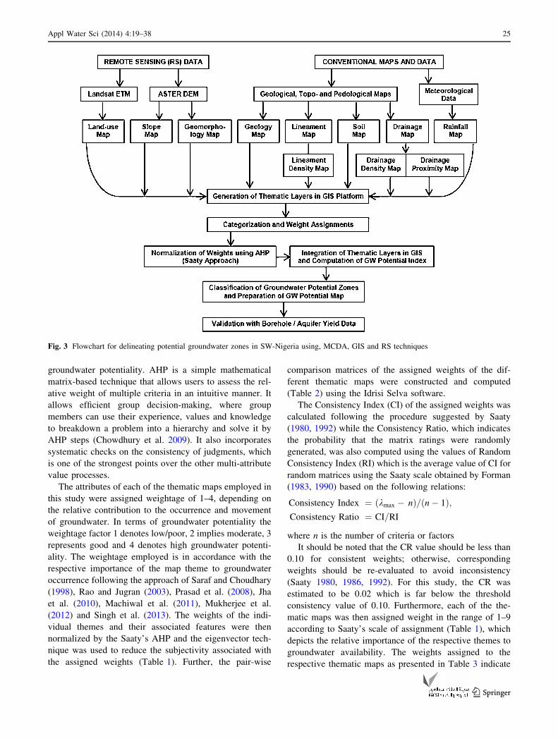
groundwater index map was produced (Fig. 13). The
potential groundwater zones (PGZ) of the study area
revealed three distinct zones, namely low, moderate and high
zones whose distribution and extents are 3,416.54 km2
(3.23 %), 84,121.75 km2 (79.53 %) and 18,239.71 km2
(17.24 %) as presented in Table 5.
The potential map, as presented in Fig. 13, gives a quick
assessment of the occurrence of groundwater resources in the
study area. The groundwater potential map revealed that the
upper north-western and the extreme eastern parts of the
study area generally have low to moderate potentials with
area coverage of about 83 %, while the southern portion
generally exhibits high potentials representing about 17 % of
the study area. The generally low to moderate groundwater
potentiality of the study area as reflected by 83 % coverage is
a confirmation of generally limited aquiferous capability of
Basement Complex terrain.
Furthermore, a closer assessment of the groundwater
potential map revealed that the distribution is more or less a
reflection of the rainfall and soil patterns in addition to the
geological control. In addition, areas underlain by migmatite
and gneiss especially in the northern and eastern sections of
the study area which are characterized by relatively lower
annual rainfall have low groundwater potential on the one
hand. On the other hand, areas underlain by quartzite and
quartz-schist, due to presence of lineament and apparently
deep weathering exhibit high groundwater potential while
areas underlain by granitic rocks have medium potential.
Moreover, high slope percentages, inselbergs and predomi-
nance of rock outcrops can be attributed to the observed low
groundwater potentials at the eastern portion of the study
area. However, high drainage density, high rainfall and low
slope percentages which can enhance infiltration of water into
the groundwater system can be attributed to the observed high
groundwater potential exhibited by the southern portions of
the study area.
Fig. 12 Water proximity map of the study area
34 Appl Water Sci (2014) 4:19–38
123
Validation with borehole yield data
In order to validate the classification of the groundwater
potential zones as revealed by the MCDA, RS and GIS-
based groundwater potential map, data on existing wells
(yield, depth and saturated column) were collated for over
100 boreholes in the study area (Table 6).
Generally, the borehole depth ranges from 22 to 92 m
across the study area which is a reflection varied and erratic
nature of the water-bearing zones in a typical basement
setting. Also the saturated thickness varies from average of
18.7 m in migmatite/gneiss to 10.8 m in granitic rocks and
43.2 m in quartzite/quartz-schist environment. The yields
of the boreholes vary from 30 to 305 m3/day (av. 94.6 m3/
day) in the quartzite/quartz-schist settings, while varying
from 26 to 203 m3/day (av. 89.4 m3/day) in Granitic rock
settings compared with 22 to 120 m3/day (av. 67.1 m3/day)
in migmatite and gneiss terrains. The borehole data were
superimposed on the groundwater potential map and
numbers of wells with different yield ranges for different
groundwater potential zones were evaluated. The fre-
quency distribution of various yields in different zones is
presented in Fig. 14.
As shown in the diagram, the occurrence of number of
wells with yield of\75 m3/day (low yield) and in the range
of 75–150 m3/day (moderate yield) cut across the different
rock units. However, the high frequency of wells within the
migmatite/gneiss settings in the low and moderate yield
categories signifies the generally low potentials of these
rocks as highlighted by the GIS-based potential map. In
addition, the high-yield category ([150 m3/day) is associ-
ated with wells in granitic rocks and quartz-schist/quartzite
settings. This is also consistent with the moderate and high
groundwater potential classification of the GIS map for
both rock units.
However, it should be noted that the frequency of the
wells decreases from the low- to high-yield categories, a
situation that can also be attributed to the generally low to
moderate groundwater potential of typical basement terrain
like the study area. Finally, favourable zones for high-
yielding wells mostly within quartzites and quartz-schist
settings coincided with area of high and moderately high
groundwater potential zones (see Table 4). Also areas of
Fig. 13 Potential groundwater zones of the study area
Table 5 Classification of groundwater potential zones and coverage
areas alongside the respective yield categories
Potential zones Area (%) Area (km2) Yield classification
Low 3.23 3,416.54 Low (\75 m3/day)
Moderate 79.53 84,121.75 Moderate (75–150 m3/day)
High 17.24 18,239.71 High ([150 m3/day)
Appl Water Sci (2014) 4:19–38 35
123

low- and moderate-yielding boreholes, characteristic of
granite and migmatite/gneiss, coincide with moderate and
low groundwater potential zones of the GIS map.
Summary and conclusion
In this study, MCDA, RS and GIS approaches have been
used to integrate various geological and hydrogeomor-
phological thematic maps, which play major role in
occurrence and movement of groundwater. The integrated
groundwater potential map has been categorized on the
basis of normalized cumulative weightage assigned to
different features of thematic maps.
As the GPI is the total weightage of all the factors in an
area and the classification of groundwater potential zones
represents the relative availability of groundwater, the
greater the weight-score, the higher the groundwater
potential. The overall integration of the thematic layers
revealed that the study area can be categorized into three
different groundwater potential zones: high, medium and
low. The medium groundwater potential zones occupy
about 84,121.8 km2 representing about 78 % of the total
area while high groundwater potential zones constitute
about 17 % (18,239.7 km2) of the total area. The overall
potential map suggests the dominant influence of geology
and geomorphological features in the delineation of the
groundwater zone; the areas underlain by medium-por-
phyritic granite, biotite-hornblende granite and granite
gneiss bedrock settings has medium groundwater potentials
compared to high potentials in the areas characterized by
weathered/fractured quartzite, quartz-schist, amphibolite
schist and phyllite bedrock settings. Areas of low ground-
water potentials constitute only 3 % (3,416.54 km2) of the
total study area and are mostly underlain by migmatite,
banded and augen gneiss bedrock settings.
Subsequent validation with boreholes/well yield data
revealed a good correlation with respect to the observed
groundwater potential zonation. Wells/boreholes with
yields greater than [150 m3/day are generally character-
istic of areas with high groundwater potential while those
with yields of 75–150 and\75 m3/day are typical of areas
with medium and low groundwater potentials, respectively.
The validation clearly highlights the efficacy of the inte-
grated MCDA, RS and GIS methods employed in this
study as useful modern approach for proper groundwater
resource evaluation and sustainable groundwater develop-
ment. Nonetheless, the groundwater potential zonation
presented here can be applied only for regional studies for
the purpose of groundwater development, providing quick
prospective guides for groundwater exploration and
exploitation in such crystalline basement settings, while
individual site selection for groundwater development
should take into consideration other site-specific conven-
tional ground-truthing methods.
Open Access This article is distributed under the terms of the
Creative Commons Attribution License which permits any use, dis-
tribution, and reproduction in any medium, provided the original
author(s) and the source are credited.
References
Acworth RI (1987) The development of crystalline basement aquifers
in a tropical environment. Q J Eng Geol 20:265–272
Aggarwal R, Kaur S, Juyal D (2009) Micro level assessment of water
resources in bist doab tract of Indian Punjab. J Agric Eng
46(2):33–39
Table 6 Summary of existing borehole data for the different bedrock settings
Rock units Migmatite/gneiss (N = 59) Granitic rocks (N = 30) Quartzite/quartz-schist (N = 22)
Parameters BH depth Sat. thick Yield (m3/day) BH depth Sat. thick Yield (m3/day) BH depth Sat. thick Yield (m3/day)
Minimum 22.8 5.70 21.6 27.9 6.0 25.9 36.0 20.9 30.0
Maximum 80.0 62.8 120.1 92.0 34.5 203.0 87.0 81.6 305.0
Mean 43.9 18.7 67.1 51.3 10.8 89.4 54.9 45.4 94.6
Median 43.0 12.5 67.9 43.4 7.2 86.4 50.0 39.2 82.8
Std. Dev 15.1 12.6 24.8 19.9 6.8 42.8 12.7 13.7 55.8
BH borehole depth in metres, Sat. thick saturated thickness in meters
Fig. 14 Groundwater yields in geology types of the study area
36 Appl Water Sci (2014) 4:19–38
123

Aigbedion I (2006) Potential for rock polishing enterprises in
southwestern Nigeria. Int J Phys Sci 1(1):1–4
Allichi AU (2007) Impacts of bedrock types on hydraulic character-
istics of basement Aquifers; A case study of parts of Ibadan
Southwest. Unpublished Msc Thesis of the Department of
Geology, University of Ibadan, Nigeria
Boutt DF, David WH, Bryan CP, David TL (2001) Identifying
potential land use-derived solute sources to stream baseflow
using ground water models and GIS. Ground Water 39:24–34
Burrough PA (1986) Principals of geographical information systems
for land resources assessment. Clarendon Press, Oxford
Chawla JK, Khepar SD, Sondhi SK, Yadav AK (2010) Assessment of
long-term groundwater behaviour in Punjab, India. Water Int
35(1):63–77
Chenini I, Mammou AB, May ME (2010) Groundwater recharge zone
mapping using GIS-based multi-criteria analysis: a case study in
Central Tunisia (Maknassy Basin). Water Resour Manage
24(5):921–939
Chilton PJ, Foster SD (1995) Hydrogeological characterisation and
water-supply potential of basement aquifers in tropical Africa.
Hydrogeol J 3(1):36–49
Chowdhury A, Jha MK, Chowdhury VM, Mal BC (2009) Integrated
remote sensing and GIS-based approach for assessing ground-
water potential in West Medinipur district, West Bengal, India.
Int J Remote Sens 30:231–250
Edet AE, Okereke CS (1997) Assessment of hydrological conditions
in basement aquifers of the Precambrian Oban massif, south-
eastern Nigeria. J Appl Geophys 36(4):195–204
Edet AE, Okereke CS, Teme SC, Esu EO (1997) Application of
remote sensing data to groundwater exploration: a case study of
the cross-river state, southeastern Nigeria. Hydrogeol J
6:394–404
El-kadi AI, Oloufa AA, Eltahan AA, Malic HU (1994) Use of a
geographic information system in site-specific groundwater
modeling. Ground Water 32:617–625
Elueze AA (1982) Rift system for proterozoic schists belts in Nigeria.
Tectonophy 209:167–169
Elueze AA (1995) Prospects for sourcing stone polishing ventures
from rock in the Basement Complex of Nigeria. J Min Geosci
Soc 31(1):73–77
Forman EH (1983) The analytic hierarchy process as a decision
support system. In: Proceedings of the IEEE Computer Society
Forman EH (1990) Random indices for incomplete pairwise com-
parison matrices. Eur J Oper Res 48(1990):153–155
Gumma MK, Pavelic P (2013) Mapping of groundwater potential
zones across Ghana using remote sensing, geographic informa-
tion systems, and spatial modelling. Environ Monit Assess
185(4):3561–3579
Heywood I, Cornelius S, Carver S (1998) An introduction to
geographical information systems. Prentice Hall, New Jersey
Iloeje NP (1981) A new geography of Nigeria, new revised edition.
Longman Publishers, London
Jaiswal RK, Mukherjee S, Krishnamurthy J, Saxena R (2003) Role of
remote sensing and GIS techniques for generation of ground-
water prospect zones towards rural development-an approach.
Int J Remote Sens 24:993–1008
Jenson SK, Trautwein CM (1987) Methods and applications in
surface depression analysis. In: Proceedings of Auto-Carto 8,
Baltimore, pp 137–144
Jha KM, Chowdary VM and Chowdhury A (2010) Groundwater
assessment in Salboni Block, West Bengal (India) using remote
sensing, geographical information system and multi-criteria
decision analysis techniques
Jones MJ (1985) The weathered zone aquifers of the basement
complex areas of Africa. Q J Eng Geol 18:35–46
Jones HA, Hockey RD (1964) The geology of part of south-western
Nigeria. Geol Surv Nigeria Bull No 31
Khan MA, Maharana PC (2002) Use of remote sensing and GIS in the
delineation and characterization of groundwater prospect zones
Krishnamurthy JN, Venkatesa K, Jayaraman V, Manivel M (1996) An
approach to demarcate ground water potential zones through
remote sensing and geographical information system. Int J
Remote Sens 17:1867–1884
Lillesand TM, Kiefer RW (1994) Remote sensing and image
interpretation, 3rd edn. Wiley, New York 750 pp
MacDonald AM, Davies J, Calow R, Chilton J (2005) Developing
groundwater: a guide to rural water supply. ITDG Publishing,
Rugby
Machiwal D, Jha MK, Mal BC (2011) Assessment of groundwater
potential in a semi-arid region of India using remote sensing,
GIS and MCDM techniques. Water Resour Manage
25:1359–1386
McNeill JD (1991) Advances in electromagnetic methods for
groundwater studies. Geoexploration 27:65–80
Meijerink AMJ (1996) Remote sensing applications to hydrology:
groundwater. Hydrol Sci J 41(4):549–561
Meijerink AMJ (2007) Remote sensing applications to groundwater.
IHP-VI, Series on Groundwater No.16. United Nations Educa-
tional, Scientific and Cultural Organization
Mukherjee P, Singh CK, Mukherjee S (2012) Delineation of ground-
water potential zones in arid region of India—a remote sensing and
GIS Approach. Water Resour Manage 26(9):2643–2672
Murthy KSR (2000) Groundwater potential in a semi-arid region of
Andhra Pradesh: a geographical information system approach.
Int J Remote Sens 21(9):1867–1884
Novaline J, Saibaba J, Prasada R (1999) Groundwater modeling for
sustainable development using GIS techniques. Preconference
volume 264–267 Geoinformetis Beyond 2000, Dehradun
Obaje, NG (2009) Geology and mineral resources of Nigeria. Lecture
Notes in Earth Sciences, vol 120. Springer, Berlin, ISBN 978-3-
540-92684-9. doi:10.1007/978-3-540-92685-6
Obi Reddy GP, Chandra Mouli K, Srivastav SK, Srinivas CV, Maji
AK (2000) Evaluation of groundwater potential zones using
remote sensing data- a case study of Gaimukh watershed,
Bhandara district, Maharashtra. J Indian Soc Remote Sens
28(1):19–32
Odeyemi IB (1976) Preliminary report of the field relationship of the
basement complex rocks around Igarra, Midwest in Kogbe, C.A
(1976.ed). Geology of Nigeria, pp 59–63
Oyawoye MO (1970) The basement complex of Nigeria. In:
Dessauragie TFJ, Whiteman AJ (eds) African geology. Ibadan
University Press, Ibadan, pp 67–78
Oyawoye MO (1972). The Basement complex of Nigeria. African
geology, I. Ibadan University Press, Ibadan, pp 67–99
Oyenuga VA (1967) Agriculture in Nigeria. Food and Agriculture
Organization (FAO), Rome
Prasad RK, Mondal NC, Banerjee P, Nandakumar MV, Singh VS
(2008) Deciphering potential groundwater zone in hard rock
through the application of GIS. Environ Geol 55:467–475
Pratap K, Ravindran KV, Prabakaran B (2000) Groundwater prospect
zoning using remote sensing and Geographical Information
System: a case study in Dala-Renukoot Area, Sonbhadra District
Uttar Pradesh. J Indian Soc Remote Sens 28(4):249–263
Rahaman MA (1976) Review of the basement geology of south
western Nigeria. In: Kogbe CA (ed) Geology of Nigeria.
Elizabehan Publishers, Lagos, pp 41–58
Rao NS (2006) Groundwater potential index in a crystalline terrain
using remote sensing data. Environ Geol 50:1067–1076
Rao YS, Jugran DK (2003) Delineation of groundwater potential
zones and zones of groundwater quality suitable for domestic
Appl Water Sci (2014) 4:19–38 37
123

purposes using remote sensing and GIS. Hydrol Sci J
48(5):821–833
Rodell M, Velicogna I, Famiglietti JS (2009) Satellite-based estimates
of groundwater depletion in India. Nature 460:999–1002
Rokade VM, Kundal P, Joshi AK (2007) Groundwater potential
modeling through remote sensing and GIS: a case study from
Rajura Taluka, Chandrapur District, Maharashtra. J Geol Soc
India 69:943–948
Saaty TL (1980) The analytic hierarchy process: planning, priority
setting, resource allocation. McGraw-Hill, New York
Saaty TL (1992) Decision making for leaders. RWS Publications,
Pittsburgh
Sander P, Chesley MM, Minor TB (1996) Groundwater assessment
using remote sensing and GIS in a rural groundwater project in
Ghana: lessons learned. Hydrogeol J 4(3):40–49
Saraf AK, Choudhary PR (1998) Integrated remote sensing and GIS
for ground water exploration and identification of artificial
recharge site. Int J Remote Sens 19:1825–1841
Saraf AK, Choudhury PR, Roy B, Sarma B, Vijay S, Choudhury S
(2004) GIS based surface hydrological modelling in identifica-
tion of groundwater recharge zones. Int J Remote Sens
25(24):5759–5770
Satty TL (1986) Axiomatic foundation of the analytic hierarchy
process. Manage Sci 32(7):841–855
Shahid S, Nath SK, Roy J (2000) Ground water potential modeling in
soft rock area using GIS. J Remote Sens 21:1919–1924
Singh AK, Prakash SR (2002) An integrated approach of remote
sensing, geophysics and GIS to evaluation of groundwater
potentiality of Ojhala sub watershed, Mirzapur District, U.P.
India (http://www.GISdevelopment.net)
Singh AK, Panda SN, Kumar KS (2013) Artificial groundwater
recharge zones mapping using remote sensing and GIS: a case
study in Indian Punjab. Environ Earth Sci 62(4):871–881
Sreedevi PD, Srinivasulu S, Raju KK (2001) Hydrogeomorphological
and groundwater prospects of the Pageru river basin by using
remote sensing data. Environ Geol 40:1919–1924
Srivastava PK, Bhattacharya AK (2006) Groundwater assessment
through an integrated approach using remote sensing, GIS and
resistivity techniques: a case study from a hard rock terrain. Int J
Remote Sens 27(20):4599–4620
Taylor R, Howard K (2000) A tectono-geomorphic model of the
hydrogeology of deeply weathered crystalline rock: evidence
from Uganda. Hydrogeol J 8(3):279–294
Teeuw RM (1995) Groundwater exploration using remote sensing and
a low-cost geographical information system. Hydrogeol J
3:21–30
Tijani MN (1994) Hydrochemical assessment of groundwater in Moro
area, Kwara State, Nigeria. Environ Geol 24(3):194–202
Talabi AO, Tijani, MN (2011) Integrated remote sensing and GIS
approach to Ground-water potential assessment in the basement
terrain of Ekiti area south-western Nigeria. RMZ—materials and
geoenvironment, vol 58, no 3, pp 303–328
Wright EP, Burgess WG (1992) The hydrogeology of crystalline
basement aquifers in Africa. Geol Soc Spec Publ No 66:1–27
38 Appl Water Sci (2014) 4:19–38
123