Deformational evolution of a Cretaceous subduction … · Deformational evolution of a Cretaceous...
18
Tectonophysics 319 (2000) 93–110 www.elsevier.com/locate/tecto Deformational evolution of a Cretaceous subduction complex: Elephant Island, South Shetland Islands, Antarctica Rudolph A.J. Trouw a, *, Cees W. Passchier b, Claudio M. Valeriano c, Luiz Se ´rgio A. Simo ˜es d, Fabio V.P. Paciullo a, Andre ´ Ribeiro a a Departamento de Geologia, I.GEO, UFRJ, 21910-900 Rio de Janeiro, Brazil b Institut fu ¨r Geowissenschaften, Gutenberg Universita ¨ t, 55099, Mainz, Germany c Departamento de Geologia/Geofı ´sica, UERJ, 20559-900, Rio de Janeiro, Brazil d Departamento de Petrologia/Metalogenia, UNESP, 13500-230, Rio Claro, SP Brazil Received 25 May 1998; accepted for publication 7 January 2000 Abstract New structural data from Elephant Island and adjacent islands are presented with the objective to improve the understanding of subduction kinematics in the area northeast of the Antarctic Peninsula. On the island, a first deformation phase, D 1 , produced a strong SL fabric with steep stretching and mineral lineations, partly defined by relatively high pressure minerals, such as crossite and glaucophane. D 1 is interpreted to record southward subduction along an E–W trench with respect to the present position of the island. A second phase, D 2 , led to intense folding with steep E–W-trending axial surfaces. The local presence of sinistral C∞-type shear bands related to this phase and the oblique inclination of the L 2 stretching lineations are the main arguments to interpret this phase as representing oblique sinistral transpressive shear along steep, approximately E–W-trending shear zones, with the northern (Pacific) block going down with respect to the southern (Antarctic Peninsula) block. The sinistral strike-slip component may represent a trench-linked strike-slip movement as a consequence of oblique subduction. Lithostatic pressure decreased and temperature increased to peak values during D 2 , interpreted to represent the collision of thickened oceanic crust with the active continental margin. The last deformation phase, D 3 , is characterised by post-metamorphic kink bands, partially forming conjugate sets consistent with E–W shortening and N–S extension. The rock units that underlie the island probably rotated during D 3 , in Cenozoic times, together with the trench, from an NE–SW to the present ENE– WSW position, during the progressive opening of the Scotia Sea. The similarity between the strain orientation of D 3 and that of the sinistral NE–SW Shackleton Fracture Zone is consistent with this interpretation. © 2000 Elsevier Science B.V. All rights reserved. Keywords: Accretionary wedge; Oblique subduction; Polyphase deformation; South Shetland Islands; Subduction complex * Corresponding author. Fax: +55-21-5983280. E-mail addresses: [email protected] ( R.A.J. Trouw), [email protected] (C.W. Passchier), [email protected] (C.M. Valeriano), [email protected] (L.S.A. Simo ˜ es) 0040-1951/00/$ - see front matter © 2000 Elsevier Science B.V. All rights reserved. PII: S0040-1951(00)00021-4
Transcript of Deformational evolution of a Cretaceous subduction … · Deformational evolution of a Cretaceous...

Tectonophysics 319 (2000) 93–110www.elsevier.com/locate/tecto
Deformational evolution of a Cretaceous subduction complex:Elephant Island, South Shetland Islands, Antarctica
Rudolph A.J. Trouw a,*, Cees W. Passchier b, Claudio M. Valeriano c,Luiz Sergio A. Simoes d, Fabio V.P. Paciullo a, Andre Ribeiro a
a Departamento de Geologia, I.GEO, UFRJ, 21910-900 Rio de Janeiro, Brazilb Institut fur Geowissenschaften, Gutenberg Universitat, 55099, Mainz, Germanyc Departamento de Geologia/Geofısica, UERJ, 20559-900, Rio de Janeiro, Brazil
d Departamento de Petrologia/Metalogenia, UNESP, 13500-230, Rio Claro, SP Brazil
Received 25 May 1998; accepted for publication 7 January 2000
Abstract
New structural data from Elephant Island and adjacent islands are presented with the objective to improve theunderstanding of subduction kinematics in the area northeast of the Antarctic Peninsula. On the island, a firstdeformation phase, D1, produced a strong SL fabric with steep stretching and mineral lineations, partly defined byrelatively high pressure minerals, such as crossite and glaucophane. D1 is interpreted to record southward subductionalong an E–W trench with respect to the present position of the island. A second phase, D2, led to intense foldingwith steep E–W-trending axial surfaces. The local presence of sinistral C∞-type shear bands related to this phase andthe oblique inclination of the L2 stretching lineations are the main arguments to interpret this phase as representingoblique sinistral transpressive shear along steep, approximately E–W-trending shear zones, with the northern (Pacific)block going down with respect to the southern (Antarctic Peninsula) block. The sinistral strike-slip component mayrepresent a trench-linked strike-slip movement as a consequence of oblique subduction. Lithostatic pressure decreasedand temperature increased to peak values during D2, interpreted to represent the collision of thickened oceanic crustwith the active continental margin. The last deformation phase, D3, is characterised by post-metamorphic kink bands,partially forming conjugate sets consistent with E–W shortening and N–S extension. The rock units that underlie theisland probably rotated during D3, in Cenozoic times, together with the trench, from an NE–SW to the present ENE–WSW position, during the progressive opening of the Scotia Sea. The similarity between the strain orientation of D3and that of the sinistral NE–SW Shackleton Fracture Zone is consistent with this interpretation. © 2000 ElsevierScience B.V. All rights reserved.
Keywords: Accretionary wedge; Oblique subduction; Polyphase deformation; South Shetland Islands; Subduction complex
* Corresponding author. Fax: +55-21-5983280.E-mail addresses: [email protected] (R.A.J. Trouw), [email protected] (C.W. Passchier),
[email protected] (C.M. Valeriano), [email protected] (L.S.A. Simoes)
0040-1951/00/$ - see front matter © 2000 Elsevier Science B.V. All rights reserved.PII: S0040-1951 ( 00 ) 00021-4
94 R.A.J. Trouw et al. / Tectonophysics 319 (2000) 93–110
1. Introduction oblique section through most of the subductioncomplex (Fig. 2; Trouw et al., 1998a).
Although Elephant Island is situated close toSouth America and the Antarctic Peninsula areconnected by a large arcuate structure, the Scotia the Shackleton Fracture Zone and the South Scotia
Ridge (Fig. 1), both active transform plate bound-arc (Fig. 1). This arc encloses a complex systemof microplates which formed during the Cenozoic aries (Klepeis and Lawver, 1996; Kim et al., 1997),
the rocks that crop out at the island seem to haveas a consequence of the break-up of a continuousactive margin that connected South America and survived post-metamorphic deformation essen-
tially as a coherent block. This is evident from thethe Antarctic Peninsula (Barker et al., 1991).Development of the Scotia arc is relatively well occurrence of only a few late brittle structures that
might be associated with these fracture zones andunderstood and can be reconstructed from thepresent geometry of the arc and the structure of from the metamorphic pattern, showing gradual
transitions between zones and facies, withoutthe ocean floor of the Scotia Sea (Barker et al.,1991; Cunningham et al., 1995). The Mesozoic to major disruptions (Fig. 2a).
This study is based on data collected in theCenozoic kinematic history of the active marginmentioned above is less well understood, since it austral summers of 1991–1992 and 1995–1996.
Elephant Island, named after the southern ele-must be reconstructed from deformed and meta-morphosed rock sequences only preserved on a phant seal, is 90% ice covered and consists of a
plateau with some ridges and isolated mountainsfew scattered islands along the Scotia arc. Alongthe South Scotia Ridge these islands are Smith up to about 1000 m high. The island has been
uplifted relatively recently by about 100 m, creat-Island, the Elephant Island group and the westernSouth Orkney Islands (Fig. 1). The metamorphic ing steep coastal cliffs with hanging glaciers. These
cliffs provide excellent outcrop along most of therocks on these islands have been collectively namedthe Scotia metamorphic complex (Tanner et al., coast, and allow detailed structural analysis. Some
scattered nunataks in the interior, of difficult1982; Dalziel, 1984), interpreted as a Mesozoic–Cenozoic subduction complex (Smellie and access, proved important to complete the structural
and metamorphic analyses.Clarkson, 1975; Dalziel, 1984; Grunow et al.,1992). The structure of this complex, or parts ofit, have been described by Dalziel (1984), Meneillyand Storey (1986), Trouw and coworkers (Trouw, 2. Lithology1988; Trouw et al., 1997) and Grunow et al.(1992). The complex is now generally considered The metamorphic succession that crops out at
Elephant Island comprises grey, green and blueas composed of three different parts, with differentmetamorphic ages (e.g. Trouw et al., 1998a): (1) phyllites and schists, with local intercalations of
thin beds of metachert, calc-silicate rocks andwestern South Orkney Islands with ages in therange 200–180 Ma; (2) Elephant Island group with marble, and thin to very thick layers of amphibolite
and fine volcanic metaconglomerate (e.g. Marshages between 90 and 110 Ma; (3) Smith Islandwith an age around 50 Ma. and Thompson, 1985; Trouw et al., 1991). Whole-
rock chemical analyses of mafic samples indicateThe objective of this paper is to present a newtectonic interpretation of the metamorphic com- them to be derived from an ocean floor environ-
ment (Valeriano et al., 1997). Most of the phyllitesplex that crops out on Elephant Island (61°15∞S,55°00∞W ), situated in the South Shetland Islands and rocks of chemical origin are interpreted as
(hemi)pelagic sediments also from the ocean floor(Fig. 1). The rock successions of this island playa key role in the reconstruction of the Mesozoic (Dalziel, 1984; Marsh and Thompson, 1985;
Trouw et al., 1991; Grunow et al., 1992). Part ofregional tectonic history because they suffered theirmain deformation and metamorphism in the the phyllites and schists may be arc-derived turbid-
ites (Heilbron et al., 1995). The fine volcanicCretaceous (Tanner et al., 1982) and because sev-eral metamorphic zones are exposed, revealing an conglomerates and associated metasandstones may
95R.A.J. Trouw et al. / Tectonophysics 319 (2000) 93–110
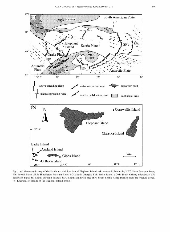
Fig. 1. (a) Geotectonic map of the Scotia arc with location of Elephant Island. AP: Antarctic Peninsula; HFZ: Hero Fracture Zone;PB: Powell Basin; SFZ: Shackleton Fracture Zone; SG: South Georgia; SM: Smith Island; SOM: South Orkney microplate; SP:Sandwich Plate; SS: South Shetland Islands; SSA: South Sandwich arc; SSR: South Scotia Ridge Dashed lines are fracture zones.(b) Location of islands of the Elephant Island group.

96 R.A.J. Trouw et al. / Tectonophysics 319 (2000) 93–110
97R.A.J. Trouw et al. / Tectonophysics 319 (2000) 93–110
be derived from the erosion of a volcanic temperature stage of the metamorphism (~7 kbar,350°C; Trouw et al., 1998a) related to D1 isseamount.attributed to a subduction setting because of thecorresponding low thermal gradient of about17°/km. The higher temperature and somewhat3. Metamorphismlower pressure conditions, during D2 (~5 kbar,500°C), recorded in the southern part of the island,The metamorphism, described in detail by
Trouw et al. (1998a,b), shows similarities with are thought to result from collision of an oceanicplateau (docking of a minor terrane) with theSanbagawa-type metamorphism from Japan
(Dalziel, 1984; Trouw et al., 1991; Grunow et al., active continental margin (Trouw et al., 1998a).1992). The Elephant Island metamorphic succes-sion shows a gradual transition from rocks belong-ing to the pumpellyite–actinolite facies in the 4. Deformation structuresnortheast (Fig. 2a), through crossite–epidote–blueschist facies in the central and northwestern Macro- and mesoscopic structures on Elephant
Island were described by Dalziel (1984), Trouwpart, greenschist facies in the southwestern partand finally to amphibolite facies around Cape (1988) and Grunow et al. (1992). The structures
of the Scotia metamorphic complex were subdi-Lookout in the extreme south (Trouw et al.,1998a,b). These transitions are marked by six vided into three groups (Dalziel, 1984; Grunow
et al., 1992), attributed to three deformationalisograds: (1) pumpellyite out-blue amphibole in;(2) spessartine in; (3) almandine in; (4) green phases: early phase (DE), main phase (DM) and
late phase (DL). Trouw (1988) used symbols D1,amphibole in-blue amphibole out; (5) biotite in;(6) oligoclase in. Most metamorphic minerals ana- D2 and D3 for these phases and this nomenclature
is maintained here.lysed by K–Ar, Rb–Sr and Ar–Ar methods yieldedCretaceous ages of 90–110 Ma (Tanner et al.,1982; Trouw et al., 1990; Herve et al., 1991; 4.1. D
1structures
Grunow et al., 1992). Comparison of core- andrim-compositions of metamorphic minerals, D1 structures, well preserved in the lower-grade
metamorphic zones, are a slaty cleavage, S1, amainly garnet, amphibole and biotite, in differentsamples, and microtectonic analysis led to the stretching and/or mineral lineation, L1, developed
on S1, and tight to isoclinal folds of beddingreconstruction of clockwise P–T–t paths (Trouwet al., 1998a,b). Although these P–T–t paths show (S0). The strongly elongated prolate shape of detri-
tal clasts in the volcanic metaconglomerate (strainsignificant differences from north to south, theirrelation with the sequence of deformation phases ratios between principal axes X/Z up to 9:1;
Trouw, 1988), associated with micro-boudinageis similar: increasing P and T during the firstdeformation phase (D1); decreasing P and increas- and stretched minerals demonstrate that L1 is a
stretching lineation developed at high strain. D1ing T during the second deformation phase (D2);and, finally, low P and T during the third deforma- folds are common, especially in thinly laminated
metachert layers, and often show a sheath-liketion phase (D3). D1 and D2 are both roughlycontemporaneous with the Cretaceous metamor- appearance (Trouw et al., 1991). Advanced trans-
position produced a situation in which S1 is usuallyphism. The early, relatively high-pressure low-
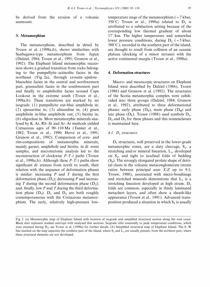
Fig. 2. (a) Metamorphic map of Elephant Island with location of isograds and simplified structural section along the west coast.Black dots represent studied outcrops with analysed thin sections. Isograds refer essentially to peak temperature conditions, whichwere attained during D2; see Trouw et al. (1998a) for further details. (b) Simplified structural map of Elephant Island. The E–Wline marked on the map separates the southern part of the island, where S2 and L2 are usually present, from the northern part, wherethese structural elements are not developed.
98 R.A.J. Trouw et al. / Tectonophysics 319 (2000) 93–110
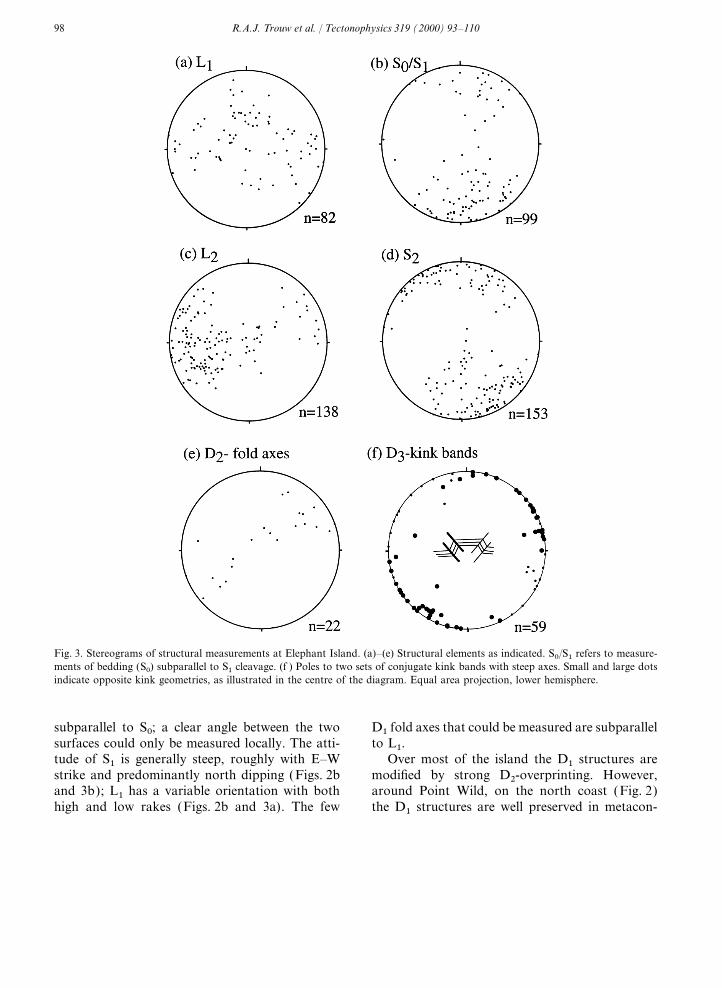
Fig. 3. Stereograms of structural measurements at Elephant Island. (a)–(e) Structural elements as indicated. S0/S1 refers to measure-ments of bedding (S0) subparallel to S1 cleavage. (f ) Poles to two sets of conjugate kink bands with steep axes. Small and large dotsindicate opposite kink geometries, as illustrated in the centre of the diagram. Equal area projection, lower hemisphere.
subparallel to S0; a clear angle between the two D1 fold axes that could be measured are subparallelto L1.surfaces could only be measured locally. The atti-
tude of S1 is generally steep, roughly with E–W Over most of the island the D1 structures aremodified by strong D2-overprinting. However,strike and predominantly north dipping (Figs. 2b
and 3b); L1 has a variable orientation with both around Point Wild, on the north coast (Fig. 2)the D1 structures are well preserved in metacon-high and low rakes (Figs. 2b and 3a). The few
99R.A.J. Trouw et al. / Tectonophysics 319 (2000) 93–110
glomerates and metasandstones. S0 (bedding) is gate quartz crystals or aggregates, and elongatemicas is present, approximately parallel to D2dipping to the NNW (347/65), subparallel to S1,
in a normal (top upwards) position (Fig. 2b). L1, fold axes.D2 structures show a clear gradient in stylewell defined at this site by stretched grains and
pebbles, is north-plunging (002/64) with a high across the succession from north to south,expressed by an increasing tightness of D2 foldsrake.and crenulations, and by the progressive develop-ment of S2 through transposition of S1 [compare4.2. D
2structures
fig. 4.17 in Passchier and Trouw (1996)], andincreasing intensity of L2 development. At PointStructures attributed to D2 predominate over
D1 structures in the higher-grade metamorphic Wild, in the north, hardly any D2 deformation ispresent and at most other outcrops in the northernzones (Fig. 2). D2 folds, deforming S0 and S1, are
open to tight and approximately cylindrical. part of the island D2 folds are open, without axialplanar cleavage. By contrast, all outcrops in theInterference patterns of D1 folds refolded by D2
are locally developed (Dalziel, 1984; Trouw, 1988). southern part show a well-developed penetrativeschistosity (S2) and usually tight D2 folds (Fig. 2b),At some places, especially in quartz veins, a well
developed L2 stretching lineation defined by elon- commonly with remnants of tight crenulations of
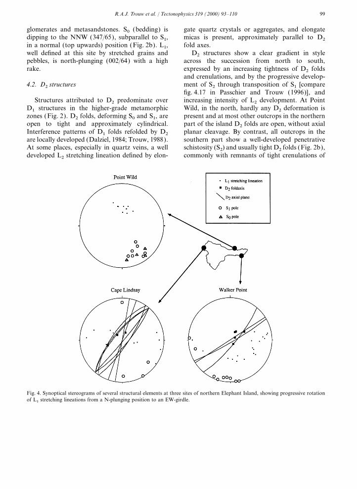
Fig. 4. Synoptical stereograms of several structural elements at three sites of northern Elephant Island, showing progressive rotationof L1 stretching lineations from a N-plunging position to an EW-girdle.

100 R.A.J. Trouw et al. / Tectonophysics 319 (2000) 93–110
at a small angle to S2 planes (Figs. 5 and 6). Theintersection lineation of this cleavage with S2 ishighly oblique or orthogonal to L2. The presenceand orientation of the C∞-shear band cleavageindicates that D2 was a phase of non-coaxial flow,probably with its main displacement direction par-allel to L2. Shear sense indicated by the shearbands is invariably sinistral looking down alongthe steeply inclined intersection lineation. Theinclined position of L2 implies that the D2 sinistralshear movements had a significant dip-slip compo-nent with relative uplift of the southern block
Fig. 5. C∞-type shear band cleavage related to S2 cleavage, indic-4.3. D
3structuresative of sinistral shear movement.
Kink bands, often in conjugate sets ofcentimetre- to metre-scale, deforming both S1 andS1. This trend is interpreted as the effect of a
southward increase in D2 strain-intensity accompa- S2, have been observed locally throughout thewhole succession They formed obviously muchnied by an increase in metamorphic temperature
(Trouw et al., 1998a,b), evident from the pattern later than D2, after the rocks had been uplifted tonon-metamorphic or very low-grade near-surfaceof metamorphic isograds (Fig. 2a).
Around Stinker Point (Fig. 2) L1 is often folded conditions. The kink bands and their axes aresteep in the southern part of the island (Fig. 7),in D2 folds, resulting in the presence of two clearly
distinct lineations: a folded L1 and a straight L2, where the S2 foliation is also steep and well-developed. In other parts of the island the kinkparallel to D2 fold hinges. Further south, only one
stretching lineation exists parallel to the hinges of bands have a more irregular orientation. The pre-ferred orientation pattern (Fig. 3f ) shows thatD2 folds. The generation of this lineation is inter-
preted to be a combination of rotated L1 and many kinks are consistent with E–W shorteningand N–S extension with respect to the presentnewly formed L2 lineation elements.
Fig. 3 shows that the distribution of L1 attitudes orientation of the island. Locally, other conjugatesets of inclined kink bands with subhorizontal axesforms a girdle that trends slightly clockwise from
the girdle of L2 orientations (Figs. 3 and 4). A indicate vertical shortening.tentative explanation for this fact is given belowin Section 7.
D2 axial planes and, in the south, S2, strike 5. Relation between deformation phases andmetamorphismroughly WSW–ENE (Figs. 2b and 3d) with steep
dips, mostly to the NNW, in the northern andsouthern parts. Gently north-dipping S2 appears The L1 mineral lineation is defined by acicular
minerals, including relatively high-pressure amphi-in the central part of the island (Fig. 2a). L2 andD2 fold hinges are WSW–ENE trending, with a boles such as glaucophane, crossite and barroisite
(Trouw et al., 1998a,b). The high degree of align-dominance of gently to steeply WSW plungingorientations (Fig. 3c). The mean value of the L2 ment with L1 indicates that these crystals must
have grown during D1.plunge is about 30° to the WSW. At Hut Bluffand Walker Point (Fig. 4), ENE-plunging linea- Garnets with spiral-shaped inclusion patterns,
continuous with S1 (Fig. 8), were interpreted astions and fold axes predominate.At several places where D2 deformation is syntectonic with respect to D1. Other crystals have
cores with spiral-shaped inclusion patterns andstrong (e.g. Stinker Point), a C∞-type shear bandcleavage (Passchier and Trouw, 1996) is developed outbowing S2 schistosity included in the rims that,

101R.A.J. Trouw et al. / Tectonophysics 319 (2000) 93–110
Fig. 6. Simplified structural scheme of Elephant Island showing mainly D2 structures with increasing intensity of D2 strain from Nto S. L1 shows progressive rotation from an N-plunging orientation towards an EW-orientation from the northern to the centralpart of the island. The oblique sinistral shear component is shown by shear bands at Stinker Point (inset); compare also with Fig. 5.
therefore, were interpreted to have grown duringD2 [see fig. 17 in Trouw et al. (1998b)].
Albite porphyroblasts generally contain inclu-sions of straight S1, locally associated with tightD1 folds, in the core, and D2 folds in the rim [seefig. 5 in Trouw et al. (1991); see also figs. 11.17and 11.18 in Passchier and Trouw (1996)]. Thismeans that the cores of these crystals grew intertec-tonically, after D1 and before D2 (Passchier andTrouw, 1996) and the rims during or after D2.The transition between cores and rims is relativelyabrupt; this is interpreted to indicate that albitegrowth continued during and after a relativelysudden initiation of D2 folding. The relationFig. 7. D3 kink bands showing late, post-metamorphic
deformation. between the growth of other metamorphic minerals

102 R.A.J. Trouw et al. / Tectonophysics 319 (2000) 93–110
6.2. Gibbs Island
De Wit et al. (1977) described the structures ofthis island in detail [see also comments by Dalziel(1984) and Trouw (1988)]. The Gibbs Island slidezone that separates a large dunite/serpentinite bodyfrom underlying schists has a WNW strike withmoderate dip to the south. We interpret this slidezone as a D1 structure, because of its parallelismwith the main cleavage, S1. A few elongationlineations with a shallow to moderate dip to thewest were reported by De Wit et al. (1977) andwe measured southwest dipping lineations related
Fig. 8. Photomicrograph of garnet with spiral-shaped inclusion to the slide zone. D2 deformation seems to havepattern, grown syntectonically to D1, indicative of tectonicbeen more restricted at this island, possibly becausemovement with top to the NE. Plane polarised light. Width ofof the different rheology of the dunite body. D3view 3 mm.structures are similar to those described onElephant Island.
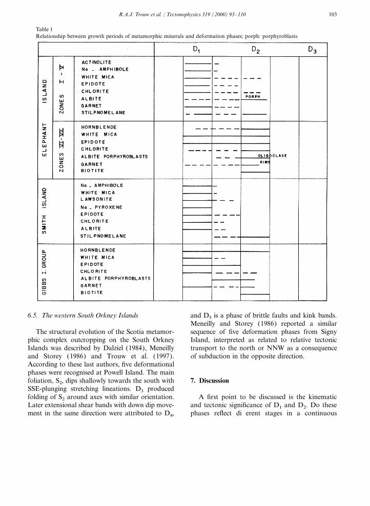
and the deformation phases is discussed by Trouwet al. (1998a,b) and is shown in Table 1. 6.3. Aspland, Eadie and O’Brien islands
The main schistosity, interpreted as S1, dipseither south (Aspland) or east (Eadie and O’Brien)
6. Structural data from adjacent islands and is strongly folded. L1 stretching lineationsplunge moderately to the ESE. Dalziel (1984)
Other islands of the Elephant Island group attributed the folds to two conjugate sets, bothwhere the Scotia metamorphic complex crops out related to his late phase, but we prefer to interpretare Clarence Island, Gibbs Island and the group them as D2 folds, since thin section studies failedof Eadie, Aspland and O’Brien islands. A review to reveal any older tectonic structure than theof structural data from Smith Island and the folded S1. Axial planes of D2 folds are steeplywestern South Orkney Islands is also given for the south dipping (Aspland) or steeply NE dippingsake of comparison. (Eadie), with moderately to steeply SW- or
SE-plunging axes.6.1. Clarence Island
Herve and coworkers (Herve et al. 1983; Herve 6.4. Smith Islandand Pankhurst, 1984), Dalziel (1984), Marsh andThompson (1985) and Trouw (1988) published Structural data from this island were presented
by Dalziel (1984), Trouw (1988) and Grunowstructural data from this island. S0–S1 is close tohorizontal or slightly west-dipping on the eastern et al. (1992). As on southern Elephant Island,
intense D2 deformation produced transposition ofpart of the island and steep, with NE–SW strikealong the west coast. The L1 elongation lineation earlier surfaces, but at Cape Smith moderately W-
to NW-dipping enveloping surfaces of S1dS0 areis about E–W and close to horizontal. D2 foldshave NE–SW-striking axial surfaces with shallow recognisable. S2 planes dip about 60° NW,
whereas D2 fold axes and mineral/extension linea-axes in the same direction. D3 structures arerestricted to local kink folds with irregular tions plunge moderately to the NE. D3 structures
are similar to those described for the other islands.orientation.
103R.A.J. Trouw et al. / Tectonophysics 319 (2000) 93–110
Table 1Relationship between growth periods of metamorphic minerals and deformation phases; porph: porphyroblasts
6.5. The western South Orkney Islands and D5 is a phase of brittle faults and kink bands.Meneilly and Storey (1986) reported a similarsequence of five deformation phases from SignyThe structural evolution of the Scotia metamor-
phic complex outcropping on the South Orkney Island, interpreted as related to relative tectonictransport to the north or NNW as a consequenceIslands was described by Dalziel (1984), Meneilly
and Storey (1986) and Trouw et al. (1997). of subduction in the opposite direction.According to these last authors, five deformationalphases were recognised at Powell Island. The mainfoliation, S2, dips shallowly towards the south with 7. DiscussionSSE-plunging stretching lineations. D3 producedfolding of S2 around axes with similar orientation. A first point to be discussed is the kinematic
and tectonic significance of D1 and D2. Do theseLater extensional shear bands with down dip move-ment in the same direction were attributed to D4, phases reflect different stages in a continuous

104 R.A.J. Trouw et al. / Tectonophysics 319 (2000) 93–110
deformation with similar kinematics or do they movements, assuming that they rotated withrepresent different kinematics? Available radiomet- respect to the surrounding cleavage, S1. The sitesric ages (Grunow et al., 1992) do not show an age where L1 has an E–W attitude with low rakegap between minerals grown during D1 and D2; generally coincide with areas where D2 overprint-therefore, they are considered as probably con- ing is relatively strong. We therefore deduce thattinuous in time. However, the kinematics of the during D2 the north- (or south-) plunging L1phases are quite different, as discussed below. lineations were progressively rotated to an E–W
position with lower rake. The fact that the girdleof L1 attitudes lies slightly clockwise from the
7.1. Kinematic and tectonic significance of D1 girdle of L2 orientations (Figs. 3 and 4) is interpre-
ted as being the result of the same progressiveThe fact that D1 structures are the oldest tec- rotation by D2. Sinistral D2 non-coaxial flow along
tonic features in the rocks that crop out at steep E–W shear zones, would reorient north-Elephant Island, and the parallelism of syntectonic plunging L1 lineations to an NE–SW orientationglaucophane and crossite crystals with S1 and L1 at low D2 strain, and to an almost E–W orientationstructures was interpreted (Trouw, 1988; Trouw at high D2 strain. The angle between the girdleset al., 1998a) to indicate that D1 acted contempora- of L2 and L1 (Fig. 3a and c) is in agreement withneously with relatively high-pressure subduction- a sinistral rotation of L1 and L2 towards the fabricrelated metamorphism and that D1 therefore attractor (Passchier, 1997) in vertical, approxi-reflects subduction movements. The presence of mately E–W-striking, D2 shear zones.D1-sheath folds (Trouw et al., 1991) and syn-D1 The outcrop pattern of the metamorphic iso-garnets with spiral-shaped inclusions supports this grads (Fig. 2a) and their polarity provide indepen-interpretation. Therefore, D1 structures provide dent indicators of the orientation of the palaeo-information related to the subduction process trench and subduction direction. Ernst (1975)during the Cretaceous. It is assumed here that S1 demonstrated that the metamorphic polarity (thatformed originally with its strike approximately
is the vector from lower to higher grade) usuallyparallel to the direction of the trench and that L1, indicates the direction of subduction. At Elephantinterpreted as the direction of the main tectonicIsland this would mean subduction towards thetransport, was subparallel to the direction of sub-SW. This method, however, is only capable ofduction. It is obviously difficult to determine abso-determining the subduction direction to a firstlute directions of tectonic transport in the absenceapproximation, since it does not take obliqueof palaeomagnetic data, but, where D2 and D3 aresubduction into consideration. One might ques-weak, it is possible to define a subduction directiontion, in this context, why the isograds are obliquerelative to the present geographic reference frame.to the main structural trend. We consider that theThis is the case at Point Wild. We thereforerestricted size of Elephant Island does not permitinterpret the E–W strike of S1, combined with theone to establish the regional importance of thissteeply north-plunging attitudes of L1 at Pointobliquity; it might simply reflect a local irregularityWild, as indicative of N–S subduction movementsrelated to the shape of the colliding plateau (seealong an E–W-trending trench, in the presentbelow).geographic reference frame. In southward subduc-
Another independent confirmation of the gene-tion the lineations would be expected to plunge toral sense of subduction can be derived from thethe south as well. The fact that they plunge to thefact that the Cretaceous magmatic arc is locatednorth can be explained as the result of large-scalealong the Antarctic Peninsula, south of ElephantD2 folding around E–W axes or as an originalIsland (Leat et al., 1998).inhomogeneity in the D1 strain pattern. The gar-
An obvious problem in the determination ofnets with spiral inclusion patterns, syntectonic withthe ‘original’ subduction direction, is that of find-respect to D1 (Fig. 5; Trouw, 1988; Trouw et al.,
1991), indicate relative top-to-the-north shear ing a suitable reference frame; both internal ductile

105R.A.J. Trouw et al. / Tectonophysics 319 (2000) 93–110
deformation and rigid body rotation of the rock The orientation of S2 planes, L2 lineations andunits underlying the island may have modified the the C∞-type shear bands fit a model of D2 flow asorientation of lineations in a geographical refer- constrained in one or more steep WSW–ENE-ence frame. If we use the north coast of the island oriented shear zones (Figs. 5 and 6) with sinistralas our reference axis, we infer that L1 in the north and ‘north-downwards’ movement components.rotated little with respect to this axis, but L1 in The intense folding of older fabric elements,the centre may have rotated by up to 90° during with axes parallel to L2, is one of the most strikingD2 (Figs. 3 and 4). features of D2 deformation on Elephant Island. If
In order to assess the subduction direction on D2 flow was exclusively accomplished by simplea regional scale, it is necessary to determine the shear, folding on this scale would only be expectedorientation of L1 with respect to geographical where the older foliation was considerably obliquecoordinates during D1. D1 was dated in the range to the (steep) D2 flow plane. Among other possible90 to 100 Ma (Trouw et al., 1990; Grunow et al., positions, this would be the case where S0 and S11992), and available reconstructions of the orienta- were gently dipping at the onset of D2. A situationtion of the Pacific margin segment in which like that would lead to an oblique relation betweenElephant Island was situated (e.g. Barker et al., L2 and D2 fold axes, especially in low-strain sec-1991; Grunow et al., 1992; McCarron and Larter, tions of the shear zone. However, L2 is parallel to1998) imply that the orientation of the north coast D2 fold axes wherever measured. It is thereforeof the island may have been approximately NE– probable that D2 flow was not simple shear, butSW at that time. If L1 did not rotate with respect that it deviated from plane strain with an N–S-to the north coast, subduction was accordingly shortening component, i.e. a transpressional D2approximately towards the southeast. This is in flow type. In such a flow type, abundant foldsagreement with the general geographic setting with with axes parallel to the stretching lineation couldthe proto-Pacific ocean in the west and with develop and L2 would be generated parallel to theregional reconstructions for the period considered
D2 fold axes, even in low strain domains.(e.g. Larson and Pitman, 1972; Zonenshayn et al.,
The present D2 structure of the whole island1984; Scheuber and Andriessen, 1990). It is there-configures an irregular asymmetric dome-shapefore assumed that at least the northern part of thewith lineations along the west coast dipping to theisland rotated in a rigid fashion after D1 (andwest and, at several places on the east coast (e.g.D2), whereas the southern part was affected byHut Bluff and Walker Point), to the east (Fig. 6).both a rigid rotation and reorientation of D1 This dome shape could be the result of an inhomo-structures during ductile D2 deformation (Fig. 6).geneous secondary vertical flow component duringtranspression. The NNW–SSE-shortening compo-nent of D2 is mainly suggested by the dominance7.2. Kinematic and tectonic significance of D
2 of tight D2 folds with steep axial planes and gentlyplunging axes, parallel to L2. As stated above, theD2 was interpreted by Trouw (1988) as a phaseintensity of folding on this scale is not likely to beof horizontal shortening resulting in relativethe result of simple shear alone. Since there are noobduction of the rock units now outcropping atindications for massive volume change during D2,Elephant Island towards the SSE. The main argu-the shortening component must have been com-ment for this ‘obduction’ is the asymmetry of D2 pensated by extension in other directions.folds with vergence towards the south (Fig. 2a),Although vertical extension is usually assumed incontrary to what would be expected in an accre-transpression models (Harland, 1971; Sandersontionary wedge with subduction towards the south.and Marchini, 1984; Means, 1989; Fossen andWith the new data presented here, it is now clearTikoff, 1993; Krantz, 1995), there are several indic-that D2 is actually a phase of non-coaxial shearations that an important horizontal extension com-with an important oblique sinistral displacement
component. ponent was present during D2 on Elephant Island.
106 R.A.J. Trouw et al. / Tectonophysics 319 (2000) 93–110
(1) Strong D2 C∞ shear band cleavage is present tion with its sinistral strike-slip component atElephant Island is to relate it to deformationwith steep intersection lineations between C∞ andwithin the forearc (Grunow et al., 1992), resultingS planes. Theoretical, experimental and field-ori-from transcurrent motion between the Antarcticented research (Passchier, 1991) has shown, thatPeninsula and southern South America, initiatedC∞-type shear band cleavage is best developed inin the mid-Cretaceous. In this interpretation the‘stretching’ shear zones (Means, 1989), i.e. thosedip-slip component of motion can only bewith an extension component parallel to the direc-explained by later tilting of the whole block, oftion of tectonic transport. (2) The orientation ofwhich Elephant Island is the now outcroppingthe strong L2 stretching lineation and the fact thatarea. However, this tilting of originally horizontalthe D2 folds are strongly cylindrical parallel toL2 lineations would lead to deeper erosion of theL2. If extension during D2 were to have beeneastern part of the island with consequently highermainly vertical, folds with more irregularly ori-metamorphic grade. The metamorphic isogradented axes should have been formed.pattern (Fig. 2a) shows quite the opposite, so thisThe mean value of the L2 plunge, interpretedexplanation seems problematic as well.as the principal movement direction, is about 30°
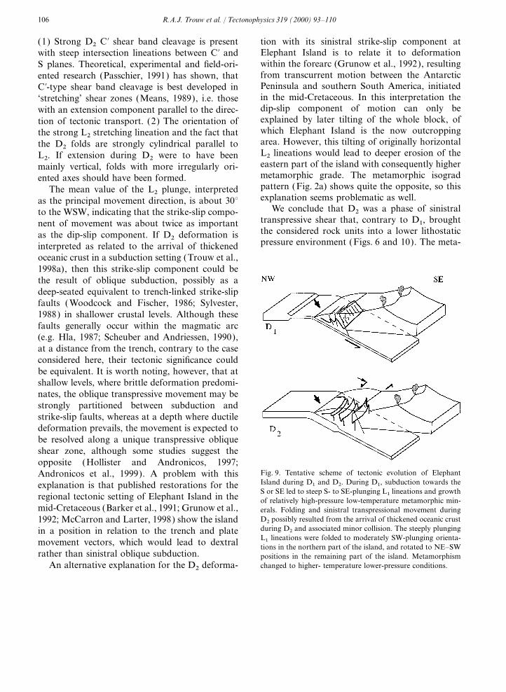
We conclude that D2 was a phase of sinistralto the WSW, indicating that the strike-slip compo-transpressive shear that, contrary to D1, broughtnent of movement was about twice as importantthe considered rock units into a lower lithostaticas the dip-slip component. If D2 deformation ispressure environment (Figs. 6 and 10). The meta-interpreted as related to the arrival of thickened
oceanic crust in a subduction setting (Trouw et al.,1998a), then this strike-slip component could bethe result of oblique subduction, possibly as adeep-seated equivalent to trench-linked strike-slipfaults (Woodcock and Fischer, 1986; Sylvester,1988) in shallower crustal levels. Although thesefaults generally occur within the magmatic arc(e.g. Hla, 1987; Scheuber and Andriessen, 1990),at a distance from the trench, contrary to the caseconsidered here, their tectonic significance couldbe equivalent. It is worth noting, however, that atshallow levels, where brittle deformation predomi-nates, the oblique transpressive movement may bestrongly partitioned between subduction andstrike-slip faults, whereas at a depth where ductiledeformation prevails, the movement is expected tobe resolved along a unique transpressive obliqueshear zone, although some studies suggest theopposite (Hollister and Andronicos, 1997;
Fig. 9. Tentative scheme of tectonic evolution of ElephantAndronicos et al., 1999). A problem with thisIsland during D1 and D2. During D1, subduction towards theexplanation is that published restorations for theS or SE led to steep S- to SE-plunging L1 lineations and growth
regional tectonic setting of Elephant Island in the of relatively high-pressure low-temperature metamorphic min-mid-Cretaceous (Barker et al., 1991; Grunow et al., erals. Folding and sinistral transpressional movement during
D2 possibly resulted from the arrival of thickened oceanic crust1992; McCarron and Larter, 1998) show the islandduring D2 and associated minor collision. The steeply plungingin a position in relation to the trench and plateL1 lineations were folded to moderately SW-plunging orienta-movement vectors, which would lead to dextral tions in the northern part of the island, and rotated to NE–SW
rather than sinistral oblique subduction. positions in the remaining part of the island. Metamorphismchanged to higher- temperature lower-pressure conditions.An alternative explanation for the D2 deforma-

107R.A.J. Trouw et al. / Tectonophysics 319 (2000) 93–110
morphic evolution during D2 corroborates this N–S compression, D3 can be interpreted as a phaseof relaxation, related to uplift and exhumation.interpretation, because pressures were falling and
temperatures increasing (Trouw et al., 1998a), However, no low-angle normal faults or jumps inmetamorphic grade were observed to indicategenerating a classical clockwise P–T–t path
(England and Thompson, 1984; Thompson and exhumation by extension. Isostatic uplift followedby erosion seems the most probable mechanismEngland, 1984).
The decrease of pressure during D2 may have for exhumation. It is clear from the Cenozoicevolution of the Scotia Sea (Barker et al., 1991;been caused by the vertical dislocation component
of D2 tectonic transport, indicated by the plunging Cunningham et al., 1995) that Elephant Islandmust have rotated over as much as 45° in anature of the L2 stretching lineations, consistent
with relative uplift of the southern part with respect clockwise sense during the last 40 Ma. The E–Wshortening and N–S extension are in goodto the northern part of the island. Alternatively,
uplift may have been produced by a vertical exten- agreement with the strain orientation along thesinistral Shackleton Fracture Zone, active duringsion component to movement inside the trans-
pressive D2 shear zone, causing secondary vertical the period 29–4 Ma (Klepeis and Lawver, 1996;Kim et al., 1997; Figs. 1 and 10). It is thereforeexpulsion of material in addition to the main
movement along the stretching lineations. On a concluded that D3 structures were probably gener-ated during the same time interval, and may bewider scale, emergence of the whole metamorphic
pile may have been due to isostatic uplift after related to movement along the ShackletonFracture Zone, associated with the opening of thelocal stagnation or slowing down of subduction
(Fig. 9). Scotia Sea (Fig. 10).
7.4. Comparison with other islands7.3. Tectonic significance of D3
As stated in Section 4.3 on D3 structures, most Although the orientation of the structures atClarence Island is somewhat different fromkink bands were probably generated as a conse-
quence of E–W shortening and N–S extension. Elephant Island, the flat-lying foliations can becompared to the situation at central west ElephantSince D1 and D2 correspond to a large extent to
Fig. 10. Evolutionary scheme showing the original orientation of D1 and D2 structures on Elephant Island with respect to north, andtheir rotation, probably during D3, related to the development of the Scotia arc and the Shackleton Fracture Zone.
108 R.A.J. Trouw et al. / Tectonophysics 319 (2000) 93–110
Island and the shallow NE-dipping lineations to which led to the northward migration of the activesubduction zone.similar ones at Walker Point (Fig. 2b). The SSW-
dipping D1 slide zone at Gibbs Island with its W- Post-metamorphic D3 kink bands and localfaults were generated during clockwise rigid bodyto SW-plunging lineations might reflect southwest-
ward subduction or southward subduction with rotation over about 45° associated with uplift inthe Cenozoic.superposed clockwise rigid body rotation. The
south- to east-dipping foliations with ESE-plung- Comparison with other parts of the Scotiametamorphic complex shows comparable struc-ing lineations on Aspland, Eadie and O’Brien
islands are quite different from Elephant Island. tural evolutions but often considerable differencesin orientation.At present it is not clear whether this might be
due to block rotation, to large-scale folding or toanother mechanism.
The orientation of structures at Smith Island, Acknowledgementsprobably generated at about 50 Ma, is alsodifferent from Elephant Island in the sense that The data presented in this paper were collectedthe lineations plunge to the ENE. It seems quite during two Brazilian expeditions in the australpossible that these structures were generated by summers of 1991–1992 and 1995–1996. Monicaeastward oblique subduction with a dextral strike Heilbron and Julio Cesar de Almeida are gratefullyslip component, but no data to confirm this are acknowledged for enthusiastic assistance in thepresently available. field and in the laboratory. This research was
The orientation of structures on the South financed by CNPq PROANTAR, grant 404513.Orkney Islands led Meneilly and Storey (1986) CWP acknowledges financial support from theand Trouw et al. (1997) to infer southward subduc- ‘Stichting GOA’. Constructive reviews by Keithtion with respect to the present orientation of these Klepeis and an anonymous reviewer are gratefullyislands. Although metamorphic ages from these acknowledged.islands are in the range 180–200 Ma, almost twiceas old as the ones from Elephant Island, thetectonic setting seems to be comparable to
Referencesthe situation during D1 at Elephant Island.
Andronicos, C.L., Hollister, L.S., Davidson, C., Chardon, D.,1999. Kinematics and tectonic significance of transpressive
8. Conclusions structures within the Coast Plutonic Complex, BritishColumbia. J. Struct. Geol. 21, 229–243.
Barker, P.F., Dalziel, I.W.D., Storey, B.C., 1991. Tectonic evo-The predominantly E–W strike of S1 with N–lution of the Scotia Arc region. In: Tingey, R.J. (Ed.), Ant-S-oriented stretching lineations led to the inter-arctic Geology. Oxford University Press, Oxford,
pretation that D1 reflects southward subduction, pp. 215–248.with respect to the present orientation of Cunningham, W.D., Dalziel, I.W.D., Lee, T.Y., Lawver, L.A.,
1995. Southernmost South America–Antarctic PeninsulaElephant Island.relative plate motion since 84 Ma: implications for the tec-D2 modified the orientation of L1 stretchingtonic evolution of the Scotia Arc region. J. Geophys. Res.lineations to an E–W position; this phase is inter-100, B5, 8257–8266.
preted as a phase of transpressional movement Dalziel, I.W.D., 1984. Tectonic evolution of a forearc terrane,with a sinistral strike slip component, either pro- southern Scotia Ridge, Antarctica. Geol. Soc. Am. Spec.
Pap. 200, 32 pp.duced by oblique subduction or by transcurrentDe Wit, M.J., Dutch, S., Kligfield, R., Allen, R., Stern, C.,motion between South America and the Antarctic
1977. Deformation, serpentinization and emplacement of aPeninsula, in the fore-arc. Increasing temperaturedunite complex, Gibbs Island, South Shetland Islands: pos-
and decreasing pressure during this phase probably sible fracture zone tectonics. J. Geol. 85, 745–762.result from the slowing down of subduction move- England, P.C., Thompson, A.B., 1984. Pressure–temper-
ature–time paths of regional metamorphism. I. Heat transferments due to the arrival of thickened oceanic crust,

109R.A.J. Trouw et al. / Tectonophysics 319 (2000) 93–110
during the evolution of regions of thickened continental gical Evolution and Processes. Universita de Siena, Siena,crust. J. Petrol. 25, 894–928. Italy, pp. 321–326.
Ernst, W.G., 1975. Systematics of large-scale tectonics and age Larson, R.L., Pitman III, W.C., 1972. World-wide correlationprogressions in alpine and circum-Pacific blueschist belts. of Mesozoic magnetic anomalies, and its implications. Bull.Tectonophysics 26, 229–246. Geol. Soc. Am. 83, 3645–3662.
Fossen, H., Tikoff, B., 1993. The deformation matrix for simul- Marsh, P.D., Thompson, J.W., 1985. The Scotia metamorphictaneous simple shearing, pure shearing and volume change, complex on Elephant Island and Clarence Island, Southand its application to transpression–transtension tectonics. Shetland Islands. Br. Antarctic Surv. Bull. 69, 71–75.J. Struct. Geol. 15, 413–422. McCarron, J.J., Larter, R.D., 1998. Late Cretaceous to early
Grunow, A.N., Dalziel, I.W.D., Harrison, T.M., Heitzler, Tertiary subduction history of the Antarctic Peninsula.M.T., 1992. Structural geology and geochronology of sub- J. Geol. Soc. London 155, 255–268.duction complexes along the margin of Gondwanaland: new Means, W.D., 1989. Stretching faults. Geology 17, 893–896.data from the Antarctic Peninsula and southernmost Andes. Meneilly, A.W., Storey, B.C., 1986. Ductile thrusting withinGeol. Soc. Am. Bull. 104, 1497–1514. subduction complex rocks on Signy Island, South Orkney
Harland, W.B., 1971. Tectonic transpression in Caledonian Islands. J. Struct. Geol. 8, 457–472.Spitzbergen. Geol. Mag. 108, 27–42. Passchier, C.W., 1991. Geometric constraints on the develop-
Heilbron, M., Valeriano, C.M., Trouw, R.A.J., Ribeiro, A., ment of shear bands in rocks. Geol. Mijnbouw 70, 203–211.1995. Lithogeochemistry of grey phyllites and schists from Passchier, C.W., 1997. The fabric attractor. J. Struct. Geol.the Scotia metamorphic complex at Elephant Island, South 19, 113–127.Shetland Islands. In: VII International Symposium on Ant- Passchier, C.W., Trouw, R.A.J., 1996. Microtectonics. Springer,arctic Earth Science, Siena, Italy, Abstracts Volume, 188. Berlin, Germany. 289 pp.
Herve, F., Pankhurst, R.J., 1984. The Scotia Metamorphic Sanderson, D.J., Marchini, R.D., 1984. Transpression. J. Struct.Complex at Cape Bowles, Clarence Island, South Shetland Geol. 6, 449–549.Islands, Western Antarctica. Br. Antarctic Surv. Bull. 62, Scheuber, E., Andriessen, P.A.M., 1990. The kinematic and15–24. geodynamic significance of the Atacama fault zone, north-
Herve, F., Godoy, E., Davidson, J., 1983. Blueschist relic clino- ern Chile. J. Struct. Geol. 12, 243–257.pyroxene of Smith Island (South Shetland Islands); their
Smellie, J.L., Clarkson, P.D., 1975. Evidence for pre-Jurassiccomposition origin and some tectonic implications. In:
subduction in western Antarctica. Nature 258, 701–702.Oliver, R.L., James, P.R., Jago, J.B. (Eds.), Antarctic Earth
Sylvester, A.G., 1988. Strike-slip faults. Geol. Soc. Am. Bull.Science. Cambridge University Press, Cambridge, UK,
100, 1666–1703.pp. 363–366.
Tanner, P.W.G., Pankhurst, R.J., Hyden, G., 1982. Radiomet-Herve, F., Loske, W.P., Miller, H., Pankhurst, R.J., 1991. Chro-ric evidence for the age of the subduction complex in thenology of provenance, deposition and metamorphism in theSouth Orkney and South Shetland Islands, West Antarctica.southern limb of the Scotia Arc. In: Thomson, M.R.A.,J. Geol. Soc. London 139, 683–690.Crame, J.A., Thomson, J.W. (Eds.), Geological Evolution
Thompson, A.B., England, P.C., 1984. Pressure–temper-of Antarctica. Cambridge University Press, Cambridge,ature–time paths of regional metamorphism. II. Their infer-UK, pp. 429–435.ence and interpretation using mineral assemblages inHla, M., 1987. Transcurrent movements in the Burma–Adamanmetamorphic rocks. J. Petrol. 25, 929–955.Sea region. Geology 15, 911–912.
Trouw, R.A.J., 1988. Structural analysis of the Elephant IslandHollister, L.S., Andronicos, C.L., 1997. A candidate for thegroup, South Shetland Islands. Inst. Antart. Chileno Ser.baja British Columbia Fault System in the coast plutonicCient. 38, 141–162.complex. GSA Today 7, 1–7.
Trouw, R.A.J., Pankhurst, R.J., Kawashita, K., 1990. NewKim, Y., Jin, Y.K., Nam, S.H., 1997. Crustal structure of theradiometric age data from Elephant Island, South ShetlandShackleton Fracture Zone in the southern Drake Passage,Islands. In: Miller, H. (Ed.), Workshop on Antarctic Geo-Antarctica. In: Ricci, C.A. (Ed.), The Antarctic Region:chronology, Zentralbl. Geol. Palaont. Teil 1:, 105–118.Geological Evolution and Processes. Tipologia Senense,
Trouw, R.A.J., Ribeiro, A., Paciullo, F.V.P., 1991. StructuralSiena, Italy, pp. 661–667.and metamorphic evolution of the Elephant Island groupKlepeis, K.A., Lawver, L.A., 1996. Tectonics of the Antarc-and Smith Island, South Shetland Islands. In: Thomson,tic–Scotia plate boundary near Elephant and ClarenceM.R.A., Crame, J.A., Thomson, J.W. (Eds.), GeologicalIslands, West Antarctica. J. Geophys. Res. 101, B9,Evolution of Antarctica. Cambridge University Press, Cam-20 211–20 231.bridge, UK, pp. 423–428.Krantz, R.W., 1995. The transpressional strain model applied
Trouw, R.A.J., Passchier, C.W., Simoes, L.S.A., Andreis, R.R.,to strike-slip, oblique-convergent and oblique-divergentValeriano, C.M., 1997. Mesozoic tectonic evolution of thedeformation. J. Struct. Geol. 17, 1125–1137.South Orkney Microcontinent, Scotia arc, Antarctica. Geol.Leat, P.T., Scarrow, J.H., Wareham, C.D., 1998. A model forMag. 134, 383–401.Late Triassic to Early Cretaceous Antarctic Peninsula plu-
tonism. In: Ricci, C.A. (Ed.), The Antarctic Region: Geolo- Trouw, R.A.J., Simoes, L.S.A., Valladares, C., 1998a. Meta-

110 R.A.J. Trouw et al. / Tectonophysics 319 (2000) 93–110
morphic evolution of a subduction complex, South Shetland complex in the South Shetland Islands: evidence for oceanfloor basalts as protoliths. In: Ricci, C.A. (Ed.), The Antarc-Islands, Antarctica. J. Metamorph. Geol. 16, 475–490.
Trouw, R.A.J., Simoes, L.S.A., Valladares, C., 1998b. Variation tic Region: Geological Evolution and Processes. Universitade Siena, Siena, Italy, pp. 390–400.in mineral chemical composition across a subduction com-
plex with Sanbagawa-type metamorphism, South Shetland Woodcock, N.H., Fischer, M., 1986. Strike-slip duplexes.J. Struct. Geol. 8, 725–735.Islands, Antarctica. Pesquisa Antartica Brasileira 3,
133–169. Zonenshayn, L.P., Savostin, L.A., Sedov, A.P., 1984. Globalpaleogeodynamic reconstructions for the last 160 millionValeriano, C.M., Heilbron, M., Trouw, R.A.J., 1997. Litho-
geochemistry of mafic rocks from the Scotia metamorphic years. Geotectonics 18, 181–195.